senior capstone
DESCRIPTION
Research, Design and Illustration of Boulevard Crossing Park in conjunction with the Atlanta BeltLine, IncTRANSCRIPT
Boulevard Crossing Park:
in Conjunction with the Atlanta BeltLine, Inc.
Uniting Atlanta One Park at a Time
by
Amelia Kane
A Senior Design ProjectPresented to the College of Environment and Design
University of Georgia
Under the Direction of:Brad Davis, Assistant Professor
In partial fulfillment of the requirements for the degree ofBachelor of Landscape Architecture
Athens, GeorgiaSpring, 2012

Boulevard Crossing Park
Atlanta BeltLine, Inc.
Subarea 3
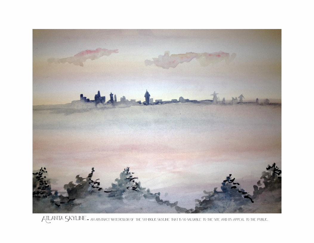
Atlanta Skyline- an abstract watercolor of the symbolic skyline that is so valuable to the site and its appeal to the public.
BeltLine Subarea 3
Boulevard Crossing
Contents6- Site Inventory & Analysis
8- Site Visit & Research
10- Site Inventory
Greenspace, Circulation, Hydrology
12- Soil Analysis Illustration & Table
14- Process Graphics
16- Concept Plans
18- Master Plan
20- Site Plan
22- Grading Plan & Staking Plan
24- Construction Details
Tree detail. boardwalk & Pond Detail,
Rock Climbing/Retaining wall detail
26- Planting Plan & Schedule
28- vignettes
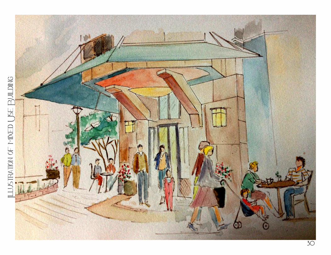
30- Mixed Use Builing Illustration
32- References
Site
Inve
ntor
y &
Ana
lysis
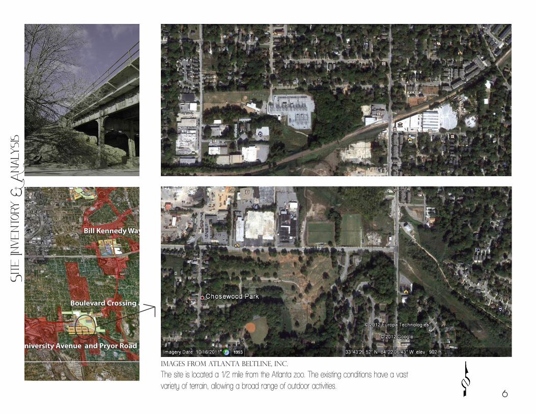
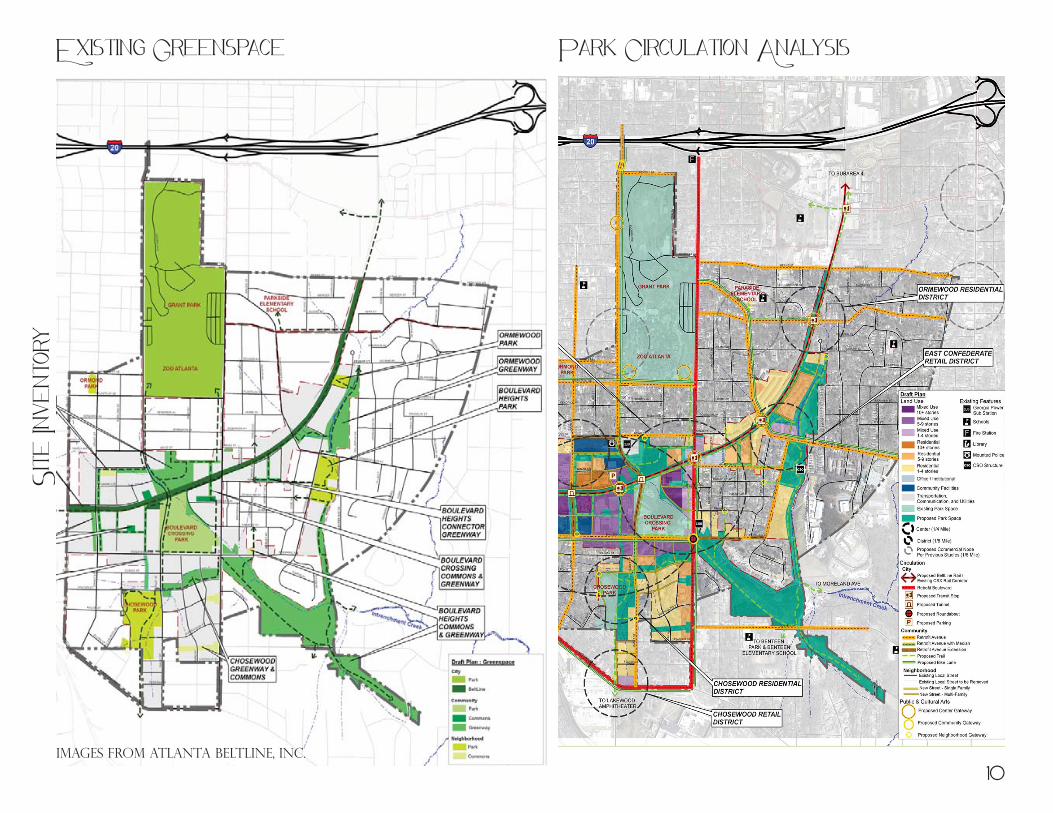
Images from Atlanta BeltLine, Inc.
The site is located a 1/2 mile from the Atlanta zoo. The existing conditions have a vast variety of terrain, allowing a broad range of outdoor activities.
6
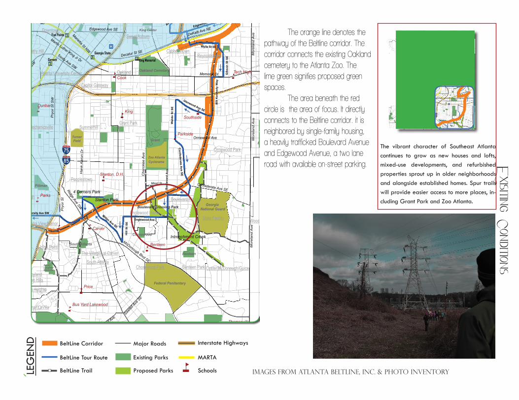
BeltLine Corridor Major Roads
Existing Parks
Proposed Parks
Interstate Highways
MARTA
Schools
BeltLine Tour Route
BeltLine TrailLEG
END
The vibrant character of Southeast Atlanta continues to grow as new houses and lofts, mixed-use developments, and refurbished properties sprout up in older neighborhoods and alongside established homes. Spur trails will provide easier access to more places, in-cluding Grant Park and Zoo Atlanta.
Key Points of Interest:•Bill Kennedy Way (The Glenwood Connec-tor) will be a scenic strip along the corridor where the transitand trial flowalong thesame street as cars.
•Southside High and the New Schools of Carver are 2 of 20 public schools within ½-mileoftheBeltLinethatwillbenefitfromadditional travel options for students and staff.
• The historic bridge crossing OrmewoodAvenue and the tunnel below Hank Aaron Drive and McDonough Boulevard present dynamic aesthetics and will be preserved.
•Oneofthefirstnewgreenspacestobede-veloped, the 21-acre Boulevard Crossing Park will enhance the vitality of Boulevard Heights and Englewood Manor.
Map 1 – Southeast Inman Park/Reynoldstown Marta Station to I-75/85
Oakland Cemetary
Piedmont
Bobby JonesGolf Course
Atlanta Memorial Park
John A. White
WestviewCemetary
Zoo AtlantaCyclorama
Grant
Boulevard Crossing
Stanton
Four Corners
Intrenchment Creek
Intrenchment Creek
Stanton Park
Mead St
4 Corners Park
Mor
elan
d A
ve
Memorial Dr
Jonesboro Rd SE
McDonough Blvd SE
Ormewood Ave
Pry
or S
t SW
Lakewood Ave
DeKalb Ave NE
Spring
St
Pry
or S
t
Che
roke
e A
ve
Decatur St SE
Pie
dmon
t Ave
Glenwood Ave SE
Nor
thsi
de D
r
Martin Luther King Jr Dr
Bouldercrest D
r SE
Bouldercrest R
d
Sawtel
l Ave
SE
Flat Shoals Ave SE
Trinity Ave SW
Peters
St SW
Edgewood Ave SE
Ridge Ave SW
Stone Mountain Fwy
Marietta St NW
Confederate Ave SE
Moreland Ave
Mor
elan
d A
veM
orel
and
Ave
Memorial Dr
Grant Park
Downtown
East Atlanta
Edgewood
Lakewood Heights
Browns Mill Park
Lakewood
Kirkwood
Ormewood Park
Summerhill
Pittsburgh
Reynoldstown
Mechanicsville
Leila Valley
Peoplestown
Polar Rock
South Atlanta
Norwood Manor
Inman Park
Thomasville Heights
Sweet Auburn
Benteen Park
Old Fourth Ward
Custer/McDonough/GuiceJoyland
Perkerson
South River Gardens
State Facility
Rosedale Heights
Swallow Circle/Baywood
Cabbagetown
Glenrose Heights
Rebel Valley Forest
Capitol Gateway
Betmar LaVilla
Oakland
Amal Heights
Castleberry Hill
Boulevard Heights
Woodland Hills
The Villages at Carver
Capitol View Manor
Hammond Park
Sylvan Hills
Englewood Manor
Vine City
Candler Park Lake Claire
Atlanta University Center
Grant
Zoo AtlantaCyclorama
TurnerField
Chosewood
Federal Penitentary
Georgia National Guard
Pittman
Brownwood
Benteen
Arthur LangfordMemorial
Oakland Cemetary
M.L.K.
King Center
Browns Mill Golf Course
South Bend Park
Milton Ave SE
University Ave SW
Englewood Ave.
Wal
do S
t SE
Edgewood Ave NE
Hill
St S
E
Bou
leva
rd A
ve.
Han
k A
aron
Dr
Wylie St SE
Confederate A
ve SE
Glenwood Ave SE
Lake A
ve N
E
Gib
son
St S
E
Bill
Ken
nedy
Way
Auburn Ave
NE
Garnett King Memorial
Georgia State
Peachtree Center
Dome/GWCC/Philips/CNN
King
Coan
Hope
Cook
Price
Parks
Dobbs
Carver
Walden
Waters
Dunbar
Bethune
Benteen
Parkside
Tech High
Southside
Whitefoord
Thomasville
Stanton, D.H.
Crim Open Campus
Cleveland Avenue
Burgess-Peterson
Bus Yard Lakewood
Five Points
Inman Park-Reynoldstown
Boulevard Crossing Park
South Atlanta
Chosewood Park
High Point
BeltLine Corridor Major Roads
Existing Parks
Proposed Parks
Interstate Highways
MARTA
Schools
BeltLine Tour Route
BeltLine TrailLEG
END
The vibrant character of Southeast Atlanta continues to grow as new houses and lofts, mixed-use developments, and refurbished properties sprout up in older neighborhoods and alongside established homes. Spur trails will provide easier access to more places, in-cluding Grant Park and Zoo Atlanta.
Key Points of Interest:•Bill Kennedy Way (The Glenwood Connec-tor) will be a scenic strip along the corridor where the transitand trial flowalong thesame street as cars.
•Southside High and the New Schools of Carver are 2 of 20 public schools within ½-mileoftheBeltLinethatwillbenefitfromadditional travel options for students and staff.
• The historic bridge crossing OrmewoodAvenue and the tunnel below Hank Aaron Drive and McDonough Boulevard present dynamic aesthetics and will be preserved.
•Oneofthefirstnewgreenspacestobede-veloped, the 21-acre Boulevard Crossing Park will enhance the vitality of Boulevard Heights and Englewood Manor.
Map 1 – Southeast Inman Park/Reynoldstown Marta Station to I-75/85
Oakland Cemetary
Piedmont
Bobby JonesGolf Course
Atlanta Memorial Park
John A. White
WestviewCemetary
Zoo AtlantaCyclorama
Grant
Boulevard Crossing
Stanton
Four Corners
Intrenchment Creek
Intrenchment Creek
Stanton Park
Mead St
4 Corners Park
Mor
elan
d A
ve
Memorial Dr
Jonesboro Rd SE
McDonough Blvd SE
Ormewood Ave
Pry
or S
t SW
Lakewood Ave
DeKalb Ave NE
Spring
St
Pry
or S
t
Che
roke
e A
ve
Decatur St SE
Pie
dmon
t Ave
Glenwood Ave SE
Nor
thsi
de D
r
Martin Luther King Jr DrB
ouldercrest Dr S
EB
ouldercrest Rd
Sawtel
l Ave
SE
Flat Shoals Ave SE
Trinity Ave SW
Peters
St SW
Edgewood Ave SE
Ridge Ave SW
Stone Mountain Fwy
Marietta St NW
Confederate Ave SE
Moreland Ave
Mor
elan
d A
veM
orel
and
Ave
Memorial Dr
Grant Park
Downtown
East Atlanta
Edgewood
Lakewood Heights
Browns Mill Park
Lakewood
Kirkwood
Ormewood Park
Summerhill
Pittsburgh
Reynoldstown
Mechanicsville
Leila Valley
Peoplestown
Polar Rock
South Atlanta
Norwood Manor
Inman Park
Thomasville Heights
Sweet Auburn
Benteen Park
Old Fourth Ward
Custer/McDonough/GuiceJoyland
Perkerson
South River Gardens
State Facility
Rosedale Heights
Swallow Circle/Baywood
Cabbagetown
Glenrose Heights
Rebel Valley Forest
Capitol Gateway
Betmar LaVilla
Oakland
Amal Heights
Castleberry Hill
Boulevard Heights
Woodland Hills
The Villages at Carver
Capitol View Manor
Hammond Park
Sylvan Hills
Englewood Manor
Vine City
Candler Park Lake Claire
Atlanta University Center
Grant
Zoo AtlantaCyclorama
TurnerField
Chosewood
Federal Penitentary
Georgia National Guard
Pittman
Brownwood
Benteen
Arthur LangfordMemorial
Oakland Cemetary
M.L.K.
King Center
Browns Mill Golf Course
South Bend Park
Milton Ave SE
University Ave SW
Englewood Ave.
Wal
do S
t SE
Edgewood Ave NE
Hill
St S
E
Bou
leva
rd A
ve.
Han
k A
aron
Dr
Wylie St SE
Confederate A
ve SE
Glenwood Ave SE
Lake A
ve N
E
Gib
son
St S
E
Bill
Ken
nedy
Way
Auburn Ave
NE
Garnett King Memorial
Georgia State
Peachtree Center
Dome/GWCC/Philips/CNN
King
Coan
Hope
Cook
Price
Parks
Dobbs
Carver
Walden
Waters
Dunbar
Bethune
Benteen
Parkside
Tech High
Southside
Whitefoord
Thomasville
Stanton, D.H.
Crim Open Campus
Cleveland Avenue
Burgess-Peterson
Bus Yard Lakewood
Five Points
Inman Park-Reynoldstown
Boulevard Crossing Park
South Atlanta
Chosewood Park
High Point
The orange line denotes the pathway of the Beltline corridor. The corridor connects the existing Oakland cemetery to the Atlanta Zoo. The lime green signifies proposed green spaces. The area beneath the red circle is the area of focus. It directly connects to the Beltline corridor. it is neighbored by single-family housing, a heavily trafficked Boulevard Avenue and Edgewood Avenue, a two lane road with available on-street parking.
Images from Atlanta BeltLine, inc. & photo inventory
Exisiting C
onditions
PLAN RECOMMENDATIONS REPORTSUBAREA 3
10
Figure II.C.2 - Example of Englewood Employment Cultural Center scale/ characterCourtesy of: Others
Figure II.C.3 - Boulevard Crossing Future- 3-D Model looking south toward Englewood Employment Cultural Center
Figure II.C.1 - Example of Englewood Employment Cultural Center scale/ characterCourtesy of: Others
c. Development OpportunitiesThe following are illustrations and descriptions for development opportunities within the 2
proposed centers and 5 proposed districts.
• Centers
o Englewood Employment Cultural Center
Employment opportunity focused on working and multi-family living oriented around community common
Cultural opportunity focused on entertainment, art, and community facilities
1/4 mile core area with linear pedestrian greenways dividing blocks and connecting to the BeltLine
Incorporate opportunity for BeltLine transit plaza on top of public parking structure
Building Heights up to 10+ stories, mixed use oriented to greenspaces and transitioning in height with topography
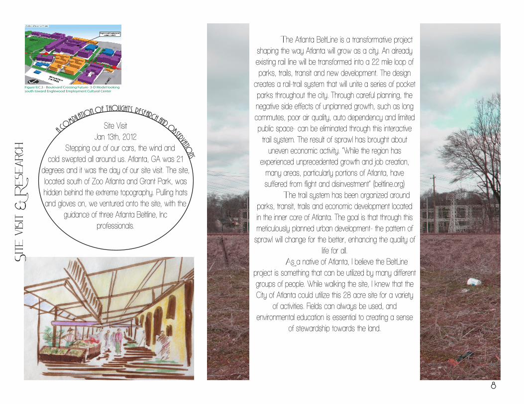
Site VisitJan 13th, 2012
Stepping out of our cars, the wind and cold swepted all around us. Atlanta, GA was 21
degrees and it was the day of our site visit. The site, located south of Zoo Atlanta and Grant Park, was hidden behind the extreme topography. Pulling hats and gloves on, we ventured onto the site, with the
guidance of three Atlanta Beltline, Inc professionals.
a co
mpilation of thoughts, research and o
bservations
The Atlanta BeltLine is a transformative project shaping the way Atlanta will grow as a city. An already existing rail line will be transformed into a 22 mile loop of parks, trails, transit and new development. The design
creates a rail-trail system that will unite a series of pocket parks throughout the city. Through careful planning, the negative side effects of unplanned growth, such as long commutes, poor air quality, auto dependency and limited public space- can be eliminated through this interactive trail system. The result of sprawl has brought about
uneven economic activity. “While the region has experienced unprecedented growth and job creation,
many areas, particularly portions of Atlanta, have suffered from flight and disinvestment” (beltline.org)
The trail system has been organized around parks, transit, trails and economic development located in the inner core of Atlanta. The goal is that through this meticulously planned urban development- the pattern of sprawl will change for the better, enhancing the quality of
life for all. As a native of Atlanta, I believe the BeltLine project is something that can be utilized by many different groups of people. While walking the site, I knew that the City of Atlanta could utilize this 28 acre site for a variety
of activities. Fields can always be used, and environmental education is essential to creating a sense
of stewardship towards the land.
Site
visi
t &
Res
earc
h
8
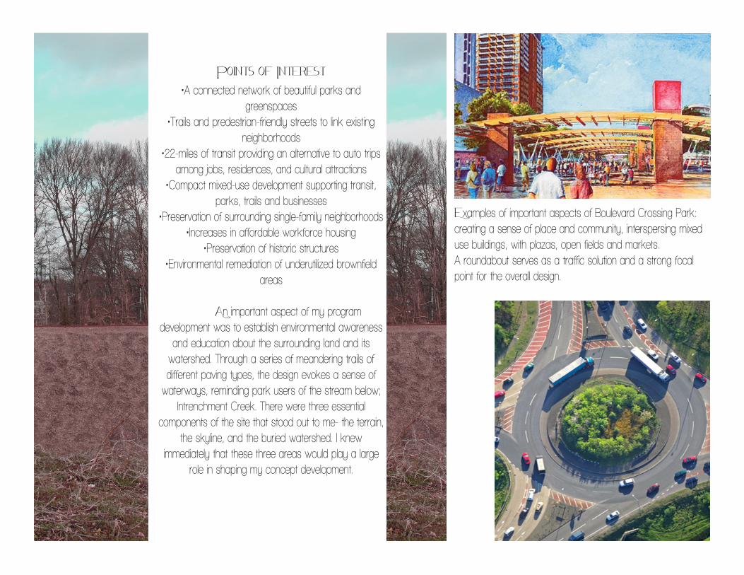
Points of Interest•A connected network of beautiful parks and
greenspaces•Trails and predestrian-friendly streets to link existing
neighborhoods•22-miles of transit providing an alternative to auto trips
among jobs, residences, and cultural attractions•Compact mixed-use development supporting transit,
parks, trails and businesses•Preservation of surrounding single-family neighborhoods
•Increases in affordable workforce housing•Preservation of historic structures
•Environmental remediation of underutilized brownfield areas
An important aspect of my program development was to establish environmental awareness
and education about the surrounding land and its watershed. Through a series of meandering trails of different paving types, the design evokes a sense of
waterways, reminding park users of the stream below; Intrenchment Creek. There were three essential
components of the site that stood out to me- the terrain, the skyline, and the buried watershed. I knew
immediately that these three areas would play a large role in shaping my concept development.
Examples of important aspects of Boulevard Crossing Park: creating a sense of place and community, interspersing mixed use buildings, with plazas, open fields and markets. A roundabout serves as a traffic solution and a strong focal point for the overall design.
EXECUTIVE SUMMARYSUBAREA 3
6
Figure 5 - Greenspace Plan
• Parks and Open Spaces: The diversity and quantity of existing and proposed greenspaces within the Subarea Plan satis es the projected future need of Boulevard Crossing residents and visitors into 2030. The Subarea Plan establishes three scales and multiple types of greenspaces encompassing 57% of the TAD properties and 27% of the entire subarea. This includes neighborhood park space for Ormewood and Boulevard Heights which are currently lacking greenspace, almost doubling Chosewood Park, and connecting multiple neighborhoods to the BeltLine via an extensive multi-use trail
network. The subarea planning process also included the development of a master plan for Boulevard Crossing Park, which focused on the theme “Urban Con uence”: seeking to restore the existing highly-disturbed landscape by infusing it with active and passive recreation, art, and nature.
Highlights of the Sustainable Action Strategies (policy and zoning recommendations) include involving artists in design development, promoting the BeltLine Arboretum, incorporating low impact and green development practices, and ensuring
architectural step back at the street. The Boulevard Crossing Subarea Plan meets transit element requirements to ensure successful BeltLine implementation, updates and re nes the Atlanta BeltLine Redevelopment and Street Framework Plans, and incorporates the Boulevard Crossing community values and goals.
The Boulevard Crossing Subarea Plan document contains an Existing Conditions Report and Plan Recommendations Report. In addition, a full Transportation Impact Report and Boulevard Crossing Park Master Plan Report are located in the Appendix of the Plan Recommendations Report.
ATLANTA BELTLINE MASTER PLAN • MARCH 16, 2009 SUBAREA 3
7
Figure 6 - Final Boulevard Crossing Subarea Plan
Images from Atlanta BeltLine, inc.
Existing Greenspace Park Circulation Analysis Si
te In
vent
ory
10
PLAN RECOMMENDATIONS REPORTSUBAREA 3
52
IV. Parks & Open Space
Figure IV.A.2 - Drainage and Elevation Map
Figure IV.A.1 - Example of park elements integrated into topography and greenspace encompassing water quality features
a. Park & Open Space PoliciesGreenspace Goals and Objectives
• Reclaim/restore/create & expand community environmental resources.
o Restore existing streams and incorporate new water features for recreational/ educational opportunities, stormwater management, and wildlife habitat.
o Expand community sustainable opportunities, such as recycling, composting, and gardening and recommend infrastructure for these activities/ amenities be included in future development.
o Enhance the urban forest by preserving and appropriately planting new trees via an expanded open space network, enhanced streetscapes, and neighborhood arboretum programs.
o Promote the importance of the community’s environmental resources through interpretation/ education, incorporation of LEED- green development principles, and habitat restoration.
• Ensure the recreational needs of the City of Atlanta are compatible with Boulevard Crossing community needs.
o Provide multi-use accessibility and connectivity to and through the community’s signi cant parks- Grant, Boulevard Crossing, and Chosewood.
o Ensure passive spaces for meditation and re ection, habitat preservation areas, trails, and picnic facilities.
o Promote innovative programming within the community open space network, such as wireless technology.
o Provide active adventure activities, such as climbing, play elds/facilities, and water play areas.
o Encourage and maintain safe and secure environment in park design and utilization through lighting and visibility.
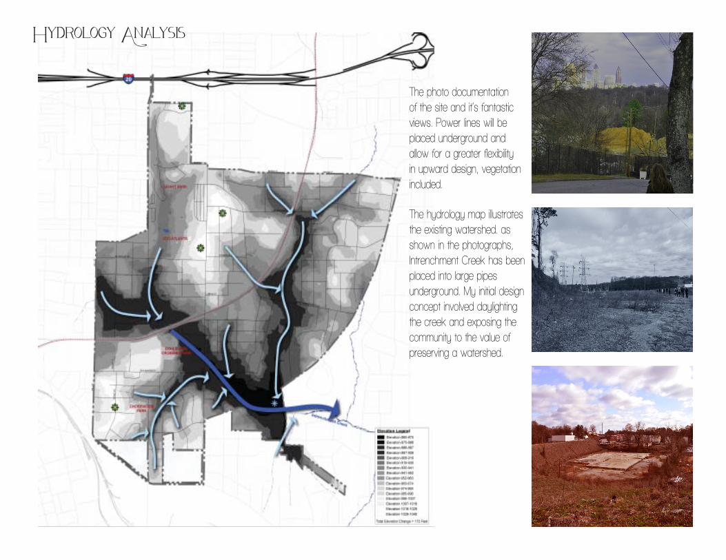
Hydrology Analysis
The photo documentation of the site and it’s fantastic views. Power lines will be placed underground and allow for a greater flexibility in upward design, vegetation included.
The hydrology map illustrates the existing watershed. as shown in the photographs, Intrenchment Creek has been placed into large pipes underground. My initial design concept involved daylighting the creek and exposing the community to the value of preserving a watershed.
United StatesDepartment ofAgriculture
A product of the NationalCooperative Soil Survey,a joint effort of the UnitedStates Department ofAgriculture and otherFederal agencies, Stateagencies including theAgricultural ExperimentStations, and localparticipants
Custom Soil ResourceReport for
Fulton County,Georgia
NaturalResourcesConservationService
January 22, 2012
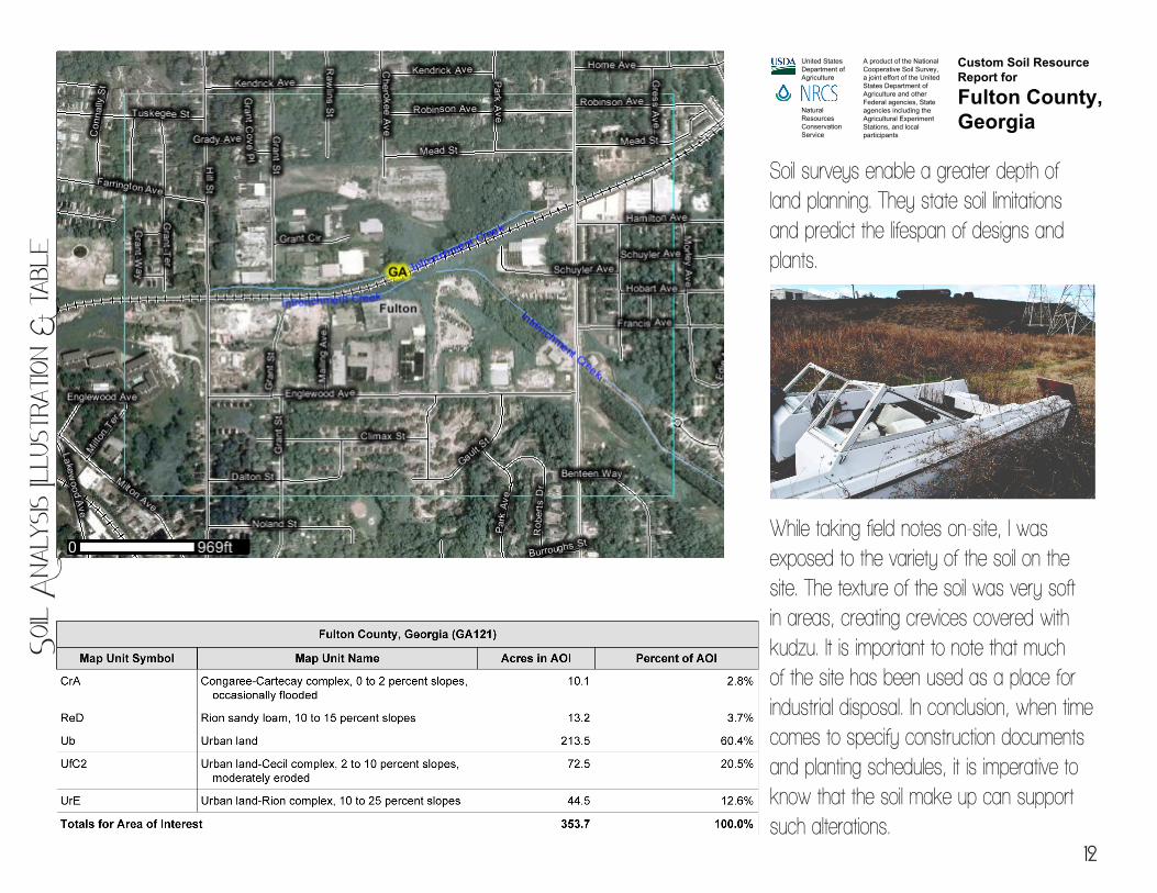
Soil surveys enable a greater depth of land planning. They state soil limitations and predict the lifespan of designs and plants.
While taking field notes on-site, I was exposed to the variety of the soil on the site. The texture of the soil was very soft in areas, creating crevices covered with kudzu. It is important to note that much of the site has been used as a place for industrial disposal. In conclusion, when time comes to specify construction documents and planting schedules, it is imperative to know that the soil make up can support such alterations.
Soil
Ana
lysis
Illu
stra
tion
& t
able
12
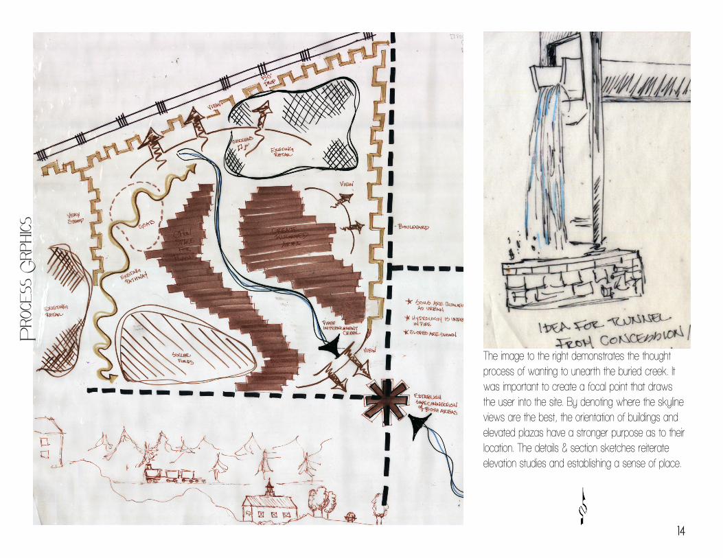
The image to the right demonstrates the thought process of wanting to unearth the buried creek. It was important to create a focal point that draws the user into the site. By denoting where the skyline views are the best, the orientation of buildings and elevated plazas have a stronger purpose as to their location. The details & section sketches reiterate elevation studies and establishing a sense of place.
Pro
cess
Grp
hics
14
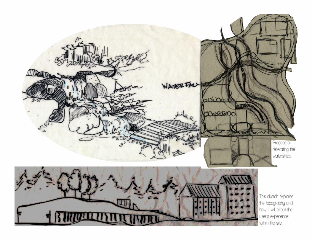
This sketch explores the topography and how it will effect the user’s experience within the site.
Process of reiterating the watershed.
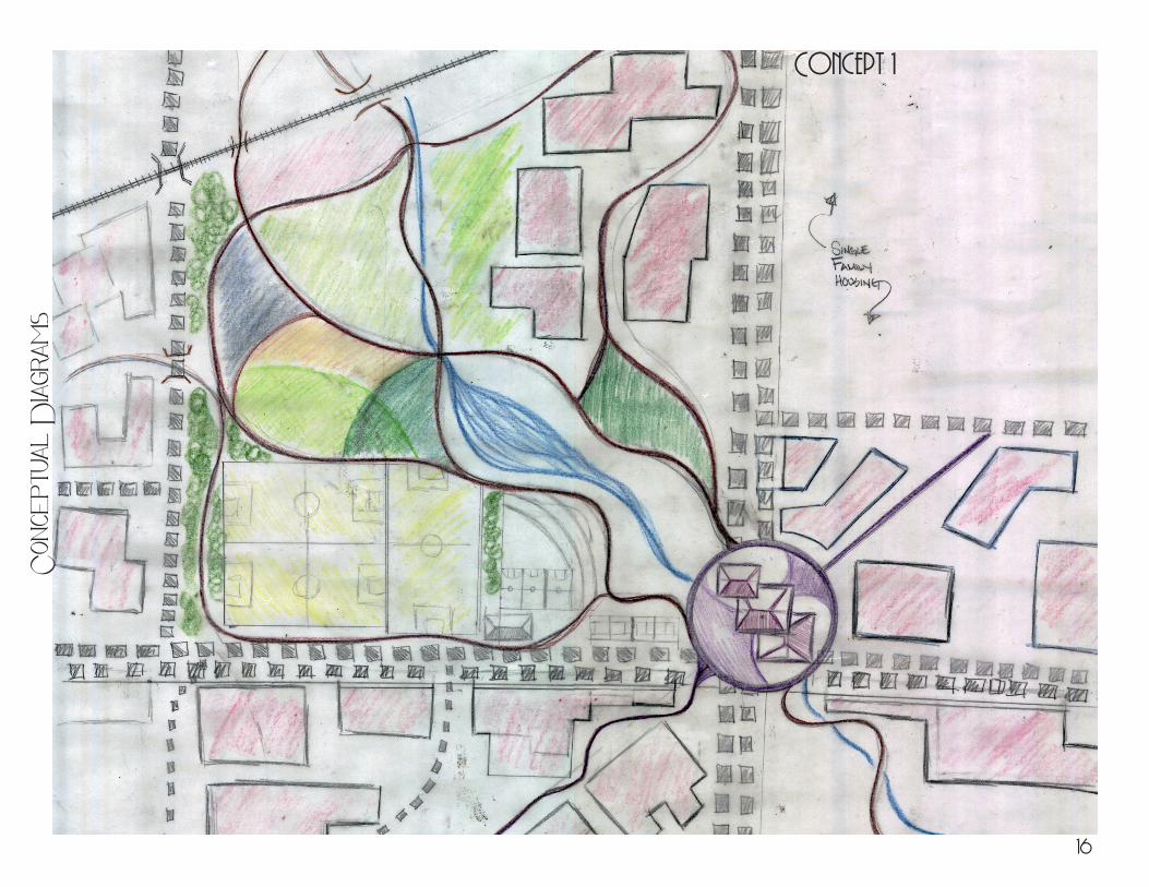
Concept 1C
once
ptua
l D
iagra
ms
16
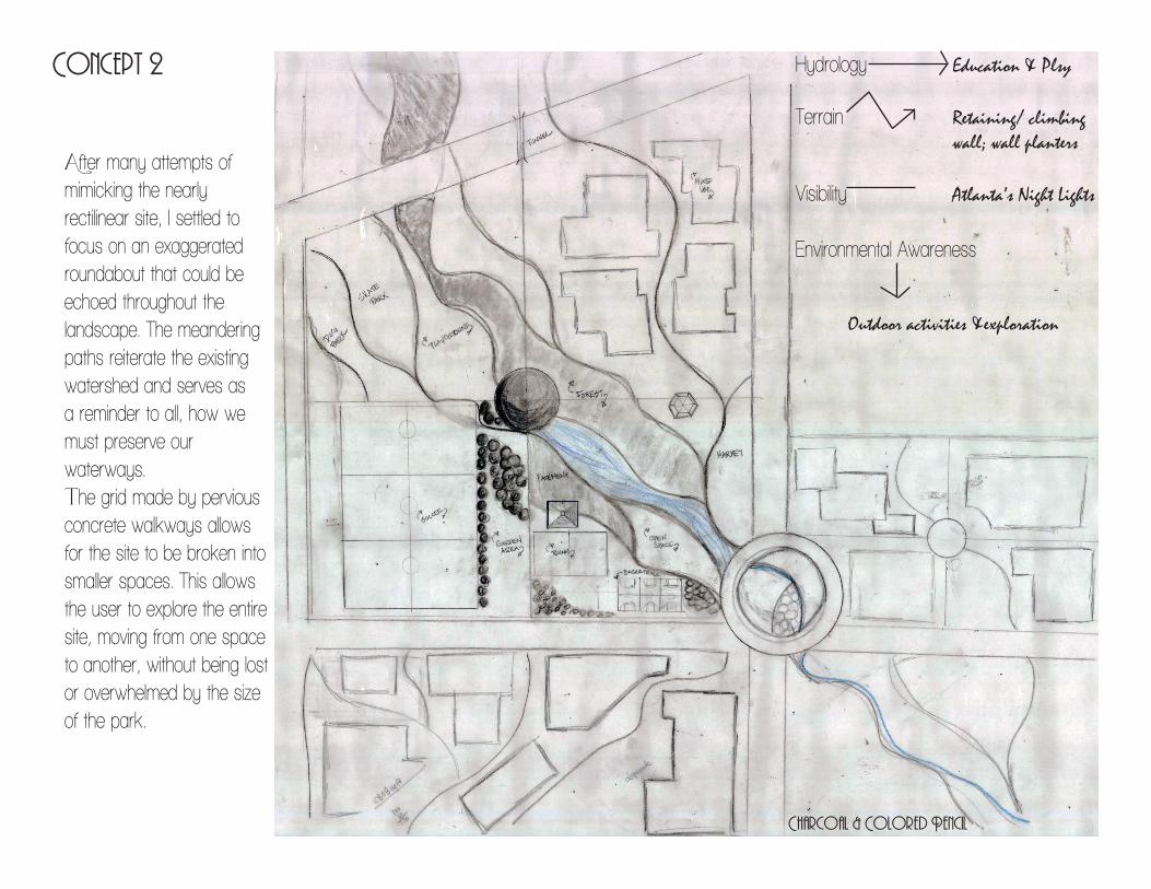
Concept 2
After many attempts of mimicking the nearly rectilinear site, I settled to focus on an exaggerated roundabout that could be echoed throughout the landscape. The meandering paths reiterate the existing watershed and serves as a reminder to all, how we must preserve our waterways. The grid made by pervious concrete walkways allows for the site to be broken into smaller spaces. This allows the user to explore the entire site, moving from one space to another, without being lost or overwhelmed by the size of the park.
Charcoal & Colored Pencil
Hydrology Education & Plsy
Terrain Retaining/ climbing wall; wall planters
Visibility Atlanta’s Night Lights
Environmental Awareness
Outdoor activities &exploration
E
A
DC
A A
A
B
B
FG
H
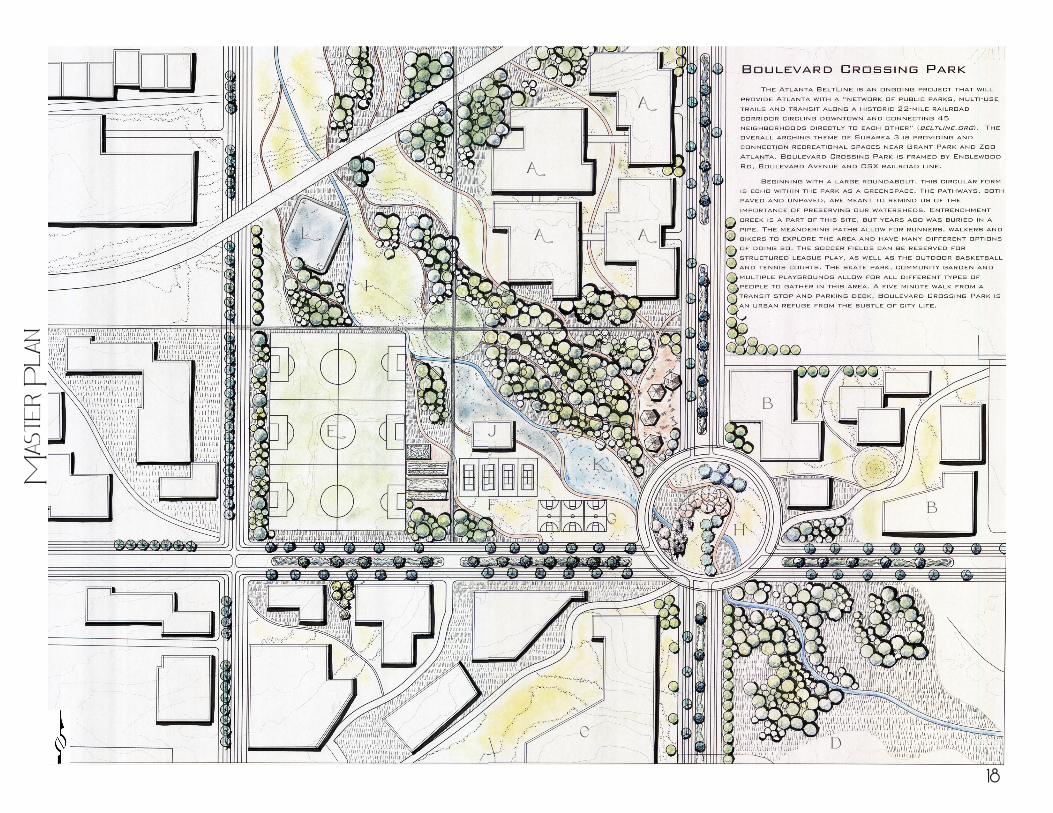
L
I
K
J
Mas
ter
Pla
n
18
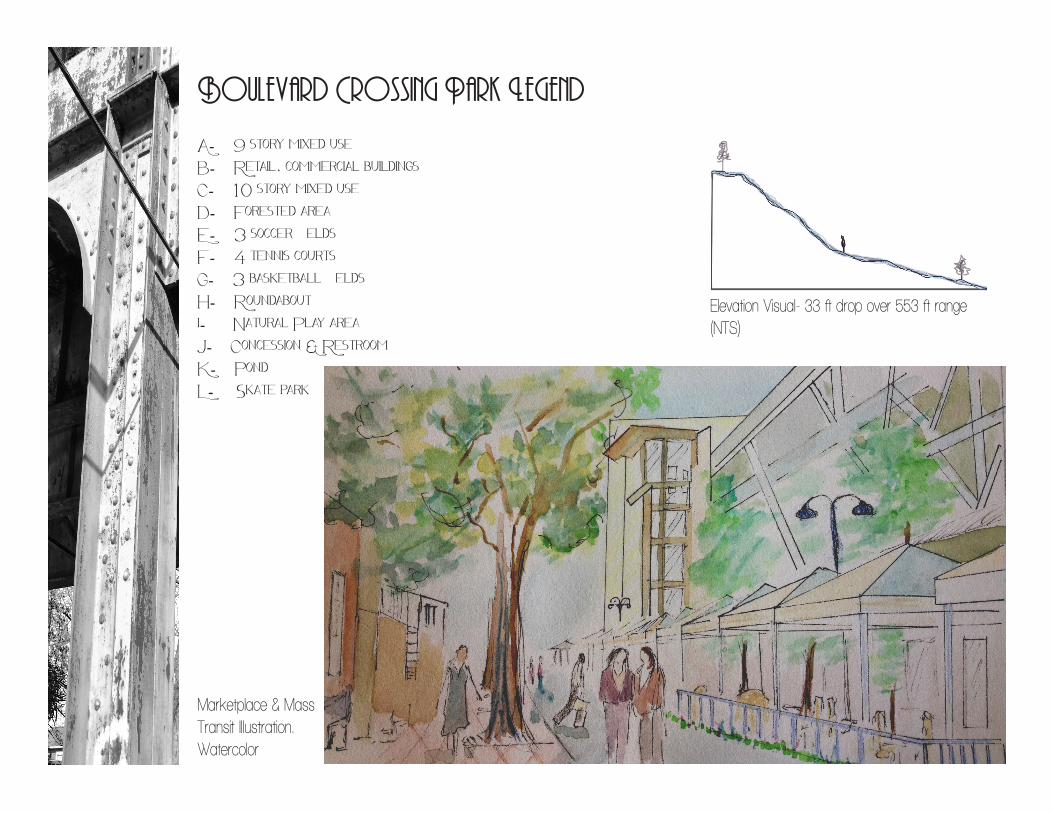
Boulevard Crossing Park Legend
A- 9 story mixed useB- Retail, commercial buildingsC- 10 story mixed useD- Forested areaE- 3 soccer fieldsF- 4 tennis courtsG- 3 basketball fieldsH- Roundabouti- Natural Play areaJ- Concession & RestroomK- PondL- Skate park
Marketplace & Mass Transit Illustration. Watercolor
Elevation Visual- 33 ft drop over 553 ft range (NTS)
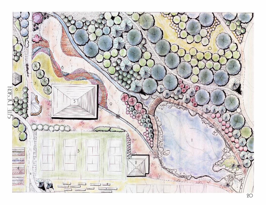
1
Site
Des
ign
10
2
3
4
6
7
9
8
5
20
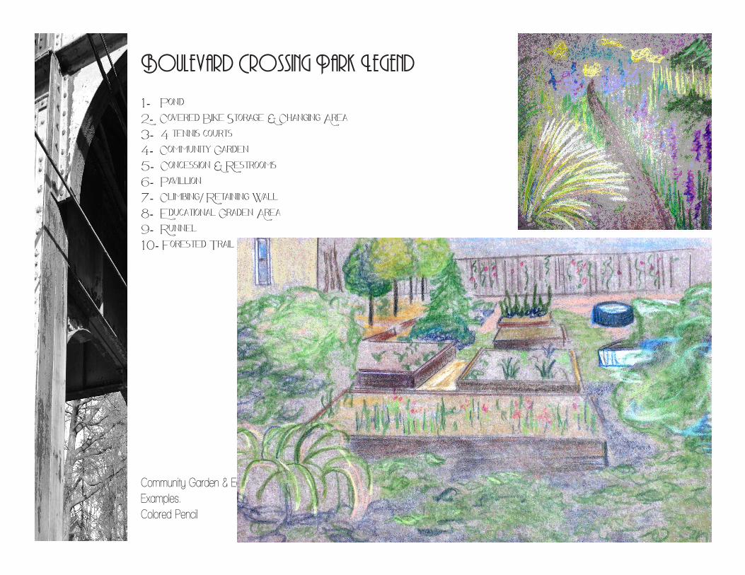
Boulevard Crossing Park Legend
1- Pond2- Covered Bike Storage & Changing Area3- 4 tennis courts4- Community Garden5- Concession & Restrooms6- Pavillion7- Climbing/ Retaining Wall8- Educational Graden Area9- Runnel10- Forested Trail
Community Garden & Educational Garden Examples.Colored Pencil
910
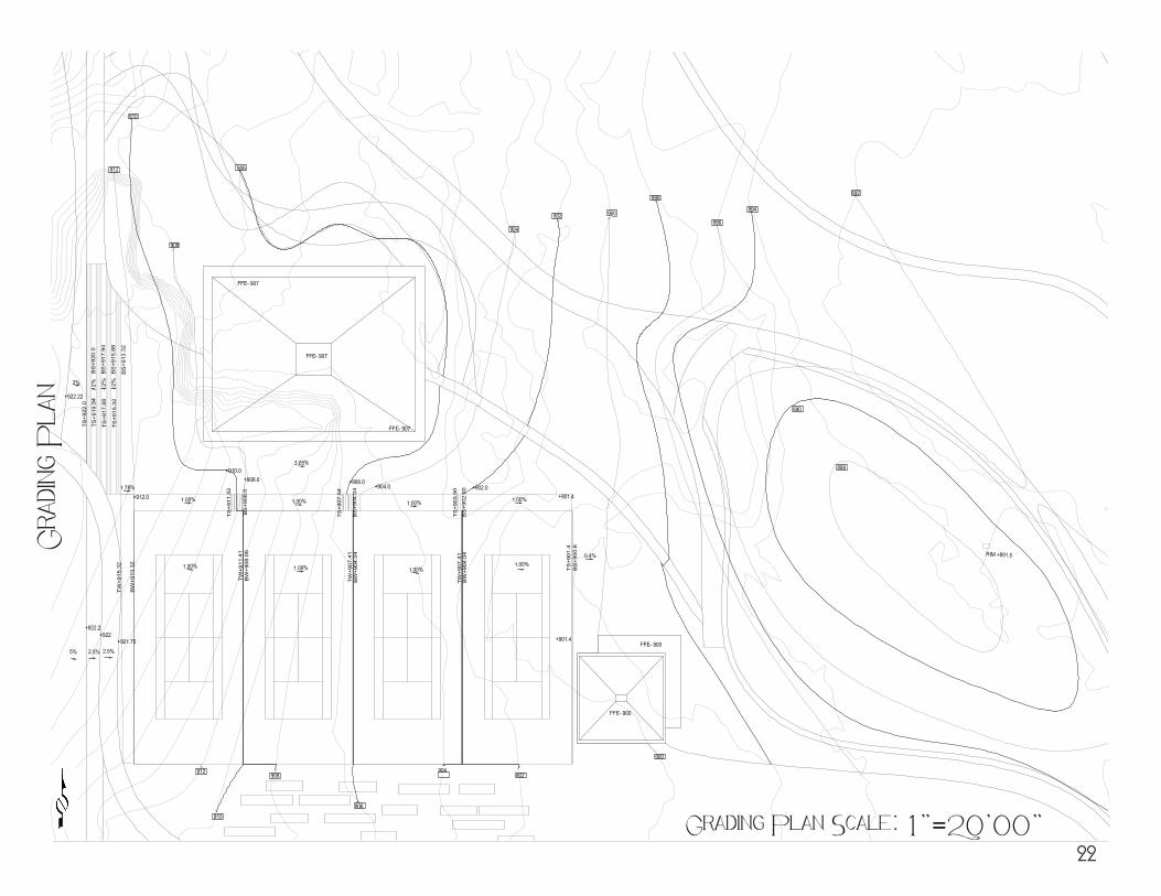
908
906
904
902 900
898
896
894
892
890
888
892
912
900
RIM +891.5
College o
f E
nvir
onment &
Desig
nU
niv
ersit
y o
f G
eorgia
LAN
D 4
900- D
avis
; S
enio
r T
hesis
Gradin
g P
lan
Revisions
Name: Date:
Issue Date:January 2012
Drawn by:Amelia Kane
Checked by:Prof. Davis
RegistrationSeal
Scale: 1"= 20'00"
North Arrow.png
Sheet contents:Grading Planproposal ofAtlanta BeltLine,Inc.Subarea 3
Sheet #
l3
A. Kane Designs
PRODUCED BY AN AUTODESK EDUCATIONAL PRODUCT
PR
OD
UC
ED
BY
AN
AU
TO
DE
SK
ED
UC
AT
ION
AL
PR
OD
UC
T
PRODUCED BY AN AUTODESK EDUCATIONAL PRODUCT
PR
OD
UC
ED
BY
AN
AU
TO
DE
SK
ED
UC
AT
ION
AL
PR
OD
UC
T
Grading Plan Scale: 1”=20’00”
Gra
ding
Pla
n
22
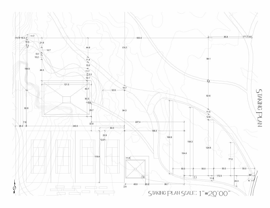
60.0240.0
119.8
172.5
146.4
50.050.050.050.0
77.0
24.3
129.9
11.8
158.3
7.1
169.9
26.3
104.4
227.432.8
83.3
121.5
94.3
52.8
29.7
5.6
10.7
175.7
179.8
82.8
100.0
7.3
10.0
11.716.59.7
2.448.8 8.2 86.7
12.8
11.5
62.6
5.4
98.1
85.8 11.2 9.8553.0
7.9
13.1
63.7
3.311.7
15.0
11.4
44.8
20.9
12.0
49.3
10.25.0
12.7
21.9
90°
11.8
7.2
College o
f E
nvir
onment &
Desig
nU
niv
ersit
y o
f G
eorgia
LAN
D 4
900- D
avis
; S
enio
r T
hesis
Stakin
g P
lan
Revisions
Name: Date:
Issue Date:January 2012
Drawn by:Amelia Kane
Checked by:Prof. Davis
RegistrationSeal
Scale: 1"= 20'00"
North Arrow.png
Sheet contents:Staking Planproposal ofAtlanta BeltLine,Inc.Subarea 3
Sheet #
l4
A. Kane Designs
PRODUCED BY AN AUTODESK EDUCATIONAL PRODUCT
PR
OD
UC
ED
BY
AN
AU
TOD
ES
K E
DU
CA
TIO
NA
L P
RO
DU
CT
PRODUCED BY AN AUTODESK EDUCATIONAL PRODUCT
PR
OD
UC
ED
BY
AN
AU
TOD
ES
K E
DU
CA
TION
AL P
RO
DU
CT
Staking Plan Scale: 1”=20’00”
Staking Plan
College o
f E
nvir
onment &
Desig
nU
niv
ersit
y o
f G
eorgia
LAN
D 4
900- D
avis
Senio
r T
hesis
Constructio
n D
etail
s
Revisions
Name: Date:
Issue Date:January 2012
Drawn by:Amelia Kane
Checked by:Brad Davis
RegistrationSeal
Scale: 1"= 1'00"
North Arrow.png
Sheet contents:ConstructionDetails
Sheet #
l5
A. Kane Designs
8" 4'
5"8"
3'-1
"
6"
1'
7"
1'
6"
6"
2'-4"
8"
9"
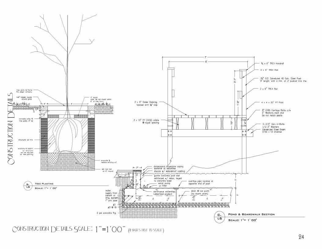
Pond & Boardwalk Section
Scale: 1"= 1' 00"
C.l6
Tree Planting
Scale: 1"= 1' 00"
b.l6
6'
7'
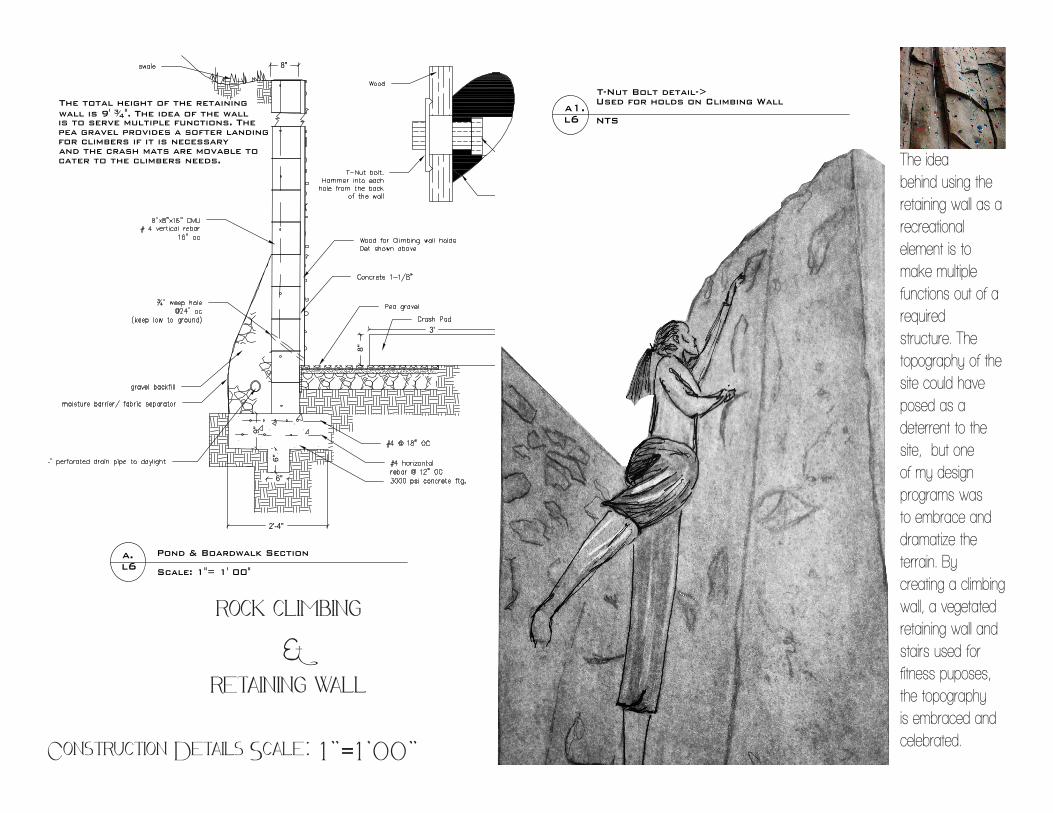
The total height of the retainingwall is 9' 34". The idea of the wallis to serve multiple functions. Thepea gravel provides a softer landingfor climbers if it is necessaryand the crash mats are movable tocater to the climbers needs.
8"
3'
4"10"
1'-8
"3'
-1"
Pond & Boardwalk Section
Scale: 1"= 1' 00"
a.l6
T-Nut Bolt detail->Used for holds on Climbing Wall
NTSa1.l6
PR
OD
UC
ED
BY
AN
AU
TOD
ES
K E
DU
CA
TIO
NA
L P
RO
DU
CT
PRODUCED BY AN AUTODESK EDUCATIONAL PRODUCT
PR
OD
UC
ED
BY
AN
AU
TOD
ES
K E
DU
CA
TION
AL P
RO
DU
CT
PRODUCED BY AN AUTODESK EDUCATIONAL PRODUCT
College o
f E
nvir
onment &
Desig
nU
niv
ersit
y o
f G
eorgia
LAN
D 4
900- D
avis
Senio
r T
hesis
Constructio
n D
etail
s
Revisions
Name: Date:
Issue Date:January 2012
Drawn by:Amelia Kane
Checked by:Brad Davis
RegistrationSeal
Scale: 1"= 1'00"
North Arrow.png
Sheet contents:ConstructionDetails
Sheet #
l5
A. Kane Designs
8" 4'
5"8"
3'-1
"
6"
1'
7"
1'
6"
6"
2'-4"
8"
9"
Pond & Boardwalk Section
Scale: 1"= 1' 00"
C.l6
Tree Planting
Scale: 1"= 1' 00"
b.l6
6'
7'
The total height of the retainingwall is 9' 34". The idea of the wallis to serve multiple functions. Thepea gravel provides a softer landingfor climbers if it is necessaryand the crash mats are movable tocater to the climbers needs.
8"
3'
4"10"
1'-8
"3'
-1"
Pond & Boardwalk Section
Scale: 1"= 1' 00"
a.l6
T-Nut Bolt detail->Used for holds on Climbing Wall
NTSa1.l6
PR
OD
UC
ED
BY
AN
AU
TOD
ES
K E
DU
CA
TIO
NA
L P
RO
DU
CT
PRODUCED BY AN AUTODESK EDUCATIONAL PRODUCT
PR
OD
UC
ED
BY
AN
AU
TOD
ES
K E
DU
CA
TION
AL P
RO
DU
CT
PRODUCED BY AN AUTODESK EDUCATIONAL PRODUCT
Construction Details Scale: 1”=1’00” (images not to scale)
Con
stru
ction
Det
ails
24
College o
f E
nvir
onment &
Desig
nU
niv
ersit
y o
f G
eorgia
LAN
D 4
900- D
avis
Senio
r T
hesis
Constructio
n D
etail
s
Revisions
Name: Date:
Issue Date:January 2012
Drawn by:Amelia Kane
Checked by:Brad Davis
RegistrationSeal
Scale: 1"= 1'00"
North Arrow.png
Sheet contents:ConstructionDetails
Sheet #
l5
A. Kane Designs
8" 4'
5"8"
3'-1
"
6"
1'
7"
1'
6"
6"
2'-4"
8"
9"
Pond & Boardwalk Section
Scale: 1"= 1' 00"
C.l6
Tree Planting
Scale: 1"= 1' 00"
b.l6
6'
7'
The total height of the retainingwall is 9' 34". The idea of the wallis to serve multiple functions. Thepea gravel provides a softer landingfor climbers if it is necessaryand the crash mats are movable tocater to the climbers needs.
8"
3'
4"10"
1'-8
"3'
-1"
Pond & Boardwalk Section
Scale: 1"= 1' 00"
a.l6
T-Nut Bolt detail->Used for holds on Climbing Wall
NTSa1.l6
PR
OD
UC
ED
BY
AN
AU
TOD
ES
K E
DU
CA
TIO
NA
L P
RO
DU
CT
PRODUCED BY AN AUTODESK EDUCATIONAL PRODUCT
PR
OD
UC
ED
BY
AN
AU
TOD
ES
K E
DU
CA
TION
AL P
RO
DU
CT
PRODUCED BY AN AUTODESK EDUCATIONAL PRODUCT
The ideabehind using the retaining wall as a recreational element is to make multiple functions out of a required structure. The topography of the site could have posed as a deterrent to the site, but one of my design programs was to embrace and dramatize the terrain. By creating a climbing wall, a vegetated retaining wall and stairs used for fitness puposes, the topography is embraced and celebrated.
Construction Details Scale: 1”=1’00”
rock climbing &
retaining wall
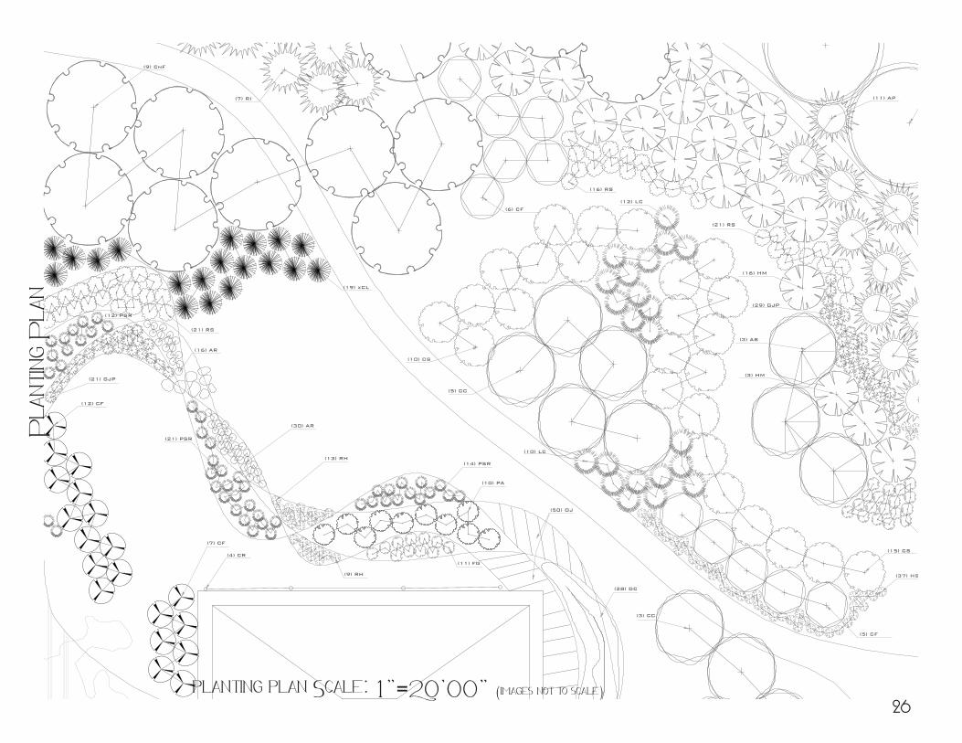
(12) CF
(7) CF
(13) RH
(9) RH
(11) FG
(10) PA
(14) PSR
(4) CR
(30) AR
(21) GJP
(12) PSR
(21) RS
(19) xCL
(9) CnF
(7) RI
(5) CC
(3) AB
(10) CS
(15) CS
(6) CF
(37) HS
(16) AR
(50) OJ
(5) CF
(18)FG
(15)RH
(21) PSR
(28) DC
College o
f E
nvir
onment &
Desig
nU
niv
ersit
y o
f G
eorgia
LAN
D 4
900- D
avis
; S
enio
r T
hesis
Plantin
g P
lan
Revisions
Name: Date:
Issue Date:January 2012
Drawn by:Amelia Kane
Checked by:Prof. Davis
RegistrationSeal
Scale: 1"= 10'00"
North Arrow.png
Sheet contents:Planting Planproposal ofAtlanta BeltLine,Inc.Subarea 3
Sheet #
l6
A. Kane Designs
PRODUCED BY AN AUTODESK EDUCATIONAL PRODUCT
PRO
DU
CED
BY
AN
AU
TOD
ESK
ED
UC
ATI
ON
AL
PRO
DU
CT
PRODUCED BY AN AUTODESK EDUCATIONAL PRODUCT
PRO
DU
CED
BY A
N A
UTO
DESK
EDU
CA
TION
AL PR
OD
UC
T
Pla
ntin
g P
lan
planting plan Scale: 1”=20’00” (images not to scale)26
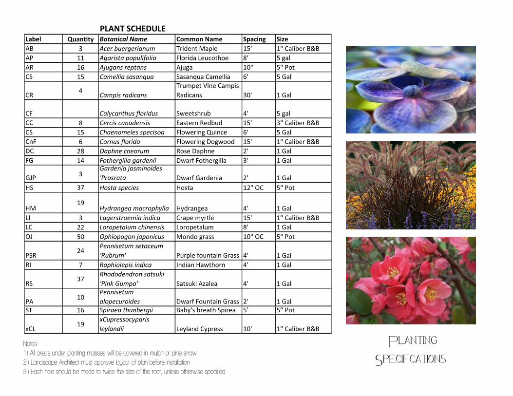
PLANT SCHEDULELabel Quantity Botanical Name Common Name Spacing SizeAB 3 Acer buergerianum Trident Maple 15' 1" Caliber B&BAP 11 Agarista populifolia Florida Leucothoe 8' 5 galAR 16 Ajugans reptans Ajuga 10" 5" PotCS 15 Camellia sasanqua Sasanqua Camellia 6' 5 Gal
CR 4 Campis radicansTrumpet Vine Campis Radicans 30' 1 Gal
CF Calycanthus floridus Sweetshrub 4' 5 galCC 8 Cercis canadensis Eastern Redbud 15' 3" Caliber B&BCS 15 Chaenomeles specisoa Flowering Quince 6' 5 GalCnF 6 Cornus florida Flowering Dogwood 15' 1" Caliber B&BDC 28 Daphne cneorum Rose Daphne 2' 1 GalFG 14 Fothergilla gardenii Dwarf Fothergilla 3' 1 Gal
GJP 3Gardenia jasminoides 'Prosrata Dwarf Gardenia 2' 1 Gal
HS 37 Hosta species Hosta 12" OC 5" Pot
HM19
Hydrangea macrophylla Hydrangea 4' 1 GalLI 3 Lagerstroemia indica Crape myrtle 15' 1" Caliber B&BLC 22 Loropetalum chinensis Loropetalum 8' 1 GalOJ 50 Ophiopogon japonicus Mondo grass 10" OC 5" Pot
PSR24
Pennisetum setaceum 'Rubrum' Purple fountain Grass 4' 1 Gal
RI 7 Raphiolepis indica Indian Hawthorn 4' 1 Gal
RS37
Rhododendron satsuki 'Pink Gumpo' Satsuki Azalea 4' 1 Gal
PA 10Pennisetum alopecuroides Dwarf Fountain Grass 2' 1 Gal
ST 16 Spiraea thunbergii Baby's breath Spirea 5' 5" Pot
xCL19
xCupressocyparis leylandii Leyland Cypress 10' 1" Caliber B&B
NOTES1.) All areas under planting masses will be covered in mulch or pine straw2.) Landcape Architect must approve layout of plan before installation3.) Each hole should be made to twice the size of the root, unless otherwise specified
Notes1.) All areas under planting masses will be covered in mulch or pine straw2.) Landscape Architect must approve layout of plan before installation3.) Each hole should be made to twice the size of the root, unless otherwise specified.
Planting Specifcations
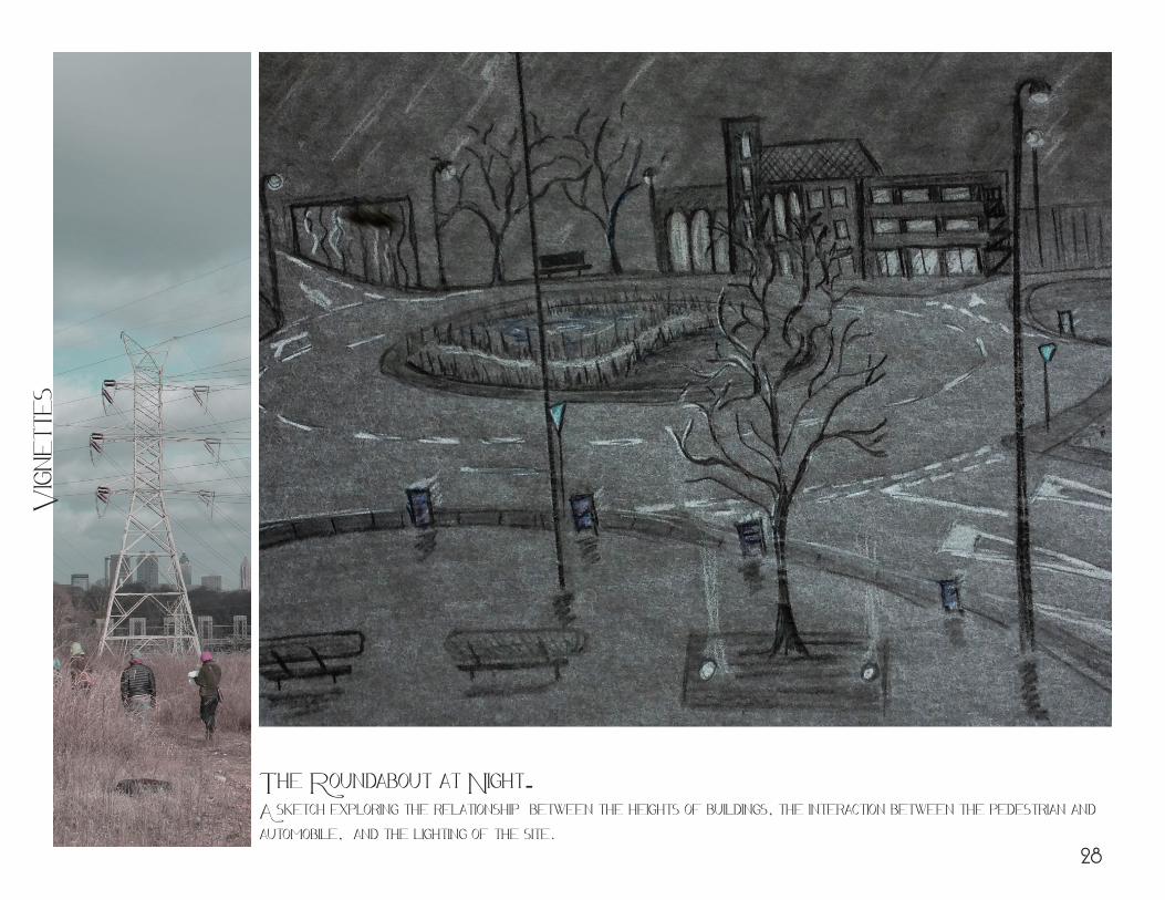
The Roundabout at Night- A sketch exploring the relationship between the heights of buildings, the interaction between the pedestrian and automobile, and the lighting of the site.
Vign
ette
s
28
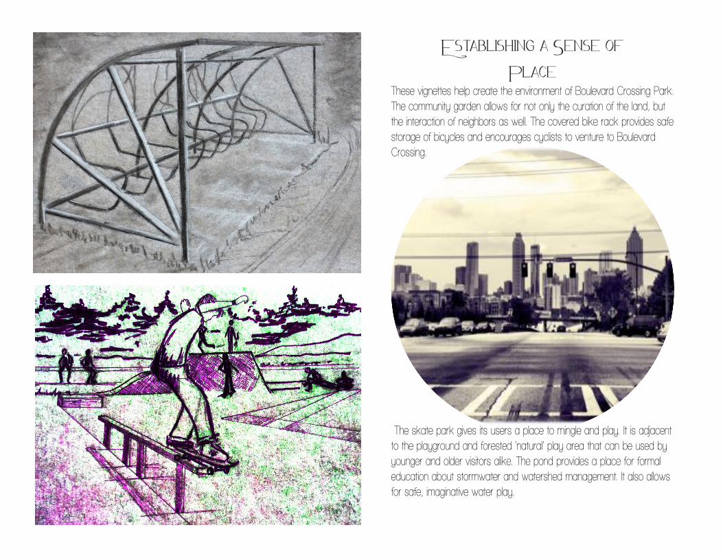
Establishing a Sense of Place
These vignettes help create the environment of Boulevard Crossing Park. The community garden allows for not only the curation of the land, but the interaction of neighbors as well. The covered bike rack provides safe storage of bicycles and encourages cyclists to venture to Boulevard Crossing.
The skate park gives its users a place to mingle and play. It is adjacent to the playground and forested ‘natural’ play area that can be used by younger and older visitors alike. The pond provides a place for formal education about stormwater and watershed management. It also allows for safe, imaginative water play.
Illus
trat
ion o
f m
ixed
Use
Bui
ldin
g
30
Amelia Vaughn Kanesenior CApstone
Work completed withAutoCAD, Adobe CS5 programs. ArcGIS, Excel
Hand graphics- watercolors, ink, charcoal and colored pencels.

Atlanta Beltline, INC.http://www.beltline.org/
usda soil surveys
Site photographs from Land 4900-Davis
Images & Inspiration
http://www.flickr.com/photos/kbrookes/3108151485/http://www.google.com/imgres?num=10&um=1&hl=en&bi
http://www.google.com/imgres?start=260&num=10&um=1&hl=en&biw=1020&bih=971&tbm=isch&tbnid=TA_-JlEvGVT7UM:&imgrefurl=http://asiseeit2010.blogspot.com/2010/11/atlanta-
skyline.html&docihttp://www.dafont.com/
Ref
eren
ces
32