senior geography - water and the environment - city of …€¦ · · 2012-12-12senior geography...
TRANSCRIPT
Senior Geography
Water and the environment
Working for our future – todayWorking for our future – today

Make your water mark!
Contents Water and the environment
Senior Geography
Introduction
General objectives
Unit plans
Worksheets
■ Global and local catchment areas
■ Investigating a local river and catchment area
■ Investigating the effects of human activities in a river catchment area
References
Appendices
■ Hinze Dam map
■ Fact sheet - What is a catchment?
■ Fact sheet - The water cycle
■ Fact sheet- Catchments and water quality
Make your water mark!
Water and the environment
Senior Geography
Introduction
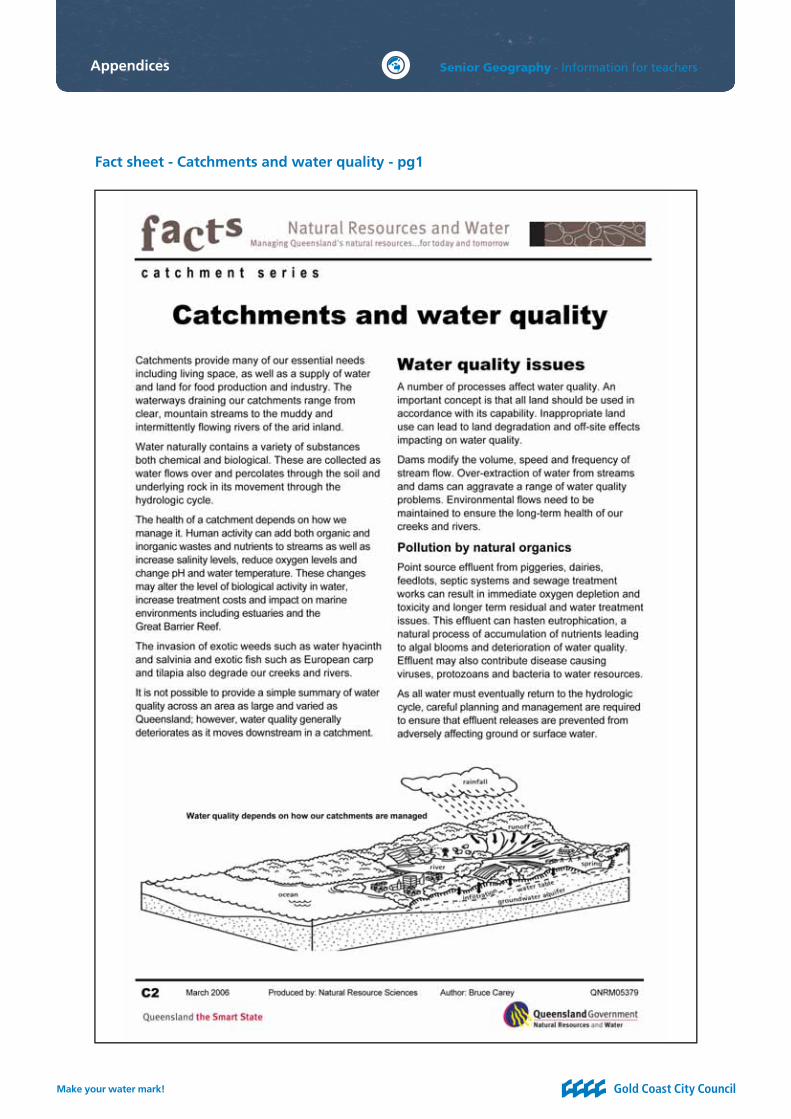
The river catchment, or drainage basin, is all the land from the mountain to the seashore, drained by a single river and its tributaries (www.bcb.uwc.ac.za/envfacts/facts/catchments.htm). On the Gold Coast, the Hinze Dam has a 207-square-kilometre catchment area. It includes the Numinbah Valley and Springbrook Plateau, with about 77 per cent covered by native bushland.
The quality of the water is very important to ensure the overall health of the surrounding catchment area is maintained. Water quality in rivers varies depending on the seasons, climate and type of rocks/soils (http://pubs.usgs.gov/fs/fs-027-01/). To maintain a healthy catchment, the rivers, creeks and groundwater systems must receive a certain quantity of water (watercare.net/wll/wc-entry.html), because water in the catchment dissolves minerals from the rock and soils. So, during a period of drought, water is evaporated from the river, and the dissolved minerals become more concentrated in the remaining water (http://pubs.usgs.gov/fs/fs-027-01/).
The quality of water is also affected by human activities including irrigation for agriculture, horticulture, chemicals, fertilisers, dam construction and recreational activities. On the Gold Coast the water quality is maintained by managing the catchment’s land, water and biological resources.
In this unit students have the chance to study river catchments at the local, national, regional and global scale. They can also make predictions, recommendations and judgments on the effect of different human activities on a river catchment area.
■ Work sheet: Global and local catchment areas
■ Work sheet: Investigating a local river and catchment area
Work sheet: Investigating the effect of human activities on a river catchment area.
Link with the key concepts within The State of Queensland - Senior Geography Syllabus that contain K (Knowledge), AP (Analytical processes), DP (Decision-making processes) and RC (Research and communication) sections, therefore they can be developed into an assessment item if desired.
The two work sheets
Students and school groups can volunteer to be part of Waterwatch Queensland. More information is available on their website www.qld.waterwatch.org.au/
Students can volunteer for GECKO, the regional environmental group. GECKO is ‘working to promote, protect, conserve and restore the natural environment and improve the sustainability of the built environment of the entire Gold Coast region, including its magnifi cent hinterland areas’ (www.gecko.org.au/index.php?index). GECKO is involved with the preservation of river catchment areas on the Gold Coast, in particular the Currumbin Creek catchment area.
Enhancing the learning experience

Make your water mark!
Water and the environment
Senior Geography
General objectives
Knowledge
1 geographical facts, concepts and key ideas, and explanations of the relationships between people and their environments
2 processes that affect the location, distributions and arrangement of geographical elements on earth
3 processes geographers use to investigate environmental and spatial aspects of human decision making
4 the impact of people on the environment
5 the impact of the environment on the quality of life
6 equity issues as they apply to Geography .
Affective objectives
1 an attitude of concern for the quality of environments, the condition of human life and the biosphere as a life support system
2 a willingness to relate to the environment and to participate in actions that ensure a sustainable future
3 a willingness to challenge existing attitudes and values in environmental, social, cultural and economic issues
4 the ability to clarify and develop personal values in relation to environmental, social, cultural questions, issues and problems
5 an interest in learning as a life-long process.
Analytical processes
1 understand the meaning of information by transforming, interpreting and extrapolating text or illustrative material
2 identify relationships
3 suggest causes for some of these relationships.
Decision-making processes
1 recognise the environmental, social, economic and political implications of an issue
2 examine alternate proposals, strategies, solutions and plans
3 make a judgment/decision about the alternatives
4 justify this decision.
Research and communication
1 gathering and recording information and primary data from sources and settings
2 designing research plans relevant to the purpose
3 selecting and organising information
4 referencing and acknowledging sources of information using current conventions
5 establishing the currency, validity and reliability of information
6 communicating and presenting information in a variety of ways
7 devising an appropriate format when presenting research fi ndings
8 demonstrating use of clear written expression and language conventions
9 using maps, diagrams and statistics appropriately.
Senior Geography syllabus links
Ao
II
K
Rc
Ap Dp
Make your water mark!
Senior Geography - Information for teachers
Theme one
1 The natural environment results from the operation and interaction of physical systems, ie. biosphere, lithosphere, hydrosphere, atmosphere.
2 Changes to the dynamics of physical systems because of factors such as population change over time, land use practices, attitudes and values can exacerbate or reduce impacts on the natural environment.
3 Managing the natural environment sustainably depends on an understanding of the elements of the natural environment.
4 Some management decisions or lack of them have increased the vulnerability of people to adverse impacts such as contamination of water supplies, landslides, inundation, loss of lives and livelihood.
Focus unit two: Managing catchments
1 River catchments are geographic units that vary in size and and complexity of characteristics.
2 Elements of catchments can be mapped and quantifi ed. Elements include topography, drainage patterns, geology, vegetation cover, rainfall, soil types, land use and settlement patterns.
3 Land and water resources are basic and interactive components of natural ecosystems within catchments.
4 River catchments are changing continuously in response to natural processes and human activity.
5 Changes within a catchment affect the natural systems and the social and economic systems of people living within the catchment.
6 People make short-term responses to changes in a catchment (e.g. tree planting, damming, fencing, catchment monitoring and fl ood mitigation).
7 Long-term responses require planning and coordinated action through the informed action of individual users and managers of resources (such as governments through legislation) in order to achieve sustainability and a balance between economic development and conservation of land and water resources.
8 Individuals can contribute to the resolution of catchment management problems through participation in groups.
Ideas for elective units for theme one
● Conserving water through water wise practices in your home/school.
● Investigating an issue and future scenario in managing the natural environment (such as building a desalination plant in your district).
● The effect of human induced disasters on the natural environment (such as industry leakage into catchment).
Key concepts and ideas
General objectives

Make your water mark!
Water and the environment
Senior Geography
Unit plans
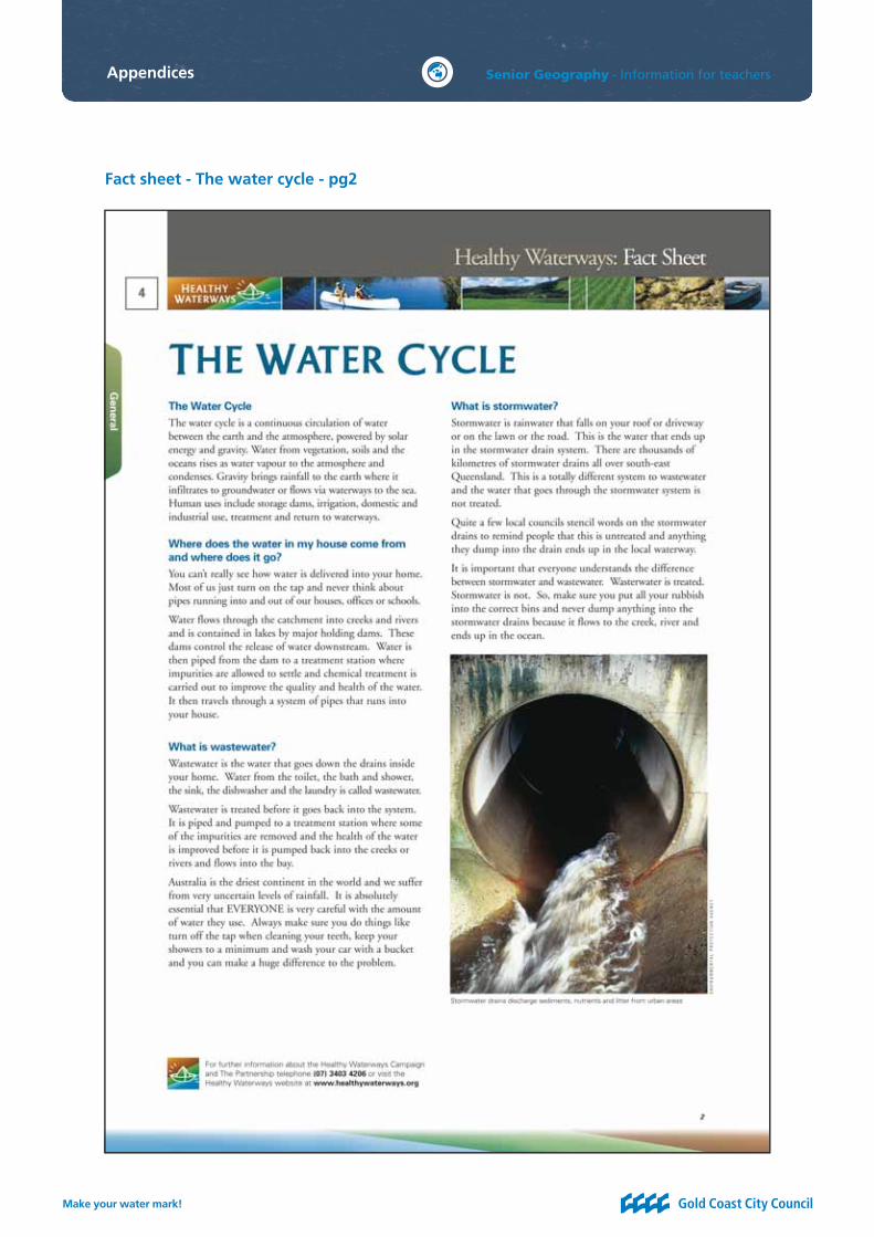
The water cycle
Learning experiences and geographical skills
Individual study of the water cycle and relationship to terms; evaporation, condensation, precipitation, evapotranspiration, capillary action and run-off.
Catchments
Learning experiences and geographical skills
● Teacher exposition and identifi cation of the elements within a river catchment area.
● Individual study on local and global catchment areas, to compare and contrast the location, statistical data and elements of three different river catchment areas.
The following resources and fact sheets are useful:
● Earth guide diagrams: Animated water cycle and quiz www.earthguide.ucsd.edu/earthguide/diagrams/watercycle/watercycleq.html
● Enchanted learning: Water cycle www.enchantedlearning.com/subjects/astronomy/planets/earth/Watercycle.shtmlwww.enchantedlearning.com/geology/label/watercycle/
● Healthy Waterways fact sheet: The water cyclewww.healthywaterways.org/healthywaterways/resources/factsheets.aspx
● United States geological survey: Water science for schools http://ga.water.usgs.gov/edu/watercycle.htmlhttp://ga.water.usgs.gov/edu/waterproperties.html
The following resources and fact sheets are useful:
● Work sheet: Global and local catchment areas
● about.com: Geography: Free blank outline maps for all countries www.geography.about.com/library/blank/blxindex.htm
● Australian Government Bureau of Meteorology:Rain, river and water storage data www.bom.gov.au/hydro/wr/agency_data.shtml
● Healthy Waterways: Fact sheet - What is a catchment? www.healthywaterways.org/healthywaterways/resources/factsheets.aspx
1
1
2 2 33
Key ideas
Key ideas
Make your water mark!
Senior Geography - Information for teachers
Investigating water quality
Managing catchments
Learning experiences and geographical skills
● Group study on the water quality in a local river and catchment area. Students gather qualitative and quantitative data on the abiotic and biotic factors of the river and catchment area.
Learning experiences and geographical skills
● Individual response to predict the short and long term, environmental, social and economic implications of one of the proposed scenarios.
The following resources and fact sheets are useful:
● Work sheet: Investigating a local river and catchment area
● Australian Government Waterwatch Australia: Information on water quality www.waterwatch.org.au/monitoring.html
The following resources and fact sheets are useful:
● Work sheet: Investigating the effects of human activities on a river catchment area
● International Rivers: People, water and life www.internationalrivers.org/en/node/234
Key ideas
Key ideas
22 3 43
4 5 6 7
Unit plans

Make your water mark!
Water and the environment
Senior Geography
Useful resources
Web address Learning experiences available
Gold Coast City Council
goldcoastcity.com.au
These websites contain information about:
● Catchment areas.
Griffi th University science on the GO!
scienceonthego@griffi th.edu.au
● Apparatus can be borrowed from Griffi th University Gold Coast campus.
Healthy Waterways
www.healthywaterways.org search for 'report card'
This website contains information about:
● Catchments.
Queensland Government
www.derm.qld.gov.au
This website contains excellent information about specifi c catchment areas in Queensland. It contains historic and recent data, in table and graph format, about:
● Water level, fl ow and conductivity.
● Water quality: turbidity, metal ions, hardness, pH, dissolved oxygen, sulphates, nitrates and temperature.
Queensland Government
www.derm.qld.gov.au
This website contains excellent information about Queensland:
● Aerial photographs.
● Surveying maps.
● Digital topographic data.
● Satellite imagery.

Make your water mark!
Senior Geography - Information for teachers
Web address Learning experiences available
United States geological survey:
Water science for schools http://ga.water.usgs.gov/edu/mearthall.html
This website contains interesting resources including:
● Water cycle diagram.
● Rivers and streams.
● Measuring stream fl ow.
● Groundwater quality.
Please note: It is an American website so information would have to be changed to fi t the Australian situation.
Waterwatch Australia
www.waterwatch.org.au/www.waterwatch.org.au/publications/module3/index.html
This website includes information on monitoring water quality and record sheets for fi eld work.
Useful resources continued
Make your water mark!
Water and the environment
Senior GeographyWorksheet:
Global and local catchment areas
Introduction
River catchments across the world vary in size and complexity. The Nile River, in Africa, has a length of 6695 kilometres (www.geography.about.com/od/specifi cplacesofi nterest/a/nile.htm) and has two main tributaries - the Blue Nile and the White Nile (www.newint.org/issue273/facts.html). The Amazon River, in South America, is slightly smaller in length to the River Nile, at a length of 6280 kilometres (www.earthobservatory.nasa.gov/Study/RiverSeasons/), but the Amazon River is the largest river in the world in terms of drainage area and volume of water (www.newint.org/issue273/facts.html). The Amazon River drains about 40 per cent of the South American continent (www.earthobservatory.nasa.gov/Study/RiverSeasons/).
In Australia, the Murray River fl ows just over 2500 kilometres from the Snowy Mountains in New South Wales. The Murray Darling Basin is about one seventh of the size of Australia (http://murrayriver.com.au/about-the-murray/murray-darling-basin). In contrast the Nerang River catchment, in southeast Queensland, has a smaller catchment area than the three rivers listed above. The Nerang River catchment covers an area of 400 square kilometres (www.bom.gov.au/hydro/fl ood/qld/brochures/south_coast/nerang.shtml), and fl ows through the Hinze Dam before entering the Southport Broadwater. The catchment area of the Nerang River includes native bushland and pastureland for dairy and beef cattle (goldcoast.qld.gov.au/t_standard2.aspx?pid=8886).
Every river and catchment area has varying topography, drainage patterns and geology. Soil types and weather infl uence the ecosystem of the river catchment, amount of vegetation cover and land use opportunities. The land and water resources within each catchment have a complex and interactive relationship.
Task
Compare and contrast the elements (such as location, topography, geology, tributaries, vegetation) of your local catchment area with two global river catchment areas.
● Study the elements of each catchment area by gathering a variety of data and information from a wide selection of resources.
● Develop skills to collect, organise, identify, interpret and analyse data from the chosen river catchment areas.
● Discuss the similarities and differences between your chosen river catchment areas.
● Discuss processes that may affect the location, distribution and arrangement of catchment areas globally and locally.
● Produce maps for each river catchment area to illustrate the location, tributaries, soil type, vegetation cover and land use.
● Produce a written report that incorporates your fi ndings, maps, tables and illustrations.
General objectives
K Ap Rc

Make your water mark!
Water and the environment
Senior Geography
Worksheet:Investigating a local riverand catchment area
Introduction
There are many natural and human activities that can change a river catchment area and the quality of water within that area. This includes global warming, change of land use, population increase and industrial waste (www.water-pollution.org.uk/causes.html). The World Commission on Water revealed that 50 per cent of the world’s biggest rivers are seriously depleted or polluted (www.worldwatercouncil.org/index.php?id=21)
In Australia, the River Murray catchment area has highly saline groundwater, but the salinity has been increased due to human activities such as irrigation and vegetation clearance (www.dwlbc.sa.gov.au/murray/salinity/index.html). The increased salinity has long-term effects on drinking supplies, damage to fl oodplains and wetlands (www.dwlbc.sa.gov.au/murray/salinity/index.html).
The Department of Natural Resources and Mines (DNRM) is responsible for the quality of waterways in Queensland. The Department of Natural Resources and Mines uses a range of indicators and sampling methods to assess the quality of the water. These include pH and dissolved oxygen. But there are many more tests that can be used to assess the quality of water within a catchment area.
Task
You have to produce a report, incorporating data tables, maps and photographs, on the different abiotic and biotic factors of a local river and catchment area.
You should:
● Identify a local river catchment area and make decisions on where to gather data and how often to gather data.
● Draw a map of the local river catchment area.
● Collect quantitative and qualitative data from your chosen river catchment area (such as pH of soil, air temperature, type of vegetation).
● Identify different tests (physical, chemical and biological) that you can use to help determine the quality of the water in your chosen river.
● Incorporate and refl ect on primary data collected.
● Display all data in appropriate diagrams, fl ow charts and tables.
● Interpret and analyse the data to make judgements regarding the quality of the local river and catchment area.
● Include maps, photographs and sketches.
● Include researched information collected from various resources. Have all information accurately referenced and all resources used displayed in a bibliography.
General objectives
K Ap Rc
Make your water mark!
Water and the environment
Senior Geography
Checklist
Phase and date Component of task Teacher’s comments and initials
Phase 1
Date:
Identifying different tests and collecting primary data about the river and catchment area.
Phase 2
Date:
Collecting data
● Research information about task from articles with a local and global perspective.
● Evidence of bibliography being developed.
Phase 3
Date:
Development of report
● Analysing and evaluating information.
● Development of ideas and design for report.
Phase 4
Date:
Submission of fi nal report
● Bibliography included.

Make your water mark!
Water and the environment
Senior Geography
Worksheet:Investigating the effects of human activities in a river catchment area
Introduction
There are many human activities that can change a river catchment area and the quality of water within that area. This includes irrigation water for farming, industrial development, recreational activities, over use of groundwater supplies, stream channel alteration and the building of dams (http://pubs.usgs.gov/fs/fs-027-01/).
The World Commission on Water has revealed that 50 per cent of the world’s biggest rivers are seriously depleted or polluted (www.worldwatercouncil.org/index.php?id=21). It shows that the destruction of natural rainforest and increased industrial logging has increased erosion on the banks of the Amazon River in South America (www.newint.org/issue273/facts.html). The Three Gorges Dam, on the Yangtze River, was built to control fl ooding, but it has been estimated that 300,000 farmers will lose their land (www.newint.org/issue273/facts.html). Worldwide, an estimated 40–80 million people have been forcibly evicted from their lands to make way for large dams (internationalrivers.org/en/node/234).
During the past 50 years there has been a global increase in the use of groundwater for agriculture, industrial and household use (www.water.usgs.gov/nrp/proj.bib/Publications/konikow.kendy.2005intro.html). Excessive groundwater depletion affects major areas of Australia, where groundwater is withdrawn at rates far beyond the replacement of water from the source aquifer (www.irrigationfutures.org.au/contacts.asp?cntID=6310). This has caused water quality to deteriorate, irreversible damage to ecosystems and land subsidence (www.water.usgs.gov/nrp/proj.bib/Publications/konikow.kendy.2005intro.html).
Scenario
1. In a city of 80,000 people, 75 per cent have spear pumps (a pump that extracts groundwater) to supplement their water supply.
2. A site for a gypsum open pit quarry has been proposed to be built two kilometres from a tributary to a river system.
3. A city is increasing in population and the council proposes to build houses on 10 square kilometres of river fl oodplain.
4. A council has produced a proposal to build a dam to form a reservoir that has a maximum storage capacity of 10,100 Gigalitres (1 Gigalitre equals 1000 Megalitres) on land currently used for agriculture and housing.
Task
You have to produce an essay that predicts the short and long term, environmental, social and economic implications in response to one of the scenarios above.
Your essay should:
● discuss the impact that people have on the environment
● recognise the environmental, social and economic implications of the issue
● suggest strategies and solutions for the short term and long term implications of the issue
● justify your alternate decision to ensure sustainability in the river catchment area
● incorporate accurately referenced information from various sources.
General objectives
K Dp Rc

Make your water mark!
Water and the environment
Senior Geography
References
1. About.com: Geography (2007), Aswan Dam controls the Nile River. Retrieved March 2008 from www.geography.about.com/od/specifi cplacesofi nterest/a/nile.htm
2. Australian Government Bureau of Meteorology (2008), Flood warning system and the Nerang River. Retrieved March 2008 from www.bom.gov.au/hydro/fl ood/qld/brochures/south_coast/nerang.shtml
3. Cooperation Research Centre for Irrigation Futures (2002), Sustainable institutional regimes for sustainable groundwater management in India and Australia: Implications for water policies. Retrieved March 2008 from www.irrigationfutures.org.au/contacts.asp?cntID=6310
4. Gold Coast City Council (no date), Gold Coast Waterwatch. Catchments and water quality results. Retrieved March 2008 from www.goldcoastwaterwatch.org/catchment.htm
5. Gold Coast City Council (2005), Our Living City Report. Chapter 2: A description of the Gold Coast area. Retrieved January 2008 from www.goldcoastwater.qld.gov.au/attachment/publications/our_living_city0405_chp2.pdf
6. Gold Coast City Council (2007), Dams and catchments. Retrieved March 2008 from www.goldcoastwater.com.au/t_gcw.asp?PID=137
7. Gold Coast City Council (2008), Hinze Dam. Retrieved March 2008 from www.goldcoastwater.com.au/t_gcw.asp?PID=139
8. Gold Coast City Council (2008), Hinze map. Retrieved March 2008 from www.goldcoastwater.com.au/attachment/hinze_map.pdf
9. Gold Coast and Hinterland Environment Council (2008), Welcome to Gecko. Retrieved March 2008 from www.gecko.org.au/index.php?index
10. Gold Coast Water (2007), Delivering a sustainable waterfuture, The Gold Coast Waterfuture Strategy 2006-2056. Retrieved January 2008 from www.goldcoastwater.qld.gov.au/attachment/goldcoastwater/GCWF_strategy_overview_Sep07.pdf
11. Healthy Waterways (2002), Education resources. Retrieved March 2008 from www.healthywaterways.org/PAGE191216PMWL1BPA.html
12. Independent on Sunday (2006), Death of the world’s rivers. Retrieved March 2008 from www.independent.co.uk/environment/death-of-the-worlds-rivers-469597.html
13. International rivers: People, water and life (2008), About rivers and dams. Retrieved March 2008 from www.internationalrivers.org/en/node/234
14. Murray River website (2007), Murray River facts and fi gures. Retrieved March 2008 from www.murrayriver.com.au/information/facts.htm
15. NASA Earth Science Enterprise Data and Services (no date), Earth observatory: River seasons. Retrieved March 2008 from www.earthobservatory.nasa.gov/Study/RiverSeasons/

Make your water mark!
Senior Geography - Information for teachers
16. Queensland Government Environmental Protection Agency (2006), Caring for our water. Retrieved March 2008 from www.epa.qld.gov.au/environmental_management/water/caring_for_our_water/
17. Queensland Government Environmental Protection Agency (2006), Threatened Plants and Animals. Retrieved January 2008 from www.epa.qld.gov.au/nature_conservation/wildlife/threatened_plants_and_animals
18. Queensland Government, Department of Natural Resources and Water (2008), Water management: Catchment map. Retrieved March 2008 from www.nrw.qld.gov.au/water/monitoring/current_data/map_qld.php
19. Queensland Government, Department of Natural Resources and Water (2008), Fact sheets. Retrieved March 2008 from www.nrw.qld.gov.au/factsheets/index.php
20. Queensland Studies Authority (2007), Geography senior syllabus. Retrieved March 2008 from www.qsa.qld.edu.au/downloads/syllabus/snr_geography_07_syll.pdf21. Queensland Water Commission (2007), Water supply projects. Retrieved January 2008 from www.qwc.qld.gov.au/Projects
21. seqwater (2011). Leslie Harrison Dam map. Retrieved September 2011 from http://www.seqwater.com.au/pubiic/catch-store-treat/dams/leslie-harrison-dam
22. United States geological survey (2001), A primer on water quality. Retrieved March 2008 from http://pubs.usgs.gov/fs-fs-027-01/
23. United States geological survey (2005), National research program: Konikow and Kendy, Groundwater depletion: A global problem: Hydrogeology Journal, v. 13, p. 317-320. Retrieved March 2008 from www.water.usgs.gov/nrp/proj.bib/Publications/konikow.kendy.2005intro.html
24. University of the Western Cape - The Department of Biodiversity and Conservation Biology (2001). Envirofacts: River catchments. Retrieved March 2008 from www.bcb.uwc.ac.za/Envfacts/facts/catchments.htm
25. Waterwatch Queensland ( 2008), Waterwatch: Communities caring for catchments. Retrieved March 2008 from www.qld.waterwatch.org.au/
References

Make your water mark!
Water and the environment
Senior Geography
Appendices
Hinze Dam map

Make your water mark!
Senior Geography - Information for teachers
Fact sheet - What is a catchment? - pg1
Appendices

Make your water mark!
Senior Geography - Information for teachers
Fact sheet - The water cycle - pg1
Appendices
Make your water mark!
Senior Geography - Information for teachers
Fact sheet - The water cycle - pg2
Appendices
Make your water mark!
Senior Geography - Information for teachers
Fact sheet - Catchments and water quality - pg1
Appendices
Make your water mark!
Senior Geography - Information for teachers
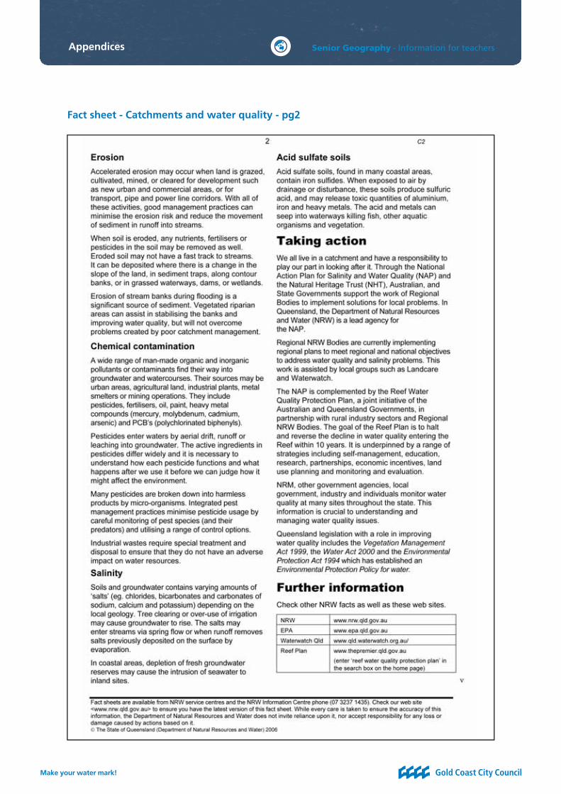
Fact sheet - Catchments and water quality - pg2
Appendices
Information for teachers
IntroductionAcknowledgements
The ‘Make your water mark!’ Watersaver education program is an initiative of Gold Coast City Council in partnership with Griffi th University.
Other agencies that have made a valuable contribution to the development of this resource include:
● Griffi th University, Science Education Alliance
● The Pimpama-Coomera Waterfuture Project Alliance
Other contributors to the resource development who deserve special thanks include:
Associate Professor Richard John, Griffi th University
Managing Director Science by Doing, Australian Academy of Science
Randall Hall, Griffi th University
Program Coordinator, Griffi th Science Education Alliance
Dale Pearse, Griffi th University
Primary Program Coordinator, Griffi th Science Education Alliance
Louise Cassels, Griffi th University
Visiting Fellow, Secondary Program Coordinator
Catherine Longworth, Griffi th University
Executive Offi cer to the Pro Vice Chancellor: Science, Environment, Engineering & Technology
Carley Freeman, Gold Coast City Council
Senior Community Water Partnerships Offi cer
Sue Street, Gold Coast City Council
Community Water Partnerships Offi cer
Carrie Hillier
LG Infrastructure Services
Simone Siwka
Abi Group Water
Acknowledgements
Make your water mark!