sentinel-2 for agriculture
TRANSCRIPT

Theia Workshop for Sentinel-2 L2A MAJA products – 13 & 14 June 2018
Sentinel-2 for AgricultureS2 OPERATIONAL EXPLOITATION FOR SUPPORTING NATIONAL TO REGIONAL
AGRICULTURE MONITORING AROUND THE WORLD AT PARCEL LEVEL
Bontemps S., Defourny P., Bellemans N., Cara C., Dedieu G., Guzzonato E., Hagolle O., Inglada J., Nicola L., Rabaute T.,
Savinaud M., Udroiu C., Valero S., Koetz B.& 12 benchmarking & demonstration sites partners
Theia Workshop for Sentinel-2 L2A MAJA products – 13 & 14 June 2018
Theia Workshop for Sentinel-2 L2A MAJA products – 13 & 14 June 2018
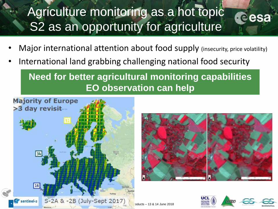
• Major international attention about food supply (insecurity, price volatility)
• International land grabbing challenging national food security
Agriculture monitoring as a hot topic
S2 as an opportunity for agriculture
Need for better agricultural monitoring capabilities
EO observation can help
Agriculture monitoring as a hot topic

Theia Workshop for Sentinel-2 L2A MAJA products – 13 & 14 June 2018
In the big data era providing dense and systematic time series and cloud computing facilities, the key question is :
can we exploit in near real time the EO data flows at parcel level over large areas dealing with the cropping systems diversity ?
S2 for operational agriculture
monitoring at 10 m resolution ?
Theia Workshop for Sentinel-2 L2A MAJA products – 13 & 14 June 2018
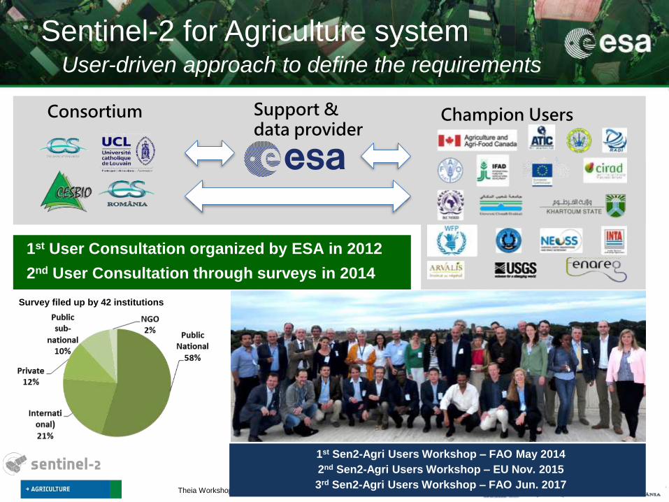
Sentinel-2 for Agriculture systemUser-driven approach to define the requirements
Consortium Champion UsersSupport &data provider
Survey filed up by 42 institutions
1st User Consultation organized by ESA in 2012
2nd User Consultation through surveys in 2014
1st Sen2-Agri Users Workshop – FAO May 2014
2nd Sen2-Agri Users Workshop – EU Nov. 2015
3rd Sen2-Agri Users Workshop – FAO Jun. 2017

Theia Workshop for Sentinel-2 L2A MAJA products – 13 & 14 June 2018
EARLY AREA INDICATOR
EARLY AREA INDICATOR
Binary map identifying annually cultivated land at 10m updated every month
Crop type map at 10 m for the main regional
crops including irrigated/rainfed
discrimination
Vegetation status map at 10 m delivered every
week (NDVI, LAI, pheno index)
Monthly cloud free surface reflectance composite at 10-20 m
Top priority : automatic delivery of 4 agri.
products along the season from S2 & L8 in line with the GEOGLAM core products
Theia Workshop for Sentinel-2 L2A MAJA products – 13 & 14 June 2018
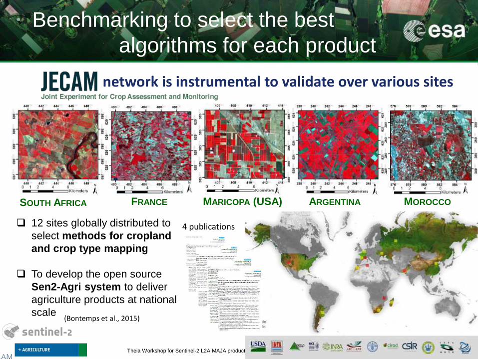
Benchmarking to select the best
algorithms for each product
4 publications
network is instrumental to validate over various sites
12 sites globally distributed to
select methods for cropland
and crop type mapping
To develop the open source
Sen2-Agri system to deliver
agriculture products at national
scale(Bontemps et al., 2015)
FRANCE MOROCCOMARICOPA (USA) ARGENTINASOUTH AFRICA

Theia Workshop for Sentinel-2 L2A MAJA products – 13 & 14 June 2018
Monthly cloud-free
composite
April, France
Weighting average approach
LAI products
• LAI retrieval by machine learning to build a non-linear regression model
• Reflectance simuated using the ProSail model• Mono-date LAI• Multi-date LAI
• Weekly product by weighted average usingthe n last LAI value
• At the end of the season, by fitting a phenological model on the full time series
Weighted Average
Synthesis Processor
(WASP)

Theia Workshop for Sentinel-2 L2A MAJA products – 13 & 14 June 2018
Dynamic cropland
maskCrop type map
L2A time series
In situ data
Featuresextraction
Randomforest
Cropland / crop type
map
Reference LC map
Trimming(samplescleaning)
http://maps.elie.ucl.ac.be/CCI/viewer/index.php
CCI global LC map
2015 - 300 m - 22 classes
Matton et al., RS2015
Valero S. et al., RS2016
Inglada et al., RS2015

Theia Workshop for Sentinel-2 L2A MAJA products – 13 & 14 June 2018
Sen2-Agri open source system
Sen2Agri Ochestrator
S2 L1C Time Series
L8 L1T Time Series
L2A Time Series
AtmosphericCorrections
(MACCS)
Temporal Synthesis Processor
Temporal Synthesis ProcessorNode #1
Biophysical Indicators Processor
Biophysical Indicators ProcessorNode #2
Cropland Mask Processor
Cropland Mask ProcessorNode #3
Crop Type Map Processor
Crop Type Map ProcessorNode #4
In-situInformation
Surface Reflectance Composite
Vegetation Status
Indicators
Dynamic Annual
Cropland Mask
Crop Type Map & Extent Area
Automated Download
Scheduled
Scheduled
Scheduled
Scheduled
Scheduled
Triggered
NRT or off-line production, locally or in the cloud,
automated or manual production

Theia Workshop for Sentinel-2 L2A MAJA products – 13 & 14 June 2018
Sen2-Agri system : main parameters settings
Area of Interest Shapefile to be uploaded
Monitoring period Start and end dates to be defined
S2 or S2 + L8 To be selected
Other parameters …
Start of the season
Monitoring periodBefore the monitoring period
System initialization
End of the season…
Sen2-Agri system : field campaigns
Sampling design Stratification and sampling
Field visit In situ data collection – early survey
In situ data collection – mid-season survey
Data upload Field data quality control and formating
Mali stratification (PIRT)
Simple parametrization
Field data collection planning

Theia Workshop for Sentinel-2 L2A MAJA products – 13 & 14 June 2018
Monitoring period
System operation for crop growth monitoring
LAI product
EoSSoS
Automatic EO data downloadfrom EO data providers
SoS
Before the monitoring period
t0
t2
t5 t10 t15
t18
t0t2
t10
t15
t18
System initialization

Theia Workshop for Sentinel-2 L2A MAJA products – 13 & 14 June 2018
17/07/2016
26/08/2016
05/09/2016
05/10/2016
25/10/2016
15/11/2016
0
1
2
3
4
Koutiala
2016-2017 LAI time series at 10m
(Mali)

Theia Workshop for Sentinel-2 L2A MAJA products – 13 & 14 June 2018
2016-2017 LAI time series at 10m
(South Africa)
16/11/2016
26/11/2016
06/12/2016
26/12/2016
15/01/2017
14/04/2017
0
1
2
3
4
5
Potchestroom (South-Africa)
27/10/2016
Leaf Area
Index

Theia Workshop for Sentinel-2 L2A MAJA products – 13 & 14 June 2018
Cloud-free temporal synthesis
South of France, S2 + L8

Theia Workshop for Sentinel-2 L2A MAJA products – 13 & 14 June 2018
Juillet 2016
Août 2016
Septembre 2016
Octobre 2016
Cape Town
Western Cape Province monitored by Sentinel 2 in 2016
June July August September October November
Winter grain production region (South Africa)

Theia Workshop for Sentinel-2 L2A MAJA products – 13 & 14 June 2018
Sen2-Agri 10 m cropland map for Ukraine
September 2016
Overall accuracy : 98 %
F-score cropland : 97 %
Non-Cropland
Cropland
November 2016
Overall accuracy : 98 %
F-score cropland : 99 %

Theia Workshop for Sentinel-2 L2A MAJA products – 13 & 14 June 2018
Sen2-Agri 10 m main crop types map for Ukraine (July 2016)
Overall accuracy : 82,7 %
NRT crop specific monitoring from the mid-season:
LAI evolution for all winter wheat fields in 2016

Theia Workshop for Sentinel-2 L2A MAJA products – 13 & 14 June 2018
Comparison of TOA, Sen2COR, MACCS for crop type classification
Experiment on L2A algorithms
by Ukrainian team (SRI)
Satellite data:
11 Sentinel-2 scenes
Ground data:
563 ground samples
(train and test sets)
Training set
Test set
TOA (OA=80.7%) Sen2cor (OA=80.6%) MACCS (OA=82.7%)

Theia Workshop for Sentinel-2 L2A MAJA products – 13 & 14 June 2018
Monthly cropland product performance
along the season
F-Score Cropland F-Score Non-Cropland Overall Accuracy

Theia Workshop for Sentinel-2 L2A MAJA products – 13 & 14 June 2018
Overall accuracy: 94 %
F-score cropland: 80 %
System validation:
2016 Cropland mask at 10m resolution for Mali
from Sentinel-2 and Landsat 8

Theia Workshop for Sentinel-2 L2A MAJA products – 13 & 14 June 2018
Fast learning curve to improve performances
Mali – work continued with our partners

Theia Workshop for Sentinel-2 L2A MAJA products – 13 & 14 June 2018
Sen2-Agri 10 m main crop types map for South AfricaSummer grain production area – Northern provinces
Maize
Soyabeans
Sunflower
Fodder crops
Other crops
Free State
Main Crops F1-Score
Maize 94%
Soyabean 83%
Sunflower 82 %
Fodder crops 90%
Overall Accuracy 90,1 %EO data: 6 months of S2 and
L8 acquisitions(Oct 2016 – March 2017)
In situ data: ~12000 samples(~451000 ha)
Sen2-Agri Online Training for USDA – 19 April 2018 22/30

Theia Workshop for Sentinel-2 L2A MAJA products – 13 & 14 June 2018
Open-source, available for download,
demonstrated at full scale, user community
Any EO users to produce agriculture
information in their area of interest: national service for agriculture monitoring
national statistical offices
international agencies
private companies
research organizations
400 downloads
20 operational installations
http://forum.esa-sen2agri.org/
Very active forum with
60 users
1.1 K posts
150 topics
Webinar every 2 months
-> Next one: 19 July
Online trainings

Theia Workshop for Sentinel-2 L2A MAJA products – 13 & 14 June 2018
Thank you for your attention
… and come and play with us!http://www.esa-sen2agri.org/

Theia Workshop for Sentinel-2 L2A MAJA products – 13 & 14 June 2018

Theia Workshop for Sentinel-2 L2A MAJA products – 13 & 14 June 2018
Sen2-Agri system: S2 exploitation for local to national
operational agriculture monitoring at 10 m
Decametric time series availability allow to proceed to full scale experimenton annual basis – Sentinel-2b much needed and Sentinel-1 integration wouldclearly enhance the timeliness and the robustness
Nationwide Sen2Agri NRT operation requires good processing but more critically in situ data collected and quality controlled in a timely manner(logistics matter a lot - flooding in Sudan, unrest in Madagascar, etc.)
Very fast learning curve thanks to this challenging globally distributeddemonstration allowing to further improve the Sen2Agri system optimizingoperational performances (timeliness, accuracies in challenging landscapes)
Sen2Agri system is a turn-key system able to evolve in close partnerships with national stakeholders to insure outcome relevance and ownership -multi-year experience much needed to fully exploit Sentinel-2 capabilities !

Theia Workshop for Sentinel-2 L2A MAJA products – 13 & 14 June 2018
Sen2-Agri is free and open source
Based on open source existing software
Under GNU-GPL License
Open source software based on Orfeo ToolBox
Cluster-ready architecture for distributed processing
Integration with Sentinel-2 ToolBox
Operational system required : CentOS7 (GNU/LINUX)

Theia Workshop for Sentinel-2 L2A MAJA products – 13 & 14 June 2018
• Optional to generate the cropland mask
• Mandatory to generate the croptype map
Field campaigns for cropland and croptype can be combined.
The quality of the in situ data set is the most important driver of the quality of the output maps
With the proper format, one single dataset can be given to the system.
2 different objectives:
In situ data for calibration/training of the machine learning algorithms: sampling to cover the diversity of the existing classes accross the site. It should represent the range of possible land cover types and crop types.
In situ data for validation: to estimate the model performance to recognize the different classes. To be consider as a proper map validation, the validation dataset should be collected using a statistically-sound sampling.
In situ data collection
By-default split of the dataset:75% of the samples to support the training25% of the samples to test the performance of the classifier

Theia Workshop for Sentinel-2 L2A MAJA products – 13 & 14 June 2018
• Shapefile to be provided with specific attribute table format [cfr Software User Manual]
• Stratification should be applied in case of large area mapping
• Guidelines for field campaign method are provided by the JECAM network:http://www.jecam.org/JECAM_Guidelines_for_Field_Data_Collection_v1_0.pdf
Dedicated webinar on in situ data collection methods is planned on July 19th
In situ data preparation

Theia Workshop for Sentinel-2 L2A MAJA products – 13 & 14 June 2018
If you intend to use the Sen2-Agri system on a local site (~90 000km²), the minimum system requirements to install and run this system are as follows:
• CPU: 8 Cores
• RAM: 32GB
• HDD Storage: 4 TB
• SSD Storage: 250 GB (optionnal – for temporary files)
If you intend to use the Sen2-Agri system on a national site (~500 000km²), the minimum system requirements to install and run this system are as follows:
• CPU: 16 to 32 Cores
• RAM: 64GB to 128 GB
• HDD Storage: 10 TB is enough even if 15TB is recommended
• SSD Storage: 1 TB (optionnal – for temporary files)
System requirements

Theia Workshop for Sentinel-2 L2A MAJA products – 13 & 14 June 2018
Amount of downloaded product (L1C Sentinel-2 and L1T Landsat 8)
For the system initialization (multi-temporal atmospheric correction)
S2: 63 products, 226 GB
L8: 327 products, 621 GB
For the growing season until today
S2: 427 products – 1.341TB
L8: 623 products – 1.2TB
Amount of L2A generated
For the system initialization (multi-temporal atmospheric correction)
S2: 63 products, 756 GB (2 months)
L8: 146 products, 205 GB (3 months)
For the growing season until today
S2: 427 products – 5.33 TB
L8 : 554 products – 775 GB
High level figures :
Ukraine national demonstration

Theia Workshop for Sentinel-2 L2A MAJA products – 13 & 14 June 2018
Processing time for each Sen2Agri product
• For Atmospheric correction: Around 30 minutes per tile
• For Cloud free composite: 8 days for a product with S2 and L8
• For LAI: Approx. 3 minutes/ S2 tile
• For L4A: About 3 days for the raw mask, about 5 days and a half for segmentation
• For L4B: About 8 days
National hardware server : 2 x Intel(R) Xeon(R) CPU E5-2650 v3 @ 2.30GHz (20 cores total, 40
threads), 128 GB RAM (26 TB disk space)
System performances over national sites

Theia Workshop for Sentinel-2 L2A MAJA products – 13 & 14 June 2018
Madagascar site – mid-season cropland and
crop type products thanks to timely in situ data

Theia Workshop for Sentinel-2 L2A MAJA products – 13 & 14 June 2018
201
7

Theia Workshop for Sentinel-2 L2A MAJA products – 13 & 14 June 2018
Madagascar site – mid-season cropland and
crop type products thanks to timely in situ data

Theia Workshop for Sentinel-2 L2A MAJA products – 13 & 14 June 2018
November 201650 days window
5/10/2016-25/11/2016
First cloud free composite series over Mali
at 10m resolution from Sentinel-2 and Landsat 8

Theia Workshop for Sentinel-2 L2A MAJA products – 13 & 14 June 2018
Cropland product for local site in Northern China
without in situ data (trained from global CCI LC map)
Cropland mask, obtained without in-situ data but using the ESA CCI Land Cover map to extract training dataset(http://maps.elie.ucl.ac.be/CCI/viewer/)
Cropland
Non cropland

Theia Workshop for Sentinel-2 L2A MAJA products – 13 & 14 June 2018
Monthly cloud-free composite
Benchmarking conclusions
• Weighted average approach
• Compositing period can vary between 30 to 50 days window
• Implements a directional correction for seamless composites
• Recurrent implementation : L3A product updated with each new L2A product
To limit the data volume to keep on-line in Sen2Agri system
April, France

Theia Workshop for Sentinel-2 L2A MAJA products – 13 & 14 June 2018
Dynamic cropland mask2 chains implemented to deal with presence/absence of in-situ data
Benchmarking conclusions• Surface reflectance preparation
• Linear interpolation of the refl data for the in situ data version• Gap filling using Whittaker smoothing if absence of in situ data
• RF supervised algorithm on a set temporal feature• Trimming to clean the reference map• A posteriori smoothing based on a per-object approach
(Matton et al., RS2015)
(Valero S. et al., RS2016)

Theia Workshop for Sentinel-2 L2A MAJA products – 13 & 14 June 2018
Crop type map
Benchmarking conclusions• Surface reflectance preparation
• Linear interpolation of the refl data for the in situ data version• Based on the crop mask previously generated• Random forest classifier• Classifier applied on temporal features : surface reflectance, NDVI,
NDWI, brightness
(Inglada et al., RS2015)