sepm society for sedimentary geology a simplified guide ...rmssepm.org/pdfs/abreu 1-2017 a...
TRANSCRIPT
A Simplified Guide For Sequence Stratigraphy:
Nomenclature, Definitions and Method
SEPM – Society for Sedimentary Geology
Vitor Abreu
President - SEPM

Abstract All attempts to “codify” Sequence Stratigraphy have failed, mostly because:
- perception of cumbersome nomenclature;
- conflicting or obscure causing mechanisms;
- disagreement on basic definitions;
- … or simply that Sequence Stratigraphy is a “young” science
Biostratigraphy has the same set of challenges as Sequence Stratigraphy:- it has a cumbersome nomenclature classification of fossils;
- driving mechanisms for rate of evolution of different taxa is debatable;
- there is strong disagreement as how to classify different species and genera;
- and it is a relatively young science.
Yet, Biostratigraphy has a set of rules and terminology (code) followed by all.
Biostratigraphy is codified as a method, not as a science, based on simple criteria
that can be directly observed from available data.
Implications for interpretation, in terms of causal mechanisms, follow after initial
interpretation, and are not part of the code.
Why do Sequence Stratigraphers have such difficulty agreeing on basic rules for
identifying surfaces and systems tracts based on direct observational criteria?

Conflicting Nomenclature:
Highstand – Transgressive – Lowstand…
Why Not:
Highstand – Midstand(!?!) – Lowstand
Or…
Lower Regressive – Transgressive – Upper Regressive??
At First, A Contradiction…
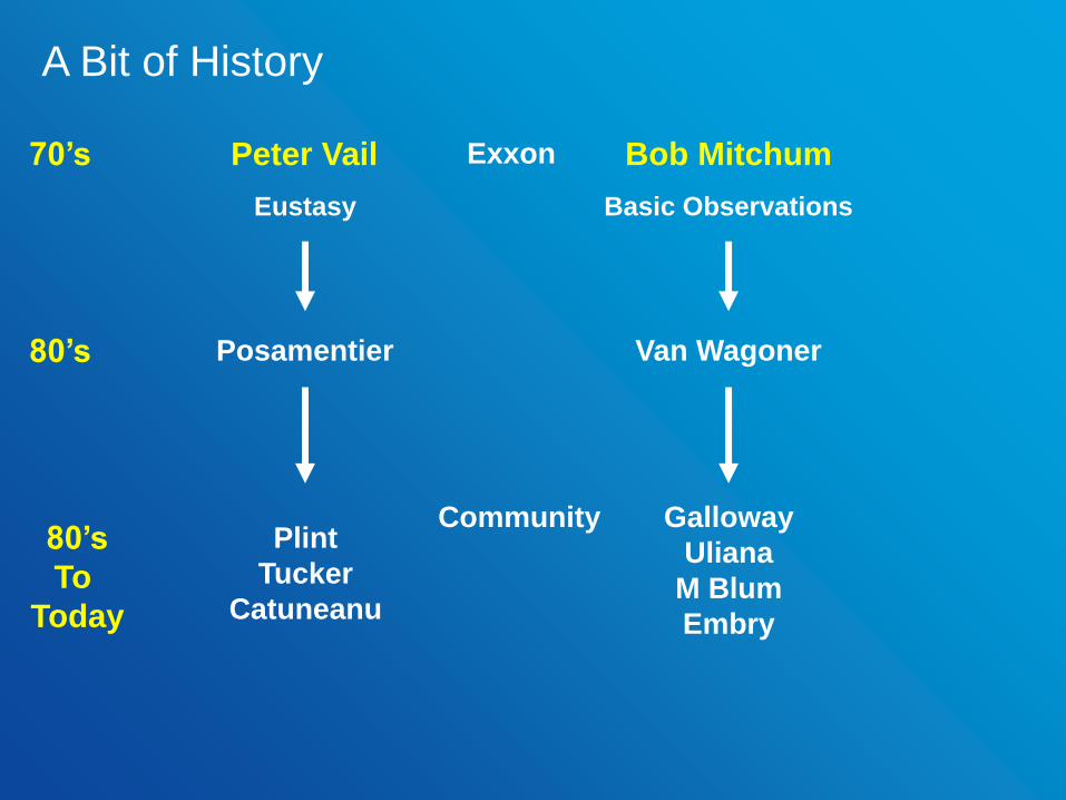
Posamentier Van Wagoner80’s
Plint
Tucker
Catuneanu
Galloway
Uliana
M Blum
Embry
80’s
To
Today
Community
Eustasy Basic Observations
Peter Vail Bob Mitchum70’s Exxon
A Bit of History
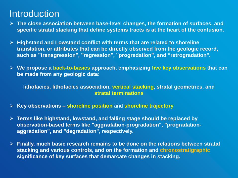
The close association between base-level changes, the formation of surfaces, and
specific stratal stacking that define systems tracts is at the heart of the confusion.
Highstand and Lowstand conflict with terms that are related to shoreline
translation, or attributes that can be directly observed from the geologic record,
such as "transgression", "regression", "progradation", and “retrogradation".
We propose a back-to-basics approach, emphasizing five key observations that can
be made from any geologic data:
lithofacies, lithofacies association, vertical stacking, stratal geometries, and
stratal terminations
Key observations – shoreline position and shoreline trajectory
Terms like highstand, lowstand, and falling stage should be replaced by
observation-based terms like "aggradation-progradation", "progradation-
aggradation", and "degradation", respectively.
Finally, much basic research remains to be done on the relations between stratal
stacking and various controls, and on the formation and chronostratigraphic
significance of key surfaces that demarcate changes in stacking.
Introduction
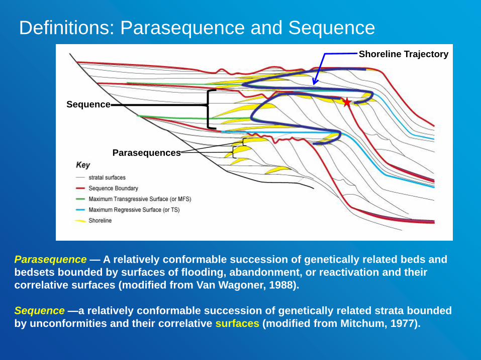
Parasequence — A relatively conformable succession of genetically related beds and
bedsets bounded by surfaces of flooding, abandonment, or reactivation and their
correlative surfaces (modified from Van Wagoner, 1988).
Sequence —a relatively conformable succession of genetically related strata bounded
by unconformities and their correlative surfaces (modified from Mitchum, 1977).
Parasequences
Sequence
Shoreline Trajectory
Definitions: Parasequence and Sequence
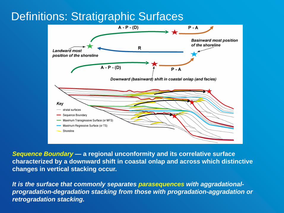
Sequence Boundary — a regional unconformity and its correlative surface
characterized by a downward shift in coastal onlap and across which distinctive
changes in vertical stacking occur.
It is the surface that commonly separates parasequences with aggradational-
progradation-degradation stacking from those with progradation-aggradation or
retrogradation stacking.
Definitions: Stratigraphic Surfaces
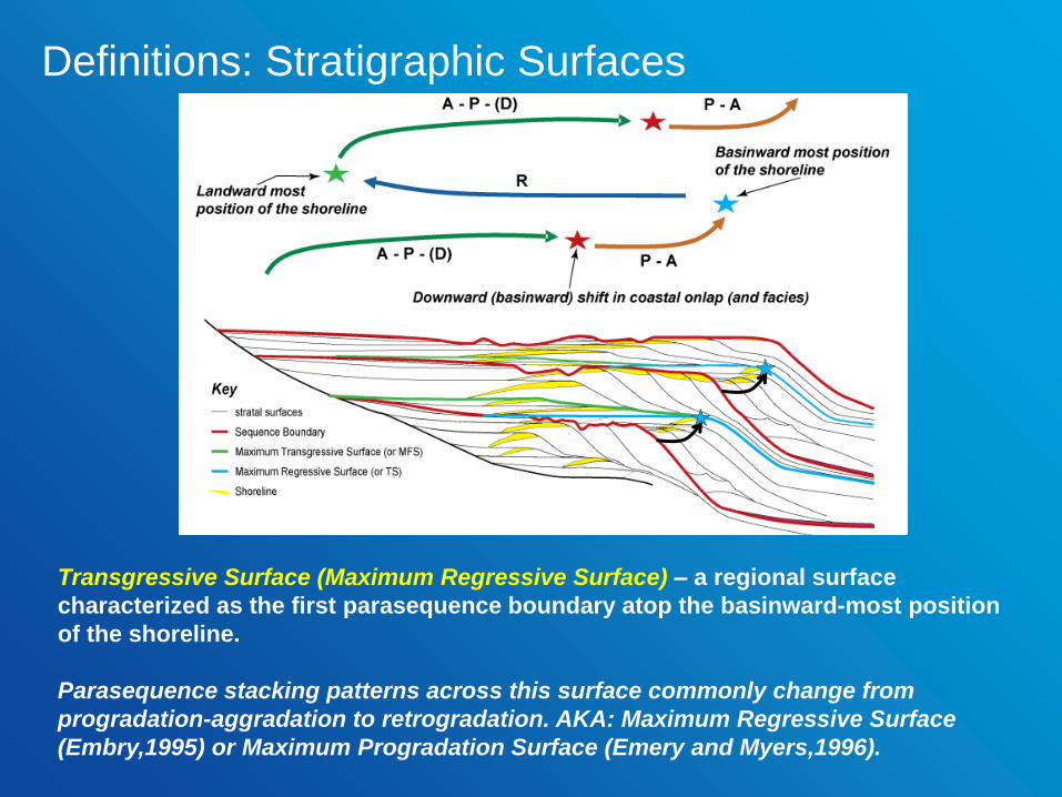
Transgressive Surface (Maximum Regressive Surface) – a regional surface
characterized as the first parasequence boundary atop the basinward-most position
of the shoreline.
Parasequence stacking patterns across this surface commonly change from
progradation-aggradation to retrogradation. AKA: Maximum Regressive Surface
(Embry,1995) or Maximum Progradation Surface (Emery and Myers,1996).
Definitions: Stratigraphic Surfaces

Maximum Flooding Surface (Maximum Transgressive Surface) – a regional surface
characterized as the first parasequence boundary atop the landward most position of
the shoreline.
Parasequence stacking patterns across this surface commonly change from
retrogradation to aggradation-progradation-degradation. In seismic, this surface can
be identified as the shelfal downlap surface.
Definitions: Stratigraphic Surfaces

Surface definitions, translation terms, and
recognition criteria.
SurfaceTranslation
Terms
Primary
Recognition
Criteria
Secondary Recognition Criteria
(based on limited available data)
Maximum
Flooding
Surface
MFS
Maximum
Transgressive
Surface
MTS
Atop maximum
landward
position of the
shoreline
Downlapss,o. Turn around in stacking pattern
from retrogradation to aggradation or
progradationw,c,o.
Transgressive
Surface
TS
Maximum
Regressive
Surface*
MRS
Atop maximum
basinward
position of the
shoreline
Surface beneath first backstep (landward
step) of shelf-slope breaks. Turn around in
stacking pattern from progradation or
aggradation to retrogradationw,c,o.
Sequence
Boundary
SB
Sequence
Boundary
SB
Beneath abrupt
basinward shift
in shoreline
Surface beneath first increase in
accommodation after progradation or
degradations. Break in shoreline trajectory
‘S’s. Truncation and/or toplap below, onlap
above s. Abrupt occurrence of proximal facies
over distal faciesw,c,o.
*sensu Embry, 2002s=seismic; w=wells; c=core; o=outcrop.
Lowstand Systems Tract (PA) — a linkage of contemporaneous depositional
systems (Brown and Fisher, 1977), characterized by a progradational to
aggradational stacking of parasequences and bounded by a Sequence Boundary
(SB) at the base and a Transgressive Surface (TS or MRS) at the top.
Transgressive Systems Tract (R) — a linkage of contemporaneous
depositional systems (Brown and Fisher, 1977), characterized by retrogradational
stacking of parasequences and bounded at the base by the TS (or MRS) and at
the top by the Maximum Flooding Surface (MFS or MTS).
Highstand Systems Tract (APD) — a linkage of contemporaneous
depositional systems (Brown and Fisher, 1977), characterized by an
aggradational to progradational to degradational stacking of parasequences,
bounded at the base by the MFS (or MTS) and at the top by the SB.
Definitions: Systems Tracts
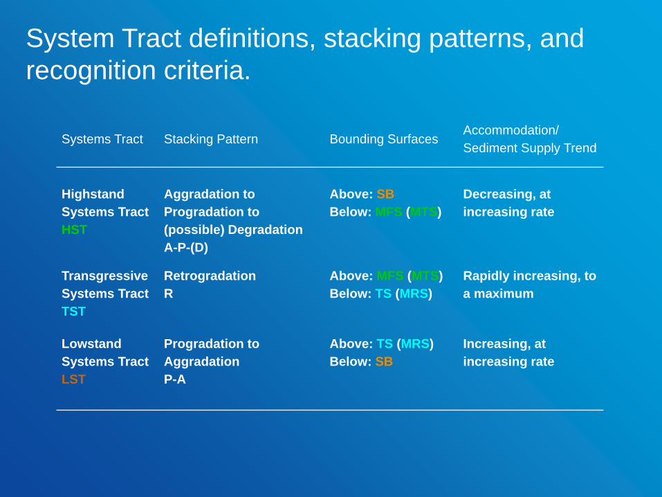
Systems Tract Stacking Pattern Bounding SurfacesAccommodation/
Sediment Supply Trend
Highstand
Systems Tract
HST
Aggradation to
Progradation to
(possible) Degradation
A-P-(D)
Above: SB
Below: MFS (MTS)
Decreasing, at
increasing rate
Transgressive
Systems Tract
TST
Retrogradation
R
Above: MFS (MTS)
Below: TS (MRS)
Rapidly increasing, to
a maximum
Lowstand
Systems Tract
LST
Progradation to
Aggradation
P-A
Above: TS (MRS)
Below: SB
Increasing, at
increasing rate
System Tract definitions, stacking patterns, and
recognition criteria.

4. Use Systems Tracts and Surfaces to define depositional sequences
The sequence stratigraphy method can be summarized in 4 steps:
1. Define lithofacies and vertical lithofacies successions to identify
vertical stacking trends and stratal terminations
2. Use vertical stacking patterns and stratal termination patterns to define 3
surfaces:
• Sequence Boundary
• Transgressive Surface (Maximum Regressive Surface)
• Maximum Flooding Surface (Maximum Transgressive Surface)
3. Use Surfaces, vertical stacking, and stratal geometries to define 3 systems
tracts:
• Lowstand Systems Tract (PA)
• Transgressive Systems Tracts (R)
• Highstand Systems Tract (APD)
Method
Then: make maps, find resources, seek to explain by various mechanisms,…

Step 1: a) Identify bedset stacking patterns;
b) Interpret high- and moderate-confidence candidate flooding surfaces;
c) Identify parasequence stacking patterns;
d) Select datum on candidate maximum flooding surface above interval of interest.
Defining Surfaces: Well Logs
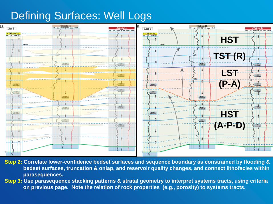
Step 2: Correlate lower-confidence bedset surfaces and sequence boundary as constrained by flooding &
bedset surfaces, truncation & onlap, and reservoir quality changes, and connect lithofacies within
parasequences.
Step 3: Use parasequence stacking patterns & stratal geometry to interpret systems tracts, using criteria
on previous page. Note the relation of rock properties (e.g., porosity) to systems tracts.
Defining Surfaces: Well Logs
HST
(A-P-D)
LST
(P-A)
TST (R)
HST
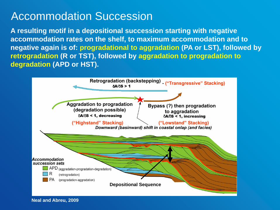
A resulting motif in a depositional succession starting with negative
accommodation rates on the shelf, to maximum accommodation and to
negative again is of: progradational to aggradation (PA or LST), followed by
retrogradation (R or TST), followed by aggradation to progradation to
degradation (APD or HST).
- (“Transgressive” Stacking)
(“Highstand” Stacking) (“Lowstand” Stacking)
Depositional Sequence
Neal and Abreu, 2009
Accommodation Succession
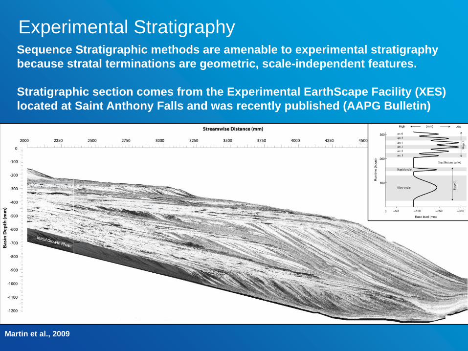
Sequence Stratigraphic methods are amenable to experimental stratigraphy
because stratal terminations are geometric, scale-independent features.
Stratigraphic section comes from the Experimental EarthScape Facility (XES)
located at Saint Anthony Falls and was recently published (AAPG Bulletin)
Martin et al., 2009
Experimental Stratigraphy

Interpretation – applying the sequence stratigraphic method…
Experimental Stratigraphy

Interpretation – applying the sequence stratigraphic method…
Experimental Stratigraphy
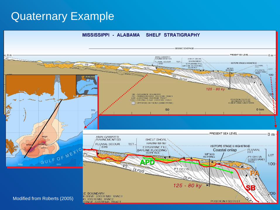
Modified from Roberts (2005)
Coastal onlap
PA
APD
SB
Quaternary Example
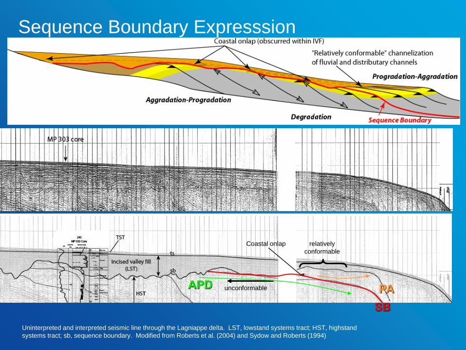
Uninterpreted and interpreted seismic line through the Lagniappe delta. LST, lowstand systems tract; HST, highstand
systems tract; sb, sequence boundary. Modified from Roberts et al. (2004) and Sydow and Roberts (1994)
unconformable
relatively
conformable
Coastal onlap
SB
PAAPD
Sequence Boundary Expresssion
modified from Mitchum and Van Wagoner, 1991
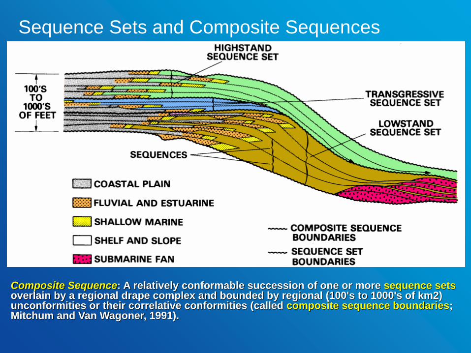
Composite Sequence: A relatively conformable succession of one or more sequence setsoverlain by a regional drape complex and bounded by regional (100's to 1000's of km2) unconformities or their correlative conformities (called composite sequence boundaries; Mitchum and Van Wagoner, 1991).
Sequence Sets and Composite Sequences

Nested Stratigraphic Hierarchy of the Neogene (Pelotas Basin, Brazil)
0 10 20 30 km
multiple
Early
Miocene
Early to
Middle
Miocene
PlioceneMiddle to Late
Miocene
PASS
RSS
APDSS
Composite SB
Sequence
Boundary (SB)
Termination
Multiple
PA-SS
APD-SS
R-SS
Modified from Abreu (1998)
Pelotas Basin, South Atlantic (Brazil)

24
Kunin and Segalovich, 1996
Sequence Sets and Composite Sequences
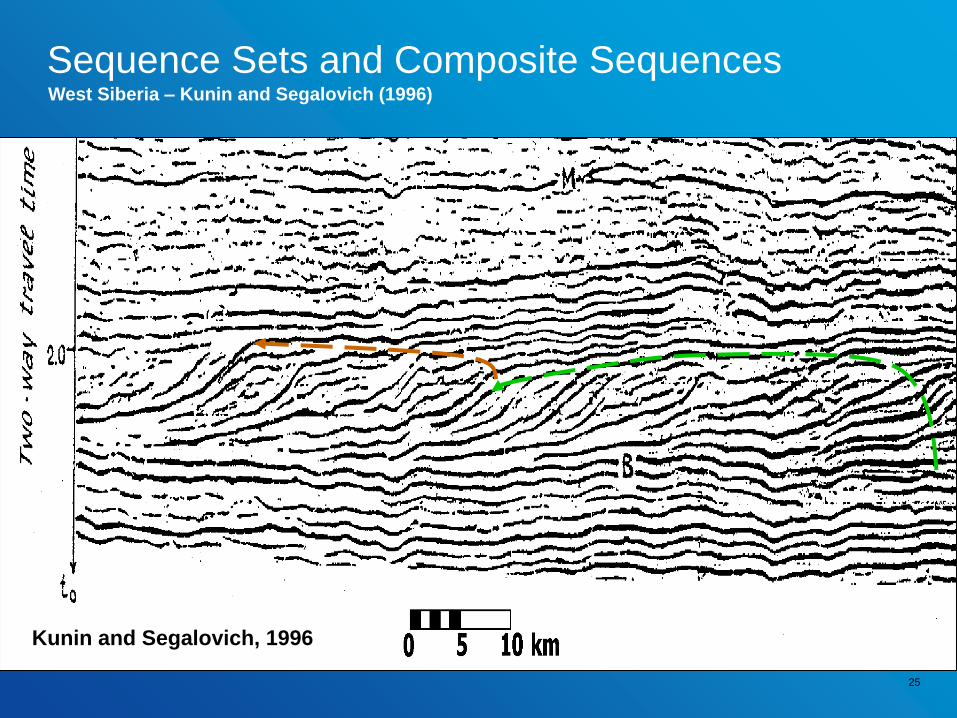
25
Kunin and Segalovich, 1996
West Siberia – Kunin and Segalovich (1996)
Sequence Sets and Composite Sequences

26
Modified from Kunin and
Segalovich, 1996APSS
PASS Composite Sequence Boundary
Sequence Sets and Composite Sequences

Fluvial
Floodplain
Coal
Delta Front
Prodelta
Shelfal Muds
Modified from Li and Bhattacharya, 2013
… Or, better… sea level changes cannot be
directly observed from the geologic record. Shoreline trajectory can.In the minds of men and women!!
So, Where is Sea Level in all of this???
Relative movement of sea level is not used and is very misleading to
define systems tracts and surfaces. For example, all Systems Tracts
are at least, in part, deposited during a relative rise of sea level.
PAHST - APD
CSBBasiward shift in coastal onlap
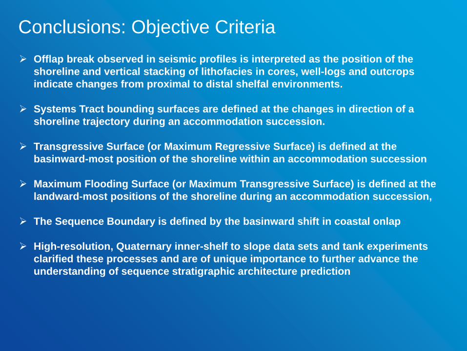
Offlap break observed in seismic profiles is interpreted as the position of the
shoreline and vertical stacking of lithofacies in cores, well-logs and outcrops
indicate changes from proximal to distal shelfal environments.
Systems Tract bounding surfaces are defined at the changes in direction of a
shoreline trajectory during an accommodation succession.
Transgressive Surface (or Maximum Regressive Surface) is defined at the
basinward-most position of the shoreline within an accommodation succession
Maximum Flooding Surface (or Maximum Transgressive Surface) is defined at the
landward-most positions of the shoreline during an accommodation succession,
The Sequence Boundary is defined by the basinward shift in coastal onlap
High-resolution, Quaternary inner-shelf to slope data sets and tank experiments
clarified these processes and are of unique importance to further advance the
understanding of sequence stratigraphic architecture prediction
Conclusions: Objective Criteria
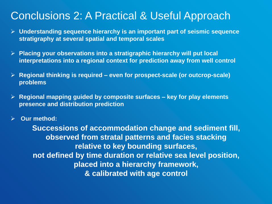
Understanding sequence hierarchy is an important part of seismic sequence
stratigraphy at several spatial and temporal scales
Placing your observations into a stratigraphic hierarchy will put local
interpretations into a regional context for prediction away from well control
Regional thinking is required – even for prospect-scale (or outcrop-scale)
problems
Regional mapping guided by composite surfaces – key for play elements
presence and distribution prediction
Our method:
Conclusions 2: A Practical & Useful Approach
Successions of accommodation change and sediment fill,
observed from stratal patterns and facies stacking
relative to key bounding surfaces,
not defined by time duration or relative sea level position,
placed into a hierarchy framework,
& calibrated with age control