september 19-22, 2006 timberline lodge mt. hood, … 19-22, 2006 timberline lodge mt. hood, oregon...
TRANSCRIPT
September 19-22, 2006
Timberline Lodge
Mt. Hood, Oregon
The MTNCLIM research conferences are sponsored by the Consortium for Integrated Climate Research on Western Mountains (CIRMOUNT), and are dedicated to mountain climate sciences and effects of climate variability on ecosystems, natural resources, and conservation in western North American mountains.
http://www.fs.fed.us/psw/mtnclim/

GoalsMTNCLIM Conferences aim to advance the sciences related to climate and its interaction with physical, ecological, and social systems of western North American mountains. Specifically, MTNCLIM goals are to:
Provide a regular forum for current, interdisciplinary research through invited and contributed oral and poster sessions;Promote active integration of science into resource-management application through focused sessions, panels, and ongoing problem-oriented working groups;Advance action goals of CIRMOUNT through ad hoc committees, networking opportunities, co-hosting meetings, and targeted fund-raising efforts.
SponsorsMTNCLIM 2006 is sponsored by CIRMOUNT, with funding and support from the following agencies and institutions:
Montana State University, Big Sky InstituteNOAA, Paleoclimatology Branch and Earth Systems Research LabUSDA Forest Service, Pacific Southwest Research Station, Sierra Nevada Resarch Center and Pacific Northwest Research Station, Fire and Environmental Research ApplicationsUniversity of California, Scripps Institution of OceanographyUSGS Water Resources, Geology, and Biological Resources DivisionsMountain Research InitiativeDesert Research Institute, Western Regional Climate CenterUniversity of Arizona, Laboratory of Tree-Ring ResearchUniversity of California, White Mountain Research StationNASA Science Mission Directorate, Earth Science DivisionUSDA, NRCS, National Water & Climate Center, Portland, ORCal Fed Bay Delta ProgramPortland State University
ConvenorsCo-Chairs:
Constance I. Millar, USDA Forest Service, Pacific Southwest Research Station, Albany CALisa J. Graumlich, Montana State University, Big Sky Institute, Bozeman, MT USAHenry F. Diaz, NOAA, Earth System Research Laboratory, Boulder, CO USA
with:Daniel R. Cayan, University of California, Scripps Institution of Oceanography, La Jolla, CA USAMichael D. Dettinger, USGS Water Resources Division, La Jolla, CA USADaniel B. Fagre, USGS Biological Resources Division, West Glacier, MT USAAndrew G. Fountain, Dept of Geology, Portland State University, Portland, OR USA (local host)Greg Greenwood, Mountain Research Initiative, Berne, SwitzerlandMalcolm K. Hughes, University of Arizona, Laboratory of Tree-Ring Research, Tucson, AZ USAPhil Pasteris, NRCS, National Water & Climate Center, Portland, OR USA (local host)David L. Peterson, USDA Forest Service, Pacific Northwest Research Station, Seattle, WA USAFrank L. Powell, University of California, White Mountain Research Station, San Diego, CA USAKelly T. Redmond, Desert Research Institute, Western Regional Climate Center, Reno, NV USANathan L. Stephenson, USGS Biological Resources Division, Three Rivers, CA USAThomas W. Swetnam, University of Arizona, Laboratory of Tree-Ring Research, Tucson, AZ USAConnie Woodhouse, NOAA, Paleoclimatology Program, Boulder, CO USA
•
•
•
•••
••••••••••
•••
•••••••••••••

Contents
AGENDA................................................................................................ 2
ABSTRACTS.......................................................................................... 7
WORK.GROUPS................................................................................40
NATIONAL.PHENOLOGY.NETWORK.......................................41
LIST.OF.PARTICIPANTS..................................................................44
MANAGERS.WORKSHOP..............................................................46
Revised October 03, 2006

Agenda - 2
AGENDAMTNCLIM 2006
Timberline Lodge, Mt. Hood, OregonSeptember 19-22, 2006
MTNCLIM 2006 website: www.fs.fed.us/psw/mtnclim
Sept 19
3:00-5:00 Pre-Conference Work Group Sessions (Open to All Interested)Mountain Climate Monitoring Network: K Redmond, M. Losleben, P. Pasteris Barlow RoomHydrologic Observatories: R. Bales & M. Dettinger Market Café, Wy’East BuildingGLORIA: C. Millar & D. Fagre Mt. Hood RmPaleoclimatic Archives for Resource Managers: G. Pederson Blue Ox BarEcosystem Responses: J. Littell & J. Hicke Mt Jefferson RmInternational Relations: G. Greenwood & C. Allen Raven’s Nest
6:00 – 7:30 Dinner, Ravens Nest
7:30 – 9:30 Ullman HallEvening Program: MTNCLIM 2006 Conference BEGINSModerating: Connie Millar (USFS) and Lisa Graumlich (MSU)
7:30 –7:45 Welcome and CIRMOUNT Update (CIRMOUNT Organizers)
7:45 – 8:30 Kelly Redmond, Desert Research Institute, Reno, NV The MTNCLIM Year: Western Mountain Climate 2005-2006 in Perspective
8:30 – 9:15 Introduction: Kelly Redmond (DRI)Keynote Presentation I Jon Jarvis, Regional Director, National Park Service, Seattle, WA Science and its Role in Resource Management
Sept 20
8:30 – Noon Ullman HallInvited Oral Session: “Remote-Sensing: Opportunities and Successes for Mountain Climate and Climate-Related Research”Moderating: Dan Cayan (USGS)
8:30-9:00 DeWayne Cecil, NASA Applied Sciences Program, Washington, D.C.NASA’s Next Generation Earth Observing Satellites; Opportunities for Global Change Research and ApplicationsTalk presented by John Dwyer
9:00-9:30 John Dwyer, USGS, Earth Resources Observation and Science, Sioux Fall, SDOverview of Satellite Remotely Sensed Data Products from EROS, with Applications and Examples Applicable to Mountain Climate Assessments
9:30-10:00 Andrew Fountain, Department of Geology and Geography, Portland State University, Portland, ORGlacier Response in the American West to Climate Change during the Past Century
»
»»»»»

10:00-10:30 Break
10:30-11:00 Diane Debinski, Department of Ecology, Evolution, and Organismal Biology, Iowa State University, Ames, IAQuantifying Ecological Effects of Climate Change
11:00-11:30 Andy Bunn, Department of Environmental Sciences, Western Washington University, Bellingham, WASpace-Based Photosynthetic Trends in High Latitude Mountains
11:30-12:00 Myra Kim, Department of Human Services, State of Oregon, Salem, ORThe View from Space and the View from Society: A Comparison of the Environmental Variables Measured by Remote Sensing and the Culturally Important Attributes of Climate Change near Mt. Hood
12:00 – 1:30 Lunch Raven’s NestModerating: Henry Diaz, (NOAA)Julio Betancourt, USGS, Tucson AZ National Phenological Network & CIRMOUNT
1:30 – 5:00 Ullman HallInvited Oral Session: “ ‘Biological Sensors’ in Mountain Environments: Ecosystem Responses”Moderating: Dave Peterson (USFS)
1:30 – 2:00 John Innes, Professor and Chair of Forest Management, University of British Columbia, Vancouver, BCBiodiversity Monitoring under Changing Climates
2:00 – 2:30 Allan Carroll, Pacific Forestry Center, Canadian Forest Service, Vancouver, British Columbia Insect Stresses, Climate Change,and Massive Forest Dieback
2:30 – 3:00 Nate Stephenson, Western Ecological Research Center, USGS-BRD, Three Rivers, CA; Jeremy Littell, College of Forest Resources, University of Washington, Seattle, WAPervasive Climate-Mediated Changes in Western Forests: Growth Rates, Demography, and Climate Change in Mountain Ecosystems
3:00 – 3:30 Break
3:30 – 4:00 George Malanson, Department of Geography, University of Iowa, Iowa City, IATreeline Dynamics and Climate Change
4:00 – 4:30 Chris Conroy, Museum of Vertebrate Zoology, University of California, Berkeley; Michelle Koo, California Academy of Sciences, San Francisco, CA The Grinnell Project; Small Mammal Responses to Climate in California
4:30 – 5:00 Steve Corn, USGS, Northern Rocky Mountain Science Center, Missoula, MTAmphibia & Climate
6:00 – 8:00 Dinner with Keynote Presentation II, Ullman HallModerating: Connie Millar (USFS)Charlie Crisafulli, Forest Ecologist, USFS, Mount St. Helens National Volcanic Monument, Amboy, WA Mt St. Helens 20 Years Later: Ecosystem Responses to the 1980 Eruption
8:00 Evening Poster Session, Ullman Hall
Agenda - 3

Sept 21
8:30 – Noon Ullman HallInvited Oral Session: “Evolving Climate Policy in the West; CIRMOUNT’s Role as a Regional Science Initiative”(Dedicated to Dennis Machida)Moderating: Henry Diaz (NOAA)
8:30 – 8:50 Randy Dole, NOAA, Earth Systems Research Laboratory, Boulder, COClimate Science and the West
8:50 – 9:10 Dan Cayan, UC Scripps Institution of Oceanography, La Jolla, CA State and Federal Support to Assess Climate Change in California
9:10 – 9:30 Brad Udall, University of Colorado, Cooperative Institute for Research in Environmental Sciences, Boulder, CORISA Support for Climate Change Assessment in Colorado
9:30 – 9:50 Phil Mote, University of Washington, Climate Impacts Group, Seattle, WAIs Anyone Listening? Hints of Progress in Adapting to Climate Change in the Northwest
9:50 – 10:10 Kindy Gosal, Columbia Basin Trust, Golden, BCCommunity Outreach, Education and Participation; Involving the Public in Science-based Decision Making
10:10 – 10:40 Break
10:40 – Noon Ullman HallContributed Oral Session IModerating: Mike Dettinger (USGS)
10:40-11:00 Alan Hamlet, Climate Impacts Group, University of Washington, Seattle, WA 98195An Overview of 20th Century Warming and Climate Variabilty in the Western U.S.
11:00-11:20 Michael Helfert, Climate Reference Network, NOAA-National Climate Data Center, Asheville, NC Connecting Climate Networks Along the Great American Cordillera
11:20-11:40 Alexander Gershunov, Scripps Institution of Oceanography, UCSD, La Jolla, CAWeather and Climate Extremes Over California Topography: Precipitation and Temperature in Observations and Regional Modeling
11:40 – 12:00 Brian Luckman, Department of Geography, University of Western Ontario, London, Ontario Canada Recent Dendrochronological Studies in the Yukon Territory, Canada
12:00 – 1:00 Lunch, Raven’s Nest
1:00 – 1:30 Work Groups meet to review notes for evening report-outs
1:30 – 3:00 Free time and informal meetings
3:00 – 5:35 Ullman HallContributed Oral Session IIModerating: Jill Baron (USGS)
3:00-3:20 Christina Tague, Bren School for Environmental Science and Management, University of California, Santa Barbara, CAIntegrating Geology, Vegetation, and Snow Regimes in Climate Change Assessment for the Western US
Agenda - 4

3:20-3:40 Thomas Pagano, USDA-NRCS National Water and Climate Center, Portland, OR Development of a Benchmark Network for Measuring Climate in the Mountain Western U.S.
3:40-4:00 Jessica Lundquist, Civil and Environmental Engineering, University of Washington, Seattle, WARain Versus Snow in the Sierra Nevada, California: Comparing Free-Air Observations of Melting Level with Surface Measurements
4:00-4:20 Anne Nolin, Department of Geosciences, Oregon State University, Corvallis, OR Mapping the Extent of Temperature-Sensitive Snowpacks and the Frequency of Warm Winters in the Western United States
4:20-4:35 Break
4:35-4:55 Mark Losleben, INSTAAR, U of Colorado, Nederland, CORed Dust Snowfall Event; February 15, 2006: Characterisitcs and Related Research at Niwot Ridge, Colorado
4:55-5:15 Thomas Painter, National Snow and Ice Data Center, COShortwave Radiative and Snowmelt Forcing by Dust Deposition in Mountain Snow Cover
5:15 –5:35 Mauri Pelto, Nichols College, Dudley, MACurrent Disequilibrium of North Cascade Glaciers, Symptoms, Causes, and Consequences
6:30 – 8:00 Dinner, Raven’s Nest
8:00-9:30 Work Group Report Session, Raven’s Nest(15 minutes each)
Mountain Climate Monitoring Network, Kelly RedmondHydrologic Observatories, Mike DettingerGLORIA, Connie MillarPaleoclimatic Archives for Resource Managers, Franco BiondiEcosystem Responses, Jeremy LittellInternational Relations, Greg Greenwood
Sept 22
8:30 – 12:10 Ullman HallContributed Oral Session IIIModerating: Linda Joyce (USFS)
8:30-8:50 Hans Schreier, Institute for Resources and Environment, University of British Columbia, Vancouver, B.C., CanadaVirtual Water and the Water Footprints in Parts of the Columbia and Fraser Basin In Canada
8:50-9:10 Don McKenzie, USDA Forest Service, PNW Research Station, Seattle, WASynthesis Activities of the Western Mountain Initiative
9:10-9:30 Anne Schrag, Big Sky Institute, Montana State University, Bozeman, MTClimate Variability and Treeline Dynamics in the Greater Yellowstone Ecosystem
9:30-9:50 Molly Smith-Cross, Environmental Science, Policy and Management, University of California, Berkeley, CAIndirect Effects of Climate Change: Ecosystem Responses to Warming-Induced Plant Species Loss and Increased Nitrogen Availability
»»»»»»
Agenda - 5

9:50-10:10 David Inouye, University of Maryland, Department of Biology, College Park, MDDemographic Consequences of Climate Change for a Montane Sunflower (Helianthella quinquenervis): Frost Effects on Population Size and Size Structure
10:10-10:30 Break
10:30-10:50 Jeff Hicke, Department of Geography, University of Idaho, Moscow, IDProgress and Challenges of Using Satellite Remote Sensing for Studying Mountain Vegetation Responses to Climate
10:50-11:10 Phil van Mantgem, USGS Western Ecological Research Center, Sequoia,Three Rivers, CAThe Influence of Climate on Increasing Mortality Rates in the Temperate Forests of the Sierra Nevada, California
11:10-11:30 Craig Allen, USGS Jemez Mountains Field Station, Los Alamos NMClimate-Induced Forest Dieback: An Emergent Global Phenomenon ?
11:30-11:50 Tony Westerling, University of California, Merced, CAExplaining Spatial Variability in Forest Wildfire Regime Response to Warming Temperatures and an Earlier Spring Snowmelt
11:50-12:10 Tony Prato, University of Missouri, Columbia, MOModeling Adaptive Agricultural Management for Climate Change in Montana’s Flathead County
12:10 – 12:30 MTNCLIM Wrap-Up & What’s Next for CIRMOUNT
12:30 pm MTNCLIM 2006 ADJOURNS
Sept 22, AFTERNOON
1:30 – 4:30 pm Post-Conference Resource Managers Workshop“Resource Options for Forest Management in a Context of Climate Change”Barlow Room, Timberline Lodge
Agenda - 6

ABSTRACTS; MTNCLIM 2006Alphabetic by Senior Author’s Last Name
Contributed Talk
CLIMATE-INDUCED FOREST DIEBACK: AN EMERGENT GLOBAL PHENOMENON?ALLEN, CRAIG D.USGS Jemez Mountains Field Station, Los Alamos NM, 87544
Climate change models predict substantial shifts in climatic envelopes over coming decades in many regions, including warmer temperatures and increases in extreme drought events. Such changes may increase stress on long-lived woody vegetation, directly leading to episodes of increased mortality and forest dieback. In some cases forest dieback is amplified by climate-mediated changes in the population dynamics of insect predators, or human-mediated spread of exotic diseases and insect pests, or human-altered land use patterns and disturbances. Forest stress and dieback are now becoming apparent in many parts of the world. Examples are presented from all forested continents, including: 1) substantial episodes of recent forest mortality from Alaska to Arizona, such as >1,000,000 ha of pinyon (Pinus edulis) dieback in the southwestern US since 2002; 2) drought impacts in the Amazon Basin; 3) dieback of several species of Pinus and Quercus in multiple mountain ranges across Mediterranean Portugal, Spain, and France; 4) recent dieback of Pinus sylvestris near the forest-steppe margin in the low mountains of northern Mongolia; 5) eucalypt dieback in Australia; and 6) dieback of forest species in the West African Sahel. Assessing the potential for extensive climate-induced forest dieback is a key global change research topic, since woody mortality losses can occur much faster than tree growth gains, with pervasive and persistent ecological effects, including feedbacks to other disturbance processes (e.g., fire, erosion) and loss of sequestered carbon back to the atmosphere.
Poster
MYCORRHIZAL SYMBIOSES ABOVE TREELINE IN THE PATAGONIAN ANDES OF ARGENTINA AT CERRO CHALLHUACO, A POTENTIAL GLORIA SITEAPPLE, MARTHA (1), FONTENLA, SONIA. (2), FERNANDEZ, NATALIA. (2), AND EZCURRA, CELIA (2) (1) Department of Biological Sciences, Montana Tech of the University of Montana, Butte, MT 59701, (2) Universidad del Comahue, Bariloche, Argentina
In March, 2006 we initiated research on Andean mycorrhizal symbioses by collecting herbaceous plants above treeline in the Patagonian Andes of Argentina near the city of San Carlos de Bariloche. Our two study sites were at the 6653 ft. summit ridge of Cerro Catedral, an alpine ski resort, and at 5324 ft., which was just above treeline on 6562 ft. Cerro Chalhuaco. Cerro Chalhuaco is relatively undisturbed, has an unobstructed, rounded summit, and is located in Parque Nacional Nahuel Huapi. It is not overly difficult to reach and may represent a potential GLORIA site. We are currently investigating roots of the collected Andean plants in order to determine the presence, absence, and type of mycorrhizal symbiosis. Using a toluidine blue-glycerin stain with UV fluorescence, we have found extraradical hyphae, interradical hyphae, and arbuscules which are indicative of vesicular arbuscular mycorrhizae (VAM). This study represents new information as little is known to date about mycorrhizal symbioses of the high Andes. Concurrently, we have constructed a herbarium of the collected plants which will yield phenological data, which will be valuable in present and future studies of climate change. Mycorrhizal colonization is influenced by climatic variables such as quantity and seasonality of precipitation. Therefore, monitoring of mycorrhizal symbioses is a valuable and necessary component of investigations of climate change in all alpine environments.
Poster
GLACIERS AND GLACIER CHANGE OF THE SIERRA NEVADA, CALIFORNIA, USABASAGIC, HASSAN J. AND FOUNTAIN, ANDREW G.Departments of Geography and Geology, Portland State University, Portland, Oregon, 97207
The Sierra Nevada extends over 640 km in eastern California and provides a vital source of California’s water supply from alpine snow. The range also contains numerous small high-elevation (~3500 m) alpine glaciers, which act to delay spring runoff and are sensitive indicators of climate change. Our inventory of glaciers and perennial ice features yields over 800
Abstracts - 7

features with an area greater than 0.01 km2, with a total area of 34.8 km2. Additionally, we identified over 800 smaller ice features with areas less than 0.01 km2. Changes in glacier area were reconstructed for seven glaciers based on historic maps, ground-based and aerial photographs, and on field measurements collected in 2004. All seven glaciers decreased in area over the past century ranging from 31 to 78%. This range is assumed to be similar for the glacier population as a whole. While the glaciers are clearly responding to regional climate changes, differences between glaciers appears to result from differences in glacier area with elevation and other topographic factors including shading from cirque headwalls. Regional temperature records indicate a warming trend over the past century, similar to global patterns. High elevation snowpack measurements on the western side of the Sierra Nevada show an increase in spring snowpack thicknesses over decadal time scales likely because of increased advection of moisture from the Pacific Ocean. Therefore, glacier retreat must be caused by more rapidly rising summer ablation caused by increasing temperatures compared to increasing snow pack. Our simplified energy balance supports this idea.
Contributed Talk
PROGRESS ON ESTABLISHING A USA-NATIONAL PHENOLOGY NETWORKBETANCOURT, JULIO L. (1), SCHWARTZ, MARK D. (2) AND THE NPN IMPLEMENTATION TEAM (3)(1) USGS and University of Arizona, Desert Laboratory, Tucson, AZ; (2) Department of Geography, University of Wisconsin, Milwaukee; (3) http://www.uwm.edu/Dept/Geography/npn/
Phenology, defining the seasonal cycle on Earth, is a far-reaching component of environmental science but is poorly understood. Critical questions include how environmental factors affect the phenology of different organisms, and how those factors vary in importance on different spatial and temporal scales. Moreover, we need to know how phenology affects the abundance and diversity of organisms, their inter-specific interactions, their ecological functions, and their effects on fluxes in water, energy, and chemical elements at various scales. With sufficient observations and understanding, phenology can be used as a predictor for other processes and variables of importance at local to global scales, and could drive a variety of ecological forecast models with both scientific and practical applications. The predictive potential of phenological data requires a new data resource -- a national network of integrated phenological observations and the tools to analyze them at multiple scales. Important objectives for such a network include simple and effective means to input, report, and utilize phenological observations, and the resources to provide the right information at the right time for a wide range of decisions made routinely by individual citizens and by the Nation as a whole.
A USA-National Phenology Network is essential to detect and to evaluate ongoing environmental changes, and can now capitalize on integration with other physical and atmospheric observation networks and remote sensing products, emerging technologies and data management capabilities, formal and informal educational opportunities, and a new readiness of the public to participate in investigations of nature on a national scale. The USA-NPN was initiated by planning workshops in August 2005 and March 2006. An Implementation Team includes 28 scientists spanning multiple disciplines, institutions and related environmental networks. The USA-NPN consists of four components or tiers, representing different levels of spatial coverage and quality/quantity of phenological and related environmental information: 1) Locally intensive sites focused on process studies (e.g., LTER, AmeriFlux, AgriFlux); 2) Spatially extensive scientific networks focused on large-scale phenomena (e.g., National Weather Service Coop stations, National Park Service Inventory & Monitoring sites); 3) Volunteer and Education Networks (e.g., garden clubs, plant-, bird- and butterfly-monitoring networks, college campuses); and 4) remote sensing products that can be ground-truthed and assimilated to extend surface phenological observations to the continental-scale. Discussions are well under way with a federal agency to fund a national coordinating office and Executive Director to be located strategically on a university campus. Plans are to leverage the first set of phenological observations across existing environmental networks by growing season 2007. We look forward to recruiting observers and researchers from the CIRMOUNT community to help develop the network in the western U.S.
Poster
14C ANALYSIS CONFIRMS CROSSDATING OF SAGEBRUSH WOOD LAYERS BIONDI, FRANCO (1,2), STRACHAN, SCOTTY D.J. (1,2), AND MENSING, SCOTT (2)(1) DendroLab, University of Nevada, Reno, NV 89557, (2) Department of Geography, University of Nevada, Reno, NV 89557
In the Great Basin of North America, long-term, accurate information on wildfire regime is needed to understand ecosystem dynamics, especially in sagebrush-dominated landscapes. Maximum age of big sagebrush (Artemisia tridentata Nutt.) can be used to establish a minimum time since fire, as long as its growth rings are correctly dated. In this study we tested the accuracy of dendrochronological crossdating by means of accelerator mass spectrometry (AMS) radiocarbon (14C) dating.
Abstracts - 8
Four cross sections were collected from three sagebrush plants near Ely, Nevada, and analyzed using dendrochronological methods. Although the number of rings on each section did not exceed 60, and the ring patterns were relatively uniform, it was possible to crossdate growth rings within a sample and across samples. A total of ten 14C measurements were then used to trace the location of the 1963-’64 “bomb spike” in two of these four sagebrush sections. Years assigned to individual wood layers by means of crossdating aligned extremely well with their expected 14C values, exactly matching the location of the 14C peak. This result confirmed the annual nature of growth rings formed by big sagebrush, which can therefore be reliably dated using dendrochronological methods. This conclusion opens the door to the development of spatially explicit, well replicated, proxy records of fire history in Great Basin valleys, and therefore will have important consequences for understanding disturbance and ecosystem processes in semi-arid shrublands.
Invited Talk
SPACE-BASED PHOTOSYNTHETIC TRENDS IN HIGH LATITUDE MOUNTAINSBUNN, ANDREW G.Department of Environmental Sciences, Western Washington University,Bellingham, WA 98225-9181
I report trends in vegetation photosynthetic activity via a time-series analyses of a 22-yr record of satellite observations in northern high latitude mountains. The results indicate that most high latitude mountainsshow no significant trend in vegetation activity despite recent climate trends. Of the places that did change, many showed the expected trends in “greening” of vegetation activity. However, significant differences direction of trends emerge when stratified by vegetation type. Tundra areas consistently show greening trends but forested areas do not. I present analysis of “greening” and “browning trends” by both climate correlates as well as vegetation density and type and conclude with speculation about the role of high latitude mountains in the terrestrial carbon cycle.
Poster
REPEAT PHOTOGRAPHY AND THE WESTERN MOUNTAIN INITIATIVEBUTLER, DAvID R. (1), MALANSON, G.P. (2), WALSH, S.J. (3), FAGRE, D.B. (4)(1) Department of Geography, Texas State University-San Marcos, San Marcos, TX 78666-4616; (2) University of Iowa, Iowa City, IA 52242, (3) University of North Carolina, Chapel Hill, NC 27599-3220, (4) USGS Glacier Field Station, West Glacier, MT 59936
Repeat photography is a well-established method for examining landscape changes over several decades. We have employed repeat photography to examine changes in alpine treeline location and density in Glacier National Park, MT, using a variety of historical photograph sources including U.S.G.S. photos from the early 20th Century, early (ca. 1910s-1920s) promotional photographs in literature distributed by the Great Northern Railway, and 360-degree panoramic photographs taken from fire lookouts in the 1930s by Lester M. Moe of the U.S. Forest Service. Repeat photographic comparisons illustrate that alpine treeline has not moved dramatically upwards during the 20th and 21st centuries, but has grown dramatically denser and taller, with some upward migration now also evident. Similar patterns over the course of 22 years were evident in repeat photographs taken in 1983 and 2005 in the Snowy Range of southeastern Wyoming.Repeat photography has been used in several western mountain ranges to illustrate landscape changes, but the emphasis has not been on alpine treeline as much as on glacial recession, changes in forest composition, and meadow infilling. L.M. Moe’s 360-degree panoramic photographs were taken throughout the west, including locations such as Sequoia/Kings Canyon National Park, Crater Lake, and Mount Hood, and illustrate treeline conditions in many cases. However, many of these original photographs have been lost to the ravages of time. A systematic search is underway for as many of Moe’s original photographs (numbering in the hundreds) as possible, in order to document changes at alpine treeline in the past 70-80 years.
Invited Talk
CHANGING THE CLIMATE, CHANGING THE RULES: GLOBAL WARMING AND INSECT DISTURBANCE IN WESTERN NORTH AMERICAN FORESTSCARROLL, ALLAN L.Natural Resources Canada, Canadian Forest Service, Pacific Forestry Centre, Victoria, BC V8Z 1M5 Canada
Insect herbivory comprises the most significant force of change in forests; annually affecting areas many times greater than that associated with fire. Among herbivorous forest insects, aggressive subcortical-feeding bark beetles are typically the most apparent disturbance agents. In recent years there has been unprecedented levels of disturbance due to bark
Abstracts - 9

beetle epidemics in western North American forests. In Alaska and adjacent Yukon Territory, the spruce beetle has caused the mortality of mature spruce trees over approximately 2 million ha since 1990. Further south, in British Columbia, the mountain pine beetle has affected >12 million ha of pine forests since the mid 1990s, and is projected to kill 80% of the mature pine volume before the end of the epidemic. Although evidence suggests that forest management activities such as selective harvesting and fire suppression have exacerbated the extent and severity of some bark beetle impacts, anthropogenic modifications to forest structure/function cannot account for the vast scale and unpredictable behaviour of recent epidemics across very diverse forest ecosystems. One ubiquitous factor implicated in all of the ongoing bark beetle outbreaks in western North America is a series of abnormally warm years. Due to the ectothermic nature of insects, they are especially sensitive to changing temperature regimes. A warming climate is expected to affect insect populations by altering the frequency/duration of population fluctuations, modify rates of herbivory/damage, and lead to range shifts and novel host species associations. This paper will (i) examine the role that climate change has played in the extensive bark beetle outbreaks across western North America to date, and (ii) predict future impacts under a plausible climate change scenario.
Invited Talk
STATE AND FEDERAL SUPPORT TO ASSESS CLIMATE CHANGE IN CALIFORNIACAYAN, DANScripps Institution of Oceanography, University of California, San Diego, La Jolla, CA
California is a big state with a large population, very diverse economy and complex terrain and ecosystems. It is bounded by the Pacific Ocean, contains long stretches of coastal and inland mountain provinces, and is affected, greatly, by mid-latitude, subtropical and tropical climate phenomena. Recent decades have produced climate anomalies and impacts that include drought, storms, floods and wet spells, heat waves and conflagrations. Climate processes supply and affect resources in the region and, in a sense, climate is recognized as one of the state’s valuable resources. Considering these factors, it is not surprising that the State government, along with Federal agencies, recognizes the importance of gaining a better understanding of climate and its impacts. It has been quite surprising to see, in the last few years, a somewhat lackluster level of interest in short period climate variations, but a burst of interest in how longer term climate change might affect the State and its resources. Interestingly, a key driver in gaining the State’s attention involved a simple picture, quantifying the threat that California would lose a significant fraction of its mountain snowpack. This talk will take stock of recent efforts by federal and a state supported research programs to assess climate impacts and to convey this information to California stakeholders.
Invited Talk
NASA’S NEXT GENERATION EARTH-OBSERVING SATELLITES; OPPORTUNITIES FOR GLOBAL CHANGE RESEARCH AND APPLICATIONSCECIL, L. DEWAYNENASA’s Applied Sciences Program, Washington, DC 20546
The NASA Applied Sciences Program extends the results of Earth Science Division (ESD) research and knowledge beyond the scientific and research communities to contribute to national priority applications with societal benefits. The Applied Sciences Program focuses on, (1) assimilation of NASA Earth-science research results to improve decision support systems, and (2) the transition of NASA research results to evolve improvements in future operational systems. The broad range of Earth-science research results that serve as inputs to the Applied Sciences Program are from NASA’s Research and Analysis Program (R&A) within the ESD. The R&A Program has established six research focus areas to study the complex processes associated with Earth-system science; Atmospheric Composition, Carbon Cycle and Ecosystems, Climate Variability and Change, Earth Surface and Interior, Water and Energy Cycle, and Weather.
Through observations-based Earth-science research results, NASA and its partners are establishing predictive capabilities for future projections of natural and human perturbations on the planet. The focus of this presentation is on the use of research results from several of NASA’s nine next generation missions for societal benefit. The newly launched missions are, (1) CloudSat, and (2) CALIPSO (Cloud Aerosol Lidar and Infrared Pathfinder Satellite Observations), both launched April 28, 2006, and the planned next generation missions include, (3) the Orbiting Carbon Observatory (OCO), (4) the Global Precipitation Mission (GPM), (5) the Landsat Data Continuity Mission (LDCM), (6) Glory, for measuring the spatial and temporal distribution of aerosols and total solar irradiance for long-term climate records, (7) Aquarius, for measuring global sea surface salinity,
Abstracts - 10

(8) the Ocean Surface Topography Mission (OSTM), and (9) the NPOESS Preparatory Project (NPP) for measuring long-term climate trends and global biological productivity.
NASA’s Applied Sciences Program is taking a systems engineering approach to facilitate rapid prototyping of potential uses of the projected research capabilities of these new missions into decision support systems. This presentation includes an example of a prototype experiment that focuses on two of the Applied Sciences Program’s twelve National Applications focus areas, Water Management and Energy Management. This experiment is utilizing the research results from existing Earth-observation missions as well as from several of NASA’s nine next generation missions. This prototype experiment is simulating decision support analysis and research results leading to priority management and/or policy issues concentrating on climate change and the associated uncertainties in alpine areas on the watershed scale.
Poster
SPATIOTEMPORAL RESPONSE OF TRANSPIRATION TO CLIMATE VARIATION IN A SNOW DOMINATED MOUNTAIN ECOSYSTEMCHRISTENSEN, LINDSEY (1), TAGUE, CHRISTINA L. (2), BARON, JILL S. (3)(1) Natural Resource Ecology Laboratory, Colorado State University, Fort Collins, CO 80523, (2) Donald Bren School of Environmental Science & Management, University of California, Santa Barbara, CA 93106, (3) US Geological Survey, Colorado State University, Fort Collins, CO 80523.
Transpiration in mountain ecosystems is an important controlling factor of the underlying hydrologic cycle, including streamflow patterns and water storage, yet due to the complex topography of mountains, variable climate patterns, and the difficulties in collecting data, there are large uncertainties in how transpiration varies within a watershed. It is vital that this variable nature of transpiration is understood for better estimates of the current distributed water balance and how it could potentially be affected by climate change. We used the RHESSys model to assess elevational differences in the sensitivity of transpiration rates to climate across the Upper Merced River in Yosemite National Park, CA. At the basin scale, the model predicted that for the past 6-7 decades, annual water transpired was lowest in driest and wettest years, and greatest in years of moderate precipitation. At finer spatial scales, distinct differences in responsiveness of transpiration rates to climate occurred along an elevational gradient. Low elevations showed little interannual variation in transpiration due to topographically controlled high soil moistures along the river corridor. Annual forest stand transpiration at intermediate elevations between 1800 and 2150 m responded more strongly to precipitation; the highest transpiration occurred during wet- and high-snow years, regardless of annual temperatures, and the lowest transpiration occurred in warm and dry years. At higher elevations (2150-2600), temperature played an important role where maximum transpiration occurred in warmest years. Consistent precipitation as snow at these elevations provides enough moisture for growth, and elevated temperatures influence transpiration both directly as a control on physiologic processes such as stomatal conductance and indirectly through their relationship with atmospheric vapor pressure deficit. Transpiration at the highest elevations showed a strong sensitivity to temperature but little sensitivity to precipitation. Elevational differences in vegetation water use and sensitivity to climate were significant and will likely play a key role in controlling the responses and vulnerability of Sierra Nevada ecosystems to future climate change.
Poster
CHANGES IN THE TIMING OF SNOWMELT AND RELATED STREAMFLOW IN THE COLORADO ROCKY MOUNTAINSCLOW, DAvID W. AND TILLOTSON, BRYCEUS Geological Survey, Federal Center, Denver, Colorado 80225
Recent studies have documented significant advances in the timing of snowmelt-related streamflow in the West between 1948 and 2000. However, only minor changes were identified in Colorado, suggesting that the state was relatively immune to climate change due to cold snowpacks and high elevations. In the present study, we investigated more recent trends (1978 – 2004) in snowmelt and streamflow timing in Colorado using data from 72 SNOTEL and 41 streamflow gages with minimal upstream diversions. For each SNOTEL site and year, the dates of first significant melt and when one-half of the snowpack mass had melted were identified. SNOTEL sites were grouped geographically into 15 groups, which were analyzed for trends in snowmelt timing using the Regional Kendall Trend (RKT) test. The RKT is a new, robust method for testing trends in grouped data, providing increased power of trend detection in short records with substantial inter-annual variability. For each streamflow site and year, the dates when 20% and 50% of cumulative flow had passed the gage were identified. Streamflow sites were grouped and analyzed for trends as was done for the SNOTEL sites.
Abstracts - 11

Although relatively few SNOTEL and streamflow sites had significant trends when analyzed individually, analysis of the grouped data indicated widespread downward trends in snowmelt- and runoff-timing indices, implying earlier melt and runoff. Trends were strong throughout the Colorado mountains (-0.3 to -1.0 d yr-1), except along the eastern flank of the northern Colorado Front Range, where trends were relatively weak. Snowmelt- and streamflow-timing indices were strongly correlated to each other (r-square = 0.76, p-value < 0.001) and to April air temperatures (r-square = 0.77, p-value < 0.001). These results demonstrate direct linkages between springtime temperatures and snowmelt and runoff timing, and indicate that even Colorado is not immune to potential changes in runoff regime associated with changing climate.
Poster
PROTOTYPE WEB TOOLS FOR THE WESTERN CLIMATE MAPPING INITIATIVE (WESTMAP)COMRIE, ANDREW C. (1); REDMOND, KELLY (2); GLUECK, MARY F. (1); AND REINBOLD HAUSS (2)(1) Dept. of Geography, University of Arizona, Tucson, AZ; (2) Western Regional Climate Center/Desert Research Institute, Reno, NV
The Western Climate Mapping Initiative (WestMap) is developing an interactive online gridded climate database focused on the western states of the US. This region is characterized by complex and mountainous terrain that greatly influences local climate conditions. WestMap was conceived by a consortium that includes the University of Arizona/CLIMAS, the Western Regional Climate Center/Desert Research Institute, the PRISM climate mapping group at Oregon State University, along with collaborators at Scripps Institute of Oceanography/California Applications Project, NOAA Climate Diagnostics Center, and the USDA Natural Resource Conservation Service. WestMap evolved in response to high stakeholder demands for lengthy time series of fine (km) scale gridded climate data that can be aggregated to user-specified domains, and accompanying user-friendly web tools. WestMap consists of three primary interwoven segments, 1) data development and operations; 2) error assessments, data analyses and diagnostics; and 3) data access, visualization and educational resources. The project was recently funded by NOAA-NCTP, and in this paper we report on the development of prototype web tools and solicit feedback from MTNCLIM participants to help us maximize the potential utility of this tool for the climate data community in the western United States.
Invited Talk
THE GRINNELL PROJECT; SMALL MAMMAL RESPONSES TO CLIMATE IN CALIFORNIACONROY, CHRIS J., AND KOO, MICHELLEMuseum of Vertebrate Zoology, 3101 Valley Life Sciences Building, University of California, Berkeley, CA 94720
Between 1915 and 1920, Joseph Grinnell and colleagues investigated the diversity of mammals, reptiles, amphibians and birds across what they termed the Yosemite Transect, an area spanning portions of the San Joaquin Valley, the Sierra Nevada, including about 1/3 of Yosemite National Park, and ending at Mono Lake. Their data collection included preservation of series of specimens at a large number of locations, point counts of birds, photography and extensive natural history notes, all of which are still archived at the Museum of Vertebrate Zoology at UC Berkeley. Beginning in 2003, researchers from the MVZ began retracing this work, collecting specimens, using point counts, and retaking some photographs. The comparison of the two periods indicates that some mammals have shifted their ranges greatly. Most taxa show an elevation increase, either an increase at the top for middle elevation species, or a retraction at the bottom for higher elevation species. However, not all species moved, and one high elevation species moved down. To further investigate how changes observed in Yosemite might also apply to larger spatial scales, our group has been using historic climate surfaces, historic specimen localities, and a variety of modeling methods to predict statewide changes in species’ distributions. Other potential sites to be revisited include the Lassen Transect in Northern California, the Colorado River, and the San Bernardino Mountains.
Invited Talk
AMPHIBIANS AND CLIMATE CHANGECORN, STEPHENUS Geological Survey, Aldo Leopold Wilderness Research Institute, 790 E. Beckwith Avenue, Missoula, MT 59801
Climate change has great potential to both harm and benefit amphibian populations. Most aspects of amphibian life histories are sensitive to temperature and precipitation, and there is good evidence that recent climate change has already resulted in a shift to earlier breeding by some species. Increasing night-time temperatures has been hypothesized to facilitate the spread of a pathogenic fungus into some populations of Central and South American frogs. The occurrence of El Niño/Southern Oscillation events has been linked to elevated mortality of amphibian embryos in Oregon via the
Abstracts - 12
interaction between ultraviolet radiation and a different pathogen, although connections between embryo mortality and declines in abundance have not been demonstrated. In the mountains of western North America, the timing of snowmelt is the primary influence on amphibian breeding phenology. Analysis of snow course data suggests that, in the northern Rocky Mountains and the Pacific Northwest, montane amphibians are now breeding 7–10 days earlier than in 1950. Reduced snow pack and increasing summer temperatures may alter the hydrology of the small wetlands that most species require for breeding. These effects are expected to be most severe at lower elevations, but amphibian species may not be able to simply shift their distribution to higher elevations. Temperature may not change fast enough to allow amphibians to use higher habitats. For example, a high-elevation area in Glacier National Park has lacked permanent snow cover for 80 years, but has yet to be colonized by any amphibian. Climate change is generally thought to be a minor cause of current amphibian declines in western mountains. The relationships between climate and disease dynamics, however, are poorly understood, and climate change may likewise influence other key aspects of ecology through complex chains of events. For montane species especially, the negative effects of changing climate are expected to outweigh any benefits, creating serious challenges to their persistence.
Invited Keynote
MOUNT ST. HELENS: SURVIVAL AND REVIVAL OF LIFE AFTER THE 1980 ERUPTIONCRISAFULLI, CHARLIEUSDA Forest Service, Pacific Northwest Research Station, Olympia, WA.
On May 18, 1980 Mount St. Helens underwent a violent explosive eruption that severely altered > 600km2 of forest, meadow, lake, and riverine environments. The complex disturbance gradient created during the eruption provided an outstanding opportunity for scientists to document the initial responses of organisms to a variety of geophysical forces and intensities, and to study the patterns and rates of biological reassembly. Overall the ecological responses have been surprisingly rapid, but have varied considerably based on initial disturbance intensity, severity of impact to biological populations, distance to source populations, and system type. Presented here are examples of long-term data for plant and animal taxa that have been systematically monitored since the eruption. Particular emphasis is given to how chance, site amelioration, residual organisms (legacies), contingencies, dispersal, life history characteristics and habitat genesis influenced either survival, or subsequent patterns and rates of biological reassembly on the Mount St. Helens volcano. In addition to areas undergoing natural succession, several active management plans were implemented in certain sectors of the landscape either to minimize future loss of life and property or to provide commodities such as timber and outdoor recreation opportunities, and these have had long-term ecological, social, and economic consequences.
Poster
SNOTEL QUALITY CONTROL USING PRISMCURTIS, JANNRCS National Water & Climate Center, Portland, OR 97232
When installation first began in the middle 1970s, the SNOTEL (SNOwTELemetry) network was never envisioned as a data source for climate change studies; however the network has become a de facto source for middle and higher elevation snowpack, precipitation and temperature data in the West. Observations from this unique network have made significant benefits to western water users, but have also played a critical role in the development of new and improved spatial climate mapping technology, such as PRISM (Parameter-elevations Regressions on Independent Slopes Method). While SNOTEL sensor technology and communication capability continue to improve the quality of observations at these remote sites, PRISM methodology is now being employed to correct or back-fill all archived SNOTEL data that is suspect or missing based on exceedance probabilities. The results of this effort may indeed provide the basis for identifying a “benchmark” SNOTEL network for climate change studies.
NRCS state Data Collection Offices will be conducting an evaluation of this PRISM-based QC technique for archived maximum and minimum daily temperatures during this summer. Once this process is accepted, a further evaluation of daily precipitation, including snow water equivalent, will be undertaken. Eventually, we plan to implement this procedure in near real-time in order to detect sensor malfunction, vandalism, or changes to sensor exposure.
Abstracts - 13

Invited Talk
QUANTIFYING ECOLOGICAL EFFECTS OF CLIMATE CHANGEDEBINSKI, DIANE M. (1), vANNIMWEGEN, RON E. (1), AND JAKUBAUSKAS, MARK E. (2)(1) Ecology, Evolution, and Organismal Biology, Iowa State University, Ames, IA 50011, (2) Kansas Applied Remote Sensing Program, University of Kansas, Lawrence, KS 66045
We compared interannual variability of both remotely sensed data and ecological communities in montane meadows during a time of decreasing precipitation (1997-2001) to examine how ecological habitats and communities may be responding to climate change in the Greater Yellowstone Ecosystem. We used Landsat satellite imagery to classify these meadows into six meadow types along a hydrological gradient. The northern portion of the ecosystem (Gallatin region) has smaller average patch sizes separated by ridges of mountains, whereas the southern portion of the ecosystem (Teton region) has much larger patches. Both support a similar suite of butterfly and bird species. The Gallatin region showed more overall among-year variation in the Normalized Difference Vegetation Index (NDVI) when meadow types were pooled within regions, perhaps because the patch sizes are smaller on average. Hydric meadows responded to long-term precipitation totals (roughly annual), while mesic to xeric meadows responded to short-term precipitation. Bird and butterfly abundances showed significant relationships relative to meadow type and NDVI. Several key species are tightly associated with specific meadow types along the hydrological gradient. Comparing taxonomic groups, butterflies showed stronger habitat affinities than butterflies. Comparing regions, the Teton region consistently showed higher predictability of community assemblages as compared to the Gallatin region. The Gallatin region exhibited more significant temporal trends with respect to butterflies, whereas the Teton region exhibited more significant temporal trends with respect to birds. We had previously concluded that the smaller patches of the Gallatins combined with the mobility of the butterfly taxon made compositional shifts possible. However, in the Tetons, where patches are larger and birds are more mobile as a taxon, a second combination of patch configuration and taxon mobility shows correlated responses for time and NDVI. These results imply that the scale of the habitat patches may be acting in concert with dispersal abilities of each of these two taxonomic groups to determine how communities respond to short-term changes in montane meadow habitats.
Poster
THE 16 MAY 2005 FLOOD IN YOSEMITE—A GLIMPSE INTO HIGH-COUNTRY FLOOD GENERATION IN THE SIERRA NEVADADETTINGER, MICHAEL (1), LUNDQUIST, JESSICA (2), AND CAYAN, DANIEL (1)(1) US Geological Survey, Scripps Institution of Oceanography, La Jolla, CA; (2) University of Washington, Seattle, WA
On 16 May 2005, a late-season Pacific storm drew warm, wet subtropical air into the Sierra Nevada, bringing moderate rains and major flood flows that raised Hetch Hetchy and Tenaya Lake levels markedly and flooded large areas of Yosemite Valley. This was the first major flood that the extensive new high-country hydroclimatic network in Yosemite National Park has been present to observe. This network was established, beginning in 2001, by a team of scientists from Scripps Institution of Oceanography, US Geological Survey, California Department of Water Resources, National Park Service, and other research institutions, The network now includes over 30 streamflow sensors and about 50 air temperature loggers at high-country locations ranging from under 2,000 m to over 3,000 m above sea level, along with a string of newly enhanced snow-instrumentation sites. The network documented widespread flooding that derived its runoff mostly from high-altitude rainfall, on soils already wet due to the onset of snowmelt a few days before the arrival of the storm. Rains fell and filled streams up to 3,000 meters, compared to normal winter snowlines near 1,500 m. Streams higher than 3,000 m generally did not flood and presumably received snow rather than rain. None of the snow-instrumentation sites measured significant depletion of the standing snowpacks, but neither did the storm add to the snowpacks. This rather clearly was a rain-through-snow runoff event rather than a rain-on-snow melting event. Even under projected declines in 21st Century snowpacks, the potential for this kind of flooding can only be expected to increase as the climate warms.
Invited Talk
CLIMATE SCIENCE AND THE WEST DOLE, RANDALL M. NOAA Earth System Research Laboratory, Boulder, Co 80305
This presentation describes outstanding climate issues and emerging national research priorities, with particular emphasis on challenges and opportunities relevant to the western U.S.. Connections are emphasized in two primary areas: the U.S.
Abstracts - 14

Climate Change Science Program and plans for a National Integrated Drought Information System. As illustrated in this Workshop, there is growing recognition of the vital need to move beyond traditional climate science approaches toward more integrated analyses of the Earth system if we are to address fundamental issues confronting the West.
Poster
DOWNSTREAM EFFECTS OF GLACIERS ON STREAM WATER QUALITYDOUGALL, JANICE A., AND FOUNTAIN, ANDREW G. Geography Department, Portland State University, Portland, OR 97207-0751.
Numerous published studies have addressed variation in glacier runoff compared to non-glacial runoff, finding that basins with partial glacial cover have smaller summer discharge variability due to increased ice melt during otherwise warm, dry periods. Few studies consider the downstream limit of the effect of glaciers on water quality, including temperature, suspended sediment, and soluble ion concentration. These qualities are an important part of the effect of glaciers on in-stream and stream-bank habitat. As glaciers recede during global climate warming, the reach and magnitude of glacial water quality characteristics will change. We hypothesize that the rate of change of these variables with distance from the glacier scales with glacier size. Data were collected during the summer melt season from four glacial streams on Mt. Hood and two glacier-fed streams on Mt. Rainier. In addition, two non-glacial streams were sampled as a control. Sampling was Lagrangian, more or less following a water parcel, and synoptic. We also deployed data loggers to sample water temperature for at least 24 hours along each stream. Preliminary results suggest glaciers strongly influence water temperatures for about ten “glacier lengths” downstream, where glacier “lengths” are the square root of glacier area. Results for suspended sediment are similar. For other variables, such as turbidity and soluble ions the downstream patterns are more complex.
Invited Talk
OVERVIEW OF SATELLITE REMOTELY SENSED DATA PRODUCTS FROM EROS, WITH APPLICATIONS AND EXAMPLES APPLICABLE TO MOUNTAIN CLIMATE ASSESSMENTSDWYER, JOHNSAIC, USGS Center for Earth Resources Observation and Science, Sioux Fall, SD 57198
The U.S. Geological Survey Center for Earth Resources Observation and Science (EROS) manages the largest archive of satellite remotely sensed data covering the Earth’s land surface. The Landsat archive alone consists of the longest continuous record of intermediate resolution land observations originating in 1972. This record begins with data acquired by the multispectral scanner (MSS) on Landsats 1-3, followed by data acquired by the thematic mapper (TM) on Landsats 4 and 5 that provided increased spatial and spectral resolution, and most recently data from the enhanced thematic mappper plus (ETM+) on Landsat 7. At present, Landsat 7 ETM+ data are being regularly acquired on a global basis, while Landsat 5 TM data are being acquired regularly over the conterminous U.S. and for selected regions around the world. The USGS also shares operational responsibility for the acquisition, processing, and distribution of data acquired by the Hyperion and Advanced Land Imager instruments onboard Earth Observer-1 (EO-1). There are several other data sets available as well, including the National Land Cover Dataset (NLCD) and the Shuttle Radar Topography Mission (SRTM) digital elevation model (DEM) data
The USGS Center for EROS also hosts the Land Processes Distributed Active Archive Center (LP DAAC) in support of NASA’s Earth Observing System (EOS). The LP DAAC has the responsibility for archive, processing, and distribution of data acquired by the Advanced Spaceborne Thermal Emission and Reflection Radiometer (ASTER) onboard the Terra satellite, and for the archive and distribution of land products derived from data acquired by the Moderate Resolution Imaging Spectroradiometer (MODIS) instruments onboard the Terra and Aqua satellites. The ASTER data product suite includes registered radiances at the sensor, brightness temperature, surface emissivity, decorrelation stretch, surface radiance, surface reflectance, surface kinetic temperature, polar surface and cloud classification, and digital elevations models. The MODIS product suite include surface reflectance, land surface temperature and emissivity, land cover and land cover change, vegetation indices, thermal anomalies/fire, leaf area index (LAI) and fraction of photosynthetically active radiation (FPAR), net primary vegetation production, bidirectional reflectance distribution function (BRDF) and albedo, vegetation continuous fields and conversion, geolocation and instrument pointing angle files.
Abstracts - 15
Poster
SNOWPACK SURFACE ROUGHNESS AS DIFFERENTIATED BY MELTING SNOW WITH RED DUSTFASSNACHT, STEvEN R. (1), WILLIAMS, MARK (2), LOSLEBEN, MARK (2), CHOWANSKI, KURT (2) AND CORRAO, MARK v. (1)(1) Watershed Science, College of Natural Resources, Colorado State University, Fort Collins, CO 80523-1472, (2) LTER, INSTAAR, University of Colorado, Boulder, CO 80309
A series of photos of the snowpack surface were taken at NIWOT Ridge during the snowmelt season. One set of photos attempted to capture the surface roughness of a melting snowpack that did not contain red dust, while the other did contain the aeolian red dust, deposited during a mid-February dust event. This paper uses the snowpack surface roughness photos to differentiate between the surface roughness of the two snowpack surfaces. Roughness was photographed at the snow surface using a darker-coloured roughness board that was inserted completely into the snowpack. The digital images were translated into individual lines. These were used to compute semivariograms in log-log space, from which the magnitude of semi-variance, the fractal dimensions, and the scale break were computed. The melting snow containing the aeolian red dust was substantially smoother and more closely resembled two-dimensional space, i.e., an area, compared to the white melting snow.
Invited Talk
GLACIER RESPONSE IN THEAMERICAN WEST TO CLIMATE CHANGE DURING THE PAST CENTURYFOUNTAIN, ANDREW G. (1), BASAGIC, HASSAN J. (1), HOFFMAN MATTHEW (1), JACKSON, KEITH (1), FAGRE, DANIEL (2)(1) Departments of Geology and Geography, Portland State University, Portland, OR, USA; (2) U.S. Geological Survey, West Glacier, Montana.
The glaciers of the American West, exclusive of Alaska, have retreated since the beginning of observations starting at the beginning of the 20th Century. The retreat was initially fast as the climate was warming from the Little Ice Age and then slowed (or reversed) in the 1950’s to 1970’s. Retreat accelerated after the 1975-76 shift in winter atmospheric circulation. The circulation shift caused thinner winter snow packs resulting in a more negative net balance. No trend in summer temperatures is evident. The magnitude and rate of retreat for individual glaciers varies greatly. The variability between climate and glacier response, aside from the dynamical time-scale response, is results from the interaction between local topography and large scale climate forcing. Glacier slope and geometry are important in the distribution of ice thickness with elevation and is a major factor in retreat rate with time. Local topographic factors may enhance or suppress local snow accumulation. Altitude range of a glacier also is an important factor such that enhanced precipitation resulting in snow at higher elevations may compensate for rising freezing levels and less snow at lower elevations. Also, as glaciers shrink they retreat into higher elevations and local climates of favorable energy balance conditions slow the rate of shrinkage. In these environments the glaciers can become insensitive to further climatic change, in our case, reduced winter snow accumulation. We speculate that this unstable state of equilibrium would persist until a climatic threshold is crossed whereby the glacier essentially disappears.
Poster
FRANKLIN, REBECCAUniversity of Arizona, Laboratory of Tree Ring Research, Tucson, AZ
Invited Talk
COMMUNITY OUTREACH, EDUCATION AND PARTICIPATION; INVOLVING THE PUBLIC IN SCIENCE BASED DECISION MAKINGGOSAL, KINDY Columbia BasinTrust, Golden, BC, Canada
Management of water values within the Canadian Columbia basin is driven by a wide array of laws, regulations, policies and international obligations. One major international agreement which heavily influences the management of Columbia River flows in Canada is the Columbia River Treaty (CRT). In 1964, Canada and the United States ratified the CRT. Its primary purpose is to provide flood control protection and optimize electrical energy production on the Columbia River system in both countries. Under the CRT, Canada agreed to build three storage dams: Duncan (1968), Keenleyside (1969), and Mica
Abstracts - 16

(1973), in exchange for a share of downstream (U.S.) flood control and power benefits. The CRT does not expire, but may be terminated (or possibly re-negotiated) no earlier than 2024, given 10 years advance notice (2014).
The Canadian Columbia Basin is an evolving region with increasing population growth, and different societal values than those that existed at the time the Columbia River Treaty was created. There are a broader range of issues concerning both the use and the management of the water resources of the region. Potential climate change impacts on these resources are not clearly understood, and may further exacerbate these issues.
The Columbia Basin Trust and other organizations are now working on trying to understand what may be in store for the Basin should the Columbia River Treaty be terminated or re-negotiated. What implications does this have to the economy of the Pacific North West and British Columbia? How do we ensure that the process to re-negotiate or renew is inclusive of a wide variety of stakeholders, and inclusive of the current and future values that the people of this region have with respect to water? How do we ensure that the people most directly affected by these decisions have meaningful input and that the decisions are not made solely by lawyers, politicians and engineers in Ottawa and Washington?
The challenge is to recognize and understand the complexities of the system and manage for a variety of interests and values. Key to doing this is integrating good science into community based decision making. A marriage between science, economics, culture and politics.About the Columbia Basin TrustWater issues are at the core of the Columbia Basin Trust’s existence. The Columbia Basin Trust was created in recognition of the impacts associated with the management of water in this region.
In the early 1990s, people of the Columbia Basin became aware that an opportunity for public involvement might present itself. The sale of the first 30 years of B.C.’s share of the downstream benefits, through the Columbia River Treaty, was about to expire. Residents of the region felt local people should be given more say in matters concerning environmental, economic, and social health. The Columbia Basin Trust was created in that spirit.
Leaders from First Nations, local communities, and the Province of B.C. worked together on an agreement that recognized the impacts to this region as a result of the creation of the Columbia River Treaty Dams. In 1995, the Columbia Basin Trust was formed with a unique mandate to support the efforts of the people of the Basin to create a legacy of social, economic, and environmental well being and to achieve greater self-sufficiency for present and future generations in the region most affected by the Columbia River Treaty.
The Columbia Basin Trust was endowed with $295 million from the Province of B.C. (approximately five per cent of the downstream benefits owned by the Province of B.C.).
During the creation of the Columbia Basin Trust, there was extensive public consultation with Basin residents that resulted in the creation of the Columbia Basin Trust Management Plan. This plan is the guiding document for the principles of investing the initial endowment and creation of programs to support the social, economic and environmental well being for the residents of the Canadian Columbia Basin.
Using this plan as a guiding document, the Columbia Basin Trust, along with our power partner, Columbia Power Corporation, made investments into upgrading existing hydroelectric facilities on the Columbia River system, as well as building new generating stations on existing dams.
Basin residents have identified a broad range of concerns regarding water quality and quantity, from both human use and natural ecosystem perspectives. Basin residents want to ensure their values and views are incorporated into any water initiatives in the Basin. Currently there is neither a comprehensive vision nor a strategic plan that incorporates a wide range of values regarding water issues in the Basin. The Columbia Basin Trust wants to involve Basin residents in building a network of organizations to address water issues in the Basin. In order to carry out this mandate, the Columbia Basin Trust has allocated staff and financial resources to its Water Initiatives Program, and is currently involved in a number of water education and planning initiatives across the Columbia Basin.
The Columbia Basin Trust recognizes that one of the most significant water issues in the Columbia Basin is the opportunity to renew, terminate, or re-negotiate the Columbia River Treaty. This process will commence in 2014. The Columbia Basin Trust is committed to ensuring that the values and views of Basin residents are a key part of the process from start to finish.
Abstracts - 17

As part of this commitment, the Columbia Basin Trust is working in partnership with a variety of community groups, local governments, first nations, provincial organizations and federal organizations to increase the understanding of water and water issues in the Columbia Basin and cooperatively work towards a common agreement for the future management of our shared water resources.
Please see our website at www.cbt.org.
Presentation FocusThis presentation will focus on the community outreach activities of the Columbia Basin Trust. We will look at 4 specific themes and provide case studies and lessons learned for each theme:
Building Community Capacity. How do you build the capacity of the general public tro deal with the complex decision making we face in natural resource management today.Outreach and extension. What are the key ingredients to effective outreach and extension? How do you get your message/science to the people that need to know.Empowerment and decision making. Understanding how decisions are made and empowering comuites to make them.Integrating Science/Economics and culture. Multi valued approaches and participatory processes.
Contributed Talk
WEATHER AND CLIMATE EXTREMES OVER CALIFORNIA TOPOGRAPHY: PRECIPITATION AND TEMPERATURE IN OBSERVATIONS AND REGIONAL MODELINGGERSHUNOv, ALEXANDER (1), KANAMARU, HIDEKI (1), KNOWLES, NOAH (2), KANAMITSU, MASAO (1), CAYAN, DAN (1,3)(1) Climate Research Division, Scripps Institution of Oceanography, UCSD, 9500 Gilman Dr., La Jolla, CA 92093-0224, (2) Water Resources Division, USGS, Bldg. 15, 345 Middlefield Rd., MS 496, Menlo Park, CA, 94025, (3) USGS, 9500 Gilman Dr., La Jolla, CA 92093-0224
We study seasonal – multidecadal variability of daily precipitation and temperature as a function of elevation, slope and aspect over California’s complex topography. Seasonal indices describing precipitation and temperature variation, including probabilities of daily extremes, will be examined for the period starting in mid-20th century to the present. Over 400 stations with daily records will be compared with a super fine resolution Regional Spectral Model downscaling of the NCEP/NCAR Reanalysis at 10 km spatial resolution over California. Topography will be represented via elevation, slope and aspect computed from a Digital Elevation Model for each station location on several different spatial scales. Daily weather and seasonal climate extremes will be given special attention in this mountain context and the relevant topographic scale will be considered for each climate/weather variable. Variables under consideration will include the seasonal cycle of daily temperatures and precipitation, seasonal average temperature and total precipitation, seasonal probabilities of extreme daily events, cumulative intensity and duration of persistent weather extremes, as well as measures of variance and volatility. Both interannual variability and long term trends will be described as functions of topography and interpreted with respect to climate forcing. For those variables that are faithfully modeled, we will use the model for a more in depth study of topographic forcing. For others, we will investigate the feasibility of a statistical correction scheme that is sensitive to topography at the appropriate scales. We anticipate this study to provide valuable weather and climate diagnostics for California, as well as a detailed assessment of current regional modeling capabilities over complex terrain.
Poster
SYNOPTIC CLIMATOLOGY AND WINTER PRECIPITATION VARIABILITY IN WESTERN MONTANAGOSHIT, SUNDAY AND MALANSON, GEORGEThe University of Iowa, Iowa City, IA, 52246
Large Scale atmospheric circulation has significant influence on daily precipitation in western United States. The topography of western Montana and the Glacier National Park in particular has necessitated the estimation of winter precipitation for hydrologic and other environmental studies. The rugged nature of the topography and the high altitudes creates high spatial and temporal variability of precipitation. Previous studies in the region have emphasized the role of topographic characteristics for such estimates of daily weather elements that affect the hydrology and ecosystems of the region. Kohonen self-organizing maps (SOM), a neural network technique is used to characterize the 700hPa Geopotential height
1.
2.
3.
4.
Abstracts - 18
over a synoptic window that has influence on the region. Data from NCDC and SNOTEL stations are used to run the MTCLIM model under different synoptic conditions. The results of daily precipitation estimates under different synoptic patterns are compared with observed precipitation values for the stations.
Contributed Talk
AN OVERVIEW OF 20TH CENTURY WARMING AND CLIMATE VARIABILTY IN THE WESTERN U.S.HAMLET, ALAN F. (1,2), MOTE, PHILIP W. (1), MANTUA, NATHAN (1, 3), LETTENMAIER, DENNIS P. (2, 1)(1) CSES Climate Impacts Group, University of Washington, Seattle, WA 98195, (2) Department of Civil and Environmental Engineering, University of Washington, (3) Department of Fisheries Science, University of Washington
The development of a West-wide, 1/8th degree, gridded daily dataset (for the period 1916-2003) with long-term trends calibrated to the U.S. Historical Climate Network permits for the first time the simultaneous calculation of meaningful spatial averages in mountainous regions and trends thereof. In this paper, we present analysis of this new dataset both for the West as a whole and for four subregions, revealing the influence both of rising greenhouse gases and of climate variability over the Pacific Ocean. These climate drivers have different influences on daily maximum temperatures (Tmax), minimum temperatures (Tmin), and precipitation in the cool (Oct-Mar) and warm (Apr-Sep) seasons. In this talk we summarize these findings for two time periods (1916-2003 and 1947-2003) and discuss a number of hypotheses that are consistent with these observations. From 1916-2003 there have been unambiguous warming trends across the western U.S. in the cool season. Linear trends in Tmax over this time were about 1.0 C per century, and trends in Tmin were about 1.5 C per century. In the warm season, trends in temperature have been smaller, especially for Tmax (~0.5 C per century), which shows considerable warming in the early part of the record associated with widespread drought in the West. Trends in warm season Tmin from 1916 to 2003 range from 0.8 to 1.9 C per century for different subregions. From 1947 to 2003, temperature trends have generally been larger, and have also been more uniform between cool and warm season. Although the causes of regional scale warming are not necessarily related directly to global warming, we show that the observed data support the hypothesis that the low frequency variability of global and regional scale temperatures are linked by robust physical processes. In particular, regional scale temperatures are well correlated with global temperature variations throughout the observed record. By comparison the PDO index time series is not well correlated with regional temperature variations, particularly for the period of rapid warming from 1975-2003 (during which trends in the PDO index are downwards). For precipitation, upward trends in cool season from 1916-2003 are shown to be mostly related to wide-spread drought in the early part of the record, and trends from 1947-2003 are different for different regions. Trends in cool season precipitation for the Colorado River basin are of the same sign for 1916-2003 and 1947-2003, but trends for the two time periods are of opposite sign in the Pacific Northwest. Trends in cool season precipitation seem to be consistently related to the PDO since about the mid-1940s, but are not consistent from region to region in the early part of the record. While trends in cool season precipitation totals are ambiguous, obvious changes in cool season precipitation variability are present from 1975 onwards (increased variance, autocorrelation, and synchronicity) and these changes have had important implications for drought impacts, particularly in the Southwest. These changes raise important questions about whether systematic changes in the variability of cool season precipitation are related to rising greenhouse gases and will persist, or whether these changes are associated with natural variations in precipitation on timescales longer than the instrumental record. The trend in warm season precipitation, by comparison, is generally upwards across the western U.S. and these trends are more robust for different time periods. These results support the hypothesis that mechanisms affecting cool and warm season precipitation are distinct and have potentially differing impacts associated with global warming and (possibly related) changes in atmospheric circulation.
Contributed Talk
CONNECTING CLIMATE NETWORKS ALONG THE GREAT AMERICAN CORDILLERAHELFERT, MICHAEL R. (1), DIAMOND, HOWARD, J. (2)(1) Climate Reference Network, NOAA-National Climate Data Center, Asheville, NC 28801, (2) NOAA/National Climatic Data Center,1335 East-West Highway, Silver Spring MD 20910-3283
The Climate Reference Network (CRN) began deploying 114 climate monitoring stations across the USA in 2000. 77 stations are now operational. Network completion will be late 2008. CRN will give national decision-makers high-confidence information on national climate variances, as well as providing benchmark-quality data for climatologists.
A US regional-level network is being prototyped. Like CRN, the regional network is autonomous and provides climate-quality temperature and precipitation data at 5-minute intervals. Derivative CRN stations are proposed for use as the Global
Abstracts - 19

Climate Observing System (GCOS) for high-elevation surface observations, for possible International Polar Year observing locations in the Russian Arctic and other high-latitude sites, in a World Bank initiative for tropical glacier monitoring in South America as well as for observing in remote and unique Pacific island locations. Finally, this technology is being considered for a mountain backbone network of research and operational stations known as the Mountain Research Institute, which includes several meteorological and other research institutions along the Andean portion of the Great American Cordillera The Canadian Reference Climate System, also using CRN technologies and monitoring principles, is locating stations in the Canadian Rockies.
A geographical gap in an integrated, international Arctic-to-Antarctic montane monitoring program is the lack of a standardized US montane network. Individual high-quality US stations exist. Although the CRN has a few western mountain stations, these may be insufficient in geographic and ecotonal representativity and may not be fully appropriate in configuration for an integrated montane climate monitoring program. A systematic census of monitoring stations existant and stations which might be needed is necessary for this region prior to proceeding further.
For maximum resource efficiencies, it is wise to standardize technology and deployment of long-term climate monitoring stations along the entire Great American Cordillera - the largest geographic unit on the planet. Up to three vertical station chains may suffice with latitudinal spacing of about 1.5-2.5° to allow inclusion of existing stations for this near pole-to-pole network. The science extensions and benefits of such an integrated multi-hemispheric, permanent, and in-situ atmospheric monitoring network are enormous - not just in scale - but in disciplinary and international breadth, enrichment, and leveraging.
Contributed Talk
PROGRESS AND CHALLENGES OF USING SATELLITE REMOTE SENSING FOR STUDYING MOUNTAIN VEGETATION RESPONSES TO CLIMATEHICKE, JEFFREY A. Department of Geography, University of Idaho, Moscow, ID 83844
Climate affects vegetation in multiple ways, including the influences of interannual variability and trends. This variability in climate directly drives variability in plant physiology, carbon and water fluxes, and mortality/natality, and indirectly drives natural disturbances such as fire and insect outbreaks. Since the mid-1970s, satellite imagery has provided a means of studying spatial and temporal patterns of vegetation characteristics. Today’s sensors are much improved over original instruments, yet tradeoffs among spatial, temporal, and spectral resolution and extent, as well as cost and processing requirements, prohibit the ability to completely map and understand vegetation processes. Mountain ecosystems, with their steep topographic gradients that result in differences in illumination, vegetation type, and microclimate characteristics, provide especially challenging environments for studying vegetation from space. In this presentation, I discuss the state-of-the-art remotely sensed imagery for studying two mountain vegetation processes that are strongly influenced by interannual climate variability. These two processes span a broad range of spatial and temporal scales, from monthly, long-term, coarse-resolution scales to hyperspatial, very local scales. Assessing the impact of climate on carbon fluxes, namely gross and net primary productivity (GPP and NPP), requires the use of modeling in addition to remote sensing observations to fully capture the climate effects. Although comparisons in other land cover types such as croplands reveal good agreement between ground- and space-based estimates, Western forest ecosystems are more challenging. We are using time series of satellite-derived NPP to explore spatiotemporal patterns of climate change effects. We are also comparing tower-derived GPP with that computed from the MODIS space-based instrument to improve satellite-derived estimates. In addition to carbon fluxes, we are quantifying the influence of climate on mountain pine beetle outbreaks in central Idaho. Quickbird imagery provides a means of monitoring and studying outbreaks in remote, rugged areas. Using scenes acquired during an epidemic in high-elevation whitebark pine, we are quantifying the evolution of the outbreak over time, and will combine these results with modeling and field measurements to understand the dynamics and controls. We are also characterizing tree mortality with respect to topography to explore how microclimate may play a role.
Abstracts - 20

Invited Talk
CLIMATE AND FORESTS IN THE NORTHWEST: THE NEED FOR BETTER DATAINNES, JOHN L. (1), NITSCHKE, CRAIG R. (1) AND OGDEN, AYNSLIE E. (1,2)(1) Sustainable Forest Management Laboratory, Faculty of Forestry, University of British Columbia, Vancouver, Canada V6T 1Z4, (2) Forest Management Branch, Department of Energy, Mines and Resources, Government of Yukon, Canada
In many parts of northwest America, anticipated changes in climate change will have significant impacts on forested ecosystems. Ecological, economic, social and cultural values will be significantly impacted. For many forests, management strategies will need to be adapted to meet the challenges of rapidly changing climatic conditions. However, relevant information on which to base management decisions is seriously lacking as a result of a paucity of monitoring data. For example, the forest inventory of British Columbia is long out of date, there is a lack of long-term meteorological stations that can be used for down-scaling, and there is only a sketchy understanding of long-term natural disturbance regimes. While there has been much discussion about the development of long-term monitoring in the region, it is now too late to establish suitable programs to meet the needs of today’s forest managers. However, given the continual need for accurate and reliable environmental and forest-related information, the development of an integrated network of long-term monitoring sites in the region, based on the existing network of long-term experimental sites, would have considerable potential. This will require better cross-border coordination than has previously occurred and the development of common data reporting standards. Greater use needs to be made of tools such as the Global Terrestrial Observing System (GTOS) and the Global Forest Information Service (GFIS), but this will require the breakdown of many of the institutional barriers that hinder inter-agency and international cooperation.
Contributed Talk
DEMOGRAPHIC CONSEQUENCES OF CLIMATE CHANGE FOR A MONTANE SUNFLOWER (HeliantHella quinquenervis): FROST EFFECTS ON POPULATION SIZE AND SIZE STRUCTUREINOUYE, DAvID W. University of Maryland, Dept. of Biology, College Park, MD 20742, and Rocky Mountain Biological Laboratory, PO Box 519, Crested Butte, CO 81224
Changes in the climate of the Colorado Rocky Mountains are influencing the ecology of both animals and plants, including such important behaviors as migration, emergence from hibernation, and the timing of flowering. Changes in precipitation and temperature have also resulted in changes in the abundance of flowering, through changes in the date of snowmelt, which sets the beginning of the growing season. Although the chain of causal events that connects changes in snowpack depth and snowmelt date to observed changes in flower abundance is not clear for some species (e.g., Delphinium nuttallianum), for several others the relationship is clear, and involves an increased frequency of frost damage to early buds. Earlier snowmelt has resulted in earlier beginning of the growing season, but the danger of hard frost in mid-June has not changed. This loss of flowers reduces floral resources for pollinators, seed predators, and parasitoids, and recruitment of new individuals to populations of susceptible plant species. The aspen sunflower, Helianthella quinquenervis, is one of the most susceptible to such frost damage near the Rocky Mountain Biological Laboratory. Since 1974, when flower abundance has been monitored annually in two permanent plots, frost damage has ranged from 0-100%, with annual flower abundance ranging from 4 – 4488. In each of the past seven years frost has killed 64-100% of flower buds. At a nearby study site where a demographic study has been conducted since 1998, the population of plants declined from the original 1,376 to 493 in 2005. Although summer drought may have increased mortality in some years, much of this decline is a consequence of the lack of seed production due to frost. In 1998, following a year with relatively little frost damage, 737 seedlings were recorded; during the past six years, when frost has killed almost all flower buds, only five seedlings were recorded. Although the plants are long-lived perennials, if this pattern continues populations of this species will be at risk.
Poster
THE EFFECT OF DEBRIS ON GLACIER RESPONSE TO CLIMATE, ELIOT GLACIER, MOUNT HOOD, OREGONJACKSON, KEITH M. (1), FOUNTAIN, ANDREW G. (2)(1) Dept. of Geography, Portland State University, Portland, OR 97207, (2) Depts. Of Geology and Geography, Portland State University, Portland, OR 97207
Eliot Glacier is a small (1.6 km2) northeast-flowing glacier on Mount Hood, Oregon, USA. Although it has been retreating, its response rate is unclear because the ablation zone is largely covered by rock debris. Initial work on Eliot Glacier dates to
Abstracts - 21

1901 when the Mazamas mountaineering club started a measurement program. Since this time, the glacier has retreated 700 m and lost about 19% of its 1901 area in response to climate warming. The lower of two transverse profiles has thinned about 30 m since 1940 (and the terminus has retreated past the profile), but the upper profile, 800 m up-glacier, has not thinned relative to 1940. The upper profile has not been constant, however, because of a cool period between the 1940s and 1970s that temporarily thickened the ice by 50 m causing a slight glacial advance. In recent decades, however, the glacier has thinned at 1 m a-1 and decreased in area by 0.14 km2. Coe Glacier, which is also mantled in a debris cover, has behaved similarly, only losing 15% of its 1901 area, but five other glaciers on Mount Hood have lost an average 41%. We estimate the debris cover on Eliot Glacier is currently thickening at a relatively constant 5 mm a-1, and we hypothesize that this debris cover buffers climatic change. As a result, the retreat rates of Eliot and Coe have been reduced relative to other glaciers on Mount Hood. Additionally, Eliot and Coe glaciers have much higher accumulation zones than do the other glaciers on Mount Hood and rising freezing levels/snow lines have not affected these glaciers as much as the other lower glaciers on Mount Hood.
Invited Keynote
CLIMATE SCIENCE AND DECISION-MAKING UNDER UNCERTAINTYJARvIS, JONRegional Director, National Park Service, Seattle, WA
Poster
ADAPTATIVE OPTIONS FOR CLIMATE-SENSITIVE ECOSYSTEMS AND RESOURCES – SYNTHESIS AND ASSESSMENT JOYCE, LINDA A. USDA Forest Service, Rocky Mountain Research Station, Fort Collins, CO 80526
The Strategic Plan of the US Climate Change Science Program calls for the preparation of 21 synthesis and assessment products to support policy making and adaptation decisions across the range of issues addressed by the Program. The purpose of Science and Assessment Product 4.4 is to review management options for adapting to climate variability and change, and to identify characteristics of ecosystems and adaptation response that promote successful implementation and meet resource managers’ needs. Climate sensitive systems to be examined in this report include ecosystems or resources in National Parks, National Wildlife Refuges, Wild and Scenic Rivers, marine protected areas, National Forests, and the National Estuary Program. The Assessment will begin with a review of (1) goals and practices for the selected federally protected and managed systems, (2) potential effects of climate variability and change on the attainment of those goals, and (3) adaptation options for increasing the resilience of natural resources to climate variability and change. Following the review will be a detailed assessment of the issues and challenges associated with implementation of adaptation options for selected case studies from the federally managed lands listed above. The report will provide a synthesis of lessons learned from the case studies that are broadly relevant across geographic areas, ecosystem types, and management goals and methods. The primary audience is resource and ecosystem managers at the federal, state, and local level, tribes, non-governmental organizations, and others involved in protected area management decisions. Stakeholders and researchers will be engaged in shaping the content of this report. This poster describes the current prospectus for this assessment with particular attention to National Forest Systems.
Poster
THE ASSOCIATION BETWEEN EQUATORIAL SEA SURFACE TEMPERATURE GRADIENTS AND UPPER KLAMATH SEASONAL STREAMFLOW: TRANS-NINO INDEXKENNEDY, ADAM M. (1), GAREN, DAvID C. (2), KOCH, ROY W. (1)(1) Environmental Sciences and Resources Program, Portland State University, Portland, Oregon, USA ([email protected]; [email protected]), (2) USDA, Natural Resources Conservation Service, Portland, Oregon, USA ([email protected])
This research investigates large-scale climate features affecting inter-annual hydrologic variability of streams flowing into Upper Klamath Lake, Oregon, USA. Upper Klamath Lake (UKL) is an arid, mountainous basin located in the rain shadow east of the crest of the Cascade Mountains in the northwestern United States.
Developing accurate statistical models for predicting spring and summer seasonal streamflow volumes for UKL is difficult because the basin has a high degree of topographic, geologic, and climatologic variability. In an effort to
Abstracts - 22

reduce streamflow forecast uncertainty, six large-scale climate indices - the Pacific North American Pattern, Southern Oscillation Index, Pacific Decadal Oscillation (PDO), Multivariate El Niño Southern Oscillation Index, Niño 3.4, and a revised Trans-Niño Index (TNI) - were evaluated for their ability to explain inter-annual variation of the major hydrologic inputs into UKL.
The TNI is the only index to show significant correlations during the current warm phase of the PDO. During the warm PDO phase (1978-present), the averaged October through December TNI is strongly correlated with the subsequent April through September streamflow (r = 0.7) and 1 April snow water equivalent (r = 0.6). Regional analysis shows that this climate signal is not limited to UKL but is found throughout the northwestern United States.
Incorporating the TNI variable into statistical streamflow prediction models significantly reduces the uncertainty of forecasts issued on the first of December, January, and February by 7-10%. This, coupled with other enhancements to the statistical models, offers a significant increment of improvement in forecasts used by water managers.
Invited Talk
THE VIEW FROM SPACE AND THE VIEW FROM SOCIETY: A COMPARISON OF THE ENVIRONMENTAL VARIABLES MEASURED BY REMOTE SENSING AND THE CULTURALLY IMPORTANT ATTRIBUTES OF CLIMATE CHANGE NEAR MOUNT HOODKIM, MYRA (1), ORLOvE, BEN (2,3), KRANTZ, DAvID (3,4), GROTE, MARK (5)(1) Graduate Group in Geography, University of California, Davis, CA 95616 (2) Department of Environmental Science and Policy, University of California, Davis, CA 95616 (3) Center for Research on Environmental Decisions, Columbia University, New York, NY 10027 (4) Department of Psychology, Columbia University, New York, NY 10027 (5) Department of Anthropology, University of California, Davis, CA 95616
We compare two sorts of views of Mount Hood. The first is remote sensing images, including LANDSAT, MODIS and IKONOS images. We indicate the characteristics (e.g., vegetation type, snow and ice indices) that these images measure. The second is human views. We present results from a set of interviews with 78 subjects conducted with residents of and visitors to the Mount Hood region in the Cascade Range in Oregon. We include demographic data such as gender, age and residence, behavioral data such as frequency of visits to the mountain, activities on the mountain, and economic activities, and attitudinal data about economic and environmental issues. In addition, we asked the same population to perform a sorting task of nine different images of possible states for Mount Hood, including all combination of snow level (much, some, little) and vegetation level (coded as color: brown, olive, green). Compliance with the surveys was high, as was the level of effort and engagement with the sorting task. These data allow us to assess the variables that are particular salient to the population. We note the partial overlap between these two sorts of views. Both address overall snow amount and some vegetation characteristics. However, some of the features that are most important to humans, such as stream flow and recreational opportunities, are not directly measurable from remote sensing, and some variables that remote sensing can assess, such as surface temperature, are not particularly salient to the study population. We review this partial overlap and offer suggestions to improve use of remote sensing in assessing variables of human and policy concerns, and to improve the “cultural legibility” of remote sensing image products.
Poster
PARTITIONING OF METEORIC SOURCES FOR GROUNDWATER AND IMPLICATIONS FOR GROUNDWATER CHANGE WITH CLIMATIC WARMING IN SOUTHERN ROCKY MOUNTAINSLIU, FENGJING (1); BALES, ROGER C. (1); WILLIAMS, MARK (2); CONKLIN, MARTHA (2)(1) School of Engineering, University of California, Merced; (2) Institute of Arctic and Alpine Research and Department of Geography, University of Colorado, Boulder
Groundwater samples were partitioned into meteoric water sources (snowmelt vs. rainwater) in Leadville, CO and Valles Caldera, NM in southern Rocky Mountains using stable isotopes of water molecule. The purpose of this study is to understand the controls of groundwater recharge and the implication in potential change of groundwater with climate warming. Meteorological records indicated that mean annual precipitation was composed of 56% and 44% of snowfall and rainfall, respectively, in Leadville for the past 57 years and about 40% and 60% in Valles Caldera for the past 75 years. Both d18O and dD values in groundwater samples followed meteoric water line established using snow and rain samples collected
Abstracts - 23

from 2001 to 2002 in Leadville and were distinct from those in snow and rain, suggesting that groundwater was a mixture of snowmelt and rainwater. Using a two-component mixing model, groundwater in Leadville was determined to consist of 83% of snowmelt on average, with an uncertainty of approximately 23% due to the spatial and temporal variability of isotopic composition in snow and rain. Groundwater in Valles Caldera was composed of 57% of snowmelt, with an uncertainty of 24%. Snowmelt exerts a major control on groundwater recharge in the area where snowfall/rainfall proportion is about 50/50. As climatic warming continues, snowfall/rainfall proportion may be subject to decrease. Thus, groundwater may be sensitive to climate warming and its storage may shrink in temperate mountainous regions.
Contributed Talk
RED DUST SNOWFALL EVENT; FEBRUARY 15, 2006: CHARACTERISITCS AND RELATED RESEARCH AT NIWOT RIDGE, COLORADOLOSLEBEN, MARK (1), PAINTER, THOMAS (2), TOWNSEND, ALLEN (3), CHOWANSKI, KURT (1), ZUKIEWICZ, LUCAS (1)(1) MRS, LTER, INSTAAR, U of Colorado, Nederland, CO 80466, (2) CIRES, U of Colorado, Boulder, CO 80309, (3) INSTAAR, U of Colorado, Boulder, CO 80309
On the night of February 15, 2006, 6.4 cm of snow fell at C1, Niwot Ridge, Colorado. The lower one half was red, the upper half was white with a sharp distinction between the two. The event began about 7 PM and was virtually over by midnight. The red snow resulted from the incorporation of dust with the snowflakes. Back-trajectory analysis shows the red dust source to be the Four Corners area, and that once the source air for this snowstorm moved slightly to the north, the snowfall became white. This dust layer is associated with weak layers and shallow slab avalanches immediately after deposition, and larger avalanches later.
At Niwot Ridge, several research investigations were begun to assess the short and long-term effects of additional dust on the snow pack and snow crystal evolution, melt-water pathways, soil, and vegetation. The red snow surfaces melt rates were greater than normal at first; about 20-30 cm greater surface depression quickly appeared.
This event suggests another avenue though which climate change may impact mountain snow packs by altering snow pack development and promoting earlier run-off. If drier conditions and gustier frontal passages become more frequent in the southwest, such relatively rare snowfall events in the headwaters of the Colorado River may need to be taken into consideration in the future.
Poster
RED DUST LAYER SURFACE EFFECTS ON SNOWPACK TEMPERATURE GRADIENTS, SUBALPINE FOREST, NIWOT RIDGE, COLORADOLOSLEBEN, MARK (1), WILLIAMS, MARK (2), BURNS, SEAN (3), HELMIG, DETLEv (2), ZUKIWEICZ, LUCAS(1), HILL, KENNETH (2)(1) MRS, LTER, INSTAAR, U of Colorado, Nederland, CO 80466, (2) LTER, INSTAAR, U of Colorado, Boulder, CO 80309, (3) Dept of Ecology and Evolutionary Biology, U of Colorado, Boulder, CO 80309
Dust that fell with snow on February 15, 2006 may have caused some of the largest rate increases in snow temperature ever reported. At our C1 site (3030 m), snow temperatures increased from -4 C to isothermal at 0 C in less than 24 hours on February 28, when the red dust layer was near the surface, and after two warm days. Similarly, at the Soddie site (3300m), there was release of snowpack meltwater into snow lysimeters on about 6 March as that site briefly became isothermal when the red layer was about 20 cm below the surface following three warm, clear days. New snowfall occurred and snow pack temperatures again decreased below 0 C. Temperature and light sensors were placed in a high-resolution vertical array within the snowpack at the Soddie site on March 9 to quantify the rate of future snowpack warming. Consistent meltwater flow at the Soddie site began on April 4th, a month earlier than the seven-year average. On April 4, the entire snow pack temperature increased from -4 C to 0 C in less than one hour. Air temperatures were warm but not exceptional on that, or preceding, days. Solar radiation was normal. However, the light sensor 20 cm above the red dust layer showed this to be the first day light penetrated to this level, suggesting energy budget activation of the red dust layer once again. This phenomenally rapid rise of a cold, two and one half meter snow pack to isothermal conditions in less than one hour may be one of the fastest snowpack temperature increases recorded.
Abstracts - 24

Contributed Talk
RECENT DENDROCHRONOLOGICAL STUDIES IN THE YUKON TERRITORY, CANADALUCKMAN, B. H., KENIGSBERG, M., EARLES, S. AND MORIMOTO, D Department of Geography, University of Western Ontario, London, Ontario CANADA, N6A 5C2
Dendrochronological studies of the northernmost Canadian Cordillera have been limited mainly to the work of Gordon Jacoby, Rosanne D’Arrigo and co-workers from Lamont. Over the last five years we have developed a new tree-ring chronology network that will contain over 140 new sites and chronologies covering most of the south and Central Yukon and adjacent British Columbia. The primary goal of this research is to reconstruct proxy climate records for the last 300-500 years, extending the Yukon climate record back in time and placing the relatively short instrumental records into a broader context. Most chronologies are Picea glauca but this database includes a new network of 26 Abies lasiocarpa sites and a ca. 500 year chronology from Pinus contorta in northern B.C. To date these chronologies have been used to develop a new summer temperature reconstruction for the South West Yukon (1684-1995) and explore the potential climate signal in the network of Abies chronologies. Examination of the ringwidth chronologies over ca. 80 sites in the network over the last 100 years indicates that tree growth was markedly reduced across the Yukon in 1900, 1904, 1912, 1919-21, 1924-1926, 1949, 1952, 1970 and 1973. Results from the longest chronology (915-2002) at the south end of Kluane Lake have been used to provide calendar dating for the Little Ice Age maximum of the Kaskawulsh Glacier (ca. 1750s) and to date beaches from recent high level stands of Kluane Lake in the late 1600s. .
Contributed Talk
RAIN VERSUS SNOW IN THE SIERRA NEVADA, CALIFORNIA: COMPARING FREE-AIR OBSERVATIONS OF MELTING LEVEL WITH SURFACE MEASUREMENTS LUNDQUIST, JESSICA D. (1), NEIMAN, PAUL J. (2), MARTNER, BROOKS (2,3), WHITE, ALLEN B. (2,3), GOTTAS, DANIEL J. (2,3), RALPH, F. MARTIN (2)(1) Civil and Environmental Engineering, University of Washington, Seattle, WA, 98195 (2) NOAA Earth Sciences Research Laboratory, Physical Sciences Division, Boulder, CO, 80305 (3) Cooperative Institute for Research in Environmental Science, University of Colorado, Boulder, CO, 80305
Rain-on-snow events have caused some of the most dramatic floods of the past century across the maritime mountain ranges of western North America, and coastal basins spanning a wide range of elevations, such as the American River Basin in California, are extremely sensitive to these events. In these maritime mountain ranges, most precipitation falls during the winter months, with a large percentage falling in the form of snow. Particularly warm storms result in floods primarily because rain falls at higher elevations and over a much greater fraction of a basin’s contributing area than during a typical storm. Because of the different radar reflectivities and fall speeds of rain and snow, Doppler profiling radars are able to detect the melting level in the atmosphere, and automated algorithms are available to make this information available to river forecasters. Over the past five years, the radars have detected progressively higher-elevation melting levels due to increasingly frequent warm storms. This trend is consistent with other studies of the region, which have indicated precipitation fractions tending towards more rain and less snow over the past fifty years.
This study compares surface temperature, precipitation, and snowfall data from CA Department of Water Resources snow pillow stations at elevations ranging from 1610 to 2190 m in the American River Basin west of Sacramento with observations from four 915-MHz vertically-pointing wind-profiling radars located roughly west (upstream) of the watershed. Increases in snow water equivalent relative to measured precipitation are used to determine the fractions of precipitation falling in solid vs. liquid forms. These observations are augmented by observations of American River discharge and by temperature data from the Oakland radiosonde and from 23 surface sites within the basin. Case studies from rain-on-snow storms are presented along with statistical correlations between the various datasets. These show that qualitatively, radar brightband levels agree well with surface melting patterns, and quantitatively, this agreement can be improved by a knowledge of the spatial location of the profiler relative to the basin, and by adjustments for radiative heating and cooling at the mountain surface.
Abstracts - 25

Invited Talk
TREELINE DYNAMICS AND CLIMATE CHANGEMALANSON, GEORGE P. (1), BOURGERON, P. (2), BUNN, A. (3), BUTLER, D.R. (4), DANIELS, L. (5), FAGRE, D. (6), HIEMSTRA, C. (7), LIPTZIN, D. (2), MILLAR, C.I., (8), PETERSON, D.L. (9), RESLER, L. (10), SHEN, Z. (11), SMITH, W.K. (12), TOMBACK, D.F. (13), WALSH, S.J. (14), WEISS, D. (14)(1) Univ. of Iowa, Iowa City, IA 52242, (2) Univ. of Colorado, Boulder, CO 80309, (3) Western Washington Univ., Bellingham, WA 98225, (4) Texas State Univ. San Marcos, TX 78666, (5) Univ. British Columbia, Vancouver, BC V6T 1Z2, (6) USGS, West Glacier, MT 59936, (7) Colorado State Univ., Ft. Collins, CO 80523, (8) USFS, Albany, CA 94701, (9) USFS, Seattle, WA 98103, (10) Virginia Tech, Blacksburg, VA 94601, (11) Peking Univ., Beijing, PRC, (12) Wake Forest Univ., Winston-Salem, NC 27106, (13) Univ. of Colorado at Denver and Health Sciences Ctr., Denver, CO 80217, (14) Univ. of North Carolina, Chapel Hill, NC 27516
The invasion of tundra by tree species is an expected outcome of climatic change. However, the alpine forest tundra ecotone (AFTE) is not a line but a boundary zone, the spatial composition of which varies in three dimensions. The continental scale pattern of AFTEs indicates that they are primarily controlled by temperature, and the temporal dynamics of AFTEs clearly suggest upslope and downslope movements in response to climatic change during the past 20,000 years. Thus change in the slope position of AFTEs has been hypothesized as a viable indicator of global-scale climatic change. However, the response is likely to be much more complex as the AFTE, while it responds to temperature in a general way, is controlled by multiple processes. The most likely focus of change with real environmental impact is the establishment of new individual seedlings, which requires a specific combination of biological, climatic and geomorphic conditions. Although the ecological mechanisms that create AFTE plant composition, structure and spatial patterns are the same across western North America, the relative importance of processes and responses to the environment vary because the environmental contexts differ among regions at the continental scale. Thus, significant variation in AFTE spatial composition and history can occur within and between different mountain ecosystems even with similar climatic change, and the lack of local, temporary change does not necessarily indicate climatic stability. Regardless, a change in the AFTE has consequences for the tundra biome, including biodiversity, carbon storage, water and nutrient budgets of drainage basins, and human values.
Poster
LINKING FALL AND SPRING STREAMFLOW, TEMPERATURE AND PRECIPITATION CONDITIONS: A CASE STUDY OF THE GUNNISON RIVER BASINMATTER, MARGARET A.(1), GARCIA, LUIS, A. (1), FONTANE, DARRELL (1).(1) Dept. of Civil Engineering, Colorado State University, Fort Collins, CO. 80523-1372
Extending lead time and increasing accuracy of water supply forecasts would facilitate more efficient and effective water use planning, management and use. We tested the hypothesis that hydroclimatic conditions that influence snowpack development and snowmelt in the Gunnison River Basin are observable in streamflow, temperature and precipitation characteristics as early as fall (i.e., Sept/Oct) before the primary snow accumulations months, December-March. Results are significant at a minimum alpha of 0.02.
Methods were applied to streamflow, precipitation and temperature data for Gunnison River near Gunnison, Colorado, for two seasons, Fall/Early Winter (FEW, Sep/Oct-Dec) and Late Winter/Early Spring (LWES, Jan-Mar), and for the period of record (POR) water years (WY) 1911-2005. The POR was divided into three segments: (a) an unimpaired period of record (Unimpaired), WY1911-1928, and (b) two validation periods, WY1945-1974 (Validation-I) and WY1975-2005 (Validation-II). The streamflow POR is discontinuous between 1928 and 1944, so the available POR was divided into three the segments, each exhibiting effects of different levels of change in the basin. Average annual precipitation was nearly equal for all three PORs. Yet, average annual basin yield (ABY) for Validation-I and II was about 20 percent lower compared to the Unimpaired POR. Precipitation and temperature characteristics during FEW and LWES are significantly correlated with each other, and with magnitudes of seasonal flow volumes and with ABY. Depending on specific variables compared and the POR segment, correlations and levels of significance vary or lose significance, particularly during Validation-I. Compounded effects of changes and rates of change in the basin may explain variations in correlations and levels of significance. Results show that lead time for water supply forecasts may be extended up to seven months prior to April 1, and may be incorporated into simulation models to increase accuracy of water supply forecasts.
Abstracts - 26

Contributed Talk
SYNTHESIS ACTIVITIES OF THE WESTERN MOUNTAIN INITIATIVEMCKENZIE1, DONALD; BARON2, JILL S.; ALLEN3, CRAIG D.; STEPHENSON4, NATE L.; FAGRE5, DAN, PETERSON1, DAvID L.; HICKE6, JEFF; LITTELL7, JEREMY S; vAN MANTGEM4, PHILLIP J.; CHRISTENSEN8, LINDSEY; TAGUE9, CHRISTINA.1USDA Forest Service, Seattle WA 98103; 2USGS, Fort Collins, CO 80523-1499; 3USGS, Los Alamos NM, 87544; 4USGS, Three Rivers CA 93271-9651; 5USGS, West Glacier MT 59936-0128; 6University of Idaho, Moscow ID 83844; 7University of Washington, Seattle WA 98195, 8Colorado State University, Fort Collins CO 80523-1499; 9UC-Santa Barbara, Santa Barbara CA 9310.
The objective of the Western Mountain Initiative (WMI) is to understand and predict the responses – emphasizing sensitivities, thresholds, resistance, and resilience – of Western mountain ecosystems to climatic variability and change. Synthetic WMI efforts are beginning to help us meet this broad objective. Watershed-scale hydrological modeling, combined with empirical studies of tree growth and climate and regional-scale estimates of NPP from remote sensing, suggests declining forest productivity over much of the West. A fire history workshop summarized paleo-historical results from the charcoal and fire-scar records, which show warmer drier climate and widespread forest fires have co-varied significantly in the past, and is producing a set of regional-scale analyses that show fire-climate dynamics differing across the West. Models using the 20th-century fire record corroborate both the general paleo-historical trends and the regional contrasts. Insect outbreaks are correlated with temperature, but also controlled by the timing of life cycles, such that the total area suitable for some insect infestations is expected to decrease over the next 100 years as the locations of optimum temperatures and suitable forest habitats diverge. Based on synthesis efforts to date, we propose two working hypotheses about the response of western mountains to a warming climate: 1) Increasing moisture limits on productivity will alter species composition by locally favoring more xeric species, exacerbating episodes of vegetation dieback, and altering mortality and turnover rates. An underlying ecological mechanism for this may be a large-scale shift to a negative water balance if temperatures rise without associated increases in precipitation. 2) Disturbance will be the principal agent of ecosystem change, but late 20th-century trends such as increasing insect mortality or fire area burned may be replaced by more abrupt changes such as extensive replacement of vulnerable species by better adapted ones (e.g., replacement of beetle-killed lodgepole pine by Douglas-fir). The underlying mechanisms here are complex, operate at multiple scales, and may be constrained by physical limits (e.g., total vulnerable area – either to fire or insect outbreak). Next steps in the WMI agenda include 1) a structured workshop on disturbance interactions intended to provide a prospectus for ongoing research, 2) West-wide watershed-scale modeling of fire and succession to complement the ecosystem models, 3) completing mapping mountain glaciers across the West, and 4) synthesis of modeling and empirical studies of treeline dynamics highlighted in a WMI-sponsored workshop.
Poster
MODERN AND PALEOCLIMATE RELATIONS OF ROCK GLACIERS AND RELATED ROCK-ICE FEATURES OF THE SIERRA NEVADA, CALIFORNIA, USAMILLAR, CONSTANCE AND WESTFALL, ROBERTUSDA Forest Service, Sierra Nevada Research Center, Albany, CA 94710
Rock glaciers and related periglacial rock-ice features (RIFs) are common but little-studied landforms in mountain ranges of the world where conditions are high, relatively dry, and adequate sources of shattered rock exist. These features are abundant in cirques and canyons of the Sierra Nevada, California south of Lake Tahoe, where they occur in a diversity of forms. While many appear to be relictual, a large proportion shows indications of activity, suggesting embedded or underlying ice. Because these features have been little studied in this region, their hydrologic role, relationships to climate, and structural dynamics remain little known. In the past we have presented an inventory and classification for Sierran features. Here we use this classification and database to analyze modern and paleoclimates of the rock glaciers RIFs. To assess modern climate relations, we intersected mapped locations with the PRISM climate model, adjusting the model results to specific elevations of the RIFs using local lapse rates. We calculated differences between modern and Late Glacial Maximum (LGM) climates in two ways, one based on elevation differences of paired modern and relict RIFs and standard lapse rates (-6.5°C/km), the other using direct PRISM climate estimates of active versus relict features.
We mapped 400 RIFs, and classified these into 4 Condition States, 6 Location Classes, and 18 Position Types. The features ranged from 2225 m – 3932 m (mean of active features: 3333 m) and occurred predominantly on NNW to NNE aspects. Discriminant analysis indicated significant differences among the means of the 6 Location Classes, with the first three canonical vectors (CV) explaining 91% of the variation. January and July maximum temperature, annual and July minimum temperatures, and July precipitation were strongly correlated to the CVs. For active features only, mean annual temperatures
Abstracts - 27
of the Location Classes estimated from downscaled PRISM ranged from 0.57°C to 2.17°C, and mean precipitation ranged from 1004 – 1055 mm. Using the standard lapse rates and mean elevation difference between paired active and relict RIFs from the same watershed, we estimated a difference in temperature between modern and LGM to be -4.3°C (range -2.5°C to -7.7°C). Estimating modern temperature differences from the active and relict features directly using downscaled PRISM and assuming lapse rates have not changed significantly over time, the modern versus LGM temperature was -3.5°C for mean maximum temperature (range, 0.3°C to -8.0°C) and -1.7°C for mean minimum temperature (range, -1.9°C to -5.8°C). We discuss these results relative to the role of permafrost in the Sierra Nevada, disequilibria of RIFs to climate, prior estimates of current vs Pleistocene climates, and the likely significance of RIFs under warming future conditions in the Sierra Nevada.
Poster
EVALUATION OF SHORT-TERM, NEAR-SURFACE AIR TEMPERATURE FORECASTS IN COMPLEX TERRAIN OF THE NORTHERN INTERMOUNTAIN WESTMOORE, BRANDON C. (1), WALDEN, vON P. (1), BLANDFORD, TROY R. (1), HARSHBURGER, BRIAN J. (1), AND HUMES, KAREN S. (1)(1) University of Idaho, Department of Geography, Moscow ID 83844
As part of a larger project to improve short-term hydrologic forecasting in snowmelt dominated basins, we have implemented a method to downscale 15-day meteorological forecasts of near-surface air temperature to the locations of 127 snowpack telemetry (SNOTEL) stations in the northern intermountain west (Idaho and northwestern Montana). We use historical meteorological records from the SNOTEL sites, along with the archive (1979-2001) from NCEP’s experimental two-week forecast product to develop monthly MOS-based regression equations for downscaling. This method is similar to the technique recently introduced by Clark and Hay (2004) using cooperative (COOP) meteorological stations across the U.S., along with NCEP’s MRF model results. Because of the greater uncertainties in model output for regions with mountainous terrain, it is important to evaluate the performance of statistical downscaling procedures for medium and high elevation stations such as those in the SNOTEL network. Monthly equations were developed for the snowmelt season (April – July) for each forecast period (1 to 15 days) for each of the 127 stations. The regression equations were subsequently used to forecast temperature at the SNOTEL sites throughout recent snowmelt seasons for 2002 through 2005. We evaluate the forecast skill of the raw NCEP and the downscaled NCEP forecasts over this time period and determine their performance in mountainous terrain. In addition, we evaluate the 7-day forecasts of maximum and minimum temperature from the new NDFD for April-July 2005. The downscaling process improves the NCEP forecasts considerably both in maximum and minimum temperature, however, the improvement is greatest in the minimum temperature. The Mean Absolute Errors (MAE) in the downscaled forecasts range from about 2°C (1-day forecast) to 4°C (7-day forecast) for maximum temperature and 2°C (1-day forecast) to 3°C (7-day forecast) for minimum temperature. The MAE values were also examined with respect to station record length and elevation.
Invited Talk
IS ANYONE LISTENING? HINTS OF PROGRESS IN ADAPTING TO CLIMATE CHANGE IN THE NORTHWEST.MOTE, PHILIP W. Climate Impacts Group, University of Washington, Seattle WA 98195
Recent years have seen a proliferation of interest in climate change among stakeholders in natural-resource management agencies and among policymakers in the Pacific Northwest. The UW Climate Impacts Group had spent years pushing the notion of climate change; now the dynamic has changed and agencies are pulling at CIG in numerous ways, with huge increases in the number of presentations per year, commissioned reports, and requests for data or information or interpretation. Whether this information is affecting decisions is another matter - mostly it seems to be used only as an additional justification for decisions that were already made for other reasons.
Poster
CONTINENTAL VEGETATION RESPONSES TO CLIMATE CHANGENEILSON, RONALD P. (1); BACHELET, DOMINIQUE (2); LENIHAN, JAMES M. (1); AND DRAPEK, RAY (1) (1) USDA Forest Service, PNW Research Station, Corvallis, OR 97331, (2) Oregon State University, Corvallis, OR 97331
Under the VINCERA (Vulnerability and Impacts of North American forests to Climate: Ecosystem Responses and Adaptation) project, the DGVM MC1 simulated the impacts of potential climate change through the 21st century under 6 future climate scenarios (CGCM2, HADCM3, CSIRO Mk2) and 2 CO2 emission scenarios (SRES A2 and B2). We documented changes in
Abstracts - 28

vegetation distribution, carbon balance and fire impacts. All major forested regions of North America (Boreal, Western temperate and Eastern temperate) experience the potential for increased fire, but for very different reasons and with very different carbon balance results. A change in the magnitude of the CO2 growth enhancement effect in the model can dramatically alter the results. Fire suppression also has the potential to significantly change these outcomes.
Poster
BASIN-SCALE INTERPOLATION OF SNOW WATER EQUIVALENT USING PRISM, SNOTEL, AND MODISNOLIN, ANNE W. (1) AND MEREDITH PAYNE (2)(1) Department of Geosciences, Wilkinson 104, Oregon State University, Corvallis, OR 97331, (2) College of Oceanic and Atmospheric Sciences, Burt Hall, Oregon State University, Corvallis, OR 97331
Traditionally, snow water equivalent (SWE) is determined through surface interpolation of a very high density of individual snow depth measurements in conjunction with a lesser number density measurements. However, where SWE measurements are sparse, there is no valid means of interpolation using only the point-based data. The goal of this study was to develop and test a SWE interpolation scheme for such data-sparse watersheds. The study area is Clear Lake watershed in the headwaters of the McKenzie River, Oregon. The basin has an area of 239 km2 and a significant proportion of annual precipitation in the basin occurs as snowfall. The spatial interpolation of precipitation is based on the 4-km Parameter-elevation Regressions on Independent Slopes Model (PRISM) data set. Annual peak SWE measurements were from NRCS SNOTel sites located within and near the basin. Fractional snow covered area was mapped using satellite data from the Moderate Resolution Imaging Spectroradiometer (MODIS). The PRISM precipitation data were normalized to range from 0 to 1 to create the SWE interpolation surface. Because PRISM precipitation does not differentiate snow from rain, we used the MODIS fractional SCA images to mask out non-snow-covered pixels. A GIS data analysis model was developed and run once for each of the approximate peak SWE dates for 2000-2005, and yielded estimated annual peak SWE volumes. While direct point comparisons between SNOTEL point values and estimated SWE grids were not highly accurate, a basin-wide comparison between the estimated SWE and a MODIS-derived snow-covered area (SCA) map, generally agreed to ~10%. Although quantitative comparisons were not made over the entire MODIS image extent, qualitative comparison between the MODIS SCA and masked estimated SWE rasters (Figure 3 rows b and d) show good agreement. Hence, as calculation area increases, so does the accuracy of the technique.
Contributed Talk
MAPPING THE EXTENT OF TEMPERATURE-SENSITIVE SNOWPACKS AND THE FREQUENCY OF WARM WINTERS IN THE WESTERN UNITED STATESNOLIN, ANNE W. Department of Geosciences, Wilkinson 104, Oregon State University, Corvallis, OR 97331
One of the most visible and widely felt impacts of climate warming is the change (mostly loss) of low elevation snow cover in the mid-latitudes. Snow cover that accumulates at temperatures close to the ice-water phase transition is at greater risk to climate warming than cold climate snowpacks because it affects both precipitation phase and ablation rates. This study maps areas in the western United States that are potentially at-risk of converting from a snow-dominated to a rain-dominated winter precipitation regime, under a climate warming scenario. We use a data-driven, climatological approach of snow cover classification to reveal these “at-risk” snow zones and also to examine the relative frequency of warm winters for the region. Using the PRISM 4-km resolution temperature and precipitation data set, Nolin and Daly (2006) have shown that the Pacific Northwest snowpacks are particularly vulnerable to climate warming with approximately 9200 km2 of the normally snow-covered area converting to a rain-dominated regime by mid-century. Furthermore, the frequency of warm winters is projected to increase although the changes are non-uniformly distributed with largest projected impacts at lower elevations in the mountain regions. This extended work shows that in the western U.S., the Rocky Mountains show little near-term sensitivity to climate warming whereas the Cascades, Sierra Nevada, and Olympic ranges have substantial areas of snowcover that are “at-risk”. A number of lower elevation ski areas could experience negative impacts because of the shift from winter snows to winter rains. The results of this study point to the potential for using existing data sets to better understand the potential impacts of climate warming.
Abstracts - 29
Contributed Talk
DEVELOPMENT OF A BENCHMARK NETWORK FOR MEASURING CLIMATE IN THE MOUNTAINOUS WESTERN USPAGANO, THOMAS (1), CURTIS, JAN (1), DOGGETT, MATTHEW (2), DALY, CHRIS (2), PASTERIS, PHIL (1)(1) USDA-NRCS National Water and Climate Center, Portland, OR, 97232, (2) Oregon State University, Corvallis, OR, 97331
The Natural Resources Conservation Service (NRCS) Snow Survey and Water Supply Forecasting Program (SS-WSF) maintains a network of high elevation climate monitoring sites in the western U.S. The sites include manual snowcourses dating back close to 100 years and automated SNOTEL stations beginning in the 1960s-1970s. The original purpose of these networks was to assist in the generation of water supply forecasts that are currently generated by the National Water and Climate Center in cooperation with the National Weather Service. Water supply forecasting helped shape the design of the network, including where stations were located within a basin. However, this data has found wide secondary use and has become the de-facto network for monitoring climate change in the mountainous western US. To accurately measure subtle changes in climate in this unique alpine environment, external factors must be minimized, such as dramatic land use changes, station moves, sensor drift and failure, or changes in measurement technology. It is proposed that an elite subset of high-quality SNOTEL stations be identified as being the most suitable for climate studies. This talk will address some of the factors involved with identifying these stations. In particular, a recently completed comprehensive PRISM-based quality control of SNOTEL temperature data lends insights into which sites are the most stable and well behaved in the network and most representative in the higher elevations of the West.
Contributed Talk
SHORTWAVE RADIATIVE AND SNOWMELT FORCING BY DUST DEPOSITION IN MOUNTAIN SNOW COVER PAINTER, THOMAS H. (1); BARRETT, ANDREW P. (1); LAWRENCE, COREY R. (2); LANDRY, CHRIS C. (3); NEFF, JASON C. (2) (1) National Snow and Ice Data Center, CO, USA, 80309, (2) Center for Snow and Avalanche Studies, Silverton, CO, (3) University of Colorado, CO, USA
Winter and spring storms entrain radiatively absorbing dust from desert regions and redistribute optically thick layers to the snow cover of the Rocky Mountains as wet and dry deposition. Whereas dust loading in the atmosphere temporarily decreases the surface irradiance through scattering and absorption, dust loading at the snow surface, which persists well beyond the atmospheric presence of the dust event, positively forces tropospheric temperatures through direct and indirect effects. Absorption by dust in the snow increases near-surface snowpack temperatures, decreasing the column cold content of the snowpack and increasing the energy available for melt. Enhanced absorption represents the direct effect of dust deposition on the regional radiative budget. Indirect effects occur as associated increases in snow grain size (further lowering albedo) and the more rapid snowpack ablation that reveals a darker substrate. In years 2003-2005, we observed 3-4 significant dust deposition events per year in winter and spring, whereas after the weak monsoon and intense drought through winter 2006 we observed 8 significant depositions including the multi-state heavy deposition on February 15 not seen in 20 years. Our monitoring of surface radiative fluxes and discharge commenced in winter 2005 at alpine and subalpine meteorological towers in the San Juan Mountains, CO. Spring season mean daily surface radiative forcings increased from 21 W m-2 in 2005 (mean desert precipitation) to 36 W m-2 in 2006 (intense drought). Snowmelt modeling showed that in 2005, dust radiative forcing affected a 20-25 day earlier melt whereas in 2006 dust radiative forcing affected a 30 day earlier ablation. With continued soil disturbance and projected drought in the southwest US under global warming scenarios (Hansen et al., 2005; Cook et al., 2004), the 2006 season may represent a new regime of dust forcing of radiative and hydrologic systems in the intermountain west.
Poster
20TH CENTURY TEMPERATURE DATA INDICATE THAT THE “LAST BEST PLACE” IS HEATING UPPEDERSON, GREGORY T. (1,2), GRAUMLICH, LISA J. (2), KIPFER, TODD (2), CARUSO, CHRISTIAN J. (2), AND FAGRE, DANIEL B. (1)(1) U.S. Geological Survey (NRMSC), Science Center, c/o Glacier National Park, West Glacier, MT 59936-0128 (2) Big Sky Institute, Montana State University, 106 AJM Johnson Hall, Bozeman, MT 59717
The people of Montana take a certain pride in enduring, and even enjoying, long, cold winters. That said, in the dead of winter the prospect of global warming is greeted by many with happy anticipation. While speculation about secular trends in Montana climate is rife, little scientific effort has been brought to bear on the topic. In this essay, we report on 20th-century trends in temperature for nine Historical Climate Network stations in the mountains of western Montana. In assembling and analyzing daily temperature data for the past 100 years, we sought to place recent trends in temperature
Abstracts - 30

in three contexts. First, how do recent trends compare to decade and longer swings in temperature in the early and mid- 20th century? Second, have extreme daily temperature events (e.g., number of days over 90 F) changed over time? Third, do regional temperature trends in western Montana mirror Northern Hemisphere trends? We find significant trends in a number of indicators reflecting a recent trend towards warmer conditions. We discuss a broad set of implications of these warming trends that fall into categories of both “good news” (i.e., reduction in the number of heating degree days) and “bad news” (i.e., incidence of large wildfires).
Contributed Talk
CURRENT DISEQUILIBRIUM OF NORTH CASCADE GLACIERS, SYMPTOMS, CAUSES, AND CONSEQUENCESPELTO, MAURI S.Nichols College, Dudley, MA 01571
Responding quickly to climate change glaciers advance or retreat to reestablish equilibrium, if a glacier cannot retreat to a point of equilibrium it is in disequilibrium and will melt completely away. Three lines of evidence indicate that most North Cascade, Washington USA glaciers are currently in a state of disequilibrium. First, annual balance measured on 9 glaciers yields a mean cumulative balance for the 1984-2005 period of -11.40 m we, 20-40% of their entire volume. Secondly longitudinal profiles completed from 1984-2005 on twelve glaciers indicate thinning is substantial along the entire length of 9 glaciers. Third, of 47 North Cascade glaciers observed from 1984-2005, all are undergoing a significant retreat and four have disappeared. The extent of the glaciers is diminishing reducing the potential glacier runoff. April 1 Snow water equivalent at five North Cascade USDA Snow course sites indicate a 25% decline in April 1 SWE since 1946. This decline has occurred despite a small increase in winter precipitation. The ratio of SWE and monthly precipitation indicates the reduction in April 1 snowpack reflects warmer conditions leading to more winter melt and rain events. Ablation season temperature has risen 0.70 C during the 1946-2005 period in the North Cascades. The resulting change in timing of snowpack and glacier melt has led to changes in Alpine streamflow. Examination of USGS streamflow records from six North Cascade basins indicate streamflow has increased an average of 18% in the winter from 1946-2003 due principally to increased snow melt and frequency of rain events in the alpine zone. In the alpine basins spring streamflow has declined 8% and summer streamflow 27%. Only in the heavily glaciated Thunder Creek Basin has summer streamflow not declined more than 10%. This is attributable to the enhanced glacier melting that has occurred.
Poster
GLACIER ANNUAL BALANCE MEASUREMENT AND CLIMATE CORRELATIONS, NORTH CASCADES, WASHINGTON 1984-2005PELTO, MAURI (1), HAMMOND, TOM (2)(1) Nichols College, Dudley, MA 01571, (2) University of Washington, Network Specialist, Seattle WA,98195
From 1984-2005 the North Cascade Glacier Climate Project has monitored annual balance on 8 North Cascade glaciers and on 4 additional glaciers during at least 10 years. Two of the glaciers monitored, Lewis Glacier (1984-1993) and Spider Glacier (1984-1998), no longer exist. The mean annual balance (ba) has been -0.52 m/a. The mean cumulative ba for the 1984-2005 period is -11.40 m w.e, which represents a net loss of ice thickness exceeding 12.5 m. This is a significant loss for glaciers that average 30-60 m in thickness, representing 20-40% of their entire volume. Cross correlation values of surface mass balance between glaciers, including the South Cascade Glacier monitored by the USGS are exceptionally high ranging from 0.75 to 0.99, indicating broad regional continuity in glacial response to climate. The annual balance record reflects less variability and a negative trend from 1984-1995. Since 1996, there has been increasing inter-annual variability with either positive or extreme negative years from 1997-2005, the overall balance trend has become more negative. The negative annual balances are resultant from a decline in end of the winter snowpack (April 1) and rising summer temperatures. There is a consistent temperature versus glacier ablation relationship regardless of glacier location within the range, which helps yield the high correlation coefficients. An equation has been derived to predict annual balance of North Cascade glaciers based on ablation season temperature at Diablo Dam and April 1 SWE at USDA Snotel sites that yielded a correlation coefficient of 0.91 with mean measured annual balance for the range. This equation did not yield satisfactory results for individual glaciers. For the North Cascade Range as a whole this demonstrated that these two parameters are useful predictors of glacier mass balance.
Abstracts - 31

Contributed Talk
MODELING ADAPTIVE AGRICULTURAL MANAGEMENT FOR CLIMATE CHANGE IN MONTANA’S FLATHEAD COUNTY PRATO, TONY (1), FAGRE, DAN (2), QIU, ZEYUAN (3), JOHNSON, DUANE (4) (1) University of Missouri, Columbia, MO 65211, (2) USGS Northern Rocky Mountain Science Center, West Glacier, MT 59936, (3) New Jersey Institute of Technology, Newark, NJ 07102, (4) Northwestern Agricultural Research Center, Kalispell, MT 59901
Mountains are expected to respond more sensitively to climate change than many other areas, affecting the vital ecosystem services they provide. Ecosystem services include fresh water supplies for agriculture and other human activities. An adaptive agricultural management model is being developed that will allow agricultural producers in Flathead County, Montana to adapt their cereal, pasture, and rangeland production operations to plausible changes in climate. Major crops grown in the county are hay, wheat, barley, lentils, and canola. About 45% of the 104,000 acres of cropland in the county is irrigated. The model contains four elements. First, climate change scenarios are developed that specify plausible changes in precipitation, temperature, solar radiation, and atmospheric CO2 concentrations for a 50-year future climate period (2005-2055). Second, producer panels identify baseline agricultural systems for representative farms in the county for a 30-year baseline climate period (1976-2005). Third, best agricultural systems for representative farms are determined in each of five 10-year planning horizons using stochastic, multiple-criteria evaluation (SMCE). The four criteria for evaluating agricultural systems are: present value of annual net farm income; variance in present value of annual net farm income; soil erosion; and water quality. Fourth, differences in the criteria between the baseline and best agricultural systems are compared for each representative farm and climate change scenario. Effects of agricultural systems on farm income are estimated using the Farm Level Income Policy Simulation Model. Effects of agricultural enterprises on soil erosion and water quality are simulated at the field scale using the Environmental Policy Integrated Climate model and at the farm scale using the Agricultural Policy-Environmental Extender model. Geospatial data required by the agricultural management model are managed using a GIS. The climate change scenarios, SMCE model, and supporting geospatial datasets are integrated in an interactive website that farmers can use to adaptively manage agricultural systems in response to evolving changes in climate.
Poster
CLIMATE INFLUENCES ON, AND INTERANNUAL VARIABILITY OF, NATURAL AVALANCHES IN THREE AVALANCHE PATHS IN GLACIER NATIONAL PARK, MONTANA, U. S. A.REARDON, BLASE A. (1), FAGRE, DANIEL B. (1), PEDERSON, GREGORY T. (1, 2), AND CARUSO, CHRISTIAN J. (2)(1) U. S. G. S. Northern Rocky Mountain Science Center, West Glacier, MT 59936, (2) Big Sky Institute, Montana State University, Bozeman, MT 59717
We compiled chronologies of natural avalanche activity in three avalanche paths in John F. Stevens Canyon, at the southwestern corner of Glacier National Park, for a 97-year period (1910-2005). Natural avalanche activity in these paths is concentrated in January and February, so we compared avalanche occurrence in each path with mean January through February Pacific Decadal Oscillation (PDO) and ENSO Southern Oscillation (ENSO) indices and March 1st snow water equivalent (SWE) and snow depth anomalies at a nearby Natural Resources Conservation Service (NRCS) snowcourse. We ranked the climate indices for the 97-year period, then grouped them into terciles. We then tallied the frequency with which an avalanche winter occurred in each tercile for the individual paths and for the paths as a group. The results show that avalanche occurrence in the individual paths has few consistent relationships with the climate indices and snowpack anomalies. Considered as a group, however, avalanches occurred more frequently in winters with negative PDO indices, neutral ENSO indices and positive SWE and depth anomalies. Avalanches occurred in 18 of 32 negative PDO winters, 21 of 30 ENSO neutral winters, and 16 of 25 winters with positive snowpack anomalies. During the 97-year period, there were 17 winters in which avalanches occurred in more than one of the three avalanche paths; eight of these coincided with PDO negative years or years with positive snow depth anomalies and seven with neutral ENSO conditions. The coincidence of positive SWE anomalies, negative PDO and neutral ENSO indices with winters with avalanche years common to two to three avalanche paths suggests that above-average snowfall driven by climate oscillations may result in more widespread avalanche activity throughout a winter, with correspondingly greater economic and ecological effects. Thus, natural avalanches may be a mechanism through which climate has large scale and long-term ecological effects on montane forests.
Abstracts - 32

Invited Talk
ROUND-UP OF THE MTNCLIM CLIMATE YEARREDMOND, KELLY
Poster
FOG STUDIES IN A MONTANE WET FOREST ON HAWAII ISLANDSCHLAPPA, KARIN B. (1) AND HUEBERT, BARRY J. (2)(1)Currently: NPS Inventory and Monitoring program, Hawaii National Park, HI 96718; (2)University of Hawaii, Oceanography Dept., Honolulu, HI 96822
We present results from fog studies conducted at a wet forest site at 1200 m asl on Kilauea Volcano in Hawaii Volcanoes National Park from 2001-03. Prevailing trade winds, presence of the temperature inversion, and orographic uplift lead to frequent and prolonged fog (cloud) immersion at this site. Fog presence, determined by measuring liquid water content of the atmosphere, was found to average 23% of the time over a 2.5-year period, with no seasonal patterns evident. With an automated collector over 500 fog samples were collected over 14 months. Fog chemical concentrations were extremely variable with the influence of the volcanic emissions apparent, particularly in the sulfate concentrations for which maximum concentrations were as high as 44 times the mean of 109 µmolL-1. Mean nitrogen (N) concentrations were found to be 23 µmolL-1. Fog interception was estimated with the use of the canopy water balance method. Mean annual fog interception was found to be 739 mm, but uncertainty in this estimate remains high. Nitrogen deposition estimates showed that, even if taking into account the high uncertainty in the fog interception estimates, this N limited ecosystem receives more N via fog than from input through rain or dry deposition.
Contributed Talk
CLIMATE VARIABILITY AND TREELINE DYNAMICS IN THE GREATER YELLOWSTONE ECOSYSTEMSCHRAG, ANNE M. (1), BUNN, ANDREW G. (2) AND GRAUMLICH, LISA J. (1)(1) Big Sky Institute, Montana State University, Bozeman, MT 59717, (2) Department of Environmental Sciences, Western Washington University, Bellingham, WA 98225
Impacts of climate change on high-elevation, protected forest ecosystems critically depend upon the biogeography of the species that compose these systems. Gaining a greater understanding of the biophysical drivers of upper treeline species distribution and abundance will fill an important need in the area of forest ecosystem management in protected areas. This study aims to fill that gap by focusing on two major objectives: 1) how have upper treeline conifer distribution and abundance in these parks changed over the past few centuries in relation to past climate; and 2) how will upper treeline conifer distributions in Yellowstone and Grand Teton National Parks change in the future under varying climate scenarios? We used a recently developed modeling technique called ‘random forest’ to forecast a probability of occurrence of each of three treeline conifer species of interest in the parks of the Greater Yellowstone Ecosystem (GYE) under future climate scenarios: whitebark pine (Pinus albicaulis), Engelmann spruce (Picea engelmannii) and subalpine fir (Abies lasiocarpa). Results suggest that drought-like conditions lead to replacement of pine-dominated forests by spruce-fir complexes, and interesting spatial rearrangements of species can be expected under future climate scenarios. To answer the question of past response of treeline to climate, we used classic dendroecological techniques to examine the spatial and temporal variability in conifer distribution and abundance over the past few centuries. Preliminary results suggest a significant influence of moisture availability on the spatial distribution of treeline conifers, and we expect that moisture availability will also vary temporally and will be reflected in species establishment dates. The results of this work are directly applicable to current management issues in the national parks of the Greater Yellowstone Ecosystem and, more generally, to management of upper treeline forests into the future.
Contributed Talk
VIRTUAL WATER AND THE WATER FOOTPRINTS IN PARTS OF THE COLUMBIA AND FRASER BASIN IN CANADASCHREIER, HANS; MAC DONALD JENNIFER; AND LAvKULICH, L.M.Institute for Resources and Environment, University of British Columbia, Vancouver, B.C. V6T 1Z3, Canada
We are currently examining the virtual water content in the Okanagan Basin (Part of the Columbia River basin) and the Lower Fraser Basin. The Okanagan Basin is the driest watershed in the country and there is now enough evidence to suggest
Abstracts - 33
that all surface water sources are fully allocated. In contrast, the Lower Fraser is one of the wettest basin in the country. Both are experiencing enormous population expansion and agricultural intensification. Measuring the virtual water content of all food products produced in the two basins will allow us to decide what the most efficient ways are to produce food in the dry and wet watersheds and then suggest effective ways of water conservation and water reallocation. The Okanagan is the most sensitive watershed to climate change in Canada and conducting virtual water calculations is an elegant way of providing a basis for deciding how to use and reallocate water. In contract, the Lower Fraser is expected to have more rainfall and hence water intensive activities should be encouraged. The use and challenges of measuring the virtual water content on a watershed scale will be addressed in this comparative study.
Poster
MILLENNIAL-SCALE MOISTURE, VEGETATION, AND FIRE REGIME VARIATIONS IN THE PARK RANGE, NORTHERN COLORADO DURING THE LATE-HOLOCENE.
SHUMAN, BRYAN (1, 2), HENDERSON, ANNA (2), MECHENICH, MICHAEL F. (1), AND STEFANOvA, vANIA (2).(1) Department of Geography, University of Minnesota, 414 Social Science Building, Minneapolis MN 55455, (2) Limnological Research Center, Department of Geology and Geophysics, University of Minnesota, Civil Engineering Bldg Room 672, 500 Pillsbury Drive SE, Minneapolis, MN 55455
Long-term climate and ecological records reveal that Western water supplies were once diminished compared to today, and that fire regimes differed from expectations based on historic events. Such data can provide an important baseline for gauging current trends in moisture and fire, but few long (>3000 yr) records of moisture and fire history exist in the southern Rockies of Colorado. We studied the sedimentary record of Hidden Lake, a small closed-basin lake at the eastern edge of the Park Range near Walden, Colorado, to examine past changes in lake level, vegetation, and local fire regimes. The moraine-dammed lake is located near the lower elevational limit of lodgepole pine forest east of the Continental Divide. Sediment cores and radar profiles show changes in sediment characteristics, sedimentation rates, stratigraphic geometries (e.g., unconformities, on-lapping sequences), and geomorphic features that indicate changes in the lake water level over time. Important moisture variation appears evident at multi-centennial time-scales. Water levels appear to have been several meters lower than the modern lake surface between 3800 and 2000 cal yr B.P., and likely had reached modern-like levels for the first time since the Pleistocene at 4300 cal yr B.P. Fossil pollen data show persistent lodgepole pine forest at the site in the past 2000 years, but reveal significant variations in abundance of subalpine fir and even episodes of locally open sagebrush meadow. Our fire history data, based on macroscopic charcoal from a central core, span the past 2000 years and reveal only two major charcoal peaks occur with the past millennium. In contrast, we found about one fire event per century before about 1000 cal yr B.P. The results reveal that millennial fluctuations in moisture availability, forest composition, and fire regimes preceded the historic period. Moisture levels are high now compared to past millennia, and intense fires of the late-20th century follow about 1000 years of infrequent fire.
Poster
THE DYNAMICS AND SPATIAL VARIABILITY OF THE TAIGA-STEPPE COMMUNITIES WITH CHANGING OF THE CLIMATE (LAKE BAIKAL’S WESTERN COAST AS AN EXAMPLE)SIZYKH, ALEXANDERSiberian Institute of Plant Physiology and Biochemistry, Russian Academy of Sciences, 664033, Irkutsk, PO. Box 317
The conditions of the physiogeographic environment had given rise to structurally highly contrasting plant communities in this region. The increase in yearly mean summertime amounts of rainfall, combined with the rise of yearly mean winter temperatures over the last 30 years were conducive to changes in the spatial structure of vegetation. The boundary between the types of vegetation undergoes smoothing. The upper boundary of forest is altered because of changes of the environment that are responsible for the zonality and properties of vertical zonality of the vegetation on the mountains surrounding Lake Baikal. Changes in the vegetation serve as indicators of climate change as well as providing diagnostic tools for the genesis of the Baikal region’s natural environment. For example large-scale aerospace pictures from different years of survey (for the territory of Lake Baikal’s western coast they were analyzes with regard to the conditions of the vegetative cover for the years 1972, 1997 and 2002) clearly show typical signatures of a change in the forest boundary with the expansion of the formation zone of taiga-steppe communities. There have emerged tendencies toward forestation of steppes, especially inter-ridge, inter-slope and flattened locations of their formation. Mesophytes are intensely intruding into steppe communities, with a concurrent increase in projective cover of steppe coenoses. The layered character of the soil cover reveals itself more clearly in taiga-steppe communities, where meadow-forest plant species are becoming dominant,
Abstracts - 34

irrespective of the communities location. The composition of taiga-steppe communities in the zone contact of forest and steppe shows up a spatial expansion of sinuosities of mosses characteristic for the light-dark-coniferous polydominant taiga. As a special feature of the spatial alterations in the coenostructure of the western coast, noteworthy is the tendency toward a very intense intrusion of tree ecobiomorphs: Pinus sylvestris and Larix sibirica into steppe communities. The processes of overall mesophytization of the species composition and forestation of the steppes have been observed to occur throughout the entire western coast of Lake Baikal.
Contributed Talk
INDIRECT EFFECTS OF CLIMATE CHANGE: ECOSYSTEM RESPONSES TO WARMING-INDUCED PLANT SPECIES LOSS AND INCREASED NITROGEN AVAILABILITYSMITH-CROSS, MOLLY E. (1,2), HARTE, JOHN (1,3)(1) Environmental Science, Policy and Management, University of California, Berkeley, CA 94720, (2) Big Sky Institute, Montana State University, Bozeman, MT 59715, (3) Energy and Resources Group, University of California, Berkeley, CA 94720.
Human-induced climate warming has the potential to alter plant productivity and soil nitrogen and carbon cycling both directly, and indirectly through warming-induced changes in plant species composition and nitrogen availability. Long-term experimental warming results from a subalpine meadow suggest that warming adversely affects shallow-rooted forb species and increases soil nitrogen availability in this ecosystem. To examine the consequences of these indirect effects of warming on ecosystem functioning, we conducted a field experiment that removed shallow-rooted forbs and increased soil nitrogen availability. After three years of species removal, we found that tap-rooted forbs and grasses were able to fully compensate for the loss of shallow-rooted forbs with increased growth. The removal of shallow-rooted forbs had no effect on plant nitrogen uptake, net nitrogen mineralization (N-MIN) and nitrification (N-NITR) rates, and soil carbon storage, but did increase the amount of nitrate (NO3
-) at 30 cm depth. However, we cannot distinguish between the effects of losing species versus losing biomass on the movement of NO3
- down through the soil profile. Despite a more than doubling of soil NO3
- and ammonium (NH4+) pools, we found no main effect of nitrogen addition on plant biomass production, plant uptake
of nitrogen, N-MIN and N-NITR rates, and soil carbon storage. However, there was a positive biomass response to nitrogen addition when shallow-rooted forbs were removed, possibly because removal also slightly increased soil moisture. We conclude that the loss of shallow-rooted forb species and increased nitrogen availability did not have a significant impact on biomass production, nitrogen cycling, or soil carbon storage over the relatively short duration of this study. However, our experiment does suggest that the loss of shallow-rooted forbs could result in an increased sensitivity to perturbations in nitrogen availability, demonstrating the importance of interactions between various indirect effects of warming on ecosystem functioning.
Poster
MONITORING SEASONAL AND LONG-TERM CLIMATE CHANGES/EXTREMES IN THE CENTRAL ALASKA NETWORK SOUSANES, PAMELA J. (1), REDMOND, KELLY T. (2), SIMERAL, DAvID B. (2), AND KEEN, RICHARD A. (3)(1) National Park Service, Denali National Park and Preserve, Denali Park, AK 99755, (2) Western Regional Climate Center/Desert Research Institute, 2215 Raggio Way, Reno, NV 89512,( 3) 34296 Gap Road, Golden, CO 80403
Climate is integral to understanding ecosystem processes within the National Park Service’s (NPS) Central Alaska Inventory and Monitoring Network (CAKN). There are numerous weather stations dating back to the early 1900s surrounding the three parks in the network (Denali National Park and Preserve, Wrangell – St. Elias National Park and Preserve, and Yukon-Charley Rivers National Preserve), but the records are far from complete. Characterizing the climate of the region is difficult, as precipitation records in the state are few and are often of dubious quality. The most complete record is the manual COOP site daily precipitation total, located at Denali Park Headquarters. Twenty to thirty years of SNOTEL data from a few sites is also available. In general, temperature records are more complete; however the CAKN covers more than 21 million remote acres and geographic coverage of stations in general is sparse. Stations are often found at low elevations, near towns and airports, and are rarely found at elevations above 1000m. Piecing together the climate record for vast areas of mountainous terrain with little available data has been a challenge. Thanks to the efforts of the Western Regional Climate Center staff and Dr. Richard Keen, a climate data inventory and analysis of existing weather stations in around the CAKN has been completed, revealing interesting relationships to major climate indices. We present an overview and initial results of the assessment, highlighting methods and approaches, and selected examples of findings. We also briefly describe the efforts of the CAKN climate monitoring program to improve climate coverage with the addition of long-term high elevation stations.
Abstracts - 35

Invited Talk
PERVASIVE CLIMATE-MEDIATED CHANGES IN WESTERN FORESTS: GROWTH RATES, DEMOGRAPHY, AND CLIMATE CHANGE IN MOUNTAIN ECOSYSTEMSSTEPHENSON, NATHAN L. (1), LITTELL, JEREMY S. (2;3), vAN MANTGEM, PHILLIP J. (1), PETERSON, DAvID L. (4), AND MCKENZIE, DON (4)(1) USGS Western Ecological Research Center, Sequoia and Kings Canyon Field Station, 47050 Generals Highway #4, Three Rivers, CA 93271, (2) UW College of Forest Resources, Fire and Mountain Ecology Lab, Box 352100, Seattle, WA 98195, (3) UW CSES Climate Impacts Group, Box 354235, Seattle, WA 98195, (4) USFS PNW Research Station Pacific Wildland Fire Sciences Lab, 400 N. 34th St.,Suite 201, Seattle, WA 98103
Sudden and extensive forest die-backs in the montane West have recently attracted significant attention, and for good reason. But the same environmental changes implicated in these die-backs may also be affecting forests that have not experienced obvious die-back – namely, the bulk of western forests. Recently-documented forest changes in tropical Amazonia (e.g., broad-scale increases in turnover, NPP, abundance of vines, and standing biomass) are slower and more difficult to detect, but their consequences may be profound. We sought to explore ongoing slow changes in Western forests, and to characterize some possible futures.
In the Pacific Northwest, factors affecting the length of the growing season and the availability of water in the environment limit growth rates along a gradient from energy-limited systems to water-limited systems. Characterizing the limiting factors for species’ growth rates along this gradient allows identification of species and locations that are vulnerable to changes in future climate. We present a summary of several studies as well as new research that shows multi-scale climatic mediation of tree growth. Regional patterns in both montane and subalpine forest growth are evident, and imply that regional climate change will exert significant control over growth at more than just the most extreme sites.
Like growth rates, demographic rates vary in both time and space. In the Pacific Coast states, mortality rates have increased over the last few decades, but recruitment rates have not. At least in the Sierra Nevada, the increase in mortality appears to be driven by drought. Insights into potential future changes can also be gleaned from elevational transects. Mortality and recruitment rates are lowest at high elevations, following the global pattern of parallel variation in forest turnover and NPP. This evidence suggests that seemingly benign environmental changes, such as warmer and wetter climates, could increase forest turnover rates, leading to younger forests and potentially cascading effects on carbon storage and wildlife habitat.
By characterizing growth and demography along abiotic gradients, we anticipate much better understanding of the changes likely to occur in Western forests. Such research complements ongoing efforts to understand the implications of more abrupt changes driven by disturbances and extreme climate events. A complete synthesis of climate impacts to forests in the West, however, requires understanding the slow but pervasive changes as well.
Contributed Talk
INTEGRATING GEOLOGY, VEGETATION, AND SNOW REGIMES IN CLIMATE CHANGE ASSESSMENT FOR THE WESTERN US TAGUE, C.L. (1), FARRELL, M. (2), GRANT, G. (3), CHRISTENSEN, L. (4), BARON, J.(4)(1) Bren School for Environmental Science and Management, University of California, Santa Barbara, CA; (2) Department of Geography, San Diego State University, San Diego, CA; (3) US Forest Service, Forest Sciences Lab, Corvallis, Oregon; (4) National Resource Ecology Lab, Fort. Collins, Colorado
In the mountainous Western US, spatial variation in eco-hydrologic processes is a complex function of geology, soil, topography, climate and vegetation patterns. Understanding how these different controls vary and interact within a regional landscape across a range of scales is a key challenge in climate change impact research. Current research focuses on spatial-temporal patterns of snow accumulation and melt as an important driver of summer streamflow. Geology however also plays a critical role in mediating the impact of changes in snow accumulation and melt regimes. We use a combination of empirical streamflow analysis, remotely sensed data and spatially distributed process-based modeling (using RHESSys - Regional Hydro-geologic Ecosystem Simulation system) to illustrate that the relationship between streamflow and climate depends strongly on both geology and apriori snow characteristics. Further we suggest that the spatial structure of these interactions varies as a function of the scale of analysis such that the explanatory power of geology is associated with specific scales and these differ from the scales at which spatial variation in snow accumulation and melt dominate responses. We also use the model to examine the relative role of vegetation responses to climate variation and predicted
Abstracts - 36

climate change. While our results suggest that changes in transpiration with climate are often secondary as a control on streamflow, changes in vegetation water use have important implications for carbon cycling and ecosystem vulnerability. Results from these empirical and model-based studies are used to develop a framework for future investigation of eco-hydrologic sensitivity to climate change for the mountains of the Western US that explicitly considers how dominant controls change with geology and scale.
Poster
FINE-SCALE WINTER PRECIPITATION VARIABILITY IN THE US SOUTHWEST TAMERIUS, JAMES D. (1), COMRIE, ANDREW C. (1)(1) University of Arizona, Department of Geography and Regional Development, Tucson, AZ 85721
Winter precipitation in the US Southwest is highly variable both temporally and spatially. Ocean-atmosphere teleconnections can cause large inter-annual variations in winter precipitation, while topographic features play a pivotal role in the spatial distribution of precipitation through orographic processes. General climatological rationale suggests that the ratio of winter precipitation accumulation between neighboring sub-regions in the US Southwest to be relatively consistent from year to year since large scale synoptic systems are the source of such precipitation. However, recent analyses of fine-scale precipitation has indicated that neighboring sub-regions within the Southwest often experience precipitation anomalies that significantly differ from one another. Utilizing PRISM 4km-gridded precipitation data and fine-scale atmospheric data from the North American Regional Reanalysis (NARR), we identify local and regional atmospheric factors that cause the anomalies, and highlight sub-regions most prone to deviations from broader regional patterns. Understanding these phenomenon may lead to improved seasonal climate predictions for the US Southwest.
Poster
LOWER EDGE PONDEROSA PINE RETREAT OVER 140 YEARS IN THE SIERRA NEVADATHORNE, JAMES AND KELSEY, RODDUniversity of California, Davis, Davis, CA
Vegetation dynamics at the landscape scale can be uniquely informed by historical vegetation maps. Albert Wieslander led the Vegetation Type Map (VTM) Project, a remarkable effort to survey the forests ofCalifornia in the 1930s. His crews surveyed over 150,000 km2, drawing detailed vegetation maps, taking 3000 photos and 17,000 vegetation plots. In addition, they drew maps of the estimated extent of coniferous forest from pre-settlement conditions (1850) for El Dorado County. We rendered these maps to a GIS for El Dorado County, a county that encompasses a large elevational gradient on the west slope of the Sierra Nevada. The lower edge of the continuous coniferous forest was found to have moved upslope by over 500 meters, and eastwards over 26 km.
This poster documents the steps used in production and analysis, and presents corroborating evidence that this shift is due to changes in minimum monthly temperatures, which have increased by over 30 C at three weather stations forming an elevational transect in the mountains. In the deforested zone, this increase means there are no longer any months of the year that are frozen all month, where before January and February did. This change ushers in an earlier summer, with associated drought, that we hypothesize drives seedling mortality in this system through both direct and indirect effects. We documented the extent of mapped possible confounding factors: grazed grasslands, urban, and fire perimeters, and found those occupied 40% of the 540 km2 region that had been deforested. Preliminary results indicate Ponderosa at the lower edge was replaced by Montane hardwoods. Human interactions with Montane conifer types have shown the forest to be more sensitive to perturbation than was previously understood, when considering landscape dynamics over multiple decades on a large elevational gradient.
Invited Talk
RISA SUPPORT FOR CLIMATE CHANGE ASSESSMENT IN COLORADOUDALL, BRADWestern Water Assessment, University of Colorado
Colorado sits at the headwaters of five major rivers: the Arkansas, South Platte, North Platte, Rio Grande, and of course, the Colorado mainstem and its major tributary the San Juan. As measured by average elevation, it is the highest state in the Union and has an exceedingly diverse climate with different regimes frequently occurring just a few miles apart. Unlike
Abstracts - 37

other western states, trends in snowpack do not present a clear picture, and some believe our altitude will buffer increasing warmth for some time. Climate change is now readily apparent just 90 minutes west of Denver near Dillon Reservoir as vast patches of the forest turned a stunning red seemingly overnight from mountain pine beetle kill. White River National Forest officials believe that up to 90% of the lodgepole pine in the state’s largest forest may be dead within 10 years. The 2000-2004 drought, after a hiatus year in 2005, may be back. Until recently water managers were focused on the short term climate; of late, however, there has been a surge of interest in longer term climate issues. This talk will describe some of the pressing issues facing the region, and how the Western Water Assessment, a NOAA-funded “Regional Integrated Sciences and Assessments”, is responding.
Contributed Talk
THE INFLUENCE OF CLIMATE ON INCREASING MORTALITY RATES IN THE TEMPERATE FORESTS OF THE SIERRA NEVADA, CALIFORNIAvAN MANTGEM, PHILLIP J. AND STEPHENSON, NATHAN L.USGS Western Ecological Research Center, Sequoia – Kings Canyon Field Station, HCR 89 Box 4, Three Rivers, CA 93271, USA
Recent studies report increasing demographic rates and stand biomass over the last few decades in tropical forests. To determine whether similar changes might be occurring in temperate forests, we analyzed data from a network of 21 old growth forest plots in the Sierra Nevada of California, encompassing 26.2 ha and 21,463 individual trees censused annually. We show that mortality rates increased from 1983 – 2004, but find no clear evidence of increasing recruitment rates. Using climate data generated from the PRISM model for individual plots or groups of spatially clustered plots, we show that the increasing mortality trend is partially explained by increasing temperature. The temporal trend in mortality rates is fully explained when mortality is split into different causes (i.e., mechanical versus biotic mortality) which respond individualistically to climate; the trend in mechanical deaths is predicted by precipitation in large storms (probably related to snow loading and wind) while biotic deaths are predicted by indicators of drought (low annual precipitation and high maximum temperatures). Mortality trends and responses to climate were similar across species groups and elevation, with the exception of biotic mortality for Pinus species, which were not as sensitive to changes in precipitation. Live stem biomass did not vary over time at our sites, implying that increased mortality has been so far restricted to small trees. Our findings indicate that some of the demographic changes identified in tropical forests may be occurring at broader scales, and further suggest changes in stand mortality rates are at least precipitated by changes in climate.
Poster
TOPOCLIMATIC CONTROLS ON THE DISTRIBUTION OF GIANT SEQUOIA: A SATELLITE PERSPECTIVE WALLER, ERIC K.Department of Environmental Science, Policy and Management, University of California, Berkeley, 137 Mulford Hall #3114, Berkeley, CA 94720
Ecologists have long invoked historic factors to explain the puzzling distribution of Giant Sequoia (Sequoiadendron giganteum). The Big Tree’s general absence from the northern Sierra Nevada has been attributed to glaciation or the associated harsh climate of the Pleistocene. Southern discontinuities have been attributed to the aridity of the Xerothermic. Less attention has been given to current patterns in climate, with the apparent assumption that the current climate of the northern Sierra is comparable to that of the southern Sierra, and that many areas of suitable climate are unoccupied for historic reasons. Yet the climate of areas occupied by Giant Sequoia may be unique. The recent ease of viewing satellite imagery from the last twenty years facilitated the observation of striking patterns of cloud cover that correspond to the distribution of Giant Sequoia. Frequent and persistent cloud banks confined to the west slope of the southern Sierra are especially prevalent from April through June, in connection with more northerly storm systems. Their appearance in the southern Sierra is likely related to the abrupt western escarpment there, although other topographic factors may be involved. It is not clear whether these cloud cover patterns are directly related to the tree’s distribution or whether the clouds might be correlated with other more important factors, but they do attest to the uniqueness of the climate in areas occupied by Giant Sequoia. A better understanding of this climate and any associated factors is required for accurate forecasting of Giant Sequoia response to climate change.
Abstracts - 38

Poster
EVALUATING THE POTENTIAL FOR SNOWPACK RECONSTRUCTION IN INTERIOR BRITISH COLUMBIA AND THE NORTHERN U.S. ROCKIES USING LARIX LYALLII (SUBALPINE LARCH)
WATSON, EMMA (1), PEDERSON, GREGORY T. (2,3), LUCKMAN, BRIAN H. (4), FAGRE, DANIEL B. (2)(1) Climate Research Division, Environment Canada, 4905 Dufferin Street, Toronto, ON M3H 5T4, (2) U.S. Geological Survey (NRMSC), Science Center, c/o Glacier National Park, West Glacier, MT 59936-0128 (3) Big Sky Institute, Montana State University, 106 AJM Johnson Hall, Bozeman, MT 59717, (4) Department of Geography, University of Western Ontario, London, ON N6A 5C2
Precipitation sensitive tree-ring width chronologies (primarily from Pseudotsuga menziesii and Pinus ponderosa) have been developed for the northern U.S. and Canadian Rockies and the interior ranges of British Columbia. These chronologies have been invaluable for exploring historic precipitation and drought variability at local and regional scales, however their moisture sensitivity is related primarily to growing season (or summer) conditions. In the mountainous west, the delayed melt of winter snowpack is an important contributor to summer flows for many rivers of importance for hydroelectric power generation, urban water resources and downstream irrigation in key agricultural regions (e.g. the Canadian Prairies and Columbia River Basin). Snowpack is also a critical control of glacier mass balance both directly and through its influence on the amount and timing of summer ablation. Snowpack conditions over the 20th century are generally decoupled from moisture received over the summer season. To realistically reconstruct the range of past fluctuations in streamflow and glacier mass balance in the intermountain West it is vital to identify tree-ring chronologies containing a strong and temporally stable winter precipitation signal.
Exploratory correlation analyses between snowpack records and Larix lyallii (subalpine larch) chronologies sampled at sites near treeline across B.C. and Alberta (Colenutt, UWO Ph.D., 2000) have been conducted. Several of the most western chronologies exhibit significant negative correlations with April 1st snowpack records. The strongest relationships are with the chronology from Grey Creek Pass, B.C. (49o 34”, 116o 41”, elev. 2117-2197 m a.s.l.). To evaluate the regional representativeness and replicabiltiy of this signal the Grey Creek Pass chronology was updated, and three additional high-elevation larch chronologies were collected at sites near the western limit of species distribution in B.C. in July 2006. We present results from these analyses as well as comparisons with an alpine larch chronology from Boulder Pass sampled in Glacier National Park, Montana. We also discuss the potential future use of this species for snowpack reconstructions in the region.
Contributed Talk
EXPLAINING SPATIAL VARIABILITY IN FOREST WILDFIRE REGIME RESPONSE TO WARMING TEMPERATURES AND AN EARLIER SPRING SNOWMELT.WESTERLING, ANTHONY L. (1), HIDALGO, HUGO G. (2), CAYAN, DANIEL R. (2, 3), AND SWETNAM THOMAS W. (4)(1) University of California, Merced, CA 95344, (2) Scripps Institution of Oceanography, La Jolla, CA 92093, (3) United States Geological Survey, La Jolla, CA 92093, (4) Laboratory of Tree-Ring Research, Tucson, AZ 85721
Analysis of a comprehensive wildfire history for Western United States forests indicates the incidence of large forest wildfires since the mid-1980s is nearly four times the level that prevailed in the 1970s and early 1980s. Total area burned in these large fires has increased to more than six and a half times its previous level. Interannual variability in western United States large forest wildfire frequency and total area burned over this period is found to be strongly correlated with mean spring and summer temperatures for the region, and the increased fire activity is associated with trends towards warmer temperatures and an earlier spring melt. The result of these trends has been a longer dry season, drier soils and vegetation in summer, a longer large-fire season, more and larger fires, longer-burning fires, and greater and more variable fire suppression expenditures.
Using the VIC hydrologic model, we examine climatologies of the local water balance (i.e. actual evapotranspiration and moisture deficit) and the length of time snow is on the ground to explain the observed spatial variation in forest wildfire regime sensitivity to warming and snowmelt timing. The same climatic factors that control the geographic distribution of forest types also appear to be determining factors for fire regime sensitivity to warming and snowmelt timing. Categorizing western forest areas by elevation and location, more than 80% of the spatial variability in wildfire activity associated with snowmelt timing can be explained by related changes in moisture deficit.
Abstracts - 39

CIRMOUNT Work Groups - 40
CIRMOUNT WORK GROUPS Six task-oriented Work Groups convened during the MTNCLIM 2005 Conference. These Groups are intended to be ongoing product-driven participation groups that focus on specific problems and issues of concern to CIRMOUNT members. CIRMOUNT assists in coordinating opportunities for individual Work Group meetings to convene and conduct agreed-on projects. Work Group leaders solicit input and collaborations from participants with the intent of achieving concrete and ongoing progress toward CIRMOUNT goals. Work Groups are open to all interested.
The Work Groups at present, and their leaders, are listed below. These six Groups will meet during MtnClim 2006 – please feel free to join any Group discussion. For coordination and assistance in forming a new group, please contact Connie Millar, [email protected].
Information on the Work Groups is on the CIRMOUNT website at: http://www.fs.fed.us/psw/cirmount/wkgrps/
Current CIRMOUNT Work Groups and Leaders:
Mountain Climate Network coordinates a 3-tier strategic approach to installing a network of mountain climate monitoring stations and analysis in western mountains. Kelly Redmond, Desert Research Institute, Reno, NV and Mark Losleben, Mountain Research Station, University of Colorado, Nederland, COMountain-Based Hydrologic Observatories develops a consistent and strategic network of mountain observatories for monitoring and research on surface-water including snow, ground- water, and hydroclimatic interactions.Roger Bales, University of California, Merced, CA and Mike Dettinger, USGS, La Jolla, CA Paleoclimatic Archives for Resource Management makes paleoclimatic and paleoecological data more accessible and applicable to users who include scientists in other disciplines and regional resource (both land and water) managers. Connie Woodhouse, NOAA, Boulder, CO, Franco Biondi, University of Nevada, Reno, NV, and Greg Pederson, USGS, Bozeman, MTCIRMOUNT and International Relations promotes and links the work and benefits of CIRMOUNT to related mountain-climate programs at the international scale, especially the Mountain Research Initiative.Greg Greenwood, Mountain Research Initiative, Berne, Switzerland and Craig Allen, USGS, Los Alamos, NMMountain Ecosystem Responses to Climate encourages scientific knowledge on effects of ecosystems to climate change, and specifically to incorporate this information in land and water resource planning and conservation.Jeremy Littell, University of Washington, Seattle, WA & Jeff Hicke, Colorado State University, Ft. Collins, CO North American GLORIA (Global Observation Research Initiative in Alpine Environments) promotes coordinated and integrated monitoring of alpine plant response to climate change using the international GLORIA protocol and additional research approaches.Connie Millar, USFS-PSW Research Station, Albany, CA and Dan Fagre, USGS, Biological Resources Division W Glacier, MT
•
•
•
•
•
•

National Phenology Network - 41
ONGOING ORGANIZATION OF A USA-NATIONAL PHENOLOGY NETWORK AND INTEGRATION WITH
CIRMOUNT-MTNCLIM WORKING GROUPS Contacts: Julio Betancourt, USGS ([email protected], 520 670 6821 ext. 107) and Mark D.
Schwartz, University of Wisconsin-Milwaukee ([email protected], (414) 229-3740
Brief history of efforts to organize phenological networks in U.S.
The idea for a USA-National Phenology Network (NPN) has many instigators. In 1956, Joseph M. Caprio (Montana State University) initiated lilac phenological research in the USA. He developed a network of volunteer observers (~1000, growing to 2500 by 1972) reporting from 12 Western states (Caprio 1966). Caprio’s program stimulated development of a similar program in the Eastern USA in 1961, initially under the direction of W.L. Colville (University of Nebraska; ~300 observers in 1970). The Eastern network lost funding in 1986, but was continued at ~40-50 stations by Mark D. Schwartz (University of Wisconsin-Milwaukee). The Western States Phenological Network was terminated upon Caprio’s retirement in 1993, but was reactivated at ~ two dozen sites by Dan Cayan and Mike Dettinger to complement their studies on changes in timing of snowmelt discharge (Cayan et al. 2001). Cloned lilacs (and models developed from them) now serve as “anchor points” binding together commonalities among phenological observations from native species in diverse ecoregions, climate data, and remote sensing observations across a continent-wide network. In the absence of other continental phenological monitoring, legacy lilac data provide the most logical tie to the mid-twentieth century before the major inflection in temperature and growing season trends (Schwartz et al. 2006).
More recently, Schwartz foresaw the need for a national network that would revitalize and broaden the lilac network, while extending phenological observations to other native and non-native species, drawing in part on co-location with a subset of National Weather Service Cooperative Observer stations and cooperation with other existing networks. In summer 2004, Julio Betancourt of the U.S. Geological Survey independently arrived at the same conclusion after co-chairing an AIBS Grand Challenge Workshop that explored NEON’s role in studying ecological responses to climate. When it appeared that NEON might be designed around intensively-sampled regional nodes, Betancourt teamed up with Schwartz to begin organizing a spatially-distributed network that would achieve wall-to-wall continental coverage for phenological observations and operate independently but ultimately in collaboration with NEON.
The NPN was initiated by planning workshops co-organized by Julio Betancourt, Mark Schwartz and a steering committee that includes Dave Inouye, Eric Post, David Breshears, Brad Reed, Mike Dettinger, and Dan Cayan. The NPN was funded by NSF, USGS, NPS, Forest Service, and EPA on August 2005 (http://www.uwm.edu/Dept/Geography/npn/meetings/index.html). An Implementation Team of 28 scientists spanning multiple disciplines, institutions and related environmental networks met in March 2006 to identify participating networks and draft short (1-2 yrs), mid (2-5 yrs), and long-term (5-10 yrs) objectives. The list of objectives might be instructive for CIRMOUNT and can be accessed at http://www.uwm.edu/Dept/Geography/npn/meetings/index.html). One of the short-term objectives was to secure base stable support from one or more federal agencies.
On June 12, 2006 USGS members of the USA-NPN Implementation Team gave a presentation to the USGS Executive Leadership Team in Reston, requesting stable base support for a National Coordinating Office and Executive Director. The USGS Bureau Planning Council (BPC) then tasked the Chief Scientists of all five disciplines (Geology, Water, Geography, Biology and Informatics) to study the issue and make recommendations. These recommendations were then approved by the BPC on August 15, 2006 and

National Phenology Network - 42
efforts are under way to hire an Executive Director. The University of Arizona has been selected by USGS and the NPN Implementation Team as the initial base for the National Coordinating Office. As part of the cost-share with USGS, the University has offered free space, a 5-yr commitment to an Assistant Director/Program Scientist, and the use of its web development, remote sensing, and spatial analytical resources. The University has identified a candidate for the Assistant Director’s position, and in October USGS will post the job announcement for the Executive Director’s position (GS-14 to GS-15, depending on qualifications; IPA or permanent).The National Coordinating Office will be in place by January 2007. Note that NPN should not be viewed as the property of any one agency or university, rather USGS and University of Arizona are providing the base stable support for a network that is the responsibility of the larger scientific community.
The NPN Implementation Team aims to leverage the first set of phenological observations across participating environmental networks in growing season 2007. The planning for this ambitious step will happen at an October 10-12, 2006 workshop funded by NSF, USGS, US Fish & Wildlife Service and NASA hosted by Mark Schwartz and UW-Milwaukee. Finally, to maintain momentum and continue to refine the objectives, framework and applications of the network, in June 2006 the NPN Implementation Team submitted an NSF proposal for a Research Coordination Network (RCN) in the Biological Sciences. If funded, this grant would support workshops over the next five years.
Integration with CIRMOUNT-MTNCLIM
The NPN is very much interested in coordinating monitoring strategies and objectives with the CIRMOUNT-MTNCLIM working groups. Now that funding and a home base for the National Coordinating Office of NPN has been secured, we fully expect the development of regional networks with a strong start in the West. Such a regional effort is already under discussion in Arizona and the Southwest, taking advantage of location of the National Coordinating Office in Tucson and on NOAA’s decision to begin modernization of the HCN stations in AZ, NM, UT and CO. Some pressing issues in these regional efforts involve selection of target species and protocols (what to measure when), co-location of weather and surface phenological observations, and labor commitment and organizational needs to make and report phenological observations across participating networks. NPN invites the CIRMOUNT-MTNCLIM community to weigh in on these issues, and seeks insitutitional partners and individual volunteers to help establish the regional network
Issues to be considered by CIRMOUNT Working Groups
Ecosystem Responses
Criteria for selecting target species will be varied, and the reasons for selection will be nuanced. Groups interested in large-scale process (e.g., biogeochemical cycling, disturbance ecology, ecohydrology, vegetation modeling, and ground truthing of remote sensing) will naturally focus on widespread and dominant plant species. Conservation biologists focused on alpine floras will want to target at risk plants or host plants for at risk organisms, while phenology of non-native species is essential to most efforts to manage plant invasions via herbicides or biocontrol. Phenological observations should take advantage of elevational and other environmental gradients available in western mountains to study the influence of weather and climate on phenology, and by extension on distribution and population abundance.
An important task for the CIRMOUNT working groups at the Mt. Hood conference will be to develop a list of target species from the CIRMOUNT perspective. Betancourt will lead the Species and Protocols Breakout Group at the upcoming NPN Workshop in Milwaukee, and the CIRMOUNT list will be given special consideration.

National Phenology Network - 43
Mountain Climate Network & Hydrological Observatories Group
Co-location of weather and surface phenological observations is critical to NPN. Current plans are for NOAA and NWS to include protocols for phenology in the third version of an Internet-enabled data entry system called WxCoder (Web Xmitted Cooperative Observer Data Encoded Report), which is used by observers across the NWS Cooperative Observer Network. Potentially, this modification will recruit many volunteer weather observers to also make phenological observations. If MONET establishes new weather stations in western mountains, then WxCoder III can also serve as the primary data entry system for both weather and phenological observations. Similar arrangements could be made across hydrological observatories.
Gloria and International Relations Groups
The NPN has established close working relationships with Canada PlantWatch and the European Phenology Network. A common goal is to coordinate monitoring, research and application of phenology, including the promotion of phenological monitoring worldwide (for example, phenological monitoring is sparse in the Southern Hemisphere). In the context of GLORIA, USA-NPN will be very interested in collaborations across the targeted alpine summits in North America, but can also promote interactions among GLORIA and the European Phenology Network. NPN and the European Phenology Network is jointly pursuing the specific inclusion of phenology in GEOSS, GCOS and other global environmental monitoring efforts.
American Institute of Biological Sciences. 2004. Ecological Implications of Climate Change: Report from a NEON Science Workshop, Washington, D.C., AIBS. http://ibrcs.aibs.org/reports/pdf/neon-climate-report.pdf
Betancourt, J.L., Schwartz, M.D., Breshears, D.D., Cayan, D.R., Dettinger, M.D., Inouye, D.W., Post, E., and Reed, B.C. 2005. Implementing a U.S.A.-National Phenology Network. Eos Transactions American Geophysical Union, Vol. 86, p. 539.
Caprio, J.M. 1966. Patterns of plant development in the Western United States. Montana Agricultural Experiment Station Bulletin 607, Montana State University, Bozeman.
Cayan, D.R., S. Kammerdiener, M.D. Dettinger, J.M. Caprio, and D.H. Peterson. 2001. Changes in the onset of spring in the western United States. Bulletin of the American Meteorological Society 82: 399-415.
Schwartz, M.D., R. Ahas, and A. Aasa. 2006. Onset of spring starting earlier across the northern hemisphere. Global Change Biology 12: 343-351.
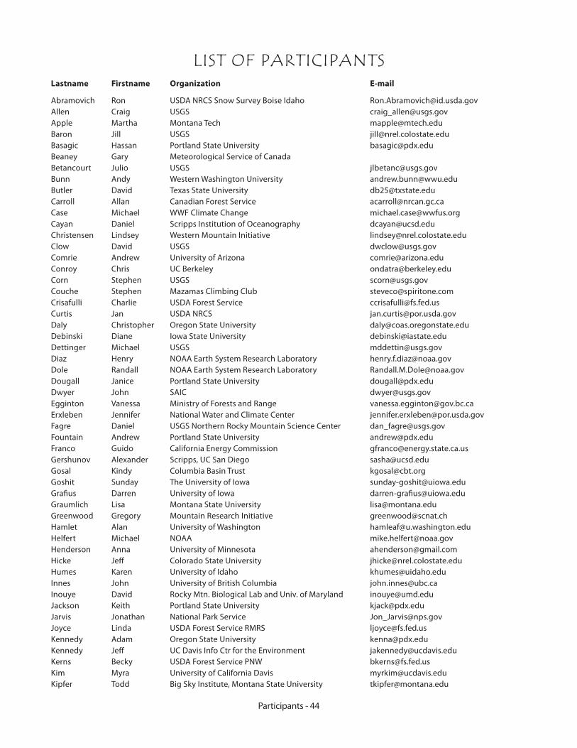
Participants - 44
LIST OF PARTICIPANTSLastname Firstname Organization E-mail
Abramovich Ron USDA NRCS Snow Survey Boise Idaho [email protected] Craig USGS [email protected] Martha Montana Tech [email protected] Jill USGS [email protected] Hassan Portland State University [email protected] Gary Meteorological Service of CanadaBetancourt Julio USGS [email protected] Andy Western Washington University [email protected] David Texas State University [email protected] Allan Canadian Forest Service [email protected] Michael WWF Climate Change [email protected] Daniel Scripps Institution of Oceanography [email protected] Lindsey Western Mountain Initiative [email protected] David USGS [email protected] Andrew University of Arizona [email protected] Chris UC Berkeley [email protected] Stephen USGS [email protected] Stephen Mazamas Climbing Club [email protected] Charlie USDA Forest Service [email protected] Jan USDA NRCS [email protected] Christopher Oregon State University [email protected] Diane Iowa State University [email protected] Michael USGS [email protected] Henry NOAA Earth System Research Laboratory [email protected] Randall NOAA Earth System Research Laboratory [email protected] Janice Portland State University [email protected] John SAIC [email protected] Vanessa Ministry of Forests and Range [email protected] Jennifer National Water and Climate Center [email protected] Daniel USGS Northern Rocky Mountain Science Center [email protected] Andrew Portland State University [email protected] Guido California Energy Commission [email protected] Alexander Scripps, UC San Diego [email protected] Kindy Columbia Basin Trust [email protected] Sunday The University of Iowa [email protected] Darren University of Iowa [email protected] Lisa Montana State University [email protected] Gregory Mountain Research Initiative [email protected] Alan University of Washington [email protected] Michael NOAA [email protected] Anna University of Minnesota [email protected] Jeff Colorado State University [email protected] Karen University of Idaho [email protected] John University of British Columbia [email protected] David Rocky Mtn. Biological Lab and Univ. of Maryland [email protected] Keith Portland State University [email protected] Jonathan National Park Service [email protected] Linda USDA Forest Service RMRS [email protected] Adam Oregon State University [email protected] Jeff UC Davis Info Ctr for the Environment [email protected] Becky USDA Forest Service PNW [email protected] Myra University of California Davis [email protected] Todd Big Sky Institute, Montana State University [email protected]
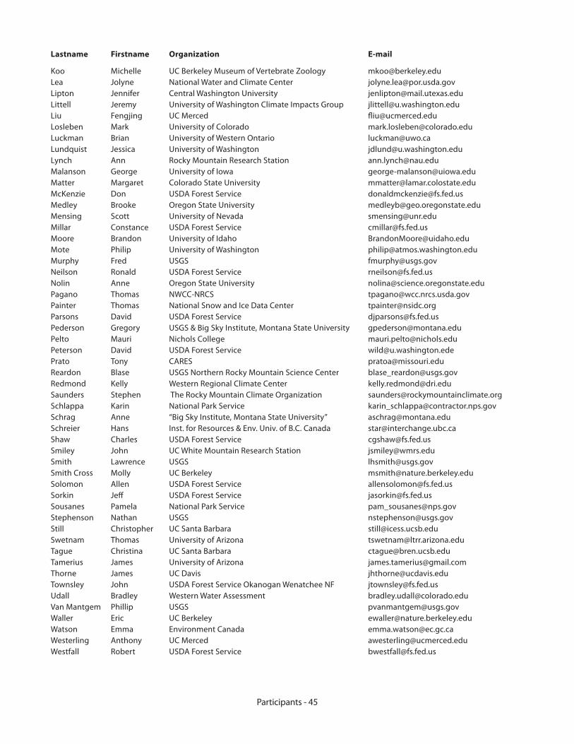
Participants - 45
Lastname Firstname Organization E-mail
Koo Michelle UC Berkeley Museum of Vertebrate Zoology [email protected] Jolyne National Water and Climate Center [email protected] Jennifer Central Washington University [email protected] Jeremy University of Washington Climate Impacts Group [email protected] Fengjing UC Merced [email protected] Mark University of Colorado [email protected] Brian University of Western Ontario [email protected] Jessica University of Washington [email protected] Ann Rocky Mountain Research Station [email protected] George University of Iowa [email protected] Margaret Colorado State University [email protected] Don USDA Forest Service [email protected] Brooke Oregon State University [email protected] Scott University of Nevada [email protected] Constance USDA Forest Service [email protected] Brandon University of Idaho [email protected] Philip University of Washington [email protected] Fred USGS [email protected] Ronald USDA Forest Service [email protected] Anne Oregon State University [email protected] Thomas NWCC-NRCS [email protected] Thomas National Snow and Ice Data Center [email protected] David USDA Forest Service [email protected] Gregory USGS & Big Sky Institute, Montana State University [email protected] Mauri Nichols College [email protected] David USDA Forest Service [email protected] Tony CARES [email protected] Blase USGS Northern Rocky Mountain Science Center [email protected] Kelly Western Regional Climate Center [email protected] Stephen The Rocky Mountain Climate Organization [email protected] Karin National Park Service [email protected] Anne “Big Sky Institute, Montana State University” [email protected] Hans Inst. for Resources & Env. Univ. of B.C. Canada [email protected] Charles USDA Forest Service [email protected] John UC White Mountain Research Station [email protected] Lawrence USGS [email protected] Cross Molly UC Berkeley [email protected] Allen USDA Forest Service [email protected] Jeff USDA Forest Service [email protected] Pamela National Park Service [email protected] Nathan USGS [email protected] Christopher UC Santa Barbara [email protected] Thomas University of Arizona [email protected] Christina UC Santa Barbara [email protected] James University of Arizona [email protected] James UC Davis [email protected] John USDA Forest Service Okanogan Wenatchee NF [email protected] Bradley Western Water Assessment [email protected] Mantgem Phillip USGS [email protected] Eric UC Berkeley [email protected] Emma Environment Canada [email protected] Anthony UC Merced [email protected] Robert USDA Forest Service [email protected]

Managers Workshop - 46
Resource Options for Forest Management In the Context of Climate Change
Post-Conference Workshop for Resource Managers
22 September 2006, 1:30 – 4:30pmTimberline Lodge, Mt. Hood, OR
Workshop OrganizersLinda Joyce, USDA Forest Service, Rocky Mountain Research Station, Ft. Collins, CO
Connie Millar, USDA Forest Service, Pacific Southwest Research Station, Albany, CA
Ron Neilson, USDA Forest Service, Pacific Northwest Research Station, Corvallis, OR
Dave Peterson, USDA, Forest Service, Pacific Northwest Research Station, Seattle, WA
John Townsley, USDA Forest Service, Okanogan and Wenatchee National Forests
Workshop Objectives Communicate current projections of future climate variability in the Pacific Northwest and its consequences to natural vegetation and forest resources in the region
Discuss new contexts and strategies for forest management under conditions of climate variability and uncertainty
Facilitate discussion on the needs and opportunities for developing case studies to incorporate climate change into forest management
Target AudienceResource managers from land-managing agencies, forest industry, and NGOs interested in learning more about climate consequences to PNW forests and in exploring options for resource-management strategies
Agenda“State of Knowledge: Climate and Vegetation Projections for PNW and Implications to Forest Management”, Ron Neilson, USDA Forest Service, PNW, Corvallis, OR
“Forest Management Strategies”, Connie Millar, USDA Forest Service, Albany, CA
“Lessons from National Forest Plan Revision: Incorporating Climate”, John Townsley, Okanogan and Wenatchee National Forests, Wenatchee, WA
Facilitated Discussion: “Developing Case Studies for Adaptation of Sensitive Forest Resources to Climate Change”, Introduction and Discussion Leaders: Linda Joyce, USDA Forest Service, Ft. Collins, CO and John Townsley, USDA Forest Service, Wentachee, WA
LogisticsThe workshop will take place from 1:30 to 4:30 pm on September 22, 2006 after the conclusion of the MTNCLIM 2006 workshop at Timberline Lodge, Mt. Hood, OR.
There is no fee for the workshop, but workshop space is limited.
Please register in advance with an email to [email protected] by September 12, 2006. For more information, contact Connie by email or phone at 510-559-6435.
•
•
•
•
•
•
•
•
•
•
•
•
•
•
•
•