september 2011 petroleumdmp.wa.gov.au/documents/petroleum/pd-res-pub-121d.pdfkey petroleum contacts...
TRANSCRIPT

IN WESTERN AUSTRALIAPETROLEUM
SEPTEMBER 2011
KEY PETROLEUM CONTACTS DEPARTMENT OF MINES AND PETROLEUM
EXECUTIVEDIRECTOR GENERAL Richard Sellers TEL: (08) 9222 3555
Deputy Director General Approvals Tim Griffin TEL: (08) 9222 3160
PETROLEUM DIVISIONTEL: (08) 9222 3622FAX: (08) 9222 3799
EXECUTIVE EXECUTIVE DIRECTORBill Tinapple TEL: (08) 9222 3291
DIRECTOR TECHNOLOGY, PETROLEUM AND GEOTHERMALJeffery Haworth TEL: (08) 9222 3214
RESOURCESGENERAL MANAGERReza Malek TEL: (08) 9222 3759
SENIOR PETROLEUM TECHNOLOGIST Steve Walsh TEL: (08) 9222 3267
SENIOR ENERGY GEOTECHNOLOGISTMike Middleton TEL: (08) 9222 3076
PETROLEUM DEVELOPMENT GEOLOGIST Craig Durran TEL: (08) 9222 3017
PETROLEUM RESOURCE GEOLOGIST Karina Jonasson TEL: (08) 9222 3445
EXPLORATION GEOLOGIST Richard Bruce TEL: (08) 9222 3314
SENIOR TECHNICAL OFFICER Mark Fletcher TEL: (08) 9222 3652
PETROLEUM TENURE AND LAND ACCESSGENERAL MANAGER Beverley Bower TEL: (08) 9222 3133
MANAGER LAND ACCESSMaryie Platt TEL: (08) 9222 3813
MANAGER PETROLEUM REGISTER Stephen Collyer TEL: (08) 9222 3318
MANAGER PETROLEUM AND GEOTHERMAL INFRASTRUCTUREWalter Law TEL: (08) 9222 3319
BUSINESS DEVELOPMENTGENERAL MANAGERMark Gabrielson TEL: (08) 9222 3010
PRINCIPAL LEGISLATION AND POLICY OFFICER
Colin Harvey TEL: (08) 9222 3315
PROJECT COORDINATION AND INFORMATION MANAGEMENT MANAGER
Hazel Harnwell TEL: (08) 9222 3490
APPROVALS MONITORING OFFICER
Hayden Samuels TEL: (08) 9222 3362
ENVIRONMENT DIVISIONGENERAL MANAGER PETROLEUM ENVIRONMENT
Kim Anderson TEL: (08) 9222 3142
SENIOR ENVIRONMENTAL ASSESSOR
Alicia Lim TEL: (08) 9222 3274
SENIOR ENVIRONMENTAL ASSESSOR
Chris Zadow TEL: (08) 9222 3159
RESOURCES SAFETY DIVISION DIRECTOR PETROLEUM SAFETY
Alan Gooch TEL: (08) 9358 8113
MANAGER PETROLEUM PIPELINES
Khalil Ihdayhid TEL: (08) 9358 8118
GEOLOGICAL SURVEY DIVISIONTEL: (08) 9222 3222/3168FAX: (08) 9222 3633
EXECUTIVEEXECUTIVE DIRECTOR
Rick Rogerson TEL: (08) 9222 3170
CHIEF GEOSCIENTIST
Roger Hocking TEL: (08) 9222 3590
RESOURCESMANAGER PETROLEUM GEOLOGY
Alan Millar TEL: (08) 9222 3841
MANAGER PETROLEUM EXPLORATION INFORMATION
Felicia Irimies TEL: (08) 9222 3268
STRATEGIC PLANNING AND ROYALTIESGENERAL MANAGER
David Norris TEL: (08) 9222 3304
MANAGER SYSTEMS AND ANALYSIS
Vince D’Angelo TEL: (08) 9222 3524
MANAGER PETROLEUM ROYALTIES & ACCOUNTING
Angelo Duca TEL: (08) 9222 3662
Government of Western AustraliaDepartment of Mines and Petroleum
DM
PJU
L11_
1352
WESTERN AUSTRALIA’S DIGEST OF PETROLEUM EXPLORATION, DEVELOPMENT AND PRODUCTION
1PWA SEPTEMBER 2011 – CONTENTS
ARTICLES
03 Minister’s Message
04 Executive Director’s Message: Is Hydraulic Fracturing a Problem in WA?
06 Petroleum Exploration, Production and Development Activity in Western Australia — Highlights from January to June 2011
14 Awards of Petroleum Exploration Permits
16 State Areas Released for Petroleum Exploration September 2011
18 Shallow Gas in the Onshore Carnarvon Basin of Western Australia
24 Heat Generation in the Darling Range Granites: Implications for Geothermal Exploration
28 Company Focus: Green Rock Energy Limited
33 Collie Hub Carbon Capture and Storage Project
TABLES
35 Table 1. 2010 Production by Field and Cumulative Production as at 31 December 2010
37 Table 2. Petroleum Reserves Estimates by Basin as at 31 December 2010
38 Table 3. Seismic Surveys in Western Australia 2010–11 Fiscal Year — Statistical Summary
38 Table 4. Petroleum Wells in Western Australia 2010–11 Fiscal Year — Statistical Summary
39 Table 5. Seismic Surveys in Western Australia Operating 2010–11 Fiscal Year
40 Table 6. Petroleum Wells in Western Australia Operating 2010–11 Fiscal Year
44 Table 7. List of Petroleum and Geothermal Titles and Holders in Western Australia as at 1 July 2011
Trade and Investment Offices
Key Petroleum Contacts
Department of Mines and Petroleum Petroleum Division Mineral House, 100 Plain Street East Perth, Western Australia 6004Tel: +61 8 9222 3622 Fax: +61 8 9222 3799www.dmp.wa.gov.au
Editor: Karina JonassonEmail: [email protected] Photo: Fracture stimulation equipment at Warro 4 in the northern Perth Basin (Photo courtesy of Nirmal Mathew)
Disclaimer: The information contained in this publication is provided in good faith and believed to be reliable and accurate at the time of publication. However, the information is provided on the basis that a reader will be solely responsible for making their own assessment of the information and its veracity and usefulness.
The State shall in no way be liable, in negligence or howsoever, for any loss sustained or incurred by anyone relying on the information, even if such information is or turns out to be wrong, incomplete, out of date or misleading.
Contents
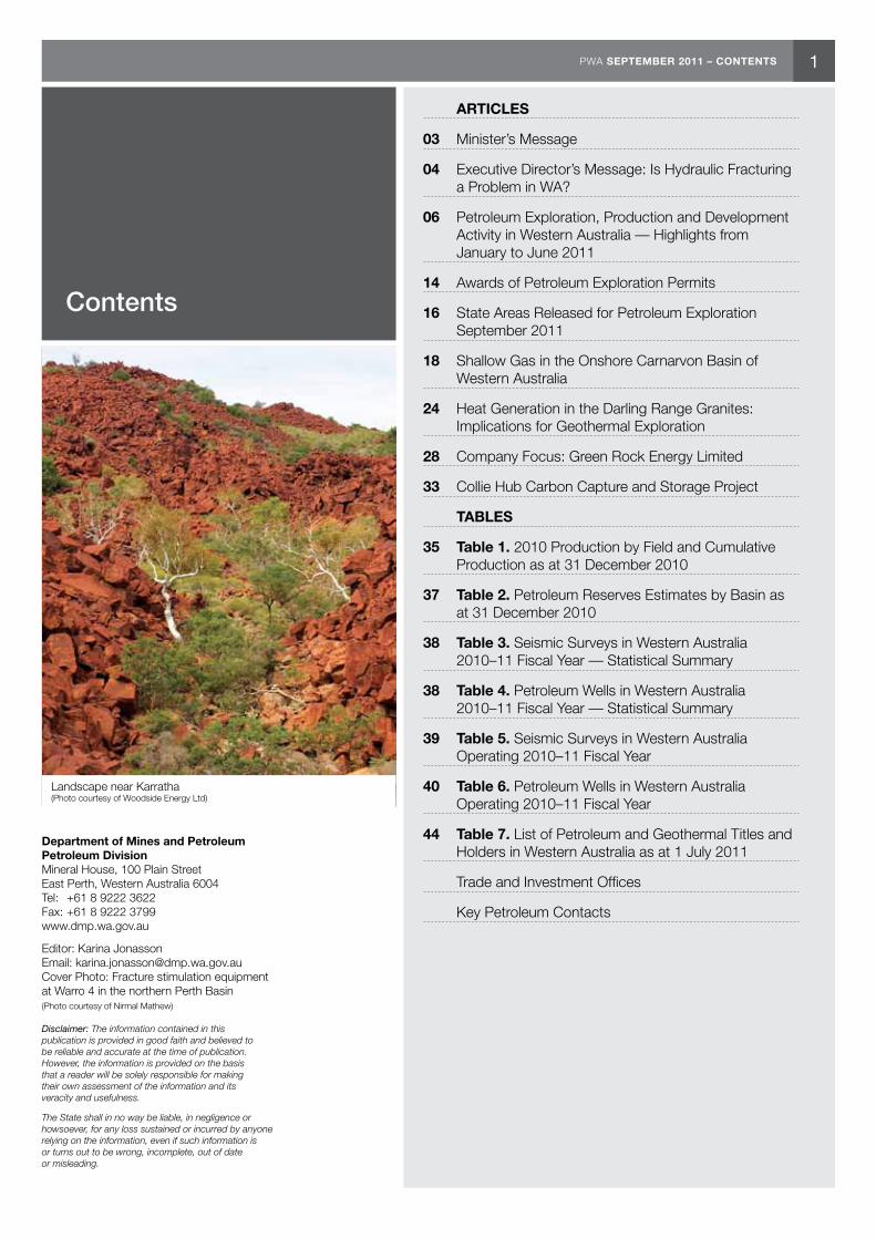
Landscape near Karratha (Photo courtesy of Woodside Energy Ltd)
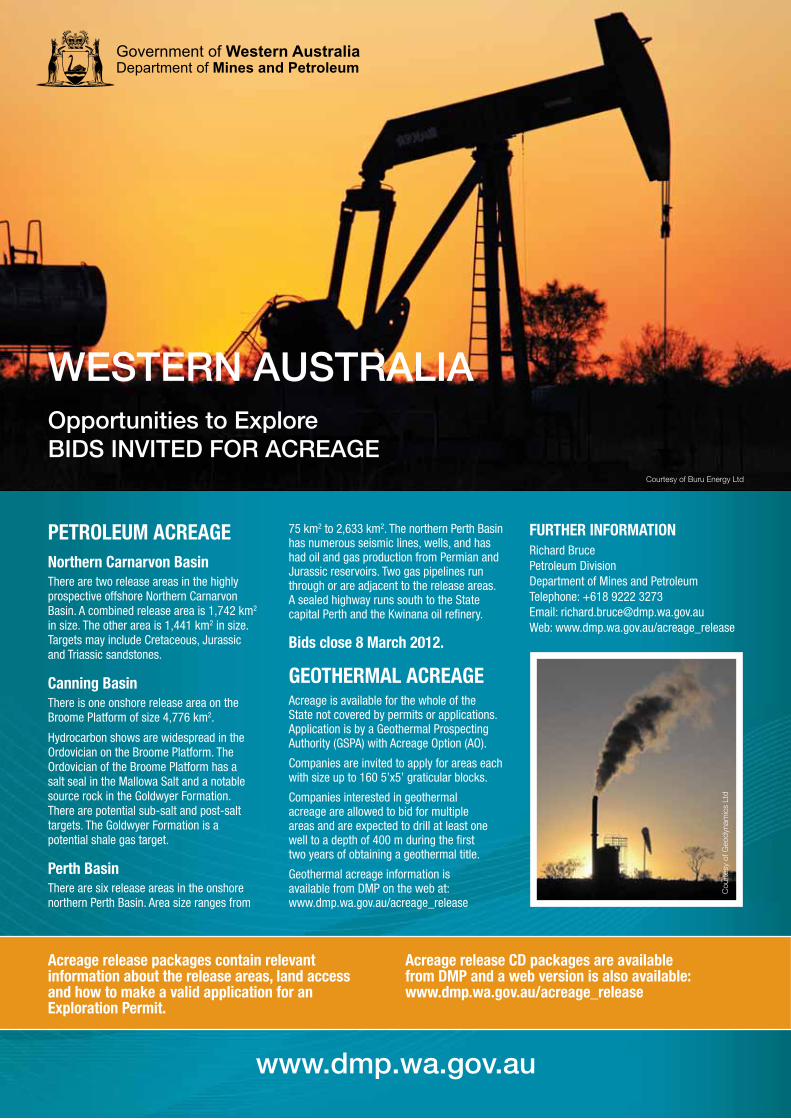
PETROLEUM ACREAGENorthern Carnarvon BasinThere are two release areas in the highly prospective offshore Northern Carnarvon Basin. A combined release area is 1,742 km2 in size. The other area is 1,441 km2 in size. Targets may include Cretaceous, Jurassic and Triassic sandstones.
Canning BasinThere is one onshore release area on the Broome Platform of size 4,776 km2.
Hydrocarbon shows are widespread in the Ordovician on the Broome Platform. The Ordovician of the Broome Platform has a salt seal in the Mallowa Salt and a notable source rock in the Goldwyer Formation. There are potential sub-salt and post-salt targets. The Goldwyer Formation is a potential shale gas target.
Perth BasinThere are six release areas in the onshore northern Perth Basin. Area size ranges from
75 km2 to 2,633 km2. The northern Perth Basin has numerous seismic lines, wells, and has had oil and gas production from Permian and Jurassic reservoirs. Two gas pipelines run through or are adjacent to the release areas. A sealed highway runs south to the State capital Perth and the Kwinana oil refinery.
Bids close 8 March 2012.
GEOTHERMAL ACREAGEAcreage is available for the whole of the State not covered by permits or applications. Application is by a Geothermal Prospecting Authority (GSPA) with Acreage Option (AO).
Companies are invited to apply for areas each with size up to 160 5’x5’ graticular blocks.
Companies interested in geothermal acreage are allowed to bid for multiple areas and are expected to drill at least one well to a depth of 400 m during the first two years of obtaining a geothermal title.
Geothermal acreage information is available from DMP on the web at: www.dmp.wa.gov.au/acreage_release
FURTHER INFORMATIONRichard Bruce Petroleum Division Department of Mines and Petroleum Telephone: +618 9222 3273 Email: [email protected] Web: www.dmp.wa.gov.au/acreage_release
www.dmp.wa.gov.au
WESTERN AUSTRALIAOpportunities to ExploreBIDS INVITED FOR ACREAGE
Acreage release packages contain relevant information about the release areas, land access and how to make a valid application for an Exploration Permit.
Acreage release CD packages are available from DMP and a web version is also available: www.dmp.wa.gov.au/acreage_release
Cou
rtes
y of
Geo
dyna
mic
s Lt
d
Courtesy of Buru Energy Ltd

PWA SEPTEMBER 2011 – MINISTER’S MESSAGE
Minister’s Message
Hon. Norman Moore MLCMinister for Mines and Petroleum
3
The petroleum sector is Western Australia’s second largest sector after iron ore. Last year it accounted for more than $22 billion or 25 per cent of total sales. In 2010, approximately $2.5 billion was spent on petroleum exploration in Western Australia, the second highest figure on record.
The State is Australia’s largest producer of oil and gas. Last year, WA was responsible 89 per cent of the nation’s crude oil and condensate production and 71 per cent of Australia’s natural gas production. This is a trend that is set to continue.
There is more than $140 billion worth of projects in the pipeline in Western
Australia. These will generate thousands of jobs in the next decade.
We have eight liquified natural gas (LNG) projects that are coming close to starting; six projects, including Gorgon and Pluto, which are moving ahead; and we can see another six to eight on-line, with final decisions to be made in the next year.
To put this into perspective, at the end of last year, we had 4,020 giga cubic metres (142 trillion cubic feet) of gas resources, which is, at our current rate of consumption, enough to provide energy for 125 years.
Once we increase production, which will happen in the next six to seven years, we have calculated we may have 30 to 35 years of gas resources behind us. However, this doesn’t include yet-to-be discovered resources.
There is also the potential for significant onshore discoveries. If shale and tight gas production is demonstrated, we would see a further expansion of the industry. Shale reservoirs have so far been identified in the Perth and Canning basins.
An independent report released in April by the US Energy Information Administration lists Australia as one of the top ten countries with technically recoverable shale gas resources, equalling 11,213 Gm3 (396 Tcf).
WA’s shale gas resources total 8,155 Gm3 (288 Tcf), which is two times the current amount of natural gas the Department of Mines and Petroleum currently has on file. Shale gas is in its infancy stage in WA, but it looks like this sector will have high potential.
However, it is vital that the department and industry address public concerns surrounding shale, tight and coal seam gas.
DMP is aware of concerns that the hydraulic fracturing process associated with shale, tight and coal seam gas (CSG) has potentially serious environmental impacts, including issues associated with water supplies.
However, there are a number of mitigating factors influencing the situation in Western Australia to make
it very different to other parts of the world, particularly where CSG is the target, such as in Queensland and New South Wales.
Importantly, shale gas and tight gas resources in Western Australia are located at deep horizons, well separated from fresh water aquifers.
In Queensland for example, it is common for resources to be located relatively close to the surface at approximately 200–1,000 metres, where aquifers can also be located.
In Western Australia, our fresh water aquifers are typically located no deeper than 600 metres, with our unconventional gas resources located at depths beyond 2,000 metres.
This means that there is generally a separation between aquifers and unconventional gas resources of at least 1.4 kilometres.
DMP has extensive experience in regulation, having been ensuring the safe development of these resources and the use of these operational techniques, including hydraulic fracturing, for more than 40 years.
The approvals process used ensures that any company seeking to carry out petroleum drilling operations must submit a Drilling Application, Environmental Management Plan and Safety Management Plan detailing their intended actions. This includes details of chemicals to be used and how the environment, including ground water, will be protected.
DMP is also able to request further information from companies to ensure that all necessary precautions are being taken to protect the environment.
DMP liaises with other State Government agencies, such as the Environmental Protection Authority (EPA) and the Department of Water to ensure that a whole-of-Government approach is taken to protect the environment.
I am confident that the State’s current regulatory processes will ensure water resources are adequately protected from any potential hydraulic fracturing activities.
Bill TinappleExecutive DirectorPetroleum Division
4 PWA SEPTEMBER 2011 – EXECUTIVE DIRECTOR’S MESSAGE
Following adverse publicity from news coverage, documentaries and moratoriums imposed by some governments, there has been public concern in Western Australia over hydraulic fracturing and the potential to cause water pollution. Is it a serious problem in WA?
The application of technologies from overseas is providing the opportunity to tap new natural gas resources in Western Australia. The technologies are based on combining hydraulic fracturing with horizontal drilling in shale and tight formations to make these sources of gas commercially viable. Hydraulic fracturing creates flow paths in the impermeable rocks. As written in the previous edition of Petroleum in Western Australia, demonstration of commerciality could create the next phase of expansion in the State’s gas and LNG industries.
At the end of 2010, WA was estimated to have over 4,000 Gm3 (142 trillion cubic feet (Tcf)) of known gas resources. This is about two per cent of world gas reserves. These resources are mostly offshore WA in the Commonwealth Area. Industry is still discovering more gas than is produced, for example, for 2010, 226.5 Gm3 (8 Tcf) was discovered while only just over 28.3 Gm3 (1 Tcf) was produced.
However, despite new gas resources being discovered offshore, the real potential growth area for the State is onshore with shale gas and tight gas. A recent estimate (April 2011) by the US Energy Information Services estimated shale gas in the Perth Basin and
Canning Basin to be 8,155 Gm3 (288 Tcf). This estimate did not include other prospective areas or tight gas. Although there is some potential for coal seam gas (CSG) and some companies are exploring for it, CSG resources are still to be demonstrated. There is also potential for underground coal gasification (UCG), however, this is a different resource and covered under a different regulatory regime.
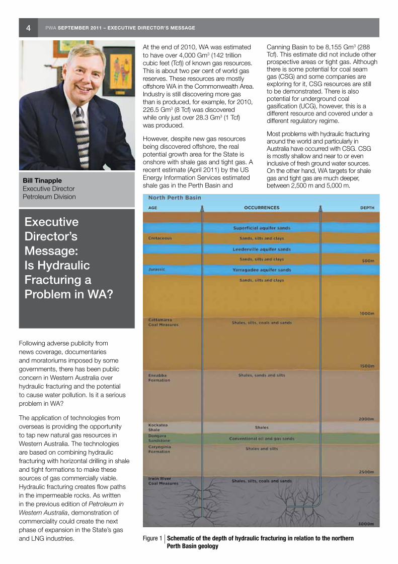
Most problems with hydraulic fracturing around the world and particularly in Australia have occurred with CSG. CSG is mostly shallow and near to or even inclusive of fresh ground water sources. On the other hand, WA targets for shale gas and tight gas are much deeper, between 2,500 m and 5,000 m.
Executive Director’s Message: Is Hydraulic Fracturing a Problem in WA?
Figure 1 Schematic of the depth of hydraulic fracturing in relation to the northern Perth Basin geology
PWA SEPTEMBER 2011 – EXECUTIVE DIRECTOR’S MESSAGE 5
The height of fractures caused by hydraulic fracturing is limited to about 300 m (see Figure 1).
The buffer zone of rock and shale prevents fracturing fluids from reaching ground water zones.
One pathway for fracturing fluids to potentially reach ground water zones is through wells. Proper well design and construction provides protection and prevents leakage to the surrounding rock formations.
The other pathway for fracturing fluids to potentially reach ground water zones is from the surface. Although about 60 per cent of fluids are locked in the deep formations, about 40 per cent flows back to the surface and has to be recovered and safely disposed of. Unlike de-watering that is required for CSG, shale gas and tight gas do not have significant produced formation water. Proper design of structures for containment of any flow-back fluids will prevent impacts to soil and ground water.
Companies are required to submit well drilling programs as well as environment management programs for assessment and approval.
DMP not only monitors drilling (including hydraulic fracturing) at this preliminary stage but monitors activities throughout drilling by reviewing daily drilling reports, meetings and site visits, as required.
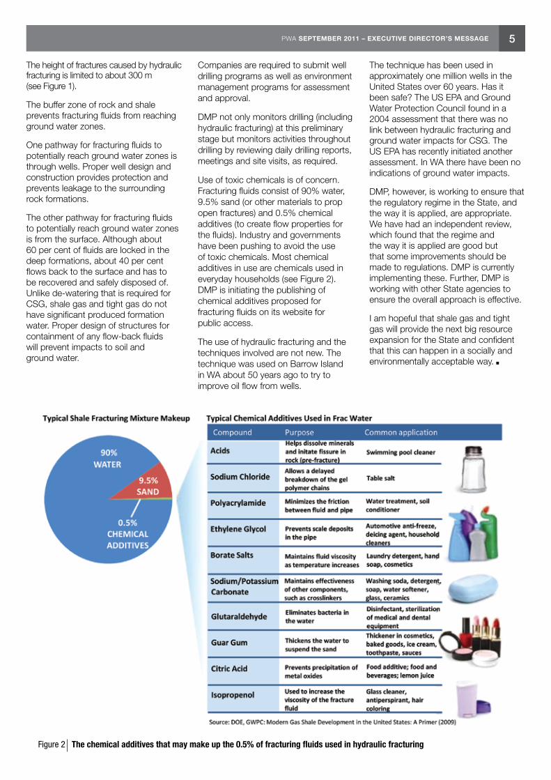
Use of toxic chemicals is of concern. Fracturing fluids consist of 90% water, 9.5% sand (or other materials to prop open fractures) and 0.5% chemical additives (to create flow properties for the fluids). Industry and governments have been pushing to avoid the use of toxic chemicals. Most chemical additives in use are chemicals used in everyday households (see Figure 2). DMP is initiating the publishing of chemical additives proposed for fracturing fluids on its website for public access.
The use of hydraulic fracturing and the techniques involved are not new. The technique was used on Barrow Island in WA about 50 years ago to try to improve oil flow from wells.
The technique has been used in approximately one million wells in the United States over 60 years. Has it been safe? The US EPA and Ground Water Protection Council found in a 2004 assessment that there was no link between hydraulic fracturing and ground water impacts for CSG. The US EPA has recently initiated another assessment. In WA there have been no indications of ground water impacts.
DMP, however, is working to ensure that the regulatory regime in the State, and the way it is applied, are appropriate. We have had an independent review, which found that the regime and the way it is applied are good but that some improvements should be made to regulations. DMP is currently implementing these. Further, DMP is working with other State agencies to ensure the overall approach is effective.
I am hopeful that shale gas and tight gas will provide the next big resource expansion for the State and confident that this can happen in a socially and environmentally acceptable way.
Figure 2 The chemical additives that may make up the 0.5% of fracturing fluids used in hydraulic fracturing

6 PWA SEPTEMBER 2011 – PETROLEUM EXPLORATION, PRODUCTION AND DEVELOPMENT ACTIVITY
Karina Jonasson Petroleum Resource Geologist Resources Branch
Petroleum Exploration, Production and Development Activity in Western Australia — Highlights from January to June 2011
This article highlights petroleum exploration, production and development activities for the second half of the 2010–11 fiscal year. Statistical summary tables for this period can be found in the back of this magazine. A summary of activities carried out in the 2010 calendar year can be found in the April 2010 edition of the Petroleum in Western Australia magazine.
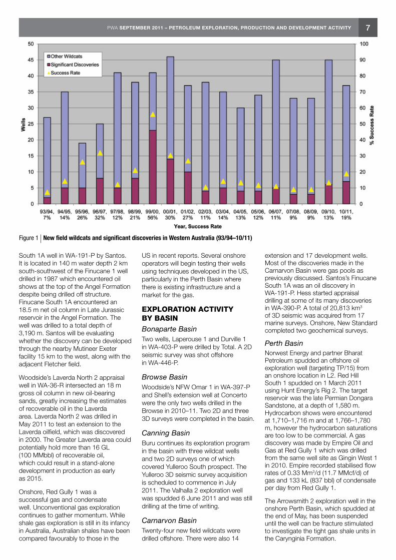
Wells drilled in 2010–11 consisted of 37 new field wildcats, 16 extension, and 14 development wells, for a total of 67 wells, which is two fewer than last fiscal year (Fig. 1). Of these, 15 wells were drilled onshore. While development activity is being maintained at the same level as last year, the amount of exploration drilling has been decreasing over the last few years. A total of 10,797 line km from 2D seismic and airborne gravity surveys and 23,942 km2 from 3D seismic surveys (one of which was shot onshore) were carried out this fiscal year in Western Australia.
Drilling was again concentrated in the offshore Carnarvon Basin where Chevron, Apache, Woodside and Santos were the main operators with successful exploration activities in the first half of 2011. Empire Oil and Gas was the only successful onshore operator, with the discovery of gas and condensate at Red Gully 1 in the Perth Basin (Figs 2–4).
Offshore in the Carnarvon Basin, Apache’s Zola 1ST1 was a natural gas
discovery, Santos drilled Finucane South 1A resulting in an oil discovery, and Chevron’s Orthrus 2 proved a deeper discovery in the Orthrus field. Apache also had success with Balnaves Deep 1, encountering oil and gas. Woodside’s Martin 1 well intersected gas while its appraisal well at Laverda North 1 encountered oil.
One field started up production in the first half of 2011 — Apache’s Halyard gas and condensate field came on line in June. Both the Ravensworth and Redback fields started production in the second half of 2010.
In February, Chevron announced drilling success at Orthrus 2 which was drilled to a total depth of 4,297 m in WA-24-R. The well encountered 74 m of net gas pay, of which 31 m of net gas pay was encountered in a deeper, previously unexplored target interval in the Orthrus field.
Zola 1ST1 was spudded on 1 December 2010 in WA-290-P and abandoned on 27 April 2011. The well tested the gas potential of several top and intra Triassic Mungaroo Formation sands (the primary reservoir at Gorgon) and discovered approximately 125 m of net gas pay in several sandstones from 4,099.5 to 4,602.5 m depth, where thickness and reservoir quality were reportedly better than expected. The Zola structure is a very large Triassic tilted fault block on trend with the giant Gorgon gasfield and had been one of
the largest undrilled structural features in the Carnarvon Basin. Apache has stated that data gathered to date in Zola 1 and Zola 1ST1 has confirmed a significant gas discovery in the Mungaroo Formation. The well results indicate that volumetrically the greater Zola structure could be at the upper end of pre drill estimates of 28.3–56.6 Gm3 (1–2 Tcf).
Located close to existing and developing gas infrastructure, Zola could have multiple potential development options. Any development at Zola could also include the overlying Antiope gas discovery from 1999-2000 (estimated at ~3.4 Gm3 (120 Bcf)).
Balnaves Deep 1 was drilled in WA-356-P in March 2011 to appraise the Balnaves field following three successful appraisal wells by Apache in October. In May the company reported 110.3 m of net pay in a deeper Mungaroo gas pool in Balnaves Deep 1. The discovery will likely be tied in with the development of Apache’s Julimar-Brunello complex as additional gas for the Wheatstone project.
Woodside’s gas discovery at Martin 1 in March, with a 100 m gross gas column, will likely contribute to the Pluto LNG project along with other recent discoveries in WA-404-P, such as Martell 1, Noblige 1, Larsen 1, Larsen Deep 1 and Remy 1.
In June an exciting oil discovery was made with the drilling of the Finucane
Drillers at work on the Jack Bates (Photo courtesy of Kai Photography and Hess Exploration)
7PWA SEPTEMBER 2011 – PETROLEUM EXPLORATION, PRODUCTION AND DEVELOPMENT ACTIVITY
South 1A well in WA-191-P by Santos. It is located in 140 m water depth 2 km south-southwest of the Finucane 1 well drilled in 1987 which encountered oil shows at the top of the Angel Formation despite being drilled off structure. Finucane South 1A encountered an 18.5 m net oil column in Late Jurassic reservoir in the Angel Formation. The well was drilled to a total depth of 3,190 m. Santos will be evaluating whether the discovery can be developed through the nearby Mutineer Exeter facility 15 km to the west, along with the adjacent Fletcher field.
Woodside’s Laverda North 2 appraisal well in WA-36-R intersected an 18 m gross oil column in new oil-bearing sands, greatly increasing the estimates of recoverable oil in the Laverda area. Laverda North 2 was drilled in May 2011 to test an extension to the Laverda oilfield, which was discovered in 2000. The Greater Laverda area could potentially hold more than 16 GL (100 MMbbl) of recoverable oil, which could result in a stand-alone development in production as early as 2015.
Onshore, Red Gully 1 was a successful gas and condensate well. Unconventional gas exploration continues to gather momentum. While shale gas exploration is still in its infancy in Australia, Australian shales have been compared favourably to those in the
US in recent reports. Several onshore operators will begin testing their wells using techniques developed in the US, particularly in the Perth Basin where there is existing infrastructure and a market for the gas.
EXPLORATION ACTIVITY BY BASINBonaparte BasinTwo wells, Laperouse 1 and Durville 1 in WA-403-P were drilled by Total. A 2D seismic survey was shot offshore in WA-446-P.
Browse BasinWoodside’s NFW Omar 1 in WA-397-P and Shell’s extension well at Concerto were the only two wells drilled in the Browse in 2010–11. Two 2D and three 3D surveys were completed in the basin.
Canning BasinBuru continues its exploration program in the basin with three wildcat wells and two 2D surveys one of which covered Yulleroo South prospect. The Yulleroo 3D seismic survey acquisition is scheduled to commence in July 2011. The Valhalla 2 exploration well was spudded 6 June 2011 and was still drilling at the time of writing.
Carnarvon BasinTwenty-four new field wildcats were drilled offshore. There were also 14
extension and 17 development wells. Most of the discoveries made in the Carnarvon Basin were gas pools as previously discussed. Santos’s Finucane South 1A was an oil discovery in WA-191-P. Hess started appraisal drilling at some of its many discoveries in WA-390-P. A total of 20,813 km3 of 3D seismic was acquired from 17 marine surveys. Onshore, New Standard completed two geochemical surveys.
Perth BasinNorwest Energy and partner Bharat Petroleum spudded an offshore oil exploration well (targeting TP/15) from an onshore location in L2. Red Hill South 1 spudded on 1 March 2011 using Hunt Energy’s Rig 2. The target reservoir was the late Permian Dongara Sandstone, at a depth of 1,580 m. Hydrocarbon shows were encountered at 1,710–1,716 m and at 1,766–1,780 m, however the hydrocarbon saturations are too low to be commercial. A gas discovery was made by Empire Oil and Gas at Red Gully 1 which was drilled from the same well site as Gingin West 1 in 2010. Empire recorded stabilised flow rates of 0.33 Mm3/d (11.7 MMcf/d) of gas and 133 kL (837 bbl) of condensate per day from Red Gully 1.
The Arrowsmith 2 exploration well in the onshore Perth Basin, which spudded at the end of May, has been suspended until the well can be fracture stimulated to investigate the tight gas shale units in the Carynginia Formation.
Figure 1 New field wildcats and significant discoveries in Western Australia (93/94–10/11)

8 PWA SEPTEMBER 2011 – PETROLEUM EXPLORATION, PRODUCTION AND DEVELOPMENT ACTIVITY
Green Rock Energy Limited and BHP Billiton Worsley Alumina Pty Ltd carried out temperature soil and soil-gas sampling and gravity surveys for a geothermal project covering GEP 10, GEP 11 and GEP 12 in the Perth and Collie basins. Field acquisition occurred in 2010 and interpretation of data was carried out in 2011, and reported in June 2011.
PRODUCTIONIn 2010, 67 fields were producing hydrocarbons from 42 licences in Western Australia (Bonaparte, Canning, Carnarvon and Perth basins). Average daily production in 2010 was 58,189.5 kL/d for liquids and 99,895.5 km3/d gas. Production and reserves data to the end of the 2010 calendar year can be found in the tables section at the back of the magazine.
One new field came online in the first half of 2011: Apache’s Halyard gas and condensate field, which was tied back to the Varanus Island processing facilities via East Spar. Halyard supplies domestic gas for Western Australia. Halyard will have an initial capacity of 1.4 Mm3 (50 MMcf) of gas equivalent per day, and will double once the Spar 2 well is tied into the development. Apache is operator and holds a 55 per cent interest in the development. Santos holds the remaining 45 per cent.
Production ForecastThe Australian Bureau of Agricultural and Resource Economics and Sciences (ABARES) June 2011 report indicated that in 2010–11, Australian LNG exports are estimated to increase by eight per cent to 19.3 MMt due to higher demand from Japan, Korea and China. The exports would be augmented by start-up of projects currently under construction including Gorgon and two LNG projects in Queensland. In 2011–12, ABARES said there was potential for LNG exports to continue to increase by two per cent to 19.7 MMt underpinned by the scheduled start-up of the Pluto project in March 2012, with increased production supported by the Halyard and Reindeer fields in the Carnarvon Basin.
Australia’s gas production is forecast to increase by 11 per cent to 5.4 Gm3 (190.7 Bcf) during 2010–11, and by a further 17 per cent in 2011–12.
ABARES said Australia’s oil and condensate production would decline by 1.5 per cent in 2010–11 to 25.2 GL (158.5 MMbbl) mainly due to weather
disruptions and despite the ramp-up of Pyrenees and Van Gogh which has supported increased production since the second half of 2010. In 2011–12 production is forecast to increase by seven per cent to 26.9 GL (169 MMbbl), strengthened by new projects in the Carnarvon and Bonaparte basins.
DEVELOPMENT ACTIVITY OFFSHORE
BalnavesThe Balnaves field is an oil accumulation in the Mungaroo Formation in a separate reservoir beneath the large gas reservoirs of the Brunello gasfield. Balnaves 1 encountered 20 m of net oil pay in 2009. Apache has estimated 2.2–2.8 GL (14–18 MMbbl) of oil equivalent could be recoverable from the accumulation. Apache is reportedly working towards a final investment decision on the development of the Balnaves oilfield. The project is expected to cost $445 million to develop through a floating, production, storage and offloading vessel and first production from the field is expected in 2014 at 4,770 kL (30,000 bbl) of oil equivalent per day.
Browse LNGWoodside is planning the Tridacna 3D survey over the southern portion of the Torosa gasfield which lies partly beneath Scott Reef. The survey is expected to take place during June to November and follows on from previous seismic surveys carried out in 2007 and 2008 as part of the ongoing program to appraise Torosa.
The proposed Browse development at James Price Point in Western Australia’s Kimberley region includes the Torosa, Brecknock and Calliance discoveries, located offshore around 425 km north of Broome. The fields contain a combined contingent resource of about 396 Gm3 (14 Tcf) of dry gas and 58.8 GL (370 MMbbl) of condensate.
Woodside started front-end engineering and design (FEED) work for the Browse project in February. In May the traditional owners of James Price Point reached a consent agreement with Woodside and the Western Australian government for the development of a LNG hub. A final investment decision for the development is targeted for mid-2012 while first gas is expected by 2017.
Coniston-NovaraApache has given approval in February to go ahead with the development of the Coniston and Novara oilfields, located in WA-35-L and WA-255-P, via a tieback to the Van Gogh development. A preliminary field development plan has been submitted. The other partners in Coniston are Inpex (41.3 per cent) and Woodside (13 per cent). First oil production from Coniston is expected in 2013.
DixonThe Commonwealth and State governments have thrown down the gauntlet to the North West Shelf Venture with the Joint Authority’s decision not to renew the Dixon Retention Lease (WA-9-R) in the North West Shelf. The North West Shelf Venture has applied for a Production Licence and submitted a preliminary field development plan.
GorgonAward of contracts continues at the Gorgon project in a bid to start domestic gas production from Gorgon by the end of 2015, a year after the first liquefied natural cargo ships in 2014. Chevron says the project is on schedule and on budget. The Atwood Osprey started a drilling program in May in the Greater Gorgon area consisting of an exploration well and Gorgon development wells.
IchthysFederal environmental approval has been given to the Ichthys project. Ichthys is intended to deliver 8.4 million tonnes (MMt) of LNG and 1.6 MMt of liquefied petroleum gas per year as well as 15.9 ML (100,000 bbl) of condensate per day at peak. A final investment decision is expected later this year, with first gas planned for 2016.
NWS CWLH & NRBThe $1.8 billion North West Shelf oil redevelopment project was adversely affected by the bad weather experienced in Australia’s North West in the first part of this year, and is now expected to start production in October. Woodside said completion of critical subsea work was affected while a mechanical fault was also experienced with a contractor’s installation support vessel. It added that it did not expect any increase in the cost of the oil redevelopment project, which includes replacement of the Cossack Pioneer floating, production, storage and offloading facility at the Cossack Wanaea Lambert Hermes (CWLH) oilfields with the Okha FPSO.

9PWA SEPTEMBER 2011 – PETROLEUM EXPLORATION, PRODUCTION AND DEVELOPMENT ACTIVITY
Figure 2 Significant hydrocarbon discoveries in Western Australia
10 PWA SEPTEMBER 2011 – PETROLEUM EXPLORATION, PRODUCTION AND DEVELOPMENT ACTIVITY
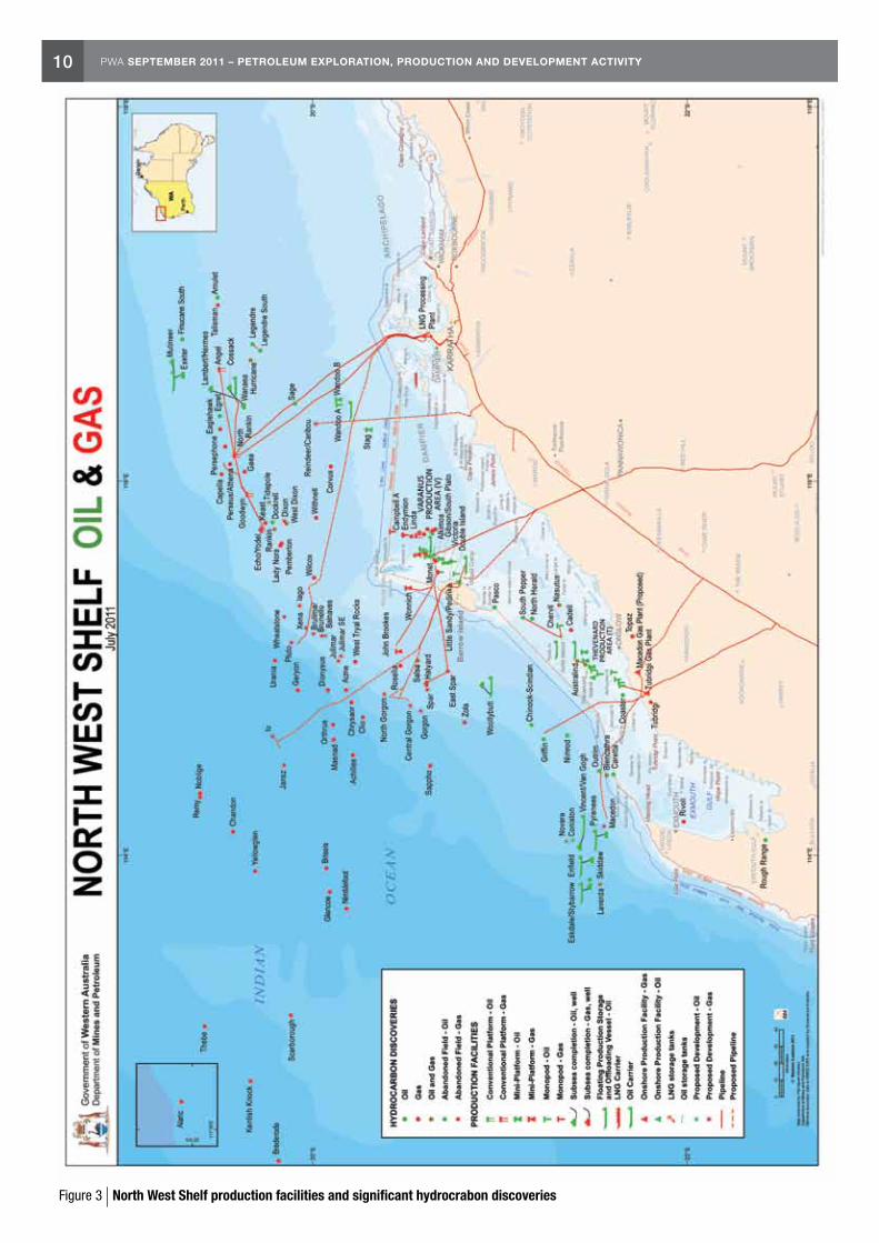
Figure 3 North West Shelf production facilities and significant hydrocrabon discoveries
11PWA SEPTEMBER 2011 – PETROLEUM EXPLORATION, PRODUCTION AND DEVELOPMENT ACTIVITY
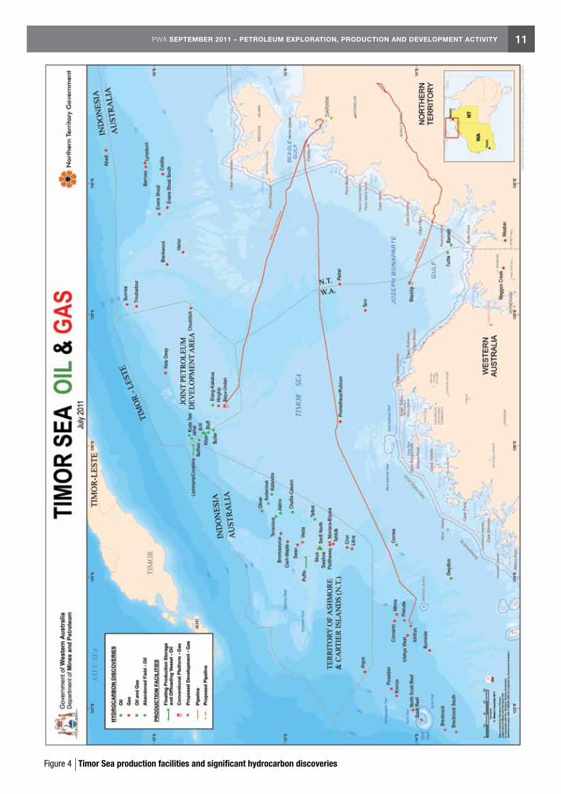
Figure 4 Timor Sea production facilities and significant hydrocarbon discoveries

12 PWA SEPTEMBER 2011 – PETROLEUM EXPLORATION, PRODUCTION AND DEVELOPMENT ACTIVITY
MacedonFollowing approval in September 2010, contracts continue to be filled for BHP Billiton’s Macedon project including one for pipeline construction to the Streicher Clough JV. The Macedon development involves four offshore production wells supplying a wet gas pipeline to an onshore gas treatment plant to be built at Ashburton North, 17 km southwest of Onslow. This will be connected to the Dampier to Bunbury Natural Gas Pipeline for sale into WA’s domestic gas market. First gas is targeted for 2013. Macedon has estimated recoverable reserves of 11.3–21.2 Gm3 (400–750 Bcf) of gas.
PlutoWoodside announced its Pluto liquefied natural gas project would cost an extra $900 million and be another six months late, blowing out costs on an already extended project. The company blames slower than expected progress in commissioning of the onshore gas plant and seven weeks of delays caused by bad weather. Woodside now expects to ship its first cargo of LNG from the project in March 2012.
PreludeIn May 2011, Royal Dutch Shell made the decision to proceed with the Prelude FLNG Project and start construction of its pioneering FLNG facility, to be the largest floating structure ever built at 488 m long and 74 m wide. Once constructed the facility will be towed to location where it will be permanently moored by four groups of massive mooring chains in 250 m-deep water. Each mooring chain held to the sea floor by suction piles the size of small houses, and the FLNG facility has been designed to withstand a Category 5 cyclone. The vessel is expected to be ready in 2016 with first gas in the same year.
The Prelude FLNG facility is expected to be permanently moored about 200 km from the coast for its 25 year project life span, and will be capable of producing at least 3.6 million tonnes of LNG per year, as well as 400,000 tpa liquid petroleum gas (LPG) and 1.3 MMtpa condensate for export. The Prelude field lies in wholly Shell owned WA-371-P and contains estimated reserves of 71 to 85 Gm3 (2.5 to 3.0 Tcf) gas and 1.9 GL (120 MMbbl) of condensate.
The Concerto field will also be developed via this facility. Shell has already agreed to sell LNG from Prelude to Japan’s Osaka Gas.
ReindeerThe Devil Creek project, which will take gas from the Reindeer field located in the offshore WA-209-P block, is on schedule to deliver first gas by November 2011. The Devil Creek plant, located about 50 km from Karratha, is expected to supply up to 220 TJ of gas into the Dampier-Bunbury Natural Gas Pipeline and will also supply up to 8 kL (50 bbl) of condensate per day. The plant will be Western Australia’s third domestic natural gas processing hub and the first new one in more than 15 years.
ScarboroughBHP Billiton and ExxonMobil are considering a range of development options for development of their Scarborough field, including an onshore plant, floating LNG and making a deal with an existing project. Woodside Petroleum’s Pluto project is considered to be a front-runner.
Aerial view of the Pluto LNG plant at Karratha (Photo courtesy of Woodside Energy)

13PWA SEPTEMBER 2011 – PETROLEUM EXPLORATION, PRODUCTION AND DEVELOPMENT ACTIVITY
Wheatstone
With the FEED stage complete and EPA approval granted for the Wheatstone project (June), FID is expected in the second half of 2011. Chevron is still waiting on State and Federal environmental approval. The Wheatstone project will take gas from Chevron’s wholly owned Wheatstone field, located in WA-37-L and WA-38-L.
Apache is also seeking environmental approval for the development of its Julimar and Brunello gasfields, which will feed gas into Wheatstone. The project will take gas from Apache Energy and Kufpec Australia’s Julimar and Brunello fields under a deal that gives the two companies a 13 per cent and 7 per cent equity stake in the Wheatstone facilities respectively. First LNG shipments are expected by 2016.
DEVELOPMENT ACTIVITY ONSHOREWarroThe Warro 4 appraisal well spudded in April 2011 and was drilled to a total depth of 4,137 m and suspended with gas shows. Transerv, the operator of the project, has confirmed the field’s potential after the drilling of the well. The Warro gasfield is estimated to hold up to 283 Gm3 (10 Tcf) of gas in place. A 3D seismic program over the Warro Project area, was carried out in February–March 2011. A Haliburton fraccing crew will be mobilising to Perth to carry out operations on Warro 4 for Transerv before moving on to three other wells. Future plans include a pipeline in late 2012 and anticipated gas production by end of 2013 or start of 2014. Warro is located 200 km north of Perth and 31 km east of both the Dampier-Bunbury Natural Gas Pipeline and the Dongara-Perth Parmelia Pipeline.
Woodada DeepAWE’s shale gas drilling activity commenced in the onshore Perth Basin with the drilling of the Arrowsmith 2 well in EP 413, southeast of the Arrowsmith 1 well which flowed gas on test from the middle Carynginia shale interval. Plans are underway for fracture stimulation and testing of the Arrowsmith 2, Woodada Deep 1 (shale gas) and Senecio 2 (tight gas) in the second half of 2011. Up to 566 Gm3 (20 Tcf) of gas in place has been estimated in the shales of the Carynginia Formation in this area of the Perth Basin. Senecio could add up to 2.83 Gm3 (100 Bcf) gross recoverable gas.
The Arrowsmith 2 well is located approximately 25 km from the Woodada Deep 1 well which was deepened by AWE in April 2010 to core the Carynginia shale interval. A coring program included convention and sidewall cores cut in the Carynginia, IRCM and High Cliff Sandstone formations in Arrowsmith 2.
Fracture stimulation equipment at Warro 4 (Photo courtesy of Yaman Ali)

14 PWA SEPTEMBER 2011 – AWARDS OF PETROLEUM EXPLORATION PERMITS
Richard Bruce Exploration Geologist Resources Branch
Awards of Petroleum Exploration Permits
Commonwealth Award of Petroleum Exploration PermitsThese new permits result from the first round of the 2010 Acreage Release that closed on 11 November 2010.
Commonwealth award information was sourced from Western Australia’s online Petroleum and Geothermal Register and from the July 2011 Australian Petroleum News.
The total indicative value of work commitments for all of the following Commonwealth permits is $128,485,000.
In June 2011 permits WA-453-P and WA-454-P were granted.
WA-453-P (released as W10-16) in the Barrow Sub-basin of the Northern Carnarvon Basin has been awarded to Apache Energy Limited. The company proposed a guaranteed work program of 80 km2 3D seismic processing and geotechnical studies to an estimated value of $685,000. The secondary work program consists of one exploration well and geotechnical studies to an estimated value of $25.4 million. There were no other bids for this area.
WA-454-P (released as W10-2) in the Northern Bonaparte Basin has been awarded to MEO Australia Limited. The company proposed a guaranteed work program of a 300 km 2D seismic survey, 750 km 2D seismic
reprocessing, a 400 km2 3D seismic survey and geotechnical studies to an estimated value of $4.55 million. The secondary work program consists of one exploration well and geotechnical studies to an estimated value of $20.5 million. There was one other bid for this area.
In July 2011 permits WA-455-P, WA-456-P, WA-457-P and WA-458-P were granted.
WA-455-P (released as W10-18) in the Barrow Sub-basin of the Northern Carnarvon Basin has been awarded to Chevron Barcoo Pty Ltd. The company proposed a guaranteed work program of 600 km of new 2D seismic surveying, one exploration well and geotechnical studies to an estimated value of $6.5 million. The secondary work program consists of an exploration well and geotechnical studies to an estimated value of $4.5 million. There were three other bids for this area.
WA-456-P (released as W10-19) in the Barrow Sub-basin of the Northern Carnarvon Basin has been awarded to Chevron Barcoo Pty Ltd. The company proposed a guaranteed work program of two exploration wells and geotechnical studies to an estimated value of $8.5 million. The secondary work program consists of an exploration well and geotechnical studies to an estimated value of $4.5 million. There were two other bids for this area.
WA-457-P (released as W10-14) in the Dampier Sub-basin of the Northern Carnarvon Basin has been awarded to Flow Energy Limited. The company proposed a guaranteed work program of 322 km2 of new 3D seismic surveying, 403 km2 3D seismic reprocessing, 200 km 2D seismic reprocessing and geotechnical studies to an estimated value of $4.3 million. The secondary work program consists of one exploration well and geotechnical studies to an estimated value of $22.8 million. There were two other bids for this area.
Exploring offshore Western Australia (Photo courtesy Apache Energy Ltd)
15PWA SEPTEMBER 2011 – AWARDS OF PETROLEUM EXPLORATION PERMITS
WA-458-P (released as W10-10) in the Dampier Sub-basin of the Northern Carnarvon Basin has been awarded to Flow Energy Limited. The company proposed a guaranteed work program of 242 km2 of new 3D seismic surveying, 335 km2 3D seismic reprocessing, 50 km 2D seismic reprocessing and geotechnical studies to an estimated value of $3.45 million. The secondary work program consists of one exploration well and geotechnical studies to an estimated value of $22.8 million. There were three other bids for this area.
State Award of Petroleum Exploration Permits
To the end of June 2011, petroleum Exploration Permits awarded in State areas were as follows:
In February 2011, EP 476 (arising from SPA 4/06-7 AO) in the Canning Basin was awarded to Buru Energy Limited. The firm two-year period program consists of a 150 km 2D seismic survey and geotechnical studies to an estimated value of $1.2 million. The remaining program consists of one exploration well and geotechnical studies to an estimated value of $3.3 million.
In April 2011, EP 477 (arising from splitting of EP 442) in the Canning Basin was awarded to Buru Energy Limited. The firm two-year period program consists of one exploration well and geotechnical studies to an estimated value of $3.05 million. The remaining program consists of geological and geophysical studies, and an exploration well to an estimated value of $3.075 million.
In April 2011, EP 478 (arising from splitting of EP 442) in the Canning Basin was awarded to Buru Energy Limited. The firm two-year period program consists of geological and geophysical studies and one exploration well to an estimated value of $3.1 million. The remaining program consists of geological and geophysical studies to an estimated value of $150,000.
The total indicative value of work commitments for these State permits is $13,875,000.
Drill pipe ready to go in the onshore Perth Basin (Photo courtesy of Karina Jonasson)
16 PWA SEPTEMBER 2011 – STATE AREAS RELEASED FOR PETROLEUM EXPLORATION
Richard Bruce Exploration Geologist Resources Branch
State Areas Released for Petroleum Exploration September 2011
DMP continues to promote the petroleum potential of Western Australia’s vast sedimentary basins using a specific area release system which includes onshore areas.
A CD package accompanies the acreage release and contains information about the prospectivity of release areas, available data listings, land access and how to make a valid application for an Exploration Permit.
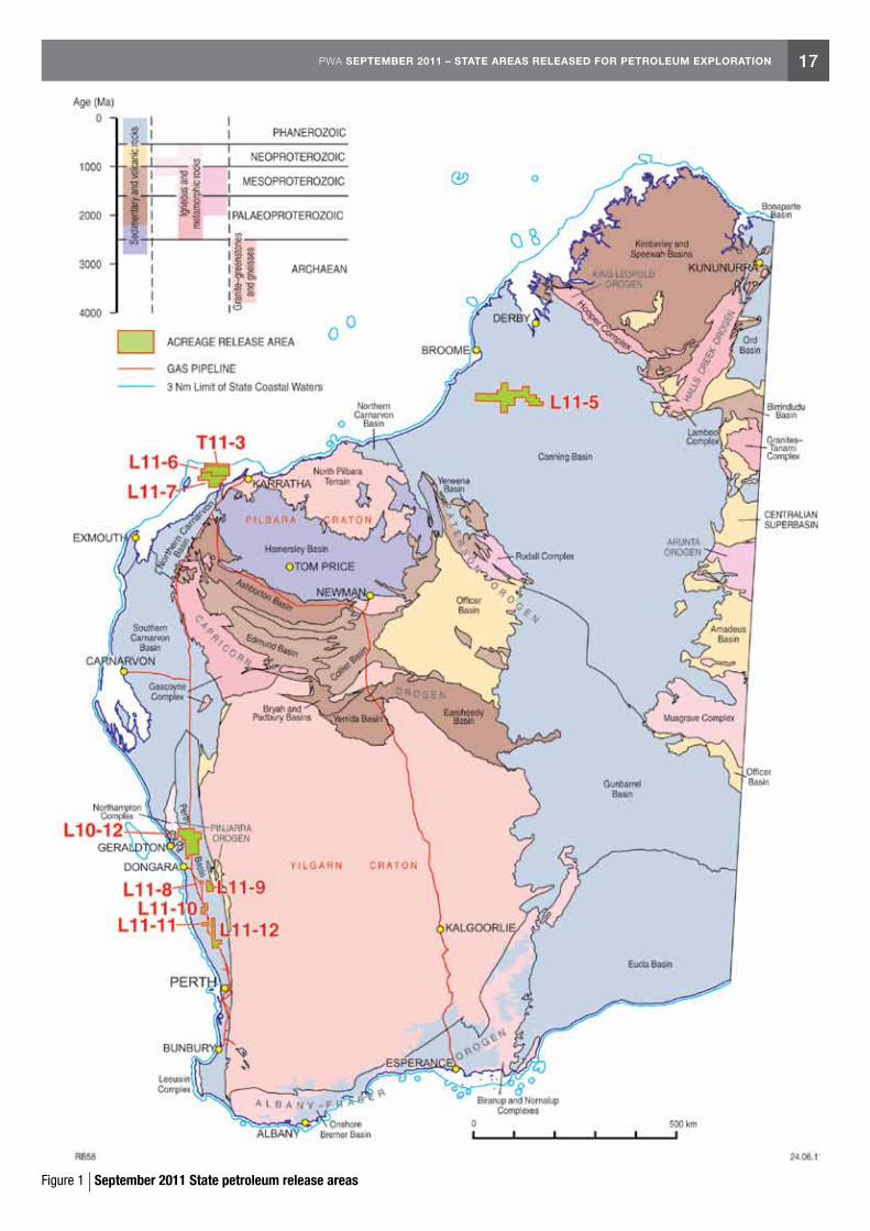
In September 2011, DMP released a total of nine blocks (Fig. 1). This comprised one block in the onshore Canning Basin, two blocks in the offshore Northern Carnarvon Basin, and six blocks in the onshore Perth Basin.
Interest in the Canning Basin has increased in recent times particularly with ARC Energy and ARC’s spinoff company Buru Energy taking up an extensive acreage holding, drilling wells and acquiring 2D and the basin’s first 3D seismic. In addition, Mitsubishi Corporation has exercised its option to participate in Buru’s 2011 exploration program in the Canning Basin.
The size of the Canning Basin block is 4,776 km2. Release area L11-5 is situated on the Broome Platform. The Broome Platform has Ordovician sourced plays including migration into Permian reservoirs, and has some shale gas potential.
There are two release areas in the highly prospective offshore Northern Carnarvon Basin. A combined release area T11-3/L11-6 is 1,742 km2 in size. The other area L11-7 is 1,441 km2 in size. Targets may include Cretaceous, Jurassic and Triassic sandstones.
The six release areas (L11-8 to L11-12) in the onshore northern Perth Basin range in size from 75 km2 to 2,633 km2. The region has a thick Lower Triassic source and seal interval, as well as likely source intervals in the Lower Jurassic. The northern Perth Basin has numerous seismic lines, wells, and has had oil and gas production from Permian and Jurassic reservoirs. Two gas pipelines occur to the east of the release area. A sealed highway runs south to the State capital Perth and the Kwinana oil refinery.
Work program bids for the release areas close at 4pm on Thursday 8 March 2012.
Should you require any further information or assistance, please contact Richard Bruce (08 9222 3314) of DMP’s Petroleum Division or Alan Millar (08 9222 3841) of the Geological Survey of Western Australia. All enquiries will be dealt with in strictest confidence.
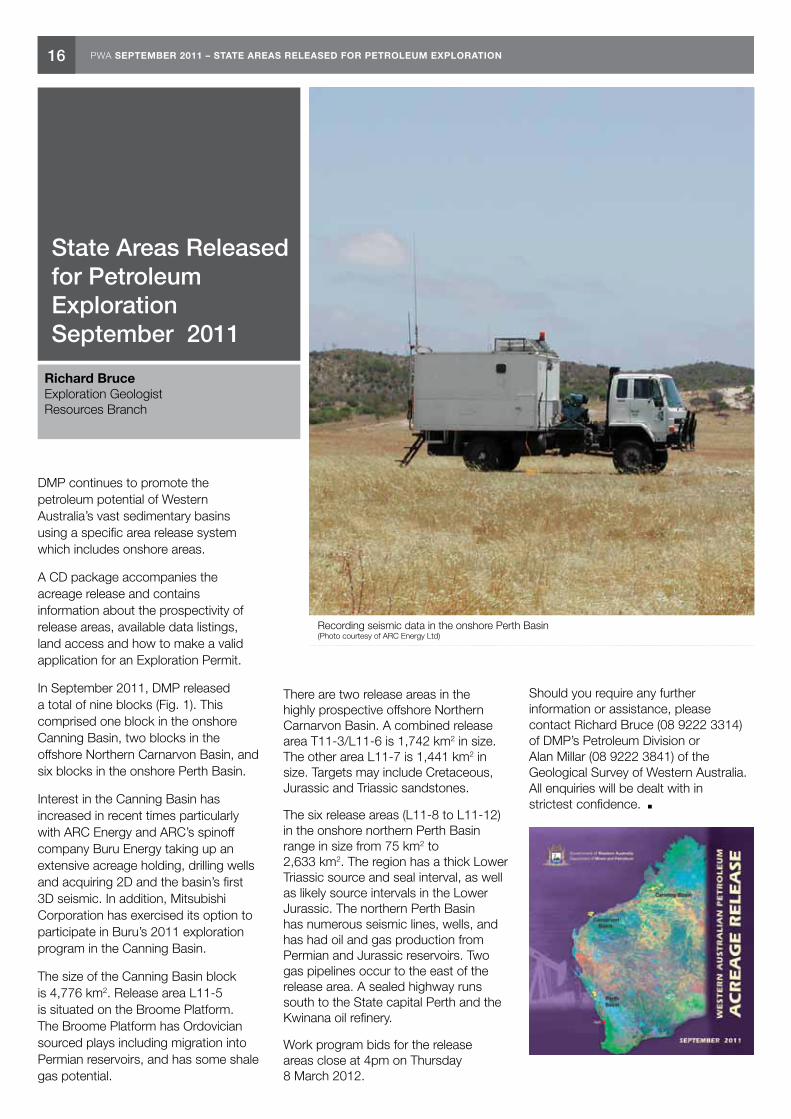
Recording seismic data in the onshore Perth Basin (Photo courtesy of ARC Energy Ltd)
17PWA SEPTEMBER 2011 – STATE AREAS RELEASED FOR PETROLEUM EXPLORATION
Figure 1 September 2011 State petroleum release areas

18 PWA SEPTEMBER 2011 – SHALLOW GAS IN THE ONSHORE CARNARVON BASIN OF WESTERN AUSTRALIA
Ali Sharifzadeh and Nirmal Mathew Senior Petroleum Engineer and Petroleum Engineer Resources Branch
Shallow Gas in the Onshore Carnarvon Basin of Western Australia
Onshore Northern Carnarvon Basin near Nanutarra (Photo courtesy of Arthur Mory)
INTRODUCTIONShallow gas is a relative term but it can be defined as natural gas occurring at subsurface depths of less than 1,200 m. Shallow natural gas can be generally classified as either thermogenic gas or biogenic gas. Thermogenic gas is generated at depth within the basin and migrates up faults as free gas or as gas associated with oil. Biogenic gas can be further subdivided as either early generation or late generation biogenic gas.
Since shallow gas accumulations typically have little or no associated liquids, and are often perceived to be small, there has been little development of these reserves in the past. Some of the reasons for their lack of development are:
• modestinferredpoolsizes,generallyless than 28.32 MMm3 (1 Bcf);
• theextraexpenserequiredforcompression due to low reservoir pressure;
• theneedforgravelpackcompletionsdue to loose, unconsolidated sands;
• historicallylownaturalgaspricing.
As exploration companies often don’t log the shallow section of hole corresponding to the surface casing, most accumulations are still intact and represent virgin reserves. In the US, there have been a number of successful completions of shallow Pliocene–Pleistocene gas in Southeast Louisiana
at depths of less than 1,067m. Though these plays have been largely ignored in the past, in recent times there has been a renewed interest in them and now they are being targeted via recompletion of existing wells.
SHALLOW GAS IN WESTERN AUSTRALIAIn Western Australia (WA), shallow gas occurrences have been observed in the Mardie Greensand member of the Muderong Shale and Yarraloola Conglomerate, in the Peedamullah Shelf on the onshore Carnarvon Basin. The Carnarvon Basin is a Paleozoic to Cainozoic depocentre which encompasses over 1,000 km of the west and northwest coast of Western Australia. The basin covers about 115,000 km2 onshore extending from just south of Kalbarri to Karratha along the western and northwestern coastline of WA. The onshore part is readily accessible from the North West Coastal Highway, and the Dampier to Bunbury Natural Gas Pipeline (DBNGP) passes down the eastern side.
All the hydrocarbon occurrences in the Peedamullah Shelf area have been discovered within the Early Cretaceous section at depths ranging from 65 to 550 metres, mainly within the low-permeability Mardie Greensand (Fig.1). The greensand is underlain by the highly permeable Yarraloola Conglomerate, which is an artesian aquifier and has probably acted as the main conduit
for hydrocarbon migration out of the Barrow Sub-basin. There is no evidence of major structural control on the hydrocarbon shows which occur sporadically over a large area.
Whilst permeability barriers within the Mardie Greensand probably influence the present distribution of hydrocarbons, there is no evidence that the hydraulics of the Yarraloola Conglomerate have been important in the localisation of accumulations discovered to date. Water salinity studies suggest that influx of meteoric water from the Yarraloola Conglomerate outcrop has resulted in a hydrodynamic trap for hydrocarbons as they migrated updip from the Barrow Sub-basin. During the Late Tertiary a much larger accumulation may have existed within the Yarraloola Conglomerate and the Mardie Greensand. The northwesterly flow of water has now ceased and the hydrocarbons have dispersed, except for the accumulation trapped within the relatively impermeable Mardie Greensand.
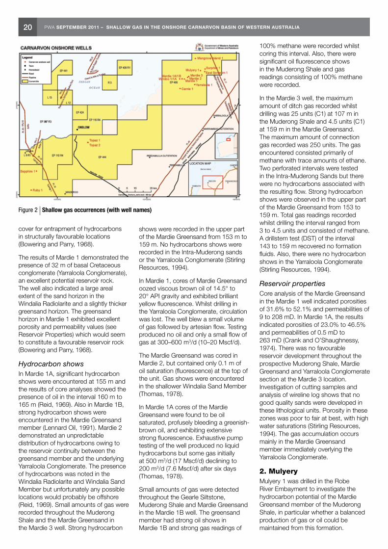
SHALLOW GAS OCCURRENCESThere are at least 79 wells in the onshore Carnarvon Basin which encountered gas shows. Most of the shallow gas accumulations recognised are found around the Peedamullah Shelf area at depths between 65 and 550 m. The shallow gas occurrences (with good gas shows) are listed in Table 1 and their locations are shown in Figure 2.

19PWA SEPTEMBER 2011 – SHALLOW GAS IN THE ONSHORE CARNARVON BASIN OF WESTERN AUSTRALIA
Figure 1 Regional stratigraphy of the Northern Carnarvon Basin (Young and Laurie, 1996)
Table 1 – Shallow gas occurrences (with good gas shows)
Well Name(s) Drilled by Year Drilled Depth (m) Oil/Gas Shows Current Permit
Mardie 1 WAPET 1967 222 Oil and gas EP 446
Mardie 2 WAPET 1969 164.9 Oil and gas EP 446
Mardie 1A WAPET 1974 164 Oil EP 446
Mardie 1B Lennard Oil 1991 165.8 Oil and gas EP 446
Mardie 3 Stirling Resources 1993 165 Oil and gas EP 446
Mulyery 1 WAPET 1968 139.6 Gas EP 446
Windoo 1 Hematite Petroleum 1972 218.85 Oil and gas EP 446
Windoo 1A WAPET 1974 174.3 Oil and gas EP 446
Carnie 1 Avon Engineering 1982 163 Gas EP 446
Sapphire 1 Carnarvon Petroleum 1993 558 Oil and gas EP 444
Topaz 1 Pan Pacific Petroleun 1995 423 Oil and gas EP 444
Topaz 2 Pan Pacific Petroleum 1996 446 Oil and gas EP 444
1. MardieMardie 1 was drilled in 1967 by WAPET following encouraging signs of hydrocarbons in five deep seismic holes drilled earlier in the same area. The well encountered hydrocarbon shows in the shallow Mardie Greensand. Following this the Mardie 2 well was drilled in 1969 with an objective to penetrate the total thickness of the greensand but avoid intersecting the Yarraloola Conglomerate aquifer. The well was suspended due to negative results of core analyses undertaken (Reid, 1969).
In 1974, the Mardie 1A appraisal well was drilled to test the Mardie Greensand which had produced significant hydrocarbon shows in Mardie 1. The Mardie 1A well was drilled as a twin to the adjacent Mardie 1 well. In 1991, Mardie 1B was drilled as part of a two well program along with East Somelim 1 as a redrill of Mardie 1A. The well encountered significant oil and gas shows in the Upper Muderong Shale and Mardie Greensand. Mardie 3 was drilled in 1993 to test the hydrocarbon potential of the Intra-Muderong sands and the Mardie Greensand. Strong hydrocarbon shows were recorded in the upper part of the Mardie Greensand whereas there were no hydrocarbon shows recorded in the Yarraloola Conglomerate (Stirling Resources, 1994).
The oil and gas shows encountered in the Mardie wells are believed to be a stratigraphic accumulation and not directly related to a structural trap (Lennard Oil, 1991). From the results of Mardie 1, it was understood that the overlying shales of the Windalia and Gearle provide a sufficient impermeable
20 PWA SEPTEMBER 2011 – SHALLOW GAS IN THE ONSHORE CARNARVON BASIN OF WESTERN AUSTRALIA
cover for entrapment of hydrocarbons in structurally favourable locations (Bowering and Parry, 1968).
The results of Mardie 1 demonstrated the presence of 32 m of basal Cretaceous conglomerate (Yarraloola Conglomerate), an excellent potential reservoir rock. The well also indicated a large areal extent of the sand horizon in the Windalia Radiolarite and a slightly thicker greensand horizon. The greensand horizon in Mardie 1 exhibited excellent porosity and permeability values (see Reservoir Properties) which would seem to constitute a favourable reservoir rock (Bowering and Parry, 1968).
Hydrocarbon showsIn Mardie 1A, significant hydrocarbon shows were encountered at 155 m and the results of core analyses showed the presence of oil in the interval 160 m to 165 m (Reid, 1969). Also in Mardie 1B, strong hydrocarbon shows were encountered in the Mardie Greensand member (Lennard Oil, 1991). Mardie 2 demonstrated an unpredictable distribution of hydrocarbons owing to the reservoir continuity between the greensand member and the underlying Yarraloola Conglomerate. The presence of hydrocarbons was noted in the Windalia Radiolarite and Windalia Sand Member but unfortunately any possible locations would probably be offshore (Reid, 1969). Small amounts of gas were recorded throughout the Muderong Shale and the Mardie Greensand in the Mardie 3 well. Strong hydrocarbon
shows were recorded in the upper part of the Mardie Greensand from 153 m to 159 m. No hydrocarbons shows were recorded in the Intra-Muderong sands or the Yarraloola Conglomerate (Stirling Resources, 1994).
In Mardie 1, cores of Mardie Greensand oozed viscous brown oil of 14.5° to 20° API gravity and exhibited brilliant yellow fluorescence. Whilst drilling in the Yarraloola Conglomerate, circulation was lost. The well blew a small volume of gas followed by artesian flow. Testing produced no oil and only a small flow of gas at 300–600 m3/d (10–20 Mscf/d).
The Mardie Greensand was cored in Mardie 2, but contained only 0.1 m of oil saturation (fluorescence) at the top of the unit. Gas shows were encountered in the shallower Windalia Sand Member (Thomas, 1978).
In Mardie 1A cores of the Mardie Greensand were found to be oil saturated, profusely bleeding a greenish-brown oil, and exhibiting extensive strong fluorescence. Exhaustive pump testing of the well produced no liquid hydrocarbons but some gas initially at 500 m3/d (17 Mscf/d) declining to 200 m3/d (7.6 Mscf/d) after six days (Thomas, 1978).
Small amounts of gas were detected throughout the Gearle Siltstone, Muderong Shale and Mardie Greensand in the Mardie 1B well. The greensand member had strong oil shows in Mardie 1B and strong gas readings of
100% methane were recorded whilst coring this interval. Also, there were significant oil fluorescence shows in the Muderong Shale and gas readings consisting of 100% methane were recorded.
In the Mardie 3 well, the maximum amount of ditch gas recorded whilst drilling was 25 units (C1) at 107 m in the Muderong Shale and 4.5 units (C1) at 159 m in the Mardie Greensand. The maximum amount of connection gas recorded was 250 units. The gas encountered consisted primarily of methane with trace amounts of ethane. Two perforated intervals were tested in the Intra-Muderong Sands but there were no hydrocarbons associated with the resulting flow. Strong hydrocarbon shows were observed in the upper part of the Mardie Greensand from 153 to 159 m. Total gas readings recorded whilst drilling the interval ranged from 3 to 4.5 units and consisted of methane. A drillstem test (DST) of the interval 143 to 159 m recovered no formation fluids. Also, there were no hydrocarbon shows in the Yarraloola Conglomerate (Stirling Resources, 1994).
Reservoir propertiesCore analysis of the Mardie Greensand in the Mardie 1 well indicated porosities of 31.6% to 52.1% and permeabilities of 9 to 208 mD. In Mardie 1A, the results indicated porosities of 23.0% to 46.5% and permeabilities of 0.5 mD to 263 mD (Crank and O’Shaughnessy, 1974). There was no favourable reservoir development throughout the prospective Muderong Shale, Mardie Greensand and Yarraloola Conglomerate section at the Mardie 3 location. Investigation of cutting samples and analysis of wireline log shows that no good quality sands were developed in these lithological units. Porosity in these zones was poor to fair at best, with high water saturations (Stirling Resources, 1994). The gas accumulation occurs mainly in the Mardie Greensand member immediately overlying the Yarraloola Conglomerate.
2. MulyeryMulyery 1 was drilled in the Robe River Embayment to investigate the hydrocarbon potential of the Mardie Greensand member of the Muderong Shale, in particular whether a balanced production of gas or oil could be maintained from this formation.
Figure 2 Shallow gas occurrences (with well names)
21PWA SEPTEMBER 2011 – SHALLOW GAS IN THE ONSHORE CARNARVON BASIN OF WESTERN AUSTRALIA
The well penetrated 12.19 m of Quarternary conglomerate and gravel, and Tertiary limestone, greensand and conglomerate, before drilling 105.46 m of Cretaceous shale, sandstone and conglomerate. The Mardie Greensand is present between 123.75 m to 128.02 m, and contains a significant accumulation of gas, but only traces of oil.
Sustained gas production was obtained from the Mardie Greensand in the Robe River Embayment. It was not known whether the accompanying water flow is derived from the greensand or the basal Cretaceous conglomerate.
Hydrocarbon showsA 36 hour flow test of the perforated interval 123.75 m to 128.02 m produced water at the rate of 31.8 kL/d (200 bbl/d) and gas at the rate of 1,130 m3/d (40,000 ft3/d). Because of the high pressure in the greensand (about 250 psi), the formation was given a Bradenhead squeeze at 200 psi, and the well was abandoned (Jones, 1968).
Reservoir propertiesThe Mardie Greensand consists of patches of clean pale grey sandstone within the Muderong Shale. Core samples fluoresced a patchy pale yellow white colour. Measured porosities ranged from 17% to 46% and permeabilities ranged from 28 to 1,218 mD. Mulyery 1 has indicated an increased areal extent of the Mardie Greensand in the Robe River Embayment, and has established its potential as a hydrocarbon reservoir. It penetrated a gas cap in the Mardie Greensand in a structurally high position. The structural dip of the Mardie Greensand is northwest at less than 1°.
3. WindooWindoo 1 was drilled in the onshore Robe River area to a total depth of 218.85 m and was plugged and abandoned. Windoo 1A is a re-drill of Windoo 1 which recorded good gas shows in the Mardie Greensand (Crank and O’Shaughnessy, 1974). Windoo 1A was drilled to a depth of 164.29 m and also encountered hydrocarbons in the Mardie Greensand. The well was exhaustively pump tested after drilling.
The stratigraphy of the Windoo area consists of a veneer of Lower Cretaceous and Cainozoic sediments which have overlapped a complexly
faulted Paleozoic and Proterozoic platform. The Paleozoic section is everywhere overlain by the permeable fluviatile Lower Cretaceous Yarraloola Conglomerate. Conformably overlying the Yarraloola Conglomerate is a marine unit, the Muderong Shale, which has a very glauconitic basal section known as the Mardie Greensand. The top of the Mardie Greensand in Windoo 1A was 0.6 m lower that the Windoo 1 well.
Hydrocarbon showsWindoo 1 flowed formation water to surface whilst pulling out and running in the hole, after lost circulation problems caused the well to kick (Hematite Petroleum Pty Ltd, 1972). The formation water was likely derived from the Yarraloola interval whereas the gas was considered to come from the Mardie Greensand interval (164.59 to 173.74 m). No estimates of the gas flow were made but the gas flow was very small. The estimate of shut in pressure at the formation was around 265 psi and the gas flowing from the relatively tight Mardie Greensand was approximately 90% methane (CH4). In Windoo 1A, the first hydrocarbons were detected at 94.49 m where 10 units of gas were recorded. From here to the total depth gas readings of up to 25 units were encountered and the well kicked several times (Crank and O’Shaughnessy, 1974).
Reservoir propertiesIn Windoo 1A, only 0.91 m of the core was analysed and the results showed porosities ranging from 39.3% to 42.6% and permeabilities ranging from 70 to 418 mD (Crank and O’Shaughnessy, 1974).
4. CarnieCarnie 1 was located near the coast in the northern onshore Carnarvon Basin. The well was drilled to test the hydrocarbon potential of the Mardie Greensand.
The Carnie 1 well was spudded in the recent alluvial flood plain deposits consisting of clays, silts and sands resting on the Trealla Limestone (at 6 m). Immediately below the Trealla Limestone, an arenaceous claystone at the top of the Muderong Shale was encountered followed by a less arenaceous claystones to the top of the Mardie Greensand, a glauconitic fine-grained sandstone. The well terminated at a depth of 163 m.
Seismic mapping of the area was rudimentary due to incomplete seismic coverage. However, the shallow well control was relatively good and structural influences could be seen from the Scholl Island Fault which runs through the embayment (Furr and Allchurch, 1982). North–south faulting may explain the variable thickness of the Mardie Greensand which also appears to be influenced by the Mardie high. The hydrocarbon accumulation is understood to be in the Mardie Greensand which rests on the Yarraloola Conglomerate.
Hydrocarbon showsTesting of the Carnie well (DST 1) produced dry gas without water at maximum initial flow rates of approximately 850 m3/d (30 Mcf/d), through a 3.175 mm (1/8 inch) choke, decreasing rapidly with time. The results indicated a very limited gas reservoir with maximum shut-in pressure of 220 psi. A major sand unit in the upper part of the Muderong Shale had good gas shows. The main target, the Mardie Greensand, also had good gas shows and a core cut in this formation showed good fluorescence and oil was visible on its surface (Furr and Allchurch, 1982).
Reservoir propertiesIn Carnie 1, the visual porosity in the core from the Mardie Greensand appeared poor as the matrix was clay. Results from the core analysis, carried out on cores cut in the Mardie Greensand, showed porosity values between 33.7% to 40.5% and permeability values ranging from 72 to 813 mD (Furr and Allchurch, 1982).
Carnie 1 confirmed that the Robe River Embayment shallows inland without significant changes in lithology. A 4% KCl mud gave sufficient inhibition to drill through the Muderong Shale section. Native clays became a part of the mud system, and it became necessary to dilute the mud to control the solids. The interval 151 to 156 m was drilled using a 10.1 to 10.2 lbs/gal mud and this was increased to 10.5 to 10.6 lbs/gal after small gas kicks occurred. The drilling parameters and completion techniques used in wells drilled in previous years within this area were thought to have heavily damaged the greensand, which was the main reason for reduced ability to produce hydrocarbons in earlier wells.
22 PWA SEPTEMBER 2011 – SHALLOW GAS IN THE ONSHORE CARNARVON BASIN OF WESTERN AUSTRALIA
The Carnie 1 well was drilled using drilling parameters which would result in minimal damage to the formation whilst taking care not to drill into the Yarraloola Conglomerate artesian aquifer.
5. SapphireSapphire 1 was drilled in the onshore Carnarvon Basin to test a Triassic Mungaroo Formation sandstone objective within a truncation trap beneath the Base Cretaceous Unconformity (BCU). Minor hydrocarbon shows were encountered above and below the unconformity in poor reservoir sands within the Mardie Greensand interval of the Muderong Shale and within the Locker Shale. A DST was run over this interval and a full string of formation water (approximately 2 kL) was recovered (Carnarvon Petroleum, 1993).
The Sapphire structure is situated to the southeast of the Tubridgi gasfield. The shape of the Top Locker Shale surface at the BCU in Sapphire 1 was determined by a syncline developed in the Paleozoic which persists southeasterly into the Ashburton Sub-basin. This syncline is understood to have generated a seal trap by establishing the Locker Shale as a lateral seal and the Muderong Shale as a top seal to the Mungaroo Formation reservoir sandstones (Carnarvon Petroleum, 1993).
The Sapphire prospect is located updip of the Tubridgi gasfield and it has been suggested that the hydrocarbons in Sapphire were sourced by oil that migrated out of the Tubridgi gasfield. A remnant oil leg in the Tubridgi field suggests that the Tubridgi anticline, which was filled to spill point with gas before production from the field, could have originally contained oil that was then displaced by later gas migration. This displaced oil would have migrated up-dip towards the Sapphire structure (Carnarvon Petroleum, 1993).
A thick sand unit developed at the base of the Mungaroo Formation was the predicted reservoir objective at Sapphire 1. However, the well encountered oil fluorescence in both the Mardie Greensand and Locker Shale units (Carnarvon Petroleum, 1993). The DST over this interval was unsuccessful.
Hydrocarbon showsGas readings measured in the well were generally low, peaking at 2% at 265 m and generally tailed off to 0.2% at TD. The predominant gas was methane
with only slight traces of heavier gases present. Minor oil shows were encountered over the interval 390 to 409 m, recognised by fluorescence within the cutting samples. The interval 385 to 409 m was tested with an open-hole DST and 2 kL (13.2 bbl) of water was recovered without any hydrocarbon indications (Carnarvon Petroleum, 1993).
Reservoir propertiesThe recovery of 2 kL of formation water from the Mardie Greensand-Locker Shale interval tested between 385 and 409 m indicated the presence of some permeable layers throughout this zone. The cutting samples and sidewall cores showed a glauconitic sandstone section in the Mardie and some thin interbedded fine-grained sandstone in the Locker Shale. Log interpretation indicated permeability within the Locker Shale with a number of intervals that showed shallow invasion by mud filtrate. Porosities in this interval averaged at around 10% (Carnarvon Petroleum, 1993).
6. TopazTopaz 1 was drilled in the onshore Carnarvon Basin to a total depth of 421 m. The well was designed to evaluate a northeast trending horst in the Lower Cretaceous Birdrong Sandstone. This primary reservoir target was intersected at 337 m and minor oil shows were observed between 335 to 341 m. An open-hole DST flowed gas to the surface but the log evaluation results indicated limited gas pay (Pan Pacific Petroleum, 1996). Topaz 2 is located on a large salt flat, approximately 20 km southeast of Onslow and approximately 160 m to the southeast of Topaz 1. The well was designed to fully evaluate the Paleozoic structure as this interval was not adequately tested in Topaz 1. A DST flowed water to the surface with a scum of oil and no gas was reported. Log evaluations indicated only minor hydrocarbons from 340.5 m to 341.5 m (Mills, 1997).
The Topaz prospect was identified as a horst structure at Birdrong level extending to 7.1 km2 with 30 m of vertical relief. The Muderong Shale was suggested to be the main seal to the structure (Mills, 1997). The postulated source kitchen for Topaz lies to the northwest where Jurassic shales are thought to be the origin of the hydrocarbons for the offshore fields. The most likely conduit for migration
of hydrocarbons into Topaz is up the Flinders Fault system and then at the Base Cretaceous level up the regional dip (Mills, 1997).
Hydrocarbon showsIn Topaz 1, minor oil shows were encountered between 335 m to 341 m. The Birdrong Sandstone showed good reservoir quality but had limited gas pay (Pan Pacific Petroleum, 1996). The Birdrong Sandstone was intersected at 340.5 m in Topaz 2. In Topaz 2, fair oil shows were encountered in loose quartz sandstone from 343 to 345 m and minor hydrocarbons were observed from 340.5 to 341.5 m (Mills, 1997).
Cutting gas levels were relatively low through Topaz 1 with a maximum of 4.3% and 3.7% at 215 m (near Top Muderong) and 340 m (Birdrong Sandstone) respectively. It was decided to run an open-hole DST based on strong drilling break at 338 to 340 m, good inferred porosity and associated shows (Pan Pacific Petroleum, 1996). Two open-hole off-bottom DSTs were conducted with DST 2 (interval 341 to 332 m) flowing gas at a stable rate of 19.8 m3/d (0.7 Mcf/d) through a 6.35 mm (1/4”) choke.
Cutting gas levels throughout Topaz 2 were relatively low and restricted to methane only. Total gas peaks were recorded at 236 m in a thin basal sandstone within the Windalia Radiolarite, at 260 m in silty claystones of the Muderong Shale and at 343 m in the uppermost Birdrong Sandstone. Fair oil shows were also recorded in the upper section of the Birdrong Sandstone (Mills, 1997). In Topaz 2, DST 1 was conducted over the uppermost section of the Birdrong Sandstone and this zone flowed water to the surface at 11.44 kL/d (72 bbl/d) with a slight oil scum. There was no gas to the surface. Log analysis showed that minor hydrocarbons were present within a thin sandstone section (340.5 to 341.5 m) in the Birdrong Sandstone.
Reservoir propertiesIn Topaz 1 oil was extracted from a core sample in the Birdrong Sandstone that showed the effects of extensive biodegradation. This is seen in Topaz 2 as well, indicated by the oil scum recovered on the DST. Ethane isotope analysis conducted on Topaz 1 DST gas samples suggests that the gas is either very immature or biogenic in origin (Pan Pacific Petroleum, 1996).
23PWA SEPTEMBER 2011 – SHALLOW GAS IN THE ONSHORE CARNARVON BASIN OF WESTERN AUSTRALIA
A biogenic source for the gas is consistent with the biodegraded nature of the oil recovered in Topaz 2.
WAY FORWARDShallow gas plays in Western Australia have been largely ignored in the past due to historical lack of gas demand, increased costs of compression and completion (sand screens), poor seismic imaging, and lack of logs to evaluate. Such reserves are perceived to be modest in comparison to deeper reservoirs, but the shallow depths of these pools require lower capital costs for exploration drilling and development.
Gravel Pack CompletionsOne of the most significant costs in shallow gas development is the need for gravel pack completions to prevent the production of loose, unconsolidated sand that, if unprotected, will cause premature cessation of production.
Seismic DataThe availability of good quality seismic data is important in terms of well planning and design. A cased-hole reservoir saturation tool (RST) of pulsed neutron logs (PNL) can be run in wells that were not previously logged in the shallow section. Cased-hole logs, particularly RST logs, have had wide application throughout the world for many years and they have the ability to effectively detect hydrocarbons in shallow sections. Careful detailed seismic and log analysis along with the study of analogous wells around the world (particularly US) is necessary for companies to enjoy success in shallow gas development.
Well Design and EconomicsIn terms of well design and economics, shallow gas wells can be drilled and completed at a very low expense in comparison to conventional gas wells. For example, a 580 m well is expected to take 6 days to drill, log and run casing plus a further 5 days to complete and an assumed 2 days for mobilisation and demobilisation. Shallow gas wells are vertical, normally pressured wellbores and the completion will usually involve running a 177.8 mm (7”) production string. The capital expenses for a shallow gas well are relatively lower, however, there will be additional costs incurred for compression and gravel pack completions. Initial and abandonment costs would be the same as for a deeper reservoir.
Wellsite CompressionThe deliverability of shallow gas wells can be improved by the installation of wellsite compression. The reservoir pressure in many of these shallow gas fields is very low compared to the gas purchaser’s line pressure. Therefore, these wells will have limited flow rate or are incapable of flowing due to the high salesline pressure. The use of wellsite compression can improve the productivity and the ultimate recovery of the gas resource. The factors taken into consideration when selecting a compressor include: the sizing parameters of the compressors, reservoir characteristics (i.e. pressure), and the economics of purchasing versus leasing a compressor. The build up of fine sand, caused by the use of gravel pack completions, can also have an adverse effect by increasing the differential pressure and adds to the importance of to using wellsite compression. It is recommended to have a looping system for the compressors (used in various wells), connected in series, that can potentially bring down the costs incurred during development.
While shallow gas resources may be small in size, they represent a promising prospect for onshore operators. Shallow gas can potentially contribute to localised power generation or be used for feed gas for gas lift purposes. It is, therefore, an important resource to be considered for possible future development in WA.
REFERENCESBowering, O.J.W. and Parry, J.C., 1968, Mardie 1 corehole well completion report: Western Australia Geological Survey, S-series, S349 A1 (unpublished)
Carnarvon Petroleum, N.L., 1993, Sapphire 1 well completion report: Western Australia Geological Survey, S-series, S20177 A2 (unpublished)
Crank, K.A. and O’Shaughnessy, P.R., 1974, Mardie 1A and Windoo 1A well completion report: Western Australia Geological Survey, S-series, S1078 A2 (unpublished)
Crostella, A., 1998, A review of oil occurrences within the Lennard Shelf, Canning Basin, Western Australia: Western Australia Geological Survey, Report 56, 40p
Furr, G. and Allchurch, P.D., 1982, Carnie 1 well completion report: Western Australia Geological Survey, S-series, S1997 A1 (unpublished)
Hematite Petroleum Pty Ltd, 1972, Final report for 5 wells – Phase II drilling operations, Robe River Block EP40, W.A: Western Australia Geological Survey, S-series, S763 A2 (unpublished)
Jones, D.K., 1968, Mulyery 1 well completion report: Western Australia Geological Survey, S-series, S404 (unpublished)
Lennard Oil N.L., 1991, Mardie 1B well completion report: Western Australia Geological Survey, S-series, S20108 A2 (unpublished)
Mills, K., 1997, Topaz 2 well completion report: Western Australia Geological Survey, S-series, S20377 A2 (unpublished)
Pan Pacific Petroleum, N.L., 1996, Topaz 1 well completion report: Western Australia Geological Survey, S-series, S20311 A3 (unpublished)
Reid, A.G., 1969, Mardie 2 well completion report, WAPET: Western Australia Geological Survey, S-series, S474 A2 (unpublished)
Stirling Resources N.L., 1994, Mardie 3 well completion report: Western Australia Geological Survey, S-series, S20193 A2 (unpublished)
Thomas, B.M., 1978, Rove River: An onshore shallow oil accumulation, Australian Petroleum Exploration Association Journal, 1978, pp. 3-12
Young, G.C. and Laurie, J.R., 1996, An Australian Phanerozoic Timescale. Oxford University Press

24 PWA SEPTEMBER 2011 – HEAT GENERATION IN THE DARLING RANGE GRANITES
Mike Middleton Senior Energy Geotechnologist Resources Branch
Heat Generation in the Darling Range Granites: Implications for Geothermal Exploration
Geothermal energy is one of the few renewable energy sources that promises to provide a substantial supplement to base-load electrical power or other substitutes, such as air conditioning or space heating. It is currently used for space heating (i.e. swimming pools) in a number of applications in Perth, and two major projects are now underway to apply geothermal energy to power air conditioning instead of using electricity or gas. These projects draw geothermal energy from hot water in sedimentary rocks buried between 1,000 and 3,000 metres beneath Perth. These are considered as low temperature economic (commercial) geothermal resource projects, because the temperatures expected are between 60 °C to 100 °C. However, there are numerous other places to find geothermal energy. This article reports another way to exploit low temperature geothermal resources.
It is commonly recognised that granitic basement rocks with a high content of the radiogenic elements Uranium (U), Thorium (Th) and Potassium (K), also referred to as “hot granites”, provide a dominant component to the heat flow in Hot Dry Rock (HDR) geothermal regimes. In HDR regimes, these hot granites reside beneath a thermal blanket comprised of between three to five kilometres of sedimentary rocks. This is the main paradigm driving geothermal exploration in the Cooper Basin and elsewhere in South Australia.
In contrast to normal HDR regimes, this article reports the results of a study of heat generation and corresponding temperatures at depth in outcropping granite batholiths in the Darling Range to the east of the Perth metropolitan area. These areas do not have blankets of sediments to act as thermal blankets. However, some important results pertaining to geothermal energy have emerged.
Heat generation in the Darling Range granites may have relevance for the exploration for geothermal energy “hot spots” either in the Perth Basin immediately to the west of the Darling Range, or within the Darling Range itself.
Western Australia has several regions where hot granites are known to occur in outcrop. The locations of high radioactivity rocks, including hot granites, are also well defined by the Geoscience Australia (GA) ternary radiogenic map of Australia (Stolz, 2010). The GA data can be used to create a surface heat generation map (Fig. 1). This is prepared by using appropriate factors (Kappelmeyer and Haenel, 1974, pg. 28) to convert U, Th and K concentrations into an approximation of heat generation in units of microwatts per cubic metre (μWm-3). These factors are 0.26 for Uranium concentration expressed as parts per million (ppm), 0.07 for Thorium concentration expressed as ppm, and 0.10 for Potassium concentration expressed as percent by volume.
It appears that, in this conversion to elemental concentration from airborne radiometric survey data, the calibration used by GA appears to place a ceiling on heat generation values at approximately 5 μWm-3. Accordingly, values greater than this do not appear on the map. It is also important to bear in mind that outcrops with higher heat generation may be localised, and so do not appear on such a regional map. Nevertheless, this map provides valuable information on the distribution of areas of high surface heat generation.
Close up of the recording instruments. The RS 125 spectrometer (orange) with detecting head, containing the detecting crystal, placed on the rock surface, and beside this is a total count Geiger counter (black meter). A compass (to detect fracture orientation), scale and recording book are also shown (Photos courtesy of Mike Middleton)
Figure 1 Surface heat generation map derived from the Geoscience Australia National Radiometric Database. U, Th and K concentration data have been adjusted by factors (Kappelmeyer and Haenel, 1974, pg. 28) to approximate heat generation (in μWm-3) at the surface.
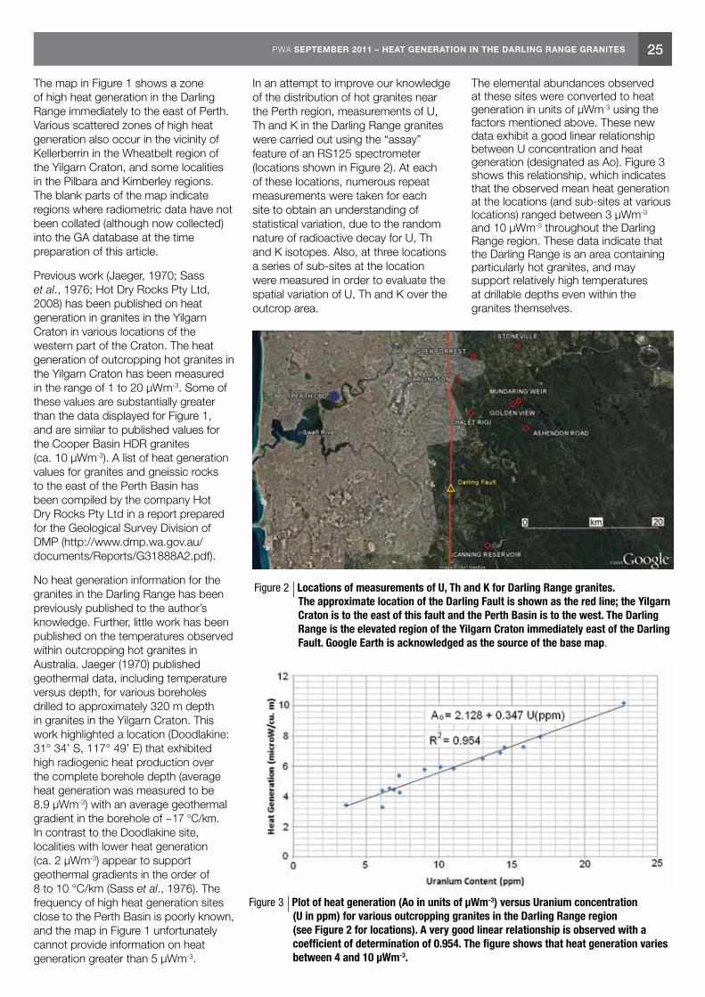
25PWA SEPTEMBER 2011 – HEAT GENERATION IN THE DARLING RANGE GRANITES
The map in Figure 1 shows a zone of high heat generation in the Darling Range immediately to the east of Perth. Various scattered zones of high heat generation also occur in the vicinity of Kellerberrin in the Wheatbelt region of the Yilgarn Craton, and some localities in the Pilbara and Kimberley regions. The blank parts of the map indicate regions where radiometric data have not been collated (although now collected) into the GA database at the time preparation of this article.
Previous work (Jaeger, 1970; Sass et al., 1976; Hot Dry Rocks Pty Ltd, 2008) has been published on heat generation in granites in the Yilgarn Craton in various locations of the western part of the Craton. The heat generation of outcropping hot granites in the Yilgarn Craton has been measured in the range of 1 to 20 μWm-3. Some of these values are substantially greater than the data displayed for Figure 1, and are similar to published values for the Cooper Basin HDR granites (ca. 10 μWm-3). A list of heat generation values for granites and gneissic rocks to the east of the Perth Basin has been compiled by the company Hot Dry Rocks Pty Ltd in a report prepared for the Geological Survey Division of DMP (http://www.dmp.wa.gov.au/documents/Reports/G31888A2.pdf).
No heat generation information for the granites in the Darling Range has been previously published to the author’s knowledge. Further, little work has been published on the temperatures observed within outcropping hot granites in Australia. Jaeger (1970) published geothermal data, including temperature versus depth, for various boreholes drilled to approximately 320 m depth in granites in the Yilgarn Craton. This work highlighted a location (Doodlakine: 31° 34’ S, 117° 49’ E) that exhibited high radiogenic heat production over the complete borehole depth (average heat generation was measured to be 8.9 μWm-3) with an average geothermal gradient in the borehole of ~17 °C/km. In contrast to the Doodlakine site, localities with lower heat generation (ca. 2 μWm-3) appear to support geothermal gradients in the order of 8 to 10 °C/km (Sass et al., 1976). The frequency of high heat generation sites close to the Perth Basin is poorly known, and the map in Figure 1 unfortunately cannot provide information on heat generation greater than 5 μWm-3.
In an attempt to improve our knowledge of the distribution of hot granites near the Perth region, measurements of U, Th and K in the Darling Range granites were carried out using the “assay” feature of an RS125 spectrometer (locations shown in Figure 2). At each of these locations, numerous repeat measurements were taken for each site to obtain an understanding of statistical variation, due to the random nature of radioactive decay for U, Th and K isotopes. Also, at three locations a series of sub-sites at the location were measured in order to evaluate the spatial variation of U, Th and K over the outcrop area.
The elemental abundances observed at these sites were converted to heat generation in units of μWm-3 using the factors mentioned above. These new data exhibit a good linear relationship between U concentration and heat generation (designated as Ao). Figure 3 shows this relationship, which indicates that the observed mean heat generation at the locations (and sub-sites at various locations) ranged between 3 μWm-3 and 10 μWm-3 throughout the Darling Range region. These data indicate that the Darling Range is an area containing particularly hot granites, and may support relatively high temperatures at drillable depths even within the granites themselves.
Figure 2 Locations of measurements of U, Th and K for Darling Range granites. The approximate location of the Darling Fault is shown as the red line; the Yilgarn Craton is to the east of this fault and the Perth Basin is to the west. The Darling Range is the elevated region of the Yilgarn Craton immediately east of the Darling Fault. Google Earth is acknowledged as the source of the base map.
Figure 3 Plot of heat generation (Ao in units of μWm-3) versus Uranium concentration (U in ppm) for various outcropping granites in the Darling Range region (see Figure 2 for locations). A very good linear relationship is observed with a coefficient of determination of 0.954. The figure shows that heat generation varies between 4 and 10 μWm-3.
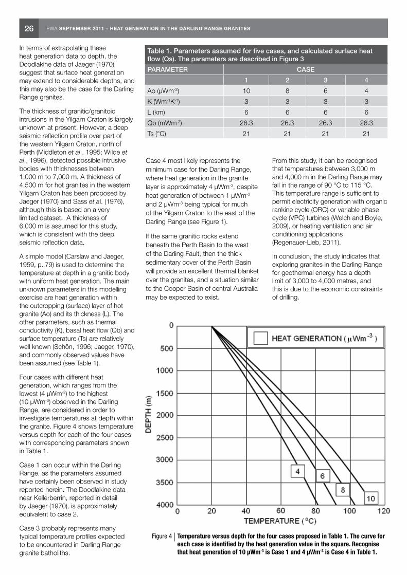
26 PWA SEPTEMBER 2011 – HEAT GENERATION IN THE DARLING RANGE GRANITES
In terms of extrapolating these heat generation data to depth, the Doodlakine data of Jaeger (1970) suggest that surface heat generation may extend to considerable depths, and this may also be the case for the Darling Range granites.
The thickness of granitic/granitoid intrusions in the Yilgarn Craton is largely unknown at present. However, a deep seismic reflection profile over part of the western Yilgarn Craton, north of Perth (Middleton et al., 1995; Wilde et al., 1996), detected possible intrusive bodies with thicknesses between 1,000 m to 7,000 m. A thickness of 4,500 m for hot granites in the western Yilgarn Craton has been proposed by Jaeger (1970) and Sass et al. (1976), although this is based on a very limited dataset. A thickness of 6,000 m is assumed for this study, which is consistent with the deep seismic reflection data.
A simple model (Carslaw and Jaeger, 1959, p. 79) is used to determine the temperature at depth in a granitic body with uniform heat generation. The main unknown parameters in this modelling exercise are heat generation within the outcropping (surface) layer of hot granite (Ao) and its thickness (L). The other parameters, such as thermal conductivity (K), basal heat flow (Qb) and surface temperature (Ts) are relatively well known (Schön, 1996; Jaeger, 1970), and commonly observed values have been assumed (see Table 1).
Four cases with different heat generation, which ranges from the lowest (4 μWm-3) to the highest (10 μWm-3) observed in the Darling Range, are considered in order to investigate temperatures at depth within the granite. Figure 4 shows temperature versus depth for each of the four cases with corresponding parameters shown in Table 1.
Case 1 can occur within the Darling Range, as the parameters assumed have certainly been observed in study reported herein. The Doodlakine data near Kellerberrin, reported in detail by Jaeger (1970), is approximately equivalent to case 2.
Case 3 probably represents many typical temperature profiles expected to be encountered in Darling Range granite batholiths.
Case 4 most likely represents the minimum case for the Darling Range, where heat generation in the granite layer is approximately 4 μWm-3, despite heat generation of between 1 μWm-3 and 2 μWm-3 being typical for much of the Yilgarn Craton to the east of the Darling Range (see Figure 1).
If the same granitic rocks extend beneath the Perth Basin to the west of the Darling Fault, then the thick sedimentary cover of the Perth Basin will provide an excellent thermal blanket over the granites, and a situation similar to the Cooper Basin of central Australia may be expected to exist.
From this study, it can be recognised that temperatures between 3,000 m and 4,000 m in the Darling Range may fall in the range of 90 °C to 115 °C. This temperature range is sufficient to permit electricity generation with organic rankine cycle (ORC) or variable phase cycle (VPC) turbines (Welch and Boyle, 2009), or heating ventilation and air conditioning applications (Regenauer-Lieb, 2011).
In conclusion, the study indicates that exploring granites in the Darling Range for geothermal energy has a depth limit of 3,000 to 4,000 metres, and this is due to the economic constraints of drilling.
Table 1. Parameters assumed for five cases, and calculated surface heat flow (Qs). The parameters are described in Figure 3
PARAMETER CASE
1 2 3 4
Ao (μWm-3) 10 8 6 4
K (Wm-1K-1) 3 3 3 3
L (km) 6 6 6 6
Qb (mWm-2) 26.3 26.3 26.3 26.3
Ts (°C) 21 21 21 21
Figure 4 Temperature versus depth for the four cases proposed in Table 1. The curve for each case is identified by the heat generation value in the square. Recognise that heat generation of 10 μWm-3 is Case 1 and 4 μWm-3 is Case 4 in Table 1.
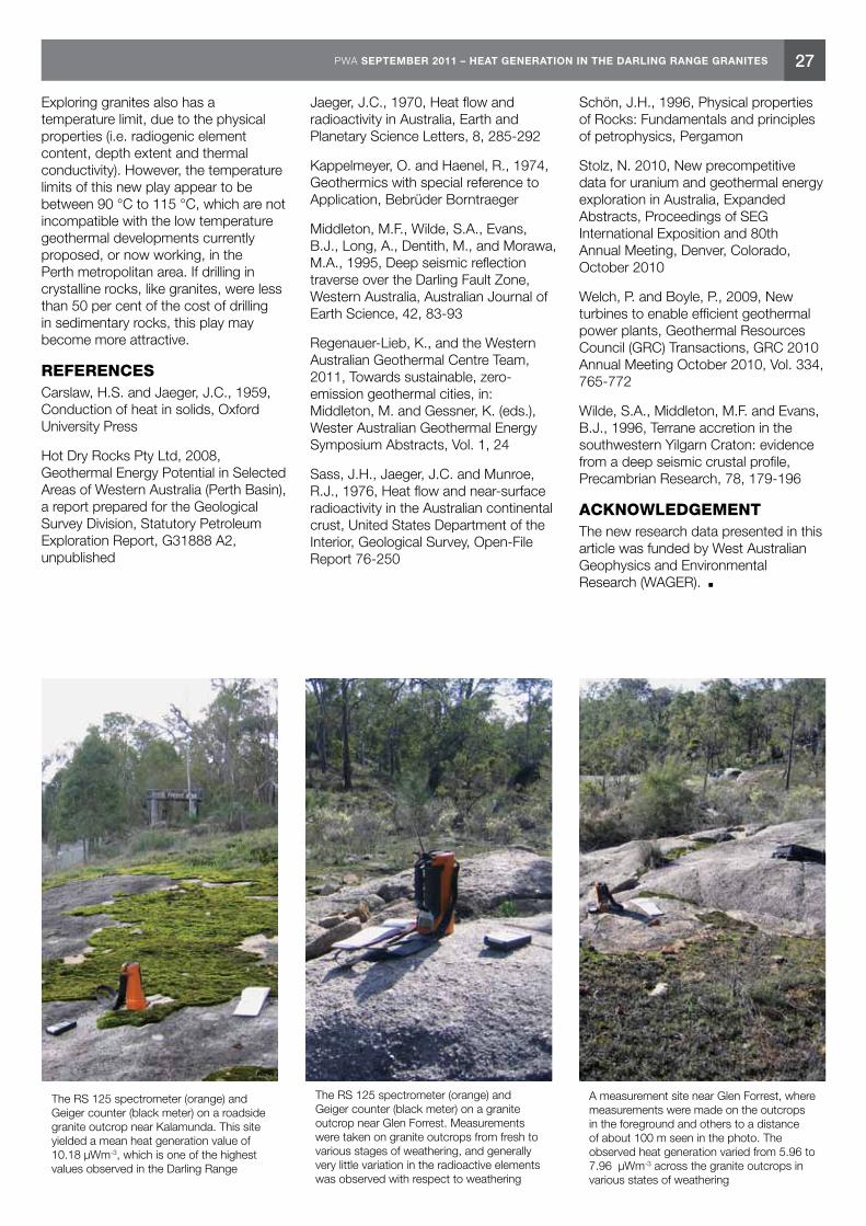
27PWA SEPTEMBER 2011 – HEAT GENERATION IN THE DARLING RANGE GRANITES
Exploring granites also has a temperature limit, due to the physical properties (i.e. radiogenic element content, depth extent and thermal conductivity). However, the temperature limits of this new play appear to be between 90 °C to 115 °C, which are not incompatible with the low temperature geothermal developments currently proposed, or now working, in the Perth metropolitan area. If drilling in crystalline rocks, like granites, were less than 50 per cent of the cost of drilling in sedimentary rocks, this play may become more attractive.
REFERENCESCarslaw, H.S. and Jaeger, J.C., 1959, Conduction of heat in solids, Oxford University Press
Hot Dry Rocks Pty Ltd, 2008, Geothermal Energy Potential in Selected Areas of Western Australia (Perth Basin), a report prepared for the Geological Survey Division, Statutory Petroleum Exploration Report, G31888 A2, unpublished
Jaeger, J.C., 1970, Heat flow and radioactivity in Australia, Earth and Planetary Science Letters, 8, 285-292
Kappelmeyer, O. and Haenel, R., 1974, Geothermics with special reference to Application, Bebrüder Borntraeger
Middleton, M.F., Wilde, S.A., Evans, B.J., Long, A., Dentith, M., and Morawa, M.A., 1995, Deep seismic reflection traverse over the Darling Fault Zone, Western Australia, Australian Journal of Earth Science, 42, 83-93
Regenauer-Lieb, K., and the Western Australian Geothermal Centre Team, 2011, Towards sustainable, zero-emission geothermal cities, in: Middleton, M. and Gessner, K. (eds.), Wester Australian Geothermal Energy Symposium Abstracts, Vol. 1, 24
Sass, J.H., Jaeger, J.C. and Munroe, R.J., 1976, Heat flow and near-surface radioactivity in the Australian continental crust, United States Department of the Interior, Geological Survey, Open-File Report 76-250
Schön, J.H., 1996, Physical properties of Rocks: Fundamentals and principles of petrophysics, Pergamon
Stolz, N. 2010, New precompetitive data for uranium and geothermal energy exploration in Australia, Expanded Abstracts, Proceedings of SEG International Exposition and 80th Annual Meeting, Denver, Colorado, October 2010
Welch, P. and Boyle, P., 2009, New turbines to enable efficient geothermal power plants, Geothermal Resources Council (GRC) Transactions, GRC 2010 Annual Meeting October 2010, Vol. 334, 765-772
Wilde, S.A., Middleton, M.F. and Evans, B.J., 1996, Terrane accretion in the southwestern Yilgarn Craton: evidence from a deep seismic crustal profile, Precambrian Research, 78, 179-196
ACKNOWLEDGEMENTThe new research data presented in this article was funded by West Australian Geophysics and Environmental Research (WAGER).
The RS 125 spectrometer (orange) and Geiger counter (black meter) on a granite outcrop near Glen Forrest. Measurements were taken on granite outcrops from fresh to various stages of weathering, and generally very little variation in the radioactive elements was observed with respect to weathering
A measurement site near Glen Forrest, where measurements were made on the outcrops in the foreground and others to a distance of about 100 m seen in the photo. The observed heat generation varied from 5.96 to 7.96 μWm-3 across the granite outcrops in various states of weathering
The RS 125 spectrometer (orange) and Geiger counter (black meter) on a roadside granite outcrop near Kalamunda. This site yielded a mean heat generation value of 10.18 μWm-3, which is one of the highest values observed in the Darling Range

28 PWA SEPTEMBER 2011 – COMPANY FOCUS: GREEN ROCK ENERGY LIMITED
Adrian Larking Director of Operations
Company Focus: Green Rock Energy Limited
Green Rock Energy Limited (Green Rock) is a Perth based company which began its life as a company listed on the Australian Securities Exchange (Code GRK) in 2005. Its primary aim is to explore for and develop geothermal energy for commercial purposes. Geothermal energy has the advantages of delivering energy around the clock, being essentially emission free and not requiring backup power or storage unlike intermittent renewable such as wind and solar energy.
The Company is one of the pioneers of geothermal energy exploration in Australia and has assembled a portfolio of geothermal projects in Western Australia, South Australia and Hungary with the main focus being on locating geothermal reserves where resources can be commercialised quickly. Recently Green Rock branched into petroleum exploration in the Fitzroy Trough which holds substantial potential for both conventional and unconventional hydrocarbon resources in the Laurel and Anderson formations. The petroleum industry is not new to the Company as its Chairman Jeff Schneider and Managing Director Richard Beresford have held executive roles with major companies such Woodside and British Gas, and the author with Western Mining Petroleum.
In two States, Western Australia and South Australia, Green Rock helped open the door to the commercial exploitation of geothermal energy
by being the first listed company to encourage the State Governments to enable exploration and production of geothermal energy for commercial uses. In response the Government of the time in each State amended their respective onshore Petroleum Act to include the legal rights to explore for and produce geothermal energy. In Western Australia this happened in 2008. The Petroleum Acts were chosen as the legislative vehicle to regulate geothermal energy. This choice enabled essentially the same administrative provisions from oil and gas legislation and regulation to be duplicated or adapted for the utilisation of geothermal energy.
Even earlier, in the late 1990s, Green Rock’s founders Simon Ashton and the author requested the SA Government to introduce geothermal legislation. As a consequence Green Rock later acquired geothermal exploration licences surrounding the world scale Olympic Dam mine in South Australia where it identified an extensive heat flow anomaly and large in-place geothermal resource sourced substantially from thermally anomalous radiogenic granite batholiths. The Company diamond drilled a slim exploration well to around 2,000 metres deep in the hot granite and successfully opened fractures in the granite by using hydraulic fracturing. Further work on these licences will depend to some extent on future plans for the mine which has a large power requirement.
In recent years Green Rock has moved its focus to recovering geothermal fluids from natural sedimentary aquifers in the Perth Basin, Hungary and South Australia.
In July 2009 Green Rock, along with The University of Western Australia (UWA), was granted the first Geothermal Exploration Permit (Permit) in Western Australia, GEP 1. Since then the Company has acquired Permits in the Perth Basin in WA totalling around 2,094 km2 near Dongara together with another 594 km2 near the Urella Fault near the eastern limb of the northern Perth Basin and 684 km2 in the Perth Metropolitan area. Another 857 km2 is held in and around the Collie Basin in a joint venture with BHP Billiton Worsley Alumina.
Key geological ingredients for geothermal energy resource potential include a heat source, heat trap in the form of thermally insulating rocks such as low thermal conductivity shales or coals and underlying naturally permeable reservoir rocks or fractures. Unlike petroleum, geothermal heat in the sub-surface is not structurally or stratigraphically confined in the subsurface but natural geothermal water must be found in extensive pores, cavities or fractures. Natural geothermal energy in the form of hot water is known as conventional geothermal energy. The key challenge for conventional geothermal energy will be to find where these hot spots have sufficient volume and water flow capacity.
Geothermal well testing at Dr Jörg Baumgärtner’s Insheim geothermal power project in Germany (Photo courtesy of Green Rock Energy)

29PWA SEPTEMBER 2011 – COMPANY FOCUS: GREEN ROCK ENERGY LIMITED
Recovery of naturally hot geothermal water trapped underground in permeable sedimentary sequences is not the same as recovery of heat from “hot rocks”. In contrast heat is recovered from “hot rocks” or “hot dry rocks” by pumping cool water down an injection well and up a production well through fractures engineered in the hot rocks by hydraulic fracturing (Fig. 1). Over 10,000 MW of electricity is produced worldwide from conventional geothermal energy. Most of this is produced from fractures in volcanic environments where rain water has seeped underground and becomes heated as it nears hot magma at depth (Fig. 1). There is also the potential for recovery of geothermal energy on a large scale from sedimentary environments without the need for any new technology. Because of its substantially lower energy content than petroleum, much higher production flow rates are needed for geothermal energy to be commercially viable. Very high flow rates of geothermal fluid have been achieved from highly permeable aquifers, faults or fractures by using geothermal well designs, completions and drilling practices which can differ substantially from practices used in the petroleum industry where water production is not wanted.
Geothermal energy is currently recovered on a commercial scale from hot sedimentary aquifers in the Paris Basin in France and in Hungary for direct heating projects. In Tuscany and in Bavaria and the Rhine Graben in Germany geothermal energy is used for both power production and district heating. In Bavaria geothermal production flow rates around
200 litres/second (i.e. over 100,000 bwd) are being achieved by Siemens. In the northern Rhine Graben at Landau where Green Rock’s director Dr Jörg Baumgärtner commissioned Germany’s first commercial geothermal power plant in 2007, geothermal water production is flowing at around 80 litres/second (43,000 bwd). Indeed it is aspects of the Perth Basin’s similarity to the northern Rhine Graben where a successful geothermal industry has emerged that has enthused Dr Baumgärtner and Green Rock about the geothermal potential of the northern Perth Basin.
The Perth Basin is a 1,000 km long rift aligned in a north-south direction, which formed by extension of the crust culminating when India split from the west coast of Australia. In the northern Perth Basin the rift is filled with around 8 km of predominantly Permian to Cretaceous aged sediments. In the northern Perth Basin the Company aims to recover geothermal energy from water trapped in hot permeable sediments which can be produced at a sustainable commercial flow rate from natural primary and fracture permeability.
Figure 1 Various types of geothermal energy resources
The Ormat power plant at Mokai, New Zealand — the type of geothermal power plant Green Rock Energy hope to install in the northern Perth Basin (Photo courtesy of Green Rock Energy)

30 PWA SEPTEMBER 2011 – COMPANY FOCUS: GREEN ROCK ENERGY LIMITED
Most of the geological and thermal information about the sedimentary sequences in the Perth Basin comes from petroleum wells and from much shallower water bores. While the information is generally sparse throughout the basin, the best data is from the northern Perth Basin where there is the greatest concentration of petroleum wells and seismic coverage, especially near the 13 oil and gas field discoveries (Fig. 2).
In the northern Perth Basin, temperature gradients exceeding 5°C/100 m and heat flows exceeding 100 mW/m2 in places have been measured from wells and deep bores near the petroleum fields. Over 250 petroleum wells have been drilled in the Perth Basin and conductive heat flows have been assessed and modelled for 183 of these wells by the Australian geothermal consultancy firm Hot Dry Rocks Pty Ltd. Results showed the northern Perth Basin is the hottest part of the Perth Basin. Modelled surface heat flows in the Perth Basin ranged from 30–140 mW/m2, with a median value of 95 mW/m2 for all wells in the northern Perth Basin, and a median value of around 76 mW/m2 for the basin as a whole (Fig. 3). The Australian median surface heat flow is 64.5 mW/m2 from the Australian heat flow database.
Green Rock has acquired geothermal Permits in the northern Perth Basin where geothermal heat flows are the highest in the basin and where petroleum wells have intersected geothermal water with temperatures above 150°C at depths less than 4,000 metres (Fig. 4). These temperatures are considered to be sufficient for commercial generation of electricity provided that sufficient geothermal water flow rates can be produced from the sediments.
The principle objective is to select the optimum drill location in the northern Perth Basin in the second half of 2012 depending on the availability of a suitable rig. Temperature mapping of the northern Perth Basin Permits has been completed and the Company’s exploration is now focussing on mapping natural permeability within the locations identified with the highest sub-surface heat flow. Existing 3D and 2D seismic is being re-interpreted and well logs and drilling information analysed for this purpose.
An advantage of the northern Perth Basin is that the Permits are located near transmission lines connected to the high voltage grid which will supply a rapidly expanding power market in the mid-west region. Unlike in member countries of the European Union such as Germany and Hungary, electricity generated from geothermal energy in Australia does not benefit from any feed in tariff arrangement and retail electricity prices in Australia are substantially lower than in Hungary and Gemany. However in Australia generators of renewable energy including geothermal energy are entitled under Federal legislation
to sell Renewable Energy Certificates (REC) in addition to selling the electricity they generate. In the absence of feed in tariffs, electricity is sold in Western Australia to utilities via power purchase agreements. Green Rock has recently signed a binding MOU with leading renewable energy company Pacific Hydro to cooperate on the development of power projects in the northern Perth Basin. Pacific Hydro brings expertise and experience of installation of power plants and surface facilities and connection to the SWIS power grid in WA and the NEM grid in SE Australia.
Figure 2 Green Rock Energy’s Geothermal Exploration Permits overlain by wells and seismic
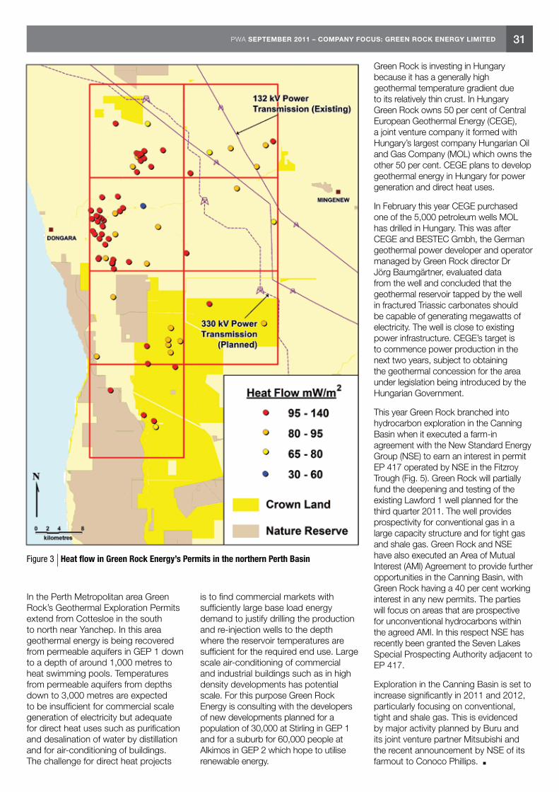
31PWA SEPTEMBER 2011 – COMPANY FOCUS: GREEN ROCK ENERGY LIMITED
In the Perth Metropolitan area Green Rock’s Geothermal Exploration Permits extend from Cottesloe in the south to north near Yanchep. In this area geothermal energy is being recovered from permeable aquifers in GEP 1 down to a depth of around 1,000 metres to heat swimming pools. Temperatures from permeable aquifers from depths down to 3,000 metres are expected to be insufficient for commercial scale generation of electricity but adequate for direct heat uses such as purification and desalination of water by distillation and for air-conditioning of buildings. The challenge for direct heat projects
is to find commercial markets with sufficiently large base load energy demand to justify drilling the production and re-injection wells to the depth where the reservoir temperatures are sufficient for the required end use. Large scale air-conditioning of commercial and industrial buildings such as in high density developments has potential scale. For this purpose Green Rock Energy is consulting with the developers of new developments planned for a population of 30,000 at Stirling in GEP 1 and for a suburb for 60,000 people at Alkimos in GEP 2 which hope to utilise renewable energy.
Green Rock is investing in Hungary because it has a generally high geothermal temperature gradient due to its relatively thin crust. In Hungary Green Rock owns 50 per cent of Central European Geothermal Energy (CEGE), a joint venture company it formed with Hungary’s largest company Hungarian Oil and Gas Company (MOL) which owns the other 50 per cent. CEGE plans to develop geothermal energy in Hungary for power generation and direct heat uses.
In February this year CEGE purchased one of the 5,000 petroleum wells MOL has drilled in Hungary. This was after CEGE and BESTEC Gmbh, the German geothermal power developer and operator managed by Green Rock director Dr Jörg Baumgärtner, evaluated data from the well and concluded that the geothermal reservoir tapped by the well in fractured Triassic carbonates should be capable of generating megawatts of electricity. The well is close to existing power infrastructure. CEGE’s target is to commence power production in the next two years, subject to obtaining the geothermal concession for the area under legislation being introduced by the Hungarian Government.
This year Green Rock branched into hydrocarbon exploration in the Canning Basin when it executed a farm-in agreement with the New Standard Energy Group (NSE) to earn an interest in permit EP 417 operated by NSE in the Fitzroy Trough (Fig. 5). Green Rock will partially fund the deepening and testing of the existing Lawford 1 well planned for the third quarter 2011. The well provides prospectivity for conventional gas in a large capacity structure and for tight gas and shale gas. Green Rock and NSE have also executed an Area of Mutual Interest (AMI) Agreement to provide further opportunities in the Canning Basin, with Green Rock having a 40 per cent working interest in any new permits. The parties will focus on areas that are prospective for unconventional hydrocarbons within the agreed AMI. In this respect NSE has recently been granted the Seven Lakes Special Prospecting Authority adjacent to EP 417.
Exploration in the Canning Basin is set to increase significantly in 2011 and 2012, particularly focusing on conventional, tight and shale gas. This is evidenced by major activity planned by Buru and its joint venture partner Mitsubishi and the recent announcement by NSE of its farmout to Conoco Phillips.
Figure 3 Heat flow in Green Rock Energy’s Permits in the northern Perth Basin
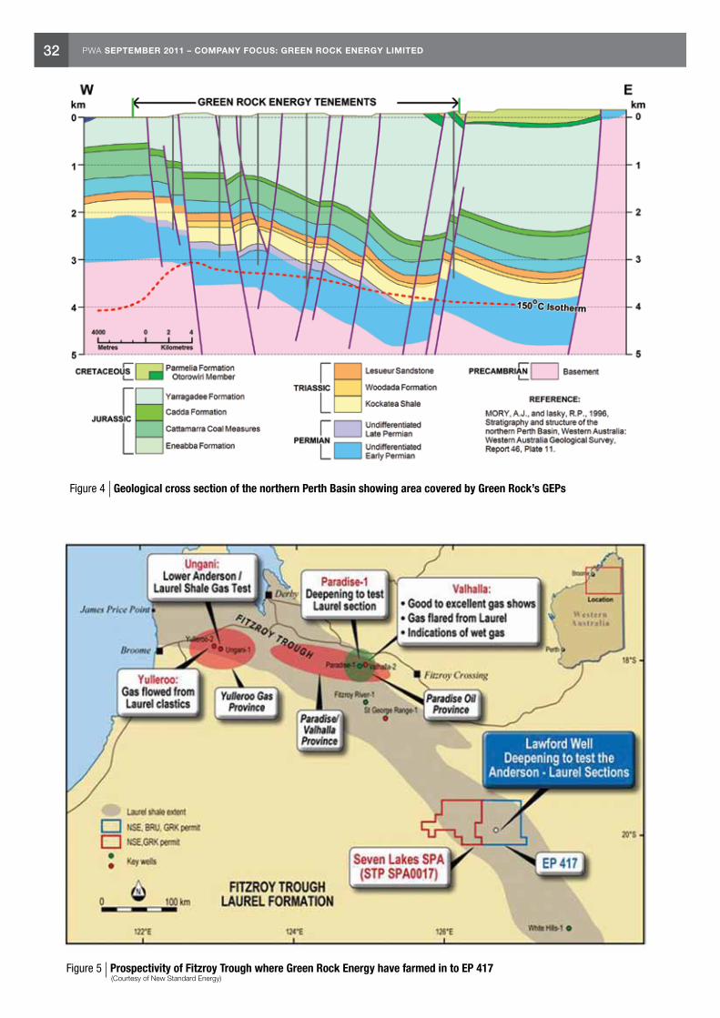
32 PWA SEPTEMBER 2011 – COMPANY FOCUS: GREEN ROCK ENERGY LIMITED
Figure 4 Geological cross section of the northern Perth Basin showing area covered by Green Rock’s GEPs
Figure 5 Prospectivity of Fitzroy Trough where Green Rock Energy have farmed in to EP 417 (Courtesy of New Standard Energy)

33PWA SEPTEMBER 2011 – COLLIE HUB CARBON CAPTURE AND STORAGE PROJECT
Jianhua Liu Petroleum Engineer Special Projects Resources Branch
Collie Hub Carbon Capture and Storage Project
On 11 June 2011, the Minister for Resources, Energy and Tourism, Mr Martin Ferguson announced the Carbon Capture and Storage (CCS) Flagship funding of $52 million to the Western Australian Collie South West Hub project to progress under a staged and gated approach. What is the Collie Hub CCS project? Where did it come from and what is the way forward?
The CCS Flagship program, built on the National Low Emission Coal Initiative, will include industrial scale demonstrations that will contribute to meeting 1,000 MV of low emissions fossil fuel power generation in Australia. The South West Collie Hub project is investigating potentially suitable storage sites near the industry centres of Kwinana and Collie, a large source region of carbon dioxide (CO2). The project aims to store up to 3.3 mega tonnes of CO2 per annum, captured from surrounding industry including coal-fired power plants.
The southwest of Western Australia, from Kwinana through to Collie (Fig. 1), is one of Australia’s major industrial areas, generating billions of dollars of domestic and export revenue. According to an estimation by the National Carbon Storage Taskforce in 2009, however, this area also contributes about 25 million tonnes per annum of carbon dioxide (CO2). In order to reduce CO2 emission, industries in this area have taken initiatives to investigate the potential of
carbon dioxide capture and geological storage in this region. The Collie Hub CCS project represents a government–industry partnership between the Department of Mines and Petroleum (DMP) and six major industry partners in the area — Griffin Energy, Verve Energy, BHP Billiton Worsley Alumina, Westfarmers Premier Coal, Perdaman Chemicals and Fertilisers, and Alcoa Australia.
Initial investigation of the potential for CO2 geological storage dates back more than a decade as part of the GEODISC Program by the then Australian Petroleum Cooperative Research Centre. In this program, sources of emission and potential geological storage sites, including the southern Perth Basin, were identified for further investigation. In 2007, the Department of Industry and Resources and the Coal Futures Group funded a more detailed study in this area. This study was carried out by the CRC for Greenhouse Gas Technologies (CO2CRC). The preliminary investigation by the CO2CRC identified the southern Perth Basin as having potential for CCS. The study found that the fresh water Yarragadee Formation was absent above the Lesueur Sandstone Formation in the Harvey Ridge region and recommended that further study should be undertaken to investigate its CO2 geological storage potential (Fig. 2). In 2010, the DMP and industry partners commissioned Carbon Storage Solutions, a division of international oilfield services provider Schlumberger, to test the validity of
suitable locations to store carbon dioxide in the southern Perth Basin by examining available seismic data and existing well cores. Both static modelling and dynamic modelling have been conducted. The independent studies have recognised the potential of the Lesueur Formation as a significant unconventional storage site.
Figure 1 Mapping showing the South West of Western Australia and the proposed Collie Hub CCS region (Van Gent and Stalker, 2010)
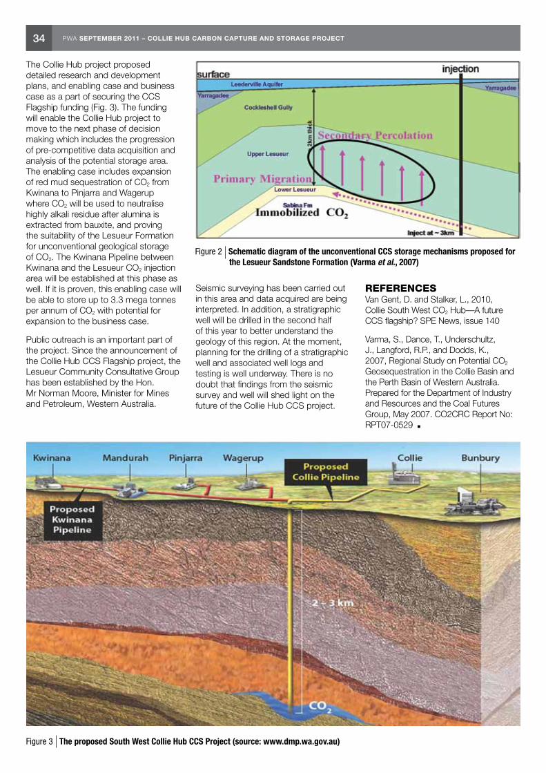
34 PWA SEPTEMBER 2011 – COLLIE HUB CARBON CAPTURE AND STORAGE PROJECT
The Collie Hub project proposed detailed research and development plans, and enabling case and business case as a part of securing the CCS Flagship funding (Fig. 3). The funding will enable the Collie Hub project to move to the next phase of decision making which includes the progression of pre-competitive data acquisition and analysis of the potential storage area. The enabling case includes expansion of red mud sequestration of CO2 from Kwinana to Pinjarra and Wagerup where CO2 will be used to neutralise highly alkali residue after alumina is extracted from bauxite, and proving the suitability of the Lesueur Formation for unconventional geological storage of CO2. The Kwinana Pipeline between Kwinana and the Lesueur CO2 injection area will be established at this phase as well. If it is proven, this enabling case will be able to store up to 3.3 mega tonnes per annum of CO2 with potential for expansion to the business case.
Public outreach is an important part of the project. Since the announcement of the Collie Hub CCS Flagship project, the Lesueur Community Consultative Group has been established by the Hon. Mr Norman Moore, Minister for Mines and Petroleum, Western Australia.
Seismic surveying has been carried out in this area and data acquired are being interpreted. In addition, a stratigraphic well will be drilled in the second half of this year to better understand the geology of this region. At the moment, planning for the drilling of a stratigraphic well and associated well logs and testing is well underway. There is no doubt that findings from the seismic survey and well will shed light on the future of the Collie Hub CCS project.
REFERENCES Van Gent, D. and Stalker, L., 2010, Collie South West CO2 Hub—A future CCS flagship? SPE News, issue 140
Varma, S., Dance, T., Underschultz, J., Langford, R.P., and Dodds, K., 2007, Regional Study on Potential CO2 Geosequestration in the Collie Basin and the Perth Basin of Western Australia. Prepared for the Department of Industry and Resources and the Coal Futures Group, May 2007. CO2CRC Report No: RPT07-0529
Figure 2 Schematic diagram of the unconventional CCS storage mechanisms proposed for the Lesueur Sandstone Formation (Varma et al., 2007)
Figure 3 The proposed South West Collie Hub CCS Project (source: www.dmp.wa.gov.au)
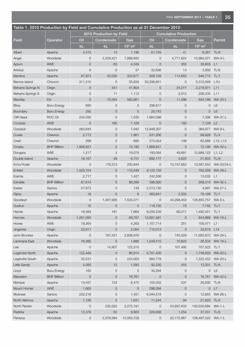
35PWA SEPTEMBER 2011 – TABLE 1
Table 1. 2010 Production by Field and Cumulative Production as at 31 December 2010
Field Operator
2010 Production by Field Cumulative Production
PermitOil Condensate Gas Oil Condensate Gas
kL kL 103 m3 kL kL 103 m3
Albert Apache 4,415 13 1,196 61,749 41 6,367 TL/6
Angel Woodside 0 2,329,421 7,899,932 0 4,771,924 15,984,521 WA-3-L
Apium AWE 0 63 4,349 0 355 30,603 L1
Artreus Apache 9 0 37 32,836 14 3,850 TL/6
Bambra Apache 67,974 30,030 323,677 309,109 114,650 846,715 TL/1
Barrow Island Chevron 311,510 0 35,934 50,296,651 0 5,315,949 L1H
Beharra Springs N Origin 0 341 41,804 0 24,211 2,279,971 L11
Beharra Springs S Origin 0 11 1,112 0 2,012 206,230 L11
Blacktip Eni 0 10,564 582,861 0 11,096 644,188 WA-33-L
Blina Buru Energy 690 0 0 296,817 0 0 L6
Boundary Buru Energy 292 0 0 20,743 0 0 L6
Cliff Head ROC Oil 234,030 0 1,530 1,664,098 0 7,396 WA-31-L
Corybas AWE 0 180 7,129 0 180 7,129 L2
Cossack Woodside 263,643 0 7,042 12,848,307 0 384,977 WA-9-L
Cowle Chevron 2,772 0 1,861 531,266 0 89,628 TL/4
Crest Chevron 299 0 695 275,054 108 62,686 L12, L13
Crosby BHP Billiton 1,908,621 0 72,190 1,908,621 0 72,190 WA-42-L
Dongara AWE 1,217 4 19,079 193,094 49,681 12,889,122 L1, L2
Double Island Apache 16,167 49 6,751 692,177 2,825 51,803 TL/9
Echo/Yodel Woodside 0 176,313 200,844 0 10,747,852 13,567,553 WA-23/24-L
Enfield Woodside 1,520,104 0 110,249 9,123,159 0 762,309 WA-28-L
Eremia AWE 2,717 0 1,427 242,506 0 13,035 L1
Eskdale BHP Billiton 87,614 0 86,268 398,900 0 268,310 WA-32-L
Exeter Santos 27,873 0 149 2,513,130 0 4,997 WA-27-L
Gipsy Apache 18 0 8 363,641 2,502 79,189 TL/1
Goodwyn Woodside 0 1,487,995 7,533,371 0 44,299,453 128,855,757 WA-5-L
Gudrun Apache 15 0 5 118,735 75 7,745 TL/1
Harriet Apache 18,483 181 7,664 8,200,239 60,217 1,492,451 TL/1
Hermes Woodside 1,261,095 0 89,767 12,681,481 0 844,868 WA-16-L
Hovea AWE 19,264 0 4,263 1,157,714 251 100,471 L1
Jingemia Origin 23,611 0 2,064 715,013 0 33,810 L14
John Brookes Apache 0 167,451 2,838,976 0 745,329 11,955,870 WA-29-L
Laminaria East Woodside 16,382 0 1,680 1,549,415 70,625 26,534 WA-18-L
Lee Apache 0 14,907 122,315 0 107,492 707,522 TL/1
Legendre North Apache 122,449 0 86,914 6,781,400 0 1,749,003 WA-20-L
Legendre South Apache 35,531 0 224,003 884,778 0 1,222,452 WA-20-L
Little Sandy Apache 4,083 12 1,593 92,230 455 13,301 TL/6
Lloyd Buru Energy 160 0 0 30,284 0 0 L8
Macedon BHP Billiton 0 0 16,761 0 0 16,761 WA-42-L
Mohave Apache 13,457 123 8,472 155,052 231 26,830 TL/6
Mount Horner AWE 1,663 0 0 298,094 0 0 L7
Mutineer Santos 252,218 0 1,451 6,044,518 0 12,955 WA-26-L
North Alkimos Apache 1,189 5 1,631 11,244 94 21,823 TL/6
North Rankin Woodside 0 235,922 2,275,191 0 24,697,633 193,530,684 WA-1-L
Pedirka Apache 12,378 50 6,563 326,938 1,254 37,201 TL/6
Perseus Woodside 0 2,379,384 12,055,759 0 22,170,967 108,497,522 WA-1-L
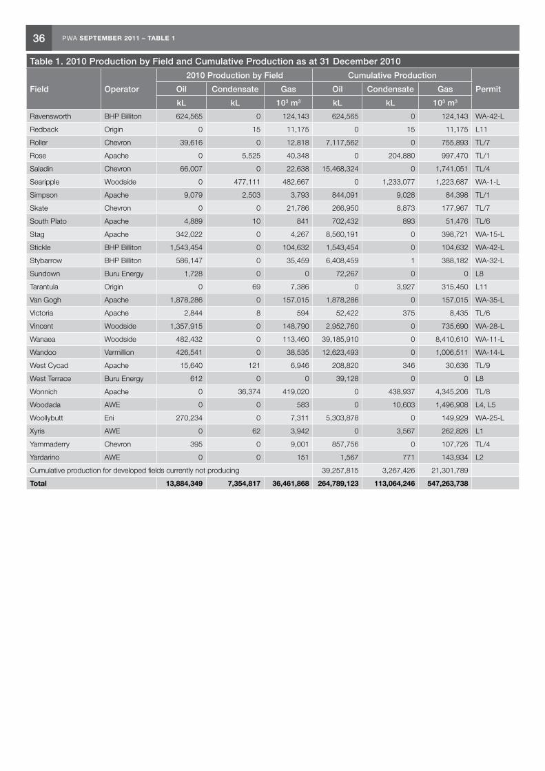
36 PWA SEPTEMBER 2011 – TABLE 1
Table 1. 2010 Production by Field and Cumulative Production as at 31 December 2010
Field Operator
2010 Production by Field Cumulative Production
PermitOil Condensate Gas Oil Condensate Gas
kL kL 103 m3 kL kL 103 m3
Ravensworth BHP Billiton 624,565 0 124,143 624,565 0 124,143 WA-42-L
Redback Origin 0 15 11,175 0 15 11,175 L11
Roller Chevron 39,616 0 12,818 7,117,562 0 755,893 TL/7
Rose Apache 0 5,525 40,348 0 204,880 997,470 TL/1
Saladin Chevron 66,007 0 22,638 15,468,324 0 1,741,051 TL/4
Searipple Woodside 0 477,111 482,667 0 1,233,077 1,223,687 WA-1-L
Simpson Apache 9,079 2,503 3,793 844,091 9,028 84,398 TL/1
Skate Chevron 0 0 21,786 266,950 8,873 177,967 TL/7
South Plato Apache 4,889 10 841 702,432 893 51,476 TL/6
Stag Apache 342,022 0 4,267 8,560,191 0 398,721 WA-15-L
Stickle BHP Billiton 1,543,454 0 104,632 1,543,454 0 104,632 WA-42-L
Stybarrow BHP Billiton 586,147 0 35,459 6,408,459 1 388,182 WA-32-L
Sundown Buru Energy 1,728 0 0 72,267 0 0 L8
Tarantula Origin 0 69 7,386 0 3,927 315,450 L11
Van Gogh Apache 1,878,286 0 157,015 1,878,286 0 157,015 WA-35-L
Victoria Apache 2,844 8 594 52,422 375 8,435 TL/6
Vincent Woodside 1,357,915 0 148,790 2,952,760 0 735,690 WA-28-L
Wanaea Woodside 482,432 0 113,460 39,185,910 0 8,410,610 WA-11-L
Wandoo Vermillion 426,541 0 38,535 12,623,493 0 1,006,511 WA-14-L
West Cycad Apache 15,640 121 6,946 208,820 346 30,636 TL/9
West Terrace Buru Energy 612 0 0 39,128 0 0 L8
Wonnich Apache 0 36,374 419,020 0 438,937 4,345,206 TL/8
Woodada AWE 0 0 583 0 10,603 1,496,908 L4, L5
Woollybutt Eni 270,234 0 7,311 5,303,878 0 149,929 WA-25-L
Xyris AWE 0 62 3,942 0 3,567 262,826 L1
Yammaderry Chevron 395 0 9,001 857,756 0 107,726 TL/4
Yardarino AWE 0 0 151 1,567 771 143,934 L2
Cumulative production for developed fields currently not producing 39,257,815 3,267,426 21,301,789
Total 13,884,349 7,354,817 36,461,868 264,789,123 113,064,246 547,263,738

37PWA SEPTEMBER 2011 – TABLE 2
Table 2a. Petroleum Reserves Estimates by Basin as at 31 December 2010 (metric units)Basin Oil Sales Gas Condensate
GL Gm3 GL
Category 1 P50 P90 P50 P90 P50 P90Bonaparte 0.000 0.000 22.791 10.452 0.401 0.184
Northern Carnarvon 67.907 34.727 1,115.299 867.415 78.213 57.629
Perth 1.224 0.689 0.275 0.126 0.006 0.006
Total 69.13 35.42 1,138.37 877.99 78.62 57.82
Category 2 P50 P90 P50 P90 P50 P90Bonaparte 0.000 0.000 60.698 34.118 1.650 0.957
Browse 0.000 0.000 447.750 267.289 57.540 34.620
Northern Carnarvon 4.129 2.217 766.544 437.410 39.316 20.114
Total 4.13 2.22 1,274.99 738.82 98.51 55.69
Category 3 P50 P90 P50 P90 P50 P90Browse 0.000 0.000 406.659 301.754 99.125 73.423
Northern Carnarvon 3.790 2.350 261.716 184.435 20.913 13.615
Total 3.79 2.35 668.38 486.19 120.04 87.04
Category 4 P50 P90 P50 P90 P50 P90Bonaparte 0.000 0.000 14.425 0.446 0.074 0.022
Browse 0.000 0.000 34.902 16.247 3.388 1.261
Carnarvon 41.388 22.909 436.638 272.571 17.268 10.324
Perth 0.000 0.000 5.500 5.500 0.000 0.000
Total 41.39 22.91 491.47 294.76 20.73 11.61
GRAND TOTAL 118.44 62.89 3,573.20 2,397.76 317.89 212.16
Table 2b. Petroleum Reserves Estimates by Basin as at 31 December 2010 (field units)Basin Oil Sales Gas Condensate
MMbbl Tcf MMbbl
Category 1 P50 P90 P50 P90 P50 P90Bonaparte 0.000 0.000 0.804 0.369 2.525 1.163
Northern Carnarvon 427.127 218.431 39.386 30.632 491.944 362.481
Perth 7.700 4.339 0.004 0.009 0.042 0.040
Total 434.83 222.77 40.19 31.01 494.51 363.68
Category 2 P50 P90 P50 P90 P50 P90Bonaparte 0.000 0.000 2.143 1.204 10.378 6.025
Browse 0.000 0.000 15.812 9.439 361.915 217.753
Northern Carnarvon 25.974 13.947 27.070 15.447 247.295 126.518
Total 25.97 13.95 45.03 26.09 619.59 350.30
Category 3 P50 P90 P50 P90 P50 P90Browse 0.000 0.000 14.361 10.656 623.479 461.817
Northern Carnarvon 23.838 14.781 9.242 6.513 131.539 85.637
Total 23.84 14.78 23.60 17.17 755.02 547.45
Category 4 P50 P90 P50 P90 P50 P90Bonaparte 0.000 0.000 0.015 0.509 0.469 0.143
Browse 0.000 0.000 1.232 0.573 21.310 7.936
Carnarvon 260.327 144.097 15.419 9.625 108.616 64.936
Perth 0.000 0.000 0.194 0.194 0.000 0.000
Total 260.33 144.10 16.86 10.901 130.40 73.02
GRAND TOTAL 744.97 395.60 125.68 85.17 1,999.51 1,334.45
NOTES Canning Basin reserves are too small to measure. Category 1 comprises current reserves of those fields which are producing hydrocarbons or have been declared commercial (FFDP approved and FID). Category 2 comprises estimates of recoverable reserves which are held under Retention Leases and have not yet been declared commercially viable. Category 3 comprises estimates of contingent resources which are held in other licences and have been declared commercially viable but may or may not have a FFDP and have not yet reached FID. Category 4 comprises estimates of contingent resources which are held in other licences and have not yet been declared commercially viable and are not held under a Retention Lease.

38 PWA SEPTEMBER 2011 – TABLES 3 & 4
Table 3. Seismic Surveys in Western Australia 2010–11 Fiscal Year — Statistical Summary
2D (line km) 3D (km2)
Bonaparte Basin Onshore
Offshore 209
Browse Basin Onshore
Offshore 9,739 3,037
Canning Basin Onshore 761
Offshore
Carnarvon Basin Onshore
Offshore 20,813(a)
Perth Basin Onshore 88 92
Offshore
Subtotal Onshore 849 92
Offshore 9,948 23,850
Total 10,797 23,942
The above table lists the quantity of 2D seismic and airborne gravity (line km) and 3D seismic (km2) acquired during the fiscal year. For surveys that commenced before 1 July 2010, only acquisition after this date is included. (a) Includes km2 from Eendracht and Schiele 3D M.S.S. commenced prior to July 2010. The attached listing of surveys operating in the fiscal year includes all data gathered prior to 30 June 2010.
Table 4. Petroleum Wells in Western Australia 2010–11 Fiscal Year — Statistical Summary
NFW EXT DEV Subtotal Total
Wells Metres Wells Metres Wells Metres Wells Metres Wells Metres
Bonaparte Basin Onshore 2 8,504
Offshore 2 8,504 2 8,504
Browse Basin Onshore 1 7,155
Offshore 1 4,824 2,331(a) 1 7,155
Canning Basin Onshore 5 8,940 5 8,940 5 8,940
Offshore
Carnarvon Basin Onshore 49 182,024
Offshore 24 97,593(b) 14 31,230 11 53,201(c) 49 182,024
Perth Basin Onshore 5 10,403 2 8,243 3 8,393 10 27,039 10 27,039
Offshore
Subtotal Onshore 10 19,343 2 8,243 3 8,393 15 35,979 67 233,662
Offshore 27 110,921 14 33,561 11 53,201 52 197,683
Total 37 130,264 16 41,804 14 61,594 67 233,662
The above table lists the number of wells spudded and metres drilled (subsurface) during the 2010–11 fiscal year. For wells spudded before 1 July 2010, only metres drilled during the fiscal year are included in the above table. (a) Concerto 1 spudded April 2010. (b) Includes six wells spudded prior to 1 July 2010. (c) Includes ENE 02 RD1 spudded May 2010 and 3 sidetracks to existing Wandoo development wells.

39PWA SEPTEMBER 2011 – TABLE 5
Table 5. Seismic Surveys in Western Australia Operating 2010–11 Fiscal Year
Survey Name ClassOn Off
Title Operator Commenced Completed2D/ Line
km @ 30/06/2011
3D km2 @ 30/06/2011
Bonaparte Basin
WA-446-P 2D M.S.S. 2D Off WA-446-P Finder No 1 25/10/2010 29/10/2010 209
Browse Basin
Golden Orb MultiClient 2D M.S.S.
2D Off 12SL/09-0 PGS 28/06/2010 18/07/2010 2,507
Vampire Non-Exclusive 2D M.S.S.
2D Off 1SL/10-1 Searcher 1/11/2010 1/02/2011 7,232
Bassett 3D M.S.S. 3D Off WA-408-P Total 23/09/2010 20/10/2010 856
Byron 3D M.S.S. 3D Off WA-396-P, WA-397-P
Woodside 25/04/2011 7/05/2011 562
Ichthys 3D M.S.S. 3D Off WA-285-P R2, WA-37-R
Inpex 21/10/2010 23/12/2010 1,619
Canning Basin
Pijalinga 2D S.S. 2D On EP 427, EP 442 Buru 2/10/2010 10/11/2010 415
Yulleroo South 2D S.S. 2D On EP 391 R2, EP 428 Buru 27/08/2010 28/09/2010 346
Goldwyer Aerial Gravity Survey
GRAVITY On EP 443, EP 450, EP 451, EP 456
New Standard 24/10/2010 10/12/2010 13,733
Carnarvon Basin
Phoenix MC3D M.S.S. 3D Off 11SL/09-0 Fugro 9/12/2010 16/02/2011 1,212
Cambozola 3D M.S.S. 3D Off WA-290-P R1 Apache 22/05/2011 27/06/2011 964
Chamois 3D M.S.S. 3D Off WA-261-P R2 Apache 16/03/2011 9/04/2011 257
Eendracht 3D M.S.S. 3D Off 6SL/08-9 Fugro 8/06/2009 27/10/2010 14,768
Endeavour MC3D Multiclient M.S.S.
3D Off 3SL/10-1 WesternGeco 6/12/2010 11/03/2011 1,851
Enfield M5 4D M.S.S. 3D Off WA-28-L Woodside 28/12/2010 12/01/2011 305
Gazelle 3D M.S.S. 3D Off WA-399-P Apache 28/02/2011 11/03/2011 135
Kultarr 3D M.S.S. 3D Off WA-334-P R1 Apache 11/04/2011 19/04/2011 229
Movida 3D M.S.S. 3D Off WA-389-P Woodside 10/03/2011 2/04/2011 1,613
Orcus 3D M.S.S. 3D Off WA-450-P Apache 9/02/2011 20/05/2011 266
Pomodoro 3D M.S.S. 3D Off WA-426-P Apache 16/01/2011 9/02/2011 317
Salsa 3D M.S.S. 3D Off WA-384-P Shell 28/12/2010 5/02/2011 300
Schiele 3D M.S.S. 3D Off WA-362-P, WA-363-P
OMV Australia 21/04/2010 6/07/2010 3,943
Sovereign 3D M.S.S. 3D Off WA-383-P Chevron 6/04/2011 21/04/2011 1,014
Stybarrow 4D Monitor M.S.S.
3D Off WA-32-L BHPB 2/05/2011 19/05/2011 82
Vincent M1 4D M.S.S. 3D Off WA-28-L Woodside 20/12/2010 27/12/2010 123
Zeebries MC3D M.S.S.
3D Off 5SL10-1 Fugro 3/12/2010 3/05/2011 3,816
Ragnar Hub 2D C.S.E.M. Survey
CSEM Off WA-428-P, WA-430-P, WA-433-P
Woodside 10/12/2010 23/12/2010 126
Kennedy Range Survey
GEOCHEM On 6/08-9 New Standard 1/05/2009 7/01/2011
Wandagee East Geochemistry
GEOCHEM On 9/09-0 New Standard 8/04/2010 7/01/2011
Eucla Basin
Balladonia ESR Survey ESR On 4/09-0 Southern Sky 7/06/2010 30/06/2010 1,940
Perth Basin
Garibaldi 2D S.S. 2D On EP 430, EP 454 Empire Oil 1/04/2011 12/04/2011 88
Warro 3D S.S. 3D On EP 321 R3, EP 407 R1
Latent 16/03/2011 28/03/2011 92
Collie Rock Chip & Soil Sampling Survey
GEOL On GEP 10, GEP 11, GEP 12
Green Rock 5/07/2010 12/07/2010
Class - Classification 2D - 2D Reflection, 3D - 3D Reflection, GRAVITY - Airborne Gravity, ESR - Electron Spin Resonance, CSEM - Controlled Source Electromagnetic Survey, GEOL - Geological Sampling Survey

40 PWA SEPTEMBER 2011 – TABLE 6
Table 6. Petroleum Wells in Western Australia Operating 2010–11 Fiscal Year
Well Name ClassOn Off
Title Operator Latitude LongitudeGnd Elev/
Water DepthRT/ KB Spud Date TD Date Rig Release Date
Bonaparte Basin
Durville 1 NFW OFF WA-403-P Total 11 31 14.390 127 6 59.180 108 24.7 7/01/2011 2/03/2011 12/03/2011
Laperouse 1 NFW OFF WA-403-P Total 11 46 42.800 127 18 22.400 122 24.7 14/03/2011 14/05/2011 25/05/2011
Browse Basin
Concerto 2 ST1 EXT OFF WA-371-P Shell 13 40 53.108 123 21 31.310 268 24.7 4/04/2010 1/08/2010 17/08/2010
Omar 1 NFW OFF WA-397-P Woodside 15 3 56.969 121 17 32.155 378.82 26.2 19/03/2011 18/05/2011 29/05/2011
Canning Basin
Backreef 1 NFW ON L 6 R1 Oil Basin Ltd 17 36 32.990 124 33 44.950 63.2 67.55 11/10/2010 27/10/2010 2/11/2010
Leander 1 ST1 NFW ON L 8 R1 Buru 17 30 56.400 124 14 19.5 38.5 43.6 8/07/2010 4/09/2010 8/09/2010
Nangu 1 NFW ON EP 471 Buru 19 10 30.200 122 3 50.800 73 77 28/11/2010 5/12/2010 7/12/2010
Valhalla 2 NFW ON EP 371 R1 Buru 18 4 4.130 124 46 4.200 110 115.8 6/06/2011
Carnarvon Basin
ENE 02 RD1 DEV OFF WA-28-L Woodside 21 28 53.958 113 59 17.693 521.3 22.9 6/05/2010 17/07/2010 5/08/2010
ENE 03 ST1 DEV OFF WA-28-L Woodside 21 28 52.842 113 59 17.851 522.3 22.9 6/08/2010 15/09/2010 5/10/2010
Macedon 10 DEV OFF WA-42-L BHPB 21 34 2.560 114 10 8.640 179.7 22 14/08/2010 27/08/2010 14/12/2010
Macedon 7 DEV OFF WA-42-L BHPB 21 33 50.800 114 13 24.6 161.2 22 21/11/2010 1/12/2010 14/12/2010
Macedon 8A DEV OFF WA-42-L BHPB 21 34 17.467 114 11 46.992 168.7 22.2 17/10/2010 3/11/2010 14/12/2010
Macedon 9 DEV OFF WA-42-L BHPB 21 34 33.220 114 9 31.460 179 22 19/09/2010 23/09/2010 14/12/2010
PLA 01 ST1 DEV OFF WA-34-L BHPB 19 54 49.270 115 7 54.530 829.1 22.3 4/10/2010 15/10/2010 14/11/2010
Stag 36H ST2 DEV OFF WA-15-L Apache 20 17 43.860 116 15 31.41 48.9 61.3 16/12/2010 21/01/2011 29/01/2011
Stag 37H BHC1 DEV OFF WA-15-L Apache 20 17 23.91 116 16 30.99 48.9 61.3 31/10/2010 7/12/2010 29/01/2011
Stybarrow 12H DEV OFF WA-32-L BHPB 21 28 11.323 113 50 47.358 800.7 22.3 31/07/2010 17/08/2010 22/09/2010
VNB-5H L2 ST1 DEV OFF WA-28-L Woodside 21 26 1.32 114 2 0.215 392.9 22.9 2/03/2011 1/06/2011
VNB-6H L3 DEV OFF WA-28-L Woodside 21 26 2.138 114 1 57.677 392 22.9 28/02/2011 3/05/2011
Wandoo A6 H3 DEV OFF WA-14-L Vermillion 20 8 14.608 116 25 22.431 54 39.44 10/10/2010 12/10/2010 18/10/2010
Wandoo B12 ST3 DEV OFF WA-14-L Vermillion 20 7 41.150 116 26 4.040 53.9 42.26 31/08/2010 3/09/2010 18/10/2010
Wandoo B8 ST1 DEV OFF WA-14-L Vermillion 20 7 41.150 116 26 4.040 54.2 42.26 23/09/2010 27/09/2010 18/10/2010
Balnaves 3 EXT OFF WA-356-P Apache 20 3 40.239 115 11 7.031 162 25 27/07/2010 27/08/2010 30/09/2010
Balnaves 4 EXT OFF WA-356-P Apache 20 3 40.239 115 11 7.031 162 25 15/09/2010 26/09/2010 30/09/2010
Bravo 2 EXT OFF WA-390-P Hess 20 2 3.524 113 37 33.129 1,088.2 29 22/04/2011 2/05/2011 17/05/2011
Chandon 3 EXT OFF WA-268-P R2 Chevron 19 35 52.590 114 9 22.560 1,207.7 22.3 2/03/2011 20/03/2011 1/04/2011
Chester 2 EXT OFF WA-390-P Hess 20 28 48.220 113 54 20.100 1,125.8 21.9 5/06/2011
Chrysaor 2 EXT OFF WA-15-R R1 Chevron 20 8 27.280 114 53 11.960 919.7 22.3 3/04/2011 29/04/2011 16/05/2011
Laverda North 1 EXT OFF WA-36-R Woodside 21 30 44.720 113 51 46.827 808.5 32 9/12/2010 7/04/2011 23/04/2011
Laverda North 2 EXT OFF WA-36-R Woodside 21 30 44.720 113 51 46.830 808.5 32 14/04/2011 15/04/2011 23/04/2011
Mentorc 2 EXT OFF WA-390-P Hess 20 29 0.344 113 44 22.350 1,134 29 12/03/2011 10/04/2011 19/04/2011
Orthrus 2 EXT OFF WA-24-R R1 Chevron 20 6 22.300 114 4 4.000 1,194 22 16/08/2010 1/12/2010 26/02/2011
Spar 2 EXT OFF WA-4-R R2 Apache 20 36 31.981 114 54 22.098 112 25 2/10/2010 1/11/2010 29/11/2010
Stag 34 EXT OFF WA-15-L Apache 20 17 3.286 116 15 24.767 49.1 36.54 31/07/2010 6/08/2010 17/08/2010
Stag 35 EXT OFF WA-15-L Apache 20 17 3.286 116 15 24.767 49.1 36.54 9/08/2010 12/08/2010 17/08/2010
West Tryal Rocks 4A EXT OFF WA-5-R R3 Chevron 20 14 9.630 115 1 43.640 139.2 22.3 18/05/2011 22/06/2011
Acme 1 NFW OFF WA-205-P R3 Chevron 20 12 27.097 114 49 8.941 877 22.3 18/06/2010 13/07/2010 26/07/2010
Alaric 1 NFW OFF WA-434-P Woodside 19 56 31.924 111 38 57.262 1,992.5 31.5 23/07/2010 17/08/2010 3/09/2010
Artemis 1 NFW OFF WA-360-P MEO 19 32 39.800 115 31 50.900 425 25 25/11/2010 12/12/2010 26/12/2010
Carnarvon Basin cont.
Balnaves Deep 1 NFW OFF WA-356-P Apache 20 4 58.213 115 10 34.192 135.3 21.5 18/03/2011 16/04/2011 27/04/2011
Barberry 1 NFW OFF TL/2 R1 Apache 21 18 13.519 115 11 40.157 16 38.5 12/07/2010 23/07/2010 28/07/2010
Black Pearl 1 NFW OFF WA-42-L BHPB 21 34 7.347 114 8 31.120 184 22.2 26/07/2010 3/08/2010 9/08/2010
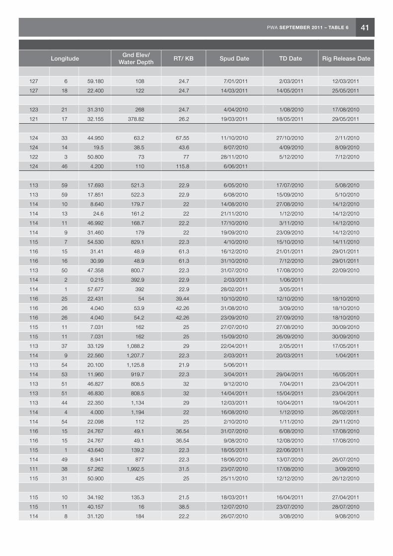
41PWA SEPTEMBER 2011 – TABLE 6
Table 6. Petroleum Wells in Western Australia Operating 2010–11 Fiscal Year
Well Name ClassOn Off
Title Operator Latitude LongitudeGnd Elev/
Water DepthRT/ KB Spud Date TD Date Rig Release Date
Bonaparte Basin
Durville 1 NFW OFF WA-403-P Total 11 31 14.390 127 6 59.180 108 24.7 7/01/2011 2/03/2011 12/03/2011
Laperouse 1 NFW OFF WA-403-P Total 11 46 42.800 127 18 22.400 122 24.7 14/03/2011 14/05/2011 25/05/2011
Browse Basin
Concerto 2 ST1 EXT OFF WA-371-P Shell 13 40 53.108 123 21 31.310 268 24.7 4/04/2010 1/08/2010 17/08/2010
Omar 1 NFW OFF WA-397-P Woodside 15 3 56.969 121 17 32.155 378.82 26.2 19/03/2011 18/05/2011 29/05/2011
Canning Basin
Backreef 1 NFW ON L 6 R1 Oil Basin Ltd 17 36 32.990 124 33 44.950 63.2 67.55 11/10/2010 27/10/2010 2/11/2010
Leander 1 ST1 NFW ON L 8 R1 Buru 17 30 56.400 124 14 19.5 38.5 43.6 8/07/2010 4/09/2010 8/09/2010
Nangu 1 NFW ON EP 471 Buru 19 10 30.200 122 3 50.800 73 77 28/11/2010 5/12/2010 7/12/2010
Valhalla 2 NFW ON EP 371 R1 Buru 18 4 4.130 124 46 4.200 110 115.8 6/06/2011
Carnarvon Basin
ENE 02 RD1 DEV OFF WA-28-L Woodside 21 28 53.958 113 59 17.693 521.3 22.9 6/05/2010 17/07/2010 5/08/2010
ENE 03 ST1 DEV OFF WA-28-L Woodside 21 28 52.842 113 59 17.851 522.3 22.9 6/08/2010 15/09/2010 5/10/2010
Macedon 10 DEV OFF WA-42-L BHPB 21 34 2.560 114 10 8.640 179.7 22 14/08/2010 27/08/2010 14/12/2010
Macedon 7 DEV OFF WA-42-L BHPB 21 33 50.800 114 13 24.6 161.2 22 21/11/2010 1/12/2010 14/12/2010
Macedon 8A DEV OFF WA-42-L BHPB 21 34 17.467 114 11 46.992 168.7 22.2 17/10/2010 3/11/2010 14/12/2010
Macedon 9 DEV OFF WA-42-L BHPB 21 34 33.220 114 9 31.460 179 22 19/09/2010 23/09/2010 14/12/2010
PLA 01 ST1 DEV OFF WA-34-L BHPB 19 54 49.270 115 7 54.530 829.1 22.3 4/10/2010 15/10/2010 14/11/2010
Stag 36H ST2 DEV OFF WA-15-L Apache 20 17 43.860 116 15 31.41 48.9 61.3 16/12/2010 21/01/2011 29/01/2011
Stag 37H BHC1 DEV OFF WA-15-L Apache 20 17 23.91 116 16 30.99 48.9 61.3 31/10/2010 7/12/2010 29/01/2011
Stybarrow 12H DEV OFF WA-32-L BHPB 21 28 11.323 113 50 47.358 800.7 22.3 31/07/2010 17/08/2010 22/09/2010
VNB-5H L2 ST1 DEV OFF WA-28-L Woodside 21 26 1.32 114 2 0.215 392.9 22.9 2/03/2011 1/06/2011
VNB-6H L3 DEV OFF WA-28-L Woodside 21 26 2.138 114 1 57.677 392 22.9 28/02/2011 3/05/2011
Wandoo A6 H3 DEV OFF WA-14-L Vermillion 20 8 14.608 116 25 22.431 54 39.44 10/10/2010 12/10/2010 18/10/2010
Wandoo B12 ST3 DEV OFF WA-14-L Vermillion 20 7 41.150 116 26 4.040 53.9 42.26 31/08/2010 3/09/2010 18/10/2010
Wandoo B8 ST1 DEV OFF WA-14-L Vermillion 20 7 41.150 116 26 4.040 54.2 42.26 23/09/2010 27/09/2010 18/10/2010
Balnaves 3 EXT OFF WA-356-P Apache 20 3 40.239 115 11 7.031 162 25 27/07/2010 27/08/2010 30/09/2010
Balnaves 4 EXT OFF WA-356-P Apache 20 3 40.239 115 11 7.031 162 25 15/09/2010 26/09/2010 30/09/2010
Bravo 2 EXT OFF WA-390-P Hess 20 2 3.524 113 37 33.129 1,088.2 29 22/04/2011 2/05/2011 17/05/2011
Chandon 3 EXT OFF WA-268-P R2 Chevron 19 35 52.590 114 9 22.560 1,207.7 22.3 2/03/2011 20/03/2011 1/04/2011
Chester 2 EXT OFF WA-390-P Hess 20 28 48.220 113 54 20.100 1,125.8 21.9 5/06/2011
Chrysaor 2 EXT OFF WA-15-R R1 Chevron 20 8 27.280 114 53 11.960 919.7 22.3 3/04/2011 29/04/2011 16/05/2011
Laverda North 1 EXT OFF WA-36-R Woodside 21 30 44.720 113 51 46.827 808.5 32 9/12/2010 7/04/2011 23/04/2011
Laverda North 2 EXT OFF WA-36-R Woodside 21 30 44.720 113 51 46.830 808.5 32 14/04/2011 15/04/2011 23/04/2011
Mentorc 2 EXT OFF WA-390-P Hess 20 29 0.344 113 44 22.350 1,134 29 12/03/2011 10/04/2011 19/04/2011
Orthrus 2 EXT OFF WA-24-R R1 Chevron 20 6 22.300 114 4 4.000 1,194 22 16/08/2010 1/12/2010 26/02/2011
Spar 2 EXT OFF WA-4-R R2 Apache 20 36 31.981 114 54 22.098 112 25 2/10/2010 1/11/2010 29/11/2010
Stag 34 EXT OFF WA-15-L Apache 20 17 3.286 116 15 24.767 49.1 36.54 31/07/2010 6/08/2010 17/08/2010
Stag 35 EXT OFF WA-15-L Apache 20 17 3.286 116 15 24.767 49.1 36.54 9/08/2010 12/08/2010 17/08/2010
West Tryal Rocks 4A EXT OFF WA-5-R R3 Chevron 20 14 9.630 115 1 43.640 139.2 22.3 18/05/2011 22/06/2011
Acme 1 NFW OFF WA-205-P R3 Chevron 20 12 27.097 114 49 8.941 877 22.3 18/06/2010 13/07/2010 26/07/2010
Alaric 1 NFW OFF WA-434-P Woodside 19 56 31.924 111 38 57.262 1,992.5 31.5 23/07/2010 17/08/2010 3/09/2010
Artemis 1 NFW OFF WA-360-P MEO 19 32 39.800 115 31 50.900 425 25 25/11/2010 12/12/2010 26/12/2010
Carnarvon Basin cont.
Balnaves Deep 1 NFW OFF WA-356-P Apache 20 4 58.213 115 10 34.192 135.3 21.5 18/03/2011 16/04/2011 27/04/2011
Barberry 1 NFW OFF TL/2 R1 Apache 21 18 13.519 115 11 40.157 16 38.5 12/07/2010 23/07/2010 28/07/2010
Black Pearl 1 NFW OFF WA-42-L BHPB 21 34 7.347 114 8 31.120 184 22.2 26/07/2010 3/08/2010 9/08/2010
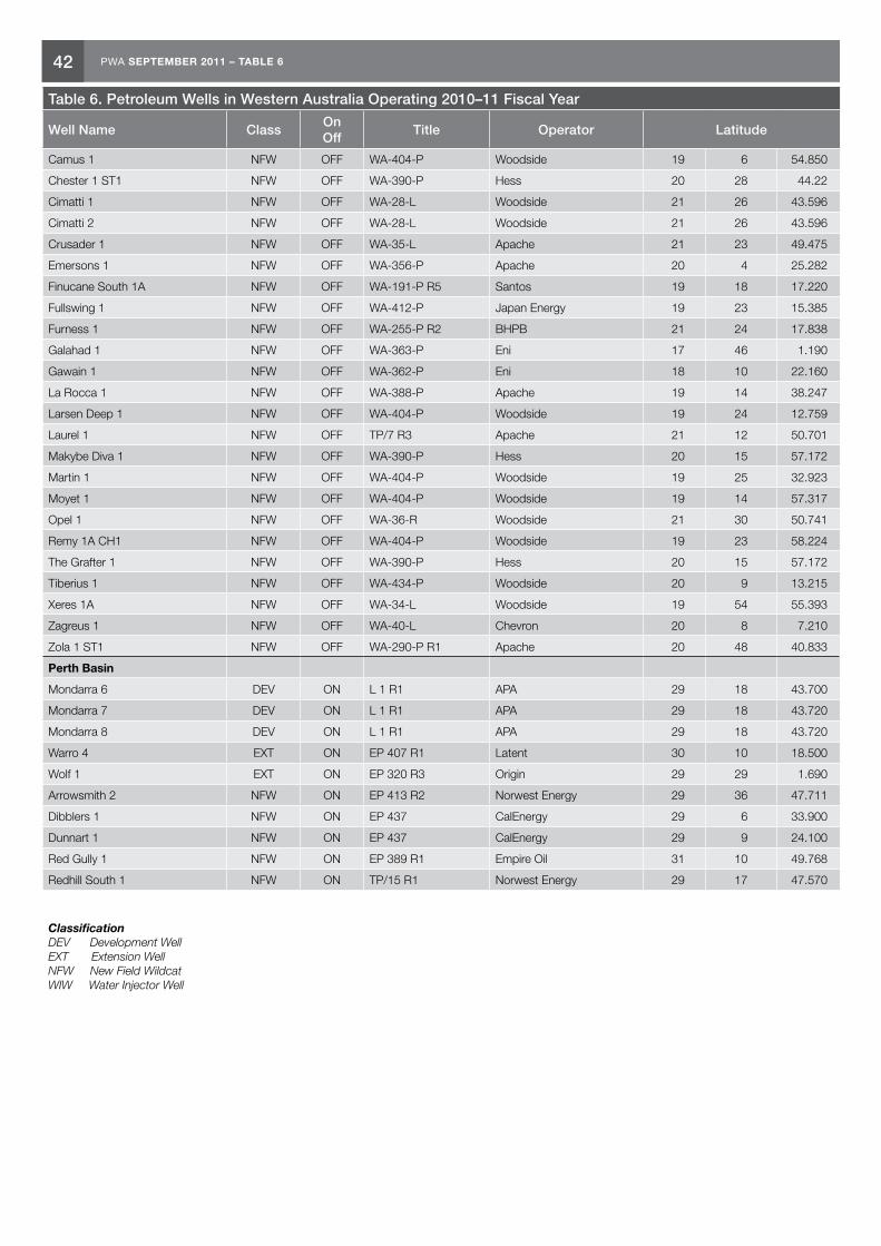
42 PWA SEPTEMBER 2011 – TABLE 6
Table 6. Petroleum Wells in Western Australia Operating 2010–11 Fiscal Year
Well Name ClassOn Off
Title Operator Latitude LongitudeGnd Elev/
Water DepthRT/ KB Spud Date TD Date Rig Release Date
Camus 1 NFW OFF WA-404-P Woodside 19 6 54.850 114 16 23.120 1,348 31.5 27/03/2010 25/09/2010 4/10/2010
Chester 1 ST1 NFW OFF WA-390-P Hess 20 28 44.22 113 55 39.320 1,121 29 20/06/2010 27/08/2010 7/09/2010
Cimatti 1 NFW OFF WA-28-L Woodside 21 26 43.596 113 58 15.444 547.4 22.9 1/11/2010 13/11/2010 30/11/2010
Cimatti 2 NFW OFF WA-28-L Woodside 21 26 43.596 113 58 15.444 547.4 22.9 18/11/2010 21/11/2010 30/11/2010
Crusader 1 NFW OFF WA-35-L Apache 21 23 49.475 114 1 21.327 428.1 21.5 11/02/2011 10/03/2011 16/03/2011
Emersons 1 NFW OFF WA-356-P Apache 20 4 25.282 115 17 49.984 76.8 41.5 22/05/2011
Finucane South 1A NFW OFF WA-191-P R5 Santos 19 18 17.220 116 45 30.110 133.4 25 3/05/2011 23/05/2011 30/05/2011
Fullswing 1 NFW OFF WA-412-P Japan Energy 19 23 15.385 116 18 12.796 133.8 22.2 19/12/2010 24/01/2011 7/02/2011
Furness 1 NFW OFF WA-255-P R2 BHPB 21 24 17.838 113 55 58.598 606.7 22.2 1/07/2010 13/07/2010 22/07/2010
Galahad 1 NFW OFF WA-363-P Eni 17 46 1.190 115 44 57.240 1,576.5 25 25/04/2011 15/05/2011 26/05/2011
Gawain 1 NFW OFF WA-362-P Eni 18 10 22.160 115 0 25.100 1,962.8 25 12/02/2011 12/04/2011 22/04/2011
La Rocca 1 NFW OFF WA-388-P Apache 19 14 38.247 115 41 10.667 407 21.5 30/04/2011 25/05/2011 6/06/2011
Larsen Deep 1 NFW OFF WA-404-P Woodside 19 24 12.759 114 14 59.409 1,242.6 26.2 19/03/2010 18/08/2010 13/09/2010
Laurel 1 NFW OFF TP/7 R3 Apache 21 12 50.701 115 7 22.036 22 38.4 12/06/2010 2/07/2010 10/07/2010
Makybe Diva 1 NFW OFF WA-390-P Hess 20 15 57.172 113 41 20.691 1,117.33 29 28/09/2010 6/10/2010 16/10/2010
Martin 1 NFW OFF WA-404-P Woodside 19 25 32.923 114 22 34.051 1,342.8 32 14/12/2010 13/03/2011 24/03/2011
Moyet 1 NFW OFF WA-404-P Woodside 19 14 57.317 114 12 37.832 1,296.2 31.5 6/09/2010 27/11/2010 3/12/2010
Opel 1 NFW OFF WA-36-R Woodside 21 30 50.741 113 50 32.524 841 31.5 6/12/2010
Remy 1A CH1 NFW OFF WA-404-P Woodside 19 23 58.224 114 18 42.811 1,293.3 26.2 6/10/2010 18/11/2010 23/12/2010
The Grafter 1 NFW OFF WA-390-P Hess 20 15 57.172 113 41 20.691 1,117.33 29 9/09/2010 24/09/2010 16/10/2010
Tiberius 1 NFW OFF WA-434-P Woodside 20 9 13.215 111 35 41.467 1,657.8 31.5 16/06/2010 13/07/2010 21/07/2010
Xeres 1A NFW OFF WA-34-L Woodside 19 54 55.393 115 15 3.912 190.3 32 27/04/2011 20/05/2011 18/06/2011
Zagreus 1 NFW OFF WA-40-L Chevron 20 8 7.210 114 6 58.760 1,189.3 28.7 27/05/2011 26/06/2011
Zola 1 ST1 NFW OFF WA-290-P R1 Apache 20 48 40.833 114 42 43.687 284.7 25 1/12/2010 9/04/2011 27/04/2011
Perth Basin
Mondarra 6 DEV ON L 1 R1 APA 29 18 43.700 115 7 8.370 79.19 86.96 13/09/2010 6/10/2010 14/10/2010
Mondarra 7 DEV ON L 1 R1 APA 29 18 43.720 115 7 10.040 79.16 86.93 22/10/2010 12/11/2010 23/12/2010
Mondarra 8 DEV ON L 1 R1 APA 29 18 43.720 115 7 10.040 79.16 86.3 18/11/2010 7/12/2010 23/12/2010
Warro 4 EXT ON EP 407 R1 Latent 30 10 18.500 115 43 59.400 278.5 286.3 11/04/2011 5/05/2011 11/05/2011
Wolf 1 EXT ON EP 320 R3 Origin 29 29 1.690 115 9 45.460 60 67.77 18/07/2010 18/08/2010 2/09/2010
Arrowsmith 2 NFW ON EP 413 R2 Norwest Energy 29 36 47.711 115 7 14.439 42 49.77 30/05/2011 18/06/2011
Dibblers 1 NFW ON EP 437 CalEnergy 29 6 33.900 114 54 21.800 14.8 18.3 21/01/2011 3/02/2011 8/02/2011
Dunnart 1 NFW ON EP 437 CalEnergy 29 9 24.100 114 56 15.600 41.8 45.3 5/12/2010 11/01/2011 16/01/2011
Red Gully 1 NFW ON EP 389 R1 Empire Oil 31 10 49.768 115 49 34.763 176.58 184.35 6/01/2011 11/02/2011 2/03/2011
Redhill South 1 NFW ON TP/15 R1 Norwest Energy 29 17 47.570 114 55 33.840 2.38 6.68 28/02/2011 19/03/2011 22/03/2011
Classification DEV Development Well EXT Extension Well NFW New Field Wildcat WIW Water Injector Well

43PWA SEPTEMBER 2011 – TABLE 6
Table 6. Petroleum Wells in Western Australia Operating 2010–11 Fiscal Year
Well Name ClassOn Off
Title Operator Latitude LongitudeGnd Elev/
Water DepthRT/ KB Spud Date TD Date Rig Release Date
Camus 1 NFW OFF WA-404-P Woodside 19 6 54.850 114 16 23.120 1,348 31.5 27/03/2010 25/09/2010 4/10/2010
Chester 1 ST1 NFW OFF WA-390-P Hess 20 28 44.22 113 55 39.320 1,121 29 20/06/2010 27/08/2010 7/09/2010
Cimatti 1 NFW OFF WA-28-L Woodside 21 26 43.596 113 58 15.444 547.4 22.9 1/11/2010 13/11/2010 30/11/2010
Cimatti 2 NFW OFF WA-28-L Woodside 21 26 43.596 113 58 15.444 547.4 22.9 18/11/2010 21/11/2010 30/11/2010
Crusader 1 NFW OFF WA-35-L Apache 21 23 49.475 114 1 21.327 428.1 21.5 11/02/2011 10/03/2011 16/03/2011
Emersons 1 NFW OFF WA-356-P Apache 20 4 25.282 115 17 49.984 76.8 41.5 22/05/2011
Finucane South 1A NFW OFF WA-191-P R5 Santos 19 18 17.220 116 45 30.110 133.4 25 3/05/2011 23/05/2011 30/05/2011
Fullswing 1 NFW OFF WA-412-P Japan Energy 19 23 15.385 116 18 12.796 133.8 22.2 19/12/2010 24/01/2011 7/02/2011
Furness 1 NFW OFF WA-255-P R2 BHPB 21 24 17.838 113 55 58.598 606.7 22.2 1/07/2010 13/07/2010 22/07/2010
Galahad 1 NFW OFF WA-363-P Eni 17 46 1.190 115 44 57.240 1,576.5 25 25/04/2011 15/05/2011 26/05/2011
Gawain 1 NFW OFF WA-362-P Eni 18 10 22.160 115 0 25.100 1,962.8 25 12/02/2011 12/04/2011 22/04/2011
La Rocca 1 NFW OFF WA-388-P Apache 19 14 38.247 115 41 10.667 407 21.5 30/04/2011 25/05/2011 6/06/2011
Larsen Deep 1 NFW OFF WA-404-P Woodside 19 24 12.759 114 14 59.409 1,242.6 26.2 19/03/2010 18/08/2010 13/09/2010
Laurel 1 NFW OFF TP/7 R3 Apache 21 12 50.701 115 7 22.036 22 38.4 12/06/2010 2/07/2010 10/07/2010
Makybe Diva 1 NFW OFF WA-390-P Hess 20 15 57.172 113 41 20.691 1,117.33 29 28/09/2010 6/10/2010 16/10/2010
Martin 1 NFW OFF WA-404-P Woodside 19 25 32.923 114 22 34.051 1,342.8 32 14/12/2010 13/03/2011 24/03/2011
Moyet 1 NFW OFF WA-404-P Woodside 19 14 57.317 114 12 37.832 1,296.2 31.5 6/09/2010 27/11/2010 3/12/2010
Opel 1 NFW OFF WA-36-R Woodside 21 30 50.741 113 50 32.524 841 31.5 6/12/2010
Remy 1A CH1 NFW OFF WA-404-P Woodside 19 23 58.224 114 18 42.811 1,293.3 26.2 6/10/2010 18/11/2010 23/12/2010
The Grafter 1 NFW OFF WA-390-P Hess 20 15 57.172 113 41 20.691 1,117.33 29 9/09/2010 24/09/2010 16/10/2010
Tiberius 1 NFW OFF WA-434-P Woodside 20 9 13.215 111 35 41.467 1,657.8 31.5 16/06/2010 13/07/2010 21/07/2010
Xeres 1A NFW OFF WA-34-L Woodside 19 54 55.393 115 15 3.912 190.3 32 27/04/2011 20/05/2011 18/06/2011
Zagreus 1 NFW OFF WA-40-L Chevron 20 8 7.210 114 6 58.760 1,189.3 28.7 27/05/2011 26/06/2011
Zola 1 ST1 NFW OFF WA-290-P R1 Apache 20 48 40.833 114 42 43.687 284.7 25 1/12/2010 9/04/2011 27/04/2011
Perth Basin
Mondarra 6 DEV ON L 1 R1 APA 29 18 43.700 115 7 8.370 79.19 86.96 13/09/2010 6/10/2010 14/10/2010
Mondarra 7 DEV ON L 1 R1 APA 29 18 43.720 115 7 10.040 79.16 86.93 22/10/2010 12/11/2010 23/12/2010
Mondarra 8 DEV ON L 1 R1 APA 29 18 43.720 115 7 10.040 79.16 86.3 18/11/2010 7/12/2010 23/12/2010
Warro 4 EXT ON EP 407 R1 Latent 30 10 18.500 115 43 59.400 278.5 286.3 11/04/2011 5/05/2011 11/05/2011
Wolf 1 EXT ON EP 320 R3 Origin 29 29 1.690 115 9 45.460 60 67.77 18/07/2010 18/08/2010 2/09/2010
Arrowsmith 2 NFW ON EP 413 R2 Norwest Energy 29 36 47.711 115 7 14.439 42 49.77 30/05/2011 18/06/2011
Dibblers 1 NFW ON EP 437 CalEnergy 29 6 33.900 114 54 21.800 14.8 18.3 21/01/2011 3/02/2011 8/02/2011
Dunnart 1 NFW ON EP 437 CalEnergy 29 9 24.100 114 56 15.600 41.8 45.3 5/12/2010 11/01/2011 16/01/2011
Red Gully 1 NFW ON EP 389 R1 Empire Oil 31 10 49.768 115 49 34.763 176.58 184.35 6/01/2011 11/02/2011 2/03/2011
Redhill South 1 NFW ON TP/15 R1 Norwest Energy 29 17 47.570 114 55 33.840 2.38 6.68 28/02/2011 19/03/2011 22/03/2011
Classification DEV Development Well EXT Extension Well NFW New Field Wildcat WIW Water Injector Well
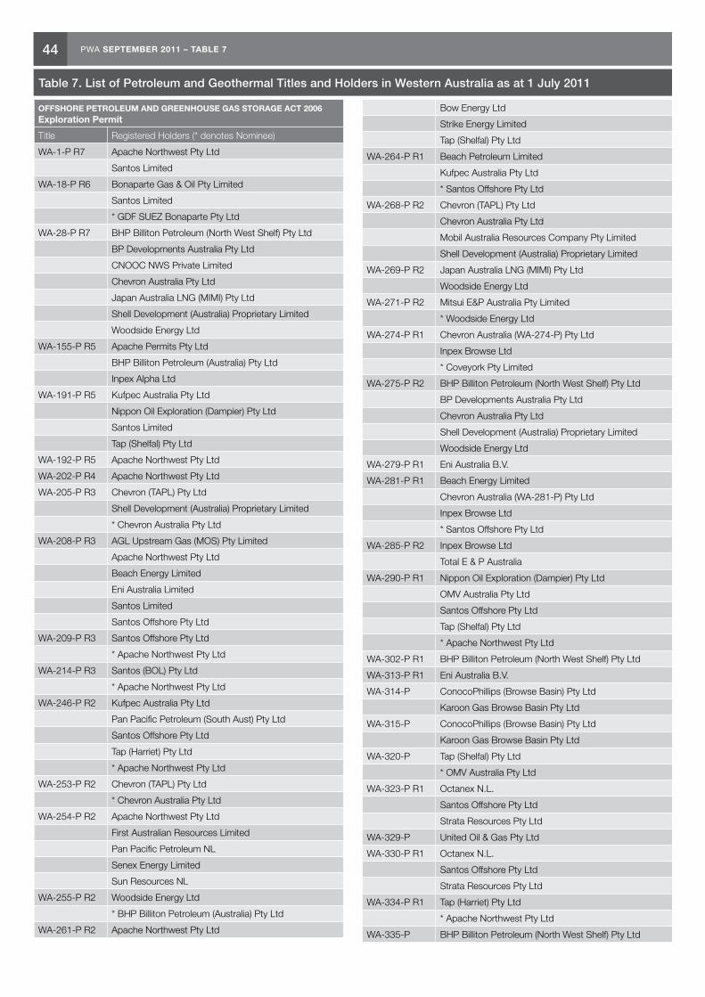
44 PWA SEPTEMBER 2011 – TABLE 7
OFFSHORE PETROLEUM AND GREENHOUSE GAS STORAGE ACT 2006 Exploration Permit
Title Registered Holders (* denotes Nominee)
WA-1-P R7 Apache Northwest Pty Ltd
Santos Limited
WA-18-P R6 Bonaparte Gas & Oil Pty Limited
Santos Limited
* GDF SUEZ Bonaparte Pty Ltd
WA-28-P R7 BHP Billiton Petroleum (North West Shelf) Pty Ltd
BP Developments Australia Pty Ltd
CNOOC NWS Private Limited
Chevron Australia Pty Ltd
Japan Australia LNG (MIMI) Pty Ltd
Shell Development (Australia) Proprietary Limited
Woodside Energy Ltd
WA-155-P R5 Apache Permits Pty Ltd
BHP Billiton Petroleum (Australia) Pty Ltd
Inpex Alpha Ltd
WA-191-P R5 Kufpec Australia Pty Ltd
Nippon Oil Exploration (Dampier) Pty Ltd
Santos Limited
Tap (Shelfal) Pty Ltd
WA-192-P R5 Apache Northwest Pty Ltd
WA-202-P R4 Apache Northwest Pty Ltd
WA-205-P R3 Chevron (TAPL) Pty Ltd
Shell Development (Australia) Proprietary Limited
* Chevron Australia Pty Ltd
WA-208-P R3 AGL Upstream Gas (MOS) Pty Limited
Apache Northwest Pty Ltd
Beach Energy Limited
Eni Australia Limited
Santos Limited
Santos Offshore Pty Ltd
WA-209-P R3 Santos Offshore Pty Ltd
* Apache Northwest Pty Ltd
WA-214-P R3 Santos (BOL) Pty Ltd
* Apache Northwest Pty Ltd
WA-246-P R2 Kufpec Australia Pty Ltd
Pan Pacific Petroleum (South Aust) Pty Ltd
Santos Offshore Pty Ltd
Tap (Harriet) Pty Ltd
* Apache Northwest Pty Ltd
WA-253-P R2 Chevron (TAPL) Pty Ltd
* Chevron Australia Pty Ltd
WA-254-P R2 Apache Northwest Pty Ltd
First Australian Resources Limited
Pan Pacific Petroleum NL
Senex Energy Limited
Sun Resources NL
WA-255-P R2 Woodside Energy Ltd
* BHP Billiton Petroleum (Australia) Pty Ltd
WA-261-P R2 Apache Northwest Pty Ltd
Table 7. List of Petroleum and Geothermal Titles and Holders in Western Australia as at 1 July 2011
Bow Energy Ltd
Strike Energy Limited
Tap (Shelfal) Pty Ltd
WA-264-P R1 Beach Petroleum Limited
Kufpec Australia Pty Ltd
* Santos Offshore Pty Ltd
WA-268-P R2 Chevron (TAPL) Pty Ltd
Chevron Australia Pty Ltd
Mobil Australia Resources Company Pty Limited
Shell Development (Australia) Proprietary Limited
WA-269-P R2 Japan Australia LNG (MIMI) Pty Ltd
Woodside Energy Ltd
WA-271-P R2 Mitsui E&P Australia Pty Limited
* Woodside Energy Ltd
WA-274-P R1 Chevron Australia (WA-274-P) Pty Ltd
Inpex Browse Ltd
* Coveyork Pty Limited
WA-275-P R2 BHP Billiton Petroleum (North West Shelf) Pty Ltd
BP Developments Australia Pty Ltd
Chevron Australia Pty Ltd
Shell Development (Australia) Proprietary Limited
Woodside Energy Ltd
WA-279-P R1 Eni Australia B.V.
WA-281-P R1 Beach Energy Limited
Chevron Australia (WA-281-P) Pty Ltd
Inpex Browse Ltd
* Santos Offshore Pty Ltd
WA-285-P R2 Inpex Browse Ltd
Total E & P Australia
WA-290-P R1 Nippon Oil Exploration (Dampier) Pty Ltd
OMV Australia Pty Ltd
Santos Offshore Pty Ltd
Tap (Shelfal) Pty Ltd
* Apache Northwest Pty Ltd
WA-302-P R1 BHP Billiton Petroleum (North West Shelf) Pty Ltd
WA-313-P R1 Eni Australia B.V.
WA-314-P ConocoPhillips (Browse Basin) Pty Ltd
Karoon Gas Browse Basin Pty Ltd
WA-315-P ConocoPhillips (Browse Basin) Pty Ltd
Karoon Gas Browse Basin Pty Ltd
WA-320-P Tap (Shelfal) Pty Ltd
* OMV Australia Pty Ltd
WA-323-P R1 Octanex N.L.
Santos Offshore Pty Ltd
Strata Resources Pty Ltd
WA-329-P United Oil & Gas Pty Ltd
WA-330-P R1 Octanex N.L.
Santos Offshore Pty Ltd
Strata Resources Pty Ltd
WA-334-P R1 Tap (Harriet) Pty Ltd
* Apache Northwest Pty Ltd
WA-335-P BHP Billiton Petroleum (North West Shelf) Pty Ltd
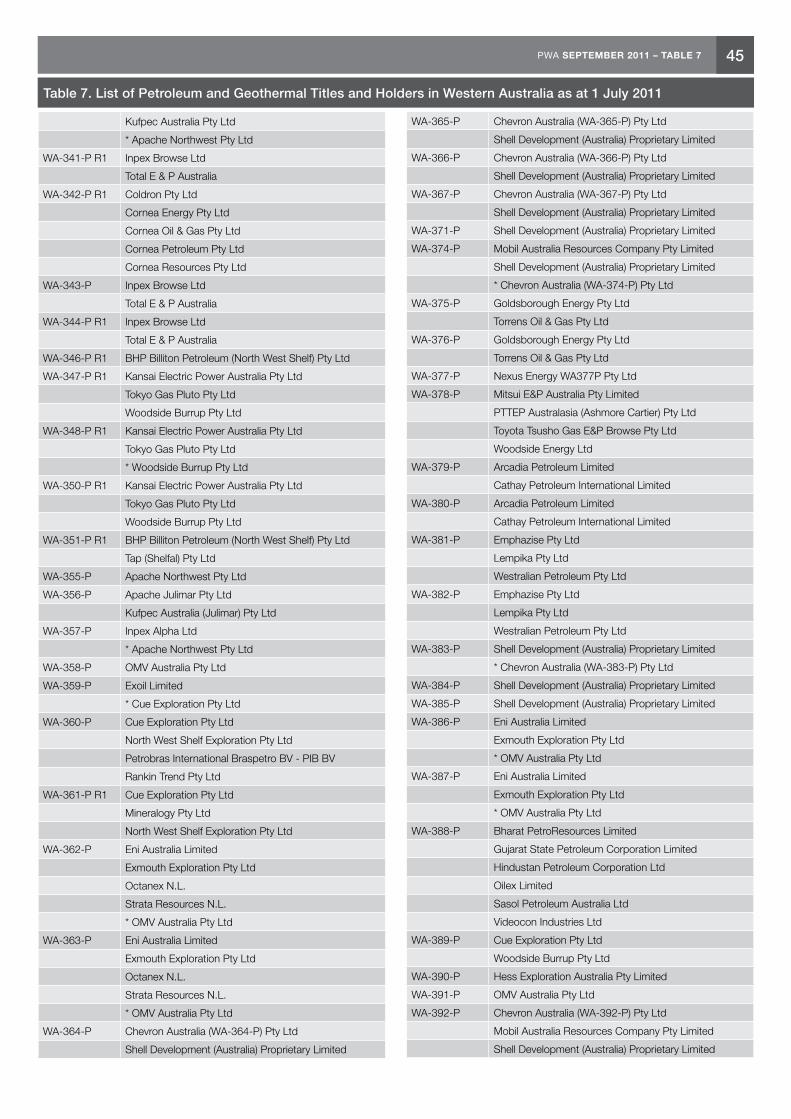
45PWA SEPTEMBER 2011 – TABLE 7
Table 7. List of Petroleum and Geothermal Titles and Holders in Western Australia as at 1 July 2011
Kufpec Australia Pty Ltd
* Apache Northwest Pty Ltd
WA-341-P R1 Inpex Browse Ltd
Total E & P Australia
WA-342-P R1 Coldron Pty Ltd
Cornea Energy Pty Ltd
Cornea Oil & Gas Pty Ltd
Cornea Petroleum Pty Ltd
Cornea Resources Pty Ltd
WA-343-P Inpex Browse Ltd
Total E & P Australia
WA-344-P R1 Inpex Browse Ltd
Total E & P Australia
WA-346-P R1 BHP Billiton Petroleum (North West Shelf) Pty Ltd
WA-347-P R1 Kansai Electric Power Australia Pty Ltd
Tokyo Gas Pluto Pty Ltd
Woodside Burrup Pty Ltd
WA-348-P R1 Kansai Electric Power Australia Pty Ltd
Tokyo Gas Pluto Pty Ltd
* Woodside Burrup Pty Ltd
WA-350-P R1 Kansai Electric Power Australia Pty Ltd
Tokyo Gas Pluto Pty Ltd
Woodside Burrup Pty Ltd
WA-351-P R1 BHP Billiton Petroleum (North West Shelf) Pty Ltd
Tap (Shelfal) Pty Ltd
WA-355-P Apache Northwest Pty Ltd
WA-356-P Apache Julimar Pty Ltd
Kufpec Australia (Julimar) Pty Ltd
WA-357-P Inpex Alpha Ltd
* Apache Northwest Pty Ltd
WA-358-P OMV Australia Pty Ltd
WA-359-P Exoil Limited
* Cue Exploration Pty Ltd
WA-360-P Cue Exploration Pty Ltd
North West Shelf Exploration Pty Ltd
Petrobras International Braspetro BV - PIB BV
Rankin Trend Pty Ltd
WA-361-P R1 Cue Exploration Pty Ltd
Mineralogy Pty Ltd
North West Shelf Exploration Pty Ltd
WA-362-P Eni Australia Limited
Exmouth Exploration Pty Ltd
Octanex N.L.
Strata Resources N.L.
* OMV Australia Pty Ltd
WA-363-P Eni Australia Limited
Exmouth Exploration Pty Ltd
Octanex N.L.
Strata Resources N.L.
* OMV Australia Pty Ltd
WA-364-P Chevron Australia (WA-364-P) Pty Ltd
Shell Development (Australia) Proprietary Limited
WA-365-P Chevron Australia (WA-365-P) Pty Ltd
Shell Development (Australia) Proprietary Limited
WA-366-P Chevron Australia (WA-366-P) Pty Ltd
Shell Development (Australia) Proprietary Limited
WA-367-P Chevron Australia (WA-367-P) Pty Ltd
Shell Development (Australia) Proprietary Limited
WA-371-P Shell Development (Australia) Proprietary Limited
WA-374-P Mobil Australia Resources Company Pty Limited
Shell Development (Australia) Proprietary Limited
* Chevron Australia (WA-374-P) Pty Ltd
WA-375-P Goldsborough Energy Pty Ltd
Torrens Oil & Gas Pty Ltd
WA-376-P Goldsborough Energy Pty Ltd
Torrens Oil & Gas Pty Ltd
WA-377-P Nexus Energy WA377P Pty Ltd
WA-378-P Mitsui E&P Australia Pty Limited
PTTEP Australasia (Ashmore Cartier) Pty Ltd
Toyota Tsusho Gas E&P Browse Pty Ltd
Woodside Energy Ltd
WA-379-P Arcadia Petroleum Limited
Cathay Petroleum International Limited
WA-380-P Arcadia Petroleum Limited
Cathay Petroleum International Limited
WA-381-P Emphazise Pty Ltd
Lempika Pty Ltd
Westralian Petroleum Pty Ltd
WA-382-P Emphazise Pty Ltd
Lempika Pty Ltd
Westralian Petroleum Pty Ltd
WA-383-P Shell Development (Australia) Proprietary Limited
* Chevron Australia (WA-383-P) Pty Ltd
WA-384-P Shell Development (Australia) Proprietary Limited
WA-385-P Shell Development (Australia) Proprietary Limited
WA-386-P Eni Australia Limited
Exmouth Exploration Pty Ltd
* OMV Australia Pty Ltd
WA-387-P Eni Australia Limited
Exmouth Exploration Pty Ltd
* OMV Australia Pty Ltd
WA-388-P Bharat PetroResources Limited
Gujarat State Petroleum Corporation Limited
Hindustan Petroleum Corporation Ltd
Oilex Limited
Sasol Petroleum Australia Ltd
Videocon Industries Ltd
WA-389-P Cue Exploration Pty Ltd
Woodside Burrup Pty Ltd
WA-390-P Hess Exploration Australia Pty Limited
WA-391-P OMV Australia Pty Ltd
WA-392-P Chevron Australia (WA-392-P) Pty Ltd
Mobil Australia Resources Company Pty Limited
Shell Development (Australia) Proprietary Limited

46 PWA SEPTEMBER 2011 – TABLE 7
WA-394-P Shell Development (Australia) Proprietary Limited
WA-396-P Mitsui E&P Australia Pty Limited
PTTEP Australasia (Ashmore Cartier) Pty Ltd
Toyota Tsusho Gas E&P Browse Pty Ltd
Woodside Energy Ltd
WA-397-P Mitsui E&P Australia Pty Limited
PTTEP Australasia (Ashmore Cartier) Pty Ltd
Toyota Tsusho Gas E&P Browse Pty Ltd
Woodside Energy Ltd
WA-398-P ConocoPhillips (Browse Basin) Pty Ltd
Karoon Gas Browse Basin Pty Ltd
WA-399-P Carnarvon Petroleum Limited
Jacka Resources Limited
Rialto Energy Limited
* Apache Northwest Pty Ltd
WA-401-P Woodside Energy Ltd
WA-402-P Petronas Carigali (Australia) Pty Ltd
Total E & P Australia
WA-403-P Petronas Carigali (Australia) Pty Ltd
Total E & P Australia
WA-404-P Woodside Energy Ltd
WA-405-P Reliance Exploration & Production DMCC
WA-406-P CNOOC Australia E&P Pty Ltd
WA-407-P Goldsborough Energy Pty Ltd
WA-408-P Total E & P Australia
WA-409-P Cue Exploration Pty Ltd
Rankin Trend Pty Ltd
WA-410-P Chevron Australia (WA-410-P) Pty Ltd
Inpex Browse Ltd
Santos Offshore Pty Ltd
WA-411-P Beach Energy Limited
Inpex Browse Ltd
Santos Offshore Pty Ltd
WA-412-P Japan Energy E&P Australia Pty Ltd
WA-413-P Hunt Oil Australia Permit 413 Holding Company Pty Ltd
WA-414-P Mitsui E&P Australia Pty Limited
* Hunt Oil Australia Permit 414 Holding Company Pty Ltd
WA-415-P Woodside Energy Ltd
WA-416-P Woodside Energy Ltd
WA-417-P Woodside Energy Ltd
WA-418-P Finder Exploration Pty Ltd
* Apache Northwest Pty Ltd
WA-419-P Emerald Gas Pty Ltd
WA-420-P Goldsborough Energy Pty Ltd
WA-421-P Goldsborough Energy Pty Ltd
WA-422-P National Oil Corporation Pty Ltd
WA-423-P Diamond Resources Australia Pty Ltd
PTTEP Australia Offshore Pty Ltd
* Murphy Australia Oil Pty Ltd
WA-424-P IPM WA 424P Pty Ltd
WA-425-P Hunt Oil Australia Permit 425 Holding Company Pty Ltd
Mitsui E&P Australia Pty Limited
SK Energy Co., Ltd
WA-426-P Apache Northwest Pty Ltd
WA-427-P Apache Northwest Pty Ltd
Kufpec Australia Pty Ltd
WA-428-P Mitsui E&P Australia Pty Limited
Woodside Energy Ltd
WA-429-P Mitsui E&P Australia Pty Limited
Woodside Energy Ltd
WA-430-P Mitsui E&P Australia Pty Limited
Woodside Energy Ltd
WA-431-P Hunt Oil Australia Permit 431 Holding Company Pty Ltd
Mitsui E&P Australia Pty Limited
SK Energy Co., Ltd
WA-432-P Mitsui E&P Australia Pty Limited
Woodside Energy Ltd
WA-433-P Mitsui E&P Australia Pty Limited
Woodside Energy Ltd
WA-434-P Woodside Energy Ltd
WA-435-P Carnarvon Petroleum Limited
Finder Exploration Pty Ltd
WA-436-P Carnarvon Petroleum Limited
Finder Exploration Pty Ltd
WA-437-P Carnarvon Petroleum Limited
Finder Exploration Pty Ltd
WA-438-P Carnarvon Petroleum Limited
Finder Exploration Pty Ltd
WA-439-P Chevron Australia (WA-439-P) Pty Ltd
Shell Development (Australia) Proprietary Limited
WA-440-P Goldsborough Energy Pty Ltd
WA-441-P Goldsborough Energy Pty Ltd
WA-442-P Ansbachall Pty Limited
Tangiers Petroleum Limited
WA-443-P Carnarvon Petroleum Limited
WA-444-P Chevron Australia (WA-444-P) Pty Ltd
Mobil Australia Resources Company Pty Limited
Shell Development (Australia) Proprietary Limited
WA-445-P Finder No 2 Pty Limited
WA-446-P Finder No 1 Pty Limited
WA-447-P Mitsui E&P Australia Pty Limited
Woodside Energy Ltd
WA-448-P Japan Australia LNG (MIMI) Pty Ltd
Woodside Energy Ltd
WA-449-P Mitsui E&P Australia Pty Limited
Woodside Energy Ltd
WA-450-P Finder No 4 Pty Limited
* Apache Northwest Pty Ltd
WA-451-P Woodside Energy Ltd
WA-452-P Riverina Energy Ltd
WA-453-P Apache Energy Limited
WA-454-P MEO Australia Ltd
Table 7. List of Petroleum and Geothermal Titles and Holders in Western Australia as at 1 July 2011

47PWA SEPTEMBER 2011 – TABLE 7
OFFSHORE PETROLEUM AND GREENHOUSE GAS STORAGE ACT 2006 Infrastructure Licence
Title Registered Holders (* denotes Nominee)
WA-1-IL Kansai Electric Power Australia Pty Ltd
Tokyo Gas Pluto Pty Ltd
Woodside Burrup Pty Ltd
WA-2-IL Shell Development (Australia) Proprietary Limited
OFFSHORE PETROLEUM AND GREENHOUSE GAS STORAGE ACT 2006 Pipeline Licence
Title Registered Holders (* denotes Nominee)
WA-1-PL BHP Billiton Petroleum (North West Shelf) Pty Ltd
BP Developments Australia Pty Ltd
Chevron Australia Pty Ltd
Japan Australia LNG (MIMI) Pty Ltd
Shell Development (Australia) Proprietary Limited
* Woodside Energy Ltd
WA-2-PL BHP Billiton Petroleum (North West Shelf) Pty Ltd
BP Developments Australia Pty Ltd
Chevron Australia Pty Ltd
Japan Australia LNG (MIMI) Pty Ltd
Shell Development (Australia) Proprietary Limited
* Woodside Energy Ltd
WA-3-PL Inpex Alpha Ltd
Mobil Exploration & Producing Australia Pty Ltd
* BHP Billiton Petroleum (Australia) Pty Ltd
WA-4-PL BHP Billiton Petroleum (North West Shelf) Pty Ltd
BP Developments Australia Pty Ltd
Chevron Australia Pty Ltd
Japan Australia LNG (MIMI) Pty Ltd
Shell Development (Australia) Proprietary Limited
* Woodside Energy Ltd
WA-5-PL Apache East Spar Pty Ltd
Apache Kersail Pty Ltd
Santos (BOL) Pty Ltd
* Apache Oil Australia Pty Ltd
WA-6-PL Apache Northwest Pty Ltd
Santos (GLOBE) Pty Ltd
Santos Offshore Pty Ltd
WA-7-PL Apache Northwest Pty Ltd
Santos Limited
WA-8-PL ConocoPhillips Pipeline Australia Pty Ltd
Eni Gas & Power LNG Australia B.V.
Inpex DLNGPL Pty Ltd
Santos Timor Sea Pipeline Pty Ltd
TEPCO Darwin LNG Pty Ltd
Tokyo Gas Darwin LNG Pty Ltd
WA-9-PL BHP Billiton Petroleum (North West Shelf) Pty Ltd
BP Developments Australia Pty Ltd
Chevron Australia Pty Ltd
Japan Australia LNG (MIMI) Pty Ltd
Shell Development (Australia) Proprietary Limited
* Woodside Energy Ltd
WA-10-PL BHP Billiton Petroleum (North West Shelf) Pty Ltd
BP Developments Australia Pty Ltd
Chevron Australia Pty Ltd
Japan Australia LNG (MIMI) Pty Ltd
Shell Development (Australia) Proprietary Limited
* Woodside Energy Ltd
WA-11-PL Apache Northwest Pty Ltd
Santos (BOL) Pty Ltd
WA-12-PL ARC (Offshore PB) Limited
AWE Oil (Western Australia) Pty Ltd
Cieco Energy Australia Pty Ltd
Roc Oil (WA) Pty Limited
WA-13-PL BHP Billiton Petroleum (North West Shelf) Pty Ltd
BP Developments Australia Pty Ltd
Chevron Australia Pty Ltd
Japan Australia LNG (MIMI) Pty Ltd
Shell Development (Australia) Proprietary Limited
Woodside Energy Ltd
WA-14-PL BHP Billiton Petroleum (North West Shelf) Pty Ltd
BP Developments Australia Pty Ltd
Chevron Australia Holdings Pty Ltd
Japan Australia LNG (MIMI) Pty Ltd
Shell Development (Australia) Proprietary Limited
Woodside Energy Ltd
WA-15-PL Eni Australia B.V.
WA-16-PL Kansai Electric Power Australia Pty Ltd
Tokyo Gas Pluto Pty Ltd
Woodside Burrup Pty Ltd
WA-17-PL Kansai Electric Power Australia Pty Ltd
Tokyo Gas Pluto Pty Ltd
Woodside Burrup Pty Ltd
WA-18-PL Apache Northwest Pty Ltd
Santos Offshore Pty Ltd
WA-19-PL Chevron (TAPL) Pty Ltd
Chevron Australia Pty Ltd
Chubu Electric Power Gorgon Pty Ltd
Mobil Australia Resources Company Pty Limited
Osaka Gas Gorgon Pty Ltd
Shell Development (Australia) Proprietary Limited
Tokyo Gas Gorgon Pty Ltd
WA-20-PL Chevron (TAPL) Pty Ltd
Chevron Australia Pty Ltd
Chubu Electric Power Gorgon Pty Ltd
Mobil Australia Resources Company Pty Limited
Osaka Gas Gorgon Pty Ltd
Shell Development (Australia) Proprietary Limited
Tokyo Gas Gorgon Pty Ltd
WA-21-PL Apache East Spar Pty Ltd
Apache Kersail Pty Ltd
Apache Oil Australia Pty Ltd
Table 7. List of Petroleum and Geothermal Titles and Holders in Western Australia as at 1 July 2011

48 PWA SEPTEMBER 2011 – TABLE 7
Santos (BOL) Pty Ltd
WA-22-PL Inpex Browse Ltd
Total E & P Australia
OFFSHORE PETROLEUM AND GREENHOUSE GAS STORAGE ACT 2006 Production Licence
Title Registered Holders (* denotes Nominee)
WA-1-L R1 BHP Billiton Petroleum (North West Shelf) Pty Ltd
BP Developments Australia Pty Ltd
CNOOC NWS Private Limited
Chevron Australia Pty Ltd
Japan Australia LNG (MIMI) Pty Ltd
Shell Development (Australia) Proprietary Limited
Woodside Energy Ltd
WA-2-L R1 BHP Billiton Petroleum (North West Shelf) Pty Ltd
BP Developments Australia Pty Ltd
CNOOC NWS Private Limited
Chevron Australia Pty Ltd
Japan Australia LNG (MIMI) Pty Ltd
Shell Development (Australia) Proprietary Limited
Woodside Energy Ltd
WA-3-L R1 BHP Billiton Petroleum (North West Shelf) Pty Ltd
BP Developments Australia Pty Ltd
CNOOC NWS Private Limited
Chevron Australia Pty Ltd
Japan Australia LNG (MIMI) Pty Ltd
Shell Development (Australia) Proprietary Limited
Woodside Energy Ltd
WA-4-L R1 BHP Billiton Petroleum (North West Shelf) Pty Ltd
BP Developments Australia Pty Ltd
CNOOC NWS Private Limited
Chevron Australia Pty Ltd
Japan Australia LNG (MIMI) Pty Ltd
Shell Development (Australia) Proprietary Limited
Woodside Energy Ltd
WA-5-L R1 BHP Billiton Petroleum (North West Shelf) Pty Ltd
BP Developments Australia Pty Ltd
CNOOC NWS Private Limited
Chevron Australia Pty Ltd
Japan Australia LNG (MIMI) Pty Ltd
Shell Development (Australia) Proprietary Limited
Woodside Energy Ltd
WA-6-L R1 BHP Billiton Petroleum (North West Shelf) Pty Ltd
BP Developments Australia Pty Ltd
CNOOC NWS Private Limited
Chevron Australia Pty Ltd
Japan Australia LNG (MIMI) Pty Ltd
Shell Development (Australia) Proprietary Limited
Woodside Energy Ltd
WA-8-L R1 Kufpec Australia Pty Ltd
Tap (Shelfal) Pty Ltd
* Santos Limited
WA-9-L BHP Billiton Petroleum (North West Shelf) Pty Ltd
BP Developments Australia Pty Ltd
CNOOC NWS Private Limited
Chevron Australia Pty Ltd
Japan Australia LNG (MIMI) Pty Ltd
Shell Development (Australia) Proprietary Limited
Woodside Energy Ltd
WA-10-L Inpex Alpha Ltd
Mobil Exploration & Producing Australia Pty Ltd
* BHP Billiton Petroleum (Australia) Pty Ltd
WA-11-L BHP Billiton Petroleum (North West Shelf) Pty Ltd
BP Developments Australia Pty Ltd
CNOOC NWS Private Limited
Chevron Australia Pty Ltd
Japan Australia LNG (MIMI) Pty Ltd
Shell Development (Australia) Proprietary Limited
Woodside Energy Ltd
WA-12-L Mobil Australia Resources Company Pty Limited
* BHP Billiton Petroleum (Australia) Pty Ltd
WA-13-L Apache East Spar Pty Ltd
Apache Kersail Pty Ltd
Santos (BOL) Pty Ltd
* Apache Oil Australia Pty Ltd
WA-14-L Vermilion Oil & Gas Australia Pty Ltd
WA-15-L Santos Offshore Pty Ltd
* Apache Northwest Pty Ltd
WA-16-L BHP Billiton Petroleum (North West Shelf) Pty Ltd
BP Developments Australia Pty Ltd
CNOOC NWS Private Limited
Chevron Australia Pty Ltd
Japan Australia LNG (MIMI) Pty Ltd
Shell Development (Australia) Proprietary Limited
Woodside Energy Ltd
WA-17-L ConocoPhillips Australia Gas Holdings Pty Ltd
* Mobil Australia Resources Company Pty Limited
WA-18-L Talisman Oil & Gas (Australia) Pty Ltd
WA-20-L Apache Northwest Pty Ltd
Santos Limited
WA-22-L Mobil Australia Resources Company Pty Limited
Tap West Pty Ltd
* Eni Australia Limited
WA-23-L BHP Billiton Petroleum (North West Shelf) Pty Ltd
BP Developments Australia Pty Ltd
CNOOC NWS Private Limited
Chevron Australia Pty Ltd
Japan Australia LNG (MIMI) Pty Ltd
Shell Development (Australia) Proprietary Limited
Woodside Energy Ltd
WA-24-L BHP Billiton Petroleum (North West Shelf) Pty Ltd
Table 7. List of Petroleum and Geothermal Titles and Holders in Western Australia as at 1 July 2011

49PWA SEPTEMBER 2011 – TABLE 7
BP Developments Australia Pty Ltd
CNOOC NWS Private Limited
Chevron Australia Pty Ltd
Japan Australia LNG (MIMI) Pty Ltd
Shell Development (Australia) Proprietary Limited
Woodside Energy Ltd
WA-25-L Mobil Australia Resources Company Pty Limited
Tap West Pty Ltd
* Eni Australia Limited
WA-26-L Kufpec Australia Pty Ltd
Nippon Oil Exploration (Dampier) Pty Ltd
Woodside Energy Ltd
* Santos Limited
WA-27-L Kufpec Australia Pty Ltd
Nippon Oil Exploration (Dampier) Pty Ltd
Woodside Energy Ltd
* Santos Limited
WA-28-L Mitsui E&P Australia Pty Limited
* Woodside Energy Ltd
WA-29-L Apache Northwest Pty Ltd
Santos (BOL) Pty Ltd
WA-30-L BHP Billiton Petroleum (North West Shelf) Pty Ltd
BP Developments Australia Pty Ltd
CNOOC NWS Private Limited
Chevron Australia Pty Ltd
Japan Australia LNG (MIMI) Pty Ltd
Shell Development (Australia) Proprietary Limited
Woodside Energy Ltd
WA-31-L ARC (Offshore PB) Limited
AWE Oil (Western Australia) Pty Ltd
Cieco Energy Australia Pty Ltd
Roc Oil (WA) Pty Limited
WA-32-L BHP Billiton Petroleum (Australia) Pty Ltd
Woodside Energy Ltd
WA-33-L Eni Australia B.V.
WA-34-L Kansai Electric Power Australia Pty Ltd
Tokyo Gas Pluto Pty Ltd
Woodside Burrup Pty Ltd
WA-35-L Apache Permits Pty Ltd
Inpex Alpha Ltd
WA-36-L Chevron (TAPL) Pty Ltd
Chevron Australia Pty Ltd
Chubu Electric Power Gorgon Pty Ltd
Mobil Australia Resources Company Pty Limited
Osaka Gas Gorgon Pty Ltd
Shell Development (Australia) Proprietary Limited
Tokyo Gas Gorgon Pty Ltd
WA-37-L Chevron (TAPL) Pty Ltd
Chevron Australia Pty Ltd
Chubu Electric Power Gorgon Pty Ltd
Mobil Australia Resources Company Pty Limited
Osaka Gas Gorgon Pty Ltd
Shell Development (Australia) Proprietary Limited
Tokyo Gas Gorgon Pty Ltd
WA-38-L Chevron (TAPL) Pty Ltd
Chevron Australia Pty Ltd
Chubu Electric Power Gorgon Pty Ltd
Mobil Australia Resources Company Pty Limited
Osaka Gas Gorgon Pty Ltd
Shell Development (Australia) Proprietary Limited
Tokyo Gas Gorgon Pty Ltd
WA-39-L BP Exploration (Alpha) Ltd
Chevron (TAPL) Pty Ltd
Chevron Australia Pty Ltd
Chubu Electric Power Gorgon Pty Ltd
Mobil Australia Resources Company Pty Limited
Osaka Gas Gorgon Pty Ltd
Shell Development (Australia) Proprietary Limited
Tokyo Gas Gorgon Pty Ltd
WA-40-L BP Exploration (Alpha) Ltd
Chevron (TAPL) Pty Ltd
Chevron Australia Pty Ltd
Chubu Electric Power Gorgon Pty Ltd
Mobil Australia Resources Company Pty Limited
Osaka Gas Gorgon Pty Ltd
Shell Development (Australia) Proprietary Limited
Tokyo Gas Gorgon Pty Ltd
WA-41-L Apache Northwest Pty Ltd
Santos Offshore Pty Ltd
WA-42-L Apache PVG Pty Ltd
BHP Billiton Petroleum (Australia) Pty Ltd
WA-43-L Apache PVG Pty Ltd
Inpex Alpha Ltd
* BHP Billiton Petroleum (Australia) Pty Ltd
WA-44-L Shell Development (Australia) Proprietary Limited
OFFSHORE PETROLEUM AND GREENHOUSE GAS STORAGE ACT 2006 Retention Lease
Title Registered Holders (* denotes Nominee)
WA-1-R R4 BHP Billiton Petroleum (North West Shelf) Pty Ltd
* Esso Australia Resources Pty Ltd
WA-4-R R2 Apache East Spar Pty Ltd
Apache Kersail Pty Ltd
Apache Oil Australia Pty Ltd
Santos Offshore Pty Ltd
WA-5-R R3 Chevron (TAPL) Pty Ltd
Chevron Australia Pty Ltd
Chubu Electric Power Gorgon Pty Ltd
Mobil Australia Resources Company Pty Limited
Osaka Gas Gorgon Pty Ltd
Shell Development (Australia) Proprietary Limited
Tokyo Gas Gorgon Pty Ltd
WA-6-R R2 Bonaparte Gas & Oil Pty Limited
Table 7. List of Petroleum and Geothermal Titles and Holders in Western Australia as at 1 July 2011

50 PWA SEPTEMBER 2011 – TABLE 7
GDF SUEZ Bonaparte Pty Ltd
Origin Energy Bonaparte Pty Limited
Santos Limited
WA-7-R R2 BHP Billiton Petroleum (North West Shelf) Pty Ltd
BP Developments Australia Pty Ltd
CNOOC NWS Private Limited
Chevron Australia Pty Ltd
Japan Australia LNG (MIMI) Pty Ltd
Shell Development (Australia) Proprietary Limited
* Woodside Energy Ltd
WA-9-R R1 BHP Billiton Petroleum (North West Shelf) Pty Ltd
BP Developments Australia Pty Ltd
CNOOC NWS Private Limited
Chevron Australia Pty Ltd
Japan Australia LNG (MIMI) Pty Ltd
Shell Development (Australia) Proprietary Limited
Woodside Energy Ltd
WA-10-R R1 BHP Billiton Petroleum (North West Shelf) Pty Ltd
BP Developments Australia Pty Ltd
CNOOC NWS Private Limited
Chevron Australia Pty Ltd
Japan Australia LNG (MIMI) Pty Ltd
Shell Development (Australia) Proprietary Limited
Woodside Energy Ltd
WA-14-R R1 Chevron (TAPL) Pty Ltd
Chevron Australia Pty Ltd
Chubu Electric Power Gorgon Pty Ltd
Mobil Australia Resources Company Pty Limited
Osaka Gas Gorgon Pty Ltd
Shell Development (Australia) Proprietary Limited
Tokyo Gas Gorgon Pty Ltd
WA-15-R R1 Chevron (TAPL) Pty Ltd
Chevron Australia Pty Ltd
Chubu Electric Power Gorgon Pty Ltd
Mobil Australia Resources Company Pty Limited
Osaka Gas Gorgon Pty Ltd
Shell Development (Australia) Proprietary Limited
Tokyo Gas Gorgon Pty Ltd
WA-16-R R1 Chevron (TAPL) Pty Ltd
Chevron Australia Pty Ltd
Shell Development (Australia) Proprietary Limited
WA-17-R R1 Chevron (TAPL) Pty Ltd
* Chevron Australia Pty Ltd
WA-19-R R1 Chevron (TAPL) Pty Ltd
Chevron Australia Pty Ltd
Chubu Electric Power Gorgon Pty Ltd
Mobil Australia Resources Company Pty Limited
Osaka Gas Gorgon Pty Ltd
Shell Development (Australia) Proprietary Limited
Tokyo Gas Gorgon Pty Ltd
WA-20-R R1 Chevron (TAPL) Pty Ltd
Chevron Australia Pty Ltd
Chubu Electric Power Gorgon Pty Ltd
Mobil Australia Resources Company Pty Limited
Osaka Gas Gorgon Pty Ltd
Shell Development (Australia) Proprietary Limited
Tokyo Gas Gorgon Pty Ltd
WA-21-R R1 Chevron (TAPL) Pty Ltd
Chevron Australia Pty Ltd
Chubu Electric Power Gorgon Pty Ltd
Mobil Australia Resources Company Pty Limited
Osaka Gas Gorgon Pty Ltd
Shell Development (Australia) Proprietary Limited
Tokyo Gas Gorgon Pty Ltd
WA-22-R R1 BP Exploration (Alpha) Ltd
Chevron (TAPL) Pty Ltd
Mobil Australia Resources Company Pty Limited
Shell Development (Australia) Proprietary Limited
* Chevron Australia Pty Ltd
WA-23-R R1 BP Exploration (Alpha) Ltd
Chevron (TAPL) Pty Ltd
Mobil Australia Resources Company Pty Limited
Shell Development (Australia) Proprietary Limited
* Chevron Australia Pty Ltd
WA-24-R R1 BP Exploration (Alpha) Ltd
Chevron (TAPL) Pty Ltd
Mobil Australia Resources Company Pty Limited
Shell Development (Australia) Proprietary Limited
* Chevron Australia Pty Ltd
WA-27-R R1 Bonaparte Gas & Oil Pty Limited
Santos Limited
* GDF SUEZ Bonaparte Pty Ltd
WA-28-R R1 BHP Billiton Petroleum (North West Shelf) Pty Ltd
BP Developments Australia Pty Ltd
Chevron Australia Pty Ltd
Shell Development (Australia) Proprietary Limited
* Woodside Energy Ltd
WA-29-R R1 BHP Billiton Petroleum (North West Shelf) Pty Ltd
BP Developments Australia Pty Ltd
Chevron Australia Pty Ltd
Shell Development (Australia) Proprietary Limited
* Woodside Energy Ltd
WA-30-R R1 BHP Billiton Petroleum (North West Shelf) Pty Ltd
BP Developments Australia Pty Ltd
Chevron Australia Pty Ltd
Shell Development (Australia) Proprietary Limited
* Woodside Energy Ltd
WA-31-R R1 BHP Billiton Petroleum (North West Shelf) Pty Ltd
BP Developments Australia Pty Ltd
Chevron Australia Pty Ltd
Shell Development (Australia) Proprietary Limited
* Woodside Energy Ltd
WA-32-R R1 BHP Billiton Petroleum (North West Shelf) Pty Ltd
BP Developments Australia Pty Ltd
Chevron Australia Pty Ltd
Shell Development (Australia) Proprietary Limited
Table 7. List of Petroleum and Geothermal Titles and Holders in Western Australia as at 1 July 2011
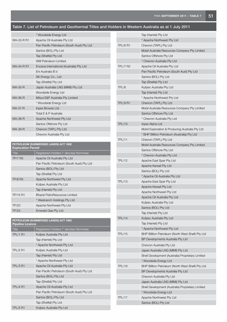
51PWA SEPTEMBER 2011 – TABLE 7
* Woodside Energy Ltd
WA-33-R R1 Apache Oil Australia Pty Ltd
Pan Pacific Petroleum (South Aust) Pty Ltd
Santos (BOL) Pty Ltd
Tap (Shelfal) Pty Ltd
WM Petroleum Limited
WA-34-R R1 Encana International (Australia) Pty Ltd
Eni Australia B.V.
SK Energy Co., Ltd
Tap (Shelfal) Pty Ltd
WA-35-R Japan Australia LNG (MIMI) Pty Ltd
Woodside Energy Ltd
WA-36-R Mitsui E&P Australia Pty Limited
* Woodside Energy Ltd
WA-37-R Inpex Browse Ltd
Total E & P Australia
WA-38-R Apache Northwest Pty Ltd
Santos Offshore Pty Ltd
WA-39-R Chevron (TAPL) Pty Ltd
Chevron Australia Pty Ltd
PETROLEUM (SUBMERGED LANDS) ACT 1982 Exploration Permit
Title Registered Holders (* denotes Nominee)
TP/7 R3 Apache Oil Australia Pty Ltd
Pan Pacific Petroleum (South Aust) Pty Ltd
Santos (BOL) Pty Ltd
Tap (Shelfal) Pty Ltd
TP/8 R3 Apache Northwest Pty Ltd
Kufpec Australia Pty Ltd
Tap (Harriet) Pty Ltd
TP/15 R1 Bharat PetroResources Limited
* Westranch Holdings Pty Ltd
TP/23 Apache Northwest Pty Ltd
TP/24 Emerald Gas Pty Ltd
PETROLEUM (SUBMERGED LANDS) ACT 1982 Pipeline Licence
Title Registered Holders (* denotes Nominee)
TPL/1 R1 Kufpec Australia Pty Ltd
Tap (Harriet) Pty Ltd
* Apache Northwest Pty Ltd
TPL/2 R1 Kufpec Australia Pty Ltd
Tap (Harriet) Pty Ltd
* Apache Northwest Pty Ltd
TPL/3 R1 Apache Oil Australia Pty Ltd
Pan Pacific Petroleum (South Aust) Pty Ltd
Santos (BOL) Pty Ltd
Tap (Shelfal) Pty Ltd
TPL/4 R1 Apache Oil Australia Pty Ltd
Pan Pacific Petroleum (South Aust) Pty Ltd
Santos (BOL) Pty Ltd
Tap (Shelfal) Pty Ltd
TPL/5 R1 Kufpec Australia Pty Ltd
Tap (Harriet) Pty Ltd
* Apache Northwest Pty Ltd
TPL/6 R1 Chevron (TAPL) Pty Ltd
Mobil Australia Resources Company Pty Limited
Santos Offshore Pty Ltd
* Chevron Australia Pty Ltd
TPL/7 R2 Apache Oil Australia Pty Ltd
Pan Pacific Petroleum (South Aust) Pty Ltd
Santos (BOL) Pty Ltd
Tap (Shelfal) Pty Ltd
TPL/8 Kufpec Australia Pty Ltd
Tap (Harriet) Pty Ltd
* Apache Northwest Pty Ltd
TPL/9 R1 Chevron (TAPL) Pty Ltd
Mobil Australia Resources Company Pty Limited
Santos Offshore Pty Ltd
* Chevron Australia Pty Ltd
TPL/10 Inpex Alpha Ltd
Mobil Exploration & Producing Australia Pty Ltd
* BHP Billiton Petroleum (Australia) Pty Ltd
TPL/11 Chevron (TAPL) Pty Ltd
Mobil Australia Resources Company Pty Limited
Santos Offshore Pty Ltd
* Chevron Australia Pty Ltd
TPL/12 Apache East Spar Pty Ltd
Apache Kersail Pty Ltd
Santos (BOL) Pty Ltd
* Apache Oil Australia Pty Ltd
TPL/13 Apache East Spar Pty Ltd
Apache Kersail Pty Ltd
Apache Northwest Pty Ltd
Apache Oil Australia Pty Ltd
Kufpec Australia Pty Ltd
Santos (BOL) Pty Ltd
Tap (Harriet) Pty Ltd
TPL/14 Kufpec Australia Pty Ltd
Tap (Harriet) Pty Ltd
* Apache Northwest Pty Ltd
TPL/15 BHP Billiton Petroleum (North West Shelf) Pty Ltd
BP Developments Australia Pty Ltd
Chevron Australia Pty Ltd
Japan Australia LNG (MIMI) Pty Ltd
Shell Development (Australia) Proprietary Limited
* Woodside Energy Ltd
TPL/16 BHP Billiton Petroleum (North West Shelf) Pty Ltd
BP Developments Australia Pty Ltd
Chevron Australia Pty Ltd
Japan Australia LNG (MIMI) Pty Ltd
Shell Development (Australia) Proprietary Limited
* Woodside Energy Ltd
TPL/17 Apache Northwest Pty Ltd
Santos (BOL) Pty Ltd
Table 7. List of Petroleum and Geothermal Titles and Holders in Western Australia as at 1 July 2011
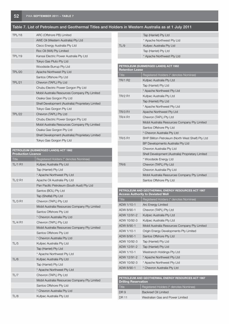
52 PWA SEPTEMBER 2011 – TABLE 7
TPL/18 ARC (Offshore PB) Limited
AWE Oil (Western Australia) Pty Ltd
Cieco Energy Australia Pty Ltd
Roc Oil (WA) Pty Limited
TPL/19 Kansai Electric Power Australia Pty Ltd
Tokyo Gas Pluto Pty Ltd
Woodside Burrup Pty Ltd
TPL/20 Apache Northwest Pty Ltd
Santos Offshore Pty Ltd
TPL/21 Chevron (TAPL) Pty Ltd
Chubu Electric Power Gorgon Pty Ltd
Mobil Australia Resources Company Pty Limited
Osaka Gas Gorgon Pty Ltd
Shell Development (Australia) Proprietary Limited
Tokyo Gas Gorgon Pty Ltd
TPL/22 Chevron (TAPL) Pty Ltd
Chubu Electric Power Gorgon Pty Ltd
Mobil Australia Resources Company Pty Limited
Osaka Gas Gorgon Pty Ltd
Shell Development (Australia) Proprietary Limited
Tokyo Gas Gorgon Pty Ltd
PETROLEUM (SUBMERGED LANDS) ACT 1982 Production Licence
Title Registered Holders (* denotes Nominee)
TL/1 R1 Kufpec Australia Pty Ltd
Tap (Harriet) Pty Ltd
* Apache Northwest Pty Ltd
TL/2 R1 Apache Oil Australia Pty Ltd
Pan Pacific Petroleum (South Aust) Pty Ltd
Santos (BOL) Pty Ltd
Tap (Shelfal) Pty Ltd
TL/3 R1 Chevron (TAPL) Pty Ltd
Mobil Australia Resources Company Pty Limited
Santos Offshore Pty Ltd
* Chevron Australia Pty Ltd
TL/4 R1 Chevron (TAPL) Pty Ltd
Mobil Australia Resources Company Pty Limited
Santos Offshore Pty Ltd
* Chevron Australia Pty Ltd
TL/5 Kufpec Australia Pty Ltd
Tap (Harriet) Pty Ltd
* Apache Northwest Pty Ltd
TL/6 Kufpec Australia Pty Ltd
Tap (Harriet) Pty Ltd
* Apache Northwest Pty Ltd
TL/7 Chevron (TAPL) Pty Ltd
Mobil Australia Resources Company Pty Limited
Santos Offshore Pty Ltd
* Chevron Australia Pty Ltd
TL/8 Kufpec Australia Pty Ltd
Tap (Harriet) Pty Ltd
* Apache Northwest Pty Ltd
TL/9 Kufpec Australia Pty Ltd
Tap (Harriet) Pty Ltd
* Apache Northwest Pty Ltd
PETROLEUM (SUBMERGED LANDS) ACT 1982 Retention Lease
Title Registered Holders (* denotes Nominee)
TR/1 R2 Kufpec Australia Pty Ltd
Tap (Harriet) Pty Ltd
* Apache Northwest Pty Ltd
TR/2 R1 Kufpec Australia Pty Ltd
Tap (Harriet) Pty Ltd
* Apache Northwest Pty Ltd
TR/3 R1 Apache Northwest Pty Ltd
TR/4 R1 Chevron (TAPL) Pty Ltd
Mobil Australia Resources Company Pty Limited
Santos Offshore Pty Ltd
* Chevron Australia Pty Ltd
TR/5 R1 BHP Billiton Petroleum (North West Shelf) Pty Ltd
BP Developments Australia Pty Ltd
Chevron Australia Pty Ltd
Shell Development (Australia) Proprietary Limited
* Woodside Energy Ltd
TR/6 Chevron (TAPL) Pty Ltd
Chevron Australia Pty Ltd
Mobil Australia Resources Company Pty Limited
Santos Offshore Pty Ltd
PETROLEUM AND GEOTHERMAL ENERGY RESOURCES ACT 1967 Access Authority to Deviated Well
Title Registered Holders (* denotes Nominee)
ADW 1/10-1 Arc Energy Limited
ADW 8/90-1 Chevron (TAPL) Pty Ltd
ADW 12/91-2 Kufpec Australia Pty Ltd
ADW 10/92-3 Kufpec Australia Pty Ltd
ADW 8/90-1 Mobil Australia Resources Company Pty Limited
ADW 1/10-1 Origin Energy Developments Pty Limited
ADW 8/90-1 Santos Offshore Pty Ltd
ADW 10/92-3 Tap (Harriet) Pty Ltd
ADW 12/91-2 Tap (Harriet) Pty Ltd
ADW 1/10-1 Westranch Holdings Pty Ltd
ADW 12/91-2 * Apache Northwest Pty Ltd
ADW 10/92-3 * Apache Northwest Pty Ltd
ADW 8/90-1 * Chevron Australia Pty Ltd
PETROLEUM AND GEOTHERMAL ENERGY RESOURCES ACT 1967 Drilling Reservation
Title Registered Holders (* denotes Nominee)
DR 9 Backreef Oil Limited
DR 11 Westralian Gas and Power Limited
Table 7. List of Petroleum and Geothermal Titles and Holders in Western Australia as at 1 July 2011
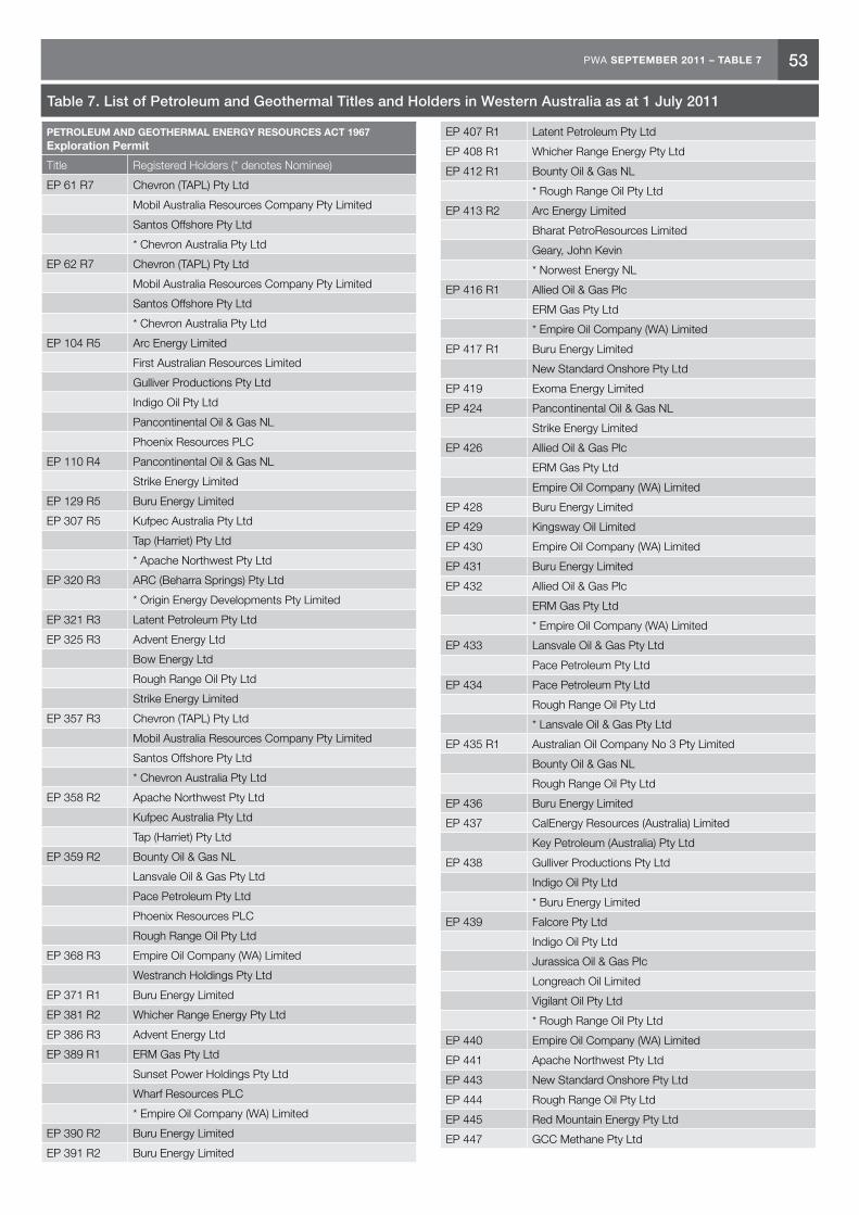
53PWA SEPTEMBER 2011 – TABLE 7
PETROLEUM AND GEOTHERMAL ENERGY RESOURCES ACT 1967 Exploration Permit
Title Registered Holders (* denotes Nominee)
EP 61 R7 Chevron (TAPL) Pty Ltd
Mobil Australia Resources Company Pty Limited
Santos Offshore Pty Ltd
* Chevron Australia Pty Ltd
EP 62 R7 Chevron (TAPL) Pty Ltd
Mobil Australia Resources Company Pty Limited
Santos Offshore Pty Ltd
* Chevron Australia Pty Ltd
EP 104 R5 Arc Energy Limited
First Australian Resources Limited
Gulliver Productions Pty Ltd
Indigo Oil Pty Ltd
Pancontinental Oil & Gas NL
Phoenix Resources PLC
EP 110 R4 Pancontinental Oil & Gas NL
Strike Energy Limited
EP 129 R5 Buru Energy Limited
EP 307 R5 Kufpec Australia Pty Ltd
Tap (Harriet) Pty Ltd
* Apache Northwest Pty Ltd
EP 320 R3 ARC (Beharra Springs) Pty Ltd
* Origin Energy Developments Pty Limited
EP 321 R3 Latent Petroleum Pty Ltd
EP 325 R3 Advent Energy Ltd
Bow Energy Ltd
Rough Range Oil Pty Ltd
Strike Energy Limited
EP 357 R3 Chevron (TAPL) Pty Ltd
Mobil Australia Resources Company Pty Limited
Santos Offshore Pty Ltd
* Chevron Australia Pty Ltd
EP 358 R2 Apache Northwest Pty Ltd
Kufpec Australia Pty Ltd
Tap (Harriet) Pty Ltd
EP 359 R2 Bounty Oil & Gas NL
Lansvale Oil & Gas Pty Ltd
Pace Petroleum Pty Ltd
Phoenix Resources PLC
Rough Range Oil Pty Ltd
EP 368 R3 Empire Oil Company (WA) Limited
Westranch Holdings Pty Ltd
EP 371 R1 Buru Energy Limited
EP 381 R2 Whicher Range Energy Pty Ltd
EP 386 R3 Advent Energy Ltd
EP 389 R1 ERM Gas Pty Ltd
Sunset Power Holdings Pty Ltd
Wharf Resources PLC
* Empire Oil Company (WA) Limited
EP 390 R2 Buru Energy Limited
EP 391 R2 Buru Energy Limited
EP 407 R1 Latent Petroleum Pty Ltd
EP 408 R1 Whicher Range Energy Pty Ltd
EP 412 R1 Bounty Oil & Gas NL
* Rough Range Oil Pty Ltd
EP 413 R2 Arc Energy Limited
Bharat PetroResources Limited
Geary, John Kevin
* Norwest Energy NL
EP 416 R1 Allied Oil & Gas Plc
ERM Gas Pty Ltd
* Empire Oil Company (WA) Limited
EP 417 R1 Buru Energy Limited
New Standard Onshore Pty Ltd
EP 419 Exoma Energy Limited
EP 424 Pancontinental Oil & Gas NL
Strike Energy Limited
EP 426 Allied Oil & Gas Plc
ERM Gas Pty Ltd
Empire Oil Company (WA) Limited
EP 428 Buru Energy Limited
EP 429 Kingsway Oil Limited
EP 430 Empire Oil Company (WA) Limited
EP 431 Buru Energy Limited
EP 432 Allied Oil & Gas Plc
ERM Gas Pty Ltd
* Empire Oil Company (WA) Limited
EP 433 Lansvale Oil & Gas Pty Ltd
Pace Petroleum Pty Ltd
EP 434 Pace Petroleum Pty Ltd
Rough Range Oil Pty Ltd
* Lansvale Oil & Gas Pty Ltd
EP 435 R1 Australian Oil Company No 3 Pty Limited
Bounty Oil & Gas NL
Rough Range Oil Pty Ltd
EP 436 Buru Energy Limited
EP 437 CalEnergy Resources (Australia) Limited
Key Petroleum (Australia) Pty Ltd
EP 438 Gulliver Productions Pty Ltd
Indigo Oil Pty Ltd
* Buru Energy Limited
EP 439 Falcore Pty Ltd
Indigo Oil Pty Ltd
Jurassica Oil & Gas Plc
Longreach Oil Limited
Vigilant Oil Pty Ltd
* Rough Range Oil Pty Ltd
EP 440 Empire Oil Company (WA) Limited
EP 441 Apache Northwest Pty Ltd
EP 443 New Standard Onshore Pty Ltd
EP 444 Rough Range Oil Pty Ltd
EP 445 Red Mountain Energy Pty Ltd
EP 447 GCC Methane Pty Ltd
Table 7. List of Petroleum and Geothermal Titles and Holders in Western Australia as at 1 July 2011

54 PWA SEPTEMBER 2011 – TABLE 7
EP 448 Buru Energy Limited
Gulliver Productions Pty Ltd
Indigo Oil Pty Ltd
United Orogen Limited
EP 449 Kingsway Oil Limited
EP 450 New Standard Onshore Pty Ltd
EP 451 New Standard Onshore Pty Ltd
EP 453 Budside Pty Limited
Pobelo Pty Ltd
EP 454 Empire Oil Company (WA) Limited
EP 455 Westralian Gas and Power Limited
* Arc Energy Limited
EP 456 New Standard Onshore Pty Ltd
EP 457 Rey Resources Ltd
EP 458 Rey Resources Ltd
EP 460 Falcore Pty Ltd
Indigo Oil Pty Ltd
Jurassica Oil & Gas Plc
Longreach Oil Limited
Vigilant Oil Pty Ltd
* Rough Range Oil Pty Ltd
EP 461 Falcore Pty Ltd
Indigo Oil Pty Ltd
Jurassica Oil & Gas Plc
Longreach Oil Limited
Vigilant Oil Pty Ltd
* Rough Range Oil Pty Ltd
EP 463 Emerald Gas Pty Ltd
EP 464 Exceed Energy (Australia) Pty Ltd
EP 465 Global International (Australia) Pty Ltd
EP 466 Rough Range Oil Pty Ltd
EP 467 ERM Gas Pty Ltd
EP 468 Officer Petroleum Pty Ltd
EP 469 Warrego Energy Pty Ltd
EP 470 Energetica Resources Pty Ltd
EP 471 Buru Energy Limited
EP 472 Buru Energy (Acacia) Pty Ltd
Buru Energy Limited
EP 473 Buru Energy Limited
EP 474 Buru Energy Limited
EP 475 Energetica Resources Pty Ltd
EP 476 Arc Energy Limited
EP 477 Buru Energy (Acacia) Pty Ltd
Buru Energy Limited
EP 478 Buru Energy (Acacia) Pty Ltd
Buru Energy Limited
PETROLEUM AND GEOTHERMAL ENERGY RESOURCES ACT 1967 Geothermal Exploration Permit
Title Registered Holders (* denotes Nominee)
GEP 1 The University of Western Australia
* Green Rock Energy Limited
GEP 2 Green Rock Energy Limited
GEP 3 Green Rock Energy Limited
GEP 4 Green Rock Energy Limited
GEP 5 Granite Power Limited
GEP 6 Granite Power Limited
GEP 7 GT Power Pty Ltd
GEP 8 GT Power Pty Ltd
GEP 9 GT Power Pty Ltd
GEP 10 BHP Billiton Worsley Alumina Pty Ltd
Green Rock Energy Limited
GEP 11 BHP Billiton Worsley Alumina Pty Ltd
Green Rock Energy Limited
GEP 12 BHP Billiton Worsley Alumina Pty Ltd
Green Rock Energy Limited
GEP 13 New World Energy Limited
GEP 14 New World Energy Limited
GEP 15 New World Energy Limited
GEP 16 New World Energy Limited
GEP 17 New World Energy Limited
GEP 18 New World Energy Limited
GEP 19 New World Energy Limited
GEP 20 New World Energy Limited
GEP 21 New World Energy Limited
GEP 22 AAA Energy Pty Ltd
GEP 23 Green Rock Energy Limited
GEP 24 Green Rock Energy Limited
GEP 25 Green Rock Energy Limited
GEP 26 Green Rock Energy Limited
GEP 27 Green Rock Energy Limited
GEP 28 Green Rock Energy Limited
GEP 29 Geothermal Energy Pty Ltd
GEP 30 New World Energy Limited
GEP 31 New World Energy Limited
GEP 32 New World Energy Limited
GEP 33 New World Energy Limited
GEP 34 New World Energy Limited
GEP 35 New World Energy Limited
GEP 36 New World Energy Limited
GEP 37 Greenpower Energy Limited
GEP 38 Greenpower Energy Limited
GEP 39 Green Rock Energy Limited
GEP 40 Green Rock Energy Limited
GEP 41 Green Rock Energy Limited
GEP 42 GT Power Pty Ltd
GEP 43 Kagara Ltd
PETROLEUM AND GEOTHERMAL ENERGY RESOURCES ACT 1967 Production Licence
Title Registered Holders (* denotes Nominee)
L 1 R1 APT Parmelia Pty Ltd
Arc Energy Limited
Origin Energy Developments Pty Limited
L 2 R1 Origin Energy Developments Pty Limited
* Arc Energy Limited
Table 7. List of Petroleum and Geothermal Titles and Holders in Western Australia as at 1 July 2011

55PWA SEPTEMBER 2011 – TABLE 7
L 4 R1 Arc Energy Limited
L 5 R1 Arc Energy Limited
L 6 R1 Buru Energy Limited
L 7 R1 Arc Energy Limited
L 8 R1 Buru Energy Limited
L 9 R1 BHP Billiton Petroleum (Australia) Pty Ltd
L 10 R1 Chevron (TAPL) Pty Ltd
Mobil Australia Resources Company Pty Limited
Santos Offshore Pty Ltd
* Chevron Australia Pty Ltd
L 11 ARC (Beharra Springs) Pty Ltd
* Origin Energy Developments Pty Limited
L 12 Chevron (TAPL) Pty Ltd
Mobil Australia Resources Company Pty Limited
Santos Offshore Pty Ltd
* Chevron Australia Pty Ltd
L 13 Chevron (TAPL) Pty Ltd
Mobil Australia Resources Company Pty Limited
Santos Offshore Pty Ltd
* Chevron Australia Pty Ltd
L 14 Arc Energy Limited
Geary, John Kevin
Norwest Energy NL
Origin Energy Developments Pty Limited
Roc Oil (WA) Pty Limited
L 15 Buru Energy Limited
First Australian Resources Limited
Gulliver Productions Pty Ltd
Indigo Oil Pty Ltd
Pancontinental Oil & Gas NL
L 16 Rough Range Oil Pty Ltd
L 1H R2 Chevron (TAPL) Pty Ltd
Mobil Australia Resources Company Pty Limited
Santos Offshore Pty Ltd
* Chevron Australia Pty Ltd
PETROLEUM AND GEOTHERMAL ENERGY RESOURCES ACT 1967 Retention Lease
Title Registered Holders (* denotes Nominee)
R 1 R1 Arc Energy Limited
First Australian Resources Limited
Gulliver Productions Pty Ltd
Indigo Oil Pty Ltd
Pancontinental Oil & Gas NL
Phoenix Resources PLC
R 2 R1 BHP Billiton Petroleum (North West Shelf) Pty Ltd
BP Developments Australia Pty Ltd
Chevron Australia Pty Ltd
Shell Development (Australia) Proprietary Limited
* Woodside Energy Ltd
R 3 Oil Basins Ltd
R 4 Chevron (TAPL) Pty Ltd
Chevron Australia Pty Ltd
Mobil Australia Resources Company Pty Limited
Santos Offshore Pty Ltd
R 5 Apache Oil Australia Pty Ltd
OMV Australia Pty Ltd
PETROLEUM PIPELINES ACT 1969 Pipeline Licence
Title Registered Holders (* denotes Nominee)
PL 1 R1 APT Parmelia Pty Ltd
PL 2 R1 APT Parmelia Pty Ltd
PL 3 R1 APT Parmelia Pty Ltd
PL 5 R1 APT Parmelia Pty Ltd
PL 6 R3 Arc Energy Limited
PL 7 R1 Buru Energy Limited
PL 8 R1 Mitsui Iron Ore Development Pty Ltd
Nippon Steel Australia Pty Limited
North Mining Limited
Sumitomo Metal Australia Pty Ltd
* Robe River Mining Co Pty Ltd
PL 12 R1 Kufpec Australia Pty Ltd
Tap (Harriet) Pty Ltd
* Apache Northwest Pty Ltd
PL 14 R1 Apache Oil Australia Pty Ltd
Pan Pacific Petroleum (South Aust) Pty Ltd
Santos (BOL) Pty Ltd
Tap (Shelfal) Pty Ltd
PL 15 Chevron (TAPL) Pty Ltd
Mobil Australia Resources Company Pty Limited
Santos Offshore Pty Ltd
* Chevron Australia Pty Ltd
PL 16 BHP Petroleum (Ashmore Operations) Pty Ltd
PL 17 Kufpec Australia Pty Ltd
Tap (Harriet) Pty Ltd
* Apache Northwest Pty Ltd
PL 18 ARC (Beharra Springs) Pty Ltd
* Origin Energy Developments Pty Limited
PL 19 BHP Petroleum (Ashmore Operations) Pty Ltd
PL 20 Inpex Alpha Ltd
Mobil Exploration & Producing Australia Pty Ltd
* BHP Billiton Petroleum (Australia) Pty Ltd
PL 21 Chevron (TAPL) Pty Ltd
Mobil Australia Resources Company Pty Limited
Santos Offshore Pty Ltd
* Chevron Australia Pty Ltd
PL 22 Epic Energy (Pilbara Pipeline) Pty Ltd
PL 23 APT Parmelia Pty Ltd
PL 24 Alinta DEWAP Pty Ltd
Southern Cross Pipelines (NPL) Australia Pty Ltd
* Southern Cross Pipelines Australia Pty Limited
PL 25 Southern Cross Pipelines Australia Pty Limited
PL 26 Southern Cross Pipelines Australia Pty Limited
PL 27 Southern Cross Pipelines Australia Pty Limited
PL 28 Southern Cross Pipelines (NPL) Australia Pty Ltd
Table 7. List of Petroleum and Geothermal Titles and Holders in Western Australia as at 1 July 2011

56 PWA SEPTEMBER 2011 – TABLE 7
PL 29 Apache East Spar Pty Ltd
Apache Kersail Pty Ltd
Santos (BOL) Pty Ltd
* Apache Oil Australia Pty Ltd
PL 30 Apache East Spar Pty Ltd
Apache Kersail Pty Ltd
Santos (BOL) Pty Ltd
* Apache Oil Australia Pty Ltd
PL 31 Epic Energy (Pilbara Pipeline) Pty Ltd
PL 32 APT Pipelines (WA) Pty Limited
PL 33 APT Pipelines (WA) Pty Limited
PL 34 Newmont Yandal Operations Pty Ltd
PL 35 Plutonic Operations Limited
PL 36 Australian Pipeline Limited
PL 37 Norilsk Nickel Cawse Pty Ltd
PL 38 Epic Energy (Pilbara Pipeline) Pty Ltd
PL 39 Origin Energy Pipelines Pty Limited
PL 40 DBNGP (WA) Nominees Pty Limited
PL 41 DBNGP (WA) Transmission Pty Limited
PL 42 Apache East Spar Pty Ltd
Apache Kersail Pty Ltd
Apache Northwest Pty Ltd
Apache Oil Australia Pty Ltd
Kufpec Australia Pty Ltd
Santos (BOL) Pty Ltd
Tap (Harriet) Pty Ltd
PL 43 Western Power Corporation
* APT Pipelines (WA) Pty Limited
PL 44 APT Parmelia Pty Ltd
PL 45 APT Parmelia Pty Ltd
PL 46 APT Parmelia Pty Ltd
PL 47 DBNGP (WA) Transmission Pty Limited
PL 48 Energy Generation Pty Ltd
PL 52 APT Parmelia Pty Ltd
PL 53 APT Parmelia Pty Ltd
PL 54 Western Power Corporation
* APT Pipelines (WA) Pty Limited
PL 55 Global Advanced Metals Wodgina Pty Ltd
PL 56 Epic Energy (WA) One Pty Ltd
PL 57 Australian Gold Reagents Pty Ltd
PL 58 BHP Billiton Petroleum (North West Shelf) Pty Ltd
BP Developments Australia Pty Ltd
Chevron Australia Pty Ltd
Japan Australia LNG (MIMI) Pty Ltd
Shell Development (Australia) Proprietary Limited
* Woodside Energy Ltd
PL 59 Esperance Pipeline Co. Pty Limited
PL 60 Gas Transmission Services WA (Operations) Pty Ltd
PL 61 APT Parmelia Pty Ltd
PL 62 Kufpec Australia Pty Ltd
Tap (Harriet) Pty Ltd
* Apache Northwest Pty Ltd
PL 63 Gas Transmission Services WA (Operations) Pty Ltd
PL 64 Arc Energy Limited
Origin Energy Developments Pty Limited
PL 65 Dalrymple Resources NL
LionOre Australia (Wildara) NL
PL 67 Hamersley Iron Pty Ltd
PL 68 Gas Transmission Services WA (Operations) Pty Ltd
PL 69 DBNGP (WA) Nominees Pty Limited
PL 70 ARC (Offshore PB) Limited
AWE Oil (Western Australia) Pty Ltd
Cieco Energy Australia Pty Ltd
Roc Oil (WA) Pty Limited
PL 72 EDL NGD (WA) PTY LTD
PL 73 Redback Pipelines Pty Ltd
PL 74 EDL LNG (WA) PTY LTD
PL 75 EIT Neerabup Power Pty Ltd
ERM Neerabup Pty Ltd
PL 76 APA Group
PL 77 Sino Iron Pty Ltd
PL 78 Hamersley Iron Pty Ltd
PL 80 Latent Petroleum Pty Ltd
PL 81 Apache Northwest Pty Ltd
PL 82 Epic Energy (Pilbara Pipeline) Pty Ltd
PL 83 WA Gas Networks Pty Ltd
PL 84 Chevron (TAPL) Pty Ltd
Chubu Electric Power Gorgon Pty Ltd
Mobil Australia Resources Company Pty Limited
Osaka Gas Gorgon Pty Ltd
Shell Development (Australia) Proprietary Limited
Tokyo Gas Gorgon Pty Ltd
PL 85 Chevron (TAPL) Pty Ltd
Chubu Electric Power Gorgon Pty Ltd
Mobil Australia Resources Company Pty Limited
Osaka Gas Gorgon Pty Ltd
Shell Development (Australia) Proprietary Limited
Tokyo Gas Gorgon Pty Ltd
PL 86 Apache Northwest Pty Ltd
Santos Offshore Pty Ltd
PL 87 Apache PVG Pty Ltd
BHP Billiton Petroleum (Australia) Pty Ltd
PL 88 Apache PVG Pty Ltd
BHP Billiton Petroleum (Australia) Pty Ltd
PL 89 Crosslands Resources Ltd
PL 90 Apache PVG Pty Ltd
BHP Petroleum (Australia) Pty Ltd
Table 7. List of Petroleum and Geothermal Titles and Holders in Western Australia as at 1 July 2011
Please consult DMP’s online Petroleum and Geothermal Register for the most current information on Titles and Holdings.
IN WESTERN AUSTRALIAPETROLEUM
SEPTEMBER 2011
KEY PETROLEUM CONTACTS DEPARTMENT OF MINES AND PETROLEUM
EXECUTIVEDIRECTOR GENERAL Richard Sellers TEL: (08) 9222 3555
Deputy Director General Approvals Tim Griffin TEL: (08) 9222 3160
PETROLEUM DIVISIONTEL: (08) 9222 3622FAX: (08) 9222 3799
EXECUTIVE EXECUTIVE DIRECTORBill Tinapple TEL: (08) 9222 3291
DIRECTOR TECHNOLOGY, PETROLEUM AND GEOTHERMALJeffery Haworth TEL: (08) 9222 3214
RESOURCESGENERAL MANAGERReza Malek TEL: (08) 9222 3759
SENIOR PETROLEUM TECHNOLOGIST Steve Walsh TEL: (08) 9222 3267
SENIOR ENERGY GEOTECHNOLOGISTMike Middleton TEL: (08) 9222 3076
PETROLEUM DEVELOPMENT GEOLOGIST Craig Durran TEL: (08) 9222 3017
PETROLEUM RESOURCE GEOLOGIST Karina Jonasson TEL: (08) 9222 3445
EXPLORATION GEOLOGIST Richard Bruce TEL: (08) 9222 3314
SENIOR TECHNICAL OFFICER Mark Fletcher TEL: (08) 9222 3652
PETROLEUM TENURE AND LAND ACCESSGENERAL MANAGER Beverley Bower TEL: (08) 9222 3133
MANAGER LAND ACCESSMaryie Platt TEL: (08) 9222 3813
MANAGER PETROLEUM REGISTER Stephen Collyer TEL: (08) 9222 3318
MANAGER PETROLEUM AND GEOTHERMAL INFRASTRUCTUREWalter Law TEL: (08) 9222 3319
BUSINESS DEVELOPMENTGENERAL MANAGERMark Gabrielson TEL: (08) 9222 3010
PRINCIPAL LEGISLATION AND POLICY OFFICER
Colin Harvey TEL: (08) 9222 3315
PROJECT COORDINATION AND INFORMATION MANAGEMENT MANAGER
Hazel Harnwell TEL: (08) 9222 3490
APPROVALS MONITORING OFFICER
Hayden Samuels TEL: (08) 9222 3362
ENVIRONMENT DIVISIONGENERAL MANAGER PETROLEUM ENVIRONMENT
Kim Anderson TEL: (08) 9222 3142
SENIOR ENVIRONMENTAL ASSESSOR
Alicia Lim TEL: (08) 9222 3274
SENIOR ENVIRONMENTAL ASSESSOR
Chris Zadow TEL: (08) 9222 3159
RESOURCES SAFETY DIVISION DIRECTOR PETROLEUM SAFETY
Alan Gooch TEL: (08) 9358 8113
MANAGER PETROLEUM PIPELINES
Khalil Ihdayhid TEL: (08) 9358 8118
GEOLOGICAL SURVEY DIVISIONTEL: (08) 9222 3222/3168FAX: (08) 9222 3633
EXECUTIVEEXECUTIVE DIRECTOR
Rick Rogerson TEL: (08) 9222 3170
CHIEF GEOSCIENTIST
Roger Hocking TEL: (08) 9222 3590
RESOURCESMANAGER PETROLEUM GEOLOGY
Alan Millar TEL: (08) 9222 3841
MANAGER PETROLEUM EXPLORATION INFORMATION
Felicia Irimies TEL: (08) 9222 3268
STRATEGIC PLANNING AND ROYALTIESGENERAL MANAGER
David Norris TEL: (08) 9222 3304
MANAGER SYSTEMS AND ANALYSIS
Vince D’Angelo TEL: (08) 9222 3524
MANAGER PETROLEUM ROYALTIES & ACCOUNTING
Angelo Duca TEL: (08) 9222 3662
Government of Western AustraliaDepartment of Mines and Petroleum
DM
PJU
L11_
1352
WESTERN AUSTRALIA’S DIGEST OF PETROLEUM EXPLORATION, DEVELOPMENT AND PRODUCTION