september 2015 - montgomery planning
TRANSCRIPT


AbstractThis report includes a proposed separated bike lane network for the White Flint Sector Plan area. Separated bike lanes create a low-stress environment for cyclists because they provide physical separation from both traffic and pedestrians.
Source of Copies:montgomeryplanning.org/bikeplan
Proposed White Flint Separated Bike Lane NetworkSeptember 2015

5 SEPARATED BIKE LANE PROPOSAL
TABLE OF CONTENTS
9 PRIORITIZATION
10 TECHNICAL DISCUSSION

Indianapolis Cultural Trail

5PROPOSED WHITE FLINT SEPARATED BIKE LANE NETWORK
Driven by changing travel patterns, investments in low-stress bicycling infrastructure and popularity of bikeshare programs, the number of trips by bicycling has grown steadily over the past 15 years. Montgomery County continues to make substantial investments in bicycling infrastructure and is well-positioned to emerge as a leader in bicycling among suburban jurisdictions.
A high-quality bicycling network is a critical component of achieving a number of County indicators, including non-auto driver mode share (NADMS) goals required in the staging elements of several master plans, and air quality and public health indicators. Furthermore, a separated bicycle network is increasingly a driver of economic activity and potentially a differentiator for the White Flint area. Several surveys reveal that the public increasingly wants to live in walkable and bikeable places with convenient access to amenities and transit.
The Montgomery County Planning Department began working on the Bicycle Master Plan in July 2015 with the goal of developing a low-stress bicycle network that can make cycling a mainstream choice for the majority of the County’s residents and employees. One critical component of this plan is evaluating bikeway types that were not a part of the planning toolkit when the Countywide Bikeways Functional Master Plan (a precursor to the current Bicycle Master Plan) was approved in 2005.
These newer types include separated bike lanes (also known as cycle tracks or protected bike lanes), which are preferred in many urban areas because they provide separation from motor vehicles and pedestrians. This separation may be vertical, such as curbs or bollards; horizontal, such as a landscape panel or a parking lane; or a combination of both. Separated bike lanes may be in a one-way or a two-way configuration.
Bicycling as a mode of transportation is experiencing a resurgence
throughout the United States, especially in urbanized areas.

6 PROPOSED WHITE FLINT SEPARATED BIKE LANE NETWORK
The map (right) shows the proposed separated bike lane network.
Montgomery County residents and employees are more likely to bicycle in low-stress environments, so improving bicycling throughout the County requires developing safe, low-stress connections between activity centers, transit facilities and neighborhoods. Based on the analysis in this document, the current master-planned bikeway network in White Flint would benefit greatly from modifications to the proposed facilities in order to encourage cycling as a mainstream choice.
Due to the pace of development in White Flint, the Planning Department is advancing work in this area of the County so that meaningful opportunities to construct segments of the preferred bike network are not lost before the Bicycle Master Plan is completed.
This document identifies an initial phase of the bikeway network. It can be implemented without an amendment to the master plan because it:
1. Can be constructed within the right-of-way recommended in the White Flint Sector Plan.
2. Will have little, if any, additional impact on vehicular traffic in the White Flint area.3. The Countywide Bikeways Functional Master Plan (page 29) allows for flexibility.
A two-way separated bike lane on Hornby Street, Vancouver, British Columbia

7PROPOSED WHITE FLINT SEPARATED BIKE LANE NETWORK
PROPOSED SEPARATED BIKE LANE NETWORK

8 PROPOSED WHITE FLINT SEPARATED BIKE LANE NETWORK
Two-way separated bike lane in Washington, DC
One-way separated bike lane in Temple City, CA (Source: Joe Linton)

9PROPOSED WHITE FLINT SEPARATED BIKE LANE NETWORK
The table below prioritizes the separated bike lane network for different locations in White Flint according to three tiers. Tier One includes those bikeways that must be substantially completed to open Stage 2 of the White Flint Sector Plan, as well as those connecting various areas to the White Flint Metrorail Station.
Tier Two includes those bikeways that are important for connectivity, but are not required to begin Stage 2 of the sector plan. Tier Three includes recommendations that are important to complete as part of the MD 355 bus rapid transit network and are, therefore, longer term recommendations.
Of course, there may be opportunities to advance some of the bikeways noted in Tier 2 and Tier 3 (for example, the Montgomery County Department of Transportation’s separated bike lane projects on Nebel Street and Woodglen Drive), and this prioritization is not intended to preclude their construction.
PRIORITIZATION
Tier Limits Rationale
Tier OneNicholson Lane Old Georgetown Rd to CSX tracks White Flint Sector Plan Staging Requirement
Old Georgetown Road Rockville Pike to Nebel St White Flint Sector Plan Staging Requirement
Marinelli Road Executive Blvd to Rockville Pike Connection to White Flint Metrorail Station Marinelli Road Rockville Pike to Nebel St Connection to White Flint Metrorail Station
Tier TwoNebel Street Randolph Rd to Rockville Pike North-South Connection
Edson Lane Rockville Pike to Woodglen Dr Connects to White Flint Mall / BRT Station
Woodglen Drive Ext Nicholson Ln to Marinelli St Extension of North Bethesda Trail
Tier ThreeRockville Pike Edson Ln to Montrose Pkwy Major North-South Connection
Security Lane Woodglen Dr to Rockville Pike Connection to Future BRT Station

10 PROPOSED WHITE FLINT SEPARATED BIKE LANE NETWORK
The analysis in this report is based on an approach that quantifies the anxiety and danger that bicyclists feel when they ride close to traffic. This level of traffic stress (LTS) methodology was developed in 2012 by the Mineta Transportation Institute and San Jose State University. It assigns a numeric stress level to streets (and other places where people can bicycle, like trails) based on attributes that include traffic speed, traffic volume, number of lanes, frequency of parking turnover, ease of intersection crossings and other characteristics. A quiet residential street with a 25-mile-per-hour speed limit presents a low-stress setting for cyclists riding in the roadway, but a six-lane highway with a 40-mile-per-hour speed limit creates a high-stress environment for cyclists who must share the roadway with traffic.
The proposed network of separated bike lanes would create a low-stress bicycling environment through much of the White Flint Sector Plan area.
Recommendations for separated bike lanes fall into three categories:
Upgrade master-planned bike lanes to separated bike lanesRoads in this category are already recommended to have bike lanes in the White Flint Sector Plan. Since bike lanes are typically 5.5 to 6 feet wide in Montgomery County and separated bike lanes in a high-demand area are 7 feet wide, 1.5 additional feet are needed on each side of the road to upgrade to separated bike lanes. This space can be gained by narrowing the traffic lanes per Bill 33-13 (the Urban Road Code bill). Upgrading to separated bike lanes would not require a reduction in the number of travel lanes or an expansion of the master-planned right-of-way. Roads in this category include:
• Nicholson Lane from Old Georgetown Road to Nebel Street• Nebel Street from Randolph Road to Rockville Pike• Edson Lane from Rockville Pike to Woodglen Drive
• Old Georgetown Road from Rockville Pike to Nebel Street
1
Upgrade existing bike lanes to separated bike lanes Roads in this category currently have striped bike lanes even though such lanes were not recommended in the White Flint Sector Plan. They would be upgraded to separated bike lanes. Roads in this category include:
• Marinelli Road from Executive Blvd to Rockville Pike
• Security Lane from Woodglen Drive to Rockville Pike
2
TECHNICAL DISCUSSION

11PROPOSED WHITE FLINT SEPARATED BIKE LANE NETWORK
Add separated bike lanes on additional roads Three additional roads would be included in the network of separated bike lanes:
• Rockville Pike from Edson Lane to Montrose Parkway• Woodglen Drive Extended from Nicholson Lane to Marinelli Street• Marinelli Road from Rockville Pike to Nebel Street
3In addition, the Montgomery County Planning Board recommended additional separated bike lanes when it reviewed the White Flint West Phase 2 mandatory referral on September 10, 2015:
• Old Georgetown Road from Nicholson Lane to Rockville Pike.• Hoya Street from Montrose Parkway to Old Georgetown Road.• Executive Blvd west of Old Georgetown Road.• Executive Blvd (realigned) from Marinelli Street to Old Georgetown Road.

12 PROPOSED WHITE FLINT SEPARATED BIKE LANE NETWORK
1# UPGRADE MASTER-PLANNED BIKE LANES TO SEPARATED BIKE LANES
NICHOLSON LANE(OLD GEORGETOWN ROAD TO NEBEL STREET)
Nicholson Lane is a major east-west thoroughfare that bisects the White Flint Sector Plan area, extending to the Luxmanor and Old Farm neighborhoods to the west and Randolph Hills and Franklin Park neighborhoods to the east. It is a five-lane road with a posted speed limit of 30 mph.
• Daily Traffic Volume• West of Rockville Pike: 14,800
vehicles (SHA, 2014)• East of Rockville Pike: 24,000
vehicles (SHA, 2014)• Number of Lanes: 4 through lanes and
a continuous center turn lane• Posted Speed Limit: 30 mph• On-Street Parking: none
Nicholson Lane looking west toward Rockville Pike
Level of Traffic Stress: An evaluation of Nicholson Lane indicates that it is currently a high-stress cycling environment suitable for about 1-4 percent of residents, due to the high volume and speed of traffic. While the bike lanes recommended in the White Flint Sector Plan would be an improvement over existing conditions, cyclists would still experience a moderate level of stress that would be suitable for only about 10 percent of the population. Therefore, separated bike lanes are needed to create an environment that would appeal to up to 60 percent of adults.
The Montgomery County Department of Transportation (MCDOT) has developed a typical section for separated bike lanes on Nicholson Lane, and the lanes will be implemented through a combination of development approvals and a County Capital Improvements Program (CIP) project. Since construction of “substantially all of” the planned bike facility is required to advance the White Flint Sector Plan to Stage 2, this bikeway should be programmed as a high-priority CIP project.

13PROPOSED WHITE FLINT SEPARATED BIKE LANE NETWORK
NEBEL STREET(MONTROSE PARKWAY TO ROCKVILLE PIKE)
Nebel Street is a master-planned, north-south road along the eastern edge of the White Flint Sector Plan area that is planned to connect Parklawn Drive to the White Flint Mall site. Nicholson Lane is the border between the existing section to the north and the unbuilt section to the south.
• Daily Traffic Volume: 11,900 vehicles (SHA, 2014)
• Number of Lanes: 2 through lanes• Posted Speed Limit: 30 mph• On-Street Parking: low turnover
Nebel Street looking south toward Nichoson Lane
The existing portion of Nebel Street is located between Randolph Road and Nicholson Lane. It is a two-lane road with a posted speed limit of 30 mph. In this location, Nebel Street is a moderate-stress road for cyclists due to high percent of truck traffic. As the industrial uses are redeveloped, truck traffic will likely become less of a stressor and on-street parking will become more of a stressor to cyclists.
MCDOT is currently evaluating several options for this road.
The unbuilt portion of Nebel Street will connect Nicholson Lane to Rockville Pike, and will be constructed as part of the redevelopment of White Flint Mall.
• Traffic Volume: unbuilt.• Number of Lanes: 2 through-lanes (planned).• Posted Speed Limit: to be determined.• On-Street Parking: likely to be high.
Level of Traffic Stress: An evaluation of the traffic stress on the existing section of Nebel Street indicates that it is a moderate-stress cycling environment that is suitable for about 10 percent of residents. Installing separated bike lanes on both the existing and planned sections of Nebel Street would create a very low-stress cycling environment, suitable for all adults and older children.

14 PROPOSED WHITE FLINT SEPARATED BIKE LANE NETWORK
EDSON LANE(ROCKVILLE PIKE TO WOODGLEN DRIVE)
Edson Lane is a two-block-long master-planned road. While traffic volumes and speeds are lower than other roads in White Flint, separated bike lanes are needed to maintain a separated bikeway connection between the North Bethesda Trail and the Woodglen Drive separated bike lanes on the west to Nebel Street and the White Flint Mall site on the east.
• Daily Traffic Volume: 4,100 vehicles (SHA, 2013)
• Number of Lanes: 2 through lanes• Posted Speed Limit: 30 mph• On-Street Parking: none
Edson Lane looking east toward Rockville Pike
Level of Traffic Stress: Edson Lane is currently a moderate-stress cycling environment that is suitable for about 10 percent of the population. Installing separated bike lanes would create a very low-stress cycling environment, suitable for all adults and older children.
This bikeway would be constructed as a County CIP project.
OLD GEORGETOWN ROAD(ROCKVILLE PIKE TO NEBEL STREET)
Old Georgetown Road is a two-lane road planned to be widened to four lanes between Rockville Pike and Nebel Street.
• Daily Traffic Volume: 8,700 vehicles (SHA, 2014)
• Number of Lanes: 2 through lanes (4 through lanes planned)
• Posted Speed Limit: 30 mph• On-Street Parking: none
Old Georgetown Road looking west toward Rockville Pike
Level of Traffic Stress: An evaluation of the traffic stress on Georgetown Road east of Rockville Pike indicates that it is a moderate-stress cycling environment that is suitable for about 10% of population. Installing separated bike lanes would create a low-stress cycling environment, suitable for all adults and older children.
Since construction of “substantially all of” the bike facility is required to advance to Stage 2 of the Sector Plan, this bikeway should be programmed as a high-priority CIP project.
15PROPOSED WHITE FLINT SEPARATED BIKE LANE NETWORK
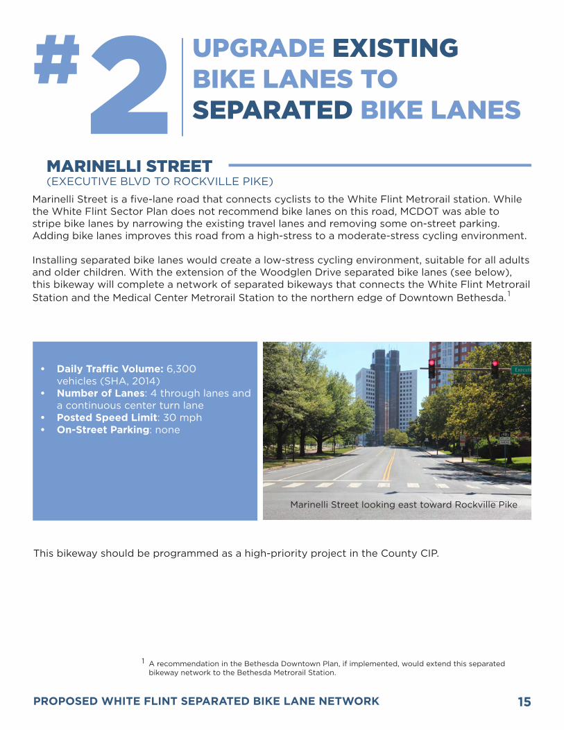
2# UPGRADE EXISTING BIKE LANES TO SEPARATED BIKE LANES
MARINELLI STREET (EXECUTIVE BLVD TO ROCKVILLE PIKE)
Marinelli Street is a five-lane road that connects cyclists to the White Flint Metrorail station. While the White Flint Sector Plan does not recommend bike lanes on this road, MCDOT was able to stripe bike lanes by narrowing the existing travel lanes and removing some on-street parking. Adding bike lanes improves this road from a high-stress to a moderate-stress cycling environment.
Installing separated bike lanes would create a low-stress cycling environment, suitable for all adults and older children. With the extension of the Woodglen Drive separated bike lanes (see below), this bikeway will complete a network of separated bikeways that connects the White Flint Metrorail Station and the Medical Center Metrorail Station to the northern edge of Downtown Bethesda.
Marinelli Street looking east toward Rockville Pike
This bikeway should be programmed as a high-priority project in the County CIP.
1
• Daily Traffic Volume: 6,300 vehicles (SHA, 2014)
• Number of Lanes: 4 through lanes and a continuous center turn lane
• Posted Speed Limit: 30 mph• On-Street Parking: none
1 A recommendation in the Bethesda Downtown Plan, if implemented, would extend this separated bikeway network to the Bethesda Metrorail Station.

16 PROPOSED WHITE FLINT SEPARATED BIKE LANE NETWORK
Security Lane is a two-lane road that connects the Woodglen Drive separated bike lanes to the center of the White Flint Mall site. The Countywide Transit Corridors Functional Master Plan recommends a bus rapid transit (BRT) stop at the intersection of Security Lane with Rockville Pike. While the White Flint Sector Plan does not recommend bike lanes on this road, MCDOT was able to stripe bike lanes by narrowing the existing travel lanes.
This improvement reduces the stress of bicycling on Security Lane. However, due to the high-turn-over of on-street parking and frequent blockage by service vehicles, the traffic stress for cyclists’ remains elevated. Upgrading the bike lanes to separated bike lanes would eliminate this stress and would facilitate access to the planned BRT station.
Security Lane looking east toward Rockville Pike
This is a lower-priority bikeway that should be implemented as a County CIP project.
• 13-Hour Traffic Volume: 3,500 vehicles (SHA, 2011)
• Number of Lanes: 2 through lanes• Posted Speed Limit: 30 mph• On-Street Parking: high turnover
SECURITY LANE (WOODGLEN DRIVE TO ROCKVILLE PIKE)

17PROPOSED WHITE FLINT SEPARATED BIKE LANE NETWORK
3# SEPARATED BIKE LANES ON ADDITIONAL ROADS
ROCKVILLE PIKE (Edson Lane to Montrose Parkway)
As the major north-south thoroughfare through the White Flint Sector Plan area, Rockville Pike is a high-stress environment for cyclists. The bikeway map and table in the White Flint Sector Plan recommend a shared-use path on Rockville Pike. However, Figure 2 of the Sector Plan (shown below) includes separated bike lanes and page 53 of the Plan calls for “on-road bicyclist accommodation.”
Separated bike lanes are needed to make Rockville Pike a suitable bicycling environment for most adults. Particular attention is needed to reduce the stress level crossing intersections.
Rockville Pike looking north
• Daily Traffic Volume: 50,500 vehicles north of Strathmore Ave
• (SHA, 2013)• Number of Lanes: 6 through lanes and
turn lanes• Posted Speed Limit: 40 mph• On-Street Parking: none
An alternative Rockville Pike Typical Section (Figure 2 of the Sector Plan)

18 PROPOSED WHITE FLINT SEPARATED BIKE LANE NETWORK
MCDOT constructed two-way separated bike lanes on Woodglen Drive between Edson Lane and Nicholson Lane in 2014. The separated bike lanes will be extended to Marinelli Street as part of the Saul Center development project. In conjunction with the recommended Marinelli Street separated bike lanes (see above), this bikeway will complete a network of separated bikeways that connects the White Flint Metrorail Station and the Medical Center Metrorail Station to the northern edge of Downtown Bethesda.
Future Location of Woodglen Drive Extended
• 13-Hour Traffic Volume: 5,900 vehicles south of Executive Blvd. (SHA, 2011)
• Number of Lanes: 2 through lanes• Posted Speed Limit: 30 mph• On-Street Parking: high turnover
WOODGLEN DRIVE(EDSON LANE TO MARINELLI ROAD)
MCDOT is considering installing bike lanes on Marinelli Road east of Rockville Pike. Doing so would be a good interim step to reduce the stress level of this street from high to moderate. Since Marinelli Street is the route that many cyclists will take to get to the White Flint Metrorail Station, adding separated bike lanes over the long term is critical to creating a low-stress connection to transit.
Marinelli Road looking east toward Nebel Street
• Daily Traffic Volume: 6,600 vehicles (SHA, 2014)
• Number of Lanes: 4 through lanes and a continuous center turn lane
• Posted Speed Limit: 30 mph
MARINELLI ROAD (ROCKVILLE PIKE TO NEBEL STREET)

A one-way separated bike lane in Boulder, Colorado (Source: Toole Design Group)
