sesplan area urban capacity study - west lothian council
TRANSCRIPT

SESplan area Urban Capacity Study
August 2009

INTRODUCTION Scottish Planning Policy 3: Planning for Homes sets out the Scottish Government’s policy on the identification of housing requirements, the provision of land for housing and the delivery of homes through the planning system. Planning authorities should promote the efficient use of land and buildings which means directing the majority of new development towards sites within existing settlements to make effective use of existing infrastructure and service capacity. Planning authorities are encouraged to make an assessment of the opportunities for further housing development within existing settlements, focussing on previously developed land and conversions of existing buildings, or a review of existing land allocations for uses other than housing, where appropriate. SPP3 states that where possible, the private sector should be involved in the preparation of these urban capacity studies and authorities should seek to make them as transparent as possible. Sites identified in urban capacity studies as having potential for residential development may be included within the housing land audit as part of the established supply. This document summarises the findings of the urban capacity study carried out for the SESplan area with the aim of providing quantitative housing windfall values to assist in the formation and justification of future SDP Housing Policy. METHODOLOGY Beyond encouraging planning authorities to carry out an urban capacity study, SPP3 gives little guidance on how this should be done and provides no detail on what should be included in the study. In England however, there is much more detailed guidance given on carrying out an UCS in ‘Tapping the Potential’. Given the lack of detailed guidance in Scotland, it was decided to carry out the SESplan survey using the methodology and key principles of ‘Tapping the Potential’. Sources of housing land Tapping the potential lists 11 categories of potential land, and using these for guidance it was decided to use the following revised categories in carrying out the SESplan study:
1) Vacant and derelict land and buildings. This includes previously developed land and is identified through the Scottish Vacant and Derelict Land Survey (SVDLS) 2) Redevelopment of public car parks 3) Increasing density on land allocated for housing in local plans or identified in
the annual housing land audit. 4) Conversion/Redevelopment of Commercial and Industrial land and buildings. This includes industrial/commercial units that may be currently in use in areas that are not protected through local plan policy. Potential sites for consideration may include those with a known interest for housing development (e.g. buildings for which planning applications for housing have been made). 5) Other vacant land. ‘White land’ - Only land within the urban area should be considered, as identified by Local Plan settlement boundaries.

6) Sub-division or change of use to housing The potential contribution of this source of land could not practically be considered on a site by site basis and so an annual contribution was estimated based upon recent trends. In some authorities, this source of land was not thought to be significant and has not been included.
Survey Initially, sites were identified using a combination of local knowledge, planning history and an examination of OS maps and digital photography. Each potential site was surveyed as to its viability according to:
Local and strategic plan policy Current use Any other preferred use for the site Current planning status – any applications pending Perceived viability of site Likely availability Likely programming Infrastructure constraints Ownership constraints Physical constraints Access constraints
Sites which were assessed as unsuitable were removed. Density assumptions were made by each authority in line with local policy and design principals and these figures applied to the site area to arrive at the potential yield for each site. Discounting Following the survey and production of draft schedules, discounting rates were applied to the potential yield to arrive at a more realistic estimate of housing delivery. It was hoped that the discounting process could be carried out with the assistance of the private house building industry via consultation with Homes for Scotland. However, due to tight timescales, the reduction of staff numbers at many building companies and some negative views regarding the methodology, Homes for Scotland declined the offer to take part. In the absence of any input from private sector partners, discounting rates from 'tapping the potential' were used. A judgement was made for each site as to the likelihood of development over the next 7 years and the potential housing yield was discounted according to the following rates. Table 1. Discount rates High rate Low rateVacant and derelict land and buildings 85% 65%Redevelopment of public car parks 85% 70%Intensification of LP/HLA sites 85% 70%Conversion/redevelopment of commercial land and buildings 85% 70%Other vacant land not previously developed 40% 30%

Land which was felt could not be developed within the next 7 years is included in the gross potential but has been discounted to zero. RESULTS The results of the SESplan area urban capacity study are summarised in tables 2 and 3 below. In total, 627 potential sites were identified covering a gross area of nearly 10 square kilometres. Following discounting, it is estimated that this could yield over 8,200 new dwellings over 7 years - an annual average of 1,300 units per annum. Table 2. Urban Housing Capacity: SESplan area
No of Sites Gross
AreaGross Units Discounted
Annual average
City of Edinburgh 65 155 4,490 2,351 426East Lothian 13 4 151 76 28Fife 66 86 2,334 1,507 215Midlothian 43 26 671 381 84Scottish Borders 282 445 5,167 2,817 402West Lothian 158 231 4,979 1,095 186 SDP Area 627 947 17,792 8,227 1,342
Of the 8,200 unit capacity across the SESplan area, 2,900 are sourced from Vacant and derelict land, 2,900 as land currently in use as commercial/industrial buildings, and 2,000 units from intensification of local plan allocations. 36% (2,800 units) of the discounted capacity is within Scottish Borders council area, 30% (2,350) is in Edinburgh and 19% (1,500) is within Fife. West Lothian accounts for 14% of the total, Midlothian 5% and East Lothian 1%. Table 3. Urban capacity by land type
City of
Edinburgh East
Lothian Fife Midlothian Scottish Borders
West Lothian TOTAL
Vacant and derelict land and buildings 306 22 1,507 93 683 303 2,914Intensification of LP sites 0 0 0 0 1,451 560 2,011Car Parks 0 6 0 0 6 4 16Conversion/ Redevelopment of non-residential land 2,045 0 0 194 589 28 2,856
Vacant land not previously developed 0 48 0 94 88 193 423Allocated in plan for non-residential use 0 0 0 0 0 7 7
Total 2,351 76 1,507 381 2,817 1,095 8,227Annual Average 336 11 215 54 402 156 1,175Annual contribution of conversion / sub-division 90 17 0 30 0 30 167
Annual total 426 28 215 84 402 186 1,342

A summary table for each local authority area is given below. The figures for Fife only relate to that part of the local authority that is within the SESplan area. Schedules for the individual sites are attached as appendix 1. City of Edinburgh Units at high rate Units at low rate Gross Discounted Gross Discounted
Discount to zero Total
Vacant and derelict land and buildings 225 191 177 115 888 306Intensification of LP sites 0 0 0 0 0Car Parks 0 0 0 0 32 0Non-residential Conversions / Redevelopment 1,248 1061 1,406 984 480 2,045Vacant land not previously developed 0 0 0 0 34 0Total 2,351Annual average 336Annual contribution from small scale conversion/sub-division 90
Annual total 426 East Lothian Units at high rate Units at low rate
Gross Discounted Gross Discounted
Discount to zero Total
Vacant and derelict land and buildings 25 22 22Intensification of LP sites Car Parks 7 6 6Non-residential Conversions / Redevelopment Vacant land not previously developed 119 48 48Total 76Annual average 11Annual contribution from small scale conversion/sub-division 17Annual total 28

Fife Units at high rate Units at low rate
Gross Discounted Gross Discounted
Discount to zero Total
Vacant and derelict land and buildings 1,337 1,139 563 368 434 1,507Intensification of LP sites Car Parks Non-residential Conversions / Redevelopment Vacant land not previously developed Total 1,507Annual average 215Annual contribution from small scale conversion/sub-division Annual total 215
Midlothian Units at high rate Units at low rate
Gross Discounted Gross Discounted
Discount to zero Total
Vacant and derelict land and buildings 92 78 22 15 93Intensification of LP sites Car Parks Non-residential Conversions / Redevelopment 139 120 107 74 44 194Vacant land not previously developed 146 59 116 35 5 94Total 381Annual average 54Annual contribution from small scale conversion/sub-division 30Annual total 84

Scottish Borders Units at high rate Units at low rate
Gross Discounted Gross Discounted
Discount to zero Total
Vacant and derelict land and buildings 570 485 304 198 506 683Intensification of LP sites 1,599 1,359 131 92 0 1,451Car Parks 0 0 9 6 45 6Non-residential Conversions / Redevelopment 0 0 841 589 482 589Vacant land not previously developed 22 9 262 79 396 88Total 2,817Annual average 402Annual contribution from small scale conversion/sub-division Annual total 402
West Lothian Units at high rate Units at low rate
Gross Discounted Gross Discounted
Discount to zero Total
Vacant and derelict land and buildings 316 267 56 36 303Intensification of LP sites 275 233 468 327 560Car Parks 0 0 5 4 4Non-residential Conversions / Redevelopment 20 17 15 11 28Vacant land not previously developed 227 90 340 103 193Allocated in Plan for non-residential use 0 0 10 7 7Total 3,247 1,095Annual average 156Annual contribution from small scale conversion/sub-division 30Annual total 186

Appendix 1. Site Schedules

City of Edinburgh CouncilReference Settlement Site Name Source Area Discount
ha rate Gross Discounted
COE0005 EDINBURGH 130 MCDONALD ROAD Conv 0.41 M 51 36COE0006 EDINBURGH 9 ST PETER'S PLACE Conv 0.15 L 5 0COE0007 EDINBURGH 1 FORD'S ROAD Conv 0.66 L 24 0
COE0009 EDINBURGH25 TELFORD DRIVE - APPEAL AGAINST NON-DETERMINATION (DISMISSED)) Vac/Der 0.12 S 8 7
COE0010 EDINBURGH 69 MARIONVILLE ROAD Conv 0.79 L 100 0COE0011 EDINBURGH 2-8 WEST BOWLING GREEN STREET Conv 0.5 L 51 0COE0013 EDINBURGH 78 ALBION ROAD Conv 0.44 L 55 0COE0014 EDINBURGH 40-50 LONGSTONE ROAD Conv 0.15 S 9 8COE0015 EDINBURGH 116 COLLINTON ROAD Conv 0.4 M 16 11COE0016 EDINBURGH 8 HILLSIDE CRESCENT Conv 0.14 S 28 24COE0017 EDINBURGH 37-39 LANARK ROAD Conv 0.16 M 20 14
COE0019 EDINBURGH STEADS PLACE/JANE STREET DEVELOPMENT BRIEF AREA Conv 71 M 117 82COE0020 EDINBURGH 111-113 CONSTITUTION STREET Conv 0.13 S 12 10COE0021 EDINBURGH 2 WESTFIELD AVENUE Conv 1.44 S 193 163COE0022 EDINBURGH 45 STEVENSON ROAD Conv 2.21 M 88 62COE0023 EDINBURGH 70 DINMONT DRIVE Conv 0.11 L 15 0COE0024 EDINBURGH 14 DUNEDIN STREET Conv 0.12 S 17 14COE0025 EDINBURGH 11 WEST HARBOUR ROAD Conv 1.17 S 114 97
COE0026 EDINBURGHLAND BETWEEN HOLYROOD ROAD, ST MARY'S STREET AND CANONGATE Conv 5.65 S 128 109
COE0027 EDINBURGH 1 HOUSE'O'HILL ROAD Conv 0.24 L 24 0COE0028 EDINBURGH 1-11 DALGETTY ROAD Conv 0.29 L 27 0COE0029 EDINBURGH GORGIE ROAD Conv 0.65 M 63 43COE0031 EDINBURGH 29 POLWARTH TERRACE Conv 0.34 S 11 9COE0032 EDINBURGH TYNECASTLE STADIUM, GORGIE ROAD Conv 1.12 M 8 6COE0033 EDINBURGH 45 MAIDENCRAIG GARDENS Conv 0.44 S 19 16COE0034 EDINBURGH 7 REDHALL HOUSE DRIVE Conv 1.05 S 6 5COE0035 EDINBURGH 33 ELLERSLY ROAD Conv 1.4 M 61 42COE0036 EDINBURGH ST JAMES CENTRE Conv 5.24 S 250 213COE0037 EDINBURGH LAND ADJACENT TO 33 ORCHARD BRAE AVENUE Conv 0.67 S 77 65COE0038 EDINBURGH 47 MARCHMONT CRESCENT Conv 0.01 S 15 13COE0039 EDINBURGH 40 - 50 STANLEY PLACE Conv 0.18 M 20 14COE0040 EDINBURGH ST NICHOLAS SCHOOL, GORGIE Conv 0.58 S 95 81COE0041 EDINBURGH 44 STANLEY PLACE Conv 0.28 M 20 14
Units

City of Edinburgh CouncilReference Settlement Site Name Source Area Discount
ha rate Gross DiscountedUnits
COE0044JUNIPER GREEN, EDINBURGH 50 BABERTON AVENUE Conv 0.52 S 30 26
COE0049 EDINBURGH 527 QUEENSFERRY ROAD Conv 0.46 S 80 68COE0052 EDINBURGH 511 CALDER ROAD Conv 0.11 L 7 0COE0053 KIRKLISTON, EDINBURGH 15 MAIN STREET Conv 0.15 S 12 10COE0054 EDINBURGH 1-5 BUGHTLIN MARKET Conv 1.81 S 68 58COE0056 EDINBURGH 8 GYLEMUIR ROAD Conv 0.26 S 9 8COE0057 EDINBURGH 2A THORBURN ROAD Conv 0.41 S 7 6COE0058 EDINBURGH LAND ADJACENT 11 OXGANGS DRIVE Conv 0.74 S 68 58COE0059 EDINBURGH 41 HOWDEN HALL ROAD Conv 2.64 M 94 66COE0060 EDINBURGH 4 MAGDALENE AVENUE Conv 0.14 L 18 0COE0061 EDINBURGH 1 BLACKCHAPEL ROAD Vac/Der 2.08 L 70 0COE0062 EDINBURGH 171 &173 DUDDINGSTON PARK SOUTH Conv 4.58 M 193 135
COE0063 EDINBURGHNIDDRIE MILL PRIMARY SCHOOL, 267 NIDDRIE MAINS ROAD Conv 0.88 M 55 39
COE0064 EDINBURGH
Site 100 Metres West Of 17 - 21 Portobello High Street(Including 3 Portobello High Street , 2 - 6 + 13 - 23 Baileyfield Road) Conv 3.15 M 600 420
COE0065 EDINBURGH 1-19 KEIR STREET CAR 0.16 L 32 0COE0070 EDINBURGH HARVESTERS WAY, WESTER HAILES Vac/Der 3.46 S 176 150COE0073 EDINBURGH LAND AT COWGATE (FIRE SITE) Vac/Der 0.31 M 28 18COE0075 EDINBURGH SOUTH COLLEGE STREET Vac/Der 0.19 L 17 0COE0078 EDINBURGH SITE AT NIDDRIE MAINS ROAD Vac/Der 1.2 M 60 39COE0080 EDINBURGH CONSTITUTION STREET Vac/Der 0.33 L 24 0COE0081 EDINBURGH FIRHILL SERVICES Vac/Der 0.22 M 28 18COE0089 EDINBURGH LAND CLERMISTON ROAD NORTH Vac/Der 0.2 S 1 1COE0090 EDINBURGH Leith Walk Vac/Der 0.13 L 32 0COE0092 EDINBURGH LAND ON GLASGOW ROAD/NORTH GYLE GROVE Vac/Der 0.18 L 7 0COE0093 EDINBURGH 7 BARNTON AVENUE WEST Vac/Der 0.43 S 4 3COE0094 EDINBURGH ROSEBURN TERRACE Vac 0.51 L 34 0COE0095 EDINBURGH B&Q WAREHOUSE, INGLIS GREEN ROAD Vac/Der 1.09 L 106 0COE0096 EDINBURGH HUNTER'S TRYST, OXGANGS GREEN Vac/Der 1.23 M 61 40COE0097 EDINBURGH GOODS CORNER, LIBERTON ROAD Vac/Der 0.18 L 2 0COE0098 EDINBURGH 37-43 CRAIGMILLAR PARK Vac/Der 0.35 S 36 30COE0099 EDINBURGH SALAMANDER STREET, LEITH Vac/Der 6.43 L 630 0COE0100 EDINBURGH ST. MARGARETS HOUSE Conv 22.4 L 154 0

East Lothian
Reference Settlement Site Name Source Area Discountha rate Gross Discounted
North Berwick Loch Bridge Road Vac 0.14 High 12 5Tranent 2-8 New Row Vac 0.25 High 12 5Tranent Balfour Square Vac 0.29 High 14 6Musselburgh Goosegreen Stables Vac 0.3 High 20 8Haddington Victoria Park Vac 0.61 High 10 4Whitecraig Whitecraig Avenue Vac 0.88 High 28 11Musselburgh 5-9 Links Avenue Vac 0.096 High 12 5Prestonpans Middleshot Square Vac 0.25 High 8 3Tranent Elphinstone Road Vac 0.12 High 3 1Wallyford 31-33 Salters Road Vac/der 0.08 High 2 2Tranent Coal Neuk Court Vac/der 0.088 High 2 2Musselburgh Balcarres Road Vac/der 0.704 High 21 18Haddington Land Adjacent To 10 Brown Street Car High 7 6
Units

Fife
Reference Settlement Site Name Source Area Discountha rate Gross Discounted
SP001 Ballingry Former Garages Vac/Der 0.2 High 5 4SP002 Buckhaven Factory Road / Victoria Road Vac/Der 0.2 Low 6 4SP003 Buckhaven Vacant Land Vac/Der 3 High 38 32SP004 Burntisland Greenmount Hotel Vac/Der 0.8 High 10 9SP005 Burntisland Grange Distillery Vac/Der 1.8 High 49 42SP006 Burntisland Burntisland Docks Vac/Der 2.2 Zero 60 0SP007 Burntisland Former Railway Station Building Vac/Der 0.5 Zero 25 0SP008 Cardenden Former Garage, Woodend Rd Vac/Der 0.2 High 5 4SP009 Cowdenbeath Adjacent to Gas Works Vac/Der 0.2 High 5 4SP010 Cowdenbeath Land At Woodend Business Centre Vac/Der 1.7 High 45 38SP011 Cowdenbeath High Street Vac/Der 0.5 Low 25 16SP012 Cowdenbeath Former Depot Vac/Der 0.3 High 15 13SP013 Cowdenbeath Union Street Vac/Der 0.6 Low 12 8SP015 Cowdenbeath Derelict Land, Thistle IE Vac/Der 0.5 High 17 14SP016 Crossgates Builders Yard by Primary Sch Vac/Der 0.7 High 10 9SP017 Crossgates Rear of Hillview Crescent Vac/Der 0.2 High 5 4SP018 Dalgety Bay Marconi's Vac/Der 1.4 Zero 30 0SP019 Dunfermline Derelict Land Nr Garage Vac/Der 0.2 High 10 8SP020 Dunfermline William Street Vac/Der 0.1 Low 4 3SP021 Dunfermline Former Mfi Store Vac/Der 0.6 Zero 15 0SP022 Dunfermline Former Esso Garage Vac/Der 1 Zero 26 0SP023 Dunfermline Linburn Road Vac/Der 0.5 High 15 13SP024 Dunfermline Sth Of Q Margaret Hosp Vac/Der 3.3 Low 100 65SP025 Dunfermline Adjacent To Asda Vac/Der 1 Low 30 19SP026 Dunfermline Elgin Street Industrial Estate Vac/Der 1.1 Zero 22 0SP027 Dunfermline Barley Sheaf Public House Vac/Der 0.4 Low 10 6SP028 Dunfermline Pittencrieff Street Vac/Der 0.2 High 10 9SP029 Dysart Railway Sidings Vac/Der 0.6 Zero 12 0SP030 Dysart Frances Colliery Vac/Der 0.9 Zero 20 0SP031 Glenrothes Astro Soccer Complex Vac/Der 0.8 High 35 30SP032 Glenrothes Cadham Road Vac/Der 3.5 Zero 75 0SP033 Inverkeithing Church Street Vac/Der 0.2 Low 6 4SP034 Inverkeithing Backlands Vac/Der 2.2 Low 70 46SP035 Kinglassie Former Poultry Farm Vac/Der 2.7 Low 40 26SP036 Kirkcaldy Nairn Street Vac/Der 5.1 High 200 170SP037 Kirkcaldy Victoria Road Vac/Der 0.7 High 100 85
Units
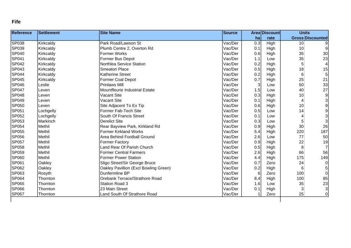
Fife
Reference Settlement Site Name Source Area Discountha rate Gross Discounted
Units
SP038 Kirkcaldy Park Road/Lawson St Vac/Der 0.3 High 10 9SP039 Kirkcaldy Plumb Centre 2, Overton Rd Vac/Der 0.1 High 10 9SP040 Kirkcaldy Former Works Vac/Der 0.6 High 35 30SP041 Kirkcaldy Former Bus Depot Vac/Der 1.1 Low 35 23SP042 Kirkcaldy Northlea Service Station Vac/Der 0.2 High 5 4SP043 Kirkcaldy Smeaton Place Vac/Der 0.5 High 18 15SP044 Kirkcaldy Katherine Street Vac/Der 0.2 High 6 5SP045 Kirkcaldy Former Coal Depot Vac/Der 0.7 High 25 21SP046 Leslie Prinlaws Mill Vac/Der 3 Low 50 33SP047 Leven Mountfleurie Industrial Estate Vac/Der 1.5 Low 40 27SP048 Leven Vacant Site Vac/Der 0.3 High 10 9SP049 Leven Vacant Site Vac/Der 0.1 High 4 3SP050 Leven Site Adjacent To Ex Tip Vac/Der 0.6 High 10 9SP051 Lochgelly Former Fab-Tech Site Vac/Der 0.5 Low 14 9SP052 Lochgelly South Of Francis Street Vac/Der 0.1 Low 4 3SP053 Markinch Derelict Site Vac/Der 0.3 Low 5 3SP054 Methil Rear Bayview Park, Kirkland Rd Vac/Der 0.9 High 30 26SP055 Methil Former Kirkland Works Vac/Der 5.4 High 220 187SP056 Methil Area Behind Football Ground Vac/Der 2.6 Low 77 50SP057 Methil Former Factory Vac/Der 0.9 High 22 19SP058 Methil Land Rear Of Parish Church Vac/Der 0.5 High 8 7SP059 Methil Former Central Farmers Vac/Der 2.6 High 66 56SP060 Methil Former Power Station Vac/Der 4.4 High 175 149SP061 Oakley Sligo Street/Sir George Bruce Vac/Der 0.7 Zero 24 0SP062 Oakley Oakley Pavillion (Excl Bowling Green) Vac/Der 0.2 High 6 5SP063 Rosyth Dunfermline BP Vac/Der 6 Zero 100 0SP064 Thornton Orebank Terrace/Strathore Road Vac/Der 8.4 High 100 85SP065 Thornton Station Road 3 Vac/Der 1.6 Low 35 23SP066 Thornton 23 Main Street Vac/Der 0.1 High 3 3SP067 Thornton Land South Of Strathore Road Vac/Der 1 Zero 25 0

Midlothian Midlothian
Reference Settlement Site Name Source Area Discountha rate Gross Discounted
BG12 Bonnyrigg / Lasswade Behind school Green (SVDLS) site Vac/Der 0.39 High 10 8BG26 Bonnyrigg / Lasswade Westmill Road (SVDLS) Site Vac/Der 0.32 High 8 7BG27 Bonnyrigg / Lasswade Staiside Inn Vac/Der 0.18 High 5 4BG28 Bonnyrigg / Lasswade Cockpen Terrace (SVDLS site) Vac/Der 0.37 High 9 8BG30 Bonnyrigg / Lasswade Rear of 51 High Street Vac/Der 0.15 High 4 3BI01 Bilston Seafield Road Telephone Exchange Conv 0.22 Low 3 2BI02 Bilston Meadow Place Garage Conv 0.35 Low 9 6BI03 Bilston Land South Of Myrtle Crescent Vacant 0.48 Low 5 1BI05 Bilston Land to the south of recreation ground Vacant 0.69 Low 14 4DH02 Dalkeith Winkle site Vacant 0.87 High 17 7DH09 Dalkeith Lugton Vacant 0.19 Low 2 1DL01 Danderhall Edmonstone Road (north side) Vacant 0.14 Low 2 1DL03 Danderhall The Maulsford Inn, Old Dalkeith Road Conv 0.23 Low 5 4DL04 Danderhall Old Dalkeith Road Conv 0.34 Low 9 6GE01 Gorebridge Greenhall Centre Conv 1.93 High 48 41GE03 Gorebridge Hunterfield Road by Scotmid Vac/Der 0.09 High 6 5GE09 Gorebridge Engine Road South Vac/Der 0.77 Low 15 10GE18 Gorebridge Bonnybank Road Vac/Der 0.13 Low 1 1LD02 Loanhead Straiton Business Park Vacant 1.5 Low 30 9LD09 Loanhead former St Margaret’s RC Primary Schoo Vac/Der 0.88 High 22 19LD14 Loanhead former Loanhead Primary Schoo Vac/Der 0.77 High 19 16LD15 Loanhead Loanhead Steading Conv 0.53 High 8 7LD18 Loanhead Bowling Club, Social Club and derelict land at The Loa Conv 0.4 High 10 9LD22 Loanhead Rear of Park Avenue Vacant 0.47 Low 50 15LD25 Loanhead Burghlee Farm Vacant 6.26 High 125 50LD32 Loanhead Loanhead Hospita Conv 0.47 High 12 10MD11 Mayfield Newbattle Lodge Conv 0.72 High 6 5MD19 Mayfield St Luke's RC Church, Stone Place Conv 0.37 Low 32 22NE01 Newtongrange Newbattle Road (i) Conv 1.02 Low 26 18NE02 Newtongrange Newbattle Road (ii) Conv 0.57 Low 14 10NE04 Newtongrange Dalhousie Rd/ Newbattle Rd Conv 1.15 High 29 25NE06 Newtongrange Dalhousie Road (i) Conv 0.12 High 3 3NE07 Newtongrange Dalhousie Road (ii) Conv 0.27 High 7 6PD01 Pathhead Land adjacent to Tynewater PS (Crichton Avenue Vac/Der 0.3 Low 6 4PD02 Pathhead Pathhead Primary Schoo Conv 0.22 High 4 3PK07 Penicuik Loganbank Lodge Vacant 0.3 High 4 2PK14 Penicuik The Stables, Mauricewood Road Conv 0.29 High 3 3PK37 Penicuik Pentland House Conv 0.34 Low 9 6
Units

Midlothian Midlothian
Reference Settlement Site Name Source Area Discountha rate Gross Discounted
Units
PK43 Penicuik Craigiebield Crescent Vac/Der 0.45 High 9 8RL03 Rosewell Ferguson Park (to NE of) Vacant 0.42 Low 8 2RL07 Rosewell Whitehill Road Vacant 0.26 Low 5 2RN05 Roslin Roslin Miners' Bowling Green and Clubhouse buildin Conv 0.35 High 9 8

Scottish Borders
Reference Settlement Site Name Source Area Discountha rate Gross Discounted
GALA039 Galashiels Netherdale Car Park 0.6 12KELS030 Kelso East Bowmont Street Car Park 0.1 3KELS032 Kelso Picnic Area car park 0.1 2SELK021 Selkirk Weavers Court, Dunsdale Road car park 0.5 11SELK027 Selkirk West Port car park 0.3 6DUNS013 Duns Newtown Street car park 0.1 2KELS012 Kelso The Knowes car park 0.3 7KELS018 Kelso Henderson's Car Park 0.1 2EARL005 Earlston Mill Road Employment Site 1.9 40EARL006 Earlston Station Road Employment Site 2.4 50EARL007 Earlston Turfford Park 1.5 31HAWI038 Hawick Gala Law employment land 1.1 22JEDB012 Jedburgh Wildcat Wood 5.4 113KELS034 Kelso Electricity sub station 0.2 5LAUD001 Lauder Lauder Employment Site 3.6 76SELK019 Selkirk Former Ettrick Park Football Ground 1.6 34TWEE004 Tweedbank Tweedbank Ind Estate - south east 1.4 29TWEE005 Tweedbank Tweedbank Ind. Estate - east 0.5 11TWEE006 Newtown St Boswells Tweedbank Ind. Estate - west I 0.4 9TWEE007 Tweedbank Tweedbank Ind Estate - west II 0.3 6GALA015 Galashiels Galafoot 2.7 56JEDB016 Jedburgh Briary Bank 0.2 4SELK005 Selkirk Land at Ettrickhaugh Road 0.7 14LAUD003 Lauder Allanbank School Site 2.2 45DUNS014 Duns Land at Duns Parish Church 0.3 7JEDB005 Jedburgh Garden Ground of Brockhirst 0.3 7JEDB013 Jedburgh Land at Stone Hill 1.4 30JEDB014 Jedburgh Land at end of Priors Road 0.2 4JEDB018 Jedburgh The Burn, Lanton Road 0.9 18JEDB019 Jedburgh Hartrigge Park 7.1 149KELS011 Kelso Kelso Bridge site 2.0 42KELS016 Kelso Pinnaclehill IE 1.3 27KELS021 Kelso Bridgend Park 1.4 30STBO004 St Boswells Main Street I 0.4 9STBO005 St Boswells Main Street II 0.5 10HAWI026 Hawick Scottish Borders Council Depot 0.3 6JEDB017 Jedburgh Jewellers Wynd 0.4 8
Units

Scottish Borders
Reference Settlement Site Name Source Area Discountha rate Gross Discounted
Units
KELS023 Kelso Spylaw Road 0.4 8KELS024 Kelso Depot, Spylaw Road 0.2 4GALA018 Galashiels Wood Street 0.7 16GALA020 Galashiels Former Railway line 1.8 37GALA021 Galashiels Land Adjacent ot Wheatlands Mill Lodge 0.1 3GALA026 Galashiels Huddersfield Street 0.2 5GALA027 Galashiels Langhaugh Industrial Estate 0.2 4GALA029 Galashiels Dale Street 0.3 7GALA030 Galashiels Adjacent to Howden 0.1 2GALA031 Galashiels Refuse Tip 0.2 4GALA033 Galashiels Galafoot2 0.2 4GALA034 Galashiels Old Refuse Tip 1.1 24GALA044 Galashiels Netherdale south 0.4 9GALA046 Galashiels Strathmoy 0.4 8GALA052 Galashiels Stirling Street 0.7 15HAWI014 Hawick Gas Works 0.7 15HAWI015 Hawick Land west Of Weensland Mill 0.4 8HAWI016 Hawick Weensland Mill 0.5 10HAWI019 Hawick Land south of Reversible Systems Ltd 2.4 51HAWI020 Hawick Land west of Longhorn Hardware 0.3 6HAWI021 Hawick Site adjacent to Jackson Jupp Ltd 0.2 5HAWI022 Hawick Land at SBC Depot 0.4 7HAWI023 Hawick Hawick Abbatoir 1.3 27HAWI024 Hawick Land to rear of H&J Coal 0.1 2JEDB001 Jedburgh Back of Shell Garage 0.2 4JEDB003 Jedburgh Back of Jedburgh Fire Station 0.3 7LAUD006 Lauder Refuse Tip 1.4 29NEWT008 Newtown St Boswells Waverley Place 0.3 7SELK004 Selkirk Philiphaugh Mill, Ettrickhaugh Road 1.4 30SELK013 Selkirk Land west of Travis Perkins 0.8 17SELK014 Selkirk Gap site north of Shepherds Mill 0.2 4SELK015 Selkirk Land west of Whinefield Mill 0.6 14SELK016 Selkirk Land at Ettrick Riverside 1.1 24SELK017 Selkirk Land west of Sewage Works 1.2 25SELK018 Selkirk Ettrick Mill Business Park 2.3 48SELK034 Selkirk Land on Rodgers Road 0.1 2JEDB015 Jedburgh Land at Bonjedward Hill 0.6 12JEDB021 Jedburgh Site at Burn Wynd 0.1 1

Scottish Borders
Reference Settlement Site Name Source Area Discountha rate Gross Discounted
Units
SELK023 Selkirk Manorhill Road 0.5 9GALA043 Galashiels Easter Langlee Farm 3.9 83PEEB007 Peebles Elliots Park 0.3 7DUNS017 Duns Unit 2, Clockmill 0.2 4HAWI027 Hawick Former Glenmac Factory 0.2 3HAWI028 Hawick Teviotdale Windows & Doors Ltd 0.3 6KELS010 Kelso Abbotsford Grove Allotments 1.0 21EARL008 Earlston School site 5.0 106EYEM011 Eyemouth Former Eyemouth High School 6.8 143GALA040 Galashiels Vacant building at Kirk Brae 0.0 1GALA041 Galashiels Above shops, Channel Street 0.0 1HAWI042 Hawick St Margarets & Wilton South Church 0.0 1NEWT006 Newtown Mills 0.6 12NEWT007 Newtown Depot 1.3 27SELK035 Selkirk Poets Corner 0.0 0COLD014 Coldstream Gallowsknowe 0.2 4COLD015 Coldstream S of West Lees 0.1 3DUNS021 Duns 25 to 27 Newtown Street 0.1 2EARL002 Earlston Halcombe Fields 0.9 20GALA019 Galashiels South of Buckholm Corner 0.9 19GALA023 Galashiels Bylands 0.2 4GALA035 Galashiels North of Abattior 0.7 15GALA045 Galashiels Tweed Road 0.9 19GALA047 Galashiels Huddersfield St 0.2 4GALA048 Galashiels Manse St/Filter Station 0.5 11GALA051 Galashiels St Aiden's 0.2 4HAWI001 Hawick Hawick Cottage Hospital 1.4 29HAWI003 Hawick Plant Depot & Mill, Slitrig Crescent 1.6 34HAWI004 Hawick Former Hoggs Mill 0.1 3HAWI008 Hawick Land behind Borders College 0.2 3HAWI009 Hawick Knitwear Factory 0.5 11HAWI010 Hawick Wilton Mill 0.2 5HAWI011 Hawick 32 Commercial Road 0.3 6HAWI017 Hawick Factory, Fairhurst Drive 0.4 8HAWI018 Hawick Land at Fairhurst Drive 0.2 3HAWI045 Hawick Burnfoot Roadhouse 0.2 5JEDB027 Jedburgh Howden Drive South 0.2 5JEDB028 Jedburgh 31 High St 0.0 1

Scottish Borders
Reference Settlement Site Name Source Area Discountha rate Gross Discounted
Units
JEDB029 Jedburgh Post Office 0.0 0KELS013 Kelso Station Road 0.6 12SELK008 Selkirk Land on Kilncroft/Mill Street 0.1 3SELK009 Selkirk St Marys Parish Church, Ettrick Terrace 0.1 3SELK010 Selkirk Land on Chapel Street 0.1 3SELK026 Selkirk Land on Chapel Street II 0.1 3SELK030 Selkirk Land at West Port Car Park 0.0 1SELK039 Selkirk Queens Head Inn 0.1 2PEEB006 Peebles Violet Bank - Allocated School Site 5.0 66INNE008 Innerleithen Gap site on High Street 0.1 -2JEDB020 Jedburgh Land on Queen Street 0.3 -3CHIR001 Chirnside Cheviot Avenue 1.7 7CHIR006 Chirnside Erskine Road 0.7 1COLD004 Coldstream Guards Road 0.3 0COLD005 Coldstream West Paddock 4.8 40DUNS008 Duns Bridgend 2 2.9 3DUNS009 Duns Berrywell 0.2 -56DUNS010 Duns Berrywell East 3.5 9DUNS011 Duns Todlaw Road 2.5 3DUNS022 Duns Langton Edge W 1.7 28DUNS023 Duns Langton Edge E 2.4 38EARL003 Earlston Earlston Glebe 2.6 29EARL009 Earlston Mill Road Housing Allocation 1.9 20EYEM001 Eyemouth Acredale Farm Cottages 5.7 34EYEM002 Eyemouth Gunsgreenhill Site A 2.4 5EYEM013 Eyemouth Barefoots 1.3 7EYEM017 Eyemouth Gillsland 2.2 23GALA001 Galashiels Ryehaugh 4.2 78GALA003 Galashiels Buckholm Corner 4.5 34GALA004 Galashiels Buckholm North 8.6 0GALA006 Galashiels Mossilee 2.1 -16GALA007 Galashiels Forest Hill 2.6 5GALA008 Galashiels Balmoral Avenue 0.5 1GALA012 Galashiels Crotchetknowe 12.7 192GALA013 Galashiels South Crotchetknowe 1.5 17GALA014 Galashiels Easter Langlee 21.3 147GALA037 Galashiels Balnakiel Phase 2 1.2 18GALA050 Galashiels Ellwyn Terrace 1.2 -12

Scottish Borders
Reference Settlement Site Name Source Area Discountha rate Gross Discounted
Units
HAWI030 Hawick Leaburn 2 1.6 -6HAWI031 Hawick Crumhaughill 2.4 31HAWI033 Hawick Summerfield 1 1.7 -25HAWI034 Hawick Summerfield 2 2.6 15HAWI035 Hawick Stirches 2 2.0 1HAWI036 Hawick Gala Law/Guthrie Road 6.8 52HAWI037 Hawick Galabrae 1.9 24HAWI039 Hawick Gala Law land Safeguarding 4.3 -10INNE010 Innerleithen Kirklands Lower 2.0 21INNE011 Innerleithen Kirklands Upper 3.2 33JEDB006 Jedburgh Sharplaw Road 0.5 -32JEDB008 Jedburgh Howden Drive 4.2 8JEDB009 Jedburgh Lochend 3.1 22JEDB010 Jedburgh Oxnam Road 5.0 38JEDB011 Jedburgh Annefield 1.9 1JEDB025 Jedburgh Wildcat Cleugh 1.7 30KELS001 Kelso Queens House 1.6 9KELS003 Kelso Broomlands East 5.9 45KELS004 Kelso Broomlands North 5.9 44KELS005 Kelso Rosebank 2 1.4 9KELS007 Kelso Wallacenick 2 6.1 -29KELS008 Kelso Wallacenick 3 4.4 -57LAUD004 Lauder Wyndhead II 1.2 -6MELR001 Melrose Dingleton Hospital 11.9 135MELR002 Melrose The Croft 2.5 27NEWT002 Newtown Melrose Road 4.2 21NEWT003 Newtown Sergeants Park II 2.0 12PEEB003 Peebles Whitehaugh 9.9 102PEEB004 Peebles Glen Crescent/ Bonnington Road 8.2 127SELK001 Selkirk Linglie Road 2.2 17SELK002 Selkirk Linglie Road II 0.3 -3SELK029 Selkirk Linglie Road/Bridge Street 0.6 4SELK036 Selkirk Hillside Terrace 1.0 -3TWEE003 Tweedbank Killie Holes 0.9 -2WEST001 West Linton School Brae 0.4 -1WEST003 West Linton Robinsland 2.3 2EYEM008 Eyemouth Gunsgreenhill Housing Site B 8.0 58EYEM009 Eyemouth Gunsgreenhill Housing Site C 4.7 29

Scottish Borders
Reference Settlement Site Name Source Area Discountha rate Gross Discounted
Units
EYEM010 Eyemouth Gunsgreenhill Mixed Use 6.3 32NEWT001 Newtown Auction Mart 9.0 39COLD006 Coldstream Duns Road 0.6 5COLD007 Coldstream Lees Farm Mill 1.1 12GALA049 Galashiels Borders College 2.1 23DUNS001 Duns Clockmills Hatchery 0.9 12EYEM014 Eyemouth Eyemouth Mill 0.1 -6JEDB004 Jedburgh Site at Builders Yard, Exchange Street 0.2 0DUNS012 Duns Berwickshire High School 6.5 87GALA002 Galashiels Plumtreehall Brae 1.8 22KELS028 Kelso Derelict Bus Depot 0.2 0PEEB010 Peebles SBC Depot Site, Dovecote Road/ George St 1.0 0PEEB011 Peebles Workshops, Dovecot Road 0.3 0PEEB012 Peebles Techauto Site 0.4 -27COLD002 Coldstream Former Refuse Tip 0.3 3COLD003 Coldstream Trafalgar House 0.5 5GALA025 Galashiels Site of former Burns Building 0.1 -13GALA036 Galashiels Adjacent to Bucceleuch Printers 2.8 39GALA053 Galashiels Windyknowe Road 0.2 0INNE012 Innerleithen Peebles Road 0.4 -11KELS031 Kelso 8 East Bowmont St 0.0 -6LAUD007 Lauder Burnmill 0.2 -6NEWT009 Newtown St Boswells Bow Butts 0.2 2NEWT010 Newtown St Boswells Balgownie 0.9 15SELK003 Selkirk Philiphaugh Farm Steading 1.8 5GALA038 Galashiels Ladhope Vale Car Park 0.1 3SELK028 Selkirk Scotts Place car park 0.1 3KELS027 Kelso Somerfield Car Park 0.2 3CHIR005 Chirnside Land adjacent to Ambulance Station 0.6 13COLD010 Coldstream Land on Hill View 0.3 7COLD012 Coldstream Hillview Industrial Estate 1 0.1 3COLD013 Coldstream Hillview Industrial Estate 2 0.2 5DUNS018 Duns Peelrig Farm 3.6 76DUNS024 Duns Cheeklaw 13 0.3 6DUNS025 Duns Cheeklaw 10 0.1 1DUNS026 Duns Cheeklaw 3 0.6 12EYEM007 Eyemouth Hawk's Nest 2.3 48EYEM018 Eyemouth Eyemouth Industrial Estate 2 0.8 16

Scottish Borders
Reference Settlement Site Name Source Area Discountha rate Gross Discounted
Units
INNE009 Innerleithen Traquair Road 2.0 41KELS035 Kelso Pinnacle Hill Extension 5.6 117PEEB005 Peebles Southpark Employment Site 9.0 190PEEB008 Peebles Cavalry Park 6.3 132WEST005 West Linton Deanfoot Road Employment 0.7 14EYEM016 Eyemouth Gunsgreenhill Employment 6.3 132EYEM005 Eyemouth Acredale Industrial Estate 5 1.3 28WEST002 West Linton Deanfoot Road School Site 2.1 44CHIR002 Chirnside Land on Windram Road 0.2 4CHIR004 Chirnside Land on Crosshill 0.5 10COLD008 Coldstream Land beside Wester Park 0.4 9COLD011 Coldstream Home Park 2.9 61DUNS004 Duns West of Cheeklaw Industrial estate 1.2 24DUNS007 Duns Springfield Drive 0.7 15DUNS015 Duns Teindhill Green 0.2 5EYEM012 Eyemouth Seafield 0.2 3KELS026 Kelso South Knowes 0.1 2SELK024 Selkirk Land to west of Linglie Road 3.3 70STBO001 St Boswells Orchard Park 0.3 7STBO003 St Boswells Site near Braehead House 0.4 8GALA011 Galashiels Grange 0.9 18GALA016 Galashiels Heriot-Watt halls of residence 3.2 68KELS025 Kelso Mayfield Garden Centre 1.3 27CHIR011 Chirnside Berwick Road 3 0.9 18KELS022 Kelso Keltek 2.0 43GALA010 Galashiels Roxburgh Street 0.8 18HAWI040 Hawick Old Swimming Baths 0.1 2HAWI041 Hawick Victoria Steam Laundry 0.2 4JEDB022 Jedburgh Land on Edinburgh Road 0.3 6KELS029 Kelso Former Trinity North Church of Scotland 0.2 3KELS033 Kelso Telephone Exchange 0.1 3PEEB013 Peebles Site North East of North Street 0.2 5WEST006 West Linton Builders Yard, Deanfoot Road 0.1 1DUNS005 Duns North of Pearsons Coal Yard 1.7 35COLD001 Coldstream Land at Hirsel Golf Course 0.2 4DUNS006 Duns Land at site 1, station road industrial estate 0.4 8DUNS016 Duns Site adj to Farne Salmon 0.3 5EYEM003 Eyemouth Acredale Industrial Estate 3 0.4 9
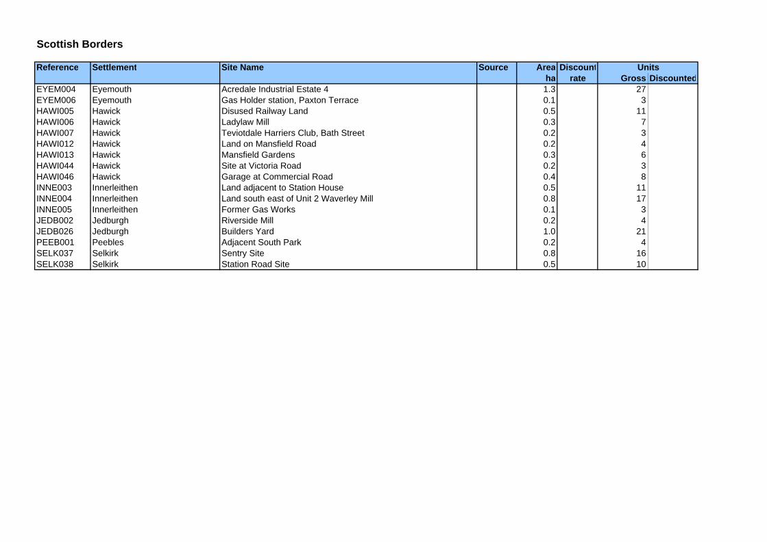
Scottish Borders
Reference Settlement Site Name Source Area Discountha rate Gross Discounted
Units
EYEM004 Eyemouth Acredale Industrial Estate 4 1.3 27EYEM006 Eyemouth Gas Holder station, Paxton Terrace 0.1 3HAWI005 Hawick Disused Railway Land 0.5 11HAWI006 Hawick Ladylaw Mill 0.3 7HAWI007 Hawick Teviotdale Harriers Club, Bath Street 0.2 3HAWI012 Hawick Land on Mansfield Road 0.2 4HAWI013 Hawick Mansfield Gardens 0.3 6HAWI044 Hawick Site at Victoria Road 0.2 3HAWI046 Hawick Garage at Commercial Road 0.4 8INNE003 Innerleithen Land adjacent to Station House 0.5 11INNE004 Innerleithen Land south east of Unit 2 Waverley Mill 0.8 17INNE005 Innerleithen Former Gas Works 0.1 3JEDB002 Jedburgh Riverside Mill 0.2 4JEDB026 Jedburgh Builders Yard 1.0 21PEEB001 Peebles Adjacent South Park 0.2 4SELK037 Selkirk Sentry Site 0.8 16SELK038 Selkirk Station Road Site 0.5 10

West Lothian
Reference Settlement Site Name Source Area Discountha rate Gross Discounted
ADW 1 ADDIEWELL Church Street (North) Vac/Der 0.2 Low 9 6ADW 2 ADDIEWELL Blackburn Road (Former Church) Vac/Der 0.2 High 9 7ADW 3 ADDIEWELL Depot, Station Road (South) 2.4 Zero 70 0ADW 4 ADDIEWELL Depot, Station Road (North) 1.8 Zero 45 0ADW 5 ADDIEWELL Meadowhead Crescent (North) Vac 3.2 Low 60 18ADW 6 ADDIEWELL Loganlea Place Intens 0.1 High 3 2ARM 1 ARMADALE Drove Road Park Vac 2.6 Low 80 24ARM 10 ARMADALE Armadale Stadium Intens 3.3 High 80 68ARM 11 ARMADALE South Street (Social Club) 0.2 Zero 5 0ARM 12 ARMADALE South Street (Bowling Club) 0.3 Zero 8 0ARM 13 ARMADALE Marches Drive / Ferrier Crescent (Garage Court) Intens 0.4 High 20 17ARM 14 ARMADALE McNeil Crescent (Garage Court) Intens 0.3 Low 6 4ARM 2 ARMADALE North Street (Former Gas Holder) 2.1 Zero 60 0ARM 3 ARMADALE McNeil Crescent (Former Telephone Exchange) Vac/Der 0.2 Low 5 3ARM 4 ARMADALE East Main Street 0.2 Zero 5 0ARM 5 ARMADALE North Street Vac/Der 0.0 Low 4 3ARM 6 ARMADALE Mill Road 0.5 Zero 10 0ARM 7 ARMADALE Birkdale Park Vac 0.5 Low 15 5ARM 8 ARMADALE Wotherspoon Crescent Vac 0.8 High 15 6ARM 9 ARMADALE Wood Park, South Street Vac/Der 0.1 Low 6 4BATH 1 BATHGATE Land adjacent to Primary Care Centre Vac/Der 0.3 High 10 8BATH 10 BATHGATE St David's House 0.4 Zero 16 0BATH 11 BATHGATE Council Depot, Waverley Street Intens 0.3 Low 10 7BATH 12 BATHGATE Glasgow Road (Adult Learning Centre) Intens 0.1 Low 6 4BATH 13 BATHGATE Wallace Road 1.5 Zero 50 0BATH 14 BATHGATE Philip Avenue, Boghall Intens 0.1 Low 4 3BATH 15 BATHGATE Marina Road, Boghall Intens 0.2 Low 6 4BATH 16 BATHGATE Balbardie Crescent 0.2 Zero 4 0BATH 17 BATHGATE Dundas Street Intens 0.1 Low 5 3BATH 18 BATHGATE Charles Crescent, Boghall Intens 0.1 Low 4 3BATH 19 BATHGATE Bathgate Foundry 0.8 Zero 25 0BATH 2 BATHGATE Glasgow Road (Showground site) 1.2 Zero 45 0BATH 3 BATHGATE Whitburn Road (Former Abbatoir) Vac/Der 2.0 High 60 51BATH 4 BATHGATE Torphican Road (East) Vac 0.5 Low 15 4BATH 5 BATHGATE Whitburn Road 0.7 Zero 10 0BATH 6 BATHGATE Mid Street (Former Swimming Pool) Intens 0.2 High 10 8BATH 7 BATHGATE Guildiehaugh Depot Intens 3.7 Low 50 35BATH 8 BATHGATE Recreation Ground, Guildiehaugh Vac 0.8 Low 15 4BATH 9 BATHGATE Land adjacent to Quintiles Vac 1.9 Low 50 15
Units

West Lothian
Reference Settlement Site Name Source Area Discountha rate Gross Discounted
Units
BLA 1 BLACKBURN 32 East Main Street 0.2 Zero 1 0BLA 10 BLACKBURN Ash Grove / Elm Grove Vac/Der 1.0 High 15 13BLA 11 BLACKBURN Beechwood Road Intens 0.1 Low 4 3BLA 12 BLACKBURN Beechwood Road (2) Intens 0.3 Low 8 5BLA 13 BLACKBURN Catherine Terrace Intens 0.2 Low 4 3BLA 14 BLACKBURN Mosside Road Intens 0.1 Low 4 3BLA 15 BLACKBURN Hopefield Road Intens 0.1 Low 5 3BLA 16 BLACKBURN Almondvale Gardens (Former Adult Training Centre Intens 0.4 Low 12 8BLA 2 BLACKBURN West Main Street (South) Vac 0.1 High 4 1BLA 3 BLACKBURN West Main Street Vac 1.0 High 30 12BLA 4 BLACKBURN Redhouse Place Vac 0.3 Low 10 3BLA 5 BLACKBURN Council Yard 0.6 Zero 15 0BLA 6 BLACKBURN Community Centre Intens 0.9 High 20 17BLA 7 BLACKBURN Health Centre Intens 0.3 High 8 7BLA 8 BLACKBURN West of Health Centre Vac 0.4 High 10 4BLA 9 BLACKBURN Connolly House Intens 0.5 High 10 8BLR 1 BLACKRIDGE Station Road Vac 0.3 Low 4 1BLR 2 BLACKRIDGE Bedlormie Drive 0.4 Zero 10 0BRO 1 BROXBURN Stewartfield Road (Garage Court) Intens 0.2 Low 4 3BRO 2 BROXBURN Paterson Court (Garage Court) Intens 0.2 Low 8 6BRO 3 BROXBURN West Main Street (Former Broxburn Primary School) Conv 0.4 High 20 17BRO 4 BROXBURN Bridge Place Intens 0.3 High 10 9BRO 5 BROXBURN Hillview Avenue Vac 0.6 High 15 6BRO 6 BROXBURN Church Street Depot Intens 0.4 Low 10 7BRO 7 BROXBURN Buchan Park 0.6 Zero 30 0BRO 8 BROXBURN Long Byres (Bowling Club) 0.3 Zero 20 0BRO 9 BROXBURN East Main Street (Grampian Foods) 7.5 Zero 200 0ECA 1 EAST CALDER Main Street 0.1 Zero 5 0EWH 1 EAST WHITBURN Bathgate Road 0.1 Zero 8 0EWH 2 EAST WHITBURN Bathgate Road 0.2 Zero 8 0EWH 3 EAST WHITBURN Torbane Drive Vac 0.2 Low 6 2FAU 1 FAULDHOUSE Willow Brae Vac 0.6 Low 18 5FAU 11 FAULDHOUSE Main Street South side (Former Cinema) Vac/Der 0.9 High 20 17FAU 12 FAULDHOUSE Eastfield (North) Intens 1.2 High 30 25FAU 13 FAULDHOUSE Victoria Cricket Ground 1.2 Zero 40 0FAU 3 FAULDHOUSE Fallas Place north Vac 0.1 Low 3 1FAU 4 FAULDHOUSE Eldrick Avenue (Formet Bowling Club) Intens 0.5 Low 14 10FAU 5 FAULDHOUSE Harthill Road (Former Pigeon Loft site) Intens 0.5 Low 15 10FAU 6 FAULDHOUSE Park View (West) (Former Garage Court) Intens 0.2 Low 5 3

West Lothian
Reference Settlement Site Name Source Area Discountha rate Gross Discounted
Units
FAU 7 FAULDHOUSE Quarry Road (Southeast)(Garage Court) Intens 0.2 Low 5 3FAU 8 FAULDHOUSE CIS office Intens 0.6 High 8 7LIN 1 LINLITHGOW High Street (Victoria Halls) 0.1 Zero 20 0LIN 10 LINLITHGOW Falkirk Road (Sawmill Site) Vac/Der 0.7 High 20 17LIN 11 LINLITHGOW Clarendon House & Walled Garden Intens 0.6 High 6 5LIN 12 LINLITHGOW Barkhill Road (ATC Hall) 0.1 Zero 3 0LIN 13 LINLITHGOW Riverside Court (Mackinnon Scout Hall) 0.2 Zero 5 0LIN 14 LINLITHGOW Moray Drive (Garage Court) Intens 0.2 Low 8 6LIN 2 LINLITHGOW High Street (Former Post Office) 0.1 Zero 5 0LIN 3 LINLITHGOW Edinburgh Road (Bonded Warehouse) Intens 0.8 Low 50 35LIN 4 LINLITHGOW Edinburgh Road (Former Candleworks) Vac/Der 0.7 High 65 55LIN 5 LINLITHGOW 89 - 91 High Street (County Buildings) 0.4 Zero 20 0LIN 6 LINLITHGOW High Street (Sheriff Court / Court Square) Conv 0.6 Low 15 11LIN 7 LINLITHGOW Boghall (East) 3.3 Zero 30 0LIN 8 LINLITHGOW Land at Mill Road Industrial Estate (West) 0.6 Zero 6 0LIN 9 LINLITHGOW Mill Road Vac 1.5 High 30 12LIV 1 LIVINGSTON Almondvale Central Vac 0.7 Low 20 6LIV 10 LIVINGSTON Linhouse 75.7 Zero 1300 0LIV 11 LIVINGSTON Barclay Way 0.2 Zero 8 0LIV 12 LIVINGSTON Deans South Vac/Der 0.3 Low 5 3LIV 13 LIVINGSTON Eagle Brae (Council Depot) Intens 0.9 Low 20 14LIV 14 LIVINGSTON St Columbas, Sydney Street Vac 0.2 Low 5 2LIV 15 LIVINGSTON Carron Walk (Former Garage) Vac/Der 0.7 Low 20 13LIV 16 LIVINGSTON West Lothian House 0.8 Zero 50 0LIV 17 LIVINGSTON Almondvale Boulevard (Land adjacent to Bubbles Pool) 0.6 Zero 20 0LIV 18 LIVINGSTON Bankton House 0.9 Zero 5 0LIV 19 LIVINGSTON Murieston Valley 0.5 Zero 5 0LIV 2 LIVINGSTON Almondvale (East) Vac 0.5 Low 15 5LIV 20 LIVINGSTON Murieston West Road 0.2 Zero 5 0LIV 21 LIVINGSTON St Paul's Church, Cousland Road Vac 0.2 Low 5 2LIV 22 LIVINGSTON Maple Grove (Car park) Car 0.2 Low 5 4LIV 23 LIVINGSTON Crofthead Community Centre Intens 1.0 Low 35 25LIV 24 LIVINGSTON James Young High School 0.7 Zero 50 0LIV 25 LIVINGSTON Lennox House 0.2 Zero 8 0LIV 26 LIVINGSTON Lammermuir House Intens 1.3 Low 60 42LIV 27 LIVINGSTON Shiel House Intens 0.2 Low 8 6LIV 28 LIVINGSTON Carmondean House 0.2 Zero 8 0LIV 29 LIVINGSTON Cheviot House Intens 0.2 Low 10 7LIV 3 LIVINGSTON Brucefield Park (West) 2.2 Zero 30 0

West Lothian
Reference Settlement Site Name Source Area Discountha rate Gross Discounted
Units
LIV 30 LIVINGSTON Deans House Intens 0.2 Low 8 6LIV 31 LIVINGSTON Almondvale Roundabout (South West) 0.5 Zero 30 0LIV 32 LIVINGSTON Alderstone Road (West) Vac 2.0 High 60 24LIV 33 LIVINGSTON Deans Community High Scool 2.5 Zero 50 0LIV 34 LIVINGSTON Almondvale South Vac 1.6 High 60 24LIV 4 LIVINGSTON Brucefield ( North) AIP 0.8 Low 10 7LIV 5 LIVINGSTON Appleton Parkway (1) 5.6 Zero 150 0LIV 6 LIVINGSTON Appleton Parkway (2) 12.9 Zero 200 0LIV 7 LIVINGSTON Appleton Parkway (3) 5.8 Zero 150 0LIV 8 LIVINGSTON Appleton Parkway (4) 7.6 Zero 100 0LIV 9 LIVINGSTON Houstoun Road (North) 5.8 Zero 150 0LON 1 LONGRIDGE School Place(North)(Redev Commercial Centre) Vac/Der 0.3 High 10 8LON 2 LONGRIDGE School Road (Former Garage) Vac/Der 0.1 Low 4 2POL 1 POLBETH Land off A71 (East) 0.2 Zero 7 0POL 2 POLBETH land off A71 (South) 0.6 Zero 18 0POL 3 POLBETH Former Limefield Tennis Courts Vac/Der 0.2 High 4 3POL 4 POLBETH Land at Chapelton Gardens 1.2 Zero 30 0PUM 1 PUMPHERSTON Pumpherston Primary School Intens 0.4 High 10 9PUM 2 PUMPHERSTON Letham Park 0.1 Zero 2 0SEA 1 SEAFIELD Land off Redhouse Road ( Former Ritchies Yard) Vac/Der 1.2 High 60 51SEA 2 SEAFIELD Redhouse Road 0.4 Zero 10 0STO 1 STONEYBURN Dick Place Intens 0.2 Low 4 3UPH 1 UPHALL Wyndford Avenue/Crossgreen Place (Garage Courts) Intens 0.5 Low 6 4UPS 1 UPHALL STATION Nettlehill Drive Vac 0.2 High 3 1WCA 1 WEST CALDER Burngrange Court (North) Vac 0.2 Low 6 2WCA 2 WEST CALDER Burngrange Park (West) Intens 1.0 High 30 25WCA 3 WEST CALDER Burngrange Farm 1.0 Zero 15 0WCA 4 WEST CALDER Burngrange Court Vac 0.5 Low 10 3WCA 5 WEST CALDER Freeport Vac/Der 14.0 High 30 25WEF 1 WESTFIELD South Logie Nursery Intens 1.5 High 30 26WHT 1 WHITBURN Manse Road 0.2 Zero 7 0WHT 2 WHITBURN Former Grampian Foods site Intens 1.2 Low 60 42WHT 3 WHITBURN Blaeberryhill 0.4 Zero 10 0WHT 4 WHITBURN Gateside Road Intens 0.1 Low 2 1WHT 5 WHITBURN Woodmuir Road Intens 0.1 Low 4 3WHT 6 WHITBURN Brucefield Church (Land to the south) Intens 0.3 Low 4 3WIN 1 WINCHBURGH Site of Former Beatlie School / Winchburgh Day Centre Vac/Der 0.6 High 10 9WIN 2 WINCHBURGH Former Janitor's House at Beatlie School Vac/Der 0.2 High 3 3WIN 3 WINCHBURGH Station Road Vac 0.2 Low 3 1

West Lothian
Reference Settlement Site Name Source Area Discountha rate Gross Discounted
Units
WIN 4 WINCHBURGH Station Road (Former Telephone Exchange) Vac/Der 0.2 Low 3 2WIN 5 WINCHBURGH Main Street (Playing Field) 1.7 Zero 50 0