session a3- removing barriers at road crossings using
TRANSCRIPT

University of Massachusetts AmherstScholarWorks@UMass AmherstInternational Conference on Engineering andEcohydrology for Fish Passage
International Conference on Engineering andEcohydrology for Fish Passage 2011
Jun 27th, 3:25 PM - 3:45 PM
Session A3- Removing barriers at road crossingsusing stream simulation techniques in the northeastUnited StatesPaul WoodworthP.E., CFM
Jacob HelminiakP.E., CFM
Laura WildmanP.E.: Princeton Hydro, LLC
Follow this and additional works at: https://scholarworks.umass.edu/fishpassage_conference
This Event is brought to you for free and open access by the Fish Passage Community at UMass Amherst at ScholarWorks@UMass Amherst. It hasbeen accepted for inclusion in International Conference on Engineering and Ecohydrology for Fish Passage by an authorized administrator ofScholarWorks@UMass Amherst. For more information, please contact [email protected].
Woodworth, Paul; Helminiak, Jacob; and Wildman, Laura, "Session A3- Removing barriers at road crossings using stream simulationtechniques in the northeast United States" (2011). International Conference on Engineering and Ecohydrology for Fish Passage. 38.https://scholarworks.umass.edu/fishpassage_conference/2011/June27/38

Redesigning Road Crossings with Stream SimulationRedesigning Road Crossings with Stream Simulation
Techniques and MA Stream Crossing StandardsTechniques and MA Stream Crossing Standards
Laura A.S. Wildman, P.E.Laura A.S. Wildman, P.E.
Director NE Regional OfficeDirector NE Regional Office
Princeton Hydro, LLCPrinceton Hydro, LLC
Fish Passage 2011Fish Passage 2011
National Conference on EngineeringNational Conference on Engineering
& & Ecohydrology Ecohydrology for Fish Passagefor Fish Passage
Jacob E. Jacob E. HelminiakHelminiak, P.E., CFM, P.E., CFM
Senior Hydraulic EngineerSenior Hydraulic Engineer
Princeton Hydro, LLCPrinceton Hydro, LLC
Paul M. WoodworthPaul M. Woodworth
Fluvial Fluvial GeomorphologistGeomorphologist
Princeton Hydro, LLCPrinceton Hydro, LLC

OutlineOutline
!! MA Stream Crossing StandardsMA Stream Crossing Standards
!! Stream SimulationStream Simulation
!! Mitchell Brook Case StudyMitchell Brook Case Study

Massachusetts River and StreamMassachusetts River and Stream
Crossing StandardsCrossing Standards
!! First 2006,First 2006, Revised 2011Revised 2011
!! Endorse Stream Simulation ApproachEndorse Stream Simulation Approach
!! Guidance / Performance standardsGuidance / Performance standards
!! Not prescriptive measuresNot prescriptive measures
!! Major Goals:Major Goals:
!! Fish and other Aquatic Organism Passage (AOP)Fish and other Aquatic Organism Passage (AOP)
!! River / Stream ContinuityRiver / Stream Continuity
!! Wildlife PassageWildlife Passage

Massachusetts River and StreamMassachusetts River and Stream
Crossing Standards (2006)Crossing Standards (2006)
!! General StandardsGeneral Standards
!! Open Bottom orOpen Bottom orEmbedded Culvert (1ft)Embedded Culvert (1ft)
!! Natural bottom substrateNatural bottom substrate
!! Span channel widthSpan channel width(min 1.2(min 1.2 x BF width)x BF width)
!! Low flow channel for comparableLow flow channel for comparabledepths and velocities at low flowsdepths and velocities at low flows
!! Openness > 0.25 mOpenness > 0.25 m
!! Optimum StandardsOptimum Standards
!! Open Bottom ArchOpen Bottom Arch
or Bridgeor Bridge
!! SpanSpan channel and bankschannel and banks
(min 1.2 x BF + banks)(min 1.2 x BF + banks)
with headroom for dry passagewith headroom for dry passage
!! Min height of 6 ft,Min height of 6 ft,
Openness > 0.75 mOpenness > 0.75 m
(where wildlife passage is(where wildlife passage is
significantly inhibited)significantly inhibited)
!! Min height of 4 ft,Min height of 4 ft,
Openness > 0.5 mOpenness > 0.5 m

Massachusetts River and StreamMassachusetts River and Stream
Crossing Standards (2011)Crossing Standards (2011)
!! General StandardsGeneral Standards!! Spans orSpans or
!! CulvertsCulverts
!! Min 2ft EmbedmentMin 2ft Embedment
!! Min 2ft, 25% ()Min 2ft, 25% ()
!! 2 x D842 x D84
!! Span min 1.2 x BF widthSpan min 1.2 x BF width
!! Natural stream substrateNatural stream substrate
!! Match bedformsMatch bedforms --> -->depths & velocities at depths & velocities at variedvariedflowsflows
!! OpennessOpenness > 0.82 ft (0.25 m)> 0.82 ft (0.25 m)
!! Continuous BanksContinuous Banks
!! Optimum StandardsOptimum Standards
!! BridgeBridge
!! Span 1.2 x BF widthSpan 1.2 x BF width + Banks+ Banks
!! Natural stream substrateNatural stream substrate
!! Match bedformsMatch bedforms --> -->
depths & velocities at depths & velocities at varied flowsvaried flows
!! Min height ofMin height of 8 ft8 ft
Openness > 2.46 ft (0.75 m)Openness > 2.46 ft (0.75 m)
(where wildlife passage is(where wildlife passage is
significantly inhibited)significantly inhibited)
!! Min height ofMin height of 6 ft6 ft
Openness > 1.64 ft (0.5 m)Openness > 1.64 ft (0.5 m)
!! Continuous BanksContinuous Banks
!! Headroom for wildlifeHeadroom for wildlife

Stream SimulationStream Simulation
!! Developed in Washington StateDeveloped in Washington State
!! Detailed in USFS ManualDetailed in USFS Manual
!! Alternative approach to species-specific designsAlternative approach to species-specific designs
!! Avoids flow constriction during normal conditionsAvoids flow constriction during normal conditions
!! MimicsMimics diversity and complexity of natural stream channeldiversity and complexity of natural stream channel
through a crossing structurethrough a crossing structure
!! Intended to accommodate normal movements of aquatic organismsIntended to accommodate normal movements of aquatic organisms
!! Presents no more of an obstacle to movement than the natural channelPresents no more of an obstacle to movement than the natural channel

Stream Simulation DesignStream Simulation Design ElementsElements
From From Stream Simulation: an Ecological Approach to Providing Passage for AquaticStream Simulation: an Ecological Approach to Providing Passage for AquaticOrganisms at Road-Stream CrossingsOrganisms at Road-Stream Crossings
!! CrossingCrossing AlignmentAlignment
!! Lateral Channel AdjustmentLateral Channel Adjustment
!! Control Points US / DSControl Points US / DS
!! Reference SlopeReference Slope
!! ReferenceReference Bed CharacteristicsBed Characteristics
!! Bed Particle Size DistributionBed Particle Size Distribution
!! Bank Rocks / Isolated Boulders SizesBank Rocks / Isolated Boulders Sizes
!! Bankfull WidthBankfull Width
!! Flood CapacityFlood Capacity
!! Bed MobilityBed Mobility

Case Study:Case Study:
Mitchell Brook Culvert ReplacementMitchell Brook Culvert Replacement
!! Conway Road crossing Mitchell Brook, Town of Conway Road crossing Mitchell Brook, Town of WhatelyWhately,,
Franklin County, MAFranklin County, MA
!! Tributary to West BrookTributary to West Brook
!! Part of West Brook stream continuity studyPart of West Brook stream continuity study
!! Several project partnersSeveral project partners
!! American RiversAmerican Rivers
!! The Nature ConservancyThe Nature Conservancy
!! Conte Conte Anadromous Anadromous Fish Research Center (USGS)Fish Research Center (USGS)

Mitchell Brook SettingMitchell Brook Setting
!! Drainage Area Drainage Area –– 225 acres (0.35 sq. mi.) 225 acres (0.35 sq. mi.)
!! Entirely forested watershedEntirely forested watershed
!! Gravel road, owned by TownGravel road, owned by Town

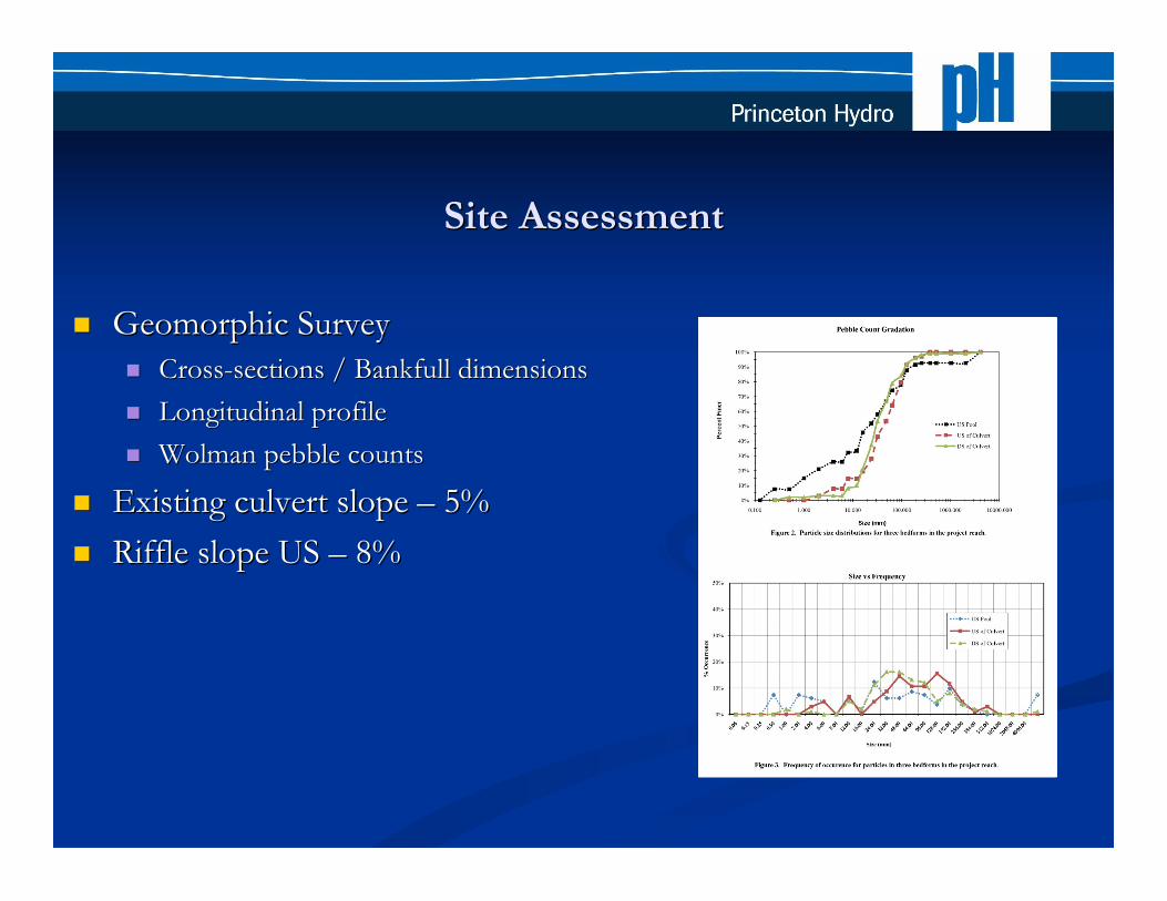
Site AssessmentSite Assessment
!! Existing perchedExisting perched
3636”” CMP CMP
!! Monitored easternMonitored eastern
brook troutbrook trout
passagepassage
!! Gravel / cobbleGravel / cobble
channelchannel
with bedrockwith bedrock
influenceinfluence
Site AssessmentSite Assessment
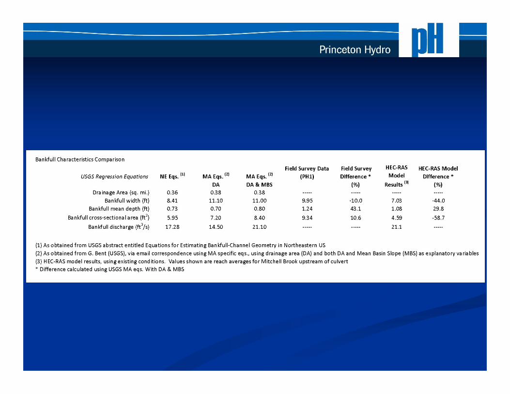
!! Geomorphic SurveyGeomorphic Survey
!! Cross-sections / Bankfull dimensionsCross-sections / Bankfull dimensions
!! Longitudinal profileLongitudinal profile
!! Wolman pebble countsWolman pebble counts
!! Existing culvert slope Existing culvert slope –– 5% 5%
!! Riffle slope US Riffle slope US –– 8% 8%

Design Constraints / ConsiderationsDesign Constraints / Considerations
!! Shallow cover over existing pipeShallow cover over existing pipe
!! Bedrock influenceBedrock influence
!! Footings for culvertFootings for culvert
!! Substrate stability, boulder embedmentSubstrate stability, boulder embedment
!! Steep reach Steep reach –– how to best simulate the bedrock influenced how to best simulate the bedrock influenced
pool/riffle systempool/riffle system
!! Road width required for Town DPW future pavement sectionRoad width required for Town DPW future pavement section

Design Constraints / ConsiderationsDesign Constraints / Considerations
!! General standards attainableGeneral standards attainable!! Arch, Substrate, Width,Arch, Substrate, Width,
Low flows, OpennessLow flows, Openness
!! Optimal standards would requireOptimal standards would requiresignificantly raising road elevation tosignificantly raising road elevation toachieve > 0.50m Opennessachieve > 0.50m Opennessand height standardand height standard
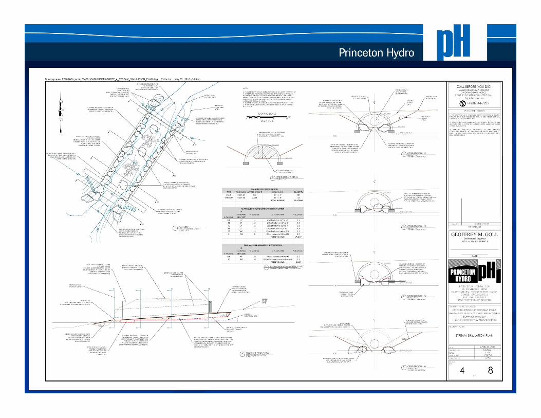
Design Features:Design Features:
PlanviewPlanview
!! Perpedicular Perpedicular alignmentalignment
!! LaterallyLaterally containedcontained
!! BouldersBoulders in banksin banks
&& mid-channel to providemid-channel to provide
varied hydraulic habitatvaried hydraulic habitat
!! Boulders sized to withstandBoulders sized to withstand
high flows (24-26high flows (24-26””))
!! Continuous banksContinuous banks
!! Low flow channelLow flow channel

Design Features:Design Features:
Cross-sectionsCross-sections
!! Openness 0.36 mOpenness 0.36 m
!! Cross-sectional areaCross-sectional area
37.65 SF min.37.65 SF min.
!! 4.8 FT rise min.4.8 FT rise min.

Design Features: ProfileDesign Features: Profile
!! US / DS Control PointsUS / DS Control Points
!! Proposed Slope (7%) / LengthProposed Slope (7%) / Length
consistent consistent w/ w/ US riffleUS riffle
!! Substrate depth to vary Substrate depth to vary w/w/
bedrockbedrock
!! Scour pool to be filledScour pool to be filled

Design Features:Design Features:
Cross-sectionsCross-sections
!! 1212’’ span x span x 66’’ rise rise
!! Adequate WidthAdequate Width
(1.2 x bankfull)(1.2 x bankfull)
!! Existing culvertExisting culvert
!! Low flow channelLow flow channel
!! Boulder placement in BanksBoulder placement in Banks
& & midchannelmidchannel
!! Continuous bank linesContinuous bank lines

Design Features:Design Features:
Bed GradationBed Gradation
!! Mimic particle sizeMimic particle size
distribution of US riffledistribution of US riffle
!! Increase fine sedimentIncrease fine sediment
fractionfraction
(pebble count bias)(pebble count bias)
!! Convert to US Convert to US Seive Seive sizessizes
for contractor / quarryfor contractor / quarry
!! Size bouldersSize boulders to resist highto resist high
flowsflows
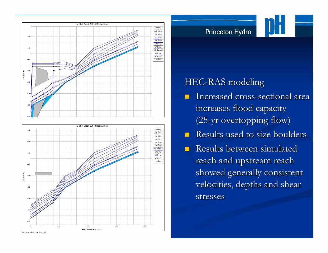
HEC-RAS modelingHEC-RAS modeling
!! Increased cross-sectional areaIncreased cross-sectional area
increases flood capacityincreases flood capacity
(25-yr overtopping flow)(25-yr overtopping flow)
!! Results usedResults used toto size boulderssize boulders
!! Results between simulatedResults between simulated
reach and upstream reachreach and upstream reach
showed generally consistentshowed generally consistent
velocities, depths and shearvelocities, depths and shear
stressesstresses

Related PH ProjectRelated PH Project
Working with PA Trout Unlimited (Bucks County Chapter)Working with PA Trout Unlimited (Bucks County Chapter)
to assess all road crossings in Cooks Creekto assess all road crossings in Cooks Creek watershedwatershed
(Delaware River tributary)(Delaware River tributary)
!! Identified all stream crossings (~100)Identified all stream crossings (~100)
!! Developed assessment protocolDeveloped assessment protocol
!! Trained volunteers for initial field assessmentTrained volunteers for initial field assessment
!! Prioritize crossingsPrioritize crossings
!! Conduct follow-up assessmentsConduct follow-up assessments
!! Develop conceptual restoration plansDevelop conceptual restoration plans
!! Possibly first in PAPossibly first in PA

ResourcesResources
UMASS River and Stream Continuity ProjectUMASS River and Stream Continuity Project
www.streamcontinuity.orgwww.streamcontinuity.org
MA MA Riverways Riverways ProgramProgram
www.mass.gov/dfwele/der/riverways/index.htmwww.mass.gov/dfwele/der/riverways/index.htm
USFS Stream Simulation ManualUSFS Stream Simulation Manual
http://www.fs.fed.us/eng/pubs/pdf/StreamSimulation/index.shtmlhttp://www.fs.fed.us/eng/pubs/pdf/StreamSimulation/index.shtml
Paul WoodworthPaul Woodworth
pwoodworth@[email protected]
DiscussionDiscussion

Culvert Retrofitting: Making the CaseCulvert Retrofitting: Making the Case
!! Dams in MA -- >2,900 dams (ASDSO 2008)Dams in MA -- >2,900 dams (ASDSO 2008)
!! Stream Crossings in MA -- > 28,500 road and railroad crossingsStream Crossings in MA -- > 28,500 road and railroad crossings
(MA (MA Riverways Riverways GIS)GIS)
!! MA crossings outnumber dams ~10xMA crossings outnumber dams ~10x
!! Significant potential impactSignificant potential impact
!! Need for restorationNeed for restoration

Regional EffortsRegional Efforts
!! Guidelines/standardsGuidelines/standards
!! MA River and Stream Crossing Standards (2006)MA River and Stream Crossing Standards (2006)
!! CT Stream Crossing Guidelines (2008)CT Stream Crossing Guidelines (2008)
!! VT Stream Crossing Guidelines (2009)VT Stream Crossing Guidelines (2009)
!! NH Stream Crossing Guidelines (2009)NH Stream Crossing Guidelines (2009)
!! UMASS River and Stream Continuity ProjectUMASS River and Stream Continuity Project
!! Volunteer assessments of road-stream crossings in MA andVolunteer assessments of road-stream crossings in MA and
NE statesNE states
