setting up a horizon scanning system: a us federal … up a horizon scanning system: a us federal...
TRANSCRIPT
1
Setting Up a Horizon Scanning System: A US Federal Agency Example
Andy Hines, David N. Bengston, Michael J. Dockry, and Adam Cowart
September 7, 2017
I. Introduction
Managers and policy makers are continually working toward a desired future within a context of rapid
and turbulent change. To be effective in this context, they must look ahead to anticipate emerging
trends, issues, opportunities, and threats. Horizon scanning (also referred to as environmental scanning)
is a foresight method that can help managers and policy makers develop and maintain a broad and
externally focused forward view to anticipate and align decisions with both emerging (near-term) and
long-term futures. Horizon scanning is defined as “the acquisition and use of information about events,
trends and relationships in an organization’s external environment, the knowledge of which would assist
management in planning the organization’s future course of action” (Choo 2002: 84).
Horizon scanning has long been practiced in the military, the intelligence community, and the business
world. Business research has demonstrated that effective horizon scanning improves organizational
performance (Choo 2002). In recent years it has been increasingly used in other public sector fields, such
as human health (Douw and Vondeling 2006) and education (Munck and McConnell 2009). But the use
of formal horizon scanning in natural resources and environmental organizations has been limited
(Sutherland and Woodroof 2009). Among the few examples are scanning exercises related to
biodiversity (Sutherland et al. 2008), global conservation issues (Sutherland et al. 2015), and
environmental issues with implications for the US military (U.S. Army Environmental Policy Institute,
n.d.).
The Millennium Ecosystem Assessment concluded that “over the past 50 years, humans have changed
ecosystems more rapidly and extensively than in any comparable period of time in human history,
largely to meet rapidly growing demands for food, fresh water, timber, fiber, and fuel” (Millennium
Ecosystem Assessment 2005, p. 1). Surprises are increasing along with the expanding scale of human
impacts (Gunderson and Longstaff 2010). Hibbard et al. (2007) refer to the period following World War II
as the “Great Acceleration,” a time of significant increase in the scope, scale, and intensity of impacts on
the social-ecological system. At the same time, the rapid pace of technological change has the potential
for sweeping environmental effects, such as genetic engineering and nanotechnologies, and makes the
future landscape more challenging to discern (Olson and Rejeski 2005).
In the face of such profound and uncertain change, foresight developed through horizon scanning is not
an attempt to “predict the future.” It is simply not possible to accurately predict the future of complex
social-ecological systems for long timeframes. Efforts devoted to social and environmental prediction
2
have been plagued by a host of shortcomings, and unjustifiable faith in these predictions have
contributed to unmanageable nuclear waste disposal practices, poisoned mining sites, inaccurate
expectations of shoreline erosion rates, and overoptimistic cost estimates of artificial beaches (Sarewitz
et al. 2000, Pilkey and Pilkey-Jarvis 2007).
The inability to accurately forecast the future of complex social-ecological systems stems from many
factors, such as the emergent nature of these systems and their sensitive dependence on initial
conditions. Emergent properties of a system cannot be predicted from the parts (de Haan 2006). The
prevalence of surprise in social-ecological systems (Gunderson and Longstaff 2010) implies that some
important uncertainties in long-term forecasts are irreducible and that traditional scientific tools and
models are blunt instruments for studying a future that does not exist.
The goal of horizon scanning, therefore, is not to try to accurately predict the future, but to identify,
compile, and analyze the various signals of change. These signals can be explored to stimulate thinking
about the range of future possibilities. While getting “the future” precisely right is futile, it is possible to
use signals of change identified in horizon scanning to map plausible scenarios and pathways to the
future (Hines 2009). Horizon scanning serves as an early warning system to identify potential threats and
opportunities. Some characteristics of horizon scanning that distinguish it from typical activities that
planners use to survey future conditions include:
it emphasizes “weak signals” or early indicators of potential change
it is comprehensive across a wide range of sectors
it emphasizes external trends and developments
and it includes possible wild cards or low-probability, high-impact events.
This article reports on the design and early stage development and implementation of a horizon
scanning system established for the US Forest Service (USFS), Strategic Foresight Group and developed
cooperatively with the University of Houston Foresight Program. The goal of the project is to develop an
ongoing horizon scanning system as an input to developing environmental foresight: insight into future
environmental challenges and opportunities, and the ability to apply that insight to prepare for a
sustainable future (Bengston, 2012). Broadly speaking, the objectives of the horizon scanning system are
to find, collect, and analyze the signals of change, and to identify emerging issues suggested by these
signals that could impact forests and forestry in the future. This project will also use this information to
support the development of scenarios of the future of forestry which integrate signals of change and
emerging issues into each scenario. Once the scenarios are crafted, indicators based on signals of
change for each scenario will be identified. Going forward, the horizon scanning system can be used to
monitor these indicators and provide early warnings that the future seems to be moving toward a
particular scenario (Schwartz 1996). This information can alert decision-makers to adjust plans
accordingly and take timely action where necessary.
3
Additionally, the horizon scanning system is supported by volunteers from within the Forest Service. By
including participants from throughout the Forest Service, the project seeks to foster a culture of
foresight within the organization, and eventually to develop a more forward looking organizational
structure for the USFS and other natural resource management agencies.
The next section of this paper explains the approach taken to develop the Forest Futures horizon
scanning system. This is followed a summary of what has been learned so far, and next steps for the
project.
II. Methods for Setting up a Horizon Scanning System
The Forest Service partnered with the University of Houston’s Foresight Program to design and
implement the horizon scanning system, driven by a small core team with members from both
organizations. The Foresight Program trains students in the concepts, theories, and frameworks for
understanding, forecasting, and influencing the future (Hines 2014). A core approached called
Framework Foresight was developed in the UH Foresight Program for exploring the future of any topic
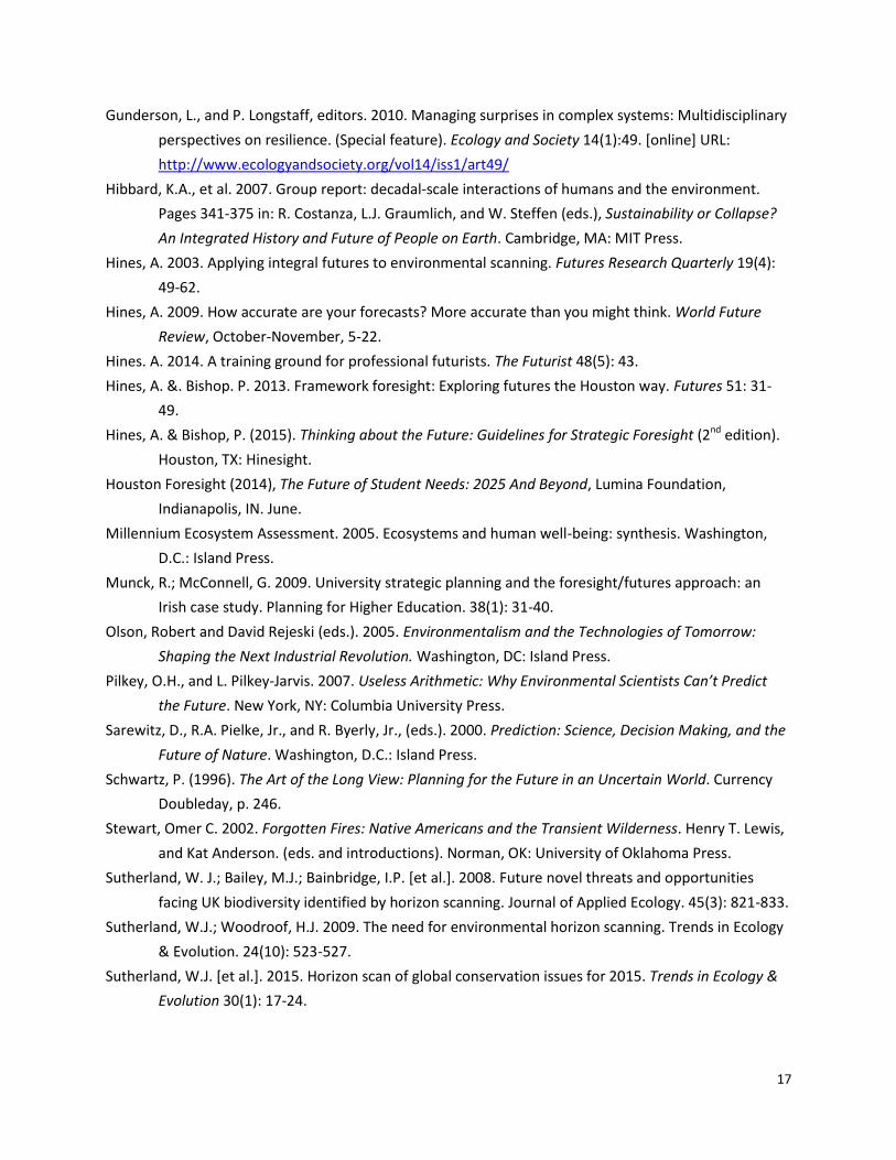
(Hines & Bishop 2013). The primary focus for this horizon scanning project involves the first two steps of
the Framework Foresight process: Framing the topic and its boundaries and scanning to identify
emerging issues. Framing and scanning provide the foundation for forecasting, depicted as the baseline
and alternative futures in Figure 1. The baseline future or “business-as-usual” assumes continuity with
the present without major surprises: trends stay on track, plans are fulfilled and mainstream projections
are on target. Emerging issues, however, may indicate potential alternative futures, that is, alternative
outcomes to the baseline. Thus the identification of emerging issues provides early warning for potential
shifts or discontinuities from business-as-usual and helps frame alternative future scenarios.
[Figure 1 about here]
Framing
The process begins with framing the domain or topic to be explored. The goal is to scope the topic so
that it is neither too broad nor too narrow (Hines & Bishop, 2015, 374). For this project, natural
resources and the environment were considered as a broader scoping and forests as narrower. After
doing some preliminary scanning, it was decided that forests would provide more focus to scanners.
Natural resources-related scanning hits (e.g., energy, water) were too broad but they could still be
included as they related to forests. Thus, scanners primarily focused on forests but were open to how
4
other natural resources might impact forests. This provided a more useful and focused framing than the
future of natural resources with a secondary focus on forests.
Domain mapping
The domain map is a visual representation of the boundaries and key categories to be explored, or
framed, in scanning. Simple diagrams can be used to represent key categories and sub-categories. Mind
mapping software works well for this. We used the cloud-based Coggle tool <https://coggle.it/>. Most
domains can be usefully mapped with 3-6 main categories and 2-4 sub-categories of each of those.
Typically maps also include a third level (sub-categories of the sub-categories). Beyond that, the map
becomes messy as a communications tool, although the greater level of detail in a domain map can be
helpful to scanners.
A domain map has three primary functions: defining the boundaries of the scanning world, organizing
the data for analysis, and as a communication device for scanners. Detailed domain maps are helpful for
those setting up and managing the scanning process. But for most scanners, especially in a volunteer
capacity, a more streamlined/simplified domain map is more instructive and functional.
The process of creating the domain map is an iterative one. It starts with identifying the important
categories and sub-categories for understanding a particular domain. If the topic is a new one, this can
be challenging and it may require some preliminary background research to get a basic grounding in the
topic. The client or end user of the horizon scanning system should be involved early in the process of
defining the domain because they know their domain well. This was the case for the USFS employees
who were involved in this project.
Important questions to help identify key topics in a domain map include:
What are the key activities that take place in the domain?
Who are the key stakeholders in the domain?
What has been driving change in the domain?
In some cases, one of these questions will prove fruitful as an organizing theme. In the USFS case, a
hybrid of all three proved useful. Six first-level categories formed the core of the map. Twenty second-
level categories were linked to them. Third and fourth-level categories were identified as appropriate,
resulting in nearly 100 categories in total. Each of the primary categories is represented as a main
branch: ecosystem, industry, institutions, stewardship, climate, and STEEP (Social, Technological,
Economic, Environmental, and Political) (see Figure 2). The ecosystems branch could be viewed as a
stakeholder, but also is the context for most USFS activities. The industry branch represents a key
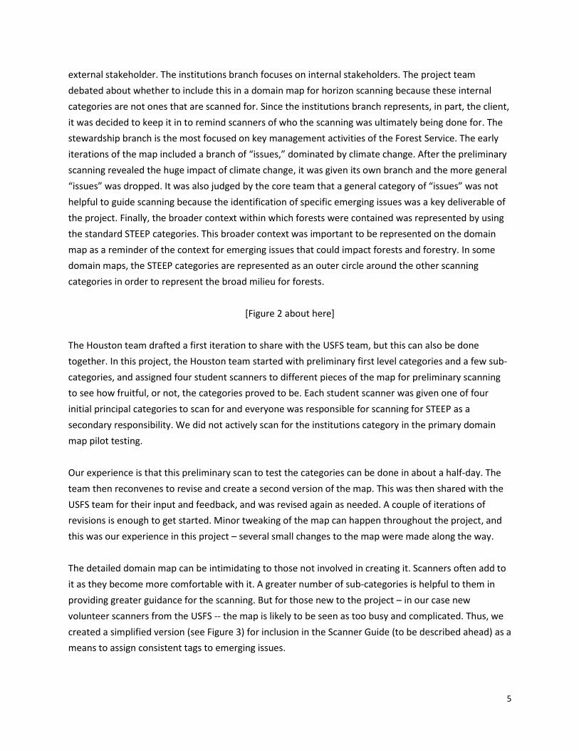
5
external stakeholder. The institutions branch focuses on internal stakeholders. The project team
debated about whether to include this in a domain map for horizon scanning because these internal
categories are not ones that are scanned for. Since the institutions branch represents, in part, the client,
it was decided to keep it in to remind scanners of who the scanning was ultimately being done for. The
stewardship branch is the most focused on key management activities of the Forest Service. The early
iterations of the map included a branch of “issues,” dominated by climate change. After the preliminary
scanning revealed the huge impact of climate change, it was given its own branch and the more general
“issues” was dropped. It was also judged by the core team that a general category of “issues” was not
helpful to guide scanning because the identification of specific emerging issues was a key deliverable of
the project. Finally, the broader context within which forests were contained was represented by using
the standard STEEP categories. This broader context was important to be represented on the domain
map as a reminder of the context for emerging issues that could impact forests and forestry. In some
domain maps, the STEEP categories are represented as an outer circle around the other scanning
categories in order to represent the broad milieu for forests.
[Figure 2 about here]
The Houston team drafted a first iteration to share with the USFS team, but this can also be done
together. In this project, the Houston team started with preliminary first level categories and a few sub-
categories, and assigned four student scanners to different pieces of the map for preliminary scanning
to see how fruitful, or not, the categories proved to be. Each student scanner was given one of four
initial principal categories to scan for and everyone was responsible for scanning for STEEP as a
secondary responsibility. We did not actively scan for the institutions category in the primary domain
map pilot testing.
Our experience is that this preliminary scan to test the categories can be done in about a half-day. The
team then reconvenes to revise and create a second version of the map. This was then shared with the
USFS team for their input and feedback, and was revised again as needed. A couple of iterations of
revisions is enough to get started. Minor tweaking of the map can happen throughout the project, and
this was our experience in this project – several small changes to the map were made along the way.
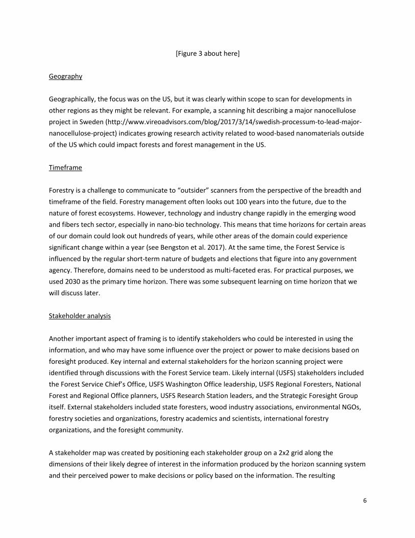
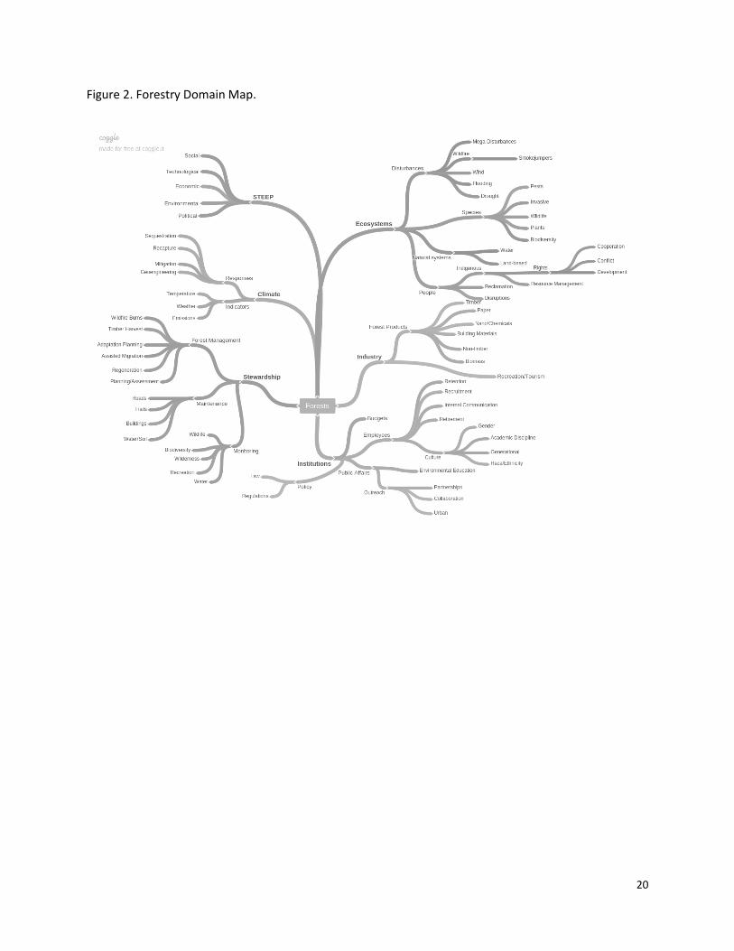
The detailed domain map can be intimidating to those not involved in creating it. Scanners often add to
it as they become more comfortable with it. A greater number of sub-categories is helpful to them in
providing greater guidance for the scanning. But for those new to the project – in our case new
volunteer scanners from the USFS -- the map is likely to be seen as too busy and complicated. Thus, we
created a simplified version (see Figure 3) for inclusion in the Scanner Guide (to be described ahead) as a
means to assign consistent tags to emerging issues.
6
[Figure 3 about here]
Geography
Geographically, the focus was on the US, but it was clearly within scope to scan for developments in
other regions as they might be relevant. For example, a scanning hit describing a major nanocellulose
project in Sweden (http://www.vireoadvisors.com/blog/2017/3/14/swedish-processum-to-lead-major-
nanocellulose-project) indicates growing research activity related to wood-based nanomaterials outside
of the US which could impact forests and forest management in the US.
Timeframe
Forestry is a challenge to communicate to “outsider” scanners from the perspective of the breadth and
timeframe of the field. Forestry management often looks out 100 years into the future, due to the
nature of forest ecosystems. However, technology and industry change rapidly in the emerging wood
and fibers tech sector, especially in nano-bio technology. This means that time horizons for certain areas
of our domain could look out hundreds of years, while other areas of the domain could experience
significant change within a year (see Bengston et al. 2017). At the same time, the Forest Service is
influenced by the regular short-term nature of budgets and elections that figure into any government
agency. Therefore, domains need to be understood as multi-faceted eras. For practical purposes, we
used 2030 as the primary time horizon. There was some subsequent learning on time horizon that we
will discuss later.
Stakeholder analysis
Another important aspect of framing is to identify stakeholders who could be interested in using the
information, and who may have some influence over the project or power to make decisions based on
foresight produced. Key internal and external stakeholders for the horizon scanning project were
identified through discussions with the Forest Service team. Likely internal (USFS) stakeholders included
the Forest Service Chief’s Office, USFS Washington Office leadership, USFS Regional Foresters, National
Forest and Regional Office planners, USFS Research Station leaders, and the Strategic Foresight Group
itself. External stakeholders included state foresters, wood industry associations, environmental NGOs,
forestry societies and organizations, forestry academics and scientists, international forestry
organizations, and the foresight community.
A stakeholder map was created by positioning each stakeholder group on a 2x2 grid along the
dimensions of their likely degree of interest in the information produced by the horizon scanning system
and their perceived power to make decisions or policy based on the information. The resulting
7
stakeholder map can be used to identify individuals or groups to contribute to the horizon scanning
project as volunteer scanners or to help in the analysis of the emerging issues. Additionally, the
stakeholder analysis can help the project team develop multiple communication and dissemination
products tailored to key stakeholder groups and an overall communication strategy. This enhances the
chances that stakeholders will use the emerging issues in decision making because the information is
specifically designed for their needs.
Guiding question
A guiding question captures why the topic is being investigated. Framework Foresight suggests there are
two useful types of guiding questions: strategic and exploratory. A strategic question guides a project
motivated by a specific purpose. For instance, “should we invest in Blockchain technology?” The project
is then designed to provide insight to help answer the question. An exploratory project, on the other
hand, does not have a specific purpose and the guiding question is more open-ended and aimed at
learning what the key issues or questions are for a broad topical area. Our project was exploratory and
the guiding question was: What emerging issues might impact forests, forestry, and the USFS in the
future? While the horizon scanning and guiding question for identifying emerging issues is exploratory,
the project also had the goal of setting up a formal ongoing horizon scanning system.
Framing sets the stage for the next step: scanning.
Scanning process
Horizon scanning has sometimes been criticized for a lack of rigor and most good scanners have
difficulty communicating their process for scanning (Hines 2003). Scanning, and futures research in
general (Burns 2005), is sometimes viewed as more art than science. Horizon scanning is often
characterized more by informal guidelines than methodological rigor, especially when compared to the
many variations of forecasting techniques.
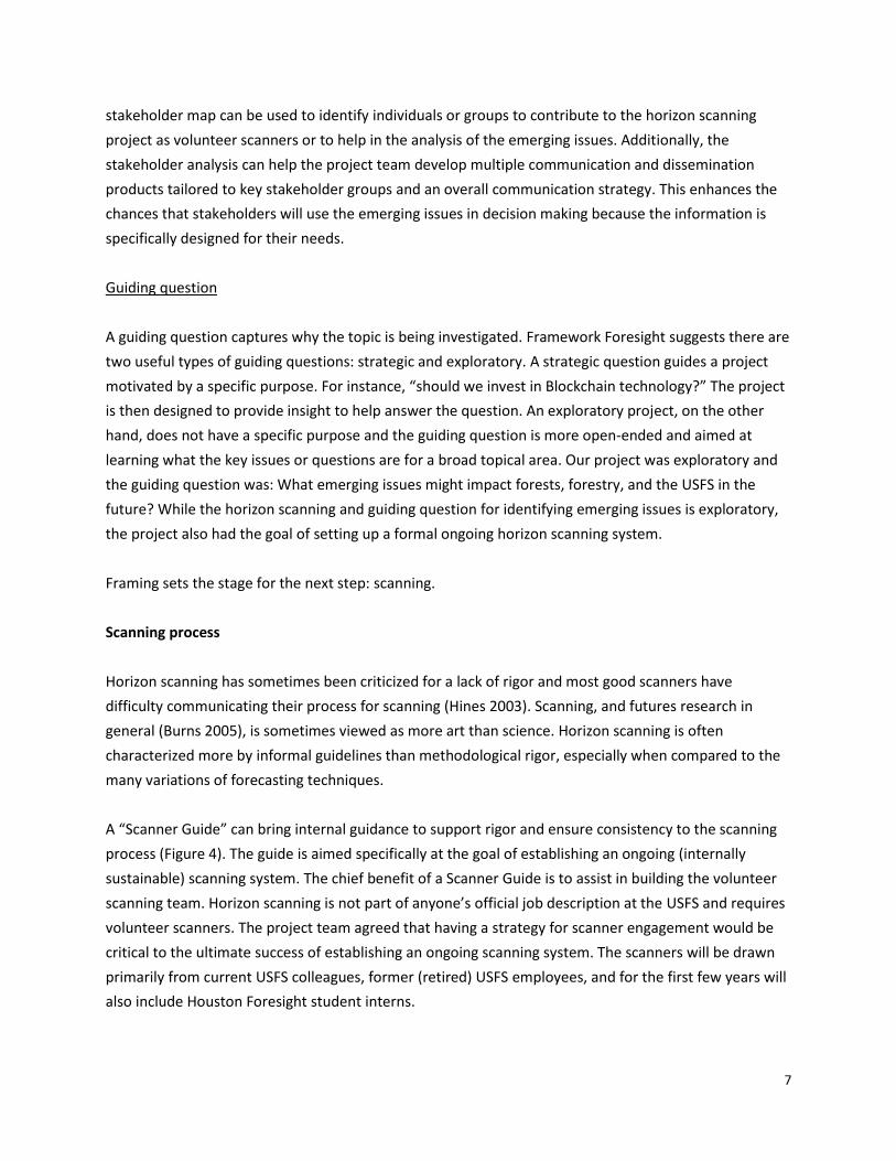
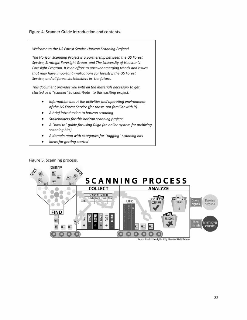
A “Scanner Guide” can bring internal guidance to support rigor and ensure consistency to the scanning
process (Figure 4). The guide is aimed specifically at the goal of establishing an ongoing (internally
sustainable) scanning system. The chief benefit of a Scanner Guide is to assist in building the volunteer
scanning team. Horizon scanning is not part of anyone’s official job description at the USFS and requires
volunteer scanners. The project team agreed that having a strategy for scanner engagement would be
critical to the ultimate success of establishing an ongoing scanning system. The scanners will be drawn
primarily from current USFS colleagues, former (retired) USFS employees, and for the first few years will
also include Houston Foresight student interns.
8
[Figure 4 about here]
The Scanning Guide is envisioned as a living document that is continuously updated as new insights are
gained into improving scanning effectiveness. The project is already on Version 9 of the guide, although
many of the upgrades were fairly minor. The guide was developed for both the Forest Service volunteers
and the UH Foresight students. A challenge in developing the guide was to make it relevant to the
diversity of scanners: The USFS team has more in-depth subject and technical knowledge, while the
Houston Foresight students are already familiar with scanning. For scanners associated with the Forest
Service, the forestry information in the Scanner Guide serves only as a general refresher, while their
main focus will be on understanding what scanning is and how to effectively perform the function. For
Houston Foresight students, the main focus is on learning more about the Forest Service and forestry,
while the scanning materials is simply a refresher.
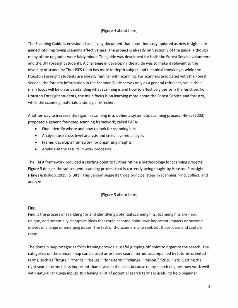
Another way to increase the rigor in scanning is to define a systematic scanning process. Hines (2003)
proposed a generic four-step scanning framework, called FAFA:
Find: identify where and how to look for scanning hits
Analyze: use cross-level analysis and cross-layered analysis
Frame: develop a framework for organizing insights
Apply: use the results in work processes
The FAFA framework provided a starting point to further refine a methodology for scanning projects.
Figure 5 depicts the subsequent scanning process that is currently being taught by Houston Foresight
(Hines & Bishop, 2015, p. 381). This version suggests three principal steps in scanning: Find, collect, and
analyze.
[Figure 5 about here]
Find
Find is the process of searching for and identifying potential scanning hits. Scanning hits are new,
unique, and potentially disruptive ideas that could at some point have important impacts or become
drivers of change or emerging issues. The task of the scanners is to seek out these ideas and capture
them.
The domain map categories from framing provide a useful jumping-off point to organize the search. The
categories on the domain map can be used as primary search terms, accompanied by futures-oriented
terms, such as “future,” “trends,” “issues,” “long-term,” “change,” “vision,” “2030,” etc. Getting the
right search terms is less important than it was in the past, because many search engines now work well
with natural language inputs. But having a list of potential search terms is useful to help beginner
9
scanners get started. Many tools are available for finding and monitoring up-to-the-minute information,
such as internet feeds and alerts, as well as sources beyond simple search engines such as specialized
databases.
Collect
Collect is the process of storing and categorizing scanning hits after they have been identified. There are
several online cloud-based bookmarking tools with tagging capabilities that can handle group inputs.
The convenience and functionality of these sites over an old-fashioned spreadsheet list and tags are
compelling. First and foremost, a geographically diverse team can add their scanning hits to a private
project library whenever and wherever they are. A spreadsheet can be used in a cloud-based file-sharing
system as well, but it takes far more time and runs the risk of version control problems. The Diigo site
was used in the USFS project (www.diigo.com). Diigo is easy to access and has a user-friendly interface,
setup, and export functions that are well-suited for a virtual team scanning project.
The purpose of collecting is to keep track of the scanning hits that might provide the basis for identifying
an emerging issue. As scanners find an article, blog post, video, or whatever item they would like to
collect as a scan hit, they use a “Diigolet” icon installed on their web browser to link it to the team
library in Diigo. The Scanner Guide provides instructions for scanners on how to set up their web
browser and link to the Diigo account. For each scanning hit, the scanner provides a short summary of
why they selected the article. This can simply involve cutting and pasting a descriptive paragraph from
the piece itself and/or can include commentary from the scanner. The scanner also adds a sentence or
two about potential implications of the scanning hit for the project, in our case the implications of the
scanning hit for forests, forestry, and the USFS.
It is crucial that scanners tag their scanning posts with a set of descriptors. This keeps the scanning
library organized and easily searchable. Framework Foresight uses the domain map hierarchy as the
basis of the tagging system. For example, if a scanner finds an innovative new use for a paper product,
they would tag it with “Industry,” “Forest Products,” and “Paper”. This is not an exact science, but more
precise tagging aligned with the domain map leads to more efficient searching of the library of scanning
hits and aids in the analysis and communication of results. The tagging system enables a visitor to the
library to quickly access, for example, all the ecosystem related articles. The library’s front page keeps
track of the top 10 tags, which can provide an indication of whether certain topics are being neglected
or over-emphasized.
A tagging system based on the domain map is useful in organizing the scanning library (Houston
Foresight 2014). For the USFS project, the first and second level domain map categories were to be used
at a minimum as tags. Third or even fourth-level tags could be included and it was suggested to include a
10
few article-specific tags as well if necessary. Scanning is an iterative process and there is flexibility to add
new tags or even edit the map as the scanners learn more about the topic and emerging issues.
Analyze
Analyze is a sense-making activity that involves prioritizing the various scanning hits collected.
Framework Foresight suggests three degrees or levels of analysis, ranging from a simple triage to multi-
criteria rankings to sophisticated weighted indices. Some horizon scanning efforts include pruning
scanning hits that are deemed less relevant. This is effective when the focus of the horizon scanning
effort is more targeted. In our case, all scan hits were kept in the data base.
The triage level of analysis involves making a quick judgment about a scanning hit. Framework Foresight
uses a simple three level ranking system:
A “1” or low score is assigned to those hits judged to be “confirming” what is already fairly well-
know. In our terminology, it confirms the baseline future. For example, a scanning hit suggesting
that wildfire management will consume a growing share of the USFS budget.
A “3” or medium score is for those hits that “resolve” in favor one of the major known
alternative futures. It may be an issue in dispute, a driver that could play out in different
directions, or a fundamental uncertainty, and the hit provides evidence for one of the possible
alternatives. For example, a scanning hit providing evidence of a paradigm shift in fire
management from a “war on fire” to “living with fire.”
A “5” or high score is assigned to scanning hits that suggest a “novel” future possibility and have
enough plausibility to be worthy of further consideration. For example, a scanning hit describing
genetic engineering to reduce the impacts of forest fires by making trees less flammable.
The triage analysis can be used in several different ways depending upon the goals of the analysis. It
could eliminate scanning hits from analysis that were scored 1 if conformational scanning hits were not
important for decision makers to weigh possible future policy directions. Additionally, the triage analysis
could just selects the 5’s if the goal is to provide emerging issues on novel emerging issues. There may
also be a reason to tweak the scores in a particular project. For example, if the decision maker or client
is most interested in more plausible and less speculative futures, the resolving hits may be scored higher
than the novel hits.
The second level of analysis evaluates the scanning hits that made it through triage and are further
filtered using seven criteria: credibility, novelty, likelihood, impact, relevance, time to awareness
(timeliness 1), and time to prepare (timeliness 2). Two or three criteria from this list are often sufficient
for narrowing down the scanning hits at this level of analysis. There are several questions used for each
of the seven criteria to determine a scanning hit’s level of each criteria. The questions are as follows:
11
Credibility
Is the source reputable?
Are there confirmations elsewhere?
Novelty
Is the hit new? Or has it been widely reported?
Is it new to the client/audience?
Likelihood
What are the chances that the hit will occur, and that it will amount to something?
Impact
Will it change the future?
If it does change the future, how big a change will that be?
Relevance
How important is that change to the client or the domain?
Is the relevance direct or indirect?
Timeliness 1 (time to awareness)
How long before this information is widely known?
When will it appear in a mainstream newspaper or magazine?
Are there resources to influence the potential outcome suggested by the hit?
Timeliness 2 (time to prepare)
How long before this hit begins to change the future?
Is it too late to do anything about it?
Is it so far off that action now would be premature?
Answers for each criteria will determine which scanning hits should be used in an analysis. As with
triage, this is determined by the goal of the analysis. For example, if the goal is to find novel scanning
hits from credible sources that take a long time to prepare for, those scanning hits can be identified and
analyzed.
The third level of analysis is a weighted index. This can be done by using the seven criteria above and
weight criteria deemed more important to the project. Then a total number can be calculated for each
scanning hit and this can be used to list the scanning hits in order of importance according to the
weighted criteria. This is “over-kill” for most projects, but in a scanning project in which the scanning
hits themselves are the deliverable, this could be a useful option. Additionally, this analysis option could
also serve to give more weight to scanning hits with long or varied time horizons which could be
important for identifying emerging issues for forestry where the ultimate impacts to forests may happen
decades or centuries into the future.
III. Lessons Learned
12
This section describes what has been learned so far as the project enters its second year of operation.
1. Background information versus scanning
The Framework Foresight process makes the distinction that background information or background
research covers the recent history and current conditions of the domain being explored, and scanning
covers what might be changing in the future. Thus, scanning hits should be relatively new in terms of
when they were published – within the last few years is our general rule of thumb. If something
interesting was said ten years ago, that is history and part of background information. In some cases,
that “something said” was largely ignored and thus appears as new information. Our view is that it is still
part of history and background research. For example, in the early 1960s Omer Stewart identified the
role of fire as important for ecological systems across the world and that fire has been used for
thousands of years by indigenous people (Stewart 2002). This work was largely ignored by foresters and
ecologists for decades. Now, however, there is a major shift in ecological thinking that conforms to
many of Stewart’s ideas. While these ideas seem new on the surface, they should be considered part of
the historical background and not part of future emerging trends.
2. “New to me versus new to the world”
This is similar to the point above, but can involve recent information. The problem of “new to me versus
new to the world” is frequently encountered in teaching beginning foresight students about scanning,
and the use of websites such as “How Stuff Works” as a source of scanning hits should be discouraged.
These are great sources of background information and can seem like new ideas or trends, but they are
really just new to the scanner. Everything can seem new and interesting to one who is exploring a topic
for the first time. But some of this may be “old hat” to those with experience in the field. Thus, it is
important to calibrate whether something that seems new really is new. Having experts in forestry from
the USFS involved was important in identifying forestry related hits that were not new to the agency or
the field of forestry but may seem new to student scanners. Ecosystem management or ecological
forestry, for example, seem to be new concepts to non-forestry professionals; however, they are
concepts with decades-old roots and far from novel within forestry.
3. How to handle “coaching” of volunteers
Some volunteers may not read the Scanner Guide and just plunge in and add hits that are off-track or
below standard. Coaching and other reminders about the goals of the scanning project can help keep
scanners focused on useful hits. Our approach was to be careful to avoid being perceived as
condescending or overly academic in giving feedback to volunteer scanners. If the feedback is seen as
13
too harsh, the volunteers may become discouraged and drop out. Instead, we conducted team “check-
ins” to provide scanning tips. For instance, the issue of background information being tagged as new
scanning hits (see #1 above) prompted the suggestion to focus on recent emerging issues and
developments – within the past year or so – rather than things that happened years ago. Other ways
that scanners can go off-track are either being too focused on the present, so the hits proposed are not
sufficiently future oriented (e.g., entering an article about ongoing deforestation in the tropics), or the
scanner entering hits that are potentially game changing but for a different domain (e.g., entering an
article about the detection of gravitational waves to a horizon scanning effort about forestry).
4. Moving beyond forests and forestry
A challenge for outside scanners, and in framing the domain, was trying to get “beyond forests” or
“beyond trees.” The Forest Service deals with many concerns affecting forests and forestry
organizations, including climate change, wildlife, outdoor recreation, water, grazing, urban forestry,
indigenous rights, and many more. And all of these concerns are affected by social, technological,
economic, and political change. For instance, the Scanner Guide suggested that scanners “focus mostly
(but not entirely) on “outside” issues and change, i.e., things that are originating outside of the field of
forestry and natural resources but could impact the field in the future. Many leaders and policy makers
within the field are already aware of emerging issues and change originating within the sector. This issue
inspired a special project to develop a list of sources for the scanners to start with.
5. Staying connected
This is the opposite of the previous issue. Some scanning hits seemed to be entirely disconnected from
the concerns of forestry. Granted, there was an explicit goal of connecting the external world to the
Forest Service, but there did need to be some connection. The suggestion here was to ask scanners to
add a comment after the description of their scanning hit explaining its possible implications or
relevance to forestry or the Forest Service. For example, a possible implication for forests and forest
management of self-driving cars is that their adoption could encourage more sprawling development
patterns (as long commutes are no longer wasted time), resulting in increased fragmentation of forests.
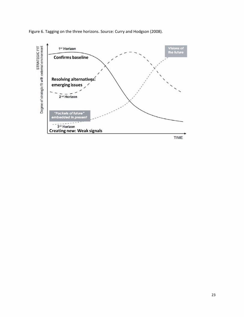
6. Stretching into the future
The project team also sought to find a way to encourage scanners to get further into the future.
Scanners were asked to tag each of their hits with the appropriate horizon (Figure 6):
Horizon 1: focuses on the current prevailing system – the baseline -- as it continues into the
future, which loses "fit" over time as its external environment changes
14
Horizon 2: an intermediate space of transition in which alternative futures begin emerging as
the first and third horizons collide
Horizon 3: focuses on “weak signals” about the future of the system which may seem marginal
in the present, but which could signal significant change in the long-term
The judgment of which time horizon is most appropriate for a scanning hit is subjective, but the process
of tagging hits with time horizons may encourage more long-term thinking and more Horizon 3 hits, i.e.,
if someone sees all their hits seem to be in Horizon 1 or 2, they could make an adjustment in their
scanning approach.
At the time of this writing, the breakdown of hits by time horizon is 42 percent Horizon 1, 38 percent
Horizon 2, and 20 percent Horizon 3. It is not surprising that there are fewer Horizon 3 hits, but that will
be monitored going forward.
7. Tagging discipline
Tagging “discipline” – i.e., accuracy and completeness in assigning descriptive tags to scanning hits -- can
be a challenge. The tagging instructions in the Scanner Guide reminded scanners to refer back to the
domain map: “Tags should be 1st level [of the domain map], 2nd level, 3rd level, something specific to
the piece, and then which time horizon the hit targets.” Addressing this level of feedback may be a bit
much to ask volunteers. The Houston team has occasionally performed tagging tune-ups and edited the
library of scanning hits. Tagging discipline will be increasingly important as the library grows. As of this
writing, there were already more than 700 hits in the library, so finding items of interest would be a
challenge without an accurate tagging system.
8. Current issues
To properly frame emerging issues it is important to first identify a list of existing or current issues facing
the USFS. There is no clear source with a formal list of issues for the agency. Therefore, the USFS UH
team reviewed Forest Service strategic plan (USDA Forest Service 2015) and other planning documents,
to identify current issues. A list of 13 widely recognized current issues were identified, including the
growing effects of climate change, more frequent and intense wildfires, and increasing forest
fragmentation due to development. This list of current issues was added to the Scanner Guide to help
scanners focus on additional emerging issues identified through horizon scanning rather than well-
known current issues.
IV. Going forward
15
The challenges identified in the preceding section should provide plenty of work for the project team to
keep the horizon scanning system in good working order—current, relevant, and consistent. There is
plenty of additional work to communicate horizon scanning hits and to develop information to feed into
additional strategic foresight projects, like the integration of the horizon scanning system with scenario
development. Beyond what has already been identified, there are a few other opportunities that the
project team would like to explore.
1. Strategies for communicating results
As is to be expected in the beginning phase of a scanning project, a significant amount of information
has been gathered. The Diigo scanning library is large and growing. Synthesis always lags behind
gathering, but we have now reached the time for more emphasis on synthesis and communicating
results. The team is working on developing a horizon scanning newsletter and periodic reports. This
paper, and other planned journal papers as well as conference presentations, will also communicate
results of this horizon scanning effort.
2. Options for organizational structure
The primary goal for this project has been to get the horizon scanning system up and running and
generating useful foresight for the organization. A complementary and longer-term goal is to integrate
foresight more tightly into the organization’s decision making and policy making. The current scanning
system is designed around a volunteer model. The team acknowledges that this could be a challenging
model to rely on for the long term. Volunteers have many things competing for their time. Once a
proven concept, foresight may garner support to continue as a staffed, dedicated effort. The project
might explore different options in terms of developing ways to embed foresight into the organization.
3. Transitioning the horizon scanning system to the Forest Service
The joint project has the ultimate goal of developing a system that can be run without assistance from
the Houston Foresight program. It may be that Houston Foresight students could continue as interns,
but the goal remains that the system be self-sustaining. An assessment of the system to determine its
effectiveness and ongoing needs may be needed as the transition to full operation by the Forest Service
approaches.
V. Conclusion
The USFS-UH horizon scanning project has provided an opportunity to experiment real-time with
academic approaches and in-the-field practice of strategic foresight methods. Horizon scanning has
16
often proven elusive to teach and to institutionalize within organizations. The project team has used a
learning, iterative approach to develop the scanning process that we hope will be sustainable within the
organization beyond the initial project. This paper has described the set-up process and what has been
learned to date. The challenge ahead is for the process to produce useful results such that formal
horizon scanning will become an indispensable component of the work of the USFS as it moves into an
increasingly uncertain and challenging future. In addition to serving the needs of the USFS, it is hoped
that this project might also provide useful lessons for futurists and their clients in setting up systems in
different fields.
References
Bengston, David N., comp. 2012. Environmental futures research: experiences, approaches, and
opportunities. Gen. Tech. Rep. NRS-P-107. Newtown Square, PA: U.S. Department of
Agriculture, Forest Service, Northern Research Station, p. 1.
Bengston, David N. 2013. Horizon scanning for environmental foresight: a review of issues and
approaches. Gen. Tech. Rep. NRS-121. Newtown Square, PA: U.S. Department of Agriculture,
Forest Service, Northern Research Station. 20 p. URL:
http://www.treesearch.fs.fed.us/pubs/44822
Bengston, D., Peck, J., Olson, R. Barros, M., Birdsey, R., Leyva Reyes, J.C., Malouin, C. 2017. North
American Forest Futures 2016 - 2090: Aspirational Futures for Building a More Resilient Forest
Sector. Review draft, USDA Forest Service, Northern Research Station, St. Paul, MN.
Bishop, P. 2009. Horizon scanning: Why is it so hard? Houston, TX: University of Houston. Available at
http://www.law.uh.edu/faculty/thester/courses/Emerging%20Tech%202011/Horizon%20Scanni
ng.pdf. (Accessed April 14, 2017).
Burns, A. 2005. Is Futures Studies a Science or An Art? In Slaughter, Richard (Ed.). Volume 1:
Foundations. The Knowledge Base of Futures Studies: Professional Edition. Indooroopilly,
Australia: Foresight International. (CD-ROM edition).
Choo, C.W. 2002. Information management for the intelligent organization: the art of scanning the
environment. 3rd ed. Published for the American Society for Information Science. Medford, NJ:
Information Today, Inc. 325 p.
Curry, A. and A. Hodgson. 2008. Seeing in multiple horizons: Connecting futures to strategy. Journal of
Futures Studies 13(1): 1-20. http://www.jfs.tku.edu.tw/13-1/A01.pdf
de Haan, J. 2006. How emergence arises. Ecological Complexity 3(4): 293-301.
Douw, K.; Vondeling, H. 2006. Selection of new health technologies for assessment aimed at informing
decision making: a survey among horizon scanning systems. International Journal of Technology
Assessment in Health Care. 22(2): 177-183.
Gordon, T.J.; Glenn, J.C. 2009. Environmental scanning. In: Glenn, J.C.; Gordon, T.J., eds. Futures
research methodology—version 3.0 [CD-ROM]. Washington, DC: The Millennium Project.
17
Gunderson, L., and P. Longstaff, editors. 2010. Managing surprises in complex systems: Multidisciplinary
perspectives on resilience. (Special feature). Ecology and Society 14(1):49. [online] URL:
http://www.ecologyandsociety.org/vol14/iss1/art49/
Hibbard, K.A., et al. 2007. Group report: decadal-scale interactions of humans and the environment.
Pages 341-375 in: R. Costanza, L.J. Graumlich, and W. Steffen (eds.), Sustainability or Collapse?
An Integrated History and Future of People on Earth. Cambridge, MA: MIT Press.
Hines, A. 2003. Applying integral futures to environmental scanning. Futures Research Quarterly 19(4):
49-62.
Hines, A. 2009. How accurate are your forecasts? More accurate than you might think. World Future
Review, October-November, 5-22.
Hines. A. 2014. A training ground for professional futurists. The Futurist 48(5): 43.
Hines, A. &. Bishop. P. 2013. Framework foresight: Exploring futures the Houston way. Futures 51: 31-
49.
Hines, A. & Bishop, P. (2015). Thinking about the Future: Guidelines for Strategic Foresight (2nd edition).
Houston, TX: Hinesight.
Houston Foresight (2014), The Future of Student Needs: 2025 And Beyond, Lumina Foundation,
Indianapolis, IN. June.
Millennium Ecosystem Assessment. 2005. Ecosystems and human well-being: synthesis. Washington,
D.C.: Island Press.
Munck, R.; McConnell, G. 2009. University strategic planning and the foresight/futures approach: an
Irish case study. Planning for Higher Education. 38(1): 31-40.
Olson, Robert and David Rejeski (eds.). 2005. Environmentalism and the Technologies of Tomorrow:
Shaping the Next Industrial Revolution. Washington, DC: Island Press.
Pilkey, O.H., and L. Pilkey-Jarvis. 2007. Useless Arithmetic: Why Environmental Scientists Can’t Predict
the Future. New York, NY: Columbia University Press.
Sarewitz, D., R.A. Pielke, Jr., and R. Byerly, Jr., (eds.). 2000. Prediction: Science, Decision Making, and the
Future of Nature. Washington, D.C.: Island Press.
Schwartz, P. (1996). The Art of the Long View: Planning for the Future in an Uncertain World. Currency
Doubleday, p. 246.
Stewart, Omer C. 2002. Forgotten Fires: Native Americans and the Transient Wilderness. Henry T. Lewis,
and Kat Anderson. (eds. and introductions). Norman, OK: University of Oklahoma Press.
Sutherland, W. J.; Bailey, M.J.; Bainbridge, I.P. [et al.]. 2008. Future novel threats and opportunities
facing UK biodiversity identified by horizon scanning. Journal of Applied Ecology. 45(3): 821-833.
Sutherland, W.J.; Woodroof, H.J. 2009. The need for environmental horizon scanning. Trends in Ecology
& Evolution. 24(10): 523-527.
Sutherland, W.J. [et al.]. 2015. Horizon scan of global conservation issues for 2015. Trends in Ecology &
Evolution 30(1): 17-24.

18
U.S. Army Environmental Policy Institute. [n.d.]. Homepage. Available at http://www.aepi.army.mil/.
(Accessed April 14, 2015).
19
Figure 1. Key Framework Foresight Elements for Scanning Project
20
Figure 2. Forestry Domain Map.
21
Figure 3. Tagging Domain Map.
22
Figure 4. Scanner Guide introduction and contents.
Figure 5. Scanning process.
Welcome to the US Forest Service Horizon Scanning Project!
The Horizon Scanning Project is a partnership between the US Forest
Service, Strategic Foresight Group and The University of Houston’s
Foresight Program. It is an effort to uncover emerging trends and issues
that may have important implications for forestry, the US Forest
Service, and all forest stakeholders in the future.
This document provides you with all the materials necessary to get
started as a “scanner” to contribute to this exciting project:
Information about the activities and operating environment
of the US Forest Service (for those not familiar with it)
A brief introduction to horizon scanning
Stakeholders for this horizon scanning project
A “how to” guide for using Diigo (an online system for archiving scanning hits)
A domain map with categories for “tagging” scanning hits
Ideas for getting started
23
Figure 6. Tagging on the three horizons. Source: Curry and Hodgson (2008).