sfa best practices
TRANSCRIPT
8/3/2019 Sfa Best Practices
http://slidepdf.com/reader/full/sfa-best-practices 1/8
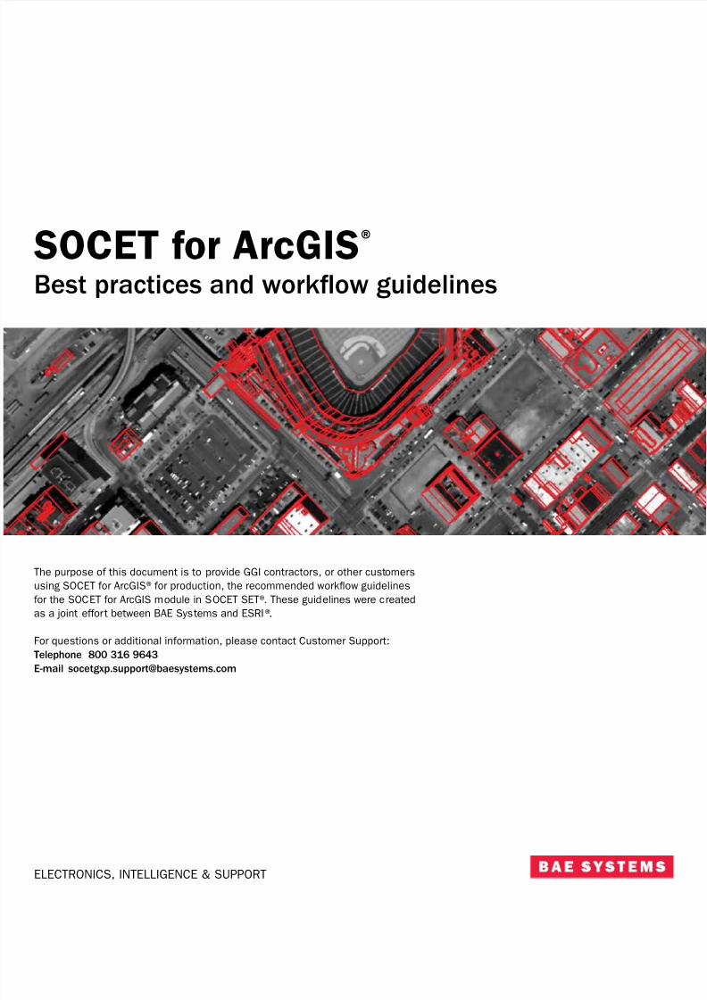
SOCET or ArcGIS®
ELECTRONICS, INTELLIGENCE & SUPPORT
Best practices and workow guidelines
The purpose o this document is to provide GGI contractors, or other customersusing SOCET or ArcGIS®or production, the recommended workow guidelines
or the SOCET or ArcGIS module in SOCET SET®. These guidelines were createdas a joint eort between BAE Systems and ESRI®.
For questions or additional inormation, please contact Customer Support:Telephone 800 316 9643
E-mail [email protected]
8/3/2019 Sfa Best Practices
http://slidepdf.com/reader/full/sfa-best-practices 2/8
SOCET or ArcGIS® Best practices and workow guidelines
Minimum sotware requirements
– Assumes technology dated 11/15/2007
– ArcGIS 9.2 service pack (SP) 3, SP4 pending; Production Line Tool Set (PLTS) 9.2, Foundation SP3; PLTS 9.2 Deense SP1,
SP2 pending
– ArcSDE®9.2 SP3
– SOCET SET v5.4.1
Hardware requirements
– Gigabit network
– Newer system: Dell Precision 690 dual core or equivalent
– Microsot®Windows®XP SP2, 32-bit, latest updates
– Maximize RAM
– New graphics card: nVidia Quadro FX 4600 PCI Express or equivalent
– Dual monitors
– Dual hard drives: new technology
System confguration
– Latest service packs or hardware and sotware
– Optimize graphics card confguration, i available
– See link below, How To: Increase perormance to make ArcMap®start and run aster
Application settings
– ArcMap properties: ArcGIS map document fle (MXD) properties•Adjust properties to save relative paths; makes MXDs more portable•Adjust properties to not save image thumbnail with map; or aster saves•Make newly added layers not visible by deault (uncheck)
– ArcMap advanced user settings•Adjust data rame reresh rate•Adjust current monitor dimensions•Adjust mouse move edit tolerance; limits accidental movement o eatures•Adjust JET Engine max number o records to calculate; requires admin privileges
Use PLTS orums and knowledge base articlessupport.esri.com/index.cm?a=homepage.homepage
support.esri.com/index.cm?a=sotware.flteredGateway&PID=34
8/3/2019 Sfa Best Practices
http://slidepdf.com/reader/full/sfa-best-practices 3/8
SOCET or ArcGIS® Best practices and workow guidelines
Pre-production
– Build project specifc ReViewer batch jobs
– Customize VVTs/CNTs/FFTs
– Use FFTs to flter unused items or assign unattached domains
– Create PLTS Favorites based on known PSG valid and common attribute combinations
– Create PLTS Metadata Favorites based on source types or project area
– Create topology or production database
– Edgematch plan
– Order o extraction
– Quality control checklist: PLTS GIS Data ReViewer batch jobs
– Use dierent MXDs or dierent tasks•Collection: simple symbology and high level o layer management•Quality assurance and quality control: more complex symbols or relationship visualization•Finishing: complex symbology and labeling
– Data loading•Build appropriate XRe fles or data loading requirements•Validate XRe or potential problems•I ArcSDE:
– Consider saving all edits, removing all versions, removing topology
– Set layers to load only mode – Load into SDE deault
– Reapply topology, validate versions, and continue editing
– Job and AOI management•Consider JTX•Otherwise, use Checkout/Replication to FileGDB, i possible•Some applications such as SOCET or ArcGIS perorm better on a local gdb
8/3/2019 Sfa Best Practices
http://slidepdf.com/reader/full/sfa-best-practices 4/8
SOCET or ArcGIS® Best practices and workow guidelines
Extraction: data collection and updating
– Use map cache
– Use ArcGIS shortcut keys
– Use PLTS context menus, also known as quick menus
– Use PLTS context sensitive help (question mark with arrow) or tool help and descriptions
– Limit number o vertices in eature delineation•Use scale appropriate collection•Place vertices where required to show appropriate eature “character”•Excessive vertices aect the perormance o topology and other tools•Avoid creating excessively large eatures; look or natural breaks and logical junctions
– Collect vertices on eatures where intersections are anticipated, this adds to easy edge sharing, and connecting networks
– Use PLTS cursor halo to remedy spacing requirements
– Use bookmarks to ag signifcant eatures and relationships or review•Reduces excessive panning across AOI; jumps to correct location•Alternatively, add to ReViewer or tracking purposes; enter custom description
– Avoid editing In projected data rame (data rame dierent rom native units o data)•Graphics reresh rates are aster i data does not have to be projected on-the-y•Editing and graphics anomalies may be introduced i edits are perormed on projected data
– Avoid external data sources•Keep as many datasets as possible internal to the edit workspace•Create an ancillary dataset and load necessary support data•Keep all data in the same spatial reerence, such as extraction data•I unavoidable, generate spatial indices or external fles, sample shapefles, and coverages
– Avoid joins and relationships•Oten unavoidable; some models rely on establishing these table relationships•Try adding the tables that participate in the join/relationship to ArcMap•I used during a collection task, remove join/relationship when possible
– Optimize TOC•Empty layers negatively aect redraw and reresh rates; remove empties•Turn o unnecessary layers or visualization•Keep symbology simple by using basic colors and symbols; complexity increases redraw perormance•Limit flls i possible; complex fll patterns have a detrimental eect•Avoid labels on eatures during collection•Avoid using advanced drawing options•Optimize selectable layers•Manage selectable layers based on extraction•Queries are generated against the database or all selectable layers
– Optimize snapping environment•Manage snapping or associated layers; try to have snapping options synced with TOC on and o, and selectable layers•Manage hierarchical order o snapping priorities
•Aect the perormance o snapping and sketch eedback (rubberbanding)•Override snapping using the spacebar
– Scale suppression•Reduce layers drawn at smaller scales; limit admin boundaries, cell boundaries, and so on•Manage scale based on the representative editing scale
– Compact database•Monitor the size and perormance o local geodatabases; edits cause databases to grow•As perormance degrades, compact the database•Schedule a regular cycle or compacting the database
8/3/2019 Sfa Best Practices
http://slidepdf.com/reader/full/sfa-best-practices 5/8
SOCET or ArcGIS® Best practices and workow guidelines
– Monitor MXD size and perormance•MXDs may become ragmented or excessively large•Periodically perorm a Save as command and save a new version o the MXD•Perorming a Save as command removes unnecessary inormation rom the MXD•I an MXD becomes corrupted, attempt to salvage it using the MXDDoctor
– Start edit session zoomed in (large-scale)•Save MXD when zoomed in to the appropriate scale•Limits initial screen reresh time on startup•Use Escape key to cancel out o long reresh cycles
– Use magnifcation window or panning•Avoids needless canvas redraw and reresh•Reduces the times or visualizing data
– Optional: Optimize spatial indexing•Update the spatial indices to enhance spatial query perormance•For personal GDB (*.mdb), the database will have to be recreated; spatial indices cannot be adjusted ater database is create
– Optional: Use redraw toggle•Temporarily stops the redraw event or the ArcMap canvas; allows or quick additions such as point collection on current imag•Optional: Imagery related
– Always ensure that pyramids and statistics are generated or imagery
– I possible, attempt to move at fle imagery to a local drive – Reresh rates are astest or Nearest Neighbor resampling method
– I possible, consider ImageServer and ArcSDE or imagery
– SAVE REGULARLY•Save early, save oten•I using ArcSDE, also reconcile and post requently
– KEEP DATA ON LOCAL MACHINE•I necessary, try to keep client and server on the same operating system generation•Easiest to remove network issues

8/3/2019 Sfa Best Practices
http://slidepdf.com/reader/full/sfa-best-practices 6/8
SOCET or ArcGIS® Best practices and workow guidelines
Resources
How To: Increase perormance to make ArcMap start and run asterwww.support.esri.com/index.cm?a=knowledgebase.techarticles.articleShow&d=31672
FAQ: How can ArcMap symbology perormance be improved and maintained?
www.support.esri.com/index.cm?a=knowledgebase.techarticles.articleShow&d=33098
How To: Compact a map documentwww.support.esri.com/index.cm?a=knowledgebase.techarticles.articleShow&d=31029
Error: ArcMap.exe has generated errors and will be closed by Windowswww.support.esri.com/index.cm?a=knowledgebase.techarticles.articleShow&d=19980
Error: ArcMap.exe has encountered an error and needs to close. We apologize or the inconveniencewww.support.esri.com/index.cm?a=knowledgebase.techarticles.articleShow&d=32797
Problem: ArcCatalog (ArcMap) crashes on shut down and/or displays the ArcToolbox Results tab or several seconds or minutes
www.support.esri.com/index.cm?a=knowledgebase.techarticles.articleShow&d=33192

8/3/2019 Sfa Best Practices
http://slidepdf.com/reader/full/sfa-best-practices 7/8
SOCET or ArcGIS® Best practices and workow guidelines
SOCET or ArcGIS perormance options
Some o these suggestions are covered by the ‘What’s this’ tips on the GUI.
– Disable toggling o Viewport on Top – During initial design, the viewport was envisioned as occupying the ArcMap canvas. Since thdoesn’t happen in practice, it should always be checked.
– Dynamically Match Viewable Extent – I there are several vectors to redraw, having this on can reduce perormance. The ArcMapcanvas resizes and re-centers whenever a zoom event or graphics reresh event happens in the stereo viewport.
– Dynamically reresh ArcMap Canvas – I this is o there will be a small perormance boost since ArcMap doesn’t have to draw eacnew eature created in the stereo viewport. The eatures exist in the ArcMap layer, but won’t be visible until selected.
– Turn o Polygon Fill, Turn o Vertex Icons – This can signifcantly increase the time it takes to reresh graphics in the stereo viewpand increase roaming perormance.
– Disable coordinate transormations – I you know that both the SOCET SET project and the ArcMap layers are the same coordinatesystem, turning this o will give a slight perormance boost. The sotware doesn’t have to convert to the WGS84 coordinate syste
and convert back ater each communication.
– Disable loading map cache – When using SOCET SET Sketch tools, the map cache rereshes ater every insert. Thereore the
eature is available to snap to. Turning this o and rereshing as needed may increase perormance.
– Use the middle mouse button or 3-D snapping with ArcMap tools – Enabling this will increase perormance when snapping is turnon and ArcMap tools are being used. ArcMap tries to snap ater every mouse movement. This can cause slow roaming in the sterviewport. Turning this on disregards the snap attempt until a middle mouse button click is detected.
Perormance tips
– Adjust the coverage o graphics drawn on a reresh. Set it to limited, instead o ull, i you only need to have graphics drawn withinthe MBR o the stereo viewport.
– Use the SOCET or ArcGIS Accelerator Key Mappings. There are shortcuts or changing target layers, zoom, and so on, withouttoggling out o the stereo viewport and doing this in ArcMap.
– Set the minimum and maximum scale or a layer’s visible scale range in ArcMap. SOCET or ArcGIS v5.4.1 will not draw and reresthe eatures in the stereo viewport i either o these thresholds has been crossed.

8/3/2019 Sfa Best Practices
http://slidepdf.com/reader/full/sfa-best-practices 8/8
For more inormation on BAE Systems and GXP produc
Americ
Telephone 800 316 9643 | 703 668 43Fax 703 668 43
Europe, Middle East, and Ari
Telephone +44 1223 3700Fax +44 1223 3700
Asia, Australia, and Pacifc-R
Telephone +61 0 2 6273 01Fax +61 0 2 6273 03
For additional contact inormation and worldwide distributoplease visit our Web si
www.baesystems.com/g
© 2008 BAE Systems National Security Solutions Inc. All rights reserAll trademarks used are the proper ty o their respective own
NS-C3I-120408-0253 EXPORT-CONTROLLED DATA: These commodities, technology, or sotware are contror export in accordance with the U.S. expor t laws. Diversion contrary to U.S. law is prohibited. Releo this brochure is approved as o 12/04/2008. This document gives only a general description o
product(s) or service(s) oered by BAE Systems and, except where expressly provided otherwise, sha
orm part o any contract. From time to time, changes may be made in the products or conditions o su