shared services: developing our potential john lally director of strategic planning david arbeit...
Post on 19-Dec-2015
213 views
TRANSCRIPT

Shared Services:
Developing our Potential
John LallyDirector of Strategic Planning
David ArbeitMinnesota Chief Geospatial Information Services Officer

Shared services
The state’s Master Plan reflects the Governor’s and DTE’s vision of a truly contemporary IT environment, which includes:
Enterprise management of common IT resources -- applications, data, hardware
Recognition of centers of excellence
Support for unique agency missions

Our Blueprint: The Federated Governance
Model
The federated enterprise model balances three ways of managing IT activities for the state
Agency-specific services
Shared services
Utility services
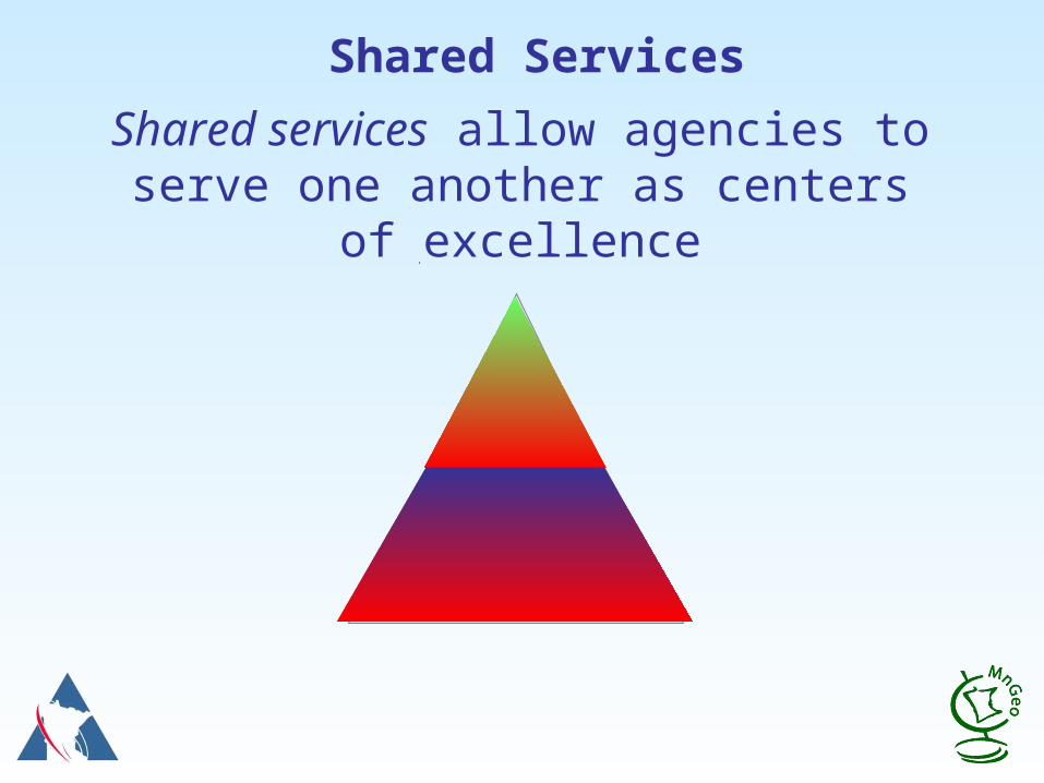
Shared Services
Shared services allow agencies to serve one another as centers of excellence

What are Shared Services? –A working definition
• Processes common to several agencies or levels of government
• Requires special expertise
• Tied to best practices, Centers of Excellence and the service center models
• Provided by lead agencies (or central IT) to other agencies on a cost-sharing basis
• Also called in-sourcing

Shared Services Drivers
• Business units need to realize economies of scale to redirect more resources to front line
• EGS demands 24x7 availability for users and customers
• Diminishing availability of technical staff in some areas
• Security-related requirements (access, authentication) are best met by coordination across the enterprise
• Information sharing requires better integration and data consistency across the enterprise

The potential advantages of shared services
• Direct a larger percentage of the total IT spend to unique applications and customer and agency services
• More efficient management of assets
• Protection of service levels
• Compatibility, interoperability, uniform quality

The potential disadvantages of shared services
• Confused priorities without SLA or equivalent
• Requires governance to set direction, tools and standards

Examples of Shared Services
Examples include:
• Case management
• Document management
• Data warehouse
• Grant management
• Licensing and registration
• Debt collection
• Asset management

Financing shared services
• Partnerships
• Negotiated service level agreements
• Rates or fee-for-service
• Shared assets and resources Staff Programs Data

It’s not just for state agencies
• Local government IT consortia
• E-12 service centers
• Cooperative agreements for support services (parks, community ed)
• Purchasing alliances
A practical test
• Not needed by everybody?
• Requires special expertise?
• Multiple delivery options?
Not needed by everybody?
Requires special expertise?
Multiple delivery options?
Shared Services summary
Directions
• Focus on shared resources
• Partners vs. vendor/customers
• Emphasis on performance and value
Desired Results
• Increased efficiency
• Lower cost
• Wider array of options and services
• Shared governance

Two case studies
Central services: Business continuation planning and operations and Data center consolidation
Distributed services: Geospatial Information Systems and Services

Business Continuation aspects
• Coordination – central oversight
• Planning – central support
• COOP operations – decentralized or combined “Hot” sites Recovery services.

Typical agency Business Continuation situation
• Limited financial & human resources
• Lack of legislative support
• Lack of knowledgeable and committed executive sponsorship
• Lack of desire to do planning when other competing priorities exist
• Lack of appropriate facilities.

Benefits of a shared approach to BC
• Planning expertise, consulting and training available, along with tools and templates
• Living Disaster Recovery Planning System (LDRPS) & enterprise-wide tools
• All state COOPs complementary
• Workspace sharing for business recoveryInteragency agreements

Benefits of a shared approach to BC
• Technology recovery strategies are costly
– State Recovery Center (SRC)
– Hot-site contracts
– Reciprocal agreements w/Wisconsin
– OET equipment and application hosting agreements
• Ability to share costs between organizations
Another central services example: Data Center Consolidation
• The business case:
– Less expensive
– More secure
– More stable
– More efficient

Another central services example: Data Center Consolidation
• The decision:
– One Tier III state data center
– A few Tier II DR sites
– Move to common architectures
– Mix of managed and colocated equipment
– Potential for partners

Distributed SolutionsGeospatial Information Systems and Services
David ArbeitMinnesota Chief Geospatial Information Services Officer

GIS: Not Just for Map Techies Anymore!
• MapQuestMapQuest
• Yahoo MapsYahoo Maps
• Google MapsGoogle Maps
• Google EarthGoogle Earth

Geographic Information is Everywhere
• On your TV
• On the Web
• In your Car
• On your Phone!

Location, Location, Location…
Almost everything we do or are concerned about involves location– People, Places, Things, Events

Geography: Why Do We Care?
Geography is fundamental to almost everything we do in government service
Where is it?
How can I get to it?
What’s near it?
What’s affected by it?
What can I build on it?
What’s services are available there?

Geographic Information: Why Do We Need It?
Most government functions concern Geographic Information
Resource Management
Transportation Management and Logistics
Land Management
Economic Development
Health and Human Services
Emergency Services
Homeland Security
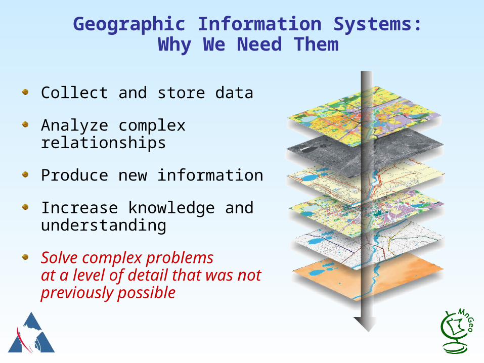
Collect and store data
Analyze complex relationships
Produce new information
Increase knowledge and understanding
Solve complex problemsat a level of detail that was not previously possible
Geographic Information Systems:Why We Need Them
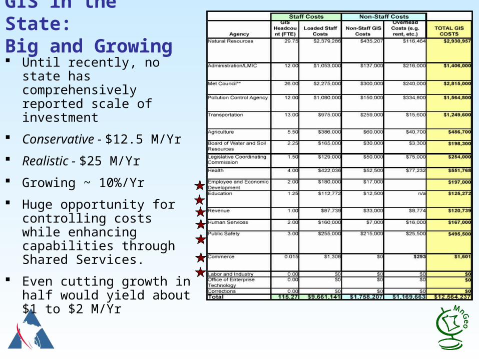
GIS in the State: Big and Growing Until recently, no state
has comprehensively reported scale of investment
Conservative - $12.5 M/Yr
Realistic - $25 M/Yr
Growing ~ 10%/Yr
Huge opportunity for controlling costs while enhancing capabilities through Shared Services.
Even cutting growth in half would yield about $1 to $2 M/Yr

Typical Agency GIS Technology Situation
Limited financial & human resources
Limited technical capacity
Lack of attention when other competing priorities exist
Lack of appropriate facilities
Lack of knowledgeable and committed executive sponsorship
Lack of legislative support


Lots of GIS & IT Planning in MN LatelyThis project is part of a logical progression
A Foundation for a Coordinated GISMGCGI, 2004
2004 2005 2006 2007
State GIS Enterprise Conceptual Architecture Design - MGCGI, 2005
The Case for a MN State GIS EnterpriseMGCGI, 2006
IT & TeleCom Systems and Services Master PlanOET, 2007
Compass Points Retreat Report – MGCGI / LMIC, 2007
Drive to Excellence Transformation RoadmapDOA, 2005
Drive to Excellence Launch of Enterprise GIS Project – D2E, 2008
2008

Transforming the GIS Business
Extensive analysis of agency needs, capabilities, resources, and plans.
Detailed profiles of State agency GIS programs.
Analysis of GIS programs in other states.
Identication of opportunities for collaboration and shared solutions.
Recommended program elements and design.
Implementation options.
2008: DTE GIS Coordination Study

Benefits of Shared Approach to GIS
Shared HW, SW, infrastructure
Staffing – greater breadth and depth
Joint development teams
Joint training
Leveraged funding/cooperative purchasing
Standardized solutions
Services through “Shared Service Centers”

Minnesota Geospatial Information Office

Shared Application Services Concept
GovernmentBusiness
Application B
HostedServices
Government Entity 1
HostedServices
Government Entity 3
GovernmentBusiness
Application A
HostedServices
GovernmentBusiness
Application C
Government Entity 2
ServiceProvider
Commercial ServiceProvider
Mash Ups!!??Mash Ups!!??
Consumer
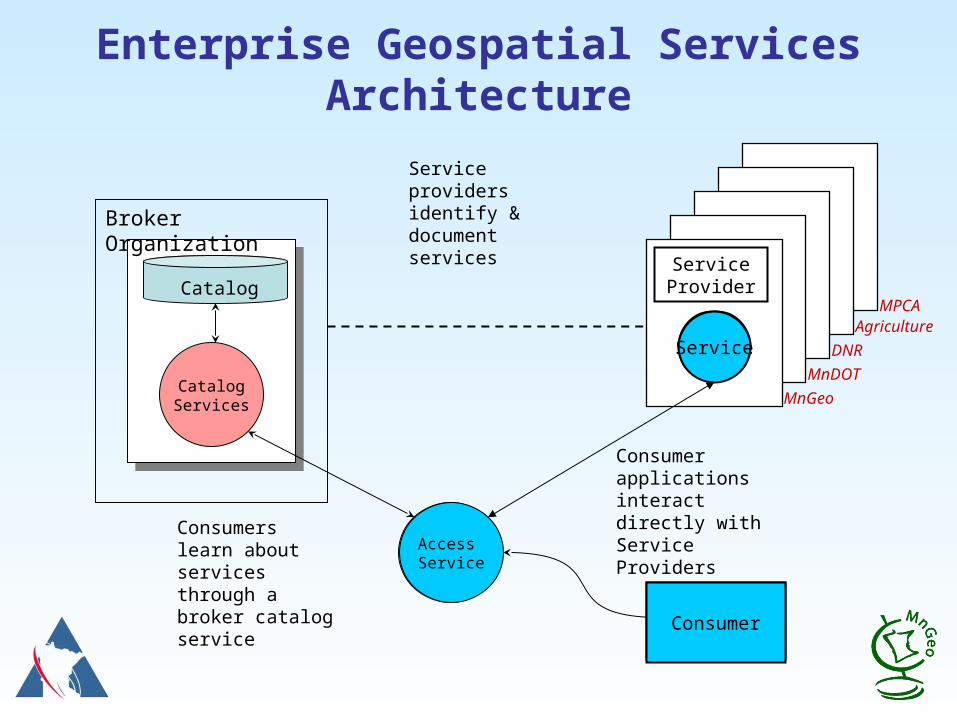
Enterprise Geospatial Services Architecture
ServiceProvider
Service
Broker Organization
CatalogServices
Catalog
Query forService
Consumers learn about services through a broker catalog service
Consumer applications interact directly with Service Providers
Service providers identify & document services
Access Service
Consumer
Service
MnGeo
MnDOT
MPCA
DNR
Agriculture
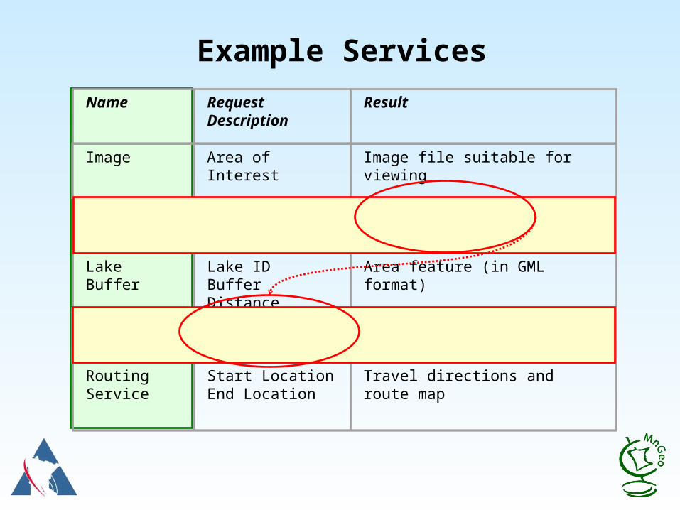
Example Services
Name
Request Description
Result
Image
Area of Interest Image file suitable for viewing
Geocoding
Street Address Coordinate Location
Lake Buffer Lake IDBuffer Distance
Area feature (in GML format)
Floodplain Test
Coordinate Location
0 – Not in Floodplain1 – In Floodplain
Routing Service
Start LocationEnd Location
Travel directions and route map

What Services Exist Now?
Several Minnesota state agencies host geospatial services that potentially eliminatepotentially eliminate the need for duplication.
– MnGeo
– MN Department of Natural Resources
– MN Department of Transportation
– MetroGIS
Organizations like these already have invested in expertise and technology. Why not use them?

500,000 images/month and growing!500,000 images/month and growing!
$6.5 M Investment

Who Uses WMS Image Server?
• MnGeo - NorthStar Mapper• MN DOT-Boring Sites• MN Dept. of Agriculture - Weed Mapping• MN DNR- Firewise program• U of MN - Swine Disease Mapping Project• U of MN Natural Resources Research Institute• Metropolitan Mosquito Control District• Private companies
– Houston Engineering – The Lawrence Group – Riverside Companies


Shared Service Opportunities
Application Function Services Address Geocoding Routing Service Mail Label Service
Web Mapping Hosting Services Application Development Services Secure Data Center GIS Training Center Contract Coordination Services Enterprise Licensing Agreements

The MnGeo Vision
"Minnesota makes "Minnesota makes CCoordinated, oordinated, AAffordable, ffordable, RReliable, and eliable, and EEffective ffective use of GIS use of GIS technology to technology to improve services improve services throughout the throughout the state." state."

Things to Watch For
Positive Signs– Strategic (serendipitous) opportunities– Champions who “Get It”– A community of partners – Small successes to build on
Warning Signs– Territorial bahavior! That Turf Thing! – Pride of ownership – Failure to meet commitments– Mistrust

Things to Watch ForChampions Who Get It
Brad MooreProject SponsorCommissionerMN Pollution Control Agency
Gopal KhannaCommissioner and State CIOOffice of Enterprise Technology
Dana BadgerowCommissionerDepartment of Administration
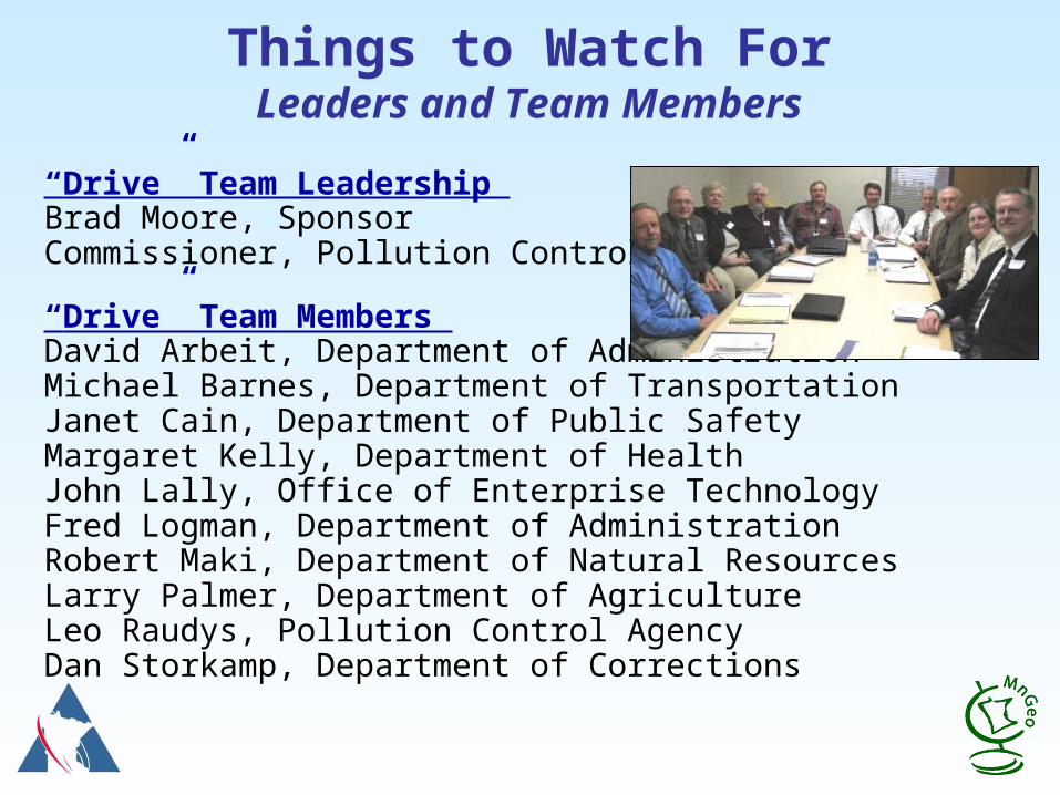
Things to Watch ForLeaders and Team Members
“Drive” Team Leadership Brad Moore, SponsorCommissioner, Pollution Control Agency
“Drive” Team Members David Arbeit, Department of AdministrationMichael Barnes, Department of Transportation Janet Cain, Department of Public Safety Margaret Kelly, Department of Health John Lally, Office of Enterprise Technology Fred Logman, Department of Administration Robert Maki, Department of Natural Resources Larry Palmer, Department of Agriculture Leo Raudys, Pollution Control Agency Dan Storkamp, Department of Corrections
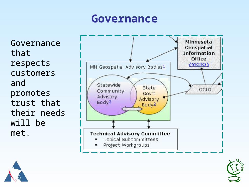
Governance
Governance that respects customers and promotes trust that their needs will be met.

Things to Watch ForAdvisors, Contributors and Stakeholders
Community of Partners

Final Thoughts
We face a fundamental challenge:
Customers continue to expect more Technology is essential to providing it The era of budget growth has ended
We are smart enough and committed enough to meet that challenge.
Working together through creative shared service arrangements are key to getting it done.
We can get it done!
Let’s Talk Shared Services