shaws creek townline - peel region...shaws creek – townline (caledon lake area) date of this site...
TRANSCRIPT

SHAWS CREEK – TOWNLINE (CALEDON LAKE AREA)
Date of this Site Summary: July 2012
1
Region of Peel NAI Area # 9045, 9606, 9702, 9704
Credit Valley Conservation Authority
Town of Caledon Size: 502 hectares Watershed: Credi t River Con 4 WHS, Lots 26-31; Con 5 WHS, Lots
29-31
Ownership: 50% private, 50% public
(Credit Valley Conservation, Peel Board of Education)
Subwatershed: Shaw’s Creek
General Summary This is a very large natural area that essentially spreads across two concession blocks, including the unopened Mississauga Rd. allowance. Much of the area is treed wetland but there are treed uplands as well. The northern two thirds of the area form a cohesive block of relatively undisturbed natural communities. In the south part of the area, natural communities form a mosaic with plantation and cultural/successional communities and the area is fragmented by clearings for residences. Caledon Lake and the smaller Second Caledon Lake are found in the bottomland and are fringed by swamps, marshes and a fen-like area. Community and species diversity is very high due to a diversity of substrate types including areas with a calcareous marl substrate, more acidic areas, organic soils and mineral soil types. Several Species At Risk as well as provincially and regionally rare species occur here. The large tracts of treed communities provide extensive interior forest habitat. Cold streams north of Caledon Lake support Brook Trout, an indication of the health and integrity of the cold water system. Groundwater seepage from upland areas feed into Caledon Lake and its associated creeks. The lakes and creeks are underlain by marl and provide a calcareous substrate that supports a number of regionally rare plants. The presence of an acidic, fen-like area in close proximity to areas underlain by calcareous marl is unusual. NAI ELC surveyors, botanists and ornithologists inventoried vegetation communities, plants and breeding birds and made incidental observations of other fauna (Table 1), covering 17% of the natural area (determined by access permission). In 2004 and 2005, CVC ELC surveyors also inventoried some vegetation communities in this area. Complete coverage for all communities in the area that permission is available for has not yet been achieved. Additional incidental records were contributed by other observers. In 2007, bat and small mammal surveys were conducted. With respect to the NAI core inventories (vegetation communities, plants, breeding birds), this area is considered data-complete for plants and breeding birds only. Vegetation community coverage is a partial data gap. Fish inventories were conducted both within this natural area and from downstream sampling stations. As there are no barriers between the natural area and the downstream stations, fish data from these stations was extrapolated upstream and combined with the on-site data. Table 1: NAI & CVC Field Visits Visit Date Inventory Type 08 Aug. 2000 Fish 26 July 2001 Fish 24 July 2002 Fish 09 July 2003 Fish 14 July 2004 Fish 28 June 2005 Fish 19 July 2005 Fish 20 July 2005 Fish 21 July 2005 Fish
04 July 2006 Fish 20 July 2006 Fish 29 June 2007 Fish 04 July 2007 Fish 01 Sept. 2007 Bats 02 Sept. 2007 Bats 09 Oct. 2007 Small Mammals 10 Oct. 2007 Small Mammals 11 Oct. 2007 Small Mammals

SHAWS CREEK – TOWNLINE (CALEDON LAKE AREA)
Date of this Site Summary: July 2012
2
12 Oct. 2007 Small Mammals 03 June 2008 Fauna 10 June 2008 Fauna 19 June 2008 Fauna 28 June 2008 Fauna 03 July 2008 Fauna 10 July 2008 Fauna 10 July 2008 Fish 15 July 2008 Fauna 03 June 2009 Flora 02 July 2009 Fish 08 July 2009 Fish
04 Aug. 2009 Flora 05 Aug. 2009 Flora 06 Aug. 2009 Flora 07 Aug. 2009 Flora 12 Aug. 2009 Flora 14 Aug. 2009 Flora 15 Sept. 2009 Flora 13 Sept. 2010 ELC 14 Sept. 2010 ELC 15 Sept. 2010 ELC 17 Sept. 2010 ELC 21 Sept. 2010 ELC
Natural Feature Classifications and Planning Areas This natural area is part of: Life Science ANSI – provincially significant Caledon Lake Forests Earth Science ANSI - regionally significant Caledon Lakes Area ESA - Caledon Lake ESA PSW – Caledon Lake Wetland Complex Greenbelt Plan – Natural Heritage System Physical Features The bedrock at this site is comprised of the Amabel/Lockport formation. This area is in the Hillsburgh Sandhills physiographic region; characterized by large, rolling hills of coarse glacial sediments that deeply bury the bedrock. Soil types here include peat, organic muck and marl deposits, as well as sandy loam and gravely soils. The sandy loam soils support high rates of recharge to groundwater aquifers. Caledon Lake and Second Caledon Lake are major aquatic features in this area. There are also several ponds left from a historical marl mining industry. Shaw’s Creek winds through this natural area and links the two lakes. Human History This area may have been utilized by First Nations, as suggested by its large body of fresh water, abundant fish and game, and presence of Northern Wild Rice (Zizania palustris) (Scheinman, 2009). European settlement was initiated in the mid-1830’s and the surrounding areas were farmed. A sawmill and associated dam were built by William Glassford south of this area on Shaw’s Creek, appearing on an 1859 map of the region. The east side of Caledon Lake (formerly known as Shaw’s Lake) was used recreationally by 1878 when a hotel was built near the lake. Most of the Caledon Lake area however, remained relatively undisturbed due to the abundant wetlands which made travel challenging and which could not be converted to farmland. The west end of Caledon Lake remained particularly isolated and plans to extend Mississauga Rd north to the town line were abandoned due to the impassable wetlands (ibid; Ecologistics Limited, 1979). Upland parts of this area have been historically logged and grazed as evident by some younger forests of successional species and areas of limited ground-layer flora diversity. Marl extraction occurred as early as 1908 to the northwest of Caledon Lake, creating a series of ponds (Scheinman, 2009). The dredged channels in these ponds are visible on air photos.

SHAWS CREEK – TOWNLINE (CALEDON LAKE AREA)
Date of this Site Summary: July 2012
3
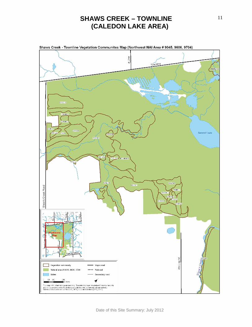
A large portion of this natural area is now owned by Credit Valley Conservation, although it is undeveloped. An outdoor education centre for schools is immediately adjacent to the natural area. Several trails are used for passive recreation and education. This natural area is partially bordered by Shaw's Creek Rd. on the southwest corner and by Third Line W. on the northeast side, and Orangeville-Caledon Townline forms the border along the entire northwest side. Surrounding land use is agricultural, rural residential, rural estate and cottages (along the east shore of Caledon Lake). Vegetation Communities The general community types present are coniferous forest (1%), deciduous forest (12%), mixed forest (3%), marsh (15%), coniferous swamp (13%), deciduous swamp (16%), mixed swamp (9%), thicket swamp (3%), open aquatic (11%), cultural meadow (1%), cultural savannah (1%), cultural woodland (3%) and plantation (10%). A total of 20 vegetation communities of 12 different types were mapped for the 17% of the natural area that received coverage (Table 2). Six communities were only classified to ecosite level. Table 2: ELC Vegetation Communities Map reference *
Vegetation type Size in hectares
% of natural area
FOD3-1 Dry-Fresh Poplar Deciduous Forest (3 communities) 7.59 1.51
FOD5-1 Dry-Fresh Sugar Maple Deciduous Forest (4 communities) 9.14 1.82
FOD5-2 Dry-Fresh Sugar Maple - Beech Deciduous Forest (2 communities) 18.52 3.69
FOD7 Fresh-Moist Lowland Deciduous Forest Ecosite (2 communities) 4.87 0.97
MAM3-5 Narrow-leaved Sedge Organic Meadow Marsh 19.99 3.99 SWD7-1 White Birch – Poplar Organic Deciduous Swamp 9.07 1.81 SWT2-1 Alder Mineral thicket Swamp 1.78 0.35 CUM1-1 Dry-Moist Old Field Meadow 2.00 0.40 CUM1 Mineral Cultural Meadow Ecosite 1.10 0.22 CUW1 Mineral Cultural Woodland Ecosite (2 communities) 6.64 1.32 CUP3-1 Red Pine Coniferous Plantation 0.50 0.10 CUP3 Coniferous Plantation Ecosite 3.96 0.79 TOTAL AREA INVENTORIED 85.16
* Note: The map reference code refers to the vegetation type shown on mapping for this area and also to the Appendix list of species typically encountered in this vegetation type. Species Presence Vascular Plants Plant species biodiversity is very high in this area. A total of 456 vascular plant species occur in this area, of which 387 (85%) are native. One species, Butternut (Juglans cinerea; S-rank S3?), is Endangered nationally and provincially, as well as being provincially rare (Table 3). Five saplings and six young Butternut trees were found. Two other plant species found here are provincially rare, Hybrid Baneberry (Actaea x ludovici; S-rank S1?) and Great St. John’s-wort (Hypericum ascyron; S-rank S3?). Seventy-six plant species in this area are regionally rare (Table 4). Seven species new to the Credit River watershed were identified during NAI fieldwork at this site. Most of these were also new to the Region of Peel. Narrow-spike Small-reedgrass (Calamagrostis

SHAWS CREEK – TOWNLINE (CALEDON LAKE AREA)
Date of this Site Summary: July 2012
4
stricta ssp. inexpansa) and Rush Aster (Symphyotrichum boreale) are new to the watershed. Autumnal Water-starwort (Callitriche hermaphroditica), Downy Willow-herb (Epilobium strictum), Bristly Black Currant (Ribes lacustre), Northern Mountain-ash (Sorbus decora) and Fernald’s Manna Grass (Torreyochloa pallida var fernaldii) are all new to the watershed and the Region of Peel. Northern Mountain-ash may also be a range extension for this species in Ontario, being more abundant further north (Cecile, 2009). Notable observations of species only known historically in the watershed include Marsh Muhly (Muhlenbergia glomerata, historic record from 1910), Hidden Spike-moss (Selaginella eclipes, historical record from 1945) and Painted Trillium (Trillium undulatum, historic record from 1947) (Cecile, 2009; Credit Valley Conservation, 2002). Breeding Birds A total of 87 species of birds are recorded for this area, of which 85 (98%) are native. Five of these species are believed to be visitors, but the others were present during the breeding season and displayed some level (possible, probable, confirmed) of breeding evidence. This includes a record from a landowner of Bluebirds (Sialia sialis) using nesting boxes. Four of the species present here are Species At Risk (Table 3). Canada Warbler (Wilsonia canadensis) is Threatened nationally and Special Concern provincially, Bobolink (Dolichonyx oryzivorus) is Threatened nationally and provincially, Barn Swallow (Hirundo rustica) is Threatened nationally and Bald Eagle (Haliaeetus leucocephalus) is Special Concern provincially. Bald Eagle is also provincially rare (S-rank S1S2N, S4B) This site supports four species of colonial-nesting birds, namely Great Blue Heron (Ardea herodias), Bank Swallow (Riparia riparia), Barn Swallow and Sedge Wren (Cistothorus platensis). The area also supports two species of waterfowl, Wood Duck (Aix sponsa) and Mallard (Anas platyrhynchos), and three species of wetland-nesting birds, Common Loon (Gavia immer), Virginia Rail (Rallus limicola) and Sedge Wren. Extensive interior forest exists at this site, supporting 11 species of area-sensitive forest interior birds, namely Hairy Woodpecker (Picoides villosus), Pileated Woodpecker (Dryocopus pileatus), Red-breasted Nuthatch (Sitta canadensis), Brown Creeper (Certhia americana), Winter Wren (Troglodytes troglodytes), Veery (Catharus fuscescens), Black-throated Green Warbler (Dendroica virens), Black-throated Blue Warbler (Dendroica caerulescens), Black-and-white Warbler (Mniotilta varia), Ovenbird (Seiurus aurocapilla) and Scarlet Tanager (Piranga olivacea). Open and successional habitat supports six species of grassland birds, namely Bobolink, Eastern Bluebird, Eastern Kingbird (Tyrannus tyrannus), Field Sparrow (Spizella pusilla), Willow Flycatcher (Empidonax traillii) and Sedge Wren; of which one (Bobolink) is area-sensitive. Four species of raptors may be breeding in this area, namely Sharp-shinned Hawk (Accipiter striatus), Cooper’s Hawk (Accipiter cooperii), Osprey (Pandion haliaetus) and Broad-winged Hawk (Buteo platypterus). Fish A total of 15 fish species were recorded, of which 14 (93%) are native. An additional species is recorded from historical (1982) CVC sampling. Iowa Darter (Etheostoma exile) occurs at this site, one of only a few locations where this species has been detected in the Credit River watershed. The waterways in this natural area support coldwater fish communities. Butterflies, Skippers and Moths Butterfly, skipper and moth biodiversity is high at this area. A total of 33 species of butterflies, skippers and moths were recorded as incidental observations for this area, of which 31 (94%) are native. One species, Monarch (Danaus plexippus), is designated Special Concern both nationally and provincially. The Monarch is also provincially rare (S-rank S2N, S4B). This is also the only site during NAI fieldwork of 2008 and 2009 where Meadow Fritillary (Boloria bellona) and Mulberry Wing (Poanes massasoit) were observed and one of only two sites where Two-spotted Skipper (Euphyes bimacula) was observed. Two-spotted Skipper and Mulberry Wing are regionally rare in adjacent Halton Region (Dwyer, 2006).

SHAWS CREEK – TOWNLINE (CALEDON LAKE AREA)
Date of this Site Summary: July 2012
5
Dragonflies and Damselflies Dragonfly/damselfly biodiversity is high in this natural area. A total of 26 species of dragonflies/damselflies are recorded as incidental observations for this area, all of which are native. This is one of only two sites visited during NAI fieldwork over 2008 and 2009 where Hagen’s Bluet (Enallagma hageni) and Lyre-tipped Spreadwing (Lestes unguiculatus) were found; and one of only three sites where Prince Baskettail (Epitheca princeps) was found. Both Hagen’s Bluet and Prince Baskettail are regionally rare in adjacent Halton Region (Dwyer, 2006). Herpetofauna Thirteen herpetofaunal species are recorded here as incidental observations, all of which are native. One species, Western Chorus Frog (Pseudacris triseriata), is Threatened nationally (Table 3). Eastern Snapping Turtle (Chelydra serpentina), a species of Special Concern nationally and provincially, is present. An Eastern Snapping Turtle was found dead on a road next to this natural area. A Midland Painted Turtle (Chrysemys picta marginata) was also found dead on a road next to this natural area. Four Northern Red-bellied Snakes (Storeria occipitomaculata occipitomaculata) were found under boards. Wood Frog (Rana sylvatica) juveniles were observed emerging from breeding pools. The remaining herpetofaunal species here consist of six additional frog/toad species, one additional snake species and one salamander species. Bullfrogs (Rana catesbeiana) are present here. Amphibian breeding occurs on site. Mammals Thirty mammal species are recorded for this area, all of which are native. Bat acoustic inventories yielded seven species of bats within this area, including three bat species new to the Credit River watershed: Hoary Bat (Lasiurus cinereus), Eastern Pipistrelle (Pipistrellus subflavus) and Northern Long-eared Bat (Myotis septentrionalis). Two of these bat species, Eastern Pipistrelle (S-rank S3?) and Northern Long-eared Bat (S-rank S3?), are provincially rare. A small mammal inventory was also conducted with Ermine (Mustela erminea) and Northern Flying Squirrel (Glaucomys sabrinus) being notable observations (Reid, 2007). Table 3: Designated Species At Risk Scientific name Common name COSEWIC COSSARO S rank G rank VASCULAR PLANTS Juglans cinerea Butternut END END S3? G4 BIRDS Haliaeetus leucocephalus Bald Eagle
THR S1S2N, S4B
G5
Hirundo rustica Barn Swallow THR S5B G5 Dolichonyx oryzivorus Bobolink THR THR S4B G5 Wilsonia canadensis Canada Warbler THR SC S4B G5 BUTTERFLIES Danaus plexippus Monarch SC SC S2N,S4B G5 HERPETOFAUNA
Chelydra serpentina Eastern Snapping Turtle
SC SC S3 G5T5
Pseudacris triseriata Western Chorus Frog THR S4 G5

SHAWS CREEK – TOWNLINE (CALEDON LAKE AREA)
Date of this Site Summary: July 2012
6
Table 4: Regionally Rare Vascular Plant Species (Ka iser, 2001) Scientific name Common name S rank G rank VASCULAR PLANTS Acorus americanus American Sweetflag S4 G5 Agrostis scabra Ticklegrass S5 G5 Andromeda polifolia ssp. glaucophylla Bog Rosemary S5 G5T5 Aronia melanocarpa Black Chokeberry S5 G5 Betula pumila Swamp Birch S5 G5 Brachyelytrum erectum Bearded Shorthusk S4S5 G5 Calamagrostis stricta ssp inexpansa Narrow-spike Small-reedgrass S5 G5T5 Callitriche palustris Vernal Water-starwort S5 G5 Campanula aparinoides Marsh Bellflower S5 G5 Campanula rotundifolia American Harebell S5 G5 Carex aquatilis Water Sedge S5 G5 Carex brunnescens ssp. brunnescens Brownish Sedge subspecies S5 G5T5 Carex castanea Chestnut-colored Sedge S5 G5 Carex cryptolepis Northeastern Sedge S4 G4 Carex echinata ssp. echinata Little Prickly Sedge subspecies S5 G5T5 Carex lasiocarpa Slender Sedge S5 G5 Carex magellanica ssp. irrigua Boreal Bog Sedge S5 G5T5 Carex prairea Prairie Sedge S5 G5? Carex trisperma var. trisperma Three-seed Sedge subspecies S5 G5T5 Carex vaginata Sheathed Sedge S5 G5 Ceratophyllum demersum Common Hornwort S5 G5 Chamaedaphne calyculata Leatherleaf S5 G5 Chrysosplenium americanum American Golden-saxifrage S5 G5 Cirsium muticum Swamp Thistle S5 G5 Cypripedium reginae Showy Lady’s-slipper S4 G4 Decodon verticillatus Hairy Swamp Loosestrife S5 G5 Drosera rotundifolia Roundleaf Sundew S5 G5 Elymus riparius River Wild-rye S4? G5 Elymus trachycaulus Slender Wheatgrass S5 G5 Epilobium coloratum Purple-leaf Willow-herb S5 G5 Epilobium strictum Downy Willow-herb S5 G5? Equisetum sylvaticum Woodland Horsetail S5 G5 Galium labradoricum Northern Bog Bedstraw S5 G5 Gaultheria hispidula Creeping Snowberry S5 G5 Gentiana rubricaulis Closed Gentian S4 G4? Geum rivale Purple Avens S5 G5 Glyceria borealis Small Floating Manna-grass S5 G5 Glyceria septentrionalis Floating Manna-grass S4 G5 Hydrophyllum canadense Blunt-leaf Waterleaf S4 G5 Lactuca biennis Tall Blue Lettuce S5 G5 Ledum groenlandicum Common Labrador Tea S5 G5 Lobelia kalmii Kalm’s Lobelia S5 G5 Lonicera hirsuta Hairy Honeysuckle S5 G4G5 Lonicera oblongifolia Swamp Fly-honeysuckle S4S5 G4 Lonicera villosa Mountain Fly-honeysuckle S5 G5 Lycopodium annotinum Stiff Clubmoss S5 G5

SHAWS CREEK – TOWNLINE (CALEDON LAKE AREA)
Date of this Site Summary: July 2012
7
Lycopodium obscurum Tree Clubmoss S4 G5 Menyanthes trifoliata Bog Buckbean S5 G5 Muhlenbergia glomerata Marsh Muhly S5 G5 Myriophyllum sibiricum Common Water-milfoil S5 G5 Nemopanthus mucronatus Mountain Holly S5 G5 Orthilia secunda One-side Wintergreen S5 G5 Oryzopsis racemosa Black-fruit Mountain-ricegrass S4 G5 Oxalis acetosella ssp. montana Mountain Woodsorrel S5 G5 Parnassia glauca Carolina Grass-of-parnassus S5 G5 Phegopteris connectilis Northern Beech Fern S5 G5 Picea mariana Black Spruce S5 G5 Polygonum punctatum Dotted Smartweed S5 G5 Potamogeton foliosus Leafy Pondweed S5 G5 Potentilla fruticosa Shrubby Cinquefoil S5 G5T5 Ribes glandulosum Skunk Currant S5 G5 Ribes hudsonianum Northern Black Currant S5 G5 Ribes lacustre Bristly Black Currant S5 G5 Salix candida Hoary Willow S5 G5 Salix serissima Autumn Willow S4 G4 Sarracenia purpurea Northern Pitcher-plant S5 G5 Schoenoplectus acutus Hard-stem Bulrush S5 G5 Solidago patula Roundleaf Goldenrod S5 G5 Solidago uliginosa Bog Goldenrod S5 G4G5 Sorbus decora Northern Mountain-ash S5 G4G5 Symphyotrichum boreale Rush Aster S5 G5 Symphyotrichum urophyllum Arrow-leaved Aster S4 G4G5 Symplocarpus foetidus Skunk Cabbage S5 G5 Thelypteris noveboracensis New York Fern S4S5 G5 Torreyochloa pallida var fernaldii Fernald's Manna Grass S4 G5?T4Q Trillium undulatum Painted Trillium S5? G5 Utricularia minor Lesser Bladderwort S5 G5 Vaccinium angustifolium Late Lowbush Blueberry S5 G5 Vaccinium macrocarpon Large Cranberry S4S5 G4 Vaccinium myrtilloides Velvetleaf Blueberry S5 G5 Vaccinium oxycoccos Small Cranberry S5 G5 Viburnum cassinoides Northern Wild-raisin S5 G5T5 Viola macloskeyi ssp. pallens Smooth White Violet S5 G5T5
Site Condition and Disturbances Abundant wetlands prevented this area from being heavily altered during 19th century settlement. It remains a large tract of intact natural area with minimal fragmentation and is in very good condition. Some upland areas are recovering from past logging and livestock grazing as evident from a low diversity of ground flora, successional tree species, scattered apple trees and more abundant alien species. Non-native species are occasional and localized with the exception of culturally disturbed areas where they are abundant. Problematic invasive species include Garlic Mustard (Alliaria petiolata), Common Buckthorn (Rhamnus cathartica), Glossy Buckthorn (Rhamnus frangula), Purple Loosestrife (Lythrum salicaria) and Black Locust (Robinia pseudo-acacia).

SHAWS CREEK – TOWNLINE (CALEDON LAKE AREA)
Date of this Site Summary: July 2012
8
Other impacts include some garbage dumping in two deciduous forests and removed/trampled shoreline vegetation on the north-east side of Caledon Lake next to the cottages. Ecological Features and Functions This area is part of the provincially significant Caledon Lake Forests Life Science ANSI as well as part of the regionally significant Caledon Lakes Area Earth Science ANSI. The area is also part of the Caledon Lake ESA and the provincially significant Caledon Lake Wetland Complex. Credit Valley Conservation has a terrestrial monitoring plot in this area. With forest communities greater than 4 ha and wetlands over 0.5 ha in size, this natural area has the potential to support and sustain biodiversity, healthy ecosystem functions and to provide long-term resilience for the natural system. The riparian areas provide a transitional zone between terrestrial and aquatic habitats, helping to maintain the water quality of the creeks and providing a movement corridor for plants and wildlife. By containing a relatively high number of habitat types, this natural area has the potential for high biodiversity function, particularly for species that require more than one habitat type for their life needs. This natural area contains a regionally rare vegetation community (the fen noted by the botanist) and thus has the potential to support additional biodiversity above and beyond that found in common community types. This area has excellent connectivity with other natural areas across the bordering roads. On the west side of the natural area there is more natural habitat across Shaw's Creek Rd. There are extensive natural areas across Orangeville Caledon Townline to the northwest and several large natural areas across Third Line W. Shaw's Creek flows southward through this area and crosses the upper portion of Mississauga Rd. into agricultural lands. The creek corridor is narrow here but this link broadens farther downstream. The relatively close proximity of other areas of natural habitat creates above-average potential for wildlife movement between natural areas, species dispersal and recovery from disturbance, creating additional resilience for the ecosystem. Shaw’s Creek, a major tributary of the Credit River, runs through this area and thus supports the connectivity function of the Credit River and its tributaries by providing a natural habitat corridor that facilitates the cross-regional movement of wildlife along this corridor between major provincial corridors. With two lakes, Shaw’s Creek, associated streams, and diverse wetlands including a fen-like community, this site carries out important wetland functions. Caledon Lake acts as a reservoir for the Shaw's Creek system. Coldwater streams support Brook Trout. This site contains seeps. Eight Species At Risk (one plant species, four bird species, one butterfly species, one turtle species, one frog species) occur in this natural area. Eight provincially rare species (three plant species, one bird species, two bat species, one butterfly species, one turtle species) occur in this area. Seventy-six species of regionally rare plants also occur here. Extensive interior forest habitat exists in this natural area, supporting the breeding of 11 species of area-sensitive forest interior birds.

SHAWS CREEK – TOWNLINE (CALEDON LAKE AREA)
Date of this Site Summary: July 2012
9
Four species of colonial-nesting birds breed in this area, including a colony of Great Blue Herons. Two species of waterfowl occur here as well as three species of wetland-nesting birds, six species of grassland birds (one of which is area-sensitive) and four species of raptors. This site supports Bullfrogs. The wetlands of this natural area provide amphibian breeding habitat. Breeding is confirmed for one frog species. Turtles may breed and nest in this natural area. Based on the above features, this area should be evaluated to determine if significant wildlife habitat is present in accordance with the Provincial Policy Statement, Region of Peel Official Plan, and area municipal Official Plan. Opportunities Existing linkages to adjacent natural areas, particularly to the north of this area are broad and should be maintained. Linkage to the south along Shaw’s Creek is much narrower and the use of Shaw’s Creek as a wildlife movement corridor could be improved by increasing the width of natural vegetation on either side of the creek. The health of the Butternut trees present here could be assessed by a Butternut Assessor in order to determine whether any individuals are candidates for inclusion in the Butternut recovery program. This natural area has five mature forest communities and they could be checked for old-growth forest characteristics. The presence here of all seven bat species known from the Credit River watershed suggests the possibility of roosts in the area, warranting a search. The vegetation community inventory should be completed where permission for access exists, thus addressing the outstanding NAI core inventories data gap for this area. Two turtle species were found dead on the road during inventory work. Wildlife crossing road signage or other mitigation measures might be considered given the extensive wetlands that occur here near roads. Literature Cited Cecile, C. Botanical Inventories For Natural Areas Inventory P roject 2009-Credit Valley Conservation. Prepared for Credit Valley Conservation. Credit Valley Conservation. 2002 Plants of the Credit Valley Watershed. . Available at http://www.creditvalleyca.ca. Last Accessed April 1, 2011. Dwyer, J. Halton Natural Areas Inventory. 2006. 2 volumes. Volume 1: Site Summaries.Volume 2: Species Checklists. ISBN 0-9732488-6-6, 0-9732488-7-4. Self-published. Ecologistics Limited. 1979. Credit River Watershed, Environmentally Significant Areas . Credit Valley Conservation Authority, Mississauga. vi + 207 pp. Kaiser, J. 2001. The Vascular Plant Flora of the Region of Peel and the Credit River Watershed . Prepared for: Credit Valley Conservation, the Regional Municipality of Peel, Toronto and Region Conservation Authority. Reid, F. and S. Amelon. 2007. Acoustic Bat Monitoring Report. Credit River Waters hed. Ontario, Canada. August 30 to Sept 4, 2007 . Prepared for Credit Valley Conservation. Reid, F. 2007. Small Mammals of the Credit River Watershed. Prelim inary Monitoring Report. October 2 to October 18, 2007. Prepared for Credit Valley Conservation. Scheinman, A. 2009. Town of Caledon Cultural Heritage Landscapes Invent ory . Envision – The Hough Group.

SHAWS CREEK – TOWNLINE (CALEDON LAKE AREA)
Date of this Site Summary: July 2012
10
SHAWS CREEK – TOWNLINE (CALEDON LAKE AREA)
Date of this Site Summary: July 2012
11

SHAWS CREEK – TOWNLINE (CALEDON LAKE AREA)
Date of this Site Summary: July 2012
12

SHAWS CREEK – TOWNLINE (CALEDON LAKE AREA)
Date of this Site Summary: July 2012
13