shifting cultivation, contentious land change, and forest ... · inland village of dayak kenyah,...
TRANSCRIPT

An international academic conference 5‐6 June 2015, Chiang Mai University
Conference Paper No. 33
BICAS www.plaas.org.za/bicas www.iss.nl/bicas
In collaboration with:
Demeter (Droits et Egalite pour une Meilleure Economie de la Terre), Geneva Graduate Institute University of Amsterdam WOTRO/AISSR Project on Land Investments (Indonesia/Philippines)
Université de Montréal – REINVENTERRA (Asia) Project Mekong Research Group, University of Sydney (AMRC)
University of Wisconsin-Madison
With funding support from:
Shifting Cultivation, Contentious Land Change, and Forest Governance in Eastern Borneo
Gregory M. Thaler
May 2015
Land grabbing, conflict and agrarian‐environmental transformations: perspectives from East and Southeast Asia

Shifting Cultivation, Contentious Land Change, and Forest Governance in Eastern Borneo by Gregory M. Thaler Published by:
BRICS Initiatives for Critical Agrarian Studies (BICAS) Email: [email protected] Websites: www.plaas.org.za/bicas | www.iss.nl/bicas MOSAIC Research Project Website: www.iss.nl/mosaic Land Deal Politics Initiative (LDPI) Email: [email protected] Website: www.iss.nl/ldpi RCSD Chiang Mai University Faculty of Social Sciences, Chiang Mai University Chiang Mai 50200 THAILAND Tel. 6653943595/6 | Fax. 6653893279 Email : [email protected] | Website : http://rcsd.soc.cmu.ac.th Transnational Institute PO Box 14656, 1001 LD Amsterdam, The Netherlands Tel: +31 20 662 66 08 | Fax: +31 20 675 71 76 Email: [email protected] | Website: www.tni.org
May 2015 Published with financial support from Ford Foundation, Transnational Institute, NWO and DFID.

Abstract
Swidden (shifting cultivation with fire) has historically been one of the most widespread land uses in upland Southeast Asia. In recent decades, swidden systems across the region have undergone rapid transformation. Understanding current swidden dynamics is therefore critical to a broader understanding of Southeast Asian land use change trajectories. This paper draws on qualitative fieldwork and household surveys in East Kalimantan Province of Indonesian Borneo to describe the swidden systems in two indigenous Dayak villages in the interior of Berau District. I focus in particular on the transformation of swidden systems in articulation with expanding industrial land uses, identifying territorialization and speculation as drivers of swidden expansion. I argue that these dynamics constitute a process of 'contentious land change' in village swidden systems. Swidden has also become a focus of forest governance initiatives in Berau, and I describe the activities of The Nature Conservancy, an international environmental NGO, which has been developing programs in the villages since 2010. I argue that while swidden has provided a locus for the development of multi-stakeholder forest governance in an area where environmental conservation has otherwise been elusive, the focus of forest governance on swidden systems has ambiguous implications.

1
Shifting Cultivation, Contentious Land Change, and Forest Governance in Eastern Borneo
Swidden, or shifting cultivation with fire, has for centuries been a dominant component of the agricultural systems of upland Southeast Asia. For almost as long, swidden systems have been under pressure from external actors, including governments, companies, and conservation groups, who have
sought to control or eliminate shifting cultivation (Scott 2009). The transformation of Southeast Asian swidden systems in recent decades has been especially intense, due to a confluence of political, economic, and ecological factors, including government resettlement and land privatization policies, infrastructure expansion, environmental conservation initiatives, and the landscape-scale expansion of
industrial agriculture (Padoch et al. 2007; Fox et al. 2009). Understanding the status of swidden is thus of critical importance to a broader comprehension of the socio-ecological dynamics of contemporary Southeast Asia.
In this paper, I draw on original fieldwork and secondary data to describe swidden dynamics in two villages in the district of Berau, part of the province of East Kalimantan in Indonesian Borneo. Most analyses of transformations in swidden systems focus on drivers that affect the practice of swidden as a livelihood strategy, such as population growth, road access, market development, and
public policy (van Vliet et al. 2012). I emphasize that in Berau, swidden is not just a livelihood
strategy but also has become increasingly important as a strategy of land control (cf. Peluso 2005),
under what I identify as a form of 'contentious land change' (Aldrich et al. 2012). I then explore how swidden dynamics are shifting through the intervention of an environmental non-governmental organization (NGO) in cooperation with government, corporate, and community actors. I find that swidden is providing a locus for the development of forest governance in a region where multi-stakeholder environmental action has otherwise proven elusive, but the focus of forest governance on swidden systems has ambiguous implications.
Background
In Borneo, as in much of the rest of Southeast Asia, swidden systems are centered on upland rice production. In the classic model, a forested area of roughly 1 ha is selected for cultivation and trees and brush are felled and then burned to enhance soil fertility. The swidden plot (called ladang) is cultivated in rice for one or several years, often intercropped with other useful species such as chili, cassava, or banana, and then the plot is fallowed for a period of usually not less than five years. Often fruit trees are planted in the fallows. When sufficient time has passed to restore fertility and reduce the
population of weeds and agricultural pests, the plot may again be cleared and returned to cultivation.1
Swidden plots and fallows are traditionally controlled by the individual (usually male) by whom they were originally cultivated, or by his descendants. This swidden model has historically been practiced by upriver indigenous Dayak groups, who would engage in trade with hunter-gatherer Punan and with
coastal populations.2 Particularly since the end of WWII, this swidden system has been circumscribed, disrupted, and
otherwise transformed by a variety of political and economic forces. Central to this transformation has
1 A classic description of an upland rice swidden system is Conklin's (1957)� work on Hanunóo agriculture in the Philippines. Descriptions of swidden systems in eastern Indonesian Borneo include Inoue and Lahjie (1990)� and Jessup (1991)� . 2 'Dayak' and 'Punan' are generic terms for indigenous agriculturalist and hunter-gatherer groups, respectively, and encompass a variety of different ethnicities (cf. Dounias et al. 2007)� . Settled Punan may also refer to themselves as 'Dayak Punan,' and I refer in this paper to all settled upland indigenous groups as 'Dayak.'

2
been the assertion of state control over most of the land in Indonesian Borneo (Kalimantan) through the creation of a national 'forest estate.' While the Indonesian forest estate has its legal and institutional origins in the colonial period, the expansion of state forest control in Dutch Borneo was hindered by
scarce resources, difficult terrain, and political disputes (Peluso and Vandergeest 2001). After WWII, and especially from the 1970s onwards under the Suharto government, the Indonesian state sought to assert more direct control over Kalimantan territory through extensive logging and through 'development' schemes, which were facilitated by the relocation and sedentarization of indigenous
groups and state-sponsored transmigration of non-indigenous settlers (Peluso 2005; Li 1999). In response to state pressures and the encroachment of logging companies and migrants, most hunter-gatherer groups have become more sedentary, usually taking up shifting cultivation and other agriculturalist livelihood practices. Indigenous agriculturalist communities have responded to shifting political and economic incentives in a variety of ways, including through expanded production of cash crops such as rubber and pursuit of off-farm employment with timber companies. The precipitous expansion of oil palm plantations in East Kalimantan in the last two decades has dramatically altered the upland landscape, and many Dayak now also cultivate oil palm, often as part of a plantation scheme, or work as laborers on an oil palm plantation.
In this paper, I focus on the Dayak villages of Merabu and Long Duhung in Berau District, East Kalimantan (see map, Appendix 1). Both villages are located in the Kelay watershed. The 56 households of Merabu consist primarily of Dayak Lebbo, and the village has been on its current site for several generations. The village is abutted by a timber concession, an oil palm plantation, and a protected forest area covering a karstic limestone escarpment, as well as by neighboring villages to the north and west. Merabu has only been accessible by road since 2013, when company access roads reached the settlement. The roughly 35 households of Long Duhung are predominantly Dayak Punan, who until recently were semi-nomadic and have traditionally relied heavily on hunting and gathering. The village has moved several times in the past decades, most recently when it moved from one side of the river to the other in order to avoid flooding and to have better access to a logging road. Long Duhung is abutted by timber concessions, as well as by up and downriver villages and a neighboring inland village of Dayak Kenyah, who settled in the area around 2008. Swidden in both Long Duhung and Merabu conforms to many of the patterns described in the broader literature, but I find that especially in Merabu, swidden plays a critical role as a form of land claiming and land control for villagers who feel pressured by competing land uses. Rapid expansion of mining and oil palm concessions heightens perceptions of tenure insecurity among villagers, leading to speculative and contentious land clearing.
Additionally, both villages are participating in programs with The Nature Conservancy (TNC), an international environmental NGO. TNC, based in the United States, is one of the largest environmental NGOs in the world, with more than 3,000 employees and operations in over 30 different countries. When it arrived in Indonesia in the 1990s, TNC initially focused on protected areas management,
especially at Lore Lindu National Park in Sulawesi (Li 2007). During the 2000s, the organization began to shift its focus towards East Kalimantan, where it worked on promoting sustainable logging, and in the late 2000s, with the advent of projects for reducing emissions from deforestation and forest degradation (REDD) on the international agenda, TNC joined with the district government of Berau to launch the Berau Forest Carbon Program (BFCP).
BFCP was designed as a jurisdictional REDD program in order to develop an integrated approach to land change at the landscape level and to facilitate interaction with government institutions and
initiatives (Fishbein and Lee 2015; Berau REDD+ Working Group 2011). The program comprises multiple components, including corporate engagement with logging concessions, protected areas conservation, development of REDD institutional frameworks, and community-based natural resource

3
management (TNC34:150316).3 Under this last component, TNC has targeted Long Duhung and Merabu as pilot villages for participation in BFCP. The villages were selected after an evaluation of 20 villages in Berau based on criteria including accessibility, forest cover and use, and community interest. Long Duhung and Merabu were chosen in part to provide a contrast between working with timber concessions (Long Duhung) and working with protected forest area (Merabu) (TNC33:150318). While BFCP has generally failed to engage the major corporate actors involved in deforestation and has struggled with lukewarm commitment from the government, I find that the projects in Merabu and Long Duhung have been successful in constructing multi-stakeholder collaboration, and I explore how and why the transformation of swidden has become a locus for development of forest governance.
Methods
This study is based on six months of fieldwork in Indonesia, November 2014-May 2015, including
interviews and participant observation at the national, provincial, district, and village levels.4 Field visits to Merabu and Long Duhung took place in March-April 2015. I also make use of both internal and publicly-available documents from TNC and government agencies, and media reports. Additionally, I draw on data collected by the Center for International Forestry Research (CIFOR) as part of its Global Comparative Study on REDD+, which has carried out interviews and household surveys in Berau in 2012 and 2014 to assess the processes and outcomes of REDD interventions. Merabu and Long Duhung are both included in the CIFOR study.
In the following sections I describe the swidden systems in Merabu and Long Duhung and the transformation of these systems through interaction with TNC's programs as part of an emerging regime of forest governance.
Swidden in Long Duhung and Merabu
Long Duhung 5 is a village of Dayak Punan who until recently lived semi-nomadically, relying predominantly on hunting and gathering for their livelihoods. As hunter-gatherers, the Punan depended on sago as a dietary staple, though as they have become more sedentary over the past several decades their diet has shifted to hill rice, with sago rarely consumed outside of ceremonial occasions. Elders in the village still speak of a time “before rice,” but today the villagers are primarily swidden rice farmers. One elder says that government officials call Long Duhung “the village that moves,” and the village has only occupied its present location since around 2004, when they moved to avoid flooding and gain better access to the logging road.
A 2013 report for TNC prepared by IDDRI found that 77% of villagers farm swiddens, and for 61% of villagers it was their primary livelihood activity. The most common secondary livelihood source
was gold, which provided income for over half of village households (Pirard and Lapeyre 2013). Villagers say they would not return to a fallow plot for a minimum of five years, and they prefer at least a seven year fallow. Both the IDDRI report and the CIFOR survey found that villagers tend to clear on average 0.7-0.8 ha per year, and the CIFOR data shows that clearing for ladang occurs primarily in 'natural' (mature) forest area, as opposed to in more recent fallows (cf. Sills et al. 2014, 373). The IDDRI report likewise finds a trajectory of expanding ladang area in the village, from
3 Information from interviews is cited using a unique identifying code for the informant, which consists of a combination of letters and numbers, followed by the date of the interview in yymmdd format. 4 Special thanks are due to Zachary Anderson, with whom I collaborated for much of the fieldwork in East Kalimantan. 5 Unless otherwise cited, details in this section on Long Duhung come from author field notes, April 2015.

4
roughly five plots per household in 2003 to eight plots per household in 2013, with villagers anticipating further expansion to 11 plots per household by 2023. Part of the reason for this expansionary dynamic in the Long Duhung swidden system is the relatively recent establishment of the village in its current location. Villagers are opening ladang for yearly rice production, but also with a view to establishing fruit groves and rubber or cacao gardens, which are longer term land uses that they have not yet fully developed in their current area. Indeed, the IDDRI study finds villagers anticipate a fourfold expansion of their tree gardens over the coming decade. Villagers are also seeking to expand the land base under their control as a legacy to their descendants.
While the village is located within logging concessions, the logging companies do not operate within a 1-2 km radius of the village and respect the villagers' right to clear swidden areas. While there are some boundary conflicts with neighboring villages, particularly the inland village of recent Kenyah migrants, these conflicts generally do not appear to affect the swidden areas of the Long Duhung villagers. Swidden plots are generally located along the river or on the logging road leading to the village. The Kenyah village is located on the road rather far from Long Duhung, so conflicts pertain to hunting or illegal clearing by the Kenyah in the Long Duhung forest area, but generally occur beyond the radius of Long Duhung swidden activity.
Merabu6 village has been in its current location for several generations and is surrounded by a more diverse mosaic of land uses than Long Duhung, resulting in substantially different swidden dynamics. Merabu villagers have overall more diversified livelihood strategies than villagers in Long Duhung. The IDDRI study, while only managing to survey 60% of the households in Merabu, found that while 73% of households still farmed ladang, it was the primary livelihood activity for just 50% of them. Harvesting edible birds' nests, either individually or as a worker for the company that holds a concession to caves in the nearby karst escarpment, provided income for 44% of households. Residents may also work for the logging company, and they are widely known for harvesting large amounts of forest honey.
Both the IDDRI study and CIFOR data show that residents of Merabu tend to clear less ladang area than villagers in Long Duhung. The IDDRI data show that while in 2003, Merabu villagers usually planted around 0.8 ha/year, in 2013 they were planting only 0.6 ha. CIFOR data show households clearing an average of just 0.6 ha over the course of two years between 2010 and 2012. Merabu villagers also had comparatively fewer ladang plots, an average of 3.6 in 2013, which they expected to grow only modestly over the following decade to an average of 4.3, according to the IDDRI study. Merabu villagers have received government support to plant rubber trees, and IDDRI found that most villagers had at least one tree garden and expected to add several more in the coming decade. The more limited practice of swidden in Merabu can be explained in part due to the longer presence of the village in its current location, and in part also due to the greater reliance on tree crop and non-agricultural livelihood sources relative to Long Duhung, where villagers are more dependent on swiddens for subsistence and income.
6 Unless otherwise cited, details in this section on Merabu come from author field notes, March 2015.
5
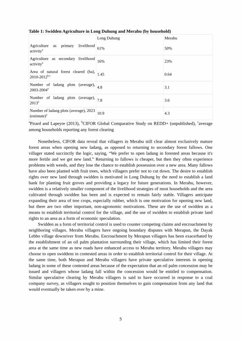
Table 1: Swidden Agriculture in Long Duhung and Merabu (by household)
Long Duhung Merabu
Agriculture as primary livelihood activitya
61% 50%
Agriculture as secondary livelihood activitya
16% 23%
Area of natural forest cleared (ha), 2010-2012b,c
1.45 0.64
Number of ladang plots (average), 2003-2004a
4.8 3.1
Number of ladang plots (average), 2013a
7.8 3.6
Number of ladang plots (average), 2023 (estimate)a
10.9 4.3
aPirard and Lapeyre (2013), bCIFOR Global Comparative Study on REDD+ (unpublished), caverage among households reporting any forest clearing
Nonetheless, CIFOR data reveal that villagers in Merabu still clear almost exclusively mature
forest areas when opening new ladang, as opposed to returning to secondary forest fallows. One villager stated succinctly the logic, saying, “We prefer to open ladang in forested areas because it's more fertile and we get new land.” Returning to fallows is cheaper, but then they often experience problems with weeds, and they lose the chance to establish possession over a new area. Many fallows have also been planted with fruit trees, which villagers prefer not to cut down. The desire to establish rights over new land through swidden is motivated in Long Duhung by the need to establish a land bank for planting fruit groves and providing a legacy for future generations. In Merabu, however, swidden is a relatively smaller component of the livelihood strategies of most households and the area cultivated through swidden has been and is expected to remain fairly stable. Villagers anticipate expanding their area of tree crops, especially rubber, which is one motivation for opening new land, but there are two other important, non-agronomic motivations. These are the use of swidden as a means to establish territorial control for the village, and the use of swidden to establish private land rights to an area as a form of economic speculation.
Swidden as a form of territorial control is used to counter competing claims and encroachment by neighboring villages. Merabu villagers have ongoing boundary disputes with Merapun, the Dayak Lebbo village downriver from Merabu. Encroachment by Merapun villagers has been exacerbated by the establishment of an oil palm plantation surrounding their village, which has limited their forest area at the same time as new roads have enhanced access to Merabu territory. Merabu villagers may choose to open swiddens in contested areas in order to establish territorial control for their village. At the same time, both Merapun and Merabu villagers have private speculative interests in opening ladang in some of these contested areas because of the expectation that an oil palm concession may be issued and villagers whose ladang fall within the concession would be entitled to compensation. Similar speculative clearing by Merabu villagers is said to have occurred in response to a coal company survey, as villagers sought to position themselves to gain compensation from any land that would eventually be taken over by a mine.
6
Contentious Land Change in a Swidden System
The strategic use of swidden as a form of land control has received relatively little attention in the literature on drivers of change in swidden systems. It receives no direct mention, for example, in van
Vliet et al.'s (2012) meta-analysis of 111 publications. The case of Merabu highlights two separate land control functions of swidden – territorialization and speculation – that help determine both the location of swidden plots and the continued expansion of swidden into new forest areas, despite the relatively long-term establishment of swidden systems in the village and the relatively lower contribution of swiddens to livelihoods. The territorializing function of swidden presents an interesting paradox, or what might be termed a problem of composition, since rights to a swidden plot are held by the individual who cultivates it, yet that individual also belongs to a village, and so his plot should also
be considered a marker of village territory (cf. Dove 1983). The fuzziness of individual land uses relative to village territorial boundaries is not surprising, given that the village as a formal administrative unit with defined cartographic boundaries has only been imposed in Kalimantan in the
last 35 years (Peluso 2005), yet the demarcation of village territory is important not just for determining the spaces for villagers to carry out their livelihood activities, but also for determining levels of collective payments made by companies operating in the village territory.
The speculative function of swidden is a response to the rapid and poorly regulated expansion of industrial land uses around Merabu. Most of the landscape falls within the forest estate, whose
management is under the authority of the central government's Ministry of Forestry,7 while even in lands outside the forest estate there is rarely any formal recognition of community land uses. The resulting tenure insecurity means communities have few options for resisting the conversion of village territory to mines or plantations. In addition to the collective payments made to communities that fall within their footprint, companies will also directly compensate individuals whose ladang or tree gardens are taken by a concession. Facing the possibility of expropriation of lands within the village territory, villagers speculate on future company activities by locating swidden in possible concession areas to establish individual land claims that will receive compensation when they are expropriated.
The expansion of swidden as a land control strategy for territorialization and speculation
represents a form of 'contentious land change.' Aldrich et al. (2012), working in the Amazon, argue that while land change science typically analyzes land cover change as the result of decisions made by individual rational actors, a more complete understanding of land change recognizes its social nature. They assert that “a component of deforestation in Amazônia results from contentious social interactions aimed at land possession in addition to what we refer to as agronomic deforestation undertaken to plant crops or pasture as an economic activity” (109, original emphasis). While Aldrich et al. were unable to obtain statistical estimates of the amount of deforestation in their case study that was specifically due to contentious processes, the recent development of a village spatial plan under TNC's project in Merabu allows for the identification of specific ladang plots as examples of contentious land use change. These clearings are explored in more detail in the following section, which examines the transformation of the swidden systems of Long Duhung and Merabu through the evolution of new structures of forest governance.
Swidden and Forest Governance
The Nature Conservancy's Conditional Payments Agreements
TNC has interacted with the Dayak communities of Kelay since the early 2000s, at first through its 7 In late 2014 the Ministry of Forestry was merged with the Ministry of Environment to form the new Ministry of Environment and Forestry.

7
support for orangutan protection in the Lesan forest area and for the development of the Upper Kelay Village Forum (Forum Kampung Hulu Kelay) as an interlocutor to the logging companies in support of 'collaborative forest management.' After launching the Berau Forest Carbon Program with the district government in 2009, TNC began to look for ways to integrate communities into REDD
(Moeliono et al. 2010), including piloting incentives schemes that would compensate villagers for
emissions reductions (Pirard and Lapeyre 2013). After a participatory planning period, both Merabu and Long Duhung signed agreements in late 2013 declaring their participation in BFCP and their commitment to protecting the forest and promoting environmentally-friendly livelihood activities. In Long Duhung, the district head (bupati) attended, opening the ceremony by planting a rubber tree (“Perayaan Keterlibatan Masyarakat Kampung Long Duhung Dalam Program Karbon Hutan Berau”
2013). In Merabu, a plaque and totem were installed in the center of the village to commemorate the village's commitment to “preserve the forest, conduct spatial and land use planning, and fight for prosperous living” (see Figure 1). Figure 1: Plaque and Totem Commemorating Merabu Village Agreement
The agreements were accompanied by the signing of Conditional Grant Agreements with TNC.
Under these agreements, TNC agreed to provide support for a variety of conservation and alternative livelihood activities in exchange for village commitments to carry out forest patrols, participate in training activities, and to limit the size and location of swidden plots. Villagers' performance in meeting the specified targets during the first year of the contract would determine the level of support

8
provided by TNC in the subsequent year, with support reduced in case of failure to meet targets. The TNC grant to the communities, Rp. 239 million each (or about US$20,000), included support for forest patrols and forest management, rubber cultivation, chicken raising, vegetable gardening, honey production, fish farming, and capacity building, among other activities. In exchange, the villagers agreed to “strengthening the enabling conditions” and “[climate change] mitigation and management
of natural resources” (TNC-Indonesia). Activities under enabling conditions generally relate to village financial management and capacity building. Under mitigation and management, the villagers agreed to carry out forest patrols and biodiversity and ecotourism surveys, and to limit their practice of shifting cultivation. Villagers agreed to open not more than 1 ha of swidden land per year, and only to open ladang in fallows as opposed to in new forest areas. New forest areas could be opened exceptionally in the case of new households that had not yet established a land base. In Merabu, villagers committed to a maximum of four ladang per household, for a total of 4 ha of swidden land
each (“Kesepakatan Dan Komitmen Masyarakat Kampung Merabu” 2013). In Long Duhung, the community agreed to a maximum of seven ladang per household, totaling 7 ha of swidden land. Additionally, TNC assisted each village in the development of a village land use plan, specifying areas for settlement, swidden farming, rubber gardens, agroforestry, and reserve land (see Appendix 2).
These agreements would appear to constitute a radical change in the swidden dynamics of the two villages. Where prior to the agreements villagers were predominantly opening ladang in new forest areas, they should now only open ladang in fallows. It was explicitly understood that this commitment was dependent on alternative livelihood support from TNC, which has focused most
heavily on the planting of rubber gardens and small animal husbandry (Pirard and Lapeyre 2013). In fact, these agreements still allow for the clearing of new forest areas under several provisions, and the immediate impact in the first year of the agreements has been to support new clearing, albeit under the aegis of the village land use plan and ostensibly as a one-time occurrence. First, households that have not yet reached the maximum land base of 4 or 7 ladang plots are permitted to clear new forest area. In addition to migrants to the village, these households include young adults from the village who are starting new households. While their parents may already have a full land allotment, these younger households are licensed to clear forest for new ladang up to their own allotment. Under the agreements, as population grows so will clearing, but in a fixed proportion of land per household. Second, TNC is supporting the establishment of 2 ha of rubber garden per household. These rubber gardens are not required to be established on fallows, so in the first year of the agreement in Merabu, virtually all households opened 1 ha of ladang in new forest area. After the first year's rice planting, they will turn the plot over to rubber and repeat the process, so that after two years they will have established their 2 ha rubber allotment. According to the land use plans, after obtaining 2 ha of rubber land and 4 or 7 ha of swidden plots, a household should not engage in any new forest clearing, but it will take several years (possibly longer than TNC's 2014-2016 conditional payments commitment) to determine whether that limitation has occurred.
While the TNC agreements thus permit continued expansion of swidden and rubber gardens into new forest areas, the organization's strategy is to control and limit the clearing through village land use and development planning. I focus here particularly on Merabu, because of the importance of contentious land change processes in the village and because I was a participant observer at the assembly to evaluate the first year of the conditional payments agreement in March 2015. In Merabu, the recent construction of the logging road to the village opened up a large area of land that was previously much less accessible. Land along the road would almost certainly have been deforested in any case, but under the village land use plan, the land along the road to the northwest of the village was zoned for rubber gardens and divided into 2 ha plots, which were allocated to each household by a random drawing. The resulting arrangement asserts village control over the area and allows for

9
expanding livelihood activities, but does so in an ordered way that aims to avoid the conflicts and inequities that often accompany the opening of a new land frontier, even at the village level.
Not surprisingly, the village agreement, conditional payments contract, and land use plan have not fully eliminated contentious land change processes from the Merabu swidden system. The one-year evaluation of the conditional payments agreement in Merabu took the form of a village assembly facilitated by TNC staff. TNC chose not to have third-party evaluators or to conduct monitoring and verification itself, favoring instead a participatory process where villagers would discuss the activities that had taken place and evaluate themselves according to the agreed upon targets. While the villagers and TNC agreed that financial management, training, and forest patrol targets had been met, the issue of swidden clearing emerged as the clear dilemma for the participants. At the prompting of a TNC staff member, villagers acknowledged that four households had cleared new swidden plots along the road to
the southwest of the village in the area zoned as reserve land under the village plan.8 Discussion then ensued about whether this clearing constituted a violation of the village agreements.
While none of the four households who had cleared in the reserve zone were in attendance at the evaluation meeting, the possible violation concerned all villagers because of their collective commitments and the potential of violations to affect the amount of funding provided to the village in the coming year. Opinion among the villagers was divided. Those who found the clearings to be a violation pointed to the letter of the agreements, while on the opposite side a variety of reasons were advanced for why these clearings should not be considered in breach of the agreements. The first justification offered was that people had opened in the reserve land in order to keep outsiders from encroaching. Villagers from Merapun have been challenging Merabu's control in this area, so swidden was in this case viewed as a means of territorialization. It was also noted that those opening in the reserve land had not cleared more than 1 ha nor had they exceeded their total land allotments. Other villagers pointed out, however, that if the transgressors were intending to keep away Merapun villagers, they had opened their swiddens on the wrong side of the road. A second justification suggested was that the plots distributed for rubber were not all equally desirable, and those who had drawn worse plots might prefer to open land elsewhere. Discussion focused primarily on the territorial justification. On another occasion, a villager had told me that people in Merabu were no longer opening ladang in new forest area except when there was a boundary conflict with another community, in which case they would clear forest to claim the land. The territorial function of swidden is clearly still considered a legitimate determinant of clearing by a significant proportion of the village population.
What becomes apparent through this moment is the encounter of competing territorializations. Territorialization through swidden clearing conflicts with territorialization through spatial planning. The spatial planning approach advocated by TNC has the additional attribute of helping the village to access Indonesian government funding designated to support village development plans (TNC33:150309). Enforcement of village territorial control is also supported under the TNC approach through forest patrols. Nonetheless, in an area where control is contested with another village, spatial plans and occasional patrols do not have the materiality or cultural weight that characterize a swidden plot. The paradox of swidden as a form of territorialization is also present in this moment, however. In the view of one of the TNC staff members most familiar with the village, the households opening ladang in the reserve land were motivated not by collective territorial control, but by individual speculative interest. He notes that there is already an area near Merabu, in the direction of the reserve land and Merapun, which has been zoned as conversion forest by the central government (meaning it can be converted to non-forest uses), and there is an area (where most of the reserve land lies) that is still classified as production forest (meaning it should remain under forest uses). Merabu villagers fear that if people from Merapun continue entering and degrading the production forest, it will be rezoned
8 Reserve land in principle would be set aside for management by future generations.
10
to conversion forest and then oil palm will enter and the village government has no authority to prevent it. The four transgressing households do not expect the village government to keep out the oil palm plantations. By opening swidden in the contested area and establishing land claims now, they will at least receive compensation when the land is expropriated for oil palm.
Speculative and territorial drivers of swidden expansion intersect in this case, and because these clearings happened contrary to the village agreements, we can identify contentious land change in Merabu as the cause of 4 ha of new deforestation. I do not have exact figures on the number of households that cleared ladang in Merabu in 2014, but CIFOR finds 52% of households in Merabu
practice agriculture as a primary or secondary occupation (Sills et al. 2014, 373), while the IDDRI survey puts the figure at 73%. If we take the conservative estimate of 73%, roughly 40 households in Merabu can be assumed to practice agriculture. If each of those households cleared 1 ha of new forest for ladang in 2014 (again a conservative assumption), then 4 out of the total 40 ha cleared, or at least 10% of the 2014 deforestation in Merabu, was determined through contentious land change processes. While the four transgressors would likely have cleared ladang within the proper zone had they not opened ladang in the reserve land, the rubber zone was slated for conversion, while the reserve land clearing constitutes deforestation that would not otherwise have occurred were it not for these specific processes of contentious land change.
In the end, community members voted 8 to 5 that the clearings in the reserve land were not a violation, and they gave themselves full points for compliance with the swidden clauses of the agreement.
Swidden and Multi-Stakeholder Governance
The attempted re-ordering of swidden practice in Merabu and Long Duhung is not limited to the interactions between TNC and the communities. Rather, it intersects with government policy and corporate practice as a nexus for the emergence of 'multi-stakeholder' forest governance in Berau. Multi-stakeholder collaboration is a key feature of neoliberal governance regimes (Castree 2010;
McCarthy and Prudham 2004), as well as a central tenet of TNC's conservation strategy, which the organization describes as a “non-confrontational, pragmatic, market-based” approach to conservation based on partnerships with governments, companies, multilateral organizations, other NGOs, and
“local stakeholders” (TNC 2013). In Berau, TNC attempted to establish BFCP as a program led by the district government with participation from the provincial and national government, companies, NGOs, and communities. The Berau REDD+ Task Force (Pokja REDD), which supported the development of BFCP and functions as a de facto secretariat for the program, counts among its membership the district forestry department and environmental bureau, two major timber concessionaires, a local environmental NGO, and TNC. Curiously for a program aimed at reducing emissions from deforestation, there has been virtually no participation in BFCP by mining or oil palm companies, which are the two sectors most responsible for forest conversion in Berau. TNC has also failed to target these sectors in its Berau program. The organization fears reputational risks from working with mining companies (TNC34:150501). In 2015, TNC is launching a new oil palm program with four years of funding from the German Federal Environment Ministry, though TNC staff acknowledge that the oil palm sector has until now been a conspicuous gap in their Berau program (TNC34:150501).
Community initiatives and sustainable logging, meanwhile, have been the areas of most substantial on-the-ground activity by TNC and other environmental organizations working in inland Berau. Aside from TNC, the most significant non-state environmental actor is the German government's Forests and Climate Change Programme (FORCLIME). Activities in the forestry and communities sector include TNC and FORCLIME support for logging companies to adopt reduced-

11
impact logging methods and achieve sustainability certifications; logging company and community participation in 'collaborative forest management,' where companies respect community areas and compensate communities for timber extraction while communities help monitor logging concessions for illegal activities; and the government's establishment of a Forest Management Unit (KPH) for western Berau to coordinate on-the-ground activities including monitoring, enforcement, and conflict resolution, as well as supporting the establishment of 'village forest' (hutan desa) rights. In 2014, Merabu was granted a village forest area over part of the protected forest land within village boundaries, becoming the first village in Berau to obtain a hutan desa designation.
The regulation of swidden practice is a cornerstone of the intersecting governance initiatives in the community-forestry sector. The beginning of industrial logging in East Kalimantan in the 1970s coincided with government efforts to resettle and sedentarize upland populations, which on the one
hand served to make those populations 'legible' to the state (Scott 1998), while on the other it cleared space for industrial resource extraction. Conflicts between logging companies and communities have sputtered over the decades, but currently the logging companies in Berau tend to respect communities'
rights to cultivate a certain amount of swidden area within their traditional territories. 9 Further delimiting the practice of swidden remains a common cause across the government and NGO actors in the forestry sector. While most do not view swidden as a major environmental problem, they nonetheless see reform of swidden as desirable and progressive. Several actors note that ladang is the largest source of illegal deforestation in Berau, since conversion for plantations and mining occurs under government licenses (GIZ04:150416; BER04:150408). This 'illegality' of ladang speaks to the government's desire to suppress shifting cultivation, and facilitates the confluence of government and NGO interest in making ladang “more effective” (BER13:150415) or offering “alternative economies”
(BER04:150408)(cf. Dove 1983). Government officials in the district forestry department and environment bureau also mention the use of fire as a danger of swidden cultivation (BER02:150317; BER08:150413), though Berau has not suffered fires of the same severity as parts of East Kalimantan further to the south. In one case, the district government is reported to have made shifting from swidden to permanent agriculture a requirement for confirming a village's administrative status (Sills
et al. 2014, 374). Meanwhile, control of swidden has been central to NGO community work as a strategy of
climate change mitigation and a counterpart to the promotion of alternative livelihoods. Like TNC, the FORCLIME program supports REDD 'demonstration activities' in upland villages. FORCLIME likewise stipulates that communities should not clear new forest areas, and encourages rubber planting, small animal husbandry, and commercialization of non-timber forest products such as honey and herbal tea. One FORCLIME employee imagines the possibility of a moratorium on swidden, saying, “People deforest for their stomachs, for rice. If we pay for their rice, they wouldn't deforest” (GIZ03:150330). He contemplates a strategy of hill rice intensification and the development of wet rice production leading up to a moratorium on shifting cultivation. In addition to the direct attempts by TNC and FORCLIME to limit swidden areas, TNC's model of village land use planning and alternative livelihoods development has been codified by the organization as 'SIGAP REDD+'
(Hartanto, Yulianto, and Hidayat 2014), and TNC is now directing around $10 million from a US Government debt-for-nature swap to support local NGOs to implement SIGAP REDD+ in Berau, thus replicating TNC's community strategies in multiple villages.
The effect of these various interlocking initiatives is that control of swidden – for climate change mitigation, for state administrative control, and for industrial timber extraction – has become a
9 The development of 'collaborative forest management' between communities and timber companies in Berau came in the early 2000s and was also supported by TNC. It marks an important chapter in the development of forest governance in the district, but space constraints preclude a more detailed discussion here.

12
central component of an emergent, loosely-institutionalized forest governance apparatus that integrates government, logging companies, NGOs, and communities in managing a landscape of timber concessions and small-scale agricultural and hunting and gathering activities. The relatively minor contribution of swidden to overall deforestation in Berau makes it particularly noteworthy that swidden has been a principal site for the development of multi-stakeholder forest governance. One TNC staff member explains the focus on communities, affirming that while the emissions reductions of community activities may not be great in themselves, the impact of community work is substantial because it serves as a way to attract government attention and commitment, to engage with companies, and to enhance the capacity of local NGOs (TNC34:150501). This multi-stakeholder apparatus could ostensibly then be expanded to develop environmental governance in other sectors. While TNC's new oil palm project may bring change to that sector, at present the community-forestry environmental governance apparatus is being undercut by the expansion of industrial mining and especially oil palm plantations, which introduces new 'stakeholders' and processes that upset the community-forestry consensus. Across Kalimantan, oil palm plantations are expanding at the expense of forest (Carlson et
al. 2012), and contentious land change ripples out from their expansion. In Long Duhung, where logging is the primary industrial land use, swidden area has been expanding, but primarily due to agronomic reasons. In Merabu, where oil palm and mining threaten to enter the village territory, the agronomic drivers of swidden expansion are more limited, but territorialization and speculation are driving additional swidden clearing.
The emergence of forest governance through control of swidden and more broadly through the conciliation of community livelihoods and industrial forestry, and the failure to integrate mining and oil palm into the forest governance apparatus, may be explained by the fact that community livelihoods and timber harvesting can be compatible with forest cover, while oil palm and mining (which in East Kalimantan is primarily open-pit coal mining) require the conversion of forest to an alternative land cover. Government actors are happy to limit the area under swidden as a way of sedentarizing villagers and promoting the production of commodities such as rubber, but officials view industrial plantations, in particular, as the key to economic development at both the district (BER20:150420) and the provincial level (BAPPEDA01:150324), and they have no intention of limiting the overall expansion of plantations in favor of forest conservation. In the words of one FORCLIME employee, “oil palm is from the government, so we can't do anything to stop it” (GIZ06:150427). Controlling swidden is a form of forest governance that remains compatible with the expansion of industrial land uses, so it has become a site for successful multi-stakeholder coordination, and possibly for deflection from the more significant drivers of deforestation in Berau.
Conclusion
Swidden systems in East Kalimantan have been dramatically transformed over the last four decades, initially through government sedentarization programs and the advent of industrial logging, and more recently through the expansion of mining and oil palm plantations and the development of forest conservation programs. I describe the swidden systems of two Dayak villages in Berau district, and I highlight how, in some areas, dynamics of territorialization and economic speculation are contributing to the expansion of swidden area through a process of 'contentious land change.' Under the Berau Forest Carbon Program, control of swidden has become a locus for the development of village land use planning and additional forest governance structures within a network of village, NGO, government, and company actors. Efforts by these actors to limit swidden clearing and promote alternative livelihoods in the villages aim to define and minimize community agricultural area and eliminate contentious land change, which fulfills an instrumental role as a further step toward clearing

13
space for industrial land uses, i.e. continued industrial timber extraction and conversion of land for oil palm plantations, as well as promoting the deeper integration of villagers into the market economy.
Forest governance programs in Berau conspicuously lack participation of the mining and oil palm sectors, and the expansion of these industrial land uses undermines the viability of the small-scale rural livelihoods on which the existing forest governance apparatus is anchored. Even communities whose territory remains forested are challenged by landscape-level forest fragmentation (which affects biodiversity and species abundance), hydrological and micro-climatic changes caused by large-scale forest clearing, and socio-economic transformations that trigger resource conflicts and drive contentious land change. The current status of swidden as a central focus of nascent forest governance structures in Berau may not herald the long-term viability of forest-dependent livelihoods so much as it indicates the inability of forest governance efforts to check the juggernaut of coal mines and oil palm plantations that is currently steamrolling the remaining forests of Indonesian Borneo.
References
Aldrich, Stephen, Robert Walker, Cynthia Simmons, Marcellus M Caldas, and Stephen Perz. 2012. “Contentious Land Change in the Amazon’s Arc of Deforestation.” Annals of the Association of American Geographers 102 (1): 103–128.
Berau REDD+ Working Group. 2011. “Berau Forest Carbon Program, 2011-2015: Berau’s Contribution to the World.” Tanjung Redeb, Indonesia. http://tfcakalimantan.org/wp-content/uploads/2012/12/BFCP-English_Compile-Done.pdf.
Carlson, Kimberly M., Lisa M. Curran, Gregory P. Asner, Alice McDonald Pittman, Simon N. Trigg, and J. Marion Adeney. 2012. “Carbon Emissions from Forest Conversion by Kalimantan Oil Palm Plantations.” Nature Climate Change 2 (10) (October 7): 1–5.
Castree, Noel. 2010. “Neoliberalism and the Biophysical Environment 1: What ‘Neoliberalism’ Is, and What Difference Nature Makes to It.” Geography Compass 4 (12) (December 1): 1725–1733.
Conklin, Harold C. 1957. “Hanunóo Agriculture: A Report on an Integral System of Shifting Cultivation in the Philippines.” Rome.
Dounias, Edmond, Audrey Selzner, Miyako Koizumi, and Patrice Levang. 2007. “From Sago to Rice, from Forest to Town: The Consequences of Sedentarization for the Nutritional Ecology of Punan Former Hunter-Gatherers of Borneo.” Food and Nutrition Bulletin 28 (2 SUPPL.): 294–302.
Dove, Michael R. 1983. “Theories of Swidden Agriculture, and the Political Economy of Ignorance.” Agroforestry Systems 1 (2): 85–99.
Fishbein, Greg, and Donna Lee. 2015. “Early Lessons from Jurisdictional REDD+ and Low Emissions Development Programs.” Arlington, Virginia. http://www.nature.org/media/climatechange/REDD+_LED_Programs.pdf.
Fox, Jefferson, Yayoi Fujita, Dimbab Ngidang, Nancy Peluso, Lesley Potter, Niken Sakuntaladewi, Janet Sturgeon, and David Thomas. 2009. “Policies, Political-Economy, and Swidden in Southeast Asia.” Human Ecology: An Interdisciplinary Journal 37 (3) (June): 305–322.
Hartanto, Herlina, Tomy S Yulianto, and Taufiq Hidayat. 2014. SIGAP-REDD+: Aksi Inspiratif Warga Untuk Perubahan Dalam REDD +. Jakarta: TNC.
Inoue, Makoto, and Abubakar M. Lahjie. 1990. “Dynamics of Swidden Agriculture in East Kalimantan.” Agroforestry Systems 12 (3): 269–284.
Jessup, Timothy C. 1991. “Persistence and Change in the Practice of Shifting Cultivation in the Apo Kayan, East Kalimantan, Indonesia.” Indo-Pacific Prehistory Association Bulletin 10: 218–225.
“Kesepakatan Dan Komitmen Masyarakat Kampung Merabu.” 2013. Li, Tania Murray, ed. 1999. Transforming the Indonesian Uplands. Harwood Academic Publishers.
14
———. 2007. The Will to Improve: Governmentality, Development, and the Practice of Politics. Durham: Duke University Press.
McCarthy, James, and Scott Prudham. 2004. “Neoliberal Nature and the Nature of Neoliberalism.” Geoforum 35 (3) (May): 275–283.
Moeliono, Ilya, Warno Hadi Winarno, Edy Dwi Hartono, and Tomy Satria Yulianto. 2010. “Masyarakat Kampung Di Kabupaten Berau Dan Rekomendasi Keterlibatannya Dalam Skema Pengurangan Emisi Dari Deforestasi Dan Degradasi Hutan (REDD).” http://tfcakalimantan.org/wp-content/uploads/2013/05/Laporan-Kajian-Keterlibatan-Masyarakat-Kampung-dalam-REDD-di-Berau1.pdf.
Padoch, Christine, Kevin Coffey, Ole Mertz, Stephen J Leisz, Jefferson Fox, and Reed L Wadley. 2007. “The Demise of Swidden in Southeast Asia? Local Realities and Regional Ambiguities.” Geografisk Tidsskrift. 107 (1): 29–41.
Peluso, Nancy Lee. 2005. “Seeing Property in Land Use: Local Territorializations in West Kalimantan, Indonesia.” Geografisk Tidsskrift-Danish Journal of Geography 105 (1): 1–16.
Peluso, Nancy Lee, and Peter Vandergeest. 2001. “Genealogies of the Political Forest and Customary Rights in Indonesia, Malaysia, and Thailand.” The Journal of Asian Studies 60 (3): 761–812.
“Perayaan Keterlibatan Masyarakat Kampung Long Duhung Dalam Program Karbon Hutan Berau.” 2013. Karbonhutanberau.org, December 16. http://www.karbonhutanberau.org/id/2013/12/perayaan-keterlibatan-masyarakat-kampung-long-duhung-dalam-program-karbon-hutan-berau/.
Pirard, Romain, and Renaud Lapeyre. 2013. “Building a Rapid Assessment Tool to Help Design Community Incentive Agreements in the Context of the Berau Forest Carbon Program: The Example of 2 Model Villages (Long Duhung, Merabu).”
Scott, James C. 1998. Seeing Like a State: How Certain Schemes to Improve the Human Condition Have Failed. New Haven, Connecticut: Yale University Press.
———. 2009. The Art of Not Being Governed: An Anarchist History of Upland Southeast Asia. New Haven, Connecticut: Yale University Press.
Sills, Erin O, Stibniati S Atmadja, Claudio De Sassi, Amy E Duchelle, Demetrius L Kweka, Ida Aju Pradnja Resosudarmo, and William D Sunderlin, ed. 2014. REDD+ on the Ground: A Case Book of Subnational Initiatives across the Globe. Bogor, Indonesia: CIFOR.
TNC. 2013. “Our Partners in Conservation.” http://www.nature.org/about-us/our-partners/index.htm. TNC-Indonesia. “TNC Conditional Payment Agreement with Merabu Village.” Van Vliet, Nathalie, Ole Mertz, Andreas Heinimann, Tobias Langanke, Unai Pascual, Birgit Schmook,
Cristina Adams, et al. 2012. “Trends, Drivers and Impacts of Changes in Swidden Cultivation in Tropical Forest-Agriculture Frontiers: A Global Assessment.” Global Environmental Change 22 (2): 418–429.
An international academic conference
5‐6 June 2015, Chiang Mai University
Land grabbing, conflict and agrarian‐environmental transformations: perspectives from East and Southeast
International Conference Paper Series The purpose of the 2015 Chiang Mai conference is to contribute to deepening and broadening of our understanding of global land deals, resource conflict and agrarian‐environmental transformations – in the specific regional context of Southeast and East Asia, with special attention to climate change mitigation and adaptation policies as well as the role of China and other middle income countries (MICs) within the region.
The Conference Paper Series aims to generate vibrant discussion around these issues in the build up towards the June 2015 conference – and beyond. We will keep these papers accessible through the websites of the main organizers before, during and after the conference.
About the Author Gregory M. Thaler is a PhD candidate in the Department of Government at Cornell University, where he works on the political ecology of tropical land use. His dissertation project examines the role of environmental governance in land use transitions in the Brazilian Amazon and Indonesian Borneo. In 2014‐2015 he is affiliated with the Center for International Forestry Research (CIFOR) in Bogor, Indonesia, where he is collaborating on their Global Comparative Study of Reducing Emissions from Deforestation and Forest Degradation (REDD+). He previously worked on forest carbon issues as a consultant to UNESCO's Man and the Biosphere Programme.