shlaa ldf settlement status at 31 march outstanding site ... · 120383 sirdar, flanshaw lane sub...
TRANSCRIPT

STRATEGIC HOUSING LAND AVAILABILITY ASSESSMENT (SHLAA) 2017- ANNEX 1
SHLAA
RefAddress
LDF Settlement
HierarchyLDF Settlement Name Green/Brown Field
Status at 31 March
2017
Outstanding
Capacity
Site Area
(hectares)Phasing Map Link
31 1 Westfield Terrace Sub Regional City Wakefield Brownfield Lapsed Permission 9 0.03 0-5 Years View Map
380 Adj 639 Barnsley Road, Sandal Sub Regional City Wakefield Brownfield Under Construction 2 0.15 0-5 Years View Map
441 25 Belle Vue Road Sub Regional City Wakefield Greenfield Full Permission 1 0.03 0-5 Years View Map
450 179 Manygates Lane Sub Regional City Wakefield Greenfield Full Permission 2 0.14 0-5 Years View Map
550 Adj 139 Flanshaw Lane Alverthorpe Sub Regional City Wakefield Greenfield Lapsed Permission 7 0.16 0-5 Years View Map
553 R/o 35 Flanshaw Lane, Alverthorpe Sub Regional City Wakefield Brownfield Full Permission 37 0.34 0-5 Years View Map
559 George-A-Green Road, Lupset Sub Regional City Wakefield Greenfield Lapsed Permission 16 0.13 0-5 Years View Map
562 Land off George A Green Road, Lupset Sub Regional City Wakefield Greenfield Lapsed Permission 17 0.42 0-5 Years View Map
569 R/o 85-89 Westgate End Sub Regional City Wakefield Greenfield Under Construction 12 0.14 0-5 Years View Map
575 Westgate End House, 18 Kemps Bridge Sub Regional City Wakefield Greenfield Lapsed Permission 6 0.35 0-5 Years View Map
584 Flanshaw Hotel, Flanshaw Lane Sub Regional City Wakefield Brownfield Lapsed Permission 10 0.18 0-5 Years View Map
621 Radcliffe Place Sub Regional City Wakefield Brownfield Lapsed Permission 9 0.29 0-5 Years View Map
632 16 St John's North Sub Regional City Wakefield Brownfield Under Construction 4 0.02 0-5 Years View Map
634 Kirkgate (Kirkgate / Sun Lane) Sub Regional City Wakefield Brownfield Allocated 14 0.28 0-5 Years View Map
640 Providence Street Sub Regional City Wakefield Brownfield Lapsed Permission 12 0.23 0-5 Years View Map
641 91 & 91a Kirkgate Sub Regional City Wakefield Brownfield Under Construction 7 0.05 6-10 Years View Map
642 18 St John's North Sub Regional City Wakefield Brownfield Full Permission 5 0.03 0-5 Years View Map
655 2 Marsland Avenue Sub Regional City Wakefield Brownfield Under Construction 1 0.11 0-5 Years View Map
659 Ings Road (former Crown works site) Sub Regional City Wakefield Brownfield Lapsed Permission 154 0.51 0-5 Years View Map
669 4 College Grove View Sub Regional City Wakefield Brownfield Lapsed Permission 5 0.02 0-5 Years View Map
676 West end of West Street Sub Regional City Wakefield Brownfield Lapsed Permission 9 0.11 0-5 Years View Map
Wakefield Council - Spatial Policy

STRATEGIC HOUSING LAND AVAILABILITY ASSESSMENT (SHLAA) 2017- ANNEX 1
SHLAA
RefAddress
LDF Settlement
HierarchyLDF Settlement Name Green/Brown Field
Status at 31 March
2017
Outstanding
Capacity
Site Area
(hectares)Phasing Map Link
762 The Old Mill Hollingthorpe Lane, Hall Green Sub Regional City Wakefield Brownfield Outline Permission 6 0.22 0-5 Years View Map
767 R/o 35 Flanshaw Lane, Alverthorpe Sub Regional City Wakefield Brownfield Full Permission 6 0.05 0-5 Years View Map
826 28 Chevet Lane (land to rear) Sub Regional City Wakefield Greenfield Full Permission 1 0.11 0-5 Years View Map
836 8 - 10 Teall Street Sub Regional City Wakefield Brownfield Full Permission 4 0.00 0-5 Years View Map
903 Former Flanshaw Children's Centre Sub Regional City Wakefield Brownfield Allocated 77 1.92 0-5 Years View Map
905 Warburton's, Westgate End Sub Regional City Wakefield Brownfield Allocated 30 0.75 0-5 Years View Map
952 Balne Lane Sub Regional City Wakefield Greenfield No planning status 356 8.94 11-15 Years View Map
953 Thornes Park, Horbury Road Sub Regional City Wakefield Greenfield No planning status 161 4.03 6-10 Years View Map
955 West of Asda, Sandal Sub Regional City Wakefield Greenfield No planning status 52 1.37 11-15 Years View Map
1043 North of Asda, Sandal Sub Regional City Wakefield Greenfield No planning status 89 2.22 11-15 Years View Map
958 Diamond Business Park Sub Regional City Wakefield Brownfield No planning status 162 4.05 16+ Years View Map
959 Land off Silcoates Lane, Wrenthorpe Sub Regional City Wakefield Greenfield No planning status 92 2.32 6-10 Years View Map
1068 Calder Park Sub Regional City Wakefield Brownfield No planning status 1640 54.68 16+ Years View Map
860 Clayton Hospital Sub Regional City Wakefield Brownfield Allocated 122 1.62 0-5 Years View Map
863 Registry of Deeds Sub Regional City Wakefield Brownfield Allocated 20 0.32 0-5 Years View Map
1079 Land north of Standbridge Lane, Kettlethorpe Sub Regional City Wakefield Greenfield No planning status 692 17.10 16+ Years View Map
1080 Eagle Grove, Flanshaw Sub Regional City Wakefield Brownfield Allocated 49 1.23 0-5 Years View Map
1091 Land adj 26 Kingfisher Close, Durkar Sub Regional City Wakefield Greenfield No planning status 17 0.43 6-10 Years View Map
1096 Land off Wakefield Road, Roundwood Sub Regional City Wakefield Mixed B30/G70 No planning status 25 0.62 11-15 Years View Map
1131 Land at Ruskin Avenue, Wrenthorpe Sub Regional City Wakefield Greenfield No planning status 42 1.05 6-10 Years View Map
120359 Land adj To Sandal Grange Farm, Walton Lane Sub Regional City Wakefield Greenfield No planning status 97 2.42 6-10 Years View Map
Wakefield Council - Spatial Policy

STRATEGIC HOUSING LAND AVAILABILITY ASSESSMENT (SHLAA) 2017- ANNEX 1
SHLAA
RefAddress
LDF Settlement
HierarchyLDF Settlement Name Green/Brown Field
Status at 31 March
2017
Outstanding
Capacity
Site Area
(hectares)Phasing Map Link
120360 Land north of Lindale Lane, Wrenthorpe Sub Regional City Wakefield Greenfield No planning status 38 0.94 6-10 Years View Map
120361 West of Sunnyhill Croft, Wrenthorpe Sub Regional City Wakefield Greenfield No planning status 117 2.92 6-10 Years View Map
120365 Land off Jerry Clay Lane, Wrenthorpe Sub Regional City Wakefield Greenfield No planning status 82 2.06 6-10 Years View Map
120383 Sirdar, Flanshaw Lane Sub Regional City Wakefield Brownfield Allocated 262 6.54 0-5 Years View Map
120315 Victoria Works Sub Regional City Wakefield Brownfield Lapsed Permission 20 0.18 0-5 Years View Map
237549 1 - 15 Pashley Court Sub Regional City Wakefield Brownfield Lapsed Permission 5 0.06 0-5 Years View Map
237562 40 Balne Lane (land adj) Sub Regional City Wakefield Greenfield Full Permission 1 0.04 0-5 Years View Map
237566 599A Leeds Road (land to rear) Sub Regional City Wakefield Greenfield Under Construction 4 0.46 0-5 Years View Map
120340 90 - 92 - 94 Horbury Road Sub Regional City Wakefield Brownfield Outline Permission 14 0.09 0-5 Years View Map
313119 Adj 144 Flanshaw Lane Sub Regional City Wakefield Brownfield Lapsed Permission 12 0.14 0-5 Years View Map
1246 497 Denby Dale Road Calder Grove Sub Regional City Wakefield Brownfield Lapsed Permission 9 0.19 0-5 Years View Map
313081 Primrose House, Primrose Lane, Calder Grove Sub Regional City Wakefield Brownfield Lapsed Permission 6 0.14 0-5 Years View Map
313156 22 Chevet Lane Sub Regional City Wakefield Greenfield Under Construction 1 0.21 0-5 Years View Map
313085 Round Street Sub Regional City Wakefield Greenfield Under Construction 1 0.02 0-5 Years View Map
313086 91 Agbrigg Road Sub Regional City Wakefield Brownfield Under Construction 6 0.25 0-5 Years View Map
313088 155 High Street (land to rear) Sub Regional City Wakefield Greenfield Full Permission 1 0.07 0-5 Years View Map
313121 48 Wrenthorpe Road Sub Regional City Wakefield Greenfield Lapsed Permission 10 0.39 0-5 Years View Map
313135 19a The Springs Sub Regional City Wakefield Brownfield Under Construction 3 0.01 0-5 Years View Map
313090 377 Barnsley Road Sub Regional City Wakefield Greenfield Under Construction 1 0.11 0-5 Years View Map
313133 Ruskin Avenue (land to rear) Sub Regional City Wakefield Greenfield Under Construction 8 6.23 0-5 Years View Map
313163 Ruskin Avenue (land to rear) Sub Regional City Wakefield Greenfield Under Construction 4 1.25 0-5 Years View Map
Wakefield Council - Spatial Policy

STRATEGIC HOUSING LAND AVAILABILITY ASSESSMENT (SHLAA) 2017- ANNEX 1
SHLAA
RefAddress
LDF Settlement
HierarchyLDF Settlement Name Green/Brown Field
Status at 31 March
2017
Outstanding
Capacity
Site Area
(hectares)Phasing Map Link
313097 Former Bar 173 Doncaster Road Sub Regional City Wakefield Brownfield Under Construction 3 0.03 0-5 Years View Map
313099 177 Doncaster Road Sub Regional City Wakefield Greenfield Outline Permission 1 0.05 0-5 Years View Map
313199 89 Thornes Road Sub Regional City Wakefield Brownfield Full Permission 1 0.08 0-5 Years View Map
313155 Belle Vue Stadium, Doncaster Road Sub Regional City Wakefield Brownfield Lapsed Permission 30 0.47 0-5 Years View Map
313230 637 Barnsley Road (Hodroyd House) Sub Regional City Wakefield Greenfield Outline Permission 1 0.27 0-5 Years View Map
313263 4 Green Lane Sub Regional City Wakefield Brownfield Under Construction 1 0.05 0-5 Years View Map
313274 633 Barnsley Road Sub Regional City Wakefield Greenfield Under Construction 2 0.18 0-5 Years View Map
313288 162 - 164 Westgate Sub Regional City Wakefield Brownfield Lapsed Permission 6 0.06 0-5 Years View Map
313241 Durkar Lane (land off) Sub Regional City Wakefield Greenfield Under Construction 2 1.97 0-5 Years View Map
1116Land east of Newton Hill Junior and Infants
SchoolSub Regional City Wakefield Greenfield Allocated 104 2.61 0-5 Years View Map
313164 Land To West Of Pinderfields Hospital Sub Regional City Wakefield Greenfield Under Construction 64 3.15 0-5 Years View Map
314066 122 Painthorpe Lane Sub Regional City Wakefield Brownfield Under Construction 1 0.12 0-5 Years View Map
314069 43 Belle Vue Road Sub Regional City Wakefield Brownfield Full Permission 2 0.01 0-5 Years View Map
1087 R/o Daw Green Avenue, Crigglestone Sub Regional City Wakefield Brownfield Allocated 24 0.52 0-5 Years View Map
1041 Land off Batley Road Sub Regional City Wakefield Greenfield No planning status 404 10.02 11-15 Years View Map
1310 Pinderfields West Sub Regional City Wakefield Greenfield No planning status 193 4.00 6-10 Years View Map
923 R/o Milton Crescent, Snapethorpe Sub Regional City Wakefield Greenfield Allocated 260 6.67 0-5 Years View Map
861 Borough Road Car Park Sub Regional City Wakefield Brownfield Allocated 68 0.96 0-5 Years View Map
614 Ivy Lane, Eastmoor Sub Regional City Wakefield Greenfield Outline Permission 33 0.77 0-5 Years View Map
237609 Land at Durkar Low Lane, Durkar Sub Regional City Wakefield Greenfield No planning status 240 7.36 6-10 Years View Map
417 Sports Club, Walton Lane, Sandal Sub Regional City Wakefield Greenfield Allocated 214 7.13 0-5 Years View Map
Wakefield Council - Spatial Policy

STRATEGIC HOUSING LAND AVAILABILITY ASSESSMENT (SHLAA) 2017- ANNEX 1
SHLAA
RefAddress
LDF Settlement
HierarchyLDF Settlement Name Green/Brown Field
Status at 31 March
2017
Outstanding
Capacity
Site Area
(hectares)Phasing Map Link
870 Ings Road (south of Ings Road) Sub Regional City Wakefield Brownfield Allocated 271 5.72 0-5 Years View Map
871 Ings Road (North of Ings Road) Sub Regional City Wakefield Brownfield Allocated 122 4.86 0-5 Years View Map
859 Jacobs Well Lane Sub Regional City Wakefield Brownfield Allocated 217 3.61 0-5 Years View Map
444 Waterfront Area, Barnsley Road Sub Regional City Wakefield Brownfield Allocated 302 2.83 0-5 Years View Map
427 Belle Vue Stadium, Doncaster Road Sub Regional City Wakefield Brownfield Lapsed Permission 76 2.06 0-5 Years View Map
1249 412/416 Denby Dale Road East Durkar Sub Regional City Wakefield Brownfield Full Permission 2 0.01 0-5 Years View Map
313240 Durkar Lane (land off) Sub Regional City Wakefield Greenfield Under Construction 48 5.58 0-5 Years View Map
315020 Cliff Hill Works Sub Regional City Wakefield Brownfield Under Construction 8 0.06 0-5 Years View Map
315021 20 St John's North Sub Regional City Wakefield Brownfield Full Permission 4 0.04 0-5 Years View Map
315024 377 Barnsley Road Sub Regional City Wakefield Greenfield Full Permission 2 0.15 0-5 Years View Map
315026 274 Standbridge Lane Sub Regional City Wakefield Greenfield Under Construction 1 0.07 0-5 Years View Map
315028 South East of Aberford Road Sub Regional City Wakefield Greenfield Outline Permission 171 8.10 0-5 Years View Map
315030Kirkgate (south & east of Kirkgate roundabout)
Chantry HouseSub Regional City Wakefield Brownfield Full Permission 84 0.32 0-5 Years View Map
315035 1 King Street Sub Regional City Wakefield Brownfield Under Construction 4 0.01 0-5 Years View Map
315070 Land at 639/643 Barnsley Road Sub Regional City Wakefield Greenfield Full Permission 1 0.07 0-5 Years View Map
315072 13 Chevet Lane Sub Regional City Wakefield Greenfield Full Permission 1 0.22 0-5 Years View Map
315073 60A Barnsley Road Sub Regional City Wakefield Brownfield Full Permission 2 0.04 0-5 Years View Map
315074 110A Manygates Lane Sub Regional City Wakefield Greenfield Full Permission 2 0.10 0-5 Years View Map
315075 Fold Yard, Brook House Sub Regional City Wakefield Greenfield Full Permission 6 0.05 0-5 Years View Map
315084 West Villa Sub Regional City Wakefield Brownfield Full Permission 2 0.03 0-5 Years View Map
315085 Clothiers Arms Sub Regional City Wakefield Brownfield Full Permission 8 0.12 0-5 Years View Map
Wakefield Council - Spatial Policy

STRATEGIC HOUSING LAND AVAILABILITY ASSESSMENT (SHLAA) 2017- ANNEX 1
SHLAA
RefAddress
LDF Settlement
HierarchyLDF Settlement Name Green/Brown Field
Status at 31 March
2017
Outstanding
Capacity
Site Area
(hectares)Phasing Map Link
315087 2 Chald Lane Sub Regional City Wakefield Brownfield Under Construction 2 0.12 0-5 Years View Map
315089 47 Westways Sub Regional City Wakefield Greenfield Under Construction 1 0.02 0-5 Years View Map
315090 297 Dewsbury Road (Land To Rear) Sub Regional City Wakefield Greenfield Under Construction 1 0.06 0-5 Years View Map
315091 Flanshaw Lane (Land At) Sub Regional City Wakefield Greenfield Full Permission 1 0.16 0-5 Years View Map
315092 68-70 Batley Road (Rear Of) Sub Regional City Wakefield Brownfield Under Construction 2 0.06 0-5 Years View Map
315097 St John's Avenue/St John's Mews (land At) Sub Regional City Wakefield Brownfield Full Permission 5 0.09 0-5 Years View Map
315098 15 St John's Square Sub Regional City Wakefield Brownfield Full Permission 1 0.02 0-5 Years View Map
315099 Baker Furnishings Sub Regional City Wakefield Brownfield Full Permission 3 0.04 0-5 Years View Map
315100 14 First Avenue Sub Regional City Wakefield Brownfield Full Permission 2 0.02 0-5 Years View Map
315101 1 Wentworth Terrace Sub Regional City Wakefield Brownfield Full Permission 1 0.17 0-5 Years View Map
315102 17A Jacobs Well Lane Sub Regional City Wakefield Brownfield Full Permission 2 0.02 0-5 Years View Map
315123 The Union Public House Sub Regional City Wakefield Brownfield Under Construction 8 0.27 0-5 Years View Map
315136 2 Durkar Low Lane Sub Regional City Wakefield Greenfield Outline Permission 6 0.21 0-5 Years View Map
315139 Bezier House, Flanshaw Way Sub Regional City Wakefield Greenfield Outline Permission 140 4.38 0-5 Years View Map
315141 8 Barratt's Road Sub Regional City Wakefield Greenfield Outline Permission 1 0.03 0-5 Years View Map
315143 The Gatehouse, Woodlands Village Sub Regional City Wakefield Brownfield Full Permission 1 0.04 0-5 Years View Map
315148 Land Off Lindale Lane Sub Regional City Wakefield Greenfield Full Permission 17 0.43 0-5 Years View Map
315150 Land at Snowhill Sub Regional City Wakefield Mixed B20/G80 Under Construction 59 6.08 0-5 Years View Map
869 Kirkgate (south & east of Kirkgate roundabout) Sub Regional City Wakefield Brownfield Allocated 151 7.02 0-5 Years View Map
925 Stanley Hall Sub Regional City Wakefield brownfield Allocated 204 1.44 0-5 Years View Map
1132 City Fields (Phase 1) Sub Regional City Wakefield Greenfield Under Construction 329 16.62 0-5 Years View Map
Wakefield Council - Spatial Policy

STRATEGIC HOUSING LAND AVAILABILITY ASSESSMENT (SHLAA) 2017- ANNEX 1
SHLAA
RefAddress
LDF Settlement
HierarchyLDF Settlement Name Green/Brown Field
Status at 31 March
2017
Outstanding
Capacity
Site Area
(hectares)Phasing Map Link
1095 Land off Lawefield Lane Sub Regional City Wakefield Mixed B40/G60 Under Construction 8 1.18 0-5 Years View Map
313165 Land off Batley Road, Sub Regional City Wakefield Greenfield Allocated 18 0.44 0-5 Years View Map
313190 274 Standbridge Lane Sub Regional City Wakefield Greenfield Under Construction 3 0.37 0-5 Years View Map
314015 Standbridge Lane Sub Regional City Wakefield Brownfield Under Construction 30 4.44 0-5 Years View Map
161515 15-17 Cheapside Sub Regional City Wakefield Brownfield Under Construction 6 0.02 0-5 Years View Map
161118 2 Durkar Low Lane Sub Regional City Wakefield Greenfield Under Construction 1 0.11 0-5 Years View Map
161302 65 Field Lane Sub Regional City Wakefield Greenfield Outline Permission 1 0.04 0-5 Years View Map
161501 4 Cheapside Sub Regional City Wakefield Brownfield Under Construction 1 0.01 0-5 Years View Map
161502 Former Clarke Hall Educational Museum Sub Regional City Wakefield Brownfield Full Permission 1 1.24 0-5 Years View Map
161503 Red Hall Avenue (unit 18B) Sub Regional City Wakefield Brownfield Full Permission 26 0.98 0-5 Years View Map
161106 2 Montague Street Sub Regional City Wakefield Brownfield Under Construction 3 0.01 0-5 Years View Map
161504 Car Park, Balne Lane Sub Regional City Wakefield Brownfield Under Construction 16 0.43 0-5 Years View Map
161117 Land Off St James Way Sub Regional City Wakefield Greenfield Full Permission 13 0.16 0-5 Years View Map
161116 Land Off St James Way Sub Regional City Wakefield Greenfield Under Construction 31 0.99 0-5 Years View Map
161505 Land To West Of Pinderfields Hospital Sub Regional City Wakefield Greenfield Under Construction 23 0.99 0-5 Years View Map
161506 23 St Johns Square Sub Regional City Wakefield Brownfield Full Permission 1 0.01 0-5 Years View Map
161107 261 Standbridge Lane (land To Rear) Sub Regional City Wakefield Greenfield Under Construction 1 0.08 0-5 Years View Map
161108 110 Manygates Lane Sub Regional City Wakefield Brownfield Under Construction 1 0.10 0-5 Years View Map
161109 Woodcock Street (land At) Sub Regional City Wakefield Brownfield Under Construction 5 0.09 0-5 Years View Map
161110 Manygates Adult Education Centre Sub Regional City Wakefield Brownfield Outline Permission 14 0.43 0-5 Years View Map
161111 23 High Street Sub Regional City Wakefield Greenfield Full Permission 2 0.09 0-5 Years View Map
Wakefield Council - Spatial Policy

STRATEGIC HOUSING LAND AVAILABILITY ASSESSMENT (SHLAA) 2017- ANNEX 1
SHLAA
RefAddress
LDF Settlement
HierarchyLDF Settlement Name Green/Brown Field
Status at 31 March
2017
Outstanding
Capacity
Site Area
(hectares)Phasing Map Link
161306 66 Batley Road Sub Regional City Wakefield Greenfield Outline Permission 2 0.04 0-5 Years View Map
161308 47 Field Lane Sub Regional City Wakefield Greenfield Outline Permission 5 0.31 0-5 Years View Map
161309 76 Horbury Road (land At) Sub Regional City Wakefield Brownfield Outline Permission 9 0.07 0-5 Years View Map
161507 22 Broomhall Avenue Sub Regional City Wakefield Greenfield Under Construction 1 0.06 0-5 Years View Map
161401 287 Leeds Road Sub Regional City Wakefield Brownfield Full Permission 1 0.01 0-5 Years View Map
161511 Bishopgarth Sub Regional City Wakefield Brownfield Outline Permission 150 3.55 0-5 Years View Map
161512 Snowhill (land At) Sub Regional City Wakefield Greenfield Full Permission 14 0.63 0-5 Years View Map
161513 Land At Red Hall Lane Sub Regional City Wakefield Greenfield Full Permission 4 0.24 0-5 Years View Map
161311 Land At Wrenthorpe Lane/Batley Road Sub Regional City Wakefield Greenfield Under Construction 5 0.15 0-5 Years View Map
161514 Land At St Faiths Manor Sub Regional City Wakefield Greenfield Outline Permission 5 0.17 0-5 Years View Map
906 Durkar Lane (land off) Sub Regional City Wakefield Greenfield Allocated 0 1.11 0-5 Years View Map
1064 Land At Wrenthorpe Lane/Batley Road Sub Regional City Wakefield Greenfield Under Construction 30 1.61 0-5 Years View Map
665 Adj Station, Westgate Sub Regional City Wakefield Brownfield Under Construction 100 1.69 0-5 Years View Map
402 Adj 41 Hill Top Road Newmillerdam Sub Regional City Wakefield Greenfield Under Construction 1 0.07 0-5 Years View Map
446 R/o Fairleigh Court, Woodthorpe Lane Sub Regional City Wakefield Greenfield Full Permission 2 0.45 0-5 Years View Map
729 Former B Power Station Site Sub Regional City Wakefield Brownfield Full Permission 334 16.64 0-5 Years View Map
1136Land at Chevet Lane / Walton Station Lane,
SandalSub Regional City Wakefield Greenfield No planning status 79 1.97 11-15 Years View Map
120375 Bradford Road - Trough Well Lane Sub Regional City Wakefield Greenfield No planning status 282 7.04 6-10 Years View Map
313102 Bishop's Lodge, Woodthorpe Lane Sub Regional City Wakefield Greenfield Under Construction 3 0.47 0-5 Years View Map
314067 The Spinney r/o 24 The Russetts) Sub Regional City Wakefield Greenfield Full Permission 1 0.06 0-5 Years View Map
237548 16 Mount Avenue Sub Regional City Wakefield Greenfield Under Construction 2 0.17 0-5 Years View Map
Wakefield Council - Spatial Policy
STRATEGIC HOUSING LAND AVAILABILITY ASSESSMENT (SHLAA) 2017- ANNEX 1
SHLAA
RefAddress
LDF Settlement
HierarchyLDF Settlement Name Green/Brown Field
Status at 31 March
2017
Outstanding
Capacity
Site Area
(hectares)Phasing Map Link
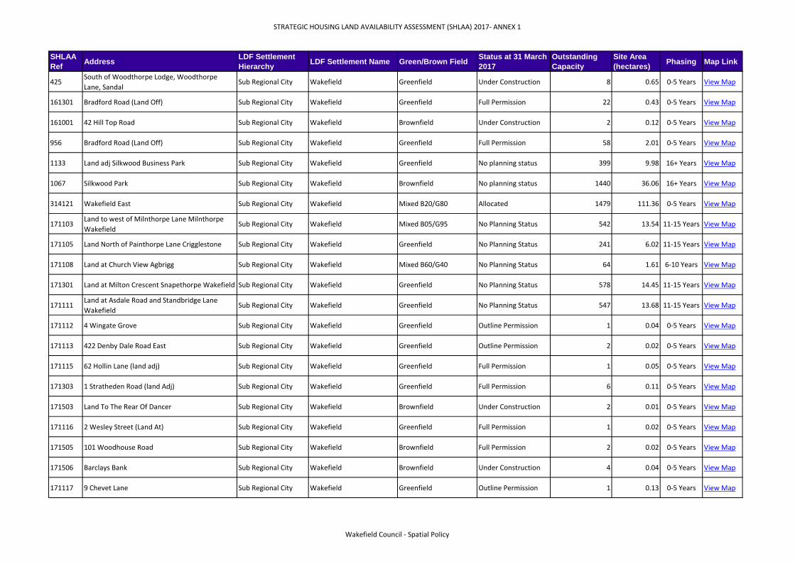
425South of Woodthorpe Lodge, Woodthorpe
Lane, SandalSub Regional City Wakefield Greenfield Under Construction 8 0.65 0-5 Years View Map
161301 Bradford Road (Land Off) Sub Regional City Wakefield Greenfield Full Permission 22 0.43 0-5 Years View Map
161001 42 Hill Top Road Sub Regional City Wakefield Brownfield Under Construction 2 0.12 0-5 Years View Map
956 Bradford Road (Land Off) Sub Regional City Wakefield Greenfield Full Permission 58 2.01 0-5 Years View Map
1133 Land adj Silkwood Business Park Sub Regional City Wakefield Greenfield No planning status 399 9.98 16+ Years View Map
1067 Silkwood Park Sub Regional City Wakefield Brownfield No planning status 1440 36.06 16+ Years View Map
314121 Wakefield East Sub Regional City Wakefield Mixed B20/G80 Allocated 1479 111.36 0-5 Years View Map
171103Land to west of Milnthorpe Lane Milnthorpe
Wakefield Sub Regional City Wakefield Mixed B05/G95 No Planning Status 542 13.54 11-15 Years View Map
171105 Land North of Painthorpe Lane Crigglestone Sub Regional City Wakefield Greenfield No Planning Status 241 6.02 11-15 Years View Map
171108 Land at Church View Agbrigg Sub Regional City Wakefield Mixed B60/G40 No Planning Status 64 1.61 6-10 Years View Map
171301 Land at Milton Crescent Snapethorpe Wakefield Sub Regional City Wakefield Greenfield No Planning Status 578 14.45 11-15 Years View Map
171111Land at Asdale Road and Standbridge Lane
WakefieldSub Regional City Wakefield Greenfield No Planning Status 547 13.68 11-15 Years View Map
171112 4 Wingate Grove Sub Regional City Wakefield Greenfield Outline Permission 1 0.04 0-5 Years View Map
171113 422 Denby Dale Road East Sub Regional City Wakefield Greenfield Outline Permission 2 0.02 0-5 Years View Map
171115 62 Hollin Lane (land adj) Sub Regional City Wakefield Greenfield Full Permission 1 0.05 0-5 Years View Map
171303 1 Stratheden Road (land Adj) Sub Regional City Wakefield Greenfield Full Permission 6 0.11 0-5 Years View Map
171503 Land To The Rear Of Dancer Sub Regional City Wakefield Brownfield Under Construction 2 0.01 0-5 Years View Map
171116 2 Wesley Street (Land At) Sub Regional City Wakefield Greenfield Full Permission 1 0.02 0-5 Years View Map
171505 101 Woodhouse Road Sub Regional City Wakefield Brownfield Full Permission 2 0.02 0-5 Years View Map
171506 Barclays Bank Sub Regional City Wakefield Brownfield Under Construction 4 0.04 0-5 Years View Map
171117 9 Chevet Lane Sub Regional City Wakefield Greenfield Outline Permission 1 0.13 0-5 Years View Map
Wakefield Council - Spatial Policy

STRATEGIC HOUSING LAND AVAILABILITY ASSESSMENT (SHLAA) 2017- ANNEX 1
SHLAA
RefAddress
LDF Settlement
HierarchyLDF Settlement Name Green/Brown Field
Status at 31 March
2017
Outstanding
Capacity
Site Area
(hectares)Phasing Map Link
171007 39 Hill Top Road Sub Regional City Wakefield Brownfield Full Permission 1 0.07 0-5 Years View Map
171119 Lindop & Smith Sub Regional City Wakefield Brownfield Under Construction 2 0.02 0-5 Years View Map
171508 70 Ruskin Avenue (Land Adjacent To) Sub Regional City Wakefield Greenfield Full Permission 1 0.03 0-5 Years View Map
171510 Barnsley Building Society Sub Regional City Wakefield Brownfield Full Permission 2 0.01 0-5 Years View Map
171120 1B Sandal Avenue Sub Regional City Wakefield Greenfield Full Permission 1 0.04 0-5 Years View Map
171121 80 Hollin Drive Sub Regional City Wakefield Greenfield Full Permission 1 0.02 0-5 Years View Map
171511 8-14 St Johns North Sub Regional City Wakefield Brownfield Full Permission 12 0.09 0-5 Years View Map
315001 Land off Batley Road, Sub Regional City Wakefield Greenfield Under Construction 87 3.45 0-5 Years View Map
171306 Land Off Batley Road Sub Regional City Wakefield Greenfield Under Construction 18 0.52 0-5 Years View Map
171512 Land At Snowhill Sub Regional City Wakefield Greenfield Full Permission 7 0.15 0-5 Years View Map
171513 Land At Snowhill Sub Regional City Wakefield Greenfield Full Permission 84 3.36 0-5 Years View Map
171514 Herriot Way (Land Off) Sub Regional City Wakefield Greenfield Full Permission 132 4.99 0-5 Years View Map
314023 Snowhill (land at) Sub Regional City Wakefield Mixed B20/G80 Allocated 112 20.96 0-5 Years View Map
891 Land at Snowhill Sub Regional City Wakefield Mixed B20/G80 Outline Permission 922 22.76 0-5 Years View Map
171307 143 Horbury Road Sub Regional City Wakefield Brownfield Under Construction 2 0.11 0-5 Years View Map
171122 Land at Hollin Lane Crigglestone Sub Regional City Wakefield Greenfield No Planning Status 82 2.04 11-15 Years View Map
171123 1 Wavell Grove Sub Regional City Wakefield Greenfield Full Permission 1 0.04 0-5 Years View Map
171124 2 Newlyn Drive Sub Regional City Wakefield Greenfield Outline Permission 1 0.10 0-5 Years View Map
171125 Land to east of Milnthorpe Lane Wakefield Sub Regional City Wakefield Greenfield No Planning Status 224 5.59 11-15 Years View Map
161510 Land Off Herriot Way Sub Regional City Wakefield Greenfield Under Construction 43 2.91 0-5 Years View Map
1065 Land off Lindale Lane, Wrenthorpe Sub Regional City Wakefield Greenfield Under Construction 31 1.48 0-5 Years View Map
Wakefield Council - Spatial Policy

STRATEGIC HOUSING LAND AVAILABILITY ASSESSMENT (SHLAA) 2017- ANNEX 1
SHLAA
RefAddress
LDF Settlement
HierarchyLDF Settlement Name Green/Brown Field
Status at 31 March
2017
Outstanding
Capacity
Site Area
(hectares)Phasing Map Link
171309 Former Redcats Sub Regional City Wakefield Brownfield Full Permission 28 0.95 0-5 Years View Map
314117 Asdale Road, (land west of) Sub Regional City Wakefield Greenfield No planning status 486 11.99 6-10 Years View Map
954 Land off Jerry Clay Lane, Wrenthorpe Sub Regional City Wakefield Greenfield No planning status 143 3.48 11-15 Years View Map
313122 Land at Dewsbury Road Sub Regional City Wakefield Greenfield Under Construction 28 7.42 0-5 Years View Map
1114 West of Durkar Low Lane Sub Regional City Wakefield Greenfield No planning status 426 10.57 6-10 Years View Map
171127Land off Kingfisher Close and Durkar Lane
DurkarSub Regional City Wakefield Greenfield No Planning Status 1146 28.65 11-15 Years View Map
656 Land off Ruskin Avenue Sub Regional City Wakefield Greenfield Under Construction 1 0.04 0-5 Years View Map
171305 Former Redcats Site, Horbury Road Sub Regional City Wakefield Brownfield Allocated 68 2.61 0-5 Years View Map
18 Land off Cambridge Street Principal Town Castleford Brownfield Lapsed Permission 8 0.05 0-5 Years View Map
39Adj Rugby Ground, Orchard Drive, Ackton
Pastures,Principal Town Castleford Greenfield Under Construction 4 0.24 0-5 Years View Map
43 6 Redhill View, Redhill Principal Town Castleford Greenfield Full Permission 1 0.08 0-5 Years View Map
45 Adj Sans-Egal, Rock Hill Principal Town Castleford Greenfield Outline Permission 1 0.07 0-5 Years View Map
46 Adj Sledmere, School Lane Principal Town Castleford Greenfield Lapsed Permission 6 0.05 0-5 Years View Map
60Part of Castlefields Car Park, off Cambridge
StreetPrincipal Town Castleford Greenfield Lapsed Permission 8 0.55 0-5 Years View Map
94 Former Car Park, Cambridge Street Principal Town Castleford Brownfield Lapsed Permission 49 0.25 0-5 Years View Map
101 67 & 69 Leeds Road, Cutsyke Principal Town Castleford Brownfield Full Permission 2 0.01 0-5 Years View Map
700 Sartek Uk Ltd Savile Road Principal Town Castleford Brownfield Lapsed Permission 40 0.15 0-5 Years View Map
784 1 - 3 Vickers Street Principal Town Castleford Brownfield Lapsed Permission 7 0.03 0-5 Years View Map
795 2 Lansdowne Avenue (land adjacent), Castleton Principal Town Castleford Greenfield Full Permission 1 0.04 0-5 Years View Map
1055 Wheldon Lane Principal Town Castleford Brownfield No planning status 12 0.31 16+ Years View Map
938 Willowbridge Lane Principal Town Castleford Brownfield No planning status 125 3.11 16+ Years View Map
Wakefield Council - Spatial Policy

STRATEGIC HOUSING LAND AVAILABILITY ASSESSMENT (SHLAA) 2017- ANNEX 1
SHLAA
RefAddress
LDF Settlement
HierarchyLDF Settlement Name Green/Brown Field
Status at 31 March
2017
Outstanding
Capacity
Site Area
(hectares)Phasing Map Link
874 Tigers Ground, Wheldon Road Principal Town Castleford Brownfield Allocated 105 3.85 0-5 Years View Map
877 Land at Pemberton Drive Principal Town Castleford Brownfield Allocated 87 2.19 0-5 Years View Map
879 Land at Saxon Way Principal Town Castleford Brownfield Allocated 242 6.07 0-5 Years View Map
880 Former C6 Solutions Centre Principal Town Castleford Brownfield Allocated 300 37.15 0-5 Years View Map
885 Land north of St Andrews Road, Fryston Principal Town Castleford Greenfield Allocated 70 2.38 0-5 Years View Map
961 Land fronting Holywell Lane, Glasshoughton Principal Town Castleford Greenfield No planning status 150 3.77 6-10 Years View Map
909 Land adj Well Wood Principal Town Castleford Brownfield No planning status 326 8.18 11-15 Years View Map
910 East of Watling Road Principal Town Castleford Greenfield No planning status 112 2.90 16+ Years View Map
1075 Wheldale Farm, Wheldale Road Principal Town Castleford Brownfield Allocated 750 31.23 0-5 Years View Map
1076 Stansfield Road, Principal Town Castleford Brownfield Allocated 451 11.28 0-5 Years View Map
120348 West of Wheldale Farm, Wheldon Road Principal Town Castleford Brownfield No planning status 204 5.10 6-10 Years View Map
120349 Bus Depot Wheldon Road Principal Town Castleford Brownfield Allocated 55 1.39 0-5 Years View Map
120352Former Railway Lane Site, South of Wheldon
RoadPrincipal Town Castleford Brownfield No planning status 30 0.75 11-15 Years View Map
120367 Nestle Site, Wheldon Road Principal Town Castleford Brownfield Allocated 155 3.47 0-5 Years View Map
120232 The Old Vicarage Principal Town Castleford Brownfield Lapsed Permission 5 0.26 0-5 Years View Map
1140 194 Holywell Lane Principal Town Castleford Brownfield Full Permission 5 0.20 0-5 Years View Map
1149Holy Cross Parochial Church The Mount,
AiredalePrincipal Town Castleford Brownfield Full Permission 6 0.11 0-5 Years View Map
313141 Crimea Tavern, Savile Road Principal Town Castleford Brownfield Lapsed Permission 14 0.01 0-5 Years View Map
313009 St Ives Crescent (land off) Principal Town Castleford Greenfield Under Construction 1 0.20 0-5 Years View Map
313207 32B Fryston Road (land adj) Principal Town Castleford Greenfield Under Construction 1 0.06 0-5 Years View Map
313208 14, 16, 18 Carlton Street Principal Town Castleford Brownfield Under Construction 6 0.02 0-5 Years View Map
Wakefield Council - Spatial Policy

STRATEGIC HOUSING LAND AVAILABILITY ASSESSMENT (SHLAA) 2017- ANNEX 1
SHLAA
RefAddress
LDF Settlement
HierarchyLDF Settlement Name Green/Brown Field
Status at 31 March
2017
Outstanding
Capacity
Site Area
(hectares)Phasing Map Link
313206 Healdfield Road (land off) Principal Town Castleford Greenfield Under Construction 11 1.79 0-5 Years View Map
314024 Yorkshire Rose PH Principal Town Castleford Brownfield Lapsed Permission 14 0.42 0-5 Years View Map
314085 School Street (Land At) (Phase 2) Principal Town Castleford Brownfield Under Construction 4 0.48 0-5 Years View Map
314026 58 Redhill Avenue (land to rear of) Principal Town Castleford Greenfield Under Construction 1 0.07 0-5 Years View Map
314030 208 Lower Oxford Street Principal Town Castleford Brownfield Full Permission 1 0.06 0-5 Years View Map
314031 4 Aketon Road Principal Town Castleford Brownfield Under Construction 3 0.02 0-5 Years View Map
314032 Wheldon Road (land at) Principal Town Castleford Brownfield Under Construction 1 0.08 0-5 Years View Map
87 Former Lime Quarry Wheldon Road Fryston Principal Town Castleford Brownfield Under Construction 6 4.82 0-5 Years View Map
845 R/o 102-146 Lumley Street Hightown Principal Town Castleford Greenfield Under Construction 2 2.05 0-5 Years View Map
1145 Aire St/Bridge St/Sagar St/ Back Wesley St Principal Town Castleford Brownfield Outline Permission 80 0.60 0-5 Years View Map
314012 Oaklands Principal Town Castleford Greenfield Allocated 2 0.06 0-5 Years View Map
315039 101-105 Holywell Lane (Land To Rear Of) Principal Town Castleford Greenfield Full Permission 3 0.10 0-5 Years View Map
315040 42 Redhill Avenue Principal Town Castleford Greenfield Under Construction 1 0.06 0-5 Years View Map
313213 R/O 122-138 Lumley Street Principal Town Castleford Greenfield Under Construction 1 1.11 0-5 Years View Map
160102 Land At 1 Elizabeth Drive Principal Town Castleford Greenfield Outline Permission 1 0.02 0-5 Years View Map
160104 Aketon Road Principal Town Castleford Greenfield Outline Permission 1 0.04 0-5 Years View Map
160117 Land At Lambsons (phase 3) Principal Town Castleford Brownfield Under Construction 73 1.70 0-5 Years View Map
160118 Savile Road Principal Town Castleford Brownfield Under Construction 11 0.29 0-5 Years View Map
160105 77 Gypsy Lane (land to rear) Principal Town Castleford Greenfield Full Permission 1 0.11 0-5 Years View Map
160106 40 Cambridge Street Principal Town Castleford Brownfield Full Permission 4 0.02 0-5 Years View Map
160108 132 Lumley Street Principal Town Castleford Greenfield Outline Permission 2 0.07 0-5 Years View Map
Wakefield Council - Spatial Policy

STRATEGIC HOUSING LAND AVAILABILITY ASSESSMENT (SHLAA) 2017- ANNEX 1
SHLAA
RefAddress
LDF Settlement
HierarchyLDF Settlement Name Green/Brown Field
Status at 31 March
2017
Outstanding
Capacity
Site Area
(hectares)Phasing Map Link
160109 134 Lumley Street Principal Town Castleford Greenfield Under Construction 2 0.06 0-5 Years View Map
160110 Fairfield Court (Land At) Principal Town Castleford Brownfield Full Permission 1 0.06 0-5 Years View Map
160112 Leeds Road/Lagentium Plaza (Junction) Principal Town Castleford Brownfield Outline Permission 11 0.07 0-5 Years View Map
160113 Lumley Street Principal Town Castleford Brownfield Outline Permission 100 4.64 0-5 Years View Map
160101 64 Barnes Road (Land Adjacent) Principal Town Castleford Greenfield Full Permission 4 0.15 0-5 Years View Map
160114 199A Aketon Road Principal Town Castleford Greenfield Outline Permission 2 0.10 0-5 Years View Map
830 Cinder Lane (former Lambsons site) Principal Town Castleford Brownfield Outline Permission 1022 7.86 0-5 Years View Map
160120 Castleford Waterfront Principal Town Castleford Brownfield Allocated 0 2.91 0-5 Years View Map
313167 R/o 102-146 Lumley Street Hightown Principal Town Castleford Greenfield Allocated 33 0.83 0-5 Years View Map
939 Land fronting Stainburn Ave, Glasshoughton Principal Town Castleford Greenfield No planning status 43 1.07 16+ Years View Map
237557 Cinder Lane (former Lambsons) Principal Town Castleford Brownfield Under Construction 86 6.04 0-5 Years View Map
1146 Hazel Dene Wood Lane Principal Town Castleford Brownfield Under Construction 1 0.05 0-5 Years View Map
313142 The Bungalow, Wood Lane Principal Town Castleford Greenfield Full Permission 1 0.13 0-5 Years View Map
314025 The Willows Principal Town Castleford Greenfield Under Construction 1 0.03 0-5 Years View Map
314027 Coalfield Links Road (Taylor Wimpey) Principal Town Castleford Greenfield Under Construction 166 6.79 0-5 Years View Map
314086 Coalfield Links Road (Harron) Principal Town Castleford Greenfield Under Construction 55 1.82 0-5 Years View Map
314087 Coalfield Links Road Principal Town Castleford Greenfield Under Construction 10 0.31 0-5 Years View Map
962 Ackton Pastures Principal Town Castleford Greenfield Under Construction 196 10.50 0-5 Years View Map
1054 New Holywell Farm, Holywell Lane Principal Town Castleford Greenfield No planning status 615 70.97 16+ Years View Map
160115 Land Off Cutsyke Road (Ackton Pastures) Principal Town Castleford Greenfield Full Permission 25 0.69 0-5 Years View Map
38 Ackton Pastures, Willowbridge Lane Principal Town Castleford Greenfield No planning status 240 17.49 6-10 Years View Map
Wakefield Council - Spatial Policy

STRATEGIC HOUSING LAND AVAILABILITY ASSESSMENT (SHLAA) 2017- ANNEX 1
SHLAA
RefAddress
LDF Settlement
HierarchyLDF Settlement Name Green/Brown Field
Status at 31 March
2017
Outstanding
Capacity
Site Area
(hectares)Phasing Map Link
313166 Castleford Riverside Principal Town Castleford Mixed Allocated 0 249.24 0-5 Years View Map
1034 Flass Lane Cut Syke Principal Town Castleford Greenfield Allocated 76 10.06 0-5 Years View Map
170102 Leeds Road (land Off) Principal Town Castleford Greenfield Outline Permission 5 0.12 0-5 Years View Map
170103 4 Hillcrest Avenue Principal Town Castleford Greenfield Under Construction 1 0.16 0-5 Years View Map
170104 Whitwood Lane (Land Off) Principal Town Castleford Greenfield Full Permission 45 1.14 0-5 Years View Map
170105 Land At Redhill Mount Principal Town Castleford Greenfield Full Permission 1 0.07 0-5 Years View Map
170106 57 Ferrybridge Road Principal Town Castleford Brownfield Under Construction 12 0.12 0-5 Years View Map
170107 Land South Of Flass Lane (phase 1) Principal Town Castleford Greenfield Full Permission 125 3.56 0-5 Years View Map
170108 Land South Of Flass Lane (phase 1) Principal Town Castleford Greenfield Full Permission 32 0.70 0-5 Years View Map
170109 Adjacent To Sledmere Principal Town Castleford Greenfield Outline Permission 3 0.07 0-5 Years View Map
170110 The New Airedale Principal Town Castleford Brownfield Full Permission 5 0.12 0-5 Years View Map
170111 Former Fryston Colliery Principal Town Castleford Brownfield Under Construction 35 0.76 0-5 Years View Map
881 Former Fryston Colliery (part) Principal Town Castleford Mixed B10/G90 Under Construction 115 4.35 0-5 Years View Map
160119 Flass Lane Principal Town Castleford Greenfield Outline Permission 403 17.58 0-5 Years View Map
706Whitwood Common Lane, & Whitwood Lane
(land off)Principal Town Castleford Greenfield Under Construction 107 4.22 0-5 Years View Map
151 Adj Washbeck House, 14 Road Principal Town Pontefract Greenfield Full Permission 1 0.03 0-5 Years View Map
154 Adj 1 Mayors Walk Close, Mayors Walk Principal Town Pontefract Brownfield Full Permission 1 0.07 0-5 Years View Map
161 Nevison Avenue (Land off) Principal Town Pontefract Brownfield Lapsed Permission 6 0.08 0-5 Years View Map
735 1 Market Place Principal Town Pontefract Brownfield Full Permission 2 0.01 0-5 Years View Map
779 60 Maple Avenue Principal Town Pontefract Greenfield Outline Permission 1 0.03 0-5 Years View Map
803 Swanhill Lane Principal Town Pontefract Brownfield Full Permission 2 0.05 0-5 Years View Map
Wakefield Council - Spatial Policy

STRATEGIC HOUSING LAND AVAILABILITY ASSESSMENT (SHLAA) 2017- ANNEX 1
SHLAA
RefAddress
LDF Settlement
HierarchyLDF Settlement Name Green/Brown Field
Status at 31 March
2017
Outstanding
Capacity
Site Area
(hectares)Phasing Map Link
963 Land north of The Chestnuts Principal Town Pontefract Greenfield Under Construction 1 0.56 0-5 Years View Map
964 Land at Willowdene Lane Principal Town Pontefract Greenfield Allocated 53 1.34 0-5 Years View Map
1069 Western of Edge of Lady Balk Principal Town Pontefract Greenfield Allocated 51 1.49 0-5 Years View Map
1129 Land east of Jubilee Way Principal Town Pontefract Brownfield No planning status 36 0.89 6-10 Years View Map
120346 North Sowgate Lane, Principal Town Pontefract Greenfield No planning status 400 10.00 11-15 Years View Map
120368 Former Chequerfield Infant School Principal Town Pontefract Brownfield No planning status 51 1.28 6-10 Years View Map
120374 West of Eastbourne View, Principal Town Pontefract Greenfield No planning status 67 1.68 6-10 Years View Map
120376Stringer's Garage, Slutwell Lane / Friarwood
LanePrincipal Town Pontefract Brownfield Allocated 18 0.46 0-5 Years View Map
120377 Friarwood Lane Car Park Principal Town Pontefract Brownfield No planning status 48 1.21 6-10 Years View Map
120379 Scrapyard, Midland Road Principal Town Pontefract Brownfield No planning status 57 1.42 11-15 Years View Map
120380 Land at North Baileygate / South Baileygate Principal Town Pontefract Brownfield No planning status 27 0.67 6-10 Years View Map
120381 Allotments, Skinner Lane / Monkhill Lane Principal Town Pontefract Greenfield No planning status 104 2.60 6-10 Years View Map
120382Carleton Furniture Works Car Park, Mill Dam
LanePrincipal Town Pontefract Brownfield No planning status 16 0.42 6-10 Years View Map
1178 29-31 Park Lane Principal Town Pontefract Brownfield Under Construction 3 0.21 0-5 Years View Map
1169 Prince of Wales Colliery Park Road Principal Town Pontefract Brownfield Outline Permission 36 1.41 0-5 Years View Map
313168 Tanshelf Industrial Estate Principal Town Pontefract Brownfield Allocated 60 4.57 0-5 Years View Map
1176 Churchbalk Lane (land adj) Principal Town Pontefract Greenfield Lapsed Permission 6 0.10 0-5 Years View Map
314008 Wakefield Road (land at) Principal Town Pontefract Greenfield Full Permission 22 0.89 0-5 Years View Map
314039 12 Box Lane Principal Town Pontefract Greenfield Full Permission 1 0.05 0-5 Years View Map
1183 North Ives off Northgate Principal Town Pontefract Brownfield Full Permission 1 0.04 0-5 Years View Map
315029 Ackworth Road & Hardwick Road Principal Town Pontefract Greenfield Under Construction 7 2.45 0-5 Years View Map
Wakefield Council - Spatial Policy

STRATEGIC HOUSING LAND AVAILABILITY ASSESSMENT (SHLAA) 2017- ANNEX 1
SHLAA
RefAddress
LDF Settlement
HierarchyLDF Settlement Name Green/Brown Field
Status at 31 March
2017
Outstanding
Capacity
Site Area
(hectares)Phasing Map Link
315051 107 Rookhill Road Principal Town Pontefract Greenfield Full Permission 1 0.02 0-5 Years View Map
875Land between Wakefield Road and Ferrybridge
RoadPrincipal Town Pontefract Greenfield Allocated 121 2.92 0-5 Years View Map
966 West of Halfpenny Lane Allotments Principal Town Pontefract Greenfield No planning status 205 5.12 16+ Years View Map
160415 Prince Of Wales Colliery (phase 2) Principal Town Pontefract Brownfield Under Construction 3 0.31 0-5 Years View Map
160402 52A Northgate Principal Town Pontefract Brownfield Full Permission 14 0.16 0-5 Years View Map
160403 8A Avens Close Principal Town Pontefract Greenfield Under Construction 1 0.04 0-5 Years View Map
160404 109A Ackworth Road (land Adj) Principal Town Pontefract Greenfield Under Construction 1 0.06 0-5 Years View Map
160406 Pontefract General Infirmary Principal Town Pontefract Brownfield Full Permission 5 0.09 0-5 Years View Map
160410 Limetrees Principal Town Pontefract Greenfield Under Construction 77 2.82 0-5 Years View Map
160411 Limetrees Principal Town Pontefract Greenfield Full Permission 3 0.11 0-5 Years View Map
160407 Cobblers Lane Principal Town Pontefract Greenfield Full Permission 55 1.77 0-5 Years View Map
160412 31 Market Place Principal Town Pontefract Brownfield Full Permission 7 0.06 0-5 Years View Map
160413 Pontefract Barracks Depot Principal Town Pontefract Brownfield Full Permission 14 0.28 0-5 Years View Map
1127 Land between Horsefair and Northgate Principal Town Pontefract Brownfield Allocated 61 2.13 0-5 Years View Map
873 Land at General Infirmary Principal Town Pontefract Brownfield Under Construction 113 3.08 0-5 Years View Map
876Land between Wakefield Road and Ferrybridge
RoadPrincipal Town Pontefract Greenfield Allocated 262 6.56 0-5 Years View Map
160416 Land east of Cobblers Lane Principal Town Pontefract Greenfield Under Construction 121 4.96 0-5 Years View Map
927 Land east of Cobblers Lane Principal Town Pontefract Greenfield Allocated 86 2.16 0-5 Years View Map
160417 King Charles II House Principal Town Pontefract Brownfield Full Permission 60 0.12 0-5 Years View Map
1059 Garden to R/o Kirkton, Moor Lane, Carleton Principal Town Pontefract Greenfield No planning status 21 0.53 6-10 Years View Map
920 Ackworth Road / Hardwick Road Principal Town Pontefract Greenfield No planning status 408 8.66 11-15 Years View Map
Wakefield Council - Spatial Policy

STRATEGIC HOUSING LAND AVAILABILITY ASSESSMENT (SHLAA) 2017- ANNEX 1
SHLAA
RefAddress
LDF Settlement
HierarchyLDF Settlement Name Green/Brown Field
Status at 31 March
2017
Outstanding
Capacity
Site Area
(hectares)Phasing Map Link
928 Land north of Moor Lane, Carleton Principal Town Pontefract Greenfield No planning status 358 8.98 6-10 Years View Map
120347 North Park Lane, Principal Town Pontefract Greenfield No planning status 518 12.95 11-15 Years View Map
120255 Carleton Lodge Principal Town Pontefract Brownfield Lapsed Permission 9 0.32 0-5 Years View Map
882 Former Prince of Wales Colliery Principal Town Pontefract Brownfield Allocated 0 13.63 0-5 Years View Map
1089 R/o Fairleigh Farm, Principal Town Pontefract Greenfield No planning status 1729 43.04 11-15 Years View Map
313227 Ackworth Road & Hardwick Road Principal Town Pontefract Greenfield Under Construction 28 6.70 0-5 Years View Map
315133 Prince Of Wales Colliery (phase 2A) Principal Town Pontefract Brownfield Under Construction 33 5.44 0-5 Years View Map
315145 Land at Carleton Road/Tumbling Hill Principal Town Pontefract Greenfield No planning status 58 1.45 11-15 Years View Map
1035 South of Park Lane Principal Town Pontefract Greenfield No planning status 324 11.79 16+ Years View Map
1032Former Prince of Wales Colliery - Monk Hill
Triangle SitePrincipal Town Pontefract Brownfield Allocated 544 13.55 0-5 Years View Map
1031 Former Prince of Wales Colliery Principal Town Pontefract Brownfield No planning status 0 161.16 16+ Years View Map
170401 Land at Cobblers Lane Pontefract Principal Town Pontefract Greenfield No Planning Status 643 16.08 11-15 Years View Map
170402 Land at Hardwick Road Pontefract Principal Town Pontefract Greenfield No Planning Status 358 8.94 11-15 Years View Map
170405 Between 9 & 10A Darrington Road Principal Town Pontefract Greenfield Outline Permission 2 0.05 0-5 Years View Map
170407 14 Gillygate Principal Town Pontefract Brownfield Under Construction 8 0.03 0-5 Years View Map
170408 Land At Cobblers Lane Principal Town Pontefract Greenfield Full Permission 23 0.63 0-5 Years View Map
170409 Prince Of Wales Colliery (phase 4) Principal Town Pontefract Brownfield Full Permission 5 0.35 0-5 Years View Map
170410 1 Cliff Villas Principal Town Pontefract Brownfield Full Permission 4 0.01 0-5 Years View Map
170411 55A Northgate/Back Northgate (Land At) Principal Town Pontefract Brownfield Outline Permission 14 0.21 0-5 Years View Map
170412 29A Market Place Principal Town Pontefract Brownfield Full Permission 2 0.01 0-5 Years View Map
170413 The Maltings Principal Town Pontefract Brownfield Full Permission 8 0.04 0-5 Years View Map
Wakefield Council - Spatial Policy

STRATEGIC HOUSING LAND AVAILABILITY ASSESSMENT (SHLAA) 2017- ANNEX 1
SHLAA
RefAddress
LDF Settlement
HierarchyLDF Settlement Name Green/Brown Field
Status at 31 March
2017
Outstanding
Capacity
Site Area
(hectares)Phasing Map Link
170414 10 Bexhill Close Principal Town Pontefract Greenfield Full Permission 1 0.02 0-5 Years View Map
170415 26 Swanhill Lane (land adj) Principal Town Pontefract Greenfield Full Permission 1 0.05 0-5 Years View Map
160414 Prince Of Wales Colliery (phase 2) Principal Town Pontefract Brownfield Under Construction 27 3.69 0-5 Years View Map
170416 Prince Of Wales Colliery (phase 4) Principal Town Pontefract Brownfield Under Construction 84 4.04 0-5 Years View Map
1168 Prince Of Wales Colliery Principal Town Pontefract Brownfield Outline Permission 540 15.45 0-5 Years View Map
313267 Cobblers Lane Principal Town Pontefract Greenfield Under Construction 137 4.58 0-5 Years View Map
120378 Land at Harrop Well Lane Principal Town Pontefract Brownfield No planning status 17 0.68 11-15 Years View Map
170417 County Police Offices Session House Principal Town Pontefract Brownfield Full Permission 1 0.16 0-5 Years View Map
170418 Land to East of Pontefract Principal Town Pontefract Greenfield No Planning Status 5153 128.82 11-15 Years View Map
965 Land off Eastbourne View Principal Town Pontefract Greenfield No planning status 452 1.19 16+ Years View Map
160409 Land At Cobblers Lane Principal Town Pontefract Greenfield Under Construction 14 0.57 0-5 Years View Map
160408 Land At Cobblers Lane Principal Town Pontefract Greenfield Under Construction 104 4.93 0-5 Years View Map
139 R/o 36 Green Lane Other Urban Area Featherstone Brownfield Lapsed Permission 8 0.08 0-5 Years View Map
146 Adj Vicarage Street (Site A), Post Office Road Other Urban Area Featherstone Brownfield Full Permission 6 0.10 0-5 Years View Map
147 Adj 2 Post office Road (Site B) Other Urban Area Featherstone Brownfield Full Permission 7 0.10 0-5 Years View Map
825 35 South View (land adjacent) Other Urban Area Featherstone Brownfield Under Construction 1 0.03 0-5 Years View Map
941 North of Green Lane Other Urban Area Featherstone Greenfield No planning status 692 22.44 11-15 Years View Map
940 Land east of Huntwick Lodge Other Urban Area Featherstone Greenfield No planning status 91 11.62 11-15 Years View Map
967 Land south of Purston Jaglin Other Urban Area Featherstone Greenfield No planning status 98 3.27 16+ Years View Map
968 Land off Southfield Avenue Other Urban Area Featherstone Greenfield No planning status 38 1.28 11-15 Years View Map
969 Allotments to r/o Featherstone Lane Other Urban Area Featherstone Greenfield No planning status 81 2.72 16+ Years View Map
Wakefield Council - Spatial Policy

STRATEGIC HOUSING LAND AVAILABILITY ASSESSMENT (SHLAA) 2017- ANNEX 1
SHLAA
RefAddress
LDF Settlement
HierarchyLDF Settlement Name Green/Brown Field
Status at 31 March
2017
Outstanding
Capacity
Site Area
(hectares)Phasing Map Link
1098 Land off Went Avenue, to R/o Nunns Court Other Urban Area Featherstone Greenfield No planning status 5 0.19 6-10 Years View Map
1100 Land at End of Girnhill Lane Other Urban Area Featherstone Greenfield No planning status 67 2.22 6-10 Years View Map
1097 Land off Wellgarth Road, Purston Other Urban Area Featherstone Greenfield No planning status 1385 46.09 11-15 Years View Map
313036 R/o 117 & 127 Wakefield Road Other Urban Area Featherstone Brownfield Outline Permission 3 0.02 0-5 Years View Map
314034 21 Ackworth Road (land adj.) Other Urban Area Featherstone Greenfield Under Construction 1 0.02 0-5 Years View Map
889 Land at Lister Close Other Urban Area Featherstone Brownfield Allocated 150 8.97 0-5 Years View Map
313031 Girnhill Other Urban Area Featherstone Brownfield Under Construction 50 4.20 0-5 Years View Map
160301 Church Lane (land adj) Other Urban Area Featherstone Greenfield Full Permission 1 0.01 0-5 Years View Map
160303 64-68 Station Lane Other Urban Area Featherstone Brownfield Full Permission 3 0.05 0-5 Years View Map
160304 46 Green Lane Other Urban Area Featherstone Brownfield Under Construction 1 0.01 0-5 Years View Map
160307 Land at South Featherstone Other Urban Area Featherstone Greenfield No planning status 3086 102.78 11-15 Years View Map
120353 Rovers Stadium & land adjacent Other Urban Area Featherstone Mixed B30/G70 No planning status 229 7.59 11-15 Years View Map
911 North of Pontefract Road Other Urban Area Featherstone Greenfield Outline Permission 292 10.58 0-5 Years View Map
314088 Pontefract Road (land off) Other Urban Area Featherstone Greenfield Under Construction 43 3.65 0-5 Years View Map
170305 Land North Of 105 Ackworth Road Other Urban Area Featherstone Greenfield Full Permission 1 0.07 0-5 Years View Map
338 Health Centre, Highfield Road Other Urban Area Hemsworth Brownfield Lapsed Permission 11 0.21 0-5 Years View Map
712 Union House, 55 Southmoor Road Other Urban Area Hemsworth Brownfield Lapsed Permission 10 0.05 0-5 Years View Map
894 West End Other Urban Area Hemsworth Brownfield Allocated 160 2.32 0-5 Years View Map
899 Sports Ground, Kirkby Road Other Urban Area Hemsworth Brownfield Outline Permission 157 5.98 0-5 Years View Map
970 Land at Vissett Cottage Hotel, Barnsley Road Other Urban Area Hemsworth Greenfield No planning status 30 1.02 16+ Years View Map
915 Land at Common End Other Urban Area Hemsworth Greenfield No planning status 250 8.40 6-10 Years View Map
Wakefield Council - Spatial Policy

STRATEGIC HOUSING LAND AVAILABILITY ASSESSMENT (SHLAA) 2017- ANNEX 1
SHLAA
RefAddress
LDF Settlement
HierarchyLDF Settlement Name Green/Brown Field
Status at 31 March
2017
Outstanding
Capacity
Site Area
(hectares)Phasing Map Link
237522 Grove Lane (land to North) Other Urban Area Hemsworth Brownfield Under Construction 18 0.61 0-5 Years View Map
237547 Grove Lane (land to north) Other Urban Area Hemsworth Brownfield Full Permission 3 0.04 0-5 Years View Map
237608 Fire Station Other Urban Area Hemsworth Brownfield Full Permission 5 0.14 0-5 Years View Map
313170 Ashfield Road Other Urban Area Hemsworth Greenfield Allocated 74 2.51 0-5 Years View Map
314011 Broad Oaks Other Urban Area Hemsworth Greenfield Under Construction 6 0.22 0-5 Years View Map
314057 16-18 Cross Hill (Land To Rear) Other Urban Area Hemsworth Brownfield Under Construction 1 0.04 0-5 Years View Map
1077 Ashfield Road Other Urban Area Hemsworth Greenfield No planning status 194 6.49 6-10 Years View Map
315067 Mayflower Other Urban Area Hemsworth Brownfield Full Permission 1 0.01 0-5 Years View Map
160803 6 Little Hemsworth Other Urban Area Hemsworth Greenfield Full Permission 2 0.12 0-5 Years View Map
160808 59 Station Road Other Urban Area Hemsworth Greenfield Full Permission 1 0.08 0-5 Years View Map
160813 The Market Kirkby Road Hemsworth Other Urban Area Hemsworth Brownfield Allocated 0 0.57 0-5 Years View Map
170804 51 Barnsley Road Other Urban Area Hemsworth Brownfield Under Construction 2 0.05 0-5 Years View Map
170806 Meadow Croft (Land At) Other Urban Area Hemsworth Greenfield Full Permission 2 0.04 0-5 Years View Map
297 Meadowcroft, Kirkbygate Other Urban Area Hemsworth Greenfield Full Permission 22 0.80 0-5 Years View Map
34 25 Tithe Barn Street (land to rear) Other Urban Area Horbury Greenfield Under Construction 1 0.10 0-5 Years View Map
471 Laburnum Grove Other Urban Area Horbury Greenfield Outline Permission 2 0.12 0-5 Years View Map
472 Plot 5, Jenkin Lane Other Urban Area Horbury Greenfield Full Permission 2 0.07 0-5 Years View Map
477 Adj Hillside, 18 Stannard Well Lane Other Urban Area Horbury Greenfield Outline Permission 1 0.05 0-5 Years View Map
479 R/o 25 Westfield Court Other Urban Area Horbury Greenfield Under Construction 4 0.26 0-5 Years View Map
482 Adj Quarry Inn, Quarry Hill Other Urban Area Horbury Brownfield Lapsed Permission 7 0.13 0-5 Years View Map
484 Hawkingcroft Road (land off) Quarry Hill Other Urban Area Horbury Brownfield Lapsed Permission 10 0.34 0-5 Years View Map
Wakefield Council - Spatial Policy

STRATEGIC HOUSING LAND AVAILABILITY ASSESSMENT (SHLAA) 2017- ANNEX 1
SHLAA
RefAddress
LDF Settlement
HierarchyLDF Settlement Name Green/Brown Field
Status at 31 March
2017
Outstanding
Capacity
Site Area
(hectares)Phasing Map Link
504 Adj 17 Parker Road Other Urban Area Horbury Brownfield Under Construction 1 0.02 0-5 Years View Map
536 15 To 21 Westfield Road, & 2 To 4 Jenkin Road, Other Urban Area Horbury Brownfield Lapsed Permission 8 0.06 0-5 Years View Map
540 Safeguard House, Millfield Road, Other Urban Area Horbury Brownfield Lapsed Permission 7 0.23 0-5 Years View Map
800 Spring Garage, Cluntergate Other Urban Area Horbury Brownfield Lapsed Permission 6 0.05 0-5 Years View Map
974 Bombardier Junction Other Urban Area Horbury Brownfield No planning status 177 5.93 16+ Years View Map
972 Phoenix Works, Storrs Hill Road Other Urban Area Horbury Brownfield No planning status 23 0.75 6-10 Years View Map
120370 Former Clifton Infants School Other Urban Area Horbury Brownfield No planning status 23 0.76 11-15 Years View Map
1266 23 Twitch Hill Other Urban Area Horbury Brownfield Lapsed Permission 13 0.12 0-5 Years View Map
1276 5 Addingford Close Other Urban Area Horbury Brownfield Outline Permission 1 0.04 0-5 Years View Map
1280 14 Southfield Lane (r/o) (Myers Croft) Other Urban Area Horbury Brownfield Under Construction 1 0.15 0-5 Years View Map
313104 26b Peel Street Other Urban Area Horbury Brownfield Full Permission 1 0.15 0-5 Years View Map
313112 41 Cluntergate Other Urban Area Horbury Brownfield Under Construction 2 0.01 0-5 Years View Map
313117 Carr Lodge, Sunroyd Hill Other Urban Area Horbury Brownfield Under Construction 1 0.16 0-5 Years View Map
313217 102 Northfield Lane (land adj) Other Urban Area Horbury Greenfield Full Permission 1 0.06 0-5 Years View Map
313275 Spring End Cottage Other Urban Area Horbury Greenfield Under Construction 1 0.04 0-5 Years View Map
313290 15 Jenkin Lane Other Urban Area Horbury Greenfield Outline Permission 1 0.04 0-5 Years View Map
314070 The Cherry Tree Public House Other Urban Area Horbury Brownfield Under Construction 2 0.08 0-5 Years View Map
237569 St Peter's Convent Other Urban Area Horbury Brownfield Lapsed Permission 12 0.75 0-5 Years View Map
315079 14 Forge Lane (Land At) Other Urban Area Horbury Greenfield Full Permission 3 0.12 0-5 Years View Map
315147 Northfield Bungalow, Northfield Lane Other Urban Area Horbury Greenfield No planning status 43 1.42 11-15 Years View Map
161204 3 St Leonards Yard Other Urban Area Horbury Greenfield Full Permission 1 0.02 0-5 Years View Map
Wakefield Council - Spatial Policy

STRATEGIC HOUSING LAND AVAILABILITY ASSESSMENT (SHLAA) 2017- ANNEX 1
SHLAA
RefAddress
LDF Settlement
HierarchyLDF Settlement Name Green/Brown Field
Status at 31 March
2017
Outstanding
Capacity
Site Area
(hectares)Phasing Map Link
161209 Honley House Other Urban Area Horbury Brownfield Under Construction 20 0.50 0-5 Years View Map
161212 Medlock Road (Land At) Other Urban Area Horbury Brownfield Full Permission 6 0.08 0-5 Years View Map
973 Benton Hill Other Urban Area Horbury Greenfield Allocated 19 0.64 0-5 Years View Map
1063 Beckett Close (Land Off) Other Urban Area Horbury Greenfield Under Construction 9 1.08 0-5 Years View Map
975 Land at Netherton LaneBridge Other Urban Area Horbury Brownfield No planning status 19 0.65 6-10 Years View Map
971 Engine Lane, Horbury Bridge Other Urban Area Horbury Brownfield No planning status 231 8.52 16+ Years View Map
1073 R/o Windermere Drive Other Urban Area Horbury Greenfield No planning status 223 7.45 11-15 Years View Map
171205 79 Westfield Road (land adj) Other Urban Area Horbury Greenfield Under Construction 1 0.05 0-5 Years View Map
171206 29 Oakwood Grove Other Urban Area Horbury Greenfield Full Permission 1 0.05 0-5 Years View Map
171207 11 Jenkin Lane (Land To Rear Of) Other Urban Area Horbury Greenfield Outline Permission 1 0.06 0-5 Years View Map
483 Land at Quarry, Quarry Hill Other Urban Area Horbury Brownfield Full Permission 20 0.85 0-5 Years View Map
481 R/o Quarry Hill, Other Urban Area Horbury Brownfield Lapsed Permission 6 0.16 0-5 Years View Map
170503 42 Ferrybridge Road Other Urban Area Knottingley/Ferrybridge Greenfield Under Construction 1 0.02 0-5 Years View Map
170504 110 Womersley Road Other Urban Area Knottingley/Ferrybridge Brownfield Outline Permission 2 0.15 0-5 Years View Map
170505 Pontefract Road Other Urban Area Knottingley/Ferrybridge Greenfield Full Permission 116 5.02 0-5 Years View Map
170506 4 Garth Cottages (Land Adjacent) Other Urban Area Knottingley/Ferrybridge Greenfield Outline Permission 1 0.04 0-5 Years View Map
170507 Land at Ferrybridge Road Other Urban Area Knottingley/Ferrybridge Brownfield Full Permission 39 0.96 0-5 Years View Map
170508 Alfred House Other Urban Area Knottingley/Ferrybridge Brownfield Full Permission 1 0.04 0-5 Years View Map
170203 70 Queen Street Other Urban Area Normanton/Altofts Brownfield Full Permission 1 0.06 0-5 Years View Map
170204 Land Off Norwood Street Other Urban Area Normanton/Altofts Brownfield Full Permission 1 0.02 0-5 Years View Map
170205 342 Castleford Road Other Urban Area Normanton/Altofts Brownfield Under Construction 2 0.01 0-5 Years View Map
Wakefield Council - Spatial Policy

STRATEGIC HOUSING LAND AVAILABILITY ASSESSMENT (SHLAA) 2017- ANNEX 1
SHLAA
RefAddress
LDF Settlement
HierarchyLDF Settlement Name Green/Brown Field
Status at 31 March
2017
Outstanding
Capacity
Site Area
(hectares)Phasing Map Link
170206 Sagar's Croft Other Urban Area Normanton/Altofts Greenfield Full Permission 6 0.29 0-5 Years View Map
503 Healey Road, Guildford Street Other Urban Area Ossett Brownfield Under Construction 6 0.04 0-5 Years View Map
524 5 Birchen Hills Other Urban Area Ossett Greenfield Under Construction 2 0.06 0-5 Years View Map
778 164 Station Road (land adjacent) Other Urban Area Ossett Greenfield Under Construction 1 0.08 0-5 Years View Map
987 Land SE of Birchen Ave, Birchen Hills Other Urban Area Ossett Greenfield No planning status 96 3.22 6-10 Years View Map
988 Land off Love Lane Large Area Other Urban Area Ossett Greenfield No planning status 185 6.19 6-10 Years View Map
991 Land at Tateley Lane, Gawthorpe Other Urban Area Ossett Greenfield No planning status 18 0.61 16+ Years View Map
1102 Land off Chickenley Heath Farm Other Urban Area Ossett Greenfield No planning status 25 0.82 6-10 Years View Map
1111 Land at Spa Street Other Urban Area Ossett Greenfield No planning status 33 1.10 11-15 Years View Map
1119 Land adj Pildacre Lane Other Urban Area Ossett Greenfield No planning status 395 13.17 11-15 Years View Map
1124 Victoria Mills Other Urban Area Ossett Brownfield Allocated 117 3.91 0-5 Years View Map
120307 Former HETS Site Other Urban Area Ossett Brownfield Allocated 14 0.52 0-5 Years View Map
237543 7 - 9 Saville Street Other Urban Area Ossett Brownfield Under Construction 3 0.05 0-5 Years View Map
237553 Sunnysides, Warneford Avenue Other Urban Area Ossett Brownfield Full Permission 2 0.03 0-5 Years View Map
237600 The Commercial PH (land to rear) Other Urban Area Ossett Brownfield Under Construction 5 0.24 0-5 Years View Map
1260 Sowood House (land adj) The Green Other Urban Area Ossett Brownfield Under Construction 1 0.06 0-5 Years View Map
313106 Adj 27 Healey Road Other Urban Area Ossett Greenfield Lapsed Permission 5 0.23 0-5 Years View Map
313114 Belgrave House, Belgrave Avenue Other Urban Area Ossett Greenfield Under Construction 4 0.34 0-5 Years View Map
313264 131 Dewsbury Road Other Urban Area Ossett Greenfield Lapsed Permission 8 0.21 0-5 Years View Map
314019 69 Sunnydale Park (land adj.) Other Urban Area Ossett Greenfield Under Construction 1 0.10 0-5 Years View Map
1264 12-14 Cross Street Other Urban Area Ossett Brownfield Under Construction 1 0.02 0-5 Years View Map
Wakefield Council - Spatial Policy

STRATEGIC HOUSING LAND AVAILABILITY ASSESSMENT (SHLAA) 2017- ANNEX 1
SHLAA
RefAddress
LDF Settlement
HierarchyLDF Settlement Name Green/Brown Field
Status at 31 March
2017
Outstanding
Capacity
Site Area
(hectares)Phasing Map Link
315078 Dun-romin Other Urban Area Ossett Greenfield Under Construction 1 0.07 0-5 Years View Map
315080 Manor Cottage Other Urban Area Ossett Brownfield Full Permission 3 0.10 0-5 Years View Map
315081 1 Sunnybank Street Other Urban Area Ossett Greenfield Full Permission 1 0.04 0-5 Years View Map
315082 35/37 Wakefield Road (land Adj) Other Urban Area Ossett Greenfield Full Permission 1 0.01 0-5 Years View Map
926 Land At Sowood Lane Other Urban Area Ossett Greenfield Under Construction 5 2.14 0-5 Years View Map
161215 44 Haggs Hill Road Other Urban Area Ossett Greenfield Full Permission 1 0.07 0-5 Years View Map
161206 20 Broadowler Lane Other Urban Area Ossett Greenfield Full Permission 1 0.03 0-5 Years View Map
161207 Ossett Fire Station Other Urban Area Ossett Brownfield Outline Permission 11 0.35 0-5 Years View Map
161208 Land Adj 3 Barmby Fold Other Urban Area Ossett Brownfield Full Permission 2 0.13 0-5 Years View Map
161210 Engineering Works Other Urban Area Ossett Brownfield Outline Permission 13 0.40 0-5 Years View Map
161211 52 Church Street Other Urban Area Ossett Brownfield Full Permission 4 0.13 0-5 Years View Map
161213 Longfield House Other Urban Area Ossett Greenfield Full Permission 3 0.12 0-5 Years View Map
315138 44 Haggs Hill Road Other Urban Area Ossett Greenfield Full Permission 1 0.18 0-5 Years View Map
756 28-36 The Green Other Urban Area Ossett Brownfield Under Construction 2 0.13 0-5 Years View Map
120363 Land at 69 Owl Lane Other Urban Area Ossett Greenfield No planning status 21 0.69 11-15 Years View Map
314119 Queens Drive/Wakefield Road Other Urban Area Ossett Greenfield No planning status 300 16.77 6-10 Years View Map
992 Land north of Gawthorpe Other Urban Area Ossett Greenfield No planning status 291 9.15 6-10 Years View Map
171201 Land South of Pildacre Lane Ossett Other Urban Area Ossett Greenfield No Planning Status 179 5.98 11-15 Years View Map
171202 9 Station Road Other Urban Area Ossett Brownfield Full Permission 2 0.01 0-5 Years View Map
171204 Aros Other Urban Area Ossett Greenfield Full Permission 1 0.05 0-5 Years View Map
171208 Fieldhead Other Urban Area Ossett Brownfield Full Permission 1 0.14 0-5 Years View Map
Wakefield Council - Spatial Policy

STRATEGIC HOUSING LAND AVAILABILITY ASSESSMENT (SHLAA) 2017- ANNEX 1
SHLAA
RefAddress
LDF Settlement
HierarchyLDF Settlement Name Green/Brown Field
Status at 31 March
2017
Outstanding
Capacity
Site Area
(hectares)Phasing Map Link
171209 17A To 19A Bank Street Other Urban Area Ossett Brownfield Full Permission 3 0.03 0-5 Years View Map
171210 73 Church Street/Hirstlands Drive Other Urban Area Ossett Brownfield Full Permission 12 0.42 0-5 Years View Map
171211 Prospect Road (land At) Other Urban Area Ossett Greenfield Full Permission 3 0.03 0-5 Years View Map
993 Land at Swithenbank Street Other Urban Area Ossett Greenfield Full Permission 8 2.09 0-5 Years View Map
14 94 High Street, South Elmsall Other Urban Area South Elmsall/South Kirkby Greenfield Under Construction 1 0.21 0-5 Years View Map
243 Rowley Lane, South Elmsall Other Urban Area South Elmsall/South Kirkby Greenfield Allocated 21 0.70 0-5 Years View Map
261 Common Road, South Kirkby Other Urban Area South Elmsall/South Kirkby Greenfield Allocated 30 0.99 0-5 Years View Map
266 R/o 164 Barnsley Road, South Kirkby, Other Urban Area South Elmsall/South Kirkby Brownfield Lapsed Permission 6 0.27 0-5 Years View Map
267 R/o 6 The Grove, South Elmsall, Other Urban Area South Elmsall/South Kirkby Greenfield Full Permission 1 0.06 0-5 Years View Map
272 Weston Hall Westfield Lane South Elmsall Other Urban Area South Elmsall/South Kirkby Brownfield Full Permission 8 0.16 6-10 Years View Map
280 Albany Crescent (land off), South Elmsall, Other Urban Area South Elmsall/South Kirkby Greenfield Outline Permission 4 0.11 0-5 Years View Map
283 Adj Northfield House, Chapel Lane, South Kirkby Other Urban Area South Elmsall/South Kirkby Greenfield Outline Permission 2 0.11 0-5 Years View Map
714 86 Mill Lane South Kirkby Other Urban Area South Elmsall/South Kirkby Brownfield Under Construction 1 0.02 0-5 Years View Map
893 Land off High Street, South Elmsall Other Urban Area South Elmsall/South Kirkby Greenfield Allocated 30 0.97 0-5 Years View Map
895 Adj Station, South Elmsall Other Urban Area South Elmsall/South Kirkby Greenfield Allocated 78 2.49 0-5 Years View Map
994 Land off Carr Lane, South Kirkby Other Urban Area South Elmsall/South Kirkby Brownfield No planning status 30 0.99 16+ Years View Map
996 R/o Cambridge Street, Moorthorpe Other Urban Area South Elmsall/South Kirkby Greenfield No planning status 47 1.60 16+ Years View Map
1001 Land at Grove Drive, South Kirkby Other Urban Area South Elmsall/South Kirkby Mixed B40/G60 Allocated 15 0.50 0-5 Years View Map
1045Land at Broad Lane, South Kirkby Or
Langthwaite GrangeOther Urban Area South Elmsall/South Kirkby Greenfield No planning status 1395 46.67 16+ Years View Map
1093 Land off Doncaster Road, South Elmsall Other Urban Area South Elmsall/South Kirkby Greenfield No planning status 34 1.13 16+ Years View Map
1118 Former Common Farm, South Elmsall Other Urban Area South Elmsall/South Kirkby Greenfield Under Construction 3 0.30 0-5 Years View Map
Wakefield Council - Spatial Policy

STRATEGIC HOUSING LAND AVAILABILITY ASSESSMENT (SHLAA) 2017- ANNEX 1
SHLAA
RefAddress
LDF Settlement
HierarchyLDF Settlement Name Green/Brown Field
Status at 31 March
2017
Outstanding
Capacity
Site Area
(hectares)Phasing Map Link
120354 East of Manorcroft Farm, South Elmsall Other Urban Area South Elmsall/South Kirkby Greenfield No planning status 72 2.48 11-15 Years View Map
120369Former Burntwood Junior and Infant School,
Church Top, South KirkbyOther Urban Area South Elmsall/South Kirkby Brownfield No planning status 41 1.37 11-15 Years View Map
120277 Emjay's Social Club Other Urban Area South Elmsall/South Kirkby Brownfield Under Construction 4 0.17 0-5 Years View Map
237607 South Elmsall Fire Station, Barnsley Road Other Urban Area South Elmsall/South Kirkby Brownfield No planning status 12 0.42 6-10 Years View Map
1215 31 Mill Lane South Kirkby Other Urban Area South Elmsall/South Kirkby Brownfield Under Construction 1 0.04 0-5 Years View Map
1219 Former Scrap Yard High Street South Elmsall Other Urban Area South Elmsall/South Kirkby Brownfield Allocated 25 0.98 0-5 Years View Map
313196 Pro Logic Computers Other Urban Area South Elmsall/South Kirkby Brownfield Under Construction 2 0.02 0-5 Years View Map
313200 Westfield Lane (land at) Other Urban Area South Elmsall/South Kirkby Greenfield Under Construction 16 0.91 0-5 Years View Map
313302 South of Langthwaite Grange Ind Est Other Urban Area South Elmsall/South Kirkby Greenfield Under Construction 7 0.17 0-5 Years View Map
1208 Mellieha (land adj) Hill Fold South Elmsall Other Urban Area South Elmsall/South Kirkby Brownfield Full Permission 2 0.18 0-5 Years View Map
314118 Owl Barn, Haigh Lane Other Urban Area South Elmsall/South Kirkby Greenfield No planning status 68 1.80 6-10 Years View Map
314049 Former Miners Institute Other Urban Area South Elmsall/South Kirkby Brownfield Under Construction 4 0.09 0-5 Years View Map
314051 The Park PH Other Urban Area South Elmsall/South Kirkby Brownfield Under Construction 1 0.12 0-5 Years View Map
120356 South of Dale Lane, South Elmsall Other Urban Area South Elmsall/South Kirkby Greenfield No planning status 840 28.01 11-15 Years View Map
262 Chapel Lane, High Street, South Elmsall Other Urban Area South Elmsall/South Kirkby Greenfield Under Construction 5 0.94 0-5 Years View Map
995 Cherry Lea, Field Lane Other Urban Area South Elmsall/South Kirkby Brownfield Allocated 86 2.51 0-5 Years View Map
997 Westfield Lane (land off) Other Urban Area South Elmsall/South Kirkby Greenfield Allocated 30 1.28 0-5 Years View Map
315062 92 Stockingate Other Urban Area South Elmsall/South Kirkby Brownfield Full Permission 2 0.07 0-5 Years View Map
315107 The Park PH (land adj) Other Urban Area South Elmsall/South Kirkby Brownfield Full Permission 1 0.06 0-5 Years View Map
160709 Westfield Lane (land Off) Other Urban Area South Elmsall/South Kirkby Brownfield Under Construction 4 0.39 0-5 Years View Map
160702 111 Barnsley Road And Land To Rear Other Urban Area South Elmsall/South Kirkby Brownfield Under Construction 3 0.05 0-5 Years View Map
Wakefield Council - Spatial Policy

STRATEGIC HOUSING LAND AVAILABILITY ASSESSMENT (SHLAA) 2017- ANNEX 1
SHLAA
RefAddress
LDF Settlement
HierarchyLDF Settlement Name Green/Brown Field
Status at 31 March
2017
Outstanding
Capacity
Site Area
(hectares)Phasing Map Link
160703 111 Barnsley Road And Land To Rear Other Urban Area South Elmsall/South Kirkby Brownfield Under Construction 2 0.02 0-5 Years View Map
160701 Mill Street (Land Off) Other Urban Area South Elmsall/South Kirkby Greenfield Under Construction 8 0.25 0-5 Years View Map
160704 33 Hill Top Estate Other Urban Area South Elmsall/South Kirkby Greenfield Full Permission 1 0.06 0-5 Years View Map
160707 68 Stockingate Other Urban Area South Elmsall/South Kirkby Brownfield Under Construction 4 0.08 0-5 Years View Map
313064 Westfield Lane (land off) Other Urban Area South Elmsall/South Kirkby Brownfield Under Construction 2 2.62 0-5 Years View Map
120282 Former Frickley Colliery Site, Broad Lane Other Urban Area South Elmsall/South Kirkby Brownfield Under Construction 58 5.61 0-5 Years View Map
945 Land at North Elmsall Other Urban Area South Elmsall/South Kirkby Greenfield No planning status 92 3.13 16+ Years View Map
120355 South of Inch Lane, South Elmsall Other Urban Area South Elmsall/South Kirkby Greenfield No planning status 410 13.61 11-15 Years View Map
1094 Land off Doncaster Road, South Elmsall Other Urban Area South Elmsall/South Kirkby Greenfield No planning status 94 3.10 16+ Years View Map
160705 Trigot Court Other Urban Area South Elmsall/South Kirkby Brownfield Full Permission 20 0.63 0-5 Years View Map
120281 South of Langthwaite Grange Ind Est Other Urban Area South Elmsall/South Kirkby Greenfield Under Construction 9 1.84 0-5 Years View Map
1036 R/o Mayfield Way, Stockingate South Kirkby Other Urban Area South Elmsall/South Kirkby Greenfield No planning status 134 4.49 6-10 Years View Map
892 Westfield Lane Improvement Area Other Urban Area South Elmsall/South Kirkby Greenfield Allocated 490 50.68 0-5 Years View Map
170701 Land at Broad Lane South Elmsall Other Urban Area South Elmsall/South Kirkby Greenfield No Planning Status 467 15.56 11-15 Years View Map
170704 Diamond Jubilee Club Other Urban Area South Elmsall/South Kirkby Brownfield Outline Permission 5 0.10 0-5 Years View Map
170705 Mill Lane WMC Other Urban Area South Elmsall/South Kirkby Brownfield Outline Permission 14 0.36 0-5 Years View Map
170706 Westfield Lane (Land At) Other Urban Area South Elmsall/South Kirkby Greenfield Outline Permission 4 0.14 0-5 Years View Map
170707 Ponty Pcs Electronic Service & Repair Centre Other Urban Area South Elmsall/South Kirkby Brownfield Full Permission 1 0.02 0-5 Years View Map
170708 200 Barnsley Road Other Urban Area South Elmsall/South Kirkby Brownfield Full Permission 1 0.01 0-5 Years View Map
170709 The Old Police House Other Urban Area South Elmsall/South Kirkby Brownfield Full Permission 2 0.10 0-5 Years View Map
170710 Beech Street (Land West Of) Other Urban Area South Elmsall/South Kirkby Greenfield Full Permission 60 1.82 0-5 Years View Map
Wakefield Council - Spatial Policy

STRATEGIC HOUSING LAND AVAILABILITY ASSESSMENT (SHLAA) 2017- ANNEX 1
SHLAA
RefAddress
LDF Settlement
HierarchyLDF Settlement Name Green/Brown Field
Status at 31 March
2017
Outstanding
Capacity
Site Area
(hectares)Phasing Map Link
242 Langthwaite Lane, South Kirkby, Other Urban Area South Elmsall/South Kirkby Greenfield Lapsed Permission 235 6.88 0-5 Years View Map
170711 5,6,7 The Little 'Un Other Urban Area South Elmsall/South Kirkby Brownfield Full Permission 3 0.04 0-5 Years View Map
23 57 Aberford Road, Stanley Other Urban Area Stanley/Outwood Brownfield Under Construction 1 0.04 0-5 Years View Map
591 207 Potovens Lane Wrenthorpe Other Urban Area Stanley/Outwood Greenfield Under Construction 1 0.09 0-5 Years View Map
595Land off Gateways, Pollard Street, Lofthouse
Gate,Other Urban Area Stanley/Outwood Greenfield Lapsed Permission 8 0.08 0-5 Years View Map
599 Adj 14 Lingwell Gate Lane, Outwood Other Urban Area Stanley/Outwood Greenfield Lapsed Permission 8 0.05 0-5 Years View Map
606 1 Bolus Lane, Outwood Other Urban Area Stanley/Outwood Brownfield Under Construction 14 0.17 0-5 Years View Map
957 Land at Leeds Road, Newton Hill Other Urban Area Stanley/Outwood Greenfield Allocated 83 2.78 0-5 Years View Map
1117 Land at Ouchthorpe Lane Other Urban Area Stanley/Outwood Greenfield No planning status 620 20.68 6-10 Years View Map
313125 74 Long Causeway Other Urban Area Stanley/Outwood Greenfield Full Permission 1 0.03 0-5 Years View Map
313193 54 Intake Lane Other Urban Area Stanley/Outwood Brownfield Under Construction 1 0.08 0-5 Years View Map
1293 Newton House, Grey Street Outwood Other Urban Area Stanley/Outwood Brownfield Lapsed Permission 7 0.16 0-5 Years View Map
120342 Sunnyvilla, Park View Other Urban Area Stanley/Outwood Brownfield Full Permission 8 0.05 0-5 Years View Map
315022 599A Leeds Road (land to rear) Other Urban Area Stanley/Outwood Greenfield Full Permission 2 0.12 0-5 Years View Map
315095 158 Potovens Lane Other Urban Area Stanley/Outwood Greenfield Under Construction 3 0.13 0-5 Years View Map
161402 12 Grey Court Other Urban Area Stanley/Outwood Greenfield Outline Permission 1 0.06 0-5 Years View Map
161403 Chapel Of Rest Other Urban Area Stanley/Outwood Brownfield Under Construction 1 0.13 0-5 Years View Map
161404 Bevin Close (Land At) Other Urban Area Stanley/Outwood Brownfield Under Construction 5 0.13 0-5 Years View Map
161407 11 Parkside Lane Other Urban Area Stanley/Outwood Greenfield Full Permission 2 0.06 0-5 Years View Map
161411 11 Parkside Lane Other Urban Area Stanley/Outwood Greenfield Full Permission 1 0.04 0-5 Years View Map
161409 196 Potovens Lane Other Urban Area Stanley/Outwood Greenfield Under Construction 1 0.09 0-5 Years View Map
Wakefield Council - Spatial Policy

STRATEGIC HOUSING LAND AVAILABILITY ASSESSMENT (SHLAA) 2017- ANNEX 1
SHLAA
RefAddress
LDF Settlement
HierarchyLDF Settlement Name Green/Brown Field
Status at 31 March
2017
Outstanding
Capacity
Site Area
(hectares)Phasing Map Link
161412 40-48 Mount Road Other Urban Area Stanley/Outwood Greenfield No planning status 14 0.49 11-15 Years View Map
788 Bottom Boat Road, Bottom Boat Other Urban Area Stanley/Outwood Greenfield Under Construction 1 0.03 0-5 Years View Map
946 41 Industrial Estate Other Urban Area Stanley/Outwood Greenfield No planning status 118 3.63 16+ Years View Map
924 Former Lofthouse Colliery Site Other Urban Area Stanley/Outwood Greenfield No planning status 344 11.56 11-15 Years View Map
1126 Lingwell Gate Lane Other Urban Area Stanley/Outwood Greenfield No planning status 525 17.50 6-10 Years View Map
315146 Glebe Farm, Aberford Road Other Urban Area Stanley/Outwood Greenfield No planning status 139 4.63 11-15 Years View Map
171401 Land at Lingwell Nook Lane Lofthouse Gate Other Urban Area Stanley/Outwood Greenfield No Planning Status 128 4.26 11-15 Years View Map
1003 Land at Park View, Lofthouse Gate Other Urban Area Stanley/Outwood Greenfield No planning status 267 9.29 6-10 Years View Map
171402 Land at Rooks Nest Road Stanley/Outwood Other Urban Area Stanley/Outwood Greenfield No Planning Status 608 20.27 11-15 Years View Map
171403 Land at Carr Gate Wakefield Other Urban Area Stanley/Outwood Mixed B05/G95 No Planning Status 357 11.89 11-15 Years View Map
171404 4 Park View Other Urban Area Stanley/Outwood Greenfield Full Permission 1 0.02 0-5 Years View Map
222 Adj Rockface Bungalow, Bell Lane Local Service Centre Ackworth (Moor Top) Greenfield Outline Permission 1 0.04 0-5 Years View Map
1004 Land at Elmcroft Farm Local Service Centre Ackworth (Moor Top) Greenfield No planning status 44 1.46 16+ Years View Map
1006 Land at Brackenhill Local Service Centre Ackworth (Moor Top) Greenfield No planning status 13 0.43 11-15 Years View Map
1090 Land east of Millers Croft Local Service Centre Ackworth (Moor Top) Greenfield No planning status 10 0.86 6-10 Years View Map
313298 Priory Cottage Local Service Centre Ackworth (Moor Top) Brownfield Under Construction 3 0.54 0-5 Years View Map
314044 12 Long Lane Local Service Centre Ackworth (Moor Top) Brownfield Under Construction 1 0.09 0-5 Years View Map
225 Adj 53 Road, Ackworth Moor Top Local Service Centre Ackworth (Moor Top) Greenfield Outline Permission 3 0.23 0-5 Years View Map
315056 38 Moor Top Avenue Local Service Centre Ackworth (Moor Top) Brownfield Full Permission 1 0.03 0-5 Years View Map
160607 Onward Business Park (phase 2&3) Local Service Centre Ackworth (Moor Top) Brownfield Under Construction 39 1.43 0-5 Years View Map
160603 83 Bell Lane Local Service Centre Ackworth (Moor Top) Brownfield Full Permission 1 0.01 0-5 Years View Map
Wakefield Council - Spatial Policy

STRATEGIC HOUSING LAND AVAILABILITY ASSESSMENT (SHLAA) 2017- ANNEX 1
SHLAA
RefAddress
LDF Settlement
HierarchyLDF Settlement Name Green/Brown Field
Status at 31 March
2017
Outstanding
Capacity
Site Area
(hectares)Phasing Map Link
160608 Wakefield Road, Ackworth Local Service Centre Ackworth (Moor Top) Greenfield No planning status 194 4.95 11-15 Years View Map
160609 Onward Business Park (phase 2&3) Local Service Centre Ackworth (Moor Top) Brownfield Under Construction 167 7.52 0-5 Years View Map
313150 Onward Business Park (phase 2&3) Local Service Centre Ackworth (Moor Top) Brownfield Outline Permission 27 0.92 0-5 Years View Map
313052 Quarry View Local Service Centre Ackworth (Moor Top) Greenfield Full Permission 5 0.33 0-5 Years View Map
1005 Onward Business Park Road Local Service Centre Ackworth (Moor Top) Brownfield Allocated 0 6.56 0-5 Years View Map
937 Hardakers Lane Local Service Centre Ackworth (Moor Top) Brownfield No planning status 54 0.63 16+ Years View Map
170604 Chiltern Court Local Service Centre Ackworth Moor Top Brownfield Under Construction 16 0.41 0-5 Years View Map
170606 Portare Local Service Centre Ackworth Moor Top Greenfield Full Permission 1 0.08 0-5 Years View Map
170607 Land Behind 20 Seals Drive Local Service Centre Ackworth Moor Top Greenfield Full Permission 12 0.59 0-5 Years View Map
170610 28 Flounders Hill Local Service Centre Ackworth Moor Top Greenfield Outline Permission 1 0.03 0-5 Years View Map
1046 Land off Cock Lane Local Service Centre Crofton Greenfield No planning status 138 4.60 11-15 Years View Map
1047 Land off Weeland Road Local Service Centre Crofton Greenfield No planning status 18 0.61 11-15 Years View Map
1109 East of Crofton Sidings Local Service Centre Crofton Greenfield No planning status 150 5.00 11-15 Years View Map
120364 Land off Santingley Lane Local Service Centre Crofton Greenfield No planning status 120 4.92 6-10 Years View Map
160907 Bedford Farm Court (Land At) Local Service Centre Crofton Greenfield Under Construction 52 1.73 0-5 Years View Map
1008 Bedford Farm Court (land at) Local Service Centre Crofton Greenfield Under Construction 82 4.87 0-5 Years View Map
160909 Land at East Crofton Local Service Centre Crofton Greenfield No planning status 2820 96.54 11-15 Years View Map
314059 Weavers Green Local Service Centre Crofton Brownfield Under Construction 6 0.20 0-5 Years View Map
160905 19 Harrison Road Local Service Centre Crofton Brownfield Under Construction 1 0.06 0-5 Years View Map
160906 68 High Street (Land Adjacent) Local Service Centre Crofton Greenfield Full Permission 1 0.05 0-5 Years View Map
160901 13 High Street Local Service Centre Crofton Greenfield Outline Permission 4 0.08 0-5 Years View Map
Wakefield Council - Spatial Policy

STRATEGIC HOUSING LAND AVAILABILITY ASSESSMENT (SHLAA) 2017- ANNEX 1
SHLAA
RefAddress
LDF Settlement
HierarchyLDF Settlement Name Green/Brown Field
Status at 31 March
2017
Outstanding
Capacity
Site Area
(hectares)Phasing Map Link
170903 WY Police Driver Training & Dev Local Service Centre Crofton Brownfield Full Permission 4 0.05 0-5 Years View Map
160904 WY Police Driver Training & Dev Local Service Centre Crofton Brownfield Under Construction 31 1.09 0-5 Years View Map
298 Farm Lane, Kinsley Local Service Centre Fitzwilliam/Kinsley Greenfield Allocated 90 3.03 0-5 Years View Map
311 R/o Nursing HomeRoad, Kinsley, Local Service Centre Fitzwilliam/Kinsley Greenfield Under Construction 8 0.26 0-5 Years View Map
313 Ford Street, Kinsley, Local Service Centre Fitzwilliam/Kinsley Greenfield Lapsed Permission 6 0.07 0-5 Years View Map
1009 Land off Newstead Lane, Fitzwilliam Local Service Centre Fitzwilliam/Kinsley Greenfield No planning status 79 2.56 6-10 Years View Map
1010 Land at Farm Lane Fitzwilliam Local Service Centre Fitzwilliam/Kinsley Greenfield No planning status 100 3.35 6-10 Years View Map
913 Wakefield Road, Kinsley Local Service Centre Fitzwilliam/Kinsley Greenfield Under Construction 99 2.91 0-5 Years View Map
120357 Highways Depot Local Service Centre Fitzwilliam/Kinsley Brownfield Full Permission 27 0.80 0-5 Years View Map
120385 Sports Ground Local Service Centre Fitzwilliam/Kinsley Brownfield Allocated 39 1.27 0-5 Years View Map
315064 2 First Avenue Local Service Centre Fitzwilliam/Kinsley Greenfield Full Permission 1 0.03 0-5 Years View Map
160801 The Rovers Return Local Service Centre Fitzwilliam/Kinsley Brownfield Outline Permission 8 0.21 0-5 Years View Map
160804 Our Lady Of Graces Church & Presbytery Local Service Centre Fitzwilliam/Kinsley Brownfield Full Permission 10 0.29 0-5 Years View Map
160811 South of Tombridge Crescent Local Service Centre Fitzwilliam/Kinsley Greenfield No planning status 207 6.92 11-15 Years View Map
324 101 Cow Lane, Havercroft Local Service Centre Ryhill/Havercroft Greenfield Full Permission 2 0.14 0-5 Years View Map
332 Adj 40a Nostell Lane, Ryhill, Local Service Centre Ryhill/Havercroft Greenfield Outline Permission 1 0.25 0-5 Years View Map
333 109 Station Road Ryhill Local Service Centre Ryhill/Havercroft Greenfield Under Construction 1 0.03 0-5 Years View Map
342 Brooklands Crescent (land to rear), Havercroft Local Service Centre Ryhill/Havercroft Brownfield Lapsed Permission 10 0.36 0-5 Years View Map
734 St George's Church, 99 Cow Lane, Havercroft, Local Service Centre Ryhill/Havercroft Brownfield Lapsed Permission 9 0.11 0-5 Years View Map
898 Land at Henry Avenue, Havercroft Local Service Centre Ryhill/Havercroft Greenfield No planning status 66 2.21 16+ Years View Map
1070 Crown Farm, Station Road, Ryhill Local Service Centre Ryhill/Havercroft Greenfield No planning status 152 5.06 16+ Years View Map
Wakefield Council - Spatial Policy

STRATEGIC HOUSING LAND AVAILABILITY ASSESSMENT (SHLAA) 2017- ANNEX 1
SHLAA
RefAddress
LDF Settlement
HierarchyLDF Settlement Name Green/Brown Field
Status at 31 March
2017
Outstanding
Capacity
Site Area
(hectares)Phasing Map Link
1099 Allotments to R/o Sunny Bank, Havercroft Local Service Centre Ryhill/Havercroft Greenfield No planning status 120 4.04 6-10 Years View Map
1112 Land at Highfields, Havercroft Local Service Centre Ryhill/Havercroft Greenfield Allocated 88 2.93 0-5 Years View Map
313069 91 Station Road (land adj) Local Service Centre Ryhill/Havercroft Greenfield Full Permission 1 0.09 0-5 Years View Map
295North of Madeley Road, off Cow Lane,
HavercroftLocal Service Centre Ryhill/Havercroft Greenfield Allocated 33 1.18 0-5 Years View Map
1053 Mill Lane (land at) Local Service Centre Ryhill/Havercroft Greenfield Allocated 28 0.84 0-5 Years View Map
344 The Scotsman (land within curtilage) Cow Lane Local Service Centre Ryhill/Havercroft Brownfield Lapsed Permission 17 0.50 0-5 Years View Map
120284 The Scotsman (Land Within Curtilage) Local Service Centre Ryhill/Havercroft Brownfield Under Construction 1 0.07 0-5 Years View Map
1221 88 Station Road (land adj) Ryhill Local Service Centre Ryhill/Havercroft Greenfield Under Construction 3 0.07 0-5 Years View Map
315065 20 Station Road (Land At) Local Service Centre Ryhill/Havercroft Greenfield Under Construction 1 0.08 0-5 Years View Map
160805 95 Cow Lane Local Service Centre Ryhill/Havercroft Greenfield Outline Permission 1 0.04 0-5 Years View Map
160809 Cp Autos Local Service Centre Ryhill/Havercroft Brownfield Under Construction 1 0.16 0-5 Years View Map
160812 Farfield Lane Local Service Centre Ryhill/Havercroft Greenfield No planning status 538 17.92 11-15 Years View Map
170801 Land at Brier Lane Havercroft Local Service Centre Ryhill/Havercroft Greenfield No Planning Status 174 5.79 11-15 Years View Map
170803 67-69 Station Road Local Service Centre Ryhill/Havercroft Brownfield Full Permission 2 0.02 0-5 Years View Map
170807 Land To Rear 22 Brunswick Local Service Centre Ryhill/Havercroft Brownfield Full Permission 1 0.06 0-5 Years View Map
246 East of School Street Local Service Centre Upton Greenfield Under Construction 8 0.54 0-5 Years View Map
249 Adj Sunnymede, Common Lane Local Service Centre Upton Greenfield Full Permission 1 0.05 0-5 Years View Map
263 The Green Hat, Waggon Lane, Upton, Local Service Centre Upton Brownfield Lapsed Permission 5 0.17 0-5 Years View Map
279 32 High Street (land to rear) Local Service Centre Upton Brownfield Under Construction 2 0.18 0-5 Years View Map
288 Adj 12a Main Street Local Service Centre Upton Greenfield Under Construction 2 0.04 0-5 Years View Map
934 Land at Wagon Lane / Wrangbrook Lane Local Service Centre Upton Greenfield No planning status 232 7.48 16+ Years View Map
Wakefield Council - Spatial Policy

STRATEGIC HOUSING LAND AVAILABILITY ASSESSMENT (SHLAA) 2017- ANNEX 1
SHLAA
RefAddress
LDF Settlement
HierarchyLDF Settlement Name Green/Brown Field
Status at 31 March
2017
Outstanding
Capacity
Site Area
(hectares)Phasing Map Link
120373 Sheepwalk Lane Allotments Local Service Centre Upton Greenfield No planning status 126 4.18 6-10 Years View Map
313292 Meadow View Local Service Centre Upton Brownfield Under Construction 11 0.27 0-5 Years View Map
314010 14 Elder Avenue (rear of) Local Service Centre Upton Brownfield Full Permission 1 0.13 0-5 Years View Map
929 Sheepwalk Lane Local Service Centre Upton Greenfield No planning status 817 27.52 16+ Years View Map
722 Recreation Ground, off Waggon Lane Local Service Centre Upton Greenfield Allocated 74 2.48 0-5 Years View Map
1211 4 Jans Close (land adjacent) Upton Local Service Centre Upton Brownfield Full Permission 1 0.11 0-5 Years View Map
315061 7 High Street Local Service Centre Upton Greenfield Under Construction 1 0.02 0-5 Years View Map
315063 1 Tower Avenue Local Service Centre Upton Greenfield Full Permission 1 0.07 0-5 Years View Map
160706 The Elders Local Service Centre Upton Greenfield Outline Permission 1 0.10 0-5 Years View Map
170601 Land off Beaconfield Road Upton Local Service Centre Upton Greenfield No Planning Status 996 33.19 11-15 Years View Map
1011 Common Lane Local Service Centre Upton Greenfield No planning status 265 8.78 6-10 Years View Map
170703 Land at Common Lane Upton Local Service Centre Upton Greenfield No Planning Status 250 8.34 11-15 Years View Map
721 Former Shinwell Estate, School Street Local Service Centre Upton Brownfield Under Construction 65 2.08 0-5 Years View Map
313148 Between 1 & 4 Manor Close Village Badsworth Greenfield Under Construction 1 0.07 0-5 Years View Map
315135 Back Lane (land At) Village Badsworth Greenfield Full Permission 1 0.03 0-5 Years View Map
1037 Land off A1 and North off Valley Road Village Darrington Greenfield No planning status 93 2.97 16+ Years View Map
1038 West of A1 slip road and south of Estcourt Drive Village Darrington Greenfield No planning status 84 2.78 16+ Years View Map
1012 Land at Back Lane Village Darrington Greenfield No planning status 25 0.82 16+ Years View Map
314007 Hillcroft Farm Village Darrington Greenfield Lapsed Permission 9 0.44 0-5 Years View Map
947 Land north of Grove Hall Village Darrington Greenfield No planning status 623 20.64 16+ Years View Map
1071 Darringfield Eco Town Nr Darrington Village Darrington Greenfield No planning status 4000 247.87 16+ Years View Map
Wakefield Council - Spatial Policy

STRATEGIC HOUSING LAND AVAILABILITY ASSESSMENT (SHLAA) 2017- ANNEX 1
SHLAA
RefAddress
LDF Settlement
HierarchyLDF Settlement Name Green/Brown Field
Status at 31 March
2017
Outstanding
Capacity
Site Area
(hectares)Phasing Map Link
930 Land north of Hollingthorpe Estate Village Hall Green Greenfield No planning status 85 2.71 6-10 Years View Map
1013 Hollingthorpe Hall Farm Village Hall Green Brownfield No planning status 150 8.81 11-15 Years View Map
171101Land to rear of Crigglestone Dane Royd Junior
and Infant School Hall GreenVillage Hall Green Greenfield No Planning Status 137 4.57 11-15 Years View Map
171102 Land to west of Boyne Hill Farm Hall Green Village Hall Green Greenfield No Planning Status 246 8.19 11-15 Years View Map
1060 Land off Langdale Drive, Low Ackworth Village High & Low Ackworth Greenfield No planning status 51 1.71 6-10 Years View Map
1061 South of Station Road Low Ackworth Village High & Low Ackworth Greenfield No planning status 427 14.36 16+ Years View Map
1014 Land at High Ackworth Village High & Low Ackworth Greenfield No planning status 35 1.12 16+ Years View Map
237537 60 Pontefract Road (land adjacent) Village High & Low Ackworth Brownfield Under Construction 1 0.01 0-5 Years View Map
1196 Westfield Grove Ackworth Village High & Low Ackworth Greenfield Lapsed Permission 7 0.35 0-5 Years View Map
315060 Ackworth Grove Village High & Low Ackworth Greenfield Under Construction 1 0.38 0-5 Years View Map
160606 Land To Front Of Orchard Lodge Village High & Low Ackworth Greenfield Outline Permission 1 0.12 0-5 Years View Map
160601 Tempest Hill Farm Village High & Low Ackworth Greenfield Under Construction 1 0.09 0-5 Years View Map
170603 Woodbine Cottage Village High & Low Ackworth Brownfield Full Permission 1 0.05 0-5 Years View Map
545 Adj 45 Brandy Carr Road Village Kirkhamgate Greenfield Under Construction 1 0.06 0-5 Years View Map
547 Poplar Farm Brandy Carr Road Village Kirkhamgate Greenfield Lapsed Permission 5 0.17 0-5 Years View Map
563 Adj 71 The Nooking Brandy Carr Road Village Kirkhamgate Greenfield Under Construction 2 0.06 0-5 Years View Map
751 3 The Nooking (land adjacent) Village Kirkhamgate Greenfield Under Construction 1 0.03 0-5 Years View Map
1016 R/o 184 Batley Road Village Kirkhamgate Mixed B25/G75 No planning status 35 1.17 6-10 Years View Map
315140 205 Batley Road (Land To Rear) Village Kirkhamgate Greenfield Full Permission 1 0.09 0-5 Years View Map
161304 Kirkham Avenue (Land At) Village Kirkhamgate Greenfield Full Permission 8 0.26 0-5 Years View Map
1015 Kirkham Farm Village Kirkhamgate Greenfield No planning status 263 8.76 16+ Years View Map
Wakefield Council - Spatial Policy

STRATEGIC HOUSING LAND AVAILABILITY ASSESSMENT (SHLAA) 2017- ANNEX 1
SHLAA
RefAddress
LDF Settlement
HierarchyLDF Settlement Name Green/Brown Field
Status at 31 March
2017
Outstanding
Capacity
Site Area
(hectares)Phasing Map Link
171308 Hawthorne Close Village Kirkhamgate Greenfield Full Permission 5 0.30 0-5 Years View Map
205 Adj The Elms, The Square, Ferrybridge Other Urban AreaKnottingley (inc
Ferrybridge)Greenfield Under Construction 1 0.11 0-5 Years View Map
1056Oxiris Chemical Works and land adjoining
Common LaneOther Urban Area
Knottingley (inc
Ferrybridge)Brownfield Allocated 0 1.50 0-5 Years View Map
976 Land at England Lane – Middle Lane Other Urban AreaKnottingley (inc
Ferrybridge)Greenfield No planning status 181 6.05 11-15 Years View Map
982 Land at A1 Business Park (Island Site) Other Urban AreaKnottingley (inc
Ferrybridge)Brownfield No planning status 65 2.17 11-15 Years View Map
1048 Land at Forge Hill Lane Other Urban AreaKnottingley (inc
Ferrybridge)Brownfield No planning status 128 4.28 16+ Years View Map
1122 West of Jackson's Bridge Other Urban AreaKnottingley (inc
Ferrybridge)Greenfield Allocated 50 1.19 0-5 Years View Map
1123 East of Jackson's Bridge Other Urban AreaKnottingley (inc
Ferrybridge)Greenfield No planning status 11 0.38 11-15 Years View Map
1074 R/o School at Hazel Road Other Urban AreaKnottingley (inc
Ferrybridge)Greenfield No planning status 315 11.02 6-10 Years View Map
120259 16 Spawd Bone Lane Other Urban AreaKnottingley (inc
Ferrybridge)Brownfield Full Permission 12 0.30 0-5 Years View Map
120261 Headlands Business Centre Other Urban AreaKnottingley (inc
Ferrybridge)Brownfield Lapsed Permission 12 0.24 0-5 Years View Map
120262 Former British Legion Hall Other Urban AreaKnottingley (inc
Ferrybridge)Brownfield Lapsed Permission 8 0.05 0-5 Years View Map
120263 Racca Green (land at) Other Urban AreaKnottingley (inc
Ferrybridge)Brownfield Lapsed Permission 8 0.14 0-5 Years View Map
120265 Former Easdale Foundry Site Other Urban AreaKnottingley (inc
Ferrybridge)Brownfield Lapsed Permission 8 0.16 0-5 Years View Map
1188 Former Quarry Womersley Road Other Urban AreaKnottingley (inc
Ferrybridge)Brownfield Allocated 165 7.77 0-5 Years View Map
313195 Beulah Court (land adj) Other Urban AreaKnottingley (inc
Ferrybridge)Greenfield Lapsed Permission 12 0.39 0-5 Years View Map
314040 Quarry Cottage Other Urban AreaKnottingley (inc
Ferrybridge)Brownfield Under Construction 1 0.11 0-5 Years View Map
314041 Pontefract Road (land At) Other Urban AreaKnottingley (inc
Ferrybridge)Greenfield Under Construction 61 5.50 0-5 Years View Map
769 Holes Lane Other Urban AreaKnottingley (inc
Ferrybridge)Brownfield Under Construction 2 0.06 0-5 Years View Map
220 Adj 2a Holes Lane Other Urban AreaKnottingley (inc
Ferrybridge)Brownfield Under Construction 14 0.73 0-5 Years View Map
981 Land at A1 Business Park, Other Urban AreaKnottingley (inc
Ferrybridge)Brownfield Allocated 32 1.09 0-5 Years View Map
Wakefield Council - Spatial Policy

STRATEGIC HOUSING LAND AVAILABILITY ASSESSMENT (SHLAA) 2017- ANNEX 1
SHLAA
RefAddress
LDF Settlement
HierarchyLDF Settlement Name Green/Brown Field
Status at 31 March
2017
Outstanding
Capacity
Site Area
(hectares)Phasing Map Link
315054 Land Adj 11 Pontefract Road Other Urban AreaKnottingley (inc
Ferrybridge)Greenfield Under Construction 1 0.20 0-5 Years View Map
315055 9 The Arcade Other Urban AreaKnottingley (inc
Ferrybridge)Brownfield Under Construction 1 0.02 0-5 Years View Map
315115 80 Womersley Road (land To Rear) Other Urban AreaKnottingley (inc
Ferrybridge)Greenfield Under Construction 1 0.06 0-5 Years View Map
160501 Holyrood House Other Urban AreaKnottingley (inc
Ferrybridge)Brownfield Outline Permission 28 0.21 0-5 Years View Map
160502 5 Kings Mount Other Urban AreaKnottingley (inc
Ferrybridge)Greenfield Under Construction 1 0.03 0-5 Years View Map
1057Land near Oxiris Chemical Works, Common
LaneOther Urban Area
Knottingley (inc
Ferrybridge)Greenfield No planning status 258 8.61 6-10 Years View Map
977 West Ings Lane Other Urban AreaKnottingley (inc
Ferrybridge)Greenfield No planning status 209 7.00 16+ Years View Map
980 Relief Road and Associated Land Other Urban AreaKnottingley (inc
Ferrybridge)Greenfield No planning status 621 20.79 11-15 Years View Map
978 Relief Road and Associated Land Other Urban AreaKnottingley (inc
Ferrybridge)Greenfield No planning status 105 3.52 11-15 Years View Map
916 Springfields Other Urban AreaKnottingley (inc
Ferrybridge)Greenfield Allocated 0 10.95 0-5 Years View Map
917 Common Lane, West of Southmoor Lane Other Urban AreaKnottingley (inc
Ferrybridge)Greenfield Allocated 0 7.05 0-5 Years View Map
918 Common Lane Other Urban AreaKnottingley (inc
Ferrybridge)Greenfield Allocated 0 9.18 0-5 Years View Map
919 Weeland Road Other Urban AreaKnottingley (inc
Ferrybridge)Greenfield No planning status 232 7.73 16+ Years View Map
943 Relief Road and Associated Land Other Urban AreaKnottingley (inc
Ferrybridge)Greenfield No planning status 143 12.46 11-15 Years View Map
1058Oxiris Chemical Works and Adjoining Common
LaneOther Urban Area
Knottingley (inc
Ferrybridge)Mixed B25/G75 Allocated 312 39.13 0-5 Years View Map
944 Land at Shilling Hill, Other Urban AreaKnottingley (inc
Ferrybridge)Greenfield No planning status 716 21.65 16+ Years View Map
942 Trinity Farm, Ferrybridge Other Urban AreaKnottingley (inc
Ferrybridge)Greenfield No planning status 785 32.37 16+ Years View Map
1044 Former A1-M62 Interchange Other Urban AreaKnottingley (inc
Ferrybridge)Mixed B25/G75 No planning status 976 32.23 11-15 Years View Map
170501Land at Park Balk Farm Womersley Road
KnottingleyOther Urban Area
Knottingley (inc
Ferrybridge)Mixed B10/G90 No Planning Status 255 8.50 11-15 Years View Map
979 Relief Road and Associated Land Other Urban AreaKnottingley (inc
Ferrybridge)Greenfield No planning status 53 5.38 6-10 Years View Map
313171 Former A1-M62 Interchange Other Urban AreaKnottingley (inc
Ferrybridge)Greenfield Outline Permission 359 11.25 0-5 Years View Map
Wakefield Council - Spatial Policy

STRATEGIC HOUSING LAND AVAILABILITY ASSESSMENT (SHLAA) 2017- ANNEX 1
SHLAA
RefAddress
LDF Settlement
HierarchyLDF Settlement Name Green/Brown Field
Status at 31 March
2017
Outstanding
Capacity
Site Area
(hectares)Phasing Map Link
410 Adj 36a Thornhill Road Village Middlestown Greenfield Full Permission 1 0.04 0-5 Years View Map
1106 Land at Overton Village Middlestown Greenfield No planning status 60 1.99 6-10 Years View Map
1240 The Stables Thornhill Road Village Middlestown Brownfield Under Construction 1 0.01 0-5 Years View Map
161004 Nell Gap Lane (Land Off) Village Middlestown Greenfield Full Permission 2 0.06 0-5 Years View Map
161008 New House Farm Village Middlestown Greenfield Under Construction 1 0.05 0-5 Years View Map
161011 New House Farm Village Middlestown Greenfield Outline Permission 3 0.15 0-5 Years View Map
161012 133 Sandy Lane (land To Rear) Village Middlestown Greenfield Outline Permission 1 0.05 0-5 Years View Map
171006 New House Farm Village Middlestown Agricultural Buildings Full Permission 1 0.10 0-5 Years View Map
161005 24 South Lane Village Netherton Brownfield Full Permission 1 0.05 0-5 Years View Map
1062 Glen Royd, South Lane Village Netherton Greenfield No planning status 30 0.94 11-15 Years View Map
109 Adj 33 Ashgap Lane Other Urban Area Normanton (inc Altofts) Greenfield Outline Permission 4 0.16 0-5 Years View Map
128Calverley Green Road Land at 33 Drury Lane
AltoftsOther Urban Area Normanton (inc Altofts) Brownfield Under Construction 4 0.48 0-5 Years View Map
1040 Land at Church Lane Other Urban Area Normanton (inc Altofts) Greenfield No planning status 45 1.56 11-15 Years View Map
985 Land off Snydale Road Other Urban Area Normanton (inc Altofts) Greenfield No planning status 58 1.95 11-15 Years View Map
986 Land off Beckbridge Lane Other Urban Area Normanton (inc Altofts) Greenfield No planning status 23 0.75 16+ Years View Map
888 Station Areas Other Urban Area Normanton (inc Altofts) Mixed B75/G25 Allocated 392 13.05 0-5 Years View Map
1078 Oakwood Drive, Altofts Other Urban Area Normanton (inc Altofts) Greenfield No planning status 72 2.39 16+ Years View Map
1083 Normanton Bypass Other Urban Area Normanton (inc Altofts) Greenfield No planning status 138 4.59 6-10 Years View Map
1125 Stations Area - Extension Other Urban Area Normanton (inc Altofts) Brownfield Allocated 25 0.63 0-5 Years View Map
120242 393 Castleford Road Other Urban Area Normanton (inc Altofts) Brownfield Under Construction 2 0.02 0-5 Years View Map
1154 152 Castleford Road Other Urban Area Normanton (inc Altofts) Brownfield Lapsed Permission 9 0.05 0-5 Years View Map
Wakefield Council - Spatial Policy

STRATEGIC HOUSING LAND AVAILABILITY ASSESSMENT (SHLAA) 2017- ANNEX 1
SHLAA
RefAddress
LDF Settlement
HierarchyLDF Settlement Name Green/Brown Field
Status at 31 March
2017
Outstanding
Capacity
Site Area
(hectares)Phasing Map Link
313019 Empire House, 29 Wakefield Road Other Urban Area Normanton (inc Altofts) Brownfield Full Permission 12 0.10 0-5 Years View Map
313174 North and East of Ashfield Other Urban Area Normanton (inc Altofts) Greenfield Allocated 141 4.69 0-5 Years View Map
313175 North and East of Ashfield Other Urban Area Normanton (inc Altofts) Greenfield Allocated 27 1.82 0-5 Years View Map
314009 Edward Street (land opposite no. 6 and 8) Other Urban Area Normanton (inc Altofts) Brownfield Full Permission 1 0.03 0-5 Years View Map
315044 165a Snydale Road Other Urban Area Normanton (inc Altofts) Brownfield Full Permission 1 0.06 0-5 Years View Map
315045 Jodine Other Urban Area Normanton (inc Altofts) Brownfield Full Permission 1 0.06 0-5 Years View Map
315047 High St/King Edward Street (Land Off) Other Urban Area Normanton (inc Altofts) Greenfield Full Permission 13 0.22 0-5 Years View Map
160205 Ashfields Other Urban Area Normanton (inc Altofts) Greenfield Full Permission 20 1.74 0-5 Years View Map
984 Land at Woodhouse Common Other Urban Area Normanton (inc Altofts) Greenfield No planning status 297 9.96 6-10 Years View Map
1110Land between Foxholes Lane and Lock Lane,
AltoftsOther Urban Area Normanton (inc Altofts) Greenfield No planning status 61 2.03 6-10 Years View Map
1312 R/o Church Road, Altofts Other Urban Area Normanton (inc Altofts) Greenfield No planning status 26 3.36 6-10 Years View Map
120245 1 Fearnley Hill Drive Other Urban Area Normanton (inc Altofts) Brownfield Under Construction 1 0.03 0-5 Years View Map
313176 Former Brickworks, Other Urban Area Normanton (inc Altofts) Greenfield Allocated 105 3.47 0-5 Years View Map
983 Former Brickworks Other Urban Area Normanton (inc Altofts) Greenfield No planning status 148 4.91 11-15 Years View Map
922 Altofts Hall Farm Other Urban Area Normanton (inc Altofts) Greenfield No planning status 1482 44.97 11-15 Years View Map
160204 Ashfields Other Urban Area Normanton (inc Altofts) Greenfield Full Permission 280 8.70 0-5 Years View Map
313173 North and East of Ashfield Other Urban Area Normanton (inc Altofts) Greenfield Allocated 166 5.50 0-5 Years View Map
921 North and East of Ashfield Other Urban Area Normanton (inc Altofts) Greenfield No planning status 0 21.46 6-10 Years View Map
886 Station Road/Normanton Sidings Other Urban Area Normanton (inc Altofts) Brownfield Allocated 142 5.40 0-5 Years View Map
170202 Land at Queen Elizabeth Drive Normanton Other Urban Area Normanton (inc Altofts) Greenfield No Planning Status 225 7.49 11-15 Years View Map
170208 Land at Greenfield Road Altofts Other Urban Area Normanton (inc Altofts) Greenfield No Planning Status 339 11.31 11-15 Years View Map
Wakefield Council - Spatial Policy

STRATEGIC HOUSING LAND AVAILABILITY ASSESSMENT (SHLAA) 2017- ANNEX 1
SHLAA
RefAddress
LDF Settlement
HierarchyLDF Settlement Name Green/Brown Field
Status at 31 March
2017
Outstanding
Capacity
Site Area
(hectares)Phasing Map Link
936 Lower Altofts Other Urban Area Normanton (inc Altofts) Brownfield No planning status 451 15.58 16+ Years View Map
1051 Hill Top Farm, Birkwood Road, Altofts Other Urban Area Normanton (inc Altofts) Brownfield No planning status 21 0.40 16+ Years View Map
315046 Ryedale Place Other Urban Area Normanton (inc Altofts) Greenfield Full Permission 2 0.08 0-5 Years View Map
313294 Altofts Brickworks Other Urban Area Normanton (inc Altofts) Brownfield Full Permission 9 0.65 0-5 Years View Map
134 R/o Hillcroft, Willow Court, Willow Lane Village North Featherstone Greenfield Under Construction 2 0.07 0-5 Years View Map
120350 Parkfield Farm, Parkfield Lane Village North Featherstone Greenfield No planning status 60 1.99 11-15 Years View Map
314005 Site of former water tower Village North Featherstone Greenfield Full Permission 1 0.04 0-5 Years View Map
726 Nuses Barn George Lane Village Notton Greenfield Under Construction 1 0.09 0-5 Years View Map
161010 The Hawthorns Village Notton Greenfield Outline Permission 2 0.34 0-5 Years View Map
171003 26 Applehaigh Lane Village Notton Brownfield Under Construction 1 0.08 0-5 Years View Map
348 6 Hammer Lane Village Sharlston Brownfield Lapsed Permission 6 0.08 0-5 Years View Map
1052 R/o Sharlston Working Mens Club Village Sharlston Mixed B60/G40 No planning status 12 0.38 11-15 Years View Map
120358 North of Weeland Road Village Sharlston Greenfield No planning status 399 13.28 11-15 Years View Map
170901 Land South of Pontefract Road Crofton Village Sharlston Greenfield No Planning Status 65 2.17 11-15 Years View Map
296 Land off Stone Court Village South Hiendley Greenfield Under Construction 4 0.13 0-5 Years View Map
304 Plot 3, Adj 19b Tun Lane, South Hiendley, Village South Hiendley Greenfield Full Permission 1 0.07 0-5 Years View Map
305 Adj 96 Northgate Village South Hiendley Greenfield Under Construction 4 0.08 0-5 Years View Map
314 3 Tun Lane Village South Hiendley Greenfield Under Construction 1 0.09 0-5 Years View Map
315 The Bay Horse, Main Street, South Hiendley, Village South Hiendley Brownfield Under Construction 6 0.28 0-5 Years View Map
329 Land off Tun Lane Village South Hiendley Greenfield Under Construction 1 0.06 0-5 Years View Map
914 Orchard Drive Village South Hiendley Greenfield No planning status 24 0.74 6-10 Years View Map
Wakefield Council - Spatial Policy

STRATEGIC HOUSING LAND AVAILABILITY ASSESSMENT (SHLAA) 2017- ANNEX 1
SHLAA
RefAddress
LDF Settlement
HierarchyLDF Settlement Name Green/Brown Field
Status at 31 March
2017
Outstanding
Capacity
Site Area
(hectares)Phasing Map Link
120291 Former Fox Inn Village South Hiendley Brownfield Lapsed Permission 7 0.27 0-5 Years View Map
315105 Streethouse Working Mens Club Village Streethouse Brownfield Full Permission 4 0.09 0-5 Years View Map
237596 Working Men's Club, George Street Village Streethouse Brownfield Full Permission 4 0.09 0-5 Years View Map
160305 Weldunroy Village Streethouse Brownfield Full Permission 1 0.01 0-5 Years View Map
160306 Whitwell Drive (land At) Village Streethouse Greenfield Full Permission 2 0.17 0-5 Years View Map
1020 Land off Red Lane Village Streethouse Greenfield No planning status 143 4.79 11-15 Years View Map
1130 Gin Lane Village Streethouse Greenfield No planning status 28 0.94 6-10 Years View Map
912 Land east of Streethouse Village Streethouse Greenfield No planning status 102 3.13 6-10 Years View Map
1018 Sharlston Colliery Village Streethouse Brownfield No planning status 180 52.99 11-15 Years View Map
170301 Land at Whinney Lane Streethouse Village Streethouse Greenfield No Planning Status 85 2.84 11-15 Years View Map
1021 The Bungalow Village Thorpe Audlin Greenfield No planning status 17 0.54 16+ Years View Map
120266 Manor Farm Village Thorpe Audlin Greenfield Under Construction 1 0.07 0-5 Years View Map
1199Thorpe Field House (land adjoining) Thorpe
LaneVillage Thorpe Audlin Brownfield Full Permission 1 0.04 0-5 Years View Map
1197 Manor Farm Watchit Hole Lane Thorpe Audlin Village Thorpe Audlin Greenfield Under Construction 2 0.10 0-5 Years View Map
1113 Land at Hillthorpe Farm Village Thorpe Audlin Greenfield No planning status 26 0.68 6-10 Years View Map
1022 Canal and River Trust land Village Walton Greenfield No planning status 54 1.82 11-15 Years View Map
237574 Former Walton Junior School Village Walton Brownfield Lapsed Permission 11 0.20 0-5 Years View Map
313244 Walton Manor (land adj) Village Walton Brownfield Full Permission 1 0.08 0-5 Years View Map
313243 Walton Manor (land adj) Village Walton Brownfield Full Permission 2 0.05 0-5 Years View Map
1023 Canal and River Trust land Village Walton Greenfield No planning status 393 11.83 11-15 Years View Map
361 Adj 59 Oakenshaw Lane Village Walton Brownfield Under Construction 1 0.13 0-5 Years View Map
Wakefield Council - Spatial Policy

STRATEGIC HOUSING LAND AVAILABILITY ASSESSMENT (SHLAA) 2017- ANNEX 1
SHLAA
RefAddress
LDF Settlement
HierarchyLDF Settlement Name Green/Brown Field
Status at 31 March
2017
Outstanding
Capacity
Site Area
(hectares)Phasing Map Link
1049 Land at Bridge Gate Farm, Shay Lane Village Walton Greenfield No planning status 162 5.28 16+ Years View Map
160903 Bridge Gate Farm Village Walton Brownfield Full Permission 2 0.20 0-5 Years View Map
170905 Land to south of Walton Village Walton Greenfield No Planning Status 107 3.57 11-15 Years View Map
170904 8 Cherry Tree Road Village Walton Greenfield Full Permission 1 0.03 0-5 Years View Map
314062 Town Farm Village West Bretton Greenfield Under Construction 2 0.18 0-5 Years View Map
1024 Land at Water Lane Village Woolley Greenfield No planning status 32 1.08 11-15 Years View Map
161007 Beech Farm Village Woolley Greenfield Full Permission 1 0.08 0-5 Years View Map
161006 Beech Farm Village Woolley Brownfield Full Permission 7 0.49 0-5 Years View Map
171004 Church Farm Village Woolley Greenfield Under Construction 1 0.05 0-5 Years View Map
594 WMC, Bottomboat, Other Other Brownfield Under Construction 3 0.05 0-5 Years View Map
1033 South of Pildacre Lane, Other Other Greenfield No planning status 90 14.23 11-15 Years View Map
1105 Land at Ossett Spa Other Other Greenfield No planning status 302 10.05 11-15 Years View Map
1107 Land at Ossett Spa Other Other Greenfield No planning status 33 1.09 11-15 Years View Map
1307 R/o 37 Jenkin Lane, Horbury Other Other Greenfield No planning status 102 3.40 11-15 Years View Map
237606 Rock House, Horbury Other Other Greenfield No planning status 117 3.74 11-15 Years View Map
120318 19 Meadowfield Rise (land adj) Other Other Greenfield Full Permission 3 0.03 0-5 Years View Map
237610 Land adj Healey Road Other Other Greenfield No planning status 17 0.58 6-10 Years View Map
314076 35 Meadowfield Rise (land adj.) Other Other Greenfield Under Construction 1 0.02 0-5 Years View Map
1313 Land adj Fieldhead Hospital Other Other Greenfield No planning status 78 1.95 11-15 Years View Map
1306 Canal and River Trust land Other Other Greenfield No planning status 398 15.07 11-15 Years View Map
315096 18 Ward Lane Other Other Brownfield Full Permission 1 0.02 0-5 Years View Map
Wakefield Council - Spatial Policy

STRATEGIC HOUSING LAND AVAILABILITY ASSESSMENT (SHLAA) 2017- ANNEX 1
SHLAA
RefAddress
LDF Settlement
HierarchyLDF Settlement Name Green/Brown Field
Status at 31 March
2017
Outstanding
Capacity
Site Area
(hectares)Phasing Map Link
161408 32 Ouchthorpe Lane (land To Rear) Other Other Brownfield Full Permission 4 0.21 0-5 Years View Map
17Nostell Low Farm Hardwick Lane West
HardwickOther Other Greenfield Under Construction 3 0.23 0-5 Years View Map
326 Ellis Laithe Farm, Church Lane, Havercroft, Other Other Greenfield Lapsed Permission 5 0.21 0-5 Years View Map
353 Former Chapel Crossley Street New Sharlston Other Other Brownfield Outline Permission 6 0.17 0-5 Years View Map
381 Moorhouse Farm, Moorhouse Lane, Haigh, Other Other Greenfield Under Construction 2 0.24 0-5 Years View Map
593 Saville Park Farm Newmarket Lane Methley Other Other Greenfield Full Permission 4 0.32 0-5 Years View Map
949 Quarry and Brickworks, Long Row, Wragby Other Other Greenfield No planning status 512 3.14 16+ Years View Map
948 Nostell Priory Roses, Doncaster Road Other Other Brownfield No planning status 263 8.73 16+ Years View Map
950 Walled Gardens / Nursery, Nostell Priory Other Other Brownfield No planning status 71 2.37 16+ Years View Map
1025 Former Woolley Colliery Other Other Greenfield No planning status 90 3.10 11-15 Years View Map
1026 600 Denby Dale Road, Broad Cut, Calder Grove Other Other Brownfield No planning status 23 0.75 6-10 Years View Map
1027 British Oak Other Other Brownfield No planning status 812 27.22 16+ Years View Map
1028 Land at Oakenshaw Lane, Heath Common Other Other Greenfield No planning status 44 1.43 11-15 Years View Map
1017 Land at Crossley Street, New Sharlston Other Other Greenfield No planning status 54 1.80 16+ Years View Map
1029 Nostell Estate Site 3-6 East of Swine Lane Other Other Brownfield No planning status 120 3.99 16+ Years View Map
1030 East of Railway Other Other Greenfield No planning status 561 18.74 16+ Years View Map
932 East of Clay Pit Lane Site 1-10 Other Other Mixed B25/G75 No planning status 73 2.43 11-15 Years View Map
933 Cricket Ground Site 2-5 Other Other Greenfield No planning status 93 3.08 11-15 Years View Map
1103 Marsh Whinn Farm Yard, Royd Moor Lane Other Other Brownfield No planning status 29 0.96 11-15 Years View Map
1104 Land off Bank Wood Road, Nr Darrington Other Other Greenfield No planning status 14 0.47 11-15 Years View Map
1128 Bottom Boat Road, Bottom Boat Other Other Greenfield No planning status 78 2.59 11-15 Years View Map
Wakefield Council - Spatial Policy

STRATEGIC HOUSING LAND AVAILABILITY ASSESSMENT (SHLAA) 2017- ANNEX 1
SHLAA
RefAddress
LDF Settlement
HierarchyLDF Settlement Name Green/Brown Field
Status at 31 March
2017
Outstanding
Capacity
Site Area
(hectares)Phasing Map Link
1050 Land off Doncaster Road, North Elmsall Other Other Greenfield No planning status 21 0.75 16+ Years View Map
1318 Land at Moor Farm, Cross Hill, Ackworth Other Other Greenfield No planning status 219 7.29 6-10 Years View Map
1316 Land at Wakefield Road Other Other Greenfield No planning status 246 8.35 11-15 Years View Map
120362Carr Gate Garden Centre, Old Bradford Road,
Carr GateOther Other Brownfield No planning status 65 2.12 16+ Years View Map
120256 Fairleigh Farm Other Other Greenfield Lapsed Permission 5 0.31 0-5 Years View Map
120273 Berrill Farm Other Other Greenfield Under Construction 1 0.09 0-5 Years View Map
120280 Wrangbrook Grange Farm Other Other Greenfield Lapsed Permission 5 0.18 0-5 Years View Map
237554 The Briars Other Other Brownfield Under Construction 1 0.21 0-5 Years View Map
313061 Field Lane (land off), South Elmsall Other Other Greenfield Under Construction 3 2.12 0-5 Years View Map
313056 Meadow View, Rigg Lane, East Hardwick Other Other Greenfield Full Permission 1 0.17 0-5 Years View Map
313079 Coxley Mills, Coxley Lane, Middlestown Other Other Brownfield Full Permission 2 0.16 0-5 Years View Map
313184 High Croft Other Other Greenfield Under Construction 1 0.36 0-5 Years View Map
313224 Snipery Farm Other Other Greenfield Under Construction 4 0.21 0-5 Years View Map
313293 Top Farm Other Other Greenfield Under Construction 2 0.23 0-5 Years View Map
313304 Land south Castle Gate, Oulton Other Other Greenfield No planning status 231 7.65 6-10 Years View Map
313305 Land at Kirkthorpe Lane, Heath Other Other Greenfield No planning status 49 1.35 6-10 Years View Map
314016 133 Cliff Road Other Other Greenfield Outline Permission 6 0.30 0-5 Years View Map
314017 15 Tanyard Lodge (land adj.) Other Other Greenfield Under Construction 1 0.09 0-5 Years View Map
314042 The Haulage Yard (adj. bungalow) Other Other Brownfield Under Construction 1 0.20 0-5 Years View Map
314046 Ackworth Park Farm Other Other Greenfield Under Construction 4 1.12 0-5 Years View Map
314048 Low Grange Farm Other Other Greenfield Under Construction 1 0.17 0-5 Years View Map
Wakefield Council - Spatial Policy

STRATEGIC HOUSING LAND AVAILABILITY ASSESSMENT (SHLAA) 2017- ANNEX 1
SHLAA
RefAddress
LDF Settlement
HierarchyLDF Settlement Name Green/Brown Field
Status at 31 March
2017
Outstanding
Capacity
Site Area
(hectares)Phasing Map Link
423 Hollingthorpe Hall Farm, Hall Green Other Other Greenfield Under Construction 1 0.10 0-5 Years View Map
240Wentbridge Tractors Pontefract Road Thorpe
AudlinOther Other Brownfield Under Construction 1 0.32 0-5 Years View Map
315137 27B Stoney Lane (Land To Front Of) Other Other Greenfield Full Permission 1 0.06 0-5 Years View Map
315152South of Halfpenny Lane/east Pontefract
crematoriumOther Other Greenfield No planning status 176 5.86 16+ Years View Map
160602 Summerfield Nurseries Other Other Brownfield Under Construction 1 0.28 0-5 Years View Map
161101 Chevet House, Lodge Lane Other Other Brownfield Under Construction 1 0.41 0-5 Years View Map
160902 Wragby Grange Other Other Greenfield Full Permission 2 0.60 0-5 Years View Map
161003 Monckton Manor Other Other Brownfield Under Construction 1 0.20 0-5 Years View Map
160302 Manor House Farm Other Other Greenfield Under Construction 2 0.24 0-5 Years View Map
161405 559-561 Aberford Road Other Other Brownfield Outline Permission 3 0.25 0-5 Years View Map
160111 2 Pope Street (land Adj) Other Other Greenfield Outline Permission 12 0.54 0-5 Years View Map
161115 The Brew House Other Other Brownfield Full Permission 1 0.06 0-5 Years View Map
161406 112 Lingwell Nook Lane Other Other Brownfield Under Construction 1 0.03 0-5 Years View Map
161114 118 Wood Lane Other Other Greenfield Outline Permission 4 0.99 0-5 Years View Map
161310 102A Brandy Carr Road Other Other Brownfield Full Permission 1 0.09 0-5 Years View Map
1039 Newmillerdam Industrial Estate (Former) Other Other Brownfield No planning status 236 10.94 11-15 Years View Map
161013 Newmillerdam Industrial Estate (Former) Other Other Brownfield Under Construction 18 2.88 0-5 Years View Map
1311 Land at J30, M62 - North of Bottom Boat Other Other Greenfield No planning status 33 0.89 16+ Years View Map
160802 The Hatchery Other Other Brownfield Outline Permission 4 0.18 0-5 Years View Map
161112 Blacker Lane (Land At) Other Other Brownfield Full Permission 1 0.05 0-5 Years View Map
1042 New Market Colliery Other Other Mixed B30/G70 No planning status 2250 93.93 16+ Years View Map
Wakefield Council - Spatial Policy

STRATEGIC HOUSING LAND AVAILABILITY ASSESSMENT (SHLAA) 2017- ANNEX 1
SHLAA
RefAddress
LDF Settlement
HierarchyLDF Settlement Name Green/Brown Field
Status at 31 March
2017
Outstanding
Capacity
Site Area
(hectares)Phasing Map Link
171104 Land to North Low Moor Lane Woolley Other Other Greenfield No Planning Status 61 2.03 11-15 Years View Map
171106 Land adj The Old Coach House Kirkthorpe Other Other Greenfield No Planning Status 43 1.44 11-15 Years View Map
171107 Land to rear The Old Coach House Kirkthorpe Other Other Greenfield No Planning Status 41 1.36 11-15 Years View Map
170302 Land off New Road Old Snydale Other Other Greenfield No Planning Status 188 6.27 11-15 Years View Map
170902 Land adj White Horse West Lane Sharlston Other Other Greenfield No Planning Status 30 0.99 11-15 Years View Map
170403 Former Parkside Hotel Park Road Pontefract Other Other Mixed B60/G40 No Planning Status 135 4.49 11-15 Years View Map
171302 Land at Jerry Clay Lane Wrenthorpe Other Other Greenfield No Planning Status 111 3.71 11-15 Years View Map
171109 Land at Wood Lane Chapelthorpe Other Other Mixed B05/G95 No Planning Status 257 8.57 11-15 Years View Map
171110 Land at Boyne Hill Chapelthorpe Other Other Greenfield No Planning Status 137 4.56 11-15 Years View Map
170404 Land at Ackworth Road Pontefract Other Other Greenfield No Planning Status 556 18.53 11-15 Years View Map
170303Land adj Manor House Farm New Road Old
SnydaleOther Other Greenfield No Planning Status 58 1.92 11-15 Years View Map
171001 Land off Woolley Colliery Road Other Other Greenfield Outline Permission 12 0.09 0-5 Years View Map
170605 33 & 43 Darrington Road (Land Bet) Other Other Greenfield Full Permission 2 0.31 0-5 Years View Map
171114 Land Off Hollin Lane Other Other Brownfield Under Construction 1 0.04 0-5 Years View Map
171203 Castlehill Farm Other Other Brownfield Under Construction 1 0.09 0-5 Years View Map
171002 Field House Farm Other Other Agricultural Buildings Full Permission 1 0.01 0-5 Years View Map
170304 Leon Other Other Greenfield Full Permission 1 0.04 0-5 Years View Map
171118 35 Milnthorpe Drive (land adj) Other Other Greenfield Outline Permission 1 0.01 0-5 Years View Map
171008 Bank Farm Other Other Agricultural Buildings Under Construction 1 0.02 0-5 Years View Map
171009 Glen Royd Other Other Brownfield Full Permission 1 0.07 0-5 Years View Map
171010 Land Off Balk Lane Other Other Brownfield Full Permission 1 0.03 0-5 Years View Map
Wakefield Council - Spatial Policy

STRATEGIC HOUSING LAND AVAILABILITY ASSESSMENT (SHLAA) 2017- ANNEX 1
SHLAA
RefAddress
LDF Settlement
HierarchyLDF Settlement Name Green/Brown Field
Status at 31 March
2017
Outstanding
Capacity
Site Area
(hectares)Phasing Map Link
170608 Blue Bell Inn Other Other Brownfield Full Permission 2 0.08 0-5 Years View Map
170609 Morning Field Farm Other Other Brownfield Full Permission 1 0.06 0-5 Years View Map
170207 Hill Top Farm Other Other Brownfield Full Permission 1 0.13 0-5 Years View Map
171126 1 Cobblers Hall Other Other Brownfield Full Permission 1 0.07 0-5 Years View Map
170712 Land at Minsthorpe Other Other Greenfield No Planning Status 893 29.77 11-15 Years View Map
171011 Former Altofts Brickworks Other Other Brownfield No Planning Status 42 1.40 11-15 Years View Map
Wakefield Council - Spatial Policy