shropshire local air quality management group
TRANSCRIPT

Shropshire Local Air Quality Management Group
Progress Report 2008
`
Shropshire Progress Report 2008 ; Page 1 of 92

Contents Contents 2 Abbreviations and Glossary 3 1. Introduction 6 2. Summary of Previous Reviews 6 3. New Monitoring Results 9 4. Nitrogen Dioxide Tube Bias 10 5. Local Transport Plan 11 6. Conclusions 11 Appendix 1 Bridgnorth District Council A1.1 New and Altered Industrial Developments 12 A1.2 New Major Developments 12 A1.3 Diffusion Tubes 13 Appendix 2 North Shropshire District Council A2.1 New and Altered Industrial Developments 20 A2.2 New Major Developments 21 A2.3 Diffusion Tubes 25 Appendix 3 Oswestry Borough Council A3.1 New and Altered Industrial Developments 29 A3.2 New Major Developments 30 A3.3 Diffusion Tubes 32 Appendix 4 Shrewsbury & Atcham Borough Council A4.1 New and Altered Industrial Developments 46 A4.2 New Major Developments 47 A4.3 Diffusion Tubes 50 A4.4 Additional Information 62 Appendix 5 South Shropshire District Council A5.1 New and Altered Industrial Developments 74 A5.2 New Major Developments 75 A5.3 Diffusion Tubes 76 Appendix 6 Telford and Wrekin Council A6.1 New and Altered Industrial Developments 85 A6.2 New Major Developments 86 A6.3 Diffusion Tubes 92
Shropshire Progress Report 2008 ; Page 2 of 92

Abbreviations and Glossary Abbreviations BDC Bridgnorth District Council NSDC North Shropshire District Council OBC Oswestry Borough Council SSDC South Shropshire District Council SABC Shrewsbury & Atcham Borough Council SCC Shropshire County Council SCCSS Staffordshire County Council Scientific Services TWC Telford & Wrekin Council AQ Air Quality AQMA Air Quality Management Area AURN Automatic Urban and Rural (air quality monitoring) Network CO Carbon Monoxide Defra Department for Environment, Food & Rural Affairs EA Environment Agency IPPC Integrated Pollution Prevention and Control LAQM Local Air Quality Management LTA Local Transport Authority LTP Local Transport Plan NO2 Nitrogen dioxide NOx Nitrogen oxide Pb Lead PM10 Particulate matter with a (equivalent aerodynamic) diameter of ten
microns (10 µm) or less QA/QC Quality Assessment/Quality Control SO2 Sulphur dioxide TEOM Tapered Element Oscillating Microbalance TPM Total particulate matter USA Updating and Screening Assessment UWE University of the West of England
Shropshire Progress Report 2008 ; Page 3 of 92

Glossary Action Plan Where local authorities have designated any AQMAs, they have a duty to produce an action plan. This plan must set out what measures the authority intends to introduce in pursuit of the Air Quality Objectives. Air Quality Objective Policy targets generally expressed as a maximum ambient concentration to be achieved, either without exception or with a permitted number of exceedences within a specified timescale (see also air quality standard). Air Quality Standard The concentrations of pollutants in the atmosphere which can broadly be taken to achieve a certain level of environmental quality. The standards are based on assessment of the effects of each pollutant on human health including the effects on sensitive sub groups (see also Air Quality Objective). Annual mean The average of the concentrations measured for each pollutant for one year. In the case of the Air Quality Objectives this is for a calendar year. AQMA Air Quality Management Area, an area which a local authority has designated for action, based upon predicted exceedences of Air Quality Objectives. AURN Automatic Urban and Rural Network of air pollution measurement sites, managed by contractors on behalf of Defra and the Devolved Administrations. Exceedence A period of time where the concentration of a pollutant is greater than the appropriate Air Quality Objective. Fine particles, particulate matter, PM10 Particles in air with an (equivalent aerodynamic) diameter of ten micrometres (10 µm, 10 micrometres) or less. Micrometre (µm) (also referred to as a micron) one millionth of a metre. mg/m
3 (milligrammes per cubic metre of air) A unit for describing the
concentration of air pollutants in the atmosphere, as a mass of pollutant per unit volume of clean air. This unit is one thousand times larger than the µg/m3 unit listed below. µg/m
3 (microgrammes per cubic metre of air) A measure of concentration
in terms of mass per unit volume. A concentration of 1 µg/m3 means that one
cubic metre of air contains one microgram (millionth of a gram) of pollutant.
Shropshire Progress Report 2008 ; Page 4 of 92

Running mean is a mean – or series of means – calculated for overlapping time periods, and is used in the calculation of several of the National Air Quality Objectives. For instance, an 8-hour running mean is calculated every hour, and averages the values for eight hours. The period of averaging is stepped forward by one hour for each value, so running mean values are given for the periods 00:00 – 07:59, 01:00 – 08:59 etc. By contrast a non-overlapping mean is calculated for consecutive time periods, giving values for the periods 00:00 – 07:59, 08:00 – 15:59 and so on. There are, therefore, 24 possible running 8-hour means in a day (calculated from hourly data) and 3 non-overlapping 8-hour means. TEOM Tapering Element Oscillating Microbalance. Equipment used for measuring fine particulate matter such as PM10.
Shropshire Progress Report 2008 ; Page 5 of 92

1: Introduction 1.1: Part IV of the Environment Act 1995 places a duty on local authorities to
periodically review and assess the quality of air within their area. This report takes account of the government policy1 and technical2 guidance for local authorities carrying out their Local Air Quality Management (LAQM) duties.
1.2: The overall aim of the progress report in line with government guidance is
to:
• report progress on implementing local air quality management; and • report progress in achieving, or in many cases maintaining,
concentrations below the air quality objectives. 1.3: This report contains information from the following six members of the
Shropshire Local Air Quality Management group:
a) Bridgnorth District Council (BDC) b) North Shropshire District Council (NSDC) c) Oswestry Borough Council (OBC) d) Shrewsbury & Atcham Borough Council (SABC) e) South Shropshire District Council (SSDC) f) Telford & Wrekin Council (TWC)
2: Summary of Previous Reviews 2.1: The group published an Updating and Screening Assessment (USA) of
local air quality in June 2006. This concluded the following:
a) Bridgnorth District Council
• No detailed assessment required for Carbon Monoxide, Benzene, 1-3 Butadiene, Lead, Sulphur Dioxide or PM10.
• Provisional annual PM10 objectives for 2010 are predicted to be exceeded and therefore further assessment of PM10 maybe required in the future if included in the Regulations.
• A detailed assessment for Nitrogen Dioxide is required at two locations outside the AQMA, Whitburn Street and Lavington Court, where exceedences of the 2005 Objective have been measured.
• It is recommended that the Council continue with its monitoring programme of nitrogen dioxide.
1 Local Air Quality Management Policy Guidance LAQM.PG(03): Defra 2003 2 Local Air Quality Management Technical Guidance LAQM.TG(03): Defra 2003
Shropshire Progress Report 2008 ; Page 6 of 92

b) North Shropshire District Council
• No detailed assessment required for Carbon Monoxide, Benzene,
1-3 Butadiene, Lead, Nitrogen Dioxide, Sulphur Dioxide or PM10. • Provisional annual PM10 objectives for 2010 are predicted to be
exceeded and therefore further assessment of PM10 maybe required in the future if included in the Regulations.
• It is recommended that the Council continue with its monitoring programme of nitrogen dioxide.
c) Oswestry Borough Council
• No detailed assessment required for Carbon Monoxide, Benzene, 1-3 Butadiene, Lead, Nitrogen Dioxide, Sulphur Dioxide or PM10.
• Provisional annual PM10 objectives for 2010 are predicted to be exceeded and therefore further assessment of PM10 maybe required in the future if included in the Regulations.
• It is recommended that the Council continue with its monitoring programme of nitrogen dioxide.
d) Shrewsbury and Atcham Borough Council
• No detailed assessment required for Carbon Monoxide, Benzene,
1-3 Butadiene, Lead, Nitrogen Dioxide, Sulphur Dioxide or PM10. • Exceedences of objective limits of Nitrogen Dioxide are measured
and predicted at a number of busy roads and junctions in the Borough, although all fall within the boundaries of the existing AQMA and therefore a detailed assessment of Nitrogen Dioxide is not required.
• Provisional annual PM10 objectives for 2010 are predicted to be exceeded and therefore further assessment of PM10 maybe required in the future if included in the Regulations.
• It is recommended that the Council continue with its monitoring programme of nitrogen dioxide.
e) South Shropshire District Council • A detailed assessment required for Benzene at a residential
property close to a petrol station • A detailed assessment required for Nitrogen Dioxide from road
traffic in Ludlow and Craven Arms • No detailed assessment required for Carbon Monoxide, 1-3
Butadiene, Lead, Sulphur Dioxide or PM10.
Shropshire Progress Report 2008 ; Page 7 of 92

f) Telford and Wrekin Council
• No detailed assessment required for Carbon Monoxide, Benzene, 1-3 Butadiene, Lead, Nitrogen Dioxide, Sulphur Dioxide or PM10.
• Provisional annual PM10 objectives for 2010 are predicted to be exceeded and therefore further assessment of PM10 maybe required in the future if included in the Regulations.
• It is recommended that the Council continue with its monitoring programme of nitrogen dioxide.
2.2: The full USA report can be viewed and downloaded at: www.northshropshiredc.gov.uk/static/page249.htm 2.2: As a result of the USA Bridgnorth and South Shropshire District Councils
undertook the following detailed assessments:- a) Bridgnorth District Council
• A Further Assessment of the Air Quality Management Area was carried out in 2006. The Further Assessment revealed that the NO2 levels in the AQMA are still likely to exceed the annual mean Air Quality Strategy Objective.
• A Detailed Assessment has been carried out for Underhill Street, Bridgnorth and this confirmed that the NO2 annual average AQS objective was likely to be exceeded. It has been decided to install additional monitoring sites and a real time monitoring station in Underhill Street prior to declaring an AQMA. DEFRA approved the Detailed Assessment’s conclusions in early 2008.
• The Draft Air Quality Action Plan was published in March 2008 and was published in its final form in October 2008
b) South Shropshire District Council
• A detailed assessment of Benzene in Ludlow concluded that the air quality objective was not being breached and that it was extremely unlikely that the 2010 objective would be breached.
• A detailed assessment of NO2 in Ludlow concluded that modelling for NO2 at one location was necessary due to the possibility of a future exceedence of the objective shown by the 2006 results. This work is ongoing.
• A detailed assessment of NO2 in Craven Arms concluded that there is unlikely to be an exceedence of the air quality objective.
Shropshire Progress Report 2008 ; Page 8 of 92

3: New Monitoring Results 3.1: Nitrogen dioxide (NO2)
OBJECTIVE by 31 December 2005: 200 micrograms per cubic metre, when expressed as an hourly mean, not to be exceeded more than 18 times a year. 40 micrograms per cubic metre, when expressed as an annual mean. All authorities in the group use diffusion tubes for passive monitoring of NO2. The results of this diffusion tube monitoring are shown in the relevant appendices within this report; for maps showing the locations of the tubes, please refer to the previous Progress Report of 2005 which can be viewed and downloaded from: www.northshropshiredc.gov.uk/static/page249.htm SABC and OBC also undertake continuous monitoring of NO2. Further details of this can be found in Appendices 3 and 4.
3.2: Fine Particulate Matter (PM10)
OBJECTIVE by 31 December 2004: 50 micrograms per cubic metre, when expressed as a 24-hour mean, not to be exceeded more than 35 times per year. 40 micrograms per cubic metre, when expressed as an annual mean. SABC has undertaken particulate monitoring at locations of public exposure for particulates from Bayston Hill Quarry. The results of the 2004 monitoring are tabulated in the detailed report that has been submitted to Defra3. There has been no deterioration in the operating regimes at the site since then, nor has there been a greater number of exceedences than permitted by the objective.
3.3: Sulphur dioxide (SO2)
OBJECTIVE by 31 December 2004: 350 micrograms per cubic metre, when expressed as an hourly mean, not to be exceeded more than 24 times per year. 125 micrograms per cubic metre, when expressed as a daily mean, not to be exceeded more than 3 times per year. OBJECTIVE by 31 December 2005: 266 micrograms per cubic metre, when expressed as a 15-minute mean, not to be exceeded more than 35 times per year.
3 SABC Detailed Assessment of Air Quality – Particulate Matter (PM10) - Nov 2004
Shropshire Progress Report 2008 ; Page 9 of 92

SABC and TWC use continuous monitoring data from two sites in Telford run by E.ON UK (the operators of Ironbridge Power Station) as a condition within the Environment Agency IPPC permit. The data is supplied as quarterly statistics via the Environment Agency. Information is contained in the detailed assessment that was submitted to Defra in May 20054. There have been no changes in the operating regimes at the site since that date, nor have there been any reported exceedences.
4: Nitrogen Dioxide Diffusion Tube Bias. 4.1: Individual local authorities use different tube suppliers and laboratories to
analyse their diffusion tubes. These are as follows: Local Authority Laboratory Tube Preparation MethodBDC Gradko 20% TEA in water NSDC Staffordshire County
Council Scientific Services
50% TEA in water
OBC Gradko 20%TEA in Water SSDC Gradko 20%TEA in Water SABC Gradko 20%TEA in Water TWC Gradko 50% TEA in Acetone 4.2: Diffusion tube measurements are subject to considerable variation and
may significantly over or under read when compared to continuously monitored NO2 concentrations; termed bias. Recent reviews show that the main factor affecting tube performance is the laboratory and it is recommended that results from diffusion tube analyses should be bias adjusted using the results from co-location studies carried out in the same year. The group uses NO2 bias correction factors from the University of West of England (UWE) website: www.uwe.ac.uk/aqm/review/diffusiontube300307.xls
4.3: SABC and OBC also co-locate diffusion tubes with continuous analysers
to allow assessment of local bias factors and to feed into the UWE national network.
4 BDC, BTW and SABC Detailed Assessment of Air Quality – Sulphur Dioxide (SO2) from Ironbridge Power Station – May 2005
Shropshire Progress Report 2008 ; Page 10 of 92

5: Local Transport Plan 5.1: The group has worked with Shropshire County Council and TWC to feed
local air quality information into the Local Transport Plan (LTP). 5.2: Local Transport Plans have to demonstrate four shared priorities:
• tackling congestion; • delivering accessibility; • safer roads; and • better air quality.
5.3: Road traffic accounts for over half the total emissions of nitrogen oxides
and fine particulate matter in the country. Where transport is the primary factor in declaring an Air Quality Management Area, Local Transport Authorities should integrate Air Quality Action Plans into the LTP.
5.4: The LTP has now been finalised and money has been allocated by SCC
and TWC for progressing Environmental and Air Quality objectives within each Council area.
6: Conclusions 6.1: Any existing or potential exceedences of the Air Quality Objectives within
Shropshire are being examined and addressed as far as possible. Further monitoring is being carried out where necessary in order to gain a more detailed understanding of the results shown.
6.2: Future trends in levels of pollutants will be examined to determine if
additional monitoring will be required. 6.3: The next Updating and Screening Assessment is due in April 2009.
Shropshire Progress Report 2008 ; Page 11 of 92

APPENDIX 1: BRIDGNORTH A1.1: Industrial Developments: Bridgnorth Part A2 Installations There are no new Part A2 installations within BDC Part B Installations The following Part B installations have opened or been granted a permit since the USA of 2006. Company
Process Pollutants Easting Northing
Elite Precast Limited
Blending, packing, loading and use of bulk cement Particulates 359756 298236
Rutter's Garage Unloading of petrol into stationary storage tanks
Petrol vapour / benzene 371274 293088
Faintree Garage
Waste Oil Burner <0.4MW rated thermal input
Particulates, lead and other metals 371617 292604
A1.2: New Major Developments: Bridgnorth The following applications for housing and other developments that may have a significant effect on air quality have received planning approval since the last Progress Report of 2007. Application No. Location Proposal Decision Date FUL/08/0068 Eudon Burnell,
Bridgnorth WV16 6UD
Erection of a free-range unit
25/03/08
FUL/08/0002 The Countess Arms, Weston Heath, Shifnal TF11 8RY
Erection of a two storey block of hotel accommodation and alterations to existing block of staff accommodation
-
FUL/07/0951 Lady Forester Memorial Hospital, Farley Road, Much Wenlock TF13 6NB
Erection of 33 dwellings and construction of new vehicular access
Appeal in progress
FUL/07/0900 Land north of 20 Northgate,
Construction of part of relief road and
18/12/07
Shropshire Progress Report 2008 ; Page 12 of 92

Bridgnorth Northgate junction – revised layout
FUL/07/0547 Lady Forester Memorial Hospital, Farley Road, Much Wenlock TF13 6NB
Alterations and extensions to provide 21 elderly care apartments with associated community facilities
-
FUL/07/0776 Land off Avenue Road, Broseley, TF12 5DL
Erection of 14 dwellings and construction of new vehicular access
-
FUL/07/0681 Bridgnorth College Site, Stourbridge Road, Bridgnorth
Erection of 70 apartments, 36 dwellings, new access road and associated works
-
FUL/06/1000 Land in Much Wenlock road, Bridgnorth
Erection of 217 dwellings, 100 apartments, new access roads and associated works
28/11/07
A1.3: Diffusion Tubes in Bridgnorth
Bridgnorth District Council currently monitors NO2 at 47 sites across the District, based on a network of diffusion tubes (40 are located in Bridgnorth). The diffusion tubes are supplied and analysed by Gradko International Limited utilising the 20% TEA in water preparation method.
NO2 Diffusion tube concentrations
Coordinates Original Annual Mean NO2 Concentration (µg/m3)
Tube ID
Location X Y 2001 2002 2003 2004 2005 2006 2007
1 Whitburn Street 371548 293258 41.1 41.2 51.7 42.8 42.5 46.2 50.92 Church Street 371637 293297 24.1 22.4 29.1 23.2 25.4 23.4 24 3 Princess Drive 370789 294030 16.5 15.5 18.2 13.7 15.6 14.6 16.24 Morfe Road 372295 292999 18.8 17.9 23.4 15.5 15.8 15.7 16.55 Kidderminster Road 372161 292440 31.2 29.7 40.5 31.8 32.3 32.4 35.16 Woodlands Road 367238 302674 17.2 12.4 12.7 12.5 13.37 Admirals Park 375066 308813 24.7 20.2 20.4 19.3 20.38 Tong island M54 379880 306676 33.2 28.8 30 28.5 31.59 Town Hall 371624 293178 33.6 31.4 31 33.3
10 Moat Street 371569 293344 38.3 38.1 35.9 41.911 Whitburn Street 2 371429 293192 30.7 28.5 31.6 29.212 St Marys Street 371423 292440 26.1 24.7 23.6 27.1
Shropshire Progress Report 2008 ; Page 13 of 92

Coordinates Original Annual Mean NO2 Concentration (µg/m3)
Tube ID
Location X Y 2001 2002 2003 2004 2005 2006 2007
13 Pound Street 371345 293081 46.2 45.5 45.8 54.314 West Castle Street 371636 292933 24.4 26.1 24.3 25.615 Ebenezer Row 371520 292885 31.8 33.2 32.9 35 16 Lavington Court 371790 292819 44.1 42.6 42.3 46.517 Underhill Street 371809 292969 30 29 28 30.418 Charles Fox 372155 292961 30.1 31 29.5 32.319 Mill St 372060 293129 38.6 39.9 36.7 41.620 Bryan & Knott 371580 293257 39.2 42.1 42.521 NAT WEST 371597 293214 26.7 27.4 29.522 Wetherspoon 371590 293288 33.8 33.7 37.223 Simply the Best 371507 293233 35.8 38 41 24 Travel Wallet 371492 293215 35.3 38.8 37.925 Citizens Advice Bureau 371355 293140 33 31.1 33.826 Majestic Cinema 371450 293188 29.4 31.8 31.327 Smithfield 371393 293189 29.4 32.3 33.228 50 Whitburn Street 371323 293132 53.5 56.6 70.729 Adj Rutters 371289 293106 34.6 36.3 41.330 10 Salop Street 371259 293123 28.9 28.2 31 34 Southalls Tobacconist 371614 293060 27.8 27.4 29.835 Trevor Phillips Opticians 371652 293069 28.3 28.7 29.936 WH SMITH 371634 293092 26.8 26.5 28.237 The Shakespeare 371652 293016 31.6 31.8 34.538 Old Post Office 371643 293028 25.6 25.9 27.439 Bridge 55 371638 293151 30.1 30.2 33.240 Market House 371590 293045 22.9 23.2 24.341 Elcock Reisen 371546 293365 32.9 34.6 34.342 Westgate House 371186 293161 25.2 25.2 29.943 Opposite Endowed School 371524 293430 35 36.5 37.444 Woodlands Road 367308 302705 12 12.5 15.0245 Delphside 367486 301704 17.1 17.3 18.846 High Street- Club 367292 301902 20.1 21.1 21.147 Broseley C of E School 367788 302103 12.8 12.7 15.648 Library 371524 293017 28.1 29.1 28 49 45 Listley Street 371419 293020 26.5 24.5 27.450 30a Salop Street 371220 293124 37 37.8 41.451 Sheinton House 362190 300319 33.452 39 Sheinton Street 362233 300261 25 53 Gaskell Corner 362099 299775 33.1
Green = Sites now discontinued ; Blue = new sites in Much Wenlock ; Yellow = Results from within AQMA
Shropshire Progress Report 2008 ; Page 14 of 92
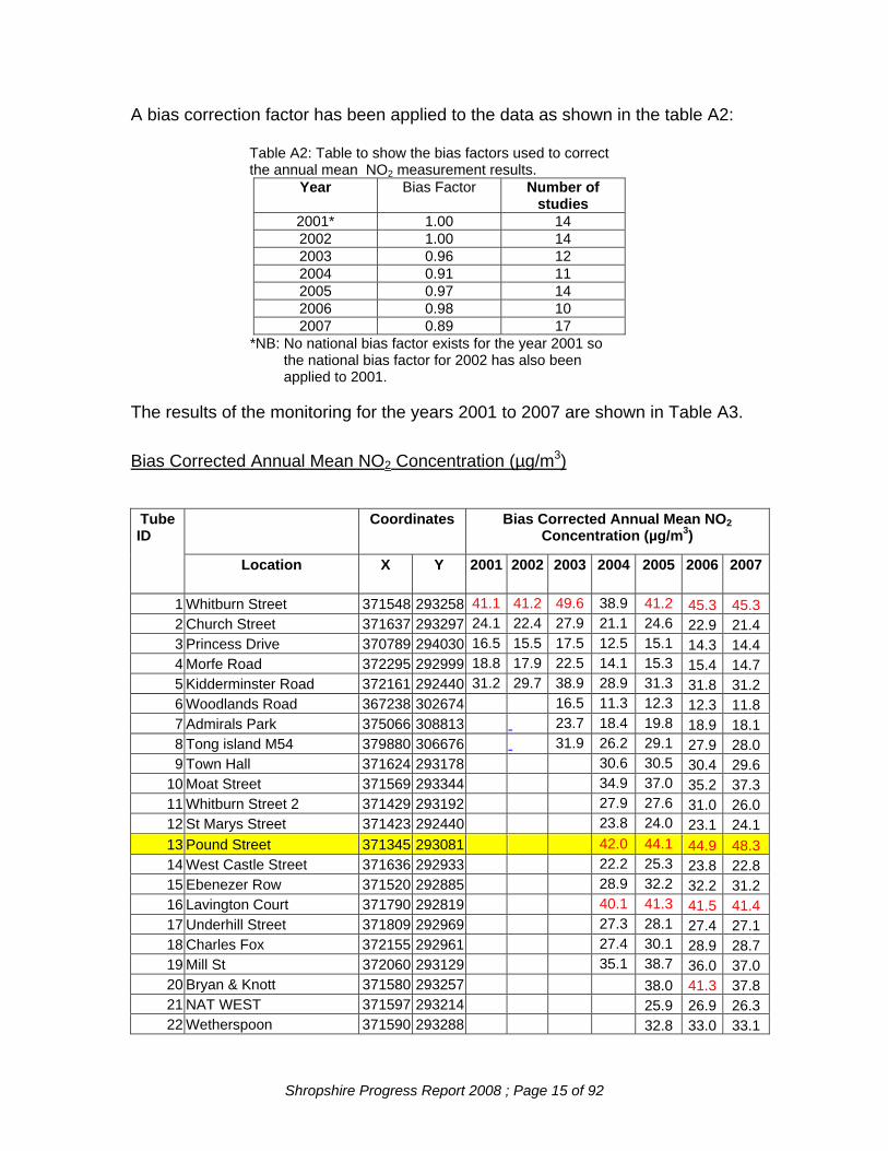
A bias correction factor has been applied to the data as shown in the table A2:
Table A2: Table to show the bias factors used to correct the annual mean NO2 measurement results.
Year Bias Factor Number of studies
2001* 1.00 14 2002 1.00 14 2003 0.96 12 2004 0.91 11 2005 0.97 14 2006 0.98 10 2007 0.89 17
*NB: No national bias factor exists for the year 2001 so the national bias factor for 2002 has also been
applied to 2001. The results of the monitoring for the years 2001 to 2007 are shown in Table A3. Bias Corrected Annual Mean NO2 Concentration (µg/m3)
Coordinates Bias Corrected Annual Mean NO2 Concentration (µg/m3)
Tube ID
Location X Y 2001 2002 2003 2004 2005 2006 2007
1 Whitburn Street 371548 293258 41.1 41.2 49.6 38.9 41.2 45.3 45.3 2 Church Street 371637 293297 24.1 22.4 27.9 21.1 24.6 22.9 21.4 3 Princess Drive 370789 294030 16.5 15.5 17.5 12.5 15.1 14.3 14.4 4 Morfe Road 372295 292999 18.8 17.9 22.5 14.1 15.3 15.4 14.7 5 Kidderminster Road 372161 292440 31.2 29.7 38.9 28.9 31.3 31.8 31.2 6 Woodlands Road 367238 302674 16.5 11.3 12.3 12.3 11.8 7 Admirals Park 375066 308813 23.7 18.4 19.8 18.9 18.1 8 Tong island M54 379880 306676 31.9 26.2 29.1 27.9 28.0 9 Town Hall 371624 293178 30.6 30.5 30.4 29.6
10 Moat Street 371569 293344 34.9 37.0 35.2 37.3 11 Whitburn Street 2 371429 293192 27.9 27.6 31.0 26.0 12 St Marys Street 371423 292440 23.8 24.0 23.1 24.1 13 Pound Street 371345 293081 42.0 44.1 44.9 48.3 14 West Castle Street 371636 292933 22.2 25.3 23.8 22.8 15 Ebenezer Row 371520 292885 28.9 32.2 32.2 31.2 16 Lavington Court 371790 292819 40.1 41.3 41.5 41.4 17 Underhill Street 371809 292969 27.3 28.1 27.4 27.1 18 Charles Fox 372155 292961 27.4 30.1 28.9 28.7 19 Mill St 372060 293129 35.1 38.7 36.0 37.0 20 Bryan & Knott 371580 293257 38.0 41.3 37.8 21 NAT WEST 371597 293214 25.9 26.9 26.3 22 Wetherspoon 371590 293288 32.8 33.0 33.1
Shropshire Progress Report 2008 ; Page 15 of 92

Coordinates Bias Corrected Annual Mean NO2 Concentration (µg/m3)
Tube ID
Location X Y 2001 2002 2003 2004 2005 2006 2007
23 Simply the Best 371507 293233 34.7 37.2 36.5 24 Travel Wallet 371492 293215 34.2 38.0 33.7 25 Citizens Advice Bureau 371355 293140 32.0 30.5 30.1 26 Majestic Cinema 371450 293188 28.5 31.2 27.9 27 Smithfield 371393 293189 28.5 31.7 29.5 28 50 Whitburn Street 371323 293132 51.9 55.5 62.9 29 Adj Rutters 371289 293106 33.6 35.6 36.8 30 10 Salop Street 371259 293123 28.0 27.6 27.6 34 Southalls Tobacconist 371614 293060 27.0 26.9 26.5 35 Trevor Phillips Opticians 371652 293069 27.5 28.1 26.6 36 WH SMITH 371634 293092 26.0 26.0 25.1 37 The Shakespeare 371652 293016 30.7 31.2 30.7 38 Old Post Office 371643 293028 24.8 25.4 24.4 39 Bridge 55 371638 293151 29.2 29.6 29.5 40 Market House 371590 293045 22.2 22.7 21.6 41 Elcock Reisen 371546 293365 31.9 33.9 30.5 42 Westgate House 371186 293161 24.4 24.7 26.6 43 Opposite Endowed School 371524 293430 34.0 35.8 33.3 44 Woodlands Road 367308 302705 11.6 12.3 13.4 45 Delphside 367486 301704 16.6 17.0 16.7 46 High Street- Club 367292 301902 19.5 20.7 18.8 47 Broseley C of E School 367788 302103 12.4 12.4 13.9 48 Library 371524 293017 27.3 28.5 24.9 49 45 Listley Street 371419 293020 25.7 24.0 24.4 50 30a Salop Street 371220 293124 35.9 37.0 36.8 51 Sheinton House 362190 300319 29.7 52 39 Sheinton Street 362233 300261 22.3 53 Gaskell Corner 362099 299775 29.5
Green = Sites now discontinued ; Blue = new sites in Much Wenlock ; Yellow = Results from within AQMA The NO2 annual average AQS Objective of 40µg/m3 has been exceeded consistently over the last three years at four locations within Bridgnorth town centre, Two of these locations are within the AQMA (ND13 Pound Street and ND28 Whitburn Street (outside no. 50)). The Air Quality Action Plan for the AQMA has recently been published (copy can be viewed at www.bridgnorth-dc.gov.uk/EnvironmentAndPlanning/Pollution/PollutionControl-AirQuality2). This Action Plan contains measures designed to reduce pollutant concentrations within this area.
Shropshire Progress Report 2008 ; Page 16 of 92

Location ND1 Whitburn Street (east) also exceeds the Objective, with several other sites in this area having concentrations close to the Objective. Site ND1 was scrutinised in the Further Assessment 2006 and it was concluded that it did not represent relevant public exposure. (copy can be viewed at www.bridgnorth-dc.gov.uk/EnvironmentAndPlanning/Pollution/PollutionControl-AirQuality2) Tube ND16 in Lavington Court also exceeds the 40µg/m3 Objective. A Detailed Assessment has been undertaken of this area, which indicated exceedences are likely at residential properties. A continuous monitoring station has been purchased and will be installed in January 2009 to allow further data collection for NO2 as well as NO and NOx. Further diffusion tubes are also being installed along Underhill Street. This will provide a much greater data set and should the results confirm the modelling data from the Detailed Assessment, may lead to the declaration of a new Air Quality Management Area covering this locality. Three of the locations in Broseley, ND44, ND45 and ND47, were discontinued, results from these 3 locations had consistently been well below the Objective, and unless some local significant change occurs, are expected to remain at these concentrations. Three new monitoring locations were introduced during 2007 in Much Wenlock (using the equipment from the discontinued Broseley sites). Some residents of Much Wenlock have expressed concerns over traffic flows passing through the town, especially HGV’s, congestion and the fact that the town is in a dip, which may reduce dispersion of pollutants. The monitoring has been introduced specifically to investigate these concerns. Results so far indicate concentrations below the annual mean Objective, but monitoring will continue to build up a greater data set. Ironbridge Power Station although within Telford & Wrekin’s borough, has a potential impact on the air quality of parts of the Bridgnorth district close to the edge of the district boundary. Telford & Wrekin Council closely monitors air quality in this area and any exceedences of air quality objectives would be notified to Bridgnorth District Council. Another potential air quality issue within the district of Bridgnorth is the Severn Valley Railway. There is a residential property located next to Bridgnorth’s steam railway station and monitoring was undertaken of sulphur dioxide levels potentially affecting the premises. However, the premises are no longer occupied so no further monitoring has been undertaken.
Shropshire Progress Report 2008 ; Page 17 of 92

Location of diffusion tubes within Bridgnorth
Shropshire Progress Report 2008 ; Page 18 of 92

Bridgnorth Air Quality Management Area
Shropshire Progress Report 2008 ; Page 19 of 92

APPENDIX 2: NORTH SHROPSHIRE A2.1: New and Altered Industrial Developments: North Shropshire Part A1 Installations The Environment Agency has granted permits for the following Part A1 processes since the last Progress Report of 2007: Company Process Emissions to
Air Easting Northing
Llynclys Farm Ltd, Heatherstone Farm
Intensive Farming
Particulates, Ammonia
3565 3356
Llynclys Farm Ltd, Stoke Heath Farm
Intensive Farming
Particulates, Ammonia
3652 3288
LW Gough & Son Intensive Farming
Particulates, Ammonia
3456 3225
JA & O Griffiths & Sons Intensive Farming
Particulates, Ammonia
5406 2969
RG & KM Price & Son Intensive Farming
Particulates, Ammonia
5194 3274
Partons Poulets Limited Intensive Farming
Particulates, Ammonia
6887 4009
Heal Eggs Ltd Intensive Farming
Particulates, Ammonia
5838 5836
2358 2272
Alan Simpson Farming Intensive Farming
Particulates, Ammonia
5788 3258
David Davies & Co Intensive Farming
Particulates, Ammonia
5771 1922
Shropshire Progress Report 2008 ; Page 20 of 92

The Environment Agency is currently processing applications for the following installations: Company Process Emissions to Air Easting NorthingHighbury Poultry Farm Produce Ltd
Treatment of Animal and Vegetable Matter and Food Industries
Particulates, Ammonia
5603 3527
J & E Ford Intensive Farming
Particulates, Ammonia
3515 3362
Oakland Farm Eggs Ltd Intensive Farming
Particulates, Ammonia
3511 3327
Part A2 Installations There are no A2 permitted installations within NSDC Part B Installations The following Part B Processes have opened since the last Progress Report of 2007: Company
Process Pollutants Easting Northing
Quality Cleaners, Whitchurch
Dry Cleaning VOCs 5424 4136
Wem Dry Cleaners Dry Cleaning VOCs 5136 2887
A2.2: New Major Developments: North Shropshire The following applications for housing and other developments that may affect air quality have received planning approval since the last Progress Report of 2007. App No. Location Proposal Decision
Date 07/00225/FUL Land Off
Chapel Road Hadnall Shropshire
Residential development of 30no. dwellings to include affordable housing; formation of estate roads and pedestrian access and including diversion of public right of way; formation of recreational space with access off A49
12.04.07
Shropshire Progress Report 2008 ; Page 21 of 92
App No. Location Proposal Decision Date
07/00460/FUL Phoenix Garage Great Hales Street Market Drayton Shropshire TF9 1JW
Erection of 14no. dwellings comprising mixed development of 2 and 3 storey mews houses and apartments; alterations to existing vehicular access; creation of estate roads, parking and amenity areas
31.05.07
07/00582/OUT Land Adjacent St Mary’s Croft Berrisford Road Market Drayton Shropshire
Outline application for residential development comprising of 6no dwelling; alterations to existing vehicular access and construction of new estate roads
09.05.07
07/00594/FUL Alford Farm Myddle Shropshire SY4 3RP
Erection of 14no dwellings; formation of estate roads with alterations to existing vehicular access
30.05.07
07/00739/DET Land At Shrewsbury Road Cockshutt Shropshire
Approval of Reserved Matters, (siting, design, external appearance and landscaping) for the proposed development at Shrewsbury Road, Cockshutt, N/05/1054/CO/259outline, granted 01.12.2006.
05.07.07
07/00826/FUL Marley Grove 48 Belton Road Whitchurch Shropshire SY13 1JA
Mixed residential development of 13no. detached and terraced dwellings; formation of parking areas and estate road
05.07.07
07/00851/OUT Manor Farm Crow Lane Childs Ercall Shropshire TF9 2DG
Outline application for the erection of 20 dwellings, to include 8 affordable units and erection of village shop and formation of formal village green and associated access
05.07.07
07/00933/FUL 3 Stafford Street Market Drayton Shropshire TF9 1HX
Erection of building comprising 12no. apartments; conversion of existing dwelling to form 2no. apartments and conversion of outbuilding to form 1no.apartment; alterations to existing vehicular access; provision of car parking and amenity areas
03.08.07
07/01083/FUL The Wharf Mill Street Whitchurch Shropshire SY13 1SA
Erection of building comprising 60no. category II type sheltered apartments for the elderly; separate block of 12no. affordable flats; landscaped gardens/amenity areas; car parking areas; formation of vehicular/pedestrian accesses
31.07.07
Shropshire Progress Report 2008 ; Page 22 of 92

App No. Location Proposal Decision Date
07/01145/FUL Market Drayton Cricket Hockey & Squash Club Betton Road Market Drayton Shropshire TF9 1HH
Residential development comprising 47 apartments in 5no. blocks; erection of club pavilion to include changing facilities, function room, bar and kitchen; provision of squash court; formation of new vehicular accesses, estate roads; associated parking areas and amenity areas; landscaping scheme
28.08.07
07/01210/FUL Land To Rear Of Sheraton House St Johns Hill In Birch Road Ellesmere Shropshire
Erection of 12 dwellings with associated access and drainage works
20.09.07
07/01470/FUL General Whitebrook Meadow Prees Shropshire
Proposed residential development of 25 dwellings to include 10 affordable units
15.02.08
07/01637/OUT Land At Heath Road Whitchurch Shropshire
Outline application (vehicular access) for the creation of business park to include B1 Offices, Research and Development Use (Phase 1)
5.10.07
07/01624/DET Land Off Harris Croft Wem Shropshire
Approval of Reserved Matters ( Layout, Scale, Appearance and Access ) for the proposed residential development (N/06/443/WU/1313 Outline) granted 24.07.2007
15.11.07
07/01816/DET Former Site Of Phoenix Rubber Ltd Pipe Gate Market Drayton Shropshire TF9 4HY
Approval of Reserved Matters (siting, design, means of access, landscaping) for the mixed development of 25no. dwellings (N/06/25/WO/39 OUTLINE)
10.12.07
07/01996/FUL Amos Liverpool Road Whitchurch Shropshire SY13 1SW
Mixed residential development of 14no. houses; formation of estate road with alterations to existing vehicular access; erection of entrance walls and piers, boundary fencing and walls
15.01.08
07/02031/FUL The Lodge 67 Alexandra Road Market Drayton Shropshire TF9 3HU
Proposed erection of 2no detached dwellings with garaging, erection of 10no apartments with alterations to vehicular access following demolition of existing dwelling House
10.01.08
Shropshire Progress Report 2008 ; Page 23 of 92

App No. Location Proposal Decision Date
07/02141/FUL Pet Market Shrewsbury Road Market Drayton Shropshire TF9 3EG
Proposed residential development comprising of 6 town houses, 4 apartments and 1 detached three bed dwelling and formation of parking areas
20.12.07
07/02377/FUL Wytheford House Wytheford Shawbury Shrewsbury Shropshire SY4 4JJ
Replacement of 3 poultry buildings with two new poultry buildings
11.03.08
08/00221/FUL Hawkstone Abbey Farm Weston Under Redcastle Shrewsbury Shropshire SY4 5LN
Erection of cattle housing building 28.03.08
07/02420/OUT Tern Valley Business Park Shrewsbury Road Market Drayton Shropshire
Outline application (vehicular access) for the development of an extension (Phase 2) of the Tern Valley Business Park for employment uses (B1,B2 and B8 uses); provision of a landscaped community recreation area; re-alignment of public footpath; landscaping scheme
06.03.08
Shropshire Progress Report 2008 ; Page 24 of 92
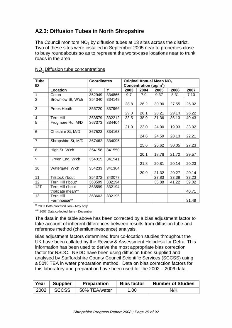
A2.3: Diffusion Tubes in North Shropshire
The Council monitors NO2 by diffusion tubes at 13 sites across the district. Two of these sites were installed in September 2005 near to properties close to busy roundabouts so as to represent the worst-case locations near to trunk roads in the area.
NO2 Diffusion tube concentrations
Coordinates Original Annual Mean NO2 Concentration (µg/m3)
Tube ID
Location X Y 2003 2004 2005 2006 2007 1 Coton 352949 334866 9.7 7.9 9.37 8.31 7.10 2 Brownlow St, W’ch 354340 334148
28.8
26.2 30.90 27.55 26.02 3 Prees Heath 355720 337966
29.3
28.1 28.21 29.13 26.22 4 Tern Hill 363579 332212 33.5 38.9 31.36 36.13 40.43 5 Frogmore Rd, M/D 367373 334404
21.0
23.0 24.00 19.93 33.92 6 Cheshire St, M/D 367523 334163
24.6 24.59 28.13 22.21 7 Shropshire St, M/D 367462 334095
25.6 26.62 30.05 27.23 8 High St, W’ch 354158 341550
20.1 18.76 21.72 29.57 9 Green End, W’ch 354315 341541
21.8 20.81 20.14 20.23 10 Watergate, W’ch 354233 341364
20.9 21.32 20.27 20.14 11 Tilstock r’bout 354372 340077 27.83 33.38 33.23 12 Tern Hill r’bout* 363599 332194 35.88 41.22 39.02 12T Tern Hill r’bout
triplicate mean** 363599 332194
40.71 13 Tern Hill
Farmhouse** 363603 332195
31.49 * 2007 Data collected Jan – May only
** 2007 Data collected June - December The data in the table above has been corrected by a bias adjustment factor to take account of inherent differences between results from diffusion tube and reference method (chemiluminescence) analysis. Bias adjustment factors determined from co-location studies throughout the UK have been collated by the Review & Assessment Helpdesk for Defra. This information has been used to derive the most appropriate bias correction factor for NSDC. NSDC have been using diffusion tubes supplied and analysed by Staffordshire County Council Scientific Services (SCCSS) using a 50% TEA in water preparation method. Data on bias correction factors for this laboratory and preparation have been used for the 2002 – 2006 data. Year Supplier Preparation Bias factor Number of Studies 2002 SCCSS 50% TEA/water 1.00 N/K
Shropshire Progress Report 2008 ; Page 25 of 92

2003 SCCSS 1.11 N/K 2004 SCCSS 50% TEA/water 1.00 N/K 2005 SCCSS 50% TEA/water 1.08 N/K 2006 SCCSS 1.03 4 2007 SCCSS 50% TEA/water 0.98 3 NO concentrations for 2010 have also been projected from the various annual averages based upon the guidance in LAQM.TG(03). The revised figures are detailed in the following table.
2
Bias Corrected Project 2010
Tube ID
2003 2004 2005 2006 2007 From 2003
From 2004
From 2005
From 2007
1 Coton
10.7 7.9 10.1 7.0 8.35 6.34 8.31 7.23 6.26
2 32.0 26.2 33.4 28.4 25.5 24.96 21.02 27.48 22.82
3 Prees Heath 32.5 28.1 30.5 30.0 25.7 22.54 25.10 25.52 22.994 Tern Hill
roundabout 37.2 33.9 37.2 39.6 29.02 31.21 27.90 31.64 35.43
5 Frogmore Rd, M/D
50% TEA/water
50% TEA/water
Bias Corrected Annual Mean NO2 Concentration (µg/m3)
Location From 2006
8.5
Brownlow St, W’ch
24.15
25.3538.9
23.3 23.0 28.2 20.5 33.2 18.17 18.45 23.20 17.44 29.70
6 Cheshire St, M/D
24.6 26.6 29.0 21.8 19.73 21.89 24.67 19.50
7 Shropshire St, M/D
25.6 31.4 31.0 20.54 25.84 26.37 23.89
8 High St, W’ch
20.1 20.3 22.4 29.0 16.12 16.70 19.05 25.95
9 Green End, W’ch
21.8 22.5 20.7 19.8 17.49 18.51 17.61 17.72
10 Watergate, W’ch
20.9 23.0 20.9 19.7 16.77 18.93 17.78 17.63
11 Tilstock roundabout
26.3 34.4 32.6 21.64 29.26 29.17
12 Tern Hill roundabout*
33.9 42.5 38.2 27.90 36.15 34.18
12T T.H. r’bout triplicate mean**
39.9 35.70
13 Tern Hill Farmhouse**
30.9 27.65
26.7
* 2007 Data collected Jan – May only
** 2007 Data collected June - December The 2010 projections from 2007 data indicate no exceedences of the annual average NO2 objective of 40µg/m3. As reported in the 2007 Progress Report, in 2006 the bias corrected figure for Tern Hill roundabout (site 12) showed a slight exceedence of the annual average NO2 objective. For this reason, from June 2007 onwards, an additional two diffusion tubes were located at this site
Shropshire Progress Report 2008 ; Page 26 of 92

(tube ID 12T) and a single tube was located at the façade of the closest property (tube ID 13), in order to further assess the NO2 levels at these sites. The bias corrected results from the triplicate tubes at 12T show levels approaching the annual objective, although the projections for 2010 are reduced. However, the tube located at the property façade shows considerably reduced levels, indicating that the drop off in NO2 levels from roadside to façade is significant. The average ratio between the two figures is 0.76; this figure ties in with the ratio suggested by the Air Quality Review and Assessment Helpdesk to estimate roadside values from kerbside results where the distance from the road is 10-20m. Due to the fact that the façade results are so much lower than the roadside figures, NSDC does not consider that it needs to designate an Air Quality Management Area at this location at the current time. Monitoring at these locations will continue and the results considered further when a full year’s exposure data has been collated.
Shropshire Progress Report 2008 ; Page 27 of 92

NO2 Diffusion Tube Concentrations
0.0
5.0
10.0
15.0
20.0
25.0
30.0
35.0
40.0
45.0
2002 2003 2004 2005 2006 2007
Year
ug/m
3
1 Coton
2 Brownlow St. Whitchurch
3 Prees Heath
4 Tern Hill
5 Market Drayton
6 Cheshire St. MD
7 Shropshire St. MD
8 High St. W'ch
9 Green End W'ch
10 Watergate W'ch
11 Tilstock Roundabout
12 Tern Hill Roundabout
12T Tern Hill Roundabouttriplicate mean13 Tern Hill Farmhouse
Shropshire Progress Report 2008 ; Page 28 of 92

APPENDIX 3: OSWESTRY A3.1: New and Altered Industrial Developments: Oswestry Part A1 Installations The Environment Agency has granted permits for the following Part A1 processes since the last Progress Report of 2007: Company Process Emissions to
Air Easting Northing
Llynclys Farm Ltd, Llynclys Intensive Farming
Particulates, Ammonia
328109 324311
Grampian Country Chickens (Rearing) Ltd., Wigmarsh
Intensive Farming
Particulates, Ammonia
337896 325003
J D Ward & Son, Perry Farm, Whittington
Intensive Farming
Particulates, Ammonia
334892 330250
Knockin Egg Farm Limited, Knockin
Intensive Farming
Particulates, Ammonia
332277 321646
JB & TS Williams, Ty-Issa Farm, Llanyblodwell
Intensive Farming
Particulates, Ammonia
323766 323623
In addition the Environment Agency has granted a permit for the following process which has transferred from Part B control: Company Process Emissions to
Air Easting Northing
Lloyds Animal Feeds Limited, Morton Mill, Morton
Animal feed processing
Particulates 328109 324311
In addition the Environment Agency have received an application for a Part A1 permit for the following process but has yet to issue the permit. Company Process Emissions to Air Easting Northing SA & DE Dixon Ltd, Vownog Farm, Porth-y-waen
Intensive Farming
Particulates, Ammonia
326036 323436
Shropshire Progress Report 2008 ; Page 29 of 92

Part A2 Installations There are two outstanding applications for A2 permitted installations within OBC. Company Process Emissions to
Air Easting Northing
Shropshire Galvanisers Limited
Galvanising PM10, Pb, NOx, SO2
330605 328270
Jones of Oswestry Galvanising PM10, Pb, NOx, SO2
329990 330586
Part B Installations The following Part B Processes have opened since the last Progress Report of 2007: Company
Process Pollutants Easting Northing
Johnson Dry Cleaners, Oswestry
Dry Cleaning VOCs 329069 329629
A3.2: New Major Developments: Oswestry The following applications for housing and other developments that may affect air quality have received planning approval since the last Progress Report of 2007.
Ref Site Development Date East North 15121 Land Adj To Ambulance
Station, Morda Bank Erection of 3 no. two storey detached dwellings and 1 no. bungalow
18/10/2007 328832 328321
15164 Old Nursery Site, High Street, Weston Rhyn
Erection of 3 no detached bungalows and alterations to access 14/11/2007 328310 335844
15162 Land Adjoining Garden Village, Overton Road St Martins
Residential development (75 dwellings), new estate road and vehicular access
14/11/2007
332139 336615 15248 Avalon, 83 Coopers
Lane St Martins
Proposed redevelopment of Avalon and development on adjoining land to comprise 3 no detached two storey dwellings with garages, re-routing of existing private driveway and associated works
19/12/2007
332969 336904
Shropshire Progress Report 2008 ; Page 30 of 92

15120 Land Adj The Croft,
Bronygarth Road, Weston Rhyn
Proposed construction of 3 no. dwellings, formation of new access and private drive with associated works
14/11/2007
328131 335861 14818 Dovaston Bank Farm
Dovaston Erection of three detached dwellings on unused garden and farm yard, including new access
03/04/2007
334804 321269 15291 Quabbs Cottage,
Argoed Kinnerley
Retrospective application for change of use of part of redundant outbuilding for the purposes of bacon curing , packaging and freezing for distribution to applicants own retail premises. 23/01/2008 332192 320588
15086 Bryn-Y-Plentyn, Middleton
Proposed extension to existing free range poultry building
19/09/2007 332745 329202
14878 Former Brickwork Site Ifton Colliery, St Martins
Alterations to building design on part of proposed commercial/industrial development
30/05/2007
332469 337430 14958 Haulfryn, 4 Lloyd Street
Oswestry Erection of 5 blocks of 4 one-bed flats and 1 three-bed block
31/05/2007 329237 330145
15062 The Downs, Victoria Street, Oswestry
Proposed erection of three dwellings, entrance to dwellings to be through adjacent Queens Park House development.
18/10/2007
329050 329076 14815 Gledrid A5 Services
Gledrid, Weston Rhyn Erection of two restaurant units and associated works
31/05/2007 330019 336207
14820 Perrymoor Farm, Berghill Lane, Whittington
Change of use and alterations to 2 no. agricultural buildings to 4 no. small business units and 4 no. garages
30/05/2007
334246 330097 14786 Hall Farm, Church
Street Ruyton XI Towns
Erection of 7 detached dwellings with double garages and new adopted road access
04/04/2007
339175 322228 15059 Cambrian Works,
Gobowen Road
Conversion of Grade II Listed former railway sheds to form new primary care centre and residential units including associated access works, external landscaping and car parking
19/09/2007
329557 329995 14823 Old Nursery Site, High
Street, Weston Rhyn
Proposed construction of three, two bedroom bungalows with private drive and alterations to existing access
28/02/2007
328310 335844
Shropshire Progress Report 2008 ; Page 31 of 92

A3.3: Diffusion Tubes in Oswestry
The Council monitors NO2 by diffusion tubes at 14 sites across the district. Two of these sites were installed in September 2005 near to properties close to busy roundabouts so as to represent the worst-case locations near to trunk roads in the area.
NO2 Diffusion tube concentrations
Coordinates Original Annual Mean NO2 Concentration (µg/m3)
Tube ID
Location X Y 2003 2004 2005 2006 2007 1 Church Street 329126 329634 36.1 26.1 26.8 27.7 29.3 2 Council Depot 328871 330172 16.9 10.1 11.2 10.9 11.0 3 Beech Grove
School 329893 329503
17.1
13.8 13.6 13.5 14.1 4 Willowgate 328899 329813 33.5 29.6 30.4 32.1 29.5 5 Heatherdene 328804 329329 47.0 6 78 Welsh Walls 328683 329525 21.7 7 74 Castle Street 328974 329883 33.3 33.4 34.1 33.3 38.0 8 Plough Inn 329205 329846 9 AQMA - 1 328922 325981 36.2 34.3 40.1 40.4 41.1 10 AQMA – 2 328922 325981 37.7 36.6 39.6 36.9 38.7 11 AQMA – 3 328922 325981 36.0 36.0 40.3 39.0 40.9 AQMA –
average 328922 325981 36.7 35.6 40.0 38.8 40.2
12 CM* 38.8 13 CM2* 36.8 14 CM3* 35.4 CM average 37.0 * 2007 Data collected May - Dec only Green = Sites now discontinued ; Yellow = Results from within AQMA
The data in the table above has been corrected by a bias adjustment factor to take account of inherent differences between results from diffusion tube and reference method (chemiluminescence) analysis. Recent reviews carried out on behalf of Defra have examined variations between diffusion tube and co-located automated monitors. These reviews show that the main factor affecting tube performance is the laboratory. Although the studies suggest that there may be residual uncertainty due largely to some aspect of the tube exposure, it has been recommended that diffusion tubes should be bias adjusted using the results from co-location studies carried out in the same year. Bias adjustment factors determined from co-location studies throughout the UK have been collated by the Review & Assessment Helpdesk for Defra. This information has been used to derive the most appropriate bias correction factor for OBC. OBC have been using diffusion tubes supplied and analysed by Gradko using a 20% TEA in water preparation since 2001. Data on bias correction factors for this laboratory and preparation have been used for the 2003 – 2007 data. The table below summarises the bias factors used and the number of studies from which the average has been derived.
Shropshire Progress Report 2008 ; Page 32 of 92

Year Supplier Preparation Bias factor No of studies
2003 Gradko 20% TEA/water 0.96 12
2004 Gradko 20% TEA/water 0.91 11
2005 Gradko 20% TEA/water 0.97 14
2006 Gradko 20% TEA/water 0.98 10
2007 Gradko 20% TEA/water 0.89 22 The uncorrected data has been bias corrected and also 2010 concentrations have been projected from the various annual averages based upon the guidance in LAQM.TG(03) (Defra 2003). The revised figures are detailed in the following table and are illustrated graphically below. Bias Corrected Annual Mean NO2 Concentration (µg/m3)
Bias Corrected Project 2010
Tube ID
Location 2003 2004 2005 2006 2007 From 2003
From 2004
From 2005
From 2006
From 2007
1 Church Street
34.7
23.7 26 27.2 26.1
27.1
19.0 21.4 23.1 23.0
2 Council Depot
16.3
9.2 10.9 10.6 9.8
12.7
7.4 9.0 9.0 8.68
3 Beech Grove School
16.4
12.5 13.1 12.1 12.5
12.8
10.0 10.8 10.3 11.0 4 Willowgate 32.2 26.9 29.5 31.5 26.2 25.1 21.6 24.2 26.8 23.1 5 Heatherdene 45.1 35.2 6 78 Welsh
Walls 20.8
16.2
7 74 Castle
Street
31.9
30.4 33.1 32.7 33.8
34.9
34.4 27.2 27.8 29.8 8 Plough Inn 9 AQMA - 1 34.8 31.2 38.9 39.6 36.5 27.1 25.0 32.0 33.7 32.2 10 AQMA – 2 35.5 32.3 38.4 36.2 34.5 27.7 26.7 31.6 30.8 30.4 11 AQMA – 3 33.7 32.7 39 38.2 36.4 26.3 26.2 32.1 32.5 32.1 AQMA –
average 34.7 32.1 38.8 38.0 35.8 27.0 26.0 31.9 32.3 31.6
12 CM1* 34.5 30.4 13 CM2* 32.8 28.9 14 CM3* 31.5 27.8 CM average 32.9 29.0 * 2007 Data collected May - Dec only Green = Sites now discontinued ; Yellow = Results from within AQMA
The 2010 projections from 2007 data indicate no exceedences of the annual average NO2 objective of 40µg/m3.
Shropshire Progress Report 2008 ; Page 33 of 92

Shropshire Progress Report 2008 ; Page 34 of 92
02001 2002 2003 2004 2005 2006 2007
Nitrogen Dioxide Concentrations - Oswestry
5
10
15
20
25
30
35
40
45
50ug
/m3
Church StreetCouncil DepotBeech Grove SchoolWillowgateHeatherdene78 Welsh Walls74 Castle StreetPlough InnAQMA – averageCM average

OSWESTRY BC - NO2 2007
0
5
10
15
20
25
30
35
40
45
50
Jan Feb Mar Apr May Jun Jul Aug Sep Oct Nov Dec
NO
2 ug
/m3
WillowgateDepotChurch StA483PantCastle StSchool
Shropshire Progress Report 2008 ; Page 35 of 92

A3.4: Additional Information: Oswestry Oswestry declared an AQMA including a single property.
Shropshire Progress Report 2008 ; Page 36 of 92

Oswestry AQMA NO2 Concentrations
0
10
20
30
40
50
2001 2002 2003 2004 2005 2006 2007
ug/m
3
AQMA - 1AQMA – 2AQMA – 3AQMA – average
Shropshire Progress Report 2008 ; Page 37 of 92

AQMA – Data Quality Assessment for 3 Co-located Tubes
Adjustment of DUPLICATE or TRIPLICATE Tubes
Diffusion Tubes Measurements
Data Quality Check
Perio
d Start Date dd/mm/yyyy
End Date dd/mm/yyyy
Tube 1 µgm-3
Tube 2 µgm-3
Tube 3 µgm-3
Triplicate Average
Standard Deviation CV 95% CI
mean Diffusion Tubes Precision Check
1 04/01/2007 29/012007 35.7 33.55 34.44 34.6 1.08 3.13 2.68 Good Good
2 29/012007 27/02/2007 46.47 43.75 44.75 45.0 1.38 3.06 3.42 Good Good
3 27/02/2007 12/04/2007 39.88 34.85 42.09 38.9 3.71 9.53 9.22 Good Good
4 12/04/2007 07/05/2007 51.3 46.4 50.64 49.4 2.66 5.38 6.61 Good Good
5 07/05/2007 31/05/2007 38.13 43.05 39.46 40.2 2.55 6.33 6.32 Good Good
6 31/05/2007 05/07/2007 43.69 37.3 41.12 40.7 3.22 7.90 7.99 Good Good
7 05/07/2007 31/07/2007 34.35 34.35 37.99 35.6 2.10 5.91 5.22 Good Good
8 31/07/2007 29/08/2007 38.99 38.94 35.76 37.9 1.85 4.88 4.60 Good Good
9 29/08/2007 03/10/2007 44.05 36.06 41.78 40.6 4.12 10.13 10.23 Good Good
10 03/10/2007 31/10/2007 42.8 44.51 43.37 43.6 0.87 2.00 2.16 Good Good
11 31/10/2007 28/11/2007 40.53 38.86 38.4 39.3 1.12 2.85 2.78 Good Good
12 28/11/2007 02/01/2008 36.84 33.31 40.37 36.8 3.53 9.58 8.77 Good Good 13
It is necessary to have results for at least two tubes in order to calculate the precision of the measurements Jaume Targa
Site Name/ ID: AQMA Co-location [email protected]
Shropshire Progress Report 2008 ; Page 38 of 92

Adjusted measurement
(95% confidence
level)Without periods with CV larger than 20%
Bias calculated using 0 periods of data Tube Precision:#DIV/0! #DIV/0!
Bias factor A:#DIV/0! Bias B:#DIV/0! Information about tubes to be adjusted
Diffusion Tube average: 40 µgm-3 Average Precision (CV): 6
Adjusted Tube average: #DIV/0! µgm-3
Adjusted measurement
(95% confidence
level)with all data
Bias calculated using 0 periods of data Tube Precision:#DIV/0! ##### Bias factor A:#DIV/0!
Bias B:#DIV/0! Information about tubes to be adjusted Diffusion Tube average: 40 µgm-3
Average Precision (CV): 6
Adjusted Tube average: #DIV/0! µgm-3
Shropshire Progress Report 2008 ; Page 39 of 92

Following the receipt of capital funding from Defra a real time air quality monitoring station was introduced by OBC during late the summer of 2007 at Pant. The location is shown at Figure 1. This equipment, supplied by Signal Ambirak, measures a range of pollutants including PM10 using an R and P TEOM instrument and oxides of nitrogen, including NO2.
Figure 1: Location of Air Quality Monitoring Station at Pant The rationale behind choosing this monitoring position was twofold:- a) to review the monitoring data for NO2 from within the AQMA – it was not possible to locate the monitoring equipment within the area of the declared AQMA due to restricted power supply and the absence of a suitable location b) given the continued elevated NO2 concentrations within the AQMA, to extrapolate the data to a location nearby the declared AQMA with the same traffic flow and many more dwellings and buildings adjacent to the roadside to review potential health impact.
This station will measure oxides of nitrogen, including NO2 and PM10 although data quality and retrieval for PM10 was not adequate to permit reporting of data. Three diffusion tubes have been co-located (attached to the sampling mast) at the continuous monitoring equipment to allow data validation. The following charts summarise the NO2 monitoring showing no hourly averages exceed the AQO along with a quality assurance assessment carried out using the co-located tube data. The bias calculations below have not been used to correct any local data as the monitoring was only for a sixth month period - however the calculated bias correction was period was 0.805 +/- 0.056 which is comparable to the reported data (0.89) from the Review & Assessment Helpdesk used for correction of the diffusion tube data..
Shropshire Progress Report 2008 ; Page 40 of 92

2007 - Pant Continuous AQ Daily Mean NO2 ug/m3
0
10
20
30
40
50
60
70
80
16-M
ay
22-M
ay
28-M
ay
03-J
un
09-J
un
15-J
un
21-J
un
27-J
un
03-J
ul
09-J
ul
15-J
ul
21-J
ul
27-J
ul
02-A
ug
08-A
ug
14-A
ug
20-A
ug
26-A
ug
01-S
ep
07-S
ep
13-S
ep
19-S
ep
25-S
ep
01-O
ct
07-O
ct
13-O
ct
19-O
ct
25-O
ct
31-O
ct
06-N
ov
12-N
ov
18-N
ov
24-N
ov
30-N
ov
06-D
ec
12-D
ec
18-D
ec
24-D
ec
30-D
ec
NO
2 ug
/m3
Shropshire Progress Report 2008 ; Page 41 of 92

Pant Continuous Monitoring 2007 Hourly Averages NO2 ug/m3
0
20
40
60
80
100
120Ti
me
serie
s09
/05/
2007
17/0
5/20
0725
/05/
2007
03/0
6/20
0711
/06/
2007
19/0
6/20
0728
/06/
2007
06/0
7/20
0714
/07/
2007
23/0
7/20
0731
/07/
2007
08/0
8/20
0717
/08/
2007
25/0
8/20
0702
/09/
2007
11/0
9/20
0719
/09/
2007
27/0
9/20
0706
/10/
2007
14/1
0/20
0722
/10/
2007
31/1
0/20
0708
/11/
2007
16/1
1/20
0725
/11/
2007
03/1
2/20
0711
/12/
2007
20/1
2/20
07
NO2 ug/m3
Shropshire Progress Report 2008 ; Page 42 of 92

Pant – Continuous Emission Monitoring comparison with 3 co-located tubes
Diffusion Tubes Measurements
Period Start Date
dd/mm/yyyy End Date
dd/mm/yyyy Tube 1 µgm-3
Tube 2 µgm-3
Tube 3 µgm-3
Triplicate Average
Standard Deviation CV 95% CI
mean Diffusion Tubes Precision Check
1 07/05/2007 31/05/2007 38.28 36.29 33.42 36.0 2.44 6.79 6.07 Good Good
2 31/05/2007 05/07/2007 36.8 38.51 37.43 37.6 0.86 2.30 2.15 Good Good
3 05/07/2007 31/07/2007 34.03 33.06 31.3 32.8 1.38 4.22 3.44 Good Good
4 31/07/2007 29/08/2007 33.76 33.11 31.61 32.8 1.10 3.36 2.74 Good Good
5 29/08/2007 03/10/2007 35.27 32.54 24.09 30.6 5.83 19.03 14.48 Good Good
6 03/10/2007 31/10/2007 48.76 44.1 43.58 45.5 2.85 6.27 7.09 Good Good
7 31/10/2007 28/11/2007 43.01 43.81 44.16 43.7 0.59 1.35 1.46 Good Good
8 28/11/2007 02/01/2008 40.78 32.99 37.29 37.0 3.90 10.54 9.69 Good Good
Site Name/ ID: Pant CAQM Station [email protected]
Precision 8 out of 8 periods have a CV smaller than 20%
Shropshire Progress Report 2008 ; Page 43 of 92

Diffusion Tubes Measurements
Period Start Date dd/mm/yyyy End Date dd/mm/yyyy Period Mean
Data Capture (DC) Automatic Data Precision Check
1 07/05/2007 31/05/2007 28.48 99 Good Good
2 31/05/2007 05/07/2007 29.62 95 Good Good
3 05/07/2007 31/07/2007 24.64 95 Good Good
4 31/07/2007 29/08/2007 24.63 99 Good Good
5 29/08/2007 03/10/2007 28 95 Good Good
6 03/10/2007 31/10/2007 35 95 Good Good
7 31/10/2007 28/11/2007 32 92 Good Good
8 28/11/2007 02/01/2008 33 90 Good Good
Site Name/ ID: Pant CAQM Station [email protected]
Shropshire Progress Report 2008 ; Page 44 of 92

Accuracy (with 95%
confidence) without periods with CV larger than 20% Bias calculated using 8 periods of data
Bias factor A 0.804 +/- 0.056 Bias B 26 +/- 6 %
Diffusion Tubes Mean: 37 µgm-3 Mean CV (Precision): 7
Automatic Mean: 29 µgm-3 Data Capture for periods used: 95
Adjusted Tubes Mean: 30 +/-2 µgm-3
Accuracy (with 95%
confidence) with all the data Bias calculated using 8 periods of data
Bias factor A 0.804 +/- 0.056 Bias B 26 +/- 6 %
Diffusion Tubes Mean: 37 µgm-3 Mean CV (Precision): 7
Automatic Mean: 29 µgm-3 Data Capture for periods used: 95
Adjusted Tubes Mean: 30 +/-2 µgm-3
Shropshire Progress Report 2008 ; Page 45 of 92

APPENDIX 4: SHREWSBURY & ATCHAM BOROUGH COUNCIL A4.1: New and Altered Industrial Developments: Shrewsbury & Atcham New and Altered Industrial Developments Shrewsbury & Atcham Part A1 Installations The Environment Agency has issued permits for the following installations: Company District Chapter Eastings Northings James Home and Partners, Forge Farm,
Upton Magna, Shrewsbury, SY4 4UD
DP4342UR
3563 3115
C.D. and P.A. Holloway, The Hayes Farm
Bomere Heath, Shrewsbury, SY5 9PQ
PP3339UR
3459 3212
The above relate to existing intensive livestock installations Part A2 Installations. The Council has not issued any permits for these installations: Part B Processes The following Part B Processes have opened since the USA Company Process Pollutants Eastings Northings Doncasters Aerospace Ltd, Whitchurch Road, Shrewsbury, SY1 4DP
Surface degreasing
Trichloroethylene, and Particulate Matter
3505 3147
Inchcape Volkswagen Paint & Body Centre, Levens Drive, Harlescott, Shrewsbury, SY1 3TQ
Preparation, repair and re-spraying of road vehicles
Volatile Organic Compounds and Particulate Matter
3503 3153
Inchcape Retail Ltd has relocated.
Shropshire Progress Report 2008 ; Page 46 of 92

The following Part B Processes have closed or no longer need Permitting since the last Progress Report: Company Process Pollutants Eastings Northings Inchcape Retail Ltd , Featherbed Lane Harlescott, Shrewsbury, SY1 4NW
Preparation, repair and re-spraying of road vehicles
Volatile Organic Compounds and Particulate Matter
3513 3157
A4.2: New Major Developments: Shrewsbury & Atcham The following major applications for housing and other developments that may affect air quality have received planning approval since the USA. APP NO.
LOCATION PROPOSAL DECISION
DATE 06/0636/F
Land off Ellesmere Road, Shrewsbury,
Erection of 128 2, 2 and a half, 3 and 4 storey dwellings (to include 45 affordable dwellings), erection of new bowling/social club, car park and bowling green, electricity sub-station, estate roads
04/09/2007
06/1667/DD
Land at Montgomery Way, Shrewsbury
Erection of 20 affordable dwellings and construction of new estate roads and pedestrian and vehicular accesses
29/05/2007
07/0024/F
Former Leoni premises, off Arlington Way, Shrewsbury
Change of use from industrial (Class B2) to non-food retail (Class A1) and formation of new vehicular access (resubmission of 06/0050/F refused on 10th March 2006)
31/05/2007
07/0056/F
Nobold Business Park, Longden Road, , Shrewsbury
Erection of 16 office units and construction of new vehicular access
24/04/2007
07/0080/F
Knights Way, Battlefield Enterprise Park, , Shrewsbury
Erection of 3 commercial/industrial units (Use Classes B1, B2 and B8) with associated parking and formation of new vehicular and pedestrian accesses
22/01/2007
07/0133/F
Former builders yard, Copthorne Road, Shrewsbury
Erection of 2.5 storey building to provide 11 apartments and 2 storey building to provide 2 apartments with associated parking
10/05/2007
07/0142/F
9-12 Glenburn Gardens, Shrewsbury,
Erection of 10 semi-detached dwellings and 1 detached bungalow to include construction of new vehicular access following demolition of existing dwellings
15/05/2007
07/0256/F
Former New Street Nursery, New Street, Shrewsbury
Erection of 14 detached 2 and 1/2 storey dwellings with garages and provision of car parking spaces following demolition of existing buildings
23/05/2007
07/0266/F
Land adj. to 63 The Leasowes, Ford
Erection of 10 affordable dwellings and construction of new estate road off The Leasowes
05/09/2007
07/0522/F Leoni House, Henley Way, Harlescott, Shrewsbury
Change of use from B2 to B8, insertion of a roller shutter and erection of perimeter fencing
20/06/2007
07/0542/F
J Bibby Agriculture Ltd, Ennerdale Road, Shrewsbury
Change of use of general industrial unit into builders/plumbers merchants
20/06/2007
07/0551/O
Land to the west of Ellesmere Road,
Outline application for residential development (35% of which will be affordable) to include means of access
18/07/2007
Shropshire Progress Report 2008 ; Page 47 of 92

Shrewsbury
07/0573/O
Royal Shrewsbury Hospital, Mytton Oak Road, Shrewsbury
Outline application for residential development to provide 122 units (consisting of 65 open market units including 10 affordable dwellings, 57 key worker units in association with the Royal Shrewsbury Hospital)
08/02/2008
07/0590/F
Plots 2 - 8 Vanguard Way, Battlefield
Erection of a car dealership building to include showroom and workshop, erection of body shop building and separate valeting bays and formation of new vehicular access
20/07/2007
07/0648/F
Plot 1, Longden Road Depot Longden Road, Shrewsbury
17/08/2007
07/0757/RM
Plot 28 Vanguard Two Vanguard Way, Battlefield, Shrewsbury
Reserved matters (pursuant to outline planning permission ref. 04/0328/O dated 30/06/04) to include siting, design, external appearance, means of access and landscaping of a commercial unit with associated parking
03/08/2007
07/0760/RM
Plots 3 & 5 Vanguard 'one', Vanguard Way, Battlefield, Shrewsbury
Reserved matters pursuant to outline permission ref: 04/0330/O dated 30/06/04 for the siting, design, external appearance, means of access and landscaping for the development of two buildings for B1, B2, B8 and mixed uses including vehicle sales/repairs and trade counter/warehousing/builders merchants and to include new vehicular/pedestrian access. (1350 sqm)
17/07/2007
07/0795/RM
Plot, 6-7 Vanguard Way, Battlefield, Shrewsbury
Reserved matters pursuant to outline permission ref: 04/0330/O dated 30/06/04 for the siting, design external appearance, means of access and landscaping for the development of two buildings for B1, B2, B8 and mixed uses including vehicle sales/repairs and trade counter/warehousing/builders merchants and to include new vehicular/pedestrian access
03/08/2007
07/0867/RM
Plot 30 'Vanguard Two', Vanguard Way, Battlefield, Shrewsbury
Reserved matters pursuant to outline permission ref: 04/0328/O dated 30th June 2004 for the erection of one building (1132 sq. m) for B1, B2, B8 and mixed uses including vehicle sales and repairs, trade counter/warehousing and builders merchants to include means of access, siting, design, external appearance and landscaping
20/08/2007
07/0889/RM
Plot 38 'Vanguard Two', Vanguard Way, Battlefield, Shrewsbury
Reserved matters pursuant to outline permission ref: 04/0328/O dated 30th June 2004 for the erection of one building (1115.2 sq.m) for B1, B2, B8 and mixed uses including vehicle sales and repairs, trade counter/warehousing and builders merchants to include means of access, siting, design, external appearance and landscaping
03/08/2007
07/0922/RM
Plots 34 & 36 Vanguard Two, Vanguard Way, Battlefield, Shrewsbury
Reserved matters pursuant to outline permission ref: 04/0328/O dated 30th June 2004 for the erection of 6 units (3,100.2 square metres) for B1, B2, B8 and mixed uses including vehicle sales & repairs, trade counter/warehousing and builders merchants to include means of access, siting, design, external appearance and landscaping
03/08/2007
07/0952/RM
Land at Spring Gardens, Ditherington, Shrewsbury
Reserved matters pursuant to outline permission ref: 01/1176/O dated 10th August 2005 for the erection of 189 dwellings (comprising 51 apartments and 138 houses of which 57 are affordable), construction of roundabout and spur road and provision of open space
21/09/2007
07/1042/F
Sundorne Trade Park, Featherbed Lane, Shrewsbury
Erection of a car dealership building to include showroom, workshop and associated office and parts showroom, workshop and associated office and parts storage to include formation of new vehicular access
12/10/2007
07/1087/F
Former Builders Yard, Copthorne Road, Shrewsbury
Alterations to include a further ground floor apartment making a total of 14 units (amendment to previously approved application ref: 07/0133/F)
18/10/2007
07/1183/F
Former Taylor Bros Premises, New Park Close, Shrewsbury
Erection of 13 two-storey dwellings and alterations to existing vehicular and pedestrian accesses (amended description)
12/10/2007
07/1223/O
Field No. 3227, Lower Wigmore Wigmore Lane, Wattlesborough
Outline application for the erection of a free range egg production unit to include siting and means of access
01/11/2007
Erection of a two storey office building (Use Class B1) and warehouse building (Use Class B8)
Shropshire Progress Report 2008 ; Page 48 of 92

Heath
07/1224/O
Lower Wigmore Farm, Wigmore Lane, Wattlesborough Heath
Outline application for the erection of a free range egg production unit to include siting and means of access
01/11/2007
07/1264/F
Bromley House, 96 Copthorne Road, Shrewsbury
Erection of 44 apartments (consisting of 15 affordable units and 29 open market units), together with the construction of an underground car park, new vehicular and pedestrian accesses and landscaping following demolition of existing nursing care home (amended resubmission of application ref. 07/0678/F refused on the 3rd August 2007 for 47 apartments)
19/11/2007
07/1287/F
Land at rear of Column House, Preston Street, Shrewsbury
Erection of 10, 3 storey town houses and associated parking and gardens with access off Preston Street
22/11/2007
07/1355/F
New House Farm, Minsterley
Erection of a building for storage of eggs, packaging and cold room and provision of an access track
10/12/2007
07/1400/F
Former New Street Nursery, Copthorne Road, Shrewsbury
Erection of 14 detached 2 and 1/2 storey dwellings with garages and provision of car parking spaces following demolition of existing buildings (including No 39 Copthorne Road) and creation of new vehicular and pedestrian accesses (Amendment to previously approved application ref: 07/0256/F
20/12/2007
07/1473/F
The Uplands, Bicton Heath
Erection of two 2-storey buildings to create twenty eight 2-bedroom extra care units and erection of single storey Wellness centre incorporating a swimming pool and gym (Amended Description)
10/01/2008
07/1493/RM
Former Tesco site, Arlington Way, Shrewsbury
Reserved matters pursuant to outline permission reference 06/0166/DDM for residential development of 101 dwellings (including 35 affordable units) incorporating open space to include layout of site, scale and external appearance of buildings and landscaping of the site
30/01/2008
07/1494/F
Plot 8 Knights Way, Battlefield Enterprise Park, Shrewsbury
Erection of 3, two storey blocks to create 5 B1 office units (2079.52 sq. m.) and provision of car parking spaces
03/01/2008 07/1561/O
Shrewsbury Livestock Market, Battlefield, Shrewsbury
Outline Application for the construction of a fine art and general sale auction rooms, storage and offices to include layout and means of access
06/02/2008
07/1566/RM
Land at Spring Gardens, Shrewsbury
Reserved matters pursuant to outline permission reference 01/1176/O dated 10th August 2005, for the substitution of house types on plots 47-92 and 121-127, changes to layout and associated garages resulting in 53 units (comprising 18 apartments and 35 houses of which 18 are affordable) instead of 54 units, to include layout of the site, scale, external appearance and landscaping (amendment to planning permission reference 07/0952/RM granted 21st September 2007)
07/01/2008
07/1639/F
Royal Shrewsbury Hospital, Mytton Oak Road Shrewsbury
Erection of a 4-storey building to provide 16, 4-bedroom key worker residential units with associated car parking, alterations to vehicular access and provision of open space
13/02/2008
07/1839/F
Plot 24, Shrewsbury Business Park
Erection of two buildings for B1 use to include formation of new vehicular access and associated car parking
22/02/2008
07/1844/DD
Land adj. Harlescott Park & Ride, Battlefield Road Shrewsbury
Erection of a new bus depot (1706.76 sq. m) and maintenance facility with two access points onto existing park & ride access road
22/02/2008
08/0012/F
Former Railway Land, Sutton Lane, Shrewsbury
Erection of 10 residential dwellings, construction of new estate roads, creation of new pedestrian and vehicular accesses, creation of landscaped seating area and additional car parking spaces (amendment to part of the site to provide 1 additional dwelling to that approved under planning reference 06/1359/F to provide a total of 47 dwellings and an additional 18 car parking spaces)
22/02/2008
07/1592/F
Land Off Ellesmere Road, Shrewsbury, SY1 2AH
Part amendment of previously approved application ref: 06/0636/F granted 4th September 2007 for the re-siting of 72 residential dwellings (comprising 26 houses and 46 apartments of which 41 are affordable) on plots 48-103 and plots 1-16 to provide a service access road to the railway line
01/05/2008
Shropshire Progress Report 2008 ; Page 49 of 92

08/0108/F
Manor Farm, Stoney Stretton, Shrewsbury,
Erection of a free range egg laying unit (2060 M.Sq.)
23/04/2008
. A4.3: Diffusion tubes in Shrewsbury & Atcham
Diffusion tube concentrations
Coordinates Original Annual Mean NO2
Concentration (µg/m3) Tube ID Location
X Y 2004 2005 2006 2007 2 A49 Bayston Hill,
Opposite Three Fishes 348726 308959 33.9 36.2 39.3 41.99
3 Mytton Oak Road, between 2 entrances to hospital
346473 312420 23.2 22.7 23.7 24.17
5 Ford, Outside School 341612 313309 ------ ------ ------ ------ 6 Pontesbury, Opposite
Mary Webb School 340300 305800 ------ ------ ------ ------
7 Woodfield School, Copthorne Road
347741 312758 30.3 31.6 29.8 32.38
8# Frankwell, on corner of Drinkwater Street
348719 312952 27.4 part
------ ------ ------
9 Smithfield Road, on corner of Victoria Avenue
348891 312721 37.4 38.2 44.1 43.53
44 # Duplicate of 9 Smithfield 348891 312721 39.3 part
------ ------ ------
45 # Duplicate of 9 Smithfield 348891 312721 41.6 part
------ ------ ------
10 Town Walls, opposite Murivance
348881 312326 27.4 24.9 23.7 26.13
11# Castle Foregate, opposite Royal Mail
349432 313100 44.1 part
------ ------ ------
13 Harlescott Park & Ride 351260 315968 22.4 24.2 21.6 23.83 15 Ditherington Road,
Mount Pleasant Road by Doctors
350255 314367 32.9 35.3 36.6 35.27
17 Dogpole (Car Entrance) 349330 312503 34.3 33.5 34.7 34.56 18 The Square, LH side by
phone boxes 349153 312482 20.0 20.7 21.2 20.99
19 Wenlock Road, between New College Road and Kingston Drive
351197 310771 20.8 20.4 21.5 23.41
20# Buildwas, outside Post Office Park View
363841 304693 11.1 part
------ ------ ------
21 Ellesmere Road (Town End) opposite York Villa
349284 313719 22.2 25.5 24.9 26.09
22# A5/Sundorne Road Junction (on roundabout A49 link/B5062 jnct)
352248 314729 43.9 part
------ ------ ------
Shropshire Progress Report 2008 ; Page 50 of 92

24 338305 319190 ------ ------ ------ ------
26 347822 302852 31.0 31.9 33.7 32.99
Whitchurch Road, adjacent to traffic lights by Morrisons
350533 314786 33.9 31.1 32.4 31.75
31 Ravens Meadow, outside 23 Meadow Place
349284 312848 37.9 41.4 42.5
Nesscliffe, opposite Nesscliffe Hotel Dorrington, outside Horseshoes Inn
30
41.13
32 Coleham Head, outside Printers
349682 312311 32.7 34.5 34.81
33 English Bridge, town side of bridge, first bus stop LHS
349540 40.0 38.9 39.2 32.39
34 Abbey Foregate gyratory(Samaritons)
349667 32.9 31.7 31.8 35.23
42A Duplicate of 34 Samaritans
349667 32.7 32.3 30.0 34.52
43A Duplicate of 34 Samaritans
312347 31.2 31.7 31.4 37.64
35 348929 310108 25.7 28.6 29.1 30.81
Meole Brace roundabout 349077 310575 25.8 27.6 24.7 26.28 37# Heathgates roundabout 350375 314590 32.2
part ------ ------
38 51 Abbey Foregate 349981 312430 31.3 30.6 28.53 39 Castle Gates next to
steps 349396 312742 37.8 39.0 41.25
40 St Michaels gate
33.2
312348
312347
312347
349667
Meole Brace between Bayleys and retail park
36 ------
30.6 37.2
349609 313375 28.6 26.3 27.6 29.50 41# Station House Upton
Magna 348891 312721 ------ ------ ------ ------
46 Monitoring Station - Bayston Hill
348776 309004 25.9 26.3 25.2 28.41
47 Duplicate of 46 Monitoring Station
348776 309004 25.9 24.4 25.66
48 Longner Street 348983 312919 17.9 17.6 16.7 17.23 49* 82/83 Frankwell (façade) 348669 312957 29.6
part 30.1 29.9 32.07
50* Brittania Inn 76 Castle Foregate (façade)
349461 313133 38.4 part
37.9 38.7 38.95
51* 6a Severn Steps (on adj lamp post)
349235 312900 39.9 part
35.5 38.6 38.23
52* 16 New Street (corner of post office) (side façade)
348657 312851 20.2 part
20.0 18.8 23.43
53* Abbey Foregate/Monkmoor Road
350103 312378 29.3 part
35.2 32.2 36.50
54* Featherbed Lane (opposite Inchcape) Lamp post
351215 315660 29.8 part
24.9 22.9 25.84
55* Heathgates Public House (front façade)
350436 314607 28.3 part
28.5 30.2 31.43
26.4
Shropshire Progress Report 2008 ; Page 51 of 92

56* 35 Whittington Close (façade facing Sundorne Road)
352114 314787 24.3 part
25.5 29.0 28.71
57* 1 Woodcote Cottages Bowbrook (gable end)
345221 311913 18.5 part
13.6 13.2 13.31
58* The Albert Smithfield Road
349283 312889 34.3 part
37.4 39.2 39.74
59* Duplicate of 58 The Albert
349283 312889 36.3 part
36.6 40.8 41.86
60* Station Hotel 4 Castle Foregate (façade)
349400 312954 61.3 part
83.2 87.9 84.53
61* 135 Harlescott Lane 350477 316167 17.9 part
18.3 17.6 16.92
62 16 Ebnal Road 351026 311311 ------ ------ 16.6 part
15.14
63 7 New College Road 351197 311148 ------ ------ 15.7 part
13.88
64 1 Knightsbridge Close, Lamp Post Outside
351531 310953 ------ ------ 19.9 part
17.49
65 36 London Road, Lamp Post
350815 311817 ------ ------ 30.4 part
28.73
HA Outside 13 Hereford Road, Bayston Hill
348682 308935 ------ ------ 50.0 Part
43.1
Note: Green = Sites now discontinued ; Yellow = Results from within AQMA
1. Locations 46 and 47 were added in November 2002 for long term co-location comparison with real time monitoring.
2. Location 48 was added in November 2003 during construction of the new Guildhall.
3. The locations of all diffusion tubes were reviewed in July 2004 following the completion of the Detailed
Assessment for NO2 in order to improve the data being collected in urban areas subjected to the highest traffic flows and to concentrate on locations where receptors would be likely to be subject to long term exposure (facades of dwellings). Those locations marked # were removed at the end of July and those marked ∗ were added in August 2004.
4. Locations 62, 63, 64 and 65 were added in October 2006 in light of the proposed collocation and
expansion of Shrewsbury 6th Form College and Shrewsbury College of Arts and Technology at the London Road campus.
5. HA indicates tube placed from April 2006 on behalf of the Highways Agency in respect of Air Quality
Management Area 01
6. Those results marked part are for mean averages based on less than 12 months data. The data in the table above has been corrected by a bias adjustment factor to take account of inherent differences between results from diffusion tube and reference method (chemiluminescence) analysis. Recent reviews carried out on behalf of Defra have examined variations between diffusion tube and co-located automated monitors. These reviews show that the main factor affecting tube performance is the laboratory. Although the studies suggest that there may be residual uncertainty due largely to some aspect of the tube exposure, it has been recommended that diffusion tubes should be bias adjusted using the results from co-location studies carried out in the same year.
Shropshire Progress Report 2008 ; Page 52 of 92

Bias adjustment factors determined from co-location studies throughout the UK have been collated by the Review & Assessment Helpdesk for Defra. This information has been used to derive the most appropriate bias correction factor for SABC. SABC have been using diffusion tubes supplied and analysed by Gradko using a 20% TEA in water preparation since 2001. Data on bias correction factors for this laboratory and preparation have been used for the 2004 – 2007 dataThe table below summarises the bias factors used and the number of studies from which the average has been derived. Year Supplier Preparation Bias factor No of studies
2004 Gradko 20% TEA/water 0.91 11
2005 Gradko 20% TEA/water 0.97 14
2006 Gradko 20% TEA/water 0.98 10
2007 Gradko 20% TEA/water 0.87 10 The uncorrected data has been bias corrected and also 2010 concentrations have been projected from the various annual averages based upon the guidance in LAQM.TG(03) (Defra 2003). The revised figures are detailed in the following table.
Bias Corrected Annual Mean NO2 Concentration (µg/m3)
Tube ID
Location Bias 04 Bias 05
Bias 06
Bias 07
Project 2010 from 2004
Project 2010 from 2005
Project 2010 from 2006
Project 2010 from 2007
2 A49 Bayston Hill,
30.80 35.09 38.53 36.53 23.89 28.06 32.03 31.74
3 Mytton Oak Road,
21.14 22.06 23.28 21.03 16.40 17.64 19.36 18.27
7 Woodfield School,
27.6 30.68 29.15 28.17 21.41 24.54 24.23 24.48
8# Frankwell, 24.9 ------- ------- ------- 19.32 ------- ------- ------- 9 Smithfield
Road, 34.07 37.01 43.27 37.87 26.43 29.60 35.97 32.90
44 Duplicate of 9 35.79 part
------- ------- ------- 27.76 part
------- ------- -------
45 Duplicate of 9 37.81part ------- ------- ------- 29.33 part
------- ------- -------
10 Town Walls, 22.22 24.17 23.18 22.73 17.24 19.33 19.27 19.75 11# Castle
Foregate, 40.15 part
--------
--------
------- 31.14 ------- ------- -------
13 Harlescott Park & Ride
20.42 23.42 21.15 20.73 15.84 18.73 17.58 18.01
15 Ditherington Road,
29.95 34.20 35.85 30.69 23.23 27.35 29.80 26.66
17 Dogpole 31.23 32.50 33.99 30.07 24.22 25.99 28.26 26.12 18 The Square, 18.17 20.03 20.77 18.26 14.09 16.02 17.27 15.87
Shropshire Progress Report 2008 ; Page 53 of 92

Tube ID
Location Bias 04 Bias 05
Bias 06
Bias 07
Project 2010 from 2004
Project 2010 from 2005
Project 2010 from 2006
Project 2010 from 2007
19 Wenlock Road,
18.91 19.74 21.02 20.37 14.67 15.78 17.48 17.69
20# Buildwas, 10.11 part
------- ------- ------- 7.85 part
------- ------- -------
21 Ellesmere Road
20.19 24.73 24.38 22.70 15.66 19.78 20.27 19.72
22# A5/Sundorne Road Junction
39.92 part
------ ------- ------- 30.96 ------- ------- -------
26 Dorrington, 28.25 30.97 33.02 28.71 21.91 24.77 27.45 24.94 30 Whitchurch
Road, 30.88 30.17 31.79 27.62 23.95 24.13 26.43 23.99
31 Ravens Meadow,
34.53 40.12 41.65 35.78 26.78 32.08 34.62 31.08
32 Coleham Head,
30.20 31.73 33.78 30.29 23.43 25.38 28.08 26.31
33 English Bridge,
36.44 37.77 38.39 28.18 28.26 30.21 31.91 24.48
34 Abbey Foregate gyratory
29.92 30.74 31.19 30.65 23.20 24.59 25.93 26.62
42A Duplicate of 34
29.71 31.30 29.37 30.03 23.04 25.03 24.42 26.09
43A Duplicate of 34
28.43 30.72 30.79 32.75 22.05 24.57 25.59 28.45
35 Meole Brace 23.41 27.74 28.47 26.81 18.16 22.18 23.67 23.29 36 Meole Brace
roundabout 23.49 26.73 24.19 22.87 18.22 21.38 20.11 19.87
37# Heathgates roundabout
29.33 part
------- ------- ------- 22.75 part
------- ------- -------
38 51 Abbey Foregate
28.50 29.64 29.95 24.82 22.10 23.70 24.90 21.56
39 Castle Gates 33.84 36.67 38.25 35.89 26.25 29.32 31.80 31.18 40 St Michaels
Gate 25.98 25.52 27.08 25.67 20.15 20.41 22.51 22.30
41# Station House Upton Magna
------- ------- ------- ------- -------- ------- ------- -------
46 Monitoring Station -
23.55 25.54 24.67 24.72 18.26 20.43 20.51 21.48
47 Duplicate of 46
23.59 25.63 23.91 22.32 18.30 20.50 19.88 19.39
48 Longner Street
16.27 17.06 16.34 14.99 12.62 13.64 13.58 13.02
49* 82/83 Frankwell
26.97 part
29.17 29.28 27.90 20.92 23.33 24.34 24.24
50* Britannia Inn 34.95 part
36.73 37.89 33.89 27.11 29.37 31.50 29.44
51* 6a Severn Steps
36.34 part
34.42 37.84 33.26 28.19 27.53 31.45 28.89
52* 16 New Street)
18.41 part
19.35 18.45 20.38 14.28 15.47 15.34 17.71
Shropshire Progress Report 2008 ; Page 54 of 92

Tube ID
Location Bias 04 Bias 05
Bias 06
Bias 07
Project 2010 from 2004
Project 2010 from 2005
Project 2010 from 2006
Project 2010 from 2007
53* Abbey Foregate /Monkmoor Rd
26.67 part
34.14 31.55 31.76 20.69 part
27.31 26.23 27.59
54* Featherbed Lane
27.14 part
24.13 22.43 22.48 21.05 part
19.30 18.65 19.53
55* Heathgates Public House
25.80 part
27.67 29.56 27.34 20.01 part
22.13 24.57 23.76
56* 35 Whittigton Close
22.20 part
24.73 28.44 24.98 17.22 part
19.77 23.64 21.70
57* 1 Woodcote Cottages
16.82 part
13.16 12.88 11.58 13.05 part
10.52 10.71 10.06
58* The Albert Smithfield Road
31.20 part
36.23 38.41 34.57 24.20 part
28.98 31.93 30.03
59* Duplicate of 58 The Albert
33.05 part
35.50 39.98 36.42 25.64 part
28.39 33.24 31.64
60* Station Hotel 4 Castle Foregate
55.76 part
80.73 86.13 73.54 43.25 part
64.56 71.60 63.89
61* 135 Harlescott Lane
16.27 part
17.73 17.28 14.72 12.62 part
14.18 14.37 12.79
62 16 Ebnal Road
------- ------- 15.91 part
13.17 ------- ------- 13.23 part
11.45
63 7 New College Road
------- ------- 13.52 part
12.08 ------- ------- 11.24 part
10.49
64 1 Knightsbridge Close,
------- ------- 17.55 part
15.22 ------- ------- 14.59 part
13.22
65 36 London Road,
------- ------- 18.56 part
24.99 ------- ------- 15.43 part
21.71
HA 13 Hereford Road, Bayston Hill
------- ------- 40.25 part
37.50 ------- ------- 33.46 part
32.58
Green = Sites now discontinued ; Yellow = Results from within AQMA In addition, this data has been reproduced graphically along with location plans in the following pages to detail the positions of new diffusion tube locations.
Shropshire Progress Report 2008 ; Page 55 of 92

Diffusion Tube Concentrations - Shrewsbury
20
25
30
35
40
45
50
55
2004 2005 2006 2007
ug/m3
2 A49 Bayston Hill, Opposite Three Fishes
3 Mytton Oak Road, between 2 entrances tohospital7 Woodfield School, Copthorne Road
8 Frankwell, on corner of Drinkwater Street
10 Town Walls, opposite Murivance
11 Castle Foregate, opposite Royal Mail
13 Harlescott Park & Ride
15 Ditherington Road, Mount Pleasant Roadby Doctors
Shropshire Progress Report 2008 ; Page 56 of 92

Nitrogen Dioxide Concentrations - Shrewsbury
5
10
15
20
25
30
35
40
45
2004 2005 2006 2007
ug/m3
17 Dogpole (Car Entrance)
18 The Square, LH side by phone boxes
19 Wenlock Road, between New CollegeRoad and Kingston Drive20 Buildwas, outside Post Office Park View
21 Ellesmere Road (Town End) oppositeYork Villa22 A5/Sundorne Road Junction (onroundabout A49 link/B5062 jnct)26 Dorrington, outside Horseshoes Inn
30 Whitchurch Road, adjacent to traffic lightsby Morrisons31 Ravens Meadow, outside 23 MeadowPlace32 Coleham Head, outside Printers
Shropshire Progress Report 2008 ; Page 57 of 92

Nitrogen Dioxide Concentrations - Shrewsbury
15
20
25
30
35
40
2004 2005 2006 2007
ug/m3
33 English Bridge, town side of bridge, firstbus stop LHS35 Meole brace between Bayleys and retailpark36 Meole brace roundabout
37 Heathgates roundabout
38 51 Abbey Foregate
39 Castle Gates next to steps
40 St Michaels gate
41 Station House Upton Magna
Shropshire Progress Report 2008 ; Page 58 of 92

Nitrogen Dioxide Concentrations - Shrewsbury
20
25
30
35
40
45
2004 2005 2006 2007
ug/m3
34 Abbey foregate gyratory(Samaritans)
42A Duplicate of 34 (Samaritans)
43A Duplicate of 34 (Samaritans)
9 Smithfield Road, on corner of VictoriaAvenue44 Duplicate of 9 (Smithfield)
45 Duplicate of 9 (Smithfield)
46 Bayston Hill AQM STN
47 Duplicate of 46 (AQM STN)
Shropshire Progress Report 2008 ; Page 59 of 92

Nitrogen Dioxide Concentrations - Shrewsbury
10
20
30
40
50
60
70
80
90
2004 2005 2006 2007
ug/m3
49 82/83 Frankwell (Facade)
50 Brittaninia Inn, Castle Foregate
51 6a Severn Steps (adj) Lamp Post
52 16 New Street (corner of post office) (sidefacard)53 Abbey Foregate/Monkmoor Road
54 Featherbed Lane (opposite Inchape) LampPost)55 Heathgates Public House (front facade)
56 35 Whittington Cose (facade facingSundorne Road)57 1 Woodcote Cottages Bowbrook (gableend)58 The Albert Smithfield Road
59 Duplicate of 58 (The Albert)
60 Station Hotel 4 Castle Foregate (facard)
61 135 Harlescott Lane
Shropshire Progress Report 2008 ; Page 60 of 92

Diffusion Tubes (East Shrewsbury)
Diffusion Tubes (South Shrewsbury)
Shropshire Progress Report 2008 ; Page 61 of 92

A4.4: Additional Information: Shrewsbury & Atcham The council does not monitor benzene, 1,3 butadiene, or lead.
The real time air quality monitoring station introduced by SABC during late 2002 at Bayston Hill at the location shown at Figure 1 continues to provide useful data. This equipment, supplied by Signal Ambirak, measures a range of pollutants including PM10 using an R and P TEOM instrument and oxides of nitrogen, including NO2.
The rationale behind choosing this monitoring position was to obtain better information about PM10 at this location of concern, whilst also obtaining local data relevant to AQMA 01 declared in May 2003 in respect of the predicted exceedence of the annual mean objective for NO2 at Hereford Road, Bayston Hill. More recently, approval by Shropshire County Council of a planning application for the enlargement of Bayston Hill Quarry, reinforces the need to continue the monitoring of particulates within the vicinity of the quarry. The intention (subject to the availability of funding from Defra) is to extend the monitoring capability to also include a new sensitive location to the east of the quarry that will potentially be impacted by the new workings.
Following the receipt of capital funding from Defra arrangements have been made to establish a new real time monitoring station at the junction of Chester Street and Castle Gates within the town centre, a location which modelling and diffusion tube monitoring indicates is likely to experience continuing non-compliance with the National Air Quality Annual Mean Objective for NO2 into the foreseeable future. This station will measure oxides of nitrogen, including NO2. and PM10 and should become operational during the early summer of this year.
Figure 2: Location of Air Quality Monitoring Station at Bayston Hill
Shropshire Progress Report 2008 ; Page 62 of 92

A colocation study for NOx diffusion tubes numbers 46 and 47 is also carried out at this location. Results for NO2 annual and 1 hour means and for PM10 annual and 24 hour means are shown in the figures below
Shropshire Progress Report 2008 ; Page 63 of 92

Hourly Mean NO2 Concentrations (ug/m3) at Bayston Hill 2005
0.00
50.00
100.00
150.00
200.00
250.00
01/01
/2005
08/01
/2005
15/01
/2005
22/01
/2005
29/01
/2005
05/02
/2005
12/02
/2005
19/02
/2005
26/02
/2005
05/03
/2005
12/03
/2005
19/03
/2005
26/03
/2005
02/04
/2005
09/04
/2005
16/04
/2005
23/04
/2005
30/04
/2005
07/05
/2005
14/05
/2005
21/05
/2005
28/05
/2005
04/06
/2005
11/06
/2005
18/06
/2005
25/06
/2005
02/07
/2005
09/07
/2005
16/07
/2005
23/07
/2005
30/07
/2005
06/08
/2005
Shropshire Progress Report 2008 ; Page 64 of 92

Hourly Mean NO2 Concentrations (ug/m3) at Bayston Hill 2006
0
50
100
150
200
250
14-Dec-05 02-Feb-06 24-Mar-06 13-May-06 02-Jul-06 21-Aug-06 10-Oct-06 29-Nov-06 18-Jan-07
Shropshire Progress Report 2008 ; Page 65 of 92

Hourly MeanNO2 Concentrations (ug/m3) at Bayston Hill 2007
0
50
100
150
200
250
300
03-Jan-07 22-Feb-07 13-Apr-07 02-Jun-07 22-Jul-07 10-Sep-07 30-Oct-07 19-Dec-07
Shropshire Progress Report 2008 ; Page 66 of 92

The annual mean values and number of exceedences of the hourly mean National Air Quality Objective of 200ug/m3 are shown in the table below
Year Annual Mean Value No. of exceedences of Hourly Mean Objective 2004 34.52 22 2005 33.12 7 2006 32.92 0 2007 33.98 73 2008 25.14 to date 0 to date
There appear to have been breaches in 2004 and again in 2007 of the hourly mean NAQO, which permits 18 exceedences per year. However, the number of hourly exceedences should be viewed with caution as the results are based on unratified data and there is marked variability in hourly values during certain periods of 2007, which may be associated with unreliability of the analyser.
It can be seen from the annual mean values calculated from the data collected by this
equipment that the values are similar to the diffusion tubes data at other Bayston Hill locations, although the co-located diffusion tubes indicate annual mean values typically 9 to 10 ug/m3 lower than the real time data.
In view of the 2007 results (albeit subject to uncertainty), the situation at Air Quality
Management Area 01 at Bayston Hill will be kept under close review and if necessary further detailed assessment and dispersion modelling will be carried out at a further date prior to any decisions being taken as to the continuing status of the AQMA.
Shropshire Progress Report 2008 ; Page 67 of 92

24 Hour PM10 Concentrations (ug/m3) at Bayston Hill 2005
0.00
10.00
20.00
30.00
40.00
50.00
60.00
70.00
80.00
01/01
/2005
15/01
/2005
29/01
/2005
12/02
/2005
26/02
/2005
12/03
/2005
26/03
/2005
09/04
/2005
23/04
/2005
07/05
/2005
21/05
/2005
04/06
/2005
18/06
/2005
02/07
/2005
16/07
/2005
30/07
/2005
13/08
/2005
27/08
/2005
10/09
/2005
24/09
/2005
08/10
/2005
22/10
/2005
05/11
/2005
19/11
/2005
03/12
/2005
17/12
/2005
Shropshire Progress Report 2008 ; Page 68 of 92

24 Hour PM10 Concentrations (ug/m3) at Bayston Hill 2006
0.00
10.00
20.00
30.00
40.00
50.00
60.00
70.00
80.00
16/0
1/20
06
30/0
1/20
06
13/0
2/20
06
27/0
2/20
06
13/0
3/20
06
27/0
3/20
06
10/0
4/20
06
24/0
4/20
06
08/0
5/20
06
22/0
5/20
06
05/0
6/20
06
19/0
6/20
06
03/0
7/20
06
17/0
7/20
06
31/0
7/20
06
14/0
8/20
06
28/0
8/20
06
11/0
9/20
06
25/0
9/20
06
09/1
0/20
06
23/1
0/20
06
06/1
1/20
06
20/1
1/20
06
04/1
2/20
06
18/1
2/20
06
Shropshire Progress Report 2008 ; Page 69 of 92

24 Hour PM10 Concentrations at Bayston Hill 2007
0
10
20
30
40
50
60
70
80
90
100
06/01
/2007
20/01
/2007
03/02
/2007
17/02
/2007
03/03
/2007
17/03
/2007
31/03
/2007
14/04
/2007
28/04
/2007
12/05
/2007
26/05
/2007
09/06
/2007
23/06
/2007
07/07
/2007
21/07
/2007
04/08
/2007
18/08
/2007
01/09
/2007
15/09
/2007
29/09
/2007
13/10
/2007
27/10
/2007
10/11
/2007
24/11
/2007
08/12
/2007
22/12
/2007
The annual mean values and number of exceedences of the 24 hours mean National Air Quality Objective of 50ug/m3 are shown in the table below
Year Annual Mean Value No. of exceedences of 24 Hours Mean Objective 2004 20.63 3 2005 27.19 11 2006 16.49 9 2007 15.18 0 2008 17.47 to date 0 to date It can be seen that the PM10 annual mean values for all years were all well below the
annual mean NAQO of 40ug/m3 and the exceedences of the PM10 24 hour mean limit were all well below the 35 exceedences of 50 ug/m3 permitted by the NAQO. .
Air Quality Management Areas (AQMA)
A detailed assessment for NO2 was completed in July 2004. This can be viewed at:
www.shrewsbury.gov.uk/public/health/airquality/aggx0116+sabc+detailed+assessmentv2.pdf
Shropshire Progress Report 2008 ; Page 70 of 92

The results of this are that the annual mean objective for NO2 is predicted to continue to be breached at existing AQMA 01 at Bayston Hill and at AQMA 03 at Frankwell/Smithfield Road/Castle Gates. Furthermore, that this objective is predicted to be breached throughout much of Shrewsbury town centre and accordingly an enlarged AQMA (03A) has been declared for most of the town centre, to encompass AQMA 03.
The annual mean objective for NO2 is now predicted to be close to, but not being exceeded, at existing AQMA 02 at Heathgates Island, however, the AQMA designation will be maintained on a precautionary basis. More recent monitoring at AQMA 01 at Bayston Hill suggests that the annual mean objective for NO2 at this location is close to, but not being exceeded, and thus the AQMA designation will be maintained on a precautionary basis. A Further Assessment for NO2, including source apportionment to quantify the effectiveness of measures within AQMA 03A, was completed in May 2006. This can be viewed at: http://www.shrewsbury.gov.uk/public/health/airquality/AMCX0406+SABC+Further+Assessment+Report+v2.pdf
The Council adopted a Draft Air Quality Action Plan (AQAP) in October 2004 in respect of Air Quality Management Areas 01, 02 and 03 which included a range of hard and soft measures designed to work towards meeting the Air Quality annual mean objective for NO2. Subsequently many of the measures have been delivered either directly by SABC or as part of ongoing work by Shropshire County Council (SCC) through the Local Transport Plan. The plan will be refined and finalised following further consultation with the statutory consultees and all relevant stakeholders. The final plan will also incorporate any additional measures stemming from the declaration of the enlarged AQMA (03A). The plan can be viewed at:
www.shrewsbury.gov.uk/public/health/airquality/air+quality+action+plan+(aqap)+2004.htm Following Detailed Review and Assessment for NO2, AQMA 03 was extended in March 2006 to cover most of Shrewsbury Town Centre. Further assessment / source apportionment modelling was carried out by Bureau Veritas to inform the finalisation of the measures in the AQAP and to assist in the production of SCCs new Local Transport Plan (LTP2) to ensure that measures to meet the Environment objective (including Air Quality) would be addressed. The AQAP was revised in March 2008 to take into account the enlargement of AQMA 03 and in light of SCC’s proposed Transport Innovation Funding (TIF) bid for a range of measures intended to include congestion charging and improved public transport. Comprehensive consultation of the public and other stakeholders by both SABC and SCC took place in respect of all the proposals prior to the TIF bid not being proceeded with and the AQAP amendments then reflecting that TIF measures would not be implemented. AQAP measures that have already been implemented to date include:
• Voluntary emissions testing in conjunction with VOSA • Improvements to Dobbie’s Roundabout to reduce queuing traffic at Bayston Hill • Upgrading of public transport infrastructure • Increased and Improved Public Transport Promotion and Information
Shropshire Progress Report 2008 ; Page 71 of 92

• Expand and integrate cycle network • Footway and footpath improvements • Implement Travel Plans and Safer Routes to School initiatives • Targeted Travel Awareness initiatives • Improved frequency of rail services on Shrewsbury – S Wales line • Expanding the Shrewsbury Bus Quality partnerships • Enhanced levels of cycle training offered at primary, secondary and adult level • Implement SABC green travel plan including acquisition of low emission pool car • Car Parking Strategy to encourage more cost effective parking outside the river loop • Measures for reducing traffic speeds and smoothing flow of traffic • Increased enforcement of waiting restrictions in town centre • Review Licensing conditions for Taxis and Private Hire vehicles • Improvements to SABC fleet and tendering for replacements based on emissions
standards/sustainability • Integration of Air Quality into land use planning policy and decision making
Shropshire Progress Report 2008 ; Page 72 of 92

AQAP measures that will be implemented in the longer term include:
• Use of Bus Contract subsidy to require operator improvements • Improve existing Park & Ride (P&R) site facilities and services • Improvements to Bus Station • Review of signposting to identify AQMAS and alternative routes • SCOOT control (With Bus priority) • Creation of a Gyratory System at Bridge Street/St. Austin’s Street. • Investigate enhancement of Gyratory System at Howard Street/Castle Foregate • Investigate creation of a Gyratory System at St Julians Friars • Identification, mapping and signing of recommended freight routes • Investigate options for further pedestrianisation of Shrewsbury town centre • Make a decision on whether to pursue a North West Relief Road for Shrewsbury • Use of Fixed Penalty Notices to enforce switch off of engines of parked vehicles • Increased provision of air quality information to public • Improved targeting of air quality monitoring into town centre location
A detailed assessment for SO2 was completed in May 2005 jointly with BTW and BDC in relation to SO2 from Ironbridge Power Station. The results of this were that although there were 66 exceedences in 2003 of the 15-minute mean NAQO for SO2 (the objective permits no more than 35 per year) at Aqueduct Monitoring Station, Telford, there were only 11 exceedences in 2004 and thus not a breach of this objective. During subsequent years, an improved control strategy as required by the operator’s Air Quality Management Plan has considerably reduced the number of 15 minute mean exceedences, such that this objective has not been breached. Therefore, it is not necessary to declare an AQMA here, but close liaison with the Environment Agency and the operator will continue.
A detailed assessment for PM10 was completed in November 2004 and indicated that that the number of yearly exceedences of the 24 hour mean level of 50 µg/m3
is unlikely to breach the
objective of 35 permitted occurrences. This can be viewed at: www.shrewsbury.gov.uk/public/health/airquality/detailed+assessment+of+air+quality+-+particulate+matter.doc On the basis of this prediction and more recent monitoring results reported above, it is not currently necessary to declare an AQMA for the pollutant PM10 at Bayston Hill. However, SABC will continue to monitor a range of pollutants at this location for the foreseeable future and will strictly enforce compliance with a range of permit conditions designed to minimise direct and fugitive particulate emissions from the quarry. This will be particularly important in view of the impending enlargement of the quarry following the recent approval of a planning application by Shropshire County Council.
Shropshire Progress Report 2008 ; Page 73 of 92

APPENDIX 5: SOUTH SHROPSHIRE A5.1: New and Altered Industrial Developments: South Shropshire Part A1 Installations The Environment Agency has granted permits for the following Part A1 processes since the USA of 2006 Company
Process Emmisions to air Grid Co-ordinates
EQL Livestock slaughter and processing
Ammonia, PM10
345571-282809
Sun Valley Foods Intensive Farming Ammonia, PM10
351364-292928
Farmpoint Ltd. Intensive Farming Ammonia, PM10
351371-269335
J L Jones & Co. Intensive Farming Ammonia, PM10
342939-285377
D J & M P Mills Intensive Farming Ammonia, PM10
345837-283414
R T Bright & Son Intensive Farming Ammonia, PM10
327498-285613
Goodwins Intensive Farming Ammonia, PM10
345630-287010
Part A2 Installations There are no A2 permitted installations within SSDC Part B Installations The following Part B Processes have opened since the USA of 2006. Company Process Pollutants Eastings Northings Harry Tuffin Ltd Petrol Vapour
Recovery Benzene 3515 2683
Tarmac Ltd Concrete Batching
PM10 3513 2749
The following Part B Processes have ceased to require a permit since the USA of 2006. Company Process Pollutants Eastings Northings Mawley Oak Garage Petrol Vapour
Recovery Benzene 3697 2757
Shropshire Progress Report 2008 ; Page 74 of 92

Sheldon & Key Waste Oil Burning
NO2, SO2, PM10
3513 2749
A5.2: New Major Developments: South Shropshire The following applications for housing and other developments that may affect air quality have received planning approval since the last Progress Report. App No. Location Proposal Decision
Date 1/08/20328/F Land at Ashbrook (off
Lawley Close) Church Stretton Shropshire
Construction of 42 residential units. 06.03.08
1/08/20452/F Land to rear of 34-36 High St, Sumach, Station St & land at Castle Street, Bishop’s Castle, Shropshire
Construction of 12 residential units. 10.06.08
1/06/18517/F Dun Cow Farm, Rocks Green, Ludlow, Shropshire
Construction of 91 residential units. 24.08.06
1/06/18858/0 Land at Fishmore Road, Ludlow, Shropshire
Construction of 94 residential units. 22.01.07
1/07/19614/F Land at Vaughan Road, Cleobury Mortimer, Kidderminster, Worcs.
Construction of 14 residential units. 21.09.07
1/07/19700/F Land adjacent to Swains Meadow, Church Stretton, Shropshire
Construction of 26 residential units. 25.09.07
1/07/19179/O Former Motorway Remouls Ltd. Factory, Silurian Mill, Mill Green Lane, Knighton
Construction of 36 residential units. (Outline permission only – no. of units may change)
05.04.07
1/08/20327/O Land at Ashbrook (off Lawley Close), Church Stretton, Shropshire
Construction of 34 residential units. 06.03.08
Shropshire Progress Report 2008 ; Page 75 of 92

A5.3: Diffusion Tubes in South Shropshire The Council monitors NO2 by diffusion tubes at sites across the district. NO2 Diffusion tube concentrations Tube ID
Location Coordinates Original Annual Mean NO2 Concentration (µg/m3)
X Y 2002 2003 2004 2005 2006 2007 1 Corve St,
Ludlow 351132 275028 N/A N/A 34.2 35.6 27.4 31.8
2 Corve St, Ludlow
351132 275028 N/A N/A 32.8 37.7 28.8 33.5
3 Upper Galdeford, Ludlow
351429 274835 N/A N/A 23.3 25.9 23.0 28.4
4 Old Street, Ludlow
351248 274681 N/A N/A 37.8 36.7 36.3 40.0
5 Ludford Bridge, Ludlow
351225 274159 N/A N/A 27.6 26.3 27.3 29.1
6 A49 south of crossroad Church Stretton
345711 229849 N/A N/A 30.6 32.8 33.2 34.3
7 A49 near Tuffins Craven Arms
343307 282833 N/A N/A 29.7 31.7 27.7 29.8
8 A49 near Tuffins, Craven Arms
343307 282833 N/A N/A 28.3 30.5 28.8 28.8
9 A49 Near Craven Arms Hotel, Craven Arms
343350 282612 N/A N/A 34.3 42.3 38.5 33.9
10 Near crossroad Clun
330097 280860 N/A N/A 14.3 13.8 12.3 14.7
11 Aston Hill 329849 229849 N/A N/A 4.9 5.2 4.6 4.9 12 Aston Hill 329849 229849 N/A N/A 4.5 4.9 4.8 4.9 13 Aston Hill 329849 229849 N/A N/A 4.6 5.1 4.9 4.7 15 Onibury N/A N/A N/A N/A 23.2 26.5 16 Ludlow Castle
Square N/A N/A N/A N/A 17.8 24.0
17 Ludlow Corve St Coral
N/A N/A N/A N/A 39.0 39.9
18 Ludlow Tower St
N/A N/A N/A N/A 26.4 29.4
19 Craven Arms Corvedale Rd – wood
N/A N/A N/A N/A 20.8 22.3
20 Craven Arms Corvedale Rd - G/ins
N/A N/A N/A N/A 19.3 23.1
21 Craven Arms Fairfield
N/A N/A N/A N/A 23.9 25.3
22 Leominster N/A N/A N/A N/A 8.7 9.9 Leominster N/A N/A N/A N/A 8.2 9.9
24 Leominster N/A N/A N/A N/A 7.8 10.8 23
Shropshire Progress Report 2008 ; Page 76 of 92

The data in the table above has been corrected by a bias adjustment factor to take account of inherent differences between results from diffusion tube and reference method (chemiluminescence) analysis. Bias adjustment factors determined from co-location studies throughout the UK have been collated by the Review & Assessment Helpdesk for Defra. This information has been used to derive the most appropriate bias correction factor for SSDC. SSDC have been using diffusion tubes supplied by Gradco using a 20% TEA in water preparation method. Data on bias correction factors for this laboratory and preparation have been used for the 2004 – 2007 data. Year Supplier Preparation Bias factor Number of Studies 2004 Gradco 20% TEA/water 0.91 11 2005 Gradco 20% TEA/water 0.97 14 2006 Gradco 20% TEA/water 0.98 10 2007 Gradco 20% TEA/water 0.89 17 Bias Corrected Annual Mean NO2 Concentration (µg/m3) Tube Location Bias Corrected ID 2001 2002 2003 2004 2005 2006 2007 1 Corve St,
Ludlow N/A N/A N/A 31.1 34.5 26.9 28.3
2 Corve St, Ludlow
N/A N/A N/A 29.8 36.6 28.2 29.8
3 Upper Galdeford, Ludlow
N/A N/A N/A 21.2 25.1 22.5 25.3
4 Old Street Ludlow
N/A N/A N/A 34.4 35.6 35.6 35.6
5 Ludford Bridge Ludlow
N/A N/A N/A 25.1 25.5 26.8 25.9
6 A49 south of crossroad Church Stretton
N/A N/A N/A 27.8 31.8 32.5 30.5
7 A49 nr Tuffins Craven Arms
N/A N/A N/A 27.0 30.7 27.1 26.5
8 A49 nr Tuffins Craven Arms
N/A N/A N/A 25.8 29.6 28.2 25.6
9 A49 Near Craven Arms Hotel Craven Arms
N/A N/A N/A 31.2 41.0 37.7 30.2
10 Near crossroad Clun
N/A N/A N/A 13.0 13.4 12.1 13.1
11 Aston Hill N/A N/A N/A 4.5 5.0 4.5 4.4 12 Aston Hill N/A N/A N/A 4.1 4.8 4.7 4.4 13 Aston Hill N/A N/A N/A 4.2 4.9 4.8 4.2 15 Onibury N/A N/A N/A N/A N/A 22.7 23.6
Shropshire Progress Report 2008 ; Page 77 of 92

16 Ludlow Castle Square
N/A N/A N/A N/A N/A 19.0z 21.4
17 Ludlow Corve St Coral
N/A N/A N/A N/A N/A 41.6 z 35.5
18 Ludlow Tower St
N/A N/A N/A N/A N/A 28.2 z 26.2
19 Craven Arms Corvedale Rd – wood
N/A N/A N/A N/A N/A 22.1 z 19.8
20 N/A N/A N/A Craven Arms Corvedale Rd - G/ins
N/A N/A 20.6 z 20.6
21 Craven Arms, Fairfield
N/A N/A N/A N/A N/A 25.5 z 22.5
22 Leominster N/A N/A N/A 8.5 8.8 N/A N/A N/A N/A N/A 8.8
24 Leominster N/A N/A N/A N/A 7.6 9.6
“ ” includes part year correction z
From the beginning of 2008, locations with ID’s 5, 7-10, 15, and 19-20 have been removed and replaced with three new sites in Bishops Castle and one in Cleobury Mortimer (see the Table below for details). These sites have been chosen as no monitoring has previously taken place in these small towns. While high concentrations of nitrogen dioxide are not expected, in order to gain a more complete understanding of concentrations throughout the district, additional monitoring was identified as being of benefit. Results at the locations where monitoring has ceased showed results consistently well below an exceedence. Tube ID
Coordinates Original Annual Mean NO Concentration (µg/m )
23
25 Bishops Castle - Whispers
Not yet available
26 Bishops castle – Whispers
Not yet available
27 Bishops Castle – Old Brick Cottage
Not yet available
Cleobury Not yet available The data has been reproduced graphically along with location plans of the four newest diffusion tube location sites in the following pages. All other location plans can be found in the 2006 USA and/or the 2007 detailed assessment reports. These reports can be found at http://www.southshropshire.gov.uk/static/page3712.htm Aston Hill & Leominster are AURN sites. While not in South Shropshire, they are in nearby localities. Aston Hill is a rural background site so is likely to be representative of rural backgrounds concentrations in the western part of the District of South Shropshire, while Leominster is an Suburban Background site not too far from Ludlow and therefore may give some idea of background concentrations in Ludlow. Both measure Ozone,NO2, NO & NOx, with SO2 in addition at Leominster from April 2008. Results from the last few years from these site can be downloaded from the air quality website
N/A N/A 23 Leominster 8.0
N/A
Note
Location
28
www.airquality.co.uk
Shropshire Progress Report 2008 ; Page 78 of 92
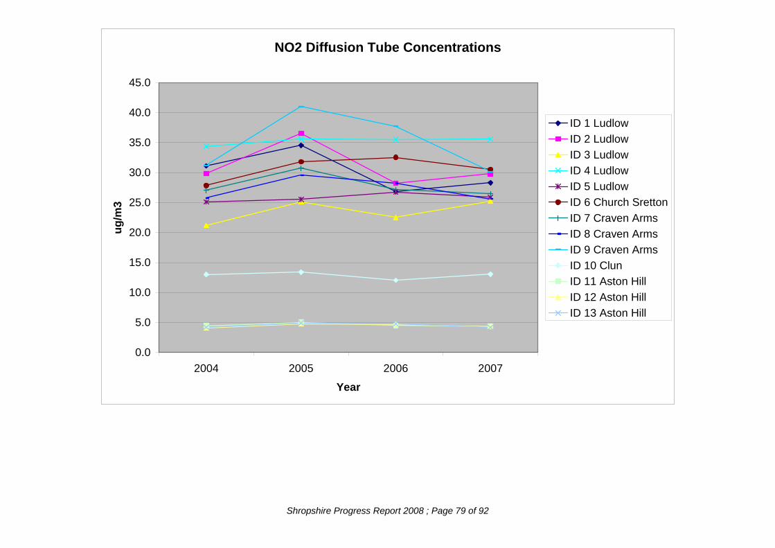
NO2 Diffusion Tube Concentrations
0.0
5.0
10.0
15.0
20.0
25.0
30.0
35.0
40.0
45.0
2004 2005 2006 2007
Year
ug/m
3ID 1 LudlowID 2 LudlowID 3 LudlowID 4 LudlowID 5 LudlowID 6 Church SrettonID 7 Craven ArmsID 8 Craven ArmsID 9 Craven ArmsID 10 ClunID 11 Aston HillID 12 Aston HillID 13 Aston Hill
Shropshire Progress Report 2008 ; Page 79 of 92

NO2 Diffusion Tube Concentrations
0.0
5.0
10.0
15.0
20.0
25.0
30.0
35.0
40.0
45.0
2006 2007
Year
ug/m
3
ID 15 OniburyID 16 LudlowID 17 LudlowID 18 LudlowID 19 Craven ArmsID 20 Craven ArmsID 21 Craven ArmsID 22 LeominsterID 23 LeominsterID 24 Leominster
Shropshire Progress Report 2008 ; Page 80 of 92

South Shropshire DC New Tube Locations
ID 28 Cleobury Mortimer
This product includes mapping data licensed from Ordnance Survey with the permission of HMSO © Crown copyright and/or database right 2008. All rights reserved. Licence no.
LA100018420
Shropshire Progress Report 2008 ; Page 81 of 92

ID 25/26 Bishops Castle
This product includes mapping data licensed from Ordnance Survey with the permission of HMSO © Crown copyright and/or database right 2008. All rights reserved. Licence no.
LA100018420
Shropshire Progress Report 2008 ; Page 82 of 92

This product includes mapping data licensed from Ordnance Survey with the permission of HMSO © Crown copyright and/or database right 2008. All rights reserved. Licence no.
LA100018420
ID 27 Bishops Castle
Shropshire Progress Report 2008 ; Page 83 of 92

The Council also monitors Benzene in one location. The results are shown in the detailed assessment report of October 2007. This report can be found at http://www.southshropshire.gov.uk/static/page3712.htm
3. There has been a real possib3
The conclusion of the report was that, at the closest residential property to the petrol service station of concern, it is extremely unlikely that there will be any exceedence of the 2003 objective of 16.25µg/m ility that the 2010 objective of 5µg/m would be exceeded at this location, however, the building of a new petrol station elsewhere in Ludlow has reduced demand and therefore emissions of petrol vapour from the refueling of vehicles. Should this reduction in petrol throughput continue it is unlikely that the 2010 objective will be exceeded.
Shropshire Progress Report 2008 ; Page 84 of 92

APPENDIX 6: TELFORD & WREKIN COUNCIL A6.1: New and Altered Industrial Developments: Telford & Wrekin Council Part A1 Installations The Environment Agency has issued a permit for the following installation since the last progress report in 2007 Company Process Pollutant Eastings Shropshire Waste Management Ltd
Landfill PM 10 372463 311825
Pollutant
The following A1 installation has closed since the last progress report in 2007. Company Process Eastings British Sugar plc Food & Drink PM 10 360496 312521
Part B Installations The following Part B Installations have opened since the last progress report in 2007.
Small Waste Oil burner
VOC
Coating
Company Pollutant Eastings Northings Marks Motors PM10 306714
TTI Nitriding Services Ltd
368444
Creases Dry Cleaning Ltd
Dry Cleaner, Degreasing
VOC 370396 313410
The following Part B Installation has closed since the last progress report in 2007. Company Process Pollutant Northings Johnson Controls Automotive UK Ltd
VOC 309130
Northings
Northings
Process 367727
313804
Eastings 371811
Shropshire Progress Report 2008 ; Page 85 of 92

A6.2: New Major Developments: Telford & Wrekin
Ref
369850
Demolition of Existing Barns and Erection of 20 no. Dwellings at Church Farm Yard, Preston Upon The Weald Moors,
27/07/2007
Erection of a New School with Associated Car Parks, Playing Fields and Playgrounds and Alterations to Existing Vehicular Accesses on Land off, Church Road, Malinslee, Telford
368681
369347
The following applications for housing and other developments that may affect air quality have received planning approval since the last Progress Report.
Description Decision date
W2007/0040
Residential development (outline) on land at, Brindleyford Primary School, Brindleyford, Brookside, Telford,
03/04/2007 305769
W2007/0091
Erection Of A Victorian Street Comprising of Shops, Catering Businesses, Workshops and Storage, Erection of Artisans Quarter, Extensions to Existing Printing Premises and WC Extension at Blists Hill Victorian Town, Legges Way, Madeley, Telford, ,
25/04/2007 369479 303531
W2007/0145
Erection of 148 Dwellings Land At, Lawley Farm, Lawley, Telford
26/04/2007 366805 308802
W2007/0212
Erection of 2 no. Residential Blocks Comprising 60 no. Flats and Alterations to Existing Vehicular/Pedestrian Accesses at Former Budget Car Hire, Furnace Road, Snedshill, Telford
03/07/2007 370344 310344
W2007/0213
17/05/2007 368248 315236
W2007/0256
Erection of a Primary School, Community Facilities and Sports Pavilion Land Off, Woodlands Lane, Horsehay, Telford
366900 306592
W2007/0300
08/06/2007 367758 305222
W2007/0316
01/05/2007 308051
W2007/0354
Residential Development (Outline) on Land Off, Grooms Alley, Wellington, Telford
15/06/2007
364873
W2007/0359
Demolition Of Existing Shops, Community Centre, Surgery And Public House And Erection Of A New Doctors Surgery, Child Development Centre, 4 no. Retail Units, Residential Development And A Local Equipped Play Area (Outline Application) Malinslee Local Centre, Brunel Road, Malinslee, Telford
13/06/2007308312
W2007/0367
Demolition Of Existing Retail Store And Erection Of A Food Store With Associated Delivery Area Car Parking And Landscaping, Alterations To Existing Vehicular Access And Creation Of A New Pedestrian Access Fashion Factory Outlet Centres, Castle Street, Hadley, Telford,
368002 312316
OS Ref
Earthworks and Associated Landscaping to Create Football Pitch, Play Area and Mound as Part Of The First Phase Of Woodlands Park, Lightmoor Village Land Off, Lightmoor Way, Lightmoor, Telford,
311560
15/06/2007
Shropshire Progress Report 2008 ; Page 86 of 92

309378
365670
W2007/0471
W2007/0477
Erection Of A Dairy Development Consisting Of Milking Parlour And 2no. Housing Buildings For 400 Cows Together With Associated Straights Store, Silage Clamps And Slurry Storage Harper Adams University College, Newport, Shropshire.
Ref Description Decision date
OS Ref
W2007/0377
21/06/2007 371229
W2007/0438
Demolition Of Part Of Old Hall School Buildings And Conversion To 4 no. Dwellings, Extension And Conversion Of Tuck Shop Building Into 1no. Dwelling And Erection Of 12no. Dwellings With Associated Garages Old Hall School, Holyhead Road, Wellington, Telford
05/07/2007310965
Erection Of A Two Storey Office Block With Associated Hardstanding Plot D3, Hadley Park, Hadley, Telford
12/06/2007 367979 313349
Residential Development To Provide 129 Apartments, 185 Basement Car Parking Spaces And Associated Landscape Land Off, Shifnal Road, Priorslee, Telford
Erection Of 6 no. Industrial Units Land At, Halesfield 9, Halesfield, Telford
04/07/2007 371451 304341 W2007/0535
Erection Of 149 Dwellings, Garages And Construction Of New Estate Roads And Vehicular/Pedestrian Accesses Site B, Limekiln Lane, Wellington, Telford,
20/07/2007
365627 310991
12/07/2007
365343 311440
W2007/0660 Erection Of A New Steel Framed Unit To Provide 10no. Individual Mixed Commercial, Industrial And Office Units Land At, Ketley Business Park, Ketley, Telford
18/07/2007
367468 310800
W2007/0714
06/08/2007
372301 320044
W2007/0753
Erection Of A New 900 Child Academy For Years 11-16 With Vocational Training Centre, Gate House, 3no. Freestanding And 6no. Roof Mounted Wind Turbines, 5no. Turf And 4no. 5-A-Side Floodlit Pitches, 1no. Floodlit Athletics Track And Construction Of A New Access Land At, Castlefields Way/Junction Of Woodside Avenue, Woodside, Telford
369200 305030
W2007/0809
Change Of Use From Use Class B8 (Storage Or Distribution) To Use Class B1 (Office) And Construction Of A Three Level Car Park International House, Stafford Park 11, Stafford Park, Telford
20/09/2007 372157 308334
W2007/0810
Residential Development (Outline Planning Application) Plot D, Pool Hill Road, Horsehay, Telford
26/03/2008 307362
W2007/0870
Conversion Of Existing Public House Into 2no. Dwellings, Erection Of 12no. Dwellings, Associated Landscape And Alterations To Existing Vehicular Access The White Hart Public House, Hinkshay Road, Dawley, Telford
27/09/2007
369458
W2007/0536 Part Demolition Of Vacant Shops And Erection Of 12no. Residential Units 27-31, High Street, Wellington, Telford
21/12/2007
367592
307361
Shropshire Progress Report 2008 ; Page 87 of 92

Ref Description Decision date
OS Ref
W2007/0884
Construction Of A New Mezzanine Floor Asda Store, St Georges Road, Donnington Wood, Telford
370766 312436
W2007/0906
Erection Of 107 Dwellings (Reserved Matters) Land Off, Trench Lock 1, Sommerfeld Road, Trench Lock, Telford
01/10/2007 368353 312367
W2007/0948
Erection Of 218no. Dwellings With Associated Landscaping And Engineering Works, Construction Of New Vehicular/Pedestrian Accesses And Construction Of Estate Roads (Reserved Matters Application) Land Off, Dawley Road, Lawley, Telford
01/10/2007
366847
W2007/0956
Erection Of A Unit To Be Used For Limousine Valeting, Hgv Maintenance And Haulage Yard Land Off, Halesfield 9, Halesfield, Telford
11/10/2007
371451 304341
Erection Of 179 Houses And Apartments With Associated Highways, Parking, Landscaping And Open Space (Reserved Matters Application) Land At, Britannia Way, Hadley, Telford
20/12/2007
367601 312154
W2007/1173 Erection Of A Industrial Dairy Production Building To Include Production And Storage Areas, Milk Silos, Laboratories And Offices, Construction Of A New Vehicular Access And Car Parking Site 1, Donnington Wood Business Park, Granville Court, Donnington, Telford
14/12/2007
371221 312239
W2007/1245
Demolition Of Existing Office Block And Erection Of New Office Block
14/11/2007
372179 308848
W2007/1252
Erection Of 58no. Dwellings, Construction Of A New Estate Road, Vehicular And Pedestrian Accesses And Alterations To Existing Doseley Works, Doseley, Telford
367564 306700
W2007/1300
Erection Of A Two Storey Extension To Existing Primark Unit Land To Rear Of, Primark, Telford Town Centre, Telford
13/12/2007 369821 308910
W2007/1334
Reserved Matters Persuant To Outline Planning Permission W2006/0759 For Residential Development For 28no. Dwellings (Comprising 19 New Dwellings And A 3 Storey Apartment Block Comprising 9no. Apartments) And Retention Of Presbytery As A Dwelling Land Of The Former, Our Lady Of The Rosary Rc Church, Winifreds Drive, Donnington, Telford
20/12/2007
370178 313240
21/09/2007
308802
W2007/1161
Kendall Holdings Ltd, Stafford Park 6 & 7, Stafford Park, Telford
07/12/2007
Shropshire Progress Report 2008 ; Page 88 of 92

Ref Description Decision
date OS Ref
W2007/1364
Erection Of Residential Development Of 14no. Dwellings (Reserved Matters Application) 139, Hadley Park Road, Hadley, Telford
29/11/2007
366850 312943
Erection Of 29no. Apartments With Associated Soft Landscaping, Hardstanding, Vehicle And Pedestrian Accesses Former Dawley Service Station, Finger Road, Dawley, Telford
08/01/2008
368935 306837
W2007/1372
28/12/2007
368256 305936
W2007/1426
Installation Of 866m2 Mezzanine Floor For Office Use Within Existing Warehouse With Associated External Alterations Enta Group, Stafford Park 6, Stafford Park, Telford
372035 309128
W2007/1466
Erection Of A 30 Bedroom 3 Storey Side Extension Whitehouse Hotel, Watling Street, Wellington, Telford
11/12/2007 311086
W2007/1521
Erection Of 54no. Dwellings With Garages And Construction Of New Accesses (Reserved Matters Application) Pursuant To Outline Application W2005/0900 Land At, Dsdc Donnington, Station Road, Donnington, Telford
05/02/2008
370764 314378
W2007/1550
Erection Of 2 Storey Extension To Hotel And Provision Of Car Park (Full Planning Application) Telford Hotel & Golf Club, Great Hay Drive, Sutton Hill, Telford
13/02/2008
369663
W2007/1586
Erection Of A Building In Connection With Haulage Building Bourne Transport, The Grange, Poynton, Shropshire.
18/02/2008
360300 318946
W2007/1666
Varation Of Condition 14 On Of Planning Permission W2001/0189 To Read: The Premises Shall Be Used For The Accommodation Of Young Families Including Single Parents And Their Children And For No Other Purposes Including Any Other Purpose In Class C3 Of The Schedule To The Town And Country Planning (Use Classes) Order 1987, Or In Any Provision Equivalent To That Class In Any Statutory Instrument Revoking And Re-Enacting That Order With Or Without Modification Clews Wood Court, Station Road, Madeley, Telford
31/01/2008
369916 304224
W2007/1368
Variation Of Conditions 6 And 11 Of Reserved Matters Approval W2007/0538 Regarding The Timing Of Details To Be Submitted For Opening And Delivery Hours And The Extraction And Dispersal Of Odours And Fumes (Reserved Matters Application) Land At, Lightmoor Way, Lightmoor, Telford
06/12/2007
366272
303008
Shropshire Progress Report 2008 ; Page 89 of 92

Ref Description Decision
date OS Ref
W2007/1703
Demolition Of Part Of Old Hall School Building And Conversion To 4no. Dwellings, Extension And Conversion Of Tuck Shop Building Into 1 Dwelling And Erection Of 12no. Dwellings With Amended House Types To Plots 5-10 And 20 (Amendment Of Planning Permission W2007/0438) Old Hall School, Holyhead Road, Wellington, Telford
17/03/2008
24/09/2007
365669 310965
W2007/1731
Land Stabilisation Works The Lloyds & Lloyds Head, Ironbridge, Telford
370178 313240
W2003/1238
Residential Development (Outline) Muxton C2/C3, Marshbrook Way, Muxton, Telford
371573 313182
W2006/0245
Demolition Of Existing Buildings And Erection Of 13no. Units Comprising Of 6no. 2 Bed Flats And 7no. 3 Bed Dwellings With Associated Access And Parking Land To Rear Of, Station Garage, Station Road, Newport, Shropshire
20/09/2007 374824 318434
W2006/0380
Residential Development (Outline)Land At, Wellington Road, Muxton, Telford
11/01/2008 314113
W2006/0608
Erection Of 18 Dwellings Land Off, Church Walk, Donnington, Telford
12/07/2007
370663
W2006/0802
Erection Of 5 Industrial Buildings Under Use Class B1(B)And (C), B2 And B8, With Access Road, Parking And Loading Areas, And Landscaping Queensway Business Park, Queensway, Hadley, Telford
14/09/2007
367364 313494
W2006/0938
Demolition Of Existing Factory, Retail Units And Residential Accommodation And Erection Of New Supermarket, 15 Retail Units, 16 Residential Units, With Car Parking, Landscaping And Servicing, Together With New Library Access And Highway Works Land At, High Street/Park Avenue/Madeley District Centre, Madeley, Telford
15/01/2008
369577 304360
W2005/0659 Residential Development (Outline To Include Access) Land At, Britannia Way, Hadley, Telford
16/08/2007
367605 312146
W2005/0661
29/02/2008
367317 312336
W2005/0702
Erection Of Deck Car Park Asda, St. Georges Road, Wrockwardine Wood, Telford
370765 312437
W2005/0932
Residential Development (Outline) Land At, Mossey Green, Ketley Bank, Telford
08/02/2008 368816 310228
W2005/0961
Residential Development (Outline) Land Opposite, 2, Marshbrook Way, Muxton, Telford
26/09/2007 313817
W2005/1049
Erection Of A Care Home And Associated Engineering Works (Outline) Former Ibstock Brickworks Site, Off, Brick Kiln Bank, Park Lane, Lightmoor, Telford
30/04/2007
367800
19/02/2008
04/04/2007
370880
313562
Residential Development To Include Access (Outline) Land At, Parkdale, Hadley, Telford
371165
305171
Shropshire Progress Report 2008 ; Page 90 of 92
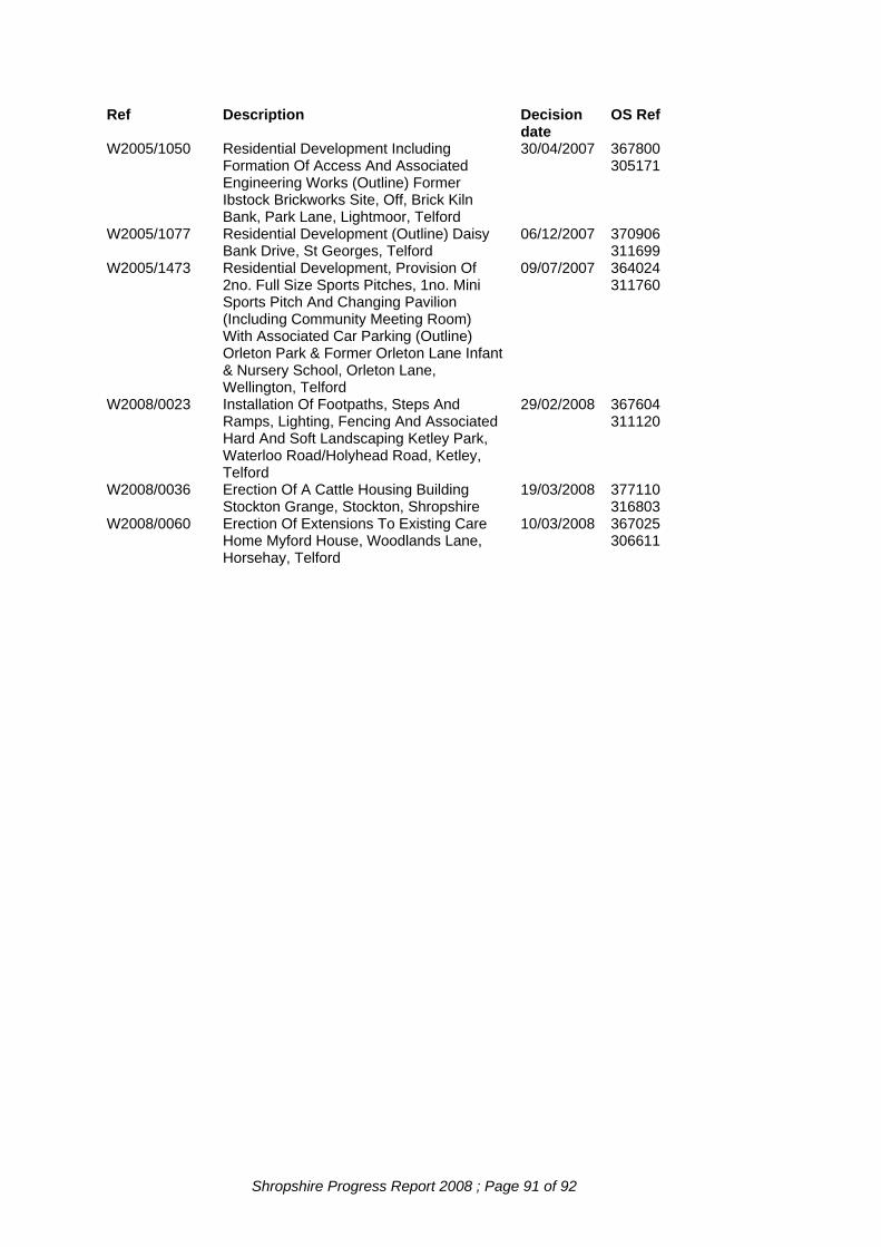
Ref Description Decision date
OS Ref
W2005/1050
Residential Development Including Formation Of Access And Associated Engineering Works (Outline) Former Ibstock Brickworks Site, Off, Brick Kiln Bank, Park Lane, Lightmoor, Telford
30/04/2007
367800 305171
W2005/1077
Residential Development (Outline) Daisy Bank Drive, St Georges, Telford
06/12/2007
370906 311699
W2005/1473
Residential Development, Provision Of 2no. Full Size Sports Pitches, 1no. Mini Sports Pitch And Changing Pavilion (Including Community Meeting Room) With Associated Car Parking (Outline) Orleton Park & Former Orleton Lane Infant & Nursery School, Orleton Lane, Wellington, Telford
09/07/2007
364024 311760
W2008/0023
Installation Of Footpaths, Steps And Ramps, Lighting, Fencing And Associated Hard And Soft Landscaping Ketley Park, Waterloo Road/Holyhead Road, Ketley, Telford
29/02/2008
367604 311120
W2008/0036
Erection Of A Cattle Housing Building Stockton Grange, Stockton, Shropshire
19/03/2008
377110 316803
W2008/0060
Erection Of Extensions To Existing Care Home Myford House, Woodlands Lane, Horsehay, Telford
10/03/2008
367025 306611
Shropshire Progress Report 2008 ; Page 91 of 92

Shropshire Progress Report 2008 ; Page 92 of 92
A6.3: Diffusion tubes in Telford & Wrekin
NO2 Diffusion tube concentrations Coordinates Original Annual Mean
NO2 Concentration (µg/m3) Location X Y 2003 2004 2005 2006 2007
Holmer Lake 370963 305913 21.5 16.4 17.9 17.2 16.1 Cygnet Drive 370612 305540 22.0 17.5 19.0 19.0 19.0 Aqueduct 368997 305843 12.6 13.0 12.0 12.0 11.0 Ironbridge 366855 303608 16.6 12.4 13.2 14.4 13.2 Bush House 368752 310043 24.4 22.3 23.0 24.0 24.0 Ketley Cross Roads 367745 311038 22.0 17.3 14.3 18.8 19.0 The Russetts 364663 310393 19.0 16.5 16.4 17.0 18.0 Wellington Solicitors 364867 311447 21.5 16.8 18.6 19.3 18.8 17 Castle Street 367901 312223 23.0 21.2 21.0 21.0 24.0 Adney 369688 317965 9.9 9.2 6.7 9.0 9.3 Priorslee Campus 371431 309412 21.0 17.8 20.6 27.7 23.7 The Council uses Gradko 50% TEA in acetone tubes that are analysed by Gradko. YEAR SUPPLIER PREPARATION BIAS
FACTOR NO.OF STUDIES
2002 Gradko 50% TEA/acetone 1.27 12 2003 Gradko 50% TEA/acetone 1.11 19 2004 Gradko 50% TEA/acetone 1.10 27 2005 Gradko 50% TEA/acetone 1.10 14 2006 Gradko 50% TEA/acetone 1.04 10 2007 Gradko 50% TEA/acetone 0.93 6 Bias Corrected Annual Mean NO2 Concentration (µg/m3) Location Bias Corrected Project 2010 2003 2004 2005 2006 2007 From
2003 From2004
From2005
From 2006
From 2007
Holmer Lake 23.9 18.0 19.7 17.9 15.0 18.64 14.40 16.21 15.22 13.23 Cygnet Drive 24.4 19.4 21.1 21.1 17.7 19.03 15.56 17.36 17.95 15.62 Aqueduct 14.0 14.4 13.3 13.3 10.2 11.49 12.09 11.40 11.71 9.25 Ironbridge 18.4 13.8 14.7 16.0 12.3 14.35 11.07 12.10 13.61 10.85 Bush House 27.1 24.8 25.5 26.6 22.3 22.24 20.81 21.85 23.41 20.22 Ketley Cross Roads
24.4 19.2 15.9 20.9 17.7 19.03 15.40 13.08 17.78 15.62
The Russetts 21.0 18.3 18.2 18.9 16.7 17.23 15.36 15.59 16.63 15.14 Wellington Solicitors
23.9 18.6 20.6 21.4 17.5 18.64 14.92 16.95 18.20 15.44
17 Castle Street
25.5 23.5 23.3 23.3 22.3 19.89 18.85 19.17 19.82 19.67
Adney 11.0 10.2 7.4 10.0 8.7 9.03 8.56 3.34 8.80 7.89 Priorslee Campus
23.3 19.8 22.9 30.7 22.1 19.12 16.62 19.62 27.02 20.04
The 2010 projections from the 2007 results indicate no exceedences of the annual average NO2 objective of 40µg/m3.