shuswap lake integrated planning process (slipp) recreation management … · ·...
TRANSCRIPT
Shuswap Lake Integrated Planning Process (SLIPP)
Recreation Management Plan – Best Practices – Lake Based Recreation Management
Submitted to:
Fraser Basin Council
Submitted by:
Peak Planning Associates, Kamloops, BC
Sydney Johnsen
John Hull
September 2012

I. Introduction .......................................................................................................................................... 1
II. Best Practice Case Studies .............................................................................................................. 2
III. Summary ......................................................................................................................................... 2
Appendices .................................................................................................................................................. 5
Appendix A - Lake Hume- Lake Hume Management Plan (LHMP) ............................................... 6
Appendix B - Otty Lake- Otty Lake Management Plan (OLMP) ..................................................... 9
Appendix C - Buffalo Lake- Buffalo Lake Integrated Shoreline Management Plan (BLISMP) . 12
Appendix D - Lake Windermere - Lake Windermere Management Plan (LWMP) ..................... 15
Appendix E - Lake Okanagan Shore Zone Plan - City of Kelowna .............................................. 18
Appendix F - Kalamalka Lake and Okanagan Boat Launch Study Lake ..................................... 22

I. Introduction The Shuswap Lakes Integrated Planning Process (SLIPP) finalised a Strategic Plan in 2008. The
vision for the Plan is to: work together to sustain the health and prosperity of Shuswap and
Mara Lakes. One of the three goals of the plan is the creation of “desirable recreation
experiences that are safe and sustainable” (SLIPP). In order to achieve this goal, a Recreation
Management Plan (RMP) for the lakes wasproposed to be developed to:
provide a vision for how public recreation resources will be used and managed;
identify current and potential recreation interests; and to
clarify recreation objectives, sites and guidelines for public access, infrastructure needs,
area zoning, and use thresholds, monitoring objectives as well as an integrated
recreation use and monitoring program to assess recreational use levels, trends and
emerging issues on the lakes and in the watershed.
Recreation management is of global importance and historically, has focused on three main
approaches. First, in the late 1960s and early 1970s, recreation management was primarily
supply-oriented and focused on management strategies aimed at the provision of facilities and
activity opportunitiesthat were measured by the number of visitor days. This management
approach ignoredissues of visitor satisfaction and the quality of on-site recreation experiences.
Second, experience-based management in the 1980s and 1990s expanded on participation in
recreation activities by focusing on ‘the experience’. This behavioural approach argues that
recreation outcomes are produced and realised by individuals. Management strategies must
provide a diversity of recreation opportunities through management of settings that ensure
that a variety of recreational users will achieve their desired experiences. More recently,
recreation management approach has shifted toa benefits-based management strategy that
expands on the experience-based approach and argues that management must address
individual recreation benefits and larger social, economic and environmental benefits. The
SLIPP process is aimed at adopting a recreation management plan that incorporates an
understanding of the relationships between experiences, activities and settings for recreation
on the Shuswap, Little Shuswap, Mara and Adams Lakes through a benefits-based management
approach that ensures desired recreation experiences for usersand that also ensures social,
economic, and environmental benefits for the larger region1.
This Best Practices Report is meant to supplement the Situational Analysis Report completed in
Phase I of the RMP planning process. The purpose of this report is to document and summarize
procedures and practices of lake-based recreation management plans in other jurisdictions to
1Stein, T. and Lee, M. (1995) Managing recreational resources for positive outcomes: anapplication of benefits-
based management. Journal of park and recreation administration.Volume 13 (3) pp. 52-70.

2
inform the RMP process for the Shuswap and Mara Lakes. Documenting procedures and
practices from lake-based management plans provides an opportunity to gain a greater
understanding of the local and global institutional, socioeconomic and environmental forces
that impact present planning and management of lake-based recreation resources. This
summary also provides an ability to identify and balance the unique qualities of the Lakes in the
study area with management practices that are common to lake-based recreation in general.
Comparative evaluation provides valuable input to the process of informed, effective choice
and decision-making2.The following case studies are meant to inform the RMP by providing a
description of eachlake, the major elements of the recreation management plan, specific
recreation issues, objectives for recreation management, and management recommendations
and actions for consideration and review as part of the RMP planning process.
II. Best Practice Case Studies Six case studies provide examples from Australia and Canada, two countries where
participation in outdoor recreation has grown rapidly since the Second World War and where
expenditure on recreation is increasing as a proportion of household expenditures3. The details
of each case study are found in the Appendices.
III. Summary The six case studies summarized as part of this report identify the growing importance of lake-
based environments as resources for outdoor recreation. Researchers argue that more and
more attention is being given to the setting in which outdoorrecreation activities take place.
Over the last thirty years, an increasing number of recreationists have realised the
physiological, psychological and social benefits of engaging in outdoor activities. Many lake-
based settingsare becoming popular destinations for recreation and are suffering from the
negative impacts of overuse and increased user conflicts. Four factors conducive to
recreational conflict on lakes include: the activity style (i.e.,leisurely vs. extreme), the resource
specificity (i.e., fishing vs. waterskiing), the mode of experience (motorized vs. nonmotorized),
and the tolerance of lifestyle diversity (i.e., social/cultural differences)4. In summarizing
themanagement considerations of the six case studies, it is clear that there are changing
physical, biological, social and managerial conditions in lake-based environments and that
policymakers are adopting benefits-based management strategies that focus on the recreation
experience in a context of the larger lake-based environment. Importantfactors for
management consideration include:
2Pigram, J. and Jenkins, J (2006) Outdoor recreation management. Routledge: Oxon, UK.
3Pigram, J. and Jenkins, J. (2006) Outdoor recreation management. Routledge: Oxon, UK.
4Pigram, J. and Jenkins, J. (2006) Outdoor recreation management. Routledge: Oxon, UK.

3
access;
non-recreational resource uses;
on-site management;
social interaction;
acceptability of visitor impacts; and
acceptable regimentation.
In summarizing the common key issues (Table 1) for the six lake-based recreation sites, the
management concerns include all of the above factors.
Table 1 Summary of Common Issues of Lake-based Management Plans
Key Issues Factors
Water-based zoning – not clearly understood, poorly delineated, not enforceable. Foreshore damage is not respected by the motorized boating community.
Access, onsite management, acceptable visitor impact, acceptable regimentation
Signage is not present or effective to orient user. All user groups are not considered.
On-site management
Increased number of boats results in higher congestion and higher potential for collisions.
Access, on-site management, social interaction, acceptability of visitor impacts
Motorized vessel speed control issues resulting in unsafe conditions for other lake users.
On-site management, acceptability of visitor impacts
Limited number of mooring points to reflect the common user. Proliferation of unofficial mooring for motorized boat users.
On-site management, acceptable regimentation
Boat launch sites and beach access points need to reflect the needs of the recreational user. Barriers created at public access sites by private and local users discourage the use of areas by the general public and visitors
Access, on-site management, acceptable regimentation
Environmental impacts on the lake from introduced species, foreshore damage, water quality.
Non recreational resource uses, on-site management
Lack of resources for enforcement of lake management regulations and laws at a level that has a public impact
On-site management, acceptable regimentation
Conflicting regulations between governing bodies, regions, and enforcement offices
Acceptable regimentation
These common key issues will be reviewed along with the results from the primary data
collection of recreational users to determine what specific management objectives are required
for the RMP for the Lake study area. In addition to the common key issues, the six case studies
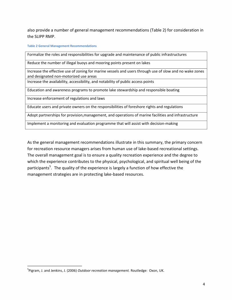
4
also provide a number of general management recommendations (Table 2) for consideration in
the SLIPP RMP.
Table 2 General Management Recommendations
Formalize the roles and responsibilities for upgrade and maintenance of public infrastructures
Reduce the number of illegal buoys and mooring points present on lakes
Increase the effective use of zoning for marine vessels and users through use of slow and no wake zones and designated non-motorized use areas
Increase the availability, accessibility, and notability of public access points
Education and awareness programs to promote lake stewardship and responsible boating
Increase enforcement of regulations and laws
Educate users and private owners on the responsibilities of foreshore rights and regulations
Adopt partnerships for provision,management, and operations of marine facilities and infrastructure
Implement a monitoring and evaluation programme that will assist with decision-making
As the general management recommendations illustrate in this summary, the primary concern
for recreation resource managers arises from human use of lake-based recreational settings.
The overall management goal is to ensure a quality recreation experience and the degree to
which the experience contributes to the physical, psychological, and spiritual well being of the
participants5. The quality of the experience is largely a function of how effective the
management strategies are in protecting lake-based resources.
5Pigram, J. and Jenkins, J. (2006) Outdoor recreation management. Routledge: Oxon, UK.

5
Appendices
Appendix A – Lake Hume (Australia)
Appendix B – Otty Lake (Ontario, Canada)
Appendix C– Buffalo Lake (Alberta, Canada)
Appendix D – Lake Windermere (BC, Canada)
Appendix E – Lake Okanagan (BC, Canada)
Appendix F – Lake Okanagan &Kalamalka Lake (BC, Canada)

6
Appendix A -Lake Hume- Lake Hume Management Plan(LHMP)6
Major Elements of the Plan
Overall Plan Goals
Community Awareness and Development Recreation and Tourism Water Quality Healthy Ecosystems Agricultural Land Use Planning and Development Cultural Heritage
Recreation Issues, Objectives and Management Recommendations
Specific Issues
Specific issues of the Lake Hume Management Plan include boating, fishing, public access, facilities and
infrastructure are described below.
Boating
Zones are poorly delineated,
not widely understood, and
are difficult to manage due
to rapidly fluctuating water
levels
Boating laws differ between
NSW and Victoria, which can
be a source of confusion
High Speed Boating
Safety to other boaters-
potential to swamp or
capsize other watercraft
Threat to swimmers in near-shore areas
Increase in wake enhancing devices
6http://www2.mdbc.gov.au/__data/page/1487/Lake_Hume_Management_Plan.pdf
Location Southern NSW and northeast Victoria, Australia
Size Artificial Lake- 20.2km2 or 7.8 sq miles
Year of Rec Man Plan Commenced November 2006/ has a 50 year vision plan, review of plan every 5 years

7
o Foreshore erosion
Noise from high powered boats
Fuel for powering boats- needs to be managed to protect the aquatic environment
and water quality
Fishing
Protection of fish habitat
Native fish habitats are in submerged or partially submerged dead trees
o This is in conflict with recreation activities that require extensive stretches of
open water
Public Access
Current access arrangements to Lake Hume are confusing and poorly delineated.
o Distinguishing between public and private land is difficult
o Victoria- Mostly Crown Land and available for public use
o NSW- Mostly privately owned, public access is dependent on current owner
Facilities and Infrastructure
Degraded facilities
Responsibility for upgrading or replacing infrastructure is unclear
Roles and responsibilities for upkeep and maintenance not clearly defined
Recreation Management Objectives
Improved boating rules to enhance access and protect the safety of recreational users of
the lake
To maintain and enhance native and stock fisheries within Lake Hume
To provide safe access for recreational use and inform the broader community about
reasons for controlled and well-managed public access.
To improve public infrastructure and clearly define roles and responsibilities for upgrade
and maintenance
Evaluate the economic value of the lake to all users and the relative value of Lake Hume
to downstream users and the local regional economy. Promote the lake as a high quality
recreation and tourism destination. Promote recreation and tourism ventures that will
not adversely impact on lake operations, water quality, environmental values or public
safety and access.
Management Recommendations and Actions
Review existing boating zones to resolveinconsistencies in cross-border regulations,
improve safety and practicality for boating,swimming and waterskiing;
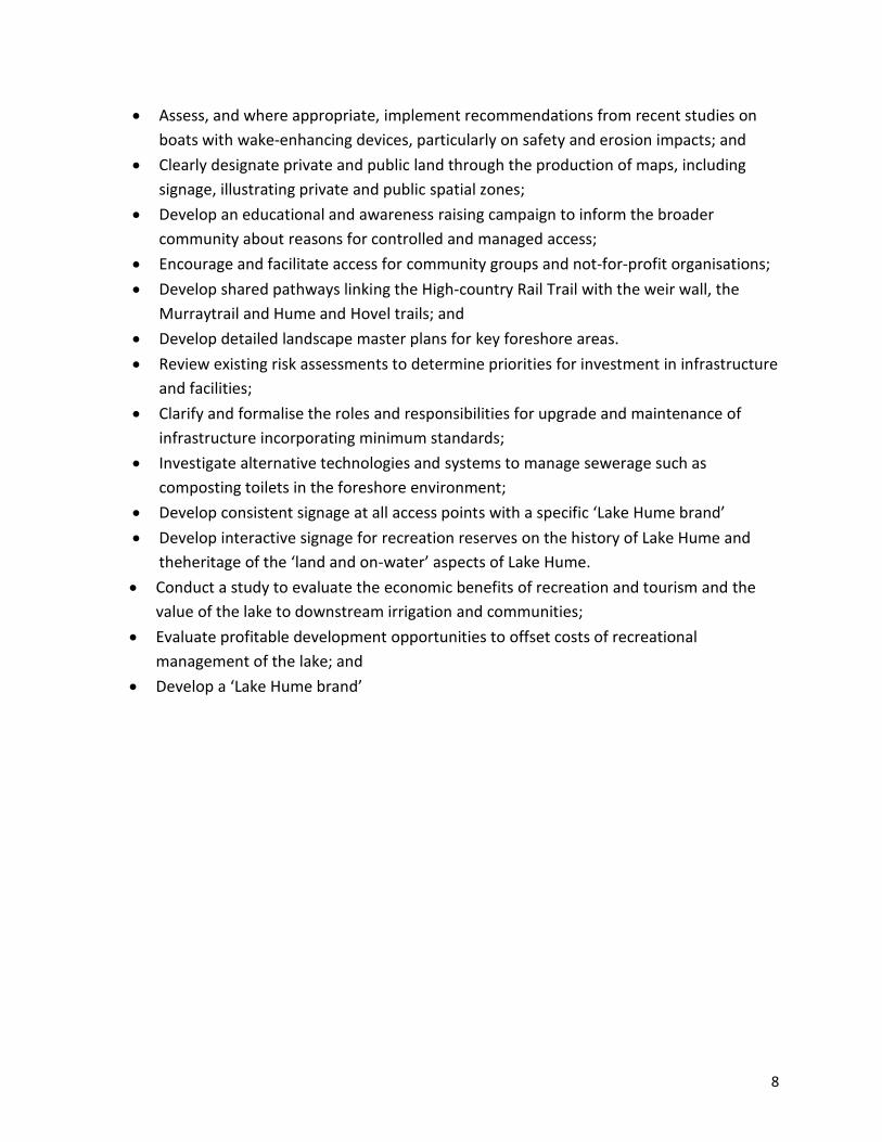
8
Assess, and where appropriate, implement recommendations from recent studies on
boats with wake-enhancing devices, particularly on safety and erosion impacts; and
Clearly designate private and public land through the production of maps, including
signage, illustrating private and public spatial zones;
Develop an educational and awareness raising campaign to inform the broader
community about reasons for controlled and managed access;
Encourage and facilitate access for community groups and not-for-profit organisations;
Develop shared pathways linking the High-country Rail Trail with the weir wall, the
Murraytrail and Hume and Hovel trails; and
Develop detailed landscape master plans for key foreshore areas.
Review existing risk assessments to determine priorities for investment in infrastructure
and facilities;
Clarify and formalise the roles and responsibilities for upgrade and maintenance of
infrastructure incorporating minimum standards;
Investigate alternative technologies and systems to manage sewerage such as
composting toilets in the foreshore environment;
Develop consistent signage at all access points with a specific ‘Lake Hume brand’
Develop interactive signage for recreation reserves on the history of Lake Hume and
theheritage of the ‘land and on-water’ aspects of Lake Hume.
Conduct a study to evaluate the economic benefits of recreation and tourism and the
value of the lake to downstream irrigation and communities;
Evaluate profitable development opportunities to offset costs of recreational
management of the lake; and
Develop a ‘Lake Hume brand’

9
Appendix B - Otty Lake- Otty Lake Management Plan (OLMP)7
Values - Otty Lake Characteristics and features valued by residents
Excellent water quality
Quiet
Pollution free
Not over-developed
Weed problem under control
Lots of birds and wildlife
Relatively low volume of boat traffic
Health natural shoreline areas
Outstanding bass fishing
Restrictions on shoreline development
that threaten habitat and water
quality
Recreational haven
Beautiful scenery
Regular septic system reviews
Concerted efforts, strategies and
approached to maintain a safe and
healthy ecosystem
Major Elements of the Plan
7http://www.ottylakeassociation.ca/FinalOttyLakeManagement%20PlanExecutive%20SummaryMay2008.pdf
Location Eastern Ontario in Lanark County, Canada 5km SE of the Town of Perth
Size total shoreline length of 35km (22mi) Year of Rec Man Plan Management plan came into effect 2008
1. Water Quality: To protect, maintain and improve the water quality of the lake 2. Aquatic Vegetation: To manage excessive aquatic vegetation growth in problem areas of the lake 3. Groundwater Quality and Quantity: To protect groundwater resources in the Otty Lake watershed 4. Water Levels: To preserve the lake’s natural water levels 5. Development Pressures and their Impacts on the Otty Lake Watershed: To protect the lake environment and ecosystem from the impacts of shoreline development and redevelopment 6. Fish and Wildlife Health: To protect the lake’s wildlife, terrestrial and aquatic habitats and ensure sustainable management of watershed resources 7. Shoreline Protection and Health: To restore and maintain a healthy ‘Ribbon of Life’ around the lake 8. Mining Rights and Claims: To protect the Otty Lake watershed from the impacts of all mining activity 9. Impacts of Boating: To minimize the negative impacts of boating on the lake

10
Recreation -- Specific Issues and Management Recommendations
Issues
Fish and Wildlife Health
Issue- Loss of wildlife habitat, poaching, exploitation of game fish
Threats to fish and wildlife include loss of habitat through development and re-
development, the removal of natural shoreline vegetation, decreased water quality as
well as poaching and over harvesting.
Shoreline Protection and Health
Issue-Shoreline and aquatic vegetation removal, erosion, loss of habitat, developed
shoreline
Impacts of Boating
Issue-Personal safety, erosion, noise
Majority of boat traffic on lake is motorized
Potential impacts from boating
o Spread of invasive species
o Erosion from boat wake
o Noise and safety concerns
o Water and air pollution
Responsibility in Protecting Lake Health
Issue-Apathy, lack of knowledge and understanding, unity
Many people are not aware their actions are harming the lake
Cumulative impact of human activities around the lake that can cause deterioration in
the quality of the water, a reduction in the fish and wildlife and a decline in the overall
quality of life in the watershed.
Management Recommendations
Goals
Protect wildlife, terrestrial and aquatic habitats and ensure sustainable management of
watershed resources
Restore and maintain a healthy “Ribbon of Life” (shoreline)
Minimize the negative impacts of boating
10. Responsibility of Landowners in Protecting Lake Health: To encourage and promote environmental awareness, responsibility, education and action 11. Partnerships in Lake Management: To establish, maintain and expand upon effective partnerships in lake management

11
Encourage and promote environmental awareness, responsibility, education and action
Establish, maintain and expand upon effective partnerships in lake management
Actions
Ensure sustainable populations of all fish species are maintained
Expand signage program (spawning areas)
Encourage lake residents to plant native species along shorelines and forested corridors
Promote and implement programs to promote or improve indigenous wildlife habitat,
terrestrial ecosystems and wetlands
Education promoting good shoreline stewardship
Encourage the municipalities to develop, implement and enforce Site Plan Policies and
other bylaws and guidelines to ensure that the shoreline (i.e. 30m buffer) is
protected/rehabilitated for all development and redevelopment applications
Educate lake users on how to minimize their impact on the lake
Develop and post speed and “watch your wake” signs in areas where boats are close to
shore or where shoreline is susceptible to wake damage
Develop education programs and information on good stewardship practices for topics
of concern identified by the lake community and distribute through various
communication avenues: Brochures/ Newsletter/ Website/ Articles/ Signage/ Face to
Face/ Dock to Dock
Encourage reporting of observed violations of environmental laws and regulations to
appropriate authority or agency
Increase public awareness of Lake Management Plan and engage all parties in its
implementation
Develop a detailed timeframe outlining how priority actions will be implemented
12
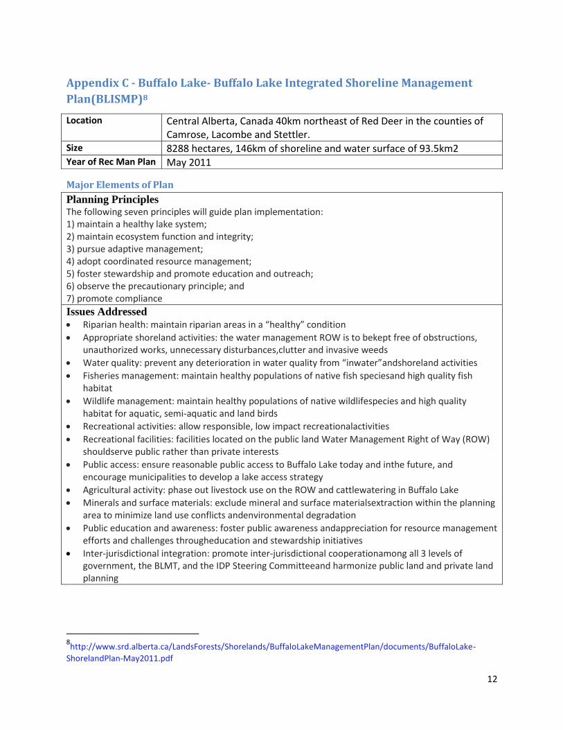
Appendix C - Buffalo Lake- Buffalo Lake Integrated Shoreline Management
Plan(BLISMP)8
Major Elements of Plan
Planning Principles The following seven principles will guide plan implementation: 1) maintain a healthy lake system; 2) maintain ecosystem function and integrity; 3) pursue adaptive management; 4) adopt coordinated resource management; 5) foster stewardship and promote education and outreach; 6) observe the precautionary principle; and 7) promote compliance Issues Addressed
Riparian health: maintain riparian areas in a “healthy” condition
Appropriate shoreland activities: the water management ROW is to bekept free of obstructions, unauthorized works, unnecessary disturbances,clutter and invasive weeds
Water quality: prevent any deterioration in water quality from “inwater”andshoreland activities
Fisheries management: maintain healthy populations of native fish speciesand high quality fish habitat
Wildlife management: maintain healthy populations of native wildlifespecies and high quality habitat for aquatic, semi-aquatic and land birds
Recreational activities: allow responsible, low impact recreationalactivities
Recreational facilities: facilities located on the public land Water Management Right of Way (ROW) shouldserve public rather than private interests
Public access: ensure reasonable public access to Buffalo Lake today and inthe future, and encourage municipalities to develop a lake access strategy
Agricultural activity: phase out livestock use on the ROW and cattlewatering in Buffalo Lake
Minerals and surface materials: exclude mineral and surface materialsextraction within the planning area to minimize land use conflicts andenvironmental degradation
Public education and awareness: foster public awareness andappreciation for resource management efforts and challenges througheducation and stewardship initiatives
Inter-jurisdictional integration: promote inter-jurisdictional cooperationamong all 3 levels of government, the BLMT, and the IDP Steering Committeeand harmonize public land and private land planning
8http://www.srd.alberta.ca/LandsForests/Shorelands/BuffaloLakeManagementPlan/documents/BuffaloLake-
ShorelandPlan-May2011.pdf
Location Central Alberta, Canada 40km northeast of Red Deer in the counties of Camrose, Lacombe and Stettler.
Size 8288 hectares, 146km of shoreline and water surface of 93.5km2
Year of Rec Man Plan May 2011

13
Recreation and Public Access–Goals & Objectives
Goal: Recreation
To provide and manage recreation opportunities and activities at Buffalo Lakewhich support
the protection and maintenance of the ecological integrity (and naturalquality) of the
shorelands and a high quality lake environment.
Objectives: Recreation
Recreation access points should be limited to existing access development nodes where
natural habitat values are already altered or compromised. Opportunities for new
recreation access points in the future will be considered as new subdivision developments
come on stream and based on public demand.
Promote outdoor recreation
activities that are suitable for
sensitive environments
where the protection of
ecosystem form and function
is the principal land
management goal.
Coordinate ROW recreation
planning and management
with adjacent land uses (i.e.,
work with the Counties,
Summer Villages, land
owners / producers and
developers) to ensure
compatibility between
jurisdictions.
Recreation facilities (beaches
and boat launches) on the ROW must be authorized byAlberta Sustainable Resource
Development and be available for public recreational use (not for exclusive or private use).
Some portions of productive or particularly sensitive shoreline habitat (identified in
Management Areas 3 and 4) will be either off limits to recreation activity or limited to
infrequent and low impact human use (i.e. minimal pedestrian traffic).
Responsible use of recreational watercraft in the planning area is essential for protecting
shoreline habitat and will be promoted through public education and awareness programs.
Commercial recreation facility development will not be supported on the ROW except as
needed in Management Areas.

14
Goal: To provide reasonable opportunities for public access to Buffalo Lake and use of the ROW
while maintaining the ecological integrity of the lake and surrounding public land.
Objectives: Public Access
Maintain existing access points that meet BLISMP guidelines and which are supported
by municipalities, and establish a sufficient number of new access points to
accommodate future public need.
To minimize environmental impacts at all designated public access sites.
Established guidelines and standards must be observed when constructing a new or
improving an existing access site or access facility.
Provide opportunities for public use and enjoyment of the ROW.
Management Recommendations
Strategically locate any new access points to provide public benefits while
avoiding/minimizing impact to habitat and wildlife
Promote recreation that is low-impact and nature appreciative
o Municipalities and government agencies will take coordinated approach to
educate and promote responsible recreation practices for riparian environments
Manage and zone diverse land uses to meet environmental goals of this plan while
minimizing conflicts between sectors and interests
Enforcement of unauthorized recreation facilities must be consistently applied to
establish standards and expectations that support plan goals and objectives
The safe and responsible use of watercraft is promoted through public education efforts
and through information provided in local communities and at recreation facility sites

15
Appendix D - Lake Windermere - Lake Windermere Management
Plan(LWMP)9
Major Elements of the Plan
Overall Plan Goals, Objectives & Principles
Goals Goal 1: Protect and enhance the environmental health and integrity of the lake. Goal 2: Ensure the continuation of diverse and safe recreational opportunities Goal 3: Encourage and support the development of a community that will work together to respect and balance the various interests on the lake. Goal 4: Clarify and strengthen responsibilities for management and enforcement
Objectives
Conduct a comprehensive analysis and synthesis of information on environmental, social and cultural resources and values associated with Lake Windermere,
Engage the public and stakeholders in a planning process that will inform and solicit input on existing conditions and potential management strategies, and
Prepare a Lake Management Plan containing policies and recommendations for lake use, management, and development that are practical, enforceable and realistic.
Principles
Focus on enforcing existing regulations related to boating more than on establishing new ones, and develop voluntary guidelines and codes of conduct related to boating practices before requesting additional boating regulations.
Ensure that the development of waterfront land and the foreshore respects environmental resources and addresses social concerns.
Shift the focus of recreation on the lake to more public use and more non‐motorized uses, e.g., walking and fishing from piers and docks, public beaches, public boat launches for small watercraft, rental of non‐motorized craft.
Make efforts to reduce the amount of motor boating at peak times, since it is perceived to be excessive to lake users.
Strive to have fewer motor boats moored on the lake for long periods of time at marinas, docks and mooring buoys.
9ftp://ftp.rdek.bc.ca/pdf/lakewindermeremanagementplan/lwmpfinalreport_feb11.pdf
Location East Kootenays, towns located on Lake Windermere- Invermere and Windermere
Size 17.7km long, average width of 1.1km, elevation 800m
Year of Rec Man Plan Initiated in November 2008 and implemented in January 2011

16
Recreation – Specific Issues& Management Recommendations
Specific Issues
Specific recreation issues on Lake Windermere include boating, mooring buoys, Marinas, infrastructure
and facilities, access to the water, and management and enforcement.
Boating10
Congestion on the lake
Safety issues such as collisions due to
increase # of boats
Disregard for rules and regulations
(speed zones)
Water quality and environmental
degradation
Mooring Buoys
Illegal buoys and increase in overnight
mooring
Too many buoys on lake
Marinas
Increase in private marinas/lack of
public marinas
Marinas in environmentally sensitive areas
Infrastructure and Facilities
Absence of adequate waste treatment
Illegal structures impeding public access
Water Access
Increased demand for public access
Infrastructure and facilities
Increased development along shoreline may reduce opportunities for public access
Public access spots often unusable or indiscernible
Foreshore tenures- impression that land is not for public use once a lease has been
issued
Management and Enforcement
Many different stakeholders
10*Lake Windermere has not experienced- houseboats, cigarette boats or towing at night

17
Complexity of jurisdictions
Lack of capacity to adequately enforce rules and regulations
Management Recommendations
Land Use and Boating Plan
Designate zones for non-motor boating areas
Establish “slow and no wake” areas with speed zones
Designate rest of lake as Responsible Boating Area
Guidelines provided for management of boating to increase safety and reduce negative
impacts
Water Structures and Public Access Plan
identifies locations of existing and proposed marinas, boat launches, public docks and mooring buoys
encourage and support construction of public docks
design and build boat launches to minimize impacts to habitat
zoning of the lake will include regulations on placement and number of mooring buoys
Foreshore Management and Use
Provides recommendations and identifies guidelines for foreshore development and enhancement
Zone the surface of the lake and establish regulations to manage water structures.
Establish a Foreshore and Aquatic Development Permit Area (DPA)for the entire lake up to the natural boundary, for protection of the natural aquatic environment, its ecosystems and biological diversity
Environmental Quality
Provides recommendations for working with others to protect and improve environmental quality
Encourage and support education to the public regarding environmental values

18
Appendix E - Lake Okanagan Shore Zone Plan - City of Kelowna11
Major Elements of the Plan
Overall Plan Recommendations
A comprehensive review of shore zone issues and opportunities resulted in a Shore Zone Plan that:
1. Recommends designation of the Shore Zone as an EnvironmentallySensitive/Hazardous Condition Area subject to Development Permit 2. Provides recommendations for addressing waterfront property owner/foreshoreuser conflicts 3. Establishes priorities for acquisition of future linear park corridors along the lake(beyond the foreshore) 4. Recommends incorporation of dock regulations (Private Moorage Guidelines)into the City’s Zoning Bylaw 5. Recommends retention of all existing road right-of-way beach access points andprovides for future acquisition of such access points 6. Makes recommendations regarding the number and size of beaches andwaterfront parks to be added in future years 7. Establishes recommendations for amenities to be considered at existing andfuture beaches 8. Makes recommendations regarding the types of upland development that wouldbe most appropriate within the shore zone area 9. Clarifies which levels of government control which aspects of the Shore Zone 10. Provides for adjustment of the City’s western boundary to the centreline ofLake Okanagan 11. Recommends the application of zoning to the portions of Lake Okanagan thatlie within the City’s boundaries 12. Recommends negotiation of a head lease arrangement
Recreation -- Specific Issues& Management Recommendations
Specific Issues
Public Access
Most noted barriers that prevent or seriously discouraged58%12 of users to public access
portions of the foreshore included:
11
http://www.kelowna.ca/CM/Page360.aspx
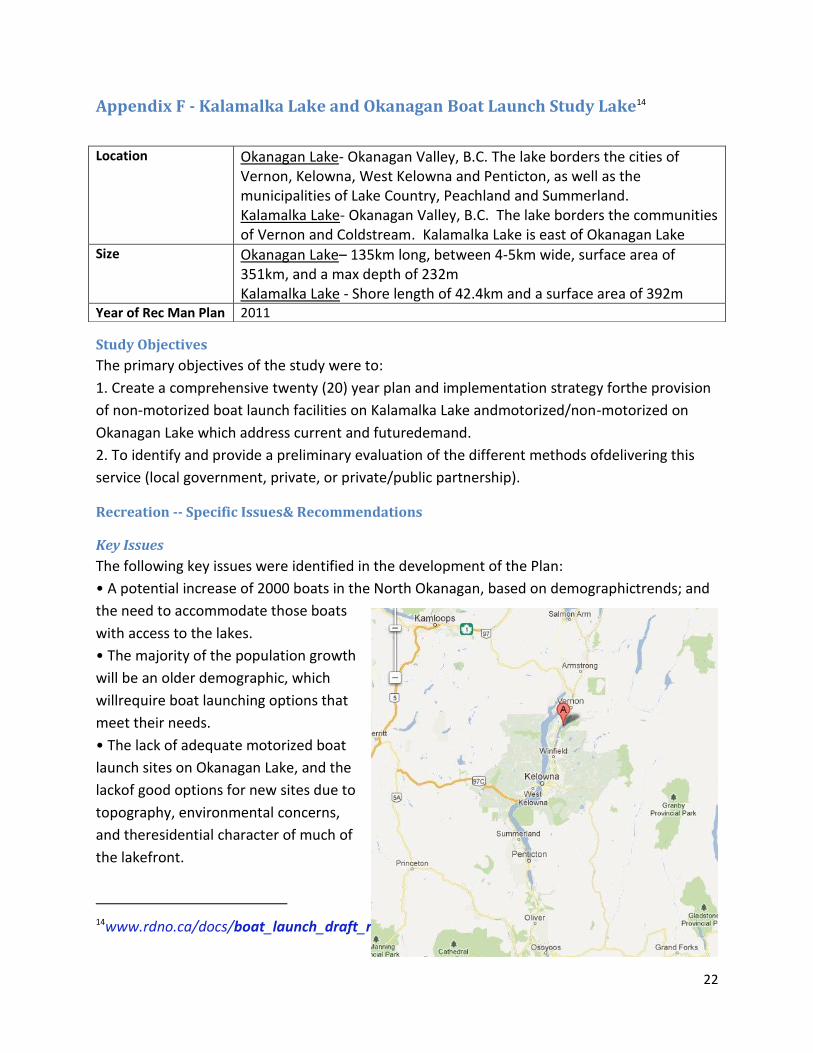
Location Okanagan Valley, B.C., Canada The lake borders the cities of Vernon, Kelowna, West Kelowna and Penticton, as well as the municipalities of Lake Country, Peachland and Summerland.
Size 135km long, between 4-5km wide, surface area of 351km, and a max depth of 232m
Year of Rec Man Plan 1997

19
o Docks (cited as number 1 barrier; note - (Docks built without provincial licences
o Berms
o Retaining walls
o Boats beached on the foreshore
o Intimidating or threatening signs
o Fences placed below the high water mark
Beaches and Waterfront Parks13
Parking- lack of and access to
Beach maintenance
o Litter
o Cleanliness of public
washrooms
Watercraft and associated facilities
Increased conflicts among lake
users
Unclear which rules and
regulations apply in which area
Unclear who is responsible for
enforcement
Lack of community docks and
moorage buoys
Lack of sani-dump facilities (at
time was only 1 on the lake)
Congestion at/lack of gas bars
Management Recommendations
Planning Department
process amendments to the OCP to incorporate the major directions of the Shore Zone Plan
prepare report for Council consideration regarding inclusion of the shore zone in the OCP
Natural Environment/Hazardous Condition Development Permit areas
12 Http://ww.kelowna.ca/CM/Page360.aspx 13In 1996 two surveys were administered, the Shore Zone Plan Survey (SZPS) and the Beach
User Survey (BUS). It was noted through the survey that recreationists appreciate uncrowded,
well-maintained beaches that provide shady areas

20
prepare report for Council consideration regarding amendment of present Council Policy
#10, to allow the City to consider some beach access points as “walkways” and as such make
adjacentproperty owners eligible for City cost-sharing of fences at these locations
prepare a detailed study of the Downtown portion of the shore zone
prepare a Plan for Sutherland Bay Park which will provide a major new opportunity for
expansion of the public waterfront system, including a potential beach park component
request extension of municipal boundary to lake’s centre line
apply zoning to that portion of the lake that falls within City of Kelowna boundaries
incorporate Provincial Private Moorage Guidelines into Zoning Bylaw
periodically review the dock guidelines of the zoning bylaw
encourage the Downtown Kelowna Business Association to expand “Biz Patrol” litter
removal coverage to Downtown beach areas
lobby the province for more Crown Lands enforcement on Okanagan Lake
request that the Provincial Crown Lands Branch intensify efforts to ensure that public access
along the foreshore is unimpeded
monitor Provincial progress regarding dock authorization and remedial action regarding
unauthorized docks
monitor progress of senior government initiatives in regulating boating activities
develop a strategy to minimize intrusion of houseboats and motorized personal watercraft
promote community involvement in foreshore “clean-up” days, with municipality
cooperating by providing garbage pick-up at designated points
request media publicity to inform the public when the lake level in spring-time reaches the high-water point
Parks Department
monitor usage of Waterfront Park, and, if necessary, initiate a publicity campaign to increase
awareness of the beach
if warranted, provide for additional shaded areas at Waterfront Park using natural
vegetation that could be planted in such a way as to deter goose usage of the park
ensure availability of garbage containers at all major City beaches
consider permitting a concession stand to be located at Rotary Park
improve wheelchair access to Rotary Park by providing a ramp or other access from the
parking lot to the grass/beach area
consider adding gas BBQ stands at City Park
improve washroom cleanliness at Strathcona, Rotary, and Sarsons beaches
monitor effectiveness of beach maintenance schedules and revise if necessary

21
post signs at all beach washrooms that indicate the name and phone number of the
company responsible for facility maintenance. The sign should also give some indication of
when the washroom was last cleaned.
ensure that all beach access points are clearly identified with appropriate signage
survey and mark the location of high water mark at high traffic beach access points
place signs at high-traffic beach access points that will inform the public of the rights and
responsibilities associated with foreshore usage (e.g. no trespassing on private property, no
littering etc.)
provide signage at high-use beach access points that give direction to the nearest major
beach with washrooms, parking, and otherfacilities
22
Appendix F - Kalamalka Lake and Okanagan Boat Launch Study Lake14
Study Objectives
The primary objectives of the study were to:
1. Create a comprehensive twenty (20) year plan and implementation strategy forthe provision
of non-motorized boat launch facilities on Kalamalka Lake andmotorized/non-motorized on
Okanagan Lake which address current and futuredemand.
2. To identify and provide a preliminary evaluation of the different methods ofdelivering this
service (local government, private, or private/public partnership).
Recreation -- Specific Issues& Recommendations
Key Issues
The following key issues were identified in the development of the Plan:
• A potential increase of 2000 boats in the North Okanagan, based on demographictrends; and
the need to accommodate those boats
with access to the lakes.
• The majority of the population growth
will be an older demographic, which
willrequire boat launching options that
meet their needs.
• The lack of adequate motorized boat
launch sites on Okanagan Lake, and the
lackof good options for new sites due to
topography, environmental concerns,
and theresidential character of much of
the lakefront.
14www.rdno.ca/docs/boat_launch_draft_report.pdf
Location Okanagan Lake- Okanagan Valley, B.C. The lake borders the cities of Vernon, Kelowna, West Kelowna and Penticton, as well as the municipalities of Lake Country, Peachland and Summerland. Kalamalka Lake- Okanagan Valley, B.C. The lake borders the communities of Vernon and Coldstream. Kalamalka Lake is east of Okanagan Lake
Size Okanagan Lake– 135km long, between 4-5km wide, surface area of 351km, and a max depth of 232m Kalamalka Lake - Shore length of 42.4km and a surface area of 392m
Year of Rec Man Plan 2011

23
• The lack of adequate, safe, non-motorized boat launches and small boat storageon both
Okanagan Lake and Kalamalka Lake will affect the non-motorized boatingcommunity and the
opportunity to promote the area for rowing and paddling.
• The lack of “launch management” at the existing motorized boat launches iscausing distress
for the boaters and the surrounding neighbours and other parkusers. There is a need for
parking control, fees, and supervision.
• There is a need for suitable alternatives to the traditional boat launches formotorized boats,
which might include offsite parking, boat valet services thatprovide boat storage along with
transportation and launching of the boat.
• There is a growing need for additional moorage, both in the water, and alternativessuch as
year-round dry land storage facilities in proximity to the lakes.
• Both motorized and non-motorized participants are seeking “motor to” or “paddleto”
destinations around the lakes. These could be beaches for swimming, picnicareas, hiking trails,
safe havens, sites of historical interest, and restaurants.
• There is a need to provide appropriate locations for boaters to seek safe harbourduring
storms or other emergencies.
• The public is concerned with the lack of knowledge around boating rules andetiquette, both
at the launches and on the lakes. An educational and signageprogram is desirable.
Recommendations and Actions
The following provides a summary of the key recommendations for Okanagan and Kalamalka Lakes.
Motorized and non-motorized boat launch sites on Okanagan Lake
Motorized Boat Launches
Paddlewheel Park continue to serve as amotorized boat launch facility for the North
Okanagan, with the recognition and respectthat the park is a multi-use area serving people
of all ages with a variety of recreationalamenities.
In addition to Paddlewheel Park,provide new and upgraded boat launches to serve the
North Okanagan.
o Undertake a small feasibility study be undertaken regarding the provision of facilities
for dragon boats on Okanagan Lake.
o Any future public pier accommodate motorized boats for shorter moorage; and that
a “valet only” motorized boat launch be included in the pier development.
Non-motorized Boat Launches
Designate and develop eight (8) specific locations around Okanagan Lake as “hand launch
only” sites in the short, medium and long term.
o one or potentially two non-motorized boat launches beestablished within the
Vernon Waterfront Neighbourhood Centre Plan area.

24
Motorized and Non-motorized Boat Launch Sites on Kalamalka Lake
Motorized Boat Launches
The proposed feasibility study for dragon boats should be extended to include KalamalkaLake.
Non-motorized Boat Launches
Develop five(5) sites on Kalamalka Lake as non-motorizedlaunch sites: West Kal Lake Access
(north of motorized launch), Kal Beach byAlexander’s, Coldstream Centennial Park, Kinloch, and
Kekuli Bay.
Other Boating Topics
Dry Dock Storage: the RDNO review publically owned lands forsuitability for dry dock
storage; and that the private sector be encouraged to provide boat storage on either public
(through partnership arrangement) or on private lands. Thestorage facilities should provide
boat valet service to the lake.
Parking: The parking lot at Paddlewheel should both be operated on a user pay basis.Install
parking ticket machines, and monitor the lots for compliance. Residents couldhave the
option to purchase a seasonal permit.
Boat Launch Management: hire a launch supervisor atPaddlewheel Park for the summer
season who can handle the public in a professionalmanner, and would provide safe
enjoyable outings through the enforcement of safetyregulations and rules of conduct.
Alternatively, a partnership could be struck with theYacht Club to manage this site.
Mooring Buoys: the RDNO encourage the continued provision ofmooring buoys by the Yacht
Club on Okanagan Lake; and that mooring buoys forKalamalka Lake be considered in the
long term, with an appropriate partner.
Washrooms and Garbage Receptacles: RDNO consider theprovision of toilet facilities at all
designated non-motorized and motorized launches. Agreater number of garbage containers
and recycling containers should be provided andmaintained by RDNO.
Signage: the RDNO implement an attractive, consistent, signageprogram that is appropriate
for the non-motorized and motorized launch locations. Thesigns should include a
combination of rules and regulations and “boater educationinformation”.
Destinations and Safe Harbours: In cooperation with the boating clubs, the RDNO
shoulddesignate locations around the lakes as “destinations”, as well as ensuring there
areappropriate locations to serve as safe harbours in case of sudden inclement weather.
Public Information: the RDNO enhance their brochure on “PublicBoat Launching Facilities in
the Greater Vernon Area” to provide information on non-motorizedlaunches as well as
destinations, amenities, rules, regulations, and etiquetteon the lakes. The brochure should
be available at the main launch sites and should beprovided in a downloadable format on
the District’s website.

25
Governance
The RDNO should:
explore the possibility ofa partnership with the Vernon Yacht Club for the operation of
the Paddlewheel Park BoatLaunch. The RDNO could contract with the Yacht Club to
maintain and supervise the boatlaunch facility, for a fee.
enter into a partnership arrangement with theVernon Paddling Centre for the
development and operation of a non-motorized launch onthe newly acquired land
adjacent to Paddlewheel Park.
participate in the Local Marine Advisory Councilregarding issues relating to Transport
Canada’s role on the lakes.
collaborate with theRegional District of Central Okanagan regarding the coordination of
provision,management, and operations of marine facilities and infrastructure on
Okanagan Lakeand Kalamalka Lake.
Alternatives to Traditional Boat Launches
Seek alternatives to the traditional practice of transporting the boat ona trailer to the boat
launch; parking the car and trailer on site after launching. Boat valet service, also known as
concierge service,is one means of reducing vehicle and trailer traffic.

26
References
Boat Launch Study Kalamalka Lake and Okanagan Lake (2012). Accessed July 15th, 2012 fromwww.rdno.ca/docs/boat_launch_draft_report.pdf Buffalo Lake- BLISMP Buffalo Lake Integrated Shoreline Management Plan (2012) Accessed July 20th, 2012 from http://www.srd.alberta.ca/LandsForests/Shorelands/BuffaloLakeManagementPlan/documents/BuffaloLake-ShorelandPlan-May2011.pdf Lake Hume- LHMP Lake Hume Management Plan (2012). Accessed July 24th, 2012 from http://www2.mdbc.gov.au/__data/page/1487/Lake_Hume_Management_Plan.pdf Lake Okanagan Shore Zone Plan - City of Kelowna(2012).Accessed July 17th, 2012 fromhttp://www.kelowna.ca/CM/Page360.aspx/ Lake Windermere- LWMP Lake Windermere Management Plan (2012) Accessed July 14th, 2012 http://ftp.rdek.bc.ca/pdf/lakewindermeremanagementplan/lwmpfinalreport_feb11.pdf Otty Lake- OLMP Otty Lake Management Plan (2012). Accessed July 14th, 2012 from http://www.ottylakeassociation.ca/FinalOttyLakeManagement%20PlanExecutive%20SummaryMay2008.pdf Pigram, J. and Jenkins, J. (2006) Outdoor recreation management.Routledge: Oxon, UK. Stein, T. and Lee, M. (1995) Managing recreational resources for positive outcomes: an application of benefits-based management. Journal of park and recreation administration.Volume 13 (3) pp. 52-70.