siberian river lena writings/siberian_river.pdf · 1 river "lena" – siberia linguists...
TRANSCRIPT
1
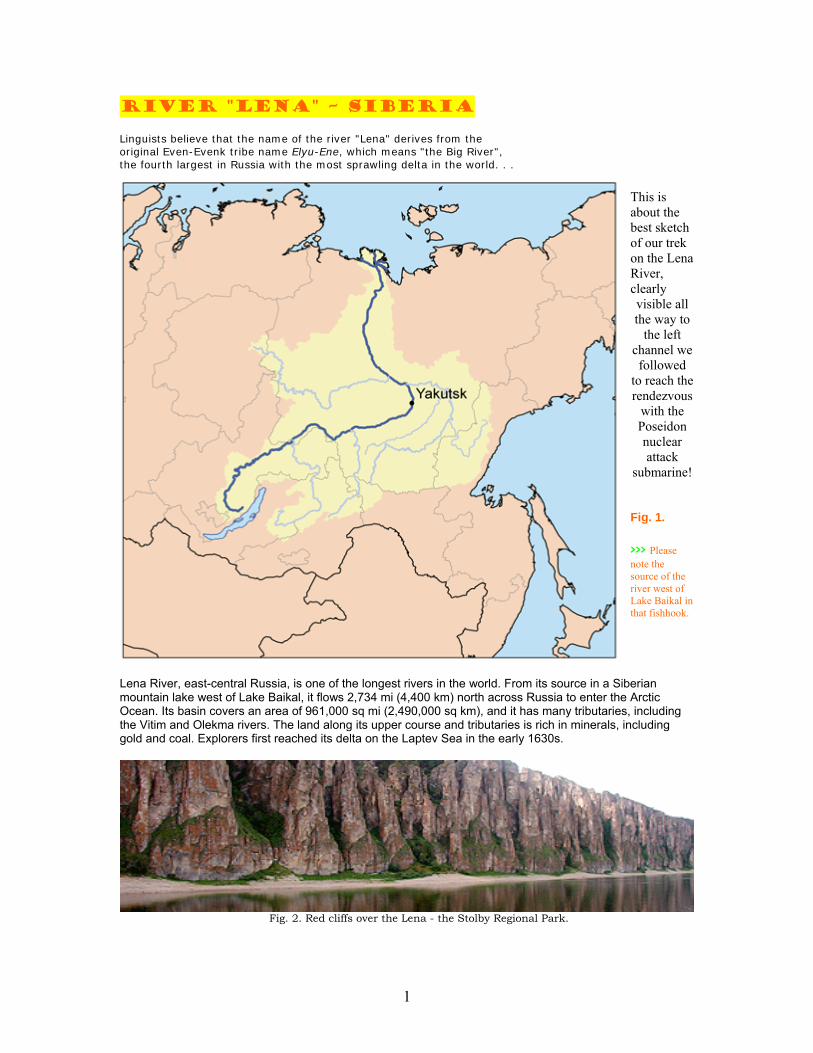
River "Lena" – Siberia Linguists believe that the name of the river "Lena" derives from the original Even-Evenk tribe name Elyu-Ene, which means "the Big River", the fourth largest in Russia with the most sprawling delta in the world. . .
This is about the best sketch of our trek on the Lena River, clearly visible all the way to
the left channel we followed
to reach the rendezvous
with the Poseidon nuclear attack
submarine! Fig. 1. >>> Please note the source of the river west of Lake Baikal in that fishhook.
Lena River, east-central Russia, is one of the longest rivers in the world. From its source in a Siberian mountain lake west of Lake Baikal, it flows 2,734 mi (4,400 km) north across Russia to enter the Arctic Ocean. Its basin covers an area of 961,000 sq mi (2,490,000 sq km), and it has many tributaries, including the Vitim and Olekma rivers. The land along its upper course and tributaries is rich in minerals, including gold and coal. Explorers first reached its delta on the Laptev Sea in the early 1630s.
Fig. 2. Red cliffs over the Lena - the Stolby Regional Park.
2
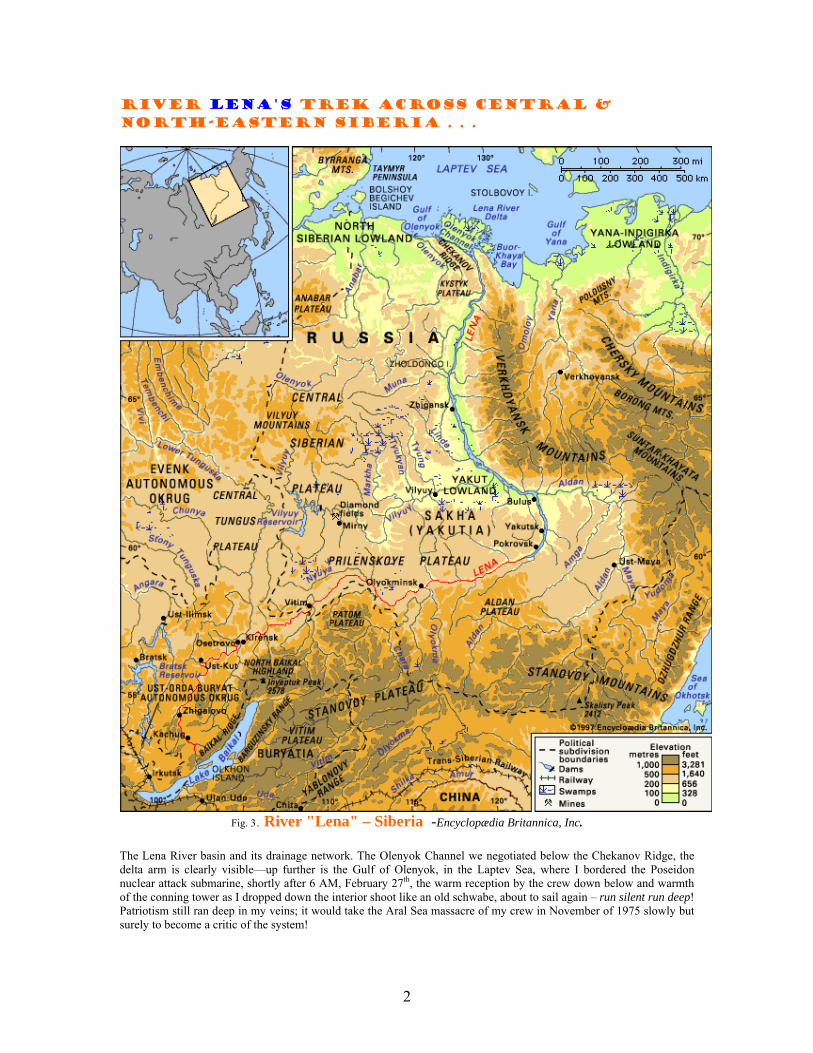
River lenA's trek across central & north-eastern Siberia . . .
Fig. 3. River "Lena" – Siberia -Encyclopædia Britannica, Inc.
The Lena River basin and its drainage network. The Olenyok Channel we negotiated below the Chekanov Ridge, the delta arm is clearly visible—up further is the Gulf of Olenyok, in the Laptev Sea, where I bordered the Poseidon nuclear attack submarine, shortly after 6 AM, February 27th, the warm reception by the crew down below and warmth of the conning tower as I dropped down the interior shoot like an old schwabe, about to sail again – run silent run deep! Patriotism still ran deep in my veins; it would take the Aral Sea massacre of my crew in November of 1975 slowly but surely to become a critic of the system!
3
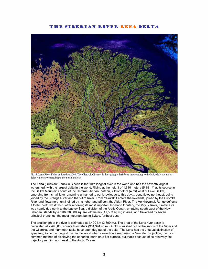
The Siberian river lena delta
Fig. 4. Lena River Delta by Landsat 2000. The Olenyok Channel is the squiggly dark-blue line running to the left, while the major delta waters are emptying to the north and east. The Lena (Russian: Ле́на) in Siberia is the 10th longest river in the world and has the seventh largest watershed, with the largest delta in the world. Rising at the height of 1,640 meters (5,381 ft) at its source in the Baikal Mountains south of the Central Siberian Plateau, 7 kilometers (4 mi) west of Lake Baikal, emerging from small lake remaining unnamed to our knowledge to this day… Lena flows northeast, being joined by the Kirenga River and the Vitim River. From Yakutsk it enters the lowlands, joined by the Oliomka River and flows north until joined by its right-hand affluent the Aldan River. The Verkhoyansk Range deflects it to the north-west; then, after receiving its most important left-hand tributary, the Vilyuy River, it makes its way nearly due north to the Laptev Sea, a division of the Arctic Ocean, emptying south-west of the New Siberian Islands by a delta 30,000 square kilometers (11,583 sq mi) in area, and traversed by seven principal branches, the most important being Bykov, farthest east. The total length of the river is estimated at 4,400 km (2,800 m.). The area of the Lena river basin is calculated at 2,490,000 square kilometers (961,394 sq mi). Gold is washed out of the sands of the Vitim and the Oliomka, and mammoth tusks have been dug out of the delta. The Lena has the unusual distinction of appearing to be the longest river in the world when viewed on a map using a Mercator projection, the most common method of displaying the spherical earth on a flat surface, but that's because of its relatively flat trajectory running northeast to the Arctic Ocean.
4
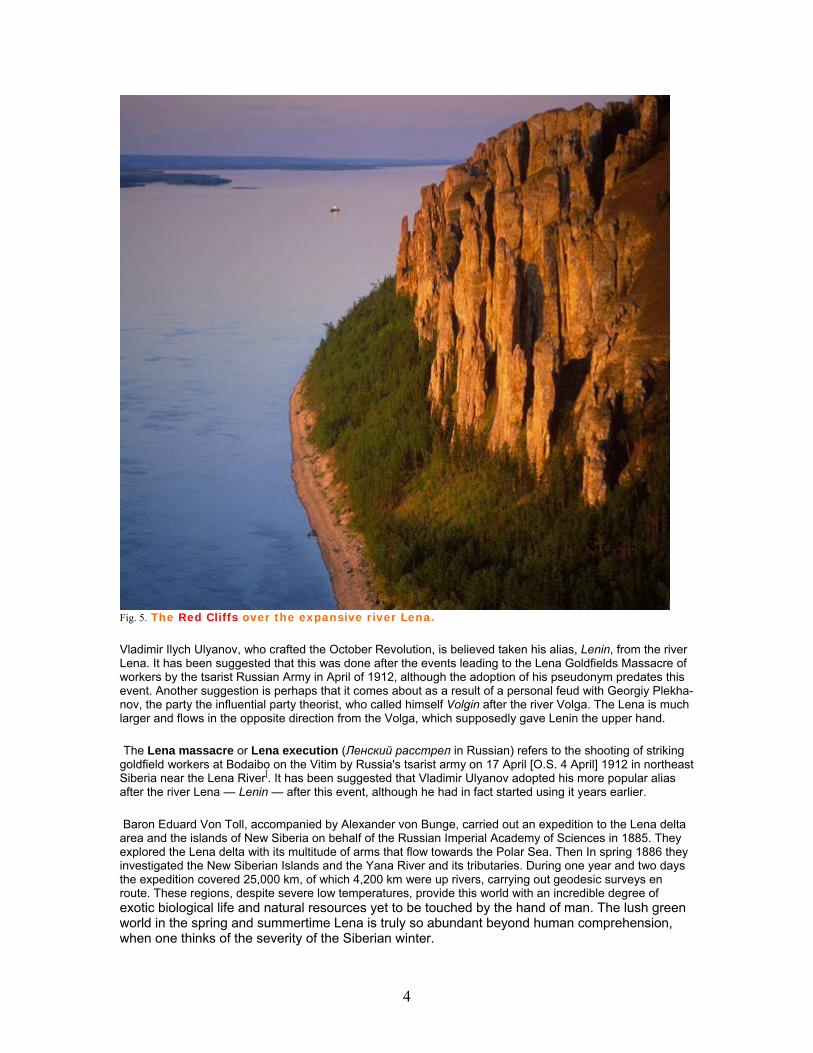
Fig. 5. The Red Cliffs over the expansive river Lena.
Vladimir Ilych Ulyanov, who crafted the October Revolution, is believed taken his alias, Lenin, from the river Lena. It has been suggested that this was done after the events leading to the Lena Goldfields Massacre of workers by the tsarist Russian Army in April of 1912, although the adoption of his pseudonym predates this event. Another suggestion is perhaps that it comes about as a result of a personal feud with Georgiy Plekha-nov, the party the influential party theorist, who called himself Volgin after the river Volga. The Lena is much larger and flows in the opposite direction from the Volga, which supposedly gave Lenin the upper hand.
The Lena massacre or Lena execution (Ленский расстрел in Russian) refers to the shooting of striking goldfield workers at Bodaibo on the Vitim by Russia's tsarist army on 17 April [O.S. 4 April] 1912 in northeast Siberia near the Lena River[. It has been suggested that Vladimir Ulyanov adopted his more popular alias after the river Lena — Lenin — after this event, although he had in fact started using it years earlier.
Baron Eduard Von Toll, accompanied by Alexander von Bunge, carried out an expedition to the Lena delta area and the islands of New Siberia on behalf of the Russian Imperial Academy of Sciences in 1885. They explored the Lena delta with its multitude of arms that flow towards the Polar Sea. Then In spring 1886 they investigated the New Siberian Islands and the Yana River and its tributaries. During one year and two days the expedition covered 25,000 km, of which 4,200 km were up rivers, carrying out geodesic surveys en route. These regions, despite severe low temperatures, provide this world with an incredible degree of exotic biological life and natural resources yet to be touched by the hand of man. The lush green world in the spring and summertime Lena is truly so abundant beyond human comprehension, when one thinks of the severity of the Siberian winter.
5
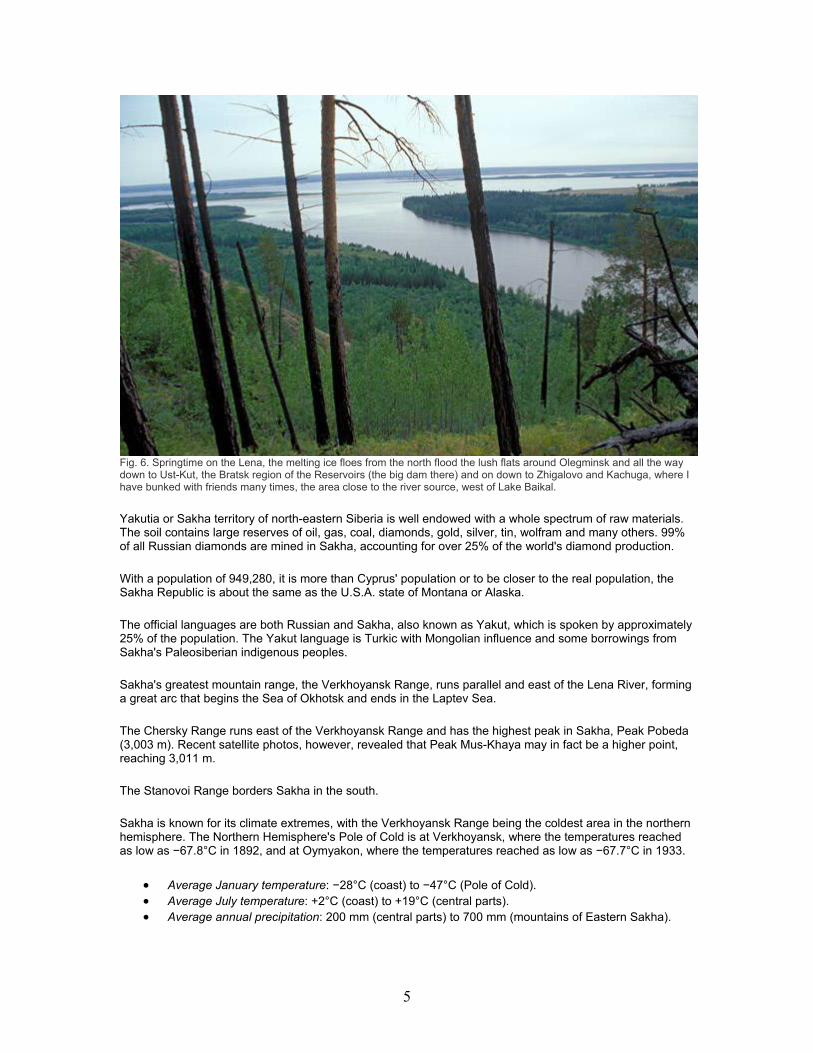
Fig. 6. Springtime on the Lena, the melting ice floes from the north flood the lush flats around Olegminsk and all the way down to Ust-Kut, the Bratsk region of the Reservoirs (the big dam there) and on down to Zhigalovo and Kachuga, where I have bunked with friends many times, the area close to the river source, west of Lake Baikal.
Yakutia or Sakha territory of north-eastern Siberia is well endowed with a whole spectrum of raw materials. The soil contains large reserves of oil, gas, coal, diamonds, gold, silver, tin, wolfram and many others. 99% of all Russian diamonds are mined in Sakha, accounting for over 25% of the world's diamond production.
With a population of 949,280, it is more than Cyprus' population or to be closer to the real population, the Sakha Republic is about the same as the U.S.A. state of Montana or Alaska.
The official languages are both Russian and Sakha, also known as Yakut, which is spoken by approximately 25% of the population. The Yakut language is Turkic with Mongolian influence and some borrowings from Sakha's Paleosiberian indigenous peoples.
Sakha's greatest mountain range, the Verkhoyansk Range, runs parallel and east of the Lena River, forming a great arc that begins the Sea of Okhotsk and ends in the Laptev Sea.
The Chersky Range runs east of the Verkhoyansk Range and has the highest peak in Sakha, Peak Pobeda (3,003 m). Recent satellite photos, however, revealed that Peak Mus-Khaya may in fact be a higher point, reaching 3,011 m.
The Stanovoi Range borders Sakha in the south.
Sakha is known for its climate extremes, with the Verkhoyansk Range being the coldest area in the northern hemisphere. The Northern Hemisphere's Pole of Cold is at Verkhoyansk, where the temperatures reached as low as −67.8°C in 1892, and at Oymyakon, where the temperatures reached as low as −67.7°C in 1933.
Average January temperature: −28°C (coast) to −47°C (Pole of Cold). Average July temperature: +2°C (coast) to +19°C (central parts). Average annual precipitation: 200 mm (central parts) to 700 mm (mountains of Eastern Sakha).
6
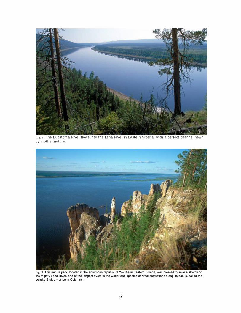
Fig. 7. The Buostoma River flows into the Lena River in Eastern Siberia, with a perfect channel hewn by mother nature,
Fig. 8. This nature park, located in the enormous republic of Yakutia in Eastern Siberia, was created to save a stretch of the mighty Lena River, one of the longest rivers in the world, and spectacular rock formations along its banks, called the Lensky Stolby – or Lena Columns.
7
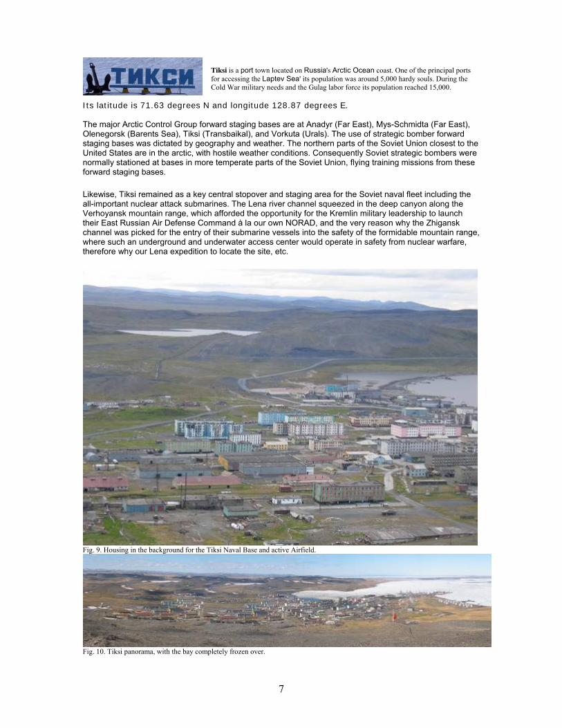
Tiksi is a port town located on Russia's Arctic Ocean coast. One of the principal ports for accessing the Laptev Sea' its population was around 5,000 hardy souls. During the Cold War military needs and the Gulag labor force its population reached 15,000.
Its latitude is 71.63 degrees N and longitude 128.87 degrees E. The major Arctic Control Group forward staging bases are at Anadyr (Far East), Mys-Schmidta (Far East), Olenegorsk (Barents Sea), Tiksi (Transbaikal), and Vorkuta (Urals). The use of strategic bomber forward staging bases was dictated by geography and weather. The northern parts of the Soviet Union closest to the United States are in the arctic, with hostile weather conditions. Consequently Soviet strategic bombers were normally stationed at bases in more temperate parts of the Soviet Union, flying training missions from these forward staging bases.
Likewise, Tiksi remained as a key central stopover and staging area for the Soviet naval fleet including the all-important nuclear attack submarines. The Lena river channel squeezed in the deep canyon along the Verhoyansk mountain range, which afforded the opportunity for the Kremlin military leadership to launch their East Russian Air Defense Command à la our own NORAD, and the very reason why the Zhigansk channel was picked for the entry of their submarine vessels into the safety of the formidable mountain range, where such an underground and underwater access center would operate in safety from nuclear warfare, therefore why our Lena expedition to locate the site, etc.
Fig. 9. Housing in the background for the Tiksi Naval Base and active Airfield.
Fig. 10. Tiksi panorama, with the bay completely frozen over.
8
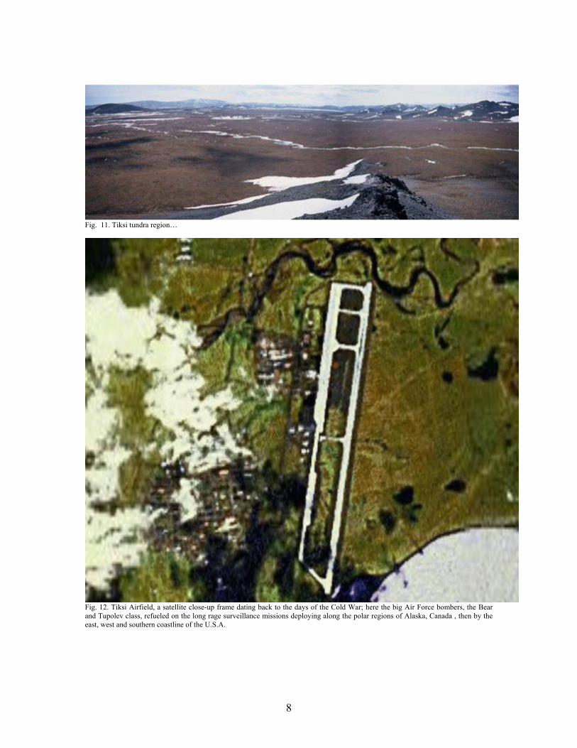
Fig. 11. Tiksi tundra region…
Fig. 12. Tiksi Airfield, a satellite close-up frame dating back to the days of the Cold War; here the big Air Force bombers, the Bear and Tupolev class, refueled on the long rage surveillance missions deploying along the polar regions of Alaska, Canada , then by the east, west and southern coastline of the U.S.A.
9
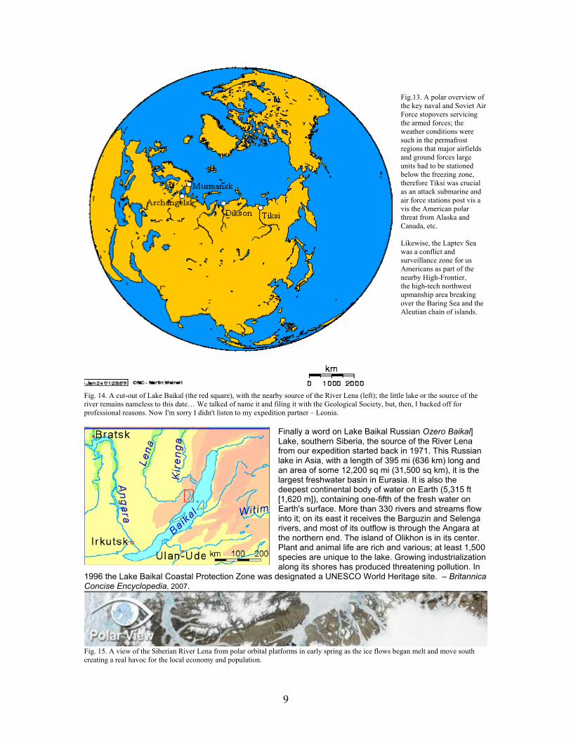
Fig.13. A polar overview of the key naval and Soviet Air Force stopovers servicing the armed forces; the weather conditions were such in the permafrost regions that major airfields and ground forces large units had to be stationed below the freezing zone, therefore Tiksi was crucial as an attack submarine and air force stations post vis a vis the American polar threat from Alaska and Canada, etc. Likewise, the Laptev Sea was a conflict and surveillance zone for us Americans as part of the nearby High-Frontier, the high-tech northwest upmanship area breaking over the Baring Sea and the Aleutian chain of islands.
Fig. 14. A cut-out of Lake Baikal (the red square), with the nearby source of the River Lena (left); the little lake or the source of the river remains nameless to this date… We talked of name it and filing it with the Geological Society, but, then, I backed off for professional reasons. Now I'm sorry I didn't listen to my expedition partner – Leonia.
Finally a word on Lake Baikal Russian Ozero Baikal] Lake, southern Siberia, the source of the River Lena from our expedition started back in 1971. This Russian lake in Asia, with a length of 395 mi (636 km) long and an area of some 12,200 sq mi (31,500 sq km), it is the largest freshwater basin in Eurasia. It is also the deepest continental body of water on Earth (5,315 ft [1,620 m]), containing one-fifth of the fresh water on Earth's surface. More than 330 rivers and streams flow into it; on its east it receives the Barguzin and Selenga rivers, and most of its outflow is through the Angara at the northern end. The island of Olikhon is in its center. Plant and animal life are rich and various; at least 1,500 species are unique to the lake. Growing industrialization along its shores has produced threatening pollution. In
1996 the Lake Baikal Coastal Protection Zone was designated a UNESCO World Heritage site. – Britannica Concise Encyclopedia, 2007.
Fig. 15. A view of the Siberian River Lena from polar orbital platforms in early spring as the ice flows began melt and move south creating a real havoc for the local economy and population.
10
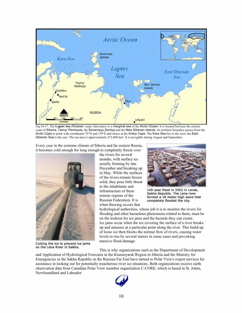
Fig.16-17. The Laptev Sea (Russian: мо́ре Ла́птевых) is a marginal sea of the Arctic Ocean. It is located between the eastern coast of Siberia, Taimyr Peninsula, the Severnaya Zemlya and the New Siberian Islands. Its northern boundary passes from the Arctic Cape to point with coordinates 79°N and 139°E and closes at the Anisiy Cape. The Kara Sea lies to the west, the East Siberian Sea to the east. The sea area is approximately 672,000 km². It is navigable during August and September. Every year in the extreme climate of Siberia and far eastern Russia, it becomes cold enough for long enough to completely freeze over
the rivers for several months, with surface ice usually forming by late December and breaking up in May. While the surfaces of the rivers remain frozen solid, they pose little threat to the inhabitants and infrastructure of these remote regions of the Russian Federation. It is when thawing occurs that hydrological authorities, whose job it is to monitor the rivers for flooding and other hazardous phenomena related to them, must be on the lookout for ice jams and the hazards they can create. Ice jams occur when the ice covering the surface of a river breaks up and amasses at a particular point along the river. This build-up of loose ice then blocks the normal flow of rivers, causing water levels to rise by several meters in some cases and provoking massive flood damage. This is why organizations such as the Department of Development
and Application of Hydrological Forecasts in the Krasnoyarsk Region in Siberia and the Ministry for Emergencies in the Sakha Republic in the Russian Far East have turned to Polar View's expert services for assistance in looking out for potentially treacherous river ice situations. Both organizations receive earth observation data from Canadian Polar View member organization C-CORE, which is based in St. Johns, Newfoundland and Labrador.
11
The river lena with insets – the delta, Tiksi & Yakutsk
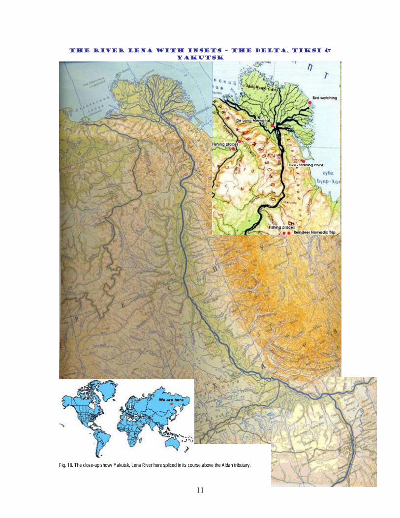
Fig. 18. The close-up shows Yakutsk, Lena River here spliced in its course above the Aldan tributary.
12
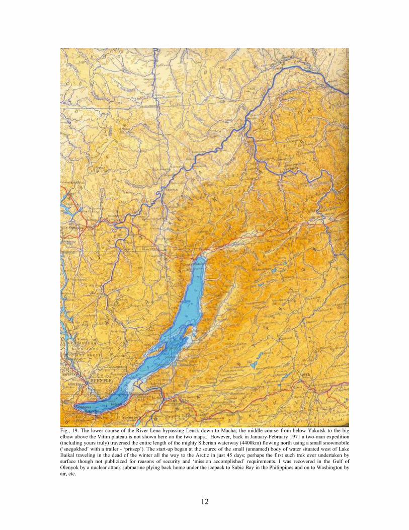
Fig., 19. The lower course of the River Lena bypassing Lensk down to Macha; the middle course from below Yakutsk to the big elbow above the Vitim plateau is not shown here on the two maps... However, back in January-February 1971 a two-man expedition (including yours truly) traversed the entire length of the mighty Siberian waterway (4400km) flowing north using a small snowmobile (‘snegokhod’ with a trailer - ‘pritsep’). The start-up began at the source of the small (unnamed) body of water situated west of Lake Baikal traveling in the dead of the winter all the way to the Arctic in just 45 days; perhaps the first such trek ever undertaken by surface though not publicized for reasons of security and ‘mission accomplished’ requirements. I was recovered in the Gulf of Olenyok by a nuclear attack submarine plying back home under the icepack to Subic Bay in the Philippines and on to Washington by air, etc.
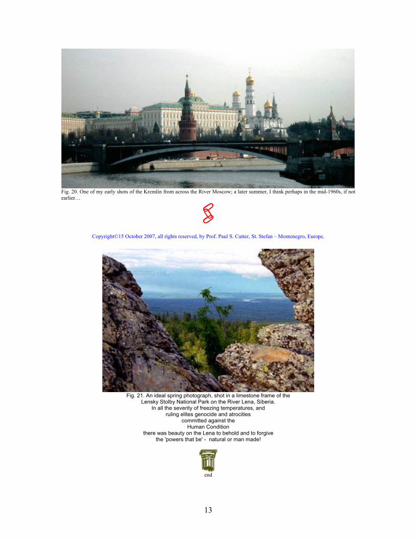
13
Fig. 20. One of my early shots of the Kremlin from across the River Moscow; a later summer, I think perhaps in the mid-1960s, if not earlier…
Copyright©15 October 2007, all rights reserved, by Prof. Paul S. Cutter, St. Stefan – Montenegro, Europe.
Fig. 21. An ideal spring photograph, shot in a limestone frame of the
Lensky Stolby National Park on the River Lena, Siberia. In all the severity of freezing temperatures, and
ruling elites genocide and atrocities committed against the
Human Condition there was beauty on the Lena to behold and to forgive
the 'powers that be' - natural or man made!
end