significant environmental effects of the proposed …
TRANSCRIPT
CHAPTER 3.0
SIGNIFICANT ENVIRONMENTAL EFFECTSOF THE PROPOSED PROJECTWHICH CAN BE MITIGATED
3.1-1
CHAPTER 3.0 – SIGNIFICANT ENVIRONMENTAL EFFECTS OF THE PROPOSED PROJECT WHICH CAN BE MITIGATED
3.1 Land Use and Planning This land use analysis for the Proposed Project describes existing land uses and land use policies within the Project site and vicinity; identifies guidelines for determination of significance; evaluates Project effects and potential impacts related to Project implementation; discusses feasible mitigation measures; and evaluates cumulative and growth-inducing impacts of the Proposed Project. In some instances, land use compatibility is evaluated in other sections of the EIR, where applicable, such as topics including biological resources, noise, aesthetics, cultural resources, and short-term construction impacts. Where appropriate, these analyses are cross-referenced within this subchapter. 3.1.1 Discussion of Existing Conditions Relating to Land Use and Planning The 935.2-acre Project site includes the Montecito Ranch SPA, two parcels adjacent to the SPA boundary (one northwest, the other northeast), and associated off-site roadway and utility improvement alignments. The Project site is located in the rural community of Ramona in an unincorporated area of San Diego County within the County’s Ramona Community Planning Area. The Project site is approximately one mile northwest of the Ramona Town Center. SR 78 borders the northern SPA boundary, while Montecito Way stems from the southern SPA boundary. Cedar Street, Summer Glen Road and Alice Street are adjacent to the southern SPA boundary, and Ash Street is adjacent to the eastern SPA boundary. Access to the Project site is provided via Montecito Way and Ash Street. Existing on-site improvements include dirt roads and the historic Montecito Ranch House. Several utility and road easements are located within the SPA. Portions of the SPA have been used for cattle grazing and farming of oat hay. The Montecito Ranch SPA is generally characterized by a broad valley in the central portion with gently sloping terrain to the north. In addition, three distinct knolls are located on site: one in the southwestern portion of the SPA; one adjacent to the north-central SPA boundary; and one adjacent to the central southern SPA boundary. The gently sloping landform transitions to steeper topography associated with Clevenger Canyon, which is located immediately adjacent to the SPA to the northeast. The SPA is situated on a drainage divide, with the northward drainages emptying into Clevenger Canyon, and the gentle southwest draining canyons and valley flowing into the Santa Maria Valley. Elevations on site vary from a high of approximately 1,750 feet AMSL atop the knoll located along the central southern property boundary to a low of approximately 1,420 feet AMSL in the southwestern portion of the SPA. The SPA contains several native plant communities, including southern coast live oak riparian forest, southern riparian scrub, Diegan coastal sage scrub, southern mixed chaparral, chamise chaparral, oak woodlands, and disturbed wetlands. Non-native habitats found on site include eucalyptus woodlands, and non-native grasslands. Non-native grasslands can be found within the flatter portions of the property where cattle grazing or other disturbances have altered the natural vegetation. Many of the steeper areas support native vegetation, with the highest quality and least disturbance occurring in the northern portion of the SPA. In these areas, Diegan coastal sage scrub and southern mixed chaparral are the dominant vegetation communities. Oak woodlands occur in the northern and northeastern portions of the SPA.

Montecito Ranch Subchapter 3.1 Draft Environmental Impact Report Land Use and Planning
3.1-2
Immediate surrounding land uses consist of semi-rural and estate residential development to the north, east, and south. The Lemurian Fellowship property, to the northwest, is developed with a church and other religious facilities (see Figure 3.1-1). The 1,027-acre Davis SPA adjoins the Project site on the west, and consists of undeveloped land and pasturelands. This property was recently purchased by The Nature Conservancy for preservation. The Ramona Airport lies approximately 0.5 mile south of the Project site. Existing land uses along proposed off-site roadway improvement areas include rural residential land uses along Ash Street and rural residential, equestrian, and agricultural land uses, as well as undeveloped land, adjacent to proposed off-site roadway improvements along Montecito Way and Montecito Road. Rural residential land use is located along Kalbaugh Street. Relevant Land Use Plans, Policies, and Ordinances Policies that apply to the Proposed Project are contained in the Montecito Ranch SPA section and other elements of the RCP, San Diego County General Plan, County Zoning Ordinance, County Subdivision Ordinance, County RPO, San Diego County Community Trails Master Plan, County Light Pollution Code, Congestion Management Plan, Natural Community Conservation Planning Program, Ramona Airport Master Plan, and Comprehensive Land Use Plan for Ramona Airport. These policies address a variety of issues, such as development at appropriate densities and in accordance with existing community character; protection of steep slopes; conservation of sensitive habitats; provision of open space and recreational opportunities; protection of visual amenities; regulation of signage and lighting; and protection against incompatible land uses. These land use plans/ordinances are described below. The applicable conditions/policies are listed in Table 3.1-1 with evaluations of consistency included in Table 3.1-2. Montecito Ranch Specific Planning Area Section of the Ramona Community Plan The RCP describes the Montecito Ranch SPA as a proposed rural development with an overall density of 0.5 dwelling unit per acre with a maximum of 417 single-family residential units on two- and four-acre lots. The RCP requires preparation of a specific plan prior to development of the Montecito Ranch SPA and specifies conditions that must be met by the specific plan. Ramona Community Plan The SPA is located within the area addressed in the RCP, which was adopted by the San Diego County Board of Supervisors on October 5, 1978, and last amended on May 10, 2006. The RCP implements the goals and policies of the Regional Land Use Element and sets forth goals, objectives, and policies intended to guide development within the community. Several sections in the RCP are relevant to the Proposed Project. These include Community Character, Land Use, Montecito Ranch SPA, Circulation, Scenic Highways, Noise, Conservation and Trails. Figure 1-13 depicts the existing RCP Circulation Element Network System. San Diego County General Plan The San Diego County General Plan (various dates, as amended) designates planned land uses that are considered appropriate for each portion of the County. The Project site is located within the County’s Estate Development Area (EDA) regional plan category, which includes agricultural and low-density
Montecito Ranch Subchapter 3.1 Draft Environmental Impact Report Land Use and Planning
3.1-3
residential uses with parcel sizes ranging from 2 to 20 acres. The General Plan land use designations for the Project site, as shown in Figure 3.1-2, include (21) Specific Planning Area (.5) and (18) Multiple Rural Use, as described below. The General Plan designation for most of the Project site (approximately 933.2 acres) is (21) Specific Planning Area (.5). This designation applies to areas where a specific plan has been adopted or must be adopted prior to development. The (.5) suffix indicates a maximum overall density of 0.5 dwelling unit per acre within the area designated (21). A small, triangular area located adjacent to the northwestern SPA boundary (approximately seven acres) is designated (18) Multiple Rural Use. This designation generally applies in remote areas to broad expanses of rural land with overall low population density and with an absence of most public services characterized by one or more of the following: not highly suited for intensive agriculture; rugged terrain; watershed; desert lands; lands susceptible to fires and erosion; lands which rely on groundwater for water supply; and other environmentally constrained areas. Minimum allowable lot sizes generally range from 4 to 20 acres and are based on slope criteria and criteria established in the County Groundwater Policy, with the more restrictive criteria determining the minimum lot size. General Plan land use designations along the segment of Ash Street proposed for improvement include (17) Estate Residential and (19) Intensive Agricultural. The (17) Estate Residential designation provides for minor agricultural and low density residential uses. Parcel sizes of two or four acres or larger are required. The (19) Intensive Agricultural designation promotes a variety of agricultural uses including minor commercial, industrial, and public facility uses appropriate to agricultural operations or supportive of the agricultural population. Minimum allowable development within this designation is based on slope criteria and includes one dwelling unit per two, four, or eight acres. Land use designations along Montecito Way include (1) Residential and (16) General Impact Industrial. The (1) Residential designation includes one dwelling unit per one, two, or four acres and the (16) General Impact Industrial designation provides for all types of industrial uses. Land use designations along the segment of Montecito Road proposed for improvement include (1) Residential, (5) Residential, (13) General Commercial, (16) General Impact Industrial, (22) Public/Semi-public Lands, and (26) Visitor-serving Commercial. The (5) Residential designation allows up to 4.3 dwelling units per acre. The (13) General Commercial designation provides for commercial areas where a wide range of retail activities and services are permitted, the (22) Public/Semi-public Lands designation provides for lands generally owned by public agencies, and the (26) Visitor-serving Commercial designation provides for areas reserved for commercial recreation and visitor-serving uses catering primarily to tourists and vacationers. The intersection of Pine Street/Main Street is within land designated as (13) General Commercial and SR 67/Highland Valley Road/Dye Road and SR 67/Archie Moore Road are within (17) Estate Residential. County of San Diego Zoning Ordinance The County Zoning Ordinance identifies the permitted uses of the Project site, consistent with the land use designations of the General Plan. As shown in Figure 3.1-3, most of the Project site (approximately 926.3 acres) is zoned S88, Specific Plan Land Use Designation. The S88 designation is intended to accommodate SPAs. Residential development is a permitted use within the S88 zone. Other development regulations associated with the S88 zone include building type, height, setbacks, and special area designations. The on-site S88 zone currently has a C Building Type Designator, which allows the development of single-family detached homes. On-site height restrictions are currently regulated by the G designator, which allows two stories with a maximum height of 35 feet.

Montecito Ranch Subchapter 3.1 Draft Environmental Impact Report Land Use and Planning
3.1-4
Finally, the S88 zoned-area on the Project site currently has a V designator, which indicates that setbacks are to be established during a Planned Development, Use Permit or Site Plan review procedure. In addition, the Project site abuts a portion of SR 78 that is designated a scenic highway corridor in the General Plan and therefore, the on-site S88 zone area currently has a special area regulation of “Scenic” and must comply with the provisions set forth in the Scenic Area Regulations contained in Sections 5200 through 5299 of the zoning ordinance. These provisions require that development shall not degrade or interfere with the scenic features attributed to the designated area. A two-acre portion of the Project site, located in the northeast portion of the site, and a seven-acre triangular area, located adjacent to the northwestern SPA boundary, are zoned A70, Limited Agriculture. The A70 zone is intended to create and preserve areas primarily for agricultural crop production and permits residential development with a minimum lot size of four acres. These areas are proposed to be rezoned to S88 in order to be consistent with the remainder of the Project site. Zoning in the vicinity of the off-site roadway and utility improvement alignments, excluding the Davis SPA, include: A70, Limited Agriculture; C36, General Commercial; C37, Heavy Commercial; M52, Limited Industrial; and M54, General Impact Industrial. The Davis SPA is zoned S88, Specific Planning Area. County of San Diego Board of Supervisors Policy I-78 County Board of Supervisors Policy I-78 deals with the location of future small wastewater treatment facilities. For Wastewater Management Option 2 (the Applicant-proposed WRF), the Proposed Project would need to comply with Policy I-78, in addition to meeting the County of San Diego General Plan Public Facilities Element requirements for construction and operation of a wastewater treatment plant. County of San Diego Subdivision Ordinance The Subdivision Ordinance is contained within Title 8, Division 1 of the San Diego Code of Regulatory Ordinances and sets forth development standards for the subdivision of land with respect to design, dedication and access, and required improvements. Applicable standards for the Proposed Project are contained in Section 81.401 and include several design regulations associated with lot size, orientation, and configuration. The Project is subject to the provisions within this ordinance. County of San Diego Resource Protection Ordinance The RPO, effective March 21, 2007, provides development controls for resources within the County deemed to be fragile, irreplaceable, and vital to the general welfare of residents. The resources protected by the County include: steep slopes, sensitive habitat lands, wetlands, wetland buffers, floodways, floodplain fringe, and significant prehistoric and historic sites. The RPO requires that prior to approval of VTMs or MUPs, a Resource Protection Study must be completed and findings must be made relative to compliance with the provisions of the RPO. The Resource Protection Study can be found in Appendix D. Steep Slopes. The RPO defines steep slope lands as “all lands having a slope with natural gradient of 25 percent or greater and a minimum rise of 50 feet, unless said land has been substantially disturbed
Montecito Ranch Subchapter 3.1 Draft Environmental Impact Report Land Use and Planning
3.1-5
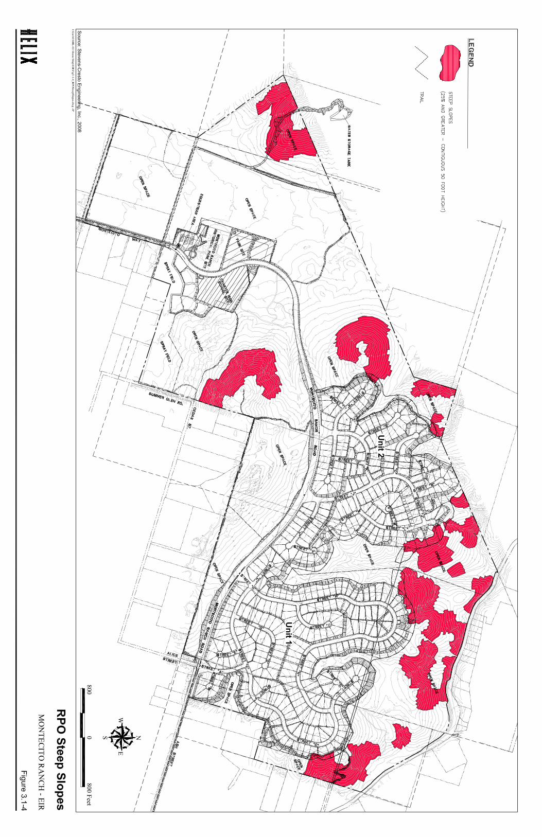
by previous legal grading. The minimum rise shall be measured vertically from the toe of slope to the top of slope within the Project site boundary.” A majority of the Project site consists of low-angle slopes between 0 and 15 percent grade (Figure 3.5-1 of this EIR). The topography on site is divided into the following classifications: approximately 64.2 percent (600.55 acres) lies within the 0 to 15 percent category; 19.8 percent (185.14 acres) lies within the 15 to 25 percent category; 14.3 percent (133.37 acres) lies within the 25 to 50 percent category; and 1.7 percent (15.94 acres) exceeds 50 percent slope. Slopes exceeding 25 percent are found primarily along the ridges and knolls along the northwest and northern property boundary as well as two smaller knolls located at the southeastern and southwestern property boundaries. The Project site contains approximately 102.6 acres of RPO steep slopes (Figure 3.1-4). Sensitive Habitat Lands. Sensitive habitat lands are defined in the RPO as, “land which supports unique vegetation communities, or the habitats of rare or endangered species or subspecies of animal or plants as defined in Section 15380 of the State CEQA Guidelines.” Sensitive habitat lands on site consist of approximately 10.60 acres of southern coast live oak riparian forest, 0.30 acre of southern riparian scrub, 0.73 acre of disturbed wetlands (agricultural ponds), 18.60 acres of open Engelmann oak woodland, 13.60 acres of dense Engelmann oak woodland, 318.93 acres of Diegan coastal sage scrub (inland form), 229.10 acres of southern mixed chaparral, 25.20 acres of chamise chaparral, and 2.50 acres of non-native grassland. The Project site also includes numerous areas of rock outcroppings that are considered a valuable visual resource and a unique microhabitat. Rock outcrops add diversity to vegetation communities by providing discrete ecological niches for species not found elsewhere in the surrounding habitat. Rock outcroppings on site support a number of fern species and flowering plants, as well as provide cover and potential nesting cavities for several animal species. Some reptile species are attracted to the sun-warmed rock surfaces and birds use boulders as perches or vantage points. In addition, RPO-sensitive habitats occur adjacent to the off-site roadway and utility improvement alignments, including Diegan coastal sage scrub and non-native grassland. Please refer to Subchapter 3.2, Biological Resources, of this EIR for a description of the locations, extent, and characteristic species of these on- and off-site habitat types. Wetlands. Wetlands are defined in the RPO as lands having one or more of the following attributes: (1) at least periodically, the land supports a predominance of hydrophytes (plants whose habitat is water or very wet places); (2) the substratum is predominantly undrained hydric soil; or (3) an ephemeral or perennial stream is present, whose substratum is predominately non-soil and such lands contribute substantially to the biological functions or values of wetlands in the drainage system. Wetlands are considered sensitive biological resources because they have been dramatically reduced in San Diego County and across the nation. Due to the regional and national loss of wetland habitats resource agencies have implemented a “no net loss” policy. Wetland habitats are important because they support high levels of food, nutrients, and high wildlife diversity, and are a valuable water source for wildlife in the arid climate of southern California. Several intermittent drainages and wetland areas are located within the Project site. As discussed in Subchapter 3.2, Biological Resources, and shown on Figure 3.2-2, four of these areas are RPO-defined wetlands and include: (1) a north/south-trending drainage in the northeastern portion of the Project site; (2) a small agriculture pond in the south central portion of the Project site; (3) an east/west-trending intermittent drainage located in the central portion of the Project site; and (4) a small north/south-trending intermittent drainage located in the northwestern portion of the Project site.

Montecito Ranch Subchapter 3.1 Draft Environmental Impact Report Land Use and Planning
3.1-6
While generally subject to avoidance requirements, permitted uses include crossings of wetlands for roads, driveways, or trails/pathways that are necessary to access adjacent lands. Wetland Buffers. Wetland buffers are defined by RPO as “lands that provide a buffer area of an appropriate size to protect the environmental and functional habitat values of the wetland, or which are integrally important in supporting the full range of the wetland and adjacent upland biological community.” The County generally requires a wetland buffer between 50 and 200 feet, depending on the condition of habitat being buffered, including areas upstream and downstream; existence of hydrophytic vegetation and sensitive species; and functionality of the buffer as a wildlife corridor and connectivity. Where oak woodland occurs adjacent to the wetland, the wetland buffer includes the entirety of the oak habitat (not to exceed 200 feet in width). Floodways. According to RPO regulation, “the development of permanent structures for human habitation or as a place of work shall not be permitted in a floodway.” A floodway is defined in the RPO as land that meets the following criteria, as determined by the Director of Public Works:
a. The floodway shall include all areas necessary to pass the 100-year flood without increasing the water surface elevation more than one foot.
b. The floodway shall include all land necessary to convey a 10-year flood without structural improvements.
c. To avoid creating erosion and the need for channelization, riprap, or concrete lining, the floodway will not be further reduced in width when the velocity at the floodway boundary is six feet per second or greater.
d. Floodways are determined by removing equal conveyance from each side unless another criterion controls.
The SPA is located above the Santa Maria Valley and is not subject to any floodplains as identified on County of San Diego floodplain maps (Appendix D). Floodplain Fringe. The RPO defines floodplain fringe as the area within the floodplain that is not in the floodway. It is generally associated with standing water as opposed to rapidly flowing water.
Significant Prehistoric or Historic Sites. Significant prehistoric or historic sites are defined by the RPO as the “sites that can provide information regarding important scientific research questions about prehistoric or historic activities that have scientific, religious, or other ethnic value of local, regional, State, or federal importance.” The property contains a total of 15 CEQA-significant archaeological sites, 4 of which also are RPO-significant. The Proposed Project would protect 14 CEQA-significant archaeological sites, including all 4 of the RPO-significant archaeological sites. Please refer to Subchapter 3.4, Cultural Resources, of this EIR for a detailed description of these sites. No archaeological sites are located within the proposed off-site roadway and utility alignments. San Diego County Community Trails Master Plan The San Diego County Community Trails Master Plan (CTMP 2005) implements the County Trails Program, which involves trail development and management on public, semi-public, and private

Montecito Ranch Subchapter 3.1 Draft Environmental Impact Report Land Use and Planning
3.1-7
lands. A system of interconnected regional and community trails and pathways is planned to be developed to address an established need for recreation and transportation, as well as health and quality of life benefits associated with hiking, biking, and horseback riding throughout the County. Goals and policies described in the CTMP encourage communities (including Ramona) to maximize trail opportunities. The CTMP contains a trails map (Figure 1-36) for the Ramona community, which identifies two proposed Priority 3 community trails/pathways within the Project site (numbers 53 and 93). County Light Pollution Code The Light Pollution Code (LPC) is a County Regulatory Ordinance (Division 9, Section 59.101 through 59.115) that restricts the use of any outdoor lighting that emits undesirable light rays into the night sky. Although the primary intent of the code is to curb lighting that may affect astronomical research at the Mount Palomar and Mount Laguna observatories, it also contains language to minimize spill light into adjacent neighborhoods. The LPC defines two zones in the unincorporated portion of San Diego County. Zone A consists of areas within a 15-mile radius of Mount Laguna and Mount Palomar. Zone B pertains to all areas that are not defined as Zone A. The Project site is located within Zone B. Congestion Management Program The CMP, as adopted by SANDAG, requires enhanced CEQA review for projects that generate 2,400 or more average daily trips (ADT), or 200 or more peak hour trips, or 50 or more peak hour trips on freeway segments. Proposed projects meeting one of these criteria must be evaluated in accordance with the requirements of the Regional CMP. The CMP analysis must include the traffic level of service impacts on affected freeways and Regionally Significant Arterial (RSA) systems, including all designated CMP roadways. The traffic study conducted for the Proposed Project (USAI 2008) concluded that although the Project would not exceed the thresholds relating to freeway segment peak hour trips, it would exceed the thresholds for the ADT and street segment peak hour trips. Therefore, preparation of a CMP analysis, consistent with the CMP Program, is required. Natural Community Conservation Planning Program Regional conservation planning strategies under the California Endangered Species Act (ESA) providing protection, preservation, and conservation of listed and candidate species, their habitats, natural communities, and natural resources, while continuing to allow appropriate development and growth within the State, are authorized and implemented under the Natural Community Conservation Planning (NCCP) Act of 1991. These strategies are designed to provide protection and conservation to threatened and endangered species through multi-species, habitat-based, and long-term approaches that ensure both the conservation of, and net benefits to, the affected species, as well as allow for growth. Under this program, the USFWS, CDFG, and other stakeholders have evaluated, or are evaluating, the distribution and extent of sensitive habitats and target sensitive plant and animal species in California. The ultimate goal of these studies is to develop interconnected ecosystem open space. Development and implementation of regional multi-species open space systems is intended to protect viable populations of key sensitive plant and animal species and their habitat while accommodating continued economic development and quality of life for residents of the region. Conformance with the NCCP and/or Section 4(d) of the federal ESA would be required if the North County MSCP Subarea Plan is not adopted prior to Project approval.
Montecito Ranch Subchapter 3.1 Draft Environmental Impact Report Land Use and Planning
3.1-8
Multiple Species Conservation Program The County adopted the Multiple Species Conservation Program (MSCP) on March 18, 1997 to meet the requirements of the NCCP Act of 1991 and the federal and California ESAs. The MSCP is a comprehensive, long-term habitat conservation plan that addresses the needs of multiple species by identifying key areas for preservation as open space in order to link core biological areas into a regional wildlife preserve. The total MSCP study area encompasses 582,243 acres, of which 43 percent (252,132 acres) is in the southwestern and western unincorporated areas of San Diego County. If the Proposed Project is approved after the adoption of the North County MSCP Subarea Plan, the Project would be required to make findings of conformance to the Subarea Plan and associated Biological Mitigation Ordinance (BMO). Ramona Airport Master Plan and Comprehensive Land Use Plan for Ramona Airport The Ramona Airport Master Plan (County 1997b) provides designations for the area within Ramona Airport property, and the Final Ramona Airport Master Plan EIR/Environmental Assessment (EA; County 1997b) discusses acceptable uses within Ramona Airport property. The runway and areas immediately adjacent to the runway are included within the airport’s designated Runway Safety Area. The Runway Safety Area is approximately 300 feet wide (150 feet to each side of the runway centerline) and 400 feet beyond the length of the runway. No development is allowed within the Runway Safety Area. The Flight Activity Zone (FAZ) of the airport designates the area of significant risk from aircraft take off and landing patterns. At the Ramona Airport, the Runway Protection Zone (RPZ), which limits activities within the FAZ, corresponds with the FAZ, and begins 200 feet beyond the end of the runway and extends for a length of 1,000 feet. The FAZ/RPZ is 500 feet wide near the runway and tapers out to 700 feet wide. Under federal and State law, the County of San Diego Airports Division has review authority over any project within one mile of the airport planning boundary to assess whether a hazard to air navigation could occur, as defined by FAR Part 77. The Project site is located approximately one-half mile north of the Ramona Airport. Project description information and a Notice of Proposed Construction or Alteration – Off Airport confirming that the Project site is located outside of the FAZ/RPZ was submitted to the Federal Aviation Administration on March 28, 2008 and is pending review. Community Character Community character can be defined as those features of a neighborhood, which give it an individual identity and the unique or significant resources that comprise the larger community. Community character also is a function of the existing land uses and natural environmental features based on a sense of space and boundaries, physical characteristics (such as geographic setting, presence of unique natural and man-made features, ambient noise, and air quality), and qualitative psychological responses held in common (e.g., “rural” or “friendly”). Each community/subregional planning area in San Diego County identifies its community character attributes and outlines goals and policies intended to preserve those attributes. The Community Character Element of the RCP describes the community character of Ramona as rural in nature. The intent of the RCP implementation is to maintain its rural atmosphere while accommodating its share of San Diego’s regional growth. While land use and lot sizes have
Montecito Ranch Subchapter 3.1 Draft Environmental Impact Report Land Use and Planning
3.1-9
considerable influence on the rural characteristics of the community, the visual aspects of the community and the “design details” at the community scale also are important in preserving the rural atmosphere. Site design, particularly on slopes surrounding the central Santa Maria Valley, should be sensitive to disruption of the landscape from excessive grading, and should protect those ridgelines that are the scenic backdrop of the valley. The preservation of the natural oak groves, as well as the maintenance and extension of street tree plantings, are emphasized in the RCP. The treatment of road edges and signage also has an effect on community character. The RCP generally allocates a gradual decrease in density from the Ramona Town Center, where lot sizes of one acre or less are allowed, to eight-acre minimum lot sizes in the western and eastern areas of the Ramona Community Planning Area. Centralized industrial and commercial areas have been created to keep residential and agricultural areas of the valleys free from industrial and commercial encroachments and to maintain the rural nature of the community. Scenic views in Ramona consist of rural hills, valleys, and riparian habitat, as well as estate residential development. The Project site and surrounding areas consist of the Santa Maria Valley with gently sloping terrain to the north. In addition, the site is situated on a drainage divide with the northward drainages emptying into Clevenger Canyon, and the southwest canyons and valley draining into the Santa Maria Valley. The area immediately surrounding the Project site is consistent with the RCP’s description of a rural community. Semi-rural and estate residential development ranging in lot sizes from one to more than four acres are scattered north, east, and south of the Project site. The Davis SPA is located west of the Project site and consists of undeveloped land and pasturelands. This property was recently purchased by The Nature Conservancy for preservation. To the immediate northwest lie orchards, as well as property owned by the Lemurian Fellowship, which has been developed with a church and other religious facilities. The immediate Project site vicinity does not contain streetlights, lighted signs or traffic signals, and outside lighting of residences is customarily kept to a minimum to maintain dark skies.
The applicable policies and recommendations within the Community Character Element of the RCP are listed in Table 3.1-1, with evaluations of consistency included in Table 3.1-2. 3.1.2 Identification and Discussion of Guidelines for the Determination of Significance A significant land use/community character impact would occur if the Proposed Project:
1. Conflicts with the land use goals, objectives, policies, and recommendations of the Montecito Ranch SPA and other sections of the RCP, County of San Diego General Plan, and any other applicable plans, policies, ordinances, guidelines, or regulations;
2. Conflicts with the established community character, as defined by the RCP; or
3. Physically divides an established community. Guideline Sources/Methodology The identified guidelines for significance are based on the State CEQA Guidelines (Appendix G) and County staff guidance. The development of these guidelines was intended to ensure conformance with
Montecito Ranch Subchapter 3.1 Draft Environmental Impact Report Land Use and Planning
3.1-10
existing regional and local planning efforts, as well as to maintain and enhance the character, structure, and dynamics of established communities in the Project vicinity. 3.1.3 Analysis of Project Effects and Determination as to Significance Plan Conformance Impacts (Significance Guideline No. 1) Table 3.1-2 provides a complete listing of relevant conditions/policies contained in applicable land use plans, as well as an analysis of the Project’s consistency with the listed conditions/policies. The Proposed Project is generally consistent with the above-named plans and ordinances. Several potential inconsistencies are addressed by the Proposed Project GPA (Development Design Services and GraphicAccess, Inc. 2008c). With approval of the GPA, the Project would attain consistency. The condition/policy changes addressed by the GPA are embodied within the RCP and General Plan, as well as the County of San Diego Zoning Ordinance and CTMP. Approval of the proposed amendments to these plans would result in Project conformance with the plans, and no significant impact would occur. These potential inconsistencies primarily relate to the proposed consolidation of Project residences on minimum half-acre lots within the central and eastern portions of the Project site in order to preserve large blocks of contiguous biological open space on the property. Inconsistencies also occur with regard to the agricultural conditions and the animal designators of the site. In addition, the amendments address changes to public services/utilities policies as necessary to implement a smaller developed park instead of dedication of 30 acres of future parkland, and to allow implementation of the proposed WRF. As indicated in Table 3.1-2, there are a few conditions/policies with which the Proposed Project is not in conformance, and for which a GPA would not be appropriate. These inconsistencies relate to the construction of the water storage tank and associated access road along a ridgeline, which would require the grading and adverse modification of natural landforms, as well as noise impacts to residential neighborhoods. The specific Project inconsistencies are addressed below and within Table 3.1-2. Ramona Community Plan As stated above, the Proposed Project is generally consistent with most of the conditions/policies in the RCP. The Project would be inconsistent with certain policies within the Community Character and Noise elements of the RCP. The Project Applicant is proposing a GPA to the RCP to address potential inconsistencies with several additional conditions/policies within the RCP, including those within the Montecito Ranch SPA and Land Use sections of the RCP, and the Circulation Element Map. With approval of the amendments, the Project would be consistent with the RCP. Montecito Ranch SPA Section. Conditions 3 and 13 of the Montecito Ranch SPA section of the RCP specify a minimum two-acre lot size for Montecito Ranch. The Project Applicant has filed a GPA to the RCP to change the minimum lot size to 0.5 acre (20,000 s.f.) in order to allow consolidation of the proposed homes on minimum 0.5-acre lots, which would result in the preservation of large blocks of contiguous biological open space. With approval of the proposed amendment, the Project would be consistent with the planned lot size limits.
Montecito Ranch Subchapter 3.1 Draft Environmental Impact Report Land Use and Planning
3.1-11
Condition 9 requires the dedication of a 30-acre neighborhood park site. The 30-acre community park requirement was anticipated to serve 417 units in Montecito Ranch and 171 units in the Davis SPA. The Nature Conservancy has since purchased the Davis SPA for preservation, reducing the total demand for parkland in the area. Therefore, a 30-acre park would not be necessary to accommodate the residents of the Project only. The Project would amend the Montecito SPA section of the RCP to allow dedication and development of an 8.3-acre local park site, as well as dedication and development of an 11.9-acre historic park site. The 8.3-acre local park site would be graded and developed with grass and playground areas, and the historic park site would include the historic Montecito Ranch House and an equestrian staging area as description in Chapter 1.0. Dedication of these two park sites would total 20.2 acres. With approval of the proposed amendment, the Project would be consistent with this condition of the RCP. The Project would either include annexation into the RMWD for sewer services and connection of a sewer force main to an existing facility connecting to the Santa Maria WTP (under Wastewater Management Option 1) or a WRF (to treat Project-generated wastewater under Option 2). If Option 1 is implemented, the Project would be consistent with Condition 11, which discourages package treatment plants within the Montecito Ranch SPA. If, however, Option 2 is implemented, the Project potentially would be inconsistent with this condition. The Project Applicant has filed a GPA to the RCP to delete the subject policy and allow the proposed WRF. With approval of the GPA, the Project would be consistent with this condition. The Project proposes approximately 10.6 miles of multi-use trails within modified alignments compared to the riding and hiking trails designated on the Ramona Community Trails and Pathways Plan. The amendments are required to reflect the proposed changes to the roadway and bicycle routes and to avoid impacts to certain sensitive resources within the open space areas of the site, including sensitive archaeological sites. The proposed 10.6-mile-long public multi-use trail system includes approximately 3.8 miles of community trails within natural open space areas, 1.7 miles within residential lots, and 2.3 miles within on-site road rights-of-way that provide hiking, horseback riding, and bicycling opportunities, as well as 2.8 miles of off-site trails extending along roadways proposed for improvement. The Project Applicant is proposing to amend the Ramona Community Trail Plan Map to reflect the revised trail alignments (Figure 1-37). With approval of the amendment, the project would be consistent with this plan. The Proposed Project includes a GPA to remove three agricultural conditions currently associated with the Project site, including Conditions 40 through 42 of the Montecito SPA section of the RCP. The proposed removal of these conditions would not result in any significant impacts related to conflicts or non-conformance with the RCP (or other local planning documents), based on the following considerations. Pursuant to Condition 40, an Agricultural Technical Study (HELIX and CIC Research 2008) was conducted for the Project site, with the results of this study summarized in Section 4.1.3, Agricultural Resources. The Agricultural Technical Study includes evaluations of agricultural resources, operations, and development potential within the Project site and associated off-site areas. Specific methods used for this analysis include: (1) the California Land Evaluation and Site Assessment (LESA) Model; (2) assessment of impacts to California Department of Conservation (CDC) Important Farmlands and U.S. Natural Resources Conservation Service (NRCS) Prime Farmland Soils; (3) evaluation of off-site impacts to agricultural resources and operations; (4) assessment of indirect impacts to and from the Proposed Project; and (5) evaluation of cumulative impacts. Based on the results of these investigations, the Project Agricultural Technical Study concludes that project impacts to agricultural resources on the Project site are not significant impacts.
Montecito Ranch Subchapter 3.1 Draft Environmental Impact Report Land Use and Planning
3.1-12
Accordingly, the requirement of Condition 40 has been met through preparation of the Project Agricultural Technical Study, with no conflicts or non-conformance related to the RCP (or other local planning documents) to result from the removal of Condition 40. The intent of Condition 41 is to determine the appropriate minimum lot size based on the above-described Agricultural Technical Study. Proposed development would include Specific Plan land use and zoning designations for the entire site, with lot sizes ranging from approximately 0.5 to 1.8 acres. Based on the above-described conclusions in the Agricultural Technical Study, the proposed lot sizes are appropriate for the Project site, and the related removal of Condition 41 would not result in any conflicts or non-conformance with the RCP (or other local planning documents). The on-site soils referenced in Condition 42 correspond to the previously noted NRCS Prime Farmland Soils, with approximately 107.1 acres of these soils located within the Project site (including the southwestern portion of the site as noted, and the northeastern site corner). Of the approximately 103 acres of Prime Farmland Soils located in the southwest portion of the site, approximately 64.4 acres are located within an existing biological open space easement and are unavailable for agricultural use (with the noted easement provided as mitigation for previous farming-related impacts). Approximately 6.3 acres within the remaining 38.6-acre area are proposed for dedication as biological open space, due to the presence of sensitive habitats (i.e., Diegan coastal sage scrub). This area is also considered unavailable for agricultural use due to the prohibitive costs associated with mitigating related biological impacts (e.g., purchasing off-site habitat credits). The remaining 32.3 acres of Prime Farmland Soils, while technically available for agricultural use, would be subject to other potential constraints that could affect the ability to farm this area. Specifically, portions of the described area encompass additional sensitive biological resources, including jurisdictional wetlands and non-native grassland, with agricultural use of these areas likely to be subject to associated mitigation requirements similar to those noted above. The limited availability of the on-site prime agricultural soils for agricultural use supports the conclusion of the Agricultural Technical Study that the project impacts to agricultural resources are less than significant. Furthermore, the fact that sufficient water to support irrigated cultivation, limits the value of agriculture at the site. As a result of the fact that 69 percent of the 103-acre area of Prime Farmland Soils identified in Condition 42 of the RCP is currently within an easement that prohibits agricultural use and the remaining areas would be subject to additional restrictions/costs to start an agricultural operation, potential agricultural uses are limited mainly to dryland farming or animal operations (e.g., cattle grazing). Therefore, based on existing constraints to agricultural use on the 103 acres of prime agricultural soils, it is not feasible to preserve these lands for agricultural pursuits. The removal of Conditions 40 through 42 of the RCP would not result in any conflicts or non-conformance with the RCP or other local planning documents because implementation of the agricultural related conditions to preserve the area of prime soils is no longer feasible given the existing condition (biological open space easement) that restricts the ability to farm the prime soils located onsite. However, the preservation of biological and open space resources where the prime soils exist does achieve many of the stated environmental and conservation goals listed in the Montecito Ranch portion of the RCP, therefore it is found that the project overall is consistent with the RCP. The Proposed Project would comply with the requirements for public roadway infrastructure improvements and right-of-way as determined by County DPW and Caltrans during review of the VTM and traffic study. The Project Applicant, however, would replace certain roadway improvement requirements with improvements that are more responsive to current land use and traffic projections

Montecito Ranch Subchapter 3.1 Draft Environmental Impact Report Land Use and Planning
3.1-13
for the area. With approval of the amendments, the Project would be consistent with Conditions 49, 50, 51, and 52, which request the execution of irrevocable offers of dedication for public highways, slope rights, and easements for roadways within the vicinity of the Project site. Community Character Element. Condition 17 of the Community Character Element of the RCP requires minimization of grading and natural landform modification. The Project has been designed to preserve the existing steep slopes, canyons, and major natural landforms to a substantial degree. The Project proposes to consolidate the residential development in the central and eastern portions of the SPA site to minimize the development area and provide a larger open space preserve. Development of the Project would require grading of approximately 330 acres (approximately 40 percent) of the 935-acre site located generally within the topographically level and gently sloping portions of the Project site. The remainder of the Project site, which largely contains steep slopes, canyons, and major landforms, would be preserved in its natural form. The height of proposed manufactured cut and fill slopes would be minimized to retain natural landforms while preserving substantial biological or cultural resources. Manufactured slopes would be at a maximum ratio of 2:1 and the maximum height of cut slopes and fill slopes would be 45 feet. All manufactured slopes in excess of 15 feet would be contour graded (using techniques such as slope undulation, rounding the top and toe of slopes, and varying gradients) and/or would receive enhanced landscaping with native species. In addition, street alignments have been designed to avoid major landforms and minimize encroachment into steep terrain. Proposed grading activities within the SPA therefore would be consistent with this condition. The proposed off-site water tank would be located on a local hilltop (approximately 1,800 feet AMSL), and the associated access road would be cut into steep hillsides. Grading required for the access road would require cut slopes of up to 50 feet tall at a gradient steeper than 2:1. These manufactured slopes would substantially modify existing natural landforms. Development of the water tank and access road, therefore, would be inconsistent with this condition. (Significant Impact No. 3.1.3a) Condition 22 of the Community Character Element requires that the smallest net lot size be at least 75 percent of the minimum lot size when consolidation is proposed. Under this condition, the minimum lot size for consolidated development in the SPA would be 1.5 acres. As stated above, the Project Applicant has applied for a GPA to the RCP to allow minimum lot sizes of approximately 0.5 acre (20,000 s.f. minimum), which would make the Project consistent with this policy. Land Use Element. Residential Policy 5 in the Land Use Element of the RCP discourages ridgeline development. Project development would occur primarily on level and gently sloping terrain. The prominent minor ridgeline, located along a portion of the southeastern SPA boundary, would be preserved in addition to the knolls and steep hillsides. In addition, the steep hillsides in the northern portion of the Project site closest to SR 78, a designated Scenic Highway and Resource Conservation Area, would be dedicated as open space. Private views from north of Pine Street (SR 78), approximately 0.25 mile from the Project site, would capture proposed homes that would appear to line the ridgeline. These homes actually would be located behind the ridgeline, but would be visible in horizon views from the noted vantage point. Visible homes would be partially screened with Project landscaping compatible with existing vegetation that would soften their appearance and minimize any skylining effect. As stated above, the proposed off-site water tank would be located on a local hilltop, and the associated access road would cut into steep hillsides. In some areas, cut slopes would occur up to 50
Montecito Ranch Subchapter 3.1 Draft Environmental Impact Report Land Use and Planning
3.1-14
feet and the gradient would be steeper than 2:1. Although siting the tank at a high elevation (as well as providing an access road) is necessary for water service, it would constitute ridgeline development and therefore would be inconsistent with this policy. (Significant Impact No. 3.1.3b) The minimum lot size under the Proposed Project would be approximately 0.5 acre (20,000 s.f.). This is less than the 1.5-acre minimum lots (75 percent of the minimum lot size for consolidated residential development) required in Residential Policy 7 of the Land Use Element. The Project Applicant has filed a GPA to the RCP to change the minimum lot size to 0.5 acre (20,000 s.f. minimum) to allow consolidation of the proposed homes on minimum 0.5-acre lots, resulting in the preservation of large blocks of contiguous biological open space. With approval of the proposed amendments, the Project would be consistent with the planned lot size limits. Noise Element. Policy 1 of the Noise Element recommends land use and circulation patterns that will minimize noise in residential neighborhoods. Montecito Ranch Road would be the most heavily traveled Project roadway on site. The noise study for the Proposed Project (Urban Crossroads 2008) concluded that on-site noise levels generated by vehicular traffic along Montecito Ranch Road could significantly impact an estimated 88 on-site residences located within approximately 500 feet of the roadway centerline. Potentially significant noise impacts to proposed residences along Montecito Ranch Road represent a potentially significant land use plan impact, pursuant to Significance Guideline No. 1. (Significant Impact No. 3.1.3c) Two existing off-site residences along Montecito Way would be significantly impacted by vehicular traffic noise. Vehicular traffic along Ash Street and Montecito Road would not result in significant noise impacts to nearby residences. Refer to Subchapter 3.3, Noise, for a detailed discussion. Potentially significant noise impacts to off-site residences along Montecito Way represent a potentially significant land use plan impact, pursuant to Significance Guideline No. 1. (Significant Impact No. 3.1.3d) Circulation Element. Figures 1-13 and 1-14 show the existing circulation roadway alignments and the changes proposed as part of the GPA to the Circulation Element. Specific changes to the Circulation Element roadway network would include:
1. Elimination of SA 603 between Pine Street and Rangeland Road.
2. Relocation of SA 330 between Sonora Way and Montecito Road to Montecito Way.
3. Revision of the road classification on Montecito Way between Sonora Way and Montecito Road from rural collector to rural light collector.
4. Revision of the road classification on Montecito Road between Montecito Way and Main Street from rural collector to rural light collector.
5. Addition of SA 330 between Sonora Way and Pine Street (the new segment of SA 330 would include Montecito Ranch Road and Ash Street).
6. Realignment of SA 330 between Montecito Road and SR 67. The existing Circulation Element map identifies SA 603 (Cedar Street located parallel to and south of Ash Street) as a future major roadway between Pine Street and Bandy Canyon Road. The Ramona Community Planning Group has requested that SA 603 be removed from the Circulation Element. The Project would eliminate this “northern bypass” between Pine Street and Rangeland Road and

Montecito Ranch Subchapter 3.1 Draft Environmental Impact Report Land Use and Planning
3.1-15
replace it with a “loop road” system that would help minimize Project traffic impacts to the Ramona Town Center by improving Ash Street, Montecito Way, and Montecito Road. The Proposed Project also would construct Montecito Ranch Road between Ash Street at the eastern site boundary and Sonora Way at the southern boundary. With approval of the RCP amendment, the Project would be in conformance with the Circulation Element. San Diego County General Plan The Project site is located within the EDA regional category. Consolidated residential development is permitted in any land use designation found compatible with the EDA regional category. Although the General Plan indicates that the location and extent of a consolidated development may be limited by conditions stated in the community or subregional plan text, residential development is specifically permitted within the proposed Montecito Ranch Specific Plan. Section 1.3 of the Regional Land Use Element of the General Plan also includes specific development standards that place limitations on consolidated residential projects, but these do not apply to projects within the (21) Specific Planning Area land use designation that exceed 500 acres. The Project site is approximately 935 acres; therefore, the consolidated development standards would not apply. The Proposed Project would be consistent with the (21) Specific Planning Area (.5) designation and the regional EDA land use designation with respect to the overall allowable residential density for the Project site. The EDA discussion defers to the RCP with respect to minimum lot size. Lot sizes under the Proposed Project would range from approximately 0.5 acre (20,000 s.f. minimum) to 1.8 acres, which is less than the specified 2-acre minimum. The Project Applicant has applied for an amendment to the General Plan to allow minimum lot sizes of approximately 0.5 acre (20,000 s.f. minimum); with approval of the amendment, the Project would be consistent with the amended minimum lot size requirements. Policy 8 of Riding and Hiking Trail Plan and Program under the Recreation Element requires the dedication of riding and hiking trails that have been designated on maps adopted as part of the County General Plan within new major subdivisions (refer to Figure 1-36). The Project proposes approximately seven miles of multi-use trails within modified alignments compared to the riding and hiking trails designated on the trail maps adopted as part of the Recreation Element of the County General Plan (refer to Figure 1-36). The amendments are required to reflect the proposed changes to the roadway and bicycle routes in the County Circulation Element as described above, and to avoid impacts to certain sensitive resources within the open space areas of the site, including sensitive archaeological sites. The proposed public multi-use trail system includes approximately 3.8 miles of community trails within natural open space areas that provide hiking, horseback riding, and bicycling opportunities, as well as off-site trails extending along proposed roadways. The Project Applicant is proposing a GPA to revise the Recreation Element and an amendment to the Ramona Community Trails and Pathways Plan within the CTMP to reflect the Proposed Project trail alignments (Figure 1-37). With approval of the amendments, the Project would be consistent with these plans. Construction of the proposed off-site roadway improvements to Ash Street, Montecito Way, and Montecito Road, as well as the proposed off-site utility improvements and improvements to existing intersections, would not conflict with applicable General Plan Land Use designations or the Circulation Element. The proposed changes to the Circulation Element Roadway Network Map, as

Montecito Ranch Subchapter 3.1 Draft Environmental Impact Report Land Use and Planning
3.1-16
discussed above under the RCP Circulation Element, also would require an amendment to the Circulation Element of the General Plan. As previously stated, the Project Applicant has filed a GPA to incorporate these changes, and with approval of the GPA, the Project would be consistent with the Circulation Element. As stated above, two existing off-site residences along Montecito Way would be significantly impacted by vehicular traffic noise. Potentially significant noise impacts to off-site residences along Montecito Way represent a potentially significant impact with regard to the Noise Element, pursuant to Significance Guideline No. 1. (Significant Impact No. 3.1.3d) For Wastewater Management Option 2 (WRF), the Proposed Project would be required to meet the County General Plan Public Facility Element requirements for construction and operation of a wastewater treatment plant, found in Policy 2.1. The Proposed Project’s consistency with the various elements of the policy is addressed in Table 3.1-2. County of San Diego Board of Supervisors Policy I-78 Board of Supervisors Policy I-78 requires that prior to the Board approving a small wastewater treatment facility, one of two findings would need to be made in addition to the findings required in the Public Facility Element, as noted above. The Proposed Project would meet Policy I-78 Finding Number 1 in that the project site is located within one mile of the Urban Limit Line. County of San Diego Zoning Ordinance The zoning for the Project site is required to be consistent with the General Plan. As shown in Figure 3.1-3, most of the Project site (approximately 926.3 acres) is zoned S88 Specific Planning Area. The S88 designation provides for all uses as set forth by an adopted specific plan. Residential development is permitted by the Montecito Ranch Specific Planning Area section of the RCP. The overall density within the SPA has been established as 0.5 dwelling unit per acre. As proposed, the Project’s overall density would be 0.45 dwelling unit per acre. The required minimum lot size for the area of the Project site zoned S88 is two acres. As such, the Proposed Project would be inconsistent with the existing S88 zone due to the consolidated nature of the Project, resulting in most lots being approximately 0.5 acre (20,000 s.f. minimum) in size. The Project Applicant has filed an application for an amendment to the RCP that would allow the minimum lot size within the residential areas to be 0.5 acre (20,000 s.f.). In addition, the Applicant has applied for a rezone to change the zoning designation of the two parcels currently zoned A70 to S88. As part of this rezone and the proposed Specific Plan and MUP, development regulations pertaining to animal regulations would be changed to “A,” which is a more restrictive designator for animal keeping, but would be consistent with a consolidated residential development. Horse lots (1 through 30) would have an animal designator of “F,” which allows horses. The setback designator also would change to “J,” to be consistent with a consolidated residential development. The Proposed Project would comply with all other development regulations associated with the S88 designation. County of San Diego Subdivision Ordinance The Proposed Project VTM has been reviewed by the County and determined to be in general conformance with the development standards within the County Subdivision Ordinance.
Montecito Ranch Subchapter 3.1 Draft Environmental Impact Report Land Use and Planning
3.1-17
County of San Diego Resource Protection Ordinance (RPO) As stated above, applicable policies include those that address steep slopes, sensitive lands, wetlands, wetland buffers, floodways, floodplains fringe, and prehistoric and historic sites. Steep Slopes. Approximately 102.6 acres of RPO steep slopes occur on site (Figure 3.5-1). Based on the RPO’s Slope Encroachment Allowance, 10 percent maximum encroachment is allowed for lots having 75 percent or less of steep slope lands. According to the Resource Protection Study (REC 2008a; Appendix D), all steep slopes would be preserved in their natural state within on-site open space. No RPO slopes occur along the proposed roadway improvement/construction alignments. The off-site water storage tank and associated access road would impact RPO steep slopes; however, such impacts would be allowed, because the water tank and access road are an “essential public facility or project,” as defined in the RPO. The RPO defines an “essential public facility or project” as “any structure or improvement necessary for the provision of public services, which must be located in the particular location to serve its purpose and for which no less environmentally damaging location, alignment, or non-structural alternative exists.” The proposed water tank and access road meet this definition, as they are associated with provision of a necessary public facility and infrastructure to provide potable water service. The required pad elevation for the water tank is approximately 1,790 feet AMSL, assuming a 30-foot deep tank with a high water mark of 1,820 feet AMSL. The proposed pad would meet this elevation requirement. Given consistent habitat (Diegan coastal sage scrub), the access road to the water tank would be in the least environmentally damaging location, because it would be the shortest distance from the proposed pipeline in Montecito Ranch Road that is allowed under topographical restraints of the area. Sensitive Habitat Lands. The majority of the highly sensitive habitats within the Project site (including oak woodlands and wetlands) would not be impacted and would be placed in dedicated open space for preservation. All potential direct and indirect impacts to sensitive lands (on and off site) would be mitigated to below a level of significance according to County regulations (refer to Subchapter 3.2, Biological Resources for mitigation). In addition, Project grading would not eliminate any of the major rock outcrops. Rock outcrops would be preserved within dedicated open space areas. Wetlands. The Proposed Project would preserve all on-site RPO wetlands within dedicated open space. The off-site alignment for proposed Montecito Road improvements would cross RPO wetlands associated with Santa Maria Creek. As discussed in the Resource Protection Study (REC 2008a; Appendix D), Montecito Road improvements meet the permitted use criteria for allowed impacts to RPO wetlands, per Section 86.604(a)(5) of the RPO. In addition, the following findings, as required by the RPO, can be made:
aa. There is no feasible alternative that avoids the wetland. With regard to the widening of Montecito Road Bridge, there is no feasible alternative that would be less environmentally damaging, as the bridge already crosses Santa Maria Creek and is adjacent to wetland habitat, and the roadway cannot be realigned without having to cross the creek. In addition, roadway realignment would result in greater impacts to biological resources, including wetlands.
bb. The crossings are limited to the minimum number feasible. The existing Montecito Road Bridge
already crosses Santa Maria Creek in one location. There is no feasible alignment that would not cross any drainages containing wetland habitat.

Montecito Ranch Subchapter 3.1 Draft Environmental Impact Report Land Use and Planning
3.1-18
cc. The crossings are located and designed in such a way as to cause the least impact to environmental resources, minimize impacts to sensitive species and prevent barriers to wildlife movement (e.g., crossing widths shall be the minimum feasible and wetlands shall be bridged where feasible). The widening of the Montecito Road Bridge would include expansion of an existing bridge from 30 to 52 feet. Feasible alternatives (e.g., locating a new crossing) would be more environmentally damaging and could possibly result in the removal of residences. No sensitive species would be impacted by proposed bridge improvements. This existing bridge does not impede wildlife movement and widening of the bridge also would not impede movement.
dd. The least damaging construction methods are utilized (e.g., staging areas shall be located outside of sensitive areas, work shall not be performed during the sensitive avian breeding season, noise attenuation measures shall be included and hours of operation shall be limited so as to comply with all applicable ordinances and to avoid impacts to sensitive resources). Construction methods, including staging areas and hours of operation, would be finalized prior to construction. At a minimum, construction would not occur during sensitive bird breeding seasons, the limits of work would be flagged, and construction would be monitored by a qualified biologist. Refer to Subchapter 3.2, Biological Resources, for details. Staging areas would avoid sensitive areas and construction hours would comply with the County Noise Ordinance.
ee. The applicant shall prepare an analysis of whether the crossing could feasibly serve adjoining properties
and thereby result in minimizing the number of additional crossings required by adjacent development. The areas adjacent to Montecito Road are built out. Therefore, it is unlikely that additional roadways would be constructed in the area, and it would not be necessary to cross Santa Maria Creek in multiple locations. In addition, the proposed roadway improvements would accommodate cumulative traffic.
ff. There must be no net loss of wetland and any impacts to wetlands shall be mitigated at a 3:1 (this shall
include a minimum 1:1 creation component, while restoration/enhancement of existing wetlands may be used to make up the remaining requirements for a total 3:1 ratio). The Project would not result in a net loss of wetland habitat. Mitigation would be conducted at a minimum 1:1 creation ratio and a 2:1 enhancement ratio on the Project site.
The Proposed Project would be in compliance with the RPO; therefore, potentially significant land use impacts related to RPO conformance would be avoided, pursuant to Significance Guideline No. 1. Wetland Buffers. According to the Resource Protection Study (Appendix D), the Proposed Project would not impact any RPO wetland buffers on site (REC 2008a). The proposed widening of Montecito Road meets the permitted use criteria for allowed impacts to RPO wetland buffers, per Section 86.604(b) of the RPO and conform to the findings as discussed above under the wetlands discussion. Therefore, the Project would avoid potentially significant land use impacts associated with RPO conformance, pursuant to Significance Guideline No. 1. Floodways. The Montecito Ranch SPA is located north of Santa Maria Creek and is not subject to any floodplains as identified on County of San Diego floodplain maps. In addition, the SPA is not located within a 100-year floodplain as indicated on the Preliminary Floodplain Evaluation Form from the County (Appendix D). Therefore, the Project would avoid potentially significant land use impacts associated with RPO conformance, pursuant to Significance Guideline No. 1.
Montecito Ranch Subchapter 3.1 Draft Environmental Impact Report Land Use and Planning
3.1-19
Floodplain Fringe. No impacts would occur to the floodplain fringe within the Project site, nor along any of the proposed off-site roadway and utility improvements. Therefore, the Project would be in conformance with the RPO with regard to floodplain fringe. Prehistoric or Historic Sites. The Project site contains four RPO-significant cultural resource sites. The proposed development design avoids direct impacts to these sites. Three of the sites would be preserved in open space and the Montecito Ranch House would be preserved and maintained as an interpretive center, community center, or museum. The off-site roadway and utility improvements would not impact any RPO-significant cultural resources sites. The purpose of the County of San Diego RPO is to protect and preserve features, resources, and habitats unique to San Diego County. As evidenced by the Resource Protection Study (Appendix D), the Proposed Project is in conformance with the purpose and guidelines set forth in the RPO with regard to steep slopes, sensitive lands, and cultural resources. The proposed widening of Montecito Road would meet the permitted use criteria for allowed impacts to wetlands, wetland buffers, floodways, and floodplain fringe (REC 2008a). Accordingly, the Project would avoid potentially significant land use impacts associated with RPO conformance, pursuant to Significance Guideline No. 1. San Diego County Community Trails Master Plan The Project would include a GPA to the Circulation Element and an amendment to the Ramona Community Trails and Pathways Plan within the CTMP. Figures 1-36 and 1-37, respectively, show the existing trails and pathways network as presented in the CTMP and the proposed changes to the Ramona Community Trails and Pathways Plan to be consistent with the proposed modifications to the County Circulation Element. Specific changes would include:
1. Elimination of SA 603 and associated trail between Pine Street and Rangeland Road.
2. Addition of trail along SA 330 between Sonora Way and Pine Street (the new segment of SA 330 would include Montecito Ranch Road and Ash Street).
3. Realignment of SA 330 trail between Montecito Road and SR 67. These proposed changes would require a GPA to amend the Ramona Community Trails and Pathways Plan. The Project Applicant has applied for an amendment to the Ramona Community Trails and Pathways Plan to incorporate these changes. With the approval of the proposed GPA and Ramona Community Trails and Pathways Plan amendments, the Project would be in conformance with the CTMP. County Light Pollution Code As discussed above, the LPC defines two zones in the unincorporated portion of San Diego County. Zone A consists of areas within a 15-mile radius of Mount Laguna and Mount Palomar. Zone B pertains to all areas not defined as Zone A. The Project site is located within Zone B. The LPC contains policies restricting the use of outdoor lighting to minimize light spill over into the dark night sky and adjacent neighborhoods. Currently, the project site and immediate surrounding area are not lit with streetlights. Visible night lighting is associated with private homes and the nearby Ramona Airport. Project lighting would include lights similar to, or lesser in intensity than, other developed areas in the
Montecito Ranch Subchapter 3.1 Draft Environmental Impact Report Land Use and Planning
3.1-20
County. Project lighting would include lights similar to, or lesser in intensity than, other developed areas in the County. All public road improvements would include lighting (where proposed) that is consistent with the LPC. Streetlights and pathway lighting along Montecito Ranch Road and neighborhood streets would illuminate areas that are currently dark, and the proposed houses and public facilities (i.e., parks and school) would be illuminated. Although project lighting would produce light levels brighter than currently exist, all lighting would adhere to the County of San Diego’s Dark Sky Ordinance. Lighting design would include the use of shields and full cut-off light fixtures to ensure that light rays are projected downward and that glare and spillage into the sky or onto adjacent property are limited. Each light would provide the lowest light level necessary, and would be limited to less than 4,050 lumens output, maintaining compliance with the LPC. Based on compliance with the LPC and the design measures to minimize glare and spill, Project lighting would result in less than significant impacts. Congestion Management Program The Project traffic report (Appendix B) was prepared consistent with the CMP Program. As a result, no significant impact is identified. Natural Community Conservation Planning Program If the Proposed Project is approved prior to the adoption of the North County MSCP Subarea Plan, the Project would need to conform with the NCCP and/or Section 4(d) of the federal ESA. The Project would comply with the NCCP and/or Section 4(d) of the federal ESA, if required (refer to Subchapter 3.2, Biological Resources). Therefore, land use impacts would be less than significant. North County MSCP Subarea Plan If the Proposed Project is approved after the adoption of the North County MSCP Subarea Plan, the Project would be required to make findings of conformance to the Subarea Plan. The Project Applicant has initiated a hardline open space discussion with the County, USFWS, and CDFG. The current Project design incorporates that hardline open space, which would allow for take authorization of the impacted area with no further approvals necessary from the resource agencies. Accordingly, the Project would be in conformance with the North County MSCP Subarea Plan hardline, if required. Therefore, land use impacts would be less than significant. Ramona Airport Master Plan/Comprehensive Land Use Plan for Ramona Airport The Project site is located approximately 0.5 mile north of the Ramona Airport. Land uses on site would include residential, parks, a WRF, and a future school. The residential structures would be no higher than two stories and buildings associated with WRF would be underground or single story. Although the school has not been designed, associated structures would be equal to or less than maximum height limits for the area and are not expected to be more than two stories high. These buildings would not interfere with the flight patterns of aircrafts utilizing the airport. The Project site also would not be located within the Runway Safety Area, FAZ, and/or RPZ associated with the airport. The Proposed Project therefore would not conflict with the Ramona Airport Master Plan or Comprehensive Land Use Plan for Ramona Airport, and impacts would be less than significant. As stated above, Project description information and a Notice of Proposed Construction or Alteration –
Montecito Ranch Subchapter 3.1 Draft Environmental Impact Report Land Use and Planning
3.1-21
Off Airport confirming that the Project site is located outside of the FAZ/RPZ was submitted to the Federal Aviation Administration on March 28, 2008 and is pending review. Summary Conclusion Table 3.1-2 provides a complete listing of relevant conditions/policies contained in applicable land use plans, as well as an analysis of the Project’s consistency with the listed conditions/policies. The Proposed Project is generally consistent with the above-named plans and ordinances, with a few exceptions, as summarized below. Several potential inconsistencies are addressed by the Proposed Project GPA (Development Design Services and GraphicAccess, Inc. 2008c). With approval of the GPA, the Project would attain consistency. The condition/policy changes addressed by the GPA are embodied within the RCP and General Plan, as well as the County of San Diego Zoning Ordinance and the Ramona Community Trails and Pathways Plan within the CTMP. Approval of the proposed amendments to these plans would result in Project conformance with the plans, and no significant impact would occur. Potential inconsistencies with the Ramona Community Trails and Pathways Plan would be addressed through the proposed GPA, Ramona Community Trails and Pathways Plan amendment, and rezone. With approval of the amendments and rezone, the Project would be consistent with these conditions/policies.
As indicated in the table, there are a few conditions/policies with which the Proposed Project is not in conformance, and for which a GPA would not be appropriate. These policies are embodied within the Community Character, Land Use, and Noise elements of the RCP. The noted inconsistencies relate to the construction of the water storage tank and associated access road along a ridgeline, which would require the grading and adverse modification of natural landforms, as well as noise impacts to residential neighborhoods. The specific Project inconsistencies are described in the preceding analysis and within Table 3.1-2. Based on these inconsistencies, implementation of the Proposed Project would result in potentially significant land use plan conformance impacts, pursuant to Significance Guideline No. 1. (Significant Impact Nos. 3.1.3a through c) Land Use Compatibility Impacts (Significance Guideline No. 1) The Proposed Project would site residences on approximately 0.5-acre (20,000 s.f. minimum) lots, but would provide larger areas of contiguous open space. This is generally compatible with existing developed areas and the planned character of the Project area, as the applicable General Plan and zoning designations for the Project site and surrounding areas call for a continuation of semi-rural and estate residential development. Land use designations in the Project area include agricultural, multiple rural use, estate residential, and Specific Planning Area. Semi-rural and estate residential development exist adjacent to the northern Project site boundary. The existing General Plan designates these areas as (18) Multiple Rural Use (one dwelling unit per 4, 8 or 20 acres) and (19) Intensive Agriculture (one dwelling unit per two, four, or eight acres). Semi-rural and estate residential development exists adjacent on the east side of the Project site. The existing General Plan identifies the (19) Intensive Agriculture (one dwelling unit per two, four, or eight acres) and (17) Estate Residential (one dwelling unit per two or four acres) land use designations for this area.

Montecito Ranch Subchapter 3.1 Draft Environmental Impact Report Land Use and Planning
3.1-22
Rural residential development exists adjacent to the Project site on the south. The existing General Plan indicates the (18) Multiple Rural Use (one dwelling unit per 4, 8 or 20 acres), (17) Estate Residential (one dwelling unit per two or four acres), and (1) Residential (one dwelling unit per one, two, or four acres) land use designations for this area. In addition, the largely undeveloped Davis SPA abuts the southwestern Project site boundary and has an allowable residential density of 0.16 dwelling unit per acre with three-acre minimum lot sizes. The Davis SPA was purchased by The Nature Conservancy for preservation in December 2005; therefore, no development would occur on that property. To the northwest is the Lemurian Fellowship. The existing General Plan land use designation for the Lemurian Fellowship is (18) Multiple Rural Use. Existing land uses adjacent to the segments of Montecito Way and Ash Street that are proposed for widening include primarily rural residential development and are zoned as (A70) Limited Agriculture. Commercial uses are located at Main Street’s intersection with Pine Street, which would be improved as mitigation for the Proposed Project traffic. Land use designations along the segment of Montecito Road proposed for improvement include (1) Residential, (5) Residential, (13) General Commercial, (16) General Impact Industrial, (22) Public/Semi-public Lands, and (26) Visitor-serving Commercial. The land use designation along Kalbaugh Street is (1) Residential. Land use designations at Pine Street/Main Street include (13) General Commercial designation, and at SR 67/Highland Valley Road/Dye Road and SR 67/Archie Moore Road include (17) Estate Residential. The Project would not conflict with these designations, because none of them would preclude the construction of roadways or utilities. As indicated above, rural residential development is located to the immediate north, east and south with lot sizes ranging from one to eight or more acres. In general, existing residences to the south and southeast are sited on smaller rural lots compared to those to the north and northeast. Proposed residences within the SPA would be located in the central and eastern portions of the Project site, which would be adjacent to existing residential development. Large undeveloped open space areas are located adjacent to the western, southwestern, and northwestern SPA boundaries, and the Project would preserve large on-site open space areas (a total of 573.8 acres under Wastewater Management Option 1 or 549.1 acres under Option 2) that would be contiguous with the adjacent off-site undeveloped land/open space. In addition, the proposed MUP contains development standards and design guidelines addressing landscaping, architecture, fencing, lighting, and signage intended to create and reinforce a rural community character within the Project site and surrounding areas. Accordingly, development of the proposed residences adjacent to existing rural residences and provision of contiguous open space would be compatible with overall existing land use patterns in the Project area. Development in the southwestern portion of the Project site would include a local park, historic park, sewer pump station within the equestrian staging/overflow parking area in the historic site (under Wastewater Management Option 1), WRF (under Option 2), and charter high school site for the future development of a school. This area would mostly be surrounded by open space; however, single-family residences occur to the south and east. The off-site water booster pump station also would be near a residence (approximately 100 feet away). The off-site water tank would be surrounded by open space, but would be visible from the surrounding area and would involve substantial landform alteration. Long-term air quality impacts associated with these uses would be less than significant (refer to Subchapter 2.2, Air Quality). Odors from the WRF would not
Montecito Ranch Subchapter 3.1 Draft Environmental Impact Report Land Use and Planning
3.1-23
significantly affect the adjacent residences. The noise study prepared for the Project demonstrates that the noise generated by the WRF and water and sewer pump stations would not significantly affect nearby residences with standard mitigation practices in place (refer to Subchapter 3.3, Noise). The WRF, pump stations, and ultimately a developed school facility would be compatible with the existing visual character of the area (refer to Subchapter 3.5, Aesthetics). To the extent feasible, the WRF, pump stations, and future school buildings would be designed to be compatible in scale and character with other Project development and the existing Ranch House buildings. In addition, landscaping would be used to screen the WRF, pump stations, and future school. Development of these Project elements would be compatible with overall existing land uses in the area. Although the landform alteration associated with the off-site water tank and access road was assessed as having a temporary visual character impact until project landscaping grows up and screens the impacted areas (refer to Subchapter 3.5, Aesthetics), this use is generally compatible with the surrounding open space and more distant residential uses. Community Character and Division Impacts (Significance Guideline Nos. 2 and 3) As described above, the RCP describes Ramona as a rural community. The Proposed Project has been designed to complement and integrate with the Ramona community by creating residential lots while preserving large areas of open space, existing landforms, and topography. The proposed circulation system would generally follow the existing contours and preserve the natural topography of the area, except to meet County roadway design standards for Montecito Ranch Road. The Proposed Project would be compatible with existing and planned surrounding land uses and land use patterns, as discussed above. The Montecito Ranch SPA section of the RCP contains conditions and policies relative to the design of the SPA. An analysis of the Project’s consistency with such conditions/policies is discussed above under “Plan Conformance Impacts” and in Table 3.1-2. As noted in the referenced analysis, the Proposed Project would be potentially inconsistent with policies relating to proposed consolidation of Project residences on minimum half-acre lots within the center of the Project site in order to preserve large blocks of contiguous biological open space on the property, park requirements, agricultural conditions and the animal designators of the site, and public services/utilities. Potential inconsistencies with these design standards are addressed by the Proposed Project GPA (Development Design Services and GraphicAccess, Inc. 2008c). Approval of the proposed GPA would result in Project conformance with design standards in the Montecito Ranch SPA section of the RCP. The Proposed Project would include lots ranging in size from approximately 0.5 acre (20,000 s.f. minimum) to 1.8 acres. As a result, the Project would be inconsistent with the Community Character Element and Montecito Ranch SPA section of the RCP in terms of exceeding minimum lot size (two acres). As previously stated, the proposed MUP contains development standards and design guidelines addressing landscaping, architecture, fencing, lighting, and signage intended to create and reinforce a rural community character within the Project site and surrounding areas. Development of a consolidated subdivision adjacent to existing residential lots along Ash Street and Alice Street also has the potential to result in adverse community character impacts, as discussed below. The Proposed Project would consolidate the residential development in the northern and eastern portions of the SPA site in order to minimize the development area and provide a larger open space preserve. Public facilities also would be consolidated in the flatter areas in the southern portion of the Project site. Residential and public facility lots would be located primarily on the level and gently
Montecito Ranch Subchapter 3.1 Draft Environmental Impact Report Land Use and Planning
3.1-24
sloping portions of the Project site. Existing landforms within the large open space preserve, including steep slopes, canyons, major natural drainages, floodways and prominent rock outcroppings would not be modified. Roadway alignments also would follow the natural topography as much as possible, except for necessary deviations to avoid sensitive resources (i.e., rock outcrops, sensitive species, etc.). Preservation of existing natural landforms and provision of large contiguous open space areas would be compatible with the existing community character of the Project area. As discussed in detail above, the Project would be consistent with all policies within the Community Character Element of the RCP, with the exception of Conditions 17 and 22. Refer to Table 3.1-2 for an analysis of Project consistency. Condition 17 requires minimization of grading and natural landform modifications. While proposed development within the SPA would be consistent with this policy, the proposed off-site water tank and access road would not. The water tank would be located on a local peak (approximately 1,800 feet AMSL), and the associated access road would cut into steep hillsides. Grading required for the access road would require cut slopes of up to 50 feet tall at a gradient steeper than 2:1. These manufactured slopes would substantially modify existing natural landforms resulting in a potentially significant plan conformance land use impact (Significant Impact No. 3.1.3a), but not a significant community character impact. Several dirt access roads occur within the immediate vicinity of the proposed water tank and access road, including one to the Lemurian Fellowship to the northwest and another extending off site to the west. Both of these existing dirt roads would remain after Project buildout. Additionally, other water tanks are located in the Project area to the north and northwest. These proposed facilities therefore would not introduce new elements into the overall community landscape, nor would they result in an overabundance of such facilities. The existing community character would not be adversely affected and community character impacts would be less than significant, pursuant to Significance Guideline No. 2. Condition 22 within the RCP Community Character Element requires that the smallest net lot size be at least 75 percent of the minimum lot size when consolidation is proposed. Based on this condition, the minimum lot size for consolidated development in the SPA would be 1.5 acres. The Project would be inconsistent with this policy in terms of plan conformance, as the proposed minimum lot size would be approximately 0.5 acre (20,000 s.f. minimum). Land use compatibility and resulting community character impacts associated with smaller residential lots is discussed above, which concludes that development of residences adjacent to existing rural residences and provision of large areas of contiguous open space would be compatible with overall existing land use patterns in the Project area. Consequently, community character impacts would be less than significant, pursuant to Significance Guideline No. 2. Consistency with all other applicable RCP Community Character Element policies, as evaluated in Table 3.1-2, would avoid or minimize potential community character impacts to less than significant levels, pursuant to Significance Guideline No. 2. Pursuant to the development guidelines set forth in the Montecito Ranch SPA section of the RCP text (specifically Design Guidelines 29, 30, and 31), development standards and design guidelines are contained in the proposed MUP to create a distinct community identity that complements the Ramona community and incorporates design techniques, streetscapes, and land use transitions designed to retain the natural character of the Project site and surroundings. Landscape design guidelines address community signage, streetscapes, fencing, plant materials, riparian corridors, and fuel modification. Architectural guidelines specifically focus on architectural style, building mass, roofs, exterior materials, windows, landscaping, outdoor living areas, outdoor lighting, and garages.

Montecito Ranch Subchapter 3.1 Draft Environmental Impact Report Land Use and Planning
3.1-25
Implementation of the development standards and design guidelines would avoid or minimize potentially significant community character impacts to less than significant levels, pursuant to Significance Guideline No. 2. Off-site improvements to several street segments and intersections are proposed as Project-related design features to address the Project’s traffic impacts, including improvements to segments of Ash Street, Montecito Way, and Montecito Road, and to the intersections of Main Street/Pine Street, Pine Street/Ash Street, Montecito Road/Montecito Way, Main Street/Montecito Road, SR 67/Highland Valley Road/Dye Road, and SR 67/Archie Moore Road. Proposed improvements would entail road widening, restriping, signalization, and/or signal modification. The proposed roadway/intersection improvements would require removal/relocation of existing landscaping, fencing, mailboxes, and portions of driveways/access roads; however, many of these features are currently located within the existing right-of-way. Table 3.1-3 includes the properties that potentially could be affected by off-site roadway improvements. Associated community character impacts would be less than significant because such features would be replaced upon construction of the proposed road improvements as part of the environmental design considerations (refer to Table 1-7). The overall design and character of the segment of Ash Street to be widened would not substantially change since no additional lanes (with the exception of added turn lanes at some intersections), sidewalks, medians, or landscaped parkways are proposed. Disturbed slopes would be landscaped. Significant short-term impacts to community character would result along Montecito Way due to the removal of mature trees. (Significant Impact No. 3.1.3e) The amount of traffic along Ash Street, Montecito Way, and Montecito Road would increase in the long-term, which may adversely impact the community character along these roadway segments. Ash Street Community Character Ash Street is currently a two-lane rural light collector road extending approximately 3,800 feet from Pine Street westerly to the eastern Project site boundary. Between Pine Street and the eastern Project site boundary, Ash Street has an existing 60-foot right-of-way width with varying pavement widths. The existing pavement width of Ash Street from Pine Street to Maple Street is 24 feet, with two 12-foot-wide travel lanes (one lane traveling in each direction). The portion of Ash Street extending approximately 1,320 feet west of Maple Street has a paved width of 32 feet with one 20-foot-wide westbound travel lane and one 12-foot-wide eastbound travel lane. The remaining segment of Ash Street, east of the SPA boundary has a pavement width of 24 feet with two 12-foot-wide travel lanes (one lane traveling in each direction). The Proposed Project would increase the paved width of Ash Street to a uniform 40 feet within the existing 60-foot-wide right-of-way, with two 14-foot-wide travel lanes (one lane traveling in each direction), two 6-foot-wide bicycle lanes on either side of the roadway, and an eight-foot-wide native soil multi-purpose trail along the north side of the road (Figures 1-20, 1-21a and 1-21b). The Project Applicant proposes a design speed exception to allow a posted speed limit of 35 miles per hour (mph), instead of the typical 40 mph design speed for this classification. (To achieve a 40 mph design speed, raising or lowering various segments of the existing street would be required, which would cause unacceptable impacts on adjacent existing facilities and development, due to the extensive cut and fill slopes impacting existing structures.) Most of the required right-of-way for the proposed improvements to Ash Street already exists. It would, however, be necessary to acquire small corner areas at the intersection with Alice Street. In addition, several cut or fill slopes would be required as part of the roadway grading, with most of these slopes extending
Montecito Ranch Subchapter 3.1 Draft Environmental Impact Report Land Use and Planning
3.1-26
beyond the edge of the right-of-way. The maximum height of these graded slopes would be approximately 11 feet. Adjacent portions of up to 17 driveways or property access roads could be affected by the Proposed Project, requiring re-grading of the bottom portions of the driveways and replacement of driveway pavement, if applicable, as well as possible placement of small retaining walls adjacent to driveways. Widening of Ash Street also would require replacement of four storm drain crossings and public utilities, such as water meters, electrical lines, and fire hydrants; restriping of the road; and relocation or replacement of existing mailboxes, fences, and landscaping, as appropriate, during the proposed improvements. The existing overhead utility lines along the north side of Ash Street could require relocation. All mailboxes would be replaced with those similar to existing mailboxes. The roadway capacity for Ash Street is 16,200 ADT. The existing ADT along this roadway segment is 500 and the segment is projected to carry 2,795 ADT following Project development. The posted speed limit for this roadway is 40 mph (Stevens Cresto 2007). The proposed design speed would be 35 mph. The speed along Ash Street would decrease from 40 to 35 mph, which would not be at a magnitude that would substantially alter the character of the road. Ash Street would continue to function as a rural residential street. None of the off-site residences along Ash Street (west of Pine Street) would experience potentially significant traffic noise impacts following implementation of the Proposed Project (refer to Subchapter 3.3, Noise). This roadway segment is sparsely populated with driveway access from the affected roadway that would preclude construction of any permanent noise barriers. Because any affected residences face the roadway and have rear yard areas protected by the homes, exterior noise levels would not be excessive where the outdoor usable open space or recreational space occurs behind the houses. Therefore, no significant noise impacts to exterior noise levels would occur, but potentially significant noise impacts to building interiors would occur where the ability to open windows at night could be potentially compromised by noise from passing vehicles. Refer to Subchapter 3.3, Noise, for a detailed discussion. The effect of traffic and associated noise increases on the community character of Ash Street could be considered adverse, but less than significant; no significant noise impacts were assessed for homes along this roadway (see Subchapter 3.3, Noise). Pavement widening would require removal and/or relocation of existing trees, landscaping, mail boxes, fencing and portions of driveways and property access roads, as well as relocation of additional storm drain crossings. The loss of these features would be short-term and less than significant, since the Proposed Project would include replacement of these features upon completion of the roadway improvements. Proposed road widening also would require the removal of several mature trees that currently edge Ash Street. Loss of these trees would not substantially affect the existing community character of the area because these trees are not distinctive1; they occur in isolated stands and do not function as a unifying prominent component of Ash Street’s character. Nonetheless, these trees would be replaced during roadway improvements. In addition, the overall design and character of the improved roadway would not substantially change since no additional lanes, sidewalks, medians or parkways are proposed. The rural nature of this roadway segment, therefore, would largely be preserved. Proposed road improvements to Ash Street, therefore, would not cause a physical change that would substantially degrade the existing community character of the Ash Street area.
1 The term “distinctive” emphasizes individuality and indicates that something is distinguished by the mind or eye as
being apart or different from others.

Montecito Ranch Subchapter 3.1 Draft Environmental Impact Report Land Use and Planning
3.1-27
The Proposed Project would construct a consolidated residential development in close proximity to an existing rural residential area located along Ash Street and Alice Street. The homes along Ash Street are mostly modern ranch style houses on larger-sized lots. The proposed residential lots would be smaller in size (minimum 20,000 s.f.), and could contrast with the existing surrounding neighborhood. Landscaping, consistent with the landscape concept, would be installed at the Project interface with this existing neighborhood to soften views and obscure differentiation between the two residential developments. Associated community character impacts would be adverse, but less than significant, pursuant to Significance Guideline No. 2. Montecito Way Community Character Montecito Way is currently a two-lane rural collector road connecting Montecito Road to the southern site boundary at Sonora Way. This segment of Montecito Way has a 40-foot-wide right-of-way, with 24-feet of pavement width consisting of two 12-foot-wide travel lanes (one lane traveling in each direction). This roadway has a design speed of 40 mph. The Proposed Project would reclassify this roadway to a rural light collector and would include a paved uniform width of 40 feet within a 60-foot-wide right-of-way within this segment of Montecito Way. Within the proposed 60-foot-wide right-of-way improvement area, the Project would construct two 14-foot-wide travel lanes (one lane traveling in each direction, two 6-foot-wide bicycle lanes, and an 8-foot-wide native soil multi-purpose trail along the western side of the road (Figures 1-22, 1-23a, and 1-23b). An approximate width of 10 feet would be acquired along the entire length of Montecito Way on the eastern side of the road (a total of 3,880 feet in length) and an approximate width of 10 feet would be acquired along the western side of the road for a distance of approximately 2,560 feet between Montecito Road and the SPA boundary. The design speed of this roadway would remain at 40 mph. The proposed widening of Montecito Way would result in an additional 16 feet of pavement width (from 24 feet to 40 feet) and the loss of existing mature trees and other landscaping that currently edge the roadway. Because this vegetation is comprised of a relatively thin strip of greenery along the existing roadway, the loss of these trees and shrubs would result in a short-term change in the community character along this roadway. Combined with the additional pavement width, short-term community character impacts along Montecito Way would be adverse and significant, pursuant to Significance Guideline No. 2. (Significant Impact No. 3.1.3e) The roadway capacity for Montecito Way is 16,200 ADT. There are 600 existing ADT along this roadway segment and the segment is projected to carry 3,131 ADT following Project development. Noise levels generated from increased traffic volumes would adversely affect two existing residences along Montecito Way (refer to Subchapter 3.3, Noise). Because of the significant impact to interior noise levels of two homes along Montecito Way, the Project would significantly affect the existing community character of Montecito Way, pursuant to Significance Guideline No. 2. (Significant Impact No. 3.1.3f) Montecito Road Community Character Montecito Road is currently a two-lane rural collector road connecting Montecito Way to Main Street for a length of approximately 4,510 feet. The roadway capacity for Montecito Road is 16,200 ADT. The existing ADT along this roadway is 3,500 between Montecito Way and Davis Street and 6,000
Montecito Ranch Subchapter 3.1 Draft Environmental Impact Report Land Use and Planning
3.1-28
between Davis Street and Main Street. The segments are projected to carry 5,560 between Montecito Way and Davis Street and 7,942 between Davis Street and Main Street. The design speed of this roadway is 40 mph. Montecito Road has a right-of-way width of 50 feet, with approximately 36 feet of pavement, which consist of two 18-foot-wide travel lanes (one lane traveling in each direction). The Project proposes a reclassification of the roadway segment to a rural light collector and would include a paved uniform width of 40 feet within a 60-foot-wide right-of-way consisting of two 14-foot-wide travel lanes (one lane traveling in each direction). Six-foot-wide bicycle lanes would be provided on each side of the road (Figures 1-24 and 1-25a through e). The edge of the pavement would be finished with curbs and gutters, and an eight-foot-wide native soil multi-purpose trail would be located along the north side of the road within the remaining right-of-way. An approximate width of 5 feet would be acquired along each side of this segment of Montecito Road. The existing bridge crossing over Santa Maria Creek along Montecito Road would also be improved. The existing 30-foot-wide bridge consists of two 15-foot-wide travel lanes (one lane traveling in each direction). Attached to the roadway bridge is a five-foot-wide pedestrian footbridge. Proposed improvements include widening the bridge to a total width of 52 feet, which would include two 14-foot-wide travel lanes (one lane traveling in each direction), a 6-foot-wide bicycle lane along either side of the road, and one 10-foot-wide trail on the north side of the road. The design speed of this roadway would remain at 40mph. The Proposed Project would increase pavement width along Montecito Road by approximately four feet. Pavement widening would require removal and/or relocation of existing landscaping, mail boxes, fencing and portions of driveways and property access roads, as well as relocation of additional storm drain crossings. The loss of these features would be short-term and less than significant, since they would be replaced upon completion of the roadway improvements. The overall design and character of the improved roadway would not substantially change since no additional lanes, sidewalks, medians, or speed increases are proposed. The rural nature of this roadway segment, therefore, would largely be preserved and proposed road improvements to Montecito Road would not cause a physical change that would substantially degrade the existing community character of the Montecito Road area. Division of an Established Community (Significance Guideline No. 3) There is no established community within the Montecito Ranch SPA and therefore the Proposed Project would not divide an established community. Improvements to existing off-site roads and intersections would not create any new barriers or divisions in the adjoining communities. No existing development is present between the Project site and the proposed off-site water tank; the proposed tank and associated access road from the Project site would therefore not divide an established community. In conclusion, no significant community division impacts would occur, pursuant to Significance Guideline No. 3. Analysis of Effects Associated With SA 330 Extension This analysis is applicable only to the projected extension of SA 330 from Montecito Road to SR 67. Buildout of this roadway is not part of the Proposed Project, but would be implemented by another entity in the future. The extension of relocated SA 330 requires a GPA for the relocation of SA 330 between Montecito Road and Main Street. It is assumed that this GPA, which is proposed as part of the current

Montecito Ranch Subchapter 3.1 Draft Environmental Impact Report Land Use and Planning
3.1-29
Montecito Ranch Project, will be in place by the time implementation of this segment of SA 330 is pursued by others. Assuming GPA completion for relocation, the extension of relocated SA 330 would be consistent with conditions and policies in the RCP and General Plan. Construction of this roadway would be in compliance with the RPO, analyzed in more detail in Section 5.8.6, Extension of SA 330 Design Scenario Alternative. The extension of SA 330 would not conflict with land use and zoning designations, as none of them would preclude the construction of roadways. Accordingly, no significant impacts would occur. The reader is referred to Section 5.8.6, Extension of SA 330 Design Scenario Alternative, for additional analysis associated with the construction of the SA 330 extension. 3.1.4 Cumulative Impact Analysis Cumulative land use and planning impacts may occur when project-specific impacts evaluated in an EIR are combined with the effects of other projects which, when examined individually, may not be considered to be significant. All of the projects depicted on Figure 1-43 were included in review of the potential for significant cumulative land use impacts. As noted in Table 1-8, one project, in addition to the Proposed Project, includes a GPA. The inclusion of all projects from Tables 1-8 and 1-9 in the following analysis was based on the location of these projects in the general site vicinity and the possibility that these projects, in combination with the Proposed Project, would conflict with their respective land use plans and policies. Particular attention was paid to the other project that includes a GPA that may contribute to increased land use density not envisioned in the General Plan or RCP. Completion of these various residential projects is anticipated to increase the urban intensity of the area, which may not be in conformance with the land use designations, policies, and goals of the existing General Plan, RCP, and County Zoning Ordinance, and may alter the overall community character and land use compatibility of the area over the long-term. A total of 1,443 residences would be constructed by the other related projects (1,026 single- and multi-family residences) and the Proposed Project (417 single-family residences) listed in Table 1-8. Approval of the two GPA projects, involving a total of 474 dwelling units (31 percent of the total cumulative residential units), could potentially result in a significant cumulative impact to the existing land use densities and character of the region if inconsistent with the RCP or General Plan. Approval of the Proposed Project and adoption of the requested discretionary actions, however, would result in consistency with the land use designations, goals, and policies of the General Plan and the RCP, as well as with the zoning designations as no change is proposed to the number of dwelling units allowed on the Project site. The Project, therefore, would not contribute to any increase in intensity over the approved RCP or General Plan. In addition, as described above, the Proposed Project would conform with applicable elements of the County LPC and RPO through associated project design, as well as compliance with the RPO, due to demonstrated compliance with ordinance intent for the issues of steep slopes and wetlands. Based on the described conditions, the Proposed Project would conform with all applicable land use and planning requirements, and would not significantly contribute to related cumulative impacts in association with the projects shown on Figure 1-42 and Tables 1-8 and 1-9. Accordingly, impacts are assessed as less than significant. With regard to community character, the area has seen an overall change in character as the community has transitioned over the last half century from an outlying rural agricultural area to a sprawling suburban rural community with a village center and a larger population. The projects within Tables 1-8 and 1-9, as well as the Proposed Project, all would contribute to changes in community character. Cumulative projects would be required to conform with community guidelines and mitigate for any significant community character impacts that may occur during project design.
Montecito Ranch Subchapter 3.1 Draft Environmental Impact Report Land Use and Planning
3.1-30
The proposed Project, however, has been designed to complement and integrate with the Ramona community by preserving large areas of open space, existing landforms, and topography. The Proposed Project would result in short-term focused community character impacts on a Project level due to the removal of mature trees along Montecito Way (Significant Impact No. 3.1.3e). With implementation of identified mitigation consisting of compatible replacement landscaping, however, this impact would be fully mitigated over time and no long-term cumulative project-level effect would occur associated with the Proposed Project. Noise levels generated by cumulative traffic volumes would adversely affect two existing homes along Montecito Way, which potentially would result in two four-foot-high sound walls being constructed in front of these homes. This very focused effect along the landscaped roadway and the low height of the walls would contribute to these sound walls blending well with existing idiosyncratic design elements on the street and no adverse cumulative effect to community character would occur. While development of the Project and other cumulative projects in Ramona would contribute to an overall change in the character in some areas of the RCP area, the Project’s short-term contribution to such change would not be considerable because of the transitory nature of the impact combined with the general lack of visibility of the Project site from surrounding areas, particularly SR 78. Proposed development would be located on the generally level and gently sloping portions of the SPA site behind the hillsides that abut SR 78. The lack of visibility from this major thoroughfare in the community would further contribute to the retention of the existing rural character of the Ramona community. Furthermore, the Project and other planned residential projects within this area would designate large contiguous open space areas, which is generally consistent with the existing developed areas and the planned community character of the community. Preservation of large open space areas also would contribute to retention of the rural character currently experienced in the Ramona area. For these reasons, cumulative community character impacts are assessed as less than significant. 3.1.5 Effects Found Not to be Significant (Plan Conformance with the County Subdivision
Ordinance, RPO, County Light Pollution Code, Congestion Management Program, Natural Community Conservation Planning Program, Land Use Compatibility, and Community Character)
Based on review of the Proposed Project, it has been determined that the Project would not have the potential to cause significant adverse effects associated with the following areas related to land use/community character: Plan conformance with the County Subdivision Ordinance, RPO, LPC, CMP, NCCP, Ramona Airport Master Plan, or Comprehensive Land Use Plan for Ramona Airport. The Project would be consistent with all requirements of these plans/ordinances, as discussed above. In addition, no significant impacts would occur to land use compatibility, when considering the character of the Proposed Project and existing and approved future development in the area. 3.1.6 Mitigation Measures Proposed to Minimize the Significant Effects Mitigation for Significant Impacts No. 3.1.3a and b Mitigation for Significant Impact Nos. 3.5.3b through f in Subchapter 3.5, Aesthetics, would reduce potentially significant land use impacts related to conformance with Condition 17 of the RCP Community Character Element and Residential Policy 5 of the RCP Land Use Element to below a level of significance. This measure includes installation of landscaping consisting of native species
Montecito Ranch Subchapter 3.1 Draft Environmental Impact Report Land Use and Planning
3.1-31
compatible with existing trees and vegetation cover around the proposed water storage tank and hydroseeding cut slopes along the proposed access road to the water tank with native seed mixes compatible with existing native species. Mitigation for Significant Impact 3.1.3c Mitigation for Significant Impact Nos. 3.3.3c and 3.3.3d, which includes establishment of a noise protection easement on site at a distance of approximately 500 feet from the centerline of Montecito Ranch Road, as identified in Subchapter 3.3, Noise, would reduce potentially significant land use plan impacts to on-site residences related to conformance with Policy 1 of the RCP Noise Element to below a level of significance. Mitigation for Significant Impact Nos. 3.1.3d and 3.1.3f Mitigation for Significant Impact No. 3.3.3e in Subchapter 3.3, Noise, would reduce potentially significant land use plan impacts and significant community character impacts due to noise levels along Montecito Way to below a level of significance. This measure includes construction of noise walls or rubberized asphalt in front of the two houses that would be significantly affected by interior noise levels. Similarly, pursuant to Mitigation for Significant Impact No. 3.5.3a in Subchapter 3.5, Aesthetics, screening vegetation will be planted in front of the walls, which will reduce impacts to the existing community character of Montecito Way to less than significant levels. Mitigation for Significant Impact No. 3.1.3e Mitigation for Significant Impact No. 3.5.3a in Subchapter 3.5, Aesthetics, would reduce significant short-term community character impacts to the Montecito Way viewshed to below a level of significance. This measure includes planting the sides of the roadway with trees and scrubs similar to those currently present along the roadway. 3.1.7 Conclusion Significant land use plan conformance impacts would occur as a result of Project development. The Proposed Project is generally consistent with most of the conditions/policies in the RCP. Several potential inconsistencies are addressed by the Proposed Project GPA. With approval of the GPA, the Project would attain consistency. The condition/policy changes addressed by the GPA are embodied within the Montecito Ranch SPA section and Circulation Element of the RCP, as well as the County General Plan, County Zoning Ordinance, and the CTMP. There are a few conditions/policies with which the Project is not in conformance, and for which a GPA would not be appropriate. These inconsistencies relate to the construction of the water storage tank and associated access road along a ridgeline, which would require the grading and adverse modification of natural landforms (Condition 17 in the Community Character Element and Residential Policy 5 in the Land Use Element of the RCP; Significant Impact Nos. 3.1.3a and 3.1.3b), as well as noise impacts to residential neighborhoods (Policy 1 in the Noise Element of the RCP; Significant Impact No. 3.1.3c). Implementation of the mitigation measures identified in Subchapter 3.5, Aesthetics (for impacts to Condition 17 of the RCP Community Character Element and Residential Policy 5 of the RCP Land Use Element) and Subchapter 3.3, Noise (for impacts to Policy 1 of the RCP Noise Element), would reduce all land use impacts to below a level of significance.

Montecito Ranch Subchapter 3.1 Draft Environmental Impact Report Land Use and Planning
3.1-32
Mitigation from Subchapter 3.5 would include screening of the proposed water tank and hydroseeding of cut slopes required for the water tank access road with native seed mixes compatible with existing natives. The screening of the water tank would result in a less intrusive visual Project component, as it would introduce a softening vegetative element to the more industrial tank. Hydroseeding would be effective because it would foster quicker re-growth of the surrounding vegetation in cut slope areas, returning these disturbed locales to a condition more consistent with abutting slopes more quickly than if only natural re-growth were allowed. Mitigation from Subchapter 3.3 would include establishment of a noise protection easement on site at a distance of approximately 500 feet from the centerline of Montecito Ranch Road. Implementation of the proposed mitigation would ensure compliance with the County Noise Ordinance. The purpose of the Noise Ordinance includes controlling disturbing, offensive and excessive noise, providing an environment in which noise is not detrimental to life, health and enjoyment of property and “securing and promoting the public health, comfort, convenience, safety, welfare, prosperity, peace and quiet of the County of San Diego and its inhabitants” (County Code Sections 36.401[b], [d], and [e]). Because the noise standards specified in the ordinance have been defined based on industry standards regarding how sound travels and how it is generally perceived by sensitive receptors, compliance with the ordinance would ensure that noise generated on the Project site would fall within generally acceptable limits for on-site residences. Significant short-term impacts to the community character of Montecito Way would occur due to the loss of existing mature trees and the increase in pavement width (Significant Impact No. 3.1.3e). Per mitigation required in Subchapter 3.5 and cited above, mitigation would include the replacement trees and shrubs along Montecito Way to offset any loss as part of the Project design and would reduce impacts to less than significant levels. Landscaping along this roadway would include existing species in the area to ensure compatibility with the existing community character. Therefore, significant impacts would not be long-term. In addition, significant community character impacts along Montecito Way would occur due to the increase in interior noise levels at two residences to above 45 dB(A) CNEL (Significant Impact Nos. 3.1.3d and 3.3.3f). Mitigation identified in Subchapter 3.3, Noise, would reduce impacts to below a level of significance. Per noise mitigation required in Subchapter 3.3 and cited above, placement of four-foot high solid noise walls on private property between Montecito Way and these two houses would mitigate impacts to below a level of significance. If an agreement cannot be reached between the Project Applicant and the affected property owners, the noise walls shall be constructed within the right-of-way along Montecito Way or the roadway will be paved with rubberized asphalt in front of the homes and extending 300 feet north and south beyond the homes. Mitigation would reduce potentially significant land use plan impacts and significant community character impacts due to noise levels along Montecito Way to below a level of significance, because implementation of the proposed mitigation would lower roadway noise experienced at the receptor locations to meet County Noise Ordinance standards. Compliance with the noise limits in the Ordinance would ensure that noise generated off the Project site would be within levels generally acceptable to noise-sensitive receptors, as noted above.

Montecito Ranch Subchapter 3.1 Draft Environmental Impact Report Land Use and Planning
3.1-33
Table 3.1-1 LAND USE CONDITIONS/POLICIES GUIDING PROJECT DEVELOPMENT
Montecito Ranch Specific Planning Area Section of the Ramona Community Plan General Condition 1 The average overall density shall not exceed 0.5 dwelling units per acre
within the residential portion of the Specific Plan. General Condition 2 No more than 417 single-family units shall be allowed. General Condition 3 No residential lot shall be smaller than two gross acres. General Condition 4 All goals, objectives and policies of the Ramona Community Plan and the
County Regional Land Use element shall apply. General Condition 5 The project shall create a rural residential community with an identity
consistent with the community character of Ramona as described in the Ramona Community Plan text. The integration of residential uses into the existing topography and the provision of a trail system that links this project with the subregional trail system of Ramona are paramount.
General Condition 6 Animal keeping regulations shall be consistent with the animal schedule in the general vicinity of the site.
General Condition 7 The residential site planning of this property shall incorporate the design guidelines of the Ramona Community Plan.
General Condition 8 The visual impact of all hillside development shall be minimized. General Condition 9 A site of approximately 30 acres shall be dedicated to the County of San
Diego as a site for a future neighborhood park subject to the approval of appropriate agencies if the density of the Davis SPA (0.16) is not increased.
General Condition 10 The Specific Plan shall include a phasing section that describes the timing and location of the proposed development.
General Condition 11 Package treatment plants shall be discouraged. Residential Condition 12 Rural residential lots shall be designed consistent with the topography of
this site. Residential Condition 13 Lots whose average slope is under 25 percent shall be at least 2 gross acres
in size. Residential Condition 14 Lots whose average slope are 25 percent or over shall be at least 4 gross
acres in size. Residential Condition 15 The location of residential lots shall be based in part on a slope analysis,
but also shall be based on the design guidelines of the Ramona Community Plan.
Residential Condition 16 Ridgeline development shall be discouraged. It should only be allowed if a viewshed analysis can show only minimal impact on adjacent properties and scenic roads identified in the Scenic Highways Element of the General Plan.
Residential Condition 17 A system of streets or walkways shall link the home sites to the proposed neighborhood park.
Residential Condition 18 No residential or accessory structure shall be sited closer than 100 feet from the Lemurian Fellowship property line.
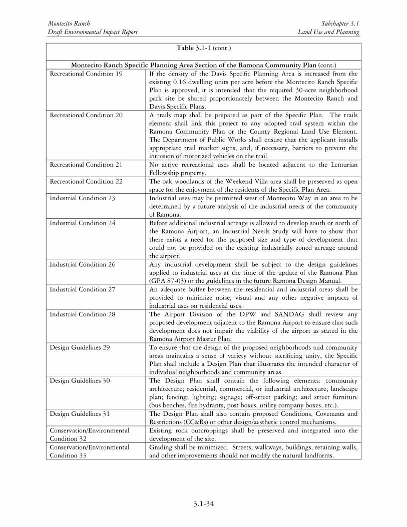
Montecito Ranch Subchapter 3.1 Draft Environmental Impact Report Land Use and Planning
3.1-34
Table 3.1-1 (cont.)
Montecito Ranch Specific Planning Area Section of the Ramona Community Plan (cont.) Recreational Condition 19 If the density of the Davis Specific Planning Area is increased from the
existing 0.16 dwelling units per acre before the Montecito Ranch Specific Plan is approved, it is intended that the required 30-acre neighborhood park site be shared proportionately between the Montecito Ranch and Davis Specific Plans.
Recreational Condition 20 A trails map shall be prepared as part of the Specific Plan. The trails element shall link this project to any adopted trail system within the Ramona Community Plan or the County Regional Land Use Element. The Department of Public Works shall ensure that the applicant installs appropriate trail marker signs, and, if necessary, barriers to prevent the intrusion of motorized vehicles on the trail.
Recreational Condition 21 No active recreational uses shall be located adjacent to the Lemurian Fellowship property.
Recreational Condition 22 The oak woodlands of the Weekend Villa area shall be preserved as open space for the enjoyment of the residents of the Specific Plan Area.
Industrial Condition 23 Industrial uses may be permitted west of Montecito Way in an area to be determined by a future analysis of the industrial needs of the community of Ramona.
Industrial Condition 24 Before additional industrial acreage is allowed to develop south or north of the Ramona Airport, an Industrial Needs Study will have to show that there exists a need for the proposed size and type of development that could not be provided on the existing industrially zoned acreage around the airport.
Industrial Condition 26 Any industrial development shall be subject to the design guidelines applied to industrial uses at the time of the update of the Ramona Plan (GPA 87-03) or the guidelines in the future Ramona Design Manual.
Industrial Condition 27 An adequate buffer between the residential and industrial areas shall be provided to minimize noise, visual and any other negative impacts of industrial uses on residential uses.
Industrial Condition 28 The Airport Division of the DPW and SANDAG shall review any proposed development adjacent to the Ramona Airport to ensure that such development does not impair the viability of the airport as stated in the Ramona Airport Master Plan.
Design Guidelines 29 To ensure that the design of the proposed neighborhoods and community areas maintains a sense of variety without sacrificing unity, the Specific Plan shall include a Design Plan that illustrates the intended character of individual neighborhoods and community areas.
Design Guidelines 30 The Design Plan shall contain the following elements: community architecture; residential, commercial, or industrial architecture; landscape plan; fencing; lighting; signage; off-street parking; and street furniture (bus benches, fire hydrants, post boxes, utility company boxes, etc.).
Design Guidelines 31 The Design Plan shall also contain proposed Conditions, Covenants and Restrictions (CC&Rs) or other design/aesthetic control mechanisms.
Conservation/Environmental Condition 32
Existing rock outcroppings shall be preserved and integrated into the development of the site.
Conservation/Environmental Condition 33
Grading shall be minimized. Streets, walkways, buildings, retaining walls, and other improvements should not modify the natural landforms.

Montecito Ranch Subchapter 3.1 Draft Environmental Impact Report Land Use and Planning
3.1-35
Table 3.1-1 (cont.)
Montecito Ranch Specific Planning Area Section of the Ramona Community Plan (cont.)
Conservation/Environmental Condition 34
Open space easements shall be placed on the oak woodlands and slopes over 50 percent.
Conservation/Environmental Condition 35
Open space easements shall be applied to protect all significant biological resources.
Conservation/Environmental Condition 36
Groundwater quality may be impacted by this project and by surrounding uses. It may be necessary for this development to be served by RMWD. Special considerations shall be given to surrounding property owners.
Conservation/Environmental Condition 37
High quality chaparral and coastal sage scrub habitat found in the northern portion of the site shall be preserved.
Conservation/Environmental Condition 38
The Montecito Ranch House designated as a Historic Preservation Area in the Ramona Community Plan shall be preserved and maintained.
Conservation/Environmental Condition 39
A study shall be conducted to assess the feasibility of installing dual water systems on all lots for the purpose of using reclaimed water for irrigation.
Agricultural Condition 40 Future potential agricultural uses located within the property shall be defined by more detailed study to determine not only the precise areas for agricultural production, but also the economic considerations associated with that use.
Agricultural Condition 41 The minimum lot size permitted within any future agricultural pursuit area shall also be determined by the above analysis. It is presently intended that a minimum lot size of four acres be allowed within that area, and the above study shall address any modifications to that requirement.
Agricultural Condition 42 The approximately 103 acres of prime agricultural soils identified as Visalia sandy loams (VaA and VaB), Fallbrook sandy loam (RaB) located in the southwest portion of the Montecito Ranch property, shall be preserved for agricultural pursuits. Any lot created on these 103 acres shall be identified as agricultural lots.
Utilities Condition 43 All utilities shall be undergrounded where feasible. Public Facilities Condition 44 The Specific Plan text shall include a financing plan outlining capital
improvements necessary to implement the proposed project. Public Facilities Condition 45 This financing plan shall include an outline of the mechanisms to be
employed to build new facilities, to connect to existing facilities and to fund the needed on-site and off-site facilities.
Public Facilities Condition 46 A map showing the location of public facilities currently serving the Specific Plan is required, along with an assessment of the adequacy of those facilities.
Public Facilities Condition 47 The types of facilities to be addressed in the financing plan shall include: the transportation network; sewage, water and drainage systems; solid waste disposal facilities; fire protection and emergency medical facilities; energy facilities (minor emphasis); and other essential facilities (e.g., law enforcement, library, animal control facilities) which may be required due to the unique characteristics of the Specific Plan Area.
Public Facilities Condition 48 The financing plan shall include detailed information on the size and scope of all needed capital improvements, the estimated costs of such improvements, and the financing mechanisms to be used to fund the improvements. Supplemental information regarding on going operational expense estimates may be required by the DPLU in certain circumstances. In all cases in which package treatment plants are proposed for solid waste disposal, ongoing operational expense and revenue estimates are required.
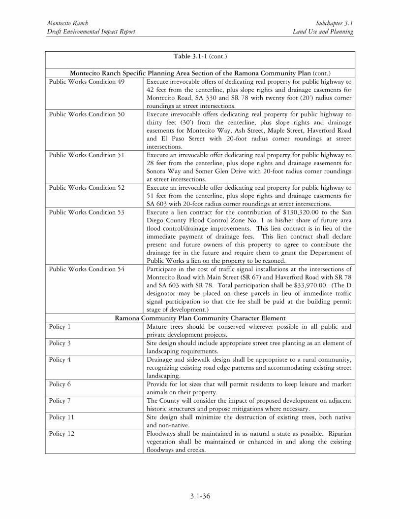
Montecito Ranch Subchapter 3.1 Draft Environmental Impact Report Land Use and Planning
3.1-36
Table 3.1-1 (cont.)
Montecito Ranch Specific Planning Area Section of the Ramona Community Plan (cont.)
Public Works Condition 49 Execute irrevocable offers of dedicating real property for public highway to 42 feet from the centerline, plus slope rights and drainage easements for Montecito Road, SA 330 and SR 78 with twenty foot (20’) radius corner roundings at street intersections.
Public Works Condition 50 Execute irrevocable offers dedicating real property for public highway to thirty feet (30’) from the centerline, plus slope rights and drainage easements for Montecito Way, Ash Street, Maple Street, Haverford Road and El Paso Street with 20-foot radius corner roundings at street intersections.
Public Works Condition 51 Execute an irrevocable offer dedicating real property for public highway to 28 feet from the centerline, plus slope rights and drainage easements for Sonora Way and Somer Glen Drive with 20-foot radius corner roundings at street intersections.
Public Works Condition 52 Execute an irrevocable offer dedicating real property for public highway to 51 feet from the centerline, plus slope rights and drainage easements for SA 603 with 20-foot radius corner roundings at street intersections.
Public Works Condition 53 Execute a lien contract for the contribution of $130,320.00 to the San Diego County Flood Control Zone No. 1 as his/her share of future area flood control/drainage improvements. This lien contract is in lieu of the immediate payment of drainage fees. This lien contract shall declare present and future owners of this property to agree to contribute the drainage fee in the future and require them to grant the Department of Public Works a lien on the property to be rezoned.
Public Works Condition 54 Participate in the cost of traffic signal installations at the intersections of Montecito Road with Main Street (SR 67) and Haverford Road with SR 78 and SA 603 with SR 78. Total participation shall be $33,970.00. (The D designator may be placed on these parcels in lieu of immediate traffic signal participation so that the fee shall be paid at the building permit stage of development.)
Ramona Community Plan Community Character Element Policy 1 Mature trees should be conserved wherever possible in all public and
private development projects. Policy 3 Site design should include appropriate street tree planting as an element of
landscaping requirements. Policy 4 Drainage and sidewalk design shall be appropriate to a rural community,
recognizing existing road edge patterns and accommodating existing street landscaping.
Policy 6 Provide for lot sizes that will permit residents to keep leisure and market animals on their property.
Policy 7 The County will consider the impact of proposed development on adjacent historic structures and propose mitigations where necessary.
Policy 11 Site design shall minimize the destruction of existing trees, both native and non-native.
Policy 12 Floodways shall be maintained in as natural a state as possible. Riparian vegetation shall be maintained or enhanced in and along the existing floodways and creeks.
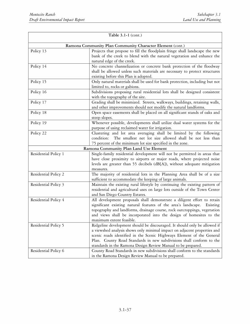
Montecito Ranch Subchapter 3.1 Draft Environmental Impact Report Land Use and Planning
3.1-37
Table 3.1-1 (cont.)
Ramona Community Plan Community Character Element (cont.)
Policy 13 Projects that propose to fill the floodplain fringe shall landscape the new bank of the creek to blend with the natural vegetation and enhance the natural edge of the creek.
Policy 14 No concrete channelization or concrete bank protection of the floodway shall be allowed unless such materials are necessary to protect structures existing before this Plan is adopted.
Policy 15 Only natural materials shall be used for bank protection, including but not limited to, rocks or gabions.
Policy 16 Subdivisions proposing rural residential lots shall be designed consistent with the topography of the site.
Policy 17 Grading shall be minimized. Streets, walkways, buildings, retaining walls, and other improvements should not modify the natural landforms.
Policy 18 Open space easements shall be placed on all significant stands of oaks and steep slopes.
Policy 19 Whenever possible, developments shall utilize dual water systems for the purpose of using reclaimed water for irrigation.
Policy 22 Clustering and lot area averaging shall be limited by the following condition: The smallest net lot size allowed shall be not less than 75 percent of the minimum lot size specified in the zone.
Ramona Community Plan Land Use Element Residential Policy 1 Single-family residential development will not be permitted in areas that
have close proximity to airports or major roads, where projected noise levels are greater than 55 decibels (dB[A]), without adequate mitigation measures.
Residential Policy 2 The majority of residential lots in the Planning Area shall be of a size sufficient to accommodate the keeping of large animals.
Residential Policy 3 Maintain the existing rural lifestyle by continuing the existing pattern of residential and agricultural uses on large lots outside of the Town Center and San Diego Country Estates.
Residential Policy 4 All development proposals shall demonstrate a diligent effort to retain significant existing natural features of the area’s landscape. Existing topography and landforms, drainage course, rock outcroppings, vegetation and views shall be incorporated into the design of homesites to the maximum extent feasible.
Residential Policy 5 Ridgeline development should be discouraged. It should only be allowed if a viewshed analysis shows only minimal impact on adjacent properties and scenic roads identified in the Scenic Highways Element of the General Plan. County Road Standards in new subdivisions shall conform to the standards in the Ramona Design Review Manual to be prepared.
Residential Policy 6 County Road Standards in new subdivisions shall conform to the standards in the Ramona Design Review Manual to be prepared.
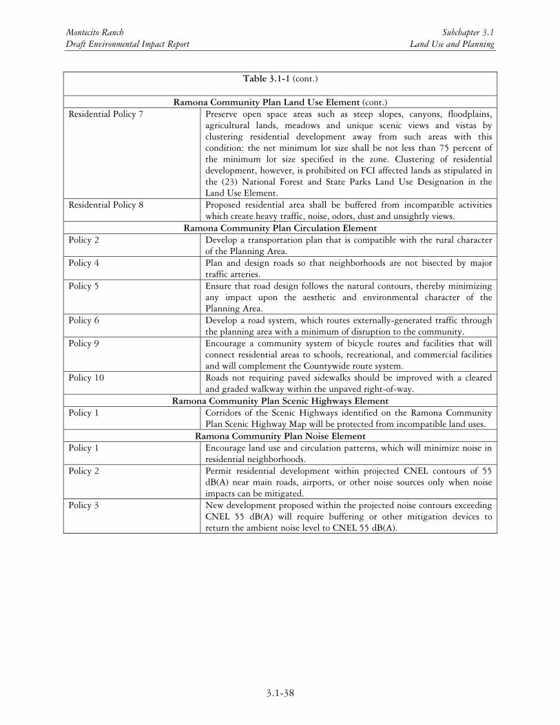
Montecito Ranch Subchapter 3.1 Draft Environmental Impact Report Land Use and Planning
3.1-38
Table 3.1-1 (cont.)
Ramona Community Plan Land Use Element (cont.)
Residential Policy 7 Preserve open space areas such as steep slopes, canyons, floodplains, agricultural lands, meadows and unique scenic views and vistas by clustering residential development away from such areas with this condition: the net minimum lot size shall be not less than 75 percent of the minimum lot size specified in the zone. Clustering of residential development, however, is prohibited on FCI affected lands as stipulated in the (23) National Forest and State Parks Land Use Designation in the Land Use Element.
Residential Policy 8 Proposed residential area shall be buffered from incompatible activities which create heavy traffic, noise, odors, dust and unsightly views.
Ramona Community Plan Circulation Element Policy 2 Develop a transportation plan that is compatible with the rural character
of the Planning Area. Policy 4 Plan and design roads so that neighborhoods are not bisected by major
traffic arteries. Policy 5 Ensure that road design follows the natural contours, thereby minimizing
any impact upon the aesthetic and environmental character of the Planning Area.
Policy 6 Develop a road system, which routes externally-generated traffic through the planning area with a minimum of disruption to the community.
Policy 9 Encourage a community system of bicycle routes and facilities that will connect residential areas to schools, recreational, and commercial facilities and will complement the Countywide route system.
Policy 10 Roads not requiring paved sidewalks should be improved with a cleared and graded walkway within the unpaved right-of-way.
Ramona Community Plan Scenic Highways Element Policy 1 Corridors of the Scenic Highways identified on the Ramona Community
Plan Scenic Highway Map will be protected from incompatible land uses. Ramona Community Plan Noise Element
Policy 1 Encourage land use and circulation patterns, which will minimize noise in residential neighborhoods.
Policy 2 Permit residential development within projected CNEL contours of 55 dB(A) near main roads, airports, or other noise sources only when noise impacts can be mitigated.
Policy 3 New development proposed within the projected noise contours exceeding CNEL 55 dB(A) will require buffering or other mitigation devices to return the ambient noise level to CNEL 55 dB(A).
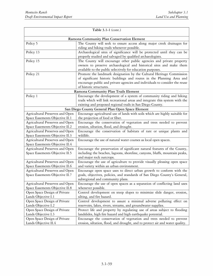
Montecito Ranch Subchapter 3.1 Draft Environmental Impact Report Land Use and Planning
3.1-39
Table 3.1-1 (cont.)
Ramona Community Plan Conservation Element
Policy 5 The County will seek to ensure access along major creek drainages for riding and hiking trails whenever possible.
Policy 13 Archaeological sites of significance will be protected until they can be properly studied and salvaged by qualified archaeologists.
Policy 15 The County will encourage other public agencies and private property owners to preserve archaeological and historical sites and make them available to the public selectively for education purposes.
Policy 21 Promote the landmark designation by the Cultural Heritage Commission of significant historic buildings and routes in the Planning Area and encourage public and private agencies and individuals to consider the reuse of historic structures.
Ramona Community Plan Trails Element Policy 1 Encourage the development of a system of community riding and hiking
trails which will link recreational areas and integrate this system with the existing and proposed regional trails in San Diego County.
San Diego County General Plan Open Space Element Agricultural Preserves and Open Space Easements Objective II.1
Encourage agricultural use of lands with soils which are highly suitable for the projection of food or fiber.
Agricultural Preserves and Open Space Easements Objective II.2
Encourage the conservation of vegetation and trees needed to prevent erosion, siltation, flood, and drought.
Agricultural Preserves and Open Space Easements Objective II.3
Encourage the conservation of habitats of rare or unique plants and wildlife.
Agricultural Preserves and Open Space Easements Objective II.4
Encourage the use of natural water courses as local open spaces.
Agricultural Preserves and Open Space Easements Objective II.5
Encourage the preservation of significant natural features of the County, including the beaches, lagoons, shoreline, canyons, bluffs, mountain peaks, and major rock outcrops.
Agricultural Preserves and Open Space Easements Objective II.6
Encourage the use of agriculture to provide visually pleasing open space and variety within an urban environment.
Agricultural Preserves and Open Space Easements Objective II.7
Encourage open space uses to direct urban growth to conform with the goals, objectives, policies, and standards of San Diego County’s General, subregional and community plans.
Agricultural Preserves and Open Space Easements Objective II.8
Encourage the use of open spaces as a separation of conflicting land uses whenever possible.
Open Space Design of Private Lands Objective I.1
Control development on steep slopes to minimize slide danger, erosion, silting, and fire hazard.
Open Space Design of Private Lands Objective I.2
Control development to assure a minimal adverse polluting effect on reservoirs, lakes, rivers, streams, and groundwater supplies.
Open Space Design of Private Lands Objective I.3
Protect life and property by regulating use of areas subject to flooding landslides, high fire hazard and high earthquake potential.
Open Space Design of Private Lands Objective II.4
Encourage the conservation of vegetation and trees needed to prevent erosion, siltation, flood, and drought, and to protect air and water quality.
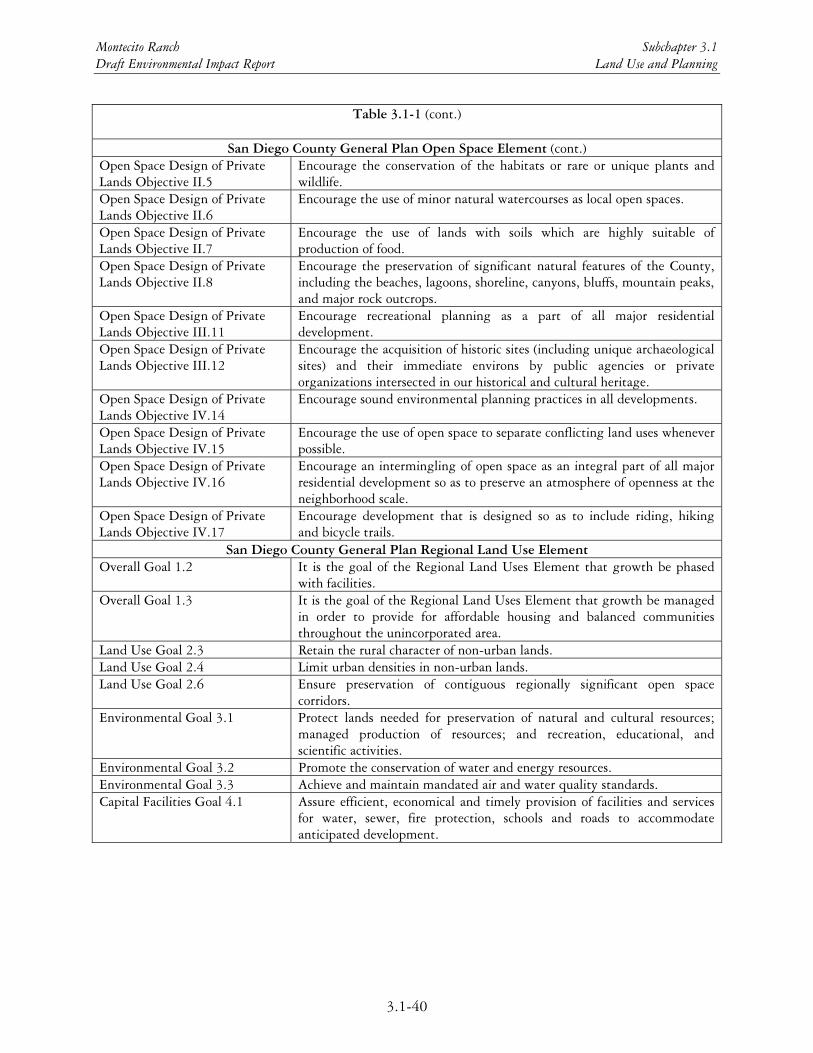
Montecito Ranch Subchapter 3.1 Draft Environmental Impact Report Land Use and Planning
3.1-40
Table 3.1-1 (cont.)
San Diego County General Plan Open Space Element (cont.)
Open Space Design of Private Lands Objective II.5
Encourage the conservation of the habitats or rare or unique plants and wildlife.
Open Space Design of Private Lands Objective II.6
Encourage the use of minor natural watercourses as local open spaces.
Open Space Design of Private Lands Objective II.7
Encourage the use of lands with soils which are highly suitable of production of food.
Open Space Design of Private Lands Objective II.8
Encourage the preservation of significant natural features of the County, including the beaches, lagoons, shoreline, canyons, bluffs, mountain peaks, and major rock outcrops.
Open Space Design of Private Lands Objective III.11
Encourage recreational planning as a part of all major residential development.
Open Space Design of Private Lands Objective III.12
Encourage the acquisition of historic sites (including unique archaeological sites) and their immediate environs by public agencies or private organizations intersected in our historical and cultural heritage.
Open Space Design of Private Lands Objective IV.14
Encourage sound environmental planning practices in all developments.
Open Space Design of Private Lands Objective IV.15
Encourage the use of open space to separate conflicting land uses whenever possible.
Open Space Design of Private Lands Objective IV.16
Encourage an intermingling of open space as an integral part of all major residential development so as to preserve an atmosphere of openness at the neighborhood scale.
Open Space Design of Private Lands Objective IV.17
Encourage development that is designed so as to include riding, hiking and bicycle trails.
San Diego County General Plan Regional Land Use Element Overall Goal 1.2 It is the goal of the Regional Land Uses Element that growth be phased
with facilities. Overall Goal 1.3 It is the goal of the Regional Land Uses Element that growth be managed
in order to provide for affordable housing and balanced communities throughout the unincorporated area.
Land Use Goal 2.3 Retain the rural character of non-urban lands. Land Use Goal 2.4 Limit urban densities in non-urban lands. Land Use Goal 2.6 Ensure preservation of contiguous regionally significant open space
corridors. Environmental Goal 3.1 Protect lands needed for preservation of natural and cultural resources;
managed production of resources; and recreation, educational, and scientific activities.
Environmental Goal 3.2 Promote the conservation of water and energy resources. Environmental Goal 3.3 Achieve and maintain mandated air and water quality standards. Capital Facilities Goal 4.1 Assure efficient, economical and timely provision of facilities and services
for water, sewer, fire protection, schools and roads to accommodate anticipated development.

Montecito Ranch Subchapter 3.1 Draft Environmental Impact Report Land Use and Planning
3.1-41
Table 3.1-1 (cont.)
San Diego County General Plan Regional Land Use Element (cont.) Capital Facilities Goal 4.2 Assure that facilities and services provided by all agencies are coordinated
in their timing, location and level of service. Housing and Social Goal 6.1 Encourage development of communities that are accessible to a mix of
residents representative of the full ranges of age, income and ethnic groups in the region.
Housing and Social Goal 6.3 Assist the private sector in the provision of sufficient housing units in the unincorporated area to accommodate regional population projections endorsed by the Board of Supervisors.
Policy 1.3 Estate - Development Area (EDA): The EDA combines agricultural and low density residential uses (parcel sizes of 2 to 20 acres will apply). Included in the category are those areas outside the Urban Limit Line but within the boundaries of the County Water Authority. -- Where authorized, parcel sizes of 2 to 20 acres or larger will be
permitted depending on the slope criteria in the underlying community or subregional plan land use designations.
-- Clustering will be permitted in any land use designation found compatible with the Estate Development Category.
Urban Residential Designations Policy 2.1
(1) Residential: This designation provides for low-density residential and minor agricultural uses. Parcel sizes of one, two or four acres (gross) are required depending on the slope criteria within each lot.
Industrial Designations Policy 2.3
(16) General Impact Industrial: This designation provides for uses exhibiting moderate to severe nuisance characteristics. Typically, large sites are required with direct access to major roads, railroads, and other transportation modes.
Policy 2.4 - Non-urban Residential Designations
(17) Estate Residential: This designation provides for minor agricultural and low density residential uses. Parcel sizes of two or four acres (gross) or larger are required depending on the slope criteria within each lot.
Policy 2.4 - Non-urban Residential Designations
(18) Multiple Rural Use: This designation is applied in areas with one or more of the following characteristics: not highly suited for intensive agriculture; rugged terrain; watershed; desert lands; lands susceptible to fires and erosion; lands which rely on groundwater for water supply; and other environmentally constrained areas. The Multiple Rural Use Designation is typically, but not necessarily exclusively, applied in remote areas to broad expanses of rural land with overall low population density and with an absence of most public services. Minimum allowable parcel sizes are based on slope criteria. Other than a single-family home on an existing lot, it is not intended that any development occur unless the proposed development has been carefully examined to assure that there will be no significant adverse environmental impacts, erosion and fire problems will be minimal, and no urban levels of service will be required.

Montecito Ranch Subchapter 3.1 Draft Environmental Impact Report Land Use and Planning
3.1-42
Table 3.1-1 (cont.)
San Diego County General Plan Regional Land Use Element (cont.)
Policy 2.5 - Agricultural Designations
(19) Intensive Agriculture: This designation promotes a variety of agricultural uses including minor commercial, industrial and public facility uses appropriate to agricultural operations or supportive of the agricultural population. This designation permits two, four and eight acre parcels.
Policy 2.6 - Special Purpose Designations
(21) Specific Plan Area: This designation is used where a specific plan has been adopted or must be adopted prior to development. The overall density permitted in a Specific Planning Area shall be designated on the community or subregional plan map.
Policy 2.6 - Special Purpose Designations
(22) Public/Semi-Public Lands: This designation indicates lands generally owned by public agencies. This designations includes military bases; Indian Reservations; cemeteries; solid waste facilities; institutions, public parks including regional parks; County airports; and other public and semi-public ownership.
San Diego County General Plan Circulation Element Bicycle Network Goal 1 Provide for the safe and convenient use of bicycles throughout San Diego
County for recreation and as a viable alternative to the automobile as a form of local transportation.
Bicycle Network Goal 4 Utilize public property, such as utility and drainage easements, parks, and lightly traveled road, whenever possible, for construction of bikeways.
Bicycle Network Goal 5 Provide continuous bikeways, affording safe and convenient community-wide accessibility while preserving the natural environment to the greatest extent practical.
Bicycle Network Policy 4 Connect cultural facilities, recreation areas, commercial areas, and educational facilities by bikeways.
Bicycle Network Policy 5 Separate bicycles and automobiles whenever it is economically and physically possible to do so with either a bike lane or bike path.
Bicycle Network Policy 6 Design bikeways as an integrated part of all subdivisions and planned residential developments with connections to the bicycle network.
San Diego County General Plan Recreation Element Local Parks Recommended Standard
An overall standard of 30 acres per 1,000 population is therefore recommended, of which half should be devoted to regional facilities as proposed in 1967 in the County General Plan, and half or 15 acres per 1,000 population, for local parks. The local park standard includes a combination of local parks, riding and hiking trails, school playgrounds, and other public facilities which meet part of the need for local recreational facilities.
Local Parks Policy 1 Local parks should provide recreation opportunities for all, regardless of national origin, color, age, or economic status, or location or residence.
Local Parks Policy 4 All parks and recreation facilities should be planned as part of an overall, well-balanced park system.
Local Parks Policy 5 Local park planning should be integrated with general planning programs. Local Parks Policy 6 Each local park should be of sufficient size and proper location to foster
flexibility in activities and programs. Local Parks Policy 9 Lands should be dedicated for local park purposes and be protected against
diversion to non-recreational uses. Riding and Hiking Trails Policy 2
Provide a variety of trail experiences by locating trails through varied terrain, scenery, and points of interest.
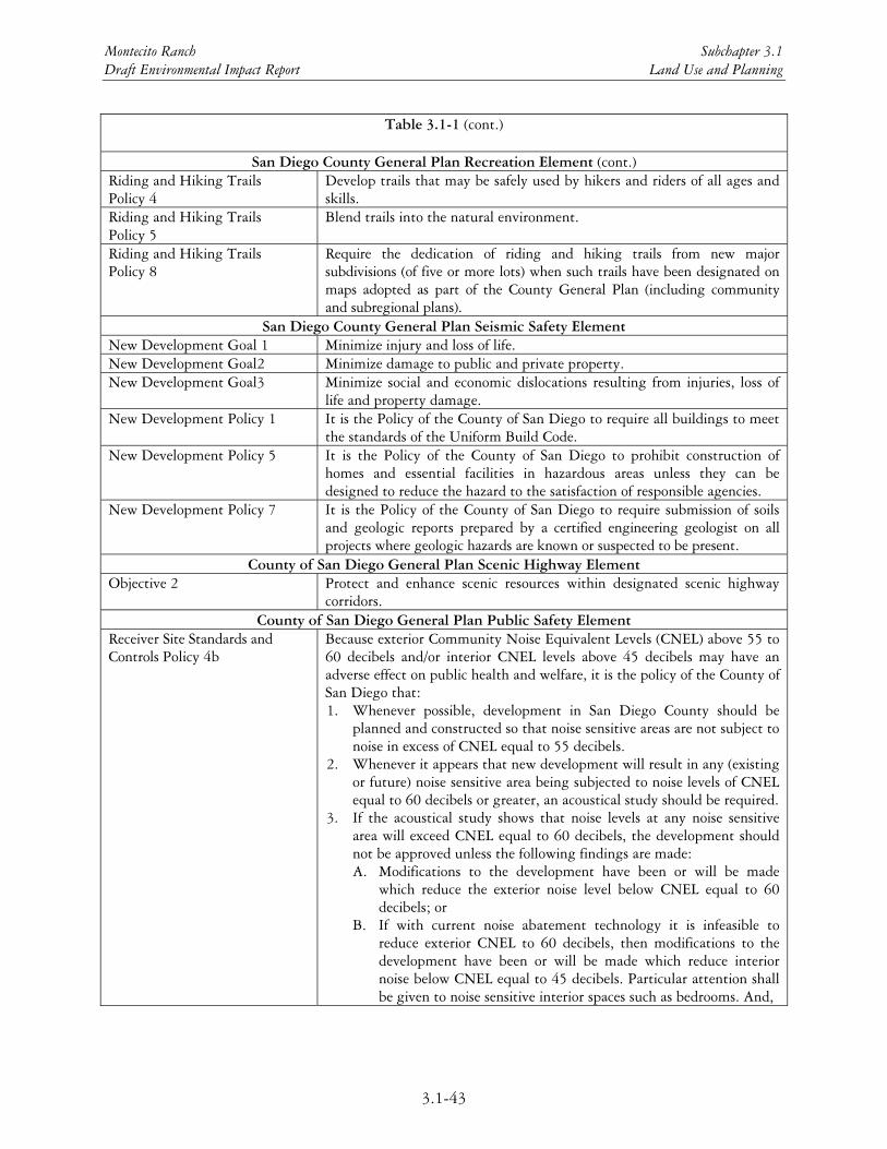
Montecito Ranch Subchapter 3.1 Draft Environmental Impact Report Land Use and Planning
3.1-43
Table 3.1-1 (cont.)
San Diego County General Plan Recreation Element (cont.)
Riding and Hiking Trails Policy 4
Develop trails that may be safely used by hikers and riders of all ages and skills.
Riding and Hiking Trails Policy 5
Blend trails into the natural environment.
Riding and Hiking Trails Policy 8
Require the dedication of riding and hiking trails from new major subdivisions (of five or more lots) when such trails have been designated on maps adopted as part of the County General Plan (including community and subregional plans).
San Diego County General Plan Seismic Safety Element New Development Goal 1 Minimize injury and loss of life. New Development Goal2 Minimize damage to public and private property. New Development Goal3 Minimize social and economic dislocations resulting from injuries, loss of
life and property damage. New Development Policy 1 It is the Policy of the County of San Diego to require all buildings to meet
the standards of the Uniform Build Code. New Development Policy 5 It is the Policy of the County of San Diego to prohibit construction of
homes and essential facilities in hazardous areas unless they can be designed to reduce the hazard to the satisfaction of responsible agencies.
New Development Policy 7 It is the Policy of the County of San Diego to require submission of soils and geologic reports prepared by a certified engineering geologist on all projects where geologic hazards are known or suspected to be present.
County of San Diego General Plan Scenic Highway Element Objective 2 Protect and enhance scenic resources within designated scenic highway
corridors. County of San Diego General Plan Public Safety Element
Receiver Site Standards and Controls Policy 4b
Because exterior Community Noise Equivalent Levels (CNEL) above 55 to 60 decibels and/or interior CNEL levels above 45 decibels may have an adverse effect on public health and welfare, it is the policy of the County of San Diego that: 1. Whenever possible, development in San Diego County should be
planned and constructed so that noise sensitive areas are not subject to noise in excess of CNEL equal to 55 decibels.
2. Whenever it appears that new development will result in any (existing or future) noise sensitive area being subjected to noise levels of CNEL equal to 60 decibels or greater, an acoustical study should be required.
3. If the acoustical study shows that noise levels at any noise sensitive area will exceed CNEL equal to 60 decibels, the development should not be approved unless the following findings are made: A. Modifications to the development have been or will be made
which reduce the exterior noise level below CNEL equal to 60 decibels; or
B. If with current noise abatement technology it is infeasible to reduce exterior CNEL to 60 decibels, then modifications to the development have been or will be made which reduce interior noise below CNEL equal to 45 decibels. Particular attention shall be given to noise sensitive interior spaces such as bedrooms. And,

Montecito Ranch Subchapter 3.1 Draft Environmental Impact Report Land Use and Planning
3.1-44
Table 3.1-1 (cont.)
County of San Diego General Plan Public Safety Element (cont.)
Receiver Site Standards and Controls Policy 4b (cont.)
C. If finding "B" above is made, a further finding is made that there are specifically identified overriding social or economic considerations which warrant approval of the development without modification as described in "A" above.
4. If the acoustical study shows that noise levels at any noise sensitive area will exceed CNEL equal to 75 decibels, the development should not be approved.
Exemptions 1. For the rooms in “Noise Sensitive Areas," which are usually occupied
only a part of the day (schools, libraries, or similar), the interior one hour average sound level, due to noise outside, should not exceed 50 decibels.
2. For County road construction projects, the exterior noise level due to vehicular traffic impacting a noise sensitive area should not exceed the following values: Other Projects - CNEL = 60 dB(A), except if the existing or projected noise level without the project is 58 dB(A) or greater a 3 dB(A) increase will be allowed, up to the maximum permitted by Federal Highway Administration Standards.
Housing Element of the San Diego County General Plan Goal 1 Assist the private sector, including non-profit and community development
organizations, to ensure that new residential construction will be available to meet the needs of the region if adequate public services and facilities are in place. Housing should be available in a variety of styles, tenancy types, and prices throughout the region.
Conservation Element of the San Diego County General Plan Water Policy 4 Reduce local reliance on imported water. Water Policy 5 Water distribution systems should be designed and constructed to
economically accommodate future use of reclaimed or desalinized water when technologically and economically feasible.
Water Policy 8 Wastewater discharges shall not adversely affect the beneficial use of receiving waters.
Water Policy 10 Storm drain run-off should be planned and managed to minimize water degradation, to reduce the waste of fresh water, to enhance wildlife, and to reduce the impact of erosion.
Water Policy 11 The County will encourage projects which will promote the reclamation and reuse of wastewater.
Water Policy 18 The County will prevent filling or construction in the floodway. Uses such as sand extraction, recreational activities, and agricultural pursuits may be exceptions to this policy.
Vegetation and Wildlife Habitats Policy 1
The County will act to conserve and enhance vegetation, wildlife and fisheries resources.
Vegetation and Wildlife Habitats Policy 2
San Diego County shall coordinate with appropriate federal, State and local agencies to conserve areas of rare, endangered or threatened species.
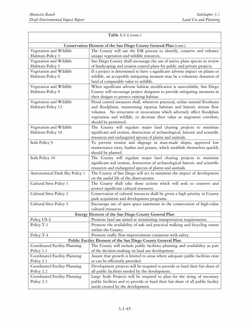
Montecito Ranch Subchapter 3.1 Draft Environmental Impact Report Land Use and Planning
3.1-45
Table 3.1-1 (cont.)
Conservation Element of the San Diego County General Plan (cont.)
Vegetation and Wildlife Habitats Policy 3
The County will use the EIR process to identify, conserve and enhance unique vegetation and wildlife resources.
Vegetation and Wildlife Habitats Policy 5
San Diego County shall encourage the use of native plant species in review of landscaping and erosion control plans for public and private projects.
Vegetation and Wildlife Habitats Policy 6
If a project is determined to have a significant adverse impact on plants or wildlife, an acceptable mitigating measure may be a voluntary donation of land of comparable value to wildlife.
Vegetation and Wildlife Habitats Policy 9
When significant adverse habitat modification is unavoidable, San Diego County will encourage project designers to provide mitigating measures in their designs to protect existing habitat.
Vegetation and Wildlife Habitats Policy 13
Flood control measures shall, whenever practical, utilize natural floodways and floodplains, maintaining riparian habitats and historic stream flow volumes. No structures or excavations which adversely affect floodplain vegetation and wildlife, or decrease their value as migration corridors, should be permitted.
Vegetation and Wildlife Habitats Policy 16
The County will regulate major land clearing projects to minimize significant soil erosion, destruction of archaeological, historic and scientific resources and endangered species of plants and animals.
Soils Policy 9 To prevent erosion and slippage in man-made slopes, approved low maintenance trees, bushes and grasses, which establish themselves quickly should be planted.
Soils Policy 10 The County will regulate major land clearing projects to minimize significant soil erosion, destruction of archaeological historic and scientific resources and endangered species of plants and animals.
Astronomical Dark Sky Policy 1 The County of San Diego will act to minimize the impact of development on the useful life of the observatories.
Cultural Sites Policy 1 The County shall take those actions which will seek to conserve and protect significant cultural resources.
Cultural Sites Policy 2 Conservation of cultural resources shall be given a high priority in County park acquisition and development programs.
Cultural Sites Policy 5 Encourage use of open space easements in the conservation of high-value cultural resources
Energy Element of the San Diego County General Plan Policy US-4 Promote land use aimed at minimizing transportation requirements. Policy T-1 Promote the availability of safe and practical walking and bicycling routes
within the County. Policy T-4 Promote traffic flow improvements consistent with safety.
Public Facility Element of the San Diego County General Plan Coordinated Facility Planning Policy 1.1
The County will include public facilities planning and availability as part of the decision-making on land use development.
Coordinated Facility Planning Policy 2.1
Assure that growth is limited to areas where adequate public facilities exist or can be efficiently provided.
Coordinated Facility Planning Policy 2.2
Development projects will be required to provide or fund their fair share of all public facilities needed by the development.
Coordinated Facility Planning Policy 2.3
Large Scale Projects will be required to plan for the siting of necessary public facilities and to provide or fund their fair share of all public facility needs created by the development.

Montecito Ranch Subchapter 3.1 Draft Environmental Impact Report Land Use and Planning
3.1-46
Table 3.1-1 (cont.)
Public Facility Element of the San Diego County General Plan (cont.)
Parks and Recreation Objective 1 Provide, in the short term, 5 acres of local parks per 1,000 unincorporated area residents and the County’s equitable portion of the regional park facilities level of 15 acres per 1,000 residents in the region.
Parks and Recreation Policy 2.2 The County will site, plan and develop local and regional parks that are compatible with community character, land use and the recreational, conservation and preservation needs of the intended service population.
Transportation Policy 1.1 New development shall provide needed roadway expansion and improvements on site to meet the demand created by the development and to maintain an LOS C on Circulation Element Roads during peak traffic hours. New development shall provide off-site improvements designed to contribute to the overall achievement of an LOS D on Circulation Element Roads.
Transportation Policy 2.1 New development shall be required to contribute its fair share toward financing transportation facilities.
Transportation Policy 4.2 The County will ensure the development of its bikeway system and encourage its use.
Transportation Policy 4.4 Ensure the provision of bicycle facilities and other needed bikeway related improvements in new development.
Flood Control Policy 1.1 Development within floodplains will be restricted to decrease the potential for property damage and loss of life from flooding and to avoid the need for channels and other flood control facilities.
Flood Control Policy 5.1 The County will require measures to decrease the adverse impacts created by increased quantity and degradation in quality of runoff from urban areas.
Law Enforcement Objective 1 A level of facilities sufficient to accommodate a service level of three patrol shifts per day per 10,000 population, or service-area-equivalent for commercial/industrial land uses, as an interim step toward meeting the facility goal.
Law Enforcement Policy 3.2 New development in the unincorporated area will be required to contribute its fair share toward financing sheriff facilities toward achieving the short term objective.
Animal Control Policy 4.1 New development shall be required to contribute its fair share toward financing animal control facilities to achieve the short term objective of providing .13 square feet of shelter space per dwelling unit.
Libraries Objective 2 Equitable sharing of funding for library facilities by unincorporated communities and all cities in the County Library's service area, and by all new development that will benefit from the facilities.
Libraries Policy 2.2 The County will attempt to establish funding programs in conjunction with cities within the County Library's service area to ensure that new development in these cities and the unincorporated area contributes its fair share to provide library facilities to serve new development.
Schools Objective 1 Provision of educational facilities sufficient to meet the demands of new development concurrent with need.
Schools Policy 1.2 To the extent allowable under State law, new development shall be required to provide additional facilities needed to serve children generated by the new development. Such facilities shall be of the quality and quantity sufficient to meet State Department of Education standards or to maintain an existing higher level of service provided by an affected school district’s facilities.
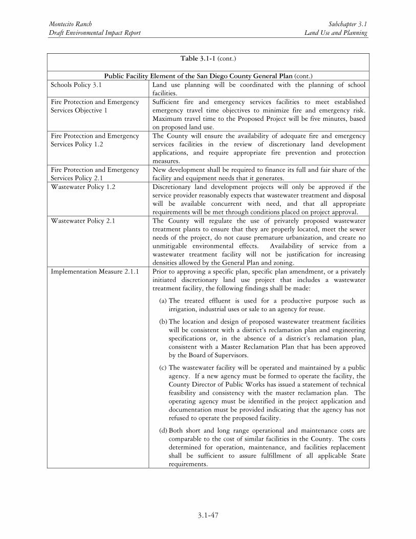
Montecito Ranch Subchapter 3.1 Draft Environmental Impact Report Land Use and Planning
3.1-47
Table 3.1-1 (cont.)
Public Facility Element of the San Diego County General Plan (cont.)
Schools Policy 3.1 Land use planning will be coordinated with the planning of school facilities.
Fire Protection and Emergency Services Objective 1
Sufficient fire and emergency services facilities to meet established emergency travel time objectives to minimize fire and emergency risk. Maximum travel time to the Proposed Project will be five minutes, based on proposed land use.
Fire Protection and Emergency Services Policy 1.2
The County will ensure the availability of adequate fire and emergency services facilities in the review of discretionary land development applications, and require appropriate fire prevention and protection measures.
Fire Protection and Emergency Services Policy 2.1
New development shall be required to finance its full and fair share of the facility and equipment needs that it generates.
Wastewater Policy 1.2 Discretionary land development projects will only be approved if the service provider reasonably expects that wastewater treatment and disposal will be available concurrent with need, and that all appropriate requirements will be met through conditions placed on project approval.
Wastewater Policy 2.1 The County will regulate the use of privately proposed wastewater treatment plants to ensure that they are properly located, meet the sewer needs of the project, do not cause premature urbanization, and create no unmitigable environmental effects. Availability of service from a wastewater treatment facility will not be justification for increasing densities allowed by the General Plan and zoning.
Implementation Measure 2.1.1 Prior to approving a specific plan, specific plan amendment, or a privately initiated discretionary land use project that includes a wastewater treatment facility, the following findings shall be made:
(a) The treated effluent is used for a productive purpose such as irrigation, industrial uses or sale to an agency for reuse.
(b) The location and design of proposed wastewater treatment facilities will be consistent with a district’s reclamation plan and engineering specifications or, in the absence of a district’s reclamation plan, consistent with a Master Reclamation Plan that has been approved by the Board of Supervisors.
(c) The wastewater facility will be operated and maintained by a public agency. If a new agency must be formed to operate the facility, the County Director of Public Works has issued a statement of technical feasibility and consistency with the master reclamation plan. The operating agency must be identified in the project application and documentation must be provided indicating that the agency has not refused to operate the proposed facility.
(d) Both short and long range operational and maintenance costs are comparable to the cost of similar facilities in the County. The costs determined for operation, maintenance, and facilities replacement shall be sufficient to assure fulfillment of all applicable State requirements.
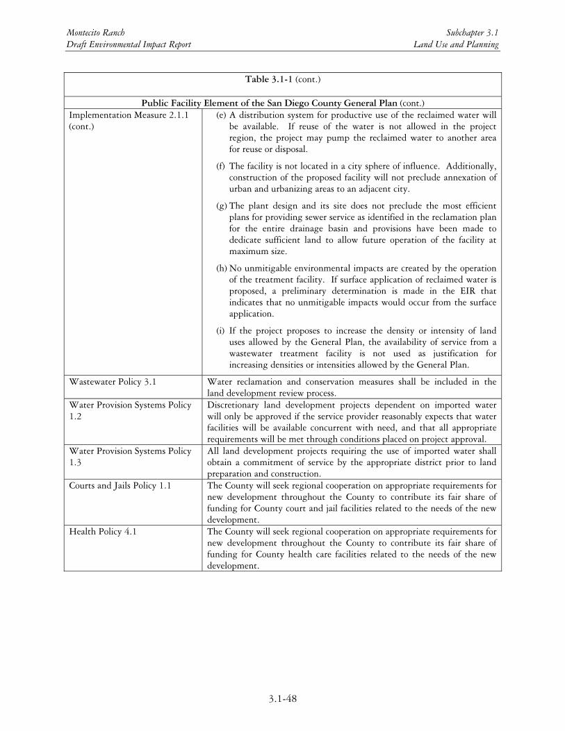
Montecito Ranch Subchapter 3.1 Draft Environmental Impact Report Land Use and Planning
3.1-48
Table 3.1-1 (cont.)
Public Facility Element of the San Diego County General Plan (cont.)
Implementation Measure 2.1.1 (cont.)
(e) A distribution system for productive use of the reclaimed water will be available. If reuse of the water is not allowed in the project region, the project may pump the reclaimed water to another area for reuse or disposal.
(f) The facility is not located in a city sphere of influence. Additionally, construction of the proposed facility will not preclude annexation of urban and urbanizing areas to an adjacent city.
(g) The plant design and its site does not preclude the most efficient plans for providing sewer service as identified in the reclamation plan for the entire drainage basin and provisions have been made to dedicate sufficient land to allow future operation of the facility at maximum size.
(h) No unmitigable environmental impacts are created by the operation of the treatment facility. If surface application of reclaimed water is proposed, a preliminary determination is made in the EIR that indicates that no unmitigable impacts would occur from the surface application.
(i) If the project proposes to increase the density or intensity of land uses allowed by the General Plan, the availability of service from a wastewater treatment facility is not used as justification for increasing densities or intensities allowed by the General Plan.
Wastewater Policy 3.1 Water reclamation and conservation measures shall be included in the land development review process.
Water Provision Systems Policy 1.2
Discretionary land development projects dependent on imported water will only be approved if the service provider reasonably expects that water facilities will be available concurrent with need, and that all appropriate requirements will be met through conditions placed on project approval.
Water Provision Systems Policy 1.3
All land development projects requiring the use of imported water shall obtain a commitment of service by the appropriate district prior to land preparation and construction.
Courts and Jails Policy 1.1 The County will seek regional cooperation on appropriate requirements for new development throughout the County to contribute its fair share of funding for County court and jail facilities related to the needs of the new development.
Health Policy 4.1 The County will seek regional cooperation on appropriate requirements for new development throughout the County to contribute its fair share of funding for County health care facilities related to the needs of the new development.
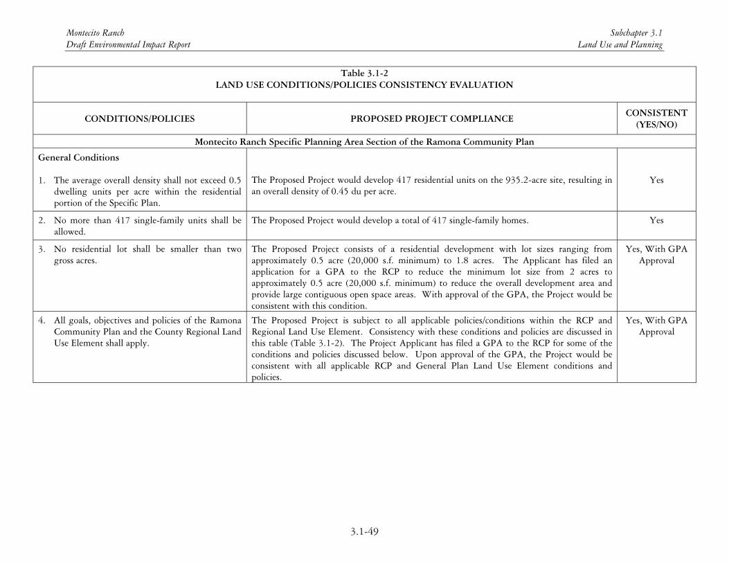
Montecito Ranch Subchapter 3.1 Draft Environmental Impact Report Land Use and Planning
3.1-49
Table 3.1-2 LAND USE CONDITIONS/POLICIES CONSISTENCY EVALUATION
CONDITIONS/POLICIES PROPOSED PROJECT COMPLIANCE CONSISTENT (YES/NO)
Montecito Ranch Specific Planning Area Section of the Ramona Community Plan
General Conditions 1. The average overall density shall not exceed 0.5
dwelling units per acre within the residential portion of the Specific Plan.
The Proposed Project would develop 417 residential units on the 935.2-acre site, resulting in an overall density of 0.45 du per acre.
Yes
2. No more than 417 single-family units shall be allowed.
The Proposed Project would develop a total of 417 single-family homes. Yes
3. No residential lot shall be smaller than two gross acres.
The Proposed Project consists of a residential development with lot sizes ranging from approximately 0.5 acre (20,000 s.f. minimum) to 1.8 acres. The Applicant has filed an application for a GPA to the RCP to reduce the minimum lot size from 2 acres to approximately 0.5 acre (20,000 s.f. minimum) to reduce the overall development area and provide large contiguous open space areas. With approval of the GPA, the Project would be consistent with this condition.
Yes, With GPA Approval
4. All goals, objectives and policies of the Ramona Community Plan and the County Regional Land Use Element shall apply.
The Proposed Project is subject to all applicable policies/conditions within the RCP and Regional Land Use Element. Consistency with these conditions and policies are discussed in this table (Table 3.1-2). The Project Applicant has filed a GPA to the RCP for some of the conditions and policies discussed below. Upon approval of the GPA, the Project would be consistent with all applicable RCP and General Plan Land Use Element conditions and policies.
Yes, With GPA Approval
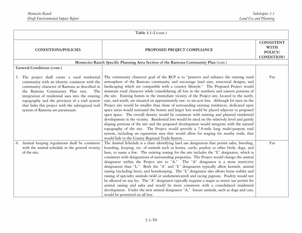
Montecito Ranch Subchapter 3.1 Draft Environmental Impact Report Land Use and Planning
3.1-50
Table 3.1-2 (cont.)
CONDITIONS/POLICIES PROPOSED PROJECT COMPLIANCE
CONSISTENT WITH
POLICY/ CONDITION?
Montecito Ranch Specific Planning Area Section of the Ramona Community Plan (cont.) General Conditions (cont.) 5. The project shall create a rural residential
community with an identity consistent with the community character of Ramona as described in the Ramona Community Plan text. The integration of residential uses into the existing topography and the provision of a trail system that links this project with the subregional trail system of Ramona are paramount.
The community character goal of the RCP is to “preserve and enhance the existing rural atmosphere of the Ramona community and encourage land uses, structural designs, and landscaping which are compatible with a country lifestyle.” The Proposed Project would maintain rural character while consolidating all lots in the northern and eastern portions of the site. Existing homes in the immediate vicinity of the Project site, located to the north, east, and south, are situated on approximately one- to six-acre lots. Although lot sizes on the Project site would be smaller than those of surrounding existing residences, dedicated open space areas would surround the homes and larger lots would be placed adjacent to proposed open space. The overall density would be consistent with existing and planned residential development in the vicinity. Residential lots would be sited on the relatively level and gently sloping portions of the site and the proposed development would integrate with the natural topography of the site. The Project would provide a 7.8-mile long multi-purpose trail system, including an equestrian area that would allow for staging for nearby trails, that would link to the County Regional Trails System.
Yes
6. Animal keeping regulations shall be consistent with the animal schedule in the general vicinity of the site.
The Animal Schedule is a chart identifying land use designators that permit sales, breeding, boarding, keeping, etc. of animals such as horses, cattle, poultry or other birds, dogs, and bees, to name a few. The existing zoning for the site includes the “L” designator, which is consistent with designations of surrounding properties. The Project would change the animal designator within the Project site to “A.” The “A” designator is a more restrictive designation than “L.” Both the “A” and “L” designators typically allow kennels, animal raising (including bees), and horsekeeping. The “L” designator also allows horse stables and raising of specialty animals (wild or undomesticated) and racing pigeons. Poultry would not be allowed on any lot. The “A” designator typically requires a major or minor use permit for animal raising and sales and would be more consistent with a consolidated residential development. Under the new animal designator “A,” leisure animals, such as dogs and cats, would be permitted on all lots.
Yes
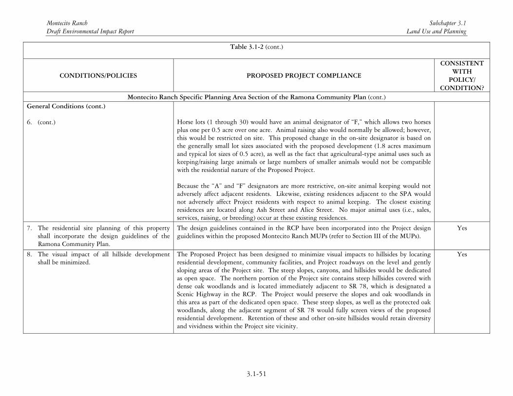
Montecito Ranch Subchapter 3.1 Draft Environmental Impact Report Land Use and Planning
3.1-51
Table 3.1-2 (cont.)
CONDITIONS/POLICIES PROPOSED PROJECT COMPLIANCE
CONSISTENT WITH
POLICY/ CONDITION?
Montecito Ranch Specific Planning Area Section of the Ramona Community Plan (cont.) General Conditions (cont.) 6. (cont.)
Horse lots (1 through 30) would have an animal designator of “F,” which allows two horses plus one per 0.5 acre over one acre. Animal raising also would normally be allowed; however, this would be restricted on site. This proposed change in the on-site designator is based on the generally small lot sizes associated with the proposed development (1.8 acres maximum and typical lot sizes of 0.5 acre), as well as the fact that agricultural-type animal uses such as keeping/raising large animals or large numbers of smaller animals would not be compatible with the residential nature of the Proposed Project. Because the “A” and “F” designators are more restrictive, on-site animal keeping would not adversely affect adjacent residents. Likewise, existing residences adjacent to the SPA would not adversely affect Project residents with respect to animal keeping. The closest existing residences are located along Ash Street and Alice Street. No major animal uses (i.e., sales, services, raising, or breeding) occur at these existing residences.
7. The residential site planning of this property shall incorporate the design guidelines of the Ramona Community Plan.
The design guidelines contained in the RCP have been incorporated into the Project design guidelines within the proposed Montecito Ranch MUPs (refer to Section III of the MUPs).
Yes
8. The visual impact of all hillside development shall be minimized.
The Proposed Project has been designed to minimize visual impacts to hillsides by locating residential development, community facilities, and Project roadways on the level and gently sloping areas of the Project site. The steep slopes, canyons, and hillsides would be dedicated as open space. The northern portion of the Project site contains steep hillsides covered with dense oak woodlands and is located immediately adjacent to SR 78, which is designated a Scenic Highway in the RCP. The Project would preserve the slopes and oak woodlands in this area as part of the dedicated open space. These steep slopes, as well as the protected oak woodlands, along the adjacent segment of SR 78 would fully screen views of the proposed residential development. Retention of these and other on-site hillsides would retain diversity and vividness within the Project site vicinity.
Yes
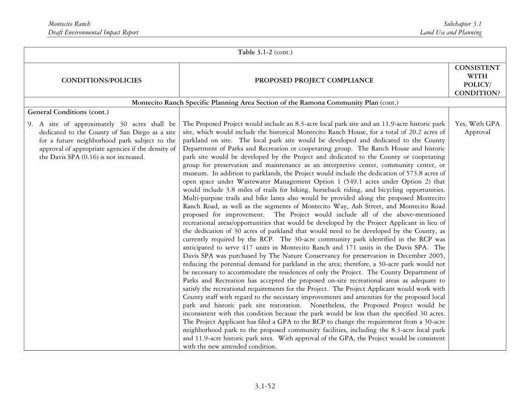
Montecito Ranch Subchapter 3.1 Draft Environmental Impact Report Land Use and Planning
3.1-52
Table 3.1-2 (cont.)
CONDITIONS/POLICIES PROPOSED PROJECT COMPLIANCE
CONSISTENT WITH
POLICY/ CONDITION?
Montecito Ranch Specific Planning Area Section of the Ramona Community Plan (cont.) General Conditions (cont.)
9. A site of approximately 30 acres shall be dedicated to the County of San Diego as a site for a future neighborhood park subject to the approval of appropriate agencies if the density of the Davis SPA (0.16) is not increased.
The Proposed Project would include an 8.3-acre local park site and an 11.9-acre historic park site, which would include the historical Montecito Ranch House, for a total of 20.2 acres of parkland on site. The local park site would be developed and dedicated to the County Department of Parks and Recreation or cooperating group. The Ranch House and historic park site would be developed by the Project and dedicated to the County or cooperating group for preservation and maintenance as an interpretive center, community center, or museum. In addition to parklands, the Project would include the dedication of 573.8 acres of open space under Wastewater Management Option 1 (549.1 acres under Option 2) that would include 3.8 miles of trails for hiking, horseback riding, and bicycling opportunities. Multi-purpose trails and bike lanes also would be provided along the proposed Montecito Ranch Road, as well as the segments of Montecito Way, Ash Street, and Montecito Road proposed for improvement. The Project would include all of the above-mentioned recreational areas/opportunities that would be developed by the Project Applicant in lieu of the dedication of 30 acres of parkland that would need to be developed by the County, as currently required by the RCP. The 30-acre community park identified in the RCP was anticipated to serve 417 units in Montecito Ranch and 171 units in the Davis SPA. The Davis SPA was purchased by The Nature Conservancy for preservation in December 2005, reducing the potential demand for parkland in the area; therefore, a 30-acre park would not be necessary to accommodate the residences of only the Project. The County Department of Parks and Recreation has accepted the proposed on-site recreational areas as adequate to satisfy the recreational requirements for the Project. The Project Applicant would work with County staff with regard to the necessary improvements and amenities for the proposed local park and historic park site restoration. Nonetheless, the Proposed Project would be inconsistent with this condition because the park would be less than the specified 30 acres. The Project Applicant has filed a GPA to the RCP to change the requirement from a 30-acre neighborhood park to the proposed community facilities, including the 8.3-acre local park and 11.9-acre historic park sites. With approval of the GPA, the Project would be consistent with the new amended condition.
Yes, With GPA Approval
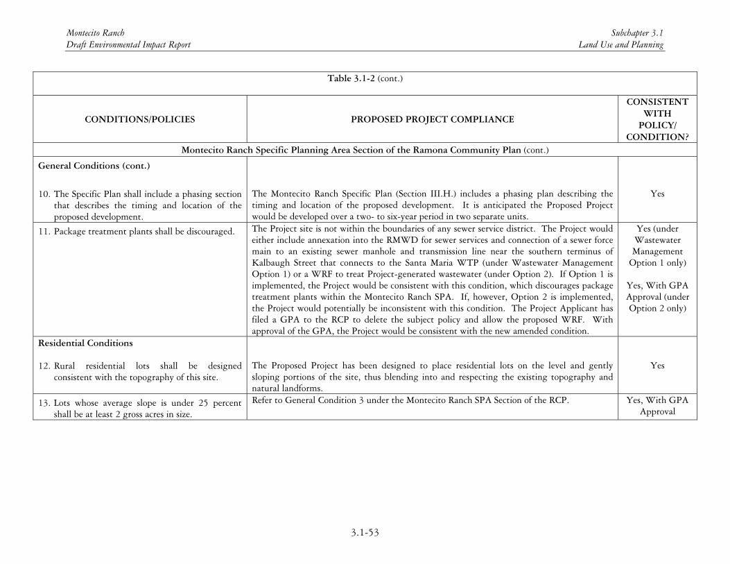
Montecito Ranch Subchapter 3.1 Draft Environmental Impact Report Land Use and Planning
3.1-53
Table 3.1-2 (cont.)
CONDITIONS/POLICIES PROPOSED PROJECT COMPLIANCE
CONSISTENT WITH
POLICY/ CONDITION?
Montecito Ranch Specific Planning Area Section of the Ramona Community Plan (cont.)
General Conditions (cont.) 10. The Specific Plan shall include a phasing section
that describes the timing and location of the proposed development.
The Montecito Ranch Specific Plan (Section III.H.) includes a phasing plan describing the timing and location of the proposed development. It is anticipated the Proposed Project would be developed over a two- to six-year period in two separate units.
Yes
11. Package treatment plants shall be discouraged. The Project site is not within the boundaries of any sewer service district. The Project would either include annexation into the RMWD for sewer services and connection of a sewer force main to an existing sewer manhole and transmission line near the southern terminus of Kalbaugh Street that connects to the Santa Maria WTP (under Wastewater Management Option 1) or a WRF to treat Project-generated wastewater (under Option 2). If Option 1 is implemented, the Project would be consistent with this condition, which discourages package treatment plants within the Montecito Ranch SPA. If, however, Option 2 is implemented, the Project would potentially be inconsistent with this condition. The Project Applicant has filed a GPA to the RCP to delete the subject policy and allow the proposed WRF. With approval of the GPA, the Project would be consistent with the new amended condition.
Yes (under Wastewater Management
Option 1 only)
Yes, With GPA Approval (under Option 2 only)
Residential Conditions 12. Rural residential lots shall be designed
consistent with the topography of this site.
The Proposed Project has been designed to place residential lots on the level and gently sloping portions of the site, thus blending into and respecting the existing topography and natural landforms.
Yes
13. Lots whose average slope is under 25 percent shall be at least 2 gross acres in size.
Refer to General Condition 3 under the Montecito Ranch SPA Section of the RCP. Yes, With GPA Approval

Montecito Ranch Subchapter 3.1 Draft Environmental Impact Report Land Use and Planning
3.1-54
Table 3.1-2 (cont.)
CONDITIONS/POLICIES PROPOSED PROJECT COMPLIANCE
CONSISTENT WITH
POLICY/ CONDITION?
Montecito Ranch Specific Planning Area Section of the Ramona Community Plan (cont.) Residential Conditions (cont.) 14. Lots whose average slope are 25 percent or over
shall be at least 4 gross acres in size.
None of the proposed residential lots has average slopes of 25 percent or greater.
Yes
15. The location of residential lots shall be based in part on a slope analysis, but also shall be based on the design guidelines of the Ramona Community Plan.
Proposed residential lots are generally located on the level and gently sloping portions of the site, based on both a slope analysis and the design guidelines of the RCP. Approximately 15.8 percent (147.89 acres) of the site is comprised of 25 percent or greater slopes. The majority of these slopes would be retained in their natural state through the dedication of open space. Additional existing natural features, such as drainages, rock outcroppings and sensitive vegetation would be retained as well. Much of the proposed open space area coincides with extremely steep slopes in the northern portion of the Project site. This open space area also has relatively high elevations and is highly visible from within and outside the Project site. Steep slopes associated with the on-site knolls and minor ridgelines also would be preserved.
Yes
16. Ridgeline development shall be discouraged. It should only be allowed if a viewshed analysis can show only minimal impact on adjacent properties and scenic roads identified in the Scenic Highways Element of the General Plan.
The Proposed Project development would occur primarily on level and gently sloping terrain. The prominent minor ridgeline, located along a portion of the southeastern boundary, would be preserved within dedicated open space, in addition to the knolls and steep hillsides. The steep hillsides in the northern portion of the Project site closest to SR 78, a designated Scenic Highway, also would be dedicated open space. Private views from north of Pine Street (SR 78), approximately 0.25 mile from the Project site, would capture proposed homes that would appear to line the ridgeline. These homes actually would be located behind the ridgeline, but would be visible in horizon views from the noted vantage point. Visible homes would be partially screened with Project landscaping compatible with existing vegetation that would soften their appearance and minimize skylining effect. Associated viewshed impacts would therefore be less than significant and the Project would be consistent with this condition.
Yes, With Project
Mitigation

Montecito Ranch Subchapter 3.1 Draft Environmental Impact Report Land Use and Planning
3.1-55
Table 3.1-2 (cont.)
CONDITIONS/POLICIES PROPOSED PROJECT COMPLIANCE
CONSISTENT WITH
POLICY/ CONDITION?
Montecito Ranch Specific Planning Area Section of the Ramona Community Plan (cont.) Residential Conditions (cont.) 16. (cont.)
The proposed off-site water tank would be located on a local hilltop (approximately 1,800 feet AMSL), and the associated access road would cut into steep hillsides. In some areas, cut slopes would occur up to 50 feet and the gradient would be steeper than 2:1. As in Subchapter 3.5, Aesthetics, the tank and cut slopes would substantially contrast with the surrounding topography, and would disrupt existing visual continuity. The resulting visual effects of this ridgeline development are discussed in Subchapter 3.5, Aesthetics, which identifies significant adverse visual impacts and required mitigation.
17. A system of streets or walkways shall link the home sites to the proposed neighborhood park.
The Project circulation plan includes an internal street network and an integrated system of multi-purpose trails that would link the residential areas with the proposed local park, historic park, and charter high school sites.
Yes
18. No residential or accessory structure shall be sited closer than one hundred feet (100’) from the Lemurian Fellowship property line.
No residential lots are proposed adjacent to (within 100 feet of) the Lemurian Fellowship property line. Areas adjacent to the Lemurian Fellowship property would be dedicated open space and include a community trail.
Yes
Recreational Conditions 19. If the density of the Davis Specific Planning
Area is increased from the existing 0.16 dwelling units per acre before the Montecito Ranch Specific Plan is approved, it is intended that the required 30-acre neighborhood park site be shared proportionately between the Montecito Ranch and Davis Specific Plans.
The Davis SPA was purchased by The Nature Conservancy for preservation in December 2005. Therefore, the park site would be provided by Montecito Ranch, without Davis SPA participation.
N/A

Montecito Ranch Subchapter 3.1 Draft Environmental Impact Report Land Use and Planning
3.1-56
Table 3.1-2 (cont.)
CONDITIONS/POLICIES PROPOSED PROJECT COMPLIANCE
CONSISTENT WITH
POLICY/ CONDITION?
Montecito Ranch Specific Planning Area Section of the Ramona Community Plan (cont.) Recreational Conditions (cont.) 20. A trails map shall be prepared as part of the
Specific Plan. The trails map shall link this project to any adopted trail system within the Ramona Community Plan or the County Regional Land Use Element. The Department of Public Works shall ensure that the applicant installs appropriate trail marker signs, and, if necessary, barriers to prevent the intrusion of motorized vehicles on the trail.
The Ramona Community Trail Plan Map (County 2005) shows a proposed community trail along the majority of an existing dirt road within the Project site (Figure 1-36). This proposed trail connects to planned community pathways along Ash Street and Montecito Way. The Proposed Project would require an amendment to the existing Ramona Community Trail Plan Map to remove the proposed community trail along the dirt road on site and add a proposed community trail along the entire length of proposed Montecito Ranch Road (Figure 1-37). The Proposed Project would include an integrated system of multi-purpose trails that would provide connections to these proposed trails/pathways (Figure 1-35). An eight-foot-wide meandering trail is proposed along the entire length of Montecito Ranch Road that would connect with planned trails at Ash Street and Montecito Way. Eight-foot-wide trails are proposed through dedicated open space in the western portion of the site, including trails that would connect with (1) the noted planned regional trail along Montecito Ranch Road to the northwestern Project site boundary, (2) the trail along Montecito Way, near the park and charter high school sites, continuing through the southeastern portion of the site and along Summer Glen Road, and (3) the planned regional trail along Montecito Ranch Road to the south of the historic park site, continuing west and north to the Project site boundary. These proposed on-site trails would provide connectivity through the property, as well as access to some of the exceptional natural features found on the property. Trail marker signs and barriers would be provided, as appropriate. With approval of the proposed Trail Plan Map Amendment, the Proposed Project would be consistent with this condition.
Yes, With GPA Approval

Montecito Ranch Subchapter 3.1 Draft Environmental Impact Report Land Use and Planning
3.1-57
Table 3.1-2 (cont.)
CONDITIONS/POLICIES PROPOSED PROJECT COMPLIANCE
CONSISTENT WITH
POLICY/ CONDITION?
Montecito Ranch Specific Planning Area Section of the Ramona Community Plan (cont.)
Recreational Conditions (cont.) 21. No active recreational uses shall be located
adjacent to the Lemurian Fellowship property.
Proposed on-site land uses adjacent to the Lemurian Fellowship property line would consist of dedicated open space and a community trail and would not include active recreational uses.
Yes
22. The oak woodlands of the Weekend Villa area shall be preserved as open space for the enjoyment of the residents of the Specific Plan Area.
Proposed impacts to 1.32 acres of oak woodlands (including oak root zones) would occur outside of the Weekend Villas portion of the SPA (REC 2008b). Oak woodlands within the Weekend Villa area would be preserved and dedicated as open space.
Yes
Industrial Conditions 23. Industrial uses may be permitted west of
Montecito Way in an area to be determined by a future analysis of the industrial needs of the community of Ramona.
No industrial uses are proposed; therefore, this condition does not apply. The area west of Montecito Way would be dedicated as open space and would not be available for future development.
N/A
24. Before additional industrial acreage is allowed to develop south or north of the Ramona Airport, an Industrial Needs Study will have to show that there exists a need for the proposed size and type of development could not be provided on the existing industrially zoned acreage around the airport.
No industrial uses are proposed; therefore, this condition does not apply. N/A
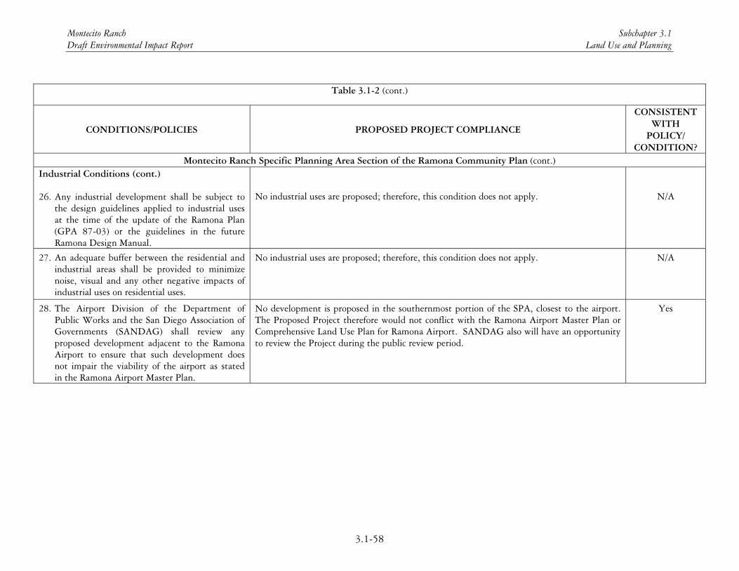
Montecito Ranch Subchapter 3.1 Draft Environmental Impact Report Land Use and Planning
3.1-58
Table 3.1-2 (cont.)
CONDITIONS/POLICIES PROPOSED PROJECT COMPLIANCE
CONSISTENT WITH
POLICY/ CONDITION?
Montecito Ranch Specific Planning Area Section of the Ramona Community Plan (cont.) Industrial Conditions (cont.) 26. Any industrial development shall be subject to
the design guidelines applied to industrial uses at the time of the update of the Ramona Plan (GPA 87-03) or the guidelines in the future Ramona Design Manual.
No industrial uses are proposed; therefore, this condition does not apply.
N/A
27. An adequate buffer between the residential and industrial areas shall be provided to minimize noise, visual and any other negative impacts of industrial uses on residential uses.
No industrial uses are proposed; therefore, this condition does not apply. N/A
28. The Airport Division of the Department of Public Works and the San Diego Association of Governments (SANDAG) shall review any proposed development adjacent to the Ramona Airport to ensure that such development does not impair the viability of the airport as stated in the Ramona Airport Master Plan.
No development is proposed in the southernmost portion of the SPA, closest to the airport. The Proposed Project therefore would not conflict with the Ramona Airport Master Plan or Comprehensive Land Use Plan for Ramona Airport. SANDAG also will have an opportunity to review the Project during the public review period.
Yes

Montecito Ranch Subchapter 3.1 Draft Environmental Impact Report Land Use and Planning
3.1-59
Table 3.1-2 (cont.)
CONDITIONS/POLICIES PROPOSED PROJECT COMPLIANCE
CONSISTENT WITH
POLICY/ CONDITION?
Montecito Ranch Specific Planning Area Section of the Ramona Community Plan (cont.)
Design Guidelines 29. To ensure that the design of the proposed
neighborhoods and community areas maintains a sense of variety without sacrificing unity, the Specific Plan shall include a Design Plan that illustrates the intended character of individual neighborhoods and community areas.
The proposed MUPs contain comprehensive design guidelines and development standards intended to reinforce the existing rural community character of the Project area (refer to Sections II and III of the MUPs). The Proposed Project is divided into eight residential neighborhoods. The proposed local park, historic park and school site add to the sense of community within Montecito Ranch.
Yes
30. The Design Plan shall contain the following elements: community architecture; residential, commercial, or industrial architecture; landscape plan; fencing; lighting; signage; off-street parking; and street furniture (bus benches, fire hydrants, post boxes, utility company boxes, etc.).
The proposed MUPs contain detailed design guidelines and development standards addressing each of the required elements (refer to Sections II and III of the MUPs).
Yes
31. The Design Plan shall also contain proposed Conditions, Covenants and Restrictions (CC&Rs) or other design/aesthetic control mechanisms.
The proposed MUPs include specific design guidelines and development standards, and allow the adoption of CC&Rs for the entire project and within individual neighborhoods to maintain and enforce applicable standards (refer to Sections II and III of the MUPs).
Yes
Conservation/Environmental Conditions 32. Existing rock outcroppings shall be preserved
and integrated into the development of the site.
The Montecito Ranch SPA is characterized by large granitic outcroppings interspersed throughout the site. The Proposed Project has been designed to maximize preservation of existing rock outcroppings to the maximum extent possible and integrate them into the Project design. Although minor impacts to select large rocks would occur during development of the Project, the prominent rock outcrops would be retained.
Yes
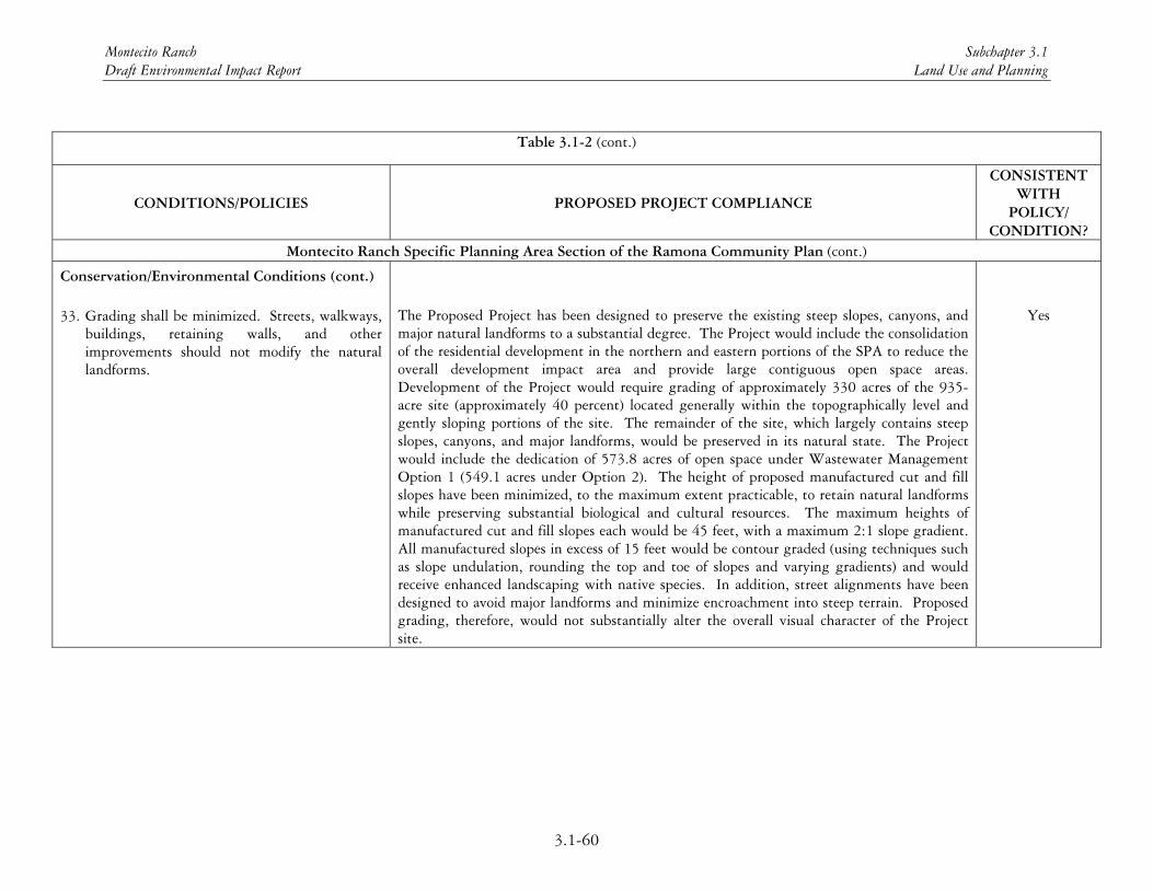
Montecito Ranch Subchapter 3.1 Draft Environmental Impact Report Land Use and Planning
3.1-60
Table 3.1-2 (cont.)
CONDITIONS/POLICIES PROPOSED PROJECT COMPLIANCE
CONSISTENT WITH
POLICY/ CONDITION?
Montecito Ranch Specific Planning Area Section of the Ramona Community Plan (cont.)
Conservation/Environmental Conditions (cont.)
33. Grading shall be minimized. Streets, walkways, buildings, retaining walls, and other improvements should not modify the natural landforms.
The Proposed Project has been designed to preserve the existing steep slopes, canyons, and major natural landforms to a substantial degree. The Project would include the consolidation of the residential development in the northern and eastern portions of the SPA to reduce the overall development impact area and provide large contiguous open space areas. Development of the Project would require grading of approximately 330 acres of the 935-acre site (approximately 40 percent) located generally within the topographically level and gently sloping portions of the site. The remainder of the site, which largely contains steep slopes, canyons, and major landforms, would be preserved in its natural state. The Project would include the dedication of 573.8 acres of open space under Wastewater Management Option 1 (549.1 acres under Option 2). The height of proposed manufactured cut and fill slopes have been minimized, to the maximum extent practicable, to retain natural landforms while preserving substantial biological and cultural resources. The maximum heights of manufactured cut and fill slopes each would be 45 feet, with a maximum 2:1 slope gradient. All manufactured slopes in excess of 15 feet would be contour graded (using techniques such as slope undulation, rounding the top and toe of slopes and varying gradients) and would receive enhanced landscaping with native species. In addition, street alignments have been designed to avoid major landforms and minimize encroachment into steep terrain. Proposed grading, therefore, would not substantially alter the overall visual character of the Project site.
Yes
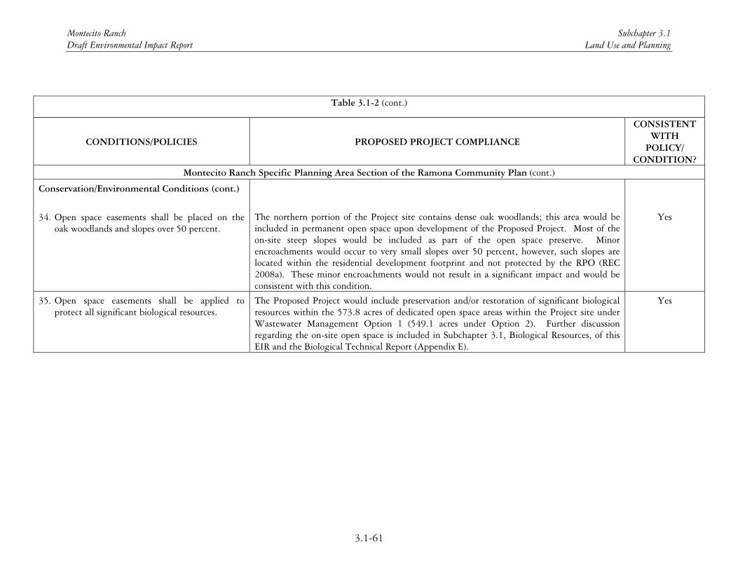
Montecito Ranch Subchapter 3.1 Draft Environmental Impact Report Land Use and Planning
3.1-61
Table 3.1-2 (cont.)
CONDITIONS/POLICIES PROPOSED PROJECT COMPLIANCE
CONSISTENT WITH
POLICY/ CONDITION?
Montecito Ranch Specific Planning Area Section of the Ramona Community Plan (cont.)
Conservation/Environmental Conditions (cont.) 34. Open space easements shall be placed on the
oak woodlands and slopes over 50 percent.
The northern portion of the Project site contains dense oak woodlands; this area would be included in permanent open space upon development of the Proposed Project. Most of the on-site steep slopes would be included as part of the open space preserve. Minor encroachments would occur to very small slopes over 50 percent, however, such slopes are located within the residential development footprint and not protected by the RPO (REC 2008a). These minor encroachments would not result in a significant impact and would be consistent with this condition.
Yes
35. Open space easements shall be applied to protect all significant biological resources.
The Proposed Project would include preservation and/or restoration of significant biological resources within the 573.8 acres of dedicated open space areas within the Project site under Wastewater Management Option 1 (549.1 acres under Option 2). Further discussion regarding the on-site open space is included in Subchapter 3.1, Biological Resources, of this EIR and the Biological Technical Report (Appendix E).
Yes

Montecito Ranch Subchapter 3.1 Draft Environmental Impact Report Land Use and Planning
3.1-62
Table 3.1-2 (cont.)
CONDITIONS/POLICIES PROPOSED PROJECT COMPLIANCE
CONSISTENT WITH
POLICY/ CONDITION?
Montecito Ranch Specific Planning Area Section of the Ramona Community Plan (cont.) Conservation/Environmental Conditions (cont.) 36. Groundwater quality may be impacted by this
project and by surrounding uses. It may be necessary for this development to be served by Ramona Municipal Water District (RMWD). Special considerations shall be given to surrounding property owners.
The Proposed Project does not propose the use of groundwater. The proposed development areas are within the RMWD water service area and the RMWD would provide water service to the Project. Two off-site water lines would be constructed to connect with existing off-site water pipelines.
Yes
37. High quality chaparral and Diegan coastal sage scrub habitat found in the northern portion of the site shall be preserved.
The northern portion of the site (generally north of the existing dirt road that laterally traverses the site) is dominated by southern mixed chaparral interspersed with a few small patches of chamise chaparral and Diegan coastal sage scrub. Moderate quality Diegan coastal sage scrub is located throughout the SPA. Some high quality Diegan coastal sage scrub occurs in the eastern-central portion of the SPA. The majority of the high and moderate qualities of Diegan coastal sage scrub would be preserved on site. The Proposed Project would dedicate approximately 78.3 percent (249.62 acres) of the site’s Diegan coastal sage scrub as open space. The Project also would dedicate approximately 46.2 percent (105.83 acres) of the site’s southern mixed chaparral and 54.1 percent (13.63 acres) of the site’s chamise chaparral, most of which is located in the northern portion of the site, as open space. The Proposed Project would mitigate impacts to these sensitive habitats via on-site habitat preservation.
Yes
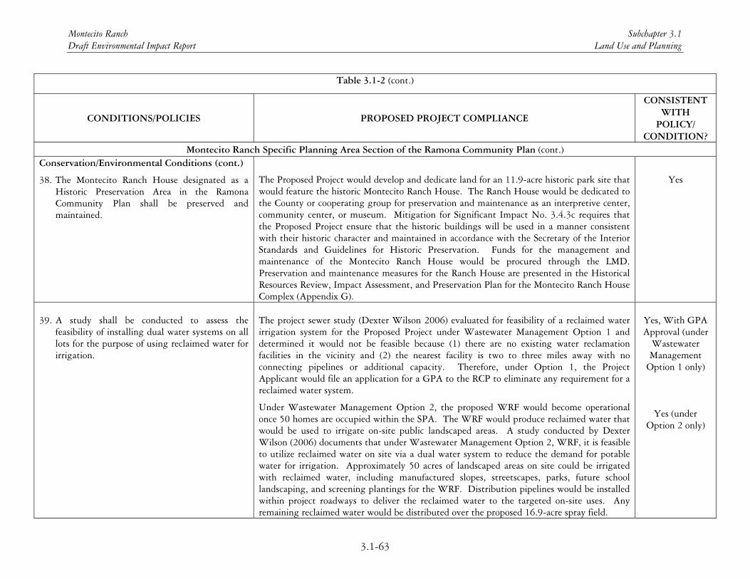
Montecito Ranch Subchapter 3.1 Draft Environmental Impact Report Land Use and Planning
3.1-63
Table 3.1-2 (cont.)
CONDITIONS/POLICIES PROPOSED PROJECT COMPLIANCE
CONSISTENT WITH
POLICY/ CONDITION?
Montecito Ranch Specific Planning Area Section of the Ramona Community Plan (cont.) Conservation/Environmental Conditions (cont.)
38. The Montecito Ranch House designated as a Historic Preservation Area in the Ramona Community Plan shall be preserved and maintained.
The Proposed Project would develop and dedicate land for an 11.9-acre historic park site that would feature the historic Montecito Ranch House. The Ranch House would be dedicated to the County or cooperating group for preservation and maintenance as an interpretive center, community center, or museum. Mitigation for Significant Impact No. 3.4.3c requires that the Proposed Project ensure that the historic buildings will be used in a manner consistent with their historic character and maintained in accordance with the Secretary of the Interior Standards and Guidelines for Historic Preservation. Funds for the management and maintenance of the Montecito Ranch House would be procured through the LMD. Preservation and maintenance measures for the Ranch House are presented in the Historical Resources Review, Impact Assessment, and Preservation Plan for the Montecito Ranch House Complex (Appendix G).
Yes
39. A study shall be conducted to assess the
feasibility of installing dual water systems on all lots for the purpose of using reclaimed water for irrigation.
The project sewer study (Dexter Wilson 2006) evaluated for feasibility of a reclaimed water irrigation system for the Proposed Project under Wastewater Management Option 1 and determined it would not be feasible because (1) there are no existing water reclamation facilities in the vicinity and (2) the nearest facility is two to three miles away with no connecting pipelines or additional capacity. Therefore, under Option 1, the Project Applicant would file an application for a GPA to the RCP to eliminate any requirement for a reclaimed water system.
Under Wastewater Management Option 2, the proposed WRF would become operational once 50 homes are occupied within the SPA. The WRF would produce reclaimed water that would be used to irrigate on-site public landscaped areas. A study conducted by Dexter Wilson (2006) documents that under Wastewater Management Option 2, WRF, it is feasible to utilize reclaimed water on site via a dual water system to reduce the demand for potable water for irrigation. Approximately 50 acres of landscaped areas on site could be irrigated with reclaimed water, including manufactured slopes, streetscapes, parks, future school landscaping, and screening plantings for the WRF. Distribution pipelines would be installed within project roadways to deliver the reclaimed water to the targeted on-site uses. Any remaining reclaimed water would be distributed over the proposed 16.9-acre spray field.
Yes, With GPA Approval (under
Wastewater Management
Option 1 only)
Yes (under Option 2 only)

Montecito Ranch Subchapter 3.1 Draft Environmental Impact Report Land Use and Planning
3.1-64
Table 3.1-2 (cont.)
CONDITIONS/POLICIES PROPOSED PROJECT COMPLIANCE
CONSISTENT WITH
POLICY/ CONDITION?
Montecito Ranch Specific Planning Area Section of the Ramona Community Plan (cont.)
Agricultural Conditions 40. Future potential agricultural uses located within
the property shall be defined by more detailed study to determine not only the precise areas for agricultural production, but also the economic considerations associated with that use.
The Proposed Project includes a GPA to remove this condition that is currently associated with the Project site. The proposed removal of this condition would not result in any significant impacts related to conflicts or non-conformance with the RCP (or other local planning documents), based on the following considerations. An Agricultural Technical Study (HELIX and CIC Research 2008) was conducted for the Project site, with the results of this study summarized in Section 4.1.3, Agricultural Resources. The Agricultural Technical Study includes evaluations of agricultural resources, operations, and development potential within the Project site and associated off-site areas. Specific methods used for this analysis include: (1) the LESA Model; (2) assessment of impacts to CDC Important Farmlands and NRCS Prime Farmland Soils; (3) evaluation of off-site impacts to agricultural resources and operations; (4) assessment of indirect impacts to and from the Proposed Project; and (5) evaluation of cumulative impacts. Based on the results of these investigations, the Project Agricultural Technical Study concludes that agricultural use of the Project site is not viable, and that no significant impacts related to the conversion of the site to non-agricultural use would result from Project implementation. Accordingly, the requirements of this condition have been met through the Project Agricultural Technical Study, with no conflicts or non-conformance related to the RCP (or other local planning documents) to result from the removal of this condition.
N/A, With GPA Approval

Montecito Ranch Subchapter 3.1 Draft Environmental Impact Report Land Use and Planning
3.1-65
Table 3.1-2 (cont.)
CONDITIONS/POLICIES PROPOSED PROJECT COMPLIANCE
CONSISTENT WITH
POLICY/ CONDITION?
Montecito Ranch Specific Planning Area Section of the Ramona Community Plan (cont.) Agricultural Conditions (cont.) 41. The minimum lot size permitted within any
future agricultural pursuit area shall also be determined by the above analysis. It is presently intended that a minimum lot size of four acres be allowed within that area, and the above study shall address any modifications to that requirement.
The Proposed Project includes a GPA to remove this condition. The proposed removal of this condition would not result in any significant impacts related to conflicts or non-conformance with the RCP (or other local planning documents). The intent of this condition is to determine the appropriate minimum lot size based on the above-described Agricultural Technical Study. Proposed development would include Specific Plan land use and zoning designations for the entire site, with lot sizes ranging from approximately 0.5 to 1.8 acre. Based on the above-described conclusions in the Agricultural Technical Study, the proposed lot sizes are appropriate for the Project site and the related removal of this condition would not result in any conflicts or non-conformance with the RCP (or other local planning documents).
N/A, With GPA Approval
42. The approximately 103 acres of prime agricultural soils identified as Visalia sandy loams (VaA and VaB), Fallbrook sandy loam (RaB) located in the southwest portion of the Montecito Ranch property, shall be preserved for agricultural pursuits. Any lot created on these 103 acres shall be identified as agricultural lots.
The Proposed Project includes a GPA to remove this condition. The proposed removal of this condition would not result in any significant impacts related to conflicts or non-conformance with the RCP (or other local planning documents). The on-site soils referenced in this condition correspond to the previously noted NRCS Prime Farmland Soils, with approximately 107.1 acres of these soils located within the Project site (including the southwestern portion of the site as noted, and the northeastern site corner). Of the approximately 103 acres of Prime Farmland Soils located in the southwest portion of the site, approximately 64.4 acres are located within an existing biological open space easement and
N/A, With GPA Approval

Montecito Ranch Subchapter 3.1 Draft Environmental Impact Report Land Use and Planning
3.1-66
Table 3.1-2 (cont.)
CONDITIONS/POLICIES PROPOSED PROJECT COMPLIANCE
CONSISTENT WITH
POLICY/ CONDITION?
Montecito Ranch Specific Planning Area Section of the Ramona Community Plan (cont.) Agricultural Conditions (cont.) 42. (cont.)
are unavailable for agricultural use (with the noted easement provided as mitigation for previous farming-related impacts). Approximately 6.3 acres within the remaining 38.6-acre area are proposed for dedication as biological open space, due to the presence of sensitive habitats (i.e., Diegan coastal sage scrub). This area is also considered unavailable for agricultural use, due to the prohibitive costs associated with mitigating related biological impacts (e.g., purchasing off-site habitat credits). The remaining 32.3 acres of Prime Farmland Soils, while technically available for agricultural use, would be subject to other potential constraints that could affect the ability to farm this area. Specifically, portions of the described area encompass additional sensitive biological resources, including jurisdictional wetlands and non-native grassland, with agricultural use of these areas likely subject to associated mitigation requirements similar to those noted above. In addition, as discussed for Condition 40, the Project Agricultural Technical Study concluded that agricultural use of the Project site as a whole is not viable, based on considerations including the LESA Model analysis and the nature of on- and off-site resources. Specific factors leading to this conclusion included the lack of CDC-designated Important Farmlands on-site, as well as the fact that sufficient water to support irrigated cultivation is not currently available. As a result of the described conditions, the majority (69 percent) of the 103-acre area of Prime Farmland Soils identified in Condition 42 of the RCP is currently unavailable for agricultural use, with the remaining areas likely subject to additional restrictions/costs and potential agricultural uses limited mainly to dryland farming or animal operations (e.g., cattle grazing). Based on the described restrictions and limitations to agricultural use of on-site Prime Farmland Soils, the removal of this condition would not result in any conflicts or non-conformance with the RCP (or other local planning documents).

Montecito Ranch Subchapter 3.1 Draft Environmental Impact Report Land Use and Planning
3.1-67
Table 3.1-2 (cont.)
CONDITIONS/POLICIES PROPOSED PROJECT COMPLIANCE
CONSISTENT WITH
POLICY/ CONDITION?
Montecito Ranch Specific Planning Area Section of the Ramona Community Plan (cont.)
Utilities Condition 43. All utilities shall be undergrounded where
feasible.
All proposed new utilities extensions located on site to serve the Proposed Project would be installed underground, including water (potable and, under Wastewater Management Option 2, reclaimed), sewer, telephone, electricity, natural gas, and cable television (refer to Chapter 1.0 for additional details).
Yes
Public Facilities Conditions 44. The Specific Plan text shall include a financing
plan outlining capital improvements necessary to implement the proposed project.
Section III of the Montecito Ranch Specific Plan describes the necessary improvements, phasing, and Public Facilities Finance Plan (PFFP) for the Proposed Project. The types of facilities addressed in the Specific Plan include, but are not limited to, on-site circulation, trails, off-site traffic mitigation, on- and off-site utility improvements, local park, historic park, and charter high school. Besides traditional development capital and finance, several programs may be implemented to fund construction including, but not limited to, 1911 and 1913 Bond Act Assessment Districts, Mello-Roos Assessment Districts and other private, and public or semi-public bond or finance mechanisms permitted under County policy and procedures.
Yes
45. This financing plan shall include an outline of the mechanisms to be employed to build new facilities, to connect to existing facilities and to fund the needed on-site and off-site facilities.
The Montecito Ranch Specific Plan includes a discussion of possible public facilities financing mechanisms.
Yes
46. A map showing the location of public facilities currently serving the Specific Plan is required, along with an assessment of the adequacy of those facilities.
The Montecito Ranch GPA Report includes a map depicting the location of existing and proposed facilities. An assessment of the state and adequacy of existing facilities accompanies the map along with a discussion of the proposed facilities necessary to adequately meet the service needs of the Project.
Yes

Montecito Ranch Subchapter 3.1 Draft Environmental Impact Report Land Use and Planning
3.1-68
Table 3.1-2 (cont.)
CONDITIONS/POLICIES PROPOSED PROJECT COMPLIANCE
CONSISTENT WITH
POLICY/ CONDITION?
Montecito Ranch Specific Planning Area Section of the Ramona Community Plan (cont.)
Public Facilities Conditions (cont.) 47. The types of facilities to be addressed in the
financing plan shall include: the transportation network; sewage, water and drainage systems; solid waste disposal facilities; fire protection and emergency medical facilities; energy facilities (minor emphasis); and other essential facilities (e.g., law enforcement, library, animal control facilities) which may be required due to the unique characteristics of the Specific Plan Area.
The types of facilities addressed in the Montecito Ranch GPA Report include the transportation network; sewage, water, and drainage systems; solid waste disposal facilities; fire protection and emergency medical services; energy facilities; and other essential public facilities (i.e., police protection, libraries, animal control).
Yes
48. The financing plan shall include detailed information on the size and scope of all needed capital improvements, the estimated costs of such improvements, and the financing mechanisms to be used to fund the improvements. Supplemental information on on-going operational expense estimates may be required by the Department of Planning and Land Use in certain circumstances. In all cases in which package treatment plants are proposed for solid waste disposal, on-going operational expense and revenue estimates are required.
The Montecito Ranch GPA Report includes a financing plan generally outlining the improvements necessary to implement the Project. The report also includes a discussion of phasing of improvements, as well as possible financing mechanisms.
Yes
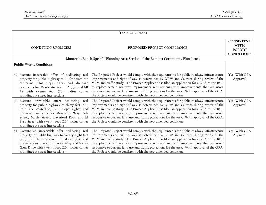
Montecito Ranch Subchapter 3.1 Draft Environmental Impact Report Land Use and Planning
3.1-69
Table 3.1-2 (cont.)
CONDITIONS/POLICIES PROPOSED PROJECT COMPLIANCE
CONSISTENT WITH
POLICY/ CONDITION?
Montecito Ranch Specific Planning Area Section of the Ramona Community Plan (cont.)
Public Works Conditions 49. Execute irrevocable offers of dedicating real
property for public highway to 42 feet from the centerline, plus slope rights and drainage easements for Montecito Road, SA 330 and SR 78 with twenty foot (20’) radius corner roundings at street intersections.
The Proposed Project would comply with the requirements for public roadway infrastructure improvements and right-of-way as determined by DPW and Caltrans during review of the VTM and traffic study. The Project Applicant has filed an application for a GPA to the RCP to replace certain roadway improvement requirements with improvements that are more responsive to current land use and traffic projections for the area. With approval of the GPA, the Project would be consistent with the new amended condition.
Yes, With GPA Approval
50. Execute irrevocable offers dedicating real property for public highway to thirty feet (30’) from the centerline, plus slope rights and drainage easements for Montecito Way, Ash Street, Maple Street, Haverford Road and El Paso Street with twenty foot (20’) radius corner roundings at street intersections.
The Proposed Project would comply with the requirements for public roadway infrastructure improvements and right-of-way as determined by DPW and Caltrans during review of the VTM and traffic study. The Project Applicant has filed an application for a GPA to the RCP to replace certain roadway improvement requirements with improvements that are more responsive to current land use and traffic projections for the area. With approval of the GPA, the Project would be consistent with the new amended condition.
Yes, With GPA Approval
51. Execute an irrevocable offer dedicating real property for public highway to twenty-eight feet (28’) from the centerline, plus slope rights and drainage easements for Sonora Way and Somer Glen Drive with twenty-foot (20’) radius corner roundings at street intersections.
The Proposed Project would comply with the requirements for public roadway infrastructure improvements and right-of-way as determined by DPW and Caltrans during review of the VTM and traffic study. The Project Applicant has filed an application for a GPA to the RCP to replace certain roadway improvement requirements with improvements that are more responsive to current land use and traffic projections for the area. With approval of the GPA, the Project would be consistent with the new amended condition.
Yes, With GPA Approval
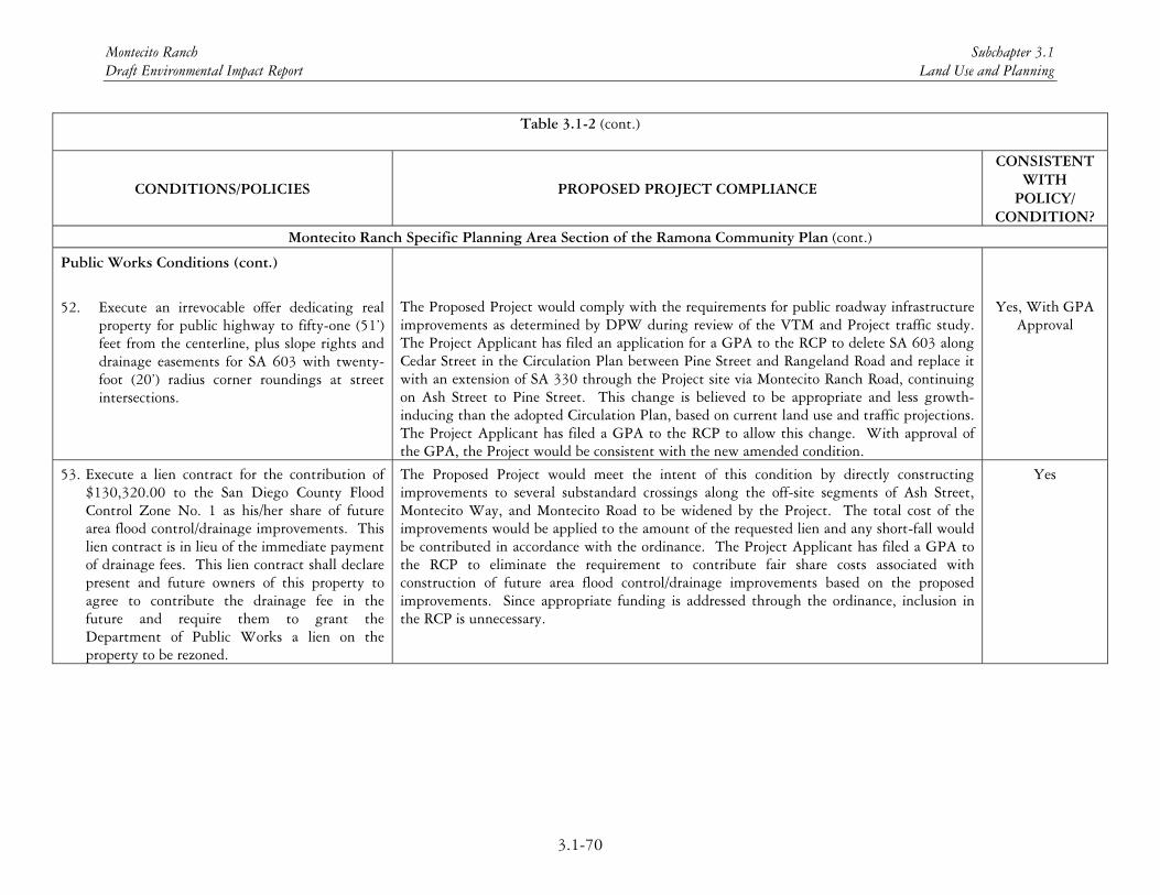
Montecito Ranch Subchapter 3.1 Draft Environmental Impact Report Land Use and Planning
3.1-70
Table 3.1-2 (cont.)
CONDITIONS/POLICIES PROPOSED PROJECT COMPLIANCE
CONSISTENT WITH
POLICY/ CONDITION?
Montecito Ranch Specific Planning Area Section of the Ramona Community Plan (cont.)
Public Works Conditions (cont.) 52. Execute an irrevocable offer dedicating real
property for public highway to fifty-one (51’) feet from the centerline, plus slope rights and drainage easements for SA 603 with twenty-foot (20’) radius corner roundings at street intersections.
The Proposed Project would comply with the requirements for public roadway infrastructure improvements as determined by DPW during review of the VTM and Project traffic study. The Project Applicant has filed an application for a GPA to the RCP to delete SA 603 along Cedar Street in the Circulation Plan between Pine Street and Rangeland Road and replace it with an extension of SA 330 through the Project site via Montecito Ranch Road, continuing on Ash Street to Pine Street. This change is believed to be appropriate and less growth-inducing than the adopted Circulation Plan, based on current land use and traffic projections. The Project Applicant has filed a GPA to the RCP to allow this change. With approval of the GPA, the Project would be consistent with the new amended condition.
Yes, With GPA Approval
53. Execute a lien contract for the contribution of $130,320.00 to the San Diego County Flood Control Zone No. 1 as his/her share of future area flood control/drainage improvements. This lien contract is in lieu of the immediate payment of drainage fees. This lien contract shall declare present and future owners of this property to agree to contribute the drainage fee in the future and require them to grant the Department of Public Works a lien on the property to be rezoned.
The Proposed Project would meet the intent of this condition by directly constructing improvements to several substandard crossings along the off-site segments of Ash Street, Montecito Way, and Montecito Road to be widened by the Project. The total cost of the improvements would be applied to the amount of the requested lien and any short-fall would be contributed in accordance with the ordinance. The Project Applicant has filed a GPA to the RCP to eliminate the requirement to contribute fair share costs associated with construction of future area flood control/drainage improvements based on the proposed improvements. Since appropriate funding is addressed through the ordinance, inclusion in the RCP is unnecessary.
Yes
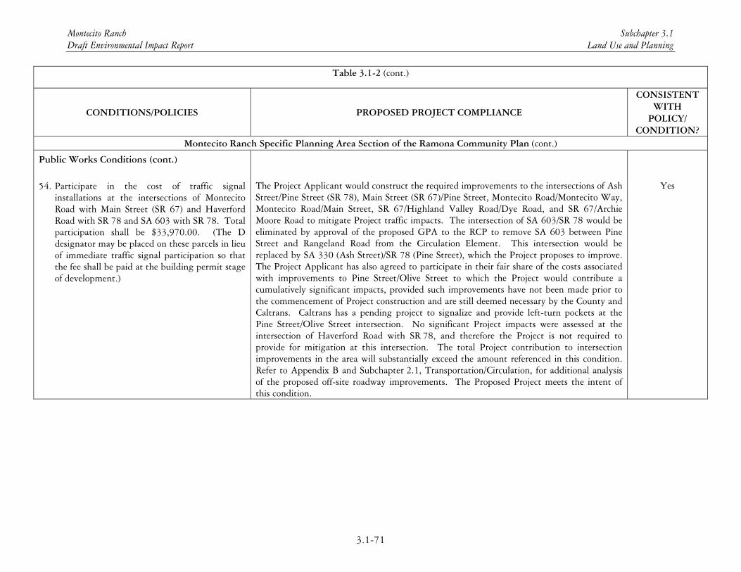
Montecito Ranch Subchapter 3.1 Draft Environmental Impact Report Land Use and Planning
3.1-71
Table 3.1-2 (cont.)
CONDITIONS/POLICIES PROPOSED PROJECT COMPLIANCE
CONSISTENT WITH
POLICY/ CONDITION?
Montecito Ranch Specific Planning Area Section of the Ramona Community Plan (cont.)
Public Works Conditions (cont.)
54. Participate in the cost of traffic signal installations at the intersections of Montecito Road with Main Street (SR 67) and Haverford Road with SR 78 and SA 603 with SR 78. Total participation shall be $33,970.00. (The D designator may be placed on these parcels in lieu of immediate traffic signal participation so that the fee shall be paid at the building permit stage of development.)
The Project Applicant would construct the required improvements to the intersections of Ash Street/Pine Street (SR 78), Main Street (SR 67)/Pine Street, Montecito Road/Montecito Way, Montecito Road/Main Street, SR 67/Highland Valley Road/Dye Road, and SR 67/Archie Moore Road to mitigate Project traffic impacts. The intersection of SA 603/SR 78 would be eliminated by approval of the proposed GPA to the RCP to remove SA 603 between Pine Street and Rangeland Road from the Circulation Element. This intersection would be replaced by SA 330 (Ash Street)/SR 78 (Pine Street), which the Project proposes to improve. The Project Applicant has also agreed to participate in their fair share of the costs associated with improvements to Pine Street/Olive Street to which the Project would contribute a cumulatively significant impacts, provided such improvements have not been made prior to the commencement of Project construction and are still deemed necessary by the County and Caltrans. Caltrans has a pending project to signalize and provide left-turn pockets at the Pine Street/Olive Street intersection. No significant Project impacts were assessed at the intersection of Haverford Road with SR 78, and therefore the Project is not required to provide for mitigation at this intersection. The total Project contribution to intersection improvements in the area will substantially exceed the amount referenced in this condition. Refer to Appendix B and Subchapter 2.1, Transportation/Circulation, for additional analysis of the proposed off-site roadway improvements. The Proposed Project meets the intent of this condition.
Yes

Montecito Ranch Subchapter 3.1 Draft Environmental Impact Report Land Use and Planning
3.1-72
Table 3.1-2 (cont.)
CONDITIONS/POLICIES PROPOSED PROJECT COMPLIANCE
CONSISTENT WITH
POLICY/ CONDITION?
Community Character Element of the Ramona Community Plan Policies 1. Mature trees should be conserved wherever
possible in all public and private development projects.
As discussed above in Condition 34 of the Montecito Ranch SPA Section of the RCP, the Proposed Project would preserve all of the oak woodlands in the northern portion of the SPA site in dedicated open space (REC 2008b). In addition to the oaks, one stand of mature eucalyptus trees, located in the south central portion of the SPA would be preserved within dedicated open space. Where prominent mature trees that substantially contribute to the visual environment are lost due to proposed off-site road widening (e.g. along Ash Street, Montecito Way, and Montecito Road), such trees would be replaced in sufficient size and quantity to mitigate potential visual impacts (see Subchapter 3.5, Aesthetics). Impacts to trees comprising sensitive vegetation communities would be mitigated accordingly (via biology mitigation measures). The Proposed Project would be consistent with this policy.
Yes, With Project
Mitigation
3. Site design should include appropriate street tree planting as an element of landscaping requirements.
The landscape design guidelines within the proposed Montecito Ranch MUP require provision of street trees along all Project roadways. Street trees would consist of a variety of native and non-native species, to be visually compatible with the existing rural community character. Therefore, the Proposed Project would be consistent with this policy.
Yes
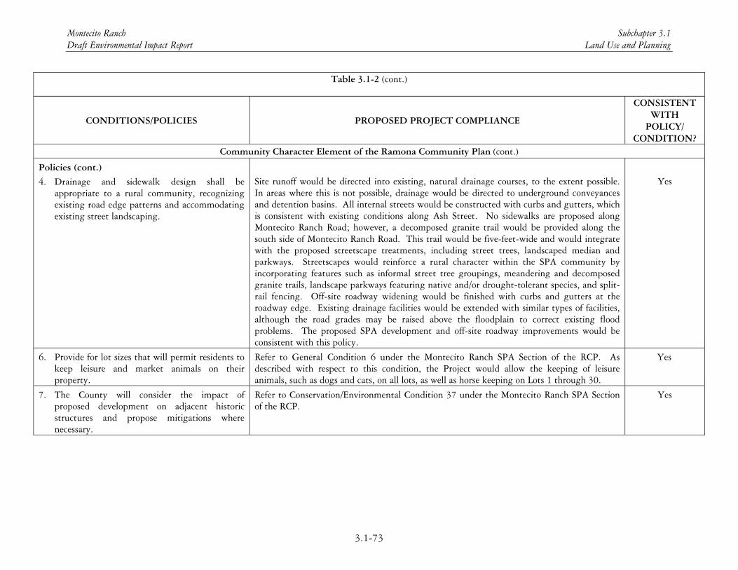
Montecito Ranch Subchapter 3.1 Draft Environmental Impact Report Land Use and Planning
3.1-73
Table 3.1-2 (cont.)
CONDITIONS/POLICIES PROPOSED PROJECT COMPLIANCE
CONSISTENT WITH
POLICY/ CONDITION?
Community Character Element of the Ramona Community Plan (cont.)
Policies (cont.) 4. Drainage and sidewalk design shall be
appropriate to a rural community, recognizing existing road edge patterns and accommodating existing street landscaping.
Site runoff would be directed into existing, natural drainage courses, to the extent possible. In areas where this is not possible, drainage would be directed to underground conveyances and detention basins. All internal streets would be constructed with curbs and gutters, which is consistent with existing conditions along Ash Street. No sidewalks are proposed along Montecito Ranch Road; however, a decomposed granite trail would be provided along the south side of Montecito Ranch Road. This trail would be five-feet-wide and would integrate with the proposed streetscape treatments, including street trees, landscaped median and parkways. Streetscapes would reinforce a rural character within the SPA community by incorporating features such as informal street tree groupings, meandering and decomposed granite trails, landscape parkways featuring native and/or drought-tolerant species, and split-rail fencing. Off-site roadway widening would be finished with curbs and gutters at the roadway edge. Existing drainage facilities would be extended with similar types of facilities, although the road grades may be raised above the floodplain to correct existing flood problems. The proposed SPA development and off-site roadway improvements would be consistent with this policy.
Yes
6. Provide for lot sizes that will permit residents to keep leisure and market animals on their property.
Refer to General Condition 6 under the Montecito Ranch SPA Section of the RCP. As described with respect to this condition, the Project would allow the keeping of leisure animals, such as dogs and cats, on all lots, as well as horse keeping on Lots 1 through 30.
Yes
7. The County will consider the impact of proposed development on adjacent historic structures and propose mitigations where necessary.
Refer to Conservation/Environmental Condition 37 under the Montecito Ranch SPA Section of the RCP.
Yes
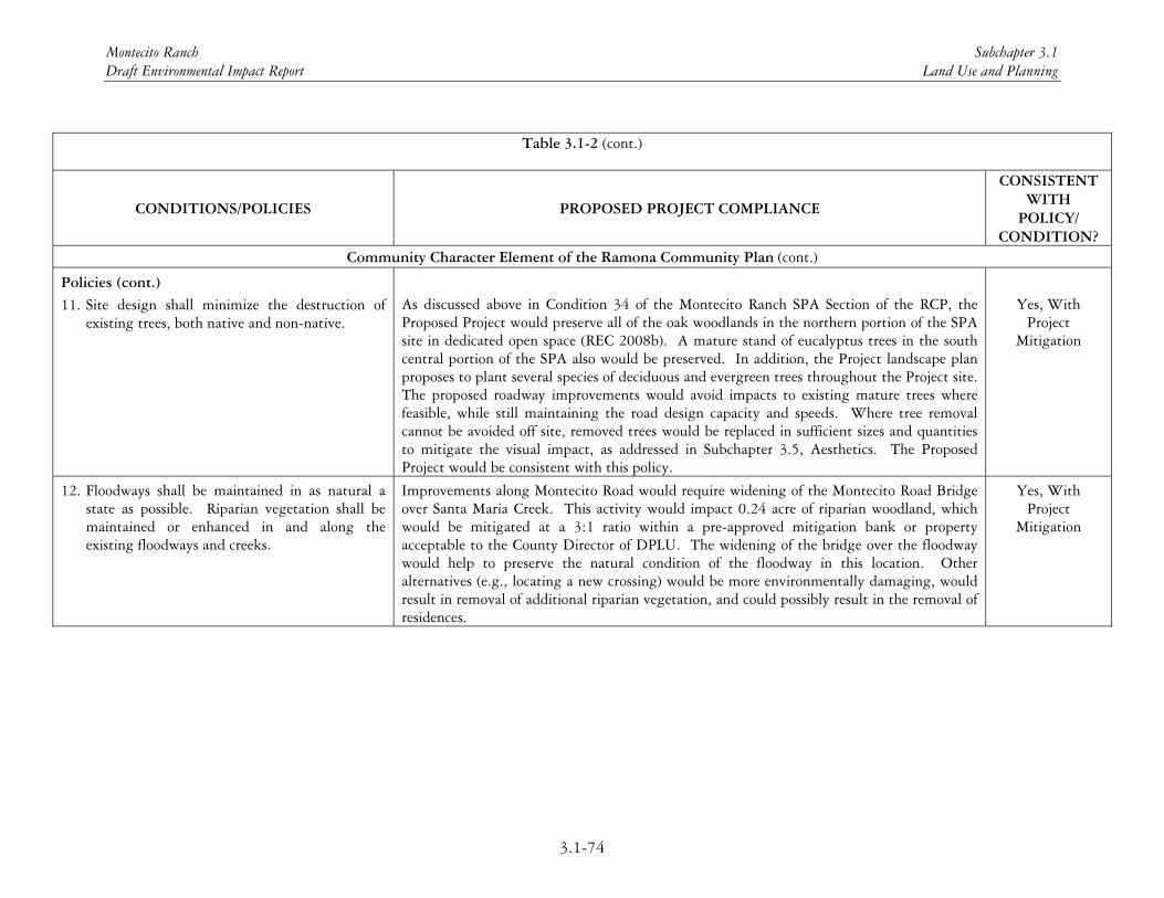
Montecito Ranch Subchapter 3.1 Draft Environmental Impact Report Land Use and Planning
3.1-74
Table 3.1-2 (cont.)
CONDITIONS/POLICIES PROPOSED PROJECT COMPLIANCE
CONSISTENT WITH
POLICY/ CONDITION?
Community Character Element of the Ramona Community Plan (cont.)
Policies (cont.) 11. Site design shall minimize the destruction of
existing trees, both native and non-native.
As discussed above in Condition 34 of the Montecito Ranch SPA Section of the RCP, the Proposed Project would preserve all of the oak woodlands in the northern portion of the SPA site in dedicated open space (REC 2008b). A mature stand of eucalyptus trees in the south central portion of the SPA also would be preserved. In addition, the Project landscape plan proposes to plant several species of deciduous and evergreen trees throughout the Project site. The proposed roadway improvements would avoid impacts to existing mature trees where feasible, while still maintaining the road design capacity and speeds. Where tree removal cannot be avoided off site, removed trees would be replaced in sufficient sizes and quantities to mitigate the visual impact, as addressed in Subchapter 3.5, Aesthetics. The Proposed Project would be consistent with this policy.
Yes, With
Project Mitigation
12. Floodways shall be maintained in as natural a state as possible. Riparian vegetation shall be maintained or enhanced in and along the existing floodways and creeks.
Improvements along Montecito Road would require widening of the Montecito Road Bridge over Santa Maria Creek. This activity would impact 0.24 acre of riparian woodland, which would be mitigated at a 3:1 ratio within a pre-approved mitigation bank or property acceptable to the County Director of DPLU. The widening of the bridge over the floodway would help to preserve the natural condition of the floodway in this location. Other alternatives (e.g., locating a new crossing) would be more environmentally damaging, would result in removal of additional riparian vegetation, and could possibly result in the removal of residences.
Yes, With Project
Mitigation
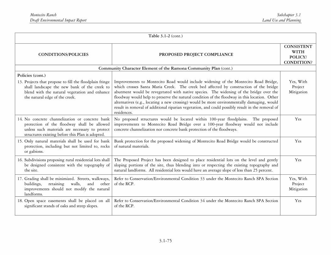
Montecito Ranch Subchapter 3.1 Draft Environmental Impact Report Land Use and Planning
3.1-75
Table 3.1-2 (cont.)
CONDITIONS/POLICIES PROPOSED PROJECT COMPLIANCE
CONSISTENT WITH
POLICY/ CONDITION?
Community Character Element of the Ramona Community Plan (cont.)
Policies (cont.) 13. Projects that propose to fill the floodplain fringe
shall landscape the new bank of the creek to blend with the natural vegetation and enhance the natural edge of the creek.
Improvements to Montecito Road would include widening of the Montecito Road Bridge, which crosses Santa Maria Creek. The creek bed affected by construction of the bridge abutment would be revegetated with native species. The widening of the bridge over the floodway would help to preserve the natural condition of the floodway in this location. Other alternatives (e.g., locating a new crossing) would be more environmentally damaging, would result in removal of additional riparian vegetation, and could possibly result in the removal of residences.
Yes, With
Project Mitigation
14. No concrete channelization or concrete bank protection of the floodway shall be allowed unless such materials are necessary to protect structures existing before this Plan is adopted.
No proposed structures would be located within 100-year floodplains. The proposed improvements to Montecito Road Bridge over a 100-year floodway would not include concrete channelization nor concrete bank protection of the floodways.
Yes
15. Only natural materials shall be used for bank protection, including but not limited to, rocks or gabions.
Bank protection for the proposed widening of Montecito Road Bridge would be constructed of natural materials.
Yes
16. Subdivisions proposing rural residential lots shall be designed consistent with the topography of the site.
The Proposed Project has been designed to place residential lots on the level and gently sloping portions of the site, thus blending into or respecting the existing topography and natural landforms. All residential lots would have an average slope of less than 25 percent.
Yes
17. Grading shall be minimized. Streets, walkways, buildings, retaining walls, and other improvements should not modify the natural landforms.
Refer to Conservation/Environmental Condition 33 under the Montecito Ranch SPA Section of the RCP.
Yes, With Project
Mitigation
18. Open space easements shall be placed on all significant stands of oaks and steep slopes.
Refer to Conservation/Environmental Condition 34 under the Montecito Ranch SPA Section of the RCP.
Yes

Montecito Ranch Subchapter 3.1 Draft Environmental Impact Report Land Use and Planning
3.1-76
Table 3.1-2 (cont.)
CONDITIONS/POLICIES PROPOSED PROJECT COMPLIANCE
CONSISTENT WITH
POLICY/ CONDITION?
Community Character Element of the Ramona Community Plan (cont.)
Policies (cont.) 19. Whenever possible, developments shall utilize
dual water systems for the purpose of using reclaimed water for irrigation.
Refer to Condition 39 of the Montecito Ranch SPA section of the RCP, above.
Yes
22. Clustering and lot area averaging shall be limited by the following condition: The smallest net lot size allowed shall be not less than 75 percent of the minimum lot size specified in the zone.
Under this condition, the minimum lot size for consolidated development in the SPA would be 1.5 acres. The Proposed Project has a minimum lot size of 0.5 acres. As stated above, the Project Applicant has applied for a GPA to the RCP to allow minimum lot sizes of approximately 0.5 acre (20,000 s.f. minimum); the Project would therefore be consistent with the amended policy.
Yes, With GPA Approval
Residential Policies 1. Single-family residential development will not
be permitted in areas that have close proximity to airports or major roads, where projected noise levels are greater than 55 decibels (dB[A]), without adequate mitigation measures.
The Montecito Ranch SPA is located in a rural setting where noise levels are relatively low. The Proposed Project consists of a residential development consolidated in the northern and eastern portions of the site. Montecito Ranch Road would be the most heavily traveled Project roadway on site. The noise study for the Project (Urban Crossroads 2008) concluded that on-site noise levels generated by vehicular traffic along Montecito Ranch Road could significantly impact on-site residences located within approximately 500 feet from the centerline of the roadway (an estimated 88 homes). Noise impacts to on-site residences would be reduced to less than significant levels through creation of a noise protection easement to a distance of approximately 500 feet from the roadway centerline. Refer to Subchapter 3.3, Noise, for a detailed discussion. The Project is well outside the influence area (55 dB[A] CNEL contour) for the Ramona Airport. Extrapolation of the currently adopted airport contours shows that on-site noise levels are less than 55 dB(A) CNEL. Therefore, noise produced by the aircraft operations would not significantly impact the proposed homes and would not require mitigation.
Yes, With Project
Mitigation

Montecito Ranch Subchapter 3.1 Draft Environmental Impact Report Land Use and Planning
3.1-77
Table 3.1-2 (cont.)
CONDITIONS/POLICIES PROPOSED PROJECT COMPLIANCE
CONSISTENT WITH
POLICY/ CONDITION?
Land Use Element of the Ramona Community Plan (cont.) Residential Policies (cont.) 2. The majority of residential lots in the Planning
Area shall be of a size sufficient to accommodate the keeping of large animals.
Refer to General Condition 6 under the Montecito Ranch SPA Section of the RCP.
Yes, With Specific Plan
Approval 3. Maintain the existing rural lifestyle by
continuing the existing pattern of residential and agricultural uses on large lots outside of the Town Center and San Diego Country Estates.
The proposed on-site residential development would include lots ranging from approximately 0.5 acre (20,000 s.f. minimum) to 1.8 acres in size. The Project Applicant has filed an application for a GPA to the RCP to reduce the minimum lot size from 2 acres to approximately 0.5 acre (20,000 s.f. minimum) to reduce the overall development impact area and provide large contiguous open space areas. The Proposed Project would maintain rural character while consolidating all lots in the northern and eastern portions of the site. Existing homes in the immediate vicinity of the Project site, located to the north, east, and south, are situated on approximately one- to six-acre lots. Although lot sizes on the Project site would be smaller than those of surrounding existing and planned residences, dedicated open space areas would surround the homes, and the overall density would be consistent with existing and planned residential development in the vicinity. Lots 1 through 30 would be permitted to keep horses, which would reflect a rural lifestyle. Equestrian/pedestrian trails would be provided within open space areas and along Project roadways. Street trees would consist of a variety of native and non-native species, and would be spaced informally to define and reinforce a rural community character. In addition, the proposed MUP contains comprehensive design guidelines and development standards intended to create and reinforce a rural community character within the SPA.
Yes, With GPA
Approval
4. All development proposals shall demonstrate a diligent effort to retain significant existing natural features of the area’s landscape. Existing topography and landforms, drainage course, rock outcroppings, vegetation and views shall be incorporated into the design of homesites to the maximum extent feasible.
Refer to Conservation/Environmental Condition 33 under the Montecito Ranch SPA Section of the RCP.
Yes
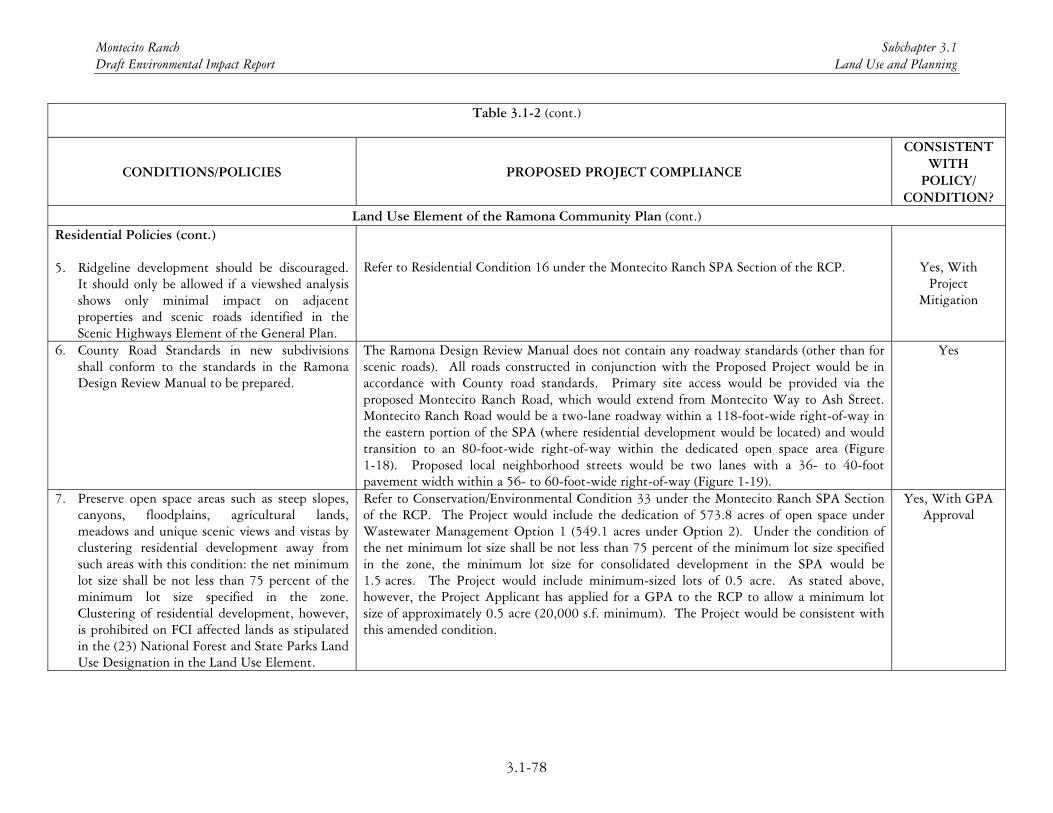
Montecito Ranch Subchapter 3.1 Draft Environmental Impact Report Land Use and Planning
3.1-78
Table 3.1-2 (cont.)
CONDITIONS/POLICIES PROPOSED PROJECT COMPLIANCE
CONSISTENT WITH
POLICY/ CONDITION?
Land Use Element of the Ramona Community Plan (cont.) Residential Policies (cont.) 5. Ridgeline development should be discouraged.
It should only be allowed if a viewshed analysis shows only minimal impact on adjacent properties and scenic roads identified in the Scenic Highways Element of the General Plan.
Refer to Residential Condition 16 under the Montecito Ranch SPA Section of the RCP.
Yes, With Project
Mitigation
6. County Road Standards in new subdivisions shall conform to the standards in the Ramona Design Review Manual to be prepared.
The Ramona Design Review Manual does not contain any roadway standards (other than for scenic roads). All roads constructed in conjunction with the Proposed Project would be in accordance with County road standards. Primary site access would be provided via the proposed Montecito Ranch Road, which would extend from Montecito Way to Ash Street. Montecito Ranch Road would be a two-lane roadway within a 118-foot-wide right-of-way in the eastern portion of the SPA (where residential development would be located) and would transition to an 80-foot-wide right-of-way within the dedicated open space area (Figure 1-18). Proposed local neighborhood streets would be two lanes with a 36- to 40-foot pavement width within a 56- to 60-foot-wide right-of-way (Figure 1-19).
Yes
7. Preserve open space areas such as steep slopes, canyons, floodplains, agricultural lands, meadows and unique scenic views and vistas by clustering residential development away from such areas with this condition: the net minimum lot size shall be not less than 75 percent of the minimum lot size specified in the zone. Clustering of residential development, however, is prohibited on FCI affected lands as stipulated in the (23) National Forest and State Parks Land Use Designation in the Land Use Element.
Refer to Conservation/Environmental Condition 33 under the Montecito Ranch SPA Section of the RCP. The Project would include the dedication of 573.8 acres of open space under Wastewater Management Option 1 (549.1 acres under Option 2). Under the condition of the net minimum lot size shall be not less than 75 percent of the minimum lot size specified in the zone, the minimum lot size for consolidated development in the SPA would be 1.5 acres. The Project would include minimum-sized lots of 0.5 acre. As stated above, however, the Project Applicant has applied for a GPA to the RCP to allow a minimum lot size of approximately 0.5 acre (20,000 s.f. minimum). The Project would be consistent with this amended condition.
Yes, With GPA Approval

Montecito Ranch Subchapter 3.1 Draft Environmental Impact Report Land Use and Planning
3.1-79
Table 3.1-2 (cont.)
CONDITIONS/POLICIES PROPOSED PROJECT COMPLIANCE
CONSISTENT WITH
POLICY/ CONDITION?
Land Use Element of the Ramona Community Plan (cont.) Residential Policies (cont.) 8. Proposed residential area shall be buffered from
incompatible activities which create heavy traffic, noise, odors, dust and unsightly views.
Noise walls up to six feet in height would be located to the north of Montecito Ranch Road within the residential lots adjacent to the road (Figures 1-7 through 1-9). The noise walls would serve as a noise barrier between traffic along Montecito Ranch Road and adjacent residences. Proposed residences would not be bothered by heavy traffic. The combination of a small WRF, under Wastewater Management Option 2, use of odor-control technology, a low density pattern, and generally favorable meteorology would render possible odor emissions much less noticeable than those from existing animal ranching operations in the Project vicinity. Possible stagnation of wastewater in the wet well of the pump station would be avoided by pumping out several times per hour, and the availability of two redundant pumps and an emergency generator. No dust-generating activities would occur following construction. Refer to Section 1.1.2, Project’s Component Parts, Subchapter 2.2, Air Quality, and Subchapter 3.3, Noise, for more details.
Yes
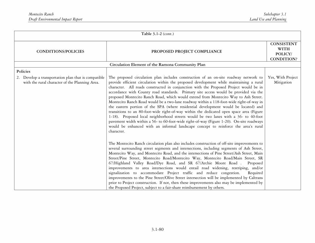
Montecito Ranch Subchapter 3.1 Draft Environmental Impact Report Land Use and Planning
3.1-80
Table 3.1-2 (cont.)
CONDITIONS/POLICIES PROPOSED PROJECT COMPLIANCE
CONSISTENT WITH
POLICY/ CONDITION?
Circulation Element of the Ramona Community Plan
Policies 2. Develop a transportation plan that is compatible
with the rural character of the Planning Area.
The proposed circulation plan includes construction of an on-site roadway network to provide efficient circulation within the proposed development while maintaining a rural character. All roads constructed in conjunction with the Proposed Project would be in accordance with County road standards. Primary site access would be provided via the proposed Montecito Ranch Road, which would extend from Montecito Way to Ash Street. Montecito Ranch Road would be a two-lane roadway within a 118-foot-wide right-of-way in the eastern portion of the SPA (where residential development would be located) and transitions to an 80-foot-wide right-of-way within the dedicated open space area (Figure 1-18). Proposed local neighborhood streets would be two lanes with a 36- to 40-foot pavement width within a 56- to 60-foot-wide right-of-way (Figure 1-20). On-site roadways would be enhanced with an informal landscape concept to reinforce the area’s rural character. The Montecito Ranch circulation plan also includes construction of off-site improvements to several surrounding street segments and intersections, including segments of Ash Street, Montecito Way, and Montecito Road, and the intersections of Pine Street/Ash Street, Main Street/Pine Street, Montecito Road/Montecito Way, Montecito Road/Main Street, SR 67/Highland Valley Road/Dye Road, and SR 67/Archie Moore Road . Proposed improvements to area intersections would entail road widening, restriping, and/or signalization to accommodate Project traffic and reduce congestion. Required improvements to the Pine Street/Olive Street intersection will be implemented by Caltrans prior to Project construction. If not, then these improvements also may be implemented by the Proposed Project, subject to a fair-share reimbursement by others.
Yes, With Project
Mitigation
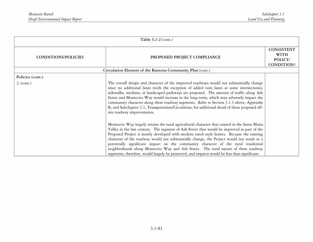
Montecito Ranch Subchapter 3.1 Draft Environmental Impact Report Land Use and Planning
3.1-81
Table 3.1-2 (cont.)
CONDITIONS/POLICIES PROPOSED PROJECT COMPLIANCE
CONSISTENT WITH
POLICY/ CONDITION?
Circulation Element of the Ramona Community Plan (cont.)
Policies (cont.) 2. (cont.)
The overall design and character of the improved roadways would not substantially change since no additional lanes (with the exception of added turn lanes at some intersections), sidewalks, medians, or landscaped parkways are proposed. The amount of traffic along Ash Street and Montecito Way would increase in the long-term, which may adversely impact the community character along these roadway segments. Refer to Section 3.1.3 above, Appendix B, and Subchapter 2.1, Transportation/Circulation, for additional detail of these proposed off-site roadway improvements. Montecito Way largely retains the rural agricultural character that existed in the Santa Maria Valley in the last century. The segment of Ash Street that would be improved as part of the Proposed Project is mostly developed with modern ranch style homes. Because the existing character of the roadway would not substantially change, the Project would not result in a potentially significant impact on the community character of the rural residential neighborhoods along Montecito Way and Ash Street. The rural nature of these roadway segments, therefore, would largely be preserved, and impacts would be less than significant.
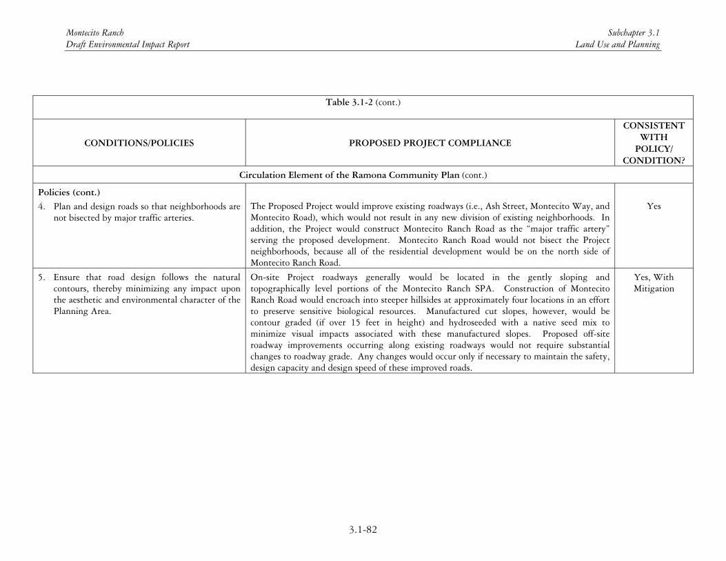
Montecito Ranch Subchapter 3.1 Draft Environmental Impact Report Land Use and Planning
3.1-82
Table 3.1-2 (cont.)
CONDITIONS/POLICIES PROPOSED PROJECT COMPLIANCE
CONSISTENT WITH
POLICY/ CONDITION?
Circulation Element of the Ramona Community Plan (cont.)
Policies (cont.) 4. Plan and design roads so that neighborhoods are
not bisected by major traffic arteries.
The Proposed Project would improve existing roadways (i.e., Ash Street, Montecito Way, and Montecito Road), which would not result in any new division of existing neighborhoods. In addition, the Project would construct Montecito Ranch Road as the “major traffic artery” serving the proposed development. Montecito Ranch Road would not bisect the Project neighborhoods, because all of the residential development would be on the north side of Montecito Ranch Road.
Yes
5. Ensure that road design follows the natural contours, thereby minimizing any impact upon the aesthetic and environmental character of the Planning Area.
On-site Project roadways generally would be located in the gently sloping and topographically level portions of the Montecito Ranch SPA. Construction of Montecito Ranch Road would encroach into steeper hillsides at approximately four locations in an effort to preserve sensitive biological resources. Manufactured cut slopes, however, would be contour graded (if over 15 feet in height) and hydroseeded with a native seed mix to minimize visual impacts associated with these manufactured slopes. Proposed off-site roadway improvements occurring along existing roadways would not require substantial changes to roadway grade. Any changes would occur only if necessary to maintain the safety, design capacity and design speed of these improved roads.
Yes, With Mitigation

Montecito Ranch Subchapter 3.1 Draft Environmental Impact Report Land Use and Planning
3.1-83
Table 3.1-2 (cont.)
CONDITIONS/POLICIES PROPOSED PROJECT COMPLIANCE
CONSISTENT WITH
POLICY/ CONDITION?
Circulation Element of the Ramona Community Plan (cont.)
Policies (cont.) 5. (cont.)
The proposed off-site water tank would be located on a local hilltop (approximately 1,800 feet AMSL), and the associated access road would cut into steep hillsides. These cut slopes would substantially contrast with the surrounding topography, and would disrupt existing visual continuity. The resulting visual effects are discussed in Subchapter 3.5, Aesthetics, which identifies significant adverse visual impacts. Development of the water tank and access road, therefore, would be inconsistent with this condition, unless mitigated. Mitigation would include landscaping consisting of native species compatible with existing trees and vegetation cover around the proposed water storage tank and hydroseeding the cut slopes required for the water tank access road with native seed mixes compatible with existing native species.
6. Develop a road system which routes externally
generated traffic through the planning area with a minimum of disruption to the community.
Proposed Project roadways have been designed to effectively move externally generated traffic through the SPA via SA 330 (i.e., Ash Street, Montecito Ranch Road, and Montecito Way) and Montecito Road. This would create a “loop road” system that would help minimize project traffic impacts to the Ramona Town Center. All Project roads would be constructed in accordance with County standards.
Yes
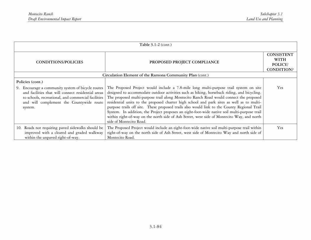
Montecito Ranch Subchapter 3.1 Draft Environmental Impact Report Land Use and Planning
3.1-84
Table 3.1-2 (cont.)
CONDITIONS/POLICIES PROPOSED PROJECT COMPLIANCE
CONSISTENT WITH
POLICY/ CONDITION?
Circulation Element of the Ramona Community Plan (cont.)
Policies (cont.) 9. Encourage a community system of bicycle routes
and facilities that will connect residential areas to schools, recreational, and commercial facilities and will complement the Countywide route system.
The Proposed Project would include a 7.8-mile long multi-purpose trail system on site designed to accommodate outdoor activities such as hiking, horseback riding, and bicycling. The proposed multi-purpose trail along Montecito Ranch Road would connect the proposed residential units to the proposed charter high school and park sites as well as to multi-purpose trails off site. These proposed trails also would link to the County Regional Trail System. In addition, the Project proposes an eight-foot-wide native soil multi-purpose trail within right-of-way on the north side of Ash Street, west side of Montecito Way, and north side of Montecito Road.
Yes
10. Roads not requiring paved sidewalks should be improved with a cleared and graded walkway within the unpaved right-of-way.
The Proposed Project would include an eight-foot-wide native soil multi-purpose trail within right-of-way on the north side of Ash Street, west side of Montecito Way and north side of Montecito Road.
Yes

Montecito Ranch Subchapter 3.1 Draft Environmental Impact Report Land Use and Planning
3.1-85
Table 3.1-2 (cont.)
CONDITIONS/POLICIES PROPOSED PROJECT COMPLIANCE
CONSISTENT WITH
POLICY/ CONDITION?
Circulation Element of the Ramona Community Plan (cont.)
Ramona Circulation Element Plan (see Figure 1-13 of this EIR)
The Project would include a General Plan Amendment (GPA) to the County Circulation Element. Figures 1-13 and 1-14 depict the existing and proposed RCP Circulation Element roadway network, respectively, and Figures 1-15 and 1-16 show the existing and proposed RCP Circulation Element bicycle network, respectively. Specific changes to the Circulation Element roadway and associated bicycle networks would include:
1. Elimination of SA 603 between Pine Street and Rangeland Road.
2. Relocation of SA 330 between Sonora Way and Montecito Road to Montecito Way.
3. Revision of the road classification on Montecito Way between Sonora Way and Montecito Road from rural collector to rural light collector.
4. Revision of the road classification on Montecito Road between Montecito Way and Main Street from rural collector to rural light collector.
5. Addition of SA 330 between Sonora Way and Pine Street (the new segment of SA 330 would include Montecito Ranch Road and Ash Street).
6. Realignment of SA 330 between Montecito Road and SR 67. With approval of the GPA, the Project would be consistent with the new amended Circulation Element.
Yes, With GPA Approval
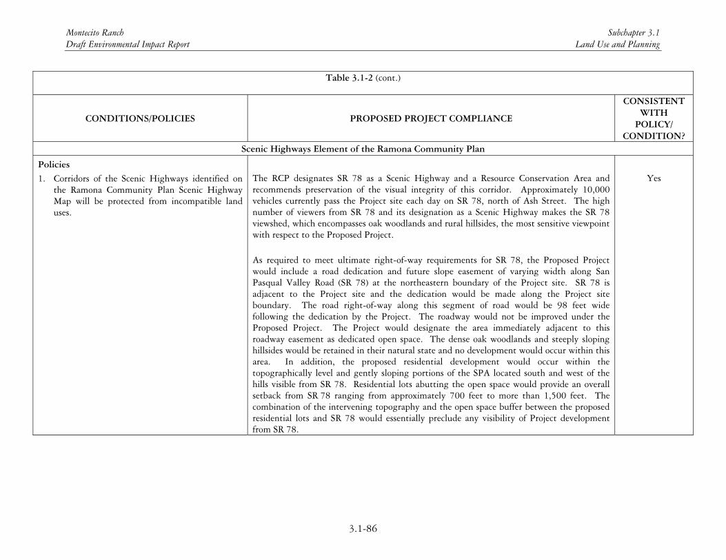
Montecito Ranch Subchapter 3.1 Draft Environmental Impact Report Land Use and Planning
3.1-86
Table 3.1-2 (cont.)
CONDITIONS/POLICIES PROPOSED PROJECT COMPLIANCE
CONSISTENT WITH
POLICY/ CONDITION?
Scenic Highways Element of the Ramona Community Plan
Policies 1. Corridors of the Scenic Highways identified on
the Ramona Community Plan Scenic Highway Map will be protected from incompatible land uses.
The RCP designates SR 78 as a Scenic Highway and a Resource Conservation Area and recommends preservation of the visual integrity of this corridor. Approximately 10,000 vehicles currently pass the Project site each day on SR 78, north of Ash Street. The high number of viewers from SR 78 and its designation as a Scenic Highway makes the SR 78 viewshed, which encompasses oak woodlands and rural hillsides, the most sensitive viewpoint with respect to the Proposed Project. As required to meet ultimate right-of-way requirements for SR 78, the Proposed Project would include a road dedication and future slope easement of varying width along San Pasqual Valley Road (SR 78) at the northeastern boundary of the Project site. SR 78 is adjacent to the Project site and the dedication would be made along the Project site boundary. The road right-of-way along this segment of road would be 98 feet wide following the dedication by the Project. The roadway would not be improved under the Proposed Project. The Project would designate the area immediately adjacent to this roadway easement as dedicated open space. The dense oak woodlands and steeply sloping hillsides would be retained in their natural state and no development would occur within this area. In addition, the proposed residential development would occur within the topographically level and gently sloping portions of the SPA located south and west of the hills visible from SR 78. Residential lots abutting the open space would provide an overall setback from SR 78 ranging from approximately 700 feet to more than 1,500 feet. The combination of the intervening topography and the open space buffer between the proposed residential lots and SR 78 would essentially preclude any visibility of Project development from SR 78.
Yes
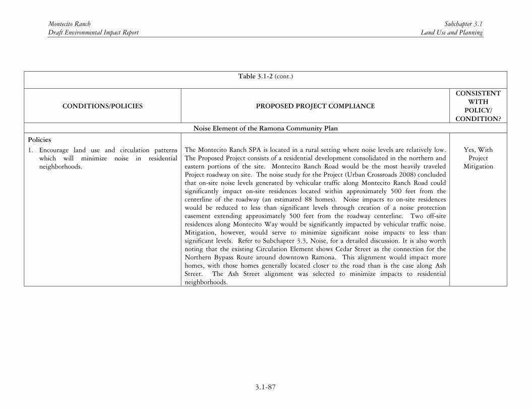
Montecito Ranch Subchapter 3.1 Draft Environmental Impact Report Land Use and Planning
3.1-87
Table 3.1-2 (cont.)
CONDITIONS/POLICIES PROPOSED PROJECT COMPLIANCE
CONSISTENT WITH
POLICY/ CONDITION?
Noise Element of the Ramona Community Plan
Policies 1. Encourage land use and circulation patterns
which will minimize noise in residential neighborhoods.
The Montecito Ranch SPA is located in a rural setting where noise levels are relatively low. The Proposed Project consists of a residential development consolidated in the northern and eastern portions of the site. Montecito Ranch Road would be the most heavily traveled Project roadway on site. The noise study for the Project (Urban Crossroads 2008) concluded that on-site noise levels generated by vehicular traffic along Montecito Ranch Road could significantly impact on-site residences located within approximately 500 feet from the centerline of the roadway (an estimated 88 homes). Noise impacts to on-site residences would be reduced to less than significant levels through creation of a noise protection easement extending approximately 500 feet from the roadway centerline. Two off-site residences along Montecito Way would be significantly impacted by vehicular traffic noise. Mitigation, however, would serve to minimize significant noise impacts to less than significant levels. Refer to Subchapter 3.3, Noise, for a detailed discussion. It is also worth noting that the existing Circulation Element shows Cedar Street as the connection for the Northern Bypass Route around downtown Ramona. This alignment would impact more homes, with those homes generally located closer to the road than is the case along Ash Street. The Ash Street alignment was selected to minimize impacts to residential neighborhoods.
Yes, With
Project Mitigation

Montecito Ranch Subchapter 3.1 Draft Environmental Impact Report Land Use and Planning
3.1-88
Table 3.1-2 (cont.)
CONDITIONS/POLICIES PROPOSED PROJECT COMPLIANCE
CONSISTENT WITH
POLICY/ CONDITION?
Noise Element of the Ramona Community Plan (cont.)
Policies (cont.) 2. Permit residential development within projected
CNEL contours of 55 dB(A) near main roads, airports, or other noise sources only when noise impacts can be mitigated.
3. New development proposed within the projected
noise contours exceeding CNEL 55 dB(A) will require buffering or other mitigation devices to return the ambient noise level to CNEL 55 dB(A).
The noise study for the Proposed Project concluded that on-site noise levels generated by vehicular traffic along Montecito Ranch Road could significantly impact on-site residences located within approximately 500 feet from the centerline of the roadway (an estimated 88 homes). Noise impacts to on-site residences would be reduced to less than significant levels through creation of a noise protection easement to a distance of approximately 500 feet from the roadway centerline. The Project would include the construction of noise walls along Montecito Ranch Road. The Project is well outside the influence area (55 dB(A) CNEL contour) for the Ramona Airport. Extrapolation of the currently adopted airport contours shows that on-site noise levels are less than 50 dB(A) CNEL. Therefore, noise produced by the aircraft operations would not significantly impact the Project and the Project would be consistent with this condition.
Yes, With
Project Mitigation
Conservation Element of the Ramona Community Plan
Policies 5. The County will seek to ensure access along
major creek drainages for riding and hiking trails whenever possible.
The Proposed Project includes multi-purpose trails, which would link to the County Regional Trail System. No major creek drainages are within the Project site. Under the Proposed Project, the existing Montecito Road Bridge across Santa Maria Creek would be widened. The proposed widening of the bridge would not preclude future trails along this creek.
Yes
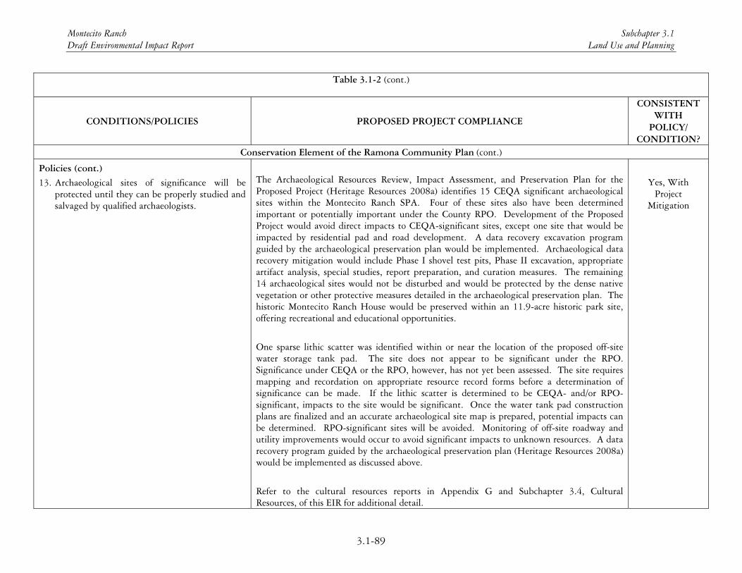
Montecito Ranch Subchapter 3.1 Draft Environmental Impact Report Land Use and Planning
3.1-89
Table 3.1-2 (cont.)
CONDITIONS/POLICIES PROPOSED PROJECT COMPLIANCE
CONSISTENT WITH
POLICY/ CONDITION?
Conservation Element of the Ramona Community Plan (cont.)
Policies (cont.) 13. Archaeological sites of significance will be
protected until they can be properly studied and salvaged by qualified archaeologists.
The Archaeological Resources Review, Impact Assessment, and Preservation Plan for the Proposed Project (Heritage Resources 2008a) identifies 15 CEQA significant archaeological sites within the Montecito Ranch SPA. Four of these sites also have been determined important or potentially important under the County RPO. Development of the Proposed Project would avoid direct impacts to CEQA-significant sites, except one site that would be impacted by residential pad and road development. A data recovery excavation program guided by the archaeological preservation plan would be implemented. Archaeological data recovery mitigation would include Phase I shovel test pits, Phase II excavation, appropriate artifact analysis, special studies, report preparation, and curation measures. The remaining 14 archaeological sites would not be disturbed and would be protected by the dense native vegetation or other protective measures detailed in the archaeological preservation plan. The historic Montecito Ranch House would be preserved within an 11.9-acre historic park site, offering recreational and educational opportunities. One sparse lithic scatter was identified within or near the location of the proposed off-site water storage tank pad. The site does not appear to be significant under the RPO. Significance under CEQA or the RPO, however, has not yet been assessed. The site requires mapping and recordation on appropriate resource record forms before a determination of significance can be made. If the lithic scatter is determined to be CEQA- and/or RPO-significant, impacts to the site would be significant. Once the water tank pad construction plans are finalized and an accurate archaeological site map is prepared, potential impacts can be determined. RPO-significant sites will be avoided. Monitoring of off-site roadway and utility improvements would occur to avoid significant impacts to unknown resources. A data recovery program guided by the archaeological preservation plan (Heritage Resources 2008a) would be implemented as discussed above.
Refer to the cultural resources reports in Appendix G and Subchapter 3.4, Cultural Resources, of this EIR for additional detail.
Yes, With
Project Mitigation
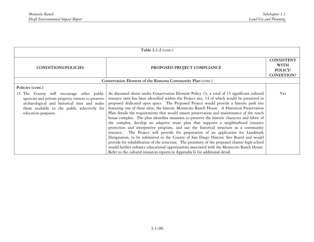
Montecito Ranch Subchapter 3.1 Draft Environmental Impact Report Land Use and Planning
3.1-90
Table 3.1-2 (cont.)
CONDITIONS/POLICIES PROPOSED PROJECT COMPLIANCE
CONSISTENT WITH
POLICY/ CONDITION?
Conservation Element of the Ramona Community Plan (cont.)
Policies (cont.) 15. The County will encourage other public
agencies and private property owners to preserve archaeological and historical sites and make them available to the public selectively for education purposes.
As discussed above under Conservation Element Policy 13, a total of 15 significant cultural resource sites has been identified within the Project site, 14 of which would be preserved in proposed dedicated open space. The Proposed Project would provide a historic park site featuring one of these sites, the historic Montecito Ranch House. A Historical Preservation Plan details the requirements that would ensure preservation and maintenance of the ranch house complex. The plan identifies measures to preserve the historic character and fabric of the complex, develop an adaptive reuse plan that supports a neighborhood resource protection and interpretive program, and use the historical structure as a community resource. The Project will provide for preparation of an application for Landmark Designation, to be submitted to the County of San Diego Historic Site Board and would provide for rehabilitation of the structure. The proximity of the proposed charter high school would further enhance educational opportunities associated with the Montecito Ranch House. Refer to the cultural resources reports in Appendix G for additional detail.
Yes
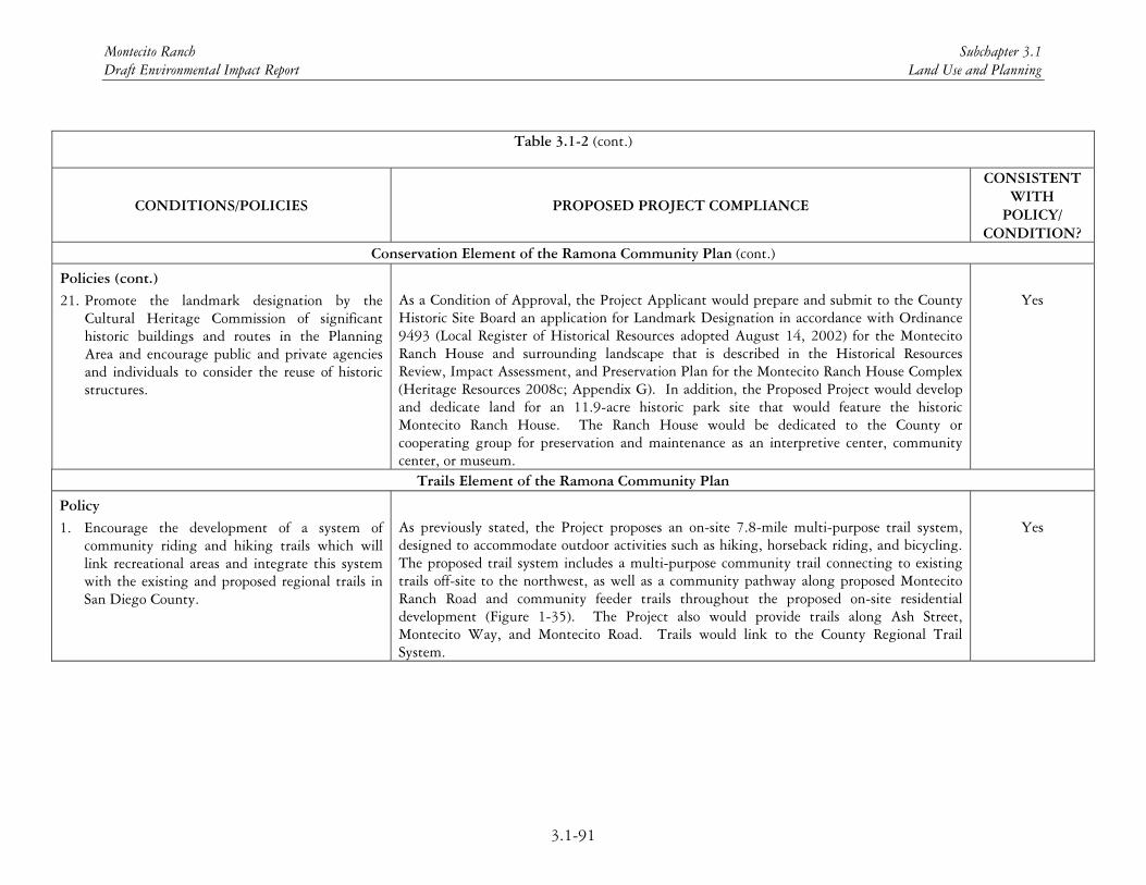
Montecito Ranch Subchapter 3.1 Draft Environmental Impact Report Land Use and Planning
3.1-91
Table 3.1-2 (cont.)
CONDITIONS/POLICIES PROPOSED PROJECT COMPLIANCE
CONSISTENT WITH
POLICY/ CONDITION?
Conservation Element of the Ramona Community Plan (cont.)
Policies (cont.) 21. Promote the landmark designation by the
Cultural Heritage Commission of significant historic buildings and routes in the Planning Area and encourage public and private agencies and individuals to consider the reuse of historic structures.
As a Condition of Approval, the Project Applicant would prepare and submit to the County Historic Site Board an application for Landmark Designation in accordance with Ordinance 9493 (Local Register of Historical Resources adopted August 14, 2002) for the Montecito Ranch House and surrounding landscape that is described in the Historical Resources Review, Impact Assessment, and Preservation Plan for the Montecito Ranch House Complex (Heritage Resources 2008c; Appendix G). In addition, the Proposed Project would develop and dedicate land for an 11.9-acre historic park site that would feature the historic Montecito Ranch House. The Ranch House would be dedicated to the County or cooperating group for preservation and maintenance as an interpretive center, community center, or museum.
Yes
Trails Element of the Ramona Community Plan
Policy 1. Encourage the development of a system of
community riding and hiking trails which will link recreational areas and integrate this system with the existing and proposed regional trails in San Diego County.
As previously stated, the Project proposes an on-site 7.8-mile multi-purpose trail system, designed to accommodate outdoor activities such as hiking, horseback riding, and bicycling. The proposed trail system includes a multi-purpose community trail connecting to existing trails off-site to the northwest, as well as a community pathway along proposed Montecito Ranch Road and community feeder trails throughout the proposed on-site residential development (Figure 1-35). The Project also would provide trails along Ash Street, Montecito Way, and Montecito Road. Trails would link to the County Regional Trail System.
Yes

Montecito Ranch Subchapter 3.1 Draft Environmental Impact Report Land Use and Planning
3.1-92
Table 3.1-2 (cont.)
CONDITIONS/POLICIES PROPOSED PROJECT COMPLIANCE
CONSISTENT WITH
POLICY/ CONDITION?
Open Space Element of the San Diego County General Plan
Agricultural Preserves and Open Space Easements Objectives of Goal II – Conservation of Resources and Natural Processes 1. Encourage agricultural use of lands with soils
which are highly suitable for the production of food or fiber.
An Agricultural Technical Study has been prepared pursuant to this policy to evaluate potential impacts to agricultural resources and operations associated with implementation of the Proposed Project (HELIX and CIC Research 2008). This study includes evaluation of direct impacts to on-site agricultural resources/operations through the California Agricultural Land Evaluation and Site Assessment (LESA) Model, which includes assessment of factors such as soil characteristics and quality, project size, water availability and the occurrence of surrounding agricultural/protected lands. The score generated from this effort indicates that implementation of the Proposed Project would not result in significant direct impacts to on-site agricultural resources or operations. Additional analyses conducted as part of the Project Agricultural Technical Study involve assessment of direct, indirect and cumulative Project-related impacts to on- and off-site agricultural resources, including California Department of Conservation (CDC) Important Farmlands, U.S. Natural Resources Conservation Service (NRCS) Prime Farmland Soils, Williamson Act contract lands and active agricultural operations. These impacts were determined to be less than significant based on the lack of Project impacts to CDC Prime Farmland, CDC Farmland of Statewide Importance and Williamson Act contract lands; the minor extent of Project impacts to CDC Unique Farmland and active agricultural operations; the inclusion of design measures to reduce Project impacts to off-site agricultural uses (e.g., buffers, agricultural access retention, and water quality BMPs); Project consistency with local planning and zoning regulations; the fact that all on-site NRCS Prime Farmland Soils are either located within existing or preserved biological easements (and are thus unavailable for agricultural use), or are incorporated into the LESA Model evaluation described above; and the minor extent of cumulative impacts to NRCS Prime Farmland Soils relative to exposures within the cumulative study area.
Yes
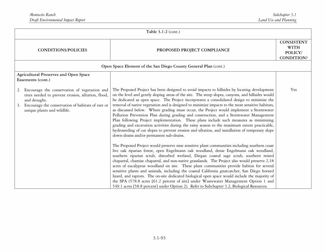
Montecito Ranch Subchapter 3.1 Draft Environmental Impact Report Land Use and Planning
3.1-93
Table 3.1-2 (cont.)
CONDITIONS/POLICIES PROPOSED PROJECT COMPLIANCE
CONSISTENT WITH
POLICY/ CONDITION?
Open Space Element of the San Diego County General Plan (cont.)
Agricultural Preserves and Open Space Easements (cont.) 2. Encourage the conservation of vegetation and
trees needed to prevent erosion, siltation, flood, and drought.
3. Encourage the conservation of habitats of rare or unique plants and wildlife.
The Proposed Project has been designed to avoid impacts to hillsides by locating development on the level and gently sloping areas of the site. The steep slopes, canyons, and hillsides would be dedicated as open space. The Project incorporates a consolidated design to minimize the removal of native vegetation and is designed to minimize impacts to the most sensitive habitats, as discussed below. Where grading must occur, the Project would implement a Stormwater Pollution Prevention Plan during grading and construction, and a Stormwater Management Plan following Project implementation. These plans include such measures as minimizing grading and excavation activities during the rainy season to the maximum extent practicable, hydroseeding of cut slopes to prevent erosion and siltation, and installation of temporary slope down-drains and/or permanent sub-drains. The Proposed Project would preserve nine sensitive plant communities including southern coast live oak riparian forest, open Engelmann oak woodland, dense Engelmann oak woodland, southern riparian scrub, disturbed wetland, Diegan coastal sage scrub, southern mixed chaparral, chamise chaparral, and non-native grasslands. The Project also would preserve 2.18 acres of eucalyptus woodland on site. These plant communities provide habitat for several sensitive plants and animals, including the coastal California gnatcatcher, San Diego horned lizard, and raptors. The on-site dedicated biological open space would include the majority of the SPA (578.8 acres [61.2 percent of site] under Wastewater Management Option 1 and 549.1 acres [58.8 percent] under Option 2). Refer to Subchapter 3.2, Biological Resources.
Yes
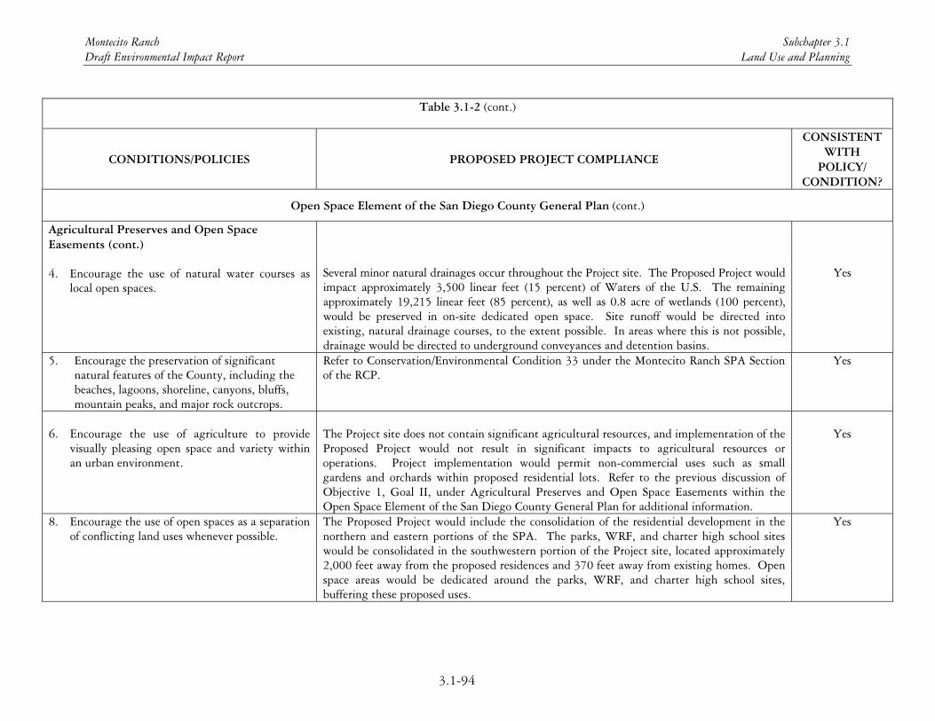
Montecito Ranch Subchapter 3.1 Draft Environmental Impact Report Land Use and Planning
3.1-94
Table 3.1-2 (cont.)
CONDITIONS/POLICIES PROPOSED PROJECT COMPLIANCE
CONSISTENT WITH
POLICY/ CONDITION?
Open Space Element of the San Diego County General Plan (cont.)
Agricultural Preserves and Open Space Easements (cont.) 4. Encourage the use of natural water courses as
local open spaces.
Several minor natural drainages occur throughout the Project site. The Proposed Project would impact approximately 3,500 linear feet (15 percent) of Waters of the U.S. The remaining approximately 19,215 linear feet (85 percent), as well as 0.8 acre of wetlands (100 percent), would be preserved in on-site dedicated open space. Site runoff would be directed into existing, natural drainage courses, to the extent possible. In areas where this is not possible, drainage would be directed to underground conveyances and detention basins.
Yes
5. Encourage the preservation of significant natural features of the County, including the beaches, lagoons, shoreline, canyons, bluffs, mountain peaks, and major rock outcrops.
Refer to Conservation/Environmental Condition 33 under the Montecito Ranch SPA Section of the RCP.
Yes
6. Encourage the use of agriculture to provide
visually pleasing open space and variety within an urban environment.
The Project site does not contain significant agricultural resources, and implementation of the Proposed Project would not result in significant impacts to agricultural resources or operations. Project implementation would permit non-commercial uses such as small gardens and orchards within proposed residential lots. Refer to the previous discussion of Objective 1, Goal II, under Agricultural Preserves and Open Space Easements within the Open Space Element of the San Diego County General Plan for additional information.
Yes
8. Encourage the use of open spaces as a separation of conflicting land uses whenever possible.
The Proposed Project would include the consolidation of the residential development in the northern and eastern portions of the SPA. The parks, WRF, and charter high school sites would be consolidated in the southwestern portion of the Project site, located approximately 2,000 feet away from the proposed residences and 370 feet away from existing homes. Open space areas would be dedicated around the parks, WRF, and charter high school sites, buffering these proposed uses.
Yes
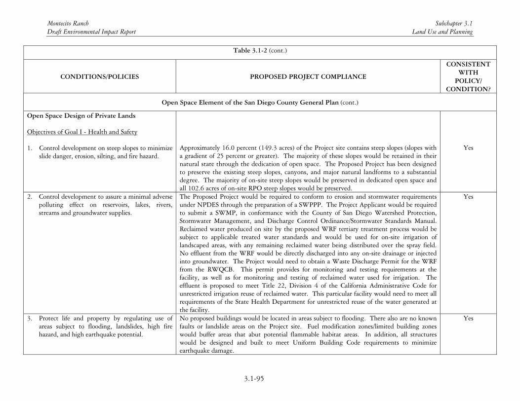
Montecito Ranch Subchapter 3.1 Draft Environmental Impact Report Land Use and Planning
3.1-95
Table 3.1-2 (cont.)
CONDITIONS/POLICIES PROPOSED PROJECT COMPLIANCE
CONSISTENT WITH
POLICY/ CONDITION?
Open Space Element of the San Diego County General Plan (cont.)
Open Space Design of Private Lands Objectives of Goal I - Health and Safety 1. Control development on steep slopes to minimize
slide danger, erosion, silting, and fire hazard.
Approximately 16.0 percent (149.3 acres) of the Project site contains steep slopes (slopes with a gradient of 25 percent or greater). The majority of these slopes would be retained in their natural state through the dedication of open space. The Proposed Project has been designed to preserve the existing steep slopes, canyons, and major natural landforms to a substantial degree. The majority of on-site steep slopes would be preserved in dedicated open space and all 102.6 acres of on-site RPO steep slopes would be preserved.
Yes
2. Control development to assure a minimal adverse polluting effect on reservoirs, lakes, rivers, streams and groundwater supplies.
The Proposed Project would be required to conform to erosion and stormwater requirements under NPDES through the preparation of a SWPPP. The Project Applicant would be required to submit a SWMP, in conformance with the County of San Diego Watershed Protection, Stormwater Management, and Discharge Control Ordinance/Stormwater Standards Manual. Reclaimed water produced on site by the proposed WRF tertiary treatment process would be subject to applicable treated water standards and would be used for on-site irrigation of landscaped areas, with any remaining reclaimed water being distributed over the spray field. No effluent from the WRF would be directly discharged into any on-site drainage or injected into groundwater. The Project would need to obtain a Waste Discharge Permit for the WRF from the RWQCB. This permit provides for monitoring and testing requirements at the facility, as well as for monitoring and testing of reclaimed water used for irrigation. The effluent is proposed to meet Title 22, Division 4 of the California Administrative Code for unrestricted irrigation reuse of reclaimed water. This particular facility would need to meet all requirements of the State Health Department for unrestricted reuse of the water generated at the facility.
Yes
3. Protect life and property by regulating use of areas subject to flooding, landslides, high fire hazard, and high earthquake potential.
No proposed buildings would be located in areas subject to flooding. There also are no known faults or landslide areas on the Project site. Fuel modification zones/limited building zones would buffer areas that abut potential flammable habitat areas. In addition, all structures would be designed and built to meet Uniform Building Code requirements to minimize earthquake damage.
Yes

Montecito Ranch Subchapter 3.1 Draft Environmental Impact Report Land Use and Planning
3.1-96
Table 3.1-2 (cont.)
CONDITIONS/POLICIES PROPOSED PROJECT COMPLIANCE
CONSISTENT WITH
POLICY/ CONDITION?
Open Space Element of the San Diego County General Plan (cont.)
Open Space Design of Private Lands (cont.) Objectives of Goal II - Conservation of Resources and Natural Processes 4. Encourage the conservation of vegetation and
trees needed to prevent erosion, siltation, flood and drought and to protect air and water quality.
5. Encourage the conservation of the habitats of rare or unique plants and wildlife.
Refer to Objectives 2 and 3 of Goal II under Agricultural Preserves and Open Space Easements of the Open Space Element of the General Plan.
Yes
6. Encourage the use of minor natural watercourses as local open spaces.
Refer to Objective 4 of Goal II under Agricultural Preserves and Open Space Easements of the Open Space Element of the General Plan.
Yes
7. Encourage agricultural use of lands with soils which are highly suitable for production of food.
The Project site is not suitable to support viable, sustained commercial agricultural operations. Personal gardens, fruit trees and similar uses would be permitted within residential lots, however. Refer to Objective 1 of Goal II under Agricultural Preserves and Open Space Easements under Open Space Element of the San Diego County General Plan, above.
Yes
8. Encourage the preservation of significant natural features of the County, including the beaches, lagoons, shorelines, canyons, bluffs mountain peaks, and major outcroppings.
Refer to Objective 5 of Goal II under Agricultural Preserves and Open Space Easements of the Open Space Element of the General Plan, above.
Yes
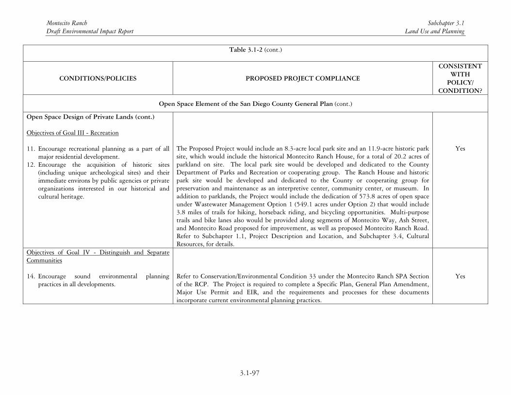
Montecito Ranch Subchapter 3.1 Draft Environmental Impact Report Land Use and Planning
3.1-97
Table 3.1-2 (cont.)
CONDITIONS/POLICIES PROPOSED PROJECT COMPLIANCE
CONSISTENT WITH
POLICY/ CONDITION?
Open Space Element of the San Diego County General Plan (cont.)
Open Space Design of Private Lands (cont.) Objectives of Goal III - Recreation 11. Encourage recreational planning as a part of all
major residential development. 12. Encourage the acquisition of historic sites
(including unique archeological sites) and their immediate environs by public agencies or private organizations interested in our historical and cultural heritage.
The Proposed Project would include an 8.3-acre local park site and an 11.9-acre historic park site, which would include the historical Montecito Ranch House, for a total of 20.2 acres of parkland on site. The local park site would be developed and dedicated to the County Department of Parks and Recreation or cooperating group. The Ranch House and historic park site would be developed and dedicated to the County or cooperating group for preservation and maintenance as an interpretive center, community center, or museum. In addition to parklands, the Project would include the dedication of 573.8 acres of open space under Wastewater Management Option 1 (549.1 acres under Option 2) that would include 3.8 miles of trails for hiking, horseback riding, and bicycling opportunities. Multi-purpose trails and bike lanes also would be provided along segments of Montecito Way, Ash Street, and Montecito Road proposed for improvement, as well as proposed Montecito Ranch Road. Refer to Subchapter 1.1, Project Description and Location, and Subchapter 3.4, Cultural Resources, for details.
Yes
Objectives of Goal IV - Distinguish and Separate Communities 14. Encourage sound environmental planning
practices in all developments.
Refer to Conservation/Environmental Condition 33 under the Montecito Ranch SPA Section of the RCP. The Project is required to complete a Specific Plan, General Plan Amendment, Major Use Permit and EIR, and the requirements and processes for these documents incorporate current environmental planning practices.
Yes

Montecito Ranch Subchapter 3.1 Draft Environmental Impact Report Land Use and Planning
3.1-98
Table 3.1-2 (cont.)
CONDITIONS/POLICIES PROPOSED PROJECT COMPLIANCE
CONSISTENT WITH
POLICY/ CONDITION?
Open Space Element of the San Diego County General Plan (cont.)
Open Space Design of Private Lands (cont.) Objectives of Goal IV - Distinguish and Separate Communities (cont.) 15. Encourage the use of open space to separate
conflicting land uses whenever possible. 16. Encourage an intermingling of open spaces as an
integral part of all major residential development so as to preserve an atmosphere of openness at the neighborhood scale.
Refer to Objective 8 of Goal II under Agricultural Preserves and Open Space Easements under Open Space Element of the San Diego County General Plan, above.
Yes
17. Encourage development that is designed so as to include riding, hiking and bicycle trails.
The Proposed Project would include the dedication of 573.8 acres of open space under Wastewater Management Option 1 (549.1 acres under Option 2) that would include 3.8 miles of trails for hiking, horseback riding, and bicycling opportunities. Approximately 2.3 miles of multi-purpose trails and bike lanes also would be provided along Montecito Ranch Road and segments of Montecito Road, Montecito Way, and Ash Street proposed for improvement. The multi-purpose trails would link the residential areas with the proposed local park, historic park, and charter high school sites.
Yes
Regional Land Use Element of the San Diego County General Plan
1. Overall Goals It is the goal of the Regional Land Use Element that: 1.2 Growth be phased with facilities.
The proposed Project addresses the availability of existing facilities to serve the Project and provides for new facilities where necessary to ensure adequate facilities would be in place as needed to serve the Project. All proposed public facilities to be built by the Proposed Project (e.g., WRF [under Wastewater Management Option 2], local park, roadways) would be phased to occur at the time of need.
Yes
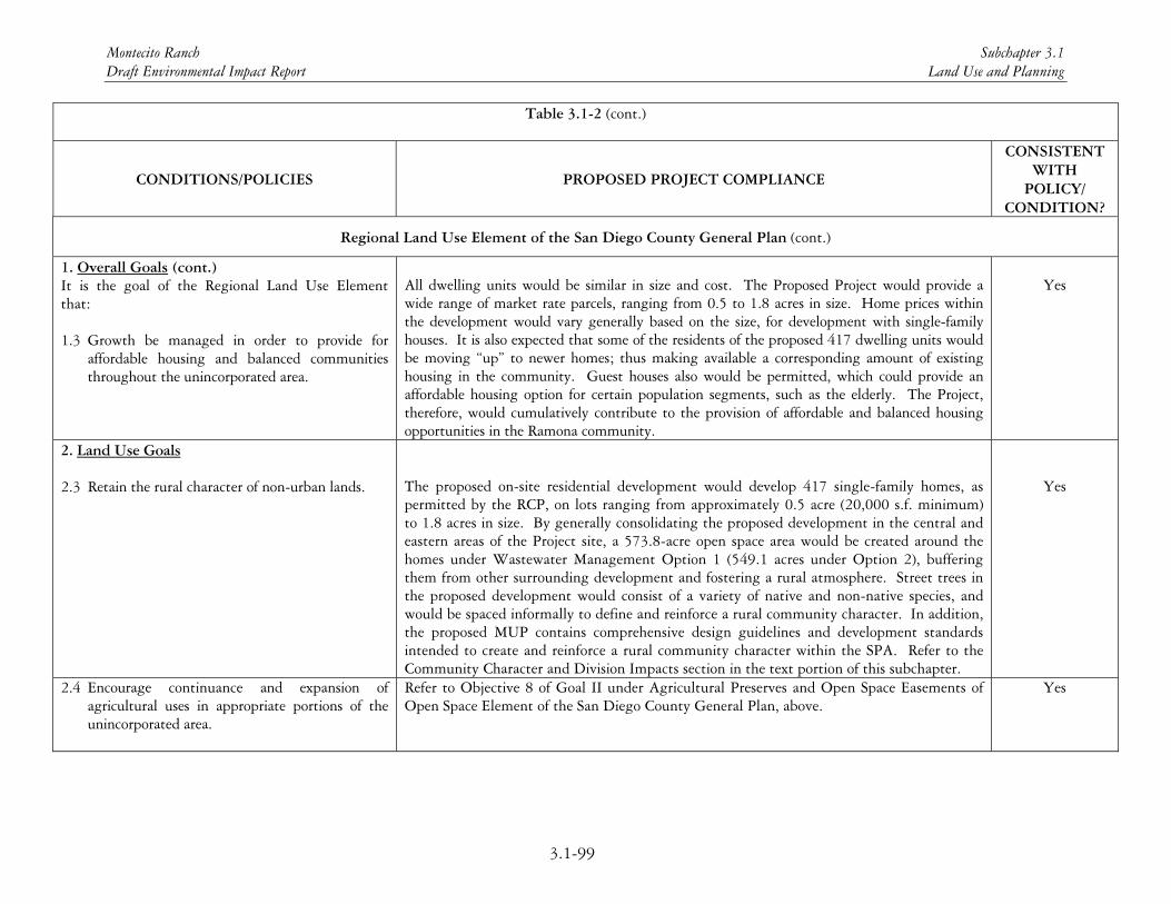
Montecito Ranch Subchapter 3.1 Draft Environmental Impact Report Land Use and Planning
3.1-99
Table 3.1-2 (cont.)
CONDITIONS/POLICIES PROPOSED PROJECT COMPLIANCE
CONSISTENT WITH
POLICY/ CONDITION?
Regional Land Use Element of the San Diego County General Plan (cont.)
1. Overall Goals (cont.) It is the goal of the Regional Land Use Element that: 1.3 Growth be managed in order to provide for
affordable housing and balanced communities throughout the unincorporated area.
All dwelling units would be similar in size and cost. The Proposed Project would provide a wide range of market rate parcels, ranging from 0.5 to 1.8 acres in size. Home prices within the development would vary generally based on the size, for development with single-family houses. It is also expected that some of the residents of the proposed 417 dwelling units would be moving “up” to newer homes; thus making available a corresponding amount of existing housing in the community. Guest houses also would be permitted, which could provide an affordable housing option for certain population segments, such as the elderly. The Project, therefore, would cumulatively contribute to the provision of affordable and balanced housing opportunities in the Ramona community.
Yes
2. Land Use Goals 2.3 Retain the rural character of non-urban lands.
The proposed on-site residential development would develop 417 single-family homes, as permitted by the RCP, on lots ranging from approximately 0.5 acre (20,000 s.f. minimum) to 1.8 acres in size. By generally consolidating the proposed development in the central and eastern areas of the Project site, a 573.8-acre open space area would be created around the homes under Wastewater Management Option 1 (549.1 acres under Option 2), buffering them from other surrounding development and fostering a rural atmosphere. Street trees in the proposed development would consist of a variety of native and non-native species, and would be spaced informally to define and reinforce a rural community character. In addition, the proposed MUP contains comprehensive design guidelines and development standards intended to create and reinforce a rural community character within the SPA. Refer to the Community Character and Division Impacts section in the text portion of this subchapter.
Yes
2.4 Encourage continuance and expansion of agricultural uses in appropriate portions of the unincorporated area.
Refer to Objective 8 of Goal II under Agricultural Preserves and Open Space Easements of Open Space Element of the San Diego County General Plan, above.
Yes

Montecito Ranch Subchapter 3.1 Draft Environmental Impact Report Land Use and Planning
3.1-100
Table 3.1-2 (cont.)
CONDITIONS/POLICIES PROPOSED PROJECT COMPLIANCE
CONSISTENT WITH
POLICY/ CONDITION?
Regional Land Use Element of the San Diego County General Plan (cont.)
2. Land Use Goals (cont.) 2.6 Ensure preservation of contiguous regionally
significant open space corridors.
The RCP allows for development of up to 417 homes and the consolidation of the homes in the relatively low lying areas of the site, which would preserve large contiguous blocks of open space (573.8 acres total under Wastewater Management Option 1 [549.1 acres under Option 2]). The Proposed Project has been designed to minimize habitat fragmentation and provide a large contiguous blocks of open space that would continue to function as wildlife corridors. The majority of impacts would be focused in the eastern portion of the site abutting existing rural residential development. The Project has been designed to provide the maximum contiguous area of open space, including sensitive habitats such as grasslands, shrublands, and woodlands. This contiguous area would be included within the Ramona Grasslands assemblage. The Project site’s ability to serve as a regional corridor in the eastern portion of the site is limited by the amount of development to the north, east, and south. Therefore, the habitat linkages to the northwest and west may be the most important for the regional movement of wildlife species. This corridor connects to the San Pasqual River Valley, which is known to be a high value wildlife area. The proposed residential development area and Montecito Ranch Road would be located east and south of regional wildlife corridors.
Yes
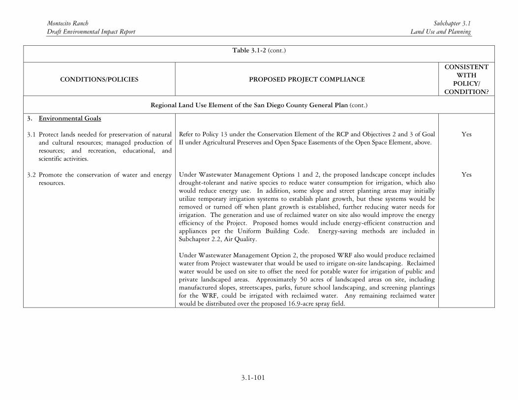
Montecito Ranch Subchapter 3.1 Draft Environmental Impact Report Land Use and Planning
3.1-101
Table 3.1-2 (cont.)
CONDITIONS/POLICIES PROPOSED PROJECT COMPLIANCE
CONSISTENT WITH
POLICY/ CONDITION?
Regional Land Use Element of the San Diego County General Plan (cont.)
3. Environmental Goals 3.1 Protect lands needed for preservation of natural
and cultural resources; managed production of resources; and recreation, educational, and scientific activities.
3.2 Promote the conservation of water and energy
resources.
Refer to Policy 13 under the Conservation Element of the RCP and Objectives 2 and 3 of Goal II under Agricultural Preserves and Open Space Easements of the Open Space Element, above. Under Wastewater Management Options 1 and 2, the proposed landscape concept includes drought-tolerant and native species to reduce water consumption for irrigation, which also would reduce energy use. In addition, some slope and street planting areas may initially utilize temporary irrigation systems to establish plant growth, but these systems would be removed or turned off when plant growth is established, further reducing water needs for irrigation. The generation and use of reclaimed water on site also would improve the energy efficiency of the Project. Proposed homes would include energy-efficient construction and appliances per the Uniform Building Code. Energy-saving methods are included in Subchapter 2.2, Air Quality. Under Wastewater Management Option 2, the proposed WRF also would produce reclaimed water from Project wastewater that would be used to irrigate on-site landscaping. Reclaimed water would be used on site to offset the need for potable water for irrigation of public and private landscaped areas. Approximately 50 acres of landscaped areas on site, including manufactured slopes, streetscapes, parks, future school landscaping, and screening plantings for the WRF, could be irrigated with reclaimed water. Any remaining reclaimed water would be distributed over the proposed 16.9-acre spray field.
Yes
Yes

Montecito Ranch Subchapter 3.1 Draft Environmental Impact Report Land Use and Planning
3.1-102
Table 3.1-2 (cont.)
CONDITIONS/POLICIES PROPOSED PROJECT COMPLIANCE
CONSISTENT WITH
POLICY/ CONDITION?
Regional Land Use Element of the San Diego County General Plan (cont.)
3. Environmental Goals (cont.) 3.3 Achieve and maintain mandated air and water
quality standards.
The Proposed Project would temporarily (during construction only) result in exceedance of PM10 and VOC thresholds. These temporary air impacts would not interfere with the long-term achievement of air quality standards. The Project is consistent with the applicable regional plans for air quality, including the Regional Air Quality Strategy (RAQS) and the State Implementation Plan (SIP), which were based upon San Diego Association of Governments (SANDAG) Series 8 growth forecasts. The Series 8 growth forecasts were based upon general plans, including the County of San Diego General Plan. The proposed project includes 417 single-family residences in an overall area of 935.2 acres, with lot sizes between approximately 0.5 acre (20,000 square feet minimum) and 1.7 acres. Current planning documents for the project site (including the County General Plan and RCP) would allow up to 417 single-family homes on the Project site. Because the proposed number of residential units is within the maximum number of units designated for the site in the applicable County planning documents, the Project would be in conformance with local and regional population, housing, and traffic generation assumptions, and would not conflict or obstruct the implementation of the San Diego RAQS or SIP.
Yes

Montecito Ranch Subchapter 3.1 Draft Environmental Impact Report Land Use and Planning
3.1-103
Table 3.1-2 (cont.)
CONDITIONS/POLICIES PROPOSED PROJECT COMPLIANCE
CONSISTENT WITH
POLICY/ CONDITION?
Regional Land Use Element of the San Diego County General Plan (cont.)
3. Environmental Goals (cont.) 3.3 (cont.)
A Project-specific SWMP has been prepared that includes a list of BMPs to address potential water quality impacts associated with short-term construction activities and long-term use. A SWPPP would be prepared pursuant to applicable NPDES and County requirements by the Project Applicant and incorporated into the Project design prior to Project construction. Refer to Section 4.1.1, Hydrology/Water Quality, for details. Reclaimed water produced on-site by the proposed WRF tertiary treatment process under Wastewater Management Option 2 would be subject to applicable treated water standards and would be used for on-site irrigation of landscaped areas, with any remaining reclaimed water being distributed over the spray field. No effluent from the WRF would be directly discharged into any on-site drainage or injected into groundwater. The Project would need to obtain a Waste Discharge Permit for the WRF from the RWQCB. This permit provides for monitoring and testing requirements at the facility, as well as for monitoring and testing of reclaimed water used for irrigation. The effluent is proposed to meet Title 22, Division 4 of the California Administrative Code for unrestricted irrigation reuse of reclaimed water. This particular facility would need to meet all requirements of the State Health Department for unrestricted reuse of the water generated at the facility.
Yes
4. Capitol Facilities Goals 4.1 Assure efficient, economical, and timely
provision of facilities and services for water, sewer, fire protection, schools, and roads to accommodate anticipated development.
4.2 Assure that facilities and services provided by all
agencies are coordinated in their timing, location, and level of service.
The planning and design of the Proposed Project has involved the early cooperation and coordination of the required providers of public services and utilities. The final approval of all proposed discretionary actions and permits for on-site improvements, as well as the proposed off-site roadway improvements, would all be predicated on the assurance of efficient, economical, and timely provision of required public services and utilities. Section 1.1.2 of the EIR addresses facility phasing requirements for the Project. Refer to Goal 1.1 of Regional Land Use Element of the San Diego County General Plan, above.
Yes
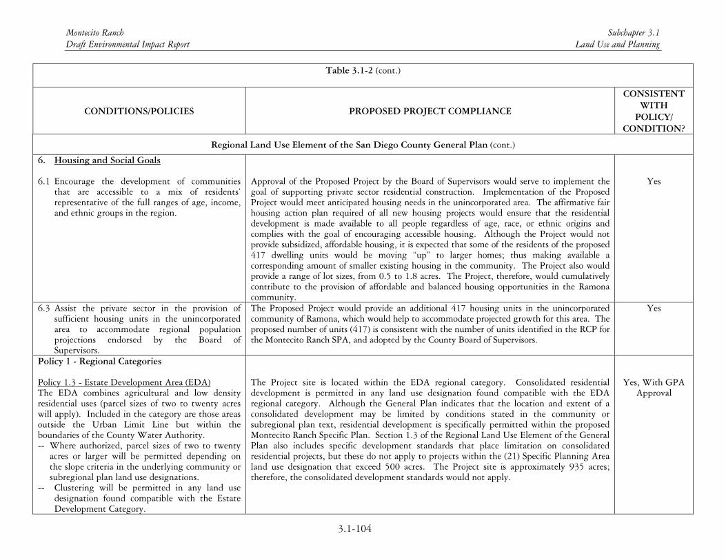
Montecito Ranch Subchapter 3.1 Draft Environmental Impact Report Land Use and Planning
3.1-104
Table 3.1-2 (cont.)
CONDITIONS/POLICIES PROPOSED PROJECT COMPLIANCE
CONSISTENT WITH
POLICY/ CONDITION?
Regional Land Use Element of the San Diego County General Plan (cont.)
6. Housing and Social Goals 6.1 Encourage the development of communities
that are accessible to a mix of residents’ representative of the full ranges of age, income, and ethnic groups in the region.
Approval of the Proposed Project by the Board of Supervisors would serve to implement the goal of supporting private sector residential construction. Implementation of the Proposed Project would meet anticipated housing needs in the unincorporated area. The affirmative fair housing action plan required of all new housing projects would ensure that the residential development is made available to all people regardless of age, race, or ethnic origins and complies with the goal of encouraging accessible housing. Although the Project would not provide subsidized, affordable housing, it is expected that some of the residents of the proposed 417 dwelling units would be moving “up” to larger homes; thus making available a corresponding amount of smaller existing housing in the community. The Project also would provide a range of lot sizes, from 0.5 to 1.8 acres. The Project, therefore, would cumulatively contribute to the provision of affordable and balanced housing opportunities in the Ramona community.
Yes
6.3 Assist the private sector in the provision of sufficient housing units in the unincorporated area to accommodate regional population projections endorsed by the Board of Supervisors.
The Proposed Project would provide an additional 417 housing units in the unincorporated community of Ramona, which would help to accommodate projected growth for this area. The proposed number of units (417) is consistent with the number of units identified in the RCP for the Montecito Ranch SPA, and adopted by the County Board of Supervisors.
Yes
Policy 1 - Regional Categories Policy 1.3 - Estate Development Area (EDA) The EDA combines agricultural and low density residential uses (parcel sizes of two to twenty acres will apply). Included in the category are those areas outside the Urban Limit Line but within the boundaries of the County Water Authority. -- Where authorized, parcel sizes of two to twenty
acres or larger will be permitted depending on the slope criteria in the underlying community or subregional plan land use designations.
-- Clustering will be permitted in any land use designation found compatible with the Estate Development Category.
The Project site is located within the EDA regional category. Consolidated residential development is permitted in any land use designation found compatible with the EDA regional category. Although the General Plan indicates that the location and extent of a consolidated development may be limited by conditions stated in the community or subregional plan text, residential development is specifically permitted within the proposed Montecito Ranch Specific Plan. Section 1.3 of the Regional Land Use Element of the General Plan also includes specific development standards that place limitation on consolidated residential projects, but these do not apply to projects within the (21) Specific Planning Area land use designation that exceed 500 acres. The Project site is approximately 935 acres; therefore, the consolidated development standards would not apply.
Yes, With GPA Approval

Montecito Ranch Subchapter 3.1 Draft Environmental Impact Report Land Use and Planning
3.1-105
Table 3.1-2 (cont.)
CONDITIONS/POLICIES PROPOSED PROJECT COMPLIANCE
CONSISTENT WITH
POLICY/ CONDITION?
Regional Land Use Element of the San Diego County General Plan (cont.)
Policy 1 - Regional Categories (cont.) Policy 1.3 - Estate Development Area (EDA) (cont.)
The Proposed Project would be consistent with the (21) Specific Planning Area (.5) designation and the regional EDA land use designation with respect to the overall allowable residential density for the Project site. The EDA discussion defers to the RCP with respect to minimum lot size. Lot sizes under the Project would range from approximately 0.5 acre (20,000 s.f. minimum) to 1.8 acres, which is less than the required 2-acre minimum. The Project Applicant has applied for an amendment to the General Plan to allow minimum lot sizes of approximately 0.5 acre (20,000 s.f. minimum); with approval of the amendment, the Project would be consistent with the amended minimum lot size requirements.
Policy 2 – Land Use Designations and Use Regulations Policy 2.1 - Urban Residential Designations (1) Residential This designation provides for low-density residential and minor agricultural uses. Parcel sizes of one, two or four acres (gross) are required depending on the slope criteria within each lot.
A portion of Montecito Way is within the (1) Residential land use designation. This segment of Montecito Way currently has a 40-foot-wide right-of-way and is paved to a width of 24 feet. The Proposed Project would increase pavement width to 40 feet within a 60-foot-wide right-of-way. Improvements on this roadway would not conflict with the (1) Residential designation. A large area adjacent to Montecito Road and Kalbaugh Street is designated (1) Residential. That area has been built out and improvements to the roadway and installation of a sewer line within existing roadways would neither significantly affect existing development nor conflict with this designation.
Yes
(5) Residential This designation provides for a density of 4.3 dwelling units per gross acre.
A small area adjacent to Montecito Road is designated (5) Residential. That area has been built out and improvements to the roadway would not significantly affect existing development nor conflict with this designation.
Yes

Montecito Ranch Subchapter 3.1 Draft Environmental Impact Report Land Use and Planning
3.1-106
Table 3.1-2 (cont.)
CONDITIONS/POLICIES PROPOSED PROJECT COMPLIANCE
CONSISTENT WITH
POLICY/ CONDITION?
Regional Land Use Element of the San Diego County General Plan (cont.)
Policy 2 – Land Use Designations and Use Regulations (cont.) Policy 2.2 – Commercial Designations (13) General Commercial This designation provides for commercial areas where a wide range of retail activities and services is permitted. Residential uses may be permitted under special circumstances.
The Montecito Road widening alignment would be adjacent to land that is designated (13) General Commercial. The intersection of Pine Street/Main Street also is within this land use designation. Proposed improvements would not conflict with this designation.
Yes
Policy 2.3 - Industrial Designations (16) General Impact Industrial This designation provides for uses exhibiting moderate to severe nuisance characteristics. Typically, large sites are required with direct access to major roads, railroads, and other transportation modes.
An area west of Montecito Way is designated (16) General Impact Industrial. The Proposed Project would increase pavement width to 40 feet within a 60-foot-wide right-of-way. A portion of the Montecito Road widening alignment also would cross over the corner of a parcel that is designated (16) General Impact Industrial. This area currently is used as a eucalyptus farm. These proposed roadway improvements would not conflict with the existing designation. In addition, the Project would construct a water booster pump station on a 10,000 s.f. lot in the northwestern corner of the intersection of Montecito Road/Montecito Way. This pump station would not conflict with the existing designation of (16) General Impact industrial.
Yes
Policy 2.4 - Non-urban Residential Designations (17) Estate Residential This designation provides for minor agricultural and low density residential uses. Parcel sizes of two or four acres (gross) or larger are required depending on the slope criteria within each lot.
An area south of Ash Street and adjacent to a portion of the Project site is designated (17) Estate Residential. The Proposed Project would increase pavement width to 40 feet within a 60-foot-wide right-of-way. Improvements on this roadway would not conflict with the (17) Estate Residential designation.
Yes

Montecito Ranch Subchapter 3.1 Draft Environmental Impact Report Land Use and Planning
3.1-107
Table 3.1-2 (cont.)
CONDITIONS/POLICIES PROPOSED PROJECT COMPLIANCE
CONSISTENT WITH
POLICY/ CONDITION?
Regional Land Use Element of the San Diego County General Plan (cont.)
Policy 2 – Land Use Designations and Use Regulations (cont.) Policy 2.4 - Non-urban Residential Designations (cont.) (18) Multiple Rural Use This designation is applied in areas with one or more of the following characteristics: not highly suited for intensive agriculture; rugged terrain; watershed; desert lands; lands susceptible to fires and erosion; lands which rely on groundwater for water supply; and other environmentally constrained areas. The Multiple Rural Use Designation is typically, but not necessarily exclusively, applied in remote areas to broad expanses of rural land with overall low population density and with an absence of most public services. Minimum allowable parcel sizes are based on slope criteria. Other than a single-family home on an existing lot, it is not intended that any development occur unless the proposed development has been carefully examined to assure that there will be no significant adverse environmental impacts, erosion and fire problems will be minimal, and no urban levels of service will be required.
A seven-acre triangular area along the northwestern portion of the Project site. This area would be included in dedicated open space under the Proposed Project, which would not conflict with the existing land use designation.
Yes
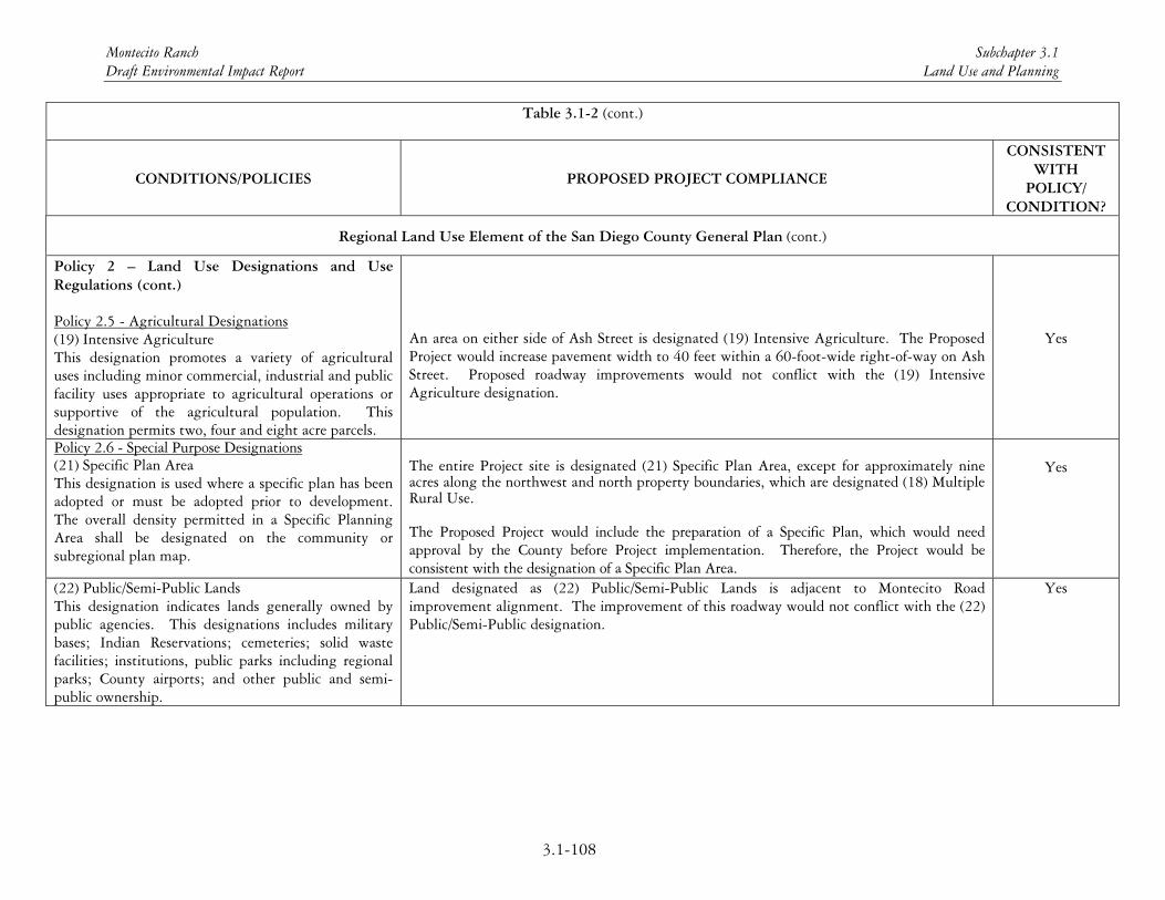
Montecito Ranch Subchapter 3.1 Draft Environmental Impact Report Land Use and Planning
3.1-108
Table 3.1-2 (cont.)
CONDITIONS/POLICIES PROPOSED PROJECT COMPLIANCE
CONSISTENT WITH
POLICY/ CONDITION?
Regional Land Use Element of the San Diego County General Plan (cont.)
Policy 2 – Land Use Designations and Use Regulations (cont.) Policy 2.5 - Agricultural Designations (19) Intensive Agriculture This designation promotes a variety of agricultural uses including minor commercial, industrial and public facility uses appropriate to agricultural operations or supportive of the agricultural population. This designation permits two, four and eight acre parcels.
An area on either side of Ash Street is designated (19) Intensive Agriculture. The Proposed Project would increase pavement width to 40 feet within a 60-foot-wide right-of-way on Ash Street. Proposed roadway improvements would not conflict with the (19) Intensive Agriculture designation.
Yes
Policy 2.6 - Special Purpose Designations (21) Specific Plan Area This designation is used where a specific plan has been adopted or must be adopted prior to development. The overall density permitted in a Specific Planning Area shall be designated on the community or subregional plan map.
The entire Project site is designated (21) Specific Plan Area, except for approximately nine acres along the northwest and north property boundaries, which are designated (18) Multiple Rural Use. The Proposed Project would include the preparation of a Specific Plan, which would need approval by the County before Project implementation. Therefore, the Project would be consistent with the designation of a Specific Plan Area.
Yes
(22) Public/Semi-Public Lands This designation indicates lands generally owned by public agencies. This designations includes military bases; Indian Reservations; cemeteries; solid waste facilities; institutions, public parks including regional parks; County airports; and other public and semi-public ownership.
Land designated as (22) Public/Semi-Public Lands is adjacent to Montecito Road improvement alignment. The improvement of this roadway would not conflict with the (22) Public/Semi-Public designation.
Yes

Montecito Ranch Subchapter 3.1 Draft Environmental Impact Report Land Use and Planning
3.1-109
Table 3.1-2 (cont.)
CONDITIONS/POLICIES PROPOSED PROJECT COMPLIANCE
CONSISTENT WITH
POLICY/ CONDITION?
Regional Land Use Element of the San Diego County General Plan (cont.)
Policy 2 – Land Use Designations and Use Regulations (cont.) (26) Visitor-serving Commercial This designation provides areas reserved for commercial recreation and visitor-serving uses catering primarily to tourists and vacationers. It is, therefore, designed to provide a limited range of goods and services such as transient lodging, entertainment and certain types of retail sales. Family residential uses are permitted only as a secondary use in conjunction with visitor commercial use types as the primary use.
The segment of Montecito Road that is proposed for improvement traverses land that is designated as (26) Visitor-serving Commercial. Improvements would not conflict with this land use designation.
Yes
Circulation Element of the San Diego County General Plan
Chapter 1 - Road Network This chapter does not contain any goals or policies, but explains, among other issues, the system of classifying the road network.
Refer to “Ramona Circulation Element Plan” under the Circulation Element of the RCP. Yes, With GPA Approval

Montecito Ranch Subchapter 3.1 Draft Environmental Impact Report Land Use and Planning
3.1-110
Table 3.1-2 (cont.)
CONDITIONS/POLICIES PROPOSED PROJECT COMPLIANCE
CONSISTENT WITH
POLICY/ CONDITION?
Circulation Element of the San Diego County General Plan (cont.)
Goals - Bicycle Network 1. Provide for the safe and convenient use of bicycles
throughout San Diego County as a viable alternative to the automobile as a form of transportation.
4. Utilize public property, such as utility and drainage easements, parks and lightly traveled roads, whenever possible, for construction of bikeways.
5. Provide continuous bikeways, affording safe and convenient community wide accessibility while preserving the natural environment to the greatest extent practical.
Policies - Bicycle Network 4. Connect cultural facilities, recreation areas,
commercial areas, and educational facilities by bikeways.
5. Separate bicycles and automobiles whenever it is economically and physically possible to do so with either a bike lane or bike path.
6. Design bikeways as an integrated part of all subdivisions and planned residential developments with connections to the bicycle network.
Refer to “Ramona Circulation Element Plan” under the Circulation Element of the RCP for the proposed changes to the RCP Circulation Element bicycle network. The Proposed Project is consistent with the goals of the Bicycle Network section of the Circulation Element in that the Project would include six-foot-wide bike lanes along both sides of Ash Street from Pine Street to Alice Street, Montecito Ranch Road, and Montecito Way that would provide for the safe and convenient use of bicycles as an alternative to automobiles. In addition, six-foot-wide bike lanes are proposed along both sides of Montecito Road. The Project would connect the proposed residential development and the parks, and charter high school sites with continuous bikeways. The planned bikeway system would connect the core areas with all of the residential neighborhoods and would connect to the Bicycle Network System shown on the adopted Bicycle Plan.
Yes

Montecito Ranch Subchapter 3.1 Draft Environmental Impact Report Land Use and Planning
3.1-111
Table 3.1-2 (cont.)
CONDITIONS/POLICIES PROPOSED PROJECT COMPLIANCE
CONSISTENT WITH
POLICY/ CONDITION?
Recreation Element of the San Diego County General Plan
Recommended Standard – Local Parks An overall standard of 30 acres per 1,000 population is therefore recommended, of which half should be devoted to regional facilities as proposed in 1967 in the County General Plan, and half or 15 acres per 1,000 population, for local parks. The local park standard includes a combination of local parks, riding and hiking trails, school playgrounds, and other public facilities which meet part of the need for local recreational facilities.
Approximately 1,300 people would reside in the Project residential area. Accordingly, the Proposed Project would need to provide 39 acres of parkland, including a minimum of 19.5 acres of each of local and regional parks. The Project would include an 8.3-acre local park, an 11.9-acre historic park site, and 3.1 acres of multi-purpose trails within roadway rights-of way in the Montecito Ranch SPA, for a total of 23.3 acres of local parkland within Montecito Ranch. An additional 4.1 acres of multi-purpose trails would be constructed by the Project off-site along Ash Street, Montecito Way, and Montecito Way. This would equate to a total of 27.4 acres of local parkland to be dedicated by the Project. The Project would dedicate 573.8 acres of open space on site under Wastewater Management Option 1 (549.1 acres under Option 2), including 11.1 acres of multi-purpose trails within the open space, thereby meeting the criterion for regional parks as described above. The County Department of Parks and Recreation has accepted the proposed on-site recreational amenities as adequate to satisfy the recreational requirements for the Proposed Project (see June 8, 2006 letter in Appendix A of Appendix O to this EIR), based on the provision of developed parkland in place of a larger block of undeveloped parkland. Accordingly, impacts would be less than significant.
Yes
Policies - Local Parks 1. Local parks should provide recreational
opportunities for all, regardless of national origin, color, age, or economic status, or location of residence.
The local and historic parks would provide recreational opportunities for all people, regardless of national origin, color, age, economic status, or location of residence.
Yes
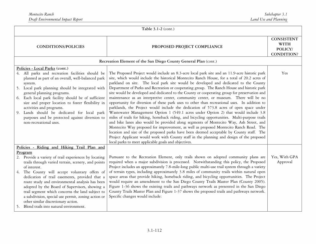
Montecito Ranch Subchapter 3.1 Draft Environmental Impact Report Land Use and Planning
3.1-112
Table 3.1-2 (cont.)
CONDITIONS/POLICIES PROPOSED PROJECT COMPLIANCE
CONSISTENT WITH
POLICY/ CONDITION?
Recreation Element of the San Diego County General Plan (cont.)
Policies - Local Parks (cont.) 4. All parks and recreation facilities should be
planned as part of an overall, well-balanced park system.
5. Local park planning should be integrated with general planning programs.
6. Each local park facility should be of sufficient size and proper location to foster flexibility in activities and programs.
9. Lands should be dedicated for local park purposes and be protected against diversion to non-recreational uses.
The Proposed Project would include an 8.3-acre local park site and an 11.9-acre historic park site, which would include the historical Montecito Ranch House, for a total of 20.2 acres of parkland on site. The local park site would be developed and dedicated to the County Department of Parks and Recreation or cooperating group. The Ranch House and historic park site would be developed and dedicated to the County or cooperating group for preservation and maintenance as an interpretive center, community center, or museum. There will be no opportunity for diversion of these park uses to other than recreational uses. In addition to parklands, the Project would include the dedication of 573.8 acres of open space under Wastewater Management Option 1 (549.1 acres under Option 2) that would include 3.8 miles of trails for hiking, horseback riding, and bicycling opportunities. Multi-purpose trails and bike lanes also would be provided along segments of Montecito Way, Ash Street, and Montecito Way proposed for improvement, as well as proposed Montecito Ranch Road. The location and size of the proposed parks have been deemed acceptable by County staff. The Project Applicant would work with County staff in the planning and design of the proposed local parks to meet applicable goals and objectives.
Yes
Policies - Riding and Hiking Trail Plan and Program 2. Provide a variety of trail experiences by locating
trails through varied terrain, scenery, and points of interest.
4. The County will accept voluntary offers of dedication of trail easements, provided that a route study and environmental analysis has been adopted by the Board of Supervisors, showing a trail segment which concerns the land subject to a subdivision, special use permit, zoning action or other similar discretionary action.
5. Blend trails into natural environment.
Pursuant to the Recreation Element, only trails shown on adopted community plans are required when a major subdivision is processed. Notwithstanding this policy, the Proposed Project includes an approximately 7.8-mile-long public multi-use trail system through a variety of terrain types, including approximately 3.8 miles of community trails within natural open space areas that provide hiking, horseback riding, and bicycling opportunities. The Project would require an amendment to the San Diego County Trails Master Plan (County 2005). Figure 1-36 shows the existing trails and pathways network as presented in the San Diego County Trails Master Plan and Figure 1-37 shows the proposed trails and pathways network. Specific changes would include:
Yes, With GPA Approval
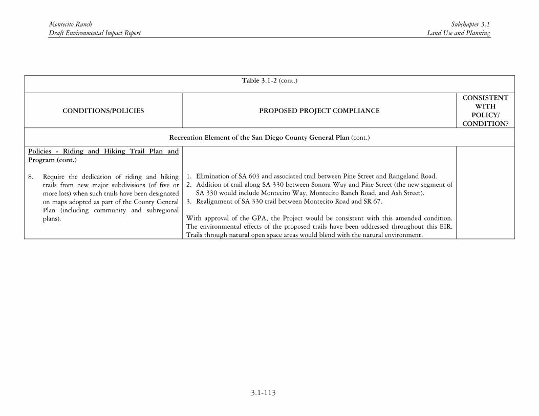
Montecito Ranch Subchapter 3.1 Draft Environmental Impact Report Land Use and Planning
3.1-113
Table 3.1-2 (cont.)
CONDITIONS/POLICIES PROPOSED PROJECT COMPLIANCE
CONSISTENT WITH
POLICY/ CONDITION?
Recreation Element of the San Diego County General Plan (cont.)
Policies - Riding and Hiking Trail Plan and Program (cont.) 8. Require the dedication of riding and hiking
trails from new major subdivisions (of five or more lots) when such trails have been designated on maps adopted as part of the County General Plan (including community and subregional plans).
1. Elimination of SA 603 and associated trail between Pine Street and Rangeland Road. 2. Addition of trail along SA 330 between Sonora Way and Pine Street (the new segment of
SA 330 would include Montecito Way, Montecito Ranch Road, and Ash Street). 3. Realignment of SA 330 trail between Montecito Road and SR 67. With approval of the GPA, the Project would be consistent with this amended condition. The environmental effects of the proposed trails have been addressed throughout this EIR. Trails through natural open space areas would blend with the natural environment.
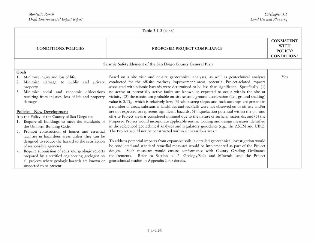
Montecito Ranch Subchapter 3.1 Draft Environmental Impact Report Land Use and Planning
3.1-114
Table 3.1-2 (cont.)
CONDITIONS/POLICIES PROPOSED PROJECT COMPLIANCE
CONSISTENT WITH
POLICY/ CONDITION?
Seismic Safety Element of the San Diego County General Plan
Goals 1. Minimize injury and loss of life. 2. Minimize damage to public and private
property. 3. Minimize social and economic dislocations
resulting from injuries, loss of life and property damage.
Policies - New Development It is the Policy of the County of San Diego to: 1. Require all buildings to meet the standards of
the Uniform Building Code. 5. Prohibit construction of homes and essential
facilities in hazardous areas unless they can be designed to reduce the hazard to the satisfaction of responsible agencies.
7. Require submission of soils and geologic reports prepared by a certified engineering geologist on all projects where geologic hazards are known or suspected to be present.
Based on a site visit and on-site geotechnical analyses, as well as geotechnical analyses conducted for the off-site roadway improvement areas, potential Project-related impacts associated with seismic hazards were determined to be less than significant. Specifically, (1) no active or potentially active faults are known or expected to occur within the site or vicinity; (2) the maximum probable on-site seismic ground acceleration (i.e., ground shaking) value is 0.15g, which is relatively low; (3) while steep slopes and rock outcrops are present in a number of areas, substantial landslides and rockfalls were not observed on or off site and/or are not expected to represent significant hazards; (4) liquefaction potential within the on- and off-site Project areas is considered minimal due to the nature of surficial materials; and (5) the Proposed Project would incorporate applicable seismic loading and design measures identified in the referenced geotechnical analyses and regulatory guidelines (e.g., the ASTM and UBC). The Project would not be constructed within a “hazardous area.” To address potential impacts from expansive soils, a detailed geotechnical investigation would be conducted and standard remedial measures would be implemented as part of the Project design. Such measures would ensure conformance with County Grading Ordinance requirements. Refer to Section 4.1.2, Geology/Soils and Minerals, and the Project geotechnical studies in Appendix L for details.
Yes
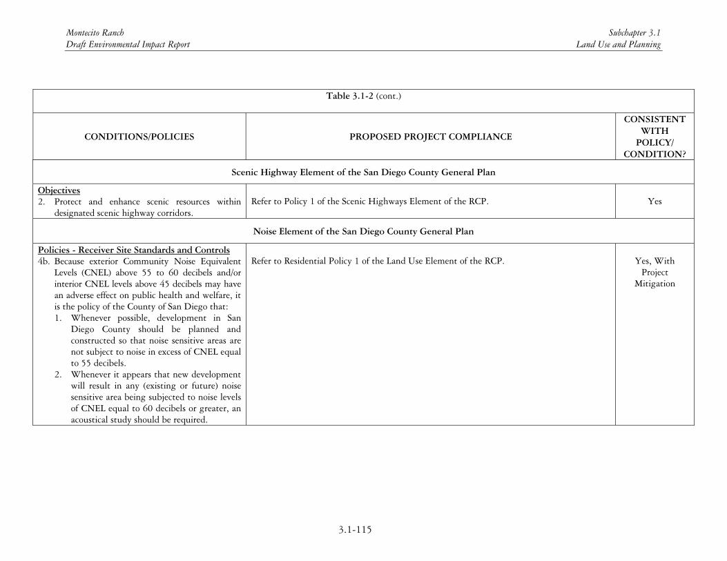
Montecito Ranch Subchapter 3.1 Draft Environmental Impact Report Land Use and Planning
3.1-115
Table 3.1-2 (cont.)
CONDITIONS/POLICIES PROPOSED PROJECT COMPLIANCE
CONSISTENT WITH
POLICY/ CONDITION?
Scenic Highway Element of the San Diego County General Plan
Objectives 2. Protect and enhance scenic resources within
designated scenic highway corridors.
Refer to Policy 1 of the Scenic Highways Element of the RCP.
Yes
Noise Element of the San Diego County General Plan
Policies - Receiver Site Standards and Controls 4b. Because exterior Community Noise Equivalent
Levels (CNEL) above 55 to 60 decibels and/or interior CNEL levels above 45 decibels may have an adverse effect on public health and welfare, it is the policy of the County of San Diego that: 1. Whenever possible, development in San
Diego County should be planned and constructed so that noise sensitive areas are not subject to noise in excess of CNEL equal to 55 decibels.
2. Whenever it appears that new development will result in any (existing or future) noise sensitive area being subjected to noise levels of CNEL equal to 60 decibels or greater, an acoustical study should be required.
Refer to Residential Policy 1 of the Land Use Element of the RCP.
Yes, With
Project Mitigation
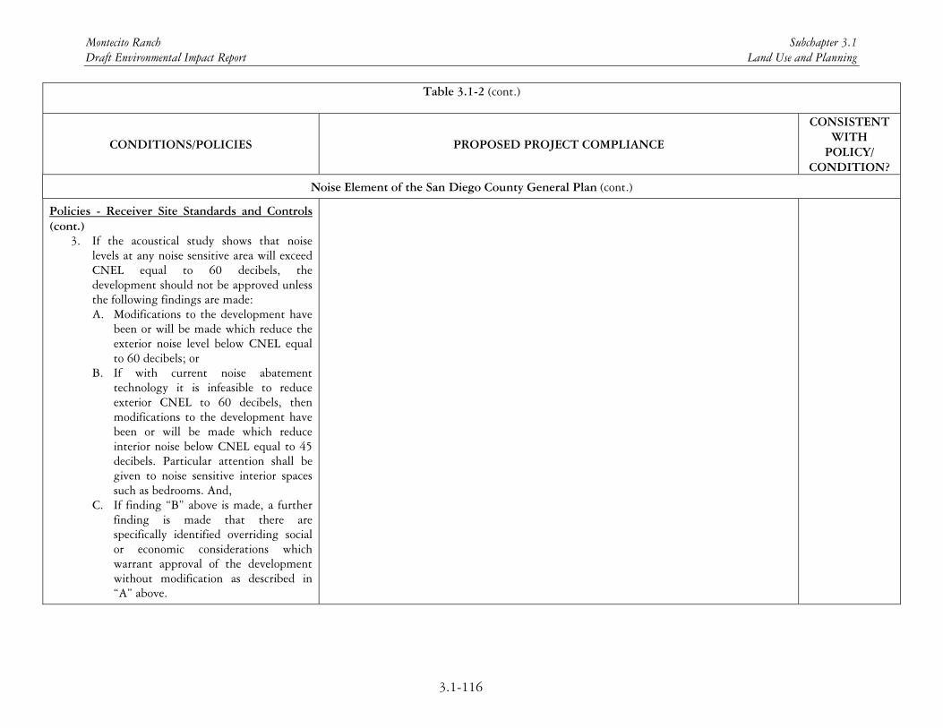
Montecito Ranch Subchapter 3.1 Draft Environmental Impact Report Land Use and Planning
3.1-116
Table 3.1-2 (cont.)
CONDITIONS/POLICIES PROPOSED PROJECT COMPLIANCE
CONSISTENT WITH
POLICY/ CONDITION?
Noise Element of the San Diego County General Plan (cont.)
Policies - Receiver Site Standards and Controls (cont.)
3. If the acoustical study shows that noise levels at any noise sensitive area will exceed CNEL equal to 60 decibels, the development should not be approved unless the following findings are made: A. Modifications to the development have
been or will be made which reduce the exterior noise level below CNEL equal to 60 decibels; or
B. If with current noise abatement technology it is infeasible to reduce exterior CNEL to 60 decibels, then modifications to the development have been or will be made which reduce interior noise below CNEL equal to 45 decibels. Particular attention shall be given to noise sensitive interior spaces such as bedrooms. And,
C. If finding “B” above is made, a further finding is made that there are specifically identified overriding social or economic considerations which warrant approval of the development without modification as described in “A” above.

Montecito Ranch Subchapter 3.1 Draft Environmental Impact Report Land Use and Planning
3.1-117
Table 3.1-2 (cont.)
CONDITIONS/POLICIES PROPOSED PROJECT COMPLIANCE CONSISTENT
WITH POLICY/ CONDITION?
Noise Element of the San Diego County General Plan
Policies - Receiver Site Standards and Controls (cont.)
4. If the acoustical study shows that noise levels at any noise sensitive area will exceed CNEL equal to 75 decibels, the development should not be approved.
Exemptions 1. For the rooms in “Noise Sensitive Areas," which
are usually occupied only a part of the day (schools, libraries, or similar), the interior one hour average sound level, due to noise outside, should not exceed 50 decibels.
2. For County road construction projects, the exterior noise level due to vehicular traffic impacting a noise sensitive area should not exceed the following values:
3. Other Projects - CNEL = 60 dB(A), except if the existing or projected noise level without the project is 58 dB(A) or greater a 3 dB(A) increase will be allowed, up to the maximum permitted by Federal Highway Administration Standards.
Housing Element of the San Diego County General Plan
Goal 1. Assist the private sector, including non-profit and
community development organizations, to ensure that new residential construction will be available to meet the needs of the region if adequate public services and facilities are in place. Housing should be available in a variety of styles, tenancy types, and prices throughout the region.
Refer to Housing and Social Goal 6.1 of the Regional Land Use Element of the General Plan.
Yes
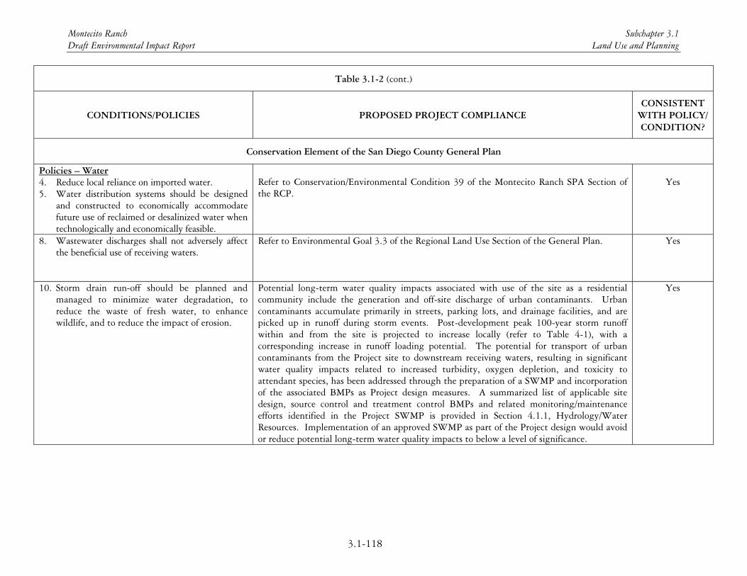
Montecito Ranch Subchapter 3.1 Draft Environmental Impact Report Land Use and Planning
3.1-118
Table 3.1-2 (cont.)
CONDITIONS/POLICIES PROPOSED PROJECT COMPLIANCE CONSISTENT
WITH POLICY/ CONDITION?
Conservation Element of the San Diego County General Plan
Policies – Water 4. Reduce local reliance on imported water. 5. Water distribution systems should be designed
and constructed to economically accommodate future use of reclaimed or desalinized water when technologically and economically feasible.
Refer to Conservation/Environmental Condition 39 of the Montecito Ranch SPA Section of the RCP.
Yes
8. Wastewater discharges shall not adversely affect the beneficial use of receiving waters.
Refer to Environmental Goal 3.3 of the Regional Land Use Section of the General Plan. Yes
10. Storm drain run-off should be planned and managed to minimize water degradation, to reduce the waste of fresh water, to enhance wildlife, and to reduce the impact of erosion.
Potential long-term water quality impacts associated with use of the site as a residential community include the generation and off-site discharge of urban contaminants. Urban contaminants accumulate primarily in streets, parking lots, and drainage facilities, and are picked up in runoff during storm events. Post-development peak 100-year storm runoff within and from the site is projected to increase locally (refer to Table 4-1), with a corresponding increase in runoff loading potential. The potential for transport of urban contaminants from the Project site to downstream receiving waters, resulting in significant water quality impacts related to increased turbidity, oxygen depletion, and toxicity to attendant species, has been addressed through the preparation of a SWMP and incorporation of the associated BMPs as Project design measures. A summarized list of applicable site design, source control and treatment control BMPs and related monitoring/maintenance efforts identified in the Project SWMP is provided in Section 4.1.1, Hydrology/Water Resources. Implementation of an approved SWMP as part of the Project design would avoid or reduce potential long-term water quality impacts to below a level of significance.
Yes
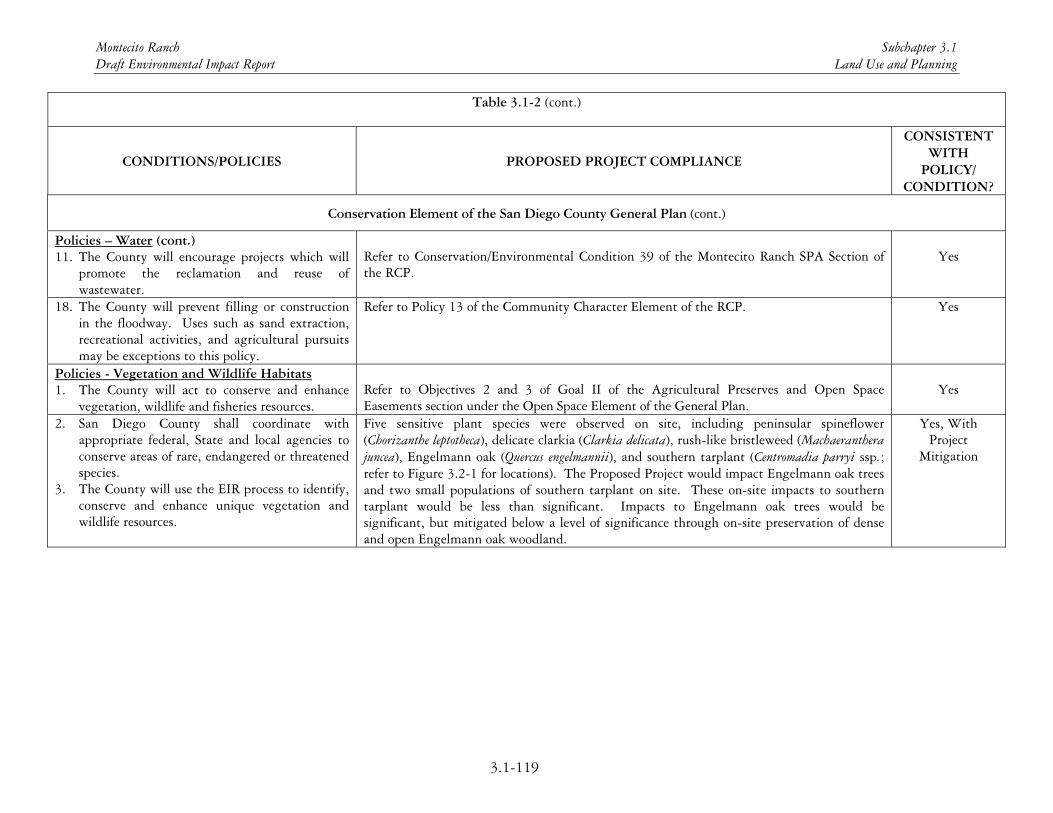
Montecito Ranch Subchapter 3.1 Draft Environmental Impact Report Land Use and Planning
3.1-119
Table 3.1-2 (cont.)
CONDITIONS/POLICIES PROPOSED PROJECT COMPLIANCE
CONSISTENT WITH
POLICY/ CONDITION?
Conservation Element of the San Diego County General Plan (cont.)
Policies – Water (cont.) 11. The County will encourage projects which will
promote the reclamation and reuse of wastewater.
Refer to Conservation/Environmental Condition 39 of the Montecito Ranch SPA Section of the RCP.
Yes
18. The County will prevent filling or construction in the floodway. Uses such as sand extraction, recreational activities, and agricultural pursuits may be exceptions to this policy.
Refer to Policy 13 of the Community Character Element of the RCP. Yes
Policies - Vegetation and Wildlife Habitats 1. The County will act to conserve and enhance
vegetation, wildlife and fisheries resources.
Refer to Objectives 2 and 3 of Goal II of the Agricultural Preserves and Open Space Easements section under the Open Space Element of the General Plan.
Yes
2. San Diego County shall coordinate with appropriate federal, State and local agencies to conserve areas of rare, endangered or threatened species.
3. The County will use the EIR process to identify, conserve and enhance unique vegetation and wildlife resources.
Five sensitive plant species were observed on site, including peninsular spineflower (Chorizanthe leptotheca), delicate clarkia (Clarkia delicata), rush-like bristleweed (Machaeranthera juncea), Engelmann oak (Quercus engelmannii), and southern tarplant (Centromadia parryi ssp.; refer to Figure 3.2-1 for locations). The Proposed Project would impact Engelmann oak trees and two small populations of southern tarplant on site. These on-site impacts to southern tarplant would be less than significant. Impacts to Engelmann oak trees would be significant, but mitigated below a level of significance through on-site preservation of dense and open Engelmann oak woodland.
Yes, With Project
Mitigation

Montecito Ranch Subchapter 3.1 Draft Environmental Impact Report Land Use and Planning
3.1-120
Table 3.1-2 (cont.)
CONDITIONS/POLICIES PROPOSED PROJECT COMPLIANCE
CONSISTENT WITH
POLICY/ CONDITION?
Conservation Element of the San Diego County General Plan (cont.)
Policies - Vegetation and Wildlife Habitats (cont.)
Twelve (12) sensitive animal species were observed on site during surveys conducted between 2001 and 2004, including: coastal California gnatcatcher, southern California rufous-crowned sparrow (Aimophila ruficeps canescens), California thrasher (Toxostoma redivivum), loggerhead shrike (Lanius ludovicianus), red-shouldered hawk (Buteo lineatus), turkey vulture (Cathartes aura), American kestrel (Falco sparverius), red-tailed hawk (Buteo jamaicensis), coastal whiptail (Cnemidophorus tigris multiscutatus), San Diego horned lizard (Phrynosoma coronatum blainvillei), two-striped garter snake (Thamnophis hammondii), and San Diego black-tailed jackrabbit (Lepus californicus bennettii; refer to Figure 3.2-1 for locations). The Project would significantly impact coastal California gnatcatcher. Preservation of on-site habitat (Diegan coastal sage scrub) and restriction of grading and construction activities within 300 feet of an occupied nest during the breeding season would mitigate impacts below a level of significance through the EIR and Project permit process. Refer to Subchapter 3.2, Biological Resources, for details.
5. San Diego County shall encourage the use of native plant species in review of landscaping and erosion control plans for public and private projects.
All manufactured slopes in excess of 15 feet would be contour graded (using techniques such as slope undulation, rounding the top and toe of slopes and varying gradients) and would receive enhanced landscaping with native species. In addition, landscaping within streetscapes, parks, future school landscaping, and screening plantings for the WRF would consist of a variety of native species, as well as non-native species.
Yes
6. If a project is determined to have a significant adverse impact on plants or wildlife, an acceptable mitigating measure may be a voluntary donation of land of comparable value to wildlife.
9. When significant adverse habitat modification is unavoidable, San Diego County will encourage project designers to provide mitigating measures in their designs to protect existing habitat.
Mitigation for significant impacts to habitat and sensitive animal species includes the preservation of 216.68 acres of sensitive habitat on site under Wastewater Management Option 1 (215.92 acres under Option 2) and between 28.80 and 30.52 acres off site. The Project Applicant also would voluntarily contribute an additional 99.00 (under Option 1) or 75.67 acres (under Option 2) of habitat to on-site dedicated open space. The open space area would preserve sensitive plant and animal species, as discussed above in Policy 3 of Vegetation and Wildlife Habitats under Conservation Element of the San Diego County General Plan.
Yes, With Project
Mitigation

Montecito Ranch Subchapter 3.1 Draft Environmental Impact Report Land Use and Planning
3.1-121
Table 3.1-2 (cont.)
CONDITIONS/POLICIES PROPOSED PROJECT COMPLIANCE
CONSISTENT WITH
POLICY/ CONDITION?
Conservation Element of the San Diego County General Plan (cont.)
Policies - Vegetation and Wildlife Habitats (cont.) 13. Flood control measures shall, whenever
practical, utilize natural floodways and floodplains, maintaining riparian habitats and historic stream flow volumes. No structures or excavations which adversely affect floodplain vegetation and wildlife, or decrease their value as migration corridors, should be permitted.
Project design would not substantially increase runoff rates or velocities within or from the site due to the relatively minor amount of proposed impervious surface and the inclusion of Project design measures to regulate flow locations, rates, and velocities. These measures would include the use of on-site drainage facilities (storm drains, etc.) designed to accommodate a 100-year storm event (per County guidelines), installation of extended detention basins and energy dissipators at appropriate locations to maintain pre-development flow/velocity levels, and the use of vegetated swales and surface or subsurface drains to increase infiltration and control flows in sloped areas. Refer to Policy 12 of the Community Character Element of the RCP.
Yes, With Project
Mitigation
16. The County will regulate major land clearing projects to minimize significant soil erosion, destruction of archaeological, historic and scientific resources and endangered species of plants and animals.
Proposed Project grading, excavation, and construction activities would increase the potential for erosion and transport of material both within and downstream of the site. The Project would be required to conform to erosion requirements under the NPDES by the preparation of a SWPPP. Project impacts associated with erosion would be less than significant. Majority of the on-site CEQA significant archaeological sites would be preserved in open space. Refer to Policy 13 of the Conservation Element of the RCP. On-site open space area would preserve sensitive plant and animal species, as discussed above in Policy 3 of Vegetation and Wildlife Habitats under Conservation Element of the San Diego County General Plan.
Yes, With Project
Mitigation
Policies – Soils 9. To prevent erosion and slippage in man-made
slopes approved low maintenance trees, bushes and grasses which establish themselves quickly should be planted.
Manufactured slopes would be planted with drought-tolerant and native species, as well as non-native species. Some slope and street planting areas may initially utilize temporary irrigation systems to establish plant growth, but these systems would be removed or turned off when plant growth is established.
Yes
10. The County will regulate major land clearing projects to minimize significant soil erosion, destruction of archaeological historic and scientific resources and endangered species of plants and animals.
Refer to Policy 16 of Vegetation and Wildlife Habitats under Conservation Element of the San Diego County General Plan.
Yes, With Project
Mitigation
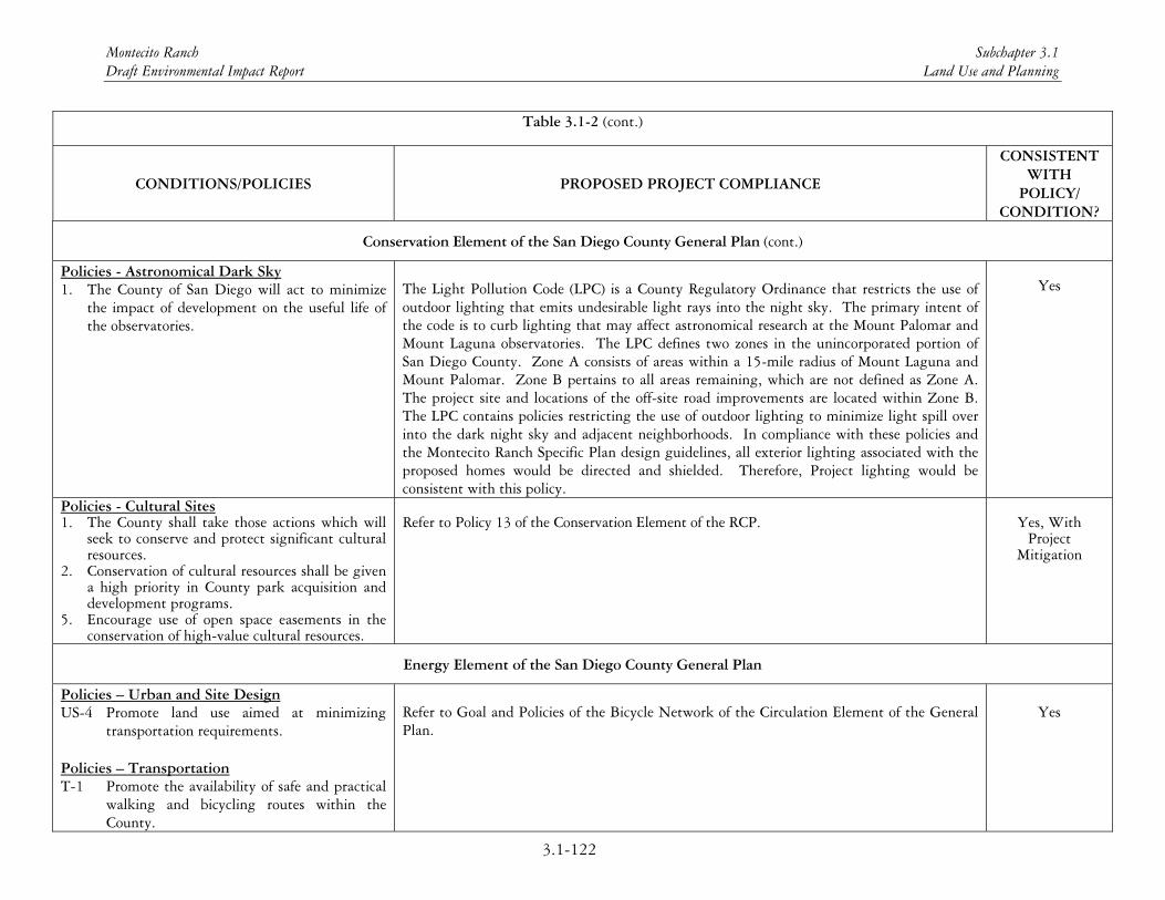
Montecito Ranch Subchapter 3.1 Draft Environmental Impact Report Land Use and Planning
3.1-122
Table 3.1-2 (cont.)
CONDITIONS/POLICIES PROPOSED PROJECT COMPLIANCE
CONSISTENT WITH
POLICY/ CONDITION?
Conservation Element of the San Diego County General Plan (cont.)
Policies - Astronomical Dark Sky 1. The County of San Diego will act to minimize
the impact of development on the useful life of the observatories.
The Light Pollution Code (LPC) is a County Regulatory Ordinance that restricts the use of outdoor lighting that emits undesirable light rays into the night sky. The primary intent of the code is to curb lighting that may affect astronomical research at the Mount Palomar and Mount Laguna observatories. The LPC defines two zones in the unincorporated portion of San Diego County. Zone A consists of areas within a 15-mile radius of Mount Laguna and Mount Palomar. Zone B pertains to all areas remaining, which are not defined as Zone A. The project site and locations of the off-site road improvements are located within Zone B. The LPC contains policies restricting the use of outdoor lighting to minimize light spill over into the dark night sky and adjacent neighborhoods. In compliance with these policies and the Montecito Ranch Specific Plan design guidelines, all exterior lighting associated with the proposed homes would be directed and shielded. Therefore, Project lighting would be consistent with this policy.
Yes
Policies - Cultural Sites 1. The County shall take those actions which will
seek to conserve and protect significant cultural resources.
2. Conservation of cultural resources shall be given a high priority in County park acquisition and development programs.
5. Encourage use of open space easements in the conservation of high-value cultural resources.
Refer to Policy 13 of the Conservation Element of the RCP.
Yes, With
Project Mitigation
Energy Element of the San Diego County General Plan
Policies – Urban and Site Design US-4 Promote land use aimed at minimizing
transportation requirements. Policies – Transportation T-1 Promote the availability of safe and practical
walking and bicycling routes within the County.
Refer to Goal and Policies of the Bicycle Network of the Circulation Element of the General Plan.
Yes
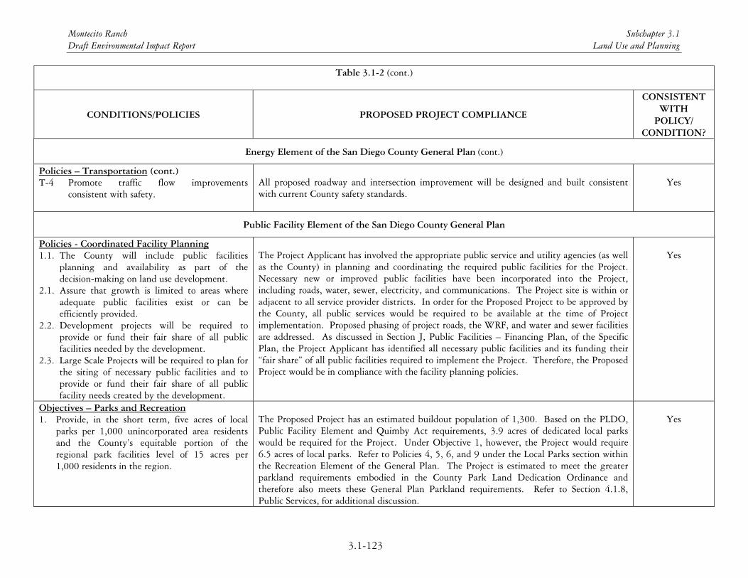
Montecito Ranch Subchapter 3.1 Draft Environmental Impact Report Land Use and Planning
3.1-123
Table 3.1-2 (cont.)
CONDITIONS/POLICIES PROPOSED PROJECT COMPLIANCE
CONSISTENT WITH
POLICY/ CONDITION?
Energy Element of the San Diego County General Plan (cont.)
Policies – Transportation (cont.) T-4 Promote traffic flow improvements
consistent with safety.
All proposed roadway and intersection improvement will be designed and built consistent with current County safety standards.
Yes
Public Facility Element of the San Diego County General Plan
Policies - Coordinated Facility Planning 1.1. The County will include public facilities
planning and availability as part of the decision-making on land use development.
2.1. Assure that growth is limited to areas where adequate public facilities exist or can be efficiently provided.
2.2. Development projects will be required to provide or fund their fair share of all public facilities needed by the development.
2.3. Large Scale Projects will be required to plan for the siting of necessary public facilities and to provide or fund their fair share of all public facility needs created by the development.
The Project Applicant has involved the appropriate public service and utility agencies (as well as the County) in planning and coordinating the required public facilities for the Project. Necessary new or improved public facilities have been incorporated into the Project, including roads, water, sewer, electricity, and communications. The Project site is within or adjacent to all service provider districts. In order for the Proposed Project to be approved by the County, all public services would be required to be available at the time of Project implementation. Proposed phasing of project roads, the WRF, and water and sewer facilities are addressed. As discussed in Section J, Public Facilities – Financing Plan, of the Specific Plan, the Project Applicant has identified all necessary public facilities and its funding their “fair share” of all public facilities required to implement the Project. Therefore, the Proposed Project would be in compliance with the facility planning policies.
Yes
Objectives – Parks and Recreation 1. Provide, in the short term, five acres of local
parks per 1,000 unincorporated area residents and the County’s equitable portion of the regional park facilities level of 15 acres per 1,000 residents in the region.
The Proposed Project has an estimated buildout population of 1,300. Based on the PLDO, Public Facility Element and Quimby Act requirements, 3.9 acres of dedicated local parks would be required for the Project. Under Objective 1, however, the Project would require 6.5 acres of local parks. Refer to Policies 4, 5, 6, and 9 under the Local Parks section within the Recreation Element of the General Plan. The Project is estimated to meet the greater parkland requirements embodied in the County Park Land Dedication Ordinance and therefore also meets these General Plan Parkland requirements. Refer to Section 4.1.8, Public Services, for additional discussion.
Yes

Montecito Ranch Subchapter 3.1 Draft Environmental Impact Report Land Use and Planning
3.1-124
Table 3.1-2 (cont.)
CONDITIONS/POLICIES PROPOSED PROJECT COMPLIANCE
CONSISTENT WITH
POLICY/ CONDITION?
Public Facility Element of the San Diego County General Plan (cont.)
Policies – Parks and Recreation 2.2. The County will site, plan and develop local and
regional parks that are compatible with community character, land use and the recreational, conservation and preservation needs of the intended service population.
The local portion of this policy is implemented by the County Park Land Dedication Ordinance (PLDO), which is in compliance with the State’s Quimby Act (Government Code Section 66477). It requires land dedication of 3 acres per 1,000 population or payment of a fee in-lieu of dedication for local parks.
Yes
Policies – Transportation 1.1. New development shall provide needed roadway
expansion and improvements on-site to meet the demand created by the development and to maintain an LOS C on Circulation Element Roads during peak traffic hours. New development shall provide off-site improvements designed to contribute to the overall achievement of an LOS D on Circulation Element Roads.
2.1. New development shall be required to contribute its fair share toward financing transportation facilities.
The Project would be required to construct/improve roadway segments and intersections as mitigation for significant direct and cumulative Project traffic impacts. Refer to Policy T-4 of Transportation under Energy Element of the San Diego County General Plan, above. Where the Proposed Project provides roadway improvements that also benefit other future (cumulative) projects, a reimbursement agreement and/or credit toward the Proposed Project’s fair share of other transportation improvements to mitigate cumulative impacts would be defined working with County staff and implemented through the County’s adopted TIF program. As part of mitigation, the Project would contribute its fair share for improvements to Pine Street/Olive Street. Identified fair share contributions of the Proposed Project toward transportation improvements to mitigate cumulative impacts would be accomplished through payments into the TIF program or credit against TIF fees based on the cost of improvements constructed by the Proposed Project, beyond the Project’s fair share of such improvements.
Yes
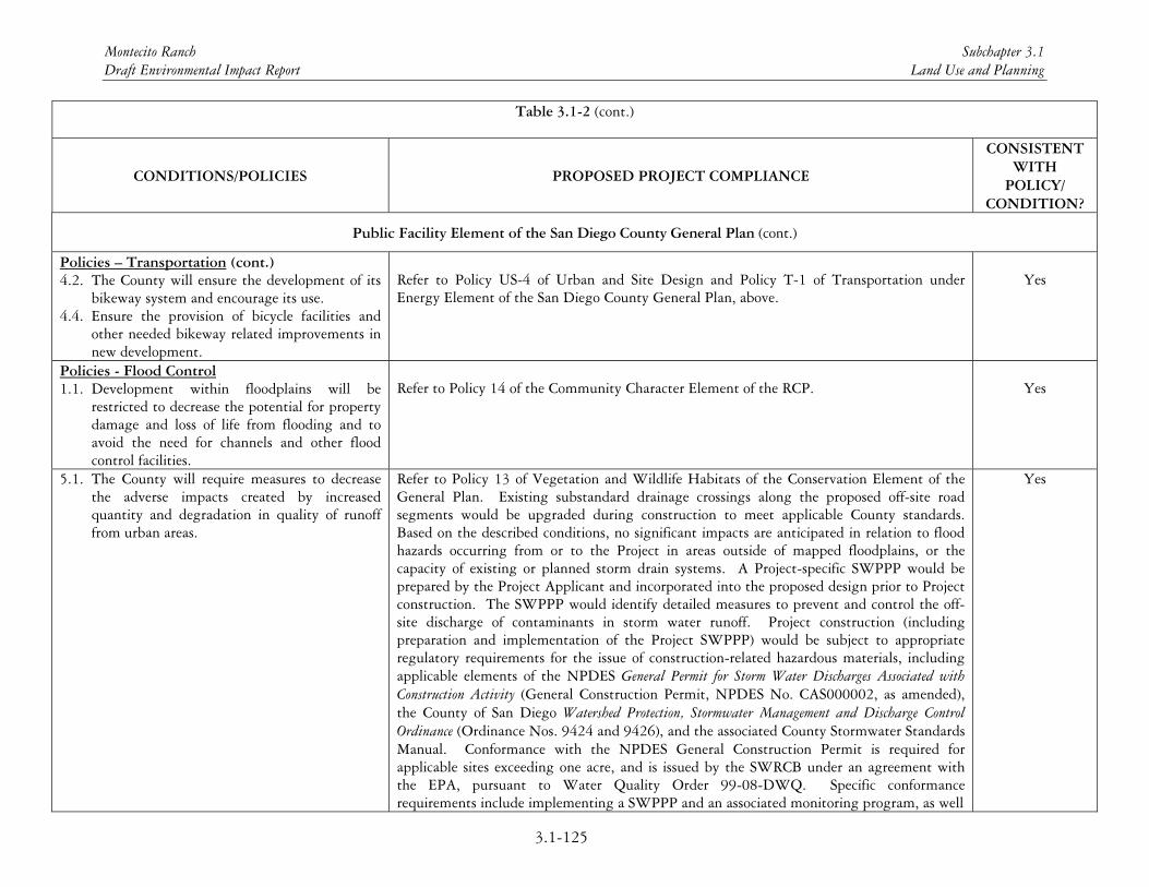
Montecito Ranch Subchapter 3.1 Draft Environmental Impact Report Land Use and Planning
3.1-125
Table 3.1-2 (cont.)
CONDITIONS/POLICIES PROPOSED PROJECT COMPLIANCE
CONSISTENT WITH
POLICY/ CONDITION?
Public Facility Element of the San Diego County General Plan (cont.)
Policies – Transportation (cont.) 4.2. The County will ensure the development of its
bikeway system and encourage its use. 4.4. Ensure the provision of bicycle facilities and
other needed bikeway related improvements in new development.
Refer to Policy US-4 of Urban and Site Design and Policy T-1 of Transportation under Energy Element of the San Diego County General Plan, above.
Yes
Policies - Flood Control 1.1. Development within floodplains will be
restricted to decrease the potential for property damage and loss of life from flooding and to avoid the need for channels and other flood control facilities.
Refer to Policy 14 of the Community Character Element of the RCP.
Yes
5.1. The County will require measures to decrease the adverse impacts created by increased quantity and degradation in quality of runoff from urban areas.
Refer to Policy 13 of Vegetation and Wildlife Habitats of the Conservation Element of the General Plan. Existing substandard drainage crossings along the proposed off-site road segments would be upgraded during construction to meet applicable County standards. Based on the described conditions, no significant impacts are anticipated in relation to flood hazards occurring from or to the Project in areas outside of mapped floodplains, or the capacity of existing or planned storm drain systems. A Project-specific SWPPP would be prepared by the Project Applicant and incorporated into the proposed design prior to Project construction. The SWPPP would identify detailed measures to prevent and control the off-site discharge of contaminants in storm water runoff. Project construction (including preparation and implementation of the Project SWPPP) would be subject to appropriate regulatory requirements for the issue of construction-related hazardous materials, including applicable elements of the NPDES General Permit for Storm Water Discharges Associated with Construction Activity (General Construction Permit, NPDES No. CAS000002, as amended), the County of San Diego Watershed Protection, Stormwater Management and Discharge Control Ordinance (Ordinance Nos. 9424 and 9426), and the associated County Stormwater Standards Manual. Conformance with the NPDES General Construction Permit is required for applicable sites exceeding one acre, and is issued by the SWRCB under an agreement with the EPA, pursuant to Water Quality Order 99-08-DWQ. Specific conformance requirements include implementing a SWPPP and an associated monitoring program, as well
Yes

Montecito Ranch Subchapter 3.1 Draft Environmental Impact Report Land Use and Planning
3.1-126
Table 3.1-2 (cont.)
CONDITIONS/POLICIES PROPOSED PROJECT COMPLIANCE
CONSISTENT WITH
POLICY/ CONDITION?
Public Facility Element of the San Diego County General Plan (cont.) Policies - Flood Control (cont.) 5.1. (cont.)
as a Storm Water Sampling and Analysis Strategy (SWSAS) for applicable projects (i.e., those discharging directly into waters impaired due to sedimentation, or involving potential discharge of non-visible contaminants that may exceed water quality objectives). The County Storm Water Ordinance/Storm Water Standards Manual also requires construction-related BMPs to address water quality issues, and the County may, at its discretion, require the submittal and approval of a SWPPP (i.e., in addition to the NPDES SWPPP described above) to address construction-related storm water issues prior to site development. Specific pollution control measures typically involve the use of best available technology economically achievable (BAT) and/or best conventional pollutant control technology (BCT) levels of treatment, with these requirements implemented through BMPs.
Objectives - Law Enforcement 1. A level of facilities sufficient to accommodate a
service level of three patrol shifts per day per 10,000 population, or service-area-equivalent for commercial/industrial land uses, as an interim step toward meeting the facility goal.
Policies - Law Enforcement 3.2. New development in the unincorporated area
will be required to contribute its fair share toward financing sheriff facilities toward achieving the short term objective.
According to SANDAG’s Population and Housing Estimates, the 2006 population within the Ramona Community Planning area was approximately 36,400 people. This would equate to 11 patrol shifts per day. The Ramona Substation is authorized to have 17 patrol deputies, but currently has only 13 due to personnel shortages throughout the department (refer to Appendix O). At any given time, two to four deputies may be on duty at this substation. A fair share impact fee program for sheriff facilities/services has not been developed by the County. It is anticipated that expanded police protection staff and services would be funded from increased property taxes and other revenues to the County resulting from the Proposed Project as well as from other cumulative developments in the Ramona area that contribute to the increased demands on police protection services.
Yes
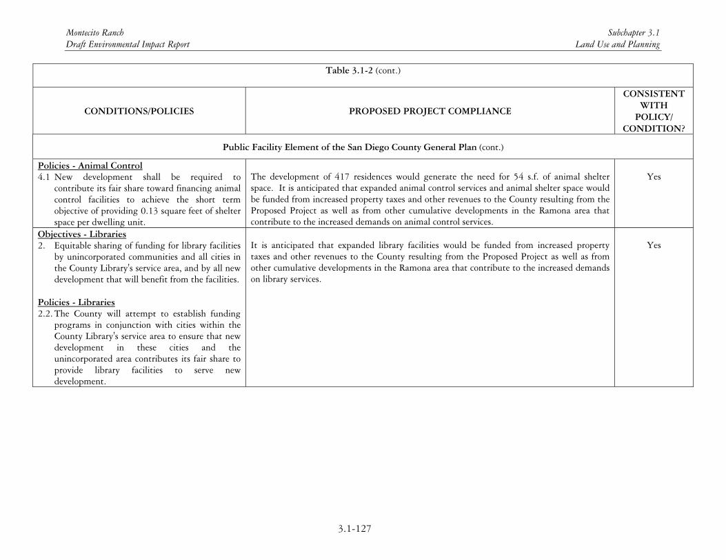
Montecito Ranch Subchapter 3.1 Draft Environmental Impact Report Land Use and Planning
3.1-127
Table 3.1-2 (cont.)
CONDITIONS/POLICIES PROPOSED PROJECT COMPLIANCE
CONSISTENT WITH
POLICY/ CONDITION?
Public Facility Element of the San Diego County General Plan (cont.)
Policies - Animal Control 4.1 New development shall be required to
contribute its fair share toward financing animal control facilities to achieve the short term objective of providing 0.13 square feet of shelter space per dwelling unit.
The development of 417 residences would generate the need for 54 s.f. of animal shelter space. It is anticipated that expanded animal control services and animal shelter space would be funded from increased property taxes and other revenues to the County resulting from the Proposed Project as well as from other cumulative developments in the Ramona area that contribute to the increased demands on animal control services.
Yes
Objectives - Libraries 2. Equitable sharing of funding for library facilities
by unincorporated communities and all cities in the County Library's service area, and by all new development that will benefit from the facilities.
Policies - Libraries 2.2. The County will attempt to establish funding
programs in conjunction with cities within the County Library's service area to ensure that new development in these cities and the unincorporated area contributes its fair share to provide library facilities to serve new development.
It is anticipated that expanded library facilities would be funded from increased property taxes and other revenues to the County resulting from the Proposed Project as well as from other cumulative developments in the Ramona area that contribute to the increased demands on library services.
Yes

Montecito Ranch Subchapter 3.1 Draft Environmental Impact Report Land Use and Planning
3.1-128
Table 3.1-2 (cont.)
CONDITIONS/POLICIES PROPOSED PROJECT COMPLIANCE
CONSISTENT WITH
POLICY/ CONDITION?
Public Facility Element of the San Diego County General Plan (cont.)
Objectives - Schools 1. Provision of educational facilities sufficient to
meet the demands of new development concurrent with need.
Policies - Schools 1.2. To the extent allowable under State law, new
development shall be required to provide additional facilities needed to serve children generated by the new development. Such facilities shall be of the quality and quantity sufficient to meet State Department of Education standards or to maintain an existing higher level of service provided by an affected school district’s facilities.
3.1. Land use planning will be coordinated with the planning of school facilities.
The Project Applicant would pay their fair share of development impact fees to the school district. Therefore, the Proposed Project is not anticipated to have a significant impact on school services. Although not required, the Project would dedicate a 10.6-acre charter high school site in the southwestern portion of the Project site. The reader should note that the Project does not include the construction of a school, just the dedication of a school site. The charter high school site would be made available to the RUSD or other appropriate entity for the construction of an approximately 600-student charter high school. The RUSD has tentatively indicated that the charter high school site is acceptable. Once the charter high school is constructed, students from the Proposed Project and surrounding areas could attend the new school.
Yes
Objectives - Fire Protection and Emergency Services 1. Sufficient fire and emergency services facilities to
meet established emergency travel time objectives to minimize fire and emergency risk. Maximum travel time to the Proposed Project will be five minutes, based on proposed land use.
The Project site, except for the seven-acre parcel at the northwestern Project site boundary, is within the Ramona Fire District (RFD)/California Department of Forestry and Fire Protection (CDF) service area for fire protection. The required response time for residential lots smaller than two acres in size is five minutes or less. CDF/RFD has indicated that Station No. 80 (829 San Vicente Road), which includes paramedic service, has “first in” responsibility for the Project site. The anticipated total travel time from this station to the farthest house within the proposed development would be approximately five minutes. Furthermore, although equipped with a paramedic unit, Station No. 82, located at 3410 Dye Road, also could dispatch fire units to the site via Montecito Road.
Yes

Montecito Ranch Subchapter 3.1 Draft Environmental Impact Report Land Use and Planning
3.1-129
Table 3.1-2 (cont.)
CONDITIONS/POLICIES PROPOSED PROJECT COMPLIANCE
CONSISTENT WITH
POLICY/ CONDITION?
Public Facility Element of the San Diego County General Plan (cont.)
Policies - Fire Protection and Emergency Services 1.2. The County will ensure the availability of
adequate fire and emergency services facilities in the review of discretionary land development applications, and require appropriate fire prevention and protection measures.
2.1. New development shall be required to finance its full and fair share of the facility and equipment needs that it generates.
Although an acceptable response time is anticipated from Station No. 80 to the proposed residences, CDF/RFD has indicated that Station No. 80 is overloaded and an additional fire station is needed to maintain acceptable response times with the addition of the Proposed Project residences and charter high school site. It is anticipated that expanded fire protection services primarily would be funded from increased property taxes and other revenues to the County resulting from the Project as well as from other cumulative developments in the Ramona area that have contributed or would contribute to the increased demands on fire protection services.
Yes
Policies – Wastewater 1.2. Discretionary land development projects will
only be approved if the service provider reasonably expects that wastewater treatment and disposal will be available concurrent with need, and that all appropriate requirements will be met through conditions placed on project approval.
2.1. The County will regulate the use of privately
proposed wastewater treatment plants to ensure that they are properly located, meet the sewer needs of the project, do not cause premature urbanization, and create no unmitigable environmental effects. Availability of service from a wastewater treatment facility will not be justification for increasing densities allowed by the General Plan and zoning.
The Project site is not within any sewer district’s service area. It is unknown at this time whether sufficient capacity will be available at the Santa Maria WTP; therefore, it is unknown if it will be feasible to annex to the RMWD for sewer/wastewater treatment service. Accordingly, two wastewater management options have been addressed equally for the Proposed Project. The Sewer Facilities Master Plan (RMWD 1998b) identifies the need for increasing sewage treatment and disposal capacities to accommodate future growth within RMWD’s service area and provides a phased expansion schedule that would double the district’s sewage treatment and disposal capacity by 2015. In case RMWD determines the sufficient capacity will be available to serve the Project at the Santa Maria WTP, and annexation would be feasible, the Proposed Project includes Wastewater Management Option 1. Under this option, wastewater management for the Project would be provided by RMWD and off-site sewer improvements would be required. The Project site would be annexed into the RMWD and Project wastewater would be transported via a force main to a manhole and main trunk line at the southern terminus of Kalbaugh Street that connects to the Santa Maria WTP for treatment.
Yes

Montecito Ranch Subchapter 3.1 Draft Environmental Impact Report Land Use and Planning
3.1-130
Table 3.1-2 (cont.)
CONDITIONS/POLICIES PROPOSED PROJECT COMPLIANCE
CONSISTENT WITH
POLICY/ CONDITION?
Public Facility Element of the San Diego County General Plan (cont.)
Policies – Wastewater (cont.) Implementation Measure 2.1.1. Prior to approving a specific plan, specific plan amendment, or a privately initiated discretionary land use project that includes a wastewater treatment facility, the following findings shall be made: (a) The treated effluent is used for a productive
purpose such as irrigation, industrial uses or sale to an agency for reuse.
(b) The location and design of proposed
wastewater treatment facilities will be consistent with a district’s reclamation plan and engineering specifications or, in the absence of a district’s reclamation plan, consistent with a Master Reclamation Plan that has been approved by the Board of Supervisors.
Under Wastewater Management Option 2, the Project Applicant is seeking approval of a Master Reclamation Plan to construct an on-site WRF. This WRF would be owned and operated by a public agency and would treat wastewater from the Proposed Project. The WRF would have the capacity to serve only the Project (up to 110,000 gpd of wastewater), based on a detailed analysis of the anticipated wastewater treatment demands associated with the Project (Dexter Wilson 2006). Refer to Subchapter 1.1, Project Description and Location, and the sewer study in Appendix O for details regarding the WRF. (a) The reclaimed water from the WRF is proposed to be used for landscape irrigation on
site. This use of reclaimed water would offset potable water use on the Project since these areas would have to be irrigated with potable water if reclaimed water was not available. The Proposed Project is consistent with this element of the policy.
(b) As noted in Section 1.1.2, the Project Applicant is pursuing approval of a Master
Reclamation Plan for the WRF. With approval of the Master Reclamation Plan, the Proposed Project would be consistent with this policy.

Montecito Ranch Subchapter 3.1 Draft Environmental Impact Report Land Use and Planning
3.1-131
Table 3.1-2 (cont.)
CONDITIONS/POLICIES PROPOSED PROJECT COMPLIANCE
CONSISTENT WITH
POLICY/ CONDITION?
Public Facility Element of the San Diego County General Plan (cont.)
Policies – Wastewater (cont.)
Implementation Measure 2.1.1 (cont.)
(c) The wastewater facility will be operated and maintained by a public agency. If a new agency must be formed to operate the facility, the County Director of Public Works has issued a statement of technical feasibility and consistency with the master reclamation plan. The operating agency must be identified in the project application and documentation must be provided indicating that the agency has not refused to operate the proposed facility.
(c) If the Board of Supervisors decides upon Wastewater Management Option 2, they would
direct the WRF to be owned and operated by a public agency. With approval of the Master Reclamation Plan and a statement of technical feasibility from the Director of DPW, the Proposed Project would be consistent with this policy.
(d) Both short and long range operational and maintenance costs are comparable to the cost of similar facilities in the County. The costs determined for operation, maintenance, and facilities replacement shall be sufficient to assure fulfillment of all applicable State requirements.
(d) The operational and maintenance costs for this facility are expected to be comparable to the costs of similarly sized facilities throughout the County. Once the WRF is designed, operational costs are determined, and the Master Reclamation Plan has been approved, the Proposed Project would be consistent with this policy.
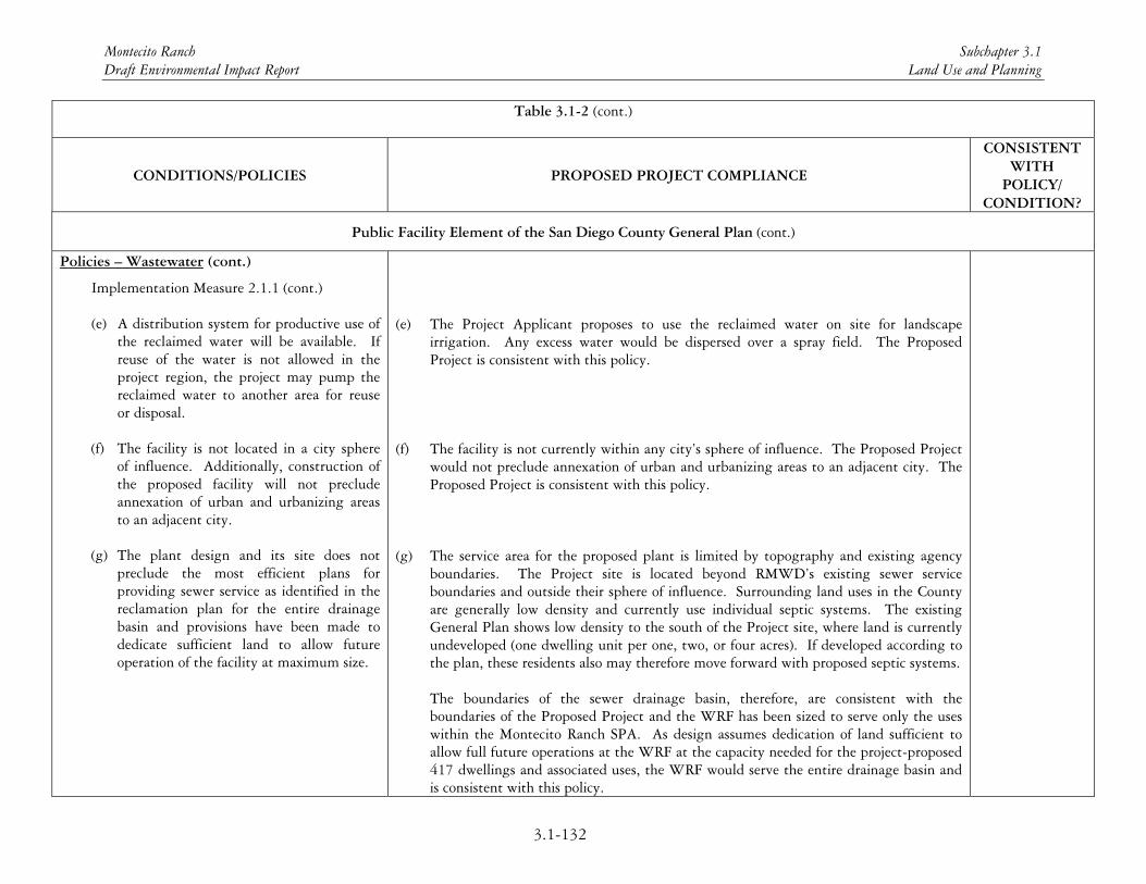
Montecito Ranch Subchapter 3.1 Draft Environmental Impact Report Land Use and Planning
3.1-132
Table 3.1-2 (cont.)
CONDITIONS/POLICIES PROPOSED PROJECT COMPLIANCE
CONSISTENT WITH
POLICY/ CONDITION?
Public Facility Element of the San Diego County General Plan (cont.)
Policies – Wastewater (cont.)
Implementation Measure 2.1.1 (cont.) (e) A distribution system for productive use of
the reclaimed water will be available. If reuse of the water is not allowed in the project region, the project may pump the reclaimed water to another area for reuse or disposal.
(f) The facility is not located in a city sphere
of influence. Additionally, construction of the proposed facility will not preclude annexation of urban and urbanizing areas to an adjacent city.
(g) The plant design and its site does not
preclude the most efficient plans for providing sewer service as identified in the reclamation plan for the entire drainage basin and provisions have been made to dedicate sufficient land to allow future operation of the facility at maximum size.
(e) The Project Applicant proposes to use the reclaimed water on site for landscape
irrigation. Any excess water would be dispersed over a spray field. The Proposed Project is consistent with this policy.
(f) The facility is not currently within any city’s sphere of influence. The Proposed Project
would not preclude annexation of urban and urbanizing areas to an adjacent city. The Proposed Project is consistent with this policy.
(g) The service area for the proposed plant is limited by topography and existing agency
boundaries. The Project site is located beyond RMWD’s existing sewer service boundaries and outside their sphere of influence. Surrounding land uses in the County are generally low density and currently use individual septic systems. The existing General Plan shows low density to the south of the Project site, where land is currently undeveloped (one dwelling unit per one, two, or four acres). If developed according to the plan, these residents also may therefore move forward with proposed septic systems.
The boundaries of the sewer drainage basin, therefore, are consistent with the boundaries of the Proposed Project and the WRF has been sized to serve only the uses within the Montecito Ranch SPA. As design assumes dedication of land sufficient to allow full future operations at the WRF at the capacity needed for the project-proposed 417 dwellings and associated uses, the WRF would serve the entire drainage basin and is consistent with this policy.

Montecito Ranch Subchapter 3.1 Draft Environmental Impact Report Land Use and Planning
3.1-133
Table 3.1-2 (cont.)
CONDITIONS/POLICIES PROPOSED PROJECT COMPLIANCE
CONSISTENT WITH
POLICY/ CONDITION?
Public Facility Element of the San Diego County General Plan (cont.)
Policies – Wastewater (cont.)
Implementation Measure 2.1.1 (cont.)
(h) No unmitigable environmental impacts are created by the operation of the treatment facility. If surface application of reclaimed water is proposed, a preliminary determination is made in the EIR that indicates that no unmitigable impacts would occur from the surface application.
(i) If the project proposes to increase the
density or intensity of land uses allowed by the General Plan, the availability of service from a wastewater treatment facility is not used as justification for increasing densities or intensities allowed by the General Plan.
3.1 Water reclamation and conservation measures
shall be included in the land development review process.
(h) This EIR evaluates all potential environmental effects of the WRF and has concluded
that there are no significant and unmitigated impacts due to facility construction or operation. As noted previously, surface application of reclaimed water is proposed, and the EIR has concluded that no unmitigable impacts would occur from the surface application. The Proposed Project is consistent with this policy.
(i) The Proposed Project would not exceed the allowable density for the Project site.
Because the WRF would be sized only to serve the Proposed Project, it would not cause premature urbanization. The availability of service from the proposed WRF could not be used as justification for increasing densities or intensities allowed by the General Plan or community plan for other surrounding parcels. The Proposed Project is consistent with this policy.
Refer to Environmental Goal 3.2 of the Regional Land Use Element of the General Plan.

Montecito Ranch Subchapter 3.1 Draft Environmental Impact Report Land Use and Planning
3.1-134
Table 3.1-2 (cont.)
CONDITIONS/POLICIES PROPOSED PROJECT COMPLIANCE
CONSISTENT WITH
POLICY/ CONDITION?
Public Facility Element of the San Diego County General Plan (cont.)
Policies - Water Provision Systems 1.2. Discretionary land development projects
dependent on imported water will only be approved if the service provider reasonably expects that water facilities will be available concurrent with need, and that all appropriate requirements will be met through conditions placed on project approval.
1.3. All land development projects requiring the use of imported water shall obtain a commitment of service by the appropriate district prior to land preparation and construction.
RMWD would provide potable water service to the Proposed Project. Potable water would be supplied to the site via off-site connections to existing pipelines within Montecito Road and Pine Street, as shown in Figure 1-3. One water line would be extended northerly along Montecito Way to the Project site from the existing water main in Montecito Road. A second water line would be extended from the existing water line in Pine Street. The proposed off-site connections would be installed during construction of the proposed improvements to Montecito Way and Ash Street. In addition, an off-site water storage tank would be installed just west of the Project site in an adjacent property. This tank would hold 1.26 million gallons under Wastewater Management Option 1 and 0.91 million gallons under Option 2. A pipeline would connect the water storage tank to the proposed pipeline within Montecito Way. The Project also would include the installation of a water booster pump station on a 10,000-s.f. lot at the northwestern corner of the Montecito Road/Montecito Way intersection. No additional or expanded RMWD facilities would be required to serve the Proposed Project, beyond the facilities proposed as part of the Project (as mentioned above). Moreover, future RMWD facilities identified within the RMWD Water and Sewer Facilities Master plans take the development of the Montecito Ranch SPA into consideration (RMWD 1998a and b).
Yes
Policies - Courts and Jails 1.1. The County will seek regional cooperation on
appropriate requirements for new development throughout the County to contribute its fair share of funding for County court and jail facilities related to the needs of the new development.
It is anticipated that expanded County court and jail facilities would be funded from increased property taxes and other revenues to the County resulting from the Proposed Project as well as from other cumulative developments in the Ramona area that contribute to the increased demands on court and jail facilities.
Yes
Montecito Ranch Subchapter 3.1 Draft Environmental Impact Report Land Use and Planning
3.1-135
Table 3.1-2 (cont.)
CONDITIONS/POLICIES PROPOSED PROJECT COMPLIANCE
CONSISTENT WITH
POLICY/ CONDITION?
Public Facility Element of the San Diego County General Plan (cont.)
Policies - Health 4.1. The County will seek regional cooperation on
appropriate requirements for new development throughout the County to contribute its fair share of funding for County health care facilities related to the needs of the new development.
It is anticipated that expanded County health care facilities would be funded from increased property taxes and other revenues to the County resulting from the Proposed Project as well as from other cumulative developments in the Ramona area that contribute to the increased demands on health care facilities.
Yes
County of San Diego Zoning Ordinance
The County Zoning Ordinance (ZO) identifies the permitted uses of the project site, consistent with the land use designations of the General Plan and Ramona Community Plan.
All but 9.0 acres of the 935.2-acre Project site are zoned S88, the Specific Planning Area Use Regulations zone, which provides for all uses as set forth by an adopted specific plan. While residential development is a permitted use within the S88 zone, the allowable maximum densities must be in conformance with the zoning designations, which are consistent with the land use designations of the General Plan and Ramona Community Plan. The required minimum lot size for the area of the Project site zoned S88 is 2.0 acres. The Proposed Project would be inconsistent with the existing zone due to consolidation of residential units, resulting in most of the lots being approximately 0.5 acre in size. The Project Applicant has filed an application for an amendment to the RCP that would allow the minimum lot size within the residential areas to be 0.5 acre. In addition, the Project Applicant has applied for a rezone to change the zoning designation of the two parcels (totaling 9.0 acres) currently zoned from their current zoning designation A70 to S88 to be consistent with the remainder of the site. As part of this rezone and the proposed Specific Plan and MUP, development regulations pertaining to animal regulations would be changed from “L” to “A” for the majority of the residential lots. The “A” designator is a more restrictive designation than “L” and would be consistent with a consolidated residential development. Horse lots (1 through 30) would have an animal designator of “F,” which allows two horses plus one per 0.5 acre over one acre. The setback designator also would change to “J,” to be consistent with a consolidated residential development. The Proposed Project would comply with all other development regulations associated with the S88 designation.
Yes, With GPA and Rezone Approval

Montecito Ranch Subchapter 3.1 Draft Environmental Impact Report Land Use and Planning
3.1-136
Table 3.1-2 (cont.)
CONDITIONS/POLICIES PROPOSED PROJECT COMPLIANCE
CONSISTENT WITH
POLICY/ CONDITION?
County Subdivision Ordinance
The County Subdivision Ordinance is contained within Title 8, Division 1 of the San Diego Code of Regulatory Ordinances and sets forth development standards for the subdivision of land with respect to design, dedication and access, and required improvements.
The Proposed Project is in general conformance with the County Subdivision Ordinance. The County has reviewed the VTM and concurred that the all lots are in general conformance.
Yes
County Resource Protection Ordinance
The County RPO provides development controls for unique topography, ecosystems and natural characteristics within the County deemed to be fragile, irreplaceable and vital to the general welfare of the County’s residents. The resources protected by the County include wetlands, floodplains, steep slopes, sensitive biological habitats, and prehistoric and historic sites. Additionally, the County requires avoidance of impacts to 80 percent of County Group A and B sensitive plants.
Steep Slopes. Approximately 102.6 acres of RPO steep slopes occur on site. According to the Resource Protection Study (REC 2008a; Appendix D), all steep slopes would be preserved in their natural state within on-site open space. No RPO step slopes occur along the proposed roadway improvement/construction alignments. The off-site water storage tank and associated pipelines and access road would impact steep slopes; however, such impacts would be exempted, as they are associated with provision of a necessary public facility and infrastructure to provide potable water service. The required pad elevation for the water tank is approximately 1,790 feet AMSL assuming a 30-foot deep tank with a high water mark of 1,820 feet AMSL. The proposed pad would meet this elevation requirement. Given consistent habitat (Diegan coastal sage scrub), the access road to the water tank would be in the least environmentally damaging location, because it would be the shortest distance from the proposed pipeline in Montecito Ranch Road that is allowed under topographical restraints of the area.
Sensitive Habitat Lands. The majority of the highly sensitive habitats within the Project site (including oak woodlands and wetlands) would not be impacted and would be placed in dedicated open space for preservation. All potential direct and indirect impacts to sensitive lands (on and off site) would be mitigated to below a level of significance according to County regulations. In addition, Project grading would not eliminate any of the major rock outcrops. Rock outcrops would be preserved within dedicated open space areas.
Montecito Ranch Subchapter 3.1 Draft Environmental Impact Report Land Use and Planning
3.1-137
Table 3.1-2 (cont.)
CONDITIONS/POLICIES PROPOSED PROJECT COMPLIANCE
CONSISTENT WITH
POLICY/ CONDITION?
County Resource Protection Ordinance (cont.)
RPO (cont.) Wetlands. The Proposed Project would preserve all on-site RPO wetlands within dedicated open space. The widening of Montecito Road would require the modification or reconstruction of the Montecito Road Bridge, which crosses Santa Maria Creek. As discussed in the Resource Protection Study (REC 2008a; Appendix D), Montecito Road widening meet the permitted use criteria for allowed impacts to RPO wetlands, per Section 86.604(a)(5) of the RPO. Impacts to RPO wetlands would be mitigated at 3:1 ratio, with a minimum 1.5:1 creation ratio to enhance a net gain of wetlands. Wetland Buffers. The Project would not impact any RPO wetland buffers on site (REC 2008a). The proposed widening of Montecito Road would meet the permitted use criteria for allowed impacts to RPO wetland buffers, per Section 86.604(b) of the RPO and conform to the wetlands findings. Floodways. The Project site is located above the Santa Maria Valley and is not subject to any floodplains as identified on County of San Diego floodplain maps. In addition, the SPA is not located within a 100-year floodplain as indicated on the Preliminary Floodplain Evaluation Form from the County. Floodplain Fringe. No impacts would occur to the floodplain fringe within the Project site or off-site improvement area alignments. Prehistoric or Historic Sites. The Project site contains four RPO-significant cultural resource sites. The proposed development design avoids direct impacts to these sites. The off-site roadway and utility improvements would not impact any RPO-significant cultural resources sites.
Yes, With RPO Exemption Approval

Montecito Ranch Subchapter 3.1 Draft Environmental Impact Report Land Use and Planning
3.1-138
Table 3.1-2 (cont.)
CONDITIONS/POLICIES PROPOSED PROJECT COMPLIANCE
CONSISTENT WITH
POLICY/ CONDITION?
San Diego County Community Trails Master Plan
The CTMP implements the County Trails Program, which involves trail development and management on public, semi-public and private lands. A system of interconnected regional and community trails and pathways are planned to be developed to address an established need for recreation and transportation, as well as health and quality of life benefits associated with hiking, biking and horseback riding throughout the County. Goals and policies described in the CTMP encourage communities (including Ramona) to maximize trail opportunities. The CTMP contains a trails map for the Ramona community, which identifies two proposed Priority 3 community trails/pathways within the Project site (numbers 53 and 93).
The Proposed Project would require an amendment to the Ramona Community Trails and Pathways Plan within the CTMP (County 2005). Refer to Policies – Riding and Hiking Trail Plan and Program under the Recreation Element of the General Plan. The Project Applicant has applied for an amendment to the Ramona Community Trails and Pathways Plan to incorporate these changes. With the approval of the proposed GPA and Ramona Community Trails and Pathways Plan amendments, the Project would be in conformance with the amended CTMP.
Yes, With GPA and Ramona Community Trails and
Pathways Plan Amendment
Approval
Montecito Ranch Subchapter 3.1 Draft Environmental Impact Report Land Use and Planning
3.1-139
Table 3.1-2 (cont.)
CONDITIONS/POLICIES PROPOSED PROJECT COMPLIANCE
CONSISTENT WITH
POLICY/ CONDITION?
County of San Diego Light Pollution Code
The LPC is a County Regulatory Ordinance that restricts the use of outdoor lighting that emits undesirable light rays into the night sky. The primary intent of the code is to curb lighting that may affect astronomical research at the Mount Palomar and Mount Laguna observatories. The LPC defines two zones in the unincorporated portion of San Diego County. Zone A consists of areas within a 15-mile radius of Mount Laguna and Mount Palomar. Zone B pertains to all areas remaining, which are not defined as Zone A. The project site, and locations of the off-site road improvements are located within Zone B.
The Project site is located within Zone B under the LPC. The LPC contains policies restricting the use of outdoor lighting to minimize light spill over into the dark night sky and adjacent neighborhoods. In compliance with these policies and the Montecito Ranch Specific Plan design guidelines, all exterior lighting associated with the proposed homes would be directed and shielded. Therefore, Project lighting would be consistent with the LPC.
Yes
Congestion Management Program
The CMP requires enhanced CEQA review for projects that generate 2,400 or more ADT or 200 or more peak hour trips on local roadway segments, or 50 or more peak hour trips on freeway segments. Proposed projects meeting these criteria must be evaluated in accordance with the requirements of the Regional CMP. The CMP analysis must include the traffic level of service (LOS) impacts on affected freeways and Regionally Significant Arterial (RSA) systems, including all designated CMP roadways.
The traffic study conducted for the Proposed Project (USAI 2008) concluded that the Project would exceed the thresholds for the ADT and street segment peak hour trips. Therefore, a CMP analysis, consistent with the CMP Program, was prepared for the Project, consistent with this requirement.
Yes
Montecito Ranch Subchapter 3.1 Draft Environmental Impact Report Land Use and Planning
3.1-140
Table 3.1-2 (cont.)
CONDITIONS/POLICIES PROPOSED PROJECT COMPLIANCE
CONSISTENT WITH
POLICY/ CONDITION?
Natural Community Conservation Planning Program
Regional conservation planning strategies under the California Endangered Species Act (ESA) providing protection, preservation and conservation of listed and candidate species, their habitats, natural communities and natural resources, while continuing to allow appropriate development and growth within the State, are authorized and implemented under the Natural Community Conservation Planning (NCCP) Act of 1991. These strategies are designed to provide protection and conservation to threatened and endangered species through multi-species, habitat-based and long-term approaches that ensure both the conservation of, and net benefits to, the affected species, as well as allow for growth.
Although the Project site is within the unincorporated areas of the County, the SPA and off-site improvements related to the Proposed Project are located outside of the boundaries of the MSCP and, therefore, are not covered under the MSCP. Thus, conformance with the MSCP and associated BMO are not required for the Project. Instead, conformance with the NCCP and/or Section 4(d) of the federal ESA is required. If, however, the North County MSCP Subarea Plan is completed prior to Project approval, the Project would be required to comply with the MSCP. The Project would comply with the NCCP and/or Section 4(d) of the federal ESA, or the MSCP, as appropriate.
Yes
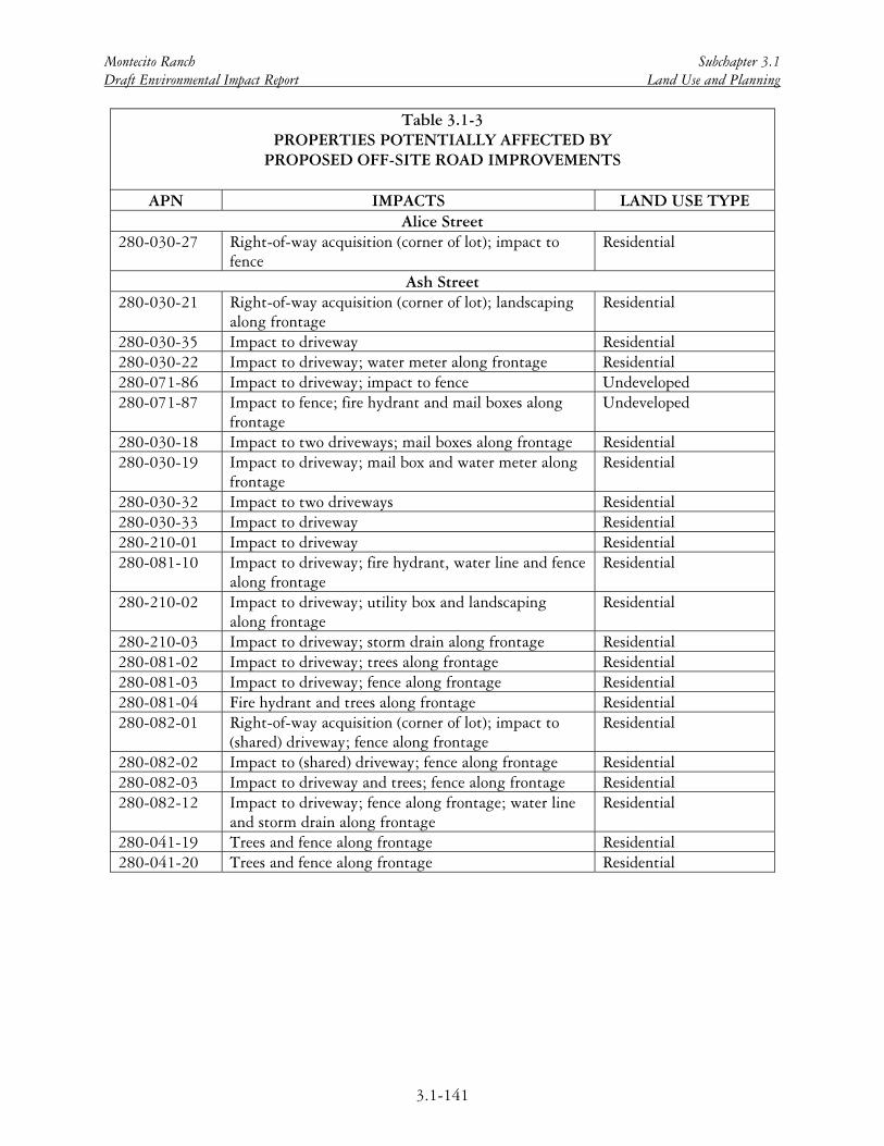
Montecito Ranch Subchapter 3.1 Draft Environmental Impact Report Land Use and Planning
3.1-141
Table 3.1-3 PROPERTIES POTENTIALLY AFFECTED BY
PROPOSED OFF-SITE ROAD IMPROVEMENTS
APN IMPACTS LAND USE TYPE Alice Street
280-030-27 Right-of-way acquisition (corner of lot); impact to fence
Residential
Ash Street 280-030-21 Right-of-way acquisition (corner of lot); landscaping
along frontage Residential
280-030-35 Impact to driveway Residential 280-030-22 Impact to driveway; water meter along frontage Residential 280-071-86 Impact to driveway; impact to fence Undeveloped 280-071-87 Impact to fence; fire hydrant and mail boxes along
frontage Undeveloped
280-030-18 Impact to two driveways; mail boxes along frontage Residential 280-030-19 Impact to driveway; mail box and water meter along
frontage Residential
280-030-32 Impact to two driveways Residential 280-030-33 Impact to driveway Residential 280-210-01 Impact to driveway Residential 280-081-10 Impact to driveway; fire hydrant, water line and fence
along frontage Residential
280-210-02 Impact to driveway; utility box and landscaping along frontage
Residential
280-210-03 Impact to driveway; storm drain along frontage Residential 280-081-02 Impact to driveway; trees along frontage Residential 280-081-03 Impact to driveway; fence along frontage Residential 280-081-04 Fire hydrant and trees along frontage Residential 280-082-01 Right-of-way acquisition (corner of lot); impact to
(shared) driveway; fence along frontage Residential
280-082-02 Impact to (shared) driveway; fence along frontage Residential 280-082-03 Impact to driveway and trees; fence along frontage Residential 280-082-12 Impact to driveway; fence along frontage; water line
and storm drain along frontage Residential
280-041-19 Trees and fence along frontage Residential 280-041-20 Trees and fence along frontage Residential
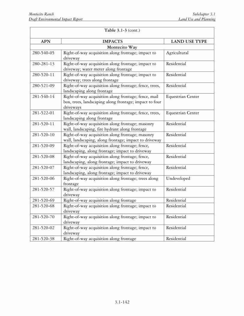
Montecito Ranch Subchapter 3.1 Draft Environmental Impact Report Land Use and Planning
3.1-142
Table 3.1-3 (cont.)
APN IMPACTS LAND USE TYPE Montecito Way
280-540-05 Right-of-way acquisition along frontage; impact to driveway
Agricultural
280-281-13 Right-of-way acquisition along frontage; impact to driveway; water meter along frontage
Residential
280-520-11 Right-of-way acquisition along frontage; impact to driveway; trees along frontage
Residential
280-521-09 Right-of-way acquisition along frontage; fence, trees, landscaping along frontage
Residential
281-540-14 Right-of-way acquisition along frontage; fence, mail box, trees, landscaping along frontage; impact to four driveways
Equestrian Center
281-522-01 Right-of-way acquisition along frontage; fence, trees, landscaping along frontage
Equestrian Center
281-520-11 Right-of-way acquisition along frontage; masonry wall, landscaping, fire hydrant along frontage
Residential
281-520-10 Right-of-way acquisition along frontage; masonry wall, landscaping, along frontage; impact to driveway
Residential
281-520-09 Right-of-way acquisition along frontage; fence, landscaping, along frontage; impact to driveway
Residential
281-520-08 Right-of-way acquisition along frontage; fence, landscaping, along frontage; impact to driveway
Residential
281-520-07 Right-of-way acquisition along frontage; fence, landscaping, along frontage; impact to driveway
Residential
281-520-06 Right-of-way acquisition along frontage; trees along frontage
Undeveloped
281-520-57 Right-of-way acquisition along frontage; impact to driveway
Residential
281-520-69 Right-of-way acquisition along frontage Residential 281-520-68 Right-of-way acquisition along frontage; impact to
driveway Residential
281-520-70 Right-of-way acquisition along frontage; impact to driveway
Residential
281-520-02 Right-of-way acquisition along frontage; impact to driveway
Residential
281-520-38 Right-of-way acquisition along frontage Residential

#
##
#
#
##
#
$$
%%
Santa Maria Creek
Undeveloped
Religious(Lemurian
Fellowship)
Rural Residential/Horizon View Farms
Undeveloped
EstateResidential
Agriculture
RMWD SprayFields/Grazing
Undeveloped
Ramona Airport
Undeveloped
Rural Residential
DowntownRamona
Rural Residential
Residential
Undeveloped
Montecito Road
Kalba
ugh S
treet
Main Street
Cedar Street
Alice
Stree
t
Summ
er Gl
en R
oad
Pine
Stree
t / SR
78
Ash Street
Haverford Road
Agriculture(oat hay)
Rang
eland
Roa
d
Montecito Ranch Site
HistoricRanchHouse
DavisSPA
A©
Monte
cito W
ay
Olive Street
?zAgriculture
(oat hay)Agriculture
(oat hay)
Sawd
ay St
reet
Residential
EquestrianFacilities
Santa Maria Creek
Agriculture(oat hay)
Ramona Airport Road
Santa Maria WastewaterTreatment Plant
CummingRanchSPA
Etcheverry Creek
Air Photo Source: Eagle Aerial, 2003
2500 0 2500 Feet
Job No: MRL-02 Date: 02/11/08
Figure 3.1-1
On-site and Surrounding Land UsesMONTECITO RANCH - EIR
4I:\GIS\M\MRL-01 Monte\Data\mrl-01.apr\Land Use - EIR -JP
Montecito Ranch SiteLEGEND
Proposed Off-site Water Pipeline Alignments
Proposed Off-site Road Improvements
SPA
%% Proposed Water Storage Tank
Proposed Off-site Sewer Pipeline Alignment UnderWastewater Management Option 1 Only
Proposed Off-site Water Booster Pump Station$$Proposed Off-site Intersection Improvements##
##
CummingRanchSPA
Highland Valley Road
Dye Road
?z
RuralResidential
Fire Station
Agriculture
Scale: 1 inch = 1000 feet
Detail of SR 67/Highland ValleyRoad/Dye Road Intersection

!h
hh
h
#
A2
R1
SP
MR
ER
PL
A1
A2 A2
SP
MR
SP
R2
ER
R2
GC
PL
SP
HI
HI
R1
MR
R3
ER
MR
R5
R3
MR
PL
R4
LI
PL
MR
LI
PL
SC
VC
SC
R5
PL
MR
ER
HI
PL
LI
R5
R6
PL
PL
PL
PL
LI
R6
PL
SC
R6
PL
R3
PL
GC
PL
SP
A2
ER
A2
A1
R1
A2
MR
PL
R1
GC
Mo
nte
cit
o
Wa
y
Montecito Road
Elm
Str
eet
Ra
mo
na
Str
eet
Hanson Lane
7th Street
10th Street
A©
?z
A©
A2
Project Site
MRHaverford Road
Pin
e S
treet
Main
Stre
et
Ash Street
Highland Valley Road
Dye Road
Ka
lba
ug
h
Str
eet
!h
Existing General Plan Land Use Designations
MONTECITO RANCH - EIR
Figure 3.1-2
µ
LEGEND
Source: San Diego County General PlanI:\GIS\M\MRL-01 Monte\Map\EIR\Fig3-1-2_LandUse.mxd -JP
Estate Residential 1 du/2,4 acresER
Residential 1 du/1,2,4 acresR1
Residential 2 du/acreR2
Residential 2.9 du/acreR3
Residential 4.3 du/acreR4
Residential 14.5 du/acreR5
Residential 24 du/acreR6
General AgricultureA1
Intensive AgricultureA2
Service CommercialSC
General CommercialGC
Visitor Serving CommercialVC
Limited Impact IndustrialLI
High Impact IndustrialHI
Public/Semi-Public LandsPL
Multiple Rural UseMR
Specific Plan AreaSP
Proposed Sewer Pipeline UnderWastewater Management Option 1
Proposed Water Pipeline andAccess Road to Water Storage Tank
Proposed Off-site Intersection Improvementsh
Proposed Off-site Water Storage Tank!
Proposed Off-site Water Pump Station#
Job No: MRL-02 Date: 01/31/08
3,000 0 3,0001,500
Feet

h
hh
h
h
!
#
Pin
e S
tree
t (S
R 7
8)
Mai
n St
reet
(SR 6
7)
Proposed Ash Street Improvements
Proposed Montecito Road Improvements
Proposed Montecito Way Improvements
Dye R
oad
Highland Valley Road
Kalb
au
gh
Str
eet
A70
A70
A70
A70
A70
A70
A70
A70
A70
S88
Montecito RanchSpecific Plan Area
DavisSpecific Plan Area
S88
S88
CummingSpecific Plan Area
Existing Zoning
MONTECITO RANCH - EIR
Figure 3.1-3
I:\GIS\M\MRL-01 Monte\Map\EIR\Fig3-1-3_Zoning.mxd -JP
µJob No: MRL-02 Date: 01/31/08
2,500 0 2,5001,250
Feet
LEGENDLimited AgriculturalA70
Specific Planning AreaS88
Proposed Off-site Water Pump Station#Proposed Off-site Water Storage Tank!
Proposed Water Pipeline andAccess Road to Water Storage Tank
Proposed Off-site IntersectionImprovementsh
Proposed Sewer Pipeline UnderWastewater Management Option 1