silent cities visualization. the case study of the main
TRANSCRIPT
ISSN 1828-5961 DISEGNARECON volume 11/ n. 21 - december 2018 ADVANCED TECHNOLOGIES FOR HISTORICAL CITIES VISUALIZATION
ISSN 1828-5961
h t t p : / / d i s e g n a r e c o n . u n i v a q . i t
David Navarro MorenoTeaching Assistant in the department of Architecture and Building Technology at the Universidad Politécnica de Cartagena, Spain. He isa Building Engineer and PhD and his lines of research have focused on the safeguarding of cultural heritage, an area in which he has several articles in indexed journals and papers at International Congresses.
Maria José Muñoz MoraTeaching Assistant in the department of Architecture and Building Technology at the Universidad Politécnica de Cartagena, Spain. She has a PhD and is an architect, herresearch has focused on the cities of the dead. She is part of the research groups; GRAMMAR, (Graphic Analysis & Methodologies for Arquitectural Research) and MAP (Metrópoli, Architecture & Heritage).Stefano ZaggiaAssociate Professor in the Department of Civil, Environmental and Architectural Engineering at theUniversità degli Studi di Padova. He has a degree in Architecture and a PhD in History of Architecture and Urban History. He has published critical essays on urban history and on the history of architecture between the XVI and the XIX centuries. He has participated in several International Congresses and has collaborated with many exhibitions.
Silent cities visualization. The case study of the Main Cemetery of Padua & the Cemetery Island of San Michele in Venice: preliminary reflections
The complexity of cultural managementprocesses in historical cities calls for methodsand tools to improve the understanding of theurban realm and underlying relationships andconnections. In this sense, visualization as a toolfor analysis, exploration, and communicationhas become a driving force in the task ofunravelling the complex urban fabrics that formhistorical cities. At present, there are several
research projects which have been developedon the visualization of some historical cities. Unfortunately, up to now, many of theseprojects have focused on the study of the city ofthe living, relegating the city of the dead to thebackground. However, it should be rememberedthat there has not always been this distinctionbetween the spaces assigned to one or theother, but for centuries the city has been sharedby both.
Key words: Information visualization; Urban development; Cemetery; Cultural heritage; Historical drawings
DISEGNARECON volume 11/ n. 21 - december 2018 ADVANCED TECHNOLOGIES FOR HISTORICAL CITIES VISUALIZATION NAVARRO - MUÑOZ - ZAGGIA
ISSN 1828-5961 Silent cities visualization. The case study of the Main Cemetery of Padua & the Cemetery Island of San Michele in Venice: preliminary reflections
h t t p : / / d i s e g n a r e c o n . u n i v a q . i t
4.2
1. THE VISUALIZATION OF CITIES The visualization of the city constitutes a work strategy consisting of the use of types of territorial representation as a base on which to incorporate complementary information. Data of very diverse nature can be cited, such as urban planning, architecture, culture, society, economy, etc. In addition, the multiplicity of possibilities derived from different chronological frameworks using this approach can be exploited. A visualization model of the city is developed from this documentation. It constitutes a useful work tool that simultaneously satisfies three functions, serving as an ordered record of information, as a support for study and analysis, and as a means of disseminating knowledge. It is possible to distinguish two large functional categories of the visualization of cities. One of them corresponds to the visualization of the current city as an inhabited place with a multitude of factors which converge and must be controlled to guarantee it runs well. The other one makes reference to the city as a changing space where the action of the passing of time together with that of the hand of man, always transformative, turn it into a place in continuous evolution, and whose previous characteristics are of great interest from an historical point of view (Calabi, 2013). Therefore, the first category has more to do with the administrative management of the demands of the current city, such as traffic density, noise level, operation of supply networks, etc. In this respect, the projects addressed by both Public Administrations and Universities, and private companies are different. Many of them are included in the Visualizing Cities platform. This is an initiative created to gather visualization projects from around the world in order to strengthen the ties between the interested parties in the use of visualization as a tool for urban management and development. The second category, on the other hand, is more closely related to the cultural management of the historical city through the knowledge of its main characterizing aspects. These include urban layout, architecture, green spaces, etc., as well as its evolution over the years. It could be said, therefore,
that contemporary visualization is associated with the general aspect of the city, while historical visualization is more closely linked to the particular evolution of the city. At present, there are several research projects being developed on the visualization of some of the most important historical cities. These involve researchers, architects and specialists in the world of virtual reality and communications. These professionals are studying and refining innovative interactive visualization techniques to order and make the many historical-artistic, economic, urban and sociological data available about those cities more transparent and easier to understand (Rinaudo, Tamborrino 2015). One of the most significant initiatives in the visualization of historical cities is represented by the Four Dimensional Cultural Heritage World project (4D-CH World), funded by the European Union. Its main purpose is to define a useful work methodology for the creation of 4D digital maps in cultural heritage. This consists of the creation of precise time-varying 3D cultural heritage reconstructions, including monuments that have been destroyed, to allow a spatio-temporal assessment. The 4D digital modelling methods were tested in the German city of Calw. Other demonstration scenarios refer to the digital reconstruction of the monument of Porta Nigra in Germany and Padrão dos Descobrimentos in Portugal (Ioannides, 2018). Italy has not been oblivious to this initiative, with various projects being carried out in the national territory, such as Visualizing Venice, jointly launched in 2009 by Università Iuav di Venezia (Italy), the Università degli Studi di Padova (Italy) and Duke University (United States). This is an initiative that comprises teachers and students who are actively involved in research projects to generate digital models and maps of the city of Venice, its territories, and its lagoon. The main objectives are two: to enhance the understanding of the city as an on-going process of change and social, economic, religious and political transformation over time; and to communicate new knowledge to local residents and the general public about place and space through different strategies such as publications, documentaries, cultural seminars, exhibitions, websites, mobile applications, etc. The research is
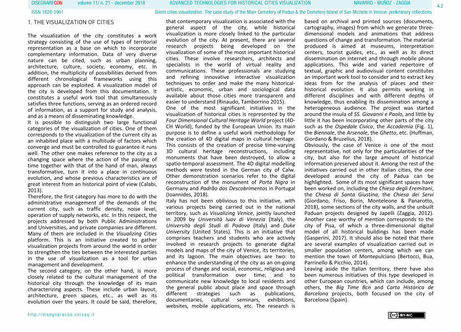
based on archival and printed sources (documents, cartography, images) from which we generate three-dimensional models and animations that address questions of change and transformation. The material produced is aimed at museums, interpretation centers, tourist guides, etc., as well as its direct dissemination on internet and through mobile phone applications. This wide and varied repertoire of textual, graphic and audiovisual content constitutes an important work tool to consider and to extract key ideas from for the analysis of places and their historical evolution. It also permits working in different disciplines and with different depths of knowledge, thus enabling its dissemination among a heterogeneous audience. The project was started around the insula of SS. Giovanni e Paolo, and little by little it has been incorporating other parts of the city such as the Ospedale Civico, the Accademia (Fig. 1), the Biennale, the Arsenale, the Ghetto, etc. (Huffman, Giordano & Bruzelius, 2018). Obviously, the case of Venice is one of the most representative, not only for the particularities of the city, but also for the large amount of historical information preserved about it. Among the rest of the initiatives carried out in other Italian cities, the one developed around the city of Padua can be highlighted. Some of its most significant spaces have been worked on, including the Chiesa degli Eremitani, the Chiesa di Santa Giustina, the Chiesa dei Servi (Giordano, Friso, Borin, Monteleone & Panarotto, 2018), some sections of the city walls, and the unbuilt Paduan projects designed by Japelli (Zaggia, 2012). Another case worthy of mention corresponds to the city of Pisa, of which a three-dimensional digital model of all historical buildings has been made (Gasperini, 2017). It should also be noted that there are several examples of visualization carried out in smaller population centers, among which we can mention the town of Montepulciano (Bertocci, Bua, Parrinello & Picchio, 2014). Leaving aside the Italian territory, there have also been numerous initiatives of this type developed in other European countries, which can include, among others, the Big Time Bcn and Carta Histórica de Barcelona projects, both focused on the city of Barcelona (Spain).
DISEGNARECON volume 11/ n. 21 - december 2018 ADVANCED TECHNOLOGIES FOR HISTORICAL CITIES VISUALIZATION NAVARRO - MUÑOZ - ZAGGIA
ISSN 1828-5961 Silent cities visualization. The case study of the Main Cemetery of Padua & the Cemetery Island of San Michele in Venice: preliminary reflections
h t t p : / / d i s e g n a r e c o n . u n i v a q . i t
4.3
On the other hand, the methods and techniques available for the representation of territory offer numerous possibilities which are particularly useful for understanding and analysing the city, with conventional systems such as maps, plans and drawings, even hand-made ones, coexisting in a fruitful way with the most modern technologies (Chías, 2018). In the case of these last ones, as Giordano (2016) points out, the renewal of the disciplines of representation is evident, revealing itself to be a privileged tool not only for the design of architecture and the city, but also and above all for their communicative-cognitive fruition. With the new digital technologies, the visualization of the city can be performed by multimedia processes starting from data acquisition (archival documents, laser scans and photogrammetric surveys) arriving to the organization of information in 3D models that can be implemented by interoperable GIS and BIM platforms. In addition, the digital results obtained can be disseminated through the design of mobile applications, interactive systems for multimedia devices, web platforms and immersive reality.
2. THE CEMETERY AS PART OF THE CITY
Unfortunately, so far, many projects of this type have been focusing on the study of the city of the living, with the city of the dead, better known as the cemetery, relegated to the background. However, it should be remembered that there has not always been this distinction between the spaces assigned to the living and dead, but for centuries the city was shared by both. The living and dead coexisted in the same space until well into the 19th century (Ariès, 1975, 1977). In Europe, since the spread of Christianity and during the Middle Ages, burials took place in the interior of the cities. The burial of citizens belonging to the popular class was carried out in mass graves excavated in churches or on the land adjacent to them, while the members of the clergy, nobility and high bourgeoisie had the privilege of being buried in individual tombs within churches, monasteries or private gardens (Nonnis, 2004). It was not until the 18th century, when under the ideology of the Enlightenment and due to the progressive unhealthiness of cities, in part caused
by this unhygienic cohabitation of the living and dead, that this practice began to be abandoned. It was gradually replaced, not without great difficulties, by the construction of closed enclosures exclusively intended for the burial of corpses outside of cities (Tomasi, 2001). With the promulgation of the Edict of Saint-Cloud in 1804, by which all the populations under Napoleonic control were forced to cease with burials inside temples and to build new cemeteries in remote parts of inhabited areas, the need arose to configure a new architectural typology previously nonexistent. This represented a challenge both in relation to its design –who and how it would be devised–, as well as its ownership –who it would belong to–, its economy –who hadto cover the costs of its execution– and its management –who had to take charge of the same–. Consequently, despite the provision of legislative measures in mortuary, the truth is that their fulfillment was eventually postponed and it was not until the last quarter of the nineteenth century when new cemeteries outside the main walls of European cities began to be built,
Fig. 1 - 3D model of the Accademia, Venice (image by L. Galeazzo, M. Pedrono, E. Svalduz).
DISEGNARECON volume 11/ n. 21 - december 2018 ADVANCED TECHNOLOGIES FOR HISTORICAL CITIES VISUALIZATION NAVARRO - MUÑOZ - ZAGGIA
ISSN 1828-5961 Silent cities visualization. The case study of the Main Cemetery of Padua & the Cemetery Island of San Michele in Venice: preliminary reflections
h t t p : / / d i s e g n a r e c o n . u n i v a q . i t
4.4
provoking different interventions aimed at transforming the spaces occupied by urban cemeteries until then (Camurri, 2007). In this context, the ideation of cemeteries became a subject of continuous reflection by architects who aimed to respond to a vital need for the city. Proof of this is that the Royal Academies of Fine Arts of different Western European countries such as France, Italy, Spain or Portugal proposed this issue in their final tests to candidates for the title of architect on several occasions (Felicori, 2005). The designing of these necropolises required conditioning of a very diverse nature, and it was approached from multiple perspectives: from the analysis of the territory, to choose the optimal location; from the perspective of urban planning, from the ordering of spaces and routes; and from the architectural composition, to define the characteristics of the dwellings for the dead. The result of this experimentation was the configuration of two basic cemetery models: the so-called Garden Cemetery, designed as a large landscaped space linked to the population in which it was located, and which was developed especially in the countries of Northern Europe; and the Monumental Cemetery, conceived as a miniature city that imitated, to a certain extent, the development patterns of the city of the living, which had greater acceptance among the countries of the Mediterranean arc (Donghi, 1916). The Garden Cemetery modal proposed an enclosure delimited by a perimeter fence. An interior space was created where landscapes and open paths were set out among abundant wild vegetation, imitating the landscape developments of the domestic gardens of large English 17th and 18th century villas (Curl, 1980). The tombs in the interior of these green enclosures were placed underground and the existing buildings were a chapel, and those used for the purpose of housing the management tasks, normally located at the entrance to the cemetery. The landscape design of these parks of the dead, designed with the intention that the tombs were lost among the existing vegetation, responded to the idea of a kind death and return to the land, to nature. Although
the antecedent was attributed to the Parisian cemetery of the Père Lachaise (France), inaugurated in 1804, most of the exponents of these cemeteries are in England –London: Kensal Green, West Norwood, Highgate, Abney Park, Nunhead, Brompton, Tower Hamlets–, Denmark –Copenhague: Assistens– and United States –Pittsburgh: Alleghany; Philadelphia: Laurel Hill; Cincinnati: Spring Grove; San Francisco: Mountain View; Brooklyn: Green-Wood; New York: Cypress Hill, Woodlawn; Boston: Mount Auburn; Cleveland: Lake View– (Worpole, 2003). In contrast, the Monumental Cemetery was projected under a regular geometry –generally rectangular–, planned in whole or in part on an architectural plan. In the first case, the whole was delimited by a porticoed gallery in which the graves were housed, with the chapel located at the center of one of the sides and the interior patio being used for the construction of tombs and pantheons. This typology was mainly in the north of Italy, with good examples being the cemeteries of Verona, Vicenza and Padua among others. Its antecedent is located in the cemetery of Pisa, built in 1278 (Cremonini, 1999). In the second case, however, the enclosure was delimited on the perimeter by means of a wall. The graves in its interior were organized in plots that served to rationalize the space according to a hierarchical arrangement along a main axis in which a Catholic chapel or a monument was erected. Many Spanish cemeteries correspond to this scheme, such as Poblenou in Barcelona (Martí, Catalá & Marín, 2004), Nuestra Señora de los Remedios in Cartagena (Muñoz & Navarro, 2015), the Sacramental de San Justo in Madrid (COAM, 1977), etc. Likewise, cemeteries that presented a combination of both models were frequent, either from the conception itself, or as a result of subsequent extensions. Some of the most representative examples of this combination in Italy are the Monumental Cemetery of Milan, the cemetery of Campo Verano in Rome, and the cemeteries of Chiavari and Staglieno in Genoa (Giuffrè, Mangone, Pace & Selvafolta, 2007).
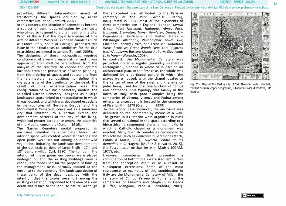
Fig. 2 - Map of the Padua city, 1784, Giovanni Valle, zenithal,2000x1770mm, copper engraving, Biblioteca Civica di Padova, RIPVII/984.
DISEGNARECON volume 11/ n. 21 - december 2018 ADVANCED TECHNOLOGIES FOR HISTORICAL CITIES VISUALIZATION NAVARRO - MUÑOZ - ZAGGIA
ISSN 1828-5961 Silent cities visualization. The case study of the Main Cemetery of Padua & the Cemetery Island of San Michele in Venice: preliminary reflections
h t t p : / / d i s e g n a r e c o n . u n i v a q . i t
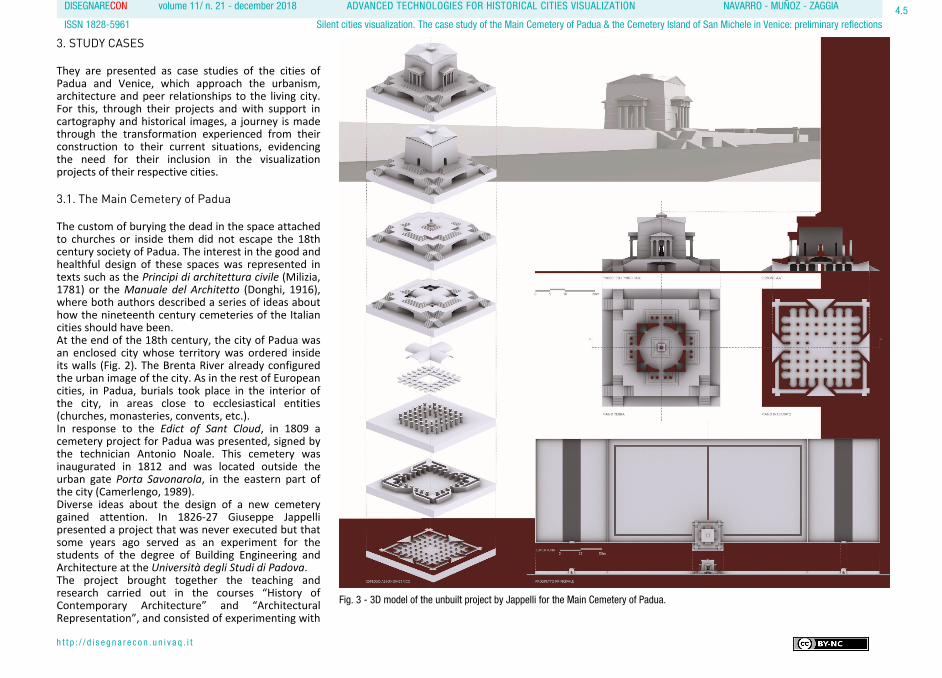
3. STUDY CASES They are presented as case studies of the cities of Padua and Venice, which approach the urbanism, architecture and peer relationships to the living city. For this, through their projects and with support in cartography and historical images, a journey is made through the transformation experienced from their construction to their current situations, evidencing the need for their inclusion in the visualization projects of their respective cities. 3.1. The Main Cemetery of Padua The custom of burying the dead in the space attached to churches or inside them did not escape the 18th century society of Padua. The interest in the good and healthful design of these spaces was represented in texts such as the Principi di architettura civile (Milizia, 1781) or the Manuale del Architetto (Donghi, 1916), where both authors described a series of ideas about how the nineteenth century cemeteries of the Italian cities should have been. At the end of the 18th century, the city of Padua was an enclosed city whose territory was ordered inside its walls (Fig. 2). The Brenta River already configured the urban image of the city. As in the rest of European cities, in Padua, burials took place in the interior of the city, in areas close to ecclesiastical entities (churches, monasteries, convents, etc.). In response to the Edict of Sant Cloud, in 1809 a cemetery project for Padua was presented, signed by the technician Antonio Noale. This cemetery was inaugurated in 1812 and was located outside the urban gate Porta Savonarola, in the eastern part of the city (Camerlengo, 1989). Diverse ideas about the design of a new cemetery gained attention. In 1826-27 Giuseppe Jappelli presented a project that was never executed but that some years ago served as an experiment for the students of the degree of Building Engineering and Architecture at the Università degli Studi di Padova. The project brought together the teaching and research carried out in the courses “History of Contemporary Architecture” and “Architectural Representation”, and consisted of experimenting with
4.5
Fig. 3 - 3D model of the unbuilt project by Jappelli for the Main Cemetery of Padua.

DISEGNARECON volume 11/ n. 21 - december 2018 ADVANCED TECHNOLOGIES FOR HISTORICAL CITIES VISUALIZATION NAVARRO - MUÑOZ - ZAGGIA
ISSN 1828-5961 Silent cities visualization. The case study of the Main Cemetery of Padua & the Cemetery Island of San Michele in Venice: preliminary reflections
h t t p : / / d i s e g n a r e c o n . u n i v a q . i t
4.6
a tangible exhibition model that, through the use of graphic representation tools, made the unbuilt works of Jappelli visible. The buildings designed by Jappelli, among them the Cemetery of Padua, were visualised with the use of typical representation systems (plans, sections and elevations) along with 3D reconstructions and panels that –by means of photographic montage– were able to set the buildings in the present urban context as if they had actually been built. Three other physical models were also made of the cemetery and chapel in plaster powder and resin, using rapid prototyping technology. (Zaggia, 2012). In 1837, a new project was commissioned to Giovanni Maestri (Fig. 4). A few years later, in 1856, Count Giovanni Cittadella proposed a cemetery model for Padua similar to Pére Lachaise. However, this proposal was not well accepted in the Italian city, where the monumental cemetery type was preferred. In 1865, a public tender was held for the project of the city cemetery of Padua. The winner was Enrico Holzner, who presented an idea proposing a Lombard style churchyard. Two years later, after a review by the Ornato Commission, he had to redesign it with a less monumental version (Serena & Komac, 2000).The original project presented the typological scheme of a monumental cemetery: a square enclosure surrounded by covered galleries destined for burials
and graves in the ground through pits in the centre of the complex (Fig. 5). In 1882, the works of the new Padua cemetery began, but ten years later, after the promulgation of the new Mortuary Police Regulations, Holzner's project was modified. The cemetery, like the city, grew according to the needs of the population it served, and for this reason, it had regulations that determined its development. In 1892, while the cemetery of Padua was under construction, cemeteries for the districts of the city were proposed from the municipal office, which provides a view of the urban adaptation which the implementation of the new cemeteries required at a regional level. The graphic proposals have been found for the village of Terranegra, Granze di Camin, Camin, San Gregorio, San Lazzaro, Ponte di Brenta, Torre, Altichiero, Mostise, Volta Brusegana, Brusegana, Mandria, Salboro, etc. (Fig. 6). The type of cemetery imposed in the city of Padua, as in the rest of the Veneto Region, was that of a rectangular or square enclosure, bordered by a wall that delimited and protected the cemetery, and that was only flanked at the point where the access to the funeral space was proposed (almost always in the center of one of the sides). From the point of access, an axis divided the space intended
Fig. 4 - Unbuilt project for the Cimitero of Padua, 1837, GiovanniMaestri, front and Ground plan, ink on paper, Archivio Generale delComune di Padova. Nº 357/1839, Pezza IIª, Allegato D, Tav II.
Fig. 5 - Project for the Cemetery of Padua, 1865, Enrico Holzner,ground plan, ink on paper, Archivio Generale del Comune diPadova. Nº 357/1839, Pezza IIª, Disegni.
Fig. 6 - Cemeteries of some districts of Padua: Camin, San Gregorio, San Lazzaro, Volta Brusegana, Brusegana & Mandria, 1892,municipal engineer, ground plan, ink on paper, Archivio Generale del Comune di Padova.
DISEGNARECON volume 11/ n. 21 - december 2018 ADVANCED TECHNOLOGIES FOR HISTORICAL CITIES VISUALIZATION NAVARRO - MUÑOZ - ZAGGIA
ISSN 1828-5961 Silent cities visualization. The case study of the Main Cemetery of Padua & the Cemetery Island of San Michele in Venice: preliminary reflections
h t t p : / / d i s e g n a r e c o n . u n i v a q . i t
4.7
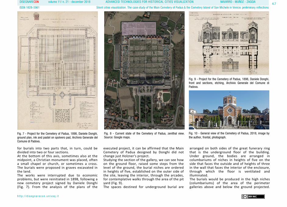
for burials into two parts that, in turn, could be divided into two or four sections. At the bottom of this axis, sometimes also at the midpoint, a Christian monument was placed, often a small chapel or church, or sometimes a cross. The burials were proposed in graves excavated in the land. The works were interrupted due to economic problems, but were reinitiated in 1898, following a new cemetery project signed by Daniele Donghi (Fig. 7). From the analysis of the plans of the
executed project, it can be affirmed that the Main Cemetery of Padua designed by Donghi did not change just Holzner's project. Studying the section of the gallery, we can see how on the ground floor, raised some steps from the level of the ground, the burial niches are ordered in heights of five, established on the outer side of the site, leaving the interior, through the arcades, for contemplative walks through the area of the pit yard (Fig. 9). The spaces destined for underground burial are
arranged on both sides of the great funerary ring that is the underground floor of the building. Under ground, the bodies are arranged in columbariums of niches in heights of five on the side that faces the outside and of heights of three in the wall that faces the interior of the enclosure, through which the floor is ventilated and illuminated. The burials would be produced in the high niches (columbariums) of the area of the perimeter galleries above and below the ground projected.
Fig. 8 - Current state of the Cemetery of Padua, zenithal view.Source: Google maps.
Fig. 7 - Project for the Cemetery of Padua, 1898, Daniele Donghi,ground plan, ink and pastel on spolvero pad, Archivio Generale delComune di Padova.
Fig. 9 - Project for the Cemetery of Padua, 1898, Daniele Donghi,front and sections, etching, Archivio Generale del Comune diPadova.
Fig. 10 - General view of the Cemetery of Padua, 2018, image bythe author, frontal, photograph.
DISEGNARECON volume 11/ n. 21 - december 2018 ADVANCED TECHNOLOGIES FOR HISTORICAL CITIES VISUALIZATION NAVARRO - MUÑOZ - ZAGGIA
ISSN 1828-5961 Silent cities visualization. The case study of the Main Cemetery of Padua & the Cemetery Island of San Michele in Venice: preliminary reflections
h t t p : / / d i s e g n a r e c o n . u n i v a q . i t
4.8
The central space of the Main Cemetery of Padua was projected based on squares that divided the space into quadrants of graves in the ground intended for the inhumations of the less well off. Until 1928, the year in which the execution of the Donghi project was completed, the cemetery was developed with different promotion initiatives analyzed in the dissertation directed by Professor Mazzi (Coluzzi, 2006). Since 1928, the configuration of the Main Cemetery of Padua has changed very little. The only extension that has been produced has added surface to the original enclosure on its north side, with a rectangular geometry that is added to the primal square (Figg. 8 & 10). The Main Cemetery of the city of Padua was conceived as a monumental cemetery that foresaw the growth of the city which, from afar, it had to accompany. As if it were a miniature city, the design of the cemetery, under the architectural typology of a monumental cemetery, established different areas for its inhabitants (deceased), grew under the same speculative processes as the city of the living (accumulating bodies in height, above and below ground, to accommodate a greater number of
bodies), and experimented with dwellings (pantheons) that are an excellent aesthetic sample of the architecture of the living. Thus, the existing parallelism at the urban, architectural and stylistic level between both cities; that of Padua and its Main Cemetery is demonstrated.
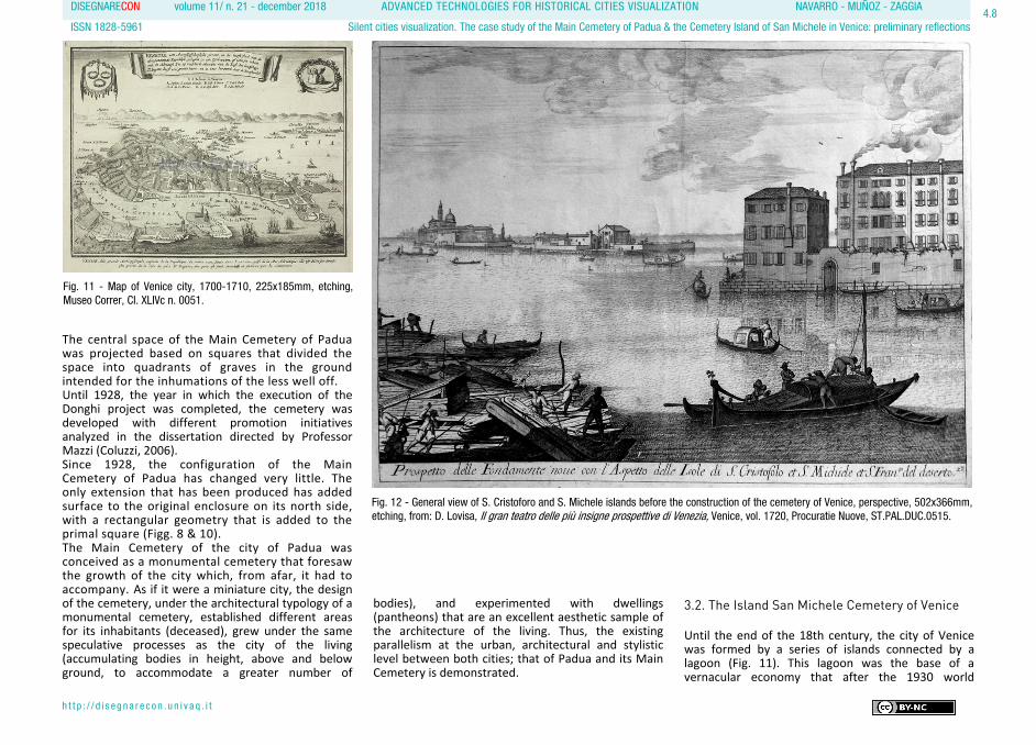
3.2. The Island San Michele Cemetery of Venice Until the end of the 18th century, the city of Venice was formed by a series of islands connected by a lagoon (Fig. 11). This lagoon was the base of a vernacular economy that after the 1930 world
Fig. 11 - Map of Venice city, 1700-1710, 225x185mm, etching,Museo Correr, CI. XLIVc n. 0051.
Fig. 12 - General view of S. Cristoforo and S. Michele islands before the construction of the cemetery of Venice, perspective, 502x366mm,etching, from: D. Lovisa, Il gran teatro delle più insigne prospettive di Venezia, Venice, vol. 1720, Procuratie Nuove, ST.PAL.DUC.0515.
DISEGNARECON volume 11/ n. 21 - december 2018 ADVANCED TECHNOLOGIES FOR HISTORICAL CITIES VISUALIZATION NAVARRO - MUÑOZ - ZAGGIA
ISSN 1828-5961 Silent cities visualization. The case study of the Main Cemetery of Padua & the Cemetery Island of San Michele in Venice: preliminary reflections
h t t p : / / d i s e g n a r e c o n . u n i v a q . i t
4.9
economic crisis and at the height of industrial development, began to be understood as a difficulty for the growth of the city. The relationship between Venetian society and the waters that characterize its territory changed radically. If until the early 19th century, Venice had been a landscape dominated by its horizontality, from then on, with the appearance of bridges and connections between the different parts of the mainland, this vision was lost. If before there had been an organizational system based on the structure of each of these small areas limited by sand and water, almost a century ago Venice became the organizational epicenter of the city, with the rest of the islands losing their importance, and therefore fading. However, there is an island that has always been maintained with the same use as it was conceived for, the island of San Michele. There, for more than 100 years, the bodies of the deceased have rested in Venice. The currently named San Michele Island was created in 1835 by joining the pre-existing islands of San Cristoforo della Pace and San Michele. Before the grouping of both spaces, burials had already taken place on the island of San Cristoforo in a space annexed to the monastery and church existing there. As in other European cities, the dead were
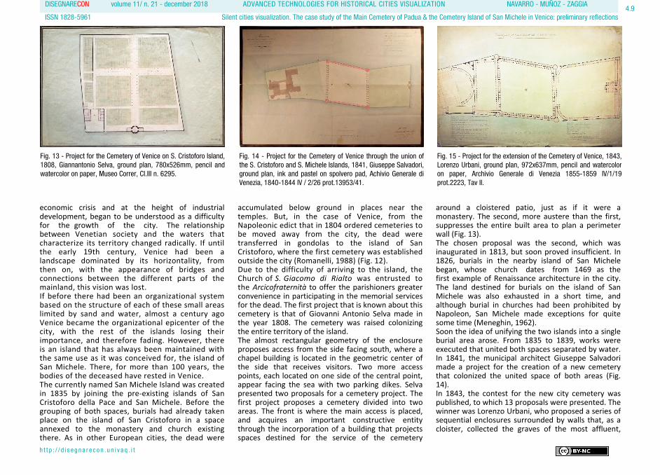
accumulated below ground in places near the temples. But, in the case of Venice, from the Napoleonic edict that in 1804 ordered cemeteries to be moved away from the city, the dead were transferred in gondolas to the island of San Cristoforo, where the first cemetery was established outside the city (Romanelli, 1988) (Fig. 12). Due to the difficulty of arriving to the island, the Church of S. Giacomo di Rialto was entrusted to the Arcicofraternità to offer the parishioners greater convenience in participating in the memorial services for the dead. The first project that is known about this cemetery is that of Giovanni Antonio Selva made in the year 1808. The cemetery was raised colonizing the entire territory of the island. The almost rectangular geometry of the enclosure proposes access from the side facing south, where a chapel building is located in the geometric center of the side that receives visitors. Two more access points, each located on one side of the central point, appear facing the sea with two parking dikes. Selva presented two proposals for a cemetery project. The first project proposes a cemetery divided into two areas. The front is where the main access is placed, and acquires an important constructive entity through the incorporation of a building that projects spaces destined for the service of the cemetery
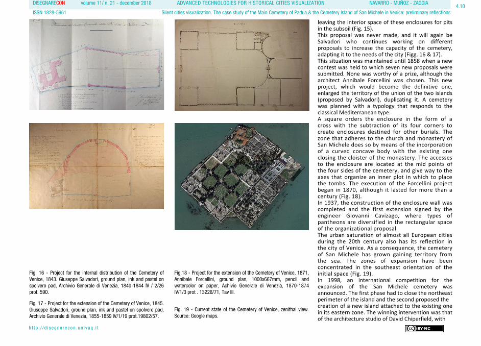
around a cloistered patio, just as if it were a monastery. The second, more austere than the first, suppresses the entire built area to plan a perimeter wall (Fig. 13). The chosen proposal was the second, which was inaugurated in 1813, but soon proved insufficient. In 1826, burials in the nearby island of San Michele began, whose church dates from 1469 as the first example of Renaissance architecture in the city. The land destined for burials on the island of San Michele was also exhausted in a short time, and although burial in churches had been prohibited by Napoleon, San Michele made exceptions for quite some time (Meneghin, 1962). Soon the idea of unifying the two islands into a single burial area arose. From 1835 to 1839, works were executed that united both spaces separated by water. In 1841, the municipal architect Giuseppe Salvadori made a project for the creation of a new cemetery that colonized the united space of both areas (Fig. 14). In 1843, the contest for the new city cemetery was published, to which 13 proposals were presented. The winner was Lorenzo Urbani, who proposed a series of sequential enclosures surrounded by walls that, as a cloister, collected the graves of the most affluent,
Fig. 13 - Project for the Cemetery of Venice on S. Cristoforo Island, 1808, Giannantonio Selva, ground plan, 780x526mm, pencil andwatercolor on paper, Museo Correr, CI.III n. 6295.
Fig. 14 - Project for the Cemetery of Venice through the union of the S. Cristoforo and S. Michele Islands, 1841, Giuseppe Salvadori, ground plan, ink and pastel on spolvero pad, Achivio Generale di Venezia, 1840-1844 IV / 2/26 prot.13953/41.
Fig. 15 - Project for the extension of the Cemetery of Venice, 1843, Lorenzo Urbani, ground plan, 972x637mm, pencil and watercolor on paper, Archivio Generale di Venezia 1855-1859 IV/1/19 prot.2223, Tav II.
DISEGNARECON volume 11/ n. 21 - december 2018 ADVANCED TECHNOLOGIES FOR HISTORICAL CITIES VISUALIZATION NAVARRO - MUÑOZ - ZAGGIA
ISSN 1828-5961 Silent cities visualization. The case study of the Main Cemetery of Padua & the Cemetery Island of San Michele in Venice: preliminary reflections
h t t p : / / d i s e g n a r e c o n . u n i v a q . i t
4.10
leaving the interior space of these enclosures for pits in the subsoil (Fig. 15). This proposal was never made, and it will again be Salvadori who continues working on different proposals to increase the capacity of the cemetery, adapting it to the needs of the city (Figg. 16 & 17). This situation was maintained until 1858 when a new contest was held to which seven new proposals were submitted. None was worthy of a prize, although the architect Annibale Forcellini was chosen. This new project, which would become the definitive one, enlarged the territory of the union of the two islands (proposed by Salvadori), duplicating it. A cemetery was planned with a typology that responds to the classical Mediterranean type. A square orders the enclosure in the form of a cross with the subtraction of its four corners to create enclosures destined for other burials. The zone that adheres to the church and monastery of San Michele does so by means of the incorporation of a curved concave body with the existing one closing the cloister of the monastery. The accesses to the enclosure are located at the mid points of the four sides of the cemetery, and give way to the axes that organize an inner plot in which to place the tombs. The execution of the Forcellini project began in 1870, although it lasted for more than a century (Fig. 18). In 1937, the construction of the enclosure wall was completed and the first extension signed by the engineer Giovanni Cavizago, where types of pantheons are diversified in the rectangular space of the organizational proposal. The urban saturation of almost all European cities during the 20th century also has its reflection in the city of Venice. As a consequence, the cemetery of San Michele has grown gaining territory from the sea. The zones of expansion have been concentrated in the southeast orientation of the initial space (Fig. 19). In 1998, an international competition for the expansion of the San Michele cemetery was announced. The first phase had to close the northeast perimeter of the island and the second proposed the creation of a new island attached to the existing one in its eastern zone. The winning intervention was that of the architecture studio of David Chiperfield, with
Fig. 16 - Project for the internal distribution of the Cemetery ofVenice, 1843. Giuseppe Salvadori, ground plan, ink and pastel onspolvero pad, Archivio Generale di Venezia, 1840-1844 IV / 2/26 prot. 590.
Fig.18 - Project for the extension of the Cemetery of Venice, 1871, Annibale Forcellini, ground plan, 1000x667mm, pencil and watercolor on paper, Achivio Generale di Venezia, 1870-1874 IV/1/3 prot . 13226/71, Tav III.
Fig. 17 - Project for the extension of the Cemetery of Venice, 1845.Giuseppe Salvadori, ground plan, ink and pastel on spolvero pad,Archivio Generale di Venezia, 1855-1859 IV/1/19 prot.19802/57.
Fig. 19 - Current state of the Cemetery of Venice, zenithal view. Source: Google maps.

DISEGNARECON volume 11/ n. 21 - december 2018 ADVANCED TECHNOLOGIES FOR HISTORICAL CITIES VISUALIZATION NAVARRO - MUÑOZ - ZAGGIA
ISSN 1828-5961 Silent cities visualization. The case study of the Main Cemetery of Padua & the Cemetery Island of San Michele in Venice: preliminary reflections
h t t p : / / d i s e g n a r e c o n . u n i v a q . i t
4.11
the first phase finishing in 2008 with a proposal that, according to Professor Blázquez (2012), aims to introduce a certain order in the Venetian lagoon disorder. And while the island of the living, Venice, has halted its territorial development almost completely, the island of the dead, the cemetery of San Michele, continues to expand and adapt to contemporary needs (Pisani, 2008). As Italo Calvino (1998) wrote about his city of Eusapia, “... the inhabitants have built an identical copy underground ... It is said that in both cities there is no way of knowing which are the living and which are the dead” (Fig. 20). 4. CONCLUSIONS The complexity of cultural management processes in historical cities requires methods and tools to improve the understanding of urban space as well as underlying relationships and connections. In this sense, visualization as a tool for analysis, exploration and communication has become a
driving force in the task of unravelling the complex urban fabrics that make up historical cities. It is at the service of all those interested, from those responsible for making decisions –urban planners and cultural manager–, to historians and citizens in general (Tamborrino, 2014). At present, there are several research projects which have been developed on the visualization of some historical cities. Although the cemetery corresponds to a part of the city that, in spite of being distant complements it, this is a space which is rarely studied. This happens despite the fact that no urban equipment shows such a detailed portrait of where society and architecture merge as the cemetery. This situation is even more evident in the case of the Monumental Cemetery, which can be understood as a replica of the city of the living that it serves. In addition, it should be remembered that there has not always been a distinction made between the spaces assigned to the living and the dead, but that for centuries the city was shared by both. Thus, when dealing with the study of the city and its transformations, we must inevitably work
with spaces destined for past burials. On the other hand, these enclosures frequently make up patrimonial groups of great historical, artistic, social and cultural value. All of these are features of an enlightened society that knew how to reinvent the configuration of its burial sites, proposing new solutions balancing sanitary and social requirements. Likewise, another factor that enriches the panorama described is the one associated with the study of funeral architecture drawn but never constructed, derived from the competitions established in the 19th century due to the legal imperative to build new cemeteries outside the city. Drawings –sometimes of relevant authorship– that may surprise us not only because of the characteristics of the proposal, but also for their refined graphics. And nobody better than Mumford to express the importance of these forgotten places:
... In the painful wanderings of Paleolithic man, the dead were the first to have a permanent abode, in a cave, in a mound marked with a few stones or in a collective mound. The city of the dead is before the city of the living. In fact, in a sense, the city of the dead is the precursor of every living city. The urban life covers all the historical space that extends from the most rudimentary cemetery of the man of the aurora to the final cemetery; the necropolis, in which one civilization after another has found its end (Mumford, 1961).
In short, the cemetery represents a place that, through its urbanism and architecture, speaks of the vital pulse of past and present society, of the reasons for which they were built, of the meaning they had and of what they have assumed and will continue to admit throughout the history of the city.
Fig. 20. General view of the Cemetery of Venice, 2018, image by the author, frontal, photograph.

DISEGNARECON volume 11/ n. 21 - december 2018 ADVANCED TECHNOLOGIES FOR HISTORICAL CITIES VISUALIZATION NAVARRO - MUÑOZ - ZAGGIA
ISSN 1828-5961 Silent cities visualization. The case study of the Main Cemetery of Padua & the Cemetery Island of San Michele in Venice: preliminary reflections
h t t p : / / d i s e g n a r e c o n . u n i v a q . i t
4.12
BIBLIOGRAPHY
Ariès, P. (1975). Essais sur l’historie de la mort en Occident du Moyen Age à nous jours. Paris, France: Le Seuil.
Ariès, P. (1977). L’homme devant la mort. Paris, France: Le Seuil.
Bertocci, S., Bua, S., Parrinello, S. & Picchio, F. (2014). Montepulciano 3D: modelli virtuali per l’urbanistica e lo sviluppo dell’ambiente urbano. Disegnare con, 7 (13), V/1-20.
Blázquez Jesús, P. (2012). San Michele. Entre el cielo y el mar. Arquitectura entre concursos, (7), 146-159.
Calabi, D. (2013). Built city, designed city, virtual city. The museum of the city. Rome, Italy: CROMA.
Calvino, I. (1998, orig. 1972). Las ciudades invisibles. Madrid, Spain: Minotauro.
Camerlengo, L. (1989). I cimiteri: i casi di Vicenza, Verona e Padova. In Mazzocca, F., Mazzariol, G. & Martinelli, S. (Ed.), Il Veneto e l’Austria vita culturale e artistica nelle città venete 1814-1866. Milan, Italy: Electa.
Camurri, D. (Ed). (2007). All’ombra dei cipressi e dentro l’urne. I cimiteri urbani in Europa a duecento anni dall’editto di Saint Cloud.
Bononia, Italy: Bononia University Press.
Chías Navarro, P. (2018). La representación de la ciudad, del territorio y del paisaje en la Revista EGA: mapas, planos y dibujos. EGA Expresión Gráfica Arquitectónica, 23 (34), 106-121.
COAM (1977). Cementerios en Madrid. Madrid, Spain: Comisión de cultura Colegio Oficial de Arquitectos de Madrid.
Coluzzi, S. (2006). Il cimitero maggiore di Padova. 1881-1928. (Dissertation) Università degli Studi di Padova, Italy.
Cremonini, L. (1999). Architetture cimiteriali. Florence, Italy: Alinea.
Curl, J.S. (1980). A celebration of death: An Introduction to Some of the Buildings, Monuments, and Settings of Funerary Architecture in the Western European Tradition. London: Constable & Co.
Donghi, D. (1916). Manuale dell´architetto. Volume II: la composizione architettonica. Parte I: distribuzione. Turin, Italy: Unione Tipografico-Editrice Torinese.
Felicori, M. (Ed.). (2005). Gli spazi della memoria. Architettura dei cimiteri monumentali europei. Rome, Italy: Luca Sosella Editore.
Gasperini, M. (2017). Pisae Forma Urbis. Digital drawing and ‘reading’ of the city. ZARCH, 8, 200-213.
Giordano, A. (2016). Visualizing Cities. Paesaggio Urbano, 4, 46-57.
Giordano, A., Friso, I., Borin, P., Monteleone, C., & Panarotto, F. (2018) Time and Space in the History of Cities. In Münster, S., Friedrichs, K., Niebling, F. & Seidel-Grzesińska, A. (Ed.), Digital Research and Education in Architectural Heritage. UHDL 2017, DECH 2017. Communications in Computer and Information Science (pp. 47-62). Cham, Switzerland: Springer.
Giuffrè, M., Mangone, F., Pace, S. & Selvafolta, O. (2007). L´architettura della memoria in Italia. Cimiteri, monumenti e cittá. 1750-1939. Milan, Italy: Skira.
Huffman, K.L., Giordano, A. & Bruzelius, C. (Ed.). (2018). Visualizing Venice: Mapping and Modeling Time and Change in a City. New York, USA: Routledge.
Ioannides, M. (Ed.). (2018). Digital Cultural Heritage. Cham, Switzerland: Springer.
Martí López, E., Catalá i Bover, L. & Marín i Silvestre, M.I. (2004). Un paseo por el cementerio de Poblenou. Barcelona, Spain: Ajuntament
de Barcelona, Cementiris de Barcelona S.A.
Meneghin, P.V. (1962). S. Michele in isola di Venezia. Venice, Italy: Stamperia di Venezia.
Milizia, F. (1781). Principi di architettura civile. Italy: Stamperia di Jacopo de’ Rossi.
Mumford, L. (2012 [Orig. 1961]). La ciudad en la historia. Sus orígenes, transformaciones y perspectivas. Logroño, Spain: Pepitas de Calabaza.
Muñoz Mora, M.J.; Navarro Moreno, D. (2015). Perpetuación de la arquitectura de la memoria y su puesta en valor. Restitución gráfica de panteones en el cementerio de Nuestra Señora de los Remedios. Anuario de Jóvenes Investigadores de Cartagena (8), 111–114.
Nonnis Vigilante, S. (2015 [Orig. 2004]). Gli spazi della morte in Età moderna e contemporanea. In Fasoli, V. (Ed.), Spazi (pp.115-131). Milan, Italy: Franco Angeli.
Pisani, D. (2008), «Variare» e «Ridefinire». David Chippefield ampliamento al cimitero di San Michele in Isola, Venezia. Casabella, (764), 26-33.
Rinaudo F., Tamborrino R. (2015). Sharing knowledge, grasping Cultural Heritage: a digital multidisciplinary
approach to the historical process of architecture and urban changes. In HERITAGE and TECHNOLOGY. Mind Knowledge Experience. Convegno Le Vie dei Mercanti - XIII Forum Internazionale di Studi, Aversa (pp. 1261-127). Naples, Italy: La scuola di Pitagora editrice.
Romanelli, G. (1988). Venezia ottocento. L’architettura, l’urbanistica. Venice, Italy: Albrizzi.
Serena, T. & Comac, I. (2000). Il nuovo cimitero. In Boito, C. (Ed.), Un´architettura per l´Italia unita (pp. 50-55). Padua, Italy: Marsilio.
Tamborrino, R. (2014). Digital Urban History: Telling the history of the City in the Age of the ICT Revolution. Rome, Italy: Croma.
Tomasi, G. (2001), Per salvare i viventi. Le originisettecentesche del cimitero extraurbano. Bononia, Italy: Il Mulino.
Worpole, K. (2003). Last landscapes. The architecture of the cemetery in the West. London, United Kingdom: Reaktion Books.
Zaggia, S. (2012). Metamorfosi negate. Progetti non realizzati di Giuseppe Jappelli. Padua, Italy: Cleup.