silviculture prescription beaman pond lot - mass.gov prescription beaman pond lot ... program...
TRANSCRIPT
1
Silviculture Prescription Beaman Pond Lot
Massachusetts Department of Conservation and Recreation Bureau of Forestry
Mid State District Otter River State Forest – Beaman Pond Lot
Baldwinville and Winchendon, MA
Prepared by:
Joelle Vautour – Management Forester – Mid State District Massachusetts Department of Conservation and Recreation
355 West Boylston Street Clinton, MA 01510 [email protected] – 978-368-0126 ext. 128
June 2016
Approved by: Management Forestry Program Supervisor ______________________________ Date:___________ William N. Hill, CF
2
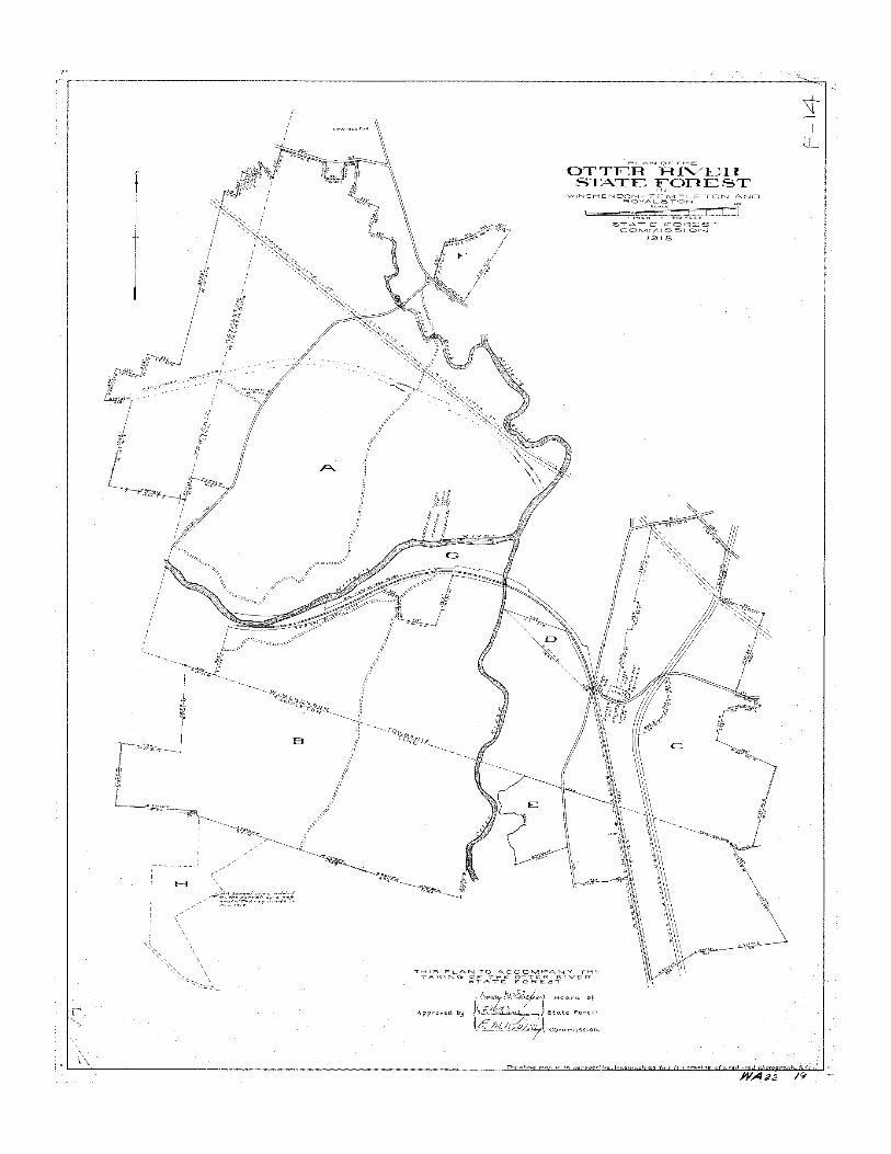
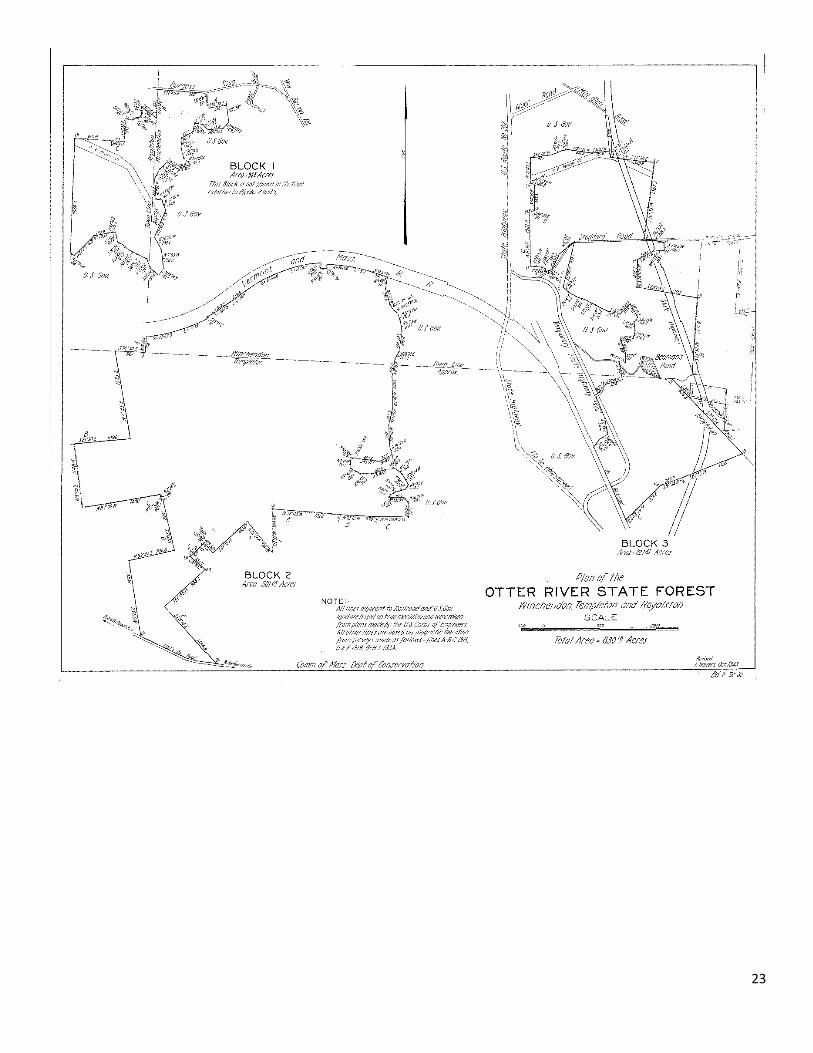
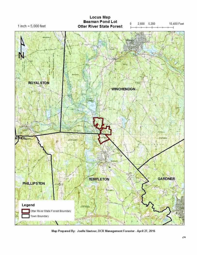
SITE DATA Cultural and Historical The Beaman Pond Lot is part of the Otter River State Forest complex and is located partially in the northeastern corner of Baldwinville (Templeton) and in the southern portion of Winchendon. Purchased in 1915 and formally established in 1917, it is the first state forest. The Otter River State Forest complex is currently comprised of three separate, non-contiguous state forest parcels, totaling nearly 1,000 acres. In addition, DCR leases approximately 4,200 acres of land in the area, including the Lake Dennison Recreation Area from the United States Army Corps of Engineers (ACOE). The Beaman Pond lot consists of approximately 290 acres, whereas approximately 239 acres will be harvested. Prior to 1935, Otter River State Forest was comprised of 1,992 acres which connected and included all three state forest parcels which are currently non-contiguous (see Plan of the Otter River State Forest in Winchendon, Templeton and Royalston, 1918). In 1935, the ACOE, by a Declaration of Taking, acquired 1,163 acres of state forest land in the Millers River and Otter River watershed for flood control operations. This Taking isolated the three separate state forest parcels that make up the Otter River State forest complex today (see Plan of Otter River State Forest in Winchendon, Templeton and Royalston, revised 1943 by F. Bowers). In addition to the acquisition of land, they built the Birch Hill and Tully Dams. The Birch Hill Dam, Tully Dam and Tully Lake provide flood protection for many towns that are located on or near the Millers River, including nearby Royalston, Athol and Orange. It also assists in the protection of communities on the Connecticut River, which the Millers River drains into. The Birch Hill area includes land owned by DCR, the Massachusetts Department of Fish and Game and ACOE, totaling nearly 8,500 acres of protected open space. A Civilian Conservation Corps (CCC) camp (Camp S-63 - Company 1102) was established at Otter River in 1934 as well as a state nursery. They were located on the former state forest land now owned by ACOE near Priest Brook. CCC projects at Otter River State Forest included forestry, road construction, fire protection and the building of recreational sites. This includes Beaman Pond and 12 of the 82 campsites at the Otter River campground. The CCC camp planted thousands of trees in the area, including on the Beaman Pond Lot which makes up this project. The Beaman Pond Lot is bounded by ACOE to the west and north and by private ownership to the east and south. It can be accessed by Route 202, Dennison Street and Lake Dennison Recreational Area and Otter River State Forest park roads. The 1916 report by the State Forester describes the Otter River State Forest land area (Berg, 1999),
“The land is for the most part flat and the soil, light, but not sandy. The areas purchased were largely cut-over lands or abandoned pastures. Except in portions near the railroad which have been burned, there is an immense amount of volunteer pine reproduction on this forest. Conditions for artificial planting are excellent.”
A 1938 aerial photograph of Otter River, Beaman Pond Lot, confirms this statement made by the State Forester in 1916. The condition of the Beaman Pond lot is a function of its past use and disturbance. Historically speaking, this property has undergone significant agricultural use, forest cutting/clearing and abandonment followed by reforestation plantings. In this case red pine (Pinus resinosa) and Eastern white pine (Pinus strobus) were the primary species used along with Scots pine (Pinus sylvestris). The intent was to periodically thin these plantations in order to maintain a stand of healthy vigorous trees with the ultimate goal of harvesting for wood products. After decades of neglect, many of these
3
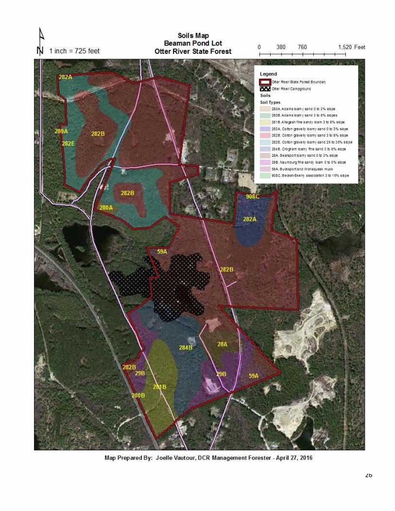
plantations have stagnated. The red pine has become susceptible to diplodia tip blight (Sphaeropsis sapinea), a fungus, and red pine scale (Matsucoccus resinosae), an insect. The white pine has been susceptible to two foliar diseases, the Canavirgella needle cast (Canavirgella banfieldii) and the brown spot needle blight (Mycosphaerella dearnessii), both of which are fungi. Geology and Soils The terrain varies dramatically throughout the project area. There are two prominent hills in the northern half of the project area and the remainder lies relatively flat. Some areas are low lying and are seasonally wet. The steepest slopes are located along the hillsides in the northern portion of the project area. The slopes on these hillsides range from 0 to greater than 30%. The property is underlain by an outwash plain of mostly droughty soils that varies from moderately well drained to excessively well drained. Approximately 73% of the upland soils are excessively well drained, 6% are well drained and 9% are moderately well drained. The remainder of the soils are poorly to very poorly drained, making up approximately 12% of the project area. Harvesting operations will only take place where the soils are suitable for the use of machinery. The use of harvesting equipment will be limited to specified crossings where soils are described as poorly or very poorly drained; otherwise the use of machinery will be prohibited within areas where wet soils exist. There are five soil types that make up the upland portion of the project area which will support harvesting operations. Additionally there are three soil types which are located in the project area that underlie wetlands which will not support harvesting operations. The different soil types present within the project area span multiple stands. The soil descriptions and maps were derived from the NRCS Web Soil Survey (see Soils Map). The majority of the project area is underlain by the Colton gravelly loamy sand. This soil type is divided into 3 groups based on slope (282A = 0 to 3%; 282B = 3 to 8 %; 282E 25-35%). Despite the difference in slope the soil properties are identical across the 3 groups. This is an excessively well drained, deep soil (being more than 80 inches to a restrictive feature), which has a very low available water capacity that is comprised of sandy and gravelly glaciofluvial deposits derived from granite. It encompasses nearly 73% of the total harvest area. The next most prevalent soil is the Croghan loamy fine sand (284B = 3 to 8% slope) which encompasses 9% of the project area. This soil type is moderately well drained with a depth that is greater than 80 inches. The Allagash fine sandy loam (281B = 3 to 8% slopes) encompasses approximately 6% of the total harvest area. This soil type is well drained with a depth that ranges from 15 to 35 inches. The Adams loamy sand (280A = 0 to 3%; 280B = 3 to 8% slopes) encompasses approximately 0.7% of the project area and is a very deep and excessively well drained soil type. The Becket-Skerry association (908C = 3 to 15% slopes) is located only in stand 2 and encompasses approximately 0.1% of the total harvest area. Being an association, this soil is comprised of two major soil types. Both soil types are well drained and have a depth that ranges from 15 to 35 inches with a low available water capacity. There are three soil types which are poorly to very poorly drained. The Bucksport and Wonsqueak mucks (59A = 0 to 3% slopes) and the Searsport loamy sand (28A = 0-3 % slopes) are two soil types which are very deep (80 inches to a restrictive layer) and very poorly drained. Lastly, the Naumburg fine sandy loam (29B = 0 to 5% slopes) is also a very deep soil that is poorly drained soil. Together they account for approximately 12% of the project area.
4
Site Productivity Soil productivity varies greatly throughout the harvest area, but seems to favor the development of upland plant species communities which are suited for these droughty soil types (USDA-NRCS). The upland soil types, Colton gravelly loamy sand, Allagash fine sandy loam, Adams loamy sand, Croghan loamy fine sand and Becket-Skerry association support the growth of white pine in comparison to other species. The Colton gravelly loamy sand has a site index of 62 for eastern white pine, 61 for sugar maple (Acer saccharum) and 52 for red pine. The Allagash fine sandy loam has a site index of 72 for eastern white pine, 71 for red pine, and 52 for white spruce (Picea glauca). The poorly drained soils encourage more of a spruce/cedar/fir forest type. The DCR Management Guidelines state that forest stands will be classed and considered for silvicultural treatments that generally fit their productivity, structural complexity (or potential thereof) and diversity. An analysis of stands 1 – 3 of the Beaman Pond lot site history (land use; agriculture/logging) and conditions (soil types, productivity; vegetation cover) suggests that the majority of these even-aged, lower complexity stands have a medium productivity and complexity. This implies that the site is suited for both even-aged management and uneven-aged management (Goodwin and Hill, 2012). Climate For this area, the United States Department of Agriculture’s Natural Resource Conservation Service (USDA-NRCS) gives a mean annual temperature between 43 and 54 degrees Fahrenheit with a mean annual precipitation between 45 and 54 inches annually. The National Oceanic and Atmospheric Administration (NOAA) more specifically states that the mean annual temperature of this project area is 47.9 degrees Fahrenheit with a mean annual precipitation of 42.78 inches. There have been no significant disturbances of the project area due to weather. A small microburst in the summer of 2005 caused slight damage to trees in the campground. The December 2008 ice storm caused minimal crown damage to overstory trees. As is typical for New England, wind and therefore weather patterns in Massachusetts vary greatly from season to season and even day to day. It is typical in the summer and spring for winds to come from the southeast and southwest. It is common for weather patterns to come down from the north and northeast in fall and winter. These weather patterns can contain both high or low pressure systems and any form of weather historically common to New England. Weather can be a major disturbance in this area of Massachusetts. Hurricanes, wind and ice have had major impacts on this landscape in the past and will continue to do so in the future. Hydrology and Watershed The Beaman Pond lot is located in the southern portion of the Millers River Watershed. This watershed encompasses nearly 310 square miles and is located in north central Massachusetts, extending slightly into southern New Hampshire. The headwaters of the Millers River are located in Ashburnham, MA and the river continues through several towns including Winchendon, Royalston , Athol, among others, and westward until it reaches the Connecticut River, which flows into Long Island Sound. The harvest area lies within one mile of two large tributaries of the Millers River. The closest is the Otter River, which lies a half mile to the west of the property boundary. The other is Priest Brook, which is approximately one mile to the northwest. The merge of these tributaries into the Millers River are within one mile of the property boundary.
5
There are seven mixed wooded swamps, three shrub swamps, one potential vernal pool and one deciduous wooded swamp located within the project area or on its edge. Beaman Pond, although outside of the project area, is located centrally in the state forest and is a result of a CCC constructed dam. This pond was at one time regularly drained and dredged. It is currently utilized as a designated swimming area at Otter River campground. There are three perennial streams within the project area. The first is Beaman Brook which enters the project area from the east side of Route 202 and flows into the southern end of Beaman Pond. The second perennial stream enters the property from the south and flows north into Beaman Pond. A third perennial stream flows northwestward out of Beaman Pond into the Mud Pond wetland system located on the ACOE property. All wetlands, potential vernal pools and streams will have appropriate buffers and filters as indicated in the Massachusetts Forestry Best Management Practices Manual (BMPs). These buffers and filter strips will be delineated in the field prior to harvesting. This will aid in directional felling away from these resource areas. No equipment will operate in streams, wetlands or wetland buffers except on pre-existing woods roads and trails or at designated crossings approved by a forest cutting plan. It is unknown at this time if any stream or wetland crossings will be required as a part of this project. Extensive planning efforts will reduce site impacts and avoid stream and wetland crossings at all opportunities. There are several existing culverts and one bridge within the project area on the main truck roads. All actions taken within a watershed will have some impact on the water quality, rates of flow, sedimentation and several other factors pertaining to hydrology. Full consideration has been given to impacts that this particular timber harvesting operation will have within the Millers River Watershed. There will be no harvesting in wetlands. Appropriate measure will be taken in order to mitigate and prevent erosion (i.e. water bars, seeding, slashing of skid roads, etc.). Slash will be left on site not only to provide nutrients to the soil and habitat purposes, but to also slow overland flow of water and to promote percolation of water into the soil. Wildlife A review of the Natural Heritage and Endangered Species Program (NHESP) atlas shows that there are no habitat restrictions located within the project area. NHESP will review the project prior to any harvesting to determine if any limitations or modifications will be required. There are signs of deer, moose and turkey using this area. Moose and deer browse are not problematic for the regeneration at this time. Pileated woodpecker sign was observed throughout the project area. Large and small mammals and numerous bird species are assumed to utilize the project area. Ring-necked pheasants are stocked regularly within the vicinity and additional hunting for native game birds is a common activity. Rabbit are common in the area as well. As outlined in the DCR Management Guidelines (Commonwealth of Massachusetts, 2012), selected large trees will be reserved as wildlife trees for future snag and den trees. Snags, dead trees and coarse woody debris will be retained for habitat as well. A minimum of two cords of coarse woody debris (256 cubic feet) will be maintained per acre. Browse for wildlife will be enhanced during the harvest and for many years after the harvest as regeneration becomes established. Mast producing trees such as black cherry and oak will be retained whenever possible. All potential vernal pools will be treated as certified vernal pools. Recreation The Beaman Pond lot is located along a portion of Route 202, Dennison Street (Baldwinville) and along “Old 202” which are actively used for recreation. All aesthetic considerations will be made to legal recreational users of the state forest. Slash over 1” in diameter will be lopped to under 2 feet in height
6
above the ground. Larger trees along the edges of trails will be retained. As mentioned in the DCR Management Guidelines for roads and trails, hazard trees will be harvested along the truck roads, skid trails and hiking trails (Commonwealth of Massachusetts, 2012). Harvester operation will be limited to times when ground conditions are stable. Directional felling to protect residual trees, wetlands, woods roads and trails will also be implemented. Removal of potentially hazardous trees to aid in public safety will be implemented. There are many passive recreational uses of the Beaman Pond Lot and surrounding protected lands (Birch Hill Wildlife Management Area, Lake Dennison Recreational Area, Birch Hill Flood Control Area). Hiking, mountain biking, cross country skiing, snowshoeing, hunting and fishing, equestrian use, dog sledding, swimming and legal snowmobiling are potential uses of this state forest. The Wilder-Mackenzie interpretive hiking trail is a popular trail which connects Otter River campground to Lake Dennison. Forest management will occur in the 50 foot wide corridor on the Wilder-Mackenzie interpretive hiking trail (see Harvest Map). Due to public safety concerns, the required management guidelines (Commonwealth of Massachusetts, 2012) in the trail’s corridor have been waived by the Greenways and Trails Coordinator and the Chief of Interpretive Services. There is an extensive network of snowmobile trails that are permitted for use and maintained by the Coldbrook Snowmobile Club. These trails extend through several local towns. Some of these trails will be utilized as main truck/access roads. Active harvesting operations will be planned to minimize impacts to recreational users as much as possible. The project area will be closed to the public during active logging hours for safety reasons. Current Vegetation Currently this site is dominated by white pine, red pine and Scots pine plantations which were planted by the CCC. The plantations are mature, fully stocked and have stagnated in growth. These stand conditions often bring about a higher susceptibility of disease and infestation. Red pine scale and diplodia tip blight often infest and infect declining stands of red pine and is capable of causing mortality within one growing season. Red pine plantations have faced mortality regionally from these causes in southern Massachusetts, the Quabbin Reservoir and Bear Brook State Park in New Hampshire. Diplodia tip blight is present in the plantation on red pine trees. Although mortality is not occurring widespread from this fungus at this time, if red pine scale infests the plantation, widespread mortality of red pine is likely to occur. The white pine plantation has been infected with Canavirgella needle cast and brown spot needle blight for several years. These fungi cause lesions to form in current year needles and can cause death to the distal portion of the infected needle. This fungal infection combined with stagnated growth and drought prone soils are causing mortality within this plantation as well as in many other white pine trees in the local landscape. The Beaman Pond Lot consists of three forest stand types, stand 1 is a red pine plantation, stand 2 is a white pine stand and stand 3 is a Scots pine plantation (see Harvest Map). The most common overstory species are red pine, white pine and Scots pine. Other associated species include spruce (Picea spp.), red maple (Acer rubrum) and Northern red oak (Quercus rubra). All of stand 1 was treated except for the northern area on the west side of Route 202. The red pine located on the east side of Route 202 was treated in 1989, the red pine located in the northwestern portion of the property was treated in 1993 along with stand 2 and the red pine south of the
7
campground and on the west side of the campground road were treated in 2000 along with stand 2. These treatments were the preparatory cut of the shelterwood regeneration method aimed at harvesting portions of the overstory to create optimal conditions for the establishment of regeneration in the understory. Stand 3 has never been treated. Past even-aged management practices has begun the creation of a new age class in some portions of the property. This is most prevalent in stands 1 and 2. Natural mortality in stands 2 and 3 has also begun to diversify the age classes in these stands. Regeneration is most prevalent in areas that were thinned. Portions of stands 2 and 3 which have undergone significant mortality and have maintained a low live crown ratio have advanced regeneration in the understory. White pine, red oak, red maple, black cherry (Prunus serotina) and Eastern hemlock (Tsuga Canadensis) are present in the understory. The ground species are for the majority associates of upland forest communities. Eastern teaberry (Gaultheria procumbens), wood ferns (Dryopteris spp.), lowbush blueberry (Vaccinium angustifolium) and bracken fern (Pteridum aquilinum) among others are common in the ground layer throughout the project area. STAND DATA
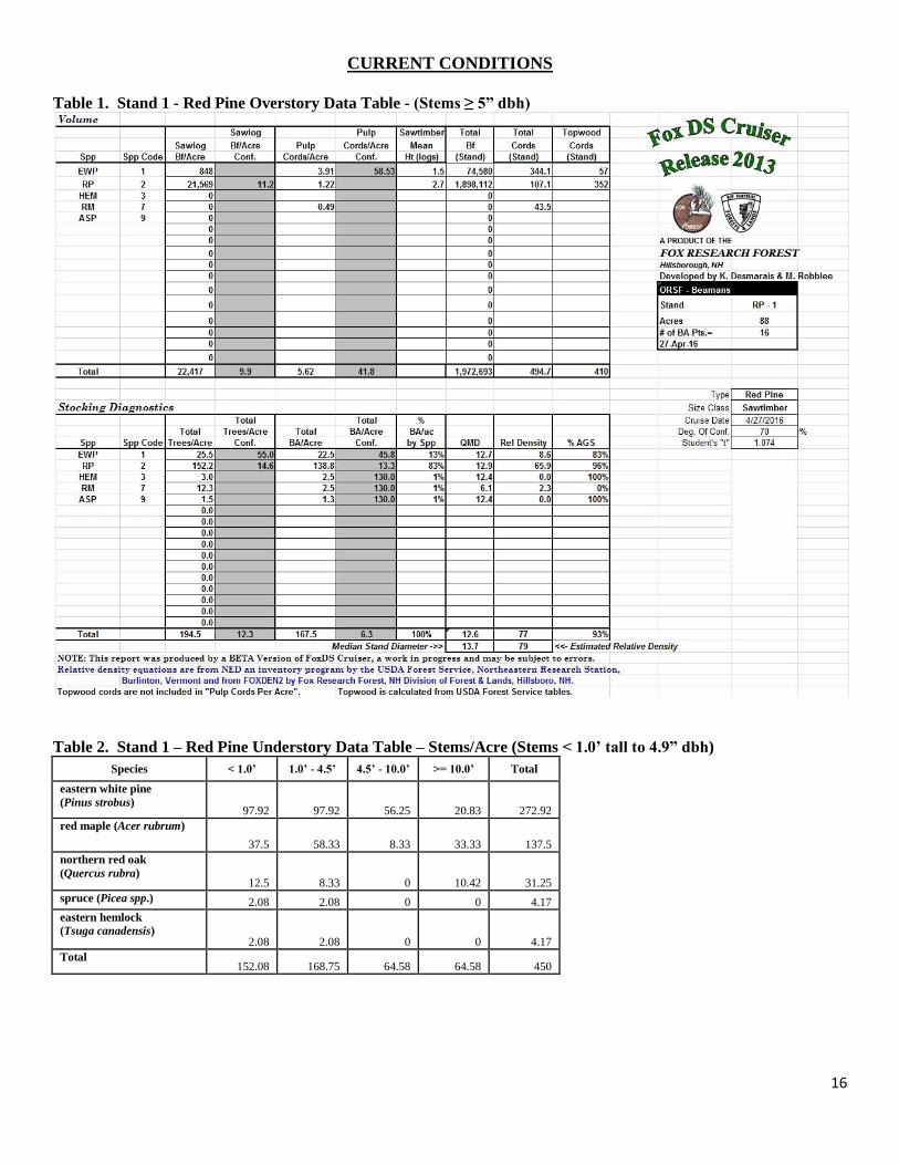
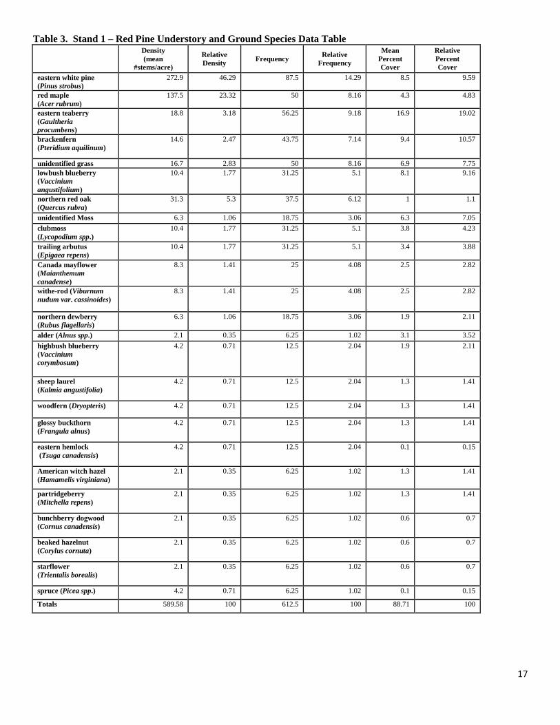
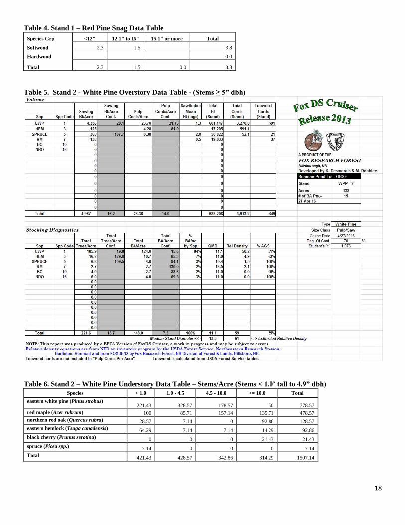
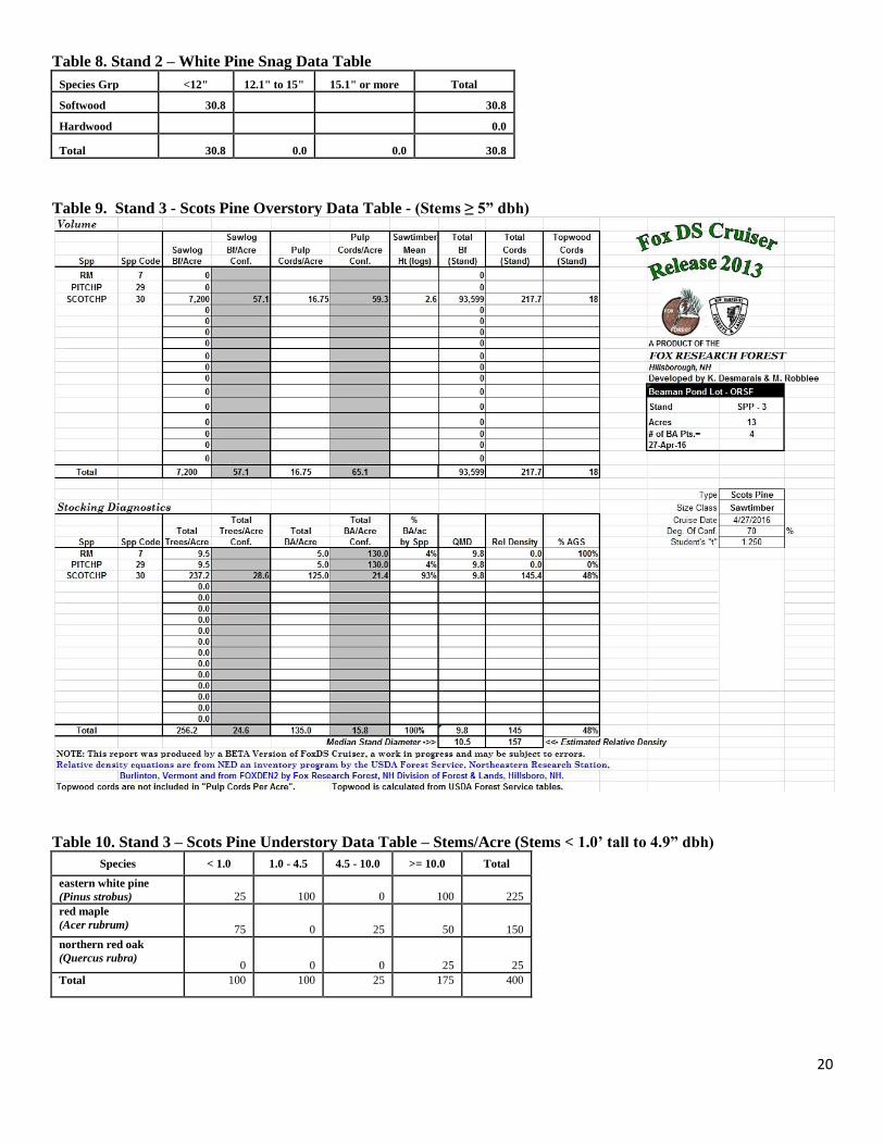
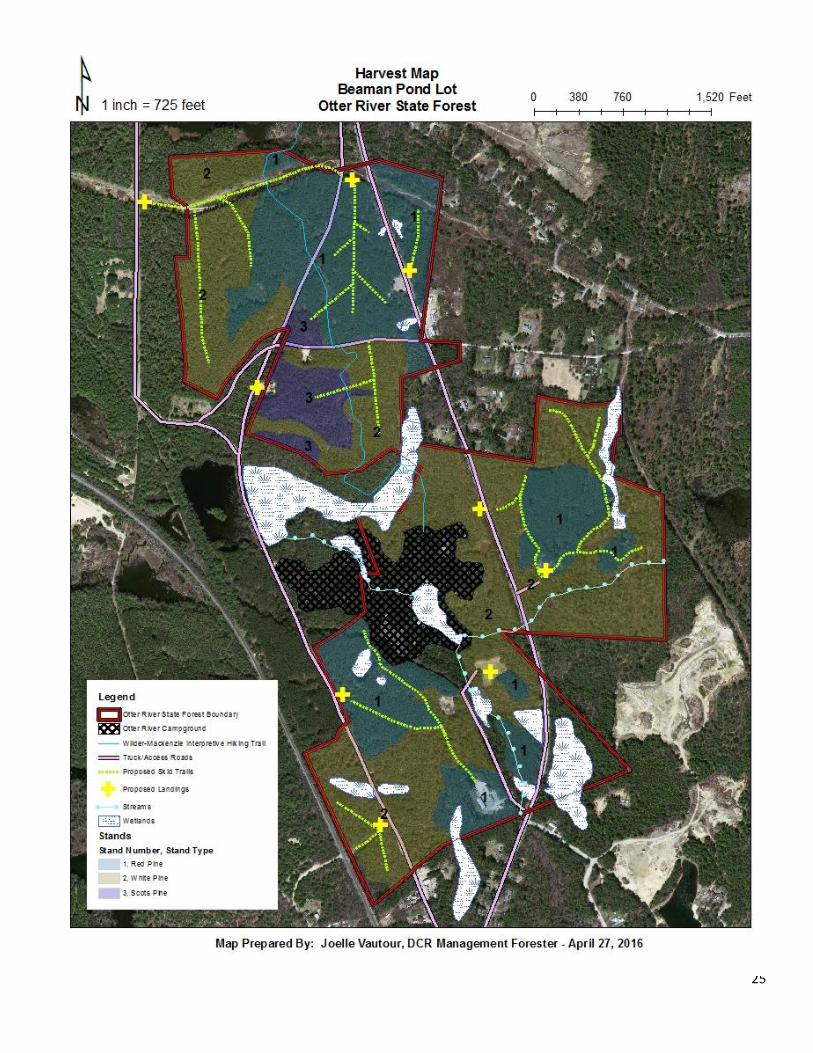
Stand Descriptions Stand 1 Stand 1 is an 88 acre red pine plantation located in seven separate locations throughout the harvest area (see Harvest Map). The dominant overstory species is red pine. Eastern white pine also occurs in the overstory in lesser amounts (Appendix, Table 1). This stand is roughly 80 years old. Using the red pine stocking chart (Benzie, 1977), the stand is approaching the A line (overstocked), with 167.5 square feet of basal area per acre, 194.5 stems per acre and a relative density of 79%. The mean stand diameter is 13.7 inches (Appendix, Table 1). Growth response from the thinnings in 1989 and 1993 was fair, but the response from the thinning in 2000 is very minimal suggesting that the plantation had stagnated in growth or was beginning to stagnate at around that time. The overstory is very uniform and consists of co-dominant trees. There are few trees in the stand that exhibit a dominant crown class. The previous thinnings removed the majority of trees from the intermediate and suppressed size classes. Regeneration occurs in the understory throughout most of the stand. Areas that were thinned heaviest have the highest density of growth. White pine, red maple and red oak seedlings and saplings are the most dominant with some patches of hemlock and spruce present also (Appendix, Table 2). Ground species present in this stand are associated with upland forest ecosystems and include mostly Eastern teaberry, bracken fern and low bush blueberry, among others (Appendix, Table 3). Glossy buckthorn is also present in this stand and is considered an invasive species (Appendix, Table 7). There are 273 stems/acre of white pine and 138 stems/acre of red maple in the understory (Appendix, Table 2). There are 3.8 snags per acre inventoried in this stand (Appendix, Table 4). There is an estimated volume of 92.6 ft³ per acre of coarse woody debris in the stand. There are several forested wetlands and one perennial stream located in this stand. There will be no harvesting in wetlands and all regulated BMP’s will be utilized for cutting in filter strips and along wetland edges as well as for the implementation of any stream or wetlands crossings. Stand 2 Stand 2 is a 138 acre white pine stand that is located in four separate locations throughout the harvest area (see Harvest Map). The majority of the stand consists of plantation white pine while a smaller
8
portion of the stand contains a natural seeded area of white pine. The dominant overstory species is white pine. Hemlock, spruce, red maple, black cherry and red oak also occur in the overstory in lesser amounts (Appendix, Table 5). This stand is roughly 80 years old. Using the white pine stocking chart (Philbrook et al., 1973), this stand currently falls between the A and B lines. The basal area is 148 square feet per acre with 221.6 stems per acre. The mean stand diameter is 13.3 inches and the estimated relative density is 61% (Appendix, Table 5). Growth response from the thinning in 1993 and 2000 is fair in portions of the stand that are not plantations. Throughout most of the stand, the live crown ratio on standing trees is extremely low. The close proximity at which these trees were planted and the lack of thinning through the years has resulted in a high level of competition and crowding, leaving the overstory trees with thin crowns and stagnated growth. Mortality can be seen throughout the stand due to these close growing conditions and high level of competition. The mean stand diameter remains low for the white pine in this stand because of a lack of past management. In areas that were not managed, the diameter remains smaller than the areas that were treated. Regeneration is dense in areas that were treated. White pine seedlings and saplings make up the majority of the regeneration in these areas. In areas that were not thinned, natural mortality and thin overstory crowns have released enough sunlight to the forest floor to allow pockets of regeneration to become established. White pine seedlings and saplings make up the majority of the regeneration present in the understory and red oak, red maple, hemlock, spruce and black cherry are also present in lesser amounts (Appendix, Table 6). There are 778 white pine stems in the understory (Appendix, Table 6). Ground species present in this stand are associated with upland forest ecosystems and include mostly eastern teaberry, wood fern and partridgeberry (Mitchella repens). Glossy buckthorn is also present in this stand and is considered an invasive species (Appendix, Table 7). Due to high levels of mortality, there are many dead standing trees and scattered large volumes of coarse woody debris. There are 30.8 snags per acre in this stand, all of which are white pine. Each snag measured was less than 12 inches dbh (Appendix, Table 8). There is an estimated 987.9 ft³ of coarse woody debris. There are several forested wetlands and one perennial stream located in this stand. There will be no harvesting in wetlands and all regulated BMP’s will be utilized for cutting in filter strips and along wetland edges as well as for the implementation of any stream or wetland crossings. Stand 3 Stand 3 is a 13 acre Scots pine plantation that is located along the north western side of the project area. This stand has never been thinned. The dominant overstory species is Scots pine. Red maple also occurs in the overstory in lesser amounts (Appendix, Table 9). This stand is roughly 80 years old. The basal area of this stand is 135 square feet per acre with 256.2 stems per acre. The mean stand diameter is 10.5 inches with a relative density of 157% (Appendix, Table 9). Throughout most of the stand, the live crown ratio on standing trees is extremely low. The lack of thinning through the years has resulted in a high level of competition and crowding, leaving the overstory trees with thin crowns and stagnated growth. Mortality can be seen throughout the stand due to these close growing conditions and high level of competition. Regeneration abundance is fair and consists mostly of white pine and red maple seedlings and sapling with some red oak scattered. There are an estimated 225 stems per acre of white pine and 150 stems per acre of red maple in the understory (Appendix, Table 10). Ground species present in this stand are associated with upland forest ecosystems and include mostly lowbush blueberry, eastern teaberry,
9
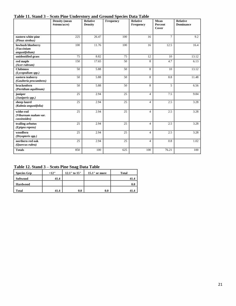
clubmoss (Lycopdium spp.), bracken fern, wood fern, juniper (Juniperis spp.) and grasses, among other species (Appendix, Table 11). Due to high levels of mortality, there are many dead standing trees and scattered large volumes of coarse woody debris. There were 41.4 snags per acre tallied in this stand. There is an estimated volume of 375.1 ft³ per acre of coarse woody debris in the stand (Appendix, Table 12). There are several forested wetlands and one perennial stream located in this stand. There will be no harvesting in wetlands and all regulated BMP’s will be utilized for cutting in filter strips and along wetland edges as well as for the implementation of any stream or wetland crossings.
EVALUATION OF DATA AND PROJECTED RESULTS As outlined in the Forest Futures Visioning Process and associated DCR Management Guidelines, published in March 2012, the Beaman Pond Lot has a Parkland designation. This property is located in an area with high recreational value including an established campground, day use picnic areas, hiking trails and waterfront swimming opportunities. While commercial production of wood for wood products is not an intended goal for Parkland designated properties, silvicultural treatments are permitted for the following purposes (Commonwealth of Massachusetts, 2012):
1.) Vegetation management necessary to protect public health and safety, public interests, public assets and/or restore or maintain recreation sites following significant natural disturbances or destructive insects or disease. 2.) Removal of plantations to restore more natural and diverse vegetative communities – if public health and safety are at risk, or to restore ecologically significant communities such as pitch pine barrens.
The project at the Beaman Pond Lot is being proposed at this time because:
1.) The plantations offer little vegetative diversity and are rapidly declining in health and vigor. 2.) White pine tree condition on the property is declining in health and vigor. 3.) Public safety and assets are being jeopardized by the current forest condition.
Project Objectives There are several overall objectives of this project:
1.) Demonstrate thinning to prepare an even aged plantation of red pine, white pine and Scots pine for the regeneration of a mixture of native tree species, including white pine and deciduous hardwoods. 2.) Release advanced regeneration of native tree species present in portions of the forest which have undergone past forest management. 3.) Increase the vegetative diversity and structural complexity within the project area to include an assortment of native plant species including native shrubs and herbaceous plants. 4.) Demonstrate harvesting techniques and best management practices that protect forest productivity, soil and water resources. 5.) Mitigate public safety risk by implementing silvicultural treatments that work to proactively harvest trees which are rapidly failing in condition.
10
6.) Educate the public on forest management practices by placing additional interpretive signage along the Wilder-Mackenzie interpretive hiking trail and in other locations as appropriate. 7.) Provide a small supply of timber to the sawmill at Otter River State Forest for in-kind use to repair the park buildings and other infrastructure at the Otter River State Forest and Lake Dennison campgrounds and day use areas.
Silvicultural Prescription and Desired Results Stand 1 Stand 1 will undergo the second stage of a three-stage even aged shelterwood regeneration system. The purpose of this cutting is to thin the overstory so that more light can permeate to the understory and ground layers to partially release advanced regeneration which became established from past treatments as well as establish new regeneration. Maintaining the right amount of shade from the overstory is essential to the survival of germinating and existing seedlings, particularly for white pine which is moderately shade tolerant. The operator is to disturb wherever possible the ground conditions to bare mineral soil which will better enable white pine seedlings to become established. This will also be beneficial for some hardwood tree species, particularly oak, to seed in. Advanced regeneration will be protected where present. Glossy buckthorn is present in this stand. The forester will hand pull as much glossy buckthorn as possible prior to the harvest. Post harvest monitoring will take place to delimit the presence and any spread of this invasive species. To help guide the management decisions in this stand, reference was made to the red pine stocking chart (Benzie, 1977). Stocking charts are developed based on intensive long term research of a species and can help make decisions based on stand density and growth within a stand. The stocking chart informs the forester if a stand is overstocked (A level), fully stocked (B level) or understocked (C level). Stand 1 stocking is currently approaching the A level. The objective is to reduce the basal area by, on average, 90 square feet of basal area per acre. This will bring the basal area down to approximately 80 square feet per acre from 167.5 square feet per acre. Small crowned, poorly formed trees will be targeted for removal while maintaining the healthiest and best formed overstory trees. Trees that exhibit defects will also be targeted for removal. The short term desired future condition is to increase the amount of light to the understory to partially release advanced regeneration, provide an opportunity for new regeneration to become established and to begin the process of removing the overstory. Greater vertical complexity and species diversity will be attained through this thinning by encouraging the growth of healthy native tree and shrub species. Stand 2 and Stand 3 Stands 2 and 3 will be treated with the group selection method. In this entry, approximately one third to one half the acreage of each stand will be regenerated with openings up to 1 acre in size. The main objective in this treatment is to regenerate a portion of stands 2 and 3 in this entry, followed similarly by 2-3 future entries which will regenerate the remaining acreage of stands 2 and 3 to achieve 3 or more age classes. Group selection is being applied to these stands for two main reasons. The first is that the overstory tree quality is so poor that it is anticipated that the overstory would not respond well enough as to be expected if the shelterwood regeneration method was used instead. Lastly, it is anticipated that by using an uneven aged regeneration system, species diversity can be enhanced from what is currently occupying the site. Although a portion of stands 2 and 3 have a fairly uniform composition, some portions that have undergone past treatments (stand 2) or large amounts of mortality (stands 2
11
and 3) contain a two aged structure. In this entry, group openings will be placed in the more uniform portions of each stand to create a new age class as well as in areas that release the younger age class within the two aged portions of stands 2 and 3. In addition, portions of the mature overstory will be reserved in each stand in this entry and in future entries. By implementing group selection, the forester will be able to implement group openings that are variable in size and which will therefore aim to regenerate a broad mixture of species that prefer varying levels of light to grow. The size of the group opening to be cut is generally determined by the species desired to regenerate the site (Lamson & Leak, 2000). For example, small openings (1/10 acre and less) and light thinnings favor shade tolerant tree species such as sugar maple and hemlock. Larger openings and heavier thinnings favor shade intolerant species such as cherry, poplar (Populus spp.) and birch (Betula) tree species. Opening sizes between 1/4 to 2/3 acre will regenerate a mixture of shade tolerant, shade intolerant and partially shade tolerant species (oak, white pine, red maple) (Lamson & Leak, 2000). Therefore, applying a mixture of group selection openings will create more of an opportunity to achieve a greater level of species diversity in each stand. Group selection mimics small scale natural disturbances that occur more frequently in natural forest stands than large scale disturbances such as the Great Hurricane of 1938. Laying the groups out in the field will focus on access and slope as well as potential impacts to water resources, aesthetic buffers and recreational impacts, among others. As mentioned above, group openings will be implemented in areas that benefit advanced regeneration or expand on previous natural disturbances or past management practices. Thinning between the gaps will occur in areas where appropriate. Thinning on the outside perimeter of gaps will be implemented if it is beneficial to advanced regeneration, particularly if the advanced regeneration is partially shade tolerant (white pine, red oak). Thinning along interior roadways and recreational trails will also be implemented for user safety. Using the white pine stocking guide (Philbrook et al., 1973), thinning in stand 2 will bring the basal area from 148 square feet per acre to an average basal area of approximately 100 to 120 square feet of basal area per acre. Thinning in stand 3 will bring the basal area from 135 square feet per acre to an average basal area of approximately 80 to 100 square feet per acre. Per the DCR Management Guidelines (Commonwealth of Massachusetts, 2012), 1-3 live, large diameter (>18” dbh) trees per acre and 4 live, 12” to 18” dbh trees per acre will be retained for future snag and den trees for wildlife. Glossy buckthorn is present in stand 2. The forester will hand pull as much glossy buckthorn as possible prior to harvesting operations. Post harvest monitoring will be implemented to delimit the presence and any spread of this invasive species. Logging System Requirements This harvest will be completed using a fully mechanized operation. Stand 1 will be limited to the use of a cut to length logging system. This type of harvesting equipment allows for a level of efficiency that is especially well suited for operating in plantations. A cut to length system will allow for increased levels of slash and woody material to be left on site, effectively replenishing nutrients to the forest soil, providing cover and habitat for wildlife and mitigating erosion by slowing the overland flow of water. The minimum goal for downed woody debris to be left on site is 256 ft³ per acre as directed by current DCR Management Guidelines (Commonwealth of Massachusetts, 2012), which will be easily achieved by
12
using the above described system. Currently stand 1 is below this threshold with approximately 92.6 ft³ per acre. Stands 2 and 3 contain large volumes of low quality pulpwood and a low volume of merchantable sawtimber. While it would be most efficient to sell the entire timber sale area as one unit to a single contractor, stands 2 and 3 might have enough of a high volume of low quality wood that a cut to length operator may not bid on the timber sale area as a whole. Ultimately, this will be dependent on the current markets of low quality material at the time of bidding and the exact volume of low quality wood that is required to be cut. If a cut to length operator does not bid on the entire Beaman Pond Lot, stand 1 will be bid out to cut to length operators and stands 2 and 3 will be bid out to whole tree harvesters. Ultimately, if a whole tree logging system is utilized in stands 2 and 3, maintenance of the minimum coarse woody debris requirements will still need to be met. Two large differences between a cut to length logging system and a whole tree logging system are the coarse woody debris retention in the woods from processing and also the utilization of low grade markets. A whole tree harvesting system will better utilize markets for the low quality wood that will be harvested from stands 2 and 3 than a cut to length logging system. However, because the whole tree is processed on the landing instead of in the woods, care will be required to ensure that the minimum coarse woody debris requirements per the DCR Management Guidelines (Commonwealth of Massachusetts, 2012) are met. This will either be done by marking trees in the field to be felled and left onsite, to have trees that were processed on the landing dragged back into the woods and scattered, or a combination of both methods. Stand 2 has an estimated 987.9 ft³ of coarse woody debris and stand 3 has an estimated 375.1 ft³ of coarse woody debris. Access to the lot for removal of wood products is available from Route 202, Dennison Street and park roads at Otter River State Forest and Lake Dennison Recreational Area. Marking Guidelines General
1.) Skid roads will be flagged and painted with red paint. 2.) Marked areas will protect pockets of advanced regeneration where appropriate. 3.) Trees which exhibit excellent form, regardless of species and size class will be retained to
encourage species diversity. 4.) Trees targeted for removal will be poor in health and vigor, have obvious defects such as crook,
sweep, excessive limbiness, decay, epicormic branching and multiple leaders or are suppressed. Stand 1
1.) A leave tree marking system using blue paint will be implemented. All residual trees will be marked with a blue horizontal stripe at breast height around the bole of the tree. Trees having a single horizontal blue line marked at breast height are to remain uncut. Red pine trees located within the harvest perimeter and that remain unpainted are designated for removal.
2.) The perimeter of the harvest area in stand 1 will be marked on trees with three horizontal lines and will be retained.
3.) This stand will be thinned from a basal area of 167.5 square feet per acre to an average basal area of approximately 80 square feet per acre. Effort will be made to maintain an even spacing.
13
Trees to be released and retained should be those that are in the dominant and co-dominant size class that exhibit large and healthy crowns and are wind firm.
Stand 2
1.) Group selection, with group openings varying in size up to 1 acre, will be implemented. Group opening shape will be irregular and will benefit the establishment of advanced regeneration. The perimeter of the openings will be marked using yellow paint on trees with three horizontal lines. Retention trees will be marked within the group openings with a single horizontal strip around the tree bole with either white aerosol paint or yellow paint.
2.) Thinning along skid trails, interior forest roads, hiking trails and some group openings will be implemented. The basal area will be thinned from 148 square feet per acre to an average basal area of approximately 100 to 120 square feet per acre.
Stand 3 1.) Group selection, with group openings varying in size up to 1 acre, will be implemented. Group
opening shape will be irregular and will benefit the establishment of advanced regeneration. The perimeter of the openings will be marked on trees with three horizontal lines. Retention trees will be marked within the group openings with a single horizontal strip around the tree bole with either white aerosol paint or yellow paint.
2.) Thinning along skid trails, interior forest roads, hiking trails and some group openings will be implemented. The basal area will be thinned from 135 square feet per acre to an average basal area of approximately 80 to 100 square feet per acre.
EXPECTED RESULTS Stand 1 Immediately after the harvest, several conditions in the stand will have changed. There will be an obvious increase in the amount of growing space in the stand. The basal area and relative density will be lower. This will allow for more growing space for overstory trees which were retained, additional growing space and increased light availability for any regeneration which will become established in the understory and for advanced regeneration that is already present. The residual mean stand diameter will be drastically lower due to the removal priority of red pine. However, diameter size of the residual trees will slowly begin to increase throughout the stand. It is anticipated that abundant seed will occupy the soil in 2 to 5 years after this treatment. In fifteen years after treatment (2031), it is anticipated that another treatment would be scheduled. Using reserves, this treatment would be the final stage of the three staged shelterwood method. The stands basal area and relative density will have increased and appear similar to the pre-harvest condition in 2016. The major difference however will be that the relative density of red pine will be significantly lower and the density of white pine will have increased. Diameters for all species will have increased dramatically also. There will be an overall higher inclusion of white pine growing in the understory in this stand at this time. In comparison to the stocking condition pre-harvest in 2016, when there was a large amount of smaller stems, the stand will have a smaller amount of stems that are generally larger in size. Red pine will still dominate the stands stocking although the rapid growth of white pine and mixed hardwoods will have been a positive response to the preferred growing conditions for the species as a result of the 2016 harvest. Volumes of both sawtimber and pulpwood will have increased as a result of the additional growing space allotted from the 2016 treatment. Pulpwood

14
volumes at this time will reflect a portion of the advanced regeneration present as saplings before the treatment in 2016, which have since grown into pole sized trees. This treatment will be the overstory removal with reserves. It will fully release the advanced regeneration in the understory as a result of the past management that this stand has undergone in 1989, 1993, 2000 and 2016. Stand 2 & Stand 3 After the harvest, there will be several dozen group openings scattered throughout stands 2 and 3. They will begin to regenerate a mixture of native tree and shrub species depending on group opening size and aspect relative to increased light exposure. Smaller group openings will provide the light requirements for the growth of more shade tolerant species such as hemlock and sugar maple. Larger openings, closer to one acre in size will favor the growth of shade intolerant species such as cherry, poplar and birch. Medium sized group openings will provide the light requirements for a mixture of shade intolerant, shade tolerant and partially shade tolerant species (white pine, oak, red maple). Advanced regeneration will have been either fully released if within an opening, or partially released on the perimeter of openings with increased diffuse light. In areas with little to no advanced regeneration, the openings will provide increased sunlight for species to become established. In areas of stands 2 and 3 that are thinned, these areas are anticipated to partially release advanced regeneration as well as increase light to the forest floor to allow regeneration to become established. In 15 years after treatment (2031), it is anticipated that another treatment would be scheduled. The goal will be to finish regenerating stands 2 and 3 by using group selection. This treatment would mimic the treatment planned at this time in 2016 with another set of group openings being harvested in stands 2 and 3. The group openings in 2031 will work to expand upon the group openings cut in 2016. By this time, the group openings cut in 2016 should have adequate established advanced regeneration. Saplings and poletimber will likely make up the majority of the advanced regeneration present in the openings. Species diversity and vertical complexity will have been enhanced from the original, pre-harvest condition of stands 2 and 3. Similarly, in 2031, group openings will be irregular and will vary in size to enhance species diversity.

15
APPENDIX
16
CURRENT CONDITIONS
Table 1. Stand 1 - Red Pine Overstory Data Table - (Stems ≥ 5” dbh)
Table 2. Stand 1 – Red Pine Understory Data Table – Stems/Acre (Stems < 1.0’ tall to 4.9” dbh)
Species < 1.0’ 1.0’ - 4.5’ 4.5’ - 10.0’ >= 10.0’ Total
eastern white pine
(Pinus strobus) 97.92 97.92 56.25 20.83 272.92
red maple (Acer rubrum)
37.5 58.33 8.33 33.33 137.5
northern red oak
(Quercus rubra) 12.5 8.33 0 10.42 31.25
spruce (Picea spp.) 2.08 2.08 0 0 4.17
eastern hemlock
(Tsuga canadensis) 2.08 2.08 0 0 4.17
Total 152.08 168.75 64.58 64.58 450
17
Table 3. Stand 1 – Red Pine Understory and Ground Species Data Table Density
(mean
#stems/acre)
Relative
Density Frequency
Relative
Frequency
Mean
Percent
Cover
Relative
Percent
Cover
eastern white pine
(Pinus strobus)
272.9 46.29 87.5 14.29 8.5 9.59
red maple
(Acer rubrum)
137.5 23.32 50 8.16 4.3 4.83
eastern teaberry
(Gaultheria
procumbens)
18.8 3.18 56.25 9.18 16.9 19.02
brackenfern
(Pteridium aquilinum)
14.6 2.47 43.75 7.14 9.4 10.57
unidentified grass 16.7 2.83 50 8.16 6.9 7.75
lowbush blueberry
(Vaccinium
angustifolium)
10.4 1.77 31.25 5.1 8.1 9.16
northern red oak
(Quercus rubra)
31.3 5.3 37.5 6.12 1 1.1
unidentified Moss 6.3 1.06 18.75 3.06 6.3 7.05
clubmoss
(Lycopodium spp.)
10.4 1.77 31.25 5.1 3.8 4.23
trailing arbutus
(Epigaea repens)
10.4 1.77 31.25 5.1 3.4 3.88
Canada mayflower
(Maianthemum
canadense)
8.3 1.41 25 4.08 2.5 2.82
withe-rod (Viburnum
nudum var. cassinoides)
8.3 1.41 25 4.08 2.5 2.82
northern dewberry
(Rubus flagellaris)
6.3 1.06 18.75 3.06 1.9 2.11
alder (Alnus spp.) 2.1 0.35 6.25 1.02 3.1 3.52
highbush blueberry
(Vaccinium
corymbosum)
4.2 0.71 12.5 2.04 1.9 2.11
sheep laurel
(Kalmia angustifolia)
4.2 0.71 12.5 2.04 1.3 1.41
woodfern (Dryopteris) 4.2 0.71 12.5 2.04 1.3 1.41
glossy buckthorn
(Frangula alnus)
4.2 0.71 12.5 2.04 1.3 1.41
eastern hemlock
(Tsuga canadensis)
4.2 0.71 12.5 2.04 0.1 0.15
American witch hazel
(Hamamelis virginiana)
2.1 0.35 6.25 1.02 1.3 1.41
partridgeberry
(Mitchella repens)
2.1 0.35 6.25 1.02 1.3 1.41
bunchberry dogwood
(Cornus canadensis)
2.1 0.35 6.25 1.02 0.6 0.7
beaked hazelnut
(Corylus cornuta)
2.1 0.35 6.25 1.02 0.6 0.7
starflower
(Trientalis borealis)
2.1 0.35 6.25 1.02 0.6 0.7
spruce (Picea spp.) 4.2 0.71 6.25 1.02 0.1 0.15
Totals 589.58 100 612.5 100 88.71 100
18
Table 4. Stand 1 – Red Pine Snag Data Table
Species Grp <12" 12.1" to 15" 15.1" or more Total
Softwood 2.3 1.5 3.8
Hardwood 0.0
Total 2.3 1.5 0.0 3.8
Table 5. Stand 2 - White Pine Overstory Data Table - (Stems ≥ 5” dbh)
Table 6. Stand 2 – White Pine Understory Data Table – Stems/Acre (Stems < 1.0’ tall to 4.9” dbh)
Species < 1.0 1.0 - 4.5 4.5 - 10.0 >= 10.0 Total
eastern white pine (Pinus strobus) 221.43 328.57 178.57 50 778.57
red maple (Acer rubrum) 100 85.71 157.14 135.71 478.57
northern red oak (Quercus rubra) 28.57 7.14 0 92.86 128.57
eastern hemlock (Tsuga canadensis) 64.29 7.14 7.14 14.29 92.86
black cherry (Prunus serotina) 0 0 0 21.43 21.43
spruce (Picea spp.) 7.14 0 0 0 7.14
Total 421.43 428.57 342.86 314.29 1507.14
19
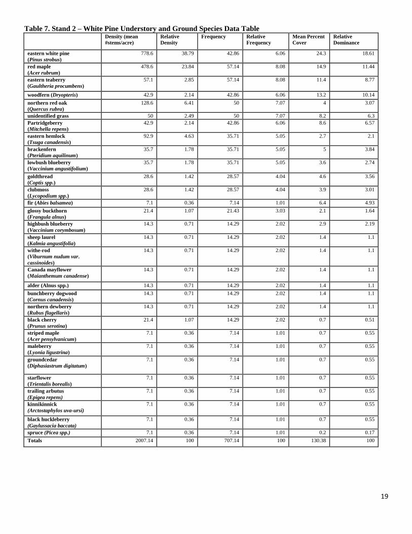
Table 7. Stand 2 – White Pine Understory and Ground Species Data Table Density (mean
#stems/acre)
Relative
Density
Frequency Relative
Frequency
Mean Percent
Cover
Relative
Dominance
eastern white pine
(Pinus strobus)
778.6 38.79 42.86 6.06 24.3 18.61
red maple
(Acer rubrum)
478.6 23.84 57.14 8.08 14.9 11.44
eastern teaberry
(Gaultheria procumbens)
57.1 2.85 57.14 8.08 11.4 8.77
woodfern (Dryopteris) 42.9 2.14 42.86 6.06 13.2 10.14
northern red oak
(Quercus rubra)
128.6 6.41 50 7.07 4 3.07
unidentified grass 50 2.49 50 7.07 8.2 6.3
Partridgeberry
(Mitchella repens)
42.9 2.14 42.86 6.06 8.6 6.57
eastern hemlock
(Tsuga canadensis)
92.9 4.63 35.71 5.05 2.7 2.1
brackenfern
(Pteridium aquilinum)
35.7 1.78 35.71 5.05 5 3.84
lowbush blueberry
(Vaccinium angustifolium)
35.7 1.78 35.71 5.05 3.6 2.74
goldthread
(Coptis spp.)
28.6 1.42 28.57 4.04 4.6 3.56
clubmoss
(Lycopodium spp.)
28.6 1.42 28.57 4.04 3.9 3.01
fir (Abies balsamea) 7.1 0.36 7.14 1.01 6.4 4.93
glossy buckthorn
(Frangula alnus)
21.4 1.07 21.43 3.03 2.1 1.64
highbush blueberry
(Vaccinium corymbosum)
14.3 0.71 14.29 2.02 2.9 2.19
sheep laurel
(Kalmia angustifolia)
14.3 0.71 14.29 2.02 1.4 1.1
withe-rod
(Viburnum nudum var.
cassinoides)
14.3 0.71 14.29 2.02 1.4 1.1
Canada mayflower
(Maianthemum canadense)
14.3 0.71 14.29 2.02 1.4 1.1
alder (Alnus spp.) 14.3 0.71 14.29 2.02 1.4 1.1
bunchberry dogwood
(Cornus canadensis)
14.3 0.71 14.29 2.02 1.4 1.1
northern dewberry
(Rubus flagellaris)
14.3 0.71 14.29 2.02 1.4 1.1
black cherry
(Prunus serotina)
21.4 1.07 14.29 2.02 0.7 0.51
striped maple
(Acer pensylvanicum)
7.1 0.36 7.14 1.01 0.7 0.55
maleberry
(Lyonia ligustrina)
7.1 0.36 7.14 1.01 0.7 0.55
groundcedar
(Diphasiastrum digitatum)
7.1 0.36 7.14 1.01 0.7 0.55
starflower
(Trientalis borealis)
7.1 0.36 7.14 1.01 0.7 0.55
trailing arbutus
(Epigea repens)
7.1 0.36 7.14 1.01 0.7 0.55
kinnikinnick
(Arctostaphylos uva-ursi)
7.1 0.36 7.14 1.01 0.7 0.55
black huckleberry
(Gaylussacia baccata)
7.1 0.36 7.14 1.01 0.7 0.55
spruce (Picea spp.) 7.1 0.36 7.14 1.01 0.2 0.17
Totals 2007.14 100 707.14 100 130.38 100
20
Table 8. Stand 2 – White Pine Snag Data Table
Species Grp <12" 12.1" to 15" 15.1" or more Total
Softwood 30.8 30.8
Hardwood 0.0
Total 30.8 0.0 0.0 30.8
Table 9. Stand 3 - Scots Pine Overstory Data Table - (Stems ≥ 5” dbh)
Table 10. Stand 3 – Scots Pine Understory Data Table – Stems/Acre (Stems < 1.0’ tall to 4.9” dbh)
Species < 1.0 1.0 - 4.5 4.5 - 10.0 >= 10.0 Total
eastern white pine
(Pinus strobus) 25 100 0 100 225
red maple
(Acer rubrum) 75 0 25 50 150
northern red oak
(Quercus rubra) 0 0 0 25 25
Total 100 100 25 175 400
21
Table 11. Stand 3 – Scots Pine Understory and Ground Species Data Table Density (mean
#stems/acre)
Relative
Density
Frequency Relative
Frequency
Mean
Percent
Cover
Relative
Dominance
eastern white pine
(Pinus strobus)
225 26.47 100 16 7 9.2
lowbush blueberry
(Vaccinium
angustifolium)
100 11.76 100 16 12.5 16.4
unidentified grass 75 8.82 75 12 10 13.12
red maple
(Acer rubrum)
150 17.65 50 8 4.7 6.13
Clubmoss
(Lycopodium spp.)
50 5.88 50 8 10 13.12
eastern teaberry
(Gaulteria procumbens)
50 5.88 50 8 8.8 11.48
brackenfern
(Pteridium aquilinum)
50 5.88 50 8 5 6.56
juniper
(Juniperis spp.)
25 2.94 25 4 7.5 9.84
sheep laurel
(Kalmia angustifolia)
25 2.94 25 4 2.5 3.28
withe-rod
(Viburnum nudum var.
cassinoides)
25 2.94 25 4 2.5 3.28
trailing arbutus
(Epigea repens)
25 2.94 25 4 2.5 3.28
woodfern
(Dryopteris spp.)
25 2.94 25 4 2.5 3.28
northern red oak
(Quercus rubra)
25 2.94 25 4 0.8 1.02
Totals 850 100 625 100 76.21 100
Table 12. Stand 3 – Scots Pine Snag Data Table
Species Grp <12" 12.1" to 15" 15.1" or more Total
Softwood 41.4 41.4
Hardwood 0.0
Total 41.4 0.0 0.0 41.4
22
23
24
25
26
27
REFERENCES
Berg, Shary Page. 1999. The Civilian Conservation Corps – Shaping the Forest and Parks of
Massachusetts: A Statewide Survey of Civilian Conservation Corps Resources. Prepared for the
Commonwealth of Massachusetts.
Commonwealth of Massachusetts. Department of Conservation and Recreation. Landscape
Designations for DCR Parks & Forests: Selection Criteria and Management Guidelines. March
2012.
Benzie, J.W. 1977. Red pine in the north-central states. Gen. Tech. Rep. NC-33 St. Paul, MN:
U.S. Department of Agriculture, Forest Service, North Central Forest Experiment Station. 22 p.
Goodwin, D.W. and W.N. Hill. 2012. Forest Productivity and Stand Complexity Model [A GIS
Grid Analysis using ArcGIS®]. Massachusetts Department of Conservation and Recreation,
Amherst, MA.
Lamson, Neil I. and W. B. Leak, 2000. Guidelines for applying group selection harvesting. NA-
TP-02-00. Newtown Square, PA: USDA Forest Service, Northeastern Area, State and Private
Forestry.
Philbrook, James S., J. P. Barrett, and W. B. Leak, 1973. A stocking guide for eastern white
pine. U.S. Dep. Agric. For. Serv. Red. Note NE-168. 3p.
National Climatic and Data Center, National Oceanic and Atmospheric Administration, United
States Department of Commerce. U.S. Statewide Analysis. Available online at
http://www.ncdc.noaa.gov/oa/climate/research/cag3/state.html. Accessed [04/27/2016].
Soil Survey Staff, Natural Resources Conservation Service, United States Department of
Agriculture. Web Soil Survey. Available online at http://websoilsurvey.nrcs.usda.gov/. Accessed
[04/27/2016].