simone arrighi · anna paiotti · maxime le goff ·...
TRANSCRIPT

Bull Volcanol (2004) 66:703–724DOI 10.1007/s00445-004-0348-8
O R I G I N A L P A P E R
Claudia Principe · Jean Claude Tanguy ·Simone Arrighi · Anna Paiotti · Maxime Le Goff ·Ugo Zoppi
Chronology of Vesuvius� activity from A.D. 79 to 1631 basedon archeomagnetism of lavas and historical sources
Received: 1 September 2002 / Accepted: 29 January 2004 / Published online: 25 May 2004� Springer-Verlag 2004
Abstract The activity of Vesuvius between A.D. 79 and1631 has been investigated by means of precise ar-chaeomagnetic dating of primary volcanic deposits andtaking into account the stratigraphy of lavas and tephra,historical written accounts, archaeological evidence re-lated to the developing urbanisation, and radiocarbonages. We found that the historical records are highlyuseful in constraining the timing of the main events, evenif the data are often too scarce and imprecise for ascer-taining the details of all phases of activity, especially theirmagnitude and emplacement of all the deposit types. Inaddition, some eruptions that took place in the 9th and 10th
centuries appear to be unnoticed by historians. The ar-chaeomagnetic study involved 26 sites of different lavasand 2 pyroclastic deposits. It shows that within the 15centuries which elapsed between A.D. 79 and 1631, theeffusive activity of Vesuvius clustered in the relativelyshort period of time between A.D. 787 and 1139 and wasfollowed by a 5-century-long repose period. During thistime Vesuvius prepared itself for the violent explosiveeruption of 1631. The huge lavas shaping the morphologyof the coast occurred largely through parasitic vents lo-cated outside the Mount Somma caldera. One of theseparasitic vents is located at low elevation, very close to
the densely inhabited town of Torre Annunziata. Amongthe various investigated lavas, a number of which werepreviously attributed to the 1631 eruption, none is actu-ally younger than the 12th century. Therefore it isdefinitively concluded that the destructive 1631 event wasexclusively explosive.
Keywords: Archaeomagnetism · Historical records ·Vesuvius · A.D. 79–1631 · Lavas
Introduction
Vesuvius’ activity from A.D. 79 to 1631 involved bothlate Roman activity, which occurred from A.D. 79 to 472,and medieval activity (Rolandi et al., 1998), which tookplace from A.D. 472 to 1631. This terminology is basedon the rough temporal coincidence between the fall of theRoman Empire and the beginning of Middle Age (A.D.476), which lasted until 1492. During this period, twosmall-scale plinian eruptions occurred, in A.D. 472 and1631, respectively (Rosi & Santacroce, 1983; Rosi et al.,1993). In fact, there is little information regarding thevolcanic activity of the Vesuvius between the plinianeruption of A.D. 79 and the nearly continuous activitythat occurred after the small-scale 1631 plinian eruption(Arn� et al., 1987). This continuous activity was made upof lava effusions (Fig. 1), together with strombolian, vi-olent strombolian, and subplinian episodes (Arrighi et al.,2001). Little data exist in the literature on the time ofdeposition and distribution of the lavas dischargedduring the 15-century-long period from A.D. 79 to 1631.Moreover, determination of the stratigraphic position ofthe so-called “medieval” lavas within the overall stratig-raphy of the Vesuvius has been hindered by urban de-velopment along the Vesuvius’ coast. In spite of thisunclear stratigraphic position, many authors, even in re-cent literature, attributed many of these large lavas thatshape the coast morphology to the 1631 eruption (DiGirolamo, 1970; Burri & Di Girolamo, 1975; Rolandi &Russo, 1989; Rolandi et al., 1993; Lirer et al., 2001). This
Editorial handling: J. McPhie
C. Principe ()) · S. ArrighiIstituto di Geoscienze e Georisorse (IGG),CNR, Via G. Moruzzi 1, 56124 Pisa, Italye-mail: [email protected].: +39-0503-152335Fax: +39-050-3152360
J. C. Tanguy · M. L. GoffUniversity of Paris 6 and Institut de Physique du Globe de Paris,94107 St. Maur des Fosses Cedex, France
A. PaiottiVia Pietro Nenni 25, 55042 Forte dei Marmi, Italy
U. ZoppiANSTO – environment,Private Mail Bag 1, 2233 Menai, NSW, Australia
idea of large 1631 lavas originates from a relatively recentreconstruction of the 1631 eruption (Le Hon, 1865,1866),that has been uncritically adopted by almost all later au-thors. According to Rosi et al. (1993), the 1631 eruptiondid not produce any lava flow.
This matter has important implications for determiningthe degree of volcanic risk in the Vesuvius area, becausethe 1631 eruption has been taken as representative of themaximum expected hazards posed by the volcano in themid-to-long term (Barberi et al., 1995). In order to assessthe potential hazard of the Vesuvius, it is also necessary toascertain whether eruptions were uniformly distributed intime or clustered in climaxes with very high eruptionrates, alternating with periods of much less intense ac-tivity (Heiken, 1999). Such information exists for therelatively short period from 1631 to 1944 (e.g. Carta etal., 1981 and Arrighi et al., 2001), but is lacking for themuch longer time interval from A.D. 79 to 1631 . The aimof this paper is to fill the gap mainly through criticalreading of historical records and archaeomagnetic datingof the “medieval lavas”.
Historical and geochronological data
Historical sources
It is commonly believed that the information provided bythe historical sources on the Vesuvius’ activity from A.D.79 to 1631 is scarce and fragmentary. Such a belief arosein comparison with the large amount of documentationpublished after the 1631 eruption (Cerbai & Principe,
1996). However, the written sources available on theVesuvius’ activity between A.D. 79 and 1631 provideuseful records of the main events and at least some detailson the types of volcanic activity.
All the post-1631 accounts, dealing with Vesuvius’history or its “latest” eruption, contain more or lesscomplete lists of the volcano’s past eruptions, as well as anumber of references to printed sources that deal with theVesuvius as far back as Greek and Roman times. Perhapsthe most complete and reliable of these lists is presentedin the milestone work “Bibliography of Vesuvius” byFurchheim (1897). An accurate critical collection of thewritten sources on Vesuvius’ activity from A.D. 79 to1631 was given by Alfano (1924). Other authors havesubsequently dealt with the chronology of the Vesuvius’eruptions between A.D. 79 and 1631 (Preusse, 1931;Figliuolo & Marturano, 1998; Nazzaro, 1998, Gasparini& Musella, 1991) without substantial changes to Alfano’sconclusions. Recently, Stothers & Rampino (1983) con-sidered not only written and associated archaeologicalsources on Vesuvius’, but also on all the volcanic erup-tions that occurred throughout the Mediterranean areabefore A.D. 630. The investigated printed sources arerather different from those usually quoted by peopleworking on Vesuvius and include not only Latin andGreek texts, but Byzantine, Syrian, and Armenian sour-ces, as well.
It is important to note that all these studies have beenperformed based on the more common printed sources.Detailed work on manuscript and ecclesiastic documentsfound in archives and libraries is still required in order to
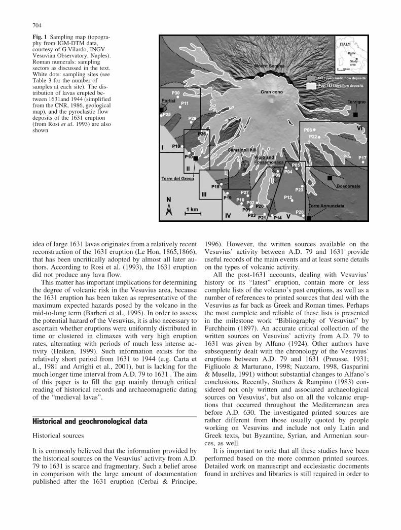
Fig. 1 Sampling map (topogra-phy from IGM-DTM data,courtesy of G.Vilardo, INGV-Vesuvian Observatory, Naples).Roman numerals: samplingsectors as discussed in the text.White dots: sampling sites (seeTable 3 for the number ofsamples at each site). The dis-tribution of lavas erupted be-tween 1631and 1944 (simplifiedfrom the CNR, 1986, geologicalmap), and the pyroclastic flowdeposits of the 1631 eruption(from Rosi et al. 1993) are alsoshown
704
produce a fully reliable picture of the activity of thevolcano during this long historical period.
Table 1 (Principe, 2003) provides a summary ofVesuvius’ activity between A.D. 79 and 1631 deducedfrom critical reading of the original sources proposed byprevious authors. The number of confirmed eruptions andperiods of activity is much smaller than that reported inthe post-1631 literature on the Vesuvius, as is the numberof the truly primary sources, meaning contemporary (ornearly so) to the described events. Such a misleadinglylarge number of sources and eruptions is due, as already
noted by Stothers & Rampino (1983), to the proliferationof vicarious “second-hand” citations.
This common practice gave rise, for instance, to var-ious reports of the “great eruption of A.D. 512”, whichwas hypothesized by Alfano (1924) on the basis of a letterfrom Magno Aurelio Cassiodoro to King Teodorico ofItaly and uncritically accepted in all the subsequent lit-erature. However, a careful reading of Cassiodoro’s letterreveals that it was simply a request for fiscal exemptionsfor a population still suffering the effects of a previousdevastating eruption in A.D. 472.
Table 1 The activity of Vesuvius between A.D. 79 and 1631 asinferred by historical sources. Citations refer to the printed sources.“Activity” refers reported weak, more or less continuous strom-
bolian activity, with possible emission of intracaldera lava flows.See Principe (2003) for a detailed discussion and the original texts
Eruptions Activity Described Phenomena
172 Violent strombolian activity1
AD 203 Explosive eruption, with a plinian fallout phase2
222–235 More or less continuous strombolian activity3
379–395 At least fumarolic activity4. A phase of lava effusion possibly happened5
AD 472 5–6 November: large explosive eruption, with a plinian fallout phase, dispersed to NE (ashes as far asCostantinopoli), darkening and heavy rains . Huge nu�e ardentes and severe destruction are described all aroundVesuvius’6. From this eruption starts the cult of San Gennaro as protector of Naples against Vesuvius’
512 More or less continuous strombolian activity7
AD 536 Explosive eruption, darkening in Mesopotamia lasted all the winter of this year.8
AD 685 February-March: earthquakes, plinian column and related fallout9. A not completely reliable source gives anaccount of lavas entering the sea10
AD 787 Autumn-Winter: lava fountains and lava (or pyroclastic?) flows “six miles long” 11
AD 968 Eruption with lavas into the sea12
AD 991 Earthquake and explosive eruption (“...erupting flames and vomiting ashes ...”) 13
AD 999 Sudden lava fountains and lava emission (”...piceas atque sulphurea repente flammas erumpere...”), fine ashes 14
1006 or1007
At least explosive eruption, with rumble, vigorous throwing of blocks (3 miles from the crater) and unbreathablegas emissions 15
1037 27 January or February: Effusive eruption with lavas into the sea (“...eructavit incendium, ita ut usque ad marediscurreret ...”) 16
1139 From 29 May to 5 June: explosive eruption, with black lapilli fallout and reddish ashes (“... pulverem ferrugineicoloris et subrubei ...”), falling during 30 days as far as Napoli, Capua, Salerno and Benevento17
1150 Violent strombolian activity18
1306? Unlikely parasitic eruption with lavas into the sea19
1500? Fumarolic activity and unlikely phreatic explosion20
1 Claudio Galeno Pergameno, De Medendi Methodo Libri XIII, liber V, cap.122 Dione Cassio Niceo, Historiae Romanae, liber LXXVI.3 Dione Cassio Niceo, Historiae Romanae, liber LXVI.4 San Paciano, Paraenesis ad poenitentiam.5 Ammiano Marcellino, Indictione decima.6 Marcellino (Conte), Chronicon ; Procopio from Cesarea, De Bello Gotico, liber II, cap IV ; Carlo Sigonio, Historiarum de OccidentaliImperio Libri XX, liber XIV & XVI; Flavio Magno Aurelio Cassiodoro, Opera Omnia quae extant, Liber IV Variarum, Epistola 50.7 Marcellino (Conte), Chronicon.8 Procopio from Cesarea, De Bello Gotico, liber II (cap IV), liber IV (cap XXXV); Giovanni from Efeso, Ecclesiastical History (otherreferences are listed in Stothers and Rampino, 1983).9 Paolo Diacono, Historia Longobardorum, liber VI, cap. IX; Giorgio Agricola, De re metallica. De natura eorum quae effluunt ex terra,liber IV.10 Appendix to the holy legend of San Gennaro (in Alfano, 1924).11 Gregorio Monaco, manuscript in greek, University of Messina library.12Damianus Petrus, Opera Omnia, Opusculum XIX.13 Pompeo Sarnelli, Cronologia dei Vescovi et Arcivescovi Sipontini, 1730, pg.112.14 Damianus Petrus, Opera Omnia, Opusculum XIX ; Ubaldo Monaco, Chronicum Ducum Neapolis, in Raccolta di varie croniche, diariiecc, appartenenti al Regno di Napoli, Napoli, Perger, 1781.15 Ridolfo Glaber, Historia Francorum.16 Anonymus Cassinensis, Chronicon; Anonymus Cavensis, Chronicon; Romoaldo Salernitano, Chronicon.17 Anonymus Cassinensis, Chronicon; Anonymus Cavensis, Chronicon; Falcone Beneventano, Chronicon; Romualdo SalernitanoChronicon.18 El Eldrisi, L’italia descritta nel libro del Re Ruggero, quoted in Baratta, Il Vesuvio e le sue eruzioni, Roma, Dante Alighieri, 1897.19 Pighius Stephanus Vinandus, Hercules Prodicius seu Principiis juventutis vita et peregrinatio, Antuerpiae, Cristoforo Plautinus, 1587,pg 466; Andrea Schottus, Itinerarium Italiae, Amstelodami, Jansson, 1655, pg 526 (into the Italian edition, dated 1669, the name of theAuthor became Francesco Scoto).20 Leone Ambrosio, De Nola, Venetiis, 1514, liber I, cap.I: De Agro Nolano, deque montibus Vesuvio et Abella.
705

No lavas outside the Mount Somma caldera arerecorded by historical sources during the first centuriesafter the A.D. 79 eruption. On the contrary, Vesuvius’activity only involved a series of explosive events ofvariable violence until at least A.D. 685. The A.D. 472eruption was by far the most important of these events.Plinian fallout and huge nu�es ardentes can be clearlyidentified in the historical accounts of this eruption (Rosi& Santacroce, 1983).
An explosive eruption must have occurred aroundA.D. 536. This has been indirectly documented in thewritings of Procopio from Cesarea, Giovanni from Efeso,and other authors in the western Mediterranean, who re-ported the darkening of the sky over Constantinople formany months, accompanied by an unusually harsh winterin Mesopotamia (Stothers & Rampino, 1983).
The eruption of A.D. 685 surely had a strong explosivecomponent as well. Analysis of the historical sources doesnot clarify whether this eruption also involved lavas aspopular tradition implies the lava underlying the oldPalazzo Baronale of Torre del Greco originates from thisevent, and does not crop out anymore at present (Principe,2003). A number of the subsequent eruptions (e.g. A.D.787, 968, 999, and 1037) had large effusive components.The A.D. 991 event was apparently exclusively explosive,as well as those in 1006–7 and 1139 for which no effusiveepisodes are described. However, the last two eruptionswere documented by authors living outside the Vesuvius’area. For this reason, in the absence of great damages toinhabited areas, the emission of lavas during these erup-tions remains possible (Principe, 2003).
Although the summit of the volcano is described byDione Cassio as a rounded depression “like an am-phitheatre”, without mention of any internal cone (Alfano,1924) during the third century A.D., historical data sug-gest the gradual building of the Gran cono inside theMount Somma caldera, starting from ~A.D. 172, due tointracaldera lava emissions and strombolian activity(Table 1). After the 1139 eruption, the Gran cono wascertainly present inside the Mount Somma caldera, withan altitude lower than that of Mount Somma, and a largecrater “resulting from the last eruption” (Boccaccio, 1353,in Alfano, 1924). This is the same general morphology ofthe volcano after the main explosive eruptions of the1631–1944 period (Nazzaro, 1998; Arrighi et al., 2001).
After the 1139 eruption, the next description of theVesuvius in an active state, characterised by “emission ofincandescent materials from the main crater” (strombolianactivity), seems to be presented in the text of the Arabwriter El Eldrisi, dated 1150 and quoted by Alfano(1924), who refers to Baratta (1897). The numeroussources subsequent to 1150 listed by Alfano (1924) onlyreport that a mountain near Naples had occasionallyerupted in the past, without providing further observationson eruptive activities coeval to the time of writing. Thereare, instead, some references to flames in the crater, vis-ible especially at night, and probably attributable to theignition of fumarole gases, rather than strombolian ac-tivity from the main crater.
A presumed eruption in 1306, with lava reaching thesea, is referred to by Leandro Alberti (1568), and Pighius(1587) as well as by Schottus (1655), who copied fromPighius. This eruption was also confirmed by Masculo(1633) on the basis of these sources. However, Alfano(1924) denied the existence of such an eruption, demon-strating on the basis of historical arguments that the 1306date is a typographical error in the text of Alberti (1568)who intended to discuss the 1036 event (Principe, 2003).
The occurrence of at least one flank eruption at theVesuvius during the period between A.D. 79 and 1631 ispossibly recorded by a fresco, which once adorned thevestibule of the Basilica of San Gennaro Extra Moenia inNaples. The work has been attributed to the 15th centuryschool of Andrea Da Salerno. Reprinted in Alfano (1924),it depicts the Vesuvius as observed from Naples, with twovolcanic plumes, one issuing from the main crater (theelevation of which is lower than the peak of Mount Somma)while the other emerges from one or more vents situated onthe southern flank of the Gran cono. The date of theeruption to which the fresco refers to is unknown. In otherwords, this fresco might simply be either a generic view ofthe erupting Vesuvius, or a copy of a previous work.
Historical accounts describe a number of parasiticcones, which by age and position may represent the ventsof some lavas emitted between A.D. 79 and 1631. Theseinclude the Viulo and Fossamonaca cones, the morphol-ogy of which is still well visible today, the two cones atTironi and the three cones at I Monticelli (“little hills”).Sorrentino (1734) described two scoria cones and asso-ciated lavas from the site known as “i Tironi”, north ofTorre del Greco, as well as three small scoria cones,called “I Monticelli”, aligned in a roughly east-to-westdirection behind the Camaldoli hill. All these cones areattributed to medieval eruptions by Sorrentino (1734).The cones of I Monticelli have been buried by the prod-ucts of subsequent eruptions and only a few morpholog-ical traces remain at present, whereas the Tironi hills werealready almost completely quarried by Sorrentino’s time.
In 1514 the Venetian Leone Ambrosio described anevent that took place in the year 1500. This could be amodest phreatic eruption. Apart from this source, how-ever, no trace remains of the 1500 event in the variousmanuscripts, annals, and chronicles of the time. For thisreason, its occurrence had already been disputed in the17th century (Braccini, 1632).
Summing up, on the basis of available historical data,it seems probable that from the early 12th century to 1631,the volcano was in a state of repose, apart perhaps frommore or less continuous fumarolic activity. Since theVesuvius was practically inactive for such a long time, itcaught most of the inhabitants unaware at the moment ofits awakening on December 16th, 1631 (Rosi et al., 1993).
Tephra chronology
The main stratigraphical markers of the entire post-A.D.79 succession are the A.D. 472 deposits (Rosi & San-
706

tacroce, 1983, Mastrolorenzo et al., 2002) and the 1631deposits (Rosi et al., 1993), both resulting from small-scale plinian events. On this basis, the tephra successionfrom A.D. 79 to 1631 can be divided into two parts.Andronico and coworkers (Andronico et al. 1995,1996a,1996b) called the pyroclastic sequence prior to theA.D. 472 eruption the “ Santa Maria cycle”, which in-cludes the tephra of the A.D. 203 eruption, as alreadyrecognised by Johnston-Lavis (1884) and Arn� et al.(1987). Andronico et al. (1995, 1996a, 1996b) identifiedsix main explosive-component eruptions subsequent toA.D. 472; their tephra deposits are interlayered with sevenminor tephra layers. The first main tephra layer was at-tributed by Andronico et al. (1995, 1996a, 1996b) to theA.D. 512 eruption, however, this eruption has been shownto be an unlikely source (see discussion above). There-fore, we propose to attribute this first main tephra layer,starting the post-A.D. 472 succession, to the explosiveeruption of A.D. 536.
In contrast to Andronico et al. (1995, 1996a, 1996b),Rolandi et al. (1998) identified only four main explosiveeruptions in the post-A.D.-472 stratigraphy, and also at-tributed different ages to the layers. The last of theseeruptions is represented by a lapilli fallout deposit whichwas attributed to the 1139 eruption by Rolandi et al.(1998). The description and stratigraphic position of thisdeposit correspond to the “ochraceous” lapilli falloutdescribed by Principe et al. (1987), which is encountered
in pockets above the medieval-age lavas in an areasoutheast of the Vesuvius, and beneath the 1631 pyro-clastic flow deposits.
With the aim of identifying possible correlations be-tween historically-defined eruption ages and the differenttephra age attributions proposed by various authors, Ta-ble 2 reports all the 14C ages available in the literature forthe period from A.D. 79 to 1631. The last column inTable 2 reports the historically substantiated eruptions oreruptive periods in the age interval obtained by calibrat-ing the 14C ages. Of the eruptions deemed “possible”through study of the historical sources, the most probableones (also based on stratigraphic position and physicalcharacteristics) are presented. A newly determined ra-diocarbon age (see Appendix 1), based on charcoalfragments found under a lapilli fallout deposit of the A.D.79–1631 period, confirms the occurrence of an explosiveepisode around A.D. 685.
Comparing Tables 1 and 2, it is evident that, despitethe rather low precision of the 14C age determinations, agood agreement exists between the 14C ages and thehistorically documented eruption ages for the events withan explosive component, a fact that underscores the im-portance of historical data.
Table 2 Available 14C data for charcoal and paleosols (*) of thepost A.D. 79 –1631 period. The most probable (bold type) eruptiondates were defined in this work on the basis of calibrated age
intervals, stratigraphic position, and physical characteristics, asgiven in the literature, and the historical data listed in Table 1. (**)Calibrated age given in Andronico et al. (1995)
1 2 3 4 5 6 7
Sample Locality Age b.p. Calibratedage
Literatureattribution
Reference Most probable eruptions
R 715 / L 371E 1815€40 A.D. 135–320 Santa Maria Andronico et al. (1995) A.D. 203PFSV 86A LAGNO
AMENDOLARE1750€60 AD 472 Arn� et al. (1987)
R939* ARCIPRETE 1630€50 AD 472 Arn� et al. (1987)Rome 643 1605€35 A.D. 415–535 AD 472 Andronico et al. (1995) A.D. 472PFSV 83 LAGNO di POLLENA 1600€60 AD 472 Arn� et al. (1987)
TERZIGNO 1590€190 A.D. 59–861 AD 472 Rolandi et al. (1998) A.D. 472PFSV 86A LAGNO
AMENDOLARE1580€60 AD 472 Arn� et al. (1987)
PFSV 306* CASE TRAPOLINO 1550€50 AD 512 Arn� et al. (1987) A.D. 536WW - 595 TERZIGNO 1440€60 A.D. 537–692 II eruption Rolandi et al. (1998) A.D. 685Rome 644 1355€55 A.D. 645–760 PM5 Andronico et al. (1995) A.D. 685WW-6327 OTTAVIANO 1290€40 A.D. 661–863 II eruption Rolandi et al. (1998) A.D. 685PFSV 101 LAGNO di POLLENA 1280€50 AD 787 Arn� et al. (1987)Rome 653* 1265€55 A.D. 685–885 PM5 Andronico et al. (1995) A.D. 685Rome 641 1230€55 A.D. 690–935 PM6 Andronico et al. (1995) A.D. 787Rome 652* 1166€55 A.D. 780–980 PM6 Andronico et al. (1995) A.D. 787WW-596 TERZIGNO 1140€60 A.D. 775–1017 III eruption Rolandi et al. (1998) 787/991/999/1006–7PFSV 86B LAGNO
AMENDOLARE1050€85 AD 787 Arn� et al. (1987)
BOSCO REALE 950€90 A.D. 895–1279 IV eruption Rolandi et al. (1998) 991/999/1006–7/1037/1139WW - 597 TERZIGNO 950€50 1003–1279 IV eruption Rolandi et al. (1998) 1006–7/1037/1139PFSV 308 * W of OTTAVIANO 470€55 1631 Arn� et al. (1987)PFSV 315 between POLLENA
and CERCOLA330€55 1485–1650** 1631 Arn� et al. (1987) 1631
707

Chronostratigraphy of lavas
The problem of the absolute age and stratigraphic positionof lavas from A.D. 79 to 1631 was raised for the first timeby Johnston-Lavis (1884,1891b) who believed that thelava effusions reported in historical sources for the periodfrom A.D. 79 to 1631 were much less frequent than theexplosive events. Moreover, he maintained that the lavaswere confined inside the Mount Somma caldera sur-rounding the Gran cono (Fig. 1), which had not yet beenfilled. This convinction was due to the fact that, following
Fig. 2 a-b Sector I. (a) TheGranatello headland on theTopographic map of MountVesuvius compiled and drawnin six sheets at the scale of1:10.000 by students of theMilitary Topography Instituteof Florence (1875–86). Thesmall promontory of Villad’Elboeuf (1) is formed by theA.D. 79 pyroclastic flow anddebris flow deposits. A branchof the nu�e ardentes of the 1631eruption (Rosi et al., 1993) ex-tended south of this, leavingPalazzo Mascabruno (2) un-touched, but destroyng the an-cient Granatello gardens (4)and partially covering the pre-1631 lava that gave rise to themain coastal morphology. Con-struction of the Royal Palace ofPortici (3) and surroundinggardens began in 1738. (5) TheHerculaneum excavations. (b)Aerial view of the currentGranatello and Royal Palaceareas; P25 refers to the sam-pling site of the Granatello lava
Fig. 3 Sector I, immediately south of the Granatello area. (1) TheLa Favorita country house and (2) its gardens that reach the sea atScogli della Favorita. (3) A few hundred meters south, a huge lavacrops out extensively on the headland of Scogli della Scala (nowPunta Quattro Venti), sampled at P18. Topographic base as inFigure 2
708

Le Hon (1865,1866), Johnston-Lavis attributed all thelavas cropping out along the coast to the 1631 eruption.
The belief that all the lavas along the coast belong tothe 1631 eruption has been recently supported by thework of Vittozzi & Gasparini (1965), who performedabsolute age determinations via the radioactive226Ra-238U disequilibrium method on the lava ofGranatello and on the three lavas of the Villa Inglese (seeFigures 2, 3, 4,5, 6,7 for the locations). On the basis ofthese data, Burri & Di Girolamo (1975) ascribed theGranatello lava to 1631, and the Villa Inglese lavas to1631, 1480 and 1139. Other lavas cropping out along thecoast between Portici and Torre Annunziata (Scogli dellaScala, Calastro, Ponte di Riveccio, Torre Bassano) have
been attributed by Di Girolamo (1970) to the 1631eruption, always on the basis of the data of Vittozzi &Gasparini (1965), without any stratigraphic support. Atleast for Torre Bassano, historical data do not supportsuch attributions, since a watchtower was built between1559 and 1567 over this lava (Principe, 2003, Fig. 5).Recently, Rolandi & Russo (1989) ascribed both the lavaunder Masseria Donna Chiara and the lava cropping outalong the coast near Torre Annunziata between Cantierela Perla and Palazzo Monteleone to the 1631 eruption.
Finally, although the emission of lavas during the 1631eruption can be ruled out, based on volcanological evi-dence (Principe et al., 2003) and historical documents(Rosi et al., 1993), most of the lavas cropping out along
Fig. 4 a-b Sector II. (a) Aerialphotograph of Torre del Grecoas it appears today. (b) Map ofTorre del Greco drawn by G.Morghen after the 1794 lavadestroyed four-fifths of the thenexisting town. (1) The lavaheadland of Calastro (samplingsite P10). (2) The Monastery ofthe Minor Franciscan Order andthe annexed church of Madonnadelle Grazie. The Monasterywas spared from the 1631 py-roclastic flow (Rosi et al.,1993). (3) Palazzo Brancaccioand its gardens. (4) The Torredel Greco Town Hall housed inthe one-time Palazzo Baronale.All these buildings lie on amorphological high spared by1631 nu�e ardentes and then by1794 lava, that corresponds toan old lava, unfortunately notcropping out anymore, attribut-ed by historical records to theA.D. 685 eruption. (5) The areaaffected by the pyroclastic flowdeposits of the 1631 eruption(“mare seccato”, which is Ital-ian for “dried sea”) and by thelava of the 1794 eruption after-wards
709

the coast of the Vesuvius are still attributed to the 1631eruption by many authors. We intend to definitivelyclarify this subject with our archaeomagnetic data.
Synthesis of available chronological data
On the basis of the available chronological information, atleast 11 main eruptions took place at Vesuvius’ betweenA.D. 79 and 1631. The most important of these events isthe small-scale plinian eruption of A.D. 472. An effusivecomponent is described by historical documents for atleast four of these eleven eruptions (Table 1), with lavafronts spreading outside the Mount Somma caldera rim,and reaching the sea in A.D. 787, 968, 999, and 1037.According to historical, radiocarbon, and stratigraphicdata, significant explosive episodes took place at least inA.D. 203, 472, 536, 685, 787, 991, 999, 1006/7, and 1139,resulting in a sequence of lapilli fallout deposits. Withinthis sequence, a number of minor tephra deposits giveevidence of additional minor explosive episodes not re-ported by printed chronicles and still not dated by ra-diocarbon or other methods.
Archaeomagnetic sampling and measurements
This archaeomagnetic study of the Vesuvius is based onthe precise method developed at Saint Maur Laboratoriesfrom the Institut de Physique du Globe de Paris (IPGP),France (Thellier, 1981; Tanguy et al., 1985, 1999, 2003).Sampling and measurement procedures used in this work
refer to the so-called “big sample plaster method” ofThellier (1981) for archaeological purposes and routinelyapplied at the Saint Maur Laboratories. Application ofthis methodology for dating of young volcanic products,its advantages, and limitations are given by Tanguy et al.(2003).
The sampling method involves the collection of sev-eral big samples, each weighing 0.5–1 kg, distributed oversome tens of meters. Each block is first detached with ahammer and then replaced in its original position. Plasterof appropriate fluidity is poured on the block, to support aplate carrying a spherical spirit level, thus making ahorizontal surface 6–7 cm in diameter on which the sunshadow is marked for calculation of the geographicalnorth. In the laboratory, the samples are replastered insquare moulds 12 cm in size. Measurements are per-formed by means of a large rotating induction magne-tometer and an AF demagnetization device for big sam-ples (Le Goff, 1975).
The advantages of this method with respect to tradi-tional core-drilling are the extremely precise orientationof the sample in the field and the possibility of obtaininghigh-precision data on lavas, welded scoriae, and high-temperature-emplaced, non-welded, pyroclastic deposits(Hoblitt et al., 1985; Genevey et al., 2002). Anotherfundamental advantage is that the plaster method avoidsthe effect of any parasitic magnetization acquired duringthe drilling process (Lauer, 1978; Audunsson & Levi,1989).
On the basis of their stratigraphic positions and addi-tional field data (e.g., age of the oldest buildings sitting onthe lavas, changes of locality names after the main
Fig. 5 Sector III. The Torre Bassano headland exhibits the mor-phology and stratigraphy typical of all the sector of the coastlinefrom Portici to Torre Annunziata. In this site, the tower (1) wasbuilt between 1559 and 1567 on the promontory generated by amedieval lava that flowed into the sea. This lava crops out underthe tower (2), along the road inland from the tower (P15), and along
the railway (2), and covers a stratigraphic succession (see inset)including the A.D. 79 eruption-related debris flow and previouspyroclastic deposits. The pyroclastic flow deposits of the 1631eruption (3) extend on both sides of the mophological high inducedby the lava and are now covered by numerous greenhouses andvineyards
710

eruptions, etc. ...) (see Appendix 2), a total of 26 siteshave been selected and sampled for archaeomagneticmeasurements, giving a total of over 400 analysed sam-ples, covering nearly all the lava outcrops attributable tothe A.D. 79–1631 period. Fig. 1 shows the location of thesites which are grouped in geographical sectors, whereasTable 3 gives the geographical coordinates and a de-scription of each site. Some sites are located in corre-spondence to newly built road segments or work yards forthe construction of new buildings, which have brought tolight portions of the lavas covered by the 1631 nu�esardentes. Some of the sampled lavas cropping out along
the coast do not appear on the 1:25,000-scale CNR (1986)geological map.
All the lavas of this period are petrographically verysimilar (Joron et al., 1987; Belkin et al., 1998; Raia et al.,2000; Paiotti, 2000) (Table 4). The main phenocrysts aretwo clinopyroxenes (diopside and augite), which are bothpresent in all lavas, and leucite. Olivine and a dark mica(phlogopite) are the other most important phases. Thegroundmass is composed of plagioclase (An80), leucite,clinopyroxenes, and oxides. Modal analyses (Table 5)show the fact that correlations between different sitescannot be performed on the basis of petrographical
Fig. 6 a-b Sector IV. (a) To-pography of the Villa Inglese-Le Mortelle area (topographicbase as in Fig. 2) showing thesmooth morphology induced bythe medieval lava flows coveredby subsequent tephra deposits,contrasting with the roughmorphology of the of the 1760lava surface cropping out in theeastern sector of this figure. (1)The old lava quarry of VillaInglese. (2) Masseria DonnaChiara. (3) Villa Prota. (4) LeMortelle. (5) Torre Scassata.The quarry has been progres-sively enlarged and today hasreached the lava emitted in1760. (b) Present aerial view ofthe Villa Inglese quarry. Num-bers refer to the sampling sitesof the pre-1631 lavas flows ex-tensively cropping out both in-side the quarried area and on thecoast beneath and inland of theTorre Scassata tower
711
composition. In fact, samples coming from the same lava,as in the case of P01 and P20 sampling sites, may differ inmineral abundance (Lc and Cpx) and vesicularity, as al-ready found for the similar lavas of the 1631–1944Vesuvius activity (Principe, 1979).
For each site, an average of 12 archaeomagneticanalyses were performed on samples originating from
different portions of the selected lava. The obtained meanvalue of the semi-angles of the 95% confidence cone ofthe average paleodirections (a95) resulted in 1.2, with arange from 0.6 to 1.8 (Table 6).
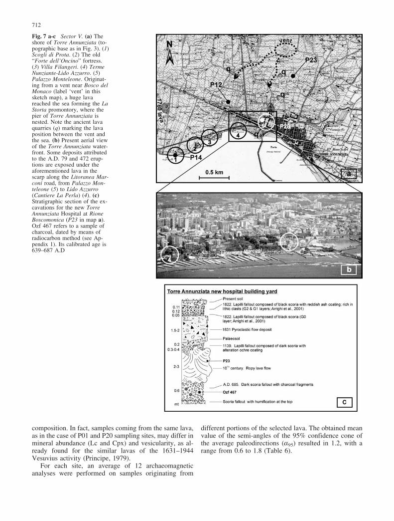
Fig. 7 a-c Sector V. (a) Theshore of Torre Annunziata (to-pographic base as in Fig. 3). (1)Scogli di Prota. (2) The old“Forte dell’Oncino” fortress.(3) Villa Filangeri. (4) TermeNunziante-Lido Azzurro. (5)Palazzo Monteleone. Originat-ing from a vent near Bosco delMonaco (label ‘vent’ in thissketch map), a huge lavareached the sea forming the LaStorta promontory, where thepier of Torre Annunziata isnested. Note the ancient lavaquarries (q) marking the lavaposition between the vent andthe sea. (b) Present aerial viewof the Torre Annunziata water-front. Some deposits attributedto the A.D. 79 and 472 erup-tions are exposed under theaforementioned lava in thescarp along the Litoranea Mar-coni road, from Palazzo Mon-teleone (5) to Lido Azzurro(Cantiere La Perla) (4). (c)Stratigraphic section of the ex-cavations for the new TorreAnnunziata Hospital at RioneBoscomonica (P23 in map a).Ozf 467 refers to a sample ofcharcoal, dated by means ofradiocarbon method (see Ap-pendix 1). Its calibrated age is639–687 A.D
712

Results and errors
Fig. 8(a, b) displays a plot of the archaeomagnetic dataobtained in this work in relation to the curve of seculargeomagnetic variation proposed by Tanguy et al. (1999)for Mount Etna (Sicily), and Bucur (1994) for France,both reduced to the latitude and longitude of the Vesuvius(40�48’N, 14�25’E). With the purpose of checking theapplicability of these curves to Vesuvius, we have alsosampled the juvenile fraction of the pyroclastic flow de-posits of the A.D. 79 and 472 eruptions (Table 3). Theposition of these two pyroclastic samples on the secularcurve at the expected age (Fig. 8a) suggests that this curve
can be used confidently for dating Vesuvian lava samples(see also Tanguy et al., 2003).
Fig. 8(a, b) shows that the reduced curves for Franceand Etna are nearly straight lines that run closely side byside from about A.D. 800 to 1200, where all but two ofthe analysed units are distributed. These units (P05 andP22) fall on a different curve referring to instrumentalpaleomagnetic record (Cafarella et al., 1992), indicatingthat they belong to the 1767 and 1701 lavas, respectively.The low a95 values result in small confidence circles andin relatively small uncertainties in age determination. Forsome sites, the positions of the confidence circles on the
Table 3 Details of the archaeomagnetic sampling sites. Geographical sectors are defined in Fig. 1
Site Coordinates Sec-tor
Samples Sample Type Locality
P01 40�45’ 20” N 14�24’ 34” E IV 10 (21–30) Lava flow Villa Inglese, near Torre Annunziata,upper lava on the W corner of the quarry
P02 40�45’ 21” N 14�24’ 34” E IV 10 (11–20) Lava flow Villa Inglese, near Torre Annunziata,lower lava on the W corner of the quarry
P03 40�45’ 05” N 14�24’ 51” E IV 15 (31–45) Lava flow Torre Scassata, along the coast,near Torre Annunziata
P04 40�46’ 23” N 14�25’ 57” E V 16 (46–54,106–107, 301–305)
Lava flow New road towards W from the cemeteryof Boscotrecase (900m from the crossing)
P05 40�46’ 20” N 14�26’ 18” E V 7 (55–60, 62–63) Lava flow New road towards W from the cemeteryof Boscotrecase (200m from the crossing)
P06 40�48’ 24” N 14�27’ 37” E VI 9 (64 –72) Lava flow Terrioni quarry, W of TerzignoP09 40�46’ 44” N 14�25’ 48” E IV 10 (108, 110–111,
113–114, 195–199)Scoria cone;juvenile scoriae
Fossa Monaca, NW of Torre Annunziata
P10 40�47’ 21” N 14�21’ 27” E II 17 (115–131) Lava flow Calastro, Torre del GrecoP11 40�49’ 05” N 14�21’ 25” E I 18 (132–142,
247–253)Lava flow NA-SA highway,
Ercolano gate (Napoli direction)P12 40�45’ 39” N 14�26’ 12” E V 9 (143–151) Lava flow Torre Annunziata soccer fieldP14 40�45’ 07” N 14�25’ 38” E V 11 (154–164) Lava flow Villa Balke—Club La Vela (Scogli di Prota),
along the coast, near Torre AnnunziataP15 40�46’ 13” N 14�22’ 59” E III 15 (165–179) Lava flow Torre Bassano, along the coast road,
back from the ancient towerP16 40�45’ 30” N 14�24’ 08” E IV 15 (180–194) Lava flow S.Vincenzo Postiglione, along the coast,
near Torre AnnunziataP17 40�46’ 42” N 14�29’57” E VI 15 (200–209,
334–338)Lava flow Passanti, near Terzigno
P18 40�47’ 34” N 14�21’ 14” E I 17 (210–226) Lava flow Scogli della Scala, 4 Venti hotel beachP19 40�45’ 44” N 14�23’37” E IV 14 (227–239) Lava flow Lido Incantesimo, near Torre AnnunziataP20 40�45’ 20” N 14�24’ 34” E IV 7 (240–246) Lava flow Villa Inglese, near Torre Annunziata,
uppermost lava on the E corner of the quarryP21 40�45’ 08” N 14�25’ 10” E IV 18 (254–271) Lava flow Masseria Galassi, along the coast,
near Torre AnnunziataP22 40�48’ 06” N 14�27’ 47” E VI 12 (306–317) Lava flow Pozzelle, uppermost quarry, near TerzignoP23 40�46’ 00” N 14�27’ 07” E V 14 (320–333) Lava flow Masseria Bosco del Monaco,
N of Torre AnnunziataP25 40�48’ 29” N 14�20’ 12” E I 8 (339–346) Lava flow Granatello, PorticiP26 40�48’ 00” N 14�22’ 55” E II 10 (347–356) Lava flow Vesuvius’ Caf�, San Sebastiano street,
N of Torre del GrecoP27 40�45’ 30” N 14�24’ 17” E IV 12 (357–368) Lava flow Masseria Donna Chiara,
near Santa Maria La BrunaP28 40�45’ 24” N 14�26’ 39” E V 13 (369–381) Lava flow Torre Annunziata harbour,
under Palazzo MonteleoneP29 40�48’ 27” N 14�21’ 42” E I 12 (382–393) Lava flow Cupa dei Monti, N of ErcolanoP30 40�49’ 13” N 14�21’ 07” E I 17 (395–406) Lava flow NA-SA highway, Portici -Bellavista gate79 40�48’ 21” N 14�20’ 59” E 17(JCT, 1–17) Unwelded
pyroclastic flow;single juvenile clast
Ercolano ancient city,inside the Archaeological excavation
472 40�51’ 24”N 14�23’ 18”E 13(P08, 88–105) Unweldedpyroclastic flow;single juvenile clasts
Pollena quarry
713

Table 4 Synopsis of eruptionsbetween A.D. 79 and 1631,based on historical, radiocarbonand archaeomagnetic data. (A):plinian and small-scale plinianeruptions. (B): violent strom-bolian to subplinian eruptions.(C): more or less continuousactivity with strombolian to vi-olent strombolian eruptions.Grey rectangle: mixed, effusiveand explosive eruptions. (*):eruptions with lavas dated in thepresent work by means of thearchaeomagnetic method
Table 5 Modal analyses of selected lava samples. Values are expressed in vol. % on 1000-point-analysis for each thin section
Sites Locality Cpx(%)
Lc(%)
Cpx xenoliths(%)
Ol(%)
Plag(%)
Vesicles(%)
Groundmass(%)
P01 Villa Inglese, upper lava 6.8 1.4 0.9 1.2 90.5P02 Villa Inglese, lower lava 16.4 0.4 4.8 78.81P03 Torre Scassata 7.9 5.0 0.9 1.9 84.3P04 W cemetery of Boscotrecase (900m) 1.7 1.0 0.9 15.1 82.0P06 Terrioni Quarry 8.0 4.9 1.9 0.1 5.4 79.4P11 NA-SA Ercolano 21.1 3.6 0.9 4.7 7.2 63.3P12 Torre Annunziata, soccer field 1.5 1.2 15.8 81.1P14 Scogli di Prota-Villa Balke 5.7 2.6 0.2 14.7 76.6P16 San Vincenzo Postiglione 6.7 4.5 0.9 1.9 0.6 85.9P17 Passanti 7.3 3.8 0.5 3.9 84.3P19 Lido Incantesimo 5.0 0.3 1.0 21.9 71.5P20 Villa Inglese, upper lava 10.7 4.1 1.2 0.9 82.9P21 Masseria Galasspi 7.2 0.7 0.6 1.9 89.2P27 Donna Chiara 4.3 0.1 2.4 4.7 88.5
714

curve are not significantly different, suggesting that theselavas belong to the same eruption.
Table 7 shows the archaeomagnetic ages and theirrange of error. Following the approach of Tanguy et al.(2003), it has been possible to obtain age determinationswithin €40 years, with a higher precision of €20 years inthe best cases. These results are substantially better thanthose of the radiocarbon method (Table 2), at least for theconsidered time span, a fact that underscores the impor-tance of archaeomagnetic dating of young volcanic suc-
cessions. Only one site yielded unacceptable analyticalresults, the Donna Chiara lava (P27), owing to the pooroutcropping conditions (only small lava outcops are ac-cessible and most were probably displaced after cooling).
Short-period palaeomagnetic techniques (secular vari-ation curve) have previously been applied by Carracedo etal. (1993) to investigate (1) some of the Vesuvian lavas,interpreted in the literature as products of the 1631 event,(2) the pyroclastic flow deposits of this same eruption and(3) other lavas unquestionably emitted after this eruptive
Table 6 Archaeomagnetic data.N= number of samples analysedfor each site; a95 = semi-angleof the 95% confidence cone ofthe average paleo-directions; K= precision parameter fromFicher (1953) statistics; I =mean inclination; D = meandeclination
Sites Locality N a95 K I(�) D(�)
P01+P20 Villa Inglese, upper lava (PA01), (PA20) 15 1,2 943 59,4 20,1P02 Villa Inglese, lower lava 9 1,4 1040 60,4 16,8P03 Torre Scassata 14 1,1 1199 60,6 15,8P04 W cemetery of Boscotrecase (900m) 13 1,3 853 56,7 17P05 W cemetery of Boscotrecase (200m) 8 1,3 1412 59,7 -16,7P06 Terrioni Quarry 5 1,2 2563 66,7 7,0P08 Pollena quarry (472 AD pyroclasts) 13 0,8 2596 56,7 4,8P09 Fossa Monaca scoria cone 7 1,3 1650 60,2 18,8P10 Calastro 15 1,1 1094 62,7 13P11 Na-Sa Ercolano 9 1,8 654 58,6 16,9P12 Torre Annunziata, soccer field 8 1,2 1784 63,4 12,3P14 Scogli di Prota-Villa Balke 10 1,8 634 60,4 19P15 Torre Bassano 14 1 1385 63,1 17P16 San Vincenzo Postiglione 10 1,2 1454 66,9 12P17 Passanti 7 1,4 1284 56,8 19.4P18 Scogli della Scala 14 1,6 520 64 13,6P19 Lido Incantesimo 11 1,2 1183 59,1 16,7P21 Masseria Galassi 15 1 1374 67,2 3,3P22 Pozzelle quarry 11 0,6 4870 66,4 -12,1P23 Masseria Bosco del Monaco 9 1,2 1523 62,4 13,7P25 Granatello 7 1,4 1395 64 11,7P26 Vesuvius’ caf�, N of Torre del Greco 10 1,7 711 60,8 17,7P28 Torre Annunziata, palazzo Monteleone 11 1,1 1484 63,8 12,3P29 Cupa dei Monti, N of Ercolano 10 1,3 1093 58,1 19,3P30 NA-SA Portici-Bellavista 9 1 2085 63,4 11,479 Ercolano ancient city,
inside the Archeological escavations11 1,1 1573 58,7 -4,8
Table 7 Archaeomagnetic agesof the pre-1631 lavas analysedin this paper. Bold character:most probable eruption datesassigned in this work on thebasis of both historical andstratigraphic considerations
Site Locality Archaeomagneticage
Attributed eruption
P21 Masseria Galassi 800€20 AD 787P06 Terrioni Quarry 850€40 9th centuryP16 San Vincenzo Postiglione 870€30 9th centuryP10 Calastro 900€30 10th centuryP30 NA-SA Portici-Bellavista 900€20 10th centuryP25 Granatello 900€30 10th centuryP18 Scogli della Scala 900€40 10th centuryP12 Torre Annunziata, soccer field 900€20 10th centuryP28 Torre Annunziata, palazzo Monteleone 900€30 10th centuryP23 Masseria Bosco del Monaco 920€30 10th centuryP15 Torre Bassano 940€30 10th century, 968P09 Fossa Monaca 1000€40 968, 999, 1006–07P03 Torre Scassata 1000€30 968, 999, 1006–07P02 Villa Inglese, lower lava 1000€50 968, 999, 1006–07, 1037P14 Scogli di Prota-Villa Balke 1000€50 968, 999, 1006–07, 1037P26 Vesuvius’ caf�, N of Torre del Greco 1000€50 968, 999, 1006–07, 1037P01+P20 Villa Inglese, upper lava 1050€30 999, 1006–07,1037P19 Lido Incantesimo 1050€30 1006–07, 1037P11 NA-SA Ercolano 1080€60 1037, 1139P29 Cupa dei Monti, N of Ercolano 1100€40 1139P17 Passanti 1100€40 1139P04 S flank W of Boscotrecase 1140€40 1139
715

event. The data obtained for the lavas attributed to the1631 eruption suggested that these lavas were the result,not of a single eruptive event, but of several differenteruptions, with a palaeomagnetic correlation with themedieval curve (Carracedo et al., 1993). Most of theselavas have been newly analysed in the framework of thepresent work (Table 8).
There is evidence that substantial differences existbetween this classical paleomagnetic method and the “bigsample” dating procedure (Tanguy et al., 2003), mainlydue to rotation of the steel, diamond-tipped corer used fortraditional palaeomagnetic sampling which induces sec-ondary magnetisation in lavas (Lauer, 1978; Audunsson& Levi, 1989). In spite of this fact, a number of authorshave extracted samples of Vesuvius’ lavas by coring andperformed paleomagnetic analyses by spinner (Hoye,1981; Carracedo et al., 1993; Gialanella et al., 1993 and1998). Figures 8c and 8d report the results obtained bythese authors, as well as the curves of secular geomag-netic variation drawn in Figures 8a and 8b. Table 8 showsthe correspondence between the various analysed sites.
Another source of error lies in the fact that Hoye(1981) based his attribution of the lava he analysed to the
1631 eruption on the thesis of Principe (1979), whereinlava sample PFSV 200 was erroneously described as alava from the 1631 eruption on the basis of the Le Hon(1866) map of Vesuvius’ lavas. This site corresponds(Table 8) to site V19 of Carracedo et al. (1993) and siteP29 of this work, which obviously belongs to medievaltimes (1139 eruption, see below). Consequently, Hoye(1981) constructed an unreliable secular curve, of whichthe 1300–1600 part was confused with the medieval one(compare Hoye, 1981 and Tanguy et al., 1999 and 2003).
Figures 8c and 8d show the fact that the results ob-tained with classical methods present a much largerspread on the secular variation curve with respect to oursamples (Figures 8a and 8b). Moreover, the literature datahave a95 values higher than our data and their analyticalresults are not always conform with the stratigraphic orderof the samples. The best results with traditional methodswere obtained by Carracedo et al. (1993) on the juvenilefraction of the 1631 pyroclastic flow, the circle of con-fidence of which is compatible with the first “direct”measurements of the Earth magnetic field (Cafarella etal., 1992). Such a good analytical result may be due to thefact that “tender” samples, such as scoriae, are drilled
Fig. 8 a-d (a) Geomagneticsecular variation curves forEtna (Tanguy et al.,1999) andFrance (Bucur, 1994) (heavyand light dashed lines, respec-tively) reduced to the latitudeand longitude of Naples, andgeomagnetic curve based on thedirect magnetic field measure-ments performed since 1640(solid line; Cafarella et al., 1992and Thellier unpublished data,see in Bucur, 1994). Confidencecircles associated with theanalyses performed in this work(P) are also plotted. (b) En-larged section of the previousplot for the medieval period. (c)Data set for lavas from A.D. 79to 1631 from Carracedo et al.(1993) (V) and (d) from Gi-alanella et al. (1993 and 1998)(G) and Hoye (1981)
716

very quickly and consequently acquire less secondarymagnetisation during mechanical core sampling than“hard” samples, such as lavas. Finally, we must point outthat some authors (Gialanella et al., 1993, 1998; Incoro-nato, 1996, 1999; Incoronato et al., 2002) were led toincorrect conclusions on medieval lavas (Table 8) becausethey also used the wrong reference curve defined by Hoye(1981).
The interpretation of new archaeomagnetic data
The geographical distribution of the main lavas dated inthis work and their stratigraphical relationships are sket-ched in Fig. 9, on the basis of both field evidence gatheredduring sampling and the cartography of lava outcropsgiven in the detailed geological map of Johnston-Lavis(1891a). In Appendix 2 the ages we obtained via the ar-chaeomagnetic method are discussed in the framework ofgeological and archaeological constraints, for each of thegeographical sectors defined in Figure 1.
Unnoticed events
As suggested by the comparison of historical (Table 1)and archaeomagnetic data (Table 7), several effusiveeruptions occurred between the second half of the 9th
century and the first half of the 10th century that were notdocumented in the surviving historical sources (Table 9).This fact may be explained by the limited circulation ofdocuments in a historical period dominated first by the
repeated invasions of the Longobards and Franks, andthen by the conflicts between the Byzantines and Saracensfor the domination of the Dukedom of Naples (Girelli,1994). It is possible that some of these effusive eruptionsalso involved an explosive phase, which might be re-sponsible for the minor tephra layers of this time span.Apart from these eruptions, all the historically docu-mented eruptions are corroborated by the archaeomag-netic evidence, confirming both the validity of the his-torical information, when available, and the power ofarchaeomagnetism as dating tool of young volcanic units.
Mixed eruptions
The current stratigraphic and geochronological findingsconfirm the attribution of the “ochraceous” lapilli falloutthat lies between the 1037 lava and the deposits of the1631 eruption in the Villa Inglese area (Fig. 6 and 7c) tothe 1139 eruption, as already recognised by Principe et al.(1987) and Rolandi et al. (1998). A number of eruptionsare of mixed (effusive and explosive) type, such as thoseof A.D. 787, 999, 1006–07, and 1139 (Table 9), based onexisting radiocarbon ages, historical data, and our newarchaeomagnetic data. Moreover, in the case of theeruptions of 1006/7 and 1139, archaeomagnetic age de-termination support a phase of lava discharge for whichdocumentation was lacking in the historical chronicles(Principe, 2003).
Table 8 Correspondence between the ages given by Vittozzi &Gasparini (1965), Di Girolamo (1970), Burri & Di Girolamo(1975), Carracedo et al. (1993), Gialanella et al. (1993 and 1998),
and Hoye (1981) and those obtained in this work for the same lavas.Sample codes are in brackets. MA = Middle Ages
Sampling locality This paper Di Girolamo(1970)Burri &Di Girolamo(1975)
Lirer et al.(2001)
Rolandi& Russo(1989)
Hoye(1981)
Gialanellaet al. (1998)Incoronato(1996)
Carracedoet al. (1993)
San Vincenzo Postiglione 9th century (P16) 1631 (GA8) MA (V8)Masseria Donna Chiara ?9th century? (P27) 1631 1631 (GA9)Calastro 10th century (P10) 1631 1631 (GA10) MA (V15)Scogli della Scala 10th century (P18) 1631 MA (V14)Granatello 10th century (P25) 1631 MA (V16)Torre Annunziata soccer 10th century (P12) 1631(GA1)Palazzo Monteleone/LaPerla
10th century (P28) 1631 1631 1631(GA2) MA (V27)
NA-SA Portici Bellavista 10th century (P30) 1631 (GA12)Scogli di Prota/Oncino 1006/7 (P14) 13th-14th
centuryMA pre-1301 (GA3) MA (V12)
Torre Bassano 968 (P15) 1631 MA MA pre-1301 (GA13) MA (V22)Villa Inglese, lower lava 999 (P02) 1480 MA pre-1301 (GA6) MA (V3, V9)Torre Scassata 999 (P03) MA MA (V11)Villa Inglese, upper lava 1037 (P01, P20) 1631 MA pre-1301 (GA4, 5) MA (V2, V4,
V10)NA-SA Ercolano 1139 (P11) MA (V20)Cupa dei Monti 1139 (P29) 1631
(PFSV200)1631 (GA11) MA (V19)
717

Effusions from central vent and intracaldera activity
The lavas of the 1139 eruption are distributed at relativelyhigh elevation on the western and southeastern slopes ofthe volcano, downstream from the Fosso Grande, Cog-noli, and Cognoletto valleys (Fig. 9), which channelledthe numerous post-1631 lavas (Arrighi et al., 2001).Contrary to the parasitic activity that generated lavassometimes more than 10 m thick and several hundredmeters across, the 1139 lavas have fronts which neverexceed 2–3 m in thickness. Hence, the 1139 lavas wereprobably erupted from the main crater. In addition to thelavas of the 1139 event, few other lavas between A.D. 79and 1631 (e.g., samples P06 and P29) were able to surpassthe Mount Somma caldera rim. Overflow probably oc-curred when the Gran cono attained sufficient develop-ment inside the Mount Somma caldera, as testified byhistorical sources (see discussion above). To appreciatethis fact it must be recalled that the Mount Somma calderawas an amphitheatre-shaped depression without any innercone after the A.D. 79 eruption. Subsequent eruptiveevents determined the gradual growth of the Gran conoand, consequently, the progressive decrease in the calderastorage capacity for the lavas which erupted both from thetop of the Gran cono and from fractures cutting its flanks.Finally, probably in the 9th century, lavas started to bedicharged from the caldera rim, which locally did not actas a morphological barrier anymore.
A similar phenomenon occurred after the 1631 erup-tion that brought about the total destruction of the Grancono. Again, lavas were able to surpass the caldera rimonly after a century of activity when the Gran cono is
Table 9 Mineralogy of selected lava samples. The presence ofeach mineral phase has been qualitatively estimated (Scarce = <5%,present =5–10%, quite abundant=10–15%; abundant >15%)
Fig. 9 Sketch map, flow direc-tions and ages of the medievallavas dated in this work (to-pography as in Fig. 1).Bold dotsrefer to the sampling sites listedin Figure 1 and Table 3
718

documented to have been fully reconstructed (Melilli,1996; Arrighi et al., 2001).
Parasitic vents
The most evident of the Vesuvius’ parasitic cones is theCamaldoli hill (Fig. 9), which is covered by the depositsfrom the the A.D. 79 eruption (CNR, 1986) and by thoseof the medieval activity, as described in detail by his-torical sources (Sorrentino, 1734) and confirmed by thestratigraphic surveys of Rolandi et al. (1998). Since theCamaldoli cone predates the A.D. 79 event, it is beyondthe focus of the present work and, for this reason, ar-chaeomagnetic sampling was not carried out.
As already mentioned, the considerable thickness andmorphological prominence of many “medieval” lavascropping out along the coast depend on their emissionfrom parasitic vents, thus suggesting activation or reac-tivation in this time interval of significant tectonic ele-ments. Four possible sources for the eccentric lavas havebeen identified in this investigation on the basis of his-torical and field data (Fig. 9): Tironi, I Monticelli, Viulo-Fossamonaca, and Masseria Bosco del Monaco. Based onthe archaeomagnetic analyses, it is reasonable to attributethe lower lava of Villa Inglese-Torre Scassata to the A.D.999 eruption and set its discharge vent at Fossamonaca.The lava widely outcropping at Torre Annunziata alongthe coastline was discharged from the vent of MasseriaBosco del Monaco in the early 10th century. Another vent(possibly opened during the same eruption or anothereruption occurring within€40 years of the Masseria Boscodel Monaco event) was also responsible for the large lavaof Granatello, the vents for which are very likely the twoTironi cones described by Sorrentino (1734). On the basisof both their position and the persistence of the relatedmorphological anomaly, even beneath the lavas dis-charged on this slope after 1631, the three vents at IMonticelli may tentatively be attributed to the 1037eruption, though this is by no means certain. The sourcevents of the Torre Bassano, Oncino and Le Mortelle lavasare still unknown.
Timing of volcanic activity
Based on our new archaeomagnetic data, the criticalreading of historical sources, and taking into account theVesuvius’ literature for the post-A.D.-79 activity, theA.D. 79–1631 period of activity can be divided into twophases by the small-scale A.D. 472 plinian eruption.
The first phase from A.D. 79 to 472 includes a mainexplosive event occurring in A.D. 203 and a number ofminor eruptions and periods of activity, tentatively clas-sified as strombolian to violent strombolian based onhistorical and available stratigraphical data. During thisperiod, there is no evidence of lava effusions outside theMount Somma caldera, although effusive intracalderaactivity cannot be ruled out.
The second phase, from A.D. 472 to 1631, was initiallycharacterised by a number of explosive eruptions asdocumented by available historical and stratigraphicaldata. However, a new kind of activity began in A.D. 787,with the occurrence of several mixed, explosive and ef-fusive, eruptions. Lavas were erupted from the main coneand fractures situated outside the Mount Somma caldera,invading the southern flanks of Vesuvius’ and shaping thecoastal morphology. These products are relatively primi-tive, with a MgO content of generally between 3.5 and6.5 wt% (Joron et al., 1987; Belkin et al., 1998; Raia etal., 2000; Paiotti, 2000). This activity lasted for about 360years and ended with the 1139 eruption which preceded a5-century-long period of quiescence.
A number of features of the post-A.D. 472 phase, suchas the initial occurrence of intracaldera events, the mixedstyle of eruptions suggesting an open-conduit system, andthe MgO concentrations of the erupted products, aresimilar to the post-1631 behaviour of the volcano (Joronet al., 1987; Belkin et al., 1993).
By assuming that the post-1631 period mimics thepost-472 period, and that the last eruptive stage endedwith the 1944 eruption (Principe, 1979; Carta et al.,1981), we are tempted to compare the long quiescencefollowing the 1139 eruption and preceding the 1631 eventwith the present state of inactivity. However, we mustpoint out that a repose period of less than one centurypreceded the A.D. 472 eruption, which is similar to the1631 event, although the pre-A.D. 472 eruptive history ispoorly known. It is clear that the present level ofknowledge of the volcano behaviour during the A.D. 79–1631 period is not yet sufficient to draw sound extrapo-lations on its future state.
Conclusions
The archaeomagnetic method has resolved the ages ofVesuvius’ eruptions in the time period from A.D. 79 to1631. The method affords high reliability and an analyt-ical error which is generally less than €40 years.
Archaeomagnetic dating highlights several lavas,erupted between the second half of the 9th and the firsthalf of the 10th century, that have been unnoticed by thehistorians of that rather dull period. Conversely, histori-cally documented ages of eruptions are consistent witharchaeomagnetic and geological data.
All the medieval lavas cropping out along the southernslopes of Vesuvius’ at low altitudes were erupted in ~360years, from A.D. 787 to 1139. The large lavas that shapedthe morphology of the Vesuvius’ coast were largely dis-charged from parasitic vents situated outside the MountSomma caldera. A number of these eruptions were alsocharacterised by an explosive component, recorded byradiocarbon-dated tephra deposits (A.D. 787, 999, 1006–07, and 1139). The dated lavas include all those attributedby various authors to the eruption of 1631, often on thebasis of questionable data and misinterpretations. Thechronology of the lavas and tephra younger than the A.D.
719
79 eruption confirms that the violent 1631 eruption waspreceded by a long period of repose (lasting probablyalmost 500 years). In the early centuries of the first mil-lennium A.D., Vesuvius’ activity was dominated by ex-plosive eruptions, the last of which was the cataclysmicevent of A.D. 472. Then, as in the case of the post-1631activity (Rosi et al., 1993; Arrighi et al., 2001), intra-caldera lava effusion recommenced, after apparently norest at all. Then, from 787 to 1139 (~360 years), at leastnine eruptions of mixed kind, effusive and explosive, tookplace, and lava fronts moved outside the Mount Sommacaldera rim. These lavas were mostly discharged fromvents placed low on the volcano slopes, invading thecoastal strip and shaping the present coastline. The lastcenturies before the violent explosive paroxysm of 1631were quiet.
On one hand, such a picture is somewhat reassuring,given the long period of quiescence that followed the1139 eruption and similarities with the current situationfollowing the 1944 eruption. On the other hand, a restperiod of less than one century preceded the A.D. 472eruption, which is very similar to the 1631 event. In ad-dition, the presence of such recent eccentric lavas un-derlying all the main inhabited land along the Vesuvius’coast cannot but arouse a certain degree of apprehension.
Acknowledgements We are grateful to Mattia Barsanti and IlariaCerbai for their generous help in sample collection. We also wish toexpress our gratitude to the Library of the Department for NationalTechnical Services of the Presidency of the Council of Ministers forkindly providing digital copies of H.J Johnston-Lavis’ geologicalmap with its topographical basis, which represent only part of itsrich cartography resources. Clara Principe Ardu is acknowledgedfor her translations of the Latin and Greek texts we used. MauroRosi and Raffaello Cioni provided useful comments on an earlierversion of this manuscript. We are also indebted to Vince Neall forhis thoughtful review of an earlier draft of the manuscript and withLuigi Marini and Jocelyn McPhie for greatly improving the En-glish. This work was supported by funding from the Institute ofGeosciences and Earth Resources in Pisa, and the Institut de Phy-sique du Globe de Paris (IPGP-CNRS UMR 7577, contributionIPGP n� 1958). The archaeomagnetic analyses are part of the de-gree thesis of AP and of the PhD thesis of SA.
Appendix 1: New radiocarbon dating
For internal control of the consistency of the archaeo-magnetic data, the charcoal sample OZF467 found withinthe scoria fallout underlying P23 (Fig. 7c), was radio-carbon-dated at the Accelerator Mass Spectrometry(AMS) facility at ANSTO (Lawson et al., 2000). AMSmakes use of a nuclear particle accelerator to detect single14C atoms in the overwhelming presence of stable 12Cand 13C atoms. Compared to the traditional countingtechnique, an AMS measurement requires smaller masssamples (typically 1 mg of carbon is sufficient) andshorter measurement times. The standard AAA method(Mook & Streurman, 1983) was employed to removecontamination. The pre-treated sample was converted toCO2 by combustion and graphitised (Hua et al, 2001). Thegraphite was loaded into an aluminium sample holder for
the AMS measurement. The 14C/13C isotopic ratio wasmeasured relative to the internationally accepted HOxIstandard material (Stuiver, 1983). Then corrections wereapplied for spectrometer background, the contaminationduring preparation of the graphite target and isotopicfractionation. Using the corrected radioisotope ratio, theconventional radiocarbon age of 1370€40 BP was cal-culated. A calibration performed using the CALIBETHsoftware (Niklaus et al., 1992) and the tree ring data setfrom Stuiver et al. (1998) provided us with a (cumulativeprobability) age range of 639–687 A.D. This result,compared with historical data, suggests that the depositbelongs to the A.D. 685 eruption, confirming the presenceof an explosive phase in such an eruption.
Appendix 2: Geologicaland archaeological framework
Sector I
The geomorphology of this coastline is dominated (Fig. 2)by the small promontory of Villa D’Elboeuf, the seawardfront of the Granatello lava (P25), and the two rockcliffsknown as Scogli della Favorita and Scogli della Scala(Fig. 3, P18). Construction of the Royal Palace of Porticiand its surrounding park, on the Granatello lava, startedin 1738 in an area that was famous before 1631 for itsmarvellous pomegranate gardens (whence the name),which were completely destroyed by the 1631 eruption(Mormile, 1632).
A lava tentatively correlated by various authors withthe Granatello lava (Di Vito et al., 1998; Bellucci, 1998)lies above the pyroclastic flow and lahar deposits of theA.D. 79 eruption which are found into numerous wellsdrilled in the immediate surroundings of Portici and alsoin outcrops along the coast below and immediately westof Villa D’Elboeuf (Fig. 2, n.1).
The coast to the south of Granatello maintains a lowflat profile, partially filled by the 1631 nu�es ardentesdeposits up to Scogli della Favorita, and then rises to thepromontory of the Scogli della Scala (now called PuntaQuattro Venti), where a single large lava crops out (P18)in an over 150 m long sea cliff .
Archaeomagnetic dating indicates that the Granatelloand Scogli della Scala lavas are a single huge lava(“Granatello” lava), which was erupted between the 9th
and 10th century. A lava attributable to the 1139 eruption(P11, P29) overlies the inland portion (P30) of theGranatello lava (Fig. 9). Both these lavas are intersectedby the Naples-Salerno highway.
Sector II
The lava (P10) forms the promontory called Calastro,from which the breakwater of the port of Torre del Greco(Fig. 4) extends outwards. This lava crops out on a longstretch of coastline (around 250 m), with a mean thickness
720

of 7–8 m. The locality name Calastro is of Greek originand the Calastro settlement precedes the founding ofTorre del Greco which occurred in the 14th century on thesite of one of the coastal towers built to defend the coastduring the domination of the Suevians, in the 13th century(Orlandi, 1631). Since this tower was situated at eightRoman miles from Naples, the settlement was initiallycalled Turris Octava. During their first extensive devel-opment, the two villages of Sola (south of the residentialarea, where the cemetery is now located) and Calastrowere reported to be damaged by the eruption of 1037 (DeSeta et al., 1980). In the 16th century, first a fortress, andthen a mill were built on this lava because of the presenceof a fresh water spring nearby. In spite of the very ancientorigin of the name, the lava of Calastro is attributed to the10th century based on our archaeomagnetic result.
Sample P26 from this sector comes from a lava at-tributed on the CNR (1986) geological map to modernactivity but, in fact, pertains to the 1006–07 eruption,based on our archaeomagnetic data.
Sector III
An outcrop (P15) of the same lava exposed on the sea-cliff under the tower (Fig. 5) is located in the stretch ofthe coastal road leading from Torre del Greco towardsTorre Annunziata, just inland of Torre Bassano. Based onour archaeomagnetic measurements, the lava under TorreBassano is attributed to the A.D. 968 eruption.
Sector IV
Near the coast, a few kilometers west of Torre Annunzi-ata, two directly overlapping lavas (P01, P02) crop out inthe large quarry of Villa Inglese (Fig. 6). On the north-eastern side of the quarry they are overlaid by the pyro-clastic flow and lahar deposits of the 1631 eruption.These, in turn, are covered by the 1760 lava. A thirdsample (P20) was collected from the uppermost of thesetwo lavas, on the northwestern side of the quarry. Here,the upper lava is divided into two lobes, giving the falseimpression of the existence of a third lava, as erroneouslystated by Gialanella et al. (1998).
The “medieval”, stratigraphically highest lava is ofwhitish colour due to weathering, very compact, and,because of its good physical and mechanical character-istics, has been quarried widely since the early 19th cen-tury. It is locally known as “il Villa Inglese” lava(Formicola et al., 1990; Penta & Del Vecchio, 1963). The“il Villa Inglese” lava is located directly below the sec-ond “medieval” lava, which was correlated by Rolandi &Russo (1989) with the seaward lava on which the TorreScassata tower was constructed (Fig. 6, n.5). Archaeo-magnetic data (P03) confirm such a correlation. There isno geologic evidence supporting Rolandi & Russo’s(1989) contention that both medieval lavas cropping outin the quarry are present under the Torre Scassata, as only
one lava crops out widely below the tower and along thebroad beach beyond.
The two lavas of the Villa Inglese occupy an importantposition in the stratigraphy of the pre-1631 deposits,particularly in the so-called “medieval” lavas. The VillaInglese lavas have been taken into account in practicallyall the studies on the Vesuvius’ eruptive history betweenA.D. 79 and 1631 (Burri & Di Girolamo, 1975; Delibriaset al., 1979; Principe et al., 1987; Rolandi & Russo,1989). We found that the two Villa Inglese lavas are ar-chaeomagnetically attributable to the A.D. 999 and 1037eruptions. This last eruption also produced the lavasampled at Lido Incantesimo (P19).
In the quarry of Villa Inglese, below the two aforesaidlavas, another lava is present, though it is not visible at thepresent time (Principe et al., 1987; Rolandi & Russo,1989; Formicola et al., 1990). On the basis of the previousdiscussion, the coastline morphology, the precise cartog-raphy by Johnston-Lavis (1891a) of the lava units crop-ping out at that time and their stratigraphic relationship,we can hypothesize that this third and oldest lava is theeasternmost edge of the large lava that formed Le Mor-telle promontory (P16, n.4 in Fig. 6). It is attributed to the9th century based on the archaeomagnetic datum. The twoVilla Inglese lavas extend along the coastline to the south,overlying the southern border of this large lava. Subse-quently, the 1631 nu�e ardentes deposits filled the to-pography, leaving the upper surface of the Le Mortellelava exposed in some morphological windows, on whichthe foundations of Masseria Donna Chiara and VillaProta were laid (n.2 and n.3 in Fig. 7a, respectively).Rolandi & Russo (1989) attribute the lava of MasseriaDonna Chiara to the eruption of 1631 and insert it be-tween the 1631 pyroclastic deposits and the 1760 lava inthe stratigraphy of the Villa Inglese quarry. The MasseriaDonna Chiara lava is not present in the quarry, but occurswest of the quarry area, beneath the farm of the samename, the existence of which is documented since at least1645 (Raimondo, 1985 and 1994). This lava (P27) isoverlain by a characteristic bed of normally gradedochreous lapilli belonging to the “middle-age” tephrasequence (Principe et al., 1987). The territory surroundingthe Masseria Donna Chiara was widely, though not en-tirely, covered by the 1631 nu�es ardentes (Rosi et al.,1993), which spared the nearby Villa Prota of which theconstruction dates back to the 16th century (De Seta et al.,1980). Although we did not obtain a reliable archaeo-magnetic age for the lava of Masseria Donna Chiara, it isolder than 1631 and might probably belong to Le Mortellelava (9th century, see above).
The two scoria cones of Viulo and Fossamonaca arelocated in the northernmost portion of this sector.TheFossamonaca cone (P09) is a scoria cone open seaward,from where lava was seen to escape (Sorrentino, 1734).Viulo is another, smaller-sized scoria cone located justsouth of Fossamonaca and that was probably constructedsoon thereafter. Due to the thick undergrowth coveringthe Viulo vent, only the Fossamonaca cone has beensuitable for archaeomagnetic sampling. Archaeomagnetic
721

dating allows us to attribute it to the eruption of A.D. 999,as is the lower Villa Inglese lava (Fig. 9).
Sector V
About 1.5 km north of Torre Annunziata, the top of asmall hill (Fig. 7a) emerges from the 1631 pyroclasticdeposits surrounding it. This is all that remains of the vent(Masseria Bosco del Monaco cone) for a large lava flowthat expands towards the sea (Johnston-Lavis, 1891a), andthe eastern edge of which crops out in the constructionsite for the new hospital of Torre Annunziata (P23). The1631 eruption deposits are located above this lava(Fig. 7c), which is intercepted by a series of small quar-ries (Fig. 7a), up to the port area of Torre Annunziata,where it crops out extensively along the Litoranea Mar-coni road, between the thermal baths of Terme Nunzianteand Palazzo Monteleone (Fig. 7a and 7b). The lava out-crops along the Naples-Salerno highway, near the TorreAnnunziata-Nord exit, also belong to this lava flow, andwere sampled for this work at the soccer stadium of TorreAnnunziata (P12). The westernmost branch of this lavacrops out opposite of the seaside garden of Villa Filangeri(n.3 in Fig. 7). The age of the large Masseria Bosco delMonaco lava is early 10th century, as indicated by ourarchaeomagnetic measurements. This is one of the erup-tions which was unnoticed by historians.
Another large lava dominates the morphology of theVesuvius’ coastline near Torre Annunziata. This is therock-cliff lava of Scogli di Prota (P14, n.1 in Fig. 7a),known in the literature as the Oncino lava because of the16th-century fortress called Forte dell’Oncino situated onthe eastern side of the Scogli di Prota promontory (n.2 inFig. 7a). In the stratigraphy proposed by Rolandi & Russo(1989), the Oncino lava is positioned below the lava ofthe Litoranea Marconi, which is attributed by these au-thors to 1631. However, no relation is recognizable in thefield between these two lavas, just as there is no basis forattributing the Litoranea Marconi lavas to 1631. In thestratigraphic section of Cantiere La Perla (near TermeNunziante), this lava merely occurs at the top of thesuccession. Based on our archaeomagnetic measurementsthe Oncino lava is attributable to the 1006–7 eruption(Table 7).
Sector VI
Two lavas, situated stratigraphically between the depositsof the A.D. 472 and the 1631 eruptions, were sampled inthis sector at Terrioni quarry (P06) and at the village ofPassanti (P17). They are attributed to the eruption of the9th century (P06) and to the 1139 event (P17), based onour archaeomagnetic measurements. These lava flowshave first been channelled into the narrow gorges of theeasternmost, low-lying sector of Mount Somma, and haveexpanded downhill. As this area is outside the main
populated areas, no historical information is available forthese lavas.
References
Alberti FL (1568) Descrizione di tutta l’Italia. Venezia, L. DegliAvanzi, p 504
Alfano GB (1924) Le eruzioni del Vesuvio tra il 79 ed il 1631(studio bibliografico). Napoli, Scuola tipografica Pontificia peri figli dei carcerati, p58
Andronico D, Calderoni G, Cioni R, Sbrana A, Sulpizio R, San-tacroce R (1995) Geologic map of Somma-Vesuvius Volcano.Per Mineral 64: 77–78
Andronico D, Cioni R, Marianelli P, Santacroce R, Sbrana A,Sulpizio R, (1996a) Introduction to Somma-Vesuvius. In“Vesuvius Decade Volcano” Workshop Handbook; Naples,September 17–22, p. 49
Andronico D, Cioni R, Sulpizio R, (1996b). General stratigraphy ofthe past 19,000 yrs at Somma-Vesuvius. In “Vesuvius DecadeVolcano” Workshop Handbook; Naples, September 17–22,p.21.
Arn� V, Principe C, Rosi M, Santacroce R, Sbrana A, Sheridan MF(1987) Eruptive history. In Somma-Vesuvius, ed. R. San-tacroce, CNR Quad Ric Sci 114: 53–103
Arrighi S, Principe C, Rosi M (2001) Violent strombolian andsubplinian eruptions at Vesuvius during the post 1631 activity.Bull Volcanol 63: 126–150
Audunsson H, Levi S (1989) Drilling-induced remanent magneti-zation in basalt drill cores. Geophys J Int 98:613–622
Baratta M (1897) Il Vesuvio e le sue eruzioni. Dall’anno 79 a.C. al1869. “Dante Alighieri”, Roma, p. 202.
Barberi F, Principe C, Rosi M, Santacroce R (1995) Scenarioeruttivo al Vesuvio nel caso di riattivazione a medio-brevetermine. Aggiornamento al 20 gennaio 1995. Internal reportNational Group for Volcanology, Italian National ResearchesCouncil (GNV) – Civil Defence, p. 14
Belkin HE, Kilburn RJ, De Vivo B, (1993) Sampling and majorelement chemistry of the recent (A.D. 1631–1944) Vesuviusactivity. J Volcanol Geotherm Res 58: 273–290
Belkin HE, De Vivo B, Torok K, Webster JD (1998) Pre-eruptivevolatile content, melt-inclusion chemistry, and microther-mometry of interplinian Vesuvius lavas (pre-A.D. 1631). JVolcanol Geotherm Res 82: 79–95
Bellucci F (1998) Nuove conoscenze stratigrafiche sui depositieffusivi ed esplosivi nel sottosuolo dell’area del Somma-Vesuvio. Boll Soc Geol It 117: 385–405
Braccini GC (1632) Dell’incendio fattosi sul Vesuvio a XVI diDicembre MDCXXXI e delle sue cause ed effetti, con la nar-razione di quanto � seguito in esso per tutto marzo 1632. E conla storia di tutti gli altri incendi, nel medesimo monte avvenuti.Napoli, Secondino Roncagliolo, p. 104
Bucur I (1994) The direction of the terrestrial magnetic field inFrance during the last 21 centuries. Recent progress. Physics ofthe Earth and Planetary Interiors 87: 95–109
Burri C, Di Girolamo P (1975) Contributo alla conoscenza dellelave della grande eruzione del Vesuvio del 1631. Rend. SIMP,30: 705–739
Cafarella L, De Santis A, Meloni A (1992) Secular variation in Italyfrom historical geomagnetic field measurements. Physics of theEarth and Planetary Interiors, 73: 206–221
Carracedo JC, Principe C, Rosi M, Soler V (1993) Time correlationby paleomagnetism of the 1631 eruption of Mount Vesuvius.Volcanological and volcanic hazard implications. J VolcanolGeotherm Res 58: 203–209
Carta S, Figari R, Sartoris G, Sassi E, Scandone R (1981) A sta-tistical model for Vesuvius and its volcanological implications.Bull Volcanol 44(2): 130–151
Cerbai I, Principe C (1996) Bibliography of Historic Activity onItalian Volcanoes. Institut of Geochronology and Isotope Ge-
722

ology, Italian National Researche Council (IGGI), Internal re-port n.� 6/96, p. 686
CNR – Progetto Finalizzato Geodinamica, 1986. Geological map ofSomma-Vesuvius volcanic complex. Roma, L. Salomone
Delibrias G, Di Paola GM, Rosi M, Santacroce R (1979) La storiaeruttiva del complesso vulcanico Somma Vesuvio ricostruitadalle successioni piroclastiche del Monte Somma. Rend. SIMP,35(1): 411–438
De Seta C, Di Mauro L, Perone M (1980) Ville vesuviane. Milano,Rusconi Immagini, p. 370
Di Girolamo P (1970) Rilevamento petrografico-stratigrafico lungoil margine S-W del Vesuvio. Rend. SIMP, 26: 77–108
Di Vito MA, Sulpizio R, Zanchetta G, Calderoni G (1998) Thegeology of the South Western Slopes of Somma-Vesuvius,Italy, as inferred by borehole stratigraphies and cores. ActaVulcanologica, 10 (2): 383–393
Figliuolo B, Marturano A (1998) The eruptions of Vesuvius fromthe 7th to the 12th centuries. In Volcanoes and History, ed.Nicoletta Morello, Genova, Brigati, 133–156
Fisher RA (1953) Dispersion on a sphere. Proc R Soc London 217(A): 295–305
Formicola F, Pappalardo U, Rolandi G, Russo F (1990) Arche-ologia, geologia e vulcanologia nel territorio di Torre delGreco: tre discipline a confronto. PACT, 25, 125–182
Furchheim F (1897) Bibliografia del Vesuvio compilata e corredatadi note critiche estratte dai pi� autorevoli scrittori vesuviani daFederigo Furchheim. Napoli, p.297
Gasparini P, Musella S (1991) Un viaggio al Vesuvio. Napoli,Liguori Editore, p. 307
Genevey A, Gallet Y, Boudon G (2002) Secular variation studyfrom non-welded pyroclastic deposits from Montagne Pel�evolcano, Martinique (West Indies). EPSL, 201: 369–382
Gialanella P, Incoronato A, Russo F, Nigro G (1993) Magneticstratigraphy of Vesuvius products. I - 1631 lavas. J. Volcanol.Geotherm. Res., 58, 211–215
Gialanella P, Incoronato A, Russo F, Sarno P, Di Martino A (1998)Magnetic stratigraphy of Vesuvius products. II—Medieval la-vas. Quaternary International, 47–48, 135–138
Girelli A (1994) Napoli dalle origini a Carlo D’Angi�. Milano,Fenice 2000, p. 95
Heiken G (1999) Will Vesuvius erupt? Three million people needto know. Science, 286: 1685–87
Hoblitt RP, Reynolds RL, Larson EE (1985) Suitability of non-welded pyroclastic-flow deposits for studies of secular varia-tion: A test based on deposits emplaced at Mount St. Helens,Washington, 1n 1980. Geology, 13: 242–245
Hoye GS (1981) Archeomagnetic secular variation record of MountVesuvius. Nature, 291: 216–217
Hua Q, Jacobsen GE, Zoppi U, Lawson EM, Williams AA, SmithAM and McGann MJ (2001) Progress in radiocarbon targetpreparation at the ANTARES AMS centre, Radiocarbon43(2A): 275–282
Incoronato A _(1996) Magnetic stratigraphy in volcanic area. Theexperience at Vesuvius. In Palaeomagnetism and tectonics ofthe Mediterranean Region, edited by A.Morris and D.H. Tar-ling, Geol Soc Spec Publ 105: 367–371
Incoronato A (1999) Comment on the paper “Some considerationson the state of Vesuvius in the Middle Ages and the precursorsof the 1631 eruption” by A. Nazzaro. Annali di Geofis., 42:137–140
Incoronato A, Angelino A, Romano R, Ferrante A, Sauna R,Vanacore G, Secchione C (2002) Retrieving geomagnetic sec-ular variations from lava flows: evidence from Mount Arso,Etna and Vesuvius (southern Italy). Geophys J Int 149: 724–730
Johnston-Lavis HJ(1884) The Geology of Monte Somma andVesuvius, being a study in Vulcanology. Q J Geol Soc London40: 35–149
Johnston-Lavis HJ (1891a) Geological map of Monte Somma andVesuvius, 1:10.000, constructed during the years 1880–1888.London, George Philip & Son
Johnston-Lavis HJ (1891b) A short and concise account of theeruptive phenomena & geology of Monte Somma and Vesuviusin explanation of the great geological map of that volcano.London George Philip & Son, 32, p. 8
Joron JL, Metrich N, Rosi M, Santacroce R, Sbrana A (1987)Chemistry and Petrography. In Somma-Vesuvius, ed. R. San-tacroce, CNR Quad. Ric. Sci., 114, 105–171
Lauer JP (1978) Creation d’aimantations remanentes de sciage etforage au cours de la pr�paration d’echantillons de roche des-tin�s � une �tude pal�omagn�tique. C R Acad Sci Paris, 287(D):1–4
Lawson EM, Elliott G, Fallon J, Fink D, Hotchkis MAC, Hua Q,Jacobsen GE, Lee P, Smith AM, Tuniz C, and Zoppi U (2000)AMS at ANTARES – The first 10 years, Nuclear Instrumentsand Methods in Physics Research Section B: Beam Interactionswith Materials and Atoms., 172: 95–99
Le Goff M(1975) Inductom�tr� � rotation continue pour la mesuredes faibles aimantations r�manentes et induites en magn�tismedes roches. Master thesis (in french), CNAM, Paris
Le Hon S (1865) Histoire compl�te de la grande �ruption du Ve-suve de 1631, avec la carte au 1/25.000 de toutes les laves de cevolcan depuis le seizieme siecle jusqu’a aujourd’ui. Bruxelles,M. Hayez, pp.64 et Bull Acad Sci Lett Beaux Arts Belg 20:483–538
Le Hon HS (1866) Carte Topographique des laves du Vesuve, al’echelle de 1/25.000, 1631–1861, avec la coupe geologique duRivage Napolitan. Bruxelles et Leipzig, C. Muquardt; Naples,A. Detken
Leone A (1514) De Nola opusculum. Venetiis, Rubri Joannis, p.210
Lirer, L., Vinci, A., Alberico, I., Gifuni, T., Bellucci, F., Petrosino,P., Tinteri, R., 2001. Occurrence of inter-eruption debris flowand hyperconcentrated flood-flos deposits on Vesuvio volcano,Italy. Sedimentary Geol 139: 151–167
Masculo GB (1633) De incendio Vesuvii excitato XVLJ Kal. Ian-uar anno trigesimo seculi decimo septimi, libri X cumcronologia superiorum incendiorum ephemeride ultimi. Napoli,Secondino Roncagliolo, p. 350
Mastrolorenzo G, Palladino DM, Vecchio G, Taddeucci J (2002)The 472 A.D. Pollena eruption of Somma-Vesuvius (Italy) andits environmental impact at the end of the Roman Empire. JVolcanol Geotherm Res 113:19–36
Melilli A (1996) Tefrostratigrafia dell’attivit� eruttiva del Vesuviocompresa fra il 1631 ed il 1944: caratteri fenomenologici.Unpublished thesis, p.330
Meo F, Russo S (1997) Torre Annunziata, uomini e fatti. TorreAnnunziata, D’Amelio, p.223
Mook WG, Streurman HJ (1983) Physical and chemical aspects ofradiocarbon dating. The Proceedings of the First InternationalSymposium on 14C and Archaeology. In: Mook, W.G., Wa-terbolk, H.T. (Eds.), PACT, 8: 31–55
Mormile G (1632) L’incendio del Vesuvio, e delle straggi, e rovine,che ha fatto n� tempi antichi e moderni, infine a 3 di marzo1631, con nota di tutte le relazioni stampate fino ad oggi delVesuvio, raccolte da Vincenzo Bove. Napoli, Egidio Longo, p.48
Nazzaro A (1998) Some considerations on the state of Vesuvius inthe Middle Ages and the precursors of the 1631 eruption. An-nali di Geofisica 41(4): 555–565
Niklaus ThR, Bonani G, Simonius M, Suter M, W�lfli W (1992)CalibETH: an interactive computer program for the calibrationof radiocarbon dates. Radiocarbon 34: 482–492
Orlandi G _(1631) Dell’incendio del Monte di Somma. Compitarelazione e di quanto � succeduto insino ad hoggi. Napoli,Lazzaro Scoriggio, p. 15
Paiotti A (2000) Archeomagnetismo di lave vesuviane: l’attivit� trail 79 ed il 1631. Unpublished thesis, p. 126
Penta F, Del Vecchio S (1963) Lave vesuviane dei principali centriestrattivi. Napoli, Fondazione politecnica del mezzogiornod’Italia, p. 108
Pighius SV (1587) Hercules Prodicius seu Principiis juventutis vitaet peregrinatio. Antuerpiae, Cristoforo Plautinus, p. 653
723

Preusse P (1931) Considerations sur la forme du Vesuve et sonactivit� dans l’antiquit�. Bull Volcanol 27–30, 11–23
Principe C (1979) Le eruzioni storiche del Vesuvio: riesame critico,studio petrologico dei prodotti e implicazioni vulcanologiche.Unpublished Thesis, University os Pisa, p. 123
Principe C (2003) Cronologia dell’attivit� del Vesuvio fra il79 A.D. ed il 1631. Submitted to Archivio storico delle pro-vince napoletane
Principe C, Rosi M, Santacroce R, Sbrana A (1987) Explanatorynotes to the geological map. In Somma-Vesuvius, ed R. San-tacroce, CNR Quad. Ric. Sci., 114, 11–52
Principe C, Giosa P, Cerbai I, Crocetti S, Franceschini F, Marini L,Gambardella B, Buettner A, Rosi M (2003) A dynamic modelfor the 1631 Vesuvius eruption. Geophysical Research Ab-stracts, Vol.5, 05432
Raia F, Webster JD, De Vivo B (2000) Pre-eruptive volatilescontents of Vesuvius magmas : constraints on eruptive historyand behavior. I – The medieval and modern interplinian sc-tivities. Eur J Mineral 12: 179–193
Raimondo R (1994) Itinerari torresi e cronistoria del Vesuvio. IIIed., Ercolano, La Buona Stampa, p. 505
Raimondo R (1985) Uomini e fatti dell’antica Torre del Greco,opera postuma. Ercolano, La Buona Stampa, p. 587
Rolandi G, Russo F (1989) Contributo alla conoscenza dell’attivit�storica del Vesuvio: dati stratigrafici e vulcanologici nel settoremeridionale tra Torre del Greco, localit� Villa Inglese e TorreAnnunziata (Campania). Boll Soc Geol It 108: 521–536
Rolandi G, Barrella AM, Borrelli A (1993) The 1631 eruption ofVesuvius. J Volcanol Geotherm Res 58: 183–201
Rolandi G, Petrosino P, Geehin J (1998). The interplinian activityat Somma-Vesuvius in the last 3500 years. J Volcanol Geo-therm Res 82: 19–52
Rosi M, Santacroce R (1983) The AD 472 “Pollena” eruption:volcanologic and petrological data for this poorly-known,Plinian-type event at Vesuvius. J Volcanol Geotherm Res 17:249–271
Rosi M, Principe C, Vecci R (1993) The 1631 eruption of Vesuviusreconstructed from the review of chronicles and study of de-posits. J Vulcanol Geotherm Res 58: 151–182
Schottus A (1655) Itinerarium italiae. Amstedolami, Jansson (citedby Alfano,1924, pg. 36)
Sorrentino I (1734) Istoria del Monte Vesuvio. Divisata in due libri.Napoli, Giuseppe Severini, p. 228
Stothers BR, Rampino RM (1983) Volcanic Eruptions in theMediterranean before A.D. 630 from written and archaeologicalsources. J Geophys Res 88: 6357–6371
Stuiver M (1983) Business meeting: international agreements andthe use of the new oxalic acid standard. Radiocarbon, 25(2):793–795
Stuiver M, Reimer PJ, Bard E, Beck JW, Burr GS, Hughen KA,Kromer B, McCormac G, Van der Plicht J, Spurk M (1998)INTCL98 radiocarbon age calibration, 24,000–0 cal BP. Ra-diocarbon, 40(3): 1041–1083
Tanguy JC, Bucur I, Thompson JFC (1985) Geomagnetic secularvariation in Sicily and revised ages of historic lavas fromMount Etna. Nature, 318: 453–455
Tanguy JC, Le Goff M, Chillemi V, Paliotti A, Principe C, La DelfaS, Patan� G (1999) Secular variations of the geomagnetic fielddirection recorded in lavas from Etna and Vesuvius during thelast two millennia. C R Acad Sci Paris Earth & PlanetarySciences 329: 557–564
Tanguy JC, Le Goff M, Principe C, Arrighi S, Chillemi V, PaiottiA, La Delfa S, Patan� G (2003) Archaeomagnetic dating ofMediterranean volcanics of the last 2100 years. Validity andlimits. EPSL 6640(2003): 1–14
Thellier E (1981) Sur la direction du champ magnetique terrestre,en France, durant les deux derniers millenaires. Phys EarthPlanet Inter 24: 89–132
Vittozzi P, Gasparini P (1965) Datazioni di lave vesuviane. Geof.Meteor., XIV, 3–4
724