simple way to site planning.pptx
TRANSCRIPT

SITE PLANNING
Context–Sensitive
Planning For Katukele
Urban Area
A.S.F. Ishana
Admission no: 158704 X
Master of Spatial Planning Management & Design:
2015/2016 Programme
08/04/2017
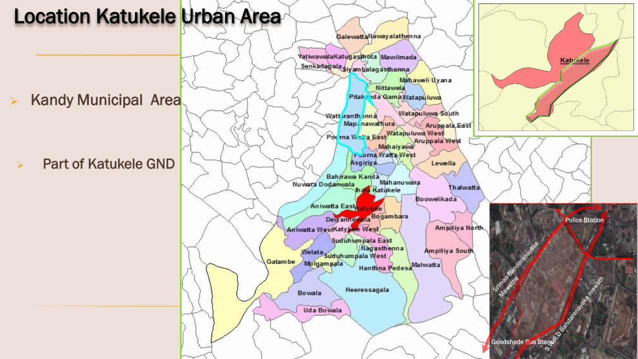
Location Katukele Urban Area
Goodshade Bus Stand
Police Station
Kandy Municipal Area
Part of Katukele GND

The Study Area

Part of Ancient Bogambara LakeSource: MAPPING MEANING IN THE CITY IMAGE: A CASE STUDY OF KANDY by Kapila D. Silva
During the 1932
– Space “of “ Governance
Hub for Colonization
1. Controlling elements
2. Transport terminal
Spatial Evolution
Source:
Tales of the Land: British Geography and Kandyan Resistance
in Sri Lanka,c. 1803–18501, SUJIT SIVASUNDARAM, Gonville and Caius College, Cambridge
And UDA
During the Kandyan Kingdom
During the British Era
2003
2017
Urban agglomeration
Informal development
Margination of natural
resources – Mede ela
Exogenous Context

City Population 1,30,000
Transient Population (per day) 500,000
Employment (per day) 90,000
Education (per day) 60,000
Local & Foreign Tourists & Pilgrims (per day) 6,000
Vehicle Arrival Per day 56,085
Land Extent (Hec. 2645) 26.45 Sq.Km(Source: UDA, Kandy)
City Profile
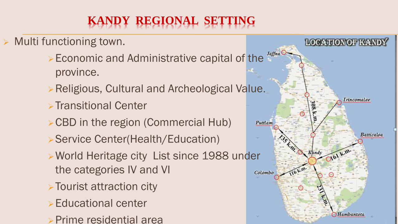
Multi functioning town.
Economic and Administrative capital of the
province.
Religious, Cultural and Archeological Value.
Transitional Center
CBD in the region (Commercial Hub)
Service Center(Health/Education)
World Heritage city List since 1988 under
the categories IV and VI
Tourist attraction city
Educational center
Prime residential area
KANDY REGIONAL SETTING
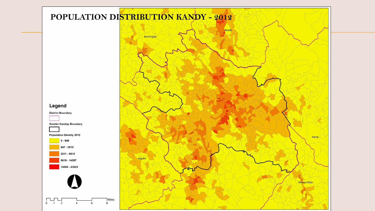


Heritage
Heritage
CBD
Transport Hub
Public Transit Zone
Natural Setting
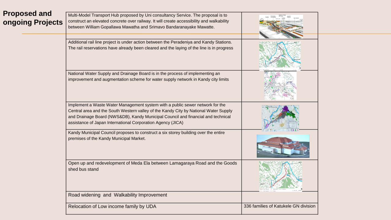
Multi-Model Transport Hub proposed by Uni consultancy Service. The proposal is to
construct an elevated concrete over railway. It will create accessibility and walkability
between William Gopallawa Mawatha and Srimavo Bandaranayake Mawatte.
Additional rail line project is under action between the Peradeniya and Kandy Stations.
The rail reservations have already been cleared and the laying of the line is in progress
National Water Supply and Drainage Board is in the process of implementing an
improvement and augmentation scheme for water supply network in Kandy city limits
Implement a Waste Water Management system with a public sewer network for the
Central area and the South Western valley of the Kandy City by National Water Supply
and Drainage Board (NWS&DB), Kandy Municipal Council and financial and technical
assistance of Japan International Corporation Agency (JICA)
Kandy Municipal Council proposes to construct a six storey building over the entire
premises of the Kandy Municipal Market.
Open up and redevelopment of Meda Ela between Lamagaraya Road and the Goods
shed bus stand
Road widening and Walkability Improvement
Relocation of Low income family by UDA 336 families of Katukele GN division
Proposed and
ongoing Projects
PHYSICAL ATTRIBUTES
BIOLOGICAL ATTRIBUTES
CULTURAL ATTRIBUTES
Endogenous of Context

40%
6%
32%
4%
2%
0.4%
5%
7.8%
2.8%Residential
Low income Housing
Commercial
Mixed Use
Education
Religious
Internal Road
Open & public space
Water Body
LAND USE PATTERN OF NORTHERN BLOCK
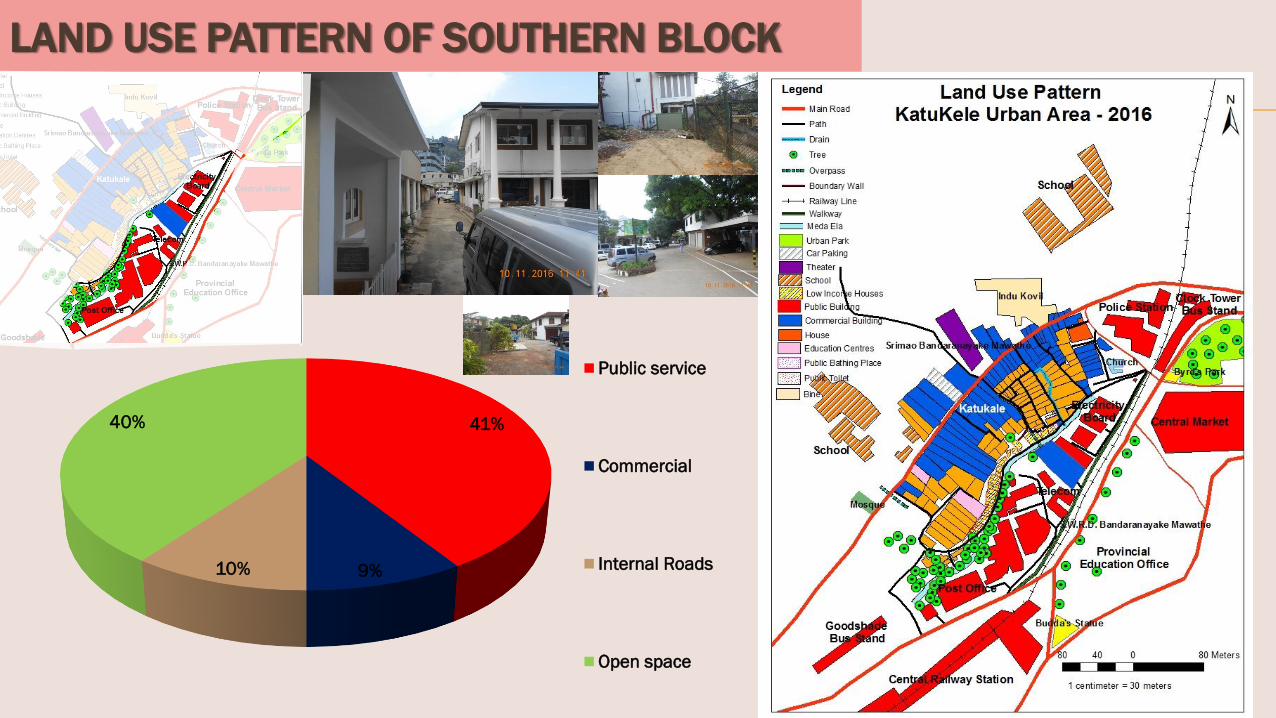
LAND USE PATTERN OF SOUTHERN BLOCK
41%
9%10%
40%
Public service
Commercial
Internal Roads
Open space

Population Density of study area – 44per Hectare (2012)
Population Density of Kandy City– 36per Hectare (2012)
Population 1997 2000 2012 2015
Katukele GN
Division
3378 3480 2124 7230
Kandy City 124453 129802 102459 102359
Kandy as a Multi-ethnic city
Gender Population - 2015
Female Male
3813 2415
Ethnicity - 2015
Sinhala Tamil Muslim
1272 1348 3610
Source: Department of Census and Statistics & Grammer Niladary
In the study area , it is 319 houses
Area 1997 2000
Katukele GN
Division
546 581
Kandy City 20287 21695
Housing
2.6% houses located in the Katukele area
Source: Department of Census and Statistics & Grammer Niladary

Parks
Greenways
Source: Field Survey and Google map-2016
40%60%
Open Space &
Public Space
Built Area
East Plot
8%
92%
Open Space &
Public Space
Built Area
West Plot
LAND USE
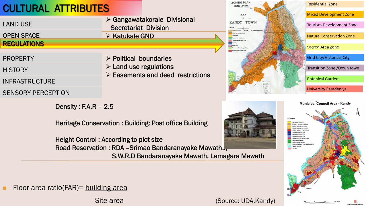
REGULATIONS
PROPERTY
SENSORY PERCEPTION
INFRASTRUCTURE
OPEN SPACE

LAND USE
OPEN SPACE
PROPERTY
SENSORY PERCEPTION
INFRASTRUCTURE
Political boundaries
Land use regulations
Easements and deed restrictionsHISTORY
Density : F.A.R – 2.5
Heritage Conservation : Building: Post office Building
Height Control : According to plot size
Road Reservation : RDA –Srimao Bandaranayake Mawathe,
S.W.R.D Bandaranayaka Mawath, Lamagara Mawath
(Source: UDA.Kandy)
Gangawatakorale Divisional
Secretariat Division
Katukale GND
CULTURAL ATTRIBUTES
REGULATIONS
Site area
Floor area ratio(FAR)= building area

LAND USE
OPEN SPACE
REGULATIONS
SENSORY PERCEPTION
INFRASTRUCTURE
HISTORY
CULTURAL ATTRIBUTES
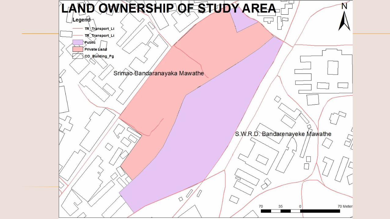
PROPERTY
Ownership : KMC & Private
Northern block– Private a & KMC
Southern block– Public Land
Value - Between 1.2m -5.0m

LAND USE
OPEN SPACE
REGULATIONS
PROPERTY
INFRASTRUCTURE
Visibility
Visual quality
Noise
Odors
HISTORY
CULTURAL ATTRIBUTES
SENSORY PERCEPTION
LAND USE
OPEN SPACE
REGULATIONS
PROPERTY
INFRASTRUCTURE Visibility
Visual quality
Noise
Odors
HISTORY
SENSORY PERCEPTION
CULTURAL ATTRIBUTES

LAND USE
OPEN SPACE
REGULATIONS
PROPERTY
SENSORY PERCEPTION
HISTORY
Transportation
Utilities
Sanitary
Storm sewer
Electric
Water
Telecommunication
Gas
Roads Railway
Telecom
Electricity
Toilet
Drain
Steps
INFRASTRUCTURE
CULTURAL ATTRIBUTES
Unique Characters
Pedestrian Alleyways
cul-de-sac

Flow Pattern
CBD Area
Vehicle Passenger
149,918 762,502
Study Area
200,000 person
per day

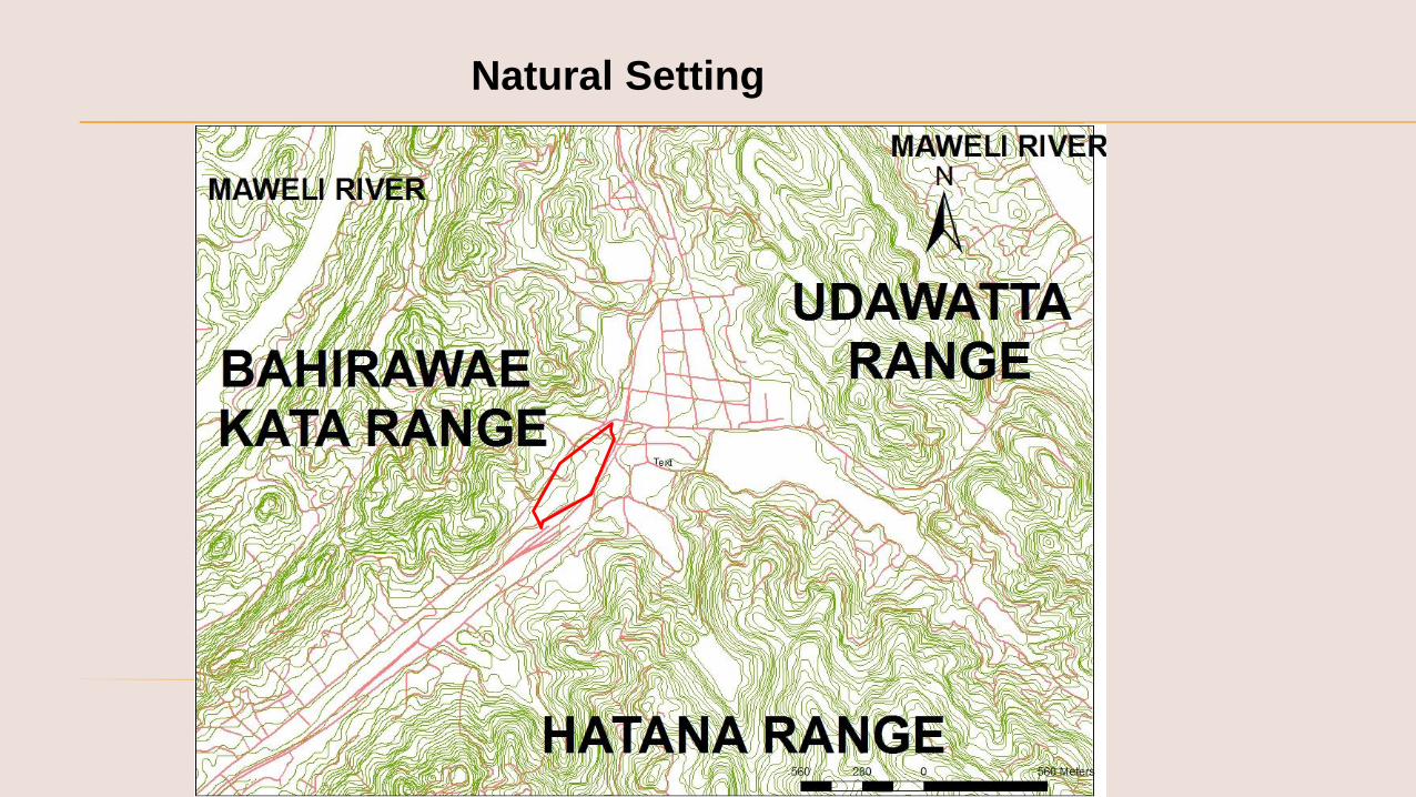
PHYSICAL ATTRIBUTES
TOPOGRAPHY
HYDROLOGY
SOIL
GEOLOGY
MICROCLIMATE
Elevation
Slope
Elevation
Orientation
Located Natural gradient 499- 512-meters MSL and
in an elevated basin surrounded by hills.
Source: Google pro

Meda Ela quality is the worst. Groundwater also
does not show good quality.Urban runoff adds organic
and chemical loading to surface water
High Do, No3,PO43-,
Alarming Coliform level by septic tank effluent leaking
Source: M/s Resources Development Consultants (Pvt) Ltd
TOPOGRAPHY
HYDROLOGY
SOIL
GEOLOGY
MICROCLIMATE
Surface drainage
water chemistry
aquifer recharge area
Seeps and springs
The Mede ela is the main drainage for the southern part of the city of Kandy
This main drainage originates from the overflow sluice of the Kandy Lake and
discharge into the Mahaveli River at Getambe
untreated domestic sewage is released directly into the Meda Ela
It is topographically situated at a low elevation
The wide of the stream is 3m
Some parts of the canal is kept closed at front and Backyard of electricity
buildings
The Meda Ela is also a unique identity to the ancient historical city of Kandy

Retaining Wall Steps
Common ToiletSeptic Tang &
Soakage pit
Septic Tang &
Soakage pit
Residential
Building
Commercial
Building
Waste water
discharging
Leakage from
Septic tang &
Soakage pit
Leakage from
Septic tang &
Soakage pit Drain
Waste water
discharging
PERADENIYA
ROAD
Leakage from
Septic tang &
Soakage pit
Ground Water Table
Soak by Ground
Under ground water
pollution
25ft
Sources of Water Pollution
!00m
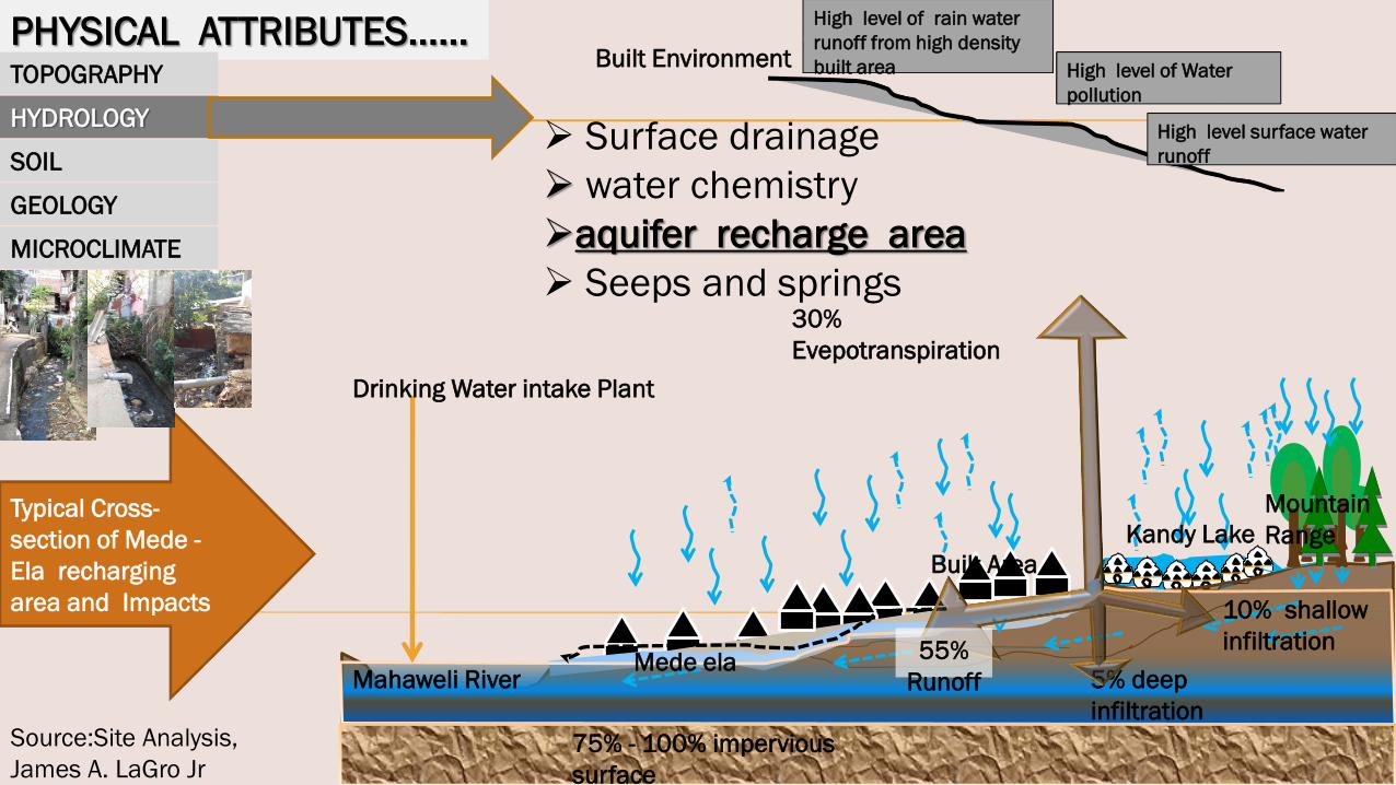
PHYSICAL ATTRIBUTES……TOPOGRAPHY
HYDROLOGY
SOIL
GEOLOGY
MICROCLIMATE
Surface drainage
water chemistry
aquifer recharge area
Seeps and springs
Typical Cross-
section of Mede -
Ela recharging
area and Impacts
High level of rain water
runoff from high density
built area High level of Water
pollution
High level surface water
runoff
Built Environment
Mahaweli River
Kandy Lake
Mountain
Range
Built Area
Mede ela
10% shallow
infiltration
30%
Evepotranspiration
5% deep
infiltration
75% - 100% impervious
surface
55%
Runoff
Drinking Water intake Plant
Source:Site Analysis,
James A. LaGro Jr

Gatambe
Water
Intake
PHYSICAL ATTRIBUTES
Mede Ela as a Tributary of Mahaweli River
The total daily drinking water consumption is about 36,000 m3 per day.
Wastewater release into ela is 20,000 m3 per day Source: National Water Supply and Drainage Board 2016

PHYSICAL ATTRIBUTES……………
TOPOGRAPHY
HYDROLOGY
SOIL
GEOLOGY
MICROCLIMATE
Surface drainage
water chemistry
aquifer recharge area
springs
Low income
housing
Seeps and springs

PHYSICAL ATTRIBUTES
TOPOGRAPHY
HYDROLOGY
GEOLOGY
Source: Geology Department of Peradeniya University , 2017
SOIL
The predominant great soil group in thesite is Reddish brown Latosolic soils whichhighly dissected, hilly and rolling terrainover burden with uneven thickness ofsoils. Moreover, red yellow Podzolic soilsand mountain regosols, immature brownloams solis also can be recorded. Most ofthe soils in the area can be categorised asresidual type soils, but soils along theMeda Ela is formed as alluvial type.Colluvial soils also can be identified alonglower parts of primrose mountain rangeand Suduhumpola area and some othersloppy areas.
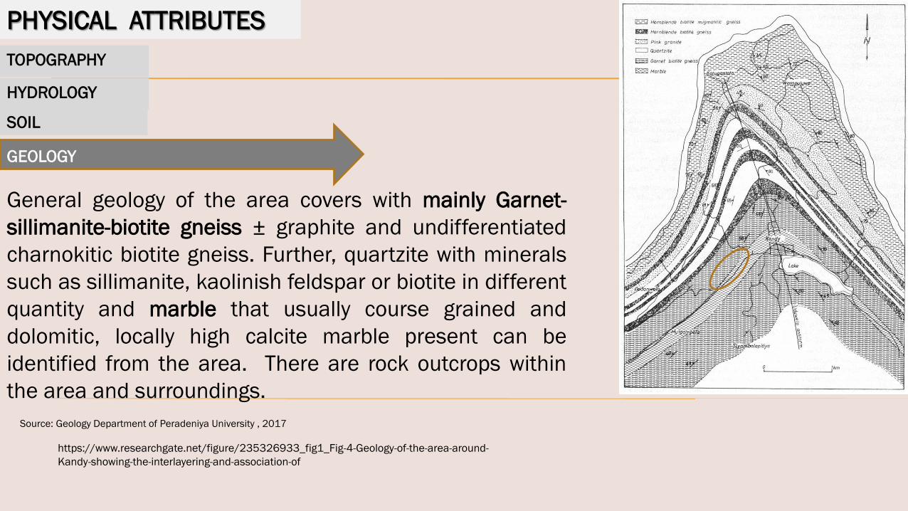
PHYSICAL ATTRIBUTES
TOPOGRAPHY
HYDROLOGY
Source: Geology Department of Peradeniya University , 2017
SOIL
GEOLOGY
General geology of the area covers with mainly Garnet-
sillimanite-biotite gneiss ± graphite and undifferentiated
charnokitic biotite gneiss. Further, quartzite with minerals
such as sillimanite, kaolinish feldspar or biotite in different
quantity and marble that usually course grained and
dolomitic, locally high calcite marble present can be
identified from the area. There are rock outcrops within
the area and surroundings.
https://www.researchgate.net/figure/235326933_fig1_Fig-4-Geology-of-the-area-around-
Kandy-showing-the-interlayering-and-association-of
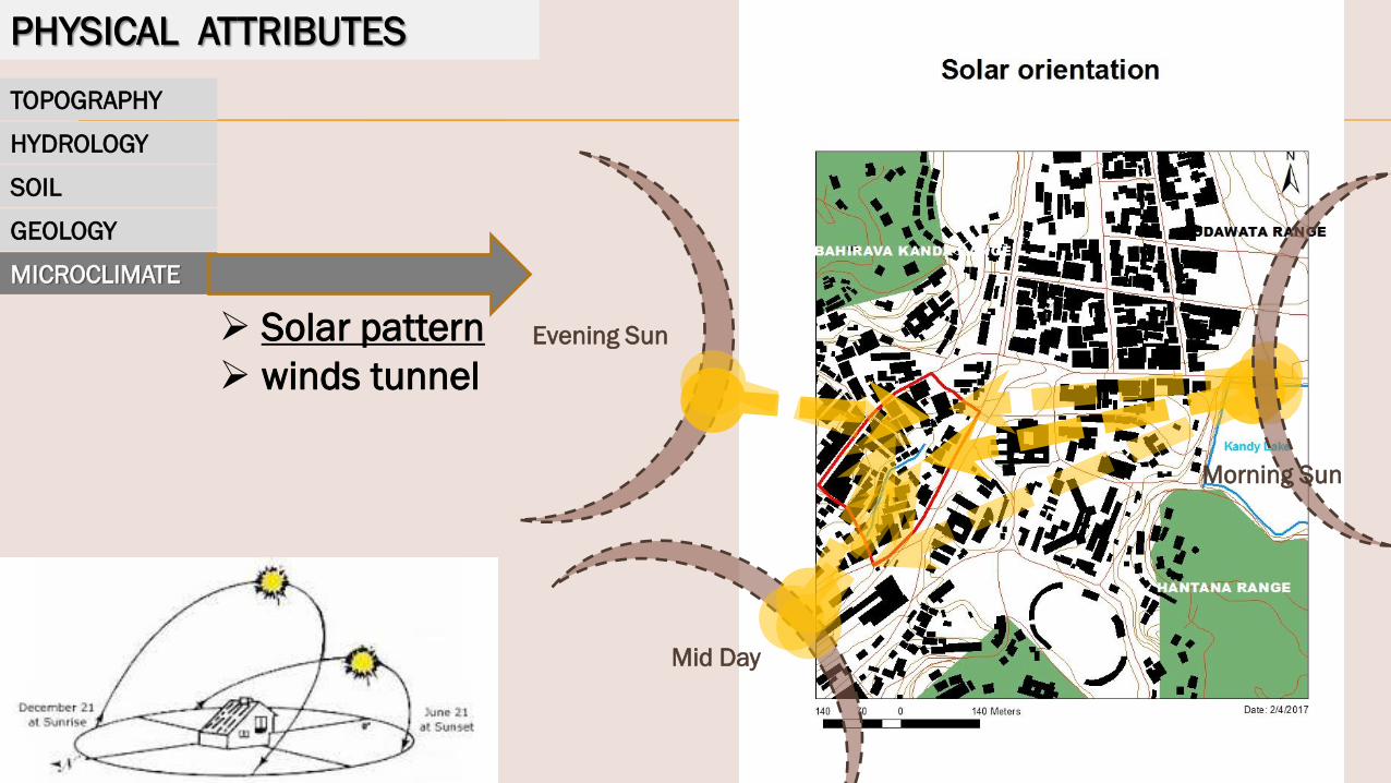
PHYSICAL ATTRIBUTES
TOPOGRAPHY
HYDROLOGY
SOIL
GEOLOGY
MICROCLIMATE
Solar pattern
winds tunnel
Mid Day
Evening Sun
Morning Sun

PHYSICAL ATTRIBUTES
TOPOGRAPHY
HYDROLOGY
SOIL
GEOLOGY
MICROCLIMATE
Solar pattern
winds tunnel
Source: Mapping meaning in city image-Case study of Kandy city,
Sri Lanka, Kapila D Silva,2011

BIOLOGICAL ATTRIBUTES
ECOLOGICAL COMMUNITIES
VEGETATION
Peltophorum pterocarpum, Mangifera indica (Amba), Persea
americana (Ali Pera), Tabebuiarosea, Ficus religiosa (Boo)
and Corvus splendens (House Crow), Acridotheres tristis
(Common Myna),
High density Canopy

Environmental Perception
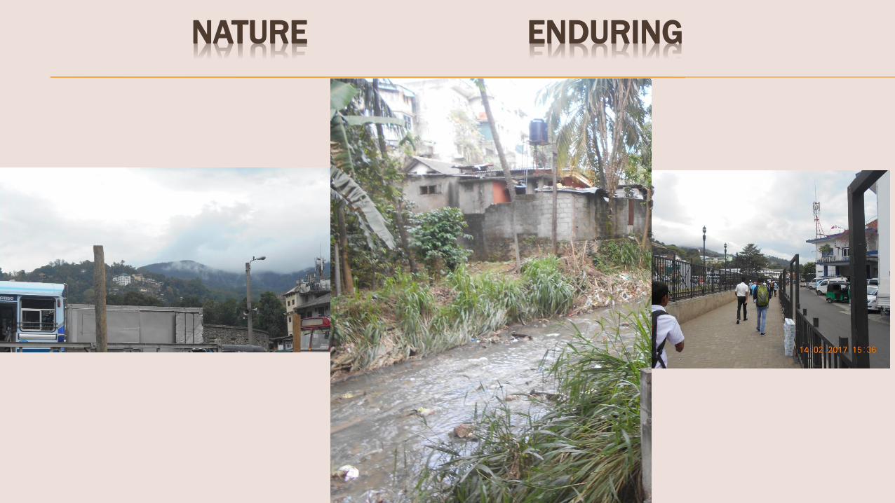
NATURE ENDURING
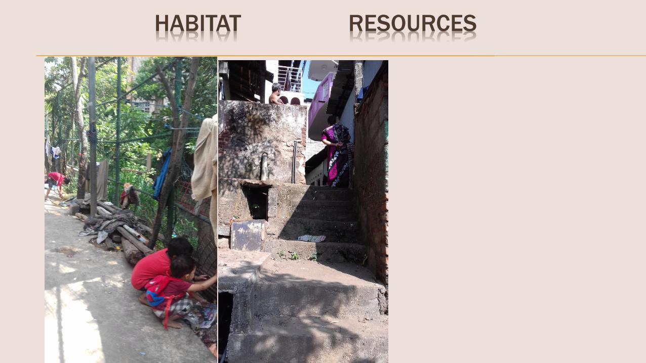
HABITAT RESOURCES

ARTIFACT PLATFORM
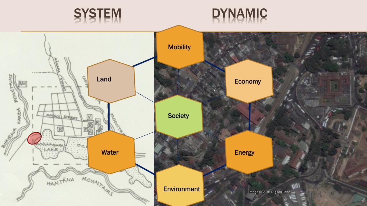
Society
Economy
Environment
Land
Water
Mobility
Energy
SYSTEM DYNAMIC
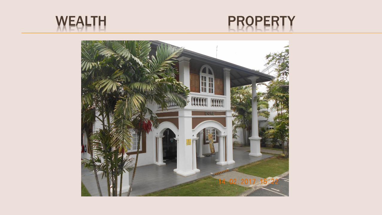
WEALTH PROPERTY

IDEOLOGY VALUES

HISTORY LEGACY

AESTHETIC SCENERY
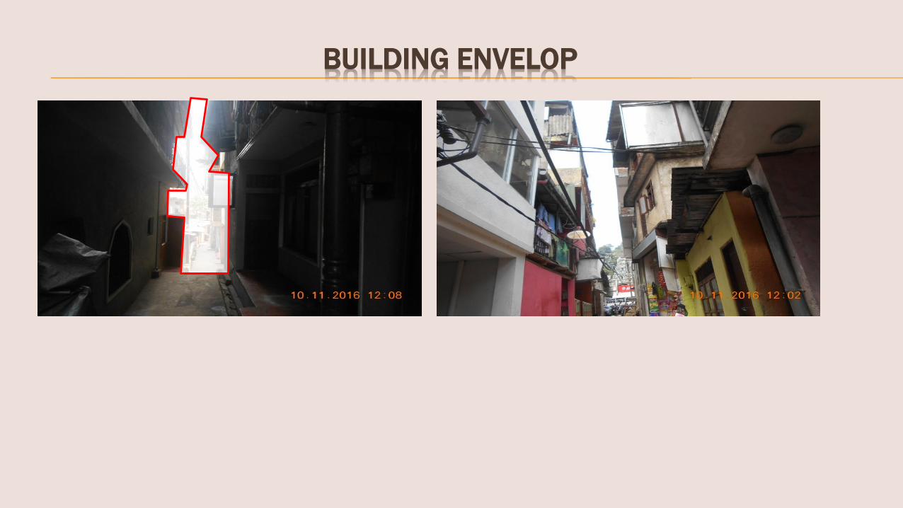
BUILDING ENVELOP

Synthesis & Analysis

Why need plan
To Katukale
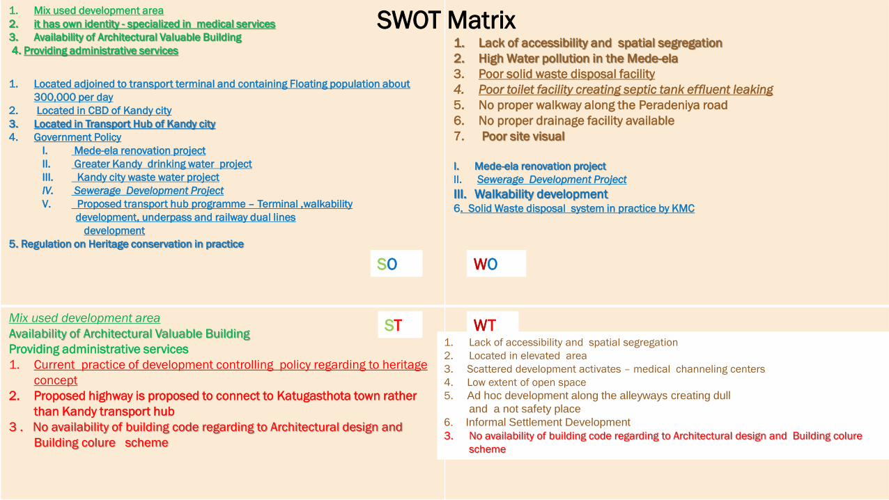
1. Mix used development area
2. it has own identity - specialized in medical services
3. Availability of Architectural Valuable Building
4. Providing administrative services
1. Located adjoined to transport terminal and containing Floating population about
300,000 per day
2. Located in CBD of Kandy city
3. Located in Transport Hub of Kandy city
4. Government Policy
I. Mede-ela renovation project
II. Greater Kandy drinking water project
III. Kandy city waste water project
IV. Sewerage Development Project
V. Proposed transport hub programme – Terminal ,walkability
development, underpass and railway dual lines
development
5. Regulation on Heritage conservation in practice
1. Lack of accessibility and spatial segregation
2. High Water pollution in the Mede-ela
3. Poor solid waste disposal facility
4. Poor toilet facility creating septic tank effluent leaking
5. No proper walkway along the Peradeniya road
6. No proper drainage facility available
7. Poor site visual
I. Mede-ela renovation project
II. Sewerage Development Project
III. Walkability development6. Solid Waste disposal system in practice by KMC
Mix used development area
Availability of Architectural Valuable Building
Providing administrative services
1. Current practice of development controlling policy regarding to heritage
concept
2. Proposed highway is proposed to connect to Katugasthota town rather
than Kandy transport hub
3 . No availability of building code regarding to Architectural design and
Building colure scheme
SWOT Matrix
SO WO
ST WT1. Lack of accessibility and spatial segregation
2. Located in elevated area
3. Scattered development activates – medical channeling centers
4. Low extent of open space
5. Ad hoc development along the alleyways creating dull
and a not safety place
6. Informal Settlement Development
3. No availability of building code regarding to Architectural design and Building colure
scheme
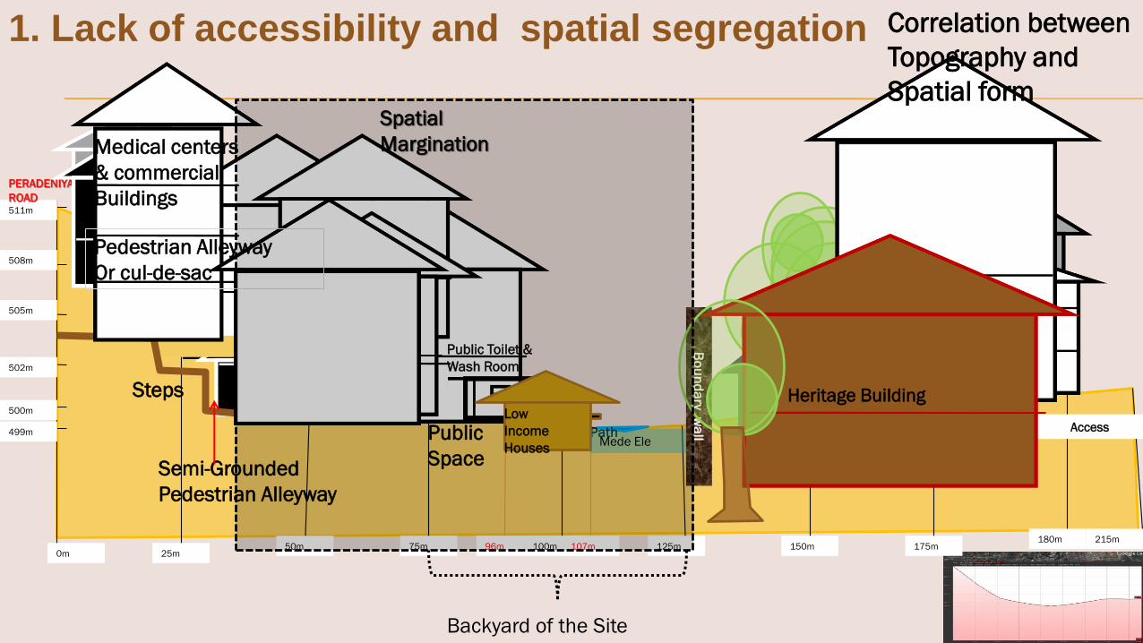
Backyard of the Site
0m 25m50m 75m 100m 125m 150m 175m
180m 215m
499m
500m
505m
508m
511m
502m
96m 107m
PERADENIYA
ROAD
House
Steps
AccessPath
Houses
Public Toilet &
Wash Room
Public
Space
Low
Income
HousesMede Ele
Bo
un
da
ry wa
ll
Medical centers
& commercial
Buildings
Pedestrian Alleyway
Or cul-de-sac
Semi-Grounded
Pedestrian Alleyway
Heritage Building
Spatial
Margination
Correlation between
Topography and
Spatial form
1. Lack of accessibility and spatial segregation

Existing Integration Future Development Scenario
Proposed
Overhead Bridge

Proposed
overhead Bridge 1
Proposed
overhead Bridge 2

Elevation: The site is located elevation
between 499m – 511m
Peradeniya road has located in
511m elevation
The Site is within elevation
gradient 2.44% - 11.7%
Northern Block – elevation
gradient - in the north
direction – 0.21m-9.57m -
in the south direction-
12.0m-0.04m
Southern Block – 2m-1.75m
Slop:Maximum slope within 5.2%
- 23.6%
Average slope within 3.0%-
10.1%
But it is differences within
the site
Orientation: Southern part has lowest location
499m height
Peradeniya road has highest
location
slop is faced to Southeast direction
Sensitive
Area
2.Located in elevated area


Srimao Bandaranayake
Mawathe
Slope %=Rise/Run*100
Rise=510m-499m
=11m
Slope %=11m/104m
= 10.57%
Balance area average
5% slope
Slope Calculation
0 – 5% Generally flat Highly buildable
5 – 10% Gently rolling Moderately buildable
10 – 15% Gentle to mild slopes Moderately difficult to build
15 – 20% Mild to steep slopes Difficult to build
20% and over Harsh, steep slopes Unbuildable


3. Scattered development activates –
medical channeling centers
Total Number of Service Centers -22
Percentage land out of Commercial total
Area - 7%
10,000 person per day visit to have
service

30,559 Sqm
19,986 Sqm
North ern block
Plot coverage– 93%
Open Space – 7.8%
FAR=1:2.2
South ern block
Plot coverage–60%
Open Space – 40%
FAR=1:1.3
Open Space Calculation
FAR=Gross Floor area
Total Land Area
100Plot Coverage = Ground Floor Plinth Area
Land Area
Figure and Ground Analysis
4. Low extent of open space

Dull and Darkness
5. Ad hoc development
along the alleyways
creating dull and a
not safety place


Source: Field Survey - 2016
Average building height – G+1
6. Underutilized Development

Skyline of Katukele Urban Area
S.W.R.D Bandaranayake Mawathe
Srimao Banaranayake Mawathe
DrainAlleyway

Total Houses - 28
Number of families – 38
Average income – Rs. 30,000 - 40,000
Building :
Single floor Houses
Average floor area 23Sqm - 35Sqm
Total Land Area -1200Sqm
6. Informal Housing Development
Development
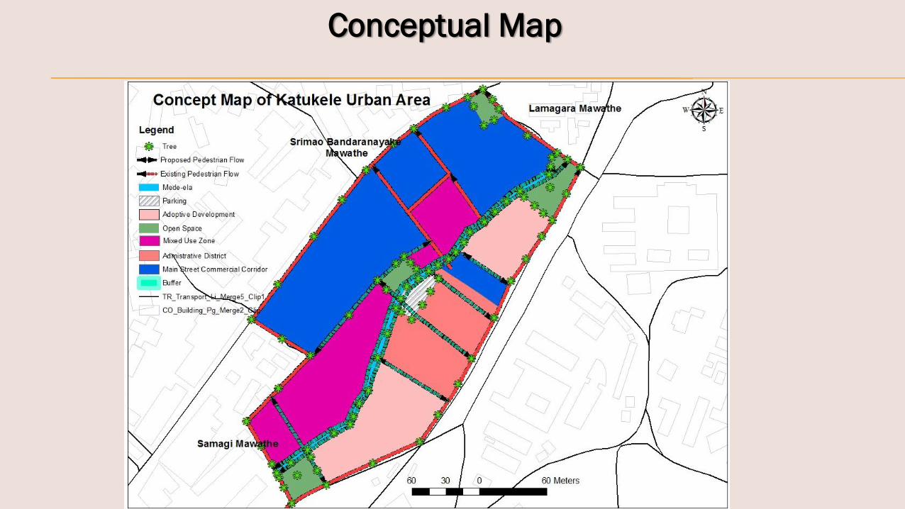
Conceptual Map

Vision Statement
Space the principal of creating perception of a society. Katukele site
planning is going to give a value on its environmental quality, culture
diversity and heritage inherence and creating pleasing place to health
living ultimately it will be a imagable place to all.
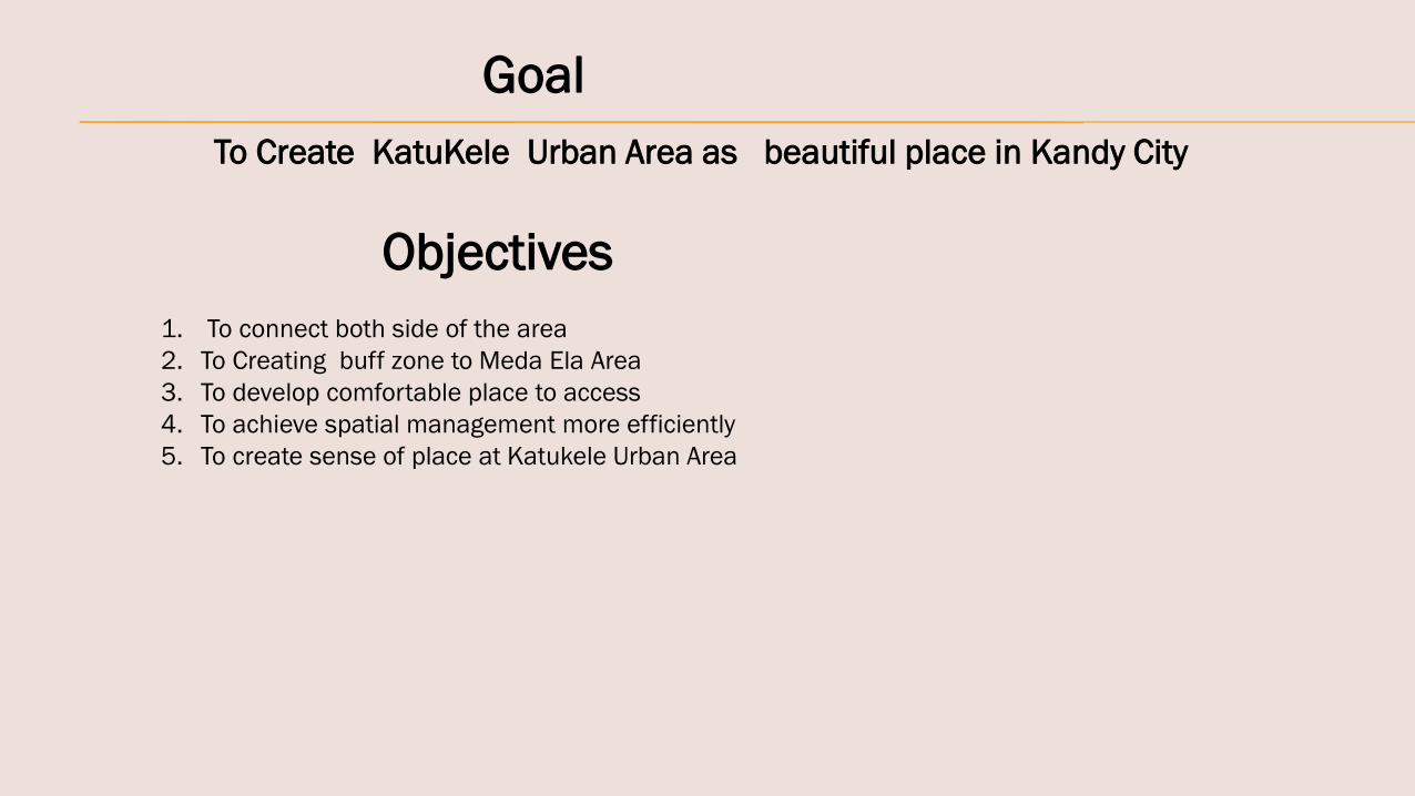
Goal
Objectives
1. To connect both side of the area
2. To Creating buff zone to Meda Ela Area
3. To develop comfortable place to access
4. To achieve spatial management more efficiently
5. To create sense of place at Katukele Urban Area
To Create KatuKele Urban Area as beautiful place in Kandy City

Meda – Ela Water front Development
Nature Path to Heritage City
Near by the New Post
Office Building

References:
Kandy City Region Strategic Development Plan(2030), By Uni Consultancy Services, University of Moratuwa Sri Lanka,
October 2015
Ka pila D. Silva , (2006), An experiential approach to urban design and conservation: A study of Kandy, Sri lanka, Journal
of research in architecture and planning, vol.5,
Kandy Transport Imprvement Program, By Uni Consultancy Services, University of Moratuwa Sri Lanka, May,2014
Jacobs J (1966) Life and Death of Great American Cities, , New Your: Random House Inc
URBAN SEGREGATION: A Theoretical Approach by Lucia Maria Machado Bógus
http://www.observatoriodasmetropoles.ufrj.br/urban_segregation.pdf
Yi-Fu Tuan,(2003) Space and Place – The perspective of experience , The university of Minnesota Press,.
Edited by Kevin Thwaites, Sergio portta, Ombretta Romice and Mark Greaves, (2007)Urban Sustainable-through
environmental design-approach to –people-place responsive urban spaces, by Routledge, New York,
James A. LaGro Jr, (2013), Site Analysis, Informing Context – Sensitive and Sustainable Site Planning and
Design,, John Wiley & sons, Inc,New York
Ir.Dr. Gue See Sew and Ir.Tan Year chin (2000) Hill – site Development – Planning, Design, Construction,
Construction and Maintenance consideration, , IEM seminar on Geotechnical Engineering ,Penang

Thank You