simulia abaqus for disaster modeling -...
TRANSCRIPT

22 November 2007 | GEOconnexion International Magazine
MODELING EARTHQUAKES WITH REALISTICSIMULATION SOFTWARE, RESEARCHER USESFEA TOOLS TO GET CLOSER TO PREDICTION
SIMULIA ABAQUS FORDISASTER MODELING
Massive destruction and loss of life followed the M9 (magnitude 9)Sumatra-Andaman Earthquake and tsunami of December 26, 2004,one of the worst natural disasters in recorded history. But there wasalso a second major (M8.7) earthquake, 100 days later and a fewkilometers to the south, along the same fault as the first. This second quake got little notice because it affected fewer peopleand caused no tsunami. But it represented a unique opportunity toDr. Tim Masterlark, Assistant Professor of Geodynamics in theDepartment of Geological Sciences at the University of Alabama.“To me that second quake was compelling,” he says. “It gave me anatural laboratory for studying how earthquakes interact with oneanother. Our primary objective is to see if we can come up withsome sort of causal relationship that could lead to more accuratepredictions of quakes and tsunamis in the future.” Masterlark was well prepared to take advantage of the new geologi-cal data that came from the Sumatra quakes. He has been modelingvirtual earthquakes and volcanoes for over a decade. A hydrogeolo-gist by training, he switched to deformation studies after readingabout the response of water wells to earthquakes in China. “If youwant to study deformation, a big earthquake is the largest scaledeformation event you can find short of a meteor impact,” he pointsout.
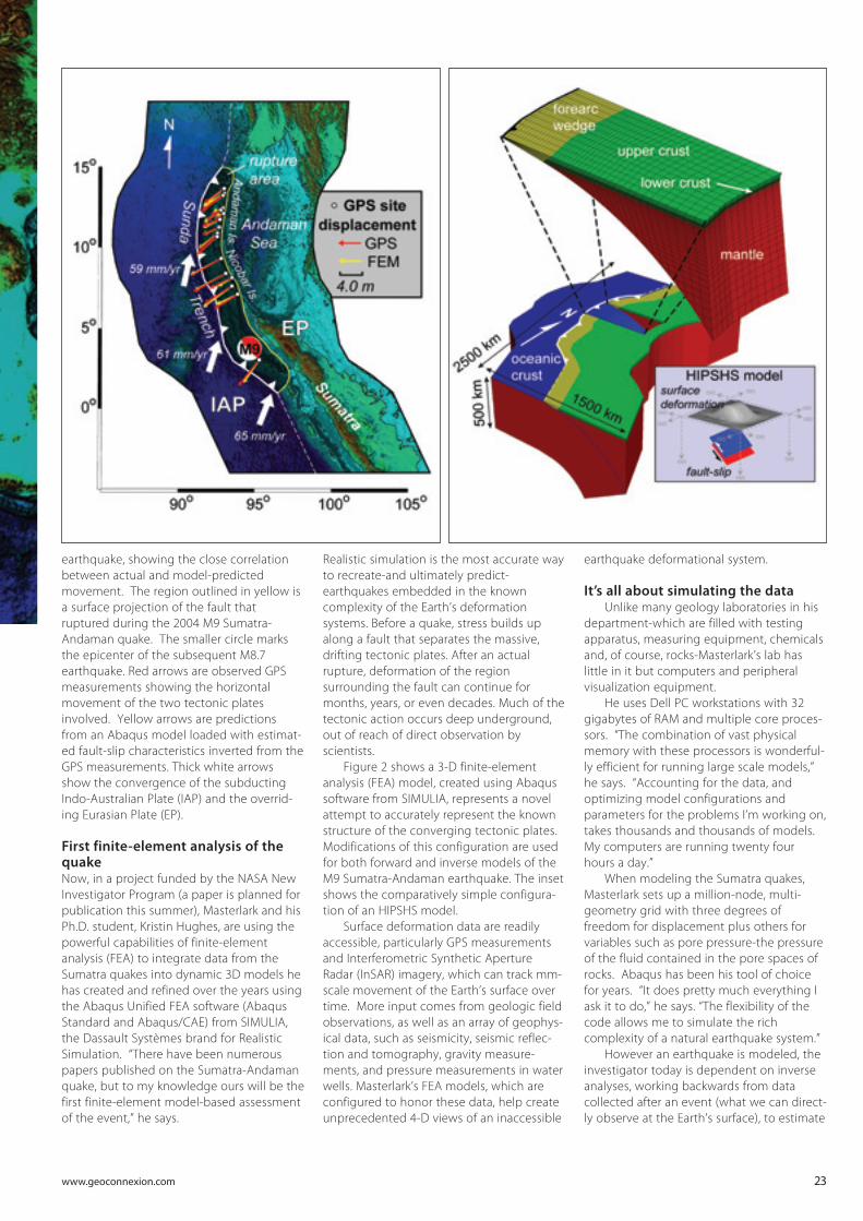
Figure 1 is a representation of the Sumatra-Andaman
Dr. Tim Masterlark,Univ. of Alabama
www.geoconnexion.com 23
earthquake, showing the close correlationbetween actual and model-predictedmovement. The region outlined in yellow isa surface projection of the fault thatruptured during the 2004 M9 Sumatra-Andaman quake. The smaller circle marksthe epicenter of the subsequent M8.7earthquake. Red arrows are observed GPSmeasurements showing the horizontalmovement of the two tectonic platesinvolved. Yellow arrows are predictionsfrom an Abaqus model loaded with estimat-ed fault-slip characteristics inverted from theGPS measurements. Thick white arrowsshow the convergence of the subductingIndo-Australian Plate (IAP) and the overrid-ing Eurasian Plate (EP).
First finite-element analysis of thequakeNow, in a project funded by the NASA NewInvestigator Program (a paper is planned forpublication this summer), Masterlark and hisPh.D. student, Kristin Hughes, are using thepowerful capabilities of finite-elementanalysis (FEA) to integrate data from theSumatra quakes into dynamic 3D models hehas created and refined over the years usingthe Abaqus Unified FEA software (AbaqusStandard and Abaqus/CAE) from SIMULIA,the Dassault Systèmes brand for RealisticSimulation. “There have been numerouspapers published on the Sumatra-Andamanquake, but to my knowledge ours will be thefirst finite-element model-based assessmentof the event,” he says.
Realistic simulation is the most accurate wayto recreate-and ultimately predict-earthquakes embedded in the knowncomplexity of the Earth’s deformationsystems. Before a quake, stress builds upalong a fault that separates the massive,drifting tectonic plates. After an actualrupture, deformation of the regionsurrounding the fault can continue formonths, years, or even decades. Much of thetectonic action occurs deep underground,out of reach of direct observation byscientists.
Figure 2 shows a 3-D finite-elementanalysis (FEA) model, created using Abaqussoftware from SIMULIA, represents a novelattempt to accurately represent the knownstructure of the converging tectonic plates.Modifications of this configuration are usedfor both forward and inverse models of theM9 Sumatra-Andaman earthquake. The insetshows the comparatively simple configura-tion of an HIPSHS model.
Surface deformation data are readilyaccessible, particularly GPS measurementsand Interferometric Synthetic ApertureRadar (InSAR) imagery, which can track mm-scale movement of the Earth’s surface overtime. More input comes from geologic fieldobservations, as well as an array of geophys-ical data, such as seismicity, seismic reflec-tion and tomography, gravity measure-ments, and pressure measurements in waterwells. Masterlark’s FEA models, which areconfigured to honor these data, help createunprecedented 4-D views of an inaccessible
earthquake deformational system.
It’s all about simulating the data Unlike many geology laboratories in his
department-which are filled with testingapparatus, measuring equipment, chemicalsand, of course, rocks-Masterlark’s lab haslittle in it but computers and peripheralvisualization equipment.
He uses Dell PC workstations with 32gigabytes of RAM and multiple core proces-sors. “The combination of vast physicalmemory with these processors is wonderful-ly efficient for running large scale models,”he says. “Accounting for the data, andoptimizing model configurations andparameters for the problems I’m working on,takes thousands and thousands of models.My computers are running twenty fourhours a day.”
When modeling the Sumatra quakes,Masterlark sets up a million-node, multi-geometry grid with three degrees offreedom for displacement plus others forvariables such as pore pressure-the pressureof the fluid contained in the pore spaces ofrocks. Abaqus has been his tool of choicefor years. “It does pretty much everything Iask it to do,” he says. “The flexibility of thecode allows me to simulate the richcomplexity of a natural earthquake system.”
However an earthquake is modeled, theinvestigator today is dependent on inverseanalyses, working backwards from datacollected after an event (what we can direct-ly observe at the Earth’s surface), to estimate

24 November 2007 | GEOconnexion International Magazine
the characteristics of fault-slip at depth(what we cannot directly observe). Thepromise of forward models, driven by theestimated fault-slip, is that they will predictthe location and time of future events-arupture beneath the ocean floor, forexample, that might catastrophically deformthe ocean bedrock and produce a tsunami.
A break from simple analytical solutionsMasterlark’s methods are different fromthose used by the vast majority of geophysi-cists, who rely on simplified analyticalsolutions collectively known as HIPSHSmodels (homogeneous, isotropic, Poisson-
solid half-spaces-each letter stands for asimplifying assumption about the naturalconfiguration of the Earth’s structure), withunreliable or ambiguous results, he finds.
“An HIPSHS model is a closed-formanalytical solution that satisfies the govern-ing equations that describe the deformationresponse to fault-slip,” he explains. “It’ssimple and fast, but not very accurate. Ifound out that the assumptions in HIPSHSmodels can be overwhelming sources oferror in inverse analyses, particularly theassumption of homogeneity.” In otherwords, because the structure of the Earth isnever uniform to begin with, the simplicityof an HIPSHS model often leads to mislead-ing interpretations of GPS and other datacollected after a quake.
Building a better earthquakeThis is where Masterlark’s FEA models comeout way ahead in terms of accuraterepresentations of the data. “By usingAbaqus, I can create any kind of geometry Iwant,” he says. To simulate the heteroge-neous, real-world Earth, Masterlark builds hiscomplex 3-D models by assigning differentmaterial properties to different regions,using the Abaqus soils module (a subset ofthe materials database).
The fault-slip of an earthquake can beeasily simulated via boundary conditionspecifications and kinematic constraintequations, he notes. And by assigningvarious material properties to the differentregions, he can recreate the displacementand pore pressure of the coseismic (during aquake) response. Then in the postseismic(after the quake) phase, he uses the Abaquscreep capability to model the viscoelasticdeformation, which slowly relaxes theearthquake-induced stress in the lowercrust and upper mantle, along with thedecay of pore pressure in the upper crustover time. Both of these postseismicdeformation mechanisms, viscoelastic andporoelastic relaxation, cause continuingdeformation of the Earth’s surface that canbe measured with GPS data and InSARimagery.
Figure 3 shows a realistic simulationmodel, constructed with Abaqus softwarefrom SIMULIA, of the coseismic warping ofthe ocean floor that set off the tsunamifollowing the Sumatra-Andamanearthquake. Increasingly reliable predictionsof seafloor deformation will generate moreaccurate models of tsunami behavior, whichin turn should improve prediction capabili-ties for such events in the future.
“I can investigate things like poroelastici-ty and viscoelasticity all in the same model- all I have to do is swap out material proper-ties specifications-it’s very easy to do,”Masterlark says. “The better the modelsimulates reality, the more reliable or closer
Fault - the boundary (a surface) between converging tectonic plates, along which stressbuilds up as the plates naturally drift in different directions over time. Fault-slip - the rupture, along a fault, that releases some of the stress and causes an earth-quake. Deformation - A change in shape of a region caused by fault-slip. Deformation changes thestate of stress and pore pressure underground. Coseismic - happening at the same time as an earthquake. Postseismic - occurring over a period of time following an earthquake. Tsunami - an immense sea wave that results from deformation of the ocean floor, which inturn changes the shape of the overlying ocean surface. InSAR - Interferometric Synthetic Aperture Radar, a form of satellite radar that can map verti-cal displacement of the earth’s surface. Pore pressure - pressure of the fluid contained in the pore spaces of rocks. Fluid pressureresponds to the stress of a quake more slowly than the solids within the earth’s crust, anddecays over time. Inverse analysis - using the deformation observed at the Earth’s surface (what we can direct-ly observe) to estimate the inaccessible fault-slip, or source of deformation, at depth. Forward analysis - simulating fault-slip and predicting deformation, stress, and pore pres-sure. HIPSHS - simplifying assumptions about the natural configuration of the Earth’s structureused to describe an earthquake; Masterlark’s FEA models are more complex. Poroelastic - Coupling of stress in a rock and fluid pressure in the pores of the rock. Viscoelastic -A material that initially behaves elastically, but then flows like a fluid over longtime intervals. Rocks deep within the Earth can flow (albeit slowly) due to high temperatureand pressure conditions.
EARTHQUAKE GEOLOGY GLOSSARY

www.geoconnexion.com 25
to the truth the predictions will be.”Although results from running quakesthrough his most recent models are comingever closer to GPS and other data, “we arestill trying to figure out precisely whatinformation we need to refine the modeleven further,” he says.
“As I try to couple the two Sumatraquakes together, we are getting moreaccurate with the spatial aspect of whatwent on. Now it’s the timing we are trying
to pin down. In the long run, the moreaccurate models we can build, the better wecan simulate stress propagation and porepressure changes. Then maybe we can say,‘look out on that section of fault down there,we think there’s another quake coming.’That’s the ultimate goal of the research.”
Modeling has a bright futureOther scientists are beginning to noticeMasterlark’s work. Through a contact made
on a cruise over the epicenter of theSumatra quake in the Indian Ocean, he isworking with a group planning to takefurther geophysical measurements on thesite. “We’ve got the models-now we needmore data,” says Masterlark.
He is pleased to be included in theinquiry. “This type of opportunity is happen-ing more frequently. Being a modeler, andhaving an expertise with a powerful codelike Abaqus, enables me to be very helpfulto a lot of people with data who want itmodeled right.” The group includes anotherresearcher who is a tsunami wave modeler.
Masterlark knows that truly accurateprediction of quakes and tsunamis will takeyears of group effort. “There are so manyaspects of deformation modeling andtsunami modeling. We all have to collabo-rate. But with the tools that are nowbecoming available, it would not surpriseme if someone had reliable causal modelsworked out by the end of my career. So I’mmaking a prediction on predictions.”
For further information, contact:Lynn Manning at the Parker Group, tel. (401)272-1510, e-mail: [email protected] Dr. Tim Masterlark, University of Alabama,Department of Geological Sciences, tel. (205)348-6269 or e-mail: [email protected]
Article by Tim Webb, Director, SIMULIAMarketing Communications, Tel: +1 401276 4400 and email: [email protected]