singsinga kalan shri vaibhav jain land, mouza …...singsinga kalan stone mines of shri vaibhav...
TRANSCRIPT

SINGSINGA KALAN Stone Mines of SHRI VAIBHAV JAIN, Area – 6.56 Acre (2.66 ha) in Non-Forest RAYATI
Land, Mouza – SINGSINGA KALAN, Thana- Chiniya, Dist. –Garhwa, State – Jharkhand
ASHOK KUMAR 1 REGN NO. – RQP/ RNC/150/2011/A
MINING PLAN &
PROGRESSIVE MINE CLOSURE PLAN
OF SHRI VAIBHAV JAIN
S/o - Shri Ashok Kumar Jain
Vill. + P.O. – Ranchi Road, Marar, P.S – Ramgarh,
District – Ramgarh, Jharkhand.
In VILLAGE: - SINGSINGA KALAN, Thana – CHINIYA,
THANA NO: 58, khata no’s- 09, 16 & 193,
Plot no’s. - 644, 645 & 667,
District – GARHWA, Jharkhand
Total Area: 6.56 Acre (2.66 ha)
PRODUCTION-185738 MT/YEAR OR 619 MT/DAY Prepared Under Rule 34 C (1) & 34 E (2) of JMMCR (A) 2014
PREPARED BY ASHOK KUMAR
VILLAGE- DINDIR, AURANGABAD, BIHAR
REG. NO. RQP/ RNC/150/2011/A
VALID UP TO- 24.01.2022.

SINGSINGA KALAN Stone Mines of SHRI VAIBHAV JAIN, Area – 6.56 Acre (2.66 ha) in Non-Forest RAYATI
Land, Mouza – SINGSINGA KALAN, Thana- Chiniya, Dist. –Garhwa, State – Jharkhand
ASHOK KUMAR 2 REGN NO. – RQP/ RNC/150/2011/A
AUTHORISATION LETTER BY THE APPLICANT
I , Mr. VAIBHAV JAIN , here by authorise Mr. Ashok Kumar (BE, MINING) to
prepare the mining plan for SINGSINGA KALAN Stone Mines, Over an area of 2.66 Ha,
situated in Mauza -SINGSINGA KALAN, P.S. - Chiniya, District- Garhwa, Jharkhand. It is
therefore requested to the District, Mining Officer (DMO), Garhwa to make further
correspondence regarding modification and to collect the approved copies of the
aforesaid mining Plan with the said recognized person on his following address.
Ashok Kumar
At + p.o. - DINDIR
PS - Haspura
Distt. - Aurangabad (Bihar)
Mob. No - 8969694392
Email. - [email protected].
Date: VAIBHAV JAIN
Place: S/o - Shri Ashok Kumar Jain,
Vill. + P.O. – Ranchi Road, Marar,
P.S – Ramgarh, Distt. - Ramgarh,
Jharkhand

SINGSINGA KALAN Stone Mines of SHRI VAIBHAV JAIN, Area – 6.56 Acre (2.66 ha) in Non-Forest RAYATI
Land, Mouza – SINGSINGA KALAN, Thana- Chiniya, Dist. –Garhwa, State – Jharkhand
ASHOK KUMAR 3 REGN NO. – RQP/ RNC/150/2011/A
CERTIFICATE
The Mining Plan & Progressive Mine Closure Plan of Stone Mines in, Khata No. 09, 16 & 193. Plot No.
644, 645 & 667, Area- 2.66 Ha, and Village – SINGSINGA KALAN, PS – Chiniya. Distt – Garhwa,
Jharkhand. complies all statutory rules, regulation, orders made by the Central or State Government,
statutory organization, court etc. have been taken into consideration and wherever any specific
permission is required, the Lessee will approach the concerned authorities.
I hereby also undertake that all the measures proposed in the Progressive Mine Closure Plan will be
implemented in a time bound manner as proposed.
Date: VAIBHAV JAIN
Place: S/o - Shri Ashok Kumar Jain,
Vill. + P.O. – Ranchi Road, Marar,
P.S – Ramgarh, Distt.- Ramgarh,
Jharkhand
.

SINGSINGA KALAN Stone Mines of SHRI VAIBHAV JAIN, Area – 6.56 Acre (2.66 ha) in Non-Forest RAYATI
Land, Mouza – SINGSINGA KALAN, Thana- Chiniya, Dist. –Garhwa, State – Jharkhand
ASHOK KUMAR 4 REGN NO. – RQP/ RNC/150/2011/A
UNDERTAKING
I do hereby undertake that:
a) If there is any change in the name/address/partnership in respect to the
above said mine, during the pendency of approval; the same shall be informed
promptly to the concerned authority with immediate effect.
b) The work as instructed vide CCOM circular no. 2/2010 dated 06.04.2010
regarding DGPS survey of lease area of our Stone Mine by engaging the
consultant as and when authorized by state Government will be submitted the
same to Department of Mines and Geology, Government of Jharkhand.
c) The boundary Pillars will be maintained properly.
Date: VAIBHAV JAIN
Place: S/o - Shri Ashok Kumar Jain,
Vill. + P.O. – Ranchi Road, Marar,
P.S – Ramgarh, Distt.- Ramgarh,
Jharkhand
.

SINGSINGA KALAN Stone Mines of SHRI VAIBHAV JAIN, Area – 6.56 Acre (2.66 ha) in Non-Forest RAYATI
Land, Mouza – SINGSINGA KALAN, Thana- Chiniya, Dist. –Garhwa, State – Jharkhand
ASHOK KUMAR 5 REGN NO. – RQP/ RNC/150/2011/A
CERTIFICATE
1. The provisions of Mineral Conservation and Development Rules, 1988, JMMCR, 2004 &
JMMCR (A) 2014 have been observed in the mining plan for SINGSINGA KALAN Stone Mines,
in, Khata No. 09, 16 & 193. Plot No. 644, 645 & 667, Area - 2.66 Ha, Village -SINGSINGA KALAN,
P. S – Chiniya. Distt – Garhwa, Jharkhand, belonging to SHRI VAIBHAV JAINand wherever specific
permission is required the applicant will approach the concerned authorities of Department of
Mines & Geology for granting the permission.”
2. It is also certified that the provisions of Mines Act, Rules and Regulations made there under
have been observed in the aforesaid Mining Plan and wherever specific permissions are required
the applicant will approach the Director General of Mines Safety.
3. It is further certified that the aforesaid Mining Plan is prepared as per the copies of the
records and documents provided by applicant and information given as per discussions held with
applicant and his representative.
4. It is also certified that the information furnished in the aforesaid Mining Plan are true and
correct to the best of our knowledge & belief and in case of default the approval would be
withdrawn.
Place: Ashok Kumar
Date : RQP/ RNC/150/2011/A
Dindir, Aurangabad, Bihar

SINGSINGA KALAN Stone Mines of SHRI VAIBHAV JAIN, Area – 6.56 Acre (2.66 ha) in Non-Forest RAYATI
Land, Mouza – SINGSINGA KALAN, Thana- Chiniya, Dist. –Garhwa, State – Jharkhand
ASHOK KUMAR 6 REGN NO. – RQP/ RNC/150/2011/A
MINING PLAN INDEX
CHAPTER
NO.
PARTICULARS
PAGE NO.
I
I
INTRODUCTION 1
II
II
GENERAL 2-3
III
III
LOCATION & ACCESSIBILITY 4
IV GEOLOGY, EXPLORATION & RESERVE 5-10
V MINING 11-15
VI BLASTING DRILLING & MACHINERY
EQUIPMENTS
16-19
VII
MANPOWER & PROJECT COST 20
VIII
USE OF MINERALS 21
19 IX
MINERAL PROCESSING 22
X
ENVIRONMENT MANAGEMENT PLAN
23-26
25-39 XI PROGRESSIVE MINE CLOSURE PLAN 27-37

SINGSINGA KALAN Stone Mines of SHRI VAIBHAV JAIN, Area – 6.56 Acre (2.66 ha) in Non-Forest RAYATI
Land, Mouza – SINGSINGA KALAN, Thana- Chiniya, Dist. –Garhwa, State – Jharkhand
ASHOK KUMAR 7 REGN NO. – RQP/ RNC/150/2011/A
LIST OF PLATES
SL. NO. DETAILS PLATE NO.
1 Location plan 1
2 Key plan –Google Image 2
3 Area plan 3
4 Surface, Plan 4
5 Geological Plan & section 5
6 1st year Development plan & section 6
7 2nd year Development plan & section 7
8 3rd year Development plan & section 8
9 4th year Development plan & section 9
10 5th year Development plan & section 10
11 Composite Plan & Section 11
12 Conceptual working plan & section 12
13 Environmental Management plan & section 13
14 Progressive Mine closer plan & section 14

SINGSINGA KALAN Stone Mines of SHRI VAIBHAV JAIN, Area – 6.56 Acre (2.66 ha) in Non-Forest RAYATI
Land, Mouza – SINGSINGA KALAN, Thana- Chiniya, Dist. –Garhwa, State – Jharkhand
ASHOK KUMAR 8 REGN NO. – RQP/ RNC/150/2011/A
ANNEXURE
(I) Photo copy of Application form
[Schedule – 4, Form A, Rule 9]
(II) Photo copy of Land Agreement
(III)Photo copy of Land Khatian
(IV) Photo copy of Aadhar Card of Applicant
(V) Photo copy of PAN Card of Applicant
(VI) Photo copy of RQP Certificate
(VII) Photograph of the Area
SINGSINGA KALAN Stone Mines of SHRI VAIBHAV JAIN, Area – 6.56 Acre (2.66 ha) in Non-Forest RAYATI
Land, Mouza – SINGSINGA KALAN, Thana- Chiniya, Dist. –Garhwa, State – Jharkhand
ASHOK KUMAR 9 REGN NO. – RQP/ RNC/150/2011/A
CHAPTER – I INTRODUCTION
The Mining lease of Stone over an area of 6.56 acres (2.66 Ha) in Village – SINGSINGA
KALAN, P.S.- Chiniya, Distt- Garhwa, State – Jharkhand, having Lat. 24° 01’ 57.0 N to 24°
02’ 03.4 “ N & Long. 83° 43’ 57.9” E to 83° 44’ 05.9” E in OSM no: - G 44 × 12 & G 44 × 16
has been applied on 26.02.2018 by Shri Vaibhav Jain for ten years.
2. The material i.e. Stone finds ready market in construction industries including road,
railway, and dwelling houses within as well as outside Jharkhand. Moreover, partly
weathered rocks are also being marketed as pitching materials.
3. Govt. of Jharkhand has made it mandatory to prepare and submit “Mining Plan”
highlighting mining methodologies of extracting mineral deposit ( in this case Stone) as well
as outlining the “Environmental Management Plan” before granting of mining lease and it is
also mandatory for obtaining environmental clearance of the project. A mining plan apart
from being a document for pursuing scientific mining suggest measures to mitigate any likely
adverse impact on environment and ecology.
4. While preparing the mining plan, due a consideration has been made to ensure that the
relevant provisions under MMDR Act 1927, MMR 1961 and Mines Act 1952, Mines Rules
1955 as well as Jharkhand MMCR 2014 are adhered to.
The relevant provisions of rules and guidelines drawn up by Govt. of Jharkhand for mining of
minor minerals have been kept in mind while preparing the “Mining Plan”.
5. The “Mining Plan” preparation is broadly based on
Maps and data provided by the Applicant.
Discussion with the Applicant (prospecting Applicant)
Help of standard publication, books, maps etc. wherever thought necessary.
Prevailing technical norms.
Though effort has been made to collect as much information / data as possible, appropriate
assumptions has been made wherever it has been considered necessary.
6. Required numbers of competent and qualified persons as prescribed under mines act,
regulation and rules made there under as well as for properly carrying out technically
competent and safe mining operation have been recommended in the “Mining Plan” report.

SINGSINGA KALAN Stone Mines of SHRI VAIBHAV JAIN, Area – 6.56 Acre (2.66 ha) in Non-Forest RAYATI
Land, Mouza – SINGSINGA KALAN, Thana- Chiniya, Dist. –Garhwa, State – Jharkhand
ASHOK KUMAR 10 REGN NO. – RQP/ RNC/150/2011/A
CHAPTER – II GENERAL
Sl.no DESCRIPTION DETAILS
a) Name of the Mines SINGSINGA KALAN Stone Mines
b) Details of Applicant
i Applicant name &
Address
SHRI VAIBHAV JAIN S/o - Shri Ashok Kumar Jain, Vill. + P.O. – Ranchi Road, Marar, P.S – Ramgarh, District – Ramgarh, Jharkhand.
ii Status of Applicant A Private Individual
b) Details of Area
i District and State Garhwa , Jharkhand
ii Thana/ Thana no. Chiniya, Thana no. - 58
iii Khasra No./Plot No./Block Range /Felling Series no.
Plot No: 644, 645 & 667, Khata No: 09, 16 & 193
iv Lease Area 6.56 Acres, 2.66 Hectare
v Whether the Area is recorded to be in
forest(please specify
Whether protected,
reserved etc.) Ownership
No,
RAYATI Land
vi Existence of public
road/railway line, if
any nearby and
approximate
distance
The Stone mining site is well connected with Ranka-
Singsinga Road, located 7.3 Km in the NW. The
nearest railway station is Garhwa Railway station,
located approx. 17.5 km in the NE. The nearest
airport is Varanasi located about 162 km in NW
While Ranchi airport is located 177 Km from the
mine lease in SE. (All are approx. Arieal distance)

SINGSINGA KALAN Stone Mines of SHRI VAIBHAV JAIN, Area – 6.56 Acre (2.66 ha) in Non-Forest RAYATI
Land, Mouza – SINGSINGA KALAN, Thana- Chiniya, Dist. –Garhwa, State – Jharkhand
ASHOK KUMAR 11 REGN NO. – RQP/ RNC/150/2011/A
vii OSM No. with
latitude and
longitude
OSM No. : G 44 × 12 & G 44 × 16
Co-ordinates Corner 1 : 24° 02’ 03.4” N & 83° 44’ 01.3 “ E
Corner 5 : 24° 01’ 57.0” N & 83° 44’ 04.4” E
viii Land use pattern
(Forest,
Agricultural,
Grazing, Barren
etc)
RAYATI (BARREN/TAND)
c) Attach a general
location and
vicinity map
indicating project
site.
Please refer Plate No. 1

SINGSINGA KALAN Stone Mines of SHRI VAIBHAV JAIN, Area – 6.56 Acre (2.66 ha) in Non-Forest RAYATI
Land, Mouza – SINGSINGA KALAN, Thana- Chiniya, Dist. –Garhwa, State – Jharkhand
ASHOK KUMAR 12 REGN NO. – RQP/ RNC/150/2011/A
CHAPTER – III LOCATION & ACCESSIBILITY
2.1 Location & Accessibility:
Stone Deposit situated about 16 Km away from Garhwa Town in SW. Near about 17.5
km from Garhwa Railway Station in SW. The nearest airport is Varanasi located about
162 km in NW While Ranchi airport is located 177 Km from the mine lease in SE. (All
are approx. Arieal distance)
2.2 OSM No- G 44 × 12 & G 44 × 16
Latitude : 24° 01’ 57.0” N TO 24° 02’ 03.4“ N
Longitude : 83° 43’ 57.0” E TO 83° 44’ 05.9” E
2.3 Availability of water, power, medical, & educational facilities:
There is no stream or pond within and around the leasehold area. Anraj River is
located around 1.4 km away from the site in North. Dispensary and local hospital
facilities are situated at Chiniya/Ranka about 11 km NW/7.3 km SE. Local educational
facilities up to primary, middle, and High school are also available in Chiniya/Ranka
area.
2.4 Key Plan
The area has been marked on survey of India OSM No. G 44 × 12 & G 44 × 16 showing
the vicinity of the area on scale of 1:50,000 (Plate -2)
2.5 Area plan:
The area is marked on the cadastral map of the concerned mauja - SINGSINGA KALAN,
Thana - Chiniya, Thana no. – 58, District – Garhwa, Jharkhand on a scale of 1:3960 or
16” = 1 mile (Plate No. 3)

SINGSINGA KALAN Stone Mines of SHRI VAIBHAV JAIN, Area – 6.56 Acre (2.66 ha) in Non-Forest RAYATI
Land, Mouza – SINGSINGA KALAN, Thana- Chiniya, Dist. –Garhwa, State – Jharkhand
ASHOK KUMAR 13 REGN NO. – RQP/ RNC/150/2011/A
CHAPTER – IV GEOLOGY, EXPLORATION & RESERVE
3.1 PHYSIOGRAPHY
The Lease area represents small hillock of stone covered with soil. The highest contour
is found 327 m. from mean Sea Level and the lowest contour is of 315 m from MSL.
There is no settlement within the area. There is no vegetation in the area. The
proposed area is almost flat terrain. Stone is exposed in the area applied for proposed
project. No other rock is exposed. No habitation or public infrastructure located in the
proposed area. No PWD road, village road, and HT Line passing through the lease
area. Layout Plan Plate is attached.
3.2 TOPOGRAPHY:-
Garhwa district is highly rugged topography with thick green forest all over the area.
The hills are widely scattered and rise up to 1164 m above MSL in the Southern of the
district. Average height of the hills varies from 700 – 900 mts. The hill which is called
Gulgulpath -3819 ft. is said to be second highest peak in Jharkhand situated in
Bhandriya Block of the district. There are also low land in Northern and Western part
of the district which is suitable for agricultural purposes. The elevation of plain varies
from 250 – 500 mtr. The slope of the district is towards north.
3.3 GEOLOGY
The geological formation of the Garhwa district comprise mainly rocks of Archaean,
Vindhyan and Gondwana ages, the last cut by dykes of Deccan trap age. The Archaean
rocks include both schist’s of Dharwar age and gneisses and granites. The schist’s,
mainly horn-blendic and biotitic, are the oldest rocks of the area and occur as parallel
and lenticular bands in the gneisses. The schist’s are intruded by epidiorites,
amphibolites, and gneisses. The gneisses and granites are, however, the most
predominant rocks of the district as in other parts of Chotanagpur. They give rise to
prominent groups of hills in the northern and southern parts of the district. The
District has long been famous as the home of the well-known ruby mica and has
several large coalfields. The portion of the Jharkhand mica belt and the coalfields that
lie in this district are economically the most important.
The main geological formations of the district are as follows:
(1) Recent deposits of alluvium and laterite.
(2) Post Gondwana Dykes of basic.
Cretaceo-Eocene, Igneous rocks
Dykes of basic Jurassic and Triassic
And Ultra bas
ic assic. Igneous rocks.
Upper Panchet or Lower Jurassic
Mahadevas Lower Triassic

SINGSINGA KALAN Stone Mines of SHRI VAIBHAV JAIN, Area – 6.56 Acre (2.66 ha) in Non-Forest RAYATI
Land, Mouza – SINGSINGA KALAN, Thana- Chiniya, Dist. –Garhwa, State – Jharkhand
ASHOK KUMAR 14 REGN NO. – RQP/ RNC/150/2011/A
Panchet series. Upper Permian
Raniganj series
Ironstone shales
(3) Gondwana Middle Permian system.
Lower Damodar Barakar Series
Lower Permian with Karharbari stage.
Upper Talchir series carboniferous with glacial boulder bed.
(4) Basic intrusives, Meta dolerite, amphibolite and epidiorites
(5) Mica pegmatites and granite pegmaties
(6) Chotanagpur granite gneiss.
(7) Dharwars-Crushed or fault breccia, garnet-amphibole schist, Granulites, schists,
phyllites, quartzites etc.
3.4 Soil Classification
There is a soil variation in the district. The soils of the district can broadly be grouped
into three classes:-
a) Heavy Clays: This soil is locally known as Kewal Soil. This soil becomes hard when
dry and sticky when wet. This soil can hold moisture for a longer period and as a result
considered to be favourable for Rabi crops.
b) Sandy Soil: This soil is locally known as Balsundar and consists of course sand to a
large extent and facilitates production of Paddy and vegetables.
c) Loamy Soil: This soil is locally name as Dorasa and consists of sand and clay. This soil
is suitable for growing sugarcanes.
4.1 Hydrogeology:
The district is underlined by hard rock foundations if belonging to the Precambrian
period and recent alluvium along river banks. The geology and structure of underlying
basement controls the occurrence and movement of ground water. The ground water
occurs in secondary porosity like joints, fractures and the extent of inter connection
with them. Ground water occurs in the district within weathered mantle. Limited
volume in alluvial deposits occurring along the Sone and Kanahar rivers. The thickness
of weathered mantle varies from 5 to 16 mbgl in general. The source of Ground Water
recharge is entirely by rainfall. The rivers of the district are effluent which do not
contain appreciable amount of water during lean period to recharge Ground water at
lower reaches. Major part of the rain water goes as run off.
3.5 Climatic Condition (District-GARHWA)
The climate of the district is humid and sub tropical. The year can be divided in to
three main seasons, the winter season from November to March, the summer season
is from March to May and Monsoon season from June to September; October is a
transitional month between Monsoon and winter seasons. December and January are
the coolest months. In winter the temperature goes down to 3°C. By March
temperature begin to rise steadily. In May and early part of June the maximum

SINGSINGA KALAN Stone Mines of SHRI VAIBHAV JAIN, Area – 6.56 Acre (2.66 ha) in Non-Forest RAYATI
Land, Mouza – SINGSINGA KALAN, Thana- Chiniya, Dist. –Garhwa, State – Jharkhand
ASHOK KUMAR 15 REGN NO. – RQP/ RNC/150/2011/A
temperature can be as high as 47°C on individual days. Humidity is generally normal in
this district, except in Monsoon months.
3.6 LITHO LOGY
south of the Son there are several scattered and narrow outcrops of Vindhyan rocks
belonging mainly to the Basal, Porcellanite and Kheinjua stages. The rocks of the
Porcellanite group are indurated and silicified volcanic ashes. Towards the north-
western part of the district there is a large outcrop of the Lower Vindhyan strata,
south of the Son, which appears to be a part of the main Lower Vindhyan formation of
the Rohtas plateau north of the Son. Bhaunathpur is situated in the eastern part of the
main outcrop. There is a small outlier about 5 miles south-east if Hussainabad near
Japla. The shales and the limestone of the Kheinjua group are mostly concealed by
alluvium along the bank of the Son. South of this at a distance of two miles is a place
called Kalapahar? The Kalapahar are a group of very conspicuous and remarkable
done hills formed of an acid volcanic rock, rhyolitic composition.
3.3 Local Geology:
Large scale mapping on 1:1000 scales has been carried out in and around the area of
Stoneic rock deposit; it comprises only one type of deposit of Stonseic rock. Then the
area was gridded according to square pattern at an interval of 50 m. Effort was made
to plot each and every characteristics of rock formation. A contour plan having 1.0 m
interval has been also prepared, showing relative elevation and depression from
ground level. In this way a geological map is prepared (Plate No. 4).
The geological sequence of rock type of the area is as follows:-
Alluvial Soil
Detrital soil with talus
……………………………...Unconformity ………………………………
Stone.
3.4 Method of Estimation of Reserves:
Standard Cross Sectional Area method.
a) Sections have been drawn from boundary to boundary across the Lease area
considering the litho units in the area. The sectional area has been estimated on the
basis of the cross sections.
b) Length of influence have been measured the by taking half of the section interval
distance on both side of each section.
c) Bulk density 2.7 has been taken.
3.5 RESOURCES:
Resources have been calculated in two categories such as Measures Mineral Resources &
Indicated Mineral Resources.
Up to an average depth of 45 meters is taken as Measured Mineral Resource category on
the basis of a drill hole drilled in middle of applied area, Stone exposed on the quarry face,
exposure on hill top and slope as well as from the nala cutting section around the lease

SINGSINGA KALAN Stone Mines of SHRI VAIBHAV JAIN, Area – 6.56 Acre (2.66 ha) in Non-Forest RAYATI
Land, Mouza – SINGSINGA KALAN, Thana- Chiniya, Dist. –Garhwa, State – Jharkhand
ASHOK KUMAR 16 REGN NO. – RQP/ RNC/150/2011/A
area and further up to a depth of 5 meters is taken as Indicated Mineral Resource
category.
Mineable reserve is based on the mineable part of the reserve. Mineable Stone reserve
has been calculated from the geological plan in the area considering the Stone which is
not mineable in view of blocked zone in ML boundary and ultimate pit limit as calculated
from the Geological plan & sections.
MEASURED MINERAL RESOURCE CATEGORY
The measured mineral resources as arrived have been divided in prima facie in mineable
and non mineable parts as follows. The detail of calculation has been shown below.
MEASURED MINERAL RESOURCE
section Sectional area(m2) Length of influence(m) Volume(m3) T.F. Tonnage
A-A' 8292 35 290220 2.7 783594
B-B' 6885 32 220320 2.7 594864
C-C' 4618 34 157012 2.7 423932
1802390
BLOCKED MEASURED MINERAL RESOURCE IN SAFETY BARRIER & UPL
This is non mineable part, of the measured mineral resources, detail calculations shown in
table below.
section Sectional area(m2) Length of influence(m) Volume(m3) T.F. Tonnage
A-A' 2343 43 100749 2.7 272022
B-B' 2343 42 98406 2.7 265696
C-C' 1535 44 67540 2.7 182358
720077
INDICATED MINERAL RESOURCE CATEGORY
The indicated mineral resources as arrived have been divided in prima facie in mineable and
non mineable parts as follow.
INDICATED MINERAL RESOURCE CATEGORY.(MINEABLE PART)
section Sectional area(m2) Length of influence(m) Volume(m3) T.F. Tonnage
A-A' 340 43 14620 2.7 39474
B-B' 256 42 10752 2.7 29030
C-C' 205 44 9020 2.7 24354
92858
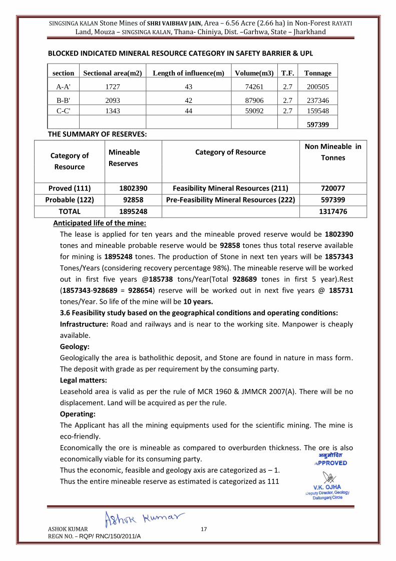
BLOCKED INDICATED MINERAL RESOURCE CATEGORY IN SAFETY BARRIER & UPL
This is non mineable part, of the Indicated mineral resources, detail calculations shown in
table
SINGSINGA KALAN Stone Mines of SHRI VAIBHAV JAIN, Area – 6.56 Acre (2.66 ha) in Non-Forest RAYATI
Land, Mouza – SINGSINGA KALAN, Thana- Chiniya, Dist. –Garhwa, State – Jharkhand
ASHOK KUMAR 17 REGN NO. – RQP/ RNC/150/2011/A
BLOCKED INDICATED MINERAL RESOURCE CATEGORY IN SAFETY BARRIER & UPL
section Sectional area(m2) Length of influence(m) Volume(m3) T.F. Tonnage
A-A' 1727 43 74261 2.7 200505
B-B' 2093 42 87906 2.7 237346
C-C' 1343 44 59092 2.7 159548
597399
THE SUMMARY OF RESERVES:
Category of
Resource
Mineable
Reserves
Category of Resource Non Mineable in
Tonnes
Proved (111) 1802390 Feasibility Mineral Resources (211) 720077
Probable (122) 92858 Pre-Feasibility Mineral Resources (222) 597399
TOTAL 1895248 1317476
Anticipated life of the mine:
The lease is applied for ten years and the mineable proved reserve would be 1802390
tones and mineable probable reserve would be 92858 tones thus total reserve available
for mining is 1895248 tones. The production of Stone in next ten years will be 1857343
Tones/Years (considering recovery percentage 98%). The mineable reserve will be worked
out in first five years @185738 tons/Year(Total 928689 tones in first 5 year).Rest
(1857343-928689 = 928654) reserve will be worked out in next five years @ 185731
tones/Year. So life of the mine will be 10 years.
3.6 Feasibility study based on the geographical conditions and operating conditions:
Infrastructure: Road and railways and is near to the working site. Manpower is cheaply
available.
Geology:
Geologically the area is batholithic deposit, and Stone are found in nature in mass form.
The deposit with grade as per requirement by the consuming party.
Legal matters:
Leasehold area is valid as per the rule of MCR 1960 & JMMCR 2007(A). There will be no
displacement. Land will be acquired as per the rule.
Operating:
The Applicant has all the mining equipments used for the scientific mining. The mine is
eco-friendly.
Economically the ore is mineable as compared to overburden thickness. The ore is also
economically viable for its consuming party.
Thus the economic, feasible and geology axis are categorized as – 1.
Thus the entire mineable reserve as estimated is categorized as 111

SINGSINGA KALAN Stone Mines of SHRI VAIBHAV JAIN, Area – 6.56 Acre (2.66 ha) in Non-Forest RAYATI
Land, Mouza – SINGSINGA KALAN, Thana- Chiniya, Dist. –Garhwa, State – Jharkhand
ASHOK KUMAR 18 REGN NO. – RQP/ RNC/150/2011/A
Economically ore is mineable as compared to overburden thickness and it is viable for the
captive plant and is categorized as – 1.
Feasibility study of the deposit is yet to establish. So, it is categorized as -2
Geologically the area is potential but the deposit in the depth is yet to establish with
grade as per the requirement by the captive plant and it is categorized as -2.
RESERVES AND RESOURCES ESTIMATED FOR STONE
Classification Code Stone (in mt)
Total Mineral Resources (A+B)
A. Mineral Reserve
(1) Proved Mineral Reserve 111 1802390
(2) Probable Mineral Reserve 122 92858
B. Remaining Resources
(1) Feasibility Mineral Resource 211 720077
(2) Pre-feasibility Mineral Resource 221 597399
Pre-feasibility Mineral Resource 222
(3) Measured Mineral Resource 331
(4) Indicated Mineral Resource 332
(5) Inferred Mineral Resource 333
(6)Reconnaissance Mineral Resource 334

SINGSINGA KALAN Stone Mines of SHRI VAIBHAV JAIN, Area – 6.56 Acre (2.66 ha) in Non-Forest RAYATI
Land, Mouza – SINGSINGA KALAN, Thana- Chiniya, Dist. –Garhwa, State – Jharkhand
ASHOK KUMAR 19 REGN NO. – RQP/ RNC/150/2011/A
CHAPTER – V
MINING
4.1 The entire area is highly potential area. The work will be started from the South-Eastern
part and gradually extended towards North-Western direction. The mound is gently sloping
towards North-Western direction. Working of the next five years will be started from the
Eastern part and extended towards further depth. The benching system 6 m X 6 m will be
practiced in the area, in accordance with the provisions of Metalliferous Mines Regulations,
1961. Details of advancement and formation of benches are shown in Development Plan &
Sections (Plates: 6, 7, 8, 9, 10) in the scale 1:2000.
4.2 Mining Strategy:
Since the deposit in this area is massive in nature, it is proposed to carry out only opencast
mechanized mining (OTFM) for this plan period. The operations like drilling of shot hole,
sorting of ore and breaking at the size will be done in semi mechanized method to deploy
100 mm & 35 mm dia Wagon Drill & jack hammer Drill to drill and blast holes having burden
and spacing of 3 m x 3.5 m in stagger grid pattern. Muffle blasting will be adopted as
precautionary measure.
To avoid fly rock problem at the edge of hill light charged muffle blasting shall be under taken
and equipment’s like pick axe, crowbar, shovels, pans etc are used for the safe mining.
4.3 Production Targets:
Year wise Production of Stone from the area has been calculated by cross sectional method.
The cross sectional area has been multiplied by the advancement to be worked in each bench
as length of influence to get the bulk volume. Thus the value obtained has been multiplied by
tonnage factor to get the actual production of ore in each bench. Year wise calculation has
been made separately and the detail of year wise development of the quarry is given in
Tables below. Thus average annual production of the mine is 185738 tones/yrs (approx.).
Year
Production of Stone Production
of Soil
in M3
Total
Excavation
in M3
ACTUAL STONE
PRODUCTION
(Considering recovery
factor as 98 % in mt)
M3 T
factor
MT
1st 70200 2.7 189540 NIL 70200 185749
2nd 70202 2.7 189545 NIL 70202 185754
3rd 70157 2.7 189424 NIL 70157 185636
4th 70062 2.7 189167 NIL 70062 185383
5th 70358 2.7 189967 NIL 70358 186167
TOTAL 350979 2.7 947643
NIL 350979 928689

SINGSINGA KALAN Stone Mines of SHRI VAIBHAV JAIN, Area – 6.56 Acre (2.66 ha) in Non-Forest RAYATI
Land, Mouza – SINGSINGA KALAN, Thana- Chiniya, Dist. –Garhwa, State – Jharkhand
ASHOK KUMAR 20 REGN NO. – RQP/ RNC/150/2011/A
4.4 Bench Design and Formation: Since the mine will be worked in IN SEMI MECHANIZED METHOD
working pattern during this plan period of 10years, bench height will be restricted to the 6 m
X 6 m as per the production requirement, available machinery, local geology of the area and
accordance with MMR, 1961.
4.5 Bench Development over the plan period:
The work will be started from the South-Eastern part and gradually extended towards North-
Western direction. The mould is gently sloping towards North-Western direction. Working of
the next five years will be started from the South-Eastern part and extended towards further
depth. The benching system 6 m X 6 m of Stone will be practiced in the area, in accordance
with the provisions of Metalifferous Mines Regulations, 1961. Details of advancement and
formation of benches are shown in Development Plan & Sections (Plates: 6, 7, 8, 9 & 10) in
the scale 1:2000.
1st year: During this year working will be started from the South-Eastern side with three
benches of 6 m X 6 m of Stone, in dimension with RL 327 m - 315 m. For haulage of the Stone
permanent ramp will be maintained at the quarry face. During quarry advancement tolerable
amount of weathered waste and gritty soil will be generated and this will be temporally
dumped at the North-Western part of the area with suitable precaution.
1st year stone
SECTION
BENCH
R.L
(M)
SECTION
AL AREA
(m2)
LENGTH
OF
INFLUEN
CE
(m)
VOLUME
(m3) T.F.
STONE
(TONES)
ACTUAL STONE
PRODUCTION
(Considering
recovery factor as
98 % (in mt)
A-A' 327-321 398 35 13930 2.7 37611 36859
A-A' 321-315 954 35 33390 2.7 90153 88350
B-B' 327-321 368 32 11776 2.7 31795 31159
B-B' 321-315 347 32 11104 2.7 29981 29381
70200 2.7 189540 185749
2nd year: - During this year working will be continued from the same quarry and advancing
the benches. The bench size is 6 m X 6 m of Stone, in dimension up to RL 319 m. For haulage
of the Stone permanent ramp will be maintained at the quarry face. During quarry
advancement very few weathered waste will be generated and this will be dumped at the
dumped yard. Details calculations are given bellow:

SINGSINGA KALAN Stone Mines of SHRI VAIBHAV JAIN, Area – 6.56 Acre (2.66 ha) in Non-Forest RAYATI
Land, Mouza – SINGSINGA KALAN, Thana- Chiniya, Dist. –Garhwa, State – Jharkhand
ASHOK KUMAR 21 REGN NO. – RQP/ RNC/150/2011/A
2ND YEAR STONE
SECTION BENCH
R.L
(M)
SECTION
AL AREA
(m2)
LENGTH
OF
INFLUEN
CE
(m)
VOLU
ME
(m3)
T.F. STONE
(TONES)
ACTUAL STONE
PRODUCTION
(Considering
recovery factor as
98 % (in mt)
B-B' 321-315 327 32 10464 2.7 28253 27688
B-B' 315-309 1326 32 42432 2.7 114566 112275
C-C' 325-319 509 34 17306 2.7 46726 45791
TOTAL 70202 2.7 189545 185754
3rd year: - During this year working will be continued from the same quarry and advancing
the benches. The bench size is 6 m X 6 m in dimension up to RL 303 m. For haulage of the
Stone permanent ramp will be maintained at the quarry face.
Details calculations are given bellow:-
3rd year Stone:-
SECTION BENCH
R.L
(M)
SECTIO
NAL
AREA
(m2)
LENGTH
OF
INFLUEN
CE
(m)
VOLU
ME
(m3)
T.F. STONE
(TONES)
ACTUAL STONE
PRODUCTION
(Considering
recovery factor as
98 % (in mt)
A-A' 315-309 1583 35 55405 2.7 149594 146602
B-B' 309-303 461 32 14752 2.7 39830 39034
TOTAL 70157 2.7 189424 185636
4th year: - During this year working will be continued from the same quarry and advancing
the benches. The bench size is 6 m X 6 m in dimension up to RL 303 m. For haulage of the
Stone permanent ramp will be maintained at the quarry face.
Details calculations are given bellow
4th year Stone:-
SECTION BENCH
R.L
(M)
SECTION
AL AREA
(m2)
LENGTH
OF
INFLUEN
CE(m)
VOLUME
(m3)
T.F. STONE
(TONES)
ACTUAL STONE
PRODUCTION
(Considering recovery
factor as 98 % in mt)
B-B' 309-303 635 32 20320 2.7 54864 53767
C-C' 319-313 1052 34 35768 2.7 96573 94642
C-C' 313-307 411 34 13974 2.7 37730 36975
TOTAL 70062 2.7 189167 185384
SINGSINGA KALAN Stone Mines of SHRI VAIBHAV JAIN, Area – 6.56 Acre (2.66 ha) in Non-Forest RAYATI
Land, Mouza – SINGSINGA KALAN, Thana- Chiniya, Dist. –Garhwa, State – Jharkhand
ASHOK KUMAR 22 REGN NO. – RQP/ RNC/150/2011/A
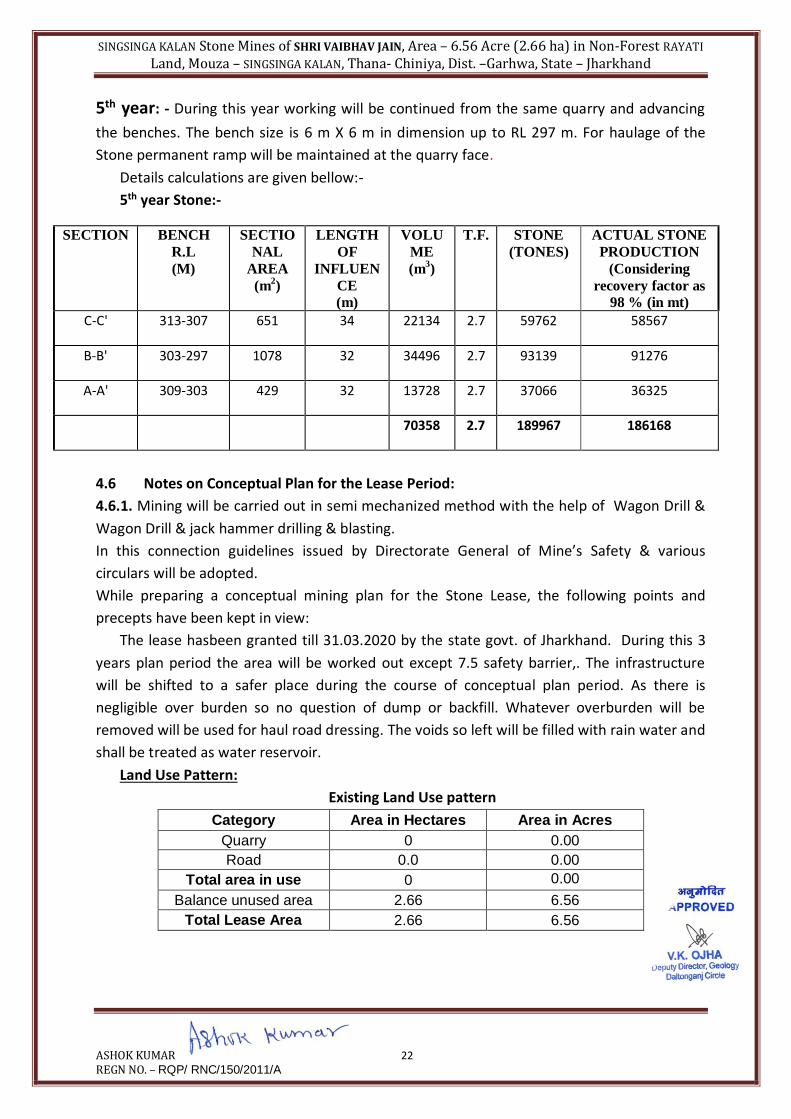
5th year: - During this year working will be continued from the same quarry and advancing
the benches. The bench size is 6 m X 6 m in dimension up to RL 297 m. For haulage of the
Stone permanent ramp will be maintained at the quarry face.
Details calculations are given bellow:-
5th year Stone:-
SECTION BENCH
R.L
(M)
SECTIO
NAL
AREA
(m2)
LENGTH
OF
INFLUEN
CE
(m)
VOLU
ME
(m3)
T.F. STONE
(TONES)
ACTUAL STONE
PRODUCTION
(Considering
recovery factor as
98 % (in mt)
C-C' 313-307 651 34 22134 2.7 59762 58567
B-B' 303-297 1078 32 34496 2.7 93139 91276
A-A' 309-303 429 32 13728 2.7 37066 36325
70358 2.7 189967 186168
4.6 Notes on Conceptual Plan for the Lease Period:
4.6.1. Mining will be carried out in semi mechanized method with the help of Wagon Drill &
Wagon Drill & jack hammer drilling & blasting.
In this connection guidelines issued by Directorate General of Mine’s Safety & various
circulars will be adopted.
While preparing a conceptual mining plan for the Stone Lease, the following points and
precepts have been kept in view:
The lease hasbeen granted till 31.03.2020 by the state govt. of Jharkhand. During this 3
years plan period the area will be worked out except 7.5 safety barrier,. The infrastructure
will be shifted to a safer place during the course of conceptual plan period. As there is
negligible over burden so no question of dump or backfill. Whatever overburden will be
removed will be used for haul road dressing. The voids so left will be filled with rain water and
shall be treated as water reservoir.
Land Use Pattern:
Existing Land Use pattern
Category Area in Hectares Area in Acres
Quarry 0 0.00
Road 0.0 0.00
Total area in use 0 0.00
Balance unused area 2.66 6.56
Total Lease Area 2.66 6.56

SINGSINGA KALAN Stone Mines of SHRI VAIBHAV JAIN, Area – 6.56 Acre (2.66 ha) in Non-Forest RAYATI
Land, Mouza – SINGSINGA KALAN, Thana- Chiniya, Dist. –Garhwa, State – Jharkhand
ASHOK KUMAR 23 REGN NO. – RQP/ RNC/150/2011/A
AFTER 5 YEARS
Category Area in Hectares Area in Acres
Quarry 0.950 2.35
Green belt/Safety barrier
0.610 1.51
Road 0.040 0.10
CRUSHER 0.20 0.05
Total area in use 1.800 4.45
Balance 0.86 2.11
Total Lease Area 2.66 6.56
AFTER 10 YEARS
Category Area in Hectares Area in Acres
Quarry including Road 1.80 4.45
Green belt 0.66 1.63
Total area in use 2.45 6.08
Balance 0.20 0.48
Balance after development
0.205 0.48

SINGSINGA KALAN Stone Mines of SHRI VAIBHAV JAIN, Area – 6.56 Acre (2.66 ha) in Non-Forest RAYATI
Land, Mouza – SINGSINGA KALAN, Thana- Chiniya, Dist. –Garhwa, State – Jharkhand
ASHOK KUMAR 24 REGN NO. – RQP/ RNC/150/2011/A
CHAPTER – VI
BLASTING DRILLING & MACHINERY EQUIPMENTS
DRILLING AND BLASTING PARAMETERS
Blasting in open cast mines is of utmost importance not only because it has to be compatible
with the shovel/loader but also preferably as will obviate the necessity of secondary blasting
which is known to be very costly. The feed size for the crusher has to be low below 600 mm.
because it is important that variations of the hardness of the formation don’t result in waste
use of explosive with unbalanced product size. It is also important that fines generated are
kept as low as possible.
The distribution of charge in the blast hole is as follows:
Bottom charge with booster (slurry explosives) and column charge also by low speed slurry
explosives will be charged in the ratio of 15:85 respectively.
Considering the nature of strata / deposit and height of the bench deck charging shall be
carried out in a following manner:
a) Deck charging with drill cutting.
b) Air decking.
Pattern and Sequence of firing
The normal pattern of holes with 3.0 m burden, 3.5 m spacing will provide the best results.
The pattern of delay blasting in conjunction with use of detonating fuse will take into account
existence of any natural cleavage layout and sequence of firing of the blast – holes pattern
proposed for blasting.
Depending upon the composition of the formations, some degree of deck-loading may have
to be resorted for better fragmentation.
TYPES OF EXPLOSIVES TO BE USED.
Nitro Mixture explosives/power gel are used for blasting. Deck charging is used wherever
necessary.
POWDER FACTOR
It is hoped that powder factor of over 8 tones per kg. of explosives is achieved.
STORAGE OF EXPLOSIVES
Storage of explosive at the mine site is not required as a vendor having valid license has been
assigned to do the blasting in the mine as required during mining operation.
Drilling and blasting operations will be carried on strictly as per the provision of MMR, 1961
under the strict supervision of qualified persons. For storage and issue of explosives, the
relevant provisions of Indian Explosives Rules, 1983 will be followed.
Blasting time is generally fixed at lunch interval or after the working shift-taking. All required
precautions, like marking the danger zone with red flags, use of warning signals and providing
blasting shelters etc.
Drilling and Blasting:

SINGSINGA KALAN Stone Mines of SHRI VAIBHAV JAIN, Area – 6.56 Acre (2.66 ha) in Non-Forest RAYATI
Land, Mouza – SINGSINGA KALAN, Thana- Chiniya, Dist. –Garhwa, State – Jharkhand
ASHOK KUMAR 25 REGN NO. – RQP/ RNC/150/2011/A
Although the mine is very far away from any population, precaution will be taken to minimize
nuisance caused by blasting. All necessary safety precaution is being taken in accordance with
the explosive act. Precaution are also taken as per permission given under MMR 1961 106(2)
(b) by Director of Mines Safety for deep hole drilling & Blasting and usage of heavy earth
moving machinery.
Vibration:
In order to minimize vibration the precautions shall be taken:
1. Blast holes shall be initiated by non-electric (NONEL) down-the-hole delay detonators.
2. Optimum charge per delay shall be kept as low as possible.
3. The depth of the hole is normally 6 m, which includes about 0.6 meter of sub grade
drilling. i.e., about 10% of the depth of hole. The diameter of the hole shall be kept at
100 mm.
4. Adoption of two row blasting and V pattern of firing.
5. The firing of maximum possible no. of blast holes towards free face.
6. Use of delay detonators between the holes and rows of blasting.
Noise:
The following steps have been taken to minimize pollution by noise.
1. Blasting is well designed & blasted periodically rather than couple of hastily
unplanned blast daily. All the explosive and the NONEL detonator is put within the
blast hole & instead of detonating fuse, NONEL trunk-line-delay-detonator is used
for trunk line connections.
2. Blasting shall be so planned as to minimize boulders, so that secondary blasting
shall be reduced.
3. Green belt with trees of varying height shall be developed around the quarry to
absorb the blast noise & reduce noise.
Fly rocks:
While blasting, if the holes shall be not properly designed and charged, the main thrust of the
blast will be upwards and instead of fragmenting the rock, there will be an outward surge
resulting in rock fragments flying. In order to prevent fly rocks:
1. Stemming length shall be kept equal to the burden.
2. Inter-row delay shall be selected in such a way each row pushes its burden
forward rather than in an upward direction.
3. Toe formation shall be avoided by proper design of drilling and blasting as toe
whole blasting involves increased risk of fly rocks.
4. To avoid fly rock problem at the edge of hill light charged muffle blasting shall
be under taken.
For Stone production
Bench height : 6.0m
Burden : 3m
Spacing : 3.5m

SINGSINGA KALAN Stone Mines of SHRI VAIBHAV JAIN, Area – 6.56 Acre (2.66 ha) in Non-Forest RAYATI
Land, Mouza – SINGSINGA KALAN, Thana- Chiniya, Dist. –Garhwa, State – Jharkhand
ASHOK KUMAR 26 REGN NO. – RQP/ RNC/150/2011/A
Bulk density : 3 MT/m3
Depth of hole : 6.0 + 6.0mX10 %( 100mm wagon drill)
= 6.6 M
Tonnage per hole : 6.6X3X3.5X3 =207.9 Tonnes
Powder factor : 8 Tonnes/KG
Charge per hole : 207.9/8 = 25.99 Say 26 KG
Avg Production/day : 185738 = 619.127 MT Say 619 MT
300
Number of hole / day : 619/207.9 = 2.977 Say 03
The fallowing blasting parameters are being adopted:-
Explosive : Power gel
Bench Height : 6.0m
Depth of hole : 6.6m
Burden : 3m
Spacing : 3.5m
Volume : 6.6X3X3.5 = 69.3cum
Charge/hole : 26 Kg
Number of hole / day : 03
Explosive : 78 Kg slurry explosives

SINGSINGA KALAN Stone Mines of SHRI VAIBHAV JAIN, Area – 6.56 Acre (2.66 ha) in Non-Forest RAYATI
Land, Mouza – SINGSINGA KALAN, Thana- Chiniya, Dist. –Garhwa, State – Jharkhand
ASHOK KUMAR 27 REGN NO. – RQP/ RNC/150/2011/A
Table no – 05.01
List of Machineries
Sl.
No
Equipment Nos.
Required
Specifications Motive Power
1 Tippers / Trucks 04 10 t capacity Diesel
2 Wagon Drills 01 100 mm dia Compressed Air
3 Excavator 01 0.9m3bucket capacity Diesel
3 Water Tanker/Sprinkler 01 13000 litre capacity Diesel
4 Compressor 01 3.4m3/min capacity Diesel
5 Tractor with Trailer 02 03 mt capacity Diesel

SINGSINGA KALAN Stone Mines of SHRI VAIBHAV JAIN, Area – 6.56 Acre (2.66 ha) in Non-Forest RAYATI
Land, Mouza – SINGSINGA KALAN, Thana- Chiniya, Dist. –Garhwa, State – Jharkhand
ASHOK KUMAR 28 REGN NO. – RQP/ RNC/150/2011/A
CHAPTER – VII MANPOWER & PROJECT COST
6.1 Manpower Deployment:
There would be 300 working days in a year. Taking into account 10 years period,
Management & supervisory personnel considered under Reg. 34 (2) (C) of MMR, 1961
would be as follows:
Employment Potential:
Future production planning does not indicate some change from present, in the
employment. The number of unskilled labour may increase depending on the quantum of
overburden removal. The Applicant has employed 20 miners for raising ores and 5
unskilled workers for removal of overburden, quarry cleaning and road repairing.
Sl. No Designation Category Nos.
1 Mine Manager managerial 01
2 Mine Foreman Supervisory 01
3 Mate Supervisory 01
4 Blasting In charge Supervisory 01
5 Tipper Operator Highly Skilled 04
6 Jack Hammer Operator Skilled 04
7 Tractor Operator Skilled 02
8 Water Sprinkler operates Skilled 01
9 Compressor Operator Skilled 01
10 Blasting Helper Semi- Skilled 01
11 Drilling Helpers Semi- Skilled 04
12 Spotters, workers for
miscellaneous job
Unskilled 14
TOTAL 35
6.2 MAN POWER & SITE SERVICES
1) Rest Shelter
2) Pit Office
3) First Aid Arrangement
4) Drinking Water

SINGSINGA KALAN Stone Mines of SHRI VAIBHAV JAIN, Area – 6.56 Acre (2.66 ha) in Non-Forest RAYATI
Land, Mouza – SINGSINGA KALAN, Thana- Chiniya, Dist. –Garhwa, State – Jharkhand
ASHOK KUMAR 29 REGN NO. – RQP/ RNC/150/2011/A
CHAPTER – VIII
USE OF MINERALS
7.1. Use of Stone
The run of mine (ROM) Stone will be sized in crusher and after screening will be sold in
market as stone chips in building construction and also in road projects. The entire mined
materials are used as ballast and chips in construction activity like road construction,
railways, buildings construction etc.
The stone boulders produced from the mine will be transported to Lessee own crusher &
screen plant of capacity 100 TPH which is proposed to install. The finished product will be
produced of different sizes as per the requirement of road and civil consumers

SINGSINGA KALAN Stone Mines of SHRI VAIBHAV JAIN, Area – 6.56 Acre (2.66 ha) in Non-Forest RAYATI
Land, Mouza – SINGSINGA KALAN, Thana- Chiniya, Dist. –Garhwa, State – Jharkhand
ASHOK KUMAR 30 REGN NO. – RQP/ RNC/150/2011/A
CHAPTER – IX MINERAL PROCESSING
8.1 Mineral Processing:
In, Stone mining there is no need for mineral processing or mineral beneficiation to upgrade
the ROM Production. Here, mined out Stone is directly used in different forms ranging from
boulders to aggregates. The stone boulders produced from the mine will be transported to
the Lessee own crusher & screen plant of capacity 100 TPH which is proposed to inside the
lease area. The finished product will be produced of different sizes as per the requirement of
road and civil consumers.
FLOW CHART
CHAPTER – X

SINGSINGA KALAN Stone Mines of SHRI VAIBHAV JAIN, Area – 6.56 Acre (2.66 ha) in Non-Forest RAYATI
Land, Mouza – SINGSINGA KALAN, Thana- Chiniya, Dist. –Garhwa, State – Jharkhand
ASHOK KUMAR 31 REGN NO. – RQP/ RNC/150/2011/A
ENVIRONMENTAL MANAGEMENT PLAN
09.01 Base Line Data
09.01.01 Existing Land Use Pattern
Category Area in Hectares Area in Acres
Quarry 0 0.00
Road 0.0 0.00
Total area in use 0 0.00
Balance unused area 2.66 6.56
Total Lease Area 2.66 6.56
The existing pattern of utilization of leasehold area has been indicated in table no -09.01.
TABLE NO 09.01
EXISTING LAND USE PATTERN
09.01.02 Water Regime
There is no existence of river or nallah passing through the lease area. Precipitated water
drains away along the natural slope of the deposit and its entry to the mining area has
been controlled by providing garlands drain and channels with low height humps of
weathered rocks and soil/ concrete mixture
09.01.03 Air Quality
With an average production rate of 619 t/day, the mining operations like drilling, blasting,
and transporting will not produced any adverse impact on the air quality of the mining
area. To mitigate the likely impact on air quality due to fugitive’s dust, regular water
spraying is being done over mine faces and roads.
09.01.04 Flora and Fauna
Flora
The area falling within the leasehold and adjoining places covering around 500 m or so do
not have vegetative cover of worth mentioning.
Scattered growth of trees can be spotted in and around the site.
Fauna
Domestic animals like cow, buffalo, goat, cat, dog etc are very common sight in the
locality. Existence of wild animal of any type has not been reported.
09.04.7 Climatic Conditions
The general climate of Garhwa district prevails in the area of mining:-
In winter temperature varies from 2 0C to 8 0C. The month of December is the coldest with
temperature dipping to almost 2 0C degree to 7 0C.
Summer days are generally hot, the month of May being the hottest. The temperature
ranges from 35 0C to 46 0C.
The district receives an annual rainfall between 1200- 1400 mm.
09.01.06 Human Settlements
There is no human habitat within 500 m of the leasehold. However, there are few

SINGSINGA KALAN Stone Mines of SHRI VAIBHAV JAIN, Area – 6.56 Acre (2.66 ha) in Non-Forest RAYATI
Land, Mouza – SINGSINGA KALAN, Thana- Chiniya, Dist. –Garhwa, State – Jharkhand
ASHOK KUMAR 32 REGN NO. – RQP/ RNC/150/2011/A
Villages located within 1 to 1.5 Km away from lease hold area.
09.01.07 Public Buildings, Places of worship and monuments
There is no public building, historical monuments etc within buffer zone of mine
Site.
09.01.08 Does Area (Partly or fully) falls under notified area under notified water
prevention and control of pollution act 1974.
The area does not fall under the Act. The forest boundary being close to the mine
leasehold a barrier of 250 m has been left between forest boundary and mine boundary
as required by rule.
09.02 Environmental Impact Assessment
09.02.01 Relief and Landscape Alteration
Whether it is hilly type of deposit or flat deposit, mining of Stone does induce change to
some extent in land profile. This however depends on the method of mining, scale of
mining etc
The mining will be carried out up to 15.5 m below surface level in its ultimate stage.
However, during first five year period, the quarry will reach 169 m RL.
The areas to be effected have already been indicated in table no 04.02
For facilities like overburden and waste dumping and locating office complex outside the
lease boundary, the Applicant has entered in to understanding with the land owners.
09.02.02 Water Regime and Quality
There is no water body or nallah or drainage channel over the lease hold area. There is no
existence of such water source within close proximity of leasehold (within 500
m).Precipitated water finds its own drainage path as surface run off during monsoon and
also led away through garland drains and channels.
The existing pattern of rain water discharge will be maintained by providing garland drain
all along the lease boundary particularly in the higher elevations.
The water quality due to water flowing through mine working will be maintained by
collecting water accumulated if any on mine benches/floors during rainy season in sumps
and then discharge the same by pumps. However, before discharging the mine water into
natural relief, sufficient time will be allowed for settling of sediments mixed with mine
water.
09.02.03 Air Pollution
Scale of mining is not much. The dust generated due to drilling, blasting, transport of
Stone and wastes can give rise to airborne dust particles which however will be for limited
period and area.
09.02.04 Noise and Blasting
Drilling and blasting operation give rise to slightly higher decibel level but within a very
limited area covering drilling and blasting sites.
Sound and vibration generated due to blasting operation travels, some distance from
blasting site depending upon explosives quantity. Both the blasting round and total

SINGSINGA KALAN Stone Mines of SHRI VAIBHAV JAIN, Area – 6.56 Acre (2.66 ha) in Non-Forest RAYATI
Land, Mouza – SINGSINGA KALAN, Thana- Chiniya, Dist. –Garhwa, State – Jharkhand
ASHOK KUMAR 33 REGN NO. – RQP/ RNC/150/2011/A
quantity explosives to be used at a time will be not much and will have limited impact for
short duration
09.02.05 Socio – Economic
Mining operation or any industrial activity in a locality particularly in rural area provides
employment opportunity to local people.
The proposed mining project is likely to open not only employment opportunity in a
modest way but also help in development of local road, education facilities etc.
09.03 ENVIRONMENT MANAGEMENT PLAN
09.03.01 Relief and Landscape Alteration
The void created by Stone mining cannot be partially filled up by the waste materials.
When the entire deposit is worked out, even then the quantity of overburden materials
will be very less, to undertake backfilling. Therefore, when the entire deposit is depleted
in the long run, the mined out area can serve as water body.
There will be no impact on landscape as such. This will be rather improved with the
planned way of green belt development programme described later as the area in and
around the mine is practically a barren field.
09.03.02 Dust Suppression
To deal with dust problem (fugitive dust) the corrective measures suggested are
Regular water spraying in mine road and mine benches.
Operators will be provided with face masks
Green belt development.
09.03.03 Noise pollution
To reduce noise pollution following measures will be taken.
Regular maintenance of machineries.
Issuing ear plugs to the operators.
09.03.04 Water Tables and water contamination
The quarry working will go down by about 15.5 m compared to surface level during the
plan period and as such there may be some seepage of water from adjoining strata.
The Stone mining does not give rise to toxic or hazardous elements. Therefore there will
no water contamination in and around the mining project.
09.03.05 Afforestation
To maintain and improve the ecological status as well as create aesthetically beautiful
surrounding, the some of the identified areas within the proposed mining lease hold will
be taken up for gradual plantation – programme. Bulk of this area will comprise of the
stretch available over the 7.5 m wide safety barrier.
Any vacant place like in and around office building, local school premises, side of roads etc
can be planted with the help of villagers / Panchayat body.
A tentative year- wise afforestation program has been indicated, in Table no 09.02
Table no 09.02.
Tentative Plantation Scheme (Year – Wise)

SINGSINGA KALAN Stone Mines of SHRI VAIBHAV JAIN, Area – 6.56 Acre (2.66 ha) in Non-Forest RAYATI
Land, Mouza – SINGSINGA KALAN, Thana- Chiniya, Dist. –Garhwa, State – Jharkhand
ASHOK KUMAR 34 REGN NO. – RQP/ RNC/150/2011/A
YEAR Plantation Site NO. of Saplings to be planted
First Safety Barrier 250
Second Safety Barrier, 250
Third Safety Barrier, other sites 250
Fourth Safety Barrier, other sites 250
Fifth Safety Barrier, other sites 250
TOTAL 1250
09.04.06 Budgetary Provision for Environment Management
Broadly, the environment management activities will comprise of
(i) Dust Suppression
(ii) Green Belt Development
(iii) Land Reclamation if feasible
To carry out the above mentioned operation initially a cost component will be built up in
capital outlay.
Tentatively this has been kept as ten lacks rupees.

SINGSINGA KALAN Stone Mines of SHRI VAIBHAV JAIN, Area – 6.56 Acre (2.66 ha) in Non-Forest RAYATI
Land, Mouza – SINGSINGA KALAN, Thana- Chiniya, Dist. –Garhwa, State – Jharkhand
ASHOK KUMAR 35 REGN NO. – RQP/ RNC/150/2011/A
CHAPTER – XI
PROGRESSIVE MINE CLOSURE PLAN
(UNDER RULE 23 B (2) OF M.C.D.R 1988)
10. PROGRESSIVE MINE CLOSURE PLAN
10.01 Introduction The name of lease, the location and extent of lease area, the type of lease area (forest, non forest etc), and
the present land use pattern, method of mining and mineral processing operations.
Applicant’s Details : SHRI VAIBHAV JAIN S/o - Shri Ashok Kumar Jain, Vill. + P.O. – Ranchi Road, Marar, P.S – Ramgarh, District – Ramgarh, Jharkhand ..
Lease Area Details
(i) Details:-
District & State : Garhwa, Jharkhand
Village : SINGSINGA KALAN
Plot Nos. : 644, 645 & 667
Khata Nos : 09, 16 & 193
Thana name : Chiniya
Total lease area : 6.56 Acres (2.66 Ha)
Lease Status : Lease Granted Till 31.03.2020
Land Status : It is RAYATI category of land.
Latitude : 24° 01’ 57.0 N TO 24° 02’ 03.4 “ N Longitude : 83° 43’ 57.9” E TO 83° 44’ 05.9” E
Reference OSM no is : G 44 × 12 & G 44 × 16
Whether the area is recorded to be forest / protected / reserve category etc.
The area does not fall under forest category
Ownership / Occupancy –
Lease is applied for ten years. It is RAYATI category land on agreement.
Status of the Applicant
The Applicant is a Private Individual.
Land use Pattern
In a part of leasehold area, the Applicant is carrying out mining of Stone and the process of
mining will continue as per ‘Mining Plan’ if approved and lease period is renewed. The
existing and during plan period the land use pattern have been shown in table no – 09.01 .
09.02. Method of Mining

SINGSINGA KALAN Stone Mines of SHRI VAIBHAV JAIN, Area – 6.56 Acre (2.66 ha) in Non-Forest RAYATI
Land, Mouza – SINGSINGA KALAN, Thana- Chiniya, Dist. –Garhwa, State – Jharkhand
ASHOK KUMAR 36 REGN NO. – RQP/ RNC/150/2011/A
Since the deposit in this area is massive in nature, it is proposed to carry out only opencast
Manual for this plan period. The operations like drilling of shot hole, sorting of ore and
breaking at the size will be done in semi mechanized method to deploy 100 mm & 35 mm
dia Wagon Drill & jack hammer Drill to drill and blast holes having burden and spacing of 3 m
x 3.5 m in stagger grid pattern. Muffle blasting will be adopted as precautionary measure. To
avoid fly rock problem at the edge of hill light charged muffle blasting shall be under taken
and equipment’s like pick axe, crowbar, shovels, pans etc are used for the safe mining, (Refer
chapter – IV)
Layout of Mine workings
Working faces will advance from north to south. Annual output will be 185738 TPA.
Mineral Beneficiation
There is no need of beneficiation only some screen to size the minerals is needed. However,
crushing of run of mine Stone will be carried out with the help of jaw crusher run by
own/different owners and located at about 1 km. away from mine site.
10.01.01 Reasons for Closure The reasons for closure of mining operations in relation to exhaustion of mineral, lack of demand uneconomic
operations, natural calamities, directions from statutory authorities or court etc should be specified:
Not applicable.
10.01.02 Statutory Obligations The legal obligations if any which the Applicant is bound to implement like special conditions imposed while
execution of lease deed , approval of mining plan, directives issued by Indian Bureau of Mines. Conditions
imposed by the Ministry of Ministry of Environment & Forest, State, or central Pollution Control. Board or by
any other organization describing the nature of conditions and compliance position thereof.
The Applicant is bound to implement like special conditions imposed by the State
Government, the Indian Bureau of Mines, Conditions imposed by Ministry of Environment &
Forest , State or Central Pollution Control Board or by any other statutory organization .
10.01.03 Closure Plan Preparation
The name and addresses of the Applicant and recognized qualified person who prepared the Mine Closure
Plan and the name of the existing agency should be furnished. A copy of the resolution of the Board of
Directors or any other appropriate administrative authority as the case may be on the decision of closure of
mine should be submitted.
Name of the Applicant : SHRI VAIBHAV JAIN S/o - Shri Ashok Kumar Jain, Vill. + P.O. – Ranchi Road, Marar, P.S – Ramgarh, District – Ramgarh, Jharkhand.
Name of the R.Q.P Preparing Mining Plan:
Name : ASHOK KUMAR
Address : VILLAGE- DINDIR, AURANGABAD, BIHAR
Phone : 8969694392
Registration no. : RQP/ RNC/150/2011/A
Valid up to : 24.01.2022.
10.2 Mines Description

SINGSINGA KALAN Stone Mines of SHRI VAIBHAV JAIN, Area – 6.56 Acre (2.66 ha) in Non-Forest RAYATI
Land, Mouza – SINGSINGA KALAN, Thana- Chiniya, Dist. –Garhwa, State – Jharkhand
ASHOK KUMAR 37 REGN NO. – RQP/ RNC/150/2011/A
10.02.01 Geology Briefly describe the topography and general geology indicating rock type available, the chemical
constituents of the rocks/ minerals including toxic elements if any, at the mine site.
These have been discussed in chapter 03.
10.02.02 Reserves Indicate the mineral reserves available category wise in lease area estimates in last mining plan/mining
scheme approved along with the balance mineral reserves at the proposed mine closure including its
quantity available (for final mine closer plan only).
The detail of method of calculation has been discussed in Geology chapter. However, the
summary of geological reserve as well as minable reserves has been indicated in a tabular
from.
Summary of Reserves (In Tonnes)
Geological and Recoverable Reserves
Category of
Resource
Mineable
Reserves
Category of Resource Non Mineable in
Tonnes
Proved (111) 1802390 Feasibility Mineral Resources (211) 720077
Probable (122) 92858 Pre-Feasibility Mineral Resources (222) 597399
TOTAL 1895248 1317476
10.02.03 Mining Method: Kindly refer to chapter 04.
10.02.04 Mineral Beneficiation: Describe in brief the mineral beneficiation practice if any indicating the process description in short.
Indicate discharge details of any tailing/ madding and their disposal/ utilization practices followed.
The Run-of-mine materials will be transported to crusher units owned by own/different
owners and located at about 15 km away from the mine site for sizing and after that it is
proposed to install a screen machine just 200 m outside the mines site. Normally the ROM
is screened to obtain three size fractions e.g. above 24 mm, 24 to 12 mm, and below 12 to
6 mm as per marketability.
10.03 Review of Implementation of Mining Plan/ Scheme of Mining including Five years
progressive closer plan up to the final closer of mine: Indicate in detail the various proposals committed with special emphasis on the proposals for protection
of environment in the approved mining plan/ scheme of mining including five years progressive closure
plan up to the closure of mine vies-a-vies their status of implementation. Highlight the area, which might
have been contaminated by mining activities and type of contaminants that might be found there. The
reasons of deviation from proposal if any with corrective measures taken should also be given.
The Applicant is going to start mining operation as per the mining plan and during the
course of mining operation the Applicant will adopt measures for protection of
environment as per the mining plan.
The Applicant will make available the status of implementation including deviation, if any
from mining plan with reasons for such deviation.
10.04 Closure Plan

SINGSINGA KALAN Stone Mines of SHRI VAIBHAV JAIN, Area – 6.56 Acre (2.66 ha) in Non-Forest RAYATI
Land, Mouza – SINGSINGA KALAN, Thana- Chiniya, Dist. –Garhwa, State – Jharkhand
ASHOK KUMAR 38 REGN NO. – RQP/ RNC/150/2011/A
Describe the proposals to be implemented for reclamation and rehabilitation of mined – out land
including the manner in which the actual site of the pit will be restored for future use.
The proposal should be supported with relevant plans and selections depicting the method of land
restoration / reclamation/ rehabilitation.
During plan period, Stone will be mined both in lateral and depth extension. The working
will reach up to 15 m level. After 5 years, the remaining, part of leasehold will be mined.
The mine working will go to further deeper horizon. The partial back filling operation can
be planned only after almost entire leasehold is worked out. That is a period after 5 years
or so. Therefore it is better to develop the quarry void as water reservoir. Moreover, the
quantity of overburden materials is very nominal for back filling purpose. Afforestation
work will be taken up along the lease boundary, the spacing between two saplings kept at
about 2 m or so. At least 50 no’s tree saplings will be planted in each of five years period.
The year- wise afforestation programme has been shown in table below.
Year – Wise Afforestation Schedule (Table No. – 10.01)
YEAR SITE SAMPLING (Nos.)
FIRST Along of safety barrier 250
SECOND Along barrier boundary and other identified place 250
THIRD Along barrier boundary and other site 250
FOURTH Along barrier boundary 250
FIFTH Along barrier boundary 250
TOTAL 1250
Post mining land use pattern has been shown in table no. -10.02
Table No – 10.02 Post Mining Land Use (AFTER 5 YEARS)
Category Area in Hectares Area in Acres
Quarry 0.950 2.35
Green belt/Safety barrier
0.610 1.51
Road 0.040 0.10
CRUSHER 0.20 0.05
Total area in use 1.800 4.45
Balance 0.86 2.11
Total Lease Area 2.66 6.56
AFTER 10 YEARS
Category Area in Hectares Area in Acres
Quarry including Road 1.80 4.45
Green belt 0.66 1.63
Total area in use 2.45 6.08
Balance 0.20 0.48
Balance after development
0.205 0.48
10.04.02 Water Quality Management

SINGSINGA KALAN Stone Mines of SHRI VAIBHAV JAIN, Area – 6.56 Acre (2.66 ha) in Non-Forest RAYATI
Land, Mouza – SINGSINGA KALAN, Thana- Chiniya, Dist. –Garhwa, State – Jharkhand
ASHOK KUMAR 39 REGN NO. – RQP/ RNC/150/2011/A
Describe in detail the existing surface and ground water bodies available in the lease area and the measures
to be taken for protection of the same including control of erosion, sedimentation, siltation, and water
treatment, diversion of water courses if any. Measures for protection of contamination of ground water from
leaching etc. Quantity and quality of surface water bodies should also be indicated and corrective the
permissible limits should also be described. Report of hydrological study carried out in the area may also be
submitted. The water balance chart should be given. If there is potential of Acid Mine Drainage the treatment
method should be given.
There is no existence of surface water bodies like river, stream, nallah, ponds etc within the
proposed lease hold area. To prevent entry of run-off water in the mining area, provision of
garland drain all along the surface level of the area has been envisaged. This will prevent
sediment loaded mine water to flow down the natural drainage system.
So there will be no possibility of contamination, after mining activity starts. Monitoring for
water quality will be done regularly as per monitoring schedule. There is no possibility of acid
drainage as the Stone materials do not contain such ingredients.
10.04.03 Air Quality Management
Describe the existing air quality status. The corrective measure to be taken for prevention of
pollution of air should be described.
Presently there is small scale mining activity in the deposit and with no impact on ambient air
quality. During further mining almost same number and type of machineries like tipper and
trucks etc will be used. As there is no Blasting so there will be no any dust cloud appears in
the cloud. Loading and transporting of Stone and overburden materials makes dust airborne
but within limited reach.
To reduce air pollution on account of fugitive dust, the following measures will be adopted:-
(i) Regular water spraying on mine working and mine road.
(ii) Waste dumps top can be sprinkled with water to keep wet.
(iii) Afforestation to create green belt.
Ambient air quality will be monitored for one year in three seasons (excluding rainy
season). In each season, monitoring will be carried out for one month on two days in a
week with three 8- hourly samples being collected each day. During five years plan period,
the ambient air quality will be monitored for the mine each quarter. In each season,
monitoring will be carried out for one month on two days in a week with three eight
hourly samples in each day as per norms lay down by Indian Bureau of Mines (IBM).
10.04.04 Noise Pollution
Machines like tippers & trucks may generate noise level above allowable decibel level but
both for limited period and area. There will be no blasting.
Noise levels can be reduced by:
(i) Choosing proper equipment
(ii) Following regular maintenance schedule
(iii) Developing green belt
10.04.05 Waste Management: Describe the type, quality and quantity of over burden, mineral rejects etc available and their disposal
practices. If no utilization of waste material is proposed, the manner in which the waste material will be

SINGSINGA KALAN Stone Mines of SHRI VAIBHAV JAIN, Area – 6.56 Acre (2.66 ha) in Non-Forest RAYATI
Land, Mouza – SINGSINGA KALAN, Thana- Chiniya, Dist. –Garhwa, State – Jharkhand
ASHOK KUMAR 40 REGN NO. – RQP/ RNC/150/2011/A
stabilized should be described. The protective measures to be taken for prevention of siltation, erosion and
dust generation from these waste materials should also be described. If toxic and hazardous elements present
in the waste material, the protective measures to be taken for presentation of their dispersal in the air
environment, leaching in the surface and ground water etc should be described.
Nature of Overburden and Waste and its Disposal
As there is no over burden so no need for overburden management.
10.04.05 Top Soil Management
The top soil cover is almost nil. Therefore, the provision of top soil dump has been not made.
10.04.06 Tailing Dam Management The step to be taken for protection and stability of tailing dam, stability of tailing materials and its utilization,
periodic desalting measures to prevent water pollution from tailings etc, arrangement for surplus water
overflow along with detail design, structural stability studies the embankment and ground water contaminant
if any should be described: Not applicable for the project.
10.04.07 Infrastructure The existing infrastructural facilities available such as roads, aerial ropeways, conveyor belts, railways, power
lines, buildings and structures, water treatment plant, transport, water supply sources in the area etc and
their future utilization should be evaluated on case to case basis. If retained, the measures to be taken for
their physical stability and maintenance should be described. If decommissioning proposed, dismantling and
disposal of building structures, support facilities and other infrastructures like electric transmission line, water
line, gas pipe line, underground tanks, transportation infrastructures like road, rail bridges, culverts etc,
electrical equipment and infrastructure like electrical cables , transformers to be described in connection with
restoring land for further use.
The Applicant will have a site office outside the leasehold area along with rest shelter, and
first-aid station etc as required under statutory provision i.e. Mines Act, Regulations, rules
etc. Road developed within quarry working will be joined to main approach road in the long
run. At the time of final closure, roads , office buildings , any residential blocks will be handed
over to the local Panchayat after due deliberations.
10.04.08 Disposal of Mining Machinery The de-commissioning of mining machineries and there possible post mining utilization, if any to be described.
If the mine machineries have sufficient working life, these may be used by the Applicants in
there other mines, if any. Otherwise these can be auctioned/ sold to interested parties.
10.04.09 Safety and Security Explain the safety measures implemented to prevent access to surface openings, excavations etc and
arrangement proposed during the mine abandonment plan and up to the site being opened for general public
should be described.
The working benches will be maintained with minimum safety zone. Provisions as per MMR
1916 will be followed (Regulation 106 of MMR 1916) DGMS approved safety shoes and
helmets will be provided to all workmen. Labourers will be provided with face mask and ear
muffs. Periodically, workmen will be medically examined for prevention of silicosis. There is
no proposal to close the mine during the plan period. At the time of final closure of the mine,
the abandoned pits will be fenced properly with display of signboard. Barbed wire fencing will
be erected specifications of which shall comply with provisions suggested in DGMS circulars.
Till such time, the infrastructure i.e. offices, sheds etc are handed over to local authority/

SINGSINGA KALAN Stone Mines of SHRI VAIBHAV JAIN, Area – 6.56 Acre (2.66 ha) in Non-Forest RAYATI
Land, Mouza – SINGSINGA KALAN, Thana- Chiniya, Dist. –Garhwa, State – Jharkhand
ASHOK KUMAR 41 REGN NO. – RQP/ RNC/150/2011/A
forest authority/ village panchayat, security guards will be engaged for security and safety of
office,etc.
10.04.10 Disaster Management and Risk Assessment This should deal with action plan for high risk accidents like landslides, subsidence, flood, and inundation in
underground mines, fires, seismic activities, tailing dam failure etc. The capability of lease to meet such
eventualities and the assistance to be required from the local authority should also be described.
The working area is not very large either in length or width extension. Though blasting
operation will be carried out, the manner, scale, and sequence of blasting round are not likely
to trigger any landslides etc. Vibration intensity of blasting waves will be of localized nature.
High risk factor such as seismic activity, subsidence, flood, fire, tailing dam failure is not
anticipated during the proposed ten years plan period. As such emergency plan for quick
evacuation, fire fighting and similar protective measures have not been drawn up for this
project.
10.04.11 Care and Maintenance during Temporary Discontinuance For every five yearly review (as given in the mining scheme), and emergency plan for the situation of
temporary discontinuance or incomplete programme due to court order or due to statutory requirements or
any other unforeseen circumstances and monitoring of status of unplanned discontinues mining operation
expected to re-open in near future This should detail item wise status monitoring and maintenance with
periodicity and objective. If due to unforeseen reason the mine need to be shut down temporarily, then
adequate arrangement will be made to protect staff, workers, and assets.
Notice of temporary discount in prescribed from D1 under rule 24 of MCDR 1988 will be send
to concerned authorities of India Bureau of Mines (IBM) as well as in prescribed from under
MMR 1961 to the DGMS authority , concerned state govt. and concerned labour department
within stipulated time. Security guards will be posted to take care of infrastructure facilities in
case of any temporary discontinuation of infrastructure facilities.
10.05 Economic Repercussions of closure of mine and manpower retrenchments
Man power retrenchment, compensation to be given, socio- economic repercussions, and remedial measures
consequent to closure of mines should be described, specially stating the following:
As the mine will continue to be operated beyond plan period, there will be no retrenchment
of manpower.
10.05.01 Number of local resident employed in the mine, status of continuation family occupation
and scope of joining the occupation back.
The mining project will provide employment to about 35 person mostly residents of nearby
villages. The main occupation of their family is agriculture. In case of final closer, employees
can revert back to their family occupation. This is still the occupation of family members. The
employees will receive compensatory package by the management as per statutory provision.
10.05.02 Compensation given or to be given to the employees connected with sustenance of himself
and their family members: Not Applicable
10.05.03 Satellite occupations connected to the mining industry – number of person engaged there
in. Continuance of such business after mine closes.

SINGSINGA KALAN Stone Mines of SHRI VAIBHAV JAIN, Area – 6.56 Acre (2.66 ha) in Non-Forest RAYATI
Land, Mouza – SINGSINGA KALAN, Thana- Chiniya, Dist. –Garhwa, State – Jharkhand
ASHOK KUMAR 42 REGN NO. – RQP/ RNC/150/2011/A
This will be required only when the mine will be finally closed because as this stage the
population of the area will be benefited directly or indirectly in the mining project.
10.05.04 Continued engagement of employees in the rehabilitated status of mining lease area and
any other remnant activities.
After final closure of the mine, the Applicant will rehabilitate the area to the best possible
technically and site specific manner. The local population will reap benefit from mined out
area as it may serve as water reservoir after discontinuance of mining operation thereby
helping in agricultural activities as well as in day to day domestic use,
10.05.05 Envisaged repercussion on the expectation of the society around due to closure of the
mine.
The clause will not be applicable as the mine will continue to operate even after plan period.
It shall be the responsibility of the Applicant to contribute part of his earning from the project
for the benefit of the local people. Tentatively, the Applicant should maintain a separate fund
to be generating out of a contribution at the minimum rate of one rupee per ton of
production and hand over the same to local bodies like Panchayat etc so that the fund can be
utilized for some welfare activities. For proper utilization of the amount earmarked for
corporate social Responsibility (CSR) related works, a mechanism will need to be developed in
consultation and cooperation from local bodies, govt. officials etc
10.6 Time scheduling for Abandonment The details of time schedule of all abandonment operations as proposed in Para should be described here.
The manpower and other resource required for completion of proposed job should be described.The
schedule of such operations should also be supplemented by PERT (Programme Evaluation &
Review Technique), bar chart etc.
The broad items/ activities to be accomplished vis-à-vis time period involved have
been shown in the form of a bar chart
ACTIVITIES Tentative Schedule for Completion of Mine closer operation ( In months)
( From date of cessation of mining operation)
1 2 3 4 5 6 7 8 9 0 1 12
Reclamation &
Rehabilitation of mined
out land
The quantity of overburden will be less and mine void cannot be filled. After
removal of entire deposit by mining, the resultant depression will be
developed as water reservoir in long run.
Waste Management Waste dumping as proposed will be practiced during mining operation
Decommission of
infrastructure
. . . . . . . . . . . To be
Handed
over
Safety and Security The safety and security aspects will be taken care by the owner from the
date of cessation of mining.
Monitoring of air and
water quality
Disposal of machineries
and equipment

SINGSINGA KALAN Stone Mines of SHRI VAIBHAV JAIN, Area – 6.56 Acre (2.66 ha) in Non-Forest RAYATI
Land, Mouza – SINGSINGA KALAN, Thana- Chiniya, Dist. –Garhwa, State – Jharkhand
ASHOK KUMAR 43 REGN NO. – RQP/ RNC/150/2011/A
10.7 Abandonment Cost:
Abandonment cost to be estimated based on the activities required for implementing the protective
and rehabilitation measures including their maintenance and monitoring program.
Expenditure to be incurred during plan period for various protective and rehabilitation
measures towards progressive mine closer indicated in the table no. – 10.03.
Tentative Expenditure Schedule (Table no -10.03)
ITEMS DETAILS ARE
A
(Ha.)
Quantity of
work
Appro
x cost
(RS.)
Remarks
(A)Reclamation
and rehabilitation
of mined out area
(i) Backfilling Quarry not
reaching
ultimate limit
(ii) Afforeststion on the
backfilled area
N.A
(iii)Others (please specify)e.g.
Afforestation on exhausted
benches
N.A
(iv)Pisciculture N.A
(v)Converting into water
reservoir
The final void
will be water
reservoir
Picnic Spot N. A
(B)Stabilisation
and rehabilitation
of dumps
Terracing, Pitching,
Construction of Parapet wall
at dump toe, construction of
setting tanks, Afforestaton
etc
All these work
will be under
taken in planned
manner
(C)Rehabilitation
barren area
Development of green belt
etc.
Planting 250
saplings (min)
(D)Air and Water
quality
monitoring
One year every month 4
location for air and 1 location
for water
4 location for
air 1 locations
for water
(E)Decommission-
ing of
infrastructure
(F)Disposal of
machineries
N.A
NOTE: The cost component will depend on market rate prevailing at the time of actual
implementation of items mentioned in the table
10.8 Financial Assurance

SINGSINGA KALAN Stone Mines of SHRI VAIBHAV JAIN, Area – 6.56 Acre (2.66 ha) in Non-Forest RAYATI
Land, Mouza – SINGSINGA KALAN, Thana- Chiniya, Dist. –Garhwa, State – Jharkhand
ASHOK KUMAR 44 REGN NO. – RQP/ RNC/150/2011/A
The financial assurance can be submitted in different form as stated in rule 23(F) (2) of
mineral conservation and Development (Amendment Rule 2003). In mine closer plan, the
manner in which financial assurance has been submitted and its particulars have to be
indicated.
The land use plan for the proposed plan period is as under.
Financial assurance, to be provided on the basis of data filled by inspecting authority, (As
per CCOM’s Circular No.-4/2006)
Break up of Area in the Mine Lease for Calculation of Financial Assurance
SL.
NO
HEAD Area Put on
use at start
of plan
(Ha.)
Addition
requiremen
t during
plan period
(Ha.)
Total
(Ha.)
Area
considered as
fully reclaimed
out
rehabilitated
(Ha.)
Net area
considered
for
calculation
(Ha.)
A B C D E=(C+D) F G(E – F)
1 Area under mining NIL 1.80 1.8 NIL 1.8
2 Storage for top soil NIL NIL NIL NIL NIL
3 Overburden dump NIL NIL NIL NIL NIL
4 Mining
Storage/Crusher
NIL NIL NIL NIL NIL
5 Infrastructure
(workshop
administration
building)
NIL NIL NIL NIL NIL
6 Roads NIL NIL NIL NIL NIL
7 Railways NIL NIL NIL NIL NIL
8 Green Belt NIL 0.66 0.66 0.66 NIL
9 Tailing pond NIL NIL NIL NIL NIL
10 Effluent treatment
plant
NIL NIL NIL NIL NIL
11 Mineral treatment
plant
NIL NIL NIL NIL NIL
12 Tower ship Area NIL NIL NIL NIL NIL
13 Other to specify NIL 0.20 0.2 NIL 0.2
TOTAL 2.66 2.66 0.66 2.0
Total area in use – 0.711 ha.
Rate of financial Assurance: Rupees Twenty Three Thousand per hectare
Amount of financial Assurance: 2.0 ha x Rs. 25,000/- = Rs. 50000/=

SINGSINGA KALAN Stone Mines of SHRI VAIBHAV JAIN, Area – 6.56 Acre (2.66 ha) in Non-Forest RAYATI
Land, Mouza – SINGSINGA KALAN, Thana- Chiniya, Dist. –Garhwa, State – Jharkhand
ASHOK KUMAR 45 REGN NO. – RQP/ RNC/150/2011/A
The Applicant will submit the financial assurance in the form of bank Guarantee for
Rupees 1, 00,000=00 (Rupees One Lac only) as minimum financial assurance amount as
per guideline before approval of the mining plan.
10.09 Certificate
10.09.01 Undertaking
The above – mentioned actions have been taken to be started clearly in the mine closer
plan. A certificate duly signed by the Applicant to the effect that said closer plan
complies all statutory rules, regulation, orders made by Central or State Government,
statutory organizations courts etc. have been taken into consideration and wherever
any specific permission is required the Applicant will approach concerned authorities.
The Applicant should also given an undertaking in the closure plan will be implemented
in a time bound manner as proposed.
The above certificate has been enclosed at the beginning of the mining plan.
10.10 Plans, Section etc
The Plans and sections provided in various chapters of mine plan report.
The chapter 1, 2, 3, & 4 should be supported with plan and section. The closure plan
may also be submitted depicting photographs, satellite images on compact disc etc
whenever possible.
The plan and sections of this mining plan may be referred for different purposes
**********************