sir john barrow monument, ulverston, report.pdf · as part of a conservation management plan for...
TRANSCRIPT

SIR JOHNBARROWMONUMENT,ULVERSTON,CUMBRIA
Desk-BasedAssessment andWalkover Survey
Oxford Archaeology North
March 2007
Elaine Rigby Architectsand the UlverstonPartnership
Issue No: 2006-07/473OA North Job No: L9608NGR: SD 2947 7903

Document Title: SIR JOHN BARROW MONUMENT, ULVERSTON, CUMBRIA
Document Type: Archaeological Desk-Based Assessment and WalkoverSurvey
Client Name: Elaine Rigby Architects and the Ulverston Partnership
Issue Number: 2006-07/473OA North Job Number: L9608National Grid Reference: SD 2947 7903
Prepared by: Daniel ElsworthPosition: Project OfficerDate: January 2006
Checked by: Stephen Rowland Signed…………………….Position: Project ManagerDate: October 2006
Approved by: Rachel Newman Signed…………………….Position: DirectorDate: March 2007
Oxford Archaeology North © Oxford Archaeological Unit Ltd (2007)Storey Institute Janus HouseMeeting House Lane Osney MeadLancaster OxfordLA1 1TF OX2 0EAt: (0044) 01524 848666 t: (0044) 01865 263800 f: (0044) 01524 848606 f: (0044) 01865 793496
w: www.oxfordarch.co.uke: [email protected]
Oxford Archaeological Unit Limited is a Registered Charity No: 285627
Disclaimer:This document has been prepared for the titled project or named part thereof and should not be relied upon or used for any otherproject without an independent check being carried out as to its suitability and prior written authority of Oxford Archaeologybeing obtained. Oxford Archaeology accepts no responsibility or liability for the consequences of this document being used for apurpose other than the purposes for which it was commissioned. Any person/party using or relying on the document for suchother purposes agrees, and will by such use or reliance be taken to confirm their agreement to indemnify Oxford Archaeology forall loss or damage resulting therefrom. Oxford Archaeology accepts no responsibility or liability for this document to any partyother than the person/party by whom it was commissioned.

Sir John Barrow Monument, Ulverston: Archaeological Desk-Based Assessment and Walkover Survey 1
For the use of Elaine Rigby Architects and the Ulverston Partnership © OA North: May 2006
CONTENTS
GLOSSARY.......................................................................................................................3
SUMMARY .......................................................................................................................4
ACKNOWLEDGEMENTS...................................................................................................5
1. INTRODUCTION ..........................................................................................................6
1.1 Circumstances of Project.....................................................................................6
2. METHODOLOGY.........................................................................................................7
2.1 Project Design .....................................................................................................7
2.2 Desk-Based Assessment......................................................................................7
2.3 Walkover Survey.................................................................................................8
2.4 Archive................................................................................................................8
3. BACKGROUND ............................................................................................................9
3.1 Location, Topography and Geology ...................................................................9
3.2 Historical and Archaeological Background ........................................................9
3.3 History of Hoad.................................................................................................13
3.4 Map Regression Analysis..................................................................................23
3.5 Archaeological Interventions ............................................................................24
3.6 Walkover Survey...............................................................................................24
4. GAZETTEER OF SITES ..............................................................................................25
5. SIGNIFICANCE OF THE REMAINS..............................................................................32
5.1 Introduction.......................................................................................................32
5.2 Criteria ..............................................................................................................32
5.3 Significance.......................................................................................................34
6. IMPACT AND RECOMMENDATIONS ..........................................................................37
6.1 Impact................................................................................................................37
6.2 Recommendations .............................................................................................37

Sir John Barrow Monument, Ulverston: Archaeological Desk-Based Assessment and Walkover Survey 2
For the use of Elaine Rigby Architects and the Ulverston Partnership © OA North: May 2006
6.3 Future Management ..........................................................................................39
7. BIBLIOGRAPHY .........................................................................................................41
7.1 Primary and Cartographic Sources....................................................................41
7.2 Secondary Sources ............................................................................................42
7.3 Aerial Photographs............................................................................................50
8. ILLUSTRATIONS ........................................................................................................51
8.1 Figures...............................................................................................................51
8.2 Plates .................................................................................................................51
APPENDIX 1: PROJECT DESIGN....................................................................................53
APPENDIX 2: OA NORTH SURVEY LEVELS .................................................................60
Sir John Barrow Monument, Ulverston: Archaeological Desk-Based Assessment and Walkover Survey 3
For the use of Elaine Rigby Architects and the Ulverston Partnership © OA North: May 2006
GLOSSARY
CCC – Cumbria County Council
CRO(B) – Cumbria Record Office (Barrow-in-Furness)
CWAAS – Cumberland and Westmorland Antiquarian and Archaeological Society
DoE – Department of the Environment
EH – English Heritage
GPS – Global Positioning System
HER – Historic Environment Record
HES – Historic Environment Service
HF – Heritage First!
LRO– Lancashire Record Office (Preston)
LUAU – Lancaster University Archaeological Unit
MCL – Manchester Central Library
OA North – Oxford Archaeology North
PPG – Planning Policy Guidance
RCHME – Royal Commission on the Historic Monuments of England
SLDC – South Lakeland District Council
SM – Scheduled Monument
UHC – Ulverston Heritage Centre

Sir John Barrow Monument, Ulverston: Archaeological Desk-Based Assessment and Walkover Survey 4
For the use of Elaine Rigby Architects and the Ulverston Partnership © OA North: May 2006
SUMMARY
As part of a Conservation Management Plan for the Sir John Barrow Monument,Ulverston, being compiled by Elaine Rigby Architects on behalf of the Friends of theSir John Barrow Monument and the Ulverston Partnership, Oxford ArchaeologyNorth (OA North) was commissioned to carry out a desk-based assessment andwalkover survey. This was intended to inform a programme of repairs to themonument, as well as consider ways in which the site could be improved andmanaged in the future. The desk-based assessment and walkover survey was intendedto outline the potential impact on any identified sites of archaeological interest in thevicinity of the monument, determine their location and extent, define theirsignificance, and propose any further work that might be required in order to preserveand protect them.
The Sir John Barrow Monument is situated on a hill known as Hoad, to the north ofUlverston (SD 2947 7903). Little is known about the early history of the site, althoughit was used as common land from an early date and was enclosed by an Act ofParliament in 1799. A recent study has, however, revealed evidence for a variety ofphases of activity, the earliest of which comprises a large hill-top enclosure, or‘hillfort’, close to which is a possible cairnfield, both of which are potentially ofprehistoric origin (Elsworth 2005a). There are also remains thought to relate to thewoollen industry in the form of tenter banks and potash kilns, which may be medievalin origin. In addition, there are considerable areas of quarrying and ridge and furrowthat relate to various periods of post-medieval use of the landscape. The constructionof the Sir John Barrow Monument between 1850 and 1851 has also led to a number ofother sites being constructed, including two small enclosures that may have been theworkmen’s huts, seats and areas of graffiti (ibid).
The desk-based assessment re-examined the results of this earlier investigation, andwas augmented by a systematic walkover survey. This found a further six sites ofarchaeological interest, in addition to those previously identified, and was also able toestablish more accurately the extent and condition of the others. In general, however,the phasing and interpretation that had been established was retained and, wherenecessary, enhanced.
The sites identified during the desk-based assessment and walkover survey werecompiled into a gazetteer and an assessment of their significance carried out. Theresults of this, combined with the likely impact of any renovation work on the site, ledto a number of recommendations for further work being devised in order to protectand enhance the archaeological sites present within the study area.
Sir John Barrow Monument, Ulverston: Archaeological Desk-Based Assessment and Walkover Survey 5
For the use of Elaine Rigby Architects and the Ulverston Partnership © OA North: May 2006
ACKNOWLEDGEMENTS
Oxford Archaeology North (OA North) would like to thank Elaine Rigby Architectsand the Ulverston Partnership for commissioning the project. Thanks are also due toJo MackIntosh, the Historic Environment Record Officer for Cumbria CountyCouncil, and all the staff of the County Record Office in Barrow-in-Furness for theirassistance with this project. Further thanks are also due to Jim Going, secretary of theUlverston Town Lands Trust, for providing additional information regarding theirarchives.
The desk-based assessment and walkover survey was undertaken by Daniel Elsworth,while the drawings were produced by Christina Clarke and Mark Tidmarsh. Theproject was managed by Stephen Rowland who also edited the report, together withRachel Newman.
Sir John Barrow Monument, Ulverston: Archaeological Desk-Based Assessment and Walkover Survey 6
For the use of Elaine Rigby Architects and the Ulverston Partnership © OA North: May 2006
1. INTRODUCTION
1.1 CIRCUMSTANCES OF PROJECT
1.1.1 As part of a Conservation Management Plan for the Sir John BarrowMonument, Ulverston, Cumbria (SD 2947 7903; Fig 1), being prepared onbehalf of The Friends of the Sir John Barrow Monument and the UlverstonPartnership by Elaine Rigby Architects, Oxford Archaeology North (OANorth) was commissioned to carry out a desk-based assessment and walkoversurvey. This was intended to provide an assessment of the archaeological andhistorical context of the monument and its environs in order to informproposals for the Conservation Management Plan. Proposals for the siteinclude a certain amount of development, such as the placing of benches,information boards, and improving footpaths, as well as extensive repairs to themonument itself. The results of the archaeological study will enable anassessment of the potential impact of the development on the features ofarchaeological interest to be made and further work recommended asnecessary.
1.1.2 The desk-based assessment, undertaken in December 2005, comprised a searchof both published and unpublished records held by the Cumbria HistoricEnvironment Record (HER) in Kendal, the Cumbria County Record Office inBarrow-in-Furness, and the archives and library held at OA North. In addition,a walkover survey was carried out of the area around the monument, in order torelate the landscape and surroundings to the results of the desk-basedassessment and identify further sites of archaeological interest. A previousstudy had already provided a great deal of information regarding the historyand archaeology of the wider landscape (Elsworth 2005a), and the results ofthis were incorporated and made use of during the desk-based assessment.
1.1.3 This report sets out the results of the desk-based assessment in the form of ashort document, outlining the findings, followed by a statement of thearchaeological potential and significance, and an assessment of the impact ofthe proposed development. The significance criteria detailed in PPG 16 (DoE1990) was employed during the assessment.

Sir John Barrow Monument, Ulverston: Archaeological Desk-Based Assessment and Walkover Survey 7
For the use of Elaine Rigby Architects and the Ulverston Partnership © OA North: May 2006
2. METHODOLOGY
2.1 PROJECT DESIGN
2.1.1 OA North submitted a project design (Appendix 1) in response to a request byElaine Rigby Architects for a desk-based assessment of the area around the SirJohn Barrow Monument. The project design was adhered to in full, and thework was consistent with the relevant standards and procedures of the Instituteof Field Archaeologists, and generally accepted best practice.
2.2 DESK-BASED ASSESSMENT
2.2.1 A study area of an approximately 250m radius around the monument wasexamined in order to identify sites of archaeological interest in proximity tothe monument. Any sites that were identified were collated into a site gazetteer(Section 4) and are shown on a location plan (Fig 2). The results were analysedusing the Secretary of State’s set of criteria used to assess the nationalimportance of an ancient monument (DoE 1990).
2.2.2 Much of the information that was collected had already been documented aspart of previous study (Elsworth 2005a; 2005b). This information wasextensively utilised although the original sources were re-examined andadditional material included where appropriate.
2.2.3 Historic Environment Record (HER): this is a list of all of the known sites ofarchaeological interest recorded in the county, which is maintained byCumbria County Council and held in Kendal. It is the primary source ofinformation for an assessment of this type and provides details about a widerange of types of site, including Scheduled Monuments and Listed Buildings.
2.2.4 Cumbria Record Office (Barrow-in-Furness) (CRO(B)): primary documentssuch as early maps, deeds, letters, newspapers and other records wereconsulted in order to provide historical information about the area and identifysites of archaeological interest. Secondary sources regarding local and regionalhistory were also examined.
2.2.5 Lancashire Record Office (Preston) (LRO): because prior to 1974 Ulverstonlay within the district of Lancashire North of the Sands, it was necessary toconsult the LRO. Primary and secondary sources providing information aboutthe general history of the area and specific details of the site were examined.
2.2.6 Oxford Archaeology North: OA North has an extensive archive of secondarysources relevant to the study area, as well as numerous unpublished clientreports on work carried out both as OA North and in its former guise ofLancaster University Archaeological Unit (LUAU). These were consultedwhere necessary.
2.2.7 Ulverston Townlands Trust: the Townlands Trust was consulted in order toassess whether there were any additional sources of information about the

Sir John Barrow Monument, Ulverston: Archaeological Desk-Based Assessment and Walkover Survey 8
For the use of Elaine Rigby Architects and the Ulverston Partnership © OA North: May 2006
historic landscape that were not available elsewhere. However, the majority ofearly documents appear to be deposited in the Cumbria Record Office(Barrow-in-Furness) and the Trust only holds more recent records.
2.2.8 Heritage First! (HF; formerly the Ulverston Heritage Centre (UHC)):primary and secondary sources held by Heritage First! were consulted.
2.2.9 Private Libraries: a number of secondary sources were examined in thelibraries of OA North members of staff.
2.2 WALKOVER SURVEY
2.3.1 An OA North ‘Level-I’ walkover survey of the study area was carried out(Appendix 2). This is a rapid survey often undertaken alongside a desk-basedassessment as part of a site assessment, and is intended to be an initialinspection to identify the extant archaeological resource. It represents theminimum standard of record and is appropriate to exploratory survey aimed atthe discovery of previously unrecorded sites or re-examination of those that arealready known. Its aim is to record the existence, location and extent of anysuch sites. The emphasis of the recording is on written description, which willrecord the form, extent, type and period of the site, and would not normallyexceed c50 words. The extent of a site was defined during the survey for sitesor features greater than 50m in size, while smaller sites are shown as a singlepoint.
2.3.2 The survey was undertaken in a systematic fashion within the extent of thedefined study area using a Global Positioning System (GPS), to locate andrecord the individual sites. The use of GPS technology has proven to be anessential and extremely cost effective means of locating monuments, and canachieve an accuracy of better than +- 0.25m. A photographic record inmonochrome print and colour slide was also made at the same time.
2.4 ARCHIVE
2.4.1 A full professional archive has been compiled in accordance with the projectdesign (Appendix 1), and in accordance with current IFA and English Heritageguidelines (English Heritage 1991). The paper and digital archive will bedeposited in the Cumbria Record Office in Barrow-in-Furness on completionof the project.

Sir John Barrow Monument, Ulverston: Archaeological Desk-Based Assessment and Walkover Survey 9
For the use of Elaine Rigby Architects and the Ulverston Partnership © OA North: May 2006
3. BACKGROUND
3.1 LOCATION, TOPOGRAPHY AND GEOLOGY
3.1.1 The Sir John Barrow Monument is situated immediately to the north ofUlverston in Cumbria (SD 2947 7903), on the summit of an area of highground known as Hoad, which rises to 133m above sea level (OrdnanceSurvey 2002a). The majority of the surrounding landscape is more than 40mabove sea level (ibid). The east side drops away sharply from the summit tolittle more than 30m above sea level (Ordnance Survey 2002b). This area ofhigh ground in effect forms the boundary between the area of low-lyingground to the south-west, known as Plain Furness, and the higher ground tothe north, know as the Furness Fells, which effectively continues into thesouthern Lake District.
3.1.2 The solid geology of Hoad and the immediately surrounding area comprisesBannisdale slates of the Ludlow association and Ordovician, Silurian andpossibly Cambrian periods (Taylor et al 1971, plate XIII; Moseley 1978, plate1). The bed of the slate ‘although deposited almost horizontally, has been sotilted… that the stratification or true bedding of the rock forms in part of itsrange and angle of 78° with the plane of the horizon’ (Bolton 1869, 105). Thindeposits of glacially-derived till made up of clay and gravel overlie this(Countryside Commission 1998, 66). The landscape is typically rural incharacter and is on the edge of the Furness Fells, which are generallyundulating in nature, with areas of outcropping rock and small patches ofwoodland present in a number of places (op cit, 64-6).
3.2 HISTORICAL AND ARCHAEOLOGICAL BACKGROUND
3.2.1 The historical background is intended to provide a local and regional contextin which to view the results of the assessment; much of it is taken from theearlier study (Elsworth 2005a), which in turn made considerable use of aprevious report (Elsworth and Dawson 2003). Where possible, sites relating toeach period are referred to, although a more detailed history of Hoad itself,taken from Elsworth (2005a, 14-24), is also included, which providesinformation relating to a number of specific sites.
3.2.2 Prehistoric Period: although the prehistoric period is well-represented insouthern Cumbria, many of the known sites have not been recorded in detailand consist of little more than surface finds. The evidence (as yet largelyunpublished) suggests that Furness was occupied shortly after the end of thelast Ice Age, with remains at Bart’s Shelter, near Scales, dating from the LateUpper Palaeolithic period (Young 2002, 21). This, coupled with less reliableresults from the immediate surroundings (Salisbury 1992), demonstrates thathunter-gatherer groups were active in the Furness area soon after the end ofthe last Ice Age. There is considerably more evidence for Mesolithichabitation of the general area, with scatters of flint artefacts particularlycommon on Walney Island and along the modern coast (Young 2002, 24). It is

Sir John Barrow Monument, Ulverston: Archaeological Desk-Based Assessment and Walkover Survey 10
For the use of Elaine Rigby Architects and the Ulverston Partnership © OA North: May 2006
probable that during the Mesolithic, particularly the earlier part of that period,the sea level was somewhat lower than it is today (Evans 1975); the litoraldistribution of Mesolithic artefacts is, therefore, likely to relate to more recentexposure of deposits within areas that would once have been further inlandrelative to the position of the contemporary coast. These people were hunter-gatherers and they seem to have made particular and, possibly long term, useof lowland, marshy areas, perhaps because of the extensive, variable, andmore-easily exploited food supplies they provided, in comparison to those ofthe dense forests that otherwise covered much of the country (Evans 1975;Bonsall 1981).
3.2.3 The following period, the Neolithic, is generally considered to be the timeduring which significant changes in the way life was led occurred: pottery wasused for the first time, agriculture and animal husbandry was adopted, andsettlement became more sedentary (Megaw and Simpson 1992). However,there is evidence for a degree of continuity between the Mesolithic andNeolithic periods, both in Furness and elsewhere, and recent excavations haveidentified Neolithic pottery in association with Mesolithic-type tools (Jones2001; OA North 2002).
3.2.4 One of the most recognisable artefacts of the Neolithic period, the polishedstone axe, has been found throughout the immediate area (Bradley andEdmonds 1999, 4); one was discovered off Chittery Lane to the west of thestudy area in 1950 (Fell 1955, 4). Settlement sites dating to this period arevery rare, however, and it is not until the Bronze and Iron Ages that settlementcan be characterised. Many of these sites are, however, difficult to date andhave often not been examined in detail (Barnes 1968, 7), although they includesome fine examples, such as Stone Walls near Urswick and Skelmore Heads,excavation of which, unfortunately, did not identify any good dating evidence(Powell et al 1963). A number of finds of burials and metalwork, particularlyof Bronze Age date, are also known across the Furness Peninsula, althoughthese too are often not well-recorded (Barnes 1968, 7). A stone axe hammer,for instance, possibly of Bronze Age date, was discovered at Oubas Cottage,immediately to the south-east of the study area, in 1868 (Gaythorpe 1899, 167;Collingwood 1926, 48).
3.2.5 It is likely that the large enclosure on Hoad, Site 15, has its origins in theprehistoric period, but similar examples in the immediate vicinity, even thosethat have been excavated (Powell et al 1963), have not been accurately dated(Forde-Johnston 1965). Elsewhere in the North West they are typically of LateBronze-Age construction, modified in the Early Iron Age, and had gone out ofuse by the end of the Iron Age (Matthews 2002). However, there is someevidence to suggest that an earlier origin may be possible for sites of this type(Barnes 1963). The mounds and cairns (Site 24) to the north of the largeenclosure (Site 15) are potentially also of prehistoric date; sites of this type areoften found in association with land improvement and clearance that tookplace in the Bronze Age (Hart 1985; Quartermaine 2002, 31), although there isoften evidence for continuity into the Iron Age and Romano-British periods(Hoaen and Loney 2004). Even if the mounds at Site 24 are natural features,

Sir John Barrow Monument, Ulverston: Archaeological Desk-Based Assessment and Walkover Survey 11
For the use of Elaine Rigby Architects and the Ulverston Partnership © OA North: May 2006
there are known examples of sites of this type having been utilised from asearly as the Neolithic period (Edmonds et al 2002).
3.2.6 Roman Period: it is not clear whether the Romans arrived in force in Furness.The earliest antiquarian accounts record the discovery of a section of well-built road at Mountbarrow, near Ulverston, and considered Dalton to be thelikely site of a fort (West 1805, 8-11). In recent years this idea has beenlargely dismissed, to the extent that it is doubted that the Romans ever came toFurness at all (Trescatheric 1993, 23), although as early as 1914 the presenceof the Romans in Furness was considered to be ‘doubtful’ (Farrer andBrownbill 1914, 286). This conclusion appears to be largely the result ofreinterpretation by early twentieth-century antiquarians (Gaythorpe 1909),which was supported by inconclusive excavations at Conishead Priory in 1929(Kelly 1930) and Goldmire in 1949 and 1966 (Brady 1971).
3.2.7 Recent re-examination of the early evidence suggests that the originalidentification of Roman remains in the area, particularly around Dalton andConishead, may have some validity, and could have been more extensive thanpreviously thought (Elsworth forthcoming a). A collection of artefacts,believed to be of prehistoric date, was recovered during the construction ofLightburn Park on the south side of Ulverston (Atkinson and Dobson 1923)and were re-examined in the 1940s. This revealed that while most of the findswere relatively modern, some of the pottery possibly dated from the first tofourth centuries AD (Fell 1948), suggesting that Romano-British activity hadtaken place nearby. Similarly, a single piece of pottery from recentexcavations in the Gill, to the south-west of the study area, was considered tobe of potentially Romano-British date (OA North 2004), further supporting thenotion that some form of contemporary settlement existed in or aroundUlverston. Several coins belonging to the Roman period have also been foundin the general vicinity of Ulverston (Shotter 1989; 1995).
3.2.8 The general area is thought to have been part of a large territory controlled bya tribal group known to the Romans as the Brigantes (Shotter 2004, 4),although it has been argued that land around Morecambe Bay might have beenheld by the Setantii, who are associated with a port somewhere in the NorthWest (op cit, 6-7). The degree of Romanisation in the area, at leastsuperficially, appears quite slight, although the relatively large number ofcoins from Furness has led to the suggestion that some form of significantcontact must have taken place (Shotter 1989, 44; 1995). Most recently it hasbeen suggested that there are the remains of a Roman fort close to the parishchurch in Urswick (Dickinson 2005), but this remains unproven. There are noknown sites of Romano-British date within the study area, although it ispossible that the large enclosure (Site 15) may belong to or have been utilisedduring this period (see Section 3.2.5).
3.2.9 Early Medieval Period: the effect of the collapse of Roman administration onFurness is not clear, although as elsewhere in the North West, life may havecontinued much as it had done before (Trescatheric 1993, 23). Cumbria andNorth Lancashire probably at times came under the influence of a number ofminor kingdoms, including, perhaps, Rheged (Kirby 1962), Northumbria(Newman 1996, 93), and Strathclyde (Rollinson 1996, 33). Much of the

Sir John Barrow Monument, Ulverston: Archaeological Desk-Based Assessment and Walkover Survey 12
For the use of Elaine Rigby Architects and the Ulverston Partnership © OA North: May 2006
evidence for the period survives in modern place-names, with only briefhistorical records (Newman 1996) and there is little solid evidence.Reinterpretation of one of the most tangible pieces, however, a carved crossslab in Urswick church (Collingwood 1911), has suggested that the site mayhave housed an early monastery (Dickinson 2002; 2005), although furtherevidence is needed to support this claim.
3.2.10 The influence that the Vikings had on the area during the ninth and tenthcenturies is perhaps more certain, given the number of place-names withScandinavian elements that are found throughout the area (Trescatheric 1993,27-9). Some physical remains have also been discovered for example a sword,perhaps from a grave, found at Rampside churchyard (Barnes 1968, 16) and apossible, as yet unpublished, merchant’s weight (Dennett 2005). People ofScandinavian extraction continued to have a strong influence on the area forseveral centuries to come (Barnes 1968, 16).
3.2.11 There are no known sites belonging to the early medieval period within thestudy area, although it is possible that the large enclosure (Site 15) may havebeen utilised during this time. It is perhaps of interest that the only hillfort inCumbria to have been scientifically dated is that at Shoulthwaite, nearThirlmere, where radiocarbon assay indicated that the fort’s exterior ditchbegan to silt up in the sixth or seventh century AD. Whether this indicates thedate at which the site was constructed, or a later reoccupation, could not beconfirmed (LUAU 1999).
3.2.12 Late Medieval Period: Ulverston’s origins essentially lie in the periodfollowing the Norman Conquest of the area, although its name suggests amixture of Anglian and Norse influences (Lee 1998). A rare entry for Cumbriain Domesday Book records Ulverston as held by Turulf in 1065; by 1086 itwas owned by the Crown (Farrer and Brownbill 1914, 349). Ulverston fromthe twelfth century was held in part or whole and at different times by theBarons of Kendal and Lancaster, and by Furness Abbey (Birkett 1949, 15-7).The manor was also divided several times; part was held by the manor ofNeville Hall and part by the Crown from the fourteenth century to thebeginning of the seventeenth century (op cit, 18-20).
3.2.13 Ulverston was granted a borough charter between 1189 and 1220 (Munby1985, 106), which, it has been claimed, was not fully exploited until theDissolution of the Monasteries led to the decline of Dalton as the principaltown in Furness (CCC and EH 2002, 6). This has been disputed, however, andit is recorded that the Abbot of Furness Abbey complained about thedetrimental effect that Ulverston’s market was having on Dalton in 1283,which demonstrates its existence and local importance (ibid). Ulverston wasalso strongly influenced by the development of Conishead Priory, which wasinitially established as a hospital (ibid). From an early date Ulverston was alsoconnected to industry; the borough charter mentions a dyeing and fulling mill(Munby 1985,103) and there are references from the fourteenth century tothree generations of glassmakers (Elsworth forthcoming b). Within the studyarea, there are no confirmed sites dating to this period, although it is probablethat the possible tenter banks (Sites 01-02 and 05) are of medieval origin. Inaddition, two small quarries (Site 09 and 16) may also be medieval in date.

Sir John Barrow Monument, Ulverston: Archaeological Desk-Based Assessment and Walkover Survey 13
For the use of Elaine Rigby Architects and the Ulverston Partnership © OA North: May 2006
3.2.14 Post-Medieval Period: the close connections that Ulverston had with bothFurness Abbey and Conishead Priory were brought to an abrupt end between1536 and 1539 with the Dissolution of the Monasteries. This actually had abeneficial effect on Ulverston, as it was now able to supersede Dalton, which,as the main market in Furness, had been the Abbey’s principal town (Birkett1949, 24). Much of the land around Ulverston was divided up between thelarge houses of the area, notably Neville Hall and Swarthmoor Hall (ibid). Thetown began to grow in wealth during the seventeenth century, in part becauseof the Fells of Swarthmoor Hall and their association with the development ofthe Society of Friends, many of whom went on to become prosperousbusinesspeople (ibid).
3.2.15 During the eighteenth century, Ulverston’s prosperity grew even greater, duein part to the number of ships visiting with goods on a regular basis and thevarious local industries that had developed, in particular those connected toiron mining (Rollinson 1966, 46-7). This was the town’s ‘golden age’;Ulverston was famously described as ‘the London of Furness’ by FatherThomas West (West 1802, 36), on account of its prosperity through trade(Robinson 1999). This was further enhanced by the expanding iron industry,which made use of landings at Ulverston (Marshall 1958, 85), and in turn ledto the development of the canal in 1796, an attempt to compete with theeconomic encroachment of Barrow’s growing harbour (Fell 1968, 323-4). Bythe beginning of the nineteenth century the town’s fortunes had taken a turnfor the worse (Rollinson 1966, 10), but its prosperity carried it through most ofthat century. The coming of the railway in 1846 is symbolic of Ulverston’sdecline and the rise of Barrow’s prominence (op cit, 13), since it effectivelyturned Ulverston into a minor halt, the main destination being Barrow. Theconstruction of the iron works on the edge of the canal in 1874 brought somemuch-needed industry back into the town (Birkett 1949, 128), as did theconstruction of the Glaxo pharmaceutical plant on the same site in 1946(Walton 1996), but Ulverston’s industrial heyday had long-since passed.
3.2.16 There are several sites within the study area that certainly or potentially belongto this period. These include a number of quarries (Sites 04, 06-07, 13 and 27),possible shooting butts (Site 08), graffiti (Sites 10, 18, 20-21 and 23), abandstand (Site 11), the site of a seat (Site 11), the Sir John Barrow Monumentitself (Site 19), ridge and furrow (Site 25), enclosures (Site 26), and a spoilheap (Site 28). In addition, two small quarries (Site 09 and 16) may alsobelong to this period.
3.3 A HISTORY OF HOAD
3.3.1 A recent detailed study of the landscape around and including the Sir JohnBarrow has highlighted number of important archaeological and historicalelements (Elsworth 2005a; 2005b). These were identified through acombination of both documentary study and limited field survey, and haveadded a great deal to the understanding of the landscape. A similarinvestigation of Kendal Fell, carried out as part of a Conservation Plan, hasrevealed a number of similarities and is a useful source of reference andcomparison with the historical development evident at Hoad (OA North

Sir John Barrow Monument, Ulverston: Archaeological Desk-Based Assessment and Walkover Survey 14
For the use of Elaine Rigby Architects and the Ulverston Partnership © OA North: May 2006
forthcoming). The earlier investigation identified three main phases of use ofthe landscape around the Sir John Barrow monument, and a number of relatedactivities that took place within these phases.
3.3.2 Phase 1, early history: in a sense, the earliest documentary reference to Hoadis its name, which is almost certainly from the Norse ‘haugr’, meaning hill(Gambles 1994, 55; Lee 1998, 42), rather than a burial mound, as suggested byEvans (1991, 40). Early authors suggested a variety of even more unlikelyderivations: ‘ALLT… a British word… It signifies an ascent, a cliff, the side ofa hill, uphill’ (Evans 1842, 134-5) and ‘Oddi, a point or tongue of land…Originally, perhaps, Hoddi-oddi, the temple headland, the site of a heathentemple’ (Barber 1894, 64-5), although even these contain a descriptive elementdenoting a hill or slope. Of all the early antiquaries, William Close seems tohave paid particular attention to the etymology of Hoad: ‘Immediately east of[Ulverston] church is a high eminence called Hoed or How-Hoad. Hence theword Ouston, as the town used often to be called, might be derived fromHows-ton’ (MCL BR 942.72 F4 c1806, 213). The suggestion has morerecently been made that the name of the estate of Hougun, of which Furnesswas part prior to the Norman Conquest, might come from the dative pluralform of haugr (Kenyon 1991, 147). This, taken with Close’s suggestion, mightinmply that the name Ulverston comes from haugr-tun or hill-town, perhapsgiving it a claim to the title of the capital of Hougun, which has previouslybeen suggested was at Millom or High Haume near Dalton (ibid).
3.3.3 The earliest written reference to Hoad would seem to date from 1597, the yearin which Thomas Lindoe of ‘Hoad Steel’ (Hoad Stile, effectively where FordPark House now stands) was buried (Bardsley and Ayre 1886, 117). The entirelandscape around Hoad is ‘Town Land’ and was common pasture during theeighteenth century, although it is probable that this right was established at amuch earlier date. The borough charter of c1200 refers to the right of commonpasture (Munby 1985, 100) and, while the location of such areas is notspecified, it would seem likely that Hoad was such a pasture; this would besimilar to the situation in Kendal (OA North forthcoming).
3.3.4 The origin of ‘Town Land’ is obscure. West describes its development thus:
‘Every whole tenement, besides the customary annual rent, was charged withthe obligation of having in readiness a man completely armed for the king’sservice, on the border or elsewhere. Of these there were sixty in PlainFurness. When the Abbot of Furness franchised his villains [villeins], andraised them to the dignity of customary tenants, the lands they had cultivatedfor their lord were divided into whole tenements, which were again subdividedinto four equal parts: each villain had one, and the party tenant contributedhis share in supporting the man at arms and other burthens. These divisionswere not properly distinguished; the land remained mixed: each tenant had ashare through all the arable and meadow land, and common of pasture overall the wastes; was deemed a principal tenant, and paid a fine upon hisadmittance. These subtenements were judged sufficient for the support of somany families, and no farther division was permitted.

Sir John Barrow Monument, Ulverston: Archaeological Desk-Based Assessment and Walkover Survey 15
For the use of Elaine Rigby Architects and the Ulverston Partnership © OA North: May 2006
These divisions and subdivisions were convenient at the time for whichthey were calculated: the land so parcelled out was of necessity more attendedto, and the industry greater where more inhabitants were to be supported byits produce: the frontier of the kingdom (of which Furness was considered)was in a constant state of attack or defence; more hands were thereforenecessary to guard the coast; to repel an invasion from Scotland, from whenceit was constantly expected; or to make reprisals on the hostile neighbour. Thedivision of the lands in the manner already mentioned, increased the numberof inhabitants and kept them at home till called for: and the land being mixed,and several tenants united in equipping a plough, the absence of the fourthman was no prejudice to the cultivation of his land, which was committed tocare of three’ (West 1805, 24-5).
3.3.5 This does not, however, provide any specific understanding of the origins ofHoad as a piece common land. Only one author has previously suggested thatany form of early structure existed on Hoad, excluding Barber’s rather fancifulsuggestion (Section 3.3.2). William Close, in his unpublished Itinerary ofFurness and the Environs, stated that ‘on Hode [sic] are some appearances offortification’ (MCL BR 942.72 F4 c1806, 214). He would, therefore, appear tobe the first person to identify the large enclosure (Site 15) recognised in therecent investigations (Elsworth 2005a, Site 26).
3.3.6 Phase 2, Hoad before the monument: prior to the construction of the Sir JohnBarrow Monument in 1850, there are numerous records of activity takingplace on and around Hoad. These tend to relate to agriculture, and are closelyassociated with the enclosure of land that took place in the late eighteenth andearly nineteenth centuries.
3.3.7 Enclosure and agriculture: in 1799 an act ‘For Dividing and Inclosing theCommons, Waste Grounds and Mosses, Within the Town and Hamlet ofUlverstone’ was passed (Ulverston Local Board 1891). This described suchexisting rights as common pasture, watering places, and ‘getting stone andother building materials’ (ibid), outlined the ways in which these would bemanaged in the future, and stated that the profits from the rent would be usedto maintain the poor of the parish. It would appear that it took some time forall of the issues associated with this to be resolved, as it was not until 1813that a further act, ‘The Ulverstone Commons Enclosure Act’ was passed (ibid),which completed the proposals of the first.
3.3.8 Initially at least, the former waste enclosed between 1799 and 1813 was usedas rough grazing and pasture, as recorded by the Tithe Map of 1850 (LRODRC 1/28) and in earlier letting agreements (CRO(B) Z1548, 1847). Therewere restrictions placed on the use of Town Lands, including the upkeep ofboundaries, gates, stiles, and so forth (Park 1932, 95), tenants also beingforbidden from having two ‘white crops’ in succession and they could notplough the land within the last two years of a tenancy or dig turfs or sodswithout permission (op cit, 96). Whether these were rules that applied to allTown Lands is not clear, however. Hoad was let at various times for a periodof years and changed hands repeatedly, although a Woodburne Postlethwaite(of Hoad Cottage (Soulby 1852, 152), now Ford Park) was a frequent tenant(CRO(B) BSUD/U/C Box 3 1/5,1836; CRO(B) Z1548, 1847).

Sir John Barrow Monument, Ulverston: Archaeological Desk-Based Assessment and Walkover Survey 16
For the use of Elaine Rigby Architects and the Ulverston Partnership © OA North: May 2006
3.3.9 Cattle were probably kept on Hoad from an early date, and there are evenrecords of cattle sales being held on adjoining land at Outrake in the first halfof the nineteenth century (CRO(B) Z5689, 1825). At times though, Hoad andOutrake were used to grow crops. The diary of William Fleming ofPennington records that in 1809: ‘Mr Richard Shaw, Attorney at Law atUlverston has this year plowed [sic] some of the ground upon Hoad andOutreach [sic] near Ulverston, which probably never was plowed [sic] before’(LRO MF1/21-23). Whether this was allowed or not according to the rules ofthe Town Lands’ trustees is not known, but there were certainly complaintsmade by them about the growing of crops at a later date (CRO(B)BDKF/150/30, 1847), although this does not necessarily refer to Hoad. Suchactivity was undoubtedly part of a general trend towards improvement thatwas taking place at the end of the eighteenth century and beginning of thenineteenth (Whyte 2003, 5). Much of this was connected with the pressures ofthe Napoleonic Wars and the need to produce more crops, which led to amarked increase in enclosure and improvement of land across the country(Turner 1986, 17).
3.3.10 Roads and improvements: there is a single road shown within the study area onthe enclosure map of 1792 (CRO(B) Z2067), along its east edge, adjacent tothe turnpike (Plate 1). By 1812, however, two foot-roads are shown (Plate 2).One of these, on the west side of the study area, leads to Mansriggs, while theother, to the east, is the same as that shown in 1792 and heads north-east,joining the Turnpike road just before Newland (Ulverston Local Board of1891). This may have been one of the main roads into Ulverston from thenorth-east prior to the construction of the Turnpike road in the 1760s (Hobbs1956, 252). A ‘Private Carriage Road and Public Driving Road, of the widthof fifteen feet, Called THE HOAD STYLE ROAD, branching from the saidTurnpike Road, in a Westerly direction to Hoad Style’ (Ulverston Local Board1891, 15) was also constructed at this time.
3.3.11 Other tracks and footpaths were added towards the middle of the nineteenthcentury as a result of subsequent improvements. Hoad was already considereda fine spot for walking and taking views of the surrounding area: ‘Theneighbourhood of Ulverston abounds with many fine views, which agreeablyshift their form and character as the spectator changes his relative position onthe course of his walks. The Ladies’ Walk, contiguous to the old church-yard,and the neighbouring hill called Hoad or Haud, may be visited withadvantage’ (Evans 1842, 160-1); ‘the places of interest in the immediatevicinity are…the Hoad, for a fine general view of the town and surroundingcountry. There are many pleasant walks in the suburbs’ (Jopling 1843, 45-6);and ‘very agreeable views may be had from walks in the vicinity; a hill near,called Hoad, commands a good view of the town’ (Sylvan 1847, 109). Sometime earlier Thomas West also recommended the general scene: ‘in crossingLeven-sands, to Ulverston, you have on the right, a grand view of Alpinescenery. A rocky hill patched with wood and heath, rising immediately fromthe coast’ (West 1802, 35-6).

Sir John Barrow Monument, Ulverston: Archaeological Desk-Based Assessment and Walkover Survey 17
For the use of Elaine Rigby Architects and the Ulverston Partnership © OA North: May 2006
3.3.12 In the middle of the nineteenth century one effort in particular promised toimprove the use of Hoad as a leisure facility. On 10th September 1847 ascheme was put in place by Thomas Postlethwaite and M Mawson:
‘We beg leave to inform you [the Townlands Trustees] that at a public meetingheld at the Sun Inn on Tuesday Evening last, to take into consideration themost eligible mode of beautifying the hill of Hoad it was resolved that theundersigned should wait upon the Trustees, to ascertain if they could expendany sum of money which might be submitted by the Inhabitants of the Town inerecting a small tower upon some prominent part of the Hill, and in laying outone or more walks thereon, with a view of rendering it a more attractive resortfor the public’ (CRO(B) BDKF/150/32).
3.3.13 M Mawson is probably Moses Mawson, the postmaster for Ulverston(Mannex 1849, 452), but there are too many Thomas Postlethwaites in the areaat the time to allow a definite identification of the second author. Their schemewas apparently successful, and remarkably pre-dates the construction of theSir John Barrow Monument by approximately three years. Sir John Barrowhimself actually contributed funds towards the scheme, albeit begrudgingly.Writing on 28th June 1848, just a few months before his death in November(Lloyd 1970, 190), he stated that:
‘I had the other day an application for money to be applied to the purposeconverting the hill Hoad into walks and shrubberies; had it come a littleearlier I should certainly had said, when you have put the Town Bank Schoolinto a decent sort of repair, and provided a decent maintenance for theschoolmaster, so as to afford a proper education for the youth of your town,you may then come to me to assist you in works of luxury and embellishment.But I prefer the utile to the dulce, and ‘til you have made some progress in theformer, I shall most certainly give you no encouragement in the persuit [sic] ofthe latter’ (CRO(B) BDX/1291). It is particularly ironic that theannouncement that a testimonial to Sir John Barrow was to be built, and thatHoad was the likely location for it, came less than four months later (Anon1849a, 2).
3.3.14 Full details of the intended scheme are not apparently available. Soulby’sUlverston Advertiser and General Intelligencer only began publication in1848, by which time the improvements were evidently under way. The earliestreference in the Ulverston Advertiser states:
‘It has been intimated to us, by a certain gentleman, whose truthfulness andrespectability it would be impossible to call in question, that on Sunday lastcertain parties were observed endeavouring to deface the walks by tearing upthe sods in the pathways, and striving to render useless the recentimprovements on Hoad. The names of these individuals are already in ourpossession; and we assure them that if we hear of a repetition of this conductno consideration shall prevent us from giving them publicity. We think it onlyright that the public should know who are the despoilers of their pleasures,and the proper authorities, knowing whence this annoyance proceeds, maythen act as may be deemed desirable. Such conduct we consider stronglyreprehensible. To those especially who have contributed towards the Hoad

Sir John Barrow Monument, Ulverston: Archaeological Desk-Based Assessment and Walkover Survey 18
For the use of Elaine Rigby Architects and the Ulverston Partnership © OA North: May 2006
improvements it must be extremely mortifying to find that their exertions forthe benefit of the town are not only unappreciated by these individuals, butthat they, the unprincipled few, must needs strive to render them unavailing tothose whose taste is more elevated than their own, and who can and doappreciate the improvements at their full value, and avail themselves of thepleasures which have been provided for their gratification. Such conduct wedeem not only worthy-of pointed rebuke, but also of severe punishment’ (Anon1848, 2).
3.3.15 Despite a lack of direct references, it is clear that turf seats and paths had beenconstructed as part of the improvements. In the following year similarcomplaints were made about damage: ‘the love of mischief seems to beinherent in the character of some of our juvenile fellow-inhabitants; and wesuppose that the… spirit of reckless demolition… led them to tear up the sodseats upon Hoad, and injure the walks, which, at a considerable outlay ofmoney, were constructed for their pleasure and gratification’ (Anon 1849b,2). Funding for the scheme began to dry up by the beginning of 1849,however, as this detailed letter to the Ulverston Advertiser demonstrates:
‘I must first remind your readers that in October, 1847, a public meeting washeld, at which meeting certain resolutions were passed, a Committee formed,and the town divided into districts, and subscriptions raised for improvingHoad. The improvements were commenced (and as far as the funds wouldallow) carried out, I think, to the satisfaction of the subscribers. Yet all theresolutions were not carried out for want of funds. The Treasurer, it is stated,is cash out of pocket, having paid more than he received. It is most true, Mr.Editor, that Hoad with all its attractions was made more attractive, the factbeing proved by the increased number of visitors to that beautiful hill duringthe last summer; and though crooked roads were made straight — roughplaces made smooth, new promenades laid out — more extensive landscapesbrought to our view — and good comfortable seats placed at convenientdistances, where the weary might rest, and the lazy lounge, still, Mr. Editor,the Third Resolution to plant, and the Fourth Resolution to build, have notbeen carried into operation simply, for want of funds. The contributions forfurthering the improvement of Hoad, should be voluntary; for the Committeefeel a reluctance at being compelled again to solicit contributions by applyingto individuals personally. I appeal to the inhabitants of Ulverston, and to thosein its locality, and I enquire — what must be done? During the winter monthsthe roads have been much damaged. Must they be repaired? — must Hoad insuitable places be planted?— must a building to grace the top be erected onwhich might be a flag-staff, and now and then a Union Jack, seen gracefullywaving from it. If any are inclined to give for the purposes mentioned, I doubtnot but the Committee will gladly receive subscriptions to enable them tocarry out the improvements. Mr. Postlethwaite, of Hoad Cottage, offered toplant a portion of the hill at the entrance, if the Committee would fence it, thecost of which would be five pounds. The offer could not be accepted, when nofunds were in hand. The season for planting is fast passing away. If anythingis to be done, let it be done speedily’ (‘Improvement’ 1849, 3).

Sir John Barrow Monument, Ulverston: Archaeological Desk-Based Assessment and Walkover Survey 19
For the use of Elaine Rigby Architects and the Ulverston Partnership © OA North: May 2006
3.3.16 The Ordnance Survey maps of 1850, which were surveyed in 1846-7, depictfootpaths running across the front of Hoad hill and the west end of the studyarea (Ordnance Survey 1850a; 1850b), all of which remain to this day. Themore detailed 60”: 1 Mile Ordnance Survey map of 1852, surveyed in 1850,unfortunately does not cover the entire area. It does, however, show a windingfootpath running up the south-east face of Hoad, with an associated seat in agap in the outcropping rock accessed by steps and a separate path (Site 12;Plate 3). A small quarry (Site 13) is shown to the south-east of the seat and alarger collection of footpaths, some of which were laid out at this time, isdepicted on the Ordnance Survey map of 1894 (Plate 4).
3.3.17 Industry: parts of the study area were evidently used for quarrying from anearly date, and stone from Hoad was used in the construction of the canal inthe late 1790s (McKeever and Layfield 2004, 41). A large common stonequarry is shown on the plan of 1812 (Ulverston Local Board 1891; Site 04;Plate 3), which was probably that used for the canal, although there are otherselsewhere within the study area (Sites 06-07, 13 and 27). In 1839 complaintswere made about damage caused to Hoad by the Ulverston Canal Company:‘in taking and carrying away Herbage Soil and Pinnel out of an Inclosure ofGround…called Hoad…outside of the Boundaries of the Public Quarry’(CRO(B) BDX/124/9/38). The quarry evidently remained in use for some time(CRO(B) Z1554, 1855), and is shown in some detail on the Ordnance Surveyplan of 1852 (Plate 5), although complaints about its dangerous condition in1870 might suggest it had gone out of use by this point (CRO(B)BDKF/150/42).
3.3.18 Tradition: Hoad seems to have held an important place in the minds ofUlverstonians from an early date. Beside its popularity as a place for walking,it also played a part in various local traditions. In 1890 it was recorded that, 40or 50 years earlier, Hoad was used as part of the Bonfire Night celebrations,with the guy being paraded through town and ‘at last wending its way toHoad, by way of Outrake, where an immense pile of wood, tar-barrels, andother combustibles, was erected for the bonfire to consume the likeness of theperson provoking public scorn’ (Anon 1890, 15). Hoad and Outrake were, itseems, regularly used for the lighting of fires and beacons, retaining atraditional practice that was a common means of communication (West 1805,11; Ferguson and Cowper 1896). It is uncertain, however, whether thispractice at Hoad had a meaningful ancient heritage, but nevertheless, theactivity continued long after the Sir John Barrow Monument was constructed.Pasche egg rolling, in connection with Easter celebrations, presently takesplace on Hoad (Anon 2005a) and, although its origins are obscure (Anon2005b), it is recorded as taking place from at least the first half of thetwentieth century, at which time Hoad was considered to be ‘a focus forrecreation’ (Clayton 2000, 8). Such activities undoubtedly have ancientorigins and have been argued to be part of a shared tradition of parts of the‘Celtic fringe’ (Bragg 1983, 129).
3.3.19 Phase 3, Hoad and the monument: perhaps the most well-documented periodof Hoad’s history is that relating to the construction of the Sir John BarrowMonument, in 1850-51, to the present day, during which time it became one of

Sir John Barrow Monument, Ulverston: Archaeological Desk-Based Assessment and Walkover Survey 20
For the use of Elaine Rigby Architects and the Ulverston Partnership © OA North: May 2006
the dominant features in the landscape. Sir John Barrow was at the timeUlverston’s most famous son (perhaps since eclipsed by Stan Laurel or LordBirkett); born in Dragley Beck in 1764, Sir John rose from lowly origins tobecome second secretary to the Admiralty in 1804 a founding member of theRoyal Geographical Society in 1830 and, in 1835, was made a Baronet. Hisearly life took him to China and South Africa and, throughout his life, he wasa great proponent of exploration, particularly of the Arctic (McSherry 2006).there are several records relating to him and to the construction of themonument. In particular are three folios of material describing both thediscussions of a site for, and the construction of, the monument (CRO(B)BPC/2/1; CRO(B) BPC/2/2; CRO(B) BPC/2/3).
3.3.20 The plans to construct a testimonial to Sir John Barrow began in 1849 andseveral locations were suggested, including Black Comb, Birkrigg, ChapelIsland, Hammerside Hill, Bigland Heights, Outrake, and the Flan, to name buta few (CRO(B) BPC/2/1). Various suggestions and arguments were made as tothe suitability of the various sites: Admiral Sir Francis Beaufort stated that ‘hisfriends, who well remember how unselfishly he [Sir John Barrow] devoted histalents and sacrificed his own tastes to objects of public and practical utility,would no doubt in the present case follow his example and decide in favour ofsuch a really useful site’ (ibid). Captain Bigland at first recommended BiglandHeights: ‘if the hill baring [sic] my name should be considered most eligiblefor use, as site upon any part of my property would be of service for theobject’ (ibid). He later withdrew the suggestion stating that it was ‘not fromany objections, but though commanding a much higher elevation… it may beconsidered too far from the place of his birth, and from the open coast’ (ibid).
3.3.21 Some unusual concerns were also voiced about the proposed choice oflocation. The Earl of Burlington asked ‘I presume that there will be nothing togive it the character of party politics, but that it is simply a testimonial inhonour of a most distinguished public servant, which may be equallysupported by persons of all politics’ (ibid). Practical considerations also calledfor it to be made use of a sea-mark, which led to Captain HM Denham backingChapel Island (ibid). Indeed, the Elder Brethren of Trinity House would notoffer any funds ‘unless it can be made to appear that, in the situation in whichit may be decided to erect the Colum, it will be useful to Navigation’ (ibid).
3.3.22 A detailed report was compiled by a Captain Washington on all of thesuggested locations. It was his opinion that Hoad was the most suitable of allof those suggested: ‘[it]… is cone-shaped, abrupt on its seaward face andadmirably adapted, from its natural form, to bear a column on its summit. Butindependently of these considerations which although they may sound triflingare not so in reality, many of the associations of the inhabitants of Ulverstonare connected with Hoad and it is a favourite resort on all holidays’ (ibid). Itwas also noted that the Church and Town Bank School, which John Barrowhad known as a boy, could be viewed from Hoad, as could the cottage atDragley Beck, in which he was born. Captain Washington also stated that ‘Iwas told too, when on the spot, that the Hoad was a favourite resort of SirJohn in his boyhood, that he was one of those who first laid out the walks andhelped erect a building there, the foundations for which were only recently

Sir John Barrow Monument, Ulverston: Archaeological Desk-Based Assessment and Walkover Survey 21
For the use of Elaine Rigby Architects and the Ulverston Partnership © OA North: May 2006
cleared away when improvements on this hill were in progress’ (ibid). Thewalks referred to are probably those of the improvements of 1847-8, althoughit is not evident what, or where, the building Sir John Barrow constructed is,nor does he appear to make any mention of it in his memoirs (Barrow 1847).
3.3.23 The decision to construct the monument on Hoad was made by the end of1849, and announced in the Ulverston Advertiser on 27th December of thatyear: ‘We hail with delight, the announcement, that Captain Washington,Tidal Harbour Commissioner, who was officially instructed to make apersonal survey as to the site for a monument to be erected to the memory ofthe late Sir John Barrow, Bart, Assistant Secretary to the Admiralty, tocombine the two-fold object of its being placed near to the birth-place of thedeceased Baronet, and at the same time so situated as to be of practical utilityas a sea-mark to vessels navigating Morecambe Bay, has reported the Hill ofHoad at Ulverston to be the proper site’ (Anon 1849c). It was no, however,until the Elder Bretheren of Trinity House visited Hoad at the beginning of1850 and accepted the site that enough money was available to begin theproject.
3.3.24 The architect appointed for the work was a Mr Andrew Trimen (Anon 1850a,365) and plans and specifications were drawn up for its construction (CRO(B)BPC/2/3; Z506/6). The articles of agreement between the Testimonialcommittee, in particular Sir George Staunton and Sir George Barrow (Sir JohnBarrow’s eldest son), and the builders, George Smith and Jacob Appleyard ofPimlico, state, among other things, that ‘the Contractor must… construct anenclosed shed for the protection of the lime from the weather, as well as aplace of resort for the men to continue their work in the preparation of stone&c in unfavourable weather’ (ibid). A portable water closet and stove was alsoto be provided by the builders, to be placed in the basement of the tower, andbricks used in the construction were to come from the Conishead or Poultonbrickworks (ibid). Significantly, there is a specific reference to the buildersbeing exempt from damage done by ‘lightning and tempest’ (CRO(B)Z506/6).
3.3.25 The intended completion date was to be 13th November 1850 (ibid), and thebuilders must have begun early in that year. They apparently discovered solidrock only a short distance below the surface of the ground (Anon 1850b;CRO(B) BPC/2/2), and it would appear that they did not alter the profile ofHoad a great deal in the construction of the monument (compare Plates 6 and7). Shortly after they began, concerns were raised regarding the sufficiency ofthe foundations:
‘At a meeting last evening of some of the Friends and Subscribers to theBarrow Testimonial… it was proposed that some half dozen of the part presentshould go up and inspect the foundations now in progress as reports areabroad of its insufficiency to bear so weighty a superstructure’ (CRO(B)Z506/13).
3.3.26 The results of this inspection were apparently not favourable: ‘the foundationexcept in width is hardly what you would expect to find in a common six footwall, the stones being in our opinion much too small for the purpose, but as
Sir John Barrow Monument, Ulverston: Archaeological Desk-Based Assessment and Walkover Survey 22
For the use of Elaine Rigby Architects and the Ulverston Partnership © OA North: May 2006
there is no specification here, we could say nothing to the builder, moreparticularly as the overlooker seems satisfied’ (ibid). This was not the end ofthe matter, however, and the subscribers were so concerned that theyconsidered delaying the ceremony for the official laying of the foundationstone (CRO(B) Z506/5). A number of drawings were made during this, andpresumably subsequent, visits, which depict the monument at various stages ofconstruction (CRO(B) BPC/2/2).
3.3.27 The laying of the foundation stone eventually took place on 15th May 1850,and was widely reported in the press at the time (Anon 1850a, 365). Withgreat pomp and ceremony, thousands of the townsfolk processed from theMarket Place to Town Bank School and finally to Hoad, where a bottlecontaining coins and a copy of the Ulverston Advertiser were deposited andthe foundation stone laid by Sir George Barrow (ibid). Construction continued,presumably with the November deadline still intended. The project did notsuffer any more problems, although a man was killed after some boys rolled arock from near the site over the cliffs on to him (Anon 2004a). The monumentwas not actually completed until 16th January 1851 (CRO(B) BPC/2/2) and,exactly two weeks later, on 30th January, it was struck by lightening, shortlybefore the installation of a lightening conductor, an act resulting in ‘throwingoff nine huge stones of 3cwt. each, five of which fell inside, and four outsidethe Tower. The stones which fell inside, broke five out of the six iron girders,and a great portion of the steps which wind inside to the top, whilst thosewhich fell outside the Tower, hit the buttress and completely smashed the partsupon which they fell’ (Anon 1850b). As a result, further funds were hastilygathered and repairs carried out.
3.3.28 It is not clear when the monument was finally opened to the public, althoughthere were complaints about vandalism to it in July 1851 (CRO(B) Z506/20),so it is likely to have been open before this date, and it required further repairsas early as 1853 (CRO(B) BPC/2/1). It was immediately a successful andpopular visitor attraction (Anon 1850b; Anon 1890). By the end of 1851, thesubscribers to the monument transferred ownership to the town of Ulverston(CRO(B) Z506/1). During the celebrations for Queen Victoria’s DiamondJubilee, in 1897, a large bonfire was built next to the monument, but such wasits heat that the stonework on the north-west side was badly damaged CRO(B)Z880/6); nevertheless, another large bonfire was still built next to it tocelebrate the Coronation of Edward VII in 1902 (Rushton and Snell 1998, 57).In 1898 an inscription was added listing all of the monument keepers to thatdate (Dickinson and Dickinson 1973, 87). In 1909 further repairs were made,including casing the entire structure in cement (CRO(B) Z880/5), as well asalterations to water outlets (CRO(B) Z880/9). Concerns were raised aboutthese repairs at the time, however (CRO(B) Z880/6), and an appeal was madenot to ‘disfigure [the monument] with cement’ (CRO(B) Z880/8). It is alsoevident that the paths were continually improved during this period and ironkissing gates were added, some of which were made by Pennington and Sons,a local blacksmiths and machine makers who operated at the end of thenineteenth and beginning of the twentieth centuries (Mackereth 1900, 189).

Sir John Barrow Monument, Ulverston: Archaeological Desk-Based Assessment and Walkover Survey 23
For the use of Elaine Rigby Architects and the Ulverston Partnership © OA North: May 2006
3.3.29 During the twentieth century Hoad remained a popular location for recreation(Horne 1988). The monument reached its 100th and 150th anniversaries, bothof which were celebrated in a suitably grand fashion (Anon 1950; 1999a;Horne 2000a). Further repairs were carried out to it in 1950 (Anon 1950), and1969, at which time it was clad in a further layer of cement (CRO(B) BD/F6/18, 3). In the last ten years, new electric floodlights have been added,although these have met with a number of problems (Anon 2000; 2004b;Horne 1995; 2000b; Pfarr 2000). Hoad is still a focus of interest in the town,and is regularly used for walking, running, , sledging, ham radio broadcasting(Farrell 2004), and even mysterious art installations (Anon 2004c), as well aspossibly revived traditions (Clayton 2000; Anon 2005a; 2005b). Recently, themonument has been closed to visitors for more than two years as a resultofcontinual problems with water ingress and a need for repairs; a scheme iscurrently in place to find funds to resolve these problems (Horne 2004a;2004b; 2004c; 2004d).
3.4 MAP REGRESSION ANALYSIS
3.4.1 A basic map regression analysis had already been undertaken as part of theprevious investigation (Elsworth 2005a) and so the results presented below arelargely derived from this study. In order to be more easily understood, the mapregression has been arranged into chronological order.
3.4.2 Yates: the earliest detailed map of the county and the earliest showing thestudy area is that of Yates of 1786 (Plate 8). Although Hoad is not named andthe Sir John Barrow Monument had not been built by this time, it is possible tomake out the field boundary marking the difference between the enclosed andun-enclosed land, the only type of division depicted on Yates’ map (Harley1968, 19).
3.4.3 Enclosure Map: although the Enclosure Map of 1792 (Plate 1) is not detailed,it clearly shows the extent of the enclosed land and is the earliest identifiedmap to name Hoad (CRO(B) Z2067). The only feature shown is a road alongthe east side, which has now become the A590.
3.4.4 Enclosure Map: the Enclosure Map of 1812 (Ulverston Local Board 1891);(Plate 2) is the earliest detailed map of the study area, although it again depictsa largely featureless landscape. The large quarry (Site 04) is shown as‘Common Stone Quarry’ and the tenants of Hoad are named as Richard Shawand John Woodburn. To the west, a footpath is shown leading to Mansriggsand a footpath to Newland is present to the east. This footpath may berepresented by the banks identified within the study area (Sites 01-02 and 05)and may have been truncated by the large quarry to the north (Site 06), but itappears to be shown on approximately the same line in the First EditionOrdnance Survey map (1850a; 1850b).
3.4.5 Ordnance Survey, 1850: the 6”: 1 Mile Ordnance Survey maps, which weresurveyed in 1848, and published in 1850 (1850a; 1850b), show the area insome detail, although the Sir John Barrow Monument had yet to be built.Additional paths and tracks had been constructed by this time, including one

Sir John Barrow Monument, Ulverston: Archaeological Desk-Based Assessment and Walkover Survey 24
For the use of Elaine Rigby Architects and the Ulverston Partnership © OA North: May 2006
from the west and another path along the east side of Hoad, orientated north-east/south-west. The quarry (Site 06) is labelled ‘sand pit’, the large quarry(Site 04) is named ‘Cockshot’, and there is an additional quarry in the north-east corner (Site 07) labelled ‘gravel pit’. The ‘Arm Chair’ (where Site 10 ispositioned) is also marked.
3.4.6 Tithe Map: the Tithe Map of 1880, for Ulverston (LRO DRC 1/28) is, unlikeothers, remarkably lacking in detail and provides little additional informationregarding the site.
3.4.7 Ordnance Survey, 1852 (Plates 3 and 5): the extremely detailed 60”: 1 Milemap, surveyed in 1850, unfortunately only covers a small part of the studyarea, but shows additional zig-zag paths up the south-east side of the hill, aseat (Site 12), a small quarry (Site 13), and the larger ‘Cockshot’ quarry (Site04).
3.4.8 Ordnance Survey, 1894 (Plate 4): by the time this 25”: 1 Mile map waspublished, the Sir John Barrow Monument (Site 19) had been built and thelandscape had much of its present form. Almost all of the present footpaths areshown and many of the other features of interest are depicted. Some of thesmaller quarries (Sites 09 and 13) are not specifically shown, however, nor arethe possible tenter banks (Site 01-02 and 05).
3.4.9 Ordnance Survey, 1913 (Plate 9): the next edition of the 25”: 1 MileOrdnance Survey Map differs very little from the previous plan, although, inthe intervening 19 years, a bandstand had been built (Site 11).
3.4.10 Coronation tree planting plan, 1953: a plan was drawn specifically relating toa number of small plantations that were added to the east slope of Hoad in1953 by a number of local organisations (CRO(B) WSUD/U/EB6) (Plate 10).Site 03 is one remaining part of this scheme, although it is likely that othertrees on Hoad represent other elements of it.
3.5 PREVIOUS ARCHAEOLOGICAL INVESTIGATIONS
3.5.1 No previous archaeological interventions have been carried out in theimmediate vicinity of the study area. However, a previous investigation intothe landscape around Hoad has recently been undertaken (Elsworth 2005a).
3.6 WALKOVER SURVEY
3.6.1 As a limited amount of walkover survey has already been carried outincorporating the present study area (Elsworth 2005a), the primary aim of thecurrent walkover survey was to re-examine the results of this earlier, morewide-ranging, investigation and more accurately plot the locations of the sitesthat were identified. In total, six additional sites of archaeological interest wereidentified within the study area, to add to the 22 sites previously identified.

Sir John Barrow Monument, Ulverston: Archaeological Desk-Based Assessment and Walkover Survey 25
For the use of Elaine Rigby Architects and the Ulverston Partnership © OA North: May 2006
4. GAZETTEER OF SITES
NB: no sites are subject to any Statutory Designation at the present time unless otherwise indicated.
Site number 01Site name HoadNGR SD 29358 78813 – SD 29381 78823Site type Tenter bank?Period Medieval?HER No 41315Sources HER; Elsworth 2005a, Site 36; walkover surveyDescription A bank, apparently constructed from earth, is evident running in a north-easterly
direction from the entrance to Hoad to the south-west (Plate 11). It isapproximately 1m tall, 1.5m wide and 20-30m long.
Assessment The site is close to footpaths, is suffering severe erosion, and is likely to beaffected in the future.
Site number 02Site name HoadNGR SD 29392 78808 – SD 29455 78848Site type Tenter bank?Period Medieval?HER No -Sources Walkover surveyDescription A bank, apparently constructed from earth, is evident running approximately
north/south. It is approximately 1.5m wide, 0.8m tall and more than 50m long. Atits north end it is cut by the present footpaths. It may be a tenter bank, although itsalignment parallel to the later footpath might suggest it is actually an earlier track.
Assessment The site is close to footpaths and is likely to suffer from erosion.
Site number 03Site name HoadNGR SD 29471 78836Site type PlantationPeriod ModernHER No 41316Sources HER; Elsworth 2005a, Site 37; Walkover survey; Plate 10Description A group of sycamores in two rows is orientated approximately north-east/south-
west. At the approximate centre of the east side of the plantation there is a concreteplatform, c 1m by 3m, associated with a large amount of loose stone, which mayrepresent the remains of a building.
Assessment The site is close to footpaths but is unlikely to be damaged in the future.
Site number 04Site name Cockshot QuarryNGR SD 29545 78827 – SD 29615 78834Site type QuarryPeriod Post-medievalHER No 18248Sources HER; Elsworth 2005a, Site 38; Walkover survey; Plate 5Description A large area of quarrying comprises two main working faces. Each is at least 15m
tall and cut into the hillside (Plate 12), with a horseshoe-shaped area of spoilaround the east side covering an area of c 40m in diameter. There are further smallareas of working to the north-east.

Sir John Barrow Monument, Ulverston: Archaeological Desk-Based Assessment and Walkover Survey 26
For the use of Elaine Rigby Architects and the Ulverston Partnership © OA North: May 2006
Assessment The site is unlikely to be damaged in the future.
Site number 05Site name HoadNGR SD 29695 78995 - SD 29679 78977Site type Tenter bank?Period Medieval?HER No 41318Sources HER; Elsworth 2005a, Site 40; Walkover surveyDescription A bank, apparently c 1.5m wide, 0.6m tall and perhaps 30m long, is orientated
north-east/south-west. At its north-east end it is cut by a large quarry (Site 06).Where it has been eroded it is evident that it is constructed from a mid-orange-brown clay, rather than from the stony subsoil otherwise present in the immediatearea. Its position, parallel to the present footpaths, might suggest it is an earliertrack, although its narrowness and the lack of any evident surface may precludethis.
Assessment The site is already badly eroded by tracks and is likely to be damaged further inthe future.
Site number 06Site name HoadNGR SD 29724 79018Site type QuarryPeriod Post-medievalHER No 18249Sources HER; Elsworth 2005a, Site 41; Walkover surveyDescription A large area of quarrying is cut into the hillside and along the road to the east. The
faces are up to 10m tall and there is possibly some spoil along the east side. Itcovers an area of approximately 50m by 20m.
Assessment The site is unlikely to be damaged in the future.
Site number 07Site name HoadNGR SD 29843 79302Site type QuarryPeriod Post-medievalHER No -Sources Ordnance Survey 1850a; Walkover surveyDescription There is a horseshoe-shaped scoop out of the slope with an entrance towards the
road on the south-east side. It is approximately 7m deep and 20-30m in diameter.It is marked as a ‘gravel pit’ on the Ordnance Survey map of 1850.
Assessment The site is unlikely to be damaged in the future.
Site number 08Site name HoadNGR SD 29707 7322 (centre)Site type Shooting butts?Period Post-medievalHER No -Sources HER; Elsworth 2005a, Site 24; Walkover surveyDescription A group of between four and six mounds and associated semi-circular scoops lies
at the northern end of the study area. Each mound is roughly oval and typically 2-3m long, 1-2m wide and 0.7m tall. The scoops are perhaps twice as big, but 0.5mdeep. These were originally thought to form part of a group of possible cairns tothe south-west (Elsworth 2005a, Site 24), but are clearly not the same. Theassociation of ditches with the mounds suggests that they may have been simple

Sir John Barrow Monument, Ulverston: Archaeological Desk-Based Assessment and Walkover Survey 27
For the use of Elaine Rigby Architects and the Ulverston Partnership © OA North: May 2006
shooting butts, and it is recorded that shooting permits were granted for use onTownlands in the late nineteenth century (CRO(B) BD HJ 320/3/7, 1879).
Assessment The site is unlikely to be damaged in the future.
Site number 09Site name HoadNGR SD 29501 79025Site type QuarryPeriod Medieval? – post-medievalHER No -Sources Walkover surveyDescription A small quarry has been scooped into the hillside. It is c 4m in diameter and 1.5-
2m deep, with spoil around the east side.Assessment The site is close to footpaths and is likely to suffer from erosion.
Site number 10Site name Devil’s ArmchairNGR SD 29482 78950Site type GraffitiPeriod Post-medieval – modernHER No 41317Sources HER; Elsworth 2005a, Site 39; Walkover surveyDescription A large area of graffiti is present on the rock outcrop at the top of the Devil’s
Armchair. Some of it is extremely well-carved and nineteenth century in date,while other pieces are more modern. A short distance to the west is a rock with thedate 1798 carved into it.
Assessment The site is close to footpaths and is likely to suffer from erosion.
Site number 11Site name HoadNGR SD 29432 78875Site type BandstandPeriod Post-medievalHER No 19800Sources HER; Elsworth 2005a, Site 35; Walkover survey; Plate 9Description A circular enclosure with a level central platform is cut into the hillside and
surrounded by upright pieces of limestone (Plate 13), some of which are held inplace by concrete. It is approximately 15m in diameter.
Assessment The site is close to footpaths and is likely to suffer from erosion.
Site number 12Site name HoadNGR SD 29359 78933Site type Site of seatPeriod Post-medievalHER No 41313Sources HER; Elsworth 2005a, Site 33; Walkover survey; Plate 3Description An enlarged but possibly natural cleft in the cliff face is where a turf seat
originally stood (Plate 14); c 3m wide and 8m tall, it is connected by short off-shoots to the zig-zag footpaths to the south-west.
Assessment The site is unlikely to be damaged in the future.
Site number 13Site name HoadNGR SD29397 78905

Sir John Barrow Monument, Ulverston: Archaeological Desk-Based Assessment and Walkover Survey 28
For the use of Elaine Rigby Architects and the Ulverston Partnership © OA North: May 2006
Site type QuarryPeriod Post-medievalHER No 41314Sources HER; Elsworth 2005a, Site 34; Walkover survey; Plate 3Description A small horseshoe-shaped quarry is cut into the hillside. It is approximately 3-4m
deep and has a diameter of 4-5m with spoil around the south-east side.Assessment The site is unlikely to be damaged in the future.
Site number 14Site name HoadNGR SD29491 78982Site type Enclosure?Period UnknownHER No 41312Sources HER; Elsworth 2005a, Site 32; Walkover surveyDescription A circular ‘doughnut’-shaped enclosure is approximately 5m in diameter, with the
centre 2.5m across and 0.3m deep (Plate 15).Assessment The site is close to footpaths and is likely to suffer from erosion.
Site number 15Site name HoadNGR SD29541 79171 – SD 29444 79052Site type EnclosurePeriod Late Bronze Age – Iron Age?HER No 41307Sources HER; Elsworth 2005a, Site 26; Walkover surveyDescription A large enclosure covers an area of approximately 150m north/south and 50-60m
east/west (Plates16, 17 and 18). It is formed by a stone and earth bank up to 3mwide and 1-3m tall around the north, south and west sides (Plates 19-20), with theeast side being completed by the steep crag. It has been cut by a footpath on thesouth side, by a track on the north, and is severely eroded along the north-westside. There are two semi-circular scooped features cut into the bank on the north-west side (Plate 21), which are presumably later features.
Assessment The site has already been damaged by erosion on the north-east side, is close tofootpaths, and likely to suffer from further erosion.
Site number 16Site name HoadNGR SD 29344 78988 and SD 29354 79003Site type QuarriesPeriod Medieval?– post-medievalHER No -Sources Walkover surveyDescription Two small scoops have been quarried out of the hillside. Both are very shallow, c
0.5m deep, and approximately 2-3m in diameter.Assessment The site is unlikely to be damaged in the future.
Site number 17Site name HoadNGR SD 29367 79034 (centre)Site type MoundsPeriod UnknownHER No -Sources Walkover surveyDescription Three to five small mounds appear to be of earth construction and are generally 1–
2m in diameter and up to 0.5m tall.

Sir John Barrow Monument, Ulverston: Archaeological Desk-Based Assessment and Walkover Survey 29
For the use of Elaine Rigby Architects and the Ulverston Partnership © OA North: May 2006
Assessment The site is unlikely to be damaged in the future.
Site number 18Site name HoadNGR SD 29458 79052Site type GraffitiPeriod Post-medievalHER No 41310Sources HER; Elsworth 2005a, Site 30; Walkover surveyDescription A small area of graffiti has been carved into the bedrock adjacent to the flagpole
immediately south-east of the Sir John Barrow Monument. It ranges in date fromthe nineteenth to the twentieth centuries and includes ‘J DOBSON 1860’ (Plate22) and ‘H PETTON (?) 1878’.
Assessment The site has been damaged by erosion and is likely to be suffer further damage inthe future.
Site number 19Site name Sir John Barrow MonumentNGR SD 29458 79071Site type MonumentPeriod Post-medievalHER No 19055Statutory Listed Grade II* (No 26496)DesignationSources HER; Elsworth 2005a, Site 29; Walkover surveyDescription A monumental tower in the form of a lighthouse; stone-built with an ashlar
limestone plinth/seat and an ashlar cupola, while the rest is cement rendered. Thereis an heraldic carved stone tympanum over the door, in the south-east side, and thededication ‘In honor (sic) of Sir John Barrow Bart erected A.D. 1850’ (Plate 23).
Assessment The site is unlikely to be damaged in the future but will be subject to repairs.
Site number 20Site name HoadNGR SD29459 79084Site type GraffitiPeriod Post-medievalHER No 41308Sources HER; Elsworth 2005a, Site 28; Walkover surveyDescription A patch of graffiti has been carved into the bedrock, including ‘M PENNY 1901’
and ‘D HOOD 1901’. Some concrete has been poured into the gaps within thebedrock in places.
Assessment The site is close to the monument and could suffer from erosion in the future.
Site number 21Site name HoadNGR SD29452 79095Site type GraffitiPeriod Post-medievalHER No 41309Sources HER; Elsworth 2005a, Site 28; Walkover surveyDescription A patch of graffiti has been carved into a large outcrop of bedrock facing east. It is
mostly modern but there is a large ‘A’ that appears earlier.Assessment The site is close to the monument but unlikely to be damaged.

Sir John Barrow Monument, Ulverston: Archaeological Desk-Based Assessment and Walkover Survey 30
For the use of Elaine Rigby Architects and the Ulverston Partnership © OA North: May 2006
Site number 22Site name HoadNGR SD 29460 79096Site type HollowPeriod UnknownHER No -Sources Walkover surveyDescription A shallow kidney-shaped scoop in the ground against an outcrop of bedrock (Plate
24) is up to 1m wide, 6m long and 0.3m deep. This may simply be a sheep-scrape,although there is apparently spoil along the north side.
Assessment The site is close to the monument and likely to suffer damage from erosion in thefuture.
Site number 23Site name HoadNGR SD 29578 79138Site type GraffitiPeriod Post-medievalHER No 41306Sources HER; Elsworth 2005a, Site 25; Walkover surveyDescription A small patch of graffiti has been carved into the bedrock facing north-east. Some
of it is dated 1922 while other parts are more recent.Assessment The site is unlikely to be damaged in the future, although it has been damaged by
more recent graffiti.
Site number 24Site name HoadNGR SD 29587 79316 (centre)Site type Mounds/cairnsPeriod UnknownHER No 41305Sources HER; Elsworth 2005a, Site 24; Walkover surveyDescription A large group of earthfast mounds or cairns is situated on two small open plateaux
(Plate 25). Each is generally c 1-2m long, 0.5-1m wide and 0.5-0.7m tall. Some areevidently constructed from stones (Plate 26), while others appear to be entirely ofearth; some may just be bedrock. Some are much larger, with scooped areasaround the south sides, up to 5m long and similar to Site 08. They appear verysimilar to clearance cairns, which typically belong to the Bronze Age or Early IronAge, but without further investigation they are impossible to date.
Assessment Part of the site lies close to footpaths and may be damaged by erosion. Some areashave also been partially unearthed and are suffering erosion from livestock
Site number 25Site name HoadNGR SD 29458 79228 (centre)Site type Ridge and furrowPeriod Post-medievalHER No 41303Sources HER; Elsworth 2005a, Site 22; Walkover surveyDescription A small area of ridge and furrow is orientated north-east/south-west (Plate 27).
The ridges are 2-3m apart and very shallow. The whole area is cut by a track and aquarry (Site 27.
Assessment The site is being severely eroded by livestock and visitors and tracks have startedto develop across it. It is likely to be affected in the future.

Sir John Barrow Monument, Ulverston: Archaeological Desk-Based Assessment and Walkover Survey 31
For the use of Elaine Rigby Architects and the Ulverston Partnership © OA North: May 2006
Site number 26Site name HoadNGR SD 29483 79207 and SD 29445 79195Site type EnclosuresPeriod Post-medievalHER No 4837Sources HER; Elsworth 2005a, Site 21; Walkover surveyDescription Two rectangular enclosures comprise low banks and a platform partially cut into
the hillside. The southernmost has banks on the north, east and west sides up to0.6m tall and is approximately 8m east/west by 6m north/south (Plate 28). Thenorthernmost is slightly smaller and orientated north-west/south-east, with a smallentrance in the south-west corner (Plate 29). They appear to overlie the adjacentridge and furrow (Site 25). The relatively wide ridges and straightness wouldsuggest a post-medieval date (Higham 2004, 58).
Assessment The site has been damaged by erosion caused by livestock and visitors and islikely to be affected in the future.
Site number 27Site name HoadNGR SD 29441 79242Site type QuarryPeriod Post-medievalHER No 41304Sources HER; Elsworth 2005a, Site 23; Walkover surveyDescription A small quarry, cut into the hillside, is c 15m long east/west, 3m wide and 1.2m
deep. There is an iron and timber bench on a concrete base situated within it.Assessment The site has been damaged by the erection of the seat within but is unlikely to be
significantly damaged in the future.
Site number 28Site name HoadNGR SD 29404 79234Site type SpoilPeriod Post-medievalHER No -Sources Walkover surveyDescription A large spoil heap, c 2m tall, covers an area c 10m in diameter. It contains stone,
gravel and slabs of concrete and there is a cast iron kissing gate post lying nearby.Assessment The site is unlikely to be damaged in the future.

Sir John Barrow Monument, Ulverston: Archaeological Desk-Based Assessment and Walkover Survey 32
For the use of Elaine Rigby Architects and the Ulverston Partnership © OA North: May 2006
5. SIGNIFICANCE OF THE REMAINS
5.1 INTRODUCTION
5.1.1 In total, 28 sites of archaeological interest were identified within the studyarea. Of these, the vast majority were recorded in the HER as a result of theprevious survey (Elsworth 2005a), although of these, five were alreadyrecorded in the HER through reference to early maps and so forth. Six of the28 sites recorded were identified during the walkover survey.
5.1.2 Only a single site with any form of Statutory Designation is present within thestudy area: the Sir John Barrow Monument (Site 19), which is a Grade II*Listed Building. The large enclosure is currently being considered fordesignation as a Scheduled Monument (Richard Newman pers comm).
5.1.3 All of the sites recorded within the study area are summarised in Table 1below:
Period No of sites Sites
Neolithic 0 -
Bronze Age? (2) Large enclosure (Site 15), cairns (Site 24)
Iron Age? (1) Large enclosure (Site 15)
Romano-British? (1) Large enclosure (Site 15)
Medieval? 3 Tenter banks? (Site 01-02 and 05)
Medieval – post-medieval?
2 Quarries (Site 09, 16)
Post-medieval 17 Quarries (Sites 04, 06-07, 13, and 27), shootingbutts(?) (Site 08), graffiti (Sites 10, 18, 20-21, 23),bandstand (Site 11), seat (Site 12), monument (Site19), ridge and furrow (Site 25), enclosures (Site 26),spoil (Site 28)
Modern 1 Plantation (Site 03)
Unknown 4 Enclosure? (Site 14), mounds (Site 17), hollow (Site22), mounds/cairns (Site 24)
Table 1: Number of sites by period (figures in brackets indicate an unknownbut suggested date)
5.2 CRITERIA
5.2.1 There are a number of different methodologies used to assess thearchaeological significance of sites; that to be used here is the ‘Secretary ofState’s criteria for scheduling ancient monuments’ which is included as Annex

Sir John Barrow Monument, Ulverston: Archaeological Desk-Based Assessment and Walkover Survey 33
For the use of Elaine Rigby Architects and the Ulverston Partnership © OA North: May 2006
4 of PPG 16 (DoE 1990). The sites within the study area (Section 4, above)were each considered using the criteria, with the results listed below.
5.2.2 Period: although their exact date is not known, the large enclosure (Site 15)and possible cairnfield (Site 24) are of particular significance as monumentstypical of this presumed period. The large enclosure, seemingly a hillfort, is ofa type considered archetypal of the Iron Age, although in many cases an originin the Bronze Age has been suggested, and certainly dated examples in thenorth-west of England apparently went out of use during this period(Matthews 2002). The majority of the other sites are only of limitedsignificance to the period in which they originated; most are post-medieval indate and relate to improvements and minor industries carried out in theimmediate area, which are not individually important. The possible tenterbanks represent the remains of what was undoubtedly an important industry inthe local area during the medieval period, and so are of greater significance.The Sir John Barrow Monument (Site 19) is also of great significance to itsperiod as it commemorates the life of an important local and national figurethroughout the early nineteenth century.
5.2.3 Rarity: the large enclosure (Site 15) is rare and, therefore, of greatsignificance. Only a small number of hillforts are known in Lancashire andCumbria (Hodgson and Brennand 2005a), although many of these areclustered around Morecambe Bay (Forde-Johnston 1965). The enclosure is,therefore, not as rare in the immediate area as it is across the whole region, butthis does not diminish its importance. The possible cairnfield (Site 24) wouldappear fairly uncommon locally, but there are many such examples in southernand eastern Cumbria. The Sir John Barrow Monument (Site 19) is also anextremely unusual construction and an important piece of architecture, hence itis Listed Grade II* and can be considered of national significance. Theremaining sites are individually less rare, but they do form part of a largerinter-related landscape, which is locally important. The exception is thepossible tenter banks (Sites 01-02 and 05), which represent a rare survival ofwhat was probably once an important local industry, and are, therefore, ofregional significance.
5.2.4 Documentation: many of the sites making up the Historic Landscape aroundthe Sir John Barrow Monument are post-medieval in date and are, therefore,quite well-documented. Their significance is therefore increased slightlybecause of this. The two features of possible prehistoric date (Site 15 and 24)are, perhaps inevitably, not well-documented and there is unlikely to be anyadditional documentary information that can be collected on them. Similarly,documentary sources relating to the tenter banks (Sites 01-02 and 05) do notseem to be forthcoming, and so these sites acquire little additional significanceon this count. Should any further information be identified, it would greatlyincrease the importance of these sites. In general, however, the landscape as awhole is quite well-documented, principally on account of the presence of themonument, and this increases the regional significance of the whole area.
5.2.5 Group Value: the group value of the entire landscape is, therefore, veryimportant, and is perhaps the most significant element of the entire area. Thereis evidence for almost continuous activity on Hoad from the prehistoric periodto the present day, much of it very important to the town of Ulverston and its

Sir John Barrow Monument, Ulverston: Archaeological Desk-Based Assessment and Walkover Survey 34
For the use of Elaine Rigby Architects and the Ulverston Partnership © OA North: May 2006
surrounding area, and in this sense it is very similar to Kendal Fell (OA Northforthcoming). Of particularly interest is the combined evidence for prehistoricenclosure (Site 15), and possibly also land improvement (Site 24), medievaltextile industry (Sites 01-02 and 05) and post-medieval beautification,particularly that relating to the construction of the Sir John Barrow Monument(Site 19).
5.2.6 Survival/Condition: most of the sites identified within the study area areearthworks and have survived in a relatively good condition. However, someare badly eroded and may become difficult to discern in the near future. Thefact that the large enclosure (Site 15) appears to have only been identified oncebefore perhaps demonstrates how little of it is readily evident. In part, this isdue to the subsequent land-use, which has obscured these remains, but this hasin turn added another layer of sites of archaeological interest. The possibletenter banks (Sites 01-02 and 05) are also rare survivals; there are few extantfeatures of this type recorded in the immediate area, with the best examplesbeing in Kendal (OA North forthcoming).
5.2.7 Fragility/Vulnerability: many of the sites are earthworks, and it is evident thatsome have already being subject to considerable erosion (Elsworth 2005a, 32,which is likely to continue and possibly get worse. Of particular concern arethe large enclosure (Site 15), possible cairnfield (Site 24), possible tenterbanks (Sites 01-02 and 05), ridge and furrow (Site 25), graffiti (Site 10), andsmall enclosures (Site 26), all of which have been damaged. These are,therefore, of particular importance, although the majority of the landscape isunder similar pressures and so should be considered of some significance onthis count.
5.2.8 Diversity: the majority of the sites are not individually diverse, although theyform part of a diverse landscape (Section 5.2.5). The large enclosure (Site 15)and possible cairnfield (Site 24) are perhaps the only sites that fall into thiscategory, although without further investigation this is difficult to assess.
5.2.9 Potential: a large number of the post-medieval sites are of limited potential,although the two small enclosures (Site 26) could reveal important informationregarding the construction of the monument. Further investigation of thepossible tenter banks (Sites 01-02 and 05) may be able to confirm their ageand how they were used. The greatest potential is present in the largeenclosure (Site 15) and the possible cairnfield (Site 24). Further examinationof these would be necessary in order to understand them more fully and to datethem, and this would in turn provide important information that could beutilised in the examination of similar monuments.
5.3 SIGNIFICANCE
5.3.1 The identification of the large enclosure, what would traditionally be called ahillfort, is of great regional or even national significance. Such sites areextremely rare, both within Cumbria as a whole, where there are only about adozen fortified hill-top sites of varying sizes presumed to date to theprehistoric period (Thomas 1976; Williams 1993), and especially on theFurness peninsula, where Skelmore Heads, near Urswick, would appear to bethe only nearby example (Powell et al 1963). Although on the basis of the

Sir John Barrow Monument, Ulverston: Archaeological Desk-Based Assessment and Walkover Survey 35
For the use of Elaine Rigby Architects and the Ulverston Partnership © OA North: May 2006
present evidence it cannot be confirmed as a prehistoric hillfort, a comparisonwith typologically similar sites (Forde-Johnston 1965), particularly SkelmoreHeads near Urswick (Powell et al 1963), suggests that this is the case. Suchenclosures remain largely unexplored in this part of the north-west of England,and very few have been excavated (Hodgson and Brennand 2005b, 18). Thefew examples that have been dated tend to have Late Bronze Age origins(ibid), and in many cases appear to have gone out of use before the end of theIron Age (Matthews 2002). It has also been suggested that some may haveNeolithic origins (Hodgson and Brennand 2005a, 13), demonstrating the needfor further dating and investigation in order to elucidate these sites (Hodgsonand Brennand 2005b, 18).
5.3.2 The nearby possible cairnfield, if found to be such, would also be of greatregional significance. Cairnfields have been examined in other parts ofCumbria, particularly the south and west, and have often been found to beassociated with field systems thought to be of Bronze Age date (Hart 1985;Quartermaine 2002, 31). There is in some cases, however, evidence forcontinuity of use of such landscapes into the Iron Age and Romano-Britishperiods (Hoaen and Loney 2004) and even the early medieval period(Quartermaine and Leech forthcoming). A similar feature excavated at SizerghFell proved to be of natural origin, despite a close association with knownBronze Age burials, although traces of activity dating to the Neolithic periodwere identified nonetheless (Edmonds et al 2002).
5.3.3 Many of the other sites within the study area are of great local significancebecause of their association with the Sir John Barrow Monument (which, as aGrade II* Listed Building is protected as a structure of national importance).These include the two small rectangular enclosures (Site 26) and arguably thevast majority of the graffiti (Sites 10, 18, 20-21 and 23), as well as themonument itself (Site 19).
5.3.4 The majority of the other sites have limited significance, although they doform part of the complex landscape surrounding the Sir John BarrowMonument and are an integral part of its context. The sites associated with theearly attempt at beautification (Site 12), subsequent alterations of a similarnature, such as the bandstand (Site 11) and plantation (Site 03), are acontinuation of this process and, therefore, form important elements within thedeveloped landscape. Similarly, the sites associated with industry, such as thetenter banks (Site 01-02 and 05) and quarries (Sites 04, 06-07, 13 and 27),reflect another aspect of the landscape and its usage, which is of someimportance in the local area.
5.3.5 The elements of the historic landscape relating to the textile industry are littleunderstood and have yet to be investigated in great detail. A larger area ofprobable tenter banks and ruined potash kilns, first recorded by Mike Davies-Shiel, are situated immediately to the west of the study area (Elsworth 2005a).There appear to be few written records relating to it: a ‘tenter field’ is recordedas having stood close to the parish church, which was used to expand thegraveyard in 1851 (Ashburner 1993, 65, probably quoting Barber 1894, 265).This appears to be the only written record for the area of an industry, all tracesof which had virtually disappeared by the middle of nineteenth century,

Sir John Barrow Monument, Ulverston: Archaeological Desk-Based Assessment and Walkover Survey 36
For the use of Elaine Rigby Architects and the Ulverston Partnership © OA North: May 2006
although other forms of evidence and surviving remains elsewhere in theregion demonstrate that it was widespread (Davies-Shiel 1970; 1972; 1974). Ingeneral, little investigation has been carried out in the North West intomedieval manufacturing and related sites, including those connected to thetextile industry (Newman 2005, 15), and there is certainly a need for furtherresearch.

Sir John Barrow Monument, Ulverston: Archaeological Desk-Based Assessment and Walkover Survey 37
For the use of Elaine Rigby Architects and the Ulverston Partnership © OA North: May 2006
6. IMPACT AND RECOMMENDATIONS
6.1 IMPACT
6.1.1 Carrying out future repairs to the Sir John Barrow Monument will potentiallyaffect a large number of sites of archaeological interest, some of which are ofgreat local, regional and national significance. This will come about not onlyas a result of the processes involved in the renovation of the monument, suchas the movement of vehicles, but also as a result of the increase in visitornumbers that is likely to occur once the renovation has been completed.
6.2 RECOMMENDATIONS
6.2.1 There are several sites of archaeological interest in close proximity to the SirJohn Barrow Monument that could potentially be affected by any subsequentrenovation works to the monument itself. In some cases this is likely to bequite severe, and the severity of the impact, taken in consideration with thesignificance of the site, has been used to produce a list of recommendations forfurther work (Table 2, below).
SiteNo
Type Period Significance Impact Recommended furtherwork
01 Tenter bank? Medieval Local –regional
Severe Topographic survey,evaluation
02 Tenter bank? Medieval Local –regional
Severe Topographic surve,evaluation
03 Plantation Modern Local None None
04 Quarry Post-medieval Local Minimal None
05 Tenter bank? Medieval Local –regional
Severe Topographic survey,evaluation
06 Quarry Post-medieval Local Severe None
07 Quarry Post-medieval Local None None
08 Shootingbutts?
Post-medieval Local Minimal None
09 Quarry Medieval –post-medieval
Local Minimal None
10 Graffiti Post-medieval Local Severe Written/ photographicrecord
11 Bandstand Post-medieval Local Minimal None

Sir John Barrow Monument, Ulverston: Archaeological Desk-Based Assessment and Walkover Survey 38
For the use of Elaine Rigby Architects and the Ulverston Partnership © OA North: May 2006
SiteNo
Type Period Significance Impact Recommended furtherwork
12 Seat Post-medieval Local –regional
Minimal None
13 Quarry Post-medieval Local –regional
Minimal None
14 Enclosure? Unknown Local Minimal Topographic survey
15 Largeenclosure
Prehistoric? Regional –national
Severe Topographic survey andevaluation
16 Quarries? Unknown Local Minimal None
17 Mounds Unknown Local Minimal None
18 Graffiti Post-medieval Local Severe None
19 Monument Post-medieval National Beneficial Photographic Recordingbefore remedial work
20 Graffiti Post-medieval Local Severe None
21 Graffiti Post-medieval Local Minimal None
22 Hollow Unknown Local Severe Topographic survey
23 Graffiti Post-medieval Local Minimal None
24 Mounds/cairns
Prehistoric? Regional –national
Minimal Topographic survey andevaluation
26 Enclosures Post-medieval Local –regional
Severe Topographic survey andevaluation
27 Quarry Post-medieval Local Minimal None
28 Spoil Post-medieval Local Minimal None
Table 2: Recommended further work
6.2.2 As is evident from Table 2, the main area of interest is immediately around themonument itself, within approximately 50m, although extending aconsiderable distance to the north to cover the full extent of Sites 15 and 24. Ageneral recommendation is, therefore, that all of the sites that are in closeproximity to the monument are subject to a detailed topographic survey,preferably to Level III-type standards (Appendix 2). In this way, a record ofthe area will have been made prior to any work being carried out, so that if anydamage or alteration occurs to any of these sites, there will be a suitabledepiction of them. This would also cover a number of sites that are notindividually considered to be of great significance, but fall within the environsof those that do. Recommendations for evaluation of certain sites are includedso that the condition of the remains can be assessed and their significance

Sir John Barrow Monument, Ulverston: Archaeological Desk-Based Assessment and Walkover Survey 39
For the use of Elaine Rigby Architects and the Ulverston Partnership © OA North: May 2006
more fully understood; this would also improve any interpretation of the site’shistory and enhance the visitor experience.
6.2.3 It is also recommended that any interpretation panels that are erected withinthe study area be positioned to avoid sites of archaeological interest where atall possible. Should any be positioned within the area of the large enclosure(Site 15), the footings should be subject to an archaeological evaluation priorto the panel being erected.
6.2.4 In addition to the above-recommended work, a number of mitigation measureswill be necessary during any renovation of the monument in order to minimisethe likelihood of damage being caused. These can be outlined as follows:
• any vehicles accessing the site during repair work should keep to theexisting track and not be allowed to cross sites within the vicinity of theSir John Barrow Monument, in particular Sites 15, 22, 25 and 26;
• any fences erected during renovation work should be placed so as to avoidnearby sites of archaeological interest. However, they should also not bepositioned in such a way that they increase erosion across them bycontrolling movement;
• stone, mortar and similar material removed from the monument duringrepair should be removed from the site as quickly as possible and notallowed to accumulate in the vicinity of or on top of sites of archaeologicalinterest;
• any rubbish or waste produced during the renovation should not beallowed to contaminate any of the sites of archaeological interest. This isparticularly important with regard to liquid waste, especially fuel, whichshould be stored in an appropriately secure bund or kept off-site.
6.3 FUTURE MANAGEMENT
6.3.1 Following the completion of repairs to the monument, it is likely that thehistoric landscape surrounding it will be put under additional strain. Visitornumbers will undoubtedly continue at their current level or increase, specialevents will be organised, and livestock will continue to graze the land. In orderto plan for the long-term survival of the historic landscape, a management planwill need to be adopted. This will need to consider a number of issues:
• visitor numbers and damage caused by erosion;
• vehicular access and damage caused by erosion;
• livestock and the damage caused by erosion;
• the suitable use of Hoad for special events and the appropriatemanagement of these;

Sir John Barrow Monument, Ulverston: Archaeological Desk-Based Assessment and Walkover Survey 40
For the use of Elaine Rigby Architects and the Ulverston Partnership © OA North: May 2006
• damage caused by vandalism, metal detectorists and the like (this hasoccurred before (Anon 1999b; 1999c));
• further alterations or improvements to the monument or the associatedlandscape;
• changes in land management and subsequent variations in vegetationcover.
6.3.2 In most cases, it is not envisaged that any great change in current usage wouldneed to be made. Access by visitors and the use of the land for livestock are animportant and essential aspect of the landscape, both in order to justify therepair and maintenance of the Sir John Barrow Monument and also to raiserevenue for the Town Lands Trust. Similarly, the use of the monument and thearea around it for special events is very important to the town and should notbe prevented. It is more important that consideration is taken when organisingsuch events. For example, any vehicles accessing the monument shouldalways stick to the existing metalled track, special events should not involveanything that will potentially damage below-ground remains, such as lightingfires or digging holes; it might be preferable to keep sheep on the land ratherthan cattle.
6.3.3 Most important is the potential for damage to be caused during improvementsto the monument. The recent installation of lights and laying of cables, forexample, has probably caused considerable damage to the fabric of the largeenclosure (Elsworth 2005a, 32; Site 15). Any further work of a similar natureshould be avoided if at all possible, be carried out under suitablearchaeological supervision, or be subject to a detailed archaeologicalinvestigation. Similarly, previous improvements to the landscape, includingthose carried out in the nineteenth century, will undoubtedly have damagedearlier archaeological remains. The planting of trees in 1953, for example,(CRO(B) WSUD/U/E86 1953; Plate 10), may have affected Site 02, and anysimilar schemes in the future should be carefully considered and suitablymonitored.

Sir John Barrow Monument, Ulverston: Archaeological Desk-Based Assessment and Walkover Survey 41
For the use of Elaine Rigby Architects and the Ulverston Partnership © OA North: May 2006
7. BIBLIOGRAPHY
7.1 PRIMARY AND CARTOGRAPHIC SOURCES
CRO(B) BD/F 6/18, 1969 Newspaper Article in Scrapbook
CRO(B) BD HJ 320/3/7, 1879 Lease of Shooting Rights on Part of Ulverston TownLands, Trustees of Ulverston Town Lands to John Cranke JP
CRO(B) BDKF/150/30, 1847 Letters Regarding Growing of Crops on Town Landsand Complaints from Town Lands Trustees
CRO(B) BDKF/150/32, 1847 Letter to Messrs from Messrs Postlethwaite andMawson, Re Beautifying Hoad
CRO(B) BDKF/150/42, 1870 Letter: William Wilson of Oubas Hill to Messrs Yarkerand Salmon
CRO(B) BDX/124/9/38, 1839 Notice from Trustees of Town Lands Claiming Damagefrom Injury Alleged to Have Been Done by the Canal Company to Hoad
CRO(B) BDX/129, 1848 Transcripts of Letters from Sir John Barrow
CRO(B) BDX/139, 1848-1851 Sir John Barrow: Miscellaneous Documents andPhotos
CRO(B) BPC/2/1, 1849-64 Letters, Papers and Drawings Connected With theErection of the Barrow Tower (Hoad Monument) at Ulverston, Compiled by Mr JohnBarrow, Regents Park, 1895
CRO(B) BPC/2/2, 1850-1 Album Relating to the Erection of Sir John Barrow’sMonument
CRO(B) BPC/2/3, 1850 Roll of Plans, Elevations and Contract for the Building of theHoad
CRO(B) BSUD/U/C Box 3 1/5, 1836 Counterpart Lease: Town Land Trustees to MrTaylor and Mr Postlethwaite
CRO(B) WSUD/U/E86, 1953 Coronation Tree Planting, March 1953
CRO(B) Z506/5, 1850 Note Regarding a Meeting of the Subscribers to the BarrowTestimonial
CRO(B) Z506/6, 1850 Articles for Agreement for Construction of Barrow Testimonial
CRO(B) Z506/13, 1850 Letter Regarding State of Foundations of Monument fromGHC Sunderland
CRO(B) Z506/17, 1851 Resolution of Transfer of Tower to Ulverston Town Council

Sir John Barrow Monument, Ulverston: Archaeological Desk-Based Assessment and Walkover Survey 42
For the use of Elaine Rigby Architects and the Ulverston Partnership © OA North: May 2006
CRO(B) Z506/20, 1851 Poster re Damage Done to the Barrow Monument
CRO(B) Z880/5, 1909 Specification for Repairs to Monument
CRO(B) Z880/6, 1909 Copy of Letter Sent to Councillor Poultney
CRO(B) Z880/8, 1909 Letter to Mr Grundy From Tedd Boundy
CRO(B) Z880/9, 1909 Newspaper Article re Repairs to Monument
CRO(B) Z1059, 1871 Plan of Town Land Adjoining Outrake
CRO(B) Z1548, 1847 Notice of Letting
CRO(B) Z1554, 1855 Poster: Sale of Stone from Hoad Quarry
CRO(B) Z2067, 1792 A Plan of the Commons Belonging to the Town and Hamlet ofUlverston in the County of Lancaster, Copy
CRO(B) Z5689, 1825 Poster: Cattle Sale, Outrake
LRO DRC 1/28, 1850 Tithe Plan of the Township of Ulverston in the Parish ofUlverston and County of Lancaster
LRO MF1/21-23, 1800-1817 Diary of William Fleming of Rowe Head, Pennington,Furness
MCL BR 942.72 F4, c1806 An Itinerary of Furness and the Environs by WilliamClose
Ordnance Survey, 1850a Lancashire Sheet 11, 6”: 1 Mile
Ordnance Survey, 1850b Lancashire Sheet 16, 6”: 1 Mile
Ordnance Survey, 1852 Ulverston Sheet 2, 60”: 1 Mile
Ordnance Survey, 1894 Lancashire Sheet 16.3, 25”: 1 Mile
Ordnance Survey, 1913 Lancashire Sheet 16.3, 25”: 1 Mile
Ordnance Survey, 2002a The English Lakes, South-Western Area, Explorer OL6, 1:25000
Ordnance Survey, 2002b The English Lakes, South-Eastern Lakeland, Explorer OL7,1: 25000
Yates, W, 1786 The County Palatine of Lancashire
7.2 SECONDARY SOURCES
Anon, 1848 Improvements on Hoad, Soulby’s Ulverston Advertiser and GeneralIntelligencer, 24th August, 2

Sir John Barrow Monument, Ulverston: Archaeological Desk-Based Assessment and Walkover Survey 43
For the use of Elaine Rigby Architects and the Ulverston Partnership © OA North: May 2006
Anon, 1849a Proposed Pillar or Tower to the Late Sir John Barrow Baronet, Soulby’sUlverston Advertiser and General Intelligencer, 26th July, 2
Anon, 1849b Spirit of Demolition, Soulby’s Ulverston Advertiser and GeneralIntelligencer, 31st August, 2
Anon, 1849c The Barrow Testimonial, Soulby’s Ulverston Advertiser and GeneralIntelligencer, 27th December, 5
Anon, 1850a Testimonial to Sir John Barrow, Bart, The Illustrated London News, 25th
March, 365
Anon, 1850b Description of the Monument Erected on the Hill of Hoad, Ulverstone,in Memory of Sir John Barrow, Bart, Ulverston
Anon, 1890 A Short Sketch of the Early Life of Sir John Barrow, With the Places ofInterest to be Seen From the Lantern of Sir John Barrow’s Monument, Ulverston
Anon, 1950 Ulverston Honours Memory of Distinguished Son, The News, 20th May, 6
Anon, 1999a Chance to be Part of History, North-west Evening Mail, 1st July, 4
Anon, 1999b Hoad Victim of Detector, North-west Evening Mail, 24th November, 4
Anon, 1999c “Holes Not Mine” Says Digger, North-west Evening Mail, 29th
November, 4
Anon, 2000 Monument will be all Aglow, North-west Evening Mail, 10th February, 4
Anon, 2004a Boy’s Rolling Stone Prank Left a Man Dead on Hoad, North-westEvening Mail, 26th May, 11
Anon, 2004b Hoad Monument Due to Light up Hill Again Soon, North-west EveningMail, 22nd June, 6
Anon, 2004c Mystery Glow on the Hoad, North-west Evening Mail, 2nd November, 6
Anon, 2005a Egg Rolling is Cracking Fun, North-west Evening Mail, 29th March, 21
Anon, 2005b Roll up to the Hoad for Eggciting Times, North-west Evening Mail, 24th
March, 15
Ashburner, D, 1993 A Story of the Growth of Ulverston, Ulverston
Association of County Archaeological Officers (ACAO), 1993 Model briefs andspecifications for Archaeological Assessments and Field Evaluations, Bedford
Atkinson, WG, and Dobson, J, 1923 Two Reports Dealing with finds of PrehistoricRemains in the Furness District, Ulverston
Barber, H, 1894 Furness and Cartmel Notes, Ulverston
Bardsley, CW, 1885 Chronicles of the Town and Church of Ulverston, Ulverston

Sir John Barrow Monument, Ulverston: Archaeological Desk-Based Assessment and Walkover Survey 44
For the use of Elaine Rigby Architects and the Ulverston Partnership © OA North: May 2006
Bardsley, CW, and Ayre, LR, 1886 The Registers of Ulverston Parish Church,Ulverston
Barnes, F, 1963 Appendix: Discovery of Four Roughed-Out Stone Axes at SkelmoreHeads, July 1959, Trans Cumberland Westmorland Antiq Archaeol Soc, n ser, 63, 27-30
Barnes, F, 1968 Barrow and District, 2nd edn, Barrow-in-Furness
Barrow, J, 1847 An Autobiographical Memoir of Sir John Barrow, London
Birkett, HF, 1949 The Story of Ulverston, Ulverston
Bolton, J, 1869 Geological Fragments of Furness and Cartmel, Beckermet (1978facsimile)
Bonsall, C, 1981 The Coastal Factor in the Mesolithic Settlement of North-WestEngland, in B Gramsch (ed), Mesolithikum in Europa, Potsdam, 451-72
Bradley, R, and Edmonds, M, 1999 Interpreting the Axe Trade, 2nd edn, Cambridge
Brady, J, 1971 An Ancient Causeway by Goldmire Bridge, Thwaite Flat, NearDalton-in-Furness, Proc Barrow Nat Field Club, n ser, 10, 32-4
Bragg, M, 1983 Land of the Lakes, London
Chapples, N, 2003 What the Romans Did for us, North West Evening Mail, 26th
September, 14
Clayton, E, 2000 My Family and Sir John Barrow, Times Past: J Ulverston HeritageCentre, 4, 7-9
Collingwood, WG, 1911 A Rune-inscribed Anglian Cross-Shaft at Urswick Church,Trans Cumberland Westmorland Antiq Archaeol Soc, n ser, 11, 462-8
Collingwood, WG, 1926 An Inventory of the Ancient Monuments of Westmorlandand Lancashire North-of-the-Sands, Trans Cumberland Westmorland Antiq ArchaeolSoc, n ser, 26, 1-62
Countryside Commission, 1998 Countryside Character, Volume 2: North West,Cheltenham
Cumbria County Council (CCC) and English Heritage (EH), 2002 Extensive UrbanSurvey, Archaeological Assessment Report, Ulverston, unpubl rep
Davies-Shiel, M, 1970 On Potash Pits in Lakeland - an Initial Report, TransCumberland Westmorland Antiq Archaeol Soc, n ser, 71, 290-1
Davies-Shiel, M, 1972 A Little-Known Late Medieval Industry Part I: The Making ofPotash for Soap in Lakeland, Trans Cumberland Westmorland Antiq Archaeol Soc, nser, 72, 85-111

Sir John Barrow Monument, Ulverston: Archaeological Desk-Based Assessment and Walkover Survey 45
For the use of Elaine Rigby Architects and the Ulverston Partnership © OA North: May 2006
Davies-Shiel, M, 1974 A Little-Known Late Medieval Industry, Part II: The AshBurners, Trans Cumberland Westmorland Antiq Archaeol Soc, n ser, 74, 33-64
Dennett, J, 2005 Rich Vikings May Have Lived Here…, Westmorland Gazette, 7th
January, 3
Department of the Environment (DoE), 1990 Planning Policy Guidance Note 16:Archaeology and Planning, London
Dickinson, R, and Dickinson, F, 1973 Monumental Inscriptions at Ulverston,Cumberland Westmorland Antiq Archaeol Soc, Tract Ser, 19, Kendal
Dickinson, S, 2002 A Beacon on the Bay, Ulverston
Dickinson, S, 2003 Why Explore Urswick? Archaeology and People in Urswick andLow Furness, unpubl rep
Dickinson, S, 2005 Life Before Barrow, Part 1, Urswick Origins DiscoveryProgramme Interim Report 1 - 2004-5, unpubl rep
Edmonds, M, Evans, H, Lund, J, and Maxwell, R, 2002 Evaluation of PrehistoricLandscape Features on Sizergh Fell, Helsington, Cumbria, Archaeol North, 20, 13-15
Elsworth, DW, 2005a Hoad, Ulverston, Cumbria: Archaeological LandscapeInvestigation, unpubl rep
Elsworth, DW, 2005b Research Into Hoad, Ulverston, Cumberland WestmorlandAntiq Archaeol Soc News, 50, 8
Elsworth, DW, forthcoming a The ‘Streetgate’ at Conishead, the ‘Castellum’ atDalton, and Roman Furness
Elsworth, DW, forthcoming b Medieval Glassmakers in Ulverston – Any OtherInformation?, Cumbria Indust Hist Soc News
Elsworth, DW, and Dawson, J, 2003 Excavations at Sir John Barrow Cottage,Dragley Beck, Ulverston, Cumbria, unpubl rep
English Heritage, 1991 Management of Archaeological Projects, 2nd edition, London
English Heritage, 2005 Heritage Counts: The State of the North West’s HistoricEnvironment, Manchester
Evans, AL, 1991 Lost Lancashire, The Story of Lancashire-Beyond-the-Sands,Milnthorpe
Evans, F, 1842 Furness and Furness Abbey, Ulverston
Farrell, S, 2004 Hill Hits the Airwaves as Hams Hog the Hoad, North-west EveningMail, 19th August

Sir John Barrow Monument, Ulverston: Archaeological Desk-Based Assessment and Walkover Survey 46
For the use of Elaine Rigby Architects and the Ulverston Partnership © OA North: May 2006
Farrer, W, and Brownbill, J, 1914 The Victoria History of the County of Lancashire,7, London (1993 facsimile)
Fell, A, 1968 The Early Iron Industry of Furness, 2nd edn, Cass Library of IndustrialClassics, 21, London
Fell, C, 1948 A Reconsideration of the finds from Low Lightburn Park, Ulverston,Trans Cumberland Westmorland Antiq Archaeol Soc, n ser, 48, 237-8
Fell, C, 1954 Three Polished Stone Axes, Trans Cumberland Westmorland AntiqArchaeol Soc, n ser, 54, 1-4
Ferguson, RS, and Cowper, HS, 1896 Sites of Local Beacons, Cumberland andWestmorland, Lancashire North of the Sands, Trans Cumberland Westmorland AntiqArchaeol Soc, 1 ser, 14, 139-43
Forde-Johnston, J, 1965 The Iron Age Hillforts of Lancashire and Cheshire, TransLancashire Cheshire Antiq Soc, 72, 9-46
Frith, F, nd Postcard: Hoad Hill & Monument, Ulverston, UVN 5
Gambles, R, 1994 Lake District Place Names, Skipton
Gaythorpe, H, 1899 Prehistoric Implements in Furness, Trans CumberlandWestmorland Antiq Archaeol Soc, 1 ser, 15, 161-71
Gaythorpe, H, 1909 Original Research, Proc Barrow Natur Field Club, 17, 144-50
Harley, JB, 1968 A Map of the County of Lancashire, 1786, by William Yates, HistSoc Lancashire Cheshire
Hart, CR, 1985 Two Prehistoric Cairnfields and Settlements in Shap, Cumbria, in DSpratt and C Burgess (eds), Upland Settlement in Britain: The Second MillenniumB.C. and After, BAR Brit ser, 143, Oxford, 111-15
Higham, NJ, 2004 A Frontier Landscape: The North West in the Middle Ages,Macclesfield
Hoaen, A, and Loney, H, 2004 Bronze and Iron Age Connections: Memory andPersistence in Matterdale, Cumbria, Trans Cumberland Westmorland Antiq ArchaeolSoc, 3 ser, 4, 39-54
Hobbs, JL, 1956 The Turnpike Roads of North Lonsdale, Trans CumberlandWestmorland Antiq Archaeol Soc, n ser, 56, 250-92
Hodgson, J, and Brennand, M (eds), 2005a North West Region ArchaeologicalResearch Framework, Prehistoric Period Resource Assessment Draft, unpubl rep,http://www.liverpoolmuseums.org.uk/liverpoollife/archaeology/arf/accessingresourceassessment.asp
Hodgson, J, and Brennand, M (eds), 2005b North West Region ArchaeologicalResearch Framework, Prehistoric Period Research Agenda Draft, unpubl rep,

Sir John Barrow Monument, Ulverston: Archaeological Desk-Based Assessment and Walkover Survey 47
For the use of Elaine Rigby Architects and the Ulverston Partnership © OA North: May 2006
http://www.liverpoolmuseums.org.uk/liverpoollife/archaeology/arf/accessingresearchagenda.asp
Horne, T, 1988 Head for Heights, North-west Evening Mail, 5th May, 12
Horne, T, 1995 Light Work at the Hoad, North-west Evening Mail, 6th November, 13
Horne, T, 2000a Why Ulverston is Preparing to Head for the Hoad, North-westEvening Mail, 1st May, 8
Horne, T, 2000b Repair Work Proves Costly, North-west Evening Mail, 19th April, 4
Horne, T, 2004a £50K Plan to Restore Landmark, North-west Evening Mail, 8th
March, 1
Horne, T, 2004b Fight to Preserve Hilltop Lighthouse, North-west Evening Mail, 28th
April, 9
Horne, T, 2004c Monument Closed, Vital Repairs Needed to Hoad landmark, North-west Evening Mail, 19th April, 1
Horne, T, 2004d Fresh Bid Launched for £50K Monument Cash, North-west EveningMail, 11th August, 6
‘Improvement’, 1849 One of the Original Shareholders of Sunderland Terrace,Soulby’s Ulverston Advertiser and General Intelligencer, 26th March, 3
Jones, E, 2001 Results of an Archaeological Evaluation at Roose Quarry, Barrow-in-Furness, Cumbria, Headland Archaeology, RQB01, unpubl rep
Jopling, CM, 1843 Sketch of Furness and Cartmel, London
Kelly, PV, 1930 Excavations at Conishead Priory, Trans Cumberland WestmorlandAntiq Archaeol Soc, n ser, 30, 149-68
Kenyon, D, 1991 The Origins of Lancashire, Manchester
Kirkby, DP, 1962 Strathclyde and Cumbria: a survey of historical development to1092, Trans Cumberland Westmorland Antiq Archaeol Soc, n ser, 62, 77-94
Lancaster University Archaeological Unit (LUAU), 1999 Shoulthwaite Hillfort,Thirlmere, Cumbria: Stratigraphic Survey Report, unpubl rep
Lee, J, 1998 Place Names of Cumbria, Carlisle
Lloyd, C, 1970 Mr Barrow of the Admiralty: A Life of Sir John Barrow, London
Mackereth, HW, 1900 HW Mackereth’s Seventh Annual Furness Yearbook, Ulverston
Mannex, PJ, 1849 History, Topography and Directory of Westmorland and LonsdaleNorth of the Sands, London
Marshall, JD, 1958 Furness and the Industrial Revolution, Barrow-in-Furness

Sir John Barrow Monument, Ulverston: Archaeological Desk-Based Assessment and Walkover Survey 48
For the use of Elaine Rigby Architects and the Ulverston Partnership © OA North: May 2006
Matthews, KJ, 2002 The Iron Age of North-West England, A Socio-Economic Model,J Chester Archaeol Soc, 76 (for 2000-1), 1-51
Megaw, JVS, and Simpson, DDA, 1992 Introduction to British Prehistory, 5th edn,Leicester
McKeever, R, and Layfield, J, 2004 The Industrial Archaeology of South Ulverston,Ulverston
McSherry, J, 2006 Sir John Barrow Biography www.arcticwebsite.com
Moseley, F (ed), 1978 The Geology of the Lake District, Yorkshire Geol Soc, occ pap,3, Leeds
Munby, J, 1985 Medieval Kendal: the First Borough Charter and its Connexions,Trans Cumberland Westmorland Antiq Archaeol Soc, n ser, 85, 95-114
Newman, C, 2005 North West Region Archaeological Research Framework MedievalPeriod Resource Assessment Draft, unpubl rep,http://www.liverpoolmuseums.org.uk/liverpoollife/archaeology/arf/accessingresourceassessment.asp
Newman, R, 1996 The Dark Ages, in R Newman (ed), The Archaeology ofLancashire: Present State and Future Priorities, Lancaster, 93-1
OA North, 2002 Holbeck Park Avenue, Barrow-in-Furness, Cumbria: ArchaeologicalEvaluation, unpubl rep
OA North, 2004 Millers Garage, The Gill, Ulverston, Cumbria: Archaeological Desk-Based Assessment, Visual Inspection, Evaluation and Watching Brief, unpubl rep
OA North, forthcoming Kendal Fell Quarry: Conservation Plan, unpubl rep
Park, J, 1-932 Some Ulverston Records, Ulverston
Pfarr, J, 2000 Cash is Needed to Keep Hoad Shining, North-west Evening Mail, 24November, 4
Powell, TGE, Fell, CI, Corcoran, JXWP, and Barnes, F, 1963 Excavation at SkelmoreHeads Near Ulverston, 1957 and 1959, Trans Cumberland Westmorland AntiqArchaeol Soc, n ser, 63, 1-27
Quartermaine, J, 2002 Upland Survey: Neolithic and Bronze Age Sites, in C Brooks,R Daniels, and A Harding (eds), Past, Present and Future: The Archaeology ofNorthern England, Architect Archaeol Soc Durham Northumberland, Res Rep, 5,Durham, 29-36
Robinson, I, 1999 ‘An Intercourse of Trade’: Coastal Shipping in the North West,1700-1750, Centre North-West Reg Stud Bull, n ser, 13, 30-7
Rollinson, W, 1966 Ulverston - A Furness Market Town During the Late 18th andEarly 19th Centuries, in M Twyman, John Soulby, Printer, Ulverston, Reading

Sir John Barrow Monument, Ulverston: Archaeological Desk-Based Assessment and Walkover Survey 49
For the use of Elaine Rigby Architects and the Ulverston Partnership © OA North: May 2006
Rollinson, W, 1996 A History of Cumberland and Westmorland, 2nd edn, Chichester
Rushton, M, and Snell, J, 1998 Ulverston in Old Picture Postcards, 2nd edn,Zaltbommel
Salisbury, CR, 1992 The Pleistocene Exploitation of Cumbria: A Review of theEvidence, Trans Cumberland Westmorland Antiq Archaeol Soc, n ser, 92, 1-7
Shotter, DCA, 1989 Roman Coin-Finds in Cumbria, Trans Cumberland WestmorlandAntiq Archaeol Soc, n ser, 89, 41-50
Shotter, DCA, 1995 Romans in South Cumbria, Trans Cumberland WestmorlandAntiq Archaeol Soc, n ser, 95, 73-8
Shotter, DCA, 2004 Romans and Britons in North-West England, 4th edn, Lancaster
Soulby, S, 1852 The Public Charities of the Hundred of Lonsdale North of the Sands,Ulverston
Sylvan, 1847 Pictorial Handbook to the English Lakes, London
Taylor, BJ, Burgess, IC, Land, H, Mills, AC, Smith, DB, and Warren, PT, 1971British Regional Geology, Northern England, 4th edn, London
Thomas, N, 1976 Guide to Prehistoric England 2nd edn, London
Trescatheric, B, 1993 The Book of Furness, Whittlebury
Turner, M, 1986 Enclosures in Britain 1750-1830, 2nd edn, London
Ulverston Local Board, 1891 An Act for Dividing and Inclosing the Commons, WasteGrounds and Mosses, Within the Town and Hamlet of Ulverstone, in the Parish ofUlverstone, in the County Palatine of Lancaster, 39 GEO III, 1799, The UlverstoneCommons Enclosure Award, 1813, Extract from the Ulverston Local Board Act, 37 &38 VICT, 1874, Ulverston
Walton, J, 1996 Glaxo Wellcome at Ulverston, Ulverston
West, T, 1802 A Guide to the Lakes of Cumberland, Westmorland and Lancashire, 8th
edn, Kendal
West, T, 1805 The Antiquities of Furness, 2nd edn, with additions by W Close,Ulverston
Williams, G, 1993 The Iron Age Hillforts of England: A Visitor’s Guide, Malvern
Whyte, I, 2003 Transforming Fell and Dale, Lancaster
Young, R, 2002 The Palaeolithic and Mesolithic Periods in Northern England: AnOverview, in C Brooks, R Daniels, and A Harding, Past Present and Future: TheArchaeology of Northern England, Architect Archaeol Soc Durham Northumberland,Res Rep, 5, 19-28, Durham

Sir John Barrow Monument, Ulverston: Archaeological Desk-Based Assessment and Walkover Survey 50
For the use of Elaine Rigby Architects and the Ulverston Partnership © OA North: May 2006
7.3 AERIAL PHOTOGRAPHS
Ordnance Survey, 1982 OS/82021, Frame 015 V
Quartermaine, J, 2004a Oblique View of Hoad, Looking North-East, unpubl
Quartermaine, J, 2004b Oblique View of Hoad, Looking South, unpubl

Sir John Barrow Monument, Ulverston: Archaeological Desk-Based Assessment and Walkover Survey 51
For the use of Elaine Rigby Architects and the Ulverston Partnership © OA North: May 2006
8. ILLUSTRATIONS
8.1 FIGURES
Figure 1: Location Map
Figure 2: Sites recorded in the study area
8.2 PLATES
Plate 1: Part of a plan of the commons 1792 (CRO(B) Z1059) showing‘Outrick’ (sic) and ‘Hoad Hill’
Plate 2: Part of the enclosure plan of 1812 (after Ulverston Local Board 1891)
Plate 3: Detail of a seat (Site 12), small quarry (Site 13) and paths (OrdnanceSurvey 1852)
Plate 4: Part of a plan showing the footpaths and monument (Ordnance Survey1894)
Plate 5: Detail of Cockshot quarry (Site 04; Ordnance Survey 1852)
Plate 6: Hoad in 1842, from a painting of St Mary’s Church (after Bardsley1885)
Plate 7: Hoad and the monument in 1851 (CRO(B) BDX/139)
Plate 8: Part of Yates’ map of 1786 (after Harley 1968, 28). Hoad is thesmaller of the two hills to the north-east of Ulverston, with the boundarybetween the enclosed fields and the common around its south-west side
Plate 9: Part of a plan showing the footpaths and monument (Ordnance Survey1894)
Plate 10: Part of plan of 1911 showing Hoad and the bandstand (Site 11), withenclosed fields to the west (Ordnance Survey 1913)
Plate 11: Plan of trees planted on Hoad in 1953 (Site 03; CRO(B)WSUD/U/E86)
Plate 12: Possible tenter bank (Site 01)
Plate 13: Part of Cockshot quarry (Site 04)
Plate 14: The bandstand (Site 11)
Plate 15: Site of former seat (Site 12)
Plate 16: Small circular enclosure? (Site 14)

Sir John Barrow Monument, Ulverston: Archaeological Desk-Based Assessment and Walkover Survey 52
For the use of Elaine Rigby Architects and the Ulverston Partnership © OA North: May 2006
Plate 17: Part of an aerial photograph of 1982 showing the large enclosure(Site 15) and part of the possible cairnfield (Site 24; Ordnance Survey 1982)
Plate 18: Aerial photograph showing the large enclosure (Site 15) and the twosmaller enclosures (Site 26) with a scar cut through the bank of the largeenclosure, probably created during the construction of the monument(Quartermaine 2004a)
Plate 19: Aerial photograph showing the large enclosure (Site 15;Quartermaine 2004b)
Plate 20: Northern part of the large enclosure (Site 15)
Plate 21: Southern part of the large enclosure (Site 15)
Plate 22: Hollow cut into the north-west part of the bank forming Site 15
Plate 23: Graffiti (Site 18)
Plate 24: Entrance to the Sir John Barrow Monument (Site 19)
Plate 25: Hollow to the north-west of the monument (Site 22)
Plate 26 Mounds or cairns (Site 24)
Plate 27: Exposed stone in one of the possible cairns (Site 24)
Plate 28: General view to north-west showing the ridge and furrow (Site 25),small enclosures (Site 26) and quarry (Site 27)
Plate 29: The southernmost of the two small enclosures (Site 26)
Plate 30: Postcard of Hoad from c1895 looking east, showing the possibletenter banks to the west of the study area (after Frith nd)

Sir John Barrow Monument, Ulverston: Archaeological Desk-Based Assessment and Walkover Survey 53
For the use of Elaine Rigby Architects and the Ulverston Partnership © OA North: May 2006
APPENDIX 1: PROJECT DESIGN
SIR JOHN BARROWMONUMENT,ULVERSTON,CUMBRIA
Desk-Based Assessment and
Walk-over Survey
Project Design
Oxford Archaeology North
February 2005
Elaine Rigby Architects
NGR: SD 2947 7903

Sir John Barrow Monument, Ulverston: Archaeological Desk-Based Assessment and Walkover Survey 54
For the use of Elaine Rigby Architects and the Ulverston Partnership © OA North: May 2006
1. INTRODUCTION
1.1 CIRCUMSTANCES OF PROJECT
1.1.1 Oxford Archaeology (North) has been invited by Elaine Rigby Architects on behalf of theFriends of the Sir John Barrow Monument and the Ulverston Partnership to submit a projectdesign and costs for an archaeological desk-based assessment and walk-over survey on HoadHill, the site of the Sir John Barrow Monument, Ulverston, Cumbria (SD 2947 7903). Thearchaeological work is in accordance with the requirements of a brief for a ConservationManagement Plan prepared by the Ulverston Partnership. The study is required to assess thearchaeological and historical importance of the site in order to inform proposals for theconservation management plan for the monument, which include a certain amount of minordevelopment of the site, such as the placing of benches, information boards and buildingfootpaths.
1.1.2 The Sir John Barrow Monument and Hoad Hill: the monument is a grade II* listed buildinglocated on the summit of Hoad Hill, overlooking Morecambe Bay, Ulverston and the mountainsof the Lake District and Pennines. Constructed in 1850 in the shape of Smeaton’s EddystoneLighthouse, the 300 foot high tower was built to commemorate the explorer and historian SirJohn Barrow, an Ulverston native of humble birth who became second secretary to theAdmiralty from 1804 to 1845 (sirjohnbarrowmonument.co.uk). The hilltop position of themonument, commanding views across land routes and the estuary, raises the possibility that thebeacons lit at anniversaries of the monuments completion, may be predated by earlier examples.Iron Age forts surmounting close-by hilltops near Woodside farm and at Ingleborough, as wellas numerous prehistoric tumuli and settlement earthworks overlooking and within the valleys,would suggest intense land use of the area in Prehistoric times. As such, the strategic location ofHoad Hill is not likely to have gone unnoticed (Daniel Elsworth pers com). Hoad Hill was oneof the first areas of common land around Ulverston to be enclosed, in 1799, and was subject tocultivation, quarrying and beautification during the early nineteenth century. It was a popularplace for recreation during the eighteenth and early nineteenth centuries, and following theconstruction of the monument it has remained a focal point of community activity into thetwenty-first century (Elsworth 2005).
1.2 OXFORD ARCHAEOLOGY (NORTH)
1.2.1 Oxford Archaeology North (OA North) (formerly Lancaster University Archaeological Unit)has considerable experience of the evaluation and assessment of sites of all periods, havingundertaken a great number of small and large scale projects during the past 24 years.Evaluations and assessments have taken place within the planning process, to fulfil therequirements of clients and planning authorities, to very rigorous timetables. OA North hasundertaken numerous archaeological assessments and studies within Cumbria and hasconsiderable experience of researching the architectural and archaeological heritage of the area.The proposed researcher (Dan Elsworth) for this project was brought up in Ulverston and has anunparalleled knowledge of the history and archaeology of the town and environs.
1.2.2 OA North has the professional expertise and resource to undertake the project detailed below toa high level of quality and efficiency. OA North and all its members of staff operate subject tothe Institute of Field Archaeologists (IFA) Code of Conduct, and OA North is a registeredorganisation with the IFA (No 17).

Sir John Barrow Monument, Ulverston: Archaeological Desk-Based Assessment and Walkover Survey 55
For the use of Elaine Rigby Architects and the Ulverston Partnership © OA North: May 2006
2. OBJECTIVES
2.1 The following programme has been designed to provide an accurate archaeological assessmentof the designated area, within its broader context. The principal purpose of the assessment is tocollate information about the archaeology and history of the site and its environs. This willenable an assessment of the significance of the identified archaeological resource and willestablish the impact of any proposed development on the identified archaeological resource, andwill help inform the production of a suitable conservation management plan for the Sir JohnBarrow Monument and its surroundings. The required stages to achieve these ends are asfollows:
2.2 Desk-Based Assessment
To accrue an organised body of data to inform the conservation management plan. It requires anassessment of the physical history of the monument along with the archaeological and landscaperesource, including an appraisal of the Cumbria Historic Environment Record (HER) and theCumbria Record Office in Barrow, Lancaster Record Office (Preston), Ulverston Local StudiesLibrary, and the Ulverston Heritage Centre.
2.3 Walk-over Survey
An identification survey to record the character of any extant archaeological features within thestudy area and provide an assessment of the archaeological significance of these remains. Togain an appreciation of the significance of the Sir John Barrow monument within the context ofthe landscape, both that which it surveys and that from which it can be seen.
2.4 Assessment Report
A written assessment report will assess the significance of the data generated by this programmewithin a local and regional context. It will advise on the impact on the resource of the anticipateddevelopment within the site, and will identify both opportunities and constraints for/of the sitesdevelopment.
3. METHOD STATEMENT
3.1 The following work programme is submitted in line with the stages and objectives of thearchaeological work summarised above. The defined programme provides for both adocumentary study and a field identification survey of the study area.
3.2 DESK-BASED ASSESSMENT
3.2.1 Documentary and cartographic material: the data generated during the desk-based studywill provide the basis for an assessment of the nature and significance of the known surfaceand subsurface remains. It will also serve as a guide to the archaeological potential of thesite, and provide a basis from which historical narratives for the study area can beconstructed. The method statement is based on the Standard and Guidance forArchaeological Desk-based Assessments compiled by the IFA. This work will rapidlyaddress the full range of potential sources of information. It will include an appraisal of theCumbria Historic Environment Record, as well as appropriate sections of County histories,early maps, and such primary documentation (tithe and estate plans etc.) as may bereasonably available. Some emphasis will be upon the early cartographic evidence which hasthe potential to inform the post-medieval activity of the area. Any photographic material,including aerial photographs, lodged in the County Historic Environment Record or Countyrecord Office will also be studied. Published documentary sources will also be examined andassessed. The study will examine place and field name evidence for the site and its environs.The Cumbria Historic Landscape Characterisation dataset will be consulted in the course ofthe visit to the HER, and copies of the relevant mapping will be obtained. This work will

Sir John Barrow Monument, Ulverston: Archaeological Desk-Based Assessment and Walkover Survey 56
For the use of Elaine Rigby Architects and the Ulverston Partnership © OA North: May 2006
involve visits to the following repositories: Cumbria Historic Environment Record, CumbriaCounty Record Office (Barrow), Lancashire Record Office (Preston), Ulverston LocalStudies Library, Ulverston Heritage Centre, the Sir John Barrow Trust and the TownlandsTrust, Lancaster University Library, the OA North library, and OA Staff personal libraries.
3.2.2 The study will involve a search on rentals, and post-medieval deeds, as well as photographs,topographic prints and eighteenth and nineteenth century antiquarian histories. Publishedsecondary sources will also be examined, including the recently published work: McKeever,R, and Hayfield, J, 2004 The Industrial Archaeology of South Ulverston, Ulverston.
3.2.3 Geology and Topography: a rapid compilation of geological (both solid and drift),pedological, topographical, and palaeoenvironmental information will be undertaken, usinginformation available from the Ordnance Survey and ADAS. This will not only set anyarchaeological features in context but also serves to provide predictive data, that willincrease the efficiency of the field investigation.
3.3 WALK-OVER SURVEY
3.3.1 It is proposed to undertake an OA North 'level 1' survey (Appendix 1) of the study area. This isa rapid survey undertaken alongside a desk-based study as part of a site assessment. It is aninitial site inspection intended to identify the extant archaeological resource. It represents theminimum standard of record and is appropriate to exploratory survey aimed at the discovery ofpreviously unrecorded sites. Its aim is to record the existence, location and extent of any suchsite. The emphasis for the recording is on the written description which will record type andperiod and would not normally exceed c50 words. The extent of a site is defined for sites orfeatures greater than 50m in size and smaller sites are shown with a cross. The reconnaissancewill be undertaken in a systematic fashion within the extent of the defined study area.
3.3.2 It is proposed to use a Global Positioning System (GPS) techniques to locate and record thefeatures and artefact sites. The use of GPS techniques has proved to be an essential andextremely cost effective means of locating monuments, and can achieve accuracies of better than+- 0.25m. A photographic record will be undertaken simultaneously.
3.3.3 This fieldwork will result in the production of plans at a scale of 1: 2500 or any otherappropriate scale required, recording the location of each of the sites listed in the gazetteer. Allarchaeological information collected in the course of field inspection will be recorded instandardised form, and will include accurate national grid references. This will form the basis ofa gazetteer, to be submitted as part of the report.
3.3.4 Health and Safety: OA North provides a Health and Safety Statement for all projects andmaintains a Unit Safety policy. All site procedures are in accordance with the guidance set outin the Health and Safety Manual compiled by the Standing Conference of Archaeological UnitManagers (1997) and risk assessments are implemented for all projects.
3.4 ASSESSMENT REPORT
3.4.1 Archive: the results of Stage 3.2 and 3.3 will form the basis of a full archive to professionalstandards, in accordance with current English Heritage guidelines (The Management ofArchaeological Projects, 2nd edition, 1991). The project archive represents the collation andindexing of all the data and material gathered during the course of the project. It will includesummary processing and analysis of any features and finds recovered during fieldwork. Thedeposition of a properly ordered and indexed project archive in an appropriate repository isconsidered an essential and integral element of all archaeological projects by the IFA in thatorganisation's code of conduct.

Sir John Barrow Monument, Ulverston: Archaeological Desk-Based Assessment and Walkover Survey 57
For the use of Elaine Rigby Architects and the Ulverston Partnership © OA North: May 2006
3.4.2 This archive can be provided in the English Heritage Centre for Archaeology format, both as aprinted document and on computer disks as required, and a synthesis (in the form of the index tothe archive and the summaried report) will be deposited with the National Monuments Record(RCHME), as appropriate. OA North practice is to deposit the original record archive ofprojects (paper, magnetic, and plastic media) with the appropriate Record Office.
3.4.3 Collation of data: the data generated by Stages 3.2 and 3.3 (above) will be collated andanalysed in order to provide an assessment of the nature and significance of the known surfaceand subsurface remains within the designated area. It will also serve as a guide to thearchaeological potential of the area to be investigated, and the basis for the formulation of anydetailed field programme and associated sampling strategy, should these be required in thefuture.
3.4.4 Assessment Report: one bound and one unbound copy of the report will be submitted to theClient for synthesis into the conservation management plan, complete copies of which will besubmitted to the Friends of the Sir John Barrow Monument, the Ulverston Partnership and theCumbria Historic Environment Record. The final report, following completion of theidentification survey, will include a copy of this project design, and indications of any agreeddeparture from that design. The report will present the detail of the methodology. It will present,summarise, and interpret the results of the programme detailed above and will include a fullindex of archaeological features identified in the course of the project, together with appropriateillustrations, including maps and gazetteers of known or suspected sites identified within orimmediately adjacent to the study area. It will also include a complete bibliography of sourcesfrom which the data has been derived, and a list of further sources identified during theprogramme of work, but not examined in detail. It will include a copy of the project design. Itwill provide an assessment of past and present land use.
3.4.5 The report will identify areas of defined archaeology, an assessment and statement of the actualand potential archaeological significance of any features within the broader context of regionaland national archaeological priorities will be made. Illustrative material will include a locationmap for the identified resource.
3.4.6 Proposals: the report identify areas of archaeological sensitivity and will make a clear statementof the impact of any development upon the identified archaeological resource. It will identifyboth the opportunities and the constraints for any development.
3.4.7 Confidentiality: the assessment report is designed as a document for the specific use of theclient, for the particular purpose as defined in the project brief and this project design, andshould be treated as such; they are not suitable for publication as an academic report, orotherwise, without amendment or revision. Any requirement to revise or reorder the material forsubmission or presentation to third parties beyond the project brief and project design, or for anyother explicit purpose, can be fulfilled, but will require separate discussion and funding.
3.5 AUDIENCE DEVELOPMENT PLAN:
3.5.1 The involvement, interest and support of the local community is of great importance in boththe justification of the conservation of the monument, but also in generating motivation andfunds to sustain ongoing conservation and development work. Such outreach work couldinvolve presentations by OA North staff during visits to schools, community centres,particularly the Ulverston Heritage centre, and to interested parties such as the Friends of theSir John Barrow Monument, the Ulverston Partnership and Morecambe Bay ArchaeologySociety, both before commencement and after completion of any field work. Pending Health
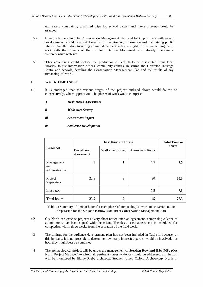
Sir John Barrow Monument, Ulverston: Archaeological Desk-Based Assessment and Walkover Survey 58
For the use of Elaine Rigby Architects and the Ulverston Partnership © OA North: May 2006
and Safety constraints, organised trips for school parties and interest groups could bearranged.
3.5.2 A web site, detailing the Conservation Management Plan and kept up to date with recentdevelopments, would be a useful means of disseminating information and maintaining publicinterest. An alternative to setting up an independent web site might, if they are willing, be towork with the Friends of the Sir John Barrow Monument who already maintain acomprehensive web site.
3.5.3 Other advertising could include the production of leaflets to be distributed from locallibraries, tourist information offices, community centres, museums, the Ulverston HeritageCentre and schools, detailing the Conservation Management Plan and the results of anyarchaeological work.
4. WORK TIMETABLE
4.1 It is envisaged that the various stages of the project outlined above would follow onconsecutively, where appropriate. The phases of work would comprise:
i Desk-Based Assessment
ii Walk-over Survey
iii Assessment Report
iv Audience Development
Phase (times in hours)
Personnel Desk-BasedAssessment
Walk-over Survey Assessment Report
Total Time inhours
Managementandadministration
1 1 7.5 9.5
ProjectSupervisor
22.5 8 30 60.5
Illustrator 7.5 7.5
Total hours 23.5 9 45 77.5
Table 1: Summary of time in hours for each phase of archaeological work to be carried out inpreparation for the Sir John Barrow Monument Conservation Management Plan
4.2 OA North can execute projects at very short notice once an agreement, comprising a letter ofappointment, has been signed with the client. The desk-based assessment is scheduled forcompletion within three weeks from the cessation of the field work.
4.3 The timings for the audience development plan has not been included in Table 1, because, atthis juncture, it is not possible to determine how many interested parties would be involved, norhow they might best be combined.
4.4 The archaeological project will be under the management of Stephen Rowland BSc, MSc (OANorth Project Manager) to whom all pertinent correspondence should be addressed, and in turnwill be monitored by Elaine Rigby architects. Stephen joined Oxford Archaeology North in

Sir John Barrow Monument, Ulverston: Archaeological Desk-Based Assessment and Walkover Survey 59
For the use of Elaine Rigby Architects and the Ulverston Partnership © OA North: May 2006
2005 after spending five years working as a field and environmental archaeologist on urban andrural sites from a range of periods in York, Syria and the United Arab Emirates. All Unit staffare experienced, qualified archaeologists, each with several years professional expertise. It isproposed that Dan Elsworth MA, who has considerable experience of archaeologicalassessments and is resident in Ulverston, undertake the desk-based assessment and walk-oversurvey. Dan joined the Lancaster University Archaeological Unit (now Oxford ArchaeologyNorth) in 1999. Now a Project Supervisor, with special responsibility for building survey andfield survey work, Dan has carried out a large number of desk-based assessments on projects ofvarious sizes, specialising in those in an upland context. Outside of work Dan has been amember of the Morecambe Bay Archaeological Society since 1992, becoming Secretary in1998, and moving to Chair in 2001. He is also a member of the committee for the UlverstonHeritage Centre since 2002.
5. INSURANCE
5.1 OA North has a professional indemnity cover to a value of £2,000,000; proof of which can besupplied as required.
6. BIBLIOGRAPHY
Elsworth, D, 2005, Hoad, Ulverston, Cumbria: Archaeological Landscape Investigation, Unpbl
http://www.sirjohnbarrowmonument.co.uk/index.htm

Sir John Barrow Monument, Ulverston: Archaeological Desk-Based Assessment and Walkover Survey 60
For the use of Elaine Rigby Architects and the Ulverston Partnership © OA North: May 2006
APPENDIX 2: OA NORTH SURVEY LEVELS
This describes the types of survey appropriate for the various stages of archaeologicalevaluation undertaken in advance of development as practised by the LancasterUniversity Archaeological Unit. They are based on survey levels defined by the RoyalCommission on the Historical Monuments of England (RCHME) and are inaccordance with stages of evaluation defined by the Association of CountyArchaeological Curators (ACAO 1993).
Level 1 Survey (Assessment)
Level 1 represents the minimum standard of record and is appropriate to exploratorysurvey aimed at the discovery of previously unrecorded sites. Its aim is to record theexistence, location and extent of an archaeological site. The emphasis for therecording is on the written description, which should record type and period andwould not normally exceed c50 words.
The location and extent of the sites is typically shown on 1:2,500 or 1:10,000 OSmaps as requested by the client. The extent of a site is only defined for sites greaterthan 50m in size and smaller sites are shown as a point. The accuracy of survey is +-10m (8 figure grid ref.) and is undertaken without the use of survey instruments.
This is a rapid level of survey (Site Inspection in project design) undertaken alongsidea desk top study as part of the site assessment (ACAO 1993, 14). It is an initial siteinspection that helps the local planning authority to consider fully the archaeologicalimplications of a planning proposal and also serves as the basis for undertaking andplanning further archaeological work on the site.
Level 2 Survey (Evaluation)
Level 2 survey defines the extent of all surface archaeological features on site inrelation to the main topographic elements (eg field walls) and accurately defines theextent of the overall archaeological site. It is produced in conjunction with a fullobjective and interpretative description of the features.
It is undertaken using Total Station survey equipment and is located usually usingGlobal Positioning Survey (GPS) techniques. The internal accuracy is typically +/-0.05m but is located with respect to the OS National Grid to an accuracy of +/- 1.0m.The survey methodology is designed to facilitate the production of any subsequentLevel 3 survey by reusing the Level 2 survey data along with additional contour data.For reasons of economy and overall flexibility the survey is generated using aComputer Aided Design (CAD) system and output on the Unit's A0 plotter.
This is a basic level of survey undertaken alongside trial excavation work as part ofthe field evaluation (ACAO 1993). It can serve as a mitigation measure for smallersites with poor surface survival and should be applied to sites of some significancethreatened by the development. More complex and archaeologically important sitesrequire a Level 3 survey as mitigation for their destruction. The Level 2 surveydefines an archaeological context for any trial excavations and shows the location ofthe trenches in relation to the surface features. This level is used to assess the
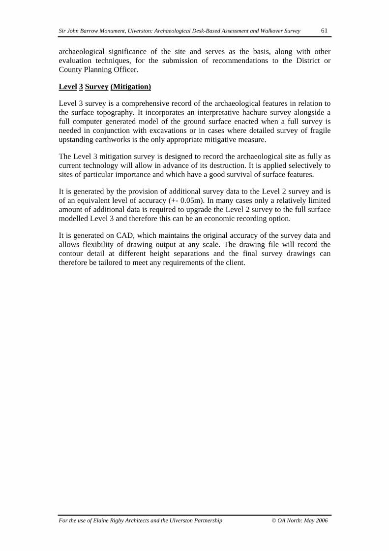
Sir John Barrow Monument, Ulverston: Archaeological Desk-Based Assessment and Walkover Survey 61
For the use of Elaine Rigby Architects and the Ulverston Partnership © OA North: May 2006
archaeological significance of the site and serves as the basis, along with otherevaluation techniques, for the submission of recommendations to the District orCounty Planning Officer.
Level 3 Survey (Mitigation)
Level 3 survey is a comprehensive record of the archaeological features in relation tothe surface topography. It incorporates an interpretative hachure survey alongside afull computer generated model of the ground surface enacted when a full survey isneeded in conjunction with excavations or in cases where detailed survey of fragileupstanding earthworks is the only appropriate mitigative measure.
The Level 3 mitigation survey is designed to record the archaeological site as fully ascurrent technology will allow in advance of its destruction. It is applied selectively tosites of particular importance and which have a good survival of surface features.
It is generated by the provision of additional survey data to the Level 2 survey and isof an equivalent level of accuracy (+- 0.05m). In many cases only a relatively limitedamount of additional data is required to upgrade the Level 2 survey to the full surfacemodelled Level 3 and therefore this can be an economic recording option.
It is generated on CAD, which maintains the original accuracy of the survey data andallows flexibility of drawing output at any scale. The drawing file will record thecontour detail at different height separations and the final survey drawings cantherefore be tailored to meet any requirements of the client.

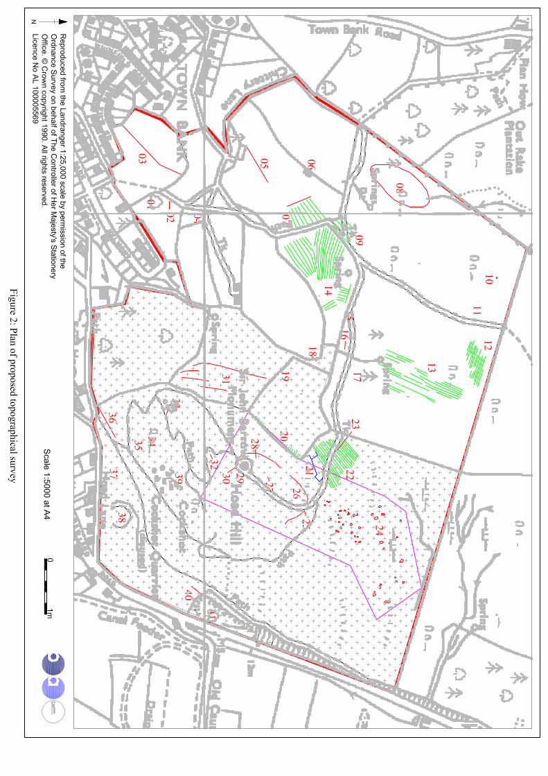

Plate 1: Part of a plan of the commons 1792 (CRO(B) Z1059) showing ‘Outrick’ (sic)and ‘Hoad Hill’
Plate 2: Part of the enclosure plan of 1812 (after Ulverston Local Board 1891)

Plate 3: Detail of a seat (Site 12), a small quarry (Site 13) and paths (Ordnance Survey1852)
Plate 4: Part of a plan showing the footpaths and monument (Ordnance Survey 1894)

Plate 5: Detail of Cockshot quarry (Site 04; Ordnance Survey 1852)

Plate 6: Hoad in 1842, from a painting of St Mary’s Church (after Bardsley 1885)

Plate 7: Hoad and the monument in 1851 (CRO(B) BDX/139)
Plate 8: Part of Yates’ map of 1786 (after Harley 1968, 28). Hoad is the smaller of thetwo hills to the north-east of Ulverston, with the boundary between the enclosed fields
and the common around its south-west side
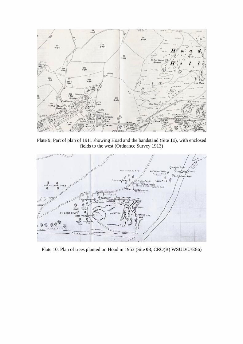
Plate 9: Part of plan of 1911 showing Hoad and the bandstand (Site 11), with enclosedfields to the west (Ordnance Survey 1913)
Plate 10: Plan of trees planted on Hoad in 1953 (Site 03; CRO(B) WSUD/U/E86)

Plate 11: Possible tenter bank (Site 01)
Plate 12: Part of Cockshot quarry (Site 04)

Plate 13: The bandstand (Site 11)
Plate 14: Site of former seat (Site 12)

Plate 15: Small circular enclosure? (Site 14)
Plate 16: Part of an aerial photograph of 1982 showing the large enclosure (Site 15)and part of the possible cairnfield (Site 24; Ordnance Survey 1982)

Plate 17: Aerial photograph showing the large enclosure (Site 15) and the two smallerenclosures (Site 26) with a scar cut through the bank of the large enclosure, probably
created during the construction of the monument (Quartermaine 2004a)
Plate 18: Aerial photograph showing the large enclosure (Site 15; Quartermaine2004b)

Plate 19: Northern part of the large enclosure (Site 15)
Plate 20: Southern part of the large enclosure (Site 15)

Plate 21: Hollow cut into the north-west part of the bank forming Site 15
Plate 22: Graffiti (Site 18)

Plate 23: Entrance to the Sir John Barrow Monument (Site 19)
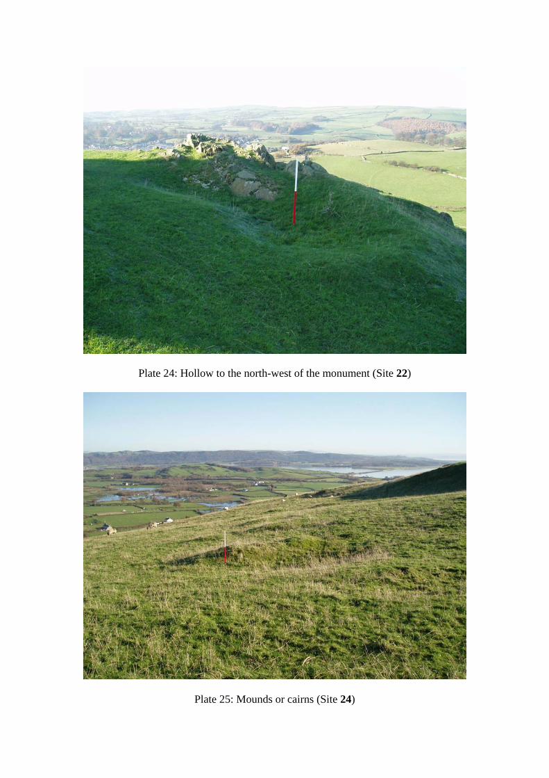
Plate 24: Hollow to the north-west of the monument (Site 22)
Plate 25: Mounds or cairns (Site 24)

Plate 26: Exposed stone in one of the possible cairns (Site 24)
Plate 27: General view to north-west showing the ridge and furrow (Site 25), smallenclosures (Site 26) and quarry (Site 27)

Plate 28: The southernmost of the two small enclosures (Site 26)
Plate 29: The northernmost of the two small enclosures (Site 26)

Plate 30: Postcard of Hoad from c1895 looking east, showing the possible tenterbanks to the west of the study area (after Frith nd)