site characterisation in the swedish crystalline rock
TRANSCRIPT

SVENSK KÄRNBRÄNSLEHANTERING
Site characterisation in the Swedish crystalline rock before and after
submitting the construction licence
Peter Wikberg

SVENSK KÄRNBRÄNSLEHANTERING
From the study site investigations 1977-1985 From the underground test facilities
2018-12-07 2
Where to learn and how to learn about the Swedish granitic rock

SVENSK KÄRNBRÄNSLEHANTERING 2018-12-07 3 Sidfot
Stripa Mine Project 1977-1992
• Development of characterization techniques and integrated characterization and modeling of site data
• Fracture flow and transport modeling • Basis for understanding of channeling and its importance for radionuclide transport
• Basic designs of engineered barriers (buffer, backfill and plugs) and basic understanding of their performance
• Successful international cooperation • Initiation of Task Force on groundwater flow and transport • Initiation of Task Force on Sealing materials and
techniques • Knowledge transfer
• Experience essential for later work at Äspö HRL and other underground laboratories

SVENSK KÄRNBRÄNSLEHANTERING 2018-12-07 Sidfot
Äspö Hard Rock Laboratory 1986-
The purpose of Äspö HRL • Provide input to performance assessments
• in situ data from a previously non-disturbed rock mass • process understanding • assessment of model validity
• Develop, test and evaluate methods for investigation, repository construction and waste emplacement
• Provide experience and training of staff
• Information and confidence building
SVENSK KÄRNBRÄNSLEHANTERING
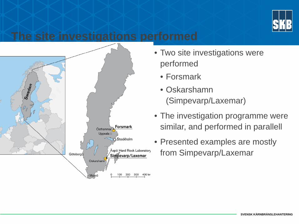
The site investigations performed • Two site investigations were
performed • Forsmark • Oskarshamn
(Simpevarp/Laxemar)
• The investigation programme were similar, and performed in parallell
• Presented examples are mostly from Simpevarp/Laxemar

SVENSK KÄRNBRÄNSLEHANTERING 6
The main activity ”Investigations” - Characterization of the geosphere and the biosphere
The work at each site was divided in two main groups:
• Investigation; producing primary data
• Site modelling; producing site descriptions

SVENSK KÄRNBRÄNSLEHANTERING 7
The programme development 1
• An important issue for the site investigation programme development was to specify what information/data is needed
• The information/data users were • Safety assessment (long term safety) • Design and enginering (layout , stability) • Environmental Impact statement • ”General (geoscientific) understanding”
• Strategies • dividing the task in diciplines, • performance in a step-wise procedure, • integration between diciplines, • interaction with the data/model users
SVENSK KÄRNBRÄNSLEHANTERING 8
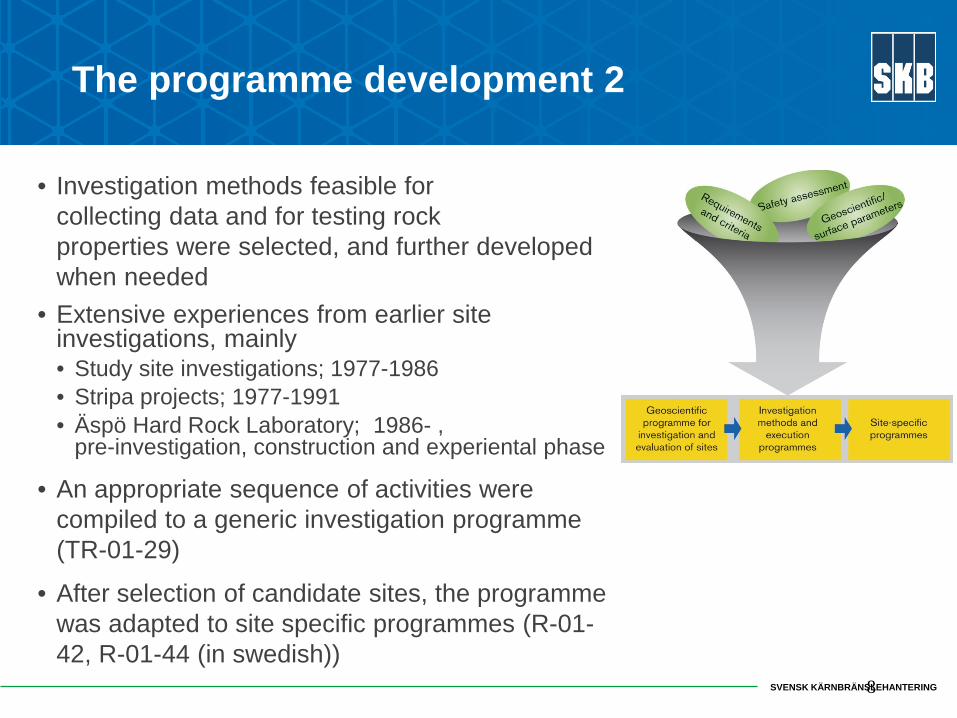
The programme development 2
• Investigation methods feasible for collecting data and for testing rock properties were selected, and further developed when needed
• Extensive experiences from earlier site investigations, mainly • Study site investigations; 1977-1986 • Stripa projects; 1977-1991 • Äspö Hard Rock Laboratory; 1986- ,
pre-investigation, construction and experiental phase
• An appropriate sequence of activities were compiled to a generic investigation programme (TR-01-29)
• After selection of candidate sites, the programme was adapted to site specific programmes (R-01-42, R-01-44 (in swedish))

SVENSK KÄRNBRÄNSLEHANTERING
Some information of importance for the characterisation
Geology
• Rock type (distribution and properties)
• Major deformation zones, dividing the rock mass into rock blocks (occurence and character)
• Fracturing within the rock blocks (frequency and character)
Rock mechanics and thermal properties
• Properties of intact rock and fractures
• Rock stress (magnitude and orientation)
• Thermal conductivity
Hydrogeology
• Hydraulic conductivity of rock mass
• Transmissivity of deformation zones
• Interaction between bedrock and soil
Hydrogeochemistry
• Water chemistry
• Fracture minerals
Transport properties
9

SVENSK KÄRNBRÄNSLEHANTERING 10

SVENSK KÄRNBRÄNSLEHANTERING 11

SVENSK KÄRNBRÄNSLEHANTERING
12
Siting factors

SVENSK KÄRNBRÄNSLEHANTERING
Site characterisation and
site selection

SVENSK KÄRNBRÄNSLEHANTERING
Site characterisation in Sweden for a repository for spent nuclear fuel
Candidate sites: Forsmark and Laxemar-Simpevarp Investigations and modelling work: 2002-2008 Site selection: 2009

SVENSK KÄRNBRÄNSLEHANTERING
Sites
• Forsmark site • flat topography • below the highest shoreline at last
deglaciation, 6 mm uplift per year • metamorphosed medium-grained
granite to granodiorite (metagranite) formed between 1,900 and 1,850 million years ago
• Laxemar site – relatively flat topography – below the highest shoreline at
last deglaciation, 1mm uplift per year
– granite and quartz monzodiorite, some 1,800 million years old
SVENSK KÄRNBRÄNSLEHANTERING
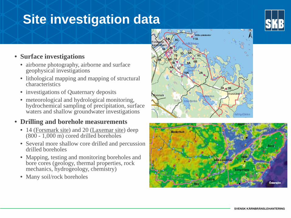
Site investigation data
• Surface investigations • airborne photography, airborne and surface
geophysical investigations • lithological mapping and mapping of structural
characteristics • investigations of Quaternary deposits • meteorological and hydrological monitoring,
hydrochemical sampling of precipitation, surface waters and shallow groundwater investigations
• Drilling and borehole measurements • 14 (Forsmark site) and 20 (Laxemar site) deep
(800 - 1,000 m) cored drilled boreholes • Several more shallow core drilled and percussion
drilled boreholes • Mapping, testing and monitoring boreholes and
bore cores (geology, thermal properties, rock mechanics, hydrogeology, chemistry)
• Many soil/rock boreholes

SVENSK KÄRNBRÄNSLEHANTERING
Evaluation of field data – Site Descriptive Model
• Synthesis • geology, rock mechanics, thermal properties,
hydrogeology, hydrogeochemistry and surface system
• Traceability • From field investigation to 3D interpretation
• Assessment of uncertainties and confidence • Used by Design and Safety Assessment • Usually a new version after each data freeze
Geological description
Rock mechanics
Thermal Hydrology and Hydrogeology
Hydrogeo-chemistry
Transportproperties
Ecosystems
Geological description
Rock mechanics
Thermal Hydrology and Hydrogeology
Hydrogeo-chemistry
Transportproperties
Ecosystems
Geological description
Rock mechanics
Thermal Hydrology and Hydrogeology
Hydrogeo-chemistry
Transportproperties
Ecosystems

SVENSK KÄRNBRÄNSLEHANTERING
Method-specific interpretation
“Datawash”, computations
Integrative, discipline specific interpretation
Integrative, iterative
Cross disciplinary
interpretation
Investigations
Database Primary data (measured data, calculated values and conceptual assumptions)
Interpretation of geometries and properties
Sitedescriptive model
Geology
Rockmechanics
Ecosystem Transportation
properties
Hydrogeology
Hydrogeo- chemistry
Thermal properties
Geometry (Structural geology)
Site description
Site Descriptive Modelling

SVENSK KÄRNBRÄNSLEHANTERING
QA and Peer Review
• Clearance procedures for entering data into Site database (SICADA)
• Internal Peer Review • documented (templates) • SKB staff • independent expert group
• International review teams set up by the authorities • review all published reports • Tracking Issue List
• Seminars held about two times every year.
All these actions essential!

SVENSK KÄRNBRÄNSLEHANTERING
Confidence Assessment
• Confidence assessment protocols
• Aim at identifying and quantifying uncertainty • including alternatives
• Explore various origins of uncertainty
• Procedure • experts first answer • assessed and revised in a workshop with
all experts
• Feedback to continued investigations
• Documented
SVENSK KÄRNBRÄNSLEHANTERING
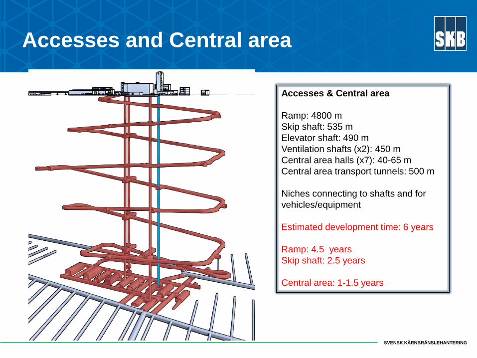
Accesses and Central area
Accesses & Central area Ramp: 4800 m Skip shaft: 535 m Elevator shaft: 490 m Ventilation shafts (x2): 450 m Central area halls (x7): 40-65 m Central area transport tunnels: 500 m Niches connecting to shafts and for vehicles/equipment Estimated development time: 6 years Ramp: 4.5 years Skip shaft: 2.5 years Central area: 1-1.5 years

SVENSK KÄRNBRÄNSLEHANTERING
Data needs and requirements

SVENSK KÄRNBRÄNSLEHANTERING
Pilot hole investigations MWD Core logging (tentative) Borehole deviation OPTV + geophysics Boremap Flow logging Selective hydraulic tests Hydrochemical sampling
Probe hole investigations MWD Hydraulic characterisation FLS→ grouting input
Geologic mapping In situ and remote mapping, using different cut-off fracture lengths
Test of rock strength LHT test Rock stress measurements LVDT/convergence HF
Hydrogeochemical and microbial sampling Water inflow Monitoring of gw levels, flow and chemistry in boreholes from surface and underground
Key investigations

SVENSK KÄRNBRÄNSLEHANTERING
• Enhance the existing database for the bedrock with new data from underground investigations and monitoring.
• Identify responses in monitoring boreholes from rock excavations and hydraulic tests.
• Input to key issues and requirements.
• Evaluate the validity of and confidence in SDM-Site
Investigations and monitoring

SVENSK KÄRNBRÄNSLEHANTERING
Key issues and requirements
• Investigations carried out throughout the excavation of the accesses and Central area – and in conjunction with rock excavation cycle.
• Investigations and measurements related to Post closure safety will be given a high priority during construction.
• Sufficient time for investigations is an important prerequisite for planning the rock excavation cycle and production.

SVENSK KÄRNBRÄNSLEHANTERING
Validity of and confidence in SDM-Site
• Compare data sets – check if data/models from surface based boreholes match those from underground pilot holes.
• Compare model prediction and outcome – check whether modelled geometries and properties from SDM-Site are correct:
• Stratigraphy and thickness of Quaternary deposits. • Location and geometry of deterministically modelled DZ where these can
be expected to intersect the accesses and Central area • Statistics of fracture transmissivity of flowing fractures in underground pilot
holes in relation to statistics used in SDM-Site for DFN modelling of flowing fractures
• Rock stress orientation and magnitude vs. depth • Spatial distribution of groundwater composition vs. depth.
• Ongoing monitoring of groundwater levels in boreholes important for baseline and the evaluation of pressure responses.

SVENSK KÄRNBRÄNSLEHANTERING
• Spiral shaped ramp with 4.5 revolutions, → opportunity to investigate anisotropy and statistical geoinformation.
• Test, update and fine-tune investigation strategies and methods.
• Provide input to rock excavation (reinforcement measures) and design (stress orientation and magnitude).
• Prove that the excavation technique fulfils the Technical Design Requirements related to EDZ before ramp reaches -370 m (in a separate niche). • Probe hole drilling and associated investigations (e.g. FLS) • Pilot hole drilling and assoc. investigations (20% of the ramp). • In situ stress measurements in connection to niches. • Measurement of water inflow to the ramp every 150-200 m in weirs. • Hydrogeochemical and microbial sampling and monitoring (in niches)
Investigations in the ramp

SVENSK KÄRNBRÄNSLEHANTERING
Strategy for pilot hole drilling in the ramp
• Understanding of expected rock conditions where the ramp will pass
• Rock excavation requires information regarding: water-bearing fractures when passing through DZ judged to require reinforcement.
• Pilot hole drilling ~20% of the total ramp length~1000 m: • Confirm and investigate boundary between fracture domains • Characterise intercepts with deterministically modelled DZ • Provides data for DFN-modelling • Provide input to construction and design • Hydraulic tests, geophysical logging and (hydrogeochemical sampling)

SVENSK KÄRNBRÄNSLEHANTERING 2018-12-07 29 Sidfot
Thank you for your attention!
The Forsmark site