site name: nw 58th street landfill · 2 ii. site description and history general setting and land...
TRANSCRIPT

Site name: NW 58th Street LandfillEPA ID: FLD980602643
Region: 04 State: Florida City/County: Miami-Dade County
LTRA*(highlight): Y N3/6/95
Construction completion date:
Fund/PRP Lead: PRPNPL status: Deleted from Final NPL
Lead agency: EPA, Region 4
Who conducted the review (EPA Region, state, Federal agencies or contractor): US ArmyCorps of Engineers, Jacksonville District
Date review conducted: From: 5/15/00 To: 9/15/00Date(s) of site visit: 6/7/00
Whether first or successive review: Successive Review
Circle: Statutory PolicyDue date: Jan 99
Trigger for this review (name and date): Five years from completion of previous reivew (Jan 94)
Recycling, reuse, redevelopment site (highlight): Y N
Deficiencies:
A list of deficiencies were identified. See attached report Section VII: Deficiencies.
Recommendations:
Recommendations are listed in the attached report, Section VIII: Recommendations.
Protectiveness Statement(s):
All elements of the remedy selected in the Record of Decision for the NW 58th Street Landfill have been putin place, are functioning properly, and remain protective of human health and the environment.
Other Comments:
The deficiencies noted during this review are not immediate threats to the protectiveness of the remedy.Once these items are investigated and corrected, long-term protectiveness, operation, and site safety willbe improved.

EPA Five-Year Review Signature Cover
Preliminary Information
Site name: NW 58th Street Landfill EPA ID: FLD980602643Region: 04 State: Florida City/County: Miami-Dade CountyLTRA* (highlight): Y N Construction completion date: 3/6/95Fund/PRP Lead: PRP NPL status: Deleted from Final NPLLead agency: EPA, Region 4Who conducted the review (EPA Region, state, Federal agencies or contractor):US Army Corps of Engineers, Jacksonville DistrictDates review conducted: From: 5/15/00 To: 9/15/00 Date(s) of site visit: 6/7/00Whether first or successive review: Successive Review
Circle: Statutory PolicyDue date: Jan 99
Trigger for this review (name and date): Five years from completion of previous review (Jan 94)Recycling, reuse, redevelopment site (highlight): Y N
Deficiencies:
A list of deficiencies were identified. See attached report Section VII: Deficiencies.
Recommendations:
Recommendations are listed in the attached report, Section VIII: Recommendations.
Protectiveness Statement(s):
All elements of the remedy selected in the Record of Decision for the NW 58th Street Landfill have been putin place, are functioning properly, and remain protective of human health and the environment.
Other Comments:
The deficiencies noted during this review are not immediate threats to the protectiveness of the remedy.Once these items are investigated and corrected, long-term protectiveness, operation, and site safety willbe improved.
Signature of EPA Regional Administrator or Division Director, and Date
Signature Date
Name and Title
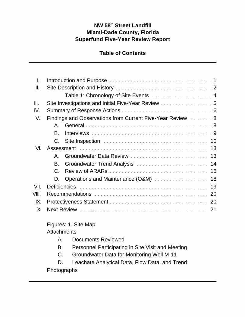
NW 58th Street LandfillMiami-Dade County, Florida
Superfund Five-Year Review Report
Table of Contents
I. Introduction and Purpose . . . . . . . . . . . . . . . . . . . . . . . . . . . . . . . . . . 1 II. Site Description and History . . . . . . . . . . . . . . . . . . . . . . . . . . . . . . . . 2
Table 1: Chronology of Site Events . . . . . . . . . . . . . . . . . . . . 4 III. Site Investigations and Initial Five-Year Review . . . . . . . . . . . . . . . . . 5 IV. Summary of Response Actions . . . . . . . . . . . . . . . . . . . . . . . . . . . . . . 6 V. Findings and Observations from Current Five-Year Review . . . . . . . 8
A. General . . . . . . . . . . . . . . . . . . . . . . . . . . . . . . . . . . . . . . . . . . 8B. Interviews . . . . . . . . . . . . . . . . . . . . . . . . . . . . . . . . . . . . . . . . 9C. Site Inspection . . . . . . . . . . . . . . . . . . . . . . . . . . . . . . . . . . . 10
VI. Assessment . . . . . . . . . . . . . . . . . . . . . . . . . . . . . . . . . . . . . . . . . . . 13A. Groundwater Data Review . . . . . . . . . . . . . . . . . . . . . . . . . . 13B. Groundwater Trend Analysis . . . . . . . . . . . . . . . . . . . . . . . . 14C. Review of ARARs . . . . . . . . . . . . . . . . . . . . . . . . . . . . . . . . . 16D. Operations and Maintenance (O&M) . . . . . . . . . . . . . . . . . . 18
VII. Deficiencies . . . . . . . . . . . . . . . . . . . . . . . . . . . . . . . . . . . . . . . . . . . 19VIII. Recommendations . . . . . . . . . . . . . . . . . . . . . . . . . . . . . . . . . . . . . . 20 IX. Protectiveness Statement . . . . . . . . . . . . . . . . . . . . . . . . . . . . . . . . . 20 X. Next Review . . . . . . . . . . . . . . . . . . . . . . . . . . . . . . . . . . . . . . . . . . . 21
Figures: 1. Site MapAttachments
A. Documents ReviewedB. Personnel Participating in Site Visit and MeetingC. Groundwater Data for Monitoring Well M-11D. Leachate Analytical Data, Flow Data, and Trend
Photographs

1
NW 58th Street LandfillMiami-Dade County, Florida
Superfund Five-Year Review Report
I. INTRODUCTION AND PURPOSE
General. During May and June, 2000, the U.S. Army Corps of Engineers, JacksonvilleDistrict (USACE), on behalf of the U.S. Environmental Protection Agency, Region 4 (EPA),conducted a Five-Year Review of the remedy implemented at Northwest 58th StreetLandfill Site (NW 58th Street Landfill) in Miami-Dade County, Florida. This reportdocuments the results of that review. The purpose of Five-Year Reviews is to determinewhether the remedial actions at a site remain protective of human health and theenvironment. The methods, findings, and conclusions of reviews are documented inFive-Year Review reports. In addition, any deficiencies identified during the review will bepresented, along with recommendations to address them.
Authority. This review is required by statute. Section 121 of the ComprehensiveEnvironmental Response, Compensation, and Liability Act of 1980 (CERCLA), asamended by the Superfund Amendments and Reauthorization Act of 1986 (SARA), andSection 300.430 (f) (4) (ii) of the National Oil and Hazardous Substance Contingency Plan(NCP), require that periodic reviews be conducted at least every five years for sites wherehazardous substances, pollutants or contaminants remain at the site above levels thatallow for unlimited use and unrestricted exposure following the completion of all remedialactions.
This is the second Five-Year Review for the NW 58th Street Landfill. The trigger for thisstatutory review is the passage of 5 years since completion of the previous Five-YearReview. All elements of the remedy for the site have been completed; the only on-goingactions at the site are operations and maintenance activities intended to maintain theintegrity of the remedy, and long-term monitoring to evaluate the effectiveness of theremedy.
Local Repository. This review will be placed in the site files and local repository for NW58th Street Landfill. The repository is located at the Miami-Dade County Department ofEnvironmental Resources Management, 33 S.W 2nd Avenue, Suite 800, Miami, FL 33130.
Note: Throughout this report, text has been extracted, summarized, and/or edited from thefollowing Northwest 58th Street Landfill documents: EPA Record of Decision (ROD) datedSeptember 21, 1987 and the ROD abstract, the Remedial Action (RA) Report, the ClosureSupport Documents and Applications, the January 1994 Five-Year Review, and the RODfor the Biscayne Aquifer Sites (September 16, 1985).

2
II. SITE DESCRIPTION AND HISTORY
General setting and land use. The NW 58th Street Landfill site (landfill) is located inMiami-Dade County, Florida, approximately five miles northwest of the Miami InternationalAirport, or about 2 miles west of the City of Hialeah and one mile south of the town ofMedley. The site covers about one square mile (640 acres), of which approximately 250acres were used for disposal. The landfill is generally bounded by NW 87th and NW 97th
Avenues to the east and west, respectively, NW 58th Street to the south, and theright-of-way for NW 74th Street to the north. Adjacent land use includes rock pit mining tothe north with an active sanitary landfill beyond that, and warehousing/light industrialproperties to the east. Within the southern limits of the site, a row of buildings along thenorth side of NW 58th Street supports local government functions including Public WorksOperations and Maintenance, and law enforcement training. The land beneath thesefacilities served as the early site of the landfill, but it did not require remediation as part ofthe site remedy. South of NW 58th Street is a country club interspersed with residentialareas, and to the west is the county’s resource recovery (waste incinerator) plant andundeveloped land.
Land to the east and south has been extensively developed, such that further developmentor near-term redevelopment is not realistic. About two to three miles to the southwest, alarge area of new housing is being constructed. As prime land becomes less available,pressures will exist to advance housing or commercial development closer to the NW 58th
Street site and the adjacent incinerator. Likewise, the quarry operation to the north has theappearance of a large open lake, and pressures will exist to develop that property forresidential or recreational purposes. A 35 acre wetland area within the one square milelandfill site provides habitat to endangered species and other native wildlife. Under theterms of the landfill closure, the Miami-Dade County Department of Solid WasteManagement (DSWM) is to sustain existing wetlands at the site; additionally, wetlands areregulated under federal law, so this aspect of current land use would not change withoutconsiderable regulatory involvement.
History. The site was operated as a landfill from 1952 until 1982, serving as DadeCounty’s principal landfill during that time. DSWM’s Landfill Closure Application describesthe waste as “municipal solid waste, trash, liquids, and other wastes. Approximately 65%of the wastes disposed at the site is...garbage from domestic and industrial sources, andthe remaining 35% is made up of street debris, discarded appliances, liquid trash, andother materials.”
Waste material was placed in shallow, unlined trenches excavated to caprock, and due tothe high ground water table in the area, the wastes often became saturated, therebyreleasing contamination into the groundwater. Additionally, wastes were burned on siteuntil 1960 to achieve volume reduction. Although the burning was a common landfillpractice for that time, it influenced the nature of contaminants and rate

3
at which they entered the groundwater. Wastes placed in the landfill increased substantiallyover the years, from approximately 60,000 tons per year in 1952, to more than 1 milliontons per year at the time the landfill ceased municipal waste operations in October, 1982.
Natural physical setting. Prior to development of the landfill, the natural topography of thesite was generally flat, with an average elevation of 5 to 10 feet above mean sea level. Thedesign drawings for the landfill cap over the main waste area (Zone 1) reflect apre-construction maximum elevation just over 75 ft.; following completion of the cap, thehighest waste mound was surveyed to be just under 71 ft. Two other waste mounds withinthe site have final elevations on the order of 50-52 ft.
The major surface drainage features in the area are man-made; feeder canals closest tothe landfill (the 58th Street and Dressel Canals) drain eastward into the Florida East CoastCanal, which in turn empties into the primary drainage feature, the Miami Canal/MiamiRiver, about 2 miles east of the site. The Snapper Creek Extension Canal, about 1.5 mileswest of the landfill, also flows eastward into the Miami Canal and is taken to be the localrecharge boundary for the Biscayne Aquifer in that area. Precipitation is typical for southFlorida; annual rainfall averages 60 inches, occurring primarily from July throughNovember.
The Biscayne Aquifer, the sole-source drinking water aquifer for the area, lies partly belowthe landfill. The aquifer exists in geologic formations of limestone and sand to a depth ofabout 80 ft., at which point it is confined by a layer of relatively impermeable silts and clays.Seasonal fluctuations raise the groundwater table to within 3 ft. of the surface, permittingthe groundwater to contact and saturate the lowest wastes within the landfill. Regional flowof the Biscayne Aquifer is from west to east at an average velocity of 1.5 ft./day. Threemajor well fields in the area tap the aquifer for potable water supplies: Preston and MiamiSprings/ Hialeah, about 2 to 3 miles to the east and southeast, and the Northwest well fieldwhich is located about 4 miles west of the site. It is understood that the effects of the canalsand the variable pumping rates at the 3 well fields have, and continue, to influence theaquifer’s regional flow direction on a local scale.
Relationship to Other NPL Sites. In the mid-1970s, a study by the U.S. Geological Surveyreported that leachate from the NW 58th Street Landfill had infiltrated the Biscayne Aquiferand was moving in an easterly direction (i.e., toward the municipal well fields) with thenatural ground-water movement. Additional studies followed which considered thegroundwater contamination problem arising from several possible sources, including thelandfill.
In October 1981, the US EPA proposed three sites for the National Priorities List basedon suspected contributions to contamination of the Biscayne Aquifer: the Varsol Spill Siteat Miami International Airport, the Miami Drum Site, and the NW 58th Street

4
Landfill. Because of potentially overlapping impacts from these sites, they were groupedtogether and additional data gathered as part of a comprehensive Remedial Investigationfor an aquifer study area of about 80 square miles. Ultimately, individual Records ofDecision (RODs) were signed for each of the named sites, and a fourth ROD was signedon September 16, 1985 which addressed the broader area-wide issue of aquifercontamination from multiple sources. Remedies protective of the public water supply wereselected in the Biscayne Aquifer ROD and have been successfully implemented. ThatROD may be consulted for a more extensive discussion of Biscayne Aquifer issues.
The chronology of the major actions at the NW 58th Street Landfill is summarized below.
Table 1: Chronology of Site Events.
Event Date
Landfill operation begin 1952
USGS study reports groundwater contamination to Biscayne Aquifer 1975
FDEP and Dade County sign Consent Order: Accept no wastesafter Aug 1, 1981
June 1979
EPA proposes 3 Biscayne Aquifer Sites for NPL October 1981
Landfill ceases municipal waste operations October 1982
NW 58th Street Landfill formally listed on NPL October 11, 1983
Record of Decision signed for Biscayne Aquifer September 16, 1985
ROD signed for NW 58th Street Landfill September 21, 1987
Municipal water supply extended to private well users January 1989
Consent Decree filed, US (EPA) vs. Metro Dade County January 20, 1989
Laechate Interceptor Trench installed on east side of landfill March 1989
Construction start for Landfill Cap August 1, 1991
Hurricane Andrew strikes South Florida August 24, 1992
Construction resumes following Hurricane Andrew October 1993
Initial Five-Year review January 1994 report date
Construction completion March 6, 1995
Final Closure Report September 29, 1995
Notice of Permit (Groundwater Monitoring) Decemder 14, 1995
Landfill is recognized as Officially Closed by FDEP January 2, 1996
NW 58th Street Landfill removed from NPL October 11, 1996

5
III. SITE INVESTIGATIONS AND INITIAL FIVE-YEAR REVIEW
Groundwater contamination was attributed to the NW 58th Street Landfill site in externalreports as early as the 1975 UGGS study. In the early 1980s, water quality issuesescalated for the Biscayne Aquifer, the sole source drinking water supply for themetropolitan Miami area. For this issue, the EPA’s CERCLA study process took on abroader scope which considered multiple, unrelated sources of contamination. In 1985, theEPA signed an area-wide Record of Decision (ROD) for the Biscayne Aquifer sitesrequiring groundwater to be pumped at the Miami Springs and Preston well fields for thedual purposes of water supply and contaminant removal, followed by treatment with airstripping to remove contaminants from the potable water. In 1986, an EndangermentAssessment identified the following 8 elements and chemicals as site-specificgroundwater Contaminants of Concern (CoCs) for the NW 58th Street Landfill: arsenic,chromium, zinc, benzene, chlorobenzene, 1,1,2,2-tetrachloroethane, trichloroethene, andvinyl chloride. The CoCs were deemed to pose a threat to human health based on adrinking water exposure pathway. Groundwater flows near the landfill are, in general terms,to the south-east. Approximately 60 (sixty) wells were identified in the industrial andresidential areas to the east of the landfill, including 20 that provided residentialconnections. Continued use of these wells would allow a potential exposure pathway forcontaminants to be completed.
Initial Five-Year Review. The site-specific ROD for the NW 58th Street Landfill required atwo-part remedy: landfill closure including leachate management, and conversion of watersupply by private wells to municipal water service. Section IV will provide more detail onimplementation of the two-part remedy. The major component of the closure was cappingof the landfill, which was completed in March, 1995.
During the fall of 1993, while the cap was under construction, EPA prepared the initialFive-Year Review for the site. At the time of the Five-Year Review, the municipal waterconnection had been completed; also, the leachate collection trench, a major element ofthe leachate management strategy, had also been completed. Fact-finding for the reviewincluded two site visits, plus interviews with representatives from the Florida Department ofEnvironmental Protection (FDEP), the Miami-Dade County Department of EnvironmentalResource Management (DERM), and DSWM.
The following statements briefly summarize the initial Five-Year Review.
Observations from site visits: (1). Leachate seeps exist along the western edge ofthe mound in Zone 1 (i.e., the main mound of landfilled materials located in theeastern end of the site). (2). There is no fence along the southern boundary. (3).Past herbicidal treatments had killed many melaleuca trees in the north-centralwetland area, but others were still thriving along the perimeter. New melaleuca treeswere growing in a wetland area in the
6
northeast corner of the site. (4). Closure activity had been delayed at least 6 monthsdue to contract negotiations between DSWM and the construction contractor.
Interviews: (1). FDEP indicated some concern that ammonia levels were elevatedin monitoring wells north of the site, and that some monitoring wells had beendecommissioned during construction. FDEP also believed that the leachatecollection trench should be extended along the northeast part of the site. (2). DERMwas satisfied with progress on the landfill closure and was not aware of theammonia and monitoring well concerns voiced at FDEP. (3). DSWM addressed theFDEP concerns: monitoring wells lost to construction would have to be reinstalled;DSWM hoped that the closure system would eliminate the seeps, and thatpost-closure monitoring would be used to determine the need for extension of theleachate trench.
Non-compliance items: Landfill closure had not yet been attained in accordancewith the applicable state regulation , FAC 17-7 (i.e., Chapter 17-7 of the FloridaAdministrative Code). At that time, construction completion was scheduled for June17, 1994.
Recommendations: Attain complete closure, in accordance with Closure Permit SF13-175312 issued by the State of Florida. Also, DSWM should address the issue ofleachate trench extension raised by FDEP. With respect to technology, EPAcontinued to recommend containment as the most effective remedy for municipallandfills.
Protectiveness: The January 1994 Five-Year Review concluded that the remediesselected in the ROD continued to be protective of human health and theenvironment, complied with the Federal and State applicable or relevant andappropriate requirements for the site, and was cost effective.
IV. SUMMARY OF RESPONSE ACTIONS
NW 58th Street Landfill: The September 21, 1987 site-specific ROD mandated a 2-partremedy which has been implemented as 3 separate steps. The first part was connection ofthe private well users to the public water supply which was completed in January, 1989.
The second part of the remedy was closure of the landfill in accordance with the technicalrequirements of the applicable state regulation at the time of the ROD (FAC Chapter 17-7(1985), which was subsequently re-numbered Chapter 62 of FAC ) and with the relevantand appropriate EPA guidance document (Covers for Uncontrolled Hazardous WasteSites, EPA/540/2-85/002). Landfill closure per FAC 17-7 required leachate management,to be achieved through a combination of storm-water

7
management, grading, drainage control, leachate collection, and capping. Additionally,FAC 17-7 and Chapter 62-701 further require long-term monitoring of groundwater quality,Operation and Maintenance of the remedy, plus control of gas migration and odor, ifnecessary. While much of the leachate control is inherent in the design and construction ofthe landfill cap, the leachate interceptor trench (LIT) can function independently from thecap. Based on the desire to address leachate as early as possible, the LIT wasconstructed low in the waste mass on the east side of Zone 1, and was completed inMarch, 1989.
The municipal water connections and installation of the LIT were successfully completedprior to the initial Five-Year Review. The remaining element of the remedy, capping of thelandfill and regulatory closure, was in progress at the time of the initial Five-Year Review;therefore, this review will highlight that final element of the remedy.
After signing the Record of Decision, the EPA, FDEP, DERM and DSWM entered intonegotiations governing the terms by which the ROD would be implemented. Thosenegotiations culminated in a Consent Decree filed in January, 1989. On January 23, 1990DSWM submitted its application for landfill closure and the associated design. In additionto a 20 acre impermeable cap over the top (i.e., everything above an elevation of 60 ft,mean sea level) of the Zone 1 mound, the proposed design called for a 2 foot thick layer ofcrushed, compacted limerock to be placed over the remaining 70 acres of the Zone 1mound and over other, less significant waste areas of the site. The design analysis hadshowed that the compacted limerock would provide the necessary physical barrier tohuman contact, provide some degree of protection against groundwater infiltration, andreduce construction costs and long term maintenance costs, without contributingsignificantly to leachate generation.
Following resolution of design and permit issues, the construction contract was negotiatedand awarded. On August 1, 1991 construction began on the landfill cap, with a scheduled16 month performance period. Work began with the clearing and grubbing of densevegetation from the Zone 1 mound, then the subgrade was reshaped to the generalcontours which would facilitate final drainage. In June 1992, a minimum 2-inch lift oflimerock was placed on top of the mound as a leveling course, followed by placement ofnon-woven geotextile. The next layer completed for the 20 acre cap on the top of Zone 1was the 12-inch sand layer.
Installation of the impermeable 30 mil PVC membrane was advancing well until August 24,1992 when Hurricane Andrew struck south Florida. Extensive damage to the cap resulted.Sections of the 12 acres of installed membrane were damaged beyond repair; much of the12-inch sand layer was extensively eroded, and the underlying geofabric would requirereplacement over 1.8 acres. Construction personnel and equipment from across thesoutheast U.S. were pressed into the disaster recovery effort, at the expense of lowerpriority work such as the landfill closure. Ultimately, the hurricane necessitated that DSWMrenegotiate the terms of

8
the construction contract and consent order before work resumed in October 1993.
Rather than attempt to salvage the damaged cap, re-grading, placement of new barriersoils, and installation of a completely new PVC impermeable membrane over thedamaged cap was determined to be the most cost-effective way to complete the work.Before the resumed work reached completion, the term of the construction contractexpired, and Miami-Dade county assumed the role of the construction contractor. Thecapping of the landfill, including capping of selected areas with compacted limerock,underwent its final inspection in January 1995.
On March 24, 1995, DSWM released the Remedial Action (or As-Built) Report whichsummarized the process of constructing the landfill cap. In a Superfund Final CloseoutReport dated September 29, 1995, the EPA documented the determination by EPA andFDEP that the Remedial Action was operational and functional, and apart from long-termOperation and Maintenance (O&M), that no further Superfund action is necessary toprotect human health and the environment. On October 11, 1996, the NW 58th StreetLandfill site was formally removed from the National Priorities List.
As required by the applicable state regulation (FAC 17-7) under which the landfill wasclosed, DSWM is performing long-term O&M at the site in accordance with the currentFAC 62-701. Several activities are ongoing under the general heading of long-term O&M:monitoring of groundwater, landfill gas and leachate; inspection, maintenance and repair ofthe cap system; leachate collection and disposal, and wetland maintenance. Maintenanceof ancillary items such as signs, fences, and access roads is performed on an as-requiredbasis.
Biscayne Aquifer Response Action: The September 16, 1985 Record of Decision for theBiscayne Aquifer study sites required that air-stripping be added to the county's potablewater treatment train. Installation of air strippers was successfully completed at the Prestonand Miami Springs water treatment plants in the 1992, and use of that treatment processcontinues to this date.
V. FINDINGS AND OBSERVATIONS FOR CURRENT FIVE-YEAR REVIEW
A. General This Five-Year Review consisted of the following activities: a review ofrelevant documents (see Attachment A, Documents Reviewed); interviews with landfillowner and involved regulatory personnel; a site inspection; and preparation of theFive-Year Review report. The completed report will be filed with EPA Region IV andplaced in the local information repository.

9
B. Interviews
EPA Region IV Remedial Project Manager, Ms. Pamela J. Langston Scully. Ms. Scullywas contacted in March 2000 during the initial planning phase for this Five-Year Review;extensive dialogue took place during the site visit, and was followed by additionaldiscussion during preparation of the report. Ms. Scully provided background information onthe NW 58th Street Landfill, a history of site activities, and a list of potential contacts havingknowledge of site activities. EPA also provided extensive documentation which ismaintained in Region IV’s Atlanta offices as part of the Deletion Docket and CERCLAAdministrative Record for the NW 58th Street Landfill site.
Metro Dade Solid Waste Management (DSWM), Mr. Lee Casey, Chief of theEnvironmental Compliance Division, and Mr. German Hernandez, Manager forEnvironmental Affairs. Mr. Casey was initially contacted in April 2000 and notified that theFive Year Review was being initiated. At that time, Mr. Casey described the current statusof the site, and O&M issues including permits and long-term monitoring. DSWM furnishedcopies of the as-built drawings, weekly internal inspection reports, the EPA CloseoutReport, the groundwater monitoring plan (permit), and results of 1995-2000 semi-annualgroundwater monitoring including narrative reports sent to FDEP and DERM. During thecourse of the site visit and on several subsequent occasions, Mr. Casey and Mr.Hernandez participated in lengthy interviews to clarify or expand on various points, andhave furnished additional information, materials, and data, as requested.
Florida Department of Environmental Protection (FDEP), Solid Waste Management, Mr.Joe Lurix. Mr. Lurix was contacted on two occasions prior to the site visit to advise FDEPof the Five Year Review, to discuss past and present regulatory status and invite FDEPparticipation regarding possible issues/concerns to be addressed during the Five YearReview. Mr. Lurix described the groundwater flow and monitoring situation for the site andfor the adjacent Resource Recovery facility (waste-to-energy plant) which is also owned bythe County. Mr. Lurix was also questioned about his position reported in the first Five YearReview, regarding the potential need to expand the leachate interceptor trench (LIT). Mr.Lurix replied that FDEP’s position was to continue monitoring and evaluating groundwatercontamination reports provided by DSWM, and that expansion of the LIT was not a currentissue with FDEP.
Miami-Dade County Department of Environmental Resource Management (DERM), Mr.Robert Johns. Mr. Johns was contacted prior to the site visit to advise DERM of the FiveYear Review, to discuss past and present regulatory status, and invite DERM participationregarding possible issues/concerns to be addressed during the Five Year Review. Mr.Johns stated that DERM receives and reviews the semi-annual groundwater monitoringdata. Mr. Johns was not aware of any environmental issues

10
to be assessed during the Five Year review, but indicated that it would be consideredinternally, and that DERM would be represented at the upcoming site visit.
Miami-Dade County Water and Sewer Authority, Mr. Tom Segars, Superintendent ofWater Plants. In a telephone interview conducted on July 5, 2000, Mr. Segars addressedthe status of the groundwater remedy implemented for the Biscayne aquifer. Mr. Segarsstated that the air strippers were initially placed in service at the Preston and MiamiSprings water treatment plants in the spring and summer of 1992, just prior to the onset ofHurricane Andrew. The strippers are still in operation today, and routine operation isexpected to continue for the foreseeable future (10-20 years). Mr. Segars further statedthat groundwater pumping rates at the Hialeah well field are governed by an agreementwith DERM; the controlled pumping prevents further degradation of the Northwest well fieldand allows contaminant levels in the raw water influent to be effectively managed byoperation of the air strippers and blending of water from different well fields.
C. Site Inspection
General. The Five-Year Review site inspection for the NW 58th Street Landfill was held onJune 7, 2000. The site visit began with a brief meeting at the offices of DSWM whichincluded an overview of the review process, regulatory issues, and operational status. Thelist of personnel who participated in the meeting is provided as Attachment B to this report.Weather for the site visit was hot, with partly cloudy skies.
During the site visit, the following features were inspected or observed: the landfill cover;drainage features including earthen benches, retention ponds, concrete spillways, anddrainage ditches; monitoring wells; gas vents on top of the Zone 1 cap; gas monitoringpoints; wetland areas; perimeter fence; the sump for leachate collection, and general siteconditions.
Cover System. The cap on the landfill is in good condition. Although the weather for severalmonths leading up to the site visit was dry, approaching drought conditions, the covervegetation on Zone 1 and throughout the site remained hearty and was primarily green,with only sparse patches of brown grass observed. In areas outside of Zone 1, the grasswas not dense and some areas of soil were clearly visible. However, on the day prior to thevisit, the NW 58th Street Landfill was hit with a heavy downpour; the vegetation andcompacted soils were effective in that no signs of recent erosion were seen anywhere onsite. There were no indications of settlement, and no signs of sliding of the cover soilswere observed. The cover grass was being maintained at a height of about 6 inches orless, and no woody or other invasive plants were seen to have established themselves inthe cover soil which might threaten the integrity of the impermeable membrane.

11
The initial Five-Year Review reported an area of leachate seeps along the western edge ofthe Zone 1 mound. During this year's site visit, EPA was careful to review this area and noleachate seeps were seen. Although this might be attributable to the recently dryconditions, no soil staining was observed, and the established vegetation was uniform indensity and type, which supports a conclusion that the cap has been effective in drying thisarea of leachate seeps.
Landfill Gas Control System. The landfill gas control system for the NW 58th Street Landfillconsists of 2 components. The first is a perimeter gravel-filled trench along the east andwest sides of the site, extending to a depth which intersects the top of the water table whenit is at its lowest seasonal elevation. Any gas migrating horizontally from the landfill wouldbe intercepted in the trench and would vent preferentially to the surface via the porousgravel media and a series of vent pipes.
The second gas control feature is protective of the impermeable membrane in Zone 1. Aseries of wind-driven turbine vents along the high points of the Zone 1 mound allow therelease of landfill gas to the atmosphere and prevent pressure from building below the cap.
Discussions with the DSWM staff indicated that their office occasionally receivescomments from the public regarding landfill gas odors, and those complaints are evaluatedusing data from an on-site weather station which records prevailing wind direction andspeed, along with the time and temperature. The locations from which odor complaints arereceived are consistent with odors arising from the adjacent resource recovery(waste-to-energy plant), not migrating from the landfill. Gas venting from the gravel trenchesis monitored quarterly, and no problems have been identified.
No gas odors were noted by personnel on the site visit and there were no indications ofexcess gas being vented. DEP and DERM representative present for the site visitreported no knowledge of odor concerns with the public. The landfill gas managementsystem appears to be functioning adequately at this time.
Site Drainage Features. The design of the landfill cap requires that rainfall be shed fromthe cap in a way which minimizes the release of contaminants from the landfill intogroundwater. Grading of the soil promotes flow of water at the surface, thus minimizing thepotential for standing water to percolate into buried wastes. Surface runoff is collected androuted away from the cap in a series of engineered features including earthen benchesand berms, pipes, and concrete lined culverts. Surface water runoff, shed from above thelandfill cap, is deemed to be free of waste contaminants and is managed on site in one oftwo ways: impounding, with ultimate infiltration into the groundwater table, or release to lowareas to promote wetland habitat.

12
Historically, DSWM has indicated that the engineered drainage features have requiredrepairs following major rain events, but that the need for such repairs is decreasing withtime. It appears that the surface drainage features are functioning adequately at this time,and that only routine operations and maintenance actions such as removal of debris andsediment are required periodically.
Leachate Collection. The remedy selected in the Record of Decision for this landfill wasclosure in accordance with the applicable State regulations, which in turn, requiredcapping of the landfill, plus management of landfill gas and leachate. Installation of aleachate interceptor trench (LIT) was completed in March 1989, long before the start of thecapping operation, and except for periodic interruptions during construction, the collection,testing, and disposal of leachate has been an ongoing process.
The LIT is a perforated pipe buried in the waste mass along the east side of Zone 1,slightly above the groundwater table. Contaminated water which enters this pipe isdiverted to a sump for collection. When the water level in the sump reaches apredetermined level, a pump is automatically activated which discharges the leachate intoa sanitary sewer system.
The volume of leachate collected has been estimated and tracked monthly, and theleachate water quality has been monitored quarterly. Representative values are shown inAttachment D.
Monitoring Wells. In general, the monitoring wells observed appeared to be in goodcondition and were secured to prevent tampering. As DSWM noted in the first semi-annualgroundwater monitoring report for the year 2000, the monitoring well cluster M2 is nolonger in service. It is believed that this background well, located in the right-of-way for theelectrical distribution line, had been destroyed during a utility construction project. Thequestion of replacing this well cluster was raised during the meeting prior to the site visit.The general feeling was that there is a sufficient number of wells between the landfill siteand the resource recovery plant that can provide background information, and that it maynot be necessary to re-establish a monitoring well cluster at the same location.
Wetlands. Although not specifically addressed in the site-specific Record of Decision, theterms of the closure permit required that DSWM protect the existing wetlands on siteduring construction of the cap, and maintain and enhance the wetlands in the post-closureperiod. During construction, the wetland areas were off limits to the contractor unlessspecifically authorized to perform a given task.
Approximately 35 acres of the 640 acre site are categorized, from a regulatory standpoint,as wetlands. Over the years, much of the wetlands had been overtaken by invasive exotic(non-native) plant species, particularly melaleuca trees. The intent

13
of the required wetland enhancement was to eradicate the dominant invasive species,thereby allowing species native to south Florida to re-establish a natural balance. Thisaspect of wetland management has been a major part of the O&M effort in the post-closureperiod. Initially, the eradication effort entailed aerial applications of a herbicide targetingthe melaleuca trees. Currently, the dense melaleuca stand has been defoliated and thewhite tree trunks remain in place. During the June, 2000 site visit, a contractor was on siteas part of the ongoing eradication process to address new growth of invasive plants asthey emerge.
Since 1995, the cumulative cost for the wetland maintenance effort is in excess of$190,000. As the melaleuca eradication program nears completion, that annualexpenditure is decreasing, and the benefits are apparent. Native plant species arebecoming established, and native animals are beginning to repopulate the site. As citizensbecome aware of the thriving wetland habitat, requests for site visits by the news media,bird-watchers, school groups and others is increasing.
Security and General Site Conditions. The January 1994 Five-Year Review reported thatthere was no security fence along the southern boundary of the site. This deficiency wascorrected prior to final acceptance of the construction project in January 1995. At the timeof the site visit for the current Five-Year Review, the entire 640 acre site was enclosed by a6 ft high chain link fence in good condition, topped by three strands of barbed wire. Onlyone instance of breaching was noted; the fence along the north boundary had been cut,sufficient for one person to crawl into the site. It was noted that the unpaved 74th Street justoutside of the north site boundary occasionally suffers illegal dumping. While such dumpingmay constitute a nuisance, the site grading and landscaping alone in that area aresufficient to prevent commercially-sized vehicles from illegally entering the site andcompromising the remedy.
Elsewhere around the site, access is well controlled via a normally-locked gate along awell-traveled street. Appropriate signs are posted along the perimeter of the site, andapart from the fence cut, no other vandalism was noted. Overall site security is good. Theoverall appearance of the site is also good. Throughout the site, the grass is cut; roads andother features are adequately maintained. From the adjacent public roads, passingmotorists see palm trees bordering a high earth berm covered with cut grass. To the extentpossible, this former NPL landfill in a suburban setting presents itself as a good neighbor.
VI. ASSESSMENT
A. Groundwater Data Review
In the early 1990s and throughout the period of landfill capping, sampling and analysis ofgroundwater from the monitoring wells at the NW 58th Street Landfill was performed
14
quarterly. Beginning with the start of the O&M period in mid-1995, groundwater monitoringhas been performed on a semi-annual basis. The analytes monitored are in accordancewith the terms of the permit issued by FDEP; likewise, the long-term monitoring plan for thesite, including monitoring well locations and designated purpose (as background,upgradient, compliance, or detection wells) have been reviewed and approved by theState.
Over the last three monitoring events, the only water quality parameters that consistentlyexceeded the standards of evaluation were iron and Total Dissolved Solids (TDS). Forexample, in the first sampling of 2000, iron exceeded the standard in 17 of the 20 wellsmonitored, including the upgradient and background wells. Iron is naturally occurring ingroundwater and is typically high in the Biscayne aquifer, but the contribution of ironleaching from the landfill is recognized. TDS was reported as high in from 5 to 10 wellsover each of the last 3 sampling events. TDS is not a hazardous contaminant, per se;rather, it is a (non-enforceable) Secondary Drinking Water Standard under both federaland state regulations, and is often considered as a contributing factor when other analytesare reported high. Other analytes which have been reported as high in recent years werelead (high in 7 wells during both sampling events of 1998) and radium (high in 1 well forboth 1999 sampling events). Both of these contaminants were reported at acceptablelimits in later sampling events, or in resampling during the same reporting period. Moreimportantly, none of the 8 contaminants of concern identified in the 1987 Record ofDecision are being detected at levels exceeding Maximum Contaminant Levels (MCLs)under the Safe Drinking Water Act.
B. Groundwater Trend Analysis
By letter dated June 18, 1996, the Florida Department of Environmental Protection notifiedEPA Region IV of its concurrence in the deletion of the NW 58th Street Landfill SuperfundSite from the National Priorities List (NPL). In the same letter, FDEP requested that anevaluation of the leachate collection system be included in the next Five-Year Review.Specifically, “The evaluation will consist of a five-year trend analysis of ammonia/chloridegroundwater concentrations downgradient of the leachate collection system”. Note thatammonia and chloride are primarily of interest as indicators of landfill maturity and stability(i.e., are wastes continuing to degrade and release contaminants, or is the landfill reachinga steady state?).
Accordingly, in the course of preparing its semi-annual groundwater monitoring reports,DSWM has highlighted the progress of ammonia and chloride concentrations ingroundwater. For this purpose, DSWM has chosen the monitoring well cluster M11 as theworst case situation among the designated compliance wells. M11 is a cluster of 3 wells(screened at depths of 15, 30, and 60 ft.) located along the eastern boundary of the site,downgradient of the Zone 1 mound where the heaviest and most recent landfilling tookplace. Positioned as it is, the M11 cluster would be expected to

15
reveal the highest concentrations of contaminants leaching into the groundwater thatpasses under the landfill, and years of data generally supports that expectation.
To address the FDEP request for a trend analysis, the Corps of Engineers took theammonia and chloride results for the M11 shallow, mid-range, and deep wells as reportedby DSWM and subjected the data to the Mann-Kendall Test for trend. Mann-Kendall is anon-parametric test well suited to environmental applications because the data need notconform to a specific distribution and missing data points are tolerated.
The ammonia and chloride data, charted values, and the general form of the Mann-Kendallequation are presented in Attachment C.
Application of the Mann-Kendall test to the data yields the following conclusions:
• A decreasing trend is indicated for chloride concentration in the M11 shallowwell with a confidence level of 97.3%, and for ammonia at a confidence level of98%
• Increasing trends are indicated for chloride and ammonia in the mid-range wellat 87.8 and 99.9%, respectively.
• Increasing trends are also indicated for chloride and ammonia concentrations inthe deep well at 98.3 and 99.9% confidence levels, respectively.
In the shallow M11 well, closest to the landfill mass where the influence of landfillcontaminants would be greatest, the trend is for decreasing concentrations of bothammonia and chloride. In both the mid-range and deep M11 wells, the trends reflectincreasing concentrations of ammonia and chloride. However, it should also be noted thatwhile chloride and ammonia are increasing in the deep M11 well, the concentrations in thedeep well are not nearly as great as in the shallow well: chloride values are approximately20-30 percent lower, while the ammonia values are only one-fourth to one-fifth of thecurrent values in the shallow well.
Only the confidence level for the mid-range chloride trend falls below a level of very strongconfidence. In spite of the generally strong statistical trends noted above, care should betaken to not place too much importance on the trend analysis. Recall that HurricaneAndrew struck the site in August of 1992 when the landfill had been partially capped; thestorm caused significant changes to the “normal” leachate production and infiltrationpatterns, and as a result, construction of the landfill cap was not completed until early 1995.In light of these influences, it would be extremely difficult to pick a date as the exact point intime when the cap became effective, or a date to use as a baseline for comparison. As istrue in many environmental studies, it is also difficult to quantify the effects of outsidefactors, including other contaminant sources and the influence of the controlled pumpinginstituted by Miami- Dade County to prevent
16
further degradation of groundwater quality at the Northwest well field in the Biscayneaquifer.
C. Review of Applicable or Relevant and Appropriate Requirements (ARARs)
An ARAR review was performed for the NW 58th Street Landfill Superfund site inaccordance with the draft EPA guidance document, “Comprehensive Five-YearReview Guidance,” EPA 540R-98-050, April 1999.
Documents reviewed for the ARAR analysis:
1. Record of Decision, 21 September 19872. Resources Recovery Facility and 58th Street Landfill First Semiannual Sampling
Episode, March 19993. Resources Recovery Facility and 58th Street Landfill Second Semiannual Sampling
Episode, September 19994. Resources Recovery Facility and 58th Street Landfill First Semiannual Monitoring
Report, March 2000
ARARs Identified in the ROD and Evaluated for the Five Year Review:
1. 1985 F.A.C. Chapter 17-7**, Resource Recovery and Management2. Solid Waste Disposal Act, Landfill Closure3. Resource Conservation and Recovery Act – Subtitle D, Non-hazardous Landfill Closure4. F.A.C. Chapter 17-3**, Water Quality Standards5. F.A.C. Chapter 17-25**, Stormwater Discharge6. 40E-4, Rules of the South Florida Water Management District, Stormwater Controls7. Clean Water Act, Water Quality8. Safe Drinking Water Act, Drinking Water Quality
**Note that the Chapters of FAC 17-xx cited in the ROD were subsequently re-numbered and incorporated into FAC Chapter 62; the relevant sections on FAC 62were reviewed for the above evaluation.
The ARARs evaluated for the Five-Year Review consist of both chemical- and action-specific requirements. Landfill closure and other solid waste management requirements,stormwater regulations, and Florida and Federal Water Quality Standards areaction-specific ARARs. Safe Drinking Water Act drinking water quality standardsconstitute chemical-specific ARARs.

17
Landfill closure and other related solid waste management requirements (1-3 above) arebeing met via the current NW 58th Street Landfill permit issued for the site by the FloridaDepartment of Environmental Protection (permit number SF13-274403). The landfill iscurrently being monitored in accordance with permit conditions and therefore it isconcluded that all solid waste related action-specific requirements have been met.
Federal Clean Water Act water quality regulations regulate discharges (both point andnon-point) to Waters of the United States. As there are no point source discharges fromthe site to Waters of the United States, it is assumed the Water Quality Standardsreferenced in the ROD were intended for application to stormwater runoff from the landfill.Storm water runoff from the landfill is being directed into the on-site wetlands, with a netzero discharge outside of the landfill site. Although analytical data has not been required toverify that the stormwater meets ambient water quality standards, this use of stormwater isin accordance with the approved landfill closure design which required wetland mitigation.
The ROD identified Safe Drinking Water Act (SDWA) drinking water quality regulations asARARs (chemical-specific). The ROD did not specify the particular requirements under theSDWA that were intended. As the ROD only discussed MCLs under the SDWA, it isassumed MCLs are the actual SDWA requirement intended as ARARs for the site. Thesemi-annual groundwater monitoring reports show some exceedances of MCLs at the site.However, groundwater treatment has been addressed under the Biscayne Aquifer RODand that remedy, which provided municipal water connections to affected groundwaterusers, has been successfully implemented. Until MCLs in groundwater have been attained,groundwater monitoring will continue under the terms of the FDEP permit.
ARARs Not Evaluated for the Five Year Review:
The following ARARs were also listed in the ROD but were not evaluated during theFive-Year Review. These requirements are action-specific ARARs requiring complianceduring construction activities and are no longer germane to protectiveness of the site.
1. F.A.C. Chapter 17-4, Permits2. F.A.C. Chapter 17-28, Underground Injection Control3. 40E-3, Rules of the South Florida Water Management District, Monitoring Well Design
and Construction4. Section 24-11, Metropolitan Dade County Code, Groundwater Standards5. Section 24-58, Metropolitan Dade County Code, Permitting6. Clean Air Act, Air Emission Control7. National Oil and Hazardous Substances Pollution Contingency Plan, Remedy
Evaluation/Selection

18
Compliance with ARAR Summary Statement:
At this time, the NW 58th Street Landfill Site is in compliance with ARARs relating to theprotectiveness of the site and remedy.
D. Operations and Maintenance (O&M)
The Record of Decision for the site was not specific as to length of the O&M period.Instead, the ROD required closure in accordance with the then current FAC 17-7 (1985);the terms leading up to the landfill closure were established in the Closure Permit SF13-175312 granted by the State of Florida. On December 14, 1995 FDEP issued PermitNumber SF13, 274403 “to continue post-closure monitoring” of the NW 58th Street Landfill.The 1995 permit, consisting of 15 General Conditions and 15 Specific Conditions(including subsequent amendments) established the required elements of post-closureO&M. Terms of the 1995 Permit were based on FAC Chapter 62-701, which supercededFAC 17-7.
The following are key elements of “O&M” specified in the comprehensive “post-closure”permit: establishment, operation, and maintenance of an approved groundwatermonitoring network in accordance with an approved groundwater monitoring plan;semi-annual groundwater testing and reporting; semi-annual leachate monitoring; quarterlymonitoring of landfill gas in accordance with an approved gas monitoring plan; continuedassurance of financial resources necessary for long-term care (i.e., an annual budgetsubmittal); operation and maintenance of the facility and the systems of treatment andcontrol.
Under the current FAC Chapter 62, an O&M period of 20 or 30 years would be specified,depending if the landfill had closed after 1985 or 1993, respectively. For landfills closedprior to 1985, long-term care would be required until the site is “stabilized”, which FDEPdefines as the state in which “biological and chemical decomposition of wastes hasceased or diminished to a level so that decomposition no longer poses a pollution, health,or safety hazard”.
On September 8, 2000 FDEP issued a new five-year permit (number 0065435-SF-002)“to continue post-closure monitoring” as a follow-on to the expired 1995 permit. The newpermit states: “The Long Term Care period for this landfill began January 2, 1996 fortwenty (20) years.” However, one of the most significant terms of the post-closure permitstates: “the permittee agrees to comply with changes in FDEP rules and Floridastatutes...”. Under either of the above terms, it can be expected that O&M of the landfill sitewill be provided at least through January 1, 2016. Beyond that time, based on theprevailing regulatory climate, it is possible that termination of the O&M period might notoccur until FDEP is satisfied that the site has indeed been stabilized.
DSWM conducts weekly inspections of the site using an extensive checklist which parallelsthe requirements of the FAC. In turn, O&M corrects those points identified during theinspections as requiring further attention. A more detailed discussion of the status ofvarious O&M elements is provided above, in section V.C., Site Inspection.
19
Overall, the O&M program for the NW 58th Street Landfill is effective and withoutsignificant deficiencies.
Early Indicators of Potential Remedy Failure. No early indicators of potential remedy failurewere noted during the review.
O&M and Construction Cost Data. At the time of the Record of Decision, the projectedpresent worth (1987 dollars) for the selected remedy was $5.5 million for construction ofthe cap and leachate collection system, and $1.5 million for 30 years of O&M. Constructionof the landfill cap (the leachate interceptor trench had already been installed) began in1991 and after the Hurricane Andrew delay, was completed in 1995 at an actualcumulative cost of $30 million. The present O&M budget for the coming fiscal year,consistent with current expenses, is $571,000, which would total $17.1 m based on auniform annual cost of $571 k. It is recognized that the scope of work and level of effort forboth construction and long-term O&M are larger than envisioned in the ROD (wetlandsmitigation, management of invasive species, additional area of trash consolidation,Hurricane Andrew, etc.); also, no attempt is made here to adjust actual and currentexpenses to a 1987 present worth. However, the overall conclusion is that both theconstruction and long-term O&M costs were underestimated when evaluated in the ROD.
VII. DEFICIENCIES
Only two deficiencies were observed during the Five-Year Review. These deficiencies arejudged to not be significant enough to affect protectiveness of the remedy, but should beaddressed.
a. The cluster of monitoring wells identified as M-2 was not available for sampling duringthe first scheduled sampling event of 2000, and it was believed that the wellheads mayhave been destroyed during clearing for a construction project in the utility company’sright-of-way. The loss of these monitoring wells is important in two ways:
• Well cluster M-2 had been formally designated as a background well inthe state-approved long term monitoring plan.
• The M-2 wells were screened at depths of 15, 20, and 60 ft. Withoutproper abandonment, the damaged wells could provide a preferredpathway for surface contaminants to be introduced into the Biscayneaquifer.
b. The chain link security fence along the north boundary of the site had been cut, allowingunauthorized personnel to enter.

20
VIII. RECOMMENDATIONS
The following recommendations are made to address the deficiencies noted above:
a. Regarding the damaged/destroyed monitoring well cluster M-2, DSWM is planning toinstall a new, clustered background well. The proposed location for the new well is in theright-of-way for NW 97th Avenue where it is less likely to be damaged by others. FDEPhas asked that the new well cluster be in service by December 8, 2000 so that it will beoperational and available for the first semi-annual sampling event of 2001.
From a groundwater protection standpoint, the current “missing in action” status for wellcluster M-2 should be resolved in accordance with the South Florida Water ManagementDistrict’s rules for well abandonment, as detailed in FAC 40E-3.500. It may be necessaryto survey and find the wells, and properly grout them to seal off potential groundwatercontaminant pathways before the wells are accepted as closed (abandoned) from aregulatory standpoint.
b. With nearly four miles of perimeter fence enclosing the site, the fact that only one fencecut was noted is itself surprising. Prompt repair and continued vigilance againstunauthorized entry are recommended.
IX. PROTECTIVENESS STATEMENT
Effectiveness of Remedy: As noted earlier in this report, the landfill cover system is in goodcondition. The vegetative cover is adequate and healthy, in spite of the recent prolongeddry spell. It was clear that past erosion had been addressed. The gas collection system isfunctioning adequately at this time, and odors are not a major issue on adjacentproperties. Generation of leachate is being effectively minimized by the landfill cap and thesurface drainage features, while the leachate interceptor trench captures leachate whichwould otherwise reach the groundwater table and Biscayne aquifer. Long-term monitoringof groundwater, as a required element of landfill closure, is being performed and none ofthe contaminants of concern cited in the ROD are being detected at unacceptable levels.Since the time of the last Five-Year Review, capping of the landfill has been completed; theFlorida Department of Environment has recognized the site as closed, and the ClosurePermit has been replaced by a permit to continue post-closure monitoring; and finally, theUS Environmental Protection Agency has removed the site from the National PrioritiesList.
Based on this Five-Year Review and the above summary, the following conclusion isdrawn: All of the elements of the remedy selected by the Record of Decision for theNW 58th Street Landfill have been put in place, are functioning properly, andremain protective of human health and the environment.

21
X. NEXT REVIEW
The NW 58th Street Landfill is a statutory site that requires ongoing Five-Year Reviews.EPA should conduct the next review within five years of completion of this Five-YearReview, listed as the date of signature on the inside cover of this report.

Figures

Fig 1: Site Map

Attachments

Attachment A
Documents Reviewed
Record of Decision, NW 58th Street Landfill, Dade County, Florida, (EPA, Sept 21, 1987)
Superfund Final Closeout Report, NW 58th Street Landfill Closure, (EPA, Sept 29, 1995)
Consent Decree, US District Court for the Southern District of Florida, Civil Action No.88-1814-CIV-SCOTT, United States of America v. Metropolitan Dade County, Florida(filed Jan 20, 1989)
Record of Decision, Biscayne Aquifer Sites, (EPA, Sept 16, 1985)
ROD Decision Summaries/Abstracts for the Following Sites: NW 58th Street Landfill,Miami Drum Services, Varsol Spill Site (Miami International Airport), (EPA, various dates)
Five-Year Review, NW 58th Street Landfill Site, (EPA, Jan 1994)
Remedial Action Report, NW 58th Street Landfill Closure, and As-Built Drawings (forMiami-Dade County Department of Solid Waste Management’s submission to EPA,March 24, 1995)
Permit to Continue Post-Closure Monitoring, No. SF13-274403 (Florida Department ofEnvironmental Protection, Dec 14, 1995)
Permit to Continue Post-Closure Monitoring, No. 0065435-SF-002 (Florida Department ofEnvironmental Protection, Sept 8, 2000)
Groundwater Monitoring Reports (for Submission to FDEP by DSWM, First and SecondSemi-Annual Reports for 1999, First Semi-Annual for 2000, and additional sampling result1995-1998)
Financial Assurance Cost Estimate (March 2000 draft, by DSWM for submission toFDEP)
Closure Permit Application (for DSWM’s submission to EPA, FDEP, DERM , and SouthFlorida Water Management District, Jan 23, 1990)

Attachment B
Personnel Participating in Site Visit and MeetingNW 58th Street Landfill
June 7, 2000
Attachment C
Groundwater Data for Compliance Monitoring Well M-11
(Charts, Table, and Mann-Kendall Test for Trend)

Ammonia Concentration Trends

Chloride Concentration Trends
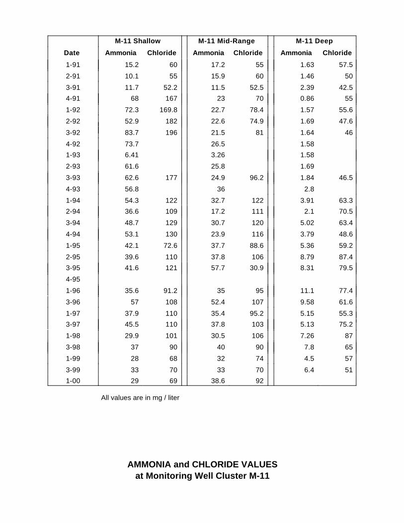
M-11 Shallow M-11 Mid-Range M-11 Deep
Date Ammonia Chloride Ammonia Chloride Ammonia Chloride
1-91 15.2 60 17.2 55 1.63 57.5
2-91 10.1 55 15.9 60 1.46 50
3-91 11.7 52.2 11.5 52.5 2.39 42.5
4-91 68 167 23 70 0.86 55
1-92 72.3 169.8 22.7 78.4 1.57 55.6
2-92 52.9 182 22.6 74.9 1.69 47.6
3-92 83.7 196 21.5 81 1.64 46
4-92 73.7 26.5 1.58
1-93 6.41 3.26 1.58
2-93 61.6 25.8 1.69
3-93 62.6 177 24.9 96.2 1.84 46.5
4-93 56.8 36 2.8
1-94 54.3 122 32.7 122 3.91 63.3
2-94 36.6 109 17.2 111 2.1 70.5
3-94 48.7 129 30.7 120 5.02 63.4
4-94 53.1 130 23.9 116 3.79 48.6
1-95 42.1 72.6 37.7 88.6 5.36 59.2
2-95 39.6 110 37.8 106 8.79 87.4
3-95 41.6 121 57.7 30.9 8.31 79.5
4-95
1-96 35.6 91.2 35 95 11.1 77.4
3-96 57 108 52.4 107 9.58 61.6
1-97 37.9 110 35.4 95.2 5.15 55.3
3-97 45.5 110 37.8 103 5.13 75.2
1-98 29.9 101 30.5 106 7.26 87
3-98 37 90 40 90 7.8 65
1-99 28 68 32 74 4.5 57
3-99 33 70 33 70 6.4 51
1-00 29 69 38.6 92
All values are in mg / liter
AMMONIA and CHLORIDE VALUESat Monitoring Well Cluster M-11

TREND ANALYSISUsing the Mann-Kendall Test
Section VI.B. of this report discusses the trend analysis for ammonia and chloride data ingroundwater, as evaluated using the Mann-Kendall test. The following steps outline theMann-Kendall test for trend, as described in Statistical Methods for EnvironmentalPollution Monitoring, Richard O. Gilbert, Van Nostrand Reinhold Publishers, 1987.
where sign (X j - X k ) = 1 if X j - X k > 0;
= 0 if X j - X k = 0;
and = -1 if X j - X k < 0.
where the summation is over the number of groups of tied values and tp is thenumber of data tied in each group.
The test statistic Z is computed as follows:
Z = (S - 1)(VAR(S)) – ½ if S > 0
= 0 if S = 0
= (S + 1)(VAR(S)) – ½ if S < 0
This test statistic is compared to the standard normal tables to determine significance ofthe trend.

Attachment D
Leachate Analytical Data, Flow Data, and Trend

Ammonia Ammonia
Date mg/L Resample
1-91 856
2-91 638
3-91 447
4-91 5941-92 465
2-92 652
3-92 522
4-92 525
1-93 701
2-93 467
3-93 2144-93 580
1-94 3030
2-94 108
3-94 574
4-94 497 630
1-95 998 91.72-95 126 381
3-95 78.1
4-95
1-96 261 278
2-96 260 257
3-96 68 4-96 250 480
1-97 552 566
2-97 400 237
3-97 310 168
4-97 547 589
1-98 5002-98 600 480
3-98 85
4-98 435 340
1-99 490 450
2-99 140 47
3-99 260 190
4-99 250 4801-00 12.3
AMMONIA CONCENTRATIONS IN LEACHATE

Date Flow Date Flow Date Flow
7-90 19022 7-94 7200 7-98 1477
8-90 94457 8-94 39639 8-98 1600
9-90 93156 9-94 77733 9-98 15273
10-90 50400 10-94 13440 10-98 9309
11-90 28480 11-94 56329 11-98 3943
12-90 15150 12-94 25821 12-98 3943
1-91 6503 1-95 4966 1-99 3943
2-91 6857 2-95 960 2-99 3943
3-91 4138 3-95 857 3-99 3943
4-91 3406 4-95 900 4-99 3429
5-91 2787 5-95 686 5-99 2229
6-91 5462 6-95 45511 6-99 7930
7-91 42300 7-95 114171 7-99 8667
8-91 53708 8-95 103467 8-99 6545
9-91 52000 9-95 114686 9-99 33523
10-91 115045 10-95 113417 10-99 33523
11-91 100050 11-95 115714 11-99 20160
12-91 43665 12-95 88103 12-99 1239
1-92 4650 1-96 101900
2-92 0 2-96 101900
3-92 0 3-96 101900
4-92 0 4-96 101900
5-92 0 5-96 101900
6-92 0 6-96 84745
7-92 99114 7-96 7341
8-92 38965 8-96 7543
9-92 0 9-96 15771
10-92 0 10-96 24873
11-92 0 11-96 15840
12-92 0 12-96 8091
1-93 0 1-97 6857
2-93 0 2-97 2914
3-93 178764 3-97 5628
4-93 0 4-97 1394
5-93 11303 5-97 1394
6-93 41920 6-97 19029
7-93 36730 7-97 7644
8-93 19927 8-97 8434
9-93 30400 9-97 20229
10-93 54857 10-97 23040
11-93 12945 11-97 13371
12-93 0 12-97 12083
1-94 2182 1-98 10306
2-94 11613 2-98 9086
3-94 5143 3-98 8057
4-94 4026 4-98 2914
5-94 7840 5-98 982
6-94 7127 6-98 686
Flow in gallons
AVERGE MONTHLY LEACHATE FLOW

Average Monthly Leachate Flow and Trend

Photographs

Photo 1: Northwest 58th Street Landfill. Gas vents and access roads atop capped Zone 1are shown.
Photo 2: View from top of Zone 1 mound, looking southeast. At time of site visit, some grasshad browned due to drought, but turf continued to stabilize the surface soil.

Photo 3: Industrial area adjacent to east perimeter of the landfill is shown just beyond thesite’s lower service road.
Photo 4: View to northeast from the side of the Zone 1 mound. Access road is the eastboundary of the landfill site; also shown is part of the industrial area, including scrap piles, andpart of the quarry’s lake.

Photo 5: North view from top of Zone 1. Quarry’s lake is seen on the horizon; large mound in thedistance is a privately operated, active landfill.
Photo 6: Aerial view of NW 58th Street Landfill, looking SW. Service roads across western cells areshown at center; wetlands with invasive melaleuca trees undergoing eradication are in foreground;part of the Zone 1 mound is shown in the lower left, Resource Recovery Plant on upper right; businessand residential development is shown at upper left and across the horizon.

Photo 7: Flamingos and egrets wading in wetlands and adjacent detention basin; ResourceRecovery plant shown in distance.
Photo 8: Wetland plants and birds.