site plan review.indd
TRANSCRIPT

Site Plan Review JAMES A. COON LOCAL GOVERNMENT TECHNICAL SERIES
A Division of the New York Department of State
Andrew M. Cuomo, Governor Rossana Rosado, Acting Secretary of State

NEW YORK STATE DEPARTMENT OF STATE99 WASHINGTON AVENUE
ALBANY, NEW YORK 12231-0001http://www.dos.ny.gov
Publication Date: August 1998 Revised: May 2012Reprint Date: 2015

Introduction
The site development review process is one of several means of plan implementation that communities may utilize. It is com-monly considered supplemental to other land development guid-ance controls.
Since most land in New York State is in private ownership, mu-nicipalities have been delegated a variety of powers to enact land development controls. The most common of these are the powers of zoning and subdivision control, which are exercises of the police power. Zoning enables communities to regulate land uses and population densities based on comprehensive land develop-ment planning. Subdivision control allows communities to effect satisfactory physical design and site improvement of privately owned lands to be subdivided, usually for residential develop-ment purposes.
An aspect of development control frequently neglected by com-munities in the past concerns the improvement of lands intended for nonresidential or multi-family housing purposes. In many of these cases, the lands are to be developed and remain in single ownership and, therefore, do not fall within the scope of the sub-division review powers. To overcome this gap in their develop-ment review capabilities, an increasing number of municipalities have added site review components, applicable to an array of uses, to their development regulations. Initially introduced in urban areas, the concept has more recently spread to other parts of the State. Most communities which have adopted site develop-ment plan review procedures have done so within the framework of their zoning regulations.
The site development plan specifi es the present characteristics of a particular parcel of land and its surroundings and describes intended activities and their potential impact on the commu-nity. The terms “site plan” and “site development plan” are interchangeable. The latter is generally used in this paper since it defi nes the intent of the “plan” and the review process more accurately.
Site development plans have two functions. First, they illustrate the intended design, arrangement and uses of the land to be im-proved. Second, they describe the proposal’s physical, social and economic effects on the community. The plans may be in either or both narrative and graphic form, as appropriate. Information on factors such as the following may be the subject of concern in the site development review process: means of access, parking, landscaping, buffers, architectural features, location of structures, impact on adjacent land uses and other elements related to the health, safety and general welfare of the community.
Site plan reviews can include both small and large scale pro-posals ranging from gas stations, drive-in facilities and offi ce buildings to complex ones such as shopping centers, apartment developments and planned unit developments. In the case of a
Site review procedure and guidelines
drive-in facility such as a fast food restaurant, bank or neighbor-hood convenience retailer, the community might be most con-cerned with providing adequate access without disrupting traffi c fl ow on the adjacent road or with minimizing visual confusion as is often produced by advertising signs. If, on the other hand, the municipality is faced with a large scale proposal, such as a shop-ping center, other factors may be more important. These include impacts on the surrounding natural environment, transportation system and land uses.
Within the site, the prime concerns might include minimizing ecological disturbances, provision of separate parking and load-ing arrangements, ensuring pedestrian safety and the aesthetic relationship of the proposed structures to the site. Thus, the site development review process permits municipalities to analyze development proposals in terms of their impacts on local growth and the need for facilities and services.
Until recently, the State’s enabling legislation did not provide for planning boards in the site development plan approval process except in an advisory capacity. The communities which used the process were, therefore, legally limited to designating the zoning board of appeals or the legislative body for decision-making purposes. In 1976, however, the State Legislature amended the General City, Town and Village laws to make it possible for planning boards to take fi nal action on proposed site development plans. Those same site plan enabling statutes were again exten-sively revised, effective for towns and villages in 1993, and for cities in 1994, so that any municipal board may be designated by the governing body to review and approve site plans. (General City Law, section 27-a; Town Law, section 274-a; Village Law, section 7-725-a. The text of the law can be found in its entirety in Appendix A.)
1

2

The framework within which this delegation of authority is cast may be critical to its impartial and effi cient implementation. The power to approve site development plans may be delegated to a planning board or other board within the context of a zoning ordinance or local law or as a separate local law. Throughout this publication, the planning board will continue to be referred to as the board which reviews site plans. It should, however, be under-stood that this merely refl ects the fact that planning boards are the bodies most commonly vested with such authority. In fact, any other board may now be given site plan approval power.
Several problems are inherent in the use of site development review without zoning regulations. First, this approach has not been tested in any litigation and a court would carefully scruti-nize such a local law to assess whether adequate constraints could be placed upon the exercise of this power without zoning regula-tions. Second, the planning board would be required to assess the desirability of a particular site development plan without any commitment by the municipality as to the character of the sur-rounding property. Lastly, the employment of site development plan review should be considered a safety mechanism within the context of applying the community’s comprehensive land use regulation. Communities which currently have no zoning controls should therefore give careful consideration to postponing the enactment of site development review regulations until they can be integrated within the comprehensive control scheme that zoning regulations provide.
The site development aspects of the zoning ordinance or local law must specify the uses for which approval is needed and the components to be included in the plans. Specifi c review crite-ria should be started in the zoning regulations. However, if the planning board is granted the review power, criteria could be stated generally in the ordinance or local law, supplemented with detailed rules and regulations of the planning board. Such rules and regulations would be developed and adopted by the planning board and approved by the local legislative body.
Before drafting the site development plan provisions, the munici-pality must decide how broad an array of uses will be subject to review. This can be accomplished in several manners. First, the land uses to be subject to review could be identifi ed by zoning district within the general use provisions. Second, they could be identifi ed by zoning district within the supplemental regulations or a special article applicable to site development plan review. Third, certain uses could be subject to review regardless of the zoning district or location. Reviews might also be tied to areas having specialized use restrictions such as fl ood hazard, coastal or historic preservation zones.
The review procedures and submission requirements for site de-velopment plan reviews can be provided for in a completely sepa-rate article of the zoning ordinance or local law. Alternatively, they can be made a part of the supplemental regulations article.
Public hearings are not required in the site development plan re-view process except where the zoning board of appeals is desig-nated as the fi nal site development plan approval body, in which case such a hearing is mandated by state law. A municipality, however, has the option of requiring a hearing. Hearings could
be required for all site development plan applications or only for certain types if the latter are defi ned in the regulations. A public hearing is benefi cial because it allows interested parties, besides applicants and local offi cials, to voice opinions on the proposal.
The statutes allow for prior approval of a proposal by a planning board under a site development plan approval procedure to be conditional for the issuance of a building permit.
The enabling laws offer additional fl exibility in the selection of a review board and a procedure most appropriate to a community’s individual needs and resources. (Prior to their original enactment in 1976, a community, through its zoning ordinance or local law, could designate either the local legislative body or the zoning board of appeals to grant fi nal approval of site development plan proposals.)
If the local legislative body, such as the town or village board, re-tains approval power, it is free to develop any justifi able approval procedure and standards. (See Lemir Reality Corp. v. Larkin, 1962, 11 N.Y.2d 20; Green Point Savings Bank v. Board of Zon-ing Appeals, 1939, 281 N.Y.534.)
If the zoning board of appeals is delegated approval power, the board is limited to using the procedure established for it by the State’s planning and zoning enabling legislation. (General City Law, section 81-a, effective July 1, 1994; Town Law, section 267-a; Village Law, section 7-712-a.)
If the planning board (or other authorized board) is delegated approval power, this action is taken pursuant to the site plan enabling statutes, which also establish the procedure to be used for approval. For example, where authorization to control site development approvals is given to the planning board in accor-dance with the recently modifi ed General City, Town and Village laws, the maximum time between receipt of the proposal and the board’s decision is specifi ed in the statutes.
Several signifi cant changes have been made to the revised stat-utes effective in 1993 in towns and villages, and in 1994 in cities. First, provision is made for a direct application to the zoning board of appeals in the event an area variance is needed from a strict dimensional requirement of the zoning ordinance, without the applicant’s fi rst having to receive a decision from the enforce-ment offi cial. Second, provision is made for the planning board to require a set aside of recreational land or cash in lieu thereof, similar to the procedure allowed for many years in subdivision applications. Third, the statutes expressly reference the need to comply with both county, metropolitan or regional referral under the General Municipal Law, as well as with State Environmental Quality Review Act procedures under Article 8 of the Environ-mental Conservation Law.
Review procedure
The review procedure described in this publication is focused primarily on utilizing the site plan enabling sections of Town, Vil-lage and General City Laws as its basis.
3
These statutes have been designed primarily to incorporate the review procedure in a community’s existing or proposed zoning ordinance or local law. They enable planning boards to approve site development proposals and to set up a single-phase approval procedure which can be divided into submittal of application, optional hearing and decision components. This is shown in Fig-ure 1. Other steps can be added if it is determined that they can provide better safeguards to the community and enhance local interaction with the applicant. However, additional steps would have to be informal in nature (i.e., optional with the applicant) if they are administered by the local planning board in accordance with the Town, Village or General City Law.
Alternatively, formalization of a mandatory multi-phase proce-dure is possible if the site plan review regulations are adopted by local law in accordance with the Municipal Home Rule Law. Thus, a number of legal options are available to institute site development plan review either within the framework of zoning controls or as a supplement to them.
The statutes make it possible to develop a single-phase review procedure that merely requires submittal of an application containing the necessary information to permit a municipality to make a rational decision on a site development plan proposal. On the other hand, a multi-phase procedure can be developed allowing for a maximum of interaction between the applicant and the community. The latter approach, though it may be partially informal, is more likely to enable the site development plan to satisfy the objectives of all concerned parties. It is the preferred approach for the review of most larger site development propos-als.
It should be noted, though, that the lengthy time span occasioned by a multi-phase review procedure can often be costly and other-wise harmful, especially to a small developer. This is especially true in communities using a three-phase procedure.
A two- or three-phase procedure, similar to that commonly employed for reviewing subdivision plats, could be used for reviewing proposed site development plans. If the planning board is charged with approving subdivision plats as well as site development plans, the use of parallel procedures may be justi-fi ed for a number of reasons. They include the relative ease of following similar steps and the potential for conducting simulta-neous reviews and hearings in cases of large scale proposals such as planned unit developments. Figure 2 shows the multi-phase procedure.
If a three-phase approval process is utilized, it would include pre-submission, preliminary submission and fi nal submission phases. Each of the steps are time consuming by themselves. In addition to them, the lag time between phases must also be considered. The inclusion of a preliminary submission phase, therefore, should only be considered for large scale proposals. The commu-nity would have to establish appropriate benchmark criteria for this purpose in its regulations.
Many communities in the State appear to be settling upon the two-phase procedure as the most satisfactory approach to site
development plan review, namely, the presubmission and fi nal submission phases. This is an appropriate choice since it pro-vides a means for ensuring adequate safeguards for the commu-nity and also protects the developer from excessive money and time investments prior to site plan approval.
It should be reemphasized that the enabling legislation provides no authority to the local government to mandate a presubmission conference or a preliminary approval phase. However, the review procedure should be tailored to the regulatory needs of the com-munity and each step of the recommended procedure, from pre-submission conference to fi nal approval, should be given careful consideration at the time the controls are drafted. The procedure to be followed should be clear so that all parties understand it.
Appendix B is a site development plan review procedure that can be adapted for use as part of a zoning ordinance or local law. The regulations in Appendix C are illustrative of a separate site development plan local law.
Presubmission conference
The purpose of the presubmission conference is to give both the municipality and the applicant an opportunity to gain a better per-spective on the ramifi cations of the proposal. This step does not constitute formal submission of an application. It is benefi cial to both parties because the community will gain knowledge of the developer’s intent and the developer will learn his responsibili-ties before either is committed to signifi cant outlays of time and money.
At this conference the applicant should provide the reviewing board with basic data regarding the proposal. At a minimum, this should include a map showing the important existing natural and man-made features in and around the site and a sketch plan showing the major features of the proposed development. This information can then form the basis with which the municipality can advise the applicant on the next steps required to gain fi nal site development plan approval and of the necessary data that will have to be provided with the application.
Preliminary site development plan phase
If preliminary as well as fi nal site development plan phases are used, the former would be more important because it is here that the more substantive reviews and recommendations should be made. It also gives the applicant-developer added assurance that the fi nal submission will be adequate for board consideration and rapid approval.
The preliminary review phase would also be considered informal in the overall review process, but it can be desirable because it gives the municipality and the developer greater opportunity to reach agreement on areas of potential confl ict. The steps fol-lowed for performance of the preliminary site development plan review phase should be similar to those detailed below describing the fi nal review process. This phase should consist of (1) appli-cation submission, (2) municipal review, (3) optional hearing and (4) local government decision.
4

OPTIONAL
PHASE
IOPTIONAL
PHASE
IIMANDATORY
PHASE
III
PUBLIC HEARING REVIEWS
PRELIMINARY
PLANNING BOARDRECOMMENDATION
TENTATIVE APPROVALWITH OR WITHOUT MODIFICATIONS
APPLICATIONFINAL SPR SUBMITTED
DISAPPROVAL
PLANNINGBOARD
62 DAYS 62DAYS
62 DAYS
PRESUBMISSION CONFERENCE
APPROVAL WITHCONDITIONS DISAPPROVALAPPROVAL
COUNTY REFERRALPUBLIC HEARING
30 DAYS
CONDITIONS SATISFIED
BUILDING PERMITISSUED
FILE DECISION
Figure 2Optional Multi-Phase Site Plan Review Procedure
5
Site development plan phase (fi nal)
This phase begins the formal review process and contains the steps included in the previously described state enabling legislation. The reviewing board should set a maximum time limit between the presubmission conference and the next phase. Three to six months is a reasonable time frame for this purpose. The mu-nicipality should have the option to require resubmission of the requirements for the previous phase if more time has elapsed than specifi ed in the regulations, especially if it is found that signifi -cant changes have occurred in the community during the interim. A similar time frame should also be established between the preliminary and fi nal phases, if applicable.
Application. The phase begins with the submission of an appli-cation for site development plan approval from the developer. It should be made in writing, preferably on a form provided for this purpose by the municipality. Appendix D is a sample application form.
The application should be accompanied by information about the proposal, including legal data, impact on its environs, natural features, existing development and infrastructure and the site development proposal. The specifi c types of information to be provided by the applicant should be identifi ed as submission requirements in the municipality’s site development plan regu-lations. Much of the data can be provided in mapped form. If variations from the submission requirements are to be granted, they can be mutually agreed upon by the applicant and the local-ity at the presubmission conference or other initial contact.
Certain submission requirements such as a record of the applica-tion and approval status of all necessary state and county permits, an estimated project construction schedule and additional speci-fi cations for materials of the proposed site improvements should also be included with the fi nal application submission, but are generally unnecessary for the preliminary phase. Typical submis-sion requirements are discussed below.
The application could be submitted to the clerk of the review-ing board or other designated local offi cial as provided for in the regulations. It will be the task of the enforcement offi cer to certify that the proposal meets the requirements of the zoning regulations other than those tied specifi cally to the site develop-ment plan section.
Expert assistance. The members of a lay board may not have suffi cient time or expertise to perform a comprehensive site development plan review analysis. If the community does not have a professional planning staff, the board or commission will have to look elsewhere for technical assistance. If the municipal-ity employs a professional planning staff, the staff should conduct the technical aspects of the basic site development plan evalua-tion. This type of review can also make use of expert resources such as legal, engineering and environmental specialists. As with other types of reviews, the municipality should avail itself of as-sistance from its county or regional planning agency, as appro-priate. Where there is no professional government planning aid
available, recourse to a private consultant should be considered. All comments and recommendations should be made in writing to the designated reviewing authority. The submission requirements cover much of the data base upon which the proposed site development plan is reviewed. It is most important that the community has a completed and up-to-date comprehensive development plan and a land capability analysis that provides data on development limitations, critical areas and unique features.
The expenses incurred by the applicant at this stage to provide the needed information further justifi es the presubmission contact since he will gain prior knowledge of the local agency’s require-ments. The community should not have to request additional data from the developer unless special site problems are discovered subsequent to the initial submission.
Referral. The approval of a proposed site development plan constitutes a special authorization within the framework of lo-cal zoning regulations. The application is therefore subject to referral by the municipality to the appropriate county or regional planning agency in accordance with the requirements of sections 239-l and 239-m of the General Municipal Law, prior to fi nal action. If, however, a hearing is required, such referral must be made at least 10 days prior to the hearing.
Public hearing. A public hearing may either be required by the applicable regulations, or even if not required, the planning board may exercise its discretion to hold a hearing on any particular ap-plication. In any case, the planning board and its experts should have completed their review of the application prior to holding the public hearing. The hearing is advantageous because it al-lows the public a formal opportunity to state its views. The plan-ning board will fi nd that the hearing can be a means of providing more information and perspectives on the probable effects of the proposal. Residents and owners of nearby properties often have intimate knowledge of existing conditions which may be vital to the proposed site development concept and they may be able to suggest design or other modifi cations concerning the proposal which may not have been recognized by others.
Decision. The next step is for the local governmental review-ing authority to reach a decision on the site development plan proposal. By this stage, the board should have developed a broad basis for making a decision which should include the information provided with the application, the recommendations of vari-ous expert reviewers and the views of affected residents and the public at large.
The statutes which authorize legislative bodies to grant the planning boards power to take fi nal action on site development plan proposals stipulate a maximum interval of 62 days between submission of an application for fi nal approval and a decision. If a public hearing is required by the regulations, however, then the hearing must be held within 62 days of receipt of the application, and a decision must be rendered within 62 days following the hearing. Notice of the hearing must be published in a newspaper of general circulation at least fi ve days in advance.
6

The board must approve, approve with modifi cations or disap-prove the proposal within the specifi ed time. The board’s deci-sion must be fi led with the municipal clerk within fi ve business days, and a copy mailed to the applicant. If the board fails to act within the prescribed time, or where any person is aggrieved by the board’s decision, the aggrieved party may apply to the State Supreme Court for review under Article 78 of the Civil Practice Law and Rules. It should be remembered that an approval with modifi cations is not a “suspended” approval. No further action is required by the planning board; failure to abide by the plan as modifi ed should, however, subject the applicant to enforcement penalties.
The planning board may require the developer to guarantee completion of public improvements such as roadways and land-scaping within a reasonable time. This can be enforced through the posting of a performance bond or similar means of assur-ance if provided for in the zoning ordinance or local law. If the developer fails to properly carry out the improvements prior to the expiration of the bond, the municipality should be able to take foreclosure action. The guarantee can be required only if it is included in the site development plan ordinance or local law.
If a preliminary phase is included in the municipality’s review process, board action for this phase should be tentative approval, tentative approval with modifi cations or disapproval. If approval or approval with modifi cations is tentatively given, the next step will be submission of a fi nal application, including the necessary documentation for fi nal approval. In this case, the board’s modi-fi cations should be satisfi ed in the fi nal application. Disapproval will require the resubmission of a preliminary application if the applicant desires further consideration of the plan.
When both preliminary and fi nal approval phases are utilized by the municipality, the latter serves to resolve residual disagree-ments between the applicant and the locality and also to assure that any required modifi cations from the preliminary phase have been satisfi ed. The most substantive and detailed technical review of the proposal should have occurred during the prelimi-nary phase. Thus, the fi nal approval phase can be viewed as a check on the tentatively approved preliminary site development plan. The board must determine that the proposal is in substan-tial agreement with the previous submission and that all required modifi cations have been incorporated. New information should be thoroughly reviewed and analyzed to determine its acceptabil-ity and compliance with the regulations.
Submission requirements
Local offi cials involved in the review of proposed site devel-opment plans should be very familiar with the subject of their review, namely, the characteristics of the site and its impact on the surrounding area. The reviewing agency, enforcement offi cer and other local offi cials should have information easily available to help them evaluate a proposal. This material could include aerial photographs, engineering data and various maps showing topography, soils, wetlands and other features of the site. Such information could be consolidated, to produce a land capability map -- a helpful tool to assist the review process.
By living and working close to a particular site, the local offi cials may also have acquired additional “seat of the pants” knowledge about their surroundings to guide them in the evaluation pro-cess. This type of information is valuable, but to assure that a basic level of information is available to all those reviewing and evaluating a proposed site development plan, the applicant should provide the reviewing agency with a satisfactory basis for making its recommendations and reaching a fi nal decision. To guide the applicant, site development plan review process materials should contain a list of submission requirements.
The site plan map should be prepared by a qualifi ed professional such as a land planner, architect, landscape architect, civil engi-neer or other similarly skilled person. The plan should include those elements deemed appropriate for the proposed develop-ment. An Illustrative Site Plan map is shown in Figure 3.
State law allows local regulations to specify the site development plan components which must be submitted for approval. These components can be categorized generally as: (1) legal data, (2) impact on the environs, (3) natural features, (4) existing man-made features, and (5) proposed development. The ordinance or local law can identify the submission requirements in either general or specifi c terms. If they are stated in general terms, the detailed review requirements can be spelled out in the regula-tions promulgated by the planning board.
The waiver of certain submission requirements is possible. How-ever, in order for the planning board to waive any of the require-ments listed in the regulations, the ordinance or local law should include criteria for granting a waiver.
The reviewing agency should develop a checklist in accordance with its plan submission requirements for the purpose of making certain that all components of the application have been received. The checklist can be broadened to include other information, such as a procedural history of the proposal so that its status can be easily determined. Appendix E is a sample checklist.
All the submission requirements listed below should be included in both the preliminary and fi nal site development review phases. The few that should be in only the fi nal phase are identifi ed as such.
Legal data
1. Name and address of applicant and authorization of owner if different from applicant.2. Name and address of owners(s) of record, if different from applicant.3. Name and address of person or fi rm preparing the plan and map.4. Ownership intentions, such as purchase options.5. Current zoning classifi cation of property, including exact zoning boundary if in more than one district.6. Property boundary line plotted to scale. Distances, angles and area should be shown.7. North arrow, scale and date.8. Locations, widths, elevations and names of existing and proposed adjacent streets.
7
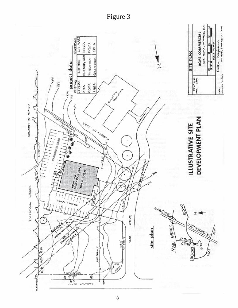
Figure 3
8

9. Property lines and names of owners of adjoining parcels.10. Location, width and purpose of all existing and proposed easements, set-backs, reservations and areas dedicated to public use within and adjoining the property.11. Description of all existing deed restrictions or covenants ap- plying to the property.12. Record of the application and approval status of all necessary state and county permits. (Final only.)
Another element, necessary to determine conformity with the in-tent of the regulations, is the identifi cation of any state or county permits required for execution of the project.
Impact of proposal on environs
1. Relationship to adjacent and nearby land uses, both public and private.2. Relationship to existing and proposed traffi c patterns.3. Relationship to existing and projected water supply, sewage disposal and similar service capabilities.4. Relationship to the community’s ability to provide adequate recreation, education, fi re protection and similar facilities and services to its residents.5. Visual compatibility with surroundings.6. Effect on air and water quality standards applicable primarily to industrial site development plans.7. Effect on energy consumption and conservation. Draft Envi- ronmental Impact Statement (DEIS) and Environmental Impact Statement (EIS) will be required if the reviewing agency deems the proposal to be signifi cant pursuant to the State Environmental Quality Review Act (SEQRA).
Natural features
1. Geologic features, such as depth to bedrock and the location of rock outcrops.2. Topographic features, including a map showing existing contour intervals of no more than fi ve feet. Two-foot contour intervals should be required if the topography is relatively fl at. Areas of steep slopes should be delineated as necessary.3. Vegetative cover, including existing wooded areas, signifi - cant isolated trees and similar features.4. Soil characteristics, such as load bearing capacity and drain- age capacity.5. Hydrologic features should include drainage and runoff pat- terns, fl ood hazard areas, wetlands and depth to groundwater.
Existing development and infrastructure
1. Location and dimensions of major buildings and structures.2. Location and width of roads and paths, including site access.3. Location, size and fl ow direction of sewers, water supply lines and culverts. Major electric, gas and telephone lines and appurtenances should also be shown.4. Location of other existing development and uses, including parking and loading areas, fences, trees and landscaping.
Proposed development
1. Grading and drainage plan showing proposed topography at appropriate contour intervals. This information can be combined with the map of existing topography if it can be clearly depicted.2. Location, proposed use and height of buildings and other structures, such as retaining walls, fences, outdoor storage tanks, air conditioning units and waste disposal units.3. Location, proposed use, design and construction materials of improvements not requiring structures, such as parking, loading, and outdoor storage areas.4. Location and arrangement of site access and egress, includ- ing all paths for pedestrian and vehicular travel within the site. Information should include profi les and cross-sections of roadways and sidewalks showing grades, widths and loca- tion and size of utility lines.5. Location and size of water and sewer lines and appurtenanc- es. Any means of water supply or sewage disposal other than extensions of existing systems should be described, including location, design and construction materials.6. Location, design and construction materials of all energy distribution facilities, including electric, gas and solar energy.7. Location, size and design of all outdoor lighting facilities and public address systems.8. Location, size, design and construction materials of all out door signs.9. General landscaping plan and planting schedule, including the treatment of buffer areas and the location and types of trees to be planted.10. Estimated project construction schedule with possible phas ing plan for large projects. (Final only).11. Additional specifi cations for materials.12. Performance bond, amount, completion schedule, public improvements covered, inspection and bond approval.
Review standards
The setting of criteria upon which the community can judge the merits of proposals submitted for review are necessary to reduce the possibility of arbitrary decisions and to maintain good will between the developer and the community. The site development plan regulations should, therefore, include standards as the basis for judging the merits of all proposals sent to it for review and action. The criteria can be contained in either an exclusive site development plan article or in the general or supplemental use regulations of the zoning ordinance or local law.
The standards chosen for evaluating a proposal should be specifi c enough to assure compliance with the regulations, but be fl exible enough to allow the reviewing agency and the developer some discretion in the ultimate design and construction of the proj-ect. All factors being reviewed should, therefore, be subject to evaluation by the use of either strict numerical standards or more discretionary performance standards.
The local comprehensive development plan, based on a land capabilities analysis and achievable goals and objectives, should be the basis for setting the numerical and performance standards.
9

Certain elements of a site proposal, such as the amount of open space and the number of needed parking spaces, can be quanti-fi ed, while others, such as architectural features and ecological disturbances, are most subjective. It should not be assumed, however, that the ability to set numerical standards means that it will be practical to use them in all cases.
The determination of the mix of numerical and the more fl exible performance standards should be based in part on local desires, but it should also be a function of the technical review capabil-ity available to the community. For instance, a rural community lacking fi nancial or professional resources to review the site de-velopment plan may need relatively detailed standards for use by the lay reviewing agency, while a municipality having qualifi ed planning assistance available, could draft more fl exible criteria. This assumes that discretionary judgments can be made more readily by trained personnel (whether local staff, county planning agency or consultant services) than by lay persons.
Development considerations
The purpose of the review process is to facilitate evaluation of a development proposal within the framework of a local govern-ment’s goals. The previously described submission requirements present the basic information needs and the review standards set the parameters for determining the adequacy of the proposal.
The task of specifying development considerations is complex. The factors to be reviewed and the relative weights given to them will vary from site to site. This is because no two parcels of land are exactly alike, and each proposed use introduces a different set of circumstances into the evaluation equation. The reviewing agency will, for example, give higher priority to analyzing the ef-fects of commercial traffi c, topography and noise for an industrial development proposal than it will for a residential one. Pedes-trian safety, neighborhood facilities and services would be more important considerations in the latter case. Thus every proposed development will have to be judged by the reviewing agency on its own merits within the parameters of local aspirations.
The number of development factors to be evaluated can be large. Therefore, it is necessary to determine the important elements early in the process, such as at the presubmission conference. Then, upon submission, the community will be ready to under-take the task of evaluating the site development plan proposal.
To assist the responsible agency, Figure 4 presents an array of frequently encountered review considerations. Although not all of the factors will apply in all cases, the table should serve as a guide to help ensure equitable and realistic reviews.
It was previously noted that the factors to be evaluated by the reviewing agency will vary for different categories of proposed uses. Descriptions of development considerations for apartment/condominium developments and drive-in facilities have, there-fore, been included in Appendix F as examples to highlight some of the differences between them. These descriptions should aid in introducing the reader to the mechanics of reviewing these types of proposals. They should also provide a guide for analyz-ing the costs and benefi ts of other use proposals.
10

Figure 4Typical Development Considerations
Regional and local environs
Relationship to comprehensive planCompatibility with surroundingsAccessibility:
pedestrianautomobiletruckingpublic transportation
Economic impactFiscal impactEnvironmental impact:
air, water, noiseFacilities and services availabilityVisual compatibilityHistoric and archaeologic considerations
Natural features
GeologyTopographySoil characteristicsVegetationMicro climateWildlifeOpen spaceSurface drainageErosionGround watersWetlandsFlood hazard areas
Circulation
Vehicular:ingress and egressroad layoutparking areasloading areastraffic control
Pedestrian:walkwayssafety
Design and aesthetics
Site Usage:densitygeometrics
Structures:relationship to site planselevationsfunctional adequacy
Architectural featuresSignsLandscapingRecreation areasIncidentals:
fencingbuffer strips
Miscellaneous
Construction specifications
ncelopment
UtilitiesMaintenaStaging of deve
11

Appendix A Town Law, section 274-a1 (as revised effective July 26, 1994)
§274-a. Site plan review.
1. Defi nition of site plan. As used in this section the term “site plan” shall mean a rendering, drawing, or sketch prepared to specifi cations and containing necessary elements, as set forth in the applicable zoning ordinance or local law, which shows the arrangement, layout and design of the proposed use of a single parcel of land as shown on said plan. Plats showing lots, blocks or sites which are subject to review pursuant to authority provided for the review of subdivisions under section two hundred seventy-six of this article shall continue to be subject to such review and shall not be subject to review as site plans under this section.
2. Approval of site plans. (a) The town board may, as part of a zoning ordinance or local law adopted pursuant to this article or other enabling law, authorize the planning board or such other administrative body that it shall so designate, to review and approve, approve with modifi cations or disapprove site plans prepared to specifi cations set forth in the ordinance or local law and/or in regulations of such authorized board. Site plans shall show the arrangement, layout and design of the proposed use of the land on said plan. The ordinance or local law shall specify the land uses that require site plan approval and the elements to be included on plans submitted for ap-proval. The required site plan elements which are included in the zoning ordinance or local law may include, where appro-priate, those related to parking, means of access, screening, signs, landscaping, architectural features, local and dimensions of buildings, adjacent land uses and physical features meant to protect adjacent land uses as well as any additional elements specifi ed by the town board in such zoning ordinance or local law.
(b) When an authorization to approve site plans is granted by the town board pursuant to this section, the terms thereof may condition the issuance of a building permit upon such ap-proval.
3. Application for area variance. Notwithstanding any provi-sion of law to the contrary, where a proposed site plan contains one or more features which do not comply with the zoning regulations, application may be made to the zoning board of appeals for an area variance pursuant to section two hundred sixty-seven-b of this article, without the necessity of a decision or determination of an administrative offi cial charged with the enforcement of the zoning regulations.
4. Conditions attached to the approval of site plans. The au-thorized board shall have the authority to impose such reason-able conditions and restrictions as are directly related to and incidental to a proposed site plan. Upon its approval of said
1 Substantively the same as Village Law, section 7-725-a, effective July 26, 1994, and General City Law, section 30-a, effective July 1, 1994.
site plan, any such conditions must be met in connection with the issuance of permits by applicable enforcement agents or offi cers of the town.5. Waiver of requirements. The town board may further em-power the authorized board to, when reasonable, waive any requirements for the approval, approval with modifi cations or dis-approval of site plans submitted for approval. Any such waiver, which shall be subject to appropriate conditions set forth in the ordinance or local law adopted pursuant to this section, may be exercised in the event any such requirements are found not to be requisite in the interest of the public health, safety or general welfare or inappropriate to a particular site plan.
6. Reservation of parkland on site plans containing residential units. (a) Before such authorized board may approve a site plan containing residential units, such site plan shall also show, when required by such board, a park or parks suitably located for play-ground or other recreational purposes.
(b) Land for park, playground or other recreational purposes may not be required until the authorized board has made a fi nding that a proper case exists for requiring that a park or parks be suitably located for playgrounds or other recreational purposes within the town. Such fi ndings shall include an evaluation of the present and anticipated future needs for park and recreational facilities in the town based on projected population growth to which the particular site plan will contribute.
(c) In the event the authorized board makes a fi nding pursuant to paragraph (b) of this subdivision that the proposed site plan presents a proper case for requiring a park or parks suitably located for playgrounds or other recreational purposes, but that a suitable park or parks of adequate size to meet the requirement cannot be properly located on such site plan, the authorized board may require a sum of money in lieu thereof to be established by the town board. In making such determination of suitability, the board shall assess the size and suitability of lands shown on the site plan which could be possible locations for park or recreation-al facilities, as well as practical factors including whether there is a need for additional facilities in the immediate neighborhood. Any monies required by the authorized board in lieu of land for park, playground or other recreational purposes, pursuant to the provisions of this section, shall be deposited into a trust fund to be used by the town exclusively for park, playground or other recreational purposes, including the acquisition of property.
(d) Notwithstanding the foregoing provisions of this subdivision, if the land included in a site plan under review is a portion of a subdivision plat which has been reviewed and approved pursuant to section two hundred seventy-six of this article, the authorized board shall credit the applicant for any land set aside or money donated in lieu thereof under such subdivision plat approval. In the event of resubdivision of such plat, nothing shall preclude the additional reservation of parkland or money donated in lieu thereof.
7. Public hearing and decision on site plans. In the event a pub-lic hearing is required by ordinance or local law adopted by the town board, the authorized board shall conduct a public hearing within sixty-two days from the day an application is received on
12

any matter referred to it under this section. The authorized board shall mail notice of said hearing to the applicant at least ten days before said hearing and shall give public notice of said hearing in a newspaper of general circulation in the town at least fi ve days prior to the date thereof and shall make a decision on the appli-cation within sixty-two days after such hearing, or after the day the application is received if no hearing has been held. The time within which the authorized board must render its decision may be extended by mutual consent of the applicant and such board. The decision of the authorized board shall be fi led in the offi ce of the town clerk within fi ve business days after such decision is rendered, and a copy thereof mailed to the applicant. Nothing herein shall preclude the holding of a public hearing on any mat-ter on which a public hearing is not so required.
8. Notice to metropolitan, regional or county planning agency. At least ten days before such hearing, the authorized board shall mail notices thereof to the county, metropolitan or regional plan-ning agency, as required by section two hundred thirty-nine-m of the general municipal law, which notice shall be accompanied by a full statement of the matter under consideration, as defi ned in subdivision one of section two hundred thirty-nine-m of the general municipal law. In the event a public hearing is not required, the matter shall be referred to the metropolitan, county, or regional planning agency before fi nal action is taken thereon, if required by section two hundred thirty-nine-m of the general municipal law.
9. Compliance with state environmental quality review act. The authorized board shall comply with the provisions of the state en-vironmental quality review act under article eight of the environ-mental conservation law and its implementing regulations.
10. Court review. Any person aggrieved by a decision of the au-thorized board or any offi cer, department, board or bureau of the town may apply to the supreme court for review by a proceeding under article seventy-eight of the civil practice law and rules. Such proceedings shall be instituted within thirty days after the fi ling of a decision by such board in the offi ce of the town clerk. The court may take evidence or appoint a referee to take such evidence as it may direct, and report the same, with fi ndings of fact and conclusions of law, if it shall appear that testimony is necessary for the proper disposition of the matter. The court shall itself dispose of the matter on the merits, determining all ques-tions which may be presented for determination.
11. Costs. Costs shall not be allowed against the authorized board unless it shall appear to the court that it acted with gross negligence, in bad faith, or with malice in making the decision appealed from.
12. Preference. All issues addressed by the court in any proceed-ing under this section shall have preference over all civil actions and proceedings.
Appendix BIllustrative site plan regulations - integral with zoning local law or ordinance
Proposed site plan review and approval provisions. Amend-ment to “Ordinance of the year 1971 for zoning in the specifi ed districts of the Town of Hanover,” Chautauqua County.
Section 16 Site Plan Review and Approval. Prior to the issu-ance of a zoning permit in the Business (B-1) District, the zoning offi cer shall require site plan approval by the planning board pur-suant to this section. The zoning offi cer shall notify an applicant for a zoning permit where site plan approval is required of the provisions of this section.
16.1 Sketch plan. A sketch plan conference may be held be-tween the planning board and the applicant prior to the prepara-tion and submission of a formal site plan. The intent of such a conference is to enable the applicant to inform the planning board of his proposal prior to the preparation of a detailed site plan; and for the planning board to review the basic site design concept, advise the applicant as to potential problems and concerns and to generally determine the information to be required on the site plan. In order to accomplish these objectives, the applicant should provide the following:
(a) A statement and rough sketch showing the locations and di-mensions of principal and accessory structures, parking areas, ac-cess signs (with descriptions), existing and proposed vegetation, and other planned features; anticipated changes in the existing topography and natural features; and, where applicable, measures and features to comply with fl ood hazard and fl ood insurance regulations;
(b) A sketch or map of the area which clearly shows the location of the site with respect to nearby streets, rights-of-way, proper-ties, easements and other pertinent features; and
(c) A topographic or contour map of adequate scale and detail to show site topography.
16.2 Application for site plan approval. An application for site plan approval shall be made in writing to the chairman of the planning board and shall be accompanied by information con-tained on the following checklist. Where the sketch plan confer-ence was held, the accompanying information shall be drawn from the following checklist as determined necessary by the planning board at said sketch plan conference.
(a) Site plan checklist.
1. Title of drawing, including name and address of applicant and person responsible for preparation of such drawing;2. North arrow, scale and date;3. Boundaries of the property plotted to scale;4. Existing watercourses;5. Grading and drainage plan, showing existing and proposed contours;
13

6. Location, design, type of construction, proposed use and exterior dimensions of all buildings;7. Location, design and type of construction of all parking and truck loading areas, showing access and egress;8. Provision for pedestrian access;9. Location of outdoor storage, if any;10. Location, design and construction materials of all existing or proposed site improvements including drains, culverts, retain- ing walls and fences;11. Description of the method of sewage disposal and location, design and construction materials of such facilities;12. Description of the method of securing public water and loca- tion, design and construction materials of such facilities;13. Location of fi re and other emergency zones, including the location of fi re hydrants;14. Location, design and construction materials of all energy distribution facilities, including electrical, gas and solar energy;15. Location, size and design and type of construction of all proposed signs;16. Location and proposed development of all buffer areas, including existing vegetative cover;17. Location and design of outdoor lighting facilities;18. Identifi cation of the location and amount of building area proposed for retail sales or similar commercial activity;19. General landscaping plan and planting schedule;20. An estimated project construction schedule.21. Record of application for and approval status of all necessary permits from state and county offi cials.22. Identifi cation of any state or county permits required for the project’s execution; and23. Other elements integral to the proposed development as con- sidered necessary by the planning board.
16.3 Review of site plan. The planning board’s review of the site plan shall include, as appropriate, but is not limited to, the following general considerations:
(a) Location, arrangement, size, design and general site compat- ibility of buildings, lighting and signs.
(b) Adequacy and arrangement of vehicular traffi c access and cir culation, including intersections, road widths, pavement sur- faces, dividers and traffi c controls.
(c) Location, arrangement, appearance and suffi ciency of off- street parking and loading.
(d) Adequacy and arrangement of pedestrian traffi c access and circulation, walkway structures, control of intersections with vehicular traffi c and overall pedestrian convenience.
(e) Adequacy of stormwater and drainage facilities.
(f) Adequacy of water supply and sewage disposal facilities.
(g) Adequacy, type and arrangement of trees, shrubs and other landscaping constituting a visual and/or noise buffer between the applicant’s and adjoining lands, including the maximum retention of existing vegetation.
(h) Adequacy of fi re lanes and other emergency zones and the provision of fi re hydrants.
(i) Special attention to the adequacy and impact of structures, roadways and landscaping in areas with susceptibility to ponding, fl ooding and/or erosion.
16.4 Planning board action on site plan. Within forty-fi ve (45) days1 of the receipt of an application for site plan approval, the planning board shall render a decision, fi le said decision with the town clerk, and mail such decision to the applicant with a copy to the zoning offi cer. The time within which a decision must be rendered may be extended by mutual consent of the applicant and planning board.
(a) Upon approval of the site plan and payment by the applicant of all fees and reimbursable costs due to the town, the planning board shall endorse its approval on a copy of the fi nal site plan and shall forward a copy to the applicant, zoning offi cer, and fi le same with the town clerk.
(b) Upon disapproval of a site plan, the planning board shall so inform the zoning offi cer and the zoning offi cer shall deny a zon-ing permit to the applicant. The planning board shall also notify the applicant in writing of its decision and its reasons for disap-proval. Such disapproval shall be fi led with the town clerk.
16.5 Reimbursable costs. Costs incurred by the planning board for consultation fees or other extraordinary expenses in connec-tion with the review of a proposed site plan shall be charged to the applicant, not to exceed $___________.
16.6 Performance guarantee. No certifi cate of occupancy shall be issued until all improvements shown on the site plan are installed or a suffi cient performance guarantee has been posted for improvements not yet completed. The suffi ciency of such performance guarantee shall be determined by the town board after consultations with the planning board, zoning offi cer, town attorney and other appropriate parties.
16.7 Inspection of improvements. The zoning offi cer shall be responsible for the overall inspection of site improvements including coordination with the planning board and other offi cials and agencies, as appropriate.
16.8 Integration of procedures. Whenever the particular cir-cumstances of proposed development require compliance with either the special use procedure in this zoning ordinance or other requirements of the town, the planning board shall attempt to in-tegrate, as appropriate, site plan review as required by this section with the procedural and submission requirements for such other compliance.
1 Now superseded by 62-day requirement of NYS Town Law, §274-a
14

Appendix CIllustrative site development plan regulations - separate local law
Town of Geneseo - Site Plan Review Law
Article IIntroductory Provisions
Section 1.010 Enactment. The Town Board of the Town of Geneseo, Livingston County, New York, does hereby ordain and enact the Town of Geneseo Site Plan Review Law pursuant to the authority and provisions of section 10 of the Municipal Home Rule Law and section 274-a of the Town Law.
1.020 Short title. This local law shall be known as the “Town of Geneseo Site Plan Review Law.” The Town of Geneseo is hereinafter referred to as the “town.”
1.030 Intent and purpose. Through site plan review, it is the intent of this local law to promote the health, safety and general welfare of the town. A clean, wholesome, attractive environment is declared to be of importance to the health and safety of the inhabitants of the town and, in addition, such an environment is deemed essential to the maintenance and continued development of the economy of the town and the general welfare of its inhabit-ants.
It is further the intent of this local law to ensure that optimum overall conservation, protection, preservation, development and use of the natural and man-related resources of the town, by regulating land use activity within the town through review and approval of site plans. It is not the intent of this local law to pro-hibit per se any land use activity but to allow all land use activi-ties which will meet the standards set forth in this local law.
1.040 Authorization of Planning Board to review site plans. The Planning Board is hereby authorized to review and approve or disapprove site plans for land uses within the town as herein-after designated pursuant to and in accordance with the standards and procedures set forth in this local law.
Article IIApplicability and defi nitionsSection 2.010 Applicability of review requirements. All new land use activities within the town shall require site plan review and approval before being undertaken, except the following:
1. Construction of one- or two-family dwelling and ordinary ac- cessory structures, and related land use activities.2. Landscaping or grading which is not intended to be used in connection with a land use reviewable under the provisions of this local law.3. Ordinary repair or maintenance or interior alterations to exist- ing structures or uses.4. Exterior alterations or additions to existing structures which would not increase the square footage of the existing struc- ture by more than 25%; and having a cost value of less than $5,000.
5. Nonstructural agricultural or gardening uses not involving substantial timber cutting.6. Signs under 10 square feet.7. The sale of agricultural produce and temporary structures related to sale of agricultural produce.8. Garage, lawn and porch sales not exceeding three days. If such sales take place more often than three (3) times in any calendar year, site plan approval will be required. Any person uncertain of the applicability of this local law to a given land use activity may apply in writing to the planning board for a written jurisdictional determination. 2.020 Effect on existing uses. This law does not apply to uses and structures which are lawfully in existence as of the date this local law becomes effective. Any use which would otherwise be subject to this law, that has been discontinued for a period of two years or more shall be subject to review pursuant to the terms of this law before such use is resumed. Any use or structure shall be considered to be in existence provided the same has been substantially commenced as of the effective date of this local law and fully constructed and completed within one year from the effective date of this local law.
2.030 Relationship of this law to other laws and regulations. This local law in no way affects the provisions or requirements of any other federal, state, or local law or regulations. Where this local law is in confl ict with any other such law or regulation, the more restrictive shall apply. 2.040 Defi nitions.“Family” means a person or persons related to each other by blood, marriage or adoption, or any number of persons, irrespec-tive of any such relationship, which nonetheless functions as the equivalent of such a family, living together as a single housekeep-ing unit. “Land use activity” means any construction or other activity which changes the use or appearance of land or a structure or the intensity of use of land or a structure. “Land use activity” shall explicitly include, but not be limited to, the following: new structures, expansions to existing structures, new uses, changes in or expansions of existing uses, roads, driveways, and excavations for the purpose of extracting soil or mineral deposits. “One family dwelling” means a complete self-contained resi-dential unit for permanent habitation by one family only, and containing one or more rooms and facilities for living including cooking, sleeping, and sanitary needs. “Shoreline” means the mean high water mark of any lake, pond, river, or permanent stream. “Structure” means any object constructed, installed or placed on
15

land to facilitate land use and development or subdivision of land, such as buildings, sheds, signs, tanks, and any fi xtures, additions and alterations thereto. “Structure, accessory” means any structure designed to accom-modate an accessory use but detached from the principal struc-ture, such as, a free standing garage for vehicles accessory to the principal use, a storage shed, garden house or similar facility. “Two family dwelling” means two complete, but separate, self-contained residential units each intended for permanent habitation by one family only in a single structure having a common wall roof, wall or ceiling and containing separate rooms and facilities for living including cooking, sleeping, and sanitary needs.
Any term used in this local law which is not defi ned hereinabove shall carry its customary meaning unless the context otherwise dictates.
Article IIISite plan review Section 3.010 Procedures - Generally. Prior to undertaking any new land use activity except for a one- or two-family dwelling and other uses specifi cally excepted in section 2.010 of this local law, a site plan approval by the planning board is required. Ap-plicants for site plan approval should follow the recommended procedures related to the sketch plan conference as hereinafter set forth. Applicants must comply with all other procedures and requirements of this local law. 3.020 Sketch plan. A sketch plan conference shall be held be-tween the planning board and the applicant prior to the prepara-tion and submission of a formal site plan. The intent of such a conference is to enable the applicant to inform the planning board of his proposal prior to the preparation of a detailed site plan; and for the planning board to review the basic site design concept, advise the applicant as to potential problems and concerns and to generally determine the information to be required on the site plan. In order to accomplish these objectives, the applicant shall provide the following: 1. A statement and rough sketch showing the locations and densions of principal and accessory structures, parking areas, ac-cess signs (with descriptions), existing and proposed vegetation, and other planned features; anticipated changes in the existing topography and natural features; and, where applicable, measures and features to comply with fl ood hazard and fl ood insurance regulations; 2. An area map showing the parcel under consideration for site plan review, and all properties, subdivisions, streets, rights-of-way, easements and other pertinent features within 200 feet of the boundaries of the parcel; and3. A topographic or contour map of adequate scale and detail to show site topography. 3.030 Application requirements. An application for site plan approval shall be made in writing to the chairman of the planning board and shall be accompanied by information contained on the
following checklist. Where the sketch plan conference was held, the accompanying information shall be drawn from the following checklist as determined necessary by the planning board at said sketch plan conference. Site plan checklist: 1. Title of drawing, including name and address of applicant and person responsible for preparation of such drawing;2. North arrow, scale and date;3. Boundaries of the property plotted to scale;4. Existing buildings;5. Grading and drainage plan, showing existing and proposed contours, rock outcrops, depth to bedrock, soil characteristics, and watercourses;6. Location, design, type of construction, proposed use and exte-rior dimensions of all buildings;7. Location, design and type of construction of all parking and truck loading areas, showing access and egress;8. Provision for pedestrian access;9. Location of outdoor storage, if any;10. Location, design and construction materials of all existing or proposed site improvements including drains, culverts, retaining walls and fences;11. Description of the method of sewage disposal and location, design and construction materials of such facilities;12. Description of the method of securing public water and loca-tion, design and construction materials of such facilities;13. Location of fi re and other emergency zones, including the location of fi re hydrants;14. Location, design and construction materials of all energy distribution facilities, including electrical, gas and solar energy;15. Location, size and design and type of construction of all proposed signs;16. Location and proposed development of all buffer areas, including existing vegetative cover;17. Location and design of outdoor lighting facilities;18. Identifi cation of the location and amount of building area proposed for retail sales or similar commercial activity;19. General landscaping plan and planting schedule;20. An estimated project construction schedule;21. Record of application for and status of all necessary permits from other governmental bodies;22. Identifi cation of any permits from other governmental bodies required for the project’s execution; and23. Other elements integral to the proposed development as may be considered necessary in the particular case by the planning board. 3.040 Required fee. An application for site plan review shall be accompanied by a fee of $_________. 3.050 Reimbursable costs. Cost incurred by the planning board for consultation fees or other extraordinary expenses in connec-tion with the review of a proposed site plan shall be charged to the applicant, not to exceed $________.
16

Article IVReview standards Section 4.010 General standards and considerations. The planning board’s review of the site plan shall include, as appro-priate, but is not limited to, the following general considerations: 1. Location, arrangement, size, design and general site compat-ibility of buildings, lighting and signs.2. Adequacy and arrangement of vehicular traffi c access and cir-culation, including intersections, road widths, pavement surfaces, dividers and traffi c controls.3. Location, arrangement, appearance and suffi ciency of off-street parking and loading.4. Adequacy and arrangement of pedestrian traffi c access and circulation, walkway structures, control of intersections with vehicular traffi c and overall pedestrian convenience.5. Adequacy of stormwater and drainage facilities.6. Adequacy of water supply and sewage disposal facilities.7. Adequacy, type and arrangement of trees, shrubs and other landscaping constituting a visual and/or noise buffer between the applicant’s and adjoining lands, including the maximum retention of existing vegetation.8. Adequacy of fi re lanes and other emergency zones and the provision of fi re hydrants.9. Special attention to the adequacy and impact of structures, roadways and landscaping in areas with susceptibility to ponding, fl ooding and/or erosion.10. Overall impact on the neighborhood including compatibility of design consideration. 4.020 Specifi c standards and considerations. The following specifi c standards shall apply in conjunction with the subject uses or in the designated areas. 4.021 Shoreline standards and considerations.1. All construction on any shoreline lot shall be carried out in such manner as to minimize interference with the natural course of such waterway, to avoid erosion of the shoreline, to minimize increased runoff of ground and surface water into the waterway, to remove only that vegetation which is necessary to the accom-plishment of the project, and to generally maintain the existing aesthetic and ecological character of the shoreline.
2. No on-site sewage tile fi eld or seepage pit shall be located within one hundred (100) feet of any shoreline and no septic or other holding tank shall be located within fi fty (50) feet of any shoreline, as measured from the normal high water mark of the waterbody.
3. Any boat pump-out or other connection to provide for the accommodation of sanitary wastes shall be connected to an ad-equate disposal system.
4. Any marina, boat service facility or any storage of petroleum products within one hundred (100) feet or reasonable setback as determined necessary by the planning board, of the shoreline shall include adequate provisions for insuring that any leak, rup-ture or spill will be contained and not be introduced into or affect the adjacent waterway. In particular, a raised earthen or paved
berm or dyke shall be constructed in such manner so as to afford adequate protection.
5. Any paved or otherwise improved parking, loading or service area within one hundred (100) feet of any shoreline shall be de-signed and constructed so as to minimize surface runoff and the entrance of any chemical pollutants or earthen siltation into the waterway.
Article VPublic hearing and planning board decision Section 5.010 Public hearing. The planning board may con-duct a public hearing on the site plan if considered desirable by a majority of its members. Such hearing shall be held within 62 days of the receipt of application for site plan review and shall be advertised in the town’s offi cial newspaper, or if there is none, in a newspaper of general circulation in the town at least fi ve (5) days before the public hearing. 5.020 Planning board decision. Within 62 days of receipt of the application for site plan approval or if a public hearing is held within 62 days of public hearing, the planning board shall render a decision. In its decision the planning board may approve, ap-prove with modifi cations or disapprove the site plan. The time period in which the planning board must render its decision can be extended by mutual consent of the applicant and the planning board. 1. Approval. Upon approval of the site plan, and payment by the applicant of all fees and reimbursable costs due the town, the planning board shall endorse its approval on a copy of the site plan and shall immediately fi le it and a written statement of approval with the town clerk. A copy of the written statement of approval shall be mailed to the applicant by certifi ed mail, return receipt requested.
2. Approval with modifi cations. The planning board may con-ditionally approve the fi nal site plan. A copy of written statement containing the modifi cations required by the conditional approval will be mailed to the applicant by certifi ed mail, return receipt re-quested. After adequate demonstration to the planning board that all conditions have been met, and payment by the applicant of all fees and reimbursable costs due the town, the planning board shall endorse its approval on a copy of the site plan and shall im-mediately fi le it and a written statement of approval with the town clerk. A copy of the written statement of approval shall be mailed to the applicant by certifi ed mail, return receipt requested.
3. Disapproval. Upon disapproval of the site plan the decision of the planning board shall immediately be fi led with the town clerk and a copy thereof mailed to the applicant by certifi ed mail, return receipt requested, along with the planning board’s reasons for disapproval.
17

Article VIAppeal of planning board decision Section 6.010 Appeal procedure. Any person aggrieved by any decision of the planning board or any offi cer, department, board or bureau of the town, may apply to the supreme court for a review by a proceeding under Article 78 of the Civil Practice Law and Rules. Such proceedings shall be instituted within thirty (30) days after the fi ling of a decision in the offi ce of the town clerk.
Article VIIMiscellaneous provisions Section 7.010 Enforcement offi cer. The town board may ap-point an enforcement offi cer to carry out the duties assigned by this local law or by any additional regulations adopted pursuant to section 7.020 hereof. If appointed, the enforcement offi cer shall be responsible for the overall inspection of site improve-ments including coordination with the planning board and other offi cials and agencies, as appropriate. 7.020 Further regulations by planning board. The planning board may, after a public hearing, adopt such further rules and regulations as it deems reasonably necessary to carry out the provisions of this local law. 7.030 Amendments. 1. The town board may on its own motion, on petition, or on recommendation of the planning board, after public notice and hearing, amend this local law pursuant to all applicable require-ments of law. 2. All proposed amendments originating by petition, or by motion of the town board, shall be referred to the planning board for a report and recommendation thereon. The planning board shall submit its report within thirty (30) days after receiving such referral. Failure of the planning board to report within the required time shall be deemed to constitute a recommendation for approval of the proposed amendment. 7.040 Integration of procedures. Whenever the circumstances of proposed development require compliance with this Site Plan Review Law and with any other local law, ordinance or require-ment of the town, the planning board shall attempt to integrate, as appropriate, site plan review as required by this local law with the procedural and submission requirements for such other compli-ance. 7.050 Enforcement. Any person, corporation, partnership, as-sociation of other legal entity who shall violate any of the provi-sions of this local law, or any conditions imposed by a permit pursuant hereto shall be guilty of an offense and subject to a fi ne of not more than two hundred fi fty dollars ($250) or by penalty of two hundred fi fty dollars ($250) to be recovered by the town in a civil action. Every such person or entity shall be deemed guilty
of a separate offense for each week such violation, disobedience, omission, neglect or refusal shall continue. 7.060 Severability. The provisions of this local law are sever-able. If any article, section, paragraph or provision of this local law shall be invalid, such invalidity shall apply only to the article, section, paragraph or provision(s) adjudged invalid, and the rest of this local law shall remain valid and effective.
18

Appendix D SAMPLE APPLICATION FOR SITE PLAN APPROVAL
DATE (check appropriate box) PRELIMINARY FINAL
Name of proposed development:
Applicant name: Plans prepared by:
Phone: Phone:
Address: Address:
City: City:
State: Zip: State: Zip:
Owner name (if different): If more than one owner, provide information for each
Phone:
Address:
City:
State: Zip:
Ownership intentions (i.e., purchase options):
Proposed zoning:
Proposed site use(s):
Describe proposed use (include primary and secondary uses; ground floor area; height; and number of stories for each building): For residential buildings include: number of dwelling units by size (efficiency, one-bedroom, two-bedroom, three- or more bedrooms) and number of parking spaces to be provided; For non-residential buildings include: total floor area and total sales area; number of automobile and truck parking spaces; Other proposal structures (Use separate sheet if needed):
PARCEL INFORMATION
Tax Map Identification Section Block Lot
Total site area (sq. feet or acres):
Current zoning:
Current land use (agricultural, commercial, undeveloped, etc.):
Current condition (buildings, brush, etc.)
Surrounding land character (urban, wetlands, etc.):
CONSTRUCTION INFORMATION
Anticipated construction time:
Will development be staged?
Estimated cost of improvement:
Anticipated increase in number of residents, shoppers, employees, etc. (as applicable)
STATE AND FEDERAL PERMITS (list type and appropriate department)
19
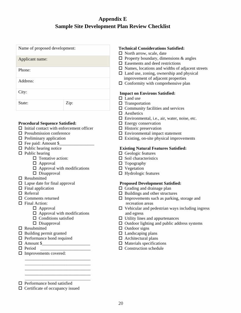
Procedural Sequence Satisfied: Initial contact with enforcement officer Presubmission conference Preliminary application Fee paid: Amount $________________ Public hearing notice Public hearing
Tentative action: Approval Approval with modifications Disapproval
Resubmitted Lapse date for final approval Final application Referral Comments returned Final Action:
Approval Approval with modifications Conditions satisfied Disapproval
Resubmitted Building permit granted Performance bond required Amount $______________________ Period _______________________ Improvements covered:
______________________________ ______________________________ ______________________________ ______________________________ ______________________________
Performance bond satisfied Certificate of occupancy issued
Technical Considerations Satisfied: North arrow, scale, date Property boundary, dimensions & angles Easements and deed restrictions Names, locations and widths of adjacent streets Land use, zoning, ownership and physical improvement of adjacent properties
Conformity with comprehensive plan
Impact on Environs Satisfied: Land use Transportation Community facilities and services Aesthetics Environmental, i.e., air, water, noise, etc. Energy conservation Historic preservation Environmental impact statement Existing, on-site physical improvements
Existing Natural Features Satisfied: Geologic features Soil characteristics Topography Vegetation Hydrologic features
Proposed Development Satisfied: Grading and drainage plan Buildings and other structures Improvements such as parking, storage and
recreation areas Vehicular and pedestrian ways including ingress
and egress Utility lines and appurtenances Outdoor lighting and public address systems Outdoor signs Landscaping plans Architectural plans Materials specifications Construction schedule
Name of proposed development:
Applicant name:
Phone:
Address:
City:
State: Zip:
Appendix ESample Site Development Plan Review Checklist
20

Appendix F Sample design review methodology* Apartments and Condominiums
Introduction. Density is a key factor in shaping the character or psychology of a community; a relatively high village density does not guarantee a “problem” village, as low density does not guarantee a desirable village. However, apartments and condo-miniums, because of their density, generate a greater impact on surrounding areas than one- or two-family house subdivisions. Land use. The development should be harmonious with the areas around it, functional and aesthetically pleasing. The com-ponents of the site should complement each other. The design should provide the residents of the development with both pri-vacy and individuality. The impact of apartments on the local tax base has been a subject of controversy for several years. Studies prepared by Nassau County and the Town of Clay in New York show that apartments generally pay their share of the cost of edu-cation. Studies for other areas, such as the State of New Jersey; Connecticut; Montgomery County, Pennsylvania; and Fairfax County, Virginia, have had similar results. The need for recreational facilities in apartment/condominium complexes is often overlooked. It is very important that children have some play area. Care could be taken so that children’s needs for movement should not confl ict with adult needs for privacy. Trees selected for the play area should be ones which can be used for climbing. Site furniture should be provided with children’s needs in mind. Play equipment should be selected with the children’s preferences in mind. The greater the variety of equipment in an area, the greater the use that area will have. Active recreation standards: .5 acres/1,000 people (children’s play area) 1.5 acres/1,000 people (fi eld play for younger children) 1.5 acres/1,000 people (older children, adults) (tennis, basketball courts) 1 pool/1,000 people (swimming) 9 hole 60 acres (min.) 80 acres (max.) 18 hole 120 acres (min.) 160 acres (max.) The most popular sports in condominiums are tennis and swim-ming. Site analysis. A careful site analysis has a great deal to do with the fi nal land use of the site. Soil composition and bearing, as well as slope, will dictate the type of development which is practical. One of the most valuable characteristics of some sites is the view: it should be developed to its greatest potential. Preservation of existing vegetation helps keep the character of a site and helps to arrest erosion. There is no question that trees and shrubs enhance the livability of housing areas. The amount of grading on the site should be kept to a minimum.
The less the soil is disturbed, the greater the survival of existing plant materials and the less chance of erosion. It is important to preserve any water features which contribute to the beauty of a site’s layout. A planning board and developer should be able to maximize the use of water and other natural features without undue restriction of the property. The solutions can usually be achieved through careful design. Certain man-made features such as stone walls, fences, roads, etc., can be used to enhance a development and should follow ridges and vales rather than straddle hills perpendicular to con-tours. Areas with poor drainage should be avoided because they necessitate more bridges, culverts and other drainage works. Transportation. Traffi c in and out of a multi-family housing de-velopment must be studied to determine its impact on surround-ing areas. Pedestrian-vehicular circulation within the develop-ment should also be studied. Wherever possible, the crossing of the pedestrian and vehicular traffi c should be prevented. *Adapted from Design Review Manual, Syracuse/Onondaga County Planning Agency, 1975 Streets should be logically related to the topography and coordinated into a system in which each street performs its intended function. The function that a street is intended to serve will determine both its right-of-way and its pavement width. The fact that collec-tor streets and major streets carry considerably higher amounts of traffi c than minor residential streets must be refl ected in the criteria used for determining the street cross-section. Other considerations affecting the width of street right-of-way are sidewalks, planting strips and utilities, including street lights and fi re hydrants. On-Site Circulation. When residential development occurs along major streets, special consideration must be given to its de-sign. The use of a buffer strip and a marginal access street helps to alleviate traffi c noise and creates a private environment. It also increases safety by greatly reducing the points of access to the major street. All entries and exits to the development should be located away from traffi c problem areas. Depending on the size of the development, a traffi c light may be needed. Intersections are another important element in street planning and design. It is very important for streets to intersect at right angles rather than acute angles. The center lines of offset street intersec-tions should be no closer than 125 feet, and in some areas they are required by law to be even farther apart. Improperly designed street intersections become potential traffi c hazards. Common pedestrian walks should be used to move people within the development so as to avoid contact with vehicles.
21

Provision should be made for bicycling, avoiding confl icts with pedestrians and motorized traffi c.
Structures. Structures within a development should complement the site (i.e., if the site has an attractive view, the structure should be designed to take advantage of that view). Signs should be uniform and unobtrusive. Building lines should not be too linear. Wherever possible, building units should be staggered; this helps to defi ne individual spaces and breaks up monotonous building lines.
Provision of services should be considered. Wherever possible, dumpsters should be screened or enclosed.
If buildings are arranged in groups, emergency vehicles should have access to all units.
Site work. Plants used in landscaping should be indigenous to enhance their chances of survival. Street trees should be used along vehicular routes; they will aid in pollution control and de-lineate the road as a space apart from the dwelling units. A great variety of plants may not always be desirable. A planting design may become confused from excessive variety. A few types of plants used properly can provide attractive landscaping. Parking areas should be screened.
Grading and drainage paths should be studied carefully to prevent ponding areas within the development. Earthwork such as berms can and should be used to screen undesirable views and to direct pedestrian traffi c on the site.
All construction details should be in harmony with the building units. Utility service boxes should be conveniently located.
Drive-in facilities
Introduction. The drive-in facility, as well as the gasoline service station, is a product of the automobile age. Practically unknown prior to World War II, except for the occasional road-side diner, “drive-ins” now comprise practically every type of commercial use which can be serviced from a highway, ranging from dairy or limited grocery retail stores, to banks and fast-food restaurants. Although the design specifi cs for each use will vary according to function, there are certain general observations which can be made about all of these uses.
Land use. Due to intense competition between development types (e.g., fast-food, banks, etc.) for sites which maximize ease of access for the public, the drive-in facility has led to a prolifera-tion of “strip” commercial development along principal highway routes. This, in turn, has led to increased traffi c congestion on these routes and visual confusion and clutter.
The basic problems of the strip commercial development are:1) individual uses with separate entry and exit drives cause exces-sive turns (left hand turning movements are particularly diffi cult);
2) entry and exit drives are often ill-defi ned and may not meetapplicable state and local standards;
3) traffi c fl ow between adjoining uses is rarely available, forcingcars back on to the highway;
4) individual uses may be poorly designed and the competitionfor attention has produced further visual disorder through a host of signs and symbols designed to attract the eye;
5) landscape screening, curbing and other devices which mightbring some order are usually minimal or nonexistent;
6) zoning technique requiring special permits or other meansof regulating uses are generally not comprehensive enough to provide adequate controls for the series of uses which comprise a “strip”;
7) special permit procedures and other controls usually regulateonly certain types of drive-in uses (for example, fast-food restau-rants may require a special permit, whereas banks may not) and such controls rarely, if ever regulate proximity of uses and the consequent potential for increased traffi c.
The problems discussed above do not include all the problems caused by “strip” commercial developments. They are, however, typical of the problem faced by the average suburban or semi-suburban community. What, then, can the community do to provide some way of ordering and controlling drive-in facilities? First, it should be noted that the automobile technology which produced the “strip” is not likely to change so drastically that such commercial development will suddenly disappear (although the current energy situation could cause some reduction in the rate of such growth). Nor is it practicable to attempt to “legislate away” the strip. The most realistic approach (and one that many communities have already undertaken) is the development of more comprehensive standards for such growth. These standards can take several forms, which include arterial or highway service districts, planned or cluster development controls and marginal or service road system.
Arterial or highway service districts - These are special districts for the regulation of strip commercial development established through zoning. They could be established along adjoining prin-cipal highwy arteries to regulate use type, geometrics (setback, site coverage), treatment (landscaping and signs), circulation (in-gress, egress, internal fl ow and parking) and proximity between uses. In addition, these districts would provide for defi ned buffer areas between commercial uses and other uses such as residences. They would be similar to existing special permit procedures, but would view uses in the aggregate rather than singly.
Planned or cluster development controls - These would provide that a combination of drive-in facilities (three or more) would have to be located in a specifi ed area with common access before any one use could be developed. This would, in effect, provide for the clustering of drive-in facilities with controlled access. A variation would be to permit drive-in facilities in shopping cen-ters where they could share vehicular access with the center and thus limit additional curb cuts for single uses (the drive-in facility would be a controlled “satellite” use within the center)
Marginal or service road system - The marginal service road
22

system would be located within the arterial control district and would require all drive-in uses to have access only on to this road. The marginal service road would run approximately paral-lel to the main arterial highway and controlled access points would connect the two at specifi ed intervals, or in concert with existing highway intersections or access points for major shop-ping centers. The marginal road system could also serve residen-tial and institutional areas on the same basis.
Site analysis. The location of drive-in facilities will generally be dictated by access to a highway service corridor, demand for services and market potential. Community planners should rec-ognize these factors and respond to them by developing controls (see above) for regulating such uses. In analyzing the suitability of sites for their uses as drive-in facilities the following physical site conditions should be considered.
Soils - For small site areas the problems associated with soil composition should not be an insurmountable barrier. However, soils which exhibit extremely poor drainage, severity of slope or instability may prove economically infeasible for such develop-ment. Extensive regrading of small sites should be avoided. Where such regrading is done, provision should be made for the use of retaining walls, drainage ways and other devices which will insure protection of adjoining sites.
Drainage - Drive-in facilities will invariably require relatively large paved areas to accommodate moving vehicles and parking. Proposals which completely pave site areas should not be accept-able. If possible, the design should be compatible with a total drainage system for the site and its surrounding area.
Vegetation - Where possible, existing vegetation should be re-tained and incorporated into the landscaping plan for the facility. This is particularly true if large trees or other signifi cant plants can be salvaged.
Air quality - Although this may appear to be a minor concern for a small site, state and federal regulations concerning air qual-ity where a series of facilities will concentrate cars, should be reviewed prior to fi nal approval.
View - Although site design and view will generally be de-termined by the location of the site in relation to an existing highway, the potential visual impact of the facility in relation to surrounding uses should be given careful consideration.
Transportation. In planning drive-in facilities the movement of vehicular traffi c is a major consideration. Because drive-in facili-ties are traffi c generators, their effect upon an existing highway system is especially critical. The following elements should be considered in analyzing these effects.
Existing system - The ability of existing roadways to absorb in-creased traffi c fl ow, the creation of numerous turning movements into individual sites and the need for controls (i.e., signals, access points, etc.) should be given careful consideration. If necessary, controls should be implemented which would create clustering of drive-in facilities or the development of marginal service roads for an entire area (see Land Use).
Relation to other facilities - Even if it is not feasible to create a marginal road system or clustering of sites, the relation between several drive-in facilities should be given careful consideration. Curb cuts which are located too close together or which produce confl icts through alignment of the highway should be eliminated. The possibility of providing joint means of access or intercon-necting sites should be examined as an alternative.
Traffi c movement - Wherever possible, curb cuts for drive-in facilities should be coordinated with existing traffi c signals, turning lanes and intersections. Minimum distances should be established between the new facility and access points on adjoin-ing uses and intersections.
Pedestrian access - Pedestrian access to drive-in facilities will undoubtedly be limited. However, this does not mean that it should not be considered, particularly in shopping centers where the facility functions as a “satellite” to the main center area. Pedestrian walks should be provided to accommodate pedestrians entering from shopping center areas and from the street wherever practicable.
On-site circulation. Internal circulation of both vehicles and pedestrians should be carefully reviewed. Points of confl ict should be minimized and well-defi ned pedestrian paths should be provided. This is especially true in most drive-in facilities where customers will park their cars and walk into the structure for the particular product or service desired. The following elements should be considered.
Ingress and Egress - Minimum and maximum driveway widths should be established (12 foot minimum, for example) and curb cuts should be located at minimum distances from property lines. Traffi c into and out of the site should be organized into a well-de-fi ned system in order to avoid confl ict between vehicles entering and leaving the site.
Entry signs - Entry and exit signs should be easily seen, uniform and in keeping with other graphic treatments. Visual confl icts with existing signs should be avoided. It would be useful for surveys to include locations of all offi cial highway signs on ad-joining right-of-ways and other signs immediately adjoining the site. Photographs of the site are extremely useful in this regard. Flashing or moving signs are confusing and unnecessary.
Signals - It is unnecessary and dangerous to have a traffi c signal at each facility. However, lack of coordination with existing sig-nals is just as dangerous. If it is practical to align entry and exit drives with existing signals this should be done. Again the use of clustering or marginal roads should be considered.
Vehicular circulation - Traffi c fl ow from entries to parking areas to exits should be well defi ned. Parking spaces which require “backing” directly in front of either entry or exit drives should be avoided. There should be a one-way traffi c system if there are two curb cuts or a loop system with a median strip separating entry and exit if there is one curb cut.
Parking/service - Parking spaces should be a minimum of one car length from property lines (greater depth is desirable) in order
23

to allow entering vehicles to pull in from the road. There should be suffi cient space to stack cars waiting to exit from the site. Recommended minimum standards for various drive-in facilities are as follows:
Drive-in banks - one space per 300 sq. ft. GFA, plus 5 stacking spaces per drive-in teller bay and two existing spaces;
Shopping and convenience goods, personal service and repair - one space per 200 sq. ft. GFA;
Drive-in restaurants - one space per four seats;
Bowling alleys - four spaces per alley.1
Service areas should be well defi ned and, where practicable, screened from parking areas. Their size and confi guration will vary dependent upon the use of the facility.
Pedestrian Circulation - As previously noted, some access should be provided, if practical, for pedestrians entering from the street or from shopping areas (if the facility is located within a shopping center). This should be subject to individual site condi-tions. Internal pedestrian circulation (from vehicle to structure or other service area) should be well defi ned by raised walks and paving materials. Outdoor sitting areas and other amenities for the pedestrian should be considered. The use of different pav-ing materials will not only defi ne pedestrian areas but will also provide visual relief.
Structures. The design of structures for drive-in facilities will vary greatly. Banks may use individual designs for each branch location. The majority of fast-food restaurants have adopted pro-totype designs for their facilities (including graphics packages). Structures should be functional and should not be too large for the site area.
Uniform setbacks and other geometric controls should be ob-served. In general, the following elements should be considered.
Relationship to site - The relation of structures to the site will be dictated largely by circulation needs. Structures should also respond to basic land forms and should be in harmony with ad-joining sites, landscape treatment and functional use.
Plans - Again, plans will vary greatly depending upon the use of the structure. Prototype designs are common for such facilities, but they should not be considered as totally static. If modifi ca-tions are warranted, they should be suggested prior to fi nal site approval. A good plan will respond to the needs of both the owner/operator and the user.
Elevations - The use of exterior materials should not require a detailed review. Facilities which are to be located in shopping centers should be in keeping with such centers and should blend with them. The use of garish materials or colors simply to attract attention should not be permitted. Drive-in facilities will employ a number of design motifs to market their product or service.
1 Eno Foundation For Transportation, Zoning, Parking and Traf-fi c, 1972.
These motifs should be complementary to the community and surrounding land uses.
Codes - Structures should conform to all applicable building and fi re codes.
Signs - Signs are, perhaps, the single most important element in any drive-in facility both from a marketing and a commu-nity standpoint. Developers will frequently insist on the largest sign or the strongest symbol to identify their product or service. Denying them such signs, they contend, will impose a severe economic hardship.
Although there may be intense competition between such com-mercial developments, that is no excuse to do away with fair and uniform sign standards. Attractive graphics can enhance both individual sites and the appearance of entire areas and still identify function. Signs for individual sites should be uniform in their treatment. Colors, style of lettering, lighting and sign sizes should complement one another. Where temporary advertising (changing) signs will be used, their location, mounting details, sizes, lighting, lettering and color ranges should be permanently established prior to fi nal site approval. This is often overlooked with the result that a wide variety of temporary signs of differing style, color and size appears without any positive relation to one another. Too large signs, or too tall mounts, fl ashing or moving signs should not be permitted.
Site work. Proper site detailing will enhance its use and the appearance of the community. It will also decrease maintenance costs for both the site owner and the community.
Construction details - Curbs should be of good quality and located so as to provide for separation of pedestrian and vehicular movement. Proper curbing will also provide for adequate surface drainage. Walks and other paved areas should have proper base courses to insure stability and prevent deterioration. Cracked paving, chipped curbs, potholes and the like should be repaired on a regular basis in order to maintain the usability and appear-ance of the facility. Catch basins and other drainage ways should be located to provide suffi cient surface drainage without interfer-ing with smooth pedestrian and vehicular movement. Fencing for screening purposes should be of stockade or similar type.
Landscaping - The use of plants, earth berms and varying textures in paving materials will improve the appearance of the site, aid in defi ning pedestrian areas and provide screening from surrounding uses. Minimum standards should be established for amount, treatment and type of plants to be used. Beware of land-scaping plans which show trees with 30 foot spreads, where none exist now or notations which read “landscaping to be provided by others.” The municipality should insist on adequate landscape treatment for drive-in facilities. Provisions that insure adequate maintenance of landscaping and removal of dead or diseased plants should also be considered.
Utilities - Provision for all utilities to service the site should be indicated prior to fi nal approval.
24
Maintenance - Provisions should be made for adequate mainte-nance of the site (including re-use or demolition of abandoned drive-in facilities). Trash receptacles should be properly screened from public view. Service areas should be kept clean and areas should be provided for snow removal and storage.

25
James A. Coon
The James A. Coon Local Government Technical Series is dedicated to the memory of the deputy counsel at the NYS Department of State. Jim Coon devoted his career to assisting localities in their planning and zoning, and helping shape state municipal law statutes.
His outstanding dedication to public service was demonstrated by his work and his writings, including a book entitled All You Ever Wanted to Know About Zoning. He also taught land use law at Albany Law School. His contributions in the area of municipal law were invaluable and as a result improved the quality of life of New Yorkers and their communities.
For further information, contact the DOS Division of Local Government at (518) 473-3355.