site ref: cfse002 site name: leadston estate - land at newton
TRANSCRIPT

Site Name: Leadston Estate - Land at Newton Lane, Allerton Bywater
Site Ref: CFSE002
Site Details
Land Use
Northing: 427980
Easting: 442817
Distance to Rail Station (metres): 5211.21
Nearest Railway Station East Garforth
Distance to bus stop (metres) 199.19
Bus Stop ID 11876
Agricultural Land Class:
SFRA Flood Zone: 1.00
Environment Agency Flood Zone: 1.00
Within 300m of retail centre boundary:
UDP Designation
Greenbelt - N32 (%): 100.00 Urban Green Corridor - N8 (%): 0.00
Protected Area of Search site - N34 (%): 0.00 Rural Land - RL1: 0.00
City Centre Primary Shopping Quarter - CC27 (%): 0.00 Town Centre - S2: 0.00
Health and Safety Executive Hazard: No
Health and Safety Executive Gas Pipeline: No
Strategic Employment Buffer: 0.00
Area sq m: 92769.57 Ward Kippax and Methley
Special Landscape Area - N37: 1.00
Allotments - N1A: 0.00
Proposed Greenspace - N5: 0.00
Protected Playing Pitch - N6: 0.00
Nature Conservation Area - N50: 0.00
Conservation Areas No
Ancient Monument/Battlefield(%): 0.00 Listed Buildings: Yes
Public Rights of Way: Yes
Other?:
Natural Resources and waste DPD (if applicable)
Within Minerals Safeguarding Site?: No Within 100m of Minerals Safeguarding Site?: Yes
HMCA: Outer South East
Greenspace - N1: 0
Existing Use 1:
Existing Use 2:
Existing Use 3:
Neighbouring Use 1
Neighbouring Use 2:
Neighbouring Use 3:
Other uses:
Topography:
Natural Landscape:
Boundaries:
Road Frontage
Site Characteristics
Site Detail
Other comments/observations on site characteristics:
Area Ha: 9.276957
Site State:
NB. Site assessments will be added to over time and some sections may be incomplete at present. Where we have not yet received comments from infrastructure providers and on other planning requirements, these will be included and taken into account prior to making decisions on which sites to allocate.

Site Name: Leadston Estate - Land at Newton Lane, Allerton Bywater
Site Ref: CFSE002
Planning History
NB. Site assessments will be added to over time and some sections may be incomplete at present. Where we have not yet received comments from infrastructure providers and on other planning requirements, these will be included and taken into account prior to making decisions on which sites to allocate.

Site Name: Leadston Estate - Land at Newton Lane, Allerton Bywater
Site Ref: CFSE002
Conformity with Core Strategy
Inner South Leeds: 0.00
Leeds Bradford Corridor: 0.00 West Leeds Gateway: 0.00
Aire Valley: 0.00Regeneration Priority Area:
Brownfield
Greenfield
Mixed
Main Urban Area
Major Settlement
Smaller Settlement
Villages/Rural
Main Urban Area Extension
Major Settlement Extension
Smaller Settlement Extension
Village/Rural Extension
Development unrelated to existing development
Green Belt assessment - only completed where site is within Green Belt
Would development lead to/constitute ribbon development?
Would development result in isolated development?
Is the site well connected to built up area (2+ boundaries with existing built up area)?
Would development of the site effectively "round off" the settlement pattern?:
Do natural/physical features provide a good existing barrier between existing urban area and undeveloped land?
Overall sprawl conclusion:
Would development of the site lead to physical connection of settlements?
Do natural/physical features provide a good existing barrier/boundary to contain development?
Overall Coalescence Conclusion:
Is there a strong defensible boundary between the site and the existing urban area?
Does the site provide access to the countryside?
Does the site include local or national conservation designated areas?
Does the site include areas of woodlands, trees, hedgerows that are protected, or significant unprotected tree/hedge cover?
Does the site include grade 1, 2, or 3a agricultural land?
Does the site contain buildings? Are these in agricultural use?
Overall countryside Encroachment Conclusion
Is the site within or adjacent to a conservation area, listed building or other historical feature?
If yes, could development preserve this character?:
Overall Character Preservation Conclusion:
Greenbelt Assessment Conclusion:
Check the unrestricted sprawl of large built up areas
Prevent neighbouring towns from merging
Assist in safeguarding countryside from encroachment
Preserve the setting and special character of historic towns
NB. Site assessments will be added to over time and some sections may be incomplete at present. Where we have not yet received comments from infrastructure providers and on other planning requirements, these will be included and taken into account prior to making decisions on which sites to allocate.
Site Name: Leadston Estate - Land at Newton Lane, Allerton Bywater
Site Ref: CFSE002
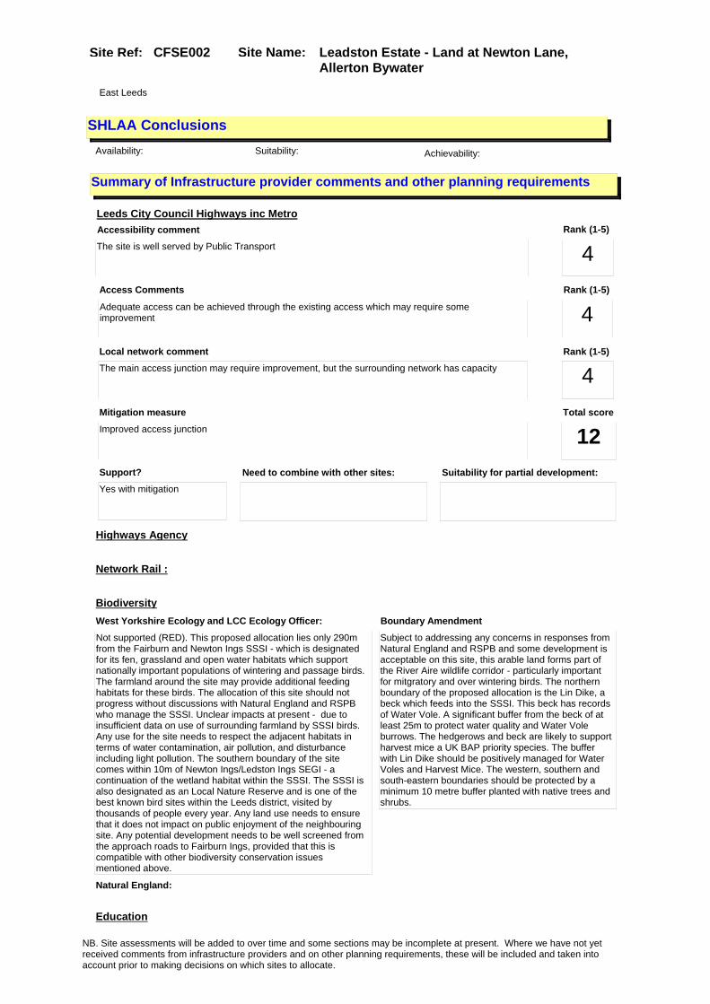
SHLAA ConclusionsAvailability: Suitability: Achievability:
East Leeds
Summary of Infrastructure provider comments and other planning requirements
Accessibility commentThe site is well served by Public Transport
Rank (1-5)
4Access Comments
Adequate access can be achieved through the existing access which may require some improvement
Local network comment
The main access junction may require improvement, but the surrounding network has capacity
Rank (1-5)
4Rank (1-5)
4
Leeds City Council Highways inc Metro
Highways Agency
Network Rail :
Biodiversity
Natural England:
Education
Mitigation measure
Improved access junction
Total score
12Support?
Yes with mitigation
Need to combine with other sites: Suitability for partial development:
West Yorkshire Ecology and LCC Ecology Officer:
Not supported (RED). This proposed allocation lies only 290m from the Fairburn and Newton Ings SSSI - which is designated for its fen, grassland and open water habitats which support nationally important populations of wintering and passage birds. The farmland around the site may provide additional feeding habitats for these birds. The allocation of this site should not progress without discussions with Natural England and RSPB who manage the SSSI. Unclear impacts at present - due to insufficient data on use of surrounding farmland by SSSI birds. Any use for the site needs to respect the adjacent habitats in terms of water contamination, air pollution, and disturbance including light pollution. The southern boundary of the site comes within 10m of Newton Ings/Ledston Ings SEGI - a continuation of the wetland habitat within the SSSI. The SSSI is also designated as an Local Nature Reserve and is one of the best known bird sites within the Leeds district, visited by thousands of people every year. Any land use needs to ensure that it does not impact on public enjoyment of the neighbouring site. Any potential development needs to be well screened from the approach roads to Fairburn Ings, provided that this is compatible with other biodiversity conservation issues mentioned above.
Boundary Amendment
Subject to addressing any concerns in responses from Natural England and RSPB and some development is acceptable on this site, this arable land forms part of the River Aire wildlife corridor - particularly important for mitgratory and over wintering birds. The northern boundary of the proposed allocation is the Lin Dike, a beck which feeds into the SSSI. This beck has records of Water Vole. A significant buffer from the beck of at least 25m to protect water quality and Water Vole burrows. The hedgerows and beck are likely to support harvest mice a UK BAP priority species. The buffer with Lin Dike should be positively managed for Water Voles and Harvest Mice. The western, southern and south-eastern boundaries should be protected by a minimum 10 metre buffer planted with native trees and shrubs.
NB. Site assessments will be added to over time and some sections may be incomplete at present. Where we have not yet received comments from infrastructure providers and on other planning requirements, these will be included and taken into account prior to making decisions on which sites to allocate.

Site Name: Leadston Estate - Land at Newton Lane, Allerton Bywater
Site Ref: CFSE002
Conclusion of Assessment
Conclusion summary:
Site not suitable for employment or residential uses as remote location adjacent to Leadston village out of centre.
Floorspace sq m (Non residential): 92769
Employment Conclusion: Red
Assesment Type: Site assessment Type: Office
Proposed Change:
Drainage/Water/FloodingEnvironment Agency Comments: Environment Agency Constraints:
Yorkshire Water Comments: Yorkshire Water Waste Water Treatment Works Comme
UtilitiesGas:
Electric:
Telecom:
Fire and Rescue Services:
Built HeritageLeeds City Council:
West Yorkshire Archaeology Service:
English Heritage:
LCC Flood Risk Management:
Gypsy Traveller Site Assessment
Yes No Maybe Could site be effectively managed (Text)
Yes No Maybe Would gypsies and travellers live on the site?
(Text)
Yes No Proximity to housed gypsies and travellers (Text)
Yes No Unknown Experience of previous encampments (Text)
NB. Site assessments will be added to over time and some sections may be incomplete at present. Where we have not yet received comments from infrastructure providers and on other planning requirements, these will be included and taken into account prior to making decisions on which sites to allocate.

Site Name: Apex View, LeedsSite Ref: CFSE003
Site Details
Land Use
Northing: 432313
Easting: 429971
Distance to Rail Station (metres): 921.25
Nearest Railway Station Leeds City
Distance to bus stop (metres) 212.06
Bus Stop ID 4404
Agricultural Land Class:
SFRA Flood Zone: 0.00
Environment Agency Flood Zone: 0.00
Within 300m of retail centre boundary:
UDP Designation
Greenbelt - N32 (%): 0.00 Urban Green Corridor - N8 (%): 0.00
Protected Area of Search site - N34 (%): 0.00 Rural Land - RL1: 0.00
City Centre Primary Shopping Quarter - CC27 (%): 0.00 Town Centre - S2: 0.00
Health and Safety Executive Hazard: Yes
Health and Safety Executive Gas Pipeline: Yes
Strategic Employment Buffer: 0.00
Area sq m: 10460.38 Ward City and Hunslet
Special Landscape Area - N37: 0.00
Allotments - N1A: 0.00
Proposed Greenspace - N5: 0.00
Protected Playing Pitch - N6: 0.00
Nature Conservation Area - N50: 0.00
Conservation Areas No
Ancient Monument/Battlefield(%): 0.00 Listed Buildings: No
Public Rights of Way: No
Other?:
Natural Resources and waste DPD (if applicable)
Within Minerals Safeguarding Site?: No Within 100m of Minerals Safeguarding Site?: No
HMCA: Inner Areas
Greenspace - N1: 0
Existing Use 1:
Existing Use 2:
Existing Use 3:
Neighbouring Use 1
Neighbouring Use 2:
Neighbouring Use 3:
Other uses:
Topography:
Natural Landscape:
Boundaries:
Road Frontage
Site Characteristics
Site Detail
Other comments/observations on site characteristics:
Area Ha: 1.046038
Site State:
NB. Site assessments will be added to over time and some sections may be incomplete at present. Where we have not yet received comments from infrastructure providers and on other planning requirements, these will be included and taken into account prior to making decisions on which sites to allocate.

Site Name: Apex View, LeedsSite Ref: CFSE003
Planning History
Planning App No. Proposal Received Decision Status Site %
99-20/216/93/RM Laying out of access and landscaping to office development
12/11/1993 21/10/1993 A 13.69
20/514/01/FU Two 4 storey office blocks 26/09/2001 25/03/2003 W 99.42
H20/104/89/99 Outline application to layout access and erect 5 storeyoffic e block, with 404 basement car parking spaces and 213 car pa
10/03/1989 30/06/1989 W 93.47
99-20/187/93/OT Outline application to erect 4 two storey office blocks
29/09/1993 21/10/1993 A 63.91
NB. Site assessments will be added to over time and some sections may be incomplete at present. Where we have not yet received comments from infrastructure providers and on other planning requirements, these will be included and taken into account prior to making decisions on which sites to allocate.

Site Name: Apex View, LeedsSite Ref: CFSE003
Conformity with Core Strategy
Inner South Leeds: 0.00
Leeds Bradford Corridor: 0.00 West Leeds Gateway: 0.00
Aire Valley: 0.00Regeneration Priority Area:
Brownfield
Greenfield
Mixed
Main Urban Area
Major Settlement
Smaller Settlement
Villages/Rural
Main Urban Area Extension
Major Settlement Extension
Smaller Settlement Extension
Village/Rural Extension
Development unrelated to existing development
Green Belt assessment - only completed where site is within Green Belt
Would development lead to/constitute ribbon development?
Would development result in isolated development?
Is the site well connected to built up area (2+ boundaries with existing built up area)?
Would development of the site effectively "round off" the settlement pattern?:
Do natural/physical features provide a good existing barrier between existing urban area and undeveloped land?
Overall sprawl conclusion:
Would development of the site lead to physical connection of settlements?
Do natural/physical features provide a good existing barrier/boundary to contain development?
Overall Coalescence Conclusion:
Is there a strong defensible boundary between the site and the existing urban area?
Does the site provide access to the countryside?
Does the site include local or national conservation designated areas?
Does the site include areas of woodlands, trees, hedgerows that are protected, or significant unprotected tree/hedge cover?
Does the site include grade 1, 2, or 3a agricultural land?
Does the site contain buildings? Are these in agricultural use?
Overall countryside Encroachment Conclusion
Is the site within or adjacent to a conservation area, listed building or other historical feature?
If yes, could development preserve this character?:
Overall Character Preservation Conclusion:
Greenbelt Assessment Conclusion:
Check the unrestricted sprawl of large built up areas
Prevent neighbouring towns from merging
Assist in safeguarding countryside from encroachment
Preserve the setting and special character of historic towns
NB. Site assessments will be added to over time and some sections may be incomplete at present. Where we have not yet received comments from infrastructure providers and on other planning requirements, these will be included and taken into account prior to making decisions on which sites to allocate.

Site Name: Apex View, LeedsSite Ref: CFSE003
SHLAA ConclusionsAvailability: Suitability: Achievability:
Conclusion of Assessment
Conclusion summary:
Site constrained – heavily sloping. SHLAA site 184
Floorspace sq m (Non residential): 10460
Employment Conclusion: Red
East Leeds
Assesment Type: Site assessment Type: Office
Proposed Change:
Gypsy Traveller Site Assessment
Yes No Maybe Could site be effectively managed (Text)
Yes No Maybe Would gypsies and travellers live on the site?
(Text)
Yes No Proximity to housed gypsies and travellers (Text)
Yes No Unknown Experience of previous encampments (Text)
NB. Site assessments will be added to over time and some sections may be incomplete at present. Where we have not yet received comments from infrastructure providers and on other planning requirements, these will be included and taken into account prior to making decisions on which sites to allocate.

Site Name: Broad Lane/Wyther LaneSite Ref: CFSE004
Site Details
Land Use
Northing: 435460
Easting: 425909
Distance to Rail Station (metres): 966.11
Nearest Railway Station Headingley
Distance to bus stop (metres) 90.90
Bus Stop ID 3377
Agricultural Land Class:
SFRA Flood Zone: 1.00
Environment Agency Flood Zone: 1.00
Within 300m of retail centre boundary:
UDP Designation
Greenbelt - N32 (%): 0.00 Urban Green Corridor - N8 (%): 100.00
Protected Area of Search site - N34 (%): 0.00 Rural Land - RL1: 0.00
City Centre Primary Shopping Quarter - CC27 (%): 0.00 Town Centre - S2: 0.00
Health and Safety Executive Hazard: No
Health and Safety Executive Gas Pipeline: No
Strategic Employment Buffer: 0.00
Area sq m: 2246.98 Ward Armley
Special Landscape Area - N37: 0.00
Allotments - N1A: 0.00
Proposed Greenspace - N5: 0.00
Protected Playing Pitch - N6: 0.00
Nature Conservation Area - N50: 0.00
Conservation Areas No
Ancient Monument/Battlefield(%): 0.00 Listed Buildings: Yes
Public Rights of Way: Yes
Other?:
Natural Resources and waste DPD (if applicable)
Within Minerals Safeguarding Site?: No Within 100m of Minerals Safeguarding Site?: No
HMCA: Outer West
Greenspace - N1: 99.43
Existing Use 1:
Existing Use 2:
Existing Use 3:
Neighbouring Use 1
Neighbouring Use 2:
Neighbouring Use 3:
Other uses:
Topography:
Natural Landscape:
Boundaries:
Road Frontage
Site Characteristics
Site Detail
Other comments/observations on site characteristics:
Area Ha: 0.224698
Site State:
NB. Site assessments will be added to over time and some sections may be incomplete at present. Where we have not yet received comments from infrastructure providers and on other planning requirements, these will be included and taken into account prior to making decisions on which sites to allocate.

Site Name: Broad Lane/Wyther LaneSite Ref: CFSE004
Planning History
Planning App No. Proposal Received Decision Status Site %
H26/368/88/ Outline application to layout access roads and erect residential development, industrial development, shopping,
01/08/1988 01/08/1988 0 100.00
H24/69/87/ Laying out of access, car park and footpath with lands caping, to vacant site. (this item
13/03/1987 19/05/1987 A 85.49
NB. Site assessments will be added to over time and some sections may be incomplete at present. Where we have not yet received comments from infrastructure providers and on other planning requirements, these will be included and taken into account prior to making decisions on which sites to allocate.

Site Name: Broad Lane/Wyther LaneSite Ref: CFSE004
Conformity with Core Strategy
Inner South Leeds: 0.00
Leeds Bradford Corridor: 0.00 West Leeds Gateway: 0.00
Aire Valley: 0.00Regeneration Priority Area:
Brownfield
Greenfield
Mixed
Main Urban Area
Major Settlement
Smaller Settlement
Villages/Rural
Main Urban Area Extension
Major Settlement Extension
Smaller Settlement Extension
Village/Rural Extension
Development unrelated to existing development
Green Belt assessment - only completed where site is within Green Belt
Would development lead to/constitute ribbon development?
Would development result in isolated development?
Is the site well connected to built up area (2+ boundaries with existing built up area)?
Would development of the site effectively "round off" the settlement pattern?:
Do natural/physical features provide a good existing barrier between existing urban area and undeveloped land?
Overall sprawl conclusion:
Would development of the site lead to physical connection of settlements?
Do natural/physical features provide a good existing barrier/boundary to contain development?
Overall Coalescence Conclusion:
Is there a strong defensible boundary between the site and the existing urban area?
Does the site provide access to the countryside?
Does the site include local or national conservation designated areas?
Does the site include areas of woodlands, trees, hedgerows that are protected, or significant unprotected tree/hedge cover?
Does the site include grade 1, 2, or 3a agricultural land?
Does the site contain buildings? Are these in agricultural use?
Overall countryside Encroachment Conclusion
Is the site within or adjacent to a conservation area, listed building or other historical feature?
If yes, could development preserve this character?:
Overall Character Preservation Conclusion:
Greenbelt Assessment Conclusion:
Check the unrestricted sprawl of large built up areas
Prevent neighbouring towns from merging
Assist in safeguarding countryside from encroachment
Preserve the setting and special character of historic towns
NB. Site assessments will be added to over time and some sections may be incomplete at present. Where we have not yet received comments from infrastructure providers and on other planning requirements, these will be included and taken into account prior to making decisions on which sites to allocate.

Site Name: Broad Lane/Wyther LaneSite Ref: CFSE004
SHLAA ConclusionsAvailability: Suitability: Achievability:
Conclusion of Assessment
Conclusion summary:
Flood Zone 2. Entrance to existing industrial estate - provides parking and footpaths. Site too small to allocate.
Floorspace sq m (Non residential):
Employment Conclusion: Red
East Leeds
Assesment Type: Site assessment Type: Industrial & Warehousing
Proposed Change:
Gypsy Traveller Site Assessment
Yes No Maybe Could site be effectively managed (Text)
Yes No Maybe Would gypsies and travellers live on the site?
(Text)
Yes No Proximity to housed gypsies and travellers (Text)
Yes No Unknown Experience of previous encampments (Text)
NB. Site assessments will be added to over time and some sections may be incomplete at present. Where we have not yet received comments from infrastructure providers and on other planning requirements, these will be included and taken into account prior to making decisions on which sites to allocate.

Site Name: 1953 Building, Marshall Street, Holbeck, Leeds
Site Ref: CFSM004
Site Details
Land Use
Northing: 432615
Easting: 429564
Distance to Rail Station (metres): 590.19
Nearest Railway Station Leeds City
Distance to bus stop (metres) 99.13
Bus Stop ID 12632
Agricultural Land Class:
SFRA Flood Zone: 1.00
Environment Agency Flood Zone: 1.00
Within 300m of retail centre boundary:
UDP Designation
Greenbelt - N32 (%): 0.00 Urban Green Corridor - N8 (%): 0.00
Protected Area of Search site - N34 (%): 0.00 Rural Land - RL1: 0.00
City Centre Primary Shopping Quarter - CC27 (%): 0.00 Town Centre - S2: 0.00
Health and Safety Executive Hazard: No
Health and Safety Executive Gas Pipeline: Yes
Strategic Employment Buffer: 0.00
Area sq m: 5943.29 Ward City and Hunslet
Special Landscape Area - N37: 0.00
Allotments - N1A: 0.00
Proposed Greenspace - N5: 0.00
Protected Playing Pitch - N6: 0.00
Nature Conservation Area - N50: 1.00
Conservation Areas Yes
Ancient Monument/Battlefield(%): 0.00 Listed Buildings: No
Public Rights of Way: No
Other?:
Natural Resources and waste DPD (if applicable)
Within Minerals Safeguarding Site?: No Within 100m of Minerals Safeguarding Site?: No
HMCA: City Centre
Greenspace - N1: 0
Existing Use 1:
Existing Use 2:
Existing Use 3:
Neighbouring Use 1
Neighbouring Use 2:
Neighbouring Use 3:
Other uses:
Topography:
Natural Landscape:
Boundaries:
Road Frontage
Site Characteristics
Site Detail
Other comments/observations on site characteristics:
Area Ha: 0.594329
Site State:
NB. Site assessments will be added to over time and some sections may be incomplete at present. Where we have not yet received comments from infrastructure providers and on other planning requirements, these will be included and taken into account prior to making decisions on which sites to allocate.

Site Name: 1953 Building, Marshall Street, Holbeck, Leeds
Site Ref: CFSM004
Planning History
Planning App No. Proposal Received Decision Status Site %
H20/41/76/ Alterations, to remove disused toilets, and form 2 rolle r shutter doors, and addition of new loading plat-form, and
26/01/1976 15/03/1976 A 99.57
10/03474/COND Consent, agreement or approval required by condition 13 of Planning Application 09/00883/FU
22/07/2010 W 18.58
H20/387/74/ Generator housing and 4, 546 li tre (1000 gallons) oil stora ge tank, with bund wall, to wo rks premises.
11/12/1974 13/01/1975 A 99.13
20/305/05/LI Listed building application to part demolish refurb & extend mill to form retail centre/ offices/cafes/75 flats/parking
21/06/2005 05/10/2007 FDO 99.00
09/00883/FU Temporary (3 year) change of use of disused mill to multi purpose performance, exhibition and events venue
02/03/2009 05/02/2010 A 18.58
H20/135/81/ Listed building application to carry out alterations, to fo rm enlarged conveyor system, t o warehouse.
26/03/1981 27/04/1981 W 99.00
20/545/04/LI Listed building application for 2.4m high steel fence and gates to part of boundary of storage & distribution centre
22/11/2004 17/03/2005 A 99.00
09/00884/CA Conservation Area Application for demolition of warehouse
27/01/2009 08/02/2010 A 97.76
07/05131/CA Conservation area application for demolition of outer bridge
13/08/2007 08/10/2007 A 91.98
09/00885/FU Laying out of temporary car park 02/03/2009 17/08/2009 W 97.76
20/303/05/FU Change of use part demolish & 1-7 storey extension to mill to form cultural retail centre 75 flats offices cafes parking
21/06/2005 05/10/2007 FDO 99.00
20/544/04/FU 2.4m high steel fence and gates to part of boundary to storage & distribution centre
22/11/2004 03/02/2005 A 99.00
H20/403/87/ Alterations to form incinerato r plant and addition of 11m h igh chimney, to works.
27/08/1987 04/01/1988 A 97.61
H20/415/87/ Listed building application to carry out alterations to fo rm incinerator plant and addit ion of 11m high chimney to
27/08/1987 04/01/1988 A 97.55
NB. Site assessments will be added to over time and some sections may be incomplete at present. Where we have not yet received comments from infrastructure providers and on other planning requirements, these will be included and taken into account prior to making decisions on which sites to allocate.

Site Name: 1953 Building, Marshall Street, Holbeck, Leeds
Site Ref: CFSM004
Conformity with Core Strategy
Inner South Leeds: 0.00
Leeds Bradford Corridor: 0.00 West Leeds Gateway: 0.00
Aire Valley: 0.00Regeneration Priority Area:
Brownfield
Greenfield
Mixed
Main Urban Area
Major Settlement
Smaller Settlement
Villages/Rural
Main Urban Area Extension
Major Settlement Extension
Smaller Settlement Extension
Village/Rural Extension
Development unrelated to existing development
Green Belt assessment - only completed where site is within Green Belt
Would development lead to/constitute ribbon development?
Would development result in isolated development?
Is the site well connected to built up area (2+ boundaries with existing built up area)?
Would development of the site effectively "round off" the settlement pattern?:
Do natural/physical features provide a good existing barrier between existing urban area and undeveloped land?
Overall sprawl conclusion:
Would development of the site lead to physical connection of settlements?
Do natural/physical features provide a good existing barrier/boundary to contain development?
Overall Coalescence Conclusion:
Is there a strong defensible boundary between the site and the existing urban area?
Does the site provide access to the countryside?
Does the site include local or national conservation designated areas?
Does the site include areas of woodlands, trees, hedgerows that are protected, or significant unprotected tree/hedge cover?
Does the site include grade 1, 2, or 3a agricultural land?
Does the site contain buildings? Are these in agricultural use?
Overall countryside Encroachment Conclusion
Is the site within or adjacent to a conservation area, listed building or other historical feature?
If yes, could development preserve this character?:
Overall Character Preservation Conclusion:
Greenbelt Assessment Conclusion:
Check the unrestricted sprawl of large built up areas
Prevent neighbouring towns from merging
Assist in safeguarding countryside from encroachment
Preserve the setting and special character of historic towns
NB. Site assessments will be added to over time and some sections may be incomplete at present. Where we have not yet received comments from infrastructure providers and on other planning requirements, these will be included and taken into account prior to making decisions on which sites to allocate.

Site Name: 1953 Building, Marshall Street, Holbeck, Leeds
Site Ref: CFSM004
SHLAA ConclusionsAvailability: Suitability: Achievability:
Conclusion of Assessment
Conclusion summary:
Existing employment site. Other uses on site may be acceptable subject to assessment.
Floorspace sq m (Non residential): 1073
Employment Conclusion: Green
East Leeds
Assesment Type: Site assessment Type: Mixed Use
Proposed Change:
Gypsy Traveller Site Assessment
Yes No Maybe Could site be effectively managed (Text)
Yes No Maybe Would gypsies and travellers live on the site?
(Text)
Yes No Proximity to housed gypsies and travellers (Text)
Yes No Unknown Experience of previous encampments (Text)
NB. Site assessments will be added to over time and some sections may be incomplete at present. Where we have not yet received comments from infrastructure providers and on other planning requirements, these will be included and taken into account prior to making decisions on which sites to allocate.

Site Name: Land at former Kirkstall Power StationSite Ref: CFSE005
Site Details
Land Use
Northing: 434441
Easting: 426666
Distance to Rail Station (metres): 1393.92
Nearest Railway Station Headingley
Distance to bus stop (metres) 534.10
Bus Stop ID 7210
Agricultural Land Class:
SFRA Flood Zone: 0.00
Environment Agency Flood Zone: 0.00
Within 300m of retail centre boundary:
UDP Designation
Greenbelt - N32 (%): 0.00 Urban Green Corridor - N8 (%): 12.97
Protected Area of Search site - N34 (%): 0.00 Rural Land - RL1: 0.00
City Centre Primary Shopping Quarter - CC27 (%): 0.00 Town Centre - S2: 0.00
Health and Safety Executive Hazard: No
Health and Safety Executive Gas Pipeline: No
Strategic Employment Buffer: 0.00
Area sq m: 42038.70 Ward Armley
Special Landscape Area - N37: 0.00
Allotments - N1A: 0.00
Proposed Greenspace - N5: 0.00
Protected Playing Pitch - N6: 0.00
Nature Conservation Area - N50: 0.00
Conservation Areas No
Ancient Monument/Battlefield(%): 0.00 Listed Buildings: Yes
Public Rights of Way: Yes
Other?:
Natural Resources and waste DPD (if applicable)
Within Minerals Safeguarding Site?: No Within 100m of Minerals Safeguarding Site?: No
HMCA: Inner Areas
Greenspace - N1: 12.94
Existing Use 1:
Existing Use 2:
Existing Use 3:
Neighbouring Use 1
Neighbouring Use 2:
Neighbouring Use 3:
Other uses:
Topography:
Natural Landscape:
Boundaries:
Road Frontage
Site Characteristics
Site Detail
Other comments/observations on site characteristics:
Area Ha: 4.20387
Site State:
NB. Site assessments will be added to over time and some sections may be incomplete at present. Where we have not yet received comments from infrastructure providers and on other planning requirements, these will be included and taken into account prior to making decisions on which sites to allocate.

Site Name: Land at former Kirkstall Power StationSite Ref: CFSE005
Planning History
Planning App No. Proposal Received Decision Status Site %
H26/368/88/ Outline application to layout access roads and erect residential development, industrial development, shopping,
01/08/1988 01/08/1988 0 100.00
H26/176/74/ Application for extension of p ermission for use of landas he licopter landing site.(applica tion no.odd48, dated 13th
17/05/1974 19/08/1974 A 26.34
NB. Site assessments will be added to over time and some sections may be incomplete at present. Where we have not yet received comments from infrastructure providers and on other planning requirements, these will be included and taken into account prior to making decisions on which sites to allocate.

Site Name: Land at former Kirkstall Power StationSite Ref: CFSE005
Conformity with Core Strategy
Inner South Leeds: 0.00
Leeds Bradford Corridor: 0.00 West Leeds Gateway: 0.00
Aire Valley: 0.00Regeneration Priority Area:
Brownfield
Greenfield
Mixed
Main Urban Area
Major Settlement
Smaller Settlement
Villages/Rural
Main Urban Area Extension
Major Settlement Extension
Smaller Settlement Extension
Village/Rural Extension
Development unrelated to existing development
Green Belt assessment - only completed where site is within Green Belt
Would development lead to/constitute ribbon development?
Would development result in isolated development?
Is the site well connected to built up area (2+ boundaries with existing built up area)?
Would development of the site effectively "round off" the settlement pattern?:
Do natural/physical features provide a good existing barrier between existing urban area and undeveloped land?
Overall sprawl conclusion:
Would development of the site lead to physical connection of settlements?
Do natural/physical features provide a good existing barrier/boundary to contain development?
Overall Coalescence Conclusion:
Is there a strong defensible boundary between the site and the existing urban area?
Does the site provide access to the countryside?
Does the site include local or national conservation designated areas?
Does the site include areas of woodlands, trees, hedgerows that are protected, or significant unprotected tree/hedge cover?
Does the site include grade 1, 2, or 3a agricultural land?
Does the site contain buildings? Are these in agricultural use?
Overall countryside Encroachment Conclusion
Is the site within or adjacent to a conservation area, listed building or other historical feature?
If yes, could development preserve this character?:
Overall Character Preservation Conclusion:
Greenbelt Assessment Conclusion:
Check the unrestricted sprawl of large built up areas
Prevent neighbouring towns from merging
Assist in safeguarding countryside from encroachment
Preserve the setting and special character of historic towns
NB. Site assessments will be added to over time and some sections may be incomplete at present. Where we have not yet received comments from infrastructure providers and on other planning requirements, these will be included and taken into account prior to making decisions on which sites to allocate.

Site Name: Land at former Kirkstall Power StationSite Ref: CFSE005
SHLAA ConclusionsAvailability: Suitability: Achievability:
Conclusion of Assessment
Conclusion summary:
Retain. Former commercial site for power station with access.
Floorspace sq m (Non residential):
Employment Conclusion: Green
East Leeds
Assesment Type: Site assessment Type: Industrial & Warehousing
Proposed Change:
Gypsy Traveller Site Assessment
Yes No Maybe Could site be effectively managed (Text)
Yes No Maybe Would gypsies and travellers live on the site?
(Text)
Yes No Proximity to housed gypsies and travellers (Text)
Yes No Unknown Experience of previous encampments (Text)
NB. Site assessments will be added to over time and some sections may be incomplete at present. Where we have not yet received comments from infrastructure providers and on other planning requirements, these will be included and taken into account prior to making decisions on which sites to allocate.

Site Name: Land At Regent Street/Skinner Lane, LeedsSite Ref: CFSM007
Site Details
Land Use
Northing: 434284
Easting: 430977
Distance to Rail Station (metres): 1686.94
Nearest Railway Station Leeds City
Distance to bus stop (metres) 180.53
Bus Stop ID 7818
Agricultural Land Class:
SFRA Flood Zone: 1.00
Environment Agency Flood Zone: 1.00
Within 300m of retail centre boundary:
UDP Designation
Greenbelt - N32 (%): 0.00 Urban Green Corridor - N8 (%): 0.00
Protected Area of Search site - N34 (%): 0.00 Rural Land - RL1: 0.00
City Centre Primary Shopping Quarter - CC27 (%): 0.00 Town Centre - S2: 0.00
Health and Safety Executive Hazard: No
Health and Safety Executive Gas Pipeline: No
Strategic Employment Buffer: 0.00
Area sq m: 10316.66 Ward City and Hunslet
Special Landscape Area - N37: 0.00
Allotments - N1A: 0.00
Proposed Greenspace - N5: 0.00
Protected Playing Pitch - N6: 0.00
Nature Conservation Area - N50: 0.00
Conservation Areas No
Ancient Monument/Battlefield(%): 0.00 Listed Buildings: No
Public Rights of Way: No
Other?:
Natural Resources and waste DPD (if applicable)
Within Minerals Safeguarding Site?: No Within 100m of Minerals Safeguarding Site?: No
HMCA: Inner Areas
Greenspace - N1: 0
Existing Use 1:
Existing Use 2:
Existing Use 3:
Neighbouring Use 1
Neighbouring Use 2:
Neighbouring Use 3:
Other uses:
Topography:
Natural Landscape:
Boundaries:
Road Frontage
Site Characteristics
Site Detail
Other comments/observations on site characteristics:
Area Ha: 1.031666
Site State:
NB. Site assessments will be added to over time and some sections may be incomplete at present. Where we have not yet received comments from infrastructure providers and on other planning requirements, these will be included and taken into account prior to making decisions on which sites to allocate.

Site Name: Land At Regent Street/Skinner Lane, LeedsSite Ref: CFSM007
Planning History
Planning App No. Proposal Received Decision Status Site %
12/01934/FU Demolition of existing building, laying out of access roads, car parking, landscaping and erection of a foodstore, retail unit, trade/warehouse unit and 2 industrial units
01/05/2012 01/10/2012 W 98.44
34/49/93/SI One internally illuminated double sided free standing sign
12/02/1993 02/04/1993 A 46.09
H34/228/89/ Two externally illuminated log o signs, size of each 2.5m x 4.5m, height above ground 9m (underside), to commercial
03/05/1989 12/06/1989 A 55.83
H34/197/87/ 6 non-illuminated pole mounted flag signs, size of each 1.29m x 0.93m, height of each above ground 8.7m (underside
03/06/1987 15/07/1987 A 56.15
34/250/92/SI 5 internally illuminated signs 1 externally illumnated sign and 4 non illuminated signs
02/11/1992 11/01/1993 A 46.09
H32/920/78/ Demolition of existing buildin gs, laying out of enlar ged access, alterations, inclu ding new entrance with ramp,
28/09/1978 13/11/1978 A 25.92
H34/237/91/ Detached bodyshop comprising s tores, toilets, office, recep tion area, spray booths and pa rking bays with staff room
24/09/1991 19/11/1991 A 87.73
H32/770/75/ Alterations, including new lif t shaft and extensions, to fo rm part fourth floor, comprisi ng 11 offices, boardroom,
01/09/1975 17/11/1975 A 22.30
34/133/92/FU Laying out of access to car park to commercial garage
08/06/1992 20/07/1992 A 35.80
34/82/93/FU 2.4 metre high fence 30/03/1993 07/06/1993 A 35.80
NB. Site assessments will be added to over time and some sections may be incomplete at present. Where we have not yet received comments from infrastructure providers and on other planning requirements, these will be included and taken into account prior to making decisions on which sites to allocate.

Site Name: Land At Regent Street/Skinner Lane, LeedsSite Ref: CFSM007
Conformity with Core Strategy
Inner South Leeds: 0.00
Leeds Bradford Corridor: 0.00 West Leeds Gateway: 0.00
Aire Valley: 0.00Regeneration Priority Area:
Brownfield
Greenfield
Mixed
Main Urban Area
Major Settlement
Smaller Settlement
Villages/Rural
Main Urban Area Extension
Major Settlement Extension
Smaller Settlement Extension
Village/Rural Extension
Development unrelated to existing development
Green Belt assessment - only completed where site is within Green Belt
Would development lead to/constitute ribbon development?
Would development result in isolated development?
Is the site well connected to built up area (2+ boundaries with existing built up area)?
Would development of the site effectively "round off" the settlement pattern?:
Do natural/physical features provide a good existing barrier between existing urban area and undeveloped land?
Overall sprawl conclusion:
Would development of the site lead to physical connection of settlements?
Do natural/physical features provide a good existing barrier/boundary to contain development?
Overall Coalescence Conclusion:
Is there a strong defensible boundary between the site and the existing urban area?
Does the site provide access to the countryside?
Does the site include local or national conservation designated areas?
Does the site include areas of woodlands, trees, hedgerows that are protected, or significant unprotected tree/hedge cover?
Does the site include grade 1, 2, or 3a agricultural land?
Does the site contain buildings? Are these in agricultural use?
Overall countryside Encroachment Conclusion
Is the site within or adjacent to a conservation area, listed building or other historical feature?
If yes, could development preserve this character?:
Overall Character Preservation Conclusion:
Greenbelt Assessment Conclusion:
Check the unrestricted sprawl of large built up areas
Prevent neighbouring towns from merging
Assist in safeguarding countryside from encroachment
Preserve the setting and special character of historic towns
NB. Site assessments will be added to over time and some sections may be incomplete at present. Where we have not yet received comments from infrastructure providers and on other planning requirements, these will be included and taken into account prior to making decisions on which sites to allocate.

Site Name: Land At Regent Street/Skinner Lane, LeedsSite Ref: CFSM007
SHLAA ConclusionsAvailability: Suitability: Achievability:
Conclusion of Assessment
Conclusion summary:
Commercial site with good access surrounded by employment uses.
Floorspace sq m (Non residential): 10316
Employment Conclusion: Green
East Leeds
Assesment Type: Site assessment Type: Office
Proposed Change:
Gypsy Traveller Site Assessment
Yes No Maybe Could site be effectively managed (Text)
Yes No Maybe Would gypsies and travellers live on the site?
(Text)
Yes No Proximity to housed gypsies and travellers (Text)
Yes No Unknown Experience of previous encampments (Text)
NB. Site assessments will be added to over time and some sections may be incomplete at present. Where we have not yet received comments from infrastructure providers and on other planning requirements, these will be included and taken into account prior to making decisions on which sites to allocate.

Site Name: Butterbowl Works, Ring Road, Lower Wortley, Leeds, LS12 5AJ
Site Ref: CFSM008
Site Details
Land Use
Northing: 432537
Easting: 425762
Distance to Rail Station (metres): 2610.00
Nearest Railway Station Bramley
Distance to bus stop (metres) 101.15
Bus Stop ID 10333
Agricultural Land Class:
SFRA Flood Zone: 1.00
Environment Agency Flood Zone: 1.00
Within 300m of retail centre boundary:
UDP Designation
Greenbelt - N32 (%): 0.00 Urban Green Corridor - N8 (%): 0.00
Protected Area of Search site - N34 (%): 0.00 Rural Land - RL1: 0.00
City Centre Primary Shopping Quarter - CC27 (%): 0.00 Town Centre - S2: 0.00
Health and Safety Executive Hazard: No
Health and Safety Executive Gas Pipeline: No
Strategic Employment Buffer: 0.00
Area sq m: 16307.77 Ward Farnley and Wortley
Special Landscape Area - N37: 0.00
Allotments - N1A: 0.00
Proposed Greenspace - N5: 0.00
Protected Playing Pitch - N6: 0.00
Nature Conservation Area - N50: 0.00
Conservation Areas No
Ancient Monument/Battlefield(%): 0.00 Listed Buildings: No
Public Rights of Way: No
Other?:
Natural Resources and waste DPD (if applicable)
Within Minerals Safeguarding Site?: No Within 100m of Minerals Safeguarding Site?: No
HMCA: Outer West
Greenspace - N1: 0
Existing Use 1: Industry and business - Manufacturing & WholesaleExisting Use 2:
Existing Use 3:
Neighbouring Use 1 Residential - Dwellings
Neighbouring Use 2: Transport - Transport tracks & ways
Neighbouring Use 3: Forestry - Unmanaged Forest
Other uses:
Topography: Flat
Natural Landscape: Limited Tree Cover
Boundaries: Existing well defined
Road Frontage
Site Characteristics
Site Detail
Other comments/observations on site characteristics:
Existing employment site set adjacent to the ring road. Residential dwellings to south and west.
Area Ha: 1.630777
Site State: Brownfield
NB. Site assessments will be added to over time and some sections may be incomplete at present. Where we have not yet received comments from infrastructure providers and on other planning requirements, these will be included and taken into account prior to making decisions on which sites to allocate.

Site Name: Butterbowl Works, Ring Road, Lower Wortley, Leeds, LS12 5AJ
Site Ref: CFSM008
Planning History
Planning App No. Proposal Received Decision Status Site %
24/34/95/RE Renewal of permission for the erection of detached warehouse industrial unit with offices to engineering works
25/01/1995 28/03/1995 A 79.90
H24/310/83/ Outline application to erect l ight industrial and wareh ouse unit to vacant site. (s ite area 0.32ha)
07/11/1983 20/02/1984 A 20.47
24/221/04/SI 4 internally illuminated signs to workshops
29/04/2004 21/05/2004 A 20.47
12/02166/FU Retrospective application for electric fence within the perimeter fencing
16/05/2012 24/07/2012 A 99.49
24/48/00/RE Renewal of permission for the erection of detached warehouse industrial unit with offices to engineering works
22/02/2000 18/04/2000 A 79.86
24/465/05/FU Laying out of overflow car parking area to car body workshop
19/09/2005 16/12/2005 A 18.90
H24/58/89/ Erection of detached industria l unit with offices and bound ary fence to engineering works .
16/02/1989 12/04/1989 A 72.67
24/509/03/FU Change of use of warehouse to car body workshop and paint spraying centre
21/10/2003 20/01/2004 A 17.88
11/04188/DEM Determination for demolition of industrial buildings
04/10/2011 31/10/2011 NR 79.86
H24/108/84/ Laying out of access and erect ion of detached single store y light industrial and warehou se unit with toiletsand with 2
19/04/1984 22/05/1984 A 20.23
H24/364/88/ Laying out of enlarged access, to plant hire depot.
12/12/1988 17/01/1989 A 72.29
H24/58/89/1 Amendment to previous applicat ion involving the condi tion regarding the use for the erection of a detached i
15/01/1990 06/02/1990 A 73.03
NB. Site assessments will be added to over time and some sections may be incomplete at present. Where we have not yet received comments from infrastructure providers and on other planning requirements, these will be included and taken into account prior to making decisions on which sites to allocate.

Site Name: Butterbowl Works, Ring Road, Lower Wortley, Leeds, LS12 5AJ
Site Ref: CFSM008
Conformity with Core Strategy
Inner South Leeds: 0.00
Leeds Bradford Corridor: 0.00 West Leeds Gateway: 0.00
Aire Valley: 0.00Regeneration Priority Area:
Brownfield
Greenfield
Mixed
Main Urban Area
Major Settlement
Smaller Settlement
Villages/Rural
Main Urban Area Extension
Major Settlement Extension
Smaller Settlement Extension
Village/Rural Extension
Development unrelated to existing development
Green Belt assessment - only completed where site is within Green Belt
Would development lead to/constitute ribbon development?
Would development result in isolated development?
Is the site well connected to built up area (2+ boundaries with existing built up area)?
Would development of the site effectively "round off" the settlement pattern?:
Do natural/physical features provide a good existing barrier between existing urban area and undeveloped land?
Overall sprawl conclusion:
Would development of the site lead to physical connection of settlements?
Do natural/physical features provide a good existing barrier/boundary to contain development?
Overall Coalescence Conclusion:
Is there a strong defensible boundary between the site and the existing urban area?
Does the site provide access to the countryside?
Does the site include local or national conservation designated areas?
Does the site include areas of woodlands, trees, hedgerows that are protected, or significant unprotected tree/hedge cover?
Does the site include grade 1, 2, or 3a agricultural land?
Does the site contain buildings? Are these in agricultural use?
Overall countryside Encroachment Conclusion
Is the site within or adjacent to a conservation area, listed building or other historical feature?
If yes, could development preserve this character?:
Overall Character Preservation Conclusion:
Greenbelt Assessment Conclusion:
Check the unrestricted sprawl of large built up areas
Prevent neighbouring towns from merging
Assist in safeguarding countryside from encroachment
Preserve the setting and special character of historic towns
NB. Site assessments will be added to over time and some sections may be incomplete at present. Where we have not yet received comments from infrastructure providers and on other planning requirements, these will be included and taken into account prior to making decisions on which sites to allocate.

Site Name: Butterbowl Works, Ring Road, Lower Wortley, Leeds, LS12 5AJ
Site Ref: CFSM008
SHLAA ConclusionsAvailability: Suitability: Achievability:
East Leeds
Summary of Infrastructure provider comments and other planning requirements
Accessibility commentMeets Core Strategy accessibility standards but lacking in local services.
Rank (1-5)
5Access Comments
Ring Road only access mitigation required.
Local network comment
Possible cumulative impact but brownfield site mitigation possible.
Rank (1-5)
4Rank (1-5)
4
Leeds City Council Highways inc Metro
Highways Agency
Network Rail :
Biodiversity
Natural England:
Education
Mitigation measure
Signal junction but may not be justified.
Total score
13Support?
yes with mitigation.
Need to combine with other sites: Suitability for partial development:
West Yorkshire Ecology and LCC Ecology Officer:
Supported
Boundary Amendment
Drainage/Water/FloodingEnvironment Agency Comments: Environment Agency Constraints:
Yorkshire Water Comments: Yorkshire Water Waste Water Treatment Works Comme
UtilitiesGas:
LCC Flood Risk Management:
NB. Site assessments will be added to over time and some sections may be incomplete at present. Where we have not yet received comments from infrastructure providers and on other planning requirements, these will be included and taken into account prior to making decisions on which sites to allocate.

Site Name: Butterbowl Works, Ring Road, Lower Wortley, Leeds, LS12 5AJ
Site Ref: CFSM008
Conclusion of Assessment
Conclusion summary:
Out of centre location not appropriate for office element of mix use scheme.
Floorspace sq m (Non residential):
Employment Conclusion: Green
Assesment Type: Site assessment Type: Mixed Use
Proposed Change:
Electric:
Telecom:
Fire and Rescue Services:
Built HeritageLeeds City Council:
West Yorkshire Archaeology Service:
English Heritage:
Gypsy Traveller Site Assessment
Yes No Maybe Could site be effectively managed (Text)
Yes No Maybe Would gypsies and travellers live on the site?
(Text)
Yes No Proximity to housed gypsies and travellers (Text)
Yes No Unknown Experience of previous encampments (Text)
NB. Site assessments will be added to over time and some sections may be incomplete at present. Where we have not yet received comments from infrastructure providers and on other planning requirements, these will be included and taken into account prior to making decisions on which sites to allocate.
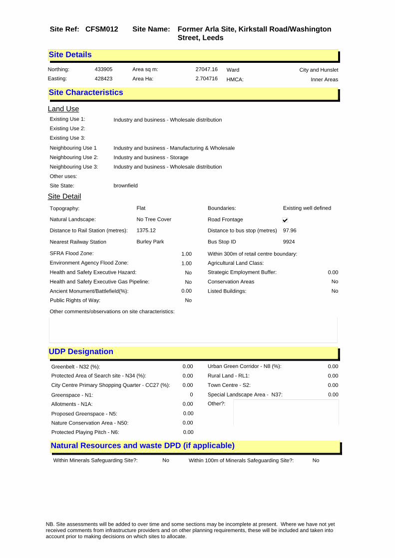
Site Name: Former Arla Site, Kirkstall Road/Washington Street, Leeds
Site Ref: CFSM012
Site Details
Land Use
Northing: 433905
Easting: 428423
Distance to Rail Station (metres): 1375.12
Nearest Railway Station Burley Park
Distance to bus stop (metres) 97.96
Bus Stop ID 9924
Agricultural Land Class:
SFRA Flood Zone: 1.00
Environment Agency Flood Zone: 1.00
Within 300m of retail centre boundary:
UDP Designation
Greenbelt - N32 (%): 0.00 Urban Green Corridor - N8 (%): 0.00
Protected Area of Search site - N34 (%): 0.00 Rural Land - RL1: 0.00
City Centre Primary Shopping Quarter - CC27 (%): 0.00 Town Centre - S2: 0.00
Health and Safety Executive Hazard: No
Health and Safety Executive Gas Pipeline: No
Strategic Employment Buffer: 0.00
Area sq m: 27047.16 Ward City and Hunslet
Special Landscape Area - N37: 0.00
Allotments - N1A: 0.00
Proposed Greenspace - N5: 0.00
Protected Playing Pitch - N6: 0.00
Nature Conservation Area - N50: 0.00
Conservation Areas No
Ancient Monument/Battlefield(%): 0.00 Listed Buildings: No
Public Rights of Way: No
Other?:
Natural Resources and waste DPD (if applicable)
Within Minerals Safeguarding Site?: No Within 100m of Minerals Safeguarding Site?: No
HMCA: Inner Areas
Greenspace - N1: 0
Existing Use 1: Industry and business - Wholesale distributionExisting Use 2:
Existing Use 3:
Neighbouring Use 1 Industry and business - Manufacturing & Wholesale
Neighbouring Use 2: Industry and business - Storage
Neighbouring Use 3: Industry and business - Wholesale distribution
Other uses:
Topography: Flat
Natural Landscape: No Tree Cover
Boundaries: Existing well defined
Road Frontage
Site Characteristics
Site Detail
Other comments/observations on site characteristics:
Area Ha: 2.704716
Site State: brownfield
NB. Site assessments will be added to over time and some sections may be incomplete at present. Where we have not yet received comments from infrastructure providers and on other planning requirements, these will be included and taken into account prior to making decisions on which sites to allocate.

Site Name: Former Arla Site, Kirkstall Road/Washington Street, Leeds
Site Ref: CFSM012
Planning History
Planning App No. Proposal Received Decision Status Site %
H26/473/80/ Laying out of drainage, to dai ry. 17/04/1980 14/07/1980 A 99.43
H26/476/80/ Amendment to previous applicat ion involving 27, 277 litre s underground diesel oil tank, 36, 369 litres undergroun
17/04/1980 14/07/1980 A 99.43
20/466/96/FU Extension to form loading and unloading platform and recladding to depot
06/09/1996 31/10/1996 A 99.49
20/166/96/FU Detached processing plant with storage tanks and altered egress and access to dairy
01/04/1996 07/12/1998 W 99.49
H20/40/87/ Alterations and extension, to form container wash, coldstore area and enlarged cartoning h all with ancillary offices, t
27/01/1987 02/03/1987 A 99.55
H20/13/91/ Addition of canopy over existi ng tanker reception area, to da iry.
15/01/1991 26/03/1991 A 95.02
20/261/96/FU Air conditioning units to roof of offices 06/06/1996 16/09/1996 A 99.49
20/566/98/FU Air conditioning units to roof of offices 24/09/1998 16/11/1998 A 99.52
H26/668/78/ 27, 277 litres (6000 galls) und erground diesel oil tank, 36, 369 litres (8000 galls) un derground petrol tan
10/07/1978 04/09/1978 A 97.59
H26/1003/79/ Addition of pump house and 2 9 0, 922 litres oil storage tanks with 3.75m high bund wall to dairy.
05/10/1979 26/11/1979 A 97.83
20/64/95/FU Pipebridge and screenwall to dairy 21/02/1995 05/04/1995 A 99.49
20/425/94/FU Two milk storage silos to dairy 05/10/1994 30/11/1994 A 99.52
H26/84/82/ Alterations and extension, to form detergent store withstore over, to dairy.
08/03/1982 04/05/1982 A 99.18
H20/451/86/ Alterations and extension to f orm enlarged dairy and enlar ged office to dairy.
21/10/1986 11/12/1986 W 99.48
H26/193/79/ Outline application to demolis h existing building, erect 5 storey office block with ca r parking spaces, and form n
15/03/1979 08/05/1979 A 18.37
H26/927/75/ Outline application to erect p art 2 and part 6 store y office extension with altera tions to car parkin
30/10/1975 01/03/1976 A 29.76
20/294/97/FU Alterations and part new cladding to entrance to offices
20/05/1997 14/07/1997 A 99.49
H26/45/74/ Outline application to erect t wo storey ancillery offic e extensions to industrial pre mises
09/04/1974 08/10/1974 A 13.49
H26/183/78/ Alterations and extension, to form entrance lobby, to da iry.
03/03/1978 17/04/1978 A 49.86
H20/94/92/ 1 internally illuminated wall logo sign and 1 exter nally illuminated fascia sign to offices.
04/03/1992 05/11/1992 A 96.44
NB. Site assessments will be added to over time and some sections may be incomplete at present. Where we have not yet received comments from infrastructure providers and on other planning requirements, these will be included and taken into account prior to making decisions on which sites to allocate.
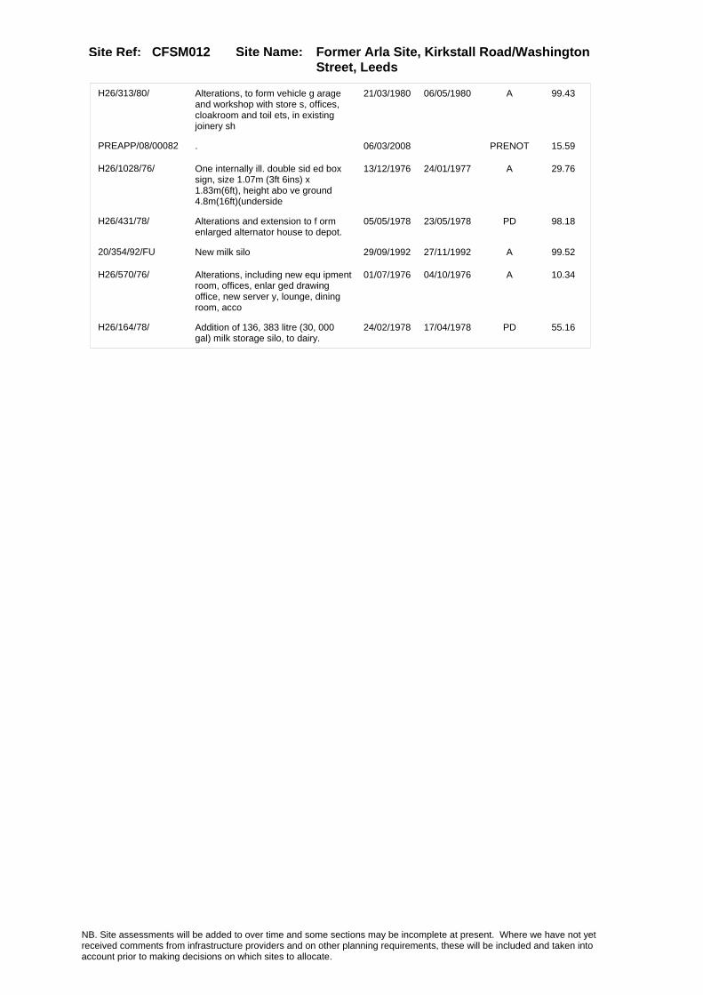
Site Name: Former Arla Site, Kirkstall Road/Washington Street, Leeds
Site Ref: CFSM012
H26/313/80/ Alterations, to form vehicle g arage and workshop with store s, offices, cloakroom and toil ets, in existing joinery sh
21/03/1980 06/05/1980 A 99.43
PREAPP/08/00082 . 06/03/2008 PRENOT 15.59
H26/1028/76/ One internally ill. double sid ed box sign, size 1.07m (3ft 6ins) x 1.83m(6ft), height abo ve ground 4.8m(16ft)(underside
13/12/1976 24/01/1977 A 29.76
H26/431/78/ Alterations and extension to f orm enlarged alternator house to depot.
05/05/1978 23/05/1978 PD 98.18
20/354/92/FU New milk silo 29/09/1992 27/11/1992 A 99.52
H26/570/76/ Alterations, including new equ ipment room, offices, enlar ged drawing office, new server y, lounge, dining room, acco
01/07/1976 04/10/1976 A 10.34
H26/164/78/ Addition of 136, 383 litre (30, 000 gal) milk storage silo, to dairy.
24/02/1978 17/04/1978 PD 55.16
NB. Site assessments will be added to over time and some sections may be incomplete at present. Where we have not yet received comments from infrastructure providers and on other planning requirements, these will be included and taken into account prior to making decisions on which sites to allocate.

Site Name: Former Arla Site, Kirkstall Road/Washington Street, Leeds
Site Ref: CFSM012
Conformity with Core Strategy
Inner South Leeds: 0.00
Leeds Bradford Corridor: 0.00 West Leeds Gateway: 0.00
Aire Valley: 0.00Regeneration Priority Area:
Brownfield
Greenfield
Mixed
Main Urban Area
Major Settlement
Smaller Settlement
Villages/Rural
Main Urban Area Extension
Major Settlement Extension
Smaller Settlement Extension
Village/Rural Extension
Development unrelated to existing development
Green Belt assessment - only completed where site is within Green Belt
Would development lead to/constitute ribbon development?
Would development result in isolated development?
Is the site well connected to built up area (2+ boundaries with existing built up area)?
Would development of the site effectively "round off" the settlement pattern?:
Do natural/physical features provide a good existing barrier between existing urban area and undeveloped land?
Overall sprawl conclusion:
Would development of the site lead to physical connection of settlements?
Do natural/physical features provide a good existing barrier/boundary to contain development?
Overall Coalescence Conclusion:
Is there a strong defensible boundary between the site and the existing urban area?
Does the site provide access to the countryside?
Does the site include local or national conservation designated areas?
Does the site include areas of woodlands, trees, hedgerows that are protected, or significant unprotected tree/hedge cover?
Does the site include grade 1, 2, or 3a agricultural land?
Does the site contain buildings? Are these in agricultural use?
Overall countryside Encroachment Conclusion
Is the site within or adjacent to a conservation area, listed building or other historical feature?
If yes, could development preserve this character?:
Overall Character Preservation Conclusion:
Greenbelt Assessment Conclusion:
Check the unrestricted sprawl of large built up areas
Prevent neighbouring towns from merging
Assist in safeguarding countryside from encroachment
Preserve the setting and special character of historic towns
NB. Site assessments will be added to over time and some sections may be incomplete at present. Where we have not yet received comments from infrastructure providers and on other planning requirements, these will be included and taken into account prior to making decisions on which sites to allocate.
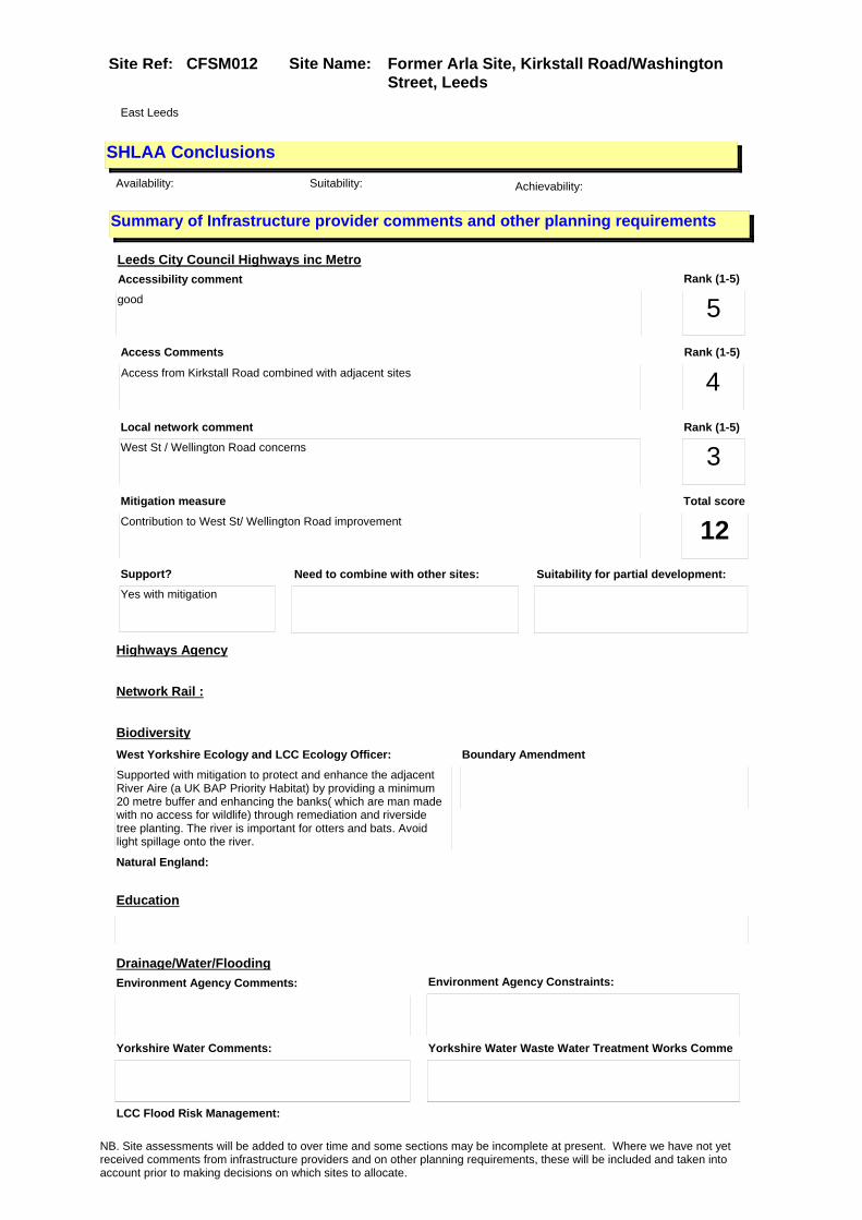
Site Name: Former Arla Site, Kirkstall Road/Washington Street, Leeds
Site Ref: CFSM012
SHLAA ConclusionsAvailability: Suitability: Achievability:
East Leeds
Summary of Infrastructure provider comments and other planning requirements
Accessibility commentgood
Rank (1-5)
5Access Comments
Access from Kirkstall Road combined with adjacent sites
Local network comment
West St / Wellington Road concerns
Rank (1-5)
4Rank (1-5)
3
Leeds City Council Highways inc Metro
Highways Agency
Network Rail :
Biodiversity
Natural England:
Education
Mitigation measure
Contribution to West St/ Wellington Road improvement
Total score
12Support?
Yes with mitigation
Need to combine with other sites: Suitability for partial development:
West Yorkshire Ecology and LCC Ecology Officer:
Supported with mitigation to protect and enhance the adjacent River Aire (a UK BAP Priority Habitat) by providing a minimum 20 metre buffer and enhancing the banks( which are man made with no access for wildlife) through remediation and riverside tree planting. The river is important for otters and bats. Avoid light spillage onto the river.
Boundary Amendment
Drainage/Water/FloodingEnvironment Agency Comments: Environment Agency Constraints:
Yorkshire Water Comments: Yorkshire Water Waste Water Treatment Works Comme
LCC Flood Risk Management:
NB. Site assessments will be added to over time and some sections may be incomplete at present. Where we have not yet received comments from infrastructure providers and on other planning requirements, these will be included and taken into account prior to making decisions on which sites to allocate.

Site Name: Former Arla Site, Kirkstall Road/Washington Street, Leeds
Site Ref: CFSM012
Conclusion of Assessment
Conclusion summary:
Existing employment site. Other uses on site may be acceptable subject to assessment.
Floorspace sq m (Non residential):
Employment Conclusion: Green
Assesment Type: Site assessment Type: Mixed Use
Proposed Change:
UtilitiesGas:
Electric:
Telecom:
Fire and Rescue Services:
Built HeritageLeeds City Council:
West Yorkshire Archaeology Service:
English Heritage:
Gypsy Traveller Site Assessment
Yes No Maybe Could site be effectively managed (Text)
Yes No Maybe Would gypsies and travellers live on the site?
(Text)
Yes No Proximity to housed gypsies and travellers (Text)
Yes No Unknown Experience of previous encampments (Text)
NB. Site assessments will be added to over time and some sections may be incomplete at present. Where we have not yet received comments from infrastructure providers and on other planning requirements, these will be included and taken into account prior to making decisions on which sites to allocate.
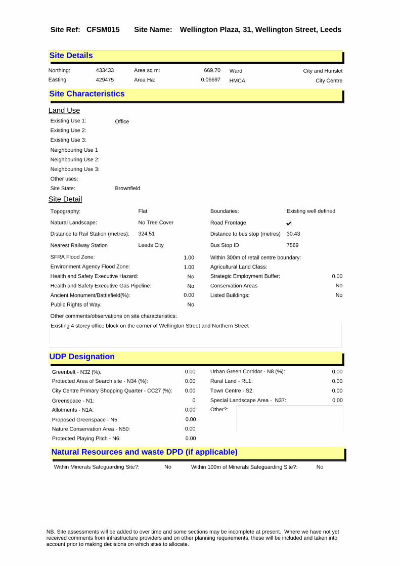
Site Name: Wellington Plaza, 31, Wellington Street, LeedsSite Ref: CFSM015
Site Details
Land Use
Northing: 433433
Easting: 429475
Distance to Rail Station (metres): 324.51
Nearest Railway Station Leeds City
Distance to bus stop (metres) 30.43
Bus Stop ID 7569
Agricultural Land Class:
SFRA Flood Zone: 1.00
Environment Agency Flood Zone: 1.00
Within 300m of retail centre boundary:
UDP Designation
Greenbelt - N32 (%): 0.00 Urban Green Corridor - N8 (%): 0.00
Protected Area of Search site - N34 (%): 0.00 Rural Land - RL1: 0.00
City Centre Primary Shopping Quarter - CC27 (%): 0.00 Town Centre - S2: 0.00
Health and Safety Executive Hazard: No
Health and Safety Executive Gas Pipeline: No
Strategic Employment Buffer: 0.00
Area sq m: 669.70 Ward City and Hunslet
Special Landscape Area - N37: 0.00
Allotments - N1A: 0.00
Proposed Greenspace - N5: 0.00
Protected Playing Pitch - N6: 0.00
Nature Conservation Area - N50: 0.00
Conservation Areas No
Ancient Monument/Battlefield(%): 0.00 Listed Buildings: No
Public Rights of Way: No
Other?:
Natural Resources and waste DPD (if applicable)
Within Minerals Safeguarding Site?: No Within 100m of Minerals Safeguarding Site?: No
HMCA: City Centre
Greenspace - N1: 0
Existing Use 1: OfficeExisting Use 2:
Existing Use 3:
Neighbouring Use 1
Neighbouring Use 2:
Neighbouring Use 3:
Other uses:
Topography: Flat
Natural Landscape: No Tree Cover
Boundaries: Existing well defined
Road Frontage
Site Characteristics
Site Detail
Other comments/observations on site characteristics:
Existing 4 storey office block on the corner of Wellington Street and Northern Street
Area Ha: 0.06697
Site State: Brownfield
NB. Site assessments will be added to over time and some sections may be incomplete at present. Where we have not yet received comments from infrastructure providers and on other planning requirements, these will be included and taken into account prior to making decisions on which sites to allocate.

Site Name: Wellington Plaza, 31, Wellington Street, LeedsSite Ref: CFSM015
Planning History
Planning App No. Proposal Received Decision Status Site %
H20/361/77/ Laying out of access and erect ion of 4 storey whole sale showroom, with ancillary offices, toilets and plant
06/09/1977 15/09/1980 W 90.71
H20/52/81/ Laying out of access roads, er ection of one block of 5, indus trial units, each with 2 store y offices and toilets, o
03/02/1981 27/07/1981 A 98.57
H20/339/82/ Laying out of drainage, with u nderground pumping stati on, to warehouse development. (outline applicationno.78/20/0
23/09/1982 04/10/1982 A 98.56
11/05069/ADV Internally illuminated individual letter wall mounted sign
02/12/2011 26/01/2012 A 99.69
11/05039/FU Installation of a curved glass canopy over main entrance
01/12/2011 26/01/2012 A 99.55
H20/396/76/1 Extension of temporary permiss ion for the use of vacantland as vehicle park. (previous app lication no 76/20/0039
02/03/1978 10/04/1978 A 99.07
H20/348/82/ Laying out of drainage to ware house development (outl ine application no. 78/20/0053 1 approved subject to conditi
28/09/1982 02/07/1984 W 99.15
H20/436/80/ Site preparation, involving dem olition & works to part of fo rmer railway viaduct to liftin g tower and to part of boundar
05/12/1980 06/08/1981 A 98.57
20/272/94/FU Roof top plant room to offices 06/07/1994 23/08/1994 A 100.00
H20/396/76/ Use of vacant land for a tempo rary period as vehicle park.
18/10/1976 20/12/1976 A 99.81
H20/90/84/ Alterations, to form entrance lobby, to offices.
22/02/1984 05/03/1984 A 98.56
20/130/03/FU Automatic sliding gates and fence to car park entrance to rear
17/03/2003 22/07/2003 A 100.00
NB. Site assessments will be added to over time and some sections may be incomplete at present. Where we have not yet received comments from infrastructure providers and on other planning requirements, these will be included and taken into account prior to making decisions on which sites to allocate.

Site Name: Wellington Plaza, 31, Wellington Street, LeedsSite Ref: CFSM015
Conformity with Core Strategy
Inner South Leeds: 0.00
Leeds Bradford Corridor: 0.00 West Leeds Gateway: 0.00
Aire Valley: 0.00Regeneration Priority Area:
Brownfield
Greenfield
Mixed
Main Urban Area
Major Settlement
Smaller Settlement
Villages/Rural
Main Urban Area Extension
Major Settlement Extension
Smaller Settlement Extension
Village/Rural Extension
Development unrelated to existing development
Green Belt assessment - only completed where site is within Green Belt
Would development lead to/constitute ribbon development?
Would development result in isolated development?
Is the site well connected to built up area (2+ boundaries with existing built up area)?
Would development of the site effectively "round off" the settlement pattern?:
Do natural/physical features provide a good existing barrier between existing urban area and undeveloped land?
Overall sprawl conclusion:
Would development of the site lead to physical connection of settlements?
Do natural/physical features provide a good existing barrier/boundary to contain development?
Overall Coalescence Conclusion:
Is there a strong defensible boundary between the site and the existing urban area?
Does the site provide access to the countryside?
Does the site include local or national conservation designated areas?
Does the site include areas of woodlands, trees, hedgerows that are protected, or significant unprotected tree/hedge cover?
Does the site include grade 1, 2, or 3a agricultural land?
Does the site contain buildings? Are these in agricultural use?
Overall countryside Encroachment Conclusion
Is the site within or adjacent to a conservation area, listed building or other historical feature?
If yes, could development preserve this character?:
Overall Character Preservation Conclusion:
Greenbelt Assessment Conclusion:
Check the unrestricted sprawl of large built up areas
Prevent neighbouring towns from merging
Assist in safeguarding countryside from encroachment
Preserve the setting and special character of historic towns
NB. Site assessments will be added to over time and some sections may be incomplete at present. Where we have not yet received comments from infrastructure providers and on other planning requirements, these will be included and taken into account prior to making decisions on which sites to allocate.

Site Name: Wellington Plaza, 31, Wellington Street, LeedsSite Ref: CFSM015
SHLAA ConclusionsAvailability: Suitability: Achievability:
Conclusion of Assessment
Conclusion summary:
Existing employment site. Other uses on site may be acceptable subject to assessment.
Floorspace sq m (Non residential): 127
Employment Conclusion: Green
East Leeds
Assesment Type: Site assessment Type: Mixed Use
Proposed Change:
Gypsy Traveller Site Assessment
Yes No Maybe Could site be effectively managed (Text)
Yes No Maybe Would gypsies and travellers live on the site?
(Text)
Yes No Proximity to housed gypsies and travellers (Text)
Yes No Unknown Experience of previous encampments (Text)
NB. Site assessments will be added to over time and some sections may be incomplete at present. Where we have not yet received comments from infrastructure providers and on other planning requirements, these will be included and taken into account prior to making decisions on which sites to allocate.

Site Name: 83-89, Bradford Road, Pudsey, Leeds LS18 6AT
Site Ref: CFSM016
Site Details
Land Use
Northing: 434345
Easting: 421591
Distance to Rail Station (metres): 458.08
Nearest Railway Station New Pudsey
Distance to bus stop (metres) 62.98
Bus Stop ID 5977
Agricultural Land Class:
SFRA Flood Zone: 0.00
Environment Agency Flood Zone: 0.00
Within 300m of retail centre boundary:
UDP Designation
Greenbelt - N32 (%): 0.00 Urban Green Corridor - N8 (%): 53.54
Protected Area of Search site - N34 (%): 0.00 Rural Land - RL1: 0.00
City Centre Primary Shopping Quarter - CC27 (%): 0.00 Town Centre - S2: 0.00
Health and Safety Executive Hazard: No
Health and Safety Executive Gas Pipeline: No
Strategic Employment Buffer: 0.00
Area sq m: 7382.61 Ward Calverley and Farsley
Special Landscape Area - N37: 0.00
Allotments - N1A: 0.00
Proposed Greenspace - N5: 0.00
Protected Playing Pitch - N6: 0.00
Nature Conservation Area - N50: 0.00
Conservation Areas No
Ancient Monument/Battlefield(%): 0.00 Listed Buildings: Yes
Public Rights of Way: Yes
Other?:
Natural Resources and waste DPD (if applicable)
Within Minerals Safeguarding Site?: No Within 100m of Minerals Safeguarding Site?: No
HMCA: Outer West
Greenspace - N1: 0
Existing Use 1:
Existing Use 2:
Existing Use 3:
Neighbouring Use 1
Neighbouring Use 2:
Neighbouring Use 3:
Other uses:
Topography:
Natural Landscape:
Boundaries:
Road Frontage
Site Characteristics
Site Detail
Other comments/observations on site characteristics:
Area Ha: 0.738261
Site State:
NB. Site assessments will be added to over time and some sections may be incomplete at present. Where we have not yet received comments from infrastructure providers and on other planning requirements, these will be included and taken into account prior to making decisions on which sites to allocate.

Site Name: 83-89, Bradford Road, Pudsey, Leeds LS18 6AT
Site Ref: CFSM016
Planning History
Planning App No. Proposal Received Decision Status Site %
H25/41/80/ Detached block of 2 single sto rey warehouse units, eachwith 2 storey offices and toilets, and with 37 car parking sp
17/01/1980 17/03/1980 A 18.84
07/03537/ADV 2 non illuminated wall signs and 1 non illuminated double sided totem sign to warehouse
31/05/2007 APPRET 96.64
H25/333/87/ Alterations and extension, to form enlarged joiners works hop, with nine additional car parking spaces, to workshop.
09/11/1987 04/01/1988 A 19.04
H25/579/75/ Outline application to erect 5 storey computer and train ing centre with offices, confe rence suite, librarystaff room
05/09/1975 24/03/1976 A 24.28
H25/469/74/ Renewal of outline permission for five warehouse units each with office and showroom accom modation to vacant industrial
11/11/1974 24/03/1975 W 41.13
25/380/05/FU Laying out of access and erection of 92 flats in 3 blocks & 2 storey office block with car parking & landscaping
27/09/2005 15/02/2007 R 99.92
10/02881/EXT Extension of time period for planning application 25/380/05/FU for laying out of access and erection of 92 flats in 3 blocks & 2 storey office block with car parking & landscaping
23/06/2010 13/05/2011 A 99.91
H25/50/80/ Detached single storey warehou se unit with 2 storey offic es and with 37 car parking spa ces, to vacant site
22/01/1980 17/03/1980 A 19.17
H25/418/76/ Laying out of access roads, an d erection of 6 wareh ouse units, in 2 blocks, inclu ding 5 units each with
25/06/1976 04/10/1976 A 58.91
H25/270/75/ Alterations and extension to f orm enlarged timber storeand l oading bay, with office space o ver, to workshop premises.
24/04/1975 12/05/1975 A 26.55
H25/147/75/ One illuminated double sided p ole sign, size 1.89m (6ft) x 0.45m (1ft.6ins) height abo ve ground 3.96m (13ft) (un
06/03/1975 21/04/1975 A 38.21
H25/498/74/ Alterations and extension to f orm timber store with loadi ng bay, and 20 new car parking spaces to works premises.
22/11/1974 10/02/1975 A 18.81
H25/537/78/ Alterations and extension, to form 2 new offices, and a ddition of brick garage, to si de of joinery works.
11/08/1978 25/09/1978 A 26.55
H25/20/85/ Alterations and extension, to form offices, to joinery works .
23/01/1985 11/03/1985 A 75.00
25/303/02/FU Laying out of access and erection of three storey office block with basement car park
07/10/2002 02/01/2003 A 98.28
H25/3/87/ Erection of light industrial w arehouse unit with officeand t oilet and with 42 car parking spaces, to vacant site.
06/01/1987 12/01/1987 W 18.80
NB. Site assessments will be added to over time and some sections may be incomplete at present. Where we have not yet received comments from infrastructure providers and on other planning requirements, these will be included and taken into account prior to making decisions on which sites to allocate.
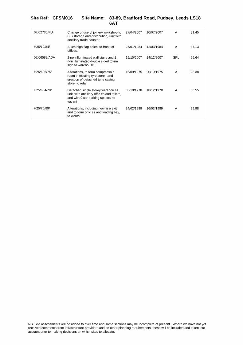
Site Name: 83-89, Bradford Road, Pudsey, Leeds LS18 6AT
Site Ref: CFSM016
07/02780/FU Change of use of joinery workshop to B8 (storage and distribution) unit with ancillary trade counter
27/04/2007 10/07/2007 A 31.45
H25/19/84/ 2, 4m high flag poles, to fron t of offices.
27/01/1984 12/03/1984 A 37.13
07/06582/ADV 2 non illuminated wall signs and 1 non illuminated double sided totem sign to warehouse
19/10/2007 14/12/2007 SPL 96.64
H25/606/75/ Alterations, to form compresso r room in existing tyre store , and erection of detached tyr e casing store, to retail
16/09/1975 20/10/1975 A 23.38
H25/634/78/ Detached single storey warehou se unit, with ancillary offic es and toilets, and with 9 car parking spaces, to vacant
05/10/1978 18/12/1978 A 60.55
H25/70/89/ Alterations, including new fir e exit and to form offic es and loading bay, to works.
24/02/1989 16/03/1989 A 99.98
NB. Site assessments will be added to over time and some sections may be incomplete at present. Where we have not yet received comments from infrastructure providers and on other planning requirements, these will be included and taken into account prior to making decisions on which sites to allocate.

Site Name: 83-89, Bradford Road, Pudsey, Leeds LS18 6AT
Site Ref: CFSM016
Conformity with Core Strategy
Inner South Leeds: 0.00
Leeds Bradford Corridor: 100.00 West Leeds Gateway: 0.00
Aire Valley: 0.00Regeneration Priority Area:
Brownfield
Greenfield
Mixed
Main Urban Area
Major Settlement
Smaller Settlement
Villages/Rural
Main Urban Area Extension
Major Settlement Extension
Smaller Settlement Extension
Village/Rural Extension
Development unrelated to existing development
Green Belt assessment - only completed where site is within Green Belt
Would development lead to/constitute ribbon development?
Would development result in isolated development?
Is the site well connected to built up area (2+ boundaries with existing built up area)?
Would development of the site effectively "round off" the settlement pattern?:
Do natural/physical features provide a good existing barrier between existing urban area and undeveloped land?
Overall sprawl conclusion:
Would development of the site lead to physical connection of settlements?
Do natural/physical features provide a good existing barrier/boundary to contain development?
Overall Coalescence Conclusion:
Is there a strong defensible boundary between the site and the existing urban area?
Does the site provide access to the countryside?
Does the site include local or national conservation designated areas?
Does the site include areas of woodlands, trees, hedgerows that are protected, or significant unprotected tree/hedge cover?
Does the site include grade 1, 2, or 3a agricultural land?
Does the site contain buildings? Are these in agricultural use?
Overall countryside Encroachment Conclusion
Is the site within or adjacent to a conservation area, listed building or other historical feature?
If yes, could development preserve this character?:
Overall Character Preservation Conclusion:
Greenbelt Assessment Conclusion:
Check the unrestricted sprawl of large built up areas
Prevent neighbouring towns from merging
Assist in safeguarding countryside from encroachment
Preserve the setting and special character of historic towns
NB. Site assessments will be added to over time and some sections may be incomplete at present. Where we have not yet received comments from infrastructure providers and on other planning requirements, these will be included and taken into account prior to making decisions on which sites to allocate.

Site Name: 83-89, Bradford Road, Pudsey, Leeds LS18 6AT
Site Ref: CFSM016
SHLAA ConclusionsAvailability: Suitability: Achievability:
East Leeds
Summary of Infrastructure provider comments and other planning requirements
Accessibility comment Rank (1-5)
Access Comments
Local network comment
Rank (1-5)
Rank (1-5)
Leeds City Council Highways inc Metro
Highways Agency
Network Rail :
Biodiversity
Natural England:
Education
Mitigation measure Total score
Support? Need to combine with other sites: Suitability for partial development:
West Yorkshire Ecology and LCC Ecology Officer:
Supported
Boundary Amendment
Drainage/Water/FloodingEnvironment Agency Comments: Environment Agency Constraints:
Yorkshire Water Comments: Yorkshire Water Waste Water Treatment Works Comme
UtilitiesGas:
LCC Flood Risk Management:
NB. Site assessments will be added to over time and some sections may be incomplete at present. Where we have not yet received comments from infrastructure providers and on other planning requirements, these will be included and taken into account prior to making decisions on which sites to allocate.

Site Name: 83-89, Bradford Road, Pudsey, Leeds LS18 6AT
Site Ref: CFSM016
Conclusion of Assessment
Conclusion summary:
Site has planning permission for housing under 10/02881/EXT.
Floorspace sq m (Non residential):
Employment Conclusion: Red
Assesment Type: Site assessment Type: Mixed Use
Proposed Change:
Electric:
Telecom:
Fire and Rescue Services:
Built HeritageLeeds City Council:
West Yorkshire Archaeology Service:
English Heritage:
Gypsy Traveller Site Assessment
Yes No Maybe Could site be effectively managed (Text)
Yes No Maybe Would gypsies and travellers live on the site?
(Text)
Yes No Proximity to housed gypsies and travellers (Text)
Yes No Unknown Experience of previous encampments (Text)
NB. Site assessments will be added to over time and some sections may be incomplete at present. Where we have not yet received comments from infrastructure providers and on other planning requirements, these will be included and taken into account prior to making decisions on which sites to allocate.

Site Name: 67-81, Kirkstall Road, Leeds, LS3 1LPSite Ref: CFSM017
Site Details
Land Use
Northing: 433781
Easting: 428598
Distance to Rail Station (metres): 1243.04
Nearest Railway Station Leeds City
Distance to bus stop (metres) 146.49
Bus Stop ID 8114
Agricultural Land Class:
SFRA Flood Zone: 1.00
Environment Agency Flood Zone: 1.00
Within 300m of retail centre boundary:
UDP Designation
Greenbelt - N32 (%): 0.00 Urban Green Corridor - N8 (%): 0.00
Protected Area of Search site - N34 (%): 0.00 Rural Land - RL1: 0.00
City Centre Primary Shopping Quarter - CC27 (%): 0.00 Town Centre - S2: 0.00
Health and Safety Executive Hazard: Yes
Health and Safety Executive Gas Pipeline: No
Strategic Employment Buffer: 0.00
Area sq m: 23902.09 Ward City and Hunslet
Special Landscape Area - N37: 0.00
Allotments - N1A: 0.00
Proposed Greenspace - N5: 0.00
Protected Playing Pitch - N6: 0.00
Nature Conservation Area - N50: 0.00
Conservation Areas No
Ancient Monument/Battlefield(%): 0.00 Listed Buildings: No
Public Rights of Way: No
Other?:
Natural Resources and waste DPD (if applicable)
Within Minerals Safeguarding Site?: No Within 100m of Minerals Safeguarding Site?: No
HMCA: Inner Areas
Greenspace - N1: 0
Existing Use 1:
Existing Use 2:
Existing Use 3:
Neighbouring Use 1
Neighbouring Use 2:
Neighbouring Use 3:
Other uses:
Topography:
Natural Landscape:
Boundaries:
Road Frontage
Site Characteristics
Site Detail
Other comments/observations on site characteristics:
Area Ha: 2.390209
Site State:
NB. Site assessments will be added to over time and some sections may be incomplete at present. Where we have not yet received comments from infrastructure providers and on other planning requirements, these will be included and taken into account prior to making decisions on which sites to allocate.

Site Name: 67-81, Kirkstall Road, Leeds, LS3 1LPSite Ref: CFSM017
Planning History
Planning App No. Proposal Received Decision Status Site %
20/254/04/FU Temporary change of use of warehouse and service yard to car park
27/05/2004 20/07/2004 R 29.52
H20/430/84/ Alterations and extension to f orm switchgear room and trans former compound, to side of fa ctory.
04/10/1984 12/11/1984 A 20.48
H26/231/81/ 2.44m high close boarded fenci ng to front of bus works hops.
30/03/1981 01/06/1981 A 62.23
H26/132/74/ Amended plans of details of ap proved plans (no.ee5507 18/2/ 74) for 2 storey extension on piers, to printing works, to
10/05/1974 06/01/1975 A 19.65
H20/327/83/ Alterations, including new bri ck cladding to existing build ing frontage and erection of 2 .9m high brick wall and timber
26/08/1983 03/10/1983 A 60.38
H26/82/83/ Alterations, including new sta ircase, and to form offic es, toilets, paintshop, prepar ation bay, cleaning b
16/02/1983 25/04/1983 A 60.52
H20/567/91/ Change of use, involving alter ations and addition of bus w ash, of vehicle workshops to b us depot.
12/12/1991 26/02/1992 A 61.81
20/338/01/OT Outline application to erect one 5 storey block and one 2 storey block of offices with ground floor a3 use
27/06/2001 07/04/2006 0 39.15
H26/480/75/ Outline application to demolis h existing timber storageshed, and erect 2 storey extension, comprising bus and buildi
03/06/1975 11/08/1975 A 60.36
H26/397/80/ Alterations including new roof to machine shop.
31/03/1980 02/06/1980 A 62.40
H20/493/90/ Alterations to form toilets, c anteen kitchen and offic es and erection of canopy to w ash area, to bus depot.
18/10/1990 14/01/1991 W 14.10
NB. Site assessments will be added to over time and some sections may be incomplete at present. Where we have not yet received comments from infrastructure providers and on other planning requirements, these will be included and taken into account prior to making decisions on which sites to allocate.

Site Name: 67-81, Kirkstall Road, Leeds, LS3 1LPSite Ref: CFSM017
Conformity with Core Strategy
Inner South Leeds: 0.00
Leeds Bradford Corridor: 0.00 West Leeds Gateway: 0.00
Aire Valley: 0.00Regeneration Priority Area:
Brownfield
Greenfield
Mixed
Main Urban Area
Major Settlement
Smaller Settlement
Villages/Rural
Main Urban Area Extension
Major Settlement Extension
Smaller Settlement Extension
Village/Rural Extension
Development unrelated to existing development
Green Belt assessment - only completed where site is within Green Belt
Would development lead to/constitute ribbon development?
Would development result in isolated development?
Is the site well connected to built up area (2+ boundaries with existing built up area)?
Would development of the site effectively "round off" the settlement pattern?:
Do natural/physical features provide a good existing barrier between existing urban area and undeveloped land?
Overall sprawl conclusion:
Would development of the site lead to physical connection of settlements?
Do natural/physical features provide a good existing barrier/boundary to contain development?
Overall Coalescence Conclusion:
Is there a strong defensible boundary between the site and the existing urban area?
Does the site provide access to the countryside?
Does the site include local or national conservation designated areas?
Does the site include areas of woodlands, trees, hedgerows that are protected, or significant unprotected tree/hedge cover?
Does the site include grade 1, 2, or 3a agricultural land?
Does the site contain buildings? Are these in agricultural use?
Overall countryside Encroachment Conclusion
Is the site within or adjacent to a conservation area, listed building or other historical feature?
If yes, could development preserve this character?:
Overall Character Preservation Conclusion:
Greenbelt Assessment Conclusion:
Check the unrestricted sprawl of large built up areas
Prevent neighbouring towns from merging
Assist in safeguarding countryside from encroachment
Preserve the setting and special character of historic towns
NB. Site assessments will be added to over time and some sections may be incomplete at present. Where we have not yet received comments from infrastructure providers and on other planning requirements, these will be included and taken into account prior to making decisions on which sites to allocate.

Site Name: 67-81, Kirkstall Road, Leeds, LS3 1LPSite Ref: CFSM017
SHLAA ConclusionsAvailability: Suitability: Achievability:
East Leeds
Summary of Infrastructure provider comments and other planning requirements
Accessibility commentgood
Rank (1-5)
5Access Comments
Access from Kirkstall Road combined with adjacent sites
Local network comment
West St / Wellington Road concerns
Rank (1-5)
4Rank (1-5)
3
Leeds City Council Highways inc Metro
Highways Agency
Network Rail :
Biodiversity
Natural England:
Education
Mitigation measure
Contribution to West St/ Wellington Road improvement
Total score
12Support?
Yes with mitigation
Need to combine with other sites: Suitability for partial development:
West Yorkshire Ecology and LCC Ecology Officer:
Supported with mitigation to protect and enhance the adjacent River Aire (a UK BAP Priority Habitat) by providing a minimum 20 metre buffer and enhancing the banks( which are man made with no access for wildlife) through remediation and riverside tree planting. The river is important for otters and bats. Avoid light spillage onto the river.
Boundary Amendment
Drainage/Water/FloodingEnvironment Agency Comments: Environment Agency Constraints:
Yorkshire Water Comments: Yorkshire Water Waste Water Treatment Works Comme
Potential for cumulative impact in combination with other sites. If site still included at next sift assess as part of City Centre / Aire Valley cluster.
NB. Site assessments will be added to over time and some sections may be incomplete at present. Where we have not yet received comments from infrastructure providers and on other planning requirements, these will be included and taken into account prior to making decisions on which sites to allocate.

Site Name: 67-81, Kirkstall Road, Leeds, LS3 1LPSite Ref: CFSM017
Conclusion of Assessment
Conclusion summary:
Existing employment site. Other uses on site may be acceptable subject to assessment.
Floorspace sq m (Non residential):
Employment Conclusion: Green
Assesment Type: Site assessment Type: Mixed Use
Proposed Change:
UtilitiesGas:
Electric:
Telecom:
Fire and Rescue Services:
Built HeritageLeeds City Council:
West Yorkshire Archaeology Service:
English Heritage:
LCC Flood Risk Management:
Gypsy Traveller Site Assessment
Yes No Maybe Could site be effectively managed (Text)
Yes No Maybe Would gypsies and travellers live on the site?
(Text)
Yes No Proximity to housed gypsies and travellers (Text)
Yes No Unknown Experience of previous encampments (Text)
NB. Site assessments will be added to over time and some sections may be incomplete at present. Where we have not yet received comments from infrastructure providers and on other planning requirements, these will be included and taken into account prior to making decisions on which sites to allocate.

Site Name: Manor Court, Manor Road, Leeds, LS11 9AHSite Ref: CFSM022
Site Details
Land Use
Northing: 432678
Easting: 429627
Distance to Rail Station (metres): 517.31
Nearest Railway Station Leeds City
Distance to bus stop (metres) 164.36
Bus Stop ID 12632
Agricultural Land Class:
SFRA Flood Zone: 1.00
Environment Agency Flood Zone: 1.00
Within 300m of retail centre boundary:
UDP Designation
Greenbelt - N32 (%): 0.00 Urban Green Corridor - N8 (%): 0.00
Protected Area of Search site - N34 (%): 0.00 Rural Land - RL1: 0.00
City Centre Primary Shopping Quarter - CC27 (%): 0.00 Town Centre - S2: 0.00
Health and Safety Executive Hazard: No
Health and Safety Executive Gas Pipeline: No
Strategic Employment Buffer: 0.00
Area sq m: 1148.55 Ward City and Hunslet
Special Landscape Area - N37: 0.00
Allotments - N1A: 0.00
Proposed Greenspace - N5: 0.00
Protected Playing Pitch - N6: 0.00
Nature Conservation Area - N50: 0.00
Conservation Areas No
Ancient Monument/Battlefield(%): 0.00 Listed Buildings: No
Public Rights of Way: No
Other?:
Natural Resources and waste DPD (if applicable)
Within Minerals Safeguarding Site?: No Within 100m of Minerals Safeguarding Site?: No
HMCA: City Centre
Greenspace - N1: 0
Existing Use 1:
Existing Use 2:
Existing Use 3:
Neighbouring Use 1
Neighbouring Use 2:
Neighbouring Use 3:
Other uses:
Topography:
Natural Landscape:
Boundaries:
Road Frontage
Site Characteristics
Site Detail
Other comments/observations on site characteristics:
Area Ha: 0.114855
Site State:
NB. Site assessments will be added to over time and some sections may be incomplete at present. Where we have not yet received comments from infrastructure providers and on other planning requirements, these will be included and taken into account prior to making decisions on which sites to allocate.

Site Name: Manor Court, Manor Road, Leeds, LS11 9AHSite Ref: CFSM022
Planning History
Planning App No. Proposal Received Decision Status Site %
20/442/04/RE Extension of permission for hackney carriage radio office and storage
30/09/2004 16/11/2004 A 50.04
20/566/01/FU Change of use of workshop and storage to hackney carriage radio office and storage�
05/11/2001 28/12/2001 A 50.03
H20/123/87/ Laying out of access and erect ion of shop unit and 3 light industrial units, in one sing le storey block and with 10 ca
09/03/1987 13/04/1987 A 99.29
H20/122/87/ Laying out of access and erect ion of shop unit and 3 wareh ouse units, in one single stor ey block and with 10car parkin
09/03/1987 13/04/1987 A 99.17
20/386/02/FU Change of use of workshop and storage to hackney carriage radio office and storage
19/09/2002 08/11/2002 W 50.03
H20/368/84/ Laying out of access, and erec tion of 2 blocks, each of 3 light industrial units, with 1 2 car parking spaces and
14/08/1984 23/11/1984 A 99.94
20/385/02/FU Extension of permission for hackney carriage radio office and storage
19/09/2002 30/10/2002 A 50.03
NB. Site assessments will be added to over time and some sections may be incomplete at present. Where we have not yet received comments from infrastructure providers and on other planning requirements, these will be included and taken into account prior to making decisions on which sites to allocate.

Site Name: Manor Court, Manor Road, Leeds, LS11 9AHSite Ref: CFSM022
Conformity with Core Strategy
Inner South Leeds: 0.00
Leeds Bradford Corridor: 0.00 West Leeds Gateway: 0.00
Aire Valley: 0.00Regeneration Priority Area:
Brownfield
Greenfield
Mixed
Main Urban Area
Major Settlement
Smaller Settlement
Villages/Rural
Main Urban Area Extension
Major Settlement Extension
Smaller Settlement Extension
Village/Rural Extension
Development unrelated to existing development
Green Belt assessment - only completed where site is within Green Belt
Would development lead to/constitute ribbon development?
Would development result in isolated development?
Is the site well connected to built up area (2+ boundaries with existing built up area)?
Would development of the site effectively "round off" the settlement pattern?:
Do natural/physical features provide a good existing barrier between existing urban area and undeveloped land?
Overall sprawl conclusion:
Would development of the site lead to physical connection of settlements?
Do natural/physical features provide a good existing barrier/boundary to contain development?
Overall Coalescence Conclusion:
Is there a strong defensible boundary between the site and the existing urban area?
Does the site provide access to the countryside?
Does the site include local or national conservation designated areas?
Does the site include areas of woodlands, trees, hedgerows that are protected, or significant unprotected tree/hedge cover?
Does the site include grade 1, 2, or 3a agricultural land?
Does the site contain buildings? Are these in agricultural use?
Overall countryside Encroachment Conclusion
Is the site within or adjacent to a conservation area, listed building or other historical feature?
If yes, could development preserve this character?:
Overall Character Preservation Conclusion:
Greenbelt Assessment Conclusion:
Check the unrestricted sprawl of large built up areas
Prevent neighbouring towns from merging
Assist in safeguarding countryside from encroachment
Preserve the setting and special character of historic towns
NB. Site assessments will be added to over time and some sections may be incomplete at present. Where we have not yet received comments from infrastructure providers and on other planning requirements, these will be included and taken into account prior to making decisions on which sites to allocate.

Site Name: Manor Court, Manor Road, Leeds, LS11 9AHSite Ref: CFSM022
SHLAA ConclusionsAvailability: Suitability: Achievability:
Conclusion of Assessment
Conclusion summary:
Existing employment site. Other uses on site may be acceptable subject to assessment.
Floorspace sq m (Non residential): 218
Employment Conclusion: Green
East Leeds
Assesment Type: Site assessment Type: Mixed Use
Proposed Change:
Gypsy Traveller Site Assessment
Yes No Maybe Could site be effectively managed (Text)
Yes No Maybe Would gypsies and travellers live on the site?
(Text)
Yes No Proximity to housed gypsies and travellers (Text)
Yes No Unknown Experience of previous encampments (Text)
NB. Site assessments will be added to over time and some sections may be incomplete at present. Where we have not yet received comments from infrastructure providers and on other planning requirements, these will be included and taken into account prior to making decisions on which sites to allocate.

Site Name: Premises At Roseville, Leeds, LS8 5DRSite Ref: CFSM027
Site Details
Land Use
Northing: 434558
Easting: 430958
Distance to Rail Station (metres): 1863.00
Nearest Railway Station Leeds City
Distance to bus stop (metres) 88.96
Bus Stop ID 5616
Agricultural Land Class:
SFRA Flood Zone: 1.00
Environment Agency Flood Zone: 1.00
Within 300m of retail centre boundary:
UDP Designation
Greenbelt - N32 (%): 0.00 Urban Green Corridor - N8 (%): 0.00
Protected Area of Search site - N34 (%): 0.00 Rural Land - RL1: 0.00
City Centre Primary Shopping Quarter - CC27 (%): 0.00 Town Centre - S2: 0.00
Health and Safety Executive Hazard: No
Health and Safety Executive Gas Pipeline: No
Strategic Employment Buffer: 0.00
Area sq m: 14428.24 Ward City and Hunslet
Special Landscape Area - N37: 0.00
Allotments - N1A: 0.00
Proposed Greenspace - N5: 0.00
Protected Playing Pitch - N6: 0.00
Nature Conservation Area - N50: 0.00
Conservation Areas No
Ancient Monument/Battlefield(%): 0.00 Listed Buildings: No
Public Rights of Way: No
Other?:
Natural Resources and waste DPD (if applicable)
Within Minerals Safeguarding Site?: No Within 100m of Minerals Safeguarding Site?: No
HMCA: Inner Areas
Greenspace - N1: 0
Existing Use 1: Industry and business - Manufacturing & WholesaleExisting Use 2:
Existing Use 3:
Neighbouring Use 1 Industry and business - Manufacturing & Wholesale
Neighbouring Use 2: Industry and business - Wholesale distribution
Neighbouring Use 3:
Other uses:
Topography: Flat
Natural Landscape: No Tree Cover
Boundaries: Existing well defined
Road Frontage
Site Characteristics
Site Detail
Other comments/observations on site characteristics:
Area Ha: 1.442824
Site State: brownfield
NB. Site assessments will be added to over time and some sections may be incomplete at present. Where we have not yet received comments from infrastructure providers and on other planning requirements, these will be included and taken into account prior to making decisions on which sites to allocate.

Site Name: Premises At Roseville, Leeds, LS8 5DRSite Ref: CFSM027
Planning History
Planning App No. Proposal Received Decision Status Site %
34/130/93/SI Two internally illuminated fascia signs and one double sided internally illuminated free standing sign
18/05/1993 14/06/1993 A 10.64
34/292/04/FU Addition of satellite dish to roof of car sales showroom
01/10/2004 26/11/2004 A 42.92
07/04802/ADV 1 externally illuminated free standing pylon sign, 2 internally illuminated entrance signs and individual letter signs, 3 non-illuminated flag signs, 1 non illuminated directional sign and 1 non illuminated parking sign to car dealership.
27/07/2007 10/09/2007 A 99.97
08/04627/ADV 1 internally illuminated fascia sign; 4 internally illuminated letter signs; 1 halo illuminated sign; 3 flagpole signs; 2 internally illuminated entrance signs and 2 non illuminated signs to car dealership
01/08/2008 24/09/2008 A 99.97
H32/1123/79/ Four non-illuminated fascia si gns, size of each 3.8m x 0.4m, height of each above ground 4 .85m (underside), two non-il
22/10/1979 12/11/1979 A 98.41
34/207/04/SI 4 internally illuminated 1 externally illuminated and 1 non illuminated signs to commercial garage
12/07/2004 19/08/2004 A 99.09
34/52/05/SI 2 internally illuminated fascia signs and 1 internally illuminated totem sign to commercial garage
19/01/2005 28/02/2005 A 99.09
H32/560/79/ One non-illuminated fascia sig n, size 32m x 1m, height abouv e ground 3.8m (underside), one internally illuminate
18/06/1979 23/07/1979 A 98.41
H32/706/75/ One externally illuminated dou ble sided freestanding 'tote m pole' sign, size 5.25m (17f t.3ins) x 1.04m (3ft.6ins)
01/08/1975 15/09/1975 A 99.16
08/00489/FU Alterations, recladding and reconfiguration of car park to car dealership
28/01/2008 10/03/2008 A 99.97
34/164/04/FU External alterations including new doors & windows to car dealers
08/06/2004 03/08/2004 A 99.48
34/11/97/FU Addition of 1.2m diameter satellite dish to commercial garage
21/01/1997 24/02/1997 A 99.95
34/70/99/SI 3 internally illuminated and 9 non-illuminated garage signs
08/04/1999 14/05/1999 A 86.52
H34/362/87/ Alterations and extension, to form parts department, with offices and reception, to comm ercial garage.
01/10/1987 23/11/1987 A 99.58
12/03595/ADV Two illuminated signs and one non illuminated sign to car dealership
20/08/2012 01/11/2012 A 79.19
H32/880/80/ Alterations, to form parts dep artment and extension, toform retail area, to showrooms and workshop.
15/12/1980 19/01/1981 A 79.29
34/129/95/FU Alterations and single storey extension to commercial garage
27/06/1995 10/08/1995 A 99.95
NB. Site assessments will be added to over time and some sections may be incomplete at present. Where we have not yet received comments from infrastructure providers and on other planning requirements, these will be included and taken into account prior to making decisions on which sites to allocate.

Site Name: Premises At Roseville, Leeds, LS8 5DRSite Ref: CFSM027
10/02863/ADV 2 externally illuminated fascia signs, 1 externally illuminated freestanding double sided sign and 3 non illuminated wall mounted signs to car dealership
22/06/2010 12/08/2010 A 99.85
0-34/39/04/MOD External alterations including new doors & windows to car dealers
18/11/2004 16/12/2004 M01 99.48
H34/15/86/ One internally illuminated wal l logo sign, size 2.44m x 0.9 1m height above ground 4m (und erside), 1 partiallyinternally
16/01/1986 21/02/1986 A 97.21
H32/851/76/ One internally illuminated, do uble sided hanging box sign, size 2.4m (7ft.11ins) x 0.4m (1ft.4ins) height above grou
15/10/1976 22/11/1976 A 99.16
H34/148/85/ Alterations and extension to f orm covered sales area and l aying out of car park to comme rcial garage.
21/05/1985 15/07/1985 A 97.70
H32/866/76/ Additional petrol pump and new petrol interceptor to pe trol service station.
15/10/1976 10/01/1977 A 99.16
09/00430/ADV Retrospective application for 2 internally illuminated individual letter fascia signs, 1 internally illuminated entrance statement sign and 1 internally illuminated freestanding totem sign to car dealership
02/02/2009 04/03/2009 A 98.70
NB. Site assessments will be added to over time and some sections may be incomplete at present. Where we have not yet received comments from infrastructure providers and on other planning requirements, these will be included and taken into account prior to making decisions on which sites to allocate.

Site Name: Premises At Roseville, Leeds, LS8 5DRSite Ref: CFSM027
Conformity with Core Strategy
Inner South Leeds: 0.00
Leeds Bradford Corridor: 0.00 West Leeds Gateway: 0.00
Aire Valley: 0.00Regeneration Priority Area:
Brownfield
Greenfield
Mixed
Main Urban Area
Major Settlement
Smaller Settlement
Villages/Rural
Main Urban Area Extension
Major Settlement Extension
Smaller Settlement Extension
Village/Rural Extension
Development unrelated to existing development
Green Belt assessment - only completed where site is within Green Belt
Would development lead to/constitute ribbon development?
Would development result in isolated development?
Is the site well connected to built up area (2+ boundaries with existing built up area)?
Would development of the site effectively "round off" the settlement pattern?:
Do natural/physical features provide a good existing barrier between existing urban area and undeveloped land?
Overall sprawl conclusion:
Would development of the site lead to physical connection of settlements?
Do natural/physical features provide a good existing barrier/boundary to contain development?
Overall Coalescence Conclusion:
Is there a strong defensible boundary between the site and the existing urban area?
Does the site provide access to the countryside?
Does the site include local or national conservation designated areas?
Does the site include areas of woodlands, trees, hedgerows that are protected, or significant unprotected tree/hedge cover?
Does the site include grade 1, 2, or 3a agricultural land?
Does the site contain buildings? Are these in agricultural use?
Overall countryside Encroachment Conclusion
Is the site within or adjacent to a conservation area, listed building or other historical feature?
If yes, could development preserve this character?:
Overall Character Preservation Conclusion:
Greenbelt Assessment Conclusion:
Check the unrestricted sprawl of large built up areas
Prevent neighbouring towns from merging
Assist in safeguarding countryside from encroachment
Preserve the setting and special character of historic towns
NB. Site assessments will be added to over time and some sections may be incomplete at present. Where we have not yet received comments from infrastructure providers and on other planning requirements, these will be included and taken into account prior to making decisions on which sites to allocate.

Site Name: Premises At Roseville, Leeds, LS8 5DRSite Ref: CFSM027
SHLAA ConclusionsAvailability: Suitability: Achievability:
East Leeds
Summary of Infrastructure provider comments and other planning requirements
Accessibility commentGood accessibility to all services
Rank (1-5)
4Access Comments
various options for acceptable access
Local network comment
Congested local network
Rank (1-5)
4Rank (1-5)
3
Leeds City Council Highways inc Metro
Highways Agency
Network Rail :
Biodiversity
Natural England:
Education
Mitigation measure Total score
11Support?
yes
Need to combine with other sites: Suitability for partial development:
West Yorkshire Ecology and LCC Ecology Officer:
Supported
Boundary Amendment
Drainage/Water/FloodingEnvironment Agency Comments: Environment Agency Constraints:
Yorkshire Water Comments: Yorkshire Water Waste Water Treatment Works Comme
UtilitiesGas:
LCC Flood Risk Management:
NB. Site assessments will be added to over time and some sections may be incomplete at present. Where we have not yet received comments from infrastructure providers and on other planning requirements, these will be included and taken into account prior to making decisions on which sites to allocate.
Site Name: Premises At Roseville, Leeds, LS8 5DRSite Ref: CFSM027
Conclusion of Assessment
Conclusion summary:
Existing employment site. Other uses on site may be acceptable subject to assessment.
Floorspace sq m (Non residential):
Employment Conclusion: Green
Assesment Type: Site assessment Type: Mixed Use
Proposed Change:
Electric:
Telecom:
Fire and Rescue Services:
Built HeritageLeeds City Council:
West Yorkshire Archaeology Service:
English Heritage:
Gypsy Traveller Site Assessment
Yes No Maybe Could site be effectively managed (Text)
Yes No Maybe Would gypsies and travellers live on the site?
(Text)
Yes No Proximity to housed gypsies and travellers (Text)
Yes No Unknown Experience of previous encampments (Text)
NB. Site assessments will be added to over time and some sections may be incomplete at present. Where we have not yet received comments from infrastructure providers and on other planning requirements, these will be included and taken into account prior to making decisions on which sites to allocate.
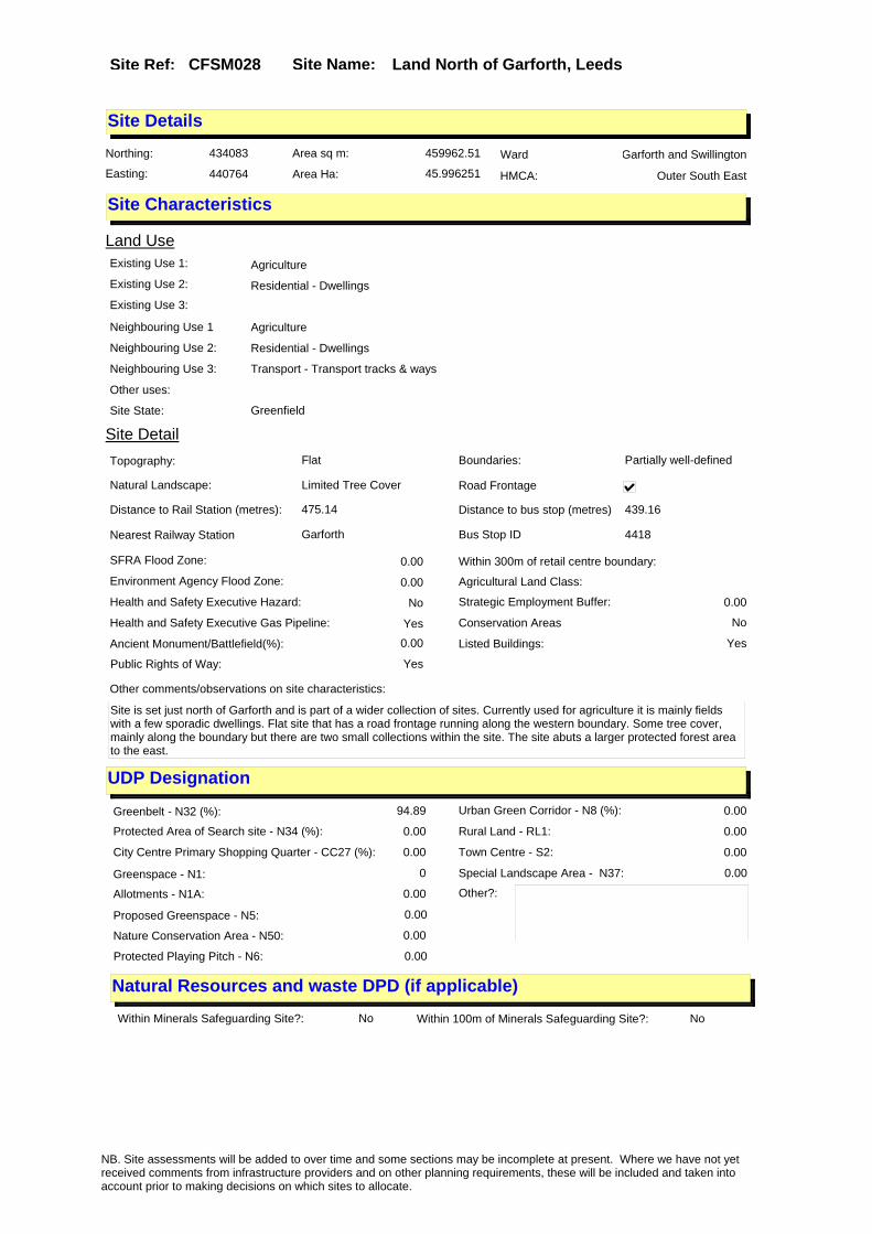
Site Name: Land North of Garforth, LeedsSite Ref: CFSM028
Site Details
Land Use
Northing: 434083
Easting: 440764
Distance to Rail Station (metres): 475.14
Nearest Railway Station Garforth
Distance to bus stop (metres) 439.16
Bus Stop ID 4418
Agricultural Land Class:
SFRA Flood Zone: 0.00
Environment Agency Flood Zone: 0.00
Within 300m of retail centre boundary:
UDP Designation
Greenbelt - N32 (%): 94.89 Urban Green Corridor - N8 (%): 0.00
Protected Area of Search site - N34 (%): 0.00 Rural Land - RL1: 0.00
City Centre Primary Shopping Quarter - CC27 (%): 0.00 Town Centre - S2: 0.00
Health and Safety Executive Hazard: No
Health and Safety Executive Gas Pipeline: Yes
Strategic Employment Buffer: 0.00
Area sq m: 459962.51 Ward Garforth and Swillington
Special Landscape Area - N37: 0.00
Allotments - N1A: 0.00
Proposed Greenspace - N5: 0.00
Protected Playing Pitch - N6: 0.00
Nature Conservation Area - N50: 0.00
Conservation Areas No
Ancient Monument/Battlefield(%): 0.00 Listed Buildings: Yes
Public Rights of Way: Yes
Other?:
Natural Resources and waste DPD (if applicable)
Within Minerals Safeguarding Site?: No Within 100m of Minerals Safeguarding Site?: No
HMCA: Outer South East
Greenspace - N1: 0
Existing Use 1: AgricultureExisting Use 2: Residential - DwellingsExisting Use 3:
Neighbouring Use 1 Agriculture
Neighbouring Use 2: Residential - Dwellings
Neighbouring Use 3: Transport - Transport tracks & ways
Other uses:
Topography: Flat
Natural Landscape: Limited Tree Cover
Boundaries: Partially well-defined
Road Frontage
Site Characteristics
Site Detail
Other comments/observations on site characteristics:
Site is set just north of Garforth and is part of a wider collection of sites. Currently used for agriculture it is mainly fields with a few sporadic dwellings. Flat site that has a road frontage running along the western boundary. Some tree cover, mainly along the boundary but there are two small collections within the site. The site abuts a larger protected forest area to the east.
Area Ha: 45.996251
Site State: Greenfield
NB. Site assessments will be added to over time and some sections may be incomplete at present. Where we have not yet received comments from infrastructure providers and on other planning requirements, these will be included and taken into account prior to making decisions on which sites to allocate.

Site Name: Land North of Garforth, LeedsSite Ref: CFSM028
Planning History
Planning App No. Proposal Received Decision Status Site %
33/104/95/FU Extraction of coal & fireclay by opencast methods & restoration to agricultural use
03/04/1995 11/03/1997 A 38.86
33/105/95/FU Extraction of coal & fireclay by opencast methods and restoration to agricultural use
03/04/1995 20/02/1997 W 38.86
NB. Site assessments will be added to over time and some sections may be incomplete at present. Where we have not yet received comments from infrastructure providers and on other planning requirements, these will be included and taken into account prior to making decisions on which sites to allocate.

Site Name: Land North of Garforth, LeedsSite Ref: CFSM028
Conformity with Core Strategy
Inner South Leeds: 0.00
Leeds Bradford Corridor: 0.00 West Leeds Gateway: 0.00
Aire Valley: 0.00Regeneration Priority Area:
Brownfield
Greenfield
Mixed
Main Urban Area
Major Settlement
Smaller Settlement
Villages/Rural
Main Urban Area Extension
Major Settlement Extension
Smaller Settlement Extension
Village/Rural Extension
Development unrelated to existing development
Green Belt assessment - only completed where site is within Green Belt
Would development lead to/constitute ribbon development?
Would development result in isolated development?
Is the site well connected to built up area (2+ boundaries with existing built up area)?
Would development of the site effectively "round off" the settlement pattern?: No
Do natural/physical features provide a good existing barrier between existing urban area and undeveloped land?
Overall sprawl conclusion:Low potential to lead to unrestricted sprawl
Would development of the site lead to physical connection of settlements?
Do natural/physical features provide a good existing barrier/boundary to contain development?
Overall Coalescence Conclusion:
No merging of settlements
Is there a strong defensible boundary between the site and the existing urban area?
Does the site provide access to the countryside?
Does the site include local or national conservation designated areas?
Does the site include areas of woodlands, trees, hedgerows that are protected, or significant unprotected tree/hedge cover?
Does the site include grade 1, 2, or 3a agricultural land?
Does the site contain buildings? Are these in agricultural use?
Overall countryside Encroachment Conclusion
The site performs an important role safeguarding countryside from encroachment
Is the site within or adjacent to a conservation area, listed building or other historical feature?
If yes, could development preserve this character?:
Overall Character Preservation Conclusion:
Development of the site would have no effect on the setting and special character of historic features
Greenbelt Assessment Conclusion:
Site is set beyond the railway line and links to an industrial rather than residential area. Well contained on all sides reducing potential for further sprawl.
Check the unrestricted sprawl of large built up areas
Prevent neighbouring towns from merging
Assist in safeguarding countryside from encroachment
Preserve the setting and special character of historic towns
NB. Site assessments will be added to over time and some sections may be incomplete at present. Where we have not yet received comments from infrastructure providers and on other planning requirements, these will be included and taken into account prior to making decisions on which sites to allocate.

Site Name: Land North of Garforth, LeedsSite Ref: CFSM028
SHLAA ConclusionsAvailability: Suitability: Achievability:
East Leeds
Summary of Infrastructure provider comments and other planning requirements
Accessibility commentpart of site 3bh, 40%primary, 40% secondary, 40% health, poor footway connection into Garforth Town Centre with little scope for mitigation due to restriction under nearby railway bridge
Rank (1-5)
3Access Comments
the level of development would require multiple accesses to be provided, position of new junctions would need to be considered in conjunction with access requirement for sites on opposite side of Barwick Road
Local network comment
route into Garforth constrained by narrow railway bridge, capacity/congestion issues on wider network
Rank (1-5)
4Rank (1-5)
2
Leeds City Council Highways inc Metro
Highways Agency
Network Rail :
Biodiversity
Natural England:
Mitigation measure
Unclear whether the local physical constriants on Barwick Road could be addressed. Significant cummulative impact on local network with other large nearby sites
Total score
9Support?
no
Need to combine with other sites: Suitability for partial development:
West Yorkshire Ecology and LCC Ecology Officer:
Not supported (RED). This proposed allocation includes 6.25ha of the Hawksnest Wood Local Wildlife Site/SEGI a site with one of the largest known populations of great crested newts in West Yorkshire. There are also water courses, lowland mixed deciduous woodland blocks and a pond all of which are UK BAP priority habitats and which should be excluded from the allocation site to maintain habitat connectivity. There are additional hedgerow and another possible ponds which need to be incorporated into the landscaping for any development or mitigation provided elsewhere. Great Crested Newts are present in the Local Wildlife Site/SEGI to the east of the proposed site and there is another record probably for the pond to the south of Lowside Cottage. Great Crested Newts are known to move up to 500m from their breeding ponds to find feeding and hiberation sites. This makes this whole proposed allocation site high risk for this European protected species. The site also supports Brown Hare a UK BAP priority species and is likely to support 4 other species of amphibians which are UK or West Yorkshire BAP priority species. A habitat corridor should be maintained along the motorway boundary to provide connectivity to land to the west. Permanent newt fencing may be required between the LWS/SEGI and the new development to prevent protected species being killed on new roads and in gully pots.
Boundary Amendment
Supported with mitigation if Red hatched areas are excluded and the boundary is amended as per Drawing RM/CFSM028. Mitigation will be required to protect and enhance the boundaries with the LWS/SEGI and the excluded land through providing a minimum 20 metre buffer planted with native shrubs and small trees. Great Crested Newts, bats and Brown Hare to consider. Hedgerows across the site to be reatined and a 10 metre buffer provided on both sides to be planted with native shrubs and small trees.
Potential for cumulative impact in combination with other sites. If site still included at next sift assess as part of East Leeds cluster.
NB. Site assessments will be added to over time and some sections may be incomplete at present. Where we have not yet received comments from infrastructure providers and on other planning requirements, these will be included and taken into account prior to making decisions on which sites to allocate.

Site Name: Land North of Garforth, LeedsSite Ref: CFSM028
Conclusion of Assessment
Conclusion summary:
Employment for industry and other uses on site may be acceptable subject to assessment.
Floorspace sq m (Non residential):
Employment Conclusion: Green
Assesment Type: Site assessment Type: Mixed Use
Proposed Change:
Education
Drainage/Water/FloodingEnvironment Agency Comments: Environment Agency Constraints:
Yorkshire Water Comments: Yorkshire Water Waste Water Treatment Works Comme
UtilitiesGas:
Electric:
Telecom:
Fire and Rescue Services:
Built HeritageLeeds City Council:
West Yorkshire Archaeology Service:
English Heritage:
LCC Flood Risk Management:
Gypsy Traveller Site Assessment
Yes No Maybe Could site be effectively managed (Text)
Yes No Maybe Would gypsies and travellers live on the site?
(Text)
Yes No Proximity to housed gypsies and travellers (Text)
Yes No Unknown Experience of previous encampments (Text)
NB. Site assessments will be added to over time and some sections may be incomplete at present. Where we have not yet received comments from infrastructure providers and on other planning requirements, these will be included and taken into account prior to making decisions on which sites to allocate.

Site Name: Former Belgrave Electrical Works Town Street, Stanningley, Pudsey, LS28 6HB
Site Ref: CFSM029
Site Details
Land Use
Northing: 434506
Easting: 422382
Distance to Rail Station (metres): 1263.56
Nearest Railway Station New Pudsey
Distance to bus stop (metres) 87.79
Bus Stop ID 12241
Agricultural Land Class:
SFRA Flood Zone: 0.00
Environment Agency Flood Zone: 0.00
Within 300m of retail centre boundary:
UDP Designation
Greenbelt - N32 (%): 0.00 Urban Green Corridor - N8 (%): 0.00
Protected Area of Search site - N34 (%): 0.00 Rural Land - RL1: 0.00
City Centre Primary Shopping Quarter - CC27 (%): 0.00 Town Centre - S2: 0.00
Health and Safety Executive Hazard: No
Health and Safety Executive Gas Pipeline: No
Strategic Employment Buffer: 0.00
Area sq m: 18236.96 Ward Bramley and Stanningley
Special Landscape Area - N37: 0.00
Allotments - N1A: 0.00
Proposed Greenspace - N5: 0.00
Protected Playing Pitch - N6: 0.00
Nature Conservation Area - N50: 0.00
Conservation Areas No
Ancient Monument/Battlefield(%): 0.00 Listed Buildings: No
Public Rights of Way: No
Other?:
Natural Resources and waste DPD (if applicable)
Within Minerals Safeguarding Site?: No Within 100m of Minerals Safeguarding Site?: Yes
HMCA: Outer West
Greenspace - N1: 0
Existing Use 1:
Existing Use 2:
Existing Use 3:
Neighbouring Use 1
Neighbouring Use 2:
Neighbouring Use 3:
Other uses:
Topography:
Natural Landscape:
Boundaries:
Road Frontage
Site Characteristics
Site Detail
Other comments/observations on site characteristics:
Area Ha: 1.823696
Site State:
NB. Site assessments will be added to over time and some sections may be incomplete at present. Where we have not yet received comments from infrastructure providers and on other planning requirements, these will be included and taken into account prior to making decisions on which sites to allocate.
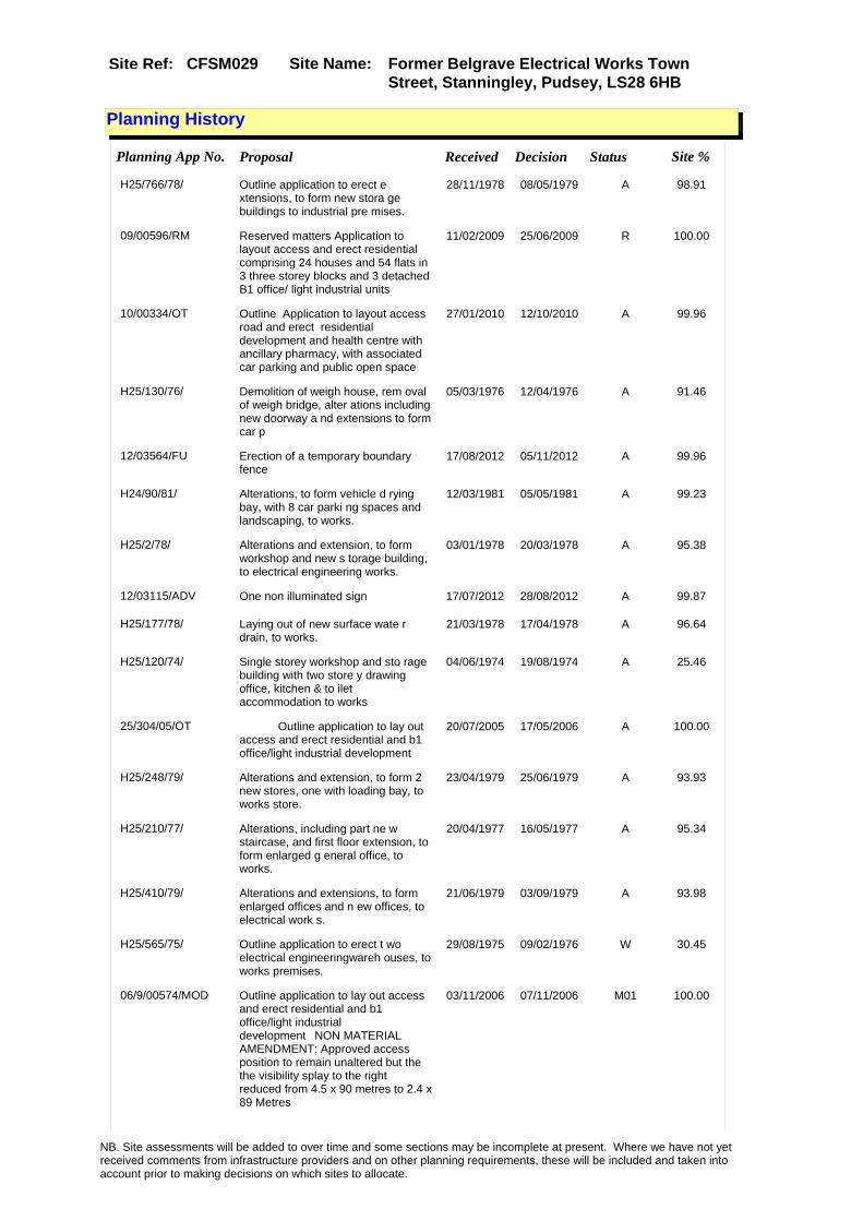
Site Name: Former Belgrave Electrical Works Town Street, Stanningley, Pudsey, LS28 6HB
Site Ref: CFSM029
Planning History
Planning App No. Proposal Received Decision Status Site %
H25/766/78/ Outline application to erect e xtensions, to form new stora ge buildings to industrial pre mises.
28/11/1978 08/05/1979 A 98.91
09/00596/RM Reserved matters Application to layout access and erect residential comprising 24 houses and 54 flats in 3 three storey blocks and 3 detached B1 office/ light industrial units
11/02/2009 25/06/2009 R 100.00
10/00334/OT Outline Application to layout access road and erect residential development and health centre with ancillary pharmacy, with associated car parking and public open space
27/01/2010 12/10/2010 A 99.96
H25/130/76/ Demolition of weigh house, rem oval of weigh bridge, alter ations including new doorway a nd extensions to form car p
05/03/1976 12/04/1976 A 91.46
12/03564/FU Erection of a temporary boundary fence
17/08/2012 05/11/2012 A 99.96
H24/90/81/ Alterations, to form vehicle d rying bay, with 8 car parki ng spaces and landscaping, to works.
12/03/1981 05/05/1981 A 99.23
H25/2/78/ Alterations and extension, to form workshop and new s torage building, to electrical engineering works.
03/01/1978 20/03/1978 A 95.38
12/03115/ADV One non illuminated sign 17/07/2012 28/08/2012 A 99.87
H25/177/78/ Laying out of new surface wate r drain, to works.
21/03/1978 17/04/1978 A 96.64
H25/120/74/ Single storey workshop and sto rage building with two store y drawing office, kitchen & to ilet accommodation to works
04/06/1974 19/08/1974 A 25.46
25/304/05/OT Outline application to lay out access and erect residential and b1 office/light industrial development
20/07/2005 17/05/2006 A 100.00
H25/248/79/ Alterations and extension, to form 2 new stores, one with loading bay, to works store.
23/04/1979 25/06/1979 A 93.93
H25/210/77/ Alterations, including part ne w staircase, and first floor extension, to form enlarged g eneral office, to works.
20/04/1977 16/05/1977 A 95.34
H25/410/79/ Alterations and extensions, to form enlarged offices and n ew offices, to electrical work s.
21/06/1979 03/09/1979 A 93.98
H25/565/75/ Outline application to erect t wo electrical engineeringwareh ouses, to works premises.
29/08/1975 09/02/1976 W 30.45
06/9/00574/MOD Outline application to lay out access and erect residential and b1 office/light industrial development�NON MATERIAL AMENDMENT: Approved access position to remain unaltered but the the visibility splay to the right reduced from 4.5 x 90 metres to 2.4 x 89 Metres
03/11/2006 07/11/2006 M01 100.00
NB. Site assessments will be added to over time and some sections may be incomplete at present. Where we have not yet received comments from infrastructure providers and on other planning requirements, these will be included and taken into account prior to making decisions on which sites to allocate.

Site Name: Former Belgrave Electrical Works Town Street, Stanningley, Pudsey, LS28 6HB
Site Ref: CFSM029
H25/248/79/1 Extension of permission to car ry out alterations and exten sion, to form 2 stores, one wi th loading bay, to works stor
05/03/1984 02/04/1984 W 99.30
H24/422/80/ Three 7.62m high freestanding aluminium flag poles, to fa ctory.
28/07/1980 02/09/1980 A 99.17
NB. Site assessments will be added to over time and some sections may be incomplete at present. Where we have not yet received comments from infrastructure providers and on other planning requirements, these will be included and taken into account prior to making decisions on which sites to allocate.

Site Name: Former Belgrave Electrical Works Town Street, Stanningley, Pudsey, LS28 6HB
Site Ref: CFSM029
Conformity with Core Strategy
Inner South Leeds: 0.00
Leeds Bradford Corridor: 100.00 West Leeds Gateway: 0.00
Aire Valley: 0.00Regeneration Priority Area:
Brownfield
Greenfield
Mixed
Main Urban Area
Major Settlement
Smaller Settlement
Villages/Rural
Main Urban Area Extension
Major Settlement Extension
Smaller Settlement Extension
Village/Rural Extension
Development unrelated to existing development
Green Belt assessment - only completed where site is within Green Belt
Would development lead to/constitute ribbon development?
Would development result in isolated development?
Is the site well connected to built up area (2+ boundaries with existing built up area)?
Would development of the site effectively "round off" the settlement pattern?:
Do natural/physical features provide a good existing barrier between existing urban area and undeveloped land?
Overall sprawl conclusion:
Would development of the site lead to physical connection of settlements?
Do natural/physical features provide a good existing barrier/boundary to contain development?
Overall Coalescence Conclusion:
Is there a strong defensible boundary between the site and the existing urban area?
Does the site provide access to the countryside?
Does the site include local or national conservation designated areas?
Does the site include areas of woodlands, trees, hedgerows that are protected, or significant unprotected tree/hedge cover?
Does the site include grade 1, 2, or 3a agricultural land?
Does the site contain buildings? Are these in agricultural use?
Overall countryside Encroachment Conclusion
Is the site within or adjacent to a conservation area, listed building or other historical feature?
If yes, could development preserve this character?:
Overall Character Preservation Conclusion:
Greenbelt Assessment Conclusion:
Check the unrestricted sprawl of large built up areas
Prevent neighbouring towns from merging
Assist in safeguarding countryside from encroachment
Preserve the setting and special character of historic towns
NB. Site assessments will be added to over time and some sections may be incomplete at present. Where we have not yet received comments from infrastructure providers and on other planning requirements, these will be included and taken into account prior to making decisions on which sites to allocate.

Site Name: Former Belgrave Electrical Works Town Street, Stanningley, Pudsey, LS28 6HB
Site Ref: CFSM029
SHLAA ConclusionsAvailability: Suitability: Achievability:
East Leeds
Summary of Infrastructure provider comments and other planning requirements
Accessibility commentMeets Core Strategy accessbility standards
Rank (1-5)
5Access Comments
Good Access required with mitigation
Local network comment
possible cumulative impact on ring road
Rank (1-5)
4Rank (1-5)
4
Leeds City Council Highways inc Metro
Highways Agency
Network Rail :
Biodiversity
Natural England:
Education
Mitigation measure
bus stop relcations and access imprvoemetns and pedestrian crossing
Total score
13Support?
yes
Need to combine with other sites: Suitability for partial development:
West Yorkshire Ecology and LCC Ecology Officer:
Supported
Boundary Amendment
Drainage/Water/FloodingEnvironment Agency Comments: Environment Agency Constraints:
Yorkshire Water Comments: Yorkshire Water Waste Water Treatment Works Comme
UtilitiesGas:
LCC Flood Risk Management:
NB. Site assessments will be added to over time and some sections may be incomplete at present. Where we have not yet received comments from infrastructure providers and on other planning requirements, these will be included and taken into account prior to making decisions on which sites to allocate.

Site Name: Former Belgrave Electrical Works Town Street, Stanningley, Pudsey, LS28 6HB
Site Ref: CFSM029
Conclusion of Assessment
Conclusion summary:
Site has planning permission for housing under 09/00596/RM.
Floorspace sq m (Non residential):
Employment Conclusion: Red
Assesment Type: Site assessment Type: Mixed Use
Proposed Change:
Electric:
Telecom:
Fire and Rescue Services:
Built HeritageLeeds City Council:
West Yorkshire Archaeology Service:
English Heritage:
Gypsy Traveller Site Assessment
Yes No Maybe Could site be effectively managed (Text)
Yes No Maybe Would gypsies and travellers live on the site?
(Text)
Yes No Proximity to housed gypsies and travellers (Text)
Yes No Unknown Experience of previous encampments (Text)
NB. Site assessments will be added to over time and some sections may be incomplete at present. Where we have not yet received comments from infrastructure providers and on other planning requirements, these will be included and taken into account prior to making decisions on which sites to allocate.

Site Name: NEB Site, Scarcorft Lodge, Scarcroft, LeedsSite Ref: CFSM033
Site Details
Land Use
Northing: 441067
Easting: 436501
Distance to Rail Station (metres): 6624.65
Nearest Railway Station Cross Gates
Distance to bus stop (metres) 281.11
Bus Stop ID 9867
Agricultural Land Class:
SFRA Flood Zone: 0.00
Environment Agency Flood Zone: 0.00
Within 300m of retail centre boundary:
UDP Designation
Greenbelt - N32 (%): 100.00 Urban Green Corridor - N8 (%): 0.00
Protected Area of Search site - N34 (%): 0.00 Rural Land - RL1: 0.00
City Centre Primary Shopping Quarter - CC27 (%): 0.00 Town Centre - S2: 0.00
Health and Safety Executive Hazard: No
Health and Safety Executive Gas Pipeline: No
Strategic Employment Buffer: 0.00
Area sq m: 47811.01 Ward Harewood
Special Landscape Area - N37: 0.00
Allotments - N1A: 0.00
Proposed Greenspace - N5: 0.00
Protected Playing Pitch - N6: 0.00
Nature Conservation Area - N50: 1.00
Conservation Areas Yes
Ancient Monument/Battlefield(%): 0.00 Listed Buildings: No
Public Rights of Way: No
Other?:
Natural Resources and waste DPD (if applicable)
Within Minerals Safeguarding Site?: No Within 100m of Minerals Safeguarding Site?: No
HMCA: Outer North East
Greenspace - N1: 0
Existing Use 1:
Existing Use 2:
Existing Use 3:
Neighbouring Use 1
Neighbouring Use 2:
Neighbouring Use 3:
Other uses:
Topography:
Natural Landscape:
Boundaries:
Road Frontage
Site Characteristics
Site Detail
Other comments/observations on site characteristics:
Area Ha: 4.781101
Site State:
NB. Site assessments will be added to over time and some sections may be incomplete at present. Where we have not yet received comments from infrastructure providers and on other planning requirements, these will be included and taken into account prior to making decisions on which sites to allocate.

Site Name: NEB Site, Scarcorft Lodge, Scarcroft, LeedsSite Ref: CFSM033
Planning History
Planning App No. Proposal Received Decision Status Site %
PREAPP/08/00324 . 29/07/2008 05/02/2009 PRENOT 63.06
33/208/99/FU Demolition of outbuildings and laying out of enlarged car park
06/08/1999 10/11/1999 A 98.08
H33/278/85/ Listed building application to demolish 2 storey exten sion and carry out alterations , to form toilets and enlarg
27/09/1985 22/01/1986 A 85.70
H33/160/88/ Alterations, including part ne w frontage, to offices.
20/04/1988 20/06/1988 A 82.50
H33/32/88/ Listed building application to carry out alterations, inclu ding new pitched roof and new windows, to offices.
27/01/1988 14/03/1988 A 85.41
33/88/00/FU 3 column mounted cctv cameras to offices
27/03/2000 12/05/2000 A 98.81
H33/47/90/ Laying out of enlarged car par k with landscaping to offic es.
31/01/1990 22/05/1990 A 10.79
H33/269/85/ Alterations, to form toilet an d enlarged buffet area, with servery and extension, to form exhibition foyer, to offices
24/09/1985 22/01/1986 A 85.77
H33/197/87/ Listed building application fo r addition of closed circu it television camera, to offic es.
21/07/1987 21/09/1987 W 92.55
H33/238/85/ Alterations including new entr ance, ventilation grill es and windows, to offices.
19/08/1985 23/09/1985 A 86.11
33/408/02/SN 3 non illuminated free standing sings and 1 non illuminated wall sign to offices
16/09/2002 07/11/2002 A 31.12
H31/17/76/ Conservation area application for, alterations, to fo rm 3 new doorways and to wall up 5 windows, to office pre
14/01/1976 16/02/1976 A 99.49
H31/76/76/ Demolition of temporary office building, and laying out o f 22 car parking spaces, to of fice premises.
11/02/1976 24/05/1976 A 99.49
H33/291/89/ Listed building application to carry out alterations and e xtension to form conservatory, to offices.
07/08/1989 12/10/1989 A 99.95
H33/300/87/ Alterations, including new doo r, windows and roof ventsand a ddition of fire escape stairca se, to offices.
29/10/1987 14/12/1987 A 85.09
H33/196/87/ 7m high closed circuit televis ion camera column, addit ion of closed circuit televisi on camera to office and additi
20/07/1987 21/09/1987 A 92.52
H33/330/85/ Laying out of car park with li ghting, to offices.
25/11/1985 17/03/1986 A 85.61
H33/212/86/ Alterations including new shut ter doors to loading bay, to of fices.
28/07/1986 22/09/1986 A 85.58
H33/231/85/ Alterations including new wind ows, to offices.
09/08/1985 11/09/1985 A 85.91
NB. Site assessments will be added to over time and some sections may be incomplete at present. Where we have not yet received comments from infrastructure providers and on other planning requirements, these will be included and taken into account prior to making decisions on which sites to allocate.

Site Name: NEB Site, Scarcorft Lodge, Scarcroft, LeedsSite Ref: CFSM033
33/446/04/LI Listed building application to demolish part of offices and convert to 14 dwellings
12/08/2004 11/07/2006 W 63.06
H33/161/88/ Listed building application to demolish corridor and carry out alterations, including pa rt new frontage, to offices.
20/04/1988 20/06/1988 A 82.50
H31/352/79/ Addition of vhf radio aerial t o offices. 07/06/1979 10/09/1979 R 99.35
H33/283/89/ Alterations and extension to f orm conservatory to offic es.
31/07/1989 12/10/1989 A 99.95
33/447/04/FU Change of use & extension of offices to form 14 dwellings convert 2 lodges to 2 houses & erect 15 houses and 18 flats
11/05/2004 11/07/2006 W 63.06
H33/301/87/ Listed building application to demolish chimney stack and c arry out alterations, includin g new door, windows an
29/10/1987 14/12/1987 A 85.00
H33/31/88/ Alterations, including new pit ched roof and new windo ws, to offices.
27/01/1988 14/03/1988 A 85.34
H33/242/85/ Listed building application to carry out alterations inclu ding new entrance, ventilation grilles and windowsto offices
22/08/1985 23/09/1985 A 85.76
H31/710/78/ Conservation area application to carry out alterations to fo rm computer tape store, to off ices.
08/11/1978 02/01/1979 A 99.35
0-33/36/00/MOD 3 column mounted cctv cameras to offices
07/09/2000 14/09/2000 M01 98.81
ENQ/10/00990 Entrance canopy at basement level 27/09/2010 05/10/2010 PAQ 20.14
NB. Site assessments will be added to over time and some sections may be incomplete at present. Where we have not yet received comments from infrastructure providers and on other planning requirements, these will be included and taken into account prior to making decisions on which sites to allocate.

Site Name: NEB Site, Scarcorft Lodge, Scarcroft, LeedsSite Ref: CFSM033
Conformity with Core Strategy
Inner South Leeds: 0.00
Leeds Bradford Corridor: 0.00 West Leeds Gateway: 0.00
Aire Valley: 0.00Regeneration Priority Area:
Brownfield
Greenfield
Mixed
Main Urban Area
Major Settlement
Smaller Settlement
Villages/Rural
Main Urban Area Extension
Major Settlement Extension
Smaller Settlement Extension
Village/Rural Extension
Development unrelated to existing development
Green Belt assessment - only completed where site is within Green Belt
Would development lead to/constitute ribbon development?
Would development result in isolated development?
Is the site well connected to built up area (2+ boundaries with existing built up area)?
Would development of the site effectively "round off" the settlement pattern?:
Do natural/physical features provide a good existing barrier between existing urban area and undeveloped land?
Overall sprawl conclusion:
Would development of the site lead to physical connection of settlements?
Do natural/physical features provide a good existing barrier/boundary to contain development?
Overall Coalescence Conclusion:
Is there a strong defensible boundary between the site and the existing urban area?
Does the site provide access to the countryside?
Does the site include local or national conservation designated areas?
Does the site include areas of woodlands, trees, hedgerows that are protected, or significant unprotected tree/hedge cover?
Does the site include grade 1, 2, or 3a agricultural land?
Does the site contain buildings? Are these in agricultural use?
Overall countryside Encroachment Conclusion
Is the site within or adjacent to a conservation area, listed building or other historical feature?
If yes, could development preserve this character?:
Overall Character Preservation Conclusion:
Greenbelt Assessment Conclusion:
Check the unrestricted sprawl of large built up areas
Prevent neighbouring towns from merging
Assist in safeguarding countryside from encroachment
Preserve the setting and special character of historic towns
NB. Site assessments will be added to over time and some sections may be incomplete at present. Where we have not yet received comments from infrastructure providers and on other planning requirements, these will be included and taken into account prior to making decisions on which sites to allocate.

Site Name: NEB Site, Scarcorft Lodge, Scarcroft, LeedsSite Ref: CFSM033
SHLAA ConclusionsAvailability: Suitability: Achievability:
Conclusion of Assessment
Conclusion summary:
Employment for industry and other uses on site may be acceptable subject to assessment.
Floorspace sq m (Non residential):
Employment Conclusion: Green
East Leeds
Assesment Type: Site assessment Type: Mixed Use
Proposed Change:
Gypsy Traveller Site Assessment
Yes No Maybe Could site be effectively managed (Text)
Yes No Maybe Would gypsies and travellers live on the site?
(Text)
Yes No Proximity to housed gypsies and travellers (Text)
Yes No Unknown Experience of previous encampments (Text)
NB. Site assessments will be added to over time and some sections may be incomplete at present. Where we have not yet received comments from infrastructure providers and on other planning requirements, these will be included and taken into account prior to making decisions on which sites to allocate.

Site Name: Land at Parkhouse Farm, Aberford, LeedsSite Ref: CFSM038
Site Details
Land Use
Northing: 435046
Easting: 442409
Distance to Rail Station (metres): 2171.21
Nearest Railway Station East Garforth
Distance to bus stop (metres) 668.32
Bus Stop ID 4474
Agricultural Land Class:
SFRA Flood Zone: 0.00
Environment Agency Flood Zone: 0.00
Within 300m of retail centre boundary:
UDP Designation
Greenbelt - N32 (%): 100.00 Urban Green Corridor - N8 (%): 0.00
Protected Area of Search site - N34 (%): 0.00 Rural Land - RL1: 0.00
City Centre Primary Shopping Quarter - CC27 (%): 0.00 Town Centre - S2: 0.00
Health and Safety Executive Hazard: No
Health and Safety Executive Gas Pipeline: No
Strategic Employment Buffer: 0.00
Area sq m: 11368.95 Ward Harewood
Special Landscape Area - N37: 0.00
Allotments - N1A: 0.00
Proposed Greenspace - N5: 0.00
Protected Playing Pitch - N6: 0.00
Nature Conservation Area - N50: 0.00
Conservation Areas No
Ancient Monument/Battlefield(%): 0.00 Listed Buildings: No
Public Rights of Way: No
Other?:
Natural Resources and waste DPD (if applicable)
Within Minerals Safeguarding Site?: No Within 100m of Minerals Safeguarding Site?: No
HMCA: Outer North East
Greenspace - N1: 0
Existing Use 1:
Existing Use 2:
Existing Use 3:
Neighbouring Use 1
Neighbouring Use 2:
Neighbouring Use 3:
Other uses:
Topography:
Natural Landscape:
Boundaries:
Road Frontage
Site Characteristics
Site Detail
Other comments/observations on site characteristics:
Area Ha: 1.136895
Site State:
NB. Site assessments will be added to over time and some sections may be incomplete at present. Where we have not yet received comments from infrastructure providers and on other planning requirements, these will be included and taken into account prior to making decisions on which sites to allocate.

Site Name: Land at Parkhouse Farm, Aberford, LeedsSite Ref: CFSM038
Planning History
NB. Site assessments will be added to over time and some sections may be incomplete at present. Where we have not yet received comments from infrastructure providers and on other planning requirements, these will be included and taken into account prior to making decisions on which sites to allocate.

Site Name: Land at Parkhouse Farm, Aberford, LeedsSite Ref: CFSM038
Conformity with Core Strategy
Inner South Leeds: 0.00
Leeds Bradford Corridor: 0.00 West Leeds Gateway: 0.00
Aire Valley: 0.00Regeneration Priority Area:
Brownfield
Greenfield
Mixed
Main Urban Area
Major Settlement
Smaller Settlement
Villages/Rural
Main Urban Area Extension
Major Settlement Extension
Smaller Settlement Extension
Village/Rural Extension
Development unrelated to existing development
Green Belt assessment - only completed where site is within Green Belt
Would development lead to/constitute ribbon development?
Would development result in isolated development?
Is the site well connected to built up area (2+ boundaries with existing built up area)?
Would development of the site effectively "round off" the settlement pattern?:
Do natural/physical features provide a good existing barrier between existing urban area and undeveloped land?
Overall sprawl conclusion:
Would development of the site lead to physical connection of settlements?
Do natural/physical features provide a good existing barrier/boundary to contain development?
Overall Coalescence Conclusion:
Is there a strong defensible boundary between the site and the existing urban area?
Does the site provide access to the countryside?
Does the site include local or national conservation designated areas?
Does the site include areas of woodlands, trees, hedgerows that are protected, or significant unprotected tree/hedge cover?
Does the site include grade 1, 2, or 3a agricultural land?
Does the site contain buildings? Are these in agricultural use?
Overall countryside Encroachment Conclusion
Is the site within or adjacent to a conservation area, listed building or other historical feature?
If yes, could development preserve this character?:
Overall Character Preservation Conclusion:
Greenbelt Assessment Conclusion:
Check the unrestricted sprawl of large built up areas
Prevent neighbouring towns from merging
Assist in safeguarding countryside from encroachment
Preserve the setting and special character of historic towns
NB. Site assessments will be added to over time and some sections may be incomplete at present. Where we have not yet received comments from infrastructure providers and on other planning requirements, these will be included and taken into account prior to making decisions on which sites to allocate.

Site Name: Land at Parkhouse Farm, Aberford, LeedsSite Ref: CFSM038
SHLAA ConclusionsAvailability: Suitability: Achievability:
Conclusion of Assessment
Conclusion summary:
Employment for industry and other uses on site may be acceptable subject to assessment.
Floorspace sq m (Non residential):
Employment Conclusion: Green
East Leeds
Assesment Type: Site assessment Type: Mixed Use
Proposed Change:
Gypsy Traveller Site Assessment
Yes No Maybe Could site be effectively managed (Text)
Yes No Maybe Would gypsies and travellers live on the site?
(Text)
Yes No Proximity to housed gypsies and travellers (Text)
Yes No Unknown Experience of previous encampments (Text)
NB. Site assessments will be added to over time and some sections may be incomplete at present. Where we have not yet received comments from infrastructure providers and on other planning requirements, these will be included and taken into account prior to making decisions on which sites to allocate.

Site Name: Land at Parlington, Aberford, LeedsSite Ref: CFSM039
Site Details
Land Use
Northing: 434878
Easting: 442663
Distance to Rail Station (metres): 2134.41
Nearest Railway Station East Garforth
Distance to bus stop (metres) 660.75
Bus Stop ID 4474
Agricultural Land Class:
SFRA Flood Zone: 0.00
Environment Agency Flood Zone: 0.00
Within 300m of retail centre boundary:
UDP Designation
Greenbelt - N32 (%): 100.00 Urban Green Corridor - N8 (%): 0.00
Protected Area of Search site - N34 (%): 0.00 Rural Land - RL1: 0.00
City Centre Primary Shopping Quarter - CC27 (%): 0.00 Town Centre - S2: 0.00
Health and Safety Executive Hazard: No
Health and Safety Executive Gas Pipeline: No
Strategic Employment Buffer: 0.00
Area sq m: 284220.08 Ward Garforth and Swillington
Special Landscape Area - N37: 0.00
Allotments - N1A: 0.00
Proposed Greenspace - N5: 0.00
Protected Playing Pitch - N6: 0.00
Nature Conservation Area - N50: 0.00
Conservation Areas No
Ancient Monument/Battlefield(%): 0.00 Listed Buildings: No
Public Rights of Way: No
Other?:
Natural Resources and waste DPD (if applicable)
Within Minerals Safeguarding Site?: No Within 100m of Minerals Safeguarding Site?: No
HMCA: Outer South East
Greenspace - N1: 0
Existing Use 1:
Existing Use 2:
Existing Use 3:
Neighbouring Use 1
Neighbouring Use 2:
Neighbouring Use 3:
Other uses:
Topography:
Natural Landscape:
Boundaries:
Road Frontage
Site Characteristics
Site Detail
Other comments/observations on site characteristics:
Area Ha: 28.422008
Site State:
NB. Site assessments will be added to over time and some sections may be incomplete at present. Where we have not yet received comments from infrastructure providers and on other planning requirements, these will be included and taken into account prior to making decisions on which sites to allocate.

Site Name: Land at Parlington, Aberford, LeedsSite Ref: CFSM039
Planning History
Planning App No. Proposal Received Decision Status Site %
12/00400/FU Engineering works including creation of earth embankment and tree planting; alterations to existing vehicular access
30/01/2012 APPRET 57.17
NB. Site assessments will be added to over time and some sections may be incomplete at present. Where we have not yet received comments from infrastructure providers and on other planning requirements, these will be included and taken into account prior to making decisions on which sites to allocate.

Site Name: Land at Parlington, Aberford, LeedsSite Ref: CFSM039
Conformity with Core Strategy
Inner South Leeds: 0.00
Leeds Bradford Corridor: 0.00 West Leeds Gateway: 0.00
Aire Valley: 0.00Regeneration Priority Area:
Brownfield
Greenfield
Mixed
Main Urban Area
Major Settlement
Smaller Settlement
Villages/Rural
Main Urban Area Extension
Major Settlement Extension
Smaller Settlement Extension
Village/Rural Extension
Development unrelated to existing development
Green Belt assessment - only completed where site is within Green Belt
Would development lead to/constitute ribbon development?
Would development result in isolated development?
Is the site well connected to built up area (2+ boundaries with existing built up area)?
Would development of the site effectively "round off" the settlement pattern?:
Do natural/physical features provide a good existing barrier between existing urban area and undeveloped land?
Overall sprawl conclusion:
Would development of the site lead to physical connection of settlements?
Do natural/physical features provide a good existing barrier/boundary to contain development?
Overall Coalescence Conclusion:
Is there a strong defensible boundary between the site and the existing urban area?
Does the site provide access to the countryside?
Does the site include local or national conservation designated areas?
Does the site include areas of woodlands, trees, hedgerows that are protected, or significant unprotected tree/hedge cover?
Does the site include grade 1, 2, or 3a agricultural land?
Does the site contain buildings? Are these in agricultural use?
Overall countryside Encroachment Conclusion
Is the site within or adjacent to a conservation area, listed building or other historical feature?
If yes, could development preserve this character?:
Overall Character Preservation Conclusion:
Greenbelt Assessment Conclusion:
Check the unrestricted sprawl of large built up areas
Prevent neighbouring towns from merging
Assist in safeguarding countryside from encroachment
Preserve the setting and special character of historic towns
NB. Site assessments will be added to over time and some sections may be incomplete at present. Where we have not yet received comments from infrastructure providers and on other planning requirements, these will be included and taken into account prior to making decisions on which sites to allocate.

Site Name: Land at Parlington, Aberford, LeedsSite Ref: CFSM039
SHLAA ConclusionsAvailability: Suitability: Achievability:
Conclusion of Assessment
Conclusion summary:
Site visit - Greenbelt site may have potential for future development.
Floorspace sq m (Non residential):
Employment Conclusion: Amber
East Leeds
Assesment Type: Site visit Type: Mixed Use
Proposed Change:
Gypsy Traveller Site Assessment
Yes No Maybe Could site be effectively managed (Text)
Yes No Maybe Would gypsies and travellers live on the site?
(Text)
Yes No Proximity to housed gypsies and travellers (Text)
Yes No Unknown Experience of previous encampments (Text)
NB. Site assessments will be added to over time and some sections may be incomplete at present. Where we have not yet received comments from infrastructure providers and on other planning requirements, these will be included and taken into account prior to making decisions on which sites to allocate.

Site Name: Wellington Road Industrial Estate, Wellington Road, Leeds, LS12 2UE
Site Ref: CFSM041
Site Details
Land Use
Northing: 433450
Easting: 428775
Distance to Rail Station (metres): 952.90
Nearest Railway Station Leeds City
Distance to bus stop (metres) 158.48
Bus Stop ID 11060
Agricultural Land Class:
SFRA Flood Zone: 1.00
Environment Agency Flood Zone: 1.00
Within 300m of retail centre boundary:
UDP Designation
Greenbelt - N32 (%): 0.00 Urban Green Corridor - N8 (%): 100.00
Protected Area of Search site - N34 (%): 0.00 Rural Land - RL1: 0.00
City Centre Primary Shopping Quarter - CC27 (%): 0.00 Town Centre - S2: 0.00
Health and Safety Executive Hazard: Yes
Health and Safety Executive Gas Pipeline: No
Strategic Employment Buffer: 0.00
Area sq m: 24472.02 Ward City and Hunslet
Special Landscape Area - N37: 0.00
Allotments - N1A: 0.00
Proposed Greenspace - N5: 0.00
Protected Playing Pitch - N6: 0.00
Nature Conservation Area - N50: 0.00
Conservation Areas No
Ancient Monument/Battlefield(%): 0.00 Listed Buildings: No
Public Rights of Way: No
Other?:
Natural Resources and waste DPD (if applicable)
Within Minerals Safeguarding Site?: No Within 100m of Minerals Safeguarding Site?: No
HMCA: Inner Areas
Greenspace - N1: 0
Existing Use 1: Industry and business - Manufacturing & WholesaleExisting Use 2:
Existing Use 3:
Neighbouring Use 1 Industry and business - Manufacturing & Wholesale
Neighbouring Use 2: Industry and business - Wholesale distribution
Neighbouring Use 3:
Other uses:
Topography: Flat
Natural Landscape: No Tree Cover
Boundaries: Existing well defined
Road Frontage
Site Characteristics
Site Detail
Other comments/observations on site characteristics:
Area Ha: 2.447202
Site State: brownfield
NB. Site assessments will be added to over time and some sections may be incomplete at present. Where we have not yet received comments from infrastructure providers and on other planning requirements, these will be included and taken into account prior to making decisions on which sites to allocate.

Site Name: Wellington Road Industrial Estate, Wellington Road, Leeds, LS12 2UE
Site Ref: CFSM041
Planning History
Planning App No. Proposal Received Decision Status Site %
20/410/02/SI 4 internally illuminated signs to commercial garage
07/10/2002 28/10/2002 A 17.86
H26/438/75/ Alterations including new roll er shutter doors, to form3 blo cks of toilets, boiler room, 3 cloakrooms, cleaners r
20/05/1975 21/07/1975 A 17.78
20/450/96/SI 4 flag signs to garage with attached light fittings to illuminate car showroom and forecourt
31/07/1996 04/11/1996 A 18.06
20/239/96/FU Elevational alterations to front and sides of car showroom and new boundary rail
07/05/1996 12/03/1997 A 18.06
H26/899/79/ 2 internally illuminated fasci a box signs, size of each9.76m x 1.21m height of each above ground 3.96m (underside
07/09/1979 15/10/1979 A 17.86
20/348/97/FU Alterations and new cladding to first floor of showrooms and workshops
17/06/1997 06/04/1998 A 18.06
H20/498/86/ Alterations, including part ne w frontage, to car showr oom.
18/11/1986 22/12/1986 A 17.51
10/04649/FU Alterations involving provision of a disabled access ramp, stepped access and new landscaping to the car park
12/10/2010 25/11/2010 W 19.43
11/00154/FU Alterations involving provision of new pedestrian footway and access point, revised vehicular access radius and reconfiguration of car parking bays
17/01/2011 22/02/2011 A 19.43
11/03119/FU Alterations to form entrance to mail sorting office
22/07/2011 01/09/2011 A 19.74
PREAPP/08/00194 . 29/05/2008 PRECAG 17.94
H26/111/77/ Block of 4 single storey wareh ouse units, each with toile ts and 2 storey offices, and w ith 33 car parking spaces, to
16/02/1977 21/03/1977 A 19.60
20/66/02/FU Change of use including alterations of distribution warehouse to postal sorting office
27/02/2002 30/04/2002 A 17.78
11/9/00037/MOD Alterations involving provision of new pedestrian footway and access point, revised vehicular access radius and reconfiguration of car parking bays�NON-MATERIAL AMENDMENT TO 11/00154/FU: Install 1m high retaining wall�
04/03/2011 18/03/2011 M01 19.43
20/104/99/FU Addition of canopy to side of car showroom
25/02/1999 08/04/1999 A 17.88
NB. Site assessments will be added to over time and some sections may be incomplete at present. Where we have not yet received comments from infrastructure providers and on other planning requirements, these will be included and taken into account prior to making decisions on which sites to allocate.

Site Name: Wellington Road Industrial Estate, Wellington Road, Leeds, LS12 2UE
Site Ref: CFSM041
Conformity with Core Strategy
Inner South Leeds: 0.00
Leeds Bradford Corridor: 0.00 West Leeds Gateway: 0.00
Aire Valley: 0.00Regeneration Priority Area:
Brownfield
Greenfield
Mixed
Main Urban Area
Major Settlement
Smaller Settlement
Villages/Rural
Main Urban Area Extension
Major Settlement Extension
Smaller Settlement Extension
Village/Rural Extension
Development unrelated to existing development
Green Belt assessment - only completed where site is within Green Belt
Would development lead to/constitute ribbon development?
Would development result in isolated development?
Is the site well connected to built up area (2+ boundaries with existing built up area)?
Would development of the site effectively "round off" the settlement pattern?:
Do natural/physical features provide a good existing barrier between existing urban area and undeveloped land?
Overall sprawl conclusion:
Would development of the site lead to physical connection of settlements?
Do natural/physical features provide a good existing barrier/boundary to contain development?
Overall Coalescence Conclusion:
Is there a strong defensible boundary between the site and the existing urban area?
Does the site provide access to the countryside?
Does the site include local or national conservation designated areas?
Does the site include areas of woodlands, trees, hedgerows that are protected, or significant unprotected tree/hedge cover?
Does the site include grade 1, 2, or 3a agricultural land?
Does the site contain buildings? Are these in agricultural use?
Overall countryside Encroachment Conclusion
Is the site within or adjacent to a conservation area, listed building or other historical feature?
If yes, could development preserve this character?:
Overall Character Preservation Conclusion:
Greenbelt Assessment Conclusion:
Check the unrestricted sprawl of large built up areas
Prevent neighbouring towns from merging
Assist in safeguarding countryside from encroachment
Preserve the setting and special character of historic towns
NB. Site assessments will be added to over time and some sections may be incomplete at present. Where we have not yet received comments from infrastructure providers and on other planning requirements, these will be included and taken into account prior to making decisions on which sites to allocate.

Site Name: Wellington Road Industrial Estate, Wellington Road, Leeds, LS12 2UE
Site Ref: CFSM041
SHLAA ConclusionsAvailability: Suitability: Achievability:
East Leeds
Summary of Infrastructure provider comments and other planning requirements
Accessibility commentgood
Rank (1-5)
5Access Comments
Access from spur road from Wellington Road, no direct access, spur road will require improvement
Local network comment
West St / Wellington Road concerns
Rank (1-5)
3Rank (1-5)
3
Leeds City Council Highways inc Metro
Highways Agency
Network Rail :
Biodiversity
Natural England:
Education
Mitigation measure
Contribution to West St/ Wellington Road improvement
Total score
11Support?
Yes with mitigation
Need to combine with other sites: Suitability for partial development:
West Yorkshire Ecology and LCC Ecology Officer:
Supported
Boundary Amendment
Drainage/Water/FloodingEnvironment Agency Comments: Environment Agency Constraints:
Yorkshire Water Comments: Yorkshire Water Waste Water Treatment Works Comme
Utilities
Potential for cumulative impact in combination with other sites. If site still included at next sift assess as part of City Centre / Aire Valley cluster.
LCC Flood Risk Management:
NB. Site assessments will be added to over time and some sections may be incomplete at present. Where we have not yet received comments from infrastructure providers and on other planning requirements, these will be included and taken into account prior to making decisions on which sites to allocate.

Site Name: Wellington Road Industrial Estate, Wellington Road, Leeds, LS12 2UE
Site Ref: CFSM041
Conclusion of Assessment
Conclusion summary:
Existing employment site. Other uses on site may be acceptable subject to assessment.
Floorspace sq m (Non residential):
Employment Conclusion: Green
Assesment Type: Site assessment Type: Mixed Use
Proposed Change:
Gas:
Electric:
Telecom:
Fire and Rescue Services:
Built HeritageLeeds City Council:
West Yorkshire Archaeology Service:
English Heritage:
Gypsy Traveller Site Assessment
Yes No Maybe Could site be effectively managed (Text)
Yes No Maybe Would gypsies and travellers live on the site?
(Text)
Yes No Proximity to housed gypsies and travellers (Text)
Yes No Unknown Experience of previous encampments (Text)
NB. Site assessments will be added to over time and some sections may be incomplete at present. Where we have not yet received comments from infrastructure providers and on other planning requirements, these will be included and taken into account prior to making decisions on which sites to allocate.

Site Name: Kirkstall Road, Studio Road, and Park Road, Kirkstall, Leeds
Site Ref: CFSM043
Site Details
Land Use
Northing: 434116
Easting: 428518
Distance to Rail Station (metres): 1227.66
Nearest Railway Station Burley Park
Distance to bus stop (metres) 116.11
Bus Stop ID 497
Agricultural Land Class:
SFRA Flood Zone: 1.00
Environment Agency Flood Zone: 1.00
Within 300m of retail centre boundary:
UDP Designation
Greenbelt - N32 (%): 0.00 Urban Green Corridor - N8 (%): 0.00
Protected Area of Search site - N34 (%): 0.00 Rural Land - RL1: 0.00
City Centre Primary Shopping Quarter - CC27 (%): 0.00 Town Centre - S2: 0.00
Health and Safety Executive Hazard: No
Health and Safety Executive Gas Pipeline: No
Strategic Employment Buffer: 0.00
Area sq m: 86064.04 Ward City and Hunslet
Special Landscape Area - N37: 0.00
Allotments - N1A: 0.00
Proposed Greenspace - N5: 0.00
Protected Playing Pitch - N6: 0.00
Nature Conservation Area - N50: 0.00
Conservation Areas No
Ancient Monument/Battlefield(%): 0.00 Listed Buildings: No
Public Rights of Way: No
Other?:
Natural Resources and waste DPD (if applicable)
Within Minerals Safeguarding Site?: No Within 100m of Minerals Safeguarding Site?: Yes
HMCA: Inner Areas
Greenspace - N1: 0
Existing Use 1: OfficeExisting Use 2: Industry and business - Manufacturing & WholesaleExisting Use 3: Industry and business - Wholesale distribution
Neighbouring Use 1 Office
Neighbouring Use 2: Industry and business - Manufacturing & Wholesale
Neighbouring Use 3:
Other uses:
Topography: Flat
Natural Landscape: No Tree Cover
Boundaries: Existing well defined
Road Frontage
Site Characteristics
Site Detail
Other comments/observations on site characteristics:
Area Ha: 8.606404
Site State: brownfield
NB. Site assessments will be added to over time and some sections may be incomplete at present. Where we have not yet received comments from infrastructure providers and on other planning requirements, these will be included and taken into account prior to making decisions on which sites to allocate.
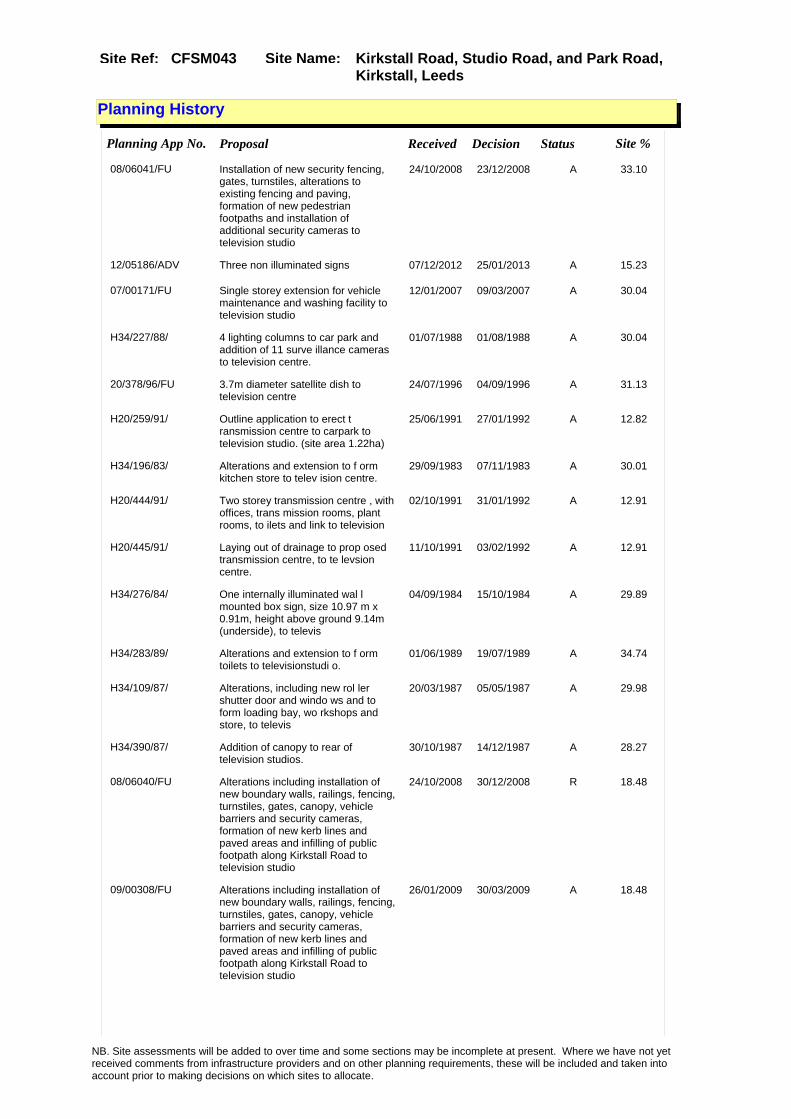
Site Name: Kirkstall Road, Studio Road, and Park Road, Kirkstall, Leeds
Site Ref: CFSM043
Planning History
Planning App No. Proposal Received Decision Status Site %
08/06041/FU Installation of new security fencing, gates, turnstiles, alterations to existing fencing and paving, formation of new pedestrian footpaths and installation of additional security cameras to television studio
24/10/2008 23/12/2008 A 33.10
12/05186/ADV Three non illuminated signs 07/12/2012 25/01/2013 A 15.23
07/00171/FU Single storey extension for vehicle maintenance and washing facility to television studio
12/01/2007 09/03/2007 A 30.04
H34/227/88/ 4 lighting columns to car park and addition of 11 surve illance cameras to television centre.
01/07/1988 01/08/1988 A 30.04
20/378/96/FU 3.7m diameter satellite dish to television centre
24/07/1996 04/09/1996 A 31.13
H20/259/91/ Outline application to erect t ransmission centre to carpark to television studio. (site area 1.22ha)
25/06/1991 27/01/1992 A 12.82
H34/196/83/ Alterations and extension to f orm kitchen store to telev ision centre.
29/09/1983 07/11/1983 A 30.01
H20/444/91/ Two storey transmission centre , with offices, trans mission rooms, plant rooms, to ilets and link to television
02/10/1991 31/01/1992 A 12.91
H20/445/91/ Laying out of drainage to prop osed transmission centre, to te levsion centre.
11/10/1991 03/02/1992 A 12.91
H34/276/84/ One internally illuminated wal l mounted box sign, size 10.97 m x 0.91m, height above ground 9.14m (underside), to televis
04/09/1984 15/10/1984 A 29.89
H34/283/89/ Alterations and extension to f orm toilets to televisionstudi o.
01/06/1989 19/07/1989 A 34.74
H34/109/87/ Alterations, including new rol ler shutter door and windo ws and to form loading bay, wo rkshops and store, to televis
20/03/1987 05/05/1987 A 29.98
H34/390/87/ Addition of canopy to rear of television studios.
30/10/1987 14/12/1987 A 28.27
08/06040/FU Alterations including installation of new boundary walls, railings, fencing, turnstiles, gates, canopy, vehicle barriers and security cameras, formation of new kerb lines and paved areas and infilling of public footpath along Kirkstall Road to television studio
24/10/2008 30/12/2008 R 18.48
09/00308/FU Alterations including installation of new boundary walls, railings, fencing, turnstiles, gates, canopy, vehicle barriers and security cameras, formation of new kerb lines and paved areas and infilling of public footpath along Kirkstall Road to television studio
26/01/2009 30/03/2009 A 18.48
NB. Site assessments will be added to over time and some sections may be incomplete at present. Where we have not yet received comments from infrastructure providers and on other planning requirements, these will be included and taken into account prior to making decisions on which sites to allocate.

Site Name: Kirkstall Road, Studio Road, and Park Road, Kirkstall, Leeds
Site Ref: CFSM043
10/03425/COND Consent, agreement or approval required by conditions 3, 4, 6, 7, 8, 9, 10, 11, 12, 13, 15, 16, 17 and 19 of Planning Application 10/01638/FU
20/07/2010 26/01/2011 SPL 34.99
12/01483/FU Demolition of plant room and relocation of satellite dish from 104 Kirkstall Road to Television Centre
02/04/2012 23/05/2012 A 37.66
H26/414/82/ Alterations and extension, to form storage area with store s and office over, and covered cycle park, to television
20/10/1982 22/11/1982 A 29.93
10/01638/FU Alterations to television centre including 2 extensions, 2 canopies, air condenser units and ducting, new access for loading bay, laying out of additional car parking and rearrangement of part of existing car park to television studio
09/04/2010 28/05/2010 A 34.99
NB. Site assessments will be added to over time and some sections may be incomplete at present. Where we have not yet received comments from infrastructure providers and on other planning requirements, these will be included and taken into account prior to making decisions on which sites to allocate.

Site Name: Kirkstall Road, Studio Road, and Park Road, Kirkstall, Leeds
Site Ref: CFSM043
Conformity with Core Strategy
Inner South Leeds: 0.00
Leeds Bradford Corridor: 0.00 West Leeds Gateway: 0.00
Aire Valley: 0.00Regeneration Priority Area:
Brownfield
Greenfield
Mixed
Main Urban Area
Major Settlement
Smaller Settlement
Villages/Rural
Main Urban Area Extension
Major Settlement Extension
Smaller Settlement Extension
Village/Rural Extension
Development unrelated to existing development
Green Belt assessment - only completed where site is within Green Belt
Would development lead to/constitute ribbon development?
Would development result in isolated development?
Is the site well connected to built up area (2+ boundaries with existing built up area)?
Would development of the site effectively "round off" the settlement pattern?:
Do natural/physical features provide a good existing barrier between existing urban area and undeveloped land?
Overall sprawl conclusion:
Would development of the site lead to physical connection of settlements?
Do natural/physical features provide a good existing barrier/boundary to contain development?
Overall Coalescence Conclusion:
Is there a strong defensible boundary between the site and the existing urban area?
Does the site provide access to the countryside?
Does the site include local or national conservation designated areas?
Does the site include areas of woodlands, trees, hedgerows that are protected, or significant unprotected tree/hedge cover?
Does the site include grade 1, 2, or 3a agricultural land?
Does the site contain buildings? Are these in agricultural use?
Overall countryside Encroachment Conclusion
Is the site within or adjacent to a conservation area, listed building or other historical feature?
If yes, could development preserve this character?:
Overall Character Preservation Conclusion:
Greenbelt Assessment Conclusion:
Check the unrestricted sprawl of large built up areas
Prevent neighbouring towns from merging
Assist in safeguarding countryside from encroachment
Preserve the setting and special character of historic towns
NB. Site assessments will be added to over time and some sections may be incomplete at present. Where we have not yet received comments from infrastructure providers and on other planning requirements, these will be included and taken into account prior to making decisions on which sites to allocate.

Site Name: Kirkstall Road, Studio Road, and Park Road, Kirkstall, Leeds
Site Ref: CFSM043
SHLAA ConclusionsAvailability: Suitability: Achievability:
East Leeds
Summary of Infrastructure provider comments and other planning requirements
Accessibility commentGood
Rank (1-5)
5Access Comments
Access from Studio Road
Local network comment
West St / Wellington Road concerns
Rank (1-5)
4Rank (1-5)
3
Leeds City Council Highways inc Metro
Highways Agency
Network Rail :
Biodiversity
Natural England:
Education
Mitigation measure
Contribution to West St/ Wellington Road improvement
Total score
12Support?
Yes with mitigation
Need to combine with other sites: Suitability for partial development:
West Yorkshire Ecology and LCC Ecology Officer:
Supported
Boundary Amendment
Drainage/Water/FloodingEnvironment Agency Comments: Environment Agency Constraints:
Yorkshire Water Comments: Yorkshire Water Waste Water Treatment Works Comme
Utilities
Potential for cumulative impact in combination with other sites. If site still included at next sift assess as part of City Centre / Aire Valley cluster.
LCC Flood Risk Management:
NB. Site assessments will be added to over time and some sections may be incomplete at present. Where we have not yet received comments from infrastructure providers and on other planning requirements, these will be included and taken into account prior to making decisions on which sites to allocate.

Site Name: Kirkstall Road, Studio Road, and Park Road, Kirkstall, Leeds
Site Ref: CFSM043
Conclusion of Assessment
Conclusion summary:
Existing employment site. Other uses on site may be acceptable subject to assessment.
Floorspace sq m (Non residential):
Employment Conclusion: Green
Assesment Type: Site assessment Type: Mixed Use
Proposed Change:
Gas:
Electric:
Telecom:
Fire and Rescue Services:
Built HeritageLeeds City Council:
West Yorkshire Archaeology Service:
English Heritage:
Gypsy Traveller Site Assessment
Yes No Maybe Could site be effectively managed (Text)
Yes No Maybe Would gypsies and travellers live on the site?
(Text)
Yes No Proximity to housed gypsies and travellers (Text)
Yes No Unknown Experience of previous encampments (Text)
NB. Site assessments will be added to over time and some sections may be incomplete at present. Where we have not yet received comments from infrastructure providers and on other planning requirements, these will be included and taken into account prior to making decisions on which sites to allocate.
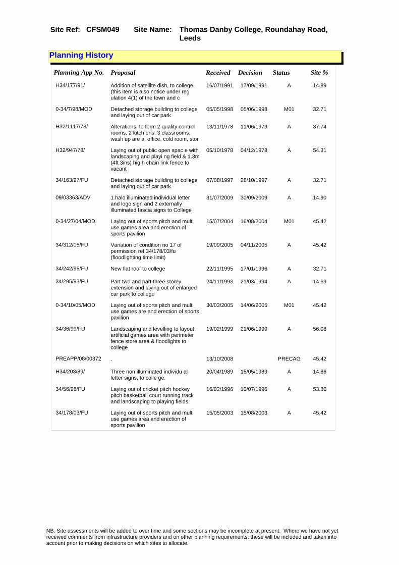
Site Name: Thomas Danby College, Roundahay Road, Leeds
Site Ref: CFSM049
Planning History
Planning App No. Proposal Received Decision Status Site %
H34/177/91/ Addition of satellite dish, to college. (this item is also notice under reg ulation 4(1) of the town and c
16/07/1991 17/09/1991 A 14.89
0-34/7/98/MOD Detached storage building to college and laying out of car park
05/05/1998 05/06/1998 M01 32.71
H32/1117/78/ Alterations, to form 2 quality control rooms, 2 kitch ens, 3 classrooms, wash up are a, office, cold room, stor
13/11/1978 11/06/1979 A 37.74
H32/947/78/ Laying out of public open spac e with landscaping and playi ng field & 1.3m (4ft 3ins) hig h chain link fence to vacant
05/10/1978 04/12/1978 A 54.31
34/163/97/FU Detached storage building to college and laying out of car park
07/08/1997 28/10/1997 A 32.71
09/03363/ADV 1 halo illuminated individual letter and logo sign and 2 externally illuminated fascia signs to College
31/07/2009 30/09/2009 A 14.90
0-34/27/04/MOD Laying out of sports pitch and multi use games area and erection of sports pavilion
15/07/2004 16/08/2004 M01 45.42
34/312/05/FU Variation of condition no 17 of permission ref 34/178/03/fu (floodlighting time limit)
19/09/2005 04/11/2005 A 45.42
34/242/95/FU New flat roof to college 22/11/1995 17/01/1996 A 32.71
34/295/93/FU Part two and part three storey extension and laying out of enlarged car park to college
24/11/1993 21/03/1994 A 14.69
0-34/10/05/MOD Laying out of sports pitch and multi use games are and erection of sports pavilion
30/03/2005 14/06/2005 M01 45.42
34/36/99/FU Landscaping and levelling to layout artificial games area with perimeter fence store area & floodlights to college
19/02/1999 21/06/1999 A 56.08
PREAPP/08/00372 . 13/10/2008 PRECAG 45.42
H34/203/89/ Three non illuminated individu al letter signs, to colle ge.
20/04/1989 15/05/1989 A 14.86
34/56/96/FU Laying out of cricket pitch hockey pitch basketball court running track and landscaping to playing fields
16/02/1996 10/07/1996 A 53.80
34/178/03/FU Laying out of sports pitch and multi use games area and erection of sports pavilion
15/05/2003 15/08/2003 A 45.42
NB. Site assessments will be added to over time and some sections may be incomplete at present. Where we have not yet received comments from infrastructure providers and on other planning requirements, these will be included and taken into account prior to making decisions on which sites to allocate.

Site Name: Thomas Danby College, Roundahay Road, Leeds
Site Ref: CFSM049
Site Details
Land Use
Northing: 434940
Easting: 430910
Distance to Rail Station (metres): 2131.20
Nearest Railway Station Leeds City
Distance to bus stop (metres) 106.20
Bus Stop ID 7548
Agricultural Land Class:
SFRA Flood Zone: 0.00
Environment Agency Flood Zone: 0.00
Within 300m of retail centre boundary:
UDP Designation
Greenbelt - N32 (%): 0.00 Urban Green Corridor - N8 (%): 0.00
Protected Area of Search site - N34 (%): 0.00 Rural Land - RL1: 0.00
City Centre Primary Shopping Quarter - CC27 (%): 0.00 Town Centre - S2: 0.00
Health and Safety Executive Hazard: Yes
Health and Safety Executive Gas Pipeline: No
Strategic Employment Buffer: 0.00
Area sq m: 48191.83 Ward City and Hunslet
Special Landscape Area - N37: 0.00
Allotments - N1A: 0.00
Proposed Greenspace - N5: 0.00
Protected Playing Pitch - N6: 0.00
Nature Conservation Area - N50: 0.00
Conservation Areas No
Ancient Monument/Battlefield(%): 0.00 Listed Buildings: No
Public Rights of Way: No
Other?:
Natural Resources and waste DPD (if applicable)
Within Minerals Safeguarding Site?: No Within 100m of Minerals Safeguarding Site?: No
HMCA: Inner Areas
Greenspace - N1: 0
Existing Use 1: Community Services - EducationExisting Use 2: OfficeExisting Use 3: Recreation & Leisure - Outdoor sport facility
Neighbouring Use 1 Industry and business - Wholesale distribution
Neighbouring Use 2:
Neighbouring Use 3:
Other uses:
Topography: Flat
Natural Landscape: Limited Tree Cover
Boundaries: Existing well defined
Road Frontage
Site Characteristics
Site Detail
Other comments/observations on site characteristics:
Area Ha: 4.819183
Site State: brownfield
NB. Site assessments will be added to over time and some sections may be incomplete at present. Where we have not yet received comments from infrastructure providers and on other planning requirements, these will be included and taken into account prior to making decisions on which sites to allocate.

Site Name: Thomas Danby College, Roundahay Road, Leeds
Site Ref: CFSM049
Conformity with Core Strategy
Inner South Leeds: 0.00
Leeds Bradford Corridor: 0.00 West Leeds Gateway: 0.00
Aire Valley: 0.00Regeneration Priority Area:
Brownfield
Greenfield
Mixed
Main Urban Area
Major Settlement
Smaller Settlement
Villages/Rural
Main Urban Area Extension
Major Settlement Extension
Smaller Settlement Extension
Village/Rural Extension
Development unrelated to existing development
Green Belt assessment - only completed where site is within Green Belt
Would development lead to/constitute ribbon development?
Would development result in isolated development?
Is the site well connected to built up area (2+ boundaries with existing built up area)?
Would development of the site effectively "round off" the settlement pattern?:
Do natural/physical features provide a good existing barrier between existing urban area and undeveloped land?
Overall sprawl conclusion:
Would development of the site lead to physical connection of settlements?
Do natural/physical features provide a good existing barrier/boundary to contain development?
Overall Coalescence Conclusion:
Is there a strong defensible boundary between the site and the existing urban area?
Does the site provide access to the countryside?
Does the site include local or national conservation designated areas?
Does the site include areas of woodlands, trees, hedgerows that are protected, or significant unprotected tree/hedge cover?
Does the site include grade 1, 2, or 3a agricultural land?
Does the site contain buildings? Are these in agricultural use?
Overall countryside Encroachment Conclusion
Is the site within or adjacent to a conservation area, listed building or other historical feature?
If yes, could development preserve this character?:
Overall Character Preservation Conclusion:
Greenbelt Assessment Conclusion:
Check the unrestricted sprawl of large built up areas
Prevent neighbouring towns from merging
Assist in safeguarding countryside from encroachment
Preserve the setting and special character of historic towns
NB. Site assessments will be added to over time and some sections may be incomplete at present. Where we have not yet received comments from infrastructure providers and on other planning requirements, these will be included and taken into account prior to making decisions on which sites to allocate.

Site Name: Thomas Danby College, Roundahay Road, Leeds
Site Ref: CFSM049
SHLAA ConclusionsAvailability: Suitability: Achievability:
East Leeds
Summary of Infrastructure provider comments and other planning requirements
Accessibility commentGood accessibility to all services
Rank (1-5)
4Access Comments
various options for acceptable access
Local network comment
Congested local network and significant development
Rank (1-5)
4Rank (1-5)
3
Leeds City Council Highways inc Metro
Highways Agency
Network Rail :
Biodiversity
Natural England:
Education
Mitigation measure
Signficant - to be determined by TA
Total score
11Support?
Yes with mitigation
Need to combine with other sites: Suitability for partial development:
West Yorkshire Ecology and LCC Ecology Officer:
Supported
Boundary Amendment
Drainage/Water/FloodingEnvironment Agency Comments: Environment Agency Constraints:
Yorkshire Water Comments: Yorkshire Water Waste Water Treatment Works Comme
UtilitiesGas:
LCC Flood Risk Management:
NB. Site assessments will be added to over time and some sections may be incomplete at present. Where we have not yet received comments from infrastructure providers and on other planning requirements, these will be included and taken into account prior to making decisions on which sites to allocate.

Site Name: Thomas Danby College, Roundahay Road, Leeds
Site Ref: CFSM049
Conclusion of Assessment
Conclusion summary:
Existing employment site. Other uses on site may be acceptable subject to assessment.
Floorspace sq m (Non residential):
Employment Conclusion: Green
Assesment Type: Site assessment Type: Mixed Use
Proposed Change:
Electric:
Telecom:
Fire and Rescue Services:
Built HeritageLeeds City Council:
West Yorkshire Archaeology Service:
English Heritage:
Gypsy Traveller Site Assessment
Yes No Maybe Could site be effectively managed (Text)
Yes No Maybe Would gypsies and travellers live on the site?
(Text)
Yes No Proximity to housed gypsies and travellers (Text)
Yes No Unknown Experience of previous encampments (Text)
NB. Site assessments will be added to over time and some sections may be incomplete at present. Where we have not yet received comments from infrastructure providers and on other planning requirements, these will be included and taken into account prior to making decisions on which sites to allocate.
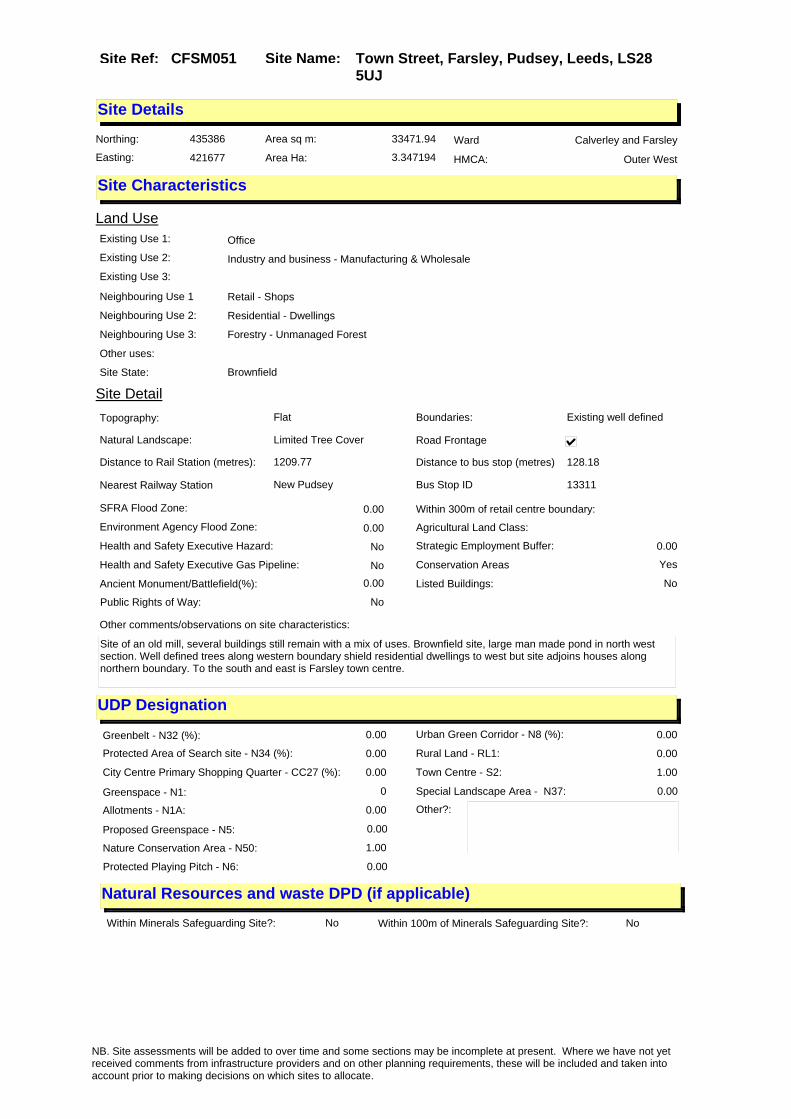
Site Name: Town Street, Farsley, Pudsey, Leeds, LS28 5UJ
Site Ref: CFSM051
Site Details
Land Use
Northing: 435386
Easting: 421677
Distance to Rail Station (metres): 1209.77
Nearest Railway Station New Pudsey
Distance to bus stop (metres) 128.18
Bus Stop ID 13311
Agricultural Land Class:
SFRA Flood Zone: 0.00
Environment Agency Flood Zone: 0.00
Within 300m of retail centre boundary:
UDP Designation
Greenbelt - N32 (%): 0.00 Urban Green Corridor - N8 (%): 0.00
Protected Area of Search site - N34 (%): 0.00 Rural Land - RL1: 0.00
City Centre Primary Shopping Quarter - CC27 (%): 0.00 Town Centre - S2: 1.00
Health and Safety Executive Hazard: No
Health and Safety Executive Gas Pipeline: No
Strategic Employment Buffer: 0.00
Area sq m: 33471.94 Ward Calverley and Farsley
Special Landscape Area - N37: 0.00
Allotments - N1A: 0.00
Proposed Greenspace - N5: 0.00
Protected Playing Pitch - N6: 0.00
Nature Conservation Area - N50: 1.00
Conservation Areas Yes
Ancient Monument/Battlefield(%): 0.00 Listed Buildings: No
Public Rights of Way: No
Other?:
Natural Resources and waste DPD (if applicable)
Within Minerals Safeguarding Site?: No Within 100m of Minerals Safeguarding Site?: No
HMCA: Outer West
Greenspace - N1: 0
Existing Use 1: OfficeExisting Use 2: Industry and business - Manufacturing & WholesaleExisting Use 3:
Neighbouring Use 1 Retail - Shops
Neighbouring Use 2: Residential - Dwellings
Neighbouring Use 3: Forestry - Unmanaged Forest
Other uses:
Topography: Flat
Natural Landscape: Limited Tree Cover
Boundaries: Existing well defined
Road Frontage
Site Characteristics
Site Detail
Other comments/observations on site characteristics:
Site of an old mill, several buildings still remain with a mix of uses. Brownfield site, large man made pond in north west section. Well defined trees along western boundary shield residential dwellings to west but site adjoins houses along northern boundary. To the south and east is Farsley town centre.
Area Ha: 3.347194
Site State: Brownfield
NB. Site assessments will be added to over time and some sections may be incomplete at present. Where we have not yet received comments from infrastructure providers and on other planning requirements, these will be included and taken into account prior to making decisions on which sites to allocate.

Site Name: Town Street, Farsley, Pudsey, Leeds, LS28 5UJ
Site Ref: CFSM051
Planning History
Planning App No. Proposal Received Decision Status Site %
H25/114/74/ Outline application to erect r esidential development
24/05/1974 16/09/1974 R 12.08
NB. Site assessments will be added to over time and some sections may be incomplete at present. Where we have not yet received comments from infrastructure providers and on other planning requirements, these will be included and taken into account prior to making decisions on which sites to allocate.

Site Name: Town Street, Farsley, Pudsey, Leeds, LS28 5UJ
Site Ref: CFSM051
Conformity with Core Strategy
Inner South Leeds: 0.00
Leeds Bradford Corridor: 100.00 West Leeds Gateway: 0.00
Aire Valley: 0.00Regeneration Priority Area:
Brownfield
Greenfield
Mixed
Main Urban Area
Major Settlement
Smaller Settlement
Villages/Rural
Main Urban Area Extension
Major Settlement Extension
Smaller Settlement Extension
Village/Rural Extension
Development unrelated to existing development
Green Belt assessment - only completed where site is within Green Belt
Would development lead to/constitute ribbon development?
Would development result in isolated development?
Is the site well connected to built up area (2+ boundaries with existing built up area)?
Would development of the site effectively "round off" the settlement pattern?:
Do natural/physical features provide a good existing barrier between existing urban area and undeveloped land?
Overall sprawl conclusion:
Would development of the site lead to physical connection of settlements?
Do natural/physical features provide a good existing barrier/boundary to contain development?
Overall Coalescence Conclusion:
Is there a strong defensible boundary between the site and the existing urban area?
Does the site provide access to the countryside?
Does the site include local or national conservation designated areas?
Does the site include areas of woodlands, trees, hedgerows that are protected, or significant unprotected tree/hedge cover?
Does the site include grade 1, 2, or 3a agricultural land?
Does the site contain buildings? Are these in agricultural use?
Overall countryside Encroachment Conclusion
Is the site within or adjacent to a conservation area, listed building or other historical feature?
If yes, could development preserve this character?:
Overall Character Preservation Conclusion:
Greenbelt Assessment Conclusion:
Check the unrestricted sprawl of large built up areas
Prevent neighbouring towns from merging
Assist in safeguarding countryside from encroachment
Preserve the setting and special character of historic towns
NB. Site assessments will be added to over time and some sections may be incomplete at present. Where we have not yet received comments from infrastructure providers and on other planning requirements, these will be included and taken into account prior to making decisions on which sites to allocate.

Site Name: Town Street, Farsley, Pudsey, Leeds, LS28 5UJ
Site Ref: CFSM051
SHLAA ConclusionsAvailability: Suitability: Achievability:
East Leeds
Summary of Infrastructure provider comments and other planning requirements
Accessibility commentMeets Core Strategy accessbility standards.
Rank (1-5)
5Access Comments
Adequate frontage to main high street but may require signals.
Local network comment
Posssible cumulative effect on ring road.
Rank (1-5)
4Rank (1-5)
4
Leeds City Council Highways inc Metro
Highways Agency
Network Rail :
Biodiversity
Natural England:
Education
Mitigation measure
Access improvements and bus stop improvements.
Total score
13Support?
Yes
Need to combine with other sites: Suitability for partial development:
West Yorkshire Ecology and LCC Ecology Officer:
Not supported (RED). This site has a mill pond which is shown on the 1852 O/S map and may date to 1829. Ponds are a UK BAP Priority Habitat. The undeveloped area adjacent to the pond is Lowland Mixed Deciduous Woodland (birch woodland) also a UK BAP Priority Habitat. Note comments re biodiversity and TPOs in application 12/02644 (withdrawn) 14/08/2012. No data on amphibians has been recorded at West Yorkshire Ecology, but the site is likely to support common toad a UK BAP Priority Species, common frog and smooth newt both West Yorkshire BAP Priority Species. It may also support Great Crested Newts although this is unlikely as the nearest reliable records are 5km to the north. Retain pond and woodland as amphibian habitat.
Boundary Amendment
Supported with mitigation if Red hatched areas are excluded and the boundary is ammended as per Drawing RM/CFSM051 and the western boundary is protected and enhanced by an appropriate buffer planted with native trees and shrubs.
Drainage/Water/FloodingEnvironment Agency Comments: Environment Agency Constraints:
NB. Site assessments will be added to over time and some sections may be incomplete at present. Where we have not yet received comments from infrastructure providers and on other planning requirements, these will be included and taken into account prior to making decisions on which sites to allocate.

Site Name: Town Street, Farsley, Pudsey, Leeds, LS28 5UJ
Site Ref: CFSM051
Conclusion of Assessment
Conclusion summary:
Existing employment site. Other uses on site may be acceptable.
Floorspace sq m (Non residential):
Employment Conclusion: Green
Assesment Type: Site assessment Type: Mixed Use
Proposed Change:
Yorkshire Water Comments: Yorkshire Water Waste Water Treatment Works Comme
UtilitiesGas:
Electric:
Telecom:
Fire and Rescue Services:
Built HeritageLeeds City Council:
West Yorkshire Archaeology Service:
English Heritage:
LCC Flood Risk Management:
Gypsy Traveller Site Assessment
Yes No Maybe Could site be effectively managed (Text)
Yes No Maybe Would gypsies and travellers live on the site?
(Text)
Yes No Proximity to housed gypsies and travellers (Text)
Yes No Unknown Experience of previous encampments (Text)
NB. Site assessments will be added to over time and some sections may be incomplete at present. Where we have not yet received comments from infrastructure providers and on other planning requirements, these will be included and taken into account prior to making decisions on which sites to allocate.

Site Name: Home Farm AberfordSite Ref: CFSM053
Site Details
Land Use
Northing: 436374
Easting: 441869
Distance to Rail Station (metres): 3009.40
Nearest Railway Station Garforth
Distance to bus stop (metres) 1113.13
Bus Stop ID 10202
Agricultural Land Class:
SFRA Flood Zone: 0.00
Environment Agency Flood Zone: 0.00
Within 300m of retail centre boundary:
UDP Designation
Greenbelt - N32 (%): 100.00 Urban Green Corridor - N8 (%): 0.00
Protected Area of Search site - N34 (%): 0.00 Rural Land - RL1: 0.00
City Centre Primary Shopping Quarter - CC27 (%): 0.00 Town Centre - S2: 0.00
Health and Safety Executive Hazard: No
Health and Safety Executive Gas Pipeline: No
Strategic Employment Buffer: 0.00
Area sq m: 22249.70 Ward Harewood
Special Landscape Area - N37: 1.00
Allotments - N1A: 0.00
Proposed Greenspace - N5: 0.00
Protected Playing Pitch - N6: 0.00
Nature Conservation Area - N50: 0.00
Conservation Areas No
Ancient Monument/Battlefield(%): 0.00 Listed Buildings: No
Public Rights of Way: No
Other?:
Natural Resources and waste DPD (if applicable)
Within Minerals Safeguarding Site?: No Within 100m of Minerals Safeguarding Site?: No
HMCA: Outer North East
Greenspace - N1: 0
Existing Use 1:
Existing Use 2:
Existing Use 3:
Neighbouring Use 1
Neighbouring Use 2:
Neighbouring Use 3:
Other uses:
Topography:
Natural Landscape:
Boundaries:
Road Frontage
Site Characteristics
Site Detail
Other comments/observations on site characteristics:
Area Ha: 2.22497
Site State:
NB. Site assessments will be added to over time and some sections may be incomplete at present. Where we have not yet received comments from infrastructure providers and on other planning requirements, these will be included and taken into account prior to making decisions on which sites to allocate.

Site Name: Home Farm AberfordSite Ref: CFSM053
Planning History
Planning App No. Proposal Received Decision Status Site %
H33/620/75/ Grain store with access apron to farm premises.
01/09/1975 06/10/1975 A 28.36
H33/409/80/ Detached covered cattle yard, to farm.
16/06/1980 21/07/1980 A 28.57
H33/464/77/ Dutch barn, to farm. 05/07/1977 16/08/1977 A 49.49
NB. Site assessments will be added to over time and some sections may be incomplete at present. Where we have not yet received comments from infrastructure providers and on other planning requirements, these will be included and taken into account prior to making decisions on which sites to allocate.

Site Name: Home Farm AberfordSite Ref: CFSM053
Conformity with Core Strategy
Inner South Leeds: 0.00
Leeds Bradford Corridor: 0.00 West Leeds Gateway: 0.00
Aire Valley: 0.00Regeneration Priority Area:
Brownfield
Greenfield
Mixed
Main Urban Area
Major Settlement
Smaller Settlement
Villages/Rural
Main Urban Area Extension
Major Settlement Extension
Smaller Settlement Extension
Village/Rural Extension
Development unrelated to existing development
Green Belt assessment - only completed where site is within Green Belt
Would development lead to/constitute ribbon development?
Would development result in isolated development?
Is the site well connected to built up area (2+ boundaries with existing built up area)?
Would development of the site effectively "round off" the settlement pattern?:
Do natural/physical features provide a good existing barrier between existing urban area and undeveloped land?
Overall sprawl conclusion:
Would development of the site lead to physical connection of settlements?
Do natural/physical features provide a good existing barrier/boundary to contain development?
Overall Coalescence Conclusion:
Is there a strong defensible boundary between the site and the existing urban area?
Does the site provide access to the countryside?
Does the site include local or national conservation designated areas?
Does the site include areas of woodlands, trees, hedgerows that are protected, or significant unprotected tree/hedge cover?
Does the site include grade 1, 2, or 3a agricultural land?
Does the site contain buildings? Are these in agricultural use?
Overall countryside Encroachment Conclusion
Is the site within or adjacent to a conservation area, listed building or other historical feature?
If yes, could development preserve this character?:
Overall Character Preservation Conclusion:
Greenbelt Assessment Conclusion:
Check the unrestricted sprawl of large built up areas
Prevent neighbouring towns from merging
Assist in safeguarding countryside from encroachment
Preserve the setting and special character of historic towns
NB. Site assessments will be added to over time and some sections may be incomplete at present. Where we have not yet received comments from infrastructure providers and on other planning requirements, these will be included and taken into account prior to making decisions on which sites to allocate.
Site Name: Home Farm AberfordSite Ref: CFSM053
SHLAA ConclusionsAvailability: Suitability: Achievability:
Conclusion of Assessment
Conclusion summary:
Employment for industry and other uses on site may be acceptable subject to assessment.
Floorspace sq m (Non residential):
Employment Conclusion: Green
East Leeds
Assesment Type: Site assessment Type: Mixed Use
Proposed Change:
Gypsy Traveller Site Assessment
Yes No Maybe Could site be effectively managed (Text)
Yes No Maybe Would gypsies and travellers live on the site?
(Text)
Yes No Proximity to housed gypsies and travellers (Text)
Yes No Unknown Experience of previous encampments (Text)
NB. Site assessments will be added to over time and some sections may be incomplete at present. Where we have not yet received comments from infrastructure providers and on other planning requirements, these will be included and taken into account prior to making decisions on which sites to allocate.

Site Name: Westgate - Brotherton House LS1 2RS Site Ref: 187
Site Details
Land Use
Northing: 433717
Easting: 429427
Distance to Rail Station (metres): 588.98
Nearest Railway Station Leeds City
Distance to bus stop (metres) 172.44
Bus Stop ID 4517
Agricultural Land Class:
SFRA Flood Zone: 0.00
Environment Agency Flood Zone: 0.00
Within 300m of retail centre boundary:
UDP Designation
Greenbelt - N32 (%): 0.00 Urban Green Corridor - N8 (%): 0.00
Protected Area of Search site - N34 (%): 0.00 Rural Land - RL1: 0.00
City Centre Primary Shopping Quarter - CC27 (%): 0.00 Town Centre - S2: 0.00
Health and Safety Executive Hazard: No
Health and Safety Executive Gas Pipeline: No
Strategic Employment Buffer: 100.00
Area sq m: 2737.94 Ward City and Hunslet
Special Landscape Area - N37: 0.00
Allotments - N1A: 0.00
Proposed Greenspace - N5: 0.00
Protected Playing Pitch - N6: 0.00
Nature Conservation Area - N50: 0.00
Conservation Areas No
Ancient Monument/Battlefield(%): 0.00 Listed Buildings: No
Public Rights of Way: No
Other?:
Natural Resources and waste DPD (if applicable)
Within Minerals Safeguarding Site?: No Within 100m of Minerals Safeguarding Site?: No
HMCA: City Centre
Greenspace - N1: 0
Existing Use 1: OfficeExisting Use 2:
Existing Use 3:
Neighbouring Use 1 Office
Neighbouring Use 2: Vacant and derelict - Vacant land
Neighbouring Use 3:
Other uses:
Topography: Flat
Natural Landscape: No Tree Cover
Boundaries: Existing well defined
Road Frontage
Site Characteristics
Site Detail
Other comments/observations on site characteristics:
Freestanding vacant 7 storey 1950s office building formerly used by metropolitan police.
Area Ha: 0.273794
Site State:
NB. Site assessments will be added to over time and some sections may be incomplete at present. Where we have not yet received comments from infrastructure providers and on other planning requirements, these will be included and taken into account prior to making decisions on which sites to allocate.

Site Name: Westgate - Brotherton House LS1 2RS Site Ref: 187
Planning History
Planning App No. Proposal Received Decision Status Site %
H20/463/75/ Alterations, to form basement generator room and secondfloor computor control room, worksh op, store, air conditioni
15/12/1975 12/01/1976 A 32.52
NB. Site assessments will be added to over time and some sections may be incomplete at present. Where we have not yet received comments from infrastructure providers and on other planning requirements, these will be included and taken into account prior to making decisions on which sites to allocate.

Site Name: Westgate - Brotherton House LS1 2RS Site Ref: 187
Conformity with Core Strategy
Inner South Leeds: 0.00
Leeds Bradford Corridor: 0.00 West Leeds Gateway: 0.00
Aire Valley: 0.00Regeneration Priority Area:
Brownfield
Greenfield
Mixed
Main Urban Area
Major Settlement
Smaller Settlement
Villages/Rural
Main Urban Area Extension
Major Settlement Extension
Smaller Settlement Extension
Village/Rural Extension
Development unrelated to existing development
Green Belt assessment - only completed where site is within Green Belt
Would development lead to/constitute ribbon development?
Would development result in isolated development?
Is the site well connected to built up area (2+ boundaries with existing built up area)?
Would development of the site effectively "round off" the settlement pattern?:
Do natural/physical features provide a good existing barrier between existing urban area and undeveloped land?
Overall sprawl conclusion:
Would development of the site lead to physical connection of settlements?
Do natural/physical features provide a good existing barrier/boundary to contain development?
Overall Coalescence Conclusion:
Is there a strong defensible boundary between the site and the existing urban area?
Does the site provide access to the countryside?
Does the site include local or national conservation designated areas?
Does the site include areas of woodlands, trees, hedgerows that are protected, or significant unprotected tree/hedge cover?
Does the site include grade 1, 2, or 3a agricultural land?
Does the site contain buildings? Are these in agricultural use?
Overall countryside Encroachment Conclusion
Is the site within or adjacent to a conservation area, listed building or other historical feature?
If yes, could development preserve this character?:
Overall Character Preservation Conclusion:
Greenbelt Assessment Conclusion:
Check the unrestricted sprawl of large built up areas
Prevent neighbouring towns from merging
Assist in safeguarding countryside from encroachment
Preserve the setting and special character of historic towns
NB. Site assessments will be added to over time and some sections may be incomplete at present. Where we have not yet received comments from infrastructure providers and on other planning requirements, these will be included and taken into account prior to making decisions on which sites to allocate.

Site Name: Westgate - Brotherton House LS1 2RS Site Ref: 187
SHLAA ConclusionsAvailability: Medium term (6-10 y Suitability: Yes Achievability: Medium term (6-10 years)
East Leeds
Summary of Infrastructure provider comments and other planning requirements
Accessibility commentMeets Public Transport accessibility and standards for local services, primary schools and healthcare - not secondary schools - however public transport available
Rank (1-5)
5Access Comments
Access possible from Lisbon St or Little Queen St
Local network comment
Capacity concerns on this section of network but lesser impact than other city centre uses
Rank (1-5)
5Rank (1-5)
4
Leeds City Council Highways inc Metro
Highways Agency
Network Rail :
Biodiversity
Natural England:
Education
Mitigation measure
Improvements to local junctions would be sought
Total score
14Support?
Yes - with mitigation
Need to combine with other sites:
combine with 230
Suitability for partial development:
West Yorkshire Ecology and LCC Ecology Officer:
Supported
Boundary Amendment
Drainage/Water/FloodingEnvironment Agency Comments: Environment Agency Constraints:
Yorkshire Water Comments: Yorkshire Water Waste Water Treatment Works Comme
UtilitiesGas:
n/a
LCC Flood Risk Management:
NB. Site assessments will be added to over time and some sections may be incomplete at present. Where we have not yet received comments from infrastructure providers and on other planning requirements, these will be included and taken into account prior to making decisions on which sites to allocate.

Site Name: Westgate - Brotherton House LS1 2RS Site Ref: 187
Conclusion of Assessment
Conclusion summary:
SHLAA site with potential for office element
Floorspace sq m (Non residential): 5000
Employment Conclusion: Green
Assesment Type: Site assessment Type: Mixed Use
Proposed Change:
Electric:
Telecom:
Fire and Rescue Services:
Built HeritageLeeds City Council:
West Yorkshire Archaeology Service:
English Heritage:
Gypsy Traveller Site Assessment
Yes No Maybe Could site be effectively managed (Text)
Yes No Maybe Would gypsies and travellers live on the site?
(Text)
Yes No Proximity to housed gypsies and travellers (Text)
Yes No Unknown Experience of previous encampments (Text)
NB. Site assessments will be added to over time and some sections may be incomplete at present. Where we have not yet received comments from infrastructure providers and on other planning requirements, these will be included and taken into account prior to making decisions on which sites to allocate.

Site Name: Water Lane - Westbank Site Ref: 225
Site Details
Land Use
Northing: 432867
Easting: 429765
Distance to Rail Station (metres): 332.34
Nearest Railway Station Leeds City
Distance to bus stop (metres) 164.19
Bus Stop ID 6735
Agricultural Land Class:
SFRA Flood Zone: 1.00
Environment Agency Flood Zone: 1.00
Within 300m of retail centre boundary:
UDP Designation
Greenbelt - N32 (%): 0.00 Urban Green Corridor - N8 (%): 0.00
Protected Area of Search site - N34 (%): 0.00 Rural Land - RL1: 0.00
City Centre Primary Shopping Quarter - CC27 (%): 0.00 Town Centre - S2: 0.00
Health and Safety Executive Hazard: No
Health and Safety Executive Gas Pipeline: No
Strategic Employment Buffer: 100.00
Area sq m: 21953.51 Ward City and Hunslet
Special Landscape Area - N37: 0.00
Allotments - N1A: 0.00
Proposed Greenspace - N5: 0.00
Protected Playing Pitch - N6: 0.00
Nature Conservation Area - N50: 0.00
Conservation Areas No
Ancient Monument/Battlefield(%): 0.00 Listed Buildings: No
Public Rights of Way: No
Other?:
Natural Resources and waste DPD (if applicable)
Within Minerals Safeguarding Site?: No Within 100m of Minerals Safeguarding Site?: No
HMCA: City Centre
Greenspace - N1: 0
Existing Use 1: OfficeExisting Use 2: Transport - Car ParksExisting Use 3:
Neighbouring Use 1 Transport - Car Parks
Neighbouring Use 2:
Neighbouring Use 3:
Other uses:
Topography: Flat
Natural Landscape: No Tree Cover
Boundaries: Existing well defined
Road Frontage
Site Characteristics
Site Detail
Other comments/observations on site characteristics:
Office buildings and surface car park to the west of Bridgewater Place
Area Ha: 2.195351
Site State:
NB. Site assessments will be added to over time and some sections may be incomplete at present. Where we have not yet received comments from infrastructure providers and on other planning requirements, these will be included and taken into account prior to making decisions on which sites to allocate.
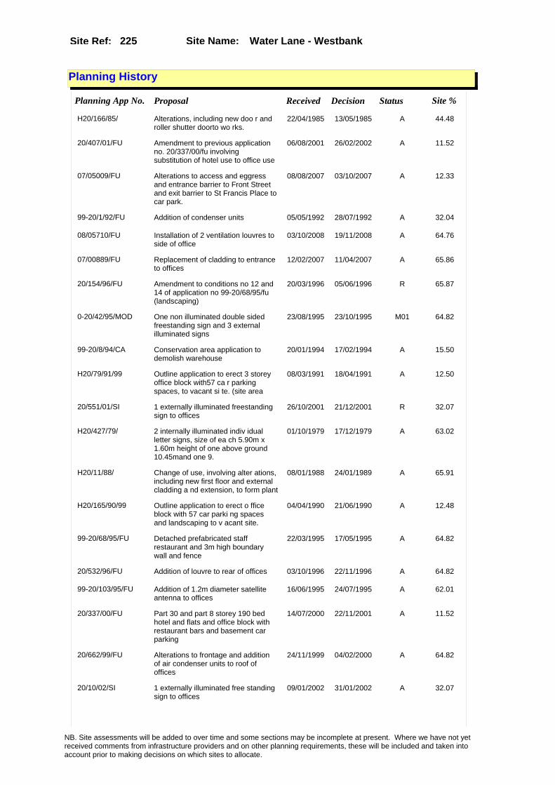
Site Name: Water Lane - Westbank Site Ref: 225
Planning History
Planning App No. Proposal Received Decision Status Site %
H20/166/85/ Alterations, including new doo r and roller shutter doorto wo rks.
22/04/1985 13/05/1985 A 44.48
20/407/01/FU Amendment to previous application no. 20/337/00/fu involving substitution of hotel use to office use
06/08/2001 26/02/2002 A 11.52
07/05009/FU Alterations to access and eggress and entrance barrier to Front Street and exit barrier to St Francis Place to car park.
08/08/2007 03/10/2007 A 12.33
99-20/1/92/FU Addition of condenser units 05/05/1992 28/07/1992 A 32.04
08/05710/FU Installation of 2 ventilation louvres to side of office
03/10/2008 19/11/2008 A 64.76
07/00889/FU Replacement of cladding to entrance to offices
12/02/2007 11/04/2007 A 65.86
20/154/96/FU Amendment to conditions no 12 and 14 of application no 99-20/68/95/fu (landscaping)
20/03/1996 05/06/1996 R 65.87
0-20/42/95/MOD One non illuminated double sided freestanding sign and 3 external illuminated signs
23/08/1995 23/10/1995 M01 64.82
99-20/8/94/CA Conservation area application to demolish warehouse
20/01/1994 17/02/1994 A 15.50
H20/79/91/99 Outline application to erect 3 storey office block with57 ca r parking spaces, to vacant si te. (site area
08/03/1991 18/04/1991 A 12.50
20/551/01/SI 1 externally illuminated freestanding sign to offices
26/10/2001 21/12/2001 R 32.07
H20/427/79/ 2 internally illuminated indiv idual letter signs, size of ea ch 5.90m x 1.60m height of one above ground 10.45mand one 9.
01/10/1979 17/12/1979 A 63.02
H20/11/88/ Change of use, involving alter ations, including new first floor and external cladding a nd extension, to form plant
08/01/1988 24/01/1989 A 65.91
H20/165/90/99 Outline application to erect o ffice block with 57 car parki ng spaces and landscaping to v acant site.
04/04/1990 21/06/1990 A 12.48
99-20/68/95/FU Detached prefabricated staff restaurant and 3m high boundary wall and fence
22/03/1995 17/05/1995 A 64.82
20/532/96/FU Addition of louvre to rear of offices 03/10/1996 22/11/1996 A 64.82
99-20/103/95/FU Addition of 1.2m diameter satellite antenna to offices
16/06/1995 24/07/1995 A 62.01
20/337/00/FU Part 30 and part 8 storey 190 bed hotel and flats and office block with restaurant bars and basement car parking
14/07/2000 22/11/2001 A 11.52
20/662/99/FU Alterations to frontage and addition of air condenser units to roof of offices
24/11/1999 04/02/2000 A 64.82
20/10/02/SI 1 externally illuminated free standing sign to offices
09/01/2002 31/01/2002 A 32.07
NB. Site assessments will be added to over time and some sections may be incomplete at present. Where we have not yet received comments from infrastructure providers and on other planning requirements, these will be included and taken into account prior to making decisions on which sites to allocate.
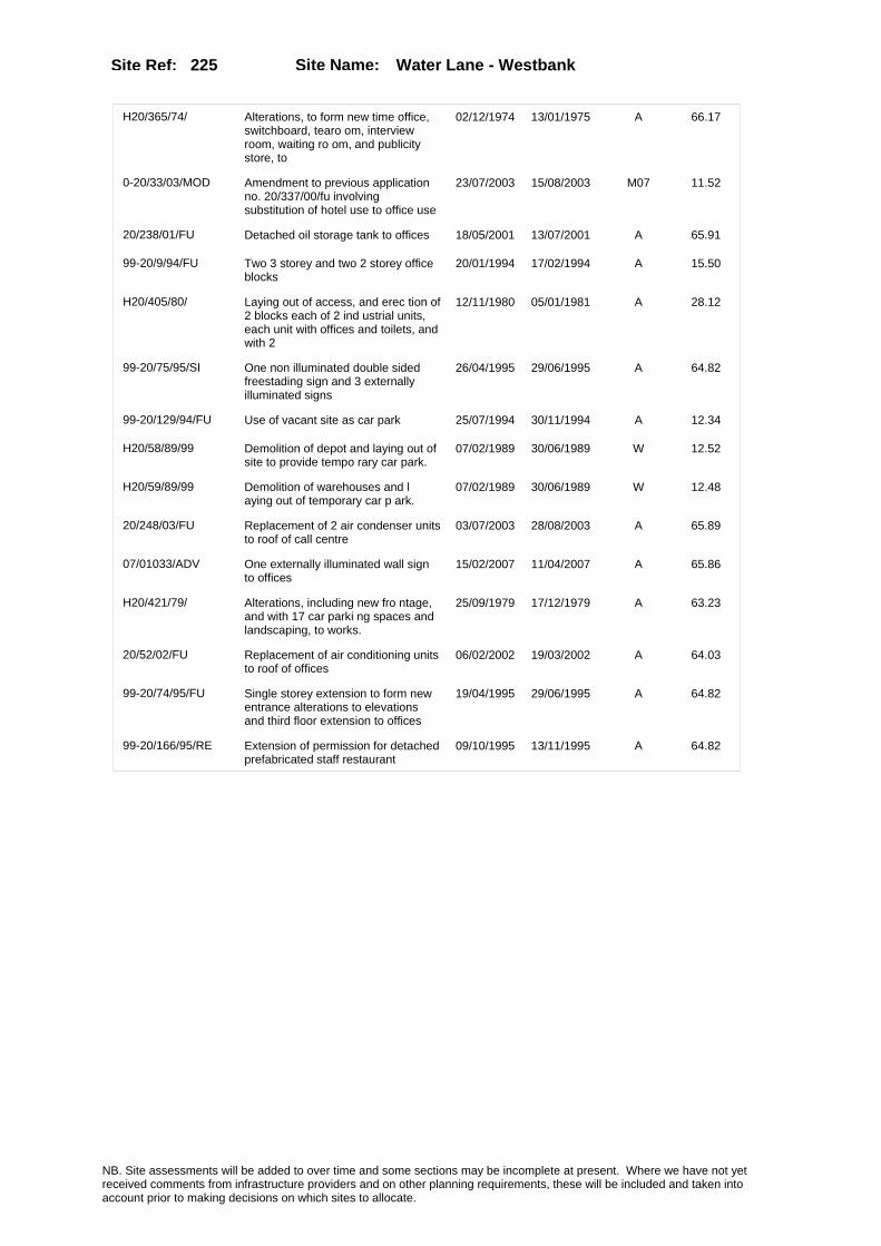
Site Name: Water Lane - Westbank Site Ref: 225
H20/365/74/ Alterations, to form new time office, switchboard, tearo om, interview room, waiting ro om, and publicity store, to
02/12/1974 13/01/1975 A 66.17
0-20/33/03/MOD Amendment to previous application no. 20/337/00/fu involving substitution of hotel use to office use
23/07/2003 15/08/2003 M07 11.52
20/238/01/FU Detached oil storage tank to offices 18/05/2001 13/07/2001 A 65.91
99-20/9/94/FU Two 3 storey and two 2 storey office blocks
20/01/1994 17/02/1994 A 15.50
H20/405/80/ Laying out of access, and erec tion of 2 blocks each of 2 ind ustrial units, each unit with offices and toilets, and with 2
12/11/1980 05/01/1981 A 28.12
99-20/75/95/SI One non illuminated double sided freestading sign and 3 externally illuminated signs
26/04/1995 29/06/1995 A 64.82
99-20/129/94/FU Use of vacant site as car park 25/07/1994 30/11/1994 A 12.34
H20/58/89/99 Demolition of depot and laying out of site to provide tempo rary car park.
07/02/1989 30/06/1989 W 12.52
H20/59/89/99 Demolition of warehouses and l aying out of temporary car p ark.
07/02/1989 30/06/1989 W 12.48
20/248/03/FU Replacement of 2 air condenser units to roof of call centre
03/07/2003 28/08/2003 A 65.89
07/01033/ADV One externally illuminated wall sign to offices
15/02/2007 11/04/2007 A 65.86
H20/421/79/ Alterations, including new fro ntage, and with 17 car parki ng spaces and landscaping, to works.
25/09/1979 17/12/1979 A 63.23
20/52/02/FU Replacement of air conditioning units to roof of offices
06/02/2002 19/03/2002 A 64.03
99-20/74/95/FU Single storey extension to form new entrance alterations to elevations and third floor extension to offices
19/04/1995 29/06/1995 A 64.82
99-20/166/95/RE Extension of permission for detached prefabricated staff restaurant
09/10/1995 13/11/1995 A 64.82
NB. Site assessments will be added to over time and some sections may be incomplete at present. Where we have not yet received comments from infrastructure providers and on other planning requirements, these will be included and taken into account prior to making decisions on which sites to allocate.

Site Name: Water Lane - Westbank Site Ref: 225
Conformity with Core Strategy
Inner South Leeds: 0.00
Leeds Bradford Corridor: 0.00 West Leeds Gateway: 0.00
Aire Valley: 0.00Regeneration Priority Area:
Brownfield
Greenfield
Mixed
Main Urban Area
Major Settlement
Smaller Settlement
Villages/Rural
Main Urban Area Extension
Major Settlement Extension
Smaller Settlement Extension
Village/Rural Extension
Development unrelated to existing development
Green Belt assessment - only completed where site is within Green Belt
Would development lead to/constitute ribbon development?
Would development result in isolated development?
Is the site well connected to built up area (2+ boundaries with existing built up area)?
Would development of the site effectively "round off" the settlement pattern?:
Do natural/physical features provide a good existing barrier between existing urban area and undeveloped land?
Overall sprawl conclusion:
Would development of the site lead to physical connection of settlements?
Do natural/physical features provide a good existing barrier/boundary to contain development?
Overall Coalescence Conclusion:
Is there a strong defensible boundary between the site and the existing urban area?
Does the site provide access to the countryside?
Does the site include local or national conservation designated areas?
Does the site include areas of woodlands, trees, hedgerows that are protected, or significant unprotected tree/hedge cover?
Does the site include grade 1, 2, or 3a agricultural land?
Does the site contain buildings? Are these in agricultural use?
Overall countryside Encroachment Conclusion
Is the site within or adjacent to a conservation area, listed building or other historical feature?
If yes, could development preserve this character?:
Overall Character Preservation Conclusion:
Greenbelt Assessment Conclusion:
Check the unrestricted sprawl of large built up areas
Prevent neighbouring towns from merging
Assist in safeguarding countryside from encroachment
Preserve the setting and special character of historic towns
NB. Site assessments will be added to over time and some sections may be incomplete at present. Where we have not yet received comments from infrastructure providers and on other planning requirements, these will be included and taken into account prior to making decisions on which sites to allocate.

Site Name: Water Lane - Westbank Site Ref: 225
SHLAA ConclusionsAvailability: Unknown Suitability: LDF to determine Achievability: Unknown
East Leeds
Summary of Infrastructure provider comments and other planning requirements
Accessibility commentMeets Public Transport accessibility and standards for local services, scools and healthcare
Rank (1-5)
5Access Comments
Access fom David Street, close access from Bridgewater place
Local network comment
Local network will need looking at
Rank (1-5)
5Rank (1-5)
4
Leeds City Council Highways inc Metro
Highways Agency
Network Rail :
Biodiversity
Natural England:
Education
Mitigation measure
Some required
Total score
14Support?
yes - with mitigation
Need to combine with other sites: Suitability for partial development:
West Yorkshire Ecology and LCC Ecology Officer:
Supported
Boundary Amendment
Drainage/Water/FloodingEnvironment Agency Comments: Environment Agency Constraints:
Yorkshire Water Comments: Yorkshire Water Waste Water Treatment Works Comme
Utilities
Potential for cumulative impact in combination with other sites. If site still included at next sift assess as part of city centre/Aire Valley cluster.
LCC Flood Risk Management:
NB. Site assessments will be added to over time and some sections may be incomplete at present. Where we have not yet received comments from infrastructure providers and on other planning requirements, these will be included and taken into account prior to making decisions on which sites to allocate.

Site Name: Water Lane - Westbank Site Ref: 225
Conclusion of Assessment
Conclusion summary:
SHLAA site with potential for office element
Floorspace sq m (Non residential): 20790
Employment Conclusion: Green
Assesment Type: Site assessment Type: Mixed Use
Proposed Change:
Gas:
Electric:
Telecom:
Fire and Rescue Services:
Built HeritageLeeds City Council:
West Yorkshire Archaeology Service:
English Heritage:
Gypsy Traveller Site Assessment
Yes No Maybe Could site be effectively managed (Text)
Yes No Maybe Would gypsies and travellers live on the site?
(Text)
Yes No Proximity to housed gypsies and travellers (Text)
Yes No Unknown Experience of previous encampments (Text)
NB. Site assessments will be added to over time and some sections may be incomplete at present. Where we have not yet received comments from infrastructure providers and on other planning requirements, these will be included and taken into account prior to making decisions on which sites to allocate.
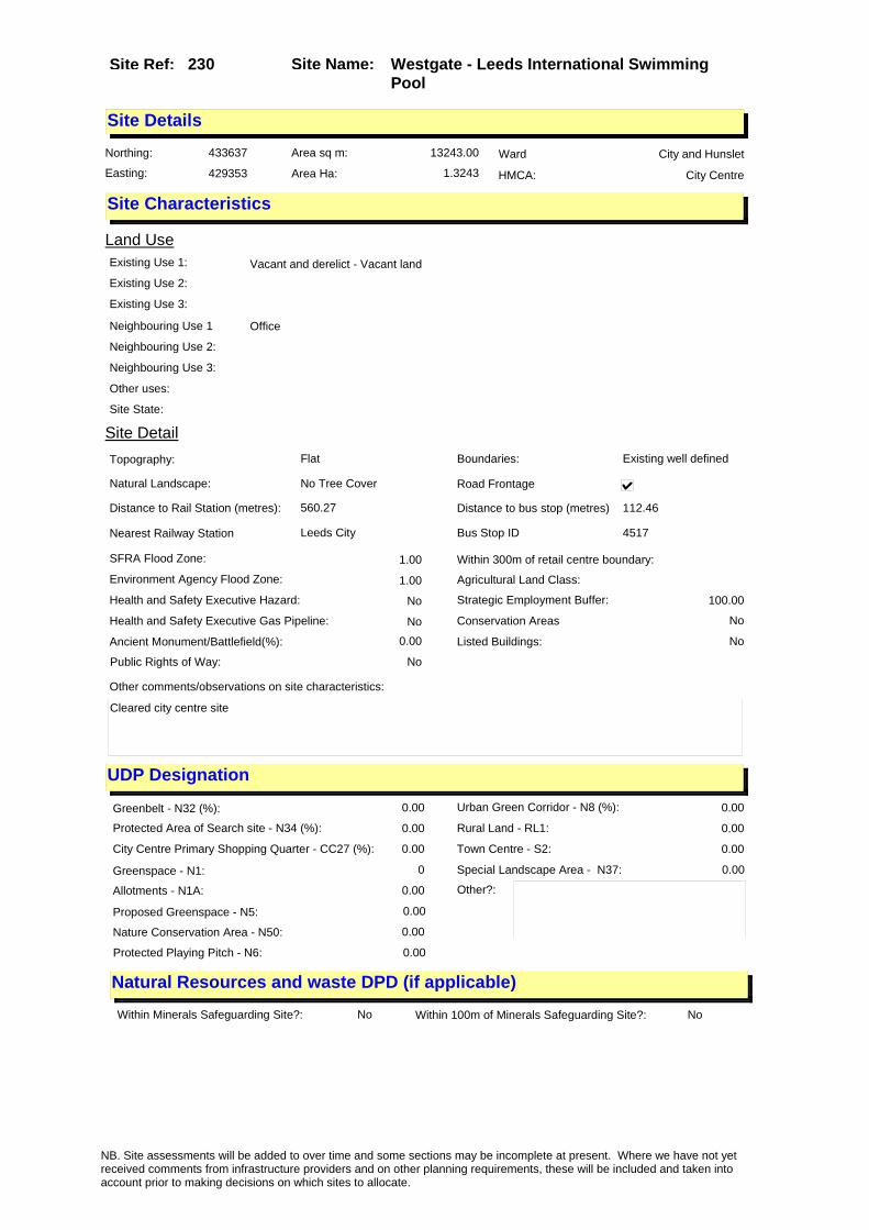
Site Name: Westgate - Leeds International Swimming Pool
Site Ref: 230
Site Details
Land Use
Northing: 433637
Easting: 429353
Distance to Rail Station (metres): 560.27
Nearest Railway Station Leeds City
Distance to bus stop (metres) 112.46
Bus Stop ID 4517
Agricultural Land Class:
SFRA Flood Zone: 1.00
Environment Agency Flood Zone: 1.00
Within 300m of retail centre boundary:
UDP Designation
Greenbelt - N32 (%): 0.00 Urban Green Corridor - N8 (%): 0.00
Protected Area of Search site - N34 (%): 0.00 Rural Land - RL1: 0.00
City Centre Primary Shopping Quarter - CC27 (%): 0.00 Town Centre - S2: 0.00
Health and Safety Executive Hazard: No
Health and Safety Executive Gas Pipeline: No
Strategic Employment Buffer: 100.00
Area sq m: 13243.00 Ward City and Hunslet
Special Landscape Area - N37: 0.00
Allotments - N1A: 0.00
Proposed Greenspace - N5: 0.00
Protected Playing Pitch - N6: 0.00
Nature Conservation Area - N50: 0.00
Conservation Areas No
Ancient Monument/Battlefield(%): 0.00 Listed Buildings: No
Public Rights of Way: No
Other?:
Natural Resources and waste DPD (if applicable)
Within Minerals Safeguarding Site?: No Within 100m of Minerals Safeguarding Site?: No
HMCA: City Centre
Greenspace - N1: 0
Existing Use 1: Vacant and derelict - Vacant landExisting Use 2:
Existing Use 3:
Neighbouring Use 1 Office
Neighbouring Use 2:
Neighbouring Use 3:
Other uses:
Topography: Flat
Natural Landscape: No Tree Cover
Boundaries: Existing well defined
Road Frontage
Site Characteristics
Site Detail
Other comments/observations on site characteristics:
Cleared city centre site
Area Ha: 1.3243
Site State:
NB. Site assessments will be added to over time and some sections may be incomplete at present. Where we have not yet received comments from infrastructure providers and on other planning requirements, these will be included and taken into account prior to making decisions on which sites to allocate.

Site Name: Westgate - Leeds International Swimming Pool
Site Ref: 230
Planning History
Planning App No. Proposal Received Decision Status Site %
PREAPP/06/00165 . 23/08/2006 01/01/2007 PRECAG 100.00
20/224/03/SN 3 non illuminated free standing sales boards
11/06/2003 18/08/2003 A 90.15
H20/156/89/ Temporary consent to erect 6, detached prefabricated offic e units to swimming pool. (this item
31/03/1989 05/06/1989 A 99.13
11/03265/FU Use of vacant site as temporary long stay car park for Woodhouse Lane Multi Storey Car Park permit holders
02/08/2011 13/10/2011 A 55.70
H20/48/81/ Laying out of access road, and erection of offices, compr ising one 13 storey block, one 11 storey block, one 8 stor
02/02/1981 30/03/1981 A 12.10
08/01151/LA Use of former swimming pool site as temporary short stay pay and display car park
27/02/2008 22/05/2008 A 80.85
H20/271/77/ Outline application to demolis h existing buildings, lay o ut access roads, and erect 5 s torey office block with car p
04/07/1977 22/08/1977 A 31.56
NB. Site assessments will be added to over time and some sections may be incomplete at present. Where we have not yet received comments from infrastructure providers and on other planning requirements, these will be included and taken into account prior to making decisions on which sites to allocate.

Site Name: Westgate - Leeds International Swimming Pool
Site Ref: 230
Conformity with Core Strategy
Inner South Leeds: 0.00
Leeds Bradford Corridor: 0.00 West Leeds Gateway: 0.00
Aire Valley: 0.00Regeneration Priority Area:
Brownfield
Greenfield
Mixed
Main Urban Area
Major Settlement
Smaller Settlement
Villages/Rural
Main Urban Area Extension
Major Settlement Extension
Smaller Settlement Extension
Village/Rural Extension
Development unrelated to existing development
Green Belt assessment - only completed where site is within Green Belt
Would development lead to/constitute ribbon development?
Would development result in isolated development?
Is the site well connected to built up area (2+ boundaries with existing built up area)?
Would development of the site effectively "round off" the settlement pattern?:
Do natural/physical features provide a good existing barrier between existing urban area and undeveloped land?
Overall sprawl conclusion:
Would development of the site lead to physical connection of settlements?
Do natural/physical features provide a good existing barrier/boundary to contain development?
Overall Coalescence Conclusion:
Is there a strong defensible boundary between the site and the existing urban area?
Does the site provide access to the countryside?
Does the site include local or national conservation designated areas?
Does the site include areas of woodlands, trees, hedgerows that are protected, or significant unprotected tree/hedge cover?
Does the site include grade 1, 2, or 3a agricultural land?
Does the site contain buildings? Are these in agricultural use?
Overall countryside Encroachment Conclusion
Is the site within or adjacent to a conservation area, listed building or other historical feature?
If yes, could development preserve this character?:
Overall Character Preservation Conclusion:
Greenbelt Assessment Conclusion:
Check the unrestricted sprawl of large built up areas
Prevent neighbouring towns from merging
Assist in safeguarding countryside from encroachment
Preserve the setting and special character of historic towns
NB. Site assessments will be added to over time and some sections may be incomplete at present. Where we have not yet received comments from infrastructure providers and on other planning requirements, these will be included and taken into account prior to making decisions on which sites to allocate.

Site Name: Westgate - Leeds International Swimming Pool
Site Ref: 230
SHLAA ConclusionsAvailability: Medium term (6-10 y Suitability: Yes Achievability: Medium term (6-10 years)
East Leeds
Summary of Infrastructure provider comments and other planning requirements
Accessibility commentMeets Public Transport accessibility and standards for local services, primary schools and healthcare - not secondary schools - however public transport available
Rank (1-5)
5Access Comments
Access possible from Lisbon St or Little Queen St
Local network comment
Capacity concerns on this section of network but lesser impact than other city centre uses
Rank (1-5)
5Rank (1-5)
4
Leeds City Council Highways inc Metro
Highways Agency
Network Rail :
Biodiversity
Natural England:
Education
Mitigation measure
Improvements to local junctions would be sought
Total score
14Support?
Yes - with mitigation
Need to combine with other sites:
combine with 187
Suitability for partial development:
West Yorkshire Ecology and LCC Ecology Officer:
Supported
Boundary Amendment
Drainage/Water/FloodingEnvironment Agency Comments: Environment Agency Constraints:
Yorkshire Water Comments: Yorkshire Water Waste Water Treatment Works Comme
Utilities
Potential for cumulative impact in combination with other sites. If site still included at next sift assess as part of city centre/Aire Valley cluster.
LCC Flood Risk Management:
NB. Site assessments will be added to over time and some sections may be incomplete at present. Where we have not yet received comments from infrastructure providers and on other planning requirements, these will be included and taken into account prior to making decisions on which sites to allocate.
Site Name: Westgate - Leeds International Swimming Pool
Site Ref: 230
Conclusion of Assessment
Conclusion summary:
SHLAA site with potential for office element
Floorspace sq m (Non residential): 13243
Employment Conclusion: Green
Assesment Type: Site assessment Type: Mixed Use
Proposed Change:
Gas:
Electric:
Telecom:
Fire and Rescue Services:
Built HeritageLeeds City Council:
West Yorkshire Archaeology Service:
English Heritage:
Gypsy Traveller Site Assessment
Yes No Maybe Could site be effectively managed (Text)
Yes No Maybe Would gypsies and travellers live on the site?
(Text)
Yes No Proximity to housed gypsies and travellers (Text)
Yes No Unknown Experience of previous encampments (Text)
NB. Site assessments will be added to over time and some sections may be incomplete at present. Where we have not yet received comments from infrastructure providers and on other planning requirements, these will be included and taken into account prior to making decisions on which sites to allocate.

Site Name: Kirkgate Phase II Site Ref: 231
Site Details
Land Use
Northing: 433386
Easting: 430486
Distance to Rail Station (metres): 817.06
Nearest Railway Station Leeds City
Distance to bus stop (metres) 50.66
Bus Stop ID 4471
Agricultural Land Class:
SFRA Flood Zone: 0.00
Environment Agency Flood Zone: 0.00
Within 300m of retail centre boundary:
UDP Designation
Greenbelt - N32 (%): 0.00 Urban Green Corridor - N8 (%): 0.00
Protected Area of Search site - N34 (%): 0.00 Rural Land - RL1: 0.00
City Centre Primary Shopping Quarter - CC27 (%): 92.12 Town Centre - S2: 0.00
Health and Safety Executive Hazard: No
Health and Safety Executive Gas Pipeline: No
Strategic Employment Buffer: 100.00
Area sq m: 2770.26 Ward City and Hunslet
Special Landscape Area - N37: 0.00
Allotments - N1A: 0.00
Proposed Greenspace - N5: 0.00
Protected Playing Pitch - N6: 0.00
Nature Conservation Area - N50: 1.00
Conservation Areas Yes
Ancient Monument/Battlefield(%): 0.00 Listed Buildings: Yes
Public Rights of Way: Yes
Other?:
Natural Resources and waste DPD (if applicable)
Within Minerals Safeguarding Site?: No Within 100m of Minerals Safeguarding Site?: No
HMCA: City Centre
Greenspace - N1: 0
Existing Use 1: Retail - ShopsExisting Use 2: Vacant & Derelict - Vacant buildingExisting Use 3:
Neighbouring Use 1 Retail - Shops
Neighbouring Use 2: Vacant and derelict - Derelict
Neighbouring Use 3: Retail - Restaurants and Cafes
Other uses:
Topography: Flat
Natural Landscape: No Tree Cover
Boundaries: Existing well defined
Road Frontage
Site Characteristics
Site Detail
Other comments/observations on site characteristics:
Site includes shops, some vacant/derelict, on the south side of Kirkgate and open land to the rear.
Area Ha: 0.277026
Site State: Brownfield
NB. Site assessments will be added to over time and some sections may be incomplete at present. Where we have not yet received comments from infrastructure providers and on other planning requirements, these will be included and taken into account prior to making decisions on which sites to allocate.
Site Name: Kirkgate Phase II Site Ref: 231
Planning History
Planning App No. Proposal Received Decision Status Site %
99-20/8/92/CA Conservation area application to demolish shops and offices
21/05/1992 29/09/1992 A 10.74
99-20/28/94/RE Extension of permission for alterations extensions and erection of shops restaurant offices and amusement arcade
17/02/1994 17/03/1994 A 79.77
H20/434/91/99 Alterations to form retail uni ts, restaurant and offic e units, part 3 and part 4 sto rey extension to form retai
27/09/1991 28/02/1992 W 99.73
H20/219/84/ Change of use of textile whole salers premises to retailaquat ic and pet shop.
22/05/1984 16/07/1984 A 14.32
20/549/01/FU Laying out of car park with automatic barriers and ticket machines
23/10/2001 18/08/2003 W 59.25
H20/433/91/99 Alterations to form retail uni ts, restaurant and officeunits , part 3 and part 4 storey ext ension to form retail uni
24/09/1991 07/02/1992 A 78.10
H20/471/90/99 Listed building and conservati on area application to demol ish shops and offices.
02/10/1990 26/02/1992 W 99.52
H20/435/91/99 Demolition of part of listed b uilding and buildings withi n a conservation area and list ed building applicatio
24/09/1991 28/02/1992 W 99.78
99-20/132/93/LI Listed building application to demolish and carry out alterations and extension to shops and offices
06/07/1993 09/09/1993 A 15.02
99-20/131/93/FU Amendment to previous application to erect shop and offices and extension to form enlarged shop unit and canopy
15/07/1993 06/10/1993 A 15.02
H20/465/77/ Laying out of car park, with 2 1 car parking spaces, to vacan t site.
16/11/1977 20/02/1978 R 14.55
H20/429/83/ 2.4m high gates, to form peat and fertiliser storage compo und, to seed merchants.
04/11/1983 03/01/1984 R 11.55
H20/233/91/99 To use cleared site as an exte nsion to the existing carpark.
12/06/1991 15/08/1991 A 20.86
H20/460/90/99 Outline application to erect o ffice, retail and resid ential development to existing offices and shops. (site area
03/10/1990 13/12/1990 A 72.63
H20/268/77/ Demolition of existing buildin gs and laying out of car p ark with 22 car parking spaces .
28/06/1977 22/08/1977 A 18.13
H20/221/90/99 Outline application to erect e xtensions to form enlar ged sales area, to shop. (s ite area 0.05ha)
09/05/1990 16/08/1990 A 12.46
09/04668/COND Consent, agreement or approval required by condition 3 of Planning Application 20/171/05/LI
29/10/2009 09/11/2009 A 80.23
10/00181/COND Consent, agreement or approval required by conditions 3 and 4 of Planning Application 20/171/05/LI
19/01/2010 PCO 80.23
NB. Site assessments will be added to over time and some sections may be incomplete at present. Where we have not yet received comments from infrastructure providers and on other planning requirements, these will be included and taken into account prior to making decisions on which sites to allocate.

Site Name: Kirkgate Phase II Site Ref: 231
H20/456/90/99 Listed building application to demolish shops and offic es.
26/09/1990 26/02/1992 W 99.11
H20/469/90/99 Outline application to erect o ffice, retail and resid ential development to existing offices and shops. (site area
03/10/1990 13/12/1990 A 67.85
99-20/167/94/LI Listed building application to demolish part and carry out alterations and extension to shops and offices
13/09/1994 20/10/1994 A 15.02
H20/508/78/ Laying out of car park with 0. 9m high boundary fence to va cant site. (site area
05/12/1978 08/01/1979 A 34.00
H20/282/91/99 Renewal of outline permission to erect office, retail and r esidential development, to exi sting offices and shops.
10/07/1991 15/08/1991 A 83.68
H20/252/89/1 Conservation area application to demolish fire damaged store .
09/01/1990 22/01/1990 A 13.12
20/171/05/LI Listed building application to demolish rear extension to 98 Kirkgate
12/04/2005 09/12/2005 A 80.23
PREAPP/06/00161 Refurbishment of shops and new build development including restoration of Grade II� listed First White Cloth Hall
23/08/2006 PCO 98.82
H20/234/91/99 To demolish a number of buildi ngs . 12/06/1991 15/08/1991 A 20.86
H20/21/83/ Conservation area application to demolish 2 vacant build ings.
28/01/1983 13/06/1983 A 20.82
99-20/15/93/RE Extension of permission for alterations extensions and erection of shops, restaurant offices and amusement arcade
22/01/1993 18/02/1993 A 83.00
H20/252/89/99 Conservation area application, to demolish fire damagedstore .
31/05/1989 15/09/1989 R 13.13
H20/436/91/99 Demolition of part of listed b uilding and buildings withi n a conservation area and list ed building applicatio
27/09/1991 10/06/1992 A 82.96
99-20/7/92/FU 3 storey offices and shops 21/05/1992 11/08/1992 A 10.74
H20/283/91/99 Renewal of outline permission to erect office, retail and r esidential development, to exi sting offices and shops.
10/07/1991 01/06/1992 W 99.51
NB. Site assessments will be added to over time and some sections may be incomplete at present. Where we have not yet received comments from infrastructure providers and on other planning requirements, these will be included and taken into account prior to making decisions on which sites to allocate.

Site Name: Kirkgate Phase II Site Ref: 231
Conformity with Core Strategy
Inner South Leeds: 0.00
Leeds Bradford Corridor: 0.00 West Leeds Gateway: 0.00
Aire Valley: 0.00Regeneration Priority Area:
Brownfield
Greenfield
Mixed
Main Urban Area
Major Settlement
Smaller Settlement
Villages/Rural
Main Urban Area Extension
Major Settlement Extension
Smaller Settlement Extension
Village/Rural Extension
Development unrelated to existing development
Green Belt assessment - only completed where site is within Green Belt
Would development lead to/constitute ribbon development?
Would development result in isolated development?
Is the site well connected to built up area (2+ boundaries with existing built up area)?
Would development of the site effectively "round off" the settlement pattern?:
Do natural/physical features provide a good existing barrier between existing urban area and undeveloped land?
Overall sprawl conclusion:
Would development of the site lead to physical connection of settlements?
Do natural/physical features provide a good existing barrier/boundary to contain development?
Overall Coalescence Conclusion:
Is there a strong defensible boundary between the site and the existing urban area?
Does the site provide access to the countryside?
Does the site include local or national conservation designated areas?
Does the site include areas of woodlands, trees, hedgerows that are protected, or significant unprotected tree/hedge cover?
Does the site include grade 1, 2, or 3a agricultural land?
Does the site contain buildings? Are these in agricultural use?
Overall countryside Encroachment Conclusion
Is the site within or adjacent to a conservation area, listed building or other historical feature?
If yes, could development preserve this character?:
Overall Character Preservation Conclusion:
Greenbelt Assessment Conclusion:
Check the unrestricted sprawl of large built up areas
Prevent neighbouring towns from merging
Assist in safeguarding countryside from encroachment
Preserve the setting and special character of historic towns
NB. Site assessments will be added to over time and some sections may be incomplete at present. Where we have not yet received comments from infrastructure providers and on other planning requirements, these will be included and taken into account prior to making decisions on which sites to allocate.

Site Name: Kirkgate Phase II Site Ref: 231
SHLAA ConclusionsAvailability: Unknown Suitability: Yes Physical Achievability: Long term (11+ years)
East Leeds
Summary of Infrastructure provider comments and other planning requirements
Accessibility commentMeets Public Transport accessibility and standards for local services, schools and healthcare
Rank (1-5)
5Access Comments
Access possible from Crown Street through the site
Local network comment
Capacity ok
Rank (1-5)
5Rank (1-5)
5
Leeds City Council Highways inc Metro
Highways Agency
Network Rail :
Biodiversity
Natural England:
Education
Mitigation measure
Pedestrian linkages and local environmental improvements required.
Total score
15Support?
Yes - with mitigation
Need to combine with other sites: Suitability for partial development:
West Yorkshire Ecology and LCC Ecology Officer:
Supported
Boundary Amendment
Drainage/Water/FloodingEnvironment Agency Comments: Environment Agency Constraints:
Yorkshire Water Comments: Yorkshire Water Waste Water Treatment Works Comme
Utilities
Potential for cumulative impact in combination with other sites. If site still included at next sift assess as part of city centre/Aire Valley cluster.
LCC Flood Risk Management:
Need to check relationship with viaduct and very long term proposal to widen to 4 tracks
NB. Site assessments will be added to over time and some sections may be incomplete at present. Where we have not yet received comments from infrastructure providers and on other planning requirements, these will be included and taken into account prior to making decisions on which sites to allocate.
Site Name: Kirkgate Phase II Site Ref: 231
Conclusion of Assessment
Conclusion summary:
SHLAA site with potential for office element
Floorspace sq m (Non residential): 2770
Employment Conclusion: Green
Assesment Type: Site assessment Type: Mixed Use
Proposed Change:
Gas:
Electric:
Telecom:
Fire and Rescue Services:
Built HeritageLeeds City Council:
West Yorkshire Archaeology Service:
English Heritage:
Gypsy Traveller Site Assessment
Yes No Maybe Could site be effectively managed (Text)
Yes No Maybe Would gypsies and travellers live on the site?
(Text)
Yes No Proximity to housed gypsies and travellers (Text)
Yes No Unknown Experience of previous encampments (Text)
NB. Site assessments will be added to over time and some sections may be incomplete at present. Where we have not yet received comments from infrastructure providers and on other planning requirements, these will be included and taken into account prior to making decisions on which sites to allocate.

Site Name: Cropper Gate - Mayfair LS1Site Ref: 402
Site Details
Land Use
Northing: 433556
Easting: 429170
Distance to Rail Station (metres): 636.68
Nearest Railway Station Leeds City
Distance to bus stop (metres) 61.10
Bus Stop ID 5349
Agricultural Land Class:
SFRA Flood Zone: 1.00
Environment Agency Flood Zone: 1.00
Within 300m of retail centre boundary:
UDP Designation
Greenbelt - N32 (%): 0.00 Urban Green Corridor - N8 (%): 0.00
Protected Area of Search site - N34 (%): 0.00 Rural Land - RL1: 0.00
City Centre Primary Shopping Quarter - CC27 (%): 0.00 Town Centre - S2: 0.00
Health and Safety Executive Hazard: No
Health and Safety Executive Gas Pipeline: No
Strategic Employment Buffer: 100.00
Area sq m: 2190.58 Ward City and Hunslet
Special Landscape Area - N37: 0.00
Allotments - N1A: 0.00
Proposed Greenspace - N5: 0.00
Protected Playing Pitch - N6: 0.00
Nature Conservation Area - N50: 0.00
Conservation Areas No
Ancient Monument/Battlefield(%): 0.00 Listed Buildings: No
Public Rights of Way: No
Other?:
Natural Resources and waste DPD (if applicable)
Within Minerals Safeguarding Site?: No Within 100m of Minerals Safeguarding Site?: No
HMCA: City Centre
Greenspace - N1: 0
Existing Use 1: Vacant & Derelict - Vacant buildingExisting Use 2:
Existing Use 3:
Neighbouring Use 1 Office
Neighbouring Use 2: Transport - Car Parks
Neighbouring Use 3:
Other uses:
Topography: Flat
Natural Landscape: No Tree Cover
Boundaries: Existing well defined
Road Frontage
Site Characteristics
Site Detail
Other comments/observations on site characteristics:
Area Ha: 0.219058
Site State:
NB. Site assessments will be added to over time and some sections may be incomplete at present. Where we have not yet received comments from infrastructure providers and on other planning requirements, these will be included and taken into account prior to making decisions on which sites to allocate.

Site Name: Cropper Gate - Mayfair LS1Site Ref: 402
Planning History
Planning App No. Proposal Received Decision Status Site %
H20/209/79/ Change of use of car workshop to warehouse.
11/05/1979 18/06/1979 A 13.98
20/153/02/OT Outline application to erect 12 storey retail and office development
19/04/2002 01/08/2002 A 45.25
H20/397/84/ Change of use of photographic studio to car park.
13/09/1984 14/08/1985 W 14.79
H20/64/85/ Change of use of ground floor workshop and offices to train ing centre, including classroo ms and offices.
21/02/1985 25/03/1985 A 45.25
H20/188/91/ Addition of fencing to top of existing wall, to rear of of fices.
14/05/1991 31/07/1991 W 46.45
20/460/02/FU Part 9 & part 22 storey block of flats with offices, a3 unit and basement level car parking
04/11/2002 09/02/2004 A 99.92
20/342/97/RE Renewal of outline permission to erect 4 storey office block with basement car parking
16/06/1997 29/08/1997 A 31.47
20/400/01/OT Outline application to erect 6 storey office block
31/07/2001 03/12/2001 A 30.04
H20/210/79/ Change of use of car workshop to light industrial unit.
11/05/1979 18/06/1979 A 13.98
H20/41/86/ Change of use of car repair wo rkshop to warehouse.
07/02/1986 03/03/1986 A 15.54
PREAPP/08/00354 . 15/10/2008 PRENOT 90.48
H20/58/79/ Change of use of offices to wa rehouse and offices.
26/01/1979 30/04/1979 W 14.65
06/06557/ADV One externally illuminated banner sign to vacant offices
02/11/2006 11/01/2007 R 36.32
H20/154/79/ Alterations, including new fro ntage, to offices.
21/03/1979 18/06/1979 A 59.59
20/498/00/OT Variation of condition no 1 of application no 20/342/97/re
11/10/2000 09/01/2001 A 31.47
H20/60/75/ Demolition of existing externa l liftshaft & store room, alter ations including new facade, f ormation of enlargedoffice are
10/02/1975 14/04/1975 A 73.61
20/207/05/FU 10-28 storey block-272 flats offices a3 basement parking (amending app 20/283/04/fu for addition 6 units & alts)
03/05/2005 24/08/2005 A 77.69
20/156/01/OT Outline application to erect 12 storey mixed use development
19/03/2001 12/06/2002 W 45.25
10/03040/ADV Temporary scaffolding shroud hoarding to vacant building with externally illuminated wrap around banner sign
02/07/2010 12/08/2010 R 36.71
20/283/04/FU 10-28 storey block of 266 flats offices a3 unit and basement parking (amendment to application 20/460/02/fu)
09/06/2004 13/09/2004 A 99.92
H20/258/75/ Alterations, and enclosure of external fire escape, to of fice premises.
08/07/1975 04/08/1975 A 22.16
NB. Site assessments will be added to over time and some sections may be incomplete at present. Where we have not yet received comments from infrastructure providers and on other planning requirements, these will be included and taken into account prior to making decisions on which sites to allocate.

Site Name: Cropper Gate - Mayfair LS1Site Ref: 402
20/152/94/OT Outline application to erect 4 storey office block with basement car parking
15/04/1994 12/07/1994 A 32.54
H20/473/83/ One internally illuminated fas cia sign, size 4.57m x 0.51m , height above ground 8.68m (u nderside), to rear of office.
30/11/1983 23/01/1984 A 21.02
H20/448/75/ Change of use of ground floor showroom with offices over, to offices.
09/12/1975 12/01/1976 A 59.59
10/03459/EXT Extension of time planning application 20/207/05/FU (10-28 storey block-272 flats offices, A3 use and basement parking).
26/07/2010 22/07/2011 A 77.69
NB. Site assessments will be added to over time and some sections may be incomplete at present. Where we have not yet received comments from infrastructure providers and on other planning requirements, these will be included and taken into account prior to making decisions on which sites to allocate.

Site Name: Cropper Gate - Mayfair LS1Site Ref: 402
Conformity with Core Strategy
Inner South Leeds: 0.00
Leeds Bradford Corridor: 0.00 West Leeds Gateway: 0.00
Aire Valley: 0.00Regeneration Priority Area:
Brownfield
Greenfield
Mixed
Main Urban Area
Major Settlement
Smaller Settlement
Villages/Rural
Main Urban Area Extension
Major Settlement Extension
Smaller Settlement Extension
Village/Rural Extension
Development unrelated to existing development
Green Belt assessment - only completed where site is within Green Belt
Would development lead to/constitute ribbon development?
Would development result in isolated development?
Is the site well connected to built up area (2+ boundaries with existing built up area)?
Would development of the site effectively "round off" the settlement pattern?:
Do natural/physical features provide a good existing barrier between existing urban area and undeveloped land?
Overall sprawl conclusion:
Would development of the site lead to physical connection of settlements?
Do natural/physical features provide a good existing barrier/boundary to contain development?
Overall Coalescence Conclusion:
Is there a strong defensible boundary between the site and the existing urban area?
Does the site provide access to the countryside?
Does the site include local or national conservation designated areas?
Does the site include areas of woodlands, trees, hedgerows that are protected, or significant unprotected tree/hedge cover?
Does the site include grade 1, 2, or 3a agricultural land?
Does the site contain buildings? Are these in agricultural use?
Overall countryside Encroachment Conclusion
Is the site within or adjacent to a conservation area, listed building or other historical feature?
If yes, could development preserve this character?:
Overall Character Preservation Conclusion:
Greenbelt Assessment Conclusion:
Check the unrestricted sprawl of large built up areas
Prevent neighbouring towns from merging
Assist in safeguarding countryside from encroachment
Preserve the setting and special character of historic towns
NB. Site assessments will be added to over time and some sections may be incomplete at present. Where we have not yet received comments from infrastructure providers and on other planning requirements, these will be included and taken into account prior to making decisions on which sites to allocate.

Site Name: Cropper Gate - Mayfair LS1Site Ref: 402
SHLAA ConclusionsAvailability: Medium term (6-10 y Suitability: LDF to determine Achievability: Long term (11+ years)
Conclusion of Assessment
Conclusion summary:
Site with planning permission for residential with office element
Floorspace sq m (Non residential): 3620
Employment Conclusion: Lime Green
East Leeds
Assesment Type: Planning status Type: Office
Proposed Change:
Gypsy Traveller Site Assessment
Yes No Maybe Could site be effectively managed (Text)
Yes No Maybe Would gypsies and travellers live on the site?
(Text)
Yes No Proximity to housed gypsies and travellers (Text)
Yes No Unknown Experience of previous encampments (Text)
NB. Site assessments will be added to over time and some sections may be incomplete at present. Where we have not yet received comments from infrastructure providers and on other planning requirements, these will be included and taken into account prior to making decisions on which sites to allocate.

Site Name: York Street LS1 Site Ref: 411
Site Details
Land Use
Northing: 433536
Easting: 430918
Distance to Rail Station (metres): 1273.29
Nearest Railway Station Leeds City
Distance to bus stop (metres) 51.74
Bus Stop ID 11030
Agricultural Land Class:
SFRA Flood Zone: 0.00
Environment Agency Flood Zone: 0.00
Within 300m of retail centre boundary:
UDP Designation
Greenbelt - N32 (%): 0.00 Urban Green Corridor - N8 (%): 0.00
Protected Area of Search site - N34 (%): 0.00 Rural Land - RL1: 0.00
City Centre Primary Shopping Quarter - CC27 (%): 0.00 Town Centre - S2: 0.00
Health and Safety Executive Hazard: No
Health and Safety Executive Gas Pipeline: No
Strategic Employment Buffer: 100.00
Area sq m: 3059.07 Ward City and Hunslet
Special Landscape Area - N37: 0.00
Allotments - N1A: 0.00
Proposed Greenspace - N5: 0.00
Protected Playing Pitch - N6: 0.00
Nature Conservation Area - N50: 0.00
Conservation Areas No
Ancient Monument/Battlefield(%): 0.00 Listed Buildings: No
Public Rights of Way: No
Other?:
Natural Resources and waste DPD (if applicable)
Within Minerals Safeguarding Site?: No Within 100m of Minerals Safeguarding Site?: No
HMCA: City Centre
Greenspace - N1: 0
Existing Use 1: Transport - Car ParksExisting Use 2: Vacant and derelict - Vacant landExisting Use 3:
Neighbouring Use 1 Office
Neighbouring Use 2: Community Services - Education
Neighbouring Use 3:
Other uses:
Topography: Flat
Natural Landscape: Limited Tree Cover
Boundaries: Existing well defined
Road Frontage
Site Characteristics
Site Detail
Other comments/observations on site characteristics:
Surface car park to the rear of Dance Studio building
Area Ha: 0.305907
Site State: Brownfield
NB. Site assessments will be added to over time and some sections may be incomplete at present. Where we have not yet received comments from infrastructure providers and on other planning requirements, these will be included and taken into account prior to making decisions on which sites to allocate.

Site Name: York Street LS1 Site Ref: 411
Planning History
Planning App No. Proposal Received Decision Status Site %
10/01770/COND Consent, agreement or approval required by conditions 2, 4, 10, 18, 20, 21, 29 and 30 of Planning Application 08/04304/LA
15/04/2010 17/12/2010 SPL 78.32
H32/678/77/ Demolition of flats, laying ou t of access roads, publi c open space, with games area, and 604 car parking sp
11/08/1977 19/09/1977 A 53.54
H20/85/84/ Use of cleared site as car par k. (this item is also notice under reg ulation 4(1) of the town and c
20/02/1984 26/03/1984 A 99.73
H20/424/86/ Laying out of access roads, in cluding footbridge and road bridge and erection of 5 store y shopping developmen
30/09/1986 30/10/1986 A 100.00
H20/529/87/ Laying out of gyratory road sy stem including new flyov er, with landscaping to inner ring road. (this item
06/11/1987 03/02/1988 A 12.67
11/9/00019/MOD 6 storey dance studio, with changing rooms, meeting rooms, stores and offices, and roof plant room NON MATERAIL AMENDMENT Change of design to plant room lourves; glazing to south elevation; addition of gas meter housing change to gate and doorway arrangement and design of projecting pilates studio to north elevation�
15/02/2011 01/04/2011 M01 78.32
H20/372/88/ Laying out of gyratory road sy stem, including new flyov er, with landscaping to inner ring road. (this item
14/07/1988 22/08/1988 A 13.11
H20/328/90/ Outline application to lay out access and erect 9 store y office block, with basement car park and staff restaurant
13/07/1990 25/10/1990 A 88.88
20/187/95/OT Outline application to erect non residential institution concert hall ballet school and ancillary residential units
18/05/1995 09/08/1995 A 80.73
H20/99/91/ Use of public car park, involv ing erection of 1.8m chain link fence as contractor's co mpound and car park with wheel
27/03/1991 15/08/1991 A 24.23
H20/320/88/ Laying out of temporary car pa rk to cleared site. (this item is also notice under reg ulation 4(1) of the town and c
16/06/1988 08/08/1988 A 88.54
H20/615/87/ Listed building application to carry out alterations, inclu ding partial demolition of eas t wall to 1904 market bui
30/12/1987 10/04/1989 A 100.00
11/00693/LA Retrospective application for 4 non illuminated signs
18/02/2011 29/03/2011 A 75.04
NB. Site assessments will be added to over time and some sections may be incomplete at present. Where we have not yet received comments from infrastructure providers and on other planning requirements, these will be included and taken into account prior to making decisions on which sites to allocate.

Site Name: York Street LS1 Site Ref: 411
12/9/00010/MOD 6 storey dance studio, with changing rooms, meeting rooms, stores and offices, and roof plant room NON MATERIAL AMENDMENT to 08/04304/LA: 2 steps for safe access to western roof; smoke vent required for fire strategy
16/01/2012 20/02/2012 M01 78.32
20/460/03/FU Pt12/pt14 storey dance studio & rehersal rooms a3/b1/d2 unit & 106 flats(amendment to app. 20/198/01/fu for 6 extra flts)
16/12/2003 27/02/2004 A 100.00
H20/576/91/ Laying out of access roads and landscaping to cleared site.
18/12/1991 12/02/1992 A 46.20
H20/614/87/ Laying out of access roads, in cluding footbridge and road bridge and erection of 5 store y shopping developmen
30/12/1987 31/03/1988 A 100.00
20/198/01/FU Part 12 storey and part 14 storey dance studio and rehearsal rooms a3/b1/d2 use unit and 100 flats
11/04/2001 06/08/2003 A 100.00
H20/202/86/ Laying out of access roads, in cluding footbridge and road bridges, and erection of 5 sto rey shopping developmen
02/06/1986 13/10/1989 W 100.00
08/04304/LA 6 storey dance studio, with changing rooms, meeting rooms, stores and offices, and roof plant room
18/07/2008 15/10/2008 A 78.32
H20/100/91/ 30 non-illuminated hoardings t o construction and car park site.
28/03/1991 06/06/1991 A 26.07
NB. Site assessments will be added to over time and some sections may be incomplete at present. Where we have not yet received comments from infrastructure providers and on other planning requirements, these will be included and taken into account prior to making decisions on which sites to allocate.
Site Name: York Street LS1 Site Ref: 411
Conformity with Core Strategy
Inner South Leeds: 0.00
Leeds Bradford Corridor: 0.00 West Leeds Gateway: 0.00
Aire Valley: 0.00Regeneration Priority Area:
Brownfield
Greenfield
Mixed
Main Urban Area
Major Settlement
Smaller Settlement
Villages/Rural
Main Urban Area Extension
Major Settlement Extension
Smaller Settlement Extension
Village/Rural Extension
Development unrelated to existing development
Green Belt assessment - only completed where site is within Green Belt
Would development lead to/constitute ribbon development?
Would development result in isolated development?
Is the site well connected to built up area (2+ boundaries with existing built up area)?
Would development of the site effectively "round off" the settlement pattern?:
Do natural/physical features provide a good existing barrier between existing urban area and undeveloped land?
Overall sprawl conclusion:
Would development of the site lead to physical connection of settlements?
Do natural/physical features provide a good existing barrier/boundary to contain development?
Overall Coalescence Conclusion:
Is there a strong defensible boundary between the site and the existing urban area?
Does the site provide access to the countryside?
Does the site include local or national conservation designated areas?
Does the site include areas of woodlands, trees, hedgerows that are protected, or significant unprotected tree/hedge cover?
Does the site include grade 1, 2, or 3a agricultural land?
Does the site contain buildings? Are these in agricultural use?
Overall countryside Encroachment Conclusion
Is the site within or adjacent to a conservation area, listed building or other historical feature?
If yes, could development preserve this character?:
Overall Character Preservation Conclusion:
Greenbelt Assessment Conclusion:
Check the unrestricted sprawl of large built up areas
Prevent neighbouring towns from merging
Assist in safeguarding countryside from encroachment
Preserve the setting and special character of historic towns
NB. Site assessments will be added to over time and some sections may be incomplete at present. Where we have not yet received comments from infrastructure providers and on other planning requirements, these will be included and taken into account prior to making decisions on which sites to allocate.
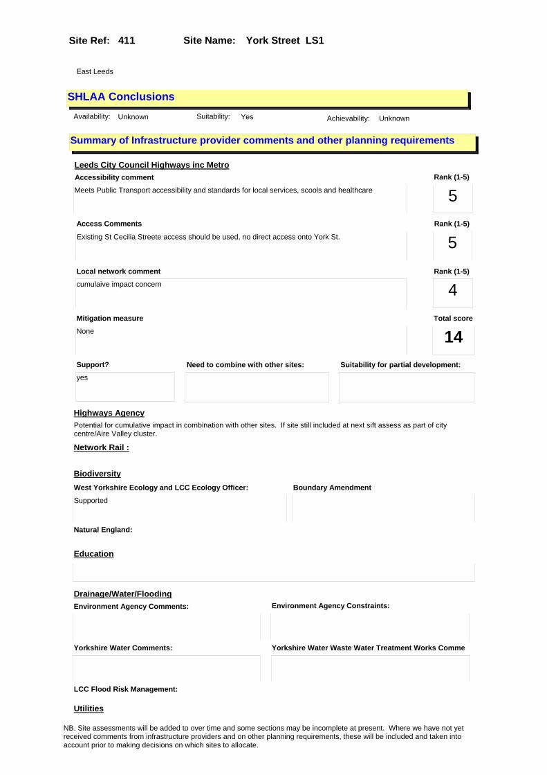
Site Name: York Street LS1 Site Ref: 411
SHLAA ConclusionsAvailability: Unknown Suitability: Yes Achievability: Unknown
East Leeds
Summary of Infrastructure provider comments and other planning requirements
Accessibility commentMeets Public Transport accessibility and standards for local services, scools and healthcare
Rank (1-5)
5Access Comments
Existing St Cecilia Streete access should be used, no direct access onto York St.
Local network comment
cumulaive impact concern
Rank (1-5)
5Rank (1-5)
4
Leeds City Council Highways inc Metro
Highways Agency
Network Rail :
Biodiversity
Natural England:
Education
Mitigation measure
None
Total score
14Support?
yes
Need to combine with other sites: Suitability for partial development:
West Yorkshire Ecology and LCC Ecology Officer:
Supported
Boundary Amendment
Drainage/Water/FloodingEnvironment Agency Comments: Environment Agency Constraints:
Yorkshire Water Comments: Yorkshire Water Waste Water Treatment Works Comme
Utilities
Potential for cumulative impact in combination with other sites. If site still included at next sift assess as part of city centre/Aire Valley cluster.
LCC Flood Risk Management:
NB. Site assessments will be added to over time and some sections may be incomplete at present. Where we have not yet received comments from infrastructure providers and on other planning requirements, these will be included and taken into account prior to making decisions on which sites to allocate.
Site Name: York Street LS1 Site Ref: 411
Conclusion of Assessment
Conclusion summary:
SHLAA site with potential for office element
Floorspace sq m (Non residential): 1000
Employment Conclusion: Green
Assesment Type: Site assessment Type: Mixed Use
Proposed Change:
Gas:
Electric:
Telecom:
Fire and Rescue Services:
Built HeritageLeeds City Council:
West Yorkshire Archaeology Service:
English Heritage:
Gypsy Traveller Site Assessment
Yes No Maybe Could site be effectively managed (Text)
Yes No Maybe Would gypsies and travellers live on the site?
(Text)
Yes No Proximity to housed gypsies and travellers (Text)
Yes No Unknown Experience of previous encampments (Text)
NB. Site assessments will be added to over time and some sections may be incomplete at present. Where we have not yet received comments from infrastructure providers and on other planning requirements, these will be included and taken into account prior to making decisions on which sites to allocate.

Site Name: High Court LS1 Site Ref: 415
Site Details
Land Use
Northing: 433294
Easting: 430602
Distance to Rail Station (metres): 915.85
Nearest Railway Station Leeds City
Distance to bus stop (metres) 107.32
Bus Stop ID 13513
Agricultural Land Class:
SFRA Flood Zone: 1.00
Environment Agency Flood Zone: 1.00
Within 300m of retail centre boundary:
UDP Designation
Greenbelt - N32 (%): 0.00 Urban Green Corridor - N8 (%): 0.00
Protected Area of Search site - N34 (%): 0.00 Rural Land - RL1: 0.00
City Centre Primary Shopping Quarter - CC27 (%): 0.00 Town Centre - S2: 0.00
Health and Safety Executive Hazard: No
Health and Safety Executive Gas Pipeline: No
Strategic Employment Buffer: 100.00
Area sq m: 707.11 Ward City and Hunslet
Special Landscape Area - N37: 0.00
Allotments - N1A: 0.00
Proposed Greenspace - N5: 0.00
Protected Playing Pitch - N6: 0.00
Nature Conservation Area - N50: 1.00
Conservation Areas Yes
Ancient Monument/Battlefield(%): 0.01 Listed Buildings: No
Public Rights of Way: No
Other?:
Natural Resources and waste DPD (if applicable)
Within Minerals Safeguarding Site?: No Within 100m of Minerals Safeguarding Site?: No
HMCA: City Centre
Greenspace - N1: 0
Existing Use 1: Vacant & Derelict - Vacant buildingExisting Use 2:
Existing Use 3:
Neighbouring Use 1 Vacant & Derelict - Vacant building
Neighbouring Use 2:
Neighbouring Use 3:
Other uses:
Topography: Flat
Natural Landscape: No Tree Cover
Boundaries: Existing well defined
Road Frontage
Site Characteristics
Site Detail
Other comments/observations on site characteristics:
Linea group of vacant two storey buildings with slate roofs
Area Ha: 0.070711
Site State:
NB. Site assessments will be added to over time and some sections may be incomplete at present. Where we have not yet received comments from infrastructure providers and on other planning requirements, these will be included and taken into account prior to making decisions on which sites to allocate.

Site Name: High Court LS1 Site Ref: 415
Planning History
Planning App No. Proposal Received Decision Status Site %
20/449/01/FU Change of use of offices to 8 flats and 3 storey extension to form ground restaurant with 8 flats over
24/08/2001 19/09/2003 A 99.93
H20/511/83/ Alterations, including re-open ing of former windows andrepla cement of sash windows, new st aircase, and to formtoilets, t
30/12/1983 05/03/1984 A 31.76
20/450/01/LI Listed building application to erect 3 storey link extension to form ground floor a3 use with flats over
24/08/2001 31/10/2003 A 99.93
H20/253/78/ Change of use of offices to cl othing factory.
21/06/1978 21/08/1978 A 30.29
07/02877/LI Listed Building Application to carry out alterations, part demolition and 3 storey infill extension to form A3 unit and 16 flats (amendment to previous Listed Building Consent 20/450/01/LI) .
02/05/2007 16/07/2007 A 83.80
H20/512/83/ Listed building application to carry out alterations, inclu ding re-opening of former wind ows and replacement of sash wi
30/12/1983 05/03/1984 A 31.69
NB. Site assessments will be added to over time and some sections may be incomplete at present. Where we have not yet received comments from infrastructure providers and on other planning requirements, these will be included and taken into account prior to making decisions on which sites to allocate.

Site Name: High Court LS1 Site Ref: 415
Conformity with Core Strategy
Inner South Leeds: 0.00
Leeds Bradford Corridor: 0.00 West Leeds Gateway: 0.00
Aire Valley: 0.00Regeneration Priority Area:
Brownfield
Greenfield
Mixed
Main Urban Area
Major Settlement
Smaller Settlement
Villages/Rural
Main Urban Area Extension
Major Settlement Extension
Smaller Settlement Extension
Village/Rural Extension
Development unrelated to existing development
Green Belt assessment - only completed where site is within Green Belt
Would development lead to/constitute ribbon development?
Would development result in isolated development?
Is the site well connected to built up area (2+ boundaries with existing built up area)?
Would development of the site effectively "round off" the settlement pattern?:
Do natural/physical features provide a good existing barrier between existing urban area and undeveloped land?
Overall sprawl conclusion:
Would development of the site lead to physical connection of settlements?
Do natural/physical features provide a good existing barrier/boundary to contain development?
Overall Coalescence Conclusion:
Is there a strong defensible boundary between the site and the existing urban area?
Does the site provide access to the countryside?
Does the site include local or national conservation designated areas?
Does the site include areas of woodlands, trees, hedgerows that are protected, or significant unprotected tree/hedge cover?
Does the site include grade 1, 2, or 3a agricultural land?
Does the site contain buildings? Are these in agricultural use?
Overall countryside Encroachment Conclusion
Is the site within or adjacent to a conservation area, listed building or other historical feature?
If yes, could development preserve this character?:
Overall Character Preservation Conclusion:
Greenbelt Assessment Conclusion:
Check the unrestricted sprawl of large built up areas
Prevent neighbouring towns from merging
Assist in safeguarding countryside from encroachment
Preserve the setting and special character of historic towns
NB. Site assessments will be added to over time and some sections may be incomplete at present. Where we have not yet received comments from infrastructure providers and on other planning requirements, these will be included and taken into account prior to making decisions on which sites to allocate.

Site Name: High Court LS1 Site Ref: 415
SHLAA ConclusionsAvailability: Short term (0-5yrs) Suitability: Yes Achievability: Short term (0-5yrs)
East Leeds
Summary of Infrastructure provider comments and other planning requirements
Accessibility commentMeets Public Transport accessibility and standards for local services, scools and healthcare
Rank (1-5)
5Access Comments
No vehicular access achievable-no vehicular acces required
Local network comment
Capacity available
Rank (1-5)
5Rank (1-5)
5
Leeds City Council Highways inc Metro
Highways Agency
Network Rail :
Biodiversity
Natural England:
Education
Mitigation measure
None
Total score
15Support?
yes
Need to combine with other sites: Suitability for partial development:
West Yorkshire Ecology and LCC Ecology Officer:
Supported
Boundary Amendment
Drainage/Water/FloodingEnvironment Agency Comments: Environment Agency Constraints:
Yorkshire Water Comments: Yorkshire Water Waste Water Treatment Works Comme
UtilitiesGas:
n/a
LCC Flood Risk Management:
NB. Site assessments will be added to over time and some sections may be incomplete at present. Where we have not yet received comments from infrastructure providers and on other planning requirements, these will be included and taken into account prior to making decisions on which sites to allocate.
Site Name: High Court LS1 Site Ref: 415
Conclusion of Assessment
Conclusion summary:
SHLAA site with potential for office element
Floorspace sq m (Non residential): 707
Employment Conclusion: Green
Assesment Type: Site assessment Type: Mixed Use
Proposed Change:
Electric:
Telecom:
Fire and Rescue Services:
Built HeritageLeeds City Council:
West Yorkshire Archaeology Service:
English Heritage:
Gypsy Traveller Site Assessment
Yes No Maybe Could site be effectively managed (Text)
Yes No Maybe Would gypsies and travellers live on the site?
(Text)
Yes No Proximity to housed gypsies and travellers (Text)
Yes No Unknown Experience of previous encampments (Text)
NB. Site assessments will be added to over time and some sections may be incomplete at present. Where we have not yet received comments from infrastructure providers and on other planning requirements, these will be included and taken into account prior to making decisions on which sites to allocate.
Site Name: Park Row (8) Site Ref: 420
Site Details
Land Use
Northing: 433612
Easting: 429955
Distance to Rail Station (metres): 496.08
Nearest Railway Station Leeds City
Distance to bus stop (metres) 36.01
Bus Stop ID 8119
Agricultural Land Class:
SFRA Flood Zone: 0.00
Environment Agency Flood Zone: 0.00
Within 300m of retail centre boundary:
UDP Designation
Greenbelt - N32 (%): 0.00 Urban Green Corridor - N8 (%): 0.00
Protected Area of Search site - N34 (%): 0.00 Rural Land - RL1: 0.00
City Centre Primary Shopping Quarter - CC27 (%): 0.00 Town Centre - S2: 0.00
Health and Safety Executive Hazard: No
Health and Safety Executive Gas Pipeline: No
Strategic Employment Buffer: 100.00
Area sq m: 1067.33 Ward City and Hunslet
Special Landscape Area - N37: 0.00
Allotments - N1A: 0.00
Proposed Greenspace - N5: 0.00
Protected Playing Pitch - N6: 0.00
Nature Conservation Area - N50: 0.00
Conservation Areas No
Ancient Monument/Battlefield(%): 0.00 Listed Buildings: No
Public Rights of Way: No
Other?:
Natural Resources and waste DPD (if applicable)
Within Minerals Safeguarding Site?: No Within 100m of Minerals Safeguarding Site?: No
HMCA: City Centre
Greenspace - N1: 0
Existing Use 1: OfficeExisting Use 2:
Existing Use 3:
Neighbouring Use 1 Office
Neighbouring Use 2: Retail - Financial and professional services
Neighbouring Use 3:
Other uses:
Topography: Flat
Natural Landscape: No Tree Cover
Boundaries: Existing well defined
Road Frontage
Site Characteristics
Site Detail
Other comments/observations on site characteristics:
Ground floor bank with 8 upper floors of offices
Area Ha: 0.106733
Site State: Brownfield
NB. Site assessments will be added to over time and some sections may be incomplete at present. Where we have not yet received comments from infrastructure providers and on other planning requirements, these will be included and taken into account prior to making decisions on which sites to allocate.

Site Name: Park Row (8) Site Ref: 420
Planning History
Planning App No. Proposal Received Decision Status Site %
H20/603/88/ Alterations, including new cas h dispenser, to bank.
14/12/1988 19/01/1989 A 85.10
20/440/00/FU Change of use & 3 storey roof extension of offices to 74 flats & a2 with coffee shop & a3 unit at ground floor
12/09/2000 16/03/2001 A 12.45
08/04781/ADV Retrospective application to display one externally illuminated projecting sign; 2 internally illuminated fascia signs and 3 internally illuminated logo fascia signs to coffee shop
08/08/2008 29/10/2008 A 19.04
12/00724/ADV One externally illuminated banner sign
16/02/2012 30/03/2012 R 17.38
10/00961/FU Installation of ten a/c condenser units and two louvred rooflights to first floor roof of bank
02/03/2010 04/06/2010 A 83.60
20/332/02/SI 8 internally illuminated and 4 non illuminated signs to bank
20/08/2002 20/09/2002 A 82.92
H20/542/85/ Alterations, to accommodate ne w cash dispenser to build ing society office.
14/11/1985 23/12/1985 A 15.72
H20/121/87/ One internally illuminated fas cia sign, size 10.9m x 0.6m, height above ground 2.4m (und erside), one internally
11/03/1987 08/06/1987 R 14.54
20/190/00/FU Alterations & rear extension to form bank retail unit & a3 unit with basement car parking and new frontage to bank
17/04/2000 13/08/2004 A 99.64
H20/84/75/ Extension of existing temporar y permission to erect 6 inche s diameter exhaust flue, to ou tside of office block. (pr
27/02/1975 26/03/1975 A 97.85
H20/415/75/ Alterations, to form cash disp ensing unit, to bank premi ses.
17/11/1975 12/01/1976 A 97.85
H20/450/75/ Alterations, to form inlet and exhaust louvres, in exist ing window openings, to office s.
08/12/1975 12/01/1976 A 97.85
09/00109/FU Air conditioning condensor unit to basement plant area
13/01/2009 APPRET 19.04
08/06054/ADV 2 internally illuminated fascia signs and 2 internally illuminated projecting signs to bank
24/10/2008 16/01/2009 R 83.60
20/645/97/FU Addition of cash dispenser to bank 17/11/1997 31/12/1997 A 83.46
09/05531/ADV 4 non-illuminated fascia signs, 3 internally illuminated fascia signs, 2 internally illuminated letter and logo signs, 2 internally illuminated projecting signs to bank and colour backed glass surrounds to ATMs on Bond Street
22/12/2009 08/03/2010 SPL 83.60
H20/379/81/ Alterations, to form new servi ce till, to bank.
20/10/1981 16/11/1981 A 81.80
H20/254/87/ Alterations and extension, to form plant room and lift motor room to roof of bank.
03/06/1987 20/07/1987 A 83.36
NB. Site assessments will be added to over time and some sections may be incomplete at present. Where we have not yet received comments from infrastructure providers and on other planning requirements, these will be included and taken into account prior to making decisions on which sites to allocate.

Site Name: Park Row (8) Site Ref: 420
09/00282/ADV Two non illuminated wall mounted signs to front entrance
23/01/2009 18/02/2009 A 99.99
20/341/92/SI Two internally illuminated double sided projecting signs and 2 internally illuminated individual letter signs
09/09/1992 09/12/1992 A 98.13
11/01910/FU Removal of 2 existing penthouse louvres and replacement with 1 reduced height and relocated penthouse louvre, replacement of existing window with louvre to bank
11/05/2011 20/06/2011 A 83.60
20/26/01/FU Addition of 60cm diameter satellite dish to rear of bank
16/01/2001 19/06/2001 A 83.54
H20/259/87/ Change of use of job centre on part ground floor and third floor to offices.
04/06/1987 20/07/1987 A 84.62
H20/474/76/ One internally illuminated dou ble sided projecting box s ign, size 0.76m (2ft.6ins) x 0 .54m (1ft.9ins), height abo
14/12/1976 28/02/1977 W 97.85
20/324/00/FU Change of use of upper floors and extensions to form residential development
06/07/2000 13/08/2004 A 97.85
07/03725/FU Alterations and formation of part new frontages to bank and retail unit
11/06/2007 16/10/2007 A 99.99
08/04110/FU Installation of 8 A/C and AHU condenser units and erection of louvred screen to first floor roof of bank
08/07/2008 02/09/2008 W 83.60
10/02030/ADV Colour backed glass surrounds to ATMs on Bond Street
04/05/2010 21/06/2010 A 83.60
10/02889/FU 3 new external lights and 2 security cameras to bank
24/06/2010 18/08/2010 A 83.64
20/393/94/FU Roller shutter to door of bank 12/09/1994 17/11/1994 A 83.46
20/344/92/FU Alterations and part new frontages including relocation of cash points
14/09/1992 05/11/1992 A 98.13
H20/84/75/2 Extension of existing temporar y permission to erect 0.15m diameter exhaust flue to roof of office block. (previous
28/11/1983 17/01/1984 A 82.92
H20/533/89/ Two internally illuminated ind ividual letter signs and one i nternally illuminated double s ided projecting box sign to ba
16/10/1989 03/01/1990 A 82.69
NB. Site assessments will be added to over time and some sections may be incomplete at present. Where we have not yet received comments from infrastructure providers and on other planning requirements, these will be included and taken into account prior to making decisions on which sites to allocate.

Site Name: Park Row (8) Site Ref: 420
Conformity with Core Strategy
Inner South Leeds: 0.00
Leeds Bradford Corridor: 0.00 West Leeds Gateway: 0.00
Aire Valley: 0.00Regeneration Priority Area:
Brownfield
Greenfield
Mixed
Main Urban Area
Major Settlement
Smaller Settlement
Villages/Rural
Main Urban Area Extension
Major Settlement Extension
Smaller Settlement Extension
Village/Rural Extension
Development unrelated to existing development
Green Belt assessment - only completed where site is within Green Belt
Would development lead to/constitute ribbon development?
Would development result in isolated development?
Is the site well connected to built up area (2+ boundaries with existing built up area)?
Would development of the site effectively "round off" the settlement pattern?:
Do natural/physical features provide a good existing barrier between existing urban area and undeveloped land?
Overall sprawl conclusion:
Would development of the site lead to physical connection of settlements?
Do natural/physical features provide a good existing barrier/boundary to contain development?
Overall Coalescence Conclusion:
Is there a strong defensible boundary between the site and the existing urban area?
Does the site provide access to the countryside?
Does the site include local or national conservation designated areas?
Does the site include areas of woodlands, trees, hedgerows that are protected, or significant unprotected tree/hedge cover?
Does the site include grade 1, 2, or 3a agricultural land?
Does the site contain buildings? Are these in agricultural use?
Overall countryside Encroachment Conclusion
Is the site within or adjacent to a conservation area, listed building or other historical feature?
If yes, could development preserve this character?:
Overall Character Preservation Conclusion:
Greenbelt Assessment Conclusion:
Check the unrestricted sprawl of large built up areas
Prevent neighbouring towns from merging
Assist in safeguarding countryside from encroachment
Preserve the setting and special character of historic towns
NB. Site assessments will be added to over time and some sections may be incomplete at present. Where we have not yet received comments from infrastructure providers and on other planning requirements, these will be included and taken into account prior to making decisions on which sites to allocate.

Site Name: Park Row (8) Site Ref: 420
SHLAA ConclusionsAvailability: Unknown Suitability: Yes Achievability: Unknown
East Leeds
Summary of Infrastructure provider comments and other planning requirements
Accessibility commentMeets Public Transport accessibility and standards for local services, scools and healthcare
Rank (1-5)
5Access Comments
No vehicular access achievable-no vehicular acces required
Local network comment
Capacity available
Rank (1-5)
5Rank (1-5)
5
Leeds City Council Highways inc Metro
Highways Agency
Network Rail :
Biodiversity
Natural England:
Education
Mitigation measure
None
Total score
15Support?
yes
Need to combine with other sites: Suitability for partial development:
West Yorkshire Ecology and LCC Ecology Officer:
Supported
Boundary Amendment
Drainage/Water/FloodingEnvironment Agency Comments: Environment Agency Constraints:
Yorkshire Water Comments: Yorkshire Water Waste Water Treatment Works Comme
Utilities
Potential for cumulative impact in combination with other sites. If site still included at next sift assess as part of city centre/Aire Valley cluster.
LCC Flood Risk Management:
NB. Site assessments will be added to over time and some sections may be incomplete at present. Where we have not yet received comments from infrastructure providers and on other planning requirements, these will be included and taken into account prior to making decisions on which sites to allocate.

Site Name: Park Row (8) Site Ref: 420
Conclusion of Assessment
Conclusion summary:
SHLAA site with potential for office element
Floorspace sq m (Non residential): 1067
Employment Conclusion: Green
Assesment Type: Site assessment Type: Mixed Use
Proposed Change:
Gas:
Electric:
Telecom:
Fire and Rescue Services:
Built HeritageLeeds City Council:
West Yorkshire Archaeology Service:
English Heritage:
Gypsy Traveller Site Assessment
Yes No Maybe Could site be effectively managed (Text)
Yes No Maybe Would gypsies and travellers live on the site?
(Text)
Yes No Proximity to housed gypsies and travellers (Text)
Yes No Unknown Experience of previous encampments (Text)
NB. Site assessments will be added to over time and some sections may be incomplete at present. Where we have not yet received comments from infrastructure providers and on other planning requirements, these will be included and taken into account prior to making decisions on which sites to allocate.

Site Name: Albion Place - Leeds Club Site Ref: 425
Site Details
Land Use
Northing: 433623
Easting: 430111
Distance to Rail Station (metres): 601.57
Nearest Railway Station Leeds City
Distance to bus stop (metres) 137.73
Bus Stop ID 1860
Agricultural Land Class:
SFRA Flood Zone: 0.00
Environment Agency Flood Zone: 0.00
Within 300m of retail centre boundary:
UDP Designation
Greenbelt - N32 (%): 0.00 Urban Green Corridor - N8 (%): 0.00
Protected Area of Search site - N34 (%): 0.00 Rural Land - RL1: 0.00
City Centre Primary Shopping Quarter - CC27 (%): 100.00 Town Centre - S2: 0.00
Health and Safety Executive Hazard: No
Health and Safety Executive Gas Pipeline: No
Strategic Employment Buffer: 100.00
Area sq m: 720.79 Ward City and Hunslet
Special Landscape Area - N37: 0.00
Allotments - N1A: 0.00
Proposed Greenspace - N5: 0.00
Protected Playing Pitch - N6: 0.00
Nature Conservation Area - N50: 1.00
Conservation Areas Yes
Ancient Monument/Battlefield(%): 0.00 Listed Buildings: No
Public Rights of Way: No
Other?:
Natural Resources and waste DPD (if applicable)
Within Minerals Safeguarding Site?: No Within 100m of Minerals Safeguarding Site?: No
HMCA: City Centre
Greenspace - N1: 0
Existing Use 1: Community ServicesExisting Use 2:
Existing Use 3:
Neighbouring Use 1 Retail - Financial and professional services
Neighbouring Use 2:
Neighbouring Use 3:
Other uses:
Topography: Flat
Natural Landscape: No Tree Cover
Boundaries: Existing well defined
Road Frontage
Site Characteristics
Site Detail
Other comments/observations on site characteristics:
Victorian gentlemans club building with grand hall and ancillary meeting rooms and offices on the north side of Albion Place
Area Ha: 0.072079
Site State: Brownfield
NB. Site assessments will be added to over time and some sections may be incomplete at present. Where we have not yet received comments from infrastructure providers and on other planning requirements, these will be included and taken into account prior to making decisions on which sites to allocate.

Site Name: Albion Place - Leeds Club Site Ref: 425
Planning History
Planning App No. Proposal Received Decision Status Site %
20/463/04/FU Change of use and 6 storey extension of private members club to retail unit cafe bar and 9 flats
15/09/2004 25/04/2005 A 99.88
20/464/04/LI Listed building application to carry out alterations and part demolition to form 9 flats & retail and cafe bar unit
15/09/2004 30/03/2005 A 99.88
07/07465/LI Listed Building application to install an exterior staircase with steel balustrading and platform lift to front lightwell and internal alterations to club
29/11/2007 07/05/2008 A 77.05
20/79/05/LI Listed building application for addition of handrail to entrance to offices
16/02/2005 07/04/2005 A 13.55
20/670/98/LI Listed building application to erect 1 non illuminated brass plaque to club
24/11/1998 22/01/1999 A 62.76
20/621/98/LI Listed building application for 2 externally illuminated hanging signs to first floor offices
19/10/1998 22/12/1998 A 14.45
20/615/98/SI Two externally illuminated projecting signs to offices
19/10/1998 22/12/1998 A 18.30
NB. Site assessments will be added to over time and some sections may be incomplete at present. Where we have not yet received comments from infrastructure providers and on other planning requirements, these will be included and taken into account prior to making decisions on which sites to allocate.
Site Name: Albion Place - Leeds Club Site Ref: 425
Conformity with Core Strategy
Inner South Leeds: 0.00
Leeds Bradford Corridor: 0.00 West Leeds Gateway: 0.00
Aire Valley: 0.00Regeneration Priority Area:
Brownfield
Greenfield
Mixed
Main Urban Area
Major Settlement
Smaller Settlement
Villages/Rural
Main Urban Area Extension
Major Settlement Extension
Smaller Settlement Extension
Village/Rural Extension
Development unrelated to existing development
Green Belt assessment - only completed where site is within Green Belt
Would development lead to/constitute ribbon development?
Would development result in isolated development?
Is the site well connected to built up area (2+ boundaries with existing built up area)?
Would development of the site effectively "round off" the settlement pattern?:
Do natural/physical features provide a good existing barrier between existing urban area and undeveloped land?
Overall sprawl conclusion:
Would development of the site lead to physical connection of settlements?
Do natural/physical features provide a good existing barrier/boundary to contain development?
Overall Coalescence Conclusion:
Is there a strong defensible boundary between the site and the existing urban area?
Does the site provide access to the countryside?
Does the site include local or national conservation designated areas?
Does the site include areas of woodlands, trees, hedgerows that are protected, or significant unprotected tree/hedge cover?
Does the site include grade 1, 2, or 3a agricultural land?
Does the site contain buildings? Are these in agricultural use?
Overall countryside Encroachment Conclusion
Is the site within or adjacent to a conservation area, listed building or other historical feature?
If yes, could development preserve this character?:
Overall Character Preservation Conclusion:
Greenbelt Assessment Conclusion:
Check the unrestricted sprawl of large built up areas
Prevent neighbouring towns from merging
Assist in safeguarding countryside from encroachment
Preserve the setting and special character of historic towns
NB. Site assessments will be added to over time and some sections may be incomplete at present. Where we have not yet received comments from infrastructure providers and on other planning requirements, these will be included and taken into account prior to making decisions on which sites to allocate.
Site Name: Albion Place - Leeds Club Site Ref: 425
SHLAA ConclusionsAvailability: Medium term (6-10 y Suitability: Yes Achievability: Medium term (6-10 years)
East Leeds
Summary of Infrastructure provider comments and other planning requirements
Accessibility commentMeets Public Transport accessibility and standards for local services, scools and healthcare
Rank (1-5)
5Access Comments
No vehicular access achievable-no vehicular acces required
Local network comment
Capacity available
Rank (1-5)
5Rank (1-5)
5
Leeds City Council Highways inc Metro
Highways Agency
Network Rail :
Biodiversity
Natural England:
Education
Mitigation measure
None
Total score
15Support?
yes
Need to combine with other sites: Suitability for partial development:
West Yorkshire Ecology and LCC Ecology Officer:
Supported
Boundary Amendment
Drainage/Water/FloodingEnvironment Agency Comments: Environment Agency Constraints:
Yorkshire Water Comments: Yorkshire Water Waste Water Treatment Works Comme
UtilitiesGas:
n/a
LCC Flood Risk Management:
NB. Site assessments will be added to over time and some sections may be incomplete at present. Where we have not yet received comments from infrastructure providers and on other planning requirements, these will be included and taken into account prior to making decisions on which sites to allocate.
Site Name: Albion Place - Leeds Club Site Ref: 425
Conclusion of Assessment
Conclusion summary:
SHLAA site with potential for office element
Floorspace sq m (Non residential): 721
Employment Conclusion: Green
Assesment Type: Site assessment Type: Mixed Use
Proposed Change:
Electric:
Telecom:
Fire and Rescue Services:
Built HeritageLeeds City Council:
West Yorkshire Archaeology Service:
English Heritage:
Gypsy Traveller Site Assessment
Yes No Maybe Could site be effectively managed (Text)
Yes No Maybe Would gypsies and travellers live on the site?
(Text)
Yes No Proximity to housed gypsies and travellers (Text)
Yes No Unknown Experience of previous encampments (Text)
NB. Site assessments will be added to over time and some sections may be incomplete at present. Where we have not yet received comments from infrastructure providers and on other planning requirements, these will be included and taken into account prior to making decisions on which sites to allocate.

Site Name: Skinner Lane - Jayco House LS7 Site Ref: 443
Site Details
Land Use
Northing: 434253
Easting: 430750
Distance to Rail Station (metres): 1498.99
Nearest Railway Station Leeds City
Distance to bus stop (metres) 147.28
Bus Stop ID 5870
Agricultural Land Class:
SFRA Flood Zone: 0.00
Environment Agency Flood Zone: 0.00
Within 300m of retail centre boundary:
UDP Designation
Greenbelt - N32 (%): 0.00 Urban Green Corridor - N8 (%): 0.00
Protected Area of Search site - N34 (%): 0.00 Rural Land - RL1: 0.00
City Centre Primary Shopping Quarter - CC27 (%): 0.00 Town Centre - S2: 0.00
Health and Safety Executive Hazard: No
Health and Safety Executive Gas Pipeline: No
Strategic Employment Buffer: 100.00
Area sq m: 1753.53 Ward City and Hunslet
Special Landscape Area - N37: 0.00
Allotments - N1A: 0.00
Proposed Greenspace - N5: 0.00
Protected Playing Pitch - N6: 0.00
Nature Conservation Area - N50: 0.00
Conservation Areas No
Ancient Monument/Battlefield(%): 0.00 Listed Buildings: No
Public Rights of Way: No
Other?:
Natural Resources and waste DPD (if applicable)
Within Minerals Safeguarding Site?: No Within 100m of Minerals Safeguarding Site?: No
HMCA: City Centre
Greenspace - N1: 0
Existing Use 1: Transport - Car ParksExisting Use 2:
Existing Use 3:
Neighbouring Use 1 Residential - Dwellings
Neighbouring Use 2:
Neighbouring Use 3:
Other uses:
Topography: Flat
Natural Landscape: No Tree Cover
Boundaries: Existing well defined
Road Frontage
Site Characteristics
Site Detail
Other comments/observations on site characteristics:
Cleared site on the south side of Skinner Lane with temporary permission for a car park
Area Ha: 0.175353
Site State:
NB. Site assessments will be added to over time and some sections may be incomplete at present. Where we have not yet received comments from infrastructure providers and on other planning requirements, these will be included and taken into account prior to making decisions on which sites to allocate.
Site Name: Skinner Lane - Jayco House LS7 Site Ref: 443
Planning History
Planning App No. Proposal Received Decision Status Site %
20/175/96/FU Use of cleared site as car parking 10/04/1996 19/07/1996 A 99.30
11/05310/FU Use of site as a temporary car park (75 spaces)
19/12/2011 20/03/2012 A 94.88
H32/29/79/ Change of use of industrial bu ilding to warehouse.
15/01/1979 05/03/1979 A 96.56
20/44/97/FU Alterations and new cladding to warehouse loading doors
28/01/1997 08/09/1997 W 99.30
20/518/05/FU 9 storey block of 104 flats with 2 ground floor offices and basement car parking
07/11/2005 09/05/2006 A 97.87
NB. Site assessments will be added to over time and some sections may be incomplete at present. Where we have not yet received comments from infrastructure providers and on other planning requirements, these will be included and taken into account prior to making decisions on which sites to allocate.

Site Name: Skinner Lane - Jayco House LS7 Site Ref: 443
Conformity with Core Strategy
Inner South Leeds: 0.00
Leeds Bradford Corridor: 0.00 West Leeds Gateway: 0.00
Aire Valley: 0.00Regeneration Priority Area:
Brownfield
Greenfield
Mixed
Main Urban Area
Major Settlement
Smaller Settlement
Villages/Rural
Main Urban Area Extension
Major Settlement Extension
Smaller Settlement Extension
Village/Rural Extension
Development unrelated to existing development
Green Belt assessment - only completed where site is within Green Belt
Would development lead to/constitute ribbon development?
Would development result in isolated development?
Is the site well connected to built up area (2+ boundaries with existing built up area)?
Would development of the site effectively "round off" the settlement pattern?:
Do natural/physical features provide a good existing barrier between existing urban area and undeveloped land?
Overall sprawl conclusion:
Would development of the site lead to physical connection of settlements?
Do natural/physical features provide a good existing barrier/boundary to contain development?
Overall Coalescence Conclusion:
Is there a strong defensible boundary between the site and the existing urban area?
Does the site provide access to the countryside?
Does the site include local or national conservation designated areas?
Does the site include areas of woodlands, trees, hedgerows that are protected, or significant unprotected tree/hedge cover?
Does the site include grade 1, 2, or 3a agricultural land?
Does the site contain buildings? Are these in agricultural use?
Overall countryside Encroachment Conclusion
Is the site within or adjacent to a conservation area, listed building or other historical feature?
If yes, could development preserve this character?:
Overall Character Preservation Conclusion:
Greenbelt Assessment Conclusion:
Check the unrestricted sprawl of large built up areas
Prevent neighbouring towns from merging
Assist in safeguarding countryside from encroachment
Preserve the setting and special character of historic towns
NB. Site assessments will be added to over time and some sections may be incomplete at present. Where we have not yet received comments from infrastructure providers and on other planning requirements, these will be included and taken into account prior to making decisions on which sites to allocate.

Site Name: Skinner Lane - Jayco House LS7 Site Ref: 443
SHLAA ConclusionsAvailability: Short term (0-5yrs) Suitability: Yes Achievability: Medium term (6-10 years)
East Leeds
Summary of Infrastructure provider comments and other planning requirements
Accessibility commentMeets Public Transport accessibility and standards for local services, scools and healthcare
Rank (1-5)
5Access Comments
Existing access from Skinner Lane
Local network comment
cumulaive impact concern
Rank (1-5)
5Rank (1-5)
4
Leeds City Council Highways inc Metro
Highways Agency
Network Rail :
Biodiversity
Natural England:
Education
Mitigation measure
improvements to local pedestrian and cycle route will be required
Total score
14Support?
Yes with mitigation
Need to combine with other sites: Suitability for partial development:
West Yorkshire Ecology and LCC Ecology Officer:
Supported
Boundary Amendment
Drainage/Water/FloodingEnvironment Agency Comments: Environment Agency Constraints:
Yorkshire Water Comments: Yorkshire Water Waste Water Treatment Works Comme
Utilities
Potential for cumulative impact in combination with other sites. If site still included at next sift assess as part of city centre/Aire Valley cluster.
LCC Flood Risk Management:
NB. Site assessments will be added to over time and some sections may be incomplete at present. Where we have not yet received comments from infrastructure providers and on other planning requirements, these will be included and taken into account prior to making decisions on which sites to allocate.

Site Name: Skinner Lane - Jayco House LS7 Site Ref: 443
Conclusion of Assessment
Conclusion summary:
SHLAA site with potential for office element
Floorspace sq m (Non residential): 1600
Employment Conclusion: Green
Assesment Type: Site assessment Type: Mixed Use
Proposed Change:
Gas:
Electric:
Telecom:
Fire and Rescue Services:
Built HeritageLeeds City Council:
West Yorkshire Archaeology Service:
English Heritage:
Gypsy Traveller Site Assessment
Yes No Maybe Could site be effectively managed (Text)
Yes No Maybe Would gypsies and travellers live on the site?
(Text)
Yes No Proximity to housed gypsies and travellers (Text)
Yes No Unknown Experience of previous encampments (Text)
NB. Site assessments will be added to over time and some sections may be incomplete at present. Where we have not yet received comments from infrastructure providers and on other planning requirements, these will be included and taken into account prior to making decisions on which sites to allocate.

Site Name: Jack Lane / Sweet Street LS10 Site Ref: 445
Site Details
Land Use
Northing: 432414
Easting: 429808
Distance to Rail Station (metres): 785.67
Nearest Railway Station Leeds City
Distance to bus stop (metres) 122.91
Bus Stop ID 4404
Agricultural Land Class:
SFRA Flood Zone: 1.00
Environment Agency Flood Zone: 1.00
Within 300m of retail centre boundary:
UDP Designation
Greenbelt - N32 (%): 0.00 Urban Green Corridor - N8 (%): 0.00
Protected Area of Search site - N34 (%): 0.00 Rural Land - RL1: 0.00
City Centre Primary Shopping Quarter - CC27 (%): 0.00 Town Centre - S2: 0.00
Health and Safety Executive Hazard: No
Health and Safety Executive Gas Pipeline: Yes
Strategic Employment Buffer: 100.00
Area sq m: 29281.88 Ward City and Hunslet
Special Landscape Area - N37: 0.00
Allotments - N1A: 0.00
Proposed Greenspace - N5: 0.00
Protected Playing Pitch - N6: 0.00
Nature Conservation Area - N50: 0.00
Conservation Areas No
Ancient Monument/Battlefield(%): 0.00 Listed Buildings: No
Public Rights of Way: No
Other?:
Natural Resources and waste DPD (if applicable)
Within Minerals Safeguarding Site?: No Within 100m of Minerals Safeguarding Site?: No
HMCA: City Centre
Greenspace - N1: 0
Existing Use 1: Transport - Car ParksExisting Use 2: Vacant and derelict - Vacant landExisting Use 3: Retail - Shops
Neighbouring Use 1 Vacant and derelict - Vacant land
Neighbouring Use 2: Residential - Hotels, boarding and guest houses
Neighbouring Use 3: Office
Other uses:
Topography: Flat
Natural Landscape: No Tree Cover
Boundaries: Existing well defined
Road Frontage
Site Characteristics
Site Detail
Other comments/observations on site characteristics:
Large site bordered to the north by Sweet St, to the east by Meadow La, to the west by Bowling Green Terrace and to the south by Jack Lane. Much of the site has a temporary permission for a surface car park. Halfords have a shop on the north east corner.
Area Ha: 2.928188
Site State: Brownfield
NB. Site assessments will be added to over time and some sections may be incomplete at present. Where we have not yet received comments from infrastructure providers and on other planning requirements, these will be included and taken into account prior to making decisions on which sites to allocate.

Site Name: Jack Lane / Sweet Street LS10 Site Ref: 445
Planning History
Planning App No. Proposal Received Decision Status Site %
H20/236/89/99 Change of use of warehouse to general industrial use.
22/05/1989 07/08/1989 A 10.20
H20/178/75/ Alterations, to form reception room, two interview rooms and filing room, to warehouse premises.
09/05/1975 23/06/1975 A 13.04
H20/16/76/ Alterations including new toil ets to one unit, and 2-sto rey extension, to form packing area, delivery areaand store
14/01/1976 05/04/1976 A 23.18
99-20/208/94/FU 4 storey office block 21/11/1994 21/12/1994 A 15.69
20/231/02/FU Use of land for open public car park 11/06/2002 07/08/2002 A 18.16
08/06511/FU Continued use of premises as a nightclub and events venue
26/11/2008 APPRET 17.05
20/476/02/OT Outline application to erect up to 22 storey hotel & casino offices a1 a3 food & drink units & multi storey car park
18/11/2002 20/01/2004 A 79.43
PREAPP/08/00352 . 30/10/2008 PRENOT 99.90
PREAPP/09/00006 . 23/01/2009 01/01/2010 PRECAG 99.90
H20/26/91/99 Alterations including new roof , to industrial unit.
25/01/1991 14/02/1991 A 16.60
H20/591/90/99 Change of use of warehouse to industry.
24/12/1990 17/01/1991 A 16.74
H20/589/88/99 4, internally illuminated indi vidual letter signs and 2, in ternally illuminated wall sign s, to retail unit.
22/12/1988 02/03/1989 A 41.94
99-20/186/95/RE Renewal of permission for 4 storey office block
19/12/1995 21/05/1996 A 15.70
20/97/99/FU Use of land for car sales and car parking with prefabricated units
23/02/1999 04/05/1999 R 24.51
07/06341/FU Change of use of vacant warehouse to nightclub and events venue
11/10/2007 15/02/2008 A 16.90
09/00301/FU Continued use of premises as a nightclub and events venue
23/01/2009 11/03/2009 A 17.05
11/05281/FU Use of site as a temporary car park together with associated works and landscaping (742 spaces)
16/12/2011 16/03/2012 A 93.22
20/517/04/OT Outline application for multi level development up to 40 storeys with 450 flats, offices, hotel, casino, MSCP, A1, A3, A4, A5.
19/11/2004 19/09/2006 A 99.96
H20/376/74/ Alterations and extension to f orm caravan showroom to shop and office to car showroom and workshop.
03/12/1974 13/01/1975 A 20.48
H20/364/85/ Alterations including re-cladd ing and part new roof to works hop and garage.
25/07/1985 30/09/1985 A 42.18
H20/199/75/ Outline application to erect s howrooms, workshops, store s and offices, to vacant site, (site area 0.32ha (0.8 acre)
23/05/1975 15/12/1975 W 13.07
NB. Site assessments will be added to over time and some sections may be incomplete at present. Where we have not yet received comments from infrastructure providers and on other planning requirements, these will be included and taken into account prior to making decisions on which sites to allocate.
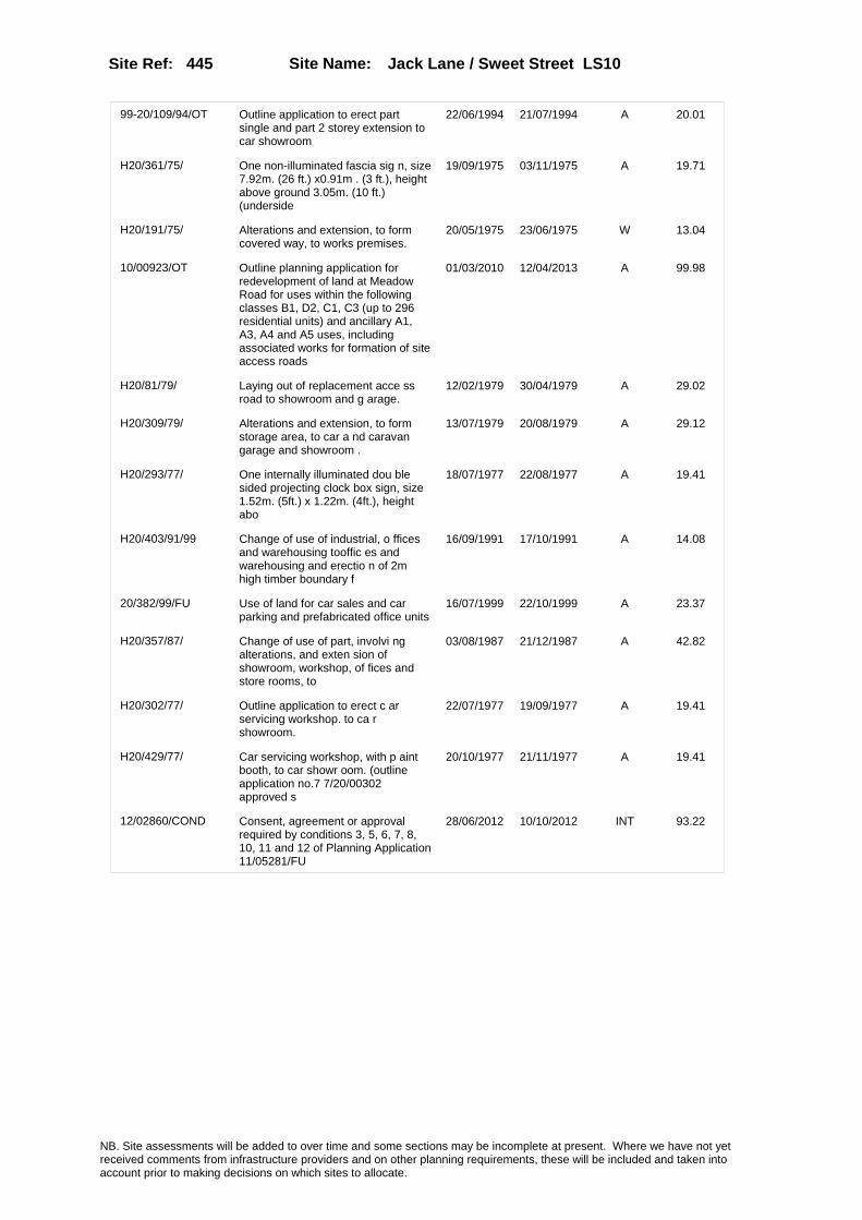
Site Name: Jack Lane / Sweet Street LS10 Site Ref: 445
99-20/109/94/OT Outline application to erect part single and part 2 storey extension to car showroom
22/06/1994 21/07/1994 A 20.01
H20/361/75/ One non-illuminated fascia sig n, size 7.92m. (26 ft.) x0.91m . (3 ft.), height above ground 3.05m. (10 ft.) (underside
19/09/1975 03/11/1975 A 19.71
H20/191/75/ Alterations and extension, to form covered way, to works premises.
20/05/1975 23/06/1975 W 13.04
10/00923/OT Outline planning application for redevelopment of land at Meadow Road for uses within the following classes B1, D2, C1, C3 (up to 296 residential units) and ancillary A1, A3, A4 and A5 uses, including associated works for formation of site access roads
01/03/2010 12/04/2013 A 99.98
H20/81/79/ Laying out of replacement acce ss road to showroom and g arage.
12/02/1979 30/04/1979 A 29.02
H20/309/79/ Alterations and extension, to form storage area, to car a nd caravan garage and showroom .
13/07/1979 20/08/1979 A 29.12
H20/293/77/ One internally illuminated dou ble sided projecting clock box sign, size 1.52m. (5ft.) x 1.22m. (4ft.), height abo
18/07/1977 22/08/1977 A 19.41
H20/403/91/99 Change of use of industrial, o ffices and warehousing tooffic es and warehousing and erectio n of 2m high timber boundary f
16/09/1991 17/10/1991 A 14.08
20/382/99/FU Use of land for car sales and car parking and prefabricated office units
16/07/1999 22/10/1999 A 23.37
H20/357/87/ Change of use of part, involvi ng alterations, and exten sion of showroom, workshop, of fices and store rooms, to
03/08/1987 21/12/1987 A 42.82
H20/302/77/ Outline application to erect c ar servicing workshop. to ca r showroom.
22/07/1977 19/09/1977 A 19.41
H20/429/77/ Car servicing workshop, with p aint booth, to car showr oom. (outline application no.7 7/20/00302 approved s
20/10/1977 21/11/1977 A 19.41
12/02860/COND Consent, agreement or approval required by conditions 3, 5, 6, 7, 8, 10, 11 and 12 of Planning Application 11/05281/FU
28/06/2012 10/10/2012 INT 93.22
NB. Site assessments will be added to over time and some sections may be incomplete at present. Where we have not yet received comments from infrastructure providers and on other planning requirements, these will be included and taken into account prior to making decisions on which sites to allocate.

Site Name: Jack Lane / Sweet Street LS10 Site Ref: 445
Conformity with Core Strategy
Inner South Leeds: 0.00
Leeds Bradford Corridor: 0.00 West Leeds Gateway: 0.00
Aire Valley: 0.00Regeneration Priority Area:
Brownfield
Greenfield
Mixed
Main Urban Area
Major Settlement
Smaller Settlement
Villages/Rural
Main Urban Area Extension
Major Settlement Extension
Smaller Settlement Extension
Village/Rural Extension
Development unrelated to existing development
Green Belt assessment - only completed where site is within Green Belt
Would development lead to/constitute ribbon development?
Would development result in isolated development?
Is the site well connected to built up area (2+ boundaries with existing built up area)?
Would development of the site effectively "round off" the settlement pattern?:
Do natural/physical features provide a good existing barrier between existing urban area and undeveloped land?
Overall sprawl conclusion:
Would development of the site lead to physical connection of settlements?
Do natural/physical features provide a good existing barrier/boundary to contain development?
Overall Coalescence Conclusion:
Is there a strong defensible boundary between the site and the existing urban area?
Does the site provide access to the countryside?
Does the site include local or national conservation designated areas?
Does the site include areas of woodlands, trees, hedgerows that are protected, or significant unprotected tree/hedge cover?
Does the site include grade 1, 2, or 3a agricultural land?
Does the site contain buildings? Are these in agricultural use?
Overall countryside Encroachment Conclusion
Is the site within or adjacent to a conservation area, listed building or other historical feature?
If yes, could development preserve this character?:
Overall Character Preservation Conclusion:
Greenbelt Assessment Conclusion:
Check the unrestricted sprawl of large built up areas
Prevent neighbouring towns from merging
Assist in safeguarding countryside from encroachment
Preserve the setting and special character of historic towns
NB. Site assessments will be added to over time and some sections may be incomplete at present. Where we have not yet received comments from infrastructure providers and on other planning requirements, these will be included and taken into account prior to making decisions on which sites to allocate.

Site Name: Jack Lane / Sweet Street LS10 Site Ref: 445
SHLAA ConclusionsAvailability: Medium term (6-10 y Suitability: Yes Physical Achievability: Medium term (6-10 years)
East Leeds
Summary of Infrastructure provider comments and other planning requirements
Accessibility commentMeets Public Transport accessibility and standards but lacking in local services
Rank (1-5)
4Access Comments
Existing access points from Sweet Street/Jack Lane must be used. No new direct access points onto Medow Lane Lane
Local network comment
Local congestion issues
Rank (1-5)
5Rank (1-5)
3
Leeds City Council Highways inc Metro
Highways Agency
Network Rail :
Biodiversity
Natural England:
Education
Mitigation measure
Improvements to Meadow Road gyratory
Total score
12Support?
Yes with mitigation
Need to combine with other sites: Suitability for partial development:
West Yorkshire Ecology and LCC Ecology Officer:
Supported
Boundary Amendment
Drainage/Water/FloodingEnvironment Agency Comments: Environment Agency Constraints:
Yorkshire Water Comments: Yorkshire Water Waste Water Treatment Works Comme
Utilities
Potential for cumulative impact in combination with other sites. If site still included at next sift assess as part of city centre/Aire Valley cluster.
LCC Flood Risk Management:
NB. Site assessments will be added to over time and some sections may be incomplete at present. Where we have not yet received comments from infrastructure providers and on other planning requirements, these will be included and taken into account prior to making decisions on which sites to allocate.

Site Name: Jack Lane / Sweet Street LS10 Site Ref: 445
Conclusion of Assessment
Conclusion summary:
SHLAA site with potential for office element
Floorspace sq m (Non residential): 95570
Employment Conclusion: Green
Assesment Type: Site assessment Type: Mixed Use
Proposed Change:
Gas:
Electric:
Telecom:
Fire and Rescue Services:
Built HeritageLeeds City Council:
West Yorkshire Archaeology Service:
English Heritage:
Gypsy Traveller Site Assessment
Yes No Maybe Could site be effectively managed (Text)
Yes No Maybe Would gypsies and travellers live on the site?
(Text)
Yes No Proximity to housed gypsies and travellers (Text)
Yes No Unknown Experience of previous encampments (Text)
NB. Site assessments will be added to over time and some sections may be incomplete at present. Where we have not yet received comments from infrastructure providers and on other planning requirements, these will be included and taken into account prior to making decisions on which sites to allocate.

Site Name: Duncan Street (7) Site Ref: 449
Site Details
Land Use
Northing: 433415
Easting: 430273
Distance to Rail Station (metres): 622.85
Nearest Railway Station Leeds City
Distance to bus stop (metres) 33.68
Bus Stop ID 9042
Agricultural Land Class:
SFRA Flood Zone: 0.00
Environment Agency Flood Zone: 0.00
Within 300m of retail centre boundary:
UDP Designation
Greenbelt - N32 (%): 0.00 Urban Green Corridor - N8 (%): 0.00
Protected Area of Search site - N34 (%): 0.00 Rural Land - RL1: 0.00
City Centre Primary Shopping Quarter - CC27 (%): 100.00 Town Centre - S2: 0.00
Health and Safety Executive Hazard: No
Health and Safety Executive Gas Pipeline: No
Strategic Employment Buffer: 100.00
Area sq m: 427.58 Ward City and Hunslet
Special Landscape Area - N37: 0.00
Allotments - N1A: 0.00
Proposed Greenspace - N5: 0.00
Protected Playing Pitch - N6: 0.00
Nature Conservation Area - N50: 1.00
Conservation Areas Yes
Ancient Monument/Battlefield(%): 0.00 Listed Buildings: No
Public Rights of Way: No
Other?:
Natural Resources and waste DPD (if applicable)
Within Minerals Safeguarding Site?: No Within 100m of Minerals Safeguarding Site?: No
HMCA: City Centre
Greenspace - N1: 0
Existing Use 1: Retail - ShopsExisting Use 2: Vacant & Derelict - Vacant buildingExisting Use 3:
Neighbouring Use 1 Residential - Dwellings
Neighbouring Use 2: Retail - Shops
Neighbouring Use 3:
Other uses:
Topography: Flat
Natural Landscape: No Tree Cover
Boundaries: Existing well defined
Road Frontage
Site Characteristics
Site Detail
Other comments/observations on site characteristics:
Under-used and vacant upper floors of shops on the north side of Duncan Street
Area Ha: 0.042758
Site State: Brownfield
NB. Site assessments will be added to over time and some sections may be incomplete at present. Where we have not yet received comments from infrastructure providers and on other planning requirements, these will be included and taken into account prior to making decisions on which sites to allocate.
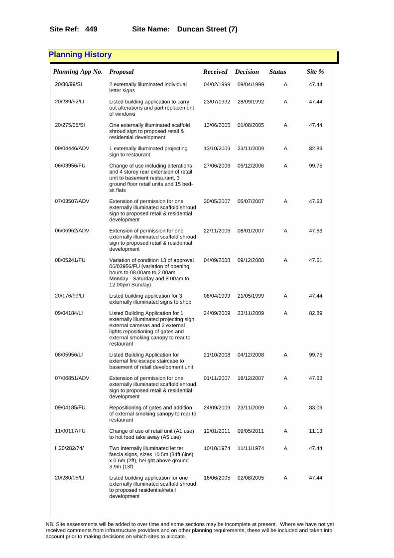
Site Name: Duncan Street (7) Site Ref: 449
Planning History
Planning App No. Proposal Received Decision Status Site %
20/80/99/SI 2 externally illuminated individual letter signs
04/02/1999 09/04/1999 A 47.44
20/289/92/LI Listed building application to carry out alterations and part replacement of windows
23/07/1992 28/09/1992 A 47.44
20/275/05/SI One externally illuminated scaffold shroud sign to proposed retail & residential development
13/06/2005 01/08/2005 A 47.44
09/04446/ADV 1 externally illuminated projecting sign to restaurant
13/10/2009 23/11/2009 A 82.89
06/03956/FU Change of use including alterations and 4 storey rear extension of retail unit to basement restaurant, 3 ground floor retail units and 15 bed-sit flats
27/06/2006 05/12/2006 A 99.75
07/03507/ADV Extension of permission for one externally illuminated scaffold shroud sign to proposed retail & residential development
30/05/2007 05/07/2007 A 47.63
06/06962/ADV Extension of permission for one externally illuminated scaffold shroud sign to proposed retail & residential development
22/11/2006 08/01/2007 A 47.63
08/05241/FU Variation of condition 13 of approval 06/03956/FU (variation of opening hours to 08.00am to 2.00am Monday - Saturday and 8.00am to 12.00pm Sunday)
04/09/2008 09/12/2008 A 47.61
20/176/99/LI Listed building application for 3 externally illuminated signs to shop
08/04/1999 21/05/1999 A 47.44
09/04184/LI Listed Building Application for 1 externally illuminated projecting sign, external cameras and 2 external lights repositioning of gates and external smoking canopy to rear to restaurant
24/09/2009 23/11/2009 A 82.89
08/05956/LI Listed Building Application for external fire escape staircase to basement of retail development unit
21/10/2008 04/12/2008 A 99.75
07/06851/ADV Extension of permission for one externally illuminated scaffold shroud sign to proposed retail & residential development
01/11/2007 18/12/2007 A 47.63
09/04185/FU Repositioning of gates and addition of external smoking canopy to rear to restaurant
24/09/2009 23/11/2009 A 83.09
11/00117/FU Change of use of retail unit (A1 use) to hot food take away (A5 use)
12/01/2011 09/05/2011 A 11.13
H20/282/74/ Two internally illuminated let ter fascia signs, sizes 10.5m (34ft.6ins) x 0.6m (2ft), hei ght above ground 3.9m (13ft
10/10/1974 11/11/1974 A 47.44
20/280/05/LI Listed building application for one externally illuminated scaffold shroud to proposed residential/retail development
16/06/2005 02/08/2005 A 47.44
NB. Site assessments will be added to over time and some sections may be incomplete at present. Where we have not yet received comments from infrastructure providers and on other planning requirements, these will be included and taken into account prior to making decisions on which sites to allocate.

Site Name: Duncan Street (7) Site Ref: 449
06/03954/LI Listed Building application to carry out alterations to form basement restaurant, 3 ground floor retail units and 15 bed-sit flats including 4 storey rear extension
27/06/2006 05/12/2006 A 99.75
08/05955/FU External fire escape staircase to basement of retail development unit
21/10/2008 08/12/2008 A 99.75
NB. Site assessments will be added to over time and some sections may be incomplete at present. Where we have not yet received comments from infrastructure providers and on other planning requirements, these will be included and taken into account prior to making decisions on which sites to allocate.

Site Name: Duncan Street (7) Site Ref: 449
Conformity with Core Strategy
Inner South Leeds: 0.00
Leeds Bradford Corridor: 0.00 West Leeds Gateway: 0.00
Aire Valley: 0.00Regeneration Priority Area:
Brownfield
Greenfield
Mixed
Main Urban Area
Major Settlement
Smaller Settlement
Villages/Rural
Main Urban Area Extension
Major Settlement Extension
Smaller Settlement Extension
Village/Rural Extension
Development unrelated to existing development
Green Belt assessment - only completed where site is within Green Belt
Would development lead to/constitute ribbon development?
Would development result in isolated development?
Is the site well connected to built up area (2+ boundaries with existing built up area)?
Would development of the site effectively "round off" the settlement pattern?:
Do natural/physical features provide a good existing barrier between existing urban area and undeveloped land?
Overall sprawl conclusion:
Would development of the site lead to physical connection of settlements?
Do natural/physical features provide a good existing barrier/boundary to contain development?
Overall Coalescence Conclusion:
Is there a strong defensible boundary between the site and the existing urban area?
Does the site provide access to the countryside?
Does the site include local or national conservation designated areas?
Does the site include areas of woodlands, trees, hedgerows that are protected, or significant unprotected tree/hedge cover?
Does the site include grade 1, 2, or 3a agricultural land?
Does the site contain buildings? Are these in agricultural use?
Overall countryside Encroachment Conclusion
Is the site within or adjacent to a conservation area, listed building or other historical feature?
If yes, could development preserve this character?:
Overall Character Preservation Conclusion:
Greenbelt Assessment Conclusion:
Check the unrestricted sprawl of large built up areas
Prevent neighbouring towns from merging
Assist in safeguarding countryside from encroachment
Preserve the setting and special character of historic towns
NB. Site assessments will be added to over time and some sections may be incomplete at present. Where we have not yet received comments from infrastructure providers and on other planning requirements, these will be included and taken into account prior to making decisions on which sites to allocate.
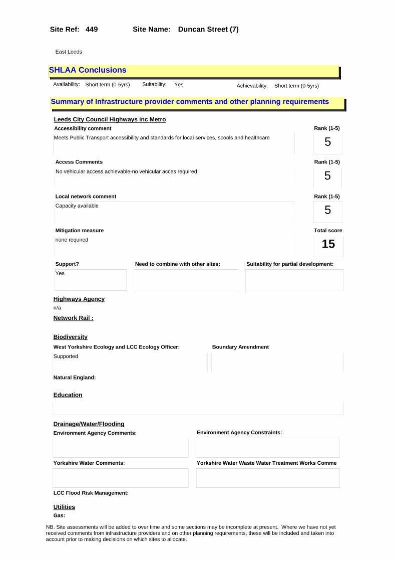
Site Name: Duncan Street (7) Site Ref: 449
SHLAA ConclusionsAvailability: Short term (0-5yrs) Suitability: Yes Achievability: Short term (0-5yrs)
East Leeds
Summary of Infrastructure provider comments and other planning requirements
Accessibility commentMeets Public Transport accessibility and standards for local services, scools and healthcare
Rank (1-5)
5Access Comments
No vehicular access achievable-no vehicular acces required
Local network comment
Capacity available
Rank (1-5)
5Rank (1-5)
5
Leeds City Council Highways inc Metro
Highways Agency
Network Rail :
Biodiversity
Natural England:
Education
Mitigation measure
none required
Total score
15Support?
Yes
Need to combine with other sites: Suitability for partial development:
West Yorkshire Ecology and LCC Ecology Officer:
Supported
Boundary Amendment
Drainage/Water/FloodingEnvironment Agency Comments: Environment Agency Constraints:
Yorkshire Water Comments: Yorkshire Water Waste Water Treatment Works Comme
UtilitiesGas:
n/a
LCC Flood Risk Management:
NB. Site assessments will be added to over time and some sections may be incomplete at present. Where we have not yet received comments from infrastructure providers and on other planning requirements, these will be included and taken into account prior to making decisions on which sites to allocate.

Site Name: Duncan Street (7) Site Ref: 449
Conclusion of Assessment
Conclusion summary:
SHLAA site with potential for office element
Floorspace sq m (Non residential): 428
Employment Conclusion: Green
Assesment Type: Site assessment Type: Mixed Use
Proposed Change:
Electric:
Telecom:
Fire and Rescue Services:
Built HeritageLeeds City Council:
West Yorkshire Archaeology Service:
English Heritage:
Gypsy Traveller Site Assessment
Yes No Maybe Could site be effectively managed (Text)
Yes No Maybe Would gypsies and travellers live on the site?
(Text)
Yes No Proximity to housed gypsies and travellers (Text)
Yes No Unknown Experience of previous encampments (Text)
NB. Site assessments will be added to over time and some sections may be incomplete at present. Where we have not yet received comments from infrastructure providers and on other planning requirements, these will be included and taken into account prior to making decisions on which sites to allocate.

Site Name: Bridge Street, Baker House Site Ref: 1010
Site Details
Land Use
Northing: 433932
Easting: 430635
Distance to Rail Station (metres): 1198.84
Nearest Railway Station Leeds City
Distance to bus stop (metres) 197.45
Bus Stop ID 7166
Agricultural Land Class:
SFRA Flood Zone: 0.00
Environment Agency Flood Zone: 1.00
Within 300m of retail centre boundary:
UDP Designation
Greenbelt - N32 (%): 0.00 Urban Green Corridor - N8 (%): 0.00
Protected Area of Search site - N34 (%): 0.00 Rural Land - RL1: 0.00
City Centre Primary Shopping Quarter - CC27 (%): 0.00 Town Centre - S2: 0.00
Health and Safety Executive Hazard: No
Health and Safety Executive Gas Pipeline: No
Strategic Employment Buffer: 100.00
Area sq m: 2012.82 Ward City and Hunslet
Special Landscape Area - N37: 0.00
Allotments - N1A: 0.00
Proposed Greenspace - N5: 0.00
Protected Playing Pitch - N6: 0.00
Nature Conservation Area - N50: 0.00
Conservation Areas No
Ancient Monument/Battlefield(%): 0.00 Listed Buildings: No
Public Rights of Way: No
Other?:
Natural Resources and waste DPD (if applicable)
Within Minerals Safeguarding Site?: No Within 100m of Minerals Safeguarding Site?: No
HMCA: City Centre
Greenspace - N1: 0
Existing Use 1: Transport - Car ParksExisting Use 2: Industry and business - StorageExisting Use 3:
Neighbouring Use 1 Residential - Dwellings
Neighbouring Use 2: Transport - Car Parks
Neighbouring Use 3:
Other uses:
Topography: Sloping
Natural Landscape: No Tree Cover
Boundaries: Existing well defined
Road Frontage
Site Characteristics
Site Detail
Other comments/observations on site characteristics:
Baker House office/storage building on south side of Trafalgar St and surface car park compound on north side of Trafalgar Street
Area Ha: 0.201282
Site State: Brownfield
NB. Site assessments will be added to over time and some sections may be incomplete at present. Where we have not yet received comments from infrastructure providers and on other planning requirements, these will be included and taken into account prior to making decisions on which sites to allocate.

Site Name: Bridge Street, Baker House Site Ref: 1010
Planning History
Planning App No. Proposal Received Decision Status Site %
H34/135/90/ Two, non-illuminated hoardings , size 3.29m x 6.3m, heigh t above ground 1.2m (underside ), to vacant site.
03/04/1990 02/10/1990 R 37.37
H32/281/77/ One non-illuminated canopy sig n, size 10.4m (34ft) x 0.7m (2ft 6ins) height above ground 4m (13ft 3ins) (underside
14/04/1977 23/05/1977 A 60.62
PREAPP/08/00314 . 18/08/2008 13/01/2009 PRENOT 100.00
H34/436/88/ Outline application to layout access and erect 3 storeyoffic e block, with car parking area , to car park site. (site area
17/10/1988 09/01/1989 A 38.43
H32/945/77/ Change of use of showrooms, ca r park, workshop and store s, to warehousing, car park, m ulti-unit antique and associ
31/10/1977 05/12/1977 A 38.54
20/426/01/DTM Determination for addition of 3 antennae 4 dishes and equipment cabin to roof of store
15/08/2001 04/09/2001 PAG 59.99
H32/543/76/ Change of use of car showrooms , to warehouse, showr ooms and ancillary offices.
15/06/1976 13/07/1976 A 60.62
20/472/02/DTM Determination for 6 antennae 4 dishes and equipment cabins to roof
15/11/2002 11/12/2002 PAG 61.31
0-20/46/04/MOD Determination for 6 antennae 4 dishes and equipment cabins to roof
20/10/2004 26/10/2004 M01 61.31
H32/950/75/ Change of use of existing grou nd floor car showrooms and b asement storage to ground floo r retail sales, administra
22/10/1975 16/02/1976 A 60.62
H32/257/77/ Alterations, including formati on of offices, reception area, and new windows and new entra nces, to warehouse showroom,
01/04/1977 23/05/1977 A 60.62
H34/153/86/ Alterations including new bric k facade and to form toile ts and entrance foyer, to fron t of offices and showroom.
08/05/1986 02/06/1986 A 59.56
20/491/00/SI 12 non illuminated and 1 internally illuminated projecting sign to warehouse
05/10/2000 28/12/2000 A 99.74
0-20/24/04/MOD Determination for 6 antennae 4 dishes and equipment cabins to roof
14/06/2004 23/06/2004 M01 61.31
H34/145/87/ Change of use and alterations, including new windows of wa rehouse and offices, to wareho use with ancillary offices.
13/04/1987 22/06/1987 A 37.78
10/00187/ADV Non illuminated scaffold mounted wrap around banner sign for temporary period of 2 years
19/01/2010 18/03/2010 W 61.07
H34/310/87/ Addition of 2 flagpoles, to ro of of warehouse.
21/08/1987 05/10/1987 A 59.68
20/37/95/FU External fire escape staircase to car park
03/02/1995 19/06/1996 A 38.58
NB. Site assessments will be added to over time and some sections may be incomplete at present. Where we have not yet received comments from infrastructure providers and on other planning requirements, these will be included and taken into account prior to making decisions on which sites to allocate.
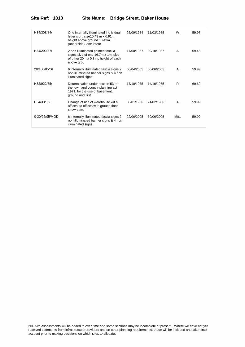
Site Name: Bridge Street, Baker House Site Ref: 1010
H34/308/84/ One internally illuminated ind ividual letter sign, size10.43 m x 0.91m, height above ground 10.43m (underside), one intern
26/09/1984 11/03/1985 W 59.97
H34/299/87/ 2 non illuminated painted fasc ia signs, size of one 16.7m x 1m, size of other 20m x 0.8 m, height of each above grou
17/08/1987 02/10/1987 A 59.48
20/160/05/SI 6 internally illuminated fascia signs 2 non illuminated banner signs & 4 non illuminated signs
06/04/2005 06/06/2005 A 59.99
H32/922/75/ Determination under section 53 of the town and country planning act 1971, for the use of basement, ground and first
17/10/1975 14/10/1975 R 60.62
H34/33/86/ Change of use of warehouse wit h offices, to offices with ground floor showroom.
30/01/1986 24/02/1986 A 59.99
0-20/22/05/MOD 6 internally illuminated fascia signs 2 non illuminated banner signs & 4 non illuminated signs
22/06/2005 30/06/2005 M01 59.99
NB. Site assessments will be added to over time and some sections may be incomplete at present. Where we have not yet received comments from infrastructure providers and on other planning requirements, these will be included and taken into account prior to making decisions on which sites to allocate.

Site Name: Bridge Street, Baker House Site Ref: 1010
Conformity with Core Strategy
Inner South Leeds: 0.00
Leeds Bradford Corridor: 0.00 West Leeds Gateway: 0.00
Aire Valley: 0.00Regeneration Priority Area:
Brownfield
Greenfield
Mixed
Main Urban Area
Major Settlement
Smaller Settlement
Villages/Rural
Main Urban Area Extension
Major Settlement Extension
Smaller Settlement Extension
Village/Rural Extension
Development unrelated to existing development
Green Belt assessment - only completed where site is within Green Belt
Would development lead to/constitute ribbon development?
Would development result in isolated development?
Is the site well connected to built up area (2+ boundaries with existing built up area)?
Would development of the site effectively "round off" the settlement pattern?:
Do natural/physical features provide a good existing barrier between existing urban area and undeveloped land?
Overall sprawl conclusion:
Would development of the site lead to physical connection of settlements?
Do natural/physical features provide a good existing barrier/boundary to contain development?
Overall Coalescence Conclusion:
Is there a strong defensible boundary between the site and the existing urban area?
Does the site provide access to the countryside?
Does the site include local or national conservation designated areas?
Does the site include areas of woodlands, trees, hedgerows that are protected, or significant unprotected tree/hedge cover?
Does the site include grade 1, 2, or 3a agricultural land?
Does the site contain buildings? Are these in agricultural use?
Overall countryside Encroachment Conclusion
Is the site within or adjacent to a conservation area, listed building or other historical feature?
If yes, could development preserve this character?:
Overall Character Preservation Conclusion:
Greenbelt Assessment Conclusion:
Check the unrestricted sprawl of large built up areas
Prevent neighbouring towns from merging
Assist in safeguarding countryside from encroachment
Preserve the setting and special character of historic towns
NB. Site assessments will be added to over time and some sections may be incomplete at present. Where we have not yet received comments from infrastructure providers and on other planning requirements, these will be included and taken into account prior to making decisions on which sites to allocate.

Site Name: Bridge Street, Baker House Site Ref: 1010
SHLAA ConclusionsAvailability: Medium term (6-10 y Suitability: Yes Achievability: Medium term (6-10 years)
East Leeds
Summary of Infrastructure provider comments and other planning requirements
Accessibility commentMeets Public Transport accessibility standards but only part of site for standards for local services, scools and healthcare
Rank (1-5)
4Access Comments
Access for local network ok
Local network comment
Pedestrian links to city cente need environmental improvements.
Rank (1-5)
5Rank (1-5)
5
Leeds City Council Highways inc Metro
Highways Agency
Network Rail :
Biodiversity
Natural England:
Education
Mitigation measure
environmental
Total score
14Support?
Yes - with mitigation
Need to combine with other sites: Suitability for partial development:
West Yorkshire Ecology and LCC Ecology Officer:
Supported
Boundary Amendment
Drainage/Water/FloodingEnvironment Agency Comments: Environment Agency Constraints:
Yorkshire Water Comments: Yorkshire Water Waste Water Treatment Works Comme
UtilitiesGas:
n/a
LCC Flood Risk Management:
NB. Site assessments will be added to over time and some sections may be incomplete at present. Where we have not yet received comments from infrastructure providers and on other planning requirements, these will be included and taken into account prior to making decisions on which sites to allocate.
Site Name: Bridge Street, Baker House Site Ref: 1010
Conclusion of Assessment
Conclusion summary:
SHLAA site with potential for office element
Floorspace sq m (Non residential): 1000
Employment Conclusion: Green
Assesment Type: Site assessment Type: Mixed Use
Proposed Change:
Electric:
Telecom:
Fire and Rescue Services:
Built HeritageLeeds City Council:
West Yorkshire Archaeology Service:
English Heritage:
Gypsy Traveller Site Assessment
Yes No Maybe Could site be effectively managed (Text)
Yes No Maybe Would gypsies and travellers live on the site?
(Text)
Yes No Proximity to housed gypsies and travellers (Text)
Yes No Unknown Experience of previous encampments (Text)
NB. Site assessments will be added to over time and some sections may be incomplete at present. Where we have not yet received comments from infrastructure providers and on other planning requirements, these will be included and taken into account prior to making decisions on which sites to allocate.
Site Name: Kidacre Street - former gas works site Site Ref: 1267
Site Details
Land Use
Northing: 432408
Easting: 430204
Distance to Rail Station (metres): 935.36
Nearest Railway Station Leeds City
Distance to bus stop (metres) 193.74
Bus Stop ID 12870
Agricultural Land Class:
SFRA Flood Zone: 1.00
Environment Agency Flood Zone: 1.00
Within 300m of retail centre boundary:
UDP Designation
Greenbelt - N32 (%): 0.00 Urban Green Corridor - N8 (%): 0.00
Protected Area of Search site - N34 (%): 0.00 Rural Land - RL1: 0.00
City Centre Primary Shopping Quarter - CC27 (%): 0.00 Town Centre - S2: 0.00
Health and Safety Executive Hazard: Yes
Health and Safety Executive Gas Pipeline: Yes
Strategic Employment Buffer: 100.00
Area sq m: 43094.37 Ward City and Hunslet
Special Landscape Area - N37: 0.00
Allotments - N1A: 0.00
Proposed Greenspace - N5: 0.00
Protected Playing Pitch - N6: 0.00
Nature Conservation Area - N50: 0.00
Conservation Areas No
Ancient Monument/Battlefield(%): 0.00 Listed Buildings: No
Public Rights of Way: No
Other?:
Natural Resources and waste DPD (if applicable)
Within Minerals Safeguarding Site?: No Within 100m of Minerals Safeguarding Site?: Yes
HMCA: City Centre
Greenspace - N1: 0
Existing Use 1: Utilities & Infrastructure - Energy production and distributionExisting Use 2: Vacant and derelict - Vacant landExisting Use 3:
Neighbouring Use 1 Office
Neighbouring Use 2: Retail - Shops
Neighbouring Use 3: Other
Other uses: car show rooms, light business units
Topography: Flat
Natural Landscape: No Tree Cover
Boundaries: Existing well defined
Road Frontage
Site Characteristics
Site Detail
Other comments/observations on site characteristics:
Linea site to the west of Kidacre Street. Includes two gas holders and other operational land for storage/distribution of gas. Also includes motorcycle testing area (formerly SHLAA site 2014).
Area Ha: 4.309437
Site State: Brownfield
NB. Site assessments will be added to over time and some sections may be incomplete at present. Where we have not yet received comments from infrastructure providers and on other planning requirements, these will be included and taken into account prior to making decisions on which sites to allocate.

Site Name: Kidacre Street - former gas works site Site Ref: 1267
Planning History
Planning App No. Proposal Received Decision Status Site %
H20/326/87/ Detached equipment store with garage to gas board site.
16/07/1987 10/08/1987 A 99.04
20/199/00/HZ Continuation of consent reference haz/dc/7 following a change in control of part of the land
26/04/2000 27/07/2000 A 29.63
99-20/40/95/OT Outline application to erect three detached office blocks with car parking and landscaping
14/02/1995 19/05/1998 W 33.11
99-20/39/95/OT Outline application to erect four detached office blocks with car parking and landscaping
14/02/1995 30/04/1998 A 62.38
20/98/96/SI 5 externally illuminated freestanding hoardings to development site
21/02/1996 14/06/1996 A 14.08
H20/396/84/ Erection of depot, comprising offices, workshops, labor atory, toilets, surgery, kitch en and dining room, with 88 ad
13/09/1984 13/09/1984 A 39.87
20/208/01/RE Renewal of outline permission to erect four detached office blocks
18/04/2001 09/05/2001 W 62.38
NB. Site assessments will be added to over time and some sections may be incomplete at present. Where we have not yet received comments from infrastructure providers and on other planning requirements, these will be included and taken into account prior to making decisions on which sites to allocate.

Site Name: Kidacre Street - former gas works site Site Ref: 1267
Conformity with Core Strategy
Inner South Leeds: 0.00
Leeds Bradford Corridor: 0.00 West Leeds Gateway: 0.00
Aire Valley: 0.00Regeneration Priority Area:
Brownfield
Greenfield
Mixed
Main Urban Area
Major Settlement
Smaller Settlement
Villages/Rural
Main Urban Area Extension
Major Settlement Extension
Smaller Settlement Extension
Village/Rural Extension
Development unrelated to existing development
Green Belt assessment - only completed where site is within Green Belt
Would development lead to/constitute ribbon development?
Would development result in isolated development?
Is the site well connected to built up area (2+ boundaries with existing built up area)?
Would development of the site effectively "round off" the settlement pattern?:
Do natural/physical features provide a good existing barrier between existing urban area and undeveloped land?
Overall sprawl conclusion:
Would development of the site lead to physical connection of settlements?
Do natural/physical features provide a good existing barrier/boundary to contain development?
Overall Coalescence Conclusion:
Is there a strong defensible boundary between the site and the existing urban area?
Does the site provide access to the countryside?
Does the site include local or national conservation designated areas?
Does the site include areas of woodlands, trees, hedgerows that are protected, or significant unprotected tree/hedge cover?
Does the site include grade 1, 2, or 3a agricultural land?
Does the site contain buildings? Are these in agricultural use?
Overall countryside Encroachment Conclusion
Is the site within or adjacent to a conservation area, listed building or other historical feature?
If yes, could development preserve this character?:
Overall Character Preservation Conclusion:
Greenbelt Assessment Conclusion:
Check the unrestricted sprawl of large built up areas
Prevent neighbouring towns from merging
Assist in safeguarding countryside from encroachment
Preserve the setting and special character of historic towns
NB. Site assessments will be added to over time and some sections may be incomplete at present. Where we have not yet received comments from infrastructure providers and on other planning requirements, these will be included and taken into account prior to making decisions on which sites to allocate.

Site Name: Kidacre Street - former gas works site Site Ref: 1267
SHLAA ConclusionsAvailability: Medium term (6-10 y Suitability: LDF to determine Achievability: Medium term (6-10 years)
East Leeds
Summary of Infrastructure provider comments and other planning requirements
Accessibility commentMeets Public Transport accessibility and standards for local services, scools and healthcare
Rank (1-5)
5Access Comments
Access possible off Kidacre Street or Holmes St with widening
Local network comment
Local network and Meadow Road gyratory has capacity issues. Kidacre St/Leathley Rd/Jack Lane route problematic
Rank (1-5)
4Rank (1-5)
3
Leeds City Council Highways inc Metro
Highways Agency
Network Rail :
Biodiversity
Natural England:
Education
Mitigation measure
Substantial improvements will be required to provide access and address capacity issues
Total score
12Support?
Yes - with mitigation
Need to combine with other sites:
Combining sites 2012,2013,2014,1267 would provide a much better comprehensive access solution
Suitability for partial development:
West Yorkshire Ecology and LCC Ecology Officer:
Supported
Boundary Amendment
Drainage/Water/FloodingEnvironment Agency Comments: Environment Agency Constraints:
Yorkshire Water Comments: Yorkshire Water Waste Water Treatment Works Comme
Utilities
Potential for cumulative impact in combination with other sites. If site still included at next sift assess as part of city centre / Aire valley cluster.
LCC Flood Risk Management:
NB. Site assessments will be added to over time and some sections may be incomplete at present. Where we have not yet received comments from infrastructure providers and on other planning requirements, these will be included and taken into account prior to making decisions on which sites to allocate.
Site Name: Kidacre Street - former gas works site Site Ref: 1267
Conclusion of Assessment
Conclusion summary:
Site suitable for employment uses however it is not known at this stage whether the site may be needed for the HS2 programme.
Floorspace sq m (Non residential): 21547.2
Employment Conclusion: Amber
Assesment Type: Site assessment Type: Office
Proposed Change:
Gas:
Electric:
Telecom:
Fire and Rescue Services:
Built HeritageLeeds City Council:
West Yorkshire Archaeology Service:
English Heritage:
Gypsy Traveller Site Assessment
Yes No Maybe Could site be effectively managed (Text)
Yes No Maybe Would gypsies and travellers live on the site?
(Text)
Yes No Proximity to housed gypsies and travellers (Text)
Yes No Unknown Experience of previous encampments (Text)
NB. Site assessments will be added to over time and some sections may be incomplete at present. Where we have not yet received comments from infrastructure providers and on other planning requirements, these will be included and taken into account prior to making decisions on which sites to allocate.

Site Name: Marsh Lane/York Street - Co-op Funeral Services & St Annes Shelter
Site Ref: 2002
Site Details
Land Use
Northing: 433436
Easting: 430901
Distance to Rail Station (metres): 1233.21
Nearest Railway Station Leeds City
Distance to bus stop (metres) 36.98
Bus Stop ID 6451
Agricultural Land Class:
SFRA Flood Zone: 0.00
Environment Agency Flood Zone: 1.00
Within 300m of retail centre boundary:
UDP Designation
Greenbelt - N32 (%): 0.00 Urban Green Corridor - N8 (%): 0.00
Protected Area of Search site - N34 (%): 0.00 Rural Land - RL1: 0.00
City Centre Primary Shopping Quarter - CC27 (%): 0.00 Town Centre - S2: 0.00
Health and Safety Executive Hazard: No
Health and Safety Executive Gas Pipeline: No
Strategic Employment Buffer: 100.00
Area sq m: 10717.11 Ward City and Hunslet
Special Landscape Area - N37: 0.00
Allotments - N1A: 0.00
Proposed Greenspace - N5: 0.00
Protected Playing Pitch - N6: 0.00
Nature Conservation Area - N50: 0.00
Conservation Areas No
Ancient Monument/Battlefield(%): 0.00 Listed Buildings: No
Public Rights of Way: No
Other?:
Natural Resources and waste DPD (if applicable)
Within Minerals Safeguarding Site?: No Within 100m of Minerals Safeguarding Site?: No
HMCA: City Centre
Greenspace - N1: 0
Existing Use 1: OtherExisting Use 2: Residential - Hotels, boarding and guest housesExisting Use 3:
Neighbouring Use 1 Transport - Transport tracks & ways
Neighbouring Use 2:
Neighbouring Use 3:
Other uses: Funeral directors
Topography: Flat
Natural Landscape: No Tree Cover
Boundaries: Existing well defined
Road Frontage
Site Characteristics
Site Detail
Other comments/observations on site characteristics:
Business and storage units that straddle the railway viaduct including advice centre plus hostel and coop funeral services buildings to the south of Brussels Street
Area Ha: 1.071711
Site State: Brownfield
NB. Site assessments will be added to over time and some sections may be incomplete at present. Where we have not yet received comments from infrastructure providers and on other planning requirements, these will be included and taken into account prior to making decisions on which sites to allocate.
Site Name: Marsh Lane/York Street - Co-op Funeral Services & St Annes Shelter
Site Ref: 2002
Planning History
Planning App No. Proposal Received Decision Status Site %
0-20/46/96/MOD Stage 6 and 7 of inner ring road 08/08/1996 16/12/1996 M01 36.72
99-20/69/94/FU Change of use of factory to function rooms, demolition of boys club to form car park and garages & erection of canopy
22/04/1994 19/05/1994 A 16.81
99-20/140/94/LI Listed building application to erect retaining wall with railings to former dyeworks stages 6 & 7 inner ring road
04/08/1994 15/09/1994 A 36.72
H20/142/92/ Stage 6 and 7 inner ring road. (this item is also notice under reg ulation 4(1) of the town and c
02/04/1992 02/07/1992 A 36.72
08/05131/ADV 3 internally illuminated fascia signs and 2 non illuminated wall signs to funeral directors
29/08/2008 09/10/2008 A 16.59
99-20/141/94/LI Listed building application to erect retaining wall with railings to factory for stage 6 and 7 inner ring road
04/08/1994 15/09/1994 A 36.72
99-20/142/94/CA Conservation area application to demolish buildings and walls for stage 6 and 7 of inner ring road
04/08/1994 15/09/1994 A 36.72
H20/141/92/99 Stage 6 and 7 of inner ring road 07/04/1992 18/06/1992 A 36.72
0-20/43/96/MOD Stage 6 and 7 of leeds inner ring road 30/07/1996 29/08/1996 M01 36.72
20/472/04/FU Disabled access ramp and stepped access to main entrance of funeral parlour
25/10/2004 10/05/2005 A 21.41
99-20/201/94/FU Stage 6 and 7 of inner ring road 01/11/1994 19/01/1995 A 36.72
0-20/41/96/MOD Stage 6 and 7 of inner ring road 26/07/1996 28/08/1996 M01 36.72
H20/495/88/ Use of cleared site and car pa rk as coach park and car p ark.
03/10/1988 16/01/1989 A 15.28
H20/161/88/ Use of vacant site as enlarged car park. (this item is also notice under reg ulation 4(1) of the town and c
24/03/1988 07/11/1988 A 15.41
20/36/03/SI 3 externally illuminated wall mounted signs to funeral directors
28/01/2003 18/03/2003 R 16.81
0-20/42/96/MOD Stage 6 and 7 of inner ring road. 26/07/1996 05/08/1996 M01 36.72
0-20/64/95/MOD Stages 6 and 7 of inner ring road 11/12/1995 18/12/1995 M01 36.72
99-20/63/92/FU 4 storey hostel for homeless men 27/10/1992 19/11/1992 A 13.37
0-20/22/97/MOD Stage 6 & 7 of inner ring road 07/05/1997 03/09/1997 M01 36.72
0-20/59/96/MOD Stage 6 and 7 of inner ring road 12/11/1996 REC 36.72
20/476/96/FU Change of use of factory to function rooms & single storey rear extensions & detached workshop to funeral directors
13/09/1996 15/01/1997 A 21.41
20/174/03/SI 3 externally illuminated wall mounted signs to funeral directors
13/05/2003 09/06/2003 A 16.80
NB. Site assessments will be added to over time and some sections may be incomplete at present. Where we have not yet received comments from infrastructure providers and on other planning requirements, these will be included and taken into account prior to making decisions on which sites to allocate.

Site Name: Marsh Lane/York Street - Co-op Funeral Services & St Annes Shelter
Site Ref: 2002
Conformity with Core Strategy
Inner South Leeds: 0.00
Leeds Bradford Corridor: 0.00 West Leeds Gateway: 0.00
Aire Valley: 0.00Regeneration Priority Area:
Brownfield
Greenfield
Mixed
Main Urban Area
Major Settlement
Smaller Settlement
Villages/Rural
Main Urban Area Extension
Major Settlement Extension
Smaller Settlement Extension
Village/Rural Extension
Development unrelated to existing development
Green Belt assessment - only completed where site is within Green Belt
Would development lead to/constitute ribbon development?
Would development result in isolated development?
Is the site well connected to built up area (2+ boundaries with existing built up area)?
Would development of the site effectively "round off" the settlement pattern?:
Do natural/physical features provide a good existing barrier between existing urban area and undeveloped land?
Overall sprawl conclusion:
Would development of the site lead to physical connection of settlements?
Do natural/physical features provide a good existing barrier/boundary to contain development?
Overall Coalescence Conclusion:
Is there a strong defensible boundary between the site and the existing urban area?
Does the site provide access to the countryside?
Does the site include local or national conservation designated areas?
Does the site include areas of woodlands, trees, hedgerows that are protected, or significant unprotected tree/hedge cover?
Does the site include grade 1, 2, or 3a agricultural land?
Does the site contain buildings? Are these in agricultural use?
Overall countryside Encroachment Conclusion
Is the site within or adjacent to a conservation area, listed building or other historical feature?
If yes, could development preserve this character?:
Overall Character Preservation Conclusion:
Greenbelt Assessment Conclusion:
Check the unrestricted sprawl of large built up areas
Prevent neighbouring towns from merging
Assist in safeguarding countryside from encroachment
Preserve the setting and special character of historic towns
NB. Site assessments will be added to over time and some sections may be incomplete at present. Where we have not yet received comments from infrastructure providers and on other planning requirements, these will be included and taken into account prior to making decisions on which sites to allocate.

Site Name: Marsh Lane/York Street - Co-op Funeral Services & St Annes Shelter
Site Ref: 2002
SHLAA ConclusionsAvailability: Long term (11+ year Suitability: Yes Achievability: Long term (11+ years)
East Leeds
Summary of Infrastructure provider comments and other planning requirements
Accessibility commentMeets Public Transport accessibility and standards for local services, scools and healthcare
Rank (1-5)
5Access Comments
Existing Brick St / Brussels St lay out should be retained for access, no other direct access onto Marsh Lane or York St.Part of site north of railway should be linked through the viaduct arches to Brussels St.
Local network comment
Ok for 100 units,cumulaive impact concern
Rank (1-5)
5Rank (1-5)
4
Leeds City Council Highways inc Metro
Highways Agency
Network Rail :
Biodiversity
Natural England:
Education
Mitigation measure
None
Total score
14Support?
yes
Need to combine with other sites: Suitability for partial development:
West Yorkshire Ecology and LCC Ecology Officer:
Supported
Boundary Amendment
Drainage/Water/FloodingEnvironment Agency Comments: Environment Agency Constraints:
Yorkshire Water Comments: Yorkshire Water Waste Water Treatment Works Comme
Utilities
Potential for cumulative impact in combination with other sites. If site still included at next sift assess as part of city centre / Aire valley cluster.
LCC Flood Risk Management:
Need to check relationship with viaduct and very long term proposal to widen to 4 tracks
NB. Site assessments will be added to over time and some sections may be incomplete at present. Where we have not yet received comments from infrastructure providers and on other planning requirements, these will be included and taken into account prior to making decisions on which sites to allocate.

Site Name: Marsh Lane/York Street - Co-op Funeral Services & St Annes Shelter
Site Ref: 2002
Conclusion of Assessment
Conclusion summary:
SHLAA site with potential for office element
Floorspace sq m (Non residential): 10000
Employment Conclusion: Green
Assesment Type: Site assessment Type: Mixed Use
Proposed Change:
Gas:
Electric:
Telecom:
Fire and Rescue Services:
Built HeritageLeeds City Council:
West Yorkshire Archaeology Service:
English Heritage:
Gypsy Traveller Site Assessment
Yes No Maybe Could site be effectively managed (Text)
Yes No Maybe Would gypsies and travellers live on the site?
(Text)
Yes No Proximity to housed gypsies and travellers (Text)
Yes No Unknown Experience of previous encampments (Text)
NB. Site assessments will be added to over time and some sections may be incomplete at present. Where we have not yet received comments from infrastructure providers and on other planning requirements, these will be included and taken into account prior to making decisions on which sites to allocate.
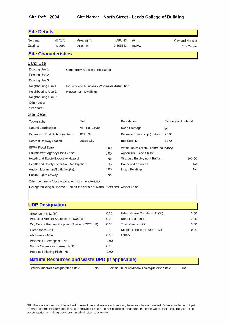
Site Name: North Street - Leeds College of Building Site Ref: 2004
Site Details
Land Use
Northing: 434170
Easting: 430692
Distance to Rail Station (metres): 1399.70
Nearest Railway Station Leeds City
Distance to bus stop (metres) 73.35
Bus Stop ID 5870
Agricultural Land Class:
SFRA Flood Zone: 0.00
Environment Agency Flood Zone: 0.00
Within 300m of retail centre boundary:
UDP Designation
Greenbelt - N32 (%): 0.00 Urban Green Corridor - N8 (%): 0.00
Protected Area of Search site - N34 (%): 0.00 Rural Land - RL1: 0.00
City Centre Primary Shopping Quarter - CC27 (%): 0.00 Town Centre - S2: 0.00
Health and Safety Executive Hazard: No
Health and Safety Executive Gas Pipeline: No
Strategic Employment Buffer: 100.00
Area sq m: 8985.43 Ward City and Hunslet
Special Landscape Area - N37: 0.00
Allotments - N1A: 0.00
Proposed Greenspace - N5: 0.00
Protected Playing Pitch - N6: 0.00
Nature Conservation Area - N50: 0.00
Conservation Areas No
Ancient Monument/Battlefield(%): 0.00 Listed Buildings: No
Public Rights of Way: No
Other?:
Natural Resources and waste DPD (if applicable)
Within Minerals Safeguarding Site?: No Within 100m of Minerals Safeguarding Site?: No
HMCA: City Centre
Greenspace - N1: 0
Existing Use 1: Community Services - EducationExisting Use 2:
Existing Use 3:
Neighbouring Use 1 Industry and business - Wholesale distribution
Neighbouring Use 2: Residential - Dwellings
Neighbouring Use 3:
Other uses:
Topography: Flat
Natural Landscape: No Tree Cover
Boundaries: Existing well defined
Road Frontage
Site Characteristics
Site Detail
Other comments/observations on site characteristics:
College building built circa 1970 on the corner of North Street and Skinner Lane
Area Ha: 0.898543
Site State:
NB. Site assessments will be added to over time and some sections may be incomplete at present. Where we have not yet received comments from infrastructure providers and on other planning requirements, these will be included and taken into account prior to making decisions on which sites to allocate.
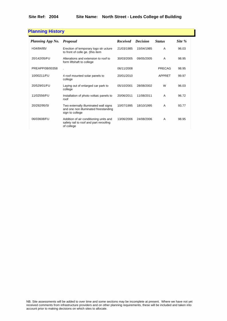
Site Name: North Street - Leeds College of Building Site Ref: 2004
Planning History
Planning App No. Proposal Received Decision Status Site %
H34/84/85/ Erection of temporary logo str ucture to front of colle ge. (this item
21/03/1985 15/04/1985 A 96.03
20/142/05/FU Alterations and extension to roof to form liftshaft to college
30/03/2005 09/05/2005 A 98.95
PREAPP/08/00358 . 06/11/2008 PRECAG 98.95
10/00211/FU 4 roof mounted solar panels to college
20/01/2010 APPRET 99.97
20/529/01/FU Laying out of enlarged car park to college
05/10/2001 28/08/2002 W 96.03
11/02556/FU Installation of photo voltaic panels to roof
20/06/2011 11/08/2011 A 96.72
20/292/95/SI Two externally illuminated wall signs and one non illuminated freestanding sign to college
10/07/1995 18/10/1995 A 93.77
06/03608/FU Addition of air conditioning units and safety rail to roof and part reroofing of college
13/06/2006 24/08/2006 A 98.95
NB. Site assessments will be added to over time and some sections may be incomplete at present. Where we have not yet received comments from infrastructure providers and on other planning requirements, these will be included and taken into account prior to making decisions on which sites to allocate.

Site Name: North Street - Leeds College of Building Site Ref: 2004
Conformity with Core Strategy
Inner South Leeds: 0.00
Leeds Bradford Corridor: 0.00 West Leeds Gateway: 0.00
Aire Valley: 0.00Regeneration Priority Area:
Brownfield
Greenfield
Mixed
Main Urban Area
Major Settlement
Smaller Settlement
Villages/Rural
Main Urban Area Extension
Major Settlement Extension
Smaller Settlement Extension
Village/Rural Extension
Development unrelated to existing development
Green Belt assessment - only completed where site is within Green Belt
Would development lead to/constitute ribbon development?
Would development result in isolated development?
Is the site well connected to built up area (2+ boundaries with existing built up area)?
Would development of the site effectively "round off" the settlement pattern?:
Do natural/physical features provide a good existing barrier between existing urban area and undeveloped land?
Overall sprawl conclusion:
Would development of the site lead to physical connection of settlements?
Do natural/physical features provide a good existing barrier/boundary to contain development?
Overall Coalescence Conclusion:
Is there a strong defensible boundary between the site and the existing urban area?
Does the site provide access to the countryside?
Does the site include local or national conservation designated areas?
Does the site include areas of woodlands, trees, hedgerows that are protected, or significant unprotected tree/hedge cover?
Does the site include grade 1, 2, or 3a agricultural land?
Does the site contain buildings? Are these in agricultural use?
Overall countryside Encroachment Conclusion
Is the site within or adjacent to a conservation area, listed building or other historical feature?
If yes, could development preserve this character?:
Overall Character Preservation Conclusion:
Greenbelt Assessment Conclusion:
Check the unrestricted sprawl of large built up areas
Prevent neighbouring towns from merging
Assist in safeguarding countryside from encroachment
Preserve the setting and special character of historic towns
NB. Site assessments will be added to over time and some sections may be incomplete at present. Where we have not yet received comments from infrastructure providers and on other planning requirements, these will be included and taken into account prior to making decisions on which sites to allocate.
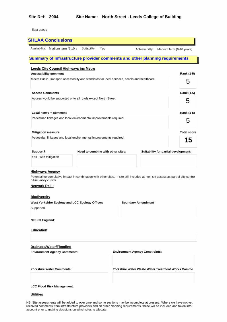
Site Name: North Street - Leeds College of Building Site Ref: 2004
SHLAA ConclusionsAvailability: Medium term (6-10 y Suitability: Yes Achievability: Medium term (6-10 years)
East Leeds
Summary of Infrastructure provider comments and other planning requirements
Accessibility commentMeets Public Transport accessibility and standards for local services, scools and healthcare
Rank (1-5)
5Access Comments
Access would be supported onto all roads except North Street
Local network comment
Pedestrian linkages and local environmental improvements required.
Rank (1-5)
5Rank (1-5)
5
Leeds City Council Highways inc Metro
Highways Agency
Network Rail :
Biodiversity
Natural England:
Education
Mitigation measure
Pedestrian linkages and local environmental improvements required.
Total score
15Support?
Yes - with mitigation
Need to combine with other sites: Suitability for partial development:
West Yorkshire Ecology and LCC Ecology Officer:
Supported
Boundary Amendment
Drainage/Water/FloodingEnvironment Agency Comments: Environment Agency Constraints:
Yorkshire Water Comments: Yorkshire Water Waste Water Treatment Works Comme
Utilities
Potential for cumulative impact in combination with other sites. If site still included at next sift assess as part of city centre / Aire valley cluster.
LCC Flood Risk Management:
NB. Site assessments will be added to over time and some sections may be incomplete at present. Where we have not yet received comments from infrastructure providers and on other planning requirements, these will be included and taken into account prior to making decisions on which sites to allocate.

Site Name: North Street - Leeds College of Building Site Ref: 2004
Conclusion of Assessment
Conclusion summary:
SHLAA site with potential for office element
Floorspace sq m (Non residential): 4500
Employment Conclusion: Amber
Assesment Type: Site assessment Type: Office
Proposed Change:
Gas:
Electric:
Telecom:
Fire and Rescue Services:
Built HeritageLeeds City Council:
West Yorkshire Archaeology Service:
English Heritage:
Gypsy Traveller Site Assessment
Yes No Maybe Could site be effectively managed (Text)
Yes No Maybe Would gypsies and travellers live on the site?
(Text)
Yes No Proximity to housed gypsies and travellers (Text)
Yes No Unknown Experience of previous encampments (Text)
NB. Site assessments will be added to over time and some sections may be incomplete at present. Where we have not yet received comments from infrastructure providers and on other planning requirements, these will be included and taken into account prior to making decisions on which sites to allocate.
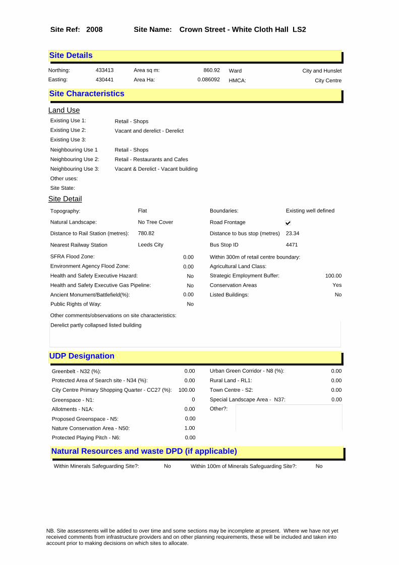
Site Name: Crown Street - White Cloth Hall LS2 Site Ref: 2008
Site Details
Land Use
Northing: 433413
Easting: 430441
Distance to Rail Station (metres): 780.82
Nearest Railway Station Leeds City
Distance to bus stop (metres) 23.34
Bus Stop ID 4471
Agricultural Land Class:
SFRA Flood Zone: 0.00
Environment Agency Flood Zone: 0.00
Within 300m of retail centre boundary:
UDP Designation
Greenbelt - N32 (%): 0.00 Urban Green Corridor - N8 (%): 0.00
Protected Area of Search site - N34 (%): 0.00 Rural Land - RL1: 0.00
City Centre Primary Shopping Quarter - CC27 (%): 100.00 Town Centre - S2: 0.00
Health and Safety Executive Hazard: No
Health and Safety Executive Gas Pipeline: No
Strategic Employment Buffer: 100.00
Area sq m: 860.92 Ward City and Hunslet
Special Landscape Area - N37: 0.00
Allotments - N1A: 0.00
Proposed Greenspace - N5: 0.00
Protected Playing Pitch - N6: 0.00
Nature Conservation Area - N50: 1.00
Conservation Areas Yes
Ancient Monument/Battlefield(%): 0.00 Listed Buildings: No
Public Rights of Way: No
Other?:
Natural Resources and waste DPD (if applicable)
Within Minerals Safeguarding Site?: No Within 100m of Minerals Safeguarding Site?: No
HMCA: City Centre
Greenspace - N1: 0
Existing Use 1: Retail - ShopsExisting Use 2: Vacant and derelict - DerelictExisting Use 3:
Neighbouring Use 1 Retail - Shops
Neighbouring Use 2: Retail - Restaurants and Cafes
Neighbouring Use 3: Vacant & Derelict - Vacant building
Other uses:
Topography: Flat
Natural Landscape: No Tree Cover
Boundaries: Existing well defined
Road Frontage
Site Characteristics
Site Detail
Other comments/observations on site characteristics:
Derelict partly collapsed listed building
Area Ha: 0.086092
Site State:
NB. Site assessments will be added to over time and some sections may be incomplete at present. Where we have not yet received comments from infrastructure providers and on other planning requirements, these will be included and taken into account prior to making decisions on which sites to allocate.

Site Name: Crown Street - White Cloth Hall LS2 Site Ref: 2008
Planning History
Planning App No. Proposal Received Decision Status Site %
H20/571/85/ Alterations, including new sta ircase and shopfront, andto fo rm offices with reception and toilets and 2 shop units
06/12/1985 10/04/1986 A 75.57
99-20/28/94/RE Extension of permission for alterations extensions and erection of shops restaurant offices and amusement arcade
17/02/1994 17/03/1994 A 100.00
H20/434/91/99 Alterations to form retail uni ts, restaurant and offic e units, part 3 and part 4 sto rey extension to form retai
27/09/1991 28/02/1992 W 100.00
H20/433/91/99 Alterations to form retail uni ts, restaurant and officeunits , part 3 and part 4 storey ext ension to form retail uni
24/09/1991 07/02/1992 A 100.00
H20/471/90/99 Listed building and conservati on area application to demol ish shops and offices.
02/10/1990 26/02/1992 W 99.83
H20/435/91/99 Demolition of part of listed b uilding and buildings withi n a conservation area and list ed building applicatio
24/09/1991 28/02/1992 W 100.00
09/02349/FU Continued use of first floor as private hire operator office
29/05/2009 14/10/2009 A 19.86
H20/577/85/ Listed building application in volving demolition of part of existing shop and offices a nd alterations, including
09/12/1985 10/04/1986 A 75.37
H20/199/81/ Change of use, of shop, to amu sement arcade.
23/04/1981 15/06/1981 R 76.20
H20/381/80/ Change of use of shop to amuse ment arcade.
22/10/1980 26/01/1981 W 40.84
99-20/132/93/LI Listed building application to demolish and carry out alterations and extension to shops and offices
06/07/1993 09/09/1993 A 99.99
99-20/131/93/FU Amendment to previous application to erect shop and offices and extension to form enlarged shop unit and canopy
15/07/1993 06/10/1993 A 99.99
H20/460/90/99 Outline application to erect o ffice, retail and resid ential development to existing offices and shops. (site area
03/10/1990 13/12/1990 A 100.00
09/04668/COND Consent, agreement or approval required by condition 3 of Planning Application 20/171/05/LI
29/10/2009 09/11/2009 A 100.00
10/00181/COND Consent, agreement or approval required by conditions 3 and 4 of Planning Application 20/171/05/LI
19/01/2010 PCO 100.00
H20/456/90/99 Listed building application to demolish shops and offic es.
26/09/1990 26/02/1992 W 99.83
H20/469/90/99 Outline application to erect o ffice, retail and resid ential development to existing offices and shops. (site area
03/10/1990 13/12/1990 A 100.00
20/201/99/FU Use of land as temporary open drinking area with landscaping to proposed bar and restaurant development
26/04/1999 21/06/1999 A 17.58
NB. Site assessments will be added to over time and some sections may be incomplete at present. Where we have not yet received comments from infrastructure providers and on other planning requirements, these will be included and taken into account prior to making decisions on which sites to allocate.

Site Name: Crown Street - White Cloth Hall LS2 Site Ref: 2008
99-20/167/94/LI Listed building application to demolish part and carry out alterations and extension to shops and offices
13/09/1994 20/10/1994 A 99.99
H20/282/91/99 Renewal of outline permission to erect office, retail and r esidential development, to exi sting offices and shops.
10/07/1991 15/08/1991 A 100.00
20/171/05/LI Listed building application to demolish rear extension to 98 Kirkgate
12/04/2005 09/12/2005 A 100.00
PREAPP/06/00161 Refurbishment of shops and new build development including restoration of Grade II� listed First White Cloth Hall
23/08/2006 PCO 100.00
20/168/05/CA Conservation area application to demolish vacant building
12/04/2005 12/12/2005 A 57.88
H20/553/79/ Two non illuminated shopfront mounted hoardings, size of ea ch 3.05m x 1.52m, height of ea ch above ground, 0.91m (und
12/12/1979 28/01/1980 R 72.88
99-20/15/93/RE Extension of permission for alterations extensions and erection of shops, restaurant offices and amusement arcade
22/01/1993 18/02/1993 A 100.00
H20/436/91/99 Demolition of part of listed b uilding and buildings withi n a conservation area and list ed building applicatio
27/09/1991 10/06/1992 A 100.00
H20/283/91/99 Renewal of outline permission to erect office, retail and r esidential development, to exi sting offices and shops.
10/07/1991 01/06/1992 W 100.00
NB. Site assessments will be added to over time and some sections may be incomplete at present. Where we have not yet received comments from infrastructure providers and on other planning requirements, these will be included and taken into account prior to making decisions on which sites to allocate.

Site Name: Crown Street - White Cloth Hall LS2 Site Ref: 2008
Conformity with Core Strategy
Inner South Leeds: 0.00
Leeds Bradford Corridor: 0.00 West Leeds Gateway: 0.00
Aire Valley: 0.00Regeneration Priority Area:
Brownfield
Greenfield
Mixed
Main Urban Area
Major Settlement
Smaller Settlement
Villages/Rural
Main Urban Area Extension
Major Settlement Extension
Smaller Settlement Extension
Village/Rural Extension
Development unrelated to existing development
Green Belt assessment - only completed where site is within Green Belt
Would development lead to/constitute ribbon development?
Would development result in isolated development?
Is the site well connected to built up area (2+ boundaries with existing built up area)?
Would development of the site effectively "round off" the settlement pattern?:
Do natural/physical features provide a good existing barrier between existing urban area and undeveloped land?
Overall sprawl conclusion:
Would development of the site lead to physical connection of settlements?
Do natural/physical features provide a good existing barrier/boundary to contain development?
Overall Coalescence Conclusion:
Is there a strong defensible boundary between the site and the existing urban area?
Does the site provide access to the countryside?
Does the site include local or national conservation designated areas?
Does the site include areas of woodlands, trees, hedgerows that are protected, or significant unprotected tree/hedge cover?
Does the site include grade 1, 2, or 3a agricultural land?
Does the site contain buildings? Are these in agricultural use?
Overall countryside Encroachment Conclusion
Is the site within or adjacent to a conservation area, listed building or other historical feature?
If yes, could development preserve this character?:
Overall Character Preservation Conclusion:
Greenbelt Assessment Conclusion:
Check the unrestricted sprawl of large built up areas
Prevent neighbouring towns from merging
Assist in safeguarding countryside from encroachment
Preserve the setting and special character of historic towns
NB. Site assessments will be added to over time and some sections may be incomplete at present. Where we have not yet received comments from infrastructure providers and on other planning requirements, these will be included and taken into account prior to making decisions on which sites to allocate.
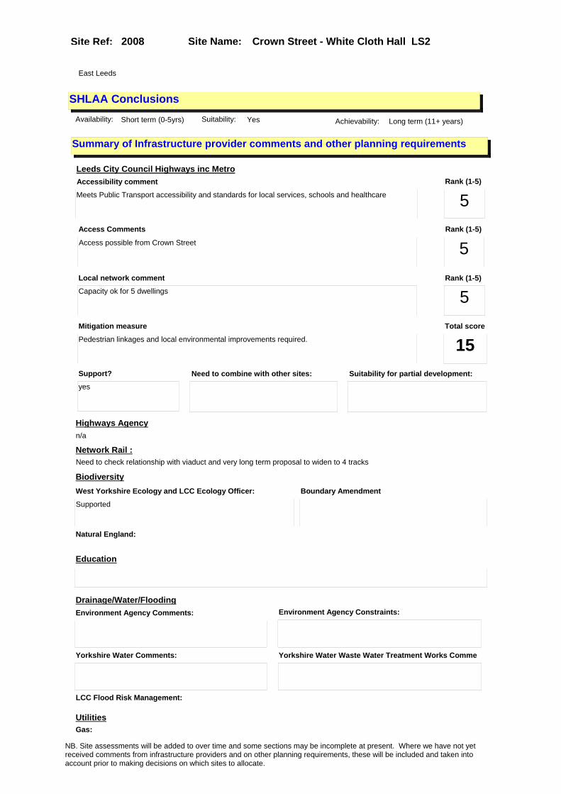
Site Name: Crown Street - White Cloth Hall LS2 Site Ref: 2008
SHLAA ConclusionsAvailability: Short term (0-5yrs) Suitability: Yes Achievability: Long term (11+ years)
East Leeds
Summary of Infrastructure provider comments and other planning requirements
Accessibility commentMeets Public Transport accessibility and standards for local services, schools and healthcare
Rank (1-5)
5Access Comments
Access possible from Crown Street
Local network comment
Capacity ok for 5 dwellings
Rank (1-5)
5Rank (1-5)
5
Leeds City Council Highways inc Metro
Highways Agency
Network Rail :
Biodiversity
Natural England:
Education
Mitigation measure
Pedestrian linkages and local environmental improvements required.
Total score
15Support?
yes
Need to combine with other sites: Suitability for partial development:
West Yorkshire Ecology and LCC Ecology Officer:
Supported
Boundary Amendment
Drainage/Water/FloodingEnvironment Agency Comments: Environment Agency Constraints:
Yorkshire Water Comments: Yorkshire Water Waste Water Treatment Works Comme
UtilitiesGas:
n/a
LCC Flood Risk Management:
Need to check relationship with viaduct and very long term proposal to widen to 4 tracks
NB. Site assessments will be added to over time and some sections may be incomplete at present. Where we have not yet received comments from infrastructure providers and on other planning requirements, these will be included and taken into account prior to making decisions on which sites to allocate.

Site Name: Crown Street - White Cloth Hall LS2 Site Ref: 2008
Conclusion of Assessment
Conclusion summary:
SHLAA site with potential for office element
Floorspace sq m (Non residential): 861
Employment Conclusion: Green
Assesment Type: Site assessment Type: Mixed Use
Proposed Change:
Electric:
Telecom:
Fire and Rescue Services:
Built HeritageLeeds City Council:
West Yorkshire Archaeology Service:
English Heritage:
Gypsy Traveller Site Assessment
Yes No Maybe Could site be effectively managed (Text)
Yes No Maybe Would gypsies and travellers live on the site?
(Text)
Yes No Proximity to housed gypsies and travellers (Text)
Yes No Unknown Experience of previous encampments (Text)
NB. Site assessments will be added to over time and some sections may be incomplete at present. Where we have not yet received comments from infrastructure providers and on other planning requirements, these will be included and taken into account prior to making decisions on which sites to allocate.

Site Name: Meadow Lane frontage - Apex Business Park Site Ref: 2012
Site Details
Land Use
Northing: 432262
Easting: 430163
Distance to Rail Station (metres): 1041.34
Nearest Railway Station Leeds City
Distance to bus stop (metres) 89.93
Bus Stop ID 11274
Agricultural Land Class:
SFRA Flood Zone: 1.00
Environment Agency Flood Zone: 1.00
Within 300m of retail centre boundary:
UDP Designation
Greenbelt - N32 (%): 0.00 Urban Green Corridor - N8 (%): 0.00
Protected Area of Search site - N34 (%): 0.00 Rural Land - RL1: 0.00
City Centre Primary Shopping Quarter - CC27 (%): 0.00 Town Centre - S2: 0.00
Health and Safety Executive Hazard: Yes
Health and Safety Executive Gas Pipeline: Yes
Strategic Employment Buffer: 100.00
Area sq m: 34113.30 Ward City and Hunslet
Special Landscape Area - N37: 0.00
Allotments - N1A: 0.00
Proposed Greenspace - N5: 0.00
Protected Playing Pitch - N6: 0.00
Nature Conservation Area - N50: 0.00
Conservation Areas No
Ancient Monument/Battlefield(%): 0.00 Listed Buildings: No
Public Rights of Way: No
Other?:
Natural Resources and waste DPD (if applicable)
Within Minerals Safeguarding Site?: No Within 100m of Minerals Safeguarding Site?: Yes
HMCA: City Centre
Greenspace - N1: 0
Existing Use 1: Industry and business - Manufacturing & WholesaleExisting Use 2: Industry and business - StorageExisting Use 3: Other
Neighbouring Use 1 Industry and business - Wholesale distribution
Neighbouring Use 2: Industry and business - Manufacturing & Wholesale
Neighbouring Use 3: Office
Other uses: Car Showroom
Topography: Flat
Natural Landscape: No Tree Cover
Boundaries: Partially well-defined
Road Frontage
Site Characteristics
Site Detail
Other comments/observations on site characteristics:
Around Apex Way, this site comprises a range of uses including car showrooms, offices and business premises comprising of largely single storey units with car parking
Area Ha: 3.41133
Site State: Brownfield
NB. Site assessments will be added to over time and some sections may be incomplete at present. Where we have not yet received comments from infrastructure providers and on other planning requirements, these will be included and taken into account prior to making decisions on which sites to allocate.

Site Name: Meadow Lane frontage - Apex Business Park Site Ref: 2012
Planning History
Planning App No. Proposal Received Decision Status Site %
20/453/97/SI 4 illuminated logo signs 4 illuminated fasica signs 3 freestanding illuminated signs
28/07/1997 02/09/1997 A 19.92
H20/322/75/ Alterations and extension, to form first aid room, compr ising examination room, lobby and office, to factory pr
27/08/1975 22/09/1975 A 20.66
20/271/98/FU External air conditioning units to car showrooms
06/05/1998 30/06/1998 A 12.18
12/01930/FU Alterations involving erection of detached vehicle wash facility to vehicle workshop
30/04/2012 22/06/2012 A 15.12
11/05415/LA Variation of condition 2 (approved plans) of approval 10/05712/LA for MINOR MATERIAL AMENDMENT relating to generator, fuel tank and fencing to data centre
23/12/2011 10/02/2012 A 12.81
H20/320/75/ New toilet block, to factory p remises. 27/08/1975 22/09/1975 A 11.87
20/248/96/FU Two car showrooms workshop offices vehicle preparation building covered car sales area and car parking
20/05/1996 16/08/1996 A 25.09
11/02075/ADV 6 illuminated and 3 non illuminated signs
20/05/2011 15/06/2011 A 36.99
H20/470/89/99 Laying out of access and erect ion of 2, two storey detac hed office units, 1, part two storey and part three stor
01/09/1989 14/01/1992 A 33.31
H20/448/87/ Laying out of access road and erection of six business units each with 2 storey offices, w ith 40 car parking spaces and
14/09/1987 19/11/1987 A 13.04
H20/357/81/ Alterations to existing factor y, and offices and layin g out of accesses and erection of 8 detached factory an
29/09/1981 21/06/1982 A 69.81
10/05712/LA Generator, fuel tank and fencing to data centre
21/12/2010 18/02/2011 A 12.99
0-20/40/97/MOD Alterations to fit out car showroom 28/08/1997 27/07/1998 M01 25.09
0-20/63/96/MOD Two car showrooms workshop offices vehicle preparation building covered car parking
19/11/1996 31/12/1996 M01 25.09
H20/546/85/ Outline application to erect o ffices and use of vacant site, as parking area. (site area 0 .02ha)
14/11/1985 19/11/1986 W 13.70
NB. Site assessments will be added to over time and some sections may be incomplete at present. Where we have not yet received comments from infrastructure providers and on other planning requirements, these will be included and taken into account prior to making decisions on which sites to allocate.
Site Name: Meadow Lane frontage - Apex Business Park Site Ref: 2012
Conformity with Core Strategy
Inner South Leeds: 0.00
Leeds Bradford Corridor: 0.00 West Leeds Gateway: 0.00
Aire Valley: 0.00Regeneration Priority Area:
Brownfield
Greenfield
Mixed
Main Urban Area
Major Settlement
Smaller Settlement
Villages/Rural
Main Urban Area Extension
Major Settlement Extension
Smaller Settlement Extension
Village/Rural Extension
Development unrelated to existing development
Green Belt assessment - only completed where site is within Green Belt
Would development lead to/constitute ribbon development?
Would development result in isolated development?
Is the site well connected to built up area (2+ boundaries with existing built up area)?
Would development of the site effectively "round off" the settlement pattern?:
Do natural/physical features provide a good existing barrier between existing urban area and undeveloped land?
Overall sprawl conclusion:
Would development of the site lead to physical connection of settlements?
Do natural/physical features provide a good existing barrier/boundary to contain development?
Overall Coalescence Conclusion:
Is there a strong defensible boundary between the site and the existing urban area?
Does the site provide access to the countryside?
Does the site include local or national conservation designated areas?
Does the site include areas of woodlands, trees, hedgerows that are protected, or significant unprotected tree/hedge cover?
Does the site include grade 1, 2, or 3a agricultural land?
Does the site contain buildings? Are these in agricultural use?
Overall countryside Encroachment Conclusion
Is the site within or adjacent to a conservation area, listed building or other historical feature?
If yes, could development preserve this character?:
Overall Character Preservation Conclusion:
Greenbelt Assessment Conclusion:
Check the unrestricted sprawl of large built up areas
Prevent neighbouring towns from merging
Assist in safeguarding countryside from encroachment
Preserve the setting and special character of historic towns
NB. Site assessments will be added to over time and some sections may be incomplete at present. Where we have not yet received comments from infrastructure providers and on other planning requirements, these will be included and taken into account prior to making decisions on which sites to allocate.
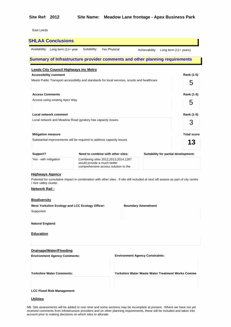
Site Name: Meadow Lane frontage - Apex Business Park Site Ref: 2012
SHLAA ConclusionsAvailability: Long term (11+ year Suitability: Yes Physical Achievability: Long term (11+ years)
East Leeds
Summary of Infrastructure provider comments and other planning requirements
Accessibility commentMeets Public Transport accessibility and standards for local services, scools and healthcare
Rank (1-5)
5Access Comments
Access using existing Apex Way
Local network comment
Local network and Meadow Road gyratory has capacity issues.
Rank (1-5)
5Rank (1-5)
3
Leeds City Council Highways inc Metro
Highways Agency
Network Rail :
Biodiversity
Natural England:
Education
Mitigation measure
Substantial improvements will be required to address capacity issues
Total score
13Support?
Yes - with mitigation
Need to combine with other sites:
Combining sites 2012,2013,2014,1267 would provide a much better comprehensive access solution to the
Suitability for partial development:
West Yorkshire Ecology and LCC Ecology Officer:
Supported
Boundary Amendment
Drainage/Water/FloodingEnvironment Agency Comments: Environment Agency Constraints:
Yorkshire Water Comments: Yorkshire Water Waste Water Treatment Works Comme
Utilities
Potential for cumulative impact in combination with other sites. If site still included at next sift assess as part of city centre / Aire valley cluster.
LCC Flood Risk Management:
NB. Site assessments will be added to over time and some sections may be incomplete at present. Where we have not yet received comments from infrastructure providers and on other planning requirements, these will be included and taken into account prior to making decisions on which sites to allocate.
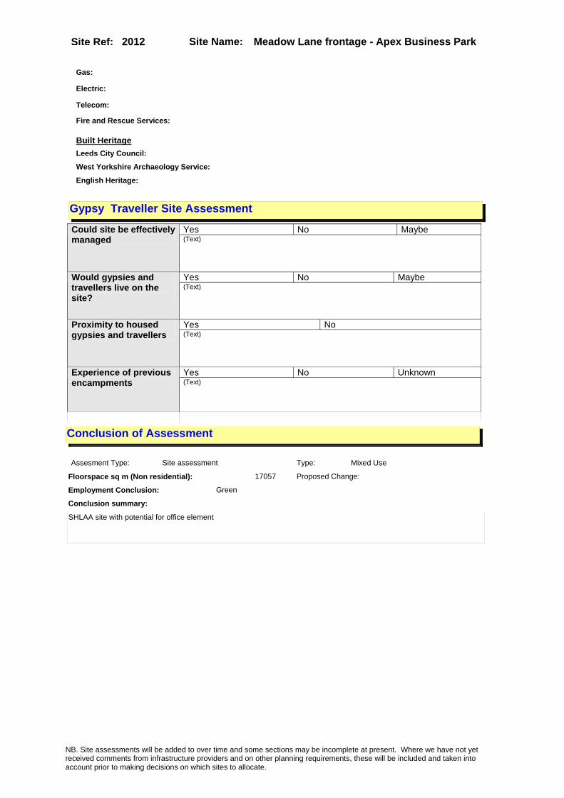
Site Name: Meadow Lane frontage - Apex Business Park Site Ref: 2012
Conclusion of Assessment
Conclusion summary:
SHLAA site with potential for office element
Floorspace sq m (Non residential): 17057
Employment Conclusion: Green
Assesment Type: Site assessment Type: Mixed Use
Proposed Change:
Gas:
Electric:
Telecom:
Fire and Rescue Services:
Built HeritageLeeds City Council:
West Yorkshire Archaeology Service:
English Heritage:
Gypsy Traveller Site Assessment
Yes No Maybe Could site be effectively managed (Text)
Yes No Maybe Would gypsies and travellers live on the site?
(Text)
Yes No Proximity to housed gypsies and travellers (Text)
Yes No Unknown Experience of previous encampments (Text)
NB. Site assessments will be added to over time and some sections may be incomplete at present. Where we have not yet received comments from infrastructure providers and on other planning requirements, these will be included and taken into account prior to making decisions on which sites to allocate.

Site Name: Kidacre Street, Motorcycle Training Area Site Ref: 2014
Site Details
Land Use
Northing: 432365
Easting: 430254
Distance to Rail Station (metres): 999.22
Nearest Railway Station Leeds City
Distance to bus stop (metres) 207.57
Bus Stop ID 11274
Agricultural Land Class:
SFRA Flood Zone: 1.00
Environment Agency Flood Zone: 1.00
Within 300m of retail centre boundary:
UDP Designation
Greenbelt - N32 (%): 0.00 Urban Green Corridor - N8 (%): 0.00
Protected Area of Search site - N34 (%): 0.00 Rural Land - RL1: 0.00
City Centre Primary Shopping Quarter - CC27 (%): 0.00 Town Centre - S2: 0.00
Health and Safety Executive Hazard: Yes
Health and Safety Executive Gas Pipeline: Yes
Strategic Employment Buffer: 100.00
Area sq m: 7686.14 Ward City and Hunslet
Special Landscape Area - N37: 0.00
Allotments - N1A: 0.00
Proposed Greenspace - N5: 0.00
Protected Playing Pitch - N6: 0.00
Nature Conservation Area - N50: 0.00
Conservation Areas No
Ancient Monument/Battlefield(%): 0.00 Listed Buildings: No
Public Rights of Way: No
Other?:
Natural Resources and waste DPD (if applicable)
Within Minerals Safeguarding Site?: No Within 100m of Minerals Safeguarding Site?: Yes
HMCA: City Centre
Greenspace - N1: 0
Existing Use 1: Vacant and derelict - Vacant landExisting Use 2: OtherExisting Use 3:
Neighbouring Use 1 Retail - Shops
Neighbouring Use 2: Industry and business - Manufacturing & Wholesale
Neighbouring Use 3: Utilities & Infrastructure - Energy distribution
Other uses: Motorcycle Training Centre
Topography: Flat
Natural Landscape: Limited Tree Cover
Boundaries: Partially well-defined
Road Frontage
Site Characteristics
Site Detail
Other comments/observations on site characteristics:
Motorcycle testing area now subsumed within former gas works site (ref 1267).
Area Ha: 0.768614
Site State: Brownfield
NB. Site assessments will be added to over time and some sections may be incomplete at present. Where we have not yet received comments from infrastructure providers and on other planning requirements, these will be included and taken into account prior to making decisions on which sites to allocate.
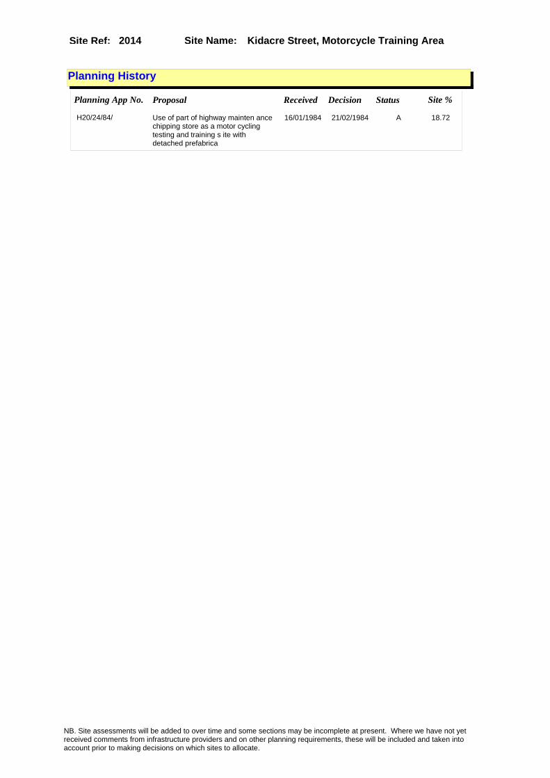
Site Name: Kidacre Street, Motorcycle Training Area Site Ref: 2014
Planning History
Planning App No. Proposal Received Decision Status Site %
H20/24/84/ Use of part of highway mainten ance chipping store as a motor cycling testing and training s ite with detached prefabrica
16/01/1984 21/02/1984 A 18.72
NB. Site assessments will be added to over time and some sections may be incomplete at present. Where we have not yet received comments from infrastructure providers and on other planning requirements, these will be included and taken into account prior to making decisions on which sites to allocate.

Site Name: Kidacre Street, Motorcycle Training Area Site Ref: 2014
Conformity with Core Strategy
Inner South Leeds: 0.00
Leeds Bradford Corridor: 0.00 West Leeds Gateway: 0.00
Aire Valley: 0.00Regeneration Priority Area:
Brownfield
Greenfield
Mixed
Main Urban Area
Major Settlement
Smaller Settlement
Villages/Rural
Main Urban Area Extension
Major Settlement Extension
Smaller Settlement Extension
Village/Rural Extension
Development unrelated to existing development
Green Belt assessment - only completed where site is within Green Belt
Would development lead to/constitute ribbon development?
Would development result in isolated development?
Is the site well connected to built up area (2+ boundaries with existing built up area)?
Would development of the site effectively "round off" the settlement pattern?:
Do natural/physical features provide a good existing barrier between existing urban area and undeveloped land?
Overall sprawl conclusion:
Would development of the site lead to physical connection of settlements?
Do natural/physical features provide a good existing barrier/boundary to contain development?
Overall Coalescence Conclusion:
Is there a strong defensible boundary between the site and the existing urban area?
Does the site provide access to the countryside?
Does the site include local or national conservation designated areas?
Does the site include areas of woodlands, trees, hedgerows that are protected, or significant unprotected tree/hedge cover?
Does the site include grade 1, 2, or 3a agricultural land?
Does the site contain buildings? Are these in agricultural use?
Overall countryside Encroachment Conclusion
Is the site within or adjacent to a conservation area, listed building or other historical feature?
If yes, could development preserve this character?:
Overall Character Preservation Conclusion:
Greenbelt Assessment Conclusion:
Check the unrestricted sprawl of large built up areas
Prevent neighbouring towns from merging
Assist in safeguarding countryside from encroachment
Preserve the setting and special character of historic towns
NB. Site assessments will be added to over time and some sections may be incomplete at present. Where we have not yet received comments from infrastructure providers and on other planning requirements, these will be included and taken into account prior to making decisions on which sites to allocate.

Site Name: Kidacre Street, Motorcycle Training Area Site Ref: 2014
SHLAA ConclusionsAvailability: Medium term (6-10 y Suitability: Yes Physical Achievability: Medium term (6-10 years)
East Leeds
Summary of Infrastructure provider comments and other planning requirements
Accessibility commentMeets Public Transport accessibility and standards for local services, scools and healthcare
Rank (1-5)
5Access Comments
Access possible off Kidacre Street with widening
Local network comment
Local network and Meadow Road gyratory has capacity issues. Kidacre St/Leathley Rd/Jack Lane route problematic
Rank (1-5)
4Rank (1-5)
3
Leeds City Council Highways inc Metro
Highways Agency
Network Rail :
Biodiversity
Natural England:
Education
Mitigation measure
Substantial improvements will be required to provide access and address capacity issues
Total score
12Support?
Yes - with mitigation
Need to combine with other sites:
Combining sites 2012,2013,2014,1267 would provide a much better comprehensive access solution
Suitability for partial development:
West Yorkshire Ecology and LCC Ecology Officer:
Supported
Boundary Amendment
Drainage/Water/FloodingEnvironment Agency Comments: Environment Agency Constraints:
Yorkshire Water Comments: Yorkshire Water Waste Water Treatment Works Comme
Utilities
Potential for cumulative impact in combination with other sites. If site still included at next sift assess as part of city centre / Aire valley cluster.
LCC Flood Risk Management:
NB. Site assessments will be added to over time and some sections may be incomplete at present. Where we have not yet received comments from infrastructure providers and on other planning requirements, these will be included and taken into account prior to making decisions on which sites to allocate.

Site Name: Kidacre Street, Motorcycle Training Area Site Ref: 2014
Conclusion of Assessment
Conclusion summary:
Site suitable for employment uses however it is not known at this stage whether the site may be needed for the HS2 programme.
Floorspace sq m (Non residential): 3500
Employment Conclusion: Amber
Assesment Type: Site assessment Type: Office
Proposed Change:
Gas:
Electric:
Telecom:
Fire and Rescue Services:
Built HeritageLeeds City Council:
West Yorkshire Archaeology Service:
English Heritage:
Gypsy Traveller Site Assessment
Yes No Maybe Could site be effectively managed (Text)
Yes No Maybe Would gypsies and travellers live on the site?
(Text)
Yes No Proximity to housed gypsies and travellers (Text)
Yes No Unknown Experience of previous encampments (Text)
NB. Site assessments will be added to over time and some sections may be incomplete at present. Where we have not yet received comments from infrastructure providers and on other planning requirements, these will be included and taken into account prior to making decisions on which sites to allocate.
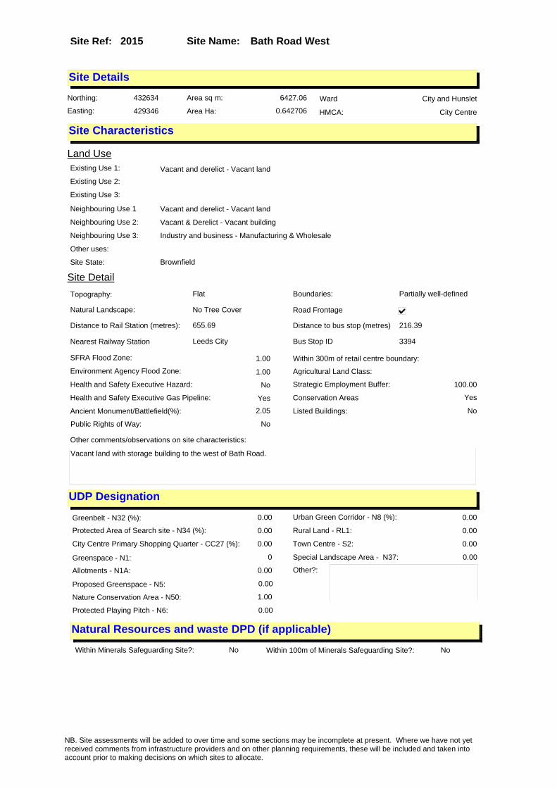
Site Name: Bath Road West Site Ref: 2015
Site Details
Land Use
Northing: 432634
Easting: 429346
Distance to Rail Station (metres): 655.69
Nearest Railway Station Leeds City
Distance to bus stop (metres) 216.39
Bus Stop ID 3394
Agricultural Land Class:
SFRA Flood Zone: 1.00
Environment Agency Flood Zone: 1.00
Within 300m of retail centre boundary:
UDP Designation
Greenbelt - N32 (%): 0.00 Urban Green Corridor - N8 (%): 0.00
Protected Area of Search site - N34 (%): 0.00 Rural Land - RL1: 0.00
City Centre Primary Shopping Quarter - CC27 (%): 0.00 Town Centre - S2: 0.00
Health and Safety Executive Hazard: No
Health and Safety Executive Gas Pipeline: Yes
Strategic Employment Buffer: 100.00
Area sq m: 6427.06 Ward City and Hunslet
Special Landscape Area - N37: 0.00
Allotments - N1A: 0.00
Proposed Greenspace - N5: 0.00
Protected Playing Pitch - N6: 0.00
Nature Conservation Area - N50: 1.00
Conservation Areas Yes
Ancient Monument/Battlefield(%): 2.05 Listed Buildings: No
Public Rights of Way: No
Other?:
Natural Resources and waste DPD (if applicable)
Within Minerals Safeguarding Site?: No Within 100m of Minerals Safeguarding Site?: No
HMCA: City Centre
Greenspace - N1: 0
Existing Use 1: Vacant and derelict - Vacant landExisting Use 2:
Existing Use 3:
Neighbouring Use 1 Vacant and derelict - Vacant land
Neighbouring Use 2: Vacant & Derelict - Vacant building
Neighbouring Use 3: Industry and business - Manufacturing & Wholesale
Other uses:
Topography: Flat
Natural Landscape: No Tree Cover
Boundaries: Partially well-defined
Road Frontage
Site Characteristics
Site Detail
Other comments/observations on site characteristics:
Vacant land with storage building to the west of Bath Road.
Area Ha: 0.642706
Site State: Brownfield
NB. Site assessments will be added to over time and some sections may be incomplete at present. Where we have not yet received comments from infrastructure providers and on other planning requirements, these will be included and taken into account prior to making decisions on which sites to allocate.
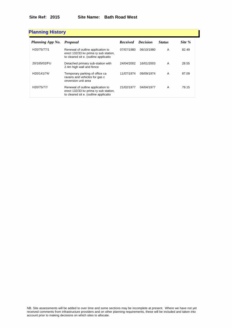
Site Name: Bath Road West Site Ref: 2015
Planning History
Planning App No. Proposal Received Decision Status Site %
H20/75/77/1 Renewal of outline application to erect 132/33 kv prima ry sub station, to cleared sit e. (outline applicatio
07/07/1980 06/10/1980 A 82.49
20/165/02/FU Detached primary sub-station with 2.4m high wall and fence
24/04/2002 16/01/2003 A 28.55
H20/141/74/ Temporary parking of office ca ravans and vehicles for gas c onversion unit area
11/07/1974 09/09/1974 A 87.09
H20/75/77/ Renewal of outline application to erect 132/33 kv prima ry sub station, to cleared sit e. (outline applicatio
21/02/1977 04/04/1977 A 79.15
NB. Site assessments will be added to over time and some sections may be incomplete at present. Where we have not yet received comments from infrastructure providers and on other planning requirements, these will be included and taken into account prior to making decisions on which sites to allocate.

Site Name: Bath Road West Site Ref: 2015
Conformity with Core Strategy
Inner South Leeds: 0.00
Leeds Bradford Corridor: 0.00 West Leeds Gateway: 0.00
Aire Valley: 0.00Regeneration Priority Area:
Brownfield
Greenfield
Mixed
Main Urban Area
Major Settlement
Smaller Settlement
Villages/Rural
Main Urban Area Extension
Major Settlement Extension
Smaller Settlement Extension
Village/Rural Extension
Development unrelated to existing development
Green Belt assessment - only completed where site is within Green Belt
Would development lead to/constitute ribbon development?
Would development result in isolated development?
Is the site well connected to built up area (2+ boundaries with existing built up area)?
Would development of the site effectively "round off" the settlement pattern?:
Do natural/physical features provide a good existing barrier between existing urban area and undeveloped land?
Overall sprawl conclusion:
Would development of the site lead to physical connection of settlements?
Do natural/physical features provide a good existing barrier/boundary to contain development?
Overall Coalescence Conclusion:
Is there a strong defensible boundary between the site and the existing urban area?
Does the site provide access to the countryside?
Does the site include local or national conservation designated areas?
Does the site include areas of woodlands, trees, hedgerows that are protected, or significant unprotected tree/hedge cover?
Does the site include grade 1, 2, or 3a agricultural land?
Does the site contain buildings? Are these in agricultural use?
Overall countryside Encroachment Conclusion
Is the site within or adjacent to a conservation area, listed building or other historical feature?
If yes, could development preserve this character?:
Overall Character Preservation Conclusion:
Greenbelt Assessment Conclusion:
Check the unrestricted sprawl of large built up areas
Prevent neighbouring towns from merging
Assist in safeguarding countryside from encroachment
Preserve the setting and special character of historic towns
NB. Site assessments will be added to over time and some sections may be incomplete at present. Where we have not yet received comments from infrastructure providers and on other planning requirements, these will be included and taken into account prior to making decisions on which sites to allocate.

Site Name: Bath Road West Site Ref: 2015
SHLAA ConclusionsAvailability: Short term (0-5yrs) Suitability: LDF to determine Achievability: Long term (11+ years)
East Leeds
Summary of Infrastructure provider comments and other planning requirements
Accessibility commentMeets Public Transport accessibility and standards but lacking in local services
Rank (1-5)
4Access Comments
Access from Bath Road
Local network comment
cumulaive impact concern
Rank (1-5)
5Rank (1-5)
4
Leeds City Council Highways inc Metro
Highways Agency
Network Rail :
Biodiversity
Natural England:
Education
Mitigation measure
Improvements into 'Holbeck Urban Village' including widening the frontage of Bath Road.
Total score
13Support?
Yes with mitigation
Need to combine with other sites: Suitability for partial development:
West Yorkshire Ecology and LCC Ecology Officer: Boundary Amendment
Drainage/Water/FloodingEnvironment Agency Comments: Environment Agency Constraints:
Yorkshire Water Comments: Yorkshire Water Waste Water Treatment Works Comme
UtilitiesGas:
LCC Flood Risk Management:
NB. Site assessments will be added to over time and some sections may be incomplete at present. Where we have not yet received comments from infrastructure providers and on other planning requirements, these will be included and taken into account prior to making decisions on which sites to allocate.

Site Name: Bath Road West Site Ref: 2015
Conclusion of Assessment
Conclusion summary:
SHLAA site with potential for office element
Floorspace sq m (Non residential): 20000
Employment Conclusion: Green
Assesment Type: Site assessment Type: Mixed Use
Proposed Change:
Electric:
Telecom:
Fire and Rescue Services:
Built HeritageLeeds City Council:
West Yorkshire Archaeology Service:
English Heritage:
Gypsy Traveller Site Assessment
Yes No Maybe Could site be effectively managed (Text)
Yes No Maybe Would gypsies and travellers live on the site?
(Text)
Yes No Proximity to housed gypsies and travellers (Text)
Yes No Unknown Experience of previous encampments (Text)
NB. Site assessments will be added to over time and some sections may be incomplete at present. Where we have not yet received comments from infrastructure providers and on other planning requirements, these will be included and taken into account prior to making decisions on which sites to allocate.

Site Name: Bath Road EastSite Ref: 2016
Site Details
Land Use
Northing: 432637
Easting: 429411
Distance to Rail Station (metres): 620.96
Nearest Railway Station Leeds City
Distance to bus stop (metres) 211.91
Bus Stop ID 12632
Agricultural Land Class:
SFRA Flood Zone: 1.00
Environment Agency Flood Zone: 1.00
Within 300m of retail centre boundary:
UDP Designation
Greenbelt - N32 (%): 0.00 Urban Green Corridor - N8 (%): 0.00
Protected Area of Search site - N34 (%): 0.00 Rural Land - RL1: 0.00
City Centre Primary Shopping Quarter - CC27 (%): 0.00 Town Centre - S2: 0.00
Health and Safety Executive Hazard: No
Health and Safety Executive Gas Pipeline: Yes
Strategic Employment Buffer: 100.00
Area sq m: 5519.70 Ward City and Hunslet
Special Landscape Area - N37: 0.00
Allotments - N1A: 0.00
Proposed Greenspace - N5: 0.00
Protected Playing Pitch - N6: 0.00
Nature Conservation Area - N50: 1.00
Conservation Areas Yes
Ancient Monument/Battlefield(%): 0.00 Listed Buildings: No
Public Rights of Way: No
Other?:
Natural Resources and waste DPD (if applicable)
Within Minerals Safeguarding Site?: No Within 100m of Minerals Safeguarding Site?: No
HMCA: City Centre
Greenspace - N1: 0
Existing Use 1: Vacant and derelict - Vacant landExisting Use 2:
Existing Use 3:
Neighbouring Use 1 Vacant and derelict - Vacant land
Neighbouring Use 2:
Neighbouring Use 3:
Other uses:
Topography: Flat
Natural Landscape: No Tree Cover
Boundaries: Existing well defined
Road Frontage
Site Characteristics
Site Detail
Other comments/observations on site characteristics:
Vacant land to the east of Bath Road used for miscellaneous storage.
Area Ha: 0.55197
Site State: Brownfield
NB. Site assessments will be added to over time and some sections may be incomplete at present. Where we have not yet received comments from infrastructure providers and on other planning requirements, these will be included and taken into account prior to making decisions on which sites to allocate.

Site Name: Bath Road EastSite Ref: 2016
Planning History
Planning App No. Proposal Received Decision Status Site %
H20/75/77/1 Renewal of outline application to erect 132/33 kv prima ry sub station, to cleared sit e. (outline applicatio
07/07/1980 06/10/1980 A 94.27
99-20/104/94/OT Outline application to erect general industrial development
09/06/1994 21/07/1994 A 98.22
99-20/105/94/OT Outline aopplication to erect warehouse development
09/06/1994 21/07/1994 A 98.22
20/60/98/LI Listed building application to carry out alterations and part steel cladding and first floor extension
20/01/1998 28/04/1998 R 12.82
H20/75/77/ Renewal of outline application to erect 132/33 kv prima ry sub station, to cleared sit e. (outline applicatio
21/02/1977 04/04/1977 A 89.28
99-20/106/94/OT Outline application to erect office development
09/06/1994 19/07/1995 W 98.22
20/638/97/FU Alterations and part new cladding and first floor office extension to factory
13/11/1997 24/04/1998 R 12.96
NB. Site assessments will be added to over time and some sections may be incomplete at present. Where we have not yet received comments from infrastructure providers and on other planning requirements, these will be included and taken into account prior to making decisions on which sites to allocate.

Site Name: Bath Road EastSite Ref: 2016
Conformity with Core Strategy
Inner South Leeds: 0.00
Leeds Bradford Corridor: 0.00 West Leeds Gateway: 0.00
Aire Valley: 0.00Regeneration Priority Area:
Brownfield
Greenfield
Mixed
Main Urban Area
Major Settlement
Smaller Settlement
Villages/Rural
Main Urban Area Extension
Major Settlement Extension
Smaller Settlement Extension
Village/Rural Extension
Development unrelated to existing development
Green Belt assessment - only completed where site is within Green Belt
Would development lead to/constitute ribbon development?
Would development result in isolated development?
Is the site well connected to built up area (2+ boundaries with existing built up area)?
Would development of the site effectively "round off" the settlement pattern?:
Do natural/physical features provide a good existing barrier between existing urban area and undeveloped land?
Overall sprawl conclusion:
Would development of the site lead to physical connection of settlements?
Do natural/physical features provide a good existing barrier/boundary to contain development?
Overall Coalescence Conclusion:
Is there a strong defensible boundary between the site and the existing urban area?
Does the site provide access to the countryside?
Does the site include local or national conservation designated areas?
Does the site include areas of woodlands, trees, hedgerows that are protected, or significant unprotected tree/hedge cover?
Does the site include grade 1, 2, or 3a agricultural land?
Does the site contain buildings? Are these in agricultural use?
Overall countryside Encroachment Conclusion
Is the site within or adjacent to a conservation area, listed building or other historical feature?
If yes, could development preserve this character?:
Overall Character Preservation Conclusion:
Greenbelt Assessment Conclusion:
Check the unrestricted sprawl of large built up areas
Prevent neighbouring towns from merging
Assist in safeguarding countryside from encroachment
Preserve the setting and special character of historic towns
NB. Site assessments will be added to over time and some sections may be incomplete at present. Where we have not yet received comments from infrastructure providers and on other planning requirements, these will be included and taken into account prior to making decisions on which sites to allocate.
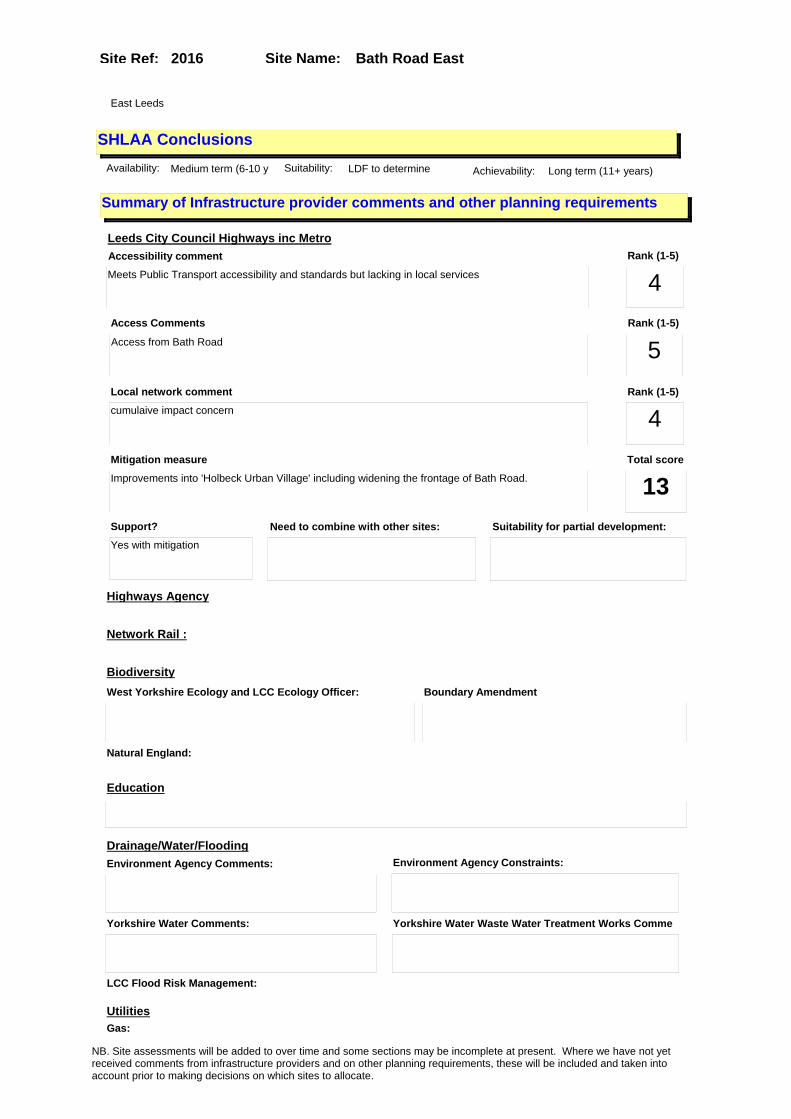
Site Name: Bath Road EastSite Ref: 2016
SHLAA ConclusionsAvailability: Medium term (6-10 y Suitability: LDF to determine Achievability: Long term (11+ years)
East Leeds
Summary of Infrastructure provider comments and other planning requirements
Accessibility commentMeets Public Transport accessibility and standards but lacking in local services
Rank (1-5)
4Access Comments
Access from Bath Road
Local network comment
cumulaive impact concern
Rank (1-5)
5Rank (1-5)
4
Leeds City Council Highways inc Metro
Highways Agency
Network Rail :
Biodiversity
Natural England:
Education
Mitigation measure
Improvements into 'Holbeck Urban Village' including widening the frontage of Bath Road.
Total score
13Support?
Yes with mitigation
Need to combine with other sites: Suitability for partial development:
West Yorkshire Ecology and LCC Ecology Officer: Boundary Amendment
Drainage/Water/FloodingEnvironment Agency Comments: Environment Agency Constraints:
Yorkshire Water Comments: Yorkshire Water Waste Water Treatment Works Comme
UtilitiesGas:
LCC Flood Risk Management:
NB. Site assessments will be added to over time and some sections may be incomplete at present. Where we have not yet received comments from infrastructure providers and on other planning requirements, these will be included and taken into account prior to making decisions on which sites to allocate.

Site Name: Bath Road EastSite Ref: 2016
Conclusion of Assessment
Conclusion summary:
SHLAA site with potential for office element
Floorspace sq m (Non residential): 2500
Employment Conclusion: Green
Assesment Type: Site assessment Type: Mixed Use
Proposed Change:
Electric:
Telecom:
Fire and Rescue Services:
Built HeritageLeeds City Council:
West Yorkshire Archaeology Service:
English Heritage:
Gypsy Traveller Site Assessment
Yes No Maybe Could site be effectively managed (Text)
Yes No Maybe Would gypsies and travellers live on the site?
(Text)
Yes No Proximity to housed gypsies and travellers (Text)
Yes No Unknown Experience of previous encampments (Text)
NB. Site assessments will be added to over time and some sections may be incomplete at present. Where we have not yet received comments from infrastructure providers and on other planning requirements, these will be included and taken into account prior to making decisions on which sites to allocate.

Site Name: Wellington Street - YEP LS1 1RF Site Ref: 2023
Site Details
Land Use
Northing: 433430
Easting: 429075
Distance to Rail Station (metres): 661.67
Nearest Railway Station Leeds City
Distance to bus stop (metres) 66.27
Bus Stop ID 11140
Agricultural Land Class:
SFRA Flood Zone: 1.00
Environment Agency Flood Zone: 1.00
Within 300m of retail centre boundary:
UDP Designation
Greenbelt - N32 (%): 0.00 Urban Green Corridor - N8 (%): 0.00
Protected Area of Search site - N34 (%): 0.00 Rural Land - RL1: 0.00
City Centre Primary Shopping Quarter - CC27 (%): 0.00 Town Centre - S2: 0.00
Health and Safety Executive Hazard: No
Health and Safety Executive Gas Pipeline: No
Strategic Employment Buffer: 100.00
Area sq m: 18549.67 Ward City and Hunslet
Special Landscape Area - N37: 0.00
Allotments - N1A: 0.00
Proposed Greenspace - N5: 0.00
Protected Playing Pitch - N6: 0.00
Nature Conservation Area - N50: 0.00
Conservation Areas No
Ancient Monument/Battlefield(%): 0.00 Listed Buildings: No
Public Rights of Way: No
Other?:
Natural Resources and waste DPD (if applicable)
Within Minerals Safeguarding Site?: No Within 100m of Minerals Safeguarding Site?: No
HMCA: City Centre
Greenspace - N1: 0
Existing Use 1: Industry and business - Manufacturing & WholesaleExisting Use 2: OfficeExisting Use 3:
Neighbouring Use 1 Office
Neighbouring Use 2: Transport - Waterways
Neighbouring Use 3: Vacant & Derelict - Vacant building
Other uses:
Topography: Flat
Natural Landscape: No Tree Cover
Boundaries: Existing well defined
Road Frontage
Site Characteristics
Site Detail
Other comments/observations on site characteristics:
Site of the former Yorkshire Evening Post office, print works and distribution centre now vacated. Fronts the junction of Wellington St and the A58 inner ring road. The rear of the site backs onto the River Aire.
Area Ha: 1.854967
Site State: Brownfield
NB. Site assessments will be added to over time and some sections may be incomplete at present. Where we have not yet received comments from infrastructure providers and on other planning requirements, these will be included and taken into account prior to making decisions on which sites to allocate.

Site Name: Wellington Street - YEP LS1 1RF Site Ref: 2023
Planning History
Planning App No. Proposal Received Decision Status Site %
20/6/93/SN 2 non-illuminated free standing signs and 2 n0n- illuminated wall signs
14/01/1993 23/02/1993 A 98.21
20/15/04/FU 2m high boundary fence and security gates to newspaper offices
27/01/2004 23/03/2004 A 97.57
20/237/99/SI 2 halo illuminated signs, 1 non-illuminated sign and 1 non-illuminated logo
05/05/1999 05/07/1999 A 96.51
H20/302/79/ Alterations and extensions, to form enlarged reel storenew u nloading area and new office a nd loading bays and security o
10/07/1979 20/08/1979 A 97.57
20/309/92/FU Addition of satellite dish 30/07/1992 17/09/1992 A 98.21
H20/357/79/ 27, 376 litres oil storage tank , to newspaper vehic le workshop.
22/08/1979 17/09/1979 A 97.57
H20/400/74/ Alteration and extension to fo rm new roof air condi tioning plant room to newspape r offices.
30/12/1974 03/02/1975 A 92.57
H20/450/81/ 10910.4 litre, l.p.g. storage tank, to newspaper offic es.
22/12/1981 26/01/1982 A 94.29
20/293/92/FU Canopy to front 21/07/1992 28/09/1992 A 98.21
12/04254/FU Glazed entrance porch 05/10/2012 28/11/2012 A 95.85
NB. Site assessments will be added to over time and some sections may be incomplete at present. Where we have not yet received comments from infrastructure providers and on other planning requirements, these will be included and taken into account prior to making decisions on which sites to allocate.
Site Name: Wellington Street - YEP LS1 1RF Site Ref: 2023
Conformity with Core Strategy
Inner South Leeds: 0.00
Leeds Bradford Corridor: 0.00 West Leeds Gateway: 0.00
Aire Valley: 0.00Regeneration Priority Area:
Brownfield
Greenfield
Mixed
Main Urban Area
Major Settlement
Smaller Settlement
Villages/Rural
Main Urban Area Extension
Major Settlement Extension
Smaller Settlement Extension
Village/Rural Extension
Development unrelated to existing development
Green Belt assessment - only completed where site is within Green Belt
Would development lead to/constitute ribbon development?
Would development result in isolated development?
Is the site well connected to built up area (2+ boundaries with existing built up area)?
Would development of the site effectively "round off" the settlement pattern?:
Do natural/physical features provide a good existing barrier between existing urban area and undeveloped land?
Overall sprawl conclusion:
Would development of the site lead to physical connection of settlements?
Do natural/physical features provide a good existing barrier/boundary to contain development?
Overall Coalescence Conclusion:
Is there a strong defensible boundary between the site and the existing urban area?
Does the site provide access to the countryside?
Does the site include local or national conservation designated areas?
Does the site include areas of woodlands, trees, hedgerows that are protected, or significant unprotected tree/hedge cover?
Does the site include grade 1, 2, or 3a agricultural land?
Does the site contain buildings? Are these in agricultural use?
Overall countryside Encroachment Conclusion
Is the site within or adjacent to a conservation area, listed building or other historical feature?
If yes, could development preserve this character?:
Overall Character Preservation Conclusion:
Greenbelt Assessment Conclusion:
Check the unrestricted sprawl of large built up areas
Prevent neighbouring towns from merging
Assist in safeguarding countryside from encroachment
Preserve the setting and special character of historic towns
NB. Site assessments will be added to over time and some sections may be incomplete at present. Where we have not yet received comments from infrastructure providers and on other planning requirements, these will be included and taken into account prior to making decisions on which sites to allocate.

Site Name: Wellington Street - YEP LS1 1RF Site Ref: 2023
SHLAA ConclusionsAvailability: Medium term (6-10 y Suitability: LDF to determine Achievability: Long term (11+ years)
East Leeds
Summary of Infrastructure provider comments and other planning requirements
Accessibility commentMeets Public Transport accessibility and standards for local services, primary schools and healthcare - not secondary schools - however public transport available
Rank (1-5)
5Access Comments
Access possible left in left out from both Wellington Street and Wellington Road on slip, both need to be preserved to allow for all moves
Local network comment
Capacity concerns will need mitigation to West St gyratory and Armley gyratory
Rank (1-5)
5Rank (1-5)
3
Leeds City Council Highways inc Metro
Highways Agency
Network Rail :
Biodiversity
Natural England:
Education
Mitigation measure
will need mitigation to West St gyratory and Armley gyratory
Total score
13Support?
Yes - with mitigation
Need to combine with other sites: Suitability for partial development:
West Yorkshire Ecology and LCC Ecology Officer:
Supported - but Otters to consider
Boundary Amendment
Drainage/Water/FloodingEnvironment Agency Comments: Environment Agency Constraints:
Yorkshire Water Comments: Yorkshire Water Waste Water Treatment Works Comme
Utilities
Potential for cumulative impact in combination with other sites. If site still included at next sift assess as part of city centre / Aire valley cluster.
LCC Flood Risk Management:
NB. Site assessments will be added to over time and some sections may be incomplete at present. Where we have not yet received comments from infrastructure providers and on other planning requirements, these will be included and taken into account prior to making decisions on which sites to allocate.
Site Name: Wellington Street - YEP LS1 1RF Site Ref: 2023
Conclusion of Assessment
Conclusion summary:
SHLAA site with potential for office element
Floorspace sq m (Non residential): 20000
Employment Conclusion: Green
Assesment Type: Site assessment Type: Mixed Use
Proposed Change:
Gas:
Electric:
Telecom:
Fire and Rescue Services:
Built HeritageLeeds City Council:
West Yorkshire Archaeology Service:
English Heritage:
Gypsy Traveller Site Assessment
Yes No Maybe Could site be effectively managed (Text)
Yes No Maybe Would gypsies and travellers live on the site?
(Text)
Yes No Proximity to housed gypsies and travellers (Text)
Yes No Unknown Experience of previous encampments (Text)
NB. Site assessments will be added to over time and some sections may be incomplete at present. Where we have not yet received comments from infrastructure providers and on other planning requirements, these will be included and taken into account prior to making decisions on which sites to allocate.
Site Name: Kirkstall Road Car Park Site Ref: 2024
Site Details
Land Use
Northing: 433621
Easting: 429020
Distance to Rail Station (metres): 797.73
Nearest Railway Station Leeds City
Distance to bus stop (metres) 143.35
Bus Stop ID 12034
Agricultural Land Class:
SFRA Flood Zone: 1.00
Environment Agency Flood Zone: 1.00
Within 300m of retail centre boundary:
UDP Designation
Greenbelt - N32 (%): 0.00 Urban Green Corridor - N8 (%): 0.00
Protected Area of Search site - N34 (%): 0.00 Rural Land - RL1: 0.00
City Centre Primary Shopping Quarter - CC27 (%): 0.00 Town Centre - S2: 0.00
Health and Safety Executive Hazard: No
Health and Safety Executive Gas Pipeline: No
Strategic Employment Buffer: 100.00
Area sq m: 7432.79 Ward City and Hunslet
Special Landscape Area - N37: 0.00
Allotments - N1A: 0.00
Proposed Greenspace - N5: 0.00
Protected Playing Pitch - N6: 0.00
Nature Conservation Area - N50: 0.00
Conservation Areas No
Ancient Monument/Battlefield(%): 0.00 Listed Buildings: No
Public Rights of Way: No
Other?:
Natural Resources and waste DPD (if applicable)
Within Minerals Safeguarding Site?: No Within 100m of Minerals Safeguarding Site?: No
HMCA: City Centre
Greenspace - N1: 0
Existing Use 1: Transport - Car ParksExisting Use 2:
Existing Use 3:
Neighbouring Use 1 Office
Neighbouring Use 2: Vacant & Derelict - Vacant building
Neighbouring Use 3: Residential - Hotels, boarding and guest houses
Other uses:
Topography: Flat
Natural Landscape: No Tree Cover
Boundaries: Existing well defined
Road Frontage
Site Characteristics
Site Detail
Other comments/observations on site characteristics:
Surface car park in between the A65 inbound and outbound carriageways in its junction with the A58 Inner Ring Road.
Area Ha: 0.743279
Site State: Brownfield
NB. Site assessments will be added to over time and some sections may be incomplete at present. Where we have not yet received comments from infrastructure providers and on other planning requirements, these will be included and taken into account prior to making decisions on which sites to allocate.

Site Name: Kirkstall Road Car Park Site Ref: 2024
Planning History
Planning App No. Proposal Received Decision Status Site %
H26/436/75/ Laying out of access roads and erection of multi-storeycar p ark for 850 cars, in two block s with bridge link between an
20/05/1975 11/08/1975 W 87.84
H26/616/76/ Laying out of car park, for 22 0 cars, with landscaping to va cant site. (this item
15/07/1976 13/09/1976 A 99.13
NB. Site assessments will be added to over time and some sections may be incomplete at present. Where we have not yet received comments from infrastructure providers and on other planning requirements, these will be included and taken into account prior to making decisions on which sites to allocate.

Site Name: Kirkstall Road Car Park Site Ref: 2024
Conformity with Core Strategy
Inner South Leeds: 0.00
Leeds Bradford Corridor: 0.00 West Leeds Gateway: 0.00
Aire Valley: 0.00Regeneration Priority Area:
Brownfield
Greenfield
Mixed
Main Urban Area
Major Settlement
Smaller Settlement
Villages/Rural
Main Urban Area Extension
Major Settlement Extension
Smaller Settlement Extension
Village/Rural Extension
Development unrelated to existing development
Green Belt assessment - only completed where site is within Green Belt
Would development lead to/constitute ribbon development?
Would development result in isolated development?
Is the site well connected to built up area (2+ boundaries with existing built up area)?
Would development of the site effectively "round off" the settlement pattern?:
Do natural/physical features provide a good existing barrier between existing urban area and undeveloped land?
Overall sprawl conclusion:
Would development of the site lead to physical connection of settlements?
Do natural/physical features provide a good existing barrier/boundary to contain development?
Overall Coalescence Conclusion:
Is there a strong defensible boundary between the site and the existing urban area?
Does the site provide access to the countryside?
Does the site include local or national conservation designated areas?
Does the site include areas of woodlands, trees, hedgerows that are protected, or significant unprotected tree/hedge cover?
Does the site include grade 1, 2, or 3a agricultural land?
Does the site contain buildings? Are these in agricultural use?
Overall countryside Encroachment Conclusion
Is the site within or adjacent to a conservation area, listed building or other historical feature?
If yes, could development preserve this character?:
Overall Character Preservation Conclusion:
Greenbelt Assessment Conclusion:
Check the unrestricted sprawl of large built up areas
Prevent neighbouring towns from merging
Assist in safeguarding countryside from encroachment
Preserve the setting and special character of historic towns
NB. Site assessments will be added to over time and some sections may be incomplete at present. Where we have not yet received comments from infrastructure providers and on other planning requirements, these will be included and taken into account prior to making decisions on which sites to allocate.

Site Name: Kirkstall Road Car Park Site Ref: 2024
SHLAA ConclusionsAvailability: Medium term (6-10 y Suitability: LDF to determine Achievability: Long term (11+ years)
East Leeds
Summary of Infrastructure provider comments and other planning requirements
Accessibility commentMeets Public Transport accessibility and standards for local services, primary schools and healthcare - not secondary schools - however public transport available
Rank (1-5)
5Access Comments
Access possible left in left out from both Wellington Street and Wellington Road on slip, both need to be preserved to allow for all moves
Local network comment
Capacity concerns will need mitigation to West St gyratory and Armley gyratory
Rank (1-5)
5Rank (1-5)
3
Leeds City Council Highways inc Metro
Highways Agency
Network Rail :
Biodiversity
Natural England:
Education
Mitigation measure
will need mitigation to West St gyratory and Armley gyratory
Total score
13Support?
Yes - with mitigation
Need to combine with other sites: Suitability for partial development:
West Yorkshire Ecology and LCC Ecology Officer:
Supported
Boundary Amendment
Drainage/Water/FloodingEnvironment Agency Comments: Environment Agency Constraints:
Yorkshire Water Comments: Yorkshire Water Waste Water Treatment Works Comme
Utilities
Potential for cumulative impact in combination with other sites. If site still included at next sift assess as part of city centre / Aire valley cluster.
LCC Flood Risk Management:
NB. Site assessments will be added to over time and some sections may be incomplete at present. Where we have not yet received comments from infrastructure providers and on other planning requirements, these will be included and taken into account prior to making decisions on which sites to allocate.

Site Name: Kirkstall Road Car Park Site Ref: 2024
Conclusion of Assessment
Conclusion summary:
SHLAA site with potential for office element
Floorspace sq m (Non residential): 22298
Employment Conclusion: Green
Assesment Type: Site assessment Type: Mixed Use
Proposed Change:
Gas:
Electric:
Telecom:
Fire and Rescue Services:
Built HeritageLeeds City Council:
West Yorkshire Archaeology Service:
English Heritage:
Gypsy Traveller Site Assessment
Yes No Maybe Could site be effectively managed (Text)
Yes No Maybe Would gypsies and travellers live on the site?
(Text)
Yes No Proximity to housed gypsies and travellers (Text)
Yes No Unknown Experience of previous encampments (Text)
NB. Site assessments will be added to over time and some sections may be incomplete at present. Where we have not yet received comments from infrastructure providers and on other planning requirements, these will be included and taken into account prior to making decisions on which sites to allocate.
Site Name: Water Lane Railway Triangle Site Ref: 2031
Site Details
Land Use
Northing: 432881
Easting: 429244
Distance to Rail Station (metres): 545.62
Nearest Railway Station Leeds City
Distance to bus stop (metres) 227.30
Bus Stop ID 4261
Agricultural Land Class:
SFRA Flood Zone: 1.00
Environment Agency Flood Zone: 1.00
Within 300m of retail centre boundary:
UDP Designation
Greenbelt - N32 (%): 0.00 Urban Green Corridor - N8 (%): 0.00
Protected Area of Search site - N34 (%): 0.00 Rural Land - RL1: 0.00
City Centre Primary Shopping Quarter - CC27 (%): 0.00 Town Centre - S2: 0.00
Health and Safety Executive Hazard: No
Health and Safety Executive Gas Pipeline: No
Strategic Employment Buffer: 100.00
Area sq m: 9779.12 Ward City and Hunslet
Special Landscape Area - N37: 0.00
Allotments - N1A: 0.00
Proposed Greenspace - N5: 0.00
Protected Playing Pitch - N6: 0.00
Nature Conservation Area - N50: 1.00
Conservation Areas Yes
Ancient Monument/Battlefield(%): 0.00 Listed Buildings: No
Public Rights of Way: No
Other?:
Natural Resources and waste DPD (if applicable)
Within Minerals Safeguarding Site?: No Within 100m of Minerals Safeguarding Site?: No
HMCA: City Centre
Greenspace - N1: 0
Existing Use 1: Vacant and derelict - Vacant landExisting Use 2:
Existing Use 3:
Neighbouring Use 1 Industry and business - Manufacturing & Wholesale
Neighbouring Use 2: Vacant and derelict - Vacant land
Neighbouring Use 3: Transport - Car Parks
Other uses:
Topography: Flat
Natural Landscape: Limited Tree Cover
Boundaries: Existing well defined
Road Frontage
Site Characteristics
Site Detail
Other comments/observations on site characteristics:
Triangle of railway land bordered by railway lines and with a single road and pedestrian access at the southern corner of the site.
Area Ha: 0.977912
Site State: Brownfield
NB. Site assessments will be added to over time and some sections may be incomplete at present. Where we have not yet received comments from infrastructure providers and on other planning requirements, these will be included and taken into account prior to making decisions on which sites to allocate.

Site Name: Water Lane Railway Triangle Site Ref: 2031
Planning History
Planning App No. Proposal Received Decision Status Site %
H20/379/85/ Use of vacant site as modern s culpture display area.
07/08/1985 21/10/1985 A 93.88
H20/177/88/ 36.5m high brick statue. 31/03/1988 07/11/1988 R 99.51
NB. Site assessments will be added to over time and some sections may be incomplete at present. Where we have not yet received comments from infrastructure providers and on other planning requirements, these will be included and taken into account prior to making decisions on which sites to allocate.

Site Name: Water Lane Railway Triangle Site Ref: 2031
Conformity with Core Strategy
Inner South Leeds: 0.00
Leeds Bradford Corridor: 0.00 West Leeds Gateway: 0.00
Aire Valley: 0.00Regeneration Priority Area:
Brownfield
Greenfield
Mixed
Main Urban Area
Major Settlement
Smaller Settlement
Villages/Rural
Main Urban Area Extension
Major Settlement Extension
Smaller Settlement Extension
Village/Rural Extension
Development unrelated to existing development
Green Belt assessment - only completed where site is within Green Belt
Would development lead to/constitute ribbon development?
Would development result in isolated development?
Is the site well connected to built up area (2+ boundaries with existing built up area)?
Would development of the site effectively "round off" the settlement pattern?:
Do natural/physical features provide a good existing barrier between existing urban area and undeveloped land?
Overall sprawl conclusion:
Would development of the site lead to physical connection of settlements?
Do natural/physical features provide a good existing barrier/boundary to contain development?
Overall Coalescence Conclusion:
Is there a strong defensible boundary between the site and the existing urban area?
Does the site provide access to the countryside?
Does the site include local or national conservation designated areas?
Does the site include areas of woodlands, trees, hedgerows that are protected, or significant unprotected tree/hedge cover?
Does the site include grade 1, 2, or 3a agricultural land?
Does the site contain buildings? Are these in agricultural use?
Overall countryside Encroachment Conclusion
Is the site within or adjacent to a conservation area, listed building or other historical feature?
If yes, could development preserve this character?:
Overall Character Preservation Conclusion:
Greenbelt Assessment Conclusion:
Check the unrestricted sprawl of large built up areas
Prevent neighbouring towns from merging
Assist in safeguarding countryside from encroachment
Preserve the setting and special character of historic towns
NB. Site assessments will be added to over time and some sections may be incomplete at present. Where we have not yet received comments from infrastructure providers and on other planning requirements, these will be included and taken into account prior to making decisions on which sites to allocate.

Site Name: Water Lane Railway Triangle Site Ref: 2031
SHLAA ConclusionsAvailability: Short term (0-5yrs) Suitability: LDF to determine Achievability: Long term (11+ years)
Conclusion of Assessment
Conclusion summary:
SHLAA site with potential for office element
Floorspace sq m (Non residential): 5000
Employment Conclusion: Green
East Leeds
Assesment Type: Site assessment Type: Mixed Use
Proposed Change:
Gypsy Traveller Site Assessment
Yes No Maybe Could site be effectively managed (Text)
Yes No Maybe Would gypsies and travellers live on the site?
(Text)
Yes No Proximity to housed gypsies and travellers (Text)
Yes No Unknown Experience of previous encampments (Text)
NB. Site assessments will be added to over time and some sections may be incomplete at present. Where we have not yet received comments from infrastructure providers and on other planning requirements, these will be included and taken into account prior to making decisions on which sites to allocate.

Site Name: Rear of The Palace (PH), The CallsSite Ref: 3017
Site Details
Land Use
Northing: 433262
Easting: 430665
Distance to Rail Station (metres): 974.91
Nearest Railway Station Leeds City
Distance to bus stop (metres) 172.18
Bus Stop ID 9254
Agricultural Land Class:
SFRA Flood Zone: 1.00
Environment Agency Flood Zone: 1.00
Within 300m of retail centre boundary:
UDP Designation
Greenbelt - N32 (%): 0.00 Urban Green Corridor - N8 (%): 0.00
Protected Area of Search site - N34 (%): 0.00 Rural Land - RL1: 0.00
City Centre Primary Shopping Quarter - CC27 (%): 0.00 Town Centre - S2: 0.00
Health and Safety Executive Hazard: No
Health and Safety Executive Gas Pipeline: No
Strategic Employment Buffer: 100.00
Area sq m: 3332.96 Ward City and Hunslet
Special Landscape Area - N37: 0.00
Allotments - N1A: 0.00
Proposed Greenspace - N5: 0.00
Protected Playing Pitch - N6: 0.00
Nature Conservation Area - N50: 1.00
Conservation Areas Yes
Ancient Monument/Battlefield(%): 39.87 Listed Buildings: No
Public Rights of Way: No
Other?:
Natural Resources and waste DPD (if applicable)
Within Minerals Safeguarding Site?: No Within 100m of Minerals Safeguarding Site?: No
HMCA: City Centre
Greenspace - N1: 0
Existing Use 1: OtherExisting Use 2: Vacant and derelict - Vacant landExisting Use 3:
Neighbouring Use 1
Neighbouring Use 2:
Neighbouring Use 3:
Other uses: Place of Worship
Topography: Flat
Natural Landscape: No Tree Cover
Boundaries: Existing well defined
Road Frontage
Site Characteristics
Site Detail
Other comments/observations on site characteristics:
Site comprises buildings and land between Leeds Parish Church and The Calls
Area Ha: 0.333296
Site State: Brownfield
NB. Site assessments will be added to over time and some sections may be incomplete at present. Where we have not yet received comments from infrastructure providers and on other planning requirements, these will be included and taken into account prior to making decisions on which sites to allocate.

Site Name: Rear of The Palace (PH), The CallsSite Ref: 3017
Planning History
Planning App No. Proposal Received Decision Status Site %
H20/336/80/ Outline application to demolis h existing school, lay out a ccess and erect 3 storey offic e block and 3 storeyblock of 3
23/09/1980 15/04/1981 A 34.55
H20/498/78/ Outline application to demolis h existing buildings, layout a ccess road and erect 3 storey office block, with 12 car par
29/11/1978 22/05/1979 A 26.47
H20/85/74/ Internal alterations to form c hoir room with music libra ry store and common room to ch urch premises
13/05/1974 22/07/1974 A 39.71
09/03230/FU Change of use including refurbishment and extensions to 2 church buildings with 2 flats, to form offices and 16 flats and erect 5 storey block comprising office and 21 flats, with car parking.��
23/07/2009 27/06/2012 A 100.00
H20/449/84/ Laying out of footpaths and ca r park, to church.
17/10/1984 30/09/1985 A 39.98
20/397/99/SN 6 non illuminated signs to gate piers and 2 non illuminated free standing signs
26/07/1999 29/09/1999 A 40.52
13/00819/FU Variation of conditions 21, 33 and 37 of previous approval 09/03230/FU relating to floor levels, windows and approved plans�
15/02/2013 PCO 100.00
H20/497/78/ Listed building application to demolish school.
29/11/1978 22/05/1979 A 26.47
H20/271/76/ Change of use, including alter ations, to form new entra nce and staircase, of residen tial accommodation, offices, a
02/07/1976 09/08/1976 A 13.79
H20/458/84/ Listed building application to layout footpath and car p arking to church.
25/10/1984 30/09/1985 A 39.77
H20/286/77/ Alterations to form loading do or to offices.
13/07/1977 01/08/1977 A 26.47
H20/198/81/ Listed building application to clean external stoneworkof pa rish church and layout landsca ping with footpaths, lighting,
31/03/1981 04/01/1983 A 63.85
20/427/99/LI Listed building application for 6 non illuminated signs to gate piers and 2 non illuminated freestanding signs
09/08/1999 29/09/1999 A 40.52
09/03397/LI Listed Building Application for alterations for replacement gate in boundary wall
03/08/2009 05/07/2012 A 100.00
H20/127/88/ Change of use of offices to do ctors surgery.
10/03/1988 08/04/1988 W 13.49
20/183/96/FU Addition of 2 air conditioning units to offices
06/03/1996 29/08/1996 A 13.75
H20/200/81/ Laying out of landscaping with lighting, footpaths, car p arking area, bin store and flo odlighting, to parish chu
31/03/1981 04/01/1983 A 64.29
H20/103/85/ Listed building application fo r the addition of flood lighting to church.
15/03/1985 13/05/1985 A 40.03
NB. Site assessments will be added to over time and some sections may be incomplete at present. Where we have not yet received comments from infrastructure providers and on other planning requirements, these will be included and taken into account prior to making decisions on which sites to allocate.

Site Name: Rear of The Palace (PH), The CallsSite Ref: 3017
H20/65/78/ Change of use of school and co llege, to warehouse, aucti on room, showroom and offices.
16/02/1978 13/03/1978 A 26.47
H20/84/81/ Laying out of access road and erection of 3 storey offic e block with 12 car parking sp aces and landscapingto cleared
20/02/1981 15/04/1981 A 34.86
H20/41/80/ Demolition of existing buildi ngs, laying out of accessand e rection of 4 storey office blo ck with toilets, kitchen, p
30/01/1980 10/03/1980 A 35.42
H20/102/85/ Addition of floodlighting to c hurch. 15/03/1985 13/05/1985 A 40.76
H20/327/77/ Conservation area application to demolish vacant school
04/08/1977 12/12/1977 R 26.47
H20/441/81/ Laying out of access road and erection of 30 flats in one 3 storey block comprising 18, o ne bedroom flats and12 bedsit
14/12/1981 04/01/1982 A 34.48
NB. Site assessments will be added to over time and some sections may be incomplete at present. Where we have not yet received comments from infrastructure providers and on other planning requirements, these will be included and taken into account prior to making decisions on which sites to allocate.

Site Name: Rear of The Palace (PH), The CallsSite Ref: 3017
Conformity with Core Strategy
Inner South Leeds: 0.00
Leeds Bradford Corridor: 0.00 West Leeds Gateway: 0.00
Aire Valley: 0.00Regeneration Priority Area:
Brownfield
Greenfield
Mixed
Main Urban Area
Major Settlement
Smaller Settlement
Villages/Rural
Main Urban Area Extension
Major Settlement Extension
Smaller Settlement Extension
Village/Rural Extension
Development unrelated to existing development
Green Belt assessment - only completed where site is within Green Belt
Would development lead to/constitute ribbon development?
Would development result in isolated development?
Is the site well connected to built up area (2+ boundaries with existing built up area)?
Would development of the site effectively "round off" the settlement pattern?:
Do natural/physical features provide a good existing barrier between existing urban area and undeveloped land?
Overall sprawl conclusion:
Would development of the site lead to physical connection of settlements?
Do natural/physical features provide a good existing barrier/boundary to contain development?
Overall Coalescence Conclusion:
Is there a strong defensible boundary between the site and the existing urban area?
Does the site provide access to the countryside?
Does the site include local or national conservation designated areas?
Does the site include areas of woodlands, trees, hedgerows that are protected, or significant unprotected tree/hedge cover?
Does the site include grade 1, 2, or 3a agricultural land?
Does the site contain buildings? Are these in agricultural use?
Overall countryside Encroachment Conclusion
Is the site within or adjacent to a conservation area, listed building or other historical feature?
If yes, could development preserve this character?:
Overall Character Preservation Conclusion:
Greenbelt Assessment Conclusion:
Check the unrestricted sprawl of large built up areas
Prevent neighbouring towns from merging
Assist in safeguarding countryside from encroachment
Preserve the setting and special character of historic towns
NB. Site assessments will be added to over time and some sections may be incomplete at present. Where we have not yet received comments from infrastructure providers and on other planning requirements, these will be included and taken into account prior to making decisions on which sites to allocate.

Site Name: Rear of The Palace (PH), The CallsSite Ref: 3017
SHLAA ConclusionsAvailability: Short term (0-5yrs) Suitability: LDF to determine Achievability: Short term (0-5yrs)
East Leeds
Summary of Infrastructure provider comments and other planning requirements
Accessibility commentMeets Public Transport accessibility and standards for local services, schools and healthcare
Rank (1-5)
5Access Comments
Access possible from the Calls
Local network comment
capacity ok for likely size of development
Rank (1-5)
5Rank (1-5)
5
Leeds City Council Highways inc Metro
Highways Agency
Network Rail :
Biodiversity
Natural England:
Education
Mitigation measure
Pedestrian linkages through St Peters church required
Total score
15Support?
yes
Need to combine with other sites: Suitability for partial development:
West Yorkshire Ecology and LCC Ecology Officer:
Supported
Boundary Amendment
Drainage/Water/FloodingEnvironment Agency Comments: Environment Agency Constraints:
Yorkshire Water Comments: Yorkshire Water Waste Water Treatment Works Comme
Utilities
Potential for cumulative impact in combination with other sites. If site still included at next sift assess as part of city centre / Aire Valley cluster.
LCC Flood Risk Management:
NB. Site assessments will be added to over time and some sections may be incomplete at present. Where we have not yet received comments from infrastructure providers and on other planning requirements, these will be included and taken into account prior to making decisions on which sites to allocate.

Site Name: Rear of The Palace (PH), The CallsSite Ref: 3017
Conclusion of Assessment
Conclusion summary:
Site with planning permission for residential with office element
Floorspace sq m (Non residential): 93
Employment Conclusion: Lime Green
Assesment Type: Planning status Type: Office
Proposed Change:
Gas:
Electric:
Telecom:
Fire and Rescue Services:
Built HeritageLeeds City Council:
West Yorkshire Archaeology Service:
English Heritage:
Gypsy Traveller Site Assessment
Yes No Maybe Could site be effectively managed (Text)
Yes No Maybe Would gypsies and travellers live on the site?
(Text)
Yes No Proximity to housed gypsies and travellers (Text)
Yes No Unknown Experience of previous encampments (Text)
NB. Site assessments will be added to over time and some sections may be incomplete at present. Where we have not yet received comments from infrastructure providers and on other planning requirements, these will be included and taken into account prior to making decisions on which sites to allocate.

Site Name: Kidacre Street & Holmes Street LS 11 Site Ref: 2000721
Site Details
Land Use
Northing: 432473
Easting: 430170
Distance to Rail Station (metres): 862.25
Nearest Railway Station Leeds City
Distance to bus stop (metres) 131.99
Bus Stop ID 12870
Agricultural Land Class:
SFRA Flood Zone: 1.00
Environment Agency Flood Zone: 1.00
Within 300m of retail centre boundary:
UDP Designation
Greenbelt - N32 (%): 0.00 Urban Green Corridor - N8 (%): 0.00
Protected Area of Search site - N34 (%): 0.00 Rural Land - RL1: 0.00
City Centre Primary Shopping Quarter - CC27 (%): 0.00 Town Centre - S2: 0.00
Health and Safety Executive Hazard: Yes
Health and Safety Executive Gas Pipeline: Yes
Strategic Employment Buffer: 0.00
Area sq m: 29899.09 Ward City and Hunslet
Special Landscape Area - N37: 0.00
Allotments - N1A: 0.00
Proposed Greenspace - N5: 0.00
Protected Playing Pitch - N6: 0.00
Nature Conservation Area - N50: 0.00
Conservation Areas No
Ancient Monument/Battlefield(%): 0.00 Listed Buildings: No
Public Rights of Way: No
Other?:
Natural Resources and waste DPD (if applicable)
Within Minerals Safeguarding Site?: No Within 100m of Minerals Safeguarding Site?: No
HMCA: City Centre
Greenspace - N1: 0
Existing Use 1:
Existing Use 2:
Existing Use 3:
Neighbouring Use 1
Neighbouring Use 2:
Neighbouring Use 3:
Other uses:
Topography:
Natural Landscape:
Boundaries:
Road Frontage
Site Characteristics
Site Detail
Other comments/observations on site characteristics:
Area Ha: 2.989909
Site State:
NB. Site assessments will be added to over time and some sections may be incomplete at present. Where we have not yet received comments from infrastructure providers and on other planning requirements, these will be included and taken into account prior to making decisions on which sites to allocate.

Site Name: Kidacre Street & Holmes Street LS 11 Site Ref: 2000721
Planning History
NB. Site assessments will be added to over time and some sections may be incomplete at present. Where we have not yet received comments from infrastructure providers and on other planning requirements, these will be included and taken into account prior to making decisions on which sites to allocate.

Site Name: Kidacre Street & Holmes Street LS 11 Site Ref: 2000721
Conformity with Core Strategy
Inner South Leeds: 0.00
Leeds Bradford Corridor: 0.00 West Leeds Gateway: 0.00
Aire Valley: 0.00Regeneration Priority Area:
Brownfield
Greenfield
Mixed
Main Urban Area
Major Settlement
Smaller Settlement
Villages/Rural
Main Urban Area Extension
Major Settlement Extension
Smaller Settlement Extension
Village/Rural Extension
Development unrelated to existing development
Green Belt assessment - only completed where site is within Green Belt
Would development lead to/constitute ribbon development?
Would development result in isolated development?
Is the site well connected to built up area (2+ boundaries with existing built up area)?
Would development of the site effectively "round off" the settlement pattern?:
Do natural/physical features provide a good existing barrier between existing urban area and undeveloped land?
Overall sprawl conclusion:
Would development of the site lead to physical connection of settlements?
Do natural/physical features provide a good existing barrier/boundary to contain development?
Overall Coalescence Conclusion:
Is there a strong defensible boundary between the site and the existing urban area?
Does the site provide access to the countryside?
Does the site include local or national conservation designated areas?
Does the site include areas of woodlands, trees, hedgerows that are protected, or significant unprotected tree/hedge cover?
Does the site include grade 1, 2, or 3a agricultural land?
Does the site contain buildings? Are these in agricultural use?
Overall countryside Encroachment Conclusion
Is the site within or adjacent to a conservation area, listed building or other historical feature?
If yes, could development preserve this character?:
Overall Character Preservation Conclusion:
Greenbelt Assessment Conclusion:
Check the unrestricted sprawl of large built up areas
Prevent neighbouring towns from merging
Assist in safeguarding countryside from encroachment
Preserve the setting and special character of historic towns
NB. Site assessments will be added to over time and some sections may be incomplete at present. Where we have not yet received comments from infrastructure providers and on other planning requirements, these will be included and taken into account prior to making decisions on which sites to allocate.
Site Name: Kidacre Street & Holmes Street LS 11 Site Ref: 2000721
SHLAA ConclusionsAvailability: Suitability: Achievability:
Conclusion of Assessment
Conclusion summary:
Site suitable for employment uses however it is not known at this stage whether the site may be needed for the HS2 programme.
Floorspace sq m (Non residential): 19040
Employment Conclusion: Amber
East Leeds
Assesment Type: Site assessment Type: Office
Proposed Change:
Gypsy Traveller Site Assessment
Yes No Maybe Could site be effectively managed (Text)
Yes No Maybe Would gypsies and travellers live on the site?
(Text)
Yes No Proximity to housed gypsies and travellers (Text)
Yes No Unknown Experience of previous encampments (Text)
NB. Site assessments will be added to over time and some sections may be incomplete at present. Where we have not yet received comments from infrastructure providers and on other planning requirements, these will be included and taken into account prior to making decisions on which sites to allocate.

Site Name: Leathley Road & Cross Myrtle Street LS 11
Site Ref: 2000950
Site Details
Land Use
Northing: 432209
Easting: 430384
Distance to Rail Station (metres): 1201.49
Nearest Railway Station Leeds City
Distance to bus stop (metres) 213.57
Bus Stop ID 11274
Agricultural Land Class:
SFRA Flood Zone: 1.00
Environment Agency Flood Zone: 1.00
Within 300m of retail centre boundary:
UDP Designation
Greenbelt - N32 (%): 0.00 Urban Green Corridor - N8 (%): 0.00
Protected Area of Search site - N34 (%): 0.00 Rural Land - RL1: 0.00
City Centre Primary Shopping Quarter - CC27 (%): 0.00 Town Centre - S2: 0.00
Health and Safety Executive Hazard: Yes
Health and Safety Executive Gas Pipeline: Yes
Strategic Employment Buffer: 100.00
Area sq m: 1555.47 Ward City and Hunslet
Special Landscape Area - N37: 0.00
Allotments - N1A: 0.00
Proposed Greenspace - N5: 0.00
Protected Playing Pitch - N6: 0.00
Nature Conservation Area - N50: 0.00
Conservation Areas No
Ancient Monument/Battlefield(%): 0.00 Listed Buildings: No
Public Rights of Way: No
Other?:
Natural Resources and waste DPD (if applicable)
Within Minerals Safeguarding Site?: Yes Within 100m of Minerals Safeguarding Site?: Yes
HMCA: City Centre
Greenspace - N1: 0
Existing Use 1:
Existing Use 2:
Existing Use 3:
Neighbouring Use 1
Neighbouring Use 2:
Neighbouring Use 3:
Other uses:
Topography:
Natural Landscape:
Boundaries:
Road Frontage
Site Characteristics
Site Detail
Other comments/observations on site characteristics:
Area Ha: 0.155547
Site State:
Site Site TypeCross Myrtle Street (ROTA) Holbeck Vehicle Dismantling and Scrap Metal
NB. Site assessments will be added to over time and some sections may be incomplete at present. Where we have not yet received comments from infrastructure providers and on other planning requirements, these will be included and taken into account prior to making decisions on which sites to allocate.
Site Name: Leathley Road & Cross Myrtle Street LS 11
Site Ref: 2000950
Planning History
Planning App No. Proposal Received Decision Status Site %
H20/280/82/ Outline application to erect 2 light industrial units to va cant site. (site area 0.15ha) (this item is also notice und
04/08/1982 04/10/1982 A 96.30
20/156/03/FU Block of 3 industrial units to vacant site
29/04/2003 24/06/2003 A 58.34
09/05571/FU Use of vacant land as coach parking with detached prefabricated drivers' office
23/12/2009 11/03/2010 A 100.00
H20/622/89/99 Laying out of access and erect ion of two detached lightindus trial units each with toilets and office, with 10 car parkin
01/12/1989 25/06/1991 W 98.57
0-20/39/03/MOD Block of 3 industrial units to vacant site
28/08/2003 17/11/2003 M01 58.34
10/04177/COND Consent, agreement or approval required by conditions 9, 10 and 12 of Planning Application 09/05571/FU
08/09/2010 17/02/2011 R 100.00
20/81/03/FU Block of 3 industrial units to vacant site
19/02/2003 17/04/2003 R 58.34
99-20/134/93/FU 2 detached wholesale warehouse units
12/07/1993 06/09/1993 A 94.12
NB. Site assessments will be added to over time and some sections may be incomplete at present. Where we have not yet received comments from infrastructure providers and on other planning requirements, these will be included and taken into account prior to making decisions on which sites to allocate.

Site Name: Leathley Road & Cross Myrtle Street LS 11
Site Ref: 2000950
Conformity with Core Strategy
Inner South Leeds: 0.00
Leeds Bradford Corridor: 0.00 West Leeds Gateway: 0.00
Aire Valley: 0.00Regeneration Priority Area:
Brownfield
Greenfield
Mixed
Main Urban Area
Major Settlement
Smaller Settlement
Villages/Rural
Main Urban Area Extension
Major Settlement Extension
Smaller Settlement Extension
Village/Rural Extension
Development unrelated to existing development
Green Belt assessment - only completed where site is within Green Belt
Would development lead to/constitute ribbon development?
Would development result in isolated development?
Is the site well connected to built up area (2+ boundaries with existing built up area)?
Would development of the site effectively "round off" the settlement pattern?:
Do natural/physical features provide a good existing barrier between existing urban area and undeveloped land?
Overall sprawl conclusion:
Would development of the site lead to physical connection of settlements?
Do natural/physical features provide a good existing barrier/boundary to contain development?
Overall Coalescence Conclusion:
Is there a strong defensible boundary between the site and the existing urban area?
Does the site provide access to the countryside?
Does the site include local or national conservation designated areas?
Does the site include areas of woodlands, trees, hedgerows that are protected, or significant unprotected tree/hedge cover?
Does the site include grade 1, 2, or 3a agricultural land?
Does the site contain buildings? Are these in agricultural use?
Overall countryside Encroachment Conclusion
Is the site within or adjacent to a conservation area, listed building or other historical feature?
If yes, could development preserve this character?:
Overall Character Preservation Conclusion:
Greenbelt Assessment Conclusion:
Check the unrestricted sprawl of large built up areas
Prevent neighbouring towns from merging
Assist in safeguarding countryside from encroachment
Preserve the setting and special character of historic towns
NB. Site assessments will be added to over time and some sections may be incomplete at present. Where we have not yet received comments from infrastructure providers and on other planning requirements, these will be included and taken into account prior to making decisions on which sites to allocate.

Site Name: Leathley Road & Cross Myrtle Street LS 11
Site Ref: 2000950
SHLAA ConclusionsAvailability: Suitability: Achievability:
East Leeds
Summary of Infrastructure provider comments and other planning requirements
Accessibility commentGood accessbility
Rank (1-5)
4Access Comments
Accesses to adopted highway achievable
Local network comment
local congestion issues
Rank (1-5)
4Rank (1-5)
3
Leeds City Council Highways inc Metro
Highways Agency
Network Rail :
Biodiversity
Natural England:
Education
Mitigation measure
Access improvements, removal on on-street parking required for access, bus stop improvements
Total score
11Support?
Yes with mitigaiton
Need to combine with other sites: Suitability for partial development:
West Yorkshire Ecology and LCC Ecology Officer:
Supported
Boundary Amendment
Drainage/Water/FloodingEnvironment Agency Comments: Environment Agency Constraints:
Yorkshire Water Comments: Yorkshire Water Waste Water Treatment Works Comme
Utilities
Potential for cumulative impact in combination with other sites. If site still included at next sift assess as part of city centre / Aire Valley cluster.
LCC Flood Risk Management:
NB. Site assessments will be added to over time and some sections may be incomplete at present. Where we have not yet received comments from infrastructure providers and on other planning requirements, these will be included and taken into account prior to making decisions on which sites to allocate.
Site Name: Leathley Road & Cross Myrtle Street LS 11
Site Ref: 2000950
Conclusion of Assessment
Conclusion summary:
Part of SHLAA site; LDF to determine whether housing or employment. Site more suited to non-office employment uses at present.
Floorspace sq m (Non residential):
Employment Conclusion: Green
Assesment Type: Site assessment Type: Industrial & Warehousing
Proposed Change:
Gas:
Electric:
Telecom:
Fire and Rescue Services:
Built HeritageLeeds City Council:
West Yorkshire Archaeology Service:
English Heritage:
Gypsy Traveller Site Assessment
Yes No Maybe Could site be effectively managed (Text)
Yes No Maybe Would gypsies and travellers live on the site?
(Text)
Yes No Proximity to housed gypsies and travellers (Text)
Yes No Unknown Experience of previous encampments (Text)
NB. Site assessments will be added to over time and some sections may be incomplete at present. Where we have not yet received comments from infrastructure providers and on other planning requirements, these will be included and taken into account prior to making decisions on which sites to allocate.

Site Name: Brown Lane LS 12 Site Ref: 2001250
Site Details
Land Use
Northing: 431958
Easting: 428283
Distance to Rail Station (metres): 1872.33
Nearest Railway Station Leeds City
Distance to bus stop (metres) 259.27
Bus Stop ID 8964
Agricultural Land Class:
SFRA Flood Zone: 1.00
Environment Agency Flood Zone: 1.00
Within 300m of retail centre boundary:
UDP Designation
Greenbelt - N32 (%): 0.00 Urban Green Corridor - N8 (%): 0.00
Protected Area of Search site - N34 (%): 0.00 Rural Land - RL1: 0.00
City Centre Primary Shopping Quarter - CC27 (%): 0.00 Town Centre - S2: 0.00
Health and Safety Executive Hazard: No
Health and Safety Executive Gas Pipeline: No
Strategic Employment Buffer: 0.00
Area sq m: 9936.72 Ward Beeston and Holbeck
Special Landscape Area - N37: 0.00
Allotments - N1A: 0.00
Proposed Greenspace - N5: 0.00
Protected Playing Pitch - N6: 0.00
Nature Conservation Area - N50: 0.00
Conservation Areas No
Ancient Monument/Battlefield(%): 0.00 Listed Buildings: No
Public Rights of Way: No
Other?:
Natural Resources and waste DPD (if applicable)
Within Minerals Safeguarding Site?: No Within 100m of Minerals Safeguarding Site?: Yes
HMCA: Inner Areas
Greenspace - N1: 0
Existing Use 1:
Existing Use 2:
Existing Use 3:
Neighbouring Use 1
Neighbouring Use 2:
Neighbouring Use 3:
Other uses:
Topography:
Natural Landscape:
Boundaries:
Road Frontage
Site Characteristics
Site Detail
Other comments/observations on site characteristics:
Area Ha: 0.993672
Site State:
NB. Site assessments will be added to over time and some sections may be incomplete at present. Where we have not yet received comments from infrastructure providers and on other planning requirements, these will be included and taken into account prior to making decisions on which sites to allocate.

Site Name: Brown Lane LS 12 Site Ref: 2001250
Planning History
Planning App No. Proposal Received Decision Status Site %
H20/113/87/ Change of use of light industr ial unit, to auction roomwith storage.
03/03/1987 21/05/1987 A 10.25
H20/406/84/ Change of use of warehouse to light industrial and stora ge unit.
17/09/1984 22/10/1984 W 10.19
H20/386/89/ Change of use of auction room to maintenance depot.
21/07/1989 22/09/1989 A 12.30
H20/189/85/ Alterations, including new gab le walls and part new pitch ed roof, to light industrial u nit.
08/05/1985 09/12/1988 W 12.17
NB. Site assessments will be added to over time and some sections may be incomplete at present. Where we have not yet received comments from infrastructure providers and on other planning requirements, these will be included and taken into account prior to making decisions on which sites to allocate.

Site Name: Brown Lane LS 12 Site Ref: 2001250
Conformity with Core Strategy
Inner South Leeds: 0.00
Leeds Bradford Corridor: 0.00 West Leeds Gateway: 0.00
Aire Valley: 0.00Regeneration Priority Area:
Brownfield
Greenfield
Mixed
Main Urban Area
Major Settlement
Smaller Settlement
Villages/Rural
Main Urban Area Extension
Major Settlement Extension
Smaller Settlement Extension
Village/Rural Extension
Development unrelated to existing development
Green Belt assessment - only completed where site is within Green Belt
Would development lead to/constitute ribbon development?
Would development result in isolated development?
Is the site well connected to built up area (2+ boundaries with existing built up area)?
Would development of the site effectively "round off" the settlement pattern?:
Do natural/physical features provide a good existing barrier between existing urban area and undeveloped land?
Overall sprawl conclusion:
Would development of the site lead to physical connection of settlements?
Do natural/physical features provide a good existing barrier/boundary to contain development?
Overall Coalescence Conclusion:
Is there a strong defensible boundary between the site and the existing urban area?
Does the site provide access to the countryside?
Does the site include local or national conservation designated areas?
Does the site include areas of woodlands, trees, hedgerows that are protected, or significant unprotected tree/hedge cover?
Does the site include grade 1, 2, or 3a agricultural land?
Does the site contain buildings? Are these in agricultural use?
Overall countryside Encroachment Conclusion
Is the site within or adjacent to a conservation area, listed building or other historical feature?
If yes, could development preserve this character?:
Overall Character Preservation Conclusion:
Greenbelt Assessment Conclusion:
Check the unrestricted sprawl of large built up areas
Prevent neighbouring towns from merging
Assist in safeguarding countryside from encroachment
Preserve the setting and special character of historic towns
NB. Site assessments will be added to over time and some sections may be incomplete at present. Where we have not yet received comments from infrastructure providers and on other planning requirements, these will be included and taken into account prior to making decisions on which sites to allocate.
Site Name: Brown Lane LS 12 Site Ref: 2001250
SHLAA ConclusionsAvailability: Suitability: Achievability:
Conclusion of Assessment
Conclusion summary:
This is effectively a backland industrial site with some constraints. It is eminently suitable for industrial & distribution uses.
Floorspace sq m (Non residential):
Employment Conclusion: Lime Green
East Leeds
Assesment Type: ELR Type: Industrial & Warehousing
Proposed Change:
Gypsy Traveller Site Assessment
Yes No Maybe Could site be effectively managed (Text)
Yes No Maybe Would gypsies and travellers live on the site?
(Text)
Yes No Proximity to housed gypsies and travellers (Text)
Yes No Unknown Experience of previous encampments (Text)
NB. Site assessments will be added to over time and some sections may be incomplete at present. Where we have not yet received comments from infrastructure providers and on other planning requirements, these will be included and taken into account prior to making decisions on which sites to allocate.

Site Name: Brown Lane LS 12 Site Ref: 2001251
Site Details
Land Use
Northing: 432013
Easting: 428342
Distance to Rail Station (metres): 1791.98
Nearest Railway Station Leeds City
Distance to bus stop (metres) 277.71
Bus Stop ID 8337
Agricultural Land Class:
SFRA Flood Zone: 1.00
Environment Agency Flood Zone: 1.00
Within 300m of retail centre boundary:
UDP Designation
Greenbelt - N32 (%): 0.00 Urban Green Corridor - N8 (%): 0.00
Protected Area of Search site - N34 (%): 0.00 Rural Land - RL1: 0.00
City Centre Primary Shopping Quarter - CC27 (%): 0.00 Town Centre - S2: 0.00
Health and Safety Executive Hazard: No
Health and Safety Executive Gas Pipeline: No
Strategic Employment Buffer: 0.00
Area sq m: 1858.11 Ward Beeston and Holbeck
Special Landscape Area - N37: 0.00
Allotments - N1A: 0.00
Proposed Greenspace - N5: 0.00
Protected Playing Pitch - N6: 0.00
Nature Conservation Area - N50: 0.00
Conservation Areas No
Ancient Monument/Battlefield(%): 0.00 Listed Buildings: No
Public Rights of Way: No
Other?:
Natural Resources and waste DPD (if applicable)
Within Minerals Safeguarding Site?: No Within 100m of Minerals Safeguarding Site?: No
HMCA: Inner Areas
Greenspace - N1: 0
Existing Use 1:
Existing Use 2:
Existing Use 3:
Neighbouring Use 1
Neighbouring Use 2:
Neighbouring Use 3:
Other uses:
Topography:
Natural Landscape:
Boundaries:
Road Frontage
Site Characteristics
Site Detail
Other comments/observations on site characteristics:
Area Ha: 0.185811
Site State:
NB. Site assessments will be added to over time and some sections may be incomplete at present. Where we have not yet received comments from infrastructure providers and on other planning requirements, these will be included and taken into account prior to making decisions on which sites to allocate.

Site Name: Brown Lane LS 12 Site Ref: 2001251
Planning History
NB. Site assessments will be added to over time and some sections may be incomplete at present. Where we have not yet received comments from infrastructure providers and on other planning requirements, these will be included and taken into account prior to making decisions on which sites to allocate.

Site Name: Brown Lane LS 12 Site Ref: 2001251
Conformity with Core Strategy
Inner South Leeds: 0.00
Leeds Bradford Corridor: 0.00 West Leeds Gateway: 0.00
Aire Valley: 0.00Regeneration Priority Area:
Brownfield
Greenfield
Mixed
Main Urban Area
Major Settlement
Smaller Settlement
Villages/Rural
Main Urban Area Extension
Major Settlement Extension
Smaller Settlement Extension
Village/Rural Extension
Development unrelated to existing development
Green Belt assessment - only completed where site is within Green Belt
Would development lead to/constitute ribbon development?
Would development result in isolated development?
Is the site well connected to built up area (2+ boundaries with existing built up area)?
Would development of the site effectively "round off" the settlement pattern?:
Do natural/physical features provide a good existing barrier between existing urban area and undeveloped land?
Overall sprawl conclusion:
Would development of the site lead to physical connection of settlements?
Do natural/physical features provide a good existing barrier/boundary to contain development?
Overall Coalescence Conclusion:
Is there a strong defensible boundary between the site and the existing urban area?
Does the site provide access to the countryside?
Does the site include local or national conservation designated areas?
Does the site include areas of woodlands, trees, hedgerows that are protected, or significant unprotected tree/hedge cover?
Does the site include grade 1, 2, or 3a agricultural land?
Does the site contain buildings? Are these in agricultural use?
Overall countryside Encroachment Conclusion
Is the site within or adjacent to a conservation area, listed building or other historical feature?
If yes, could development preserve this character?:
Overall Character Preservation Conclusion:
Greenbelt Assessment Conclusion:
Check the unrestricted sprawl of large built up areas
Prevent neighbouring towns from merging
Assist in safeguarding countryside from encroachment
Preserve the setting and special character of historic towns
NB. Site assessments will be added to over time and some sections may be incomplete at present. Where we have not yet received comments from infrastructure providers and on other planning requirements, these will be included and taken into account prior to making decisions on which sites to allocate.

Site Name: Brown Lane LS 12 Site Ref: 2001251
SHLAA ConclusionsAvailability: Suitability: Achievability:
Conclusion of Assessment
Conclusion summary:
See comments under Site 2001250.
Floorspace sq m (Non residential):
Employment Conclusion: Lime Green
East Leeds
Assesment Type: ELR Type: Industrial & Warehousing
Proposed Change:
Gypsy Traveller Site Assessment
Yes No Maybe Could site be effectively managed (Text)
Yes No Maybe Would gypsies and travellers live on the site?
(Text)
Yes No Proximity to housed gypsies and travellers (Text)
Yes No Unknown Experience of previous encampments (Text)
NB. Site assessments will be added to over time and some sections may be incomplete at present. Where we have not yet received comments from infrastructure providers and on other planning requirements, these will be included and taken into account prior to making decisions on which sites to allocate.

Site Name: Land Inc Plot 7 The Piggeries Brown Lane West LS 12
Site Ref: 2001252
Site Details
Land Use
Northing: 431979
Easting: 428251
Distance to Rail Station (metres): 1883.58
Nearest Railway Station Leeds City
Distance to bus stop (metres) 222.07
Bus Stop ID 8964
Agricultural Land Class:
SFRA Flood Zone: 1.00
Environment Agency Flood Zone: 1.00
Within 300m of retail centre boundary:
UDP Designation
Greenbelt - N32 (%): 0.00 Urban Green Corridor - N8 (%): 0.00
Protected Area of Search site - N34 (%): 0.00 Rural Land - RL1: 0.00
City Centre Primary Shopping Quarter - CC27 (%): 0.00 Town Centre - S2: 0.00
Health and Safety Executive Hazard: No
Health and Safety Executive Gas Pipeline: No
Strategic Employment Buffer: 0.00
Area sq m: 1392.39 Ward Beeston and Holbeck
Special Landscape Area - N37: 0.00
Allotments - N1A: 0.00
Proposed Greenspace - N5: 0.00
Protected Playing Pitch - N6: 0.00
Nature Conservation Area - N50: 0.00
Conservation Areas No
Ancient Monument/Battlefield(%): 0.00 Listed Buildings: No
Public Rights of Way: No
Other?:
Natural Resources and waste DPD (if applicable)
Within Minerals Safeguarding Site?: No Within 100m of Minerals Safeguarding Site?: Yes
HMCA: Inner Areas
Greenspace - N1: 0
Existing Use 1:
Existing Use 2:
Existing Use 3:
Neighbouring Use 1
Neighbouring Use 2:
Neighbouring Use 3:
Other uses:
Topography:
Natural Landscape:
Boundaries:
Road Frontage
Site Characteristics
Site Detail
Other comments/observations on site characteristics:
Area Ha: 0.139239
Site State:
NB. Site assessments will be added to over time and some sections may be incomplete at present. Where we have not yet received comments from infrastructure providers and on other planning requirements, these will be included and taken into account prior to making decisions on which sites to allocate.

Site Name: Land Inc Plot 7 The Piggeries Brown Lane West LS 12
Site Ref: 2001252
Planning History
Planning App No. Proposal Received Decision Status Site %
21/209/01/FU Single storey industrial unit with office to vacant site
03/08/2001 25/09/2001 A 99.81
NB. Site assessments will be added to over time and some sections may be incomplete at present. Where we have not yet received comments from infrastructure providers and on other planning requirements, these will be included and taken into account prior to making decisions on which sites to allocate.

Site Name: Land Inc Plot 7 The Piggeries Brown Lane West LS 12
Site Ref: 2001252
Conformity with Core Strategy
Inner South Leeds: 0.00
Leeds Bradford Corridor: 0.00 West Leeds Gateway: 0.00
Aire Valley: 0.00Regeneration Priority Area:
Brownfield
Greenfield
Mixed
Main Urban Area
Major Settlement
Smaller Settlement
Villages/Rural
Main Urban Area Extension
Major Settlement Extension
Smaller Settlement Extension
Village/Rural Extension
Development unrelated to existing development
Green Belt assessment - only completed where site is within Green Belt
Would development lead to/constitute ribbon development?
Would development result in isolated development?
Is the site well connected to built up area (2+ boundaries with existing built up area)?
Would development of the site effectively "round off" the settlement pattern?:
Do natural/physical features provide a good existing barrier between existing urban area and undeveloped land?
Overall sprawl conclusion:
Would development of the site lead to physical connection of settlements?
Do natural/physical features provide a good existing barrier/boundary to contain development?
Overall Coalescence Conclusion:
Is there a strong defensible boundary between the site and the existing urban area?
Does the site provide access to the countryside?
Does the site include local or national conservation designated areas?
Does the site include areas of woodlands, trees, hedgerows that are protected, or significant unprotected tree/hedge cover?
Does the site include grade 1, 2, or 3a agricultural land?
Does the site contain buildings? Are these in agricultural use?
Overall countryside Encroachment Conclusion
Is the site within or adjacent to a conservation area, listed building or other historical feature?
If yes, could development preserve this character?:
Overall Character Preservation Conclusion:
Greenbelt Assessment Conclusion:
Check the unrestricted sprawl of large built up areas
Prevent neighbouring towns from merging
Assist in safeguarding countryside from encroachment
Preserve the setting and special character of historic towns
NB. Site assessments will be added to over time and some sections may be incomplete at present. Where we have not yet received comments from infrastructure providers and on other planning requirements, these will be included and taken into account prior to making decisions on which sites to allocate.

Site Name: Land Inc Plot 7 The Piggeries Brown Lane West LS 12
Site Ref: 2001252
SHLAA ConclusionsAvailability: Suitability: Achievability:
Conclusion of Assessment
Conclusion summary:
See Site 2001250 for comments. Retain for the comprehensive redevelopment of sites 2001250, 51 and 52 for employment purposes.
Floorspace sq m (Non residential):
Employment Conclusion: Lime Green
East Leeds
Assesment Type: ELR Type: Industrial & Warehousing
Proposed Change:
Gypsy Traveller Site Assessment
Yes No Maybe Could site be effectively managed (Text)
Yes No Maybe Would gypsies and travellers live on the site?
(Text)
Yes No Proximity to housed gypsies and travellers (Text)
Yes No Unknown Experience of previous encampments (Text)
NB. Site assessments will be added to over time and some sections may be incomplete at present. Where we have not yet received comments from infrastructure providers and on other planning requirements, these will be included and taken into account prior to making decisions on which sites to allocate.

Site Name: PH 1 MARSHALLS MILL MARSHALL ST LS11Site Ref: 2002360
Site Details
Land Use
Northing: 432802
Easting: 429458
Distance to Rail Station (metres): 453.90
Nearest Railway Station Leeds City
Distance to bus stop (metres) 311.22
Bus Stop ID 12632
Agricultural Land Class:
SFRA Flood Zone: 1.00
Environment Agency Flood Zone: 1.00
Within 300m of retail centre boundary:
UDP Designation
Greenbelt - N32 (%): 0.00 Urban Green Corridor - N8 (%): 0.00
Protected Area of Search site - N34 (%): 0.00 Rural Land - RL1: 0.00
City Centre Primary Shopping Quarter - CC27 (%): 0.00 Town Centre - S2: 0.00
Health and Safety Executive Hazard: No
Health and Safety Executive Gas Pipeline: No
Strategic Employment Buffer: 100.00
Area sq m: 20890.29 Ward City and Hunslet
Special Landscape Area - N37: 0.00
Allotments - N1A: 0.00
Proposed Greenspace - N5: 0.00
Protected Playing Pitch - N6: 0.00
Nature Conservation Area - N50: 1.00
Conservation Areas Yes
Ancient Monument/Battlefield(%): 0.00 Listed Buildings: No
Public Rights of Way: No
Other?:
Natural Resources and waste DPD (if applicable)
Within Minerals Safeguarding Site?: No Within 100m of Minerals Safeguarding Site?: No
HMCA: City Centre
Greenspace - N1: 0
Existing Use 1:
Existing Use 2:
Existing Use 3:
Neighbouring Use 1
Neighbouring Use 2:
Neighbouring Use 3:
Other uses:
Topography:
Natural Landscape:
Boundaries:
Road Frontage
Site Characteristics
Site Detail
Other comments/observations on site characteristics:
Area Ha: 2.089029
Site State:
NB. Site assessments will be added to over time and some sections may be incomplete at present. Where we have not yet received comments from infrastructure providers and on other planning requirements, these will be included and taken into account prior to making decisions on which sites to allocate.

Site Name: PH 1 MARSHALLS MILL MARSHALL ST LS11Site Ref: 2002360
Planning History
Planning App No. Proposal Received Decision Status Site %
12/05263/LI Listed Building application for ten external lights at second floor level to Marshall Street facade
13/12/2012 06/03/2013 A 45.35
20/80/02/LI Listed building application to carry out alterations
28/02/2002 07/06/2002 A 44.41
12/03990/LI Listed Building application for internal and external alterations to offices�
19/09/2012 23/01/2013 A 45.37
20/378/04/LI Listed building application to demolish part of boundary wall to mill
14/06/2004 22/06/2005 A 99.11
10/02672/EXT Extension of Time of planning approval 20/380/04/OT (Outline application to erect mixed use development with hotel residential a1/a2/a3/a4/d1 retail leisure & business units)
10/06/2010 05/03/2012 A 99.11
H20/35/88/ Alterations and addition of fi re escape staircase to first floor from car park.
28/01/1988 29/02/1988 A 20.89
20/393/05/FU External fin wall & glazed box window to offices
11/08/2005 16/12/2005 A 46.15
20/394/05/LI Listed building application to carry out alterations & glazed box window & external fin wall to offices
11/08/2005 17/01/2006 A 45.96
11/03427/LI Listed Building application for internal alterations and construction of new vestibule to entrance
09/08/2011 14/10/2011 A 45.38
H20/519/78/ One non illuminated fascia sig n, overall size 14m x 0.6m, height above ground 9m (under side) to printers.
13/12/1978 08/01/1979 A 18.52
H20/496/90/99 Listed building applilcation t o carry out alterations inclu ding new staircase to light in dustrial unit.
23/10/1990 13/12/1990 A 11.25
H20/329/76/ Outline application to erect w arehouse, comprising parki ng area, despatch area, storag e area, cloakroom, toilets, 2
16/08/1976 17/01/1977 A 45.18
20/627/00/FU Alterations to form windows to offices 14/12/2000 02/02/2001 A 37.15
20/390/02/FU Change of use of industrial to warehouse and distribution
24/09/2002 19/11/2002 A 18.52
H20/61/89/99 Change of use of mill and ware house, to offices and busin ess use.
08/02/1989 06/11/1990 W 46.15
H20/367/76/ Alterations, to form new roof, to fire damaged light indus trial works.
21/09/1976 29/11/1976 A 10.79
20/280/03/LI Listed building application for addition of antenna to roof of mill
11/06/2003 11/09/2003 A 31.15
11/03732/COND Consent, agreement or approval required by conditions 3, 4, 6 and 7 of Planning Application 11/01610/LI
30/08/2011 20/09/2011 A 46.02
11/01610/LI Listed Building application for internal alterations to 3rd, 4th and 6th floor offices
19/04/2011 22/06/2011 A 46.02
NB. Site assessments will be added to over time and some sections may be incomplete at present. Where we have not yet received comments from infrastructure providers and on other planning requirements, these will be included and taken into account prior to making decisions on which sites to allocate.

Site Name: PH 1 MARSHALLS MILL MARSHALL ST LS11Site Ref: 2002360
20/417/01/LI Listed building application to demolish chimney alterations to form new access and erect 5 storey office block
07/08/2001 18/12/2001 R 44.62
20/418/01/FU 5 storey extension to side with new entrance lobby to existing offices
07/08/2001 18/12/2001 R 44.62
99-20/194/94/FU Laying out of access to offices 25/10/1994 17/11/1994 A 45.96
20/380/04/OT Outline application to erect mxd use development with hotel residential a1/a2/a3/a4/d1 retail leisure &business units
14/06/2004 30/06/2005 A 99.11
20/325/04/FU Extension of temporary permission 20/390/02/fu for use of building as b8 (warehouse & storage)
16/07/2004 27/08/2004 A 17.59
H20/30/81/ Alterations, to form 15 light industrial units to 3 floor s of works.
22/01/1981 16/02/1981 W 16.68
20/194/02/FU 5 storey office block with basement car parking
16/05/2002 04/09/2002 A 43.51
12/05262/FU Retrospective application for ten external lights at second floor level to Marshall Street facade
13/12/2012 06/03/2013 A 45.35
12/03989/FU Alterations including new entrances to offices
19/09/2012 23/01/2013 A 45.37
20/421/97/FU Detached gas meter housing 21/07/1997 17/09/1997 A 22.99
08/03828/RM 4 storey building with ground floor A1, A2, A3, A4, D1 uses and offices over and erection of 4 storey office block
24/06/2008 17/02/2009 A 15.14
H20/118/77/ Outline application to layout access road and erect 4 store y, with basement, warehouse, w ith link bridge to existing w
18/03/1977 20/02/1978 W 77.83
20/419/01/FU Alterations including front extension and balustrades to first and second floors
07/08/2001 19/12/2001 A 43.47
99-20/47/95/LI Listed building application to erect 3 storey extension and 5 detached 3 storey business units with carpark and access
21/02/1995 07/07/1995 A 48.27
99-20/195/94/LI Listed building application to carry out alterations to form entrance windows staircase and lift and to layout access
25/10/1994 17/11/1994 A 45.96
11/03425/FU Internal alterations and construction of new vestibule to entrance
12/08/2011 14/10/2011 A 45.38
10/02677/EXT Extension of time of Conservation Area application 20/379/04/CA (Conservation area application to demolish part of printing works)
11/06/2010 05/03/2012 A 99.11
H20/222/79/ Alterations, to form new doorwa y, to glass works.
21/05/1979 18/06/1979 A 10.70
H20/262/75/ Outline application to erect w arehouse unit, with 21 car p arking spaces and landscaping to vacant site. (site area
17/07/1975 22/09/1975 W 30.48
20/625/00/LI Listed building application to carry out alterations to form windows to offices
18/12/2000 03/05/2001 A 37.15
NB. Site assessments will be added to over time and some sections may be incomplete at present. Where we have not yet received comments from infrastructure providers and on other planning requirements, these will be included and taken into account prior to making decisions on which sites to allocate.

Site Name: PH 1 MARSHALLS MILL MARSHALL ST LS11Site Ref: 2002360
13/00398/LI Listed Building application for internal alterations to first floor offices
24/01/2013 18/04/2013 A 44.33
99-20/46/95/FU 3 storey side extension and 5 detached 3 storey business units with car parking and new access
21/02/1995 07/07/1995 A 48.27
20/420/01/LI Listed building application to carry out alterations including front extension
07/08/2001 19/12/2001 A 44.62
20/379/04/CA Conservation area application to demolish part of printing works
14/06/2004 15/06/2005 A 99.11
10/02676/EXT Extension of Time of Listed Building application 20/378/04/LI (Listed building application to demolish part of boundary wall to mill)
11/06/2010 05/03/2012 A 99.11
PREAPP/08/00390 . 01/12/2008 17/07/2009 PRECAG 24.36
H20/511/91/99 Listed building application fo r addition of two non- illum inated flags and one non-illum inated sign, to works.
28/11/1991 16/01/1992 A 11.23
NB. Site assessments will be added to over time and some sections may be incomplete at present. Where we have not yet received comments from infrastructure providers and on other planning requirements, these will be included and taken into account prior to making decisions on which sites to allocate.

Site Name: PH 1 MARSHALLS MILL MARSHALL ST LS11Site Ref: 2002360
Conformity with Core Strategy
Inner South Leeds: 0.00
Leeds Bradford Corridor: 0.00 West Leeds Gateway: 0.00
Aire Valley: 0.00Regeneration Priority Area:
Brownfield
Greenfield
Mixed
Main Urban Area
Major Settlement
Smaller Settlement
Villages/Rural
Main Urban Area Extension
Major Settlement Extension
Smaller Settlement Extension
Village/Rural Extension
Development unrelated to existing development
Green Belt assessment - only completed where site is within Green Belt
Would development lead to/constitute ribbon development?
Would development result in isolated development?
Is the site well connected to built up area (2+ boundaries with existing built up area)?
Would development of the site effectively "round off" the settlement pattern?:
Do natural/physical features provide a good existing barrier between existing urban area and undeveloped land?
Overall sprawl conclusion:
Would development of the site lead to physical connection of settlements?
Do natural/physical features provide a good existing barrier/boundary to contain development?
Overall Coalescence Conclusion:
Is there a strong defensible boundary between the site and the existing urban area?
Does the site provide access to the countryside?
Does the site include local or national conservation designated areas?
Does the site include areas of woodlands, trees, hedgerows that are protected, or significant unprotected tree/hedge cover?
Does the site include grade 1, 2, or 3a agricultural land?
Does the site contain buildings? Are these in agricultural use?
Overall countryside Encroachment Conclusion
Is the site within or adjacent to a conservation area, listed building or other historical feature?
If yes, could development preserve this character?:
Overall Character Preservation Conclusion:
Greenbelt Assessment Conclusion:
Check the unrestricted sprawl of large built up areas
Prevent neighbouring towns from merging
Assist in safeguarding countryside from encroachment
Preserve the setting and special character of historic towns
NB. Site assessments will be added to over time and some sections may be incomplete at present. Where we have not yet received comments from infrastructure providers and on other planning requirements, these will be included and taken into account prior to making decisions on which sites to allocate.

Site Name: PH 1 MARSHALLS MILL MARSHALL ST LS11Site Ref: 2002360
SHLAA ConclusionsAvailability: Suitability: Achievability:
Conclusion of Assessment
Conclusion summary:
High-density employment opportunity in accessible city centre location.
Floorspace sq m (Non residential): 13610
Employment Conclusion: Green
East Leeds
Assesment Type: ELR Type: Office
Proposed Change:
Gypsy Traveller Site Assessment
Yes No Maybe Could site be effectively managed (Text)
Yes No Maybe Would gypsies and travellers live on the site?
(Text)
Yes No Proximity to housed gypsies and travellers (Text)
Yes No Unknown Experience of previous encampments (Text)
NB. Site assessments will be added to over time and some sections may be incomplete at present. Where we have not yet received comments from infrastructure providers and on other planning requirements, these will be included and taken into account prior to making decisions on which sites to allocate.

Site Name: Flax Warehouse (Formerly Marshall House) Marshall Street LS11
Site Ref: 2002362
Site Details
Land Use
Northing: 432802
Easting: 429465
Distance to Rail Station (metres): 450.26
Nearest Railway Station Leeds City
Distance to bus stop (metres) 308.41
Bus Stop ID 12632
Agricultural Land Class:
SFRA Flood Zone: 1.00
Environment Agency Flood Zone: 1.00
Within 300m of retail centre boundary:
UDP Designation
Greenbelt - N32 (%): 0.00 Urban Green Corridor - N8 (%): 0.00
Protected Area of Search site - N34 (%): 0.00 Rural Land - RL1: 0.00
City Centre Primary Shopping Quarter - CC27 (%): 0.00 Town Centre - S2: 0.00
Health and Safety Executive Hazard: No
Health and Safety Executive Gas Pipeline: No
Strategic Employment Buffer: 100.00
Area sq m: 247.34 Ward City and Hunslet
Special Landscape Area - N37: 0.00
Allotments - N1A: 0.00
Proposed Greenspace - N5: 0.00
Protected Playing Pitch - N6: 0.00
Nature Conservation Area - N50: 1.00
Conservation Areas Yes
Ancient Monument/Battlefield(%): 0.00 Listed Buildings: No
Public Rights of Way: No
Other?:
Natural Resources and waste DPD (if applicable)
Within Minerals Safeguarding Site?: No Within 100m of Minerals Safeguarding Site?: No
HMCA: City Centre
Greenspace - N1: 0
Existing Use 1:
Existing Use 2:
Existing Use 3:
Neighbouring Use 1
Neighbouring Use 2:
Neighbouring Use 3:
Other uses:
Topography:
Natural Landscape:
Boundaries:
Road Frontage
Site Characteristics
Site Detail
Other comments/observations on site characteristics:
Area Ha: 0.024734
Site State:
NB. Site assessments will be added to over time and some sections may be incomplete at present. Where we have not yet received comments from infrastructure providers and on other planning requirements, these will be included and taken into account prior to making decisions on which sites to allocate.

Site Name: Flax Warehouse (Formerly Marshall House) Marshall Street LS11
Site Ref: 2002362
Planning History
Planning App No. Proposal Received Decision Status Site %
12/05263/LI Listed Building application for ten external lights at second floor level to Marshall Street facade
13/12/2012 06/03/2013 A 99.94
12/03990/LI Listed Building application for internal and external alterations to offices�
19/09/2012 23/01/2013 A 99.98
20/378/04/LI Listed building application to demolish part of boundary wall to mill
14/06/2004 22/06/2005 A 100.00
10/02672/EXT Extension of Time of planning approval 20/380/04/OT (Outline application to erect mixed use development with hotel residential a1/a2/a3/a4/d1 retail leisure & business units)
10/06/2010 05/03/2012 A 100.00
H20/116/91/99 Addition of external staircase , to offices.
11/04/1991 16/05/1991 A 99.00
20/393/05/FU External fin wall & glazed box window to offices
11/08/2005 16/12/2005 A 100.00
20/394/05/LI Listed building application to carry out alterations & glazed box window & external fin wall to offices
11/08/2005 17/01/2006 A 99.82
11/03427/LI Listed Building application for internal alterations and construction of new vestibule to entrance
09/08/2011 14/10/2011 A 99.94
H20/396/90/99 Change of use, involving alter ations of workshop with garag e and offices to training and retraining workshops
20/08/1990 20/09/1990 A 97.68
08/04754/FU Change of use of training centre to uses within use classes A2/A3/A4/D1, with the option of B1 business uses on upper floors
07/08/2008 24/06/2009 A 99.98
H20/61/89/99 Change of use of mill and ware house, to offices and busin ess use.
08/02/1989 06/11/1990 W 100.00
11/03732/COND Consent, agreement or approval required by conditions 3, 4, 6 and 7 of Planning Application 11/01610/LI
30/08/2011 20/09/2011 A 99.94
11/01610/LI Listed Building application for internal alterations to 3rd, 4th and 6th floor offices
19/04/2011 22/06/2011 A 99.94
99-20/194/94/FU Laying out of access to offices 25/10/1994 17/11/1994 A 99.82
20/380/04/OT Outline application to erect mxd use development with hotel residential a1/a2/a3/a4/d1 retail leisure &business units
14/06/2004 30/06/2005 A 100.00
12/05262/FU Retrospective application for ten external lights at second floor level to Marshall Street facade
13/12/2012 06/03/2013 A 99.94
12/03989/FU Alterations including new entrances to offices
19/09/2012 23/01/2013 A 99.98
H20/118/77/ Outline application to layout access road and erect 4 store y, with basement, warehouse, w ith link bridge to existing w
18/03/1977 20/02/1978 W 100.00
NB. Site assessments will be added to over time and some sections may be incomplete at present. Where we have not yet received comments from infrastructure providers and on other planning requirements, these will be included and taken into account prior to making decisions on which sites to allocate.
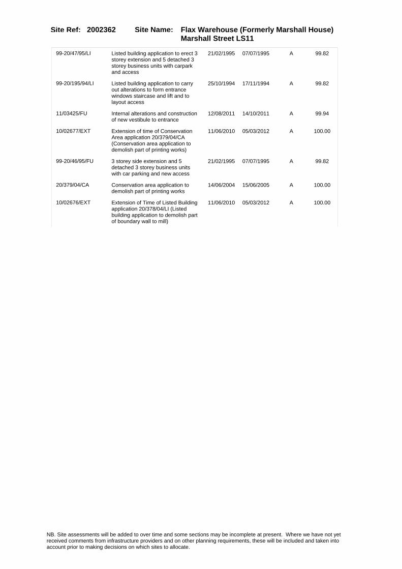
Site Name: Flax Warehouse (Formerly Marshall House) Marshall Street LS11
Site Ref: 2002362
99-20/47/95/LI Listed building application to erect 3 storey extension and 5 detached 3 storey business units with carpark and access
21/02/1995 07/07/1995 A 99.82
99-20/195/94/LI Listed building application to carry out alterations to form entrance windows staircase and lift and to layout access
25/10/1994 17/11/1994 A 99.82
11/03425/FU Internal alterations and construction of new vestibule to entrance
12/08/2011 14/10/2011 A 99.94
10/02677/EXT Extension of time of Conservation Area application 20/379/04/CA (Conservation area application to demolish part of printing works)
11/06/2010 05/03/2012 A 100.00
99-20/46/95/FU 3 storey side extension and 5 detached 3 storey business units with car parking and new access
21/02/1995 07/07/1995 A 99.82
20/379/04/CA Conservation area application to demolish part of printing works
14/06/2004 15/06/2005 A 100.00
10/02676/EXT Extension of Time of Listed Building application 20/378/04/LI (Listed building application to demolish part of boundary wall to mill)
11/06/2010 05/03/2012 A 100.00
NB. Site assessments will be added to over time and some sections may be incomplete at present. Where we have not yet received comments from infrastructure providers and on other planning requirements, these will be included and taken into account prior to making decisions on which sites to allocate.

Site Name: Flax Warehouse (Formerly Marshall House) Marshall Street LS11
Site Ref: 2002362
Conformity with Core Strategy
Inner South Leeds: 0.00
Leeds Bradford Corridor: 0.00 West Leeds Gateway: 0.00
Aire Valley: 0.00Regeneration Priority Area:
Brownfield
Greenfield
Mixed
Main Urban Area
Major Settlement
Smaller Settlement
Villages/Rural
Main Urban Area Extension
Major Settlement Extension
Smaller Settlement Extension
Village/Rural Extension
Development unrelated to existing development
Green Belt assessment - only completed where site is within Green Belt
Would development lead to/constitute ribbon development?
Would development result in isolated development?
Is the site well connected to built up area (2+ boundaries with existing built up area)?
Would development of the site effectively "round off" the settlement pattern?:
Do natural/physical features provide a good existing barrier between existing urban area and undeveloped land?
Overall sprawl conclusion:
Would development of the site lead to physical connection of settlements?
Do natural/physical features provide a good existing barrier/boundary to contain development?
Overall Coalescence Conclusion:
Is there a strong defensible boundary between the site and the existing urban area?
Does the site provide access to the countryside?
Does the site include local or national conservation designated areas?
Does the site include areas of woodlands, trees, hedgerows that are protected, or significant unprotected tree/hedge cover?
Does the site include grade 1, 2, or 3a agricultural land?
Does the site contain buildings? Are these in agricultural use?
Overall countryside Encroachment Conclusion
Is the site within or adjacent to a conservation area, listed building or other historical feature?
If yes, could development preserve this character?:
Overall Character Preservation Conclusion:
Greenbelt Assessment Conclusion:
Check the unrestricted sprawl of large built up areas
Prevent neighbouring towns from merging
Assist in safeguarding countryside from encroachment
Preserve the setting and special character of historic towns
NB. Site assessments will be added to over time and some sections may be incomplete at present. Where we have not yet received comments from infrastructure providers and on other planning requirements, these will be included and taken into account prior to making decisions on which sites to allocate.

Site Name: Flax Warehouse (Formerly Marshall House) Marshall Street LS11
Site Ref: 2002362
SHLAA ConclusionsAvailability: Suitability: Achievability:
Conclusion of Assessment
Conclusion summary:
Consent for change of use to commercial uses including use for offices on 1st & 2nd floors; 08/04754/FU expires 23/6/2012.
Floorspace sq m (Non residential): 390
Employment Conclusion: Lime Green
East Leeds
Assesment Type: ELR Type: Office
Proposed Change:
Gypsy Traveller Site Assessment
Yes No Maybe Could site be effectively managed (Text)
Yes No Maybe Would gypsies and travellers live on the site?
(Text)
Yes No Proximity to housed gypsies and travellers (Text)
Yes No Unknown Experience of previous encampments (Text)
NB. Site assessments will be added to over time and some sections may be incomplete at present. Where we have not yet received comments from infrastructure providers and on other planning requirements, these will be included and taken into account prior to making decisions on which sites to allocate.

Site Name: WHITEHALL RIVERSIDE WHITEHALL ROAD LS1
Site Ref: 2002400
Site Details
Land Use
Northing: 433214
Easting: 429403
Distance to Rail Station (metres): 290.53
Nearest Railway Station Leeds City
Distance to bus stop (metres) 105.02
Bus Stop ID 7872
Agricultural Land Class:
SFRA Flood Zone: 1.00
Environment Agency Flood Zone: 1.00
Within 300m of retail centre boundary:
UDP Designation
Greenbelt - N32 (%): 0.00 Urban Green Corridor - N8 (%): 0.00
Protected Area of Search site - N34 (%): 0.00 Rural Land - RL1: 0.00
City Centre Primary Shopping Quarter - CC27 (%): 0.00 Town Centre - S2: 0.00
Health and Safety Executive Hazard: No
Health and Safety Executive Gas Pipeline: No
Strategic Employment Buffer: 100.00
Area sq m: 16952.24 Ward City and Hunslet
Special Landscape Area - N37: 0.00
Allotments - N1A: 0.00
Proposed Greenspace - N5: 0.00
Protected Playing Pitch - N6: 0.00
Nature Conservation Area - N50: 0.00
Conservation Areas No
Ancient Monument/Battlefield(%): 0.00 Listed Buildings: No
Public Rights of Way: No
Other?:
Natural Resources and waste DPD (if applicable)
Within Minerals Safeguarding Site?: No Within 100m of Minerals Safeguarding Site?: No
HMCA: City Centre
Greenspace - N1: 0
Existing Use 1:
Existing Use 2:
Existing Use 3:
Neighbouring Use 1
Neighbouring Use 2:
Neighbouring Use 3:
Other uses:
Topography:
Natural Landscape:
Boundaries:
Road Frontage
Site Characteristics
Site Detail
Other comments/observations on site characteristics:
Area Ha: 1.695224
Site State:
NB. Site assessments will be added to over time and some sections may be incomplete at present. Where we have not yet received comments from infrastructure providers and on other planning requirements, these will be included and taken into account prior to making decisions on which sites to allocate.

Site Name: WHITEHALL RIVERSIDE WHITEHALL ROAD LS1
Site Ref: 2002400
Planning History
Planning App No. Proposal Received Decision Status Site %
20/97/97/RE Renewal of outline permission to erect 7 office blocks and mixed use block
25/02/1997 25/01/1999 A 96.39
20/88/94/FU Variation of condition nos 1 and 3 and deletion of condition nos 5 and 7 of application no 20/122/93/re
09/03/1994 20/06/1994 R 95.75
07/01930/FU Retention of temporary car park for period of 3 years
22/03/2007 19/06/2007 W 74.11
H20/53/89/ Laying out of enlarged tempora ry car park, to cleared site.
03/02/1989 27/06/1991 W 95.45
20/296/03/RE Extension of temporary permission for use of cleared site as car park
08/08/2003 13/10/2003 A 93.23
20/123/93/FU Use of cleared site as car park 19/04/1993 10/08/1993 R 95.75
20/299/00/OT Outline application to erect 4 office blocks 2 residential blocks 2 cafe bars, retail units & multi storey car park
27/06/2000 10/10/2001 A 96.15
H20/485/91/ Laying out of enlarged tempora ry car park with lands caping to cleared site.
18/10/1991 17/01/1992 A 95.84
20/456/03/RM 8 storey office block with 2 basement level car parking areas
17/12/2003 17/03/2004 A 29.09
H20/303/88/ Use of land for temporary car parking. 06/06/1988 12/08/1988 A 95.35
H20/179/89/ Outline application to layout access and erect part six s torey and part four storey off ice block, with 2 level base
19/04/1989 04/06/1991 W 95.08
10/04375/FU Retention of surface car park for period of 5 years (423 spaces)
24/09/2010 19/03/2012 A 73.45
20/145/99/RE Renewal of outline permission to layout access and erect 7 detached office blocks aand mixed use block
12/03/1999 14/06/1999 A 96.79
H20/303/88/1 Amendment to previous applicat ion, involving removal ofcondi tion no.7 for the use of land for temporary car parking.
08/02/1989 27/02/1989 R 95.56
20/379/94/RE Extension of temporary permission for car park and vehicular access
14/09/1994 08/11/1994 A 95.75
H20/543/86/ Outline application to erect r etail warehouses and garde n centre to site of existing w orks. (site area
24/12/1986 10/08/1987 R 95.42
06/01849/FU Retention of site as car park 21/03/2006 15/02/2007 W 71.59
20/264/93/FU Alterations to vehicular access to car park
02/08/1993 17/09/1993 A 95.75
20/44/95/FU Amendment to condition nos 1 and 3 of application no 20/379/94/re (no of parking spaces & extension of time)
10/02/1995 16/05/1995 A 95.73
20/261/01/RE Extension of temporary permission for use of cleared site as car park
30/05/2001 31/07/2001 A 95.84
H20/507/89/1 Extension of temporary permiss ion to lay out enlarged car p ark with landscaping to cleare d site. (previous
20/09/1990 05/02/1992 W 94.80
NB. Site assessments will be added to over time and some sections may be incomplete at present. Where we have not yet received comments from infrastructure providers and on other planning requirements, these will be included and taken into account prior to making decisions on which sites to allocate.

Site Name: WHITEHALL RIVERSIDE WHITEHALL ROAD LS1
Site Ref: 2002400
20/303/02/RE Extension of temporary permission for use of cleared site as car park
31/07/2002 16/09/2002 A 89.55
12/02227/ADV One illuminated sign and one non illuminated sign
18/05/2012 12/07/2012 A 15.08
20/543/01/RM Part 16 storey and part 11 storey block of 193 flats offices and a3 food and drink use unit & basement parking
17/10/2001 08/03/2002 A 96.15
20/473/99/RE Temporary use of cleared site as car park
07/09/1999 13/06/2000 A 95.84
20/25/97/FU Temporary use of cleared site as car park
21/01/1997 02/11/1998 A 95.73
20/326/92/FU Laying out of car park 28/08/1992 10/08/1993 R 95.75
20/122/93/RE Extension of temporary permission for car park to cleared site
19/04/1993 10/08/1993 A 95.75
H20/212/89/ Outline application, to lay ou t access road and erect 7 det ached office blocks, having a gross external floorarea of 31
23/05/1989 30/05/1991 A 96.69
H20/507/89/ Laying out of enlarged tempora ry car park with lands caping to cleared site.
27/09/1989 06/11/1989 A 95.58
0-20/52/04/MOD 8 storey office block with ground floor cafe/bar and undercroft car parking
02/12/2004 23/03/2005 M01 29.59
11/04023/FU Part 6 and part 10 storey mixed use development comprising office space (Class B1) and 130 bed hotel (Class C1) with basement car parking
23/09/2011 23/12/2011 A 19.69
20/161/99/OT Outline application to erect 3 office buildings multi storey car park, cafe & ext to form restaurant to lifting tower
26/03/1999 23/03/2000 A 93.14
20/31/94/RE Renewal of outline permission ref. 89/20/00212 to layout access & erect 7 det office blocks & mixed use block
24/01/1994 26/05/1994 A 95.72
H20/544/86/ Outline application to erect r etail warehouses and garde n centre to site of existing w orks. (site area
24/12/1986 10/08/1987 R 95.38
20/192/04/FU Part 10 part 12 storey office block with undercroft car parking
27/04/2004 29/07/2004 A 23.28
06/04682/FU 11 storey office block (elevational changes to previous approval 20/192/04/FU)
02/08/2006 09/11/2006 A 23.28
20/295/03/FU 8 storey office block with ground floor cafe/bar and undercroft car parking
04/08/2003 11/11/2003 A 29.59
NB. Site assessments will be added to over time and some sections may be incomplete at present. Where we have not yet received comments from infrastructure providers and on other planning requirements, these will be included and taken into account prior to making decisions on which sites to allocate.

Site Name: WHITEHALL RIVERSIDE WHITEHALL ROAD LS1
Site Ref: 2002400
Conformity with Core Strategy
Inner South Leeds: 0.00
Leeds Bradford Corridor: 0.00 West Leeds Gateway: 0.00
Aire Valley: 0.00Regeneration Priority Area:
Brownfield
Greenfield
Mixed
Main Urban Area
Major Settlement
Smaller Settlement
Villages/Rural
Main Urban Area Extension
Major Settlement Extension
Smaller Settlement Extension
Village/Rural Extension
Development unrelated to existing development
Green Belt assessment - only completed where site is within Green Belt
Would development lead to/constitute ribbon development?
Would development result in isolated development?
Is the site well connected to built up area (2+ boundaries with existing built up area)?
Would development of the site effectively "round off" the settlement pattern?:
Do natural/physical features provide a good existing barrier between existing urban area and undeveloped land?
Overall sprawl conclusion:
Would development of the site lead to physical connection of settlements?
Do natural/physical features provide a good existing barrier/boundary to contain development?
Overall Coalescence Conclusion:
Is there a strong defensible boundary between the site and the existing urban area?
Does the site provide access to the countryside?
Does the site include local or national conservation designated areas?
Does the site include areas of woodlands, trees, hedgerows that are protected, or significant unprotected tree/hedge cover?
Does the site include grade 1, 2, or 3a agricultural land?
Does the site contain buildings? Are these in agricultural use?
Overall countryside Encroachment Conclusion
Is the site within or adjacent to a conservation area, listed building or other historical feature?
If yes, could development preserve this character?:
Overall Character Preservation Conclusion:
Greenbelt Assessment Conclusion:
Check the unrestricted sprawl of large built up areas
Prevent neighbouring towns from merging
Assist in safeguarding countryside from encroachment
Preserve the setting and special character of historic towns
NB. Site assessments will be added to over time and some sections may be incomplete at present. Where we have not yet received comments from infrastructure providers and on other planning requirements, these will be included and taken into account prior to making decisions on which sites to allocate.

Site Name: WHITEHALL RIVERSIDE WHITEHALL ROAD LS1
Site Ref: 2002400
SHLAA ConclusionsAvailability: Suitability: Achievability:
Conclusion of Assessment
Conclusion summary:
High-density employment opportunity in accessible city centre location.
Floorspace sq m (Non residential): 26930
Employment Conclusion: Green
East Leeds
Assesment Type: ELR Type: Office
Proposed Change:
Gypsy Traveller Site Assessment
Yes No Maybe Could site be effectively managed (Text)
Yes No Maybe Would gypsies and travellers live on the site?
(Text)
Yes No Proximity to housed gypsies and travellers (Text)
Yes No Unknown Experience of previous encampments (Text)
NB. Site assessments will be added to over time and some sections may be incomplete at present. Where we have not yet received comments from infrastructure providers and on other planning requirements, these will be included and taken into account prior to making decisions on which sites to allocate.
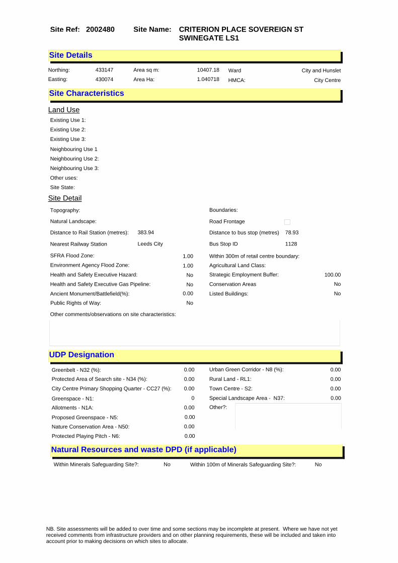
Site Name: CRITERION PLACE SOVEREIGN ST SWINEGATE LS1
Site Ref: 2002480
Site Details
Land Use
Northing: 433147
Easting: 430074
Distance to Rail Station (metres): 383.94
Nearest Railway Station Leeds City
Distance to bus stop (metres) 78.93
Bus Stop ID 1128
Agricultural Land Class:
SFRA Flood Zone: 1.00
Environment Agency Flood Zone: 1.00
Within 300m of retail centre boundary:
UDP Designation
Greenbelt - N32 (%): 0.00 Urban Green Corridor - N8 (%): 0.00
Protected Area of Search site - N34 (%): 0.00 Rural Land - RL1: 0.00
City Centre Primary Shopping Quarter - CC27 (%): 0.00 Town Centre - S2: 0.00
Health and Safety Executive Hazard: No
Health and Safety Executive Gas Pipeline: No
Strategic Employment Buffer: 100.00
Area sq m: 10407.18 Ward City and Hunslet
Special Landscape Area - N37: 0.00
Allotments - N1A: 0.00
Proposed Greenspace - N5: 0.00
Protected Playing Pitch - N6: 0.00
Nature Conservation Area - N50: 0.00
Conservation Areas No
Ancient Monument/Battlefield(%): 0.00 Listed Buildings: No
Public Rights of Way: No
Other?:
Natural Resources and waste DPD (if applicable)
Within Minerals Safeguarding Site?: No Within 100m of Minerals Safeguarding Site?: No
HMCA: City Centre
Greenspace - N1: 0
Existing Use 1:
Existing Use 2:
Existing Use 3:
Neighbouring Use 1
Neighbouring Use 2:
Neighbouring Use 3:
Other uses:
Topography:
Natural Landscape:
Boundaries:
Road Frontage
Site Characteristics
Site Detail
Other comments/observations on site characteristics:
Area Ha: 1.040718
Site State:
NB. Site assessments will be added to over time and some sections may be incomplete at present. Where we have not yet received comments from infrastructure providers and on other planning requirements, these will be included and taken into account prior to making decisions on which sites to allocate.

Site Name: CRITERION PLACE SOVEREIGN ST SWINEGATE LS1
Site Ref: 2002480
Planning History
Planning App No. Proposal Received Decision Status Site %
H20/629/89/99 Use of cleared site as tempora ry car park.
06/12/1989 14/12/1989 A 89.78
99-20/174/94/RE Extension of temporary permission fof use of cleared site as car park
26/09/1994 20/10/1994 A 91.88
12/04018/FU Four storey office development with basement car parking and landscaping
20/09/2012 03/12/2012 A 28.96
H20/41/75/ Change of use of existing film theatre, and part car park to 6 squash courts, with chang ing and clubroom facilities
31/01/1975 24/02/1975 A 72.68
H20/315/82/ Alterations, including 6 fire exit doors, to exhibitionhall.
03/09/1982 28/09/1982 A 72.68
99-20/43/95/RM Part five and part six storey office development with basement car parking and landscaping
16/02/1995 15/05/1995 A 55.07
20/260/96/RM Amendment to elevations and extended fifth floor to part five and part six storey office development
20/05/1996 16/08/1996 A 55.07
99-20/160/95/RE Extension of permission to layout new roadbridge and roads with landscaping
25/09/1995 14/11/1995 A 11.84
12/04503/ADV Four illuminated signs to proposed office development
22/10/2012 03/12/2012 A 28.96
07/05355/FU Two storey temporary car parking deck to existing multi-storey car park to provide 132 additional car parking spaces
22/08/2007 07/12/2007 W 25.34
20/382/04/FU Alterations to enclose external seating area including new frontage to restaurant
17/08/2004 12/10/2004 A 56.00
H20/273/90/99 Change of use of cleared site to temporary car park.
07/06/1990 16/08/1990 A 89.93
20/608/97/FU Laying out of access to car park 30/10/1997 11/11/1998 A 91.88
99-20/201/93/RE Extension of temporary permission for use of cleared site as car park
19/10/1993 18/11/1993 A 91.88
H20/249/82/ Alterations and extension, inc luding part new roof, to exhib ition hall.
14/07/1982 26/07/1982 A 72.41
11/04556/LA 5 non-illuminated free standing hoardings
28/10/2011 06/12/2011 A 99.24
H20/331/89/99 Outline application to layout accesses and erect officeblock s, retail and leisure with gal leria and car parking an
14/07/1989 26/07/1991 W 100.00
H20/332/89/99 Outline application to lay out accesses and erect offic e blocks, retail and leisure u nits with galleria and altera
14/07/1989 26/07/1991 W 100.00
H20/258/77/ Alterations, including new st aircases and to form 2 add itional squash courts, with vi ewing galleries, to squash
20/06/1977 18/07/1977 A 72.57
NB. Site assessments will be added to over time and some sections may be incomplete at present. Where we have not yet received comments from infrastructure providers and on other planning requirements, these will be included and taken into account prior to making decisions on which sites to allocate.

Site Name: CRITERION PLACE SOVEREIGN ST SWINEGATE LS1
Site Ref: 2002480
H20/45/91/99 Outline application to layout access roads and erect shops , offices, and leisure facilit ies, with public open space
15/02/1991 19/01/1995 A 99.99
H20/51/91/99 Extension of temporary permiss ion for use of cleared site as temporary car park. (previous
15/02/1991 21/11/1991 A 97.61
12/04017/LA Change of use from car park to public realm and amenity space, to include paving, water feature, drainage, exterior lighting and associated soft landscaping works
20/09/2012 03/12/2012 A 45.34
NB. Site assessments will be added to over time and some sections may be incomplete at present. Where we have not yet received comments from infrastructure providers and on other planning requirements, these will be included and taken into account prior to making decisions on which sites to allocate.

Site Name: CRITERION PLACE SOVEREIGN ST SWINEGATE LS1
Site Ref: 2002480
Conformity with Core Strategy
Inner South Leeds: 0.00
Leeds Bradford Corridor: 0.00 West Leeds Gateway: 0.00
Aire Valley: 0.00Regeneration Priority Area:
Brownfield
Greenfield
Mixed
Main Urban Area
Major Settlement
Smaller Settlement
Villages/Rural
Main Urban Area Extension
Major Settlement Extension
Smaller Settlement Extension
Village/Rural Extension
Development unrelated to existing development
Green Belt assessment - only completed where site is within Green Belt
Would development lead to/constitute ribbon development?
Would development result in isolated development?
Is the site well connected to built up area (2+ boundaries with existing built up area)?
Would development of the site effectively "round off" the settlement pattern?:
Do natural/physical features provide a good existing barrier between existing urban area and undeveloped land?
Overall sprawl conclusion:
Would development of the site lead to physical connection of settlements?
Do natural/physical features provide a good existing barrier/boundary to contain development?
Overall Coalescence Conclusion:
Is there a strong defensible boundary between the site and the existing urban area?
Does the site provide access to the countryside?
Does the site include local or national conservation designated areas?
Does the site include areas of woodlands, trees, hedgerows that are protected, or significant unprotected tree/hedge cover?
Does the site include grade 1, 2, or 3a agricultural land?
Does the site contain buildings? Are these in agricultural use?
Overall countryside Encroachment Conclusion
Is the site within or adjacent to a conservation area, listed building or other historical feature?
If yes, could development preserve this character?:
Overall Character Preservation Conclusion:
Greenbelt Assessment Conclusion:
Check the unrestricted sprawl of large built up areas
Prevent neighbouring towns from merging
Assist in safeguarding countryside from encroachment
Preserve the setting and special character of historic towns
NB. Site assessments will be added to over time and some sections may be incomplete at present. Where we have not yet received comments from infrastructure providers and on other planning requirements, these will be included and taken into account prior to making decisions on which sites to allocate.

Site Name: CRITERION PLACE SOVEREIGN ST SWINEGATE LS1
Site Ref: 2002480
SHLAA ConclusionsAvailability: Suitability: Achievability:
Conclusion of Assessment
Conclusion summary:
Opportunity to create a high-density, high-accessibility employment location at a high-profile position in the city centre.
Floorspace sq m (Non residential): 12596
Employment Conclusion: Green
East Leeds
Assesment Type: ELR Type: Office
Proposed Change:
Gypsy Traveller Site Assessment
Yes No Maybe Could site be effectively managed (Text)
Yes No Maybe Would gypsies and travellers live on the site?
(Text)
Yes No Proximity to housed gypsies and travellers (Text)
Yes No Unknown Experience of previous encampments (Text)
NB. Site assessments will be added to over time and some sections may be incomplete at present. Where we have not yet received comments from infrastructure providers and on other planning requirements, these will be included and taken into account prior to making decisions on which sites to allocate.

Site Name: Wellbridge Industrial Estate Graingers Way LS12
Site Ref: 2002611
Site Details
Land Use
Northing: 433193
Easting: 428964
Distance to Rail Station (metres): 727.85
Nearest Railway Station Leeds City
Distance to bus stop (metres) 181.94
Bus Stop ID 789
Agricultural Land Class:
SFRA Flood Zone: 1.00
Environment Agency Flood Zone: 1.00
Within 300m of retail centre boundary:
UDP Designation
Greenbelt - N32 (%): 0.00 Urban Green Corridor - N8 (%): 0.00
Protected Area of Search site - N34 (%): 0.00 Rural Land - RL1: 0.00
City Centre Primary Shopping Quarter - CC27 (%): 0.00 Town Centre - S2: 0.00
Health and Safety Executive Hazard: No
Health and Safety Executive Gas Pipeline: No
Strategic Employment Buffer: 100.00
Area sq m: 4590.24 Ward City and Hunslet
Special Landscape Area - N37: 0.00
Allotments - N1A: 0.00
Proposed Greenspace - N5: 0.00
Protected Playing Pitch - N6: 0.00
Nature Conservation Area - N50: 0.00
Conservation Areas No
Ancient Monument/Battlefield(%): 0.00 Listed Buildings: No
Public Rights of Way: No
Other?:
Natural Resources and waste DPD (if applicable)
Within Minerals Safeguarding Site?: No Within 100m of Minerals Safeguarding Site?: No
HMCA: Inner Areas
Greenspace - N1: 0
Existing Use 1:
Existing Use 2:
Existing Use 3:
Neighbouring Use 1
Neighbouring Use 2:
Neighbouring Use 3:
Other uses:
Topography:
Natural Landscape:
Boundaries:
Road Frontage
Site Characteristics
Site Detail
Other comments/observations on site characteristics:
Area Ha: 0.459024
Site State:
NB. Site assessments will be added to over time and some sections may be incomplete at present. Where we have not yet received comments from infrastructure providers and on other planning requirements, these will be included and taken into account prior to making decisions on which sites to allocate.
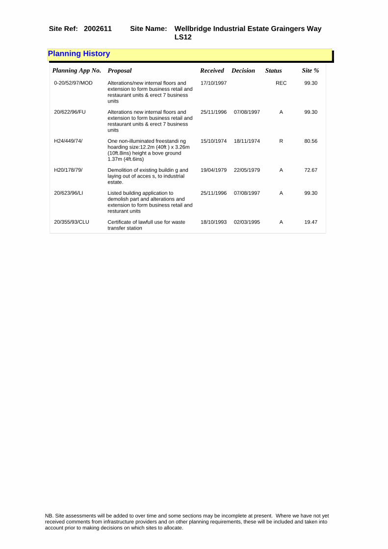
Site Name: Wellbridge Industrial Estate Graingers Way LS12
Site Ref: 2002611
Planning History
Planning App No. Proposal Received Decision Status Site %
0-20/52/97/MOD Alterations/new internal floors and extension to form business retail and restaurant units & erect 7 business units
17/10/1997 REC 99.30
20/622/96/FU Alterations new internal floors and extension to form business retail and restaurant units & erect 7 business units
25/11/1996 07/08/1997 A 99.30
H24/449/74/ One non-illuminated freestandi ng hoarding size:12.2m (40ft ) x 3.26m (10ft.8ins) height a bove ground 1.37m (4ft.6ins)
15/10/1974 18/11/1974 R 80.56
H20/178/79/ Demolition of existing buildin g and laying out of acces s, to industrial estate.
19/04/1979 22/05/1979 A 72.67
20/623/96/LI Listed building application to demolish part and alterations and extension to form business retail and resturant units
25/11/1996 07/08/1997 A 99.30
20/355/93/CLU Certificate of lawfull use for waste transfer station
18/10/1993 02/03/1995 A 19.47
NB. Site assessments will be added to over time and some sections may be incomplete at present. Where we have not yet received comments from infrastructure providers and on other planning requirements, these will be included and taken into account prior to making decisions on which sites to allocate.

Site Name: Wellbridge Industrial Estate Graingers Way LS12
Site Ref: 2002611
Conformity with Core Strategy
Inner South Leeds: 0.00
Leeds Bradford Corridor: 0.00 West Leeds Gateway: 0.00
Aire Valley: 0.00Regeneration Priority Area:
Brownfield
Greenfield
Mixed
Main Urban Area
Major Settlement
Smaller Settlement
Villages/Rural
Main Urban Area Extension
Major Settlement Extension
Smaller Settlement Extension
Village/Rural Extension
Development unrelated to existing development
Green Belt assessment - only completed where site is within Green Belt
Would development lead to/constitute ribbon development?
Would development result in isolated development?
Is the site well connected to built up area (2+ boundaries with existing built up area)?
Would development of the site effectively "round off" the settlement pattern?:
Do natural/physical features provide a good existing barrier between existing urban area and undeveloped land?
Overall sprawl conclusion:
Would development of the site lead to physical connection of settlements?
Do natural/physical features provide a good existing barrier/boundary to contain development?
Overall Coalescence Conclusion:
Is there a strong defensible boundary between the site and the existing urban area?
Does the site provide access to the countryside?
Does the site include local or national conservation designated areas?
Does the site include areas of woodlands, trees, hedgerows that are protected, or significant unprotected tree/hedge cover?
Does the site include grade 1, 2, or 3a agricultural land?
Does the site contain buildings? Are these in agricultural use?
Overall countryside Encroachment Conclusion
Is the site within or adjacent to a conservation area, listed building or other historical feature?
If yes, could development preserve this character?:
Overall Character Preservation Conclusion:
Greenbelt Assessment Conclusion:
Check the unrestricted sprawl of large built up areas
Prevent neighbouring towns from merging
Assist in safeguarding countryside from encroachment
Preserve the setting and special character of historic towns
NB. Site assessments will be added to over time and some sections may be incomplete at present. Where we have not yet received comments from infrastructure providers and on other planning requirements, these will be included and taken into account prior to making decisions on which sites to allocate.
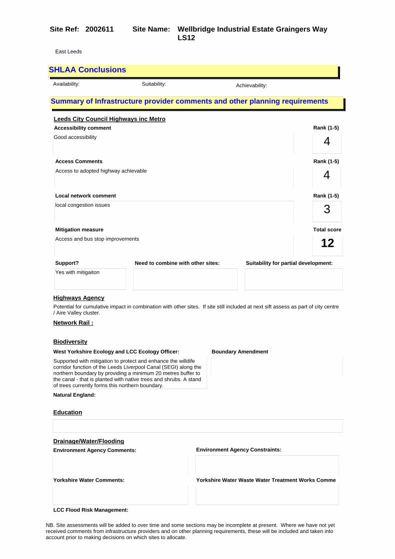
Site Name: Wellbridge Industrial Estate Graingers Way LS12
Site Ref: 2002611
SHLAA ConclusionsAvailability: Suitability: Achievability:
East Leeds
Summary of Infrastructure provider comments and other planning requirements
Accessibility commentGood accessibility
Rank (1-5)
4Access Comments
Access to adopted highway achievable
Local network comment
local congestion issues
Rank (1-5)
4Rank (1-5)
3
Leeds City Council Highways inc Metro
Highways Agency
Network Rail :
Biodiversity
Natural England:
Education
Mitigation measure
Access and bus stop improvements
Total score
12Support?
Yes with mitigaiton
Need to combine with other sites: Suitability for partial development:
West Yorkshire Ecology and LCC Ecology Officer:
Supported with mitigation to protect and enhance the willdife corridor function of the Leeds Liverpool Canal (SEGI) along the northern boundary by providing a minimum 20 metres buffer to the canal - that is planted with native trees and shrubs. A stand of trees currently forms this northern boundary.
Boundary Amendment
Drainage/Water/FloodingEnvironment Agency Comments: Environment Agency Constraints:
Yorkshire Water Comments: Yorkshire Water Waste Water Treatment Works Comme
Potential for cumulative impact in combination with other sites. If site still included at next sift assess as part of city centre / Aire Valley cluster.
LCC Flood Risk Management:
NB. Site assessments will be added to over time and some sections may be incomplete at present. Where we have not yet received comments from infrastructure providers and on other planning requirements, these will be included and taken into account prior to making decisions on which sites to allocate.
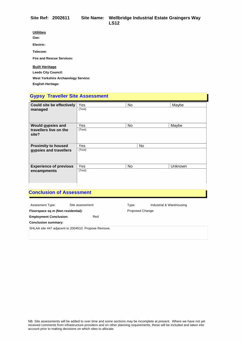
Site Name: Wellbridge Industrial Estate Graingers Way LS12
Site Ref: 2002611
Conclusion of Assessment
Conclusion summary:
SHLAA site 447 adjacent to 2004510. Propose Remove.
Floorspace sq m (Non residential):
Employment Conclusion: Red
Assesment Type: Site assessment Type: Industrial & Warehousing
Proposed Change:
UtilitiesGas:
Electric:
Telecom:
Fire and Rescue Services:
Built HeritageLeeds City Council:
West Yorkshire Archaeology Service:
English Heritage:
Gypsy Traveller Site Assessment
Yes No Maybe Could site be effectively managed (Text)
Yes No Maybe Would gypsies and travellers live on the site?
(Text)
Yes No Proximity to housed gypsies and travellers (Text)
Yes No Unknown Experience of previous encampments (Text)
NB. Site assessments will be added to over time and some sections may be incomplete at present. Where we have not yet received comments from infrastructure providers and on other planning requirements, these will be included and taken into account prior to making decisions on which sites to allocate.

Site Name: Adj West Point Wellington Street LS1Site Ref: 2003139
Site Details
Land Use
Northing: 433393
Easting: 429577
Distance to Rail Station (metres): 232.47
Nearest Railway Station Leeds City
Distance to bus stop (metres) 31.43
Bus Stop ID 10619
Agricultural Land Class:
SFRA Flood Zone: 1.00
Environment Agency Flood Zone: 1.00
Within 300m of retail centre boundary:
UDP Designation
Greenbelt - N32 (%): 0.00 Urban Green Corridor - N8 (%): 0.00
Protected Area of Search site - N34 (%): 0.00 Rural Land - RL1: 0.00
City Centre Primary Shopping Quarter - CC27 (%): 0.00 Town Centre - S2: 0.00
Health and Safety Executive Hazard: No
Health and Safety Executive Gas Pipeline: No
Strategic Employment Buffer: 100.00
Area sq m: 3637.54 Ward City and Hunslet
Special Landscape Area - N37: 0.00
Allotments - N1A: 0.00
Proposed Greenspace - N5: 0.00
Protected Playing Pitch - N6: 0.00
Nature Conservation Area - N50: 0.00
Conservation Areas No
Ancient Monument/Battlefield(%): 0.00 Listed Buildings: No
Public Rights of Way: No
Other?:
Natural Resources and waste DPD (if applicable)
Within Minerals Safeguarding Site?: No Within 100m of Minerals Safeguarding Site?: No
HMCA: City Centre
Greenspace - N1: 0
Existing Use 1:
Existing Use 2:
Existing Use 3:
Neighbouring Use 1
Neighbouring Use 2:
Neighbouring Use 3:
Other uses:
Topography:
Natural Landscape:
Boundaries:
Road Frontage
Site Characteristics
Site Detail
Other comments/observations on site characteristics:
Area Ha: 0.363754
Site State:
NB. Site assessments will be added to over time and some sections may be incomplete at present. Where we have not yet received comments from infrastructure providers and on other planning requirements, these will be included and taken into account prior to making decisions on which sites to allocate.
Site Name: Adj West Point Wellington Street LS1Site Ref: 2003139
Planning History
Planning App No. Proposal Received Decision Status Site %
H20/464/90/ Alterations including new entr ance and extension to form entrance lobby and enlarged fo yer to office.
27/09/1990 23/04/1991 A 39.88
20/63/03/FU Amendment to 20/314/00 to form pt9/pt10 storey office block inc 2 retail/food and drink units and basement car park
14/02/2003 16/05/2003 A 99.99
H20/333/84/ Laying out of enlarged access to postal sorting office and erection of a replacement gate house.
30/07/1984 13/08/1984 A 99.45
H20/378/85/ Detached prefabricated office unit to roof of exist ing offices.
06/08/1985 21/10/1985 R 99.92
08/01914/FU Erection of 33 storey and 55 storey development with connecting covered public winter garden, comprising 832 flats, 120 serviced apartments, offices, health centre, ground floor and mezzanine level retail uses (A1,A3, A4 and A5) and basement car parking, with landscaping. (Revision to permission 06/01622/FU approved 4th April 2007)
31/03/2008 08/02/2010 R 99.78
20/511/05/FU Alterations including new frontage to 4 retail units and new cash dispenser machine to mixed development
02/11/2005 22/12/2005 A 99.95
12/03788/FU Planning Permission in Outline for a maximum of 11,616 sqm gross internal area of new office (B1) with A1, A2, A3, A4, A5 or B1 uses at ground floor or hotel (C1) development, with all matters reserved. Full Planning Permission for basement plant and parking for 85 cars with a GIA 3,320 sqm, and an office building (B1) of 16,086 sqm gross internal area with A1, A2, A3, A4, A5 or B1 uses at ground floor
03/09/2012 PCO 100.00
H20/354/90/ Laying out of paved area, acce ss ramp and landscaping to fr ont of postal sorting office.
16/08/1990 12/02/1991 A 40.28
20/314/00/FU Change of use and extensions of offices to flats new hotel offices a1 and a3 uses with basement car parking
30/06/2000 07/08/2001 A 99.95
H20/248/84/ Alterations and addition of ba rbed wire to form 2.9m perim eter fence to post office.
13/06/1984 23/01/1985 A 99.55
H20/4/79/ Addition of two, 3.6m. high ra dio aerials, to offices and p ostal sorting office.
03/01/1979 29/01/1979 A 85.62
06/01622/FU Erection of 32 storey and 54 storey development with connecting covered public winter garden, comprising 838 flats, offices, health centre, ground floor retail uses (class A1, A3, A4 and A5) with basement car parking
10/03/2006 04/04/2007 A 99.83
H20/141/91/ Alterations and addition of ca nopy to sorting office.
23/04/1991 11/06/1991 A 38.28
NB. Site assessments will be added to over time and some sections may be incomplete at present. Where we have not yet received comments from infrastructure providers and on other planning requirements, these will be included and taken into account prior to making decisions on which sites to allocate.
Site Name: Adj West Point Wellington Street LS1Site Ref: 2003139
20/9/95/FU 7 1.25 metre high bollards to sorting office
09/01/1995 17/02/1995 A 99.93
20/327/97/FU 2.4m high fence to sorting office 04/06/1997 19/08/1997 A 99.93
0-20/63/97/MOD 2.4 high fence to sorting office 02/12/1997 09/12/1997 M01 99.93
NB. Site assessments will be added to over time and some sections may be incomplete at present. Where we have not yet received comments from infrastructure providers and on other planning requirements, these will be included and taken into account prior to making decisions on which sites to allocate.

Site Name: Adj West Point Wellington Street LS1Site Ref: 2003139
Conformity with Core Strategy
Inner South Leeds: 0.00
Leeds Bradford Corridor: 0.00 West Leeds Gateway: 0.00
Aire Valley: 0.00Regeneration Priority Area:
Brownfield
Greenfield
Mixed
Main Urban Area
Major Settlement
Smaller Settlement
Villages/Rural
Main Urban Area Extension
Major Settlement Extension
Smaller Settlement Extension
Village/Rural Extension
Development unrelated to existing development
Green Belt assessment - only completed where site is within Green Belt
Would development lead to/constitute ribbon development?
Would development result in isolated development?
Is the site well connected to built up area (2+ boundaries with existing built up area)?
Would development of the site effectively "round off" the settlement pattern?:
Do natural/physical features provide a good existing barrier between existing urban area and undeveloped land?
Overall sprawl conclusion:
Would development of the site lead to physical connection of settlements?
Do natural/physical features provide a good existing barrier/boundary to contain development?
Overall Coalescence Conclusion:
Is there a strong defensible boundary between the site and the existing urban area?
Does the site provide access to the countryside?
Does the site include local or national conservation designated areas?
Does the site include areas of woodlands, trees, hedgerows that are protected, or significant unprotected tree/hedge cover?
Does the site include grade 1, 2, or 3a agricultural land?
Does the site contain buildings? Are these in agricultural use?
Overall countryside Encroachment Conclusion
Is the site within or adjacent to a conservation area, listed building or other historical feature?
If yes, could development preserve this character?:
Overall Character Preservation Conclusion:
Greenbelt Assessment Conclusion:
Check the unrestricted sprawl of large built up areas
Prevent neighbouring towns from merging
Assist in safeguarding countryside from encroachment
Preserve the setting and special character of historic towns
NB. Site assessments will be added to over time and some sections may be incomplete at present. Where we have not yet received comments from infrastructure providers and on other planning requirements, these will be included and taken into account prior to making decisions on which sites to allocate.

Site Name: Adj West Point Wellington Street LS1Site Ref: 2003139
SHLAA ConclusionsAvailability: Suitability: Achievability:
Conclusion of Assessment
Conclusion summary:
Pre-app on new leisure scheme with office element
Floorspace sq m (Non residential): 14100
Employment Conclusion: Green
East Leeds
Assesment Type: ELR Type: Office
Proposed Change:
Gypsy Traveller Site Assessment
Yes No Maybe Could site be effectively managed (Text)
Yes No Maybe Would gypsies and travellers live on the site?
(Text)
Yes No Proximity to housed gypsies and travellers (Text)
Yes No Unknown Experience of previous encampments (Text)
NB. Site assessments will be added to over time and some sections may be incomplete at present. Where we have not yet received comments from infrastructure providers and on other planning requirements, these will be included and taken into account prior to making decisions on which sites to allocate.

Site Name: Management Archives 20 Sweet Street West Holbeck LS11 9QT
Site Ref: 2003549
Site Details
Land Use
Northing: 432608
Easting: 429495
Distance to Rail Station (metres): 616.10
Nearest Railway Station Leeds City
Distance to bus stop (metres) 128.01
Bus Stop ID 12632
Agricultural Land Class:
SFRA Flood Zone: 1.00
Environment Agency Flood Zone: 1.00
Within 300m of retail centre boundary:
UDP Designation
Greenbelt - N32 (%): 0.00 Urban Green Corridor - N8 (%): 0.00
Protected Area of Search site - N34 (%): 0.00 Rural Land - RL1: 0.00
City Centre Primary Shopping Quarter - CC27 (%): 0.00 Town Centre - S2: 0.00
Health and Safety Executive Hazard: No
Health and Safety Executive Gas Pipeline: Yes
Strategic Employment Buffer: 100.00
Area sq m: 4523.25 Ward City and Hunslet
Special Landscape Area - N37: 0.00
Allotments - N1A: 0.00
Proposed Greenspace - N5: 0.00
Protected Playing Pitch - N6: 0.00
Nature Conservation Area - N50: 1.00
Conservation Areas Yes
Ancient Monument/Battlefield(%): 0.00 Listed Buildings: No
Public Rights of Way: No
Other?:
Natural Resources and waste DPD (if applicable)
Within Minerals Safeguarding Site?: No Within 100m of Minerals Safeguarding Site?: No
HMCA: City Centre
Greenspace - N1: 0
Existing Use 1:
Existing Use 2:
Existing Use 3:
Neighbouring Use 1
Neighbouring Use 2:
Neighbouring Use 3:
Other uses:
Topography:
Natural Landscape:
Boundaries:
Road Frontage
Site Characteristics
Site Detail
Other comments/observations on site characteristics:
Area Ha: 0.452325
Site State:
NB. Site assessments will be added to over time and some sections may be incomplete at present. Where we have not yet received comments from infrastructure providers and on other planning requirements, these will be included and taken into account prior to making decisions on which sites to allocate.

Site Name: Management Archives 20 Sweet Street West Holbeck LS11 9QT
Site Ref: 2003549
Planning History
Planning App No. Proposal Received Decision Status Site %
08/00195/OT Outline planning application for mixed use development comprising 140 flats, A2/B1 offices, A1/A3 retail at ground floor and basement car parking
14/01/2008 27/04/2010 A 100.00
NB. Site assessments will be added to over time and some sections may be incomplete at present. Where we have not yet received comments from infrastructure providers and on other planning requirements, these will be included and taken into account prior to making decisions on which sites to allocate.

Site Name: Management Archives 20 Sweet Street West Holbeck LS11 9QT
Site Ref: 2003549
Conformity with Core Strategy
Inner South Leeds: 0.00
Leeds Bradford Corridor: 0.00 West Leeds Gateway: 0.00
Aire Valley: 0.00Regeneration Priority Area:
Brownfield
Greenfield
Mixed
Main Urban Area
Major Settlement
Smaller Settlement
Villages/Rural
Main Urban Area Extension
Major Settlement Extension
Smaller Settlement Extension
Village/Rural Extension
Development unrelated to existing development
Green Belt assessment - only completed where site is within Green Belt
Would development lead to/constitute ribbon development?
Would development result in isolated development?
Is the site well connected to built up area (2+ boundaries with existing built up area)?
Would development of the site effectively "round off" the settlement pattern?:
Do natural/physical features provide a good existing barrier between existing urban area and undeveloped land?
Overall sprawl conclusion:
Would development of the site lead to physical connection of settlements?
Do natural/physical features provide a good existing barrier/boundary to contain development?
Overall Coalescence Conclusion:
Is there a strong defensible boundary between the site and the existing urban area?
Does the site provide access to the countryside?
Does the site include local or national conservation designated areas?
Does the site include areas of woodlands, trees, hedgerows that are protected, or significant unprotected tree/hedge cover?
Does the site include grade 1, 2, or 3a agricultural land?
Does the site contain buildings? Are these in agricultural use?
Overall countryside Encroachment Conclusion
Is the site within or adjacent to a conservation area, listed building or other historical feature?
If yes, could development preserve this character?:
Overall Character Preservation Conclusion:
Greenbelt Assessment Conclusion:
Check the unrestricted sprawl of large built up areas
Prevent neighbouring towns from merging
Assist in safeguarding countryside from encroachment
Preserve the setting and special character of historic towns
NB. Site assessments will be added to over time and some sections may be incomplete at present. Where we have not yet received comments from infrastructure providers and on other planning requirements, these will be included and taken into account prior to making decisions on which sites to allocate.

Site Name: Management Archives 20 Sweet Street West Holbeck LS11 9QT
Site Ref: 2003549
SHLAA ConclusionsAvailability: Suitability: Achievability:
Conclusion of Assessment
Conclusion summary:
Current site with planning permission for employment purposes
Floorspace sq m (Non residential): 1470
Employment Conclusion: Lime Green
East Leeds
Assesment Type: ELR Type: Office
Proposed Change:
Gypsy Traveller Site Assessment
Yes No Maybe Could site be effectively managed (Text)
Yes No Maybe Would gypsies and travellers live on the site?
(Text)
Yes No Proximity to housed gypsies and travellers (Text)
Yes No Unknown Experience of previous encampments (Text)
NB. Site assessments will be added to over time and some sections may be incomplete at present. Where we have not yet received comments from infrastructure providers and on other planning requirements, these will be included and taken into account prior to making decisions on which sites to allocate.

Site Name: Tower Works Globe Road Holbeck LS11 Site Ref: 2003829
Site Details
Land Use
Northing: 433000
Easting: 429583
Distance to Rail Station (metres): 220.35
Nearest Railway Station Leeds City
Distance to bus stop (metres) 336.14
Bus Stop ID 8681
Agricultural Land Class:
SFRA Flood Zone: 1.00
Environment Agency Flood Zone: 1.00
Within 300m of retail centre boundary:
UDP Designation
Greenbelt - N32 (%): 0.00 Urban Green Corridor - N8 (%): 0.00
Protected Area of Search site - N34 (%): 0.00 Rural Land - RL1: 0.00
City Centre Primary Shopping Quarter - CC27 (%): 0.00 Town Centre - S2: 0.00
Health and Safety Executive Hazard: No
Health and Safety Executive Gas Pipeline: No
Strategic Employment Buffer: 100.00
Area sq m: 11304.26 Ward City and Hunslet
Special Landscape Area - N37: 0.00
Allotments - N1A: 0.00
Proposed Greenspace - N5: 0.00
Protected Playing Pitch - N6: 0.00
Nature Conservation Area - N50: 1.00
Conservation Areas Yes
Ancient Monument/Battlefield(%): 66.11 Listed Buildings: No
Public Rights of Way: No
Other?:
Natural Resources and waste DPD (if applicable)
Within Minerals Safeguarding Site?: No Within 100m of Minerals Safeguarding Site?: No
HMCA: City Centre
Greenspace - N1: 0
Existing Use 1:
Existing Use 2:
Existing Use 3:
Neighbouring Use 1
Neighbouring Use 2:
Neighbouring Use 3:
Other uses:
Topography:
Natural Landscape:
Boundaries:
Road Frontage
Site Characteristics
Site Detail
Other comments/observations on site characteristics:
Area Ha: 1.130426
Site State:
NB. Site assessments will be added to over time and some sections may be incomplete at present. Where we have not yet received comments from infrastructure providers and on other planning requirements, these will be included and taken into account prior to making decisions on which sites to allocate.

Site Name: Tower Works Globe Road Holbeck LS11 Site Ref: 2003829
Planning History
Planning App No. Proposal Received Decision Status Site %
H20/206/84/ Listed building application to carry out demolition, alter ations and extension, to form 10 industrial units, each with
11/05/1984 20/11/1984 A 61.65
12/01604/COND Consent, agreement or approval required by conditions 4, 7, 8, 9, 10, 11, 12, 13, 14, 18, 27, 29, 32, 36, 37, 38 and 39 of Planning Application 10/02604/FU
10/04/2012 13/06/2012 A 99.96
10/03807/COND Consent, agreement or approval required by conditions 2, 3, 4, 5 and 6 of Planning Application 08/05145/LI
16/08/2010 28/07/2011 SPL 99.88
H20/188/92/99 Listed building application to carry out alterations toform offices and 3 storey extension to form offices, toilets an
24/04/1992 18/06/1992 A 99.90
H20/205/84/ Change of use involving demoli tion, alterations and exten sion of part of works to 10 in dustrial units, eachwith offic
11/05/1984 20/11/1984 A 61.34
08/05146/CA Conservation Area Application for the demolition of existing buildings
01/09/2008 24/06/2009 A 99.88
09/04414/COND Consent, agreement or approval required by conditions 1, 2 and 3 of Planning Application 08/05146/CA
08/10/2009 29/10/2009 A 99.88
H20/30/82/ Listed building application to demolish part of works, and l ay out access and car park.
28/01/1982 25/10/1982 A 99.52
20/371/02/LI Listed building application to part demolish and carry out alterations and extension to form a3 units flats & offices
17/09/2002 16/04/2004 A 99.52
H20/77/84/ Listed building application to carry out alterations, to fo rm toilets, to each of 2 light industrial units.
13/02/1984 02/07/1984 A 99.52
H20/193/77/ One non illuminated pole mount ed flag sign, size of fl ag 2.5m (8ft.4ins) x 1.4m (4ft .6ins) height above grou
04/05/1977 30/05/1977 A 34.97
10/00727/ADV 1 non illuminated free standing hoarding and 1 non illuminated wall mounted banner sign to development site
17/02/2010 25/03/2010 A 99.88
10/9/00117/MOD Demolition, and phased re-development and change of use of buildings for a mixed use scheme incorporating B1(offices), C3 (residential), D1 (Community facilities), A1 (retail), A3 (Cafe) and A4 (Bar) uses with a combined heat and power unit, public open space and landscaping and use of land at Water Lane as a temporary car park ( Phases 1A, 1B and 2)�NON MATERIAL AMENDMENT: Addition of specific new condition planning approval listing or cross referencing the full list of approved plans and supporting details.
14/05/2010 21/05/2010 M01 99.88
NB. Site assessments will be added to over time and some sections may be incomplete at present. Where we have not yet received comments from infrastructure providers and on other planning requirements, these will be included and taken into account prior to making decisions on which sites to allocate.

Site Name: Tower Works Globe Road Holbeck LS11 Site Ref: 2003829
H20/189/92/99 Alterations to form offices an d 3 storey extension to form offices, toilets and covered c ar parking to offices.
24/04/1992 18/06/1992 A 99.90
H20/605/88/99 Listed building application, t o carry out cleaning to chimn eys.
15/12/1988 07/08/1989 A 99.39
H20/440/82/ Listed building application to demolish part of works and l aying out of access, to works.
14/12/1982 05/05/1983 A 99.37
H20/66/83/ Change of use of part of works to 8 industrial units.
25/02/1983 05/05/1983 A 99.24
13/01422/ADV 2 non illuminated banner signs 26/03/2013 21/05/2013 A 99.99
08/05145/LI Listed Building Application for alterations and change of use of various buildings for mixed use scheme incorporating B1(offices), C3 (residential), D1 (Community facilities), A1 (retail), A3 (Cafe) and A4 (Bar) uses with combined heat and power plant
29/08/2008 20/07/2009 A 99.88
06/04451/FU Addition of external lighting to three towers
21/07/2006 28/09/2006 A 99.52
H20/51/82/ Demolition of part of works, a nd alterations and layingout o f access and 96 car parking sp aces to works.
15/02/1982 25/10/1982 A 99.62
H20/349/88/ Listed building application, t o carry out cleaning and renov ation work.
05/07/1988 11/03/1992 A 99.40
10/02604/FU Variation of permission 08/05144/FU pursuant to non-material amendment 10/9/0017/MOD involving alterations to Block B
08/06/2010 01/04/2011 A 99.96
10/03811/COND Consent, agreement or approval required by conditions 4, 7, 8, 9, 10, 11, 12, 13, 14, 18, 27, 29, 32, 36, 37, 38 and 39 of Planning Application 08/05144/FU
16/08/2010 28/07/2011 SPL 99.88
H20/202/91/99 Alterations and 3 storey exten sion to form car park andoffic es to offices.
15/05/1991 15/05/1992 W 99.33
20/367/02/FU Change of use of ind.unit to a3/res/part 4, 5, & 6 storey res 5 storey offices; a1/a2/a3; basement car park/public space
12/09/2002 14/04/2004 A 99.52
06/04452/LI Listed building application for addition of external lighting to three towers
21/07/2006 28/09/2006 A 99.52
12/01617/FU Change of use of vacant space within Block B of the Tower Works (Rooms RB0001 and RB0101) to B1/D1 use
10/04/2012 31/05/2012 A 99.99
08/05144/FU Demolition, and phased re-development and change of use of buildings for a mixed use scheme incorporating B1(offices), C3 (residential), D1 (Community facilities), A1 (retail), A3 (Cafe) and A4 (Bar) uses with a combined heat and power unit, public open space and landscaping and use of land at Water Lane as a temporary car park ( Phases 1A, 1B and 2)
29/08/2008 19/10/2009 A 99.96
NB. Site assessments will be added to over time and some sections may be incomplete at present. Where we have not yet received comments from infrastructure providers and on other planning requirements, these will be included and taken into account prior to making decisions on which sites to allocate.

Site Name: Tower Works Globe Road Holbeck LS11 Site Ref: 2003829
Conformity with Core Strategy
Inner South Leeds: 0.00
Leeds Bradford Corridor: 0.00 West Leeds Gateway: 0.00
Aire Valley: 0.00Regeneration Priority Area:
Brownfield
Greenfield
Mixed
Main Urban Area
Major Settlement
Smaller Settlement
Villages/Rural
Main Urban Area Extension
Major Settlement Extension
Smaller Settlement Extension
Village/Rural Extension
Development unrelated to existing development
Green Belt assessment - only completed where site is within Green Belt
Would development lead to/constitute ribbon development?
Would development result in isolated development?
Is the site well connected to built up area (2+ boundaries with existing built up area)?
Would development of the site effectively "round off" the settlement pattern?:
Do natural/physical features provide a good existing barrier between existing urban area and undeveloped land?
Overall sprawl conclusion:
Would development of the site lead to physical connection of settlements?
Do natural/physical features provide a good existing barrier/boundary to contain development?
Overall Coalescence Conclusion:
Is there a strong defensible boundary between the site and the existing urban area?
Does the site provide access to the countryside?
Does the site include local or national conservation designated areas?
Does the site include areas of woodlands, trees, hedgerows that are protected, or significant unprotected tree/hedge cover?
Does the site include grade 1, 2, or 3a agricultural land?
Does the site contain buildings? Are these in agricultural use?
Overall countryside Encroachment Conclusion
Is the site within or adjacent to a conservation area, listed building or other historical feature?
If yes, could development preserve this character?:
Overall Character Preservation Conclusion:
Greenbelt Assessment Conclusion:
Check the unrestricted sprawl of large built up areas
Prevent neighbouring towns from merging
Assist in safeguarding countryside from encroachment
Preserve the setting and special character of historic towns
NB. Site assessments will be added to over time and some sections may be incomplete at present. Where we have not yet received comments from infrastructure providers and on other planning requirements, these will be included and taken into account prior to making decisions on which sites to allocate.

Site Name: Tower Works Globe Road Holbeck LS11 Site Ref: 2003829
SHLAA ConclusionsAvailability: Suitability: Achievability:
Conclusion of Assessment
Conclusion summary:
Constraints militate against this site being reserved solely for employment use. It is in a good location for high density employment.
Floorspace sq m (Non residential): 15602
Employment Conclusion: Lime Green
East Leeds
Assesment Type: ELR Type: Office
Proposed Change:
Gypsy Traveller Site Assessment
Yes No Maybe Could site be effectively managed (Text)
Yes No Maybe Would gypsies and travellers live on the site?
(Text)
Yes No Proximity to housed gypsies and travellers (Text)
Yes No Unknown Experience of previous encampments (Text)
NB. Site assessments will be added to over time and some sections may be incomplete at present. Where we have not yet received comments from infrastructure providers and on other planning requirements, these will be included and taken into account prior to making decisions on which sites to allocate.

Site Name: Ex-Metroholst Site Quarry Hill Leeds 9Site Ref: 2003900
Site Details
Land Use
Northing: 433758
Easting: 430864
Distance to Rail Station (metres): 1301.23
Nearest Railway Station Leeds City
Distance to bus stop (metres) 216.16
Bus Stop ID 5179
Agricultural Land Class:
SFRA Flood Zone: 0.00
Environment Agency Flood Zone: 1.00
Within 300m of retail centre boundary:
UDP Designation
Greenbelt - N32 (%): 0.00 Urban Green Corridor - N8 (%): 0.00
Protected Area of Search site - N34 (%): 0.00 Rural Land - RL1: 0.00
City Centre Primary Shopping Quarter - CC27 (%): 0.00 Town Centre - S2: 0.00
Health and Safety Executive Hazard: No
Health and Safety Executive Gas Pipeline: No
Strategic Employment Buffer: 0.00
Area sq m: 6738.56 Ward City and Hunslet
Special Landscape Area - N37: 0.00
Allotments - N1A: 0.00
Proposed Greenspace - N5: 0.00
Protected Playing Pitch - N6: 0.00
Nature Conservation Area - N50: 0.00
Conservation Areas No
Ancient Monument/Battlefield(%): 0.00 Listed Buildings: No
Public Rights of Way: No
Other?:
Natural Resources and waste DPD (if applicable)
Within Minerals Safeguarding Site?: No Within 100m of Minerals Safeguarding Site?: No
HMCA: City Centre
Greenspace - N1: 0
Existing Use 1:
Existing Use 2:
Existing Use 3:
Neighbouring Use 1
Neighbouring Use 2:
Neighbouring Use 3:
Other uses:
Topography:
Natural Landscape:
Boundaries:
Road Frontage
Site Characteristics
Site Detail
Other comments/observations on site characteristics:
Area Ha: 0.673856
Site State:
NB. Site assessments will be added to over time and some sections may be incomplete at present. Where we have not yet received comments from infrastructure providers and on other planning requirements, these will be included and taken into account prior to making decisions on which sites to allocate.

Site Name: Ex-Metroholst Site Quarry Hill Leeds 9Site Ref: 2003900
Planning History
NB. Site assessments will be added to over time and some sections may be incomplete at present. Where we have not yet received comments from infrastructure providers and on other planning requirements, these will be included and taken into account prior to making decisions on which sites to allocate.

Site Name: Ex-Metroholst Site Quarry Hill Leeds 9Site Ref: 2003900
Conformity with Core Strategy
Inner South Leeds: 0.00
Leeds Bradford Corridor: 0.00 West Leeds Gateway: 0.00
Aire Valley: 0.00Regeneration Priority Area:
Brownfield
Greenfield
Mixed
Main Urban Area
Major Settlement
Smaller Settlement
Villages/Rural
Main Urban Area Extension
Major Settlement Extension
Smaller Settlement Extension
Village/Rural Extension
Development unrelated to existing development
Green Belt assessment - only completed where site is within Green Belt
Would development lead to/constitute ribbon development?
Would development result in isolated development?
Is the site well connected to built up area (2+ boundaries with existing built up area)?
Would development of the site effectively "round off" the settlement pattern?:
Do natural/physical features provide a good existing barrier between existing urban area and undeveloped land?
Overall sprawl conclusion:
Would development of the site lead to physical connection of settlements?
Do natural/physical features provide a good existing barrier/boundary to contain development?
Overall Coalescence Conclusion:
Is there a strong defensible boundary between the site and the existing urban area?
Does the site provide access to the countryside?
Does the site include local or national conservation designated areas?
Does the site include areas of woodlands, trees, hedgerows that are protected, or significant unprotected tree/hedge cover?
Does the site include grade 1, 2, or 3a agricultural land?
Does the site contain buildings? Are these in agricultural use?
Overall countryside Encroachment Conclusion
Is the site within or adjacent to a conservation area, listed building or other historical feature?
If yes, could development preserve this character?:
Overall Character Preservation Conclusion:
Greenbelt Assessment Conclusion:
Check the unrestricted sprawl of large built up areas
Prevent neighbouring towns from merging
Assist in safeguarding countryside from encroachment
Preserve the setting and special character of historic towns
NB. Site assessments will be added to over time and some sections may be incomplete at present. Where we have not yet received comments from infrastructure providers and on other planning requirements, these will be included and taken into account prior to making decisions on which sites to allocate.

Site Name: Ex-Metroholst Site Quarry Hill Leeds 9Site Ref: 2003900
SHLAA ConclusionsAvailability: Suitability: Achievability:
Conclusion of Assessment
Conclusion summary:
Retain this site for office development as it is within the city centre and accessible.
Floorspace sq m (Non residential): 20010
Employment Conclusion: Lime Green
East Leeds
Assesment Type: ELR Type: Office
Proposed Change:
Gypsy Traveller Site Assessment
Yes No Maybe Could site be effectively managed (Text)
Yes No Maybe Would gypsies and travellers live on the site?
(Text)
Yes No Proximity to housed gypsies and travellers (Text)
Yes No Unknown Experience of previous encampments (Text)
NB. Site assessments will be added to over time and some sections may be incomplete at present. Where we have not yet received comments from infrastructure providers and on other planning requirements, these will be included and taken into account prior to making decisions on which sites to allocate.

Site Name: 3 Wellington Place Whitehall Road LS1Site Ref: 2003993
Site Details
Land Use
Northing: 433422
Easting: 429388
Distance to Rail Station (metres): 382.28
Nearest Railway Station Leeds City
Distance to bus stop (metres) 76.58
Bus Stop ID 11388
Agricultural Land Class:
SFRA Flood Zone: 1.00
Environment Agency Flood Zone: 1.00
Within 300m of retail centre boundary:
UDP Designation
Greenbelt - N32 (%): 0.00 Urban Green Corridor - N8 (%): 0.00
Protected Area of Search site - N34 (%): 0.00 Rural Land - RL1: 0.00
City Centre Primary Shopping Quarter - CC27 (%): 0.00 Town Centre - S2: 0.00
Health and Safety Executive Hazard: No
Health and Safety Executive Gas Pipeline: No
Strategic Employment Buffer: 100.00
Area sq m: 5501.05 Ward City and Hunslet
Special Landscape Area - N37: 0.00
Allotments - N1A: 0.00
Proposed Greenspace - N5: 0.00
Protected Playing Pitch - N6: 0.00
Nature Conservation Area - N50: 0.00
Conservation Areas No
Ancient Monument/Battlefield(%): 0.00 Listed Buildings: No
Public Rights of Way: No
Other?:
Natural Resources and waste DPD (if applicable)
Within Minerals Safeguarding Site?: No Within 100m of Minerals Safeguarding Site?: No
HMCA: City Centre
Greenspace - N1: 0
Existing Use 1:
Existing Use 2:
Existing Use 3:
Neighbouring Use 1
Neighbouring Use 2:
Neighbouring Use 3:
Other uses:
Topography:
Natural Landscape:
Boundaries:
Road Frontage
Site Characteristics
Site Detail
Other comments/observations on site characteristics:
Area Ha: 0.550105
Site State:
NB. Site assessments will be added to over time and some sections may be incomplete at present. Where we have not yet received comments from infrastructure providers and on other planning requirements, these will be included and taken into account prior to making decisions on which sites to allocate.

Site Name: 3 Wellington Place Whitehall Road LS1Site Ref: 2003993
Planning History
NB. Site assessments will be added to over time and some sections may be incomplete at present. Where we have not yet received comments from infrastructure providers and on other planning requirements, these will be included and taken into account prior to making decisions on which sites to allocate.

Site Name: 3 Wellington Place Whitehall Road LS1Site Ref: 2003993
Conformity with Core Strategy
Inner South Leeds: 0.00
Leeds Bradford Corridor: 0.00 West Leeds Gateway: 0.00
Aire Valley: 0.00Regeneration Priority Area:
Brownfield
Greenfield
Mixed
Main Urban Area
Major Settlement
Smaller Settlement
Villages/Rural
Main Urban Area Extension
Major Settlement Extension
Smaller Settlement Extension
Village/Rural Extension
Development unrelated to existing development
Green Belt assessment - only completed where site is within Green Belt
Would development lead to/constitute ribbon development?
Would development result in isolated development?
Is the site well connected to built up area (2+ boundaries with existing built up area)?
Would development of the site effectively "round off" the settlement pattern?:
Do natural/physical features provide a good existing barrier between existing urban area and undeveloped land?
Overall sprawl conclusion:
Would development of the site lead to physical connection of settlements?
Do natural/physical features provide a good existing barrier/boundary to contain development?
Overall Coalescence Conclusion:
Is there a strong defensible boundary between the site and the existing urban area?
Does the site provide access to the countryside?
Does the site include local or national conservation designated areas?
Does the site include areas of woodlands, trees, hedgerows that are protected, or significant unprotected tree/hedge cover?
Does the site include grade 1, 2, or 3a agricultural land?
Does the site contain buildings? Are these in agricultural use?
Overall countryside Encroachment Conclusion
Is the site within or adjacent to a conservation area, listed building or other historical feature?
If yes, could development preserve this character?:
Overall Character Preservation Conclusion:
Greenbelt Assessment Conclusion:
Check the unrestricted sprawl of large built up areas
Prevent neighbouring towns from merging
Assist in safeguarding countryside from encroachment
Preserve the setting and special character of historic towns
NB. Site assessments will be added to over time and some sections may be incomplete at present. Where we have not yet received comments from infrastructure providers and on other planning requirements, these will be included and taken into account prior to making decisions on which sites to allocate.

Site Name: 3 Wellington Place Whitehall Road LS1Site Ref: 2003993
SHLAA ConclusionsAvailability: Suitability: Achievability:
Conclusion of Assessment
Conclusion summary:
Current site with planning permission for employment purposes
Floorspace sq m (Non residential): 13565
Employment Conclusion: Lime Green
East Leeds
Assesment Type: ELR Type: Office
Proposed Change:
Gypsy Traveller Site Assessment
Yes No Maybe Could site be effectively managed (Text)
Yes No Maybe Would gypsies and travellers live on the site?
(Text)
Yes No Proximity to housed gypsies and travellers (Text)
Yes No Unknown Experience of previous encampments (Text)
NB. Site assessments will be added to over time and some sections may be incomplete at present. Where we have not yet received comments from infrastructure providers and on other planning requirements, these will be included and taken into account prior to making decisions on which sites to allocate.
Site Name: 10 Wellington Place Whitehall Road LS1Site Ref: 2003994
Site Details
Land Use
Northing: 433380
Easting: 429323
Distance to Rail Station (metres): 414.99
Nearest Railway Station Leeds City
Distance to bus stop (metres) 109.21
Bus Stop ID 11388
Agricultural Land Class:
SFRA Flood Zone: 1.00
Environment Agency Flood Zone: 1.00
Within 300m of retail centre boundary:
UDP Designation
Greenbelt - N32 (%): 0.00 Urban Green Corridor - N8 (%): 0.00
Protected Area of Search site - N34 (%): 0.00 Rural Land - RL1: 0.00
City Centre Primary Shopping Quarter - CC27 (%): 0.00 Town Centre - S2: 0.00
Health and Safety Executive Hazard: No
Health and Safety Executive Gas Pipeline: No
Strategic Employment Buffer: 100.00
Area sq m: 1738.21 Ward City and Hunslet
Special Landscape Area - N37: 0.00
Allotments - N1A: 0.00
Proposed Greenspace - N5: 0.00
Protected Playing Pitch - N6: 0.00
Nature Conservation Area - N50: 0.00
Conservation Areas No
Ancient Monument/Battlefield(%): 0.00 Listed Buildings: No
Public Rights of Way: No
Other?:
Natural Resources and waste DPD (if applicable)
Within Minerals Safeguarding Site?: No Within 100m of Minerals Safeguarding Site?: No
HMCA: City Centre
Greenspace - N1: 0
Existing Use 1:
Existing Use 2:
Existing Use 3:
Neighbouring Use 1
Neighbouring Use 2:
Neighbouring Use 3:
Other uses:
Topography:
Natural Landscape:
Boundaries:
Road Frontage
Site Characteristics
Site Detail
Other comments/observations on site characteristics:
Area Ha: 0.173821
Site State:
NB. Site assessments will be added to over time and some sections may be incomplete at present. Where we have not yet received comments from infrastructure providers and on other planning requirements, these will be included and taken into account prior to making decisions on which sites to allocate.

Site Name: 10 Wellington Place Whitehall Road LS1Site Ref: 2003994
Planning History
Planning App No. Proposal Received Decision Status Site %
12/9/00198/MOD 5 storey office block, with landscaping NON MATERIAL AMENDMENT to 10/02973/RM: Change of roof from green/brown to standing seam metal composite system
28/09/2012 24/10/2012 W 100.00
H20/468/91/ The erection of 6 replacement internally illuminated signs on the building and 3 non-ill uminated standing signs.
15/10/1991 24/06/1992 A 28.70
07/00029/FU Use of land for the display of public art, public seating and sound and light installations on a temporary basis to development site
03/01/2007 09/03/2007 A 12.11
20/448/96/FU Alterations to service yard and to form new entrance and fire exit to retail unit
13/08/1996 25/09/1996 A 29.37
H20/383/87/ Outline application to carry o ut alterations and exten sions, to form 2 retail units and 1 enlarged retail uni
14/08/1987 13/06/1989 W 70.92
H20/154/88/ Outline application to carry o ut alterations and exten sions, to form 2 retail units and 1 enlarged retail uni
22/03/1988 08/08/1988 R 71.46
H20/326/84/ 2 internally illuminated frees tanding signs, size of each 2.5m x 1.26m, height of each a bove ground 0.41m (underside
20/08/1984 13/05/1985 R 63.62
H20/52/81/ Laying out of access roads, er ection of one block of 5, indus trial units, each with 2 store y offices and toilets, o
03/02/1981 27/07/1981 A 100.00
H20/298/82/ Use of cleared railway goods y ard as car park.
20/08/1982 04/10/1982 A 41.21
12/04419/RM Reserved Matters application for variation of approval 10/02973/RM relating to 5 storey office block with landscaping for the addition of 4 car parking spaces, the change of roof from green to a standing seam metal composite system and minor elevational alterations pursuant to original outline permission 06/06824/OT.
16/10/2012 12/11/2012 A 100.00
H20/531/78/ Outline application to lay out access roads to proposedindus trial, retail, office, showroo m, residential, shops, res
22/12/1978 14/08/1980 A 100.00
H20/13/77/ Use of cleared goods yard site as car park for 500 cars (site area 1.53ha (3.78 acres) ).
13/01/1977 21/08/1978 A 41.22
H20/491/85/ Change of use involving altera tions, of retail showr oom and warehouse, to enlarged retail showroom and wareho
17/10/1985 11/11/1985 A 26.97
H20/524/84/ One externally illuminated ind ividual letter wall sign, size 4.01m x 1.11m, height ab ove ground 2.45m (underside
30/11/1984 21/01/1985 A 25.99
NB. Site assessments will be added to over time and some sections may be incomplete at present. Where we have not yet received comments from infrastructure providers and on other planning requirements, these will be included and taken into account prior to making decisions on which sites to allocate.
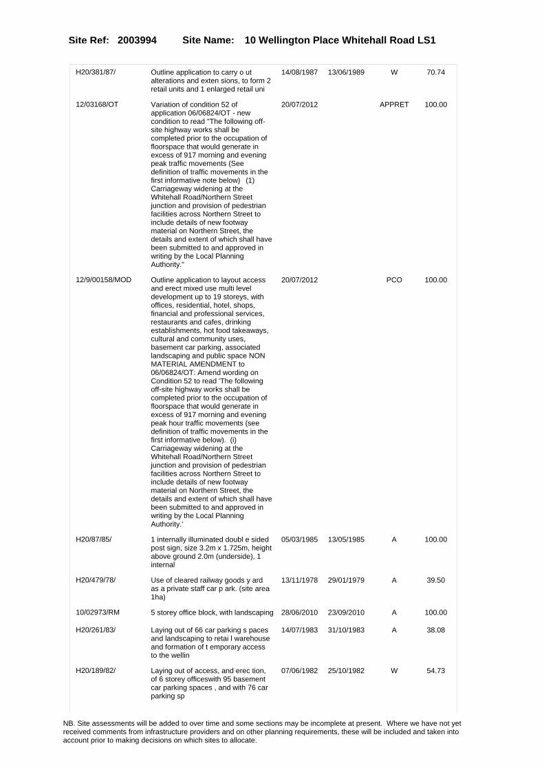
Site Name: 10 Wellington Place Whitehall Road LS1Site Ref: 2003994
H20/381/87/ Outline application to carry o ut alterations and exten sions, to form 2 retail units and 1 enlarged retail uni
14/08/1987 13/06/1989 W 70.74
12/03168/OT Variation of condition 52 of application 06/06824/OT - new condition to read "The following off-site highway works shall be completed prior to the occupation of floorspace that would generate in excess of 917 morning and evening peak traffic movements (See definition of traffic movements in the first informative note below)�(1) Carriageway widening at the Whitehall Road/Northern Street junction and provision of pedestrian facilities across Northern Street to include details of new footway material on Northern Street, the details and extent of which shall have been submitted to and approved in writing by the Local Planning Authority."
20/07/2012 APPRET 100.00
12/9/00158/MOD Outline application to layout access and erect mixed use multi level development up to 19 storeys, with offices, residential, hotel, shops, financial and professional services, restaurants and cafes, drinking establishments, hot food takeaways, cultural and community uses, basement car parking, associated landscaping and public space NON MATERIAL AMENDMENT to 06/06824/OT: Amend wording on Condition 52 to read 'The following off-site highway works shall be completed prior to the occupation of floorspace that would generate in excess of 917 morning and evening peak hour traffic movements (see definition of traffic movements in the first informative below). (i) Carriageway widening at the Whitehall Road/Northern Street junction and provision of pedestrian facilities across Northern Street to include details of new footway material on Northern Street, the details and extent of which shall have been submitted to and approved in writing by the Local Planning Authority.'
20/07/2012 PCO 100.00
H20/87/85/ 1 internally illuminated doubl e sided post sign, size 3.2m x 1.725m, height above ground 2.0m (underside), 1 internal
05/03/1985 13/05/1985 A 100.00
H20/479/78/ Use of cleared railway goods y ard as a private staff car p ark. (site area 1ha)
13/11/1978 29/01/1979 A 39.50
10/02973/RM 5 storey office block, with landscaping 28/06/2010 23/09/2010 A 100.00
H20/261/83/ Laying out of 66 car parking s paces and landscaping to retai l warehouse and formation of t emporary access to the wellin
14/07/1983 31/10/1983 A 38.08
H20/189/82/ Laying out of access, and erec tion, of 6 storey officeswith 95 basement car parking spaces , and with 76 car parking sp
07/06/1982 25/10/1982 W 54.73
NB. Site assessments will be added to over time and some sections may be incomplete at present. Where we have not yet received comments from infrastructure providers and on other planning requirements, these will be included and taken into account prior to making decisions on which sites to allocate.

Site Name: 10 Wellington Place Whitehall Road LS1Site Ref: 2003994
06/06824/OT Outline application to layout access and erect mixed use multi level development up to 19 storeys, with offices, residential, hotel, shops, financial and professional services, restaurants and cafes, drinking establishments, hot food takeaways, cultural and community uses, basement car parking, associated landscaping and public space.
15/11/2006 31/03/2008 A 100.00
H20/308/76/ Change of use of goods shed to car park, with 100 car p arking spaces.
28/07/1976 18/10/1976 A 15.25
H20/210/82/ Laying out and landscaping to proposed office and retai l warehouse development (previ ous application no.78/20/0
14/06/1982 05/07/1982 A 54.70
H20/271/83/ 1 internally illuminated indiv idual letter sign, size 4.25m x 0.45m, height above ground 3.35m (underside), 1 internal
21/07/1983 15/08/1983 A 27.33
H20/407/83/ 1 non illuminated double sided freestanding signs, size1.8m x 1.2m, height above ground 1. 8m (underside), 5 external
21/10/1983 14/11/1983 A 26.95
H20/161/83/ 10, temporary non illuminated banner signs, size of each 6.09m x 0.91m height of each a bove ground 4.87m (underside
18/05/1983 13/06/1983 A 27.04
20/442/95/FU Use of land as car park 06/10/1995 13/02/1996 A 19.96
20/712/98/RE Extension of permission for use of land as car park
09/12/1998 09/03/1999 A 20.37
07/02969/FU Amendment to increase size of approved marketing suite
08/05/2007 02/07/2007 A 13.70
09/00782/FU Temporary public square with seating and planting
23/02/2009 20/04/2009 A 65.28
H20/371/78/ Laying out of car park for 150 car parking spaces, to si te of former railway yard.
13/09/1978 30/10/1978 A 16.53
20/326/02/SI 6 internally illuminated signs and 2 non illuminated signs to retail unit
13/08/2002 20/09/2002 A 28.92
H20/332/74/ Use of site of former goods ra ilway station for car parki ng purposes (site area 1.92ha (4.74 acres)).
31/10/1974 24/02/1975 R 57.67
20/386/96/SI 3 externally illuminated 4 non illuminated and 2 non illuminated free standing signs to retail unit
30/07/1996 03/09/1996 A 45.87
20/347/03/OT Outline application to erect residential apartments offices a1 retail leisure restaurant and bar units with car parking
05/06/2003 24/11/2004 A 88.19
06/06713/FU Part single and part two storey marketing suite building with exhibition space, office, meeting room and lounge bar
10/11/2006 05/02/2007 A 13.70
12/04439/RM Variation of condition 1 (approved plans) of approval 10/02973/RM for MINOR MATERIAL AMENDMENT relating to 5 storey office block for the change of roof from green to standing seam metal composite system
18/10/2012 12/11/2012 W 100.00
NB. Site assessments will be added to over time and some sections may be incomplete at present. Where we have not yet received comments from infrastructure providers and on other planning requirements, these will be included and taken into account prior to making decisions on which sites to allocate.

Site Name: 10 Wellington Place Whitehall Road LS1Site Ref: 2003994
H20/340/83/ Alterations including 2 roller shutter doors and to form lobby and escape corridor, to retail warehouse.
05/09/1983 03/10/1983 A 26.60
12/04441/COND Consent, agreement or approval required by condition 3 of Planning Application 06/06824/OT
18/10/2012 19/03/2013 A 100.00
11/02640/FU Use of land as temporary car park (200 spaces)
21/06/2011 17/04/2012 A 85.46
H20/436/80/ Site preparation, involving dem olition & works to part of fo rmer railway viaduct to liftin g tower and to part of boundar
05/12/1980 06/08/1981 A 100.00
20/74/97/RE Extension of permission for use of land as car park
13/02/1997 22/04/1997 A 19.96
20/210/99/FU 4 storey office block 28/04/1999 23/03/2000 A 16.61
12/04081/RM Reserved Matters Application for landscaping details in relation to Building 10 of Wellington Place (06/06824/OT)
25/09/2012 20/12/2012 A 89.39
12/9/00188/MOD 5 storey office block, with landscaping NON MATERIAL AMENDMENT to 10/02973/RM: Introduction of 4 ground floor parking bays; integration of ventilation louvres to the northern facade of the building; minor adjustments to the internal arrangement; minor adjustments to the elevation fenestration; external canopy introduced on northern facade
17/09/2012 07/11/2012 W 100.00
H20/209/89/ One, non illuminated individua l letter sign, size 1.2m x 2.3 m, height above ground 2.3m (u nderside), to retail uni
04/05/1989 20/06/1989 A 29.01
20/237/94/FU 6 prefabricated storage containers 25/05/1994 16/08/1994 W 28.92
H20/160/83/ Temporary change of use of ret ail warehouse to exhib ition hall.
18/05/1983 13/06/1983 A 27.04
10/04358/FU Retention of public car park for period of 5 years (290 spaces)
24/09/2010 17/04/2012 A 85.46
12/05316/FU Variation of condition 2 (approved plans) of approval 11/02640/FU for MINOR MATERIAL AMENDMENT to allow a revised car park layout
17/12/2012 14/02/2013 A 85.46
20/161/99/OT Outline application to erect 3 office buildings multi storey car park, cafe & ext to form restaurant to lifting tower
26/03/1999 23/03/2000 A 52.08
NB. Site assessments will be added to over time and some sections may be incomplete at present. Where we have not yet received comments from infrastructure providers and on other planning requirements, these will be included and taken into account prior to making decisions on which sites to allocate.

Site Name: 10 Wellington Place Whitehall Road LS1Site Ref: 2003994
Conformity with Core Strategy
Inner South Leeds: 0.00
Leeds Bradford Corridor: 0.00 West Leeds Gateway: 0.00
Aire Valley: 0.00Regeneration Priority Area:
Brownfield
Greenfield
Mixed
Main Urban Area
Major Settlement
Smaller Settlement
Villages/Rural
Main Urban Area Extension
Major Settlement Extension
Smaller Settlement Extension
Village/Rural Extension
Development unrelated to existing development
Green Belt assessment - only completed where site is within Green Belt
Would development lead to/constitute ribbon development?
Would development result in isolated development?
Is the site well connected to built up area (2+ boundaries with existing built up area)?
Would development of the site effectively "round off" the settlement pattern?:
Do natural/physical features provide a good existing barrier between existing urban area and undeveloped land?
Overall sprawl conclusion:
Would development of the site lead to physical connection of settlements?
Do natural/physical features provide a good existing barrier/boundary to contain development?
Overall Coalescence Conclusion:
Is there a strong defensible boundary between the site and the existing urban area?
Does the site provide access to the countryside?
Does the site include local or national conservation designated areas?
Does the site include areas of woodlands, trees, hedgerows that are protected, or significant unprotected tree/hedge cover?
Does the site include grade 1, 2, or 3a agricultural land?
Does the site contain buildings? Are these in agricultural use?
Overall countryside Encroachment Conclusion
Is the site within or adjacent to a conservation area, listed building or other historical feature?
If yes, could development preserve this character?:
Overall Character Preservation Conclusion:
Greenbelt Assessment Conclusion:
Check the unrestricted sprawl of large built up areas
Prevent neighbouring towns from merging
Assist in safeguarding countryside from encroachment
Preserve the setting and special character of historic towns
NB. Site assessments will be added to over time and some sections may be incomplete at present. Where we have not yet received comments from infrastructure providers and on other planning requirements, these will be included and taken into account prior to making decisions on which sites to allocate.

Site Name: 10 Wellington Place Whitehall Road LS1Site Ref: 2003994
SHLAA ConclusionsAvailability: Suitability: Achievability:
Conclusion of Assessment
Conclusion summary:
Current site with planning permission for employment purposes
Floorspace sq m (Non residential): 4350
Employment Conclusion: Lime Green
East Leeds
Assesment Type: ELR Type: Office
Proposed Change:
Gypsy Traveller Site Assessment
Yes No Maybe Could site be effectively managed (Text)
Yes No Maybe Would gypsies and travellers live on the site?
(Text)
Yes No Proximity to housed gypsies and travellers (Text)
Yes No Unknown Experience of previous encampments (Text)
NB. Site assessments will be added to over time and some sections may be incomplete at present. Where we have not yet received comments from infrastructure providers and on other planning requirements, these will be included and taken into account prior to making decisions on which sites to allocate.

Site Name: PLOT 6B WELLINGTON PLACE WHITEHALL ROAD LEEDS 1
Site Ref: 2003996
Site Details
Land Use
Northing: 433281
Easting: 429301
Distance to Rail Station (metres): 400.90
Nearest Railway Station Leeds City
Distance to bus stop (metres) 79.31
Bus Stop ID 7872
Agricultural Land Class:
SFRA Flood Zone: 1.00
Environment Agency Flood Zone: 1.00
Within 300m of retail centre boundary:
UDP Designation
Greenbelt - N32 (%): 0.00 Urban Green Corridor - N8 (%): 0.00
Protected Area of Search site - N34 (%): 0.00 Rural Land - RL1: 0.00
City Centre Primary Shopping Quarter - CC27 (%): 0.00 Town Centre - S2: 0.00
Health and Safety Executive Hazard: No
Health and Safety Executive Gas Pipeline: No
Strategic Employment Buffer: 100.00
Area sq m: 13302.31 Ward City and Hunslet
Special Landscape Area - N37: 0.00
Allotments - N1A: 0.00
Proposed Greenspace - N5: 0.00
Protected Playing Pitch - N6: 0.00
Nature Conservation Area - N50: 0.00
Conservation Areas No
Ancient Monument/Battlefield(%): 0.00 Listed Buildings: No
Public Rights of Way: No
Other?:
Natural Resources and waste DPD (if applicable)
Within Minerals Safeguarding Site?: No Within 100m of Minerals Safeguarding Site?: No
HMCA: City Centre
Greenspace - N1: 0
Existing Use 1:
Existing Use 2:
Existing Use 3:
Neighbouring Use 1
Neighbouring Use 2:
Neighbouring Use 3:
Other uses:
Topography:
Natural Landscape:
Boundaries:
Road Frontage
Site Characteristics
Site Detail
Other comments/observations on site characteristics:
Area Ha: 1.330231
Site State:
NB. Site assessments will be added to over time and some sections may be incomplete at present. Where we have not yet received comments from infrastructure providers and on other planning requirements, these will be included and taken into account prior to making decisions on which sites to allocate.

Site Name: PLOT 6B WELLINGTON PLACE WHITEHALL ROAD LEEDS 1
Site Ref: 2003996
Planning History
Planning App No. Proposal Received Decision Status Site %
08/04314/RM Laying out of access and erection of mixed use multi level development up to 10 storeys, with offices, ground floor cafe bar/retail units, plant room and basement car parking, with associated landscaping.
18/07/2008 16/10/2008 A 99.33
H20/154/88/ Outline application to carry o ut alterations and exten sions, to form 2 retail units and 1 enlarged retail uni
22/03/1988 08/08/1988 R 35.88
H20/326/84/ 2 internally illuminated frees tanding signs, size of each 2.5m x 1.26m, height of each a bove ground 0.41m (underside
20/08/1984 13/05/1985 R 32.37
H20/52/81/ Laying out of access roads, er ection of one block of 5, indus trial units, each with 2 store y offices and toilets, o
03/02/1981 27/07/1981 A 98.33
H20/531/78/ Outline application to lay out access roads to proposedindus trial, retail, office, showroo m, residential, shops, res
22/12/1978 14/08/1980 A 99.40
12/03168/OT Variation of condition 52 of application 06/06824/OT - new condition to read "The following off-site highway works shall be completed prior to the occupation of floorspace that would generate in excess of 917 morning and evening peak traffic movements (See definition of traffic movements in the first informative note below)�(1) Carriageway widening at the Whitehall Road/Northern Street junction and provision of pedestrian facilities across Northern Street to include details of new footway material on Northern Street, the details and extent of which shall have been submitted to and approved in writing by the Local Planning Authority."
20/07/2012 APPRET 99.92
NB. Site assessments will be added to over time and some sections may be incomplete at present. Where we have not yet received comments from infrastructure providers and on other planning requirements, these will be included and taken into account prior to making decisions on which sites to allocate.

Site Name: PLOT 6B WELLINGTON PLACE WHITEHALL ROAD LEEDS 1
Site Ref: 2003996
12/9/00158/MOD Outline application to layout access and erect mixed use multi level development up to 19 storeys, with offices, residential, hotel, shops, financial and professional services, restaurants and cafes, drinking establishments, hot food takeaways, cultural and community uses, basement car parking, associated landscaping and public space NON MATERIAL AMENDMENT to 06/06824/OT: Amend wording on Condition 52 to read 'The following off-site highway works shall be completed prior to the occupation of floorspace that would generate in excess of 917 morning and evening peak hour traffic movements (see definition of traffic movements in the first informative below). (i) Carriageway widening at the Whitehall Road/Northern Street junction and provision of pedestrian facilities across Northern Street to include details of new footway material on Northern Street, the details and extent of which shall have been submitted to and approved in writing by the Local Planning Authority.'
20/07/2012 PCO 99.92
H20/87/85/ 1 internally illuminated doubl e sided post sign, size 3.2m x 1.725m, height above ground 2.0m (underside), 1 internal
05/03/1985 13/05/1985 A 98.56
H20/462/83/ 2 externally illuminated wall signs, size of each 5.2m x 1.3 m, height of each above ground 2.6m and 3m, (each underside)
28/11/1983 20/09/1985 A 14.22
06/06824/OT Outline application to layout access and erect mixed use multi level development up to 19 storeys, with offices, residential, hotel, shops, financial and professional services, restaurants and cafes, drinking establishments, hot food takeaways, cultural and community uses, basement car parking, associated landscaping and public space.
15/11/2006 31/03/2008 A 99.92
09/00782/FU Temporary public square with seating and planting
23/02/2009 20/04/2009 A 12.55
20/347/03/OT Outline application to erect residential apartments offices a1 retail leisure restaurant and bar units with car parking
05/06/2003 24/11/2004 A 100.00
12/04441/COND Consent, agreement or approval required by condition 3 of Planning Application 06/06824/OT
18/10/2012 19/03/2013 A 99.92
11/02640/FU Use of land as temporary car park (200 spaces)
21/06/2011 17/04/2012 A 100.00
H20/436/80/ Site preparation, involving dem olition & works to part of fo rmer railway viaduct to liftin g tower and to part of boundar
05/12/1980 06/08/1981 A 98.27
10/04358/FU Retention of public car park for period of 5 years (290 spaces)
24/09/2010 17/04/2012 A 100.00
NB. Site assessments will be added to over time and some sections may be incomplete at present. Where we have not yet received comments from infrastructure providers and on other planning requirements, these will be included and taken into account prior to making decisions on which sites to allocate.

Site Name: PLOT 6B WELLINGTON PLACE WHITEHALL ROAD LEEDS 1
Site Ref: 2003996
12/05316/FU Variation of condition 2 (approved plans) of approval 11/02640/FU for MINOR MATERIAL AMENDMENT to allow a revised car park layout
17/12/2012 14/02/2013 A 100.00
NB. Site assessments will be added to over time and some sections may be incomplete at present. Where we have not yet received comments from infrastructure providers and on other planning requirements, these will be included and taken into account prior to making decisions on which sites to allocate.

Site Name: PLOT 6B WELLINGTON PLACE WHITEHALL ROAD LEEDS 1
Site Ref: 2003996
Conformity with Core Strategy
Inner South Leeds: 0.00
Leeds Bradford Corridor: 0.00 West Leeds Gateway: 0.00
Aire Valley: 0.00Regeneration Priority Area:
Brownfield
Greenfield
Mixed
Main Urban Area
Major Settlement
Smaller Settlement
Villages/Rural
Main Urban Area Extension
Major Settlement Extension
Smaller Settlement Extension
Village/Rural Extension
Development unrelated to existing development
Green Belt assessment - only completed where site is within Green Belt
Would development lead to/constitute ribbon development?
Would development result in isolated development?
Is the site well connected to built up area (2+ boundaries with existing built up area)?
Would development of the site effectively "round off" the settlement pattern?:
Do natural/physical features provide a good existing barrier between existing urban area and undeveloped land?
Overall sprawl conclusion:
Would development of the site lead to physical connection of settlements?
Do natural/physical features provide a good existing barrier/boundary to contain development?
Overall Coalescence Conclusion:
Is there a strong defensible boundary between the site and the existing urban area?
Does the site provide access to the countryside?
Does the site include local or national conservation designated areas?
Does the site include areas of woodlands, trees, hedgerows that are protected, or significant unprotected tree/hedge cover?
Does the site include grade 1, 2, or 3a agricultural land?
Does the site contain buildings? Are these in agricultural use?
Overall countryside Encroachment Conclusion
Is the site within or adjacent to a conservation area, listed building or other historical feature?
If yes, could development preserve this character?:
Overall Character Preservation Conclusion:
Greenbelt Assessment Conclusion:
Check the unrestricted sprawl of large built up areas
Prevent neighbouring towns from merging
Assist in safeguarding countryside from encroachment
Preserve the setting and special character of historic towns
NB. Site assessments will be added to over time and some sections may be incomplete at present. Where we have not yet received comments from infrastructure providers and on other planning requirements, these will be included and taken into account prior to making decisions on which sites to allocate.

Site Name: PLOT 6B WELLINGTON PLACE WHITEHALL ROAD LEEDS 1
Site Ref: 2003996
SHLAA ConclusionsAvailability: Suitability: Achievability:
Conclusion of Assessment
Conclusion summary:
High-density employment opportunity in accessible city centre location.
Floorspace sq m (Non residential): 20500
Employment Conclusion: Green
East Leeds
Assesment Type: ELR Type: Office
Proposed Change:
Gypsy Traveller Site Assessment
Yes No Maybe Could site be effectively managed (Text)
Yes No Maybe Would gypsies and travellers live on the site?
(Text)
Yes No Proximity to housed gypsies and travellers (Text)
Yes No Unknown Experience of previous encampments (Text)
NB. Site assessments will be added to over time and some sections may be incomplete at present. Where we have not yet received comments from infrastructure providers and on other planning requirements, these will be included and taken into account prior to making decisions on which sites to allocate.

Site Name: PLOT 3 WELLINGTON PLACE WHITEHALL ROAD LEEDS 1
Site Ref: 2003997
Site Details
Land Use
Northing: 433200
Easting: 429207
Distance to Rail Station (metres): 485.06
Nearest Railway Station Leeds City
Distance to bus stop (metres) 53.67
Bus Stop ID 3487
Agricultural Land Class:
SFRA Flood Zone: 1.00
Environment Agency Flood Zone: 1.00
Within 300m of retail centre boundary:
UDP Designation
Greenbelt - N32 (%): 0.00 Urban Green Corridor - N8 (%): 0.00
Protected Area of Search site - N34 (%): 0.00 Rural Land - RL1: 0.00
City Centre Primary Shopping Quarter - CC27 (%): 0.00 Town Centre - S2: 0.00
Health and Safety Executive Hazard: No
Health and Safety Executive Gas Pipeline: No
Strategic Employment Buffer: 100.00
Area sq m: 7007.81 Ward City and Hunslet
Special Landscape Area - N37: 0.00
Allotments - N1A: 0.00
Proposed Greenspace - N5: 0.00
Protected Playing Pitch - N6: 0.00
Nature Conservation Area - N50: 0.00
Conservation Areas No
Ancient Monument/Battlefield(%): 0.00 Listed Buildings: No
Public Rights of Way: No
Other?:
Natural Resources and waste DPD (if applicable)
Within Minerals Safeguarding Site?: No Within 100m of Minerals Safeguarding Site?: No
HMCA: City Centre
Greenspace - N1: 0
Existing Use 1:
Existing Use 2:
Existing Use 3:
Neighbouring Use 1
Neighbouring Use 2:
Neighbouring Use 3:
Other uses:
Topography:
Natural Landscape:
Boundaries:
Road Frontage
Site Characteristics
Site Detail
Other comments/observations on site characteristics:
Area Ha: 0.700781
Site State:
NB. Site assessments will be added to over time and some sections may be incomplete at present. Where we have not yet received comments from infrastructure providers and on other planning requirements, these will be included and taken into account prior to making decisions on which sites to allocate.

Site Name: PLOT 3 WELLINGTON PLACE WHITEHALL ROAD LEEDS 1
Site Ref: 2003997
Planning History
Planning App No. Proposal Received Decision Status Site %
H20/52/81/ Laying out of access roads, er ection of one block of 5, indus trial units, each with 2 store y offices and toilets, o
03/02/1981 27/07/1981 A 99.70
08/01695/RM Multi level development up to 11 storeys, comprising 49 flats, offices and 4 retail units, with basement car parking
20/03/2008 19/06/2008 A 99.97
H20/531/78/ Outline application to lay out access roads to proposedindus trial, retail, office, showroo m, residential, shops, res
22/12/1978 14/08/1980 A 98.01
20/43/95/FU Exhibition area to warehouse units 09/02/1995 22/03/1995 A 58.77
H20/293/86/ Resiting of waste compactor, t o warehouse.
16/07/1986 15/08/1986 A 97.61
12/03168/OT Variation of condition 52 of application 06/06824/OT - new condition to read "The following off-site highway works shall be completed prior to the occupation of floorspace that would generate in excess of 917 morning and evening peak traffic movements (See definition of traffic movements in the first informative note below)�(1) Carriageway widening at the Whitehall Road/Northern Street junction and provision of pedestrian facilities across Northern Street to include details of new footway material on Northern Street, the details and extent of which shall have been submitted to and approved in writing by the Local Planning Authority."
20/07/2012 APPRET 99.84
12/9/00158/MOD Outline application to layout access and erect mixed use multi level development up to 19 storeys, with offices, residential, hotel, shops, financial and professional services, restaurants and cafes, drinking establishments, hot food takeaways, cultural and community uses, basement car parking, associated landscaping and public space NON MATERIAL AMENDMENT to 06/06824/OT: Amend wording on Condition 52 to read 'The following off-site highway works shall be completed prior to the occupation of floorspace that would generate in excess of 917 morning and evening peak hour traffic movements (see definition of traffic movements in the first informative below). (i) Carriageway widening at the Whitehall Road/Northern Street junction and provision of pedestrian facilities across Northern Street to include details of new footway material on Northern Street, the details and extent of which shall have been submitted to and approved in writing by the Local Planning Authority.'
20/07/2012 PCO 99.84
NB. Site assessments will be added to over time and some sections may be incomplete at present. Where we have not yet received comments from infrastructure providers and on other planning requirements, these will be included and taken into account prior to making decisions on which sites to allocate.

Site Name: PLOT 3 WELLINGTON PLACE WHITEHALL ROAD LEEDS 1
Site Ref: 2003997
H20/87/85/ 1 internally illuminated doubl e sided post sign, size 3.2m x 1.725m, height above ground 2.0m (underside), 1 internal
05/03/1985 13/05/1985 A 99.62
H20/252/82/ Change of use of 2 vacant indu strial units to 2 whole sale warehouse units.
14/07/1982 26/07/1982 A 55.06
06/06824/OT Outline application to layout access and erect mixed use multi level development up to 19 storeys, with offices, residential, hotel, shops, financial and professional services, restaurants and cafes, drinking establishments, hot food takeaways, cultural and community uses, basement car parking, associated landscaping and public space.
15/11/2006 31/03/2008 A 99.84
07/00331/FU Use of vacant land for recreation, car parking and external lighting
19/01/2007 28/03/2007 A 78.85
20/347/03/OT Outline application to erect residential apartments offices a1 retail leisure restaurant and bar units with car parking
05/06/2003 24/11/2004 A 95.14
12/04441/COND Consent, agreement or approval required by condition 3 of Planning Application 06/06824/OT
18/10/2012 19/03/2013 A 99.84
11/02640/FU Use of land as temporary car park (200 spaces)
21/06/2011 17/04/2012 A 98.17
H20/436/80/ Site preparation, involving dem olition & works to part of fo rmer railway viaduct to liftin g tower and to part of boundar
05/12/1980 06/08/1981 A 99.61
10/04358/FU Retention of public car park for period of 5 years (290 spaces)
24/09/2010 17/04/2012 A 98.17
12/05316/FU Variation of condition 2 (approved plans) of approval 11/02640/FU for MINOR MATERIAL AMENDMENT to allow a revised car park layout
17/12/2012 14/02/2013 A 98.17
NB. Site assessments will be added to over time and some sections may be incomplete at present. Where we have not yet received comments from infrastructure providers and on other planning requirements, these will be included and taken into account prior to making decisions on which sites to allocate.

Site Name: PLOT 3 WELLINGTON PLACE WHITEHALL ROAD LEEDS 1
Site Ref: 2003997
Conformity with Core Strategy
Inner South Leeds: 0.00
Leeds Bradford Corridor: 0.00 West Leeds Gateway: 0.00
Aire Valley: 0.00Regeneration Priority Area:
Brownfield
Greenfield
Mixed
Main Urban Area
Major Settlement
Smaller Settlement
Villages/Rural
Main Urban Area Extension
Major Settlement Extension
Smaller Settlement Extension
Village/Rural Extension
Development unrelated to existing development
Green Belt assessment - only completed where site is within Green Belt
Would development lead to/constitute ribbon development?
Would development result in isolated development?
Is the site well connected to built up area (2+ boundaries with existing built up area)?
Would development of the site effectively "round off" the settlement pattern?:
Do natural/physical features provide a good existing barrier between existing urban area and undeveloped land?
Overall sprawl conclusion:
Would development of the site lead to physical connection of settlements?
Do natural/physical features provide a good existing barrier/boundary to contain development?
Overall Coalescence Conclusion:
Is there a strong defensible boundary between the site and the existing urban area?
Does the site provide access to the countryside?
Does the site include local or national conservation designated areas?
Does the site include areas of woodlands, trees, hedgerows that are protected, or significant unprotected tree/hedge cover?
Does the site include grade 1, 2, or 3a agricultural land?
Does the site contain buildings? Are these in agricultural use?
Overall countryside Encroachment Conclusion
Is the site within or adjacent to a conservation area, listed building or other historical feature?
If yes, could development preserve this character?:
Overall Character Preservation Conclusion:
Greenbelt Assessment Conclusion:
Check the unrestricted sprawl of large built up areas
Prevent neighbouring towns from merging
Assist in safeguarding countryside from encroachment
Preserve the setting and special character of historic towns
NB. Site assessments will be added to over time and some sections may be incomplete at present. Where we have not yet received comments from infrastructure providers and on other planning requirements, these will be included and taken into account prior to making decisions on which sites to allocate.

Site Name: PLOT 3 WELLINGTON PLACE WHITEHALL ROAD LEEDS 1
Site Ref: 2003997
SHLAA ConclusionsAvailability: Suitability: Achievability:
Conclusion of Assessment
Conclusion summary:
High-density employment opportunity in accessible city centre location.
Floorspace sq m (Non residential): 14000
Employment Conclusion: Green
East Leeds
Assesment Type: ELR Type: Office
Proposed Change:
Gypsy Traveller Site Assessment
Yes No Maybe Could site be effectively managed (Text)
Yes No Maybe Would gypsies and travellers live on the site?
(Text)
Yes No Proximity to housed gypsies and travellers (Text)
Yes No Unknown Experience of previous encampments (Text)
NB. Site assessments will be added to over time and some sections may be incomplete at present. Where we have not yet received comments from infrastructure providers and on other planning requirements, these will be included and taken into account prior to making decisions on which sites to allocate.

Site Name: AIRESIDE CENTRE REDEVELOPMENT WHITEHALL ROAD NORTHERN STREET LS1
Site Ref: 2003999
Site Details
Land Use
Northing: 433332
Easting: 429286
Distance to Rail Station (metres): 429.44
Nearest Railway Station Leeds City
Distance to bus stop (metres) 130.98
Bus Stop ID 7872
Agricultural Land Class:
SFRA Flood Zone: 1.00
Environment Agency Flood Zone: 1.00
Within 300m of retail centre boundary:
UDP Designation
Greenbelt - N32 (%): 0.00 Urban Green Corridor - N8 (%): 0.00
Protected Area of Search site - N34 (%): 0.00 Rural Land - RL1: 0.00
City Centre Primary Shopping Quarter - CC27 (%): 0.00 Town Centre - S2: 0.00
Health and Safety Executive Hazard: No
Health and Safety Executive Gas Pipeline: No
Strategic Employment Buffer: 100.00
Area sq m: 33220.13 Ward City and Hunslet
Special Landscape Area - N37: 0.00
Allotments - N1A: 0.00
Proposed Greenspace - N5: 0.00
Protected Playing Pitch - N6: 0.00
Nature Conservation Area - N50: 0.00
Conservation Areas No
Ancient Monument/Battlefield(%): 0.00 Listed Buildings: No
Public Rights of Way: No
Other?:
Natural Resources and waste DPD (if applicable)
Within Minerals Safeguarding Site?: No Within 100m of Minerals Safeguarding Site?: No
HMCA: City Centre
Greenspace - N1: 0
Existing Use 1:
Existing Use 2:
Existing Use 3:
Neighbouring Use 1
Neighbouring Use 2:
Neighbouring Use 3:
Other uses:
Topography:
Natural Landscape:
Boundaries:
Road Frontage
Site Characteristics
Site Detail
Other comments/observations on site characteristics:
Area Ha: 3.322013
Site State:
NB. Site assessments will be added to over time and some sections may be incomplete at present. Where we have not yet received comments from infrastructure providers and on other planning requirements, these will be included and taken into account prior to making decisions on which sites to allocate.

Site Name: AIRESIDE CENTRE REDEVELOPMENT WHITEHALL ROAD NORTHERN STREET LS1
Site Ref: 2003999
Planning History
Planning App No. Proposal Received Decision Status Site %
H20/332/74/ Use of site of former goods ra ilway station for car parki ng purposes (site area 1.92ha (4.74 acres)).
31/10/1974 24/02/1975 R 38.57
H20/479/78/ Use of cleared railway goods y ard as a private staff car p ark. (site area 1ha)
13/11/1978 29/01/1979 A 13.09
20/707/99/RE Extension of permission for use of reduced area of land as car park
22/12/1999 09/05/2000 A 14.43
20/347/03/OT Outline application to erect residential apartments offices a1 retail leisure restaurant and bar units with car parking
05/06/2003 24/11/2004 A 81.31
06/06824/OT Outline application to layout access and erect mixed use multi level development up to 19 storeys, with offices, residential, hotel, shops, financial and professional services, restaurants and cafes, drinking establishments, hot food takeaways, cultural and community uses, basement car parking, associated landscaping and public space.
15/11/2006 31/03/2008 A 99.57
H20/531/78/ Outline application to lay out access roads to proposedindus trial, retail, office, showroo m, residential, shops, res
22/12/1978 14/08/1980 A 99.23
H20/87/85/ 1 internally illuminated doubl e sided post sign, size 3.2m x 1.725m, height above ground 2.0m (underside), 1 internal
05/03/1985 13/05/1985 A 99.72
H20/436/80/ Site preparation, involving dem olition & works to part of fo rmer railway viaduct to liftin g tower and to part of boundar
05/12/1980 06/08/1981 A 99.71
H20/210/82/ Laying out and landscaping to proposed office and retai l warehouse development (previ ous application no.78/20/0
14/06/1982 05/07/1982 A 18.48
H20/271/83/ 1 internally illuminated indiv idual letter sign, size 4.25m x 0.45m, height above ground 3.35m (underside), 1 internal
21/07/1983 15/08/1983 A 19.33
H20/209/89/ One, non illuminated individua l letter sign, size 1.2m x 2.3 m, height above ground 2.3m (u nderside), to retail uni
04/05/1989 20/06/1989 A 11.35
20/482/04/RM 9 storey office block with basement parking
02/11/2004 11/01/2005 A 10.46
H20/478/78/ Use of cleared railway goods y ard as car park. (site area 1.5ha)
10/11/1978 26/03/1980 A 11.48
H20/340/83/ Alterations including 2 roller shutter doors and to form lobby and escape corridor, to retail warehouse.
05/09/1983 03/10/1983 A 11.39
NB. Site assessments will be added to over time and some sections may be incomplete at present. Where we have not yet received comments from infrastructure providers and on other planning requirements, these will be included and taken into account prior to making decisions on which sites to allocate.

Site Name: AIRESIDE CENTRE REDEVELOPMENT WHITEHALL ROAD NORTHERN STREET LS1
Site Ref: 2003999
12/03168/OT Variation of condition 52 of application 06/06824/OT - new condition to read "The following off-site highway works shall be completed prior to the occupation of floorspace that would generate in excess of 917 morning and evening peak traffic movements (See definition of traffic movements in the first informative note below)�(1) Carriageway widening at the Whitehall Road/Northern Street junction and provision of pedestrian facilities across Northern Street to include details of new footway material on Northern Street, the details and extent of which shall have been submitted to and approved in writing by the Local Planning Authority."
20/07/2012 APPRET 99.57
H20/160/83/ Temporary change of use of ret ail warehouse to exhib ition hall.
18/05/1983 13/06/1983 A 19.49
H20/161/83/ 10, temporary non illuminated banner signs, size of each 6.09m x 0.91m height of each a bove ground 4.87m (underside
18/05/1983 13/06/1983 A 19.49
H20/293/86/ Resiting of waste compactor, t o warehouse.
16/07/1986 15/08/1986 A 15.44
H20/381/87/ Outline application to carry o ut alterations and exten sions, to form 2 retail units and 1 enlarged retail uni
14/08/1987 13/06/1989 W 39.79
H20/154/88/ Outline application to carry o ut alterations and exten sions, to form 2 retail units and 1 enlarged retail uni
22/03/1988 08/08/1988 R 44.45
20/210/99/FU 4 storey office block 28/04/1999 23/03/2000 A 10.26
12/04441/COND Consent, agreement or approval required by condition 3 of Planning Application 06/06824/OT
18/10/2012 19/03/2013 A 99.57
H20/491/85/ Change of use involving altera tions, of retail showr oom and warehouse, to enlarged retail showroom and wareho
17/10/1985 11/11/1985 A 11.35
20/448/96/FU Alterations to service yard and to form new entrance and fire exit to retail unit
13/08/1996 25/09/1996 A 12.67
20/74/97/RE Extension of permission for use of land as car park
13/02/1997 22/04/1997 A 20.58
11/02640/FU Use of land as temporary car park (200 spaces)
21/06/2011 17/04/2012 A 85.61
H20/13/77/ Use of cleared goods yard site as car park for 500 cars (site area 1.53ha (3.78 acres) ).
13/01/1977 21/08/1978 A 14.85
H20/52/81/ Laying out of access roads, er ection of one block of 5, indus trial units, each with 2 store y offices and toilets, o
03/02/1981 27/07/1981 A 99.78
H20/189/82/ Laying out of access, and erec tion, of 6 storey officeswith 95 basement car parking spaces , and with 76 car parking sp
07/06/1982 25/10/1982 W 18.38
NB. Site assessments will be added to over time and some sections may be incomplete at present. Where we have not yet received comments from infrastructure providers and on other planning requirements, these will be included and taken into account prior to making decisions on which sites to allocate.

Site Name: AIRESIDE CENTRE REDEVELOPMENT WHITEHALL ROAD NORTHERN STREET LS1
Site Ref: 2003999
H20/524/84/ One externally illuminated ind ividual letter wall sign, size 4.01m x 1.11m, height ab ove ground 2.45m (underside
30/11/1984 21/01/1985 A 18.53
H20/383/87/ Outline application to carry o ut alterations and exten sions, to form 2 retail units and 1 enlarged retail uni
14/08/1987 13/06/1989 W 39.67
20/442/95/FU Use of land as car park 06/10/1995 13/02/1996 A 20.58
H20/407/83/ 1 non illuminated double sided freestanding signs, size1.8m x 1.2m, height above ground 1. 8m (underside), 5 external
21/10/1983 14/11/1983 A 19.38
H20/326/84/ 2 internally illuminated frees tanding signs, size of each 2.5m x 1.26m, height of each a bove ground 0.41m (underside
20/08/1984 13/05/1985 R 37.88
20/386/96/SI 3 externally illuminated 4 non illuminated and 2 non illuminated free standing signs to retail unit
30/07/1996 03/09/1996 A 11.52
20/712/98/RE Extension of permission for use of land as car park
09/12/1998 09/03/1999 A 20.47
20/161/99/OT Outline application to erect 3 office buildings multi storey car park, cafe & ext to form restaurant to lifting tower
26/03/1999 23/03/2000 A 31.33
10/04358/FU Retention of public car park for period of 5 years (290 spaces)
24/09/2010 17/04/2012 A 85.61
12/9/00158/MOD Outline application to layout access and erect mixed use multi level development up to 19 storeys, with offices, residential, hotel, shops, financial and professional services, restaurants and cafes, drinking establishments, hot food takeaways, cultural and community uses, basement car parking, associated landscaping and public space NON MATERIAL AMENDMENT to 06/06824/OT: Amend wording on Condition 52 to read 'The following off-site highway works shall be completed prior to the occupation of floorspace that would generate in excess of 917 morning and evening peak hour traffic movements (see definition of traffic movements in the first informative below). (i) Carriageway widening at the Whitehall Road/Northern Street junction and provision of pedestrian facilities across Northern Street to include details of new footway material on Northern Street, the details and extent of which shall have been submitted to and approved in writing by the Local Planning Authority.'
20/07/2012 PCO 99.57
12/05316/FU Variation of condition 2 (approved plans) of approval 11/02640/FU for MINOR MATERIAL AMENDMENT to allow a revised car park layout
17/12/2012 14/02/2013 A 85.61
NB. Site assessments will be added to over time and some sections may be incomplete at present. Where we have not yet received comments from infrastructure providers and on other planning requirements, these will be included and taken into account prior to making decisions on which sites to allocate.

Site Name: AIRESIDE CENTRE REDEVELOPMENT WHITEHALL ROAD NORTHERN STREET LS1
Site Ref: 2003999
Conformity with Core Strategy
Inner South Leeds: 0.00
Leeds Bradford Corridor: 0.00 West Leeds Gateway: 0.00
Aire Valley: 0.00Regeneration Priority Area:
Brownfield
Greenfield
Mixed
Main Urban Area
Major Settlement
Smaller Settlement
Villages/Rural
Main Urban Area Extension
Major Settlement Extension
Smaller Settlement Extension
Village/Rural Extension
Development unrelated to existing development
Green Belt assessment - only completed where site is within Green Belt
Would development lead to/constitute ribbon development?
Would development result in isolated development?
Is the site well connected to built up area (2+ boundaries with existing built up area)?
Would development of the site effectively "round off" the settlement pattern?:
Do natural/physical features provide a good existing barrier between existing urban area and undeveloped land?
Overall sprawl conclusion:
Would development of the site lead to physical connection of settlements?
Do natural/physical features provide a good existing barrier/boundary to contain development?
Overall Coalescence Conclusion:
Is there a strong defensible boundary between the site and the existing urban area?
Does the site provide access to the countryside?
Does the site include local or national conservation designated areas?
Does the site include areas of woodlands, trees, hedgerows that are protected, or significant unprotected tree/hedge cover?
Does the site include grade 1, 2, or 3a agricultural land?
Does the site contain buildings? Are these in agricultural use?
Overall countryside Encroachment Conclusion
Is the site within or adjacent to a conservation area, listed building or other historical feature?
If yes, could development preserve this character?:
Overall Character Preservation Conclusion:
Greenbelt Assessment Conclusion:
Check the unrestricted sprawl of large built up areas
Prevent neighbouring towns from merging
Assist in safeguarding countryside from encroachment
Preserve the setting and special character of historic towns
NB. Site assessments will be added to over time and some sections may be incomplete at present. Where we have not yet received comments from infrastructure providers and on other planning requirements, these will be included and taken into account prior to making decisions on which sites to allocate.

Site Name: AIRESIDE CENTRE REDEVELOPMENT WHITEHALL ROAD NORTHERN STREET LS1
Site Ref: 2003999
SHLAA ConclusionsAvailability: Suitability: Achievability:
Conclusion of Assessment
Conclusion summary:
High-density employment opportunity in accessible city centre location.
Floorspace sq m (Non residential): 163000
Employment Conclusion: Green
East Leeds
Assesment Type: ELR Type: Office
Proposed Change:
Gypsy Traveller Site Assessment
Yes No Maybe Could site be effectively managed (Text)
Yes No Maybe Would gypsies and travellers live on the site?
(Text)
Yes No Proximity to housed gypsies and travellers (Text)
Yes No Unknown Experience of previous encampments (Text)
NB. Site assessments will be added to over time and some sections may be incomplete at present. Where we have not yet received comments from infrastructure providers and on other planning requirements, these will be included and taken into account prior to making decisions on which sites to allocate.

Site Name: Office Scheme Wellington Road & Gotts Road Leeds
Site Ref: 2004069
Site Details
Land Use
Northing: 433344
Easting: 428916
Distance to Rail Station (metres): 790.86
Nearest Railway Station Leeds City
Distance to bus stop (metres) 125.00
Bus Stop ID 789
Agricultural Land Class:
SFRA Flood Zone: 1.00
Environment Agency Flood Zone: 1.00
Within 300m of retail centre boundary:
UDP Designation
Greenbelt - N32 (%): 0.00 Urban Green Corridor - N8 (%): 0.00
Protected Area of Search site - N34 (%): 0.00 Rural Land - RL1: 0.00
City Centre Primary Shopping Quarter - CC27 (%): 0.00 Town Centre - S2: 0.00
Health and Safety Executive Hazard: No
Health and Safety Executive Gas Pipeline: No
Strategic Employment Buffer: 0.00
Area sq m: 4921.73 Ward City and Hunslet
Special Landscape Area - N37: 0.00
Allotments - N1A: 0.00
Proposed Greenspace - N5: 0.00
Protected Playing Pitch - N6: 0.00
Nature Conservation Area - N50: 0.00
Conservation Areas No
Ancient Monument/Battlefield(%): 0.00 Listed Buildings: No
Public Rights of Way: No
Other?:
Natural Resources and waste DPD (if applicable)
Within Minerals Safeguarding Site?: No Within 100m of Minerals Safeguarding Site?: No
HMCA: Inner Areas
Greenspace - N1: 0
Existing Use 1:
Existing Use 2:
Existing Use 3:
Neighbouring Use 1
Neighbouring Use 2:
Neighbouring Use 3:
Other uses:
Topography:
Natural Landscape:
Boundaries:
Road Frontage
Site Characteristics
Site Detail
Other comments/observations on site characteristics:
Area Ha: 0.492173
Site State:
NB. Site assessments will be added to over time and some sections may be incomplete at present. Where we have not yet received comments from infrastructure providers and on other planning requirements, these will be included and taken into account prior to making decisions on which sites to allocate.

Site Name: Office Scheme Wellington Road & Gotts Road Leeds
Site Ref: 2004069
Planning History
NB. Site assessments will be added to over time and some sections may be incomplete at present. Where we have not yet received comments from infrastructure providers and on other planning requirements, these will be included and taken into account prior to making decisions on which sites to allocate.

Site Name: Office Scheme Wellington Road & Gotts Road Leeds
Site Ref: 2004069
Conformity with Core Strategy
Inner South Leeds: 0.00
Leeds Bradford Corridor: 0.00 West Leeds Gateway: 0.00
Aire Valley: 0.00Regeneration Priority Area:
Brownfield
Greenfield
Mixed
Main Urban Area
Major Settlement
Smaller Settlement
Villages/Rural
Main Urban Area Extension
Major Settlement Extension
Smaller Settlement Extension
Village/Rural Extension
Development unrelated to existing development
Green Belt assessment - only completed where site is within Green Belt
Would development lead to/constitute ribbon development?
Would development result in isolated development?
Is the site well connected to built up area (2+ boundaries with existing built up area)?
Would development of the site effectively "round off" the settlement pattern?:
Do natural/physical features provide a good existing barrier between existing urban area and undeveloped land?
Overall sprawl conclusion:
Would development of the site lead to physical connection of settlements?
Do natural/physical features provide a good existing barrier/boundary to contain development?
Overall Coalescence Conclusion:
Is there a strong defensible boundary between the site and the existing urban area?
Does the site provide access to the countryside?
Does the site include local or national conservation designated areas?
Does the site include areas of woodlands, trees, hedgerows that are protected, or significant unprotected tree/hedge cover?
Does the site include grade 1, 2, or 3a agricultural land?
Does the site contain buildings? Are these in agricultural use?
Overall countryside Encroachment Conclusion
Is the site within or adjacent to a conservation area, listed building or other historical feature?
If yes, could development preserve this character?:
Overall Character Preservation Conclusion:
Greenbelt Assessment Conclusion:
Check the unrestricted sprawl of large built up areas
Prevent neighbouring towns from merging
Assist in safeguarding countryside from encroachment
Preserve the setting and special character of historic towns
NB. Site assessments will be added to over time and some sections may be incomplete at present. Where we have not yet received comments from infrastructure providers and on other planning requirements, these will be included and taken into account prior to making decisions on which sites to allocate.

Site Name: Office Scheme Wellington Road & Gotts Road Leeds
Site Ref: 2004069
SHLAA ConclusionsAvailability: Suitability: Achievability:
Conclusion of Assessment
Conclusion summary:
Could be viable as s office location, as indicated by the outline planning permission but it is peripheral to the city centre itself.
Floorspace sq m (Non residential): 20370
Employment Conclusion: Green
East Leeds
Assesment Type: ELR Type: Office
Proposed Change:
Gypsy Traveller Site Assessment
Yes No Maybe Could site be effectively managed (Text)
Yes No Maybe Would gypsies and travellers live on the site?
(Text)
Yes No Proximity to housed gypsies and travellers (Text)
Yes No Unknown Experience of previous encampments (Text)
NB. Site assessments will be added to over time and some sections may be incomplete at present. Where we have not yet received comments from infrastructure providers and on other planning requirements, these will be included and taken into account prior to making decisions on which sites to allocate.

Site Name: S/O 20-22 Manor Road Holbeck LS11Site Ref: 2004179
Site Details
Land Use
Northing: 432662
Easting: 429736
Distance to Rail Station (metres): 531.32
Nearest Railway Station Leeds City
Distance to bus stop (metres) 206.99
Bus Stop ID 12632
Agricultural Land Class:
SFRA Flood Zone: 1.00
Environment Agency Flood Zone: 1.00
Within 300m of retail centre boundary:
UDP Designation
Greenbelt - N32 (%): 0.00 Urban Green Corridor - N8 (%): 0.00
Protected Area of Search site - N34 (%): 0.00 Rural Land - RL1: 0.00
City Centre Primary Shopping Quarter - CC27 (%): 0.00 Town Centre - S2: 0.00
Health and Safety Executive Hazard: No
Health and Safety Executive Gas Pipeline: No
Strategic Employment Buffer: 100.00
Area sq m: 3820.45 Ward City and Hunslet
Special Landscape Area - N37: 0.00
Allotments - N1A: 0.00
Proposed Greenspace - N5: 0.00
Protected Playing Pitch - N6: 0.00
Nature Conservation Area - N50: 0.00
Conservation Areas No
Ancient Monument/Battlefield(%): 0.00 Listed Buildings: No
Public Rights of Way: No
Other?:
Natural Resources and waste DPD (if applicable)
Within Minerals Safeguarding Site?: No Within 100m of Minerals Safeguarding Site?: No
HMCA: City Centre
Greenspace - N1: 0
Existing Use 1:
Existing Use 2:
Existing Use 3:
Neighbouring Use 1
Neighbouring Use 2:
Neighbouring Use 3:
Other uses:
Topography:
Natural Landscape:
Boundaries:
Road Frontage
Site Characteristics
Site Detail
Other comments/observations on site characteristics:
Area Ha: 0.382045
Site State:
NB. Site assessments will be added to over time and some sections may be incomplete at present. Where we have not yet received comments from infrastructure providers and on other planning requirements, these will be included and taken into account prior to making decisions on which sites to allocate.

Site Name: S/O 20-22 Manor Road Holbeck LS11Site Ref: 2004179
Planning History
Planning App No. Proposal Received Decision Status Site %
H20/210/78/ Two detached blocks of one sin gle and one double preca st concrete garages for the st orage of motor vehicles.
22/05/1978 10/07/1978 A 15.28
H20/537/88/99 Change of use of warehouse to industrial.
04/11/1988 15/12/1988 A 99.71
20/246/03/FU 7 storey block of 92 flats with 68 car parking spaces
19/06/2003 02/10/2003 W 99.71
H20/166/84/ Two detached blocks of one dou ble and one double with one s ingle precast concrete garages , for the storage ofmotor vehi
10/04/1984 14/05/1984 A 13.30
H20/120/79/ Detached pre-cast concrete gar age to vacant site.
16/03/1979 24/04/1979 A 14.49
20/473/01/FU 4 storey office block 10/09/2001 31/07/2002 A 100.00
H20/204/78/ Outline application to erect 5 industrial units, to forme r industrial site. (site area 0.05ha (0.12 acres))
18/05/1978 10/07/1978 W 13.17
20/304/04/FU Part 8, part 9 storey residential, a1/a2/a3 and office development with car parking
28/06/2004 30/06/2005 A 90.66
20/488/05/FU Part 8 and 9 storey block of 278 flats and 2 A1/A2/A3/B1 units with car parking
12/10/2005 22/02/2006 A 100.00
06/00501/FU Laying out of temporary car park 04/10/2005 13/04/2006 R 99.66
NB. Site assessments will be added to over time and some sections may be incomplete at present. Where we have not yet received comments from infrastructure providers and on other planning requirements, these will be included and taken into account prior to making decisions on which sites to allocate.

Site Name: S/O 20-22 Manor Road Holbeck LS11Site Ref: 2004179
Conformity with Core Strategy
Inner South Leeds: 0.00
Leeds Bradford Corridor: 0.00 West Leeds Gateway: 0.00
Aire Valley: 0.00Regeneration Priority Area:
Brownfield
Greenfield
Mixed
Main Urban Area
Major Settlement
Smaller Settlement
Villages/Rural
Main Urban Area Extension
Major Settlement Extension
Smaller Settlement Extension
Village/Rural Extension
Development unrelated to existing development
Green Belt assessment - only completed where site is within Green Belt
Would development lead to/constitute ribbon development?
Would development result in isolated development?
Is the site well connected to built up area (2+ boundaries with existing built up area)?
Would development of the site effectively "round off" the settlement pattern?:
Do natural/physical features provide a good existing barrier between existing urban area and undeveloped land?
Overall sprawl conclusion:
Would development of the site lead to physical connection of settlements?
Do natural/physical features provide a good existing barrier/boundary to contain development?
Overall Coalescence Conclusion:
Is there a strong defensible boundary between the site and the existing urban area?
Does the site provide access to the countryside?
Does the site include local or national conservation designated areas?
Does the site include areas of woodlands, trees, hedgerows that are protected, or significant unprotected tree/hedge cover?
Does the site include grade 1, 2, or 3a agricultural land?
Does the site contain buildings? Are these in agricultural use?
Overall countryside Encroachment Conclusion
Is the site within or adjacent to a conservation area, listed building or other historical feature?
If yes, could development preserve this character?:
Overall Character Preservation Conclusion:
Greenbelt Assessment Conclusion:
Check the unrestricted sprawl of large built up areas
Prevent neighbouring towns from merging
Assist in safeguarding countryside from encroachment
Preserve the setting and special character of historic towns
NB. Site assessments will be added to over time and some sections may be incomplete at present. Where we have not yet received comments from infrastructure providers and on other planning requirements, these will be included and taken into account prior to making decisions on which sites to allocate.

Site Name: S/O 20-22 Manor Road Holbeck LS11Site Ref: 2004179
SHLAA ConclusionsAvailability: Suitability: Achievability:
Conclusion of Assessment
Conclusion summary:
Current site with planning permission for employment purposes
Floorspace sq m (Non residential): 909
Employment Conclusion: Lime Green
East Leeds
Assesment Type: ELR Type: Office
Proposed Change:
Gypsy Traveller Site Assessment
Yes No Maybe Could site be effectively managed (Text)
Yes No Maybe Would gypsies and travellers live on the site?
(Text)
Yes No Proximity to housed gypsies and travellers (Text)
Yes No Unknown Experience of previous encampments (Text)
NB. Site assessments will be added to over time and some sections may be incomplete at present. Where we have not yet received comments from infrastructure providers and on other planning requirements, these will be included and taken into account prior to making decisions on which sites to allocate.

Site Name: Globe Road & Whitehall Road Leeds LS11Site Ref: 2004229
Site Details
Land Use
Northing: 433001
Easting: 429153
Distance to Rail Station (metres): 572.21
Nearest Railway Station Leeds City
Distance to bus stop (metres) 77.92
Bus Stop ID 4261
Agricultural Land Class:
SFRA Flood Zone: 1.00
Environment Agency Flood Zone: 1.00
Within 300m of retail centre boundary:
UDP Designation
Greenbelt - N32 (%): 0.00 Urban Green Corridor - N8 (%): 0.00
Protected Area of Search site - N34 (%): 0.00 Rural Land - RL1: 0.00
City Centre Primary Shopping Quarter - CC27 (%): 0.00 Town Centre - S2: 0.00
Health and Safety Executive Hazard: No
Health and Safety Executive Gas Pipeline: No
Strategic Employment Buffer: 0.00
Area sq m: 18555.78 Ward City and Hunslet
Special Landscape Area - N37: 0.00
Allotments - N1A: 0.00
Proposed Greenspace - N5: 0.00
Protected Playing Pitch - N6: 0.00
Nature Conservation Area - N50: 0.00
Conservation Areas No
Ancient Monument/Battlefield(%): 0.00 Listed Buildings: No
Public Rights of Way: No
Other?:
Natural Resources and waste DPD (if applicable)
Within Minerals Safeguarding Site?: No Within 100m of Minerals Safeguarding Site?: No
HMCA: Inner Areas
Greenspace - N1: 0
Existing Use 1:
Existing Use 2:
Existing Use 3:
Neighbouring Use 1
Neighbouring Use 2:
Neighbouring Use 3:
Other uses:
Topography:
Natural Landscape:
Boundaries:
Road Frontage
Site Characteristics
Site Detail
Other comments/observations on site characteristics:
Area Ha: 1.855578
Site State:
NB. Site assessments will be added to over time and some sections may be incomplete at present. Where we have not yet received comments from infrastructure providers and on other planning requirements, these will be included and taken into account prior to making decisions on which sites to allocate.

Site Name: Globe Road & Whitehall Road Leeds LS11Site Ref: 2004229
Planning History
NB. Site assessments will be added to over time and some sections may be incomplete at present. Where we have not yet received comments from infrastructure providers and on other planning requirements, these will be included and taken into account prior to making decisions on which sites to allocate.

Site Name: Globe Road & Whitehall Road Leeds LS11Site Ref: 2004229
Conformity with Core Strategy
Inner South Leeds: 0.00
Leeds Bradford Corridor: 0.00 West Leeds Gateway: 0.00
Aire Valley: 0.00Regeneration Priority Area:
Brownfield
Greenfield
Mixed
Main Urban Area
Major Settlement
Smaller Settlement
Villages/Rural
Main Urban Area Extension
Major Settlement Extension
Smaller Settlement Extension
Village/Rural Extension
Development unrelated to existing development
Green Belt assessment - only completed where site is within Green Belt
Would development lead to/constitute ribbon development?
Would development result in isolated development?
Is the site well connected to built up area (2+ boundaries with existing built up area)?
Would development of the site effectively "round off" the settlement pattern?:
Do natural/physical features provide a good existing barrier between existing urban area and undeveloped land?
Overall sprawl conclusion:
Would development of the site lead to physical connection of settlements?
Do natural/physical features provide a good existing barrier/boundary to contain development?
Overall Coalescence Conclusion:
Is there a strong defensible boundary between the site and the existing urban area?
Does the site provide access to the countryside?
Does the site include local or national conservation designated areas?
Does the site include areas of woodlands, trees, hedgerows that are protected, or significant unprotected tree/hedge cover?
Does the site include grade 1, 2, or 3a agricultural land?
Does the site contain buildings? Are these in agricultural use?
Overall countryside Encroachment Conclusion
Is the site within or adjacent to a conservation area, listed building or other historical feature?
If yes, could development preserve this character?:
Overall Character Preservation Conclusion:
Greenbelt Assessment Conclusion:
Check the unrestricted sprawl of large built up areas
Prevent neighbouring towns from merging
Assist in safeguarding countryside from encroachment
Preserve the setting and special character of historic towns
NB. Site assessments will be added to over time and some sections may be incomplete at present. Where we have not yet received comments from infrastructure providers and on other planning requirements, these will be included and taken into account prior to making decisions on which sites to allocate.

Site Name: Globe Road & Whitehall Road Leeds LS11Site Ref: 2004229
SHLAA ConclusionsAvailability: Suitability: Achievability:
Conclusion of Assessment
Conclusion summary:
Unlikely that housing scheme will be resurrected therefore keep for offices. This is not really a gateway location.
Floorspace sq m (Non residential): 3220
Employment Conclusion: Lime Green
East Leeds
Assesment Type: ELR Type: Office
Proposed Change:
Gypsy Traveller Site Assessment
Yes No Maybe Could site be effectively managed (Text)
Yes No Maybe Would gypsies and travellers live on the site?
(Text)
Yes No Proximity to housed gypsies and travellers (Text)
Yes No Unknown Experience of previous encampments (Text)
NB. Site assessments will be added to over time and some sections may be incomplete at present. Where we have not yet received comments from infrastructure providers and on other planning requirements, these will be included and taken into account prior to making decisions on which sites to allocate.

Site Name: Land Off Manor Road Ingram Row & Sweet Street
Site Ref: 2004330
Site Details
Land Use
Northing: 432624
Easting: 429803
Distance to Rail Station (metres): 578.28
Nearest Railway Station Leeds City
Distance to bus stop (metres) 193.30
Bus Stop ID 2873
Agricultural Land Class:
SFRA Flood Zone: 1.00
Environment Agency Flood Zone: 1.00
Within 300m of retail centre boundary:
UDP Designation
Greenbelt - N32 (%): 0.00 Urban Green Corridor - N8 (%): 0.00
Protected Area of Search site - N34 (%): 0.00 Rural Land - RL1: 0.00
City Centre Primary Shopping Quarter - CC27 (%): 0.00 Town Centre - S2: 0.00
Health and Safety Executive Hazard: No
Health and Safety Executive Gas Pipeline: No
Strategic Employment Buffer: 0.00
Area sq m: 19210.23 Ward City and Hunslet
Special Landscape Area - N37: 0.00
Allotments - N1A: 0.00
Proposed Greenspace - N5: 0.00
Protected Playing Pitch - N6: 0.00
Nature Conservation Area - N50: 0.00
Conservation Areas No
Ancient Monument/Battlefield(%): 0.00 Listed Buildings: No
Public Rights of Way: No
Other?:
Natural Resources and waste DPD (if applicable)
Within Minerals Safeguarding Site?: No Within 100m of Minerals Safeguarding Site?: No
HMCA: City Centre
Greenspace - N1: 0
Existing Use 1:
Existing Use 2:
Existing Use 3:
Neighbouring Use 1
Neighbouring Use 2:
Neighbouring Use 3:
Other uses:
Topography:
Natural Landscape:
Boundaries:
Road Frontage
Site Characteristics
Site Detail
Other comments/observations on site characteristics:
Area Ha: 1.921023
Site State:
NB. Site assessments will be added to over time and some sections may be incomplete at present. Where we have not yet received comments from infrastructure providers and on other planning requirements, these will be included and taken into account prior to making decisions on which sites to allocate.

Site Name: Land Off Manor Road Ingram Row & Sweet Street
Site Ref: 2004330
Planning History
NB. Site assessments will be added to over time and some sections may be incomplete at present. Where we have not yet received comments from infrastructure providers and on other planning requirements, these will be included and taken into account prior to making decisions on which sites to allocate.

Site Name: Land Off Manor Road Ingram Row & Sweet Street
Site Ref: 2004330
Conformity with Core Strategy
Inner South Leeds: 0.00
Leeds Bradford Corridor: 0.00 West Leeds Gateway: 0.00
Aire Valley: 0.00Regeneration Priority Area:
Brownfield
Greenfield
Mixed
Main Urban Area
Major Settlement
Smaller Settlement
Villages/Rural
Main Urban Area Extension
Major Settlement Extension
Smaller Settlement Extension
Village/Rural Extension
Development unrelated to existing development
Green Belt assessment - only completed where site is within Green Belt
Would development lead to/constitute ribbon development?
Would development result in isolated development?
Is the site well connected to built up area (2+ boundaries with existing built up area)?
Would development of the site effectively "round off" the settlement pattern?:
Do natural/physical features provide a good existing barrier between existing urban area and undeveloped land?
Overall sprawl conclusion:
Would development of the site lead to physical connection of settlements?
Do natural/physical features provide a good existing barrier/boundary to contain development?
Overall Coalescence Conclusion:
Is there a strong defensible boundary between the site and the existing urban area?
Does the site provide access to the countryside?
Does the site include local or national conservation designated areas?
Does the site include areas of woodlands, trees, hedgerows that are protected, or significant unprotected tree/hedge cover?
Does the site include grade 1, 2, or 3a agricultural land?
Does the site contain buildings? Are these in agricultural use?
Overall countryside Encroachment Conclusion
Is the site within or adjacent to a conservation area, listed building or other historical feature?
If yes, could development preserve this character?:
Overall Character Preservation Conclusion:
Greenbelt Assessment Conclusion:
Check the unrestricted sprawl of large built up areas
Prevent neighbouring towns from merging
Assist in safeguarding countryside from encroachment
Preserve the setting and special character of historic towns
NB. Site assessments will be added to over time and some sections may be incomplete at present. Where we have not yet received comments from infrastructure providers and on other planning requirements, these will be included and taken into account prior to making decisions on which sites to allocate.

Site Name: Land Off Manor Road Ingram Row & Sweet Street
Site Ref: 2004330
SHLAA ConclusionsAvailability: Suitability: Achievability:
Conclusion of Assessment
Conclusion summary:
A high-density, high-accessibility employment opportunity in a gateway location for the city centre.
Floorspace sq m (Non residential): 10275
Employment Conclusion: Lime Green
East Leeds
Assesment Type: ELR Type: Office
Proposed Change:
Gypsy Traveller Site Assessment
Yes No Maybe Could site be effectively managed (Text)
Yes No Maybe Would gypsies and travellers live on the site?
(Text)
Yes No Proximity to housed gypsies and travellers (Text)
Yes No Unknown Experience of previous encampments (Text)
NB. Site assessments will be added to over time and some sections may be incomplete at present. Where we have not yet received comments from infrastructure providers and on other planning requirements, these will be included and taken into account prior to making decisions on which sites to allocate.

Site Name: Latitude Blue Office Bldg 2 At S/O Doncasters Monkbridge Works Whitehall
Site Ref: 2004517
Site Details
Land Use
Northing: 433134
Easting: 429062
Distance to Rail Station (metres): 632.66
Nearest Railway Station Leeds City
Distance to bus stop (metres) 76.96
Bus Stop ID 10229
Agricultural Land Class:
SFRA Flood Zone: 1.00
Environment Agency Flood Zone: 1.00
Within 300m of retail centre boundary:
UDP Designation
Greenbelt - N32 (%): 0.00 Urban Green Corridor - N8 (%): 0.00
Protected Area of Search site - N34 (%): 0.00 Rural Land - RL1: 0.00
City Centre Primary Shopping Quarter - CC27 (%): 0.00 Town Centre - S2: 0.00
Health and Safety Executive Hazard: No
Health and Safety Executive Gas Pipeline: No
Strategic Employment Buffer: 0.00
Area sq m: 3429.45 Ward City and Hunslet
Special Landscape Area - N37: 0.00
Allotments - N1A: 0.00
Proposed Greenspace - N5: 0.00
Protected Playing Pitch - N6: 0.00
Nature Conservation Area - N50: 0.00
Conservation Areas No
Ancient Monument/Battlefield(%): 0.00 Listed Buildings: No
Public Rights of Way: No
Other?:
Natural Resources and waste DPD (if applicable)
Within Minerals Safeguarding Site?: No Within 100m of Minerals Safeguarding Site?: No
HMCA: Inner Areas
Greenspace - N1: 0
Existing Use 1:
Existing Use 2:
Existing Use 3:
Neighbouring Use 1
Neighbouring Use 2:
Neighbouring Use 3:
Other uses:
Topography:
Natural Landscape:
Boundaries:
Road Frontage
Site Characteristics
Site Detail
Other comments/observations on site characteristics:
Area Ha: 0.342945
Site State:
NB. Site assessments will be added to over time and some sections may be incomplete at present. Where we have not yet received comments from infrastructure providers and on other planning requirements, these will be included and taken into account prior to making decisions on which sites to allocate.

Site Name: Latitude Blue Office Bldg 2 At S/O Doncasters Monkbridge Works Whitehall
Site Ref: 2004517
Planning History
NB. Site assessments will be added to over time and some sections may be incomplete at present. Where we have not yet received comments from infrastructure providers and on other planning requirements, these will be included and taken into account prior to making decisions on which sites to allocate.

Site Name: Latitude Blue Office Bldg 2 At S/O Doncasters Monkbridge Works Whitehall
Site Ref: 2004517
Conformity with Core Strategy
Inner South Leeds: 0.00
Leeds Bradford Corridor: 0.00 West Leeds Gateway: 0.00
Aire Valley: 0.00Regeneration Priority Area:
Brownfield
Greenfield
Mixed
Main Urban Area
Major Settlement
Smaller Settlement
Villages/Rural
Main Urban Area Extension
Major Settlement Extension
Smaller Settlement Extension
Village/Rural Extension
Development unrelated to existing development
Green Belt assessment - only completed where site is within Green Belt
Would development lead to/constitute ribbon development?
Would development result in isolated development?
Is the site well connected to built up area (2+ boundaries with existing built up area)?
Would development of the site effectively "round off" the settlement pattern?:
Do natural/physical features provide a good existing barrier between existing urban area and undeveloped land?
Overall sprawl conclusion:
Would development of the site lead to physical connection of settlements?
Do natural/physical features provide a good existing barrier/boundary to contain development?
Overall Coalescence Conclusion:
Is there a strong defensible boundary between the site and the existing urban area?
Does the site provide access to the countryside?
Does the site include local or national conservation designated areas?
Does the site include areas of woodlands, trees, hedgerows that are protected, or significant unprotected tree/hedge cover?
Does the site include grade 1, 2, or 3a agricultural land?
Does the site contain buildings? Are these in agricultural use?
Overall countryside Encroachment Conclusion
Is the site within or adjacent to a conservation area, listed building or other historical feature?
If yes, could development preserve this character?:
Overall Character Preservation Conclusion:
Greenbelt Assessment Conclusion:
Check the unrestricted sprawl of large built up areas
Prevent neighbouring towns from merging
Assist in safeguarding countryside from encroachment
Preserve the setting and special character of historic towns
NB. Site assessments will be added to over time and some sections may be incomplete at present. Where we have not yet received comments from infrastructure providers and on other planning requirements, these will be included and taken into account prior to making decisions on which sites to allocate.

Site Name: Latitude Blue Office Bldg 2 At S/O Doncasters Monkbridge Works Whitehall
Site Ref: 2004517
SHLAA ConclusionsAvailability: Suitability: Achievability:
Conclusion of Assessment
Conclusion summary:
Current site with planning permission for employment purposes.
Floorspace sq m (Non residential): 13940
Employment Conclusion: Lime Green
East Leeds
Assesment Type: Planning status Type: Office
Proposed Change:
Gypsy Traveller Site Assessment
Yes No Maybe Could site be effectively managed (Text)
Yes No Maybe Would gypsies and travellers live on the site?
(Text)
Yes No Proximity to housed gypsies and travellers (Text)
Yes No Unknown Experience of previous encampments (Text)
NB. Site assessments will be added to over time and some sections may be incomplete at present. Where we have not yet received comments from infrastructure providers and on other planning requirements, these will be included and taken into account prior to making decisions on which sites to allocate.
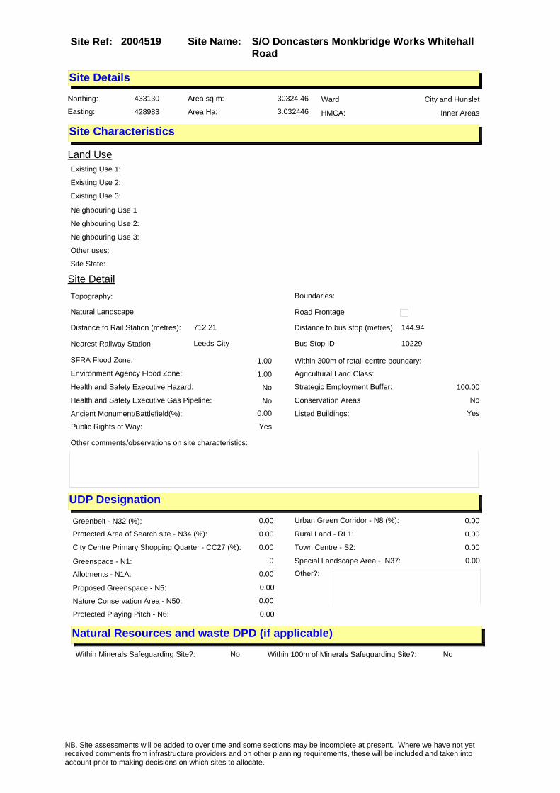
Site Name: S/O Doncasters Monkbridge Works Whitehall Road
Site Ref: 2004519
Site Details
Land Use
Northing: 433130
Easting: 428983
Distance to Rail Station (metres): 712.21
Nearest Railway Station Leeds City
Distance to bus stop (metres) 144.94
Bus Stop ID 10229
Agricultural Land Class:
SFRA Flood Zone: 1.00
Environment Agency Flood Zone: 1.00
Within 300m of retail centre boundary:
UDP Designation
Greenbelt - N32 (%): 0.00 Urban Green Corridor - N8 (%): 0.00
Protected Area of Search site - N34 (%): 0.00 Rural Land - RL1: 0.00
City Centre Primary Shopping Quarter - CC27 (%): 0.00 Town Centre - S2: 0.00
Health and Safety Executive Hazard: No
Health and Safety Executive Gas Pipeline: No
Strategic Employment Buffer: 100.00
Area sq m: 30324.46 Ward City and Hunslet
Special Landscape Area - N37: 0.00
Allotments - N1A: 0.00
Proposed Greenspace - N5: 0.00
Protected Playing Pitch - N6: 0.00
Nature Conservation Area - N50: 0.00
Conservation Areas No
Ancient Monument/Battlefield(%): 0.00 Listed Buildings: Yes
Public Rights of Way: Yes
Other?:
Natural Resources and waste DPD (if applicable)
Within Minerals Safeguarding Site?: No Within 100m of Minerals Safeguarding Site?: No
HMCA: Inner Areas
Greenspace - N1: 0
Existing Use 1:
Existing Use 2:
Existing Use 3:
Neighbouring Use 1
Neighbouring Use 2:
Neighbouring Use 3:
Other uses:
Topography:
Natural Landscape:
Boundaries:
Road Frontage
Site Characteristics
Site Detail
Other comments/observations on site characteristics:
Area Ha: 3.032446
Site State:
NB. Site assessments will be added to over time and some sections may be incomplete at present. Where we have not yet received comments from infrastructure providers and on other planning requirements, these will be included and taken into account prior to making decisions on which sites to allocate.

Site Name: S/O Doncasters Monkbridge Works Whitehall Road
Site Ref: 2004519
Planning History
Planning App No. Proposal Received Decision Status Site %
H20/18/82/ Laying out of works car park, with 260 car parking space s, to disused railway site. ( site area 0.7ha).
18/01/1982 08/03/1982 A 22.18
12/03431/COND Consent, agreement or approval required by condition 1 of Planning Application 07/04583/RM
07/08/2012 PCO 22.00
12/01935/OT Variation of conditions 5,6,7,8,9,11,12,20,25,26,33,34,37,38,43,48 of previous approval 06/02880/OT to allow date of implementation rather than commencement
01/05/2012 APPRET 99.61
H20/224/84/ Listed building application, t o demolish railway arche s over works yard.
23/05/1984 09/10/1989 W 12.59
20/169/01/FU 11.6m high storage tank and vapouriser unit.
22/03/2001 18/05/2001 A 53.40
12/05448/LI Listed Building application for use of disused viaduct as an outdoor architcture/art/sculpture plinth
21/12/2012 15/02/2013 A 14.69
12/03430/COND Consent, agreement or approval required by conditions 8, 13, 14, 27, 30, 49 and 50 of Planning Application 06/02880/OT
07/08/2012 PDE 99.61
11/03759/RM 29 storey block of 194 flats and use of 2 railway arches for commercial purposes
05/09/2011 06/12/2011 A 13.85
11/05225/FU Use of cleared site for car park (420 spaces)
12/12/2011 19/03/2012 R 33.08
12/05444/FU Use of disused viaduct as an outdoor architecture/art/sculpture platform
21/12/2012 15/02/2013 A 14.69
06/02880/OT Outline application to layout access and erect multi level mixed use development for residential and office uses up to 33 storeys high, with ancillary class A1, A2, A3, A4, A5, D1 and D2 uses and associated car parking and landscaped areas.
04/07/2006 10/09/2007 A 99.61
07/04583/RM 16 storey block of 103 flats and 23 storey block of 166 flats, with associated landscaping
18/07/2007 25/06/2008 A 22.00
08/03199/RM Laying out of pocket park with landscaping
28/05/2008 28/10/2008 A 15.55
10/04864/OT Variation of condition CPLAN - Plans List of non material amendment 10/9/00209/MOD (previous approval 06/02880/OT) relating to re-alignment of Building 02
28/10/2010 29/11/2010 W 99.61
20/527/04/OT Outline application to layout access and erect mixed use development comprising offices residential and retail
10/11/2004 14/11/2006 A 98.57
09/9/00046/MOD Laying out of pocket park with landscaping�NON MATERIAL AMENDMENT: Revision to planting scheme to area north of viaduct due to unforeseen loss of existing vegetation
05/03/2009 REC 15.55
NB. Site assessments will be added to over time and some sections may be incomplete at present. Where we have not yet received comments from infrastructure providers and on other planning requirements, these will be included and taken into account prior to making decisions on which sites to allocate.

Site Name: S/O Doncasters Monkbridge Works Whitehall Road
Site Ref: 2004519
06/00463/LI Listed Building Application for removal of structures and associated works and equipment from railway viaduct arches. Removal of brickwork attached to the viaduct and opening up of all arches by removal of retaining walls
23/01/2006 13/06/2006 A 15.87
10/02587/COND Consent, agreement or approval required by condition 7 of Planning Application 06/02880/OT
07/06/2010 28/06/2010 A 99.61
10/9/00209/MOD Outline application to layout access and erect multi level mixed use development for residential and office uses up to 33 storeys high, with ancillary class A1, A2, A3, A4, A5, D1 and D2 uses and associated car parking and landscaped areas.�NON MATERIAL AMENDMENT: Addition of specific new condition to planning approval listing or cross referencing the full list of approved plans and supporting details.
18/08/2010 09/09/2010 M01 99.61
12/9/00138/MOD Outline application to layout access and erect multi level mixed use development for residential and office uses up to 33 storeys high, with ancillary class A1, A2, A3, A4, A5, D1 and D2 uses and associated car parking and landscaped areas. NON MATERIAL AMENDMENT to 06/02880/OT: Amend date of required discharge of Conditions 5, 7, 9, 11, 12, 20, 25, 26, 33, 34, 37, 38, 43 and 48
19/06/2012 11/07/2012 M01 99.61
H20/225/84/ Outline application to demolis h existing railway archesand e rection of workshops to cleare d site. (site area
24/05/1984 09/10/1989 W 48.24
06/06408/FU Contamination remediation of the site including all necessary engineering works
26/10/2006 10/01/2007 A 33.12
09/9/00026/MOD Laying out of pocket park with landscaping�NON MATERIAL AMENDMENT: Amendments to levels of landscape areas between footpath due to unforeseen needs for on-site redistribution of excavations that are deemed to be contaminated by giant hogweed roots and seeds.
19/01/2009 09/03/2009 M01 15.55
07/06133/LI Listed Building Application to carry out alterations, repairs and restoration to disused railway viaduct to form new public realm and links to adjoining proposed residential development
01/10/2007 05/09/2008 A 55.26
11/03758/LI Listed Building Application to carry out alterations, repairs and restoration to disused railway viaduct to form new public realm and links to adjoining proposed residential development
05/09/2011 28/11/2011 A 55.26
09/9/00075/MOD Laying out of pocket park with landscaping�NON MATERIAL AMENDMENT: Two additional gates to the canal towpath and city island entrances
12/03/2009 24/04/2009 M04 15.55
NB. Site assessments will be added to over time and some sections may be incomplete at present. Where we have not yet received comments from infrastructure providers and on other planning requirements, these will be included and taken into account prior to making decisions on which sites to allocate.

Site Name: S/O Doncasters Monkbridge Works Whitehall Road
Site Ref: 2004519
Conformity with Core Strategy
Inner South Leeds: 0.00
Leeds Bradford Corridor: 0.00 West Leeds Gateway: 0.00
Aire Valley: 0.00Regeneration Priority Area:
Brownfield
Greenfield
Mixed
Main Urban Area
Major Settlement
Smaller Settlement
Villages/Rural
Main Urban Area Extension
Major Settlement Extension
Smaller Settlement Extension
Village/Rural Extension
Development unrelated to existing development
Green Belt assessment - only completed where site is within Green Belt
Would development lead to/constitute ribbon development?
Would development result in isolated development?
Is the site well connected to built up area (2+ boundaries with existing built up area)?
Would development of the site effectively "round off" the settlement pattern?:
Do natural/physical features provide a good existing barrier between existing urban area and undeveloped land?
Overall sprawl conclusion:
Would development of the site lead to physical connection of settlements?
Do natural/physical features provide a good existing barrier/boundary to contain development?
Overall Coalescence Conclusion:
Is there a strong defensible boundary between the site and the existing urban area?
Does the site provide access to the countryside?
Does the site include local or national conservation designated areas?
Does the site include areas of woodlands, trees, hedgerows that are protected, or significant unprotected tree/hedge cover?
Does the site include grade 1, 2, or 3a agricultural land?
Does the site contain buildings? Are these in agricultural use?
Overall countryside Encroachment Conclusion
Is the site within or adjacent to a conservation area, listed building or other historical feature?
If yes, could development preserve this character?:
Overall Character Preservation Conclusion:
Greenbelt Assessment Conclusion:
Check the unrestricted sprawl of large built up areas
Prevent neighbouring towns from merging
Assist in safeguarding countryside from encroachment
Preserve the setting and special character of historic towns
NB. Site assessments will be added to over time and some sections may be incomplete at present. Where we have not yet received comments from infrastructure providers and on other planning requirements, these will be included and taken into account prior to making decisions on which sites to allocate.

Site Name: S/O Doncasters Monkbridge Works Whitehall Road
Site Ref: 2004519
SHLAA ConclusionsAvailability: Suitability: Achievability:
Conclusion of Assessment
Conclusion summary:
Outline planning permission for offices valid until Sept 2010. Site is within city centre; therefore, retain for office use.
Floorspace sq m (Non residential): 36440
Employment Conclusion: Green
East Leeds
Assesment Type: ELR Type: Office
Proposed Change:
Gypsy Traveller Site Assessment
Yes No Maybe Could site be effectively managed (Text)
Yes No Maybe Would gypsies and travellers live on the site?
(Text)
Yes No Proximity to housed gypsies and travellers (Text)
Yes No Unknown Experience of previous encampments (Text)
NB. Site assessments will be added to over time and some sections may be incomplete at present. Where we have not yet received comments from infrastructure providers and on other planning requirements, these will be included and taken into account prior to making decisions on which sites to allocate.

Site Name: Globe Road/Water Lane Holbeck LS11Site Ref: 2004545
Site Details
Land Use
Northing: 432949
Easting: 429505
Distance to Rail Station (metres): 306.05
Nearest Railway Station Leeds City
Distance to bus stop (metres) 326.74
Bus Stop ID 7872
Agricultural Land Class:
SFRA Flood Zone: 1.00
Environment Agency Flood Zone: 1.00
Within 300m of retail centre boundary:
UDP Designation
Greenbelt - N32 (%): 0.00 Urban Green Corridor - N8 (%): 0.00
Protected Area of Search site - N34 (%): 0.00 Rural Land - RL1: 0.00
City Centre Primary Shopping Quarter - CC27 (%): 0.00 Town Centre - S2: 0.00
Health and Safety Executive Hazard: No
Health and Safety Executive Gas Pipeline: No
Strategic Employment Buffer: 0.00
Area sq m: 4012.09 Ward City and Hunslet
Special Landscape Area - N37: 0.00
Allotments - N1A: 0.00
Proposed Greenspace - N5: 0.00
Protected Playing Pitch - N6: 0.00
Nature Conservation Area - N50: 1.00
Conservation Areas Yes
Ancient Monument/Battlefield(%): 0.00 Listed Buildings: No
Public Rights of Way: No
Other?:
Natural Resources and waste DPD (if applicable)
Within Minerals Safeguarding Site?: No Within 100m of Minerals Safeguarding Site?: No
HMCA: City Centre
Greenspace - N1: 0
Existing Use 1:
Existing Use 2:
Existing Use 3:
Neighbouring Use 1
Neighbouring Use 2:
Neighbouring Use 3:
Other uses:
Topography:
Natural Landscape:
Boundaries:
Road Frontage
Site Characteristics
Site Detail
Other comments/observations on site characteristics:
Area Ha: 0.401209
Site State:
NB. Site assessments will be added to over time and some sections may be incomplete at present. Where we have not yet received comments from infrastructure providers and on other planning requirements, these will be included and taken into account prior to making decisions on which sites to allocate.

Site Name: Globe Road/Water Lane Holbeck LS11Site Ref: 2004545
Planning History
NB. Site assessments will be added to over time and some sections may be incomplete at present. Where we have not yet received comments from infrastructure providers and on other planning requirements, these will be included and taken into account prior to making decisions on which sites to allocate.

Site Name: Globe Road/Water Lane Holbeck LS11Site Ref: 2004545
Conformity with Core Strategy
Inner South Leeds: 0.00
Leeds Bradford Corridor: 0.00 West Leeds Gateway: 0.00
Aire Valley: 0.00Regeneration Priority Area:
Brownfield
Greenfield
Mixed
Main Urban Area
Major Settlement
Smaller Settlement
Villages/Rural
Main Urban Area Extension
Major Settlement Extension
Smaller Settlement Extension
Village/Rural Extension
Development unrelated to existing development
Green Belt assessment - only completed where site is within Green Belt
Would development lead to/constitute ribbon development?
Would development result in isolated development?
Is the site well connected to built up area (2+ boundaries with existing built up area)?
Would development of the site effectively "round off" the settlement pattern?:
Do natural/physical features provide a good existing barrier between existing urban area and undeveloped land?
Overall sprawl conclusion:
Would development of the site lead to physical connection of settlements?
Do natural/physical features provide a good existing barrier/boundary to contain development?
Overall Coalescence Conclusion:
Is there a strong defensible boundary between the site and the existing urban area?
Does the site provide access to the countryside?
Does the site include local or national conservation designated areas?
Does the site include areas of woodlands, trees, hedgerows that are protected, or significant unprotected tree/hedge cover?
Does the site include grade 1, 2, or 3a agricultural land?
Does the site contain buildings? Are these in agricultural use?
Overall countryside Encroachment Conclusion
Is the site within or adjacent to a conservation area, listed building or other historical feature?
If yes, could development preserve this character?:
Overall Character Preservation Conclusion:
Greenbelt Assessment Conclusion:
Check the unrestricted sprawl of large built up areas
Prevent neighbouring towns from merging
Assist in safeguarding countryside from encroachment
Preserve the setting and special character of historic towns
NB. Site assessments will be added to over time and some sections may be incomplete at present. Where we have not yet received comments from infrastructure providers and on other planning requirements, these will be included and taken into account prior to making decisions on which sites to allocate.

Site Name: Globe Road/Water Lane Holbeck LS11Site Ref: 2004545
SHLAA ConclusionsAvailability: Suitability: Achievability:
Conclusion of Assessment
Conclusion summary:
Current site with planning permission for employment purposes
Floorspace sq m (Non residential): 8060
Employment Conclusion: Lime Green
East Leeds
Assesment Type: ELR Type: Office
Proposed Change:
Gypsy Traveller Site Assessment
Yes No Maybe Could site be effectively managed (Text)
Yes No Maybe Would gypsies and travellers live on the site?
(Text)
Yes No Proximity to housed gypsies and travellers (Text)
Yes No Unknown Experience of previous encampments (Text)
NB. Site assessments will be added to over time and some sections may be incomplete at present. Where we have not yet received comments from infrastructure providers and on other planning requirements, these will be included and taken into account prior to making decisions on which sites to allocate.

Site Name: CAR PARK C PORTLAND CRESC LS1Site Ref: 2004589
Site Details
Land Use
Northing: 434208
Easting: 429911
Distance to Rail Station (metres): 1040.25
Nearest Railway Station Leeds City
Distance to bus stop (metres) 65.12
Bus Stop ID 1293
Agricultural Land Class:
SFRA Flood Zone: 0.00
Environment Agency Flood Zone: 0.00
Within 300m of retail centre boundary:
UDP Designation
Greenbelt - N32 (%): 0.00 Urban Green Corridor - N8 (%): 0.00
Protected Area of Search site - N34 (%): 0.00 Rural Land - RL1: 0.00
City Centre Primary Shopping Quarter - CC27 (%): 0.00 Town Centre - S2: 0.00
Health and Safety Executive Hazard: No
Health and Safety Executive Gas Pipeline: No
Strategic Employment Buffer: 100.00
Area sq m: 4211.46 Ward City and Hunslet
Special Landscape Area - N37: 0.00
Allotments - N1A: 0.00
Proposed Greenspace - N5: 0.00
Protected Playing Pitch - N6: 0.00
Nature Conservation Area - N50: 0.00
Conservation Areas No
Ancient Monument/Battlefield(%): 0.00 Listed Buildings: Yes
Public Rights of Way: Yes
Other?:
Natural Resources and waste DPD (if applicable)
Within Minerals Safeguarding Site?: No Within 100m of Minerals Safeguarding Site?: No
HMCA: City Centre
Greenspace - N1: 0
Existing Use 1:
Existing Use 2:
Existing Use 3:
Neighbouring Use 1
Neighbouring Use 2:
Neighbouring Use 3:
Other uses:
Topography:
Natural Landscape:
Boundaries:
Road Frontage
Site Characteristics
Site Detail
Other comments/observations on site characteristics:
Area Ha: 0.421146
Site State:
NB. Site assessments will be added to over time and some sections may be incomplete at present. Where we have not yet received comments from infrastructure providers and on other planning requirements, these will be included and taken into account prior to making decisions on which sites to allocate.

Site Name: CAR PARK C PORTLAND CRESC LS1Site Ref: 2004589
Planning History
Planning App No. Proposal Received Decision Status Site %
20/315/98/FU Surfacing and laying out of access to existing car park
22/05/1998 21/07/1998 A 48.98
06/00949/FU Application seeking permission for the university business school (phase 1) and permission for a mixture of office, residential, hotel and ancillary commercial uses (class A1, A2, A3, A4 and D1) (phase 2)
09/02/2006 28/02/2007 A 99.97
20/581/99/LI Listed building application to form disabled persons access ramp and handrails
19/10/1999 18/05/2000 W 48.98
09/03849/ADV 1 internally illuminated moving sign to roof of university building
03/09/2009 02/11/2009 W 48.74
20/43/05/FU Variation of condition no 1 of deemed planning consent for north and east supertram (extension of time limit)
31/01/2005 25/07/2005 A 29.35
H20/575/91/ Change of use, involving layin g out of enlarged access and e rection of kiosk of vacant sit e, to temporary car park.
18/12/1991 11/02/1992 A 49.21
NB. Site assessments will be added to over time and some sections may be incomplete at present. Where we have not yet received comments from infrastructure providers and on other planning requirements, these will be included and taken into account prior to making decisions on which sites to allocate.

Site Name: CAR PARK C PORTLAND CRESC LS1Site Ref: 2004589
Conformity with Core Strategy
Inner South Leeds: 0.00
Leeds Bradford Corridor: 0.00 West Leeds Gateway: 0.00
Aire Valley: 0.00Regeneration Priority Area:
Brownfield
Greenfield
Mixed
Main Urban Area
Major Settlement
Smaller Settlement
Villages/Rural
Main Urban Area Extension
Major Settlement Extension
Smaller Settlement Extension
Village/Rural Extension
Development unrelated to existing development
Green Belt assessment - only completed where site is within Green Belt
Would development lead to/constitute ribbon development?
Would development result in isolated development?
Is the site well connected to built up area (2+ boundaries with existing built up area)?
Would development of the site effectively "round off" the settlement pattern?:
Do natural/physical features provide a good existing barrier between existing urban area and undeveloped land?
Overall sprawl conclusion:
Would development of the site lead to physical connection of settlements?
Do natural/physical features provide a good existing barrier/boundary to contain development?
Overall Coalescence Conclusion:
Is there a strong defensible boundary between the site and the existing urban area?
Does the site provide access to the countryside?
Does the site include local or national conservation designated areas?
Does the site include areas of woodlands, trees, hedgerows that are protected, or significant unprotected tree/hedge cover?
Does the site include grade 1, 2, or 3a agricultural land?
Does the site contain buildings? Are these in agricultural use?
Overall countryside Encroachment Conclusion
Is the site within or adjacent to a conservation area, listed building or other historical feature?
If yes, could development preserve this character?:
Overall Character Preservation Conclusion:
Greenbelt Assessment Conclusion:
Check the unrestricted sprawl of large built up areas
Prevent neighbouring towns from merging
Assist in safeguarding countryside from encroachment
Preserve the setting and special character of historic towns
NB. Site assessments will be added to over time and some sections may be incomplete at present. Where we have not yet received comments from infrastructure providers and on other planning requirements, these will be included and taken into account prior to making decisions on which sites to allocate.

Site Name: CAR PARK C PORTLAND CRESC LS1Site Ref: 2004589
SHLAA ConclusionsAvailability: Suitability: Achievability:
Conclusion of Assessment
Conclusion summary:
Highly accessible and in the city centre. Outline planning permission for Ph2 indicates office element of 2500-7000 sqm within a mixed use
Floorspace sq m (Non residential): 4000
Employment Conclusion: Green
East Leeds
Assesment Type: ELR Type: Office
Proposed Change:
Gypsy Traveller Site Assessment
Yes No Maybe Could site be effectively managed (Text)
Yes No Maybe Would gypsies and travellers live on the site?
(Text)
Yes No Proximity to housed gypsies and travellers (Text)
Yes No Unknown Experience of previous encampments (Text)
NB. Site assessments will be added to over time and some sections may be incomplete at present. Where we have not yet received comments from infrastructure providers and on other planning requirements, these will be included and taken into account prior to making decisions on which sites to allocate.

Site Name: 2-28 The Calls Leeds LS2Site Ref: 2004609
Site Details
Land Use
Northing: 433263
Easting: 430387
Distance to Rail Station (metres): 698.44
Nearest Railway Station Leeds City
Distance to bus stop (metres) 102.64
Bus Stop ID 4950
Agricultural Land Class:
SFRA Flood Zone: 1.00
Environment Agency Flood Zone: 1.00
Within 300m of retail centre boundary:
UDP Designation
Greenbelt - N32 (%): 0.00 Urban Green Corridor - N8 (%): 0.00
Protected Area of Search site - N34 (%): 0.00 Rural Land - RL1: 0.00
City Centre Primary Shopping Quarter - CC27 (%): 0.00 Town Centre - S2: 0.00
Health and Safety Executive Hazard: No
Health and Safety Executive Gas Pipeline: No
Strategic Employment Buffer: 0.00
Area sq m: 4989.52 Ward City and Hunslet
Special Landscape Area - N37: 0.00
Allotments - N1A: 0.00
Proposed Greenspace - N5: 0.00
Protected Playing Pitch - N6: 0.00
Nature Conservation Area - N50: 1.00
Conservation Areas Yes
Ancient Monument/Battlefield(%): 0.00 Listed Buildings: No
Public Rights of Way: No
Other?:
Natural Resources and waste DPD (if applicable)
Within Minerals Safeguarding Site?: No Within 100m of Minerals Safeguarding Site?: No
HMCA: City Centre
Greenspace - N1: 0
Existing Use 1:
Existing Use 2:
Existing Use 3:
Neighbouring Use 1
Neighbouring Use 2:
Neighbouring Use 3:
Other uses:
Topography:
Natural Landscape:
Boundaries:
Road Frontage
Site Characteristics
Site Detail
Other comments/observations on site characteristics:
Area Ha: 0.498952
Site State:
NB. Site assessments will be added to over time and some sections may be incomplete at present. Where we have not yet received comments from infrastructure providers and on other planning requirements, these will be included and taken into account prior to making decisions on which sites to allocate.

Site Name: 2-28 The Calls Leeds LS2Site Ref: 2004609
Planning History
NB. Site assessments will be added to over time and some sections may be incomplete at present. Where we have not yet received comments from infrastructure providers and on other planning requirements, these will be included and taken into account prior to making decisions on which sites to allocate.

Site Name: 2-28 The Calls Leeds LS2Site Ref: 2004609
Conformity with Core Strategy
Inner South Leeds: 0.00
Leeds Bradford Corridor: 0.00 West Leeds Gateway: 0.00
Aire Valley: 0.00Regeneration Priority Area:
Brownfield
Greenfield
Mixed
Main Urban Area
Major Settlement
Smaller Settlement
Villages/Rural
Main Urban Area Extension
Major Settlement Extension
Smaller Settlement Extension
Village/Rural Extension
Development unrelated to existing development
Green Belt assessment - only completed where site is within Green Belt
Would development lead to/constitute ribbon development?
Would development result in isolated development?
Is the site well connected to built up area (2+ boundaries with existing built up area)?
Would development of the site effectively "round off" the settlement pattern?:
Do natural/physical features provide a good existing barrier between existing urban area and undeveloped land?
Overall sprawl conclusion:
Would development of the site lead to physical connection of settlements?
Do natural/physical features provide a good existing barrier/boundary to contain development?
Overall Coalescence Conclusion:
Is there a strong defensible boundary between the site and the existing urban area?
Does the site provide access to the countryside?
Does the site include local or national conservation designated areas?
Does the site include areas of woodlands, trees, hedgerows that are protected, or significant unprotected tree/hedge cover?
Does the site include grade 1, 2, or 3a agricultural land?
Does the site contain buildings? Are these in agricultural use?
Overall countryside Encroachment Conclusion
Is the site within or adjacent to a conservation area, listed building or other historical feature?
If yes, could development preserve this character?:
Overall Character Preservation Conclusion:
Greenbelt Assessment Conclusion:
Check the unrestricted sprawl of large built up areas
Prevent neighbouring towns from merging
Assist in safeguarding countryside from encroachment
Preserve the setting and special character of historic towns
NB. Site assessments will be added to over time and some sections may be incomplete at present. Where we have not yet received comments from infrastructure providers and on other planning requirements, these will be included and taken into account prior to making decisions on which sites to allocate.

Site Name: 2-28 The Calls Leeds LS2Site Ref: 2004609
SHLAA ConclusionsAvailability: Suitability: Achievability:
Conclusion of Assessment
Conclusion summary:
Reflects office element of mixed use scheme.
Floorspace sq m (Non residential): 4400
Employment Conclusion: Green
East Leeds
Assesment Type: ELR Type: Office
Proposed Change:
Gypsy Traveller Site Assessment
Yes No Maybe Could site be effectively managed (Text)
Yes No Maybe Would gypsies and travellers live on the site?
(Text)
Yes No Proximity to housed gypsies and travellers (Text)
Yes No Unknown Experience of previous encampments (Text)
NB. Site assessments will be added to over time and some sections may be incomplete at present. Where we have not yet received comments from infrastructure providers and on other planning requirements, these will be included and taken into account prior to making decisions on which sites to allocate.

Site Name: Sweet Street West & Marshall Street LS11Site Ref: 2004659
Site Details
Land Use
Northing: 432494
Easting: 429479
Distance to Rail Station (metres): 728.91
Nearest Railway Station Leeds City
Distance to bus stop (metres) 110.95
Bus Stop ID 12632
Agricultural Land Class:
SFRA Flood Zone: 1.00
Environment Agency Flood Zone: 1.00
Within 300m of retail centre boundary:
UDP Designation
Greenbelt - N32 (%): 0.00 Urban Green Corridor - N8 (%): 0.00
Protected Area of Search site - N34 (%): 0.00 Rural Land - RL1: 0.00
City Centre Primary Shopping Quarter - CC27 (%): 0.00 Town Centre - S2: 0.00
Health and Safety Executive Hazard: No
Health and Safety Executive Gas Pipeline: Yes
Strategic Employment Buffer: 0.00
Area sq m: 30376.35 Ward City and Hunslet
Special Landscape Area - N37: 0.00
Allotments - N1A: 0.00
Proposed Greenspace - N5: 0.00
Protected Playing Pitch - N6: 0.00
Nature Conservation Area - N50: 0.00
Conservation Areas No
Ancient Monument/Battlefield(%): 0.00 Listed Buildings: No
Public Rights of Way: No
Other?:
Natural Resources and waste DPD (if applicable)
Within Minerals Safeguarding Site?: No Within 100m of Minerals Safeguarding Site?: No
HMCA: City Centre
Greenspace - N1: 0
Existing Use 1:
Existing Use 2:
Existing Use 3:
Neighbouring Use 1
Neighbouring Use 2:
Neighbouring Use 3:
Other uses:
Topography:
Natural Landscape:
Boundaries:
Road Frontage
Site Characteristics
Site Detail
Other comments/observations on site characteristics:
Area Ha: 3.037635
Site State:
NB. Site assessments will be added to over time and some sections may be incomplete at present. Where we have not yet received comments from infrastructure providers and on other planning requirements, these will be included and taken into account prior to making decisions on which sites to allocate.

Site Name: Sweet Street West & Marshall Street LS11Site Ref: 2004659
Planning History
NB. Site assessments will be added to over time and some sections may be incomplete at present. Where we have not yet received comments from infrastructure providers and on other planning requirements, these will be included and taken into account prior to making decisions on which sites to allocate.
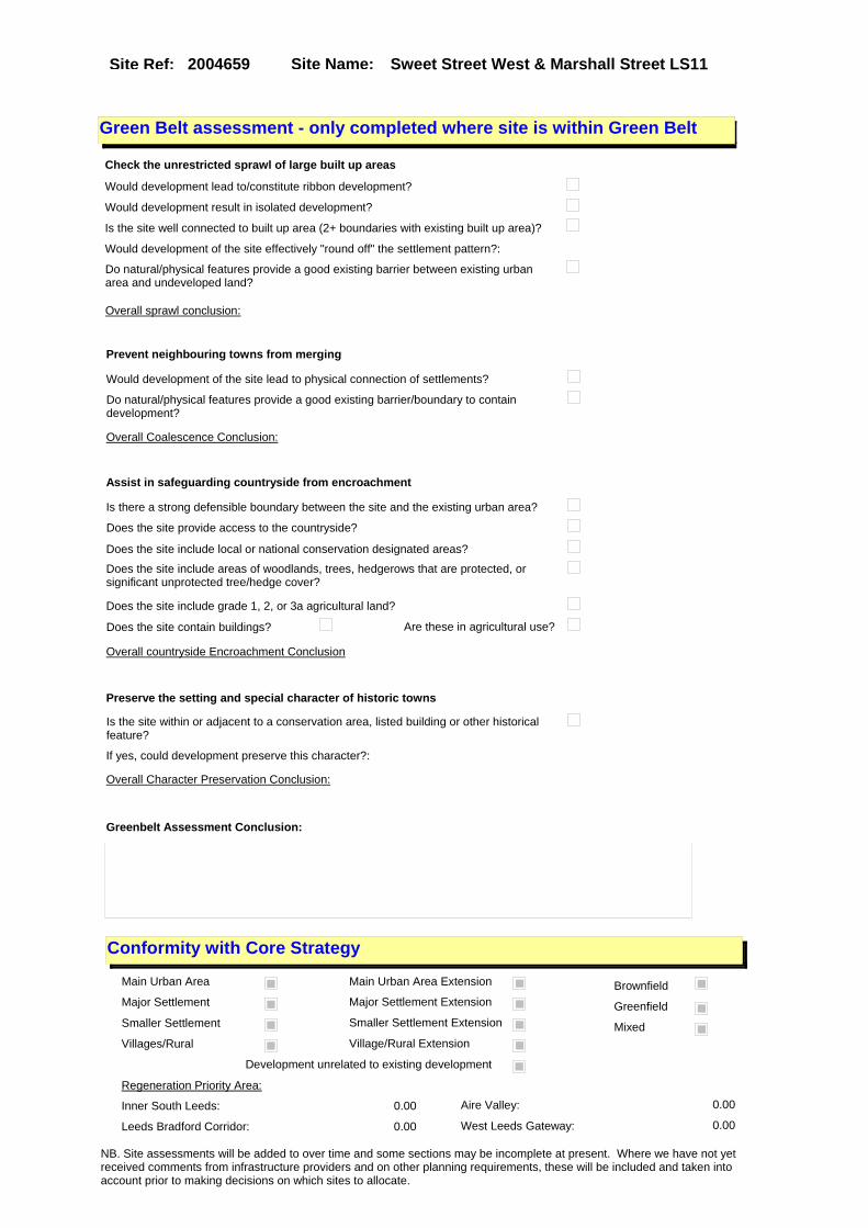
Site Name: Sweet Street West & Marshall Street LS11Site Ref: 2004659
Conformity with Core Strategy
Inner South Leeds: 0.00
Leeds Bradford Corridor: 0.00 West Leeds Gateway: 0.00
Aire Valley: 0.00Regeneration Priority Area:
Brownfield
Greenfield
Mixed
Main Urban Area
Major Settlement
Smaller Settlement
Villages/Rural
Main Urban Area Extension
Major Settlement Extension
Smaller Settlement Extension
Village/Rural Extension
Development unrelated to existing development
Green Belt assessment - only completed where site is within Green Belt
Would development lead to/constitute ribbon development?
Would development result in isolated development?
Is the site well connected to built up area (2+ boundaries with existing built up area)?
Would development of the site effectively "round off" the settlement pattern?:
Do natural/physical features provide a good existing barrier between existing urban area and undeveloped land?
Overall sprawl conclusion:
Would development of the site lead to physical connection of settlements?
Do natural/physical features provide a good existing barrier/boundary to contain development?
Overall Coalescence Conclusion:
Is there a strong defensible boundary between the site and the existing urban area?
Does the site provide access to the countryside?
Does the site include local or national conservation designated areas?
Does the site include areas of woodlands, trees, hedgerows that are protected, or significant unprotected tree/hedge cover?
Does the site include grade 1, 2, or 3a agricultural land?
Does the site contain buildings? Are these in agricultural use?
Overall countryside Encroachment Conclusion
Is the site within or adjacent to a conservation area, listed building or other historical feature?
If yes, could development preserve this character?:
Overall Character Preservation Conclusion:
Greenbelt Assessment Conclusion:
Check the unrestricted sprawl of large built up areas
Prevent neighbouring towns from merging
Assist in safeguarding countryside from encroachment
Preserve the setting and special character of historic towns
NB. Site assessments will be added to over time and some sections may be incomplete at present. Where we have not yet received comments from infrastructure providers and on other planning requirements, these will be included and taken into account prior to making decisions on which sites to allocate.

Site Name: Sweet Street West & Marshall Street LS11Site Ref: 2004659
SHLAA ConclusionsAvailability: Suitability: Achievability:
Conclusion of Assessment
Conclusion summary:
Reflects outline planning permission.
Floorspace sq m (Non residential): 17340
Employment Conclusion: Green
East Leeds
Assesment Type: ELR Type: Office
Proposed Change:
Gypsy Traveller Site Assessment
Yes No Maybe Could site be effectively managed (Text)
Yes No Maybe Would gypsies and travellers live on the site?
(Text)
Yes No Proximity to housed gypsies and travellers (Text)
Yes No Unknown Experience of previous encampments (Text)
NB. Site assessments will be added to over time and some sections may be incomplete at present. Where we have not yet received comments from infrastructure providers and on other planning requirements, these will be included and taken into account prior to making decisions on which sites to allocate.
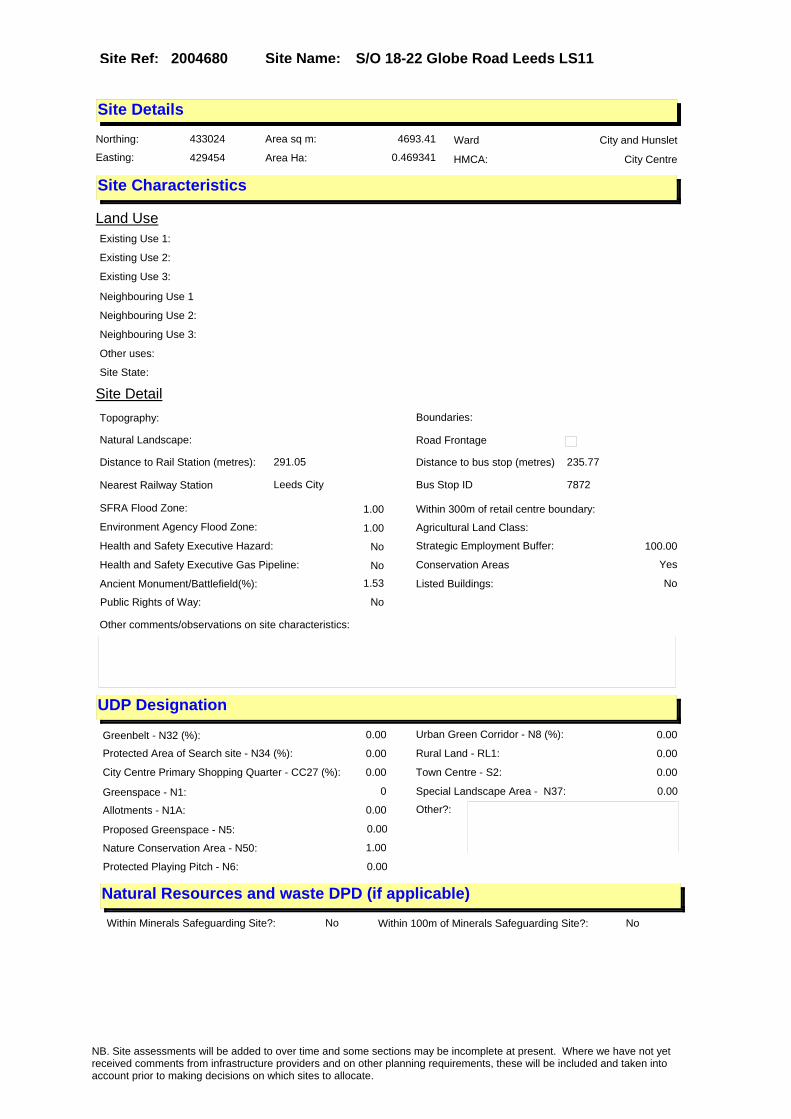
Site Name: S/O 18-22 Globe Road Leeds LS11Site Ref: 2004680
Site Details
Land Use
Northing: 433024
Easting: 429454
Distance to Rail Station (metres): 291.05
Nearest Railway Station Leeds City
Distance to bus stop (metres) 235.77
Bus Stop ID 7872
Agricultural Land Class:
SFRA Flood Zone: 1.00
Environment Agency Flood Zone: 1.00
Within 300m of retail centre boundary:
UDP Designation
Greenbelt - N32 (%): 0.00 Urban Green Corridor - N8 (%): 0.00
Protected Area of Search site - N34 (%): 0.00 Rural Land - RL1: 0.00
City Centre Primary Shopping Quarter - CC27 (%): 0.00 Town Centre - S2: 0.00
Health and Safety Executive Hazard: No
Health and Safety Executive Gas Pipeline: No
Strategic Employment Buffer: 100.00
Area sq m: 4693.41 Ward City and Hunslet
Special Landscape Area - N37: 0.00
Allotments - N1A: 0.00
Proposed Greenspace - N5: 0.00
Protected Playing Pitch - N6: 0.00
Nature Conservation Area - N50: 1.00
Conservation Areas Yes
Ancient Monument/Battlefield(%): 1.53 Listed Buildings: No
Public Rights of Way: No
Other?:
Natural Resources and waste DPD (if applicable)
Within Minerals Safeguarding Site?: No Within 100m of Minerals Safeguarding Site?: No
HMCA: City Centre
Greenspace - N1: 0
Existing Use 1:
Existing Use 2:
Existing Use 3:
Neighbouring Use 1
Neighbouring Use 2:
Neighbouring Use 3:
Other uses:
Topography:
Natural Landscape:
Boundaries:
Road Frontage
Site Characteristics
Site Detail
Other comments/observations on site characteristics:
Area Ha: 0.469341
Site State:
NB. Site assessments will be added to over time and some sections may be incomplete at present. Where we have not yet received comments from infrastructure providers and on other planning requirements, these will be included and taken into account prior to making decisions on which sites to allocate.

Site Name: S/O 18-22 Globe Road Leeds LS11Site Ref: 2004680
Planning History
Planning App No. Proposal Received Decision Status Site %
12/02214/COND Cosent, agreement or approval required by condition 3 of Planning Application 11/05218/FU
18/05/2012 10/08/2012 A 100.00
H20/83/87/ Alterations and 2 storey exten sion, to form offices andtoile ts with 7 car parking spaces, 2m high brick boundary w
16/02/1987 23/03/1987 A 57.89
12/03376/COND Consent, agreement or approval required by condition 9 of Planning Application 11/05218/FU
03/08/2012 13/08/2012 A 100.00
H20/78/83/ 5455.3 litres diesel oil stora ge tank to distribution depot .
16/03/1983 25/04/1983 A 38.27
H20/202/79/ Change of use of warehouse to light industrial unit.
09/05/1979 18/06/1979 A 89.79
H20/299/79/ 3m high chain link boundary fe nce, with landscaping, layin g out of concrete yard to work s.
06/07/1979 20/08/1979 A 95.94
H20/143/79/ Alterations and extension, to form corridor link, to works .
06/04/1979 22/05/1979 A 97.72
H20/420/82/ Alterations, including new fro ntage and to form new entra nce, toilets, offices and cant een, and addition two canopi
26/11/1982 24/01/1983 R 38.49
H20/83/78/ Addition of loading platform t o warehouse unit.
02/03/1978 10/04/1978 A 39.72
H20/98/77/ Change of use of clothing fact ory, to warehouse.
02/03/1977 09/05/1977 A 24.97
H20/58/74/ Extension to form toilet accom odation to factory premi ses.
09/05/1974 10/06/1974 A 73.53
09/05209/EXT Extension of time for outline application to erect mixed use development with hotel residential A2/A3/A4/A5/B1/D1 uses and car parking
30/11/2009 29/11/2010 A 100.00
11/05218/FU Use of cleared site for long stay car park (170 spaces)
12/12/2011 19/03/2012 A 100.00
20/245/05/OT Outline application to erect mixed use development with hotel residential A2/A3/A4/A5/B1/D1 uses and car parking
24/05/2005 28/12/2006 A 94.15
H20/417/82/ Erection of new entrance gates with 2 metre high chain link fence and alterations to works .
25/11/1982 07/12/1982 A 38.49
06/01094/FU Use of cleared site as car park 20/02/2006 28/04/2006 R 98.63
12/02632/COND Consent, agreement or approval required by conditions 5, 6, 7 and 8 of Planning Application 11/05218/FU
11/06/2012 13/08/2012 A 100.00
PREAPP/08/00390 . 01/12/2008 17/07/2009 PRECAG 99.78
H20/301/79/ 8 storage racks, to works storage yard.
10/07/1979 20/08/1979 A 97.46
NB. Site assessments will be added to over time and some sections may be incomplete at present. Where we have not yet received comments from infrastructure providers and on other planning requirements, these will be included and taken into account prior to making decisions on which sites to allocate.

Site Name: S/O 18-22 Globe Road Leeds LS11Site Ref: 2004680
Conformity with Core Strategy
Inner South Leeds: 0.00
Leeds Bradford Corridor: 0.00 West Leeds Gateway: 0.00
Aire Valley: 0.00Regeneration Priority Area:
Brownfield
Greenfield
Mixed
Main Urban Area
Major Settlement
Smaller Settlement
Villages/Rural
Main Urban Area Extension
Major Settlement Extension
Smaller Settlement Extension
Village/Rural Extension
Development unrelated to existing development
Green Belt assessment - only completed where site is within Green Belt
Would development lead to/constitute ribbon development?
Would development result in isolated development?
Is the site well connected to built up area (2+ boundaries with existing built up area)?
Would development of the site effectively "round off" the settlement pattern?:
Do natural/physical features provide a good existing barrier between existing urban area and undeveloped land?
Overall sprawl conclusion:
Would development of the site lead to physical connection of settlements?
Do natural/physical features provide a good existing barrier/boundary to contain development?
Overall Coalescence Conclusion:
Is there a strong defensible boundary between the site and the existing urban area?
Does the site provide access to the countryside?
Does the site include local or national conservation designated areas?
Does the site include areas of woodlands, trees, hedgerows that are protected, or significant unprotected tree/hedge cover?
Does the site include grade 1, 2, or 3a agricultural land?
Does the site contain buildings? Are these in agricultural use?
Overall countryside Encroachment Conclusion
Is the site within or adjacent to a conservation area, listed building or other historical feature?
If yes, could development preserve this character?:
Overall Character Preservation Conclusion:
Greenbelt Assessment Conclusion:
Check the unrestricted sprawl of large built up areas
Prevent neighbouring towns from merging
Assist in safeguarding countryside from encroachment
Preserve the setting and special character of historic towns
NB. Site assessments will be added to over time and some sections may be incomplete at present. Where we have not yet received comments from infrastructure providers and on other planning requirements, these will be included and taken into account prior to making decisions on which sites to allocate.

Site Name: S/O 18-22 Globe Road Leeds LS11Site Ref: 2004680
SHLAA ConclusionsAvailability: Suitability: Achievability:
Conclusion of Assessment
Conclusion summary:
Outline planning permission for mixed use has not been implemented.
Floorspace sq m (Non residential): 10660
Employment Conclusion: Lime Green
East Leeds
Assesment Type: ELR Type: Office
Proposed Change:
Gypsy Traveller Site Assessment
Yes No Maybe Could site be effectively managed (Text)
Yes No Maybe Would gypsies and travellers live on the site?
(Text)
Yes No Proximity to housed gypsies and travellers (Text)
Yes No Unknown Experience of previous encampments (Text)
NB. Site assessments will be added to over time and some sections may be incomplete at present. Where we have not yet received comments from infrastructure providers and on other planning requirements, these will be included and taken into account prior to making decisions on which sites to allocate.

Site Name: Office elements Harewood Quarter LS2Site Ref: 2004730
Site Details
Land Use
Northing: 433808
Easting: 430512
Distance to Rail Station (metres): 1025.62
Nearest Railway Station Leeds City
Distance to bus stop (metres) 86.10
Bus Stop ID 2595
Agricultural Land Class:
SFRA Flood Zone: 0.00
Environment Agency Flood Zone: 0.00
Within 300m of retail centre boundary:
UDP Designation
Greenbelt - N32 (%): 0.00 Urban Green Corridor - N8 (%): 0.00
Protected Area of Search site - N34 (%): 0.00 Rural Land - RL1: 0.00
City Centre Primary Shopping Quarter - CC27 (%): 100.00 Town Centre - S2: 0.00
Health and Safety Executive Hazard: No
Health and Safety Executive Gas Pipeline: No
Strategic Employment Buffer: 100.00
Area sq m: 9300.88 Ward City and Hunslet
Special Landscape Area - N37: 0.00
Allotments - N1A: 0.00
Proposed Greenspace - N5: 0.00
Protected Playing Pitch - N6: 0.00
Nature Conservation Area - N50: 0.00
Conservation Areas No
Ancient Monument/Battlefield(%): 0.00 Listed Buildings: No
Public Rights of Way: No
Other?:
Natural Resources and waste DPD (if applicable)
Within Minerals Safeguarding Site?: No Within 100m of Minerals Safeguarding Site?: No
HMCA: City Centre
Greenspace - N1: 0
Existing Use 1:
Existing Use 2:
Existing Use 3:
Neighbouring Use 1
Neighbouring Use 2:
Neighbouring Use 3:
Other uses:
Topography:
Natural Landscape:
Boundaries:
Road Frontage
Site Characteristics
Site Detail
Other comments/observations on site characteristics:
Area Ha: 0.930088
Site State:
NB. Site assessments will be added to over time and some sections may be incomplete at present. Where we have not yet received comments from infrastructure providers and on other planning requirements, these will be included and taken into account prior to making decisions on which sites to allocate.

Site Name: Office elements Harewood Quarter LS2Site Ref: 2004730
Planning History
Planning App No. Proposal Received Decision Status Site %
H20/221/85/ Alterations, including new win dows to offices.
23/05/1985 01/07/1985 A 15.20
12/9/00098/MOD NON MATERIAL AMENDMENT to 11/01000/OT: To amend the development description to read Outline application for major redevelopment, including demolition, involving mixed use to provide retail stores, restaurants, bars and offices (A1, A2, A3, A4, A5 and B1 Use Classes), Leisure use (D2 Use Class), Casino Use, medical centre, creche, multi-faith prayer room (D1 Use Classes), changing places toilet facilities; with new squares and public realm, landscaping, car parking and associated highway works
16/05/2012 02/10/2012 M01 100.00
H20/66/85/ Laying out of enlarged concour se with canopy over and new b us shelters, and improved publ ic and passenger facilities
25/02/1985 15/03/1988 W 15.58
20/558/01/CLU Certificate of lawfulness for car park 26/10/2001 25/06/2002 A 56.61
12/9/00055/MOD Outline application for major redevelopment, including demolition, involving mixed use to provide retail stores, restaurants, bars and offices (A1, A2, A3, A4, A5 and B1 Use Classes), gym (D2 Use Class), medical centre, creche, multi-faith prayer room (D1 Use Classes), changing places toilet facilities; with new squares and public realm, landscaping, car parking and associated highway works NON MATERIAL AMENDMENT to 11/01000/OT: Amendment to description to refer to leisure use (D2 use class) instead of gym (D2 use class)
15/03/2012 04/04/2012 M01 100.00
12/9/00233/MOD NON MATERIAL AMENDMENT to 12/03002/OT: Variation of wording to conditions 9, 18 and 54; amendment to approved parameters of Plot HQ1
21/11/2012 12/12/2012 M01 100.00
06/03333/OT Outline application for major redevelopment involving mixed use to provide retail stores, restaurants, bars and offices within use classes A1,A2,A3,A4,A5 and B1and housing (class C3), cinema (class D2), gym (class D2), medical centre (class D1), church drop in facility, creche (class D1) and hotel (class C1), with associated highways works, open space, landscaping, car parking, pedestrian facilities and re-alignment of culvert
31/05/2006 24/08/2007 A 100.00
H20/119/78/ Use of vacant land as short st ay car park.
30/03/1978 02/05/1978 A 38.61
H20/103/77/ Demolition of existing buildin gs, laying out of acces s roads, alterations to rear o f theatre to form 2 shop units
04/03/1977 31/10/1977 W 90.04
NB. Site assessments will be added to over time and some sections may be incomplete at present. Where we have not yet received comments from infrastructure providers and on other planning requirements, these will be included and taken into account prior to making decisions on which sites to allocate.

Site Name: Office elements Harewood Quarter LS2Site Ref: 2004730
12/03002/OT Variation of condition 3 of planning permission 11/01000/OT to allow for leisure use (D2 use class) and casino use (sui generis) as part of a retail-led mixed use development
10/07/2012 30/10/2012 A 100.00
20/371/98/OT Outline application to erect leisure development with multi screen cinema restaurants bars retail & multi storey parking
22/06/1998 29/04/1999 W 74.51
11/01000/OT Outline application for major redevelopment, including demolition, involving mixed use to provide retail stores, restaurants, bars and offices (A1, A2, A3, A4, A5 and B1 Use Classes), Leisure use (D2 Use Class), casino use, medical centre, creche, multi-faith prayer room (D1 Use Classes), changing places toilet facilities; with new squares and public realm, landscaping, car parking and associated highway works.
10/03/2011 06/09/2011 A 100.00
H20/31/76/ Use of vacant land as short st ay car-park.for a furthertempo rary period.
23/01/1976 23/02/1976 A 40.46
20/11/94/OT Outline application to erect office retail and leisure development with multi storey car park
12/01/1994 18/01/1995 W 61.99
20/290/94/FU Retail and leisure development with multi storey car park
18/07/1994 01/12/1997 W 85.91
H20/374/74/ Extension of existing car park to form enlarged short stay car park to vacant land. (site area 0.436ha (1.077 acr
03/12/1974 24/02/1975 A 100.00
20/312/94/LI Listed building application to form new entrance reglaze windows and remove partition
28/07/1994 01/12/1997 W 85.91
H20/46/77/ Renewal of outline application to demolish shops, offic es, bus station and toffee fac tory and to comprehens
07/02/1977 14/03/1977 A 99.84
09/9/00291/MOD Outline application for major redevelopment involving mixed use to provide retail stores, restaurants, bars and offices within use classes A1,A2,A3,A4,A5 and B1and housing (class C3), cinema (class D2), gym (class D2), medical centre (class D1), church drop in facility, creche (class D1) and hotel (class C1), with associated highways works, open space, landscaping, car parking, pedestrian facilities and re-alignment of culvert�NON MATERIAL AMENDMENT: Minor amendment to junction design A3 agreed with LCC Highways.
25/09/2009 19/10/2009 M01 100.00
NB. Site assessments will be added to over time and some sections may be incomplete at present. Where we have not yet received comments from infrastructure providers and on other planning requirements, these will be included and taken into account prior to making decisions on which sites to allocate.

Site Name: Office elements Harewood Quarter LS2Site Ref: 2004730
10/01477/EXT Extension of time period for application 06/03333/OT for major redevelopment involving mixed use to provide retail stores, restaurants, bars and offices within use classes A1, A2, A3, A4, A5 and B1and housing (class C3), cinema (class D2), gym (class D2), medical centre (class D1), church drop in facility, creche (class D1) and hotel (class C1), with associated highways works, open space, landscaping, car parking, pedestrian facilities and re-alignment of culvert
30/03/2010 09/07/2010 A 100.00
NB. Site assessments will be added to over time and some sections may be incomplete at present. Where we have not yet received comments from infrastructure providers and on other planning requirements, these will be included and taken into account prior to making decisions on which sites to allocate.

Site Name: Office elements Harewood Quarter LS2Site Ref: 2004730
Conformity with Core Strategy
Inner South Leeds: 0.00
Leeds Bradford Corridor: 0.00 West Leeds Gateway: 0.00
Aire Valley: 0.00Regeneration Priority Area:
Brownfield
Greenfield
Mixed
Main Urban Area
Major Settlement
Smaller Settlement
Villages/Rural
Main Urban Area Extension
Major Settlement Extension
Smaller Settlement Extension
Village/Rural Extension
Development unrelated to existing development
Green Belt assessment - only completed where site is within Green Belt
Would development lead to/constitute ribbon development?
Would development result in isolated development?
Is the site well connected to built up area (2+ boundaries with existing built up area)?
Would development of the site effectively "round off" the settlement pattern?:
Do natural/physical features provide a good existing barrier between existing urban area and undeveloped land?
Overall sprawl conclusion:
Would development of the site lead to physical connection of settlements?
Do natural/physical features provide a good existing barrier/boundary to contain development?
Overall Coalescence Conclusion:
Is there a strong defensible boundary between the site and the existing urban area?
Does the site provide access to the countryside?
Does the site include local or national conservation designated areas?
Does the site include areas of woodlands, trees, hedgerows that are protected, or significant unprotected tree/hedge cover?
Does the site include grade 1, 2, or 3a agricultural land?
Does the site contain buildings? Are these in agricultural use?
Overall countryside Encroachment Conclusion
Is the site within or adjacent to a conservation area, listed building or other historical feature?
If yes, could development preserve this character?:
Overall Character Preservation Conclusion:
Greenbelt Assessment Conclusion:
Check the unrestricted sprawl of large built up areas
Prevent neighbouring towns from merging
Assist in safeguarding countryside from encroachment
Preserve the setting and special character of historic towns
NB. Site assessments will be added to over time and some sections may be incomplete at present. Where we have not yet received comments from infrastructure providers and on other planning requirements, these will be included and taken into account prior to making decisions on which sites to allocate.

Site Name: Office elements Harewood Quarter LS2Site Ref: 2004730
SHLAA ConclusionsAvailability: Suitability: Achievability:
Conclusion of Assessment
Conclusion summary:
Reflects office element within outline planning permission.
Floorspace sq m (Non residential): 9260
Employment Conclusion: Lime Green
East Leeds
Assesment Type: ELR Type: Office
Proposed Change:
Gypsy Traveller Site Assessment
Yes No Maybe Could site be effectively managed (Text)
Yes No Maybe Would gypsies and travellers live on the site?
(Text)
Yes No Proximity to housed gypsies and travellers (Text)
Yes No Unknown Experience of previous encampments (Text)
NB. Site assessments will be added to over time and some sections may be incomplete at present. Where we have not yet received comments from infrastructure providers and on other planning requirements, these will be included and taken into account prior to making decisions on which sites to allocate.

Site Name: 30 Sovereign Street LS1 4BJSite Ref: 2004760
Site Details
Land Use
Northing: 433138
Easting: 430178
Distance to Rail Station (metres): 488.21
Nearest Railway Station Leeds City
Distance to bus stop (metres) 97.72
Bus Stop ID 1128
Agricultural Land Class:
SFRA Flood Zone: 1.00
Environment Agency Flood Zone: 1.00
Within 300m of retail centre boundary:
UDP Designation
Greenbelt - N32 (%): 0.00 Urban Green Corridor - N8 (%): 0.00
Protected Area of Search site - N34 (%): 0.00 Rural Land - RL1: 0.00
City Centre Primary Shopping Quarter - CC27 (%): 0.00 Town Centre - S2: 0.00
Health and Safety Executive Hazard: No
Health and Safety Executive Gas Pipeline: No
Strategic Employment Buffer: 100.00
Area sq m: 356.57 Ward City and Hunslet
Special Landscape Area - N37: 0.00
Allotments - N1A: 0.00
Proposed Greenspace - N5: 0.00
Protected Playing Pitch - N6: 0.00
Nature Conservation Area - N50: 0.00
Conservation Areas No
Ancient Monument/Battlefield(%): 0.00 Listed Buildings: No
Public Rights of Way: No
Other?:
Natural Resources and waste DPD (if applicable)
Within Minerals Safeguarding Site?: No Within 100m of Minerals Safeguarding Site?: No
HMCA: City Centre
Greenspace - N1: 0
Existing Use 1:
Existing Use 2:
Existing Use 3:
Neighbouring Use 1
Neighbouring Use 2:
Neighbouring Use 3:
Other uses:
Topography:
Natural Landscape:
Boundaries:
Road Frontage
Site Characteristics
Site Detail
Other comments/observations on site characteristics:
Area Ha: 0.035657
Site State:
NB. Site assessments will be added to over time and some sections may be incomplete at present. Where we have not yet received comments from infrastructure providers and on other planning requirements, these will be included and taken into account prior to making decisions on which sites to allocate.
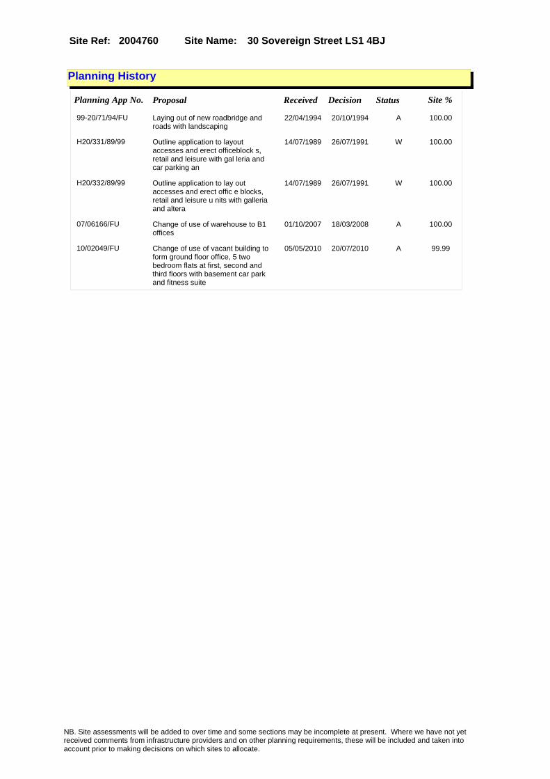
Site Name: 30 Sovereign Street LS1 4BJSite Ref: 2004760
Planning History
Planning App No. Proposal Received Decision Status Site %
99-20/71/94/FU Laying out of new roadbridge and roads with landscaping
22/04/1994 20/10/1994 A 100.00
H20/331/89/99 Outline application to layout accesses and erect officeblock s, retail and leisure with gal leria and car parking an
14/07/1989 26/07/1991 W 100.00
H20/332/89/99 Outline application to lay out accesses and erect offic e blocks, retail and leisure u nits with galleria and altera
14/07/1989 26/07/1991 W 100.00
07/06166/FU Change of use of warehouse to B1 offices
01/10/2007 18/03/2008 A 100.00
10/02049/FU Change of use of vacant building to form ground floor office, 5 two bedroom flats at first, second and third floors with basement car park and fitness suite
05/05/2010 20/07/2010 A 99.99
NB. Site assessments will be added to over time and some sections may be incomplete at present. Where we have not yet received comments from infrastructure providers and on other planning requirements, these will be included and taken into account prior to making decisions on which sites to allocate.

Site Name: 30 Sovereign Street LS1 4BJSite Ref: 2004760
Conformity with Core Strategy
Inner South Leeds: 0.00
Leeds Bradford Corridor: 0.00 West Leeds Gateway: 0.00
Aire Valley: 0.00Regeneration Priority Area:
Brownfield
Greenfield
Mixed
Main Urban Area
Major Settlement
Smaller Settlement
Villages/Rural
Main Urban Area Extension
Major Settlement Extension
Smaller Settlement Extension
Village/Rural Extension
Development unrelated to existing development
Green Belt assessment - only completed where site is within Green Belt
Would development lead to/constitute ribbon development?
Would development result in isolated development?
Is the site well connected to built up area (2+ boundaries with existing built up area)?
Would development of the site effectively "round off" the settlement pattern?:
Do natural/physical features provide a good existing barrier between existing urban area and undeveloped land?
Overall sprawl conclusion:
Would development of the site lead to physical connection of settlements?
Do natural/physical features provide a good existing barrier/boundary to contain development?
Overall Coalescence Conclusion:
Is there a strong defensible boundary between the site and the existing urban area?
Does the site provide access to the countryside?
Does the site include local or national conservation designated areas?
Does the site include areas of woodlands, trees, hedgerows that are protected, or significant unprotected tree/hedge cover?
Does the site include grade 1, 2, or 3a agricultural land?
Does the site contain buildings? Are these in agricultural use?
Overall countryside Encroachment Conclusion
Is the site within or adjacent to a conservation area, listed building or other historical feature?
If yes, could development preserve this character?:
Overall Character Preservation Conclusion:
Greenbelt Assessment Conclusion:
Check the unrestricted sprawl of large built up areas
Prevent neighbouring towns from merging
Assist in safeguarding countryside from encroachment
Preserve the setting and special character of historic towns
NB. Site assessments will be added to over time and some sections may be incomplete at present. Where we have not yet received comments from infrastructure providers and on other planning requirements, these will be included and taken into account prior to making decisions on which sites to allocate.

Site Name: 30 Sovereign Street LS1 4BJSite Ref: 2004760
SHLAA ConclusionsAvailability: Suitability: Achievability:
Conclusion of Assessment
Conclusion summary:
Consent for change of use to offices: 07/06166/FU expires 17/3/2011; mixed use inc offices proposed under 10/02049/FU.
Floorspace sq m (Non residential): 205
Employment Conclusion: Lime Green
East Leeds
Assesment Type: ELR Type: Office
Proposed Change:
Gypsy Traveller Site Assessment
Yes No Maybe Could site be effectively managed (Text)
Yes No Maybe Would gypsies and travellers live on the site?
(Text)
Yes No Proximity to housed gypsies and travellers (Text)
Yes No Unknown Experience of previous encampments (Text)
NB. Site assessments will be added to over time and some sections may be incomplete at present. Where we have not yet received comments from infrastructure providers and on other planning requirements, these will be included and taken into account prior to making decisions on which sites to allocate.

Site Name: 9, 10 & 12 South Parade Leeds LS1 5QSSite Ref: 2004790
Site Details
Land Use
Northing: 433711
Easting: 429828
Distance to Rail Station (metres): 537.20
Nearest Railway Station Leeds City
Distance to bus stop (metres) 34.22
Bus Stop ID 4019
Agricultural Land Class:
SFRA Flood Zone: 0.00
Environment Agency Flood Zone: 0.00
Within 300m of retail centre boundary:
UDP Designation
Greenbelt - N32 (%): 0.00 Urban Green Corridor - N8 (%): 0.00
Protected Area of Search site - N34 (%): 0.00 Rural Land - RL1: 0.00
City Centre Primary Shopping Quarter - CC27 (%): 0.00 Town Centre - S2: 0.00
Health and Safety Executive Hazard: No
Health and Safety Executive Gas Pipeline: No
Strategic Employment Buffer: 100.00
Area sq m: 1350.94 Ward City and Hunslet
Special Landscape Area - N37: 0.00
Allotments - N1A: 0.00
Proposed Greenspace - N5: 0.00
Protected Playing Pitch - N6: 0.00
Nature Conservation Area - N50: 0.00
Conservation Areas No
Ancient Monument/Battlefield(%): 0.00 Listed Buildings: No
Public Rights of Way: No
Other?:
Natural Resources and waste DPD (if applicable)
Within Minerals Safeguarding Site?: No Within 100m of Minerals Safeguarding Site?: No
HMCA: City Centre
Greenspace - N1: 0
Existing Use 1:
Existing Use 2:
Existing Use 3:
Neighbouring Use 1
Neighbouring Use 2:
Neighbouring Use 3:
Other uses:
Topography:
Natural Landscape:
Boundaries:
Road Frontage
Site Characteristics
Site Detail
Other comments/observations on site characteristics:
Area Ha: 0.135094
Site State:
NB. Site assessments will be added to over time and some sections may be incomplete at present. Where we have not yet received comments from infrastructure providers and on other planning requirements, these will be included and taken into account prior to making decisions on which sites to allocate.

Site Name: 9, 10 & 12 South Parade Leeds LS1 5QSSite Ref: 2004790
Planning History
Planning App No. Proposal Received Decision Status Site %
06/04327/FU Disabled access ramp to offices 14/07/2006 05/11/2007 A 40.68
10/03490/COND Consent, agreement or approval required by conditions 1, 2, 3, 4, 5, 6, 7, 8, 9, 10, 11, 12, 13, 14, 15, 16 and 17 of Planning Application 10/02312/FU
26/07/2010 18/10/2010 A 77.23
08/01912/FU Demolition of office block and erection of 5, 6 and 7 storey office block with link extensions and basement car parking
31/03/2008 30/06/2008 A 99.61
10/9/00067/MOD New 4th floor and extensions to ground and first floors including part new frontage and new cladding to office�NON MATERIAL AMENDMENT: Include condition to list all approved drawings relating to the approval.
07/04/2010 19/04/2010 M01 77.11
10/02312/FU Variation to condition 1 of non material amendment 10/9/00067/MOD (previous approval 09/02975/FU) relating to re-configuration of entrance staircase
20/05/2010 06/07/2010 A 77.23
H20/400/84/ Change of use of part of offic es to retail showroom.
14/09/1984 01/10/1984 A 18.36
08/04509/LI Listed Building Application for the part demolition (rear annexe) and refurbishment of exterior and interior of the main building
25/07/2008 13/10/2008 A 99.97
20/514/98/FU Change of use of offices to employment agency
27/08/1998 09/11/1998 A 22.70
H20/113/77/ Alterations, including new sta ircase and formation of new o ffices, toilets and switch roo m, 2nd floor extension,
15/03/1977 09/05/1977 A 21.77
09/02975/FU New 4th floor and extensions to ground and first floors including part new frontage and new cladding to office
08/07/2009 18/09/2009 A 77.11
10/9/00107/MOD New 4th floor and extensions to ground and first floors including part new frontage and new cladding to office�NON MATERIAL AMENDMENT:Changes to floor plans and elevations to incorporate new entrance stairs to reception area
06/05/2010 12/10/2010 M04 77.11
H20/189/90/ Change of use of ground floor offices to mortgage consu ltants and surveyors offices.
18/04/1990 07/08/1990 A 34.27
09/04679/COND Consent, agreement or approval required by conditions 1, 2, 5, 6, 9, 10, 11, 12, 13, 14, 15, 16 and 17 of Planning Application 09/02975/FU
29/10/2009 18/01/2010 A 77.11
09/9/00340/MOD New 4th floor and extensions to ground and first floors including part new frontage and new cladding to office�NON MATERIAL AMENDMENT: Ground floor revision to reposition the disabled access lift and reconfigure the reception area to suit
27/11/2009 01/12/2009 M01 77.11
NB. Site assessments will be added to over time and some sections may be incomplete at present. Where we have not yet received comments from infrastructure providers and on other planning requirements, these will be included and taken into account prior to making decisions on which sites to allocate.

Site Name: 9, 10 & 12 South Parade Leeds LS1 5QSSite Ref: 2004790
10/01787/FU Addition of two roller shutters to entrance area of office block
19/04/2010 06/07/2010 A 77.11
10/01944/COND Consent, agreement or approval required by conditions 1, 2, 3, 4, 5, 6, 7, 8, 9, 10, 11, 12, 13, 14, 15, 16, 17 and 18 of Planning Application 09/05013/FU
28/04/2010 23/06/2010 A 77.11
10/9/00108/MOD Amendment to approval 09/02975/FU for alterations to 4th floor layout and amendment to reception area glazing and disabled access lift location (09/05013)�NON MATERIAL AMENDMENT: Revised floor plans and elevations to allow for new entrance stairs to reception area
06/05/2010 12/10/2010 M04 77.11
H20/383/77/ One internally illuminated ind ividual letter wall sign, size 3.8m (12ft.6ins) x 0.5m (1ft.7ins) height above grou
20/09/1977 10/10/1977 A 21.77
20/444/02/LI Listed building application for addition of floodlights to office
29/10/2002 11/12/2002 A 22.75
H20/40/89/ 1, internally illuminated wall mounted sign, to office.
25/01/1989 15/03/1989 A 59.48
H20/44/78/ Extension of permission for on e internally illuminated projecting canopy box sign, size 1. 3m (4ft 3ins) x 0.4m (1ft
02/02/1978 13/03/1978 A 71.27
10/01490/COND Consent, agreement or approval required by conditions 3, 4, 7 and 8 of Planning Application 09/02975/FU
30/03/2010 07/05/2010 A 77.11
09/05013/FU Amendment to approval 09/02975/FU for alterations to 4th floor layout and amendment to reception area glazing and disabled access lift location
17/11/2009 19/01/2010 A 77.11
10/03492/COND Consent, agreement or approval required by conditions 1, 2, 3, 4, 5, 6, 7, 8, 9, 10, 11, 12, 13, 14, 15, 16, 17 and 18 of Planning Application 10/02313/FU
26/07/2010 18/10/2010 A 77.23
20/494/97/FU Change of use of ground floor office to the display and sale of art exhibits
21/08/1997 14/11/1997 W 22.70
11/01297/FU Change of use of part of vacant ground floor offices (B1 use) to clinic (D1 use)
29/03/2011 25/05/2011 W 22.75
H20/264/90/ Addition of cooling tower to r oof of offices.
30/05/1990 23/10/1990 A 75.93
10/02313/FU Variation to condition 2 of previous approval 09/05013/FU relating to internal layouts
20/05/2010 07/07/2010 A 77.23
H20/74/76/ Change of use of offices and c lub to offices.
19/02/1976 15/03/1976 A 21.99
NB. Site assessments will be added to over time and some sections may be incomplete at present. Where we have not yet received comments from infrastructure providers and on other planning requirements, these will be included and taken into account prior to making decisions on which sites to allocate.

Site Name: 9, 10 & 12 South Parade Leeds LS1 5QSSite Ref: 2004790
Conformity with Core Strategy
Inner South Leeds: 0.00
Leeds Bradford Corridor: 0.00 West Leeds Gateway: 0.00
Aire Valley: 0.00Regeneration Priority Area:
Brownfield
Greenfield
Mixed
Main Urban Area
Major Settlement
Smaller Settlement
Villages/Rural
Main Urban Area Extension
Major Settlement Extension
Smaller Settlement Extension
Village/Rural Extension
Development unrelated to existing development
Green Belt assessment - only completed where site is within Green Belt
Would development lead to/constitute ribbon development?
Would development result in isolated development?
Is the site well connected to built up area (2+ boundaries with existing built up area)?
Would development of the site effectively "round off" the settlement pattern?:
Do natural/physical features provide a good existing barrier between existing urban area and undeveloped land?
Overall sprawl conclusion:
Would development of the site lead to physical connection of settlements?
Do natural/physical features provide a good existing barrier/boundary to contain development?
Overall Coalescence Conclusion:
Is there a strong defensible boundary between the site and the existing urban area?
Does the site provide access to the countryside?
Does the site include local or national conservation designated areas?
Does the site include areas of woodlands, trees, hedgerows that are protected, or significant unprotected tree/hedge cover?
Does the site include grade 1, 2, or 3a agricultural land?
Does the site contain buildings? Are these in agricultural use?
Overall countryside Encroachment Conclusion
Is the site within or adjacent to a conservation area, listed building or other historical feature?
If yes, could development preserve this character?:
Overall Character Preservation Conclusion:
Greenbelt Assessment Conclusion:
Check the unrestricted sprawl of large built up areas
Prevent neighbouring towns from merging
Assist in safeguarding countryside from encroachment
Preserve the setting and special character of historic towns
NB. Site assessments will be added to over time and some sections may be incomplete at present. Where we have not yet received comments from infrastructure providers and on other planning requirements, these will be included and taken into account prior to making decisions on which sites to allocate.

Site Name: 9, 10 & 12 South Parade Leeds LS1 5QSSite Ref: 2004790
SHLAA ConclusionsAvailability: Suitability: Achievability:
Conclusion of Assessment
Conclusion summary:
Current site with planning permission for employment purposes
Floorspace sq m (Non residential): 9150
Employment Conclusion: Lime Green
East Leeds
Assesment Type: ELR Type: Office
Proposed Change:
Gypsy Traveller Site Assessment
Yes No Maybe Could site be effectively managed (Text)
Yes No Maybe Would gypsies and travellers live on the site?
(Text)
Yes No Proximity to housed gypsies and travellers (Text)
Yes No Unknown Experience of previous encampments (Text)
NB. Site assessments will be added to over time and some sections may be incomplete at present. Where we have not yet received comments from infrastructure providers and on other planning requirements, these will be included and taken into account prior to making decisions on which sites to allocate.

Site Name: Extension at Cloth Hall Court Infirmary Street LS1
Site Ref: 2004840
Site Details
Land Use
Northing: 433503
Easting: 429838
Distance to Rail Station (metres): 344.25
Nearest Railway Station Leeds City
Distance to bus stop (metres) 38.02
Bus Stop ID 7472
Agricultural Land Class:
SFRA Flood Zone: 0.00
Environment Agency Flood Zone: 0.00
Within 300m of retail centre boundary:
UDP Designation
Greenbelt - N32 (%): 0.00 Urban Green Corridor - N8 (%): 0.00
Protected Area of Search site - N34 (%): 0.00 Rural Land - RL1: 0.00
City Centre Primary Shopping Quarter - CC27 (%): 0.00 Town Centre - S2: 0.00
Health and Safety Executive Hazard: No
Health and Safety Executive Gas Pipeline: No
Strategic Employment Buffer: 100.00
Area sq m: 2807.82 Ward City and Hunslet
Special Landscape Area - N37: 0.00
Allotments - N1A: 0.00
Proposed Greenspace - N5: 0.00
Protected Playing Pitch - N6: 0.00
Nature Conservation Area - N50: 1.00
Conservation Areas Yes
Ancient Monument/Battlefield(%): 0.00 Listed Buildings: No
Public Rights of Way: No
Other?:
Natural Resources and waste DPD (if applicable)
Within Minerals Safeguarding Site?: No Within 100m of Minerals Safeguarding Site?: No
HMCA: City Centre
Greenspace - N1: 0
Existing Use 1:
Existing Use 2:
Existing Use 3:
Neighbouring Use 1
Neighbouring Use 2:
Neighbouring Use 3:
Other uses:
Topography:
Natural Landscape:
Boundaries:
Road Frontage
Site Characteristics
Site Detail
Other comments/observations on site characteristics:
Area Ha: 0.280782
Site State:
NB. Site assessments will be added to over time and some sections may be incomplete at present. Where we have not yet received comments from infrastructure providers and on other planning requirements, these will be included and taken into account prior to making decisions on which sites to allocate.

Site Name: Extension at Cloth Hall Court Infirmary Street LS1
Site Ref: 2004840
Planning History
Planning App No. Proposal Received Decision Status Site %
H20/267/79/ Change of use of proposed offi ce basement to car park with 21 car parking spaces. (outlin e application no. 78/20/0011
20/06/1979 30/07/1979 A 17.60
09/04654/FU Change of use of part of ground floor to A2 office and A2/B1 office.
28/10/2009 21/12/2009 A 34.33
H20/136/85/ Alterations to form store room from existing basement car p ark and rearrangement of 14 ca r parking spaces to offices.
02/04/1985 13/05/1985 A 96.43
H20/47/92/ Addition of chiller units, to offices. 10/02/1992 03/03/1992 A 42.62
20/303/94/FU Installation of 6 roof top chiller units 22/07/1994 16/12/1994 A 66.99
H20/615/89/ Alterations, including new lou vre and addition of roof top c ondenser to offices.
05/12/1989 02/02/1990 A 41.73
H20/218/80/1 Renewal of reserved matters co nsent to carry out alter ations including demolition of 2 chimney stacks and loweri
04/10/1983 14/11/1983 A 99.43
H20/320/76/ Addition of water storage tank room, to roof of post offic e premises.
11/08/1976 27/09/1976 A 79.24
06/07707/FU Alterations to ground floor elevation, single storey entrance extension, 8 storey rear extension, alterations to sixth floor and new seventh and eighth floor with plant room to offices
28/12/2006 28/03/2007 A 100.00
H20/291/78/ Demolition of existing buildin gs and erection of 6 sto rey extension, to form offices with toilets and entran
19/07/1978 04/10/1978 A 62.35
H20/51/76/ Listed building application to demolish part of post offic e premises.
05/02/1976 05/04/1976 A 74.35
07/9/00519/MOD Alterations to ground floor elevation, single storey entrance extension, 8 storey rear extension, alterations to sixth floor and new seventh and eighth floor with plant room to offices�NON MATERIAL AMENDMENT: Escape stair 4 extended to 7th floor, transoms added to 5th floor windows, amendment to external wall material on 5,6 and 7th floors and louvred roof over 7th floor plant room.
02/10/2007 13/03/2009 M01 100.00
H20/215/82/ Alterations, including new win dows and entrance to bank.
17/06/1982 05/07/1982 A 20.38
H20/331/82/ Alterations to form basement s taffroom, toilets, store and s trongroom to bank.
15/09/1982 04/10/1982 A 43.83
H20/376/75/ Listed building application to carry out alterations toform open plan office, new store and toilet block, to second flo
03/10/1975 03/11/1975 W 79.24
H20/377/75/ Alterations including new lift and staircase, new basem ent entrance and store, new gr ound floor entrance, toilets an
03/10/1975 15/12/1975 A 79.24
NB. Site assessments will be added to over time and some sections may be incomplete at present. Where we have not yet received comments from infrastructure providers and on other planning requirements, these will be included and taken into account prior to making decisions on which sites to allocate.
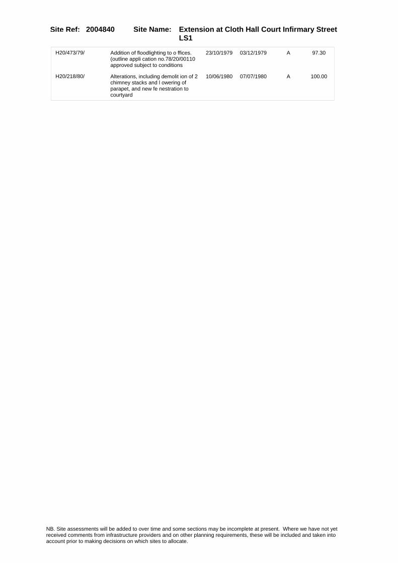
Site Name: Extension at Cloth Hall Court Infirmary Street LS1
Site Ref: 2004840
H20/473/79/ Addition of floodlighting to o ffices. (outline appli cation no.78/20/00110 approved subject to conditions
23/10/1979 03/12/1979 A 97.30
H20/218/80/ Alterations, including demolit ion of 2 chimney stacks and l owering of parapet, and new fe nestration to courtyard
10/06/1980 07/07/1980 A 100.00
NB. Site assessments will be added to over time and some sections may be incomplete at present. Where we have not yet received comments from infrastructure providers and on other planning requirements, these will be included and taken into account prior to making decisions on which sites to allocate.

Site Name: Extension at Cloth Hall Court Infirmary Street LS1
Site Ref: 2004840
Conformity with Core Strategy
Inner South Leeds: 0.00
Leeds Bradford Corridor: 0.00 West Leeds Gateway: 0.00
Aire Valley: 0.00Regeneration Priority Area:
Brownfield
Greenfield
Mixed
Main Urban Area
Major Settlement
Smaller Settlement
Villages/Rural
Main Urban Area Extension
Major Settlement Extension
Smaller Settlement Extension
Village/Rural Extension
Development unrelated to existing development
Green Belt assessment - only completed where site is within Green Belt
Would development lead to/constitute ribbon development?
Would development result in isolated development?
Is the site well connected to built up area (2+ boundaries with existing built up area)?
Would development of the site effectively "round off" the settlement pattern?:
Do natural/physical features provide a good existing barrier between existing urban area and undeveloped land?
Overall sprawl conclusion:
Would development of the site lead to physical connection of settlements?
Do natural/physical features provide a good existing barrier/boundary to contain development?
Overall Coalescence Conclusion:
Is there a strong defensible boundary between the site and the existing urban area?
Does the site provide access to the countryside?
Does the site include local or national conservation designated areas?
Does the site include areas of woodlands, trees, hedgerows that are protected, or significant unprotected tree/hedge cover?
Does the site include grade 1, 2, or 3a agricultural land?
Does the site contain buildings? Are these in agricultural use?
Overall countryside Encroachment Conclusion
Is the site within or adjacent to a conservation area, listed building or other historical feature?
If yes, could development preserve this character?:
Overall Character Preservation Conclusion:
Greenbelt Assessment Conclusion:
Check the unrestricted sprawl of large built up areas
Prevent neighbouring towns from merging
Assist in safeguarding countryside from encroachment
Preserve the setting and special character of historic towns
NB. Site assessments will be added to over time and some sections may be incomplete at present. Where we have not yet received comments from infrastructure providers and on other planning requirements, these will be included and taken into account prior to making decisions on which sites to allocate.

Site Name: Extension at Cloth Hall Court Infirmary Street LS1
Site Ref: 2004840
SHLAA ConclusionsAvailability: Suitability: Achievability:
Conclusion of Assessment
Conclusion summary:
Current site with planning permission for employment purposes
Floorspace sq m (Non residential): 4350
Employment Conclusion: Lime Green
East Leeds
Assesment Type: ELR Type: Office
Proposed Change:
Gypsy Traveller Site Assessment
Yes No Maybe Could site be effectively managed (Text)
Yes No Maybe Would gypsies and travellers live on the site?
(Text)
Yes No Proximity to housed gypsies and travellers (Text)
Yes No Unknown Experience of previous encampments (Text)
NB. Site assessments will be added to over time and some sections may be incomplete at present. Where we have not yet received comments from infrastructure providers and on other planning requirements, these will be included and taken into account prior to making decisions on which sites to allocate.

Site Name: S/O GRANARY WHARF CAR PARK WATER LANE LS11
Site Ref: 2004880
Site Details
Land Use
Northing: 432999
Easting: 429659
Distance to Rail Station (metres): 194.63
Nearest Railway Station Leeds City
Distance to bus stop (metres) 268.24
Bus Stop ID 6735
Agricultural Land Class:
SFRA Flood Zone: 1.00
Environment Agency Flood Zone: 1.00
Within 300m of retail centre boundary:
UDP Designation
Greenbelt - N32 (%): 0.00 Urban Green Corridor - N8 (%): 0.00
Protected Area of Search site - N34 (%): 0.00 Rural Land - RL1: 0.00
City Centre Primary Shopping Quarter - CC27 (%): 0.00 Town Centre - S2: 0.00
Health and Safety Executive Hazard: No
Health and Safety Executive Gas Pipeline: No
Strategic Employment Buffer: 0.00
Area sq m: 3997.25 Ward City and Hunslet
Special Landscape Area - N37: 0.00
Allotments - N1A: 0.00
Proposed Greenspace - N5: 0.00
Protected Playing Pitch - N6: 0.00
Nature Conservation Area - N50: 1.00
Conservation Areas Yes
Ancient Monument/Battlefield(%): 0.01 Listed Buildings: No
Public Rights of Way: No
Other?:
Natural Resources and waste DPD (if applicable)
Within Minerals Safeguarding Site?: No Within 100m of Minerals Safeguarding Site?: No
HMCA: City Centre
Greenspace - N1: 0
Existing Use 1:
Existing Use 2:
Existing Use 3:
Neighbouring Use 1
Neighbouring Use 2:
Neighbouring Use 3:
Other uses:
Topography:
Natural Landscape:
Boundaries:
Road Frontage
Site Characteristics
Site Detail
Other comments/observations on site characteristics:
Area Ha: 0.399725
Site State:
NB. Site assessments will be added to over time and some sections may be incomplete at present. Where we have not yet received comments from infrastructure providers and on other planning requirements, these will be included and taken into account prior to making decisions on which sites to allocate.

Site Name: S/O GRANARY WHARF CAR PARK WATER LANE LS11
Site Ref: 2004880
Planning History
NB. Site assessments will be added to over time and some sections may be incomplete at present. Where we have not yet received comments from infrastructure providers and on other planning requirements, these will be included and taken into account prior to making decisions on which sites to allocate.

Site Name: S/O GRANARY WHARF CAR PARK WATER LANE LS11
Site Ref: 2004880
Conformity with Core Strategy
Inner South Leeds: 0.00
Leeds Bradford Corridor: 0.00 West Leeds Gateway: 0.00
Aire Valley: 0.00Regeneration Priority Area:
Brownfield
Greenfield
Mixed
Main Urban Area
Major Settlement
Smaller Settlement
Villages/Rural
Main Urban Area Extension
Major Settlement Extension
Smaller Settlement Extension
Village/Rural Extension
Development unrelated to existing development
Green Belt assessment - only completed where site is within Green Belt
Would development lead to/constitute ribbon development?
Would development result in isolated development?
Is the site well connected to built up area (2+ boundaries with existing built up area)?
Would development of the site effectively "round off" the settlement pattern?:
Do natural/physical features provide a good existing barrier between existing urban area and undeveloped land?
Overall sprawl conclusion:
Would development of the site lead to physical connection of settlements?
Do natural/physical features provide a good existing barrier/boundary to contain development?
Overall Coalescence Conclusion:
Is there a strong defensible boundary between the site and the existing urban area?
Does the site provide access to the countryside?
Does the site include local or national conservation designated areas?
Does the site include areas of woodlands, trees, hedgerows that are protected, or significant unprotected tree/hedge cover?
Does the site include grade 1, 2, or 3a agricultural land?
Does the site contain buildings? Are these in agricultural use?
Overall countryside Encroachment Conclusion
Is the site within or adjacent to a conservation area, listed building or other historical feature?
If yes, could development preserve this character?:
Overall Character Preservation Conclusion:
Greenbelt Assessment Conclusion:
Check the unrestricted sprawl of large built up areas
Prevent neighbouring towns from merging
Assist in safeguarding countryside from encroachment
Preserve the setting and special character of historic towns
NB. Site assessments will be added to over time and some sections may be incomplete at present. Where we have not yet received comments from infrastructure providers and on other planning requirements, these will be included and taken into account prior to making decisions on which sites to allocate.

Site Name: S/O GRANARY WHARF CAR PARK WATER LANE LS11
Site Ref: 2004880
SHLAA ConclusionsAvailability: Suitability: Achievability:
Conclusion of Assessment
Conclusion summary:
Outline planning permission for mixed use development inc offices expires 8/10/2011. Potential for 6,800 sqm offices
Floorspace sq m (Non residential): 6800
Employment Conclusion: Green
East Leeds
Assesment Type: ELR Type: Office
Proposed Change:
Gypsy Traveller Site Assessment
Yes No Maybe Could site be effectively managed (Text)
Yes No Maybe Would gypsies and travellers live on the site?
(Text)
Yes No Proximity to housed gypsies and travellers (Text)
Yes No Unknown Experience of previous encampments (Text)
NB. Site assessments will be added to over time and some sections may be incomplete at present. Where we have not yet received comments from infrastructure providers and on other planning requirements, these will be included and taken into account prior to making decisions on which sites to allocate.

Site Name: Jack Lane/Grape Street Hunslet LS10Site Ref: 2004990
Site Details
Land Use
Northing: 431991
Easting: 430666
Distance to Rail Station (metres): 1545.66
Nearest Railway Station Leeds City
Distance to bus stop (metres) 309.49
Bus Stop ID 7870
Agricultural Land Class:
SFRA Flood Zone: 0.00
Environment Agency Flood Zone: 0.00
Within 300m of retail centre boundary:
UDP Designation
Greenbelt - N32 (%): 0.00 Urban Green Corridor - N8 (%): 0.00
Protected Area of Search site - N34 (%): 0.00 Rural Land - RL1: 0.00
City Centre Primary Shopping Quarter - CC27 (%): 0.00 Town Centre - S2: 0.00
Health and Safety Executive Hazard: No
Health and Safety Executive Gas Pipeline: Yes
Strategic Employment Buffer: 0.00
Area sq m: 3472.70 Ward City and Hunslet
Special Landscape Area - N37: 0.00
Allotments - N1A: 0.00
Proposed Greenspace - N5: 0.00
Protected Playing Pitch - N6: 0.00
Nature Conservation Area - N50: 0.00
Conservation Areas No
Ancient Monument/Battlefield(%): 0.00 Listed Buildings: No
Public Rights of Way: No
Other?:
Natural Resources and waste DPD (if applicable)
Within Minerals Safeguarding Site?: No Within 100m of Minerals Safeguarding Site?: No
HMCA: Inner Areas
Greenspace - N1: 0
Existing Use 1:
Existing Use 2:
Existing Use 3:
Neighbouring Use 1
Neighbouring Use 2:
Neighbouring Use 3:
Other uses:
Topography:
Natural Landscape:
Boundaries:
Road Frontage
Site Characteristics
Site Detail
Other comments/observations on site characteristics:
Area Ha: 0.34727
Site State:
NB. Site assessments will be added to over time and some sections may be incomplete at present. Where we have not yet received comments from infrastructure providers and on other planning requirements, these will be included and taken into account prior to making decisions on which sites to allocate.
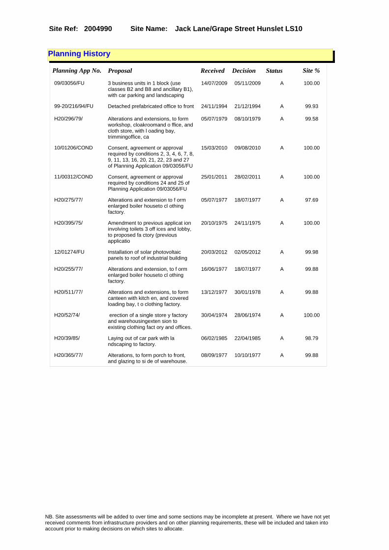
Site Name: Jack Lane/Grape Street Hunslet LS10Site Ref: 2004990
Planning History
Planning App No. Proposal Received Decision Status Site %
09/03056/FU 3 business units in 1 block (use classes B2 and B8 and ancillary B1), with car parking and landscaping
14/07/2009 05/11/2009 A 100.00
99-20/216/94/FU Detached prefabricated office to front 24/11/1994 21/12/1994 A 99.93
H20/296/79/ Alterations and extensions, to form workshop, cloakroomand o ffice, and cloth store, with l oading bay, trimmingoffice, ca
05/07/1979 08/10/1979 A 99.58
10/01206/COND Consent, agreement or approval required by conditions 2, 3, 4, 6, 7, 8, 9, 11, 13, 16, 20, 21, 22, 23 and 27 of Planning Application 09/03056/FU
15/03/2010 09/08/2010 A 100.00
11/00312/COND Consent, agreement or approval required by conditions 24 and 25 of Planning Application 09/03056/FU
25/01/2011 28/02/2011 A 100.00
H20/275/77/ Alterations and extension to f orm enlarged boiler houseto cl othing factory.
05/07/1977 18/07/1977 A 97.69
H20/395/75/ Amendment to previous applicat ion involving toilets 3 off ices and lobby, to proposed fa ctory (previous applicatio
20/10/1975 24/11/1975 A 100.00
12/01274/FU Installation of solar photovoltaic panels to roof of industrial building
20/03/2012 02/05/2012 A 99.98
H20/255/77/ Alterations and extension, to f orm enlarged boiler houseto cl othing factory.
16/06/1977 18/07/1977 A 99.88
H20/511/77/ Alterations and extensions, to form canteen with kitch en, and covered loading bay, t o clothing factory.
13/12/1977 30/01/1978 A 99.88
H20/52/74/ erection of a single store y factory and warehousingexten sion to existing clothing fact ory and offices.
30/04/1974 28/06/1974 A 100.00
H20/39/85/ Laying out of car park with la ndscaping to factory.
06/02/1985 22/04/1985 A 98.79
H20/365/77/ Alterations, to form porch to front, and glazing to si de of warehouse.
08/09/1977 10/10/1977 A 99.88
NB. Site assessments will be added to over time and some sections may be incomplete at present. Where we have not yet received comments from infrastructure providers and on other planning requirements, these will be included and taken into account prior to making decisions on which sites to allocate.

Site Name: Jack Lane/Grape Street Hunslet LS10Site Ref: 2004990
Conformity with Core Strategy
Inner South Leeds: 0.00
Leeds Bradford Corridor: 0.00 West Leeds Gateway: 0.00
Aire Valley: 0.00Regeneration Priority Area:
Brownfield
Greenfield
Mixed
Main Urban Area
Major Settlement
Smaller Settlement
Villages/Rural
Main Urban Area Extension
Major Settlement Extension
Smaller Settlement Extension
Village/Rural Extension
Development unrelated to existing development
Green Belt assessment - only completed where site is within Green Belt
Would development lead to/constitute ribbon development?
Would development result in isolated development?
Is the site well connected to built up area (2+ boundaries with existing built up area)?
Would development of the site effectively "round off" the settlement pattern?:
Do natural/physical features provide a good existing barrier between existing urban area and undeveloped land?
Overall sprawl conclusion:
Would development of the site lead to physical connection of settlements?
Do natural/physical features provide a good existing barrier/boundary to contain development?
Overall Coalescence Conclusion:
Is there a strong defensible boundary between the site and the existing urban area?
Does the site provide access to the countryside?
Does the site include local or national conservation designated areas?
Does the site include areas of woodlands, trees, hedgerows that are protected, or significant unprotected tree/hedge cover?
Does the site include grade 1, 2, or 3a agricultural land?
Does the site contain buildings? Are these in agricultural use?
Overall countryside Encroachment Conclusion
Is the site within or adjacent to a conservation area, listed building or other historical feature?
If yes, could development preserve this character?:
Overall Character Preservation Conclusion:
Greenbelt Assessment Conclusion:
Check the unrestricted sprawl of large built up areas
Prevent neighbouring towns from merging
Assist in safeguarding countryside from encroachment
Preserve the setting and special character of historic towns
NB. Site assessments will be added to over time and some sections may be incomplete at present. Where we have not yet received comments from infrastructure providers and on other planning requirements, these will be included and taken into account prior to making decisions on which sites to allocate.

Site Name: Jack Lane/Grape Street Hunslet LS10Site Ref: 2004990
SHLAA ConclusionsAvailability: Suitability: Achievability:
Conclusion of Assessment
Conclusion summary:
Current site with planning permission for employment purposes.
Floorspace sq m (Non residential): 1440
Employment Conclusion: Lime Green
East Leeds
Assesment Type: Planning status Type: Office
Proposed Change:
Gypsy Traveller Site Assessment
Yes No Maybe Could site be effectively managed (Text)
Yes No Maybe Would gypsies and travellers live on the site?
(Text)
Yes No Proximity to housed gypsies and travellers (Text)
Yes No Unknown Experience of previous encampments (Text)
NB. Site assessments will be added to over time and some sections may be incomplete at present. Where we have not yet received comments from infrastructure providers and on other planning requirements, these will be included and taken into account prior to making decisions on which sites to allocate.

Site Name: Land Between Mabgate, Macaulay Street, Argyll Road LS9
Site Ref: 2005000
Site Details
Land Use
Northing: 434047
Easting: 431032
Distance to Rail Station (metres): 1589.30
Nearest Railway Station Leeds City
Distance to bus stop (metres) 179.16
Bus Stop ID 7818
Agricultural Land Class:
SFRA Flood Zone: 0.00
Environment Agency Flood Zone: 1.00
Within 300m of retail centre boundary:
UDP Designation
Greenbelt - N32 (%): 0.00 Urban Green Corridor - N8 (%): 0.00
Protected Area of Search site - N34 (%): 0.00 Rural Land - RL1: 0.00
City Centre Primary Shopping Quarter - CC27 (%): 0.00 Town Centre - S2: 0.00
Health and Safety Executive Hazard: No
Health and Safety Executive Gas Pipeline: No
Strategic Employment Buffer: 0.00
Area sq m: 11809.00 Ward City and Hunslet
Special Landscape Area - N37: 0.00
Allotments - N1A: 0.00
Proposed Greenspace - N5: 0.00
Protected Playing Pitch - N6: 0.00
Nature Conservation Area - N50: 0.00
Conservation Areas No
Ancient Monument/Battlefield(%): 0.00 Listed Buildings: No
Public Rights of Way: No
Other?:
Natural Resources and waste DPD (if applicable)
Within Minerals Safeguarding Site?: No Within 100m of Minerals Safeguarding Site?: Yes
HMCA: Inner Areas
Greenspace - N1: 0
Existing Use 1:
Existing Use 2:
Existing Use 3:
Neighbouring Use 1
Neighbouring Use 2:
Neighbouring Use 3:
Other uses:
Topography:
Natural Landscape:
Boundaries:
Road Frontage
Site Characteristics
Site Detail
Other comments/observations on site characteristics:
Area Ha: 1.1809
Site State:
NB. Site assessments will be added to over time and some sections may be incomplete at present. Where we have not yet received comments from infrastructure providers and on other planning requirements, these will be included and taken into account prior to making decisions on which sites to allocate.

Site Name: Land Between Mabgate, Macaulay Street, Argyll Road LS9
Site Ref: 2005000
Planning History
Planning App No. Proposal Received Decision Status Site %
08/01248/OT Outline application for approval of layout, scale and access for multi level mixed use development in 8 blocks comprising residential, retail, offices and leisure uses, with car parking and landscaping
03/03/2008 08/03/2010 A 100.00
H34/4/88/ Alterations and extension, to form storage area, to furni ture factory.
07/01/1988 22/02/1988 A 92.68
20/33/99/FU Addition of external staircase and new door to front of offices
21/01/1999 15/04/1999 W 13.46
H32/59/75/ Alterations to form new first floor kitchen and enlar ged canteen to factory premise s.
21/01/1975 10/03/1975 W 79.58
20/1/96/FU Single storey vehicle workshop 28/12/1995 18/03/1996 A 87.72
12/04953/EXT Extension of time period for Outline application 08/01248/OT for approval of layout, scale and access for multi level mixed use development in 8 blocks comprising residential, retail, offices and leisure uses, with car parking and landscaping
21/11/2012 20/02/2013 A 100.00
09/04872/FU Change of use of office unit to a private hire taxi booking office
10/11/2009 12/01/2010 A 29.36
H32/632/78/ Extension, to form storage she d, to works.
28/06/1978 14/08/1978 A 63.26
NB. Site assessments will be added to over time and some sections may be incomplete at present. Where we have not yet received comments from infrastructure providers and on other planning requirements, these will be included and taken into account prior to making decisions on which sites to allocate.

Site Name: Land Between Mabgate, Macaulay Street, Argyll Road LS9
Site Ref: 2005000
Conformity with Core Strategy
Inner South Leeds: 0.00
Leeds Bradford Corridor: 0.00 West Leeds Gateway: 0.00
Aire Valley: 0.00Regeneration Priority Area:
Brownfield
Greenfield
Mixed
Main Urban Area
Major Settlement
Smaller Settlement
Villages/Rural
Main Urban Area Extension
Major Settlement Extension
Smaller Settlement Extension
Village/Rural Extension
Development unrelated to existing development
Green Belt assessment - only completed where site is within Green Belt
Would development lead to/constitute ribbon development?
Would development result in isolated development?
Is the site well connected to built up area (2+ boundaries with existing built up area)?
Would development of the site effectively "round off" the settlement pattern?:
Do natural/physical features provide a good existing barrier between existing urban area and undeveloped land?
Overall sprawl conclusion:
Would development of the site lead to physical connection of settlements?
Do natural/physical features provide a good existing barrier/boundary to contain development?
Overall Coalescence Conclusion:
Is there a strong defensible boundary between the site and the existing urban area?
Does the site provide access to the countryside?
Does the site include local or national conservation designated areas?
Does the site include areas of woodlands, trees, hedgerows that are protected, or significant unprotected tree/hedge cover?
Does the site include grade 1, 2, or 3a agricultural land?
Does the site contain buildings? Are these in agricultural use?
Overall countryside Encroachment Conclusion
Is the site within or adjacent to a conservation area, listed building or other historical feature?
If yes, could development preserve this character?:
Overall Character Preservation Conclusion:
Greenbelt Assessment Conclusion:
Check the unrestricted sprawl of large built up areas
Prevent neighbouring towns from merging
Assist in safeguarding countryside from encroachment
Preserve the setting and special character of historic towns
NB. Site assessments will be added to over time and some sections may be incomplete at present. Where we have not yet received comments from infrastructure providers and on other planning requirements, these will be included and taken into account prior to making decisions on which sites to allocate.

Site Name: Land Between Mabgate, Macaulay Street, Argyll Road LS9
Site Ref: 2005000
SHLAA ConclusionsAvailability: Suitability: Achievability:
Conclusion of Assessment
Conclusion summary:
Consent for mixed use residential and commercial scheme 08/01248/OT expires 7/3/2013.
Floorspace sq m (Non residential): 3670
Employment Conclusion: Lime Green
East Leeds
Assesment Type: ELR Type: Office
Proposed Change:
Gypsy Traveller Site Assessment
Yes No Maybe Could site be effectively managed (Text)
Yes No Maybe Would gypsies and travellers live on the site?
(Text)
Yes No Proximity to housed gypsies and travellers (Text)
Yes No Unknown Experience of previous encampments (Text)
NB. Site assessments will be added to over time and some sections may be incomplete at present. Where we have not yet received comments from infrastructure providers and on other planning requirements, these will be included and taken into account prior to making decisions on which sites to allocate.

Site Name: Globe Road Leeds LS11Site Ref: 2005010
Site Details
Land Use
Northing: 433012
Easting: 429314
Distance to Rail Station (metres): 419.00
Nearest Railway Station Leeds City
Distance to bus stop (metres) 184.04
Bus Stop ID 3487
Agricultural Land Class:
SFRA Flood Zone: 1.00
Environment Agency Flood Zone: 1.00
Within 300m of retail centre boundary:
UDP Designation
Greenbelt - N32 (%): 0.00 Urban Green Corridor - N8 (%): 0.00
Protected Area of Search site - N34 (%): 0.00 Rural Land - RL1: 0.00
City Centre Primary Shopping Quarter - CC27 (%): 0.00 Town Centre - S2: 0.00
Health and Safety Executive Hazard: No
Health and Safety Executive Gas Pipeline: No
Strategic Employment Buffer: 100.00
Area sq m: 1863.17 Ward City and Hunslet
Special Landscape Area - N37: 0.00
Allotments - N1A: 0.00
Proposed Greenspace - N5: 0.00
Protected Playing Pitch - N6: 0.00
Nature Conservation Area - N50: 0.00
Conservation Areas No
Ancient Monument/Battlefield(%): 0.00 Listed Buildings: No
Public Rights of Way: No
Other?:
Natural Resources and waste DPD (if applicable)
Within Minerals Safeguarding Site?: No Within 100m of Minerals Safeguarding Site?: No
HMCA: City Centre
Greenspace - N1: 0
Existing Use 1:
Existing Use 2:
Existing Use 3:
Neighbouring Use 1
Neighbouring Use 2:
Neighbouring Use 3:
Other uses:
Topography:
Natural Landscape:
Boundaries:
Road Frontage
Site Characteristics
Site Detail
Other comments/observations on site characteristics:
Area Ha: 0.186317
Site State:
NB. Site assessments will be added to over time and some sections may be incomplete at present. Where we have not yet received comments from infrastructure providers and on other planning requirements, these will be included and taken into account prior to making decisions on which sites to allocate.

Site Name: Globe Road Leeds LS11Site Ref: 2005010
Planning History
Planning App No. Proposal Received Decision Status Site %
20/509/05/FU 2 storey sales and marketing suite building with 8 car parking spaces
25/10/2005 18/01/2006 A 95.14
10/01670/EXT Extension of time for Planning Application 20/499/04/FU (multi level development up to 31 storeys with 833 flats commercial units car parking and landscaping)
13/04/2010 17/11/2010 A 95.14
12/03459/FU Multi level development up to 17 storeys with 609 residential apartments, commercial units (Class A1 to A5, B1, D1 and D2), car parking, associated access, engineering works, landscape and public amenity space
08/08/2012 PCO 96.10
09/05601/FU Retention of the building for 10 years and change of use of marketing suite to A2 (financial and professional ) or B1 ( general office ) or marketing suite
24/12/2009 01/03/2010 A 95.14
20/499/04/FU Multi level development up to 31 storeys with 833 flats commercial units car parking and landscaping
10/11/2004 22/09/2005 A 95.14
PREAPP/09/00018 . 13/02/2009 PRENOT 95.14
NB. Site assessments will be added to over time and some sections may be incomplete at present. Where we have not yet received comments from infrastructure providers and on other planning requirements, these will be included and taken into account prior to making decisions on which sites to allocate.

Site Name: Globe Road Leeds LS11Site Ref: 2005010
Conformity with Core Strategy
Inner South Leeds: 0.00
Leeds Bradford Corridor: 0.00 West Leeds Gateway: 0.00
Aire Valley: 0.00Regeneration Priority Area:
Brownfield
Greenfield
Mixed
Main Urban Area
Major Settlement
Smaller Settlement
Villages/Rural
Main Urban Area Extension
Major Settlement Extension
Smaller Settlement Extension
Village/Rural Extension
Development unrelated to existing development
Green Belt assessment - only completed where site is within Green Belt
Would development lead to/constitute ribbon development?
Would development result in isolated development?
Is the site well connected to built up area (2+ boundaries with existing built up area)?
Would development of the site effectively "round off" the settlement pattern?:
Do natural/physical features provide a good existing barrier between existing urban area and undeveloped land?
Overall sprawl conclusion:
Would development of the site lead to physical connection of settlements?
Do natural/physical features provide a good existing barrier/boundary to contain development?
Overall Coalescence Conclusion:
Is there a strong defensible boundary between the site and the existing urban area?
Does the site provide access to the countryside?
Does the site include local or national conservation designated areas?
Does the site include areas of woodlands, trees, hedgerows that are protected, or significant unprotected tree/hedge cover?
Does the site include grade 1, 2, or 3a agricultural land?
Does the site contain buildings? Are these in agricultural use?
Overall countryside Encroachment Conclusion
Is the site within or adjacent to a conservation area, listed building or other historical feature?
If yes, could development preserve this character?:
Overall Character Preservation Conclusion:
Greenbelt Assessment Conclusion:
Check the unrestricted sprawl of large built up areas
Prevent neighbouring towns from merging
Assist in safeguarding countryside from encroachment
Preserve the setting and special character of historic towns
NB. Site assessments will be added to over time and some sections may be incomplete at present. Where we have not yet received comments from infrastructure providers and on other planning requirements, these will be included and taken into account prior to making decisions on which sites to allocate.

Site Name: Globe Road Leeds LS11Site Ref: 2005010
SHLAA ConclusionsAvailability: Suitability: Achievability:
Conclusion of Assessment
Conclusion summary:
Change of use of marketing suite to A2 or B1a: temp consent 09/05601/FU expires 28/2/2020.
Floorspace sq m (Non residential): 280
Employment Conclusion: Lime Green
East Leeds
Assesment Type: ELR Type: Office
Proposed Change:
Gypsy Traveller Site Assessment
Yes No Maybe Could site be effectively managed (Text)
Yes No Maybe Would gypsies and travellers live on the site?
(Text)
Yes No Proximity to housed gypsies and travellers (Text)
Yes No Unknown Experience of previous encampments (Text)
NB. Site assessments will be added to over time and some sections may be incomplete at present. Where we have not yet received comments from infrastructure providers and on other planning requirements, these will be included and taken into account prior to making decisions on which sites to allocate.

Site Name: 6 Queen Street And 28A York Place LS1Site Ref: 2005020
Site Details
Land Use
Northing: 433554
Easting: 429496
Distance to Rail Station (metres): 412.45
Nearest Railway Station Leeds City
Distance to bus stop (metres) 93.22
Bus Stop ID 7569
Agricultural Land Class:
SFRA Flood Zone: 0.00
Environment Agency Flood Zone: 0.00
Within 300m of retail centre boundary:
UDP Designation
Greenbelt - N32 (%): 0.00 Urban Green Corridor - N8 (%): 0.00
Protected Area of Search site - N34 (%): 0.00 Rural Land - RL1: 0.00
City Centre Primary Shopping Quarter - CC27 (%): 0.00 Town Centre - S2: 0.00
Health and Safety Executive Hazard: No
Health and Safety Executive Gas Pipeline: No
Strategic Employment Buffer: 100.00
Area sq m: 1882.19 Ward City and Hunslet
Special Landscape Area - N37: 0.00
Allotments - N1A: 0.00
Proposed Greenspace - N5: 0.00
Protected Playing Pitch - N6: 0.00
Nature Conservation Area - N50: 1.00
Conservation Areas Yes
Ancient Monument/Battlefield(%): 0.00 Listed Buildings: No
Public Rights of Way: No
Other?:
Natural Resources and waste DPD (if applicable)
Within Minerals Safeguarding Site?: No Within 100m of Minerals Safeguarding Site?: No
HMCA: City Centre
Greenspace - N1: 0
Existing Use 1:
Existing Use 2:
Existing Use 3:
Neighbouring Use 1
Neighbouring Use 2:
Neighbouring Use 3:
Other uses:
Topography:
Natural Landscape:
Boundaries:
Road Frontage
Site Characteristics
Site Detail
Other comments/observations on site characteristics:
Area Ha: 0.188219
Site State:
NB. Site assessments will be added to over time and some sections may be incomplete at present. Where we have not yet received comments from infrastructure providers and on other planning requirements, these will be included and taken into account prior to making decisions on which sites to allocate.

Site Name: 6 Queen Street And 28A York Place LS1Site Ref: 2005020
Planning History
Planning App No. Proposal Received Decision Status Site %
20/171/94/SN 2 non illuminated angled sale boards to offices
25/04/1994 03/06/1994 A 23.07
09/05038/FU Demolition of existing buildings and erection of six storey office block with basement car parking.
19/11/2009 03/03/2010 A 99.66
PREAPP/08/00340 . 30/09/2008 PRECAP 99.43
H20/543/85/ 5, storey office block with ba sement including bank andsales kiosk and with 15 car parking spaces and landscapin
15/11/1985 30/06/1986 R 50.57
H20/49/86/ Refurbishment and extension to form a 3 storey office block with basement, to existing 2 storey building.
14/02/1986 21/04/1986 A 31.97
H20/558/85/ Conservation area application to demolish existing offic es and erect 5, storey office block with basement including
21/11/1985 30/06/1986 R 50.03
12/04569/FU Variation of condition 2 (approved plans) of approval 09/05038/FU for alterations to facade of proposed office building
26/10/2012 24/01/2013 A 99.66
H20/326/74/ Elevational detail and treatme nt to previously approved5 sto rey bank cash centre and offic e accommodation. (outline a
29/10/1974 23/12/1974 A 94.71
20/193/97/FU Addition of external ducting to offices 14/04/1997 20/05/1997 A 48.45
NB. Site assessments will be added to over time and some sections may be incomplete at present. Where we have not yet received comments from infrastructure providers and on other planning requirements, these will be included and taken into account prior to making decisions on which sites to allocate.

Site Name: 6 Queen Street And 28A York Place LS1Site Ref: 2005020
Conformity with Core Strategy
Inner South Leeds: 0.00
Leeds Bradford Corridor: 0.00 West Leeds Gateway: 0.00
Aire Valley: 0.00Regeneration Priority Area:
Brownfield
Greenfield
Mixed
Main Urban Area
Major Settlement
Smaller Settlement
Villages/Rural
Main Urban Area Extension
Major Settlement Extension
Smaller Settlement Extension
Village/Rural Extension
Development unrelated to existing development
Green Belt assessment - only completed where site is within Green Belt
Would development lead to/constitute ribbon development?
Would development result in isolated development?
Is the site well connected to built up area (2+ boundaries with existing built up area)?
Would development of the site effectively "round off" the settlement pattern?:
Do natural/physical features provide a good existing barrier between existing urban area and undeveloped land?
Overall sprawl conclusion:
Would development of the site lead to physical connection of settlements?
Do natural/physical features provide a good existing barrier/boundary to contain development?
Overall Coalescence Conclusion:
Is there a strong defensible boundary between the site and the existing urban area?
Does the site provide access to the countryside?
Does the site include local or national conservation designated areas?
Does the site include areas of woodlands, trees, hedgerows that are protected, or significant unprotected tree/hedge cover?
Does the site include grade 1, 2, or 3a agricultural land?
Does the site contain buildings? Are these in agricultural use?
Overall countryside Encroachment Conclusion
Is the site within or adjacent to a conservation area, listed building or other historical feature?
If yes, could development preserve this character?:
Overall Character Preservation Conclusion:
Greenbelt Assessment Conclusion:
Check the unrestricted sprawl of large built up areas
Prevent neighbouring towns from merging
Assist in safeguarding countryside from encroachment
Preserve the setting and special character of historic towns
NB. Site assessments will be added to over time and some sections may be incomplete at present. Where we have not yet received comments from infrastructure providers and on other planning requirements, these will be included and taken into account prior to making decisions on which sites to allocate.

Site Name: 6 Queen Street And 28A York Place LS1Site Ref: 2005020
SHLAA ConclusionsAvailability: Suitability: Achievability:
Conclusion of Assessment
Conclusion summary:
Full planning permission for office development: 09/05038/FU expires 2/3/2015.
Floorspace sq m (Non residential): 8070
Employment Conclusion: Lime Green
East Leeds
Assesment Type: ELR Type: Office
Proposed Change:
Gypsy Traveller Site Assessment
Yes No Maybe Could site be effectively managed (Text)
Yes No Maybe Would gypsies and travellers live on the site?
(Text)
Yes No Proximity to housed gypsies and travellers (Text)
Yes No Unknown Experience of previous encampments (Text)
NB. Site assessments will be added to over time and some sections may be incomplete at present. Where we have not yet received comments from infrastructure providers and on other planning requirements, these will be included and taken into account prior to making decisions on which sites to allocate.

Site Name: Arches 1 - 8 Church Walk LS2Site Ref: 2005030
Site Details
Land Use
Northing: 433376
Easting: 430627
Distance to Rail Station (metres): 953.17
Nearest Railway Station Leeds City
Distance to bus stop (metres) 78.15
Bus Stop ID 10686
Agricultural Land Class:
SFRA Flood Zone: 1.00
Environment Agency Flood Zone: 1.00
Within 300m of retail centre boundary:
UDP Designation
Greenbelt - N32 (%): 0.00 Urban Green Corridor - N8 (%): 0.00
Protected Area of Search site - N34 (%): 0.00 Rural Land - RL1: 0.00
City Centre Primary Shopping Quarter - CC27 (%): 0.00 Town Centre - S2: 0.00
Health and Safety Executive Hazard: No
Health and Safety Executive Gas Pipeline: No
Strategic Employment Buffer: 100.00
Area sq m: 2121.20 Ward City and Hunslet
Special Landscape Area - N37: 0.00
Allotments - N1A: 0.00
Proposed Greenspace - N5: 0.00
Protected Playing Pitch - N6: 0.00
Nature Conservation Area - N50: 1.00
Conservation Areas Yes
Ancient Monument/Battlefield(%): 0.00 Listed Buildings: No
Public Rights of Way: No
Other?:
Natural Resources and waste DPD (if applicable)
Within Minerals Safeguarding Site?: No Within 100m of Minerals Safeguarding Site?: No
HMCA: City Centre
Greenspace - N1: 0
Existing Use 1:
Existing Use 2:
Existing Use 3:
Neighbouring Use 1
Neighbouring Use 2:
Neighbouring Use 3:
Other uses:
Topography:
Natural Landscape:
Boundaries:
Road Frontage
Site Characteristics
Site Detail
Other comments/observations on site characteristics:
Area Ha: 0.21212
Site State:
NB. Site assessments will be added to over time and some sections may be incomplete at present. Where we have not yet received comments from infrastructure providers and on other planning requirements, these will be included and taken into account prior to making decisions on which sites to allocate.

Site Name: Arches 1 - 8 Church Walk LS2Site Ref: 2005030
Planning History
Planning App No. Proposal Received Decision Status Site %
12/03867/FU Use of vacant railway arches as children's day nursery (Use Class D1)
10/09/2012 12/11/2012 A 25.93
H20/244/86/ Change of use, involving alter ations including new front age and 8 floodlights, of 8 ra ilway arches to 8 light indu
18/06/1986 11/08/1986 A 31.81
09/05439/FU Use of vacant railway arches as use classes A1, A2, A3, A4,A5 and B1, with new frontages and mezzanine floor to each arch
14/12/2009 08/03/2010 A 99.88
20/639/99/FU Change of use involving alterations and extension of tattoo parlour retail and taxi offices to cafe bar.
18/11/1999 24/07/2001 A 45.84
20/616/97/FU Change of use of forecourt car parking area to beer garden and form bin enclosure to bar
05/11/1997 11/03/1998 A 11.75
11/00526/COND Consent, agreement or approval required by conditions 4, 5, 6, 7, 8, 15, 16, 18 and 21 of Planning Application 09/05439/FU
04/02/2011 23/05/2011 SPL 99.88
H20/56/86/ Laying out of footpaths, lands caping and 21 car parkingspace s, to public open space. (this item
19/02/1986 09/06/1986 A 64.67
20/101/94/FU Security grilles to front of 8 shop units 16/03/1994 20/07/1995 W 33.25
20/34/98/SI Two internally illuminated projecting signs to bar
05/11/1997 11/03/1998 R 11.75
20/173/01/FU Change of use of retail units to a3 units with external drinking area
26/03/2001 11/04/2002 R 50.68
NB. Site assessments will be added to over time and some sections may be incomplete at present. Where we have not yet received comments from infrastructure providers and on other planning requirements, these will be included and taken into account prior to making decisions on which sites to allocate.

Site Name: Arches 1 - 8 Church Walk LS2Site Ref: 2005030
Conformity with Core Strategy
Inner South Leeds: 0.00
Leeds Bradford Corridor: 0.00 West Leeds Gateway: 0.00
Aire Valley: 0.00Regeneration Priority Area:
Brownfield
Greenfield
Mixed
Main Urban Area
Major Settlement
Smaller Settlement
Villages/Rural
Main Urban Area Extension
Major Settlement Extension
Smaller Settlement Extension
Village/Rural Extension
Development unrelated to existing development
Green Belt assessment - only completed where site is within Green Belt
Would development lead to/constitute ribbon development?
Would development result in isolated development?
Is the site well connected to built up area (2+ boundaries with existing built up area)?
Would development of the site effectively "round off" the settlement pattern?:
Do natural/physical features provide a good existing barrier between existing urban area and undeveloped land?
Overall sprawl conclusion:
Would development of the site lead to physical connection of settlements?
Do natural/physical features provide a good existing barrier/boundary to contain development?
Overall Coalescence Conclusion:
Is there a strong defensible boundary between the site and the existing urban area?
Does the site provide access to the countryside?
Does the site include local or national conservation designated areas?
Does the site include areas of woodlands, trees, hedgerows that are protected, or significant unprotected tree/hedge cover?
Does the site include grade 1, 2, or 3a agricultural land?
Does the site contain buildings? Are these in agricultural use?
Overall countryside Encroachment Conclusion
Is the site within or adjacent to a conservation area, listed building or other historical feature?
If yes, could development preserve this character?:
Overall Character Preservation Conclusion:
Greenbelt Assessment Conclusion:
Check the unrestricted sprawl of large built up areas
Prevent neighbouring towns from merging
Assist in safeguarding countryside from encroachment
Preserve the setting and special character of historic towns
NB. Site assessments will be added to over time and some sections may be incomplete at present. Where we have not yet received comments from infrastructure providers and on other planning requirements, these will be included and taken into account prior to making decisions on which sites to allocate.

Site Name: Arches 1 - 8 Church Walk LS2Site Ref: 2005030
SHLAA ConclusionsAvailability: Suitability: Achievability:
Conclusion of Assessment
Conclusion summary:
Full planning permission for mixed use A1/A2/A3/A4/A5 & B1: 09/05439/FU expires 7/2/2013.
Floorspace sq m (Non residential): 1040
Employment Conclusion: Lime Green
East Leeds
Assesment Type: ELR Type: Office
Proposed Change:
Gypsy Traveller Site Assessment
Yes No Maybe Could site be effectively managed (Text)
Yes No Maybe Would gypsies and travellers live on the site?
(Text)
Yes No Proximity to housed gypsies and travellers (Text)
Yes No Unknown Experience of previous encampments (Text)
NB. Site assessments will be added to over time and some sections may be incomplete at present. Where we have not yet received comments from infrastructure providers and on other planning requirements, these will be included and taken into account prior to making decisions on which sites to allocate.

Site Name: 11-14 Bond Court LS1Site Ref: 2005050
Site Details
Land Use
Northing: 433574
Easting: 429903
Distance to Rail Station (metres): 437.21
Nearest Railway Station Leeds City
Distance to bus stop (metres) 39.88
Bus Stop ID 1131
Agricultural Land Class:
SFRA Flood Zone: 0.00
Environment Agency Flood Zone: 0.00
Within 300m of retail centre boundary:
UDP Designation
Greenbelt - N32 (%): 0.00 Urban Green Corridor - N8 (%): 0.00
Protected Area of Search site - N34 (%): 0.00 Rural Land - RL1: 0.00
City Centre Primary Shopping Quarter - CC27 (%): 0.00 Town Centre - S2: 0.00
Health and Safety Executive Hazard: No
Health and Safety Executive Gas Pipeline: No
Strategic Employment Buffer: 100.00
Area sq m: 133.40 Ward City and Hunslet
Special Landscape Area - N37: 0.00
Allotments - N1A: 0.00
Proposed Greenspace - N5: 0.00
Protected Playing Pitch - N6: 0.00
Nature Conservation Area - N50: 0.00
Conservation Areas No
Ancient Monument/Battlefield(%): 0.00 Listed Buildings: No
Public Rights of Way: No
Other?:
Natural Resources and waste DPD (if applicable)
Within Minerals Safeguarding Site?: No Within 100m of Minerals Safeguarding Site?: No
HMCA: City Centre
Greenspace - N1: 0
Existing Use 1:
Existing Use 2:
Existing Use 3:
Neighbouring Use 1
Neighbouring Use 2:
Neighbouring Use 3:
Other uses:
Topography:
Natural Landscape:
Boundaries:
Road Frontage
Site Characteristics
Site Detail
Other comments/observations on site characteristics:
Area Ha: 0.01334
Site State:
NB. Site assessments will be added to over time and some sections may be incomplete at present. Where we have not yet received comments from infrastructure providers and on other planning requirements, these will be included and taken into account prior to making decisions on which sites to allocate.
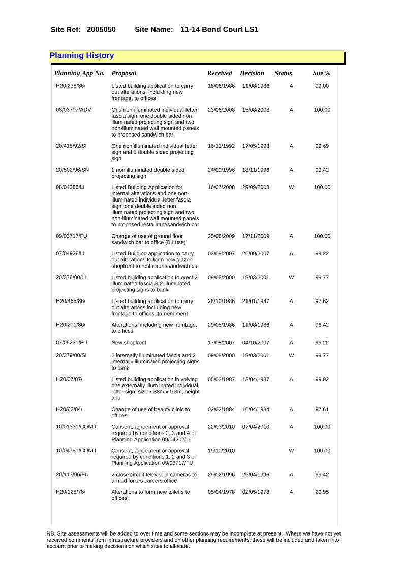
Site Name: 11-14 Bond Court LS1Site Ref: 2005050
Planning History
Planning App No. Proposal Received Decision Status Site %
H20/238/86/ Listed building application to carry out alterations, inclu ding new frontage, to offices.
18/06/1986 11/08/1986 A 99.00
08/03797/ADV One non-illuminated individual letter fascia sign, one double sided non illuminated projecting sign and two non-illuminated wall mounted panels to proposed sandwich bar.
23/06/2008 15/08/2008 A 100.00
20/418/92/SI One non illuminated individual letter sign and 1 double sided projecting sign
16/11/1992 17/05/1993 A 99.69
20/502/96/SN 1 non illuminated double sided projecting sign
24/09/1996 18/11/1996 A 99.42
08/04288/LI Listed Building Application for internal alterations and one non-illuminated individual letter fascia sign, one double sided non illuminated projecting sign and two non-illuminated wall mounted panels to proposed restaurant/sandwich bar
16/07/2008 29/09/2008 W 100.00
09/03717/FU Change of use of ground floor sandwich bar to office (B1 use)
25/08/2009 17/11/2009 A 100.00
07/04928/LI Listed Building application to carry out alterations to form new glazed shopfront to restaurant/sandwich bar
03/08/2007 26/09/2007 A 99.22
20/378/00/LI Listed building application to erect 2 illuminated fascia & 2 illuminated projecting signs to bank
09/08/2000 19/03/2001 W 99.77
H20/465/86/ Listed building application to carry out alterations inclu ding new frontage to offices. (amendment
28/10/1986 21/01/1987 A 97.62
H20/201/86/ Alterations, including new fro ntage, to offices.
29/05/1986 11/08/1986 A 96.42
07/05231/FU New shopfront 17/08/2007 04/10/2007 A 99.22
20/379/00/SI 2 internally illuminated fascia and 2 internally illuminated projecting signs to bank
09/08/2000 19/03/2001 W 99.77
H20/57/87/ Listed building application in volving one externally illum inated individual letter sign, size 7.38m x 0.3m, height abo
05/02/1987 13/04/1987 A 99.92
H20/62/84/ Change of use of beauty clinic to offices.
02/02/1984 16/04/1984 A 97.61
10/01331/COND Consent, agreement or approval required by conditions 2, 3 and 4 of Planning Application 09/04202/LI
22/03/2010 07/04/2010 A 100.00
10/04781/COND Consent, agreement or approval required by conditions 1, 2 and 3 of Planning Application 09/03717/FU
19/10/2010 W 100.00
20/113/96/FU 2 close circuit television cameras to armed forces careers office
29/02/1996 25/04/1996 A 99.42
H20/128/78/ Alterations to form new toilet s to offices.
05/04/1978 02/05/1978 A 29.95
NB. Site assessments will be added to over time and some sections may be incomplete at present. Where we have not yet received comments from infrastructure providers and on other planning requirements, these will be included and taken into account prior to making decisions on which sites to allocate.
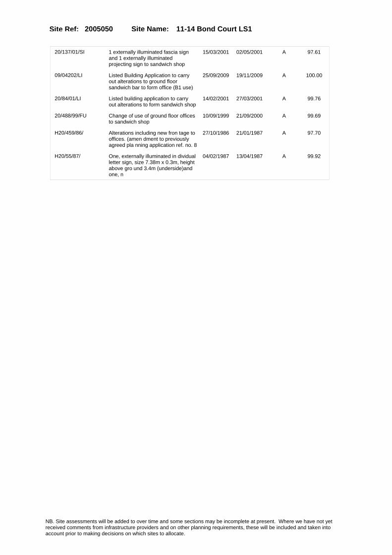
Site Name: 11-14 Bond Court LS1Site Ref: 2005050
20/137/01/SI 1 externally illuminated fascia sign and 1 externally illuminated projecting sign to sandwich shop
15/03/2001 02/05/2001 A 97.61
09/04202/LI Listed Building Application to carry out alterations to ground floor sandwich bar to form office (B1 use)
25/09/2009 19/11/2009 A 100.00
20/84/01/LI Listed building application to carry out alterations to form sandwich shop
14/02/2001 27/03/2001 A 99.76
20/488/99/FU Change of use of ground floor offices to sandwich shop
10/09/1999 21/09/2000 A 99.69
H20/459/86/ Alterations including new fron tage to offices. (amen dment to previously agreed pla nning application ref. no. 8
27/10/1986 21/01/1987 A 97.70
H20/55/87/ One, externally illuminated in dividual letter sign, size 7.38m x 0.3m, height above gro und 3.4m (underside)and one, n
04/02/1987 13/04/1987 A 99.92
NB. Site assessments will be added to over time and some sections may be incomplete at present. Where we have not yet received comments from infrastructure providers and on other planning requirements, these will be included and taken into account prior to making decisions on which sites to allocate.

Site Name: 11-14 Bond Court LS1Site Ref: 2005050
Conformity with Core Strategy
Inner South Leeds: 0.00
Leeds Bradford Corridor: 0.00 West Leeds Gateway: 0.00
Aire Valley: 0.00Regeneration Priority Area:
Brownfield
Greenfield
Mixed
Main Urban Area
Major Settlement
Smaller Settlement
Villages/Rural
Main Urban Area Extension
Major Settlement Extension
Smaller Settlement Extension
Village/Rural Extension
Development unrelated to existing development
Green Belt assessment - only completed where site is within Green Belt
Would development lead to/constitute ribbon development?
Would development result in isolated development?
Is the site well connected to built up area (2+ boundaries with existing built up area)?
Would development of the site effectively "round off" the settlement pattern?:
Do natural/physical features provide a good existing barrier between existing urban area and undeveloped land?
Overall sprawl conclusion:
Would development of the site lead to physical connection of settlements?
Do natural/physical features provide a good existing barrier/boundary to contain development?
Overall Coalescence Conclusion:
Is there a strong defensible boundary between the site and the existing urban area?
Does the site provide access to the countryside?
Does the site include local or national conservation designated areas?
Does the site include areas of woodlands, trees, hedgerows that are protected, or significant unprotected tree/hedge cover?
Does the site include grade 1, 2, or 3a agricultural land?
Does the site contain buildings? Are these in agricultural use?
Overall countryside Encroachment Conclusion
Is the site within or adjacent to a conservation area, listed building or other historical feature?
If yes, could development preserve this character?:
Overall Character Preservation Conclusion:
Greenbelt Assessment Conclusion:
Check the unrestricted sprawl of large built up areas
Prevent neighbouring towns from merging
Assist in safeguarding countryside from encroachment
Preserve the setting and special character of historic towns
NB. Site assessments will be added to over time and some sections may be incomplete at present. Where we have not yet received comments from infrastructure providers and on other planning requirements, these will be included and taken into account prior to making decisions on which sites to allocate.
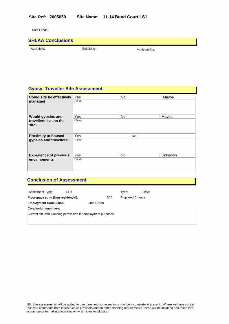
Site Name: 11-14 Bond Court LS1Site Ref: 2005050
SHLAA ConclusionsAvailability: Suitability: Achievability:
Conclusion of Assessment
Conclusion summary:
Current site with planning permission for employment purposes
Floorspace sq m (Non residential): 200
Employment Conclusion: Lime Green
East Leeds
Assesment Type: ELR Type: Office
Proposed Change:
Gypsy Traveller Site Assessment
Yes No Maybe Could site be effectively managed (Text)
Yes No Maybe Would gypsies and travellers live on the site?
(Text)
Yes No Proximity to housed gypsies and travellers (Text)
Yes No Unknown Experience of previous encampments (Text)
NB. Site assessments will be added to over time and some sections may be incomplete at present. Where we have not yet received comments from infrastructure providers and on other planning requirements, these will be included and taken into account prior to making decisions on which sites to allocate.

Site Name: 10 - 11 Sweet Street Holbeck LS11 9DBSite Ref: 2005100
Site Details
Land Use
Northing: 432496
Easting: 429644
Distance to Rail Station (metres): 696.53
Nearest Railway Station Leeds City
Distance to bus stop (metres) 61.67
Bus Stop ID 12632
Agricultural Land Class:
SFRA Flood Zone: 1.00
Environment Agency Flood Zone: 1.00
Within 300m of retail centre boundary:
UDP Designation
Greenbelt - N32 (%): 0.00 Urban Green Corridor - N8 (%): 0.00
Protected Area of Search site - N34 (%): 0.00 Rural Land - RL1: 0.00
City Centre Primary Shopping Quarter - CC27 (%): 0.00 Town Centre - S2: 0.00
Health and Safety Executive Hazard: No
Health and Safety Executive Gas Pipeline: Yes
Strategic Employment Buffer: 100.00
Area sq m: 9363.13 Ward City and Hunslet
Special Landscape Area - N37: 0.00
Allotments - N1A: 0.00
Proposed Greenspace - N5: 0.00
Protected Playing Pitch - N6: 0.00
Nature Conservation Area - N50: 0.00
Conservation Areas No
Ancient Monument/Battlefield(%): 0.00 Listed Buildings: No
Public Rights of Way: No
Other?:
Natural Resources and waste DPD (if applicable)
Within Minerals Safeguarding Site?: No Within 100m of Minerals Safeguarding Site?: No
HMCA: City Centre
Greenspace - N1: 0
Existing Use 1:
Existing Use 2:
Existing Use 3:
Neighbouring Use 1
Neighbouring Use 2:
Neighbouring Use 3:
Other uses:
Topography:
Natural Landscape:
Boundaries:
Road Frontage
Site Characteristics
Site Detail
Other comments/observations on site characteristics:
Area Ha: 0.936313
Site State:
NB. Site assessments will be added to over time and some sections may be incomplete at present. Where we have not yet received comments from infrastructure providers and on other planning requirements, these will be included and taken into account prior to making decisions on which sites to allocate.

Site Name: 10 - 11 Sweet Street Holbeck LS11 9DBSite Ref: 2005100
Planning History
Planning App No. Proposal Received Decision Status Site %
10/00462/FU Detached single storey prefabricated classroom to yard to rear of church
03/02/2010 APPRET 18.60
06/02152/FU Change of use of private car park to public car park
03/04/2006 07/11/2006 R 50.53
99-20/48/93/FU Change of use of warehouse to office with ancillary storage
02/03/1993 20/05/1993 A 41.94
H20/487/87/ Change of use, involving alter ations, of printing workswith offices to 2 warehouse units e ach with ancillary offices.
12/10/1987 30/11/1987 A 42.02
20/293/05/FU Demolition of warehouse and re-development of site to form 225 space public car park
08/06/2005 19/08/2005 W 50.60
20/477/02/FU Laying out of car parking to front of warehouse
20/11/2002 14/01/2003 W 100.00
07/02999/FU Change of use of warehouse (B8) to Church meeting rooms (D1)
09/05/2007 13/07/2007 A 22.82
H20/54/81/ Alterations, to form showroom, security room, office, sales area, staff room and toilets, to cash and carry warehouse.
04/02/1981 18/05/1981 W 83.68
08/05196/ADV 1 non illuminated individual letter sign to church
02/09/2008 14/10/2008 A 16.36
H20/135/83/ Change of use of warehouse to printing works.
29/04/1983 17/05/1983 A 41.47
H20/45/88/ One externally illuminated wal l sign, size 3.6m x 1.8m, height above ground 3.8m (und erside), to offices.
29/01/1988 21/03/1988 A 41.32
09/03829/OT Outline Application to erect B1 offices in 2 blocks and health and fitness centre and 596 bay multi storey car park
02/09/2009 13/10/2010 A 100.00
NB. Site assessments will be added to over time and some sections may be incomplete at present. Where we have not yet received comments from infrastructure providers and on other planning requirements, these will be included and taken into account prior to making decisions on which sites to allocate.

Site Name: 10 - 11 Sweet Street Holbeck LS11 9DBSite Ref: 2005100
Conformity with Core Strategy
Inner South Leeds: 0.00
Leeds Bradford Corridor: 0.00 West Leeds Gateway: 0.00
Aire Valley: 0.00Regeneration Priority Area:
Brownfield
Greenfield
Mixed
Main Urban Area
Major Settlement
Smaller Settlement
Villages/Rural
Main Urban Area Extension
Major Settlement Extension
Smaller Settlement Extension
Village/Rural Extension
Development unrelated to existing development
Green Belt assessment - only completed where site is within Green Belt
Would development lead to/constitute ribbon development?
Would development result in isolated development?
Is the site well connected to built up area (2+ boundaries with existing built up area)?
Would development of the site effectively "round off" the settlement pattern?:
Do natural/physical features provide a good existing barrier between existing urban area and undeveloped land?
Overall sprawl conclusion:
Would development of the site lead to physical connection of settlements?
Do natural/physical features provide a good existing barrier/boundary to contain development?
Overall Coalescence Conclusion:
Is there a strong defensible boundary between the site and the existing urban area?
Does the site provide access to the countryside?
Does the site include local or national conservation designated areas?
Does the site include areas of woodlands, trees, hedgerows that are protected, or significant unprotected tree/hedge cover?
Does the site include grade 1, 2, or 3a agricultural land?
Does the site contain buildings? Are these in agricultural use?
Overall countryside Encroachment Conclusion
Is the site within or adjacent to a conservation area, listed building or other historical feature?
If yes, could development preserve this character?:
Overall Character Preservation Conclusion:
Greenbelt Assessment Conclusion:
Check the unrestricted sprawl of large built up areas
Prevent neighbouring towns from merging
Assist in safeguarding countryside from encroachment
Preserve the setting and special character of historic towns
NB. Site assessments will be added to over time and some sections may be incomplete at present. Where we have not yet received comments from infrastructure providers and on other planning requirements, these will be included and taken into account prior to making decisions on which sites to allocate.

Site Name: 10 - 11 Sweet Street Holbeck LS11 9DBSite Ref: 2005100
SHLAA ConclusionsAvailability: Suitability: Achievability:
Conclusion of Assessment
Conclusion summary:
Current site with planning permission for employment purposes
Floorspace sq m (Non residential): 7900
Employment Conclusion: Lime Green
East Leeds
Assesment Type: ELR Type: Office
Proposed Change:
Gypsy Traveller Site Assessment
Yes No Maybe Could site be effectively managed (Text)
Yes No Maybe Would gypsies and travellers live on the site?
(Text)
Yes No Proximity to housed gypsies and travellers (Text)
Yes No Unknown Experience of previous encampments (Text)
NB. Site assessments will be added to over time and some sections may be incomplete at present. Where we have not yet received comments from infrastructure providers and on other planning requirements, these will be included and taken into account prior to making decisions on which sites to allocate.

Site Name: s/o Yorkshire Chemicals plc Kirkstall Road & Land Off Wellington Road LS3
Site Ref: 2005110
Site Details
Land Use
Northing: 433700
Easting: 428558
Distance to Rail Station (metres): 1242.67
Nearest Railway Station Leeds City
Distance to bus stop (metres) 198.57
Bus Stop ID 8114
Agricultural Land Class:
SFRA Flood Zone: 1.00
Environment Agency Flood Zone: 1.00
Within 300m of retail centre boundary:
UDP Designation
Greenbelt - N32 (%): 0.00 Urban Green Corridor - N8 (%): 63.46
Protected Area of Search site - N34 (%): 0.00 Rural Land - RL1: 0.00
City Centre Primary Shopping Quarter - CC27 (%): 0.00 Town Centre - S2: 0.00
Health and Safety Executive Hazard: Yes
Health and Safety Executive Gas Pipeline: No
Strategic Employment Buffer: 0.34
Area sq m: 59325.42 Ward City and Hunslet
Special Landscape Area - N37: 0.00
Allotments - N1A: 0.00
Proposed Greenspace - N5: 0.00
Protected Playing Pitch - N6: 0.00
Nature Conservation Area - N50: 0.00
Conservation Areas No
Ancient Monument/Battlefield(%): 0.00 Listed Buildings: Yes
Public Rights of Way: Yes
Other?:
Natural Resources and waste DPD (if applicable)
Within Minerals Safeguarding Site?: No Within 100m of Minerals Safeguarding Site?: Yes
HMCA: Inner Areas
Greenspace - N1: 0
Existing Use 1:
Existing Use 2:
Existing Use 3:
Neighbouring Use 1
Neighbouring Use 2:
Neighbouring Use 3:
Other uses:
Topography:
Natural Landscape:
Boundaries:
Road Frontage
Site Characteristics
Site Detail
Other comments/observations on site characteristics:
Area Ha: 5.932542
Site State:
NB. Site assessments will be added to over time and some sections may be incomplete at present. Where we have not yet received comments from infrastructure providers and on other planning requirements, these will be included and taken into account prior to making decisions on which sites to allocate.

Site Name: s/o Yorkshire Chemicals plc Kirkstall Road & Land Off Wellington Road LS3
Site Ref: 2005110
Planning History
Planning App No. Proposal Received Decision Status Site %
20/59/93/FU 4 storey extension to part of works 02/03/1993 18/06/1993 A 34.06
20/499/99/HZ Claim for hazardous substances deemed consent (1999)
20/09/1999 15/12/1999 DC 72.62
20/443/93/SN 2 non illuminated wall signs 16/12/1993 25/01/1994 A 34.06
H26/132/79/ Alterations and extension, to form enlarged time offic e, to chemical works.
19/02/1979 09/04/1979 A 35.09
H26/534/74/ One illuminated wall box sign, size 3.66m (12ft) x 2.44m (8ft), height above ground 20 .12m (66ft) (underside
12/09/1974 28/10/1974 A 33.70
H26/487/75/1 Extension of permission for si ngle storey mess room to ch emical works. (previous applic ation no.75/26/00487expires on
15/01/1980 14/02/1980 A 35.18
H20/52/85/1 Extensions of permission for s ingle storey mess room tochemi cal works. (previous
05/03/1990 20/04/1990 A 35.11
H26/487/75/ Single storey mess room to che mical works.
05/06/1975 21/07/1975 A 33.70
H26/1012/75/ 2 25, 458 litres (5, 600 gallons ) hydrochloric acid stora ge tanks, to works premises.
28/11/1975 09/02/1976 A 33.70
H20/52/85/ Extension of permission for si ngle storey mess room to chemi cal works. (previous
12/02/1985 25/03/1985 A 34.94
20/313/95/FU 2.2 metre high boundary fence, refurbish elevations and extension to form production annexe to works
26/07/1995 26/09/1995 A 35.24
20/16/01/SI 1 halo illuminated logo sign and 1 halo illuminated sign to factory
10/01/2001 01/03/2001 A 35.05
06/04610/OT Outline application (layout and access) for the proposed remediation and mixed use regeneration including the erection of buildings including employment space (B1 Offices - 31,000 m2) residential development (C3 apartments (1424 max) and 20 houses), secondary supporting uses (A 1 retail (430 m2), A3 restaurants, A4 bars (2,500 m2)) community health facility (D1 - 400 m2) laying out of public open spaces, riverside walkway, nature corridor, landscaping, vehicular and cycle parking including multi storey car park (488 spaces) and basement car parks (897 spaces), pedestrian river bridge, access and highway improvements.
28/07/2006 16/02/2011 A 100.00
NB. Site assessments will be added to over time and some sections may be incomplete at present. Where we have not yet received comments from infrastructure providers and on other planning requirements, these will be included and taken into account prior to making decisions on which sites to allocate.

Site Name: s/o Yorkshire Chemicals plc Kirkstall Road & Land Off Wellington Road LS3
Site Ref: 2005110
Conformity with Core Strategy
Inner South Leeds: 0.00
Leeds Bradford Corridor: 0.00 West Leeds Gateway: 21.78
Aire Valley: 0.00Regeneration Priority Area:
Brownfield
Greenfield
Mixed
Main Urban Area
Major Settlement
Smaller Settlement
Villages/Rural
Main Urban Area Extension
Major Settlement Extension
Smaller Settlement Extension
Village/Rural Extension
Development unrelated to existing development
Green Belt assessment - only completed where site is within Green Belt
Would development lead to/constitute ribbon development?
Would development result in isolated development?
Is the site well connected to built up area (2+ boundaries with existing built up area)?
Would development of the site effectively "round off" the settlement pattern?:
Do natural/physical features provide a good existing barrier between existing urban area and undeveloped land?
Overall sprawl conclusion:
Would development of the site lead to physical connection of settlements?
Do natural/physical features provide a good existing barrier/boundary to contain development?
Overall Coalescence Conclusion:
Is there a strong defensible boundary between the site and the existing urban area?
Does the site provide access to the countryside?
Does the site include local or national conservation designated areas?
Does the site include areas of woodlands, trees, hedgerows that are protected, or significant unprotected tree/hedge cover?
Does the site include grade 1, 2, or 3a agricultural land?
Does the site contain buildings? Are these in agricultural use?
Overall countryside Encroachment Conclusion
Is the site within or adjacent to a conservation area, listed building or other historical feature?
If yes, could development preserve this character?:
Overall Character Preservation Conclusion:
Greenbelt Assessment Conclusion:
Check the unrestricted sprawl of large built up areas
Prevent neighbouring towns from merging
Assist in safeguarding countryside from encroachment
Preserve the setting and special character of historic towns
NB. Site assessments will be added to over time and some sections may be incomplete at present. Where we have not yet received comments from infrastructure providers and on other planning requirements, these will be included and taken into account prior to making decisions on which sites to allocate.

Site Name: s/o Yorkshire Chemicals plc Kirkstall Road & Land Off Wellington Road LS3
Site Ref: 2005110
SHLAA ConclusionsAvailability: Suitability: Achievability:
Conclusion of Assessment
Conclusion summary:
Current site with planning permission for employment purposes.
Floorspace sq m (Non residential): 31000
Employment Conclusion: Lime Green
East Leeds
Assesment Type: Planning status Type: Office
Proposed Change:
Gypsy Traveller Site Assessment
Yes No Maybe Could site be effectively managed (Text)
Yes No Maybe Would gypsies and travellers live on the site?
(Text)
Yes No Proximity to housed gypsies and travellers (Text)
Yes No Unknown Experience of previous encampments (Text)
NB. Site assessments will be added to over time and some sections may be incomplete at present. Where we have not yet received comments from infrastructure providers and on other planning requirements, these will be included and taken into account prior to making decisions on which sites to allocate.

Site Name: Midland Mills Silver Street LS11 9YWSite Ref: 2005170
Site Details
Land Use
Northing: 432797
Easting: 429353
Distance to Rail Station (metres): 520.34
Nearest Railway Station Leeds City
Distance to bus stop (metres) 360.11
Bus Stop ID 4261
Agricultural Land Class:
SFRA Flood Zone: 1.00
Environment Agency Flood Zone: 1.00
Within 300m of retail centre boundary:
UDP Designation
Greenbelt - N32 (%): 0.00 Urban Green Corridor - N8 (%): 0.00
Protected Area of Search site - N34 (%): 0.00 Rural Land - RL1: 0.00
City Centre Primary Shopping Quarter - CC27 (%): 0.00 Town Centre - S2: 0.00
Health and Safety Executive Hazard: No
Health and Safety Executive Gas Pipeline: No
Strategic Employment Buffer: 100.00
Area sq m: 2051.12 Ward City and Hunslet
Special Landscape Area - N37: 0.00
Allotments - N1A: 0.00
Proposed Greenspace - N5: 0.00
Protected Playing Pitch - N6: 0.00
Nature Conservation Area - N50: 1.00
Conservation Areas Yes
Ancient Monument/Battlefield(%): 0.42 Listed Buildings: No
Public Rights of Way: No
Other?:
Natural Resources and waste DPD (if applicable)
Within Minerals Safeguarding Site?: No Within 100m of Minerals Safeguarding Site?: No
HMCA: City Centre
Greenspace - N1: 0
Existing Use 1:
Existing Use 2:
Existing Use 3:
Neighbouring Use 1
Neighbouring Use 2:
Neighbouring Use 3:
Other uses:
Topography:
Natural Landscape:
Boundaries:
Road Frontage
Site Characteristics
Site Detail
Other comments/observations on site characteristics:
Area Ha: 0.205112
Site State:
NB. Site assessments will be added to over time and some sections may be incomplete at present. Where we have not yet received comments from infrastructure providers and on other planning requirements, these will be included and taken into account prior to making decisions on which sites to allocate.
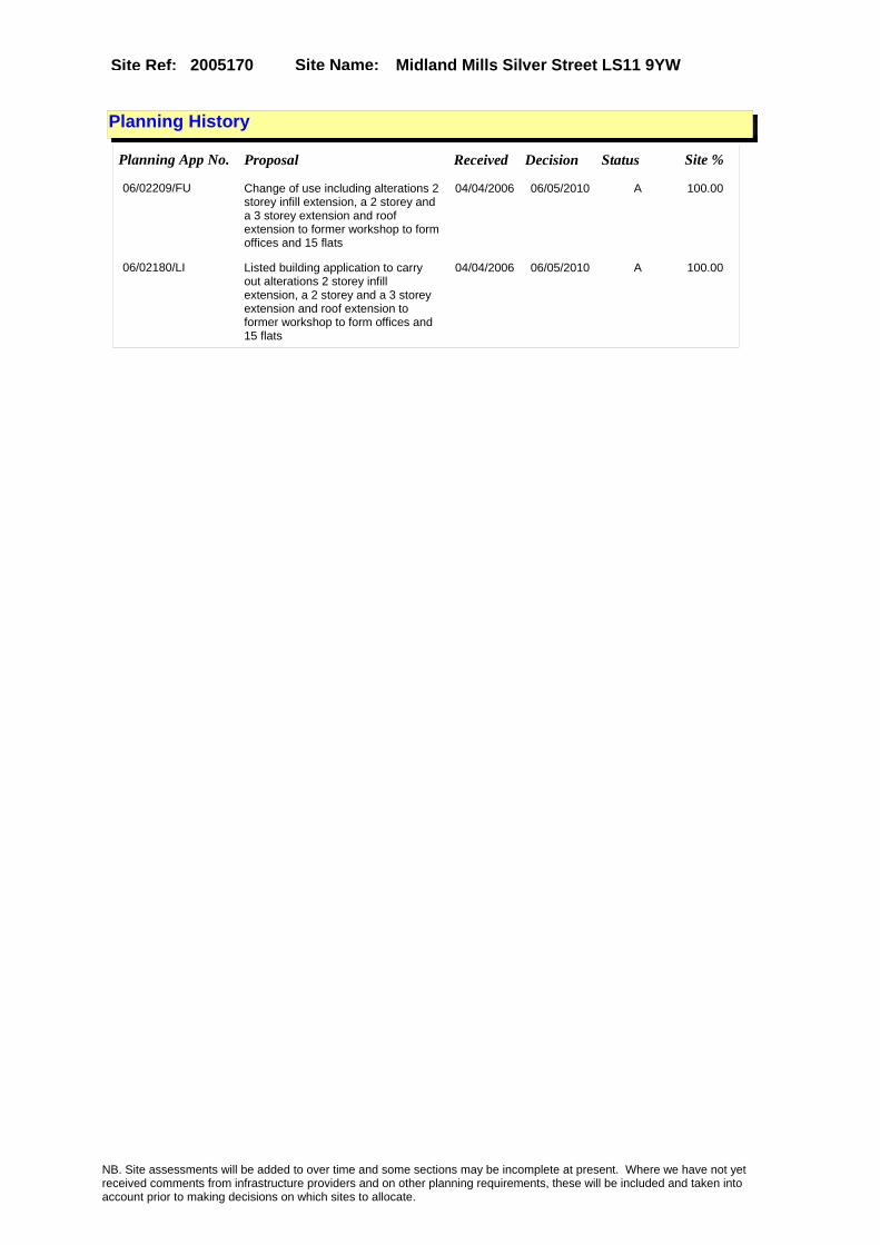
Site Name: Midland Mills Silver Street LS11 9YWSite Ref: 2005170
Planning History
Planning App No. Proposal Received Decision Status Site %
06/02209/FU Change of use including alterations 2 storey infill extension, a 2 storey and a 3 storey extension and roof extension to former workshop to form offices and 15 flats
04/04/2006 06/05/2010 A 100.00
06/02180/LI Listed building application to carry out alterations 2 storey infill extension, a 2 storey and a 3 storey extension and roof extension to former workshop to form offices and 15 flats
04/04/2006 06/05/2010 A 100.00
NB. Site assessments will be added to over time and some sections may be incomplete at present. Where we have not yet received comments from infrastructure providers and on other planning requirements, these will be included and taken into account prior to making decisions on which sites to allocate.

Site Name: Midland Mills Silver Street LS11 9YWSite Ref: 2005170
Conformity with Core Strategy
Inner South Leeds: 0.00
Leeds Bradford Corridor: 0.00 West Leeds Gateway: 0.00
Aire Valley: 0.00Regeneration Priority Area:
Brownfield
Greenfield
Mixed
Main Urban Area
Major Settlement
Smaller Settlement
Villages/Rural
Main Urban Area Extension
Major Settlement Extension
Smaller Settlement Extension
Village/Rural Extension
Development unrelated to existing development
Green Belt assessment - only completed where site is within Green Belt
Would development lead to/constitute ribbon development?
Would development result in isolated development?
Is the site well connected to built up area (2+ boundaries with existing built up area)?
Would development of the site effectively "round off" the settlement pattern?:
Do natural/physical features provide a good existing barrier between existing urban area and undeveloped land?
Overall sprawl conclusion:
Would development of the site lead to physical connection of settlements?
Do natural/physical features provide a good existing barrier/boundary to contain development?
Overall Coalescence Conclusion:
Is there a strong defensible boundary between the site and the existing urban area?
Does the site provide access to the countryside?
Does the site include local or national conservation designated areas?
Does the site include areas of woodlands, trees, hedgerows that are protected, or significant unprotected tree/hedge cover?
Does the site include grade 1, 2, or 3a agricultural land?
Does the site contain buildings? Are these in agricultural use?
Overall countryside Encroachment Conclusion
Is the site within or adjacent to a conservation area, listed building or other historical feature?
If yes, could development preserve this character?:
Overall Character Preservation Conclusion:
Greenbelt Assessment Conclusion:
Check the unrestricted sprawl of large built up areas
Prevent neighbouring towns from merging
Assist in safeguarding countryside from encroachment
Preserve the setting and special character of historic towns
NB. Site assessments will be added to over time and some sections may be incomplete at present. Where we have not yet received comments from infrastructure providers and on other planning requirements, these will be included and taken into account prior to making decisions on which sites to allocate.

Site Name: Midland Mills Silver Street LS11 9YWSite Ref: 2005170
SHLAA ConclusionsAvailability: Suitability: Achievability:
Conclusion of Assessment
Conclusion summary:
Current site with planning permission for employment purposes
Floorspace sq m (Non residential): 3310
Employment Conclusion: Lime Green
East Leeds
Assesment Type: ELR Type: Office
Proposed Change:
Gypsy Traveller Site Assessment
Yes No Maybe Could site be effectively managed (Text)
Yes No Maybe Would gypsies and travellers live on the site?
(Text)
Yes No Proximity to housed gypsies and travellers (Text)
Yes No Unknown Experience of previous encampments (Text)
NB. Site assessments will be added to over time and some sections may be incomplete at present. Where we have not yet received comments from infrastructure providers and on other planning requirements, these will be included and taken into account prior to making decisions on which sites to allocate.

Site Name: Parkside Lane LS 11 Site Ref: 2101900
Site Details
Land Use
Northing: 430131
Easting: 430386
Distance to Rail Station (metres): 3001.97
Nearest Railway Station Cottingley
Distance to bus stop (metres) 102.07
Bus Stop ID 10326
Agricultural Land Class:
SFRA Flood Zone: 0.00
Environment Agency Flood Zone: 0.00
Within 300m of retail centre boundary:
UDP Designation
Greenbelt - N32 (%): 0.00 Urban Green Corridor - N8 (%): 25.79
Protected Area of Search site - N34 (%): 0.00 Rural Land - RL1: 0.00
City Centre Primary Shopping Quarter - CC27 (%): 0.00 Town Centre - S2: 0.00
Health and Safety Executive Hazard: No
Health and Safety Executive Gas Pipeline: No
Strategic Employment Buffer: 0.00
Area sq m: 55091.15 Ward City and Hunslet
Special Landscape Area - N37: 0.00
Allotments - N1A: 0.00
Proposed Greenspace - N5: 0.00
Protected Playing Pitch - N6: 0.00
Nature Conservation Area - N50: 0.00
Conservation Areas No
Ancient Monument/Battlefield(%): 0.00 Listed Buildings: Yes
Public Rights of Way: Yes
Other?:
Natural Resources and waste DPD (if applicable)
Within Minerals Safeguarding Site?: No Within 100m of Minerals Safeguarding Site?: Yes
HMCA: Outer South West
Greenspace - N1: 25.79
Existing Use 1:
Existing Use 2:
Existing Use 3:
Neighbouring Use 1
Neighbouring Use 2:
Neighbouring Use 3:
Other uses:
Topography:
Natural Landscape:
Boundaries:
Road Frontage
Site Characteristics
Site Detail
Other comments/observations on site characteristics:
Area Ha: 5.509115
Site State:
NB. Site assessments will be added to over time and some sections may be incomplete at present. Where we have not yet received comments from infrastructure providers and on other planning requirements, these will be included and taken into account prior to making decisions on which sites to allocate.

Site Name: Parkside Lane LS 11 Site Ref: 2101900
Planning History
NB. Site assessments will be added to over time and some sections may be incomplete at present. Where we have not yet received comments from infrastructure providers and on other planning requirements, these will be included and taken into account prior to making decisions on which sites to allocate.

Site Name: Parkside Lane LS 11 Site Ref: 2101900
Conformity with Core Strategy
Inner South Leeds: 0.00
Leeds Bradford Corridor: 0.00 West Leeds Gateway: 0.00
Aire Valley: 0.00Regeneration Priority Area:
Brownfield
Greenfield
Mixed
Main Urban Area
Major Settlement
Smaller Settlement
Villages/Rural
Main Urban Area Extension
Major Settlement Extension
Smaller Settlement Extension
Village/Rural Extension
Development unrelated to existing development
Green Belt assessment - only completed where site is within Green Belt
Would development lead to/constitute ribbon development?
Would development result in isolated development?
Is the site well connected to built up area (2+ boundaries with existing built up area)?
Would development of the site effectively "round off" the settlement pattern?:
Do natural/physical features provide a good existing barrier between existing urban area and undeveloped land?
Overall sprawl conclusion:
Would development of the site lead to physical connection of settlements?
Do natural/physical features provide a good existing barrier/boundary to contain development?
Overall Coalescence Conclusion:
Is there a strong defensible boundary between the site and the existing urban area?
Does the site provide access to the countryside?
Does the site include local or national conservation designated areas?
Does the site include areas of woodlands, trees, hedgerows that are protected, or significant unprotected tree/hedge cover?
Does the site include grade 1, 2, or 3a agricultural land?
Does the site contain buildings? Are these in agricultural use?
Overall countryside Encroachment Conclusion
Is the site within or adjacent to a conservation area, listed building or other historical feature?
If yes, could development preserve this character?:
Overall Character Preservation Conclusion:
Greenbelt Assessment Conclusion:
Check the unrestricted sprawl of large built up areas
Prevent neighbouring towns from merging
Assist in safeguarding countryside from encroachment
Preserve the setting and special character of historic towns
NB. Site assessments will be added to over time and some sections may be incomplete at present. Where we have not yet received comments from infrastructure providers and on other planning requirements, these will be included and taken into account prior to making decisions on which sites to allocate.

Site Name: Parkside Lane LS 11 Site Ref: 2101900
SHLAA ConclusionsAvailability: Suitability: Achievability:
East Leeds
Summary of Infrastructure provider comments and other planning requirements
Accessibility commentreasonable accessibilty
Rank (1-5)
3Access Comments
access is very difficult given roundabout location and gradients
Local network comment
spare local capacity
Rank (1-5)
2Rank (1-5)
4
Leeds City Council Highways inc Metro
Highways Agency
Network Rail :
Biodiversity
Natural England:
Education
Mitigation measure Total score
9Support?
no
Need to combine with other sites: Suitability for partial development:
West Yorkshire Ecology and LCC Ecology Officer:
Supported
Boundary Amendment
Drainage/Water/FloodingEnvironment Agency Comments: Environment Agency Constraints:
Yorkshire Water Comments: Yorkshire Water Waste Water Treatment Works Comme
UtilitiesGas:
LCC Flood Risk Management:
NB. Site assessments will be added to over time and some sections may be incomplete at present. Where we have not yet received comments from infrastructure providers and on other planning requirements, these will be included and taken into account prior to making decisions on which sites to allocate.

Site Name: Parkside Lane LS 11 Site Ref: 2101900
Conclusion of Assessment
Conclusion summary:
Retain. Unimplemented.
Floorspace sq m (Non residential):
Employment Conclusion: Green
Assesment Type: Site assessment Type: Industrial & Warehousing
Proposed Change:
Electric:
Telecom:
Fire and Rescue Services:
Built HeritageLeeds City Council:
West Yorkshire Archaeology Service:
English Heritage:
Gypsy Traveller Site Assessment
Yes No Maybe Could site be effectively managed (Text)
Yes No Maybe Would gypsies and travellers live on the site?
(Text)
Yes No Proximity to housed gypsies and travellers (Text)
Yes No Unknown Experience of previous encampments (Text)
NB. Site assessments will be added to over time and some sections may be incomplete at present. Where we have not yet received comments from infrastructure providers and on other planning requirements, these will be included and taken into account prior to making decisions on which sites to allocate.

Site Name: City West Office Park Gelderd Road Leeds 12Site Ref: 2103380
Site Details
Land Use
Northing: 431363
Easting: 427805
Distance to Rail Station (metres): 1359.73
Nearest Railway Station Cottingley
Distance to bus stop (metres) 226.33
Bus Stop ID 13458
Agricultural Land Class:
SFRA Flood Zone: 1.00
Environment Agency Flood Zone: 1.00
Within 300m of retail centre boundary:
UDP Designation
Greenbelt - N32 (%): 0.00 Urban Green Corridor - N8 (%): 0.00
Protected Area of Search site - N34 (%): 0.00 Rural Land - RL1: 0.00
City Centre Primary Shopping Quarter - CC27 (%): 0.00 Town Centre - S2: 0.00
Health and Safety Executive Hazard: No
Health and Safety Executive Gas Pipeline: No
Strategic Employment Buffer: 0.00
Area sq m: 14102.46 Ward Beeston and Holbeck
Special Landscape Area - N37: 0.00
Allotments - N1A: 0.00
Proposed Greenspace - N5: 0.00
Protected Playing Pitch - N6: 0.00
Nature Conservation Area - N50: 0.00
Conservation Areas No
Ancient Monument/Battlefield(%): 0.00 Listed Buildings: No
Public Rights of Way: No
Other?:
Natural Resources and waste DPD (if applicable)
Within Minerals Safeguarding Site?: No Within 100m of Minerals Safeguarding Site?: No
HMCA: Inner Areas
Greenspace - N1: 0
Existing Use 1:
Existing Use 2:
Existing Use 3:
Neighbouring Use 1
Neighbouring Use 2:
Neighbouring Use 3:
Other uses:
Topography:
Natural Landscape:
Boundaries:
Road Frontage
Site Characteristics
Site Detail
Other comments/observations on site characteristics:
Area Ha: 1.410246
Site State:
NB. Site assessments will be added to over time and some sections may be incomplete at present. Where we have not yet received comments from infrastructure providers and on other planning requirements, these will be included and taken into account prior to making decisions on which sites to allocate.

Site Name: City West Office Park Gelderd Road Leeds 12Site Ref: 2103380
Planning History
NB. Site assessments will be added to over time and some sections may be incomplete at present. Where we have not yet received comments from infrastructure providers and on other planning requirements, these will be included and taken into account prior to making decisions on which sites to allocate.

Site Name: City West Office Park Gelderd Road Leeds 12Site Ref: 2103380
Conformity with Core Strategy
Inner South Leeds: 0.00
Leeds Bradford Corridor: 0.00 West Leeds Gateway: 0.00
Aire Valley: 0.00Regeneration Priority Area:
Brownfield
Greenfield
Mixed
Main Urban Area
Major Settlement
Smaller Settlement
Villages/Rural
Main Urban Area Extension
Major Settlement Extension
Smaller Settlement Extension
Village/Rural Extension
Development unrelated to existing development
Green Belt assessment - only completed where site is within Green Belt
Would development lead to/constitute ribbon development?
Would development result in isolated development?
Is the site well connected to built up area (2+ boundaries with existing built up area)?
Would development of the site effectively "round off" the settlement pattern?:
Do natural/physical features provide a good existing barrier between existing urban area and undeveloped land?
Overall sprawl conclusion:
Would development of the site lead to physical connection of settlements?
Do natural/physical features provide a good existing barrier/boundary to contain development?
Overall Coalescence Conclusion:
Is there a strong defensible boundary between the site and the existing urban area?
Does the site provide access to the countryside?
Does the site include local or national conservation designated areas?
Does the site include areas of woodlands, trees, hedgerows that are protected, or significant unprotected tree/hedge cover?
Does the site include grade 1, 2, or 3a agricultural land?
Does the site contain buildings? Are these in agricultural use?
Overall countryside Encroachment Conclusion
Is the site within or adjacent to a conservation area, listed building or other historical feature?
If yes, could development preserve this character?:
Overall Character Preservation Conclusion:
Greenbelt Assessment Conclusion:
Check the unrestricted sprawl of large built up areas
Prevent neighbouring towns from merging
Assist in safeguarding countryside from encroachment
Preserve the setting and special character of historic towns
NB. Site assessments will be added to over time and some sections may be incomplete at present. Where we have not yet received comments from infrastructure providers and on other planning requirements, these will be included and taken into account prior to making decisions on which sites to allocate.

Site Name: City West Office Park Gelderd Road Leeds 12Site Ref: 2103380
SHLAA ConclusionsAvailability: Suitability: Achievability:
Conclusion of Assessment
Conclusion summary:
Smallish residual backland site on partly developed Business Park; not very well located re PPS4 criteria.
Floorspace sq m (Non residential): 4160
Employment Conclusion: Lime Green
East Leeds
Assesment Type: ELR Type: Office
Proposed Change:
Gypsy Traveller Site Assessment
Yes No Maybe Could site be effectively managed (Text)
Yes No Maybe Would gypsies and travellers live on the site?
(Text)
Yes No Proximity to housed gypsies and travellers (Text)
Yes No Unknown Experience of previous encampments (Text)
NB. Site assessments will be added to over time and some sections may be incomplete at present. Where we have not yet received comments from infrastructure providers and on other planning requirements, these will be included and taken into account prior to making decisions on which sites to allocate.

Site Name: Gelderd Road Leeds 12Site Ref: 2103385
Site Details
Land Use
Northing: 431397
Easting: 427662
Distance to Rail Station (metres): 1355.77
Nearest Railway Station Cottingley
Distance to bus stop (metres) 81.36
Bus Stop ID 13458
Agricultural Land Class:
SFRA Flood Zone: 1.00
Environment Agency Flood Zone: 1.00
Within 300m of retail centre boundary:
UDP Designation
Greenbelt - N32 (%): 0.00 Urban Green Corridor - N8 (%): 0.00
Protected Area of Search site - N34 (%): 0.00 Rural Land - RL1: 0.00
City Centre Primary Shopping Quarter - CC27 (%): 0.00 Town Centre - S2: 0.00
Health and Safety Executive Hazard: No
Health and Safety Executive Gas Pipeline: No
Strategic Employment Buffer: 0.00
Area sq m: 9931.26 Ward Beeston and Holbeck
Special Landscape Area - N37: 0.00
Allotments - N1A: 0.00
Proposed Greenspace - N5: 0.00
Protected Playing Pitch - N6: 0.00
Nature Conservation Area - N50: 0.00
Conservation Areas No
Ancient Monument/Battlefield(%): 0.00 Listed Buildings: No
Public Rights of Way: No
Other?:
Natural Resources and waste DPD (if applicable)
Within Minerals Safeguarding Site?: No Within 100m of Minerals Safeguarding Site?: No
HMCA: Inner Areas
Greenspace - N1: 0
Existing Use 1:
Existing Use 2:
Existing Use 3:
Neighbouring Use 1
Neighbouring Use 2:
Neighbouring Use 3:
Other uses:
Topography:
Natural Landscape:
Boundaries:
Road Frontage
Site Characteristics
Site Detail
Other comments/observations on site characteristics:
Area Ha: 0.993126
Site State:
NB. Site assessments will be added to over time and some sections may be incomplete at present. Where we have not yet received comments from infrastructure providers and on other planning requirements, these will be included and taken into account prior to making decisions on which sites to allocate.
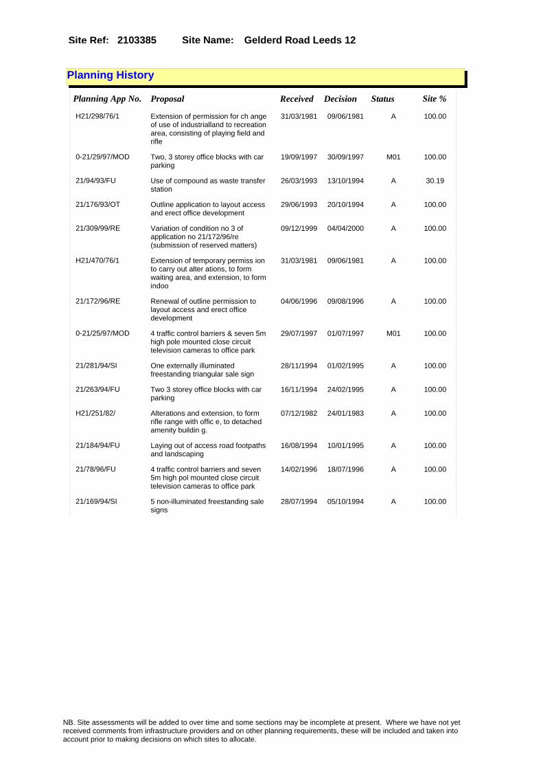
Site Name: Gelderd Road Leeds 12Site Ref: 2103385
Planning History
Planning App No. Proposal Received Decision Status Site %
H21/298/76/1 Extension of permission for ch ange of use of industrialland to recreation area, consisting of playing field and rifle
31/03/1981 09/06/1981 A 100.00
0-21/29/97/MOD Two, 3 storey office blocks with car parking
19/09/1997 30/09/1997 M01 100.00
21/94/93/FU Use of compound as waste transfer station
26/03/1993 13/10/1994 A 30.19
21/176/93/OT Outline application to layout access and erect office development
29/06/1993 20/10/1994 A 100.00
21/309/99/RE Variation of condition no 3 of application no 21/172/96/re (submission of reserved matters)
09/12/1999 04/04/2000 A 100.00
H21/470/76/1 Extension of temporary permiss ion to carry out alter ations, to form waiting area, and extension, to form indoo
31/03/1981 09/06/1981 A 100.00
21/172/96/RE Renewal of outline permission to layout access and erect office development
04/06/1996 09/08/1996 A 100.00
0-21/25/97/MOD 4 traffic control barriers & seven 5m high pole mounted close circuit television cameras to office park
29/07/1997 01/07/1997 M01 100.00
21/281/94/SI One externally illuminated freestanding triangular sale sign
28/11/1994 01/02/1995 A 100.00
21/263/94/FU Two 3 storey office blocks with car parking
16/11/1994 24/02/1995 A 100.00
H21/251/82/ Alterations and extension, to form rifle range with offic e, to detached amenity buildin g.
07/12/1982 24/01/1983 A 100.00
21/184/94/FU Laying out of access road footpaths and landscaping
16/08/1994 10/01/1995 A 100.00
21/78/96/FU 4 traffic control barriers and seven 5m high pol mounted close circuit television cameras to office park
14/02/1996 18/07/1996 A 100.00
21/169/94/SI 5 non-illuminated freestanding sale signs
28/07/1994 05/10/1994 A 100.00
NB. Site assessments will be added to over time and some sections may be incomplete at present. Where we have not yet received comments from infrastructure providers and on other planning requirements, these will be included and taken into account prior to making decisions on which sites to allocate.

Site Name: Gelderd Road Leeds 12Site Ref: 2103385
Conformity with Core Strategy
Inner South Leeds: 0.00
Leeds Bradford Corridor: 0.00 West Leeds Gateway: 0.00
Aire Valley: 0.00Regeneration Priority Area:
Brownfield
Greenfield
Mixed
Main Urban Area
Major Settlement
Smaller Settlement
Villages/Rural
Main Urban Area Extension
Major Settlement Extension
Smaller Settlement Extension
Village/Rural Extension
Development unrelated to existing development
Green Belt assessment - only completed where site is within Green Belt
Would development lead to/constitute ribbon development?
Would development result in isolated development?
Is the site well connected to built up area (2+ boundaries with existing built up area)?
Would development of the site effectively "round off" the settlement pattern?:
Do natural/physical features provide a good existing barrier between existing urban area and undeveloped land?
Overall sprawl conclusion:
Would development of the site lead to physical connection of settlements?
Do natural/physical features provide a good existing barrier/boundary to contain development?
Overall Coalescence Conclusion:
Is there a strong defensible boundary between the site and the existing urban area?
Does the site provide access to the countryside?
Does the site include local or national conservation designated areas?
Does the site include areas of woodlands, trees, hedgerows that are protected, or significant unprotected tree/hedge cover?
Does the site include grade 1, 2, or 3a agricultural land?
Does the site contain buildings? Are these in agricultural use?
Overall countryside Encroachment Conclusion
Is the site within or adjacent to a conservation area, listed building or other historical feature?
If yes, could development preserve this character?:
Overall Character Preservation Conclusion:
Greenbelt Assessment Conclusion:
Check the unrestricted sprawl of large built up areas
Prevent neighbouring towns from merging
Assist in safeguarding countryside from encroachment
Preserve the setting and special character of historic towns
NB. Site assessments will be added to over time and some sections may be incomplete at present. Where we have not yet received comments from infrastructure providers and on other planning requirements, these will be included and taken into account prior to making decisions on which sites to allocate.

Site Name: Gelderd Road Leeds 12Site Ref: 2103385
SHLAA ConclusionsAvailability: Suitability: Achievability:
East Leeds
Summary of Infrastructure provider comments and other planning requirements
Accessibility commentGood accessibility
Rank (1-5)
4Access Comments
Good existing access
Local network comment
congested location but small site
Rank (1-5)
4Rank (1-5)
4
Leeds City Council Highways inc Metro
Highways Agency
Network Rail :
Biodiversity
Natural England:
Education
Mitigation measure Total score
12Support?
Yes
Need to combine with other sites: Suitability for partial development:
West Yorkshire Ecology and LCC Ecology Officer:
Supported with mitigation to protect and enhance the northern boundary adjacent to a small tree lined beck by providing a minimum 20 metre buffer that is planted with native shrubs and small trees. The beck is not continuous and neighbouring areas have been culverted below ground, but the woodland and water still provide valuable habitat and landscape benefits in an otherwise heavily developed area. The adjacent lowland mixed deciduous woodland is a UK Biodiversity Action Plan Priority Habitat.
Boundary Amendment
Drainage/Water/FloodingEnvironment Agency Comments: Environment Agency Constraints:
Yorkshire Water Comments: Yorkshire Water Waste Water Treatment Works Comme
NB. Site assessments will be added to over time and some sections may be incomplete at present. Where we have not yet received comments from infrastructure providers and on other planning requirements, these will be included and taken into account prior to making decisions on which sites to allocate.

Site Name: Gelderd Road Leeds 12Site Ref: 2103385
Conclusion of Assessment
Conclusion summary:
Retain for B2 to B8.
Floorspace sq m (Non residential):
Employment Conclusion: Green
Assesment Type: Site assessment Type: Industrial & Warehousing
Proposed Change:
UtilitiesGas:
Electric:
Telecom:
Fire and Rescue Services:
Built HeritageLeeds City Council:
West Yorkshire Archaeology Service:
English Heritage:
LCC Flood Risk Management:
Gypsy Traveller Site Assessment
Yes No Maybe Could site be effectively managed (Text)
Yes No Maybe Would gypsies and travellers live on the site?
(Text)
Yes No Proximity to housed gypsies and travellers (Text)
Yes No Unknown Experience of previous encampments (Text)
NB. Site assessments will be added to over time and some sections may be incomplete at present. Where we have not yet received comments from infrastructure providers and on other planning requirements, these will be included and taken into account prior to making decisions on which sites to allocate.

Site Name: Plots 2 & 3 Astra Park Parkside Lane LS11Site Ref: 2103631
Site Details
Land Use
Northing: 430525
Easting: 430032
Distance to Rail Station (metres): 2686.45
Nearest Railway Station Cottingley
Distance to bus stop (metres) 179.73
Bus Stop ID 11092
Agricultural Land Class:
SFRA Flood Zone: 0.00
Environment Agency Flood Zone: 0.00
Within 300m of retail centre boundary:
UDP Designation
Greenbelt - N32 (%): 0.00 Urban Green Corridor - N8 (%): 0.00
Protected Area of Search site - N34 (%): 0.00 Rural Land - RL1: 0.00
City Centre Primary Shopping Quarter - CC27 (%): 0.00 Town Centre - S2: 0.00
Health and Safety Executive Hazard: No
Health and Safety Executive Gas Pipeline: No
Strategic Employment Buffer: 0.00
Area sq m: 3920.71 Ward City and Hunslet
Special Landscape Area - N37: 0.00
Allotments - N1A: 0.00
Proposed Greenspace - N5: 0.00
Protected Playing Pitch - N6: 0.00
Nature Conservation Area - N50: 0.00
Conservation Areas No
Ancient Monument/Battlefield(%): 0.00 Listed Buildings: No
Public Rights of Way: No
Other?:
Natural Resources and waste DPD (if applicable)
Within Minerals Safeguarding Site?: No Within 100m of Minerals Safeguarding Site?: No
HMCA: Outer South West
Greenspace - N1: 0
Existing Use 1:
Existing Use 2:
Existing Use 3:
Neighbouring Use 1
Neighbouring Use 2:
Neighbouring Use 3:
Other uses:
Topography:
Natural Landscape:
Boundaries:
Road Frontage
Site Characteristics
Site Detail
Other comments/observations on site characteristics:
Area Ha: 0.392071
Site State:
NB. Site assessments will be added to over time and some sections may be incomplete at present. Where we have not yet received comments from infrastructure providers and on other planning requirements, these will be included and taken into account prior to making decisions on which sites to allocate.

Site Name: Plots 2 & 3 Astra Park Parkside Lane LS11Site Ref: 2103631
Planning History
NB. Site assessments will be added to over time and some sections may be incomplete at present. Where we have not yet received comments from infrastructure providers and on other planning requirements, these will be included and taken into account prior to making decisions on which sites to allocate.

Site Name: Plots 2 & 3 Astra Park Parkside Lane LS11Site Ref: 2103631
Conformity with Core Strategy
Inner South Leeds: 0.00
Leeds Bradford Corridor: 0.00 West Leeds Gateway: 0.00
Aire Valley: 0.00Regeneration Priority Area:
Brownfield
Greenfield
Mixed
Main Urban Area
Major Settlement
Smaller Settlement
Villages/Rural
Main Urban Area Extension
Major Settlement Extension
Smaller Settlement Extension
Village/Rural Extension
Development unrelated to existing development
Green Belt assessment - only completed where site is within Green Belt
Would development lead to/constitute ribbon development?
Would development result in isolated development?
Is the site well connected to built up area (2+ boundaries with existing built up area)?
Would development of the site effectively "round off" the settlement pattern?:
Do natural/physical features provide a good existing barrier between existing urban area and undeveloped land?
Overall sprawl conclusion:
Would development of the site lead to physical connection of settlements?
Do natural/physical features provide a good existing barrier/boundary to contain development?
Overall Coalescence Conclusion:
Is there a strong defensible boundary between the site and the existing urban area?
Does the site provide access to the countryside?
Does the site include local or national conservation designated areas?
Does the site include areas of woodlands, trees, hedgerows that are protected, or significant unprotected tree/hedge cover?
Does the site include grade 1, 2, or 3a agricultural land?
Does the site contain buildings? Are these in agricultural use?
Overall countryside Encroachment Conclusion
Is the site within or adjacent to a conservation area, listed building or other historical feature?
If yes, could development preserve this character?:
Overall Character Preservation Conclusion:
Greenbelt Assessment Conclusion:
Check the unrestricted sprawl of large built up areas
Prevent neighbouring towns from merging
Assist in safeguarding countryside from encroachment
Preserve the setting and special character of historic towns
NB. Site assessments will be added to over time and some sections may be incomplete at present. Where we have not yet received comments from infrastructure providers and on other planning requirements, these will be included and taken into account prior to making decisions on which sites to allocate.

Site Name: Plots 2 & 3 Astra Park Parkside Lane LS11Site Ref: 2103631
SHLAA ConclusionsAvailability: Suitability: Achievability:
Conclusion of Assessment
Conclusion summary:
Retain subject to highway information.
Floorspace sq m (Non residential):
Employment Conclusion: Lime Green
East Leeds
Assesment Type: ELR Type: Industrial & Warehousing
Proposed Change:
Gypsy Traveller Site Assessment
Yes No Maybe Could site be effectively managed (Text)
Yes No Maybe Would gypsies and travellers live on the site?
(Text)
Yes No Proximity to housed gypsies and travellers (Text)
Yes No Unknown Experience of previous encampments (Text)
NB. Site assessments will be added to over time and some sections may be incomplete at present. Where we have not yet received comments from infrastructure providers and on other planning requirements, these will be included and taken into account prior to making decisions on which sites to allocate.

Site Name: S/O 30 Springwell Road Holbeck Leeds 12Site Ref: 2104060
Site Details
Land Use
Northing: 432908
Easting: 428941
Distance to Rail Station (metres): 802.41
Nearest Railway Station Leeds City
Distance to bus stop (metres) 46.62
Bus Stop ID 268
Agricultural Land Class:
SFRA Flood Zone: 1.00
Environment Agency Flood Zone: 1.00
Within 300m of retail centre boundary:
UDP Designation
Greenbelt - N32 (%): 0.00 Urban Green Corridor - N8 (%): 0.00
Protected Area of Search site - N34 (%): 0.00 Rural Land - RL1: 0.00
City Centre Primary Shopping Quarter - CC27 (%): 0.00 Town Centre - S2: 0.00
Health and Safety Executive Hazard: No
Health and Safety Executive Gas Pipeline: No
Strategic Employment Buffer: 0.00
Area sq m: 3864.62 Ward Beeston and Holbeck
Special Landscape Area - N37: 0.00
Allotments - N1A: 0.00
Proposed Greenspace - N5: 0.00
Protected Playing Pitch - N6: 0.00
Nature Conservation Area - N50: 0.00
Conservation Areas No
Ancient Monument/Battlefield(%): 0.00 Listed Buildings: No
Public Rights of Way: No
Other?:
Natural Resources and waste DPD (if applicable)
Within Minerals Safeguarding Site?: No Within 100m of Minerals Safeguarding Site?: No
HMCA: Inner Areas
Greenspace - N1: 0
Existing Use 1:
Existing Use 2:
Existing Use 3:
Neighbouring Use 1
Neighbouring Use 2:
Neighbouring Use 3:
Other uses:
Topography:
Natural Landscape:
Boundaries:
Road Frontage
Site Characteristics
Site Detail
Other comments/observations on site characteristics:
Area Ha: 0.386462
Site State:
NB. Site assessments will be added to over time and some sections may be incomplete at present. Where we have not yet received comments from infrastructure providers and on other planning requirements, these will be included and taken into account prior to making decisions on which sites to allocate.
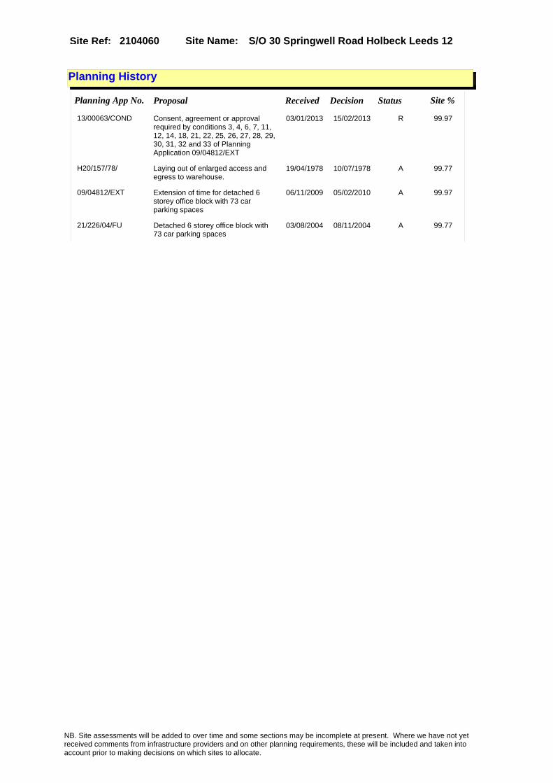
Site Name: S/O 30 Springwell Road Holbeck Leeds 12Site Ref: 2104060
Planning History
Planning App No. Proposal Received Decision Status Site %
13/00063/COND Consent, agreement or approval required by conditions 3, 4, 6, 7, 11, 12, 14, 18, 21, 22, 25, 26, 27, 28, 29, 30, 31, 32 and 33 of Planning Application 09/04812/EXT
03/01/2013 15/02/2013 R 99.97
H20/157/78/ Laying out of enlarged access and egress to warehouse.
19/04/1978 10/07/1978 A 99.77
09/04812/EXT Extension of time for detached 6 storey office block with 73 car parking spaces
06/11/2009 05/02/2010 A 99.97
21/226/04/FU Detached 6 storey office block with 73 car parking spaces
03/08/2004 08/11/2004 A 99.77
NB. Site assessments will be added to over time and some sections may be incomplete at present. Where we have not yet received comments from infrastructure providers and on other planning requirements, these will be included and taken into account prior to making decisions on which sites to allocate.

Site Name: S/O 30 Springwell Road Holbeck Leeds 12Site Ref: 2104060
Conformity with Core Strategy
Inner South Leeds: 0.00
Leeds Bradford Corridor: 0.00 West Leeds Gateway: 0.00
Aire Valley: 0.00Regeneration Priority Area:
Brownfield
Greenfield
Mixed
Main Urban Area
Major Settlement
Smaller Settlement
Villages/Rural
Main Urban Area Extension
Major Settlement Extension
Smaller Settlement Extension
Village/Rural Extension
Development unrelated to existing development
Green Belt assessment - only completed where site is within Green Belt
Would development lead to/constitute ribbon development?
Would development result in isolated development?
Is the site well connected to built up area (2+ boundaries with existing built up area)?
Would development of the site effectively "round off" the settlement pattern?:
Do natural/physical features provide a good existing barrier between existing urban area and undeveloped land?
Overall sprawl conclusion:
Would development of the site lead to physical connection of settlements?
Do natural/physical features provide a good existing barrier/boundary to contain development?
Overall Coalescence Conclusion:
Is there a strong defensible boundary between the site and the existing urban area?
Does the site provide access to the countryside?
Does the site include local or national conservation designated areas?
Does the site include areas of woodlands, trees, hedgerows that are protected, or significant unprotected tree/hedge cover?
Does the site include grade 1, 2, or 3a agricultural land?
Does the site contain buildings? Are these in agricultural use?
Overall countryside Encroachment Conclusion
Is the site within or adjacent to a conservation area, listed building or other historical feature?
If yes, could development preserve this character?:
Overall Character Preservation Conclusion:
Greenbelt Assessment Conclusion:
Check the unrestricted sprawl of large built up areas
Prevent neighbouring towns from merging
Assist in safeguarding countryside from encroachment
Preserve the setting and special character of historic towns
NB. Site assessments will be added to over time and some sections may be incomplete at present. Where we have not yet received comments from infrastructure providers and on other planning requirements, these will be included and taken into account prior to making decisions on which sites to allocate.

Site Name: S/O 30 Springwell Road Holbeck Leeds 12Site Ref: 2104060
SHLAA ConclusionsAvailability: Suitability: Achievability:
Conclusion of Assessment
Conclusion summary:
Full planning permission for office use, surrounded by employment and being marketed.
Floorspace sq m (Non residential): 6550
Employment Conclusion: Lime Green
East Leeds
Assesment Type: ELR Type: Office
Proposed Change:
Gypsy Traveller Site Assessment
Yes No Maybe Could site be effectively managed (Text)
Yes No Maybe Would gypsies and travellers live on the site?
(Text)
Yes No Proximity to housed gypsies and travellers (Text)
Yes No Unknown Experience of previous encampments (Text)
NB. Site assessments will be added to over time and some sections may be incomplete at present. Where we have not yet received comments from infrastructure providers and on other planning requirements, these will be included and taken into account prior to making decisions on which sites to allocate.

Site Name: 139 Gelderd Road Leeds 12 Site Ref: 2104130
Site Details
Land Use
Northing: 432075
Easting: 428102
Distance to Rail Station (metres): 1942.39
Nearest Railway Station Leeds City
Distance to bus stop (metres) 68.20
Bus Stop ID 8964
Agricultural Land Class:
SFRA Flood Zone: 0.00
Environment Agency Flood Zone: 0.00
Within 300m of retail centre boundary:
UDP Designation
Greenbelt - N32 (%): 0.00 Urban Green Corridor - N8 (%): 0.00
Protected Area of Search site - N34 (%): 0.00 Rural Land - RL1: 0.00
City Centre Primary Shopping Quarter - CC27 (%): 0.00 Town Centre - S2: 0.00
Health and Safety Executive Hazard: No
Health and Safety Executive Gas Pipeline: No
Strategic Employment Buffer: 0.00
Area sq m: 2389.63 Ward Beeston and Holbeck
Special Landscape Area - N37: 0.00
Allotments - N1A: 0.00
Proposed Greenspace - N5: 0.00
Protected Playing Pitch - N6: 0.00
Nature Conservation Area - N50: 0.00
Conservation Areas No
Ancient Monument/Battlefield(%): 0.00 Listed Buildings: No
Public Rights of Way: No
Other?:
Natural Resources and waste DPD (if applicable)
Within Minerals Safeguarding Site?: No Within 100m of Minerals Safeguarding Site?: No
HMCA: Inner Areas
Greenspace - N1: 0
Existing Use 1:
Existing Use 2:
Existing Use 3:
Neighbouring Use 1
Neighbouring Use 2:
Neighbouring Use 3:
Other uses:
Topography:
Natural Landscape:
Boundaries:
Road Frontage
Site Characteristics
Site Detail
Other comments/observations on site characteristics:
Area Ha: 0.238963
Site State:
NB. Site assessments will be added to over time and some sections may be incomplete at present. Where we have not yet received comments from infrastructure providers and on other planning requirements, these will be included and taken into account prior to making decisions on which sites to allocate.

Site Name: 139 Gelderd Road Leeds 12 Site Ref: 2104130
Planning History
Planning App No. Proposal Received Decision Status Site %
H20/560/85/ 2, internally illuminated cano py box signs, size of each 7.62m x 0.76m height of each a bove ground 3.81m (underside
25/11/1985 04/07/1986 A 97.36
09/03776/FU Use of former petrol filling service station as hand car wash with valet - canopy, office and storage facilities
27/08/2009 20/10/2009 A 99.74
10/00693/EXT Extension of time of planning application 21/325/04/FU for 2 single storey wholesale warehouse units with 22 car parking spaces
16/02/2010 APPRET 99.74
21/325/04/FU 2 single storey wholesale warehouse units with 22 car parking spaces
01/11/2004 14/04/2005 A 98.25
H20/76/86/ Change of use of petrol fillin g station to petrol filli ng station and vehicle hire de pot.
28/02/1986 07/07/1986 A 97.65
07/04720/FU Variation of condition 16 of planning permission 21/325/04/FU
24/07/2007 19/10/2007 A 99.74
06/06125/FU Change of use of vacant wholesale warehouse to distribution warehouse with ancillary sales
12/10/2006 29/11/2006 RET 61.33
H20/334/89/ Alterations, new pump stand wi th enlarged canopy over and e rection of shop with offices a nd toilet to petrol filling st
10/07/1989 05/03/1990 A 98.25
10/01201/EXT Extension of time of planning application 21/325/04/FU for 2 single storey wholesale warehouse units with 22 car parking spaces
10/03/2010 14/05/2010 A 99.74
21/144/04/OT Outline application to erect wholesale warehouse
14/05/2004 29/10/2004 W 99.74
NB. Site assessments will be added to over time and some sections may be incomplete at present. Where we have not yet received comments from infrastructure providers and on other planning requirements, these will be included and taken into account prior to making decisions on which sites to allocate.

Site Name: 139 Gelderd Road Leeds 12 Site Ref: 2104130
Conformity with Core Strategy
Inner South Leeds: 0.00
Leeds Bradford Corridor: 0.00 West Leeds Gateway: 0.00
Aire Valley: 0.00Regeneration Priority Area:
Brownfield
Greenfield
Mixed
Main Urban Area
Major Settlement
Smaller Settlement
Villages/Rural
Main Urban Area Extension
Major Settlement Extension
Smaller Settlement Extension
Village/Rural Extension
Development unrelated to existing development
Green Belt assessment - only completed where site is within Green Belt
Would development lead to/constitute ribbon development?
Would development result in isolated development?
Is the site well connected to built up area (2+ boundaries with existing built up area)?
Would development of the site effectively "round off" the settlement pattern?:
Do natural/physical features provide a good existing barrier between existing urban area and undeveloped land?
Overall sprawl conclusion:
Would development of the site lead to physical connection of settlements?
Do natural/physical features provide a good existing barrier/boundary to contain development?
Overall Coalescence Conclusion:
Is there a strong defensible boundary between the site and the existing urban area?
Does the site provide access to the countryside?
Does the site include local or national conservation designated areas?
Does the site include areas of woodlands, trees, hedgerows that are protected, or significant unprotected tree/hedge cover?
Does the site include grade 1, 2, or 3a agricultural land?
Does the site contain buildings? Are these in agricultural use?
Overall countryside Encroachment Conclusion
Is the site within or adjacent to a conservation area, listed building or other historical feature?
If yes, could development preserve this character?:
Overall Character Preservation Conclusion:
Greenbelt Assessment Conclusion:
Check the unrestricted sprawl of large built up areas
Prevent neighbouring towns from merging
Assist in safeguarding countryside from encroachment
Preserve the setting and special character of historic towns
NB. Site assessments will be added to over time and some sections may be incomplete at present. Where we have not yet received comments from infrastructure providers and on other planning requirements, these will be included and taken into account prior to making decisions on which sites to allocate.

Site Name: 139 Gelderd Road Leeds 12 Site Ref: 2104130
SHLAA ConclusionsAvailability: Suitability: Achievability:
Conclusion of Assessment
Conclusion summary:
Current site with planning permission for employment purposes
Floorspace sq m (Non residential):
Employment Conclusion: Lime Green
East Leeds
Assesment Type: Planning status Type: Industrial & Warehousing
Proposed Change:
Gypsy Traveller Site Assessment
Yes No Maybe Could site be effectively managed (Text)
Yes No Maybe Would gypsies and travellers live on the site?
(Text)
Yes No Proximity to housed gypsies and travellers (Text)
Yes No Unknown Experience of previous encampments (Text)
NB. Site assessments will be added to over time and some sections may be incomplete at present. Where we have not yet received comments from infrastructure providers and on other planning requirements, these will be included and taken into account prior to making decisions on which sites to allocate.

Site Name: Frontage site. Sussex Avenue, Twaite Gate, Hunslet, LS10
Site Ref: 2104201
Site Details
Land Use
Northing: 431165
Easting: 431957
Distance to Rail Station (metres): 3038.67
Nearest Railway Station Leeds City
Distance to bus stop (metres) 111.25
Bus Stop ID 13389
Agricultural Land Class:
SFRA Flood Zone: 0.00
Environment Agency Flood Zone: 0.00
Within 300m of retail centre boundary:
UDP Designation
Greenbelt - N32 (%): 0.00 Urban Green Corridor - N8 (%): 0.00
Protected Area of Search site - N34 (%): 0.00 Rural Land - RL1: 0.00
City Centre Primary Shopping Quarter - CC27 (%): 0.00 Town Centre - S2: 0.00
Health and Safety Executive Hazard: No
Health and Safety Executive Gas Pipeline: No
Strategic Employment Buffer: 0.00
Area sq m: 4638.58 Ward City and Hunslet
Special Landscape Area - N37: 0.00
Allotments - N1A: 0.00
Proposed Greenspace - N5: 0.00
Protected Playing Pitch - N6: 0.00
Nature Conservation Area - N50: 0.00
Conservation Areas No
Ancient Monument/Battlefield(%): 0.00 Listed Buildings: No
Public Rights of Way: No
Other?:
Natural Resources and waste DPD (if applicable)
Within Minerals Safeguarding Site?: No Within 100m of Minerals Safeguarding Site?: No
HMCA: East Leeds
Greenspace - N1: 0
Existing Use 1:
Existing Use 2:
Existing Use 3:
Neighbouring Use 1
Neighbouring Use 2:
Neighbouring Use 3:
Other uses:
Topography:
Natural Landscape:
Boundaries:
Road Frontage
Site Characteristics
Site Detail
Other comments/observations on site characteristics:
Area Ha: 0.463858
Site State:
NB. Site assessments will be added to over time and some sections may be incomplete at present. Where we have not yet received comments from infrastructure providers and on other planning requirements, these will be included and taken into account prior to making decisions on which sites to allocate.

Site Name: Frontage site. Sussex Avenue, Twaite Gate, Hunslet, LS10
Site Ref: 2104201
Planning History
Planning App No. Proposal Received Decision Status Site %
H21/442/79/ 2 non illuminated freestanding site direction signs, size of each 2.59m x 1.12m height o f each above ground 1.83m (und
17/08/1979 19/11/1979 A 96.44
H21/16/92/ Change of use of works and war ehouse with offices, to car a nd commercial vehicle hire and maintenance with offices.
13/01/1992 17/03/1992 A 99.15
H21/599/78/ Laying out of access and erect ion of single storey first phase of light industrial pre mises with ancillary
01/11/1978 16/02/1979 A 48.60
07/00608/FU Amendment to approved 2 three storey office blocks with car parking
29/01/2007 23/03/2007 A 100.00
21/311/05/FU Laying out of access and erection of 2 three storey office blocks with car parking
28/09/2005 17/05/2006 A 100.00
21/115/98/FU Change of use of industrial unit to warehouse unit with staff car parking
05/05/1998 13/04/1999 W 99.87
H21/90/78/ Laying out of access road to l ight industrial estate. (this item is also notice under reg ulation 4(1) of the tow
22/02/1978 10/04/1978 A 99.38
H21/509/77/ Outline application to erect l ight industrial devel opment (class iii) to vacant s ite. (site area
18/10/1977 12/12/1977 A 99.76
NB. Site assessments will be added to over time and some sections may be incomplete at present. Where we have not yet received comments from infrastructure providers and on other planning requirements, these will be included and taken into account prior to making decisions on which sites to allocate.
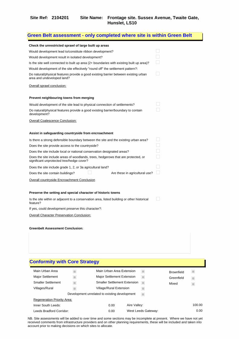
Site Name: Frontage site. Sussex Avenue, Twaite Gate, Hunslet, LS10
Site Ref: 2104201
Conformity with Core Strategy
Inner South Leeds: 0.00
Leeds Bradford Corridor: 0.00 West Leeds Gateway: 0.00
Aire Valley: 100.00Regeneration Priority Area:
Brownfield
Greenfield
Mixed
Main Urban Area
Major Settlement
Smaller Settlement
Villages/Rural
Main Urban Area Extension
Major Settlement Extension
Smaller Settlement Extension
Village/Rural Extension
Development unrelated to existing development
Green Belt assessment - only completed where site is within Green Belt
Would development lead to/constitute ribbon development?
Would development result in isolated development?
Is the site well connected to built up area (2+ boundaries with existing built up area)?
Would development of the site effectively "round off" the settlement pattern?:
Do natural/physical features provide a good existing barrier between existing urban area and undeveloped land?
Overall sprawl conclusion:
Would development of the site lead to physical connection of settlements?
Do natural/physical features provide a good existing barrier/boundary to contain development?
Overall Coalescence Conclusion:
Is there a strong defensible boundary between the site and the existing urban area?
Does the site provide access to the countryside?
Does the site include local or national conservation designated areas?
Does the site include areas of woodlands, trees, hedgerows that are protected, or significant unprotected tree/hedge cover?
Does the site include grade 1, 2, or 3a agricultural land?
Does the site contain buildings? Are these in agricultural use?
Overall countryside Encroachment Conclusion
Is the site within or adjacent to a conservation area, listed building or other historical feature?
If yes, could development preserve this character?:
Overall Character Preservation Conclusion:
Greenbelt Assessment Conclusion:
Check the unrestricted sprawl of large built up areas
Prevent neighbouring towns from merging
Assist in safeguarding countryside from encroachment
Preserve the setting and special character of historic towns
NB. Site assessments will be added to over time and some sections may be incomplete at present. Where we have not yet received comments from infrastructure providers and on other planning requirements, these will be included and taken into account prior to making decisions on which sites to allocate.

Site Name: Frontage site. Sussex Avenue, Twaite Gate, Hunslet, LS10
Site Ref: 2104201
SHLAA ConclusionsAvailability: Suitability: Achievability:
Conclusion of Assessment
Conclusion summary:
Retain subject to highways data.
Floorspace sq m (Non residential): 3720
Employment Conclusion: Green
East Leeds
Assesment Type: ELR Type: Office
Proposed Change:
Gypsy Traveller Site Assessment
Yes No Maybe Could site be effectively managed (Text)
Yes No Maybe Would gypsies and travellers live on the site?
(Text)
Yes No Proximity to housed gypsies and travellers (Text)
Yes No Unknown Experience of previous encampments (Text)
NB. Site assessments will be added to over time and some sections may be incomplete at present. Where we have not yet received comments from infrastructure providers and on other planning requirements, these will be included and taken into account prior to making decisions on which sites to allocate.
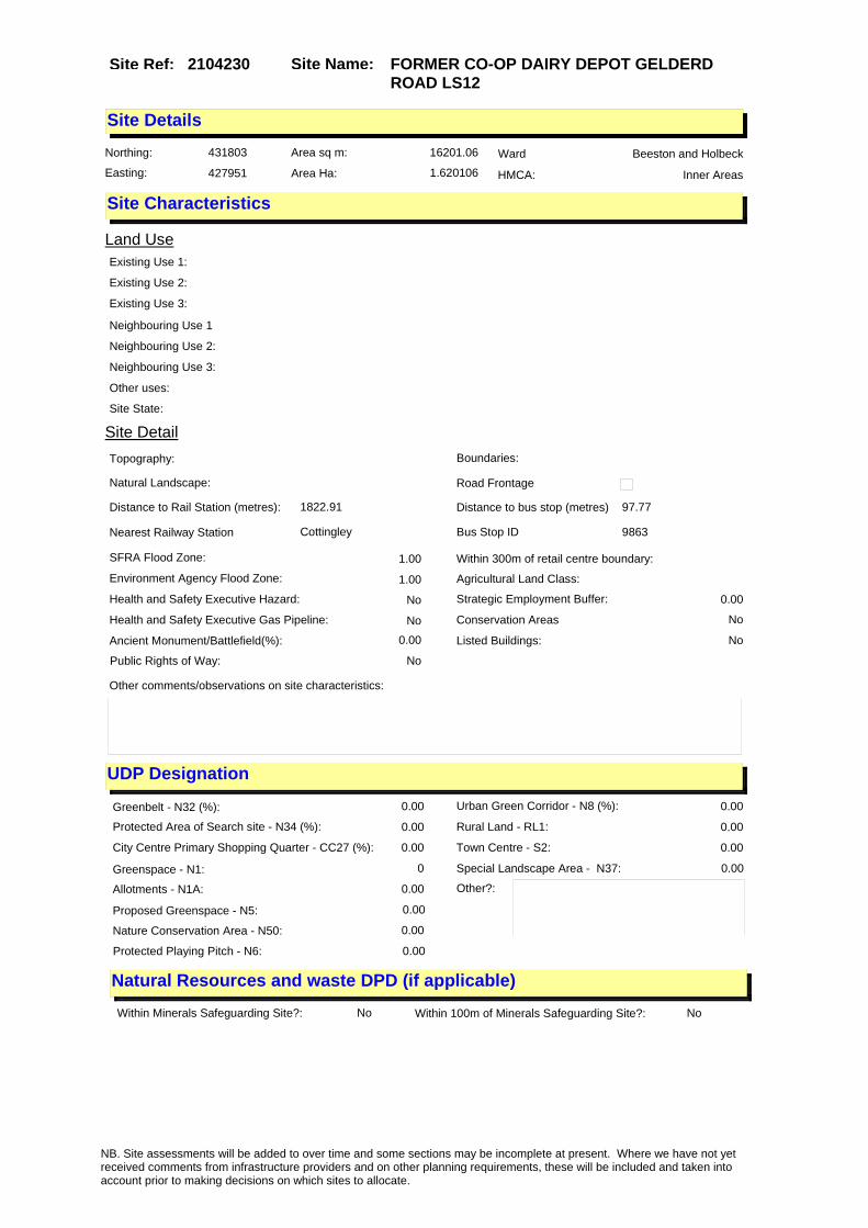
Site Name: FORMER CO-OP DAIRY DEPOT GELDERD ROAD LS12
Site Ref: 2104230
Site Details
Land Use
Northing: 431803
Easting: 427951
Distance to Rail Station (metres): 1822.91
Nearest Railway Station Cottingley
Distance to bus stop (metres) 97.77
Bus Stop ID 9863
Agricultural Land Class:
SFRA Flood Zone: 1.00
Environment Agency Flood Zone: 1.00
Within 300m of retail centre boundary:
UDP Designation
Greenbelt - N32 (%): 0.00 Urban Green Corridor - N8 (%): 0.00
Protected Area of Search site - N34 (%): 0.00 Rural Land - RL1: 0.00
City Centre Primary Shopping Quarter - CC27 (%): 0.00 Town Centre - S2: 0.00
Health and Safety Executive Hazard: No
Health and Safety Executive Gas Pipeline: No
Strategic Employment Buffer: 0.00
Area sq m: 16201.06 Ward Beeston and Holbeck
Special Landscape Area - N37: 0.00
Allotments - N1A: 0.00
Proposed Greenspace - N5: 0.00
Protected Playing Pitch - N6: 0.00
Nature Conservation Area - N50: 0.00
Conservation Areas No
Ancient Monument/Battlefield(%): 0.00 Listed Buildings: No
Public Rights of Way: No
Other?:
Natural Resources and waste DPD (if applicable)
Within Minerals Safeguarding Site?: No Within 100m of Minerals Safeguarding Site?: No
HMCA: Inner Areas
Greenspace - N1: 0
Existing Use 1:
Existing Use 2:
Existing Use 3:
Neighbouring Use 1
Neighbouring Use 2:
Neighbouring Use 3:
Other uses:
Topography:
Natural Landscape:
Boundaries:
Road Frontage
Site Characteristics
Site Detail
Other comments/observations on site characteristics:
Area Ha: 1.620106
Site State:
NB. Site assessments will be added to over time and some sections may be incomplete at present. Where we have not yet received comments from infrastructure providers and on other planning requirements, these will be included and taken into account prior to making decisions on which sites to allocate.

Site Name: FORMER CO-OP DAIRY DEPOT GELDERD ROAD LS12
Site Ref: 2104230
Planning History
NB. Site assessments will be added to over time and some sections may be incomplete at present. Where we have not yet received comments from infrastructure providers and on other planning requirements, these will be included and taken into account prior to making decisions on which sites to allocate.

Site Name: FORMER CO-OP DAIRY DEPOT GELDERD ROAD LS12
Site Ref: 2104230
Conformity with Core Strategy
Inner South Leeds: 0.00
Leeds Bradford Corridor: 0.00 West Leeds Gateway: 0.00
Aire Valley: 0.00Regeneration Priority Area:
Brownfield
Greenfield
Mixed
Main Urban Area
Major Settlement
Smaller Settlement
Villages/Rural
Main Urban Area Extension
Major Settlement Extension
Smaller Settlement Extension
Village/Rural Extension
Development unrelated to existing development
Green Belt assessment - only completed where site is within Green Belt
Would development lead to/constitute ribbon development?
Would development result in isolated development?
Is the site well connected to built up area (2+ boundaries with existing built up area)?
Would development of the site effectively "round off" the settlement pattern?:
Do natural/physical features provide a good existing barrier between existing urban area and undeveloped land?
Overall sprawl conclusion:
Would development of the site lead to physical connection of settlements?
Do natural/physical features provide a good existing barrier/boundary to contain development?
Overall Coalescence Conclusion:
Is there a strong defensible boundary between the site and the existing urban area?
Does the site provide access to the countryside?
Does the site include local or national conservation designated areas?
Does the site include areas of woodlands, trees, hedgerows that are protected, or significant unprotected tree/hedge cover?
Does the site include grade 1, 2, or 3a agricultural land?
Does the site contain buildings? Are these in agricultural use?
Overall countryside Encroachment Conclusion
Is the site within or adjacent to a conservation area, listed building or other historical feature?
If yes, could development preserve this character?:
Overall Character Preservation Conclusion:
Greenbelt Assessment Conclusion:
Check the unrestricted sprawl of large built up areas
Prevent neighbouring towns from merging
Assist in safeguarding countryside from encroachment
Preserve the setting and special character of historic towns
NB. Site assessments will be added to over time and some sections may be incomplete at present. Where we have not yet received comments from infrastructure providers and on other planning requirements, these will be included and taken into account prior to making decisions on which sites to allocate.

Site Name: FORMER CO-OP DAIRY DEPOT GELDERD ROAD LS12
Site Ref: 2104230
SHLAA ConclusionsAvailability: Suitability: Achievability:
Conclusion of Assessment
Conclusion summary:
The developable area of this site is c 1.2 ha rather than the stated figure. It is in a good location for B2/B8 uses on a main radial (A62).
Floorspace sq m (Non residential):
Employment Conclusion: Green
East Leeds
Assesment Type: ELR Type: Industrial & Warehousing
Proposed Change:
Gypsy Traveller Site Assessment
Yes No Maybe Could site be effectively managed (Text)
Yes No Maybe Would gypsies and travellers live on the site?
(Text)
Yes No Proximity to housed gypsies and travellers (Text)
Yes No Unknown Experience of previous encampments (Text)
NB. Site assessments will be added to over time and some sections may be incomplete at present. Where we have not yet received comments from infrastructure providers and on other planning requirements, these will be included and taken into account prior to making decisions on which sites to allocate.

Site Name: S/O Premier House Ring Road Royds Lane LS12
Site Ref: 2104440
Site Details
Land Use
Northing: 431418
Easting: 427353
Distance to Rail Station (metres): 1348.13
Nearest Railway Station Cottingley
Distance to bus stop (metres) 102.99
Bus Stop ID 3990
Agricultural Land Class:
SFRA Flood Zone: 1.00
Environment Agency Flood Zone: 1.00
Within 300m of retail centre boundary:
UDP Designation
Greenbelt - N32 (%): 0.00 Urban Green Corridor - N8 (%): 0.00
Protected Area of Search site - N34 (%): 0.00 Rural Land - RL1: 0.00
City Centre Primary Shopping Quarter - CC27 (%): 0.00 Town Centre - S2: 0.00
Health and Safety Executive Hazard: No
Health and Safety Executive Gas Pipeline: No
Strategic Employment Buffer: 0.00
Area sq m: 3301.43 Ward Beeston and Holbeck
Special Landscape Area - N37: 0.00
Allotments - N1A: 0.00
Proposed Greenspace - N5: 0.00
Protected Playing Pitch - N6: 0.00
Nature Conservation Area - N50: 0.00
Conservation Areas No
Ancient Monument/Battlefield(%): 0.00 Listed Buildings: No
Public Rights of Way: No
Other?:
Natural Resources and waste DPD (if applicable)
Within Minerals Safeguarding Site?: No Within 100m of Minerals Safeguarding Site?: No
HMCA: Outer South West
Greenspace - N1: 0
Existing Use 1:
Existing Use 2:
Existing Use 3:
Neighbouring Use 1
Neighbouring Use 2:
Neighbouring Use 3:
Other uses:
Topography:
Natural Landscape:
Boundaries:
Road Frontage
Site Characteristics
Site Detail
Other comments/observations on site characteristics:
Area Ha: 0.330143
Site State:
NB. Site assessments will be added to over time and some sections may be incomplete at present. Where we have not yet received comments from infrastructure providers and on other planning requirements, these will be included and taken into account prior to making decisions on which sites to allocate.

Site Name: S/O Premier House Ring Road Royds Lane LS12
Site Ref: 2104440
Planning History
NB. Site assessments will be added to over time and some sections may be incomplete at present. Where we have not yet received comments from infrastructure providers and on other planning requirements, these will be included and taken into account prior to making decisions on which sites to allocate.

Site Name: S/O Premier House Ring Road Royds Lane LS12
Site Ref: 2104440
Conformity with Core Strategy
Inner South Leeds: 0.00
Leeds Bradford Corridor: 0.00 West Leeds Gateway: 0.00
Aire Valley: 0.00Regeneration Priority Area:
Brownfield
Greenfield
Mixed
Main Urban Area
Major Settlement
Smaller Settlement
Villages/Rural
Main Urban Area Extension
Major Settlement Extension
Smaller Settlement Extension
Village/Rural Extension
Development unrelated to existing development
Green Belt assessment - only completed where site is within Green Belt
Would development lead to/constitute ribbon development?
Would development result in isolated development?
Is the site well connected to built up area (2+ boundaries with existing built up area)?
Would development of the site effectively "round off" the settlement pattern?:
Do natural/physical features provide a good existing barrier between existing urban area and undeveloped land?
Overall sprawl conclusion:
Would development of the site lead to physical connection of settlements?
Do natural/physical features provide a good existing barrier/boundary to contain development?
Overall Coalescence Conclusion:
Is there a strong defensible boundary between the site and the existing urban area?
Does the site provide access to the countryside?
Does the site include local or national conservation designated areas?
Does the site include areas of woodlands, trees, hedgerows that are protected, or significant unprotected tree/hedge cover?
Does the site include grade 1, 2, or 3a agricultural land?
Does the site contain buildings? Are these in agricultural use?
Overall countryside Encroachment Conclusion
Is the site within or adjacent to a conservation area, listed building or other historical feature?
If yes, could development preserve this character?:
Overall Character Preservation Conclusion:
Greenbelt Assessment Conclusion:
Check the unrestricted sprawl of large built up areas
Prevent neighbouring towns from merging
Assist in safeguarding countryside from encroachment
Preserve the setting and special character of historic towns
NB. Site assessments will be added to over time and some sections may be incomplete at present. Where we have not yet received comments from infrastructure providers and on other planning requirements, these will be included and taken into account prior to making decisions on which sites to allocate.

Site Name: S/O Premier House Ring Road Royds Lane LS12
Site Ref: 2104440
SHLAA ConclusionsAvailability: Suitability: Achievability:
Conclusion of Assessment
Conclusion summary:
Current site with planning permission for employment purposes
Floorspace sq m (Non residential): 4910
Employment Conclusion: Lime Green
East Leeds
Assesment Type: ELR Type: Office
Proposed Change:
Gypsy Traveller Site Assessment
Yes No Maybe Could site be effectively managed (Text)
Yes No Maybe Would gypsies and travellers live on the site?
(Text)
Yes No Proximity to housed gypsies and travellers (Text)
Yes No Unknown Experience of previous encampments (Text)
NB. Site assessments will be added to over time and some sections may be incomplete at present. Where we have not yet received comments from infrastructure providers and on other planning requirements, these will be included and taken into account prior to making decisions on which sites to allocate.

Site Name: Tristram Centre Brown Lane West LS12Site Ref: 2104460
Site Details
Land Use
Northing: 432018
Easting: 428179
Distance to Rail Station (metres): 1914.81
Nearest Railway Station Leeds City
Distance to bus stop (metres) 142.08
Bus Stop ID 8964
Agricultural Land Class:
SFRA Flood Zone: 0.00
Environment Agency Flood Zone: 0.00
Within 300m of retail centre boundary:
UDP Designation
Greenbelt - N32 (%): 0.00 Urban Green Corridor - N8 (%): 0.00
Protected Area of Search site - N34 (%): 0.00 Rural Land - RL1: 0.00
City Centre Primary Shopping Quarter - CC27 (%): 0.00 Town Centre - S2: 0.00
Health and Safety Executive Hazard: No
Health and Safety Executive Gas Pipeline: No
Strategic Employment Buffer: 0.00
Area sq m: 583.28 Ward Beeston and Holbeck
Special Landscape Area - N37: 0.00
Allotments - N1A: 0.00
Proposed Greenspace - N5: 0.00
Protected Playing Pitch - N6: 0.00
Nature Conservation Area - N50: 0.00
Conservation Areas No
Ancient Monument/Battlefield(%): 0.00 Listed Buildings: No
Public Rights of Way: No
Other?:
Natural Resources and waste DPD (if applicable)
Within Minerals Safeguarding Site?: No Within 100m of Minerals Safeguarding Site?: No
HMCA: Inner Areas
Greenspace - N1: 0
Existing Use 1:
Existing Use 2:
Existing Use 3:
Neighbouring Use 1
Neighbouring Use 2:
Neighbouring Use 3:
Other uses:
Topography:
Natural Landscape:
Boundaries:
Road Frontage
Site Characteristics
Site Detail
Other comments/observations on site characteristics:
Area Ha: 0.058328
Site State:
NB. Site assessments will be added to over time and some sections may be incomplete at present. Where we have not yet received comments from infrastructure providers and on other planning requirements, these will be included and taken into account prior to making decisions on which sites to allocate.

Site Name: Tristram Centre Brown Lane West LS12Site Ref: 2104460
Planning History
Planning App No. Proposal Received Decision Status Site %
H21/203/80/ Detached single storey furnitu re warehouse with office, tearo om and toilets, to warehouse.
01/04/1980 01/07/1980 A 99.76
H21/242/78/ Outline application to erect v ehicle maintenance block, with ancillary offices, to warehous e.
10/05/1978 10/07/1978 A 76.42
07/02534/FU 3 storey office block to part of car parking area
18/04/2007 07/08/2007 A 96.85
H21/507/75/ Outline application to erect 4 warehouse units, each with loading bay and ancillary offi ces, to existing warehouse
09/10/1975 15/12/1975 A 92.97
H21/669/78/ Renewal of outline application to erect 4 warehouse units each with loading bay and anc illary offices, to existing w
12/12/1978 29/01/1979 A 100.00
0-21/6/94/MOD Industrial units 25/11/1994 02/12/1994 M01 99.76
21/147/94/FU 7 industrial and warehouse units 11/07/1994 07/11/1994 A 99.76
0-21/14/95/MOD Single portal framed building containing 5no b2/b8 units with mezzanine offices
25/04/1995 02/05/1995 M01 99.76
08/01088/FU Change of use from B8 to B1 and erection of a mezzanine floor to extend first floor office space and fire escape
25/02/2008 29/04/2008 A 97.20
12/03603/FU Formation of an external security enclosure to house power plant compound to support the data centre, erection of 3.0m security fencing and relocation of the existing car park turning head
21/08/2012 07/01/2013 A 94.98
0-21/46/95/MOD 7 industrial and warehouse units 29/12/1995 08/01/1996 M01 99.76
H21/102/79/ Alterations, including new loa ding bay, to existing wareh ouse and erection of 2 warehou se units, each with toile
07/03/1979 30/04/1979 A 100.00
21/176/92/OT Outline application to lay out access and erect industrial and warehousing units
10/06/1992 11/08/1992 A 99.76
NB. Site assessments will be added to over time and some sections may be incomplete at present. Where we have not yet received comments from infrastructure providers and on other planning requirements, these will be included and taken into account prior to making decisions on which sites to allocate.

Site Name: Tristram Centre Brown Lane West LS12Site Ref: 2104460
Conformity with Core Strategy
Inner South Leeds: 0.00
Leeds Bradford Corridor: 0.00 West Leeds Gateway: 0.00
Aire Valley: 0.00Regeneration Priority Area:
Brownfield
Greenfield
Mixed
Main Urban Area
Major Settlement
Smaller Settlement
Villages/Rural
Main Urban Area Extension
Major Settlement Extension
Smaller Settlement Extension
Village/Rural Extension
Development unrelated to existing development
Green Belt assessment - only completed where site is within Green Belt
Would development lead to/constitute ribbon development?
Would development result in isolated development?
Is the site well connected to built up area (2+ boundaries with existing built up area)?
Would development of the site effectively "round off" the settlement pattern?:
Do natural/physical features provide a good existing barrier between existing urban area and undeveloped land?
Overall sprawl conclusion:
Would development of the site lead to physical connection of settlements?
Do natural/physical features provide a good existing barrier/boundary to contain development?
Overall Coalescence Conclusion:
Is there a strong defensible boundary between the site and the existing urban area?
Does the site provide access to the countryside?
Does the site include local or national conservation designated areas?
Does the site include areas of woodlands, trees, hedgerows that are protected, or significant unprotected tree/hedge cover?
Does the site include grade 1, 2, or 3a agricultural land?
Does the site contain buildings? Are these in agricultural use?
Overall countryside Encroachment Conclusion
Is the site within or adjacent to a conservation area, listed building or other historical feature?
If yes, could development preserve this character?:
Overall Character Preservation Conclusion:
Greenbelt Assessment Conclusion:
Check the unrestricted sprawl of large built up areas
Prevent neighbouring towns from merging
Assist in safeguarding countryside from encroachment
Preserve the setting and special character of historic towns
NB. Site assessments will be added to over time and some sections may be incomplete at present. Where we have not yet received comments from infrastructure providers and on other planning requirements, these will be included and taken into account prior to making decisions on which sites to allocate.

Site Name: Tristram Centre Brown Lane West LS12Site Ref: 2104460
SHLAA ConclusionsAvailability: Suitability: Achievability:
Conclusion of Assessment
Conclusion summary:
Current site with planning permission for employment purposes.
Floorspace sq m (Non residential): 650
Employment Conclusion: Lime Green
East Leeds
Assesment Type: Planning status Type: Office
Proposed Change:
Gypsy Traveller Site Assessment
Yes No Maybe Could site be effectively managed (Text)
Yes No Maybe Would gypsies and travellers live on the site?
(Text)
Yes No Proximity to housed gypsies and travellers (Text)
Yes No Unknown Experience of previous encampments (Text)
NB. Site assessments will be added to over time and some sections may be incomplete at present. Where we have not yet received comments from infrastructure providers and on other planning requirements, these will be included and taken into account prior to making decisions on which sites to allocate.

Site Name: Unit 4, Tristram Centre, Brown Lane West, LS12 6BP
Site Ref: 2104690
Site Details
Land Use
Northing: 431977
Easting: 428194
Distance to Rail Station (metres): 1928.61
Nearest Railway Station Leeds City
Distance to bus stop (metres) 170.02
Bus Stop ID 8964
Agricultural Land Class:
SFRA Flood Zone: 0.00
Environment Agency Flood Zone: 0.00
Within 300m of retail centre boundary:
UDP Designation
Greenbelt - N32 (%): 0.00 Urban Green Corridor - N8 (%): 0.00
Protected Area of Search site - N34 (%): 0.00 Rural Land - RL1: 0.00
City Centre Primary Shopping Quarter - CC27 (%): 0.00 Town Centre - S2: 0.00
Health and Safety Executive Hazard: No
Health and Safety Executive Gas Pipeline: No
Strategic Employment Buffer: 0.00
Area sq m: 8697.60 Ward Beeston and Holbeck
Special Landscape Area - N37: 0.00
Allotments - N1A: 0.00
Proposed Greenspace - N5: 0.00
Protected Playing Pitch - N6: 0.00
Nature Conservation Area - N50: 0.00
Conservation Areas No
Ancient Monument/Battlefield(%): 0.00 Listed Buildings: No
Public Rights of Way: No
Other?:
Natural Resources and waste DPD (if applicable)
Within Minerals Safeguarding Site?: No Within 100m of Minerals Safeguarding Site?: Yes
HMCA: Inner Areas
Greenspace - N1: 0
Existing Use 1:
Existing Use 2:
Existing Use 3:
Neighbouring Use 1
Neighbouring Use 2:
Neighbouring Use 3:
Other uses:
Topography:
Natural Landscape:
Boundaries:
Road Frontage
Site Characteristics
Site Detail
Other comments/observations on site characteristics:
Area Ha: 0.86976
Site State:
NB. Site assessments will be added to over time and some sections may be incomplete at present. Where we have not yet received comments from infrastructure providers and on other planning requirements, these will be included and taken into account prior to making decisions on which sites to allocate.

Site Name: Unit 4, Tristram Centre, Brown Lane West, LS12 6BP
Site Ref: 2104690
Planning History
Planning App No. Proposal Received Decision Status Site %
H21/203/80/ Detached single storey furnitu re warehouse with office, tearo om and toilets, to warehouse.
01/04/1980 01/07/1980 A 99.30
H21/242/78/ Outline application to erect v ehicle maintenance block, with ancillary offices, to warehous e.
10/05/1978 10/07/1978 A 95.48
21/318/02/FU Alterations to frontage and louvres to front
15/11/2002 08/01/2003 A 17.35
21/317/02/FU Alterations and louvres to front 15/11/2002 08/01/2003 A 17.35
07/02534/FU 3 storey office block to part of car parking area
18/04/2007 07/08/2007 A 99.85
H21/507/75/ Outline application to erect 4 warehouse units, each with loading bay and ancillary offi ces, to existing warehouse
09/10/1975 15/12/1975 A 97.32
H21/669/78/ Renewal of outline application to erect 4 warehouse units each with loading bay and anc illary offices, to existing w
12/12/1978 29/01/1979 A 99.75
0-21/6/94/MOD Industrial units 25/11/1994 02/12/1994 M01 99.64
21/147/94/FU 7 industrial and warehouse units 11/07/1994 07/11/1994 A 99.64
0-21/14/95/MOD Single portal framed building containing 5no b2/b8 units with mezzanine offices
25/04/1995 02/05/1995 M01 99.64
08/01088/FU Change of use from B8 to B1 and erection of a mezzanine floor to extend first floor office space and fire escape
25/02/2008 29/04/2008 A 100.00
12/03603/FU Formation of an external security enclosure to house power plant compound to support the data centre, erection of 3.0m security fencing and relocation of the existing car park turning head
21/08/2012 07/01/2013 A 38.70
0-21/46/95/MOD 7 industrial and warehouse units 29/12/1995 08/01/1996 M01 99.64
0-21/10/02/MOD Alterations to elevations & detached generator housing to front
26/03/2002 10/04/2002 M01 17.35
H21/102/79/ Alterations, including new loa ding bay, to existing wareh ouse and erection of 2 warehou se units, each with toile
07/03/1979 30/04/1979 A 99.75
21/242/01/FU Alterations to elevations and detached generator housing to front
13/09/2001 01/11/2001 A 17.35
21/319/02/FU Detached generator to front 15/11/2002 08/01/2003 A 17.35
21/176/92/OT Outline application to lay out access and erect industrial and warehousing units
10/06/1992 11/08/1992 A 99.64
NB. Site assessments will be added to over time and some sections may be incomplete at present. Where we have not yet received comments from infrastructure providers and on other planning requirements, these will be included and taken into account prior to making decisions on which sites to allocate.

Site Name: Unit 4, Tristram Centre, Brown Lane West, LS12 6BP
Site Ref: 2104690
Conformity with Core Strategy
Inner South Leeds: 0.00
Leeds Bradford Corridor: 0.00 West Leeds Gateway: 0.00
Aire Valley: 0.00Regeneration Priority Area:
Brownfield
Greenfield
Mixed
Main Urban Area
Major Settlement
Smaller Settlement
Villages/Rural
Main Urban Area Extension
Major Settlement Extension
Smaller Settlement Extension
Village/Rural Extension
Development unrelated to existing development
Green Belt assessment - only completed where site is within Green Belt
Would development lead to/constitute ribbon development?
Would development result in isolated development?
Is the site well connected to built up area (2+ boundaries with existing built up area)?
Would development of the site effectively "round off" the settlement pattern?:
Do natural/physical features provide a good existing barrier between existing urban area and undeveloped land?
Overall sprawl conclusion:
Would development of the site lead to physical connection of settlements?
Do natural/physical features provide a good existing barrier/boundary to contain development?
Overall Coalescence Conclusion:
Is there a strong defensible boundary between the site and the existing urban area?
Does the site provide access to the countryside?
Does the site include local or national conservation designated areas?
Does the site include areas of woodlands, trees, hedgerows that are protected, or significant unprotected tree/hedge cover?
Does the site include grade 1, 2, or 3a agricultural land?
Does the site contain buildings? Are these in agricultural use?
Overall countryside Encroachment Conclusion
Is the site within or adjacent to a conservation area, listed building or other historical feature?
If yes, could development preserve this character?:
Overall Character Preservation Conclusion:
Greenbelt Assessment Conclusion:
Check the unrestricted sprawl of large built up areas
Prevent neighbouring towns from merging
Assist in safeguarding countryside from encroachment
Preserve the setting and special character of historic towns
NB. Site assessments will be added to over time and some sections may be incomplete at present. Where we have not yet received comments from infrastructure providers and on other planning requirements, these will be included and taken into account prior to making decisions on which sites to allocate.

Site Name: Unit 4, Tristram Centre, Brown Lane West, LS12 6BP
Site Ref: 2104690
SHLAA ConclusionsAvailability: Suitability: Achievability:
Conclusion of Assessment
Conclusion summary:
Current site with planning permission for employment purposes
Floorspace sq m (Non residential):
Employment Conclusion: Lime Green
East Leeds
Assesment Type: Planning status Type: Industrial & Warehousing
Proposed Change:
Gypsy Traveller Site Assessment
Yes No Maybe Could site be effectively managed (Text)
Yes No Maybe Would gypsies and travellers live on the site?
(Text)
Yes No Proximity to housed gypsies and travellers (Text)
Yes No Unknown Experience of previous encampments (Text)
NB. Site assessments will be added to over time and some sections may be incomplete at present. Where we have not yet received comments from infrastructure providers and on other planning requirements, these will be included and taken into account prior to making decisions on which sites to allocate.

Site Name: Ex- BOC Works Gelderd Road LS12Site Ref: 2104700
Site Details
Land Use
Northing: 431713
Easting: 427545
Distance to Rail Station (metres): 1650.97
Nearest Railway Station Cottingley
Distance to bus stop (metres) 199.29
Bus Stop ID 12529
Agricultural Land Class:
SFRA Flood Zone: 1.00
Environment Agency Flood Zone: 1.00
Within 300m of retail centre boundary:
UDP Designation
Greenbelt - N32 (%): 0.00 Urban Green Corridor - N8 (%): 0.00
Protected Area of Search site - N34 (%): 0.00 Rural Land - RL1: 0.00
City Centre Primary Shopping Quarter - CC27 (%): 0.00 Town Centre - S2: 0.00
Health and Safety Executive Hazard: No
Health and Safety Executive Gas Pipeline: No
Strategic Employment Buffer: 0.00
Area sq m: 32893.58 Ward Beeston and Holbeck
Special Landscape Area - N37: 0.00
Allotments - N1A: 0.00
Proposed Greenspace - N5: 0.00
Protected Playing Pitch - N6: 0.00
Nature Conservation Area - N50: 0.00
Conservation Areas No
Ancient Monument/Battlefield(%): 0.00 Listed Buildings: No
Public Rights of Way: No
Other?:
Natural Resources and waste DPD (if applicable)
Within Minerals Safeguarding Site?: Yes Within 100m of Minerals Safeguarding Site?: Yes
HMCA: Inner Areas
Greenspace - N1: 0
Existing Use 1:
Existing Use 2:
Existing Use 3:
Neighbouring Use 1
Neighbouring Use 2:
Neighbouring Use 3:
Other uses:
Topography:
Natural Landscape:
Boundaries:
Road Frontage
Site Characteristics
Site Detail
Other comments/observations on site characteristics:
Area Ha: 3.289358
Site State:
Site Site TypeGelderd Road Holbeck recent pp General Waste Management Sites
NB. Site assessments will be added to over time and some sections may be incomplete at present. Where we have not yet received comments from infrastructure providers and on other planning requirements, these will be included and taken into account prior to making decisions on which sites to allocate.
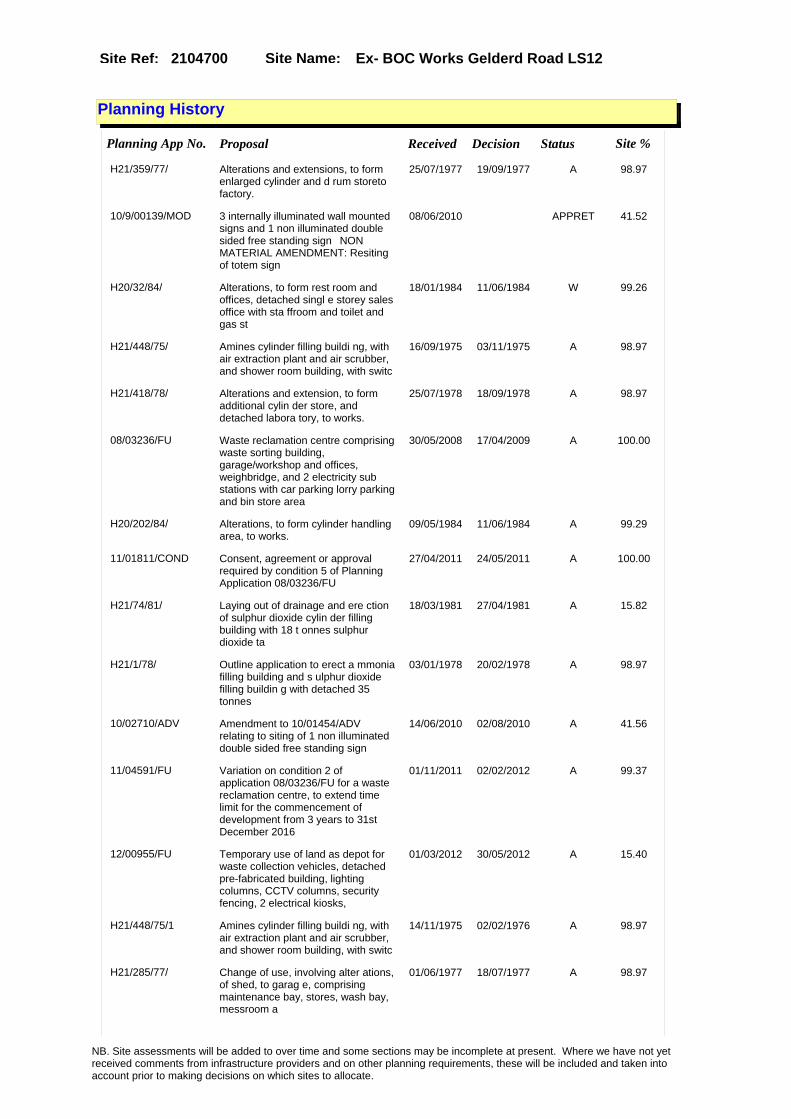
Site Name: Ex- BOC Works Gelderd Road LS12Site Ref: 2104700
Planning History
Planning App No. Proposal Received Decision Status Site %
H21/359/77/ Alterations and extensions, to form enlarged cylinder and d rum storeto factory.
25/07/1977 19/09/1977 A 98.97
10/9/00139/MOD 3 internally illuminated wall mounted signs and 1 non illuminated double sided free standing sign�NON MATERIAL AMENDMENT: Resiting of totem sign
08/06/2010 APPRET 41.52
H20/32/84/ Alterations, to form rest room and offices, detached singl e storey sales office with sta ffroom and toilet and gas st
18/01/1984 11/06/1984 W 99.26
H21/448/75/ Amines cylinder filling buildi ng, with air extraction plant and air scrubber, and shower room building, with switc
16/09/1975 03/11/1975 A 98.97
H21/418/78/ Alterations and extension, to form additional cylin der store, and detached labora tory, to works.
25/07/1978 18/09/1978 A 98.97
08/03236/FU Waste reclamation centre comprising waste sorting building, garage/workshop and offices, weighbridge, and 2 electricity sub stations with car parking lorry parking and bin store area
30/05/2008 17/04/2009 A 100.00
H20/202/84/ Alterations, to form cylinder handling area, to works.
09/05/1984 11/06/1984 A 99.29
11/01811/COND Consent, agreement or approval required by condition 5 of Planning Application 08/03236/FU
27/04/2011 24/05/2011 A 100.00
H21/74/81/ Laying out of drainage and ere ction of sulphur dioxide cylin der filling building with 18 t onnes sulphur dioxide ta
18/03/1981 27/04/1981 A 15.82
H21/1/78/ Outline application to erect a mmonia filling building and s ulphur dioxide filling buildin g with detached 35 tonnes
03/01/1978 20/02/1978 A 98.97
10/02710/ADV Amendment to 10/01454/ADV relating to siting of 1 non illuminated double sided free standing sign
14/06/2010 02/08/2010 A 41.56
11/04591/FU Variation on condition 2 of application 08/03236/FU for a waste reclamation centre, to extend time limit for the commencement of development from 3 years to 31st December 2016
01/11/2011 02/02/2012 A 99.37
12/00955/FU Temporary use of land as depot for waste collection vehicles, detached pre-fabricated building, lighting columns, CCTV columns, security fencing, 2 electrical kiosks,
01/03/2012 30/05/2012 A 15.40
H21/448/75/1 Amines cylinder filling buildi ng, with air extraction plant and air scrubber, and shower room building, with switc
14/11/1975 02/02/1976 A 98.97
H21/285/77/ Change of use, involving alter ations, of shed, to garag e, comprising maintenance bay, stores, wash bay, messroom a
01/06/1977 18/07/1977 A 98.97
NB. Site assessments will be added to over time and some sections may be incomplete at present. Where we have not yet received comments from infrastructure providers and on other planning requirements, these will be included and taken into account prior to making decisions on which sites to allocate.

Site Name: Ex- BOC Works Gelderd Road LS12Site Ref: 2104700
H21/1/78/1 Renewal of outline permission to erect ammonia filling build ing and sulphur dioxide fillin g building with detached 3
23/12/1980 26/01/1981 A 99.11
10/01454/ADV 3 internally illuminated wall mounted signs and 1 non illuminated double sided free standing sign
29/03/2010 11/05/2010 A 41.52
H20/534/84/ Alterations, to form offices s tore, cylinder filling room, enlarged pallet handling area , detached sales office and
07/12/1984 22/04/1985 A 98.93
H20/530/86/ Alterations, including new sta ircase and extension to form enlarged garage and detached v ehicle wash to works.
15/12/1986 13/04/1987 A 99.37
12/02743/COND Consent, agreement or approval required by condition 7 of Planning Application 12/00955/FU
20/06/2012 22/08/2012 A 15.40
H21/250/75/ Cylinder and drum store buildi ng to wo rks premises.
19/05/1975 22/09/1975 A 98.97
NB. Site assessments will be added to over time and some sections may be incomplete at present. Where we have not yet received comments from infrastructure providers and on other planning requirements, these will be included and taken into account prior to making decisions on which sites to allocate.

Site Name: Ex- BOC Works Gelderd Road LS12Site Ref: 2104700
Conformity with Core Strategy
Inner South Leeds: 0.00
Leeds Bradford Corridor: 0.00 West Leeds Gateway: 0.00
Aire Valley: 0.00Regeneration Priority Area:
Brownfield
Greenfield
Mixed
Main Urban Area
Major Settlement
Smaller Settlement
Villages/Rural
Main Urban Area Extension
Major Settlement Extension
Smaller Settlement Extension
Village/Rural Extension
Development unrelated to existing development
Green Belt assessment - only completed where site is within Green Belt
Would development lead to/constitute ribbon development?
Would development result in isolated development?
Is the site well connected to built up area (2+ boundaries with existing built up area)?
Would development of the site effectively "round off" the settlement pattern?:
Do natural/physical features provide a good existing barrier between existing urban area and undeveloped land?
Overall sprawl conclusion:
Would development of the site lead to physical connection of settlements?
Do natural/physical features provide a good existing barrier/boundary to contain development?
Overall Coalescence Conclusion:
Is there a strong defensible boundary between the site and the existing urban area?
Does the site provide access to the countryside?
Does the site include local or national conservation designated areas?
Does the site include areas of woodlands, trees, hedgerows that are protected, or significant unprotected tree/hedge cover?
Does the site include grade 1, 2, or 3a agricultural land?
Does the site contain buildings? Are these in agricultural use?
Overall countryside Encroachment Conclusion
Is the site within or adjacent to a conservation area, listed building or other historical feature?
If yes, could development preserve this character?:
Overall Character Preservation Conclusion:
Greenbelt Assessment Conclusion:
Check the unrestricted sprawl of large built up areas
Prevent neighbouring towns from merging
Assist in safeguarding countryside from encroachment
Preserve the setting and special character of historic towns
NB. Site assessments will be added to over time and some sections may be incomplete at present. Where we have not yet received comments from infrastructure providers and on other planning requirements, these will be included and taken into account prior to making decisions on which sites to allocate.

Site Name: Ex- BOC Works Gelderd Road LS12Site Ref: 2104700
SHLAA ConclusionsAvailability: Suitability: Achievability:
Conclusion of Assessment
Conclusion summary:
Consent for Waste Reclamation Centre: 08/03236/FU expires 17/04/2012
Floorspace sq m (Non residential):
Employment Conclusion: Lime Green
East Leeds
Assesment Type: ELR Type: Industrial & Warehousing
Proposed Change:
Gypsy Traveller Site Assessment
Yes No Maybe Could site be effectively managed (Text)
Yes No Maybe Would gypsies and travellers live on the site?
(Text)
Yes No Proximity to housed gypsies and travellers (Text)
Yes No Unknown Experience of previous encampments (Text)
NB. Site assessments will be added to over time and some sections may be incomplete at present. Where we have not yet received comments from infrastructure providers and on other planning requirements, these will be included and taken into account prior to making decisions on which sites to allocate.

Site Name: TULIP STREET BEZA STREET LS10 Site Ref: 2104710
Site Details
Land Use
Northing: 431217
Easting: 430675
Distance to Rail Station (metres): 2205.01
Nearest Railway Station Leeds City
Distance to bus stop (metres) 46.45
Bus Stop ID 1363
Agricultural Land Class:
SFRA Flood Zone: 0.00
Environment Agency Flood Zone: 0.00
Within 300m of retail centre boundary:
UDP Designation
Greenbelt - N32 (%): 0.00 Urban Green Corridor - N8 (%): 0.00
Protected Area of Search site - N34 (%): 0.00 Rural Land - RL1: 0.00
City Centre Primary Shopping Quarter - CC27 (%): 0.00 Town Centre - S2: 0.00
Health and Safety Executive Hazard: No
Health and Safety Executive Gas Pipeline: No
Strategic Employment Buffer: 0.00
Area sq m: 4619.53 Ward City and Hunslet
Special Landscape Area - N37: 0.00
Allotments - N1A: 0.00
Proposed Greenspace - N5: 0.00
Protected Playing Pitch - N6: 0.00
Nature Conservation Area - N50: 0.00
Conservation Areas No
Ancient Monument/Battlefield(%): 0.00 Listed Buildings: No
Public Rights of Way: No
Other?:
Natural Resources and waste DPD (if applicable)
Within Minerals Safeguarding Site?: No Within 100m of Minerals Safeguarding Site?: No
HMCA: Inner Areas
Greenspace - N1: 0
Existing Use 1:
Existing Use 2:
Existing Use 3:
Neighbouring Use 1
Neighbouring Use 2:
Neighbouring Use 3:
Other uses:
Topography:
Natural Landscape:
Boundaries:
Road Frontage
Site Characteristics
Site Detail
Other comments/observations on site characteristics:
Area Ha: 0.461953
Site State:
NB. Site assessments will be added to over time and some sections may be incomplete at present. Where we have not yet received comments from infrastructure providers and on other planning requirements, these will be included and taken into account prior to making decisions on which sites to allocate.

Site Name: TULIP STREET BEZA STREET LS10 Site Ref: 2104710
Planning History
NB. Site assessments will be added to over time and some sections may be incomplete at present. Where we have not yet received comments from infrastructure providers and on other planning requirements, these will be included and taken into account prior to making decisions on which sites to allocate.

Site Name: TULIP STREET BEZA STREET LS10 Site Ref: 2104710
Conformity with Core Strategy
Inner South Leeds: 0.00
Leeds Bradford Corridor: 0.00 West Leeds Gateway: 0.00
Aire Valley: 0.00Regeneration Priority Area:
Brownfield
Greenfield
Mixed
Main Urban Area
Major Settlement
Smaller Settlement
Villages/Rural
Main Urban Area Extension
Major Settlement Extension
Smaller Settlement Extension
Village/Rural Extension
Development unrelated to existing development
Green Belt assessment - only completed where site is within Green Belt
Would development lead to/constitute ribbon development?
Would development result in isolated development?
Is the site well connected to built up area (2+ boundaries with existing built up area)?
Would development of the site effectively "round off" the settlement pattern?:
Do natural/physical features provide a good existing barrier between existing urban area and undeveloped land?
Overall sprawl conclusion:
Would development of the site lead to physical connection of settlements?
Do natural/physical features provide a good existing barrier/boundary to contain development?
Overall Coalescence Conclusion:
Is there a strong defensible boundary between the site and the existing urban area?
Does the site provide access to the countryside?
Does the site include local or national conservation designated areas?
Does the site include areas of woodlands, trees, hedgerows that are protected, or significant unprotected tree/hedge cover?
Does the site include grade 1, 2, or 3a agricultural land?
Does the site contain buildings? Are these in agricultural use?
Overall countryside Encroachment Conclusion
Is the site within or adjacent to a conservation area, listed building or other historical feature?
If yes, could development preserve this character?:
Overall Character Preservation Conclusion:
Greenbelt Assessment Conclusion:
Check the unrestricted sprawl of large built up areas
Prevent neighbouring towns from merging
Assist in safeguarding countryside from encroachment
Preserve the setting and special character of historic towns
NB. Site assessments will be added to over time and some sections may be incomplete at present. Where we have not yet received comments from infrastructure providers and on other planning requirements, these will be included and taken into account prior to making decisions on which sites to allocate.

Site Name: TULIP STREET BEZA STREET LS10 Site Ref: 2104710
SHLAA ConclusionsAvailability: Suitability: Achievability:
Conclusion of Assessment
Conclusion summary:
Consent for 2 B1(C) and B8 units: 08/04632/FU expires 21/10/2011
Floorspace sq m (Non residential):
Employment Conclusion: Green
East Leeds
Assesment Type: ELR Type: Industrial & Warehousing
Proposed Change:
Gypsy Traveller Site Assessment
Yes No Maybe Could site be effectively managed (Text)
Yes No Maybe Would gypsies and travellers live on the site?
(Text)
Yes No Proximity to housed gypsies and travellers (Text)
Yes No Unknown Experience of previous encampments (Text)
NB. Site assessments will be added to over time and some sections may be incomplete at present. Where we have not yet received comments from infrastructure providers and on other planning requirements, these will be included and taken into account prior to making decisions on which sites to allocate.

Site Name: Fall Lane East Ardsley WF3Site Ref: 2200462
Site Details
Land Use
Northing: 426004
Easting: 431122
Distance to Rail Station (metres): 4658.55
Nearest Railway Station Morley
Distance to bus stop (metres) 173.40
Bus Stop ID 14347
Agricultural Land Class:
SFRA Flood Zone: 0.00
Environment Agency Flood Zone: 0.00
Within 300m of retail centre boundary:
UDP Designation
Greenbelt - N32 (%): 0.00 Urban Green Corridor - N8 (%): 0.00
Protected Area of Search site - N34 (%): 0.00 Rural Land - RL1: 0.00
City Centre Primary Shopping Quarter - CC27 (%): 0.00 Town Centre - S2: 0.00
Health and Safety Executive Hazard: No
Health and Safety Executive Gas Pipeline: No
Strategic Employment Buffer: 0.00
Area sq m: 6107.33 Ward Ardsley and Robin Hood
Special Landscape Area - N37: 0.00
Allotments - N1A: 0.00
Proposed Greenspace - N5: 0.00
Protected Playing Pitch - N6: 0.00
Nature Conservation Area - N50: 0.00
Conservation Areas No
Ancient Monument/Battlefield(%): 0.00 Listed Buildings: No
Public Rights of Way: No
Other?:
Natural Resources and waste DPD (if applicable)
Within Minerals Safeguarding Site?: No Within 100m of Minerals Safeguarding Site?: No
HMCA: Outer South West
Greenspace - N1: 0
Existing Use 1:
Existing Use 2:
Existing Use 3:
Neighbouring Use 1
Neighbouring Use 2:
Neighbouring Use 3:
Other uses:
Topography:
Natural Landscape:
Boundaries:
Road Frontage
Site Characteristics
Site Detail
Other comments/observations on site characteristics:
Area Ha: 0.610733
Site State:
NB. Site assessments will be added to over time and some sections may be incomplete at present. Where we have not yet received comments from infrastructure providers and on other planning requirements, these will be included and taken into account prior to making decisions on which sites to allocate.

Site Name: Fall Lane East Ardsley WF3Site Ref: 2200462
Planning History
Planning App No. Proposal Received Decision Status Site %
08/00541/FU Laying out of access and erection of 4 storey block comprising 12 two bedroom flats ground floor surgery and pharmacy, detached 2 storey nursery and detached single storey block of 3 retail units, with car parking and landscaping
30/01/2008 16/04/2008 A 94.42
22/53/99/OT Outline application to erect residential development
30/03/1999 19/09/2001 W 92.75
22/3/05/OT Variation of condition 20 of permission 22/293/00/ot (highway and pedestrian safety)
24/12/2004 10/05/2005 A 100.00
22/126/03/RM 320 dwelling houses and laying out of public open space
31/01/2003 12/02/2004 A 99.99
22/76/96/MIN Tipping of inert excavation material to former railway sidings
27/03/1996 25/10/1996 R 100.00
22/298/04/RM 2 storey office block 2 shop units and public house
05/04/2004 18/10/2004 A 89.32
22/72/97/MIN Tipping of inert excavation material to former railway sidings
15/04/1997 18/02/1998 A 100.00
07/03388/FU Laying out of access and erection of 3 storey block of 12 two bedroom flats, 2 storey nursery and single storey block comprising surgery and 4 retail units, with car parking and landscaping
24/05/2007 14/09/2007 W 94.42
H23/492/78/ Outline application to erect r ailhead and distr ibution depot, to derelict sit e.
15/06/1978 21/11/1978 R 100.00
H23/259/80/ Outline application to layout access road and erect wareh ouse and railhead, to each of 2 cleared sites. (total sit
27/03/1980 28/02/1983 W 100.00
22/293/00/OT Outline application to erect housing offices retail and public house
20/12/2000 27/07/2001 A 100.00
22/139/96/OT Outline application to layout access and erect industrial units
07/06/1996 19/09/2001 W 99.59
22/124/04/FU Amendment to conditions no 13, 14 & 15 of application no 22/293/00/ot (carrying out of remediation works)
22/03/2004 01/07/2004 A 99.99
NB. Site assessments will be added to over time and some sections may be incomplete at present. Where we have not yet received comments from infrastructure providers and on other planning requirements, these will be included and taken into account prior to making decisions on which sites to allocate.

Site Name: Fall Lane East Ardsley WF3Site Ref: 2200462
Conformity with Core Strategy
Inner South Leeds: 0.00
Leeds Bradford Corridor: 0.00 West Leeds Gateway: 0.00
Aire Valley: 0.00Regeneration Priority Area:
Brownfield
Greenfield
Mixed
Main Urban Area
Major Settlement
Smaller Settlement
Villages/Rural
Main Urban Area Extension
Major Settlement Extension
Smaller Settlement Extension
Village/Rural Extension
Development unrelated to existing development
Green Belt assessment - only completed where site is within Green Belt
Would development lead to/constitute ribbon development?
Would development result in isolated development?
Is the site well connected to built up area (2+ boundaries with existing built up area)?
Would development of the site effectively "round off" the settlement pattern?:
Do natural/physical features provide a good existing barrier between existing urban area and undeveloped land?
Overall sprawl conclusion:
Would development of the site lead to physical connection of settlements?
Do natural/physical features provide a good existing barrier/boundary to contain development?
Overall Coalescence Conclusion:
Is there a strong defensible boundary between the site and the existing urban area?
Does the site provide access to the countryside?
Does the site include local or national conservation designated areas?
Does the site include areas of woodlands, trees, hedgerows that are protected, or significant unprotected tree/hedge cover?
Does the site include grade 1, 2, or 3a agricultural land?
Does the site contain buildings? Are these in agricultural use?
Overall countryside Encroachment Conclusion
Is the site within or adjacent to a conservation area, listed building or other historical feature?
If yes, could development preserve this character?:
Overall Character Preservation Conclusion:
Greenbelt Assessment Conclusion:
Check the unrestricted sprawl of large built up areas
Prevent neighbouring towns from merging
Assist in safeguarding countryside from encroachment
Preserve the setting and special character of historic towns
NB. Site assessments will be added to over time and some sections may be incomplete at present. Where we have not yet received comments from infrastructure providers and on other planning requirements, these will be included and taken into account prior to making decisions on which sites to allocate.

Site Name: Fall Lane East Ardsley WF3Site Ref: 2200462
SHLAA ConclusionsAvailability: Suitability: Achievability:
Conclusion of Assessment
Conclusion summary:
This site forms part of the larger Meadowside Road Housing Development. Recent approval for housing retail and medical centre.
Floorspace sq m (Non residential): 430
Employment Conclusion: Red
East Leeds
Assesment Type: ELR Type: Office
Proposed Change:
Gypsy Traveller Site Assessment
Yes No Maybe Could site be effectively managed (Text)
Yes No Maybe Would gypsies and travellers live on the site?
(Text)
Yes No Proximity to housed gypsies and travellers (Text)
Yes No Unknown Experience of previous encampments (Text)
NB. Site assessments will be added to over time and some sections may be incomplete at present. Where we have not yet received comments from infrastructure providers and on other planning requirements, these will be included and taken into account prior to making decisions on which sites to allocate.

Site Name: FORMER BRICK WORKS LINGWELL GATE LANE THORPE
Site Ref: 2201920
Site Details
Land Use
Northing: 426726
Easting: 431692
Distance to Rail Station (metres): 4924.97
Nearest Railway Station Morley
Distance to bus stop (metres) 166.03
Bus Stop ID 2849
Agricultural Land Class:
SFRA Flood Zone: 0.00
Environment Agency Flood Zone: 0.00
Within 300m of retail centre boundary:
UDP Designation
Greenbelt - N32 (%): 0.05 Urban Green Corridor - N8 (%): 0.00
Protected Area of Search site - N34 (%): 0.00 Rural Land - RL1: 0.00
City Centre Primary Shopping Quarter - CC27 (%): 0.00 Town Centre - S2: 0.00
Health and Safety Executive Hazard: No
Health and Safety Executive Gas Pipeline: No
Strategic Employment Buffer: 0.00
Area sq m: 26777.17 Ward Ardsley and Robin Hood
Special Landscape Area - N37: 0.00
Allotments - N1A: 0.00
Proposed Greenspace - N5: 0.00
Protected Playing Pitch - N6: 0.00
Nature Conservation Area - N50: 0.00
Conservation Areas No
Ancient Monument/Battlefield(%): 0.00 Listed Buildings: No
Public Rights of Way: No
Other?:
Natural Resources and waste DPD (if applicable)
Within Minerals Safeguarding Site?: Yes Within 100m of Minerals Safeguarding Site?: Yes
HMCA: Outer South West
Greenspace - N1: 0
Existing Use 1:
Existing Use 2:
Existing Use 3:
Neighbouring Use 1
Neighbouring Use 2:
Neighbouring Use 3:
Other uses:
Topography:
Natural Landscape:
Boundaries:
Road Frontage
Site Characteristics
Site Detail
Other comments/observations on site characteristics:
Area Ha: 2.677717
Site State:
Site Site TypeBritannia Recycling Robin Hood (Closed) Other (Waste) Specialist Misc - Loose Ends
NB. Site assessments will be added to over time and some sections may be incomplete at present. Where we have not yet received comments from infrastructure providers and on other planning requirements, these will be included and taken into account prior to making decisions on which sites to allocate.

Site Name: FORMER BRICK WORKS LINGWELL GATE LANE THORPE
Site Ref: 2201920
Planning History
Planning App No. Proposal Received Decision Status Site %
H22/301/74/ Installation of new weighbridg e, and second storey exten sion to form recording office, with external staircase,
25/10/1974 27/01/1975 A 40.81
H21/66/83/ Laying out of access and erect ion of 2 furnaces, each with storage feed and preparation b uildings, filter buildings,
15/03/1983 11/06/1984 W 40.48
22/96/03/FU 2m high fence and additional fence to wall to boundary of recycling centre
10/03/2003 02/05/2003 A 40.49
H22/143/87/ Alterations and first floor ex tension, to form offices, to of fice block, to works.
24/08/1987 28/09/1987 A 40.50
H21/242/82/ Laying out of access road and erection of furnace, withrefin ery area, stores, despatch are a and flux store with relax
03/12/1982 28/03/1983 W 40.49
08/02668/FU Variation of condition 3 of permission reference 22/265/04/OT (service infrastructure and employment area access)
01/05/2008 02/07/2008 A 94.26
20/130/06/OT Variation of condition nos. 1, 2, 4, 5, 7, 9, 10, 13-16, 18, 21-24, 27, 28, 30, 31, 34-36 (phasing of development & reserved matters
04/01/2006 30/06/2006 A 95.17
H21/273/78/ Alterations, including realign ing, of existing 2.4m (8ft) high fence and erection of ne w 2.4m (8ft) high fence, to
24/05/1978 19/06/1978 A 40.81
H22/183/85/ Laying out of access and erect ion of 2m high stone bound ary wall and landscaping to wo rks.
01/11/1985 23/12/1985 W 15.97
22/265/04/OT Outline application to layout access and erect residential light industrial and office development
29/06/2004 16/08/2005 A 91.29
08/04893/RM Laying out of access road and erection of 2 two storey office blocks and 10 industrial units, with car parking and landscaping
15/08/2008 APPRET 94.54
H22/4/84/ Outline application to lay out access road and erect indus trial and warehouse developmen t with ancillary offices, t
09/01/1984 11/06/1984 W 40.74
NB. Site assessments will be added to over time and some sections may be incomplete at present. Where we have not yet received comments from infrastructure providers and on other planning requirements, these will be included and taken into account prior to making decisions on which sites to allocate.

Site Name: FORMER BRICK WORKS LINGWELL GATE LANE THORPE
Site Ref: 2201920
Conformity with Core Strategy
Inner South Leeds: 0.00
Leeds Bradford Corridor: 0.00 West Leeds Gateway: 0.00
Aire Valley: 0.00Regeneration Priority Area:
Brownfield
Greenfield
Mixed
Main Urban Area
Major Settlement
Smaller Settlement
Villages/Rural
Main Urban Area Extension
Major Settlement Extension
Smaller Settlement Extension
Village/Rural Extension
Development unrelated to existing development
Green Belt assessment - only completed where site is within Green Belt
Would development lead to/constitute ribbon development?
Would development result in isolated development?
Is the site well connected to built up area (2+ boundaries with existing built up area)?
Would development of the site effectively "round off" the settlement pattern?:
Do natural/physical features provide a good existing barrier between existing urban area and undeveloped land?
Overall sprawl conclusion:
Would development of the site lead to physical connection of settlements?
Do natural/physical features provide a good existing barrier/boundary to contain development?
Overall Coalescence Conclusion:
Is there a strong defensible boundary between the site and the existing urban area?
Does the site provide access to the countryside?
Does the site include local or national conservation designated areas?
Does the site include areas of woodlands, trees, hedgerows that are protected, or significant unprotected tree/hedge cover?
Does the site include grade 1, 2, or 3a agricultural land?
Does the site contain buildings? Are these in agricultural use?
Overall countryside Encroachment Conclusion
Is the site within or adjacent to a conservation area, listed building or other historical feature?
If yes, could development preserve this character?:
Overall Character Preservation Conclusion:
Greenbelt Assessment Conclusion:
Check the unrestricted sprawl of large built up areas
Prevent neighbouring towns from merging
Assist in safeguarding countryside from encroachment
Preserve the setting and special character of historic towns
NB. Site assessments will be added to over time and some sections may be incomplete at present. Where we have not yet received comments from infrastructure providers and on other planning requirements, these will be included and taken into account prior to making decisions on which sites to allocate.

Site Name: FORMER BRICK WORKS LINGWELL GATE LANE THORPE
Site Ref: 2201920
SHLAA ConclusionsAvailability: Suitability: Achievability:
East Leeds
Summary of Infrastructure provider comments and other planning requirements
Accessibility commentPublic Transport adequate for B1©, B2 & B8 uses
Rank (1-5)
3Access Comments
existing with some improvements would be adequate
Local network comment
spare local capacity
Rank (1-5)
4Rank (1-5)
4
Leeds City Council Highways inc Metro
Highways Agency
Network Rail :
Biodiversity
Natural England:
Education
Mitigation measure Total score
11Support?
yes
Need to combine with other sites: Suitability for partial development:
West Yorkshire Ecology and LCC Ecology Officer:
Supported
Boundary Amendment
Drainage/Water/FloodingEnvironment Agency Comments: Environment Agency Constraints:
Yorkshire Water Comments: Yorkshire Water Waste Water Treatment Works Comme
UtilitiesGas:
LCC Flood Risk Management:
NB. Site assessments will be added to over time and some sections may be incomplete at present. Where we have not yet received comments from infrastructure providers and on other planning requirements, these will be included and taken into account prior to making decisions on which sites to allocate.

Site Name: FORMER BRICK WORKS LINGWELL GATE LANE THORPE
Site Ref: 2201920
Conclusion of Assessment
Conclusion summary:
Allocated site. May still come forward for employment use but housing a possibility in view of residential development on adjoining land
Floorspace sq m (Non residential):
Employment Conclusion: Red
Assesment Type: Site assessment Type: Industrial & Warehousing
Proposed Change:
Electric:
Telecom:
Fire and Rescue Services:
Built HeritageLeeds City Council:
West Yorkshire Archaeology Service:
English Heritage:
Gypsy Traveller Site Assessment
Yes No Maybe Could site be effectively managed (Text)
Yes No Maybe Would gypsies and travellers live on the site?
(Text)
Yes No Proximity to housed gypsies and travellers (Text)
Yes No Unknown Experience of previous encampments (Text)
NB. Site assessments will be added to over time and some sections may be incomplete at present. Where we have not yet received comments from infrastructure providers and on other planning requirements, these will be included and taken into account prior to making decisions on which sites to allocate.

Site Name: FORMER BRICK WORKS LINGWELL GATE LANE THORPE
Site Ref: 2201921
Site Details
Land Use
Northing: 426570
Easting: 431702
Distance to Rail Station (metres): 4980.31
Nearest Railway Station Morley
Distance to bus stop (metres) 73.54
Bus Stop ID 7675
Agricultural Land Class:
SFRA Flood Zone: 0.00
Environment Agency Flood Zone: 0.00
Within 300m of retail centre boundary:
UDP Designation
Greenbelt - N32 (%): 0.12 Urban Green Corridor - N8 (%): 0.00
Protected Area of Search site - N34 (%): 0.00 Rural Land - RL1: 0.00
City Centre Primary Shopping Quarter - CC27 (%): 0.00 Town Centre - S2: 0.00
Health and Safety Executive Hazard: No
Health and Safety Executive Gas Pipeline: No
Strategic Employment Buffer: 0.00
Area sq m: 24279.64 Ward Ardsley and Robin Hood
Special Landscape Area - N37: 0.00
Allotments - N1A: 0.00
Proposed Greenspace - N5: 0.00
Protected Playing Pitch - N6: 0.00
Nature Conservation Area - N50: 0.00
Conservation Areas No
Ancient Monument/Battlefield(%): 0.00 Listed Buildings: No
Public Rights of Way: No
Other?:
Natural Resources and waste DPD (if applicable)
Within Minerals Safeguarding Site?: No Within 100m of Minerals Safeguarding Site?: Yes
HMCA: Outer South West
Greenspace - N1: 0
Existing Use 1:
Existing Use 2:
Existing Use 3:
Neighbouring Use 1
Neighbouring Use 2:
Neighbouring Use 3:
Other uses:
Topography:
Natural Landscape:
Boundaries:
Road Frontage
Site Characteristics
Site Detail
Other comments/observations on site characteristics:
Area Ha: 2.427964
Site State:
NB. Site assessments will be added to over time and some sections may be incomplete at present. Where we have not yet received comments from infrastructure providers and on other planning requirements, these will be included and taken into account prior to making decisions on which sites to allocate.
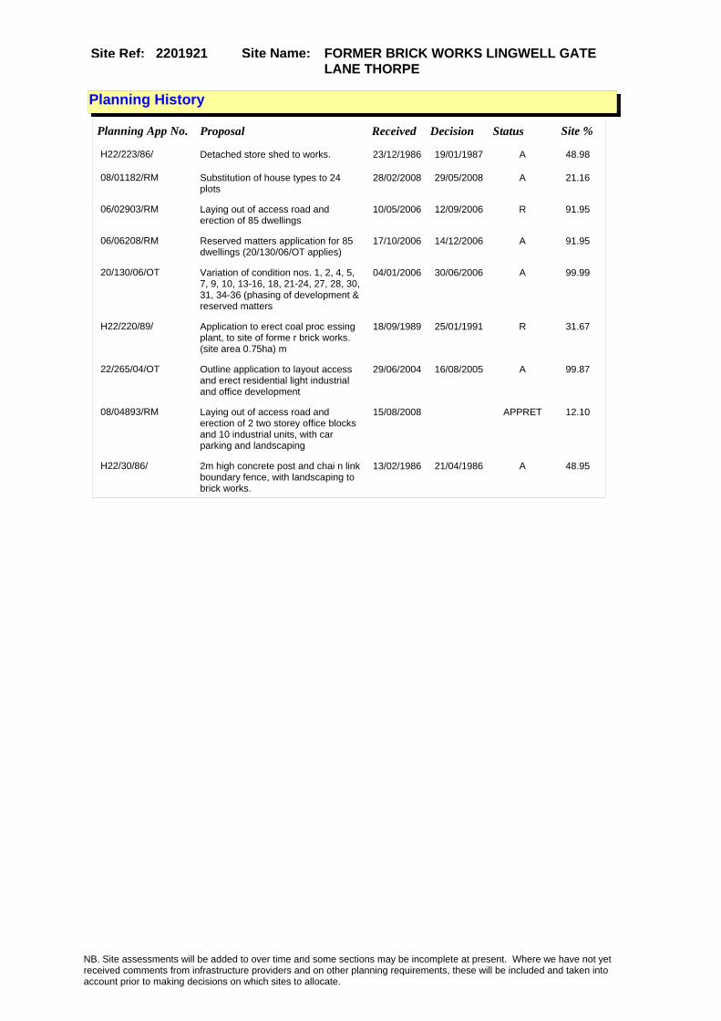
Site Name: FORMER BRICK WORKS LINGWELL GATE LANE THORPE
Site Ref: 2201921
Planning History
Planning App No. Proposal Received Decision Status Site %
H22/223/86/ Detached store shed to works. 23/12/1986 19/01/1987 A 48.98
08/01182/RM Substitution of house types to 24 plots
28/02/2008 29/05/2008 A 21.16
06/02903/RM Laying out of access road and erection of 85 dwellings
10/05/2006 12/09/2006 R 91.95
06/06208/RM Reserved matters application for 85 dwellings (20/130/06/OT applies)
17/10/2006 14/12/2006 A 91.95
20/130/06/OT Variation of condition nos. 1, 2, 4, 5, 7, 9, 10, 13-16, 18, 21-24, 27, 28, 30, 31, 34-36 (phasing of development & reserved matters
04/01/2006 30/06/2006 A 99.99
H22/220/89/ Application to erect coal proc essing plant, to site of forme r brick works. (site area 0.75ha) m
18/09/1989 25/01/1991 R 31.67
22/265/04/OT Outline application to layout access and erect residential light industrial and office development
29/06/2004 16/08/2005 A 99.87
08/04893/RM Laying out of access road and erection of 2 two storey office blocks and 10 industrial units, with car parking and landscaping
15/08/2008 APPRET 12.10
H22/30/86/ 2m high concrete post and chai n link boundary fence, with landscaping to brick works.
13/02/1986 21/04/1986 A 48.95
NB. Site assessments will be added to over time and some sections may be incomplete at present. Where we have not yet received comments from infrastructure providers and on other planning requirements, these will be included and taken into account prior to making decisions on which sites to allocate.

Site Name: FORMER BRICK WORKS LINGWELL GATE LANE THORPE
Site Ref: 2201921
Conformity with Core Strategy
Inner South Leeds: 0.00
Leeds Bradford Corridor: 0.00 West Leeds Gateway: 0.00
Aire Valley: 0.00Regeneration Priority Area:
Brownfield
Greenfield
Mixed
Main Urban Area
Major Settlement
Smaller Settlement
Villages/Rural
Main Urban Area Extension
Major Settlement Extension
Smaller Settlement Extension
Village/Rural Extension
Development unrelated to existing development
Green Belt assessment - only completed where site is within Green Belt
Would development lead to/constitute ribbon development?
Would development result in isolated development?
Is the site well connected to built up area (2+ boundaries with existing built up area)?
Would development of the site effectively "round off" the settlement pattern?:
Do natural/physical features provide a good existing barrier between existing urban area and undeveloped land?
Overall sprawl conclusion:
Would development of the site lead to physical connection of settlements?
Do natural/physical features provide a good existing barrier/boundary to contain development?
Overall Coalescence Conclusion:
Is there a strong defensible boundary between the site and the existing urban area?
Does the site provide access to the countryside?
Does the site include local or national conservation designated areas?
Does the site include areas of woodlands, trees, hedgerows that are protected, or significant unprotected tree/hedge cover?
Does the site include grade 1, 2, or 3a agricultural land?
Does the site contain buildings? Are these in agricultural use?
Overall countryside Encroachment Conclusion
Is the site within or adjacent to a conservation area, listed building or other historical feature?
If yes, could development preserve this character?:
Overall Character Preservation Conclusion:
Greenbelt Assessment Conclusion:
Check the unrestricted sprawl of large built up areas
Prevent neighbouring towns from merging
Assist in safeguarding countryside from encroachment
Preserve the setting and special character of historic towns
NB. Site assessments will be added to over time and some sections may be incomplete at present. Where we have not yet received comments from infrastructure providers and on other planning requirements, these will be included and taken into account prior to making decisions on which sites to allocate.

Site Name: FORMER BRICK WORKS LINGWELL GATE LANE THORPE
Site Ref: 2201921
SHLAA ConclusionsAvailability: Suitability: Achievability:
Conclusion of Assessment
Conclusion summary:
This site is already has full planning permission for housing and is being developed and promoted for this use.
Floorspace sq m (Non residential):
Employment Conclusion: Red
East Leeds
Assesment Type: ELR Type: Industrial & Warehousing
Proposed Change:
Gypsy Traveller Site Assessment
Yes No Maybe Could site be effectively managed (Text)
Yes No Maybe Would gypsies and travellers live on the site?
(Text)
Yes No Proximity to housed gypsies and travellers (Text)
Yes No Unknown Experience of previous encampments (Text)
NB. Site assessments will be added to over time and some sections may be incomplete at present. Where we have not yet received comments from infrastructure providers and on other planning requirements, these will be included and taken into account prior to making decisions on which sites to allocate.

Site Name: Thorpe Hall Thorpe Lane Thorpe WF3Site Ref: 2201930
Site Details
Land Use
Northing: 427007
Easting: 431587
Distance to Rail Station (metres): 4750.93
Nearest Railway Station Morley
Distance to bus stop (metres) 162.10
Bus Stop ID 2849
Agricultural Land Class:
SFRA Flood Zone: 0.00
Environment Agency Flood Zone: 0.00
Within 300m of retail centre boundary:
UDP Designation
Greenbelt - N32 (%): 0.00 Urban Green Corridor - N8 (%): 0.00
Protected Area of Search site - N34 (%): 0.00 Rural Land - RL1: 0.00
City Centre Primary Shopping Quarter - CC27 (%): 0.00 Town Centre - S2: 0.00
Health and Safety Executive Hazard: No
Health and Safety Executive Gas Pipeline: No
Strategic Employment Buffer: 0.00
Area sq m: 10079.99 Ward Ardsley and Robin Hood
Special Landscape Area - N37: 0.00
Allotments - N1A: 0.00
Proposed Greenspace - N5: 0.00
Protected Playing Pitch - N6: 0.00
Nature Conservation Area - N50: 0.00
Conservation Areas No
Ancient Monument/Battlefield(%): 0.00 Listed Buildings: Yes
Public Rights of Way: Yes
Other?:
Natural Resources and waste DPD (if applicable)
Within Minerals Safeguarding Site?: No Within 100m of Minerals Safeguarding Site?: No
HMCA: Outer South West
Greenspace - N1: 0
Existing Use 1:
Existing Use 2:
Existing Use 3:
Neighbouring Use 1
Neighbouring Use 2:
Neighbouring Use 3:
Other uses:
Topography:
Natural Landscape:
Boundaries:
Road Frontage
Site Characteristics
Site Detail
Other comments/observations on site characteristics:
Area Ha: 1.007999
Site State:
NB. Site assessments will be added to over time and some sections may be incomplete at present. Where we have not yet received comments from infrastructure providers and on other planning requirements, these will be included and taken into account prior to making decisions on which sites to allocate.

Site Name: Thorpe Hall Thorpe Lane Thorpe WF3Site Ref: 2201930
Planning History
NB. Site assessments will be added to over time and some sections may be incomplete at present. Where we have not yet received comments from infrastructure providers and on other planning requirements, these will be included and taken into account prior to making decisions on which sites to allocate.
Site Name: Thorpe Hall Thorpe Lane Thorpe WF3Site Ref: 2201930
Conformity with Core Strategy
Inner South Leeds: 0.00
Leeds Bradford Corridor: 0.00 West Leeds Gateway: 0.00
Aire Valley: 0.00Regeneration Priority Area:
Brownfield
Greenfield
Mixed
Main Urban Area
Major Settlement
Smaller Settlement
Villages/Rural
Main Urban Area Extension
Major Settlement Extension
Smaller Settlement Extension
Village/Rural Extension
Development unrelated to existing development
Green Belt assessment - only completed where site is within Green Belt
Would development lead to/constitute ribbon development?
Would development result in isolated development?
Is the site well connected to built up area (2+ boundaries with existing built up area)?
Would development of the site effectively "round off" the settlement pattern?:
Do natural/physical features provide a good existing barrier between existing urban area and undeveloped land?
Overall sprawl conclusion:
Would development of the site lead to physical connection of settlements?
Do natural/physical features provide a good existing barrier/boundary to contain development?
Overall Coalescence Conclusion:
Is there a strong defensible boundary between the site and the existing urban area?
Does the site provide access to the countryside?
Does the site include local or national conservation designated areas?
Does the site include areas of woodlands, trees, hedgerows that are protected, or significant unprotected tree/hedge cover?
Does the site include grade 1, 2, or 3a agricultural land?
Does the site contain buildings? Are these in agricultural use?
Overall countryside Encroachment Conclusion
Is the site within or adjacent to a conservation area, listed building or other historical feature?
If yes, could development preserve this character?:
Overall Character Preservation Conclusion:
Greenbelt Assessment Conclusion:
Check the unrestricted sprawl of large built up areas
Prevent neighbouring towns from merging
Assist in safeguarding countryside from encroachment
Preserve the setting and special character of historic towns
NB. Site assessments will be added to over time and some sections may be incomplete at present. Where we have not yet received comments from infrastructure providers and on other planning requirements, these will be included and taken into account prior to making decisions on which sites to allocate.

Site Name: Thorpe Hall Thorpe Lane Thorpe WF3Site Ref: 2201930
SHLAA ConclusionsAvailability: Suitability: Achievability:
Conclusion of Assessment
Conclusion summary:
Out of centre. The scale, cost & urgency of works needed to save the Listed Building are likely to dictate that employment use
Floorspace sq m (Non residential): 3750
Employment Conclusion: Red
East Leeds
Assesment Type: ELR Type: Office
Proposed Change:
Gypsy Traveller Site Assessment
Yes No Maybe Could site be effectively managed (Text)
Yes No Maybe Would gypsies and travellers live on the site?
(Text)
Yes No Proximity to housed gypsies and travellers (Text)
Yes No Unknown Experience of previous encampments (Text)
NB. Site assessments will be added to over time and some sections may be incomplete at present. Where we have not yet received comments from infrastructure providers and on other planning requirements, these will be included and taken into account prior to making decisions on which sites to allocate.

Site Name: Adj Dunford House Green Lane Methley LS26Site Ref: 2201970
Site Details
Land Use
Northing: 426196
Easting: 440856
Distance to Rail Station (metres): 4958.02
Nearest Railway Station Woodlesford
Distance to bus stop (metres) 222.50
Bus Stop ID 2657
Agricultural Land Class:
SFRA Flood Zone: 1.00
Environment Agency Flood Zone: 1.00
Within 300m of retail centre boundary:
UDP Designation
Greenbelt - N32 (%): 100.00 Urban Green Corridor - N8 (%): 0.00
Protected Area of Search site - N34 (%): 0.00 Rural Land - RL1: 0.00
City Centre Primary Shopping Quarter - CC27 (%): 0.00 Town Centre - S2: 0.00
Health and Safety Executive Hazard: No
Health and Safety Executive Gas Pipeline: No
Strategic Employment Buffer: 0.00
Area sq m: 4458.09 Ward Kippax and Methley
Special Landscape Area - N37: 0.00
Allotments - N1A: 0.00
Proposed Greenspace - N5: 0.00
Protected Playing Pitch - N6: 0.00
Nature Conservation Area - N50: 0.00
Conservation Areas No
Ancient Monument/Battlefield(%): 0.00 Listed Buildings: No
Public Rights of Way: No
Other?:
Natural Resources and waste DPD (if applicable)
Within Minerals Safeguarding Site?: No Within 100m of Minerals Safeguarding Site?: Yes
HMCA: Outer South
Greenspace - N1: 0
Existing Use 1:
Existing Use 2:
Existing Use 3:
Neighbouring Use 1
Neighbouring Use 2:
Neighbouring Use 3:
Other uses:
Topography:
Natural Landscape:
Boundaries:
Road Frontage
Site Characteristics
Site Detail
Other comments/observations on site characteristics:
Area Ha: 0.445809
Site State:
NB. Site assessments will be added to over time and some sections may be incomplete at present. Where we have not yet received comments from infrastructure providers and on other planning requirements, these will be included and taken into account prior to making decisions on which sites to allocate.

Site Name: Adj Dunford House Green Lane Methley LS26Site Ref: 2201970
Planning History
Planning App No. Proposal Received Decision Status Site %
H22/204/75/1 Sinking of temporary bore-hole to prove coal measures, to fi eld. (this item appears for in formation only in pursuance
14/10/1975 24/11/1975 A 100.00
H22/323/77/ Use of land for quarrying of s and and gravel with plantsite. over burden stockpiles and sc reens to agricultur
18/08/1977 28/02/1978 A 100.00
22/313/01/LI Listed building application to carry out alterations and 2 storey extension to outbuildings to form offices
24/12/2001 18/09/2002 A 94.36
H22/29/89/ Extension of sand and gravel w orkings, enlarged lake and r etention of existing processin g plant.
22/02/1989 22/02/1989 0 12.00
H22/204/75/ Sinking of temporary bore-hole , to prove coal measures, to fi eld.
02/05/1975 01/09/1975 A 100.00
22/166/96/FU Change of use of agricultural buildings to 2 two bedroom and 2 three bedroom dwelling houses and workshops
24/07/1996 20/12/1996 A 80.94
22/294/01/RE Extension of permission for change of use of agricultural buildings to 4 dwellings and workshops
30/11/2001 25/01/2002 A 90.23
22/223/01/FU Change of use and 3 two storey extensions of outbuildings to offices
21/09/2001 29/11/2001 W 94.36
22/314/01/FU Change of use and two storey extension of outbuildings to offices
24/12/2001 18/09/2002 A 94.36
22/293/01/RE Extension of listed building consent for alterations to form dwelling house with ancillary workshop
30/11/2001 25/01/2002 A 90.23
H22/441/76/ Use of land for quarrying of s and and gravel with plant site, overburden stockpiles a nd screens to agricultur
02/09/1976 10/04/1978 W 100.00
22/222/01/LI Listed building application to carry out alterations and 3 two storey extensions to outbuildings to form offices
21/09/2001 20/09/2002 W 94.36
NB. Site assessments will be added to over time and some sections may be incomplete at present. Where we have not yet received comments from infrastructure providers and on other planning requirements, these will be included and taken into account prior to making decisions on which sites to allocate.

Site Name: Adj Dunford House Green Lane Methley LS26Site Ref: 2201970
Conformity with Core Strategy
Inner South Leeds: 0.00
Leeds Bradford Corridor: 0.00 West Leeds Gateway: 0.00
Aire Valley: 0.00Regeneration Priority Area:
Brownfield
Greenfield
Mixed
Main Urban Area
Major Settlement
Smaller Settlement
Villages/Rural
Main Urban Area Extension
Major Settlement Extension
Smaller Settlement Extension
Village/Rural Extension
Development unrelated to existing development
Green Belt assessment - only completed where site is within Green Belt
Would development lead to/constitute ribbon development?
Would development result in isolated development?
Is the site well connected to built up area (2+ boundaries with existing built up area)?
Would development of the site effectively "round off" the settlement pattern?:
Do natural/physical features provide a good existing barrier between existing urban area and undeveloped land?
Overall sprawl conclusion:
Would development of the site lead to physical connection of settlements?
Do natural/physical features provide a good existing barrier/boundary to contain development?
Overall Coalescence Conclusion:
Is there a strong defensible boundary between the site and the existing urban area?
Does the site provide access to the countryside?
Does the site include local or national conservation designated areas?
Does the site include areas of woodlands, trees, hedgerows that are protected, or significant unprotected tree/hedge cover?
Does the site include grade 1, 2, or 3a agricultural land?
Does the site contain buildings? Are these in agricultural use?
Overall countryside Encroachment Conclusion
Is the site within or adjacent to a conservation area, listed building or other historical feature?
If yes, could development preserve this character?:
Overall Character Preservation Conclusion:
Greenbelt Assessment Conclusion:
Check the unrestricted sprawl of large built up areas
Prevent neighbouring towns from merging
Assist in safeguarding countryside from encroachment
Preserve the setting and special character of historic towns
NB. Site assessments will be added to over time and some sections may be incomplete at present. Where we have not yet received comments from infrastructure providers and on other planning requirements, these will be included and taken into account prior to making decisions on which sites to allocate.

Site Name: Adj Dunford House Green Lane Methley LS26Site Ref: 2201970
SHLAA ConclusionsAvailability: Suitability: Achievability:
Conclusion of Assessment
Conclusion summary:
Consent has been granted and development is being implemented, albeit slowly.
Floorspace sq m (Non residential): 270
Employment Conclusion: Lime Green
East Leeds
Assesment Type: ELR Type: Office
Proposed Change:
Gypsy Traveller Site Assessment
Yes No Maybe Could site be effectively managed (Text)
Yes No Maybe Would gypsies and travellers live on the site?
(Text)
Yes No Proximity to housed gypsies and travellers (Text)
Yes No Unknown Experience of previous encampments (Text)
NB. Site assessments will be added to over time and some sections may be incomplete at present. Where we have not yet received comments from infrastructure providers and on other planning requirements, these will be included and taken into account prior to making decisions on which sites to allocate.

Site Name: Holme Well Road Middleton LS10 Site Ref: 2202170
Site Details
Land Use
Northing: 428167
Easting: 431134
Distance to Rail Station (metres): 4169.50
Nearest Railway Station Morley
Distance to bus stop (metres) 132.92
Bus Stop ID 3495
Agricultural Land Class:
SFRA Flood Zone: 0.00
Environment Agency Flood Zone: 0.00
Within 300m of retail centre boundary:
UDP Designation
Greenbelt - N32 (%): 0.00 Urban Green Corridor - N8 (%): 0.00
Protected Area of Search site - N34 (%): 0.00 Rural Land - RL1: 0.00
City Centre Primary Shopping Quarter - CC27 (%): 0.00 Town Centre - S2: 0.00
Health and Safety Executive Hazard: No
Health and Safety Executive Gas Pipeline: No
Strategic Employment Buffer: 0.00
Area sq m: 2296.10 Ward Middleton Park
Special Landscape Area - N37: 0.00
Allotments - N1A: 0.00
Proposed Greenspace - N5: 0.00
Protected Playing Pitch - N6: 0.00
Nature Conservation Area - N50: 0.00
Conservation Areas No
Ancient Monument/Battlefield(%): 0.00 Listed Buildings: No
Public Rights of Way: No
Other?:
Natural Resources and waste DPD (if applicable)
Within Minerals Safeguarding Site?: Yes Within 100m of Minerals Safeguarding Site?: Yes
HMCA: Inner Areas
Greenspace - N1: 0
Existing Use 1:
Existing Use 2:
Existing Use 3:
Neighbouring Use 1
Neighbouring Use 2:
Neighbouring Use 3:
Other uses:
Topography:
Natural Landscape:
Boundaries:
Road Frontage
Site Characteristics
Site Detail
Other comments/observations on site characteristics:
Area Ha: 0.22961
Site State:
Site Site TypeHolmewell Road HWS Middleton General Waste Management Sites
NB. Site assessments will be added to over time and some sections may be incomplete at present. Where we have not yet received comments from infrastructure providers and on other planning requirements, these will be included and taken into account prior to making decisions on which sites to allocate.

Site Name: Holme Well Road Middleton LS10 Site Ref: 2202170
Planning History
NB. Site assessments will be added to over time and some sections may be incomplete at present. Where we have not yet received comments from infrastructure providers and on other planning requirements, these will be included and taken into account prior to making decisions on which sites to allocate.

Site Name: Holme Well Road Middleton LS10 Site Ref: 2202170
Conformity with Core Strategy
Inner South Leeds: 0.00
Leeds Bradford Corridor: 0.00 West Leeds Gateway: 0.00
Aire Valley: 0.00Regeneration Priority Area:
Brownfield
Greenfield
Mixed
Main Urban Area
Major Settlement
Smaller Settlement
Villages/Rural
Main Urban Area Extension
Major Settlement Extension
Smaller Settlement Extension
Village/Rural Extension
Development unrelated to existing development
Green Belt assessment - only completed where site is within Green Belt
Would development lead to/constitute ribbon development?
Would development result in isolated development?
Is the site well connected to built up area (2+ boundaries with existing built up area)?
Would development of the site effectively "round off" the settlement pattern?:
Do natural/physical features provide a good existing barrier between existing urban area and undeveloped land?
Overall sprawl conclusion:
Would development of the site lead to physical connection of settlements?
Do natural/physical features provide a good existing barrier/boundary to contain development?
Overall Coalescence Conclusion:
Is there a strong defensible boundary between the site and the existing urban area?
Does the site provide access to the countryside?
Does the site include local or national conservation designated areas?
Does the site include areas of woodlands, trees, hedgerows that are protected, or significant unprotected tree/hedge cover?
Does the site include grade 1, 2, or 3a agricultural land?
Does the site contain buildings? Are these in agricultural use?
Overall countryside Encroachment Conclusion
Is the site within or adjacent to a conservation area, listed building or other historical feature?
If yes, could development preserve this character?:
Overall Character Preservation Conclusion:
Greenbelt Assessment Conclusion:
Check the unrestricted sprawl of large built up areas
Prevent neighbouring towns from merging
Assist in safeguarding countryside from encroachment
Preserve the setting and special character of historic towns
NB. Site assessments will be added to over time and some sections may be incomplete at present. Where we have not yet received comments from infrastructure providers and on other planning requirements, these will be included and taken into account prior to making decisions on which sites to allocate.

Site Name: Holme Well Road Middleton LS10 Site Ref: 2202170
SHLAA ConclusionsAvailability: Suitability: Achievability:
Conclusion of Assessment
Conclusion summary:
Current site with planning permission for employment purposes
Floorspace sq m (Non residential):
Employment Conclusion: Lime Green
East Leeds
Assesment Type: Planning status Type: Industrial & Warehousing
Proposed Change:
Gypsy Traveller Site Assessment
Yes No Maybe Could site be effectively managed (Text)
Yes No Maybe Would gypsies and travellers live on the site?
(Text)
Yes No Proximity to housed gypsies and travellers (Text)
Yes No Unknown Experience of previous encampments (Text)
NB. Site assessments will be added to over time and some sections may be incomplete at present. Where we have not yet received comments from infrastructure providers and on other planning requirements, these will be included and taken into account prior to making decisions on which sites to allocate.

Site Name: Plots 210-220 Howley Park Ind Est Morley Site Ref: 2300262
Site Details
Land Use
Northing: 426461
Easting: 426175
Distance to Rail Station (metres): 1825.01
Nearest Railway Station Morley
Distance to bus stop (metres) 302.33
Bus Stop ID 1608
Agricultural Land Class:
SFRA Flood Zone: 0.00
Environment Agency Flood Zone: 0.00
Within 300m of retail centre boundary:
UDP Designation
Greenbelt - N32 (%): 0.00 Urban Green Corridor - N8 (%): 0.00
Protected Area of Search site - N34 (%): 0.00 Rural Land - RL1: 0.00
City Centre Primary Shopping Quarter - CC27 (%): 0.00 Town Centre - S2: 0.00
Health and Safety Executive Hazard: No
Health and Safety Executive Gas Pipeline: No
Strategic Employment Buffer: 0.00
Area sq m: 35491.38 Ward Morley South
Special Landscape Area - N37: 0.00
Allotments - N1A: 0.00
Proposed Greenspace - N5: 0.00
Protected Playing Pitch - N6: 0.00
Nature Conservation Area - N50: 0.00
Conservation Areas No
Ancient Monument/Battlefield(%): 0.00 Listed Buildings: No
Public Rights of Way: No
Other?:
Natural Resources and waste DPD (if applicable)
Within Minerals Safeguarding Site?: No Within 100m of Minerals Safeguarding Site?: No
HMCA: Outer South West
Greenspace - N1: 0
Existing Use 1:
Existing Use 2:
Existing Use 3:
Neighbouring Use 1
Neighbouring Use 2:
Neighbouring Use 3:
Other uses:
Topography:
Natural Landscape:
Boundaries:
Road Frontage
Site Characteristics
Site Detail
Other comments/observations on site characteristics:
Area Ha: 3.549138
Site State:
NB. Site assessments will be added to over time and some sections may be incomplete at present. Where we have not yet received comments from infrastructure providers and on other planning requirements, these will be included and taken into account prior to making decisions on which sites to allocate.

Site Name: Plots 210-220 Howley Park Ind Est Morley Site Ref: 2300262
Planning History
Planning App No. Proposal Received Decision Status Site %
H23/478/77/ Outline application to erect e xtensions, comprising addit ional warehouse space and offi ces, to proposed warehouse.
13/07/1977 19/09/1977 A 15.62
23/702/03/FU Laying out of access and erection of 200 dwellings
28/11/2003 26/05/2005 R 45.03
H23/585/75/ Warehouse unit, with single-st orey ancillary offices and t oilets, and 30 car parking spa ces, to proposed industrial
06/08/1975 15/12/1975 A 17.94
H23/587/75/ Warehouse unit, with single st orey ancillary offices and t oilets, with 30 car parking sp aces to proposed industrial
06/08/1975 15/12/1975 W 17.94
H23/667/75/ Single-storey warehouse unit, with offices and toilets, 30 ca r-parking spaces, and landscap ing to vacant site.
12/09/1975 15/12/1975 A 17.94
H23/753/75/ Warehouse unit, with single st orey ancillary office andtoile ts, and 2727.7 litres (600 gal ls.) oil storage tank and 3
30/09/1975 12/01/1976 A 13.04
H23/963/75/ Laying out of access road and erection of warehouse unit, with ancillary offices, toile ts and reception and31 car par
12/12/1975 06/01/1976 A 11.33
H23/179/75/ Steel stockholding warehouse w ith two-storey ancillary offic e block, comprising reception, offices, messroom, conference
18/03/1975 05/05/1975 W 11.68
H23/581/75/ Warehouse unit, with single-st orey ancillary offices and t oilets, and 30 car parking spa ces, to proposed industrial
06/08/1975 15/12/1975 A 17.94
H23/590/75/ Light industrial unit, with si ngle storey ancillary offic es and toilets, and 17 car par king spaces, to proposed i
07/08/1975 15/12/1975 A 17.94
H23/580/75/ Single storey showroom unit, wi th ancillary sales officeoffic e & interview room and toilets , and 17 car parkingspaces, to
06/08/1975 15/12/1975 W 17.94
H23/589/75/ Single storey showroom unit wi th ancillary repair area and t oilets, with office over, and sales office, office, re
06/08/1975 15/12/1975 W 17.94
H23/774/79/ Laying out of access and erect ion of 5 retail warehouseunits , each with service area and w ith 297 car parking spaces and
24/09/1979 28/01/1980 W 39.26
H23/665/75/ Single-storey warehouse unit, with offices and toile ts, 30 car-parking spaces and landscaping, to vacant sit
12/09/1975 15/12/1975 A 17.94
H23/669/75/ Single-storey warehouse unit, with offices and toile ts, 19 car-parking spaces and landscaping, to vacant sit
12/09/1975 15/12/1975 A 17.94
NB. Site assessments will be added to over time and some sections may be incomplete at present. Where we have not yet received comments from infrastructure providers and on other planning requirements, these will be included and taken into account prior to making decisions on which sites to allocate.
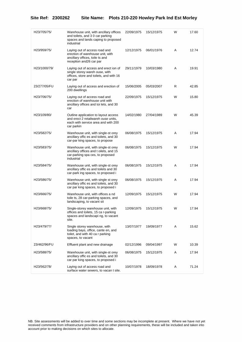
Site Name: Plots 210-220 Howley Park Ind Est Morley Site Ref: 2300262
H23/705/75/ Warehouse unit, with ancillary offices and toilets, and 3 0 car parking spaces and lands caping to proposed industrial
22/09/1975 15/12/1975 W 17.60
H23/959/75/ Laying out of access road and erection of warehouse unit, with ancillary offices, toile ts and reception and26 car par
12/12/1975 06/01/1976 A 12.74
H23/1000/79/ Laying out of access and erect ion of single storey wareh ouse, with offices, store and toilets, and with 16 car par
29/11/1979 10/03/1980 A 19.91
23/277/05/FU Laying out of access and erection of 200 dwellings
15/06/2005 05/03/2007 R 42.85
H23/706/75/ Laying out of access road and erection of warehouse unit with ancillary offices and toi lets, and 30 car
22/09/1975 15/12/1975 W 15.80
H23/109/80/ Outline application to layout access and erect 2 retailwareh ouse units, each with service area and with 200 car parkin
14/02/1980 27/04/1989 W 45.39
H23/582/75/ Warehouse unit, with single-st orey ancillary offic es and toilets, and 30 car-par king spaces, to propose
06/08/1975 15/12/1975 A 17.94
H23/583/75/ Warehouse unit, with single-st orey ancillary offices and t oilets, and 15 car-parking spa ces, to proposed industrial
06/08/1975 15/12/1975 W 17.94
H23/584/75/ Warehouse unit, with single-st orey ancillary offic es and toilets and 30 car-park ing spaces, to proposed i
06/08/1975 15/12/1975 A 17.94
H23/586/75/ Warehouse unit, with single st orey ancillary offic es and toilets, and 30 car par king spaces, to proposed i
06/08/1975 15/12/1975 A 17.94
H23/666/75/ Warehouse unit, with offices a nd toile ts, 28 car-parking spaces, and landscaping, to vacant sit
12/09/1975 15/12/1975 W 17.94
H23/668/75/ Single-storey warehouse unit, with offices and toilets, 15 ca r-parking spaces and landscapi ng, to vacant site.
12/09/1975 15/12/1975 W 17.94
H23/479/77/ Single storey warehouse, with loading bays, office, cante en, and toilet, and with 40 ca r parking spaces, to vacant
13/07/1977 19/09/1977 A 15.62
23/462/96/FU Effluent plant and new drainage 02/12/1996 09/04/1997 W 10.39
H23/588/75/ Warehouse unit, with single-st orey ancillary offic es and toilets, and 30 car par king spaces, to proposed i
06/08/1975 15/12/1975 A 17.94
H23/562/78/ Laying out of access road and surface water sewers, to vacan t site.
10/07/1978 18/09/1978 A 71.24
NB. Site assessments will be added to over time and some sections may be incomplete at present. Where we have not yet received comments from infrastructure providers and on other planning requirements, these will be included and taken into account prior to making decisions on which sites to allocate.

Site Name: Plots 210-220 Howley Park Ind Est Morley Site Ref: 2300262
Conformity with Core Strategy
Inner South Leeds: 0.00
Leeds Bradford Corridor: 0.00 West Leeds Gateway: 0.00
Aire Valley: 0.00Regeneration Priority Area:
Brownfield
Greenfield
Mixed
Main Urban Area
Major Settlement
Smaller Settlement
Villages/Rural
Main Urban Area Extension
Major Settlement Extension
Smaller Settlement Extension
Village/Rural Extension
Development unrelated to existing development
Green Belt assessment - only completed where site is within Green Belt
Would development lead to/constitute ribbon development?
Would development result in isolated development?
Is the site well connected to built up area (2+ boundaries with existing built up area)?
Would development of the site effectively "round off" the settlement pattern?:
Do natural/physical features provide a good existing barrier between existing urban area and undeveloped land?
Overall sprawl conclusion:
Would development of the site lead to physical connection of settlements?
Do natural/physical features provide a good existing barrier/boundary to contain development?
Overall Coalescence Conclusion:
Is there a strong defensible boundary between the site and the existing urban area?
Does the site provide access to the countryside?
Does the site include local or national conservation designated areas?
Does the site include areas of woodlands, trees, hedgerows that are protected, or significant unprotected tree/hedge cover?
Does the site include grade 1, 2, or 3a agricultural land?
Does the site contain buildings? Are these in agricultural use?
Overall countryside Encroachment Conclusion
Is the site within or adjacent to a conservation area, listed building or other historical feature?
If yes, could development preserve this character?:
Overall Character Preservation Conclusion:
Greenbelt Assessment Conclusion:
Check the unrestricted sprawl of large built up areas
Prevent neighbouring towns from merging
Assist in safeguarding countryside from encroachment
Preserve the setting and special character of historic towns
NB. Site assessments will be added to over time and some sections may be incomplete at present. Where we have not yet received comments from infrastructure providers and on other planning requirements, these will be included and taken into account prior to making decisions on which sites to allocate.

Site Name: Plots 210-220 Howley Park Ind Est Morley Site Ref: 2300262
SHLAA ConclusionsAvailability: Suitability: Achievability:
Conclusion of Assessment
Conclusion summary:
Site at core of well-established industrial area. Neighbouring uses mainly B2/B8
Floorspace sq m (Non residential):
Employment Conclusion: Lime Green
East Leeds
Assesment Type: ELR Type: Industrial & Warehousing
Proposed Change:
Gypsy Traveller Site Assessment
Yes No Maybe Could site be effectively managed (Text)
Yes No Maybe Would gypsies and travellers live on the site?
(Text)
Yes No Proximity to housed gypsies and travellers (Text)
Yes No Unknown Experience of previous encampments (Text)
NB. Site assessments will be added to over time and some sections may be incomplete at present. Where we have not yet received comments from infrastructure providers and on other planning requirements, these will be included and taken into account prior to making decisions on which sites to allocate.

Site Name: Plot 460 Howley Park Ind Est Morley Site Ref: 2300267
Site Details
Land Use
Northing: 426077
Easting: 426596
Distance to Rail Station (metres): 2062.74
Nearest Railway Station Morley
Distance to bus stop (metres) 535.10
Bus Stop ID 12969
Agricultural Land Class:
SFRA Flood Zone: 0.00
Environment Agency Flood Zone: 0.00
Within 300m of retail centre boundary:
UDP Designation
Greenbelt - N32 (%): 0.00 Urban Green Corridor - N8 (%): 0.00
Protected Area of Search site - N34 (%): 0.00 Rural Land - RL1: 0.00
City Centre Primary Shopping Quarter - CC27 (%): 0.00 Town Centre - S2: 0.00
Health and Safety Executive Hazard: No
Health and Safety Executive Gas Pipeline: No
Strategic Employment Buffer: 0.00
Area sq m: 11503.76 Ward Morley South
Special Landscape Area - N37: 0.00
Allotments - N1A: 0.00
Proposed Greenspace - N5: 0.00
Protected Playing Pitch - N6: 0.00
Nature Conservation Area - N50: 0.00
Conservation Areas No
Ancient Monument/Battlefield(%): 0.00 Listed Buildings: No
Public Rights of Way: No
Other?:
Natural Resources and waste DPD (if applicable)
Within Minerals Safeguarding Site?: Yes Within 100m of Minerals Safeguarding Site?: Yes
HMCA: Outer South West
Greenspace - N1: 0
Existing Use 1:
Existing Use 2:
Existing Use 3:
Neighbouring Use 1
Neighbouring Use 2:
Neighbouring Use 3:
Other uses:
Topography:
Natural Landscape:
Boundaries:
Road Frontage
Site Characteristics
Site Detail
Other comments/observations on site characteristics:
Area Ha: 1.150376
Site State:
Site Site TypeBritannia Quarry Morley Landfill Sites
Britannia Quarry Morley Quarries
NB. Site assessments will be added to over time and some sections may be incomplete at present. Where we have not yet received comments from infrastructure providers and on other planning requirements, these will be included and taken into account prior to making decisions on which sites to allocate.
Site Name: Plot 460 Howley Park Ind Est Morley Site Ref: 2300267
Howley Park Ind Estate Unimplemented Morley General Waste Management Sites
NB. Site assessments will be added to over time and some sections may be incomplete at present. Where we have not yet received comments from infrastructure providers and on other planning requirements, these will be included and taken into account prior to making decisions on which sites to allocate.

Site Name: Plot 460 Howley Park Ind Est Morley Site Ref: 2300267
Planning History
Planning App No. Proposal Received Decision Status Site %
13/00904/FU Soil treatment facility together with new [replacement] access to existing quarry, incorporating shared access arrangements and internal haul road, site office, car park, wheelwash and weighbridges
22/02/2013 PCO 66.40
H23/697/75/ Laying out of access road and erection of warehouse unit, with ancillary offices and to ilets, and 34 car parking sp
22/09/1975 15/12/1975 A 99.95
H23/702/75/ Laying out of access road and erection of warehouse unit, with ancillary offices and to ilets, and 31 car
22/09/1975 15/12/1975 A 99.95
H23/703/75/ Warehouse unit, with ancillary offices and toilets, and 3 1 car parking spaces and lands caping, to proposed i
22/09/1975 15/12/1975 A 99.95
H23/100/85/ Detached single storey worksho p with toilet and detac hed single storey prefabricate d office unit with tea room a
22/03/1985 10/06/1985 A 40.91
09/04074/COND Consent, agreement or approval required by conditions 2, 3 and 8 of planning permission 23/333/00/MIN and condition 3 of planning permission 23/325/01/MIN
17/09/2009 01/10/2009 A 99.91
23/325/01/MIN Amendment to condition no 1 of planning permission no 23/333/00/min (approved plans)
09/08/2001 03/10/2001 A 99.91
23/333/00/MIN Detached waste transfer station with offices and weighbridge
07/09/2000 28/03/2001 A 99.91
06/02788/FU Variation of condition No. 1 of permission 23/325/01/MIN (extend time period of commencement by 3 years)
05/05/2006 04/08/2006 A 99.91
H23/714/75/ Warehouse unit, with ancillary offices and toile ts, and 14 car parking spaces and landscaping, to propose
22/09/1975 15/12/1975 A 99.95
NB. Site assessments will be added to over time and some sections may be incomplete at present. Where we have not yet received comments from infrastructure providers and on other planning requirements, these will be included and taken into account prior to making decisions on which sites to allocate.

Site Name: Plot 460 Howley Park Ind Est Morley Site Ref: 2300267
Conformity with Core Strategy
Inner South Leeds: 0.00
Leeds Bradford Corridor: 0.00 West Leeds Gateway: 0.00
Aire Valley: 0.00Regeneration Priority Area:
Brownfield
Greenfield
Mixed
Main Urban Area
Major Settlement
Smaller Settlement
Villages/Rural
Main Urban Area Extension
Major Settlement Extension
Smaller Settlement Extension
Village/Rural Extension
Development unrelated to existing development
Green Belt assessment - only completed where site is within Green Belt
Would development lead to/constitute ribbon development?
Would development result in isolated development?
Is the site well connected to built up area (2+ boundaries with existing built up area)?
Would development of the site effectively "round off" the settlement pattern?:
Do natural/physical features provide a good existing barrier between existing urban area and undeveloped land?
Overall sprawl conclusion:
Would development of the site lead to physical connection of settlements?
Do natural/physical features provide a good existing barrier/boundary to contain development?
Overall Coalescence Conclusion:
Is there a strong defensible boundary between the site and the existing urban area?
Does the site provide access to the countryside?
Does the site include local or national conservation designated areas?
Does the site include areas of woodlands, trees, hedgerows that are protected, or significant unprotected tree/hedge cover?
Does the site include grade 1, 2, or 3a agricultural land?
Does the site contain buildings? Are these in agricultural use?
Overall countryside Encroachment Conclusion
Is the site within or adjacent to a conservation area, listed building or other historical feature?
If yes, could development preserve this character?:
Overall Character Preservation Conclusion:
Greenbelt Assessment Conclusion:
Check the unrestricted sprawl of large built up areas
Prevent neighbouring towns from merging
Assist in safeguarding countryside from encroachment
Preserve the setting and special character of historic towns
NB. Site assessments will be added to over time and some sections may be incomplete at present. Where we have not yet received comments from infrastructure providers and on other planning requirements, these will be included and taken into account prior to making decisions on which sites to allocate.

Site Name: Plot 460 Howley Park Ind Est Morley Site Ref: 2300267
SHLAA ConclusionsAvailability: Suitability: Achievability:
Conclusion of Assessment
Conclusion summary:
Site may still be best suited to a Waste Transfer Station
Floorspace sq m (Non residential):
Employment Conclusion: Lime Green
East Leeds
Assesment Type: ELR Type: Industrial & Warehousing
Proposed Change:
Gypsy Traveller Site Assessment
Yes No Maybe Could site be effectively managed (Text)
Yes No Maybe Would gypsies and travellers live on the site?
(Text)
Yes No Proximity to housed gypsies and travellers (Text)
Yes No Unknown Experience of previous encampments (Text)
NB. Site assessments will be added to over time and some sections may be incomplete at present. Where we have not yet received comments from infrastructure providers and on other planning requirements, these will be included and taken into account prior to making decisions on which sites to allocate.
Site Name: Plots 410 & 420 Howley Park Road East Morley LS27
Site Ref: 2300268
Site Details
Land Use
Northing: 426450
Easting: 426429
Distance to Rail Station (metres): 1741.25
Nearest Railway Station Morley
Distance to bus stop (metres) 297.04
Bus Stop ID 1666
Agricultural Land Class:
SFRA Flood Zone: 0.00
Environment Agency Flood Zone: 0.00
Within 300m of retail centre boundary:
UDP Designation
Greenbelt - N32 (%): 0.00 Urban Green Corridor - N8 (%): 0.00
Protected Area of Search site - N34 (%): 0.00 Rural Land - RL1: 0.00
City Centre Primary Shopping Quarter - CC27 (%): 0.00 Town Centre - S2: 0.00
Health and Safety Executive Hazard: No
Health and Safety Executive Gas Pipeline: No
Strategic Employment Buffer: 0.00
Area sq m: 18133.32 Ward Morley South
Special Landscape Area - N37: 0.00
Allotments - N1A: 0.00
Proposed Greenspace - N5: 0.00
Protected Playing Pitch - N6: 0.00
Nature Conservation Area - N50: 0.00
Conservation Areas No
Ancient Monument/Battlefield(%): 0.00 Listed Buildings: No
Public Rights of Way: No
Other?:
Natural Resources and waste DPD (if applicable)
Within Minerals Safeguarding Site?: Yes Within 100m of Minerals Safeguarding Site?: Yes
HMCA: Outer South West
Greenspace - N1: 0
Existing Use 1:
Existing Use 2:
Existing Use 3:
Neighbouring Use 1
Neighbouring Use 2:
Neighbouring Use 3:
Other uses:
Topography:
Natural Landscape:
Boundaries:
Road Frontage
Site Characteristics
Site Detail
Other comments/observations on site characteristics:
Area Ha: 1.813332
Site State:
Site Site TypeBritannia Quarry Morley Landfill Sites
Britannia Quarry Morley Quarries
NB. Site assessments will be added to over time and some sections may be incomplete at present. Where we have not yet received comments from infrastructure providers and on other planning requirements, these will be included and taken into account prior to making decisions on which sites to allocate.

Site Name: Plots 410 & 420 Howley Park Road East Morley LS27
Site Ref: 2300268
Planning History
Planning App No. Proposal Received Decision Status Site %
H23/26/74/ Number cancelled 13/01/1975 03/02/1975 W 11.29
23/247/01/FU Detached industrial and warehouse unit with offices and fork lift truck repairs
27/06/2001 18/09/2001 A 15.64
H23/697/75/ Laying out of access road and erection of warehouse unit, with ancillary offices and to ilets, and 34 car parking sp
22/09/1975 15/12/1975 A 55.67
H23/702/75/ Laying out of access road and erection of warehouse unit, with ancillary offices and to ilets, and 31 car
22/09/1975 15/12/1975 A 55.67
H23/369/78/ Laying out of access and erect ion of 16 single storey wareh ouse units, in 1 block, each u nit with ancillary office and
08/05/1978 03/06/1980 W 39.84
H23/703/75/ Warehouse unit, with ancillary offices and toilets, and 3 1 car parking spaces and lands caping, to proposed i
22/09/1975 15/12/1975 A 55.67
H23/40/78/ Laying out of access and erect ion of 14 single storey indus trial units, in 2 blocks, each unit with office and toilet
17/01/1978 13/03/1978 A 39.35
23/362/00/FU Detached warehouse unit 06/10/2000 02/04/2001 A 17.93
H23/859/77/ Laying out of access road and erection of 14 warehouse units , in 2 blocks, each unit with office and toilets, and with 6
14/12/1977 20/02/1978 A 40.55
H23/643/78/ Detached block of 2 single sto rey warehouse units, eachunit with reception area, toilets a nd tea room with offices ov
08/08/1978 03/06/1980 W 40.31
H23/701/75/ Laying out of access road and erection of warehouse unit, with ancillary offices and to ilets, and 39 car parking sp
22/09/1975 15/12/1975 A 14.70
H23/714/75/ Warehouse unit, with ancillary offices and toile ts, and 14 car parking spaces and landscaping, to propose
22/09/1975 15/12/1975 A 55.67
H23/578/78/ 1 block of 2 single storey war ehouse units, each with 2 storey ancillary offices, to ilets and reception and each w
18/07/1978 18/06/1979 A 38.48
H23/700/75/ Laying out of access road and erection of warehouse unit, with ancillary offices and to ilets, and 24 car
22/09/1975 15/12/1975 A 22.92
NB. Site assessments will be added to over time and some sections may be incomplete at present. Where we have not yet received comments from infrastructure providers and on other planning requirements, these will be included and taken into account prior to making decisions on which sites to allocate.

Site Name: Plots 410 & 420 Howley Park Road East Morley LS27
Site Ref: 2300268
Conformity with Core Strategy
Inner South Leeds: 0.00
Leeds Bradford Corridor: 0.00 West Leeds Gateway: 0.00
Aire Valley: 0.00Regeneration Priority Area:
Brownfield
Greenfield
Mixed
Main Urban Area
Major Settlement
Smaller Settlement
Villages/Rural
Main Urban Area Extension
Major Settlement Extension
Smaller Settlement Extension
Village/Rural Extension
Development unrelated to existing development
Green Belt assessment - only completed where site is within Green Belt
Would development lead to/constitute ribbon development?
Would development result in isolated development?
Is the site well connected to built up area (2+ boundaries with existing built up area)?
Would development of the site effectively "round off" the settlement pattern?:
Do natural/physical features provide a good existing barrier between existing urban area and undeveloped land?
Overall sprawl conclusion:
Would development of the site lead to physical connection of settlements?
Do natural/physical features provide a good existing barrier/boundary to contain development?
Overall Coalescence Conclusion:
Is there a strong defensible boundary between the site and the existing urban area?
Does the site provide access to the countryside?
Does the site include local or national conservation designated areas?
Does the site include areas of woodlands, trees, hedgerows that are protected, or significant unprotected tree/hedge cover?
Does the site include grade 1, 2, or 3a agricultural land?
Does the site contain buildings? Are these in agricultural use?
Overall countryside Encroachment Conclusion
Is the site within or adjacent to a conservation area, listed building or other historical feature?
If yes, could development preserve this character?:
Overall Character Preservation Conclusion:
Greenbelt Assessment Conclusion:
Check the unrestricted sprawl of large built up areas
Prevent neighbouring towns from merging
Assist in safeguarding countryside from encroachment
Preserve the setting and special character of historic towns
NB. Site assessments will be added to over time and some sections may be incomplete at present. Where we have not yet received comments from infrastructure providers and on other planning requirements, these will be included and taken into account prior to making decisions on which sites to allocate.

Site Name: Plots 410 & 420 Howley Park Road East Morley LS27
Site Ref: 2300268
SHLAA ConclusionsAvailability: Suitability: Achievability:
Conclusion of Assessment
Conclusion summary:
Site at edge of well-established industrial area. Housing nearby so buffering needed
Floorspace sq m (Non residential):
Employment Conclusion: Lime Green
East Leeds
Assesment Type: ELR Type: Industrial & Warehousing
Proposed Change:
Gypsy Traveller Site Assessment
Yes No Maybe Could site be effectively managed (Text)
Yes No Maybe Would gypsies and travellers live on the site?
(Text)
Yes No Proximity to housed gypsies and travellers (Text)
Yes No Unknown Experience of previous encampments (Text)
NB. Site assessments will be added to over time and some sections may be incomplete at present. Where we have not yet received comments from infrastructure providers and on other planning requirements, these will be included and taken into account prior to making decisions on which sites to allocate.

Site Name: Adj Ravenheat Ltd Chartists Way Morley Site Ref: 2300894
Site Details
Land Use
Northing: 427258
Easting: 426363
Distance to Rail Station (metres): 1040.40
Nearest Railway Station Morley
Distance to bus stop (metres) 20.58
Bus Stop ID 1986
Agricultural Land Class:
SFRA Flood Zone: 0.00
Environment Agency Flood Zone: 0.00
Within 300m of retail centre boundary:
UDP Designation
Greenbelt - N32 (%): 0.00 Urban Green Corridor - N8 (%): 0.00
Protected Area of Search site - N34 (%): 0.00 Rural Land - RL1: 0.00
City Centre Primary Shopping Quarter - CC27 (%): 0.00 Town Centre - S2: 0.00
Health and Safety Executive Hazard: No
Health and Safety Executive Gas Pipeline: No
Strategic Employment Buffer: 0.00
Area sq m: 916.29 Ward Morley South
Special Landscape Area - N37: 0.00
Allotments - N1A: 0.00
Proposed Greenspace - N5: 0.00
Protected Playing Pitch - N6: 0.00
Nature Conservation Area - N50: 0.00
Conservation Areas No
Ancient Monument/Battlefield(%): 0.00 Listed Buildings: No
Public Rights of Way: No
Other?:
Natural Resources and waste DPD (if applicable)
Within Minerals Safeguarding Site?: No Within 100m of Minerals Safeguarding Site?: No
HMCA: Outer South West
Greenspace - N1: 0
Existing Use 1:
Existing Use 2:
Existing Use 3:
Neighbouring Use 1
Neighbouring Use 2:
Neighbouring Use 3:
Other uses:
Topography:
Natural Landscape:
Boundaries:
Road Frontage
Site Characteristics
Site Detail
Other comments/observations on site characteristics:
Area Ha: 0.091629
Site State:
NB. Site assessments will be added to over time and some sections may be incomplete at present. Where we have not yet received comments from infrastructure providers and on other planning requirements, these will be included and taken into account prior to making decisions on which sites to allocate.
Site Name: Adj Ravenheat Ltd Chartists Way Morley Site Ref: 2300894
Planning History
Planning App No. Proposal Received Decision Status Site %
23/44/00/OT Outline application to erect detached assembly workshop
08/02/2000 05/07/2001 A 99.95
H23/176/83/ Land reclamation of former goo ds railway yard. (this item is also notice under reg ulation 4(1) of the town and c
13/06/1983 12/09/1983 A 100.00
H23/46/90/ Laying out of access and erect ion of works, comprising assem bly room, warehouse area, 2 st orey offices, reception,
31/01/1990 08/05/1990 A 95.98
H23/77/90/ Outline application to lay out access and erect detac hed assembly workshop with car parking and landscapin
21/02/1990 08/05/1990 A 99.06
06/04325/OT Outline application to erect detached assembly workshop
13/07/2006 07/09/2006 A 85.17
NB. Site assessments will be added to over time and some sections may be incomplete at present. Where we have not yet received comments from infrastructure providers and on other planning requirements, these will be included and taken into account prior to making decisions on which sites to allocate.

Site Name: Adj Ravenheat Ltd Chartists Way Morley Site Ref: 2300894
Conformity with Core Strategy
Inner South Leeds: 0.00
Leeds Bradford Corridor: 0.00 West Leeds Gateway: 0.00
Aire Valley: 0.00Regeneration Priority Area:
Brownfield
Greenfield
Mixed
Main Urban Area
Major Settlement
Smaller Settlement
Villages/Rural
Main Urban Area Extension
Major Settlement Extension
Smaller Settlement Extension
Village/Rural Extension
Development unrelated to existing development
Green Belt assessment - only completed where site is within Green Belt
Would development lead to/constitute ribbon development?
Would development result in isolated development?
Is the site well connected to built up area (2+ boundaries with existing built up area)?
Would development of the site effectively "round off" the settlement pattern?:
Do natural/physical features provide a good existing barrier between existing urban area and undeveloped land?
Overall sprawl conclusion:
Would development of the site lead to physical connection of settlements?
Do natural/physical features provide a good existing barrier/boundary to contain development?
Overall Coalescence Conclusion:
Is there a strong defensible boundary between the site and the existing urban area?
Does the site provide access to the countryside?
Does the site include local or national conservation designated areas?
Does the site include areas of woodlands, trees, hedgerows that are protected, or significant unprotected tree/hedge cover?
Does the site include grade 1, 2, or 3a agricultural land?
Does the site contain buildings? Are these in agricultural use?
Overall countryside Encroachment Conclusion
Is the site within or adjacent to a conservation area, listed building or other historical feature?
If yes, could development preserve this character?:
Overall Character Preservation Conclusion:
Greenbelt Assessment Conclusion:
Check the unrestricted sprawl of large built up areas
Prevent neighbouring towns from merging
Assist in safeguarding countryside from encroachment
Preserve the setting and special character of historic towns
NB. Site assessments will be added to over time and some sections may be incomplete at present. Where we have not yet received comments from infrastructure providers and on other planning requirements, these will be included and taken into account prior to making decisions on which sites to allocate.
Site Name: Adj Ravenheat Ltd Chartists Way Morley Site Ref: 2300894
SHLAA ConclusionsAvailability: Suitability: Achievability:
Conclusion of Assessment
Conclusion summary:
Current site with planning permission for employment purposes
Floorspace sq m (Non residential):
Employment Conclusion: Lime Green
East Leeds
Assesment Type: ELR Type: Industrial & Warehousing
Proposed Change:
Gypsy Traveller Site Assessment
Yes No Maybe Could site be effectively managed (Text)
Yes No Maybe Would gypsies and travellers live on the site?
(Text)
Yes No Proximity to housed gypsies and travellers (Text)
Yes No Unknown Experience of previous encampments (Text)
NB. Site assessments will be added to over time and some sections may be incomplete at present. Where we have not yet received comments from infrastructure providers and on other planning requirements, these will be included and taken into account prior to making decisions on which sites to allocate.

Site Name: Howley Park Ind Est Morley Site Ref: 2301350
Site Details
Land Use
Northing: 426131
Easting: 426257
Distance to Rail Station (metres): 2098.81
Nearest Railway Station Morley
Distance to bus stop (metres) 619.99
Bus Stop ID 1608
Agricultural Land Class:
SFRA Flood Zone: 0.00
Environment Agency Flood Zone: 0.00
Within 300m of retail centre boundary:
UDP Designation
Greenbelt - N32 (%): 0.00 Urban Green Corridor - N8 (%): 0.00
Protected Area of Search site - N34 (%): 0.00 Rural Land - RL1: 0.00
City Centre Primary Shopping Quarter - CC27 (%): 0.00 Town Centre - S2: 0.00
Health and Safety Executive Hazard: No
Health and Safety Executive Gas Pipeline: No
Strategic Employment Buffer: 0.00
Area sq m: 18503.79 Ward Morley South
Special Landscape Area - N37: 0.00
Allotments - N1A: 0.00
Proposed Greenspace - N5: 0.00
Protected Playing Pitch - N6: 0.00
Nature Conservation Area - N50: 0.00
Conservation Areas No
Ancient Monument/Battlefield(%): 0.00 Listed Buildings: No
Public Rights of Way: No
Other?:
Natural Resources and waste DPD (if applicable)
Within Minerals Safeguarding Site?: No Within 100m of Minerals Safeguarding Site?: Yes
HMCA: Outer South West
Greenspace - N1: 0
Existing Use 1:
Existing Use 2:
Existing Use 3:
Neighbouring Use 1
Neighbouring Use 2:
Neighbouring Use 3:
Other uses:
Topography:
Natural Landscape:
Boundaries:
Road Frontage
Site Characteristics
Site Detail
Other comments/observations on site characteristics:
Area Ha: 1.850379
Site State:
NB. Site assessments will be added to over time and some sections may be incomplete at present. Where we have not yet received comments from infrastructure providers and on other planning requirements, these will be included and taken into account prior to making decisions on which sites to allocate.
Site Name: Howley Park Ind Est Morley Site Ref: 2301350
Planning History
Planning App No. Proposal Received Decision Status Site %
08/03909/FU Laying out of access road and levelling of site
27/06/2008 20/10/2008 W 53.11
09/00833/FU Laying out of access road and levelling of site
26/02/2009 28/05/2009 A 53.22
12/03302/FU Change of use of vacant land to trailer parking area
30/07/2012 18/09/2012 A 15.06
NB. Site assessments will be added to over time and some sections may be incomplete at present. Where we have not yet received comments from infrastructure providers and on other planning requirements, these will be included and taken into account prior to making decisions on which sites to allocate.

Site Name: Howley Park Ind Est Morley Site Ref: 2301350
Conformity with Core Strategy
Inner South Leeds: 0.00
Leeds Bradford Corridor: 0.00 West Leeds Gateway: 0.00
Aire Valley: 0.00Regeneration Priority Area:
Brownfield
Greenfield
Mixed
Main Urban Area
Major Settlement
Smaller Settlement
Villages/Rural
Main Urban Area Extension
Major Settlement Extension
Smaller Settlement Extension
Village/Rural Extension
Development unrelated to existing development
Green Belt assessment - only completed where site is within Green Belt
Would development lead to/constitute ribbon development?
Would development result in isolated development?
Is the site well connected to built up area (2+ boundaries with existing built up area)?
Would development of the site effectively "round off" the settlement pattern?:
Do natural/physical features provide a good existing barrier between existing urban area and undeveloped land?
Overall sprawl conclusion:
Would development of the site lead to physical connection of settlements?
Do natural/physical features provide a good existing barrier/boundary to contain development?
Overall Coalescence Conclusion:
Is there a strong defensible boundary between the site and the existing urban area?
Does the site provide access to the countryside?
Does the site include local or national conservation designated areas?
Does the site include areas of woodlands, trees, hedgerows that are protected, or significant unprotected tree/hedge cover?
Does the site include grade 1, 2, or 3a agricultural land?
Does the site contain buildings? Are these in agricultural use?
Overall countryside Encroachment Conclusion
Is the site within or adjacent to a conservation area, listed building or other historical feature?
If yes, could development preserve this character?:
Overall Character Preservation Conclusion:
Greenbelt Assessment Conclusion:
Check the unrestricted sprawl of large built up areas
Prevent neighbouring towns from merging
Assist in safeguarding countryside from encroachment
Preserve the setting and special character of historic towns
NB. Site assessments will be added to over time and some sections may be incomplete at present. Where we have not yet received comments from infrastructure providers and on other planning requirements, these will be included and taken into account prior to making decisions on which sites to allocate.

Site Name: Howley Park Ind Est Morley Site Ref: 2301350
SHLAA ConclusionsAvailability: Suitability: Achievability:
Conclusion of Assessment
Conclusion summary:
Issue of access over third party land resolved by consent 09/00833/FU
Floorspace sq m (Non residential):
Employment Conclusion: Lime Green
East Leeds
Assesment Type: ELR Type: Industrial & Warehousing
Proposed Change:
Gypsy Traveller Site Assessment
Yes No Maybe Could site be effectively managed (Text)
Yes No Maybe Would gypsies and travellers live on the site?
(Text)
Yes No Proximity to housed gypsies and travellers (Text)
Yes No Unknown Experience of previous encampments (Text)
NB. Site assessments will be added to over time and some sections may be incomplete at present. Where we have not yet received comments from infrastructure providers and on other planning requirements, these will be included and taken into account prior to making decisions on which sites to allocate.

Site Name: BRUNTCLIFFE LANE MORLEY Site Ref: 2301552
Site Details
Land Use
Northing: 428004
Easting: 425449
Distance to Rail Station (metres): 1519.54
Nearest Railway Station Morley
Distance to bus stop (metres) 159.56
Bus Stop ID 1390
Agricultural Land Class:
SFRA Flood Zone: 0.00
Environment Agency Flood Zone: 0.00
Within 300m of retail centre boundary:
UDP Designation
Greenbelt - N32 (%): 0.00 Urban Green Corridor - N8 (%): 0.00
Protected Area of Search site - N34 (%): 0.00 Rural Land - RL1: 0.00
City Centre Primary Shopping Quarter - CC27 (%): 0.00 Town Centre - S2: 0.00
Health and Safety Executive Hazard: No
Health and Safety Executive Gas Pipeline: No
Strategic Employment Buffer: 96.47
Area sq m: 12410.04 Ward Morley North
Special Landscape Area - N37: 0.00
Allotments - N1A: 0.00
Proposed Greenspace - N5: 0.00
Protected Playing Pitch - N6: 0.00
Nature Conservation Area - N50: 0.00
Conservation Areas No
Ancient Monument/Battlefield(%): 0.00 Listed Buildings: No
Public Rights of Way: No
Other?:
Natural Resources and waste DPD (if applicable)
Within Minerals Safeguarding Site?: No Within 100m of Minerals Safeguarding Site?: No
HMCA: Outer South West
Greenspace - N1: 0
Existing Use 1:
Existing Use 2:
Existing Use 3:
Neighbouring Use 1
Neighbouring Use 2:
Neighbouring Use 3:
Other uses:
Topography:
Natural Landscape:
Boundaries:
Road Frontage
Site Characteristics
Site Detail
Other comments/observations on site characteristics:
Area Ha: 1.241004
Site State:
NB. Site assessments will be added to over time and some sections may be incomplete at present. Where we have not yet received comments from infrastructure providers and on other planning requirements, these will be included and taken into account prior to making decisions on which sites to allocate.

Site Name: BRUNTCLIFFE LANE MORLEY Site Ref: 2301552
Planning History
Planning App No. Proposal Received Decision Status Site %
H23/352/74/ Demolition of existing buildin gs and erection of boat and c aravan showroom, comprising sa les area, offices, toilets an
12/08/1974 21/10/1974 R 94.61
H23/312/77/ One externally illuminated ind ividual letter wall sign, size 11.7m (38ft) x 1m (3ft.4 ins) height above ground 3m
10/05/1977 27/06/1977 W 19.63
H23/830/75/ Laying out of access road and erection of single storeywareh ouse unit, with offices, mess r oom, kitchen and toilets wi
27/10/1975 15/12/1975 A 19.63
23/19/04/OT Outline application to erect residential development to motor auction site
11/11/2003 07/04/2004 R 87.79
H23/127/84/ Use of land for storage and sa le of cars.
16/04/1984 23/05/1984 A 93.97
NB. Site assessments will be added to over time and some sections may be incomplete at present. Where we have not yet received comments from infrastructure providers and on other planning requirements, these will be included and taken into account prior to making decisions on which sites to allocate.

Site Name: BRUNTCLIFFE LANE MORLEY Site Ref: 2301552
Conformity with Core Strategy
Inner South Leeds: 0.00
Leeds Bradford Corridor: 0.00 West Leeds Gateway: 0.00
Aire Valley: 0.00Regeneration Priority Area:
Brownfield
Greenfield
Mixed
Main Urban Area
Major Settlement
Smaller Settlement
Villages/Rural
Main Urban Area Extension
Major Settlement Extension
Smaller Settlement Extension
Village/Rural Extension
Development unrelated to existing development
Green Belt assessment - only completed where site is within Green Belt
Would development lead to/constitute ribbon development?
Would development result in isolated development?
Is the site well connected to built up area (2+ boundaries with existing built up area)?
Would development of the site effectively "round off" the settlement pattern?:
Do natural/physical features provide a good existing barrier between existing urban area and undeveloped land?
Overall sprawl conclusion:
Would development of the site lead to physical connection of settlements?
Do natural/physical features provide a good existing barrier/boundary to contain development?
Overall Coalescence Conclusion:
Is there a strong defensible boundary between the site and the existing urban area?
Does the site provide access to the countryside?
Does the site include local or national conservation designated areas?
Does the site include areas of woodlands, trees, hedgerows that are protected, or significant unprotected tree/hedge cover?
Does the site include grade 1, 2, or 3a agricultural land?
Does the site contain buildings? Are these in agricultural use?
Overall countryside Encroachment Conclusion
Is the site within or adjacent to a conservation area, listed building or other historical feature?
If yes, could development preserve this character?:
Overall Character Preservation Conclusion:
Greenbelt Assessment Conclusion:
Check the unrestricted sprawl of large built up areas
Prevent neighbouring towns from merging
Assist in safeguarding countryside from encroachment
Preserve the setting and special character of historic towns
NB. Site assessments will be added to over time and some sections may be incomplete at present. Where we have not yet received comments from infrastructure providers and on other planning requirements, these will be included and taken into account prior to making decisions on which sites to allocate.

Site Name: BRUNTCLIFFE LANE MORLEY Site Ref: 2301552
SHLAA ConclusionsAvailability: Suitability: Achievability:
Conclusion of Assessment
Conclusion summary:
Site is in operational use as a Motor Auction business. Attempts to gain consent for housing.
Floorspace sq m (Non residential):
Employment Conclusion: Red
East Leeds
Assesment Type: ELR Type: Industrial & Warehousing
Proposed Change:
Gypsy Traveller Site Assessment
Yes No Maybe Could site be effectively managed (Text)
Yes No Maybe Would gypsies and travellers live on the site?
(Text)
Yes No Proximity to housed gypsies and travellers (Text)
Yes No Unknown Experience of previous encampments (Text)
NB. Site assessments will be added to over time and some sections may be incomplete at present. Where we have not yet received comments from infrastructure providers and on other planning requirements, these will be included and taken into account prior to making decisions on which sites to allocate.

Site Name: Wakefield Road Gildersome Site Ref: 2301611
Site Details
Land Use
Northing: 428038
Easting: 424368
Distance to Rail Station (metres): 2597.09
Nearest Railway Station Morley
Distance to bus stop (metres) 71.80
Bus Stop ID 7561
Agricultural Land Class:
SFRA Flood Zone: 0.00
Environment Agency Flood Zone: 0.00
Within 300m of retail centre boundary:
UDP Designation
Greenbelt - N32 (%): 0.03 Urban Green Corridor - N8 (%): 0.00
Protected Area of Search site - N34 (%): 0.00 Rural Land - RL1: 0.00
City Centre Primary Shopping Quarter - CC27 (%): 0.00 Town Centre - S2: 0.00
Health and Safety Executive Hazard: No
Health and Safety Executive Gas Pipeline: No
Strategic Employment Buffer: 74.44
Area sq m: 35718.31 Ward Morley North
Special Landscape Area - N37: 0.00
Allotments - N1A: 0.00
Proposed Greenspace - N5: 0.00
Protected Playing Pitch - N6: 0.00
Nature Conservation Area - N50: 0.00
Conservation Areas No
Ancient Monument/Battlefield(%): 0.00 Listed Buildings: No
Public Rights of Way: No
Other?:
Natural Resources and waste DPD (if applicable)
Within Minerals Safeguarding Site?: No Within 100m of Minerals Safeguarding Site?: No
HMCA: Outer South West
Greenspace - N1: 0
Existing Use 1:
Existing Use 2:
Existing Use 3:
Neighbouring Use 1
Neighbouring Use 2:
Neighbouring Use 3:
Other uses:
Topography:
Natural Landscape:
Boundaries:
Road Frontage
Site Characteristics
Site Detail
Other comments/observations on site characteristics:
Area Ha: 3.571831
Site State:
NB. Site assessments will be added to over time and some sections may be incomplete at present. Where we have not yet received comments from infrastructure providers and on other planning requirements, these will be included and taken into account prior to making decisions on which sites to allocate.

Site Name: Wakefield Road Gildersome Site Ref: 2301611
Planning History
NB. Site assessments will be added to over time and some sections may be incomplete at present. Where we have not yet received comments from infrastructure providers and on other planning requirements, these will be included and taken into account prior to making decisions on which sites to allocate.

Site Name: Wakefield Road Gildersome Site Ref: 2301611
Conformity with Core Strategy
Inner South Leeds: 0.00
Leeds Bradford Corridor: 0.00 West Leeds Gateway: 0.00
Aire Valley: 0.00Regeneration Priority Area:
Brownfield
Greenfield
Mixed
Main Urban Area
Major Settlement
Smaller Settlement
Villages/Rural
Main Urban Area Extension
Major Settlement Extension
Smaller Settlement Extension
Village/Rural Extension
Development unrelated to existing development
Green Belt assessment - only completed where site is within Green Belt
Would development lead to/constitute ribbon development?
Would development result in isolated development?
Is the site well connected to built up area (2+ boundaries with existing built up area)?
Would development of the site effectively "round off" the settlement pattern?:
Do natural/physical features provide a good existing barrier between existing urban area and undeveloped land?
Overall sprawl conclusion:
Would development of the site lead to physical connection of settlements?
Do natural/physical features provide a good existing barrier/boundary to contain development?
Overall Coalescence Conclusion:
Is there a strong defensible boundary between the site and the existing urban area?
Does the site provide access to the countryside?
Does the site include local or national conservation designated areas?
Does the site include areas of woodlands, trees, hedgerows that are protected, or significant unprotected tree/hedge cover?
Does the site include grade 1, 2, or 3a agricultural land?
Does the site contain buildings? Are these in agricultural use?
Overall countryside Encroachment Conclusion
Is the site within or adjacent to a conservation area, listed building or other historical feature?
If yes, could development preserve this character?:
Overall Character Preservation Conclusion:
Greenbelt Assessment Conclusion:
Check the unrestricted sprawl of large built up areas
Prevent neighbouring towns from merging
Assist in safeguarding countryside from encroachment
Preserve the setting and special character of historic towns
NB. Site assessments will be added to over time and some sections may be incomplete at present. Where we have not yet received comments from infrastructure providers and on other planning requirements, these will be included and taken into account prior to making decisions on which sites to allocate.

Site Name: Wakefield Road Gildersome Site Ref: 2301611
SHLAA ConclusionsAvailability: Suitability: Achievability:
Conclusion of Assessment
Conclusion summary:
Site has outline consent for office development (23/360/03/RE) expired 10/9/2010.
Floorspace sq m (Non residential): 11340
Employment Conclusion: Lime Green
East Leeds
Assesment Type: ELR Type: Office
Proposed Change:
Gypsy Traveller Site Assessment
Yes No Maybe Could site be effectively managed (Text)
Yes No Maybe Would gypsies and travellers live on the site?
(Text)
Yes No Proximity to housed gypsies and travellers (Text)
Yes No Unknown Experience of previous encampments (Text)
NB. Site assessments will be added to over time and some sections may be incomplete at present. Where we have not yet received comments from infrastructure providers and on other planning requirements, these will be included and taken into account prior to making decisions on which sites to allocate.

Site Name: Off Britannia Rd Morley Site Ref: 2302250
Site Details
Land Use
Northing: 426688
Easting: 426138
Distance to Rail Station (metres): 1641.62
Nearest Railway Station Morley
Distance to bus stop (metres) 139.37
Bus Stop ID 1608
Agricultural Land Class:
SFRA Flood Zone: 0.00
Environment Agency Flood Zone: 0.00
Within 300m of retail centre boundary:
UDP Designation
Greenbelt - N32 (%): 0.00 Urban Green Corridor - N8 (%): 0.00
Protected Area of Search site - N34 (%): 0.00 Rural Land - RL1: 0.00
City Centre Primary Shopping Quarter - CC27 (%): 0.00 Town Centre - S2: 0.00
Health and Safety Executive Hazard: No
Health and Safety Executive Gas Pipeline: No
Strategic Employment Buffer: 0.00
Area sq m: 23866.07 Ward Morley South
Special Landscape Area - N37: 0.00
Allotments - N1A: 0.00
Proposed Greenspace - N5: 0.00
Protected Playing Pitch - N6: 0.00
Nature Conservation Area - N50: 0.00
Conservation Areas No
Ancient Monument/Battlefield(%): 0.00 Listed Buildings: No
Public Rights of Way: No
Other?:
Natural Resources and waste DPD (if applicable)
Within Minerals Safeguarding Site?: No Within 100m of Minerals Safeguarding Site?: No
HMCA: Outer South West
Greenspace - N1: 0
Existing Use 1:
Existing Use 2:
Existing Use 3:
Neighbouring Use 1
Neighbouring Use 2:
Neighbouring Use 3:
Other uses:
Topography:
Natural Landscape:
Boundaries:
Road Frontage
Site Characteristics
Site Detail
Other comments/observations on site characteristics:
Area Ha: 2.386607
Site State:
NB. Site assessments will be added to over time and some sections may be incomplete at present. Where we have not yet received comments from infrastructure providers and on other planning requirements, these will be included and taken into account prior to making decisions on which sites to allocate.

Site Name: Off Britannia Rd Morley Site Ref: 2302250
Planning History
Planning App No. Proposal Received Decision Status Site %
23/255/97/FU Drive through restaurant and car parking
30/07/1997 21/07/1998 A 15.80
H23/774/79/ Laying out of access and erect ion of 5 retail warehouseunits , each with service area and w ith 297 car parking spaces and
24/09/1979 28/01/1980 W 84.71
H23/148/90/ Laying out of access and erection of 3 retail units in one block of two units and one detached unit with two storey offices
11/04/1990 06/03/1991 AP 98.77
H23/366/90/ Laying out of access and erect ion of 3 retail units in one b lock of 2 units and one detach ed unit with 2 storey off
05/09/1990 05/08/1991 W 99.01
23/377/95/RM Laying out of access and the erection of four retail units and garden centre with car parking
08/11/1995 04/07/1997 A 85.19
23/70/01/FU Amendment to road layout to proposed drive-through restaurant
22/02/2001 17/07/2001 A 33.19
23/240/93/OT Outline application to erect 1 food and 2 non-food retail units, d i y and carden centre
05/07/1993 06/07/1995 A 86.23
H23/109/80/ Outline application to layout access and erect 2 retailwareh ouse units, each with service area and with 200 car parkin
14/02/1980 27/04/1989 W 85.03
23/224/02/FU Variation of condition no 11 of planning permission no 23/70/01/fu (hours of operation)
29/05/2002 24/06/2002 W 28.99
23/5/00/FU Drive through restaurant and car parking
06/01/2000 21/03/2000 A 25.77
H23/192/88/ Laying out of access and erect ion of 2 retail units, each with offices and warehouse and one with internal greenhouse
11/05/1988 20/03/1989 A 100.00
H23/726/78/ Laying out of access road and drainage to vacant site.
12/09/1978 18/06/1979 W 19.63
23/288/01/SI One internally illuminated pole sign to drive through restaurant
23/07/2001 13/09/2001 R 25.77
23/702/03/FU Laying out of access and erection of 200 dwellings
28/11/2003 26/05/2005 R 86.11
23/289/01/SI Two internally illuminated signs to drive through restaurant
23/07/2001 13/09/2001 A 25.77
23/287/01/SI 6 internally illuminated and 13 non illuminated signs to drive through restaurant
23/07/2001 13/09/2001 A 25.77
23/277/05/FU Laying out of access and erection of 200 dwellings
15/06/2005 05/03/2007 R 87.25
0-23/14/00/MOD Drive thru restaurant and car parking 09/05/2000 24/05/2000 M04 25.77
NB. Site assessments will be added to over time and some sections may be incomplete at present. Where we have not yet received comments from infrastructure providers and on other planning requirements, these will be included and taken into account prior to making decisions on which sites to allocate.

Site Name: Off Britannia Rd Morley Site Ref: 2302250
Conformity with Core Strategy
Inner South Leeds: 0.00
Leeds Bradford Corridor: 0.00 West Leeds Gateway: 0.00
Aire Valley: 0.00Regeneration Priority Area:
Brownfield
Greenfield
Mixed
Main Urban Area
Major Settlement
Smaller Settlement
Villages/Rural
Main Urban Area Extension
Major Settlement Extension
Smaller Settlement Extension
Village/Rural Extension
Development unrelated to existing development
Green Belt assessment - only completed where site is within Green Belt
Would development lead to/constitute ribbon development?
Would development result in isolated development?
Is the site well connected to built up area (2+ boundaries with existing built up area)?
Would development of the site effectively "round off" the settlement pattern?:
Do natural/physical features provide a good existing barrier between existing urban area and undeveloped land?
Overall sprawl conclusion:
Would development of the site lead to physical connection of settlements?
Do natural/physical features provide a good existing barrier/boundary to contain development?
Overall Coalescence Conclusion:
Is there a strong defensible boundary between the site and the existing urban area?
Does the site provide access to the countryside?
Does the site include local or national conservation designated areas?
Does the site include areas of woodlands, trees, hedgerows that are protected, or significant unprotected tree/hedge cover?
Does the site include grade 1, 2, or 3a agricultural land?
Does the site contain buildings? Are these in agricultural use?
Overall countryside Encroachment Conclusion
Is the site within or adjacent to a conservation area, listed building or other historical feature?
If yes, could development preserve this character?:
Overall Character Preservation Conclusion:
Greenbelt Assessment Conclusion:
Check the unrestricted sprawl of large built up areas
Prevent neighbouring towns from merging
Assist in safeguarding countryside from encroachment
Preserve the setting and special character of historic towns
NB. Site assessments will be added to over time and some sections may be incomplete at present. Where we have not yet received comments from infrastructure providers and on other planning requirements, these will be included and taken into account prior to making decisions on which sites to allocate.

Site Name: Off Britannia Rd Morley Site Ref: 2302250
SHLAA ConclusionsAvailability: Suitability: Achievability:
East Leeds
Summary of Infrastructure provider comments and other planning requirements
Accessibility commentGood accessibility
Rank (1-5)
4Access Comments
signalised junction may be required
Local network comment
congested local network and cumulative issues
Rank (1-5)
3Rank (1-5)
3
Leeds City Council Highways inc Metro
Highways Agency
Network Rail :
Biodiversity
Natural England:
Education
Mitigation measure
signalised access and potential off-site works
Total score
10Support?
Yes with mitigation
Need to combine with other sites: Suitability for partial development:
West Yorkshire Ecology and LCC Ecology Officer:
Supported
Boundary Amendment
Drainage/Water/FloodingEnvironment Agency Comments: Environment Agency Constraints:
Yorkshire Water Comments: Yorkshire Water Waste Water Treatment Works Comme
Utilities
Potential for cumulative impact in combination with other sites. If site still included at next sift assess as part of Morley/Gildersome/Ardsley cluster.
LCC Flood Risk Management:
NB. Site assessments will be added to over time and some sections may be incomplete at present. Where we have not yet received comments from infrastructure providers and on other planning requirements, these will be included and taken into account prior to making decisions on which sites to allocate.

Site Name: Off Britannia Rd Morley Site Ref: 2302250
Conclusion of Assessment
Conclusion summary:
Retain. Unimplemented.
Floorspace sq m (Non residential):
Employment Conclusion: Green
Assesment Type: Site assessment Type: Industrial & Warehousing
Proposed Change:
Gas:
Electric:
Telecom:
Fire and Rescue Services:
Built HeritageLeeds City Council:
West Yorkshire Archaeology Service:
English Heritage:
Gypsy Traveller Site Assessment
Yes No Maybe Could site be effectively managed (Text)
Yes No Maybe Would gypsies and travellers live on the site?
(Text)
Yes No Proximity to housed gypsies and travellers (Text)
Yes No Unknown Experience of previous encampments (Text)
NB. Site assessments will be added to over time and some sections may be incomplete at present. Where we have not yet received comments from infrastructure providers and on other planning requirements, these will be included and taken into account prior to making decisions on which sites to allocate.

Site Name: R/O Arlington Business Centre Millshaw Park Avenue LS11
Site Ref: 2302404
Site Details
Land Use
Northing: 429574
Easting: 427886
Distance to Rail Station (metres): 706.15
Nearest Railway Station Cottingley
Distance to bus stop (metres) 281.14
Bus Stop ID 11121
Agricultural Land Class:
SFRA Flood Zone: 0.00
Environment Agency Flood Zone: 0.00
Within 300m of retail centre boundary:
UDP Designation
Greenbelt - N32 (%): 0.00 Urban Green Corridor - N8 (%): 0.00
Protected Area of Search site - N34 (%): 0.00 Rural Land - RL1: 0.00
City Centre Primary Shopping Quarter - CC27 (%): 0.00 Town Centre - S2: 0.00
Health and Safety Executive Hazard: No
Health and Safety Executive Gas Pipeline: No
Strategic Employment Buffer: 0.00
Area sq m: 3749.64 Ward Morley North
Special Landscape Area - N37: 0.00
Allotments - N1A: 0.00
Proposed Greenspace - N5: 0.00
Protected Playing Pitch - N6: 0.00
Nature Conservation Area - N50: 0.00
Conservation Areas No
Ancient Monument/Battlefield(%): 0.00 Listed Buildings: No
Public Rights of Way: No
Other?:
Natural Resources and waste DPD (if applicable)
Within Minerals Safeguarding Site?: No Within 100m of Minerals Safeguarding Site?: No
HMCA: Outer South West
Greenspace - N1: 0
Existing Use 1:
Existing Use 2:
Existing Use 3:
Neighbouring Use 1
Neighbouring Use 2:
Neighbouring Use 3:
Other uses:
Topography:
Natural Landscape:
Boundaries:
Road Frontage
Site Characteristics
Site Detail
Other comments/observations on site characteristics:
Area Ha: 0.374964
Site State:
NB. Site assessments will be added to over time and some sections may be incomplete at present. Where we have not yet received comments from infrastructure providers and on other planning requirements, these will be included and taken into account prior to making decisions on which sites to allocate.
Site Name: R/O Arlington Business Centre Millshaw Park Avenue LS11
Site Ref: 2302404
Planning History
NB. Site assessments will be added to over time and some sections may be incomplete at present. Where we have not yet received comments from infrastructure providers and on other planning requirements, these will be included and taken into account prior to making decisions on which sites to allocate.

Site Name: R/O Arlington Business Centre Millshaw Park Avenue LS11
Site Ref: 2302404
Conformity with Core Strategy
Inner South Leeds: 0.00
Leeds Bradford Corridor: 0.00 West Leeds Gateway: 0.00
Aire Valley: 0.00Regeneration Priority Area:
Brownfield
Greenfield
Mixed
Main Urban Area
Major Settlement
Smaller Settlement
Villages/Rural
Main Urban Area Extension
Major Settlement Extension
Smaller Settlement Extension
Village/Rural Extension
Development unrelated to existing development
Green Belt assessment - only completed where site is within Green Belt
Would development lead to/constitute ribbon development?
Would development result in isolated development?
Is the site well connected to built up area (2+ boundaries with existing built up area)?
Would development of the site effectively "round off" the settlement pattern?:
Do natural/physical features provide a good existing barrier between existing urban area and undeveloped land?
Overall sprawl conclusion:
Would development of the site lead to physical connection of settlements?
Do natural/physical features provide a good existing barrier/boundary to contain development?
Overall Coalescence Conclusion:
Is there a strong defensible boundary between the site and the existing urban area?
Does the site provide access to the countryside?
Does the site include local or national conservation designated areas?
Does the site include areas of woodlands, trees, hedgerows that are protected, or significant unprotected tree/hedge cover?
Does the site include grade 1, 2, or 3a agricultural land?
Does the site contain buildings? Are these in agricultural use?
Overall countryside Encroachment Conclusion
Is the site within or adjacent to a conservation area, listed building or other historical feature?
If yes, could development preserve this character?:
Overall Character Preservation Conclusion:
Greenbelt Assessment Conclusion:
Check the unrestricted sprawl of large built up areas
Prevent neighbouring towns from merging
Assist in safeguarding countryside from encroachment
Preserve the setting and special character of historic towns
NB. Site assessments will be added to over time and some sections may be incomplete at present. Where we have not yet received comments from infrastructure providers and on other planning requirements, these will be included and taken into account prior to making decisions on which sites to allocate.

Site Name: R/O Arlington Business Centre Millshaw Park Avenue LS11
Site Ref: 2302404
SHLAA ConclusionsAvailability: Suitability: Achievability:
Conclusion of Assessment
Conclusion summary:
Current site with planning permission for employment purposes
Floorspace sq m (Non residential): 3280
Employment Conclusion: Lime Green
East Leeds
Assesment Type: ELR Type: Office
Proposed Change:
Gypsy Traveller Site Assessment
Yes No Maybe Could site be effectively managed (Text)
Yes No Maybe Would gypsies and travellers live on the site?
(Text)
Yes No Proximity to housed gypsies and travellers (Text)
Yes No Unknown Experience of previous encampments (Text)
NB. Site assessments will be added to over time and some sections may be incomplete at present. Where we have not yet received comments from infrastructure providers and on other planning requirements, these will be included and taken into account prior to making decisions on which sites to allocate.

Site Name: Rods Mills La - High St MorleySite Ref: 2302530
Site Details
Land Use
Northing: 427368
Easting: 426699
Distance to Rail Station (metres): 785.27
Nearest Railway Station Morley
Distance to bus stop (metres) 90.44
Bus Stop ID 1907
Agricultural Land Class:
SFRA Flood Zone: 0.00
Environment Agency Flood Zone: 0.00
Within 300m of retail centre boundary:
UDP Designation
Greenbelt - N32 (%): 0.00 Urban Green Corridor - N8 (%): 0.00
Protected Area of Search site - N34 (%): 0.00 Rural Land - RL1: 0.00
City Centre Primary Shopping Quarter - CC27 (%): 0.00 Town Centre - S2: 1.00
Health and Safety Executive Hazard: No
Health and Safety Executive Gas Pipeline: No
Strategic Employment Buffer: 0.00
Area sq m: 18415.17 Ward Morley South
Special Landscape Area - N37: 0.00
Allotments - N1A: 0.00
Proposed Greenspace - N5: 0.00
Protected Playing Pitch - N6: 0.00
Nature Conservation Area - N50: 1.00
Conservation Areas Yes
Ancient Monument/Battlefield(%): 0.00 Listed Buildings: No
Public Rights of Way: No
Other?:
Natural Resources and waste DPD (if applicable)
Within Minerals Safeguarding Site?: No Within 100m of Minerals Safeguarding Site?: No
HMCA: Outer South West
Greenspace - N1: 0
Existing Use 1:
Existing Use 2:
Existing Use 3:
Neighbouring Use 1
Neighbouring Use 2:
Neighbouring Use 3:
Other uses:
Topography:
Natural Landscape:
Boundaries:
Road Frontage
Site Characteristics
Site Detail
Other comments/observations on site characteristics:
Area Ha: 1.841517
Site State:
NB. Site assessments will be added to over time and some sections may be incomplete at present. Where we have not yet received comments from infrastructure providers and on other planning requirements, these will be included and taken into account prior to making decisions on which sites to allocate.

Site Name: Rods Mills La - High St MorleySite Ref: 2302530
Planning History
NB. Site assessments will be added to over time and some sections may be incomplete at present. Where we have not yet received comments from infrastructure providers and on other planning requirements, these will be included and taken into account prior to making decisions on which sites to allocate.

Site Name: Rods Mills La - High St MorleySite Ref: 2302530
Conformity with Core Strategy
Inner South Leeds: 0.00
Leeds Bradford Corridor: 0.00 West Leeds Gateway: 0.00
Aire Valley: 0.00Regeneration Priority Area:
Brownfield
Greenfield
Mixed
Main Urban Area
Major Settlement
Smaller Settlement
Villages/Rural
Main Urban Area Extension
Major Settlement Extension
Smaller Settlement Extension
Village/Rural Extension
Development unrelated to existing development
Green Belt assessment - only completed where site is within Green Belt
Would development lead to/constitute ribbon development?
Would development result in isolated development?
Is the site well connected to built up area (2+ boundaries with existing built up area)?
Would development of the site effectively "round off" the settlement pattern?:
Do natural/physical features provide a good existing barrier between existing urban area and undeveloped land?
Overall sprawl conclusion:
Would development of the site lead to physical connection of settlements?
Do natural/physical features provide a good existing barrier/boundary to contain development?
Overall Coalescence Conclusion:
Is there a strong defensible boundary between the site and the existing urban area?
Does the site provide access to the countryside?
Does the site include local or national conservation designated areas?
Does the site include areas of woodlands, trees, hedgerows that are protected, or significant unprotected tree/hedge cover?
Does the site include grade 1, 2, or 3a agricultural land?
Does the site contain buildings? Are these in agricultural use?
Overall countryside Encroachment Conclusion
Is the site within or adjacent to a conservation area, listed building or other historical feature?
If yes, could development preserve this character?:
Overall Character Preservation Conclusion:
Greenbelt Assessment Conclusion:
Check the unrestricted sprawl of large built up areas
Prevent neighbouring towns from merging
Assist in safeguarding countryside from encroachment
Preserve the setting and special character of historic towns
NB. Site assessments will be added to over time and some sections may be incomplete at present. Where we have not yet received comments from infrastructure providers and on other planning requirements, these will be included and taken into account prior to making decisions on which sites to allocate.

Site Name: Rods Mills La - High St MorleySite Ref: 2302530
SHLAA ConclusionsAvailability: Suitability: Achievability:
Conclusion of Assessment
Conclusion summary:
Site falls within town centre boundary and would be suitable for wider range of residential and town centre uses.
Floorspace sq m (Non residential): 6900
Employment Conclusion: Red
East Leeds
Assesment Type: ELR Type: Office
Proposed Change:
Gypsy Traveller Site Assessment
Yes No Maybe Could site be effectively managed (Text)
Yes No Maybe Would gypsies and travellers live on the site?
(Text)
Yes No Proximity to housed gypsies and travellers (Text)
Yes No Unknown Experience of previous encampments (Text)
NB. Site assessments will be added to over time and some sections may be incomplete at present. Where we have not yet received comments from infrastructure providers and on other planning requirements, these will be included and taken into account prior to making decisions on which sites to allocate.

Site Name: Topcliffe Lane Tingley LS27 Site Ref: 2302750
Site Details
Land Use
Northing: 426790
Easting: 427967
Distance to Rail Station (metres): 1654.32
Nearest Railway Station Morley
Distance to bus stop (metres) 175.33
Bus Stop ID 8422
Agricultural Land Class:
SFRA Flood Zone: 0.00
Environment Agency Flood Zone: 0.00
Within 300m of retail centre boundary:
UDP Designation
Greenbelt - N32 (%): 0.32 Urban Green Corridor - N8 (%): 0.00
Protected Area of Search site - N34 (%): 0.00 Rural Land - RL1: 0.00
City Centre Primary Shopping Quarter - CC27 (%): 0.00 Town Centre - S2: 0.00
Health and Safety Executive Hazard: No
Health and Safety Executive Gas Pipeline: No
Strategic Employment Buffer: 0.00
Area sq m: 12808.77 Ward Morley South
Special Landscape Area - N37: 0.00
Allotments - N1A: 0.00
Proposed Greenspace - N5: 0.00
Protected Playing Pitch - N6: 0.00
Nature Conservation Area - N50: 0.00
Conservation Areas No
Ancient Monument/Battlefield(%): 0.00 Listed Buildings: No
Public Rights of Way: No
Other?:
Natural Resources and waste DPD (if applicable)
Within Minerals Safeguarding Site?: No Within 100m of Minerals Safeguarding Site?: No
HMCA: Outer South West
Greenspace - N1: 0
Existing Use 1:
Existing Use 2:
Existing Use 3:
Neighbouring Use 1
Neighbouring Use 2:
Neighbouring Use 3:
Other uses:
Topography:
Natural Landscape:
Boundaries:
Road Frontage
Site Characteristics
Site Detail
Other comments/observations on site characteristics:
Area Ha: 1.280877
Site State:
NB. Site assessments will be added to over time and some sections may be incomplete at present. Where we have not yet received comments from infrastructure providers and on other planning requirements, these will be included and taken into account prior to making decisions on which sites to allocate.

Site Name: Topcliffe Lane Tingley LS27 Site Ref: 2302750
Planning History
NB. Site assessments will be added to over time and some sections may be incomplete at present. Where we have not yet received comments from infrastructure providers and on other planning requirements, these will be included and taken into account prior to making decisions on which sites to allocate.

Site Name: Topcliffe Lane Tingley LS27 Site Ref: 2302750
Conformity with Core Strategy
Inner South Leeds: 0.00
Leeds Bradford Corridor: 0.00 West Leeds Gateway: 0.00
Aire Valley: 0.00Regeneration Priority Area:
Brownfield
Greenfield
Mixed
Main Urban Area
Major Settlement
Smaller Settlement
Villages/Rural
Main Urban Area Extension
Major Settlement Extension
Smaller Settlement Extension
Village/Rural Extension
Development unrelated to existing development
Green Belt assessment - only completed where site is within Green Belt
Would development lead to/constitute ribbon development?
Would development result in isolated development?
Is the site well connected to built up area (2+ boundaries with existing built up area)?
Would development of the site effectively "round off" the settlement pattern?:
Do natural/physical features provide a good existing barrier between existing urban area and undeveloped land?
Overall sprawl conclusion:
Would development of the site lead to physical connection of settlements?
Do natural/physical features provide a good existing barrier/boundary to contain development?
Overall Coalescence Conclusion:
Is there a strong defensible boundary between the site and the existing urban area?
Does the site provide access to the countryside?
Does the site include local or national conservation designated areas?
Does the site include areas of woodlands, trees, hedgerows that are protected, or significant unprotected tree/hedge cover?
Does the site include grade 1, 2, or 3a agricultural land?
Does the site contain buildings? Are these in agricultural use?
Overall countryside Encroachment Conclusion
Is the site within or adjacent to a conservation area, listed building or other historical feature?
If yes, could development preserve this character?:
Overall Character Preservation Conclusion:
Greenbelt Assessment Conclusion:
Check the unrestricted sprawl of large built up areas
Prevent neighbouring towns from merging
Assist in safeguarding countryside from encroachment
Preserve the setting and special character of historic towns
NB. Site assessments will be added to over time and some sections may be incomplete at present. Where we have not yet received comments from infrastructure providers and on other planning requirements, these will be included and taken into account prior to making decisions on which sites to allocate.

Site Name: Topcliffe Lane Tingley LS27 Site Ref: 2302750
SHLAA ConclusionsAvailability: Suitability: Achievability:
Conclusion of Assessment
Conclusion summary:
Vacant site within now-established employment location (Capitol Park) at J28 M62.
Floorspace sq m (Non residential):
Employment Conclusion: Lime Green
East Leeds
Assesment Type: ELR Type: Industrial & Warehousing
Proposed Change:
Gypsy Traveller Site Assessment
Yes No Maybe Could site be effectively managed (Text)
Yes No Maybe Would gypsies and travellers live on the site?
(Text)
Yes No Proximity to housed gypsies and travellers (Text)
Yes No Unknown Experience of previous encampments (Text)
NB. Site assessments will be added to over time and some sections may be incomplete at present. Where we have not yet received comments from infrastructure providers and on other planning requirements, these will be included and taken into account prior to making decisions on which sites to allocate.

Site Name: Phase 2c Capitol Park Tingley Common Tingley WF3
Site Ref: 2302835
Site Details
Land Use
Northing: 426591
Easting: 427348
Distance to Rail Station (metres): 1563.11
Nearest Railway Station Morley
Distance to bus stop (metres) 145.76
Bus Stop ID 6718
Agricultural Land Class:
SFRA Flood Zone: 0.00
Environment Agency Flood Zone: 0.00
Within 300m of retail centre boundary:
UDP Designation
Greenbelt - N32 (%): 0.00 Urban Green Corridor - N8 (%): 0.00
Protected Area of Search site - N34 (%): 0.00 Rural Land - RL1: 0.00
City Centre Primary Shopping Quarter - CC27 (%): 0.00 Town Centre - S2: 0.00
Health and Safety Executive Hazard: No
Health and Safety Executive Gas Pipeline: No
Strategic Employment Buffer: 0.00
Area sq m: 9592.43 Ward Morley South
Special Landscape Area - N37: 0.00
Allotments - N1A: 0.00
Proposed Greenspace - N5: 0.00
Protected Playing Pitch - N6: 0.00
Nature Conservation Area - N50: 0.00
Conservation Areas No
Ancient Monument/Battlefield(%): 0.00 Listed Buildings: No
Public Rights of Way: No
Other?:
Natural Resources and waste DPD (if applicable)
Within Minerals Safeguarding Site?: No Within 100m of Minerals Safeguarding Site?: No
HMCA: Outer South West
Greenspace - N1: 0
Existing Use 1:
Existing Use 2:
Existing Use 3:
Neighbouring Use 1
Neighbouring Use 2:
Neighbouring Use 3:
Other uses:
Topography:
Natural Landscape:
Boundaries:
Road Frontage
Site Characteristics
Site Detail
Other comments/observations on site characteristics:
Area Ha: 0.959243
Site State:
NB. Site assessments will be added to over time and some sections may be incomplete at present. Where we have not yet received comments from infrastructure providers and on other planning requirements, these will be included and taken into account prior to making decisions on which sites to allocate.

Site Name: Phase 2c Capitol Park Tingley Common Tingley WF3
Site Ref: 2302835
Planning History
NB. Site assessments will be added to over time and some sections may be incomplete at present. Where we have not yet received comments from infrastructure providers and on other planning requirements, these will be included and taken into account prior to making decisions on which sites to allocate.

Site Name: Phase 2c Capitol Park Tingley Common Tingley WF3
Site Ref: 2302835
Conformity with Core Strategy
Inner South Leeds: 0.00
Leeds Bradford Corridor: 0.00 West Leeds Gateway: 0.00
Aire Valley: 0.00Regeneration Priority Area:
Brownfield
Greenfield
Mixed
Main Urban Area
Major Settlement
Smaller Settlement
Villages/Rural
Main Urban Area Extension
Major Settlement Extension
Smaller Settlement Extension
Village/Rural Extension
Development unrelated to existing development
Green Belt assessment - only completed where site is within Green Belt
Would development lead to/constitute ribbon development?
Would development result in isolated development?
Is the site well connected to built up area (2+ boundaries with existing built up area)?
Would development of the site effectively "round off" the settlement pattern?:
Do natural/physical features provide a good existing barrier between existing urban area and undeveloped land?
Overall sprawl conclusion:
Would development of the site lead to physical connection of settlements?
Do natural/physical features provide a good existing barrier/boundary to contain development?
Overall Coalescence Conclusion:
Is there a strong defensible boundary between the site and the existing urban area?
Does the site provide access to the countryside?
Does the site include local or national conservation designated areas?
Does the site include areas of woodlands, trees, hedgerows that are protected, or significant unprotected tree/hedge cover?
Does the site include grade 1, 2, or 3a agricultural land?
Does the site contain buildings? Are these in agricultural use?
Overall countryside Encroachment Conclusion
Is the site within or adjacent to a conservation area, listed building or other historical feature?
If yes, could development preserve this character?:
Overall Character Preservation Conclusion:
Greenbelt Assessment Conclusion:
Check the unrestricted sprawl of large built up areas
Prevent neighbouring towns from merging
Assist in safeguarding countryside from encroachment
Preserve the setting and special character of historic towns
NB. Site assessments will be added to over time and some sections may be incomplete at present. Where we have not yet received comments from infrastructure providers and on other planning requirements, these will be included and taken into account prior to making decisions on which sites to allocate.

Site Name: Phase 2c Capitol Park Tingley Common Tingley WF3
Site Ref: 2302835
SHLAA ConclusionsAvailability: Suitability: Achievability:
Conclusion of Assessment
Conclusion summary:
Site has full planning permission for offices and is being promoted for this use.
Floorspace sq m (Non residential): 4400
Employment Conclusion: Lime Green
East Leeds
Assesment Type: ELR Type: Office
Proposed Change:
Gypsy Traveller Site Assessment
Yes No Maybe Could site be effectively managed (Text)
Yes No Maybe Would gypsies and travellers live on the site?
(Text)
Yes No Proximity to housed gypsies and travellers (Text)
Yes No Unknown Experience of previous encampments (Text)
NB. Site assessments will be added to over time and some sections may be incomplete at present. Where we have not yet received comments from infrastructure providers and on other planning requirements, these will be included and taken into account prior to making decisions on which sites to allocate.
Site Name: PHASE 3 CAPITOL PARK TINGLEY COMMON WF3
Site Ref: 2302836
Site Details
Land Use
Northing: 426559
Easting: 427813
Distance to Rail Station (metres): 1764.45
Nearest Railway Station Morley
Distance to bus stop (metres) 295.00
Bus Stop ID 13167
Agricultural Land Class:
SFRA Flood Zone: 0.00
Environment Agency Flood Zone: 0.00
Within 300m of retail centre boundary:
UDP Designation
Greenbelt - N32 (%): 0.00 Urban Green Corridor - N8 (%): 0.00
Protected Area of Search site - N34 (%): 0.00 Rural Land - RL1: 0.00
City Centre Primary Shopping Quarter - CC27 (%): 0.00 Town Centre - S2: 0.00
Health and Safety Executive Hazard: No
Health and Safety Executive Gas Pipeline: No
Strategic Employment Buffer: 100.00
Area sq m: 24281.16 Ward Morley South
Special Landscape Area - N37: 0.00
Allotments - N1A: 0.00
Proposed Greenspace - N5: 0.00
Protected Playing Pitch - N6: 0.00
Nature Conservation Area - N50: 0.00
Conservation Areas No
Ancient Monument/Battlefield(%): 0.00 Listed Buildings: No
Public Rights of Way: No
Other?:
Natural Resources and waste DPD (if applicable)
Within Minerals Safeguarding Site?: No Within 100m of Minerals Safeguarding Site?: No
HMCA: Outer South West
Greenspace - N1: 0
Existing Use 1:
Existing Use 2:
Existing Use 3:
Neighbouring Use 1
Neighbouring Use 2:
Neighbouring Use 3:
Other uses:
Topography:
Natural Landscape:
Boundaries:
Road Frontage
Site Characteristics
Site Detail
Other comments/observations on site characteristics:
Area Ha: 2.428116
Site State:
NB. Site assessments will be added to over time and some sections may be incomplete at present. Where we have not yet received comments from infrastructure providers and on other planning requirements, these will be included and taken into account prior to making decisions on which sites to allocate.

Site Name: PHASE 3 CAPITOL PARK TINGLEY COMMON WF3
Site Ref: 2302836
Planning History
Planning App No. Proposal Received Decision Status Site %
23/540/02/FU Detached car warehouse with showroom workshops and offices
13/12/2002 19/05/2003 A 15.91
08/9/00365/MOD Two storey office block with 44 car parking spaces and landscaping�NON MATERIAL AMENDMENTS: Fire exit to ground floor west elevation (relocated from north) and building footprint repositioned 300mm, amendment to retaining wall (north elevation) and proposed crib wall replaced with brick wall.
07/08/2008 19/03/2009 M01 15.81
H23/389/75/ Two-storey office building, in cluding toilets and plantroom and landscaping, to gas works premises.
28/05/1975 04/08/1975 A 31.59
0-23/15/04/MOD Detached car warehouse with showroom workshops and offices
23/03/2004 02/04/2004 M01 15.91
0-23/18/98/MOD New build warehouse with offices 17/06/1998 25/06/1998 M01 17.16
H23/339/82/ Outline application, to erect industrial, light indus trial and warehouse developmen t, to vacant site. (site area
04/11/1982 14/02/1983 R 68.55
23/30/99/FU Variation of condition no 31 of application no 23/165/96/ot (limit to size of floor space)
08/02/1999 20/04/1999 A 31.60
06/01382/FU Variation of condition No. 2 of application No. 23/72/01/OT (Time limit for approval of reserved matters application/s)
03/03/2006 30/08/2006 A 68.16
23/72/01/OT Outline application to lay out access and erect 3 storey detached offices with landscaping
28/02/2001 10/12/2003 A 71.12
06/05573/RM Two storey office block with 44 car parking spaces and landscaping
14/09/2006 21/12/2006 A 15.81
07/9/00148/MOD Two storey office block with 44 car parking spaces and landscaping�NON MATERIAL AMENDMENT: changes to position of external doors, minor change to posiiton of sub station
30/03/2007 19/04/2007 M01 15.81
23/165/96/OT Outline application to layout access and erect warehouses light industrial units and offices
13/05/1996 09/05/1997 A 31.60
23/256/98/FU Variation of condition no 33 of application no 23/165/96/ot (access works)
17/07/1998 08/09/1998 A 31.60
H23/9/82/ Outline application to erect i ndustrial development, tovacan t site. (site area 49.27ha).
19/01/1982 11/11/1982 W 67.87
0-23/57/03/MOD Detached car warehouse with showroom workshops and offices
01/10/2003 26/02/2004 M04 15.91
11/02512/RM Reserved matters application to erect 5 office blocks.
15/06/2011 29/05/2012 A 81.80
23/24/98/RM Detached distribution centre with offices
19/01/1998 17/04/1998 A 17.16
NB. Site assessments will be added to over time and some sections may be incomplete at present. Where we have not yet received comments from infrastructure providers and on other planning requirements, these will be included and taken into account prior to making decisions on which sites to allocate.

Site Name: PHASE 3 CAPITOL PARK TINGLEY COMMON WF3
Site Ref: 2302836
06/02212/OT Outline application to layout access road and cycle way and erect office development with structural landscaping and plateaux levels
04/04/2006 04/07/2006 A 99.58
H23/60/78/ Alterations, including new win dows, and addition of exter nal fire escape, to offices.
25/01/1978 20/02/1978 A 31.59
0-23/24/98/MOD New build distribution warehouse 24/08/1998 23/09/1998 M01 31.60
NB. Site assessments will be added to over time and some sections may be incomplete at present. Where we have not yet received comments from infrastructure providers and on other planning requirements, these will be included and taken into account prior to making decisions on which sites to allocate.

Site Name: PHASE 3 CAPITOL PARK TINGLEY COMMON WF3
Site Ref: 2302836
Conformity with Core Strategy
Inner South Leeds: 0.00
Leeds Bradford Corridor: 0.00 West Leeds Gateway: 0.00
Aire Valley: 0.00Regeneration Priority Area:
Brownfield
Greenfield
Mixed
Main Urban Area
Major Settlement
Smaller Settlement
Villages/Rural
Main Urban Area Extension
Major Settlement Extension
Smaller Settlement Extension
Village/Rural Extension
Development unrelated to existing development
Green Belt assessment - only completed where site is within Green Belt
Would development lead to/constitute ribbon development?
Would development result in isolated development?
Is the site well connected to built up area (2+ boundaries with existing built up area)?
Would development of the site effectively "round off" the settlement pattern?:
Do natural/physical features provide a good existing barrier between existing urban area and undeveloped land?
Overall sprawl conclusion:
Would development of the site lead to physical connection of settlements?
Do natural/physical features provide a good existing barrier/boundary to contain development?
Overall Coalescence Conclusion:
Is there a strong defensible boundary between the site and the existing urban area?
Does the site provide access to the countryside?
Does the site include local or national conservation designated areas?
Does the site include areas of woodlands, trees, hedgerows that are protected, or significant unprotected tree/hedge cover?
Does the site include grade 1, 2, or 3a agricultural land?
Does the site contain buildings? Are these in agricultural use?
Overall countryside Encroachment Conclusion
Is the site within or adjacent to a conservation area, listed building or other historical feature?
If yes, could development preserve this character?:
Overall Character Preservation Conclusion:
Greenbelt Assessment Conclusion:
Check the unrestricted sprawl of large built up areas
Prevent neighbouring towns from merging
Assist in safeguarding countryside from encroachment
Preserve the setting and special character of historic towns
NB. Site assessments will be added to over time and some sections may be incomplete at present. Where we have not yet received comments from infrastructure providers and on other planning requirements, these will be included and taken into account prior to making decisions on which sites to allocate.

Site Name: PHASE 3 CAPITOL PARK TINGLEY COMMON WF3
Site Ref: 2302836
SHLAA ConclusionsAvailability: Suitability: Achievability:
Conclusion of Assessment
Conclusion summary:
Need to amend site boundary in view of implementation of Phase 1 office block (ref 06/05573/RM)
Floorspace sq m (Non residential): 1600
Employment Conclusion: Green
East Leeds
Assesment Type: ELR Type: Office
Proposed Change:
Gypsy Traveller Site Assessment
Yes No Maybe Could site be effectively managed (Text)
Yes No Maybe Would gypsies and travellers live on the site?
(Text)
Yes No Proximity to housed gypsies and travellers (Text)
Yes No Unknown Experience of previous encampments (Text)
NB. Site assessments will be added to over time and some sections may be incomplete at present. Where we have not yet received comments from infrastructure providers and on other planning requirements, these will be included and taken into account prior to making decisions on which sites to allocate.

Site Name: Flats Adj Block B Capitol Park Tingley Common Tingley WF3
Site Ref: 2302837
Site Details
Land Use
Northing: 426490
Easting: 427454
Distance to Rail Station (metres): 1688.53
Nearest Railway Station Morley
Distance to bus stop (metres) 269.23
Bus Stop ID 6718
Agricultural Land Class:
SFRA Flood Zone: 0.00
Environment Agency Flood Zone: 0.00
Within 300m of retail centre boundary:
UDP Designation
Greenbelt - N32 (%): 0.00 Urban Green Corridor - N8 (%): 0.00
Protected Area of Search site - N34 (%): 0.00 Rural Land - RL1: 0.00
City Centre Primary Shopping Quarter - CC27 (%): 0.00 Town Centre - S2: 0.00
Health and Safety Executive Hazard: No
Health and Safety Executive Gas Pipeline: No
Strategic Employment Buffer: 98.30
Area sq m: 106015.61 Ward Morley South
Special Landscape Area - N37: 0.00
Allotments - N1A: 0.00
Proposed Greenspace - N5: 0.00
Protected Playing Pitch - N6: 0.00
Nature Conservation Area - N50: 0.00
Conservation Areas No
Ancient Monument/Battlefield(%): 0.00 Listed Buildings: No
Public Rights of Way: No
Other?:
Natural Resources and waste DPD (if applicable)
Within Minerals Safeguarding Site?: No Within 100m of Minerals Safeguarding Site?: No
HMCA: Outer South West
Greenspace - N1: 0
Existing Use 1:
Existing Use 2:
Existing Use 3:
Neighbouring Use 1
Neighbouring Use 2:
Neighbouring Use 3:
Other uses:
Topography:
Natural Landscape:
Boundaries:
Road Frontage
Site Characteristics
Site Detail
Other comments/observations on site characteristics:
Area Ha: 10.601561
Site State:
NB. Site assessments will be added to over time and some sections may be incomplete at present. Where we have not yet received comments from infrastructure providers and on other planning requirements, these will be included and taken into account prior to making decisions on which sites to allocate.

Site Name: Flats Adj Block B Capitol Park Tingley Common Tingley WF3
Site Ref: 2302837
Planning History
Planning App No. Proposal Received Decision Status Site %
23/540/02/FU Detached car warehouse with showroom workshops and offices
13/12/2002 19/05/2003 A 35.45
23/143/97/OT Outline application to erect manufacturing, distribution and business development
14/05/1997 12/10/1999 A 99.80
08/9/00109/MOD Part 2 and 5 storey hotel with 113 bedrooms, health and fitness facilities, conference facilities, restaurant and 283 car parking spaces and erection of 3 storey office block with 30 car parking spaces�NON MATERIAL AMENDMENT: Amended and adjusted layout of building envelope louvres and amendment of location and reduction in size of external plant housing
22/02/2008 10/04/2008 M01 14.55
0-23/15/04/MOD Detached car warehouse with showroom workshops and offices
23/03/2004 02/04/2004 M01 35.45
23/226/00/FU Variation of condition no 21 and 23 of application no 23/143/97/ot (highways work and access & spine road work)
26/06/2000 15/08/2000 A 99.65
23/234/01/RM 2 three storey detached office blocks 22/06/2001 19/02/2002 A 10.25
23/345/05/FU Part 2 and 6 storey hotel with restaurant pub/cafe leisure facilities and 280 car parking spaces
21/07/2005 16/08/2006 W 11.30
08/02212/ADV 2 internally illuminated totem signs and 8 non illuminated wall signs to hotel
14/04/2008 09/06/2008 A 15.88
09/04768/FU Retrospective application for installation of external ductwork and air handling unit to rear of industrial unit
04/11/2009 05/01/2010 A 14.03
H23/339/82/ Outline application, to erect industrial, light indus trial and warehouse developmen t, to vacant site. (site area
04/11/1982 14/02/1983 R 99.16
23/499/05/FU Single storey temporary warehouse building to rear of warehouse and offices
26/10/2005 19/12/2005 A 14.03
H23/166/86/ Outline application to erect h otel, with car parking, servi ce areas and leisure areas to vacant site. (hse l3).
16/06/1986 29/09/1986 R 34.56
0-23/1/02/MOD Outline application to erect manufacturing, distribution and business development
09/01/2002 17/01/2002 M01 99.80
13/01079/FU Detached pallet store to rear 06/03/2013 29/04/2013 A 14.06
H23/144/88/ Outline application to erect l ight industrial and wareh ouse units to vacant site. (site area 11.03ha)
19/05/1988 19/12/1988 R 99.65
0-23/13/02/MOD 2 detached light industrial warehouse units and 2 storey office unit
26/02/2002 05/03/2002 M01 99.65
23/407/00/RM 2 detached industrial and warehouse units
10/11/2000 09/03/2001 A 99.80
NB. Site assessments will be added to over time and some sections may be incomplete at present. Where we have not yet received comments from infrastructure providers and on other planning requirements, these will be included and taken into account prior to making decisions on which sites to allocate.

Site Name: Flats Adj Block B Capitol Park Tingley Common Tingley WF3
Site Ref: 2302837
0-23/14/01/MOD 2 detached industrial and warehouse units
14/05/2001 05/06/2001 M01 99.80
H23/9/82/ Outline application to erect i ndustrial development, tovacan t site. (site area 49.27ha).
19/01/1982 11/11/1982 W 99.80
08/04387/ADV 1 internally illuminated individual letter sign, 2 internally illuminated fascia signs and 1 internally illuminated totem sign to hotel
18/07/2008 12/09/2008 A 15.51
23/712/04/SN 1 non illuminated double sided freestanding sign and 1 non illuminated wall sign to offices
09/12/2004 08/02/2005 A 13.68
0-23/57/03/MOD Detached car warehouse with showroom workshops and offices
01/10/2003 26/02/2004 M04 35.45
23/310/00/RM 2 detached industrial warehouse units and 3 storey office unit
22/08/2000 17/01/2001 A 99.65
06/04599/FU Part 2 and 5 storey hotel with 113 bedrooms, health and fitness facilities, conference facilities, restaurant and 283 car parking spaces and erection of 3 storey office block with 30 car parking spaces
24/07/2006 20/07/2007 A 14.55
NB. Site assessments will be added to over time and some sections may be incomplete at present. Where we have not yet received comments from infrastructure providers and on other planning requirements, these will be included and taken into account prior to making decisions on which sites to allocate.

Site Name: Flats Adj Block B Capitol Park Tingley Common Tingley WF3
Site Ref: 2302837
Conformity with Core Strategy
Inner South Leeds: 0.00
Leeds Bradford Corridor: 0.00 West Leeds Gateway: 0.00
Aire Valley: 0.00Regeneration Priority Area:
Brownfield
Greenfield
Mixed
Main Urban Area
Major Settlement
Smaller Settlement
Villages/Rural
Main Urban Area Extension
Major Settlement Extension
Smaller Settlement Extension
Village/Rural Extension
Development unrelated to existing development
Green Belt assessment - only completed where site is within Green Belt
Would development lead to/constitute ribbon development?
Would development result in isolated development?
Is the site well connected to built up area (2+ boundaries with existing built up area)?
Would development of the site effectively "round off" the settlement pattern?:
Do natural/physical features provide a good existing barrier between existing urban area and undeveloped land?
Overall sprawl conclusion:
Would development of the site lead to physical connection of settlements?
Do natural/physical features provide a good existing barrier/boundary to contain development?
Overall Coalescence Conclusion:
Is there a strong defensible boundary between the site and the existing urban area?
Does the site provide access to the countryside?
Does the site include local or national conservation designated areas?
Does the site include areas of woodlands, trees, hedgerows that are protected, or significant unprotected tree/hedge cover?
Does the site include grade 1, 2, or 3a agricultural land?
Does the site contain buildings? Are these in agricultural use?
Overall countryside Encroachment Conclusion
Is the site within or adjacent to a conservation area, listed building or other historical feature?
If yes, could development preserve this character?:
Overall Character Preservation Conclusion:
Greenbelt Assessment Conclusion:
Check the unrestricted sprawl of large built up areas
Prevent neighbouring towns from merging
Assist in safeguarding countryside from encroachment
Preserve the setting and special character of historic towns
NB. Site assessments will be added to over time and some sections may be incomplete at present. Where we have not yet received comments from infrastructure providers and on other planning requirements, these will be included and taken into account prior to making decisions on which sites to allocate.
Site Name: Flats Adj Block B Capitol Park Tingley Common Tingley WF3
Site Ref: 2302837
SHLAA ConclusionsAvailability: Suitability: Achievability:
Conclusion of Assessment
Conclusion summary:
Current site with planning permission for employment purposes
Floorspace sq m (Non residential): 476
Employment Conclusion: Lime Green
East Leeds
Assesment Type: ELR Type: Office
Proposed Change:
Gypsy Traveller Site Assessment
Yes No Maybe Could site be effectively managed (Text)
Yes No Maybe Would gypsies and travellers live on the site?
(Text)
Yes No Proximity to housed gypsies and travellers (Text)
Yes No Unknown Experience of previous encampments (Text)
NB. Site assessments will be added to over time and some sections may be incomplete at present. Where we have not yet received comments from infrastructure providers and on other planning requirements, these will be included and taken into account prior to making decisions on which sites to allocate.
Site Name: Nepshaw Lane Asquith Avenue GildersomeSite Ref: 2303010
Site Details
Land Use
Northing: 428662
Easting: 424981
Distance to Rail Station (metres): 2059.61
Nearest Railway Station Morley
Distance to bus stop (metres) 364.24
Bus Stop ID 6861
Agricultural Land Class:
SFRA Flood Zone: 0.00
Environment Agency Flood Zone: 0.00
Within 300m of retail centre boundary:
UDP Designation
Greenbelt - N32 (%): 0.00 Urban Green Corridor - N8 (%): 0.00
Protected Area of Search site - N34 (%): 0.00 Rural Land - RL1: 0.00
City Centre Primary Shopping Quarter - CC27 (%): 0.00 Town Centre - S2: 0.00
Health and Safety Executive Hazard: No
Health and Safety Executive Gas Pipeline: No
Strategic Employment Buffer: 100.00
Area sq m: 157150.57 Ward Morley North
Special Landscape Area - N37: 0.00
Allotments - N1A: 0.00
Proposed Greenspace - N5: 0.00
Protected Playing Pitch - N6: 0.00
Nature Conservation Area - N50: 0.00
Conservation Areas No
Ancient Monument/Battlefield(%): 0.00 Listed Buildings: Yes
Public Rights of Way: Yes
Other?:
Natural Resources and waste DPD (if applicable)
Within Minerals Safeguarding Site?: No Within 100m of Minerals Safeguarding Site?: Yes
HMCA: Outer South West
Greenspace - N1: 0
Existing Use 1:
Existing Use 2:
Existing Use 3:
Neighbouring Use 1
Neighbouring Use 2:
Neighbouring Use 3:
Other uses:
Topography:
Natural Landscape:
Boundaries:
Road Frontage
Site Characteristics
Site Detail
Other comments/observations on site characteristics:
Area Ha: 15.715057
Site State:
NB. Site assessments will be added to over time and some sections may be incomplete at present. Where we have not yet received comments from infrastructure providers and on other planning requirements, these will be included and taken into account prior to making decisions on which sites to allocate.

Site Name: Nepshaw Lane Asquith Avenue GildersomeSite Ref: 2303010
Planning History
Planning App No. Proposal Received Decision Status Site %
23/60/03/OT Outline application to erect business industrial and storage and distribution development
11/02/2003 22/06/2012 R 75.05
H23/143/91/ Extraction of coal by open cas t mining to existing rugby pitch. m
03/05/1991 16/07/1991 A 19.23
H23/135/92/ Extraction of coal by opencast method to agricultural site. (site area 12.2ha) m
16/03/1992 20/12/1993 AP 75.34
23/248/04/OT Outline application to layout access road and erect distribution centre
02/04/2004 25/06/2012 R 20.07
23/47/96/OT Outline application to erect mail distribution depot with offices
09/02/1996 28/02/2000 W 19.36
12/02470/OT Outline application for proposed employment development for use classes B1(b) and B1(c) (Research and Development/Light Industrial Uses), B2 (General Industrial Uses) and B8 (Storage and Distribution Uses) with new accesses, associated infrastructure and landscaping
01/06/2012 PCO 98.09
NB. Site assessments will be added to over time and some sections may be incomplete at present. Where we have not yet received comments from infrastructure providers and on other planning requirements, these will be included and taken into account prior to making decisions on which sites to allocate.

Site Name: Nepshaw Lane Asquith Avenue GildersomeSite Ref: 2303010
Conformity with Core Strategy
Inner South Leeds: 0.00
Leeds Bradford Corridor: 0.00 West Leeds Gateway: 0.00
Aire Valley: 0.00Regeneration Priority Area:
Brownfield
Greenfield
Mixed
Main Urban Area
Major Settlement
Smaller Settlement
Villages/Rural
Main Urban Area Extension
Major Settlement Extension
Smaller Settlement Extension
Village/Rural Extension
Development unrelated to existing development
Green Belt assessment - only completed where site is within Green Belt
Would development lead to/constitute ribbon development?
Would development result in isolated development?
Is the site well connected to built up area (2+ boundaries with existing built up area)?
Would development of the site effectively "round off" the settlement pattern?:
Do natural/physical features provide a good existing barrier between existing urban area and undeveloped land?
Overall sprawl conclusion:
Would development of the site lead to physical connection of settlements?
Do natural/physical features provide a good existing barrier/boundary to contain development?
Overall Coalescence Conclusion:
Is there a strong defensible boundary between the site and the existing urban area?
Does the site provide access to the countryside?
Does the site include local or national conservation designated areas?
Does the site include areas of woodlands, trees, hedgerows that are protected, or significant unprotected tree/hedge cover?
Does the site include grade 1, 2, or 3a agricultural land?
Does the site contain buildings? Are these in agricultural use?
Overall countryside Encroachment Conclusion
Is the site within or adjacent to a conservation area, listed building or other historical feature?
If yes, could development preserve this character?:
Overall Character Preservation Conclusion:
Greenbelt Assessment Conclusion:
Check the unrestricted sprawl of large built up areas
Prevent neighbouring towns from merging
Assist in safeguarding countryside from encroachment
Preserve the setting and special character of historic towns
NB. Site assessments will be added to over time and some sections may be incomplete at present. Where we have not yet received comments from infrastructure providers and on other planning requirements, these will be included and taken into account prior to making decisions on which sites to allocate.

Site Name: Nepshaw Lane Asquith Avenue GildersomeSite Ref: 2303010
SHLAA ConclusionsAvailability: Suitability: Achievability:
Conclusion of Assessment
Conclusion summary:
Good motorway location Planning Brief & three applications for employment uses pending.
Floorspace sq m (Non residential):
Employment Conclusion: Lime Green
East Leeds
Assesment Type: ELR Type: Industrial & Warehousing
Proposed Change:
Gypsy Traveller Site Assessment
Yes No Maybe Could site be effectively managed (Text)
Yes No Maybe Would gypsies and travellers live on the site?
(Text)
Yes No Proximity to housed gypsies and travellers (Text)
Yes No Unknown Experience of previous encampments (Text)
NB. Site assessments will be added to over time and some sections may be incomplete at present. Where we have not yet received comments from infrastructure providers and on other planning requirements, these will be included and taken into account prior to making decisions on which sites to allocate.

Site Name: Moorfield Land At Nepshaw Lane Asquith Avenue Gildersome
Site Ref: 2303011
Site Details
Land Use
Northing: 428441
Easting: 425164
Distance to Rail Station (metres): 1831.98
Nearest Railway Station Morley
Distance to bus stop (metres) 453.78
Bus Stop ID 6449
Agricultural Land Class:
SFRA Flood Zone: 0.00
Environment Agency Flood Zone: 0.00
Within 300m of retail centre boundary:
UDP Designation
Greenbelt - N32 (%): 0.00 Urban Green Corridor - N8 (%): 0.00
Protected Area of Search site - N34 (%): 0.00 Rural Land - RL1: 0.00
City Centre Primary Shopping Quarter - CC27 (%): 0.00 Town Centre - S2: 0.00
Health and Safety Executive Hazard: No
Health and Safety Executive Gas Pipeline: No
Strategic Employment Buffer: 100.00
Area sq m: 152617.37 Ward Morley North
Special Landscape Area - N37: 0.00
Allotments - N1A: 0.00
Proposed Greenspace - N5: 0.00
Protected Playing Pitch - N6: 0.00
Nature Conservation Area - N50: 0.00
Conservation Areas No
Ancient Monument/Battlefield(%): 0.00 Listed Buildings: Yes
Public Rights of Way: Yes
Other?:
Natural Resources and waste DPD (if applicable)
Within Minerals Safeguarding Site?: No Within 100m of Minerals Safeguarding Site?: No
HMCA: Outer South West
Greenspace - N1: 0
Existing Use 1:
Existing Use 2:
Existing Use 3:
Neighbouring Use 1
Neighbouring Use 2:
Neighbouring Use 3:
Other uses:
Topography:
Natural Landscape:
Boundaries:
Road Frontage
Site Characteristics
Site Detail
Other comments/observations on site characteristics:
Area Ha: 15.261737
Site State:
NB. Site assessments will be added to over time and some sections may be incomplete at present. Where we have not yet received comments from infrastructure providers and on other planning requirements, these will be included and taken into account prior to making decisions on which sites to allocate.

Site Name: Moorfield Land At Nepshaw Lane Asquith Avenue Gildersome
Site Ref: 2303011
Planning History
Planning App No. Proposal Received Decision Status Site %
H23/234/88/ Outline application, to layout access and erection of distr ibution depot with offices and car parking to vacant sit
03/06/1988 12/04/1990 W 31.68
23/60/03/OT Outline application to erect business industrial and storage and distribution development
11/02/2003 22/06/2012 R 11.02
12/04024/CLE Certificate of Existing Lawful Use for use of land for storage of caravans
21/09/2012 22/11/2012 A 10.58
H23/667/80/ Extraction of coal and fire cl ay, to agricultural land.(site area 14.05ha). (county matter ).
04/11/1980 23/05/1984 A 95.73
23/47/96/OT Outline application to erect mail distribution depot with offices
09/02/1996 28/02/2000 W 23.73
12/02470/OT Outline application for proposed employment development for use classes B1(b) and B1(c) (Research and Development/Light Industrial Uses), B2 (General Industrial Uses) and B8 (Storage and Distribution Uses) with new accesses, associated infrastructure and landscaping
01/06/2012 PCO 82.47
23/35/01/OT Outline application to layout access and erect business park
22/01/2001 25/06/2012 R 82.72
NB. Site assessments will be added to over time and some sections may be incomplete at present. Where we have not yet received comments from infrastructure providers and on other planning requirements, these will be included and taken into account prior to making decisions on which sites to allocate.

Site Name: Moorfield Land At Nepshaw Lane Asquith Avenue Gildersome
Site Ref: 2303011
Conformity with Core Strategy
Inner South Leeds: 0.00
Leeds Bradford Corridor: 0.00 West Leeds Gateway: 0.00
Aire Valley: 0.00Regeneration Priority Area:
Brownfield
Greenfield
Mixed
Main Urban Area
Major Settlement
Smaller Settlement
Villages/Rural
Main Urban Area Extension
Major Settlement Extension
Smaller Settlement Extension
Village/Rural Extension
Development unrelated to existing development
Green Belt assessment - only completed where site is within Green Belt
Would development lead to/constitute ribbon development?
Would development result in isolated development?
Is the site well connected to built up area (2+ boundaries with existing built up area)?
Would development of the site effectively "round off" the settlement pattern?:
Do natural/physical features provide a good existing barrier between existing urban area and undeveloped land?
Overall sprawl conclusion:
Would development of the site lead to physical connection of settlements?
Do natural/physical features provide a good existing barrier/boundary to contain development?
Overall Coalescence Conclusion:
Is there a strong defensible boundary between the site and the existing urban area?
Does the site provide access to the countryside?
Does the site include local or national conservation designated areas?
Does the site include areas of woodlands, trees, hedgerows that are protected, or significant unprotected tree/hedge cover?
Does the site include grade 1, 2, or 3a agricultural land?
Does the site contain buildings? Are these in agricultural use?
Overall countryside Encroachment Conclusion
Is the site within or adjacent to a conservation area, listed building or other historical feature?
If yes, could development preserve this character?:
Overall Character Preservation Conclusion:
Greenbelt Assessment Conclusion:
Check the unrestricted sprawl of large built up areas
Prevent neighbouring towns from merging
Assist in safeguarding countryside from encroachment
Preserve the setting and special character of historic towns
NB. Site assessments will be added to over time and some sections may be incomplete at present. Where we have not yet received comments from infrastructure providers and on other planning requirements, these will be included and taken into account prior to making decisions on which sites to allocate.

Site Name: Moorfield Land At Nepshaw Lane Asquith Avenue Gildersome
Site Ref: 2303011
SHLAA ConclusionsAvailability: Suitability: Achievability:
Conclusion of Assessment
Conclusion summary:
Current site with planning permission for employment purposes
Floorspace sq m (Non residential):
Employment Conclusion: Lime Green
East Leeds
Assesment Type: ELR Type: Industrial & Warehousing
Proposed Change:
Gypsy Traveller Site Assessment
Yes No Maybe Could site be effectively managed (Text)
Yes No Maybe Would gypsies and travellers live on the site?
(Text)
Yes No Proximity to housed gypsies and travellers (Text)
Yes No Unknown Experience of previous encampments (Text)
NB. Site assessments will be added to over time and some sections may be incomplete at present. Where we have not yet received comments from infrastructure providers and on other planning requirements, these will be included and taken into account prior to making decisions on which sites to allocate.

Site Name: Hub62 Bruntcliffe Road Morley LS27Site Ref: 2303020
Site Details
Land Use
Northing: 426973
Easting: 425145
Distance to Rail Station (metres): 2143.93
Nearest Railway Station Morley
Distance to bus stop (metres) 242.67
Bus Stop ID 4435
Agricultural Land Class:
SFRA Flood Zone: 0.00
Environment Agency Flood Zone: 0.00
Within 300m of retail centre boundary:
UDP Designation
Greenbelt - N32 (%): 0.00 Urban Green Corridor - N8 (%): 0.00
Protected Area of Search site - N34 (%): 0.00 Rural Land - RL1: 0.00
City Centre Primary Shopping Quarter - CC27 (%): 0.00 Town Centre - S2: 0.00
Health and Safety Executive Hazard: No
Health and Safety Executive Gas Pipeline: No
Strategic Employment Buffer: 0.00
Area sq m: 59345.00 Ward Morley South
Special Landscape Area - N37: 0.00
Allotments - N1A: 0.00
Proposed Greenspace - N5: 0.00
Protected Playing Pitch - N6: 0.00
Nature Conservation Area - N50: 0.00
Conservation Areas No
Ancient Monument/Battlefield(%): 0.00 Listed Buildings: Yes
Public Rights of Way: Yes
Other?:
Natural Resources and waste DPD (if applicable)
Within Minerals Safeguarding Site?: No Within 100m of Minerals Safeguarding Site?: No
HMCA: Outer South West
Greenspace - N1: 0
Existing Use 1:
Existing Use 2:
Existing Use 3:
Neighbouring Use 1
Neighbouring Use 2:
Neighbouring Use 3:
Other uses:
Topography:
Natural Landscape:
Boundaries:
Road Frontage
Site Characteristics
Site Detail
Other comments/observations on site characteristics:
Area Ha: 5.9345
Site State:
NB. Site assessments will be added to over time and some sections may be incomplete at present. Where we have not yet received comments from infrastructure providers and on other planning requirements, these will be included and taken into account prior to making decisions on which sites to allocate.

Site Name: Hub62 Bruntcliffe Road Morley LS27Site Ref: 2303020
Planning History
NB. Site assessments will be added to over time and some sections may be incomplete at present. Where we have not yet received comments from infrastructure providers and on other planning requirements, these will be included and taken into account prior to making decisions on which sites to allocate.
Site Name: Hub62 Bruntcliffe Road Morley LS27Site Ref: 2303020
Conformity with Core Strategy
Inner South Leeds: 0.00
Leeds Bradford Corridor: 0.00 West Leeds Gateway: 0.00
Aire Valley: 0.00Regeneration Priority Area:
Brownfield
Greenfield
Mixed
Main Urban Area
Major Settlement
Smaller Settlement
Villages/Rural
Main Urban Area Extension
Major Settlement Extension
Smaller Settlement Extension
Village/Rural Extension
Development unrelated to existing development
Green Belt assessment - only completed where site is within Green Belt
Would development lead to/constitute ribbon development?
Would development result in isolated development?
Is the site well connected to built up area (2+ boundaries with existing built up area)?
Would development of the site effectively "round off" the settlement pattern?:
Do natural/physical features provide a good existing barrier between existing urban area and undeveloped land?
Overall sprawl conclusion:
Would development of the site lead to physical connection of settlements?
Do natural/physical features provide a good existing barrier/boundary to contain development?
Overall Coalescence Conclusion:
Is there a strong defensible boundary between the site and the existing urban area?
Does the site provide access to the countryside?
Does the site include local or national conservation designated areas?
Does the site include areas of woodlands, trees, hedgerows that are protected, or significant unprotected tree/hedge cover?
Does the site include grade 1, 2, or 3a agricultural land?
Does the site contain buildings? Are these in agricultural use?
Overall countryside Encroachment Conclusion
Is the site within or adjacent to a conservation area, listed building or other historical feature?
If yes, could development preserve this character?:
Overall Character Preservation Conclusion:
Greenbelt Assessment Conclusion:
Check the unrestricted sprawl of large built up areas
Prevent neighbouring towns from merging
Assist in safeguarding countryside from encroachment
Preserve the setting and special character of historic towns
NB. Site assessments will be added to over time and some sections may be incomplete at present. Where we have not yet received comments from infrastructure providers and on other planning requirements, these will be included and taken into account prior to making decisions on which sites to allocate.

Site Name: Hub62 Bruntcliffe Road Morley LS27Site Ref: 2303020
SHLAA ConclusionsAvailability: Suitability: Achievability:
Conclusion of Assessment
Conclusion summary:
Vehicular access will be a problem, especially for employment uses but potential access off Scott Lane needs to be investigated
Floorspace sq m (Non residential):
Employment Conclusion: Lime Green
East Leeds
Assesment Type: ELR Type: Industrial & Warehousing
Proposed Change:
Gypsy Traveller Site Assessment
Yes No Maybe Could site be effectively managed (Text)
Yes No Maybe Would gypsies and travellers live on the site?
(Text)
Yes No Proximity to housed gypsies and travellers (Text)
Yes No Unknown Experience of previous encampments (Text)
NB. Site assessments will be added to over time and some sections may be incomplete at present. Where we have not yet received comments from infrastructure providers and on other planning requirements, these will be included and taken into account prior to making decisions on which sites to allocate.

Site Name: Warehouse Units Adwalton Business Park Wakefield Road Drighlington BD11
Site Ref: 2303441
Site Details
Land Use
Northing: 428377
Easting: 423188
Distance to Rail Station (metres): 3786.04
Nearest Railway Station Morley
Distance to bus stop (metres) 100.79
Bus Stop ID 5354
Agricultural Land Class:
SFRA Flood Zone: 0.00
Environment Agency Flood Zone: 0.00
Within 300m of retail centre boundary:
UDP Designation
Greenbelt - N32 (%): 0.00 Urban Green Corridor - N8 (%): 0.00
Protected Area of Search site - N34 (%): 0.00 Rural Land - RL1: 0.00
City Centre Primary Shopping Quarter - CC27 (%): 0.00 Town Centre - S2: 0.00
Health and Safety Executive Hazard: No
Health and Safety Executive Gas Pipeline: No
Strategic Employment Buffer: 0.00
Area sq m: 1643.75 Ward Morley North
Special Landscape Area - N37: 0.00
Allotments - N1A: 0.00
Proposed Greenspace - N5: 0.00
Protected Playing Pitch - N6: 0.00
Nature Conservation Area - N50: 0.00
Conservation Areas No
Ancient Monument/Battlefield(%): 0.00 Listed Buildings: No
Public Rights of Way: No
Other?:
Natural Resources and waste DPD (if applicable)
Within Minerals Safeguarding Site?: No Within 100m of Minerals Safeguarding Site?: No
HMCA: Outer South West
Greenspace - N1: 0
Existing Use 1:
Existing Use 2:
Existing Use 3:
Neighbouring Use 1
Neighbouring Use 2:
Neighbouring Use 3:
Other uses:
Topography:
Natural Landscape:
Boundaries:
Road Frontage
Site Characteristics
Site Detail
Other comments/observations on site characteristics:
Area Ha: 0.164375
Site State:
NB. Site assessments will be added to over time and some sections may be incomplete at present. Where we have not yet received comments from infrastructure providers and on other planning requirements, these will be included and taken into account prior to making decisions on which sites to allocate.

Site Name: Warehouse Units Adwalton Business Park Wakefield Road Drighlington BD11
Site Ref: 2303441
Planning History
NB. Site assessments will be added to over time and some sections may be incomplete at present. Where we have not yet received comments from infrastructure providers and on other planning requirements, these will be included and taken into account prior to making decisions on which sites to allocate.

Site Name: Warehouse Units Adwalton Business Park Wakefield Road Drighlington BD11
Site Ref: 2303441
Conformity with Core Strategy
Inner South Leeds: 0.00
Leeds Bradford Corridor: 0.00 West Leeds Gateway: 0.00
Aire Valley: 0.00Regeneration Priority Area:
Brownfield
Greenfield
Mixed
Main Urban Area
Major Settlement
Smaller Settlement
Villages/Rural
Main Urban Area Extension
Major Settlement Extension
Smaller Settlement Extension
Village/Rural Extension
Development unrelated to existing development
Green Belt assessment - only completed where site is within Green Belt
Would development lead to/constitute ribbon development?
Would development result in isolated development?
Is the site well connected to built up area (2+ boundaries with existing built up area)?
Would development of the site effectively "round off" the settlement pattern?:
Do natural/physical features provide a good existing barrier between existing urban area and undeveloped land?
Overall sprawl conclusion:
Would development of the site lead to physical connection of settlements?
Do natural/physical features provide a good existing barrier/boundary to contain development?
Overall Coalescence Conclusion:
Is there a strong defensible boundary between the site and the existing urban area?
Does the site provide access to the countryside?
Does the site include local or national conservation designated areas?
Does the site include areas of woodlands, trees, hedgerows that are protected, or significant unprotected tree/hedge cover?
Does the site include grade 1, 2, or 3a agricultural land?
Does the site contain buildings? Are these in agricultural use?
Overall countryside Encroachment Conclusion
Is the site within or adjacent to a conservation area, listed building or other historical feature?
If yes, could development preserve this character?:
Overall Character Preservation Conclusion:
Greenbelt Assessment Conclusion:
Check the unrestricted sprawl of large built up areas
Prevent neighbouring towns from merging
Assist in safeguarding countryside from encroachment
Preserve the setting and special character of historic towns
NB. Site assessments will be added to over time and some sections may be incomplete at present. Where we have not yet received comments from infrastructure providers and on other planning requirements, these will be included and taken into account prior to making decisions on which sites to allocate.

Site Name: Warehouse Units Adwalton Business Park Wakefield Road Drighlington BD11
Site Ref: 2303441
SHLAA ConclusionsAvailability: Suitability: Achievability:
Conclusion of Assessment
Conclusion summary:
Current site with planning permission for employment purposes
Floorspace sq m (Non residential): 580
Employment Conclusion: Lime Green
East Leeds
Assesment Type: ELR Type: Office
Proposed Change:
Gypsy Traveller Site Assessment
Yes No Maybe Could site be effectively managed (Text)
Yes No Maybe Would gypsies and travellers live on the site?
(Text)
Yes No Proximity to housed gypsies and travellers (Text)
Yes No Unknown Experience of previous encampments (Text)
NB. Site assessments will be added to over time and some sections may be incomplete at present. Where we have not yet received comments from infrastructure providers and on other planning requirements, these will be included and taken into account prior to making decisions on which sites to allocate.
Site Name: PEEL MILLS COMMERCIAL STREET MORLEY LS27
Site Ref: 2303459
Site Details
Land Use
Northing: 427644
Easting: 426628
Distance to Rail Station (metres): 571.92
Nearest Railway Station Morley
Distance to bus stop (metres) 94.38
Bus Stop ID 905
Agricultural Land Class:
SFRA Flood Zone: 0.00
Environment Agency Flood Zone: 0.00
Within 300m of retail centre boundary:
UDP Designation
Greenbelt - N32 (%): 0.00 Urban Green Corridor - N8 (%): 0.00
Protected Area of Search site - N34 (%): 0.00 Rural Land - RL1: 0.00
City Centre Primary Shopping Quarter - CC27 (%): 0.00 Town Centre - S2: 1.00
Health and Safety Executive Hazard: No
Health and Safety Executive Gas Pipeline: No
Strategic Employment Buffer: 0.00
Area sq m: 4284.10 Ward Morley South
Special Landscape Area - N37: 0.00
Allotments - N1A: 0.00
Proposed Greenspace - N5: 0.00
Protected Playing Pitch - N6: 0.00
Nature Conservation Area - N50: 0.00
Conservation Areas No
Ancient Monument/Battlefield(%): 0.00 Listed Buildings: No
Public Rights of Way: No
Other?:
Natural Resources and waste DPD (if applicable)
Within Minerals Safeguarding Site?: No Within 100m of Minerals Safeguarding Site?: No
HMCA: Outer South West
Greenspace - N1: 0
Existing Use 1:
Existing Use 2:
Existing Use 3:
Neighbouring Use 1
Neighbouring Use 2:
Neighbouring Use 3:
Other uses:
Topography:
Natural Landscape:
Boundaries:
Road Frontage
Site Characteristics
Site Detail
Other comments/observations on site characteristics:
Area Ha: 0.42841
Site State:
NB. Site assessments will be added to over time and some sections may be incomplete at present. Where we have not yet received comments from infrastructure providers and on other planning requirements, these will be included and taken into account prior to making decisions on which sites to allocate.
Site Name: PEEL MILLS COMMERCIAL STREET MORLEY LS27
Site Ref: 2303459
Planning History
NB. Site assessments will be added to over time and some sections may be incomplete at present. Where we have not yet received comments from infrastructure providers and on other planning requirements, these will be included and taken into account prior to making decisions on which sites to allocate.

Site Name: PEEL MILLS COMMERCIAL STREET MORLEY LS27
Site Ref: 2303459
Conformity with Core Strategy
Inner South Leeds: 0.00
Leeds Bradford Corridor: 0.00 West Leeds Gateway: 0.00
Aire Valley: 0.00Regeneration Priority Area:
Brownfield
Greenfield
Mixed
Main Urban Area
Major Settlement
Smaller Settlement
Villages/Rural
Main Urban Area Extension
Major Settlement Extension
Smaller Settlement Extension
Village/Rural Extension
Development unrelated to existing development
Green Belt assessment - only completed where site is within Green Belt
Would development lead to/constitute ribbon development?
Would development result in isolated development?
Is the site well connected to built up area (2+ boundaries with existing built up area)?
Would development of the site effectively "round off" the settlement pattern?:
Do natural/physical features provide a good existing barrier between existing urban area and undeveloped land?
Overall sprawl conclusion:
Would development of the site lead to physical connection of settlements?
Do natural/physical features provide a good existing barrier/boundary to contain development?
Overall Coalescence Conclusion:
Is there a strong defensible boundary between the site and the existing urban area?
Does the site provide access to the countryside?
Does the site include local or national conservation designated areas?
Does the site include areas of woodlands, trees, hedgerows that are protected, or significant unprotected tree/hedge cover?
Does the site include grade 1, 2, or 3a agricultural land?
Does the site contain buildings? Are these in agricultural use?
Overall countryside Encroachment Conclusion
Is the site within or adjacent to a conservation area, listed building or other historical feature?
If yes, could development preserve this character?:
Overall Character Preservation Conclusion:
Greenbelt Assessment Conclusion:
Check the unrestricted sprawl of large built up areas
Prevent neighbouring towns from merging
Assist in safeguarding countryside from encroachment
Preserve the setting and special character of historic towns
NB. Site assessments will be added to over time and some sections may be incomplete at present. Where we have not yet received comments from infrastructure providers and on other planning requirements, these will be included and taken into account prior to making decisions on which sites to allocate.

Site Name: PEEL MILLS COMMERCIAL STREET MORLEY LS27
Site Ref: 2303459
SHLAA ConclusionsAvailability: Suitability: Achievability:
Conclusion of Assessment
Conclusion summary:
Concluded that as there are further phases remaining to be developed on the site, these should be retained within supply.
Floorspace sq m (Non residential): 430
Employment Conclusion: Green
East Leeds
Assesment Type: ELR Type: Office
Proposed Change:
Gypsy Traveller Site Assessment
Yes No Maybe Could site be effectively managed (Text)
Yes No Maybe Would gypsies and travellers live on the site?
(Text)
Yes No Proximity to housed gypsies and travellers (Text)
Yes No Unknown Experience of previous encampments (Text)
NB. Site assessments will be added to over time and some sections may be incomplete at present. Where we have not yet received comments from infrastructure providers and on other planning requirements, these will be included and taken into account prior to making decisions on which sites to allocate.

Site Name: R/O Epsom Court Bruntcliffe Avenue Morley LS27
Site Ref: 2304060
Site Details
Land Use
Northing: 428136
Easting: 425467
Distance to Rail Station (metres): 1497.94
Nearest Railway Station Morley
Distance to bus stop (metres) 231.02
Bus Stop ID 3393
Agricultural Land Class:
SFRA Flood Zone: 0.00
Environment Agency Flood Zone: 0.00
Within 300m of retail centre boundary:
UDP Designation
Greenbelt - N32 (%): 0.00 Urban Green Corridor - N8 (%): 0.00
Protected Area of Search site - N34 (%): 0.00 Rural Land - RL1: 0.00
City Centre Primary Shopping Quarter - CC27 (%): 0.00 Town Centre - S2: 0.00
Health and Safety Executive Hazard: No
Health and Safety Executive Gas Pipeline: No
Strategic Employment Buffer: 0.00
Area sq m: 2900.09 Ward Morley North
Special Landscape Area - N37: 0.00
Allotments - N1A: 0.00
Proposed Greenspace - N5: 0.00
Protected Playing Pitch - N6: 0.00
Nature Conservation Area - N50: 0.00
Conservation Areas No
Ancient Monument/Battlefield(%): 0.00 Listed Buildings: No
Public Rights of Way: No
Other?:
Natural Resources and waste DPD (if applicable)
Within Minerals Safeguarding Site?: No Within 100m of Minerals Safeguarding Site?: No
HMCA: Outer South West
Greenspace - N1: 0
Existing Use 1:
Existing Use 2:
Existing Use 3:
Neighbouring Use 1
Neighbouring Use 2:
Neighbouring Use 3:
Other uses:
Topography:
Natural Landscape:
Boundaries:
Road Frontage
Site Characteristics
Site Detail
Other comments/observations on site characteristics:
Area Ha: 0.290009
Site State:
NB. Site assessments will be added to over time and some sections may be incomplete at present. Where we have not yet received comments from infrastructure providers and on other planning requirements, these will be included and taken into account prior to making decisions on which sites to allocate.
Site Name: R/O Epsom Court Bruntcliffe Avenue Morley LS27
Site Ref: 2304060
Planning History
NB. Site assessments will be added to over time and some sections may be incomplete at present. Where we have not yet received comments from infrastructure providers and on other planning requirements, these will be included and taken into account prior to making decisions on which sites to allocate.

Site Name: R/O Epsom Court Bruntcliffe Avenue Morley LS27
Site Ref: 2304060
Conformity with Core Strategy
Inner South Leeds: 0.00
Leeds Bradford Corridor: 0.00 West Leeds Gateway: 0.00
Aire Valley: 0.00Regeneration Priority Area:
Brownfield
Greenfield
Mixed
Main Urban Area
Major Settlement
Smaller Settlement
Villages/Rural
Main Urban Area Extension
Major Settlement Extension
Smaller Settlement Extension
Village/Rural Extension
Development unrelated to existing development
Green Belt assessment - only completed where site is within Green Belt
Would development lead to/constitute ribbon development?
Would development result in isolated development?
Is the site well connected to built up area (2+ boundaries with existing built up area)?
Would development of the site effectively "round off" the settlement pattern?:
Do natural/physical features provide a good existing barrier between existing urban area and undeveloped land?
Overall sprawl conclusion:
Would development of the site lead to physical connection of settlements?
Do natural/physical features provide a good existing barrier/boundary to contain development?
Overall Coalescence Conclusion:
Is there a strong defensible boundary between the site and the existing urban area?
Does the site provide access to the countryside?
Does the site include local or national conservation designated areas?
Does the site include areas of woodlands, trees, hedgerows that are protected, or significant unprotected tree/hedge cover?
Does the site include grade 1, 2, or 3a agricultural land?
Does the site contain buildings? Are these in agricultural use?
Overall countryside Encroachment Conclusion
Is the site within or adjacent to a conservation area, listed building or other historical feature?
If yes, could development preserve this character?:
Overall Character Preservation Conclusion:
Greenbelt Assessment Conclusion:
Check the unrestricted sprawl of large built up areas
Prevent neighbouring towns from merging
Assist in safeguarding countryside from encroachment
Preserve the setting and special character of historic towns
NB. Site assessments will be added to over time and some sections may be incomplete at present. Where we have not yet received comments from infrastructure providers and on other planning requirements, these will be included and taken into account prior to making decisions on which sites to allocate.

Site Name: R/O Epsom Court Bruntcliffe Avenue Morley LS27
Site Ref: 2304060
SHLAA ConclusionsAvailability: Suitability: Achievability:
Conclusion of Assessment
Conclusion summary:
Current site with planning permission for employment purposes
Floorspace sq m (Non residential):
Employment Conclusion: Lime Green
East Leeds
Assesment Type: ELR Type: Industrial & Warehousing
Proposed Change:
Gypsy Traveller Site Assessment
Yes No Maybe Could site be effectively managed (Text)
Yes No Maybe Would gypsies and travellers live on the site?
(Text)
Yes No Proximity to housed gypsies and travellers (Text)
Yes No Unknown Experience of previous encampments (Text)
NB. Site assessments will be added to over time and some sections may be incomplete at present. Where we have not yet received comments from infrastructure providers and on other planning requirements, these will be included and taken into account prior to making decisions on which sites to allocate.

Site Name: Unit A Bracken Park & Overland Industrial Estate Gelderd Road Gildersome LS27
Site Ref: 2304190
Site Details
Land Use
Northing: 428375
Easting: 424438
Distance to Rail Station (metres): 2540.39
Nearest Railway Station Morley
Distance to bus stop (metres) 195.33
Bus Stop ID 13819
Agricultural Land Class:
SFRA Flood Zone: 0.00
Environment Agency Flood Zone: 0.00
Within 300m of retail centre boundary:
UDP Designation
Greenbelt - N32 (%): 0.00 Urban Green Corridor - N8 (%): 0.00
Protected Area of Search site - N34 (%): 0.00 Rural Land - RL1: 0.00
City Centre Primary Shopping Quarter - CC27 (%): 0.00 Town Centre - S2: 0.00
Health and Safety Executive Hazard: No
Health and Safety Executive Gas Pipeline: No
Strategic Employment Buffer: 100.00
Area sq m: 3483.29 Ward Morley North
Special Landscape Area - N37: 0.00
Allotments - N1A: 0.00
Proposed Greenspace - N5: 0.00
Protected Playing Pitch - N6: 0.00
Nature Conservation Area - N50: 0.00
Conservation Areas No
Ancient Monument/Battlefield(%): 0.00 Listed Buildings: No
Public Rights of Way: No
Other?:
Natural Resources and waste DPD (if applicable)
Within Minerals Safeguarding Site?: No Within 100m of Minerals Safeguarding Site?: No
HMCA: Outer South West
Greenspace - N1: 0
Existing Use 1:
Existing Use 2:
Existing Use 3:
Neighbouring Use 1
Neighbouring Use 2:
Neighbouring Use 3:
Other uses:
Topography:
Natural Landscape:
Boundaries:
Road Frontage
Site Characteristics
Site Detail
Other comments/observations on site characteristics:
Area Ha: 0.348329
Site State:
NB. Site assessments will be added to over time and some sections may be incomplete at present. Where we have not yet received comments from infrastructure providers and on other planning requirements, these will be included and taken into account prior to making decisions on which sites to allocate.
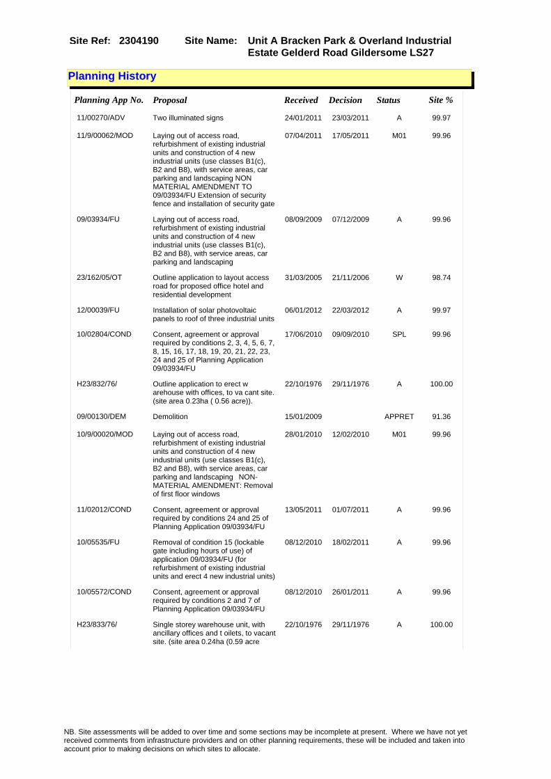
Site Name: Unit A Bracken Park & Overland Industrial Estate Gelderd Road Gildersome LS27
Site Ref: 2304190
Planning History
Planning App No. Proposal Received Decision Status Site %
11/00270/ADV Two illuminated signs 24/01/2011 23/03/2011 A 99.97
11/9/00062/MOD Laying out of access road, refurbishment of existing industrial units and construction of 4 new industrial units (use classes B1(c), B2 and B8), with service areas, car parking and landscaping NON MATERIAL AMENDMENT TO 09/03934/FU Extension of security fence and installation of security gate
07/04/2011 17/05/2011 M01 99.96
09/03934/FU Laying out of access road, refurbishment of existing industrial units and construction of 4 new industrial units (use classes B1(c), B2 and B8), with service areas, car parking and landscaping
08/09/2009 07/12/2009 A 99.96
23/162/05/OT Outline application to layout access road for proposed office hotel and residential development
31/03/2005 21/11/2006 W 98.74
12/00039/FU Installation of solar photovoltaic panels to roof of three industrial units
06/01/2012 22/03/2012 A 99.97
10/02804/COND Consent, agreement or approval required by conditions 2, 3, 4, 5, 6, 7, 8, 15, 16, 17, 18, 19, 20, 21, 22, 23, 24 and 25 of Planning Application 09/03934/FU
17/06/2010 09/09/2010 SPL 99.96
H23/832/76/ Outline application to erect w arehouse with offices, to va cant site. (site area 0.23ha ( 0.56 acre)).
22/10/1976 29/11/1976 A 100.00
09/00130/DEM Demolition 15/01/2009 APPRET 91.36
10/9/00020/MOD Laying out of access road, refurbishment of existing industrial units and construction of 4 new industrial units (use classes B1(c), B2 and B8), with service areas, car parking and landscaping�NON-MATERIAL AMENDMENT: Removal of first floor windows
28/01/2010 12/02/2010 M01 99.96
11/02012/COND Consent, agreement or approval required by conditions 24 and 25 of Planning Application 09/03934/FU
13/05/2011 01/07/2011 A 99.96
10/05535/FU Removal of condition 15 (lockable gate including hours of use) of application 09/03934/FU (for refurbishment of existing industrial units and erect 4 new industrial units)
08/12/2010 18/02/2011 A 99.96
10/05572/COND Consent, agreement or approval required by conditions 2 and 7 of Planning Application 09/03934/FU
08/12/2010 26/01/2011 A 99.96
H23/833/76/ Single storey warehouse unit, with ancillary offices and t oilets, to vacant site. (site area 0.24ha (0.59 acre
22/10/1976 29/11/1976 A 100.00
NB. Site assessments will be added to over time and some sections may be incomplete at present. Where we have not yet received comments from infrastructure providers and on other planning requirements, these will be included and taken into account prior to making decisions on which sites to allocate.

Site Name: Unit A Bracken Park & Overland Industrial Estate Gelderd Road Gildersome LS27
Site Ref: 2304190
Conformity with Core Strategy
Inner South Leeds: 0.00
Leeds Bradford Corridor: 0.00 West Leeds Gateway: 0.00
Aire Valley: 0.00Regeneration Priority Area:
Brownfield
Greenfield
Mixed
Main Urban Area
Major Settlement
Smaller Settlement
Villages/Rural
Main Urban Area Extension
Major Settlement Extension
Smaller Settlement Extension
Village/Rural Extension
Development unrelated to existing development
Green Belt assessment - only completed where site is within Green Belt
Would development lead to/constitute ribbon development?
Would development result in isolated development?
Is the site well connected to built up area (2+ boundaries with existing built up area)?
Would development of the site effectively "round off" the settlement pattern?:
Do natural/physical features provide a good existing barrier between existing urban area and undeveloped land?
Overall sprawl conclusion:
Would development of the site lead to physical connection of settlements?
Do natural/physical features provide a good existing barrier/boundary to contain development?
Overall Coalescence Conclusion:
Is there a strong defensible boundary between the site and the existing urban area?
Does the site provide access to the countryside?
Does the site include local or national conservation designated areas?
Does the site include areas of woodlands, trees, hedgerows that are protected, or significant unprotected tree/hedge cover?
Does the site include grade 1, 2, or 3a agricultural land?
Does the site contain buildings? Are these in agricultural use?
Overall countryside Encroachment Conclusion
Is the site within or adjacent to a conservation area, listed building or other historical feature?
If yes, could development preserve this character?:
Overall Character Preservation Conclusion:
Greenbelt Assessment Conclusion:
Check the unrestricted sprawl of large built up areas
Prevent neighbouring towns from merging
Assist in safeguarding countryside from encroachment
Preserve the setting and special character of historic towns
NB. Site assessments will be added to over time and some sections may be incomplete at present. Where we have not yet received comments from infrastructure providers and on other planning requirements, these will be included and taken into account prior to making decisions on which sites to allocate.
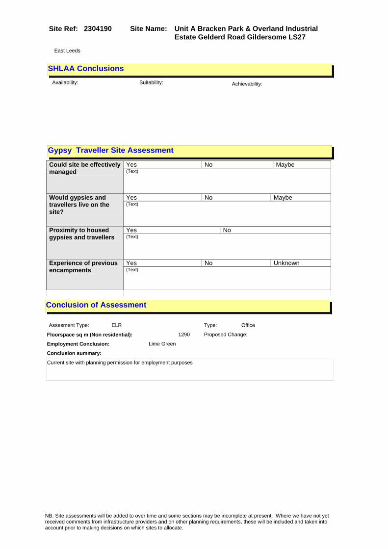
Site Name: Unit A Bracken Park & Overland Industrial Estate Gelderd Road Gildersome LS27
Site Ref: 2304190
SHLAA ConclusionsAvailability: Suitability: Achievability:
Conclusion of Assessment
Conclusion summary:
Current site with planning permission for employment purposes
Floorspace sq m (Non residential): 1290
Employment Conclusion: Lime Green
East Leeds
Assesment Type: ELR Type: Office
Proposed Change:
Gypsy Traveller Site Assessment
Yes No Maybe Could site be effectively managed (Text)
Yes No Maybe Would gypsies and travellers live on the site?
(Text)
Yes No Proximity to housed gypsies and travellers (Text)
Yes No Unknown Experience of previous encampments (Text)
NB. Site assessments will be added to over time and some sections may be incomplete at present. Where we have not yet received comments from infrastructure providers and on other planning requirements, these will be included and taken into account prior to making decisions on which sites to allocate.
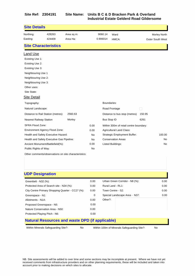
Site Name: Units B C & D Bracken Park & Overland Industrial Estate Gelderd Road Gildersome
Site Ref: 2304191
Site Details
Land Use
Northing: 428263
Easting: 424409
Distance to Rail Station (metres): 2560.63
Nearest Railway Station Morley
Distance to bus stop (metres) 150.95
Bus Stop ID 6261
Agricultural Land Class:
SFRA Flood Zone: 0.00
Environment Agency Flood Zone: 0.00
Within 300m of retail centre boundary:
UDP Designation
Greenbelt - N32 (%): 0.00 Urban Green Corridor - N8 (%): 0.00
Protected Area of Search site - N34 (%): 0.00 Rural Land - RL1: 0.00
City Centre Primary Shopping Quarter - CC27 (%): 0.00 Town Centre - S2: 0.00
Health and Safety Executive Hazard: No
Health and Safety Executive Gas Pipeline: No
Strategic Employment Buffer: 100.00
Area sq m: 9060.14 Ward Morley North
Special Landscape Area - N37: 0.00
Allotments - N1A: 0.00
Proposed Greenspace - N5: 0.00
Protected Playing Pitch - N6: 0.00
Nature Conservation Area - N50: 0.00
Conservation Areas No
Ancient Monument/Battlefield(%): 0.00 Listed Buildings: No
Public Rights of Way: No
Other?:
Natural Resources and waste DPD (if applicable)
Within Minerals Safeguarding Site?: No Within 100m of Minerals Safeguarding Site?: No
HMCA: Outer South West
Greenspace - N1: 0
Existing Use 1:
Existing Use 2:
Existing Use 3:
Neighbouring Use 1
Neighbouring Use 2:
Neighbouring Use 3:
Other uses:
Topography:
Natural Landscape:
Boundaries:
Road Frontage
Site Characteristics
Site Detail
Other comments/observations on site characteristics:
Area Ha: 0.906014
Site State:
NB. Site assessments will be added to over time and some sections may be incomplete at present. Where we have not yet received comments from infrastructure providers and on other planning requirements, these will be included and taken into account prior to making decisions on which sites to allocate.

Site Name: Units B C & D Bracken Park & Overland Industrial Estate Gelderd Road Gildersome
Site Ref: 2304191
Planning History
Planning App No. Proposal Received Decision Status Site %
11/9/00062/MOD Laying out of access road, refurbishment of existing industrial units and construction of 4 new industrial units (use classes B1(c), B2 and B8), with service areas, car parking and landscaping NON MATERIAL AMENDMENT TO 09/03934/FU Extension of security fence and installation of security gate
07/04/2011 17/05/2011 M01 79.69
09/03934/FU Laying out of access road, refurbishment of existing industrial units and construction of 4 new industrial units (use classes B1(c), B2 and B8), with service areas, car parking and landscaping
08/09/2009 07/12/2009 A 79.69
H23/537/77/ Amendment to reserved matters application no. 76/23 /00903 for laying out of acces s road, and erectionof 3 wareh
05/08/1977 22/08/1977 A 92.75
23/162/05/OT Outline application to layout access road for proposed office hotel and residential development
31/03/2005 21/11/2006 W 99.99
23/90/00/FU Laying out of hardstanding area to works
02/03/2000 21/12/2001 A 81.72
10/02804/COND Consent, agreement or approval required by conditions 2, 3, 4, 5, 6, 7, 8, 15, 16, 17, 18, 19, 20, 21, 22, 23, 24 and 25 of Planning Application 09/03934/FU
17/06/2010 09/09/2010 SPL 79.69
23/216/01/FU Change of use vehicle storage facility to plant repair workshop
11/06/2001 28/01/2002 A 99.56
10/9/00020/MOD Laying out of access road, refurbishment of existing industrial units and construction of 4 new industrial units (use classes B1(c), B2 and B8), with service areas, car parking and landscaping�NON-MATERIAL AMENDMENT: Removal of first floor windows
28/01/2010 12/02/2010 M01 79.69
11/02012/COND Consent, agreement or approval required by conditions 24 and 25 of Planning Application 09/03934/FU
13/05/2011 01/07/2011 A 79.69
10/05535/FU Removal of condition 15 (lockable gate including hours of use) of application 09/03934/FU (for refurbishment of existing industrial units and erect 4 new industrial units)
08/12/2010 18/02/2011 A 80.72
H23/192/80/ Laying out of access road and erection of 4 warehouse units in 2 blocks, 3 each with offi ces and toilets, one with c
13/03/1980 28/04/1980 A 84.18
H23/186/74/ Addition of conservatory to de tached house
25/06/1974 16/07/1974 A 22.55
H23/647/77/ Detached, concrete block doubl e garage, to rear of detac hed house.
22/09/1977 14/11/1977 A 22.55
10/05572/COND Consent, agreement or approval required by conditions 2 and 7 of Planning Application 09/03934/FU
08/12/2010 26/01/2011 A 79.69
NB. Site assessments will be added to over time and some sections may be incomplete at present. Where we have not yet received comments from infrastructure providers and on other planning requirements, these will be included and taken into account prior to making decisions on which sites to allocate.

Site Name: Units B C & D Bracken Park & Overland Industrial Estate Gelderd Road Gildersome
Site Ref: 2304191
H23/903/76/ Laying out of access road, and erection of 3 warehouse units , 1 with 2-storey ancillary of fice block, with 24 ca
19/11/1976 07/02/1977 A 92.31
NB. Site assessments will be added to over time and some sections may be incomplete at present. Where we have not yet received comments from infrastructure providers and on other planning requirements, these will be included and taken into account prior to making decisions on which sites to allocate.
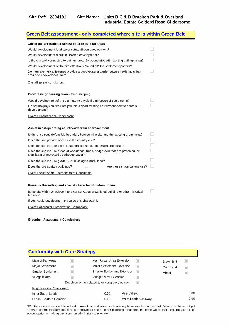
Site Name: Units B C & D Bracken Park & Overland Industrial Estate Gelderd Road Gildersome
Site Ref: 2304191
Conformity with Core Strategy
Inner South Leeds: 0.00
Leeds Bradford Corridor: 0.00 West Leeds Gateway: 0.00
Aire Valley: 0.00Regeneration Priority Area:
Brownfield
Greenfield
Mixed
Main Urban Area
Major Settlement
Smaller Settlement
Villages/Rural
Main Urban Area Extension
Major Settlement Extension
Smaller Settlement Extension
Village/Rural Extension
Development unrelated to existing development
Green Belt assessment - only completed where site is within Green Belt
Would development lead to/constitute ribbon development?
Would development result in isolated development?
Is the site well connected to built up area (2+ boundaries with existing built up area)?
Would development of the site effectively "round off" the settlement pattern?:
Do natural/physical features provide a good existing barrier between existing urban area and undeveloped land?
Overall sprawl conclusion:
Would development of the site lead to physical connection of settlements?
Do natural/physical features provide a good existing barrier/boundary to contain development?
Overall Coalescence Conclusion:
Is there a strong defensible boundary between the site and the existing urban area?
Does the site provide access to the countryside?
Does the site include local or national conservation designated areas?
Does the site include areas of woodlands, trees, hedgerows that are protected, or significant unprotected tree/hedge cover?
Does the site include grade 1, 2, or 3a agricultural land?
Does the site contain buildings? Are these in agricultural use?
Overall countryside Encroachment Conclusion
Is the site within or adjacent to a conservation area, listed building or other historical feature?
If yes, could development preserve this character?:
Overall Character Preservation Conclusion:
Greenbelt Assessment Conclusion:
Check the unrestricted sprawl of large built up areas
Prevent neighbouring towns from merging
Assist in safeguarding countryside from encroachment
Preserve the setting and special character of historic towns
NB. Site assessments will be added to over time and some sections may be incomplete at present. Where we have not yet received comments from infrastructure providers and on other planning requirements, these will be included and taken into account prior to making decisions on which sites to allocate.

Site Name: Units B C & D Bracken Park & Overland Industrial Estate Gelderd Road Gildersome
Site Ref: 2304191
SHLAA ConclusionsAvailability: Suitability: Achievability:
Conclusion of Assessment
Conclusion summary:
Retain to reflect consent for new build B1c B2 & B8 units as part of 09/03934/FU.
Floorspace sq m (Non residential):
Employment Conclusion: Lime Green
East Leeds
Assesment Type: ELR Type: Industrial & Warehousing
Proposed Change:
Gypsy Traveller Site Assessment
Yes No Maybe Could site be effectively managed (Text)
Yes No Maybe Would gypsies and travellers live on the site?
(Text)
Yes No Proximity to housed gypsies and travellers (Text)
Yes No Unknown Experience of previous encampments (Text)
NB. Site assessments will be added to over time and some sections may be incomplete at present. Where we have not yet received comments from infrastructure providers and on other planning requirements, these will be included and taken into account prior to making decisions on which sites to allocate.

Site Name: Former Loco Shed Site Off Royds Lane LS 12 Site Ref: 2401060
Site Details
Land Use
Northing: 431277
Easting: 427059
Distance to Rail Station (metres): 1250.26
Nearest Railway Station Cottingley
Distance to bus stop (metres) 317.15
Bus Stop ID 8064
Agricultural Land Class:
SFRA Flood Zone: 0.00
Environment Agency Flood Zone: 0.00
Within 300m of retail centre boundary:
UDP Designation
Greenbelt - N32 (%): 0.76 Urban Green Corridor - N8 (%): 0.00
Protected Area of Search site - N34 (%): 0.00 Rural Land - RL1: 0.00
City Centre Primary Shopping Quarter - CC27 (%): 0.00 Town Centre - S2: 0.00
Health and Safety Executive Hazard: No
Health and Safety Executive Gas Pipeline: No
Strategic Employment Buffer: 0.00
Area sq m: 55788.44 Ward Farnley and Wortley
Special Landscape Area - N37: 0.00
Allotments - N1A: 0.00
Proposed Greenspace - N5: 0.00
Protected Playing Pitch - N6: 0.00
Nature Conservation Area - N50: 0.00
Conservation Areas No
Ancient Monument/Battlefield(%): 0.00 Listed Buildings: Yes
Public Rights of Way: Yes
Other?:
Natural Resources and waste DPD (if applicable)
Within Minerals Safeguarding Site?: Yes Within 100m of Minerals Safeguarding Site?: Yes
HMCA: Outer South West
Greenspace - N1: 0
Existing Use 1:
Existing Use 2:
Existing Use 3:
Neighbouring Use 1
Neighbouring Use 2:
Neighbouring Use 3:
Other uses:
Topography:
Natural Landscape:
Boundaries:
Road Frontage
Site Characteristics
Site Detail
Other comments/observations on site characteristics:
Area Ha: 5.578844
Site State:
Site Site TypeRoyds Lane Holbeck/Beeston recent pp General Waste Management Sites
NB. Site assessments will be added to over time and some sections may be incomplete at present. Where we have not yet received comments from infrastructure providers and on other planning requirements, these will be included and taken into account prior to making decisions on which sites to allocate.

Site Name: Former Loco Shed Site Off Royds Lane LS 12 Site Ref: 2401060
Planning History
NB. Site assessments will be added to over time and some sections may be incomplete at present. Where we have not yet received comments from infrastructure providers and on other planning requirements, these will be included and taken into account prior to making decisions on which sites to allocate.

Site Name: Former Loco Shed Site Off Royds Lane LS 12 Site Ref: 2401060
Conformity with Core Strategy
Inner South Leeds: 0.00
Leeds Bradford Corridor: 0.00 West Leeds Gateway: 0.00
Aire Valley: 0.00Regeneration Priority Area:
Brownfield
Greenfield
Mixed
Main Urban Area
Major Settlement
Smaller Settlement
Villages/Rural
Main Urban Area Extension
Major Settlement Extension
Smaller Settlement Extension
Village/Rural Extension
Development unrelated to existing development
Green Belt assessment - only completed where site is within Green Belt
Would development lead to/constitute ribbon development?
Would development result in isolated development?
Is the site well connected to built up area (2+ boundaries with existing built up area)?
Would development of the site effectively "round off" the settlement pattern?:
Do natural/physical features provide a good existing barrier between existing urban area and undeveloped land?
Overall sprawl conclusion:
Would development of the site lead to physical connection of settlements?
Do natural/physical features provide a good existing barrier/boundary to contain development?
Overall Coalescence Conclusion:
Is there a strong defensible boundary between the site and the existing urban area?
Does the site provide access to the countryside?
Does the site include local or national conservation designated areas?
Does the site include areas of woodlands, trees, hedgerows that are protected, or significant unprotected tree/hedge cover?
Does the site include grade 1, 2, or 3a agricultural land?
Does the site contain buildings? Are these in agricultural use?
Overall countryside Encroachment Conclusion
Is the site within or adjacent to a conservation area, listed building or other historical feature?
If yes, could development preserve this character?:
Overall Character Preservation Conclusion:
Greenbelt Assessment Conclusion:
Check the unrestricted sprawl of large built up areas
Prevent neighbouring towns from merging
Assist in safeguarding countryside from encroachment
Preserve the setting and special character of historic towns
NB. Site assessments will be added to over time and some sections may be incomplete at present. Where we have not yet received comments from infrastructure providers and on other planning requirements, these will be included and taken into account prior to making decisions on which sites to allocate.
Site Name: Former Loco Shed Site Off Royds Lane LS 12 Site Ref: 2401060
SHLAA ConclusionsAvailability: Suitability: Achievability:
Conclusion of Assessment
Conclusion summary:
There is residential/mixed use consent (06/02324/OT) on the site which expires 1/2/2011.
Floorspace sq m (Non residential): 4670
Employment Conclusion: Lime Green
East Leeds
Assesment Type: ELR Type: Office
Proposed Change:
Gypsy Traveller Site Assessment
Yes No Maybe Could site be effectively managed (Text)
Yes No Maybe Would gypsies and travellers live on the site?
(Text)
Yes No Proximity to housed gypsies and travellers (Text)
Yes No Unknown Experience of previous encampments (Text)
NB. Site assessments will be added to over time and some sections may be incomplete at present. Where we have not yet received comments from infrastructure providers and on other planning requirements, these will be included and taken into account prior to making decisions on which sites to allocate.

Site Name: Allocated Site Chelsea Close Leeds 12 Site Ref: 2401181
Site Details
Land Use
Northing: 432870
Easting: 427294
Distance to Rail Station (metres): 2384.98
Nearest Railway Station Burley Park
Distance to bus stop (metres) 194.88
Bus Stop ID 14237
Agricultural Land Class:
SFRA Flood Zone: 0.00
Environment Agency Flood Zone: 0.00
Within 300m of retail centre boundary:
UDP Designation
Greenbelt - N32 (%): 0.00 Urban Green Corridor - N8 (%): 0.85
Protected Area of Search site - N34 (%): 0.00 Rural Land - RL1: 0.00
City Centre Primary Shopping Quarter - CC27 (%): 0.00 Town Centre - S2: 0.00
Health and Safety Executive Hazard: No
Health and Safety Executive Gas Pipeline: No
Strategic Employment Buffer: 0.00
Area sq m: 9339.44 Ward Farnley and Wortley
Special Landscape Area - N37: 0.00
Allotments - N1A: 0.00
Proposed Greenspace - N5: 0.00
Protected Playing Pitch - N6: 0.00
Nature Conservation Area - N50: 0.00
Conservation Areas No
Ancient Monument/Battlefield(%): 0.00 Listed Buildings: No
Public Rights of Way: No
Other?:
Natural Resources and waste DPD (if applicable)
Within Minerals Safeguarding Site?: No Within 100m of Minerals Safeguarding Site?: No
HMCA: Outer West
Greenspace - N1: 0
Existing Use 1:
Existing Use 2:
Existing Use 3:
Neighbouring Use 1
Neighbouring Use 2:
Neighbouring Use 3:
Other uses:
Topography:
Natural Landscape:
Boundaries:
Road Frontage
Site Characteristics
Site Detail
Other comments/observations on site characteristics:
Area Ha: 0.933944
Site State:
NB. Site assessments will be added to over time and some sections may be incomplete at present. Where we have not yet received comments from infrastructure providers and on other planning requirements, these will be included and taken into account prior to making decisions on which sites to allocate.

Site Name: Allocated Site Chelsea Close Leeds 12 Site Ref: 2401181
Planning History
Planning App No. Proposal Received Decision Status Site %
H24/148/89/ Laying out of access and erect ion of builders merchantsgarag e, warehouse and office with 1 1 car parking spacesto vacant
05/05/1989 11/09/1989 A 43.73
H24/221/90/ Outline application to erect w arehouse, offices, car parki ng area and open storage area, to vacant site. (site area
22/06/1990 01/10/1990 A 99.88
H24/221/90/1 Amendement to previous outline application, involving the h ours of use condition, for the erection of warehouse
22/10/1990 15/11/1990 A 99.34
NB. Site assessments will be added to over time and some sections may be incomplete at present. Where we have not yet received comments from infrastructure providers and on other planning requirements, these will be included and taken into account prior to making decisions on which sites to allocate.

Site Name: Allocated Site Chelsea Close Leeds 12 Site Ref: 2401181
Conformity with Core Strategy
Inner South Leeds: 0.00
Leeds Bradford Corridor: 100.00 West Leeds Gateway: 100.00
Aire Valley: 0.00Regeneration Priority Area:
Brownfield
Greenfield
Mixed
Main Urban Area
Major Settlement
Smaller Settlement
Villages/Rural
Main Urban Area Extension
Major Settlement Extension
Smaller Settlement Extension
Village/Rural Extension
Development unrelated to existing development
Green Belt assessment - only completed where site is within Green Belt
Would development lead to/constitute ribbon development?
Would development result in isolated development?
Is the site well connected to built up area (2+ boundaries with existing built up area)?
Would development of the site effectively "round off" the settlement pattern?:
Do natural/physical features provide a good existing barrier between existing urban area and undeveloped land?
Overall sprawl conclusion:
Would development of the site lead to physical connection of settlements?
Do natural/physical features provide a good existing barrier/boundary to contain development?
Overall Coalescence Conclusion:
Is there a strong defensible boundary between the site and the existing urban area?
Does the site provide access to the countryside?
Does the site include local or national conservation designated areas?
Does the site include areas of woodlands, trees, hedgerows that are protected, or significant unprotected tree/hedge cover?
Does the site include grade 1, 2, or 3a agricultural land?
Does the site contain buildings? Are these in agricultural use?
Overall countryside Encroachment Conclusion
Is the site within or adjacent to a conservation area, listed building or other historical feature?
If yes, could development preserve this character?:
Overall Character Preservation Conclusion:
Greenbelt Assessment Conclusion:
Check the unrestricted sprawl of large built up areas
Prevent neighbouring towns from merging
Assist in safeguarding countryside from encroachment
Preserve the setting and special character of historic towns
NB. Site assessments will be added to over time and some sections may be incomplete at present. Where we have not yet received comments from infrastructure providers and on other planning requirements, these will be included and taken into account prior to making decisions on which sites to allocate.

Site Name: Allocated Site Chelsea Close Leeds 12 Site Ref: 2401181
SHLAA ConclusionsAvailability: Suitability: Achievability:
Conclusion of Assessment
Conclusion summary:
Suitable for employment or residential (although residential would likely require alternative access). Retain as important for local supply.
Floorspace sq m (Non residential):
Employment Conclusion: Lime Green
East Leeds
Assesment Type: ELR Type: Industrial & Warehousing
Proposed Change:
Gypsy Traveller Site Assessment
Yes No Maybe Could site be effectively managed (Text)
Yes No Maybe Would gypsies and travellers live on the site?
(Text)
Yes No Proximity to housed gypsies and travellers (Text)
Yes No Unknown Experience of previous encampments (Text)
NB. Site assessments will be added to over time and some sections may be incomplete at present. Where we have not yet received comments from infrastructure providers and on other planning requirements, these will be included and taken into account prior to making decisions on which sites to allocate.

Site Name: Tong Road/Pipe & Nook La LS 12Site Ref: 2401631
Site Details
Land Use
Northing: 433025
Easting: 425551
Distance to Rail Station (metres): 2119.55
Nearest Railway Station Bramley
Distance to bus stop (metres) 79.76
Bus Stop ID 6294
Agricultural Land Class:
SFRA Flood Zone: 0.00
Environment Agency Flood Zone: 0.00
Within 300m of retail centre boundary:
UDP Designation
Greenbelt - N32 (%): 0.00 Urban Green Corridor - N8 (%): 0.00
Protected Area of Search site - N34 (%): 0.00 Rural Land - RL1: 0.00
City Centre Primary Shopping Quarter - CC27 (%): 0.00 Town Centre - S2: 0.00
Health and Safety Executive Hazard: No
Health and Safety Executive Gas Pipeline: Yes
Strategic Employment Buffer: 0.00
Area sq m: 2294.60 Ward Farnley and Wortley
Special Landscape Area - N37: 0.00
Allotments - N1A: 0.00
Proposed Greenspace - N5: 0.00
Protected Playing Pitch - N6: 0.00
Nature Conservation Area - N50: 0.00
Conservation Areas No
Ancient Monument/Battlefield(%): 0.00 Listed Buildings: No
Public Rights of Way: No
Other?:
Natural Resources and waste DPD (if applicable)
Within Minerals Safeguarding Site?: No Within 100m of Minerals Safeguarding Site?: No
HMCA: Outer West
Greenspace - N1: 0
Existing Use 1:
Existing Use 2:
Existing Use 3:
Neighbouring Use 1
Neighbouring Use 2:
Neighbouring Use 3:
Other uses:
Topography:
Natural Landscape:
Boundaries:
Road Frontage
Site Characteristics
Site Detail
Other comments/observations on site characteristics:
Area Ha: 0.22946
Site State:
NB. Site assessments will be added to over time and some sections may be incomplete at present. Where we have not yet received comments from infrastructure providers and on other planning requirements, these will be included and taken into account prior to making decisions on which sites to allocate.

Site Name: Tong Road/Pipe & Nook La LS 12Site Ref: 2401631
Planning History
NB. Site assessments will be added to over time and some sections may be incomplete at present. Where we have not yet received comments from infrastructure providers and on other planning requirements, these will be included and taken into account prior to making decisions on which sites to allocate.

Site Name: Tong Road/Pipe & Nook La LS 12Site Ref: 2401631
Conformity with Core Strategy
Inner South Leeds: 0.00
Leeds Bradford Corridor: 0.00 West Leeds Gateway: 0.00
Aire Valley: 0.00Regeneration Priority Area:
Brownfield
Greenfield
Mixed
Main Urban Area
Major Settlement
Smaller Settlement
Villages/Rural
Main Urban Area Extension
Major Settlement Extension
Smaller Settlement Extension
Village/Rural Extension
Development unrelated to existing development
Green Belt assessment - only completed where site is within Green Belt
Would development lead to/constitute ribbon development?
Would development result in isolated development?
Is the site well connected to built up area (2+ boundaries with existing built up area)?
Would development of the site effectively "round off" the settlement pattern?:
Do natural/physical features provide a good existing barrier between existing urban area and undeveloped land?
Overall sprawl conclusion:
Would development of the site lead to physical connection of settlements?
Do natural/physical features provide a good existing barrier/boundary to contain development?
Overall Coalescence Conclusion:
Is there a strong defensible boundary between the site and the existing urban area?
Does the site provide access to the countryside?
Does the site include local or national conservation designated areas?
Does the site include areas of woodlands, trees, hedgerows that are protected, or significant unprotected tree/hedge cover?
Does the site include grade 1, 2, or 3a agricultural land?
Does the site contain buildings? Are these in agricultural use?
Overall countryside Encroachment Conclusion
Is the site within or adjacent to a conservation area, listed building or other historical feature?
If yes, could development preserve this character?:
Overall Character Preservation Conclusion:
Greenbelt Assessment Conclusion:
Check the unrestricted sprawl of large built up areas
Prevent neighbouring towns from merging
Assist in safeguarding countryside from encroachment
Preserve the setting and special character of historic towns
NB. Site assessments will be added to over time and some sections may be incomplete at present. Where we have not yet received comments from infrastructure providers and on other planning requirements, these will be included and taken into account prior to making decisions on which sites to allocate.

Site Name: Tong Road/Pipe & Nook La LS 12Site Ref: 2401631
SHLAA ConclusionsAvailability: Suitability: Achievability:
Conclusion of Assessment
Conclusion summary:
Current site with planning permission for employment purposes
Floorspace sq m (Non residential):
Employment Conclusion: Lime Green
East Leeds
Assesment Type: Planning status Type: Industrial & Warehousing
Proposed Change:
Gypsy Traveller Site Assessment
Yes No Maybe Could site be effectively managed (Text)
Yes No Maybe Would gypsies and travellers live on the site?
(Text)
Yes No Proximity to housed gypsies and travellers (Text)
Yes No Unknown Experience of previous encampments (Text)
NB. Site assessments will be added to over time and some sections may be incomplete at present. Where we have not yet received comments from infrastructure providers and on other planning requirements, these will be included and taken into account prior to making decisions on which sites to allocate.

Site Name: Ph2 Arlington Mills Armley Road Pickering Street
Site Ref: 2401781
Site Details
Land Use
Northing: 433802
Easting: 427547
Distance to Rail Station (metres): 1419.91
Nearest Railway Station Burley Park
Distance to bus stop (metres) 35.13
Bus Stop ID 13601
Agricultural Land Class:
SFRA Flood Zone: 0.00
Environment Agency Flood Zone: 0.00
Within 300m of retail centre boundary:
UDP Designation
Greenbelt - N32 (%): 0.00 Urban Green Corridor - N8 (%): 0.00
Protected Area of Search site - N34 (%): 0.00 Rural Land - RL1: 0.00
City Centre Primary Shopping Quarter - CC27 (%): 0.00 Town Centre - S2: 0.00
Health and Safety Executive Hazard: No
Health and Safety Executive Gas Pipeline: No
Strategic Employment Buffer: 0.00
Area sq m: 4595.81 Ward Armley
Special Landscape Area - N37: 0.00
Allotments - N1A: 0.00
Proposed Greenspace - N5: 0.00
Protected Playing Pitch - N6: 0.00
Nature Conservation Area - N50: 1.00
Conservation Areas Yes
Ancient Monument/Battlefield(%): 0.00 Listed Buildings: No
Public Rights of Way: No
Other?:
Natural Resources and waste DPD (if applicable)
Within Minerals Safeguarding Site?: No Within 100m of Minerals Safeguarding Site?: No
HMCA: Inner Areas
Greenspace - N1: 0
Existing Use 1:
Existing Use 2:
Existing Use 3:
Neighbouring Use 1
Neighbouring Use 2:
Neighbouring Use 3:
Other uses:
Topography:
Natural Landscape:
Boundaries:
Road Frontage
Site Characteristics
Site Detail
Other comments/observations on site characteristics:
Area Ha: 0.459581
Site State:
NB. Site assessments will be added to over time and some sections may be incomplete at present. Where we have not yet received comments from infrastructure providers and on other planning requirements, these will be included and taken into account prior to making decisions on which sites to allocate.

Site Name: Ph2 Arlington Mills Armley Road Pickering Street
Site Ref: 2401781
Planning History
Planning App No. Proposal Received Decision Status Site %
24/331/05/FU Laying out of access roads and erection of 10 two storey office units in 7 blocks with 139 car parking spaces
21/04/2005 16/08/2006 A 99.90
H26/368/88/ Outline application to layout access roads and erect residential development, industrial development, shopping,
01/08/1988 01/08/1988 0 99.36
H24/74/89/99 Alterations, including new win dows, to warehouse.
06/03/1989 27/04/1989 A 92.05
H24/92/80/ Change of use of part of facto ry and store to factory, store , distribution and retail show room.
18/02/1980 17/03/1980 A 96.78
H24/372/90/99 Change of use of part of wareh ouse to private hire vehic le office and delivery service with 12 car parkingspaces.
17/10/1990 13/12/1990 A 74.46
H24/337/83/ Change of use, involving alter ations, including new stair case, of fireplace suppliers t o 27 industrial units with
12/12/1983 20/02/1984 A 52.83
NB. Site assessments will be added to over time and some sections may be incomplete at present. Where we have not yet received comments from infrastructure providers and on other planning requirements, these will be included and taken into account prior to making decisions on which sites to allocate.

Site Name: Ph2 Arlington Mills Armley Road Pickering Street
Site Ref: 2401781
Conformity with Core Strategy
Inner South Leeds: 0.00
Leeds Bradford Corridor: 100.00 West Leeds Gateway: 100.00
Aire Valley: 0.00Regeneration Priority Area:
Brownfield
Greenfield
Mixed
Main Urban Area
Major Settlement
Smaller Settlement
Villages/Rural
Main Urban Area Extension
Major Settlement Extension
Smaller Settlement Extension
Village/Rural Extension
Development unrelated to existing development
Green Belt assessment - only completed where site is within Green Belt
Would development lead to/constitute ribbon development?
Would development result in isolated development?
Is the site well connected to built up area (2+ boundaries with existing built up area)?
Would development of the site effectively "round off" the settlement pattern?:
Do natural/physical features provide a good existing barrier between existing urban area and undeveloped land?
Overall sprawl conclusion:
Would development of the site lead to physical connection of settlements?
Do natural/physical features provide a good existing barrier/boundary to contain development?
Overall Coalescence Conclusion:
Is there a strong defensible boundary between the site and the existing urban area?
Does the site provide access to the countryside?
Does the site include local or national conservation designated areas?
Does the site include areas of woodlands, trees, hedgerows that are protected, or significant unprotected tree/hedge cover?
Does the site include grade 1, 2, or 3a agricultural land?
Does the site contain buildings? Are these in agricultural use?
Overall countryside Encroachment Conclusion
Is the site within or adjacent to a conservation area, listed building or other historical feature?
If yes, could development preserve this character?:
Overall Character Preservation Conclusion:
Greenbelt Assessment Conclusion:
Check the unrestricted sprawl of large built up areas
Prevent neighbouring towns from merging
Assist in safeguarding countryside from encroachment
Preserve the setting and special character of historic towns
NB. Site assessments will be added to over time and some sections may be incomplete at present. Where we have not yet received comments from infrastructure providers and on other planning requirements, these will be included and taken into account prior to making decisions on which sites to allocate.

Site Name: Ph2 Arlington Mills Armley Road Pickering Street
Site Ref: 2401781
SHLAA ConclusionsAvailability: Suitability: Achievability:
Conclusion of Assessment
Conclusion summary:
Phase offices completed Nov 07; this site is Phase 2 of 24/331/05/FU. Consent will not lapse.
Floorspace sq m (Non residential): 1780
Employment Conclusion: Green
East Leeds
Assesment Type: ELR Type: Office
Proposed Change:
Gypsy Traveller Site Assessment
Yes No Maybe Could site be effectively managed (Text)
Yes No Maybe Would gypsies and travellers live on the site?
(Text)
Yes No Proximity to housed gypsies and travellers (Text)
Yes No Unknown Experience of previous encampments (Text)
NB. Site assessments will be added to over time and some sections may be incomplete at present. Where we have not yet received comments from infrastructure providers and on other planning requirements, these will be included and taken into account prior to making decisions on which sites to allocate.

Site Name: Carr Crofts Drive Armley Moor LS 12 Site Ref: 2402152
Site Details
Land Use
Northing: 433194
Easting: 426683
Distance to Rail Station (metres): 2327.60
Nearest Railway Station Burley Park
Distance to bus stop (metres) 118.73
Bus Stop ID 13041
Agricultural Land Class:
SFRA Flood Zone: 0.00
Environment Agency Flood Zone: 0.00
Within 300m of retail centre boundary:
UDP Designation
Greenbelt - N32 (%): 0.00 Urban Green Corridor - N8 (%): 0.00
Protected Area of Search site - N34 (%): 0.00 Rural Land - RL1: 0.00
City Centre Primary Shopping Quarter - CC27 (%): 0.00 Town Centre - S2: 0.00
Health and Safety Executive Hazard: No
Health and Safety Executive Gas Pipeline: No
Strategic Employment Buffer: 0.00
Area sq m: 1737.16 Ward Armley
Special Landscape Area - N37: 0.00
Allotments - N1A: 0.00
Proposed Greenspace - N5: 0.00
Protected Playing Pitch - N6: 0.00
Nature Conservation Area - N50: 0.00
Conservation Areas No
Ancient Monument/Battlefield(%): 0.00 Listed Buildings: No
Public Rights of Way: No
Other?:
Natural Resources and waste DPD (if applicable)
Within Minerals Safeguarding Site?: No Within 100m of Minerals Safeguarding Site?: No
HMCA: Outer West
Greenspace - N1: 0
Existing Use 1:
Existing Use 2:
Existing Use 3:
Neighbouring Use 1
Neighbouring Use 2:
Neighbouring Use 3:
Other uses:
Topography:
Natural Landscape:
Boundaries:
Road Frontage
Site Characteristics
Site Detail
Other comments/observations on site characteristics:
Area Ha: 0.173716
Site State:
NB. Site assessments will be added to over time and some sections may be incomplete at present. Where we have not yet received comments from infrastructure providers and on other planning requirements, these will be included and taken into account prior to making decisions on which sites to allocate.

Site Name: Carr Crofts Drive Armley Moor LS 12 Site Ref: 2402152
Planning History
Planning App No. Proposal Received Decision Status Site %
07/02757/FU Detached block of 4 light industrial units including service areas and parking
26/04/2007 03/10/2007 A 97.82
24/111/93/FU Two light industrial units 06/05/1993 05/10/1993 A 95.40
H24/211/86/ Outline application to layout access road and erect super store with service areas and c ar parks, to railway go
29/08/1986 30/03/1987 R 91.77
H24/230/85/ Outline application to layout access road and erect super store with service areas and c ar parks, to railway go
02/08/1985 10/03/1986 W 91.18
12/00605/FU Block of 4 industrial units, with first floor office accommodation with link bridge to existing premises; and associated parking and service area
08/02/2012 03/04/2012 A 99.81
08/03007/FU Block of 4 industrial units and associated parking and servi ce area
19/05/2008 04/07/2008 A 99.64
24/246/95/FU Detached store to works 26/07/1995 07/09/1995 A 73.45
12/02621/COND Consent, agreement and approval required by conditions 4 and 7 of Planning Application 12/00605/FU
11/06/2012 26/04/2013 INT 99.81
24/20/04/OT Outline application to erect industrial development
15/01/2004 11/03/2004 A 97.61
H24/107/90/ Outline application to lay out access and erect busin ess units and warehouses to va cant railway yard. (site area
23/03/1990 08/08/2000 W 91.75
24/29/94/FU Detached climbing hall with car parking
01/02/1994 22/03/1994 A 95.40
24/221/95/FU New access to rear 06/07/1995 08/11/1996 W 94.47
H24/209/86/ Outline application to lay out access road and erect super store, with service areas and car parks, to railway go
27/08/1986 30/03/1987 R 90.11
NB. Site assessments will be added to over time and some sections may be incomplete at present. Where we have not yet received comments from infrastructure providers and on other planning requirements, these will be included and taken into account prior to making decisions on which sites to allocate.

Site Name: Carr Crofts Drive Armley Moor LS 12 Site Ref: 2402152
Conformity with Core Strategy
Inner South Leeds: 0.00
Leeds Bradford Corridor: 100.00 West Leeds Gateway: 100.00
Aire Valley: 0.00Regeneration Priority Area:
Brownfield
Greenfield
Mixed
Main Urban Area
Major Settlement
Smaller Settlement
Villages/Rural
Main Urban Area Extension
Major Settlement Extension
Smaller Settlement Extension
Village/Rural Extension
Development unrelated to existing development
Green Belt assessment - only completed where site is within Green Belt
Would development lead to/constitute ribbon development?
Would development result in isolated development?
Is the site well connected to built up area (2+ boundaries with existing built up area)?
Would development of the site effectively "round off" the settlement pattern?:
Do natural/physical features provide a good existing barrier between existing urban area and undeveloped land?
Overall sprawl conclusion:
Would development of the site lead to physical connection of settlements?
Do natural/physical features provide a good existing barrier/boundary to contain development?
Overall Coalescence Conclusion:
Is there a strong defensible boundary between the site and the existing urban area?
Does the site provide access to the countryside?
Does the site include local or national conservation designated areas?
Does the site include areas of woodlands, trees, hedgerows that are protected, or significant unprotected tree/hedge cover?
Does the site include grade 1, 2, or 3a agricultural land?
Does the site contain buildings? Are these in agricultural use?
Overall countryside Encroachment Conclusion
Is the site within or adjacent to a conservation area, listed building or other historical feature?
If yes, could development preserve this character?:
Overall Character Preservation Conclusion:
Greenbelt Assessment Conclusion:
Check the unrestricted sprawl of large built up areas
Prevent neighbouring towns from merging
Assist in safeguarding countryside from encroachment
Preserve the setting and special character of historic towns
NB. Site assessments will be added to over time and some sections may be incomplete at present. Where we have not yet received comments from infrastructure providers and on other planning requirements, these will be included and taken into account prior to making decisions on which sites to allocate.

Site Name: Carr Crofts Drive Armley Moor LS 12 Site Ref: 2402152
SHLAA ConclusionsAvailability: Suitability: Achievability:
Conclusion of Assessment
Conclusion summary:
Current site with planning permission for employment purposes
Floorspace sq m (Non residential):
Employment Conclusion: Lime Green
East Leeds
Assesment Type: Planning status Type: Industrial & Warehousing
Proposed Change:
Gypsy Traveller Site Assessment
Yes No Maybe Could site be effectively managed (Text)
Yes No Maybe Would gypsies and travellers live on the site?
(Text)
Yes No Proximity to housed gypsies and travellers (Text)
Yes No Unknown Experience of previous encampments (Text)
NB. Site assessments will be added to over time and some sections may be incomplete at present. Where we have not yet received comments from infrastructure providers and on other planning requirements, these will be included and taken into account prior to making decisions on which sites to allocate.
Site Name: Cubic Business Centre Stanningley Road LS13
Site Ref: 2402880
Site Details
Land Use
Northing: 434533
Easting: 423758
Distance to Rail Station (metres): 225.88
Nearest Railway Station Bramley
Distance to bus stop (metres) 34.54
Bus Stop ID 11542
Agricultural Land Class:
SFRA Flood Zone: 0.00
Environment Agency Flood Zone: 0.00
Within 300m of retail centre boundary:
UDP Designation
Greenbelt - N32 (%): 0.00 Urban Green Corridor - N8 (%): 0.00
Protected Area of Search site - N34 (%): 0.00 Rural Land - RL1: 0.00
City Centre Primary Shopping Quarter - CC27 (%): 0.00 Town Centre - S2: 0.00
Health and Safety Executive Hazard: No
Health and Safety Executive Gas Pipeline: No
Strategic Employment Buffer: 0.00
Area sq m: 2037.38 Ward Bramley and Stanningley
Special Landscape Area - N37: 0.00
Allotments - N1A: 0.00
Proposed Greenspace - N5: 0.00
Protected Playing Pitch - N6: 0.00
Nature Conservation Area - N50: 0.00
Conservation Areas No
Ancient Monument/Battlefield(%): 0.00 Listed Buildings: No
Public Rights of Way: No
Other?:
Natural Resources and waste DPD (if applicable)
Within Minerals Safeguarding Site?: No Within 100m of Minerals Safeguarding Site?: No
HMCA: Outer West
Greenspace - N1: 0
Existing Use 1:
Existing Use 2:
Existing Use 3:
Neighbouring Use 1
Neighbouring Use 2:
Neighbouring Use 3:
Other uses:
Topography:
Natural Landscape:
Boundaries:
Road Frontage
Site Characteristics
Site Detail
Other comments/observations on site characteristics:
Area Ha: 0.203738
Site State:
NB. Site assessments will be added to over time and some sections may be incomplete at present. Where we have not yet received comments from infrastructure providers and on other planning requirements, these will be included and taken into account prior to making decisions on which sites to allocate.

Site Name: Cubic Business Centre Stanningley Road LS13
Site Ref: 2402880
Planning History
Planning App No. Proposal Received Decision Status Site %
H24/47/89/ Laying out of access and erect ion of 6 industrial units and workshops each with offic e and toilet and with car p
10/03/1989 15/05/1989 A 21.12
H24/328/89/ 3 underground chemical storage tanks to industrial units .
25/09/1989 09/10/1989 W 21.23
10/03530/ADV 2 internally illuminated individual letter & logo signs to proposed offices
29/07/2010 22/10/2010 A 73.42
10/00311/COND Consent, agreement or approval required by conditions 2, 3, 4, 5, 6, 7, 13, 14 and 15 of Planning Application 09/00695/FU
26/01/2010 12/05/2010 SPL 95.21
H24/302/89/ Outline application to erect 1 , two storey block of 3 busin ess units with car parking, to vacant site. (site area
13/09/1989 13/11/1989 A 71.06
10/00589/COND Consent, agreement or approval required by condition 16 of Planning Application 09/00695/FU
10/02/2010 16/03/2010 A 95.21
H24/881/75/ One externally illuminated sy mbol and individual lette r wall sign size 15.8m (51ft.9 ins) x 1.1m (3ft.6ins)
19/12/1975 19/01/1976 A 77.20
08/05027/FU 3 storey office block and alterations to existing car parking
21/08/2008 17/12/2008 R 96.04
H24/174/82/ Change of use of factory to wa rehouse and factory unit with offices, factory unit, worksho p unit with offices an
08/07/1982 20/09/1982 A 96.15
09/04874/COND Consent, agreement or approval required by conditions 2, 4, 5, 6, 7, 8, 13 and 16 of Planning Application 09/00695/FU
10/11/2009 05/01/2010 SPL 95.21
09/05598/FU New fourth floor to office block 24/12/2009 30/03/2010 A 16.15
06/00392/FU Change of use of business centre to 24 flats with car parking
25/01/2006 17/03/2008 A 55.77
H24/205/83/ Outline application to lay out access and erect super store, garden centre and diy c entre, with basementcar park a
14/07/1983 30/04/1984 W 95.87
11/00380/COND Consent, agreement or approval required by condition 17 of Planning Application 09/00695/FU
28/01/2011 21/04/2011 A 95.21
09/00695/FU Erection of 4 storey office block and alterations to existing car park
18/02/2009 21/05/2009 A 95.21
H24/153/77/ Addition of pump house and one replacement 13638 litres(3000 gallons) underground petrol s torage tank, to works.
24/03/1977 16/05/1977 A 90.36
10/9/00173/MOD Erection of 4 storey office block and alterations to existing car park�NON-MATERIAL AMENDMENT: Addition of opening lights to facade windows; change of window profile section
21/07/2010 27/07/2010 M01 95.21
H24/48/86/ Change of use of ancillary off ices, canteen and works hop to offices and ground floo r workshop.
20/02/1986 17/11/1986 A 95.51
NB. Site assessments will be added to over time and some sections may be incomplete at present. Where we have not yet received comments from infrastructure providers and on other planning requirements, these will be included and taken into account prior to making decisions on which sites to allocate.

Site Name: Cubic Business Centre Stanningley Road LS13
Site Ref: 2402880
10/9/00145/MOD Erection of 4 storey office block and alterations to existing car park�NON-MATERIAL AMENDMENT: Replace window on ground floor of north elevation with door and sidelight; omit banks of windows from first, second and third floor of west elevation�
21/06/2010 27/07/2010 M01 95.21
NB. Site assessments will be added to over time and some sections may be incomplete at present. Where we have not yet received comments from infrastructure providers and on other planning requirements, these will be included and taken into account prior to making decisions on which sites to allocate.

Site Name: Cubic Business Centre Stanningley Road LS13
Site Ref: 2402880
Conformity with Core Strategy
Inner South Leeds: 0.00
Leeds Bradford Corridor: 100.00 West Leeds Gateway: 0.00
Aire Valley: 0.00Regeneration Priority Area:
Brownfield
Greenfield
Mixed
Main Urban Area
Major Settlement
Smaller Settlement
Villages/Rural
Main Urban Area Extension
Major Settlement Extension
Smaller Settlement Extension
Village/Rural Extension
Development unrelated to existing development
Green Belt assessment - only completed where site is within Green Belt
Would development lead to/constitute ribbon development?
Would development result in isolated development?
Is the site well connected to built up area (2+ boundaries with existing built up area)?
Would development of the site effectively "round off" the settlement pattern?:
Do natural/physical features provide a good existing barrier between existing urban area and undeveloped land?
Overall sprawl conclusion:
Would development of the site lead to physical connection of settlements?
Do natural/physical features provide a good existing barrier/boundary to contain development?
Overall Coalescence Conclusion:
Is there a strong defensible boundary between the site and the existing urban area?
Does the site provide access to the countryside?
Does the site include local or national conservation designated areas?
Does the site include areas of woodlands, trees, hedgerows that are protected, or significant unprotected tree/hedge cover?
Does the site include grade 1, 2, or 3a agricultural land?
Does the site contain buildings? Are these in agricultural use?
Overall countryside Encroachment Conclusion
Is the site within or adjacent to a conservation area, listed building or other historical feature?
If yes, could development preserve this character?:
Overall Character Preservation Conclusion:
Greenbelt Assessment Conclusion:
Check the unrestricted sprawl of large built up areas
Prevent neighbouring towns from merging
Assist in safeguarding countryside from encroachment
Preserve the setting and special character of historic towns
NB. Site assessments will be added to over time and some sections may be incomplete at present. Where we have not yet received comments from infrastructure providers and on other planning requirements, these will be included and taken into account prior to making decisions on which sites to allocate.

Site Name: Cubic Business Centre Stanningley Road LS13
Site Ref: 2402880
SHLAA ConclusionsAvailability: Suitability: Achievability:
Conclusion of Assessment
Conclusion summary:
Current site with planning permission for employment purposes.
Floorspace sq m (Non residential): 1150
Employment Conclusion: Lime Green
East Leeds
Assesment Type: Planning status Type: Office
Proposed Change:
Gypsy Traveller Site Assessment
Yes No Maybe Could site be effectively managed (Text)
Yes No Maybe Would gypsies and travellers live on the site?
(Text)
Yes No Proximity to housed gypsies and travellers (Text)
Yes No Unknown Experience of previous encampments (Text)
NB. Site assessments will be added to over time and some sections may be incomplete at present. Where we have not yet received comments from infrastructure providers and on other planning requirements, these will be included and taken into account prior to making decisions on which sites to allocate.

Site Name: Abbey Rd Adj R Aire Leeds 5 Site Ref: 2403100
Site Details
Land Use
Northing: 436840
Easting: 424338
Distance to Rail Station (metres): 2300.67
Nearest Railway Station Horsforth
Distance to bus stop (metres) 276.64
Bus Stop ID 12448
Agricultural Land Class:
SFRA Flood Zone: 1.00
Environment Agency Flood Zone: 1.00
Within 300m of retail centre boundary:
UDP Designation
Greenbelt - N32 (%): 0.00 Urban Green Corridor - N8 (%): 99.94
Protected Area of Search site - N34 (%): 0.00 Rural Land - RL1: 0.00
City Centre Primary Shopping Quarter - CC27 (%): 0.00 Town Centre - S2: 0.00
Health and Safety Executive Hazard: No
Health and Safety Executive Gas Pipeline: No
Strategic Employment Buffer: 0.00
Area sq m: 12379.62 Ward Bramley and Stanningley
Special Landscape Area - N37: 0.00
Allotments - N1A: 0.00
Proposed Greenspace - N5: 0.00
Protected Playing Pitch - N6: 0.00
Nature Conservation Area - N50: 1.00
Conservation Areas Yes
Ancient Monument/Battlefield(%): 0.00 Listed Buildings: No
Public Rights of Way: No
Other?:
Natural Resources and waste DPD (if applicable)
Within Minerals Safeguarding Site?: No Within 100m of Minerals Safeguarding Site?: No
HMCA: Outer West
Greenspace - N1: 0
Existing Use 1:
Existing Use 2:
Existing Use 3:
Neighbouring Use 1
Neighbouring Use 2:
Neighbouring Use 3:
Other uses:
Topography:
Natural Landscape:
Boundaries:
Road Frontage
Site Characteristics
Site Detail
Other comments/observations on site characteristics:
Area Ha: 1.237962
Site State:
NB. Site assessments will be added to over time and some sections may be incomplete at present. Where we have not yet received comments from infrastructure providers and on other planning requirements, these will be included and taken into account prior to making decisions on which sites to allocate.

Site Name: Abbey Rd Adj R Aire Leeds 5 Site Ref: 2403100
Planning History
NB. Site assessments will be added to over time and some sections may be incomplete at present. Where we have not yet received comments from infrastructure providers and on other planning requirements, these will be included and taken into account prior to making decisions on which sites to allocate.

Site Name: Abbey Rd Adj R Aire Leeds 5 Site Ref: 2403100
Conformity with Core Strategy
Inner South Leeds: 0.00
Leeds Bradford Corridor: 0.00 West Leeds Gateway: 0.00
Aire Valley: 0.00Regeneration Priority Area:
Brownfield
Greenfield
Mixed
Main Urban Area
Major Settlement
Smaller Settlement
Villages/Rural
Main Urban Area Extension
Major Settlement Extension
Smaller Settlement Extension
Village/Rural Extension
Development unrelated to existing development
Green Belt assessment - only completed where site is within Green Belt
Would development lead to/constitute ribbon development?
Would development result in isolated development?
Is the site well connected to built up area (2+ boundaries with existing built up area)?
Would development of the site effectively "round off" the settlement pattern?:
Do natural/physical features provide a good existing barrier between existing urban area and undeveloped land?
Overall sprawl conclusion:
Would development of the site lead to physical connection of settlements?
Do natural/physical features provide a good existing barrier/boundary to contain development?
Overall Coalescence Conclusion:
Is there a strong defensible boundary between the site and the existing urban area?
Does the site provide access to the countryside?
Does the site include local or national conservation designated areas?
Does the site include areas of woodlands, trees, hedgerows that are protected, or significant unprotected tree/hedge cover?
Does the site include grade 1, 2, or 3a agricultural land?
Does the site contain buildings? Are these in agricultural use?
Overall countryside Encroachment Conclusion
Is the site within or adjacent to a conservation area, listed building or other historical feature?
If yes, could development preserve this character?:
Overall Character Preservation Conclusion:
Greenbelt Assessment Conclusion:
Check the unrestricted sprawl of large built up areas
Prevent neighbouring towns from merging
Assist in safeguarding countryside from encroachment
Preserve the setting and special character of historic towns
NB. Site assessments will be added to over time and some sections may be incomplete at present. Where we have not yet received comments from infrastructure providers and on other planning requirements, these will be included and taken into account prior to making decisions on which sites to allocate.

Site Name: Abbey Rd Adj R Aire Leeds 5 Site Ref: 2403100
SHLAA ConclusionsAvailability: Suitability: Achievability:
Conclusion of Assessment
Conclusion summary:
High risk of flooding therefore unlikely to gain planning permission for any use.
Floorspace sq m (Non residential):
Employment Conclusion: Red
East Leeds
Assesment Type: ELR Type: Industrial & Warehousing
Proposed Change:
Gypsy Traveller Site Assessment
Yes No Maybe Could site be effectively managed (Text)
Yes No Maybe Would gypsies and travellers live on the site?
(Text)
Yes No Proximity to housed gypsies and travellers (Text)
Yes No Unknown Experience of previous encampments (Text)
NB. Site assessments will be added to over time and some sections may be incomplete at present. Where we have not yet received comments from infrastructure providers and on other planning requirements, these will be included and taken into account prior to making decisions on which sites to allocate.

Site Name: Wyther Lane Leeds 5 Site Ref: 2403210
Site Details
Land Use
Northing: 435295
Easting: 425894
Distance to Rail Station (metres): 1053.44
Nearest Railway Station Headingley
Distance to bus stop (metres) 62.13
Bus Stop ID 9072
Agricultural Land Class:
SFRA Flood Zone: 1.00
Environment Agency Flood Zone: 1.00
Within 300m of retail centre boundary:
UDP Designation
Greenbelt - N32 (%): 0.00 Urban Green Corridor - N8 (%): 0.00
Protected Area of Search site - N34 (%): 0.00 Rural Land - RL1: 0.00
City Centre Primary Shopping Quarter - CC27 (%): 0.00 Town Centre - S2: 0.00
Health and Safety Executive Hazard: No
Health and Safety Executive Gas Pipeline: No
Strategic Employment Buffer: 0.00
Area sq m: 11072.91 Ward Armley
Special Landscape Area - N37: 0.00
Allotments - N1A: 0.00
Proposed Greenspace - N5: 0.00
Protected Playing Pitch - N6: 0.00
Nature Conservation Area - N50: 0.00
Conservation Areas No
Ancient Monument/Battlefield(%): 0.00 Listed Buildings: No
Public Rights of Way: No
Other?:
Natural Resources and waste DPD (if applicable)
Within Minerals Safeguarding Site?: No Within 100m of Minerals Safeguarding Site?: No
HMCA: Outer West
Greenspace - N1: 0
Existing Use 1:
Existing Use 2:
Existing Use 3:
Neighbouring Use 1
Neighbouring Use 2:
Neighbouring Use 3:
Other uses:
Topography:
Natural Landscape:
Boundaries:
Road Frontage
Site Characteristics
Site Detail
Other comments/observations on site characteristics:
Area Ha: 1.107291
Site State:
NB. Site assessments will be added to over time and some sections may be incomplete at present. Where we have not yet received comments from infrastructure providers and on other planning requirements, these will be included and taken into account prior to making decisions on which sites to allocate.

Site Name: Wyther Lane Leeds 5 Site Ref: 2403210
Planning History
NB. Site assessments will be added to over time and some sections may be incomplete at present. Where we have not yet received comments from infrastructure providers and on other planning requirements, these will be included and taken into account prior to making decisions on which sites to allocate.

Site Name: Wyther Lane Leeds 5 Site Ref: 2403210
Conformity with Core Strategy
Inner South Leeds: 0.00
Leeds Bradford Corridor: 0.00 West Leeds Gateway: 0.00
Aire Valley: 0.00Regeneration Priority Area:
Brownfield
Greenfield
Mixed
Main Urban Area
Major Settlement
Smaller Settlement
Villages/Rural
Main Urban Area Extension
Major Settlement Extension
Smaller Settlement Extension
Village/Rural Extension
Development unrelated to existing development
Green Belt assessment - only completed where site is within Green Belt
Would development lead to/constitute ribbon development?
Would development result in isolated development?
Is the site well connected to built up area (2+ boundaries with existing built up area)?
Would development of the site effectively "round off" the settlement pattern?:
Do natural/physical features provide a good existing barrier between existing urban area and undeveloped land?
Overall sprawl conclusion:
Would development of the site lead to physical connection of settlements?
Do natural/physical features provide a good existing barrier/boundary to contain development?
Overall Coalescence Conclusion:
Is there a strong defensible boundary between the site and the existing urban area?
Does the site provide access to the countryside?
Does the site include local or national conservation designated areas?
Does the site include areas of woodlands, trees, hedgerows that are protected, or significant unprotected tree/hedge cover?
Does the site include grade 1, 2, or 3a agricultural land?
Does the site contain buildings? Are these in agricultural use?
Overall countryside Encroachment Conclusion
Is the site within or adjacent to a conservation area, listed building or other historical feature?
If yes, could development preserve this character?:
Overall Character Preservation Conclusion:
Greenbelt Assessment Conclusion:
Check the unrestricted sprawl of large built up areas
Prevent neighbouring towns from merging
Assist in safeguarding countryside from encroachment
Preserve the setting and special character of historic towns
NB. Site assessments will be added to over time and some sections may be incomplete at present. Where we have not yet received comments from infrastructure providers and on other planning requirements, these will be included and taken into account prior to making decisions on which sites to allocate.

Site Name: Wyther Lane Leeds 5 Site Ref: 2403210
SHLAA ConclusionsAvailability: Suitability: Achievability:
Conclusion of Assessment
Conclusion summary:
Removed following consent for residential development.
Floorspace sq m (Non residential):
Employment Conclusion: Red
East Leeds
Assesment Type: ELR Type: Industrial & Warehousing
Proposed Change:
Gypsy Traveller Site Assessment
Yes No Maybe Could site be effectively managed (Text)
Yes No Maybe Would gypsies and travellers live on the site?
(Text)
Yes No Proximity to housed gypsies and travellers (Text)
Yes No Unknown Experience of previous encampments (Text)
NB. Site assessments will be added to over time and some sections may be incomplete at present. Where we have not yet received comments from infrastructure providers and on other planning requirements, these will be included and taken into account prior to making decisions on which sites to allocate.

Site Name: Carr Crofts Tong Rd LS12 Site Ref: 2403250
Site Details
Land Use
Northing: 427269
Easting: 426326
Distance to Rail Station (metres): 1052.60
Nearest Railway Station Morley
Distance to bus stop (metres) 50.05
Bus Stop ID 1986
Agricultural Land Class:
SFRA Flood Zone: 0.00
Environment Agency Flood Zone: 0.00
Within 300m of retail centre boundary:
UDP Designation
Greenbelt - N32 (%): 0.00 Urban Green Corridor - N8 (%): 0.00
Protected Area of Search site - N34 (%): 0.00 Rural Land - RL1: 0.00
City Centre Primary Shopping Quarter - CC27 (%): 0.00 Town Centre - S2: 0.00
Health and Safety Executive Hazard: No
Health and Safety Executive Gas Pipeline: No
Strategic Employment Buffer: 0.00
Area sq m: 2198.19 Ward Morley South
Special Landscape Area - N37: 0.00
Allotments - N1A: 0.00
Proposed Greenspace - N5: 0.00
Protected Playing Pitch - N6: 0.00
Nature Conservation Area - N50: 0.00
Conservation Areas No
Ancient Monument/Battlefield(%): 0.00 Listed Buildings: No
Public Rights of Way: No
Other?:
Natural Resources and waste DPD (if applicable)
Within Minerals Safeguarding Site?: No Within 100m of Minerals Safeguarding Site?: No
HMCA: Outer South West
Greenspace - N1: 0
Existing Use 1:
Existing Use 2:
Existing Use 3:
Neighbouring Use 1
Neighbouring Use 2:
Neighbouring Use 3:
Other uses:
Topography:
Natural Landscape:
Boundaries:
Road Frontage
Site Characteristics
Site Detail
Other comments/observations on site characteristics:
Area Ha: 0.219819
Site State:
NB. Site assessments will be added to over time and some sections may be incomplete at present. Where we have not yet received comments from infrastructure providers and on other planning requirements, these will be included and taken into account prior to making decisions on which sites to allocate.

Site Name: Carr Crofts Tong Rd LS12 Site Ref: 2403250
Planning History
Planning App No. Proposal Received Decision Status Site %
23/182/94/FU Detached block of 2 and detached block of 4 industrial units
03/06/1994 10/01/1995 A 100.00
23/87/96/FU 1 single storey office block and 1 two storey block of 2 offices with car parking
14/03/1996 07/06/1996 A 100.00
H23/46/90/ Laying out of access and erect ion of works, comprising assem bly room, warehouse area, 2 st orey offices, reception,
31/01/1990 08/05/1990 A 96.12
H23/120/90/ Laying out of access and erect ion of detached two store y block of 6 offices, with car parking spaces, andlandscapin
16/03/1990 19/09/1990 A 89.17
23/181/94/OT Outline application to erect 6 industrial units
03/06/1994 10/01/1995 A 100.00
NB. Site assessments will be added to over time and some sections may be incomplete at present. Where we have not yet received comments from infrastructure providers and on other planning requirements, these will be included and taken into account prior to making decisions on which sites to allocate.

Site Name: Carr Crofts Tong Rd LS12 Site Ref: 2403250
Conformity with Core Strategy
Inner South Leeds: 0.00
Leeds Bradford Corridor: 0.00 West Leeds Gateway: 0.00
Aire Valley: 0.00Regeneration Priority Area:
Brownfield
Greenfield
Mixed
Main Urban Area
Major Settlement
Smaller Settlement
Villages/Rural
Main Urban Area Extension
Major Settlement Extension
Smaller Settlement Extension
Village/Rural Extension
Development unrelated to existing development
Green Belt assessment - only completed where site is within Green Belt
Would development lead to/constitute ribbon development?
Would development result in isolated development?
Is the site well connected to built up area (2+ boundaries with existing built up area)?
Would development of the site effectively "round off" the settlement pattern?:
Do natural/physical features provide a good existing barrier between existing urban area and undeveloped land?
Overall sprawl conclusion:
Would development of the site lead to physical connection of settlements?
Do natural/physical features provide a good existing barrier/boundary to contain development?
Overall Coalescence Conclusion:
Is there a strong defensible boundary between the site and the existing urban area?
Does the site provide access to the countryside?
Does the site include local or national conservation designated areas?
Does the site include areas of woodlands, trees, hedgerows that are protected, or significant unprotected tree/hedge cover?
Does the site include grade 1, 2, or 3a agricultural land?
Does the site contain buildings? Are these in agricultural use?
Overall countryside Encroachment Conclusion
Is the site within or adjacent to a conservation area, listed building or other historical feature?
If yes, could development preserve this character?:
Overall Character Preservation Conclusion:
Greenbelt Assessment Conclusion:
Check the unrestricted sprawl of large built up areas
Prevent neighbouring towns from merging
Assist in safeguarding countryside from encroachment
Preserve the setting and special character of historic towns
NB. Site assessments will be added to over time and some sections may be incomplete at present. Where we have not yet received comments from infrastructure providers and on other planning requirements, these will be included and taken into account prior to making decisions on which sites to allocate.

Site Name: Carr Crofts Tong Rd LS12 Site Ref: 2403250
SHLAA ConclusionsAvailability: Suitability: Achievability:
Conclusion of Assessment
Conclusion summary:
Current site with planning permission for employment purposes
Floorspace sq m (Non residential):
Employment Conclusion: Lime Green
East Leeds
Assesment Type: ELR Type: Industrial & Warehousing
Proposed Change:
Gypsy Traveller Site Assessment
Yes No Maybe Could site be effectively managed (Text)
Yes No Maybe Would gypsies and travellers live on the site?
(Text)
Yes No Proximity to housed gypsies and travellers (Text)
Yes No Unknown Experience of previous encampments (Text)
NB. Site assessments will be added to over time and some sections may be incomplete at present. Where we have not yet received comments from infrastructure providers and on other planning requirements, these will be included and taken into account prior to making decisions on which sites to allocate.
Site Name: R/O Nina Works Cottingley Spring Gelderd Road LS27
Site Ref: 2403262
Site Details
Land Use
Northing: 430552
Easting: 426672
Distance to Rail Station (metres): 859.71
Nearest Railway Station Cottingley
Distance to bus stop (metres) 158.59
Bus Stop ID 8042
Agricultural Land Class:
SFRA Flood Zone: 0.00
Environment Agency Flood Zone: 0.00
Within 300m of retail centre boundary:
UDP Designation
Greenbelt - N32 (%): 0.00 Urban Green Corridor - N8 (%): 0.00
Protected Area of Search site - N34 (%): 0.00 Rural Land - RL1: 0.00
City Centre Primary Shopping Quarter - CC27 (%): 0.00 Town Centre - S2: 0.00
Health and Safety Executive Hazard: No
Health and Safety Executive Gas Pipeline: Yes
Strategic Employment Buffer: 0.00
Area sq m: 6391.18 Ward Farnley and Wortley
Special Landscape Area - N37: 0.00
Allotments - N1A: 0.00
Proposed Greenspace - N5: 0.00
Protected Playing Pitch - N6: 0.00
Nature Conservation Area - N50: 0.00
Conservation Areas No
Ancient Monument/Battlefield(%): 0.00 Listed Buildings: No
Public Rights of Way: No
Other?:
Natural Resources and waste DPD (if applicable)
Within Minerals Safeguarding Site?: No Within 100m of Minerals Safeguarding Site?: No
HMCA: Outer South West
Greenspace - N1: 0
Existing Use 1:
Existing Use 2:
Existing Use 3:
Neighbouring Use 1
Neighbouring Use 2:
Neighbouring Use 3:
Other uses:
Topography:
Natural Landscape:
Boundaries:
Road Frontage
Site Characteristics
Site Detail
Other comments/observations on site characteristics:
Area Ha: 0.639118
Site State:
NB. Site assessments will be added to over time and some sections may be incomplete at present. Where we have not yet received comments from infrastructure providers and on other planning requirements, these will be included and taken into account prior to making decisions on which sites to allocate.

Site Name: R/O Nina Works Cottingley Spring Gelderd Road LS27
Site Ref: 2403262
Planning History
NB. Site assessments will be added to over time and some sections may be incomplete at present. Where we have not yet received comments from infrastructure providers and on other planning requirements, these will be included and taken into account prior to making decisions on which sites to allocate.

Site Name: R/O Nina Works Cottingley Spring Gelderd Road LS27
Site Ref: 2403262
Conformity with Core Strategy
Inner South Leeds: 0.00
Leeds Bradford Corridor: 0.00 West Leeds Gateway: 0.00
Aire Valley: 0.00Regeneration Priority Area:
Brownfield
Greenfield
Mixed
Main Urban Area
Major Settlement
Smaller Settlement
Villages/Rural
Main Urban Area Extension
Major Settlement Extension
Smaller Settlement Extension
Village/Rural Extension
Development unrelated to existing development
Green Belt assessment - only completed where site is within Green Belt
Would development lead to/constitute ribbon development?
Would development result in isolated development?
Is the site well connected to built up area (2+ boundaries with existing built up area)?
Would development of the site effectively "round off" the settlement pattern?:
Do natural/physical features provide a good existing barrier between existing urban area and undeveloped land?
Overall sprawl conclusion:
Would development of the site lead to physical connection of settlements?
Do natural/physical features provide a good existing barrier/boundary to contain development?
Overall Coalescence Conclusion:
Is there a strong defensible boundary between the site and the existing urban area?
Does the site provide access to the countryside?
Does the site include local or national conservation designated areas?
Does the site include areas of woodlands, trees, hedgerows that are protected, or significant unprotected tree/hedge cover?
Does the site include grade 1, 2, or 3a agricultural land?
Does the site contain buildings? Are these in agricultural use?
Overall countryside Encroachment Conclusion
Is the site within or adjacent to a conservation area, listed building or other historical feature?
If yes, could development preserve this character?:
Overall Character Preservation Conclusion:
Greenbelt Assessment Conclusion:
Check the unrestricted sprawl of large built up areas
Prevent neighbouring towns from merging
Assist in safeguarding countryside from encroachment
Preserve the setting and special character of historic towns
NB. Site assessments will be added to over time and some sections may be incomplete at present. Where we have not yet received comments from infrastructure providers and on other planning requirements, these will be included and taken into account prior to making decisions on which sites to allocate.

Site Name: R/O Nina Works Cottingley Spring Gelderd Road LS27
Site Ref: 2403262
SHLAA ConclusionsAvailability: Suitability: Achievability:
Conclusion of Assessment
Conclusion summary:
Vacant site to the rear of established B2/B8 operation; Retain to reflect consent 06/01804/FU granted 27/11/2006.
Floorspace sq m (Non residential):
Employment Conclusion: Lime Green
East Leeds
Assesment Type: ELR Type: Industrial & Warehousing
Proposed Change:
Gypsy Traveller Site Assessment
Yes No Maybe Could site be effectively managed (Text)
Yes No Maybe Would gypsies and travellers live on the site?
(Text)
Yes No Proximity to housed gypsies and travellers (Text)
Yes No Unknown Experience of previous encampments (Text)
NB. Site assessments will be added to over time and some sections may be incomplete at present. Where we have not yet received comments from infrastructure providers and on other planning requirements, these will be included and taken into account prior to making decisions on which sites to allocate.

Site Name: Whitehall Park Whitehall Road Leeds 12 Site Ref: 2403270
Site Details
Land Use
Northing: 431714
Easting: 425904
Distance to Rail Station (metres): 2211.84
Nearest Railway Station Cottingley
Distance to bus stop (metres) 216.51
Bus Stop ID 2070
Agricultural Land Class:
SFRA Flood Zone: 0.00
Environment Agency Flood Zone: 0.00
Within 300m of retail centre boundary:
UDP Designation
Greenbelt - N32 (%): 0.00 Urban Green Corridor - N8 (%): 0.00
Protected Area of Search site - N34 (%): 0.00 Rural Land - RL1: 0.00
City Centre Primary Shopping Quarter - CC27 (%): 0.00 Town Centre - S2: 0.00
Health and Safety Executive Hazard: Yes
Health and Safety Executive Gas Pipeline: No
Strategic Employment Buffer: 0.00
Area sq m: 19842.57 Ward Farnley and Wortley
Special Landscape Area - N37: 0.00
Allotments - N1A: 0.00
Proposed Greenspace - N5: 0.00
Protected Playing Pitch - N6: 0.00
Nature Conservation Area - N50: 0.00
Conservation Areas No
Ancient Monument/Battlefield(%): 0.00 Listed Buildings: Yes
Public Rights of Way: Yes
Other?:
Natural Resources and waste DPD (if applicable)
Within Minerals Safeguarding Site?: Yes Within 100m of Minerals Safeguarding Site?: Yes
HMCA: Outer West
Greenspace - N1: 0
Existing Use 1:
Existing Use 2:
Existing Use 3:
Neighbouring Use 1
Neighbouring Use 2:
Neighbouring Use 3:
Other uses:
Topography:
Natural Landscape:
Boundaries:
Road Frontage
Site Characteristics
Site Detail
Other comments/observations on site characteristics:
Area Ha: 1.984257
Site State:
Site Site TypeAshfield Way Whitehall Road (Mone Bros) General Waste Management Sites
Ashfield Industrial Estate, Wortley Industrial Estate
NB. Site assessments will be added to over time and some sections may be incomplete at present. Where we have not yet received comments from infrastructure providers and on other planning requirements, these will be included and taken into account prior to making decisions on which sites to allocate.

Site Name: Whitehall Park Whitehall Road Leeds 12 Site Ref: 2403270
Planning History
NB. Site assessments will be added to over time and some sections may be incomplete at present. Where we have not yet received comments from infrastructure providers and on other planning requirements, these will be included and taken into account prior to making decisions on which sites to allocate.

Site Name: Whitehall Park Whitehall Road Leeds 12 Site Ref: 2403270
Conformity with Core Strategy
Inner South Leeds: 0.00
Leeds Bradford Corridor: 0.00 West Leeds Gateway: 0.00
Aire Valley: 0.00Regeneration Priority Area:
Brownfield
Greenfield
Mixed
Main Urban Area
Major Settlement
Smaller Settlement
Villages/Rural
Main Urban Area Extension
Major Settlement Extension
Smaller Settlement Extension
Village/Rural Extension
Development unrelated to existing development
Green Belt assessment - only completed where site is within Green Belt
Would development lead to/constitute ribbon development?
Would development result in isolated development?
Is the site well connected to built up area (2+ boundaries with existing built up area)?
Would development of the site effectively "round off" the settlement pattern?:
Do natural/physical features provide a good existing barrier between existing urban area and undeveloped land?
Overall sprawl conclusion:
Would development of the site lead to physical connection of settlements?
Do natural/physical features provide a good existing barrier/boundary to contain development?
Overall Coalescence Conclusion:
Is there a strong defensible boundary between the site and the existing urban area?
Does the site provide access to the countryside?
Does the site include local or national conservation designated areas?
Does the site include areas of woodlands, trees, hedgerows that are protected, or significant unprotected tree/hedge cover?
Does the site include grade 1, 2, or 3a agricultural land?
Does the site contain buildings? Are these in agricultural use?
Overall countryside Encroachment Conclusion
Is the site within or adjacent to a conservation area, listed building or other historical feature?
If yes, could development preserve this character?:
Overall Character Preservation Conclusion:
Greenbelt Assessment Conclusion:
Check the unrestricted sprawl of large built up areas
Prevent neighbouring towns from merging
Assist in safeguarding countryside from encroachment
Preserve the setting and special character of historic towns
NB. Site assessments will be added to over time and some sections may be incomplete at present. Where we have not yet received comments from infrastructure providers and on other planning requirements, these will be included and taken into account prior to making decisions on which sites to allocate.

Site Name: Whitehall Park Whitehall Road Leeds 12 Site Ref: 2403270
SHLAA ConclusionsAvailability: Suitability: Achievability:
Conclusion of Assessment
Conclusion summary:
Land is in operational use by Mone Bros for materials recycling.
Floorspace sq m (Non residential):
Employment Conclusion: Red
East Leeds
Assesment Type: ELR Type: Industrial & Warehousing
Proposed Change:
Gypsy Traveller Site Assessment
Yes No Maybe Could site be effectively managed (Text)
Yes No Maybe Would gypsies and travellers live on the site?
(Text)
Yes No Proximity to housed gypsies and travellers (Text)
Yes No Unknown Experience of previous encampments (Text)
NB. Site assessments will be added to over time and some sections may be incomplete at present. Where we have not yet received comments from infrastructure providers and on other planning requirements, these will be included and taken into account prior to making decisions on which sites to allocate.

Site Name: Opp Ravell Works Gelderd Road Wortley LS12Site Ref: 2403810
Site Details
Land Use
Northing: 430577
Easting: 427024
Distance to Rail Station (metres): 621.92
Nearest Railway Station Cottingley
Distance to bus stop (metres) 173.07
Bus Stop ID 1901
Agricultural Land Class:
SFRA Flood Zone: 0.00
Environment Agency Flood Zone: 0.00
Within 300m of retail centre boundary:
UDP Designation
Greenbelt - N32 (%): 0.00 Urban Green Corridor - N8 (%): 0.00
Protected Area of Search site - N34 (%): 0.00 Rural Land - RL1: 0.00
City Centre Primary Shopping Quarter - CC27 (%): 0.00 Town Centre - S2: 0.00
Health and Safety Executive Hazard: No
Health and Safety Executive Gas Pipeline: Yes
Strategic Employment Buffer: 0.00
Area sq m: 50282.11 Ward Farnley and Wortley
Special Landscape Area - N37: 0.00
Allotments - N1A: 0.00
Proposed Greenspace - N5: 0.00
Protected Playing Pitch - N6: 0.00
Nature Conservation Area - N50: 0.00
Conservation Areas No
Ancient Monument/Battlefield(%): 0.00 Listed Buildings: Yes
Public Rights of Way: Yes
Other?:
Natural Resources and waste DPD (if applicable)
Within Minerals Safeguarding Site?: No Within 100m of Minerals Safeguarding Site?: Yes
HMCA: Outer South West
Greenspace - N1: 0
Existing Use 1:
Existing Use 2:
Existing Use 3:
Neighbouring Use 1
Neighbouring Use 2:
Neighbouring Use 3:
Other uses:
Topography:
Natural Landscape:
Boundaries:
Road Frontage
Site Characteristics
Site Detail
Other comments/observations on site characteristics:
Area Ha: 5.028211
Site State:
NB. Site assessments will be added to over time and some sections may be incomplete at present. Where we have not yet received comments from infrastructure providers and on other planning requirements, these will be included and taken into account prior to making decisions on which sites to allocate.

Site Name: Opp Ravell Works Gelderd Road Wortley LS12Site Ref: 2403810
Planning History
NB. Site assessments will be added to over time and some sections may be incomplete at present. Where we have not yet received comments from infrastructure providers and on other planning requirements, these will be included and taken into account prior to making decisions on which sites to allocate.

Site Name: Opp Ravell Works Gelderd Road Wortley LS12Site Ref: 2403810
Conformity with Core Strategy
Inner South Leeds: 0.00
Leeds Bradford Corridor: 0.00 West Leeds Gateway: 0.00
Aire Valley: 0.00Regeneration Priority Area:
Brownfield
Greenfield
Mixed
Main Urban Area
Major Settlement
Smaller Settlement
Villages/Rural
Main Urban Area Extension
Major Settlement Extension
Smaller Settlement Extension
Village/Rural Extension
Development unrelated to existing development
Green Belt assessment - only completed where site is within Green Belt
Would development lead to/constitute ribbon development?
Would development result in isolated development?
Is the site well connected to built up area (2+ boundaries with existing built up area)?
Would development of the site effectively "round off" the settlement pattern?:
Do natural/physical features provide a good existing barrier between existing urban area and undeveloped land?
Overall sprawl conclusion:
Would development of the site lead to physical connection of settlements?
Do natural/physical features provide a good existing barrier/boundary to contain development?
Overall Coalescence Conclusion:
Is there a strong defensible boundary between the site and the existing urban area?
Does the site provide access to the countryside?
Does the site include local or national conservation designated areas?
Does the site include areas of woodlands, trees, hedgerows that are protected, or significant unprotected tree/hedge cover?
Does the site include grade 1, 2, or 3a agricultural land?
Does the site contain buildings? Are these in agricultural use?
Overall countryside Encroachment Conclusion
Is the site within or adjacent to a conservation area, listed building or other historical feature?
If yes, could development preserve this character?:
Overall Character Preservation Conclusion:
Greenbelt Assessment Conclusion:
Check the unrestricted sprawl of large built up areas
Prevent neighbouring towns from merging
Assist in safeguarding countryside from encroachment
Preserve the setting and special character of historic towns
NB. Site assessments will be added to over time and some sections may be incomplete at present. Where we have not yet received comments from infrastructure providers and on other planning requirements, these will be included and taken into account prior to making decisions on which sites to allocate.

Site Name: Opp Ravell Works Gelderd Road Wortley LS12Site Ref: 2403810
SHLAA ConclusionsAvailability: Suitability: Achievability:
Conclusion of Assessment
Conclusion summary:
Potential for employment uses adjacent main radial (A62); access to J1 M621 within 1km
Floorspace sq m (Non residential):
Employment Conclusion: Lime Green
East Leeds
Assesment Type: ELR Type: Industrial & Warehousing
Proposed Change:
Gypsy Traveller Site Assessment
Yes No Maybe Could site be effectively managed (Text)
Yes No Maybe Would gypsies and travellers live on the site?
(Text)
Yes No Proximity to housed gypsies and travellers (Text)
Yes No Unknown Experience of previous encampments (Text)
NB. Site assessments will be added to over time and some sections may be incomplete at present. Where we have not yet received comments from infrastructure providers and on other planning requirements, these will be included and taken into account prior to making decisions on which sites to allocate.

Site Name: Swinnow Road Bramley LS13Site Ref: 2403820
Site Details
Land Use
Northing: 434315
Easting: 424053
Distance to Rail Station (metres): 143.51
Nearest Railway Station Bramley
Distance to bus stop (metres) 120.96
Bus Stop ID 8316
Agricultural Land Class:
SFRA Flood Zone: 0.00
Environment Agency Flood Zone: 0.00
Within 300m of retail centre boundary:
UDP Designation
Greenbelt - N32 (%): 0.00 Urban Green Corridor - N8 (%): 0.00
Protected Area of Search site - N34 (%): 0.00 Rural Land - RL1: 0.00
City Centre Primary Shopping Quarter - CC27 (%): 0.00 Town Centre - S2: 0.00
Health and Safety Executive Hazard: No
Health and Safety Executive Gas Pipeline: No
Strategic Employment Buffer: 0.00
Area sq m: 5849.04 Ward Armley
Special Landscape Area - N37: 0.00
Allotments - N1A: 0.00
Proposed Greenspace - N5: 0.00
Protected Playing Pitch - N6: 0.00
Nature Conservation Area - N50: 0.00
Conservation Areas No
Ancient Monument/Battlefield(%): 0.00 Listed Buildings: No
Public Rights of Way: No
Other?:
Natural Resources and waste DPD (if applicable)
Within Minerals Safeguarding Site?: No Within 100m of Minerals Safeguarding Site?: No
HMCA: Outer West
Greenspace - N1: 0
Existing Use 1:
Existing Use 2:
Existing Use 3:
Neighbouring Use 1
Neighbouring Use 2:
Neighbouring Use 3:
Other uses:
Topography:
Natural Landscape:
Boundaries:
Road Frontage
Site Characteristics
Site Detail
Other comments/observations on site characteristics:
Area Ha: 0.584904
Site State:
NB. Site assessments will be added to over time and some sections may be incomplete at present. Where we have not yet received comments from infrastructure providers and on other planning requirements, these will be included and taken into account prior to making decisions on which sites to allocate.

Site Name: Swinnow Road Bramley LS13Site Ref: 2403820
Planning History
Planning App No. Proposal Received Decision Status Site %
24/116/01/SN 9 non illuminated banner signs to supermarket
20/03/2001 04/06/2001 A 99.05
PREAPP/11/01123 Residential development 15/11/2011 CLO 97.69
11/00991/OT Layout access and erect residential development of 25 houses
09/03/2011 05/07/2011 A 97.69
06/05720/FU Laying out of access road and erection of 61 flats in 2 three storey and 2 four storey blocks, with 70 car parking spaces
21/09/2006 23/11/2006 R 96.42
0-24/12/02/MOD Detached printing works with car parking
28/03/2002 30/04/2002 M01 100.00
24/158/04/SI 10 internally illuminated one externally illuminated and one non illuminated signs to supermarket and petrol station
19/03/2004 14/05/2004 A 18.10
H24/38/86/ Laying out of access and erect ion of non-food retail unit, with sales area and stock roo m and with 69 car parking sp
13/02/1986 18/01/1988 AP 94.67
H24/158/76/ Addition of waste paper trim c yclone with steel supportframe and ducting, and erection of dust extractor cyclone wi
08/03/1976 12/04/1976 A 98.63
H24/591/76/ Alterations and extension, to form loading bay with canopy, to factory.
12/08/1976 20/09/1976 A 98.63
24/117/97/FU Covered trolley bays and alterations including new window openings to supermarket
03/04/1997 16/06/1997 A 18.10
07/07333/FU Laying out of access road and erection of 42 flats in 3 three storey blocks, with 58 car parking spaces
23/11/2007 02/04/2009 A 98.04
24/302/00/FU Detached printing works with car parking
05/10/2000 30/07/2001 A 100.00
H24/86/84/ Outline application to erect r esidential development with shop units to existing industr ial site. (site area
28/03/1984 12/08/1986 W 97.58
H24/128/75/ Outline application to erect s ingle storey warehouse with two-storey showroom and office s, and with car- parking fo
17/02/1975 12/05/1975 A 98.63
12/00288/EXT Extension of time period for planning permission 07/07333/FU Laying out of access road and erection of 42 flats in 3 three storey blocks, with 58 car parking spaces
24/01/2012 24/04/2012 A 98.19
NB. Site assessments will be added to over time and some sections may be incomplete at present. Where we have not yet received comments from infrastructure providers and on other planning requirements, these will be included and taken into account prior to making decisions on which sites to allocate.

Site Name: Swinnow Road Bramley LS13Site Ref: 2403820
Conformity with Core Strategy
Inner South Leeds: 0.00
Leeds Bradford Corridor: 100.00 West Leeds Gateway: 0.00
Aire Valley: 0.00Regeneration Priority Area:
Brownfield
Greenfield
Mixed
Main Urban Area
Major Settlement
Smaller Settlement
Villages/Rural
Main Urban Area Extension
Major Settlement Extension
Smaller Settlement Extension
Village/Rural Extension
Development unrelated to existing development
Green Belt assessment - only completed where site is within Green Belt
Would development lead to/constitute ribbon development?
Would development result in isolated development?
Is the site well connected to built up area (2+ boundaries with existing built up area)?
Would development of the site effectively "round off" the settlement pattern?:
Do natural/physical features provide a good existing barrier between existing urban area and undeveloped land?
Overall sprawl conclusion:
Would development of the site lead to physical connection of settlements?
Do natural/physical features provide a good existing barrier/boundary to contain development?
Overall Coalescence Conclusion:
Is there a strong defensible boundary between the site and the existing urban area?
Does the site provide access to the countryside?
Does the site include local or national conservation designated areas?
Does the site include areas of woodlands, trees, hedgerows that are protected, or significant unprotected tree/hedge cover?
Does the site include grade 1, 2, or 3a agricultural land?
Does the site contain buildings? Are these in agricultural use?
Overall countryside Encroachment Conclusion
Is the site within or adjacent to a conservation area, listed building or other historical feature?
If yes, could development preserve this character?:
Overall Character Preservation Conclusion:
Greenbelt Assessment Conclusion:
Check the unrestricted sprawl of large built up areas
Prevent neighbouring towns from merging
Assist in safeguarding countryside from encroachment
Preserve the setting and special character of historic towns
NB. Site assessments will be added to over time and some sections may be incomplete at present. Where we have not yet received comments from infrastructure providers and on other planning requirements, these will be included and taken into account prior to making decisions on which sites to allocate.

Site Name: Swinnow Road Bramley LS13Site Ref: 2403820
SHLAA ConclusionsAvailability: Suitability: Achievability:
Conclusion of Assessment
Conclusion summary:
Current site with planning permission for employment purposes.
Floorspace sq m (Non residential): 2663
Employment Conclusion: Lime Green
East Leeds
Assesment Type: Planning status Type: Office
Proposed Change:
Gypsy Traveller Site Assessment
Yes No Maybe Could site be effectively managed (Text)
Yes No Maybe Would gypsies and travellers live on the site?
(Text)
Yes No Proximity to housed gypsies and travellers (Text)
Yes No Unknown Experience of previous encampments (Text)
NB. Site assessments will be added to over time and some sections may be incomplete at present. Where we have not yet received comments from infrastructure providers and on other planning requirements, these will be included and taken into account prior to making decisions on which sites to allocate.

Site Name: Lcc Depot Off Viaduct Road Leeds LS4Site Ref: 2404190
Site Details
Land Use
Northing: 434147
Easting: 427929
Distance to Rail Station (metres): 1030.26
Nearest Railway Station Burley Park
Distance to bus stop (metres) 114.09
Bus Stop ID 2319
Agricultural Land Class:
SFRA Flood Zone: 1.00
Environment Agency Flood Zone: 1.00
Within 300m of retail centre boundary:
UDP Designation
Greenbelt - N32 (%): 0.00 Urban Green Corridor - N8 (%): 0.00
Protected Area of Search site - N34 (%): 0.00 Rural Land - RL1: 0.00
City Centre Primary Shopping Quarter - CC27 (%): 0.00 Town Centre - S2: 0.00
Health and Safety Executive Hazard: No
Health and Safety Executive Gas Pipeline: No
Strategic Employment Buffer: 0.00
Area sq m: 2878.88 Ward City and Hunslet
Special Landscape Area - N37: 0.00
Allotments - N1A: 0.00
Proposed Greenspace - N5: 0.00
Protected Playing Pitch - N6: 0.00
Nature Conservation Area - N50: 0.00
Conservation Areas No
Ancient Monument/Battlefield(%): 0.00 Listed Buildings: No
Public Rights of Way: No
Other?:
Natural Resources and waste DPD (if applicable)
Within Minerals Safeguarding Site?: No Within 100m of Minerals Safeguarding Site?: Yes
HMCA: North
Greenspace - N1: 0
Existing Use 1:
Existing Use 2:
Existing Use 3:
Neighbouring Use 1
Neighbouring Use 2:
Neighbouring Use 3:
Other uses:
Topography:
Natural Landscape:
Boundaries:
Road Frontage
Site Characteristics
Site Detail
Other comments/observations on site characteristics:
Area Ha: 0.287888
Site State:
NB. Site assessments will be added to over time and some sections may be incomplete at present. Where we have not yet received comments from infrastructure providers and on other planning requirements, these will be included and taken into account prior to making decisions on which sites to allocate.

Site Name: Lcc Depot Off Viaduct Road Leeds LS4Site Ref: 2404190
Planning History
NB. Site assessments will be added to over time and some sections may be incomplete at present. Where we have not yet received comments from infrastructure providers and on other planning requirements, these will be included and taken into account prior to making decisions on which sites to allocate.

Site Name: Lcc Depot Off Viaduct Road Leeds LS4Site Ref: 2404190
Conformity with Core Strategy
Inner South Leeds: 0.00
Leeds Bradford Corridor: 0.00 West Leeds Gateway: 0.00
Aire Valley: 0.00Regeneration Priority Area:
Brownfield
Greenfield
Mixed
Main Urban Area
Major Settlement
Smaller Settlement
Villages/Rural
Main Urban Area Extension
Major Settlement Extension
Smaller Settlement Extension
Village/Rural Extension
Development unrelated to existing development
Green Belt assessment - only completed where site is within Green Belt
Would development lead to/constitute ribbon development?
Would development result in isolated development?
Is the site well connected to built up area (2+ boundaries with existing built up area)?
Would development of the site effectively "round off" the settlement pattern?:
Do natural/physical features provide a good existing barrier between existing urban area and undeveloped land?
Overall sprawl conclusion:
Would development of the site lead to physical connection of settlements?
Do natural/physical features provide a good existing barrier/boundary to contain development?
Overall Coalescence Conclusion:
Is there a strong defensible boundary between the site and the existing urban area?
Does the site provide access to the countryside?
Does the site include local or national conservation designated areas?
Does the site include areas of woodlands, trees, hedgerows that are protected, or significant unprotected tree/hedge cover?
Does the site include grade 1, 2, or 3a agricultural land?
Does the site contain buildings? Are these in agricultural use?
Overall countryside Encroachment Conclusion
Is the site within or adjacent to a conservation area, listed building or other historical feature?
If yes, could development preserve this character?:
Overall Character Preservation Conclusion:
Greenbelt Assessment Conclusion:
Check the unrestricted sprawl of large built up areas
Prevent neighbouring towns from merging
Assist in safeguarding countryside from encroachment
Preserve the setting and special character of historic towns
NB. Site assessments will be added to over time and some sections may be incomplete at present. Where we have not yet received comments from infrastructure providers and on other planning requirements, these will be included and taken into account prior to making decisions on which sites to allocate.

Site Name: Lcc Depot Off Viaduct Road Leeds LS4Site Ref: 2404190
SHLAA ConclusionsAvailability: Suitability: Achievability:
Conclusion of Assessment
Conclusion summary:
Current site with planning permission for employment purposes
Floorspace sq m (Non residential):
Employment Conclusion: Lime Green
East Leeds
Assesment Type: ELR Type: Industrial & Warehousing
Proposed Change:
Gypsy Traveller Site Assessment
Yes No Maybe Could site be effectively managed (Text)
Yes No Maybe Would gypsies and travellers live on the site?
(Text)
Yes No Proximity to housed gypsies and travellers (Text)
Yes No Unknown Experience of previous encampments (Text)
NB. Site assessments will be added to over time and some sections may be incomplete at present. Where we have not yet received comments from infrastructure providers and on other planning requirements, these will be included and taken into account prior to making decisions on which sites to allocate.

Site Name: Premises Of A Taylor & Son Weaver Street LS4
Site Ref: 2404191
Site Details
Land Use
Northing: 434149
Easting: 427872
Distance to Rail Station (metres): 1028.75
Nearest Railway Station Burley Park
Distance to bus stop (metres) 149.83
Bus Stop ID 2319
Agricultural Land Class:
SFRA Flood Zone: 1.00
Environment Agency Flood Zone: 1.00
Within 300m of retail centre boundary:
UDP Designation
Greenbelt - N32 (%): 0.00 Urban Green Corridor - N8 (%): 0.00
Protected Area of Search site - N34 (%): 0.00 Rural Land - RL1: 0.00
City Centre Primary Shopping Quarter - CC27 (%): 0.00 Town Centre - S2: 0.00
Health and Safety Executive Hazard: No
Health and Safety Executive Gas Pipeline: No
Strategic Employment Buffer: 0.00
Area sq m: 4905.28 Ward Kirkstall
Special Landscape Area - N37: 0.00
Allotments - N1A: 0.00
Proposed Greenspace - N5: 0.00
Protected Playing Pitch - N6: 0.00
Nature Conservation Area - N50: 0.00
Conservation Areas No
Ancient Monument/Battlefield(%): 0.00 Listed Buildings: No
Public Rights of Way: No
Other?:
Natural Resources and waste DPD (if applicable)
Within Minerals Safeguarding Site?: Yes Within 100m of Minerals Safeguarding Site?: Yes
HMCA: North
Greenspace - N1: 0
Existing Use 1:
Existing Use 2:
Existing Use 3:
Neighbouring Use 1
Neighbouring Use 2:
Neighbouring Use 3:
Other uses:
Topography:
Natural Landscape:
Boundaries:
Road Frontage
Site Characteristics
Site Detail
Other comments/observations on site characteristics:
Area Ha: 0.490528
Site State:
Site Site TypeWeaver Street:Kirkstall (Hinchcliffe) Vehicle Dismantling and Scrap Metal
NB. Site assessments will be added to over time and some sections may be incomplete at present. Where we have not yet received comments from infrastructure providers and on other planning requirements, these will be included and taken into account prior to making decisions on which sites to allocate.
Site Name: Premises Of A Taylor & Son Weaver Street LS4
Site Ref: 2404191
Planning History
NB. Site assessments will be added to over time and some sections may be incomplete at present. Where we have not yet received comments from infrastructure providers and on other planning requirements, these will be included and taken into account prior to making decisions on which sites to allocate.

Site Name: Premises Of A Taylor & Son Weaver Street LS4
Site Ref: 2404191
Conformity with Core Strategy
Inner South Leeds: 0.00
Leeds Bradford Corridor: 0.00 West Leeds Gateway: 0.00
Aire Valley: 0.00Regeneration Priority Area:
Brownfield
Greenfield
Mixed
Main Urban Area
Major Settlement
Smaller Settlement
Villages/Rural
Main Urban Area Extension
Major Settlement Extension
Smaller Settlement Extension
Village/Rural Extension
Development unrelated to existing development
Green Belt assessment - only completed where site is within Green Belt
Would development lead to/constitute ribbon development?
Would development result in isolated development?
Is the site well connected to built up area (2+ boundaries with existing built up area)?
Would development of the site effectively "round off" the settlement pattern?:
Do natural/physical features provide a good existing barrier between existing urban area and undeveloped land?
Overall sprawl conclusion:
Would development of the site lead to physical connection of settlements?
Do natural/physical features provide a good existing barrier/boundary to contain development?
Overall Coalescence Conclusion:
Is there a strong defensible boundary between the site and the existing urban area?
Does the site provide access to the countryside?
Does the site include local or national conservation designated areas?
Does the site include areas of woodlands, trees, hedgerows that are protected, or significant unprotected tree/hedge cover?
Does the site include grade 1, 2, or 3a agricultural land?
Does the site contain buildings? Are these in agricultural use?
Overall countryside Encroachment Conclusion
Is the site within or adjacent to a conservation area, listed building or other historical feature?
If yes, could development preserve this character?:
Overall Character Preservation Conclusion:
Greenbelt Assessment Conclusion:
Check the unrestricted sprawl of large built up areas
Prevent neighbouring towns from merging
Assist in safeguarding countryside from encroachment
Preserve the setting and special character of historic towns
NB. Site assessments will be added to over time and some sections may be incomplete at present. Where we have not yet received comments from infrastructure providers and on other planning requirements, these will be included and taken into account prior to making decisions on which sites to allocate.

Site Name: Premises Of A Taylor & Son Weaver Street LS4
Site Ref: 2404191
SHLAA ConclusionsAvailability: Suitability: Achievability:
Conclusion of Assessment
Conclusion summary:
Site is not available.
Floorspace sq m (Non residential):
Employment Conclusion: Red
East Leeds
Assesment Type: ELR Type: Industrial & Warehousing
Proposed Change:
Gypsy Traveller Site Assessment
Yes No Maybe Could site be effectively managed (Text)
Yes No Maybe Would gypsies and travellers live on the site?
(Text)
Yes No Proximity to housed gypsies and travellers (Text)
Yes No Unknown Experience of previous encampments (Text)
NB. Site assessments will be added to over time and some sections may be incomplete at present. Where we have not yet received comments from infrastructure providers and on other planning requirements, these will be included and taken into account prior to making decisions on which sites to allocate.
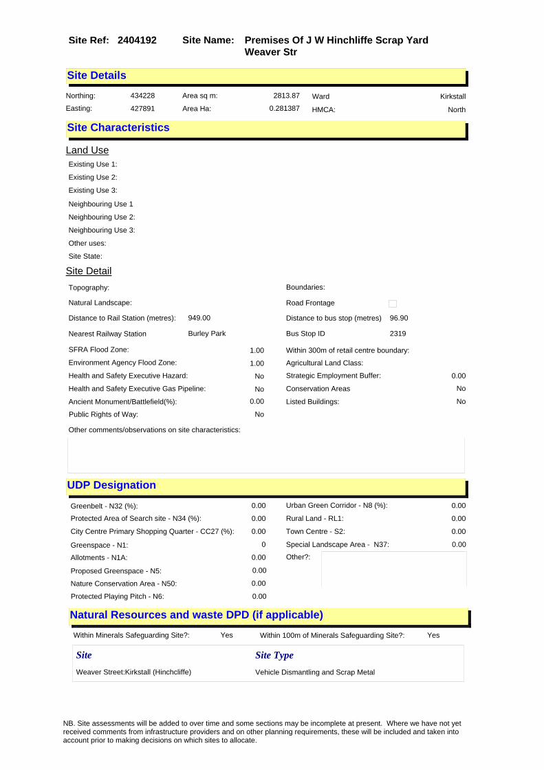
Site Name: Premises Of J W Hinchliffe Scrap Yard Weaver Str
Site Ref: 2404192
Site Details
Land Use
Northing: 434228
Easting: 427891
Distance to Rail Station (metres): 949.00
Nearest Railway Station Burley Park
Distance to bus stop (metres) 96.90
Bus Stop ID 2319
Agricultural Land Class:
SFRA Flood Zone: 1.00
Environment Agency Flood Zone: 1.00
Within 300m of retail centre boundary:
UDP Designation
Greenbelt - N32 (%): 0.00 Urban Green Corridor - N8 (%): 0.00
Protected Area of Search site - N34 (%): 0.00 Rural Land - RL1: 0.00
City Centre Primary Shopping Quarter - CC27 (%): 0.00 Town Centre - S2: 0.00
Health and Safety Executive Hazard: No
Health and Safety Executive Gas Pipeline: No
Strategic Employment Buffer: 0.00
Area sq m: 2813.87 Ward Kirkstall
Special Landscape Area - N37: 0.00
Allotments - N1A: 0.00
Proposed Greenspace - N5: 0.00
Protected Playing Pitch - N6: 0.00
Nature Conservation Area - N50: 0.00
Conservation Areas No
Ancient Monument/Battlefield(%): 0.00 Listed Buildings: No
Public Rights of Way: No
Other?:
Natural Resources and waste DPD (if applicable)
Within Minerals Safeguarding Site?: Yes Within 100m of Minerals Safeguarding Site?: Yes
HMCA: North
Greenspace - N1: 0
Existing Use 1:
Existing Use 2:
Existing Use 3:
Neighbouring Use 1
Neighbouring Use 2:
Neighbouring Use 3:
Other uses:
Topography:
Natural Landscape:
Boundaries:
Road Frontage
Site Characteristics
Site Detail
Other comments/observations on site characteristics:
Area Ha: 0.281387
Site State:
Site Site TypeWeaver Street:Kirkstall (Hinchcliffe) Vehicle Dismantling and Scrap Metal
NB. Site assessments will be added to over time and some sections may be incomplete at present. Where we have not yet received comments from infrastructure providers and on other planning requirements, these will be included and taken into account prior to making decisions on which sites to allocate.
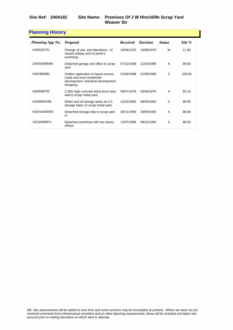
Site Name: Premises Of J W Hinchliffe Scrap Yard Weaver Str
Site Ref: 2404192
Planning History
Planning App No. Proposal Received Decision Status Site %
H26/532/76/ Change of use, and alterations , of vacant railway arch to joiner's workshop.
16/06/1976 16/08/1976 W 11.69
24/403/98/MIN Detached garage and office to scrap yard
07/12/1998 21/04/1999 A 89.60
H26/368/88/ Outline application to layout access roads and erect residential development, industrial development, shopping,
01/08/1988 01/08/1988 0 100.00
H26/658/79/ 2.29m high concrete block boun dary wall to scrap metal yard.
09/07/1979 03/09/1979 A 82.13
H24/69/92/99 Water and oil storage tanks an d 3 storage skips, to scrap metal yard.
21/02/1992 08/04/1992 A 88.95
H24/434/90/99 Detached storage skip to scrap yard. m
30/11/1990 29/09/1992 A 88.88
24/193/96/FU Detached workshop with two storey offices
12/07/1996 08/10/1996 A 88.09
NB. Site assessments will be added to over time and some sections may be incomplete at present. Where we have not yet received comments from infrastructure providers and on other planning requirements, these will be included and taken into account prior to making decisions on which sites to allocate.

Site Name: Premises Of J W Hinchliffe Scrap Yard Weaver Str
Site Ref: 2404192
Conformity with Core Strategy
Inner South Leeds: 0.00
Leeds Bradford Corridor: 0.00 West Leeds Gateway: 0.00
Aire Valley: 0.00Regeneration Priority Area:
Brownfield
Greenfield
Mixed
Main Urban Area
Major Settlement
Smaller Settlement
Villages/Rural
Main Urban Area Extension
Major Settlement Extension
Smaller Settlement Extension
Village/Rural Extension
Development unrelated to existing development
Green Belt assessment - only completed where site is within Green Belt
Would development lead to/constitute ribbon development?
Would development result in isolated development?
Is the site well connected to built up area (2+ boundaries with existing built up area)?
Would development of the site effectively "round off" the settlement pattern?:
Do natural/physical features provide a good existing barrier between existing urban area and undeveloped land?
Overall sprawl conclusion:
Would development of the site lead to physical connection of settlements?
Do natural/physical features provide a good existing barrier/boundary to contain development?
Overall Coalescence Conclusion:
Is there a strong defensible boundary between the site and the existing urban area?
Does the site provide access to the countryside?
Does the site include local or national conservation designated areas?
Does the site include areas of woodlands, trees, hedgerows that are protected, or significant unprotected tree/hedge cover?
Does the site include grade 1, 2, or 3a agricultural land?
Does the site contain buildings? Are these in agricultural use?
Overall countryside Encroachment Conclusion
Is the site within or adjacent to a conservation area, listed building or other historical feature?
If yes, could development preserve this character?:
Overall Character Preservation Conclusion:
Greenbelt Assessment Conclusion:
Check the unrestricted sprawl of large built up areas
Prevent neighbouring towns from merging
Assist in safeguarding countryside from encroachment
Preserve the setting and special character of historic towns
NB. Site assessments will be added to over time and some sections may be incomplete at present. Where we have not yet received comments from infrastructure providers and on other planning requirements, these will be included and taken into account prior to making decisions on which sites to allocate.

Site Name: Premises Of J W Hinchliffe Scrap Yard Weaver Str
Site Ref: 2404192
SHLAA ConclusionsAvailability: Suitability: Achievability:
Conclusion of Assessment
Conclusion summary:
Current site with planning permission for employment purposes
Floorspace sq m (Non residential):
Employment Conclusion: Lime Green
East Leeds
Assesment Type: ELR Type: Industrial & Warehousing
Proposed Change:
Gypsy Traveller Site Assessment
Yes No Maybe Could site be effectively managed (Text)
Yes No Maybe Would gypsies and travellers live on the site?
(Text)
Yes No Proximity to housed gypsies and travellers (Text)
Yes No Unknown Experience of previous encampments (Text)
NB. Site assessments will be added to over time and some sections may be incomplete at present. Where we have not yet received comments from infrastructure providers and on other planning requirements, these will be included and taken into account prior to making decisions on which sites to allocate.
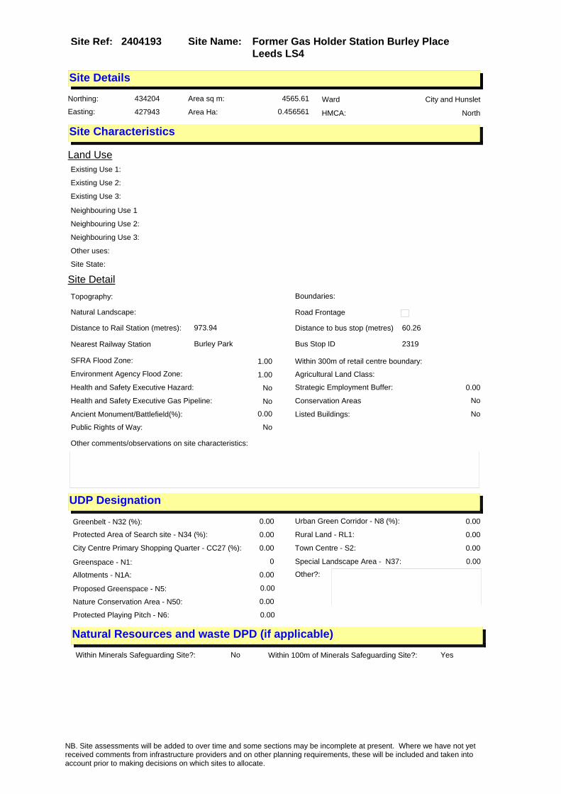
Site Name: Former Gas Holder Station Burley Place Leeds LS4
Site Ref: 2404193
Site Details
Land Use
Northing: 434204
Easting: 427943
Distance to Rail Station (metres): 973.94
Nearest Railway Station Burley Park
Distance to bus stop (metres) 60.26
Bus Stop ID 2319
Agricultural Land Class:
SFRA Flood Zone: 1.00
Environment Agency Flood Zone: 1.00
Within 300m of retail centre boundary:
UDP Designation
Greenbelt - N32 (%): 0.00 Urban Green Corridor - N8 (%): 0.00
Protected Area of Search site - N34 (%): 0.00 Rural Land - RL1: 0.00
City Centre Primary Shopping Quarter - CC27 (%): 0.00 Town Centre - S2: 0.00
Health and Safety Executive Hazard: No
Health and Safety Executive Gas Pipeline: No
Strategic Employment Buffer: 0.00
Area sq m: 4565.61 Ward City and Hunslet
Special Landscape Area - N37: 0.00
Allotments - N1A: 0.00
Proposed Greenspace - N5: 0.00
Protected Playing Pitch - N6: 0.00
Nature Conservation Area - N50: 0.00
Conservation Areas No
Ancient Monument/Battlefield(%): 0.00 Listed Buildings: No
Public Rights of Way: No
Other?:
Natural Resources and waste DPD (if applicable)
Within Minerals Safeguarding Site?: No Within 100m of Minerals Safeguarding Site?: Yes
HMCA: North
Greenspace - N1: 0
Existing Use 1:
Existing Use 2:
Existing Use 3:
Neighbouring Use 1
Neighbouring Use 2:
Neighbouring Use 3:
Other uses:
Topography:
Natural Landscape:
Boundaries:
Road Frontage
Site Characteristics
Site Detail
Other comments/observations on site characteristics:
Area Ha: 0.456561
Site State:
NB. Site assessments will be added to over time and some sections may be incomplete at present. Where we have not yet received comments from infrastructure providers and on other planning requirements, these will be included and taken into account prior to making decisions on which sites to allocate.

Site Name: Former Gas Holder Station Burley Place Leeds LS4
Site Ref: 2404193
Planning History
Planning App No. Proposal Received Decision Status Site %
08/03368/FU Detached motorcycle showroom, with offices and workshop, and detached blocks of 1 and 4 light industrial units
04/06/2008 10/09/2008 A 87.27
H26/532/76/ Change of use, and alterations , of vacant railway arch to joiner's workshop.
16/06/1976 16/08/1976 W 12.65
08/06129/FU Construction of block of 3 light industrial units with ancillary car parking
31/10/2008 APPRET 87.27
11/02976/OT Single storey self storage facility 13/07/2011 12/10/2011 A 84.22
09/04850/FU Temporary use of cleared site for self storage container units (class B8)
09/11/2009 28/01/2010 A 88.19
H26/368/88/ Outline application to layout access roads and erect residential development, industrial development, shopping,
01/08/1988 01/08/1988 0 100.00
H26/590/78/ 1 non illuminated wall mounted hoarding, size 6.1m (20ft ) x 3.05m (10ft), height above ground 1.52m (5ft) (underside
16/06/1978 17/07/1978 A 87.71
07/07247/FU Change of use of vacant site to car park
20/11/2007 14/03/2008 R 88.19
NB. Site assessments will be added to over time and some sections may be incomplete at present. Where we have not yet received comments from infrastructure providers and on other planning requirements, these will be included and taken into account prior to making decisions on which sites to allocate.

Site Name: Former Gas Holder Station Burley Place Leeds LS4
Site Ref: 2404193
Conformity with Core Strategy
Inner South Leeds: 0.00
Leeds Bradford Corridor: 0.00 West Leeds Gateway: 0.00
Aire Valley: 0.00Regeneration Priority Area:
Brownfield
Greenfield
Mixed
Main Urban Area
Major Settlement
Smaller Settlement
Villages/Rural
Main Urban Area Extension
Major Settlement Extension
Smaller Settlement Extension
Village/Rural Extension
Development unrelated to existing development
Green Belt assessment - only completed where site is within Green Belt
Would development lead to/constitute ribbon development?
Would development result in isolated development?
Is the site well connected to built up area (2+ boundaries with existing built up area)?
Would development of the site effectively "round off" the settlement pattern?:
Do natural/physical features provide a good existing barrier between existing urban area and undeveloped land?
Overall sprawl conclusion:
Would development of the site lead to physical connection of settlements?
Do natural/physical features provide a good existing barrier/boundary to contain development?
Overall Coalescence Conclusion:
Is there a strong defensible boundary between the site and the existing urban area?
Does the site provide access to the countryside?
Does the site include local or national conservation designated areas?
Does the site include areas of woodlands, trees, hedgerows that are protected, or significant unprotected tree/hedge cover?
Does the site include grade 1, 2, or 3a agricultural land?
Does the site contain buildings? Are these in agricultural use?
Overall countryside Encroachment Conclusion
Is the site within or adjacent to a conservation area, listed building or other historical feature?
If yes, could development preserve this character?:
Overall Character Preservation Conclusion:
Greenbelt Assessment Conclusion:
Check the unrestricted sprawl of large built up areas
Prevent neighbouring towns from merging
Assist in safeguarding countryside from encroachment
Preserve the setting and special character of historic towns
NB. Site assessments will be added to over time and some sections may be incomplete at present. Where we have not yet received comments from infrastructure providers and on other planning requirements, these will be included and taken into account prior to making decisions on which sites to allocate.

Site Name: Former Gas Holder Station Burley Place Leeds LS4
Site Ref: 2404193
SHLAA ConclusionsAvailability: Suitability: Achievability:
Conclusion of Assessment
Conclusion summary:
A small site with remediation completed. Best suited to small-scale low-sensitivity commercial uses such as B1c/B2/B8.
Floorspace sq m (Non residential):
Employment Conclusion: Lime Green
East Leeds
Assesment Type: ELR Type: Industrial & Warehousing
Proposed Change:
Gypsy Traveller Site Assessment
Yes No Maybe Could site be effectively managed (Text)
Yes No Maybe Would gypsies and travellers live on the site?
(Text)
Yes No Proximity to housed gypsies and travellers (Text)
Yes No Unknown Experience of previous encampments (Text)
NB. Site assessments will be added to over time and some sections may be incomplete at present. Where we have not yet received comments from infrastructure providers and on other planning requirements, these will be included and taken into account prior to making decisions on which sites to allocate.
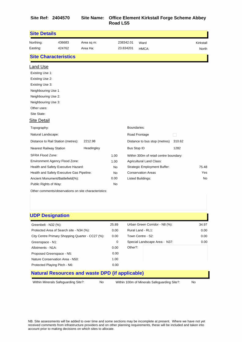
Site Name: Office Element Kirkstall Forge Scheme Abbey Road LS5
Site Ref: 2404570
Site Details
Land Use
Northing: 436683
Easting: 424762
Distance to Rail Station (metres): 2212.98
Nearest Railway Station Headingley
Distance to bus stop (metres) 310.62
Bus Stop ID 1282
Agricultural Land Class:
SFRA Flood Zone: 1.00
Environment Agency Flood Zone: 1.00
Within 300m of retail centre boundary:
UDP Designation
Greenbelt - N32 (%): 25.89 Urban Green Corridor - N8 (%): 34.97
Protected Area of Search site - N34 (%): 0.00 Rural Land - RL1: 0.00
City Centre Primary Shopping Quarter - CC27 (%): 0.00 Town Centre - S2: 0.00
Health and Safety Executive Hazard: No
Health and Safety Executive Gas Pipeline: No
Strategic Employment Buffer: 75.48
Area sq m: 238342.01 Ward Kirkstall
Special Landscape Area - N37: 0.00
Allotments - N1A: 0.00
Proposed Greenspace - N5: 0.00
Protected Playing Pitch - N6: 0.00
Nature Conservation Area - N50: 1.00
Conservation Areas Yes
Ancient Monument/Battlefield(%): 0.00 Listed Buildings: No
Public Rights of Way: No
Other?:
Natural Resources and waste DPD (if applicable)
Within Minerals Safeguarding Site?: No Within 100m of Minerals Safeguarding Site?: No
HMCA: North
Greenspace - N1: 0
Existing Use 1:
Existing Use 2:
Existing Use 3:
Neighbouring Use 1
Neighbouring Use 2:
Neighbouring Use 3:
Other uses:
Topography:
Natural Landscape:
Boundaries:
Road Frontage
Site Characteristics
Site Detail
Other comments/observations on site characteristics:
Area Ha: 23.834201
Site State:
NB. Site assessments will be added to over time and some sections may be incomplete at present. Where we have not yet received comments from infrastructure providers and on other planning requirements, these will be included and taken into account prior to making decisions on which sites to allocate.

Site Name: Office Element Kirkstall Forge Scheme Abbey Road LS5
Site Ref: 2404570
Planning History
Planning App No. Proposal Received Decision Status Site %
H26/199/79/ Single storey industrial unit, with 2 storey ancillary offic es and toilets, to engineering works.
19/03/1979 04/06/1979 A 57.62
PREAPP/08/00206 Masterplan Revisions and Reserved Matters Submissions
11/05/2008 PCO 70.56
24/193/93/OT Outline application to erect non-food retail development to industrial site
16/06/1993 22/03/1994 R 25.89
24/192/93/OT Outline application to erect non-food retail development to industrial site
09/06/1993 22/03/1994 R 25.89
24/96/05/OT Outline application to erect mixed use development comprising residential, offices, leisure, hotel, retail & bar/restaurants including access, site remediation, construction of bridges and river works, car parking and landscaping
02/02/2005 20/07/2007 A 100.00
H26/391/75/ Alterations, to form w.c., and 18639 litres (4100 gallo ns) cess pit, to gate house, t o engineering premises.
07/05/1975 21/07/1975 A 57.62
H26/340/79/ Laying out of 245 car parking spaces, to vacant site. (site area 0.72ha).
05/04/1979 04/06/1979 A 57.62
H26/1178/79/ Use of vacant site as tip. 26/11/1979 18/11/1980 A 13.92
24/191/93/OT Outline application to erect food and non-food retail development to industrial site
16/06/1993 22/03/1994 R 25.89
11/01400/EXT Extension of Time period permission for application 24/96/05/OT for mixed use development comprising residential, offices, leisure, hotel, retail & bar/restaurants including access, site remediation, construction of bridges and river works, car parking and landscaping
05/04/2011 PCO 100.00
24/190/93/OT Outline application to erect food and non-food retail development to industrial site
09/06/1993 22/03/1994 R 25.89
PREAPP/08/00392 Proposed railway station 01/12/2008 PRECAG 70.56
H26/168/76/ Extension of existing permissi on for single-storey prefa bricated office building. (app lication no. bb 787/1 e
20/02/1976 09/03/1976 A 57.62
H26/263/76/ Alterations to existing access , to engineering works.
18/03/1976 18/05/1976 A 57.62
H26/928/77/ Alterations to form medical st ore and additional surge ry and first floor extension, to form chiropody room, dent
10/11/1977 19/12/1977 A 18.61
NB. Site assessments will be added to over time and some sections may be incomplete at present. Where we have not yet received comments from infrastructure providers and on other planning requirements, these will be included and taken into account prior to making decisions on which sites to allocate.

Site Name: Office Element Kirkstall Forge Scheme Abbey Road LS5
Site Ref: 2404570
Conformity with Core Strategy
Inner South Leeds: 0.00
Leeds Bradford Corridor: 0.00 West Leeds Gateway: 0.00
Aire Valley: 0.00Regeneration Priority Area:
Brownfield
Greenfield
Mixed
Main Urban Area
Major Settlement
Smaller Settlement
Villages/Rural
Main Urban Area Extension
Major Settlement Extension
Smaller Settlement Extension
Village/Rural Extension
Development unrelated to existing development
Green Belt assessment - only completed where site is within Green Belt
Would development lead to/constitute ribbon development?
Would development result in isolated development?
Is the site well connected to built up area (2+ boundaries with existing built up area)?
Would development of the site effectively "round off" the settlement pattern?:
Do natural/physical features provide a good existing barrier between existing urban area and undeveloped land?
Overall sprawl conclusion:
Would development of the site lead to physical connection of settlements?
Do natural/physical features provide a good existing barrier/boundary to contain development?
Overall Coalescence Conclusion:
Is there a strong defensible boundary between the site and the existing urban area?
Does the site provide access to the countryside?
Does the site include local or national conservation designated areas?
Does the site include areas of woodlands, trees, hedgerows that are protected, or significant unprotected tree/hedge cover?
Does the site include grade 1, 2, or 3a agricultural land?
Does the site contain buildings? Are these in agricultural use?
Overall countryside Encroachment Conclusion
Is the site within or adjacent to a conservation area, listed building or other historical feature?
If yes, could development preserve this character?:
Overall Character Preservation Conclusion:
Greenbelt Assessment Conclusion:
Check the unrestricted sprawl of large built up areas
Prevent neighbouring towns from merging
Assist in safeguarding countryside from encroachment
Preserve the setting and special character of historic towns
NB. Site assessments will be added to over time and some sections may be incomplete at present. Where we have not yet received comments from infrastructure providers and on other planning requirements, these will be included and taken into account prior to making decisions on which sites to allocate.

Site Name: Office Element Kirkstall Forge Scheme Abbey Road LS5
Site Ref: 2404570
SHLAA ConclusionsAvailability: Suitability: Achievability:
Conclusion of Assessment
Conclusion summary:
Reflects the outline planning permission for mixed use granted 20/7/2007.
Floorspace sq m (Non residential): 14270
Employment Conclusion: Green
East Leeds
Assesment Type: ELR Type: Office
Proposed Change:
Gypsy Traveller Site Assessment
Yes No Maybe Could site be effectively managed (Text)
Yes No Maybe Would gypsies and travellers live on the site?
(Text)
Yes No Proximity to housed gypsies and travellers (Text)
Yes No Unknown Experience of previous encampments (Text)
NB. Site assessments will be added to over time and some sections may be incomplete at present. Where we have not yet received comments from infrastructure providers and on other planning requirements, these will be included and taken into account prior to making decisions on which sites to allocate.

Site Name: Unit 2 St Anns Mills off Commercial Road Kirkstall
Site Ref: 2405330
Site Details
Land Use
Northing: 435248
Easting: 426374
Distance to Rail Station (metres): 720.63
Nearest Railway Station Headingley
Distance to bus stop (metres) 95.17
Bus Stop ID 12126
Agricultural Land Class:
SFRA Flood Zone: 1.00
Environment Agency Flood Zone: 1.00
Within 300m of retail centre boundary:
UDP Designation
Greenbelt - N32 (%): 0.00 Urban Green Corridor - N8 (%): 99.95
Protected Area of Search site - N34 (%): 0.00 Rural Land - RL1: 0.00
City Centre Primary Shopping Quarter - CC27 (%): 0.00 Town Centre - S2: 1.00
Health and Safety Executive Hazard: No
Health and Safety Executive Gas Pipeline: No
Strategic Employment Buffer: 0.00
Area sq m: 2213.65 Ward Kirkstall
Special Landscape Area - N37: 0.00
Allotments - N1A: 0.00
Proposed Greenspace - N5: 0.00
Protected Playing Pitch - N6: 0.00
Nature Conservation Area - N50: 0.00
Conservation Areas No
Ancient Monument/Battlefield(%): 0.00 Listed Buildings: No
Public Rights of Way: No
Other?:
Natural Resources and waste DPD (if applicable)
Within Minerals Safeguarding Site?: No Within 100m of Minerals Safeguarding Site?: No
HMCA: North
Greenspace - N1: 0
Existing Use 1:
Existing Use 2:
Existing Use 3:
Neighbouring Use 1
Neighbouring Use 2:
Neighbouring Use 3:
Other uses:
Topography:
Natural Landscape:
Boundaries:
Road Frontage
Site Characteristics
Site Detail
Other comments/observations on site characteristics:
Area Ha: 0.221365
Site State:
NB. Site assessments will be added to over time and some sections may be incomplete at present. Where we have not yet received comments from infrastructure providers and on other planning requirements, these will be included and taken into account prior to making decisions on which sites to allocate.

Site Name: Unit 2 St Anns Mills off Commercial Road Kirkstall
Site Ref: 2405330
Planning History
Planning App No. Proposal Received Decision Status Site %
09/04584/FU Use of vacant building for general industry (Class B2)
22/10/2009 11/12/2009 A 100.00
H26/1070/79/ Laying out of new access to mi lls. (this item is also notic e under regulation 4(1) of the town and country planning g
22/10/1979 26/11/1979 A 100.00
H26/368/88/ Outline application to layout access roads and erect residential development, industrial development, shopping,
01/08/1988 01/08/1988 0 100.00
H26/9/82/ Detached warehouse unit to sid e of factory.
14/01/1982 22/02/1982 A 11.97
H26/223/88/ Alterations and extension, to form enlarged warehouse to wo rks.
12/05/1988 15/08/1988 A 97.93
NB. Site assessments will be added to over time and some sections may be incomplete at present. Where we have not yet received comments from infrastructure providers and on other planning requirements, these will be included and taken into account prior to making decisions on which sites to allocate.

Site Name: Unit 2 St Anns Mills off Commercial Road Kirkstall
Site Ref: 2405330
Conformity with Core Strategy
Inner South Leeds: 0.00
Leeds Bradford Corridor: 0.00 West Leeds Gateway: 0.00
Aire Valley: 0.00Regeneration Priority Area:
Brownfield
Greenfield
Mixed
Main Urban Area
Major Settlement
Smaller Settlement
Villages/Rural
Main Urban Area Extension
Major Settlement Extension
Smaller Settlement Extension
Village/Rural Extension
Development unrelated to existing development
Green Belt assessment - only completed where site is within Green Belt
Would development lead to/constitute ribbon development?
Would development result in isolated development?
Is the site well connected to built up area (2+ boundaries with existing built up area)?
Would development of the site effectively "round off" the settlement pattern?:
Do natural/physical features provide a good existing barrier between existing urban area and undeveloped land?
Overall sprawl conclusion:
Would development of the site lead to physical connection of settlements?
Do natural/physical features provide a good existing barrier/boundary to contain development?
Overall Coalescence Conclusion:
Is there a strong defensible boundary between the site and the existing urban area?
Does the site provide access to the countryside?
Does the site include local or national conservation designated areas?
Does the site include areas of woodlands, trees, hedgerows that are protected, or significant unprotected tree/hedge cover?
Does the site include grade 1, 2, or 3a agricultural land?
Does the site contain buildings? Are these in agricultural use?
Overall countryside Encroachment Conclusion
Is the site within or adjacent to a conservation area, listed building or other historical feature?
If yes, could development preserve this character?:
Overall Character Preservation Conclusion:
Greenbelt Assessment Conclusion:
Check the unrestricted sprawl of large built up areas
Prevent neighbouring towns from merging
Assist in safeguarding countryside from encroachment
Preserve the setting and special character of historic towns
NB. Site assessments will be added to over time and some sections may be incomplete at present. Where we have not yet received comments from infrastructure providers and on other planning requirements, these will be included and taken into account prior to making decisions on which sites to allocate.

Site Name: Unit 2 St Anns Mills off Commercial Road Kirkstall
Site Ref: 2405330
SHLAA ConclusionsAvailability: Suitability: Achievability:
Conclusion of Assessment
Conclusion summary:
Current site with planning permission for employment purposes
Floorspace sq m (Non residential):
Employment Conclusion: Lime Green
East Leeds
Assesment Type: ELR Type: Industrial & Warehousing
Proposed Change:
Gypsy Traveller Site Assessment
Yes No Maybe Could site be effectively managed (Text)
Yes No Maybe Would gypsies and travellers live on the site?
(Text)
Yes No Proximity to housed gypsies and travellers (Text)
Yes No Unknown Experience of previous encampments (Text)
NB. Site assessments will be added to over time and some sections may be incomplete at present. Where we have not yet received comments from infrastructure providers and on other planning requirements, these will be included and taken into account prior to making decisions on which sites to allocate.

Site Name: Round Hill Pudsey Site Ref: 2500550
Site Details
Land Use
Northing: 433060
Easting: 421130
Distance to Rail Station (metres): 1245.22
Nearest Railway Station New Pudsey
Distance to bus stop (metres) 184.87
Bus Stop ID 6520
Agricultural Land Class:
SFRA Flood Zone: 0.00
Environment Agency Flood Zone: 0.00
Within 300m of retail centre boundary:
UDP Designation
Greenbelt - N32 (%): 0.00 Urban Green Corridor - N8 (%): 0.00
Protected Area of Search site - N34 (%): 0.00 Rural Land - RL1: 0.00
City Centre Primary Shopping Quarter - CC27 (%): 0.00 Town Centre - S2: 0.00
Health and Safety Executive Hazard: No
Health and Safety Executive Gas Pipeline: No
Strategic Employment Buffer: 0.00
Area sq m: 10482.38 Ward Pudsey
Special Landscape Area - N37: 0.00
Allotments - N1A: 0.00
Proposed Greenspace - N5: 0.00
Protected Playing Pitch - N6: 0.00
Nature Conservation Area - N50: 0.00
Conservation Areas No
Ancient Monument/Battlefield(%): 0.00 Listed Buildings: No
Public Rights of Way: No
Other?:
Natural Resources and waste DPD (if applicable)
Within Minerals Safeguarding Site?: No Within 100m of Minerals Safeguarding Site?: No
HMCA: Outer West
Greenspace - N1: 0
Existing Use 1:
Existing Use 2:
Existing Use 3:
Neighbouring Use 1
Neighbouring Use 2:
Neighbouring Use 3:
Other uses:
Topography:
Natural Landscape:
Boundaries:
Road Frontage
Site Characteristics
Site Detail
Other comments/observations on site characteristics:
Area Ha: 1.048238
Site State:
NB. Site assessments will be added to over time and some sections may be incomplete at present. Where we have not yet received comments from infrastructure providers and on other planning requirements, these will be included and taken into account prior to making decisions on which sites to allocate.

Site Name: Round Hill Pudsey Site Ref: 2500550
Planning History
NB. Site assessments will be added to over time and some sections may be incomplete at present. Where we have not yet received comments from infrastructure providers and on other planning requirements, these will be included and taken into account prior to making decisions on which sites to allocate.

Site Name: Round Hill Pudsey Site Ref: 2500550
Conformity with Core Strategy
Inner South Leeds: 0.00
Leeds Bradford Corridor: 100.00 West Leeds Gateway: 0.00
Aire Valley: 0.00Regeneration Priority Area:
Brownfield
Greenfield
Mixed
Main Urban Area
Major Settlement
Smaller Settlement
Villages/Rural
Main Urban Area Extension
Major Settlement Extension
Smaller Settlement Extension
Village/Rural Extension
Development unrelated to existing development
Green Belt assessment - only completed where site is within Green Belt
Would development lead to/constitute ribbon development?
Would development result in isolated development?
Is the site well connected to built up area (2+ boundaries with existing built up area)?
Would development of the site effectively "round off" the settlement pattern?:
Do natural/physical features provide a good existing barrier between existing urban area and undeveloped land?
Overall sprawl conclusion:
Would development of the site lead to physical connection of settlements?
Do natural/physical features provide a good existing barrier/boundary to contain development?
Overall Coalescence Conclusion:
Is there a strong defensible boundary between the site and the existing urban area?
Does the site provide access to the countryside?
Does the site include local or national conservation designated areas?
Does the site include areas of woodlands, trees, hedgerows that are protected, or significant unprotected tree/hedge cover?
Does the site include grade 1, 2, or 3a agricultural land?
Does the site contain buildings? Are these in agricultural use?
Overall countryside Encroachment Conclusion
Is the site within or adjacent to a conservation area, listed building or other historical feature?
If yes, could development preserve this character?:
Overall Character Preservation Conclusion:
Greenbelt Assessment Conclusion:
Check the unrestricted sprawl of large built up areas
Prevent neighbouring towns from merging
Assist in safeguarding countryside from encroachment
Preserve the setting and special character of historic towns
NB. Site assessments will be added to over time and some sections may be incomplete at present. Where we have not yet received comments from infrastructure providers and on other planning requirements, these will be included and taken into account prior to making decisions on which sites to allocate.

Site Name: Round Hill Pudsey Site Ref: 2500550
SHLAA ConclusionsAvailability: Suitability: Achievability:
Conclusion of Assessment
Conclusion summary:
Site has consent for housing.
Floorspace sq m (Non residential):
Employment Conclusion: Red
East Leeds
Assesment Type: ELR Type: Industrial & Warehousing
Proposed Change:
Gypsy Traveller Site Assessment
Yes No Maybe Could site be effectively managed (Text)
Yes No Maybe Would gypsies and travellers live on the site?
(Text)
Yes No Proximity to housed gypsies and travellers (Text)
Yes No Unknown Experience of previous encampments (Text)
NB. Site assessments will be added to over time and some sections may be incomplete at present. Where we have not yet received comments from infrastructure providers and on other planning requirements, these will be included and taken into account prior to making decisions on which sites to allocate.

Site Name: Stanningley Station LS 28 Site Ref: 2501400
Site Details
Land Use
Northing: 434329
Easting: 422278
Distance to Rail Station (metres): 1143.47
Nearest Railway Station New Pudsey
Distance to bus stop (metres) 182.83
Bus Stop ID 12547
Agricultural Land Class:
SFRA Flood Zone: 0.00
Environment Agency Flood Zone: 0.00
Within 300m of retail centre boundary:
UDP Designation
Greenbelt - N32 (%): 0.00 Urban Green Corridor - N8 (%): 0.00
Protected Area of Search site - N34 (%): 0.00 Rural Land - RL1: 0.00
City Centre Primary Shopping Quarter - CC27 (%): 0.00 Town Centre - S2: 0.00
Health and Safety Executive Hazard: No
Health and Safety Executive Gas Pipeline: No
Strategic Employment Buffer: 0.00
Area sq m: 31080.20 Ward Calverley and Farsley
Special Landscape Area - N37: 0.00
Allotments - N1A: 0.00
Proposed Greenspace - N5: 0.00
Protected Playing Pitch - N6: 0.00
Nature Conservation Area - N50: 0.00
Conservation Areas No
Ancient Monument/Battlefield(%): 0.00 Listed Buildings: No
Public Rights of Way: No
Other?:
Natural Resources and waste DPD (if applicable)
Within Minerals Safeguarding Site?: Yes Within 100m of Minerals Safeguarding Site?: Yes
HMCA: Outer West
Greenspace - N1: 0
Existing Use 1:
Existing Use 2:
Existing Use 3:
Neighbouring Use 1
Neighbouring Use 2:
Neighbouring Use 3:
Other uses:
Topography:
Natural Landscape:
Boundaries:
Road Frontage
Site Characteristics
Site Detail
Other comments/observations on site characteristics:
Area Ha: 3.10802
Site State:
Site Site TypeGrangefield Industrial Estate, Stanningley Industrial Estate
NB. Site assessments will be added to over time and some sections may be incomplete at present. Where we have not yet received comments from infrastructure providers and on other planning requirements, these will be included and taken into account prior to making decisions on which sites to allocate.
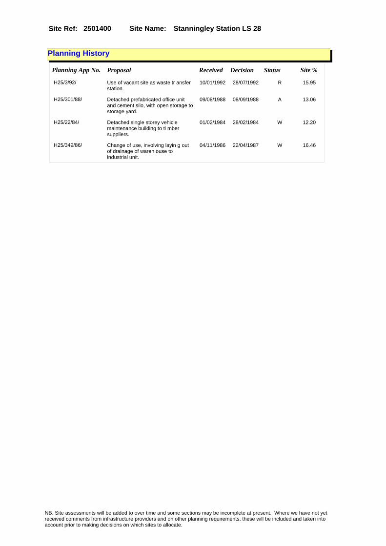
Site Name: Stanningley Station LS 28 Site Ref: 2501400
Planning History
Planning App No. Proposal Received Decision Status Site %
H25/3/92/ Use of vacant site as waste tr ansfer station.
10/01/1992 28/07/1992 R 15.95
H25/301/88/ Detached prefabricated office unit and cement silo, with open storage to storage yard.
09/08/1988 08/09/1988 A 13.06
H25/22/84/ Detached single storey vehicle maintenance building to ti mber suppliers.
01/02/1984 28/02/1984 W 12.20
H25/349/86/ Change of use, involving layin g out of drainage of wareh ouse to industrial unit.
04/11/1986 22/04/1987 W 16.46
NB. Site assessments will be added to over time and some sections may be incomplete at present. Where we have not yet received comments from infrastructure providers and on other planning requirements, these will be included and taken into account prior to making decisions on which sites to allocate.

Site Name: Stanningley Station LS 28 Site Ref: 2501400
Conformity with Core Strategy
Inner South Leeds: 0.00
Leeds Bradford Corridor: 100.00 West Leeds Gateway: 0.00
Aire Valley: 0.00Regeneration Priority Area:
Brownfield
Greenfield
Mixed
Main Urban Area
Major Settlement
Smaller Settlement
Villages/Rural
Main Urban Area Extension
Major Settlement Extension
Smaller Settlement Extension
Village/Rural Extension
Development unrelated to existing development
Green Belt assessment - only completed where site is within Green Belt
Would development lead to/constitute ribbon development?
Would development result in isolated development?
Is the site well connected to built up area (2+ boundaries with existing built up area)?
Would development of the site effectively "round off" the settlement pattern?:
Do natural/physical features provide a good existing barrier between existing urban area and undeveloped land?
Overall sprawl conclusion:
Would development of the site lead to physical connection of settlements?
Do natural/physical features provide a good existing barrier/boundary to contain development?
Overall Coalescence Conclusion:
Is there a strong defensible boundary between the site and the existing urban area?
Does the site provide access to the countryside?
Does the site include local or national conservation designated areas?
Does the site include areas of woodlands, trees, hedgerows that are protected, or significant unprotected tree/hedge cover?
Does the site include grade 1, 2, or 3a agricultural land?
Does the site contain buildings? Are these in agricultural use?
Overall countryside Encroachment Conclusion
Is the site within or adjacent to a conservation area, listed building or other historical feature?
If yes, could development preserve this character?:
Overall Character Preservation Conclusion:
Greenbelt Assessment Conclusion:
Check the unrestricted sprawl of large built up areas
Prevent neighbouring towns from merging
Assist in safeguarding countryside from encroachment
Preserve the setting and special character of historic towns
NB. Site assessments will be added to over time and some sections may be incomplete at present. Where we have not yet received comments from infrastructure providers and on other planning requirements, these will be included and taken into account prior to making decisions on which sites to allocate.

Site Name: Stanningley Station LS 28 Site Ref: 2501400
SHLAA ConclusionsAvailability: Suitability: Achievability:
Conclusion of Assessment
Conclusion summary:
Site is in active use as timber and builders merchant and should therefore be removed.
Floorspace sq m (Non residential):
Employment Conclusion: Red
East Leeds
Assesment Type: ELR Type: Industrial & Warehousing
Proposed Change:
Gypsy Traveller Site Assessment
Yes No Maybe Could site be effectively managed (Text)
Yes No Maybe Would gypsies and travellers live on the site?
(Text)
Yes No Proximity to housed gypsies and travellers (Text)
Yes No Unknown Experience of previous encampments (Text)
NB. Site assessments will be added to over time and some sections may be incomplete at present. Where we have not yet received comments from infrastructure providers and on other planning requirements, these will be included and taken into account prior to making decisions on which sites to allocate.
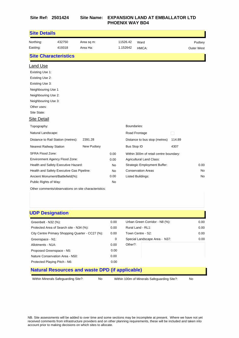
Site Name: EXPANSION LAND AT EMBALLATOR LTD PHOENIX WAY BD4
Site Ref: 2501424
Site Details
Land Use
Northing: 432750
Easting: 419318
Distance to Rail Station (metres): 2391.28
Nearest Railway Station New Pudsey
Distance to bus stop (metres) 114.89
Bus Stop ID 4307
Agricultural Land Class:
SFRA Flood Zone: 0.00
Environment Agency Flood Zone: 0.00
Within 300m of retail centre boundary:
UDP Designation
Greenbelt - N32 (%): 0.00 Urban Green Corridor - N8 (%): 0.00
Protected Area of Search site - N34 (%): 0.00 Rural Land - RL1: 0.00
City Centre Primary Shopping Quarter - CC27 (%): 0.00 Town Centre - S2: 0.00
Health and Safety Executive Hazard: No
Health and Safety Executive Gas Pipeline: No
Strategic Employment Buffer: 0.00
Area sq m: 11526.42 Ward Pudsey
Special Landscape Area - N37: 0.00
Allotments - N1A: 0.00
Proposed Greenspace - N5: 0.00
Protected Playing Pitch - N6: 0.00
Nature Conservation Area - N50: 0.00
Conservation Areas No
Ancient Monument/Battlefield(%): 0.00 Listed Buildings: No
Public Rights of Way: No
Other?:
Natural Resources and waste DPD (if applicable)
Within Minerals Safeguarding Site?: No Within 100m of Minerals Safeguarding Site?: No
HMCA: Outer West
Greenspace - N1: 0
Existing Use 1:
Existing Use 2:
Existing Use 3:
Neighbouring Use 1
Neighbouring Use 2:
Neighbouring Use 3:
Other uses:
Topography:
Natural Landscape:
Boundaries:
Road Frontage
Site Characteristics
Site Detail
Other comments/observations on site characteristics:
Area Ha: 1.152642
Site State:
NB. Site assessments will be added to over time and some sections may be incomplete at present. Where we have not yet received comments from infrastructure providers and on other planning requirements, these will be included and taken into account prior to making decisions on which sites to allocate.
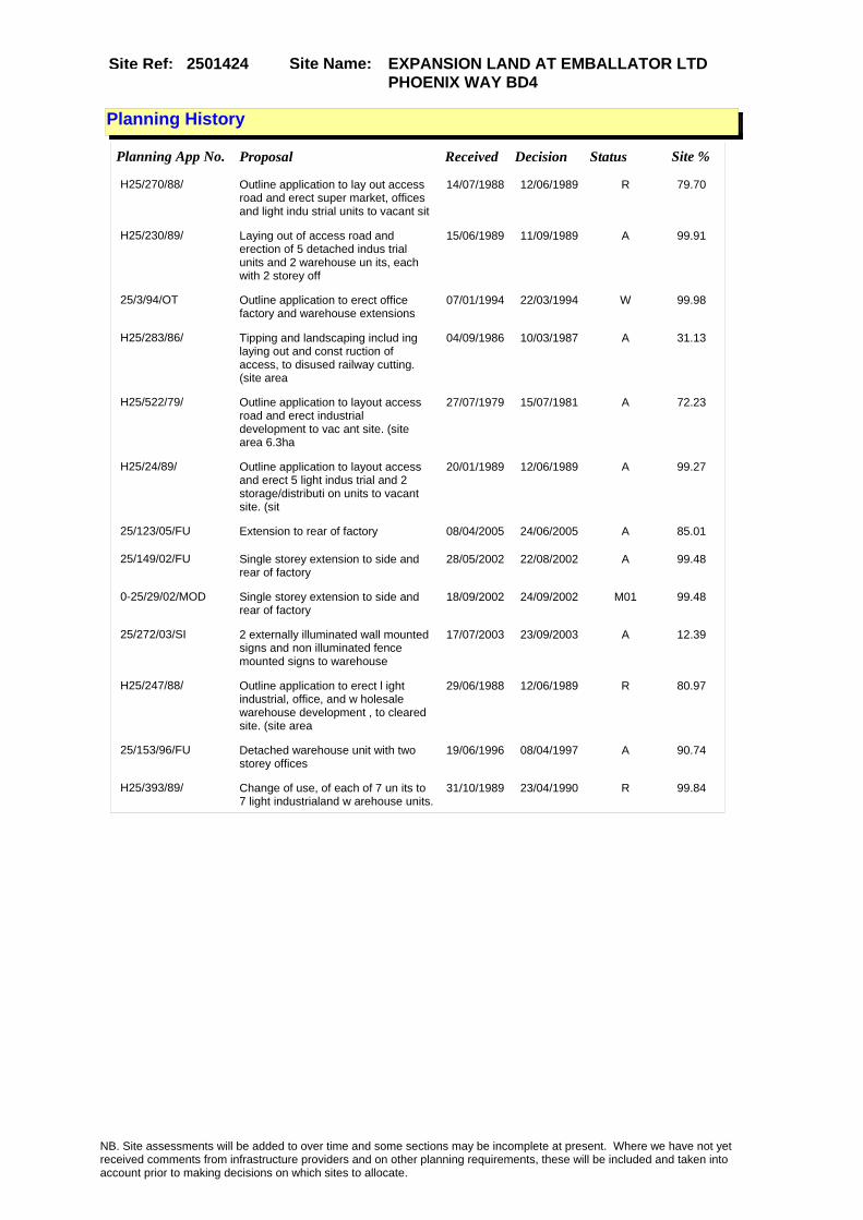
Site Name: EXPANSION LAND AT EMBALLATOR LTD PHOENIX WAY BD4
Site Ref: 2501424
Planning History
Planning App No. Proposal Received Decision Status Site %
H25/270/88/ Outline application to lay out access road and erect super market, offices and light indu strial units to vacant sit
14/07/1988 12/06/1989 R 79.70
H25/230/89/ Laying out of access road and erection of 5 detached indus trial units and 2 warehouse un its, each with 2 storey off
15/06/1989 11/09/1989 A 99.91
25/3/94/OT Outline application to erect office factory and warehouse extensions
07/01/1994 22/03/1994 W 99.98
H25/283/86/ Tipping and landscaping includ ing laying out and const ruction of access, to disused railway cutting. (site area
04/09/1986 10/03/1987 A 31.13
H25/522/79/ Outline application to layout access road and erect industrial development to vac ant site. (site area 6.3ha
27/07/1979 15/07/1981 A 72.23
H25/24/89/ Outline application to layout access and erect 5 light indus trial and 2 storage/distributi on units to vacant site. (sit
20/01/1989 12/06/1989 A 99.27
25/123/05/FU Extension to rear of factory 08/04/2005 24/06/2005 A 85.01
25/149/02/FU Single storey extension to side and rear of factory
28/05/2002 22/08/2002 A 99.48
0-25/29/02/MOD Single storey extension to side and rear of factory
18/09/2002 24/09/2002 M01 99.48
25/272/03/SI 2 externally illuminated wall mounted signs and non illuminated fence mounted signs to warehouse
17/07/2003 23/09/2003 A 12.39
H25/247/88/ Outline application to erect l ight industrial, office, and w holesale warehouse development , to cleared site. (site area
29/06/1988 12/06/1989 R 80.97
25/153/96/FU Detached warehouse unit with two storey offices
19/06/1996 08/04/1997 A 90.74
H25/393/89/ Change of use, of each of 7 un its to 7 light industrialand w arehouse units.
31/10/1989 23/04/1990 R 99.84
NB. Site assessments will be added to over time and some sections may be incomplete at present. Where we have not yet received comments from infrastructure providers and on other planning requirements, these will be included and taken into account prior to making decisions on which sites to allocate.

Site Name: EXPANSION LAND AT EMBALLATOR LTD PHOENIX WAY BD4
Site Ref: 2501424
Conformity with Core Strategy
Inner South Leeds: 0.00
Leeds Bradford Corridor: 100.00 West Leeds Gateway: 0.00
Aire Valley: 0.00Regeneration Priority Area:
Brownfield
Greenfield
Mixed
Main Urban Area
Major Settlement
Smaller Settlement
Villages/Rural
Main Urban Area Extension
Major Settlement Extension
Smaller Settlement Extension
Village/Rural Extension
Development unrelated to existing development
Green Belt assessment - only completed where site is within Green Belt
Would development lead to/constitute ribbon development?
Would development result in isolated development?
Is the site well connected to built up area (2+ boundaries with existing built up area)?
Would development of the site effectively "round off" the settlement pattern?:
Do natural/physical features provide a good existing barrier between existing urban area and undeveloped land?
Overall sprawl conclusion:
Would development of the site lead to physical connection of settlements?
Do natural/physical features provide a good existing barrier/boundary to contain development?
Overall Coalescence Conclusion:
Is there a strong defensible boundary between the site and the existing urban area?
Does the site provide access to the countryside?
Does the site include local or national conservation designated areas?
Does the site include areas of woodlands, trees, hedgerows that are protected, or significant unprotected tree/hedge cover?
Does the site include grade 1, 2, or 3a agricultural land?
Does the site contain buildings? Are these in agricultural use?
Overall countryside Encroachment Conclusion
Is the site within or adjacent to a conservation area, listed building or other historical feature?
If yes, could development preserve this character?:
Overall Character Preservation Conclusion:
Greenbelt Assessment Conclusion:
Check the unrestricted sprawl of large built up areas
Prevent neighbouring towns from merging
Assist in safeguarding countryside from encroachment
Preserve the setting and special character of historic towns
NB. Site assessments will be added to over time and some sections may be incomplete at present. Where we have not yet received comments from infrastructure providers and on other planning requirements, these will be included and taken into account prior to making decisions on which sites to allocate.

Site Name: EXPANSION LAND AT EMBALLATOR LTD PHOENIX WAY BD4
Site Ref: 2501424
SHLAA ConclusionsAvailability: Suitability: Achievability:
Conclusion of Assessment
Conclusion summary:
Expansion land for frontage occupier.
Floorspace sq m (Non residential):
Employment Conclusion: Green
East Leeds
Assesment Type: ELR Type: Industrial & Warehousing
Proposed Change:
Gypsy Traveller Site Assessment
Yes No Maybe Could site be effectively managed (Text)
Yes No Maybe Would gypsies and travellers live on the site?
(Text)
Yes No Proximity to housed gypsies and travellers (Text)
Yes No Unknown Experience of previous encampments (Text)
NB. Site assessments will be added to over time and some sections may be incomplete at present. Where we have not yet received comments from infrastructure providers and on other planning requirements, these will be included and taken into account prior to making decisions on which sites to allocate.

Site Name: Lane End Terrace PudseySite Ref: 2501640
Site Details
Land Use
Northing: 433663
Easting: 422848
Distance to Rail Station (metres): 1336.21
Nearest Railway Station Bramley
Distance to bus stop (metres) 95.70
Bus Stop ID 9660
Agricultural Land Class:
SFRA Flood Zone: 0.00
Environment Agency Flood Zone: 0.00
Within 300m of retail centre boundary:
UDP Designation
Greenbelt - N32 (%): 0.00 Urban Green Corridor - N8 (%): 0.00
Protected Area of Search site - N34 (%): 0.00 Rural Land - RL1: 0.00
City Centre Primary Shopping Quarter - CC27 (%): 0.00 Town Centre - S2: 0.00
Health and Safety Executive Hazard: No
Health and Safety Executive Gas Pipeline: No
Strategic Employment Buffer: 0.00
Area sq m: 2864.93 Ward Pudsey
Special Landscape Area - N37: 0.00
Allotments - N1A: 0.00
Proposed Greenspace - N5: 0.00
Protected Playing Pitch - N6: 0.00
Nature Conservation Area - N50: 1.00
Conservation Areas Yes
Ancient Monument/Battlefield(%): 0.00 Listed Buildings: No
Public Rights of Way: No
Other?:
Natural Resources and waste DPD (if applicable)
Within Minerals Safeguarding Site?: No Within 100m of Minerals Safeguarding Site?: No
HMCA: Outer West
Greenspace - N1: 0
Existing Use 1:
Existing Use 2:
Existing Use 3:
Neighbouring Use 1
Neighbouring Use 2:
Neighbouring Use 3:
Other uses:
Topography:
Natural Landscape:
Boundaries:
Road Frontage
Site Characteristics
Site Detail
Other comments/observations on site characteristics:
Area Ha: 0.286493
Site State:
NB. Site assessments will be added to over time and some sections may be incomplete at present. Where we have not yet received comments from infrastructure providers and on other planning requirements, these will be included and taken into account prior to making decisions on which sites to allocate.

Site Name: Lane End Terrace PudseySite Ref: 2501640
Planning History
Planning App No. Proposal Received Decision Status Site %
13/01239/FU Residential application for 14 dwellings with garages and associated landscaping
14/03/2013 PCO 99.59
H25/241/89/ Laying out of access and erect ion of 4 light industrialwareh ouse units, in one block of 2 and 2 detached units, eac
28/06/1989 13/11/1989 A 61.41
H24/129/81/ 4 light industrial units, each with office and toilets, and w ith 11 car parking spaces, to cleared site. (site area
31/03/1981 23/11/1981 R 27.87
H24/436/80/ Detached single storey worksho p with offices and with nine car parking spaces and 1.8m hi gh chain link boundary f
01/08/1980 03/11/1980 R 27.45
25/61/03/CA Conservation area application to demolish part of mills
21/02/2003 17/10/2006 A 99.59
07/03197/FU Erection of part 3 storey part 4 storey block of 39 two bedroom flats and 2 one bedroom flats, 2 storey block of 6 two bedroom flats and change of use of barn to form 2 two bedroom flats, with car parking and landscaping
17/05/2007 09/07/2012 A 99.96
25/60/03/FU Change of use involving three storey extension of mill to 41 flats and erection of 8 flats in 2 two storey blocks
21/02/2003 11/01/2007 A 99.59
25/12/94/FU Change of use of mill to gymnasium 12/01/1994 03/10/1994 A 71.91
25/58/00/FU Change of use of yard for the purpose of the storage of motor vehicles and parts of motor vehicles
07/03/2000 11/05/2000 A 14.35
06/06099/FU Erection of part 3 storey and part 4 storey block of 47 flats, 2 storey block of 6 flats and change of use of barn to 2 flats, with car parking
11/10/2006 13/03/2007 W 99.78
H25/98/91/ Change of use of part of third floor of mill to gymna sium and car parking for 17 ve hicles.
29/04/1991 23/12/1991 A 20.38
H24/230/74/ Outline application to erect g arage and workshop to vacan t site.
10/07/1974 09/12/1974 R 28.62
H24/863/78/ 2.7m high chain link fence and gates, to storage area.
06/12/1978 15/01/1979 A 28.62
H25/59/92/ Detached block of four and detached block of two industrial units
19/02/1992 02/07/1992 0 44.49
25/94/93/FU Detached block of 4 and detached block of 2 industrial units
23/02/1993 19/12/2002 0 65.97
06/06098/CA Conservation area application to demolish shed, garage and adjoining building
11/10/2006 03/04/2007 W 99.78
NB. Site assessments will be added to over time and some sections may be incomplete at present. Where we have not yet received comments from infrastructure providers and on other planning requirements, these will be included and taken into account prior to making decisions on which sites to allocate.

Site Name: Lane End Terrace PudseySite Ref: 2501640
Conformity with Core Strategy
Inner South Leeds: 0.00
Leeds Bradford Corridor: 100.00 West Leeds Gateway: 0.00
Aire Valley: 0.00Regeneration Priority Area:
Brownfield
Greenfield
Mixed
Main Urban Area
Major Settlement
Smaller Settlement
Villages/Rural
Main Urban Area Extension
Major Settlement Extension
Smaller Settlement Extension
Village/Rural Extension
Development unrelated to existing development
Green Belt assessment - only completed where site is within Green Belt
Would development lead to/constitute ribbon development?
Would development result in isolated development?
Is the site well connected to built up area (2+ boundaries with existing built up area)?
Would development of the site effectively "round off" the settlement pattern?:
Do natural/physical features provide a good existing barrier between existing urban area and undeveloped land?
Overall sprawl conclusion:
Would development of the site lead to physical connection of settlements?
Do natural/physical features provide a good existing barrier/boundary to contain development?
Overall Coalescence Conclusion:
Is there a strong defensible boundary between the site and the existing urban area?
Does the site provide access to the countryside?
Does the site include local or national conservation designated areas?
Does the site include areas of woodlands, trees, hedgerows that are protected, or significant unprotected tree/hedge cover?
Does the site include grade 1, 2, or 3a agricultural land?
Does the site contain buildings? Are these in agricultural use?
Overall countryside Encroachment Conclusion
Is the site within or adjacent to a conservation area, listed building or other historical feature?
If yes, could development preserve this character?:
Overall Character Preservation Conclusion:
Greenbelt Assessment Conclusion:
Check the unrestricted sprawl of large built up areas
Prevent neighbouring towns from merging
Assist in safeguarding countryside from encroachment
Preserve the setting and special character of historic towns
NB. Site assessments will be added to over time and some sections may be incomplete at present. Where we have not yet received comments from infrastructure providers and on other planning requirements, these will be included and taken into account prior to making decisions on which sites to allocate.

Site Name: Lane End Terrace PudseySite Ref: 2501640
SHLAA ConclusionsAvailability: Suitability: Achievability:
Conclusion of Assessment
Conclusion summary:
Current site with planning permission for employment purposes.
Floorspace sq m (Non residential): 975
Employment Conclusion: Lime Green
East Leeds
Assesment Type: Planning status Type: Office
Proposed Change:
Gypsy Traveller Site Assessment
Yes No Maybe Could site be effectively managed (Text)
Yes No Maybe Would gypsies and travellers live on the site?
(Text)
Yes No Proximity to housed gypsies and travellers (Text)
Yes No Unknown Experience of previous encampments (Text)
NB. Site assessments will be added to over time and some sections may be incomplete at present. Where we have not yet received comments from infrastructure providers and on other planning requirements, these will be included and taken into account prior to making decisions on which sites to allocate.
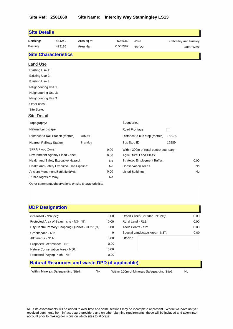
Site Name: Intercity Way Stanningley LS13Site Ref: 2501660
Site Details
Land Use
Northing: 434242
Easting: 423185
Distance to Rail Station (metres): 786.46
Nearest Railway Station Bramley
Distance to bus stop (metres) 188.75
Bus Stop ID 12589
Agricultural Land Class:
SFRA Flood Zone: 0.00
Environment Agency Flood Zone: 0.00
Within 300m of retail centre boundary:
UDP Designation
Greenbelt - N32 (%): 0.00 Urban Green Corridor - N8 (%): 0.00
Protected Area of Search site - N34 (%): 0.00 Rural Land - RL1: 0.00
City Centre Primary Shopping Quarter - CC27 (%): 0.00 Town Centre - S2: 0.00
Health and Safety Executive Hazard: No
Health and Safety Executive Gas Pipeline: No
Strategic Employment Buffer: 0.00
Area sq m: 5085.82 Ward Calverley and Farsley
Special Landscape Area - N37: 0.00
Allotments - N1A: 0.00
Proposed Greenspace - N5: 0.00
Protected Playing Pitch - N6: 0.00
Nature Conservation Area - N50: 0.00
Conservation Areas No
Ancient Monument/Battlefield(%): 0.00 Listed Buildings: No
Public Rights of Way: No
Other?:
Natural Resources and waste DPD (if applicable)
Within Minerals Safeguarding Site?: No Within 100m of Minerals Safeguarding Site?: No
HMCA: Outer West
Greenspace - N1: 0
Existing Use 1:
Existing Use 2:
Existing Use 3:
Neighbouring Use 1
Neighbouring Use 2:
Neighbouring Use 3:
Other uses:
Topography:
Natural Landscape:
Boundaries:
Road Frontage
Site Characteristics
Site Detail
Other comments/observations on site characteristics:
Area Ha: 0.508582
Site State:
NB. Site assessments will be added to over time and some sections may be incomplete at present. Where we have not yet received comments from infrastructure providers and on other planning requirements, these will be included and taken into account prior to making decisions on which sites to allocate.

Site Name: Intercity Way Stanningley LS13Site Ref: 2501660
Planning History
NB. Site assessments will be added to over time and some sections may be incomplete at present. Where we have not yet received comments from infrastructure providers and on other planning requirements, these will be included and taken into account prior to making decisions on which sites to allocate.

Site Name: Intercity Way Stanningley LS13Site Ref: 2501660
Conformity with Core Strategy
Inner South Leeds: 0.00
Leeds Bradford Corridor: 100.00 West Leeds Gateway: 0.00
Aire Valley: 0.00Regeneration Priority Area:
Brownfield
Greenfield
Mixed
Main Urban Area
Major Settlement
Smaller Settlement
Villages/Rural
Main Urban Area Extension
Major Settlement Extension
Smaller Settlement Extension
Village/Rural Extension
Development unrelated to existing development
Green Belt assessment - only completed where site is within Green Belt
Would development lead to/constitute ribbon development?
Would development result in isolated development?
Is the site well connected to built up area (2+ boundaries with existing built up area)?
Would development of the site effectively "round off" the settlement pattern?:
Do natural/physical features provide a good existing barrier between existing urban area and undeveloped land?
Overall sprawl conclusion:
Would development of the site lead to physical connection of settlements?
Do natural/physical features provide a good existing barrier/boundary to contain development?
Overall Coalescence Conclusion:
Is there a strong defensible boundary between the site and the existing urban area?
Does the site provide access to the countryside?
Does the site include local or national conservation designated areas?
Does the site include areas of woodlands, trees, hedgerows that are protected, or significant unprotected tree/hedge cover?
Does the site include grade 1, 2, or 3a agricultural land?
Does the site contain buildings? Are these in agricultural use?
Overall countryside Encroachment Conclusion
Is the site within or adjacent to a conservation area, listed building or other historical feature?
If yes, could development preserve this character?:
Overall Character Preservation Conclusion:
Greenbelt Assessment Conclusion:
Check the unrestricted sprawl of large built up areas
Prevent neighbouring towns from merging
Assist in safeguarding countryside from encroachment
Preserve the setting and special character of historic towns
NB. Site assessments will be added to over time and some sections may be incomplete at present. Where we have not yet received comments from infrastructure providers and on other planning requirements, these will be included and taken into account prior to making decisions on which sites to allocate.

Site Name: Intercity Way Stanningley LS13Site Ref: 2501660
SHLAA ConclusionsAvailability: Suitability: Achievability:
Conclusion of Assessment
Conclusion summary:
High profile site situated directly on Stanningley by-pass. Suitable for B2 or B8 users.
Floorspace sq m (Non residential):
Employment Conclusion: Lime Green
East Leeds
Assesment Type: ELR Type: Industrial & Warehousing
Proposed Change:
Gypsy Traveller Site Assessment
Yes No Maybe Could site be effectively managed (Text)
Yes No Maybe Would gypsies and travellers live on the site?
(Text)
Yes No Proximity to housed gypsies and travellers (Text)
Yes No Unknown Experience of previous encampments (Text)
NB. Site assessments will be added to over time and some sections may be incomplete at present. Where we have not yet received comments from infrastructure providers and on other planning requirements, these will be included and taken into account prior to making decisions on which sites to allocate.

Site Name: Midpoint Dick Lane Thornbury BD4Site Ref: 2502500
Site Details
Land Use
Northing: 433550
Easting: 419703
Distance to Rail Station (metres): 1618.22
Nearest Railway Station New Pudsey
Distance to bus stop (metres) 245.71
Bus Stop ID 9298
Agricultural Land Class:
SFRA Flood Zone: 0.00
Environment Agency Flood Zone: 0.00
Within 300m of retail centre boundary:
UDP Designation
Greenbelt - N32 (%): 9.87 Urban Green Corridor - N8 (%): 0.00
Protected Area of Search site - N34 (%): 0.00 Rural Land - RL1: 0.00
City Centre Primary Shopping Quarter - CC27 (%): 0.00 Town Centre - S2: 0.00
Health and Safety Executive Hazard: No
Health and Safety Executive Gas Pipeline: Yes
Strategic Employment Buffer: 0.00
Area sq m: 37281.60 Ward Calverley and Farsley
Special Landscape Area - N37: 0.00
Allotments - N1A: 0.00
Proposed Greenspace - N5: 0.00
Protected Playing Pitch - N6: 9.77
Nature Conservation Area - N50: 0.00
Conservation Areas No
Ancient Monument/Battlefield(%): 0.00 Listed Buildings: No
Public Rights of Way: No
Other?:
Natural Resources and waste DPD (if applicable)
Within Minerals Safeguarding Site?: No Within 100m of Minerals Safeguarding Site?: No
HMCA: Outer West
Greenspace - N1: 0
Existing Use 1:
Existing Use 2:
Existing Use 3:
Neighbouring Use 1
Neighbouring Use 2:
Neighbouring Use 3:
Other uses:
Topography:
Natural Landscape:
Boundaries:
Road Frontage
Site Characteristics
Site Detail
Other comments/observations on site characteristics:
Area Ha: 3.72816
Site State:
NB. Site assessments will be added to over time and some sections may be incomplete at present. Where we have not yet received comments from infrastructure providers and on other planning requirements, these will be included and taken into account prior to making decisions on which sites to allocate.

Site Name: Midpoint Dick Lane Thornbury BD4Site Ref: 2502500
Planning History
NB. Site assessments will be added to over time and some sections may be incomplete at present. Where we have not yet received comments from infrastructure providers and on other planning requirements, these will be included and taken into account prior to making decisions on which sites to allocate.

Site Name: Midpoint Dick Lane Thornbury BD4Site Ref: 2502500
Conformity with Core Strategy
Inner South Leeds: 0.00
Leeds Bradford Corridor: 100.00 West Leeds Gateway: 0.00
Aire Valley: 0.00Regeneration Priority Area:
Brownfield
Greenfield
Mixed
Main Urban Area
Major Settlement
Smaller Settlement
Villages/Rural
Main Urban Area Extension
Major Settlement Extension
Smaller Settlement Extension
Village/Rural Extension
Development unrelated to existing development
Green Belt assessment - only completed where site is within Green Belt
Would development lead to/constitute ribbon development?
Would development result in isolated development?
Is the site well connected to built up area (2+ boundaries with existing built up area)?
Would development of the site effectively "round off" the settlement pattern?:
Do natural/physical features provide a good existing barrier between existing urban area and undeveloped land?
Overall sprawl conclusion:
Would development of the site lead to physical connection of settlements?
Do natural/physical features provide a good existing barrier/boundary to contain development?
Overall Coalescence Conclusion:
Is there a strong defensible boundary between the site and the existing urban area?
Does the site provide access to the countryside?
Does the site include local or national conservation designated areas?
Does the site include areas of woodlands, trees, hedgerows that are protected, or significant unprotected tree/hedge cover?
Does the site include grade 1, 2, or 3a agricultural land?
Does the site contain buildings? Are these in agricultural use?
Overall countryside Encroachment Conclusion
Is the site within or adjacent to a conservation area, listed building or other historical feature?
If yes, could development preserve this character?:
Overall Character Preservation Conclusion:
Greenbelt Assessment Conclusion:
Check the unrestricted sprawl of large built up areas
Prevent neighbouring towns from merging
Assist in safeguarding countryside from encroachment
Preserve the setting and special character of historic towns
NB. Site assessments will be added to over time and some sections may be incomplete at present. Where we have not yet received comments from infrastructure providers and on other planning requirements, these will be included and taken into account prior to making decisions on which sites to allocate.

Site Name: Midpoint Dick Lane Thornbury BD4Site Ref: 2502500
SHLAA ConclusionsAvailability: Suitability: Achievability:
East Leeds
Summary of Infrastructure provider comments and other planning requirements
Accessibility comment4 buses an hour over 400m from site, 2 buses per hour on Dick Lane
Rank (1-5)
3Access Comments
Access via existing signal junction and business park
Local network comment
local congestion issues
Rank (1-5)
5Rank (1-5)
3
Leeds City Council Highways inc Metro
Highways Agency
Network Rail :
Biodiversity
Natural England:
Education
Mitigation measure
Bus and capacity improvements
Total score
11Support?
Yes, potential mitigation measures for capacity
Need to combine with other sites:
no
Suitability for partial development:
yes
West Yorkshire Ecology and LCC Ecology Officer:
Supported
Boundary Amendment
Drainage/Water/FloodingEnvironment Agency Comments: Environment Agency Constraints:
Yorkshire Water Comments: Yorkshire Water Waste Water Treatment Works Comme
UtilitiesGas:
LCC Flood Risk Management:
NB. Site assessments will be added to over time and some sections may be incomplete at present. Where we have not yet received comments from infrastructure providers and on other planning requirements, these will be included and taken into account prior to making decisions on which sites to allocate.

Site Name: Midpoint Dick Lane Thornbury BD4Site Ref: 2502500
Conclusion of Assessment
Conclusion summary:
Under construction for residential under HLA site 2503040. Propose Remove.
Floorspace sq m (Non residential): 13950
Employment Conclusion: Red
Assesment Type: Site assessment Type: Office
Proposed Change:
Electric:
Telecom:
Fire and Rescue Services:
Built HeritageLeeds City Council:
West Yorkshire Archaeology Service:
English Heritage:
Gypsy Traveller Site Assessment
Yes No Maybe Could site be effectively managed (Text)
Yes No Maybe Would gypsies and travellers live on the site?
(Text)
Yes No Proximity to housed gypsies and travellers (Text)
Yes No Unknown Experience of previous encampments (Text)
NB. Site assessments will be added to over time and some sections may be incomplete at present. Where we have not yet received comments from infrastructure providers and on other planning requirements, these will be included and taken into account prior to making decisions on which sites to allocate.

Site Name: Off Tyersal Lane TyersaL BD4Site Ref: 2502510
Site Details
Land Use
Northing: 432033
Easting: 419358
Distance to Rail Station (metres): 2884.20
Nearest Railway Station New Pudsey
Distance to bus stop (metres) 240.62
Bus Stop ID 6663
Agricultural Land Class:
SFRA Flood Zone: 0.00
Environment Agency Flood Zone: 0.00
Within 300m of retail centre boundary:
UDP Designation
Greenbelt - N32 (%): 0.00 Urban Green Corridor - N8 (%): 0.00
Protected Area of Search site - N34 (%): 0.00 Rural Land - RL1: 0.00
City Centre Primary Shopping Quarter - CC27 (%): 0.00 Town Centre - S2: 0.00
Health and Safety Executive Hazard: No
Health and Safety Executive Gas Pipeline: Yes
Strategic Employment Buffer: 0.00
Area sq m: 111001.43 Ward Pudsey
Special Landscape Area - N37: 0.00
Allotments - N1A: 0.00
Proposed Greenspace - N5: 0.00
Protected Playing Pitch - N6: 0.00
Nature Conservation Area - N50: 0.00
Conservation Areas No
Ancient Monument/Battlefield(%): 0.00 Listed Buildings: Yes
Public Rights of Way: Yes
Other?:
Natural Resources and waste DPD (if applicable)
Within Minerals Safeguarding Site?: No Within 100m of Minerals Safeguarding Site?: No
HMCA: Outer West
Greenspace - N1: 0
Existing Use 1:
Existing Use 2:
Existing Use 3:
Neighbouring Use 1
Neighbouring Use 2:
Neighbouring Use 3:
Other uses:
Topography:
Natural Landscape:
Boundaries:
Road Frontage
Site Characteristics
Site Detail
Other comments/observations on site characteristics:
Area Ha: 11.100143
Site State:
NB. Site assessments will be added to over time and some sections may be incomplete at present. Where we have not yet received comments from infrastructure providers and on other planning requirements, these will be included and taken into account prior to making decisions on which sites to allocate.
Site Name: Off Tyersal Lane TyersaL BD4Site Ref: 2502510
Planning History
NB. Site assessments will be added to over time and some sections may be incomplete at present. Where we have not yet received comments from infrastructure providers and on other planning requirements, these will be included and taken into account prior to making decisions on which sites to allocate.

Site Name: Off Tyersal Lane TyersaL BD4Site Ref: 2502510
Conformity with Core Strategy
Inner South Leeds: 0.00
Leeds Bradford Corridor: 100.00 West Leeds Gateway: 0.00
Aire Valley: 0.00Regeneration Priority Area:
Brownfield
Greenfield
Mixed
Main Urban Area
Major Settlement
Smaller Settlement
Villages/Rural
Main Urban Area Extension
Major Settlement Extension
Smaller Settlement Extension
Village/Rural Extension
Development unrelated to existing development
Green Belt assessment - only completed where site is within Green Belt
Would development lead to/constitute ribbon development?
Would development result in isolated development?
Is the site well connected to built up area (2+ boundaries with existing built up area)?
Would development of the site effectively "round off" the settlement pattern?:
Do natural/physical features provide a good existing barrier between existing urban area and undeveloped land?
Overall sprawl conclusion:
Would development of the site lead to physical connection of settlements?
Do natural/physical features provide a good existing barrier/boundary to contain development?
Overall Coalescence Conclusion:
Is there a strong defensible boundary between the site and the existing urban area?
Does the site provide access to the countryside?
Does the site include local or national conservation designated areas?
Does the site include areas of woodlands, trees, hedgerows that are protected, or significant unprotected tree/hedge cover?
Does the site include grade 1, 2, or 3a agricultural land?
Does the site contain buildings? Are these in agricultural use?
Overall countryside Encroachment Conclusion
Is the site within or adjacent to a conservation area, listed building or other historical feature?
If yes, could development preserve this character?:
Overall Character Preservation Conclusion:
Greenbelt Assessment Conclusion:
Check the unrestricted sprawl of large built up areas
Prevent neighbouring towns from merging
Assist in safeguarding countryside from encroachment
Preserve the setting and special character of historic towns
NB. Site assessments will be added to over time and some sections may be incomplete at present. Where we have not yet received comments from infrastructure providers and on other planning requirements, these will be included and taken into account prior to making decisions on which sites to allocate.

Site Name: Off Tyersal Lane TyersaL BD4Site Ref: 2502510
SHLAA ConclusionsAvailability: Suitability: Achievability:
East Leeds
Summary of Infrastructure provider comments and other planning requirements
Accessibility commentDoes not meet Core Strategy standards and would require additional services to be funded
Rank (1-5)
2Access Comments
Not suitable for heavy traffic in residential area, road not wide enough on approach past residential development
Local network comment
local congestion issues
Rank (1-5)
2Rank (1-5)
3
Leeds City Council Highways inc Metro
Highways Agency
Network Rail :
Biodiversity
Natural England:
Education
Mitigation measure
not achievable within highway limits, unsuitable for B8 traffic anyway
Total score
7Support?
No, accessibility and access issues not suitable for employment development
Need to combine with other sites:
no
Suitability for partial development:
Possible for B1c with mitigation including additional bus services, road widening and junction improvements, no
West Yorkshire Ecology and LCC Ecology Officer:
Supported
Boundary Amendment
Drainage/Water/FloodingEnvironment Agency Comments: Environment Agency Constraints:
Yorkshire Water Comments: Yorkshire Water Waste Water Treatment Works Comme
UtilitiesGas:
LCC Flood Risk Management:
NB. Site assessments will be added to over time and some sections may be incomplete at present. Where we have not yet received comments from infrastructure providers and on other planning requirements, these will be included and taken into account prior to making decisions on which sites to allocate.

Site Name: Off Tyersal Lane TyersaL BD4Site Ref: 2502510
Conclusion of Assessment
Conclusion summary:
Former employment allocation proposed for residential.
Floorspace sq m (Non residential):
Employment Conclusion: Red
Assesment Type: Site assessment Type: Industrial & Warehousing
Proposed Change:
Electric:
Telecom:
Fire and Rescue Services:
Built HeritageLeeds City Council:
West Yorkshire Archaeology Service:
English Heritage:
Gypsy Traveller Site Assessment
Yes No Maybe Could site be effectively managed (Text)
Yes No Maybe Would gypsies and travellers live on the site?
(Text)
Yes No Proximity to housed gypsies and travellers (Text)
Yes No Unknown Experience of previous encampments (Text)
NB. Site assessments will be added to over time and some sections may be incomplete at present. Where we have not yet received comments from infrastructure providers and on other planning requirements, these will be included and taken into account prior to making decisions on which sites to allocate.

Site Name: Richardshaw Drive Pudsey LS28Site Ref: 2502940
Site Details
Land Use
Northing: 434022
Easting: 422235
Distance to Rail Station (metres): 1136.31
Nearest Railway Station New Pudsey
Distance to bus stop (metres) 97.35
Bus Stop ID 10250
Agricultural Land Class:
SFRA Flood Zone: 0.00
Environment Agency Flood Zone: 0.00
Within 300m of retail centre boundary:
UDP Designation
Greenbelt - N32 (%): 0.00 Urban Green Corridor - N8 (%): 0.00
Protected Area of Search site - N34 (%): 0.00 Rural Land - RL1: 0.00
City Centre Primary Shopping Quarter - CC27 (%): 0.00 Town Centre - S2: 0.00
Health and Safety Executive Hazard: No
Health and Safety Executive Gas Pipeline: No
Strategic Employment Buffer: 0.00
Area sq m: 4377.34 Ward Calverley and Farsley
Special Landscape Area - N37: 0.00
Allotments - N1A: 0.00
Proposed Greenspace - N5: 0.00
Protected Playing Pitch - N6: 0.00
Nature Conservation Area - N50: 0.00
Conservation Areas No
Ancient Monument/Battlefield(%): 0.00 Listed Buildings: No
Public Rights of Way: No
Other?:
Natural Resources and waste DPD (if applicable)
Within Minerals Safeguarding Site?: Yes Within 100m of Minerals Safeguarding Site?: Yes
HMCA: Outer West
Greenspace - N1: 0
Existing Use 1:
Existing Use 2:
Existing Use 3:
Neighbouring Use 1
Neighbouring Use 2:
Neighbouring Use 3:
Other uses:
Topography:
Natural Landscape:
Boundaries:
Road Frontage
Site Characteristics
Site Detail
Other comments/observations on site characteristics:
Area Ha: 0.437734
Site State:
Site Site TypeGrangefield Industrial Estate, Stanningley Industrial Estate
NB. Site assessments will be added to over time and some sections may be incomplete at present. Where we have not yet received comments from infrastructure providers and on other planning requirements, these will be included and taken into account prior to making decisions on which sites to allocate.
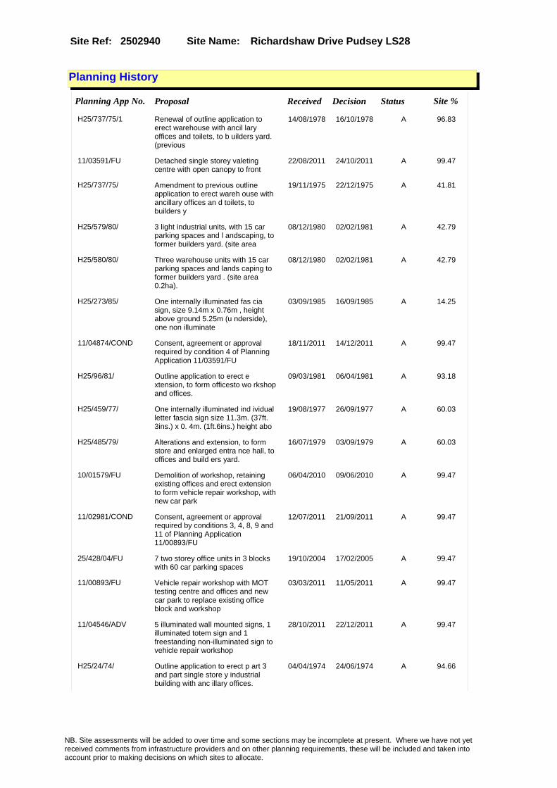
Site Name: Richardshaw Drive Pudsey LS28Site Ref: 2502940
Planning History
Planning App No. Proposal Received Decision Status Site %
H25/737/75/1 Renewal of outline application to erect warehouse with ancil lary offices and toilets, to b uilders yard. (previous
14/08/1978 16/10/1978 A 96.83
11/03591/FU Detached single storey valeting centre with open canopy to front
22/08/2011 24/10/2011 A 99.47
H25/737/75/ Amendment to previous outline application to erect wareh ouse with ancillary offices an d toilets, to builders y
19/11/1975 22/12/1975 A 41.81
H25/579/80/ 3 light industrial units, with 15 car parking spaces and l andscaping, to former builders yard. (site area
08/12/1980 02/02/1981 A 42.79
H25/580/80/ Three warehouse units with 15 car parking spaces and lands caping to former builders yard . (site area 0.2ha).
08/12/1980 02/02/1981 A 42.79
H25/273/85/ One internally illuminated fas cia sign, size 9.14m x 0.76m , height above ground 5.25m (u nderside), one non illuminate
03/09/1985 16/09/1985 A 14.25
11/04874/COND Consent, agreement or approval required by condition 4 of Planning Application 11/03591/FU
18/11/2011 14/12/2011 A 99.47
H25/96/81/ Outline application to erect e xtension, to form officesto wo rkshop and offices.
09/03/1981 06/04/1981 A 93.18
H25/459/77/ One internally illuminated ind ividual letter fascia sign size 11.3m. (37ft. 3ins.) x 0. 4m. (1ft.6ins.) height abo
19/08/1977 26/09/1977 A 60.03
H25/485/79/ Alterations and extension, to form store and enlarged entra nce hall, to offices and build ers yard.
16/07/1979 03/09/1979 A 60.03
10/01579/FU Demolition of workshop, retaining existing offices and erect extension to form vehicle repair workshop, with new car park
06/04/2010 09/06/2010 A 99.47
11/02981/COND Consent, agreement or approval required by conditions 3, 4, 8, 9 and 11 of Planning Application 11/00893/FU
12/07/2011 21/09/2011 A 99.47
25/428/04/FU 7 two storey office units in 3 blocks with 60 car parking spaces
19/10/2004 17/02/2005 A 99.47
11/00893/FU Vehicle repair workshop with MOT testing centre and offices and new car park to replace existing office block and workshop
03/03/2011 11/05/2011 A 99.47
11/04546/ADV 5 illuminated wall mounted signs, 1 illuminated totem sign and 1 freestanding non-illuminated sign to vehicle repair workshop
28/10/2011 22/12/2011 A 99.47
H25/24/74/ Outline application to erect p art 3 and part single store y industrial building with anc illary offices.
04/04/1974 24/06/1974 A 94.66
NB. Site assessments will be added to over time and some sections may be incomplete at present. Where we have not yet received comments from infrastructure providers and on other planning requirements, these will be included and taken into account prior to making decisions on which sites to allocate.

Site Name: Richardshaw Drive Pudsey LS28Site Ref: 2502940
Conformity with Core Strategy
Inner South Leeds: 0.00
Leeds Bradford Corridor: 100.00 West Leeds Gateway: 0.00
Aire Valley: 0.00Regeneration Priority Area:
Brownfield
Greenfield
Mixed
Main Urban Area
Major Settlement
Smaller Settlement
Villages/Rural
Main Urban Area Extension
Major Settlement Extension
Smaller Settlement Extension
Village/Rural Extension
Development unrelated to existing development
Green Belt assessment - only completed where site is within Green Belt
Would development lead to/constitute ribbon development?
Would development result in isolated development?
Is the site well connected to built up area (2+ boundaries with existing built up area)?
Would development of the site effectively "round off" the settlement pattern?:
Do natural/physical features provide a good existing barrier between existing urban area and undeveloped land?
Overall sprawl conclusion:
Would development of the site lead to physical connection of settlements?
Do natural/physical features provide a good existing barrier/boundary to contain development?
Overall Coalescence Conclusion:
Is there a strong defensible boundary between the site and the existing urban area?
Does the site provide access to the countryside?
Does the site include local or national conservation designated areas?
Does the site include areas of woodlands, trees, hedgerows that are protected, or significant unprotected tree/hedge cover?
Does the site include grade 1, 2, or 3a agricultural land?
Does the site contain buildings? Are these in agricultural use?
Overall countryside Encroachment Conclusion
Is the site within or adjacent to a conservation area, listed building or other historical feature?
If yes, could development preserve this character?:
Overall Character Preservation Conclusion:
Greenbelt Assessment Conclusion:
Check the unrestricted sprawl of large built up areas
Prevent neighbouring towns from merging
Assist in safeguarding countryside from encroachment
Preserve the setting and special character of historic towns
NB. Site assessments will be added to over time and some sections may be incomplete at present. Where we have not yet received comments from infrastructure providers and on other planning requirements, these will be included and taken into account prior to making decisions on which sites to allocate.

Site Name: Richardshaw Drive Pudsey LS28Site Ref: 2502940
SHLAA ConclusionsAvailability: Suitability: Achievability:
Conclusion of Assessment
Conclusion summary:
Not allocated and not in centre.
Floorspace sq m (Non residential): 670
Employment Conclusion: Red
East Leeds
Assesment Type: ELR Type: Office
Proposed Change:
Gypsy Traveller Site Assessment
Yes No Maybe Could site be effectively managed (Text)
Yes No Maybe Would gypsies and travellers live on the site?
(Text)
Yes No Proximity to housed gypsies and travellers (Text)
Yes No Unknown Experience of previous encampments (Text)
NB. Site assessments will be added to over time and some sections may be incomplete at present. Where we have not yet received comments from infrastructure providers and on other planning requirements, these will be included and taken into account prior to making decisions on which sites to allocate.

Site Name: Waterloo Road & Gibraltar Road PudseySite Ref: 2503200
Site Details
Land Use
Northing: 433209
Easting: 420978
Distance to Rail Station (metres): 1107.13
Nearest Railway Station New Pudsey
Distance to bus stop (metres) 116.88
Bus Stop ID 10124
Agricultural Land Class:
SFRA Flood Zone: 0.00
Environment Agency Flood Zone: 0.00
Within 300m of retail centre boundary:
UDP Designation
Greenbelt - N32 (%): 0.00 Urban Green Corridor - N8 (%): 0.00
Protected Area of Search site - N34 (%): 0.00 Rural Land - RL1: 0.00
City Centre Primary Shopping Quarter - CC27 (%): 0.00 Town Centre - S2: 0.00
Health and Safety Executive Hazard: No
Health and Safety Executive Gas Pipeline: No
Strategic Employment Buffer: 0.00
Area sq m: 11175.61 Ward Pudsey
Special Landscape Area - N37: 0.00
Allotments - N1A: 0.00
Proposed Greenspace - N5: 0.00
Protected Playing Pitch - N6: 0.00
Nature Conservation Area - N50: 0.00
Conservation Areas No
Ancient Monument/Battlefield(%): 0.00 Listed Buildings: No
Public Rights of Way: No
Other?:
Natural Resources and waste DPD (if applicable)
Within Minerals Safeguarding Site?: No Within 100m of Minerals Safeguarding Site?: No
HMCA: Outer West
Greenspace - N1: 0
Existing Use 1:
Existing Use 2:
Existing Use 3:
Neighbouring Use 1
Neighbouring Use 2:
Neighbouring Use 3:
Other uses:
Topography:
Natural Landscape:
Boundaries:
Road Frontage
Site Characteristics
Site Detail
Other comments/observations on site characteristics:
Area Ha: 1.117561
Site State:
NB. Site assessments will be added to over time and some sections may be incomplete at present. Where we have not yet received comments from infrastructure providers and on other planning requirements, these will be included and taken into account prior to making decisions on which sites to allocate.

Site Name: Waterloo Road & Gibraltar Road PudseySite Ref: 2503200
Planning History
NB. Site assessments will be added to over time and some sections may be incomplete at present. Where we have not yet received comments from infrastructure providers and on other planning requirements, these will be included and taken into account prior to making decisions on which sites to allocate.

Site Name: Waterloo Road & Gibraltar Road PudseySite Ref: 2503200
Conformity with Core Strategy
Inner South Leeds: 0.00
Leeds Bradford Corridor: 100.00 West Leeds Gateway: 0.00
Aire Valley: 0.00Regeneration Priority Area:
Brownfield
Greenfield
Mixed
Main Urban Area
Major Settlement
Smaller Settlement
Villages/Rural
Main Urban Area Extension
Major Settlement Extension
Smaller Settlement Extension
Village/Rural Extension
Development unrelated to existing development
Green Belt assessment - only completed where site is within Green Belt
Would development lead to/constitute ribbon development?
Would development result in isolated development?
Is the site well connected to built up area (2+ boundaries with existing built up area)?
Would development of the site effectively "round off" the settlement pattern?:
Do natural/physical features provide a good existing barrier between existing urban area and undeveloped land?
Overall sprawl conclusion:
Would development of the site lead to physical connection of settlements?
Do natural/physical features provide a good existing barrier/boundary to contain development?
Overall Coalescence Conclusion:
Is there a strong defensible boundary between the site and the existing urban area?
Does the site provide access to the countryside?
Does the site include local or national conservation designated areas?
Does the site include areas of woodlands, trees, hedgerows that are protected, or significant unprotected tree/hedge cover?
Does the site include grade 1, 2, or 3a agricultural land?
Does the site contain buildings? Are these in agricultural use?
Overall countryside Encroachment Conclusion
Is the site within or adjacent to a conservation area, listed building or other historical feature?
If yes, could development preserve this character?:
Overall Character Preservation Conclusion:
Greenbelt Assessment Conclusion:
Check the unrestricted sprawl of large built up areas
Prevent neighbouring towns from merging
Assist in safeguarding countryside from encroachment
Preserve the setting and special character of historic towns
NB. Site assessments will be added to over time and some sections may be incomplete at present. Where we have not yet received comments from infrastructure providers and on other planning requirements, these will be included and taken into account prior to making decisions on which sites to allocate.

Site Name: Waterloo Road & Gibraltar Road PudseySite Ref: 2503200
SHLAA ConclusionsAvailability: Suitability: Achievability:
Conclusion of Assessment
Conclusion summary:
To reflect consent for builders merchants warehouse with ancillary offices 06/04894/FU granted 26/11/2007
Floorspace sq m (Non residential):
Employment Conclusion: Green
East Leeds
Assesment Type: ELR Type: Industrial & Warehousing
Proposed Change:
Gypsy Traveller Site Assessment
Yes No Maybe Could site be effectively managed (Text)
Yes No Maybe Would gypsies and travellers live on the site?
(Text)
Yes No Proximity to housed gypsies and travellers (Text)
Yes No Unknown Experience of previous encampments (Text)
NB. Site assessments will be added to over time and some sections may be incomplete at present. Where we have not yet received comments from infrastructure providers and on other planning requirements, these will be included and taken into account prior to making decisions on which sites to allocate.

Site Name: Ex-Woodside Quarries Clayton Wood Road LS16
Site Ref: 2601360
Site Details
Land Use
Northing: 438379
Easting: 425498
Distance to Rail Station (metres): 1318.13
Nearest Railway Station Horsforth
Distance to bus stop (metres) 374.59
Bus Stop ID 13728
Agricultural Land Class:
SFRA Flood Zone: 0.00
Environment Agency Flood Zone: 0.00
Within 300m of retail centre boundary:
UDP Designation
Greenbelt - N32 (%): 0.96 Urban Green Corridor - N8 (%): 100.00
Protected Area of Search site - N34 (%): 0.00 Rural Land - RL1: 0.00
City Centre Primary Shopping Quarter - CC27 (%): 0.00 Town Centre - S2: 0.00
Health and Safety Executive Hazard: No
Health and Safety Executive Gas Pipeline: No
Strategic Employment Buffer: 0.00
Area sq m: 130825.15 Ward Weetwood
Special Landscape Area - N37: 0.00
Allotments - N1A: 0.00
Proposed Greenspace - N5: 10.41
Protected Playing Pitch - N6: 0.00
Nature Conservation Area - N50: 0.00
Conservation Areas No
Ancient Monument/Battlefield(%): 0.00 Listed Buildings: Yes
Public Rights of Way: Yes
Other?:
Natural Resources and waste DPD (if applicable)
Within Minerals Safeguarding Site?: No Within 100m of Minerals Safeguarding Site?: No
HMCA: North
Greenspace - N1: 0
Existing Use 1:
Existing Use 2:
Existing Use 3:
Neighbouring Use 1
Neighbouring Use 2:
Neighbouring Use 3:
Other uses:
Topography:
Natural Landscape:
Boundaries:
Road Frontage
Site Characteristics
Site Detail
Other comments/observations on site characteristics:
Area Ha: 13.082515
Site State:
NB. Site assessments will be added to over time and some sections may be incomplete at present. Where we have not yet received comments from infrastructure providers and on other planning requirements, these will be included and taken into account prior to making decisions on which sites to allocate.
Site Name: Ex-Woodside Quarries Clayton Wood Road LS16
Site Ref: 2601360
Planning History
NB. Site assessments will be added to over time and some sections may be incomplete at present. Where we have not yet received comments from infrastructure providers and on other planning requirements, these will be included and taken into account prior to making decisions on which sites to allocate.

Site Name: Ex-Woodside Quarries Clayton Wood Road LS16
Site Ref: 2601360
Conformity with Core Strategy
Inner South Leeds: 0.00
Leeds Bradford Corridor: 0.00 West Leeds Gateway: 0.00
Aire Valley: 0.00Regeneration Priority Area:
Brownfield
Greenfield
Mixed
Main Urban Area
Major Settlement
Smaller Settlement
Villages/Rural
Main Urban Area Extension
Major Settlement Extension
Smaller Settlement Extension
Village/Rural Extension
Development unrelated to existing development
Green Belt assessment - only completed where site is within Green Belt
Would development lead to/constitute ribbon development?
Would development result in isolated development?
Is the site well connected to built up area (2+ boundaries with existing built up area)?
Would development of the site effectively "round off" the settlement pattern?:
Do natural/physical features provide a good existing barrier between existing urban area and undeveloped land?
Overall sprawl conclusion:
Would development of the site lead to physical connection of settlements?
Do natural/physical features provide a good existing barrier/boundary to contain development?
Overall Coalescence Conclusion:
Is there a strong defensible boundary between the site and the existing urban area?
Does the site provide access to the countryside?
Does the site include local or national conservation designated areas?
Does the site include areas of woodlands, trees, hedgerows that are protected, or significant unprotected tree/hedge cover?
Does the site include grade 1, 2, or 3a agricultural land?
Does the site contain buildings? Are these in agricultural use?
Overall countryside Encroachment Conclusion
Is the site within or adjacent to a conservation area, listed building or other historical feature?
If yes, could development preserve this character?:
Overall Character Preservation Conclusion:
Greenbelt Assessment Conclusion:
Check the unrestricted sprawl of large built up areas
Prevent neighbouring towns from merging
Assist in safeguarding countryside from encroachment
Preserve the setting and special character of historic towns
NB. Site assessments will be added to over time and some sections may be incomplete at present. Where we have not yet received comments from infrastructure providers and on other planning requirements, these will be included and taken into account prior to making decisions on which sites to allocate.
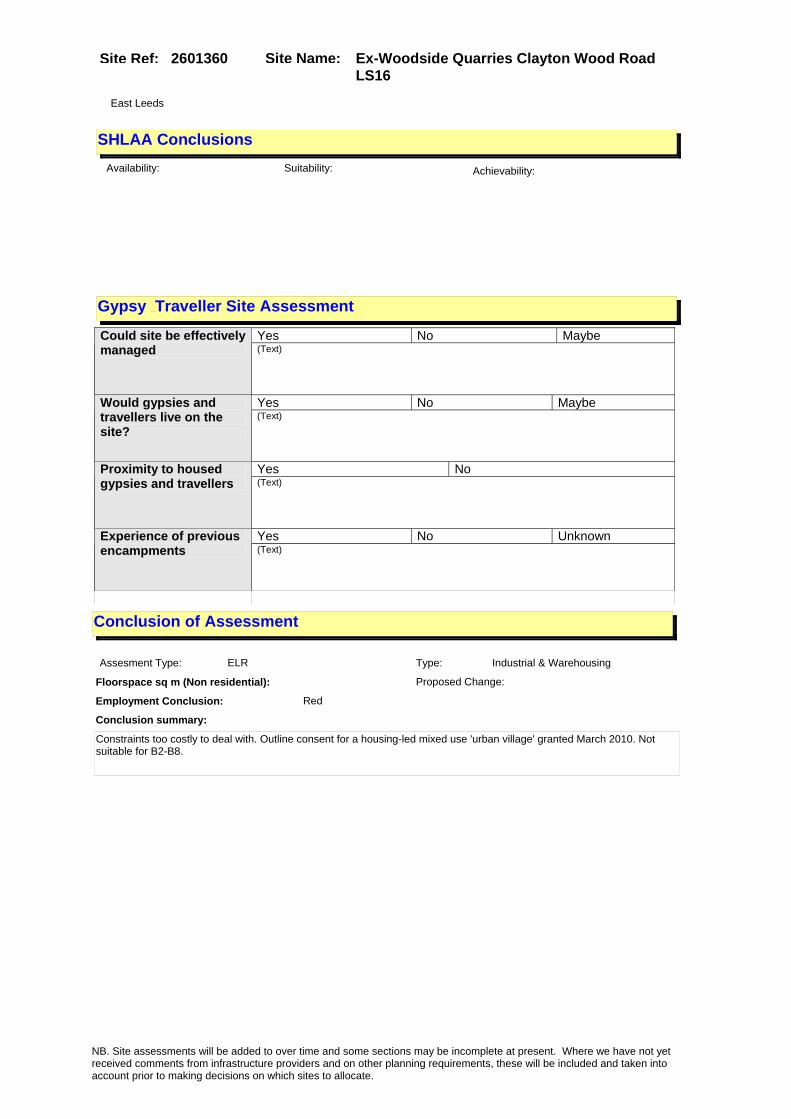
Site Name: Ex-Woodside Quarries Clayton Wood Road LS16
Site Ref: 2601360
SHLAA ConclusionsAvailability: Suitability: Achievability:
Conclusion of Assessment
Conclusion summary:
Constraints too costly to deal with. Outline consent for a housing-led mixed use 'urban village' granted March 2010. Not suitable for B2-B8.
Floorspace sq m (Non residential):
Employment Conclusion: Red
East Leeds
Assesment Type: ELR Type: Industrial & Warehousing
Proposed Change:
Gypsy Traveller Site Assessment
Yes No Maybe Could site be effectively managed (Text)
Yes No Maybe Would gypsies and travellers live on the site?
(Text)
Yes No Proximity to housed gypsies and travellers (Text)
Yes No Unknown Experience of previous encampments (Text)
NB. Site assessments will be added to over time and some sections may be incomplete at present. Where we have not yet received comments from infrastructure providers and on other planning requirements, these will be included and taken into account prior to making decisions on which sites to allocate.

Site Name: Ex-Gilchrist Bros Ltd Ring Road West Park LS16
Site Ref: 2601361
Site Details
Land Use
Northing: 438053
Easting: 425544
Distance to Rail Station (metres): 1562.60
Nearest Railway Station Horsforth
Distance to bus stop (metres) 86.62
Bus Stop ID 13595
Agricultural Land Class:
SFRA Flood Zone: 0.00
Environment Agency Flood Zone: 0.00
Within 300m of retail centre boundary:
UDP Designation
Greenbelt - N32 (%): 0.00 Urban Green Corridor - N8 (%): 0.00
Protected Area of Search site - N34 (%): 0.00 Rural Land - RL1: 0.00
City Centre Primary Shopping Quarter - CC27 (%): 0.00 Town Centre - S2: 0.00
Health and Safety Executive Hazard: No
Health and Safety Executive Gas Pipeline: No
Strategic Employment Buffer: 0.00
Area sq m: 14264.06 Ward Weetwood
Special Landscape Area - N37: 0.00
Allotments - N1A: 0.00
Proposed Greenspace - N5: 0.00
Protected Playing Pitch - N6: 0.00
Nature Conservation Area - N50: 0.00
Conservation Areas No
Ancient Monument/Battlefield(%): 0.00 Listed Buildings: No
Public Rights of Way: No
Other?:
Natural Resources and waste DPD (if applicable)
Within Minerals Safeguarding Site?: No Within 100m of Minerals Safeguarding Site?: No
HMCA: North
Greenspace - N1: 0
Existing Use 1:
Existing Use 2:
Existing Use 3:
Neighbouring Use 1
Neighbouring Use 2:
Neighbouring Use 3:
Other uses:
Topography:
Natural Landscape:
Boundaries:
Road Frontage
Site Characteristics
Site Detail
Other comments/observations on site characteristics:
Area Ha: 1.426406
Site State:
NB. Site assessments will be added to over time and some sections may be incomplete at present. Where we have not yet received comments from infrastructure providers and on other planning requirements, these will be included and taken into account prior to making decisions on which sites to allocate.
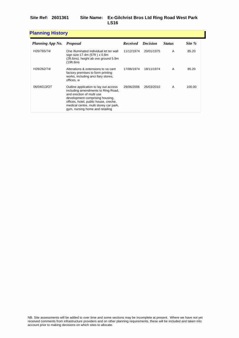
Site Name: Ex-Gilchrist Bros Ltd Ring Road West Park LS16
Site Ref: 2601361
Planning History
Planning App No. Proposal Received Decision Status Site %
H26/765/74/ One illuminated individual let ter wall sign size:17.4m (57ft ) x 0.8m (2ft.6ins). height ab ove ground 5.9m (19ft.6ins
11/12/1974 20/01/1975 A 85.20
H26/262/74/ Alterations & extensions to va cant factory premises to form printing works, including anci llary stores, offices, w
17/06/1974 18/11/1974 A 85.20
06/04013/OT Outline application to lay out access including amendments to Ring Road, and erection of multi use development comprising housing, offices, hotel, public house, creche, medical centre, multi storey car park, gym, nursing home and retailing
29/06/2006 26/03/2010 A 100.00
NB. Site assessments will be added to over time and some sections may be incomplete at present. Where we have not yet received comments from infrastructure providers and on other planning requirements, these will be included and taken into account prior to making decisions on which sites to allocate.

Site Name: Ex-Gilchrist Bros Ltd Ring Road West Park LS16
Site Ref: 2601361
Conformity with Core Strategy
Inner South Leeds: 0.00
Leeds Bradford Corridor: 0.00 West Leeds Gateway: 0.00
Aire Valley: 0.00Regeneration Priority Area:
Brownfield
Greenfield
Mixed
Main Urban Area
Major Settlement
Smaller Settlement
Villages/Rural
Main Urban Area Extension
Major Settlement Extension
Smaller Settlement Extension
Village/Rural Extension
Development unrelated to existing development
Green Belt assessment - only completed where site is within Green Belt
Would development lead to/constitute ribbon development?
Would development result in isolated development?
Is the site well connected to built up area (2+ boundaries with existing built up area)?
Would development of the site effectively "round off" the settlement pattern?:
Do natural/physical features provide a good existing barrier between existing urban area and undeveloped land?
Overall sprawl conclusion:
Would development of the site lead to physical connection of settlements?
Do natural/physical features provide a good existing barrier/boundary to contain development?
Overall Coalescence Conclusion:
Is there a strong defensible boundary between the site and the existing urban area?
Does the site provide access to the countryside?
Does the site include local or national conservation designated areas?
Does the site include areas of woodlands, trees, hedgerows that are protected, or significant unprotected tree/hedge cover?
Does the site include grade 1, 2, or 3a agricultural land?
Does the site contain buildings? Are these in agricultural use?
Overall countryside Encroachment Conclusion
Is the site within or adjacent to a conservation area, listed building or other historical feature?
If yes, could development preserve this character?:
Overall Character Preservation Conclusion:
Greenbelt Assessment Conclusion:
Check the unrestricted sprawl of large built up areas
Prevent neighbouring towns from merging
Assist in safeguarding countryside from encroachment
Preserve the setting and special character of historic towns
NB. Site assessments will be added to over time and some sections may be incomplete at present. Where we have not yet received comments from infrastructure providers and on other planning requirements, these will be included and taken into account prior to making decisions on which sites to allocate.

Site Name: Ex-Gilchrist Bros Ltd Ring Road West Park LS16
Site Ref: 2601361
SHLAA ConclusionsAvailability: Suitability: Achievability:
Conclusion of Assessment
Conclusion summary:
Retain recommended due to its location adjacent to existing employment uses. Employment land is the dominant land use in the area.
Floorspace sq m (Non residential): 4950
Employment Conclusion: Lime Green
East Leeds
Assesment Type: ELR Type: Office
Proposed Change:
Gypsy Traveller Site Assessment
Yes No Maybe Could site be effectively managed (Text)
Yes No Maybe Would gypsies and travellers live on the site?
(Text)
Yes No Proximity to housed gypsies and travellers (Text)
Yes No Unknown Experience of previous encampments (Text)
NB. Site assessments will be added to over time and some sections may be incomplete at present. Where we have not yet received comments from infrastructure providers and on other planning requirements, these will be included and taken into account prior to making decisions on which sites to allocate.

Site Name: Moor Grange West Park LS 16Site Ref: 2601811
Site Details
Land Use
Northing: 438294
Easting: 425947
Distance to Rail Station (metres): 1744.45
Nearest Railway Station Horsforth
Distance to bus stop (metres) 186.84
Bus Stop ID 1628
Agricultural Land Class:
SFRA Flood Zone: 0.00
Environment Agency Flood Zone: 0.00
Within 300m of retail centre boundary:
UDP Designation
Greenbelt - N32 (%): 0.00 Urban Green Corridor - N8 (%): 0.00
Protected Area of Search site - N34 (%): 0.00 Rural Land - RL1: 0.00
City Centre Primary Shopping Quarter - CC27 (%): 0.00 Town Centre - S2: 0.00
Health and Safety Executive Hazard: No
Health and Safety Executive Gas Pipeline: No
Strategic Employment Buffer: 0.00
Area sq m: 6817.22 Ward Weetwood
Special Landscape Area - N37: 0.00
Allotments - N1A: 0.00
Proposed Greenspace - N5: 0.00
Protected Playing Pitch - N6: 0.00
Nature Conservation Area - N50: 0.00
Conservation Areas No
Ancient Monument/Battlefield(%): 0.00 Listed Buildings: No
Public Rights of Way: No
Other?:
Natural Resources and waste DPD (if applicable)
Within Minerals Safeguarding Site?: No Within 100m of Minerals Safeguarding Site?: No
HMCA: North
Greenspace - N1: 0
Existing Use 1:
Existing Use 2:
Existing Use 3:
Neighbouring Use 1
Neighbouring Use 2:
Neighbouring Use 3:
Other uses:
Topography:
Natural Landscape:
Boundaries:
Road Frontage
Site Characteristics
Site Detail
Other comments/observations on site characteristics:
Area Ha: 0.681722
Site State:
NB. Site assessments will be added to over time and some sections may be incomplete at present. Where we have not yet received comments from infrastructure providers and on other planning requirements, these will be included and taken into account prior to making decisions on which sites to allocate.

Site Name: Moor Grange West Park LS 16Site Ref: 2601811
Planning History
Planning App No. Proposal Received Decision Status Site %
H26/214/87/ Outline application to erect e nlarged workshop and layin g out of car park to existing works. (site area
22/05/1987 26/10/1987 A 99.26
NB. Site assessments will be added to over time and some sections may be incomplete at present. Where we have not yet received comments from infrastructure providers and on other planning requirements, these will be included and taken into account prior to making decisions on which sites to allocate.

Site Name: Moor Grange West Park LS 16Site Ref: 2601811
Conformity with Core Strategy
Inner South Leeds: 0.00
Leeds Bradford Corridor: 0.00 West Leeds Gateway: 0.00
Aire Valley: 0.00Regeneration Priority Area:
Brownfield
Greenfield
Mixed
Main Urban Area
Major Settlement
Smaller Settlement
Villages/Rural
Main Urban Area Extension
Major Settlement Extension
Smaller Settlement Extension
Village/Rural Extension
Development unrelated to existing development
Green Belt assessment - only completed where site is within Green Belt
Would development lead to/constitute ribbon development?
Would development result in isolated development?
Is the site well connected to built up area (2+ boundaries with existing built up area)?
Would development of the site effectively "round off" the settlement pattern?:
Do natural/physical features provide a good existing barrier between existing urban area and undeveloped land?
Overall sprawl conclusion:
Would development of the site lead to physical connection of settlements?
Do natural/physical features provide a good existing barrier/boundary to contain development?
Overall Coalescence Conclusion:
Is there a strong defensible boundary between the site and the existing urban area?
Does the site provide access to the countryside?
Does the site include local or national conservation designated areas?
Does the site include areas of woodlands, trees, hedgerows that are protected, or significant unprotected tree/hedge cover?
Does the site include grade 1, 2, or 3a agricultural land?
Does the site contain buildings? Are these in agricultural use?
Overall countryside Encroachment Conclusion
Is the site within or adjacent to a conservation area, listed building or other historical feature?
If yes, could development preserve this character?:
Overall Character Preservation Conclusion:
Greenbelt Assessment Conclusion:
Check the unrestricted sprawl of large built up areas
Prevent neighbouring towns from merging
Assist in safeguarding countryside from encroachment
Preserve the setting and special character of historic towns
NB. Site assessments will be added to over time and some sections may be incomplete at present. Where we have not yet received comments from infrastructure providers and on other planning requirements, these will be included and taken into account prior to making decisions on which sites to allocate.

Site Name: Moor Grange West Park LS 16Site Ref: 2601811
SHLAA ConclusionsAvailability: Suitability: Achievability:
Conclusion of Assessment
Conclusion summary:
Land-locked site within a Local Nature Reserve (LNR 026). Any development would result in loss of established trees. Highway issues.
Floorspace sq m (Non residential):
Employment Conclusion: Red
East Leeds
Assesment Type: ELR Type: Industrial & Warehousing
Proposed Change:
Gypsy Traveller Site Assessment
Yes No Maybe Could site be effectively managed (Text)
Yes No Maybe Would gypsies and travellers live on the site?
(Text)
Yes No Proximity to housed gypsies and travellers (Text)
Yes No Unknown Experience of previous encampments (Text)
NB. Site assessments will be added to over time and some sections may be incomplete at present. Where we have not yet received comments from infrastructure providers and on other planning requirements, these will be included and taken into account prior to making decisions on which sites to allocate.

Site Name: St Marks Church St Marks Road LS 6Site Ref: 2602360
Site Details
Land Use
Northing: 435158
Easting: 429520
Distance to Rail Station (metres): 1619.17
Nearest Railway Station Burley Park
Distance to bus stop (metres) 176.06
Bus Stop ID 9089
Agricultural Land Class:
SFRA Flood Zone: 0.00
Environment Agency Flood Zone: 0.00
Within 300m of retail centre boundary:
UDP Designation
Greenbelt - N32 (%): 0.00 Urban Green Corridor - N8 (%): 0.00
Protected Area of Search site - N34 (%): 0.00 Rural Land - RL1: 0.00
City Centre Primary Shopping Quarter - CC27 (%): 0.00 Town Centre - S2: 0.00
Health and Safety Executive Hazard: No
Health and Safety Executive Gas Pipeline: No
Strategic Employment Buffer: 0.00
Area sq m: 9919.80 Ward e Park and Woodhouse
Special Landscape Area - N37: 0.00
Allotments - N1A: 0.00
Proposed Greenspace - N5: 0.00
Protected Playing Pitch - N6: 0.00
Nature Conservation Area - N50: 0.00
Conservation Areas No
Ancient Monument/Battlefield(%): 0.00 Listed Buildings: Yes
Public Rights of Way: Yes
Other?:
Natural Resources and waste DPD (if applicable)
Within Minerals Safeguarding Site?: No Within 100m of Minerals Safeguarding Site?: No
HMCA: Inner Areas
Greenspace - N1: 0
Existing Use 1:
Existing Use 2:
Existing Use 3:
Neighbouring Use 1
Neighbouring Use 2:
Neighbouring Use 3:
Other uses:
Topography:
Natural Landscape:
Boundaries:
Road Frontage
Site Characteristics
Site Detail
Other comments/observations on site characteristics:
Area Ha: 0.99198
Site State:
NB. Site assessments will be added to over time and some sections may be incomplete at present. Where we have not yet received comments from infrastructure providers and on other planning requirements, these will be included and taken into account prior to making decisions on which sites to allocate.

Site Name: St Marks Church St Marks Road LS 6Site Ref: 2602360
Planning History
NB. Site assessments will be added to over time and some sections may be incomplete at present. Where we have not yet received comments from infrastructure providers and on other planning requirements, these will be included and taken into account prior to making decisions on which sites to allocate.

Site Name: St Marks Church St Marks Road LS 6Site Ref: 2602360
Conformity with Core Strategy
Inner South Leeds: 0.00
Leeds Bradford Corridor: 0.00 West Leeds Gateway: 0.00
Aire Valley: 0.00Regeneration Priority Area:
Brownfield
Greenfield
Mixed
Main Urban Area
Major Settlement
Smaller Settlement
Villages/Rural
Main Urban Area Extension
Major Settlement Extension
Smaller Settlement Extension
Village/Rural Extension
Development unrelated to existing development
Green Belt assessment - only completed where site is within Green Belt
Would development lead to/constitute ribbon development?
Would development result in isolated development?
Is the site well connected to built up area (2+ boundaries with existing built up area)?
Would development of the site effectively "round off" the settlement pattern?:
Do natural/physical features provide a good existing barrier between existing urban area and undeveloped land?
Overall sprawl conclusion:
Would development of the site lead to physical connection of settlements?
Do natural/physical features provide a good existing barrier/boundary to contain development?
Overall Coalescence Conclusion:
Is there a strong defensible boundary between the site and the existing urban area?
Does the site provide access to the countryside?
Does the site include local or national conservation designated areas?
Does the site include areas of woodlands, trees, hedgerows that are protected, or significant unprotected tree/hedge cover?
Does the site include grade 1, 2, or 3a agricultural land?
Does the site contain buildings? Are these in agricultural use?
Overall countryside Encroachment Conclusion
Is the site within or adjacent to a conservation area, listed building or other historical feature?
If yes, could development preserve this character?:
Overall Character Preservation Conclusion:
Greenbelt Assessment Conclusion:
Check the unrestricted sprawl of large built up areas
Prevent neighbouring towns from merging
Assist in safeguarding countryside from encroachment
Preserve the setting and special character of historic towns
NB. Site assessments will be added to over time and some sections may be incomplete at present. Where we have not yet received comments from infrastructure providers and on other planning requirements, these will be included and taken into account prior to making decisions on which sites to allocate.

Site Name: St Marks Church St Marks Road LS 6Site Ref: 2602360
SHLAA ConclusionsAvailability: Suitability: Achievability:
Conclusion of Assessment
Conclusion summary:
Has been historic interest in conversion to offices, but the site is constrained by listed status and burial ground.
Floorspace sq m (Non residential): 3713
Employment Conclusion: Red
East Leeds
Assesment Type: ELR Type: Office
Proposed Change:
Gypsy Traveller Site Assessment
Yes No Maybe Could site be effectively managed (Text)
Yes No Maybe Would gypsies and travellers live on the site?
(Text)
Yes No Proximity to housed gypsies and travellers (Text)
Yes No Unknown Experience of previous encampments (Text)
NB. Site assessments will be added to over time and some sections may be incomplete at present. Where we have not yet received comments from infrastructure providers and on other planning requirements, these will be included and taken into account prior to making decisions on which sites to allocate.

Site Name: Bodington Business Park Otley Road LS16Site Ref: 2602760
Site Details
Land Use
Northing: 438775
Easting: 426986
Distance to Rail Station (metres): 2591.46
Nearest Railway Station Horsforth
Distance to bus stop (metres) 168.19
Bus Stop ID 5786
Agricultural Land Class:
SFRA Flood Zone: 0.00
Environment Agency Flood Zone: 0.00
Within 300m of retail centre boundary:
UDP Designation
Greenbelt - N32 (%): 0.00 Urban Green Corridor - N8 (%): 99.20
Protected Area of Search site - N34 (%): 0.00 Rural Land - RL1: 0.00
City Centre Primary Shopping Quarter - CC27 (%): 0.00 Town Centre - S2: 0.00
Health and Safety Executive Hazard: No
Health and Safety Executive Gas Pipeline: No
Strategic Employment Buffer: 0.00
Area sq m: 65280.83 Ward Weetwood
Special Landscape Area - N37: 0.00
Allotments - N1A: 0.00
Proposed Greenspace - N5: 0.00
Protected Playing Pitch - N6: 0.00
Nature Conservation Area - N50: 0.00
Conservation Areas No
Ancient Monument/Battlefield(%): 0.00 Listed Buildings: No
Public Rights of Way: No
Other?:
Natural Resources and waste DPD (if applicable)
Within Minerals Safeguarding Site?: No Within 100m of Minerals Safeguarding Site?: No
HMCA: North
Greenspace - N1: 0
Existing Use 1:
Existing Use 2:
Existing Use 3:
Neighbouring Use 1
Neighbouring Use 2:
Neighbouring Use 3:
Other uses:
Topography:
Natural Landscape:
Boundaries:
Road Frontage
Site Characteristics
Site Detail
Other comments/observations on site characteristics:
Area Ha: 6.528083
Site State:
NB. Site assessments will be added to over time and some sections may be incomplete at present. Where we have not yet received comments from infrastructure providers and on other planning requirements, these will be included and taken into account prior to making decisions on which sites to allocate.

Site Name: Bodington Business Park Otley Road LS16Site Ref: 2602760
Planning History
NB. Site assessments will be added to over time and some sections may be incomplete at present. Where we have not yet received comments from infrastructure providers and on other planning requirements, these will be included and taken into account prior to making decisions on which sites to allocate.

Site Name: Bodington Business Park Otley Road LS16Site Ref: 2602760
Conformity with Core Strategy
Inner South Leeds: 0.00
Leeds Bradford Corridor: 0.00 West Leeds Gateway: 0.00
Aire Valley: 0.00Regeneration Priority Area:
Brownfield
Greenfield
Mixed
Main Urban Area
Major Settlement
Smaller Settlement
Villages/Rural
Main Urban Area Extension
Major Settlement Extension
Smaller Settlement Extension
Village/Rural Extension
Development unrelated to existing development
Green Belt assessment - only completed where site is within Green Belt
Would development lead to/constitute ribbon development?
Would development result in isolated development?
Is the site well connected to built up area (2+ boundaries with existing built up area)?
Would development of the site effectively "round off" the settlement pattern?:
Do natural/physical features provide a good existing barrier between existing urban area and undeveloped land?
Overall sprawl conclusion:
Would development of the site lead to physical connection of settlements?
Do natural/physical features provide a good existing barrier/boundary to contain development?
Overall Coalescence Conclusion:
Is there a strong defensible boundary between the site and the existing urban area?
Does the site provide access to the countryside?
Does the site include local or national conservation designated areas?
Does the site include areas of woodlands, trees, hedgerows that are protected, or significant unprotected tree/hedge cover?
Does the site include grade 1, 2, or 3a agricultural land?
Does the site contain buildings? Are these in agricultural use?
Overall countryside Encroachment Conclusion
Is the site within or adjacent to a conservation area, listed building or other historical feature?
If yes, could development preserve this character?:
Overall Character Preservation Conclusion:
Greenbelt Assessment Conclusion:
Check the unrestricted sprawl of large built up areas
Prevent neighbouring towns from merging
Assist in safeguarding countryside from encroachment
Preserve the setting and special character of historic towns
NB. Site assessments will be added to over time and some sections may be incomplete at present. Where we have not yet received comments from infrastructure providers and on other planning requirements, these will be included and taken into account prior to making decisions on which sites to allocate.
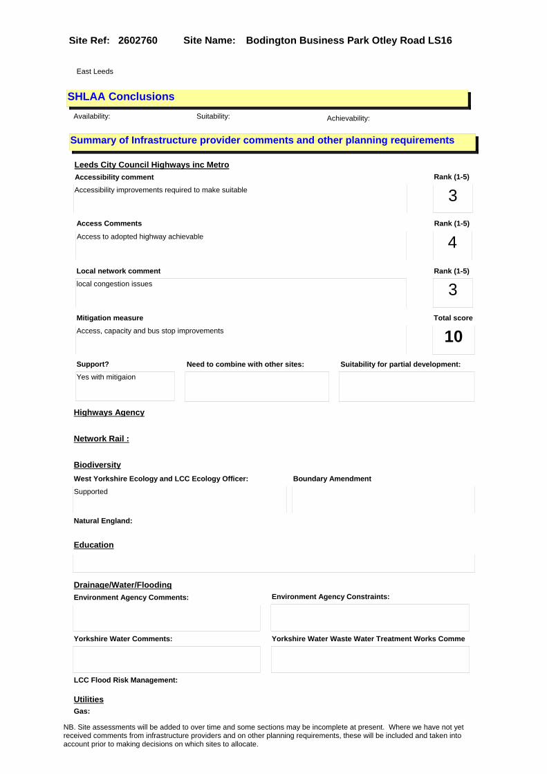
Site Name: Bodington Business Park Otley Road LS16Site Ref: 2602760
SHLAA ConclusionsAvailability: Suitability: Achievability:
East Leeds
Summary of Infrastructure provider comments and other planning requirements
Accessibility commentAccessibility improvements required to make suitable
Rank (1-5)
3Access Comments
Access to adopted highway achievable
Local network comment
local congestion issues
Rank (1-5)
4Rank (1-5)
3
Leeds City Council Highways inc Metro
Highways Agency
Network Rail :
Biodiversity
Natural England:
Education
Mitigation measure
Access, capacity and bus stop improvements
Total score
10Support?
Yes with mitigaion
Need to combine with other sites: Suitability for partial development:
West Yorkshire Ecology and LCC Ecology Officer:
Supported
Boundary Amendment
Drainage/Water/FloodingEnvironment Agency Comments: Environment Agency Constraints:
Yorkshire Water Comments: Yorkshire Water Waste Water Treatment Works Comme
UtilitiesGas:
LCC Flood Risk Management:
NB. Site assessments will be added to over time and some sections may be incomplete at present. Where we have not yet received comments from infrastructure providers and on other planning requirements, these will be included and taken into account prior to making decisions on which sites to allocate.

Site Name: Bodington Business Park Otley Road LS16Site Ref: 2602760
Conclusion of Assessment
Conclusion summary:
Retain. Boundary to be amended. Northern part of site residential but retain remaining as employment.
Floorspace sq m (Non residential): 24375
Employment Conclusion: Green
Assesment Type: Site assessment Type: Office
Proposed Change:
Electric:
Telecom:
Fire and Rescue Services:
Built HeritageLeeds City Council:
West Yorkshire Archaeology Service:
English Heritage:
Gypsy Traveller Site Assessment
Yes No Maybe Could site be effectively managed (Text)
Yes No Maybe Would gypsies and travellers live on the site?
(Text)
Yes No Proximity to housed gypsies and travellers (Text)
Yes No Unknown Experience of previous encampments (Text)
NB. Site assessments will be added to over time and some sections may be incomplete at present. Where we have not yet received comments from infrastructure providers and on other planning requirements, these will be included and taken into account prior to making decisions on which sites to allocate.

Site Name: Site 4 Oatland Lane Meanwood LS7Site Ref: 2603710
Site Details
Land Use
Northing: 434768
Easting: 430352
Distance to Rail Station (metres): 1708.94
Nearest Railway Station Leeds City
Distance to bus stop (metres) 110.65
Bus Stop ID 6855
Agricultural Land Class:
SFRA Flood Zone: 0.00
Environment Agency Flood Zone: 0.00
Within 300m of retail centre boundary:
UDP Designation
Greenbelt - N32 (%): 0.00 Urban Green Corridor - N8 (%): 0.00
Protected Area of Search site - N34 (%): 0.00 Rural Land - RL1: 0.00
City Centre Primary Shopping Quarter - CC27 (%): 0.00 Town Centre - S2: 0.00
Health and Safety Executive Hazard: Yes
Health and Safety Executive Gas Pipeline: No
Strategic Employment Buffer: 0.00
Area sq m: 12794.18 Ward e Park and Woodhouse
Special Landscape Area - N37: 0.00
Allotments - N1A: 0.00
Proposed Greenspace - N5: 0.00
Protected Playing Pitch - N6: 0.00
Nature Conservation Area - N50: 0.00
Conservation Areas No
Ancient Monument/Battlefield(%): 0.00 Listed Buildings: No
Public Rights of Way: No
Other?:
Natural Resources and waste DPD (if applicable)
Within Minerals Safeguarding Site?: No Within 100m of Minerals Safeguarding Site?: No
HMCA: Inner Areas
Greenspace - N1: 30.79
Existing Use 1:
Existing Use 2:
Existing Use 3:
Neighbouring Use 1
Neighbouring Use 2:
Neighbouring Use 3:
Other uses:
Topography:
Natural Landscape:
Boundaries:
Road Frontage
Site Characteristics
Site Detail
Other comments/observations on site characteristics:
Area Ha: 1.279418
Site State:
NB. Site assessments will be added to over time and some sections may be incomplete at present. Where we have not yet received comments from infrastructure providers and on other planning requirements, these will be included and taken into account prior to making decisions on which sites to allocate.

Site Name: Site 4 Oatland Lane Meanwood LS7Site Ref: 2603710
Planning History
Planning App No. Proposal Received Decision Status Site %
26/435/01/FU 3 storey block of 15 flats 11/10/2001 09/01/2003 W 20.74
10/02950/EXT Extension of time application for application number 08/02852/LA , Outline application for 7 retail units, 1 housing office, 1 community centre and residential development
24/06/2010 15/09/2010 A 99.80
H26/1141/79/ Laying out of childrens playgr ound, footpath and lands caping to vacant site. (site a rea 0.32ha). (this item
19/11/1979 17/12/1979 A 24.86
10/05213/RM Reserved matters application for 7 retail units, 1 housing office, 1 community centre and residential development
17/11/2010 11/03/2011 A 99.80
H26/1025/79/ Alterations, to form new kitch en, and extension to formmain hall, toilets, committee room, office, cleaners store and
11/10/1979 05/11/1979 A 10.06
10/02790/LA Removal of conditions 4 and 6 and variation of condition 5, of application no. 08/02852/LA ( 4, affordable housing provision, 6, provision of educational facilities, 5, amended number of dwellings.)��
17/06/2010 16/09/2010 A 99.80
08/02852/LA Outline application for 7 retail units, 1 housing office, 1 community centre and residential development
06/05/2008 19/09/2008 A 100.00
26/225/00/FU 3 storey block of 10 flats 24/05/2000 11/09/2000 A 20.36
10/02789/LA Variation of condition no. 8 of application no. 08/02852/LA ( Provision of highways and transport improvements)
17/06/2010 16/09/2010 A 99.76
PREAPP/06/00211 . 07/11/2006 01/01/2010 PRECAG 100.00
NB. Site assessments will be added to over time and some sections may be incomplete at present. Where we have not yet received comments from infrastructure providers and on other planning requirements, these will be included and taken into account prior to making decisions on which sites to allocate.

Site Name: Site 4 Oatland Lane Meanwood LS7Site Ref: 2603710
Conformity with Core Strategy
Inner South Leeds: 0.00
Leeds Bradford Corridor: 0.00 West Leeds Gateway: 0.00
Aire Valley: 0.00Regeneration Priority Area:
Brownfield
Greenfield
Mixed
Main Urban Area
Major Settlement
Smaller Settlement
Villages/Rural
Main Urban Area Extension
Major Settlement Extension
Smaller Settlement Extension
Village/Rural Extension
Development unrelated to existing development
Green Belt assessment - only completed where site is within Green Belt
Would development lead to/constitute ribbon development?
Would development result in isolated development?
Is the site well connected to built up area (2+ boundaries with existing built up area)?
Would development of the site effectively "round off" the settlement pattern?:
Do natural/physical features provide a good existing barrier between existing urban area and undeveloped land?
Overall sprawl conclusion:
Would development of the site lead to physical connection of settlements?
Do natural/physical features provide a good existing barrier/boundary to contain development?
Overall Coalescence Conclusion:
Is there a strong defensible boundary between the site and the existing urban area?
Does the site provide access to the countryside?
Does the site include local or national conservation designated areas?
Does the site include areas of woodlands, trees, hedgerows that are protected, or significant unprotected tree/hedge cover?
Does the site include grade 1, 2, or 3a agricultural land?
Does the site contain buildings? Are these in agricultural use?
Overall countryside Encroachment Conclusion
Is the site within or adjacent to a conservation area, listed building or other historical feature?
If yes, could development preserve this character?:
Overall Character Preservation Conclusion:
Greenbelt Assessment Conclusion:
Check the unrestricted sprawl of large built up areas
Prevent neighbouring towns from merging
Assist in safeguarding countryside from encroachment
Preserve the setting and special character of historic towns
NB. Site assessments will be added to over time and some sections may be incomplete at present. Where we have not yet received comments from infrastructure providers and on other planning requirements, these will be included and taken into account prior to making decisions on which sites to allocate.

Site Name: Site 4 Oatland Lane Meanwood LS7Site Ref: 2603710
SHLAA ConclusionsAvailability: Suitability: Achievability:
Conclusion of Assessment
Conclusion summary:
Consent 08/02852/LA for mixed use development to replace existing neighbourhood centre. Includes small replacement office element.
Floorspace sq m (Non residential): 160
Employment Conclusion: Lime Green
East Leeds
Assesment Type: ELR Type: Office
Proposed Change:
Gypsy Traveller Site Assessment
Yes No Maybe Could site be effectively managed (Text)
Yes No Maybe Would gypsies and travellers live on the site?
(Text)
Yes No Proximity to housed gypsies and travellers (Text)
Yes No Unknown Experience of previous encampments (Text)
NB. Site assessments will be added to over time and some sections may be incomplete at present. Where we have not yet received comments from infrastructure providers and on other planning requirements, these will be included and taken into account prior to making decisions on which sites to allocate.

Site Name: Royal Park Primary School Queens Road LS6Site Ref: 2603880
Site Details
Land Use
Northing: 434963
Easting: 428471
Distance to Rail Station (metres): 609.66
Nearest Railway Station Burley Park
Distance to bus stop (metres) 32.88
Bus Stop ID 3432
Agricultural Land Class:
SFRA Flood Zone: 0.00
Environment Agency Flood Zone: 0.00
Within 300m of retail centre boundary:
UDP Designation
Greenbelt - N32 (%): 0.00 Urban Green Corridor - N8 (%): 0.00
Protected Area of Search site - N34 (%): 0.00 Rural Land - RL1: 0.00
City Centre Primary Shopping Quarter - CC27 (%): 0.00 Town Centre - S2: 0.00
Health and Safety Executive Hazard: No
Health and Safety Executive Gas Pipeline: No
Strategic Employment Buffer: 0.00
Area sq m: 3103.31 Ward e Park and Woodhouse
Special Landscape Area - N37: 0.00
Allotments - N1A: 0.00
Proposed Greenspace - N5: 0.00
Protected Playing Pitch - N6: 0.00
Nature Conservation Area - N50: 0.00
Conservation Areas No
Ancient Monument/Battlefield(%): 0.00 Listed Buildings: No
Public Rights of Way: No
Other?:
Natural Resources and waste DPD (if applicable)
Within Minerals Safeguarding Site?: No Within 100m of Minerals Safeguarding Site?: No
HMCA: Inner Areas
Greenspace - N1: 0
Existing Use 1:
Existing Use 2:
Existing Use 3:
Neighbouring Use 1
Neighbouring Use 2:
Neighbouring Use 3:
Other uses:
Topography:
Natural Landscape:
Boundaries:
Road Frontage
Site Characteristics
Site Detail
Other comments/observations on site characteristics:
Area Ha: 0.310331
Site State:
NB. Site assessments will be added to over time and some sections may be incomplete at present. Where we have not yet received comments from infrastructure providers and on other planning requirements, these will be included and taken into account prior to making decisions on which sites to allocate.

Site Name: Royal Park Primary School Queens Road LS6Site Ref: 2603880
Planning History
NB. Site assessments will be added to over time and some sections may be incomplete at present. Where we have not yet received comments from infrastructure providers and on other planning requirements, these will be included and taken into account prior to making decisions on which sites to allocate.

Site Name: Royal Park Primary School Queens Road LS6Site Ref: 2603880
Conformity with Core Strategy
Inner South Leeds: 0.00
Leeds Bradford Corridor: 0.00 West Leeds Gateway: 0.00
Aire Valley: 0.00Regeneration Priority Area:
Brownfield
Greenfield
Mixed
Main Urban Area
Major Settlement
Smaller Settlement
Villages/Rural
Main Urban Area Extension
Major Settlement Extension
Smaller Settlement Extension
Village/Rural Extension
Development unrelated to existing development
Green Belt assessment - only completed where site is within Green Belt
Would development lead to/constitute ribbon development?
Would development result in isolated development?
Is the site well connected to built up area (2+ boundaries with existing built up area)?
Would development of the site effectively "round off" the settlement pattern?:
Do natural/physical features provide a good existing barrier between existing urban area and undeveloped land?
Overall sprawl conclusion:
Would development of the site lead to physical connection of settlements?
Do natural/physical features provide a good existing barrier/boundary to contain development?
Overall Coalescence Conclusion:
Is there a strong defensible boundary between the site and the existing urban area?
Does the site provide access to the countryside?
Does the site include local or national conservation designated areas?
Does the site include areas of woodlands, trees, hedgerows that are protected, or significant unprotected tree/hedge cover?
Does the site include grade 1, 2, or 3a agricultural land?
Does the site contain buildings? Are these in agricultural use?
Overall countryside Encroachment Conclusion
Is the site within or adjacent to a conservation area, listed building or other historical feature?
If yes, could development preserve this character?:
Overall Character Preservation Conclusion:
Greenbelt Assessment Conclusion:
Check the unrestricted sprawl of large built up areas
Prevent neighbouring towns from merging
Assist in safeguarding countryside from encroachment
Preserve the setting and special character of historic towns
NB. Site assessments will be added to over time and some sections may be incomplete at present. Where we have not yet received comments from infrastructure providers and on other planning requirements, these will be included and taken into account prior to making decisions on which sites to allocate.

Site Name: Royal Park Primary School Queens Road LS6Site Ref: 2603880
SHLAA ConclusionsAvailability: Suitability: Achievability:
Conclusion of Assessment
Conclusion summary:
Current site with planning permission for employment purposes.
Floorspace sq m (Non residential): 660
Employment Conclusion: Lime Green
East Leeds
Assesment Type: Planning status Type: Office
Proposed Change:
Gypsy Traveller Site Assessment
Yes No Maybe Could site be effectively managed (Text)
Yes No Maybe Would gypsies and travellers live on the site?
(Text)
Yes No Proximity to housed gypsies and travellers (Text)
Yes No Unknown Experience of previous encampments (Text)
NB. Site assessments will be added to over time and some sections may be incomplete at present. Where we have not yet received comments from infrastructure providers and on other planning requirements, these will be included and taken into account prior to making decisions on which sites to allocate.

Site Name: S/O Troy Mills Troy Road LS18Site Ref: 2701350
Site Details
Land Use
Northing: 438814
Easting: 424390
Distance to Rail Station (metres): 327.01
Nearest Railway Station Horsforth
Distance to bus stop (metres) 29.65
Bus Stop ID 8020
Agricultural Land Class:
SFRA Flood Zone: 1.00
Environment Agency Flood Zone: 1.00
Within 300m of retail centre boundary:
UDP Designation
Greenbelt - N32 (%): 5.90 Urban Green Corridor - N8 (%): 5.90
Protected Area of Search site - N34 (%): 0.00 Rural Land - RL1: 0.00
City Centre Primary Shopping Quarter - CC27 (%): 0.00 Town Centre - S2: 0.00
Health and Safety Executive Hazard: No
Health and Safety Executive Gas Pipeline: No
Strategic Employment Buffer: 0.00
Area sq m: 5697.30 Ward Horsforth
Special Landscape Area - N37: 0.00
Allotments - N1A: 0.00
Proposed Greenspace - N5: 0.00
Protected Playing Pitch - N6: 0.00
Nature Conservation Area - N50: 1.00
Conservation Areas Yes
Ancient Monument/Battlefield(%): 0.00 Listed Buildings: No
Public Rights of Way: No
Other?:
Natural Resources and waste DPD (if applicable)
Within Minerals Safeguarding Site?: No Within 100m of Minerals Safeguarding Site?: No
HMCA: North
Greenspace - N1: 0
Existing Use 1:
Existing Use 2:
Existing Use 3:
Neighbouring Use 1
Neighbouring Use 2:
Neighbouring Use 3:
Other uses:
Topography:
Natural Landscape:
Boundaries:
Road Frontage
Site Characteristics
Site Detail
Other comments/observations on site characteristics:
Area Ha: 0.56973
Site State:
NB. Site assessments will be added to over time and some sections may be incomplete at present. Where we have not yet received comments from infrastructure providers and on other planning requirements, these will be included and taken into account prior to making decisions on which sites to allocate.

Site Name: S/O Troy Mills Troy Road LS18Site Ref: 2701350
Planning History
Planning App No. Proposal Received Decision Status Site %
09/9/00175/MOD Part demolition of mill and change of use of mill buildings to offices, 12 flats and 2 maisonettes, erection of 2 storey office block with basement car parking and laying out of new vehicular access and surface car parking�NON MATERIAL AMENDMENT: Amendments to layout to millpond car park area and construction of 4 additional spaces off access
12/06/2009 15/06/2009 M01 98.85
09/05414/COND Consent, agreement or approval required by conditions 3, 4, 6, 13 and 26 of Planning Application 07/02260/FU
14/12/2009 14/01/2010 A 98.85
08/9/00174/MOD Part demolition of mill and change of use of mill buildings to offices, 12 flats and 2 maisonettes, erection of 2 storey office block with basement car parking and laying out of new vehicular access and surface car parking�NON MATERIAL AMENDMENT: Move residential cycle and bin store to new locations (Dwg 4284-05F, 4284-28B and 4284-32B).
31/03/2008 20/01/2009 M04 98.85
07/02260/FU Part demolition of mill and change of use of mill buildings to offices, 12 flats and 2 maisonettes, erection of 2 storey office block with basement car parking and laying out of new vehicular access and surface car parking
04/04/2007 06/03/2008 A 98.85
H27/5/83/ Change of use of part of mill to offices.
14/01/1983 14/03/1983 R 36.41
NB. Site assessments will be added to over time and some sections may be incomplete at present. Where we have not yet received comments from infrastructure providers and on other planning requirements, these will be included and taken into account prior to making decisions on which sites to allocate.

Site Name: S/O Troy Mills Troy Road LS18Site Ref: 2701350
Conformity with Core Strategy
Inner South Leeds: 0.00
Leeds Bradford Corridor: 0.00 West Leeds Gateway: 0.00
Aire Valley: 0.00Regeneration Priority Area:
Brownfield
Greenfield
Mixed
Main Urban Area
Major Settlement
Smaller Settlement
Villages/Rural
Main Urban Area Extension
Major Settlement Extension
Smaller Settlement Extension
Village/Rural Extension
Development unrelated to existing development
Green Belt assessment - only completed where site is within Green Belt
Would development lead to/constitute ribbon development?
Would development result in isolated development?
Is the site well connected to built up area (2+ boundaries with existing built up area)?
Would development of the site effectively "round off" the settlement pattern?:
Do natural/physical features provide a good existing barrier between existing urban area and undeveloped land?
Overall sprawl conclusion:
Would development of the site lead to physical connection of settlements?
Do natural/physical features provide a good existing barrier/boundary to contain development?
Overall Coalescence Conclusion:
Is there a strong defensible boundary between the site and the existing urban area?
Does the site provide access to the countryside?
Does the site include local or national conservation designated areas?
Does the site include areas of woodlands, trees, hedgerows that are protected, or significant unprotected tree/hedge cover?
Does the site include grade 1, 2, or 3a agricultural land?
Does the site contain buildings? Are these in agricultural use?
Overall countryside Encroachment Conclusion
Is the site within or adjacent to a conservation area, listed building or other historical feature?
If yes, could development preserve this character?:
Overall Character Preservation Conclusion:
Greenbelt Assessment Conclusion:
Check the unrestricted sprawl of large built up areas
Prevent neighbouring towns from merging
Assist in safeguarding countryside from encroachment
Preserve the setting and special character of historic towns
NB. Site assessments will be added to over time and some sections may be incomplete at present. Where we have not yet received comments from infrastructure providers and on other planning requirements, these will be included and taken into account prior to making decisions on which sites to allocate.

Site Name: S/O Troy Mills Troy Road LS18Site Ref: 2701350
SHLAA ConclusionsAvailability: Suitability: Achievability:
Conclusion of Assessment
Conclusion summary:
Retain for offices in mixed use scheme 07/02260/FU approved 6/3/2008 and part-developed. Consent for remaining office building.
Floorspace sq m (Non residential): 1140
Employment Conclusion: Lime Green
East Leeds
Assesment Type: ELR Type: Office
Proposed Change:
Gypsy Traveller Site Assessment
Yes No Maybe Could site be effectively managed (Text)
Yes No Maybe Would gypsies and travellers live on the site?
(Text)
Yes No Proximity to housed gypsies and travellers (Text)
Yes No Unknown Experience of previous encampments (Text)
NB. Site assessments will be added to over time and some sections may be incomplete at present. Where we have not yet received comments from infrastructure providers and on other planning requirements, these will be included and taken into account prior to making decisions on which sites to allocate.

Site Name: Lcc Depot Off Green Lane YeadonSite Ref: 2800611
Site Details
Land Use
Northing: 440568
Easting: 420630
Distance to Rail Station (metres): 2417.33
Nearest Railway Station Guiseley
Distance to bus stop (metres) 126.11
Bus Stop ID 11710
Agricultural Land Class:
SFRA Flood Zone: 0.00
Environment Agency Flood Zone: 0.00
Within 300m of retail centre boundary:
UDP Designation
Greenbelt - N32 (%): 0.00 Urban Green Corridor - N8 (%): 0.00
Protected Area of Search site - N34 (%): 0.00 Rural Land - RL1: 0.00
City Centre Primary Shopping Quarter - CC27 (%): 0.00 Town Centre - S2: 0.00
Health and Safety Executive Hazard: No
Health and Safety Executive Gas Pipeline: No
Strategic Employment Buffer: 0.00
Area sq m: 15023.25 Ward Guiseley and Rawdon
Special Landscape Area - N37: 0.00
Allotments - N1A: 0.00
Proposed Greenspace - N5: 0.00
Protected Playing Pitch - N6: 0.00
Nature Conservation Area - N50: 1.00
Conservation Areas Yes
Ancient Monument/Battlefield(%): 0.00 Listed Buildings: No
Public Rights of Way: No
Other?:
Natural Resources and waste DPD (if applicable)
Within Minerals Safeguarding Site?: No Within 100m of Minerals Safeguarding Site?: No
HMCA: Aireborough
Greenspace - N1: 0
Existing Use 1:
Existing Use 2:
Existing Use 3:
Neighbouring Use 1
Neighbouring Use 2:
Neighbouring Use 3:
Other uses:
Topography:
Natural Landscape:
Boundaries:
Road Frontage
Site Characteristics
Site Detail
Other comments/observations on site characteristics:
Area Ha: 1.502325
Site State:
NB. Site assessments will be added to over time and some sections may be incomplete at present. Where we have not yet received comments from infrastructure providers and on other planning requirements, these will be included and taken into account prior to making decisions on which sites to allocate.

Site Name: Lcc Depot Off Green Lane YeadonSite Ref: 2800611
Planning History
NB. Site assessments will be added to over time and some sections may be incomplete at present. Where we have not yet received comments from infrastructure providers and on other planning requirements, these will be included and taken into account prior to making decisions on which sites to allocate.

Site Name: Lcc Depot Off Green Lane YeadonSite Ref: 2800611
Conformity with Core Strategy
Inner South Leeds: 0.00
Leeds Bradford Corridor: 0.00 West Leeds Gateway: 0.00
Aire Valley: 0.00Regeneration Priority Area:
Brownfield
Greenfield
Mixed
Main Urban Area
Major Settlement
Smaller Settlement
Villages/Rural
Main Urban Area Extension
Major Settlement Extension
Smaller Settlement Extension
Village/Rural Extension
Development unrelated to existing development
Green Belt assessment - only completed where site is within Green Belt
Would development lead to/constitute ribbon development?
Would development result in isolated development?
Is the site well connected to built up area (2+ boundaries with existing built up area)?
Would development of the site effectively "round off" the settlement pattern?:
Do natural/physical features provide a good existing barrier between existing urban area and undeveloped land?
Overall sprawl conclusion:
Would development of the site lead to physical connection of settlements?
Do natural/physical features provide a good existing barrier/boundary to contain development?
Overall Coalescence Conclusion:
Is there a strong defensible boundary between the site and the existing urban area?
Does the site provide access to the countryside?
Does the site include local or national conservation designated areas?
Does the site include areas of woodlands, trees, hedgerows that are protected, or significant unprotected tree/hedge cover?
Does the site include grade 1, 2, or 3a agricultural land?
Does the site contain buildings? Are these in agricultural use?
Overall countryside Encroachment Conclusion
Is the site within or adjacent to a conservation area, listed building or other historical feature?
If yes, could development preserve this character?:
Overall Character Preservation Conclusion:
Greenbelt Assessment Conclusion:
Check the unrestricted sprawl of large built up areas
Prevent neighbouring towns from merging
Assist in safeguarding countryside from encroachment
Preserve the setting and special character of historic towns
NB. Site assessments will be added to over time and some sections may be incomplete at present. Where we have not yet received comments from infrastructure providers and on other planning requirements, these will be included and taken into account prior to making decisions on which sites to allocate.

Site Name: Lcc Depot Off Green Lane YeadonSite Ref: 2800611
SHLAA ConclusionsAvailability: Suitability: Achievability:
Conclusion of Assessment
Conclusion summary:
Site is not available as currently used by Leeds City Council as a Highways Depot. No plans for relocation.
Floorspace sq m (Non residential):
Employment Conclusion: Red
East Leeds
Assesment Type: ELR Type: Industrial & Warehousing
Proposed Change:
Gypsy Traveller Site Assessment
Yes No Maybe Could site be effectively managed (Text)
Yes No Maybe Would gypsies and travellers live on the site?
(Text)
Yes No Proximity to housed gypsies and travellers (Text)
Yes No Unknown Experience of previous encampments (Text)
NB. Site assessments will be added to over time and some sections may be incomplete at present. Where we have not yet received comments from infrastructure providers and on other planning requirements, these will be included and taken into account prior to making decisions on which sites to allocate.
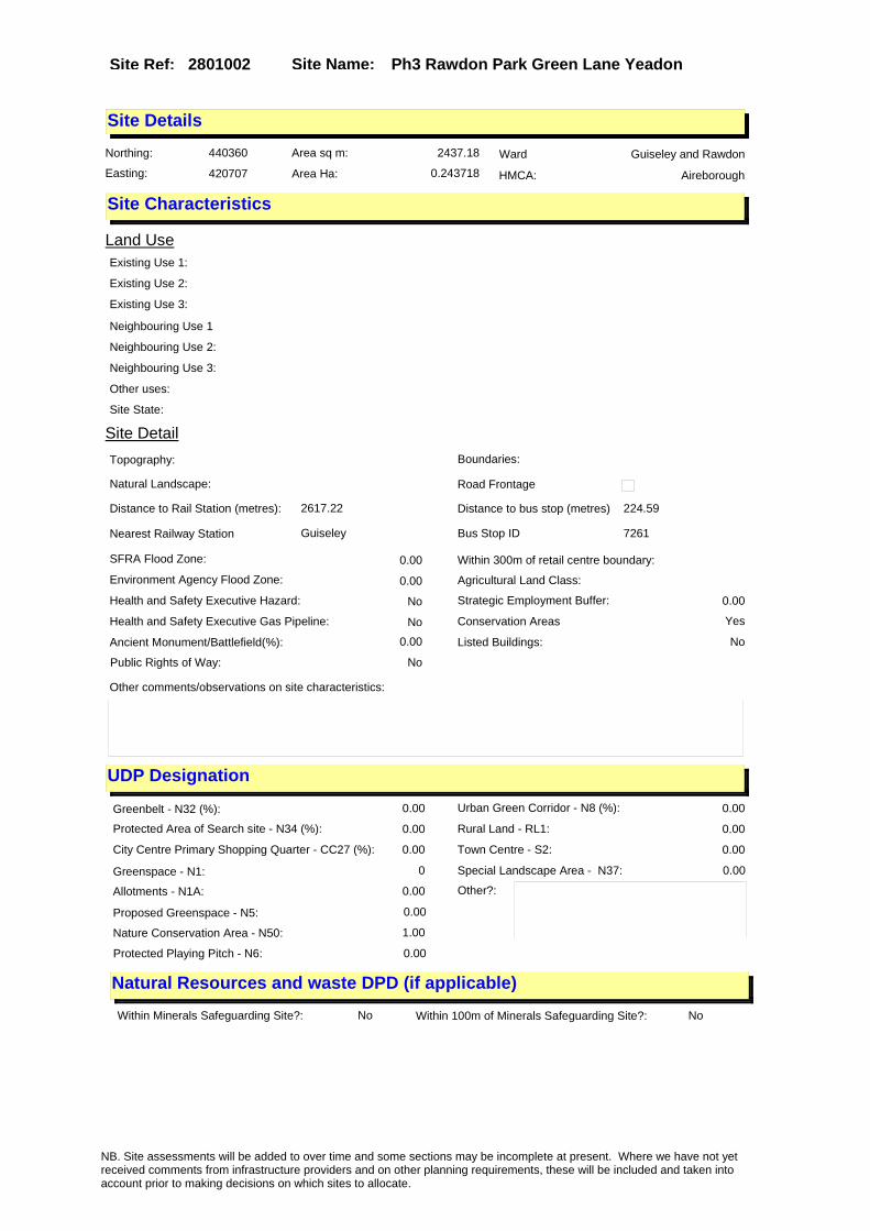
Site Name: Ph3 Rawdon Park Green Lane YeadonSite Ref: 2801002
Site Details
Land Use
Northing: 440360
Easting: 420707
Distance to Rail Station (metres): 2617.22
Nearest Railway Station Guiseley
Distance to bus stop (metres) 224.59
Bus Stop ID 7261
Agricultural Land Class:
SFRA Flood Zone: 0.00
Environment Agency Flood Zone: 0.00
Within 300m of retail centre boundary:
UDP Designation
Greenbelt - N32 (%): 0.00 Urban Green Corridor - N8 (%): 0.00
Protected Area of Search site - N34 (%): 0.00 Rural Land - RL1: 0.00
City Centre Primary Shopping Quarter - CC27 (%): 0.00 Town Centre - S2: 0.00
Health and Safety Executive Hazard: No
Health and Safety Executive Gas Pipeline: No
Strategic Employment Buffer: 0.00
Area sq m: 2437.18 Ward Guiseley and Rawdon
Special Landscape Area - N37: 0.00
Allotments - N1A: 0.00
Proposed Greenspace - N5: 0.00
Protected Playing Pitch - N6: 0.00
Nature Conservation Area - N50: 1.00
Conservation Areas Yes
Ancient Monument/Battlefield(%): 0.00 Listed Buildings: No
Public Rights of Way: No
Other?:
Natural Resources and waste DPD (if applicable)
Within Minerals Safeguarding Site?: No Within 100m of Minerals Safeguarding Site?: No
HMCA: Aireborough
Greenspace - N1: 0
Existing Use 1:
Existing Use 2:
Existing Use 3:
Neighbouring Use 1
Neighbouring Use 2:
Neighbouring Use 3:
Other uses:
Topography:
Natural Landscape:
Boundaries:
Road Frontage
Site Characteristics
Site Detail
Other comments/observations on site characteristics:
Area Ha: 0.243718
Site State:
NB. Site assessments will be added to over time and some sections may be incomplete at present. Where we have not yet received comments from infrastructure providers and on other planning requirements, these will be included and taken into account prior to making decisions on which sites to allocate.

Site Name: Ph3 Rawdon Park Green Lane YeadonSite Ref: 2801002
Planning History
Planning App No. Proposal Received Decision Status Site %
10/05238/EXT Extension of time period for planning application 07/02137/FU for 2 storey office block
19/11/2010 11/01/2011 A 99.39
07/02137/FU Detached 2 storey office block 02/04/2007 21/06/2007 R 99.43
0-28/26/03/MOD Laying out of access road and erection of 3 two storey office blocks
23/09/2003 REC 97.87
12/01253/FU Laying out of 9 additional car parking spaces
19/03/2012 14/05/2012 R 10.30
13/00323/FU Detached three storey office block with car parking
21/01/2013 15/03/2013 A 91.05
07/07374/FU Detached 2 storey office block 27/11/2007 22/01/2008 R 99.43
0-28/27/03/MOD Layint out of access road and erection of 3 two storey office blocks
23/09/2003 14/11/2003 M01 97.87
28/105/02/FU Laying out of access road and erection of 3 two storey office blocks
13/05/2002 22/05/2003 A 97.87
28/139/92/FU 1.8m high boundary fence 15/07/1992 03/09/1992 A 73.20
NB. Site assessments will be added to over time and some sections may be incomplete at present. Where we have not yet received comments from infrastructure providers and on other planning requirements, these will be included and taken into account prior to making decisions on which sites to allocate.

Site Name: Ph3 Rawdon Park Green Lane YeadonSite Ref: 2801002
Conformity with Core Strategy
Inner South Leeds: 0.00
Leeds Bradford Corridor: 0.00 West Leeds Gateway: 0.00
Aire Valley: 0.00Regeneration Priority Area:
Brownfield
Greenfield
Mixed
Main Urban Area
Major Settlement
Smaller Settlement
Villages/Rural
Main Urban Area Extension
Major Settlement Extension
Smaller Settlement Extension
Village/Rural Extension
Development unrelated to existing development
Green Belt assessment - only completed where site is within Green Belt
Would development lead to/constitute ribbon development?
Would development result in isolated development?
Is the site well connected to built up area (2+ boundaries with existing built up area)?
Would development of the site effectively "round off" the settlement pattern?:
Do natural/physical features provide a good existing barrier between existing urban area and undeveloped land?
Overall sprawl conclusion:
Would development of the site lead to physical connection of settlements?
Do natural/physical features provide a good existing barrier/boundary to contain development?
Overall Coalescence Conclusion:
Is there a strong defensible boundary between the site and the existing urban area?
Does the site provide access to the countryside?
Does the site include local or national conservation designated areas?
Does the site include areas of woodlands, trees, hedgerows that are protected, or significant unprotected tree/hedge cover?
Does the site include grade 1, 2, or 3a agricultural land?
Does the site contain buildings? Are these in agricultural use?
Overall countryside Encroachment Conclusion
Is the site within or adjacent to a conservation area, listed building or other historical feature?
If yes, could development preserve this character?:
Overall Character Preservation Conclusion:
Greenbelt Assessment Conclusion:
Check the unrestricted sprawl of large built up areas
Prevent neighbouring towns from merging
Assist in safeguarding countryside from encroachment
Preserve the setting and special character of historic towns
NB. Site assessments will be added to over time and some sections may be incomplete at present. Where we have not yet received comments from infrastructure providers and on other planning requirements, these will be included and taken into account prior to making decisions on which sites to allocate.

Site Name: Ph3 Rawdon Park Green Lane YeadonSite Ref: 2801002
SHLAA ConclusionsAvailability: Suitability: Achievability:
Conclusion of Assessment
Conclusion summary:
Current site with outstanding planning permission for employment purposes.
Floorspace sq m (Non residential): 510
Employment Conclusion: Lime Green
East Leeds
Assesment Type: Planning status Type: Office
Proposed Change:
Gypsy Traveller Site Assessment
Yes No Maybe Could site be effectively managed (Text)
Yes No Maybe Would gypsies and travellers live on the site?
(Text)
Yes No Proximity to housed gypsies and travellers (Text)
Yes No Unknown Experience of previous encampments (Text)
NB. Site assessments will be added to over time and some sections may be incomplete at present. Where we have not yet received comments from infrastructure providers and on other planning requirements, these will be included and taken into account prior to making decisions on which sites to allocate.

Site Name: Adj Westfield Mills YeadonSite Ref: 2801642
Site Details
Land Use
Northing: 440853
Easting: 420360
Distance to Rail Station (metres): 2025.55
Nearest Railway Station Guiseley
Distance to bus stop (metres) 290.37
Bus Stop ID 10504
Agricultural Land Class:
SFRA Flood Zone: 0.00
Environment Agency Flood Zone: 0.00
Within 300m of retail centre boundary:
UDP Designation
Greenbelt - N32 (%): 0.00 Urban Green Corridor - N8 (%): 0.00
Protected Area of Search site - N34 (%): 0.00 Rural Land - RL1: 0.00
City Centre Primary Shopping Quarter - CC27 (%): 0.00 Town Centre - S2: 0.00
Health and Safety Executive Hazard: No
Health and Safety Executive Gas Pipeline: No
Strategic Employment Buffer: 0.00
Area sq m: 1175.34 Ward Guiseley and Rawdon
Special Landscape Area - N37: 0.00
Allotments - N1A: 0.00
Proposed Greenspace - N5: 0.00
Protected Playing Pitch - N6: 0.00
Nature Conservation Area - N50: 1.00
Conservation Areas Yes
Ancient Monument/Battlefield(%): 0.00 Listed Buildings: No
Public Rights of Way: No
Other?:
Natural Resources and waste DPD (if applicable)
Within Minerals Safeguarding Site?: No Within 100m of Minerals Safeguarding Site?: No
HMCA: Aireborough
Greenspace - N1: 0
Existing Use 1:
Existing Use 2:
Existing Use 3:
Neighbouring Use 1
Neighbouring Use 2:
Neighbouring Use 3:
Other uses:
Topography:
Natural Landscape:
Boundaries:
Road Frontage
Site Characteristics
Site Detail
Other comments/observations on site characteristics:
Area Ha: 0.117534
Site State:
NB. Site assessments will be added to over time and some sections may be incomplete at present. Where we have not yet received comments from infrastructure providers and on other planning requirements, these will be included and taken into account prior to making decisions on which sites to allocate.

Site Name: Adj Westfield Mills YeadonSite Ref: 2801642
Planning History
Planning App No. Proposal Received Decision Status Site %
28/228/92/FU Detached light industrial warehousing and distribution unit with ancillary offices, car parking and landscaping
20/11/1992 22/12/1992 A 84.16
H28/459/77/ Outline application to erect a udit equipment factory with ancillary store and offices, w ith 66 car parking spaces and
17/08/1977 07/07/1978 A 98.20
H28/74/92/ Light ind & warehouse unit & ancillary offices, revised turning head, car parking & landscaping to vacant site
02/04/1992 29/04/1993 W 94.99
H28/293/89/ Outline application to lay out access and erect b1 light industrial and b8 warehouse d evelopment to vacantsite.
13/10/1989 29/01/1992 A 99.76
12/03363/FU Detached industrial unit with associated parking, hardstanding and entrance gates to vacant land
02/08/2012 01/11/2012 A 99.86
H28/397/74/ Internal alterations to form a ncillary offices, hall, lobby , toilets and canteen with 17 additional car parking sp
04/12/1974 03/03/1975 A 100.00
H28/459/77/1 Renewal of outline application to erect audit equip ment factory, with ancillary s tore and offices, and with
18/09/1980 24/11/1980 A 99.95
H28/459/77/2 Renewal of outline permission to erect audit equipment facto ry, with ancillary store and o ffices, and with 66 car parkin
12/09/1983 31/10/1983 A 99.95
NB. Site assessments will be added to over time and some sections may be incomplete at present. Where we have not yet received comments from infrastructure providers and on other planning requirements, these will be included and taken into account prior to making decisions on which sites to allocate.

Site Name: Adj Westfield Mills YeadonSite Ref: 2801642
Conformity with Core Strategy
Inner South Leeds: 0.00
Leeds Bradford Corridor: 0.00 West Leeds Gateway: 0.00
Aire Valley: 0.00Regeneration Priority Area:
Brownfield
Greenfield
Mixed
Main Urban Area
Major Settlement
Smaller Settlement
Villages/Rural
Main Urban Area Extension
Major Settlement Extension
Smaller Settlement Extension
Village/Rural Extension
Development unrelated to existing development
Green Belt assessment - only completed where site is within Green Belt
Would development lead to/constitute ribbon development?
Would development result in isolated development?
Is the site well connected to built up area (2+ boundaries with existing built up area)?
Would development of the site effectively "round off" the settlement pattern?:
Do natural/physical features provide a good existing barrier between existing urban area and undeveloped land?
Overall sprawl conclusion:
Would development of the site lead to physical connection of settlements?
Do natural/physical features provide a good existing barrier/boundary to contain development?
Overall Coalescence Conclusion:
Is there a strong defensible boundary between the site and the existing urban area?
Does the site provide access to the countryside?
Does the site include local or national conservation designated areas?
Does the site include areas of woodlands, trees, hedgerows that are protected, or significant unprotected tree/hedge cover?
Does the site include grade 1, 2, or 3a agricultural land?
Does the site contain buildings? Are these in agricultural use?
Overall countryside Encroachment Conclusion
Is the site within or adjacent to a conservation area, listed building or other historical feature?
If yes, could development preserve this character?:
Overall Character Preservation Conclusion:
Greenbelt Assessment Conclusion:
Check the unrestricted sprawl of large built up areas
Prevent neighbouring towns from merging
Assist in safeguarding countryside from encroachment
Preserve the setting and special character of historic towns
NB. Site assessments will be added to over time and some sections may be incomplete at present. Where we have not yet received comments from infrastructure providers and on other planning requirements, these will be included and taken into account prior to making decisions on which sites to allocate.

Site Name: Adj Westfield Mills YeadonSite Ref: 2801642
SHLAA ConclusionsAvailability: Suitability: Achievability:
Conclusion of Assessment
Conclusion summary:
Current site with outstanding planning permission for employment purposes.
Floorspace sq m (Non residential):
Employment Conclusion: Lime Green
East Leeds
Assesment Type: Planning status Type: Industrial & Warehousing
Proposed Change:
Gypsy Traveller Site Assessment
Yes No Maybe Could site be effectively managed (Text)
Yes No Maybe Would gypsies and travellers live on the site?
(Text)
Yes No Proximity to housed gypsies and travellers (Text)
Yes No Unknown Experience of previous encampments (Text)
NB. Site assessments will be added to over time and some sections may be incomplete at present. Where we have not yet received comments from infrastructure providers and on other planning requirements, these will be included and taken into account prior to making decisions on which sites to allocate.

Site Name: Low Mills Guiseley Ls19Site Ref: 2802310
Site Details
Land Use
Northing: 441003
Easting: 419407
Distance to Rail Station (metres): 1328.43
Nearest Railway Station Guiseley
Distance to bus stop (metres) 479.39
Bus Stop ID 3957
Agricultural Land Class:
SFRA Flood Zone: 1.00
Environment Agency Flood Zone: 1.00
Within 300m of retail centre boundary:
UDP Designation
Greenbelt - N32 (%): 0.01 Urban Green Corridor - N8 (%): 0.00
Protected Area of Search site - N34 (%): 0.00 Rural Land - RL1: 0.00
City Centre Primary Shopping Quarter - CC27 (%): 0.00 Town Centre - S2: 0.00
Health and Safety Executive Hazard: No
Health and Safety Executive Gas Pipeline: No
Strategic Employment Buffer: 0.00
Area sq m: 72265.36 Ward Guiseley and Rawdon
Special Landscape Area - N37: 0.00
Allotments - N1A: 0.00
Proposed Greenspace - N5: 0.00
Protected Playing Pitch - N6: 0.00
Nature Conservation Area - N50: 0.00
Conservation Areas No
Ancient Monument/Battlefield(%): 0.00 Listed Buildings: No
Public Rights of Way: No
Other?:
Natural Resources and waste DPD (if applicable)
Within Minerals Safeguarding Site?: Yes Within 100m of Minerals Safeguarding Site?: Yes
HMCA: Aireborough
Greenspace - N1: 0
Existing Use 1:
Existing Use 2:
Existing Use 3:
Neighbouring Use 1
Neighbouring Use 2:
Neighbouring Use 3:
Other uses:
Topography:
Natural Landscape:
Boundaries:
Road Frontage
Site Characteristics
Site Detail
Other comments/observations on site characteristics:
Area Ha: 7.226536
Site State:
Site Site TypeMilners Road (Aireborough Mini Skips) General Waste Management Sites
Machells Reclamation, Guiseley Other (Waste) Specialist Misc - Loose Ends
NB. Site assessments will be added to over time and some sections may be incomplete at present. Where we have not yet received comments from infrastructure providers and on other planning requirements, these will be included and taken into account prior to making decisions on which sites to allocate.

Site Name: Low Mills Guiseley Ls19Site Ref: 2802310
Stone Masons Milners Road, Yeadon Other (Waste) Specialist Misc - Building Materials
Milners Road Yeadon (SBT) General Waste Management Sites
Milners Road Guiseley (Tarmac) Asphalt and Concrete Plants
NB. Site assessments will be added to over time and some sections may be incomplete at present. Where we have not yet received comments from infrastructure providers and on other planning requirements, these will be included and taken into account prior to making decisions on which sites to allocate.
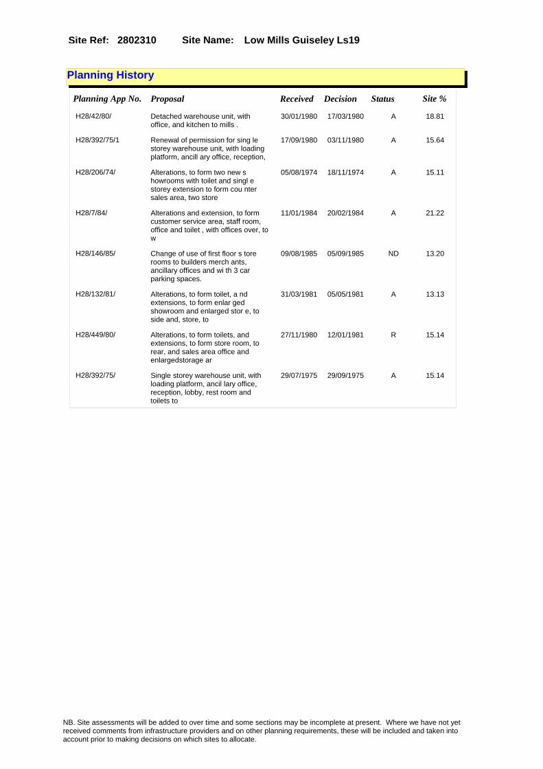
Site Name: Low Mills Guiseley Ls19Site Ref: 2802310
Planning History
Planning App No. Proposal Received Decision Status Site %
H28/42/80/ Detached warehouse unit, with office, and kitchen to mills .
30/01/1980 17/03/1980 A 18.81
H28/392/75/1 Renewal of permission for sing le storey warehouse unit, with loading platform, ancill ary office, reception,
17/09/1980 03/11/1980 A 15.64
H28/206/74/ Alterations, to form two new s howrooms with toilet and singl e storey extension to form cou nter sales area, two store
05/08/1974 18/11/1974 A 15.11
H28/7/84/ Alterations and extension, to form customer service area, staff room, office and toilet , with offices over, to w
11/01/1984 20/02/1984 A 21.22
H28/146/85/ Change of use of first floor s tore rooms to builders merch ants, ancillary offices and wi th 3 car parking spaces.
09/08/1985 05/09/1985 ND 13.20
H28/132/81/ Alterations, to form toilet, a nd extensions, to form enlar ged showroom and enlarged stor e, to side and, store, to
31/03/1981 05/05/1981 A 13.13
H28/449/80/ Alterations, to form toilets, and extensions, to form store room, to rear, and sales area office and enlargedstorage ar
27/11/1980 12/01/1981 R 15.14
H28/392/75/ Single storey warehouse unit, with loading platform, ancil lary office, reception, lobby, rest room and toilets to
29/07/1975 29/09/1975 A 15.14
NB. Site assessments will be added to over time and some sections may be incomplete at present. Where we have not yet received comments from infrastructure providers and on other planning requirements, these will be included and taken into account prior to making decisions on which sites to allocate.

Site Name: Low Mills Guiseley Ls19Site Ref: 2802310
Conformity with Core Strategy
Inner South Leeds: 0.00
Leeds Bradford Corridor: 0.00 West Leeds Gateway: 0.00
Aire Valley: 0.00Regeneration Priority Area:
Brownfield
Greenfield
Mixed
Main Urban Area
Major Settlement
Smaller Settlement
Villages/Rural
Main Urban Area Extension
Major Settlement Extension
Smaller Settlement Extension
Village/Rural Extension
Development unrelated to existing development
Green Belt assessment - only completed where site is within Green Belt
Would development lead to/constitute ribbon development?
Would development result in isolated development?
Is the site well connected to built up area (2+ boundaries with existing built up area)?
Would development of the site effectively "round off" the settlement pattern?:
Do natural/physical features provide a good existing barrier between existing urban area and undeveloped land?
Overall sprawl conclusion:
Would development of the site lead to physical connection of settlements?
Do natural/physical features provide a good existing barrier/boundary to contain development?
Overall Coalescence Conclusion:
Is there a strong defensible boundary between the site and the existing urban area?
Does the site provide access to the countryside?
Does the site include local or national conservation designated areas?
Does the site include areas of woodlands, trees, hedgerows that are protected, or significant unprotected tree/hedge cover?
Does the site include grade 1, 2, or 3a agricultural land?
Does the site contain buildings? Are these in agricultural use?
Overall countryside Encroachment Conclusion
Is the site within or adjacent to a conservation area, listed building or other historical feature?
If yes, could development preserve this character?:
Overall Character Preservation Conclusion:
Greenbelt Assessment Conclusion:
Check the unrestricted sprawl of large built up areas
Prevent neighbouring towns from merging
Assist in safeguarding countryside from encroachment
Preserve the setting and special character of historic towns
NB. Site assessments will be added to over time and some sections may be incomplete at present. Where we have not yet received comments from infrastructure providers and on other planning requirements, these will be included and taken into account prior to making decisions on which sites to allocate.

Site Name: Low Mills Guiseley Ls19Site Ref: 2802310
SHLAA ConclusionsAvailability: Suitability: Achievability:
Conclusion of Assessment
Conclusion summary:
The site has been available for over 20 years and will not come forward for employment use because of issues over contamination and access.
Floorspace sq m (Non residential):
Employment Conclusion: Red
East Leeds
Assesment Type: ELR Type: Industrial & Warehousing
Proposed Change:
Gypsy Traveller Site Assessment
Yes No Maybe Could site be effectively managed (Text)
Yes No Maybe Would gypsies and travellers live on the site?
(Text)
Yes No Proximity to housed gypsies and travellers (Text)
Yes No Unknown Experience of previous encampments (Text)
NB. Site assessments will be added to over time and some sections may be incomplete at present. Where we have not yet received comments from infrastructure providers and on other planning requirements, these will be included and taken into account prior to making decisions on which sites to allocate.

Site Name: Office Element High Royds Hospital, Redevelopment Bradford Road, Guisely
Site Ref: 2802330
Site Details
Land Use
Northing: 443059
Easting: 417491
Distance to Rail Station (metres): 1608.07
Nearest Railway Station Guiseley
Distance to bus stop (metres) 401.48
Bus Stop ID 6204
Agricultural Land Class:
SFRA Flood Zone: 0.00
Environment Agency Flood Zone: 0.00
Within 300m of retail centre boundary:
UDP Designation
Greenbelt - N32 (%): 100.00 Urban Green Corridor - N8 (%): 0.00
Protected Area of Search site - N34 (%): 0.00 Rural Land - RL1: 0.00
City Centre Primary Shopping Quarter - CC27 (%): 0.00 Town Centre - S2: 0.00
Health and Safety Executive Hazard: No
Health and Safety Executive Gas Pipeline: No
Strategic Employment Buffer: 0.00
Area sq m: 12798.98 Ward Guiseley and Rawdon
Special Landscape Area - N37: 1.00
Allotments - N1A: 0.00
Proposed Greenspace - N5: 0.00
Protected Playing Pitch - N6: 0.00
Nature Conservation Area - N50: 0.00
Conservation Areas No
Ancient Monument/Battlefield(%): 100.00 Listed Buildings: No
Public Rights of Way: No
Other?:
Natural Resources and waste DPD (if applicable)
Within Minerals Safeguarding Site?: No Within 100m of Minerals Safeguarding Site?: No
HMCA: Aireborough
Greenspace - N1: 0
Existing Use 1:
Existing Use 2:
Existing Use 3:
Neighbouring Use 1
Neighbouring Use 2:
Neighbouring Use 3:
Other uses:
Topography:
Natural Landscape:
Boundaries:
Road Frontage
Site Characteristics
Site Detail
Other comments/observations on site characteristics:
Area Ha: 1.279898
Site State:
NB. Site assessments will be added to over time and some sections may be incomplete at present. Where we have not yet received comments from infrastructure providers and on other planning requirements, these will be included and taken into account prior to making decisions on which sites to allocate.
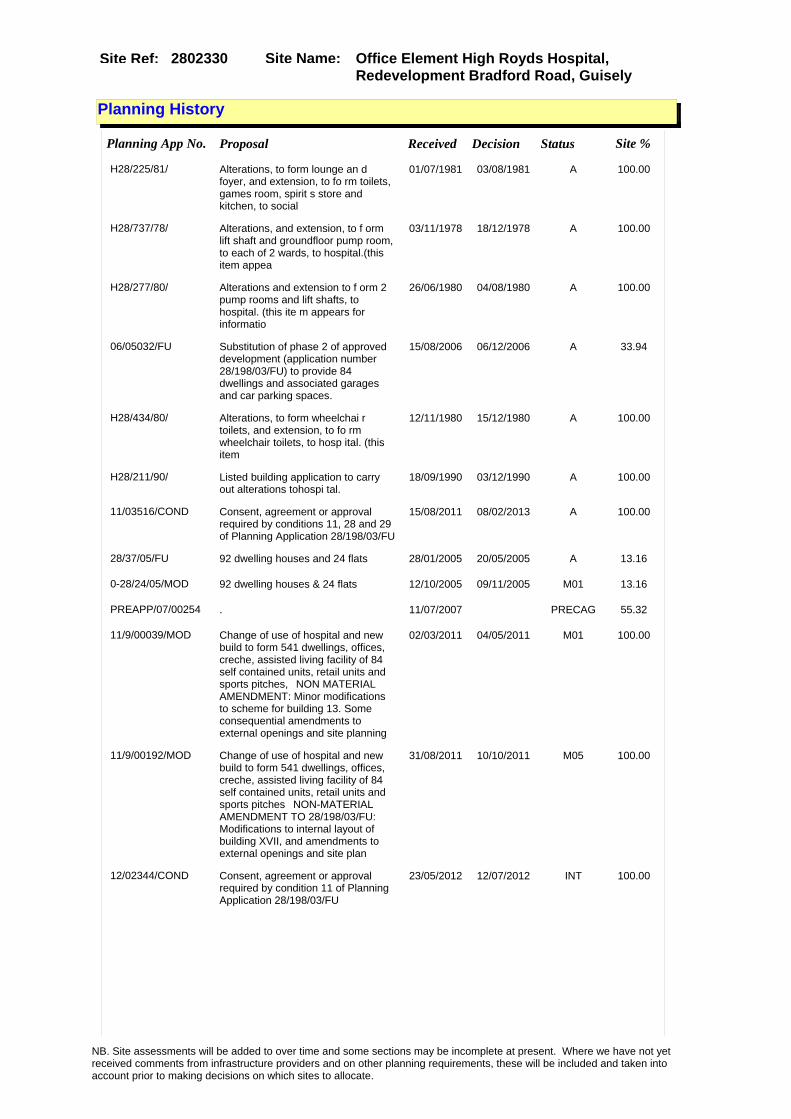
Site Name: Office Element High Royds Hospital, Redevelopment Bradford Road, Guisely
Site Ref: 2802330
Planning History
Planning App No. Proposal Received Decision Status Site %
H28/225/81/ Alterations, to form lounge an d foyer, and extension, to fo rm toilets, games room, spirit s store and kitchen, to social
01/07/1981 03/08/1981 A 100.00
H28/737/78/ Alterations, and extension, to f orm lift shaft and groundfloor pump room, to each of 2 wards, to hospital.(this item appea
03/11/1978 18/12/1978 A 100.00
H28/277/80/ Alterations and extension to f orm 2 pump rooms and lift shafts, to hospital. (this ite m appears for informatio
26/06/1980 04/08/1980 A 100.00
06/05032/FU Substitution of phase 2 of approved development (application number 28/198/03/FU) to provide 84 dwellings and associated garages and car parking spaces.
15/08/2006 06/12/2006 A 33.94
H28/434/80/ Alterations, to form wheelchai r toilets, and extension, to fo rm wheelchair toilets, to hosp ital. (this item
12/11/1980 15/12/1980 A 100.00
H28/211/90/ Listed building application to carry out alterations tohospi tal.
18/09/1990 03/12/1990 A 100.00
11/03516/COND Consent, agreement or approval required by conditions 11, 28 and 29 of Planning Application 28/198/03/FU
15/08/2011 08/02/2013 A 100.00
28/37/05/FU 92 dwelling houses and 24 flats 28/01/2005 20/05/2005 A 13.16
0-28/24/05/MOD 92 dwelling houses & 24 flats 12/10/2005 09/11/2005 M01 13.16
PREAPP/07/00254 . 11/07/2007 PRECAG 55.32
11/9/00039/MOD Change of use of hospital and new build to form 541 dwellings, offices, creche, assisted living facility of 84 self contained units, retail units and sports pitches,�NON MATERIAL AMENDMENT: Minor modifications to scheme for building 13. Some consequential amendments to external openings and site planning
02/03/2011 04/05/2011 M01 100.00
11/9/00192/MOD Change of use of hospital and new build to form 541 dwellings, offices, creche, assisted living facility of 84 self contained units, retail units and sports pitches�NON-MATERIAL AMENDMENT TO 28/198/03/FU: Modifications to internal layout of building XVII, and amendments to external openings and site plan
31/08/2011 10/10/2011 M05 100.00
12/02344/COND Consent, agreement or approval required by condition 11 of Planning Application 28/198/03/FU
23/05/2012 12/07/2012 INT 100.00
NB. Site assessments will be added to over time and some sections may be incomplete at present. Where we have not yet received comments from infrastructure providers and on other planning requirements, these will be included and taken into account prior to making decisions on which sites to allocate.

Site Name: Office Element High Royds Hospital, Redevelopment Bradford Road, Guisely
Site Ref: 2802330
12/9/00105/MOD Change of use of hospital and new build to form 541 dwellings, offices, creche, assisted living facility of 84 self contained units, retail units and sports pitches NON MATERIAL AMENDMENT to 28/198/03/FU: Amendment to internal layout of building 1 which has led to consequential amendments to external openings and site plan
23/05/2012 27/07/2012 M01 100.00
H28/330/88/ 2 electricity sub-distribution boxes to hospital. (this item appears for information only being notificati
20/12/1988 23/01/1989 A 100.00
06/9/00099/MOD 92 dwelling houses and 24 flats. �NON MATERIAL AMENDMENT: 2 number windows added to appartment blocks (Q) DBZZ, 1 to second floor, 1 to third floor. Site layout plot number 8-13, 20-25, 54-59, 95-100
27/02/2006 22/03/2006 M01 13.16
H28/253/80/ Alterations and extension, to form mess room, staff room, rest room, showers, toilets a nd locker room. (this item
10/06/1980 14/07/1980 A 100.00
H28/199/82/ Alterations and extensions, to form kitchen and bathr oom, to hospital. (this item a ppears for informatio
18/08/1982 20/09/1982 A 100.00
H28/123/82/ Erection of replacement single storey chapel, with meeti ng room, office, oratory, vest ries, store, toilets, a
18/05/1982 21/06/1982 A 100.00
10/9/00085/MOD Change of use of hospital and new build to form 541 dwellings, offices, creche, assisted living facility of 84 self contained units, retail units and sports pitches,�NON MATERIAL AMENDMENT: Minor modifications to internal layout of the planning approved conversion scheme to building 12. Some consequential amendments to external openings and site plan
12/04/2010 22/06/2010 M01 100.00
28/199/03/LI Listed building application to alter and demolish part of hospital to form dwellings creche medical & offices
30/06/2003 27/05/2005 A 100.00
28/198/03/FU Change of use of hospital and new build to form 541 dwellings, offices, creche, assisted living facility of 84 self contained units, retail units and sports pitches,
30/06/2003 26/01/2005 A 100.00
H28/552/79/ Alterations, to form lift, and extensions, to form pumproom and lift and pump room, to hos pital. (this item appears fo
21/08/1979 24/09/1979 A 100.00
H28/227/85/ Alterations and first floor ex tension, to form 4 offic es and corridor link to hospit al. (this item
14/11/1985 09/12/1985 A 100.00
H28/475/79/ Alterations, to form bathroom, sluice, toilets and washr oom, and first floor extension , to form toilets, to hospita
25/07/1979 03/09/1979 A 100.00
H28/30/80/ Alterations, to form stores, s hower rooms and enlarged bathr ooms, and addition of 2 extern al staircases, to hospital.
22/01/1980 25/02/1980 A 100.00
NB. Site assessments will be added to over time and some sections may be incomplete at present. Where we have not yet received comments from infrastructure providers and on other planning requirements, these will be included and taken into account prior to making decisions on which sites to allocate.

Site Name: Office Element High Royds Hospital, Redevelopment Bradford Road, Guisely
Site Ref: 2802330
H28/98/81/ Alterations, to form toilets, cleaners rooms, bathr ooms, and shower rooms, to hos pital. (this item appears fo
16/03/1981 01/06/1981 A 100.00
H28/159/90/ Listed building application to carry out alterations, to fo rm dust extraction plant room and addition of loading ba
04/07/1990 04/09/1990 A 100.00
10/04543/COND Consent, agreement or approval required by conditions 1, 2, 3, 4, 5, 6, 7, 8, 9, 10, 12, 13, 14, 15, 16 and 17 of Planning Application 28/199/03/LI
04/10/2010 04/02/2013 SPL 100.00
H28/259/81/ Alterations, to form lift shaf t, and extension, to formlift shaft, to hospital. (this item
25/08/1981 21/09/1981 A 100.00
NB. Site assessments will be added to over time and some sections may be incomplete at present. Where we have not yet received comments from infrastructure providers and on other planning requirements, these will be included and taken into account prior to making decisions on which sites to allocate.

Site Name: Office Element High Royds Hospital, Redevelopment Bradford Road, Guisely
Site Ref: 2802330
Conformity with Core Strategy
Inner South Leeds: 0.00
Leeds Bradford Corridor: 0.00 West Leeds Gateway: 0.00
Aire Valley: 0.00Regeneration Priority Area:
Brownfield
Greenfield
Mixed
Main Urban Area
Major Settlement
Smaller Settlement
Villages/Rural
Main Urban Area Extension
Major Settlement Extension
Smaller Settlement Extension
Village/Rural Extension
Development unrelated to existing development
Green Belt assessment - only completed where site is within Green Belt
Would development lead to/constitute ribbon development?
Would development result in isolated development?
Is the site well connected to built up area (2+ boundaries with existing built up area)?
Would development of the site effectively "round off" the settlement pattern?:
Do natural/physical features provide a good existing barrier between existing urban area and undeveloped land?
Overall sprawl conclusion:
Would development of the site lead to physical connection of settlements?
Do natural/physical features provide a good existing barrier/boundary to contain development?
Overall Coalescence Conclusion:
Is there a strong defensible boundary between the site and the existing urban area?
Does the site provide access to the countryside?
Does the site include local or national conservation designated areas?
Does the site include areas of woodlands, trees, hedgerows that are protected, or significant unprotected tree/hedge cover?
Does the site include grade 1, 2, or 3a agricultural land?
Does the site contain buildings? Are these in agricultural use?
Overall countryside Encroachment Conclusion
Is the site within or adjacent to a conservation area, listed building or other historical feature?
If yes, could development preserve this character?:
Overall Character Preservation Conclusion:
Greenbelt Assessment Conclusion:
Check the unrestricted sprawl of large built up areas
Prevent neighbouring towns from merging
Assist in safeguarding countryside from encroachment
Preserve the setting and special character of historic towns
NB. Site assessments will be added to over time and some sections may be incomplete at present. Where we have not yet received comments from infrastructure providers and on other planning requirements, these will be included and taken into account prior to making decisions on which sites to allocate.
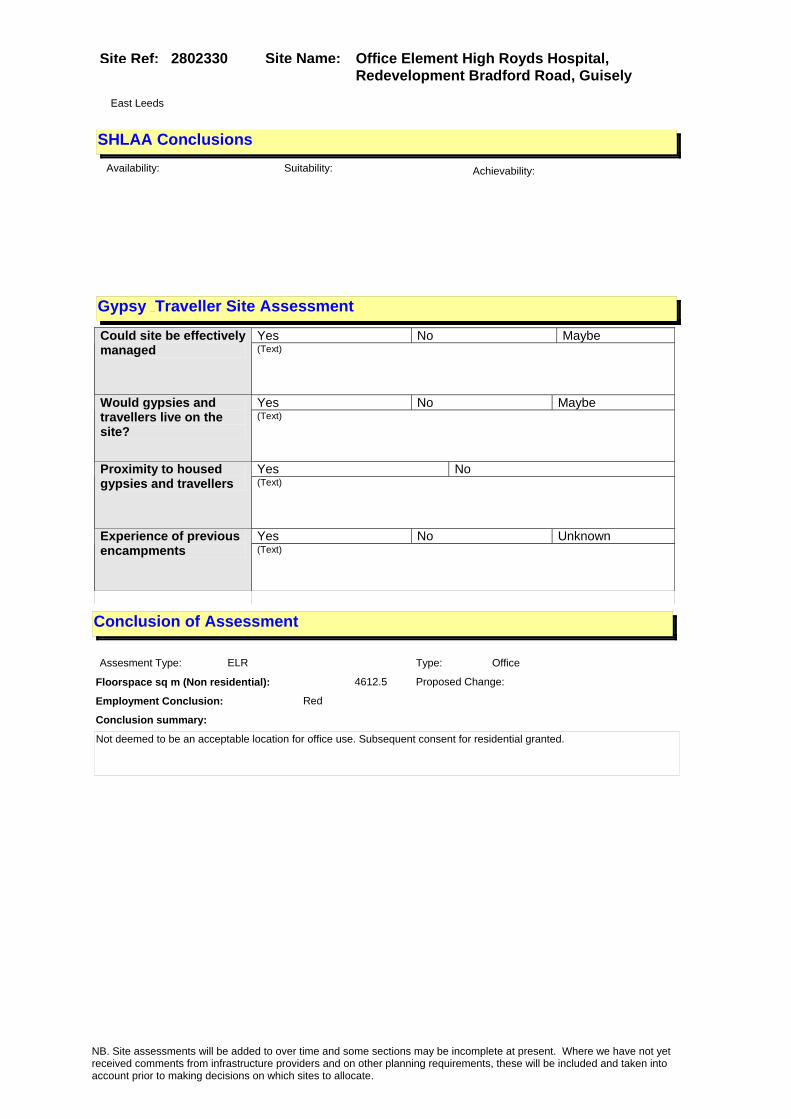
Site Name: Office Element High Royds Hospital, Redevelopment Bradford Road, Guisely
Site Ref: 2802330
SHLAA ConclusionsAvailability: Suitability: Achievability:
Conclusion of Assessment
Conclusion summary:
Not deemed to be an acceptable location for office use. Subsequent consent for residential granted.
Floorspace sq m (Non residential): 4612.5
Employment Conclusion: Red
East Leeds
Assesment Type: ELR Type: Office
Proposed Change:
Gypsy Traveller Site Assessment
Yes No Maybe Could site be effectively managed (Text)
Yes No Maybe Would gypsies and travellers live on the site?
(Text)
Yes No Proximity to housed gypsies and travellers (Text)
Yes No Unknown Experience of previous encampments (Text)
NB. Site assessments will be added to over time and some sections may be incomplete at present. Where we have not yet received comments from infrastructure providers and on other planning requirements, these will be included and taken into account prior to making decisions on which sites to allocate.

Site Name: Warren House Lane Harrogate Rd Yeadon LS19
Site Ref: 2900890
Site Details
Land Use
Northing: 442112
Easting: 421993
Distance to Rail Station (metres): 3135.70
Nearest Railway Station Guiseley
Distance to bus stop (metres) 262.26
Bus Stop ID 8308
Agricultural Land Class:
SFRA Flood Zone: 0.00
Environment Agency Flood Zone: 0.00
Within 300m of retail centre boundary:
UDP Designation
Greenbelt - N32 (%): 0.00 Urban Green Corridor - N8 (%): 0.00
Protected Area of Search site - N34 (%): 0.00 Rural Land - RL1: 0.00
City Centre Primary Shopping Quarter - CC27 (%): 0.00 Town Centre - S2: 0.00
Health and Safety Executive Hazard: No
Health and Safety Executive Gas Pipeline: No
Strategic Employment Buffer: 0.00
Area sq m: 8004.10 Ward Otley and Yeadon
Special Landscape Area - N37: 0.00
Allotments - N1A: 0.00
Proposed Greenspace - N5: 0.00
Protected Playing Pitch - N6: 0.00
Nature Conservation Area - N50: 0.00
Conservation Areas No
Ancient Monument/Battlefield(%): 0.00 Listed Buildings: No
Public Rights of Way: No
Other?:
Natural Resources and waste DPD (if applicable)
Within Minerals Safeguarding Site?: No Within 100m of Minerals Safeguarding Site?: Yes
HMCA: Aireborough
Greenspace - N1: 0
Existing Use 1:
Existing Use 2:
Existing Use 3:
Neighbouring Use 1
Neighbouring Use 2:
Neighbouring Use 3:
Other uses:
Topography:
Natural Landscape:
Boundaries:
Road Frontage
Site Characteristics
Site Detail
Other comments/observations on site characteristics:
Area Ha: 0.80041
Site State:
NB. Site assessments will be added to over time and some sections may be incomplete at present. Where we have not yet received comments from infrastructure providers and on other planning requirements, these will be included and taken into account prior to making decisions on which sites to allocate.

Site Name: Warren House Lane Harrogate Rd Yeadon LS19
Site Ref: 2900890
Planning History
Planning App No. Proposal Received Decision Status Site %
H29/157/89/ Number cancelled 13/06/1989 11/04/1990 W 92.76
H29/62/86/ Laying out of access road and erection of factory, with2 sto rey offices and with detached security office, 290 car pa
04/04/1986 20/05/1986 A 99.70
H28/436/77/ Laying out of runway extension , with enlarged apron area, diverted and new roads system and new balancing reservoir
08/08/1977 17/12/1980 A 10.19
H29/185/85/ Outline application to lay out access and erect facto ry, with 2, storey offices, an d 290 car parking spaces to
26/07/1985 27/01/1986 A 88.65
29/77/95/OT Outline application to erect industrial warehouses offices and hotel
12/04/1995 22/12/1999 A 100.00
H28/241/81/ Insulation of dwellings within the 45nni contour in accordance with condition 9, application number 77/28/00436
28/07/1981 24/08/1981 A 96.55
NB. Site assessments will be added to over time and some sections may be incomplete at present. Where we have not yet received comments from infrastructure providers and on other planning requirements, these will be included and taken into account prior to making decisions on which sites to allocate.

Site Name: Warren House Lane Harrogate Rd Yeadon LS19
Site Ref: 2900890
Conformity with Core Strategy
Inner South Leeds: 0.00
Leeds Bradford Corridor: 0.00 West Leeds Gateway: 0.00
Aire Valley: 0.00Regeneration Priority Area:
Brownfield
Greenfield
Mixed
Main Urban Area
Major Settlement
Smaller Settlement
Villages/Rural
Main Urban Area Extension
Major Settlement Extension
Smaller Settlement Extension
Village/Rural Extension
Development unrelated to existing development
Green Belt assessment - only completed where site is within Green Belt
Would development lead to/constitute ribbon development?
Would development result in isolated development?
Is the site well connected to built up area (2+ boundaries with existing built up area)?
Would development of the site effectively "round off" the settlement pattern?:
Do natural/physical features provide a good existing barrier between existing urban area and undeveloped land?
Overall sprawl conclusion:
Would development of the site lead to physical connection of settlements?
Do natural/physical features provide a good existing barrier/boundary to contain development?
Overall Coalescence Conclusion:
Is there a strong defensible boundary between the site and the existing urban area?
Does the site provide access to the countryside?
Does the site include local or national conservation designated areas?
Does the site include areas of woodlands, trees, hedgerows that are protected, or significant unprotected tree/hedge cover?
Does the site include grade 1, 2, or 3a agricultural land?
Does the site contain buildings? Are these in agricultural use?
Overall countryside Encroachment Conclusion
Is the site within or adjacent to a conservation area, listed building or other historical feature?
If yes, could development preserve this character?:
Overall Character Preservation Conclusion:
Greenbelt Assessment Conclusion:
Check the unrestricted sprawl of large built up areas
Prevent neighbouring towns from merging
Assist in safeguarding countryside from encroachment
Preserve the setting and special character of historic towns
NB. Site assessments will be added to over time and some sections may be incomplete at present. Where we have not yet received comments from infrastructure providers and on other planning requirements, these will be included and taken into account prior to making decisions on which sites to allocate.

Site Name: Warren House Lane Harrogate Rd Yeadon LS19
Site Ref: 2900890
SHLAA ConclusionsAvailability: Suitability: Achievability:
Conclusion of Assessment
Conclusion summary:
Forms part of a UDP allocation as a Key Business Park.
Floorspace sq m (Non residential): 3000
Employment Conclusion: Lime Green
East Leeds
Assesment Type: ELR Type: Office
Proposed Change:
Gypsy Traveller Site Assessment
Yes No Maybe Could site be effectively managed (Text)
Yes No Maybe Would gypsies and travellers live on the site?
(Text)
Yes No Proximity to housed gypsies and travellers (Text)
Yes No Unknown Experience of previous encampments (Text)
NB. Site assessments will be added to over time and some sections may be incomplete at present. Where we have not yet received comments from infrastructure providers and on other planning requirements, these will be included and taken into account prior to making decisions on which sites to allocate.

Site Name: Coney Park Harrogate Rd Yeadon LS19Site Ref: 2900891
Site Details
Land Use
Northing: 442295
Easting: 422101
Distance to Rail Station (metres): 3242.57
Nearest Railway Station Guiseley
Distance to bus stop (metres) 291.70
Bus Stop ID 2391
Agricultural Land Class:
SFRA Flood Zone: 0.00
Environment Agency Flood Zone: 0.00
Within 300m of retail centre boundary:
UDP Designation
Greenbelt - N32 (%): 0.01 Urban Green Corridor - N8 (%): 0.00
Protected Area of Search site - N34 (%): 0.00 Rural Land - RL1: 0.00
City Centre Primary Shopping Quarter - CC27 (%): 0.00 Town Centre - S2: 0.00
Health and Safety Executive Hazard: No
Health and Safety Executive Gas Pipeline: No
Strategic Employment Buffer: 0.00
Area sq m: 165020.06 Ward Otley and Yeadon
Special Landscape Area - N37: 0.00
Allotments - N1A: 0.00
Proposed Greenspace - N5: 0.00
Protected Playing Pitch - N6: 0.00
Nature Conservation Area - N50: 0.00
Conservation Areas No
Ancient Monument/Battlefield(%): 0.00 Listed Buildings: No
Public Rights of Way: No
Other?:
Natural Resources and waste DPD (if applicable)
Within Minerals Safeguarding Site?: Yes Within 100m of Minerals Safeguarding Site?: Yes
HMCA: Aireborough
Greenspace - N1: 0
Existing Use 1:
Existing Use 2:
Existing Use 3:
Neighbouring Use 1
Neighbouring Use 2:
Neighbouring Use 3:
Other uses:
Topography:
Natural Landscape:
Boundaries:
Road Frontage
Site Characteristics
Site Detail
Other comments/observations on site characteristics:
Area Ha: 16.502006
Site State:
Site Site TypeWarren House Lane Yeadon General Waste Management Sites
NB. Site assessments will be added to over time and some sections may be incomplete at present. Where we have not yet received comments from infrastructure providers and on other planning requirements, these will be included and taken into account prior to making decisions on which sites to allocate.
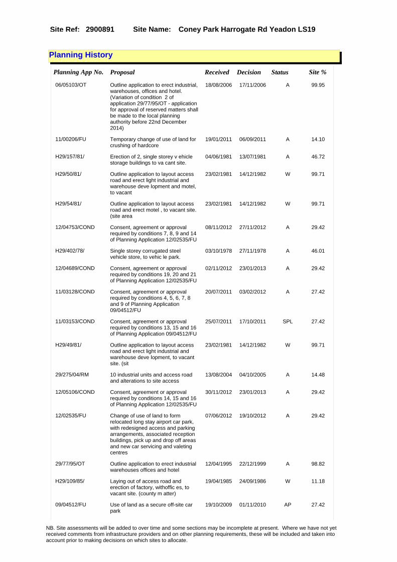
Site Name: Coney Park Harrogate Rd Yeadon LS19Site Ref: 2900891
Planning History
Planning App No. Proposal Received Decision Status Site %
06/05103/OT Outline application to erect industrial, warehouses, offices and hotel. (Variation of condition 2 of application 29/77/95/OT - application for approval of reserved matters shall be made to the local planning authority before 22nd December 2014)
18/08/2006 17/11/2006 A 99.95
11/00206/FU Temporary change of use of land for crushing of hardcore�
19/01/2011 06/09/2011 A 14.10
H29/157/81/ Erection of 2, single storey v ehicle storage buildings to va cant site.
04/06/1981 13/07/1981 A 46.72
H29/50/81/ Outline application to layout access road and erect light industrial and warehouse deve lopment and motel, to vacant
23/02/1981 14/12/1982 W 99.71
H29/54/81/ Outline application to layout access road and erect motel , to vacant site. (site area
23/02/1981 14/12/1982 W 99.71
12/04753/COND Consent, agreement or approval required by conditions 7, 8, 9 and 14 of Planning Application 12/02535/FU
08/11/2012 27/11/2012 A 29.42
H29/402/78/ Single storey corrugated steel vehicle store, to vehic le park.
03/10/1978 27/11/1978 A 46.01
12/04689/COND Consent, agreement or approval required by conditions 19, 20 and 21 of Planning Application 12/02535/FU
02/11/2012 23/01/2013 A 29.42
11/03128/COND Consent, agreement or approval required by conditions 4, 5, 6, 7, 8 and 9 of Planning Application 09/04512/FU
20/07/2011 03/02/2012 A 27.42
11/03153/COND Consent, agreement or approval required by conditions 13, 15 and 16 of Planning Application 09/04512/FU
25/07/2011 17/10/2011 SPL 27.42
H29/49/81/ Outline application to layout access road and erect light industrial and warehouse deve lopment, to vacant site. (sit
23/02/1981 14/12/1982 W 99.71
29/275/04/RM 10 industrial units and access road and alterations to site access
13/08/2004 04/10/2005 A 14.48
12/05106/COND Consent, agreement or approval required by conditions 14, 15 and 16 of Planning Application 12/02535/FU
30/11/2012 23/01/2013 A 29.42
12/02535/FU Change of use of land to form relocated long stay airport car park, with redesigned access and parking arrangements, associated reception buildings, pick up and drop off areas and new car servicing and valeting centres
07/06/2012 19/10/2012 A 29.42
29/77/95/OT Outline application to erect industrial warehouses offices and hotel
12/04/1995 22/12/1999 A 98.82
H29/109/85/ Laying out of access road and erection of factory, withoffic es, to vacant site. (county m atter)
19/04/1985 24/09/1986 W 11.18
09/04512/FU Use of land as a secure off-site car park
19/10/2009 01/11/2010 AP 27.42
NB. Site assessments will be added to over time and some sections may be incomplete at present. Where we have not yet received comments from infrastructure providers and on other planning requirements, these will be included and taken into account prior to making decisions on which sites to allocate.

Site Name: Coney Park Harrogate Rd Yeadon LS19Site Ref: 2900891
H29/116/82/ Excavation of fill material an d regrading, to plant ation and agricultural site. (site area 28ha) (county ma
06/08/1982 05/10/1982 A 97.79
NB. Site assessments will be added to over time and some sections may be incomplete at present. Where we have not yet received comments from infrastructure providers and on other planning requirements, these will be included and taken into account prior to making decisions on which sites to allocate.

Site Name: Coney Park Harrogate Rd Yeadon LS19Site Ref: 2900891
Conformity with Core Strategy
Inner South Leeds: 0.00
Leeds Bradford Corridor: 0.00 West Leeds Gateway: 0.00
Aire Valley: 0.00Regeneration Priority Area:
Brownfield
Greenfield
Mixed
Main Urban Area
Major Settlement
Smaller Settlement
Villages/Rural
Main Urban Area Extension
Major Settlement Extension
Smaller Settlement Extension
Village/Rural Extension
Development unrelated to existing development
Green Belt assessment - only completed where site is within Green Belt
Would development lead to/constitute ribbon development?
Would development result in isolated development?
Is the site well connected to built up area (2+ boundaries with existing built up area)?
Would development of the site effectively "round off" the settlement pattern?:
Do natural/physical features provide a good existing barrier between existing urban area and undeveloped land?
Overall sprawl conclusion:
Would development of the site lead to physical connection of settlements?
Do natural/physical features provide a good existing barrier/boundary to contain development?
Overall Coalescence Conclusion:
Is there a strong defensible boundary between the site and the existing urban area?
Does the site provide access to the countryside?
Does the site include local or national conservation designated areas?
Does the site include areas of woodlands, trees, hedgerows that are protected, or significant unprotected tree/hedge cover?
Does the site include grade 1, 2, or 3a agricultural land?
Does the site contain buildings? Are these in agricultural use?
Overall countryside Encroachment Conclusion
Is the site within or adjacent to a conservation area, listed building or other historical feature?
If yes, could development preserve this character?:
Overall Character Preservation Conclusion:
Greenbelt Assessment Conclusion:
Check the unrestricted sprawl of large built up areas
Prevent neighbouring towns from merging
Assist in safeguarding countryside from encroachment
Preserve the setting and special character of historic towns
NB. Site assessments will be added to over time and some sections may be incomplete at present. Where we have not yet received comments from infrastructure providers and on other planning requirements, these will be included and taken into account prior to making decisions on which sites to allocate.

Site Name: Coney Park Harrogate Rd Yeadon LS19Site Ref: 2900891
SHLAA ConclusionsAvailability: Suitability: Achievability:
Conclusion of Assessment
Conclusion summary:
Temporary uses on site would not preclude future development.
Floorspace sq m (Non residential):
Employment Conclusion: Lime Green
East Leeds
Assesment Type: ELR Type: Industrial & Warehousing
Proposed Change:
Gypsy Traveller Site Assessment
Yes No Maybe Could site be effectively managed (Text)
Yes No Maybe Would gypsies and travellers live on the site?
(Text)
Yes No Proximity to housed gypsies and travellers (Text)
Yes No Unknown Experience of previous encampments (Text)
NB. Site assessments will be added to over time and some sections may be incomplete at present. Where we have not yet received comments from infrastructure providers and on other planning requirements, these will be included and taken into account prior to making decisions on which sites to allocate.

Site Name: Airport West Ph3 Warren House Lane Yeadon LS19
Site Ref: 2900893
Site Details
Land Use
Northing: 441995
Easting: 422078
Distance to Rail Station (metres): 3226.33
Nearest Railway Station Guiseley
Distance to bus stop (metres) 150.26
Bus Stop ID 8308
Agricultural Land Class:
SFRA Flood Zone: 0.00
Environment Agency Flood Zone: 0.00
Within 300m of retail centre boundary:
UDP Designation
Greenbelt - N32 (%): 0.00 Urban Green Corridor - N8 (%): 0.00
Protected Area of Search site - N34 (%): 0.00 Rural Land - RL1: 0.00
City Centre Primary Shopping Quarter - CC27 (%): 0.00 Town Centre - S2: 0.00
Health and Safety Executive Hazard: No
Health and Safety Executive Gas Pipeline: No
Strategic Employment Buffer: 0.00
Area sq m: 4537.81 Ward Otley and Yeadon
Special Landscape Area - N37: 0.00
Allotments - N1A: 0.00
Proposed Greenspace - N5: 0.00
Protected Playing Pitch - N6: 0.00
Nature Conservation Area - N50: 0.00
Conservation Areas No
Ancient Monument/Battlefield(%): 0.00 Listed Buildings: No
Public Rights of Way: No
Other?:
Natural Resources and waste DPD (if applicable)
Within Minerals Safeguarding Site?: No Within 100m of Minerals Safeguarding Site?: No
HMCA: Aireborough
Greenspace - N1: 0
Existing Use 1:
Existing Use 2:
Existing Use 3:
Neighbouring Use 1
Neighbouring Use 2:
Neighbouring Use 3:
Other uses:
Topography:
Natural Landscape:
Boundaries:
Road Frontage
Site Characteristics
Site Detail
Other comments/observations on site characteristics:
Area Ha: 0.453781
Site State:
NB. Site assessments will be added to over time and some sections may be incomplete at present. Where we have not yet received comments from infrastructure providers and on other planning requirements, these will be included and taken into account prior to making decisions on which sites to allocate.

Site Name: Airport West Ph3 Warren House Lane Yeadon LS19
Site Ref: 2900893
Planning History
Planning App No. Proposal Received Decision Status Site %
H29/157/89/ Number cancelled 13/06/1989 11/04/1990 W 99.66
H29/62/86/ Laying out of access road and erection of factory, with2 sto rey offices and with detached security office, 290 car pa
04/04/1986 20/05/1986 A 99.97
0-29/18/05/MOD 3 three storey and 1 two storey block of offices
29/06/2005 02/08/2005 M01 87.57
H28/436/77/ Laying out of runway extension , with enlarged apron area, diverted and new roads system and new balancing reservoir
08/08/1977 17/12/1980 A 19.75
06/05594/FU Office block and detached kiosk, with car parking and landscaping
15/09/2006 22/12/2006 A 91.27
07/9/00091/MOD Office block and detached kiosk, with car parking and landscaping�NON MATERIAL AMENDMENT: addition of external fire escape stair pod
05/03/2007 19/04/2007 M01 91.27
09/05530/EXT Extension of time to erect office block and detached kiosk, with car parking and landscaping�
22/12/2009 APPRET 91.27
H29/19/86/ Proposed amendment of hours sp ecified in condition nos 5 & 7 attached to planning permissi on no. 77/28/00436 dated 17.1
29/01/1986 02/01/1990 AP 45.69
07/9/00408/MOD Office block and detached kiosk, with car parking and landscaping�NON MATERIAL AMENDMENT: To suit provision of combined kiosk/ substation building, building relocated to suit access to substation via adjacent parking spaces and kiosk frontage viewed from site access road
07/08/2007 24/10/2007 M01 91.27
H28/114/82/ Excavation of airport runway e mbankment fill material, and o n completion regrading and res toration to agricultur
07/05/1982 29/06/1982 A 91.63
H29/185/85/ Outline application to lay out access and erect facto ry, with 2, storey offices, an d 290 car parking spaces to
26/07/1985 27/01/1986 A 86.50
29/99/05/RM 3 three storey and 1 two storey block of offices
31/03/2005 28/06/2005 A 87.57
29/77/95/OT Outline application to erect industrial warehouses offices and hotel
12/04/1995 22/12/1999 A 100.00
H28/22/82/ Laying out of runway extension , enlarged apron area, roads , car and coach park, and erec tion of detached lighting c
03/02/1982 20/04/1982 A 100.00
29/243/04/FU 4 two storey and 1 three storey block of offices
19/08/2004 26/04/2005 A 12.65
0-29/14/05/MOD 4 two storey and 1 three storey block of offices
27/04/2005 18/05/2005 M01 12.65
29/249/04/OT Outline application to layout access and erect 11 business units (b1) and kiosk (a3)
19/08/2004 26/04/2005 A 99.97
NB. Site assessments will be added to over time and some sections may be incomplete at present. Where we have not yet received comments from infrastructure providers and on other planning requirements, these will be included and taken into account prior to making decisions on which sites to allocate.
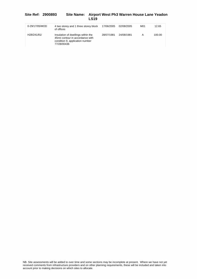
Site Name: Airport West Ph3 Warren House Lane Yeadon LS19
Site Ref: 2900893
0-29/17/05/MOD 4 two storey and 1 three storey block of offices
17/06/2005 02/08/2005 M01 12.65
H28/241/81/ Insulation of dwellings within the 45nni contour in accordance with condition 9, application number 77/28/00436
28/07/1981 24/08/1981 A 100.00
NB. Site assessments will be added to over time and some sections may be incomplete at present. Where we have not yet received comments from infrastructure providers and on other planning requirements, these will be included and taken into account prior to making decisions on which sites to allocate.

Site Name: Airport West Ph3 Warren House Lane Yeadon LS19
Site Ref: 2900893
Conformity with Core Strategy
Inner South Leeds: 0.00
Leeds Bradford Corridor: 0.00 West Leeds Gateway: 0.00
Aire Valley: 0.00Regeneration Priority Area:
Brownfield
Greenfield
Mixed
Main Urban Area
Major Settlement
Smaller Settlement
Villages/Rural
Main Urban Area Extension
Major Settlement Extension
Smaller Settlement Extension
Village/Rural Extension
Development unrelated to existing development
Green Belt assessment - only completed where site is within Green Belt
Would development lead to/constitute ribbon development?
Would development result in isolated development?
Is the site well connected to built up area (2+ boundaries with existing built up area)?
Would development of the site effectively "round off" the settlement pattern?:
Do natural/physical features provide a good existing barrier between existing urban area and undeveloped land?
Overall sprawl conclusion:
Would development of the site lead to physical connection of settlements?
Do natural/physical features provide a good existing barrier/boundary to contain development?
Overall Coalescence Conclusion:
Is there a strong defensible boundary between the site and the existing urban area?
Does the site provide access to the countryside?
Does the site include local or national conservation designated areas?
Does the site include areas of woodlands, trees, hedgerows that are protected, or significant unprotected tree/hedge cover?
Does the site include grade 1, 2, or 3a agricultural land?
Does the site contain buildings? Are these in agricultural use?
Overall countryside Encroachment Conclusion
Is the site within or adjacent to a conservation area, listed building or other historical feature?
If yes, could development preserve this character?:
Overall Character Preservation Conclusion:
Greenbelt Assessment Conclusion:
Check the unrestricted sprawl of large built up areas
Prevent neighbouring towns from merging
Assist in safeguarding countryside from encroachment
Preserve the setting and special character of historic towns
NB. Site assessments will be added to over time and some sections may be incomplete at present. Where we have not yet received comments from infrastructure providers and on other planning requirements, these will be included and taken into account prior to making decisions on which sites to allocate.

Site Name: Airport West Ph3 Warren House Lane Yeadon LS19
Site Ref: 2900893
SHLAA ConclusionsAvailability: Suitability: Achievability:
Conclusion of Assessment
Conclusion summary:
Not a particularly sustainable site. However given its location within a Key Business Park (UDP allocation) retain for employment purposes.
Floorspace sq m (Non residential): 2900
Employment Conclusion: Lime Green
East Leeds
Assesment Type: ELR Type: Industrial & Warehousing
Proposed Change:
Gypsy Traveller Site Assessment
Yes No Maybe Could site be effectively managed (Text)
Yes No Maybe Would gypsies and travellers live on the site?
(Text)
Yes No Proximity to housed gypsies and travellers (Text)
Yes No Unknown Experience of previous encampments (Text)
NB. Site assessments will be added to over time and some sections may be incomplete at present. Where we have not yet received comments from infrastructure providers and on other planning requirements, these will be included and taken into account prior to making decisions on which sites to allocate.

Site Name: Airport West Ph4 Warren House Lane Yeadon LS19
Site Ref: 2900895
Site Details
Land Use
Northing: 441931
Easting: 422138
Distance to Rail Station (metres): 3290.98
Nearest Railway Station Guiseley
Distance to bus stop (metres) 111.00
Bus Stop ID 8308
Agricultural Land Class:
SFRA Flood Zone: 0.00
Environment Agency Flood Zone: 0.00
Within 300m of retail centre boundary:
UDP Designation
Greenbelt - N32 (%): 0.00 Urban Green Corridor - N8 (%): 0.00
Protected Area of Search site - N34 (%): 0.00 Rural Land - RL1: 0.00
City Centre Primary Shopping Quarter - CC27 (%): 0.00 Town Centre - S2: 0.00
Health and Safety Executive Hazard: No
Health and Safety Executive Gas Pipeline: No
Strategic Employment Buffer: 0.00
Area sq m: 10301.64 Ward Otley and Yeadon
Special Landscape Area - N37: 0.00
Allotments - N1A: 0.00
Proposed Greenspace - N5: 0.00
Protected Playing Pitch - N6: 0.00
Nature Conservation Area - N50: 0.00
Conservation Areas No
Ancient Monument/Battlefield(%): 0.00 Listed Buildings: No
Public Rights of Way: No
Other?:
Natural Resources and waste DPD (if applicable)
Within Minerals Safeguarding Site?: No Within 100m of Minerals Safeguarding Site?: No
HMCA: Aireborough
Greenspace - N1: 0
Existing Use 1:
Existing Use 2:
Existing Use 3:
Neighbouring Use 1
Neighbouring Use 2:
Neighbouring Use 3:
Other uses:
Topography:
Natural Landscape:
Boundaries:
Road Frontage
Site Characteristics
Site Detail
Other comments/observations on site characteristics:
Area Ha: 1.030164
Site State:
NB. Site assessments will be added to over time and some sections may be incomplete at present. Where we have not yet received comments from infrastructure providers and on other planning requirements, these will be included and taken into account prior to making decisions on which sites to allocate.
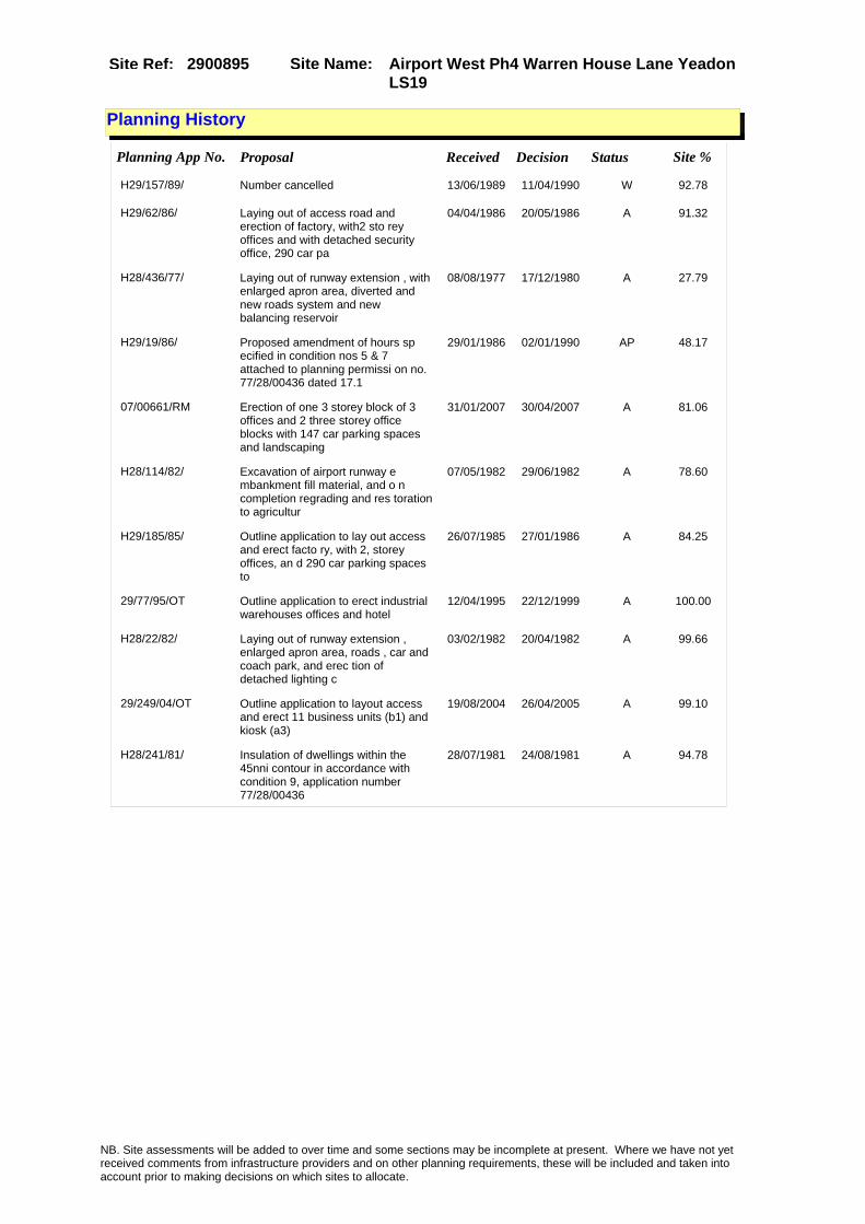
Site Name: Airport West Ph4 Warren House Lane Yeadon LS19
Site Ref: 2900895
Planning History
Planning App No. Proposal Received Decision Status Site %
H29/157/89/ Number cancelled 13/06/1989 11/04/1990 W 92.78
H29/62/86/ Laying out of access road and erection of factory, with2 sto rey offices and with detached security office, 290 car pa
04/04/1986 20/05/1986 A 91.32
H28/436/77/ Laying out of runway extension , with enlarged apron area, diverted and new roads system and new balancing reservoir
08/08/1977 17/12/1980 A 27.79
H29/19/86/ Proposed amendment of hours sp ecified in condition nos 5 & 7 attached to planning permissi on no. 77/28/00436 dated 17.1
29/01/1986 02/01/1990 AP 48.17
07/00661/RM Erection of one 3 storey block of 3 offices and 2 three storey office blocks with 147 car parking spaces and landscaping
31/01/2007 30/04/2007 A 81.06
H28/114/82/ Excavation of airport runway e mbankment fill material, and o n completion regrading and res toration to agricultur
07/05/1982 29/06/1982 A 78.60
H29/185/85/ Outline application to lay out access and erect facto ry, with 2, storey offices, an d 290 car parking spaces to
26/07/1985 27/01/1986 A 84.25
29/77/95/OT Outline application to erect industrial warehouses offices and hotel
12/04/1995 22/12/1999 A 100.00
H28/22/82/ Laying out of runway extension , enlarged apron area, roads , car and coach park, and erec tion of detached lighting c
03/02/1982 20/04/1982 A 99.66
29/249/04/OT Outline application to layout access and erect 11 business units (b1) and kiosk (a3)
19/08/2004 26/04/2005 A 99.10
H28/241/81/ Insulation of dwellings within the 45nni contour in accordance with condition 9, application number 77/28/00436
28/07/1981 24/08/1981 A 94.78
NB. Site assessments will be added to over time and some sections may be incomplete at present. Where we have not yet received comments from infrastructure providers and on other planning requirements, these will be included and taken into account prior to making decisions on which sites to allocate.

Site Name: Airport West Ph4 Warren House Lane Yeadon LS19
Site Ref: 2900895
Conformity with Core Strategy
Inner South Leeds: 0.00
Leeds Bradford Corridor: 0.00 West Leeds Gateway: 0.00
Aire Valley: 0.00Regeneration Priority Area:
Brownfield
Greenfield
Mixed
Main Urban Area
Major Settlement
Smaller Settlement
Villages/Rural
Main Urban Area Extension
Major Settlement Extension
Smaller Settlement Extension
Village/Rural Extension
Development unrelated to existing development
Green Belt assessment - only completed where site is within Green Belt
Would development lead to/constitute ribbon development?
Would development result in isolated development?
Is the site well connected to built up area (2+ boundaries with existing built up area)?
Would development of the site effectively "round off" the settlement pattern?:
Do natural/physical features provide a good existing barrier between existing urban area and undeveloped land?
Overall sprawl conclusion:
Would development of the site lead to physical connection of settlements?
Do natural/physical features provide a good existing barrier/boundary to contain development?
Overall Coalescence Conclusion:
Is there a strong defensible boundary between the site and the existing urban area?
Does the site provide access to the countryside?
Does the site include local or national conservation designated areas?
Does the site include areas of woodlands, trees, hedgerows that are protected, or significant unprotected tree/hedge cover?
Does the site include grade 1, 2, or 3a agricultural land?
Does the site contain buildings? Are these in agricultural use?
Overall countryside Encroachment Conclusion
Is the site within or adjacent to a conservation area, listed building or other historical feature?
If yes, could development preserve this character?:
Overall Character Preservation Conclusion:
Greenbelt Assessment Conclusion:
Check the unrestricted sprawl of large built up areas
Prevent neighbouring towns from merging
Assist in safeguarding countryside from encroachment
Preserve the setting and special character of historic towns
NB. Site assessments will be added to over time and some sections may be incomplete at present. Where we have not yet received comments from infrastructure providers and on other planning requirements, these will be included and taken into account prior to making decisions on which sites to allocate.

Site Name: Airport West Ph4 Warren House Lane Yeadon LS19
Site Ref: 2900895
SHLAA ConclusionsAvailability: Suitability: Achievability:
Conclusion of Assessment
Conclusion summary:
No other type of built form would be acceptable in this location.
Floorspace sq m (Non residential): 6080
Employment Conclusion: Lime Green
East Leeds
Assesment Type: ELR Type: Industrial & Warehousing
Proposed Change:
Gypsy Traveller Site Assessment
Yes No Maybe Could site be effectively managed (Text)
Yes No Maybe Would gypsies and travellers live on the site?
(Text)
Yes No Proximity to housed gypsies and travellers (Text)
Yes No Unknown Experience of previous encampments (Text)
NB. Site assessments will be added to over time and some sections may be incomplete at present. Where we have not yet received comments from infrastructure providers and on other planning requirements, these will be included and taken into account prior to making decisions on which sites to allocate.

Site Name: Land to Rear of Garnetts Mill Lane Otley LS21Site Ref: 2901161
Site Details
Land Use
Northing: 446030
Easting: 420600
Distance to Rail Station (metres): 4195.09
Nearest Railway Station Guiseley
Distance to bus stop (metres) 274.96
Bus Stop ID 1005
Agricultural Land Class:
SFRA Flood Zone: 1.00
Environment Agency Flood Zone: 1.00
Within 300m of retail centre boundary:
UDP Designation
Greenbelt - N32 (%): 0.00 Urban Green Corridor - N8 (%): 0.00
Protected Area of Search site - N34 (%): 0.00 Rural Land - RL1: 0.00
City Centre Primary Shopping Quarter - CC27 (%): 0.00 Town Centre - S2: 0.00
Health and Safety Executive Hazard: No
Health and Safety Executive Gas Pipeline: No
Strategic Employment Buffer: 0.00
Area sq m: 14133.59 Ward Otley and Yeadon
Special Landscape Area - N37: 0.00
Allotments - N1A: 0.00
Proposed Greenspace - N5: 0.00
Protected Playing Pitch - N6: 0.00
Nature Conservation Area - N50: 0.00
Conservation Areas No
Ancient Monument/Battlefield(%): 0.00 Listed Buildings: No
Public Rights of Way: No
Other?:
Natural Resources and waste DPD (if applicable)
Within Minerals Safeguarding Site?: No Within 100m of Minerals Safeguarding Site?: No
HMCA: Outer North West
Greenspace - N1: 0
Existing Use 1:
Existing Use 2:
Existing Use 3:
Neighbouring Use 1
Neighbouring Use 2:
Neighbouring Use 3:
Other uses:
Topography:
Natural Landscape:
Boundaries:
Road Frontage
Site Characteristics
Site Detail
Other comments/observations on site characteristics:
Area Ha: 1.413359
Site State:
NB. Site assessments will be added to over time and some sections may be incomplete at present. Where we have not yet received comments from infrastructure providers and on other planning requirements, these will be included and taken into account prior to making decisions on which sites to allocate.

Site Name: Land to Rear of Garnetts Mill Lane Otley LS21Site Ref: 2901161
Planning History
Planning App No. Proposal Received Decision Status Site %
H29/272/74/ Alteration, including new stai rcase and extension to form first floor engineer's store t o factory premises.
11/11/1974 10/02/1975 A 97.50
29/267/05/OT Outline application for access residential (c3)restaurant (a3) offices (b1) pub (a4) hotel (c1) retirement complex (c2) &surgery
22/08/2005 14/11/2006 A 99.86
29/167/98/FU Laying out of access and erection of 25 industrial and warehouse units and 3 storey nursing home
09/07/1998 15/02/2002 0 82.76
H29/111/85/ Alterations and extension, to form enlarged storage unit to mill.
24/04/1985 21/05/1985 A 82.65
29/265/97/OT Outline application to layout access and erect residential development
27/11/1997 01/02/2000 R 36.48
08/02079/OT Amendments to conditions numbers 22, 24 and 31 of application number 29/267/05/OT relating to highways, footpath, cycleway and off site improvements including flood storage
04/04/2008 04/07/2008 A 99.86
29/9/93/OT Outline application to erect extension to factory
18/01/1993 18/03/1993 A 20.80
H29/144/80/ Alterations and extension, to form enlarged loading bay t o paper mills.
31/03/1980 02/06/1980 A 100.00
29/24/97/OT Outline application to layout access and erect hospital and residential development
10/02/1997 08/03/1999 W 100.00
29/2/95/OT Outline application to layout access and erect business warehouse and industrial units and nursing home
23/12/1994 14/07/1995 A 100.00
10/03695/FU Laying out of access road 10/08/2010 11/06/2012 A 100.00
09/04881/OT Outline Application to layout for mixed use development comprising of residential (new build and conversion) office development (new build and conversion) retirement complex, restaurant and public open space
11/11/2009 10/02/2010 W 99.86
H29/223/81/ Alterations and extension, to form link corridor to paper stores, to factory.
02/10/1981 02/11/1981 A 100.00
H29/194/81/ Detached single storey paper s tore to mill premises.
24/08/1981 12/10/1981 A 100.00
H29/360/77/ Laying out of access road and alterations and extensionto fo rm enlarged speciality departm ent, with 2.1m (6ft 11ins
24/10/1977 28/11/1977 A 97.50
H29/43/81/ Demolition of existing, and ad dition of new loading bay, to works.
18/02/1981 20/01/1982 W 100.00
PREAPP/07/00258 . 11/07/2007 02/11/2009 PRECAP 99.99
29/313/05/MIN Remediation of land at Garnetts Mill 23/08/2005 19/06/2006 A 97.33
NB. Site assessments will be added to over time and some sections may be incomplete at present. Where we have not yet received comments from infrastructure providers and on other planning requirements, these will be included and taken into account prior to making decisions on which sites to allocate.

Site Name: Land to Rear of Garnetts Mill Lane Otley LS21Site Ref: 2901161
09/04287/RM Reserved matters application for laying out of access roads and erection of 138 dwellings, 21 flats in 3 blocks, 41 retirement apartments, 2 storey office block and alterations and extensions to mill building to form 36 flats and 1 office unit and change of use of building to bar/ restaurant and 20 space public car park, greenspace and landscaping �
02/10/2009 11/06/2012 A 99.86
29/39/02/FU Detached industrial and warehouse unit to rear of factory
20/02/2002 10/09/2002 W 95.97
H29/276/84/ Alterations and extension, to form enlarged workshop, with toilets and 2 storey ancillary offices, to works.
24/12/1984 28/01/1985 A 100.00
H29/163/74/ Alterations and extension, (si ze 496sq.m (5, 400 sq ft))to en large solle department, to pap er mill premises.
30/07/1974 18/11/1974 A 97.50
NB. Site assessments will be added to over time and some sections may be incomplete at present. Where we have not yet received comments from infrastructure providers and on other planning requirements, these will be included and taken into account prior to making decisions on which sites to allocate.

Site Name: Land to Rear of Garnetts Mill Lane Otley LS21Site Ref: 2901161
Conformity with Core Strategy
Inner South Leeds: 0.00
Leeds Bradford Corridor: 0.00 West Leeds Gateway: 0.00
Aire Valley: 0.00Regeneration Priority Area:
Brownfield
Greenfield
Mixed
Main Urban Area
Major Settlement
Smaller Settlement
Villages/Rural
Main Urban Area Extension
Major Settlement Extension
Smaller Settlement Extension
Village/Rural Extension
Development unrelated to existing development
Green Belt assessment - only completed where site is within Green Belt
Would development lead to/constitute ribbon development?
Would development result in isolated development?
Is the site well connected to built up area (2+ boundaries with existing built up area)?
Would development of the site effectively "round off" the settlement pattern?:
Do natural/physical features provide a good existing barrier between existing urban area and undeveloped land?
Overall sprawl conclusion:
Would development of the site lead to physical connection of settlements?
Do natural/physical features provide a good existing barrier/boundary to contain development?
Overall Coalescence Conclusion:
Is there a strong defensible boundary between the site and the existing urban area?
Does the site provide access to the countryside?
Does the site include local or national conservation designated areas?
Does the site include areas of woodlands, trees, hedgerows that are protected, or significant unprotected tree/hedge cover?
Does the site include grade 1, 2, or 3a agricultural land?
Does the site contain buildings? Are these in agricultural use?
Overall countryside Encroachment Conclusion
Is the site within or adjacent to a conservation area, listed building or other historical feature?
If yes, could development preserve this character?:
Overall Character Preservation Conclusion:
Greenbelt Assessment Conclusion:
Check the unrestricted sprawl of large built up areas
Prevent neighbouring towns from merging
Assist in safeguarding countryside from encroachment
Preserve the setting and special character of historic towns
NB. Site assessments will be added to over time and some sections may be incomplete at present. Where we have not yet received comments from infrastructure providers and on other planning requirements, these will be included and taken into account prior to making decisions on which sites to allocate.

Site Name: Land to Rear of Garnetts Mill Lane Otley LS21Site Ref: 2901161
SHLAA ConclusionsAvailability: Suitability: Achievability:
Conclusion of Assessment
Conclusion summary:
Land forms part of a planning permission for a residential led scheme taking in the adjoining Garnetts Mill site. It is therefore very unlikely to come forward for employment development.
Floorspace sq m (Non residential):
Employment Conclusion: Red
East Leeds
Assesment Type: ELR Type: Industrial & Warehousing
Proposed Change:
Gypsy Traveller Site Assessment
Yes No Maybe Could site be effectively managed (Text)
Yes No Maybe Would gypsies and travellers live on the site?
(Text)
Yes No Proximity to housed gypsies and travellers (Text)
Yes No Unknown Experience of previous encampments (Text)
NB. Site assessments will be added to over time and some sections may be incomplete at present. Where we have not yet received comments from infrastructure providers and on other planning requirements, these will be included and taken into account prior to making decisions on which sites to allocate.

Site Name: White House Lane Yeadon LS20Site Ref: 2901210
Site Details
Land Use
Northing: 441820
Easting: 422347
Distance to Rail Station (metres): 3388.92
Nearest Railway Station Horsforth
Distance to bus stop (metres) 107.94
Bus Stop ID 2897
Agricultural Land Class:
SFRA Flood Zone: 0.00
Environment Agency Flood Zone: 0.00
Within 300m of retail centre boundary:
UDP Designation
Greenbelt - N32 (%): 0.00 Urban Green Corridor - N8 (%): 0.00
Protected Area of Search site - N34 (%): 0.00 Rural Land - RL1: 0.00
City Centre Primary Shopping Quarter - CC27 (%): 0.00 Town Centre - S2: 0.00
Health and Safety Executive Hazard: No
Health and Safety Executive Gas Pipeline: No
Strategic Employment Buffer: 0.00
Area sq m: 45996.12 Ward Otley and Yeadon
Special Landscape Area - N37: 0.00
Allotments - N1A: 0.00
Proposed Greenspace - N5: 0.00
Protected Playing Pitch - N6: 0.00
Nature Conservation Area - N50: 0.00
Conservation Areas No
Ancient Monument/Battlefield(%): 0.00 Listed Buildings: No
Public Rights of Way: No
Other?:
Natural Resources and waste DPD (if applicable)
Within Minerals Safeguarding Site?: No Within 100m of Minerals Safeguarding Site?: No
HMCA: Aireborough
Greenspace - N1: 0
Existing Use 1:
Existing Use 2:
Existing Use 3:
Neighbouring Use 1
Neighbouring Use 2:
Neighbouring Use 3:
Other uses:
Topography:
Natural Landscape:
Boundaries:
Road Frontage
Site Characteristics
Site Detail
Other comments/observations on site characteristics:
Area Ha: 4.599612
Site State:
NB. Site assessments will be added to over time and some sections may be incomplete at present. Where we have not yet received comments from infrastructure providers and on other planning requirements, these will be included and taken into account prior to making decisions on which sites to allocate.
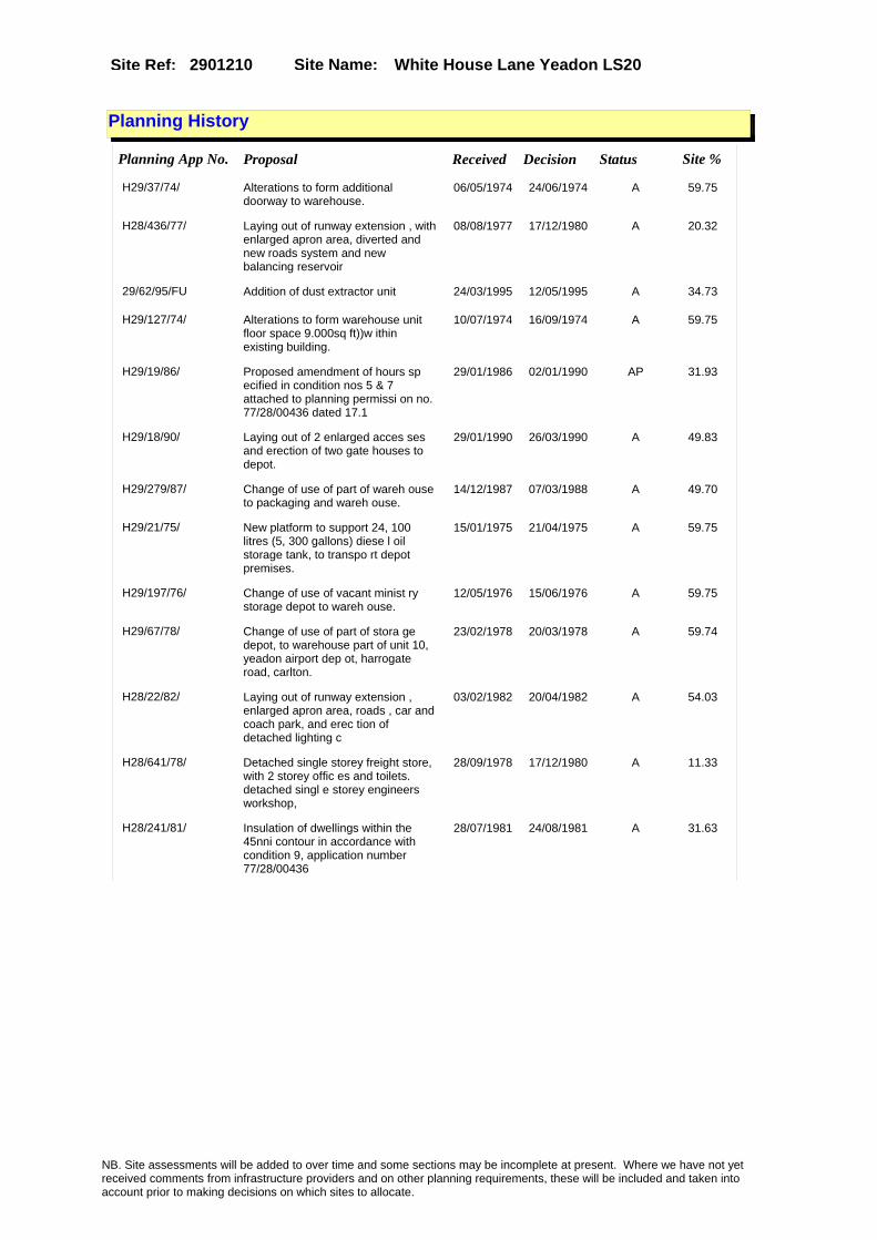
Site Name: White House Lane Yeadon LS20Site Ref: 2901210
Planning History
Planning App No. Proposal Received Decision Status Site %
H29/37/74/ Alterations to form additional doorway to warehouse.
06/05/1974 24/06/1974 A 59.75
H28/436/77/ Laying out of runway extension , with enlarged apron area, diverted and new roads system and new balancing reservoir
08/08/1977 17/12/1980 A 20.32
29/62/95/FU Addition of dust extractor unit 24/03/1995 12/05/1995 A 34.73
H29/127/74/ Alterations to form warehouse unit floor space 9.000sq ft))w ithin existing building.
10/07/1974 16/09/1974 A 59.75
H29/19/86/ Proposed amendment of hours sp ecified in condition nos 5 & 7 attached to planning permissi on no. 77/28/00436 dated 17.1
29/01/1986 02/01/1990 AP 31.93
H29/18/90/ Laying out of 2 enlarged acces ses and erection of two gate houses to depot.
29/01/1990 26/03/1990 A 49.83
H29/279/87/ Change of use of part of wareh ouse to packaging and wareh ouse.
14/12/1987 07/03/1988 A 49.70
H29/21/75/ New platform to support 24, 100 litres (5, 300 gallons) diese l oil storage tank, to transpo rt depot premises.
15/01/1975 21/04/1975 A 59.75
H29/197/76/ Change of use of vacant minist ry storage depot to wareh ouse.
12/05/1976 15/06/1976 A 59.75
H29/67/78/ Change of use of part of stora ge depot, to warehouse part of unit 10, yeadon airport dep ot, harrogate road, carlton.
23/02/1978 20/03/1978 A 59.74
H28/22/82/ Laying out of runway extension , enlarged apron area, roads , car and coach park, and erec tion of detached lighting c
03/02/1982 20/04/1982 A 54.03
H28/641/78/ Detached single storey freight store, with 2 storey offic es and toilets. detached singl e storey engineers workshop,
28/09/1978 17/12/1980 A 11.33
H28/241/81/ Insulation of dwellings within the 45nni contour in accordance with condition 9, application number 77/28/00436
28/07/1981 24/08/1981 A 31.63
NB. Site assessments will be added to over time and some sections may be incomplete at present. Where we have not yet received comments from infrastructure providers and on other planning requirements, these will be included and taken into account prior to making decisions on which sites to allocate.

Site Name: White House Lane Yeadon LS20Site Ref: 2901210
Conformity with Core Strategy
Inner South Leeds: 0.00
Leeds Bradford Corridor: 0.00 West Leeds Gateway: 0.00
Aire Valley: 0.00Regeneration Priority Area:
Brownfield
Greenfield
Mixed
Main Urban Area
Major Settlement
Smaller Settlement
Villages/Rural
Main Urban Area Extension
Major Settlement Extension
Smaller Settlement Extension
Village/Rural Extension
Development unrelated to existing development
Green Belt assessment - only completed where site is within Green Belt
Would development lead to/constitute ribbon development?
Would development result in isolated development?
Is the site well connected to built up area (2+ boundaries with existing built up area)?
Would development of the site effectively "round off" the settlement pattern?:
Do natural/physical features provide a good existing barrier between existing urban area and undeveloped land?
Overall sprawl conclusion:
Would development of the site lead to physical connection of settlements?
Do natural/physical features provide a good existing barrier/boundary to contain development?
Overall Coalescence Conclusion:
Is there a strong defensible boundary between the site and the existing urban area?
Does the site provide access to the countryside?
Does the site include local or national conservation designated areas?
Does the site include areas of woodlands, trees, hedgerows that are protected, or significant unprotected tree/hedge cover?
Does the site include grade 1, 2, or 3a agricultural land?
Does the site contain buildings? Are these in agricultural use?
Overall countryside Encroachment Conclusion
Is the site within or adjacent to a conservation area, listed building or other historical feature?
If yes, could development preserve this character?:
Overall Character Preservation Conclusion:
Greenbelt Assessment Conclusion:
Check the unrestricted sprawl of large built up areas
Prevent neighbouring towns from merging
Assist in safeguarding countryside from encroachment
Preserve the setting and special character of historic towns
NB. Site assessments will be added to over time and some sections may be incomplete at present. Where we have not yet received comments from infrastructure providers and on other planning requirements, these will be included and taken into account prior to making decisions on which sites to allocate.

Site Name: White House Lane Yeadon LS20Site Ref: 2901210
SHLAA ConclusionsAvailability: Suitability: Achievability:
Conclusion of Assessment
Conclusion summary:
Retain the site as whilst it has topographical issues it has good access and whilst out of centre it is in a good strategic location.
Floorspace sq m (Non residential):
Employment Conclusion: Lime Green
East Leeds
Assesment Type: ELR Type: Industrial & Warehousing
Proposed Change:
Gypsy Traveller Site Assessment
Yes No Maybe Could site be effectively managed (Text)
Yes No Maybe Would gypsies and travellers live on the site?
(Text)
Yes No Proximity to housed gypsies and travellers (Text)
Yes No Unknown Experience of previous encampments (Text)
NB. Site assessments will be added to over time and some sections may be incomplete at present. Where we have not yet received comments from infrastructure providers and on other planning requirements, these will be included and taken into account prior to making decisions on which sites to allocate.

Site Name: East Chevin Road Otley LS21Site Ref: 2901230
Site Details
Land Use
Northing: 445032
Easting: 420599
Distance to Rail Station (metres): 3312.16
Nearest Railway Station Guiseley
Distance to bus stop (metres) 79.67
Bus Stop ID 3459
Agricultural Land Class:
SFRA Flood Zone: 0.00
Environment Agency Flood Zone: 0.00
Within 300m of retail centre boundary:
UDP Designation
Greenbelt - N32 (%): 0.00 Urban Green Corridor - N8 (%): 0.00
Protected Area of Search site - N34 (%): 0.00 Rural Land - RL1: 0.00
City Centre Primary Shopping Quarter - CC27 (%): 0.00 Town Centre - S2: 0.00
Health and Safety Executive Hazard: No
Health and Safety Executive Gas Pipeline: No
Strategic Employment Buffer: 0.00
Area sq m: 14963.52 Ward Otley and Yeadon
Special Landscape Area - N37: 0.00
Allotments - N1A: 0.00
Proposed Greenspace - N5: 0.00
Protected Playing Pitch - N6: 0.00
Nature Conservation Area - N50: 1.00
Conservation Areas Yes
Ancient Monument/Battlefield(%): 0.00 Listed Buildings: No
Public Rights of Way: No
Other?:
Natural Resources and waste DPD (if applicable)
Within Minerals Safeguarding Site?: No Within 100m of Minerals Safeguarding Site?: No
HMCA: Outer North West
Greenspace - N1: 0
Existing Use 1:
Existing Use 2:
Existing Use 3:
Neighbouring Use 1
Neighbouring Use 2:
Neighbouring Use 3:
Other uses:
Topography:
Natural Landscape:
Boundaries:
Road Frontage
Site Characteristics
Site Detail
Other comments/observations on site characteristics:
Area Ha: 1.496352
Site State:
NB. Site assessments will be added to over time and some sections may be incomplete at present. Where we have not yet received comments from infrastructure providers and on other planning requirements, these will be included and taken into account prior to making decisions on which sites to allocate.

Site Name: East Chevin Road Otley LS21Site Ref: 2901230
Planning History
NB. Site assessments will be added to over time and some sections may be incomplete at present. Where we have not yet received comments from infrastructure providers and on other planning requirements, these will be included and taken into account prior to making decisions on which sites to allocate.

Site Name: East Chevin Road Otley LS21Site Ref: 2901230
Conformity with Core Strategy
Inner South Leeds: 0.00
Leeds Bradford Corridor: 0.00 West Leeds Gateway: 0.00
Aire Valley: 0.00Regeneration Priority Area:
Brownfield
Greenfield
Mixed
Main Urban Area
Major Settlement
Smaller Settlement
Villages/Rural
Main Urban Area Extension
Major Settlement Extension
Smaller Settlement Extension
Village/Rural Extension
Development unrelated to existing development
Green Belt assessment - only completed where site is within Green Belt
Would development lead to/constitute ribbon development?
Would development result in isolated development?
Is the site well connected to built up area (2+ boundaries with existing built up area)?
Would development of the site effectively "round off" the settlement pattern?:
Do natural/physical features provide a good existing barrier between existing urban area and undeveloped land?
Overall sprawl conclusion:
Would development of the site lead to physical connection of settlements?
Do natural/physical features provide a good existing barrier/boundary to contain development?
Overall Coalescence Conclusion:
Is there a strong defensible boundary between the site and the existing urban area?
Does the site provide access to the countryside?
Does the site include local or national conservation designated areas?
Does the site include areas of woodlands, trees, hedgerows that are protected, or significant unprotected tree/hedge cover?
Does the site include grade 1, 2, or 3a agricultural land?
Does the site contain buildings? Are these in agricultural use?
Overall countryside Encroachment Conclusion
Is the site within or adjacent to a conservation area, listed building or other historical feature?
If yes, could development preserve this character?:
Overall Character Preservation Conclusion:
Greenbelt Assessment Conclusion:
Check the unrestricted sprawl of large built up areas
Prevent neighbouring towns from merging
Assist in safeguarding countryside from encroachment
Preserve the setting and special character of historic towns
NB. Site assessments will be added to over time and some sections may be incomplete at present. Where we have not yet received comments from infrastructure providers and on other planning requirements, these will be included and taken into account prior to making decisions on which sites to allocate.

Site Name: East Chevin Road Otley LS21Site Ref: 2901230
SHLAA ConclusionsAvailability: Suitability: Achievability:
Conclusion of Assessment
Conclusion summary:
Unavailable. Significant doubt over whether the site will come forward for employment given its existing uses as a cattle market.
Floorspace sq m (Non residential):
Employment Conclusion: Red
East Leeds
Assesment Type: ELR Type: Industrial & Warehousing
Proposed Change:
Gypsy Traveller Site Assessment
Yes No Maybe Could site be effectively managed (Text)
Yes No Maybe Would gypsies and travellers live on the site?
(Text)
Yes No Proximity to housed gypsies and travellers (Text)
Yes No Unknown Experience of previous encampments (Text)
NB. Site assessments will be added to over time and some sections may be incomplete at present. Where we have not yet received comments from infrastructure providers and on other planning requirements, these will be included and taken into account prior to making decisions on which sites to allocate.

Site Name: East of Otley (Indicative allocation) off Pool RSite Ref: 2901470
Site Details
Land Use
Northing: 445507
Easting: 421508
Distance to Rail Station (metres): 4226.58
Nearest Railway Station Guiseley
Distance to bus stop (metres) 328.02
Bus Stop ID 11094
Agricultural Land Class:
SFRA Flood Zone: 1.00
Environment Agency Flood Zone: 0.00
Within 300m of retail centre boundary:
UDP Designation
Greenbelt - N32 (%): 0.00 Urban Green Corridor - N8 (%): 0.00
Protected Area of Search site - N34 (%): 0.00 Rural Land - RL1: 0.00
City Centre Primary Shopping Quarter - CC27 (%): 0.00 Town Centre - S2: 0.00
Health and Safety Executive Hazard: No
Health and Safety Executive Gas Pipeline: No
Strategic Employment Buffer: 0.00
Area sq m: 50280.76 Ward Otley and Yeadon
Special Landscape Area - N37: 0.00
Allotments - N1A: 0.00
Proposed Greenspace - N5: 0.00
Protected Playing Pitch - N6: 0.00
Nature Conservation Area - N50: 0.00
Conservation Areas No
Ancient Monument/Battlefield(%): 0.00 Listed Buildings: Yes
Public Rights of Way: Yes
Other?:
Natural Resources and waste DPD (if applicable)
Within Minerals Safeguarding Site?: Yes Within 100m of Minerals Safeguarding Site?: Yes
HMCA: Outer North West
Greenspace - N1: 0
Existing Use 1:
Existing Use 2:
Existing Use 3:
Neighbouring Use 1
Neighbouring Use 2:
Neighbouring Use 3:
Other uses:
Topography:
Natural Landscape:
Boundaries:
Road Frontage
Site Characteristics
Site Detail
Other comments/observations on site characteristics:
Area Ha: 5.028076
Site State:
Site Site TypeMidgley Farm, Otley Mineral Safeguardinig Area
NB. Site assessments will be added to over time and some sections may be incomplete at present. Where we have not yet received comments from infrastructure providers and on other planning requirements, these will be included and taken into account prior to making decisions on which sites to allocate.

Site Name: East of Otley (Indicative allocation) off Pool RSite Ref: 2901470
Planning History
Planning App No. Proposal Received Decision Status Site %
07/06714/FU Erection of canopies to replace existing glasshouses, buildings and containers to garden centre
25/10/2007 07/03/2008 A 16.62
H29/125/91/ Outline application to erect extension to form leisure centre, 2 storey extension to form 24 bedrooms and 3 cabins
24/06/1991 31/10/1994 A 16.63
H29/294/74/ Outline application to erect r efreshment pavilion to garde n centre premises.
19/12/1974 03/03/1975 A 14.42
06/05927/FU Erection of polytunnel canopies to replace existing walkway canopies to garden centre
03/10/2006 26/01/2007 A 16.62
29/217/94/FU Replacement garden centre with enlarged outdoor sales with car parking to garden centre
23/11/1994 31/05/1995 A 16.63
29/289/05/FU Part single storey part two storey extension and new sale canopies to garden centre
16/08/2005 12/12/2005 R 16.74
NB. Site assessments will be added to over time and some sections may be incomplete at present. Where we have not yet received comments from infrastructure providers and on other planning requirements, these will be included and taken into account prior to making decisions on which sites to allocate.

Site Name: East of Otley (Indicative allocation) off Pool RSite Ref: 2901470
Conformity with Core Strategy
Inner South Leeds: 0.00
Leeds Bradford Corridor: 0.00 West Leeds Gateway: 0.00
Aire Valley: 0.00Regeneration Priority Area:
Brownfield
Greenfield
Mixed
Main Urban Area
Major Settlement
Smaller Settlement
Villages/Rural
Main Urban Area Extension
Major Settlement Extension
Smaller Settlement Extension
Village/Rural Extension
Development unrelated to existing development
Green Belt assessment - only completed where site is within Green Belt
Would development lead to/constitute ribbon development?
Would development result in isolated development?
Is the site well connected to built up area (2+ boundaries with existing built up area)?
Would development of the site effectively "round off" the settlement pattern?:
Do natural/physical features provide a good existing barrier between existing urban area and undeveloped land?
Overall sprawl conclusion:
Would development of the site lead to physical connection of settlements?
Do natural/physical features provide a good existing barrier/boundary to contain development?
Overall Coalescence Conclusion:
Is there a strong defensible boundary between the site and the existing urban area?
Does the site provide access to the countryside?
Does the site include local or national conservation designated areas?
Does the site include areas of woodlands, trees, hedgerows that are protected, or significant unprotected tree/hedge cover?
Does the site include grade 1, 2, or 3a agricultural land?
Does the site contain buildings? Are these in agricultural use?
Overall countryside Encroachment Conclusion
Is the site within or adjacent to a conservation area, listed building or other historical feature?
If yes, could development preserve this character?:
Overall Character Preservation Conclusion:
Greenbelt Assessment Conclusion:
Check the unrestricted sprawl of large built up areas
Prevent neighbouring towns from merging
Assist in safeguarding countryside from encroachment
Preserve the setting and special character of historic towns
NB. Site assessments will be added to over time and some sections may be incomplete at present. Where we have not yet received comments from infrastructure providers and on other planning requirements, these will be included and taken into account prior to making decisions on which sites to allocate.

Site Name: East of Otley (Indicative allocation) off Pool RSite Ref: 2901470
SHLAA ConclusionsAvailability: Suitability: Achievability:
Conclusion of Assessment
Conclusion summary:
Site delivery dependent on East of Otley Relief Road and housing developments to fund this. Retain as long-term commitment to meet Otley's needs
Floorspace sq m (Non residential):
Employment Conclusion: Lime Green
East Leeds
Assesment Type: ELR Type: Industrial & Warehousing
Proposed Change:
Gypsy Traveller Site Assessment
Yes No Maybe Could site be effectively managed (Text)
Yes No Maybe Would gypsies and travellers live on the site?
(Text)
Yes No Proximity to housed gypsies and travellers (Text)
Yes No Unknown Experience of previous encampments (Text)
NB. Site assessments will be added to over time and some sections may be incomplete at present. Where we have not yet received comments from infrastructure providers and on other planning requirements, these will be included and taken into account prior to making decisions on which sites to allocate.

Site Name: Wharfedale Fabrication Coal Yard, Station Rd, Arthington
Site Ref: 2901530
Site Details
Land Use
Northing: 444659
Easting: 425914
Distance to Rail Station (metres): 5717.85
Nearest Railway Station Horsforth
Distance to bus stop (metres) 186.76
Bus Stop ID 7571
Agricultural Land Class:
SFRA Flood Zone: 0.00
Environment Agency Flood Zone: 0.00
Within 300m of retail centre boundary:
UDP Designation
Greenbelt - N32 (%): 100.00 Urban Green Corridor - N8 (%): 0.00
Protected Area of Search site - N34 (%): 0.00 Rural Land - RL1: 0.00
City Centre Primary Shopping Quarter - CC27 (%): 0.00 Town Centre - S2: 0.00
Health and Safety Executive Hazard: No
Health and Safety Executive Gas Pipeline: No
Strategic Employment Buffer: 0.00
Area sq m: 427.13 Ward Adel and Wharfedale
Special Landscape Area - N37: 1.00
Allotments - N1A: 0.00
Proposed Greenspace - N5: 0.00
Protected Playing Pitch - N6: 0.00
Nature Conservation Area - N50: 0.00
Conservation Areas No
Ancient Monument/Battlefield(%): 0.00 Listed Buildings: No
Public Rights of Way: No
Other?:
Natural Resources and waste DPD (if applicable)
Within Minerals Safeguarding Site?: No Within 100m of Minerals Safeguarding Site?: No
HMCA: Outer North West
Greenspace - N1: 0
Existing Use 1:
Existing Use 2:
Existing Use 3:
Neighbouring Use 1
Neighbouring Use 2:
Neighbouring Use 3:
Other uses:
Topography:
Natural Landscape:
Boundaries:
Road Frontage
Site Characteristics
Site Detail
Other comments/observations on site characteristics:
Area Ha: 0.042713
Site State:
NB. Site assessments will be added to over time and some sections may be incomplete at present. Where we have not yet received comments from infrastructure providers and on other planning requirements, these will be included and taken into account prior to making decisions on which sites to allocate.

Site Name: Wharfedale Fabrication Coal Yard, Station Rd, Arthington
Site Ref: 2901530
Planning History
Planning App No. Proposal Received Decision Status Site %
H29/398/79/ Change of use of stables, and coal yard to storage of machi nery in connection with privat e hobby.
27/09/1979 26/11/1979 A 94.72
08/05222/FU Detached block of 2 workshop units 04/09/2008 29/10/2008 R 100.00
09/03190/FU Detached block of 2 workshop units 22/07/2009 05/10/2009 A 100.00
H29/32/77/ Use of vacant railway coal yar d as storage area. (site area 0.034ha) (0.084 acres)).
24/01/1977 18/04/1977 R 63.88
09/01558/CLE Certificate of Lawfulness for use as light industrial/storage
09/04/2009 08/07/2009 A 100.00
NB. Site assessments will be added to over time and some sections may be incomplete at present. Where we have not yet received comments from infrastructure providers and on other planning requirements, these will be included and taken into account prior to making decisions on which sites to allocate.

Site Name: Wharfedale Fabrication Coal Yard, Station Rd, Arthington
Site Ref: 2901530
Conformity with Core Strategy
Inner South Leeds: 0.00
Leeds Bradford Corridor: 0.00 West Leeds Gateway: 0.00
Aire Valley: 0.00Regeneration Priority Area:
Brownfield
Greenfield
Mixed
Main Urban Area
Major Settlement
Smaller Settlement
Villages/Rural
Main Urban Area Extension
Major Settlement Extension
Smaller Settlement Extension
Village/Rural Extension
Development unrelated to existing development
Green Belt assessment - only completed where site is within Green Belt
Would development lead to/constitute ribbon development?
Would development result in isolated development?
Is the site well connected to built up area (2+ boundaries with existing built up area)?
Would development of the site effectively "round off" the settlement pattern?:
Do natural/physical features provide a good existing barrier between existing urban area and undeveloped land?
Overall sprawl conclusion:
Would development of the site lead to physical connection of settlements?
Do natural/physical features provide a good existing barrier/boundary to contain development?
Overall Coalescence Conclusion:
Is there a strong defensible boundary between the site and the existing urban area?
Does the site provide access to the countryside?
Does the site include local or national conservation designated areas?
Does the site include areas of woodlands, trees, hedgerows that are protected, or significant unprotected tree/hedge cover?
Does the site include grade 1, 2, or 3a agricultural land?
Does the site contain buildings? Are these in agricultural use?
Overall countryside Encroachment Conclusion
Is the site within or adjacent to a conservation area, listed building or other historical feature?
If yes, could development preserve this character?:
Overall Character Preservation Conclusion:
Greenbelt Assessment Conclusion:
Check the unrestricted sprawl of large built up areas
Prevent neighbouring towns from merging
Assist in safeguarding countryside from encroachment
Preserve the setting and special character of historic towns
NB. Site assessments will be added to over time and some sections may be incomplete at present. Where we have not yet received comments from infrastructure providers and on other planning requirements, these will be included and taken into account prior to making decisions on which sites to allocate.

Site Name: Wharfedale Fabrication Coal Yard, Station Rd, Arthington
Site Ref: 2901530
SHLAA ConclusionsAvailability: Suitability: Achievability:
Conclusion of Assessment
Conclusion summary:
Current site with planning permission for employment purposes
Floorspace sq m (Non residential):
Employment Conclusion: Lime Green
East Leeds
Assesment Type: Planning status Type: Industrial & Warehousing
Proposed Change:
Gypsy Traveller Site Assessment
Yes No Maybe Could site be effectively managed (Text)
Yes No Maybe Would gypsies and travellers live on the site?
(Text)
Yes No Proximity to housed gypsies and travellers (Text)
Yes No Unknown Experience of previous encampments (Text)
NB. Site assessments will be added to over time and some sections may be incomplete at present. Where we have not yet received comments from infrastructure providers and on other planning requirements, these will be included and taken into account prior to making decisions on which sites to allocate.

Site Name: 355 Roundhay Road, LeedsSite Ref: 3002680
Site Details
Land Use
Northing: 436279
Easting: 432249
Distance to Rail Station (metres): 4008.70
Nearest Railway Station Leeds City
Distance to bus stop (metres) 41.67
Bus Stop ID 1789
Agricultural Land Class:
SFRA Flood Zone: 0.00
Environment Agency Flood Zone: 0.00
Within 300m of retail centre boundary:
UDP Designation
Greenbelt - N32 (%): 0.00 Urban Green Corridor - N8 (%): 0.00
Protected Area of Search site - N34 (%): 0.00 Rural Land - RL1: 0.00
City Centre Primary Shopping Quarter - CC27 (%): 0.00 Town Centre - S2: 0.00
Health and Safety Executive Hazard: No
Health and Safety Executive Gas Pipeline: No
Strategic Employment Buffer: 0.00
Area sq m: 2623.46 Ward Roundhay
Special Landscape Area - N37: 0.00
Allotments - N1A: 0.00
Proposed Greenspace - N5: 0.00
Protected Playing Pitch - N6: 0.00
Nature Conservation Area - N50: 0.00
Conservation Areas No
Ancient Monument/Battlefield(%): 0.00 Listed Buildings: No
Public Rights of Way: No
Other?:
Natural Resources and waste DPD (if applicable)
Within Minerals Safeguarding Site?: No Within 100m of Minerals Safeguarding Site?: No
HMCA: North
Greenspace - N1: 0
Existing Use 1:
Existing Use 2:
Existing Use 3:
Neighbouring Use 1
Neighbouring Use 2:
Neighbouring Use 3:
Other uses:
Topography:
Natural Landscape:
Boundaries:
Road Frontage
Site Characteristics
Site Detail
Other comments/observations on site characteristics:
Area Ha: 0.262346
Site State:
NB. Site assessments will be added to over time and some sections may be incomplete at present. Where we have not yet received comments from infrastructure providers and on other planning requirements, these will be included and taken into account prior to making decisions on which sites to allocate.

Site Name: 355 Roundhay Road, LeedsSite Ref: 3002680
Planning History
Planning App No. Proposal Received Decision Status Site %
30/135/97/SI Twelve internally illuminated and thirteen non illuminated signs to petrol filling station
22/04/1997 25/06/1997 A 38.56
30/335/94/SI 12 internally illuminated and 11 non illuminated signs to petrol filling station
01/08/1994 15/11/1994 A 51.37
H30/386/79/ Change of use of restricted of fice use to general offic e use.
10/04/1979 10/09/1979 A 17.07
08/00112/ADV 1 internally illuminated free standing totem sign to petrol filling station
09/01/2008 05/03/2008 A 52.24
30/584/03/FU 1.8 m high boundary fence to front side and rear of offices
10/09/2003 31/10/2003 A 43.14
H30/36/74/ Illuminated double sided box s ign to petrol filling stati ion size of sign 0.6m(2ft) x 0 .45m(1'4.1/2�) height abo
08/04/1974 24/06/1974 A 49.02
H30/884/77/ One internally illuminated dou ble sided pole mounted sign, size 2m (6ft.7ins) x 1.4m (4f t.6ins), height above grou
06/10/1977 14/11/1977 A 49.02
30/385/05/DTM Determination for 12m high monopole with 3 antennae and roof mounted equipment cabinet to filling station
13/07/2005 27/09/2005 RPA 42.91
H30/5/74/ Illuminated sign to existing p etrol filling station pylon . size of si
01/04/1974 01/07/1974 A 49.02
30/38/05/DTM Determination for 14.7m high monopole with 3 antennae and roof mounted equipment cabinet to filling station
17/01/2005 11/03/2005 RPA 47.31
30/348/97/FU Addition of cash dispenser to petrol filling station shop
24/10/1997 17/12/1997 A 37.32
10/04073/FU Replacement petrol filling station, two storey building for A1 and B1 use, ATM, canopy, car wash, jet wash/vac service bays, basement car parking and new vehicle access from Gledhow Wood Road
07/09/2010 31/12/2010 A 100.00
H30/103/86/ 3, internally illuminated fasc ia signs, size of one 7.42m x 0.5m, height above ground 2 .7m (underside), size of on
20/03/1986 23/06/1986 R 51.87
H30/273/86/ 2 internally illuminated fasci a signs, size of one 7.42m x 0.5m height above ground 2. 7m (underside), sizeof one 2.8
14/08/1986 08/09/1986 A 52.89
H30/614/80/ Change of use of part of petro l filling station to off l icence with stores.
11/07/1980 08/09/1980 R 52.54
30/537/03/FU 1 jet wash bay to petrol filling station 12/08/2003 06/10/2003 A 52.54
13/00296/FU Replacement Petrol filling station, single storey building retail unit, cash machine, canopy, carwash jetwash bays, floodlighting and new underground tanks
18/01/2013 22/04/2013 A 99.51
30/47/02/FU 1.8m high boundary fence to front side and rear of offices
30/01/2002 19/03/2002 R 43.14
NB. Site assessments will be added to over time and some sections may be incomplete at present. Where we have not yet received comments from infrastructure providers and on other planning requirements, these will be included and taken into account prior to making decisions on which sites to allocate.

Site Name: 355 Roundhay Road, LeedsSite Ref: 3002680
30/360/03/FU 2 jet wash bays to petrol filling station 11/06/2003 31/07/2003 R 51.87
H30/128/85/ Detached sales office, with of fice storeroom and staff-room, 4 petrol pump islands, with c anopy over, detachedtank room
26/04/1985 15/07/1985 A 52.82
30/457/05/FU Detached car wash and jet wash enlarged canopy with 2 pump islands to petrol filling station
16/08/2005 23/12/2005 W 52.54
09/05183/ADV 2 internally illuminated free standing poster signs to petrol filling station
27/11/2009 08/01/2010 A 43.53
06/07162/FU Detached car wash and detached jet wash to petrol filling station
01/12/2006 05/02/2007 W 52.54
H30/719/76/ Change of use of first floor o f restricted office use to ge neral office use.
14/07/1976 11/10/1976 R 49.02
H30/295/77/ 2 replacement petrol pump isla nds, petrol interceptor, 45461 litres (10, 000 galls) undergr ound petrol storage ta
13/04/1977 11/07/1977 A 49.02
H30/883/77/ One internally illuminated wal l mounted motif sign, size 1.5m (5ft) x 1.5m (5ft) height above ground 1.4m (4ft.
06/10/1977 14/11/1977 A 49.02
30/336/94/FU Alterations to car wash and new jet wash and 4 pump islands to petrol filling station
26/09/1994 16/11/1994 A 51.37
NB. Site assessments will be added to over time and some sections may be incomplete at present. Where we have not yet received comments from infrastructure providers and on other planning requirements, these will be included and taken into account prior to making decisions on which sites to allocate.

Site Name: 355 Roundhay Road, LeedsSite Ref: 3002680
Conformity with Core Strategy
Inner South Leeds: 0.00
Leeds Bradford Corridor: 0.00 West Leeds Gateway: 0.00
Aire Valley: 0.00Regeneration Priority Area:
Brownfield
Greenfield
Mixed
Main Urban Area
Major Settlement
Smaller Settlement
Villages/Rural
Main Urban Area Extension
Major Settlement Extension
Smaller Settlement Extension
Village/Rural Extension
Development unrelated to existing development
Green Belt assessment - only completed where site is within Green Belt
Would development lead to/constitute ribbon development?
Would development result in isolated development?
Is the site well connected to built up area (2+ boundaries with existing built up area)?
Would development of the site effectively "round off" the settlement pattern?:
Do natural/physical features provide a good existing barrier between existing urban area and undeveloped land?
Overall sprawl conclusion:
Would development of the site lead to physical connection of settlements?
Do natural/physical features provide a good existing barrier/boundary to contain development?
Overall Coalescence Conclusion:
Is there a strong defensible boundary between the site and the existing urban area?
Does the site provide access to the countryside?
Does the site include local or national conservation designated areas?
Does the site include areas of woodlands, trees, hedgerows that are protected, or significant unprotected tree/hedge cover?
Does the site include grade 1, 2, or 3a agricultural land?
Does the site contain buildings? Are these in agricultural use?
Overall countryside Encroachment Conclusion
Is the site within or adjacent to a conservation area, listed building or other historical feature?
If yes, could development preserve this character?:
Overall Character Preservation Conclusion:
Greenbelt Assessment Conclusion:
Check the unrestricted sprawl of large built up areas
Prevent neighbouring towns from merging
Assist in safeguarding countryside from encroachment
Preserve the setting and special character of historic towns
NB. Site assessments will be added to over time and some sections may be incomplete at present. Where we have not yet received comments from infrastructure providers and on other planning requirements, these will be included and taken into account prior to making decisions on which sites to allocate.

Site Name: 355 Roundhay Road, LeedsSite Ref: 3002680
SHLAA ConclusionsAvailability: Suitability: Achievability:
Conclusion of Assessment
Conclusion summary:
Current site with planning permission for employment purposes.
Floorspace sq m (Non residential): 580
Employment Conclusion: Lime Green
East Leeds
Assesment Type: ELR Type: Office
Proposed Change:
Gypsy Traveller Site Assessment
Yes No Maybe Could site be effectively managed (Text)
Yes No Maybe Would gypsies and travellers live on the site?
(Text)
Yes No Proximity to housed gypsies and travellers (Text)
Yes No Unknown Experience of previous encampments (Text)
NB. Site assessments will be added to over time and some sections may be incomplete at present. Where we have not yet received comments from infrastructure providers and on other planning requirements, these will be included and taken into account prior to making decisions on which sites to allocate.

Site Name: Avenue E West Thorp Arch T E Site Ref: 3100820
Site Details
Land Use
Northing: 445880
Easting: 444680
Distance to Rail Station (metres): 12903.26
Nearest Railway Station Garforth
Distance to bus stop (metres) 168.99
Bus Stop ID 10409
Agricultural Land Class:
SFRA Flood Zone: 0.00
Environment Agency Flood Zone: 0.00
Within 300m of retail centre boundary:
UDP Designation
Greenbelt - N32 (%): 0.00 Urban Green Corridor - N8 (%): 0.00
Protected Area of Search site - N34 (%): 0.00 Rural Land - RL1: 0.00
City Centre Primary Shopping Quarter - CC27 (%): 0.00 Town Centre - S2: 0.00
Health and Safety Executive Hazard: No
Health and Safety Executive Gas Pipeline: No
Strategic Employment Buffer: 0.00
Area sq m: 39062.94 Ward Wetherby
Special Landscape Area - N37: 0.00
Allotments - N1A: 0.00
Proposed Greenspace - N5: 0.00
Protected Playing Pitch - N6: 0.00
Nature Conservation Area - N50: 0.00
Conservation Areas No
Ancient Monument/Battlefield(%): 0.00 Listed Buildings: No
Public Rights of Way: No
Other?:
Natural Resources and waste DPD (if applicable)
Within Minerals Safeguarding Site?: Yes Within 100m of Minerals Safeguarding Site?: Yes
HMCA: Outer North East
Greenspace - N1: 0
Existing Use 1:
Existing Use 2:
Existing Use 3:
Neighbouring Use 1
Neighbouring Use 2:
Neighbouring Use 3:
Other uses:
Topography:
Natural Landscape:
Boundaries:
Road Frontage
Site Characteristics
Site Detail
Other comments/observations on site characteristics:
Area Ha: 3.906294
Site State:
Site Site TypeThorp Arch Industrial Estate Industrial Estate
NB. Site assessments will be added to over time and some sections may be incomplete at present. Where we have not yet received comments from infrastructure providers and on other planning requirements, these will be included and taken into account prior to making decisions on which sites to allocate.

Site Name: Avenue E West Thorp Arch T E Site Ref: 3100820
Planning History
NB. Site assessments will be added to over time and some sections may be incomplete at present. Where we have not yet received comments from infrastructure providers and on other planning requirements, these will be included and taken into account prior to making decisions on which sites to allocate.

Site Name: Avenue E West Thorp Arch T E Site Ref: 3100820
Conformity with Core Strategy
Inner South Leeds: 0.00
Leeds Bradford Corridor: 0.00 West Leeds Gateway: 0.00
Aire Valley: 0.00Regeneration Priority Area:
Brownfield
Greenfield
Mixed
Main Urban Area
Major Settlement
Smaller Settlement
Villages/Rural
Main Urban Area Extension
Major Settlement Extension
Smaller Settlement Extension
Village/Rural Extension
Development unrelated to existing development
Green Belt assessment - only completed where site is within Green Belt
Would development lead to/constitute ribbon development?
Would development result in isolated development?
Is the site well connected to built up area (2+ boundaries with existing built up area)?
Would development of the site effectively "round off" the settlement pattern?:
Do natural/physical features provide a good existing barrier between existing urban area and undeveloped land?
Overall sprawl conclusion:
Would development of the site lead to physical connection of settlements?
Do natural/physical features provide a good existing barrier/boundary to contain development?
Overall Coalescence Conclusion:
Is there a strong defensible boundary between the site and the existing urban area?
Does the site provide access to the countryside?
Does the site include local or national conservation designated areas?
Does the site include areas of woodlands, trees, hedgerows that are protected, or significant unprotected tree/hedge cover?
Does the site include grade 1, 2, or 3a agricultural land?
Does the site contain buildings? Are these in agricultural use?
Overall countryside Encroachment Conclusion
Is the site within or adjacent to a conservation area, listed building or other historical feature?
If yes, could development preserve this character?:
Overall Character Preservation Conclusion:
Greenbelt Assessment Conclusion:
Check the unrestricted sprawl of large built up areas
Prevent neighbouring towns from merging
Assist in safeguarding countryside from encroachment
Preserve the setting and special character of historic towns
NB. Site assessments will be added to over time and some sections may be incomplete at present. Where we have not yet received comments from infrastructure providers and on other planning requirements, these will be included and taken into account prior to making decisions on which sites to allocate.

Site Name: Avenue E West Thorp Arch T E Site Ref: 3100820
SHLAA ConclusionsAvailability: Suitability: Achievability:
Conclusion of Assessment
Conclusion summary:
This is a good quality site is located within a well established trading estate and is therefore appropriate for employment use.
Floorspace sq m (Non residential):
Employment Conclusion: Lime Green
East Leeds
Assesment Type: ELR Type: Industrial & Warehousing
Proposed Change:
Gypsy Traveller Site Assessment
Yes No Maybe Could site be effectively managed (Text)
Yes No Maybe Would gypsies and travellers live on the site?
(Text)
Yes No Proximity to housed gypsies and travellers (Text)
Yes No Unknown Experience of previous encampments (Text)
NB. Site assessments will be added to over time and some sections may be incomplete at present. Where we have not yet received comments from infrastructure providers and on other planning requirements, these will be included and taken into account prior to making decisions on which sites to allocate.
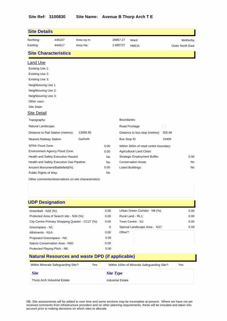
Site Name: Avenue B Thorp Arch T E Site Ref: 3100830
Site Details
Land Use
Northing: 446107
Easting: 444617
Distance to Rail Station (metres): 13099.95
Nearest Railway Station Garforth
Distance to bus stop (metres) 355.66
Bus Stop ID 10409
Agricultural Land Class:
SFRA Flood Zone: 0.00
Environment Agency Flood Zone: 0.00
Within 300m of retail centre boundary:
UDP Designation
Greenbelt - N32 (%): 0.00 Urban Green Corridor - N8 (%): 0.00
Protected Area of Search site - N34 (%): 0.00 Rural Land - RL1: 0.00
City Centre Primary Shopping Quarter - CC27 (%): 0.00 Town Centre - S2: 0.00
Health and Safety Executive Hazard: No
Health and Safety Executive Gas Pipeline: No
Strategic Employment Buffer: 0.00
Area sq m: 26857.27 Ward Wetherby
Special Landscape Area - N37: 0.00
Allotments - N1A: 0.00
Proposed Greenspace - N5: 0.00
Protected Playing Pitch - N6: 0.00
Nature Conservation Area - N50: 0.00
Conservation Areas No
Ancient Monument/Battlefield(%): 0.00 Listed Buildings: No
Public Rights of Way: No
Other?:
Natural Resources and waste DPD (if applicable)
Within Minerals Safeguarding Site?: Yes Within 100m of Minerals Safeguarding Site?: Yes
HMCA: Outer North East
Greenspace - N1: 0
Existing Use 1:
Existing Use 2:
Existing Use 3:
Neighbouring Use 1
Neighbouring Use 2:
Neighbouring Use 3:
Other uses:
Topography:
Natural Landscape:
Boundaries:
Road Frontage
Site Characteristics
Site Detail
Other comments/observations on site characteristics:
Area Ha: 2.685727
Site State:
Site Site TypeThorp Arch Industrial Estate Industrial Estate
NB. Site assessments will be added to over time and some sections may be incomplete at present. Where we have not yet received comments from infrastructure providers and on other planning requirements, these will be included and taken into account prior to making decisions on which sites to allocate.
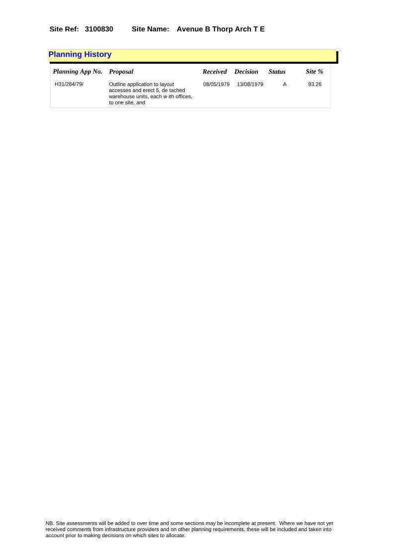
Site Name: Avenue B Thorp Arch T E Site Ref: 3100830
Planning History
Planning App No. Proposal Received Decision Status Site %
H31/284/79/ Outline application to layout accesses and erect 5, de tached warehouse units, each w ith offices, to one site, and
08/05/1979 13/08/1979 A 93.26
NB. Site assessments will be added to over time and some sections may be incomplete at present. Where we have not yet received comments from infrastructure providers and on other planning requirements, these will be included and taken into account prior to making decisions on which sites to allocate.

Site Name: Avenue B Thorp Arch T E Site Ref: 3100830
Conformity with Core Strategy
Inner South Leeds: 0.00
Leeds Bradford Corridor: 0.00 West Leeds Gateway: 0.00
Aire Valley: 0.00Regeneration Priority Area:
Brownfield
Greenfield
Mixed
Main Urban Area
Major Settlement
Smaller Settlement
Villages/Rural
Main Urban Area Extension
Major Settlement Extension
Smaller Settlement Extension
Village/Rural Extension
Development unrelated to existing development
Green Belt assessment - only completed where site is within Green Belt
Would development lead to/constitute ribbon development?
Would development result in isolated development?
Is the site well connected to built up area (2+ boundaries with existing built up area)?
Would development of the site effectively "round off" the settlement pattern?:
Do natural/physical features provide a good existing barrier between existing urban area and undeveloped land?
Overall sprawl conclusion:
Would development of the site lead to physical connection of settlements?
Do natural/physical features provide a good existing barrier/boundary to contain development?
Overall Coalescence Conclusion:
Is there a strong defensible boundary between the site and the existing urban area?
Does the site provide access to the countryside?
Does the site include local or national conservation designated areas?
Does the site include areas of woodlands, trees, hedgerows that are protected, or significant unprotected tree/hedge cover?
Does the site include grade 1, 2, or 3a agricultural land?
Does the site contain buildings? Are these in agricultural use?
Overall countryside Encroachment Conclusion
Is the site within or adjacent to a conservation area, listed building or other historical feature?
If yes, could development preserve this character?:
Overall Character Preservation Conclusion:
Greenbelt Assessment Conclusion:
Check the unrestricted sprawl of large built up areas
Prevent neighbouring towns from merging
Assist in safeguarding countryside from encroachment
Preserve the setting and special character of historic towns
NB. Site assessments will be added to over time and some sections may be incomplete at present. Where we have not yet received comments from infrastructure providers and on other planning requirements, these will be included and taken into account prior to making decisions on which sites to allocate.

Site Name: Avenue B Thorp Arch T E Site Ref: 3100830
SHLAA ConclusionsAvailability: Suitability: Achievability:
Conclusion of Assessment
Conclusion summary:
Site located within established trading estate with no significant constraints to its development.
Floorspace sq m (Non residential):
Employment Conclusion: Lime Green
East Leeds
Assesment Type: ELR Type: Industrial & Warehousing
Proposed Change:
Gypsy Traveller Site Assessment
Yes No Maybe Could site be effectively managed (Text)
Yes No Maybe Would gypsies and travellers live on the site?
(Text)
Yes No Proximity to housed gypsies and travellers (Text)
Yes No Unknown Experience of previous encampments (Text)
NB. Site assessments will be added to over time and some sections may be incomplete at present. Where we have not yet received comments from infrastructure providers and on other planning requirements, these will be included and taken into account prior to making decisions on which sites to allocate.

Site Name: Avenue D Thorp Arch T E Site Ref: 3100831
Site Details
Land Use
Northing: 446013
Easting: 444565
Distance to Rail Station (metres): 12994.59
Nearest Railway Station Garforth
Distance to bus stop (metres) 291.71
Bus Stop ID 15
Agricultural Land Class:
SFRA Flood Zone: 0.00
Environment Agency Flood Zone: 0.00
Within 300m of retail centre boundary:
UDP Designation
Greenbelt - N32 (%): 0.00 Urban Green Corridor - N8 (%): 0.00
Protected Area of Search site - N34 (%): 0.00 Rural Land - RL1: 0.00
City Centre Primary Shopping Quarter - CC27 (%): 0.00 Town Centre - S2: 0.00
Health and Safety Executive Hazard: No
Health and Safety Executive Gas Pipeline: No
Strategic Employment Buffer: 0.00
Area sq m: 8186.04 Ward Wetherby
Special Landscape Area - N37: 0.00
Allotments - N1A: 0.00
Proposed Greenspace - N5: 0.00
Protected Playing Pitch - N6: 0.00
Nature Conservation Area - N50: 0.00
Conservation Areas No
Ancient Monument/Battlefield(%): 0.00 Listed Buildings: No
Public Rights of Way: No
Other?:
Natural Resources and waste DPD (if applicable)
Within Minerals Safeguarding Site?: Yes Within 100m of Minerals Safeguarding Site?: Yes
HMCA: Outer North East
Greenspace - N1: 0
Existing Use 1:
Existing Use 2:
Existing Use 3:
Neighbouring Use 1
Neighbouring Use 2:
Neighbouring Use 3:
Other uses:
Topography:
Natural Landscape:
Boundaries:
Road Frontage
Site Characteristics
Site Detail
Other comments/observations on site characteristics:
Area Ha: 0.818604
Site State:
Site Site TypeThorp Arch Industrial Estate Industrial Estate
NB. Site assessments will be added to over time and some sections may be incomplete at present. Where we have not yet received comments from infrastructure providers and on other planning requirements, these will be included and taken into account prior to making decisions on which sites to allocate.

Site Name: Avenue D Thorp Arch T E Site Ref: 3100831
Planning History
NB. Site assessments will be added to over time and some sections may be incomplete at present. Where we have not yet received comments from infrastructure providers and on other planning requirements, these will be included and taken into account prior to making decisions on which sites to allocate.

Site Name: Avenue D Thorp Arch T E Site Ref: 3100831
Conformity with Core Strategy
Inner South Leeds: 0.00
Leeds Bradford Corridor: 0.00 West Leeds Gateway: 0.00
Aire Valley: 0.00Regeneration Priority Area:
Brownfield
Greenfield
Mixed
Main Urban Area
Major Settlement
Smaller Settlement
Villages/Rural
Main Urban Area Extension
Major Settlement Extension
Smaller Settlement Extension
Village/Rural Extension
Development unrelated to existing development
Green Belt assessment - only completed where site is within Green Belt
Would development lead to/constitute ribbon development?
Would development result in isolated development?
Is the site well connected to built up area (2+ boundaries with existing built up area)?
Would development of the site effectively "round off" the settlement pattern?:
Do natural/physical features provide a good existing barrier between existing urban area and undeveloped land?
Overall sprawl conclusion:
Would development of the site lead to physical connection of settlements?
Do natural/physical features provide a good existing barrier/boundary to contain development?
Overall Coalescence Conclusion:
Is there a strong defensible boundary between the site and the existing urban area?
Does the site provide access to the countryside?
Does the site include local or national conservation designated areas?
Does the site include areas of woodlands, trees, hedgerows that are protected, or significant unprotected tree/hedge cover?
Does the site include grade 1, 2, or 3a agricultural land?
Does the site contain buildings? Are these in agricultural use?
Overall countryside Encroachment Conclusion
Is the site within or adjacent to a conservation area, listed building or other historical feature?
If yes, could development preserve this character?:
Overall Character Preservation Conclusion:
Greenbelt Assessment Conclusion:
Check the unrestricted sprawl of large built up areas
Prevent neighbouring towns from merging
Assist in safeguarding countryside from encroachment
Preserve the setting and special character of historic towns
NB. Site assessments will be added to over time and some sections may be incomplete at present. Where we have not yet received comments from infrastructure providers and on other planning requirements, these will be included and taken into account prior to making decisions on which sites to allocate.

Site Name: Avenue D Thorp Arch T E Site Ref: 3100831
SHLAA ConclusionsAvailability: Suitability: Achievability:
Conclusion of Assessment
Conclusion summary:
Site located within established trading estate with no significant constraints to its development.
Floorspace sq m (Non residential):
Employment Conclusion: Lime Green
East Leeds
Assesment Type: ELR Type: Industrial & Warehousing
Proposed Change:
Gypsy Traveller Site Assessment
Yes No Maybe Could site be effectively managed (Text)
Yes No Maybe Would gypsies and travellers live on the site?
(Text)
Yes No Proximity to housed gypsies and travellers (Text)
Yes No Unknown Experience of previous encampments (Text)
NB. Site assessments will be added to over time and some sections may be incomplete at present. Where we have not yet received comments from infrastructure providers and on other planning requirements, these will be included and taken into account prior to making decisions on which sites to allocate.

Site Name: Avenue D Thorp Arch T E Site Ref: 3100832
Site Details
Land Use
Northing: 446023
Easting: 444487
Distance to Rail Station (metres): 12981.20
Nearest Railway Station Garforth
Distance to bus stop (metres) 315.41
Bus Stop ID 15
Agricultural Land Class:
SFRA Flood Zone: 0.00
Environment Agency Flood Zone: 0.00
Within 300m of retail centre boundary:
UDP Designation
Greenbelt - N32 (%): 0.00 Urban Green Corridor - N8 (%): 0.00
Protected Area of Search site - N34 (%): 0.00 Rural Land - RL1: 0.00
City Centre Primary Shopping Quarter - CC27 (%): 0.00 Town Centre - S2: 0.00
Health and Safety Executive Hazard: No
Health and Safety Executive Gas Pipeline: No
Strategic Employment Buffer: 0.00
Area sq m: 43175.41 Ward Wetherby
Special Landscape Area - N37: 0.00
Allotments - N1A: 0.00
Proposed Greenspace - N5: 0.00
Protected Playing Pitch - N6: 0.00
Nature Conservation Area - N50: 0.00
Conservation Areas No
Ancient Monument/Battlefield(%): 0.00 Listed Buildings: No
Public Rights of Way: No
Other?:
Natural Resources and waste DPD (if applicable)
Within Minerals Safeguarding Site?: Yes Within 100m of Minerals Safeguarding Site?: Yes
HMCA: Outer North East
Greenspace - N1: 0
Existing Use 1:
Existing Use 2:
Existing Use 3:
Neighbouring Use 1
Neighbouring Use 2:
Neighbouring Use 3:
Other uses:
Topography:
Natural Landscape:
Boundaries:
Road Frontage
Site Characteristics
Site Detail
Other comments/observations on site characteristics:
Area Ha: 4.317541
Site State:
Site Site TypeThorp Arch Industrial Estate Industrial Estate
NB. Site assessments will be added to over time and some sections may be incomplete at present. Where we have not yet received comments from infrastructure providers and on other planning requirements, these will be included and taken into account prior to making decisions on which sites to allocate.

Site Name: Avenue D Thorp Arch T E Site Ref: 3100832
Planning History
NB. Site assessments will be added to over time and some sections may be incomplete at present. Where we have not yet received comments from infrastructure providers and on other planning requirements, these will be included and taken into account prior to making decisions on which sites to allocate.

Site Name: Avenue D Thorp Arch T E Site Ref: 3100832
Conformity with Core Strategy
Inner South Leeds: 0.00
Leeds Bradford Corridor: 0.00 West Leeds Gateway: 0.00
Aire Valley: 0.00Regeneration Priority Area:
Brownfield
Greenfield
Mixed
Main Urban Area
Major Settlement
Smaller Settlement
Villages/Rural
Main Urban Area Extension
Major Settlement Extension
Smaller Settlement Extension
Village/Rural Extension
Development unrelated to existing development
Green Belt assessment - only completed where site is within Green Belt
Would development lead to/constitute ribbon development?
Would development result in isolated development?
Is the site well connected to built up area (2+ boundaries with existing built up area)?
Would development of the site effectively "round off" the settlement pattern?:
Do natural/physical features provide a good existing barrier between existing urban area and undeveloped land?
Overall sprawl conclusion:
Would development of the site lead to physical connection of settlements?
Do natural/physical features provide a good existing barrier/boundary to contain development?
Overall Coalescence Conclusion:
Is there a strong defensible boundary between the site and the existing urban area?
Does the site provide access to the countryside?
Does the site include local or national conservation designated areas?
Does the site include areas of woodlands, trees, hedgerows that are protected, or significant unprotected tree/hedge cover?
Does the site include grade 1, 2, or 3a agricultural land?
Does the site contain buildings? Are these in agricultural use?
Overall countryside Encroachment Conclusion
Is the site within or adjacent to a conservation area, listed building or other historical feature?
If yes, could development preserve this character?:
Overall Character Preservation Conclusion:
Greenbelt Assessment Conclusion:
Check the unrestricted sprawl of large built up areas
Prevent neighbouring towns from merging
Assist in safeguarding countryside from encroachment
Preserve the setting and special character of historic towns
NB. Site assessments will be added to over time and some sections may be incomplete at present. Where we have not yet received comments from infrastructure providers and on other planning requirements, these will be included and taken into account prior to making decisions on which sites to allocate.

Site Name: Avenue D Thorp Arch T E Site Ref: 3100832
SHLAA ConclusionsAvailability: Suitability: Achievability:
Conclusion of Assessment
Conclusion summary:
The site is of good quality and located within an established trading estate making it appropriate for employment use.
Floorspace sq m (Non residential):
Employment Conclusion: Lime Green
East Leeds
Assesment Type: ELR Type: Industrial & Warehousing
Proposed Change:
Gypsy Traveller Site Assessment
Yes No Maybe Could site be effectively managed (Text)
Yes No Maybe Would gypsies and travellers live on the site?
(Text)
Yes No Proximity to housed gypsies and travellers (Text)
Yes No Unknown Experience of previous encampments (Text)
NB. Site assessments will be added to over time and some sections may be incomplete at present. Where we have not yet received comments from infrastructure providers and on other planning requirements, these will be included and taken into account prior to making decisions on which sites to allocate.

Site Name: Avenue B Thorp Arch T E Site Ref: 3102230
Site Details
Land Use
Northing: 446187
Easting: 444696
Distance to Rail Station (metres): 13200.46
Nearest Railway Station Garforth
Distance to bus stop (metres) 269.91
Bus Stop ID 4322
Agricultural Land Class:
SFRA Flood Zone: 0.00
Environment Agency Flood Zone: 0.00
Within 300m of retail centre boundary:
UDP Designation
Greenbelt - N32 (%): 0.00 Urban Green Corridor - N8 (%): 0.00
Protected Area of Search site - N34 (%): 0.00 Rural Land - RL1: 0.00
City Centre Primary Shopping Quarter - CC27 (%): 0.00 Town Centre - S2: 0.00
Health and Safety Executive Hazard: No
Health and Safety Executive Gas Pipeline: No
Strategic Employment Buffer: 0.00
Area sq m: 25724.67 Ward Wetherby
Special Landscape Area - N37: 0.00
Allotments - N1A: 0.00
Proposed Greenspace - N5: 0.00
Protected Playing Pitch - N6: 0.00
Nature Conservation Area - N50: 0.00
Conservation Areas No
Ancient Monument/Battlefield(%): 0.00 Listed Buildings: No
Public Rights of Way: No
Other?:
Natural Resources and waste DPD (if applicable)
Within Minerals Safeguarding Site?: Yes Within 100m of Minerals Safeguarding Site?: Yes
HMCA: Outer North East
Greenspace - N1: 0
Existing Use 1:
Existing Use 2:
Existing Use 3:
Neighbouring Use 1
Neighbouring Use 2:
Neighbouring Use 3:
Other uses:
Topography:
Natural Landscape:
Boundaries:
Road Frontage
Site Characteristics
Site Detail
Other comments/observations on site characteristics:
Area Ha: 2.572467
Site State:
Site Site TypeThorp Arch Industrial Estate Industrial Estate
NB. Site assessments will be added to over time and some sections may be incomplete at present. Where we have not yet received comments from infrastructure providers and on other planning requirements, these will be included and taken into account prior to making decisions on which sites to allocate.

Site Name: Avenue B Thorp Arch T E Site Ref: 3102230
Planning History
NB. Site assessments will be added to over time and some sections may be incomplete at present. Where we have not yet received comments from infrastructure providers and on other planning requirements, these will be included and taken into account prior to making decisions on which sites to allocate.

Site Name: Avenue B Thorp Arch T E Site Ref: 3102230
Conformity with Core Strategy
Inner South Leeds: 0.00
Leeds Bradford Corridor: 0.00 West Leeds Gateway: 0.00
Aire Valley: 0.00Regeneration Priority Area:
Brownfield
Greenfield
Mixed
Main Urban Area
Major Settlement
Smaller Settlement
Villages/Rural
Main Urban Area Extension
Major Settlement Extension
Smaller Settlement Extension
Village/Rural Extension
Development unrelated to existing development
Green Belt assessment - only completed where site is within Green Belt
Would development lead to/constitute ribbon development?
Would development result in isolated development?
Is the site well connected to built up area (2+ boundaries with existing built up area)?
Would development of the site effectively "round off" the settlement pattern?:
Do natural/physical features provide a good existing barrier between existing urban area and undeveloped land?
Overall sprawl conclusion:
Would development of the site lead to physical connection of settlements?
Do natural/physical features provide a good existing barrier/boundary to contain development?
Overall Coalescence Conclusion:
Is there a strong defensible boundary between the site and the existing urban area?
Does the site provide access to the countryside?
Does the site include local or national conservation designated areas?
Does the site include areas of woodlands, trees, hedgerows that are protected, or significant unprotected tree/hedge cover?
Does the site include grade 1, 2, or 3a agricultural land?
Does the site contain buildings? Are these in agricultural use?
Overall countryside Encroachment Conclusion
Is the site within or adjacent to a conservation area, listed building or other historical feature?
If yes, could development preserve this character?:
Overall Character Preservation Conclusion:
Greenbelt Assessment Conclusion:
Check the unrestricted sprawl of large built up areas
Prevent neighbouring towns from merging
Assist in safeguarding countryside from encroachment
Preserve the setting and special character of historic towns
NB. Site assessments will be added to over time and some sections may be incomplete at present. Where we have not yet received comments from infrastructure providers and on other planning requirements, these will be included and taken into account prior to making decisions on which sites to allocate.

Site Name: Avenue B Thorp Arch T E Site Ref: 3102230
SHLAA ConclusionsAvailability: Suitability: Achievability:
Conclusion of Assessment
Conclusion summary:
Site is located on an established trading estate with few constraints to its development.
Floorspace sq m (Non residential):
Employment Conclusion: Lime Green
East Leeds
Assesment Type: ELR Type: Industrial & Warehousing
Proposed Change:
Gypsy Traveller Site Assessment
Yes No Maybe Could site be effectively managed (Text)
Yes No Maybe Would gypsies and travellers live on the site?
(Text)
Yes No Proximity to housed gypsies and travellers (Text)
Yes No Unknown Experience of previous encampments (Text)
NB. Site assessments will be added to over time and some sections may be incomplete at present. Where we have not yet received comments from infrastructure providers and on other planning requirements, these will be included and taken into account prior to making decisions on which sites to allocate.
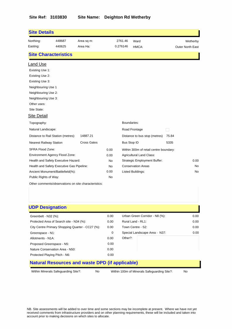
Site Name: Deighton Rd WetherbySite Ref: 3103830
Site Details
Land Use
Northing: 448687
Easting: 440625
Distance to Rail Station (metres): 14887.21
Nearest Railway Station Cross Gates
Distance to bus stop (metres) 75.84
Bus Stop ID 5335
Agricultural Land Class:
SFRA Flood Zone: 0.00
Environment Agency Flood Zone: 0.00
Within 300m of retail centre boundary:
UDP Designation
Greenbelt - N32 (%): 0.00 Urban Green Corridor - N8 (%): 0.00
Protected Area of Search site - N34 (%): 0.00 Rural Land - RL1: 0.00
City Centre Primary Shopping Quarter - CC27 (%): 0.00 Town Centre - S2: 0.00
Health and Safety Executive Hazard: No
Health and Safety Executive Gas Pipeline: No
Strategic Employment Buffer: 0.00
Area sq m: 2761.46 Ward Wetherby
Special Landscape Area - N37: 0.00
Allotments - N1A: 0.00
Proposed Greenspace - N5: 0.00
Protected Playing Pitch - N6: 0.00
Nature Conservation Area - N50: 0.00
Conservation Areas No
Ancient Monument/Battlefield(%): 0.00 Listed Buildings: No
Public Rights of Way: No
Other?:
Natural Resources and waste DPD (if applicable)
Within Minerals Safeguarding Site?: No Within 100m of Minerals Safeguarding Site?: No
HMCA: Outer North East
Greenspace - N1: 0
Existing Use 1:
Existing Use 2:
Existing Use 3:
Neighbouring Use 1
Neighbouring Use 2:
Neighbouring Use 3:
Other uses:
Topography:
Natural Landscape:
Boundaries:
Road Frontage
Site Characteristics
Site Detail
Other comments/observations on site characteristics:
Area Ha: 0.276146
Site State:
NB. Site assessments will be added to over time and some sections may be incomplete at present. Where we have not yet received comments from infrastructure providers and on other planning requirements, these will be included and taken into account prior to making decisions on which sites to allocate.

Site Name: Deighton Rd WetherbySite Ref: 3103830
Planning History
Planning App No. Proposal Received Decision Status Site %
31/236/00/RE Renewal of outline permission to erect detached 2 storey office block
08/08/2000 08/01/2001 A 79.76
H31/207/80/ Outline application to erect l ight industrial units, wareh ouse units and showroom, to va cant site. (site area 1.25h
18/03/1980 15/04/1980 W 16.43
H31/7/80/ Outline application to lay out access and erect light industrial development, to va cant site. (site area 1.25h
04/01/1980 24/03/1980 A 18.40
H31/238/76/ Addition of open canopy and in crease height of boundarywall to 3.2m (10ft 6ins) to detache d house.
06/04/1976 11/05/1976 A 76.75
31/141/97/FU Variation of condition no 3 of application no 31/182/92/ot (time limit)
23/06/1997 17/09/1997 A 99.59
H31/96/87/ Outline application to layout access roads and erect 2 store y supermarket, with offices, s torage and plant areas and
06/04/1987 01/02/1989 W 76.01
H31/8/80/ Outline application to lay out access and erect showr oom and light industrial devel opment, to vacant site. (sit
04/01/1980 24/03/1980 A 18.40
H31/698/79/ Alterations and first floor ex tension, to form sitting room, to rear of detached house.
25/10/1979 02/01/1980 W 76.75
H31/341/75/ Alterations, including enlarge d lounge, bedroom, and bathr oom with w.c., and extension, to form enlarged kitchen, n
23/05/1975 07/07/1975 A 79.78
H31/619/75/ Demolition of existing shed an d extension to form new stora ge shed, with double garage do ors, to double garage, to
29/09/1975 08/12/1975 A 80.04
H31/33/80/ Alterations, to form enlarged bathroom, and extension, to fo rm first floor bedroom, to rea r of detached house.
18/01/1980 11/02/1980 A 78.55
H31/55/87/ Detached single storey buildin g to house private colle ction of old articles, to side of detached house.
24/02/1987 24/08/1987 A 75.88
31/182/92/OT Outline application to erect detached two storey office block
04/06/1992 08/12/1992 A 77.16
H31/278/76/ Outline application to demolis h existing cafe and erect building to house collection of old articles.
27/04/1976 02/08/1976 A 76.75
10/04071/EXT Extension of time for planning application 31/315/05/RE (Renewal of outline permission to erect detached 2 storey office block)
07/09/2010 19/10/2010 A 99.61
H31/208/80/ Outline application to erect l ight industrial and wareh ouse units, to vacant site. (s ite area 1.25ha (this item
18/03/1980 30/06/1980 A 17.61
31/315/05/RE Renewal of outline permission to erect detached 2 storey office block
15/08/2005 10/10/2005 A 99.59
NB. Site assessments will be added to over time and some sections may be incomplete at present. Where we have not yet received comments from infrastructure providers and on other planning requirements, these will be included and taken into account prior to making decisions on which sites to allocate.

Site Name: Deighton Rd WetherbySite Ref: 3103830
H31/9/80/ Outline application to lay out access and erect showr oom and offices, to vacant sit e. (site area 1.25ha) (t
04/01/1980 31/03/1980 W 18.40
31/220/92/RE Detached single storey store 08/07/1992 29/07/1992 W 77.16
H31/138/88/ Outline application to layout access roads and erect super market, with 172 car parking s paces and service areas, to
20/04/1988 22/02/1991 W 75.02
H31/6/80/ Outline application to lay out access and erect offic es, to vacant site. (site area 1.25ha). (this item is al
04/01/1980 24/03/1980 W 18.40
H31/37/88/ 5, 2 storey business units, wi th 158 car parking spacesto va cant site.
17/02/1988 01/08/1988 A 25.32
NB. Site assessments will be added to over time and some sections may be incomplete at present. Where we have not yet received comments from infrastructure providers and on other planning requirements, these will be included and taken into account prior to making decisions on which sites to allocate.
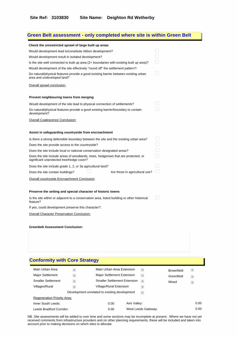
Site Name: Deighton Rd WetherbySite Ref: 3103830
Conformity with Core Strategy
Inner South Leeds: 0.00
Leeds Bradford Corridor: 0.00 West Leeds Gateway: 0.00
Aire Valley: 0.00Regeneration Priority Area:
Brownfield
Greenfield
Mixed
Main Urban Area
Major Settlement
Smaller Settlement
Villages/Rural
Main Urban Area Extension
Major Settlement Extension
Smaller Settlement Extension
Village/Rural Extension
Development unrelated to existing development
Green Belt assessment - only completed where site is within Green Belt
Would development lead to/constitute ribbon development?
Would development result in isolated development?
Is the site well connected to built up area (2+ boundaries with existing built up area)?
Would development of the site effectively "round off" the settlement pattern?:
Do natural/physical features provide a good existing barrier between existing urban area and undeveloped land?
Overall sprawl conclusion:
Would development of the site lead to physical connection of settlements?
Do natural/physical features provide a good existing barrier/boundary to contain development?
Overall Coalescence Conclusion:
Is there a strong defensible boundary between the site and the existing urban area?
Does the site provide access to the countryside?
Does the site include local or national conservation designated areas?
Does the site include areas of woodlands, trees, hedgerows that are protected, or significant unprotected tree/hedge cover?
Does the site include grade 1, 2, or 3a agricultural land?
Does the site contain buildings? Are these in agricultural use?
Overall countryside Encroachment Conclusion
Is the site within or adjacent to a conservation area, listed building or other historical feature?
If yes, could development preserve this character?:
Overall Character Preservation Conclusion:
Greenbelt Assessment Conclusion:
Check the unrestricted sprawl of large built up areas
Prevent neighbouring towns from merging
Assist in safeguarding countryside from encroachment
Preserve the setting and special character of historic towns
NB. Site assessments will be added to over time and some sections may be incomplete at present. Where we have not yet received comments from infrastructure providers and on other planning requirements, these will be included and taken into account prior to making decisions on which sites to allocate.

Site Name: Deighton Rd WetherbySite Ref: 3103830
SHLAA ConclusionsAvailability: Suitability: Achievability:
Conclusion of Assessment
Conclusion summary:
Current site with planning permission for employment purposes.
Floorspace sq m (Non residential): 1210
Employment Conclusion: Lime Green
East Leeds
Assesment Type: Planning status Type: Office
Proposed Change:
Gypsy Traveller Site Assessment
Yes No Maybe Could site be effectively managed (Text)
Yes No Maybe Would gypsies and travellers live on the site?
(Text)
Yes No Proximity to housed gypsies and travellers (Text)
Yes No Unknown Experience of previous encampments (Text)
NB. Site assessments will be added to over time and some sections may be incomplete at present. Where we have not yet received comments from infrastructure providers and on other planning requirements, these will be included and taken into account prior to making decisions on which sites to allocate.

Site Name: Park Hill Farm Park Hill Studio Walton Road Wetherby
Site Ref: 3103954
Site Details
Land Use
Northing: 447762
Easting: 441147
Distance to Rail Station (metres): 14150.12
Nearest Railway Station Garforth
Distance to bus stop (metres) 355.11
Bus Stop ID 9722
Agricultural Land Class:
SFRA Flood Zone: 0.00
Environment Agency Flood Zone: 0.00
Within 300m of retail centre boundary:
UDP Designation
Greenbelt - N32 (%): 0.00 Urban Green Corridor - N8 (%): 0.00
Protected Area of Search site - N34 (%): 0.00 Rural Land - RL1: 100.00
City Centre Primary Shopping Quarter - CC27 (%): 0.00 Town Centre - S2: 0.00
Health and Safety Executive Hazard: No
Health and Safety Executive Gas Pipeline: No
Strategic Employment Buffer: 0.00
Area sq m: 5005.25 Ward Wetherby
Special Landscape Area - N37: 1.00
Allotments - N1A: 0.00
Proposed Greenspace - N5: 0.00
Protected Playing Pitch - N6: 0.00
Nature Conservation Area - N50: 0.00
Conservation Areas No
Ancient Monument/Battlefield(%): 0.00 Listed Buildings: No
Public Rights of Way: No
Other?:
Natural Resources and waste DPD (if applicable)
Within Minerals Safeguarding Site?: No Within 100m of Minerals Safeguarding Site?: No
HMCA: Outer North East
Greenspace - N1: 0
Existing Use 1:
Existing Use 2:
Existing Use 3:
Neighbouring Use 1
Neighbouring Use 2:
Neighbouring Use 3:
Other uses:
Topography:
Natural Landscape:
Boundaries:
Road Frontage
Site Characteristics
Site Detail
Other comments/observations on site characteristics:
Area Ha: 0.500525
Site State:
NB. Site assessments will be added to over time and some sections may be incomplete at present. Where we have not yet received comments from infrastructure providers and on other planning requirements, these will be included and taken into account prior to making decisions on which sites to allocate.
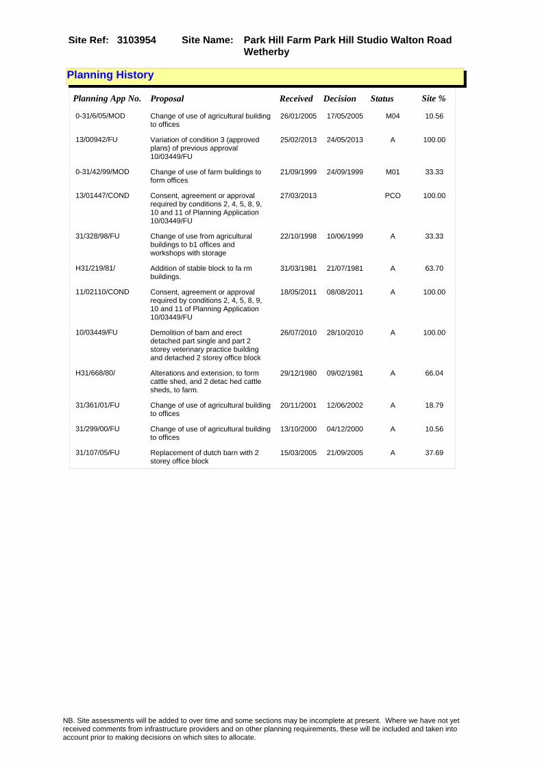
Site Name: Park Hill Farm Park Hill Studio Walton Road Wetherby
Site Ref: 3103954
Planning History
Planning App No. Proposal Received Decision Status Site %
0-31/6/05/MOD Change of use of agricultural building to offices
26/01/2005 17/05/2005 M04 10.56
13/00942/FU Variation of condition 3 (approved plans) of previous approval 10/03449/FU
25/02/2013 24/05/2013 A 100.00
0-31/42/99/MOD Change of use of farm buildings to form offices
21/09/1999 24/09/1999 M01 33.33
13/01447/COND Consent, agreement or approval required by conditions 2, 4, 5, 8, 9, 10 and 11 of Planning Application 10/03449/FU
27/03/2013 PCO 100.00
31/328/98/FU Change of use from agricultural buildings to b1 offices and workshops with storage
22/10/1998 10/06/1999 A 33.33
H31/219/81/ Addition of stable block to fa rm buildings.
31/03/1981 21/07/1981 A 63.70
11/02110/COND Consent, agreement or approval required by conditions 2, 4, 5, 8, 9, 10 and 11 of Planning Application 10/03449/FU
18/05/2011 08/08/2011 A 100.00
10/03449/FU Demolition of barn and erect detached part single and part 2 storey veterinary practice building and detached 2 storey office block
26/07/2010 28/10/2010 A 100.00
H31/668/80/ Alterations and extension, to form cattle shed, and 2 detac hed cattle sheds, to farm.
29/12/1980 09/02/1981 A 66.04
31/361/01/FU Change of use of agricultural building to offices
20/11/2001 12/06/2002 A 18.79
31/299/00/FU Change of use of agricultural building to offices
13/10/2000 04/12/2000 A 10.56
31/107/05/FU Replacement of dutch barn with 2 storey office block
15/03/2005 21/09/2005 A 37.69
NB. Site assessments will be added to over time and some sections may be incomplete at present. Where we have not yet received comments from infrastructure providers and on other planning requirements, these will be included and taken into account prior to making decisions on which sites to allocate.

Site Name: Park Hill Farm Park Hill Studio Walton Road Wetherby
Site Ref: 3103954
Conformity with Core Strategy
Inner South Leeds: 0.00
Leeds Bradford Corridor: 0.00 West Leeds Gateway: 0.00
Aire Valley: 0.00Regeneration Priority Area:
Brownfield
Greenfield
Mixed
Main Urban Area
Major Settlement
Smaller Settlement
Villages/Rural
Main Urban Area Extension
Major Settlement Extension
Smaller Settlement Extension
Village/Rural Extension
Development unrelated to existing development
Green Belt assessment - only completed where site is within Green Belt
Would development lead to/constitute ribbon development?
Would development result in isolated development?
Is the site well connected to built up area (2+ boundaries with existing built up area)?
Would development of the site effectively "round off" the settlement pattern?:
Do natural/physical features provide a good existing barrier between existing urban area and undeveloped land?
Overall sprawl conclusion:
Would development of the site lead to physical connection of settlements?
Do natural/physical features provide a good existing barrier/boundary to contain development?
Overall Coalescence Conclusion:
Is there a strong defensible boundary between the site and the existing urban area?
Does the site provide access to the countryside?
Does the site include local or national conservation designated areas?
Does the site include areas of woodlands, trees, hedgerows that are protected, or significant unprotected tree/hedge cover?
Does the site include grade 1, 2, or 3a agricultural land?
Does the site contain buildings? Are these in agricultural use?
Overall countryside Encroachment Conclusion
Is the site within or adjacent to a conservation area, listed building or other historical feature?
If yes, could development preserve this character?:
Overall Character Preservation Conclusion:
Greenbelt Assessment Conclusion:
Check the unrestricted sprawl of large built up areas
Prevent neighbouring towns from merging
Assist in safeguarding countryside from encroachment
Preserve the setting and special character of historic towns
NB. Site assessments will be added to over time and some sections may be incomplete at present. Where we have not yet received comments from infrastructure providers and on other planning requirements, these will be included and taken into account prior to making decisions on which sites to allocate.
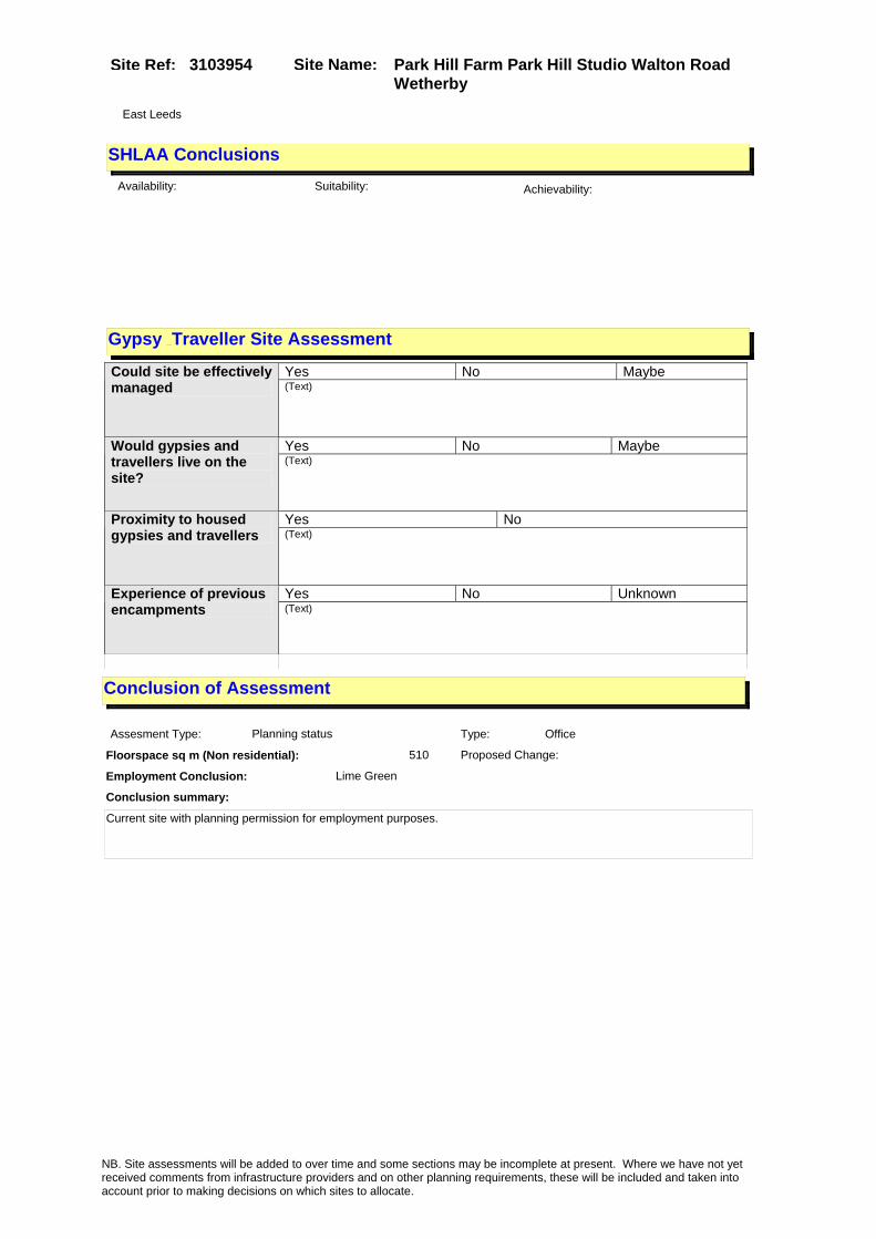
Site Name: Park Hill Farm Park Hill Studio Walton Road Wetherby
Site Ref: 3103954
SHLAA ConclusionsAvailability: Suitability: Achievability:
Conclusion of Assessment
Conclusion summary:
Current site with planning permission for employment purposes.
Floorspace sq m (Non residential): 510
Employment Conclusion: Lime Green
East Leeds
Assesment Type: Planning status Type: Office
Proposed Change:
Gypsy Traveller Site Assessment
Yes No Maybe Could site be effectively managed (Text)
Yes No Maybe Would gypsies and travellers live on the site?
(Text)
Yes No Proximity to housed gypsies and travellers (Text)
Yes No Unknown Experience of previous encampments (Text)
NB. Site assessments will be added to over time and some sections may be incomplete at present. Where we have not yet received comments from infrastructure providers and on other planning requirements, these will be included and taken into account prior to making decisions on which sites to allocate.
Site Name: Sandbeck Lane Wetherby LS22Site Ref: 3104020
Site Details
Land Use
Northing: 449465
Easting: 440938
Distance to Rail Station (metres): 15723.48
Nearest Railway Station Cross Gates
Distance to bus stop (metres) 354.85
Bus Stop ID 2951
Agricultural Land Class:
SFRA Flood Zone: 1.00
Environment Agency Flood Zone: 1.00
Within 300m of retail centre boundary:
UDP Designation
Greenbelt - N32 (%): 0.00 Urban Green Corridor - N8 (%): 0.00
Protected Area of Search site - N34 (%): 0.00 Rural Land - RL1: 0.00
City Centre Primary Shopping Quarter - CC27 (%): 0.00 Town Centre - S2: 0.00
Health and Safety Executive Hazard: No
Health and Safety Executive Gas Pipeline: No
Strategic Employment Buffer: 0.00
Area sq m: 62844.12 Ward Wetherby
Special Landscape Area - N37: 0.00
Allotments - N1A: 0.00
Proposed Greenspace - N5: 0.00
Protected Playing Pitch - N6: 0.00
Nature Conservation Area - N50: 0.00
Conservation Areas No
Ancient Monument/Battlefield(%): 0.00 Listed Buildings: Yes
Public Rights of Way: Yes
Other?:
Natural Resources and waste DPD (if applicable)
Within Minerals Safeguarding Site?: No Within 100m of Minerals Safeguarding Site?: No
HMCA: Outer North East
Greenspace - N1: 0
Existing Use 1:
Existing Use 2:
Existing Use 3:
Neighbouring Use 1
Neighbouring Use 2:
Neighbouring Use 3:
Other uses:
Topography:
Natural Landscape:
Boundaries:
Road Frontage
Site Characteristics
Site Detail
Other comments/observations on site characteristics:
Area Ha: 6.284412
Site State:
NB. Site assessments will be added to over time and some sections may be incomplete at present. Where we have not yet received comments from infrastructure providers and on other planning requirements, these will be included and taken into account prior to making decisions on which sites to allocate.

Site Name: Sandbeck Lane Wetherby LS22Site Ref: 3104020
Planning History
NB. Site assessments will be added to over time and some sections may be incomplete at present. Where we have not yet received comments from infrastructure providers and on other planning requirements, these will be included and taken into account prior to making decisions on which sites to allocate.

Site Name: Sandbeck Lane Wetherby LS22Site Ref: 3104020
Conformity with Core Strategy
Inner South Leeds: 0.00
Leeds Bradford Corridor: 0.00 West Leeds Gateway: 0.00
Aire Valley: 0.00Regeneration Priority Area:
Brownfield
Greenfield
Mixed
Main Urban Area
Major Settlement
Smaller Settlement
Villages/Rural
Main Urban Area Extension
Major Settlement Extension
Smaller Settlement Extension
Village/Rural Extension
Development unrelated to existing development
Green Belt assessment - only completed where site is within Green Belt
Would development lead to/constitute ribbon development?
Would development result in isolated development?
Is the site well connected to built up area (2+ boundaries with existing built up area)?
Would development of the site effectively "round off" the settlement pattern?:
Do natural/physical features provide a good existing barrier between existing urban area and undeveloped land?
Overall sprawl conclusion:
Would development of the site lead to physical connection of settlements?
Do natural/physical features provide a good existing barrier/boundary to contain development?
Overall Coalescence Conclusion:
Is there a strong defensible boundary between the site and the existing urban area?
Does the site provide access to the countryside?
Does the site include local or national conservation designated areas?
Does the site include areas of woodlands, trees, hedgerows that are protected, or significant unprotected tree/hedge cover?
Does the site include grade 1, 2, or 3a agricultural land?
Does the site contain buildings? Are these in agricultural use?
Overall countryside Encroachment Conclusion
Is the site within or adjacent to a conservation area, listed building or other historical feature?
If yes, could development preserve this character?:
Overall Character Preservation Conclusion:
Greenbelt Assessment Conclusion:
Check the unrestricted sprawl of large built up areas
Prevent neighbouring towns from merging
Assist in safeguarding countryside from encroachment
Preserve the setting and special character of historic towns
NB. Site assessments will be added to over time and some sections may be incomplete at present. Where we have not yet received comments from infrastructure providers and on other planning requirements, these will be included and taken into account prior to making decisions on which sites to allocate.

Site Name: Sandbeck Lane Wetherby LS22Site Ref: 3104020
SHLAA ConclusionsAvailability: Suitability: Achievability:
Conclusion of Assessment
Conclusion summary:
The site is located on the edge of an existing employment site with good access both to the main road and the motorway.
Floorspace sq m (Non residential):
Employment Conclusion: Lime Green
East Leeds
Assesment Type: ELR Type: Industrial & Warehousing
Proposed Change:
Gypsy Traveller Site Assessment
Yes No Maybe Could site be effectively managed (Text)
Yes No Maybe Would gypsies and travellers live on the site?
(Text)
Yes No Proximity to housed gypsies and travellers (Text)
Yes No Unknown Experience of previous encampments (Text)
NB. Site assessments will be added to over time and some sections may be incomplete at present. Where we have not yet received comments from infrastructure providers and on other planning requirements, these will be included and taken into account prior to making decisions on which sites to allocate.

Site Name: Ph2 Plot 361 Street 7 & Avenue E East Thorp Arch Trading Estate Wetherby
Site Ref: 3104030
Site Details
Land Use
Northing: 446435
Easting: 445545
Distance to Rail Station (metres): 13715.95
Nearest Railway Station Garforth
Distance to bus stop (metres) 134.24
Bus Stop ID 364
Agricultural Land Class:
SFRA Flood Zone: 0.00
Environment Agency Flood Zone: 0.00
Within 300m of retail centre boundary:
UDP Designation
Greenbelt - N32 (%): 0.00 Urban Green Corridor - N8 (%): 0.00
Protected Area of Search site - N34 (%): 0.00 Rural Land - RL1: 0.00
City Centre Primary Shopping Quarter - CC27 (%): 0.00 Town Centre - S2: 0.00
Health and Safety Executive Hazard: No
Health and Safety Executive Gas Pipeline: No
Strategic Employment Buffer: 0.00
Area sq m: 14018.11 Ward Wetherby
Special Landscape Area - N37: 0.00
Allotments - N1A: 0.00
Proposed Greenspace - N5: 0.00
Protected Playing Pitch - N6: 0.00
Nature Conservation Area - N50: 0.00
Conservation Areas No
Ancient Monument/Battlefield(%): 0.00 Listed Buildings: No
Public Rights of Way: No
Other?:
Natural Resources and waste DPD (if applicable)
Within Minerals Safeguarding Site?: Yes Within 100m of Minerals Safeguarding Site?: Yes
HMCA: Outer North East
Greenspace - N1: 0
Existing Use 1:
Existing Use 2:
Existing Use 3:
Neighbouring Use 1
Neighbouring Use 2:
Neighbouring Use 3:
Other uses:
Topography:
Natural Landscape:
Boundaries:
Road Frontage
Site Characteristics
Site Detail
Other comments/observations on site characteristics:
Area Ha: 1.401811
Site State:
Site Site TypeThorp Arch Industrial Estate Industrial Estate
NB. Site assessments will be added to over time and some sections may be incomplete at present. Where we have not yet received comments from infrastructure providers and on other planning requirements, these will be included and taken into account prior to making decisions on which sites to allocate.

Site Name: Ph2 Plot 361 Street 7 & Avenue E East Thorp Arch Trading Estate Wetherby
Site Ref: 3104030
Planning History
NB. Site assessments will be added to over time and some sections may be incomplete at present. Where we have not yet received comments from infrastructure providers and on other planning requirements, these will be included and taken into account prior to making decisions on which sites to allocate.

Site Name: Ph2 Plot 361 Street 7 & Avenue E East Thorp Arch Trading Estate Wetherby
Site Ref: 3104030
Conformity with Core Strategy
Inner South Leeds: 0.00
Leeds Bradford Corridor: 0.00 West Leeds Gateway: 0.00
Aire Valley: 0.00Regeneration Priority Area:
Brownfield
Greenfield
Mixed
Main Urban Area
Major Settlement
Smaller Settlement
Villages/Rural
Main Urban Area Extension
Major Settlement Extension
Smaller Settlement Extension
Village/Rural Extension
Development unrelated to existing development
Green Belt assessment - only completed where site is within Green Belt
Would development lead to/constitute ribbon development?
Would development result in isolated development?
Is the site well connected to built up area (2+ boundaries with existing built up area)?
Would development of the site effectively "round off" the settlement pattern?:
Do natural/physical features provide a good existing barrier between existing urban area and undeveloped land?
Overall sprawl conclusion:
Would development of the site lead to physical connection of settlements?
Do natural/physical features provide a good existing barrier/boundary to contain development?
Overall Coalescence Conclusion:
Is there a strong defensible boundary between the site and the existing urban area?
Does the site provide access to the countryside?
Does the site include local or national conservation designated areas?
Does the site include areas of woodlands, trees, hedgerows that are protected, or significant unprotected tree/hedge cover?
Does the site include grade 1, 2, or 3a agricultural land?
Does the site contain buildings? Are these in agricultural use?
Overall countryside Encroachment Conclusion
Is the site within or adjacent to a conservation area, listed building or other historical feature?
If yes, could development preserve this character?:
Overall Character Preservation Conclusion:
Greenbelt Assessment Conclusion:
Check the unrestricted sprawl of large built up areas
Prevent neighbouring towns from merging
Assist in safeguarding countryside from encroachment
Preserve the setting and special character of historic towns
NB. Site assessments will be added to over time and some sections may be incomplete at present. Where we have not yet received comments from infrastructure providers and on other planning requirements, these will be included and taken into account prior to making decisions on which sites to allocate.
Site Name: Ph2 Plot 361 Street 7 & Avenue E East Thorp Arch Trading Estate Wetherby
Site Ref: 3104030
SHLAA ConclusionsAvailability: Suitability: Achievability:
Conclusion of Assessment
Conclusion summary:
The site is located within an existing larger employment site (Thorp Arch Estate) and is appropriate for continued employment.
Floorspace sq m (Non residential):
Employment Conclusion: Green
East Leeds
Assesment Type: ELR Type: Industrial & Warehousing
Proposed Change:
Gypsy Traveller Site Assessment
Yes No Maybe Could site be effectively managed (Text)
Yes No Maybe Would gypsies and travellers live on the site?
(Text)
Yes No Proximity to housed gypsies and travellers (Text)
Yes No Unknown Experience of previous encampments (Text)
NB. Site assessments will be added to over time and some sections may be incomplete at present. Where we have not yet received comments from infrastructure providers and on other planning requirements, these will be included and taken into account prior to making decisions on which sites to allocate.

Site Name: Units A-D Cromwell Park York Road Wetherby Ls22
Site Ref: 3104060
Site Details
Land Use
Northing: 448721
Easting: 440830
Distance to Rail Station (metres): 14981.40
Nearest Railway Station Cross Gates
Distance to bus stop (metres) 106.01
Bus Stop ID 904
Agricultural Land Class:
SFRA Flood Zone: 0.00
Environment Agency Flood Zone: 0.00
Within 300m of retail centre boundary:
UDP Designation
Greenbelt - N32 (%): 0.00 Urban Green Corridor - N8 (%): 0.00
Protected Area of Search site - N34 (%): 0.00 Rural Land - RL1: 0.00
City Centre Primary Shopping Quarter - CC27 (%): 0.00 Town Centre - S2: 0.00
Health and Safety Executive Hazard: No
Health and Safety Executive Gas Pipeline: No
Strategic Employment Buffer: 0.00
Area sq m: 4844.78 Ward Wetherby
Special Landscape Area - N37: 0.00
Allotments - N1A: 0.00
Proposed Greenspace - N5: 0.00
Protected Playing Pitch - N6: 0.00
Nature Conservation Area - N50: 0.00
Conservation Areas No
Ancient Monument/Battlefield(%): 0.00 Listed Buildings: No
Public Rights of Way: No
Other?:
Natural Resources and waste DPD (if applicable)
Within Minerals Safeguarding Site?: No Within 100m of Minerals Safeguarding Site?: No
HMCA: Outer North East
Greenspace - N1: 0
Existing Use 1:
Existing Use 2:
Existing Use 3:
Neighbouring Use 1
Neighbouring Use 2:
Neighbouring Use 3:
Other uses:
Topography:
Natural Landscape:
Boundaries:
Road Frontage
Site Characteristics
Site Detail
Other comments/observations on site characteristics:
Area Ha: 0.484478
Site State:
NB. Site assessments will be added to over time and some sections may be incomplete at present. Where we have not yet received comments from infrastructure providers and on other planning requirements, these will be included and taken into account prior to making decisions on which sites to allocate.

Site Name: Units A-D Cromwell Park York Road Wetherby Ls22
Site Ref: 3104060
Planning History
Planning App No. Proposal Received Decision Status Site %
08/01093/LI Listed Building application for the removal of existing entrance canopy and erection of extension comprising canopy with kitchen over to night club
25/02/2008 21/04/2008 A 23.45
31/324/94/FU Change of use and alterations and new entrance canopy of vacant warehouse to dance hall and function room
19/12/1994 24/03/1995 A 30.69
31/310/98/FU Change of use of dance hall to mixed use comprising dance hall (d2) and food and drink (a3)
02/10/1998 20/04/1999 A 22.90
06/05358/FU Part two storey part single storey detached unit to form veterinary surgery (D1) with associated car parking, and hard and soft landscaping
01/09/2006 16/05/2007 A 11.67
H31/306/83/ Detached prefabricated office unit, to existing officesand w orkshop.
28/11/1983 16/01/1984 A 34.51
08/01092/FU Extension to form canopy with kitchen over to front of night club
25/02/2008 21/04/2008 A 23.45
08/04054/FU Use of building as laser eye surgery (D1)
04/07/2008 29/08/2008 A 15.47
31/194/04/FU Detached 3 storey office block 14/04/2004 13/07/2004 A 67.75
31/548/03/FU Detached 3 storey office block 22/12/2003 05/04/2004 W 67.97
0-31/50/05/MOD Two 3 storey office blocks 28/06/2005 27/09/2005 M01 100.00
H31/305/83/ 2 internally illuminated wall signs, size of each 1.83mx 0.6 1m, height of each above groun d 3.8m and 4.17m (each unde
28/11/1983 19/12/1983 A 34.49
31/342/01/LI Listed building application to carry out alterations new mezzanine floor and external staircase to dance hall & bar
30/10/2001 12/03/2002 A 31.03
H31/318/77/ Change of use, involving alter ations and extension, of build ers store to sports hall.
21/06/1977 06/03/1978 A 10.87
H31/515/80/ Change of use, involving alter ations, to form offices, and a ddition of canopy to front, an d siting of tower crane to r
11/09/1980 11/11/1980 A 35.44
31/37/95/FU 2.4m high boundary fence to commercial garage
06/02/1995 24/04/1995 A 40.06
07/06907/FU Two storey side extension and external staircase to dance hall and bar
02/11/2007 21/12/2007 A 23.45
07/06908/LI Listed building application for two storey side extension to form public WC and artists changing facilities to dance hall and bar
02/11/2007 19/12/2007 A 23.45
0-31/34/95/MOD Alterations to form dance hall 20/06/1995 10/07/1995 M01 30.69
0-31/41/99/MOD Part 2 part single storey office and industrial unit
15/09/1999 13/10/1999 M01 46.31
H31/196/77/ Prefabricated office unit, com prising 4 offices kitch en and toilets to works.
07/04/1977 11/07/1977 A 19.92
NB. Site assessments will be added to over time and some sections may be incomplete at present. Where we have not yet received comments from infrastructure providers and on other planning requirements, these will be included and taken into account prior to making decisions on which sites to allocate.

Site Name: Units A-D Cromwell Park York Road Wetherby Ls22
Site Ref: 3104060
31/343/01/FU Alterations new mezzanine floor and addition of external fire escape staircase to dance hall and bar
30/10/2001 12/03/2002 A 31.03
31/325/94/LI Listed building application to carry out alterations and new entrance canopy to form dance hall and function room
19/12/1994 24/03/1995 A 30.69
31/88/97/FU Part 2 part single storey office & industrial unit with laying out of car parking to existing industrial site
23/04/1997 14/07/1998 A 46.31
H31/171/81/ Change of use of plant depot w ith offices, to vehicle repai r works with storage compound.
31/03/1981 21/07/1981 A 37.17
31/522/04/FU Two 3 storey office blocks 18/11/2004 11/02/2005 A 100.00
0-31/35/95/MOD 2.4 high boundary fence to commercial garage
20/06/1995 10/07/1995 M01 40.06
H31/35/92/ Detached prefabricated office unit and two detached prefa bricated storage units, to sub station.
30/01/1992 28/04/1992 R 26.49
NB. Site assessments will be added to over time and some sections may be incomplete at present. Where we have not yet received comments from infrastructure providers and on other planning requirements, these will be included and taken into account prior to making decisions on which sites to allocate.

Site Name: Units A-D Cromwell Park York Road Wetherby Ls22
Site Ref: 3104060
Conformity with Core Strategy
Inner South Leeds: 0.00
Leeds Bradford Corridor: 0.00 West Leeds Gateway: 0.00
Aire Valley: 0.00Regeneration Priority Area:
Brownfield
Greenfield
Mixed
Main Urban Area
Major Settlement
Smaller Settlement
Villages/Rural
Main Urban Area Extension
Major Settlement Extension
Smaller Settlement Extension
Village/Rural Extension
Development unrelated to existing development
Green Belt assessment - only completed where site is within Green Belt
Would development lead to/constitute ribbon development?
Would development result in isolated development?
Is the site well connected to built up area (2+ boundaries with existing built up area)?
Would development of the site effectively "round off" the settlement pattern?:
Do natural/physical features provide a good existing barrier between existing urban area and undeveloped land?
Overall sprawl conclusion:
Would development of the site lead to physical connection of settlements?
Do natural/physical features provide a good existing barrier/boundary to contain development?
Overall Coalescence Conclusion:
Is there a strong defensible boundary between the site and the existing urban area?
Does the site provide access to the countryside?
Does the site include local or national conservation designated areas?
Does the site include areas of woodlands, trees, hedgerows that are protected, or significant unprotected tree/hedge cover?
Does the site include grade 1, 2, or 3a agricultural land?
Does the site contain buildings? Are these in agricultural use?
Overall countryside Encroachment Conclusion
Is the site within or adjacent to a conservation area, listed building or other historical feature?
If yes, could development preserve this character?:
Overall Character Preservation Conclusion:
Greenbelt Assessment Conclusion:
Check the unrestricted sprawl of large built up areas
Prevent neighbouring towns from merging
Assist in safeguarding countryside from encroachment
Preserve the setting and special character of historic towns
NB. Site assessments will be added to over time and some sections may be incomplete at present. Where we have not yet received comments from infrastructure providers and on other planning requirements, these will be included and taken into account prior to making decisions on which sites to allocate.

Site Name: Units A-D Cromwell Park York Road Wetherby Ls22
Site Ref: 3104060
SHLAA ConclusionsAvailability: Suitability: Achievability:
Conclusion of Assessment
Conclusion summary:
Current site with planning permission for employment purposes.
Floorspace sq m (Non residential): 800
Employment Conclusion: Lime Green
East Leeds
Assesment Type: Planning status Type: Office
Proposed Change:
Gypsy Traveller Site Assessment
Yes No Maybe Could site be effectively managed (Text)
Yes No Maybe Would gypsies and travellers live on the site?
(Text)
Yes No Proximity to housed gypsies and travellers (Text)
Yes No Unknown Experience of previous encampments (Text)
NB. Site assessments will be added to over time and some sections may be incomplete at present. Where we have not yet received comments from infrastructure providers and on other planning requirements, these will be included and taken into account prior to making decisions on which sites to allocate.

Site Name: Adj Former Linton Springs Hotel Sicklinghall Road Wetherby LS22
Site Ref: 3104100
Site Details
Land Use
Northing: 448210
Easting: 437851
Distance to Rail Station (metres): 13852.14
Nearest Railway Station Cross Gates
Distance to bus stop (metres) 1314.17
Bus Stop ID 8541
Agricultural Land Class:
SFRA Flood Zone: 0.00
Environment Agency Flood Zone: 0.00
Within 300m of retail centre boundary:
UDP Designation
Greenbelt - N32 (%): 100.00 Urban Green Corridor - N8 (%): 0.00
Protected Area of Search site - N34 (%): 0.00 Rural Land - RL1: 0.00
City Centre Primary Shopping Quarter - CC27 (%): 0.00 Town Centre - S2: 0.00
Health and Safety Executive Hazard: No
Health and Safety Executive Gas Pipeline: No
Strategic Employment Buffer: 0.00
Area sq m: 2027.24 Ward Harewood
Special Landscape Area - N37: 1.00
Allotments - N1A: 0.00
Proposed Greenspace - N5: 0.00
Protected Playing Pitch - N6: 0.00
Nature Conservation Area - N50: 0.00
Conservation Areas No
Ancient Monument/Battlefield(%): 0.00 Listed Buildings: No
Public Rights of Way: No
Other?:
Natural Resources and waste DPD (if applicable)
Within Minerals Safeguarding Site?: No Within 100m of Minerals Safeguarding Site?: No
HMCA: Outer North East
Greenspace - N1: 0
Existing Use 1:
Existing Use 2:
Existing Use 3:
Neighbouring Use 1
Neighbouring Use 2:
Neighbouring Use 3:
Other uses:
Topography:
Natural Landscape:
Boundaries:
Road Frontage
Site Characteristics
Site Detail
Other comments/observations on site characteristics:
Area Ha: 0.202724
Site State:
NB. Site assessments will be added to over time and some sections may be incomplete at present. Where we have not yet received comments from infrastructure providers and on other planning requirements, these will be included and taken into account prior to making decisions on which sites to allocate.

Site Name: Adj Former Linton Springs Hotel Sicklinghall Road Wetherby LS22
Site Ref: 3104100
Planning History
Planning App No. Proposal Received Decision Status Site %
10/05300/FU Change of use of offices to 4 flats and 4 houses (Amendment to approval 07/04873/FU, 2 additional flats) including side extension
22/11/2010 17/03/2011 A 92.52
11/04948/COND Consent, agreement or approval required by conditions 6, 10, 11 and 14 of Planning Application 10/05300/FU
24/11/2011 20/05/2013 A 92.52
11/04196/FU Change of use, alterations and extension of offices to 1 house and erect detached double garage and store
04/10/2011 29/11/2011 A 92.60
H31/243/84/ Alterations and change of use to form servery and 11 guest bedrooms, each with bathroom, to restaurant.
08/10/1984 17/12/1984 A 100.00
06/07653/FU Change of use including alterations and addition of dormer windows to north and south elevations; metal access staircases to south elevation of vacant offices (D2) to form six 3 bedroom dwellings (C3) including laying out of new access and car parking
27/12/2006 27/02/2007 W 99.29
31/73/05/FU Change of use and extensions of vacant hotel to 17 flats and retention of detached building to form offices
01/02/2005 26/05/2006 A 100.00
08/01390/FU Change of use of golf driving range to 9 hole practice golf course and clubhouse
10/03/2008 30/06/2008 A 15.07
31/144/03/FU Golf driving range 26/03/2003 15/04/2004 A 100.00
H31/578/75/ Alterations, including new sta ircase and bathroom with w.c., and formation of rear hall an d new pantry, and extension
11/09/1975 23/11/1976 W 100.00
08/06758/CLE Certificate of lawfulness for use of basement as an office
10/12/2008 11/02/2009 R 15.07
NB. Site assessments will be added to over time and some sections may be incomplete at present. Where we have not yet received comments from infrastructure providers and on other planning requirements, these will be included and taken into account prior to making decisions on which sites to allocate.

Site Name: Adj Former Linton Springs Hotel Sicklinghall Road Wetherby LS22
Site Ref: 3104100
07/9/00046/MOD Change of use and extensions of vacant hotel to 17 flats and retention of detached building to form offices�NON MATERIAL AMENDMENT: �South East:�First Floor:: New Window in left hand side wing, small window on left hand side wing replaced with larger window, roof level - rooflights added, �North West:�Ground Floor: windows and door on left hand side gable end replaced by bay window arrangement, new window to porch entrance, new windows to courtyard gable, windows replaced with bay window / door arrangement on right hand side wing, bay window / door arrangement replaced by windows on right hand side wing.�First Floor - roof light added to prch enterance roof, window added to courtyard gable�Roof level - roof lights added�South West Elevation�Ground Floor - window replaced with larger window on central wing�Windows on central wing position altered�Roof level - roof lights added, chimney removed�North East Elevation�Ground floor - door on right hand side bay window replaced by window�right hand side bay window replaced with two windows�First Floor - window above entrance door added, roof lights added
02/02/2007 15/02/2007 M04 100.00
H31/212/88/ Outline application to erect d etached house, to resta urant. (site area 0.3ha)
17/06/1988 01/08/1988 R 100.00
31/10/96/FU New window to restaurant and alterations to fire escape to hotel
05/01/1996 23/02/1996 A 100.00
31/255/96/FU Alterations and new portico to hotel 13/09/1996 18/11/1996 A 100.00
08/06477/FU Change of use of offices to 4 flats and 4 town houses (Amendment to approval 07/04873/FU, 2 additional flats) including side extension
24/11/2008 03/02/2009 R 92.52
31/68/94/FU Single storey side extension 16/03/1994 26/08/1994 A 100.00
31/46/93/FU Leisure facility to front of hotel 19/02/1993 02/07/1993 A 100.00
H31/12/90/ Change of use of staff living accommodation to enlargedhotel and installation of steel ext ernal fire escape.
11/01/1990 12/03/1990 A 100.00
09/01578/FU Change of use of offices to 4 flats and 4 town houses (Amendment to approval 07/04873/FU, 2 additional flats) including side extension
09/04/2009 21/09/2009 A 92.52
H31/247/74/ Change of use of existing rest aurant to offices
02/07/1974 25/11/1974 R 100.00
08/06476/FU Change of use of golf driving range building to five bedroom dwelling house
24/11/2008 03/02/2009 R 15.07
31/320/96/FU Detached two storey leisure facility to hotel
07/11/1996 14/02/1997 R 100.00
31/52/94/FU Detached leisure facility to hotel 03/03/1994 03/06/1994 W 22.41
NB. Site assessments will be added to over time and some sections may be incomplete at present. Where we have not yet received comments from infrastructure providers and on other planning requirements, these will be included and taken into account prior to making decisions on which sites to allocate.

Site Name: Adj Former Linton Springs Hotel Sicklinghall Road Wetherby LS22
Site Ref: 3104100
07/04873/FU Change of use of offices to form two flats and four houses.
01/08/2007 09/10/2008 A 92.52
11/04198/FU Change of use, alterations and extension of part of offices to form 4 dwellings, with detached double garage and store. (Amendment to previous approval 10/05300/FU)
04/10/2011 29/11/2011 A 92.60
06/07655/FU Change of use of golf driving range to one 5 bedroom dwelling house including infill front extension with open porch, single storey rear extension and dormers to front, side and rear and laying out of new access and car parking
22/12/2006 28/02/2007 W 99.22
07/04868/FU Removal of condition 6 of permission reference 31/144/03/FU (driving range use to be independent of former hotel) and infill extension to form plant room and WC under roof overhang to golf driving range; alterations to car parking layout and accesses and landscaping works
01/08/2007 30/10/2007 A 15.07
31/217/98/FU Part two storey part single storey leisure facility extension to front of hotel
06/07/1998 24/12/1998 A 100.00
31/142/03/FU Two 2 storey extensions to rear and side of hotel
26/03/2003 15/04/2004 A 100.00
31/392/02/FU Change of use of hotel and restaurant to 1 dwelling house
20/09/2002 07/11/2002 W 100.00
NB. Site assessments will be added to over time and some sections may be incomplete at present. Where we have not yet received comments from infrastructure providers and on other planning requirements, these will be included and taken into account prior to making decisions on which sites to allocate.

Site Name: Adj Former Linton Springs Hotel Sicklinghall Road Wetherby LS22
Site Ref: 3104100
Conformity with Core Strategy
Inner South Leeds: 0.00
Leeds Bradford Corridor: 0.00 West Leeds Gateway: 0.00
Aire Valley: 0.00Regeneration Priority Area:
Brownfield
Greenfield
Mixed
Main Urban Area
Major Settlement
Smaller Settlement
Villages/Rural
Main Urban Area Extension
Major Settlement Extension
Smaller Settlement Extension
Village/Rural Extension
Development unrelated to existing development
Green Belt assessment - only completed where site is within Green Belt
Would development lead to/constitute ribbon development?
Would development result in isolated development?
Is the site well connected to built up area (2+ boundaries with existing built up area)?
Would development of the site effectively "round off" the settlement pattern?:
Do natural/physical features provide a good existing barrier between existing urban area and undeveloped land?
Overall sprawl conclusion:
Would development of the site lead to physical connection of settlements?
Do natural/physical features provide a good existing barrier/boundary to contain development?
Overall Coalescence Conclusion:
Is there a strong defensible boundary between the site and the existing urban area?
Does the site provide access to the countryside?
Does the site include local or national conservation designated areas?
Does the site include areas of woodlands, trees, hedgerows that are protected, or significant unprotected tree/hedge cover?
Does the site include grade 1, 2, or 3a agricultural land?
Does the site contain buildings? Are these in agricultural use?
Overall countryside Encroachment Conclusion
Is the site within or adjacent to a conservation area, listed building or other historical feature?
If yes, could development preserve this character?:
Overall Character Preservation Conclusion:
Greenbelt Assessment Conclusion:
Check the unrestricted sprawl of large built up areas
Prevent neighbouring towns from merging
Assist in safeguarding countryside from encroachment
Preserve the setting and special character of historic towns
NB. Site assessments will be added to over time and some sections may be incomplete at present. Where we have not yet received comments from infrastructure providers and on other planning requirements, these will be included and taken into account prior to making decisions on which sites to allocate.

Site Name: Adj Former Linton Springs Hotel Sicklinghall Road Wetherby LS22
Site Ref: 3104100
SHLAA ConclusionsAvailability: Suitability: Achievability:
Conclusion of Assessment
Conclusion summary:
Not deemed to be an acceptable location for office use. Subsequent consent for residential granted.
Floorspace sq m (Non residential): 5287.5
Employment Conclusion: Red
East Leeds
Assesment Type: ELR Type: Office
Proposed Change:
Gypsy Traveller Site Assessment
Yes No Maybe Could site be effectively managed (Text)
Yes No Maybe Would gypsies and travellers live on the site?
(Text)
Yes No Proximity to housed gypsies and travellers (Text)
Yes No Unknown Experience of previous encampments (Text)
NB. Site assessments will be added to over time and some sections may be incomplete at present. Where we have not yet received comments from infrastructure providers and on other planning requirements, these will be included and taken into account prior to making decisions on which sites to allocate.
Site Name: Units 512 & 515 Thorp Arch Trading Estate Wetherby LS23 7BJ
Site Ref: 3104210
Site Details
Land Use
Northing: 446174
Easting: 445170
Distance to Rail Station (metres): 13340.56
Nearest Railway Station Garforth
Distance to bus stop (metres) 104.69
Bus Stop ID 3608
Agricultural Land Class:
SFRA Flood Zone: 0.00
Environment Agency Flood Zone: 0.00
Within 300m of retail centre boundary:
UDP Designation
Greenbelt - N32 (%): 0.00 Urban Green Corridor - N8 (%): 0.00
Protected Area of Search site - N34 (%): 0.00 Rural Land - RL1: 0.00
City Centre Primary Shopping Quarter - CC27 (%): 0.00 Town Centre - S2: 0.00
Health and Safety Executive Hazard: No
Health and Safety Executive Gas Pipeline: No
Strategic Employment Buffer: 0.00
Area sq m: 16358.78 Ward Wetherby
Special Landscape Area - N37: 0.00
Allotments - N1A: 0.00
Proposed Greenspace - N5: 0.00
Protected Playing Pitch - N6: 0.00
Nature Conservation Area - N50: 0.00
Conservation Areas No
Ancient Monument/Battlefield(%): 0.00 Listed Buildings: No
Public Rights of Way: No
Other?:
Natural Resources and waste DPD (if applicable)
Within Minerals Safeguarding Site?: Yes Within 100m of Minerals Safeguarding Site?: Yes
HMCA: Outer North East
Greenspace - N1: 0
Existing Use 1:
Existing Use 2:
Existing Use 3:
Neighbouring Use 1
Neighbouring Use 2:
Neighbouring Use 3:
Other uses:
Topography:
Natural Landscape:
Boundaries:
Road Frontage
Site Characteristics
Site Detail
Other comments/observations on site characteristics:
Area Ha: 1.635878
Site State:
Site Site TypeThorp Arch Industrial Estate Industrial Estate
NB. Site assessments will be added to over time and some sections may be incomplete at present. Where we have not yet received comments from infrastructure providers and on other planning requirements, these will be included and taken into account prior to making decisions on which sites to allocate.
Site Name: Units 512 & 515 Thorp Arch Trading Estate Wetherby LS23 7BJ
Site Ref: 3104210
Planning History
Planning App No. Proposal Received Decision Status Site %
H31/265/85/ 6, two tonne liquid petroleum gas storage tanks, to works . (hse)
20/09/1985 04/11/1985 A 72.50
H31/81/84/ Alterations and extension to f orm enlarged factory, to si de of factory.
02/04/1984 25/06/1984 A 81.07
H31/497/89/ Alterations and extension to f orm two storey offices toworks .
06/12/1989 27/03/1990 A 69.35
H31/352/89/ Amendment to approved scheme. alterations and extensionto fo rm enlarged workshop to works.
01/09/1989 30/10/1989 A 69.35
H31/229/80/ Alterations and extension, to form tool store, with board room over, to side of engineeri ng works.
24/03/1980 12/05/1980 A 31.79
H31/347/78/ Use of vacant site as storage area, with 1.8m (6ft) high boundary fence. (site area 0.1 6ha (0.4 acres)).
08/06/1978 23/10/1978 A 32.23
H31/452/81/ Change of use of warehouse to general industrial and wareh ousing, with showroom, offices and stores.
10/12/1981 11/01/1982 A 44.43
H31/116/91/ Alterations and extension to f orm paint shop to works.
12/04/1991 23/08/1991 A 65.89
31/410/02/FU Addition of extractor flue to roof of factory
26/09/2002 21/11/2002 A 94.05
08/05903/FU Part demolition, rebuilding and alterations to refurbish 3 industrial units to form 24 B1(C)/B2/B8 units and 8 B1 office units
17/10/2008 21/01/2009 A 99.79
H31/671/75/ Single storey workshop, with 2 storey ancillary officescompr ising 5 offices, toilets and w orks canteen, to industrial
17/10/1975 08/12/1975 A 17.10
H31/124/78/ Alterations and extension, to form additional storage area to engineering works.
09/03/1978 24/04/1978 A 33.63
H31/137/89/ Alterations and extension, to form enlarged workshop to wo rks.
05/04/1989 12/06/1989 A 82.44
08/00330/FU Demolition, rebuilding and alterations to 3 business industrial units to form 15 self contained industrial business units, 8 warehouse units and 8 offices suites
21/01/2008 21/04/2008 A 100.00
H31/236/79/ Amendment to previous applicat ion involving alterationsand e xtension, to form additional s torage area, to engineerin
20/04/1979 11/06/1979 A 40.05
NB. Site assessments will be added to over time and some sections may be incomplete at present. Where we have not yet received comments from infrastructure providers and on other planning requirements, these will be included and taken into account prior to making decisions on which sites to allocate.

Site Name: Units 512 & 515 Thorp Arch Trading Estate Wetherby LS23 7BJ
Site Ref: 3104210
Conformity with Core Strategy
Inner South Leeds: 0.00
Leeds Bradford Corridor: 0.00 West Leeds Gateway: 0.00
Aire Valley: 0.00Regeneration Priority Area:
Brownfield
Greenfield
Mixed
Main Urban Area
Major Settlement
Smaller Settlement
Villages/Rural
Main Urban Area Extension
Major Settlement Extension
Smaller Settlement Extension
Village/Rural Extension
Development unrelated to existing development
Green Belt assessment - only completed where site is within Green Belt
Would development lead to/constitute ribbon development?
Would development result in isolated development?
Is the site well connected to built up area (2+ boundaries with existing built up area)?
Would development of the site effectively "round off" the settlement pattern?:
Do natural/physical features provide a good existing barrier between existing urban area and undeveloped land?
Overall sprawl conclusion:
Would development of the site lead to physical connection of settlements?
Do natural/physical features provide a good existing barrier/boundary to contain development?
Overall Coalescence Conclusion:
Is there a strong defensible boundary between the site and the existing urban area?
Does the site provide access to the countryside?
Does the site include local or national conservation designated areas?
Does the site include areas of woodlands, trees, hedgerows that are protected, or significant unprotected tree/hedge cover?
Does the site include grade 1, 2, or 3a agricultural land?
Does the site contain buildings? Are these in agricultural use?
Overall countryside Encroachment Conclusion
Is the site within or adjacent to a conservation area, listed building or other historical feature?
If yes, could development preserve this character?:
Overall Character Preservation Conclusion:
Greenbelt Assessment Conclusion:
Check the unrestricted sprawl of large built up areas
Prevent neighbouring towns from merging
Assist in safeguarding countryside from encroachment
Preserve the setting and special character of historic towns
NB. Site assessments will be added to over time and some sections may be incomplete at present. Where we have not yet received comments from infrastructure providers and on other planning requirements, these will be included and taken into account prior to making decisions on which sites to allocate.

Site Name: Units 512 & 515 Thorp Arch Trading Estate Wetherby LS23 7BJ
Site Ref: 3104210
SHLAA ConclusionsAvailability: Suitability: Achievability:
Conclusion of Assessment
Conclusion summary:
Consent 08/05903/FU for refurbishment into 24 industry units. Expired 20/1/2012 but office units built so valid in perpetuity.
Floorspace sq m (Non residential):
Employment Conclusion: Lime Green
East Leeds
Assesment Type: ELR Type: Industrial & Warehousing
Proposed Change:
Gypsy Traveller Site Assessment
Yes No Maybe Could site be effectively managed (Text)
Yes No Maybe Would gypsies and travellers live on the site?
(Text)
Yes No Proximity to housed gypsies and travellers (Text)
Yes No Unknown Experience of previous encampments (Text)
NB. Site assessments will be added to over time and some sections may be incomplete at present. Where we have not yet received comments from infrastructure providers and on other planning requirements, these will be included and taken into account prior to making decisions on which sites to allocate.

Site Name: S/O Travellers Rest Inn Harewood Road Collingham Wetherby
Site Ref: 3104330
Site Details
Land Use
Northing: 445116
Easting: 435346
Distance to Rail Station (metres): 10710.41
Nearest Railway Station Cross Gates
Distance to bus stop (metres) 908.30
Bus Stop ID 10085
Agricultural Land Class:
SFRA Flood Zone: 0.00
Environment Agency Flood Zone: 0.00
Within 300m of retail centre boundary:
UDP Designation
Greenbelt - N32 (%): 100.00 Urban Green Corridor - N8 (%): 0.00
Protected Area of Search site - N34 (%): 0.00 Rural Land - RL1: 0.00
City Centre Primary Shopping Quarter - CC27 (%): 0.00 Town Centre - S2: 0.00
Health and Safety Executive Hazard: No
Health and Safety Executive Gas Pipeline: No
Strategic Employment Buffer: 0.00
Area sq m: 4104.57 Ward Harewood
Special Landscape Area - N37: 1.00
Allotments - N1A: 0.00
Proposed Greenspace - N5: 0.00
Protected Playing Pitch - N6: 0.00
Nature Conservation Area - N50: 0.00
Conservation Areas No
Ancient Monument/Battlefield(%): 0.00 Listed Buildings: No
Public Rights of Way: No
Other?:
Natural Resources and waste DPD (if applicable)
Within Minerals Safeguarding Site?: No Within 100m of Minerals Safeguarding Site?: No
HMCA: Outer North East
Greenspace - N1: 0
Existing Use 1:
Existing Use 2:
Existing Use 3:
Neighbouring Use 1
Neighbouring Use 2:
Neighbouring Use 3:
Other uses:
Topography:
Natural Landscape:
Boundaries:
Road Frontage
Site Characteristics
Site Detail
Other comments/observations on site characteristics:
Area Ha: 0.410457
Site State:
NB. Site assessments will be added to over time and some sections may be incomplete at present. Where we have not yet received comments from infrastructure providers and on other planning requirements, these will be included and taken into account prior to making decisions on which sites to allocate.
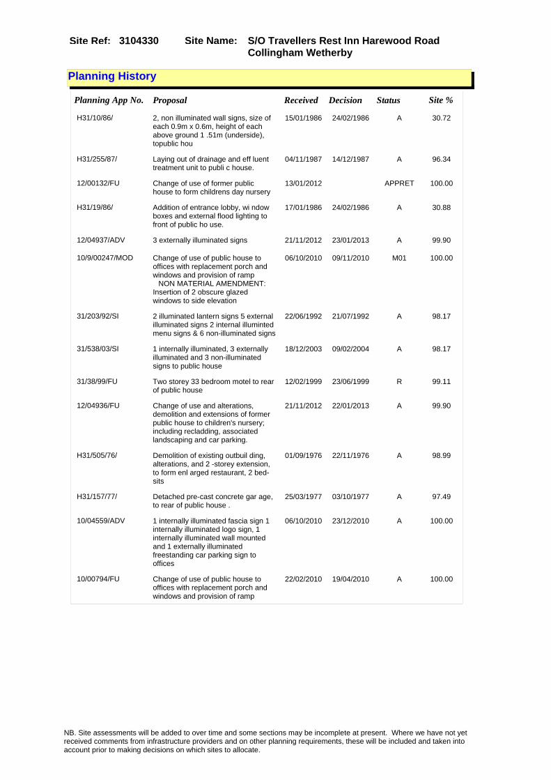
Site Name: S/O Travellers Rest Inn Harewood Road Collingham Wetherby
Site Ref: 3104330
Planning History
Planning App No. Proposal Received Decision Status Site %
H31/10/86/ 2, non illuminated wall signs, size of each 0.9m x 0.6m, height of each above ground 1 .51m (underside), topublic hou
15/01/1986 24/02/1986 A 30.72
H31/255/87/ Laying out of drainage and eff luent treatment unit to publi c house.
04/11/1987 14/12/1987 A 96.34
12/00132/FU Change of use of former public house to form childrens day nursery
13/01/2012 APPRET 100.00
H31/19/86/ Addition of entrance lobby, wi ndow boxes and external flood lighting to front of public ho use.
17/01/1986 24/02/1986 A 30.88
12/04937/ADV 3 externally illuminated signs 21/11/2012 23/01/2013 A 99.90
10/9/00247/MOD Change of use of public house to offices with replacement porch and windows and provision of ramp �NON MATERIAL AMENDMENT: Insertion of 2 obscure glazed windows to side elevation
06/10/2010 09/11/2010 M01 100.00
31/203/92/SI 2 illuminated lantern signs 5 external illuminated signs 2 internal illuminted menu signs & 6 non-illuminated signs
22/06/1992 21/07/1992 A 98.17
31/538/03/SI 1 internally illuminated, 3 externally illuminated and 3 non-illuminated signs to public house
18/12/2003 09/02/2004 A 98.17
31/38/99/FU Two storey 33 bedroom motel to rear of public house
12/02/1999 23/06/1999 R 99.11
12/04936/FU Change of use and alterations, demolition and extensions of former public house to children's nursery; including recladding, associated landscaping and car parking.
21/11/2012 22/01/2013 A 99.90
H31/505/76/ Demolition of existing outbuil ding, alterations, and 2 -storey extension, to form enl arged restaurant, 2 bed-sits
01/09/1976 22/11/1976 A 98.99
H31/157/77/ Detached pre-cast concrete gar age, to rear of public house .
25/03/1977 03/10/1977 A 97.49
10/04559/ADV 1 internally illuminated fascia sign 1 internally illuminated logo sign, 1 internally illuminated wall mounted and 1 externally illuminated freestanding car parking sign to offices
06/10/2010 23/12/2010 A 100.00
10/00794/FU Change of use of public house to offices with replacement porch and windows and provision of ramp
22/02/2010 19/04/2010 A 100.00
NB. Site assessments will be added to over time and some sections may be incomplete at present. Where we have not yet received comments from infrastructure providers and on other planning requirements, these will be included and taken into account prior to making decisions on which sites to allocate.

Site Name: S/O Travellers Rest Inn Harewood Road Collingham Wetherby
Site Ref: 3104330
Conformity with Core Strategy
Inner South Leeds: 0.00
Leeds Bradford Corridor: 0.00 West Leeds Gateway: 0.00
Aire Valley: 0.00Regeneration Priority Area:
Brownfield
Greenfield
Mixed
Main Urban Area
Major Settlement
Smaller Settlement
Villages/Rural
Main Urban Area Extension
Major Settlement Extension
Smaller Settlement Extension
Village/Rural Extension
Development unrelated to existing development
Green Belt assessment - only completed where site is within Green Belt
Would development lead to/constitute ribbon development?
Would development result in isolated development?
Is the site well connected to built up area (2+ boundaries with existing built up area)?
Would development of the site effectively "round off" the settlement pattern?:
Do natural/physical features provide a good existing barrier between existing urban area and undeveloped land?
Overall sprawl conclusion:
Would development of the site lead to physical connection of settlements?
Do natural/physical features provide a good existing barrier/boundary to contain development?
Overall Coalescence Conclusion:
Is there a strong defensible boundary between the site and the existing urban area?
Does the site provide access to the countryside?
Does the site include local or national conservation designated areas?
Does the site include areas of woodlands, trees, hedgerows that are protected, or significant unprotected tree/hedge cover?
Does the site include grade 1, 2, or 3a agricultural land?
Does the site contain buildings? Are these in agricultural use?
Overall countryside Encroachment Conclusion
Is the site within or adjacent to a conservation area, listed building or other historical feature?
If yes, could development preserve this character?:
Overall Character Preservation Conclusion:
Greenbelt Assessment Conclusion:
Check the unrestricted sprawl of large built up areas
Prevent neighbouring towns from merging
Assist in safeguarding countryside from encroachment
Preserve the setting and special character of historic towns
NB. Site assessments will be added to over time and some sections may be incomplete at present. Where we have not yet received comments from infrastructure providers and on other planning requirements, these will be included and taken into account prior to making decisions on which sites to allocate.

Site Name: S/O Travellers Rest Inn Harewood Road Collingham Wetherby
Site Ref: 3104330
SHLAA ConclusionsAvailability: Suitability: Achievability:
Conclusion of Assessment
Conclusion summary:
Current site with planning permission for employment purposes.
Floorspace sq m (Non residential): 430
Employment Conclusion: Lime Green
East Leeds
Assesment Type: Planning status Type: Office
Proposed Change:
Gypsy Traveller Site Assessment
Yes No Maybe Could site be effectively managed (Text)
Yes No Maybe Would gypsies and travellers live on the site?
(Text)
Yes No Proximity to housed gypsies and travellers (Text)
Yes No Unknown Experience of previous encampments (Text)
NB. Site assessments will be added to over time and some sections may be incomplete at present. Where we have not yet received comments from infrastructure providers and on other planning requirements, these will be included and taken into account prior to making decisions on which sites to allocate.

Site Name: Sweep Farm Boston Road Wetherby LS22 5 DX
Site Ref: 3104400
Site Details
Land Use
Northing: 446780
Easting: 440230
Distance to Rail Station (metres): 12949.59
Nearest Railway Station Cross Gates
Distance to bus stop (metres) 1017.88
Bus Stop ID 4869
Agricultural Land Class:
SFRA Flood Zone: 0.00
Environment Agency Flood Zone: 0.00
Within 300m of retail centre boundary:
UDP Designation
Greenbelt - N32 (%): 100.00 Urban Green Corridor - N8 (%): 0.00
Protected Area of Search site - N34 (%): 0.00 Rural Land - RL1: 0.00
City Centre Primary Shopping Quarter - CC27 (%): 0.00 Town Centre - S2: 0.00
Health and Safety Executive Hazard: No
Health and Safety Executive Gas Pipeline: No
Strategic Employment Buffer: 0.00
Area sq m: 3929.86 Ward Wetherby
Special Landscape Area - N37: 0.00
Allotments - N1A: 0.00
Proposed Greenspace - N5: 0.00
Protected Playing Pitch - N6: 0.00
Nature Conservation Area - N50: 0.00
Conservation Areas No
Ancient Monument/Battlefield(%): 0.00 Listed Buildings: No
Public Rights of Way: No
Other?:
Natural Resources and waste DPD (if applicable)
Within Minerals Safeguarding Site?: No Within 100m of Minerals Safeguarding Site?: No
HMCA: Outer North East
Greenspace - N1: 0
Existing Use 1:
Existing Use 2:
Existing Use 3:
Neighbouring Use 1
Neighbouring Use 2:
Neighbouring Use 3:
Other uses:
Topography:
Natural Landscape:
Boundaries:
Road Frontage
Site Characteristics
Site Detail
Other comments/observations on site characteristics:
Area Ha: 0.392986
Site State:
NB. Site assessments will be added to over time and some sections may be incomplete at present. Where we have not yet received comments from infrastructure providers and on other planning requirements, these will be included and taken into account prior to making decisions on which sites to allocate.

Site Name: Sweep Farm Boston Road Wetherby LS22 5 DX
Site Ref: 3104400
Planning History
NB. Site assessments will be added to over time and some sections may be incomplete at present. Where we have not yet received comments from infrastructure providers and on other planning requirements, these will be included and taken into account prior to making decisions on which sites to allocate.

Site Name: Sweep Farm Boston Road Wetherby LS22 5 DX
Site Ref: 3104400
Conformity with Core Strategy
Inner South Leeds: 0.00
Leeds Bradford Corridor: 0.00 West Leeds Gateway: 0.00
Aire Valley: 0.00Regeneration Priority Area:
Brownfield
Greenfield
Mixed
Main Urban Area
Major Settlement
Smaller Settlement
Villages/Rural
Main Urban Area Extension
Major Settlement Extension
Smaller Settlement Extension
Village/Rural Extension
Development unrelated to existing development
Green Belt assessment - only completed where site is within Green Belt
Would development lead to/constitute ribbon development?
Would development result in isolated development?
Is the site well connected to built up area (2+ boundaries with existing built up area)?
Would development of the site effectively "round off" the settlement pattern?:
Do natural/physical features provide a good existing barrier between existing urban area and undeveloped land?
Overall sprawl conclusion:
Would development of the site lead to physical connection of settlements?
Do natural/physical features provide a good existing barrier/boundary to contain development?
Overall Coalescence Conclusion:
Is there a strong defensible boundary between the site and the existing urban area?
Does the site provide access to the countryside?
Does the site include local or national conservation designated areas?
Does the site include areas of woodlands, trees, hedgerows that are protected, or significant unprotected tree/hedge cover?
Does the site include grade 1, 2, or 3a agricultural land?
Does the site contain buildings? Are these in agricultural use?
Overall countryside Encroachment Conclusion
Is the site within or adjacent to a conservation area, listed building or other historical feature?
If yes, could development preserve this character?:
Overall Character Preservation Conclusion:
Greenbelt Assessment Conclusion:
Check the unrestricted sprawl of large built up areas
Prevent neighbouring towns from merging
Assist in safeguarding countryside from encroachment
Preserve the setting and special character of historic towns
NB. Site assessments will be added to over time and some sections may be incomplete at present. Where we have not yet received comments from infrastructure providers and on other planning requirements, these will be included and taken into account prior to making decisions on which sites to allocate.

Site Name: Sweep Farm Boston Road Wetherby LS22 5 DX
Site Ref: 3104400
SHLAA ConclusionsAvailability: Suitability: Achievability:
Conclusion of Assessment
Conclusion summary:
Current site with planning permission for employment purposes.
Floorspace sq m (Non residential):
Employment Conclusion: Lime Green
East Leeds
Assesment Type: Planning status Type: Industrial & Warehousing
Proposed Change:
Gypsy Traveller Site Assessment
Yes No Maybe Could site be effectively managed (Text)
Yes No Maybe Would gypsies and travellers live on the site?
(Text)
Yes No Proximity to housed gypsies and travellers (Text)
Yes No Unknown Experience of previous encampments (Text)
NB. Site assessments will be added to over time and some sections may be incomplete at present. Where we have not yet received comments from infrastructure providers and on other planning requirements, these will be included and taken into account prior to making decisions on which sites to allocate.

Site Name: Land at Sandbeck Lane Wetherby LS23Site Ref: 3104420
Site Details
Land Use
Northing: 449726
Easting: 441308
Distance to Rail Station (metres): 16084.64
Nearest Railway Station Cross Gates
Distance to bus stop (metres) 805.01
Bus Stop ID 14188
Agricultural Land Class:
SFRA Flood Zone: 1.00
Environment Agency Flood Zone: 1.00
Within 300m of retail centre boundary:
UDP Designation
Greenbelt - N32 (%): 0.00 Urban Green Corridor - N8 (%): 0.00
Protected Area of Search site - N34 (%): 0.00 Rural Land - RL1: 99.87
City Centre Primary Shopping Quarter - CC27 (%): 0.00 Town Centre - S2: 0.00
Health and Safety Executive Hazard: No
Health and Safety Executive Gas Pipeline: No
Strategic Employment Buffer: 0.00
Area sq m: 5223.16 Ward Wetherby
Special Landscape Area - N37: 0.00
Allotments - N1A: 0.00
Proposed Greenspace - N5: 0.00
Protected Playing Pitch - N6: 0.00
Nature Conservation Area - N50: 0.00
Conservation Areas No
Ancient Monument/Battlefield(%): 0.00 Listed Buildings: Yes
Public Rights of Way: Yes
Other?:
Natural Resources and waste DPD (if applicable)
Within Minerals Safeguarding Site?: No Within 100m of Minerals Safeguarding Site?: No
HMCA: Outer North East
Greenspace - N1: 0
Existing Use 1:
Existing Use 2:
Existing Use 3:
Neighbouring Use 1
Neighbouring Use 2:
Neighbouring Use 3:
Other uses:
Topography:
Natural Landscape:
Boundaries:
Road Frontage
Site Characteristics
Site Detail
Other comments/observations on site characteristics:
Area Ha: 0.522316
Site State:
NB. Site assessments will be added to over time and some sections may be incomplete at present. Where we have not yet received comments from infrastructure providers and on other planning requirements, these will be included and taken into account prior to making decisions on which sites to allocate.

Site Name: Land at Sandbeck Lane Wetherby LS23Site Ref: 3104420
Planning History
Planning App No. Proposal Received Decision Status Site %
31/151/95/FU Block of 4 workshops 31/05/1995 19/11/1998 R 30.30
11/02020/COND Consent, agreement or approval required by conditions 3, 6, 9, 11, 12 and 17 of Planning Application 10/03298/FU
13/05/2011 28/07/2011 SPL 100.00
31/359/98/CLU Certificate of lawfulness for use as transport depot
18/11/1998 23/11/1999 A 65.26
07/02255/OT Outline application to erect B1 offices 05/04/2007 28/09/2007 W 71.26
31/29/05/FU Demolition of former stable block and erection of detcahed block of 4 vehicle repair workshops
13/01/2005 24/03/2005 R 30.30
10/03298/FU Detached warehouse including laying out of car park and vehicular access
16/07/2010 04/11/2010 A 100.00
12/02928/COND Consent, agreement or approval required by conditions 4, 6, 9, 10, 11, 12, 15, 16 and 17 of Planning Application 10/03298/FU
03/07/2012 22/02/2013 SPL 100.00
08/03928/OT Outline application to erect B1 offices 30/06/2008 15/10/2008 R 71.26
NB. Site assessments will be added to over time and some sections may be incomplete at present. Where we have not yet received comments from infrastructure providers and on other planning requirements, these will be included and taken into account prior to making decisions on which sites to allocate.

Site Name: Land at Sandbeck Lane Wetherby LS23Site Ref: 3104420
Conformity with Core Strategy
Inner South Leeds: 0.00
Leeds Bradford Corridor: 0.00 West Leeds Gateway: 0.00
Aire Valley: 0.00Regeneration Priority Area:
Brownfield
Greenfield
Mixed
Main Urban Area
Major Settlement
Smaller Settlement
Villages/Rural
Main Urban Area Extension
Major Settlement Extension
Smaller Settlement Extension
Village/Rural Extension
Development unrelated to existing development
Green Belt assessment - only completed where site is within Green Belt
Would development lead to/constitute ribbon development?
Would development result in isolated development?
Is the site well connected to built up area (2+ boundaries with existing built up area)?
Would development of the site effectively "round off" the settlement pattern?:
Do natural/physical features provide a good existing barrier between existing urban area and undeveloped land?
Overall sprawl conclusion:
Would development of the site lead to physical connection of settlements?
Do natural/physical features provide a good existing barrier/boundary to contain development?
Overall Coalescence Conclusion:
Is there a strong defensible boundary between the site and the existing urban area?
Does the site provide access to the countryside?
Does the site include local or national conservation designated areas?
Does the site include areas of woodlands, trees, hedgerows that are protected, or significant unprotected tree/hedge cover?
Does the site include grade 1, 2, or 3a agricultural land?
Does the site contain buildings? Are these in agricultural use?
Overall countryside Encroachment Conclusion
Is the site within or adjacent to a conservation area, listed building or other historical feature?
If yes, could development preserve this character?:
Overall Character Preservation Conclusion:
Greenbelt Assessment Conclusion:
Check the unrestricted sprawl of large built up areas
Prevent neighbouring towns from merging
Assist in safeguarding countryside from encroachment
Preserve the setting and special character of historic towns
NB. Site assessments will be added to over time and some sections may be incomplete at present. Where we have not yet received comments from infrastructure providers and on other planning requirements, these will be included and taken into account prior to making decisions on which sites to allocate.

Site Name: Land at Sandbeck Lane Wetherby LS23Site Ref: 3104420
SHLAA ConclusionsAvailability: Suitability: Achievability:
Conclusion of Assessment
Conclusion summary:
Current site with planning permission for employment purposes
Floorspace sq m (Non residential):
Employment Conclusion: Lime Green
East Leeds
Assesment Type: Planning status Type: Industrial & Warehousing
Proposed Change:
Gypsy Traveller Site Assessment
Yes No Maybe Could site be effectively managed (Text)
Yes No Maybe Would gypsies and travellers live on the site?
(Text)
Yes No Proximity to housed gypsies and travellers (Text)
Yes No Unknown Experience of previous encampments (Text)
NB. Site assessments will be added to over time and some sections may be incomplete at present. Where we have not yet received comments from infrastructure providers and on other planning requirements, these will be included and taken into account prior to making decisions on which sites to allocate.

Site Name: Manston La Sandleas Way LS15 Site Ref: 3200011
Site Details
Land Use
Northing: 434882
Easting: 437511
Distance to Rail Station (metres): 1301.97
Nearest Railway Station Cross Gates
Distance to bus stop (metres) 52.75
Bus Stop ID 7145
Agricultural Land Class:
SFRA Flood Zone: 0.00
Environment Agency Flood Zone: 0.00
Within 300m of retail centre boundary:
UDP Designation
Greenbelt - N32 (%): 0.00 Urban Green Corridor - N8 (%): 0.00
Protected Area of Search site - N34 (%): 0.00 Rural Land - RL1: 0.00
City Centre Primary Shopping Quarter - CC27 (%): 0.00 Town Centre - S2: 0.00
Health and Safety Executive Hazard: No
Health and Safety Executive Gas Pipeline: No
Strategic Employment Buffer: 0.00
Area sq m: 9575.91 Ward ss Gates and Whinmoor
Special Landscape Area - N37: 0.00
Allotments - N1A: 0.00
Proposed Greenspace - N5: 0.00
Protected Playing Pitch - N6: 0.00
Nature Conservation Area - N50: 0.00
Conservation Areas No
Ancient Monument/Battlefield(%): 0.00 Listed Buildings: No
Public Rights of Way: No
Other?:
Natural Resources and waste DPD (if applicable)
Within Minerals Safeguarding Site?: No Within 100m of Minerals Safeguarding Site?: No
HMCA: East Leeds
Greenspace - N1: 0
Existing Use 1:
Existing Use 2:
Existing Use 3:
Neighbouring Use 1
Neighbouring Use 2:
Neighbouring Use 3:
Other uses:
Topography:
Natural Landscape:
Boundaries:
Road Frontage
Site Characteristics
Site Detail
Other comments/observations on site characteristics:
Area Ha: 0.957591
Site State:
NB. Site assessments will be added to over time and some sections may be incomplete at present. Where we have not yet received comments from infrastructure providers and on other planning requirements, these will be included and taken into account prior to making decisions on which sites to allocate.

Site Name: Manston La Sandleas Way LS15 Site Ref: 3200011
Planning History
Planning App No. Proposal Received Decision Status Site %
H32/889/76/ Renewal of outline application to erect 132kv sub stati on, to vacant site. (outline a pplication no. 0bb481 exp
01/11/1976 13/12/1976 A 94.82
32/338/92/FU Removal of conditions 9 and 11 of application no.32/265/92/fu (hours of operation)
25/11/1992 05/01/1993 A 99.73
32/264/94/FU Recladding of existing building to ice cream factory
30/11/1994 05/01/1995 A 99.73
32/224/94/FU Laying out of vehicular hard standing 28/09/1994 06/07/1995 A 99.73
32/106/95/FU Side and front extension to factory 19/05/1995 05/09/1995 A 99.91
32/72/95/FU Change of use and external alterations of part of factory to trade counter
05/04/1995 22/05/1995 A 99.91
32/202/98/FU First floor canteen extension to rear of factory
21/08/1998 14/10/1998 A 99.91
32/231/92/FU Single storey extension 31/07/1992 25/09/1992 A 99.73
32/318/92/FU Detached hut and detached prefabricated office unit
30/10/1992 05/01/1993 A 99.73
32/265/92/FU Laying out of access and change of use of training centre to manufacturing, warehouse and workshop
08/09/1992 10/11/1992 A 99.72
32/227/92/FU Vehicular access and detached gatehouse
31/07/1992 04/11/1992 A 99.73
07/9/00353/MOD Extension to warehouse and laying out of secure floodlights to trailer park and depot�NON MATERIAL AMENDMENT: Lorry wash area re-located, security hut removed
12/07/2007 21/08/2007 M01 98.96
32/2/94/FU 2.5m high fence and detached gatehouse to ice cream manufacturers
05/01/1994 25/03/1994 A 99.73
32/103/93/FU Single storey front extension to offices
19/05/1993 10/06/1993 A 99.73
32/160/93/FU Extension to form engine room to works
18/06/1993 15/03/1994 A 99.73
09/04909/COND Consent, agreement or approval required by conditions 3, 4, 9, 11, 14, 16 and 17 of Planning Application 32/141/05/FU
12/11/2009 PCO 98.96
32/141/05/FU Extension to warehouse and laying out of secure floodlights to trailer park and depot
15/03/2005 22/06/2005 A 98.96
10/9/00074/MOD Extension to warehouse and laying out of secure floodlights to trailer park and depot�NON MATERIAL AMENDMENT: Amendments to elevational treatment of warehouse office refurbishment. Amendments to parking layout and access arrangements.
01/04/2010 23/04/2010 M01 98.96
32/43/94/DN Determination to demolish two dwellings
25/02/1994 07/04/1994 PD 99.73
NB. Site assessments will be added to over time and some sections may be incomplete at present. Where we have not yet received comments from infrastructure providers and on other planning requirements, these will be included and taken into account prior to making decisions on which sites to allocate.
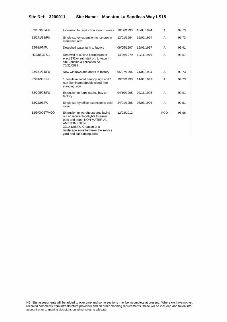
Site Name: Manston La Sandleas Way LS15 Site Ref: 3200011
32/159/93/FU Extension to production area to works 18/06/1993 18/03/1994 A 99.73
32/271/93/FU Single storey extension to ice cream manufacturers
12/01/1994 16/02/1994 A 99.73
32/91/97/FU Detached water tank to factory 09/05/1997 19/06/1997 A 99.91
H32/889/76/1 Renewal of outline permission to erect 132kv sub stati on, to vacant site. (outline a pplication no. 76/32/0088
14/09/1979 12/11/1979 A 98.67
32/151/94/FU New windows and doors to factory 05/07/1994 24/08/1994 A 99.73
32/91/93/SN 1 non illuminated canopy sign and 1 non illuminated double sided free standing sign
19/05/1993 14/06/1993 A 99.73
32/205/95/FU Extension to form loading bay to factory
04/10/1995 02/11/1995 A 99.91
32/22/96/FU Single storey office extension to cold store
24/01/1996 05/03/1996 A 99.91
12/9/00067/MOD Extension to warehouse and laying out of secure floodlights to trailer park and depot NON MATERIAL AMENDMENT to 32/141/05/FU:Creation of a landscape zone between the service yard and car parking area
12/03/2012 PCO 98.96
NB. Site assessments will be added to over time and some sections may be incomplete at present. Where we have not yet received comments from infrastructure providers and on other planning requirements, these will be included and taken into account prior to making decisions on which sites to allocate.

Site Name: Manston La Sandleas Way LS15 Site Ref: 3200011
Conformity with Core Strategy
Inner South Leeds: 0.00
Leeds Bradford Corridor: 0.00 West Leeds Gateway: 0.00
Aire Valley: 0.00Regeneration Priority Area:
Brownfield
Greenfield
Mixed
Main Urban Area
Major Settlement
Smaller Settlement
Villages/Rural
Main Urban Area Extension
Major Settlement Extension
Smaller Settlement Extension
Village/Rural Extension
Development unrelated to existing development
Green Belt assessment - only completed where site is within Green Belt
Would development lead to/constitute ribbon development?
Would development result in isolated development?
Is the site well connected to built up area (2+ boundaries with existing built up area)?
Would development of the site effectively "round off" the settlement pattern?:
Do natural/physical features provide a good existing barrier between existing urban area and undeveloped land?
Overall sprawl conclusion:
Would development of the site lead to physical connection of settlements?
Do natural/physical features provide a good existing barrier/boundary to contain development?
Overall Coalescence Conclusion:
Is there a strong defensible boundary between the site and the existing urban area?
Does the site provide access to the countryside?
Does the site include local or national conservation designated areas?
Does the site include areas of woodlands, trees, hedgerows that are protected, or significant unprotected tree/hedge cover?
Does the site include grade 1, 2, or 3a agricultural land?
Does the site contain buildings? Are these in agricultural use?
Overall countryside Encroachment Conclusion
Is the site within or adjacent to a conservation area, listed building or other historical feature?
If yes, could development preserve this character?:
Overall Character Preservation Conclusion:
Greenbelt Assessment Conclusion:
Check the unrestricted sprawl of large built up areas
Prevent neighbouring towns from merging
Assist in safeguarding countryside from encroachment
Preserve the setting and special character of historic towns
NB. Site assessments will be added to over time and some sections may be incomplete at present. Where we have not yet received comments from infrastructure providers and on other planning requirements, these will be included and taken into account prior to making decisions on which sites to allocate.

Site Name: Manston La Sandleas Way LS15 Site Ref: 3200011
SHLAA ConclusionsAvailability: Suitability: Achievability:
Conclusion of Assessment
Conclusion summary:
Site is currently in use for HGV storage or similar in connection to adjacent user. Accessible site within an employment area.
Floorspace sq m (Non residential):
Employment Conclusion: Lime Green
East Leeds
Assesment Type: ELR Type: Industrial & Warehousing
Proposed Change:
Gypsy Traveller Site Assessment
Yes No Maybe Could site be effectively managed (Text)
Yes No Maybe Would gypsies and travellers live on the site?
(Text)
Yes No Proximity to housed gypsies and travellers (Text)
Yes No Unknown Experience of previous encampments (Text)
NB. Site assessments will be added to over time and some sections may be incomplete at present. Where we have not yet received comments from infrastructure providers and on other planning requirements, these will be included and taken into account prior to making decisions on which sites to allocate.

Site Name: Coal Road Seacroft LS 14Site Ref: 3202740
Site Details
Land Use
Northing: 437189
Easting: 435632
Distance to Rail Station (metres): 2819.07
Nearest Railway Station Cross Gates
Distance to bus stop (metres) 69.29
Bus Stop ID 10232
Agricultural Land Class:
SFRA Flood Zone: 0.00
Environment Agency Flood Zone: 0.00
Within 300m of retail centre boundary:
UDP Designation
Greenbelt - N32 (%): 0.00 Urban Green Corridor - N8 (%): 0.00
Protected Area of Search site - N34 (%): 0.00 Rural Land - RL1: 0.00
City Centre Primary Shopping Quarter - CC27 (%): 0.00 Town Centre - S2: 0.00
Health and Safety Executive Hazard: Yes
Health and Safety Executive Gas Pipeline: No
Strategic Employment Buffer: 0.00
Area sq m: 36532.69 Ward ss Gates and Whinmoor
Special Landscape Area - N37: 0.00
Allotments - N1A: 0.00
Proposed Greenspace - N5: 0.00
Protected Playing Pitch - N6: 0.00
Nature Conservation Area - N50: 0.00
Conservation Areas No
Ancient Monument/Battlefield(%): 0.00 Listed Buildings: No
Public Rights of Way: No
Other?:
Natural Resources and waste DPD (if applicable)
Within Minerals Safeguarding Site?: No Within 100m of Minerals Safeguarding Site?: Yes
HMCA: East Leeds
Greenspace - N1: 0
Existing Use 1:
Existing Use 2:
Existing Use 3:
Neighbouring Use 1
Neighbouring Use 2:
Neighbouring Use 3:
Other uses:
Topography:
Natural Landscape:
Boundaries:
Road Frontage
Site Characteristics
Site Detail
Other comments/observations on site characteristics:
Area Ha: 3.653269
Site State:
NB. Site assessments will be added to over time and some sections may be incomplete at present. Where we have not yet received comments from infrastructure providers and on other planning requirements, these will be included and taken into account prior to making decisions on which sites to allocate.

Site Name: Coal Road Seacroft LS 14Site Ref: 3202740
Planning History
Planning App No. Proposal Received Decision Status Site %
H32/398/83/1 Renewal of outline permission to erect premises for themanuf acture, packaging and ancillar y storage of toilet preparatio
19/01/1987 23/02/1987 A 98.03
32/244/93/OT Outline application to erect non-food retail development and restaurant
26/10/1993 17/12/1993 R 99.99
H32/92/80/ Outline application to erect s quash club, with 48 car p arking spaces, to vacant site. (site area 1.05ha).
28/01/1980 24/03/1980 A 28.72
07/02204/OT Removal of condition 8 and variation of conditions 21, 26, 36, 37, 38 of approval 06/05664/OT for business units (B1) and car dealerships, including laying out of access, car parking, landscaping and highway works
03/04/2007 15/06/2007 A 99.99
12/02505/COND Consent, agreement or approval required by conditions 2, 3, 15, 16, 17 and 21 of Planning Application 11/00319/FU
01/06/2012 20/09/2012 W 31.39
11/00319/FU Detached DIY store with associated car parking, landscaping and laying out of access road
26/01/2011 07/10/2011 A 31.39
32/67/93/FU Laying out of access and erection of 6 non-food retail units and restaurant with car parking
15/03/1993 21/07/1994 R 99.81
06/03385/OT Outline application to erect business units (B1) and car dealerships including laying out of access, car parking, landscaping and highway works
01/06/2006 31/08/2006 R 99.99
H32/583/80/ Amendment to previous outline application to erect squas h club with car park, to vacan t site. (site area
03/07/1980 11/08/1980 A 16.53
H32/398/83/ Outline application to erect p remises for the manuf acture, packaging and ancillar y storage of toilet preparatio
12/12/1983 09/04/1984 A 99.81
32/216/98/OT Outline application to layout access and erect 16 business units and restaurant
24/09/1998 25/04/2001 W 99.99
06/05664/OT 0utline application to erect business units (B1) and car dealerships, including laying out of access, car parking, landscaping and highway works
19/09/2006 08/01/2007 A 99.99
12/02689/COND Consent, agreement or approval required by conditions 19, 22 and 23 of Planning Application 11/00319/FU
18/06/2012 20/09/2012 W 31.39
32/80/95/OT Outline application to erect light industrial and/or storage and warehousing
19/04/1995 05/09/1996 W 99.99
11/00318/OT Laying out of access road and erect private hospital and B1, B2 and B8 units.
26/01/2011 07/10/2011 A 74.55
NB. Site assessments will be added to over time and some sections may be incomplete at present. Where we have not yet received comments from infrastructure providers and on other planning requirements, these will be included and taken into account prior to making decisions on which sites to allocate.
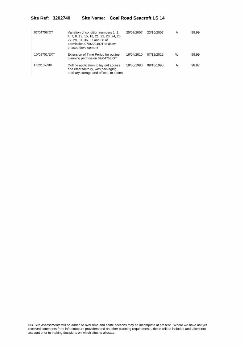
Site Name: Coal Road Seacroft LS 14Site Ref: 3202740
07/04758/OT Variation of condition numbers 1, 2, 4, 7, 8, 13, 15, 18, 21, 22, 23, 24, 25, 27, 29, 31, 36, 37 and 38 of permission 07/02204/OT to allow phased development
25/07/2007 23/10/2007 A 99.99
10/01751/EXT Extension of Time Period for outline planning permission 07/04758/OT
16/04/2010 07/12/2012 W 99.99
H32/187/90/ Outline application to lay out access and erect facto ry, with packaging, ancillary storage and offices, to sports
18/06/1990 09/10/1990 A 98.87
NB. Site assessments will be added to over time and some sections may be incomplete at present. Where we have not yet received comments from infrastructure providers and on other planning requirements, these will be included and taken into account prior to making decisions on which sites to allocate.

Site Name: Coal Road Seacroft LS 14Site Ref: 3202740
Conformity with Core Strategy
Inner South Leeds: 0.00
Leeds Bradford Corridor: 0.00 West Leeds Gateway: 0.00
Aire Valley: 0.00Regeneration Priority Area:
Brownfield
Greenfield
Mixed
Main Urban Area
Major Settlement
Smaller Settlement
Villages/Rural
Main Urban Area Extension
Major Settlement Extension
Smaller Settlement Extension
Village/Rural Extension
Development unrelated to existing development
Green Belt assessment - only completed where site is within Green Belt
Would development lead to/constitute ribbon development?
Would development result in isolated development?
Is the site well connected to built up area (2+ boundaries with existing built up area)?
Would development of the site effectively "round off" the settlement pattern?:
Do natural/physical features provide a good existing barrier between existing urban area and undeveloped land?
Overall sprawl conclusion:
Would development of the site lead to physical connection of settlements?
Do natural/physical features provide a good existing barrier/boundary to contain development?
Overall Coalescence Conclusion:
Is there a strong defensible boundary between the site and the existing urban area?
Does the site provide access to the countryside?
Does the site include local or national conservation designated areas?
Does the site include areas of woodlands, trees, hedgerows that are protected, or significant unprotected tree/hedge cover?
Does the site include grade 1, 2, or 3a agricultural land?
Does the site contain buildings? Are these in agricultural use?
Overall countryside Encroachment Conclusion
Is the site within or adjacent to a conservation area, listed building or other historical feature?
If yes, could development preserve this character?:
Overall Character Preservation Conclusion:
Greenbelt Assessment Conclusion:
Check the unrestricted sprawl of large built up areas
Prevent neighbouring towns from merging
Assist in safeguarding countryside from encroachment
Preserve the setting and special character of historic towns
NB. Site assessments will be added to over time and some sections may be incomplete at present. Where we have not yet received comments from infrastructure providers and on other planning requirements, these will be included and taken into account prior to making decisions on which sites to allocate.

Site Name: Coal Road Seacroft LS 14Site Ref: 3202740
SHLAA ConclusionsAvailability: Suitability: Achievability:
Conclusion of Assessment
Conclusion summary:
Scores well for employment use but permission granted for part employment part car dealership.
Floorspace sq m (Non residential): 11510
Employment Conclusion: Lime Green
East Leeds
Assesment Type: ELR Type: Office
Proposed Change:
Gypsy Traveller Site Assessment
Yes No Maybe Could site be effectively managed (Text)
Yes No Maybe Would gypsies and travellers live on the site?
(Text)
Yes No Proximity to housed gypsies and travellers (Text)
Yes No Unknown Experience of previous encampments (Text)
NB. Site assessments will be added to over time and some sections may be incomplete at present. Where we have not yet received comments from infrastructure providers and on other planning requirements, these will be included and taken into account prior to making decisions on which sites to allocate.

Site Name: Thorpe Park Selby Road LS15Site Ref: 3203100
Site Details
Land Use
Northing: 434078
Easting: 437977
Distance to Rail Station (metres): 1733.11
Nearest Railway Station Cross Gates
Distance to bus stop (metres) 435.01
Bus Stop ID 9907
Agricultural Land Class:
SFRA Flood Zone: 0.00
Environment Agency Flood Zone: 0.00
Within 300m of retail centre boundary:
UDP Designation
Greenbelt - N32 (%): 1.64 Urban Green Corridor - N8 (%): 0.00
Protected Area of Search site - N34 (%): 0.00 Rural Land - RL1: 0.00
City Centre Primary Shopping Quarter - CC27 (%): 0.00 Town Centre - S2: 0.00
Health and Safety Executive Hazard: No
Health and Safety Executive Gas Pipeline: Yes
Strategic Employment Buffer: 100.00
Area sq m: 346670.75 Ward Temple Newsam
Special Landscape Area - N37: 0.00
Allotments - N1A: 0.00
Proposed Greenspace - N5: 1.94
Protected Playing Pitch - N6: 0.00
Nature Conservation Area - N50: 0.00
Conservation Areas No
Ancient Monument/Battlefield(%): 0.00 Listed Buildings: Yes
Public Rights of Way: Yes
Other?:
Natural Resources and waste DPD (if applicable)
Within Minerals Safeguarding Site?: No Within 100m of Minerals Safeguarding Site?: No
HMCA: East Leeds
Greenspace - N1: 0
Existing Use 1:
Existing Use 2:
Existing Use 3:
Neighbouring Use 1
Neighbouring Use 2:
Neighbouring Use 3:
Other uses:
Topography:
Natural Landscape:
Boundaries:
Road Frontage
Site Characteristics
Site Detail
Other comments/observations on site characteristics:
Area Ha: 34.667075
Site State:
NB. Site assessments will be added to over time and some sections may be incomplete at present. Where we have not yet received comments from infrastructure providers and on other planning requirements, these will be included and taken into account prior to making decisions on which sites to allocate.

Site Name: Thorpe Park Selby Road LS15Site Ref: 3203100
Planning History
Planning App No. Proposal Received Decision Status Site %
PREAPP/06/00221 Revised master plan for Thorpe Park 01/11/2006 PCO 84.97
12/03887/FU Detailed Application for the Manston Lane Link Road (North - South Route)
10/09/2012 PCO 22.40
32/355/01/RM Laying out of new access and roundabout diverting footpaths and bridleway and construction of cycleway/footpath -option 1
01/11/2001 22/01/2002 A 12.50
32/199/94/OT Outline application to layout business park green park and access roads
08/09/1994 04/10/1995 A 99.64
32/356/01/RM Laying out of new access and roundabout diverting footpaths and bridleway and construction of cycleway/footpath-option 2
02/11/2001 22/01/2002 A 16.39
32/140/96/FU Variation of condition no 21 of application no 32/199/94/0t (total floor area increased from 111500 sqm to 167220 sqm)
01/07/1996 31/03/2004 A 98.38
32/269/94/FU Extraction of coal by opencast mining 09/12/1994 26/05/1995 R 58.69
32/124/94/FU Extraction of coal by opencast mining m
07/05/1994 26/05/1995 R 59.58
12/03886/OT Outline Planning Application for mixed use development comprising offices (business park) (B1A), (B) and (C), retail and bar/restaurant (A1, A2, A3, A4 and A5), hotel (C1), leisure facilities (D1, D2), multi-storey car park, together with internal roads, car parking, landscaping and drainage.
10/09/2012 PCO 98.96
32/148/05/FU Variation of condition no.9 of permission ref 32/140/96/fu (completion of access roads related to gross floor area)
22/03/2005 13/05/2005 A 98.38
32/156/05/RM Phase 6 infrastructure planting to access road and roundabout and landscaping adjacent plots 5100 to 5500
07/04/2005 15/02/2007 W 31.55
32/44/05/FU Variation of condition no 17 of permission 32/140/96/fu (foul & surface water drainage)
27/01/2005 15/04/2005 A 99.64
32/130/97/FU Variation of conditions nos 17 and 19 of application number 32/199/94/o t (access arrangement and floor area)
23/06/1997 04/01/1999 A 98.38
NB. Site assessments will be added to over time and some sections may be incomplete at present. Where we have not yet received comments from infrastructure providers and on other planning requirements, these will be included and taken into account prior to making decisions on which sites to allocate.

Site Name: Thorpe Park Selby Road LS15Site Ref: 3203100
Conformity with Core Strategy
Inner South Leeds: 0.00
Leeds Bradford Corridor: 0.00 West Leeds Gateway: 0.00
Aire Valley: 0.00Regeneration Priority Area:
Brownfield
Greenfield
Mixed
Main Urban Area
Major Settlement
Smaller Settlement
Villages/Rural
Main Urban Area Extension
Major Settlement Extension
Smaller Settlement Extension
Village/Rural Extension
Development unrelated to existing development
Green Belt assessment - only completed where site is within Green Belt
Would development lead to/constitute ribbon development?
Would development result in isolated development?
Is the site well connected to built up area (2+ boundaries with existing built up area)?
Would development of the site effectively "round off" the settlement pattern?:
Do natural/physical features provide a good existing barrier between existing urban area and undeveloped land?
Overall sprawl conclusion:
Would development of the site lead to physical connection of settlements?
Do natural/physical features provide a good existing barrier/boundary to contain development?
Overall Coalescence Conclusion:
Is there a strong defensible boundary between the site and the existing urban area?
Does the site provide access to the countryside?
Does the site include local or national conservation designated areas?
Does the site include areas of woodlands, trees, hedgerows that are protected, or significant unprotected tree/hedge cover?
Does the site include grade 1, 2, or 3a agricultural land?
Does the site contain buildings? Are these in agricultural use?
Overall countryside Encroachment Conclusion
Is the site within or adjacent to a conservation area, listed building or other historical feature?
If yes, could development preserve this character?:
Overall Character Preservation Conclusion:
Greenbelt Assessment Conclusion:
Check the unrestricted sprawl of large built up areas
Prevent neighbouring towns from merging
Assist in safeguarding countryside from encroachment
Preserve the setting and special character of historic towns
NB. Site assessments will be added to over time and some sections may be incomplete at present. Where we have not yet received comments from infrastructure providers and on other planning requirements, these will be included and taken into account prior to making decisions on which sites to allocate.

Site Name: Thorpe Park Selby Road LS15Site Ref: 3203100
SHLAA ConclusionsAvailability: Suitability: Achievability:
Conclusion of Assessment
Conclusion summary:
A good employment site which benefits from an outline planning permission. M1 junction to be upgraded.
Floorspace sq m (Non residential): 104240
Employment Conclusion: Lime Green
East Leeds
Assesment Type: ELR Type: Office
Proposed Change:
Gypsy Traveller Site Assessment
Yes No Maybe Could site be effectively managed (Text)
Yes No Maybe Would gypsies and travellers live on the site?
(Text)
Yes No Proximity to housed gypsies and travellers (Text)
Yes No Unknown Experience of previous encampments (Text)
NB. Site assessments will be added to over time and some sections may be incomplete at present. Where we have not yet received comments from infrastructure providers and on other planning requirements, these will be included and taken into account prior to making decisions on which sites to allocate.

Site Name: Colton Mill Bullerthorpe Lane LS15Site Ref: 3203123
Site Details
Land Use
Northing: 433006
Easting: 437629
Distance to Rail Station (metres): 1971.27
Nearest Railway Station Cross Gates
Distance to bus stop (metres) 110.02
Bus Stop ID 3752
Agricultural Land Class:
SFRA Flood Zone: 0.00
Environment Agency Flood Zone: 0.00
Within 300m of retail centre boundary:
UDP Designation
Greenbelt - N32 (%): 0.00 Urban Green Corridor - N8 (%): 0.00
Protected Area of Search site - N34 (%): 0.00 Rural Land - RL1: 0.00
City Centre Primary Shopping Quarter - CC27 (%): 0.00 Town Centre - S2: 0.00
Health and Safety Executive Hazard: No
Health and Safety Executive Gas Pipeline: Yes
Strategic Employment Buffer: 0.00
Area sq m: 1314.48 Ward Temple Newsam
Special Landscape Area - N37: 0.00
Allotments - N1A: 0.00
Proposed Greenspace - N5: 0.00
Protected Playing Pitch - N6: 0.00
Nature Conservation Area - N50: 0.00
Conservation Areas No
Ancient Monument/Battlefield(%): 0.00 Listed Buildings: No
Public Rights of Way: No
Other?:
Natural Resources and waste DPD (if applicable)
Within Minerals Safeguarding Site?: No Within 100m of Minerals Safeguarding Site?: No
HMCA: East Leeds
Greenspace - N1: 0
Existing Use 1:
Existing Use 2:
Existing Use 3:
Neighbouring Use 1
Neighbouring Use 2:
Neighbouring Use 3:
Other uses:
Topography:
Natural Landscape:
Boundaries:
Road Frontage
Site Characteristics
Site Detail
Other comments/observations on site characteristics:
Area Ha: 0.131448
Site State:
NB. Site assessments will be added to over time and some sections may be incomplete at present. Where we have not yet received comments from infrastructure providers and on other planning requirements, these will be included and taken into account prior to making decisions on which sites to allocate.

Site Name: Colton Mill Bullerthorpe Lane LS15Site Ref: 3203123
Planning History
Planning App No. Proposal Received Decision Status Site %
H32/10/86/ Outline application to erect r esidential development, publi c house, hotel and restaurant to vacant site. (this item
16/01/1986 18/07/1986 W 99.12
09/05179/FU Detached two storey outbuilding comprising garage and annexe accommodation
27/11/2009 20/01/2010 A 87.45
32/284/99/OT Outline application to erect restaurants hotel offices public house creche and medical centre
24/12/1999 19/07/2002 A 100.00
0-32/7/04/MOD Outline application to erect restaurants hotel offices public house creche and medical centre
27/02/2004 26/03/2004 M01 100.00
06/00768/FU Change of use and alterations of vacant mill to five bedroom dwelling
08/02/2006 19/05/2006 A 92.04
06/9/00364/MOD Change of use and alterations of vacant mill to five bedroom dwelling�NON MATERIAL AMENDMENT: Replacement of window on level two with door
13/07/2006 03/08/2006 M01 92.04
06/9/00231/MOD 1 three storey office block and 2 two storey office blocks with car parking�NON MATERIAL AMENDMENT:Glazed enterence lobby added to unit 4
10/05/2006 03/08/2006 M01 14.10
32/365/01/RM 3 storey 60 bedroom hotel three drive thru restaurants creche and part two part single storey medical centre
09/11/2001 19/07/2002 A 100.00
32/70/03/SI 2 internally illuminated individual letter signs and 2 internally illuminated wall signs to travel lodge
14/02/2003 21/03/2003 A 99.39
06/00770/LI Listed Building Application for alterations of vacant mill to five bedroom dwelling house
08/02/2006 19/05/2006 A 92.04
0-32/4/04/MOD Outline application to erect restaurants hotel offices public house creche and medical centre
28/01/2004 05/02/2004 M01 100.00
09/04217/FU Detached two storey outbuilding comprising garage and annex accommodation
25/09/2009 24/11/2009 W 87.55
32/406/05/RM 1 three storey office block and 2 two storey office blocks with car parking
26/09/2005 13/04/2006 A 14.10
NB. Site assessments will be added to over time and some sections may be incomplete at present. Where we have not yet received comments from infrastructure providers and on other planning requirements, these will be included and taken into account prior to making decisions on which sites to allocate.

Site Name: Colton Mill Bullerthorpe Lane LS15Site Ref: 3203123
Conformity with Core Strategy
Inner South Leeds: 0.00
Leeds Bradford Corridor: 0.00 West Leeds Gateway: 0.00
Aire Valley: 0.00Regeneration Priority Area:
Brownfield
Greenfield
Mixed
Main Urban Area
Major Settlement
Smaller Settlement
Villages/Rural
Main Urban Area Extension
Major Settlement Extension
Smaller Settlement Extension
Village/Rural Extension
Development unrelated to existing development
Green Belt assessment - only completed where site is within Green Belt
Would development lead to/constitute ribbon development?
Would development result in isolated development?
Is the site well connected to built up area (2+ boundaries with existing built up area)?
Would development of the site effectively "round off" the settlement pattern?:
Do natural/physical features provide a good existing barrier between existing urban area and undeveloped land?
Overall sprawl conclusion:
Would development of the site lead to physical connection of settlements?
Do natural/physical features provide a good existing barrier/boundary to contain development?
Overall Coalescence Conclusion:
Is there a strong defensible boundary between the site and the existing urban area?
Does the site provide access to the countryside?
Does the site include local or national conservation designated areas?
Does the site include areas of woodlands, trees, hedgerows that are protected, or significant unprotected tree/hedge cover?
Does the site include grade 1, 2, or 3a agricultural land?
Does the site contain buildings? Are these in agricultural use?
Overall countryside Encroachment Conclusion
Is the site within or adjacent to a conservation area, listed building or other historical feature?
If yes, could development preserve this character?:
Overall Character Preservation Conclusion:
Greenbelt Assessment Conclusion:
Check the unrestricted sprawl of large built up areas
Prevent neighbouring towns from merging
Assist in safeguarding countryside from encroachment
Preserve the setting and special character of historic towns
NB. Site assessments will be added to over time and some sections may be incomplete at present. Where we have not yet received comments from infrastructure providers and on other planning requirements, these will be included and taken into account prior to making decisions on which sites to allocate.

Site Name: Colton Mill Bullerthorpe Lane LS15Site Ref: 3203123
SHLAA ConclusionsAvailability: Suitability: Achievability:
Conclusion of Assessment
Conclusion summary:
Current site with planning permission for employment purposes
Floorspace sq m (Non residential): 60
Employment Conclusion: Lime Green
East Leeds
Assesment Type: Planning status Type: Office
Proposed Change:
Gypsy Traveller Site Assessment
Yes No Maybe Could site be effectively managed (Text)
Yes No Maybe Would gypsies and travellers live on the site?
(Text)
Yes No Proximity to housed gypsies and travellers (Text)
Yes No Unknown Experience of previous encampments (Text)
NB. Site assessments will be added to over time and some sections may be incomplete at present. Where we have not yet received comments from infrastructure providers and on other planning requirements, these will be included and taken into account prior to making decisions on which sites to allocate.

Site Name: Residual Land At Temple Point Bullerthorpe Lane LS15
Site Ref: 3203170
Site Details
Land Use
Northing: 432725
Easting: 437704
Distance to Rail Station (metres): 2231.90
Nearest Railway Station Cross Gates
Distance to bus stop (metres) 323.63
Bus Stop ID 7932
Agricultural Land Class:
SFRA Flood Zone: 0.00
Environment Agency Flood Zone: 0.00
Within 300m of retail centre boundary:
UDP Designation
Greenbelt - N32 (%): 0.00 Urban Green Corridor - N8 (%): 0.00
Protected Area of Search site - N34 (%): 0.00 Rural Land - RL1: 0.00
City Centre Primary Shopping Quarter - CC27 (%): 0.00 Town Centre - S2: 0.00
Health and Safety Executive Hazard: No
Health and Safety Executive Gas Pipeline: No
Strategic Employment Buffer: 0.00
Area sq m: 25629.34 Ward Garforth and Swillington
Special Landscape Area - N37: 0.00
Allotments - N1A: 0.00
Proposed Greenspace - N5: 0.00
Protected Playing Pitch - N6: 0.00
Nature Conservation Area - N50: 0.00
Conservation Areas No
Ancient Monument/Battlefield(%): 0.00 Listed Buildings: No
Public Rights of Way: No
Other?:
Natural Resources and waste DPD (if applicable)
Within Minerals Safeguarding Site?: No Within 100m of Minerals Safeguarding Site?: No
HMCA: Outer South East
Greenspace - N1: 0
Existing Use 1:
Existing Use 2:
Existing Use 3:
Neighbouring Use 1
Neighbouring Use 2:
Neighbouring Use 3:
Other uses:
Topography:
Natural Landscape:
Boundaries:
Road Frontage
Site Characteristics
Site Detail
Other comments/observations on site characteristics:
Area Ha: 2.562934
Site State:
NB. Site assessments will be added to over time and some sections may be incomplete at present. Where we have not yet received comments from infrastructure providers and on other planning requirements, these will be included and taken into account prior to making decisions on which sites to allocate.

Site Name: Residual Land At Temple Point Bullerthorpe Lane LS15
Site Ref: 3203170
Planning History
Planning App No. Proposal Received Decision Status Site %
32/195/99/OT Outline application to form access and erect a business park
20/08/1999 20/12/2001 A 99.99
32/188/02/RM Laying out of access road site levelling and landscaping to proposed business park
25/04/2002 15/11/2002 A 99.99
07/9/00621/MOD Laying out of access road site levelling and landscaping to proposed business park�Non Material Amendment: Revised layout and grace landscaping layout.
29/11/2007 10/12/2007 M01 99.99
12/03712/COND Consent, agreement or approval required by conditions 4, 5, 7, 8, 10, 13, 16 and 17 of Planning Application 12/01422/FU
23/08/2012 PCO 95.24
32/194/99/FU Four two storey business units 20/08/1999 05/02/2002 W 28.16
12/01422/FU Erection of 86 houses and associated greenspace
29/03/2012 02/08/2012 A 95.24
12/9/00203/MOD Erection of 86 houses and associated greenspace NON MATERIAL AMENDMENT to 12/01422/FU: House type substitutions to Plots 39, 40, 44, 45, 49, 50, 51, 52, 56, 57, 74, 75, 78, 79, 15, 16, 17, 66 and 67
04/10/2012 13/11/2012 M01 95.24
12/04236/FU Variation of condition 3 of Planning Application 12/01422/FU (Erection of 86 houses and associated greenspace) to allow use of alternative materials
04/10/2012 03/01/2013 A 95.24
32/449/04/OT Variation of condition 2 of permission 32/195/99/ot (time limit)
30/11/2004 26/01/2005 A 96.75
08/03752/FU Laying out of access and erection of 3 storey office block with 28 car parking spaces and landscaping
20/06/2008 18/09/2008 R 11.35
11/02402/FU Erection of 86 houses and associated greenspace
02/06/2011 02/03/2012 R 98.17
NB. Site assessments will be added to over time and some sections may be incomplete at present. Where we have not yet received comments from infrastructure providers and on other planning requirements, these will be included and taken into account prior to making decisions on which sites to allocate.

Site Name: Residual Land At Temple Point Bullerthorpe Lane LS15
Site Ref: 3203170
Conformity with Core Strategy
Inner South Leeds: 0.00
Leeds Bradford Corridor: 0.00 West Leeds Gateway: 0.00
Aire Valley: 0.00Regeneration Priority Area:
Brownfield
Greenfield
Mixed
Main Urban Area
Major Settlement
Smaller Settlement
Villages/Rural
Main Urban Area Extension
Major Settlement Extension
Smaller Settlement Extension
Village/Rural Extension
Development unrelated to existing development
Green Belt assessment - only completed where site is within Green Belt
Would development lead to/constitute ribbon development?
Would development result in isolated development?
Is the site well connected to built up area (2+ boundaries with existing built up area)?
Would development of the site effectively "round off" the settlement pattern?:
Do natural/physical features provide a good existing barrier between existing urban area and undeveloped land?
Overall sprawl conclusion:
Would development of the site lead to physical connection of settlements?
Do natural/physical features provide a good existing barrier/boundary to contain development?
Overall Coalescence Conclusion:
Is there a strong defensible boundary between the site and the existing urban area?
Does the site provide access to the countryside?
Does the site include local or national conservation designated areas?
Does the site include areas of woodlands, trees, hedgerows that are protected, or significant unprotected tree/hedge cover?
Does the site include grade 1, 2, or 3a agricultural land?
Does the site contain buildings? Are these in agricultural use?
Overall countryside Encroachment Conclusion
Is the site within or adjacent to a conservation area, listed building or other historical feature?
If yes, could development preserve this character?:
Overall Character Preservation Conclusion:
Greenbelt Assessment Conclusion:
Check the unrestricted sprawl of large built up areas
Prevent neighbouring towns from merging
Assist in safeguarding countryside from encroachment
Preserve the setting and special character of historic towns
NB. Site assessments will be added to over time and some sections may be incomplete at present. Where we have not yet received comments from infrastructure providers and on other planning requirements, these will be included and taken into account prior to making decisions on which sites to allocate.
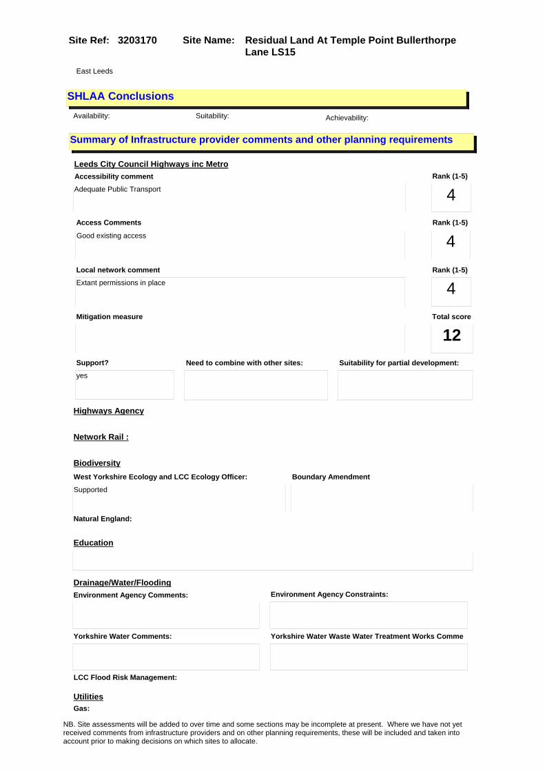
Site Name: Residual Land At Temple Point Bullerthorpe Lane LS15
Site Ref: 3203170
SHLAA ConclusionsAvailability: Suitability: Achievability:
East Leeds
Summary of Infrastructure provider comments and other planning requirements
Accessibility commentAdequate Public Transport
Rank (1-5)
4Access Comments
Good existing access
Local network comment
Extant permissions in place
Rank (1-5)
4Rank (1-5)
4
Leeds City Council Highways inc Metro
Highways Agency
Network Rail :
Biodiversity
Natural England:
Education
Mitigation measure Total score
12Support?
yes
Need to combine with other sites: Suitability for partial development:
West Yorkshire Ecology and LCC Ecology Officer:
Supported
Boundary Amendment
Drainage/Water/FloodingEnvironment Agency Comments: Environment Agency Constraints:
Yorkshire Water Comments: Yorkshire Water Waste Water Treatment Works Comme
UtilitiesGas:
LCC Flood Risk Management:
NB. Site assessments will be added to over time and some sections may be incomplete at present. Where we have not yet received comments from infrastructure providers and on other planning requirements, these will be included and taken into account prior to making decisions on which sites to allocate.

Site Name: Residual Land At Temple Point Bullerthorpe Lane LS15
Site Ref: 3203170
Conclusion of Assessment
Conclusion summary:
UDP Policy E18 allocation with no planning permission at 31/3/2010.
Floorspace sq m (Non residential): 9788
Employment Conclusion: Red
Assesment Type: Site assessment Type: Office
Proposed Change:
Electric:
Telecom:
Fire and Rescue Services:
Built HeritageLeeds City Council:
West Yorkshire Archaeology Service:
English Heritage:
Gypsy Traveller Site Assessment
Yes No Maybe Could site be effectively managed (Text)
Yes No Maybe Would gypsies and travellers live on the site?
(Text)
Yes No Proximity to housed gypsies and travellers (Text)
Yes No Unknown Experience of previous encampments (Text)
NB. Site assessments will be added to over time and some sections may be incomplete at present. Where we have not yet received comments from infrastructure providers and on other planning requirements, these will be included and taken into account prior to making decisions on which sites to allocate.

Site Name: Land Off Bullerthorpe Lane LS15Site Ref: 3203171
Site Details
Land Use
Northing: 433032
Easting: 437728
Distance to Rail Station (metres): 2021.02
Nearest Railway Station Cross Gates
Distance to bus stop (metres) 90.51
Bus Stop ID 3752
Agricultural Land Class:
SFRA Flood Zone: 0.00
Environment Agency Flood Zone: 0.00
Within 300m of retail centre boundary:
UDP Designation
Greenbelt - N32 (%): 0.00 Urban Green Corridor - N8 (%): 0.00
Protected Area of Search site - N34 (%): 0.00 Rural Land - RL1: 0.00
City Centre Primary Shopping Quarter - CC27 (%): 0.00 Town Centre - S2: 0.00
Health and Safety Executive Hazard: No
Health and Safety Executive Gas Pipeline: Yes
Strategic Employment Buffer: 0.00
Area sq m: 600.85 Ward Temple Newsam
Special Landscape Area - N37: 0.00
Allotments - N1A: 0.00
Proposed Greenspace - N5: 0.00
Protected Playing Pitch - N6: 0.00
Nature Conservation Area - N50: 0.00
Conservation Areas No
Ancient Monument/Battlefield(%): 0.00 Listed Buildings: No
Public Rights of Way: No
Other?:
Natural Resources and waste DPD (if applicable)
Within Minerals Safeguarding Site?: No Within 100m of Minerals Safeguarding Site?: No
HMCA: East Leeds
Greenspace - N1: 0
Existing Use 1:
Existing Use 2:
Existing Use 3:
Neighbouring Use 1
Neighbouring Use 2:
Neighbouring Use 3:
Other uses:
Topography:
Natural Landscape:
Boundaries:
Road Frontage
Site Characteristics
Site Detail
Other comments/observations on site characteristics:
Area Ha: 0.060085
Site State:
NB. Site assessments will be added to over time and some sections may be incomplete at present. Where we have not yet received comments from infrastructure providers and on other planning requirements, these will be included and taken into account prior to making decisions on which sites to allocate.

Site Name: Land Off Bullerthorpe Lane LS15Site Ref: 3203171
Planning History
Planning App No. Proposal Received Decision Status Site %
32/342/03/FU Two storey office block with car parking
30/07/2003 29/10/2003 A 10.85
H33/879/79/ Outline application to lay out accesses, and erect publi c house and restaurant with ca r park, to agricultur
25/10/1979 11/02/1980 R 100.00
NB. Site assessments will be added to over time and some sections may be incomplete at present. Where we have not yet received comments from infrastructure providers and on other planning requirements, these will be included and taken into account prior to making decisions on which sites to allocate.

Site Name: Land Off Bullerthorpe Lane LS15Site Ref: 3203171
Conformity with Core Strategy
Inner South Leeds: 0.00
Leeds Bradford Corridor: 0.00 West Leeds Gateway: 0.00
Aire Valley: 0.00Regeneration Priority Area:
Brownfield
Greenfield
Mixed
Main Urban Area
Major Settlement
Smaller Settlement
Villages/Rural
Main Urban Area Extension
Major Settlement Extension
Smaller Settlement Extension
Village/Rural Extension
Development unrelated to existing development
Green Belt assessment - only completed where site is within Green Belt
Would development lead to/constitute ribbon development?
Would development result in isolated development?
Is the site well connected to built up area (2+ boundaries with existing built up area)?
Would development of the site effectively "round off" the settlement pattern?:
Do natural/physical features provide a good existing barrier between existing urban area and undeveloped land?
Overall sprawl conclusion:
Would development of the site lead to physical connection of settlements?
Do natural/physical features provide a good existing barrier/boundary to contain development?
Overall Coalescence Conclusion:
Is there a strong defensible boundary between the site and the existing urban area?
Does the site provide access to the countryside?
Does the site include local or national conservation designated areas?
Does the site include areas of woodlands, trees, hedgerows that are protected, or significant unprotected tree/hedge cover?
Does the site include grade 1, 2, or 3a agricultural land?
Does the site contain buildings? Are these in agricultural use?
Overall countryside Encroachment Conclusion
Is the site within or adjacent to a conservation area, listed building or other historical feature?
If yes, could development preserve this character?:
Overall Character Preservation Conclusion:
Greenbelt Assessment Conclusion:
Check the unrestricted sprawl of large built up areas
Prevent neighbouring towns from merging
Assist in safeguarding countryside from encroachment
Preserve the setting and special character of historic towns
NB. Site assessments will be added to over time and some sections may be incomplete at present. Where we have not yet received comments from infrastructure providers and on other planning requirements, these will be included and taken into account prior to making decisions on which sites to allocate.

Site Name: Land Off Bullerthorpe Lane LS15Site Ref: 3203171
SHLAA ConclusionsAvailability: Suitability: Achievability:
East Leeds
Summary of Infrastructure provider comments and other planning requirements
Accessibility commentAdequate Public Transport
Rank (1-5)
4Access Comments
Good existing access
Local network comment
Small development and good local network
Rank (1-5)
4Rank (1-5)
4
Leeds City Council Highways inc Metro
Highways Agency
Network Rail :
Biodiversity
Natural England:
Education
Mitigation measure Total score
12Support?
Yes
Need to combine with other sites: Suitability for partial development:
West Yorkshire Ecology and LCC Ecology Officer:
Supported
Boundary Amendment
Drainage/Water/FloodingEnvironment Agency Comments: Environment Agency Constraints:
Yorkshire Water Comments: Yorkshire Water Waste Water Treatment Works Comme
UtilitiesGas:
LCC Flood Risk Management:
NB. Site assessments will be added to over time and some sections may be incomplete at present. Where we have not yet received comments from infrastructure providers and on other planning requirements, these will be included and taken into account prior to making decisions on which sites to allocate.

Site Name: Land Off Bullerthorpe Lane LS15Site Ref: 3203171
Conclusion of Assessment
Conclusion summary:
UDP Policy E18 allocation with no planning permission at 31/3/2010.
Floorspace sq m (Non residential):
Employment Conclusion: Green
Assesment Type: Site assessment Type: Industrial & Warehousing
Proposed Change:
Electric:
Telecom:
Fire and Rescue Services:
Built HeritageLeeds City Council:
West Yorkshire Archaeology Service:
English Heritage:
Gypsy Traveller Site Assessment
Yes No Maybe Could site be effectively managed (Text)
Yes No Maybe Would gypsies and travellers live on the site?
(Text)
Yes No Proximity to housed gypsies and travellers (Text)
Yes No Unknown Experience of previous encampments (Text)
NB. Site assessments will be added to over time and some sections may be incomplete at present. Where we have not yet received comments from infrastructure providers and on other planning requirements, these will be included and taken into account prior to making decisions on which sites to allocate.

Site Name: Red Hall Red Hall Lane LS17Site Ref: 3203180
Site Details
Land Use
Northing: 438558
Easting: 434887
Distance to Rail Station (metres): 4342.14
Nearest Railway Station Cross Gates
Distance to bus stop (metres) 180.38
Bus Stop ID 9531
Agricultural Land Class:
SFRA Flood Zone: 0.00
Environment Agency Flood Zone: 0.00
Within 300m of retail centre boundary:
UDP Designation
Greenbelt - N32 (%): 0.00 Urban Green Corridor - N8 (%): 0.00
Protected Area of Search site - N34 (%): 0.00 Rural Land - RL1: 0.00
City Centre Primary Shopping Quarter - CC27 (%): 0.00 Town Centre - S2: 0.00
Health and Safety Executive Hazard: No
Health and Safety Executive Gas Pipeline: No
Strategic Employment Buffer: 0.00
Area sq m: 97100.66 Ward ss Gates and Whinmoor
Special Landscape Area - N37: 0.00
Allotments - N1A: 0.00
Proposed Greenspace - N5: 0.00
Protected Playing Pitch - N6: 0.00
Nature Conservation Area - N50: 0.00
Conservation Areas No
Ancient Monument/Battlefield(%): 0.00 Listed Buildings: Yes
Public Rights of Way: Yes
Other?:
Natural Resources and waste DPD (if applicable)
Within Minerals Safeguarding Site?: Yes Within 100m of Minerals Safeguarding Site?: Yes
HMCA: East Leeds
Greenspace - N1: 0
Existing Use 1:
Existing Use 2:
Existing Use 3:
Neighbouring Use 1
Neighbouring Use 2:
Neighbouring Use 3:
Other uses:
Topography:
Natural Landscape:
Boundaries:
Road Frontage
Site Characteristics
Site Detail
Other comments/observations on site characteristics:
Area Ha: 9.710066
Site State:
Site Site TypeRedhall Composting Whinmoor Lane General Waste Management Sites
NB. Site assessments will be added to over time and some sections may be incomplete at present. Where we have not yet received comments from infrastructure providers and on other planning requirements, these will be included and taken into account prior to making decisions on which sites to allocate.

Site Name: Red Hall Red Hall Lane LS17Site Ref: 3203180
Planning History
NB. Site assessments will be added to over time and some sections may be incomplete at present. Where we have not yet received comments from infrastructure providers and on other planning requirements, these will be included and taken into account prior to making decisions on which sites to allocate.

Site Name: Red Hall Red Hall Lane LS17Site Ref: 3203180
Conformity with Core Strategy
Inner South Leeds: 0.00
Leeds Bradford Corridor: 0.00 West Leeds Gateway: 0.00
Aire Valley: 0.00Regeneration Priority Area:
Brownfield
Greenfield
Mixed
Main Urban Area
Major Settlement
Smaller Settlement
Villages/Rural
Main Urban Area Extension
Major Settlement Extension
Smaller Settlement Extension
Village/Rural Extension
Development unrelated to existing development
Green Belt assessment - only completed where site is within Green Belt
Would development lead to/constitute ribbon development?
Would development result in isolated development?
Is the site well connected to built up area (2+ boundaries with existing built up area)?
Would development of the site effectively "round off" the settlement pattern?:
Do natural/physical features provide a good existing barrier between existing urban area and undeveloped land?
Overall sprawl conclusion:
Would development of the site lead to physical connection of settlements?
Do natural/physical features provide a good existing barrier/boundary to contain development?
Overall Coalescence Conclusion:
Is there a strong defensible boundary between the site and the existing urban area?
Does the site provide access to the countryside?
Does the site include local or national conservation designated areas?
Does the site include areas of woodlands, trees, hedgerows that are protected, or significant unprotected tree/hedge cover?
Does the site include grade 1, 2, or 3a agricultural land?
Does the site contain buildings? Are these in agricultural use?
Overall countryside Encroachment Conclusion
Is the site within or adjacent to a conservation area, listed building or other historical feature?
If yes, could development preserve this character?:
Overall Character Preservation Conclusion:
Greenbelt Assessment Conclusion:
Check the unrestricted sprawl of large built up areas
Prevent neighbouring towns from merging
Assist in safeguarding countryside from encroachment
Preserve the setting and special character of historic towns
NB. Site assessments will be added to over time and some sections may be incomplete at present. Where we have not yet received comments from infrastructure providers and on other planning requirements, these will be included and taken into account prior to making decisions on which sites to allocate.

Site Name: Red Hall Red Hall Lane LS17Site Ref: 3203180
SHLAA ConclusionsAvailability: Suitability: Achievability:
Conclusion of Assessment
Conclusion summary:
Offices not acceptable in this location (NPPF) and other B1 uses not realistic here. Option for residential use in line with adjacent land.
Floorspace sq m (Non residential): 3641
Employment Conclusion: Red
East Leeds
Assesment Type: ELR Type: Office
Proposed Change:
Gypsy Traveller Site Assessment
Yes No Maybe Could site be effectively managed (Text)
Yes No Maybe Would gypsies and travellers live on the site?
(Text)
Yes No Proximity to housed gypsies and travellers (Text)
Yes No Unknown Experience of previous encampments (Text)
NB. Site assessments will be added to over time and some sections may be incomplete at present. Where we have not yet received comments from infrastructure providers and on other planning requirements, these will be included and taken into account prior to making decisions on which sites to allocate.

Site Name: Former Vickers Defence Factory Manston Lane LS 15
Site Ref: 3203230
Site Details
Land Use
Northing: 434563
Easting: 437488
Distance to Rail Station (metres): 1210.21
Nearest Railway Station Cross Gates
Distance to bus stop (metres) 164.82
Bus Stop ID 11579
Agricultural Land Class:
SFRA Flood Zone: 0.00
Environment Agency Flood Zone: 0.00
Within 300m of retail centre boundary:
UDP Designation
Greenbelt - N32 (%): 0.00 Urban Green Corridor - N8 (%): 0.00
Protected Area of Search site - N34 (%): 0.00 Rural Land - RL1: 0.00
City Centre Primary Shopping Quarter - CC27 (%): 0.00 Town Centre - S2: 0.00
Health and Safety Executive Hazard: No
Health and Safety Executive Gas Pipeline: No
Strategic Employment Buffer: 80.87
Area sq m: 204698.56 Ward ss Gates and Whinmoor
Special Landscape Area - N37: 0.00
Allotments - N1A: 0.00
Proposed Greenspace - N5: 0.00
Protected Playing Pitch - N6: 0.00
Nature Conservation Area - N50: 0.00
Conservation Areas No
Ancient Monument/Battlefield(%): 0.00 Listed Buildings: No
Public Rights of Way: No
Other?:
Natural Resources and waste DPD (if applicable)
Within Minerals Safeguarding Site?: No Within 100m of Minerals Safeguarding Site?: No
HMCA: East Leeds
Greenspace - N1: 0
Existing Use 1:
Existing Use 2:
Existing Use 3:
Neighbouring Use 1
Neighbouring Use 2:
Neighbouring Use 3:
Other uses:
Topography:
Natural Landscape:
Boundaries:
Road Frontage
Site Characteristics
Site Detail
Other comments/observations on site characteristics:
Area Ha: 20.469856
Site State:
NB. Site assessments will be added to over time and some sections may be incomplete at present. Where we have not yet received comments from infrastructure providers and on other planning requirements, these will be included and taken into account prior to making decisions on which sites to allocate.
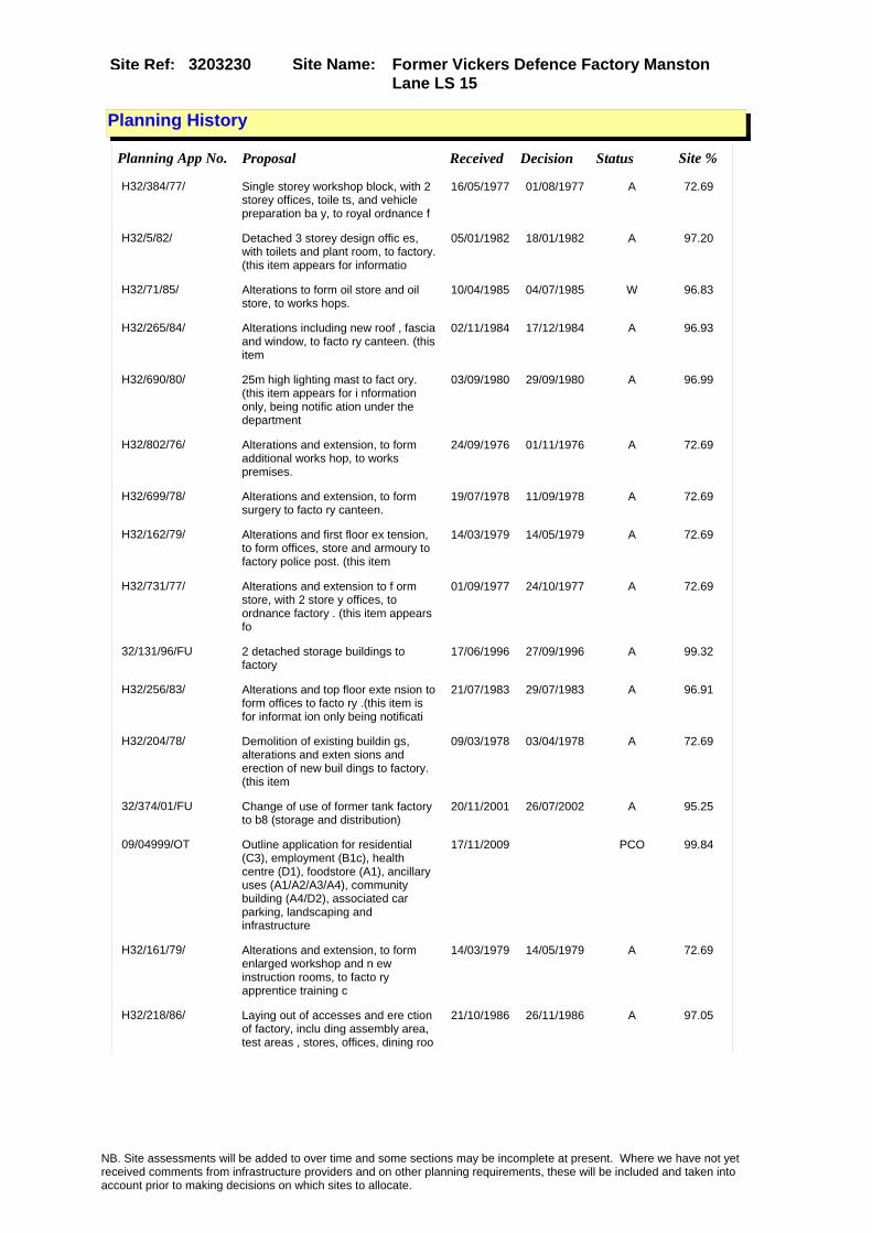
Site Name: Former Vickers Defence Factory Manston Lane LS 15
Site Ref: 3203230
Planning History
Planning App No. Proposal Received Decision Status Site %
H32/384/77/ Single storey workshop block, with 2 storey offices, toile ts, and vehicle preparation ba y, to royal ordnance f
16/05/1977 01/08/1977 A 72.69
H32/5/82/ Detached 3 storey design offic es, with toilets and plant room, to factory. (this item appears for informatio
05/01/1982 18/01/1982 A 97.20
H32/71/85/ Alterations to form oil store and oil store, to works hops.
10/04/1985 04/07/1985 W 96.83
H32/265/84/ Alterations including new roof , fascia and window, to facto ry canteen. (this item
02/11/1984 17/12/1984 A 96.93
H32/690/80/ 25m high lighting mast to fact ory. (this item appears for i nformation only, being notific ation under the department
03/09/1980 29/09/1980 A 96.99
H32/802/76/ Alterations and extension, to form additional works hop, to works premises.
24/09/1976 01/11/1976 A 72.69
H32/699/78/ Alterations and extension, to form surgery to facto ry canteen.
19/07/1978 11/09/1978 A 72.69
H32/162/79/ Alterations and first floor ex tension, to form offices, store and armoury to factory police post. (this item
14/03/1979 14/05/1979 A 72.69
H32/731/77/ Alterations and extension to f orm store, with 2 store y offices, to ordnance factory . (this item appears fo
01/09/1977 24/10/1977 A 72.69
32/131/96/FU 2 detached storage buildings to factory
17/06/1996 27/09/1996 A 99.32
H32/256/83/ Alterations and top floor exte nsion to form offices to facto ry .(this item is for informat ion only being notificati
21/07/1983 29/07/1983 A 96.91
H32/204/78/ Demolition of existing buildin gs, alterations and exten sions and erection of new buil dings to factory. (this item
09/03/1978 03/04/1978 A 72.69
32/374/01/FU Change of use of former tank factory to b8 (storage and distribution)
20/11/2001 26/07/2002 A 95.25
09/04999/OT Outline application for residential (C3), employment (B1c), health centre (D1), foodstore (A1), ancillary uses (A1/A2/A3/A4), community building (A4/D2), associated car parking, landscaping and infrastructure
17/11/2009 PCO 99.84
H32/161/79/ Alterations and extension, to form enlarged workshop and n ew instruction rooms, to facto ry apprentice training c
14/03/1979 14/05/1979 A 72.69
H32/218/86/ Laying out of accesses and ere ction of factory, inclu ding assembly area, test areas , stores, offices, dining roo
21/10/1986 26/11/1986 A 97.05
NB. Site assessments will be added to over time and some sections may be incomplete at present. Where we have not yet received comments from infrastructure providers and on other planning requirements, these will be included and taken into account prior to making decisions on which sites to allocate.

Site Name: Former Vickers Defence Factory Manston Lane LS 15
Site Ref: 3203230
Conformity with Core Strategy
Inner South Leeds: 0.00
Leeds Bradford Corridor: 0.00 West Leeds Gateway: 0.00
Aire Valley: 0.00Regeneration Priority Area:
Brownfield
Greenfield
Mixed
Main Urban Area
Major Settlement
Smaller Settlement
Villages/Rural
Main Urban Area Extension
Major Settlement Extension
Smaller Settlement Extension
Village/Rural Extension
Development unrelated to existing development
Green Belt assessment - only completed where site is within Green Belt
Would development lead to/constitute ribbon development?
Would development result in isolated development?
Is the site well connected to built up area (2+ boundaries with existing built up area)?
Would development of the site effectively "round off" the settlement pattern?:
Do natural/physical features provide a good existing barrier between existing urban area and undeveloped land?
Overall sprawl conclusion:
Would development of the site lead to physical connection of settlements?
Do natural/physical features provide a good existing barrier/boundary to contain development?
Overall Coalescence Conclusion:
Is there a strong defensible boundary between the site and the existing urban area?
Does the site provide access to the countryside?
Does the site include local or national conservation designated areas?
Does the site include areas of woodlands, trees, hedgerows that are protected, or significant unprotected tree/hedge cover?
Does the site include grade 1, 2, or 3a agricultural land?
Does the site contain buildings? Are these in agricultural use?
Overall countryside Encroachment Conclusion
Is the site within or adjacent to a conservation area, listed building or other historical feature?
If yes, could development preserve this character?:
Overall Character Preservation Conclusion:
Greenbelt Assessment Conclusion:
Check the unrestricted sprawl of large built up areas
Prevent neighbouring towns from merging
Assist in safeguarding countryside from encroachment
Preserve the setting and special character of historic towns
NB. Site assessments will be added to over time and some sections may be incomplete at present. Where we have not yet received comments from infrastructure providers and on other planning requirements, these will be included and taken into account prior to making decisions on which sites to allocate.

Site Name: Former Vickers Defence Factory Manston Lane LS 15
Site Ref: 3203230
SHLAA ConclusionsAvailability: Suitability: Achievability:
East Leeds
Summary of Infrastructure provider comments and other planning requirements
Accessibility commentGood accessibility
Rank (1-5)
4Access Comments
Good access achievable
Local network comment
requires Manston Lane Link Road
Rank (1-5)
4Rank (1-5)
3
Leeds City Council Highways inc Metro
Highways Agency
Network Rail :
Biodiversity
Natural England:
Education
Mitigation measure
MLLR is required
Total score
11Support?
Yes with mitigation
Need to combine with other sites: Suitability for partial development:
West Yorkshire Ecology and LCC Ecology Officer:
Supported with mitigation to protect and enhance breeding and terrestrial habitat for Great Crested Newts - to be achieved partly through retaining a minimum 40metre buffer along the entire length of the railway line with new breeding ponds with terrestrail habitat that is positively managed. This site supports a population of Great Crested Newts - also present on the opposite side of the railway line which forms the southern boundary of the site. The site has also records for notable red and amber list birds - provide locally native species tree and shrub planting for passerine bird species.
Boundary Amendment
Drainage/Water/FloodingEnvironment Agency Comments: Environment Agency Constraints:
Yorkshire Water Comments: Yorkshire Water Waste Water Treatment Works Comme
Potential for cumulative impact in combination with other sites. If site still included at next sift assess as part of East Leeds cluster.
NB. Site assessments will be added to over time and some sections may be incomplete at present. Where we have not yet received comments from infrastructure providers and on other planning requirements, these will be included and taken into account prior to making decisions on which sites to allocate.

Site Name: Former Vickers Defence Factory Manston Lane LS 15
Site Ref: 3203230
Conclusion of Assessment
Conclusion summary:
Residential scheme (08/03440/OT) approved 16/3/2009 for adjoining site 3203231.
Floorspace sq m (Non residential):
Employment Conclusion: Red
Assesment Type: Site assessment Type: Industrial & Warehousing
Proposed Change:
UtilitiesGas:
Electric:
Telecom:
Fire and Rescue Services:
Built HeritageLeeds City Council:
West Yorkshire Archaeology Service:
English Heritage:
LCC Flood Risk Management:
Gypsy Traveller Site Assessment
Yes No Maybe Could site be effectively managed (Text)
Yes No Maybe Would gypsies and travellers live on the site?
(Text)
Yes No Proximity to housed gypsies and travellers (Text)
Yes No Unknown Experience of previous encampments (Text)
NB. Site assessments will be added to over time and some sections may be incomplete at present. Where we have not yet received comments from infrastructure providers and on other planning requirements, these will be included and taken into account prior to making decisions on which sites to allocate.

Site Name: Residential Scheme At Former Vickers Defence Factory Manston Lane LS 15
Site Ref: 3203231
Site Details
Land Use
Northing: 434591
Easting: 437009
Distance to Rail Station (metres): 739.59
Nearest Railway Station Cross Gates
Distance to bus stop (metres) 127.34
Bus Stop ID 6286
Agricultural Land Class:
SFRA Flood Zone: 0.00
Environment Agency Flood Zone: 0.00
Within 300m of retail centre boundary:
UDP Designation
Greenbelt - N32 (%): 0.00 Urban Green Corridor - N8 (%): 0.00
Protected Area of Search site - N34 (%): 0.00 Rural Land - RL1: 0.00
City Centre Primary Shopping Quarter - CC27 (%): 0.00 Town Centre - S2: 0.00
Health and Safety Executive Hazard: No
Health and Safety Executive Gas Pipeline: Yes
Strategic Employment Buffer: 8.45
Area sq m: 49826.62 Ward ss Gates and Whinmoor
Special Landscape Area - N37: 0.00
Allotments - N1A: 0.00
Proposed Greenspace - N5: 0.00
Protected Playing Pitch - N6: 0.00
Nature Conservation Area - N50: 0.00
Conservation Areas No
Ancient Monument/Battlefield(%): 0.00 Listed Buildings: No
Public Rights of Way: No
Other?:
Natural Resources and waste DPD (if applicable)
Within Minerals Safeguarding Site?: No Within 100m of Minerals Safeguarding Site?: No
HMCA: East Leeds
Greenspace - N1: 0
Existing Use 1:
Existing Use 2:
Existing Use 3:
Neighbouring Use 1
Neighbouring Use 2:
Neighbouring Use 3:
Other uses:
Topography:
Natural Landscape:
Boundaries:
Road Frontage
Site Characteristics
Site Detail
Other comments/observations on site characteristics:
Area Ha: 4.982662
Site State:
NB. Site assessments will be added to over time and some sections may be incomplete at present. Where we have not yet received comments from infrastructure providers and on other planning requirements, these will be included and taken into account prior to making decisions on which sites to allocate.

Site Name: Residential Scheme At Former Vickers Defence Factory Manston Lane LS 15
Site Ref: 3203231
Planning History
NB. Site assessments will be added to over time and some sections may be incomplete at present. Where we have not yet received comments from infrastructure providers and on other planning requirements, these will be included and taken into account prior to making decisions on which sites to allocate.

Site Name: Residential Scheme At Former Vickers Defence Factory Manston Lane LS 15
Site Ref: 3203231
Conformity with Core Strategy
Inner South Leeds: 0.00
Leeds Bradford Corridor: 0.00 West Leeds Gateway: 0.00
Aire Valley: 0.00Regeneration Priority Area:
Brownfield
Greenfield
Mixed
Main Urban Area
Major Settlement
Smaller Settlement
Villages/Rural
Main Urban Area Extension
Major Settlement Extension
Smaller Settlement Extension
Village/Rural Extension
Development unrelated to existing development
Green Belt assessment - only completed where site is within Green Belt
Would development lead to/constitute ribbon development?
Would development result in isolated development?
Is the site well connected to built up area (2+ boundaries with existing built up area)?
Would development of the site effectively "round off" the settlement pattern?:
Do natural/physical features provide a good existing barrier between existing urban area and undeveloped land?
Overall sprawl conclusion:
Would development of the site lead to physical connection of settlements?
Do natural/physical features provide a good existing barrier/boundary to contain development?
Overall Coalescence Conclusion:
Is there a strong defensible boundary between the site and the existing urban area?
Does the site provide access to the countryside?
Does the site include local or national conservation designated areas?
Does the site include areas of woodlands, trees, hedgerows that are protected, or significant unprotected tree/hedge cover?
Does the site include grade 1, 2, or 3a agricultural land?
Does the site contain buildings? Are these in agricultural use?
Overall countryside Encroachment Conclusion
Is the site within or adjacent to a conservation area, listed building or other historical feature?
If yes, could development preserve this character?:
Overall Character Preservation Conclusion:
Greenbelt Assessment Conclusion:
Check the unrestricted sprawl of large built up areas
Prevent neighbouring towns from merging
Assist in safeguarding countryside from encroachment
Preserve the setting and special character of historic towns
NB. Site assessments will be added to over time and some sections may be incomplete at present. Where we have not yet received comments from infrastructure providers and on other planning requirements, these will be included and taken into account prior to making decisions on which sites to allocate.

Site Name: Residential Scheme At Former Vickers Defence Factory Manston Lane LS 15
Site Ref: 3203231
SHLAA ConclusionsAvailability: Suitability: Achievability:
Conclusion of Assessment
Conclusion summary:
Consent for residential: 08/03440/OT refers.
Floorspace sq m (Non residential):
Employment Conclusion: Red
East Leeds
Assesment Type: ELR Type: Industrial & Warehousing
Proposed Change:
Gypsy Traveller Site Assessment
Yes No Maybe Could site be effectively managed (Text)
Yes No Maybe Would gypsies and travellers live on the site?
(Text)
Yes No Proximity to housed gypsies and travellers (Text)
Yes No Unknown Experience of previous encampments (Text)
NB. Site assessments will be added to over time and some sections may be incomplete at present. Where we have not yet received comments from infrastructure providers and on other planning requirements, these will be included and taken into account prior to making decisions on which sites to allocate.

Site Name: Plot 4500 Century Way Thorpe Park LS15Site Ref: 3203250
Site Details
Land Use
Northing: 433876
Easting: 437726
Distance to Rail Station (metres): 1550.91
Nearest Railway Station Cross Gates
Distance to bus stop (metres) 309.42
Bus Stop ID 9907
Agricultural Land Class:
SFRA Flood Zone: 0.00
Environment Agency Flood Zone: 0.00
Within 300m of retail centre boundary:
UDP Designation
Greenbelt - N32 (%): 0.00 Urban Green Corridor - N8 (%): 0.00
Protected Area of Search site - N34 (%): 0.00 Rural Land - RL1: 0.00
City Centre Primary Shopping Quarter - CC27 (%): 0.00 Town Centre - S2: 0.00
Health and Safety Executive Hazard: No
Health and Safety Executive Gas Pipeline: No
Strategic Employment Buffer: 100.00
Area sq m: 19910.70 Ward Temple Newsam
Special Landscape Area - N37: 0.00
Allotments - N1A: 0.00
Proposed Greenspace - N5: 0.00
Protected Playing Pitch - N6: 0.00
Nature Conservation Area - N50: 0.00
Conservation Areas No
Ancient Monument/Battlefield(%): 0.00 Listed Buildings: No
Public Rights of Way: No
Other?:
Natural Resources and waste DPD (if applicable)
Within Minerals Safeguarding Site?: No Within 100m of Minerals Safeguarding Site?: No
HMCA: East Leeds
Greenspace - N1: 0
Existing Use 1:
Existing Use 2:
Existing Use 3:
Neighbouring Use 1
Neighbouring Use 2:
Neighbouring Use 3:
Other uses:
Topography:
Natural Landscape:
Boundaries:
Road Frontage
Site Characteristics
Site Detail
Other comments/observations on site characteristics:
Area Ha: 1.99107
Site State:
NB. Site assessments will be added to over time and some sections may be incomplete at present. Where we have not yet received comments from infrastructure providers and on other planning requirements, these will be included and taken into account prior to making decisions on which sites to allocate.

Site Name: Plot 4500 Century Way Thorpe Park LS15Site Ref: 3203250
Planning History
Planning App No. Proposal Received Decision Status Site %
32/29/03/RM Laying out of access road and landscaping with associated levelling and drainage
29/01/2003 08/09/2003 A 100.00
32/246/04/RM Variation of condition numbers 5 & 10 of application ref no 32/29/03/rm (drainage and balancing pond treatment)
15/06/2004 29/09/2004 A 100.00
07/9/00357/MOD Laying out of access road and landscaping with associated levelling and drainage�NON MATERIAL AMENDMENT: Erection of closed boarded timber fence
17/07/2007 20/09/2007 M01 100.00
32/199/94/OT Outline application to layout business park green park and access roads
08/09/1994 04/10/1995 A 100.00
32/80/04/FU anTwo storey health and fitness club with outdoor tennis courts and swimming pool with car parking and landscaping
23/02/2004 12/04/2007 W 86.73
32/356/01/RM Laying out of new access and roundabout diverting footpaths and bridleway and construction of cycleway/footpath-option 2
02/11/2001 22/01/2002 A 100.00
32/140/96/FU Variation of condition no 21 of application no 32/199/94/0t (total floor area increased from 111500 sqm to 167220 sqm)
01/07/1996 31/03/2004 A 100.00
12/03886/OT Outline Planning Application for mixed use development comprising offices (business park) (B1A), (B) and (C), retail and bar/restaurant (A1, A2, A3, A4 and A5), hotel (C1), leisure facilities (D1, D2), multi-storey car park, together with internal roads, car parking, landscaping and drainage.
10/09/2012 PCO 100.00
32/148/05/FU Variation of condition no.9 of permission ref 32/140/96/fu (completion of access roads related to gross floor area)
22/03/2005 13/05/2005 A 100.00
32/44/05/FU Variation of condition no 17 of permission 32/140/96/fu (foul & surface water drainage)
27/01/2005 15/04/2005 A 100.00
32/130/97/FU Variation of conditions nos 17 and 19 of application number 32/199/94/o t (access arrangement and floor area)
23/06/1997 04/01/1999 A 100.00
NB. Site assessments will be added to over time and some sections may be incomplete at present. Where we have not yet received comments from infrastructure providers and on other planning requirements, these will be included and taken into account prior to making decisions on which sites to allocate.

Site Name: Plot 4500 Century Way Thorpe Park LS15Site Ref: 3203250
Conformity with Core Strategy
Inner South Leeds: 0.00
Leeds Bradford Corridor: 0.00 West Leeds Gateway: 0.00
Aire Valley: 0.00Regeneration Priority Area:
Brownfield
Greenfield
Mixed
Main Urban Area
Major Settlement
Smaller Settlement
Villages/Rural
Main Urban Area Extension
Major Settlement Extension
Smaller Settlement Extension
Village/Rural Extension
Development unrelated to existing development
Green Belt assessment - only completed where site is within Green Belt
Would development lead to/constitute ribbon development?
Would development result in isolated development?
Is the site well connected to built up area (2+ boundaries with existing built up area)?
Would development of the site effectively "round off" the settlement pattern?:
Do natural/physical features provide a good existing barrier between existing urban area and undeveloped land?
Overall sprawl conclusion:
Would development of the site lead to physical connection of settlements?
Do natural/physical features provide a good existing barrier/boundary to contain development?
Overall Coalescence Conclusion:
Is there a strong defensible boundary between the site and the existing urban area?
Does the site provide access to the countryside?
Does the site include local or national conservation designated areas?
Does the site include areas of woodlands, trees, hedgerows that are protected, or significant unprotected tree/hedge cover?
Does the site include grade 1, 2, or 3a agricultural land?
Does the site contain buildings? Are these in agricultural use?
Overall countryside Encroachment Conclusion
Is the site within or adjacent to a conservation area, listed building or other historical feature?
If yes, could development preserve this character?:
Overall Character Preservation Conclusion:
Greenbelt Assessment Conclusion:
Check the unrestricted sprawl of large built up areas
Prevent neighbouring towns from merging
Assist in safeguarding countryside from encroachment
Preserve the setting and special character of historic towns
NB. Site assessments will be added to over time and some sections may be incomplete at present. Where we have not yet received comments from infrastructure providers and on other planning requirements, these will be included and taken into account prior to making decisions on which sites to allocate.

Site Name: Plot 4500 Century Way Thorpe Park LS15Site Ref: 3203250
SHLAA ConclusionsAvailability: Suitability: Achievability:
Conclusion of Assessment
Conclusion summary:
Part of Thorpe Park which is key business park.
Floorspace sq m (Non residential): 7463
Employment Conclusion: Lime Green
East Leeds
Assesment Type: ELR Type: Office
Proposed Change:
Gypsy Traveller Site Assessment
Yes No Maybe Could site be effectively managed (Text)
Yes No Maybe Would gypsies and travellers live on the site?
(Text)
Yes No Proximity to housed gypsies and travellers (Text)
Yes No Unknown Experience of previous encampments (Text)
NB. Site assessments will be added to over time and some sections may be incomplete at present. Where we have not yet received comments from infrastructure providers and on other planning requirements, these will be included and taken into account prior to making decisions on which sites to allocate.

Site Name: Plot 4400 Park Approach Thorpe Park LS15Site Ref: 3203252
Site Details
Land Use
Northing: 433777
Easting: 437682
Distance to Rail Station (metres): 1549.61
Nearest Railway Station Cross Gates
Distance to bus stop (metres) 283.47
Bus Stop ID 9907
Agricultural Land Class:
SFRA Flood Zone: 0.00
Environment Agency Flood Zone: 0.00
Within 300m of retail centre boundary:
UDP Designation
Greenbelt - N32 (%): 0.00 Urban Green Corridor - N8 (%): 0.00
Protected Area of Search site - N34 (%): 0.00 Rural Land - RL1: 0.00
City Centre Primary Shopping Quarter - CC27 (%): 0.00 Town Centre - S2: 0.00
Health and Safety Executive Hazard: No
Health and Safety Executive Gas Pipeline: No
Strategic Employment Buffer: 0.00
Area sq m: 9185.40 Ward Temple Newsam
Special Landscape Area - N37: 0.00
Allotments - N1A: 0.00
Proposed Greenspace - N5: 0.00
Protected Playing Pitch - N6: 0.00
Nature Conservation Area - N50: 0.00
Conservation Areas No
Ancient Monument/Battlefield(%): 0.00 Listed Buildings: No
Public Rights of Way: No
Other?:
Natural Resources and waste DPD (if applicable)
Within Minerals Safeguarding Site?: No Within 100m of Minerals Safeguarding Site?: No
HMCA: East Leeds
Greenspace - N1: 0
Existing Use 1:
Existing Use 2:
Existing Use 3:
Neighbouring Use 1
Neighbouring Use 2:
Neighbouring Use 3:
Other uses:
Topography:
Natural Landscape:
Boundaries:
Road Frontage
Site Characteristics
Site Detail
Other comments/observations on site characteristics:
Area Ha: 0.91854
Site State:
NB. Site assessments will be added to over time and some sections may be incomplete at present. Where we have not yet received comments from infrastructure providers and on other planning requirements, these will be included and taken into account prior to making decisions on which sites to allocate.

Site Name: Plot 4400 Park Approach Thorpe Park LS15Site Ref: 3203252
Planning History
NB. Site assessments will be added to over time and some sections may be incomplete at present. Where we have not yet received comments from infrastructure providers and on other planning requirements, these will be included and taken into account prior to making decisions on which sites to allocate.

Site Name: Plot 4400 Park Approach Thorpe Park LS15Site Ref: 3203252
Conformity with Core Strategy
Inner South Leeds: 0.00
Leeds Bradford Corridor: 0.00 West Leeds Gateway: 0.00
Aire Valley: 0.00Regeneration Priority Area:
Brownfield
Greenfield
Mixed
Main Urban Area
Major Settlement
Smaller Settlement
Villages/Rural
Main Urban Area Extension
Major Settlement Extension
Smaller Settlement Extension
Village/Rural Extension
Development unrelated to existing development
Green Belt assessment - only completed where site is within Green Belt
Would development lead to/constitute ribbon development?
Would development result in isolated development?
Is the site well connected to built up area (2+ boundaries with existing built up area)?
Would development of the site effectively "round off" the settlement pattern?:
Do natural/physical features provide a good existing barrier between existing urban area and undeveloped land?
Overall sprawl conclusion:
Would development of the site lead to physical connection of settlements?
Do natural/physical features provide a good existing barrier/boundary to contain development?
Overall Coalescence Conclusion:
Is there a strong defensible boundary between the site and the existing urban area?
Does the site provide access to the countryside?
Does the site include local or national conservation designated areas?
Does the site include areas of woodlands, trees, hedgerows that are protected, or significant unprotected tree/hedge cover?
Does the site include grade 1, 2, or 3a agricultural land?
Does the site contain buildings? Are these in agricultural use?
Overall countryside Encroachment Conclusion
Is the site within or adjacent to a conservation area, listed building or other historical feature?
If yes, could development preserve this character?:
Overall Character Preservation Conclusion:
Greenbelt Assessment Conclusion:
Check the unrestricted sprawl of large built up areas
Prevent neighbouring towns from merging
Assist in safeguarding countryside from encroachment
Preserve the setting and special character of historic towns
NB. Site assessments will be added to over time and some sections may be incomplete at present. Where we have not yet received comments from infrastructure providers and on other planning requirements, these will be included and taken into account prior to making decisions on which sites to allocate.

Site Name: Plot 4400 Park Approach Thorpe Park LS15Site Ref: 3203252
SHLAA ConclusionsAvailability: Suitability: Achievability:
Conclusion of Assessment
Conclusion summary:
Part of Thorpe Park which is key business park.
Floorspace sq m (Non residential): 360
Employment Conclusion: Lime Green
East Leeds
Assesment Type: ELR Type: Office
Proposed Change:
Gypsy Traveller Site Assessment
Yes No Maybe Could site be effectively managed (Text)
Yes No Maybe Would gypsies and travellers live on the site?
(Text)
Yes No Proximity to housed gypsies and travellers (Text)
Yes No Unknown Experience of previous encampments (Text)
NB. Site assessments will be added to over time and some sections may be incomplete at present. Where we have not yet received comments from infrastructure providers and on other planning requirements, these will be included and taken into account prior to making decisions on which sites to allocate.

Site Name: Plot 3175 Century Way Thorpe Park LS15Site Ref: 3203254
Site Details
Land Use
Northing: 433631
Easting: 438057
Distance to Rail Station (metres): 1951.85
Nearest Railway Station Cross Gates
Distance to bus stop (metres) 119.92
Bus Stop ID 12988
Agricultural Land Class:
SFRA Flood Zone: 0.00
Environment Agency Flood Zone: 0.00
Within 300m of retail centre boundary:
UDP Designation
Greenbelt - N32 (%): 0.00 Urban Green Corridor - N8 (%): 0.00
Protected Area of Search site - N34 (%): 0.00 Rural Land - RL1: 0.00
City Centre Primary Shopping Quarter - CC27 (%): 0.00 Town Centre - S2: 0.00
Health and Safety Executive Hazard: No
Health and Safety Executive Gas Pipeline: Yes
Strategic Employment Buffer: 100.00
Area sq m: 5891.12 Ward Garforth and Swillington
Special Landscape Area - N37: 0.00
Allotments - N1A: 0.00
Proposed Greenspace - N5: 0.00
Protected Playing Pitch - N6: 0.00
Nature Conservation Area - N50: 0.00
Conservation Areas No
Ancient Monument/Battlefield(%): 0.00 Listed Buildings: No
Public Rights of Way: No
Other?:
Natural Resources and waste DPD (if applicable)
Within Minerals Safeguarding Site?: No Within 100m of Minerals Safeguarding Site?: No
HMCA: East Leeds
Greenspace - N1: 0
Existing Use 1:
Existing Use 2:
Existing Use 3:
Neighbouring Use 1
Neighbouring Use 2:
Neighbouring Use 3:
Other uses:
Topography:
Natural Landscape:
Boundaries:
Road Frontage
Site Characteristics
Site Detail
Other comments/observations on site characteristics:
Area Ha: 0.589112
Site State:
NB. Site assessments will be added to over time and some sections may be incomplete at present. Where we have not yet received comments from infrastructure providers and on other planning requirements, these will be included and taken into account prior to making decisions on which sites to allocate.

Site Name: Plot 3175 Century Way Thorpe Park LS15Site Ref: 3203254
Planning History
Planning App No. Proposal Received Decision Status Site %
32/185/00/FU Reprofiling to proposed business park 12/07/2000 27/04/2001 A 98.80
32/355/01/RM Laying out of new access and roundabout diverting footpaths and bridleway and construction of cycleway/footpath -option 1
01/11/2001 22/01/2002 A 12.38
32/199/94/OT Outline application to layout business park green park and access roads
08/09/1994 04/10/1995 A 100.00
32/152/05/RM Three 3 storey office blocks including car parking & landscaping to business park
31/03/2005 03/10/2005 A 92.36
32/356/01/RM Laying out of new access and roundabout diverting footpaths and bridleway and construction of cycleway/footpath-option 2
02/11/2001 22/01/2002 A 51.54
32/140/96/FU Variation of condition no 21 of application no 32/199/94/0t (total floor area increased from 111500 sqm to 167220 sqm)
01/07/1996 31/03/2004 A 100.00
0-32/35/05/MOD Three 2 storey office blocks including car parking & landscaping to business park
09/11/2005 13/12/2005 M01 92.36
06/9/00162/MOD Three 3 storey office blocks including car parking & landscaping to business park�NON MATERIAL AMENDMENT: Increased length of building & reduced width of entrance/atrium area
06/04/2006 03/08/2006 M01 92.36
06/9/00639/MOD Three 3 storey office blocks including car parking & landscaping to business park�NON MATERIAL AMENDMENT: composite cladding panel around stairwell changed to rainscreen, size and location of plantroom revised,louvre panels added to gable end elevations, sliding entrance doors in lieu of bi-parting entrance doors
06/12/2006 18/01/2007 M01 92.36
09/00829/RM Three storey office block with car parking
25/02/2009 22/05/2009 A 100.00
32/148/05/FU Variation of condition no.9 of permission ref 32/140/96/fu (completion of access roads related to gross floor area)
22/03/2005 13/05/2005 A 100.00
32/260/98/OT Outline application to erect 150 bed hotel with leisure facilities and 270 car parking spaces
13/11/1998 29/04/1999 A 98.80
32/259/98/RM Laying out of access roads balancing pond and landscaping to proposed business park
13/11/1998 15/06/1999 A 99.95
32/177/02/RM Detached two storey office block 25/04/2002 02/08/2002 A 10.14
32/44/05/FU Variation of condition no 17 of permission 32/140/96/fu (foul & surface water drainage)
27/01/2005 15/04/2005 A 100.00
32/130/97/FU Variation of conditions nos 17 and 19 of application number 32/199/94/o t (access arrangement and floor area)
23/06/1997 04/01/1999 A 100.00
NB. Site assessments will be added to over time and some sections may be incomplete at present. Where we have not yet received comments from infrastructure providers and on other planning requirements, these will be included and taken into account prior to making decisions on which sites to allocate.

Site Name: Plot 3175 Century Way Thorpe Park LS15Site Ref: 3203254
Conformity with Core Strategy
Inner South Leeds: 0.00
Leeds Bradford Corridor: 0.00 West Leeds Gateway: 0.00
Aire Valley: 0.00Regeneration Priority Area:
Brownfield
Greenfield
Mixed
Main Urban Area
Major Settlement
Smaller Settlement
Villages/Rural
Main Urban Area Extension
Major Settlement Extension
Smaller Settlement Extension
Village/Rural Extension
Development unrelated to existing development
Green Belt assessment - only completed where site is within Green Belt
Would development lead to/constitute ribbon development?
Would development result in isolated development?
Is the site well connected to built up area (2+ boundaries with existing built up area)?
Would development of the site effectively "round off" the settlement pattern?:
Do natural/physical features provide a good existing barrier between existing urban area and undeveloped land?
Overall sprawl conclusion:
Would development of the site lead to physical connection of settlements?
Do natural/physical features provide a good existing barrier/boundary to contain development?
Overall Coalescence Conclusion:
Is there a strong defensible boundary between the site and the existing urban area?
Does the site provide access to the countryside?
Does the site include local or national conservation designated areas?
Does the site include areas of woodlands, trees, hedgerows that are protected, or significant unprotected tree/hedge cover?
Does the site include grade 1, 2, or 3a agricultural land?
Does the site contain buildings? Are these in agricultural use?
Overall countryside Encroachment Conclusion
Is the site within or adjacent to a conservation area, listed building or other historical feature?
If yes, could development preserve this character?:
Overall Character Preservation Conclusion:
Greenbelt Assessment Conclusion:
Check the unrestricted sprawl of large built up areas
Prevent neighbouring towns from merging
Assist in safeguarding countryside from encroachment
Preserve the setting and special character of historic towns
NB. Site assessments will be added to over time and some sections may be incomplete at present. Where we have not yet received comments from infrastructure providers and on other planning requirements, these will be included and taken into account prior to making decisions on which sites to allocate.

Site Name: Plot 3175 Century Way Thorpe Park LS15Site Ref: 3203254
SHLAA ConclusionsAvailability: Suitability: Achievability:
Conclusion of Assessment
Conclusion summary:
Consent 09/00829/RM for office block replaces previous approval on same site. Site identified separately to identify it as part of the supply.
Floorspace sq m (Non residential): 3000
Employment Conclusion: Lime Green
East Leeds
Assesment Type: ELR Type: Office
Proposed Change:
Gypsy Traveller Site Assessment
Yes No Maybe Could site be effectively managed (Text)
Yes No Maybe Would gypsies and travellers live on the site?
(Text)
Yes No Proximity to housed gypsies and travellers (Text)
Yes No Unknown Experience of previous encampments (Text)
NB. Site assessments will be added to over time and some sections may be incomplete at present. Where we have not yet received comments from infrastructure providers and on other planning requirements, these will be included and taken into account prior to making decisions on which sites to allocate.

Site Name: S/O Howson Algraphy Ring Road Seacroft Site Ref: 3203370
Site Details
Land Use
Northing: 437110
Easting: 435495
Distance to Rail Station (metres): 2777.51
Nearest Railway Station Cross Gates
Distance to bus stop (metres) 121.25
Bus Stop ID 7721
Agricultural Land Class:
SFRA Flood Zone: 0.00
Environment Agency Flood Zone: 0.00
Within 300m of retail centre boundary:
UDP Designation
Greenbelt - N32 (%): 0.00 Urban Green Corridor - N8 (%): 0.00
Protected Area of Search site - N34 (%): 0.00 Rural Land - RL1: 0.00
City Centre Primary Shopping Quarter - CC27 (%): 0.00 Town Centre - S2: 0.00
Health and Safety Executive Hazard: No
Health and Safety Executive Gas Pipeline: No
Strategic Employment Buffer: 0.00
Area sq m: 4812.84 Ward Killingbeck and Seacroft
Special Landscape Area - N37: 0.00
Allotments - N1A: 0.00
Proposed Greenspace - N5: 0.00
Protected Playing Pitch - N6: 0.00
Nature Conservation Area - N50: 0.00
Conservation Areas No
Ancient Monument/Battlefield(%): 0.00 Listed Buildings: No
Public Rights of Way: No
Other?:
Natural Resources and waste DPD (if applicable)
Within Minerals Safeguarding Site?: Yes Within 100m of Minerals Safeguarding Site?: Yes
HMCA: Inner Areas
Greenspace - N1: 0
Existing Use 1:
Existing Use 2:
Existing Use 3:
Neighbouring Use 1
Neighbouring Use 2:
Neighbouring Use 3:
Other uses:
Topography:
Natural Landscape:
Boundaries:
Road Frontage
Site Characteristics
Site Detail
Other comments/observations on site characteristics:
Area Ha: 0.481284
Site State:
Site Site TypeLimewood Industrial Estate, Seacroft Industrial Estate
NB. Site assessments will be added to over time and some sections may be incomplete at present. Where we have not yet received comments from infrastructure providers and on other planning requirements, these will be included and taken into account prior to making decisions on which sites to allocate.
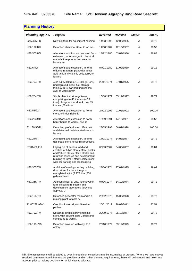
Site Name: S/O Howson Algraphy Ring Road Seacroft Site Ref: 3203370
Planning History
Planning App No. Proposal Received Decision Status Site %
32/59/95/FU New platform for equipment housing 14/03/1995 12/05/1995 A 99.76
H32/172/87/ Detached chemical store, to wo rks. 14/08/1987 12/10/1987 A 98.50
H32/303/85/ Alterations and first and seco nd floor extension, to form organic chemical manufacture p roduction area, to factory an
18/12/1985 03/02/1986 A 98.88
H32/6/80/ Alterations and extension, to form effluent treatment plant with acetic acid tank and cau stic soda tank, to factory
04/01/1980 11/02/1980 A 99.12
H32/797/74/ 4 no 54, 550 litres (12, 000 gal lons) underground diesel fuel storage tanks with 16 car-park ing spaces over to works prem
20/11/1974 27/01/1975 A 99.72
H32/704/77/ 3 bulk chemical storage tanks, comprising one 48 tonne s (47.2 tons) phosphoric acid tank, one 39 tonnes (38.4 tons
15/08/1977 05/12/1977 A 99.72
H32/53/92/ Alterations and extension to f orm store, to industrial unit.
24/02/1992 01/05/1992 A 100.00
H32/263/91/ Alterations and extension to f orm boiler house to works . hse l2
16/09/1991 14/10/1991 A 98.52
32/130/98/FU Detached prefabricated office unit and detached prefabricated store to factory
28/05/1998 06/07/1998 A 100.00
H32/24/77/ Alterations and extension, to form gas bottle store, to wo rks premises.
17/01/1977 14/03/1977 A 99.72
07/01488/FU Laying out of access road and erection of 6 two storey office blocks and 2 three storey office blocks and refurbish research and development building to form 2 storey office block, with car parking and landscaping
05/03/2007 04/06/2007 A 99.84
H32/305/74/ Addition of coatings mixing bu ilding, drum store, for the s torage of methylated spirit (2 273 litre (500 gal)petroleum
28/06/1974 27/01/1975 A 99.02
H32/266/74/ Additional floor at 2nd. floor level to form offices to re search and development laborat ory (previous approval 0
07/06/1974 14/10/1974 A 99.72
H32/155/78/ Detached generator room and ic e making plant to facto ry.
20/02/1978 15/05/1978 A 99.72
12/00238/ADV One illuminated sign to 5-a-side pitches
20/01/2012 29/03/2012 A 87.51
H32/792/77/ Detached single storey chemica l store, with solvent store , office and compound to works .
20/09/1977 05/12/1977 A 99.72
H32/1151/79/ Detached covered walkway, to f actory.
25/10/1979 03/12/1979 A 99.72
NB. Site assessments will be added to over time and some sections may be incomplete at present. Where we have not yet received comments from infrastructure providers and on other planning requirements, these will be included and taken into account prior to making decisions on which sites to allocate.

Site Name: S/O Howson Algraphy Ring Road Seacroft Site Ref: 3203370
Conformity with Core Strategy
Inner South Leeds: 0.00
Leeds Bradford Corridor: 0.00 West Leeds Gateway: 0.00
Aire Valley: 0.00Regeneration Priority Area:
Brownfield
Greenfield
Mixed
Main Urban Area
Major Settlement
Smaller Settlement
Villages/Rural
Main Urban Area Extension
Major Settlement Extension
Smaller Settlement Extension
Village/Rural Extension
Development unrelated to existing development
Green Belt assessment - only completed where site is within Green Belt
Would development lead to/constitute ribbon development?
Would development result in isolated development?
Is the site well connected to built up area (2+ boundaries with existing built up area)?
Would development of the site effectively "round off" the settlement pattern?:
Do natural/physical features provide a good existing barrier between existing urban area and undeveloped land?
Overall sprawl conclusion:
Would development of the site lead to physical connection of settlements?
Do natural/physical features provide a good existing barrier/boundary to contain development?
Overall Coalescence Conclusion:
Is there a strong defensible boundary between the site and the existing urban area?
Does the site provide access to the countryside?
Does the site include local or national conservation designated areas?
Does the site include areas of woodlands, trees, hedgerows that are protected, or significant unprotected tree/hedge cover?
Does the site include grade 1, 2, or 3a agricultural land?
Does the site contain buildings? Are these in agricultural use?
Overall countryside Encroachment Conclusion
Is the site within or adjacent to a conservation area, listed building or other historical feature?
If yes, could development preserve this character?:
Overall Character Preservation Conclusion:
Greenbelt Assessment Conclusion:
Check the unrestricted sprawl of large built up areas
Prevent neighbouring towns from merging
Assist in safeguarding countryside from encroachment
Preserve the setting and special character of historic towns
NB. Site assessments will be added to over time and some sections may be incomplete at present. Where we have not yet received comments from infrastructure providers and on other planning requirements, these will be included and taken into account prior to making decisions on which sites to allocate.

Site Name: S/O Howson Algraphy Ring Road Seacroft Site Ref: 3203370
SHLAA ConclusionsAvailability: Suitability: Achievability:
Conclusion of Assessment
Conclusion summary:
Retain - to reflect the full planning permission for office development 4/6/2007
Floorspace sq m (Non residential): 8450
Employment Conclusion: Green
East Leeds
Assesment Type: ELR Type: Office
Proposed Change:
Gypsy Traveller Site Assessment
Yes No Maybe Could site be effectively managed (Text)
Yes No Maybe Would gypsies and travellers live on the site?
(Text)
Yes No Proximity to housed gypsies and travellers (Text)
Yes No Unknown Experience of previous encampments (Text)
NB. Site assessments will be added to over time and some sections may be incomplete at present. Where we have not yet received comments from infrastructure providers and on other planning requirements, these will be included and taken into account prior to making decisions on which sites to allocate.

Site Name: R/O Woodville Garage York Road Whinmoor LS14
Site Ref: 3203490
Site Details
Land Use
Northing: 436679
Easting: 436008
Distance to Rail Station (metres): 2249.27
Nearest Railway Station Cross Gates
Distance to bus stop (metres) 105.89
Bus Stop ID 9974
Agricultural Land Class:
SFRA Flood Zone: 0.00
Environment Agency Flood Zone: 0.00
Within 300m of retail centre boundary:
UDP Designation
Greenbelt - N32 (%): 0.00 Urban Green Corridor - N8 (%): 0.00
Protected Area of Search site - N34 (%): 0.00 Rural Land - RL1: 0.00
City Centre Primary Shopping Quarter - CC27 (%): 0.00 Town Centre - S2: 0.00
Health and Safety Executive Hazard: No
Health and Safety Executive Gas Pipeline: No
Strategic Employment Buffer: 0.00
Area sq m: 4227.08 Ward ss Gates and Whinmoor
Special Landscape Area - N37: 0.00
Allotments - N1A: 0.00
Proposed Greenspace - N5: 0.00
Protected Playing Pitch - N6: 0.00
Nature Conservation Area - N50: 0.00
Conservation Areas No
Ancient Monument/Battlefield(%): 0.00 Listed Buildings: No
Public Rights of Way: No
Other?:
Natural Resources and waste DPD (if applicable)
Within Minerals Safeguarding Site?: No Within 100m of Minerals Safeguarding Site?: No
HMCA: East Leeds
Greenspace - N1: 0
Existing Use 1:
Existing Use 2:
Existing Use 3:
Neighbouring Use 1
Neighbouring Use 2:
Neighbouring Use 3:
Other uses:
Topography:
Natural Landscape:
Boundaries:
Road Frontage
Site Characteristics
Site Detail
Other comments/observations on site characteristics:
Area Ha: 0.422708
Site State:
NB. Site assessments will be added to over time and some sections may be incomplete at present. Where we have not yet received comments from infrastructure providers and on other planning requirements, these will be included and taken into account prior to making decisions on which sites to allocate.
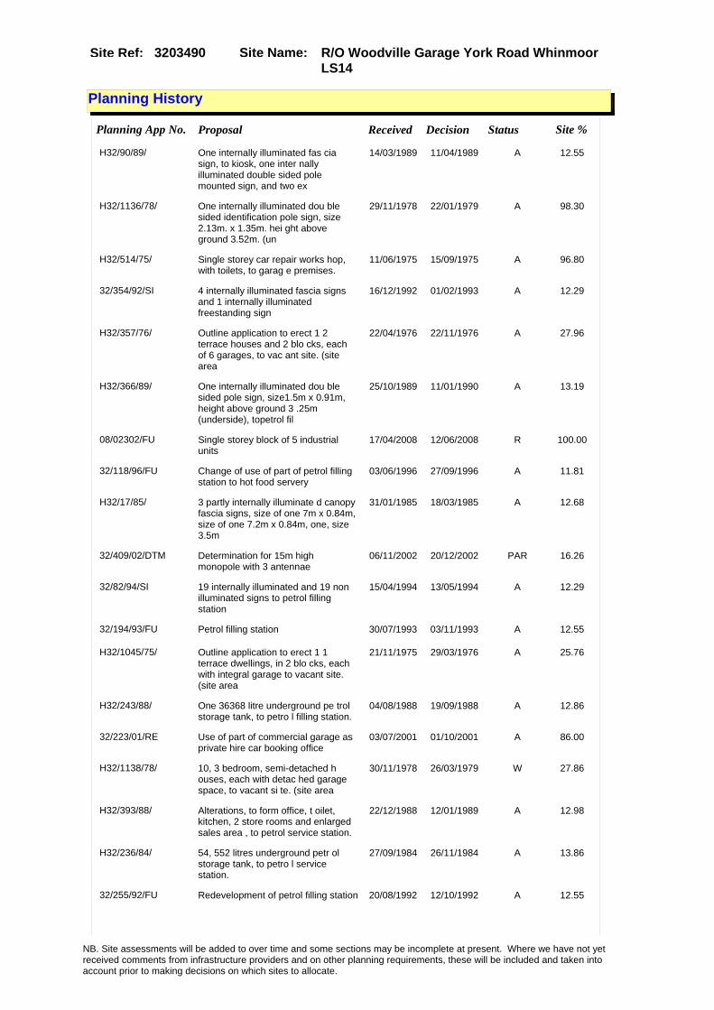
Site Name: R/O Woodville Garage York Road Whinmoor LS14
Site Ref: 3203490
Planning History
Planning App No. Proposal Received Decision Status Site %
H32/90/89/ One internally illuminated fas cia sign, to kiosk, one inter nally illuminated double sided pole mounted sign, and two ex
14/03/1989 11/04/1989 A 12.55
H32/1136/78/ One internally illuminated dou ble sided identification pole sign, size 2.13m. x 1.35m. hei ght above ground 3.52m. (un
29/11/1978 22/01/1979 A 98.30
H32/514/75/ Single storey car repair works hop, with toilets, to garag e premises.
11/06/1975 15/09/1975 A 96.80
32/354/92/SI 4 internally illuminated fascia signs and 1 internally illuminated freestanding sign
16/12/1992 01/02/1993 A 12.29
H32/357/76/ Outline application to erect 1 2 terrace houses and 2 blo cks, each of 6 garages, to vac ant site. (site area
22/04/1976 22/11/1976 A 27.96
H32/366/89/ One internally illuminated dou ble sided pole sign, size1.5m x 0.91m, height above ground 3 .25m (underside), topetrol fil
25/10/1989 11/01/1990 A 13.19
08/02302/FU Single storey block of 5 industrial units
17/04/2008 12/06/2008 R 100.00
32/118/96/FU Change of use of part of petrol filling station to hot food servery
03/06/1996 27/09/1996 A 11.81
H32/17/85/ 3 partly internally illuminate d canopy fascia signs, size of one 7m x 0.84m, size of one 7.2m x 0.84m, one, size 3.5m
31/01/1985 18/03/1985 A 12.68
32/409/02/DTM Determination for 15m high monopole with 3 antennae
06/11/2002 20/12/2002 PAR 16.26
32/82/94/SI 19 internally illuminated and 19 non illuminated signs to petrol filling station
15/04/1994 13/05/1994 A 12.29
32/194/93/FU Petrol filling station 30/07/1993 03/11/1993 A 12.55
H32/1045/75/ Outline application to erect 1 1 terrace dwellings, in 2 blo cks, each with integral garage to vacant site. (site area
21/11/1975 29/03/1976 A 25.76
H32/243/88/ One 36368 litre underground pe trol storage tank, to petro l filling station.
04/08/1988 19/09/1988 A 12.86
32/223/01/RE Use of part of commercial garage as private hire car booking office
03/07/2001 01/10/2001 A 86.00
H32/1138/78/ 10, 3 bedroom, semi-detached h ouses, each with detac hed garage space, to vacant si te. (site area
30/11/1978 26/03/1979 W 27.86
H32/393/88/ Alterations, to form office, t oilet, kitchen, 2 store rooms and enlarged sales area , to petrol service station.
22/12/1988 12/01/1989 A 12.98
H32/236/84/ 54, 552 litres underground petr ol storage tank, to petro l service station.
27/09/1984 26/11/1984 A 13.86
32/255/92/FU Redevelopment of petrol filling station 20/08/1992 12/10/1992 A 12.55
NB. Site assessments will be added to over time and some sections may be incomplete at present. Where we have not yet received comments from infrastructure providers and on other planning requirements, these will be included and taken into account prior to making decisions on which sites to allocate.

Site Name: R/O Woodville Garage York Road Whinmoor LS14
Site Ref: 3203490
07/04194/FU Single storey block of 5 industrial units
06/07/2007 11/01/2008 R 100.00
08/05072/FU Demolition of existing industrial units and erection of detached block of 5 industrial units and detached block of 2 industrial units, with car parking
27/08/2008 24/11/2008 A 100.00
H32/339/83/ Installation of manual car was h unit and car vacuum unit to petrol filling station.
03/10/1983 16/01/1984 A 13.31
32/143/00/SN 1 non illuminated (48 sheet) hoarding to petrol filling station
09/06/2000 23/10/2000 R 12.29
H32/336/89/ Detached car wash and 12, 000 g allon fuel storage tank to pe trol filling station.
09/10/1989 16/03/1990 A 13.46
NB. Site assessments will be added to over time and some sections may be incomplete at present. Where we have not yet received comments from infrastructure providers and on other planning requirements, these will be included and taken into account prior to making decisions on which sites to allocate.

Site Name: R/O Woodville Garage York Road Whinmoor LS14
Site Ref: 3203490
Conformity with Core Strategy
Inner South Leeds: 0.00
Leeds Bradford Corridor: 0.00 West Leeds Gateway: 0.00
Aire Valley: 0.00Regeneration Priority Area:
Brownfield
Greenfield
Mixed
Main Urban Area
Major Settlement
Smaller Settlement
Villages/Rural
Main Urban Area Extension
Major Settlement Extension
Smaller Settlement Extension
Village/Rural Extension
Development unrelated to existing development
Green Belt assessment - only completed where site is within Green Belt
Would development lead to/constitute ribbon development?
Would development result in isolated development?
Is the site well connected to built up area (2+ boundaries with existing built up area)?
Would development of the site effectively "round off" the settlement pattern?:
Do natural/physical features provide a good existing barrier between existing urban area and undeveloped land?
Overall sprawl conclusion:
Would development of the site lead to physical connection of settlements?
Do natural/physical features provide a good existing barrier/boundary to contain development?
Overall Coalescence Conclusion:
Is there a strong defensible boundary between the site and the existing urban area?
Does the site provide access to the countryside?
Does the site include local or national conservation designated areas?
Does the site include areas of woodlands, trees, hedgerows that are protected, or significant unprotected tree/hedge cover?
Does the site include grade 1, 2, or 3a agricultural land?
Does the site contain buildings? Are these in agricultural use?
Overall countryside Encroachment Conclusion
Is the site within or adjacent to a conservation area, listed building or other historical feature?
If yes, could development preserve this character?:
Overall Character Preservation Conclusion:
Greenbelt Assessment Conclusion:
Check the unrestricted sprawl of large built up areas
Prevent neighbouring towns from merging
Assist in safeguarding countryside from encroachment
Preserve the setting and special character of historic towns
NB. Site assessments will be added to over time and some sections may be incomplete at present. Where we have not yet received comments from infrastructure providers and on other planning requirements, these will be included and taken into account prior to making decisions on which sites to allocate.

Site Name: R/O Woodville Garage York Road Whinmoor LS14
Site Ref: 3203490
SHLAA ConclusionsAvailability: Suitability: Achievability:
Conclusion of Assessment
Conclusion summary:
Consent 08/05072/FU for industrial units; expires 23/11/2011.
Floorspace sq m (Non residential):
Employment Conclusion: Green
East Leeds
Assesment Type: ELR Type: Industrial & Warehousing
Proposed Change:
Gypsy Traveller Site Assessment
Yes No Maybe Could site be effectively managed (Text)
Yes No Maybe Would gypsies and travellers live on the site?
(Text)
Yes No Proximity to housed gypsies and travellers (Text)
Yes No Unknown Experience of previous encampments (Text)
NB. Site assessments will be added to over time and some sections may be incomplete at present. Where we have not yet received comments from infrastructure providers and on other planning requirements, these will be included and taken into account prior to making decisions on which sites to allocate.

Site Name: Holmecroft York Road LS13 4Site Ref: 3203550
Site Details
Land Use
Northing: 438221
Easting: 437928
Distance to Rail Station (metres): 4117.29
Nearest Railway Station Cross Gates
Distance to bus stop (metres) 120.47
Bus Stop ID 9233
Agricultural Land Class:
SFRA Flood Zone: 0.00
Environment Agency Flood Zone: 0.00
Within 300m of retail centre boundary:
UDP Designation
Greenbelt - N32 (%): 100.00 Urban Green Corridor - N8 (%): 0.00
Protected Area of Search site - N34 (%): 0.00 Rural Land - RL1: 0.00
City Centre Primary Shopping Quarter - CC27 (%): 0.00 Town Centre - S2: 0.00
Health and Safety Executive Hazard: No
Health and Safety Executive Gas Pipeline: Yes
Strategic Employment Buffer: 0.00
Area sq m: 22894.60 Ward Harewood
Special Landscape Area - N37: 0.00
Allotments - N1A: 0.00
Proposed Greenspace - N5: 0.00
Protected Playing Pitch - N6: 0.00
Nature Conservation Area - N50: 0.00
Conservation Areas No
Ancient Monument/Battlefield(%): 0.00 Listed Buildings: No
Public Rights of Way: No
Other?:
Natural Resources and waste DPD (if applicable)
Within Minerals Safeguarding Site?: No Within 100m of Minerals Safeguarding Site?: No
HMCA: Outer North East
Greenspace - N1: 0
Existing Use 1:
Existing Use 2:
Existing Use 3:
Neighbouring Use 1
Neighbouring Use 2:
Neighbouring Use 3:
Other uses:
Topography:
Natural Landscape:
Boundaries:
Road Frontage
Site Characteristics
Site Detail
Other comments/observations on site characteristics:
Area Ha: 2.28946
Site State:
NB. Site assessments will be added to over time and some sections may be incomplete at present. Where we have not yet received comments from infrastructure providers and on other planning requirements, these will be included and taken into account prior to making decisions on which sites to allocate.

Site Name: Holmecroft York Road LS13 4Site Ref: 3203550
Planning History
Planning App No. Proposal Received Decision Status Site %
32/163/93/CLU Application for certificate of lawful use for vehicle dismantlers
24/06/1993 24/05/1994 A 38.07
H32/193/84/ Laying out of access to farm. 24/07/1984 05/11/1984 R 52.71
07/03348/FU Erection of 2 two storey block of 2 business units, 2 single storey block of 2 business units and 1 single storey block of 10 office units with shared facilities and laying out of new access
23/05/2007 12/10/2007 W 98.64
10/00711/FU Laying out of access road and erection of 4 buildings comprising of 1 single block of 12 start up units with 2 seminar areas and 6 workshop units in 3 blocks (all class B1(b and c)) with car parking
17/02/2010 09/02/2011 A 100.00
H32/271/91/ 3.65 metre high boundary fence to scrapyard.
26/09/1991 10/03/1992 A 31.83
08/00198/FU Laying out of access road and erection of single block of 12 start up units, with 2 seminar areas, and 8 workshops units in 4 blocks, (all B1) with car parking
14/01/2008 28/02/2011 W 98.64
H32/112/92/ Security fence to car dismantlers 08/04/1992 02/07/1993 A 31.82
NB. Site assessments will be added to over time and some sections may be incomplete at present. Where we have not yet received comments from infrastructure providers and on other planning requirements, these will be included and taken into account prior to making decisions on which sites to allocate.

Site Name: Holmecroft York Road LS13 4Site Ref: 3203550
Conformity with Core Strategy
Inner South Leeds: 0.00
Leeds Bradford Corridor: 0.00 West Leeds Gateway: 0.00
Aire Valley: 0.00Regeneration Priority Area:
Brownfield
Greenfield
Mixed
Main Urban Area
Major Settlement
Smaller Settlement
Villages/Rural
Main Urban Area Extension
Major Settlement Extension
Smaller Settlement Extension
Village/Rural Extension
Development unrelated to existing development
Green Belt assessment - only completed where site is within Green Belt
Would development lead to/constitute ribbon development?
Would development result in isolated development?
Is the site well connected to built up area (2+ boundaries with existing built up area)?
Would development of the site effectively "round off" the settlement pattern?:
Do natural/physical features provide a good existing barrier between existing urban area and undeveloped land?
Overall sprawl conclusion:
Would development of the site lead to physical connection of settlements?
Do natural/physical features provide a good existing barrier/boundary to contain development?
Overall Coalescence Conclusion:
Is there a strong defensible boundary between the site and the existing urban area?
Does the site provide access to the countryside?
Does the site include local or national conservation designated areas?
Does the site include areas of woodlands, trees, hedgerows that are protected, or significant unprotected tree/hedge cover?
Does the site include grade 1, 2, or 3a agricultural land?
Does the site contain buildings? Are these in agricultural use?
Overall countryside Encroachment Conclusion
Is the site within or adjacent to a conservation area, listed building or other historical feature?
If yes, could development preserve this character?:
Overall Character Preservation Conclusion:
Greenbelt Assessment Conclusion:
Check the unrestricted sprawl of large built up areas
Prevent neighbouring towns from merging
Assist in safeguarding countryside from encroachment
Preserve the setting and special character of historic towns
NB. Site assessments will be added to over time and some sections may be incomplete at present. Where we have not yet received comments from infrastructure providers and on other planning requirements, these will be included and taken into account prior to making decisions on which sites to allocate.

Site Name: Holmecroft York Road LS13 4Site Ref: 3203550
SHLAA ConclusionsAvailability: Suitability: Achievability:
Conclusion of Assessment
Conclusion summary:
Current site with planning permission for employment purposes.
Floorspace sq m (Non residential): 2100
Employment Conclusion: Lime Green
East Leeds
Assesment Type: Planning status Type: Office
Proposed Change:
Gypsy Traveller Site Assessment
Yes No Maybe Could site be effectively managed (Text)
Yes No Maybe Would gypsies and travellers live on the site?
(Text)
Yes No Proximity to housed gypsies and travellers (Text)
Yes No Unknown Experience of previous encampments (Text)
NB. Site assessments will be added to over time and some sections may be incomplete at present. Where we have not yet received comments from infrastructure providers and on other planning requirements, these will be included and taken into account prior to making decisions on which sites to allocate.

Site Name: New Hold Est Garforth Plot 3-5Site Ref: 3303683
Site Details
Land Use
Northing: 433731
Easting: 441525
Distance to Rail Station (metres): 691.34
Nearest Railway Station East Garforth
Distance to bus stop (metres) 60.71
Bus Stop ID 4325
Agricultural Land Class:
SFRA Flood Zone: 0.00
Environment Agency Flood Zone: 0.00
Within 300m of retail centre boundary:
UDP Designation
Greenbelt - N32 (%): 0.00 Urban Green Corridor - N8 (%): 0.00
Protected Area of Search site - N34 (%): 0.00 Rural Land - RL1: 0.00
City Centre Primary Shopping Quarter - CC27 (%): 0.00 Town Centre - S2: 0.00
Health and Safety Executive Hazard: No
Health and Safety Executive Gas Pipeline: No
Strategic Employment Buffer: 2.63
Area sq m: 5854.89 Ward Garforth and Swillington
Special Landscape Area - N37: 0.00
Allotments - N1A: 0.00
Proposed Greenspace - N5: 0.00
Protected Playing Pitch - N6: 0.00
Nature Conservation Area - N50: 0.00
Conservation Areas No
Ancient Monument/Battlefield(%): 0.00 Listed Buildings: No
Public Rights of Way: No
Other?:
Natural Resources and waste DPD (if applicable)
Within Minerals Safeguarding Site?: No Within 100m of Minerals Safeguarding Site?: No
HMCA: Outer South East
Greenspace - N1: 0
Existing Use 1:
Existing Use 2:
Existing Use 3:
Neighbouring Use 1
Neighbouring Use 2:
Neighbouring Use 3:
Other uses:
Topography:
Natural Landscape:
Boundaries:
Road Frontage
Site Characteristics
Site Detail
Other comments/observations on site characteristics:
Area Ha: 0.585489
Site State:
NB. Site assessments will be added to over time and some sections may be incomplete at present. Where we have not yet received comments from infrastructure providers and on other planning requirements, these will be included and taken into account prior to making decisions on which sites to allocate.
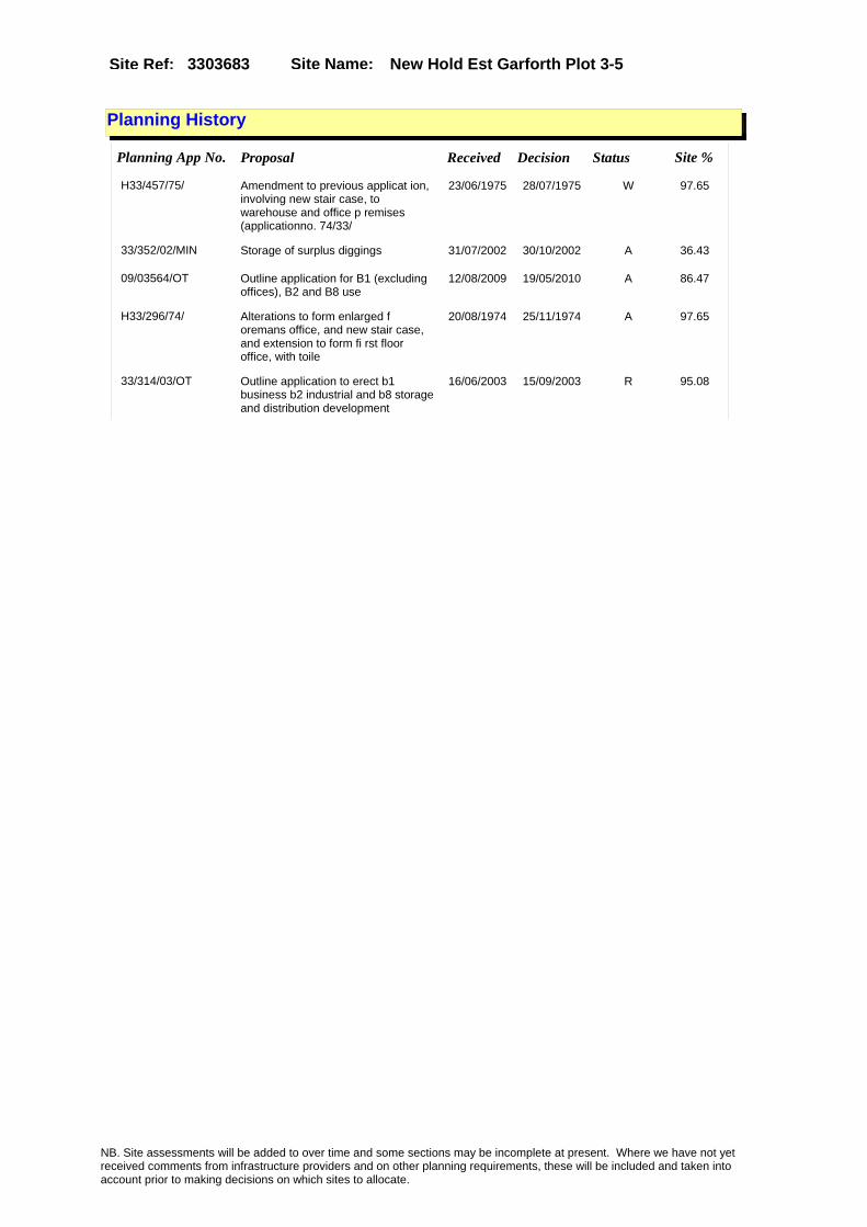
Site Name: New Hold Est Garforth Plot 3-5Site Ref: 3303683
Planning History
Planning App No. Proposal Received Decision Status Site %
H33/457/75/ Amendment to previous applicat ion, involving new stair case, to warehouse and office p remises (applicationno. 74/33/
23/06/1975 28/07/1975 W 97.65
33/352/02/MIN Storage of surplus diggings 31/07/2002 30/10/2002 A 36.43
09/03564/OT Outline application for B1 (excluding offices), B2 and B8 use
12/08/2009 19/05/2010 A 86.47
H33/296/74/ Alterations to form enlarged f oremans office, and new stair case, and extension to form fi rst floor office, with toile
20/08/1974 25/11/1974 A 97.65
33/314/03/OT Outline application to erect b1 business b2 industrial and b8 storage and distribution development
16/06/2003 15/09/2003 R 95.08
NB. Site assessments will be added to over time and some sections may be incomplete at present. Where we have not yet received comments from infrastructure providers and on other planning requirements, these will be included and taken into account prior to making decisions on which sites to allocate.

Site Name: New Hold Est Garforth Plot 3-5Site Ref: 3303683
Conformity with Core Strategy
Inner South Leeds: 0.00
Leeds Bradford Corridor: 0.00 West Leeds Gateway: 0.00
Aire Valley: 0.00Regeneration Priority Area:
Brownfield
Greenfield
Mixed
Main Urban Area
Major Settlement
Smaller Settlement
Villages/Rural
Main Urban Area Extension
Major Settlement Extension
Smaller Settlement Extension
Village/Rural Extension
Development unrelated to existing development
Green Belt assessment - only completed where site is within Green Belt
Would development lead to/constitute ribbon development?
Would development result in isolated development?
Is the site well connected to built up area (2+ boundaries with existing built up area)?
Would development of the site effectively "round off" the settlement pattern?:
Do natural/physical features provide a good existing barrier between existing urban area and undeveloped land?
Overall sprawl conclusion:
Would development of the site lead to physical connection of settlements?
Do natural/physical features provide a good existing barrier/boundary to contain development?
Overall Coalescence Conclusion:
Is there a strong defensible boundary between the site and the existing urban area?
Does the site provide access to the countryside?
Does the site include local or national conservation designated areas?
Does the site include areas of woodlands, trees, hedgerows that are protected, or significant unprotected tree/hedge cover?
Does the site include grade 1, 2, or 3a agricultural land?
Does the site contain buildings? Are these in agricultural use?
Overall countryside Encroachment Conclusion
Is the site within or adjacent to a conservation area, listed building or other historical feature?
If yes, could development preserve this character?:
Overall Character Preservation Conclusion:
Greenbelt Assessment Conclusion:
Check the unrestricted sprawl of large built up areas
Prevent neighbouring towns from merging
Assist in safeguarding countryside from encroachment
Preserve the setting and special character of historic towns
NB. Site assessments will be added to over time and some sections may be incomplete at present. Where we have not yet received comments from infrastructure providers and on other planning requirements, these will be included and taken into account prior to making decisions on which sites to allocate.

Site Name: New Hold Est Garforth Plot 3-5Site Ref: 3303683
SHLAA ConclusionsAvailability: Suitability: Achievability:
Conclusion of Assessment
Conclusion summary:
The site is suitable for industry/warehousing (subject to off-site drainage and suitable access arrangements).
Floorspace sq m (Non residential):
Employment Conclusion: Lime Green
East Leeds
Assesment Type: ELR Type: Industrial & Warehousing
Proposed Change:
Gypsy Traveller Site Assessment
Yes No Maybe Could site be effectively managed (Text)
Yes No Maybe Would gypsies and travellers live on the site?
(Text)
Yes No Proximity to housed gypsies and travellers (Text)
Yes No Unknown Experience of previous encampments (Text)
NB. Site assessments will be added to over time and some sections may be incomplete at present. Where we have not yet received comments from infrastructure providers and on other planning requirements, these will be included and taken into account prior to making decisions on which sites to allocate.

Site Name: New Hold Est Garforth Plot 9Site Ref: 3303689
Site Details
Land Use
Northing: 433745
Easting: 441459
Distance to Rail Station (metres): 713.09
Nearest Railway Station East Garforth
Distance to bus stop (metres) 127.29
Bus Stop ID 4325
Agricultural Land Class:
SFRA Flood Zone: 0.00
Environment Agency Flood Zone: 0.00
Within 300m of retail centre boundary:
UDP Designation
Greenbelt - N32 (%): 0.00 Urban Green Corridor - N8 (%): 0.00
Protected Area of Search site - N34 (%): 0.00 Rural Land - RL1: 0.00
City Centre Primary Shopping Quarter - CC27 (%): 0.00 Town Centre - S2: 0.00
Health and Safety Executive Hazard: No
Health and Safety Executive Gas Pipeline: No
Strategic Employment Buffer: 0.00
Area sq m: 1551.31 Ward Garforth and Swillington
Special Landscape Area - N37: 0.00
Allotments - N1A: 0.00
Proposed Greenspace - N5: 0.00
Protected Playing Pitch - N6: 0.00
Nature Conservation Area - N50: 0.00
Conservation Areas No
Ancient Monument/Battlefield(%): 0.00 Listed Buildings: No
Public Rights of Way: No
Other?:
Natural Resources and waste DPD (if applicable)
Within Minerals Safeguarding Site?: No Within 100m of Minerals Safeguarding Site?: No
HMCA: Outer South East
Greenspace - N1: 0
Existing Use 1:
Existing Use 2:
Existing Use 3:
Neighbouring Use 1
Neighbouring Use 2:
Neighbouring Use 3:
Other uses:
Topography:
Natural Landscape:
Boundaries:
Road Frontage
Site Characteristics
Site Detail
Other comments/observations on site characteristics:
Area Ha: 0.155131
Site State:
NB. Site assessments will be added to over time and some sections may be incomplete at present. Where we have not yet received comments from infrastructure providers and on other planning requirements, these will be included and taken into account prior to making decisions on which sites to allocate.

Site Name: New Hold Est Garforth Plot 9Site Ref: 3303689
Planning History
Planning App No. Proposal Received Decision Status Site %
H33/129/78/ Laying out of access and erect ion of single storey works hop with car parking area to v acant site. (site area
17/02/1978 15/05/1978 A 33.59
33/40/94/FU Change of use of vacant plot to car parking area and erection of 2.4 metre high boundary fence
07/02/1994 15/06/1994 A 66.78
33/141/03/FU Extension to workshop to commercial garage
24/03/2003 24/09/2003 A 98.35
H33/457/75/ Amendment to previous applicat ion, involving new stair case, to warehouse and office p remises (applicationno. 74/33/
23/06/1975 28/07/1975 W 100.00
H33/296/74/ Alterations to form enlarged f oremans office, and new stair case, and extension to form fi rst floor office, with toile
20/08/1974 25/11/1974 A 100.00
H33/293/79/ Detached panel beating shop, t o panel beating and s praying workshop.
26/04/1979 02/07/1979 A 28.07
H33/218/89/ Alterations and extension, to form reception, toilet and e nlarged canteen to workshop pr emises.
05/06/1989 29/06/1989 A 91.16
NB. Site assessments will be added to over time and some sections may be incomplete at present. Where we have not yet received comments from infrastructure providers and on other planning requirements, these will be included and taken into account prior to making decisions on which sites to allocate.

Site Name: New Hold Est Garforth Plot 9Site Ref: 3303689
Conformity with Core Strategy
Inner South Leeds: 0.00
Leeds Bradford Corridor: 0.00 West Leeds Gateway: 0.00
Aire Valley: 0.00Regeneration Priority Area:
Brownfield
Greenfield
Mixed
Main Urban Area
Major Settlement
Smaller Settlement
Villages/Rural
Main Urban Area Extension
Major Settlement Extension
Smaller Settlement Extension
Village/Rural Extension
Development unrelated to existing development
Green Belt assessment - only completed where site is within Green Belt
Would development lead to/constitute ribbon development?
Would development result in isolated development?
Is the site well connected to built up area (2+ boundaries with existing built up area)?
Would development of the site effectively "round off" the settlement pattern?:
Do natural/physical features provide a good existing barrier between existing urban area and undeveloped land?
Overall sprawl conclusion:
Would development of the site lead to physical connection of settlements?
Do natural/physical features provide a good existing barrier/boundary to contain development?
Overall Coalescence Conclusion:
Is there a strong defensible boundary between the site and the existing urban area?
Does the site provide access to the countryside?
Does the site include local or national conservation designated areas?
Does the site include areas of woodlands, trees, hedgerows that are protected, or significant unprotected tree/hedge cover?
Does the site include grade 1, 2, or 3a agricultural land?
Does the site contain buildings? Are these in agricultural use?
Overall countryside Encroachment Conclusion
Is the site within or adjacent to a conservation area, listed building or other historical feature?
If yes, could development preserve this character?:
Overall Character Preservation Conclusion:
Greenbelt Assessment Conclusion:
Check the unrestricted sprawl of large built up areas
Prevent neighbouring towns from merging
Assist in safeguarding countryside from encroachment
Preserve the setting and special character of historic towns
NB. Site assessments will be added to over time and some sections may be incomplete at present. Where we have not yet received comments from infrastructure providers and on other planning requirements, these will be included and taken into account prior to making decisions on which sites to allocate.

Site Name: New Hold Est Garforth Plot 9Site Ref: 3303689
SHLAA ConclusionsAvailability: Suitability: Achievability:
Conclusion of Assessment
Conclusion summary:
Current site with planning permission for employment purposes
Floorspace sq m (Non residential):
Employment Conclusion: Lime Green
East Leeds
Assesment Type: Planning status Type: Industrial & Warehousing
Proposed Change:
Gypsy Traveller Site Assessment
Yes No Maybe Could site be effectively managed (Text)
Yes No Maybe Would gypsies and travellers live on the site?
(Text)
Yes No Proximity to housed gypsies and travellers (Text)
Yes No Unknown Experience of previous encampments (Text)
NB. Site assessments will be added to over time and some sections may be incomplete at present. Where we have not yet received comments from infrastructure providers and on other planning requirements, these will be included and taken into account prior to making decisions on which sites to allocate.

Site Name: New Hold Est Garforth Plot 17 Site Ref: 3303691
Site Details
Land Use
Northing: 433831
Easting: 441501
Distance to Rail Station (metres): 792.94
Nearest Railway Station East Garforth
Distance to bus stop (metres) 129.94
Bus Stop ID 11047
Agricultural Land Class:
SFRA Flood Zone: 0.00
Environment Agency Flood Zone: 0.00
Within 300m of retail centre boundary:
UDP Designation
Greenbelt - N32 (%): 0.00 Urban Green Corridor - N8 (%): 0.00
Protected Area of Search site - N34 (%): 0.00 Rural Land - RL1: 0.00
City Centre Primary Shopping Quarter - CC27 (%): 0.00 Town Centre - S2: 0.00
Health and Safety Executive Hazard: No
Health and Safety Executive Gas Pipeline: No
Strategic Employment Buffer: 13.71
Area sq m: 3293.47 Ward Garforth and Swillington
Special Landscape Area - N37: 0.00
Allotments - N1A: 0.00
Proposed Greenspace - N5: 0.00
Protected Playing Pitch - N6: 0.00
Nature Conservation Area - N50: 0.00
Conservation Areas No
Ancient Monument/Battlefield(%): 0.00 Listed Buildings: No
Public Rights of Way: No
Other?:
Natural Resources and waste DPD (if applicable)
Within Minerals Safeguarding Site?: No Within 100m of Minerals Safeguarding Site?: No
HMCA: Outer South East
Greenspace - N1: 0
Existing Use 1:
Existing Use 2:
Existing Use 3:
Neighbouring Use 1
Neighbouring Use 2:
Neighbouring Use 3:
Other uses:
Topography:
Natural Landscape:
Boundaries:
Road Frontage
Site Characteristics
Site Detail
Other comments/observations on site characteristics:
Area Ha: 0.329347
Site State:
NB. Site assessments will be added to over time and some sections may be incomplete at present. Where we have not yet received comments from infrastructure providers and on other planning requirements, these will be included and taken into account prior to making decisions on which sites to allocate.
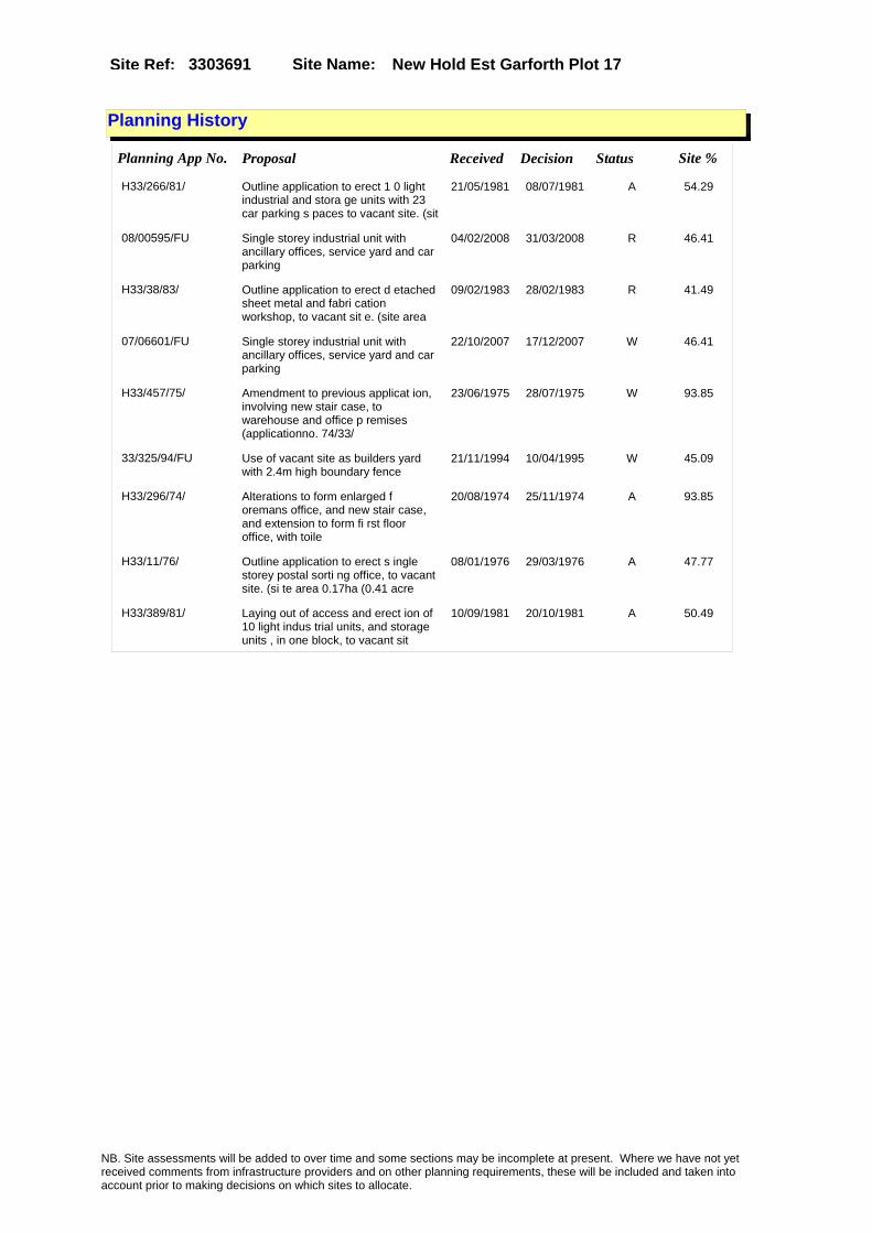
Site Name: New Hold Est Garforth Plot 17 Site Ref: 3303691
Planning History
Planning App No. Proposal Received Decision Status Site %
H33/266/81/ Outline application to erect 1 0 light industrial and stora ge units with 23 car parking s paces to vacant site. (sit
21/05/1981 08/07/1981 A 54.29
08/00595/FU Single storey industrial unit with ancillary offices, service yard and car parking
04/02/2008 31/03/2008 R 46.41
H33/38/83/ Outline application to erect d etached sheet metal and fabri cation workshop, to vacant sit e. (site area
09/02/1983 28/02/1983 R 41.49
07/06601/FU Single storey industrial unit with ancillary offices, service yard and car parking
22/10/2007 17/12/2007 W 46.41
H33/457/75/ Amendment to previous applicat ion, involving new stair case, to warehouse and office p remises (applicationno. 74/33/
23/06/1975 28/07/1975 W 93.85
33/325/94/FU Use of vacant site as builders yard with 2.4m high boundary fence
21/11/1994 10/04/1995 W 45.09
H33/296/74/ Alterations to form enlarged f oremans office, and new stair case, and extension to form fi rst floor office, with toile
20/08/1974 25/11/1974 A 93.85
H33/11/76/ Outline application to erect s ingle storey postal sorti ng office, to vacant site. (si te area 0.17ha (0.41 acre
08/01/1976 29/03/1976 A 47.77
H33/389/81/ Laying out of access and erect ion of 10 light indus trial units, and storage units , in one block, to vacant sit
10/09/1981 20/10/1981 A 50.49
NB. Site assessments will be added to over time and some sections may be incomplete at present. Where we have not yet received comments from infrastructure providers and on other planning requirements, these will be included and taken into account prior to making decisions on which sites to allocate.

Site Name: New Hold Est Garforth Plot 17 Site Ref: 3303691
Conformity with Core Strategy
Inner South Leeds: 0.00
Leeds Bradford Corridor: 0.00 West Leeds Gateway: 0.00
Aire Valley: 0.00Regeneration Priority Area:
Brownfield
Greenfield
Mixed
Main Urban Area
Major Settlement
Smaller Settlement
Villages/Rural
Main Urban Area Extension
Major Settlement Extension
Smaller Settlement Extension
Village/Rural Extension
Development unrelated to existing development
Green Belt assessment - only completed where site is within Green Belt
Would development lead to/constitute ribbon development?
Would development result in isolated development?
Is the site well connected to built up area (2+ boundaries with existing built up area)?
Would development of the site effectively "round off" the settlement pattern?:
Do natural/physical features provide a good existing barrier between existing urban area and undeveloped land?
Overall sprawl conclusion:
Would development of the site lead to physical connection of settlements?
Do natural/physical features provide a good existing barrier/boundary to contain development?
Overall Coalescence Conclusion:
Is there a strong defensible boundary between the site and the existing urban area?
Does the site provide access to the countryside?
Does the site include local or national conservation designated areas?
Does the site include areas of woodlands, trees, hedgerows that are protected, or significant unprotected tree/hedge cover?
Does the site include grade 1, 2, or 3a agricultural land?
Does the site contain buildings? Are these in agricultural use?
Overall countryside Encroachment Conclusion
Is the site within or adjacent to a conservation area, listed building or other historical feature?
If yes, could development preserve this character?:
Overall Character Preservation Conclusion:
Greenbelt Assessment Conclusion:
Check the unrestricted sprawl of large built up areas
Prevent neighbouring towns from merging
Assist in safeguarding countryside from encroachment
Preserve the setting and special character of historic towns
NB. Site assessments will be added to over time and some sections may be incomplete at present. Where we have not yet received comments from infrastructure providers and on other planning requirements, these will be included and taken into account prior to making decisions on which sites to allocate.

Site Name: New Hold Est Garforth Plot 17 Site Ref: 3303691
SHLAA ConclusionsAvailability: Suitability: Achievability:
Conclusion of Assessment
Conclusion summary:
Site suitable for employment uses however it is not known at this stage whether the site may be needed for the HS2 programme.
Floorspace sq m (Non residential):
Employment Conclusion: Amber
East Leeds
Assesment Type: Planning status Type: Industrial & Warehousing
Proposed Change:
Gypsy Traveller Site Assessment
Yes No Maybe Could site be effectively managed (Text)
Yes No Maybe Would gypsies and travellers live on the site?
(Text)
Yes No Proximity to housed gypsies and travellers (Text)
Yes No Unknown Experience of previous encampments (Text)
NB. Site assessments will be added to over time and some sections may be incomplete at present. Where we have not yet received comments from infrastructure providers and on other planning requirements, these will be included and taken into account prior to making decisions on which sites to allocate.

Site Name: Proctors Site New Hold GarforthSite Ref: 3305010
Site Details
Land Use
Northing: 433995
Easting: 441373
Distance to Rail Station (metres): 810.73
Nearest Railway Station Garforth
Distance to bus stop (metres) 331.83
Bus Stop ID 11047
Agricultural Land Class:
SFRA Flood Zone: 0.00
Environment Agency Flood Zone: 0.00
Within 300m of retail centre boundary:
UDP Designation
Greenbelt - N32 (%): 0.00 Urban Green Corridor - N8 (%): 0.00
Protected Area of Search site - N34 (%): 0.00 Rural Land - RL1: 0.00
City Centre Primary Shopping Quarter - CC27 (%): 0.00 Town Centre - S2: 0.00
Health and Safety Executive Hazard: No
Health and Safety Executive Gas Pipeline: No
Strategic Employment Buffer: 0.00
Area sq m: 11106.36 Ward Garforth and Swillington
Special Landscape Area - N37: 0.00
Allotments - N1A: 0.00
Proposed Greenspace - N5: 0.00
Protected Playing Pitch - N6: 0.00
Nature Conservation Area - N50: 0.00
Conservation Areas No
Ancient Monument/Battlefield(%): 0.00 Listed Buildings: Yes
Public Rights of Way: Yes
Other?:
Natural Resources and waste DPD (if applicable)
Within Minerals Safeguarding Site?: No Within 100m of Minerals Safeguarding Site?: No
HMCA: Outer South East
Greenspace - N1: 0
Existing Use 1:
Existing Use 2:
Existing Use 3:
Neighbouring Use 1
Neighbouring Use 2:
Neighbouring Use 3:
Other uses:
Topography:
Natural Landscape:
Boundaries:
Road Frontage
Site Characteristics
Site Detail
Other comments/observations on site characteristics:
Area Ha: 1.110636
Site State:
NB. Site assessments will be added to over time and some sections may be incomplete at present. Where we have not yet received comments from infrastructure providers and on other planning requirements, these will be included and taken into account prior to making decisions on which sites to allocate.

Site Name: Proctors Site New Hold GarforthSite Ref: 3305010
Planning History
Planning App No. Proposal Received Decision Status Site %
12/03789/FU Detached distribution warehouse 03/09/2012 20/11/2012 A 38.44
H33/25/80/ Laying out of access road, and alterations and exten sions to form production area, stores, despatch room, mess
11/01/1980 11/02/1980 A 99.56
33/61/00/FU 2 manufacturing units with offices removal of 3 spoil heaps and extension of road layout from adjacent site
23/02/2000 16/05/2002 A 98.79
H33/746/78/ Outline application to erect e xtension, to form fence manuf acturing area with offices, to factory.
04/09/1978 04/12/1978 A 99.54
0-33/9/99/MOD Two detached workshop buildings to concrete works
11/02/1999 17/02/1999 M01 98.79
H33/333/78/ Removal of old pit head spoil heaps. 27/04/1978 24/07/1978 A 37.58
33/427/02/FU Two single storey extensions to works 25/09/2002 31/10/2002 R 98.79
33/553/02/FU Single storey extensions to works 04/12/2002 31/12/2004 0 98.79
33/121/98/FU Two detached workshop buildings to concrete works
22/04/1998 22/10/1998 A 98.79
NB. Site assessments will be added to over time and some sections may be incomplete at present. Where we have not yet received comments from infrastructure providers and on other planning requirements, these will be included and taken into account prior to making decisions on which sites to allocate.

Site Name: Proctors Site New Hold GarforthSite Ref: 3305010
Conformity with Core Strategy
Inner South Leeds: 0.00
Leeds Bradford Corridor: 0.00 West Leeds Gateway: 0.00
Aire Valley: 0.00Regeneration Priority Area:
Brownfield
Greenfield
Mixed
Main Urban Area
Major Settlement
Smaller Settlement
Villages/Rural
Main Urban Area Extension
Major Settlement Extension
Smaller Settlement Extension
Village/Rural Extension
Development unrelated to existing development
Green Belt assessment - only completed where site is within Green Belt
Would development lead to/constitute ribbon development?
Would development result in isolated development?
Is the site well connected to built up area (2+ boundaries with existing built up area)?
Would development of the site effectively "round off" the settlement pattern?:
Do natural/physical features provide a good existing barrier between existing urban area and undeveloped land?
Overall sprawl conclusion:
Would development of the site lead to physical connection of settlements?
Do natural/physical features provide a good existing barrier/boundary to contain development?
Overall Coalescence Conclusion:
Is there a strong defensible boundary between the site and the existing urban area?
Does the site provide access to the countryside?
Does the site include local or national conservation designated areas?
Does the site include areas of woodlands, trees, hedgerows that are protected, or significant unprotected tree/hedge cover?
Does the site include grade 1, 2, or 3a agricultural land?
Does the site contain buildings? Are these in agricultural use?
Overall countryside Encroachment Conclusion
Is the site within or adjacent to a conservation area, listed building or other historical feature?
If yes, could development preserve this character?:
Overall Character Preservation Conclusion:
Greenbelt Assessment Conclusion:
Check the unrestricted sprawl of large built up areas
Prevent neighbouring towns from merging
Assist in safeguarding countryside from encroachment
Preserve the setting and special character of historic towns
NB. Site assessments will be added to over time and some sections may be incomplete at present. Where we have not yet received comments from infrastructure providers and on other planning requirements, these will be included and taken into account prior to making decisions on which sites to allocate.

Site Name: Proctors Site New Hold GarforthSite Ref: 3305010
SHLAA ConclusionsAvailability: Suitability: Achievability:
Conclusion of Assessment
Conclusion summary:
It is partly developed for employment use and owned by an employment development agency. Also, neighbouring uses are employment.
Floorspace sq m (Non residential):
Employment Conclusion: Lime Green
East Leeds
Assesment Type: ELR Type: Industrial & Warehousing
Proposed Change:
Gypsy Traveller Site Assessment
Yes No Maybe Could site be effectively managed (Text)
Yes No Maybe Would gypsies and travellers live on the site?
(Text)
Yes No Proximity to housed gypsies and travellers (Text)
Yes No Unknown Experience of previous encampments (Text)
NB. Site assessments will be added to over time and some sections may be incomplete at present. Where we have not yet received comments from infrastructure providers and on other planning requirements, these will be included and taken into account prior to making decisions on which sites to allocate.

Site Name: Exstg Works At Proctors Site New Hold Garforth
Site Ref: 3305013
Site Details
Land Use
Northing: 433916
Easting: 441424
Distance to Rail Station (metres): 824.33
Nearest Railway Station Garforth
Distance to bus stop (metres) 241.80
Bus Stop ID 11047
Agricultural Land Class:
SFRA Flood Zone: 0.00
Environment Agency Flood Zone: 0.00
Within 300m of retail centre boundary:
UDP Designation
Greenbelt - N32 (%): 0.00 Urban Green Corridor - N8 (%): 0.00
Protected Area of Search site - N34 (%): 0.00 Rural Land - RL1: 0.00
City Centre Primary Shopping Quarter - CC27 (%): 0.00 Town Centre - S2: 0.00
Health and Safety Executive Hazard: No
Health and Safety Executive Gas Pipeline: No
Strategic Employment Buffer: 0.00
Area sq m: 2048.75 Ward Garforth and Swillington
Special Landscape Area - N37: 0.00
Allotments - N1A: 0.00
Proposed Greenspace - N5: 0.00
Protected Playing Pitch - N6: 0.00
Nature Conservation Area - N50: 0.00
Conservation Areas No
Ancient Monument/Battlefield(%): 0.00 Listed Buildings: No
Public Rights of Way: No
Other?:
Natural Resources and waste DPD (if applicable)
Within Minerals Safeguarding Site?: No Within 100m of Minerals Safeguarding Site?: No
HMCA: Outer South East
Greenspace - N1: 0
Existing Use 1:
Existing Use 2:
Existing Use 3:
Neighbouring Use 1
Neighbouring Use 2:
Neighbouring Use 3:
Other uses:
Topography:
Natural Landscape:
Boundaries:
Road Frontage
Site Characteristics
Site Detail
Other comments/observations on site characteristics:
Area Ha: 0.204875
Site State:
NB. Site assessments will be added to over time and some sections may be incomplete at present. Where we have not yet received comments from infrastructure providers and on other planning requirements, these will be included and taken into account prior to making decisions on which sites to allocate.

Site Name: Exstg Works At Proctors Site New Hold Garforth
Site Ref: 3305013
Planning History
NB. Site assessments will be added to over time and some sections may be incomplete at present. Where we have not yet received comments from infrastructure providers and on other planning requirements, these will be included and taken into account prior to making decisions on which sites to allocate.

Site Name: Exstg Works At Proctors Site New Hold Garforth
Site Ref: 3305013
Conformity with Core Strategy
Inner South Leeds: 0.00
Leeds Bradford Corridor: 0.00 West Leeds Gateway: 0.00
Aire Valley: 0.00Regeneration Priority Area:
Brownfield
Greenfield
Mixed
Main Urban Area
Major Settlement
Smaller Settlement
Villages/Rural
Main Urban Area Extension
Major Settlement Extension
Smaller Settlement Extension
Village/Rural Extension
Development unrelated to existing development
Green Belt assessment - only completed where site is within Green Belt
Would development lead to/constitute ribbon development?
Would development result in isolated development?
Is the site well connected to built up area (2+ boundaries with existing built up area)?
Would development of the site effectively "round off" the settlement pattern?:
Do natural/physical features provide a good existing barrier between existing urban area and undeveloped land?
Overall sprawl conclusion:
Would development of the site lead to physical connection of settlements?
Do natural/physical features provide a good existing barrier/boundary to contain development?
Overall Coalescence Conclusion:
Is there a strong defensible boundary between the site and the existing urban area?
Does the site provide access to the countryside?
Does the site include local or national conservation designated areas?
Does the site include areas of woodlands, trees, hedgerows that are protected, or significant unprotected tree/hedge cover?
Does the site include grade 1, 2, or 3a agricultural land?
Does the site contain buildings? Are these in agricultural use?
Overall countryside Encroachment Conclusion
Is the site within or adjacent to a conservation area, listed building or other historical feature?
If yes, could development preserve this character?:
Overall Character Preservation Conclusion:
Greenbelt Assessment Conclusion:
Check the unrestricted sprawl of large built up areas
Prevent neighbouring towns from merging
Assist in safeguarding countryside from encroachment
Preserve the setting and special character of historic towns
NB. Site assessments will be added to over time and some sections may be incomplete at present. Where we have not yet received comments from infrastructure providers and on other planning requirements, these will be included and taken into account prior to making decisions on which sites to allocate.

Site Name: Exstg Works At Proctors Site New Hold Garforth
Site Ref: 3305013
SHLAA ConclusionsAvailability: Suitability: Achievability:
Conclusion of Assessment
Conclusion summary:
Current site with planning permission for employment purposes
Floorspace sq m (Non residential):
Employment Conclusion: Lime Green
East Leeds
Assesment Type: Planning status Type: Industrial & Warehousing
Proposed Change:
Gypsy Traveller Site Assessment
Yes No Maybe Could site be effectively managed (Text)
Yes No Maybe Would gypsies and travellers live on the site?
(Text)
Yes No Proximity to housed gypsies and travellers (Text)
Yes No Unknown Experience of previous encampments (Text)
NB. Site assessments will be added to over time and some sections may be incomplete at present. Where we have not yet received comments from infrastructure providers and on other planning requirements, these will be included and taken into account prior to making decisions on which sites to allocate.

Site Name: Ash Lane Procter Bros SiteSite Ref: 3305014
Site Details
Land Use
Northing: 433951
Easting: 441397
Distance to Rail Station (metres): 813.30
Nearest Railway Station Garforth
Distance to bus stop (metres) 284.26
Bus Stop ID 11047
Agricultural Land Class:
SFRA Flood Zone: 0.00
Environment Agency Flood Zone: 0.00
Within 300m of retail centre boundary:
UDP Designation
Greenbelt - N32 (%): 0.00 Urban Green Corridor - N8 (%): 0.00
Protected Area of Search site - N34 (%): 0.00 Rural Land - RL1: 0.00
City Centre Primary Shopping Quarter - CC27 (%): 0.00 Town Centre - S2: 0.00
Health and Safety Executive Hazard: No
Health and Safety Executive Gas Pipeline: No
Strategic Employment Buffer: 0.00
Area sq m: 4431.82 Ward Garforth and Swillington
Special Landscape Area - N37: 0.00
Allotments - N1A: 0.00
Proposed Greenspace - N5: 0.00
Protected Playing Pitch - N6: 0.00
Nature Conservation Area - N50: 0.00
Conservation Areas No
Ancient Monument/Battlefield(%): 0.00 Listed Buildings: No
Public Rights of Way: No
Other?:
Natural Resources and waste DPD (if applicable)
Within Minerals Safeguarding Site?: No Within 100m of Minerals Safeguarding Site?: No
HMCA: Outer South East
Greenspace - N1: 0
Existing Use 1:
Existing Use 2:
Existing Use 3:
Neighbouring Use 1
Neighbouring Use 2:
Neighbouring Use 3:
Other uses:
Topography:
Natural Landscape:
Boundaries:
Road Frontage
Site Characteristics
Site Detail
Other comments/observations on site characteristics:
Area Ha: 0.443182
Site State:
NB. Site assessments will be added to over time and some sections may be incomplete at present. Where we have not yet received comments from infrastructure providers and on other planning requirements, these will be included and taken into account prior to making decisions on which sites to allocate.

Site Name: Ash Lane Procter Bros SiteSite Ref: 3305014
Planning History
Planning App No. Proposal Received Decision Status Site %
12/03789/FU Detached distribution warehouse 03/09/2012 20/11/2012 A 21.93
H33/25/80/ Laying out of access road, and alterations and exten sions to form production area, stores, despatch room, mess
11/01/1980 11/02/1980 A 100.00
33/61/00/FU 2 manufacturing units with offices removal of 3 spoil heaps and extension of road layout from adjacent site
23/02/2000 16/05/2002 A 99.94
H33/746/78/ Outline application to erect e xtension, to form fence manuf acturing area with offices, to factory.
04/09/1978 04/12/1978 A 100.00
0-33/9/99/MOD Two detached workshop buildings to concrete works
11/02/1999 17/02/1999 M01 99.94
H33/333/78/ Removal of old pit head spoil heaps. 27/04/1978 24/07/1978 A 10.43
33/427/02/FU Two single storey extensions to works 25/09/2002 31/10/2002 R 99.94
08/02574/FU Prefabricated office building to replace existing single storey offices and 2.4m high boundary mesh fence
28/04/2008 15/07/2008 A 12.05
33/553/02/FU Single storey extensions to works 04/12/2002 31/12/2004 0 99.94
10/02420/FU Two storey steel fabrication workshop and ancillary office, with associated parking and landscaping
26/05/2010 16/09/2010 A 100.00
33/121/98/FU Two detached workshop buildings to concrete works
22/04/1998 22/10/1998 A 99.94
NB. Site assessments will be added to over time and some sections may be incomplete at present. Where we have not yet received comments from infrastructure providers and on other planning requirements, these will be included and taken into account prior to making decisions on which sites to allocate.

Site Name: Ash Lane Procter Bros SiteSite Ref: 3305014
Conformity with Core Strategy
Inner South Leeds: 0.00
Leeds Bradford Corridor: 0.00 West Leeds Gateway: 0.00
Aire Valley: 0.00Regeneration Priority Area:
Brownfield
Greenfield
Mixed
Main Urban Area
Major Settlement
Smaller Settlement
Villages/Rural
Main Urban Area Extension
Major Settlement Extension
Smaller Settlement Extension
Village/Rural Extension
Development unrelated to existing development
Green Belt assessment - only completed where site is within Green Belt
Would development lead to/constitute ribbon development?
Would development result in isolated development?
Is the site well connected to built up area (2+ boundaries with existing built up area)?
Would development of the site effectively "round off" the settlement pattern?:
Do natural/physical features provide a good existing barrier between existing urban area and undeveloped land?
Overall sprawl conclusion:
Would development of the site lead to physical connection of settlements?
Do natural/physical features provide a good existing barrier/boundary to contain development?
Overall Coalescence Conclusion:
Is there a strong defensible boundary between the site and the existing urban area?
Does the site provide access to the countryside?
Does the site include local or national conservation designated areas?
Does the site include areas of woodlands, trees, hedgerows that are protected, or significant unprotected tree/hedge cover?
Does the site include grade 1, 2, or 3a agricultural land?
Does the site contain buildings? Are these in agricultural use?
Overall countryside Encroachment Conclusion
Is the site within or adjacent to a conservation area, listed building or other historical feature?
If yes, could development preserve this character?:
Overall Character Preservation Conclusion:
Greenbelt Assessment Conclusion:
Check the unrestricted sprawl of large built up areas
Prevent neighbouring towns from merging
Assist in safeguarding countryside from encroachment
Preserve the setting and special character of historic towns
NB. Site assessments will be added to over time and some sections may be incomplete at present. Where we have not yet received comments from infrastructure providers and on other planning requirements, these will be included and taken into account prior to making decisions on which sites to allocate.

Site Name: Ash Lane Procter Bros SiteSite Ref: 3305014
SHLAA ConclusionsAvailability: Suitability: Achievability:
Conclusion of Assessment
Conclusion summary:
Current site with planning permission for employment purposes
Floorspace sq m (Non residential):
Employment Conclusion: Lime Green
East Leeds
Assesment Type: Planning status Type: Industrial & Warehousing
Proposed Change:
Gypsy Traveller Site Assessment
Yes No Maybe Could site be effectively managed (Text)
Yes No Maybe Would gypsies and travellers live on the site?
(Text)
Yes No Proximity to housed gypsies and travellers (Text)
Yes No Unknown Experience of previous encampments (Text)
NB. Site assessments will be added to over time and some sections may be incomplete at present. Where we have not yet received comments from infrastructure providers and on other planning requirements, these will be included and taken into account prior to making decisions on which sites to allocate.

Site Name: Lotherton Way & Ash Lane GarforthSite Ref: 3305200
Site Details
Land Use
Northing: 433840
Easting: 441351
Distance to Rail Station (metres): 730.77
Nearest Railway Station Garforth
Distance to bus stop (metres) 259.59
Bus Stop ID 4325
Agricultural Land Class:
SFRA Flood Zone: 0.00
Environment Agency Flood Zone: 0.00
Within 300m of retail centre boundary:
UDP Designation
Greenbelt - N32 (%): 0.00 Urban Green Corridor - N8 (%): 0.00
Protected Area of Search site - N34 (%): 0.00 Rural Land - RL1: 0.00
City Centre Primary Shopping Quarter - CC27 (%): 0.00 Town Centre - S2: 0.00
Health and Safety Executive Hazard: No
Health and Safety Executive Gas Pipeline: No
Strategic Employment Buffer: 0.00
Area sq m: 7201.92 Ward Garforth and Swillington
Special Landscape Area - N37: 0.00
Allotments - N1A: 0.00
Proposed Greenspace - N5: 0.00
Protected Playing Pitch - N6: 0.00
Nature Conservation Area - N50: 0.00
Conservation Areas No
Ancient Monument/Battlefield(%): 0.00 Listed Buildings: No
Public Rights of Way: No
Other?:
Natural Resources and waste DPD (if applicable)
Within Minerals Safeguarding Site?: No Within 100m of Minerals Safeguarding Site?: No
HMCA: Outer South East
Greenspace - N1: 0
Existing Use 1:
Existing Use 2:
Existing Use 3:
Neighbouring Use 1
Neighbouring Use 2:
Neighbouring Use 3:
Other uses:
Topography:
Natural Landscape:
Boundaries:
Road Frontage
Site Characteristics
Site Detail
Other comments/observations on site characteristics:
Area Ha: 0.720192
Site State:
NB. Site assessments will be added to over time and some sections may be incomplete at present. Where we have not yet received comments from infrastructure providers and on other planning requirements, these will be included and taken into account prior to making decisions on which sites to allocate.

Site Name: Lotherton Way & Ash Lane GarforthSite Ref: 3305200
Planning History
NB. Site assessments will be added to over time and some sections may be incomplete at present. Where we have not yet received comments from infrastructure providers and on other planning requirements, these will be included and taken into account prior to making decisions on which sites to allocate.

Site Name: Lotherton Way & Ash Lane GarforthSite Ref: 3305200
Conformity with Core Strategy
Inner South Leeds: 0.00
Leeds Bradford Corridor: 0.00 West Leeds Gateway: 0.00
Aire Valley: 0.00Regeneration Priority Area:
Brownfield
Greenfield
Mixed
Main Urban Area
Major Settlement
Smaller Settlement
Villages/Rural
Main Urban Area Extension
Major Settlement Extension
Smaller Settlement Extension
Village/Rural Extension
Development unrelated to existing development
Green Belt assessment - only completed where site is within Green Belt
Would development lead to/constitute ribbon development?
Would development result in isolated development?
Is the site well connected to built up area (2+ boundaries with existing built up area)?
Would development of the site effectively "round off" the settlement pattern?:
Do natural/physical features provide a good existing barrier between existing urban area and undeveloped land?
Overall sprawl conclusion:
Would development of the site lead to physical connection of settlements?
Do natural/physical features provide a good existing barrier/boundary to contain development?
Overall Coalescence Conclusion:
Is there a strong defensible boundary between the site and the existing urban area?
Does the site provide access to the countryside?
Does the site include local or national conservation designated areas?
Does the site include areas of woodlands, trees, hedgerows that are protected, or significant unprotected tree/hedge cover?
Does the site include grade 1, 2, or 3a agricultural land?
Does the site contain buildings? Are these in agricultural use?
Overall countryside Encroachment Conclusion
Is the site within or adjacent to a conservation area, listed building or other historical feature?
If yes, could development preserve this character?:
Overall Character Preservation Conclusion:
Greenbelt Assessment Conclusion:
Check the unrestricted sprawl of large built up areas
Prevent neighbouring towns from merging
Assist in safeguarding countryside from encroachment
Preserve the setting and special character of historic towns
NB. Site assessments will be added to over time and some sections may be incomplete at present. Where we have not yet received comments from infrastructure providers and on other planning requirements, these will be included and taken into account prior to making decisions on which sites to allocate.

Site Name: Lotherton Way & Ash Lane GarforthSite Ref: 3305200
SHLAA ConclusionsAvailability: Suitability: Achievability:
Conclusion of Assessment
Conclusion summary:
Highway constraints and drainage issues
Floorspace sq m (Non residential):
Employment Conclusion: Red
East Leeds
Assesment Type: ELR Type: Industrial & Warehousing
Proposed Change:
Gypsy Traveller Site Assessment
Yes No Maybe Could site be effectively managed (Text)
Yes No Maybe Would gypsies and travellers live on the site?
(Text)
Yes No Proximity to housed gypsies and travellers (Text)
Yes No Unknown Experience of previous encampments (Text)
NB. Site assessments will be added to over time and some sections may be incomplete at present. Where we have not yet received comments from infrastructure providers and on other planning requirements, these will be included and taken into account prior to making decisions on which sites to allocate.

Site Name: Aberford Road Garforth Site Ref: 3305370
Site Details
Land Use
Northing: 433694
Easting: 441358
Distance to Rail Station (metres): 687.65
Nearest Railway Station East Garforth
Distance to bus stop (metres) 136.06
Bus Stop ID 8628
Agricultural Land Class:
SFRA Flood Zone: 0.00
Environment Agency Flood Zone: 0.00
Within 300m of retail centre boundary:
UDP Designation
Greenbelt - N32 (%): 0.00 Urban Green Corridor - N8 (%): 0.00
Protected Area of Search site - N34 (%): 0.00 Rural Land - RL1: 0.00
City Centre Primary Shopping Quarter - CC27 (%): 0.00 Town Centre - S2: 0.00
Health and Safety Executive Hazard: No
Health and Safety Executive Gas Pipeline: No
Strategic Employment Buffer: 0.00
Area sq m: 17695.39 Ward Garforth and Swillington
Special Landscape Area - N37: 0.00
Allotments - N1A: 0.00
Proposed Greenspace - N5: 0.00
Protected Playing Pitch - N6: 0.00
Nature Conservation Area - N50: 0.00
Conservation Areas No
Ancient Monument/Battlefield(%): 0.00 Listed Buildings: No
Public Rights of Way: No
Other?:
Natural Resources and waste DPD (if applicable)
Within Minerals Safeguarding Site?: No Within 100m of Minerals Safeguarding Site?: No
HMCA: Outer South East
Greenspace - N1: 0
Existing Use 1:
Existing Use 2:
Existing Use 3:
Neighbouring Use 1
Neighbouring Use 2:
Neighbouring Use 3:
Other uses:
Topography:
Natural Landscape:
Boundaries:
Road Frontage
Site Characteristics
Site Detail
Other comments/observations on site characteristics:
Area Ha: 1.769539
Site State:
NB. Site assessments will be added to over time and some sections may be incomplete at present. Where we have not yet received comments from infrastructure providers and on other planning requirements, these will be included and taken into account prior to making decisions on which sites to allocate.
Site Name: Aberford Road Garforth Site Ref: 3305370
Planning History
NB. Site assessments will be added to over time and some sections may be incomplete at present. Where we have not yet received comments from infrastructure providers and on other planning requirements, these will be included and taken into account prior to making decisions on which sites to allocate.

Site Name: Aberford Road Garforth Site Ref: 3305370
Conformity with Core Strategy
Inner South Leeds: 0.00
Leeds Bradford Corridor: 0.00 West Leeds Gateway: 0.00
Aire Valley: 0.00Regeneration Priority Area:
Brownfield
Greenfield
Mixed
Main Urban Area
Major Settlement
Smaller Settlement
Villages/Rural
Main Urban Area Extension
Major Settlement Extension
Smaller Settlement Extension
Village/Rural Extension
Development unrelated to existing development
Green Belt assessment - only completed where site is within Green Belt
Would development lead to/constitute ribbon development?
Would development result in isolated development?
Is the site well connected to built up area (2+ boundaries with existing built up area)?
Would development of the site effectively "round off" the settlement pattern?:
Do natural/physical features provide a good existing barrier between existing urban area and undeveloped land?
Overall sprawl conclusion:
Would development of the site lead to physical connection of settlements?
Do natural/physical features provide a good existing barrier/boundary to contain development?
Overall Coalescence Conclusion:
Is there a strong defensible boundary between the site and the existing urban area?
Does the site provide access to the countryside?
Does the site include local or national conservation designated areas?
Does the site include areas of woodlands, trees, hedgerows that are protected, or significant unprotected tree/hedge cover?
Does the site include grade 1, 2, or 3a agricultural land?
Does the site contain buildings? Are these in agricultural use?
Overall countryside Encroachment Conclusion
Is the site within or adjacent to a conservation area, listed building or other historical feature?
If yes, could development preserve this character?:
Overall Character Preservation Conclusion:
Greenbelt Assessment Conclusion:
Check the unrestricted sprawl of large built up areas
Prevent neighbouring towns from merging
Assist in safeguarding countryside from encroachment
Preserve the setting and special character of historic towns
NB. Site assessments will be added to over time and some sections may be incomplete at present. Where we have not yet received comments from infrastructure providers and on other planning requirements, these will be included and taken into account prior to making decisions on which sites to allocate.

Site Name: Aberford Road Garforth Site Ref: 3305370
SHLAA ConclusionsAvailability: Suitability: Achievability:
Conclusion of Assessment
Conclusion summary:
Highway constraints and drainage issues
Floorspace sq m (Non residential):
Employment Conclusion: Red
East Leeds
Assesment Type: ELR Type: Industrial & Warehousing
Proposed Change:
Gypsy Traveller Site Assessment
Yes No Maybe Could site be effectively managed (Text)
Yes No Maybe Would gypsies and travellers live on the site?
(Text)
Yes No Proximity to housed gypsies and travellers (Text)
Yes No Unknown Experience of previous encampments (Text)
NB. Site assessments will be added to over time and some sections may be incomplete at present. Where we have not yet received comments from infrastructure providers and on other planning requirements, these will be included and taken into account prior to making decisions on which sites to allocate.
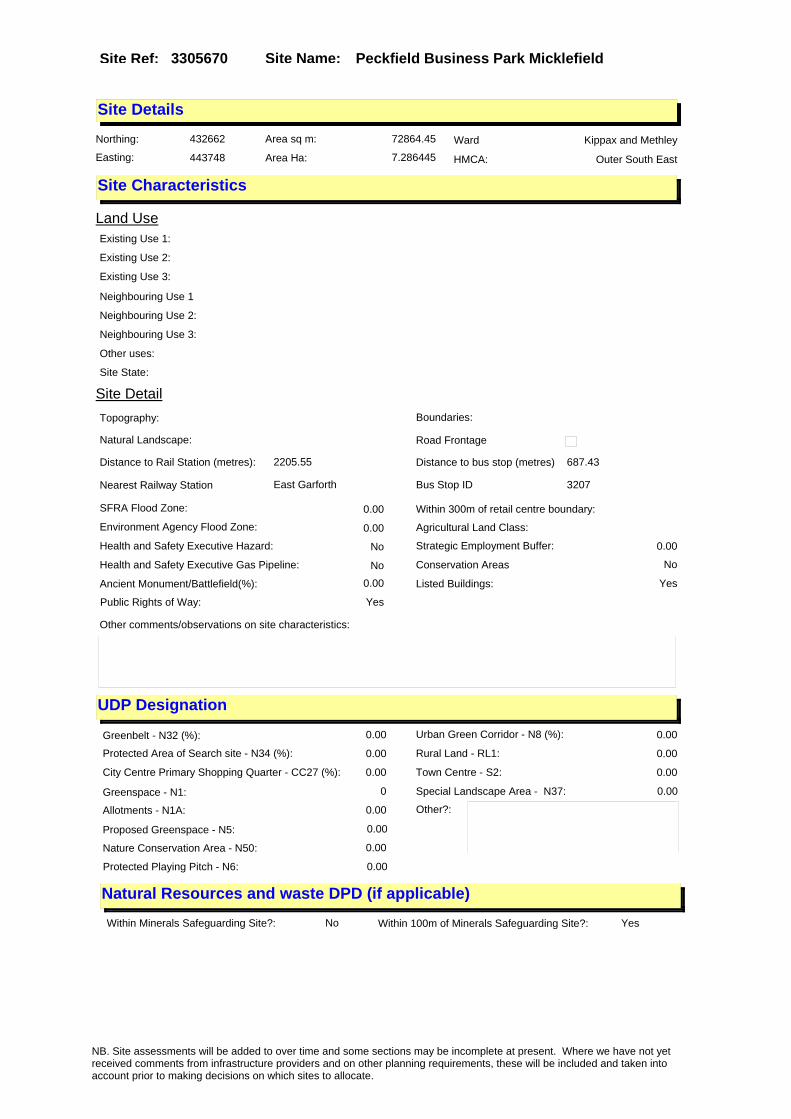
Site Name: Peckfield Business Park MicklefieldSite Ref: 3305670
Site Details
Land Use
Northing: 432662
Easting: 443748
Distance to Rail Station (metres): 2205.55
Nearest Railway Station East Garforth
Distance to bus stop (metres) 687.43
Bus Stop ID 3207
Agricultural Land Class:
SFRA Flood Zone: 0.00
Environment Agency Flood Zone: 0.00
Within 300m of retail centre boundary:
UDP Designation
Greenbelt - N32 (%): 0.00 Urban Green Corridor - N8 (%): 0.00
Protected Area of Search site - N34 (%): 0.00 Rural Land - RL1: 0.00
City Centre Primary Shopping Quarter - CC27 (%): 0.00 Town Centre - S2: 0.00
Health and Safety Executive Hazard: No
Health and Safety Executive Gas Pipeline: No
Strategic Employment Buffer: 0.00
Area sq m: 72864.45 Ward Kippax and Methley
Special Landscape Area - N37: 0.00
Allotments - N1A: 0.00
Proposed Greenspace - N5: 0.00
Protected Playing Pitch - N6: 0.00
Nature Conservation Area - N50: 0.00
Conservation Areas No
Ancient Monument/Battlefield(%): 0.00 Listed Buildings: Yes
Public Rights of Way: Yes
Other?:
Natural Resources and waste DPD (if applicable)
Within Minerals Safeguarding Site?: No Within 100m of Minerals Safeguarding Site?: Yes
HMCA: Outer South East
Greenspace - N1: 0
Existing Use 1:
Existing Use 2:
Existing Use 3:
Neighbouring Use 1
Neighbouring Use 2:
Neighbouring Use 3:
Other uses:
Topography:
Natural Landscape:
Boundaries:
Road Frontage
Site Characteristics
Site Detail
Other comments/observations on site characteristics:
Area Ha: 7.286445
Site State:
NB. Site assessments will be added to over time and some sections may be incomplete at present. Where we have not yet received comments from infrastructure providers and on other planning requirements, these will be included and taken into account prior to making decisions on which sites to allocate.

Site Name: Peckfield Business Park MicklefieldSite Ref: 3305670
Planning History
NB. Site assessments will be added to over time and some sections may be incomplete at present. Where we have not yet received comments from infrastructure providers and on other planning requirements, these will be included and taken into account prior to making decisions on which sites to allocate.

Site Name: Peckfield Business Park MicklefieldSite Ref: 3305670
Conformity with Core Strategy
Inner South Leeds: 0.00
Leeds Bradford Corridor: 0.00 West Leeds Gateway: 0.00
Aire Valley: 0.00Regeneration Priority Area:
Brownfield
Greenfield
Mixed
Main Urban Area
Major Settlement
Smaller Settlement
Villages/Rural
Main Urban Area Extension
Major Settlement Extension
Smaller Settlement Extension
Village/Rural Extension
Development unrelated to existing development
Green Belt assessment - only completed where site is within Green Belt
Would development lead to/constitute ribbon development?
Would development result in isolated development?
Is the site well connected to built up area (2+ boundaries with existing built up area)?
Would development of the site effectively "round off" the settlement pattern?:
Do natural/physical features provide a good existing barrier between existing urban area and undeveloped land?
Overall sprawl conclusion:
Would development of the site lead to physical connection of settlements?
Do natural/physical features provide a good existing barrier/boundary to contain development?
Overall Coalescence Conclusion:
Is there a strong defensible boundary between the site and the existing urban area?
Does the site provide access to the countryside?
Does the site include local or national conservation designated areas?
Does the site include areas of woodlands, trees, hedgerows that are protected, or significant unprotected tree/hedge cover?
Does the site include grade 1, 2, or 3a agricultural land?
Does the site contain buildings? Are these in agricultural use?
Overall countryside Encroachment Conclusion
Is the site within or adjacent to a conservation area, listed building or other historical feature?
If yes, could development preserve this character?:
Overall Character Preservation Conclusion:
Greenbelt Assessment Conclusion:
Check the unrestricted sprawl of large built up areas
Prevent neighbouring towns from merging
Assist in safeguarding countryside from encroachment
Preserve the setting and special character of historic towns
NB. Site assessments will be added to over time and some sections may be incomplete at present. Where we have not yet received comments from infrastructure providers and on other planning requirements, these will be included and taken into account prior to making decisions on which sites to allocate.

Site Name: Peckfield Business Park MicklefieldSite Ref: 3305670
SHLAA ConclusionsAvailability: Suitability: Achievability:
Conclusion of Assessment
Conclusion summary:
Current site with planning permission for employment purposes
Floorspace sq m (Non residential):
Employment Conclusion: Lime Green
East Leeds
Assesment Type: ELR Type: Industrial & Warehousing
Proposed Change:
Gypsy Traveller Site Assessment
Yes No Maybe Could site be effectively managed (Text)
Yes No Maybe Would gypsies and travellers live on the site?
(Text)
Yes No Proximity to housed gypsies and travellers (Text)
Yes No Unknown Experience of previous encampments (Text)
NB. Site assessments will be added to over time and some sections may be incomplete at present. Where we have not yet received comments from infrastructure providers and on other planning requirements, these will be included and taken into account prior to making decisions on which sites to allocate.

Site Name: Unit3 Peckfield Business Park MicklefieldSite Ref: 3305674
Site Details
Land Use
Northing: 432718
Easting: 443415
Distance to Rail Station (metres): 1867.71
Nearest Railway Station East Garforth
Distance to bus stop (metres) 873.68
Bus Stop ID 11764
Agricultural Land Class:
SFRA Flood Zone: 0.00
Environment Agency Flood Zone: 0.00
Within 300m of retail centre boundary:
UDP Designation
Greenbelt - N32 (%): 0.00 Urban Green Corridor - N8 (%): 0.00
Protected Area of Search site - N34 (%): 0.00 Rural Land - RL1: 0.00
City Centre Primary Shopping Quarter - CC27 (%): 0.00 Town Centre - S2: 0.00
Health and Safety Executive Hazard: No
Health and Safety Executive Gas Pipeline: No
Strategic Employment Buffer: 0.00
Area sq m: 15484.44 Ward Kippax and Methley
Special Landscape Area - N37: 0.00
Allotments - N1A: 0.00
Proposed Greenspace - N5: 0.00
Protected Playing Pitch - N6: 0.00
Nature Conservation Area - N50: 0.00
Conservation Areas No
Ancient Monument/Battlefield(%): 0.00 Listed Buildings: No
Public Rights of Way: No
Other?:
Natural Resources and waste DPD (if applicable)
Within Minerals Safeguarding Site?: No Within 100m of Minerals Safeguarding Site?: No
HMCA: Outer South East
Greenspace - N1: 0
Existing Use 1:
Existing Use 2:
Existing Use 3:
Neighbouring Use 1
Neighbouring Use 2:
Neighbouring Use 3:
Other uses:
Topography:
Natural Landscape:
Boundaries:
Road Frontage
Site Characteristics
Site Detail
Other comments/observations on site characteristics:
Area Ha: 1.548444
Site State:
NB. Site assessments will be added to over time and some sections may be incomplete at present. Where we have not yet received comments from infrastructure providers and on other planning requirements, these will be included and taken into account prior to making decisions on which sites to allocate.
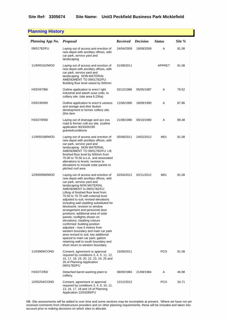
Site Name: Unit3 Peckfield Business Park MicklefieldSite Ref: 3305674
Planning History
Planning App No. Proposal Received Decision Status Site %
09/01782/FU Laying out of access and erection of new depot with ancillary offices, with car park, service yard and landscaping
24/04/2009 19/08/2009 A 81.08
11/9/00162/MOD Laying out of access and erection of new depot with ancillary offices, with car park, service yard and landscaping�NON-MATERIAL AMENDMENT TO 09/01782/FU: Building floor level raised by 500mm
01/08/2011 APPRET 81.08
H33/347/86/ Outline application to erect l ight industrial and wareh ouse units, to colliery site. (site area 9.23ha)
02/12/1986 05/05/1987 A 79.52
H33/195/90/ Outline application to erect b usiness and storage and distr ibution development to former colliery site. (this item
11/06/1990 18/09/1990 A 87.86
H33/278/90/ Laying out of drainage and acc ess road to former colli ery site. (outline application 90/33/00195 grantedconditiona
21/08/1990 09/10/1990 A 89.48
11/9/00168/MOD Laying out of access and erection of new depot with ancillary offices, with car park, service yard and landscaping�NON MATERIAL AMENDMENT TO 09/01782/FU: Lift finished floor level by 500mm from 70.00 to 70.50 a.o.d., and associated alterations to levels; revision to elevations to include solar panels to pitched roof area
05/08/2011 24/02/2012 M01 81.08
12/9/00069/MOD Laying out of access and erection of new depot with ancillary offices, with car park, service yard and landscaping NON MATERIAL AMENDMENT to 09/01782/FU: Lifting of finished floor level from 70.50 to 70.70 with external level adjusted to suit; revised elevations including wall cladding substituted for blockwork, revision to window arrangement and personnel door positions; additional area of solar panels; rooflights shown on elevations; cladding colours confirmed; building position adjusted - now 4 metres from western boundary and main car park area revised to suit; two additional spaced to main car park; gabion retaining wall to south boundary and short return to western boundary
02/04/2012 02/11/2012 M01 81.08
11/03909/COND Consent, agreement or approval required by conditions 3, 4, 5, 11, 12, 15, 17, 18, 19, 20, 22, 23, 24, 25 and 26 of Planning Application 09/01782/FU
15/09/2011 PCO 81.08
H33/272/83/ Detached barrel washing plant to colliery.
08/09/1983 21/08/1984 A 46.98
12/05254/COND Consent, agreement or approval required by conditions 3, 4, 9, 10, 11, 13, 16, 17, 18 and 19 of Planning Application 12/03285/FU
12/12/2012 PCO 34.71
NB. Site assessments will be added to over time and some sections may be incomplete at present. Where we have not yet received comments from infrastructure providers and on other planning requirements, these will be included and taken into account prior to making decisions on which sites to allocate.

Site Name: Unit3 Peckfield Business Park MicklefieldSite Ref: 3305674
12/03285/FU Use of site for external storage and erect detached covered storage building
27/07/2012 16/11/2012 A 34.71
12/9/00251/MOD Laying out of access and erection of new depot with ancillary offices, with car park, service yard and landscaping NON MATERIAL AMENDMENT to 09/01782/FU: Repostioning and size of new depot building and alterations to car parking
05/12/2012 PCO 81.08
NB. Site assessments will be added to over time and some sections may be incomplete at present. Where we have not yet received comments from infrastructure providers and on other planning requirements, these will be included and taken into account prior to making decisions on which sites to allocate.

Site Name: Unit3 Peckfield Business Park MicklefieldSite Ref: 3305674
Conformity with Core Strategy
Inner South Leeds: 0.00
Leeds Bradford Corridor: 0.00 West Leeds Gateway: 0.00
Aire Valley: 0.00Regeneration Priority Area:
Brownfield
Greenfield
Mixed
Main Urban Area
Major Settlement
Smaller Settlement
Villages/Rural
Main Urban Area Extension
Major Settlement Extension
Smaller Settlement Extension
Village/Rural Extension
Development unrelated to existing development
Green Belt assessment - only completed where site is within Green Belt
Would development lead to/constitute ribbon development?
Would development result in isolated development?
Is the site well connected to built up area (2+ boundaries with existing built up area)?
Would development of the site effectively "round off" the settlement pattern?:
Do natural/physical features provide a good existing barrier between existing urban area and undeveloped land?
Overall sprawl conclusion:
Would development of the site lead to physical connection of settlements?
Do natural/physical features provide a good existing barrier/boundary to contain development?
Overall Coalescence Conclusion:
Is there a strong defensible boundary between the site and the existing urban area?
Does the site provide access to the countryside?
Does the site include local or national conservation designated areas?
Does the site include areas of woodlands, trees, hedgerows that are protected, or significant unprotected tree/hedge cover?
Does the site include grade 1, 2, or 3a agricultural land?
Does the site contain buildings? Are these in agricultural use?
Overall countryside Encroachment Conclusion
Is the site within or adjacent to a conservation area, listed building or other historical feature?
If yes, could development preserve this character?:
Overall Character Preservation Conclusion:
Greenbelt Assessment Conclusion:
Check the unrestricted sprawl of large built up areas
Prevent neighbouring towns from merging
Assist in safeguarding countryside from encroachment
Preserve the setting and special character of historic towns
NB. Site assessments will be added to over time and some sections may be incomplete at present. Where we have not yet received comments from infrastructure providers and on other planning requirements, these will be included and taken into account prior to making decisions on which sites to allocate.

Site Name: Unit3 Peckfield Business Park MicklefieldSite Ref: 3305674
SHLAA ConclusionsAvailability: Suitability: Achievability:
Conclusion of Assessment
Conclusion summary:
Consent 09/01782/FU for depot; expires 18/8/2012.
Floorspace sq m (Non residential):
Employment Conclusion: Lime Green
East Leeds
Assesment Type: ELR Type: Industrial & Warehousing
Proposed Change:
Gypsy Traveller Site Assessment
Yes No Maybe Could site be effectively managed (Text)
Yes No Maybe Would gypsies and travellers live on the site?
(Text)
Yes No Proximity to housed gypsies and travellers (Text)
Yes No Unknown Experience of previous encampments (Text)
NB. Site assessments will be added to over time and some sections may be incomplete at present. Where we have not yet received comments from infrastructure providers and on other planning requirements, these will be included and taken into account prior to making decisions on which sites to allocate.

Site Name: Residual Site Station Road Allerton Bywater WF10
Site Ref: 3306161
Site Details
Land Use
Northing: 427700
Easting: 442418
Distance to Rail Station (metres): 5407.17
Nearest Railway Station East Garforth
Distance to bus stop (metres) 139.96
Bus Stop ID 9481
Agricultural Land Class:
SFRA Flood Zone: 1.00
Environment Agency Flood Zone: 1.00
Within 300m of retail centre boundary:
UDP Designation
Greenbelt - N32 (%): 0.00 Urban Green Corridor - N8 (%): 0.00
Protected Area of Search site - N34 (%): 0.00 Rural Land - RL1: 0.00
City Centre Primary Shopping Quarter - CC27 (%): 0.00 Town Centre - S2: 0.00
Health and Safety Executive Hazard: No
Health and Safety Executive Gas Pipeline: No
Strategic Employment Buffer: 0.00
Area sq m: 14804.77 Ward Kippax and Methley
Special Landscape Area - N37: 0.00
Allotments - N1A: 0.00
Proposed Greenspace - N5: 0.00
Protected Playing Pitch - N6: 0.00
Nature Conservation Area - N50: 0.00
Conservation Areas No
Ancient Monument/Battlefield(%): 0.00 Listed Buildings: No
Public Rights of Way: No
Other?:
Natural Resources and waste DPD (if applicable)
Within Minerals Safeguarding Site?: No Within 100m of Minerals Safeguarding Site?: No
HMCA: Outer South East
Greenspace - N1: 0
Existing Use 1:
Existing Use 2:
Existing Use 3:
Neighbouring Use 1
Neighbouring Use 2:
Neighbouring Use 3:
Other uses:
Topography:
Natural Landscape:
Boundaries:
Road Frontage
Site Characteristics
Site Detail
Other comments/observations on site characteristics:
Area Ha: 1.480477
Site State:
NB. Site assessments will be added to over time and some sections may be incomplete at present. Where we have not yet received comments from infrastructure providers and on other planning requirements, these will be included and taken into account prior to making decisions on which sites to allocate.

Site Name: Residual Site Station Road Allerton Bywater WF10
Site Ref: 3306161
Planning History
NB. Site assessments will be added to over time and some sections may be incomplete at present. Where we have not yet received comments from infrastructure providers and on other planning requirements, these will be included and taken into account prior to making decisions on which sites to allocate.

Site Name: Residual Site Station Road Allerton Bywater WF10
Site Ref: 3306161
Conformity with Core Strategy
Inner South Leeds: 0.00
Leeds Bradford Corridor: 0.00 West Leeds Gateway: 0.00
Aire Valley: 0.00Regeneration Priority Area:
Brownfield
Greenfield
Mixed
Main Urban Area
Major Settlement
Smaller Settlement
Villages/Rural
Main Urban Area Extension
Major Settlement Extension
Smaller Settlement Extension
Village/Rural Extension
Development unrelated to existing development
Green Belt assessment - only completed where site is within Green Belt
Would development lead to/constitute ribbon development?
Would development result in isolated development?
Is the site well connected to built up area (2+ boundaries with existing built up area)?
Would development of the site effectively "round off" the settlement pattern?:
Do natural/physical features provide a good existing barrier between existing urban area and undeveloped land?
Overall sprawl conclusion:
Would development of the site lead to physical connection of settlements?
Do natural/physical features provide a good existing barrier/boundary to contain development?
Overall Coalescence Conclusion:
Is there a strong defensible boundary between the site and the existing urban area?
Does the site provide access to the countryside?
Does the site include local or national conservation designated areas?
Does the site include areas of woodlands, trees, hedgerows that are protected, or significant unprotected tree/hedge cover?
Does the site include grade 1, 2, or 3a agricultural land?
Does the site contain buildings? Are these in agricultural use?
Overall countryside Encroachment Conclusion
Is the site within or adjacent to a conservation area, listed building or other historical feature?
If yes, could development preserve this character?:
Overall Character Preservation Conclusion:
Greenbelt Assessment Conclusion:
Check the unrestricted sprawl of large built up areas
Prevent neighbouring towns from merging
Assist in safeguarding countryside from encroachment
Preserve the setting and special character of historic towns
NB. Site assessments will be added to over time and some sections may be incomplete at present. Where we have not yet received comments from infrastructure providers and on other planning requirements, these will be included and taken into account prior to making decisions on which sites to allocate.

Site Name: Residual Site Station Road Allerton Bywater WF10
Site Ref: 3306161
SHLAA ConclusionsAvailability: Suitability: Achievability:
Conclusion of Assessment
Conclusion summary:
Current site with planning permission for employment purposes
Floorspace sq m (Non residential): 5550
Employment Conclusion: Lime Green
East Leeds
Assesment Type: Planning status Type: Office
Proposed Change:
Gypsy Traveller Site Assessment
Yes No Maybe Could site be effectively managed (Text)
Yes No Maybe Would gypsies and travellers live on the site?
(Text)
Yes No Proximity to housed gypsies and travellers (Text)
Yes No Unknown Experience of previous encampments (Text)
NB. Site assessments will be added to over time and some sections may be incomplete at present. Where we have not yet received comments from infrastructure providers and on other planning requirements, these will be included and taken into account prior to making decisions on which sites to allocate.

Site Name: Ph2 Hawks Park North Newhold Aberford Road Garforth
Site Ref: 3306220
Site Details
Land Use
Northing: 434318
Easting: 441572
Distance to Rail Station (metres): 1152.58
Nearest Railway Station Garforth
Distance to bus stop (metres) 373.00
Bus Stop ID 523
Agricultural Land Class:
SFRA Flood Zone: 0.00
Environment Agency Flood Zone: 0.00
Within 300m of retail centre boundary:
UDP Designation
Greenbelt - N32 (%): 0.00 Urban Green Corridor - N8 (%): 0.00
Protected Area of Search site - N34 (%): 0.00 Rural Land - RL1: 0.00
City Centre Primary Shopping Quarter - CC27 (%): 0.00 Town Centre - S2: 0.00
Health and Safety Executive Hazard: No
Health and Safety Executive Gas Pipeline: Yes
Strategic Employment Buffer: 51.64
Area sq m: 166449.44 Ward Garforth and Swillington
Special Landscape Area - N37: 0.00
Allotments - N1A: 0.00
Proposed Greenspace - N5: 0.00
Protected Playing Pitch - N6: 0.00
Nature Conservation Area - N50: 0.00
Conservation Areas No
Ancient Monument/Battlefield(%): 0.00 Listed Buildings: No
Public Rights of Way: No
Other?:
Natural Resources and waste DPD (if applicable)
Within Minerals Safeguarding Site?: No Within 100m of Minerals Safeguarding Site?: No
HMCA: Outer South East
Greenspace - N1: 0
Existing Use 1:
Existing Use 2:
Existing Use 3:
Neighbouring Use 1
Neighbouring Use 2:
Neighbouring Use 3:
Other uses:
Topography:
Natural Landscape:
Boundaries:
Road Frontage
Site Characteristics
Site Detail
Other comments/observations on site characteristics:
Area Ha: 16.644944
Site State:
NB. Site assessments will be added to over time and some sections may be incomplete at present. Where we have not yet received comments from infrastructure providers and on other planning requirements, these will be included and taken into account prior to making decisions on which sites to allocate.

Site Name: Ph2 Hawks Park North Newhold Aberford Road Garforth
Site Ref: 3306220
Planning History
Planning App No. Proposal Received Decision Status Site %
33/279/97/MIN Variation of condition no 3 of application no 33/234/94/fu (to allow site operations to continue until 31-may-1998)
27/10/1997 19/12/1997 A 96.03
11/04212/COND Consent, agreement or approval required by conditions 8, 11, 13, 16, 18, 21, 22, 23, 24 and 25 of Planning Application 10/00916/EXT
04/10/2011 07/06/2012 A 100.00
33/234/94/FU Stabilisation of proposed development land and reclamation of derelict land by opencast mining
11/08/1994 04/10/1995 A 95.72
12/00725/OT Outline application for employment park and laying out of access
16/02/2012 PCO 99.76
33/269/97/MIN Variation of condition no 2 of application no 33/234/94/fu (approved drawings)
07/10/1997 19/12/1997 A 96.03
33/103/97/MIN Variation of condition no 2 of application no 33/234/94/fu (to modify the method of working of the site)
30/04/1997 17/06/1997 A 95.72
09/05079/COND Consent, agreement or approval required by conditions 15, 16, 17 and 18 of Planning Application 33/119/05/OT
20/11/2009 05/01/2010 SPL 100.00
09/05557/COND Consent, agreement or approval required by conditions 3, 5, 7, 8, 10, 27 and 28 of Planning Application 33/119/05/OT
23/12/2009 17/03/2010 SPL 100.00
09/03680/ADV One non illuminated free standing sales hoarding to development site
21/08/2009 16/10/2009 A 22.66
33/119/05/OT Outline application for offices, industrial units, warehousing and balancing pond
11/03/2005 31/05/2007 A 100.00
33/191/96/MIN Variation of condition no 5 of application no 33/234/94/fu (noise limits)
04/07/1996 14/08/1996 R 96.03
10/00834/COND Consent, agreement or approval required by conditions 6 and 13 of Planning Application 33/119/05/OT
23/02/2010 14/05/2010 A 100.00
10/00916/EXT Extension of time application for an outline application for offices, industrial units, warehousing and balancing pond
26/02/2010 26/05/2010 A 100.00
NB. Site assessments will be added to over time and some sections may be incomplete at present. Where we have not yet received comments from infrastructure providers and on other planning requirements, these will be included and taken into account prior to making decisions on which sites to allocate.

Site Name: Ph2 Hawks Park North Newhold Aberford Road Garforth
Site Ref: 3306220
Conformity with Core Strategy
Inner South Leeds: 0.00
Leeds Bradford Corridor: 0.00 West Leeds Gateway: 0.00
Aire Valley: 0.00Regeneration Priority Area:
Brownfield
Greenfield
Mixed
Main Urban Area
Major Settlement
Smaller Settlement
Villages/Rural
Main Urban Area Extension
Major Settlement Extension
Smaller Settlement Extension
Village/Rural Extension
Development unrelated to existing development
Green Belt assessment - only completed where site is within Green Belt
Would development lead to/constitute ribbon development?
Would development result in isolated development?
Is the site well connected to built up area (2+ boundaries with existing built up area)?
Would development of the site effectively "round off" the settlement pattern?:
Do natural/physical features provide a good existing barrier between existing urban area and undeveloped land?
Overall sprawl conclusion:
Would development of the site lead to physical connection of settlements?
Do natural/physical features provide a good existing barrier/boundary to contain development?
Overall Coalescence Conclusion:
Is there a strong defensible boundary between the site and the existing urban area?
Does the site provide access to the countryside?
Does the site include local or national conservation designated areas?
Does the site include areas of woodlands, trees, hedgerows that are protected, or significant unprotected tree/hedge cover?
Does the site include grade 1, 2, or 3a agricultural land?
Does the site contain buildings? Are these in agricultural use?
Overall countryside Encroachment Conclusion
Is the site within or adjacent to a conservation area, listed building or other historical feature?
If yes, could development preserve this character?:
Overall Character Preservation Conclusion:
Greenbelt Assessment Conclusion:
Check the unrestricted sprawl of large built up areas
Prevent neighbouring towns from merging
Assist in safeguarding countryside from encroachment
Preserve the setting and special character of historic towns
NB. Site assessments will be added to over time and some sections may be incomplete at present. Where we have not yet received comments from infrastructure providers and on other planning requirements, these will be included and taken into account prior to making decisions on which sites to allocate.

Site Name: Ph2 Hawks Park North Newhold Aberford Road Garforth
Site Ref: 3306220
SHLAA ConclusionsAvailability: Suitability: Achievability:
Conclusion of Assessment
Conclusion summary:
Site subdivided following RMs 08/06887/RM. This is Ph 2. It has employment planning permission.
Floorspace sq m (Non residential):
Employment Conclusion: Lime Green
East Leeds
Assesment Type: ELR Type: Industrial & Warehousing
Proposed Change:
Gypsy Traveller Site Assessment
Yes No Maybe Could site be effectively managed (Text)
Yes No Maybe Would gypsies and travellers live on the site?
(Text)
Yes No Proximity to housed gypsies and travellers (Text)
Yes No Unknown Experience of previous encampments (Text)
NB. Site assessments will be added to over time and some sections may be incomplete at present. Where we have not yet received comments from infrastructure providers and on other planning requirements, these will be included and taken into account prior to making decisions on which sites to allocate.

Site Name: Ph1a Offices Hawks Park North Newhold Aberford Road Garforth
Site Ref: 3306221
Site Details
Land Use
Northing: 434154
Easting: 441787
Distance to Rail Station (metres): 1132.66
Nearest Railway Station East Garforth
Distance to bus stop (metres) 143.47
Bus Stop ID 523
Agricultural Land Class:
SFRA Flood Zone: 0.00
Environment Agency Flood Zone: 0.00
Within 300m of retail centre boundary:
UDP Designation
Greenbelt - N32 (%): 0.00 Urban Green Corridor - N8 (%): 0.00
Protected Area of Search site - N34 (%): 0.00 Rural Land - RL1: 0.00
City Centre Primary Shopping Quarter - CC27 (%): 0.00 Town Centre - S2: 0.00
Health and Safety Executive Hazard: No
Health and Safety Executive Gas Pipeline: No
Strategic Employment Buffer: 0.00
Area sq m: 37880.70 Ward Garforth and Swillington
Special Landscape Area - N37: 0.00
Allotments - N1A: 0.00
Proposed Greenspace - N5: 0.00
Protected Playing Pitch - N6: 0.00
Nature Conservation Area - N50: 0.00
Conservation Areas No
Ancient Monument/Battlefield(%): 0.00 Listed Buildings: No
Public Rights of Way: No
Other?:
Natural Resources and waste DPD (if applicable)
Within Minerals Safeguarding Site?: No Within 100m of Minerals Safeguarding Site?: No
HMCA: Outer South East
Greenspace - N1: 0
Existing Use 1:
Existing Use 2:
Existing Use 3:
Neighbouring Use 1
Neighbouring Use 2:
Neighbouring Use 3:
Other uses:
Topography:
Natural Landscape:
Boundaries:
Road Frontage
Site Characteristics
Site Detail
Other comments/observations on site characteristics:
Area Ha: 3.78807
Site State:
NB. Site assessments will be added to over time and some sections may be incomplete at present. Where we have not yet received comments from infrastructure providers and on other planning requirements, these will be included and taken into account prior to making decisions on which sites to allocate.
Site Name: Ph1a Offices Hawks Park North Newhold Aberford Road Garforth
Site Ref: 3306221
Planning History
NB. Site assessments will be added to over time and some sections may be incomplete at present. Where we have not yet received comments from infrastructure providers and on other planning requirements, these will be included and taken into account prior to making decisions on which sites to allocate.

Site Name: Ph1a Offices Hawks Park North Newhold Aberford Road Garforth
Site Ref: 3306221
Conformity with Core Strategy
Inner South Leeds: 0.00
Leeds Bradford Corridor: 0.00 West Leeds Gateway: 0.00
Aire Valley: 0.00Regeneration Priority Area:
Brownfield
Greenfield
Mixed
Main Urban Area
Major Settlement
Smaller Settlement
Villages/Rural
Main Urban Area Extension
Major Settlement Extension
Smaller Settlement Extension
Village/Rural Extension
Development unrelated to existing development
Green Belt assessment - only completed where site is within Green Belt
Would development lead to/constitute ribbon development?
Would development result in isolated development?
Is the site well connected to built up area (2+ boundaries with existing built up area)?
Would development of the site effectively "round off" the settlement pattern?:
Do natural/physical features provide a good existing barrier between existing urban area and undeveloped land?
Overall sprawl conclusion:
Would development of the site lead to physical connection of settlements?
Do natural/physical features provide a good existing barrier/boundary to contain development?
Overall Coalescence Conclusion:
Is there a strong defensible boundary between the site and the existing urban area?
Does the site provide access to the countryside?
Does the site include local or national conservation designated areas?
Does the site include areas of woodlands, trees, hedgerows that are protected, or significant unprotected tree/hedge cover?
Does the site include grade 1, 2, or 3a agricultural land?
Does the site contain buildings? Are these in agricultural use?
Overall countryside Encroachment Conclusion
Is the site within or adjacent to a conservation area, listed building or other historical feature?
If yes, could development preserve this character?:
Overall Character Preservation Conclusion:
Greenbelt Assessment Conclusion:
Check the unrestricted sprawl of large built up areas
Prevent neighbouring towns from merging
Assist in safeguarding countryside from encroachment
Preserve the setting and special character of historic towns
NB. Site assessments will be added to over time and some sections may be incomplete at present. Where we have not yet received comments from infrastructure providers and on other planning requirements, these will be included and taken into account prior to making decisions on which sites to allocate.

Site Name: Ph1a Offices Hawks Park North Newhold Aberford Road Garforth
Site Ref: 3306221
SHLAA ConclusionsAvailability: Suitability: Achievability:
Conclusion of Assessment
Conclusion summary:
Site suitable for employment uses however it is not known at this stage whether the site may be needed for the HS2 programme.
Floorspace sq m (Non residential): 9290
Employment Conclusion: Amber
East Leeds
Assesment Type: ELR Type: Office
Proposed Change:
Gypsy Traveller Site Assessment
Yes No Maybe Could site be effectively managed (Text)
Yes No Maybe Would gypsies and travellers live on the site?
(Text)
Yes No Proximity to housed gypsies and travellers (Text)
Yes No Unknown Experience of previous encampments (Text)
NB. Site assessments will be added to over time and some sections may be incomplete at present. Where we have not yet received comments from infrastructure providers and on other planning requirements, these will be included and taken into account prior to making decisions on which sites to allocate.

Site Name: Ph1b Offices Hawks Park North Newhold Aberford Road Garforth
Site Ref: 3306222
Site Details
Land Use
Northing: 434368
Easting: 441948
Distance to Rail Station (metres): 1378.35
Nearest Railway Station East Garforth
Distance to bus stop (metres) 248.94
Bus Stop ID 4474
Agricultural Land Class:
SFRA Flood Zone: 0.00
Environment Agency Flood Zone: 0.00
Within 300m of retail centre boundary:
UDP Designation
Greenbelt - N32 (%): 0.00 Urban Green Corridor - N8 (%): 0.00
Protected Area of Search site - N34 (%): 0.00 Rural Land - RL1: 0.00
City Centre Primary Shopping Quarter - CC27 (%): 0.00 Town Centre - S2: 0.00
Health and Safety Executive Hazard: No
Health and Safety Executive Gas Pipeline: Yes
Strategic Employment Buffer: 0.00
Area sq m: 3164.78 Ward Garforth and Swillington
Special Landscape Area - N37: 0.00
Allotments - N1A: 0.00
Proposed Greenspace - N5: 0.00
Protected Playing Pitch - N6: 0.00
Nature Conservation Area - N50: 0.00
Conservation Areas No
Ancient Monument/Battlefield(%): 0.00 Listed Buildings: No
Public Rights of Way: No
Other?:
Natural Resources and waste DPD (if applicable)
Within Minerals Safeguarding Site?: No Within 100m of Minerals Safeguarding Site?: No
HMCA: Outer South East
Greenspace - N1: 0
Existing Use 1:
Existing Use 2:
Existing Use 3:
Neighbouring Use 1
Neighbouring Use 2:
Neighbouring Use 3:
Other uses:
Topography:
Natural Landscape:
Boundaries:
Road Frontage
Site Characteristics
Site Detail
Other comments/observations on site characteristics:
Area Ha: 0.316478
Site State:
NB. Site assessments will be added to over time and some sections may be incomplete at present. Where we have not yet received comments from infrastructure providers and on other planning requirements, these will be included and taken into account prior to making decisions on which sites to allocate.

Site Name: Ph1b Offices Hawks Park North Newhold Aberford Road Garforth
Site Ref: 3306222
Planning History
NB. Site assessments will be added to over time and some sections may be incomplete at present. Where we have not yet received comments from infrastructure providers and on other planning requirements, these will be included and taken into account prior to making decisions on which sites to allocate.

Site Name: Ph1b Offices Hawks Park North Newhold Aberford Road Garforth
Site Ref: 3306222
Conformity with Core Strategy
Inner South Leeds: 0.00
Leeds Bradford Corridor: 0.00 West Leeds Gateway: 0.00
Aire Valley: 0.00Regeneration Priority Area:
Brownfield
Greenfield
Mixed
Main Urban Area
Major Settlement
Smaller Settlement
Villages/Rural
Main Urban Area Extension
Major Settlement Extension
Smaller Settlement Extension
Village/Rural Extension
Development unrelated to existing development
Green Belt assessment - only completed where site is within Green Belt
Would development lead to/constitute ribbon development?
Would development result in isolated development?
Is the site well connected to built up area (2+ boundaries with existing built up area)?
Would development of the site effectively "round off" the settlement pattern?:
Do natural/physical features provide a good existing barrier between existing urban area and undeveloped land?
Overall sprawl conclusion:
Would development of the site lead to physical connection of settlements?
Do natural/physical features provide a good existing barrier/boundary to contain development?
Overall Coalescence Conclusion:
Is there a strong defensible boundary between the site and the existing urban area?
Does the site provide access to the countryside?
Does the site include local or national conservation designated areas?
Does the site include areas of woodlands, trees, hedgerows that are protected, or significant unprotected tree/hedge cover?
Does the site include grade 1, 2, or 3a agricultural land?
Does the site contain buildings? Are these in agricultural use?
Overall countryside Encroachment Conclusion
Is the site within or adjacent to a conservation area, listed building or other historical feature?
If yes, could development preserve this character?:
Overall Character Preservation Conclusion:
Greenbelt Assessment Conclusion:
Check the unrestricted sprawl of large built up areas
Prevent neighbouring towns from merging
Assist in safeguarding countryside from encroachment
Preserve the setting and special character of historic towns
NB. Site assessments will be added to over time and some sections may be incomplete at present. Where we have not yet received comments from infrastructure providers and on other planning requirements, these will be included and taken into account prior to making decisions on which sites to allocate.

Site Name: Ph1b Offices Hawks Park North Newhold Aberford Road Garforth
Site Ref: 3306222
SHLAA ConclusionsAvailability: Suitability: Achievability:
Conclusion of Assessment
Conclusion summary:
Site suitable for employment uses however it is not known at this stage whether the site may be needed for the HS2 programme.
Floorspace sq m (Non residential): 1860
Employment Conclusion: Amber
East Leeds
Assesment Type: ELR Type: Office
Proposed Change:
Gypsy Traveller Site Assessment
Yes No Maybe Could site be effectively managed (Text)
Yes No Maybe Would gypsies and travellers live on the site?
(Text)
Yes No Proximity to housed gypsies and travellers (Text)
Yes No Unknown Experience of previous encampments (Text)
NB. Site assessments will be added to over time and some sections may be incomplete at present. Where we have not yet received comments from infrastructure providers and on other planning requirements, these will be included and taken into account prior to making decisions on which sites to allocate.

Site Name: Ph1 Warehouse Hawks Park North Newhold Aberford Road Garforth
Site Ref: 3306223
Site Details
Land Use
Northing: 434405
Easting: 441867
Distance to Rail Station (metres): 1394.23
Nearest Railway Station East Garforth
Distance to bus stop (metres) 326.04
Bus Stop ID 4474
Agricultural Land Class:
SFRA Flood Zone: 0.00
Environment Agency Flood Zone: 0.00
Within 300m of retail centre boundary:
UDP Designation
Greenbelt - N32 (%): 0.01 Urban Green Corridor - N8 (%): 0.00
Protected Area of Search site - N34 (%): 0.00 Rural Land - RL1: 0.00
City Centre Primary Shopping Quarter - CC27 (%): 0.00 Town Centre - S2: 0.00
Health and Safety Executive Hazard: No
Health and Safety Executive Gas Pipeline: Yes
Strategic Employment Buffer: 0.00
Area sq m: 72144.45 Ward Garforth and Swillington
Special Landscape Area - N37: 0.00
Allotments - N1A: 0.00
Proposed Greenspace - N5: 0.00
Protected Playing Pitch - N6: 0.00
Nature Conservation Area - N50: 0.00
Conservation Areas No
Ancient Monument/Battlefield(%): 0.00 Listed Buildings: No
Public Rights of Way: No
Other?:
Natural Resources and waste DPD (if applicable)
Within Minerals Safeguarding Site?: No Within 100m of Minerals Safeguarding Site?: No
HMCA: Outer South East
Greenspace - N1: 0
Existing Use 1:
Existing Use 2:
Existing Use 3:
Neighbouring Use 1
Neighbouring Use 2:
Neighbouring Use 3:
Other uses:
Topography:
Natural Landscape:
Boundaries:
Road Frontage
Site Characteristics
Site Detail
Other comments/observations on site characteristics:
Area Ha: 7.214445
Site State:
NB. Site assessments will be added to over time and some sections may be incomplete at present. Where we have not yet received comments from infrastructure providers and on other planning requirements, these will be included and taken into account prior to making decisions on which sites to allocate.

Site Name: Ph1 Warehouse Hawks Park North Newhold Aberford Road Garforth
Site Ref: 3306223
Planning History
NB. Site assessments will be added to over time and some sections may be incomplete at present. Where we have not yet received comments from infrastructure providers and on other planning requirements, these will be included and taken into account prior to making decisions on which sites to allocate.

Site Name: Ph1 Warehouse Hawks Park North Newhold Aberford Road Garforth
Site Ref: 3306223
Conformity with Core Strategy
Inner South Leeds: 0.00
Leeds Bradford Corridor: 0.00 West Leeds Gateway: 0.00
Aire Valley: 0.00Regeneration Priority Area:
Brownfield
Greenfield
Mixed
Main Urban Area
Major Settlement
Smaller Settlement
Villages/Rural
Main Urban Area Extension
Major Settlement Extension
Smaller Settlement Extension
Village/Rural Extension
Development unrelated to existing development
Green Belt assessment - only completed where site is within Green Belt
Would development lead to/constitute ribbon development?
Would development result in isolated development?
Is the site well connected to built up area (2+ boundaries with existing built up area)?
Would development of the site effectively "round off" the settlement pattern?:
Do natural/physical features provide a good existing barrier between existing urban area and undeveloped land?
Overall sprawl conclusion:
Would development of the site lead to physical connection of settlements?
Do natural/physical features provide a good existing barrier/boundary to contain development?
Overall Coalescence Conclusion:
Is there a strong defensible boundary between the site and the existing urban area?
Does the site provide access to the countryside?
Does the site include local or national conservation designated areas?
Does the site include areas of woodlands, trees, hedgerows that are protected, or significant unprotected tree/hedge cover?
Does the site include grade 1, 2, or 3a agricultural land?
Does the site contain buildings? Are these in agricultural use?
Overall countryside Encroachment Conclusion
Is the site within or adjacent to a conservation area, listed building or other historical feature?
If yes, could development preserve this character?:
Overall Character Preservation Conclusion:
Greenbelt Assessment Conclusion:
Check the unrestricted sprawl of large built up areas
Prevent neighbouring towns from merging
Assist in safeguarding countryside from encroachment
Preserve the setting and special character of historic towns
NB. Site assessments will be added to over time and some sections may be incomplete at present. Where we have not yet received comments from infrastructure providers and on other planning requirements, these will be included and taken into account prior to making decisions on which sites to allocate.

Site Name: Ph1 Warehouse Hawks Park North Newhold Aberford Road Garforth
Site Ref: 3306223
SHLAA ConclusionsAvailability: Suitability: Achievability:
Conclusion of Assessment
Conclusion summary:
Retain as per conclusion for Site 3306220. Large site subdivided following grant of RMs (08/06887/RM). This element is the warehouse.
Floorspace sq m (Non residential):
Employment Conclusion: Lime Green
East Leeds
Assesment Type: ELR Type: Industrial & Warehousing
Proposed Change:
Gypsy Traveller Site Assessment
Yes No Maybe Could site be effectively managed (Text)
Yes No Maybe Would gypsies and travellers live on the site?
(Text)
Yes No Proximity to housed gypsies and travellers (Text)
Yes No Unknown Experience of previous encampments (Text)
NB. Site assessments will be added to over time and some sections may be incomplete at present. Where we have not yet received comments from infrastructure providers and on other planning requirements, these will be included and taken into account prior to making decisions on which sites to allocate.

Site Name: Former Colliery Offices Site Park Lane Allerton Bywater WF10
Site Ref: 3306260
Site Details
Land Use
Northing: 428004
Easting: 442234
Distance to Rail Station (metres): 5080.21
Nearest Railway Station East Garforth
Distance to bus stop (metres) 80.77
Bus Stop ID 12705
Agricultural Land Class:
SFRA Flood Zone: 0.00
Environment Agency Flood Zone: 0.00
Within 300m of retail centre boundary:
UDP Designation
Greenbelt - N32 (%): 0.26 Urban Green Corridor - N8 (%): 0.00
Protected Area of Search site - N34 (%): 0.00 Rural Land - RL1: 0.00
City Centre Primary Shopping Quarter - CC27 (%): 0.00 Town Centre - S2: 0.00
Health and Safety Executive Hazard: No
Health and Safety Executive Gas Pipeline: No
Strategic Employment Buffer: 0.00
Area sq m: 18130.73 Ward Kippax and Methley
Special Landscape Area - N37: 0.00
Allotments - N1A: 0.00
Proposed Greenspace - N5: 0.00
Protected Playing Pitch - N6: 26.50
Nature Conservation Area - N50: 0.00
Conservation Areas No
Ancient Monument/Battlefield(%): 0.00 Listed Buildings: No
Public Rights of Way: No
Other?:
Natural Resources and waste DPD (if applicable)
Within Minerals Safeguarding Site?: No Within 100m of Minerals Safeguarding Site?: No
HMCA: Outer South East
Greenspace - N1: 0
Existing Use 1:
Existing Use 2:
Existing Use 3:
Neighbouring Use 1
Neighbouring Use 2:
Neighbouring Use 3:
Other uses:
Topography:
Natural Landscape:
Boundaries:
Road Frontage
Site Characteristics
Site Detail
Other comments/observations on site characteristics:
Area Ha: 1.813073
Site State:
NB. Site assessments will be added to over time and some sections may be incomplete at present. Where we have not yet received comments from infrastructure providers and on other planning requirements, these will be included and taken into account prior to making decisions on which sites to allocate.

Site Name: Former Colliery Offices Site Park Lane Allerton Bywater WF10
Site Ref: 3306260
Planning History
Planning App No. Proposal Received Decision Status Site %
H33/363/83/ Alterations to form display ar ea, reception area, toile ts, offices, switchgear room a nd kitchen and addition o
15/12/1983 27/02/1984 A 16.04
H33/51/76/ Two prefabricated, single stor ey office units, to coal board headquarters.
27/01/1976 16/02/1976 A 15.55
H33/489/77/ Pre-fabricated toilet block to coal board premises.
21/07/1977 03/10/1977 A 15.55
33/240/05/OT Amendment to condition no 2 of application 33/311/00/ot (extension of time for reserved matters)
20/05/2005 10/10/2005 A 100.00
33/57/97/MIN 2.4m high fence/gates detached prefab office crushing of concrete/tarmac & storage of crushed concrete & tarmac
18/03/1997 04/07/1997 A 99.73
33/404/02/RM Laying out of spine roads and public square
10/09/2002 22/01/2003 W 99.03
33/383/03/MIN Remediation of land for the purposes of future development
16/07/2003 10/11/2003 A 34.76
H33/491/77/ Addition of prefabricated offi ces unit, with toilets, to ex isting offices, to coal board premises.
20/07/1977 12/09/1977 A 15.55
08/01549/OT Outline application to erect mixed use development, comprising residential, retail, nursing/care home, offices,workshops and light industrial with car parking
14/03/2008 12/05/2008 W 97.03
33/311/00/OT Outline application to erect residential commercial and community developments with infrastructure and green space
15/09/2000 20/08/2002 A 100.00
33/234/03/RM Laying out of spine roads and village square
29/04/2003 29/07/2003 A 100.00
H33/352/85/ Alterations and extension, to form enlarged offices, tooffic es.
09/12/1985 13/01/1986 A 15.93
33/26/98/MIN Reclamation of derelict colliery site and landscaping operations
10/02/1998 14/07/1998 A 93.87
33/27/98/OT Outline application to layout access and erect residential development to former colliery site
10/02/1998 17/01/2006 0 93.87
33/28/98/FU 11 single storey industrial units with car parking and landscaping
10/02/1998 14/07/1998 A 93.87
NB. Site assessments will be added to over time and some sections may be incomplete at present. Where we have not yet received comments from infrastructure providers and on other planning requirements, these will be included and taken into account prior to making decisions on which sites to allocate.
Site Name: Former Colliery Offices Site Park Lane Allerton Bywater WF10
Site Ref: 3306260
Conformity with Core Strategy
Inner South Leeds: 0.00
Leeds Bradford Corridor: 0.00 West Leeds Gateway: 0.00
Aire Valley: 0.00Regeneration Priority Area:
Brownfield
Greenfield
Mixed
Main Urban Area
Major Settlement
Smaller Settlement
Villages/Rural
Main Urban Area Extension
Major Settlement Extension
Smaller Settlement Extension
Village/Rural Extension
Development unrelated to existing development
Green Belt assessment - only completed where site is within Green Belt
Would development lead to/constitute ribbon development?
Would development result in isolated development?
Is the site well connected to built up area (2+ boundaries with existing built up area)?
Would development of the site effectively "round off" the settlement pattern?:
Do natural/physical features provide a good existing barrier between existing urban area and undeveloped land?
Overall sprawl conclusion:
Would development of the site lead to physical connection of settlements?
Do natural/physical features provide a good existing barrier/boundary to contain development?
Overall Coalescence Conclusion:
Is there a strong defensible boundary between the site and the existing urban area?
Does the site provide access to the countryside?
Does the site include local or national conservation designated areas?
Does the site include areas of woodlands, trees, hedgerows that are protected, or significant unprotected tree/hedge cover?
Does the site include grade 1, 2, or 3a agricultural land?
Does the site contain buildings? Are these in agricultural use?
Overall countryside Encroachment Conclusion
Is the site within or adjacent to a conservation area, listed building or other historical feature?
If yes, could development preserve this character?:
Overall Character Preservation Conclusion:
Greenbelt Assessment Conclusion:
Check the unrestricted sprawl of large built up areas
Prevent neighbouring towns from merging
Assist in safeguarding countryside from encroachment
Preserve the setting and special character of historic towns
NB. Site assessments will be added to over time and some sections may be incomplete at present. Where we have not yet received comments from infrastructure providers and on other planning requirements, these will be included and taken into account prior to making decisions on which sites to allocate.

Site Name: Former Colliery Offices Site Park Lane Allerton Bywater WF10
Site Ref: 3306260
SHLAA ConclusionsAvailability: Suitability: Achievability:
Conclusion of Assessment
Conclusion summary:
It is part of the application for the Millenium Village and has a proposed employment use.
Floorspace sq m (Non residential): 1400
Employment Conclusion: Lime Green
East Leeds
Assesment Type: ELR Type: Office
Proposed Change:
Gypsy Traveller Site Assessment
Yes No Maybe Could site be effectively managed (Text)
Yes No Maybe Would gypsies and travellers live on the site?
(Text)
Yes No Proximity to housed gypsies and travellers (Text)
Yes No Unknown Experience of previous encampments (Text)
NB. Site assessments will be added to over time and some sections may be incomplete at present. Where we have not yet received comments from infrastructure providers and on other planning requirements, these will be included and taken into account prior to making decisions on which sites to allocate.

Site Name: Hill Top Works Buslingthorpe Lane LS 7Site Ref: 3400301
Site Details
Land Use
Northing: 435447
Easting: 430289
Distance to Rail Station (metres): 2333.26
Nearest Railway Station Leeds City
Distance to bus stop (metres) 190.27
Bus Stop ID 4886
Agricultural Land Class:
SFRA Flood Zone: 0.00
Environment Agency Flood Zone: 1.00
Within 300m of retail centre boundary:
UDP Designation
Greenbelt - N32 (%): 0.00 Urban Green Corridor - N8 (%): 0.00
Protected Area of Search site - N34 (%): 0.00 Rural Land - RL1: 0.00
City Centre Primary Shopping Quarter - CC27 (%): 0.00 Town Centre - S2: 0.00
Health and Safety Executive Hazard: No
Health and Safety Executive Gas Pipeline: No
Strategic Employment Buffer: 0.00
Area sq m: 11220.34 Ward Chapel Allerton
Special Landscape Area - N37: 0.00
Allotments - N1A: 0.00
Proposed Greenspace - N5: 0.00
Protected Playing Pitch - N6: 0.00
Nature Conservation Area - N50: 1.00
Conservation Areas Yes
Ancient Monument/Battlefield(%): 24.67 Listed Buildings: No
Public Rights of Way: No
Other?:
Natural Resources and waste DPD (if applicable)
Within Minerals Safeguarding Site?: No Within 100m of Minerals Safeguarding Site?: No
HMCA: Inner Areas
Greenspace - N1: 0
Existing Use 1:
Existing Use 2:
Existing Use 3:
Neighbouring Use 1
Neighbouring Use 2:
Neighbouring Use 3:
Other uses:
Topography:
Natural Landscape:
Boundaries:
Road Frontage
Site Characteristics
Site Detail
Other comments/observations on site characteristics:
Area Ha: 1.122034
Site State:
NB. Site assessments will be added to over time and some sections may be incomplete at present. Where we have not yet received comments from infrastructure providers and on other planning requirements, these will be included and taken into account prior to making decisions on which sites to allocate.

Site Name: Hill Top Works Buslingthorpe Lane LS 7Site Ref: 3400301
Planning History
NB. Site assessments will be added to over time and some sections may be incomplete at present. Where we have not yet received comments from infrastructure providers and on other planning requirements, these will be included and taken into account prior to making decisions on which sites to allocate.

Site Name: Hill Top Works Buslingthorpe Lane LS 7Site Ref: 3400301
Conformity with Core Strategy
Inner South Leeds: 0.00
Leeds Bradford Corridor: 0.00 West Leeds Gateway: 0.00
Aire Valley: 0.00Regeneration Priority Area:
Brownfield
Greenfield
Mixed
Main Urban Area
Major Settlement
Smaller Settlement
Villages/Rural
Main Urban Area Extension
Major Settlement Extension
Smaller Settlement Extension
Village/Rural Extension
Development unrelated to existing development
Green Belt assessment - only completed where site is within Green Belt
Would development lead to/constitute ribbon development?
Would development result in isolated development?
Is the site well connected to built up area (2+ boundaries with existing built up area)?
Would development of the site effectively "round off" the settlement pattern?:
Do natural/physical features provide a good existing barrier between existing urban area and undeveloped land?
Overall sprawl conclusion:
Would development of the site lead to physical connection of settlements?
Do natural/physical features provide a good existing barrier/boundary to contain development?
Overall Coalescence Conclusion:
Is there a strong defensible boundary between the site and the existing urban area?
Does the site provide access to the countryside?
Does the site include local or national conservation designated areas?
Does the site include areas of woodlands, trees, hedgerows that are protected, or significant unprotected tree/hedge cover?
Does the site include grade 1, 2, or 3a agricultural land?
Does the site contain buildings? Are these in agricultural use?
Overall countryside Encroachment Conclusion
Is the site within or adjacent to a conservation area, listed building or other historical feature?
If yes, could development preserve this character?:
Overall Character Preservation Conclusion:
Greenbelt Assessment Conclusion:
Check the unrestricted sprawl of large built up areas
Prevent neighbouring towns from merging
Assist in safeguarding countryside from encroachment
Preserve the setting and special character of historic towns
NB. Site assessments will be added to over time and some sections may be incomplete at present. Where we have not yet received comments from infrastructure providers and on other planning requirements, these will be included and taken into account prior to making decisions on which sites to allocate.

Site Name: Hill Top Works Buslingthorpe Lane LS 7Site Ref: 3400301
SHLAA ConclusionsAvailability: Suitability: Achievability:
Conclusion of Assessment
Conclusion summary:
Removal of existing buildings and new build for non office employment use would not be viable in this out of centre location.
Floorspace sq m (Non residential): 4200
Employment Conclusion: Red
East Leeds
Assesment Type: ELR Type: Office
Proposed Change:
Gypsy Traveller Site Assessment
Yes No Maybe Could site be effectively managed (Text)
Yes No Maybe Would gypsies and travellers live on the site?
(Text)
Yes No Proximity to housed gypsies and travellers (Text)
Yes No Unknown Experience of previous encampments (Text)
NB. Site assessments will be added to over time and some sections may be incomplete at present. Where we have not yet received comments from infrastructure providers and on other planning requirements, these will be included and taken into account prior to making decisions on which sites to allocate.

Site Name: Trent Road Torre Road LS9 Site Ref: 3400620
Site Details
Land Use
Northing: 434072
Easting: 432106
Distance to Rail Station (metres): 2569.69
Nearest Railway Station Leeds City
Distance to bus stop (metres) 238.52
Bus Stop ID 921
Agricultural Land Class:
SFRA Flood Zone: 0.00
Environment Agency Flood Zone: 0.00
Within 300m of retail centre boundary:
UDP Designation
Greenbelt - N32 (%): 0.00 Urban Green Corridor - N8 (%): 0.00
Protected Area of Search site - N34 (%): 0.00 Rural Land - RL1: 0.00
City Centre Primary Shopping Quarter - CC27 (%): 0.00 Town Centre - S2: 0.00
Health and Safety Executive Hazard: No
Health and Safety Executive Gas Pipeline: No
Strategic Employment Buffer: 0.00
Area sq m: 86381.95 Ward ntofts and Richmond Hill
Special Landscape Area - N37: 0.00
Allotments - N1A: 0.00
Proposed Greenspace - N5: 0.00
Protected Playing Pitch - N6: 0.00
Nature Conservation Area - N50: 0.00
Conservation Areas No
Ancient Monument/Battlefield(%): 0.00 Listed Buildings: Yes
Public Rights of Way: Yes
Other?:
Natural Resources and waste DPD (if applicable)
Within Minerals Safeguarding Site?: No Within 100m of Minerals Safeguarding Site?: No
HMCA: Inner Areas
Greenspace - N1: 0
Existing Use 1:
Existing Use 2:
Existing Use 3:
Neighbouring Use 1
Neighbouring Use 2:
Neighbouring Use 3:
Other uses:
Topography:
Natural Landscape:
Boundaries:
Road Frontage
Site Characteristics
Site Detail
Other comments/observations on site characteristics:
Area Ha: 8.638195
Site State:
NB. Site assessments will be added to over time and some sections may be incomplete at present. Where we have not yet received comments from infrastructure providers and on other planning requirements, these will be included and taken into account prior to making decisions on which sites to allocate.

Site Name: Trent Road Torre Road LS9 Site Ref: 3400620
Planning History
NB. Site assessments will be added to over time and some sections may be incomplete at present. Where we have not yet received comments from infrastructure providers and on other planning requirements, these will be included and taken into account prior to making decisions on which sites to allocate.

Site Name: Trent Road Torre Road LS9 Site Ref: 3400620
Conformity with Core Strategy
Inner South Leeds: 0.00
Leeds Bradford Corridor: 0.00 West Leeds Gateway: 0.00
Aire Valley: 0.00Regeneration Priority Area:
Brownfield
Greenfield
Mixed
Main Urban Area
Major Settlement
Smaller Settlement
Villages/Rural
Main Urban Area Extension
Major Settlement Extension
Smaller Settlement Extension
Village/Rural Extension
Development unrelated to existing development
Green Belt assessment - only completed where site is within Green Belt
Would development lead to/constitute ribbon development?
Would development result in isolated development?
Is the site well connected to built up area (2+ boundaries with existing built up area)?
Would development of the site effectively "round off" the settlement pattern?:
Do natural/physical features provide a good existing barrier between existing urban area and undeveloped land?
Overall sprawl conclusion:
Would development of the site lead to physical connection of settlements?
Do natural/physical features provide a good existing barrier/boundary to contain development?
Overall Coalescence Conclusion:
Is there a strong defensible boundary between the site and the existing urban area?
Does the site provide access to the countryside?
Does the site include local or national conservation designated areas?
Does the site include areas of woodlands, trees, hedgerows that are protected, or significant unprotected tree/hedge cover?
Does the site include grade 1, 2, or 3a agricultural land?
Does the site contain buildings? Are these in agricultural use?
Overall countryside Encroachment Conclusion
Is the site within or adjacent to a conservation area, listed building or other historical feature?
If yes, could development preserve this character?:
Overall Character Preservation Conclusion:
Greenbelt Assessment Conclusion:
Check the unrestricted sprawl of large built up areas
Prevent neighbouring towns from merging
Assist in safeguarding countryside from encroachment
Preserve the setting and special character of historic towns
NB. Site assessments will be added to over time and some sections may be incomplete at present. Where we have not yet received comments from infrastructure providers and on other planning requirements, these will be included and taken into account prior to making decisions on which sites to allocate.

Site Name: Trent Road Torre Road LS9 Site Ref: 3400620
SHLAA ConclusionsAvailability: Suitability: Achievability:
Conclusion of Assessment
Conclusion summary:
Allocated site. Site is not in centre and is within the area formerly defined in the EASEL AAP.
Floorspace sq m (Non residential):
Employment Conclusion: Lime Green
East Leeds
Assesment Type: ELR Type: Industrial & Warehousing
Proposed Change:
Gypsy Traveller Site Assessment
Yes No Maybe Could site be effectively managed (Text)
Yes No Maybe Would gypsies and travellers live on the site?
(Text)
Yes No Proximity to housed gypsies and travellers (Text)
Yes No Unknown Experience of previous encampments (Text)
NB. Site assessments will be added to over time and some sections may be incomplete at present. Where we have not yet received comments from infrastructure providers and on other planning requirements, these will be included and taken into account prior to making decisions on which sites to allocate.

Site Name: Mansion & Former Kitchen Garden Gledhow Park Dri
Site Ref: 3401980
Site Details
Land Use
Northing: 436678
Easting: 431045
Distance to Rail Station (metres): 3484.61
Nearest Railway Station Burley Park
Distance to bus stop (metres) 177.51
Bus Stop ID 7558
Agricultural Land Class:
SFRA Flood Zone: 0.00
Environment Agency Flood Zone: 0.00
Within 300m of retail centre boundary:
UDP Designation
Greenbelt - N32 (%): 0.00 Urban Green Corridor - N8 (%): 100.00
Protected Area of Search site - N34 (%): 0.00 Rural Land - RL1: 0.00
City Centre Primary Shopping Quarter - CC27 (%): 0.00 Town Centre - S2: 0.00
Health and Safety Executive Hazard: No
Health and Safety Executive Gas Pipeline: No
Strategic Employment Buffer: 0.00
Area sq m: 7133.02 Ward Chapel Allerton
Special Landscape Area - N37: 0.00
Allotments - N1A: 0.00
Proposed Greenspace - N5: 0.00
Protected Playing Pitch - N6: 0.00
Nature Conservation Area - N50: 0.00
Conservation Areas No
Ancient Monument/Battlefield(%): 0.00 Listed Buildings: No
Public Rights of Way: No
Other?:
Natural Resources and waste DPD (if applicable)
Within Minerals Safeguarding Site?: No Within 100m of Minerals Safeguarding Site?: No
HMCA: North
Greenspace - N1: 0
Existing Use 1:
Existing Use 2:
Existing Use 3:
Neighbouring Use 1
Neighbouring Use 2:
Neighbouring Use 3:
Other uses:
Topography:
Natural Landscape:
Boundaries:
Road Frontage
Site Characteristics
Site Detail
Other comments/observations on site characteristics:
Area Ha: 0.713302
Site State:
NB. Site assessments will be added to over time and some sections may be incomplete at present. Where we have not yet received comments from infrastructure providers and on other planning requirements, these will be included and taken into account prior to making decisions on which sites to allocate.

Site Name: Mansion & Former Kitchen Garden Gledhow Park Dri
Site Ref: 3401980
Planning History
NB. Site assessments will be added to over time and some sections may be incomplete at present. Where we have not yet received comments from infrastructure providers and on other planning requirements, these will be included and taken into account prior to making decisions on which sites to allocate.

Site Name: Mansion & Former Kitchen Garden Gledhow Park Dri
Site Ref: 3401980
Conformity with Core Strategy
Inner South Leeds: 0.00
Leeds Bradford Corridor: 0.00 West Leeds Gateway: 0.00
Aire Valley: 0.00Regeneration Priority Area:
Brownfield
Greenfield
Mixed
Main Urban Area
Major Settlement
Smaller Settlement
Villages/Rural
Main Urban Area Extension
Major Settlement Extension
Smaller Settlement Extension
Village/Rural Extension
Development unrelated to existing development
Green Belt assessment - only completed where site is within Green Belt
Would development lead to/constitute ribbon development?
Would development result in isolated development?
Is the site well connected to built up area (2+ boundaries with existing built up area)?
Would development of the site effectively "round off" the settlement pattern?:
Do natural/physical features provide a good existing barrier between existing urban area and undeveloped land?
Overall sprawl conclusion:
Would development of the site lead to physical connection of settlements?
Do natural/physical features provide a good existing barrier/boundary to contain development?
Overall Coalescence Conclusion:
Is there a strong defensible boundary between the site and the existing urban area?
Does the site provide access to the countryside?
Does the site include local or national conservation designated areas?
Does the site include areas of woodlands, trees, hedgerows that are protected, or significant unprotected tree/hedge cover?
Does the site include grade 1, 2, or 3a agricultural land?
Does the site contain buildings? Are these in agricultural use?
Overall countryside Encroachment Conclusion
Is the site within or adjacent to a conservation area, listed building or other historical feature?
If yes, could development preserve this character?:
Overall Character Preservation Conclusion:
Greenbelt Assessment Conclusion:
Check the unrestricted sprawl of large built up areas
Prevent neighbouring towns from merging
Assist in safeguarding countryside from encroachment
Preserve the setting and special character of historic towns
NB. Site assessments will be added to over time and some sections may be incomplete at present. Where we have not yet received comments from infrastructure providers and on other planning requirements, these will be included and taken into account prior to making decisions on which sites to allocate.

Site Name: Mansion & Former Kitchen Garden Gledhow Park Dri
Site Ref: 3401980
SHLAA ConclusionsAvailability: Suitability: Achievability:
Conclusion of Assessment
Conclusion summary:
Planning permission granted for conversion of offices to flats and erection of a further block of flats; 07/02971/FU refers.
Floorspace sq m (Non residential): 2700
Employment Conclusion: Red
East Leeds
Assesment Type: ELR Type: Office
Proposed Change:
Gypsy Traveller Site Assessment
Yes No Maybe Could site be effectively managed (Text)
Yes No Maybe Would gypsies and travellers live on the site?
(Text)
Yes No Proximity to housed gypsies and travellers (Text)
Yes No Unknown Experience of previous encampments (Text)
NB. Site assessments will be added to over time and some sections may be incomplete at present. Where we have not yet received comments from infrastructure providers and on other planning requirements, these will be included and taken into account prior to making decisions on which sites to allocate.