site specific design for ward number 100. karampura.pdf · site specific design for ward number...
TRANSCRIPT
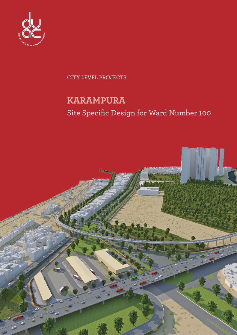
CITY LEVEL PROJECTS
KARAMPURASite Specific Design for Ward Number 100

Senior ConsultantProf. Kavas Kapadia
ConsultantsKirti Kawale
Prashant Chaturvedi
Nikhil Pandey (3D Visualizer)
Delhi Urban Art Commission
Prof. Dr. P.S.N. Rao Chairman
Sonali Bhagwati Member
Samir Mathur Member
Sonali Rastogi Member
Durga Shanker Mishra Member & Addl. Secretary, Ministry of Urban Development
Vinod Kumar Secretary
DUAC Staf
Rajeev Kumar Gaur, Raghvendra Singh, Amit Mukherji, V. K.Tyagi, Uma Bhati, Nishi Sachdeva, Manju Anjali,
Siddharth Sagar, Indu Rawat, Nihal Chand
(An ISO 9001 : 2008 Certiied Organisation)

Preface
The city of Delhi, capital of this vast land of diversities, is a city laden with layers of history,
a place where civilizations have lived, prospered and perished over centuries. The modern
city today, built over and around a rich tapestry of heritage, presents an opportunity
at every turn, to allow for co-existence of the past, present and the future. In order to
understand this multidimensional urban spectrum and attempt to plan the future, various
city level studies have been initiated by the DUAC. I hope that these studies will help
the planners of modern day Delhi to carefully articulate urban space, structure, form and
environment and sensitively address future requirements.
I convey my thanks to all the Consultants and Members of the Commission who have
tirelessly worked on this research project to bring out this document. I also take this
opportunity to place on record my sincere appreciation of the efforts of Secretary and
other staff of DUAC for providing the necessary administrative support to make this
happen.
I fondly hope that the authorities of the local, state and national government take these
studies seriously and implement, in right earnest, the suggestions given herein.
March, 2015
Prof. Dr. P.S.N. Rao Chairman, DUAC
DELHI URBAN ART COMMISSION with gratitude duly acknowledges the valuable contributions of the
following in making this report:
Raj Rewal Former Chairman, DUACSatish Khanna Former Member, DUAC
Eric P. Mall Former Member, DUAC
D. Diptivilasa Former Member DUAC & Addl. Secretary, Ministry of Urban Development
Organisations/Others
Ministry of Urban Development, Government of India
Delhi Development Authority
Government of National Capital Territory of Delhi
North Delhi Municipal Corporation
East Delhi Municipal Corporation
South Delhi Municipal Corporation
New Delhi Municipal Council
Geospatial Delhi Limited
Delhi Metro Rail Corporation
Delhi Urban Shelter Improvement Board
BSES Rajdhani Power Limited
BSES Yamuna Power Limited
RWA

Contents1 Context 6
1.1 City Location 6
1.2 Administrative Boundaries 7
2 Area Introduction 8
2.1 Ward Location 8
2.2 Connectivity 9
3 Mapping and Area Analysis 10
3.1 Shivaji Najafgarh Road 10
3.2 Milan Cinema Road 11
3.3 Land Use as per MPD 2001 12
3.4 Land Use 2014 13
3.5 Building Use 2014 12
3.6 Green and Open Spaces 14
3.7 Residential Built Fabric 16
3.8 Commercial Character 18
3.9 Social Infrastructure 20
3.10 Utilities 21
3.11 Overview 22
4 Proposals 24
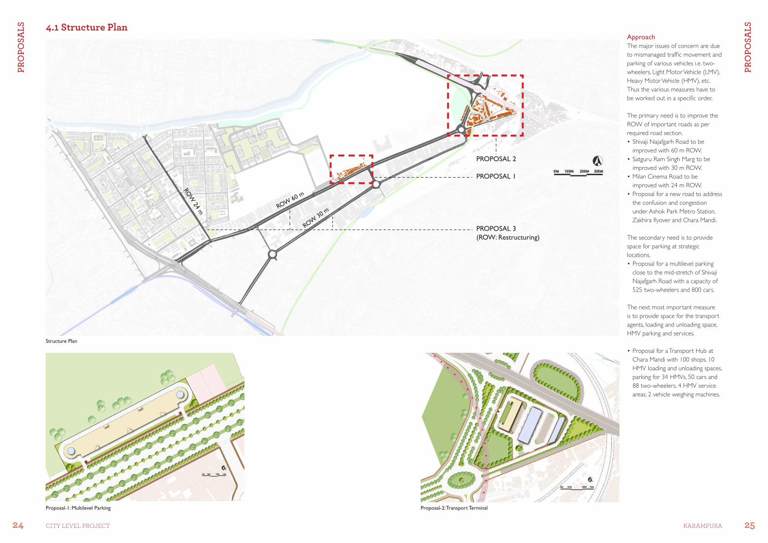
4.1 Structure Plan 24
4.2 Proposal 1: Multi-level Parking 26
4.3 Proposal 2: Transport Terminal 32
4.4 Proposal 3: Restructuring of Roads 40 4.4.1 Shivaji Najafgarh Road 60 m ROW 40 4.4.2 Satguru Ram Singh Marg 30 m ROW 41 4.4.3 Milan Cinema Road 24 m ROW 42
5 Recommendations and Conclusion 43
Summary
Master Plan Delhi 2021, has introduced the concept of Local Area Planning (LAP) with a
view to decentralizing urban governance and developing a framework for participatory
planning and control. The process could accommodate the views of people of the locality
and the elected ward councillor directly. The change so observed will relect need-based,
locally generated/monitored growth of the area, i.e. the ward.
Objective: With the above view in mind, the Delhi Urban Art Commission envisages
undertaking area speciic ward design under the ambit of Local Area Planning in order
to present easily understandable planning policies and proposals which can apply to
the speciic area. The following report analyses Karampura (Municipal Ward No 100),
in an effort to come up with solutions for the area, which witnesses typical chaos due
to the presence of a mix of conditions akin to rest of Delhi/NCR. There is an extremely
high volume of vehicles and on-road parking, causing the right of way (ROW) to shrink
and rampant horizontal growth largely violates the development guidelines promoted
under various sections of Master Plan Delhi 2021 to sustain increasing population and
socioeconomic growth of the city.
Also, due to a wide range of activities such as residential, institutional, commercial and
haphazard small scale industries, the ambiance and the trafic in the area is very confused.
The proposed planning projects are expected to bring some order to this part of the city.
Methodology: The Karampura ward varies from high-rise luxury apartments to low rise
plotted development as well as a large population that lives in the slums that lie within
the limits of this ward. The area has high-end luxury car showrooms, ofices, banquet
halls, etc. on one hand, and on the other hand, unauthorized and hazardous industries
that are located in the slums. The area has been evolving as a major transport hub for the
movement of freight all around the country.
This report presents a comprehensive overview of the urban fabric in terms of land use,
space activities, work centres and mixed-use streets. In addition, the urban transport study
includes identifying road functions, transport networks etc. It also includes qualitative and
quantitative analysis of the urban fabric, social infrastructure and utilities for the people
residing in the area. Area speciic issues have been addressed based upon the comparison
of the current on-site situation to that mentioned in the Master Plan Delhi 2021 and the
Zonal Plan for the area.
Approach: To bring about changes in the area by proposing minimal, yet meaningful
interventions, by selective and speciic development of land along intensively developed
zones, with a series of phase-wise design solutions, besides identifying policy control. The
approach thus requires planning through a development based on urban design principles
involving built form, space use and people. The proposals also identify the stakeholders
involved and the people affected, to provide for their vision for the area.

6 7CITY LEVEL PROJECT KARAMPURA
CO
NT
EX
T
CO
NT
EX
T 1.1 City Location 1.2 Administrative Boundaries
DDA Zones in Delhi -Area of study falls under Zone G
MCD Zones in Delhi -Area of study falls under North Municipal Zone
MCD Sub-zones in Delhi -Area of Study falls under West Zone
Wards in Delhi -Area of Study falls under Ward 100
Zone–G and Sub-zone G-I
The ward falls in Sub-zone G-1
of Zone-G as per the Zonal
Development Plan and covers 246
ha as Najafgarh Road Industrial Area.
Land is proposed to be used broadly
for residential, recreational, industrial
and circulation, etc.
Various stretches of roads have
been identiied as commercial streets
and mixed-use streets.
Karampura is situated in the
northwest of Delhi. It can be
approached from Rohtak, Gurgaon
and Ghaziabad by NH 10, NH 8 and
NH 24 respectively. It is connected to
the various parts of the city with easy
approach to both Outer and Inner
Ring Roads. It can also be reached via
Patel Nagar and Daya Basti Railway
Station. It is very well-connected
by the Metro Rapid Transit System
(MRTS) and Green, Blue and Red
lines lie within a 2-km radius.
Karampura
Old Delhi
Rly. Stn.
New Delhi Railway Station – 10 km Old Delhi Railway Station – 9 km
Connaught Place – 9 km Indira Gandhi Airport – 17 km Zone GSub-zonal Plan G-1
DLF Capital Green
AUDI Showroom 7 Star Banquet Rama Road Manufacturers Welfare Association
Swatantra Bharat Mills
Chara Mandi
Location on Delhi Map
New Delhi
Rly. Stn.
Connaught Place
Source: MPD 2021 Source: MPD 2021

8 9CITY LEVEL PROJECT KARAMPURA
AR
EA
IN
TR
OD
UC
TIO
N
AR
EA
IN
TR
OD
UC
TIO
N 2.1 Ward Location 2.2 Connectivity
Surrounding Wards
Najafgarh Drain
View showing Karampura from NH 10 (Zakhira Flyover)
Karampura is very well-connected
with the city by its three major arterial
roads and two railway stations.
The Green, Blue and Red Metro
Lines are in close proximity, and have
further strengthened the approach.
Roads
NH 10 Rohtak Road
To Rohtak towards northwest and to
Anand Parbat towards Central Delhi
Patel Road
To Ring Road towards the northwest
and to Connaught Place towards
Central Delhi
Shivaji Najafgarh Road
To NH10/Inderlok towards the east
and Kirti Nagar towards the southwest
Railway Stations
Patel Nagar Station
Daya Basti Station
Metro Station
Green Line: Satguru Ram Singh Marg,
Ashok Park Main
Blue Line: Kirti Nagar, Moti Nagar
Red Line: Inderlok
The study area and the adjacent wards have similar land
use with residential as the major component.
The details of the study area and adjacent wards along
with the spread areas and major land use are as follows:
Ward 74, Inderlok Colony (290.64 ha) - Residential
Ward 94, Patel Nagar (167.75 ha) - Residential
Ward 97, Kirti Nagar (293.26 ha) - Residential
Ward 99, Moti Nagar (224.93 ha) - Residential
Ward100, Karampura (246.00 ha) - Residential/
Industrial
Milan Cinema Road Satyadev Upadhyay Marg
3 6
Shivaji Najafgarh Road Neighbourhood Streets, New Moti Nagar
52
Karampura
Ward No. 100
Kirti Nagar
Ward No. 97
Moti Nagar
Ward No. 99
Inderlok Colony
Ward No. 74
Patel Nagar
Ward No. 94
Shivaji N
ajafga
rh Road
Najafgarh Drain
Milan C
inema R
oad
Patel Road
Karampura Flyover
TOW
ARDS
PUNJABI BAGH
TOWARDSROHTAK
TOWARDSKAROL BAGH
TOWARDS
CP
TOW
ARD
S
KIRT
I NAG
AR
TOWARDS
RAJOURI G
ARDEN
TOW
ARDS
SHAST
RI NAGARGuru Govind Singh Marg
Zakhira Flyover
0M 100M 200M 300M
Legend
Arterial Roads
Sub-Arterial Roads
Collector Roads
Metro Station
Zakhira Flyover
1 4
Patel Road
Ward Connectivity
1
3
5
6
2
4

10 11CITY LEVEL PROJECT KARAMPURA
MA
PP
ING
AN
D A
RE
A A
NA
LYS
IS
MA
PP
ING
AN
D A
RE
A A
NA
LYS
IS 3.1 Shivaji Najafgarh Road 3.2 Milan Cinema Road
Section - AA, Shivaji Najafgarh Road at ROW 25 m
Commercial CommercialParking Bay 5.5 m Carriage Way 10.3 m Carriage Way 10.3 m
ROW 25 m Shivaji Najafgarh Road
Median Pathway
Private Parking Bay
Commercial CommercialParking Bay 5.5 m Carriage Way 10.3 m Carriage Way 10.3 m
ROW 25 m Shivaji Najafgarh Road
Median Pathway Private Parking Bay
Section - BB, Shivaji Najafgarh Road at ROW 35 m
Milan Cinema Road at Najafgarh Drain
Milan Cinema Road at Post Ofice
Milan Cinema Road at Jhule Lal Marg
Milan Cinema Road at Shivaji Najafgarh Road
Shivaji Najafgarh Road at the Fire Station
Shivaji Najafgarh Road at DLF Tower
Shivaji Najafgarh Road at Sita Ram Dharamshala
1
3
4
5
1
2
3
Milan Cinema Road is a sub-arterial
road connecting Karampura and
Punjabi Bagh across Najafgarh Drain.
It has varying widths ranging between
9 m, 11 m and 15 m at stretches in
the study area. It serves Karampura
East, Karampura West and New Moti
Nagar.
Issues
•Lackofpedestrianinfrastructureand signage.
•LackofIntermediatePublicTransport (IPT) stands.
•Mixed-useareasalongMilanCinema Road.
•On-streetparkingleadingtocongestion.
•InadequateParking.•VaryingROWs.
Shivaji Najafgarh Road is a major arterial road (proposed 60 m as per MPD
2021) connecting Karampura to Dwarka (east–west). It has varying widths
ranging between 20 m, 25 m and 45 m at stretches in the study area.
It connects Amar Park on the west by NH 10 (to Rohtak) and Chara Mandi
on the east by NH 10 (to Anand Parbat and Karol Bagh).
Issues
•Lackofpedestrianinfrastructure.•Lackofsignage,dilapidatedbusshelters.•On-streetparkingoftwo-wheelersandprivatevehicles.•Lackofparkingforheavyvehiclesandforunloadingcarsatvarious
automobile showrooms.
•Scrapandgarbagedumpingalongtheroad.•Waterloggingandpotholesduetolackofdrainsandsewersinsomestretches.
A
A
A
A
B
B
B
B
2
Milan Cinema Road at Milan Cinema
Commercial Cinema Complex ROW 15 m CorridorWalkway
Walkway ROW 13M SetbackProperty
Section-AA, Milan Cinema Road at ROW 15 m
Section-BB, Milan Cinema Road at ROW 13 m
2
3
1
5
4
3
2
1
0M 100M 200M 300M
0M 100M 200M 300M

MA
PP
ING
AN
D A
RE
A A
NA
LYS
IS
MA
PP
ING
AN
D A
RE
A A
NA
LYS
IS
12 13CITY LEVEL PROJECT KARAMPURA
Observations:
•Mixed-usehasincreasedintheresidential colonies due to lack of
commercial complexes.
•Industrieshavebeenshiftedandanumber of commercial buildings,
ofices and banquet halls have
come up.
•MilanCinemaRoadandShivajiNajafgarh Road have been
identiied as commercial use roads.
•Unauthorizedandharmfulindustries have arisen in the Chara
Mandi area – many of which are
scrap plastic and metal recycling
units.
•Zakhirahasbecomeasalargeslum with 6000 DUs along the
railway line encroaching on railway
land. The area lacks basic physical
infrastructure such as roads.
Observations:
•TheareaismostlyanotiiedmanufacturinghubaspertheMasterPlan2001.•Itgeneratesemploymentforaround2/5thofthetotalworkforceofthezone.•Theresidentialcoloniesintheareaare:NewMotiNagar,KarampuraEastandKarampuraWest.•Acommercialcomplexwithaspaceforgovernmentoficesandaneducationalinstitutionisalsoapartoftheproposal.
Observations:
•Anincreaseingrowthinalmosteverytypeoflanduse.•Residentialareahasremainedalmostthesame.•Commercialsectorhasincreasedby16%.•Partofopenareasincludetransportationmodes.•Industrieshaveseenadeclineofalmost35%inarea.
3.3 Land Use as per MPD 2001
3.5 Building Use 2014
3.4 Land Use 2014
26%
1%
22%
47%
4%
Legend Residential
Commercial
Industrial
Public & Semi-public
Transport
Legend Residential
Commercial
Industrial
Public & Semi- Public
Green
Mixed-use
Transport
Legend
Residential
Commercial
District Park
Industrial
Garden/ Parks
Scrub Area
Public & Semi-public
Greens
Mixed-use
17%35%
13%
4%
27%
4%
0M 100M 200M 300M 0M 100M 200M 300M
0M 100M 200M 300M

MA
PP
ING
AN
D A
RE
A A
NA
LYS
IS
MA
PP
ING
AN
D A
RE
A A
NA
LYS
IS
14 15CITY LEVEL PROJECT KARAMPURA
Observations:
•Theplotsinresidentialcolonieshave been gradually taken over as
parking space.
•Afewcommunityparksstillremainand are maintained.
•A10-acre(approx.)siteforaproposed facility centre has been
identiied and execution work is in
progress.
•AlongtheNajafgarhDrain40acres(approx.) has been identiied to be
developed and maintained by DDA
as a park/playground.
•AlongtheShivajiNajafgarhRoadat Zakhira 2 acres (approx.) has
been allocated, but is yet to be
developed as a park/playground.
DDA District Park (10 acres approx.)
Green maintained by DDA (40 acres approx.)
Community Park in Karampura West
Community Park in Amar Park Slum
Park on Shivaji Najafgarh Road
Entrance to the DDA District Park
Community Park in Karampura East Park on Milan Cinema RoadCommunity Park in New Moti Nagar
Green to be maintained by DDA 40 acres (approx.)
DDA District Park10 acres (approx.)
1 2 3 4 5
9
8
7
6
3.6 Green and Open Spaces
Legend
District Park
Built-up
Garden/Parks
Scrub Area
Roads
Greens
Inderlok Colony
Patel Nagar
Moti Nagar
Kirti Nagar
6
7
8
9
1
2
3
4
5

MA
PP
ING
AN
D A
RE
A A
NA
LYS
IS
MA
PP
ING
AN
D A
RE
A A
NA
LYS
IS
16 17CITY LEVEL PROJECT KARAMPURA
1
DLF Capital Greens
West Karampura
Chara Mandi
Chara Mandi
Residential Colonies
Plotted Development with open
green spaces, schools and ofice
buildings exist in Karampura. The
height of the buildings vary from
G+1 to G+2. Due to lack of
convenience shopping, mixed-use
has developed along the streets.
On-street parking has led to a major
movement problem.
DLF Capital Greens
The stark contrast in the skyline can be observed with DLF Capital Greens next to Karampura East. The buildings are
as high as G+26 loors.
Transport Hub
Chara Mandi has evolved as a transport hub, with approximately 100 shops
that provide delivery services for various goods to and from Delhi to other
parts of the country. Patel Nagar Railway Station for freight is also adjacent to
the area.
Urban Village
Area mainly covers the unauthorized colony with people working in factories
in Karampura and Najafgarh Industrial areas.
Slum
6000 (approx.) Dwelling Units are
located on the extreme northwest
corner of the ward along the railway
line, with a large population of 30,000
people (approx.).
ZakhiraAmar Park Slum
3.7 Residential Built Fabric
Zakhira
Legend
Plotted
High Rise
Urban Village
Slums
1
3
4
5
A
B
C
E
F
D
7
6
2
2B
7
6
5
43
A
C D
E
F

MA
PP
ING
AN
D A
RE
A A
NA
LYS
IS
MA
PP
ING
AN
D A
RE
A A
NA
LYS
IS
18 19CITY LEVEL PROJECT KARAMPURA
Observations:
•Commercialactivityhasdevelopedinresidentialcoloniesduetothelackofashoppingarea,withmixed-use evenly spread.
•AroundtheMilanCinemaarea,oficesandshopshavesprungup.•Industrieshavebeenshiftedandanumberofcommercialspaces,oficesandbanquethallshavecomeupalong
Shivaji Najafgarh Road.
•MilanCinemaRoadandShivajiNajafgarhRoadhavebeenidentiiedascommercialstreetsasperMPD2021.•UnauthorizedandharmfulindustrieshavedevelopedinCharaMandiarea,manyofwhichareinvolvedinthe
recycling of plastic and metal scrap. DLF Towers, Shivaji Najafgarh RoadAutomobile Showrooms, Shivaji Najafgarh Road
Sita Ram Dharamshala, Shivaji Najafgarh Road
3.8 Commercial Character
Plastic Scrap Industry, Chara MandiMetal Scrap Industry, Amar Park Slum Plastic Scrap Industry, Zakhira
Plastic Scrap Industry, Zakhira
Karampura West Karampura East
1 2
3
4 5 6
8
7
9
Milan Cinema Road
6
Mixed Use
Commercial
Heavy Commercial
Slum Commercial
6
7
8
91 2
3
4
5

MA
PP
ING
AN
D A
RE
A A
NA
LYS
IS
MA
PP
ING
AN
D A
RE
A A
NA
LYS
IS
20 21CITY LEVEL PROJECT KARAMPURA
3.9 Social Infrastructure 3.10 Utilities
Legend
Schools and Colleges
Hospitals/Healthcare Facilities
Government Ofice/Fire/Police Station
Religious and Communal Areas
Legend
Auto Stand
Bus Stop
Dhalao
Substation
Public Amenities
Cycle Rickshaw Stand
Petrol Pump
Voter ID Ofice
Booth Ofice
MCD Ofice
Fire Station
Social Infrastructure
Social infrastructure is uniformly
spread across the residential colonies.
The area has adequate infrastructure
such as:
•NagarNigamAdarshPrimaryVidhyalaya
•RajkiyaSarvodayaSehshikshaUchchtar Madhyamik Vidhyalaya
•RajkiyaUchchtarMadhyamikSehshiksha Vidhyalaya
•NigamPratibhaVikasVidhyalaya•DeenDayalCollege•TempleandGurudwaraComplex•VoterRegistrationOfice•PostOficeComplex•ReligiousComplex•PoliceStation,NewMotiNagar•FireStation,NewMotiNagar•DhyanchandJoshiAyurvedic
Panchakarma Evam Siddha Hospital
•CommunityCentre,H-Block,Karampura (W)
Primary School
Deen Dayal Upadhayay College
Nigam Pratibha Vikas Vidhyalaya
Arya Samaj MandirDhyanchand Joshi Ayurvedic Panchakarma Evam Siddha Hospital Rickshaw Stand, Shivaji Najafgarh Road Community Toilet, Amar Park JJ Cluster On-street Parking, Shivaji Najafgarh Road
Bus Shelter, Shivaji Najafgarh Road
Auto Stand, Shivaji Najafgarh Road
Bus Shelter, Patel Road Substation, Shivaji Najafgarh Road
Dhalao, Jhule Lal Marg
Public Amenities, Jhule Lal Marg Petrol Pump, Shivaji Najafgarh Road
Utilities
The area has unevenly distributed
utilities. Karampura West and New
Moti Nagar have public amenities
and dhalaos as required, while
Karampura East lacks these facilities.
Chara Mandi, Zakhira and Amar Park
are deprived of all sewerage and
sanitation facilities.
The major issues that need to be
taken care of are:
•Nopedestriansinfrastructure.•NocyclerickshaworIPTstand.•Dilapidatedbusshelters.•Lackofparkingfacilities.•Unevendistributionofutilities.
0M 100M 200M 300M
0M 100M 200M 300M

MA
PP
ING
AN
D A
RE
A A
NA
LYS
IS
MA
PP
ING
AN
D A
RE
A A
NA
LYS
IS
22 23CITY LEVEL PROJECT KARAMPURA
12
3
9
6
11
5
4
87
10
12
3.11 Overview
Amar Park JJ Cluster Metal Scrap Industry, Amar Park JJ Cluster Slum along Railway line, Zakhira JJ Cluster
Slum along Railway line, Chara Mandi JJ Cluster
1
Amar Park JJ Cluster
2
34
5
Plastic Scrap Industry, Chara Mandi Transport Hub Plastic Scrap Industry, under Zakhira Flyover
Trucks parked on Zakhira Flyover
Freight transfer at Patel Nagar Railway Line, Chara Mandi Scrap industry and truck parking under the Metro line near Patel Nagar Railway Line
Utensil manufacture under Zakhira Flyover
6 7
8
11 12
10
The area has various independent
functions with no physical boundaries.
Although, they have varying social
character, the major share of activities
can be categorized as:
•Residential
High-rise (luxury apartments)
Low-rise (plotted development)
Slums (unauthorized growth)
•Commercial
Convenience/daily need shops
Ofice buildings
Automobile showrooms
•Industries
Medical equipment manufacturing
industry
Small-scale harmful industries of
plastic, metal, synthetic glue, etc.
have developed in the slum area
Freight transport agencies
Light and heavy motor vehicle
service and repair
•Transport
Insuficient ROW (right-of-way)
Lack of parking
Lack of pedestrian paths and cycle
tracks.
Dilapidated bus shelters
Transport hub that lacks
infrastructure.
Lack of loading and unloading spaces.
•Greens
10 acres (approx.) district park in the
process of development by DDA
40 acres (approx.) land allotted, but
yet to be developed as green by
DDA
Chara Mandi, Zakhira and Amar Park
areas need immediate attention
9
Plastic picking under Zakhira Flyover
PR
OP
OS
AL
S
24 25CITY LEVEL PROJECT KARAMPURA
PR
OP
OS
AL
S
Approach
The major issues of concern are due
to mismanaged trafic movement and
parking of various vehicles i.e. two-
wheelers, Light Motor Vehicle (LMV),
Heavy Motor Vehicle (HMV), etc.
Thus the various measures have to
be worked out in a speciic order.
The primary need is to improve the
ROW of important roads as per
required road section.
•ShivajiNajafgarhRoadtobeimproved with 60 m ROW.
•SatguruRamSinghMargtobeimproved with 30 m ROW.
•MilanCinemaRoadtobeimproved with 24 m ROW.
•Proposalforanewroadtoaddressthe confusion and congestion
under Ashok Park Metro Station,
Zakhira lyover and Chara Mandi.
The secondary need is to provide
space for parking at strategic
locations.
•Proposalforamultilevelparkingclose to the mid-stretch of Shivaji
Najafgarh Road with a capacity of
525 two-wheelers and 800 cars.
The next most important measure
is to provide space for the transport
agents, loading and unloading space,
HMV parking and services.
•ProposalforaTransportHubatChara Mandi with 100 shops, 10
HMV loading and unloading spaces,
parking for 34 HMVs, 50 cars and
88 two-wheelers, 4 HMV service
areas, 2 vehicle weighing machines.
ROW 60 m
ROW 30
m
ROW
24 m
4.1 Structure Plan
Proposal-1: Multilevel Parking
Structure Plan
Proposal-2: Transport Terminal
PROPOSAL 2
PROPOSAL 1
PROPOSAL 3
(ROW: Restructuring)

PR
OP
OS
AL
S
PR
OP
OS
AL
S
26 27CITY LEVEL PROJECT KARAMPURA
4.2 Proposal 1: Multi-level Parking
Proposal 1
Considering that the Shivaji Najafgarh
Road has improved to 60 m ROW,
space for vehicle parking has to
be identiied. The major issues of
concern are due to mismanaged
trafic movement and parking of
various vehicles i.e. two-wheelers,
LMVs, HMVs etc. Thus, a strategic
location for parking has been
identiied at the mid-stretch of
the road.
The space for the structure is
proposed to be taken from the
open park currently under DDA
ownership. A multi-level parking is
proposed to resolve the parking
problem with a capacity for 525 two-
wheelers and 800 cars.
The parking is on multiple levels with
3 basements, stilt and 4 upper loors.
It will be provided with lifts and stairs
for the safety and convenience of
parking users.
Site Area = 184.6 m x 37.7 m
= 6960 sq m.
Stilt Floor: 525 two-wheelers
3 Basement: 115 cars (each)
4 Upper Floor: 115 cars (each)
Existing SiteKey Plan
Proposal 1 - Site Plan
Shivaji N
ajafga
rh Road 60 m wide
Multilevel P
arking
Green maintained by DDA
Proposal-1: Site Plan

PR
OP
OS
AL
S
PR
OP
OS
AL
S
28 29CITY LEVEL PROJECT KARAMPURA
Aerial View of Proposed Multilevel Parking at Shivaji Najafgarh Road near DLF Tower

PR
OP
OS
AL
S
PR
OP
OS
AL
S
30 31CITY LEVEL PROJECT KARAMPURA
Typical Upper Floor Plan
Ground Floor Plan
Typical Basement Floor Plan
Entry ramp (anti-clockwise)for movementto upper loors
Proposal 1
A multi-level parking is proposed to resolve the parking problem with a capacity to park 525 two-wheelers and
805 cars.
Site Area = 184.6 m x 37.7 m
= 6960 sq m
Stilt Floor = 525 two-wheelers
3 Basement = 3 x 115 cars (each)
= 345 cars
4 Upper Floor = 4 x 115 cars (each)
= 460 cars
Salient Features:
•Locatedinthemid-stretchofthecatchmentarea.•Adjacenttoamajorcommercialroad.•One-waymovementwithinthesite.•Separateentryandexitramps.•Adequatenumberofstairsandlifts.•Allnecessaryserviceswithinthesitearea.•Artiiciallightingonlyrequiredforbasements.•Terracetobeusedforsolarpanelinstallation.•Electricityproducedcanbealsobeusedtoilluminatetheadjacentgreensandforstreetlights,etc.•CouldbedevelopedonPPPmodel,potentialrevenuegenerationbyparkingfee,advertisingandbyproviding
electricity.
EntryRamp
ExitRamp
EntryRamp
ExitRamp
EntryRamp
ExitRamp
EntryRamp
ExitRamp
EntryRamp
ExitRamp
Exit ramp (anti-clockwise)for movement to lower loors
Entry ramp (clockwise)for movementto lower loors
Exit ramp(clockwise)for movementto upper loors

PR
OP
OS
AL
S
PR
OP
OS
AL
S
32 33CITY LEVEL PROJECT KARAMPURA
4.3 Proposal 2: Transport Terminal
Proposal 2
Considering a new connecting road
being constructed from NH 10 to
Shivaji Najafgarh Road.
The Chara Mandi area is to be
redeveloped. It is proposed to
cleanup the existing Chara Mandi site
for use as a transport hub.
Transport hub at Chara Mandi
with 100 shops, 10 HMV loading
& unloading spaces, parking for
34 HMVs, 50 LMVs and 88 two-
wheelers, 4 HMV service areas, 2
vehicle weighing machines.
Basement Floor: 50 LMVs, 88 two-
wheelers
Ground Floor: Management ofice,
loading & unloading area, service
station and recreational area under
Metro line.
First Floor: Shops for freight agents.
Shops
Loading/Unloading Area
Service Area
HMV Parking
Weighing Platforms
Recreational/Green Area
Existing Site
Shiv
aji N
ajaf
garh
Road
60
m w
ide
Proposed Flyover
Zakhira Flyover
NH 10
Existing Flyover
To Anand Parbat
To Rohtak
Proposal-2 Site Plan
1
2
4
3
5
6
1
2
4
3
5
6

PR
OP
OS
AL
S
PR
OP
OS
AL
S
34 35CITY LEVEL PROJECT KARAMPURA
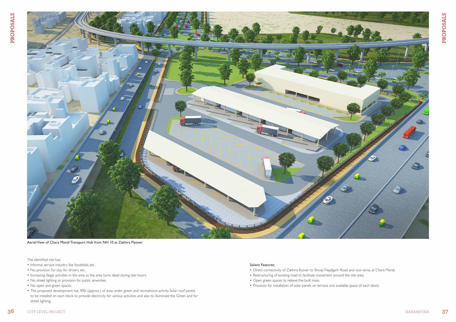
Aerial View of Chara Mandi Transport Hub from Metro
The identiied site has:
•Unauthorizedharmfulindustries.•Dilapidatedwater-loggedroad,haphazardlyparkedtrucks,cars,etc.•BuiltstructuresundertheelevatedMetropassingthroughit.•TransporthubatCharaMandihasbeenproposed,keepinginviewremoving,formalising,separating,structuringand
developing various interdependent activities with necessary improvements.
Salient Features:
•RestructuringofShivajiNajafgarhroadasa60mROWwithadedicated3-lanecarriageway,3-laneserviceroadwith a dedicated NMV track and a footpath with maintained green verges to provide safety and ease in movement.
•Rationalisedmovementwithinthesitetofacilitateproperfunctioningoftheprivate/freightvehicles.•Dedicatedcommercialcomplextoincorporateexistingshopsoffreightserviceproviders.•Opengreenspaceactsasarecreationalareawithinthesiteforvarioususers.
PR
OP
OS
AL
S
PR
OP
OS
AL
S
36 37CITY LEVEL PROJECT KARAMPURA
Aerial View of Chara Mandi Transport Hub from NH 10 at Zakhira Flyover
Salient Features:
•DirectconnectivityofZakhiralyovertoShivajiNajafgarhRoadandvice-versa,atCharaMandi.•Restructuringofexistingroadtofacilitatemovementaroundthesitearea.•Opengreenspacestorelievethebuiltmass.•Provisionforinstallationofsolarpanelsonterraceandavailablespaceofeachblock.
The identiied site has:
•Informalserviceindustrylikefoodstalls,etc.•Noprovisionforstayfordrivers,etc.•Increasingillegalactivitiesintheareaastheareaturnsdeadduringlatehours.•Nostreetlightingorprovisionforpublicamenities.•Noopenandgreenspaces.•Theproposeddevelopmenthas40%(approx.)ofareaundergreenandrecreationalactivity.Solarroofpanels
to be installed on each block to provide electricity for various activities and also to illuminate the Green and for
street lighting.

PR
OP
OS
AL
S
PR
OP
OS
AL
S
38 39CITY LEVEL PROJECT KARAMPURA
Ground Floor Plan Typical Floor Plan for Commercial Complex
Basement Plan under Commercial Complex
Ground Floor Plan
•10HMVloadingunloadingspaceswith covered stacking area.
•Vehicleserviceareafor4HMVs.•Parkingfor34HMVs.•2vehicleweighingmachines.•Recreationalareasprovidedwithin
the site for various users.
•Adequatenumberofstairsandlifts provided for connecting the
basement and upper loors.
Basement Floor Plan
•BasementParkingfor88two-wheelers and 50 cars.
Typical Floor Plan
•Spaceonirstandsecondloorsfor shops for freight service agents.
Proposal-2 Site Plan
PR
OP
OS
AL
S
PR
OP
OS
AL
S
40 41CITY LEVEL PROJECT KARAMPURA
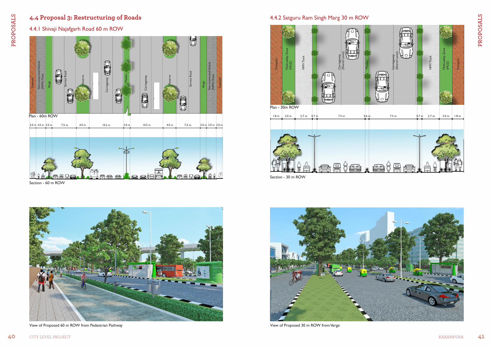
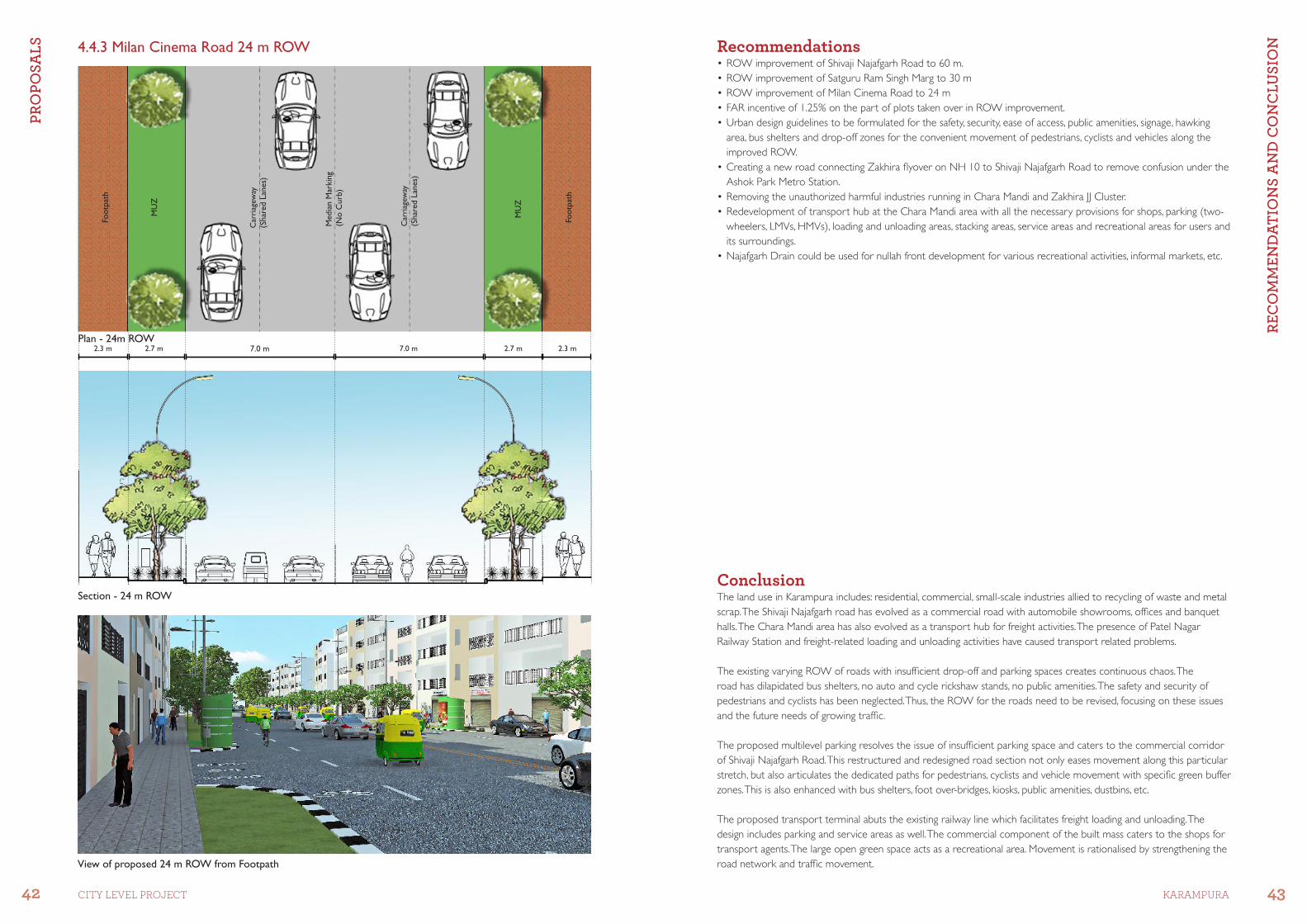
4.4 Proposal 3: Restructuring of Roads
Section - 60 m ROW
Section - 30 m ROW
View of Proposed 30 m ROW from VergeView of Proposed 60 m ROW from Pedestrian Pathway
4.4.1 Shivaji Najafgarh Road 60 m ROW
4.4.2 Satguru Ram Singh Marg 30 m ROW
2.7 m 2.7 m1.8 m 0.7 m 1.8 m0.7 m7.5 m 7.5 m0.6 m2.0 m 2.0 m
Footp
ath
Multi-utilit
y Z
one
(MU
Z)
NM
V T
rack
Car
riag
eway
(Shar
ed L
anes)
Media
n
Car
riag
eway
(Shar
ed L
anes)
NM
V T
rack
Multi-utilit
y Z
one
(MU
Z)
Footp
ath
Sidew
alk
Non-m
oto
rize
d V
ehic
le
(NM
V) Tra
ck
Verg
e
7.5 m 7.5 m2.0 m 2.0 m3.0 m 3.0 m4.0 m 4.0 m10.5 m 10.5 m2.0 m2.0 m 2.0 m
Serv
ice R
oad
Car
riag
eway
Media
n
Rese
rve
Car
riag
eway
Rese
rve
Serv
ice R
oad
Verg
e
Non-m
oto
rize
d V
ehic
le
(NM
V) Tra
ck
Sidew
alk
Plan - 60m ROW
Plan - 30m ROW
42 43CITY LEVEL PROJECT KARAMPURA
RE
CO
MM
EN
DA
TIO
NS
AN
D C
ON
CL
US
ION
PR
OP
OS
AL
S
View of proposed 24 m ROW from Footpath
Section - 24 m ROW
Recommendations•ROWimprovementofShivajiNajafgarhRoadto60m.•ROWimprovementofSatguruRamSinghMargto30m•ROWimprovementofMilanCinemaRoadto24m•FARincentiveof1.25%onthepartofplotstakenoverinROWimprovement.•Urbandesignguidelinestobeformulatedforthesafety,security,easeofaccess,publicamenities,signage,hawking
area, bus shelters and drop-off zones for the convenient movement of pedestrians, cyclists and vehicles along the
improved ROW.
•CreatinganewroadconnectingZakhiralyoveronNH10toShivajiNajafgarhRoadtoremoveconfusionundertheAshok Park Metro Station.
•RemovingtheunauthorizedharmfulindustriesrunninginCharaMandiandZakhiraJJCluster.•RedevelopmentoftransporthubattheCharaMandiareawithallthenecessaryprovisionsforshops,parking(two-
wheelers, LMVs, HMVs), loading and unloading areas, stacking areas, service areas and recreational areas for users and
its surroundings.
•NajafgarhDraincouldbeusedfornullahfrontdevelopmentforvariousrecreationalactivities,informalmarkets,etc.
ConclusionThe land use in Karampura includes: residential, commercial, small-scale industries allied to recycling of waste and metal
scrap. The Shivaji Najafgarh road has evolved as a commercial road with automobile showrooms, ofices and banquet
halls. The Chara Mandi area has also evolved as a transport hub for freight activities. The presence of Patel Nagar
Railway Station and freight-related loading and unloading activities have caused transport related problems.
The existing varying ROW of roads with insuficient drop-off and parking spaces creates continuous chaos. The
road has dilapidated bus shelters, no auto and cycle rickshaw stands, no public amenities. The safety and security of
pedestrians and cyclists has been neglected. Thus, the ROW for the roads need to be revised, focusing on these issues
and the future needs of growing trafic.
The proposed multilevel parking resolves the issue of insuficient parking space and caters to the commercial corridor
of Shivaji Najafgarh Road. This restructured and redesigned road section not only eases movement along this particular
stretch, but also articulates the dedicated paths for pedestrians, cyclists and vehicle movement with speciic green buffer
zones. This is also enhanced with bus shelters, foot over-bridges, kiosks, public amenities, dustbins, etc.
The proposed transport terminal abuts the existing railway line which facilitates freight loading and unloading. The
design includes parking and service areas as well. The commercial component of the built mass caters to the shops for
transport agents. The large open green space acts as a recreational area. Movement is rationalised by strengthening the
road network and trafic movement.
4.4.3 Milan Cinema Road 24 m ROW
7.0 m2.7 m 7.0 m 2.7 m 2.3 m
Car
riag
eway
(Shar
ed L
anes)
Footp
ath
MU
Z
Car
riag
eway
(Shar
ed L
anes)
MU
Z
Footp
ath
2.3 m
Media
n M
arkin
g
(No C
urb
)Plan - 24m ROW

Delhi Urban Art Commission
The Delhi Urban Art Commission was set up by an Act of Parliament in 1973
to “advise the Government of India in the matter of preserving, developing
and maintaining the aesthetic quality of urban and environmental design within
Delhi and to provide advice and guidance to any local body in respect of any
project of building operations or engineering operations or any development
proposal which affects or is like to affect the skyline or the aesthetic quality of
the surroundings or any public amenity provided therein”.
(An ISO 9001 : 2008 Certiied Organisation)

fnYyh uxj dyk vk;ksxDelhi Urban Art Commission
Tel: 24619593, 24618607, 24690821, 24636191, Fax: 24648970
Email: [email protected] Website: www.duac.org
(An ISO 9001 : 2008 Certiied Organisation)