slope stability problems associated with timber harvesting ... · slope stability problems...
TRANSCRIPT
1974USDA FOREST SERVICE GENERAL TECHNICAL REPORT PNW- 21
SLOPE STABILITY PROBLEMSASSOCIATED WITHTIMBER HARVESTING INMOUNTAINOUS REGIONS OFTHE WESTERN UNITED STATES
D. N. SWANSTON
PACIFIC NORTHWEST FOREST AND RANGE EXPERIMENT STATIONU.S. DEPARTMENT OF AGRICULTURE FOREST SERVICE
PORTLAND, OREGON
This file was created by scanning the printed publication. Text errors identified by the software have
been corrected; however, some errors may remain.
This paper was presented at the "Symposium on Forest Operations in Mountainous Regions, '' in Krasnodar, U. S . S. R., August 30-September 11, 1971.
SUMMARY
Natural soil-mass-movements on forested slopes in the Western United States can be divided into two major groups of closely related landslide types. These include, in order of decreasing importance and regional frequency of occurrence: (1) debris slides, debris avalanches, debris flows, and debris torrents; and (2) creep, slumps, and earth flows. Each type requires the presence of steep slopes, frequently in excess of the angle of soil stability. Al l characteristically occur under high soil moisture conditions and usually develop or are accelerated during periods of abnormally high rainfall. Further, all are encouraged or accelerated by destruction of the natural mechanical support on the slopes.
A s forest operations shift to steeper slopes, they play an increas- ing role in initiation and acceleration of soil mass movements. The logging operation itself is a major contributor through (1) destruction of roots, the natural mechanical support of slope soils, (2) disruption of surface vegetation cover which alters soil water distribution, and (3) obstruction of main drainage channels by logging debris, Road building stands out at the present time as the most damaging operation with soil failures resulting largely from slope loading (from road fill and sidecasting), oversteepened bank cuts, and inadequate provision for slope and road drainage.
At the present time attempts at prevention and control are limited to identification and avoidance of highly unstable areas and development and implementation of timber harvesting techniques least damaging to natural slope stability.
KEYWORDS: Soil stability, soil erosion.
CONTENTS
Page
INTRODUCTION. . . . . . . . . . . . . . . . . . . . . . . . . . . . . . . . . . 1
CLASSIFICATION . . . . . . . . . . . . . . . . . . . . . . . . . . . . . . . . . 1 9
INTERRELATIONSHIP BETWEEN PRINCIPAL FACTORS PRODUCING LANDSLIDE MOVEMENTS ON TIMBERED SLOPES. . . . . . . . . . . . . 7
EFFECT OF FOREST OPERATIONS ON SOIL STABILITY . . . . . . . . . . . 9
METHODS OF PREDICTION, PREVENTION, AND CONTROL . . . . . . . . . 10
LITERATURE CITED. . . . . . . . . . . . . . . . . . . . . . . . . . . . . . . 13
INTRODUCTION
Landslides in shallow soils are ubiquitous in the western cordillera and in the circum-Pacific mountain belts where mountain g1 ac iation, tectonic up- lift, and strong weathering processes have oversteepened slopes creating extremely
the downslope component of gravitational stress. Locally, creep deformation’ and landslides, resulting from quasi-viscous flow and progressive failure of pyroclastics and overconsolidated, deep pelitic sedi- ments, dominate .
. unstable natural conditions in terms of
In the undisturbed state and under normal climatic conditions, these slopes maintain a delicate state of balance be- tween major forces tending to create downslope movement and those tending to resist it. Natural catastrophic events such as rapid saturation of the soil mass, rock falls, or tree windthrow can quickly destroy this balance as can any disrupting activities of man.
With increasing demand for lumber and pulpwood in the United States, more of these steep mountain watersheds are being directly influenced by forest opera- tions. The resulting disruption of natural slope stability characteristics has accel- erated slope failure in many logged areas, causing extensive damage to structures and roads and effectively removing por- tions of the watershed from immediate reforestation.
CLASS IF KAT1 0 N
depth o€ movement, and character of the failure surface. The classification terminology is basically that suggested by Sharpe (1938) and Eckel (1958).
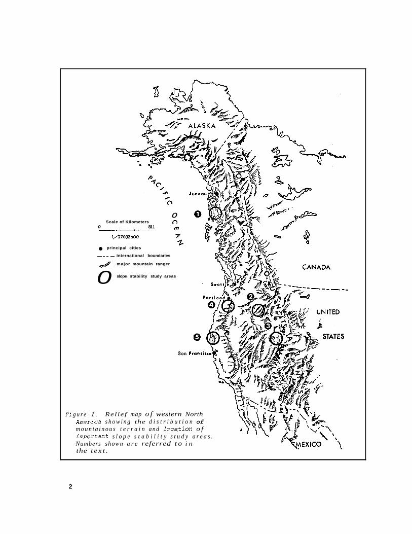
The first and most widespread group includes debris slides, debris avalanches, debris flows, and debris torrents involv- ing the initial failure of a relatively shallow, cohesionless soil mass on steep slopes above an impermeable boundary. This group corresponds to Savarenskii’s (1937) consequent landslides and Type A move- ments (slope movements of superficial deposits) of Z h b a and Mencl (1969). These types serve as a dominant erosion process in such diverse climatic areas as the maritime coast of Alaska (Bishop and Stevens 1964; Swanston 1967, 1969, 1970) (fig. 1, area 1) and the drier inter- mountain areas of Utah, Idaho, and Montan&/ (Croft and Adams 1950) (fig. 1, areas 2 and 3). Dyrness (1967a) also reports them as a common constituent of recent massive landsliding on the west flank of the Cascade Range in Oregon (fig. 1, area 4).
Debris slides are the rapid downward movement of unsaturated, relatively uncon- solidated soils and forest debris by sliding or rolling and are differentiated from debris avalanches largely by lower soil water content. Debris flows involve the rapid downslope movement of water- s aturated soil and debris by true flow processes (fig. 2). All three are characterized by initial failure of a mass of soil or mixed soil and organic debris above a relatively impermeable boundary. Failure is either by rotational or by translational
Based on a review of literature and current research (fig. l), soil mass move- ments in timbered areas can be broken down into two major groups differentiated roughly on the basis of type material,
J’ Walter F. Megahan. Summary of research on mass stability by the Intermountain Forest and Range Experiment Station, Soil Stabilization Project, Boise, Idaho. Unpublished proceedings, USDA Forest Service, Berkely Mass Erosion Cod., Oct. 17-20, 1967.
F i
0 0
1 F Scale of Kilometers
0 81 1
1/27033600
principal cities
--- - international boundaries
& major mountain ranger
slope stability study areas 0
Son Francisco
g u r e 1. Rel ief map o f western North Amer-ica s h o w i n g the d i s t r i b u t i o n of m o u n t a i n o u s t e r r a i n and 1 o c a . t i o n o f X m p o r t a n t s l o p e s t a b i l i t y s t u d y a r e a s . Numbers shown a r e referred t o i n the t e x t .
2
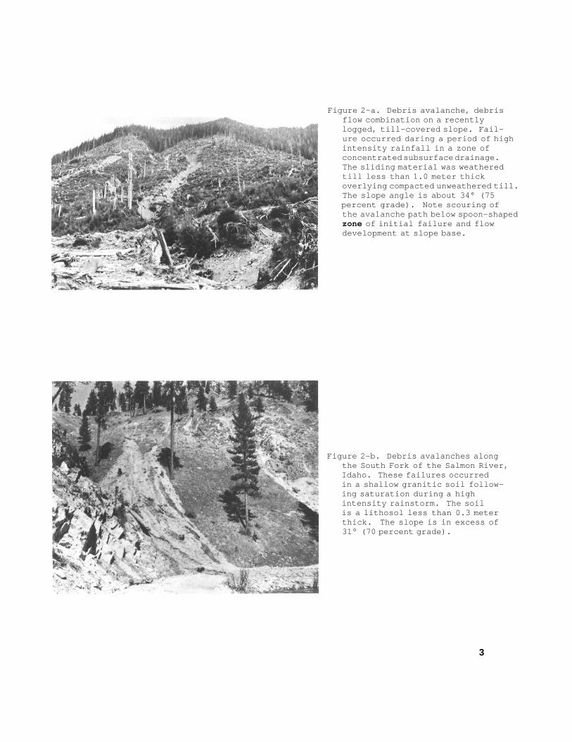
Figure 2-a. Debris avalanche, debrisflow combination on a recentlylogged, till-covered slope. Fail-ure occurred daring a period of highintensity rainfall in a zone ofconcentrated subsurface drainage.The sliding material was weatheredtill less than 1.0 meter thickoverlying compacted unweathered till.The slope angle is about 34° (75percent grade). Note scouring ofthe avalanche path below spoon-shapedzone of initial failure and flowdevelopment at slope base.
Figure 2-b. Debris avalanches alongthe South Fork of the Salmon River,Idaho. These failures occurredin a shallow granitic soil follow-ing saturation during a highintensity rainstorm. The soilis a lithosol less than 0.3 meterthick. The slope is in excess of31° (70 percent grade).
3
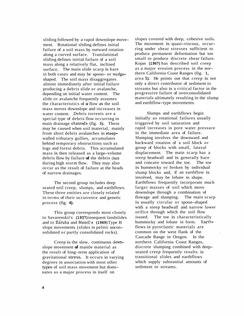
sliding followed by a rapid downslope move- ment. Rotational sliding defines initial failure of a soil mass by outward rotation along a curved surface. Translational sliding defines initial failure of a soil mass along a relatively flat, inclined surface. The main slide scarp is bare in both cases and may be spoon- or wedge- shaped. The soil mass disaggregates almost immediately after initial failure producing a debris slide or avalanche, depending on initial water content. The slide or avalanche frequently assumes the characteristics of .a flow as the soil mass moves downslope and increases in water content. Debris torrents are a special type of debris flow occurring in main drainage channels (fig. 3). These may be caused when soil material, mainly from short debris avalanches in steep- walled tributary gullies, accumulates behind temporary obstructions such as logs and forest debris. This accumulated mass is then released as a large-volume debris flow by failure of the debris dam during high storm flow. They may also occur as the result of failure at the heads of narrow drainages.
The second group includes deep seated soil creep, slumps, and earthflows. These three entities are closely related in terms of their occurrence and genetic process (fig. 4).
This group corresponds most closely to Savarenskii's (1937) insequent landslides and to Z k b a and Mencl's (1969) Type B slope movements (slides in pelitic uncon- solidated o r partly consolidated rocks).
Creep is the slow, continuous down- slope movement of mantle material as the result of long-term application of gravitational stress. It occurs in varying degrees in association with most other types of soil mass movement but domi- nates as a major process in itself on
slopes covered with deep, cohesive soils. The movement is quasi-viscous, occur- ring under shear stresses sufficient to produce permanent deformation but too small to produce discrete shear failure. Kojan (1967) has described soil creep as a major erosion process in the nor- thern California Coast Ranges (fig. 1, area 5). He points out that creep is not only a direct contributor of sediment to streams but also is a critical factor in the progressive failure of overconsolidated materials ultimately resulting in the slump and earthflow-type movements.
Slumps and earthflows begin initially as rotational failures usually triggered by soil saturation and rapid increases in pore water pressure in the immediate area of failure. Slumping involves the downward and backward rotation of a soil block o r group of blocks with small, lateral displacement. The main scarp has a steep headwall and is generally bare and concave toward the toe. The toe is hummocky or broken by individual slump blocks and, if an earthflow is involved, may be lobate in shape. Earthflows frequently incorporate much larger masses of soil which move downslope through a combination of flowage and slumping. The main scarp is usually circular or spoon-shaped with a steep headwall and narrow lower orifice through which the soil flow issued. The toe is characteristically hummocky and lobate in form. flows in pyroclastic materials are common on the west flank of the Cascade Range in Oregon. In the northern California Coast Ranges, discrete slumping combined with deep- seated creep frequently results in transitional slides and earthflows which supply substantial amounts of sediment to streams.
Earth-
4
Figure 3-a. Three debris torrents inthe Maybeso Creek valley. Princeof Wales Island, Alaska. All threedeveloped during a high-intensitystorm in the fall of 1961. Initialfailure occurred at debris damsnear the upper limit of logging inall three ravines.
Figure 3-b. Channel scour event inundisturbed timber on the H. J.Andrews Experimental Forest, Oregon.This event occurred as a result offailure near the head of thedrainage.
Figure 3-c. Debris torrent developedin an intermittent stream channelalong the South Fork of the SalmonRiver in Idaho. Initial failureoccurred in road fill near theridgetop.
5
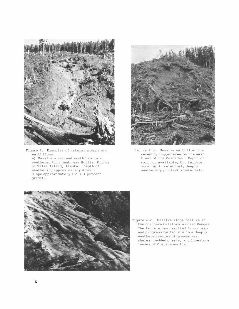
Figure 4. Examples of natural slumps andearth flows.a) Massive slump and earthflow in aweathered till bank near Hollis, Princeof Wales Island, Alaska. Depth ofweathering approximately 4 feet.Slope approximately 15° (34 percentgrade).
Figure 4-b. Massive earthflow in arecently logged area on the westflank of the Cascades. Depth ofsoil not available, but failureoccurred in relatively deeplyweathered pyroclastic materials.
Figure 4-c. Massive slope failure inthe northern California Coast Ranges.The failure has resulted from creepand progressive failure in a deeplyweathered series of greywackes,shales, bedded cherts, and limestonelenses of Cretaceous Age.
6

INTERRELATIONSHIP BETWEEN PRINCIPAL FACTORS PRODUCING
LANDSLIDE MOVEMENTS O N TIMBERED SLOPES
Direct application of soil mechanics theory to analysis of mass movement processes is difficult because of the hetero- geneous nature of soil materials, the ex- treme variability of soil water conditions, and the related variations in stress-strain relationships with time. It does, however, provide a convenient framework in which to discuss the general mechanism and complex interrelationships of the various factors active in development of soil mass movements on timbered slopes.
In simplest terms, failure in a mate- rial results if the shear stress acting on the material (force producing nonelastic defor- mation) equals the shear strength or internal resistance to shear stress of the material.
Soil mass movements result from changes in the soil shear strength-shear stress relationship in the vicinity of fail- ure. This may involve a mechanical read- justment among individual particles or a more complex interaction among both inter- nal and external factors acting on the slope.
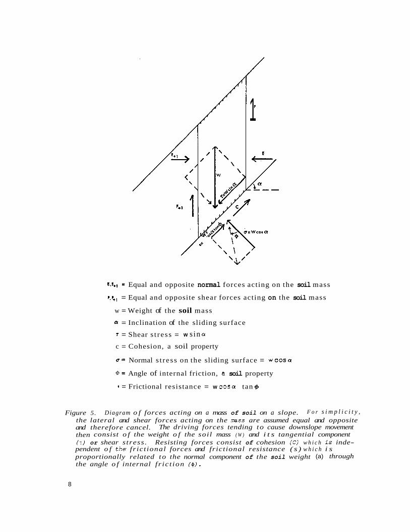
Shear stress (r ), or the tangential component of gravitational stress along a basal zone of sliding, can be expressed by the formula
= W sin a where W = effective weight of the soil
a = slope of failure surface.
Shear strength (S) or resistance to downslope gravitational stress is expressed by the formula
S = C + W c o s a t a n ( $
W = effective weight of the soil a = slope of failure surface ($ = angle of internal friction.
where C = cohesion
Figure 5 shows the geometrical relationship of these various factors. Any increases in the tangential component of gravitational stress will increase the tendency for the soil to move downslope. Increases in shear stress result from increasing slope of the failure surface ( a ) o r increases in the effective weight of the soil mass (W). Increases in slope may result from land rejuvenation by mountain building, sea level change, or local glacial and stream modification. Increases in weight of the soil result from increased water content or surface loading. Shear stress can also be augmented temporarily by application of wind stresses transferred to the soil through the root systems of trees, by local buildup of internal stresses in the soil by creep deformation, by fric- tional "drag" produced by seepage pressures, and by removal of downslope support by undercutting or progressive failure.
Shear strength is governed,by a more complex interrelationship of soil and slope characteristics. These factors include: (a) cohesion, the capacity of soil particles to adhere o r stick together. This is a distinct soil property independent of gravi- tational stresses , produced by cementation, capillary tension, or weak electrical bond- ing of organic colloids and clay particles; (b) the angle of internal friction ( 4 ), which is an expression of the degree of interlock- ing of individual grains; and (c) the effective weight or normal component of gravitational stress ( W cos a), which includes both weight of the soil mass and any additional surface loading plus the effect of slope gradient ( a ). The tangent of the angle of internal friction ( 4 ) times the effective weight (W cos a) constitute a mathematical expression of frictional resistance (s = W cos a tan ($ ). Moisture content and active pore water pressure (pressure produced by
7
/ /
\ L
d 4‘ ‘
\ \ \ \
V \
1
E.E+I = Equal and opposite normal forces acting on the soil mass
p,F+l = Equal and opposite shear forces acting on the soil mass
w = Weight of the soil mass
= Inclination of the sliding surface
= Shear s t ress = w s in cy c = Cohesion, a soil property
d = Normal s t ress on the sliding surface = wcosar
+ = Angle of internal friction, a soil property
= Frictional resistance = w COS^ tan q5
Figure 5. Diagram o f forces acting on a mass of soil on a slope. F o r s i m p l i c i t y , the lateral and shear forces acting on the mass are assumed equal and opposite and therefore cancel. The driving forces tending to cause downslope movement then consist o f the weight o f the soi l mass ( W ) and i t s tangential component (T) or shear s tress . Resisting forces consist of cohesion (C) w h i c h i s inde- pendent o f the, fr ict ional forces and frictional resistance ( s ) w h i c h i s proportionally related to the normal component of the soil weight (a) through the angle o f internal f r ic t ion ( 4 ) .
8
the head of water in a saturated soil and transferred to the base of the soil through the pore water) act to modify the component of frictional resistance by reducing the value of the normal component of gravita- tional stress. This is frequently expressed by the modified equation for effective weight ( W cos a - P ) where p is pore water pressure.
Decreases in the cohesive properties of soils may be produced by certain proc- esses of soil formation such as leaching and eluviation, or by destruction of capillary tens ion through increasing water content . A s slope angles of potential failure surfaces approach or exceed the soil's angle of internal friction, shear strength may also be reduced due to a reduction in the com- ponent of frictional resistance. Increased weight of the soil mass caused by surface loading increases the normal component of gravitational stress.
Rising pore water pressures reduce shear strength as a result of decreased effective weight of the soil mass. A t the same time, seepage pressures resulting from frictional rrdragrt of water flowing downslope through the soil may add sig- nificantly to the tangential component of shear stress. In highly cohesive soils, increasing water content may also help to mobilize the clay particles through saturation and further add to increased creep rates and even ultimate failure.
Root systems of trees and other vegetation can serve as cohesive binders or, if theypenetrate entirely through the soil zone, can anchor the soil mantle to the substrate and thus provide an effective stabilizing influence. In some extremely steep areas in the Western United States, this may be a dominant factor in shear strength of the slope soil (Swanston 1967, 1969, 1970). Under natural conditions, the destruction of such effective
'
mechanical support by windthrow, fire, o r timber harvesting can produce substan- tial decreases in mechanical soil strength.
EFFECT OF FOREST OPERATIONS ON SOIL STABILITY
Timber harvesting as a direct factor in accelerating soil mass movements was first identified (Croft and Adams 1950) in shallow soils on steep, recently logged slopes along the North Fork of the Ogden River in Utah (fig. 1, area,3). Here, debris avalanches were initiated by com- bined heavy spring rains and s n o m e l t , but the authors felt that a contributing factor was a lessening of the mechanical support of the slope, chiefly by timber cutting and burning.
Reconnaissance investigations in southeast Alaska by Bishop and Stevens (1964) have also shown a direct correla- tion between timber harvesting and accel- erated soil mass movements following heavy rains in the fall of 1961. More detailed work in this area (Swanston 1967, 1969, 1970) has shown that sections of almost every logged slope exceed the natural angle of stability of the soils ( - 34"). This condition is aggravated by high intensity storms in the spring and fall (occasionally in excess of 25 mm in 24 hours). Shear strength tests on roots taken from clearcut units of various ages in southeast Alaska showed a marked decrease in strength 3 to 5 years after cutting.2/ This 3- to 5-year time period roughly corresponds to the lag between time of logging and massive debris ava- lanching in southeast Alaska (Bishop and Stevens 1964) .
g/ D. N. Swanston and W. J. Walkotten. Tree rooting and soil stability in coastal forests of south- east Alaska. Study No. FS-NOR-1604:26, on file at the Pacific Northwest Forest and Range Experiment Station, Juneau, Alaska.
9
Dyrness (1967a) investigated acceler- ated soil mass movements on the west flank of the Cascade Range following heavy rains in the winter of 1964-65. He reported that out of 47 recorded debris avalanches, debris flows, earthflows and slumps, 78 percent were directly associated with logging and roadbuilding. Slumps and earthflows caused by road fill failures, road back- slope failures, and failures due to road drainage waters were the most frequently occurring events. Road fill failures con- stituted the greatest single event, but together all three types of failure made up more than 65 percent of all the mass move- ments that occurred (fig. 6). The majority occurred in shallow soils on slopes with a gradient of over 50 percent (23"). Bedrock geology was closely related to the soil mass movements, with the largest numbers occurring on soils derived from pyroclastic rocks, especially greenish tuffs and breccias. Recent work (Paeth 1970) sug- gests that the instability of the greenish tuff and breccia soils is due to a high montmorillonitic clay content. During periods of high rainfall, the soils exper- ience substantial reductions in shear resis- tance as the result of osmotic swelling.
In Idaho, Megahan (see footnote 1) reports about 90 percent of the soil mass movements which occurred along the South Fork of the Salmon River during a storm in April 1965 (a total of 89 events) result- ing from soil failures along the logging road right-of-way. Most open-slope fail- ures occurred in shallow granitic soils on slopes in excess of 50 percent. Again, the greatest number of these resulted from road f i l l failures followed by failures re- sulting from obstructed road drainage (fig. 6).
In the northern California Coast Ranges, Kojan (1967) has identified deep- seated soil creep as a major erosion proc- ess. Creep measurements, using bore
hole inclinometers extending as deep as 1 8 . 3 meters into bedrock, have shown measurable and persistent patterns of creep. Rates vary greatly from place to place and are apparently related to the fundamental variables of mineralogy, fabric, and compressional and weathering history of the rock. Kojan believes that weathering history and the rate of release of locked-in stress from preconsolidation of the Pliocene sediments is a'critical factor in the creep rate. Discrete slump- ing combined with deep-seated creep combine to form transitional slides which account for as much as 70 percent of the natural sediment reaching some streams. No work has been done directly on the effects of timber harvesting in this area, but Kojan (personal communication) be- lieves that such activities have a "profound and extensive effect" on this type of land- slide .occurrence.
METHODS OF PREDICTION, PREVENTION, AND CONTROL
Current research on the effect of forest operations on soil stability is di- rected toward: (a) anticipation of hazard- ous sites, (b) avoidance of disturbances systematically damaging to slope stability, and (c) reduction of landslide incidence after disturbance.
The ability to identify hazardous sites is probably the most useful and economical management tool available. Many of the techniques presently being used effectively in southeast Alaska and northern California are applicable else- where in the Western United States with adequate Imowledge of site conditions and failure mechanisms. In the northern California Coast Ranges aerial photos are being used extensively to identify, delineate, measure, and interpret topo- graphic features related to deep-seated creep and sliding. The interpretations
10
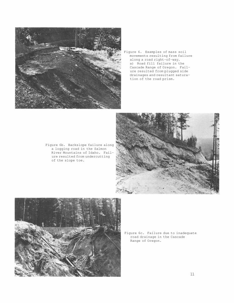
Figure 6. Examples of mass soilmovements resulting from failurealong a road right-of-way,a) Road fill failure in theCascade Range of Oregon. Fail-ure resulted from plugged sidedrainages and resultant satura-tion of the road prism.
Figure 6b. Backslope failure alonga logging road in the SalmonRiver Mountains of Idaho. Fail-ure resulted from undercuttingof the slope toe.
Figure 6c. Failure due to inadequateroad drainage in the CascadeRange of Oregon.
11
are supplemented by geologic maps com- piled from surface outcrops and drill cuttings which aid in the interpretation and extrapolation of observed creep pat- terns. Maps of seismic refraction sur- faces have also been prepared with the object of correlating velocity data and strength parameters with observed creep rates. Vertical color-infrared photographs are being used to identify slope areas of high soil moisture content.
A i r photo interpretation has also been used extensively in southeast Alaska to identify, measure, and delineate current or recent debris avalanche activity. Isoline maps of slope angle have .also been pre- pared for many individual watersheds from air photo and topographic map meamre- ments. The area above a critical isoline corresponding to the measured or esti- mated internal friction angle of the local soil defines areas of "imminent slide hazard. I t In a region where slope gradient alone constitutes a major factor of slope stability, these maps clearly indicate areas of probable landsliding or where additional engineering-geological inves ti- gations are necessary. A map has also been prepared of southeast Alaska show- ing landslide distribution as it relates to regional rainfall patterns. This map has shown a direct correlation between areas of high rainfall and debris avalanche concentration. Currently, maps are being compiled showing the relationship between commercial timber distribution and high hazard areas.
Avoiding activities that are system- atically damaging to slope stability will keep slope distur6ance to a minimum dur- ing forest operations. These include re- stricting forest road construction on poten- tially unstable slopes and preventing damage to the slopes by timber harvesting equip- ment and methods. A number of promising new timber harvesting methods are also being investigated or are undergoing limited practical trials. These include balloon logging and helicopter transport, both of which have a tremendous potential for re- ducing ground damage to a minimum.
Most direct methods of stabilization and control of disturbed areas are expensive and difficult. At present, these methods are not being applied extensively to unstable areas in the Western United States but may be in the near future as timber and esthetic values increase. There have been some limited attempts to stabilize disturbed areas by vege- tation planting. This has been done with some success in the Western States with grass h d legumes on road cut and sidecast slopes to reduce surface soil erosion (Wollum 1962, Bethlahmy and Kidd 1966, Dyrness 1967b). At least one attempt to stabilize a debris avalanche track using a mixture of reed can- ary grass and alder wildlings has also been tried in southeast Alaska. This shows prom- ise although more careful and extensive inves- tigations are needed to make a final judgment of its effectiveness. The United States Forest Service is currently experimenting with the hand seeding of debris avalanche tracks with alder in southeast Alaska.
12
,
LITERATURE CITED
Bethlahmy, N., and W. J. Kidd 1966. Controlling soil movement from steep road fills. USDA For. Serv. Res.
Note INT-45, 4 p., illus. Intermt. For. & Range Exp. Stn. , Ogden, Utah.
Bishop, D. M. , and M. E. Stevens 1964.
Croft, A. R. 1950.
Dyrness, C. 1967a.
Landslides on logged areas in southeast Alaska. Northern For. Exp. Stn. USDA For. Serv. Res. Pap. NOR-1, 18 p. , illus.
, and J. A. Adams Landslides and sedimentation on the North Fork of @den River, May 1949. USDA For. Serv. Intermt. For. & Range Exp. Stn. Res. Pap. INT-21, 4 p. , illus.
T. Mass soil movements in the H. J. Andrews Experimental Forest. USDA
For. Serv. Res. Pap. PNW-42, 12 p., illus. Pac. Northwest For. & Range Exp. Stn., Portland, Oreg.
1967b. Grass-legume mktures for roadside stabilization. USDA For. Serv. Res. Note PNW-71, 19 p., illus.’ Pac. Northwest For. & Range Exp. Stn. , Portland, Oreg.
Eckel, Edwin B. 1958. Landslides and engineering practice. Highway Res. Board Spec. Rep. 29,
NAS-NRC Publ. 544, 232 p., illus. , Wash. , D. C.
Kojan, Eugene 1967. Mechanics and rates of natural soil creep. Fifth Annu. Eng. Geol. & Soils
Eng. SGp . , Idaho Dep. Highways, Univ. Idaho, Idaho State Univ. , ! Pocatello, Proc. 1967, p. 233-253.
Paeth, Robert Carl 1970. Genetic and stability relationships of four Western Cascade soils.
illus. Ph. D. thesis, Oregon State Univ., Corvallis. 126 p.,
Savarenskii, P. F. 1937. Inzhenernaya geologiya. Moskva.
Sharpe, C. F. S. 1938. Landslides and related phenomena. 137 p. , illus. New York: Columbia
Univ. Press.
Swanston, D. N. 1967. Debris avalanching in thin soils derived from bedrock. USDA For. Serv.
Res. Note PNW-64, 7 p., illus. Pac. Northwest For. & Range Exp. Stn. , Portland, Oreg.
13
1969. Mass wasting in coastal Alaska. USDA For. Serv. Res. Pap. PNW-83, 15 p., illus. Pac. Northwest For. & Range Exp. Stn., Portland, Oreg.
1970. Mechanics of debris avalanching in shallow till soils of southeast Alaska. USDA For. Serv. Res. Pap. PNW-103, 17 p . , illus. Pac. Northwest For. & Range Exp. Stn., Portland, Oreg.
Wollum, A. G. 1962. Grass seeding as a control for roadbank erosion. USDA For. Serv. Pac.
Northwest For. & Range Exp. Stn., Res. Note PNW-218, 5 p., illus. Portland, Oreg.
Zgruba, Q., and V. Mencl 1969. Landslides and their control. 205 p., illus. New York: Am. Elsevier
Publ. Co., Inc. (Prague: Acad., Publ. House Czech. Acad. Sci.).
14
The mission of the PACIFIC NORTHWEST FOREST A N D RANGE EXPERIMENT STATlON is to provide the knowledge, technology, and alternatives for present and future protection, management, and use of forest, range, and related environments.
Within this overall mission, the Station conducts and stimulates research to facilitate and to accelerate progress toward the fol lowing goals:
1. Providing safe and efficient technology for inventory, protection, and use of resources.
2. Development and evaluation of alternative methods and levels of resource management.
3. Achievement of optimum sustained resource produc- t iv i ty consistent w i th maintaining a high qual i ty forest environment.
The area of research encompasses Oregon, Washington, Alaska, and, in some cases, California, Hawaii, the Western States, and t h e Nation. Results of the research will be made available promptly. Project headquarters are at:
Fairbanks, Alaska Portland, Oregon Juneau, Alaska Olympia, Washington Bend, Oregon Seattle, Washington Corwallis, Oregon Wenatchee, Washington L a Grande, Oregon
Mailing Address: Pacific Northwest Forest and Range Experiment Station
P.O. Box 3141 Portland, Oregon 97208
GPO 990-683

The FOREST SERVICE of the U. S. Department of Agricultureis dedicated to the principle of multiple use management of theNation's forest resources for sustained yields of wood, water,forage, wildlife, and recreation. Through forestry research, co-operation with the States and private forest owners, and man-agement of the National Forests and National Grasslands, itstrives — as directed by Congress -- to provide increasingly greaterservice to a growing Nation.