small hydro resource mapping in tanzania site visits...
TRANSCRIPT
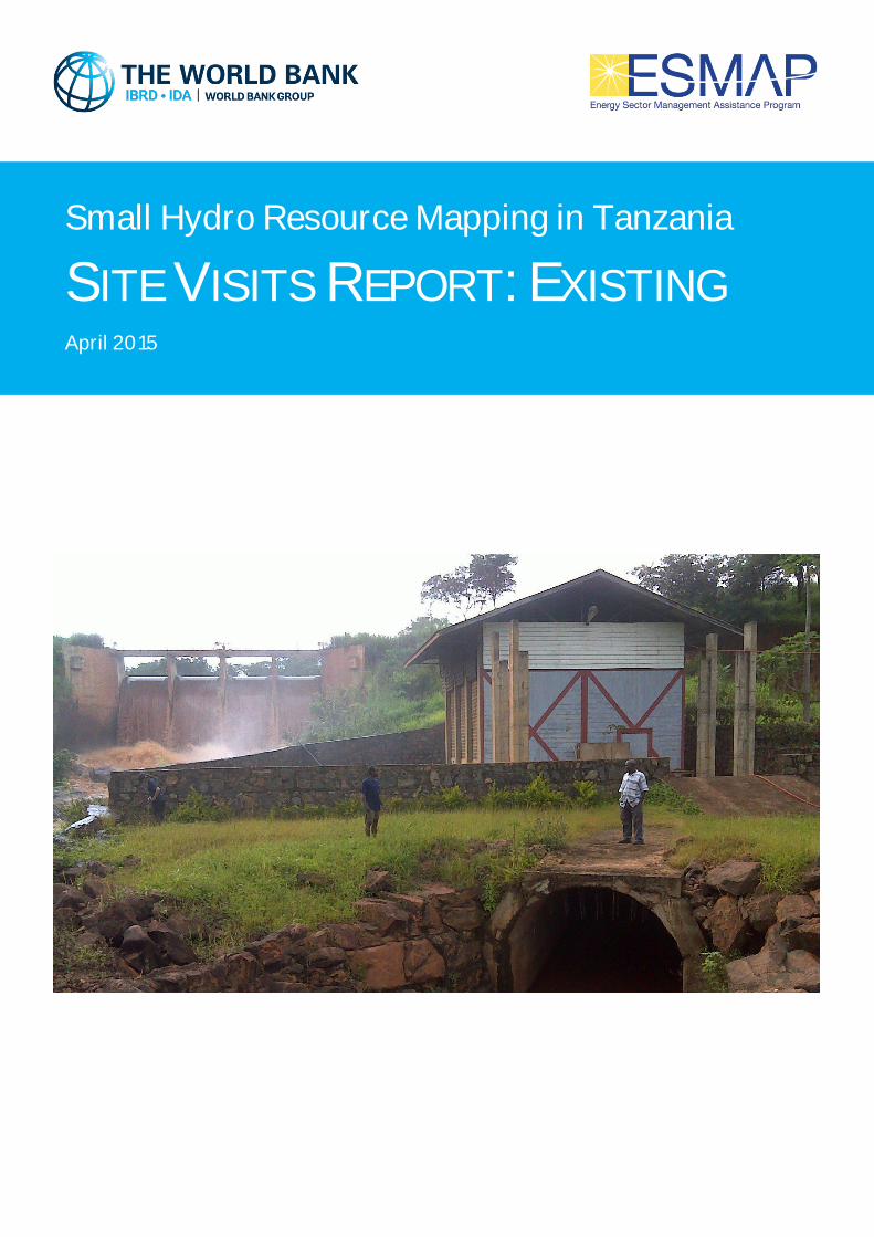
Small Hydro Resource Mapping in Tanzania
SITE VISITS REPORT: EXISTING April 2015

This report was prepared by SHER Ingénieurs-Conseils s.a. in association with Mhylab, under contract to The World Bank. It is one of several outputs from the wind Renewable Energy Resource Mapping and Geospatial Planning Tanzania ]. This activity is funded and supported by the Energy Sector Management Assistance Program (ESMAP), a multi-donor trust fund administered by The World Bank, under a global initiative on Renewable Energy Resource Mapping. Further details on the initiative can be obtained from the ESMAP website. This document is an interim output from the above-mentioned project. Users are strongly advised to exercise caution when utilizing the information and data contained, as this has not been subject to full peer review. The final, validated, peer reviewed output from this project will be a Tanzania Small Hydro Atlas, which will be published once the project is completed.
Copyright © 2015 International Bank for Reconstruction and Development / THE WORLD BANK
Washington DC 20433
Telephone: +1-202-473-1000
Internet: www.worldbank.org
This work is a product of the consultants listed, and not of World Bank staff. The findings, interpretations,
and conclusions expressed in this work do not necessarily reflect the views of The World Bank, its Board of
Executive Directors, or the governments they represent.
The World Bank does not guarantee the accuracy of the data included in this work and accept no
responsibility for any consequence of their use. The boundaries, colors, denominations, and other
information shown on any map in this work do not imply any judgment on the part of The World Bank
concerning the legal status of any territory or the endorsement or acceptance of such boundaries.
The material in this work is subject to copyright. Because The World Bank encourages dissemination of its
knowledge, this work may be reproduced, in whole or in part, for non-commercial purposes as long as full
attribution to this work is given. Any queries on rights and licenses, including subsidiary rights, should be
addressed to World Bank Publications, The World Bank Group, 1818 H Street NW, Washington, DC 20433,
USA; fax: +1-202-522-2625; e-mail: [email protected]. Furthermore, the ESMAP Program Manager
would appreciate receiving a copy of the publication that uses this publication for its source sent in care of
the address above, or to [email protected].

Small Hydro Tanzania REA / The World Bank Contract n°7169139
SHER s.a. in association with Mhylab Site visit report - April 2015 Page 3 of 42
SHER Ingénieurs-conseils s.a. Rue J. Matagne, 15
5020 Namur – Belgium
Phone : +32 81 32 79 80
Fax : +32 81 32 79 89
www.sher.be
Project Manager: Julien LEFEVERE
Référence SHER : TNZ01
Phone : +32 (0) 81 327 982
Fax : +32 (0) 81 327 989
E-mail : [email protected]
Rev.n° Date Content Drafted Verified
0 02/2015 Site visit report - Interim Thomas DUBOIS Giress MUNYANDEKWE Alice VANDENBUSSCHE
Pierre SMITS
1 04/2015 Site visit report - FINAL Thomas DUBOIS Giress MUNYANDEKWE Alice VANDENBUSSCHE
Pierre SMITS
SHER INGÉNIEURS-CONSEILS S.A.
IS ISO 9001 CERTIFIED

Small Hydro Tanzania REA / The World Bank Contract n°7169139
SHER s.a. in association with Mhylab Site visit report - April 2015 Page 4 of 42

Small Hydro Tanzania REA / The World Bank Contract n°7169139
SHER s.a. in association with Mhylab Site visit report - April 2015 Page 5 of 42

Small Hydro Tanzania REA / The World Bank Contract n°7169139
SHER s.a. in association with Mhylab Site visit report - April 2015 Page 6 of 42
1 GENERAL CONTEXT OF THE ESMAP – FWC PROJECT
The Energy Sector Management Assistance Program (ESMAP), a global knowledge and technical
assistance program administered by the World Bank and supported by 11 bilateral donors, has
launched, in January 2013, an initiative that will support country-driven efforts to improve RE
resource awareness, put in place appropriate policy frameworks for RE development, and provide
‘open access’ to resource and geospatial mapping data. It will also support the IRENA Solar and
Wind Atlas by improving the data availability and quality that can be accessed through the atlas on
a modular basis.
This "Renewable Energy Mapping: Small Hydro Tanzania" study, is part of a technical assistance
project, ESMAP funded, being implemented by Africa Energy Practice 1 (AFTG1) of the World Bank
in Tanzania (the ‘Client’) which aims at supporting resource mapping and geospatial planning for
small hydro. It is being undertaken in close coordination with the Rural Energy Agency (REA) of
Tanzania, the World Bank’s primary Client country counterpart for this study.
The "Provision of Small Hydropower Resource Data and Mapping Services" IDA 8004801
Framework contract was signed 29th May 2013, while the specific contract " Renewable Energy
Mapping: Small Hydro Tanzania", n. 7169139, is dated 4th November 2013.
2 FRAMEWORK OF THE SITE VISITS REPORT IN TANZANIA
The Site Visits Report is the result of the consolidation of the primary and secondary data collected
and processed during the site visits. This report comes with the Hydro Mapping report provided at
the end of Phase 1 which established an inventory of existing and potential hydropower sites put
into perspective in their socio-economic and natural environment.
The fact sheets, presented in this report, for the 11 hydropower existing visited sites contain some
preliminary information for future improvement or rehabilitation.

Small Hydro Tanzania REA / The World Bank Contract n°7169139
SHER s.a. in association with Mhylab Site visit report - April 2015 Page 7 of 42

Small Hydro Tanzania REA / The World Bank Contract n°7169139 - Framework of the Site Visits report in TANZANIA -
SHER s.a. in association with Mhylab Site visit report - April 2015 Page 8 of 42
Table of Contents
1 General context of the ESMAP – FWC project ............................................................................................................. 6
2 Framework of the Site investigation report in TANZANIA ........................................................................................... 6
3 Kindimba Existing (N-003) .......................................................................................................................................... 9
4 Kitai (E-003) .............................................................................................................................................................. 12
5 Kitandazi I (E-004) ..................................................................................................................................................... 15
6 Litembo Existing (M-298A) ....................................................................................................................................... 18
7 Lumeme (M-266) ...................................................................................................................................................... 21
8 Lundomato Mission (N-001) ..................................................................................................................................... 24
9 Lupilo (E-002)............................................................................................................................................................ 27
10 Maguu (E-005) .......................................................................................................................................................... 30
11 Masigira (SF-030) ...................................................................................................................................................... 33
12 Ndanda (M-348) ....................................................................................................................................................... 36
13 Peramiho - Likingo (E-001) ........................................................................................................................................ 39

Small Hydro Tanzania REA / The World Bank Contract n°7169139 - Kindimba Existing (N-003) -
SHER s.a. in association with Mhylab Site visit report - April 2015 Page 9 of 42
3 KINDIMBA EXISTING (N-003)
Figure 1 : Site layout
Geographic coordinates (WGS 84) Easting [°] Northing [°]
Dam 34.889 -10.957
Powerhouse 34.891 -10.954
1. Administrative and socio-economic data
Site code N-003
Site name Kindimba Existing
River Mangaka
Village Kindimba
Region Ruvuma
Basin Lake Nyasa
Topographical map reference Topographical map n° 297/4 (scale 1/50,000)
2. Reference study
Study name : Field visit Author : SHER Edition year : 2014
Estimated potential from Hydropower Atlas
Operating discharge [m³/s] 0.04
Gross head [m] 25
Installed capacity [kW] 8

Small Hydro Tanzania REA / The World Bank Contract n°7169139 - Kindimba Existing (N-003) -
SHER s.a. in association with Mhylab Site visit report - April 2015 Page 10 of 42
3. Technical data
Type of scheme: Run of the river Type of connection: Off-grid Scheme description : Existing powerhouse (50 kw) including an option for mill turbine. The infrastructure (dam-canal-forebay-penstock-spillway-powerhouse) is in a good condition. The electrical system has been destroyed by a lightning. There is a currrent rehabilitation of the alternator and the transformer. During the rainy season, the removing of the sand takes 2 days per week. Due to the river basin deterioration, an improved desilting basin should be built.
Canal length [m] 442
Tunnel length [m] 0
Penstock length [m] 72
Dam type Masonery dam
Dam height [m] 2
Dam width [m] 10
Measured turbidity [NTU] 300
Comments on solid transport Important
Transmission line length [km] 0.0
Comments on accessibility Difficult existing access to the infrastructures
Other comments Existing site to be improved by a new desilting system.
Existing isolated Grid
-
An extension of the local grid is under progress.
-
4. Hydrological data
These parameters were defined by regionalization. These preliminary values are only indicative. They might in no case be used for detailed design.
Firm discharge Q95% [m³/s] 0.02
Q90% discharge [m³/s] 0.04
Q50% discharge [m³/s] 0.14
Q30% discharge [m³/s] 0.20
Design flood P100 yr [m³/s] 0.84
Catchment area [km²] 21
Hydrological confidence indication Medium

Small Hydro Tanzania REA / The World Bank Contract n°7169139 - Kindimba Existing (N-003) -
SHER s.a. in association with Mhylab Site visit report - April 2015 Page 11 of 42
5. Representative pictures
Figure 2 : Dam site and intake (Tyrolean intake)
Figure 3 : Desilting basin (to be enlarged)
Figure 4 : Forebay
Figure 5 : Power house including crossflow turbine, watermill
and alternator
Small Hydro Tanzania REA / The World Bank Contract n°7169139 - Kitai (E-003) -
SHER s.a. in association with Mhylab Site visit report - April 2015 Page 12 of 42
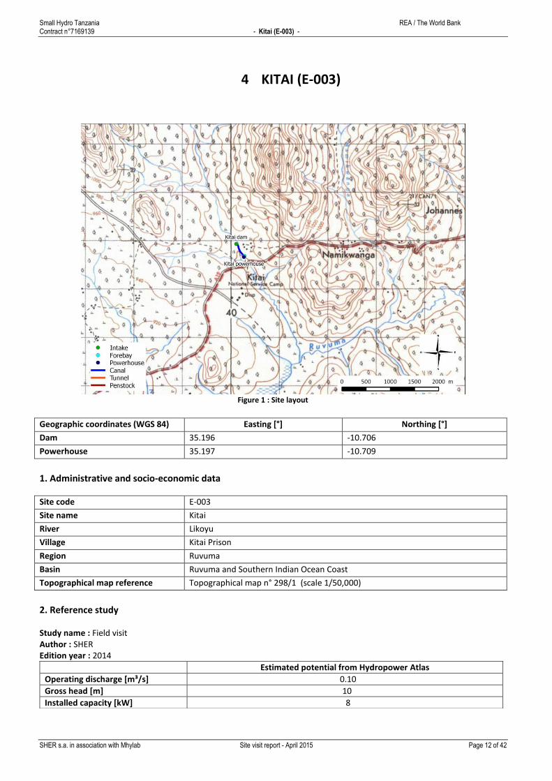
4 KITAI (E-003)
Figure 1 : Site layout
Geographic coordinates (WGS 84) Easting [°] Northing [°]
Dam 35.196 -10.706
Powerhouse 35.197 -10.709
1. Administrative and socio-economic data
Site code E-003
Site name Kitai
River Likoyu
Village Kitai Prison
Region Ruvuma
Basin Ruvuma and Southern Indian Ocean Coast
Topographical map reference Topographical map n° 298/1 (scale 1/50,000)
2. Reference study
Study name : Field visit Author : SHER Edition year : 2014
Estimated potential from Hydropower Atlas
Operating discharge [m³/s] 0.10
Gross head [m] 10
Installed capacity [kW] 8
Small Hydro Tanzania REA / The World Bank Contract n°7169139 - Kitai (E-003) -
SHER s.a. in association with Mhylab Site visit report - April 2015 Page 13 of 42
3. Technical data
Type of scheme: Run of the river Type of connection: Off-grid Scheme description : The hydropower system has been created to supply the prison. The prison may have between 100 and 200 inmates. According to the prison's director, the plant was created in 1974 at the request of president Nyerere on visit at the site. He asked the assistence of the Peramiho Mission who was already experienced in this field. They took advantage of the artificial pond created for fishing purposes. However, this does not constitutes a reservoir for the power plant since the flow regulation is very light, and no water accumulation is possible for power generation. Concrete components consist in a gate in a backfilled dam and an unlined canal that diverts the outlet to the powerhouse. A head of 9.5m is created and an Ossberger turbine uses 600l/s to create 45kW of power.
Canal length [m] 352
Tunnel length [m] 0
Penstock length [m] 31
Dam type Masonery dam
Dam height [m] 3
Dam width [m] 50
Measured turbidity [NTU] 80
Comments on solid transport Non existent because of the pond.
Transmission line length [km] 1.0
Comments on accessibility Weir access: Good: a kilometer from the main road
Powerhouse access: Good: a few meters from the main road
Other comments Existing site that feeds the prison.
-
No future infractructure is foreseen in the coming years.
-
4. Hydrological data
These parameters were defined by regionalization. These preliminary values are only indicative. They might in no case be used for detailed design.
Firm discharge Q95% [m³/s] 0.06
Q90% discharge [m³/s] 0.10
Q50% discharge [m³/s] 0.35
Q30% discharge [m³/s] 0.51
Design flood P100 yr [m³/s] 2.15
Catchment area [km²] 60
Hydrological confidence indication Medium

Small Hydro Tanzania REA / The World Bank Contract n°7169139 - Kitai (E-003) -
SHER s.a. in association with Mhylab Site visit report - April 2015 Page 14 of 42
5. Representative pictures
Figure 2 : Artificial pond for fishery
Figure 3 : Intake
Figure 4 : Forebay
Figure 5 : Powerhouse

Small Hydro Tanzania REA / The World Bank Contract n°7169139 - Kitandazi I (E-004) -
SHER s.a. in association with Mhylab Site visit report - April 2015 Page 15 of 42
5 KITANDAZI I (E-004)
Figure 1 : Site layout
Geographic coordinates (WGS 84) Easting [°] Northing [°]
Dam 35.070 -11.016
Powerhouse 35.074 -11.021
1. Administrative and socio-economic data
Site code E-004
Site name Kitandazi I
River Mbinga
Village -
Region Ruvuma
Basin Ruvuma and Southern Indian Ocean Coast
Topographical map reference Topographical map n° 310/1 (scale 1/50,000)
2. Reference study
Study name : Field visit Author : SHER Edition year : 2014
Estimated potential from Hydropower Atlas
Operating discharge [m³/s] 1.10
Gross head [m] 36
Installed capacity [kW] 330

Small Hydro Tanzania REA / The World Bank Contract n°7169139 - Kitandazi I (E-004) -
SHER s.a. in association with Mhylab Site visit report - April 2015 Page 16 of 42
3. Technical data
Type of scheme: Run of the river Type of connection: Connected to a mini-grid Scheme description : This powerplant is currently being built by AHEPO (Andoya Hydropower Project), with part of the funds comnig from the WB and with some support from REA. A concrete weir diverts water into the scheme; no reservoir is foreseen. The plant will be able to generate 1MW from 2 Francis turbines (constructor: ZECO). The head is 36m and the discharge is 3.8m³/s. Mr Andoya is a private investor, who owned the hydro-mill on the site. He will sell the power to TANESCO.
Canal length [m] 792
Tunnel length [m] 0
Penstock length [m] 177
Dam type Masonery dam
Dam height [m] 5
Dam width [m] 30
Measured turbidity [NTU] 30
Comments on solid transport Limited but the watershed is very exposed to agriculture and solid transport
might be significant during rainy weather.
Transmission line length [km] 14.0
Comments on accessibility Weir access: Accessible by an unpaved road
Powerhouse access: Accessible by an unpaved road.
Other comments Site under construction that will be connected to the Mbinga minigrid.
Lined canal.
No future infractructure is foreseen in the coming years.
The promotor and owner of the project is Andoya Hydropower Project (AHEPO).
4. Hydrological data
These parameters were defined by regionalization. These preliminary values are only indicative. They might in no case be used for detailed design.
Firm discharge Q95% [m³/s] 0.20
Q90% discharge [m³/s] 0.32
Q50% discharge [m³/s] 1.13
Q30% discharge [m³/s] 1.63
Design flood P100 yr [m³/s] 6.91
Catchment area [km²] 176
Hydrological confidence indication Medium
Small Hydro Tanzania REA / The World Bank Contract n°7169139 - Kitandazi I (E-004) -
SHER s.a. in association with Mhylab Site visit report - April 2015 Page 17 of 42
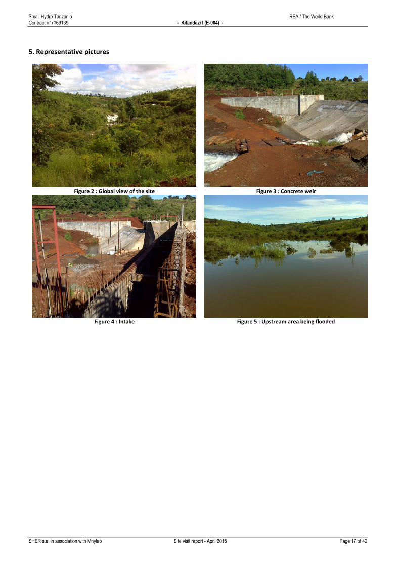
5. Representative pictures
Figure 2 : Global view of the site
Figure 3 : Concrete weir
Figure 4 : Intake
Figure 5 : Upstream area being flooded

Small Hydro Tanzania REA / The World Bank Contract n°7169139 - Litembo Existing (M-298A) -
SHER s.a. in association with Mhylab Site visit report - April 2015 Page 18 of 42
6 LITEMBO EXISTING (M-298A)
Figure 1 : Site layout
Geographic coordinates (WGS 84) Easting [°] Northing [°]
Dam 34.832 -10.977
Powerhouse 34.830 -10.975
1. Administrative and socio-economic data
Site code M-298A
Site name Litembo Existing
River Ndumbi
Village Litembo Mission
Region Ruvuma
Basin Lake Nyasa
Topographical map reference Topographical map n° 297/4 (scale 1/50,000)
2. Reference study
Study name : IREP - GIS - base list Author : IED Edition year : 2013
Estimated potential from Hydropower Atlas
Operating discharge [m³/s] 0.06
Gross head [m] 12
Installed capacity [kW] 6

Small Hydro Tanzania REA / The World Bank Contract n°7169139 - Litembo Existing (M-298A) -
SHER s.a. in association with Mhylab Site visit report - April 2015 Page 19 of 42
3. Technical data
Type of scheme: Run of the river Type of connection: Off-grid Scheme description : Existing dam, power canal and penstock. A 94 kW Crossflow Turbine is fed by a concrete canal. The turbine is properly working since 1982 and feeds a mini-grid. The scheme is well designed, well maintained and in good operating condition. They face an increasing problem of sediment that must be flushed at the forebay with a higher frequency.
Canal length [m] 341
Tunnel length [m] 0
Penstock length [m] 81
Dam type Concrete dam
Dam height [m] 6
Dam width [m] 25
Measured turbidity [NTU] 300
Comments on solid transport Sand
Transmission line length [km] 0.0
Comments on accessibility Existing access
Other comments Existing site feeding the Mission minigrid.
Canal on the left riverbank.
No grid extention is foreseen in the coming years.
-
4. Hydrological data
These parameters were defined by regionalization. These preliminary values are only indicative. They might in no case be used for detailed design.
Firm discharge Q95% [m³/s] 0.04
Q90% discharge [m³/s] 0.06
Q50% discharge [m³/s] 0.22
Q30% discharge [m³/s] 0.32
Design flood P100 yr [m³/s] 1.33
Catchment area [km²] 34
Hydrological confidence indication Medium

Small Hydro Tanzania REA / The World Bank Contract n°7169139 - Litembo Existing (M-298A) -
SHER s.a. in association with Mhylab Site visit report - April 2015 Page 20 of 42
5. Representative pictures
Figure 2 : Intake
Figure 3 : Power canal
Figure 4 : Forebay and flushing gate
Figure 5 : Turbine

Small Hydro Tanzania REA / The World Bank Contract n°7169139 - Lumeme (M-266) -
SHER s.a. in association with Mhylab Site visit report - April 2015 Page 21 of 42
7 LUMEME (M-266)
Figure 1 : Site layout
Geographic coordinates (WGS 84) Easting [°] Northing [°]
Dam 34.953 -11.152
Powerhouse 34.954 -11.157
1. Administrative and socio-economic data
Site code M-266
Site name Lumeme
River Lumeme
Village Several villages are located around the project scheme
Region Ruvuma
Basin Ruvuma and Southern Indian Ocean Coast
Topographical map reference Topographical map n° 309/2 (scale 1/50,000)
2. Reference study
Study name : List for Feasibility Study Author : REA Edition year : 2009
Estimated potential from Hydropower Atlas
Operating discharge [m³/s] 0.20
Gross head [m] 26
Installed capacity [kW] 40

Small Hydro Tanzania REA / The World Bank Contract n°7169139 - Lumeme (M-266) -
SHER s.a. in association with Mhylab Site visit report - April 2015 Page 22 of 42
3. Technical data
Type of scheme: Run of the river Type of connection: Off-grid Scheme description : The scheme benefits from the head created by waterfalls located on a reduced stretch of the river. The canal will be located on the right riverbank which is the most appropriate. Part of the riverflow is currently diverted through a small canal on about 100m to feed an existing mechanical hydromill.
Canal length [m] 891
Tunnel length [m] 0
Penstock length [m] 164
Dam type Masonery dam
Dam height [m] 5
Dam width [m] 25
Measured turbidity [NTU] 150
Comments on solid transport Presence of sand in the water
Transmission line length [km] 10.0
Comments on accessibility Weir access: Good: 1km from the road
Powerhouse access: Good: 1km from the road
Other comments The transmission line for this scheme could be developped together with that for
the Kingilikiti scheme.
Canal on the right riverbank. Mostly superficial soft grounds.
No future infractructure is foreseen in the coming years.
Kingilikiti scheme is located about 4km downstream of this site.
A reservoir scheme is probably not appropriate given the size of the site.
4. Hydrological data
These parameters were defined by regionalization. These preliminary values are only indicative. They might in no case be used for detailed design.
Firm discharge Q95% [m³/s] 0.12
Q90% discharge [m³/s] 0.20
Q50% discharge [m³/s] 0.69
Q30% discharge [m³/s] 0.99
Design flood P100 yr [m³/s] 4.20
Catchment area [km²] 106
Hydrological confidence indication Medium

Small Hydro Tanzania REA / The World Bank Contract n°7169139 - Lumeme (M-266) -
SHER s.a. in association with Mhylab Site visit report - April 2015 Page 23 of 42
5. Representative pictures
Figure 2 : Vicinity of proposed weir location
Figure 3 : Detail of river downstream of weir position
Figure 4 : Existing hydro-mill
Figure 5 : View on the powerhouse proposed site

Small Hydro Tanzania REA / The World Bank Contract n°7169139 - Lundomato Mission (N-001) -
SHER s.a. in association with Mhylab Site visit report - April 2015 Page 24 of 42
8 LUNDOMATO MISSION (N-001)
Figure 1 : Site layout
Geographic coordinates (WGS 84) Easting [°] Northing [°]
Dam 34.803 -10.858
Powerhouse 34.800 -10.853
1. Administrative and socio-economic data
Site code N-001
Site name Lundomato Mission
River Mhusi
Village Lundomato
Region Ruvuma
Basin Lake Nyasa
Topographical map reference Topographical map n° 297/4 (scale 1/50,000)
2. Reference study
Study name : Field visit Author : SHER Edition year : 2014
Estimated potential from Hydropower Atlas
Operating discharge [m³/s] 0.02
Gross head [m] 10
Installed capacity [kW] 1

Small Hydro Tanzania REA / The World Bank Contract n°7169139 - Lundomato Mission (N-001) -
SHER s.a. in association with Mhylab Site visit report - April 2015 Page 25 of 42
3. Technical data
Type of scheme: Run of the river Type of connection: Off-grid Scheme description : Existing micro-site to be rehabilitate with a new dam, new power canal, new desilting system and new penstock and a turbine.The turbine mill and scheme is not operational. A reconditionning can be foreseen. The dam has to be rebuild and/or adapted. The power canal must be totaly rebuilt. A sand trap must be included in the scheme
Canal length [m] 710
Tunnel length [m] 0
Penstock length [m] 42
Dam type Masonery dam
Dam height [m] 2
Dam width [m] 20
Measured turbidity [NTU] 100
Comments on solid transport Sand and small stones (< 5cm).
Transmission line length [km] 2.0
Comments on accessibility Existing access
Other comments Existing site with an isolated grid for the Lundomato Mission. No grid extension is
foreseen in the coming years.
Topsoil with hard rock below.
No future infractructure is foreseen in the coming years.
-
4. Hydrological data
These parameters were defined by regionalization. These preliminary values are only indicative. They might in no case be used for detailed design.
Firm discharge Q95% [m³/s] 0.01
Q90% discharge [m³/s] 0.02
Q50% discharge [m³/s] 0.10
Q30% discharge [m³/s] 0.18
Design flood P100 yr [m³/s] 1.57
Catchment area [km²] 19
Hydrological confidence indication Low

Small Hydro Tanzania REA / The World Bank Contract n°7169139 - Lundomato Mission (N-001) -
SHER s.a. in association with Mhylab Site visit report - April 2015 Page 26 of 42
5. Representative pictures
Figure 2 : Forebay - Problem of sediment
Figure 3 : Penstock and powerhouse
Figure 4 : Turbine mill
Figure 5 : Turbine detail

Small Hydro Tanzania REA / The World Bank Contract n°7169139 - Lupilo (E-002) -
SHER s.a. in association with Mhylab Site visit report - April 2015 Page 27 of 42
9 LUPILO (E-002)
Figure 1 : Site layout
Geographic coordinates (WGS 84) Easting [°] Northing [°]
Dam 35.201 -10.863
Powerhouse 35.201 -10.863
1. Administrative and socio-economic data
Site code E-002
Site name Lupilo
River Ruvuma
Village Chipole Mission
Region Ruvuma
Basin Ruvuma and Southern Indian Ocean Coast
Topographical map reference Topographical map n° 298/3 (scale 1/50,000)
2. Reference study
Study name : Field visit Author : SHER Edition year : 2014
Estimated potential from Hydropower Atlas
Operating discharge [m³/s] 11.40
Gross head [m] 8
Installed capacity [kW] 620

Small Hydro Tanzania REA / The World Bank Contract n°7169139 - Lupilo (E-002) -
SHER s.a. in association with Mhylab Site visit report - April 2015 Page 28 of 42
3. Technical data
Type of scheme: Daily reservoir Type of connection: Off-grid Scheme description : A reservoir is created by a dam which floods the swamp. The dam is an earthfilled dam with a concrete spillway which creates an artificial head of about 8m. The intake is on the left embankment, and the penstock carries the water directly from the intake to the powerhouse.
Canal length [m] 0
Tunnel length [m] 0
Penstock length [m] 36
Dam type Masonery dam
Dam height [m] 9
Dam width [m] 40
Measured turbidity [NTU] 500
Comments on solid transport Because of the presence of the reservoir, the heaviest particles are trapped.
However, the water quality seems very poor. The dredging requirements are
unknown but will be doubtless significant on the long term.
Transmission line length [km] 10.0
Comments on accessibility Weir access: Average: long unpaved road
Powerhouse access: Average: long unpaved road
Other comments Existing site that feeds the Chipole Mission.
-
No future infractructure is foreseen in the coming years.
Unfortunately, access to the powerhouse has not been granted at the time of the
visit. So no information on the production system is available.
4. Hydrological data
These parameters were defined by regionalization. These preliminary values are only indicative. They might in no case be used for detailed design.
Firm discharge Q95% [m³/s] 1.77
Q90% discharge [m³/s] 2.86
Q50% discharge [m³/s] 10.04
Q30% discharge [m³/s] 14.51
Design flood P100 yr [m³/s] 61.50
Catchment area [km²] 1,663
Hydrological confidence indication Medium
Small Hydro Tanzania REA / The World Bank Contract n°7169139 - Lupilo (E-002) -
SHER s.a. in association with Mhylab Site visit report - April 2015 Page 29 of 42
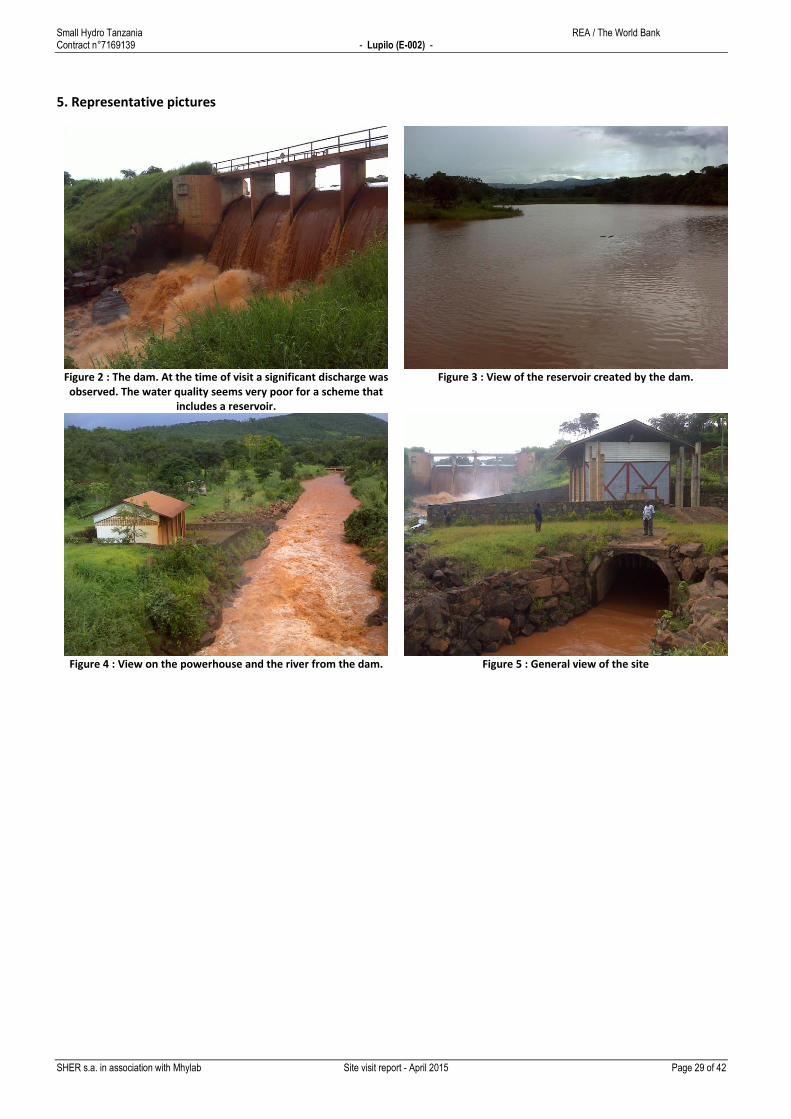
5. Representative pictures
Figure 2 : The dam. At the time of visit a significant discharge was observed. The water quality seems very poor for a scheme that
includes a reservoir.
Figure 3 : View of the reservoir created by the dam.
Figure 4 : View on the powerhouse and the river from the dam.
Figure 5 : General view of the site
Small Hydro Tanzania REA / The World Bank Contract n°7169139 - Maguu (E-005) -
SHER s.a. in association with Mhylab Site visit report - April 2015 Page 30 of 42
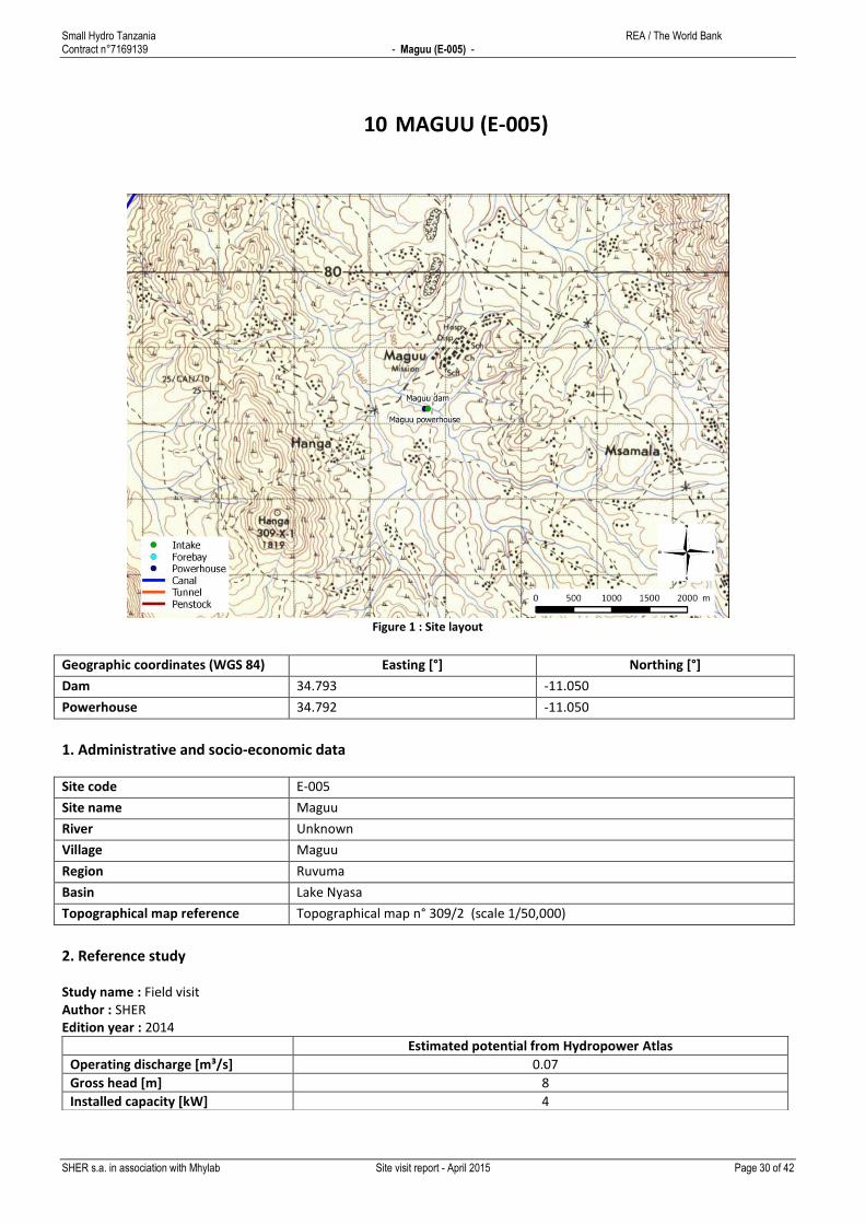
10 MAGUU (E-005)
Figure 1 : Site layout
Geographic coordinates (WGS 84) Easting [°] Northing [°]
Dam 34.793 -11.050
Powerhouse 34.792 -11.050
1. Administrative and socio-economic data
Site code E-005
Site name Maguu
River Unknown
Village Maguu
Region Ruvuma
Basin Lake Nyasa
Topographical map reference Topographical map n° 309/2 (scale 1/50,000)
2. Reference study
Study name : Field visit Author : SHER Edition year : 2014
Estimated potential from Hydropower Atlas
Operating discharge [m³/s] 0.07
Gross head [m] 8
Installed capacity [kW] 4
Small Hydro Tanzania REA / The World Bank Contract n°7169139 - Maguu (E-005) -
SHER s.a. in association with Mhylab Site visit report - April 2015 Page 31 of 42
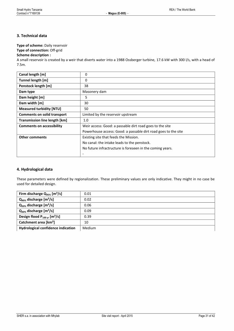
3. Technical data
Type of scheme: Daily reservoir Type of connection: Off-grid Scheme description : A small reservoir is created by a weir that diverts water into a 1988 Ossberger turbine, 17.6 kW with 300 l/s, with a head of 7.5m.
Canal length [m] 0
Tunnel length [m] 0
Penstock length [m] 38
Dam type Masonery dam
Dam height [m] 5
Dam width [m] 30
Measured turbidity [NTU] 50
Comments on solid transport Limited by the reservoir upstream
Transmission line length [km] 1.0
Comments on accessibility Weir access: Good: a passable dirt road goes to the site
Powerhouse access: Good: a passable dirt road goes to the site
Other comments Existing site that feeds the Mission.
No canal: the intake leads to the penstock.
No future infractructure is foreseen in the coming years.
-
4. Hydrological data
These parameters were defined by regionalization. These preliminary values are only indicative. They might in no case be used for detailed design.
Firm discharge Q95% [m³/s] 0.01
Q90% discharge [m³/s] 0.02
Q50% discharge [m³/s] 0.06
Q30% discharge [m³/s] 0.09
Design flood P100 yr [m³/s] 0.39
Catchment area [km²] 10
Hydrological confidence indication Medium

Small Hydro Tanzania REA / The World Bank Contract n°7169139 - Maguu (E-005) -
SHER s.a. in association with Mhylab Site visit report - April 2015 Page 32 of 42
5. Representative pictures
Figure 2 : Weir
Figure 3 : Pond created by the weir
Figure 4 : Intake
Figure 5 : Penstock

Small Hydro Tanzania REA / The World Bank Contract n°7169139 - Masigira (SF-030) -
SHER s.a. in association with Mhylab Site visit report - April 2015 Page 33 of 42
11 MASIGIRA (SF-030)
Figure 1 : Site layout
Geographic coordinates (WGS 84) Easting [°] Northing [°]
Dam 35.197 - 9.952
Powerhouse 35.196 - 9.956
1. Administrative and socio-economic data
Site code SF-030
Site name Masigira
River Ruhuhu
Village Mahanje (East)
Region Njombe
Basin Lake Nyasa
Topographical map reference Topographical map n° 275/3 (scale 1/50,000)
2. Reference study
Study name : Field visit Author : SHER Edition year : 2014
Estimated potential from Hydropower Atlas
Operating discharge [m³/s] 15.80
Gross head [m] 30
Installed capacity [kW] 3,920

Small Hydro Tanzania REA / The World Bank Contract n°7169139 - Masigira (SF-030) -
SHER s.a. in association with Mhylab Site visit report - April 2015 Page 34 of 42
3. Technical data
Type of scheme: Run of the river Type of connection: Off-grid Scheme description : The existing small hydropower scheme (Crossflow 80kW) is located on the Magisira potential site (big hydropower - 118 MW) called "site MH-02". The current powerplant is feeding an agro-industrial plantation and in particular a pumping station located a few km on a small tributary.
Canal length [m] 355
Tunnel length [m] 0
Penstock length [m] 155
Dam type No dam
Dam height [m] 0
Dam width [m] 0
Measured turbidity [NTU] 200
Comments on solid transport Moderate sand deposit
Transmission line length [km] 0.0
Comments on accessibility -
Other comments Existing small hydro site supplying an isolated grid.
-
This major site could be connected with the Backbone (400 kV) to Singida.
MH-02 is a 118 MW large hydropower scheme (MASIGIRA) which is out of the
scope of the present Atlas. Several investors, including a Chineese company, are
interested in the major MH-02 project.
4. Hydrological data
These parameters were defined by regionalization. These preliminary values are only indicative. They might in no case be used for detailed design.
Firm discharge Q95% [m³/s] 11.13
Q90% discharge [m³/s] 15.77
Q50% discharge [m³/s] 39.26
Q30% discharge [m³/s] 51.29
Design flood P100 yr [m³/s] 146.40
Catchment area [km²] 1,997
Hydrological confidence indication High
Small Hydro Tanzania REA / The World Bank Contract n°7169139 - Masigira (SF-030) -
SHER s.a. in association with Mhylab Site visit report - April 2015 Page 35 of 42
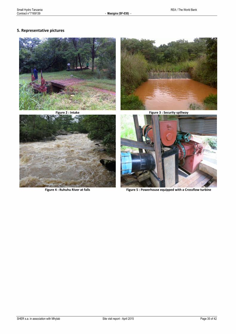
5. Representative pictures
Figure 2 : Intake
Figure 3 : Security spillway
Figure 4 : Ruhuhu River at falls
Figure 5 : Powerhouse equipped with a Crossflow turbine

Small Hydro Tanzania REA / The World Bank Contract n°7169139 - Ndanda (M-348) -
SHER s.a. in association with Mhylab Site visit report - April 2015 Page 36 of 42
12 NDANDA (M-348)
Figure 1 : Site layout
Geographic coordinates (WGS 84) Easting [°] Northing [°]
Dam 39.032 -10.537
Powerhouse 39.026 -10.502
1. Administrative and socio-economic data
Site code M-348
Site name Ndanda
River Ndanda
Village Ndanda
Region Mtwara
Basin Ruvuma and Southern Indian Ocean Coast
Topographical map reference Topographical map n° 306/1 (scale 1/50,000)
2. Reference study
Study name : IREP - GIS - base list Author : IED Edition year : 2013
Estimated potential from Hydropower Atlas
Operating discharge [m³/s] 0.20
Gross head [m] 170
Installed capacity [kW] 310
Small Hydro Tanzania REA / The World Bank Contract n°7169139 - Ndanda (M-348) -
SHER s.a. in association with Mhylab Site visit report - April 2015 Page 37 of 42
3. Technical data
Type of scheme: Daily reservoir Type of connection: Connected to the main grid Scheme description : Existing site with a small reservoir directly followed by the forebay. A headrace pipe brings water to the powerhouse.
Canal length [m] 0
Tunnel length [m] 0
Penstock length [m] 4,513
Dam type No dam
Dam height [m] 0
Dam width [m] 0
Measured turbidity [NTU] 20
Comments on solid transport None
Transmission line length [km] 0.2
Comments on accessibility The powerhouse is located next to the asphalted road and a dirt road allows
access to the intake.
Other comments Existing site
A pipe brings water from the forebay to the powerhouse.
No future infractructure is foreseen in the coming years.
Collected information : H=170m, Flow=60 l/s, P=1500-2000 Kwh, N=750 tr/sec,
pression: 17 bar, Constructor: Mr.FUCHS, Year of construction: 1985-1986,
turbine from Switzerland.
4. Hydrological data
These parameters were defined by regionalization. These preliminary values are only indicative. They might in no case be used for detailed design.
Firm discharge Q95% [m³/s] 0.00
Q90% discharge [m³/s] 0.01
Q50% discharge [m³/s] 0.06
Q30% discharge [m³/s] 0.10
Design flood P100 yr [m³/s] 0.88
Catchment area [km²] 13
Hydrological confidence indication Medium

Small Hydro Tanzania REA / The World Bank Contract n°7169139 - Ndanda (M-348) -
SHER s.a. in association with Mhylab Site visit report - April 2015 Page 38 of 42
5. Representative pictures
Figure 2 : General view of the site
Figure 3 : Detail view of the river flow, presence of pebbles
Figure 4 : Existing reservoir
Figure 5 : Existing powerhouse
Small Hydro Tanzania REA / The World Bank Contract n°7169139 - Peramiho - Likingo (E-001) -
SHER s.a. in association with Mhylab Site visit report - April 2015 Page 39 of 42
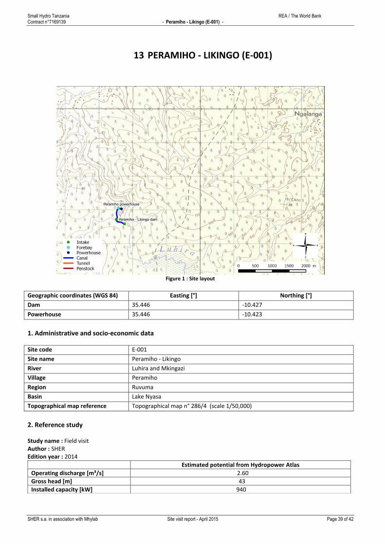
13 PERAMIHO - LIKINGO (E-001)
Figure 1 : Site layout
Geographic coordinates (WGS 84) Easting [°] Northing [°]
Dam 35.446 -10.427
Powerhouse 35.446 -10.423
1. Administrative and socio-economic data
Site code E-001
Site name Peramiho - Likingo
River Luhira and Mkingazi
Village Peramiho
Region Ruvuma
Basin Lake Nyasa
Topographical map reference Topographical map n° 286/4 (scale 1/50,000)
2. Reference study
Study name : Field visit Author : SHER Edition year : 2014
Estimated potential from Hydropower Atlas
Operating discharge [m³/s] 2.60
Gross head [m] 43
Installed capacity [kW] 940

Small Hydro Tanzania REA / The World Bank Contract n°7169139 - Peramiho - Likingo (E-001) -
SHER s.a. in association with Mhylab Site visit report - April 2015 Page 40 of 42
3. Technical data
Type of scheme: Run of the river Type of connection: Connected to a mini-grid Scheme description : The Likingo waterfall is located at the confluence of Mkingazi and Luhira rivers. Two weirs have been installed on the Luhira and the Mkingazi rivers and two ponds are created by the two concrete weirs. The water from the Luhira is deviated towards the Mkingazi and goes through a sand trap. Further away, it crosses the Mkingazi river in a waterduct inside the weir. The water of both rivers meet at the "left" end of the Mkingazi weir. The water passes then through a second sand trap. From the forebay, two penstocks (DN600) carry the water to the powerhouse. There, two crossflow turbines (Ossberger G62/12G 1984, each taking 0.8m³/s) generate a gross power of 271 kW each. The whole system is in very good condition and perfectly maintained.
Canal length [m] 737
Tunnel length [m] 0
Penstock length [m] 115
Dam type Masonery dam
Dam height [m] 4
Dam width [m] 30
Measured turbidity [NTU] 250
Comments on solid transport No sand was visible at the time of the visit. However, some dredging is reported
to be necessary upstream of the weir.
Transmission line length [km] 0.0
Comments on accessibility Weir access: Average: long unpaved road
Powerhouse access: Average: long unpaved road
Other comments Existing site already connected to the grid of Songea.
Concrete canal.
No future infractructure is foreseen in the coming years.
The plant is supplying the Peramiho Mission since 1986 (70 monks, 300
employees), a hospital, 5 schools, including the seminary, electrical and
mechanical workshops, and some private houses.
The plant produces power in excess during the rainy season. For some
unexplainable reason, Tanesco refused to synchronize the plant to their network,
although the power production of Tanesco is achieved by a thermal plant, which
costs the Company much more than buying the power from Likingo.
During the dry season however, the plant does not produce enough power for
the Mission, and the deficit is actually covered by importing power from Tanesco
(in which case the hydropower plant has to be "switched off", since no
synchronisation has been permitted), or by their own thermal plants and solar
plants. A study is currently going on to assess the possibility of biomass
generated power (Jathropha).
Small Hydro Tanzania REA / The World Bank Contract n°7169139 - Peramiho - Likingo (E-001) -
SHER s.a. in association with Mhylab Site visit report - April 2015 Page 41 of 42
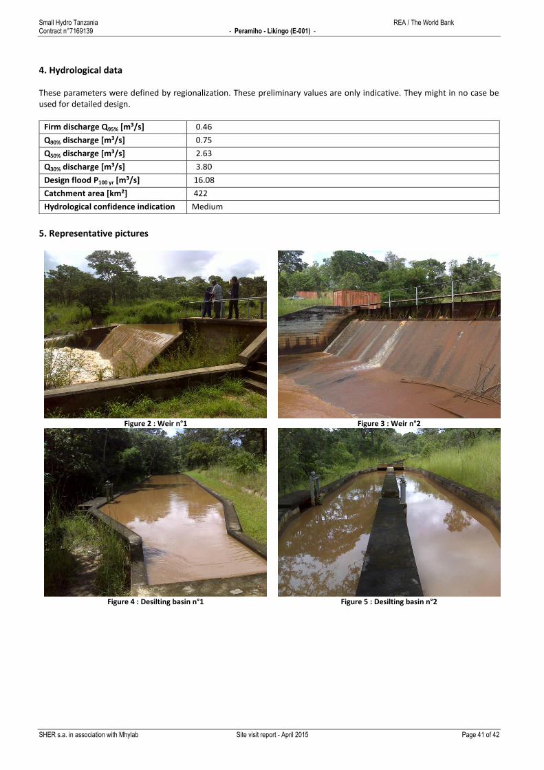
4. Hydrological data
These parameters were defined by regionalization. These preliminary values are only indicative. They might in no case be used for detailed design.
Firm discharge Q95% [m³/s] 0.46
Q90% discharge [m³/s] 0.75
Q50% discharge [m³/s] 2.63
Q30% discharge [m³/s] 3.80
Design flood P100 yr [m³/s] 16.08
Catchment area [km²] 422
Hydrological confidence indication Medium
5. Representative pictures
Figure 2 : Weir n°1
Figure 3 : Weir n°2
Figure 4 : Desilting basin n°1
Figure 5 : Desilting basin n°2

Small Hydro Tanzania REA / The World Bank Contract n°7169139 - Peramiho - Likingo (E-001) -
SHER s.a. in association with Mhylab Site visit report - April 2015 Page 42 of 42