smarttrack presentation- toronto transit network planning
TRANSCRIPT
Coordinated Transit Planning in Toronto
Public Information Session June 1, 2016
Transportation Planning Section | City Planning Division
Toronto Transit Commission
SmartTrack/GO RER | Eglinton West LRT | Eglinton East LRT
Scarborough Subway Extension | Relief Line | Waterfront Transit
Today’s Agenda 1. Overview of our coordinated approach 2. Overview: Update of transit initiatives underway 3. Update: SmartTrack/GO RER
4. Update: Relief Line 5. Next Steps
6. Questions
2
Today’s Agenda 1. Overview of our coordinated approach 2. Overview: Update of transit initiatives underway 3. Update: SmartTrack/GO RER 4. Update: Relief Line 5. Next Steps 6. Questions
3
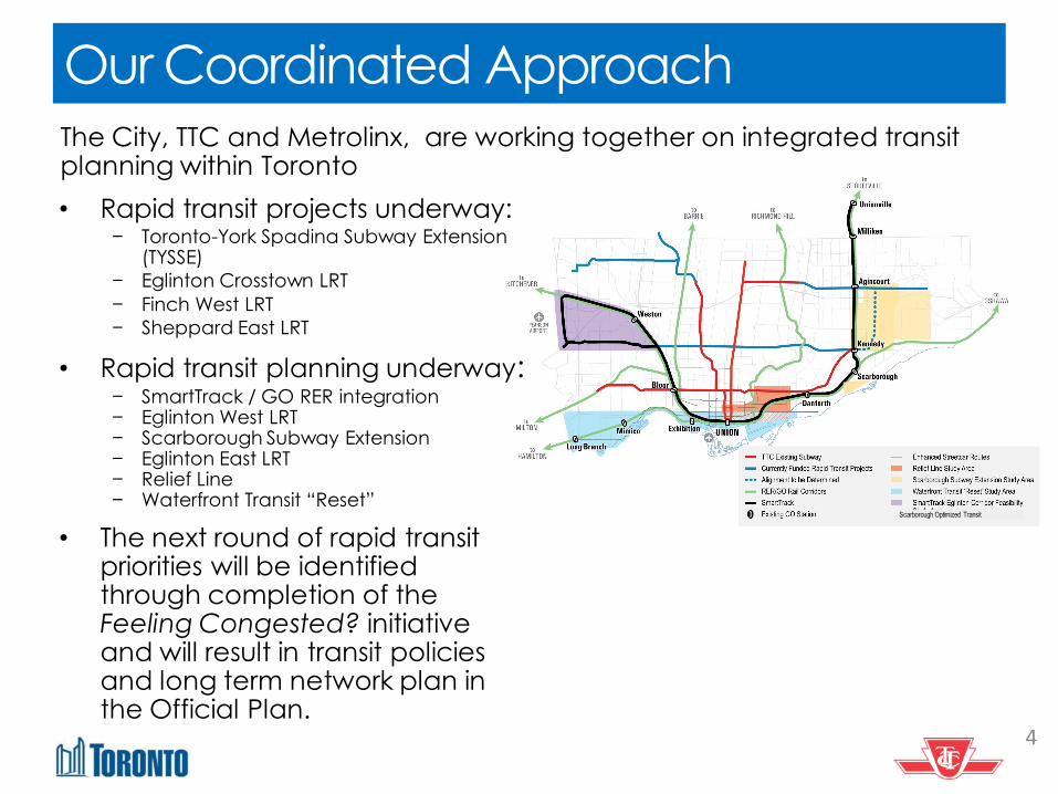
Our Coordinated Approach The City, TTC and Metrolinx, are working together on integrated transit planning within Toronto
4
• Rapid transit projects underway: − Toronto-York Spadina Subway Extension
(TYSSE)
− Eglinton Crosstown LRT
− Finch West LRT
− Sheppard East LRT
• Rapid transit planning underway: − SmartTrack / GO RER integration − Eglinton West LRT − Scarborough Subway Extension − Eglinton East LRT − Relief Line − Waterfront Transit “Reset”
• The next round of rapid transit priorities will be identified through completion of the Feeling Congested? initiative and will result in transit policies and long term network plan in the Official Plan.
Scarborough Optimized Transit
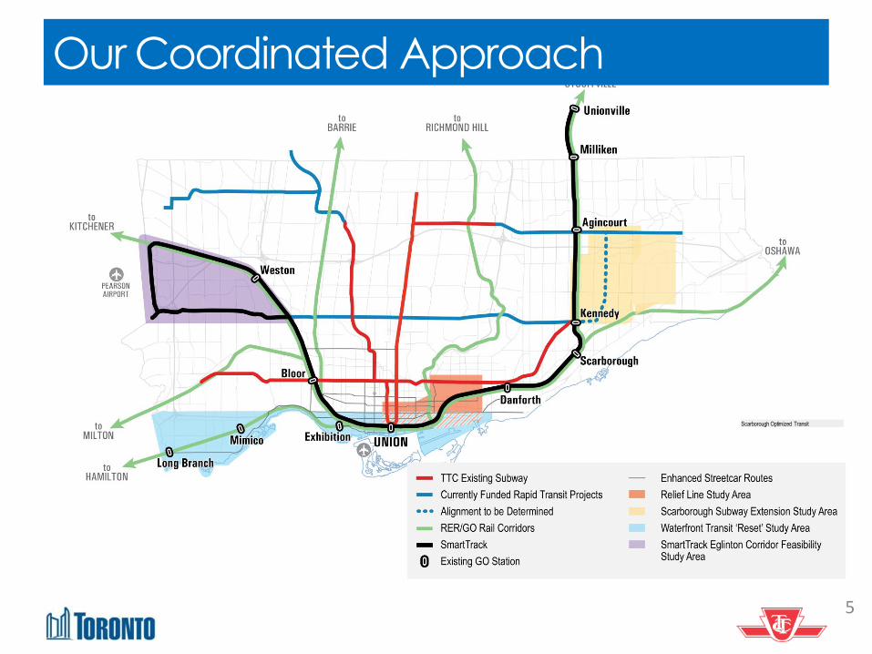
Our Coordinated Approach
5
Scarborough Optimized Transit
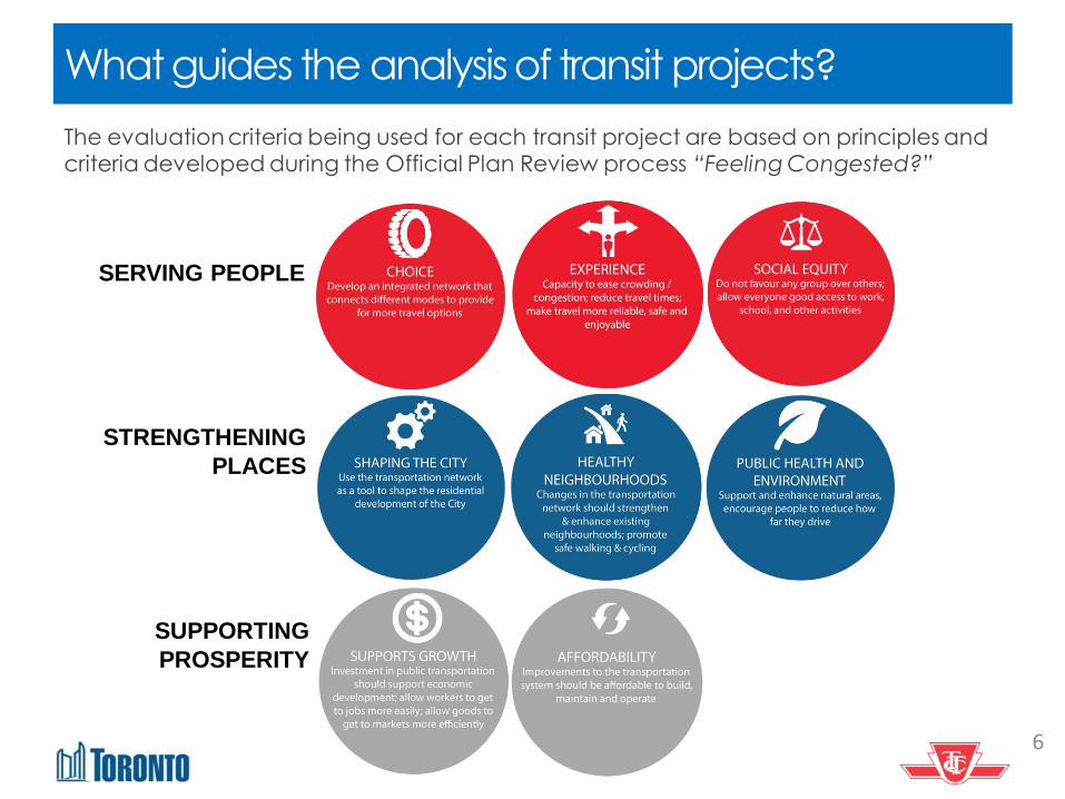
What guides the analysis of transit projects?
The evaluation criteria being used for each transit project are based on principles and criteria developed during the Official Plan Review process “Feeling Congested?”
6
SERVING PEOPLE
STRENGTHENING
PLACES
SUPPORTING
PROSPERITY
Today’s Agenda 1. Overview of our coordinated approach
2. Overview: Update of transit initiatives underway 3. Update: SmartTrack/GO RER
4. Update: Relief Line 5. Next Steps
6. Questions
7
Jan
2016
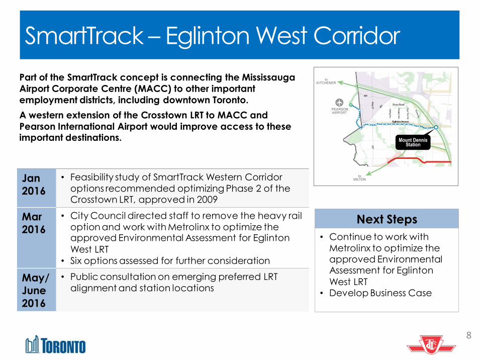
• Feasibility study of SmartTrack Western Corridor
options recommended optimizing Phase 2 of the Crosstown LRT, approved in 2009
Mar
2016
• City Council directed staff to remove the heavy rail
option and work with Metrolinx to optimize the approved Environmental Assessment for Eglinton
West LRT
• Six options assessed for further consideration
May/
June
2016
• Public consultation on emerging preferred LRT
alignment and station locations
SmartTrack – Eglinton West Corridor
8
Next Steps
• Continue to work with
Metrolinx to optimize the approved Environmental Assessment for Eglinton
West LRT • Develop Business Case
Part of the SmartTrack concept is connecting the Mississauga
Airport Corporate Centre (MACC) to other important
employment districts, including downtown Toronto.
A western extension of the Crosstown LRT to MACC and
Pearson International Airport would improve access to these important destinations.
Eglinton East LRT
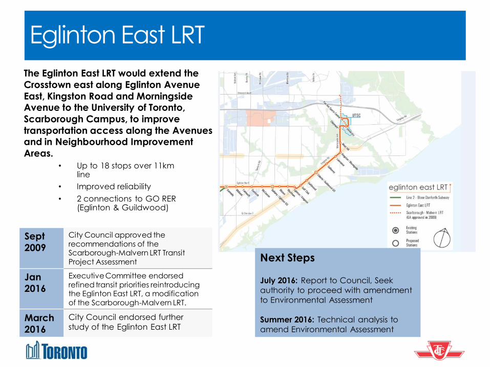
Sept
2009
City Council approved the recommendations of the Scarborough-Malvern LRT Transit Project Assessment
Jan
2016
Executive Committee endorsed refined transit priorities reintroducing the Eglinton East LRT, a modification of the Scarborough-Malvern LRT.
March
2016
City Council endorsed further
study of the Eglinton East LRT
• Up to 18 stops over 11km line
• Improved reliability
• 2 connections to GO RER (Eglinton & Guildwood)
Next Steps July 2016: Report to Council, Seek
authority to proceed with amendment
to Environmental Assessment
Summer 2016: Technical analysis to
amend Environmental Assessment
The Eglinton East LRT would extend the
Crosstown east along Eglinton Avenue
East, Kingston Road and Morningside Avenue to the University of Toronto,
Scarborough Campus, to improve
transportation access along the Avenues and in Neighbourhood Improvement
Areas.
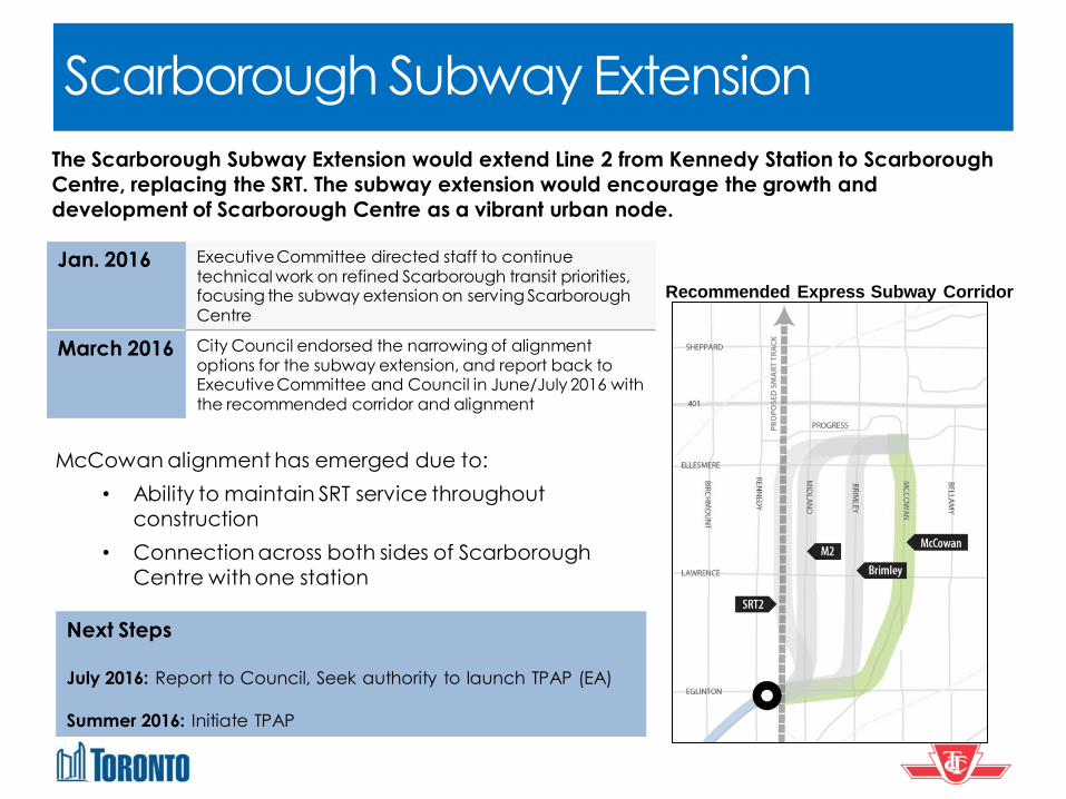
Scarborough Subway Extension
Jan. 2016 Executive Committee directed staff to continue technical work on refined Scarborough transit priorities, focusing the subway extension on serving Scarborough Centre
March 2016 City Council endorsed the narrowing of alignment options for the subway extension, and report back to Executive Committee and Council in June/July 2016 with the recommended corridor and alignment
Recommended Express Subway Corridor
McCowan alignment has emerged due to:
• Ability to maintain SRT service throughout
construction
• Connection across both sides of Scarborough
Centre with one station
Next Steps
July 2016: Report to Council, Seek authority to launch TPAP (EA)
Summer 2016: Initiate TPAP
The Scarborough Subway Extension would extend Line 2 from Kennedy Station to Scarborough
Centre, replacing the SRT. The subway extension would encourage the growth and
development of Scarborough Centre as a vibrant urban node.
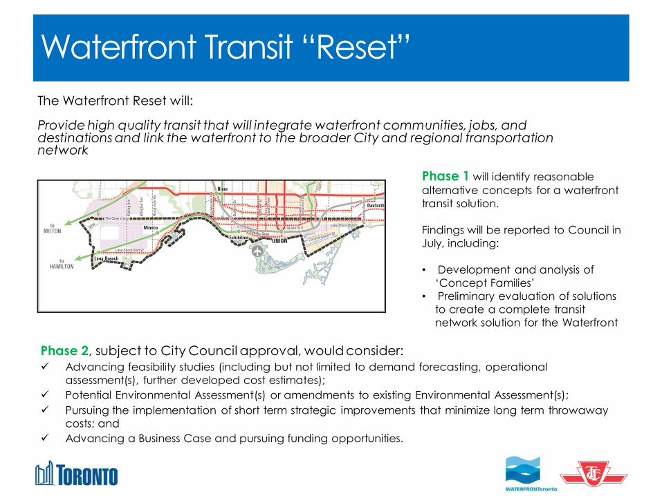
Waterfront Transit “Reset”
The Waterfront Reset will: Provide high quality transit that will integrate waterfront communities, jobs, and destinations and link the waterfront to the broader City and regional transportation network
Phase 2, subject to City Council approval, would consider:
Advancing feasibility studies (including but not limited to demand forecasting, operational
assessment(s), further developed cost estimates);
Potential Environmental Assessment(s) or amendments to existing Environmental Assessment(s);
Pursuing the implementation of short term strategic improvements that minimize long term throwaway
costs; and
Advancing a Business Case and pursuing funding opportunities.
Phase 1 will identify reasonable
alternative concepts for a waterfront
transit solution.
Findings will be reported to Council in
July, including:
• Development and analysis of
‘Concept Families’
• Preliminary evaluation of solutions
to create a complete transit
network solution for the Waterfront
Today’s Agenda 1. Overview of our coordinated approach 2. Overview: Update of transit initiatives underway
3. Update: SmartTrack/GO RER 4. Update: Relief Line
5. Next Steps 6. Questions
12
SmartTrack / GO RER Background
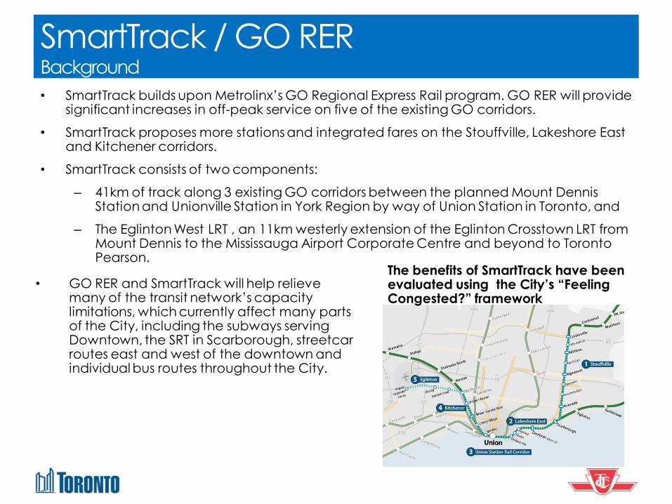
• SmartTrack builds upon Metrolinx’s GO Regional Express Rail program. GO RER will provide significant increases in off-peak service on five of the existing GO corridors.
• SmartTrack proposes more stations and integrated fares on the Stouffville, Lakeshore East and Kitchener corridors.
• SmartTrack consists of two components:
– 41km of track along 3 existing GO corridors between the planned Mount Dennis Station and Unionville Station in York Region by way of Union Station in Toronto, and
– The Eglinton West LRT , an 11km westerly extension of the Eglinton Crosstown LRT from Mount Dennis to the Mississauga Airport Corporate Centre and beyond to Toronto Pearson.
• GO RER and SmartTrack will help relieve many of the transit network’s capacity limitations, which currently affect many parts of the City, including the subways serving Downtown, the SRT in Scarborough, streetcar routes east and west of the downtown and individual bus routes throughout the City.
The benefits of SmartTrack have been evaluated using the City’s “Feeling Congested?” framework

SmartTrack Options Background
Option B Option A
• The City has been working with Metrolinx on the integration of SmartTrack and GO RER
• Four options for SmartTrack/GO RER integration were developed and analysed.
Option D Option C
14
SmartTrack / GO RER Background
• These four options were presented to the public in February 2016.
• Based on technical and planning analysis, City staff recommended that Options A and B not be carried forward for further analysis. These options would have required significant incremental infrastructure that would lead to increased costs and community impacts.
• In March 2016, Council directed staff to continue working with Metrolinx on Options C and D to determine the best SmartTrack arrangement
15
SmartTrack / GO RER Background
16
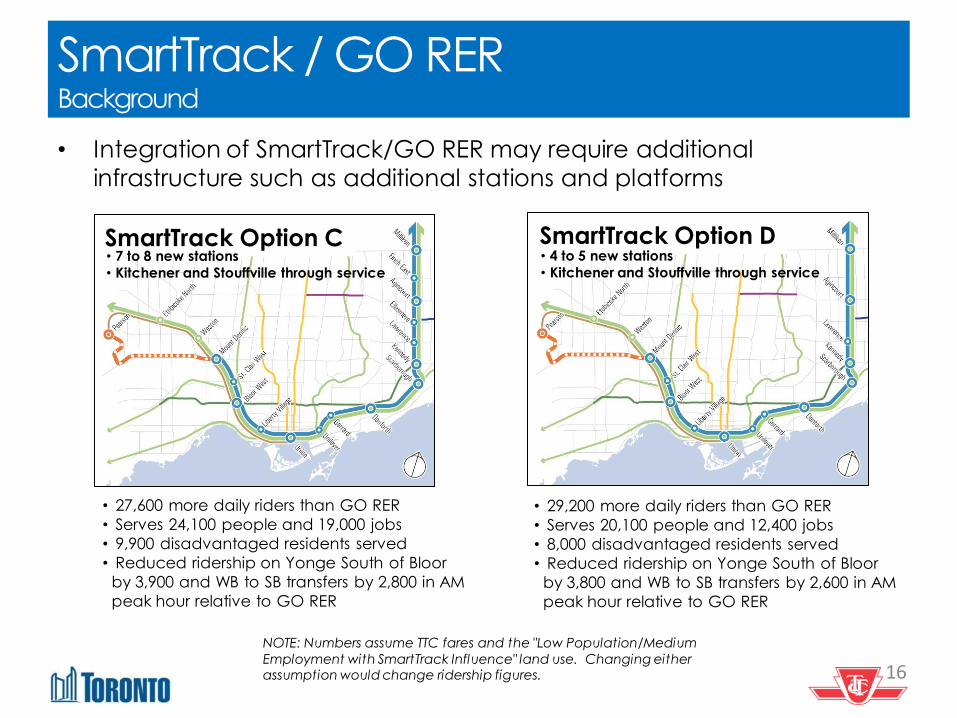
• 27,600 more daily riders than GO RER
• Serves 24,100 people and 19,000 jobs
• 9,900 disadvantaged residents served
• Reduced ridership on Yonge South of Bloor
by 3,900 and WB to SB transfers by 2,800 in AM
peak hour relative to GO RER
• 29,200 more daily riders than GO RER
• Serves 20,100 people and 12,400 jobs
• 8,000 disadvantaged residents served
• Reduced ridership on Yonge South of Bloor
by 3,800 and WB to SB transfers by 2,600 in AM
peak hour relative to GO RER
SmartTrack Option C • 7 to 8 new stations
• Kitchener and Stouffville through service
SmartTrack Option D • 4 to 5 new stations
• Kitchener and Stouffville through service
• Integration of SmartTrack/GO RER may require additional
infrastructure such as additional stations and platforms
NOTE: Numbers assume TTC fares and the "Low Population/Medium
Employment with SmartTrack Influence" land use. Changing either assumption would change ridership figures.

Today’s Agenda 1. Overview of our coordinated approach 2. Overview: Update of transit initiatives underway 3. Update: SmartTrack/GO RER
4. Update: Relief Line
5. Next Steps 6. Questions
17
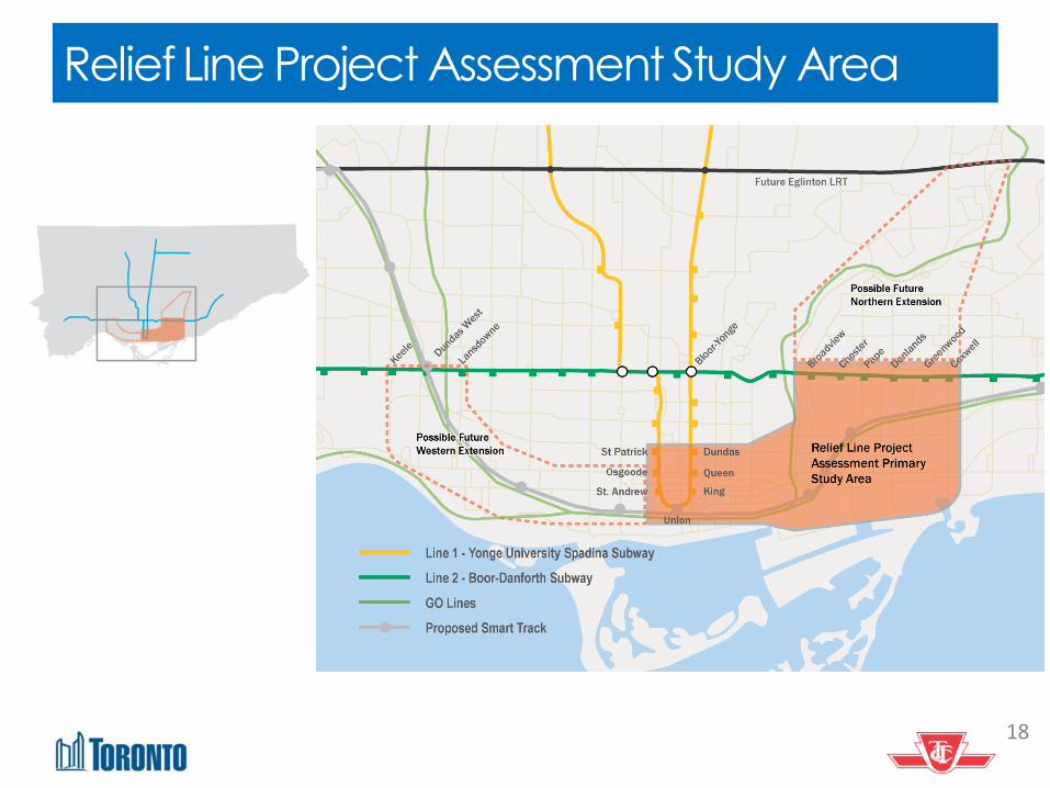
Relief Line Project Assessment Study Area
18
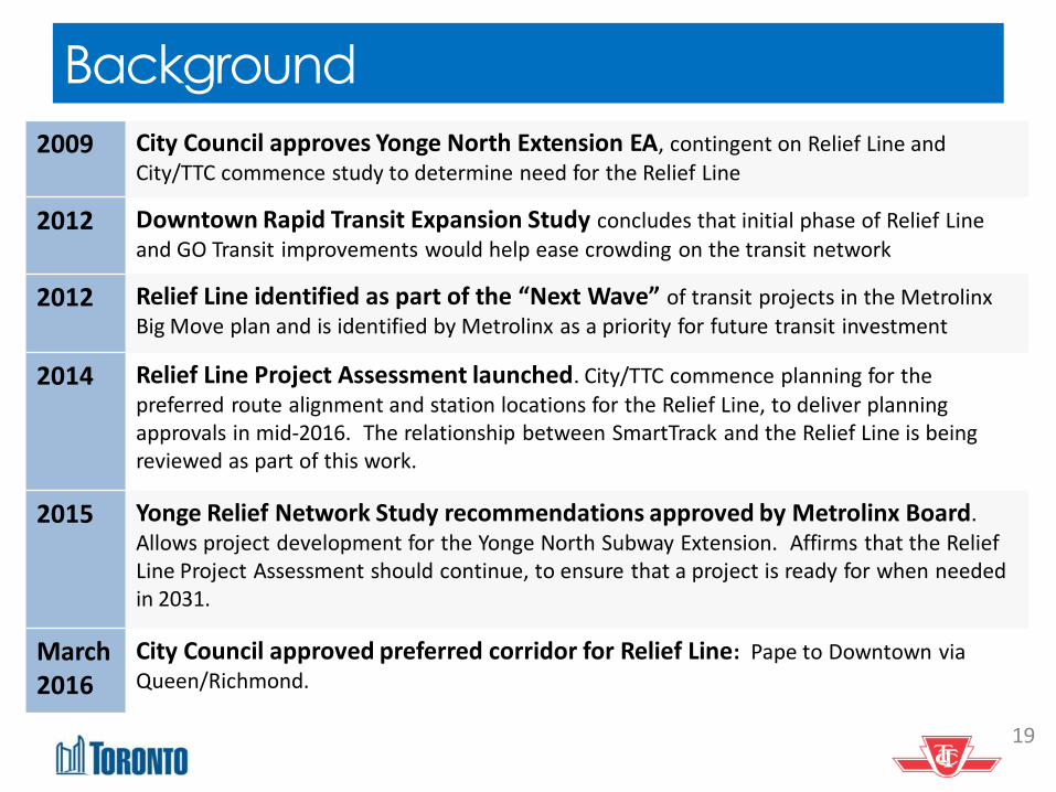
Background
19
2009 City Council approves Yonge North Extension EA, contingent on Relief Line and City/TTC commence study to determine need for the Relief Line
2012 Downtown Rapid Transit Expansion Study concludes that initial phase of Relief Line
and GO Transit improvements would help ease crowding on the transit network
2012 Relief Line identified as part of the “Next Wave” of transit projects in the Metrolinx
Big Move plan and is identified by Metrolinx as a priority for future transit investment
2014 Relief Line Project Assessment launched. City/TTC commence planning for the
preferred route alignment and station locations for the Relief Line, to deliver planning approvals in mid-2016. The relationship between SmartTrack and the Relief Line is being reviewed as part of this work.
2015 Yonge Relief Network Study recommendations approved by Metrolinx Board. Allows project development for the Yonge North Subway Extension. Affirms that the Relief Line Project Assessment should continue, to ensure that a project is ready for when needed in 2031.
March2016
City Council approved preferred corridor for Relief Line: Pape to Downtown via Queen/Richmond.
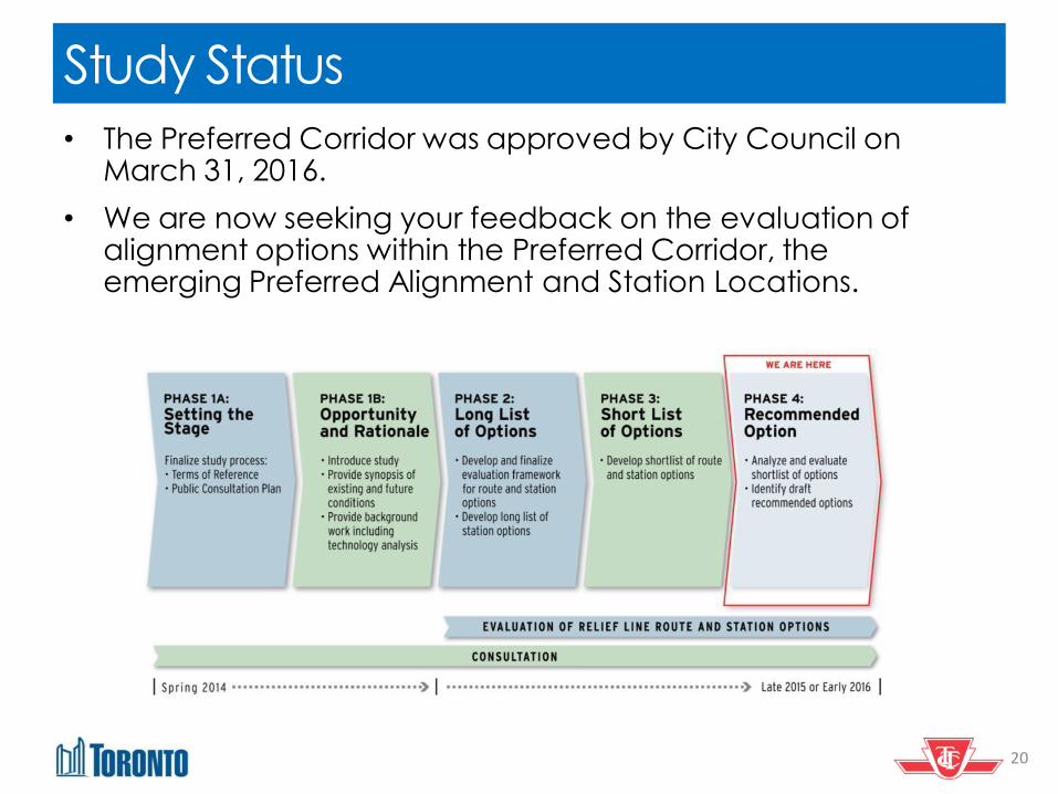
Study Status
20
• The Preferred Corridor was approved by City Council on March 31, 2016.
• We are now seeking your feedback on the evaluation of alignment options within the Preferred Corridor, the emerging Preferred Alignment and Station Locations.
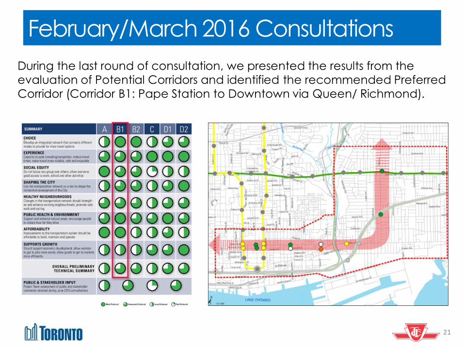
February/March 2016 Consultations
21
During the last round of consultation, we presented the results from the
evaluation of Potential Corridors and identified the recommended Preferred
Corridor (Corridor B1: Pape Station to Downtown via Queen/ Richmond).

February/March 2016 Consultations
22
KEY MESSAGES FROM PUBLIC AND STAKEHOLDERS
• Overall support for the results of the evaluation and for advancing Corridor B1 (Pape to Downtown via Queen/Richmond)as the preferred corridor
• Preference for downtown stations that provide direct interchange at the Yonge and University subway lines (i.e. two stations rather than one)
• Support major redevelopment opportunities, such as the Unilever site.
• Address potential impacts during construction, such as disruptions to the existing 501 Queen Street and 504 King Street streetcar routes , noise and vibration, and traffic.
23
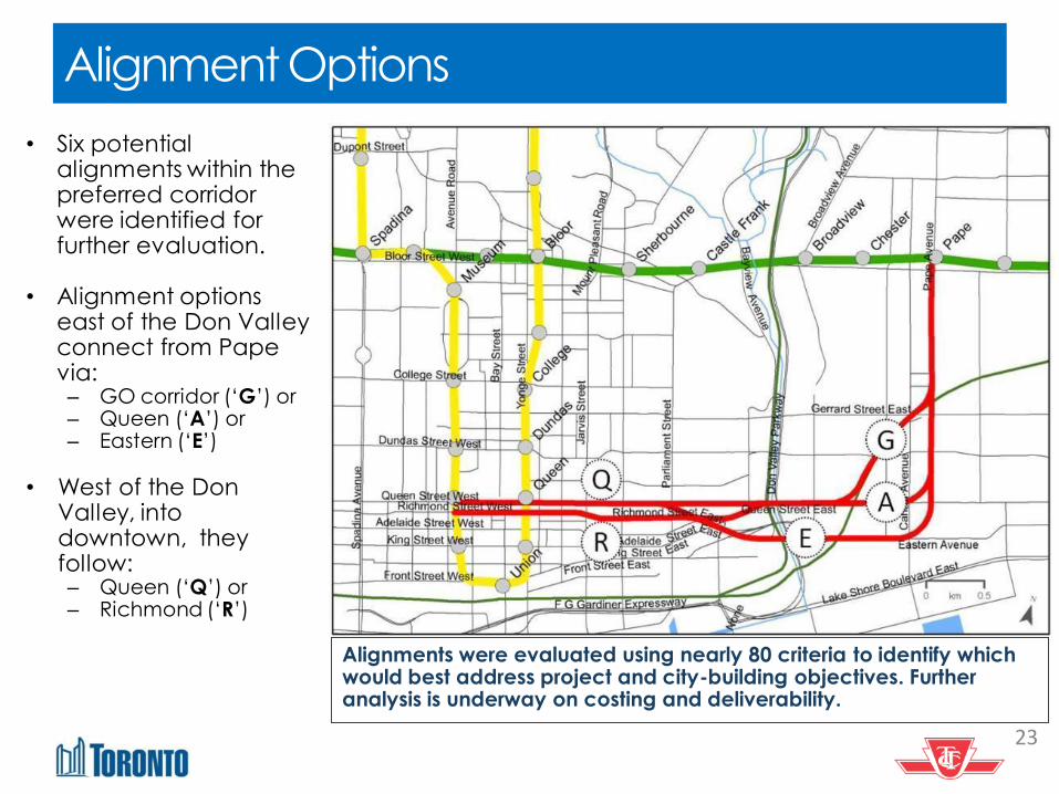
Alignment Options
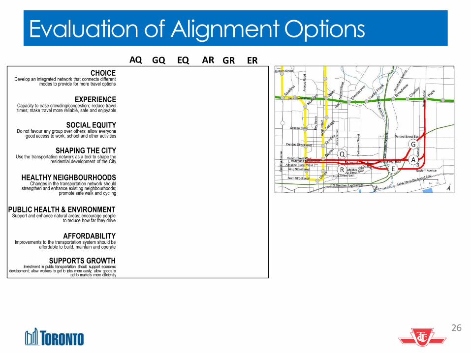
• Six potential alignments within the preferred corridor were identified for further evaluation.
• Alignment options
east of the Don Valley connect from Pape via: – GO corridor (‘G’) or – Queen (‘A’) or – Eastern (‘E’)
• West of the Don Valley, into downtown, they follow: – Queen (‘Q’) or – Richmond (‘R’)
Alignments were evaluated using nearly 80 criteria to identify which would best address project and city-building objectives. Further analysis is underway on costing and deliverability.
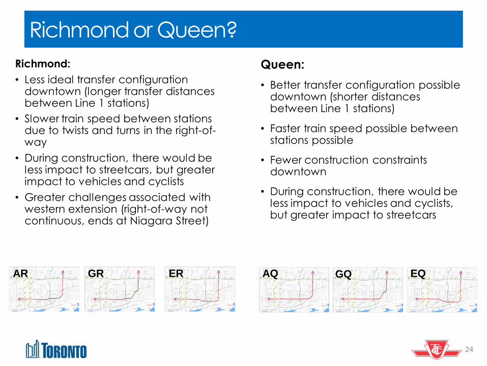
Richmond or Queen?
24
Richmond:
• Less ideal transfer configuration downtown (longer transfer distances between Line 1 stations)
• Slower train speed between stations due to twists and turns in the right-of-way
• During construction, there would be less impact to streetcars, but greater impact to vehicles and cyclists
• Greater challenges associated with western extension (right-of-way not continuous, ends at Niagara Street)
AR GR ER
Queen:
• Better transfer configuration possible downtown (shorter distances between Line 1 stations)
• Faster train speed possible between stations possible
• Fewer construction constraints downtown
• During construction, there would be less impact to vehicles and cyclists, but greater impact to streetcars
AQ GQ EQ
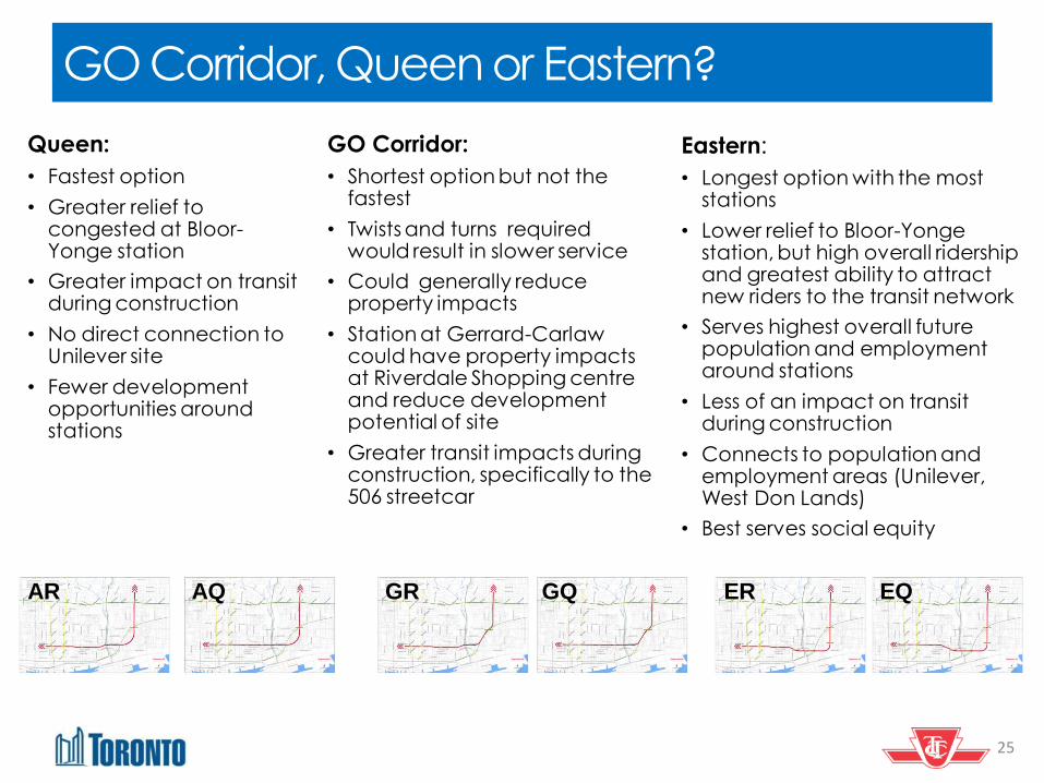
GO Corridor, Queen or Eastern?
25
GO Corridor:
• Shortest option but not the fastest
• Twists and turns required would result in slower service
• Could generally reduce property impacts
• Station at Gerrard-Carlaw could have property impacts at Riverdale Shopping centre and reduce development potential of site
• Greater transit impacts during construction, specifically to the 506 streetcar
Queen:
• Fastest option
• Greater relief to congested at Bloor-Yonge station
• Greater impact on transit during construction
• No direct connection to Unilever site
• Fewer development opportunities around stations
Eastern:
• Longest option with the most stations
• Lower relief to Bloor-Yonge station, but high overall ridership and greatest ability to attract new riders to the transit network
• Serves highest overall future population and employment around stations
• Less of an impact on transit during construction
• Connects to population and employment areas (Unilever, West Don Lands)
• Best serves social equity
AR GR ER AQ GQ EQ
26
Evaluation of Alignment Options AQ
CHOICE Develop an integrated network that connects different
modes to provide for more travel options
EXPERIENCE Capacity to ease crowding/congestion; reduce travel times; make travel more reliable, safe and enjoyable
SOCIAL EQUITY Do not favour any group over others; allow everyone
good access to work, school and other activities
SHAPING THE CITY Use the transportation network as a tool to shape the
residential development of the City
HEALTHY NEIGHBOURHOODS Changes in the transportation network should
strengthen and enhance existing neighbourhoods; promote safe walk and cycling
PUBLIC HEALTH & ENVIRONMENT Support and enhance natural areas; encourage people
to reduce how far they drive
SUPPORTS GROWTH Investment in public transportation should support economic
development; allow workers to get to jobs more easily; allow goods to get to markets more efficiently
AFFORDABILITY Improvements to the transportation system should be
affordable to build, maintain and operate
EQ GR ER GQ AR
27
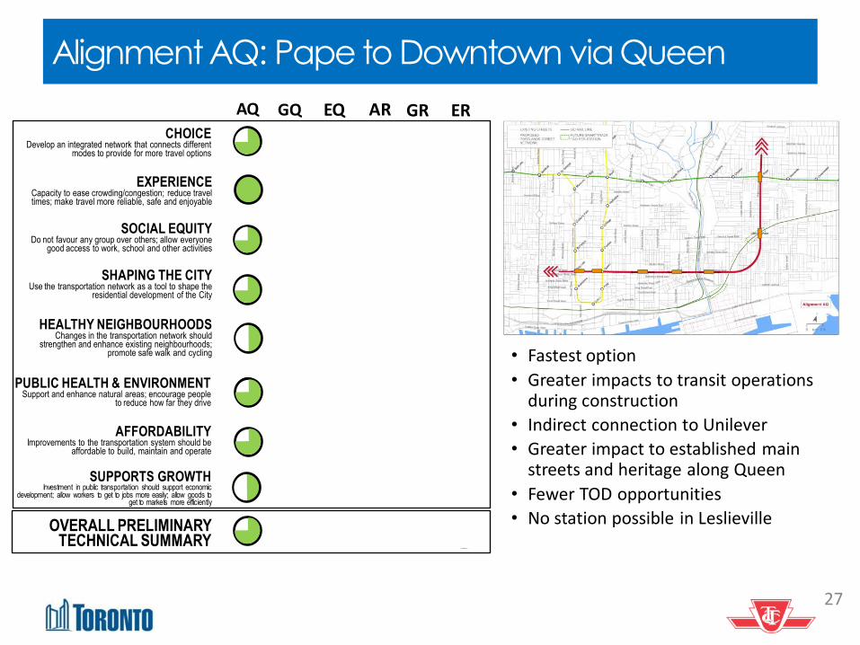
Alignment AQ: Pape to Downtown via Queen
• Fastest option
• Greater impacts to transit operations during construction
• Indirect connection to Unilever
• Greater impact to established main streets and heritage along Queen
• Fewer TOD opportunities
• No station possible in Leslieville
AQ
CHOICE Develop an integrated network that connects different
modes to provide for more travel options
EXPERIENCE Capacity to ease crowding/congestion; reduce travel times; make travel more reliable, safe and enjoyable
SOCIAL EQUITY Do not favour any group over others; allow everyone
good access to work, school and other activities
SHAPING THE CITY Use the transportation network as a tool to shape the
residential development of the City
HEALTHY NEIGHBOURHOODS Changes in the transportation network should
strengthen and enhance existing neighbourhoods; promote safe walk and cycling
PUBLIC HEALTH & ENVIRONMENT Support and enhance natural areas; encourage people
to reduce how far they drive
SUPPORTS GROWTH Investment in public transportation should support economic
development; allow workers to get to jobs more easily; allow goods to get to markets more efficiently
AFFORDABILITY Improvements to the transportation system should be
affordable to build, maintain and operate
EQ GR ER GQ AR
OVERALL PRELIMINARY TECHNICAL SUMMARY
28
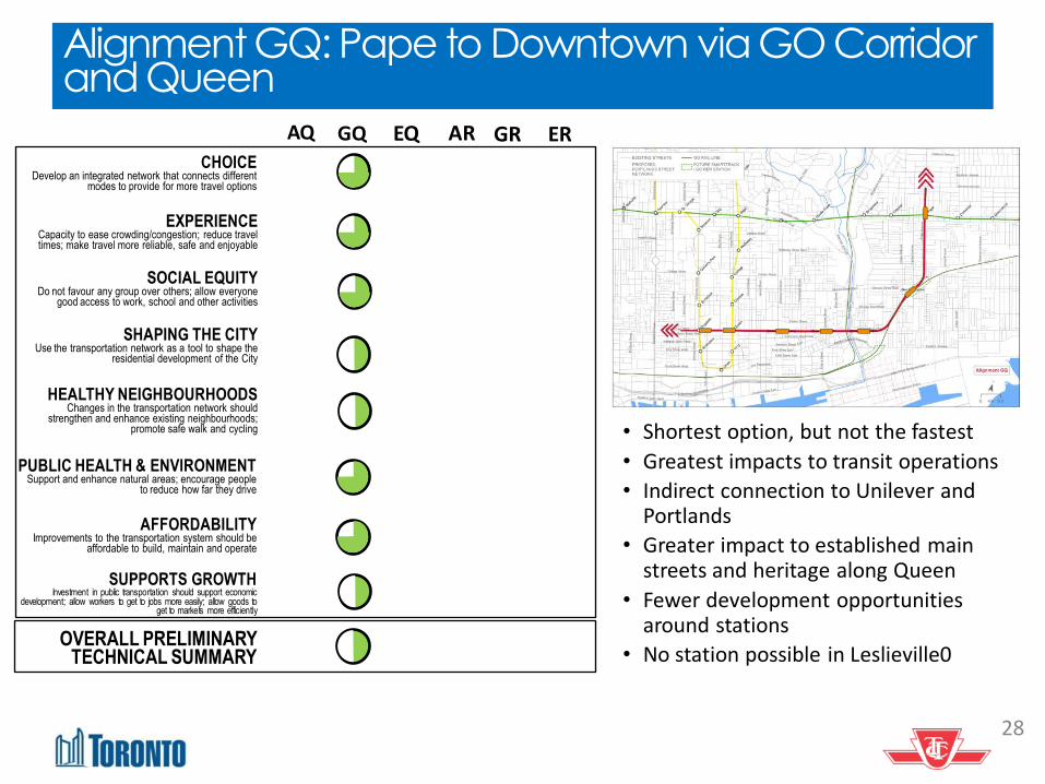
Alignment GQ: Pape to Downtown via GO Corridor and Queen
• Shortest option, but not the fastest
• Greatest impacts to transit operations
• Indirect connection to Unilever and Portlands
• Greater impact to established main streets and heritage along Queen
• Fewer development opportunities around stations
• No station possible in Leslieville0
AQ
CHOICE Develop an integrated network that connects different
modes to provide for more travel options
EXPERIENCE Capacity to ease crowding/congestion; reduce travel times; make travel more reliable, safe and enjoyable
SOCIAL EQUITY Do not favour any group over others; allow everyone
good access to work, school and other activities
SHAPING THE CITY Use the transportation network as a tool to shape the
residential development of the City
HEALTHY NEIGHBOURHOODS Changes in the transportation network should
strengthen and enhance existing neighbourhoods; promote safe walk and cycling
PUBLIC HEALTH & ENVIRONMENT Support and enhance natural areas; encourage people
to reduce how far they drive
SUPPORTS GROWTH Investment in public transportation should support economic
development; allow workers to get to jobs more easily; allow goods to get to markets more efficiently
AFFORDABILITY Improvements to the transportation system should be
affordable to build, maintain and operate
EQ GR ER GQ AR
OVERALL PRELIMINARY TECHNICAL SUMMARY
29
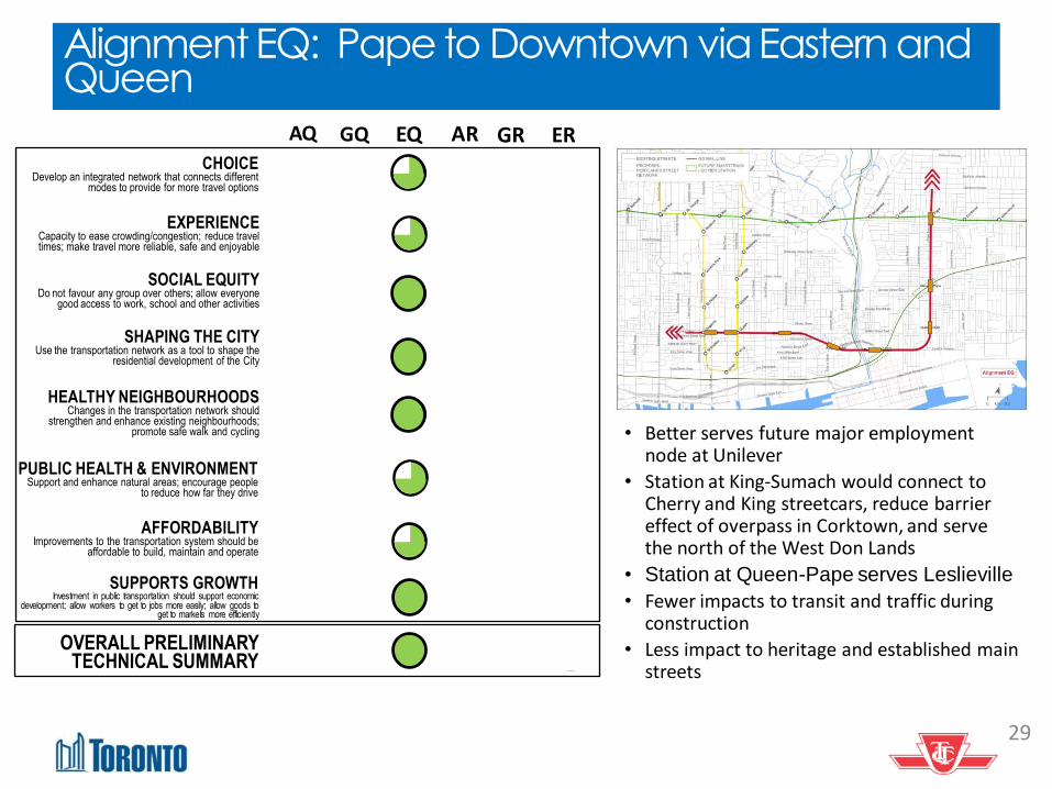
Alignment EQ: Pape to Downtown via Eastern and Queen
• Better serves future major employment node at Unilever
• Station at King-Sumach would connect to Cherry and King streetcars, reduce barrier effect of overpass in Corktown, and serve the north of the West Don Lands
• Station at Queen-Pape serves Leslieville
• Fewer impacts to transit and traffic during construction
• Less impact to heritage and established main streets
AQ
CHOICE Develop an integrated network that connects different
modes to provide for more travel options
EXPERIENCE Capacity to ease crowding/congestion; reduce travel times; make travel more reliable, safe and enjoyable
SOCIAL EQUITY Do not favour any group over others; allow everyone
good access to work, school and other activities
SHAPING THE CITY Use the transportation network as a tool to shape the
residential development of the City
HEALTHY NEIGHBOURHOODS Changes in the transportation network should
strengthen and enhance existing neighbourhoods; promote safe walk and cycling
PUBLIC HEALTH & ENVIRONMENT Support and enhance natural areas; encourage people
to reduce how far they drive
SUPPORTS GROWTH Investment in public transportation should support economic
development; allow workers to get to jobs more easily; allow goods to get to markets more efficiently
AFFORDABILITY Improvements to the transportation system should be
affordable to build, maintain and operate
EQ GR ER GQ AR
OVERALL PRELIMINARY TECHNICAL SUMMARY

30
Alignment AR: Pape to Downtown via Richmond
• No station possible in Corktown or Leslieville
• Connects with Queen and King streetcars at Queen-Broadview
• Indirect connection to Unilever and Portlands
• Fewer opportunities for development around stations
AQ
CHOICE Develop an integrated network that connects different
modes to provide for more travel options
EXPERIENCE Capacity to ease crowding/congestion; reduce travel times; make travel more reliable, safe and enjoyable
SOCIAL EQUITY Do not favour any group over others; allow everyone
good access to work, school and other activities
SHAPING THE CITY Use the transportation network as a tool to shape the
residential development of the City
HEALTHY NEIGHBOURHOODS Changes in the transportation network should
strengthen and enhance existing neighbourhoods; promote safe walk and cycling
PUBLIC HEALTH & ENVIRONMENT Support and enhance natural areas; encourage people
to reduce how far they drive
SUPPORTS GROWTH Investment in public transportation should support economic
development; allow workers to get to jobs more easily; allow goods to get to markets more efficiently
AFFORDABILITY Improvements to the transportation system should be
affordable to build, maintain and operate
EQ GR ER GQ AR
OVERALL PRELIMINARY TECHNICAL SUMMARY
31
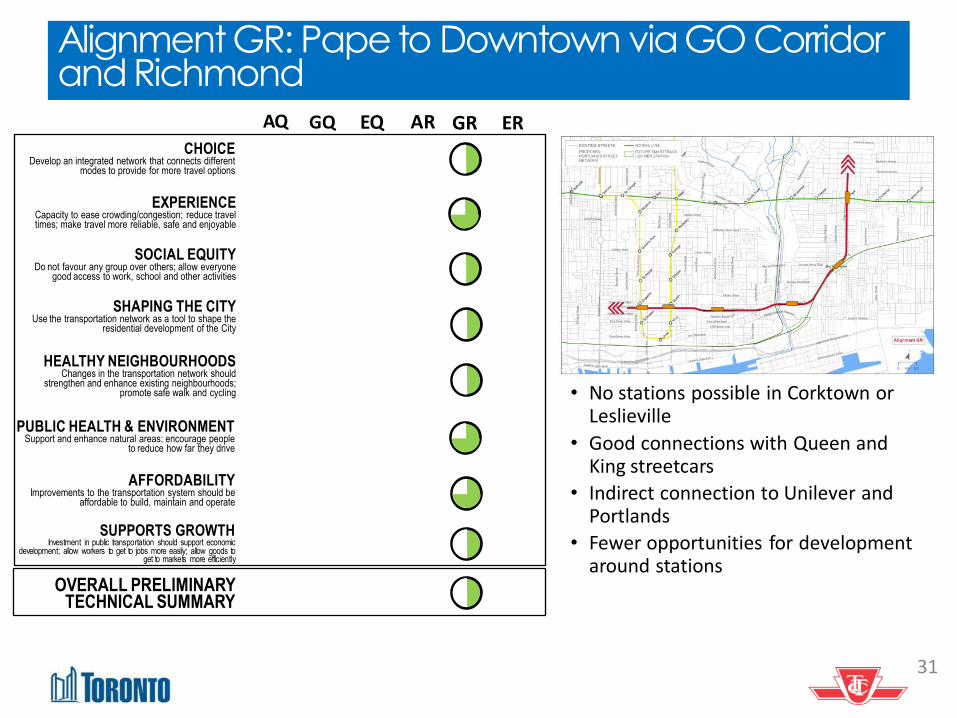
Alignment GR: Pape to Downtown via GO Corridor and Richmond
• No stations possible in Corktown or Leslieville
• Good connections with Queen and King streetcars
• Indirect connection to Unilever and Portlands
• Fewer opportunities for development around stations
AQ
CHOICE Develop an integrated network that connects different
modes to provide for more travel options
EXPERIENCE Capacity to ease crowding/congestion; reduce travel times; make travel more reliable, safe and enjoyable
SOCIAL EQUITY Do not favour any group over others; allow everyone
good access to work, school and other activities
SHAPING THE CITY Use the transportation network as a tool to shape the
residential development of the City
HEALTHY NEIGHBOURHOODS Changes in the transportation network should
strengthen and enhance existing neighbourhoods; promote safe walk and cycling
PUBLIC HEALTH & ENVIRONMENT Support and enhance natural areas; encourage people
to reduce how far they drive
SUPPORTS GROWTH Investment in public transportation should support economic
development; allow workers to get to jobs more easily; allow goods to get to markets more efficiently
AFFORDABILITY Improvements to the transportation system should be
affordable to build, maintain and operate
EQ GR ER GQ AR
OVERALL PRELIMINARY TECHNICAL SUMMARY
32
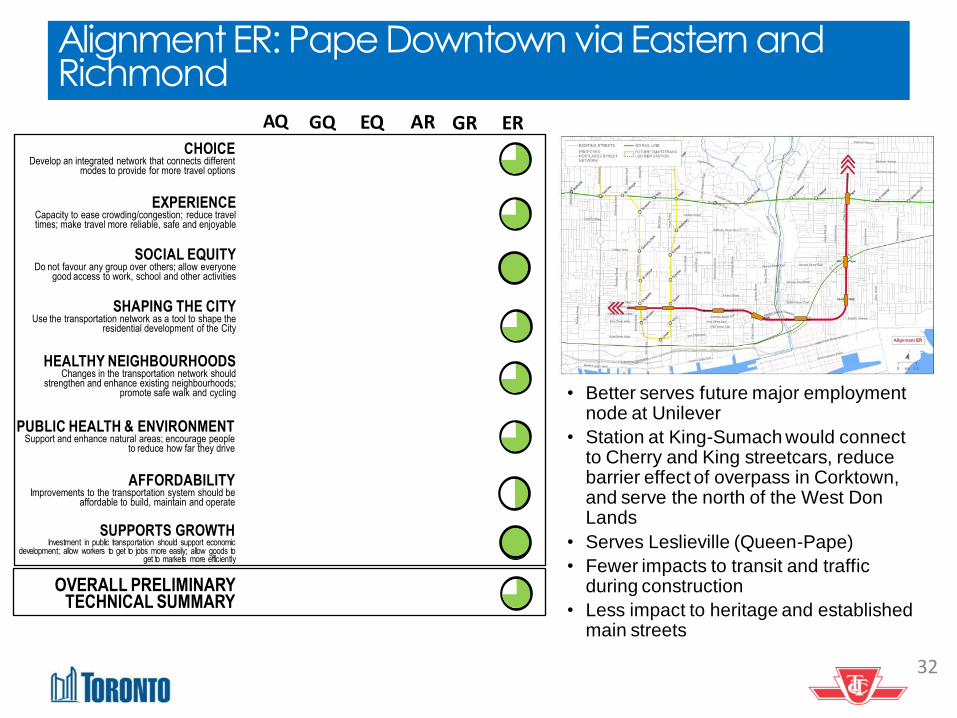
Alignment ER: Pape Downtown via Eastern and Richmond
• Better serves future major employment node at Unilever
• Station at King-Sumach would connect to Cherry and King streetcars, reduce barrier effect of overpass in Corktown, and serve the north of the West Don Lands
• Serves Leslieville (Queen-Pape)
• Fewer impacts to transit and traffic during construction
• Less impact to heritage and established main streets
AQ
CHOICE Develop an integrated network that connects different
modes to provide for more travel options
EXPERIENCE Capacity to ease crowding/congestion; reduce travel times; make travel more reliable, safe and enjoyable
SOCIAL EQUITY Do not favour any group over others; allow everyone
good access to work, school and other activities
SHAPING THE CITY Use the transportation network as a tool to shape the
residential development of the City
HEALTHY NEIGHBOURHOODS Changes in the transportation network should
strengthen and enhance existing neighbourhoods; promote safe walk and cycling
PUBLIC HEALTH & ENVIRONMENT Support and enhance natural areas; encourage people
to reduce how far they drive
SUPPORTS GROWTH Investment in public transportation should support economic
development; allow workers to get to jobs more easily; allow goods to get to markets more efficiently
AFFORDABILITY Improvements to the transportation system should be
affordable to build, maintain and operate
EQ GR ER GQ AR
OVERALL PRELIMINARY TECHNICAL SUMMARY
33
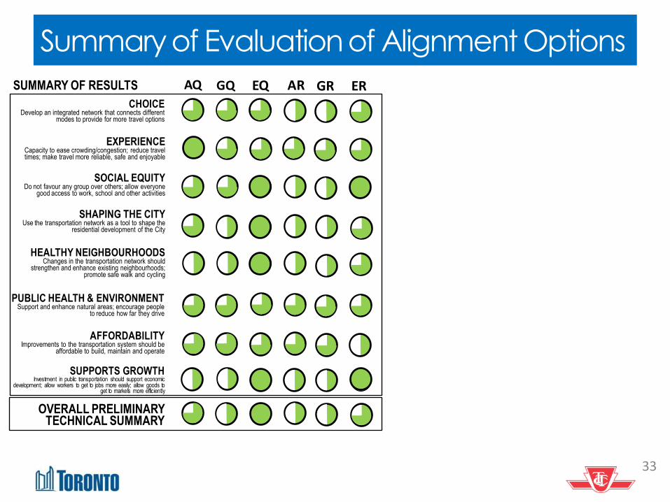
Summary of Evaluation of Alignment Options
AQ
CHOICE Develop an integrated network that connects different
modes to provide for more travel options
EXPERIENCE Capacity to ease crowding/congestion; reduce travel times; make travel more reliable, safe and enjoyable
SOCIAL EQUITY Do not favour any group over others; allow everyone
good access to work, school and other activities
SHAPING THE CITY Use the transportation network as a tool to shape the
residential development of the City
HEALTHY NEIGHBOURHOODS Changes in the transportation network should
strengthen and enhance existing neighbourhoods; promote safe walk and cycling
PUBLIC HEALTH & ENVIRONMENT Support and enhance natural areas; encourage people
to reduce how far they drive
SUPPORTS GROWTH Investment in public transportation should support economic
development; allow workers to get to jobs more easily; allow goods to get to markets more efficiently
AFFORDABILITY Improvements to the transportation system should be
affordable to build, maintain and operate
EQ GR ER
OVERALL PRELIMINARY TECHNICAL SUMMARY
GQ AR SUMMARY OF RESULTS
34
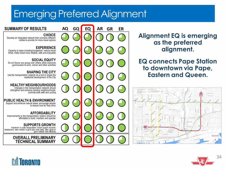
Emerging Preferred Alignment
AQ
CHOICE Develop an integrated network that connects different
modes to provide for more travel options
EXPERIENCE Capacity to ease crowding/congestion; reduce travel times; make travel more reliable, safe and enjoyable
SOCIAL EQUITY Do not favour any group over others; allow everyone
good access to work, school and other activities
SHAPING THE CITY Use the transportation network as a tool to shape the
residential development of the City
HEALTHY NEIGHBOURHOODS Changes in the transportation network should
strengthen and enhance existing neighbourhoods; promote safe walk and cycling
PUBLIC HEALTH & ENVIRONMENT Support and enhance natural areas; encourage people
to reduce how far they drive
SUPPORTS GROWTH Investment in public transportation should support economic
development; allow workers to get to jobs more easily; allow goods to get to markets more efficiently
AFFORDABILITY Improvements to the transportation system should be
affordable to build, maintain and operate
EQ GR ER
OVERALL PRELIMINARY TECHNICAL SUMMARY
GQ AR SUMMARY OF RESULTS
Alignment EQ is emerging as the preferred
alignment.
EQ connects Pape Station to downtown via Pape,
Eastern and Queen.
35
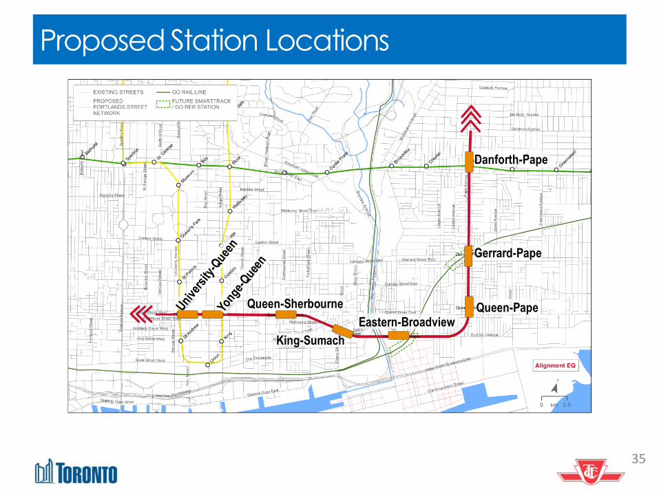
Proposed Station Locations
Gerrard-Pape
Queen-Pape Eastern-Broadview
King-Sumach
Queen-Sherbourne
Danforth-Pape

Main Advantages of Alignment EQ Best achieves city-building objectives
Serves the greatest number of projected future residents and jobs. Stations complement plans for growth and redevelopment
Best addresses social equity needs
Station at King-Sumach offers key opportunity for additional social infrastructure and community space while bridging the West Don Lands and Regent Park in Corktown.
Station at Eastern-Broadview improves city-wide transit accessibility to the significant new employment area being planned for the Unilever site.
Most compatible with preserving integrity of existing neighbourhoods and heritage resources
Station at Pape and Gerrard will reconnect neighbourhoods to the north and south by helping to overcome the existing barrier presented by the GO Rail corridor
Station at King-Sumach supports integration of Corktown communities by reducing the existing north-south barrier effect of Richmond/Adelaide overpass and serves the northern areas within the West Don Lands
Stations offer excellent redevelopment opportunities for some older commercial areas well suited to redevelopment for transit oriented uses
Best ability to avoid potential negative impacts on heritage buildings, Heritage Conservation Districts and established main streets
A well designed station at Queen and Pape will integrate entrances within the surrounding residential area in order to improve transit service to the Leslieville neighbourhood.
Best transit network connectivity opportunities
Offers the greatest relief to overcrowding on the existing streetcar network with interconnections with the King, Queen, Cherry, and Broadview streetcars
Provides most interchanges with SmartTrack/GO RER at Pape and Gerrard and Eastern and Broadview Stations Good potential to optimize the passenger transfer configuration Queen and Osgoode stations to minimize
transfer times and end loading at stations
Strongest long-term ridership results
Forecast to attract the highest number of new riders to the transit system based on 2031 modelling results. By 2041, the alignment pulls further ahead in attracting the most riders. The additional benefit is maintained
when the northern extension is assumed. Does not provide as much relief to the Yonge line as the other alignments, it still provides significant relief when
the long term extension of the Relief Line to the north is factored in.
Strongest opportunity for public-private partnership for capital cost sharing
Best opportunity for sharing capital costs through redevelopment at Unilever.
Fewer construction impacts Fewest impacts anticipated to private property especially related to stations at Broadview and Eastern and King and Sumach
Lowest potential for transit and traffic related impacts during construction by avoiding high traffic/transit areas, especially Queen-Broadview
Today’s Agenda 1. Overview of our coordinated approach 2. Overview: Update of transit initiatives underway 3. Update: SmartTrack/GO RER
4. Update: Relief Line
5. Next Steps 6. Questions
37
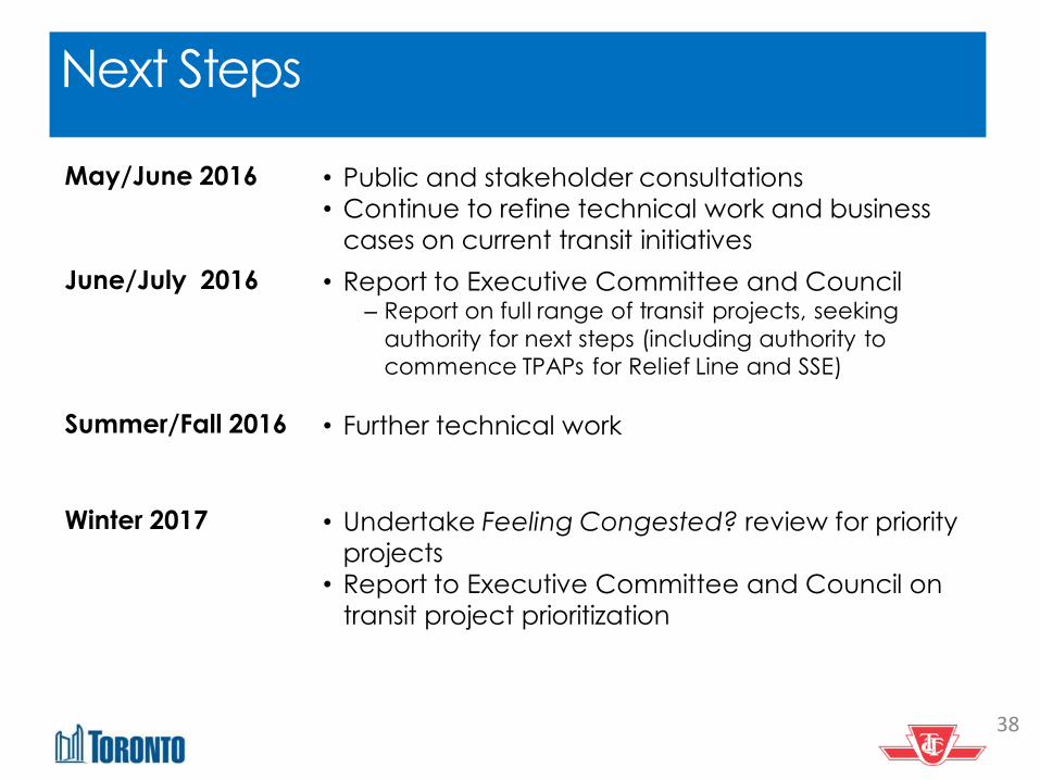
Next Steps
38
May/June 2016 • Public and stakeholder consultations
• Continue to refine technical work and business
cases on current transit initiatives
June/July 2016 • Report to Executive Committee and Council ‒ Report on full range of transit projects, seeking
authority for next steps (including authority to
commence TPAPs for Relief Line and SSE)
Summer/Fall 2016 • Further technical work
Winter 2017 • Undertake Feeling Congested? review for priority
projects
• Report to Executive Committee and Council on
transit project prioritization
Today’s Agenda 1. Overview of our coordinated approach 2. Overview: Update of transit initiatives underway 3. Update: SmartTrack/GO RER
4. Update: Relief Line 5. Next Steps
6. Questions
39