smcd annual report fy10: year in review
TRANSCRIPT

2010
NOAA NESDIS
Center for Satellite Applications and Research
Satellite Meteorology and Climatology Division
Annual Report Photo courtesy of Lockheed Martin

Table of Contents
Message from Mitch Goldberg, Chief, ..................................................................................................................................... 3
Mission ..................................................................................................................................................................................... 5
Who We Are ............................................................................................................................................................................. 6
Setting within NOAA .................................................................................................................................................. 6
Organization ............................................................................................................................................................................. 6
Sensor Physics Branch ................................................................................................................................................ 6
Environmental Monitoring Branch ............................................................................................................................ 6
Operational Products Development Branch .............................................................................................................. 7
NOAA-NASA-DoD Joint Center for Satellite Data Assimilation (JCSDA) ..................................................................... 7
Staff .......................................................................................................................................................................................... 8
New Staff Profiles ..................................................................................................................................................... 10
Contract Support Staff (listed alphabetically) .......................................................................................................... 10
Accomplishments ................................................................................................................................................................... 12
Ensuring High Quality Calibrated Observations and Products ................................................................................. 12
Improved Utilization of Satellite Observations ........................................................................................................ 14
Transition to Operations .......................................................................................................................................... 20
Leadership and Development of new Algorithms and Applications for Future Operational Satellite Observing Systems (JPSS and GOES-R) ...................................................................................................................................... 22
National and International Collaborations ............................................................................................................... 24
Education, Outreach and Training ........................................................................................................................... 29
Visiting Scientists...................................................................................................................................................... 30
Awards and Honors .................................................................................................................................................. 30
Administrator’s Awards ........................................................................................................................................... 32
Journal Articles ......................................................................................................................................................... 33
Conference Papers and Non-peer-reviewed Articles ............................................................................................... 35
Technical Reports ..................................................................................................................................................... 38

3
MESSAGE FROM MITCH GOLDBERG, CHIEF,
Satellite Meteorology and Climatology Division
On behalf of the Satellite Meteorology and Climatology Division (SMCD), it is my pleasure to present the Fiscal Year 2010 Report. This report summarizes the major activities and accomplishments within my division throughout the year.
As an organization focused on the research and development of new satellite products, SMCD is actively engaged and committed to improve and expand the use of satellite data for monitoring global meteorological, environmental and climatological conditions.
I am very proud to share this report on our accomplishments, which include the Division’s completed tasks, highlights from workshops and meetings attended, published papers, and training provided during the Fiscal Year.
We contributed to the Center for Satellite Applications and Research (STAR) mission through the following outcomes:
– Ensuring high quality calibrated observations and products
o Characteristics Of AMSU Instrument Errors
o NOAA’s Newest GOES Sounder
o The Stratospheric Temperature Climate Record
– Improved utilization of satellite observations
o The Community Radiative Transfer Model
o Malaria Tracking
o Soil Saturation
– Transition to Operations: Products below were transitioned to NESDIS Office of Satellite Data Processing and Distribution (OSDPD)
o NOAA-19 Green Vegetation Fraction (GVF) Production
o METOP AVHRR Polar Winds
o Microwave Integrated Retrieval System (MIRS)

4
– Leadership and Development of new Algorithms and Applications for Future Operational Satellite Observing Systems (JPSS and GOES-R)
o The Joint Polar Satellite Systems (JPSS) Data Products and Algorithms Group (DPAG)
o Ensuring Monitoring of the Antarctic Ozone Hole far into the Future
– National and International Collaborations
o NESDIS – India Ministry of Earth Sciences Arrangement
o CEOS Dome C Inter-comparison Project
o Flash Flood Workshop in Black Sea Region
o NOAA Workshop On Climate Data Records From Satellite Microwave Radiometers
– Education, Outreach and Training:
o Virtual Institute for Satellite Integration Training (VISIT) program
In December we said a fond farewell to Hank Drahos, my branch chief of twelve years. He will be greatly missed. I wish him a long and happy retirement, and I particularly want to thank him for his support in operating the Division. His help and support to me as Chief has been invaluable.
Please join me in welcoming Laurie Rokke who joined us earlier this year. “Who we are” gives more details. Dr Rokke’s experience will bring new insight and expertise to our team, and complement our existing strengths.
I hope you enjoy reading our accomplishments. Although these are a representative sample of my Division’s scientific activities in FY10, they demonstrate the dedication of the hard-working staff in SMCD. I am confident that our highly talented staff and our commitment to investment in research and development will continue to support further progress in the year ahead. I look forward to working closely with our team and partners for many years to come.

5
MISSION
SMCD conducts research and develops new satellite products to improve and expand the use of satellite data for monitoring global meteorological, environmental and climatological conditions. The Division conducts an end-to-end program ranging from planning new satellite instruments to developing new satellite products and applications and transitioning these developments to operations in NOAA's weather, climate, and environmental monitoring and prediction systems. Most of the Division's research and development falls in the following discipline areas:
• Atmospheric variables - temperature, humidity, winds
• Land surface variables - vegetation, snow and ice cover
• Hydrological Cycle variables - precipitation, clouds, water vapor
• Environmental hazards - aviation hazards, air quality, fires, heavy rainfall and flash floods, drought
• Climate variables - ozone, Earth radiation budget, aerosols, greenhouse gases
In addition to developing new and improved products, we conduct the following crosscutting activities:
• Calibrating satellite instruments
• Transitioning research products to operational production
• Developing radiative transfer models for the National Weather Service (NWS) Numerical Weather Prediction (NWP) satellite data assimilation systems
• Developing and analyzing long-term satellite data sets for studying and assessing climate change
• Planning and preparing for new satellite instruments
To execute its activities, SMCD has an active visiting scientist program, an extensive task order contract support system - which provides scientists and software specialists to support the SMCD investigators – and access to Cooperative Institutes via grants. Its scientists also collaborate with colleagues both nationally and internationally.

6
WHO WE ARE
SETTING WITHIN NOAA
SMCD is one of three units in the NESDIS Center for Satellite Applications and Research (STAR). The other units are the Satellite Oceanography and Climatology Division (SOCD) and the Cooperative Research Program (CoRP). STAR is the science arm of NOAA's National Environmental Satellite, Data and Information Service (NESDIS) and provides leadership, guidance, and direction for NESDIS research, development, and applications activities with respect to satellites and satellite data. The main objectives of STAR are to ensure that satellite remote sensing data and information products are of the highest quality possible and to enhance their utilization to enable NOAA to fulfill its mission to understand and predict changes in Earth's environment and conserve and manage coastal and marine resources to meet our Nation's economic, social, and environmental needs. STAR conducts research and develops satellite products for meteorological, climatological, oceanographic, and land surface applications by NOAA's operational and research components. STAR is a vital link in NOAA’s research to operations pathway.
Key development activities include the NPOESS Data Exploitation (NDE), GOES-R, the Joint Polar Satellite System (JPSS), Climate Data Records (CDRs), and the Global Space-based Intercalibration System (GSICS).
ORGANIZATION
SENSOR PHYSICS BRANCH
The Sensor Physics Branch oversees the calibration of all of NOAA's Earth observing satellite instruments and develops many of the atmospheric products derived from satellite observations. It researches state-of-the-art algorithms for profiling atmospheric temperature and water vapor, ozone, air quality, carbon cycle and hydrological products from operational and research satellite instruments. It develops, upgrades, and maintains the Community Radiative Transfer Model, which is used for data assimilation in the numerical weather prediction models of the NWS, NASA, and DoD. It develops and tests advanced retrieval algorithms for current and future satellite observing systems. The Branch also strongly supports the NOAA climate goal through its retrospective reprocessing of satellite observations of ozone and other important constituents to produce long term Climate Data Records. It also participates in the design, planning, and preparation for next generation satellite systems.
ENVIRONMENTAL MONITORING BRANCH
The Environmental Monitoring Branch develops satellite-based land surface, climate, and environmental hazards products. Its vegetation, snow and ice cover products are used as initial or boundary conditions for NWS weather prediction models. The Branch's Earth Radiation Budget, cloud, and aerosol products help scientists to better understand critical climate processes. Its heavy rainfall, fire, and drought products provide early warnings for destructive environmental hazards. The Branch also constructs long-term satellite-based data sets of Earth Radiation Budget, clouds, aerosols, vegetation, and atmospheric temperature for monitoring global climate change. It also participates in the design, planning, and preparation for next generation satellite systems.
7
OPERATIONAL PRODUCTS DEVELOPMENT BRANCH
The Operational Products Development Branch (OPDB) is the main conduit for transferring new science into NESDIS operations for both geostationary and polar satellites, and provides support in training NWS and DoD forecasters to correctly utilize and interpret satellite products. The OPDB transitions research products to operations. The Branch transitions the science algorithms developed by SMCD for atmospheric sounding, wind, and convection intensity products to operational processing systems for the NESDIS Office of Satellite Data Processing and Distribution (OSDPD). It also develops satellite products for use by the aviation sector, such as aircraft icing, volcanic ash hazards, and fog and low ceiling events.
NOAA-NASA-DOD JOINT CENTER FOR SATELLITE DATA ASSIMILATION (JCSDA)
SMCD provides support to the JCSDA through its staff who work on JCSDA Directed Research programs and also through collaboration with the extramural community through a Federally Funded Opportunity to develop advanced data assimilation sciences.
The JCSDA was established by NOAA, NASA, and DoD to accelerate and improve the quantitative use of research and operational satellite data in weather and climate analysis and prediction models. It is part of the Environmental Modeling Program, under NOAA's Weather and Water Goal, which provides model-based estimates of current and future states of the environment at multiple time scales. These estimates are based upon a wide array of observational data and ever more refined modeling techniques. The program maintains a suite of operational models to meet current needs as well as a research and development program for improved performance and new capabilities in future generations of environmental models.
The vision of the JCSDA is an interagency partnership working to become a world leader in applying satellite data and research to operational goals in environmental analysis and prediction. The major short term goal of the JCSDA is:
• Contribute to making the forecast skill of the operational NWP systems of the JCSDA partners internationally competitive by assimilating the largest possible number of satellite observations in the most effective way.
Additional goals include:
• Reducing from two years to one year the average time for operational implementation of new satellite technology
• Improving and increasing uses of current and future satellite data in NWP models
• Assessing the impacts of data from advanced satellite instruments on weather and climate predictions

8
STAFF
SMCD’s most important asset is its employees. Thus, our organization works diligently to attract and maintain a staff of highly qualified and motivated professionals. Our staff members are accustomed to working on projects and problems requiring close team work, and innovative solutions. Their record of research and publications, their product maintenance, validation, improvement and development, and also their scientific collaboration and leadership is evidence of the Division’s success. Below are photos of the civil servant staff members and a list of the contract support staff.
CHIEF
Goldberg, Mitch Tammie Herrin Danette Warren
SENSOR PHYSICS BRANCH Branch Chief
Weng, Fuzhong Barnet, Chris Beck, Trevor Cao, Changyong
Flynn, Larry Han, Yong Kleespies, Tom Kondragunta, Shobha
Mo, Tsan Wu, “Fred” Xiangqian

9
ENVIRONMENTAL MONITORING BRANCH Branch Chief
Csiszar, Ivan Gallo, Kevin Kogan, Felix Kuligowski, Bob
Laszlo, Istvan Li, Xiaofan Vargas, Marco Yu, “Bob” Yunyue
Zhan, “Jerry” Xiwu Zou, Cheng-Zhi
OPERATIONAL PRODUCTS DEVELOPMENT BRANCH Branch Chief
Rokke, Laurie Chalfant, Mike Daniels, Jaime Pryor, Ken
Reale, Tony Weldon, Roger Wolf, Walter
10
NEW STAFF PROFILES
Laurie Rokke received her doctorate in Physics (D.Phil) at the University of Oxford, England in 2006, a Master of Science (MS) in Meteorology from the University of Wisconsin-Madison in 1987, and a BS in Aeronautical Studies and BA in Geography from the University of North Dakota. She has worked with instrument calibration (HIRDLS, MOPITT), retrieval theory with FTIS instruments (HIS, AIRS, IASI), radiometers (HALOE, ATOVS, SSU) and microwave instruments (MSU, AMSU, DMR) and data assimilation applications. She worked as the program manager for the COBE science team for the DMR instrument during the calibration, launch, intensive cal/val and operational production activities. In 2006 Dr. George Smoot received the Nobel Prize in Physics for DMR and the discovery of anisotropies in the CMB. Dr Rokke was one of the co-authors of the papers cited in the Nobel announcement along with the calibration paper on DMR.
CONTRACT SUPPORT STAFF (LISTED ALPHABETICALLY)
Mitch Goldberg, Chief, SMCD
Dowling, Deborah Ohring, George/ JCSDA Price, Julie Valenzuela, Tess
Fuzhong Weng (Sensor Physics Branch)
Beach, Eric Pachepsky, Yakov Chen, Ruiyue / U-MD Padula, Frank Chen, Wanchun Qian, Haifeng Chen, Yong Rowland, William Cucurull, Lidia Sindic-Rancic, Gordana Darnel, Jonathan Sun, Ninghai Divakarla, Murty Swales, Dustin Garrett, Kevin Uprety, Sirish Grassotti, Christopher Varma Raja, M. K. Rama Grotenhuis, Michael Vogel, Ronald Guo, Guang Wang, Likun Hanna, Rafik Wei, Jennifer Hao, Yan Xiong, Xiaozhen Iacovazzi, Bob Xu, Chuanyu Iturbide-Sanchez, Flavio Yan, Banghua/ JCSDA Kim, Min-Jeong/ CIRA Yang, Hu (Tiger) Kongoli, Cezar Yu, Fang Fang Krasowski, Greg Zeng, Jian Li, Yaping Zhang, Xiaoyang Liang, Ding (Ellen) Zhao, Qiang Maddy, Eric Zhou, Mi Nalli, Nick Zhu, Tong/ JCSDA Niu, Jianguo

11
Ivan Csiszar (Environmental Monitoring Branch)
Laurie Rokke (Operational Products Development Branch)
Barnhill, Richard Liu, Jicheng Chen, Ming Qian, Haifeng Ciren, Pubu/ U-MD Romanov, Peter/ CICS Ellicott, Evan Schroeder, Wilfrid / CICS Guo, Wei Tarpley, Dan Hale, David / UCAR Tian, Yuhong Jelenak, Aleksandar/ UCAR Wang, Likun Jiang, Zhangyan Wang, Wenhui Kim, Hye-Yun Xu, Hui Li, Yaping Zhang, Zhihua Liu, Hongqing
Allegrino, Rico Pettey, Michael Appel, Igor Qiu, Shuang Atkins, Tom Rollins, Ricky Bailey, Andrew Sampson, Shanna Bresky, Wayne Song, Yi Brown, Charlie Sprietzer, Kristina Cheng, Zhaohui Sun, Bomin Fan, Meizhu Sun, Fengying Fu, Gang Sun, Haibing Gambacorta, Antonia Tan, Changyi Guo, Qingzhao Tilley, Frank Jensen, Ken Wang, Wenhui Jung, Jim / CIMSS Xie, Hua Keehn, Peter Yu, Tianxu King, Tom Zhang, Kexin Koval, Larisa Zhang, Wendy Li, Aiwu Zhao, Yunhui Liu, Quanhua 'Mark' Zhang, Chen Liu, Xingpin Zhang, Zhaohui

12
ACCOMPLISHMENTS
ENSURING HIGH QUALITY CALIBRATED OBSERVATIONS AND PRODUCTS
Good instrument calibration is critical to good products. Requirements for more accurate satellite information products are rapidly growing. As numerical weather prediction models become more reliable, their appetite for more accurate data input steadily increases. As the requirements for monitoring global climate become clearer – temperature changes as tiny as a few tenths of a degree Celsius per decade, ozone trends as small as 1%/decade – the measurements become more demanding. To create the stable long-term data sets needed for monitoring climate change it becomes vital to inter-calibrate sensors on different satellites. These are major challenges, but in 2010, our calibration scientists made a number of breakthroughs.
THE STRATOSPHERE COOLS IN A GREENHOUSE WORLD
Cheng-Zhi Zou
Stratospheric temperature is an important climate change indicator, providing further observational evidence on the effects of greenhouse gas emissions. Theory indicates that the Earth’s surface and troposphere should warm with increasing carbon dioxide, but that the stratosphere should cool. Prior to the launch of AMSU-A in 1998, the Stratospheric Sounding Unit (SSU) was the only satellite sensor that operationally measured stratospheric temperatures on a continuous basis (1978-2006). SMCD scientists have been developing consistent, homogenous, better-documented, and well-inter-calibrated temperature Climate Data Records (CDRs) from the 28-year SSU series. The importance of recalibration is illustrated in the figure, which shows temperature time series for stratospheric layers before and after recalibration. As a result of increasing CO2, the stratosphere cools at a rate that increases from -0.8 C/decade at about 25 km to -1.2 deg/decade at about 50 km.
Time series of SSU layer temperatures at 30, 40, and 45 km (Ch 1, 2, 3, respectively) before (gray) and after recalibration (color). The different colors represent the observations from different

13
CHECKING NOAA’S NEWEST GOES SOUNDER
Xiangqian Wu
GOES-14, the second satellite of the GOES M,O,P series, was launched into orbit in June 2009. To check out the observations of the GOES-14 Sounder, SMCD scientists applied the tools developed by the Global Space-based Inter-
Calibration System (GSICS). The figure shows the differences (biases) between GOES-14 Sounder observations and measurements of the IASI instrument on the EUMETSAT MetOp satellite (red boxes). Because of its high quality measurements, IASI is used as reference instrument by GSICS for recalibrating other IR instruments in space. The differences are determined from matched observations when the polar orbiting MetOp underflies the GOES. Also shown are results for GOES-11 and -12. These initial analyses indicate that the GOES-14 Sounder is comparable to GOES-11/12, with significant improvement for a few channels – note the remarkable reduction in channel 15 bias.
CHARACTERISTICS OF AMSU INSTRUMENT ERRORS
Tsan Mo
NOAA’s AMSU instruments continuously scan the Earth perpendicular to the orbital track. Comparisons of the observations with those computed with a radiative transfer model reveal small systematic errors – a few tenths of a deg C in brightness temperature (BT) - as a function of viewing angle. These biases have been determined from monthly mean angular distributions of brightness temperatures at the four window channels of the NOAA-18 AMSU-A over the tropical oceans for January and April 2010 and are shown in the figure. These results can be used to correct the observations for this artifact.
Mean and standard deviation of GOES-11/12/14 Sounder brightness temperature difference from nighttime IASI data in December, 2009.
AMSU-A Measurements: View-angle Dependent Biases and Asymmetries
GOES Sounder - IASI (night-time)
-8
-6
-4
-2
0
2
4
1 2 3 4 5 6 7 8 9 10 11 12 13 14 15 16 17
Channel #
Mea
n an
d St
d. o
f Tb
Bia
s (K
)
GOES11 GOES12 GOES14

14
IMPROVED UTILIZATION OF SATELLITE OBSERVATIONS
Our researchers are constantly developing new applications of and products from satellite observations. This activity includes developing new applications for existing satellite observations as well as for the advanced instruments as they come online. As part of these activities, SMCD scientists contribute to the JCSDA’s mission of accelerating and improving the quantitative use of research and operational satellite data in weather, ocean, climate and environmental analysis and prediction systems.
COMMUNITY RADIATIVE TRANSFER MODEL (CRTM) UPGRADE
Yong Han
Conversion of remotely sensed satellite observations to information on the Earth’s atmosphere and surface requires an ability – a model - to calculate the radiation that the Earth reflects or emits to space. The Community Radiative Transfer Model (CRTM), used to assimilate satellite observations in NOAA, NASA, Navy, and Air Force NWP models, has been improved by adding:
• components for Visible/UV sensors, enabling assimilation of aerosols and ozone
• a fast transmittance model with variable gases H2O, CO2, O3, CO, N2O and CH4, for assimilating greenhouse gases and pollutants
• a fast transmittance model for the SSU that accounts the CO2 cell leaking problem, for use in climate reanalyses
• a fast Zeeman transmittance model for assimilating upper stratospheric SSMIS and AMSU-A channels
• a Bidirectional Reflectance Distribution Function model for reflection of sunlight by the ocean for assimilating daytime IR shortwave radiance data.
• the Nalli Quasi-specular ocean IR emissivity model, for improved assimilation of SST and temperature sounding radiances
• improved computational efficiency - a factor 3 for the Forward model and a factor 2 for the Jacobian model under the clear-sky condition – speeding up the assimilation cycle and allowing more data to be assimilated
Simulations of reflected sunlight for the GOES-R ABI visible channels. Highest reflectances (light grey) are from thick clouds, moderate reflectances (dark grey) are from aerosols, and lowest reflectances (black) are from the surface of the Earth. Atmospheric and cloud conditions from NWS’s Global Data Assimilation System, aerosol concentrations from the Goddard Chemistry Aerosol Radiation and Transport model.
15
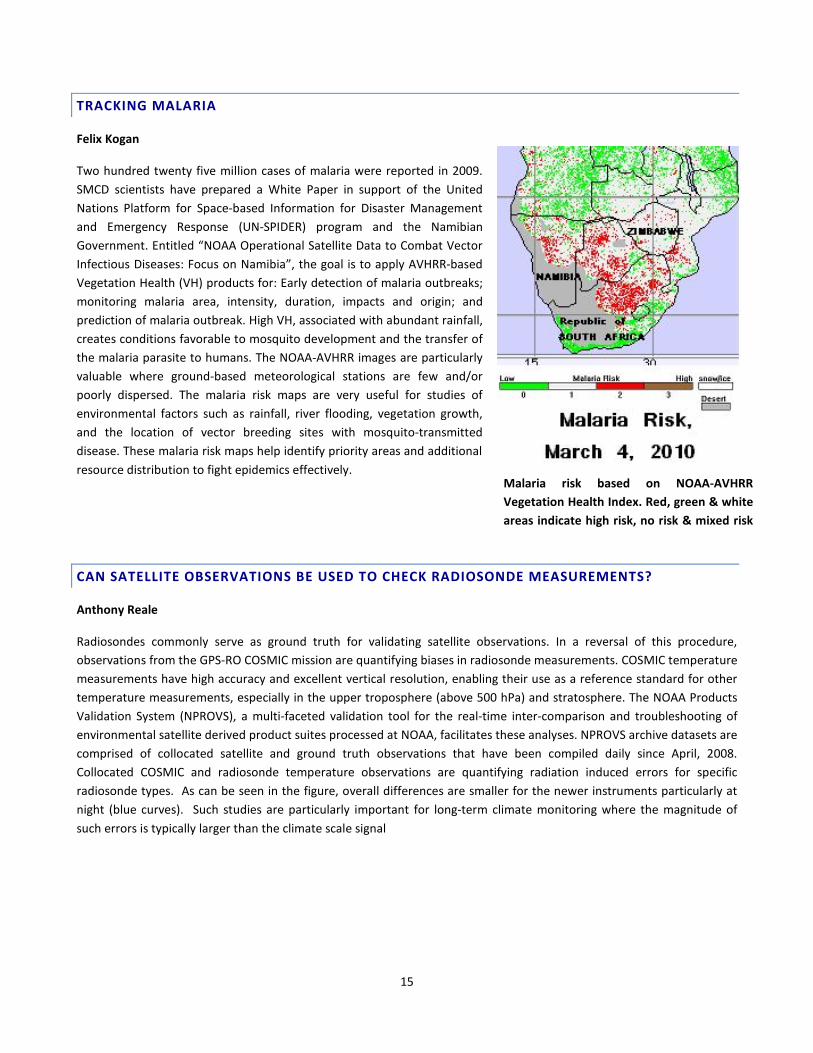
TRACKING MALARIA
Felix Kogan
Two hundred twenty five million cases of malaria were reported in 2009. SMCD scientists have prepared a White Paper in support of the United Nations Platform for Space-based Information for Disaster Management and Emergency Response (UN-SPIDER) program and the Namibian Government. Entitled “NOAA Operational Satellite Data to Combat Vector Infectious Diseases: Focus on Namibia”, the goal is to apply AVHRR-based Vegetation Health (VH) products for: Early detection of malaria outbreaks; monitoring malaria area, intensity, duration, impacts and origin; and prediction of malaria outbreak. High VH, associated with abundant rainfall, creates conditions favorable to mosquito development and the transfer of the malaria parasite to humans. The NOAA-AVHRR images are particularly valuable where ground-based meteorological stations are few and/or poorly dispersed. The malaria risk maps are very useful for studies of environmental factors such as rainfall, river flooding, vegetation growth, and the location of vector breeding sites with mosquito-transmitted disease. These malaria risk maps help identify priority areas and additional resource distribution to fight epidemics effectively.
CAN SATELLITE OBSERVATIONS BE USED TO CHECK RADIOSONDE MEASUREMENTS?
Anthony Reale
Radiosondes commonly serve as ground truth for validating satellite observations. In a reversal of this procedure, observations from the GPS-RO COSMIC mission are quantifying biases in radiosonde measurements. COSMIC temperature measurements have high accuracy and excellent vertical resolution, enabling their use as a reference standard for other temperature measurements, especially in the upper troposphere (above 500 hPa) and stratosphere. The NOAA Products Validation System (NPROVS), a multi-faceted validation tool for the real-time inter-comparison and troubleshooting of environmental satellite derived product suites processed at NOAA, facilitates these analyses. NPROVS archive datasets are comprised of collocated satellite and ground truth observations that have been compiled daily since April, 2008. Collocated COSMIC and radiosonde temperature observations are quantifying radiation induced errors for specific radiosonde types. As can be seen in the figure, overall differences are smaller for the newer instruments particularly at night (blue curves). Such studies are particularly important for long-term climate monitoring where the magnitude of such errors is typically larger than the climate scale signal
Malaria risk based on NOAA-AVHRR Vegetation Health Index. Red, green & white areas indicate high risk, no risk & mixed risk

16
Radiosonde minus COSMIC temperature differences as a function of pressure level and solar elevation angle (colored curves) for older (left panel) and newer (right panel) radiosonde types. Note the overall reduction in radiation induced errors for the newer radiosonde types particularly at night (blue).
FIRST SATELLITE TECHNIQUE FOR MEASURING SOIL SATURATION
Felix Kogan
SMCD scientists have developed the first satellite-based technique for determining soil saturation. Soil saturation (SS) is a phenomenon that occurs when water from excessive rains and/or flooding fills large soil pores, limiting the amount of oxygen absorbed by the roots. This causes vegetation stress, injury, and even death. In the case of SS-related stress, vegetation becomes less green and vigorous resulting in a reduced Normalized Difference Vegetation Index (NDVI). This is similar to what happens during drought-related stress. However, drought stress and SS affect vegetation performance and productivity differently and therefore must be identified correctly.
The Soil Saturation Index (SSI) is a numerical indicator produced from the following multi-sensor and multi-channel SMCD satellite products:

17
Vegetation Health (VH), rainfall rate from the Hydroestimator (H-E), and Snow Cover (SC). SSI covers the globe at 4 km, 7-day resolution. It is the first product estimating soil saturation; based on a synergy of products from GOES-Imager, NOAA-AVHRR and DMSP-SSM/I. (http://www.star.nesdis.noaa.gov/smcd/emb/vci/VH/index.php).
The VH images on the left show total vegetation stress (red) dynamics during June 8-28, 2008; the images on the right separate the total stress into drought (red) and soil saturation (white) stress
REMOVING THE ATMOSPHERIC BLURRING OF VEGETATION OBSERVATIONS
Marco Vargas
SMCD has developed a prototype system to correct measurements of the Normalized Difference Vegetation Index (NDVI) for the effects of the atmosphere. Currently, NDVI is determined directly from the satellite AVHRR observations of reflected sunlight. These measurements include the effects of the atmosphere – in particular absorption by water vapor and scattering by aerosols - on the AVHRR measurements. Thus, the current NDVI can be considered a top of the atmosphere (TOA) NDVI. But what is needed is the surface NDVI. The new prototype system uses a radiative transfer model to convert the TOA AVHRR reflectances to a top-of-canopy signals, or surface reflectances.
NDVI is enhanced after atmospheric correction. The improved NDVI data allow for the construction of more consistent NDVI time series from this historical AVHRR dataset for climate studies

18
ENHANCING THE SPATIAL DETAIL OF FIRE DETECTIONS
Ivan Csiszar
To achieve smoother spatial fields, the baseline processing system for the NPP and JPSS VIIRS (Visible Infrared Imager Radiometer Suite) will average neighboring pixel observations. Since many fires, especially in their early stages, are small scale events, averaging of pixels may reduce the fire signal to undectability. SMCD scientists are exploring the potential for fire detection from unaveraged, or native, VIIRS observations. Using proxy data from the Advanced Spaceborne Thermal Emission and Reflection Radiometer (ASTER), they have found (see figure) that use of the native observations results in detection of smaller fires and improved spatial detail. Evaluation of sensor saturation and alternative VIIRS bands is continuing. Current indications are that a VIIRS fire product from the native measurements will improves the quality and usefulness of the fire information.
Example of proxy fire products from averaged (top) and unaveraged (bottom) VIIRS radiances over fire masks from coincident ASTER (Advanced Spaceborne Thermal Emission and Reflection Radiometer) measurements. VIIRS fire pixels are in red.
IS SEA LEVEL RISING OR IS IT ONLY THE ALTIMETER DRIFTING?
Changyong Cao
Jason-1 & -2 observe global sea level with their radar altimeters. The measurements are exacting: height of the sea to a few cm for individual observations, to a few mm for long term sea level rise due to global warming. But atmospheric water vapor absorbs a small amount of the radar pulse on its round trip from spacecraft to ocean. This results in a path-delay that, if uncorrected for, would lead to an error in the spacecraft-ocean distance measurement, the basis for the sea level measurement. To correct for this attenuation, Jason 2 carries a microwave radiometer – Advanced Microwave Radiometer (AMR) – to measure the water vapor. SMCD scientists, working closely with scientists from the satellite
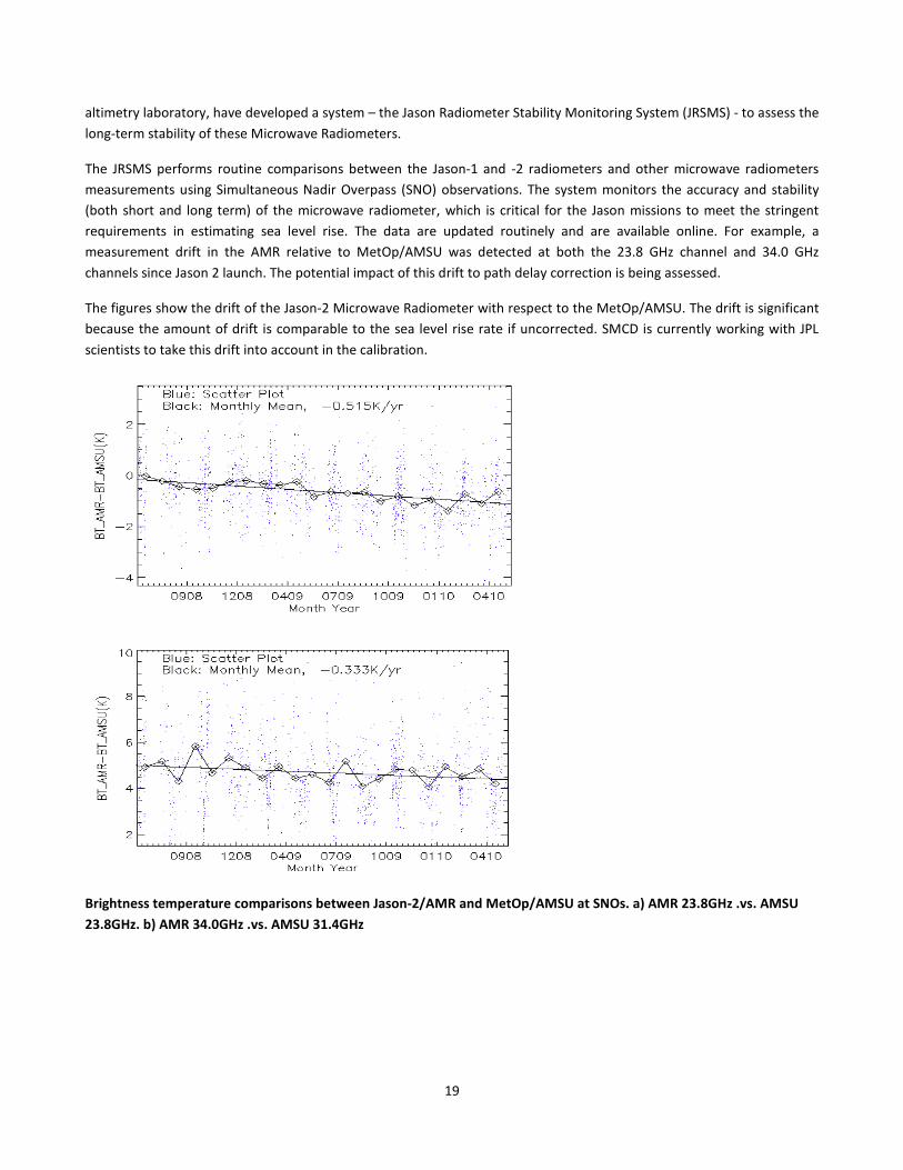
19
altimetry laboratory, have developed a system – the Jason Radiometer Stability Monitoring System (JRSMS) - to assess the long-term stability of these Microwave Radiometers.
The JRSMS performs routine comparisons between the Jason-1 and -2 radiometers and other microwave radiometers measurements using Simultaneous Nadir Overpass (SNO) observations. The system monitors the accuracy and stability (both short and long term) of the microwave radiometer, which is critical for the Jason missions to meet the stringent requirements in estimating sea level rise. The data are updated routinely and are available online. For example, a measurement drift in the AMR relative to MetOp/AMSU was detected at both the 23.8 GHz channel and 34.0 GHz channels since Jason 2 launch. The potential impact of this drift to path delay correction is being assessed.
The figures show the drift of the Jason-2 Microwave Radiometer with respect to the MetOp/AMSU. The drift is significant because the amount of drift is comparable to the sea level rise rate if uncorrected. SMCD is currently working with JPL scientists to take this drift into account in the calibration.
Brightness temperature comparisons between Jason-2/AMR and MetOp/AMSU at SNOs. a) AMR 23.8GHz .vs. AMSU 23.8GHz. b) AMR 34.0GHz .vs. AMSU 31.4GHz

20
TRANSITION TO OPERATIONS
Transition to operations is the ultimate step in the development of a new product system. During the year, SMCD and the JCSDA transitioned a number of product systems to the NESDIS Office of Satellite Data Processing and Distribution and assimilation systems for new instruments to the NWS National Centers for Environmental Prediction. These are listed below; more detail on some of these transitions follows. SMCD’s Integration Team continues to standardize STAR product systems and reduce the time it takes to transition new systems to operations.
• NOAA-19 Green Vegetation Fraction (GVF) Production
• METOP AVHRR Polar Wind Production
• Microwave Integrated Retrieval System (MIRS)
NOAA-19 GREEN VEGETATION FRACTION
Ivan Csiszar
Accurate and consistent Green Vegetation Fraction data are critical for land surface monitoring. GVF is derived from AVHRR Normalized Difference Vegetation Index (NDVI). However, different AVHRR instruments may produce slightly different NDVI due to calibration and sensor differences. Consistent GVF can be derived by statistical adjustment between satellites. SMCD has determined the statistical adjustment needed for the new NOAA-19 satellite and it has been implemented operationally in GVF production. The figure shows that after application of the statistical adjustment, mean global GVF from NOAA-18 and -19 are identical.
Comparison of time series of global NDVI (top) and GVF (bottom) from NOAA-18 and NOAA-19 AVHRR. The GVF time series are consistent after statistical adjustment.

21
METOP AVHRR POLAR WINDS
Jaime Daniels
SMCD has checked out, and NESDIS operations has implemented, the system for determining polar area winds by tracking cloud drifts from the AVHRR/3 window (10.8 µm) channel measurements of successive METOP orbits. The winds are generated every 2 hours over the Arctic and Antarctica. The high resolution (1km) AVHRR/3 imagery allows for the production of a significant number of wind vectors with excellent geographic coverage. These winds provide critical data in the unobserved Polar Regions and serve as a vital data source for assimilation in NWP models.
MICROWAVE INTEGRATED RETRIEVAL SYSTEM UPGRADE
Sid Boukabara
SMCD has upgraded the Microwave Integrated Retrieval System (MIRS) and released an updated Delivery Algorithm Package to both NOAA’s Office of Satellite Data Processing and Distribution (OSDPD) and NPOESS Data Exploitation (NDE). The upgrade includes the ability to process new satellite data: the DMSP F18 SSMI/S and NPP ATMS. For NPP ATMS, MIRS has the ability to process both sample and proxy data within the NDE processing environment, in preparation for the NPP satellite launch scheduled for October 2011. Currently, MIRS processes global NPP ATMS proxy data on a daily basis within SMCD to produce a full complement of sounding and surface products to ensure readiness for and support of the NPP mission.
METOP-AVHRR cloud-drift winds over Antarctica at 1157UTC on 14 December 2009. High level (above 400 hPa) winds are shown in violet, mid-level (400-700 hPa) winds are shown in cyan, and low level (below 700 hPa) are shown in yellow.
MIRS Total Precipitable Water derived from NPP ATMS proxy data on 2010-12-06. Proxy data are generated at SMCD using software distributed by MIT Lincoln Laboratory and NOAA-18 AMSU-A/MHS data.
22
LEADERSHIP AND DEVELOPMENT OF NEW ALGORITHMS AND APPLICATIONS FOR FUTURE OPERATIONAL SATELLITE OBSERVING SYSTEMS (JPSS AND GOES-R)
SMCD plays a key role in preparing for the next generation of operational polar and geostationary satellites – JPSS and GOES-R. Our scientists assist satellite procurement programs in defining instrument calibration requirements, developing product-processing algorithms, and planning data exploitation.
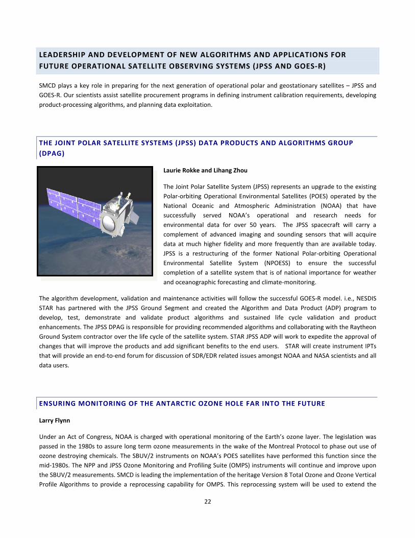
THE JOINT POLAR SATELLITE SYSTEMS (JPSS) DATA PRODUCTS AND ALGORITHMS GROUP (DPAG)
Laurie Rokke and Lihang Zhou
The Joint Polar Satellite System (JPSS) represents an upgrade to the existing Polar-orbiting Operational Environmental Satellites (POES) operated by the National Oceanic and Atmospheric Administration (NOAA) that have successfully served NOAA’s operational and research needs for environmental data for over 50 years. The JPSS spacecraft will carry a complement of advanced imaging and sounding sensors that will acquire data at much higher fidelity and more frequently than are available today. JPSS is a restructuring of the former National Polar-orbiting Operational Environmental Satellite System (NPOESS) to ensure the successful completion of a satellite system that is of national importance for weather and oceanographic forecasting and climate-monitoring.
The algorithm development, validation and maintenance activities will follow the successful GOES-R model. i.e., NESDIS STAR has partnered with the JPSS Ground Segment and created the Algorithm and Data Product (ADP) program to develop, test, demonstrate and validate product algorithms and sustained life cycle validation and product enhancements. The JPSS DPAG is responsible for providing recommended algorithms and collaborating with the Raytheon Ground System contractor over the life cycle of the satellite system. STAR JPSS ADP will work to expedite the approval of changes that will improve the products and add significant benefits to the end users. STAR will create instrument IPTs that will provide an end-to-end forum for discussion of SDR/EDR related issues amongst NOAA and NASA scientists and all data users.
ENSURING MONITORING OF THE ANTARCTIC OZONE HOLE FAR INTO THE FUTURE
Larry Flynn
Under an Act of Congress, NOAA is charged with operational monitoring of the Earth’s ozone layer. The legislation was passed in the 1980s to assure long term ozone measurements in the wake of the Montreal Protocol to phase out use of ozone destroying chemicals. The SBUV/2 instruments on NOAA’s POES satellites have performed this function since the mid-1980s. The NPP and JPSS Ozone Monitoring and Profiling Suite (OMPS) instruments will continue and improve upon the SBUV/2 measurements. SMCD is leading the implementation of the heritage Version 8 Total Ozone and Ozone Vertical Profile Algorithms to provide a reprocessing capability for OMPS. This reprocessing system will be used to extend the

23
existing long-term ozone records from the Total Ozone Mapping Spectrometers (TOMS) and SBUV(/2) instruments dating back to the 1970s, enabling monitoring of the Earth’s ozone layer and the expected recovery of the Antarctic Ozone Hole far into the future.
Total ozone retrieval results for two orbits of synthetic OMPS observations (left panel) and comparison with validation data (right panel).
24
NATIONAL AND INTERNATIONAL COLLABORATIONS
National and international collaborations are a significant part of SMCD’s scientific and technical activities. The Division engages in a number of national and international collaborations with industry groups, scientific and academic institutions, national labs, international agencies and organizations, and governments. These collaborations are an important vehicle for expanding the Division’s knowledge base, developing expertise, and leveraging resources to advance its program.
The Division also participates in numerous formal and informal meetings and workshops, nationally and internationally. These are an important vehicle for identifying areas where investments are necessary to fill gaps in current and/or future research efforts.
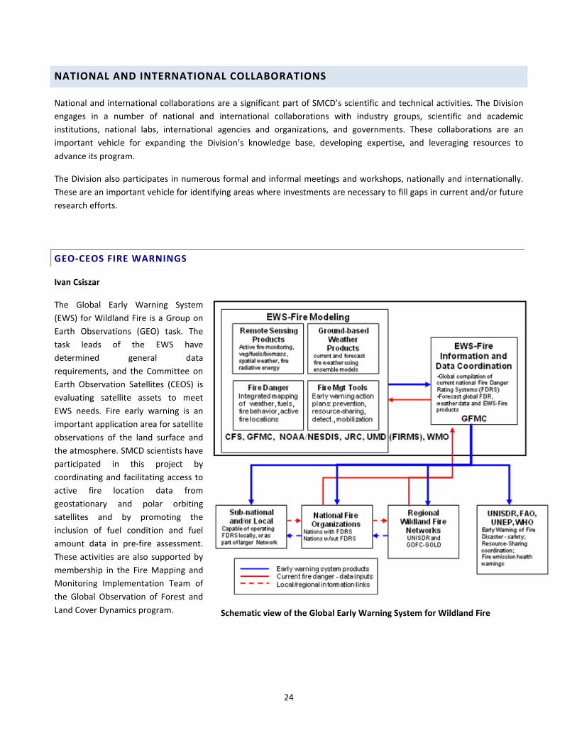
GEO-CEOS FIRE WARNINGS
Ivan Csiszar
The Global Early Warning System (EWS) for Wildland Fire is a Group on Earth Observations (GEO) task. The task leads of the EWS have determined general data requirements, and the Committee on Earth Observation Satellites (CEOS) is evaluating satellite assets to meet EWS needs. Fire early warning is an important application area for satellite observations of the land surface and the atmosphere. SMCD scientists have participated in this project by coordinating and facilitating access to active fire location data from geostationary and polar orbiting satellites and by promoting the inclusion of fuel condition and fuel amount data in pre-fire assessment. These activities are also supported by membership in the Fire Mapping and Monitoring Implementation Team of the Global Observation of Forest and Land Cover Dynamics program.
Schematic view of the Global Early Warning System for Wildland Fire

25
COMMITTEE ON EARTH OBSERVATION SATELLITES PROGRESS REPORT TO THE UNFCCC
Mitch Goldberg
The “2010 Progress Report: Coordinated Response from Parties that Support Space Agencies Involved in Global Observations to the Needs Expressed in the Global Climate Observing System (GCOS) Implementation Plan of 2004” reviews the criticality of Earth observing satellites for climate monitoring, understanding, prediction, and attribution of causes of climate change. It describes 50 Climate Actions for implementation, and reviews key accomplishments and future plans. Progress on forest carbon monitoring and land validation is also
provided. This report was prepared in response to an invitation from the U.N. Framework Convention on Climate Change (UNFCCC) Subsidiary Body on Scientific and Technological Advice (SBSTA), at its 32nd session, to the Committee on Earth Observation Satellites (CEOS), to report on progress made in the development of methodologies, and validation and inter-comparison of satellite-based applications, as well as the coordination of the satellite component of the GCOS. The report includes inputs from CEOS member agencies and CEOS Virtual Constellation Teams. The effort was largely spearheaded by the Division Chief and CEOS Climate Societal Benefit Area (SBA) Coordinator, Dr. Mitch Goldberg, with assistance from George Ohring and Julie Price.
NESDIS – INDIA MINISTRY OF EARTH SCIENCES ARRANGEMENT
Shobha Kondragunta
NESDIS Assistant Administrator, Mary Kicza and Ministry of Earth Sciences (MoES)/India Meteorological Department (IMD) director general Dr. Tyagi signed an Implementing Arrangement (IA) related to India’s INSAT-3D satellite data on 6 October 2010. This agreement provides a framework for technical and scientific co-operation between MoES and NESDIS on INSAT-3D (Imager and Sounder similar to NOAA GOES) satellite data applications. Key areas of collaboration include development of scientific algorithms/products for INSAT-3D and cal/val programs. SMCD scientist Dr. Shobha Kondragunta is the technical lead for this IA. In that capacity, she prepared the agreement that was signed and will coordinate the INSAT-3D product development and calibration/validation activities after the satellite is launched in 2011.

26
CEOS DOME C INTER-COMPARISON PROJECT
Changyong Cao
The CEOS/WGCV (Committee on Earth Observation Satellites/Working Group on Cal/Val) coordinated a comparison of radiometers aboard international satellites at the Antarctic Dome C calibration site. This phase-two study focused on the inter-comparison of 7 radiometers from US and European space agencies, and spectral characterization of the site.
The study revealed traceability, standards, and stability issues for some instruments. For example, MODIS and MERIS agree within 1%, while AVHRR is significantly lower than all other sensors. The project represents a major milestone towards establishing common reference standard sites for all space agencies. Such reference standards and traceability are essential to ensure satellite measurement consistency worldwide.
FLASH FLOOD WORKSHOP IN BLACK SEA REGION
Bob Kuligowski
Satellite-derived estimates of rainfall are a critical component for flash flood forecasting, particularly in regions without other significant observing infrastructure. SMCD scientist Bob Kuligowski attended the Regional Flash Flood Guidance System—Black Sea and Middle East Regions Initial Workshop in Istanbul, Turkey in March. The purpose of the workshop was to present the NOAA’s Regional Flash Flood Guidance System to representatives from Turkey, Armenia, Azerbaijan, Georgia, Iraq, and Lebanon. Collaborators include the Hydrologic Research Center (HRC), based in San Diego, California, the World Meteorological Organization (WMO), the U.S. Agency for International Development (USAID), and NOAA. SMCD will provide satellite-derived rainfall estimates to support the flash flood guidance system.
Workshop Participants
Reflectance comparison at the Dome C Site (a) 0.64 mm band (b) 0.86 mm band
27
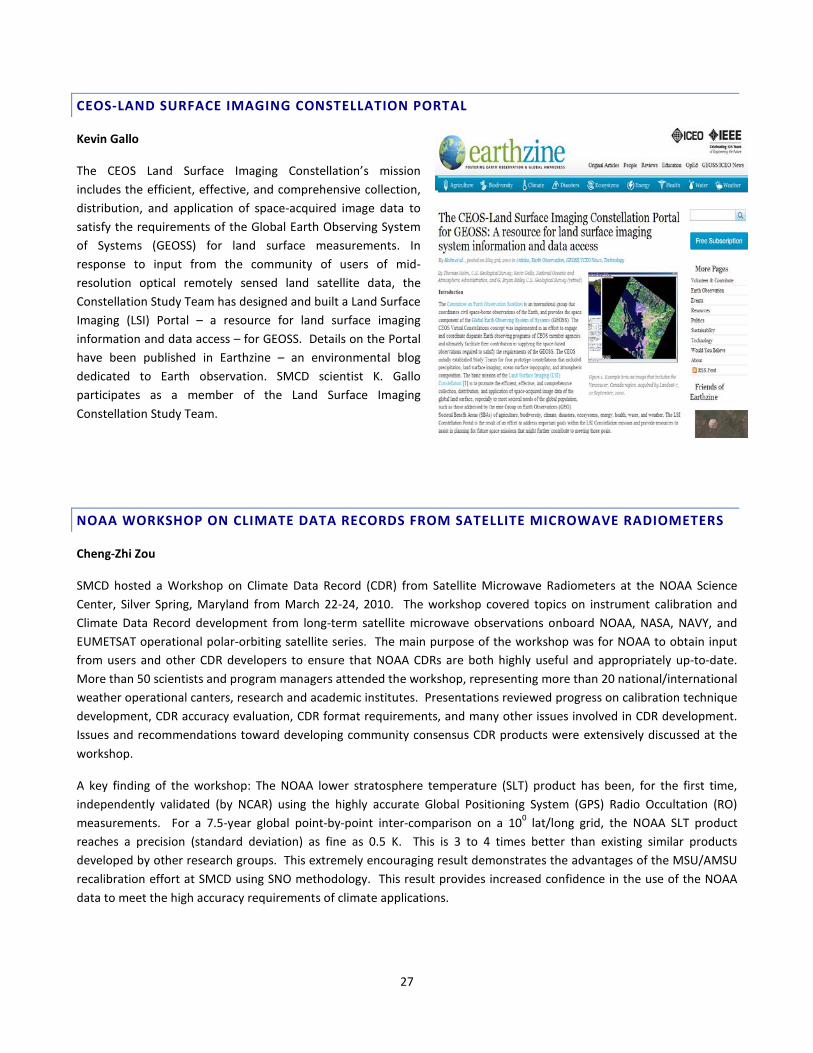
CEOS-LAND SURFACE IMAGING CONSTELLATION PORTAL
Kevin Gallo
The CEOS Land Surface Imaging Constellation’s mission includes the efficient, effective, and comprehensive collection, distribution, and application of space-acquired image data to satisfy the requirements of the Global Earth Observing System of Systems (GEOSS) for land surface measurements. In response to input from the community of users of mid-resolution optical remotely sensed land satellite data, the Constellation Study Team has designed and built a Land Surface Imaging (LSI) Portal – a resource for land surface imaging information and data access – for GEOSS. Details on the Portal have been published in Earthzine – an environmental blog dedicated to Earth observation. SMCD scientist K. Gallo participates as a member of the Land Surface Imaging Constellation Study Team.
NOAA WORKSHOP ON CLIMATE DATA RECORDS FROM SATELLITE MICROWAVE RADIOMETERS
Cheng-Zhi Zou
SMCD hosted a Workshop on Climate Data Record (CDR) from Satellite Microwave Radiometers at the NOAA Science Center, Silver Spring, Maryland from March 22-24, 2010. The workshop covered topics on instrument calibration and Climate Data Record development from long-term satellite microwave observations onboard NOAA, NASA, NAVY, and EUMETSAT operational polar-orbiting satellite series. The main purpose of the workshop was for NOAA to obtain input from users and other CDR developers to ensure that NOAA CDRs are both highly useful and appropriately up-to-date. More than 50 scientists and program managers attended the workshop, representing more than 20 national/international weather operational canters, research and academic institutes. Presentations reviewed progress on calibration technique development, CDR accuracy evaluation, CDR format requirements, and many other issues involved in CDR development. Issues and recommendations toward developing community consensus CDR products were extensively discussed at the workshop.
A key finding of the workshop: The NOAA lower stratosphere temperature (SLT) product has been, for the first time, independently validated (by NCAR) using the highly accurate Global Positioning System (GPS) Radio Occultation (RO) measurements. For a 7.5-year global point-by-point inter-comparison on a 100 lat/long grid, the NOAA SLT product reaches a precision (standard deviation) as fine as 0.5 K. This is 3 to 4 times better than existing similar products developed by other research groups. This extremely encouraging result demonstrates the advantages of the MSU/AMSU recalibration effort at SMCD using SNO methodology. This result provides increased confidence in the use of the NOAA data to meet the high accuracy requirements of climate applications.
28
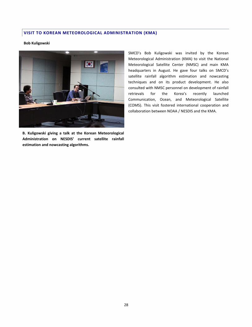
VISIT TO KOREAN METEOROLOGICAL ADMINISTRATION (KMA)
Bob Kuligowski
SMCD’s Bob Kuligowski was invited by the Korean Meteorological Administration (KMA) to visit the National Meteorological Satellite Center (NMSC) and main KMA headquarters in August. He gave four talks on SMCD’s satellite rainfall algorithm estimation and nowcasting techniques and on its product development. He also consulted with NMSC personnel on development of rainfall retrievals for the Korea’s recently launched Communication, Ocean, and Meteorological Satellite (COMS). This visit fostered international cooperation and collaboration between NOAA / NESDIS and the KMA.
B. Kuligowski giving a talk at the Korean Meteorological Administration on NESDIS’ current satellite rainfall estimation and nowcasting algorithms.

29
EDUCATION, OUTREACH AND TRAINING
SMCD is actively engaged in educational and public outreach efforts related to its research and development of satellite products. The Division’s education, training and outreach are rooted in its scientific activities, and are linked to its products. A product example is aviation and convective storms, which is an important contributor to the Virtual Institute for Satellite Integration Training (VISIT).
VIRTUAL INSTITUTE FOR SATELLITE INTEGRATION TRAINING (VISIT)
Ken Pryor
Involvement in the Virtual Institute for Satellite Integration Training (VISIT) program continues with five sessions of the course “Forecasting Convective Downburst Potential Using GOES Sounder Derived Products” presented by Ken Pryor to National Weather Service offices between March and September, 2010. The lesson provides understanding of techniques for predicting the risk of convective downbursts utilizing GOES sounder-derived data. Audio and web-based video versions of the lesson are now available on the Commerce Learning Center/National Weather Service LearnCenter (https://doc.learn.com/) web site and the VISIT student guide page
(http://www.cira.colostate.edu/ramm/visit/downburst.html).
Media relations activities included an interview as part of a documentary production by Canadian Television (CTV). The documentary detailed the events surrounding the sinking of the Canadian sailing vessel (SV) Concordia on February 17, 2010 in the South Atlantic Ocean off the coast of Brazil. During the interview, Ken Pryor provided information pertaining to the conceptual model of a microburst, favorable environmental conditions for microbursts, and the hazards of microbursts to marine transportation. Of special interest was the presentation of satellite imagery that served as evidence of the occurrence of a microburst that resulted in severe winds and capsize and sinking of the Concordia.
GOES microburst product image that shows the location of the sinking of the S.V. Concordia (white cross) and the presence of a microburst-producing thunderstorm off the coast of Brazil.

30
VISITING SCIENTISTS
SMCD’s visiting scientist program plays an integral role in the execution of its activities. The program provides collaborative research opportunities to scientists from institutions of higher education, international organizations, and foreign institutions.
Chen, Ruiyue, Visitor / PostDoc, (University of Maryland)
Chen, Yong, Visitor / PostDoc, (Cooperative Institute for Research in the Atmosphere (CIRA))
Ellicott, Evan, Visiting Scientist, (University of Maryland)
Hale, David, Visiting Scientist, (University Corporation for Atmospheric Research (UCAR))
Jelenak, Aleksandar, Visiting Scientist, (University Corporation for Atmospheric Research (UCAR))
Kim, Min-Jeong, Visitor / PostDoc, (Cooperative Institute for Research in the Atmosphere (CIRA))
Romanov, Peter, Visitor / PostDoc, (Cooperative Institute for Climate and Satellites (CICS))
Wang, KungHwa (Peter), Visiting Scientist, (Cooperative Institute for Climate and Satellites (CICS))
Wu, Rongjun, Visiting Scientist, (Cooperative Institute for Climate and Satellites (CICS))
Zhu, Tong, Visitor / PostDoc, (Cooperative Institute for Research in the Atmosphere (CIRA))
AWARDS AND HONORS
The 62nd annual Department of Commerce Honor Awards ceremony was held in October at the Ronald Reagan Building Amphitheater in Washington, DC. Three SMCD scientists (Shobha Kondragunta, Changyong Cao, Mitch Goldberg) received Gold Medals honoring their work. Gold medals are the highest forms of recognition that can be awarded by the Department of Commerce. They are granted by the Secretary, for rare and distinguished contributions of major significance to the Department, the nation, or the world. Secretary of Commerce Gary Locke addressed the assembly, and praised the work of the award winners.

31
GOLD MEDAL FOR SCIENTIFIC / ENGINEERING ACHIEVEMENT
Dr. Shobha Kondragunta was recognized for her contributions to NOAA's air quality program through the suite of new products she developed from NOAA satellites. These products include atmospheric smoke concentration, burned area, biomass fuel load, trace gas and aerosol biomass burning emissions, and nitrogen dioxide. Her collaborations with other agencies have led to the application of these products in various air quality decision support systems at EPA and the National Weather Service.
GOLD MEDAL FOR LEADERSHIP
• Mary E. Kicza
• W. Stan Wilson
• D. Brent Smith
• Linda V. Moodie
• Kerry A. Sawyer
• Mitchell D. Goldberg
• Changyong Cao
• Kenneth R. McDonald
The group was recognized for mobilizing space agencies worldwide to achieve demonstrated results in implementing the Global Earth Observation System of Systems (GEOSS) of the intergovernmental Group on
Earth Observations (GEO). NOAA leadership secured concrete commitments -- the first ever -- from heads of over 20 space agencies to address gaps in observation for priority societal needs. Such needs included the global monitoring of greenhouse gases from space and forest carbon tracking as identified by GEO, the Group of Eight Industrialized Nations, and the United Nations Framework Convention on Climate Change.
Changyong Cao, second from left; Mitch Goldberg, 4th from left.
Shobha Kondragunta, middle

32
BRONZE MEDAL
A Bronze Medal recognizes superior performance characterized by outstanding or significant contributions, which have increased NOAA's efficiency and effectiveness. Bronze Medals are awarded to individuals, groups (or teams), and organizations. The Bronze Medal is the highest honorary award granted by the NOAA Administrator. Dr. Istvan Laszlo was among the STAR employees awarded a bronze medal for his contributions towards the development of an enhanced production system for satellite-based real-time radiation data from NOAA's operational geostationary satellites.
ADMINISTRATOR’S AWARDS
On October 28, Mitch Goldberg was honored with a 2010 Administrator's Award "FOR ORGANIZING AND LEADING AN INTERNATIONAL PROGRAM TO ENSURE THE ACCURACY AND COMPARABILITY OF MEASUREMENTS FROM EARTH OBSERVING SATELLITES." The Administrator's Award recognizes significant contributions to NOAA programs in equal employment opportunity, diversity, scientific research, public service, engineering development, environmental conservation, policy development, administrative support, public affairs, and information systems. The Global Space-based Intercalibration System (GSICS) has been worked on by Mitch and his team for several years now.

33
JOURNAL ARTICLES
OCTOBER
Cao, C., E. Vermote, and X. Xiong, 2009: Using AVHRR lunar observations for NDVI long-term climate change detection. J. Geophys. Res., 114, D20105, doi:10.1029/2009JD012179.
Gao, S., and X. Li, 2009: Dependence of the accuracy of precipitation and cloud simulation on time and spatial scales. Adv. Atmos. Sci., 26, 1108-1114.
Maddy, E.S., C.D. Barnet and A. Gambacorta, 2009: A computationally efficient retrieval algorithm for hyperspectral sounders incorporating a priori information. IEEE Geosci. Remote Sens. Letters v.6, p. 802-806.
Neil, D., S. Kondragunta, G. Osterman, K. Pickering, R. Pinder, A. Prados, J.J. Szykman, 2009: Satellite observations for detecting and tracking changes in atmospheric composition. Environment Manager, 2009.
Wu, A., X. Xiong, C. Cao, 2009: Tracking the calibration stability and consistency of the 3.7, 11.0 and 12.0 ?m channels of the NOAA-KLM AVHRR with MODIS. International Journal of Remote Sensing, 1366-5901, Volume 30, Issue 22, pages 5901-5917.
Yue, C., S. Shou, and X. Li, 2009: Water vapor, cloud, surface rainfall, and heat budgets associated with the landfill of Typhoon Krosa (2007): A cloud-resolving modeling study. Adv. Atmos. Sci., 26, 1198-1208.
DECEMBER
Behrangi, A., K-L. Hsu, B. Imam, S. Sorooshian, G.J. Huffman, and R.J. Kuligowski, 2009: PERSIANN-MSA: A precipitation estimation method from satellite-based multispectral analysis. Journal of Hydrometeorology, 10(6), 1414-1429.
Li, X., 2009: Dominant physical processes associated with phase differences between surface rainfall and convective available potential energy, J. Tropical Meteor., 15, 148-154.
Pittman, J.V., L.L. Pan, J.C. Wei, F.W. Irion, X. Liu, E.S. Maddy, C.D. Barnet, K. Chance and Ra Gao, 2009: Evaluation of AIRS, IASI, and OMI ozone profile retrievals in the extratropical tropopause region using in situ aircraft measurements. J. Geophys. Res. v.114 D24109 doi:10.1029/2009JD12493, 10 pgs.
JANUARY
Gao, S., and X. Li, 2010: Effects of time-dependent large-scale forcing, solar zenith angle, and sea surface temperature on time-mean tropical rainfall processes, Meteor. Atmos. Phys., 106, 95-105.
Wang, D., X. Li, and W.-K. Tao, 2010: Responses of vertical structure in convective and stratiform regions to large-scale forcing during the landfall of severe tropical storms bilis (2006): Adv. Atmos. Sci., 27, 33-46.
FEBRUARY
Li, X., and X. Shen, 2010: Sensitivity of cloud-resolving precipitation simulations to uncertainty of vertical structures of initial conditions. Quart. J. Roy. Meteor. Soc., 136, 201-212.
Ping, F., Z. Luo, and X. Li, 2010: Effects of ice microphysics on a tropical coupling system. Dyn. Atmos. Ocean, 49, 83-95.

34
Xu, Qing, Hui Lin, Xiaofeng Li, Juncheng Zuo, Quanan Zheng, William Pichel, Liu Yuguang, 2010: Assessment of an analytical model for sea surface wind speed retrieval from spaceborne SAR, International Journal or Remote Sensing, 31:4, 993-1008.
APRIL
Meng, Z., P. Yang, G.,W. Kattawar, L. Bi, K.N. Liou, I. Laszlo, 2010: Single-scattering properties of tri-axial ellipsoidal mineral dust aerosols: A database for application to radiative transfer calculations, Journal of Aerosol Science, 41 (2010) 501-512.
Mo, T., 2010: Postlaunch Calibration of the NOAA-19 Advanced Microwave Sounding Unit-A, J. Geophys. Res., 115, DO8111, doi:10.1029/2009JD013177.
Xiong, X., C. Cao, G. Chander, 2010: An overview of sensor calibration inter-comparison and applications, Frontiers of Earth Science in China, 2010, 4(2): 237-252, DOI 10.1007/s11707-010-0002-z.
MAY
Gao, S., and X. Li, 2010: Precipitation equations and their applications to the analysis of diurnal variation of tropical oceanic rainfall. J. Geophsy. Res., 115, D8204, doi:10.1029/2009JD012452.
Holm, T., K. Gallo, and G.B. Bailey, 2010: The CEOS-Land Surface Imaging Constellation Portal for GEOSS: A resource for land surface imaging system information and data access. Earthzine, online publication of IEEE.
Yue, C., W. Lu, and X. Li, 2010: A study of the impacts of latent heat parameterization scheme on prediction skill of ENSO with a simple ocean-atmosphere coupled model. J. Tropical Meteor., 16, 10-19.
JUNE
Jiang, L., F. Kogan, W. Guo, D. Tarpley, K. Mitchell, M. Ek, Y. Tian, W. Zheng, C. Zou, and B. Ramsay, 2010: Real time weekly global green vegetation fraction derived from advanced very high resolution radiometer-based NOAA operational global vegetation index (GVI) system, Journal of Geophysical Research, 115, (D11114), pp. 22.
Mo, T., 2010: A Study of the NOAA Near-Nadir AMSU-A Brightness Temperatures over Antarctica, J. Atmospheric and Oceanic Technology, 27, 995-1004, doi:10.1175/2010JTECHA1317.1.
Rhaman, A., N. Krakauer, L. Roytman, M. Goldberg, and F. Kogan, 2010: Modeling and Prediction of malaria vector distribution in Bangladesh from remote sensing data. Am. J. Trop. Hyg., 82(6), pp. 1004-1009.
Wang, Y., X. Shen, and X. Li, 2010: Microphysical and radiative effects of ice clouds on responses of rainfall to the large-scale forcing during pre-summer heavy rainfall over Southern China, Atmos. Res., 97, 35-46.
Zhang, X., M. Goldberg, D. Tarpley, M. Friedi, J. Mosisette, F. Kogan, Y. Yu, 2010: Drought-induced Vegetation Reduction in Southwestern North America, Environ. Res. Lett. ERL, Vol. 5, No. 2
JULY
Shen, X., Y. Wang, N. Zhang, and X. Li, 2010: Roles of large--scale forcing, thermodynamics, and cloud microphysics in tropical precipitation processes. Atmos. Res., 97, 371-384.
35
AUGUST
Kleespies, T., 2010: Re-Characterization of the Microwave Sounding Unit Cross-track Asymmetry During a Spacecraft Tumble, IEEE Geoscience Remote Sensing Letters.
Lee, Thomas F., Craig S. Nelson, Patrick Dills, Lars PeterRiishojgaard, Andy Jones, Le Li, Steven Miller, Lawrence E. Flynn, Gary Jedlovec, William McCarty, Carl Hoffman and Gary Williams, 2010: NPOESS: Next Generation Operational Global Earth Observations. Bulleting of the Amer. Met. Soc., June 2010, Vol. 91, DOI:10.1175/2009BAMS2953.1.
SEPTEMBER
Changyong Cao, Sirish Uprety, Jack Xiong, Aisheng Wu, Ping Jing, David Smith, Gyanesh Chander, Nigel Fox, and Stephen Ungar, 2010: Establishing the Antarctic Dome C Community Reference Standard Site towards Consistent Measurements from Earth Observation Satellites, Canadian Journal of Remote Sensing
Xiong, X., C.D. Barnet, Q. Zhuang, T. Machida, C. Sweeney, P.K. Patra. 2010: Mid-upper Tropospheric Methane in the High Northern Hemisphere: Space-borne Observations by AIRS, Aircraft Measurements and Model Simulations. J. Geophys. Res.
CONFERENCE PAPERS AND NON-PEER-REVIEWED ARTICLES
OCTOBER
Han, Y., Operational Ocean Microwave Emissivity Models, Operational Ocean Microwave Radiometer and Remote Sensing of the Environment, Washington, DC
Kleespies, T., Sub-Field-of-View- Radiative Transfer for the Advanced Technology Microwave Sounder, MICRORAD 2010
NOVEMBER
Kondragunta, S., Climate Change, GIS, Natural Hazards, Association of American Geographer Annual Meeting
Kuligowski, R., Satellite Rainfall Information for Flood Preparedness and Response, Advanced Research Workshop, Ukraine
DECEMBER
Cao, C., A Comparison of the Antarctic Dome C and Sonoran Desert Sites for the Cal/Val of Visible and Near-Infrared Radiometers, SPIE Conference on Optics and Photonics 2010
Goldberg, M., Monitoring Fall Foliage Dynamics Using Time Series of Satellite Data, 2010 US-IALE
Kleespies, T., Modeling of Inhomogenous Surface Properties for the Advanced Technology Microwave Sounder, 17th Int'l. TOVS Study Conference
Kleespies, T., Sub-Field-of-View Radiative Transfer for the Advanced Technology Microwave Sounder, 6th Annual Symposium on Future National Operational Environmental Satellite Systems-NPOESS and GOES-R
Kleespies, T., Footprint Matching for the Advanced Technology Microwave, 17th International TOVS Study Conference

36
Kondragunta, S., Global Biomass Emissions Products from a Constellation of Geostationary Satellites, IGARSS 2010
Weng, F., Comparing the forecast impacts from assimilating SSMIS and AMSU data in NCEP GFS, IGARSS 2010
Wu, F., Vicarious calibration of GOES Visible Channel, IGARSS 2010
JANUARY
Weng, F., and M. Goldberg, Assimilation of MSG-2 SEVIRI data in NCEP Global Forecast System, 2010 EUMETSAT Met Sat Conference
Weng, F., Development of Climate Data Records from Special Sensor Microwave Imager, 2010 EUMETSAT Met Sat Conference
Wu, X., Extended Inter-comparison of collocated MetOp-A AVHRR-IASI Brightness Temp Data, SPIE Conference on Optics and Photonics 2010
Wu, X., In-Orbit Health and Performance of Operational AVHRR Instruments, SPIE Conference on Optics and Photonics 2010
Wu, X., M. Goldberg, and F. Weng, Evaluation of GOES Imager and Sounder Infrared Channels Calibration Accuracy using GSICS, 2010 EUMETSAT Met Sat Conference
Wu, X., T. Schmit, and D. Hillger, GOES-14, 2010 EUMETSAT Met Sat Conference
Yu, X., and M. Goldberg, Developing Land Surface Products for the US GOES-R Mission, 2010 EUMETSAT Met Sat Conference
Yu, X., Validating Satellite Land Surface Temp Product using Ground Tower Data, 3rd Conference of Recent Advantages in Quantitative Remote Sensing
FEBRUARY
Weng, F., Update of the JCSDA Community Radiative Transfer Model, 17th International TOVS Study Conference
Zhan, X., and M. Goldberg, NOAA-NESDIS Global Soil Moisture Product System, AGU Western Pacific Geophysics Meeting
MARCH
Csiszar, I., A 10-year Record of Fire Emissions in South American Derived from sat-based Fire Occurrence Data, AGU Meeting of the Americas
Gallo, K., Severe Storm Assessment Using Satellite Data: Case Studies from Iowa in 2009
APRIL
Cao, C., and X. Wu, A radiometic model to improve the AVHRR infrared channel calibration, Calcon 2010
Flynn, L., Application of Limb Remote Sensing Retrieval Products, AGU Brazil 2010
Goldberg, M., The generation of time series vegetative NDVI trajectory and long-term phenological trends from AVHRR data, Phenology 2010 Conference
37
Laszlo, I., Using CERES in developing shortwave radiation budget algorithms from ABI on GOES-R, 13th CERES Science Team Meeting
MAY
Kleespies, T., Footprint Matching for the Advanced Technology Microwave Sounder, 17th Conference on Sat Met and Ocean
JUNE
Cao, C., and L. Miller, Monitoring the Jason 2/AMR Stability using SNO Observations from MetOp/AMSU, Ocean Surface Topography Team Meeting
Cao, C., Spectral Comparison of the Dunhuang and Dome C sites using Hyperspectral Measurements, SPIE, Korea
Goldberg, M., Assessment of a technique for estimation of outgoing longwave radiation from the atmospheric infrared sounder radiance observations, IGARSS 2010
Kleespies, T., Footprint Matching for the Advanced Tech Microwave Sounder, 2010 EUMETSAT Met Sat Conference
Kleespies, T., Modeling of Inhomogenous Surface Properties for the Advanced Technology Microwave Sounder, 2010 EUMETSAT Met Sat Conference
Weng, F., and M. Goldberg, Uses of GPS/RO Data in the WMO Global Space-based Inter-calibration System, OPAC 2010 Workshop
JULY
Cao, C., Results from a prototype for the GOES particle Intersensor Toolkit, AMS Annual Meeting
Yu, Y., M. Goldberg, and I. Csiszar, Land surface product development for GOES-R satellite mission, AMS Annual Meeting
Yu, Y., M. Goldberg, and I. Csiszar, Land surface product development for US GOES-R satellite mission, Land Surface Analysis Workshop
AUGUST
Cao, C., and M. Goldberg, Ensuring the SI Traceability of Sat Measurements, AMS Annual Meeting
Csiszar, I., Evolution of active fire capabilities from the US geostationary and polar orbiting sat series, ISRSE Meeting
Ferraro, R, S., Boukabara, R., Kuligowski, Meng, T., Smith, and F., Weng, The Status of NOAA/NESDIS Precipitation Algorithms and Products, International Precipitation Working Group, Hamburg, Germany
Goldberg, M., F. Weng, and X. Wu, The Global Space-based Intercalibration System, 7th Annual symposium on Future National Ops Environmental Satellite Systems
Goldberg, M., J. Daniels, W. Wolf, and L. Rokke, GOES-R Algorithm Working Group, 7th Annual symposium on Future National Ops Environmental Sat Systems

38
Han, Y., and F. Weng, Recent Improvements to the Community Radiative Transfer Model, 7th Annual symposium on Future National Ops Environmental Sat Systems
Weng, F., and M. Goldberg, Use of COSMIC data to cross-calibrate AMSU-A, AMS Annual Meeting
Weng, F., Preliminary Demo of Thematic Climate Data Records, AMS Annual Meeting
SEPTEMBER
Kondragunta, S., Long-term biomass burning emissions inventory from GOES Satellites, 2010 Fall AGU Meeting
Kondragunta, S., Near real-time monitoring of global biomass burning emissions from multiple geostationary instruments, 2010 Fall AGU Meeting
TECHNICAL REPORTS
JULY
Yu, Y., D. Tarpley, H. Xu, M. Chen, GOES-R Advanced Baseline (ABI) Algorithm Theoretical Basis Document for Land Surface Temperature, Version 3.0 (100% readiness).
Xu, H., P. Romanov, Y. Yu, D. Tarpley, GOES-R Advanced Baseline Imager (ABI) Algorithm Theoretical Basis Document for Vegetation Index, Version 3.0 (100% readiness).
Schmidt, C., J. Hoffman, E. Prins, S. Lindstrom, GOES-R Advanced Baseline Imager (ABI) Algorithm Theoretical Basis Document for Fire/Hot Spot Characterization, Version 3.0 (100 readiness).
Sun, D., R. Zhang, S. Li, Y. Yu, GOES-R Advanced Baseline Imager (ABI) Algorithm Theoretical Basis Document for Flood/Standing Water, Version 2.0 (80% readiness).
Liang, S., D. Wang, T. He, Y. Yu, GOES-R Advanced Baseline Imager (ABI) Algorithm Theoretical Basis Document for Surface Albedo, Version 2.0 (80% readiness).
Romanov, P., Y. Tian, Y. Yu, D. Tarpley, GOES-R Advanced Baseline Imager (ABI) Algorithm Theoretical Basis Document for Green Vegetation Fraction, Version 2.0 (80% readiness).
AUGUST
Shobha Kondragunta (1st Author): ABI Aerosol Detection Product (100% readiness)
Bob Kuligowski (1st Author): ABI Rainfall Rate (100% readiness)
Bob Kuligowski (1st Author): ABI Probability of Rainfall (80% readiness)
Bob Kuligowski (1st Author): ABI Rainfall Potential (80% readiness)
SEPTEMBER
I. Laszlo (second author): ABI Downward Longwave Radiation (DLR) – 100%
I. Laszlo (second author): ABI Upward Longwave Radiation: TOA– 100%
39
I. Laszlo (second author): ABI Upward Longwave Radiation: (ULR): Surface – 100%
I. Laszlo (first author): ABI Suspended Matter/Aerosol Optical Depth and Aerosol Size Parameter – 100%
I. Laszlo (first author): ABI Downward Shortwave Radiation (Surface), and Reflected Shortwave Radiation (TOA) – 100%
J. Daniels (first author): ABI Derived Motion Winds – 100%
J. Daniels (third author): ABI Hurricane Intensity – 100%
I. Laszlo (first author): ABI Absorbed Shortwave Radiation (Surface) – 80%
I. Laszlo (second author): ABI Downward Longwave Radiation (DLR): Surface – 80%
I. Laszlo (second author): ABI Upward Longwave Radiation: TOA – 80%
I. Laszlo (second author): ABI Upward Longwave Radiation (ULR): Surface – 80%