societal benefit area or transverse area - earth … · web viewidentify key leaders of relevant...
TRANSCRIPT
GEO 2007 Work Plan April 2007Ecosystems Task EC-06-07
Task Number Regional Networks for EcosystemsEC-06-07 Build upon existing initiatives (e.g. ANTARES in South America and IOC-
sponsored regional networks for oceans; GOFC-GOLD regional networks and ILTER for terrestrial domains) to develop a global network of organization-networks for ecosystems, and coordinate activities to strengthen observing capacity in developing countries.
AreaEcosystemsRelevant CommitteeCBC
Description of the Work to be Performed
1. Begin the process of building a network of networks for GEOSS by building on an existing initiative in South America (Antares). The goal is to set a model for international sharing of resources to promote marine ecosystem observations within GEO.
2. Identify key leaders of relevant networks (e.g., the International LTER Network, Terrestrial Ecosystem Monitoring Sites (TEMS), the LOICZ network, the GOOS Regional Alliances, Antares, and ODIN Africa), establish a Steering Committee and convene a workshop to identify common concerns and objectives that will contribute to the development of GEOSS.
3. Initiate development of a website that links qualified networks of organizations having active research and monitoring programs on terrestrial, freshwater, estuarine and marine ecosystems.
4. Initiate collaboration between Antares and GOOS Africa/ODIN-Africa through a jointly agreed upon capacity building pilot project; the collaboration must also engage GOOS Regional Alliances and national GOOS programs active in South America and Africa as well as ecosystem networks active in their regions.
5. Plan regional networks and coordinate workshops to strengthen observations of ecological variables on land in remote and developing country regions.
6. Develop, on a global basis, standardized and integrated methodologies, observations and products that allow the repeated mapping of forest and land ecosystem extent and the quantification of ecosystem condition.
Output & Deliverables
Establishment of a network of networks for aquatic ecosystem observations
Contribution of data to appropriate international data centers
Establishment and maintenance of web sites for Antares and the network of networks
Development and use (for education and management) of quantitative indicators of ecosystem condition
Calendar (incl. milestones)
Activities to be span over 2006 and 2007
Financial Contributions (from GEO Operations Budget)
CHF 50.000
Current Status
May 2008:
Brief report on ChloroGIN distributed meeting at IOCCG13, Paris 14th (February 2008) at SAFARI, Halifax, 26 March 2008
Many of the active members of ChloroGIN availed of their presence at two different meetings (one the IOCCG meeting in Paris in February 2008 and the other the SAFARI meeting in Halifax, Canada in March 2008) to meet in person to discuss ChloroGIN progress and to discuss plans for the future.
GEO 2007 Work Plan April 2007Ecosystems Task EC-06-07
Present:
Trevor Platt (in Paris and Halifax)
Shubha Sathyendranath (in Paris and Halifax)
Steve Groom (in Paris and Halifax)
John Field (in Halifax)
RM Dwivedi (standing in for K. Srinivas, in Halifax)
Kanthi Yapa (in Halifax)
Vivian Lutz (in Halifax)
Nick Hoepffner (in Paris and Halifax)
Nick Hardman-Mountford (in Halifax)
Chuanmin Hu (standing in for Frank Mueller-Karger, in Halifax)
Stewart Bernard (in Paris)
Paul di Giacamo (in Paris)
Joji Izhizaka (in Paris)
Mark Dowell (in Paris)
items discussed:
Structure
The group requested Trevor Platt and John Field to stay on as co-chairs of ChloroGIN, and they agreed. Formation of a steering committee was recommended, with representation from each node/partner (1 member + alternate for each)
The following names were suggested:
Africa: Bernard, Field
Indian Ocean: Srinivas
Far East: Ishizaka
Antares: Kampel, Lutz
JRC: Hoepffner, Dowell
PML: Groom, Hardman-Mountford
USF: Hu
POGO: Sathyendranath
IOCCG: Platt, Yoder/Stuart
GOOS GSSC/PICO: Paul diGiacommo, Neville Sweijd
The following additional recommendations were made:
Recommendation 1: That steering group should meet minimum once annually.

GEO 2007 Work Plan April 2007Ecosystems Task EC-06-07
Recommendation 2: Network membership should include a commitment to providing manpower/logistics for monthly time-series sampling using ChloroGIN protocols as a minimum requirement.
Network Extension:
Addition of a Far East node including efforts of Japan, Korea and China was recommended with Joji Ishizaka as the initial contact.
Possible links with freshwater networks (yet to be established) are being discussed, under a common theme of water quality. (Contact Steve Greb).
Other potential additions were discussed.
Links to other GEO Tasks:
ChloroGIN related activities are part of the European project DevCoCast, which is designed as a demonstration project for GEO NetCast.
ChloroGIN had a strong presence at the first meeting of SAFARI (AG-06-02) which was held in Halifax in March 2008, and the links between the two will be further developed in the future.
ChloroGIN web portal:
New web portal chlorogin.org portal including links to all nodes of ChloroGIN is being developed on a voluntary basis by Steve Groom (PML).
Infrastructure Development:
In situ
The group discussed various improvements and consolidation of efforts on the in situ side, as well as ways to improve the data access through web.
Satellite
The participants also agreed to revisit protocols for clarity & completion.
Funding
Funding remains an issue for future plans, which include a full meeting of ChloroGIN and regional demonstration projects designed to highlight societal benefits of ChloroGIN. Participants agreed to explore various funding sources.
January 2008
ChloroGIN and the GEO Ministerial, November 2007, Cape Town
After discussion at the 7th Framework DevCoCast planning sessions, it was felt that there would be considerable benefit to mounting a ChloroGIN exhibit at the GEO Ministerial. Using Benguela Current Large Marine Ecosystem, POGO, South African Council for Scientific and Industrial Research, and JRC funding, an exhibit was constructed as part of the Oceans United collaborative by the South African Marine Remote Sensing Unit (MRSU). The exhibit consisted of two 3 x 2 m curved posters; two large plasma screens demonstrating various ChloroGIN web-sites and the IOCCG Ocean Colour film (courtesy Roland

GEO 2007 Work Plan April 2007Ecosystems Task EC-06-07
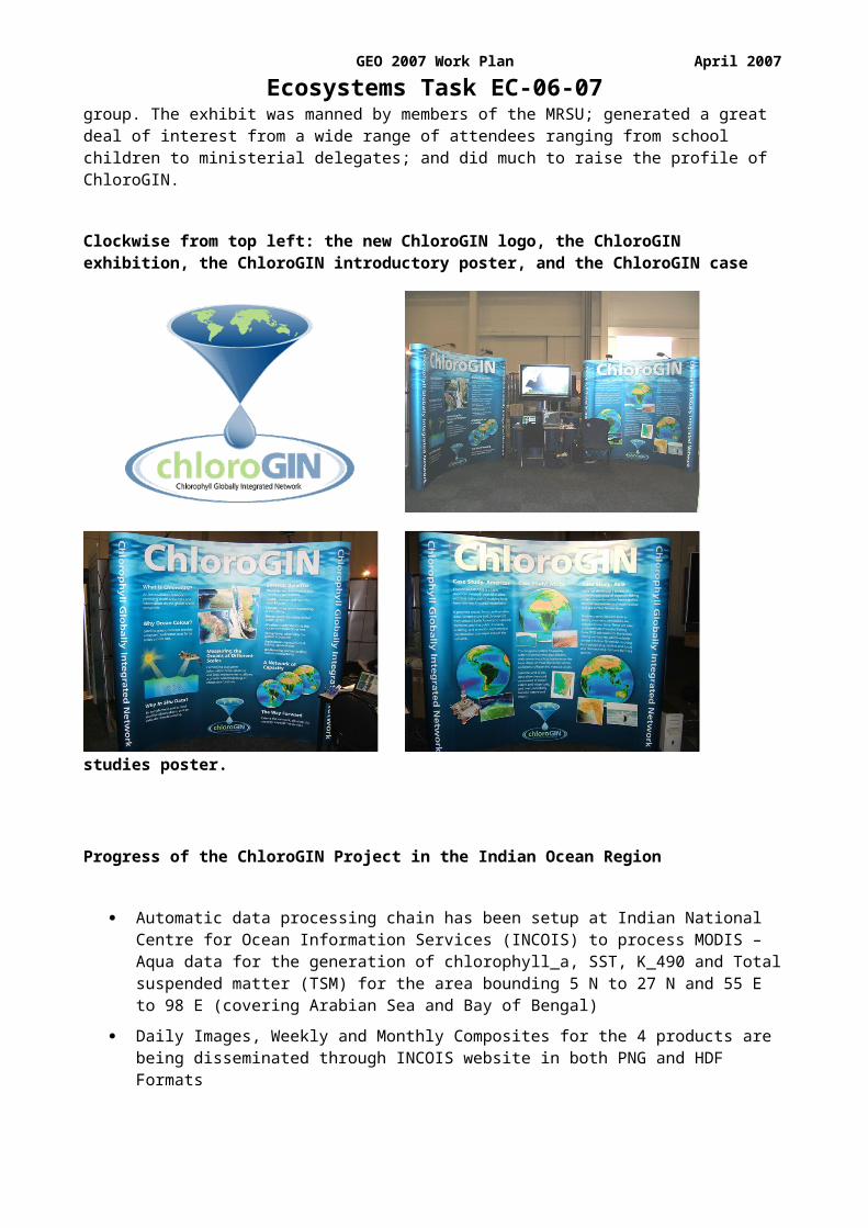
Doerffer); supported by pamphlets to distribute. As part of the poster design process, the new ChloroGIN logo was also designed, with much consultation amongst the group. The exhibit was manned by members of the MRSU; generated a great deal of interest from a wide range of attendees ranging from school children to ministerial delegates; and did much to raise the profile of ChloroGIN.
Clockwise from top left: the new ChloroGIN logo, the ChloroGIN exhibition, the ChloroGIN introductory poster, and the ChloroGIN case studies poster.
Progress of the ChloroGIN Project in the Indian Ocean Region
Automatic data processing chain has been setup at Indian National Centre for Ocean Information Services (INCOIS) to process MODIS – Aqua data for the generation of chlorophyll_a, SST, K_490 and Total suspended matter (TSM) for the area bounding 5 N to 27 N and 55 E to 98 E (covering Arabian Sea and Bay of Bengal)
Daily Images, Weekly and Monthly Composites for the 4 products are being disseminated through INCOIS website in both PNG and HDF Formats
Eight Time-series stations have been established in coastal waters off Goa, Mangalore, Kochi, Pondicherry Coast, Parangipettai Coast, Nagapattinam Coast, Vishakapatnam and Machlipatnam coast to make monthly measurements of chlorophyll, SST, TSM as well as the bio-optical properties using profiling radiometers.
A presentation was made on the ChloroGIN Project during the recently concluded IOGOOS Annual Meeting held at Phuket during November 30 – December 03, 2007. IOGOOS Members endorsed the ChloroGIN Project and requested IOGOOS Secretariat/INCOIS to provide real-time Satellite Products (Chlorophyll, SST, Kd-490 and Suspended Sediments) for the coastal regions of the following countries:
GEO 2007 Work Plan April 2007Ecosystems Task EC-06-07
Tanzania
Iran
Kenya
Sri Lanka
Maldives
Oman
Thailand
INCOIS is in the process of providing MODIS Data products for the above Regions.
Link to GEOnetCast
ChloroGIN has been selected as once of the demonstration projects inDevCoCast, a proposal to the European Commission currently under negotiation with a kick-off date expected in early/mid March. DevCoCast will utilise the GEONETCast concept to provide satellite data on chlorophyll-a and other ocean colour and SST products from a variety of sensors including SeaWiFS, MODIS, AVHRR and MERIS by regional dataproviders (PML, JRC, MARE) to countries in Africa (Namibia, Tanzania, Ghana and Senegal) and South America (Brazil). GEONETCast(http://www.earthobservations.org/geonetcast.shtml) is a GEO sponsored concept to distribute global environmental data to and from developing countries at low cost (or no cost) using satellite based Digital Video Broadcast technology. It is hoped, as DevCoCast is shown to be successful, that additional partners will join the team. It alsoexpected that additional products will be provided.
Further Plans
An ad-hoc ChloroGIN planning meeting will take place in Paris on 13-14 January 2008, taking advantage of the presence of many active members of ChloroGIN in Paris at that time for the IOCCG meeting. A second ad hoc meeting is planned in Halifax on 26-28 March, again taking advantage of the SAFARI meeting. These meetings will be used to discuss further plans for development of ChloroGIN.
29 Aug. 2007:
(a) The samples collected during the Plymouth meeting in 2006 were sent to participating organisations. The results of the analyses from the various laboratories were pooled and an intercomparison report has been prepared and submitted to GEO.
The full report is available at the GEO web site: ftp://ftp.wmo.int/Projects/GEO/TaskSheets/2007-09/EC-06-07
(b) An exhibition of ChloroGIN (chlorophyll Global Integrated Network, which is the name assigned to the Extended Antares Network) is being prepared for the GEO ministerial meeting in Africa in Nov. 2007.
(c) EC-JRC is organizing an Ocean Colour Training Course 2007 Africa (24 Sept.-5 Oct., Mombasa, Kenya). The main objectives of the course are (a) to provide theoretical basis of satellite Ocean Colour measurements; and to promote applications of OC radiometry in Africa for monitoring and managing coastal zones and for protecting marine ecosystems and resources. The training course is supported by GEO and IOCCG.
16 Feb 07: An interim report (GEO-GOOS_Interim_Report_ChloroGIN-160207.pdf) of the Plymouth Chlorophyll Meeting and Workshops (Extended Antares Network), Plymouth, 18-22 Sep 2006 has been
GEO 2007 Work Plan April 2007Ecosystems Task EC-06-07
drafted and is included from the GEO FTP site (ftp://ftp.wmo.int/Projects/GEO/TaskSheets/2007-09/EC-06-07/).
The executive summary of the report and its recommendations is reproduced below.
Executive SummaryThe meeting consisted of three components: 1) a plenary planning meeting, 2) a satellite remote sensing technical workshop and 3) an in situ observations technical and inter-comparison workshop. The 44 participants represented Latin America, Southern and East Africa, India, China, Thailand, the Joint Research Centre of the European Commission, and the sponsors: the Plymouth Marine Laboratory, GOOS, GEO and POGO. Over 90% of the participants were under 50 years old and more than half under 40. Most had been previously trained under the auspices of the IOCCG and POGO. The aim of the project is to deliver products, namely maps of ocean chlorophyll and sea surface temperature, as indicators of the state of the ecosystem needed for ecosystem and fisheries management, and at some sites, a measure of light penetration into the ocean, which is needed, along with the other two variables, to calculate plankton primary production. These are three of the core variables recommended for the Global Coastal Network listed in the GOOS Coastal Panel strategic plan. The value of decades-long time series is illustrated by two case studies relating fish catch fluctuations to inter-annual ocean chlorophyll variations in a spatial context. The meeting and workshops were outstanding successes, resulting in many technical recommendations given in the full report. Amongst the most important general recommendations are: The project should have three initial principal regional centres, in Latin America, southern Africa, and India linked by good communications to three northern centres in UK, the European Commission, and USA. During the first five-year phase, map products would be regularly updated on a web site at each centre, while the infrastructure is improved and personnel trained at new centres. During the second five-year phase, the existing centres would become fully operational with a range of products suited to local needs, and new centres developed. Several case studies of existing uses for remotely-sensed ocean chlorophyll products are given in the full report: 1) Monthly State of Environment Reports for fisheries management (Namibia), 2) Maps of Ocean Chlorophyll around Latin America (Antares Network), 3) Short-term forecasts of harmful algal blooms for fisheries (BCLME programme, South Africa), 4) Directing research vessels to dynamic ocean phenomena for process studies (Plymouth Marine Laboratory, UK), and 5) Fuel-saving by directing fishing vessels to ocean fronts and convergences (India). The meeting concluded that there is enormous synergy to be gained from linking national and regional centres together to form an integrated network including both satellite and in situ observations, and suited to local needs.
Principal recommendations:1) That the network linking participating centres around the world, named Chlorophyll Ocean
Globally Integrated Network, or ChloroGIN, be implemented with immediate effect, linking existing national and regional centres;
2) That the appropriate bodies ensure that continuity of satellite ocean colour sensors is achieved to provide inter-calibrated long time series of surface ocean chlorophyll and SST;
3) That in situ time-series of surface and sub-surface observations be made at each regional centre to support the satellite measurements by integration/combination in a manner that suits local societal and scientific needs;
4) That the need for homogeneity/compatibility of protocols (e.g. for match-ups), procedures and analysis tools/practises be recognised and that members of the network move towards common protocols;
5) That physical infrastructure (such as the connection between networks and receiving stations, data distribution, materials required to adopt best practice protocols for in situ measurements) and human capacity be developed in existing and new centres to expand the network in two five-year phases;

GEO 2007 Work Plan April 2007Ecosystems Task EC-06-07
6) That communications bandwidth be improved in most developing countries, as this limits the delivery of ocean chlorophyll and related products and is more important than satellite ground receiving stations;
7) That funding be sought for development of the ChloroGIN Network from national bodies, the Large Marine Ecosystem programmes, and other sources.
26 Sept 06: The first meeting of the extended Antares network took place on 18-22 Sept at the Plymouth Marine Laboratory, UK, with co-sponsorship from GEO and GOOS. POGO took the lead in organising the meeting, which was chaired by Dr. Trevor Platt and Prof. John Field. The meeting was also supported by IOCCG.
The meeting brought together some 40 participants from all over the world, interested in chlorophyll measurements by in situ techniques and by satellite techniques. The group met in plenary at the beginning and at the end of the meeting. In between, during parallel sessions, the in situ and remote sensing groups explored ways to coordinate their activities better. The in situ measurements group also carried out lab experiments using field samples to evaluate relative merits of different techniques for estimation of chlorophyll concentration, and came up with an effective, simple method that could be shared by all members of the network. During the plenary, the participants decided to integrate in situ and satellite observations into a single network of networks.
A detailed report of the meeting is being prepared, including a proposal for a Global Integrated Network for chlorophyll monitoring, with recommendations for its operation and suggested ancillary measurements.
Jun 06: The task as conceived envisaged the extension and expansion of the South American network Antares, which was set up on a very modest scale for observations of the marine ecosystem in the coastal waters around South America (web address: www.Antares.ws). The network encompasses in situ time series stations around South America, coupled with time series of satellite data covering South American coastal waters. Antares emerged from capacity building activities undertaken by IOCCG and POGO in South America. The emphasis of Antares is on bio-optical methods for characterising phytoplankton dynamics and primary productivity in the ocean. Under EC-06-07, it was proposed to strengthen Antares; to establish Antares-like networks in other regions (with priority for developing countries); and finally to network regional networks.
This project found synergy with the GOOS Chl Pilot Study, in which it was planned to establish a series of long-term observatories for monitoring phytoplankton dynamics through in situ and remote-sensing techniques.
With GOOS sponsorship, POGO organised a pre-planning meeting of the Chlorophyll Pilot Study immediately following the POGO meeting in Hyderabad, India in January 2006. IOCCG also played an important role at this meeting. This meeting established that there was interest and technical know-how in Asian and African countries that would allow extension of Antares to Africa and Asia. Report of the Hyderabad meeting is available on the POGO web site, at:
http://www.ocean-partners.org/documents/GOOS_ChlPilotMtgReport.pdf
The Hyderabad meeting recommended that the next step in the work should be a full-fledged coordination meeting of the proposed, extended Antares network/ Chl Pilot Study, with a view to (a) intercomparison of techniques for operational in situ measurements of the major phytoplankton pigment, chlorophyll-a; (b) standardisation of ocean-colour satellite processing for chlorophyll retrieval at all participating centres; and (c) plan future activities. Plymouth Marine Laboratories offered to host the meeting. GEO and GOOS were then approached for funding support for the proposed meeting.
Subsequently, Shubha Sathyendranath reported on these developments at the Paris meeting of the GEO Capacity Building Committee in March, and requested funding support from GEO for the Plymouth meeting. The committee deliberated on the advisability of extending Antares to other initiatives. In fact, this synergy has been achieved for the marine component, with the Antares initiative now being linked to the GOOS chl pilot study initiative and to the IGOS-P coastal theme. On the other hand, linking the marine initiative with terrestrial ecosystem observations immediately would present some problems: Since the next step envisaged by the marine community is a workshop to promote standardised protocols for in situ

GEO 2007 Work Plan April 2007Ecosystems Task EC-06-07
observations and satellite data processing, coupling this with the terrestrial component would be difficult, since terrestrial and coastal ecosystems have different observational techniques for in situ observations; use different satellite systems and have different dynamics and problems to deal with.
After due consideration of the issues involved, it was recommended that Doug Muchoney work with terrestrial groups to develop the terrestrial component in FY06. He is pursuing putting together a group who would explore/attempt the EC-07 objectives in South America: Birdlife International, Guyra Paraguay, NBII, IABIN (inter-American Biodiversity Information Network), USGS and possibly EEA, ESA and EC JRC are under consideration. Having the terrestrial group identified would better facilitate cross-group participation. In the early stages, this could be as simple as having a person from each group represent the other at meetings and track communications.
A second area of overlap is the EC-02 task, creating an Ecosystem Classification Working Group for Marine, Freshwater and Terrestrial Ecosystems. USGS (Lead) and Guyra Paraguay(Co-Lead) are hosting a preliminary workshop in Ascuncion Paraguay. POGO and CoML has been invited to participate in the Working Group. This relationship will foster integration across marine, freshwater and terrestrial systems.
The plans for establishing a chlorophyll pilot study were also reviewed and endorsed strongly by GOOS. Given the overlapping interests of the EC-06-07 of GEO and the GOOS Chl Pilot Study, it has been decided that these two activities will be merged and taken forward as one.
Both GEO and GOOS approved co-funding support for the proposed meeting in May, and the preparations for the Plymouth meeting have begun in earnest. A short announcement of the meeting is provided below.
Participants have been invited from Argentina, Australia, Bermuda, Brazil, Canada, Chile, China, EU, India, Japan, Mexico, Namibia, Philippines, South Africa, Tanzania, Thailand, Vietnam, Venezuela, Japan, UK and USA. Since this is seen as a capacity building activity, priority is given to participants from developing countries who are maintaining or have plans to initiate, long-term time series observations of marine ecological variables.
NASA has been invited to nominate a suitable person to the meeting, to contribute to the discussions on satellite data processing. JRC Ispra, which is involved in the European MERSEA project for chlorophyll mapping through remote sensing is also expected to participate at the meeting. Members of the OceanSITES network, which is a network of open-ocean time series stations have also been invited to the meeting. IOCCG is also involved in this meeting.
Dr. Trevor Platt (former chairman of IOCCG) and Dr. John Field (Chairman of the GOOS Scientific Steering Committee) will co-chair the Plymouth meeting, which is scheduled for September 18-22, 2006.
Announcement of the First Meeting ofThe Chlorophyll Pilot Study (Enhanced Antares Network)
GEO and GOOS will sponsor the first full-fledged planning meeting of the Chlorophyll Pilot Study Group (also referred to as the extended Antares network), based on the recommendations from the pre-planning workshop which was held in Hyderabad in January this year. POGO is taking the lead in organising the meeting. John Field and Trevor Platt are the co-chairs of the Chlorophyll Pilot Study. The proposed meeting will have three components:
1. Full-fledged co-ordination and planning meeting Participants will be representative PI’s from all the proposed regions.Purpose: to recommend detailed mechanisms for practical operation of the chlorophyll network; to recommend strategies for establishing, enhancing and maintaining network over the long term.
2. Analytical cross-calibration workshop.(in parallel with satellite processing WS) Participants will be in situ experts from all regions.Purpose: to ground truth satellite chlorophyll by measuring chlorophyll in water.
GEO 2007 Work Plan April 2007Ecosystems Task EC-06-07
3. Satellite processing technical inter-comparison and capacity building workshop (in parallel with analytical cross-calibration WS)Participants will be satellite specialists from all regions.Purpose: to decide on technical specifications for products and recommend software for general use on network.
The workshops and meeting will be hosted by the Plymouth Marine Laboratory (tentative dates: 18-22 Sept 2006). The two working groups will meet in parallel for 2 days. The entire group then will meet together for 2.5 days for the full-fledged co-ordination and planning meeting.
This activity is being carried out within the GEO Task EC-06-07.
Coordination with other tasks of committees
GEO Member Potential Contributions Reported to date
IOC
A pilot project by GOOS Coastal Panel, on chlorophyll observation through satellite ocean colour observations. This is a pilot project for the GOOS Coastal Network (GCN), which is directly within the purview of the task EC-06-07 to extend Antares.
CEOS
CEOS/WGCV (through LPV and NASA) will continue its role as Contributing Organization for this task in establishing the set of Cal/Val procedures needed to meet the objectives.
GTOS
GTOS, through various panel activities (and through the use of the TEMS database) will contribute to developing a global network of organization-networks for terrestrial ecosystems, and to coordinating workshops to strengthen observing capacity in developing countries. GOFC-GOLD is contributing through regional network activities. The activities of TCO, will contribute to the development of a global network of carbon data based on the existing FLUXNET network and the CARBOAFRICA project. C-GTOS can participate on programs of coastal ecosystems through two initiatives. One concerns lagoon and estuarine ecosystems in countries around the Med. Sea, including Northern Africa. The other involves deltas and builds on the World Deltas Database and World Deltas Network.
Relevant EC Projects
DG-RTD I-3
DESURVEY(Desertification and Land Degradation), CSIC – Madrid, Juan Puigdefabregas, [email protected]
ENVASSO(Desertification and Land Degradation), Cranfield University (UK), Bob Jones, [email protected]
ESONET, IFREMER, France, Roland PERSON, [email protected]
TENATSO, IFM-GEOMAR, Kiel, Douglas Wallace, [email protected]
DG-RTD I-4
CARBOAFRICA, Università degli Studi della Tuscia, Prof. Riccardo Valentini
CARBOEUROPE-IP, MAX PLANCK GESELLSCHAFT ZUR FOERDERUNG DER WISSENSCHAFTEN E.V., Prof. Ernst-Detlef Schulze, [email protected]

GEO 2007 Work Plan April 2007Ecosystems Task EC-06-07
Task Participants
Type Representing Organisation Name EmailAddressTask POC POGO POGO Shubha Sathyendranath [email protected] GTOS GOFC-GOLD Michael Brady [email protected] USA USG identifying lead. For
correspondence, contact US Capacity Building Committee lead, Schafer, and USGEO Executive Secretary Sullivan
Lead USA NOAA Rene Eppi [email protected] Australia CSIRO Alex Held [email protected] Canada Canadian Forestry Service, Natural
Resources CanadaMichael Brady [email protected]
Contributor CEOS WGCV, LPV/TM Frédéric Baret [email protected] CEOS WGCV, ACSG Changyong Cao [email protected] CEOS WGCV/NASA Garik Gutman [email protected] CEOS IOC Justin Ahanhanzo [email protected] CEOS WGCV/NASA Jeff Morisette [email protected] France INSU André Mariotti [email protected] GBIF Hannu Saarenmaa [email protected] GBIF Jim Edwards [email protected] Germany GKSS Carlo van Bernem [email protected] GOOS John Field [email protected] GTOS GTOS Secretariat GTOS Secretariat [email protected] GTOS GTOS Secretariat John Latham [email protected] IGOS-P IGWCO Richard Lawford [email protected] Japan Japan Agency for Marine-Earth Science
and Technology (JAMSTEC)Tetsuro Isono [email protected]
Contributor Japan FFPRI (Forestry and Forest Products Research Institute)
Ryuichi TABUCHI [email protected]
Contributor Netherlands ITC A.K. Skidmore [email protected] Niger Issoufou Wata [email protected] Norway Institute of Marine Research Erik Olsen [email protected] POGO Plymouth Marine Laboratory Nicholas Owens [email protected] South Africa SAEON Avinash Chuntharpursat [email protected] UNESCO Robert Missotten [email protected]