soil information in the maltese islands - ciheamressources.ciheam.org/om/pdf/b34/01002093.pdf ·...
TRANSCRIPT

Soil information in the Maltese Islands
Vella S.
in
Zdruli P. (ed.), Steduto P. (ed.), Lacirignola C. (ed.), Montanarella L. (ed.). Soil resources of Southern and Eastern Mediterranean countries
Bari : CIHEAMOptions Méditerranéennes : Série B. Etudes et Recherches; n. 34
2001pages 171-191
Article available on line / Article disponible en ligne à l’adresse :
--------------------------------------------------------------------------------------------------------------------------------------------------------------------------
http://om.ciheam.org/article.php?IDPDF=1002093
--------------------------------------------------------------------------------------------------------------------------------------------------------------------------
To cite th is article / Pour citer cet article
--------------------------------------------------------------------------------------------------------------------------------------------------------------------------
Vella S. Soil information in the Maltese Islands. In : Zdruli P. (ed.), Steduto P. (ed.), Lacirignola C.
(ed.), Montanarella L. (ed.). Soil resources of Southern and Eastern Mediterranean countries. Bari :
CIHEAM, 2001. p. 171-191 (Options Méditerranéennes : Série B. Etudes et Recherches; n. 34)
--------------------------------------------------------------------------------------------------------------------------------------------------------------------------
http://www.ciheam.org/http://om.ciheam.org/

Soil Information in the
Maltese Islands
Sonya Vella1
Status of soil surveys in Malta
D.M. Lang is responsible for the only detailed
study of the soils of Malta and Gozo (Lang,
1960). The soil survey was carried out from
1956-57 and finalised in 1960 with a soil map
of the Maltese Islands published at a scale of
1:31,680 (2 inches to 1 mile). Lang�s main ob-
jective of the soil survey was to provide basic
descriptions of the soils and map their distri-
bution as an aid to agricultural planning. In
view of this he mapped differences in chemis-
try, physics, and biology of the soil, as re-
flected in soil colour, texture, and structure,
in conjunction with the landscape type.
The geological and climatic controls have been
very distinctive in the genesis of the soils of
Malta and Gozo. However, the existing soils
are complex and difficult to categorise owing
to centuries of intense human activity. To ac-
commodate for this, Lang used profiles rela-
tively untouched by man. The principal modes
of soil disturbance are carting, quarrying, ma-
nuring and terracing.
Soil constraints for agricultural pro-
duction
The soils of Malta and Gozo are rather young or
immature soils, due to the fact that pedologi-
cal processes are slow in calcareous soils.
The soils are described as largely artificial,
being man-made or altered, and highly calcare-
1 Ministry of Agriculture & Fisheries, Department of Agricul-
ture, La Valletta, Malta.
Options Méditerranéennes, Série B, n. 34
171

Soil Information in the Maltese Islands
ous, so that in the Mediterranean climate the
evolution of morphology is slow and the dynamic
not clearly defined.
The climate of Malta and Gozo is a good example
of the Mediterranean type: hot dry summers,
having a high rate of evaporation and no rain
warm and showery autumns normally with a rain-
fall deficit, short cool winters with enough
rainfall for agriculture in most years, but
leaving insufficient reserve in the soil to
combat the warm drying springs again having a
rainfall deficit. This uniformly arid climate
is the reason for the restricted range of soils
found in the Maltese Islands, and for the lack
of development of noticeable humus horizons.
The carbonate raw soils and Xerorendzinas,
(Kubiena 1953) are immature soils of similar
genesis, both having developed from weathering
of the Globigerina limestone. These fine tex-
tured limestones impede the percolation of
rainfall, which accounts for the raw nature and
high calcium carbonate levels of these soils.
The total organic matter is in general very
low.
The most striking feature of the soils is the
high content of calcium and magnesium carbon-
ates in the whole profile. Although the high
amount of calcium carbonate influences plant
growth by effecting uptake of certain nutri-
ents, it prevents the accumulation of sodium in
the exchange complex and hence minimises alka-
linity hazards as a result of irrigation with
highly sodic water. The relatively raw, newly
exposed soils developed on the Blue Clay (Fid-
dien heavy clays) are sometimes markedly alka-
line and slightly saline. These soils are ei-
ther unused or producing only very poor crops
because they are very difficult when wet and
when dry are hard and rock-like. In some loca-
tions, heavy textured soils of the Xerorendzina
group are salinised, and out of agricultural
use.
Options Méditerranéennes, Série B, n. 34
172
Sonya Vella
The depth of the soil and soil material is very
variable. On the ridges, plateaux and plains
(erosion surfaces), the soils are very shallow
ranging in depth form less than 20 cm to about
60 cm. Deeper soils occur only in isolated
pockets. In the erosional and structural val-
leys, the soils are deeper (150 cm), but
patches of shallow soils are very common, espe-
cially near the valley edges.
Although the extent of salt-affected soils is
not well documented, there is plenty of evi-
dence to suggest that salinity is a soil con-
straint for agricultural production. The hydro-
geological features of the Maltese Islands, the
Mediterranean non-leaching climate, and the
scarcity of fresh-water resources, constitute
predisposing factors for the accumulation of
salts and provide the setting for salinity-
related phenomena to emerge and develop. Irri-
gated land is by far the most productive, how-
ever, much irrigated land has already become
saline, as is the case in the Pwales valley,
where due to the seawater intrusion and over-
abstraction of the groundwater resources, salt
crystals may be observed on the soil surface.
Studies by the Department of Agriculture have
indicated that the problem of soil salinity is
most salient in greenhouse production systems
(Camilleri, 1999).
Environmental problems related to
soils
The existing national legislation and policies
(Box 1) are inadequate to provide a legal
framework for the protection and conservation
of soils. Provisions to protect soil against
activities contributing to soil erosion (e.g.
reclamation of watercourses, reclamation of
land that is exposed and/or steeply sloping,
deforestation and/or clearing of wild vegeta-
tion) are absent and need to be added. Current
legislation is primarily directed towards regu-
Options Méditerranéennes, Série B, n. 34
173
Soil Information in the Maltese Islands
lating activities leading to soil disturbance
in large quantities, and does not provide for
the preservation of the soil�s health, quality
and fertility status.
Options Méditerranéennes, Série B, n. 34
174
Sonya Vella
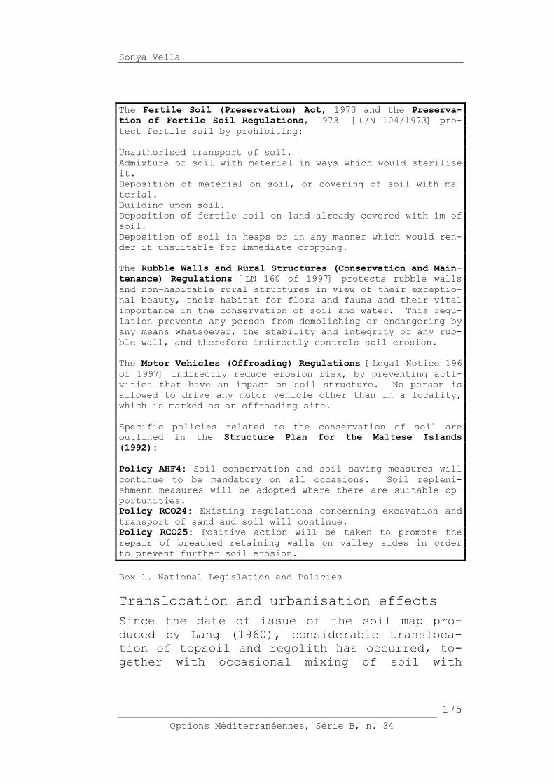
The Fertile Soil (Preservation) Act, 1973 and the Preserva-tion of Fertile Soil Regulations, 1973 [L/N 104/1973] pro-
tect fertile soil by prohibiting:
Unauthorised transport of soil.
Admixture of soil with material in ways which would sterilise
it.
Deposition of material on soil, or covering of soil with ma-
terial.
Building upon soil.
Deposition of fertile soil on land already covered with 1m of
soil.
Deposition of soil in heaps or in any manner which would ren-
der it unsuitable for immediate cropping.
The Rubble Walls and Rural Structures (Conservation and Main-tenance) Regulations [LN 160 of 1997] protects rubble walls
and non-habitable rural structures in view of their exceptio-
nal beauty, their habitat for flora and fauna and their vital
importance in the conservation of soil and water. This regu-
lation prevents any person from demolishing or endangering by
any means whatsoever, the stability and integrity of any rub-
ble wall, and therefore indirectly controls soil erosion.
The Motor Vehicles (Offroading) Regulations [Legal Notice 196
of 1997] indirectly reduce erosion risk, by preventing acti-
vities that have an impact on soil structure. No person is
allowed to drive any motor vehicle other than in a locality,
which is marked as an offroading site.
Specific policies related to the conservation of soil are
outlined in the Structure Plan for the Maltese Islands (1992): Policy AHF4: Soil conservation and soil saving measures will
continue to be mandatory on all occasions. Soil repleni-
shment measures will be adopted where there are suitable op-
portunities.
Policy RCO24: Existing regulations concerning excavation and
transport of sand and soil will continue.
Policy RCO25: Positive action will be taken to promote the
repair of breached retaining walls on valley sides in order
to prevent further soil erosion.
Box 1. National Legislation and Policies
Translocation and urbanisation effects
Since the date of issue of the soil map pro-
duced by Lang (1960), considerable transloca-
tion of topsoil and regolith has occurred, to-
gether with occasional mixing of soil with
Options Méditerranéennes, Série B, n. 34
175

Soil Information in the Maltese Islands
other material. These interventions have gen-
erally been associated with:
site clearance for development;
infilling of disused, or partly exhausted,
quarries;
�reclamation� of land for agriculture and soft
landscaping of development sites;
disposal of excavation debris;
overspill from development sites;
valley engineering projects.
The volume of soil relocated by the private
sector is not recorded, and rough estimates de-
rived from measuring the land areas given over
to development have high margins of error, due
to:
non-uniform soil depth
numerous developments scattered in the country-
side (individual areas are difficult to esti-
mate)
numerous small-scale and/or illegal (and there-
fore undeclared) developments that are not re-
corded in official documentation (e.g. trapping
huts and other rural rooms);
illegal burial, dumping, translocation and/or
mounding of soil, as well as illegal admixing
of soil with other material.
Access routes
Following increased mechanisation of agricul-
tural activity, numerous roads and tracks for
vehicular access to remote rural areas were
opened. In relatively recent times, many
tracks have been widened and surfaced, some by
the Department of Agriculture through an ongo-
ing scheme for the improvement of rural areas,
others by Local Councils, and the rest by indi-
vidual farmers or groups of farmers. Whilst
assisting farmers in reaching their land with-
Options Méditerranéennes, Série B, n. 34
176

Sonya Vella
out undue hardship, this practice also has a
number of important environmental impacts, in-
cluding:
An increase in the quantity and velocity of
runoff in the case of impermeable surfaces, es-
pecially if located on steep valley sides or
within a valley bed. The ultimate effects in-
clude increased soil erosion and structural
damage to rubble walls.
Tracks surfaced with spalls, hardstone dust,
poor-quality asphalt/concrete, or other loose
material gradually release gravel, which in-
creases the physical erosive capacity of runoff
water, thereby promoting soil loss and sedimen-
tation of watercourses.
Soil erosion
Under natural conditions the soils are easily
eroded in a climatic regime of a long dry sum-
mer and a wet season in which rain frequently
falls in heavy showers. The actual field
situation in Malta gives rise to most erosion
in marginal areas, where the retaining stone
walls are in a state of disrepair.
The phenomenon of soil erosion constitutes a
major ongoing problem throughout the whole Mal-
tese countryside, especially in valleys. Ero-
sion appears to be on the increase owing to a
number of factors, which include the following:
Dereliction and subsequent collapse of soil-
retaining random stone walls;
Deliberate/accidental damage to soil-retaining
random stone walls as a result of snail-
collecting, offroading and motorised scram-
bling, and infrastructural and/or maintenance
interventions such as trenching, dredging, and
cleaning/�weeding� of country roads;
Breaching of soil-retaining random stone walls
to provide new access points to fields;
Options Méditerranéennes, Série B, n. 34
177

Soil Information in the Maltese Islands
Replacement of random stone walls with less
adequate structures (for example walls that
lack weep-holes often collapse when the soil
becomes waterlogged);
Abandonment of traditional runoff management
structures (e.g. tunnels constructed in rubble
walling underneath cultivated land);
Clearing of vegetation from uncultivated land;
Localised deforestation;
Compaction of soil surfaces as a result of the
passage of heavy vehicular traffic associated
with offroading and motorised scrambling, as
well as with general access and parking in
(and/or around) popular recreational areas,
hunting areas, trapping sites, agricultural ar-
eas and isolated rural buildings/hamlets;
Clearing of vegetation, deposition of material,
compaction and inhibition of plant growth (us-
ing herbicides) for the preparation and mainte-
nance of trapping sites;
Reprofiling of land into steep escarpments;
Excavation on sloping ground;
Downslope ploughing;
Modification of soil structure through the ex-
cessive use of fertilisers (nitrates, in par-
ticular, are known to oxidise soil humus, ren-
dering the soil crumbly and readily erodible);
Lack of attention to incipient gullying;
Deposition of soil and other material (for ag-
ricultural reclamation, �temporary� storage, or
permanent dumping) on sloping ground prone to
runoff-induced erosion, and on land exposed to
wind;
Reclamation of land in valley beds and water-
courses;
Construction of impermeable surfaces (e.g.
buildings, paved areas) on valley sides and
valley catchments;
Options Méditerranéennes, Série B, n. 34
178

Sonya Vella
Rendering rural tracks impermeable, especially
those on sloping ground and within valley beds,
thereby increasing the quantity and speed of
water runoff.
Beyond a few specific case studies, there is
little existing information on soil erosion in
the Maltese Islands, and no systematic erosion
status/erosion susceptibility database.
Photo 1. Rubble walls show their exceptional beauty, their
habitat for flora and fauna and their vital importance
in the conservation of soil and water
Options Méditerranéennes, Série B, n. 34
179

Soil Information in the Maltese Islands
Photo 2. Even the existing regulation prevents demolishing or
endangering the rubble walls increased soil erosion
brings to their structural damage
In order to assess soil erosion in the Maltese
Islands, a national team is currently undertak-
ing preparatory works for a Soil Erosion/Deser-
tification Assessment and Mapping activity
scheduled to start in January 2000. This pro-
ject is integrated within the Coastal Area Man-
agement Programme (CAMP) for Malta. The insti-
tutions responsible for the co-ordination of
the various activities are the Priority Actions
Programme/Regional Action Centre (PAP/RAC), the
Land and Water Division of the Food and Agri-
culture Organisation (FAO/AGL), and the Envi-
ronment Protection Department of Malta (EPD).
The objectives of the erosion study are to in-
troduce and apply the FAO/PAP consolidated map-
ping methodology to selected pilot areas and
make recommendations for preven-
tion/rehabilitation techniques.
The implementation of this project is based on
the principle of sustainable development pre-
sented in Agenda 21; principles of the Guide-
lines on Integrated Coastal Area Management
(ICAM) developed by PAP-UNEP and of Guidelines
for Erosion Mapping and Measurement (PAP/RAC in
collaboration with FAO). The expected project
Options Méditerranéennes, Série B, n. 34
180

Sonya Vella
outputs will include basic digitised maps of
erosion status and dynamics, supply of GIS and
mapping equipment, photo catalogues and im-
proved land use plans. The final product of
this project will be the physical assessment of
erosion-prone areas and its documentation in a
cartographic database. This activity is in line
with the implementation of the United Nations
Convention to Combat Desertification. Through
the ratification of this Convention, the Gov-
ernment of Malta has taken the first measures
towards soil conservation.
Soil maps and supporting data
The only soil map of the Maltese Islands is
that published in 1960 on a scale of 1:31,680
as a result of the study of the Maltese soils
by D.M. Lang in 1956-57. The existing soil map
has never been digitised because it is regarded
as outdated and consequently of little use for
land management and planning purposes. Since
the date of issue of the national soil map pro-
duced by Lang, considerable translocation of
topsoil, subsoil and regolith has occurred, to-
gether with occasional mixing of soil with
other material. The soil descriptive and ana-
lytical data as a result of this survey are
older than 40 years and do not correspond to
the field anymore. This is especially true in
areas having strong human-influence. A list of
national maps and supporting data is included
in Appendix A.
Conversion of national soil legend
into international systems
In classifying the soils of the Maltese Is-
lands, Lang adopted the system developed by
Kubiena (1953) (Box 2). According to this
classification system three sub-types were rec-
ognised: carbonate raw soils, Xerorendzinas and
Terra soils.
Options Méditerranéennes, Série B, n. 34
181
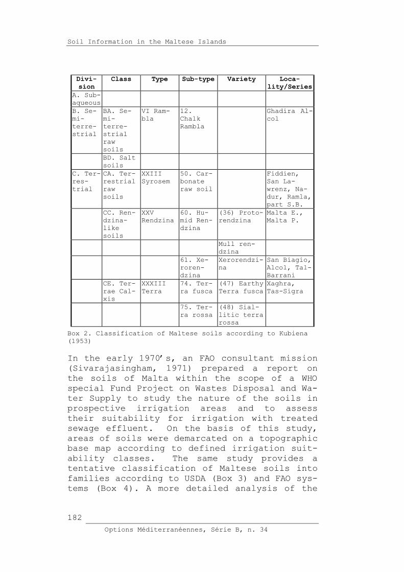
Soil Information in the Maltese Islands
Divi-sion
Class Type Sub-type Variety Loca-lity/Series
A. Sub-
aqueous
B. Se-
mi-
terre-
strial
BA. Se-
mi-
terre-
strial
raw
soils
VI Ram-
bla
12.
Chalk
Rambla
Ghadira Al-
col
BD. Salt
soils
C. Ter-
res-
trial
CA. Ter-
restrial
raw
soils
XXIII
Syrosem
50. Car-
bonate
raw soil
Fiddien,
San La-
wrenz, Na-
dur, Ramla,
part S.B.
CC. Ren-
dzina-
like
soils
XXV
Rendzina
60. Hu-
mid Ren-
dzina
(36) Proto-
rendzina
Malta E.,
Malta P.
Mull ren-
dzina
61. Xe-
roren-
dzina
Xerorendzi-
na
San Biagio,
Alcol, Tal-
Barrani
CE. Ter-
rae Cal-
xis
XXXIII
Terra
74. Ter-
ra fusca
(47) Earthy
Terra fusca
Xaghra,
Tas-Sigra
75. Ter-
ra rossa
(48) Sial-
litic terra
rossa
Box 2. Classification of Maltese soils according to Kubiena
(1953)
In the early 1970�s, an FAO consultant mission
(Sivarajasingham, 1971) prepared a report on
the soils of Malta within the scope of a WHO
special Fund Project on Wastes Disposal and Wa-
ter Supply to study the nature of the soils in
prospective irrigation areas and to assess
their suitability for irrigation with treated
sewage effluent. On the basis of this study,
areas of soils were demarcated on a topographic
base map according to defined irrigation suit-
ability classes. The same study provides a
tentative classification of Maltese soils into
families according to USDA (Box 3) and FAO sys-
tems (Box 4). A more detailed analysis of the
Options Méditerranéennes, Série B, n. 34
182

Sonya Vella
classification of Maltese soils is included in
Appendix B.
Ramla sandy, carbonatic, calcareous, Typic Ustor-
thent
Nadur coarse loamy, carbonatic, calcareous, Typic
Ustorthent
Fiddien fine clayey, mixed calcareous Typic Ustorthent
San La-
wrenz
fine loamy, carbonatic, calcareous Typic U-
storthent
San Biagio fine loamy, carbonatic, calcareous Lithic
Typic Ustorthent
Alcol fine loamy, carbonatic, calcareous, Rendollic
Ustochrept
Tal-
Barrani
fine loamy, carbonatic, calcareous, Rendollic
Ustochrept
Xaghra fine clayey, mixed calcareous Typic Ustochrept
Tas-Sigra fine clayey, mixed calcareous Typic Ustochrept
Box 3. Classification of Maltese soils according to USDA
system (Sivarajasingham, 1971)
Options Méditerranéennes, Série B, n. 34
183

Soil Information in the Maltese Islands
Ramla Calcaric Regosol
Nadur Calcaric Regosol
Fiddien Calcaric Regosol (in some places Chromic Ver-
tisol sodic)
San Lawrenz Calcaric Regosol
San Biagio Calcic Cambisol lithic
Alcol Calcic Cambisol
Tal-Barrani Calcic Cambiso
Xaghra Chromic Cambisol
Tas-Sigra Chromic Cambisol
Box 4: Classification of Maltese soils according to FAO
system (Sivarajasingham, 1971)
National soil institutions
In the absence of a national institution re-
sponsible for soil survey activities, mapping
and monitoring, soil information has until the
present day received little attention and re-
mained a relatively undeveloped agricultural
field in Malta. Soil information is very frag-
mented and linked to specific surveys and stud-
ies carried out by undergraduates or as part of
environmental impact assessments for project
location and development purposes.
The Agricultural Research & Development Centre
has a soil fertility and salinity monitoring
programme in relation to commercial fertiliser
plans. The collection of soil data is re-
stricted because of insufficient facilities for
soil characterisation (field survey and labora-
tory analysis), and lack of expertise in soil
science and soil geographic information sys-
tems. The laboratory methods for soil analysis
are based on different methodologies (SSSA, FAO
and MAFF) and are not standardised.
Suggestions for a Soil Information
System in Malta
In the present situation, the need to provide
the country with an operational tool for multi-
functional use of the land and protection of
the environment has never been as compelling as
Options Méditerranéennes, Série B, n. 34
184

Sonya Vella
today, not only on account of Malta�s EU acces-
sion prospects, but also in response to the de-
mand by farmers and developers to obtain accu-
rate information about the soil, this precious
and limited resource.
Various objectives of soil protection dealing
with predictions for safeguarding soil status,
stabilisation and remediation require detailed
knowledge about soils, their potential and ac-
tual loading.
It is proposed, therefore, to develop a soil
information system for the Maltese Islands
(MALSIS) to remedy current shortcomings and to
allow for the preparation of thematic outputs
that address a broad range of land use issues.
This system would serve as a basis for decision
making, policy regulation, planning and devel-
opment at the national and regional levels.
The suitability of georeferenced soil databases
has been demonstrated by a number of applica-
tions, which have already been made in differ-
ent European countries. These applications in-
clude the protection of groundwater quality,
the assessment of the risks of soil erosion,
the assessment of drought hazards, the evalua-
tion of land capability, the delineation of
lands vulnerable to nitrate leaching, the as-
sessment of risks of agrochemical pollution,
the monitoring of vegetation ecosystems and de-
sertification abatement.
Updating of the existing soil map for Malta is
strongly recommended in view of the extensive
translocation of soil and the urbanisation of
significant tracts of former soil-covered land.
In a report on the state of the environment in
the Maltese Islands (Axiaq et al., 1999), the
need to survey the soil resources, and to de-
velop a tool for the management of soil infor-
mation, was identified as one of the most ur-
gent priorities that the government should en-
courage and fund.
Options Méditerranéennes, Série B, n. 34
185

Soil Information in the Maltese Islands
The implementation of many EU Directives aimed
at protecting the environment requires detailed
information about the soil resource base. Ex-
amples include:
EC Nitrate Directive (91/676/EEC);
Directive on Environmental Assessment
(85/337/EEC);
Sewage Sludge in Agriculture Directive
(86/278/EEC);
Habitats and Species Directive (92/43/EEC);
Directive on Integrated Pollution Prevention
and Control (96/61/EEC);
Framework Directive on Waste (75/442/EEC).
The obligations originating from the Nitrate
Directive, for example, require a soil data
layer for delineating vulnerable zones, and a
knowledge of the soil and crop growth condi-
tions for the development of fertiliser recom-
mendations and establishment of fertiliser (nu-
trient) plans on a farm-by-farm basis. In order
to fulfil the obligations of the Sewage Sludge
Directive, the background levels of heavy met-
als in soils must be determined before estab-
lishing rates of application of sludge on land.
Implementation and data acquisition
The recommended strategy for the development of
a soil information system for the Maltese Is-
lands is based on the Manual of Procedures for
a Georeferenced Soil Database for Europe by the
European Soil Bureau (Finke et al., 1998). It
is proposed to carry out the required investi-
gations and data acquisition by considering the
Maltese Islands as a pilot area in the frame-
work of the project to provide an increasing
coverage of Europe with the construction of a
1:250,000 soil database.
As proposed, it is desirable to have pilot ar-
eas in most EU countries and national represen-
Options Méditerranéennes, Série B, n. 34
186

Sonya Vella
tatives should inventory regional and national
interests. It is suggested to include the Mal-
tese Islands together with Italy in pilot area
no. 6 (Finke et al., 1998). In justifying the
consideration of Malta as a pilot area, a num-
ber of important points can be highlighted:
The draft list of possible locations for pilot
areas is lacking any representation from the
central Mediterranean region. Therefore, the
inclusion of the Maltese Islands as a pilot
area would help in establishing the necessary
representative coverage of European countries.
As a signatory to the Convention to Combat De-
sertification (CCD), national support exists to
tackle the severe problem of land degradation
in the Maltese Islands.
The choice of Malta as a pilot area would be a
great source of experience; primarily for those
involved at the local scale, but also for the
technical experts.
If, according to preliminary analysis of exist-
ing data, it is concluded that Malta is un-
mapped, then compilation of data and develop-
ment of a georeferenced soil database would be
done according to standard methodology proposed
by ESB/FAO thus eliminating the need for har-
monisation of data.
As outlined in the Manual of Procedures (Finke
et al., 1998), the work is to be carried out in
a number of successive research phases. If
Malta is identified and delineated as a pilot
area, the following research phases should be
carried out (Box 5). A more detailed diagram-
matic representation is found in Appendix C.
Options Méditerranéennes, Série B, n. 34
187

Soil Information in the Maltese Islands
Research phase
Description Comments
Phase 1 Construction of a meta-
database of existing
information
Overview of existing
information within the
pilot area (semantic
and geographic knowle-
dge) in a computerised
metadatabase or a writ-
ten report.
Existing information
has been identified.
The available soil data
has been compiled into
spreadsheets.
Phase 2 Screening, aggregation
and use of existing da-
ta
Data or maps screened
on applicability and
quality; useable maps
are generalised to the
appropriate scale; har-
monisation of existing
map legends to the de-
finitions of soil bo-
dies and soilscapes
Preliminary screening
indicates that existing
soil data is unsuitable
for use. Verification
of this is required.
Phase 3 Primary data acquisi-
tion
Collection of new data
in cases where: data
is lacking or below
standard; data cannot
be harmonised; comple-
mentary data needed in
addition to existing
data; new forms of data
are desirable
A programme of stren-
gthening laboratory fa-
cilities and purchasing
equipment is necessary.
Technical assistance,
together with extensive
training of the natio-
nal team, is needed to
carry out the fiel-
dwork. Estimated time-
frame: 12 months
Phase 4 Definition and delinea-
tion. Material collec-
ted is combined
Phase 5 Filling of the database
Geometric, topographi-
cal and semantic parts
of database are filled
Phase 6 Validation
Validation in a refe-
rence area to obtain an
objective measure of
predictive power of
database
Phase 7 Secondary data acquisi-
tion
Use of pedotransfer
function (PTF) and pe-
dotransfer rules (PTR)
Options Méditerranéennes, Série B, n. 34
188
Sonya Vella
Box 5. Research phases
Benefits and applications
The benefits of developing a Soil Information
System for the Maltese Islands and potential
applications in relation to national require-
ments have been identified and are listed in
Box 6.
Options Méditerranéennes, Série B, n. 34
189

Soil Information in the Maltese Islands
Applications of MALSIS
National Requirements
Description of the
state of the envi-
ronment
Detailed updating of the existing soils
map was identified as an urgent priority
by the expert panel in the State of the
Environment Report (Axiaq et al., 1999).
Environmental
impact assessment
As established in the Environment Protec-
tion Act (1991), an impact assessment
shall identify and assess the direct and
indirect effects on the soil.
Risk assessment Soil erosion risk maps could be used with
hydrological data to model infiltration
processes of unsaturated land zones.
Ecological rehabi-
litation of pollu-
ted sites
A soil database would provide a tool for
drawing up policies for the protection of
sites of scientific and ecological impor-
tance.
The base for rese-
arch development,
for new standard
elaboration and
for land use
planning on appro-
priate level
A major problem in transferring technology
and research to Maltese agriculture lies
in the absence of detailed soil informa-
tion.
Monitoring of the
impact of natural
factors and an-
thropogenic acti-
vities on soils
Extensive urbanisation, mixing and distur-
bance of topsoil is the major man-induced
impact on soil which is not monitored.
Providing informa-
tion for sustaina-
ble agriculture
and rural develo-
pment
Identification and protection of good gra-
de agricultural land to ensure continued
viability at present does not include soil
quality criteria.
Providing informa-
tion for the ela-
boration of soil
and environment
protection strate-
gies
Soil information is a pre-requisite in e-
laboration of a Soil Code (the Code of Go-
od Agricultural Practice for the Protec-
tion of Soil). At present there is no
Soil Code for the Maltese Islands.
Providing informa-
tion for the stra-
tegy and decisions
on the control of
soil fertility
The control of soil fertility is entirely
absent from existing regulations and needs
to be included. This is especially impor-
tant in view of the need to adopt sustai-
nable nutrient management plans, which ha-
ve minimum impact on the environment.
Evaluation of soil
protection measu-
res and farm
management practi-
ces
In the absence of a Code for the Protec-
tion of Soil, the farmers do not adopt
soil protection measures. Soil informa-
tion would provide the basis for recommen-
ding farm management practices, which aim
at reversing trends in deteriorating soil
quality.
Providing data for
predictive models
In the absence of data on soils, predicti-
ve models cannot be applied. This is e-
specially an important issue in the appli-
cation of models for designating nitrate
vulnerability of groundwater resources.
Serving as a basis
of sound land use
policy
In the absence of updated soil informa-
tion, site inspections for evaluating ap-
plications for development permits reveal
Options Méditerranéennes, Série B, n. 34
190

Sonya Vella
a large number of would-be coincidences
wherein the interested sites are degraded
beforehand.
Legal measures for
soil protection
(enforcement, pe-
nalisation, stimu-
lation)
Provisions to protect soil against activi-
ties contributing to soil erosion are ab-
sent and need to be added to the national
legislation.
Box 6. The benefits of the Soil Information System for the
Maltese Islands
The current soil monitoring landscape in Malta
is a highly scattered one. Apart from budgetary
constraints for the establishment of a compre-
hensive national soil information system, there
is not yet an unambiguous opinion about the in-
stitutional and organisational framework in
which it could operate.
As recommended by the FAO/EC Technical Consul-
tation on the European Soil Information System,
national soil institutions should be responsi-
ble for collecting soil information and for
monitoring of spatial and temporal changes in
soil variables.
International efforts for co-operation should
be directed towards establishing and strength-
ening of such bodies, so that local knowledge
and experience is nourished. In the absence of
a single organisation whether state-owned or
private, responsible for soil information and
soil monitoring in Malta, it is recommended
that a permanent Soil Office should be estab-
lished within the Department of Agriculture.
This unit would be responsible for the manage-
ment, maintenance and ownership of soil data.
Conclusion
The particular position of the Maltese Islands
represents an important and strategic point of
linkage between the European and the African
reality from a geographic and climatic point of
view. The development of a Soil Geographic Da-
tabase for the Maltese Islands would constitute
an important achievement in the extension of
Options Méditerranéennes, Série B, n. 34
191

Soil Information in the Maltese Islands
the European Soil Information System (EUSIS) to
the Mediterranean Basin.
The creation of a georeferenced soil database
for Malta and Gozo, compatible with the Euro-
pean Soil Bureau database, could be used to as-
sess the sustainability of current soil use and
management and to develop models for predicting
potential uses and risks. At the national
level, the driving force is an ever-increasing
demand for harmonised and compatible soil data
information by policy and decision- makers,
planning regulators, environmental managers,
agriculturists and civil engineers.
In comparison to other European and Mediterra-
nean countries, the state of soil information
in the Maltese Islands is relatively poor and
insufficient to meet current requirements for
agricultural production and sustainable use of
land resources. Although at present knowledge
is limited and the necessary expertise in soil
information is lacking, it is a national prior-
ity to consolidate efforts towards the develop-
ment of a soil information system for the Mal-
tese Islands. Moreover, the creation of a per-
manent operational structure (a national soil
office) would support Malta�s participation in
a fully integrated Euro-Mediterranean Network
of Soil Information.
References
Axiaq, V. et al. 1999. State of the Environ-
ment Report for Malta, 1998. Malta University
Press. 1999.
Camilleri, S. 1999. A Preliminary Study of Sa-
linity and Sodicity in Maltese Soils, Malta:
University of Malta, Dip. Agric. thesis.
FAO-ISRIC-ISSS. 1998. World Reference Base for
Soil Resources (WRB). World Soil Resources Re-
port 84, FAO, Rome.
Options Méditerranéennes, Série B, n. 34
192

Sonya Vella
FAO-UNESCO. 1974. Soil Map of the World 1: 5
000 000. Volume I. Legend. UNESCO, Paris.
Finke, P. et al. 1998. Georeferenced Soil Da-
tabase for Europe. Manual of Procedures. Ver-
sion 1.0. European Soil Bureau, European Com-
munities, Italy.
Kubiena, W. L. 1953. The Soil of Europe. Murby,
London.
Lang, D.M. 1960. Soils of Malta and Gozo: Colo-
nial Research Studies No. 29, Colonial Office,
London: HMSO.
Sacco, A. 1997. A Study on the Organic Matter
Content of Maltese Soils, Malta: University of
Malta, M.Sc.(Agric. Sc.) thesis. (unpublished).
Sciberras, M. 1999. A Preliminary Study of
Phosphorus Status in Maltese Soils, Malta: Uni-
versity of Malta, Dip. Agric. thesis. (unpub-
lished).
Sivarajasingham, S. 1971. Wastes Disposal and
Water Supply, Malta: The Soils of Malta,
AGL:SF/MAT 5, Rome: FAO.
Soil Survey Staff. 1998. Keys to Soil Taxonomy.
Eighth edition. United States Department of Ag-
riculture, Washington D.C.
Vella, J. 1997. Heavy Metals in Soils amended
by Composted Municipal Waste, Malta: University
of Malta, M.Sc.(Agric. Sc.) thesis. (unpub-
lished).
Yaalon, D.H. 1997. �Soils in the Mediterranean
region: what makes them different?� Catena, 28,
157-169.
Options Méditerranéennes, Série B, n. 34
193

Soil Information in the Maltese Islands
Appendix A: Supporting data
Type of
map
Organisa-
tion
Area
cove-
red
Da-
te
Scale Remarks
Topo-
graphi-
cal
maps
Public
Works De-
partment
Malta
& Gozo
196
8
1:2500 Available
in print
form
Topo-
graphi-
cal
maps
Planning
Authority
Malta
& Gozo
199
0
1:25000 Available
in print
and digi-
tal form
Topo-
graphi-
cal
maps
Planning
Authority
Malta
& Gozo
199
0
1:25000 Available
in print
and digi-
tal form
Geolo-
gical
maps
Department
of Infor-
mation
Malta
& Gozo
1:25000
Soil
map
Department
of Agri-
culture
Malta
& Gozo
196
0
1:31680 outdated
Permea-
bility
map
Water Ser-
vices Cor-
poration
199
0
1:100,00
0
Land
regist
ation
(te-
nancy
r
)
Department
of Agri-
culture
Malta
& Gozo
N/A outdated
Land
use (a-
gricul-
ture)
Department
of Agri-
culture
Malta
north
(pilot
area)
Habitat
data
(rural)
Environ-
mental
Management
Unit,
Planning
Authority
Selec-
ted
areas
Circula-
tion re-
stricted
Appendix B: Soil Taxonomy of Maltese Soils
The classification of Maltese soils in accor-
dance with the 7th approximation prior to the
publication of Soil Taxonomy in 1975 places the
carbonate raw soils and the San Biagio series
Options Méditerranéennes, Série B, n. 34
194

Sonya Vella
of the xerorendzinas into the Entisol order of
Soil Taxonomy. �Entisols are mineral soils with
little or no evidence of pedogenetic horizons
arising from a too short pedogenesis period,
geomorphic instability or little weatherability
of the parent materials.�
Five Entisol suborders are recognised: Aquents
(poorly developed wet soils), Arents (disturbed
by man), Psamments (sandy), Fluvents (alluvial
soils with irregular organic matter distribu-
tion in depth), and Orthents (other Entisols).
Orthents are, by far, the most abundant Enti-
sols in the Mediterranean region and account
for the Entisols of the Maltese Islands.
Order: Entisol
Suborder: Orthents:
�Other Entisols.�
Great Group: Xerorthents:
�Other Orthents that have a xeric moisture regime.�
Subgroup: Typic Xerorthents:
�Other Xerorthents.�
Subgroup: Lithic Typic Xerorthents:
�Other Xerorthents that have a lithic contact wi-
thin 50 cm of the mineral soil surface.�
The remaining series within the xerorendzinas:
Alcol and Tal-barrani series; together with the
terra soils are classified as Ustochrepts, a
great group of the order Inceptisols: �young,
immature soils whose pedogenic features are
less outstanding than in mature soils� (Tor-
rent, 1995).
However, this great group is not present in the
�Keys to Soil Taxonomy, eighth edition, 1998�.
The great group Ustochrepts was deleted from
Soil Taxonomy in 1975 and replaced with the
great group Xerochrepts. The great group Xero-
chrepts was then deleted from Soil Taxonomy in
1998 and was replaced with the suborder of
Xerepts.
Order: Inceptisols
Suborder: Xerepts:
Options Méditerranéennes, Série B, n. 34
195

Soil Information in the Maltese Islands
�Other Inceptisols that have a xeric soil moisture
regime.�
The Terra soils were classified as Typic Usto-
chrepts. With regard to the latest Soil Taxon-
omy, these are likely to be Typic Haploxerepts.
Great Group: Haploxerepts:
�Other Xerepts.�
Subgroup: Typic Haploxerepts:
�Other Haploxerepts.�
While the Rendollic Ustochrepts (Alcol and Tal-
barrani series) will likely be Calcixerepts in
either the aridic or typic subgroups.
Great Group: Calcixerepts:
�Other Xerepts that both:
Have a calcic horizon with its upper boundary wi-
thin 100 cm of the mineral soil surface or a petro-
calcic horizon with its upper boundary within 150
cm of the mineral soil surface; and
Are calcareous in all parts above the calcic or pe-
trocalcic horizon, after the soil between the mine-
ral soil surface and a depth of 18 cm has been mi-
xed.
Subgroup: Typic Calcixerepts:
�Other Calcixerepts.�
With reference to the �Key to the FAO Soil
Units� as contained in the �Legend of the Soil
Map of the World� (UNESCO, Paris, 1974) the
classifications are defined as follows:
Regosols:
�Other soils having no diagnostic horizons or
none other than (unless buried by 50 cm or more
new material) an ochric A horizon.�
Calcaric Regosols (Rc):
�Other Regosols which are calcareous at least
between 20 and 50 cm from the surface�.
Vertisols (V):
�Other soils which, after the upper 20 cm are
mixed, have 30 per cent or more clay in all ho-
Options Méditerranéennes, Série B, n. 34
196

Sonya Vella
rizons to at least 50 cm from the surface; at
some period in most years have cracks at least
1 cm wide at a depth of 50 cm, unless irri-
gated, and have one or more of the following
characteristics: gilgai microrelief, intersect-
ing slickensides or wedge-shaped or paral-
lelpiped structural aggregates at some depth
between 25 and 100 cm from the surface�.
Chromic Vertisols (Vc):
�Other Vertisols� having moist chromas of less
then 1.5 dominant in the soil matrix throughout
the upper 30 cm�.
Chromic Vertisol sodic:
�Other Vertisols� with �an exchangeable sodium
percentage (ESP) of more than 15 within 50 cm
from the soil surface�.
Cambisols (B):
�Other soils having a cambic B horizon or an
umbric A horizon which is more than 25 cm
thick.�
Calcic Cambisols (Bk):
�Other Cambisols showing one or more of the
following: a calcic horizon or a gypsic horizon
or concentrations of soft powdery lime within
125 cm of the surface when the weighted average
textural class is coarse, within 90 cm for me-
dium textures, within 75 cm for fine textures;
calcareous at least between 20 and 50 cm from
the surface.�
Calcic Cambisol lithic:
As above, with a �continuous hard rock within
10 cm from the soil surface�.
Chromic Cambisols (Bc):
�Other Cambisols which have a strong brown to
red B horizon (rubbed soil has a hue of 7.5YR
and a chroma of more than 4, or a hue redder
than 7.5 YR).�
Options Méditerranéennes, Série B, n. 34
197

Soil Information in the Maltese Islands
Flowchart to illustrate the work to be done in
a possible pilot area project in Malta for the
1:250.000 scale soil database according to the
ESB Manual.
PHASE 1 PHASE 2 PHASE 4
Development of Screening Definiti on and
metadatabase Map - delineation
Scale:
see Table 1 1:25,000 to 1:200,000 = appropriate
Hence, 1:31,680 = appropriate
Observation density (profile/ha):
Malta - 1/8000
Gozo - 1/400
Total - 1/790
Survey method:
(1) ground traversing
(2) use of aerial photographs
Legend:
Kubiena (1953)
Soil p rofile data
see Table 2
PHASE 3 PHASE 4 PHASE 5 PHASE 6
Primary data acquisi tion Definiti on and Filli ng of t he Validation
delineation database
PHASE 7
Secondary data
Requirements to existing soil profile data
Requirement Status
1. The position (coordinates) of the sampling site is exactly known
2. The data are descriptive of a whole soil profile down to the depth of
150 cm (59 in) or to the lithic contact, if shallower. They must refer to
all soil horizons or lithological layers thicker than 10 cm, and include
also important thinner layers (e.g. iron pans).
3. Required attributes are the mandatory attributes described
Chapter 7 (see Table 3)
4. Attributes must be coded according to Manual (ESB, 1998)
5. Analytical data must have been determined according to acceptable
methodologies.
6. There must be an acceptable estimate of the accuracy of the data
provided by the owner.
7. The sampling sites fit to the definition and are representative of the
soil body as described by the Manual and can be assigned to it.
8. There must be a minimum of 2 sampling sites for each soil body.
9. Data in electronic bases and GIS will be preferable.
10. Time dependent data must be valid otherwise redetermined.
11. The data must be reproducible. Checks must be conducted regularly
on the data of the national laborities by a designated laboratory.
Legend
Mandatory
Optional
Options Méditerranéennes, Série B, n. 34
198