soil management handbook for the lower fraser valley
TRANSCRIPT


SOIL MANAGEMENT HANDBOOK
FOR THE
LOWER FRASER VALLEY
R.A. Bertrand, P.Ag.
G. A. Hughes-Games, P.Ag.
D. C. Nikkel, C.Tech.
Soils and Engineering Branch
B.C. Ministry of Agriculture, Fisheries and Food
Abbotsford
1991
2nd Edition

Canadian Cataloguing in Publication Data Bertrand, R. A. (Ronald A.) Soil management handbook for the lower Fraser Valley An updated and expanded version of: Bertrand, R. A. (Ronald A.). Soil management handbook for the Fraser Valley. Soils Branch, B.C. Ministry of Agriculture & Food. 1983
Included bibliographical references: p. ISBN 0-7726-1477-6
1. Soil management – British Columbia – Fraser River Valley. 2. Crops and soils – British Columbia – Fraser River Valley. I. Hughes-Games, G.A. II. Nikkel, D.C. III. British Columbia. Ministry of Agriculture, Fisheries and Food. IV. Bertrand, R.A. (Ronald A.). Soil management handbook for the Fraser Valley. V. Title.
S599.1.B7B47 1991 631.4’971137 C92-092042-X

ACKNOWLEDGEMENT This manual was preceded by “The Soil Management Handbook for the Fraser Valley” 1st Edition. The information contained herein has been updated and expanded. Numerous people have been involved in the production of the current edition. The authors wish to acknowledge the contributors: R.C. (Craig) Wood, P.Ag. Original co-author, former Soil Specialist, BCMAFF Martin Driehuyzen, P.Ag. Former Provincial Drainage Specialist, BCMAFF, Soil Drainage
Guide for the Fraser Valley. Michael Goldstein, P.Ag. Consulting Agrologist, Soil Structure and Soil Loosening, ARDSA
Project Report 23008. Linda Scabar, C. Tech. Structures Technician, Drawings, BCMAFF, Soils and Engineering
Branch. Mauro C. Coligado, PhD Air Quality Analyst, The Climate of the Lower Fraser Valley,
BCMOE, Air Management Branch. Rob Kline, P.Ag. Soil Conservation/Management Specialist, Conservation Farming
Section, BCMAFF, Soils and Engineering Branch. Roger Bryant, C. Tech. Engineering Technician, Drawings, BCMAFF, Soils and Engineering
Branch. The authors extend their appreciation to all of the above for their time, effort and assistance in preparing this manual.
- iii -

PREFACE The Soil Management Handbook for the Fraser Valley has been prepared to facilitate the use of soil inventory maps and reports. The Handbook provides information on the types of crops suited to the soils of the Fraser Valley and the management inputs required to grow these crops. If more detailed or site specific information is required on soil management, contact an office of the B.C. Ministry of Agriculture, Fisheries and Food. It should be noted that although the authors are specialists in soil management, general comments have been made in this publication on production economics, crop suitability, and crop production. These are not intended to be expert comments, but are to provide the reader with a general understanding of the suitability of various soils for production of various climatically adapted crops. For definitive information on the economics of producing or marketing a specific crop, or on producing a specific crop, an expert in the appropriate field of agrology should be contacted.
- iv -

TABLE OF CONTENTS
Page Acknowledgement.................................................................................................................................. iii Preface.................................................................................................................................................... iv Table of Contents .....................................................................................................................................v List of Soil Series ................................................................................................................................... ix List of Soil Management Groups and Soils Which Comprise Each Group .............................................x List of Figures ........................................................................................................................................ xi List of Tables......................................................................................................................................... xii Introduction ..............................................................................................................................................1 Use of Handbook......................................................................................................................................2 Management Inputs, Crops and Soil Management Groups......................................................................3 Management Inputs............................................................................................................................5 Crops or Crop Groups........................................................................................................................6 Soil Management Groups ..................................................................................................................8 Abbotsford and Ryder Soil Management Groups..............................................................................9 Alouette and Blundell Soil Management Groups ............................................................................10 Benson, Guichon and Spetifore Soil Management Groups .............................................................11 Berry Soil Management Group........................................................................................................12 Bose, Buntzen, Capilano, Coghlan, Harrison, Sardis and Shalish Soil Management Groups....................................................................................................................13 Carvolth and Vedder Soil Management Groups..............................................................................14 Cloverdale Soil Management Group ...............................................................................................15
- v -

Table of Contents Con’t. Page Columbia and Sunshine Soil Management Groups .........................................................................15 Crescent Soil Management Group ...................................................................................................17 Delta Soil Management Group ........................................................................................................18 Fairfield Soil Management Group ...................................................................................................19 Grevell Soil Management Group .....................................................................................................20 Heron, Murrayville and Summer Soil Management Groups ...........................................................21 Ladner Soil Management Group......................................................................................................22 Lehman Soil Management Group....................................................................................................23 Lumbum Soil Management Group ..................................................................................................24 Monroe Soil Management Group ....................................................................................................25 Page, Pitt and Prest Soil Management Groups ................................................................................26 Scat Soil Management Group ..........................................................................................................27 Sumas Soil Management Group ......................................................................................................28 Triggs Soil Management Group ......................................................................................................29 Vinod Soil Management Group.......................................................................................................30 Whatcom Soil Management Group .................................................................................................31 Soil Management Guide.......................................................................................................................32
1. The Physical Nature of Soils.......................................................................................................33
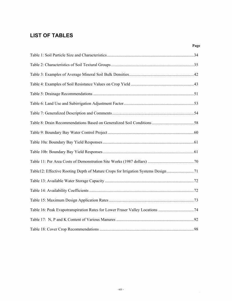
1.1 Soil Composition and Soil Properties.................................................................................33 1.2 Soil Texture ........................................................................................................................34 1.3 Soil Structure ......................................................................................................................36 1.4 Porosity ...............................................................................................................................36
- vi -

Table of Contents Con’t. Page
2. Maintaining Soil Structure and Fertility .....................................................................................38
2.1 The Formation of Soil Structure .........................................................................................38
2.2 Soil Structure, Degradation and Plant Growth ...................................................................40
2.3 Soil Fertility ........................................................................................................................47
2.4 Soil Testing.........................................................................................................................48
3. Water Management .....................................................................................................................50
3.1 Land Drainage ....................................................................................................................50
3.2 Soil Drainage Guide for the Fraser Valley .........................................................................50
3.3 Drainage in Lowland soils ..................................................................................................58
3.4 Drainage: The Boundary Bay Water Control Project ........................................................59
3.5 Saline and Sodic Soils ........................................................................................................64
3.6 Drainage in Upland Soils....................................................................................................64
3.7 Drainage and Soil Management for Erosion Control .........................................................65
3. Irrigation .............................................................................................................................70
4. Practical Aspects of Soil Management .......................................................................................76
4.1 Land Clearing. Levelling and Recontouring.......................................................................76
4.2 Tillage and Tillage Implements ..........................................................................................78
4.3 Soil Loosening / Subsoiling................................................................................................84
4.4 Management of Peat and Muck Soils .................................................................................87
4. Soil Amendments................................................................................................................88
- vii -

Table of Contents Con’t. Page
5. Animal Manure Management .....................................................................................................92
5.1 Managing Manures for Crop Production ............................................................................92
5.2 Factors Affecting Contamination from Manure .................................................................94
5.3 Factors Contributing to High Fall Nitrate Levels in the Root Zone and Nitrate Leaching.........................................................................................94
5. Practical Guidance on Land application of Manure ...........................................................95
6. Soil Conservation........................................................................................................................97
6.1 Crop Rotations ....................................................................................................................97
6.2 Cover Crops ........................................................................................................................97
6.3 Mulching.............................................................................................................................99
6.4 Wind Erosion Control.......................................................................................................100
6.5 Conservation Farming.......................................................................................................100 References ...........................................................................................................................................106
Published Sources............................................................................................................................106
Personal Communication.................................................................................................................108 Appendix A: The Climate of the Lower Fraser Valley .................................................................... A-1
- viii -

LIST OF SOIL SERIES Page Abbotsford (AD) 9 Addington (AG) 26 Albion (AB) 27 Alouette (AL) 10 Annacis (AS) 24 Annis (AN) 10 Arnold (AR) 26 Banford (BD) 24 Bates (BT) 19 Beharrel (BL) 14 Benson (B) 11 Berry (BR) 12 Blackburn (BB) 26 Blundell (BU) 10 Bonson (BN) 19 Boosey (BY) 23 Bose (BO) 13 Buckerfield (BK) 26 Buntzen (BZ) 13 Calkins (CN) 23 Capilano (CP) 13 Carvolth (CV) 14 Cheam (CM) 13 Chehalis (CS) 13 Cloverdale (CD) 15 Coghlan (CG) 13 Columbia (CL) 16 Coquitlam (CQ) 31 Crescent (CT) 17 Dean (DN) 13 Deas (DS) 18 Defehr (DR) 21 Delta (DT) 18 Dewdney (DW) 19 Dixon (DX) 14 Durieu (DU) 31 Eastcap (EP) 13 Elk (EK) 23 Embree (EM) 18 Errock (ER) 13 Fadden (FD) 19 Fairfield (F) 19 Fellows (FS) 21 Gibson (GN) 24 Glen Valley (GV) 29
Page Goudy (GY) 24 Grevell (G) 20 Grigg (GG) 14 Guichon (GU) 11 Hallert (HT) 10 Hammond (HA) 26 Haney (HY) 13 Harrison (HR) 13 Hatzic (HZ) 14 Hazelwood (HD) 14 Henderson (H) 19 Heron (HN) 21 Hjorth (HJ) 26 Hopedale (HP) 26 Isar (IS) 13 Judson (JN) 24 Katzie (KZ) 14 Kennedy (KD) 16 Keystone (KE) 9 Kitter (K) 17 Ladner (L) 22 Langdale (LE) 13 Langley (LA) 15 Laxton (LX) 9 Lehman (LH) 23 Lickman (LK) 25 Livingstone (LV) 21 Lonzo Creek (LZ) 9 Lulu (LU) 24 Lumbum (LM) 24 Lynden (LY) 16 Marble Hill (MH) 9 Mathews (MW) 18 Matsqui (MQ) 25 McElvee (ME) 26 McLellan (ML) 14 Milner (MR) 31 Monroe (M) 25 Murrayville (MY) 21 Neaves (NV) 26 Neptune (NP) 20 Nicholson (N) 31 Nicomekl (NK) 18 Niven (NN) 26 Page (PE) 26
Page Peardonville (PD) 9 Pelly (PY) 14 Pitt (P) 26 Porpoise (PP) 13 Prest (PR) 26 Richmond (RC) 24 Roach (RH) 13 Ross (RS) 14 Ryder (RD) 9 Sandel (SA) 18 Sardis (SD) 13 Scat (SC) 27 Seabird (SB) 20 Seaview (SV) 11 Sechelt (SL) 16 Seymour (SY) 13 Shalish (SH) 13 Sim (SI) 26 Spetifore (SF) 11 Stave (SE) 9 Steelhead (ST) 13 Sturgeon (SG) 10 Sumas (SM) 28 Summer (SR) 21 Sunshine (SS) 16 Surrey (SU) 13 Triggs (TR) 29 Tsawwassen (TS) 20 Tunbridge (TU) 12 Vedder (VD) 14 Vinod (V) 30 Vye (VY) 19 Westham (WS) 18 Westlang (WL) 14 Whatcom (W) 31 Widgeon (WG) 24
- ix -

LIST OF SOIL MANAGEMENT GROUPS AND SOILS WHICH COMPRISE EACH GROUP Page 1. ABBOTSFORD - Abbotsford (AD), Keystone (KE), Laxton (LX), Marble Hill
(MH), Peardonville (PD) and Stave (SE). 9
2. ALOUETTE - Alouette (AL), Annis (AN), Hallert (HT) and Sturgeon (SG). 10 3. BENSON - Benson (B). 11 4. BERRY - Berry (BR) and Tunbridge (TU). 12 5. BLUNDELL - Blundell (BU). 10 6. BOSE - Bose (BO), Langdale (LE) and Porpoise (PP). 13 7. BUNTZEN - Buntzen (BZ), Steelhead (ST) and Surrey (SU). 13 8. CAPILANO - Capilano (CP), Haney (HY) and Roach (RH). 13 9. CARVOLTH - Carvolth (CV) and Ross (RS). 14 10. CLOVERDALE - Cloverdale (CD) and Langley (LA). 15 11. COGHLAN - Coghlan (CG) and Errock (ER). 13 12. COLUMBIA - Columbia (CL). 16 13. CRESCENT - Crescent (CT) and Kitter (K). 17 14. DELTA - Deas (DS), Delta (DT), Embree (EM), Mathews (MW),
Nicomekl (NK), Sandel (SA) and Westham (WS). 18
15. FAIRFIELD - Bates (BT), Bonson (BN), Dewdney (DW), Fadden (FD), Fairfield (F), Henderson (H) and Vye (VY).
19
16. GREVELL - Grevell (G), Neptune (NP), Tsawwassen (TS) and Seabird (SB). 20 17. GUICHON - Guichon (GU) and Seaview (SV). 11 18. HARRISON - Chehalis (CS), Harrison (HR) and Isar (IS). 13 19. HERON - Heron (HN) and Livingstone (LV). 21 20. LADNER - Ladner (L). 22 21. LEHMAN - Boosey (BY). Calkins (CN), Elk (EK) and Lehman (LM). 23 22. LUMBUM - Annacis (AS), Banford (BD), Gibson (GN), Goudy (GY),
Judson (JN), Lulu (LU), Lumbum (LM), Richmond (RC) and Widgeon (WG).
24
23. MONROE - Lickman (LK), Matsqui (MQ) and Munroe (M). 25 24. MURRAYVILLE - Defehr (DR), Fellows (FS) and Murrayville (MY). 21 25. PAGE - Arnold (AR), Blackburn (BB), Buckerfield (BK), Hjorth (HJ),
Hopedale (HP), McElvee (ME), Niven (NN), Page (PE) and Sim (SI). 26
26. PITT - Hammond (HA), Neaves (NV) and Pitt (P). 26 27. PREST - Addington (AG) and Prest (PR). 26 28. RYDER - Lonzo Creek (LZ) and Ryder (RD). 9 29. SARDIS - Eastcap (EP) and Sardis (SD). 13 30. SCAT - Albion (AB) and Scat (SC). 27 31. SHALISH - Cheam (CM), Dean (DN), Seymour (SY) and Shalish (SH). 13 32. SPETIFORE - Spetifore (SP). 11 33. SUMAS - Sumas (SM). 28 34. SUMMER - Summer (SR). 21 35. SUNSHINE - Kennedy (KD), Lynden (LY), Sechelt (SL) and Sunshine (SS). 16 36. TRIGGS - Glen Valley (GV) and Triggs (TR). 29 37. VEDDER - Beharrel (BL), Dixon (DX), Hatzic (HZ), Hazelwood (HD),
Katzie (KZ), McLellan (ML), Pelly (PY), Vedder (VD) and Westlang (WL). 14
38. VINOD - Vinod (V). 30 39. WHATCOM - Coquitlam (CQ), Durieu (DU), Milner (MR), Nicholson (N) and Whatcom
(W). 31
-x -

LIST OF FIGURES Page Figure 1: Volume composition of a silt loam surface soil in good condition for plant growth.................................................................................................................................................33 Figure 2: Soil texture classes. Percentages of clay and sand in the main textural classes of soil; the remainder of each is silt................................................................................................................34 Figure 3: Schematic drawing of root growth in well-structured and poorly-structured soil ......................................................................................................................................................36 Figure 4: Effect of cropping practices on soil aggregation ...............................................................39 Figure 5: The effect of compaction on pore space ............................................................................41 Figure 6: The effect of compaction on crop root growth ..................................................................41 Figure 7: Puddling of soil particles ...................................................................................................45 Figure 8: Effects of drainage on soil moisture ..................................................................................45 Figure 9: Schematic drawing of the effect of tillage practices on soils.............................................46 Figure 10: Effects of wheel traffic on soil..........................................................................................46 Figure 11: Bulk density profiles before and after tractor wheel passage ...........................................47 Figure 12: Typical drainage response to a series of major storm events............................................61 Figure 13: Water Table Fluctuation, 1988 – Regime A – Drained ....................................................62 Figure 14: Water Table Fluctuation, 1988 – Regime C – Subirrigated..............................................62 Figure 15: Water Table Fluctuation, 1988 – Regime D – Undrained ................................................62 Figure 16: Schematic drawing of the effect of plowing on soils........................................................79 Figure 17: Schematic drawing of the action of disc implements .......................................................79 Figure 18: Schematic drawing comparing the effect of shovel and chisel cultivation on soils.....................................................................................................................................................80 Figure 19: Schematic drawing of the action of rotary cultivation......................................................81 Figure 20: Rotary Spade.....................................................................................................................82 Figure 21: Power Harrow...................................................................................................................83 Figure 22: Conservation Tillage – A Systems Approach...................................................................102
-xi -
SOIL MANAGEMENT HANDBOOK FOR THE LOWER FRASER VALLEY 1
LIST OF TABLES Page Table 1: Soil Particle Size and Characteristics...................................................................................34 Table 2: Characteristics of Soil Textural Groups ...............................................................................35 Table 3: Examples of Average Mineral Soil Bulk Densities..............................................................42 Table 4: Examples of Soil Resistance Values on Crop Yield ............................................................43 Table 5: Drainage Recommendations ................................................................................................51 Table 6: Land Use and Subirrigation Adjustment Factor...................................................................53 Table 7: Generalized Description and Comments..............................................................................54 Table 8: Drain Recommendations Based on Generalized Soil Conditions ........................................58 Table 9: Boundary Bay Water Control Project ..................................................................................60 Table 10a: Boundary Bay Yield Responses .......................................................................................61 Table 10b: Boundary Bay Yield Responses.......................................................................................61 Table 11: Per Area Costs of Demonstration Site Works (1987 dollars) ............................................70 Table12: Effective Rooting Depth of Mature Crops for Irrigation Systems Design..........................71 Table 13: Available Water Storage Capacity .....................................................................................72 Table 14: Availability Coefficients ....................................................................................................72 Table 15: Maximum Design Application Rates .................................................................................73 Table 16: Peak Evapotranspiration Rates for Lower Fraser Valley Locations ..................................74 Table 17: N, P and K Content of Various Manures ..........................................................................92 Table 18: Cover Crop Recommendations ..........................................................................................98
-xii -


SOIL MANAGEMENT HANDBOOK FOR THE LOWER FRASER VALLEY 1
INTRODUCTION There are approximately 200 soil series or phases of soil series in the Lower Fraser Valley of British Columbia. Some of the characteristics which distinguish one soil from another must be considered if agricultural crops are to be grown, whereas other characteristics have little relevance to crop production. In this Handbook, soils having similar agriculturally important characteristics are combined into "Soil Management Groups". Each group is comprised of soils with similar limitations to crop production and requires similar types and levels of management inputs for successful crop production. Soil characteristics which were considered agriculturally important and used in forming Soil Management Groups included: soil parent material, drainage, texture, surface soil organic matter level, depth to impervious or restricting layers, stoniness, topography and salinity. For each Soil Management Group, formed after consideration of the above parameters, the Handbook provides information on suited crops, management inputs required to grow various crops and limitations for agriculture. In addition, there are sections on general soil management and the climate of the Lower Fraser Valley.

2 SOIL MANAGEMENT HANDBOOK FOR THE LOWER FRASER VALLEY
USE OF THE HANDBOOK The Handbook is to be used in conjunction with volumes 1, 2, 3 and 5 of the R.A.B. Bulletin 18 – Soils of the Langley-Vancouver Map Area by H.A. Luttmerding published in 1980, 1981 and 1982. Volumes 1 and 2 contain soil maps of the Lower Fraser Valley and Sechelt Peninsula, volume 3 contains descriptions of each soil and information on land use suitability and volume 5 details the soil management groups which are the basis for this publication. In addition to these volumes, the following sets of interpretive maps are available from Maps B.C.: • Land Capability Classification for Agriculture • Soil Drainage • Agricultural Soil Management Groups • Surface Soil Erosion Potential • Soil Sensitivity to Acidification To obtain information about the soils of a particular location, their management requirements, and suited crops, the following steps should be used: • Determine the soil series names from the maps in volume 1 and 2 of R.A.B. Bulletin 18.
• Locate the pages where the soil series in question are discussed in the Handbook from the list on pages ix and x.
• Turn to the appropriate pages where information is provided on: general characteristics of the soil, dominant soil limitations for agriculture, suitability of climatically adapted crops, and management inputs required to reach an acceptable level of productivity.
• Refer to pages 33 to 37 for more detailed information on the physical nature of soils and on various soil management practices.
• Appendix A provides details of the climate of the Lower Fraser Valley.
For more details on the soils of the Lower Fraser Valley, refer to volumes 3 and 5 of R.A.B. Bulletin 18. This handbook is also applicable to the soil survey of the Chilliwack-Agassiz map area, available only as 1:25000 scale diazo maps.

SOIL MANAGEMENT HANDBOOK FOR THE LOWER FRASER VALLEY 3
MANAGEMENT INPUTS, CROPS AND SOIL MANAGEMENT GROUPS The climate (heat units, sunshine, precipitation, freeze-free period) of an area or region is the ultimate limit to the range of crops which are suitable for production and to the yield of each crop. Given a sufficient and appropriate level of management inputs, virtually all climatically suited crops can be produced on all soils within a climatic region with only minor differences in yield. For example, in a class 1 climatic region, most C.L.I. class 1 to 6 lands can be managed such that all crops can be grown with similar yield potentials, but only if all limitations can be removed. Droughty land can be irrigated, wet lands drained, acid soils limed; sloped lands can be terraced, levelled, or managed using appropriate conservation measures; stones can be removed from stony land; flooded lands protected by dykes, infertile soils fertilized; and so on. However, it is recognized that some soils are better suited to production of a particular crop than are other soils. On the well suited soils, management inputs required to reach an acceptable level of productivity will be less than for a soil less well suited to the crop in question. To produce some crops on some soils, the level of management inputs required may not be justified or feasible using current technology and/or under current economic and market conditions. In the subsequent section on "Soil Management Groups", the climatically adapted crops have been placed into one of three groups depending on the level of management required to achieve an acceptable level of production. These are as follows: WELL SUITED CROPS: a low to moderate level of management inputs are required to achieve an acceptable level of production. SUITED CROPS: a moderate to high level of management inputs are required to achieve an acceptable level of production. UNSUITED CROPS: the crops are not suited to the particular soil management group. It is recognized that some crops require more intensive management in terms of labour, tillage, soil conservation, crop production, post harvest handling, etc., to achieve acceptable yields than do other crops grown on the same soil. The terms low, moderate and high level of inputs refer to the level of management required to produce a particular crop. That is, a low or moderate level of management inputs for lettuce may be quite different from a low or moderate level for tree fruits. With respect to lettuce, for example, a high management input requirement indicates that it is more costly and difficult to achieve acceptable yields than where a low level of management inputs are required. Following are some general considerations used to group crops according to their suitability for production on a particular soil management group.
WELL SUITED CROPS • All necessary management inputs can be made by the individual farmer. • An exceptional level of management expertise for the crop in question is not required.

4 SOIL MANAGEMENT HANDBOOK FOR THE LOWER FRASER VALLEY
• Technological inputs are low to moderate. That is, on-farm production constraints can be alleviated without the need for regional dyking, drainage, irrigation, or soil conservation schemes.
• There are no unusual annual costs which reduce the feasibility for production of the crop under consideration.
SUITED CROPS • A moderate to high level of farmer expertise is required. Improperly managed land could be
seriously damaged; timeliness of cultivation, fertilization, and other field operations are crucial to achieving acceptable crop growth.
• Technological inputs are moderate to high. For example, drainage, irrigation, dyking, subsoiling, conservation practices to reduce erosion and/or other inputs are required before acceptable yields can be sustained.
• Land development costs (e.g. stone picking or land levelling) may be moderate to high.
• Economic inputs for land development and/or annual production may be moderate to high.
• Risk of crop failure or costs to reduce risk may be moderate to high.
UNSUITED CROPS Crops placed in this category are considered to be not suitable for production on the soil management groups in question. It is, however, not to be concluded that a crop can not be grown on a particular soil. With a sufficient and appropriate level of management inputs, most crops can be grown on most soils. However, long-term commercial production of unsuited crops should be on soils that are well suited or suited to these crops. Some general considerations for considering crops to be unsuited are as follows: • Risk of crop failure is high and the costs to reduce the risk to an acceptable level are very high.
• Level of management inputs required to achieve acceptable yields are probably not justifiable in terms of current economic and market conditions.
• An exceptional level of management expertise is required.

SOIL MANAGEMENT HANDBOOK FOR THE LOWER FRASER VALLEY 5
MANAGEMENT INPUTS Water Management System: A system used to reduce overland flow, to reduce surface ponding/flooding and to lower the watertable (associate benefits). Includes underdrains, perimeter ditching, pumps, outlets, dyking and surface inlets. Erosion Control Practices: Practices employed to halt mass wasting, to reduce overland flow and/or sloughing, to reduce rainfall impact and wind erosion by cover cropping and to reduce wind velocities, includes: underdrains, blind surface inlets, cover crops and wind breaks. Subsoiling: Subsoiling is done to increase infiltrability (air and water), to increase effective rooting depth and to improve soil structure. Lime and/or Fertilizer Application: Soil amendments required to neutralize soil acidity and for nutrient enhancement. Timing of lime or fertilizer application is important to ensure efficient use and minimize pollution hazard. Organic Matter Incorporation: The use of manures, cover crops and other organic inputs to improve soil structure and fertility and to reduce erosion. Tillage Practices: Practices used for soil structure improvement and seedbed preparation or organic matter incorporation and decomposition. Stone Removal: Stone removal is required for seedbed enhancement and to prevent machinery damage. Irrigation System: A system is required to supply supplemental water during periods of moisture deficit. Cover Cropping: Cover cropping is needed for wind and water erosion control and to aid soil drainage by maintaining a porous soil surface. Crop Rotation: Crop rotation is required to modify cultivation practices, to reduce pest pressure and to enhance the organic matter content of the soil.

6 SOIL MANAGEMENT HANDBOOK FOR THE LOWER FRASER VALLEY
CROPS OR CROP GROUPS Annual Legumes: Beans, fababeans, lentils, peas and soybeans. Blueberries: Included with the blueberries are Ribes. Currants and gooseberries can be grown on heavier, wetter soils. Cereals: Barley, fall rye, oats, wheat and winter wheat. Oil seeds, such as canola, would be included in this crop group. Cole Crops: Broccoli, brussel sprouts, cabbage, cauliflower and kale. Corn: Sweet and forage. Nursery and Christmas Trees: Crops grown in ground rather than in containers. Perennial Forage Crops: Grass and grass clover. Raspberries: Included in this group are the Brambels. Blackberries, loganberries and tayberries can be grown on slightly poorer drained sites. Root Crops: Beets, carrots, parsnips, potatoes, radishes and turnips (Note: earlier potato varieties are grown on lighter, better drained sites). Shallow Rooted Annual Vegetables: Celery, cucumbers, lettuce, onions, parsley, peppers, pumpkins, spinach, squash and tomatoes. Strawberries: All varieties. Tree Fruits: Apples, pears and hazelnuts. (Hazelnuts require a deep soil, with good waterholding capacity. A cover crop should be grown in between the trees.) NOTE: The following crops will be referred to once in this Handbook as these crops are not grown extensively for production and are not suited to most soils in the Fraser Valley. Alfalfa: Alfalfa may be successfully grown on some soils during some years, but winter injury, due to excess water, is possible. Recommended soil groups are Abbotsford, Grevell and Monroe. Asparagus: Asparagus should be planted only into fertile, well-drained loams, sandy loams and muck soils which are free of perennial weeds. Soil groups include: Fairfield and Whatcom. Asparagus can also be grown on the Sumas Prairie if planted in raised beds and if there is good water control such as drainage and subirrigation. Cranberries: Cranberries are grown successfully on organic or muck soils. The crop requires that the ground be level, and have good internal soil drainage. The soil must be capable of

SOIL MANAGEMENT HANDBOOK FOR THE LOWER FRASER VALLEY 7
sustaining a rapidly fluctuating water table as the fields need to be flooded to aid in harvest. Supplemental irrigation is also required. The most common soil group for cranberries is Triggs, but other organic soils are used as well. Grapes: Grapes will not tolerate a waterlogged soil and perform better on a well-drained soil. Site selection should have suitable soil drainage, and good water-holding capacity. Good soil management promotes grape production by encouraging a favourable environment for grape roots. Kiwifruit: Kiwifruit can best be grown on a well-drained soil as the vines are prone to root rot. The soil should be at least 75 cm deep; a well-drained sandy loam soil is best suited for kiwifruit production. In general, sites suitable for raspberries are also suitable for kiwifruit production, but not in the Fraser Valley based on climatic restrictions. There are only a few isolated pockets that are suitable. NOTE: Grapes and kiwifruit require full sun exposure and are best situated on a south or west facing slope to maximize the heat units and minimize the risk of frost. Rhubarb: Rhubarb is best grown in a well-drained soil with a good moisture-holding capacity and a pH of 5.5 to 7.0. Lighter soils will produce an earlier crop, but may require irrigation.

8 SOIL MANAGEMENT HANDBOOK FOR THE LOWER FRASER VALLEY
SOIL MANAGEMENT GROUPS

SOIL MANAGEMENT HANDBOOK FOR THE LOWER FRASER VALLEY 9
ABBOTSFORD AND RYDER SOIL MANAGEMENT GROUPS General Characteristics Two of the Soil Management Groups (Ab-botsford and Ryder) described in R.A.B. Bulletin 18, Volume 5, have been combined. This group encompasses 11,500 ha on the uplands south and east of Abbotsford and in the southern part of Mission Municipality. These soils have developed on well to rapidly drained, silty loess material overlying gravelly outwash or glacial till at depths of 20 to 100 cm. Topography ranges from nearly level to steeply sloping. Soils have a moderate to high water and nutrient-holding capacity if the loess layer is more than 50 cm.
Soil Series: Abbotsford, Keystone, Laxton,
Lonzo Creek, Marble Hill, Peardonville, Ryder, Stave.
Dominant Soil Limitations:
• Soils have a low water and nutrient-holding capacity where the surface loess layer is less than 50 cm over outwash or glacial till.
• Where slopes are greater than 5%, soils are moderately to highly susceptible to water erosion.
Well Suited Crops: Where slopes are less
than 5% and the depth of the surface soil is greater than 50 cm, all climatically adapted crops.
Management Inputs: Irrigation System: Periodic climatic moisture
deficits require the use of supplemental irrigation of some crops during some years to achieve maximum economic yields.
Suited Crops: Where slopes are 5-10%
and/or the depth of the surface soil is less than 50 cm, all climatically adapted crops. These crops include annual legumes, blueberries, cereals, cole crops, corn, nursery
and christmas trees, perennial forage crops, root crops, shallow rooted annual vegetables, strawberries and tree fruits.
Management Inputs: Erosion Control Practices: Sloping lands
require some water erosion control practices which may include contour planting and cultivation, grassed waterways, interceptor drains, terraces, land levelling (where feasible), and stabilized drain and ditch outlets. See Sections 3.6 and 3.7 for more detailed information.
Irrigation System: Shallow soils have a low water holding capacity, therefore, supplemental irrigation is required for acceptable yields of most suited crops.
Water Management System: Soils with a compacted subsoil (Lonzo Creek) will have a perched water table during periods of heavy precipitation. Some drainage improvements may be necessary.
Unsuited Crops: Where slopes are greater
than 10%, the soil is suited only to perennial forage crops and berry and fruit crops where a complete grass cover is maintained.
Reasons: An exceptional level of soil conservation management practices are required to grow annual crops without causing excessive soil loss by water erosion. Refer to Sections 3.6 and 3.7 for information on soil conservation measures required on steeply sloping lands.

10 SOIL MANAGEMENT HANDBOOK FOR THE LOWER FRASER VALLEY
ALOUETTE AND BLUNDELL SOIL MANAGEMENT GROUPS General Characteristics This group occupies 7,000 ha in the lowlands of Pitt Meadows, Matsqui Prairie, Sumas Prairie and at the mouth of the Fraser River. Soils have formed in 15 to 40 cm of decomposed organic material overlying medium to moderately fine-textured floodplain deposits. Soils of the Alouette group are moderately to slowly pervious and poorly to very poorly drained. Nutrient and water-holding capacity is high. Soil Series: Alouette, Annis, Blundell,
Hallert, Sturgeon Dominant Soil Limitations:
• The shallowness of the organic layer, over mineral subsoil, limits the rooting zone and water movement.
• Variable depth to underlying mineral soil results in some uneven crop growth and makes these soils difficult to drain.
• If left in a bare and pulverized condition, soils are subject to water erosion during periods of heavy precipitation and to wind erosion when the surface dries.
Well Suited Crops: None Suited Crops: Annual legumes, blueberries,
cereals, cole crops, corn, perennial forage crops, root crops (except carrots) and shallow rooted annual vegetables.
Management Inputs:
Water Management System: Due to the slowly pervious subsoil, underdrains should have a relatively narrow spacing (12 to 14 m) for successful production of over wintering and perennial crops and the system should be fully functional year around.
Cover Cropping System: A fall planted crop is required to limit erosion and
increase the effectiveness of the water management system.
Lime and/or Fertilizer Application: Requirements are often high and organic soils are often deficient in copper.
Subsoiling: Periodic subsoiling is required to break any compacted layers and to improve the effectiveness of the drainage system.
Unsuited Crops: Nursery and christmas
trees, raspberries, strawberries and tree fruits.
Reasons: Even with a drainage system, soils will have excess water for successful production of these crops.

SOIL MANAGEMENT HANDBOOK FOR THE LOWER FRASER VALLEY 11
BENSON, GUICHON AND SPETIFORE SOIL MANAGEMENT General Characteristics Three of the Soil Management Groups (Benson, Guichon and Spetifore) described in R.A.B. Bulletin 18, Volume 5, have been combined. These groups occupy 1,500 ha in the central and southern parts of Delta. The soil has developed on medium-textured deltaic deposits overlying sands at a depth of more than 1 m. This group also includes the coarse-textured Benson series. Drainage is poor to very poor and temporary ponding is common during periods of heavy precipitation. The subsoil, and sometimes the surface soil, is moderately to strongly saline. Surface soils are often high in organic matter resulting in a high water and nutrient-holding capacity. Soil Series: Benson, Guichon, Seaview,
Spetifore Dominant Soil Limitations:
• These soils are very poorly drained. • Salinity is present due to tidal water
entering the root zone through subsurface sand layers. Surface salinity is variable, but often limits crop growth during the growing season.
Well Suited Crops: None Suited Crops: Annual legumes, blueberries,
cereals, cole crops, leaf vegetables, perennial forage crops, potatoes and shallow rooted annual vegetables (except celery). (All root crops on Benson soil).
Management Inputs: Water Management System: A complete water
management system is required to lower the water table and control salinity, as well as reduce saturated soil conditions. Underdrains should be placed as follows:
Benson - 16 m, Guichon - 18 m,
Seaview - 10 m and Spetifore - 14 m.
Irrigation System: Irrigation may be required on some soils to assist in flushing salts from the surface soil during the growing season, in addition to overcoming a climatic moisture deficit.
Subsoiling: Refer to the section on Soil Loosening/Subsoiling.
Cover Cropping: A fall planted crop is re-quired to increase the effectiveness of the water management system
Land Levelling: After the above inputs are in place and where depressions remain wet, resulting in variable moisture conditions in the spring, land levelling may be a useful tool.
Unsuited Crops: Celery, nursery and
christmas trees, raspberries, root crops, strawberries and tree fruits.
Reasons: It is difficult to overcome drainage and salinity limitations sufficiently to successfully produce these crops.

12 SOIL MANAGEMENT HANDBOOK FOR THE LOWER FRASER VALLEY
BERRY SOIL MANAGEMENT GROUP General Characteristics
This group occupies 1,300 ha in the Langley lowlands and north of Mission. Topography of these marine sediments is undulating to gently rolling with slopes less than 10%. Soils are moderately pervious and imperfectly drained with a compacted subsoil occurring at about 70 cm. The texture is medium, resulting in a moderate to high nutrient and water-holding capacity.
Soil Series: Berry, Tunbridge
Dominant Soil Limitations:
• There are some drainage problems due to the compacted subsoils.
• Soils on slopes over 5% are subject to erosion.
Well Suited Crops: Annual legumes, blueberries, cereals, cole crops, corn, nursery and christmas trees, perennial forage crops, root crops, and shallow rooted annual vegetables.
Management Inputs: Tillage Practices: Timely tillage practices are
required to prevent soil structural degradation so that the infiltration rate and internal drainage of the soil are maintained.
Suited Crops: Raspberries, strawberries and tree fruits.
Management Inputs: Water Management System: The use of
underdrains, with spacings of 16 m for Berry and 20 m for Tunbridge, is required to ensure long term productivity of these crops.
Erosion Control Practices: Where slopes are over 5%, erosion control practices are needed. See Sections 3.6 and 3.7 for more information.
Unsuited Crops: None

SOIL MANAGEMENT HANDBOOK FOR THE LOWER FRASER VALLEY 13
BOSE, BUNTZEN, CAPILANO, COGHLAN, HARRISON, SARDIS AND SHALISH SOIL MANAGEMENT GROUPS
General Characteristics
Seven of the Soil Management Groups described in R.A.B. Bulletin 18, Volume 5, have been combined. These groups occupy 60,000 ha in scattered areas of the upland and mountainous portions of the map area, and along some stream channels. Soils have developed on coarse-textured, gravelly and stony deposits which have only limited value for agriculture. Drainage is generally well to rapid, although some soils (Coghlan, Dean, Errock, Shalish, and Seymour) have cemented layers which restrict water movement, and Eastcap is subject to inundation. Coarse fragment content is moderate to excessive and there is a high proportion of cobbles, stones and boulders. Topography ranges from level to 30% and is variable. Water and nutrient-holding capacity is low.
Soil Series: Bose, Buntzen, Capilano, Cheam, Chehalis, Coghlan, Dean, Eastcap, Errock, Haney, Harrison, Isar, Langdale, Porpoise, Roach, Sardis, Seymour, Shalish, Steelhead, Surrey
Dominant Soil Limitations:
• Some soils are excessively stony which severely limits their use for agriculture.
• Variability of the stone content makes management difficult.
• The varying slopes and steepness (topography) limits agricultural use on much of the management group.
• Nutrient and water-holding capacity is very low.
• Some soils have strongly cemented subsoil layers which limit root and water penetration.
Well Suited Crops: None
Suited Crops: On soils where stoniness is not excessive and slopes are less than 15%; blueberries, nursery and christmas trees, perennial forage crops, raspberries and tree fruits.
Management Inputs:
Stone Removal: Sufficient stones should be removed to allow for crop establishment. Irrigation System: Due to low water-holding capacity, irrigation is essential and must be at frequent intervals. Lime and/or Fertilizer Application: Due to low nutrient-holding capacity, fertilization practices must be monitored closely to ensure that nutrient deficiencies do not occur. Additions of mobile nutrients, such as nitrogen, should be split into small applications.
Subsoiling: Subsoiling is required to fracture cemented layers in some soils.
Water Management System: Underdrain spacing requirements for Coghlan, Errock and Steelhead are 24 m, 24 m and 20 m respectively due to the presence of cemented layers.
Unsuited Crops: All annually cultivated
crops. Reasons: Although there are pockets of soils
with few stones on slopes that are not excessively steep, most of the soils are not suited to annual crops. Stones will seriously impair plowing and cultivation operations.

14 SOIL MANAGEMENT HANDBOOK FOR THE LOWER FRASER VALLEY
CARVOLTH AND VEDDER SOIL MANAGEMENT GROUPS General Characteristics Two of the Soil Management Groups (Carvolth and Vedder) described in R.A.B. Bulletin 18, Volume 5, have been combined. These groups occupy 5,700 ha in lowland areas of Sumas, Matsqui, Hatzic Valley and Surrey. Soils have developed on deltaic material. Soils are poorly drained, and slowly pervious, with a groundwater table near the surface during part of the year. Surface ponding is prevalent in the winter. Soils are moderately fine to fine-textured, are moderately fertile and have a high water and nutrient-holding capacity. At depths below 50 cm, sand is common. Soil Series: Beharrel, Carvolth, Dixon,
Grigg, Hatzic, Hazelwood, Katzie, McLellan, Pelly, Ross, Vedder, Westlang
Dominant Soil Limitations:
• These soils have very poor drainage and a high clay content.
Well Suited Crops: None Suited Crops: Annual legumes,
blueberries, cereals, cole crops, perennial forage crops and shallow rooted annual vegetables (except celery).
Management Inputs: Water Management System: Due to the high
clay content, narrow spacings between underdrains are recommended as follows: Carvolth 10 m, Hatzic, Ross and Westlang 12 m, Beharrel and McLellan 14 m, Dixon, Hazelwood, Pelly and Vedder 16 m, and Grigg and Katzie 18 m.
Subsoiling: Periodic subsoiling is required to break up compacted layers and to fracture the subsoil, thereby enhancing the drainage system.
Tillage Practices: Timely and appropriate operations are required. Working with clay soils at the wrong moisture content will
break down soil structure which could result in compaction, poor aeration, crusting and clod formation.
Crop Rotation: A rotation, which includes a perennial sod crop, is recommended. This will help to maintain a favourable soil structure.
Cover Cropping: Maintenance of a winter cover crop will enhance soil infiltration rate and improve soil organic matter contents.
Unsuited Crops: Nursery and christmas
trees, raspberries, root crops, strawberries and tree fruits.
Reasons: It is difficult to overcome poor drainage and an adverse soil texture sufficiently to grow these crops.

SOIL MANAGEMENT HANDBOOK FOR THE LOWER FRASER VALLEY 15
CLOVERDALE SOIL MANAGEMENT GROUP General Characteristics This group comprises 3,500 ha located in the Hazelmere and Milner Valleys. Soils have developed in clayey marine material. They are poorly drained, slowly pervious and have a high water and nutrient-holding capacity. Soils are stone-free and have a dense subsoil. Soil Series: Cloverdale, Langley Dominant Soil Limitations:
• These soils are very poorly drained. • The dense compacted subsoils inhibit
water movement and root development. Well Suited Crops: None Suited Crops: Annual legumes, cereals,
cole crops, corn, perennial forage crops, shallow rooted annual vegetables (except celery), tree fruits and nursery and christmas trees (on Langley soils only).
Management Inputs: The combination of
poor drainage, high clay content and dense subsoil requires a high level of management expertise and technological inputs to achieve acceptable production.
Water Management System: Underdrain spacings should be 10 m.
Irrigation System: Irrigation is required to eliminate the moisture deficit which is prevalent in the summer months due to shallow rooting.
Subsoiling: Subsoiling is recommended to open up the dense subsoil.
Tillage Practices: There is a very narrow moisture content at which these soils can be successfully worked into a good seedbed and at the same time minimize compaction, so careful tillage practices are needed.
Organic Matter Incorporation: Organic matter should be added as this will help to overcome adverse soil structure due to the high clay content (on Cloverdale soils especially.)
Unsuited Crops: Nursery and christmas
trees, raspberries, root crops, strawberries and tree fruits and nursery and christmas trees (on Cloverdale soils only).
Reasons: Poor drainage, high clay content and an impervious subsoil are difficult to overcome sufficiently to produce these crops.

16 SOIL MANAGEMENT HANDBOOK FOR THE LOWER FRASER VALLEY
COLUMBIA AND SUNSHINE SOIL MANAGEMENT GROUPS General Characteristics Two of the Soil Management Groups (Columbia and Sunshine) described in R.A.B. Bulletin 18, Volume 5, have been combined. The groups occupy 13,700 ha in the Columbia Valley and upland areas in south Langley, Surrey, Pitt Meadows, Maple Ridge, Delta, near Peardonville and near Sechelt. Soils have developed in deep, coarse-textured material with the stone content varying from few stones to very stony. Drainage is well to rapid and the soils are rapidly pervious. Water and nutrient-holding capacity is low. Topography is variable with most slopes being less than 5%. There is a small area of sloping lands with gradients up to 30%. Soil Series: Columbia, Kennedy, Lynden,
Sechelt, Sunshine
Dominant Soil Limitations:
• Water and nutrient-holding capacity is low.
• The nutrient supplying ability of these soils is low.
• Some areas are excessively stony. • Slopes are very steep in some small
areas of the group. Well Suited Crops: None Suited Crops: Annual legumes, blue-
berries, cereals, corn, nursery and christmas trees, perennial forage crops, raspberries, strawberries and tree fruits.
Management Inputs:
Irrigation System: The low water-holding capacity of the soils in these groups require frequent applications of low volumes of water.
Lime and/or Fertilizer Application: Soils have a low nutrient-holding and supplying
capacity making them subject to nutrient deficiencies.
Organic Matter Incorporation: Organic matter should be added to improve water and nutrient-holding capacity.
Stone Removal: Stone removal is required for some crops on some soils.
Unsuited Crops: Cole crops, root crops
and shallow rooted annual vegetables where soils are stony.
Reasons: There are sufficient stones in some soils to hamper seeding and planting and prevent proper development and mechanical harvesting of root crops.

SOIL MANAGEMENT HANDBOOK FOR THE LOWER FRASER VALLEY 17
CRESCENT SOIL MANAGEMENT GROUP
General Characteristics These soils occupy 3,450 ha in the southern part of Richmond, Westham and Crescent Islands, and the southeastern lowlands of Delta. The Crescent group is a poorly drained, medium-textured, stone-free soil with a relatively high nutrient and water-holding capacity. There is a relatively low level of organic matter in the surface layer. Soil Series: Crescent, Kitter Dominant Soil Limitations:
• Drainage is naturally poor, but existing drainage infra-structures in most areas provides a saturation-free root zone for most crops during the growing season.
• Some soils have a low level of native organic matter making them subject to structural degradation, compaction and crusting.
Well Suited Crops: Annual legumes,
blueberries, cole crops, corn, perennial forage crops, rooted crops (except carrots) and shallow rooted annual vegetables (except celery).
Management Inputs:
Tillage Practices: Timely and appropriate cultivation techniques are necessary to prevent excessive structural degradation.
Water Management System: Underdrains are required and should be placed at a spacing of 16 m.
Cover Cropping: Maintenance of the surface cover, throughout the winter, is essential to prevent surface soil structural degradation. Cover cropping will also increase organic matter levels.
Subsoiling: Periodic subsoiling will increase aeration and improve the effectiveness of the drainage system.
Suited Crops: Carrots, perennial forage crops, raspberries and strawberries.
Management Inputs: Water Management System: An adequately
aerated root zone must be maintained to successfully produce these crops.
Tillage Practices: Techniques which prevent compaction are crucial for carrot production.
Unsuited Crops: Nursery and christmas
trees and tree fruits. Reasons: Crop injury will result from
excessive soil moisture levels even where a drainage system has been installed.

18 SOIL MANAGEMENT HANDBOOK FOR THE LOWER FRASER VALLEY
DELTA SOIL MANAGEMENT GROUP General Characteristics This group occupies 6,850 ha in the lowlands of Delta and Richmond and in the Serpentine-Nicomekl valley of Surrey near Mud Bay. Soils have developed in medium-textured deltaic deposits. They are poorly drained, have a high water and nutrient-holding capacity, and have a relatively high organic matter content in the cultivated surface layer. Soil Series: Deas, Delta, Embree, Mathews,
Nicomekl, Sandel, Westham
Dominant Soil Limitations:
• Soils are very poorly drained. Well Suited Crops: None Suited Crops: Annual legumes,
blueberries, cereals, cole crops, corn, perennial forage crops, root vegetables (except carrots), shallow rooted annual vegetables (except celery) and strawberries.
Management Inputs:
Water Management System: The medium texture and high level of surface organic matter make this management group highly suited to a wide range of crops provided that a drainage system is installed. Without drainage, the range of crops, field access and productivity are restricted. Spacings are recommended at 14 m for Embree and Sandel, 16 m for Delta, Deas, Nicomekl and Westham and 18 m for Mathews.
Subsoiling: Periodic subsoiling will increase aeration and improve the effectiveness of the drainage system.
Irrigation System: An irrigation system will flush salts from the saline depressional areas of some soils. Irrigation will also overcome climatic moisture deficits in some years.
Unsuited Crops: Carrots, celery, nursery and christmas trees, raspberries and tree fruits.
Reasons: It is difficult to overcome restricted drainage sufficiently to produce these crops.

SOIL MANAGEMENT HANDBOOK FOR THE LOWER FRASER VALLEY 19
FAIRFIELD SOIL MANAGEMENT GROUP
General Characteristics The group occupies 11,000 ha in Matsqui Prairie, Sumas Prairie, Chilliwack Municipality and Pitt Meadows and is composed of imperfectly drained, moderately pervious soils. The soils are stone-free, medium-textured and have a moderately high water and nutrient-holding capacity. A fluctuating water table is typical and may restrict rooting depth of some crops. Topography is variable with slopes up to 6% which may cause uneven growth of some crops. Soils Series: Bates, Bonson, Dewdney,
Fadden, Fairfield, Henderson, Vye
Dominant Soil Limitations:
• Excess water for some crops during part of the growing season. A combination of medium soil texture and a low soil moisture deficit makes these soils highly productive for most climatically adapted crops.
Well Suited Crops: Annual legumes,
blueberries, cereals, cole crops, corn, nursery and christmas trees, perennial forage crops, root crops and shallow rooted annual vegetables.
Management Inputs:
Tillage Practices: Operations should not occur when the soils are excessively wet. Soils should be managed such that water readily moves into and through the soil profile. This includes periodic subsoiling, organic matter maintenance and minimum tillage.
Suited Crops: Raspberries, strawberries
and tree fruits.
Management Inputs:
Water Management System: Some soils have too great a drainage problem to successfully grow these crops over the long term. Land drainage, including perimeter ditches and in some cases subsurface drains, is required. An assessment of the drainage status of a parcel of land should be obtained before planting these crops.
Unsuited Crops: None

20 SOIL MANAGEMENT HANDBOOK FOR THE LOWER FRASER VALLEY
GREVELL SOIL MANAGEMENT GROUP General Characteristics This group occupies 1,700 ha on the lowlands of the map area, mainly on islands in the Fraser River and in other locations along the river. Also, small areas near Mud Bay and in Delta have been included. Soils are sandy, stone-free floodplain and beach deposits. They are rapidly pervious, well drained, however, soils not protected by dykes are subject to flooding during the freshet period. Soils have a low nutrient and water-holding capacity. Soil Series: Grevell, Neptune, Seabird,
Tsawwassen Dominant Soil Limitations:
• These soils have a low nutrient supplying and holding capacity.
• The water-holding capacity of these soils is low.
Well Suited Crops: None Suited Crops: Annual legumes,
blueberries, cereals, cole crops, corn, nursery and christmas trees, perennial forage crops, raspberries, root crops, shallow rooted annual vegetables, strawberries and tree fruits.
Management Inputs: Irrigation System: Coarse soil texture results in
a soil moisture deficit during the growing season, therefore, irrigation is required at short intervals.
Lime and/or Fertilizer Application: Practices must be timely and appropriate. Mobile nutrients, such as nitrogen, should be applied in small amounts in 2 to 3 intervals during the growing season.
Water Management System: Soils subjected to stream overflow must be dyked before crop production can be sustained.
Organic Matter Incorporation: Organic matter levels should be enhanced in order to increase nutrient and water-holding capacity.
Unsuited Crops: None

SOIL MANAGEMENT HANDBOOK FOR THE LOWER FRASER VALLEY 21
HERON, MURRAYVILLE AND SUMMER SOIL MANAGEMENT
GROUPS General Characteristics Three of the Soil Management Groups (Heron, Murrayville and Summer) described in R.A.B. Bulletin 18, Volume 5, have been combined. These groups occupy 7,000 ha in the uplands of the map area, mainly in Surrey, Langley, Matsqui and Maple Ridge. Soils have developed in coarse, stone-free material, usually between 50 and 150 cm thick, over moderately fine to fine-textured deposits. Slopes are generally less than 5%, although, there is some hilly topography. Drainage ranges from imperfect to moderately poor and a perched water table develops over the clayey material in the winter. Water and nutrient-holding capacity is low. Soil Series: Defehr, Fellows, Heron,
Livingstone, Murrayville, Summer Dominant Soil Limitations:
• These soils have a low water and nutrient-holding capacity.
• There is restricted drainage for some crops on some soils.
Well Suited Crops: None Suited Crops: Annual legumes,
blueberries, cereals, cole crops, corn, nursery and christmas trees, perennial forage crops, root crops, shallow rooted annual vegetables and strawberries.
Management Inputs: Irrigation System: The low water-holding
capacity requires frequent applications of low volumes of water.
Lime and/or Fertilizer Application: Soils have a low nutrient-holding and supplying capacity. Split applications of mobile nutrients, such as nitrogen, is recommended.
Water Management System: For some of the poorly drained soils, a subsurface drainage system will lengthen the growing season and reduce winter injury to sensitive perennial crops. Drainage recommendations for the group includes: 18 m for Heron and Livingstone, 20 m for Murrayville and Summer and 24 m for Defehr.
Unsuited Crops: Raspberries and tree
fruits are not suited to some Heron and Livingstone soils which have restricted drainage.
Reasons: Excess soil moisture in late fall, winter and early spring will result in crop injury.

22 SOIL MANAGEMENT HANDBOOK FOR THE LOWER FRASER VALLEY
LADNER SOIL MANAGEMENT GROUP
General Characteristics The Ladner group occupies 1,700 ha in central Delta and small areas of Richmond. These are moderately fine-textured, poorly drained and slowly pervious soils. They have a high water and nutrient-holding capacity and a dense, impervious sub-layer. Topography is relatively level and soils are stone-free. Soils Series: Ladner Dominant Soil Limitations:
• Soils are very poorly drained. • The high clay content limits the crop
range and increases the management expertise required to produce acceptable yields.
• The dense subsoil limits the rooting depth and water movement.
Well Suited Crops: None Suited Crops: Annual legumes,
blueberries, cereals, cole crops, corn, perennial forage crops, root crops (except carrots and parsnips), strawberries and shallow rooted annual vegetables (except celery).
Management Inputs: Water Management System: The high clay
content of the soil necessitates close spacing of the underdrains, at 14 m, and periodic subsoiling to break up compacted layers and to enhance the drainage system.
Tillage Practices: Timely and appropriate tillage operations are required as there is a narrow soil moisture range over which these soils can be successfully cultivated.
Organic Matter Incorporation: Additions of organic matter will help overcome adverse soil structure due to the high clay content.
Unsuited Crops: Nursery and christmas trees, raspberries and tree fruits. Reasons: Even with artificial drainage, these soils do not drain rapidly enough to reduce the risk of winter injury to raspberries and tree fruits. The high clay content will result in growth and harvesting problems of carrots and parsnips.

SOIL MANAGEMENT HANDBOOK FOR THE LOWER FRASER VALLEY 23
LEHMAN SOIL MANAGEMENT GROUP General Characteristics The group occupies 1,700 ha in small, scattered areas in the uplands. The soil consists of up to 30 cm of a silty loess capping over coarse-textured material. Due to run-off and seepage from higher lands or overflow from associated streams, soils are poorly drained. Moderate amounts of stones and cobbles are present. Surface soils have a relatively high nutrient and water-holding capacity due to the silt texture and a high level of organic matter. Soil Series: Boosey, Calkins, Elk, Lehman Dominant Soil Limitations:
• These soils are very poorly drained. • There is an abundance of stones in these
soils that cause major problems with cropping.
Well Suited Crops: None Suited Crops: Annual legumes,
blueberries, cereals, cole crops, corn, nursery and christmas trees, perennial forage crops and shallow rooted annual vegetables.
Management Inputs: Water Management System: Due to the
depressional position of some of these soils in the landscape, substantial excavation may be necessary to provide a suitable outlet. Stones will increase the cost and difficulty of installing a drainage system. Recommended underdrain spacings are 18 m for Calkins, Elk and Lehman and 20 m for Boosey.
Stone Removal: Sufficient stones need to be removed for crop establishment.
Water Management System: Where stream overflow is an apparent hazard, dyking should be put in place before crop production can be sustained.
Unsuited Crops: Raspberries, root crops, strawberries and tree fruits.
Reasons: It is difficult to control excess water sufficiently to produce these crops. Stones will prevent successful production of root crops.

24 SOIL MANAGEMENT HANDBOOK FOR THE LOWER FRASER VALLEY
LUMBUM SOIL MANAGEMENT GROUP
General Characteristics This group occupies 12,700 ha on the lowlands of Delta, Richmond and Surrey Municipalities, in the Big Bend area of Burnaby, in Glen Valley, Matsqui Prairie and in the Pitt Meadows, Pitt Polder and Port Coquitlam areas. The soil is partially to well decomposed organic material between 0.4 and 2 m in depth overlying moderately fine-textured mineral deposits. The group is poorly drained, has a high water and nutrient-holding capacity and is relatively infertile and acidic in its natural state. Decomposition and subsidence will be accelerated by drainage and cultivation. Refer to the Alouette Soil Management Group if the organic layer has been reduced to 40 cm or less in depth. Soil Series: Annacis, Banford, Gibson,
Goudy, Judson, Lulu, Lumbum, Richmond, Widgeon
Dominant Soil Limitations:
• Soils are very poorly drained. • Soils are naturally infertile and acidic. • The bulk density of the soil is low. • The root zone is restricted where the
depth of the organic layer is reduced to less than 40 cm due to subsidence.
Well Suited Crops: None Suited Crops: Annual legumes, blue-
berries, cereals, cole crops, corn, perennial forage crops, root crops and shallow rooted annual vegetables.
Management Inputs:
Water Management System: A close drainage spacing of 12 m is recommended. With adequate water table control, these soils are highly productive and are used mainly for intensive vegetable production.
Cover Cropping: When dry, soils are subject to wind erosion and a cover crop is recommended following harvest to maintain infiltration.
Subsidence: Refer to section 4.4, Management of Peat and Muck Soils, on controls of subsidence in peat soils.
Lime and/or Fertilizer Application: In their natural state, these soils have limitations that require high levels of fertilizer and lime inputs, but most are presently under intensive management and these limitations have been eliminated.
Unsuited Crops: Nursery and christmas
trees, raspberries, strawberries and tree fruits.
Reasons: It is difficult to adequately drain these soils to prevent winter injury due to a high water table.

SOIL MANAGEMENT HANDBOOK FOR THE LOWER FRASER VALLEY 25
MONROE SOIL MANAGEMENT GROUP
General Characteristics This group, totalling 3,400 ha, is common in Matsqui Prairie, Nicomen Island and Chilliwack Municipality. Soils have developed in a stone-free, medium-textured, moderately well to well drained material which was deposited by streams and rivers. Water and nutrient-holding capacity is moderate to high and there are no restrictions to root development or water movement. Soil Series: Lickman, Matsqui, Monroe Dominant Soil Limitations: None Well Suited Crops: Annual legumes,
blueberries, cereals, cole crops, corn, nurs-ery and christmas trees, perennial forage crops, raspberries, root crops, shallow rooted annual vegetables, strawberries and tree fruits.
Management Inputs: For production of
agricultural crops, these soils require the lowest level of management inputs to reach an acceptable level of production of the widest range of crops. A climatic moisture deficit (especially on Matsqui soils), during the summer months, makes supplemental irrigation necessary to achieve maximum economic production of some crops in some years.
Suited Crops: None Unsuited Crops: None

26 SOIL MANAGEMENT HANDBOOK FOR THE LOWER FRASER VALLEY
PAGE, PITT AND PREST SOIL MANAGEMENT GROUPS
General Characteristics Three of the Soil Management Groups (Page, Pitt and Prest) described in R.A.B. Bulletin 18, Volume 5, have been combined. These groups occupy 10,400 ha in the lowlands of the municipalities of Abbotsford, Matsqui, Chilliwack, Pitt Meadows and Maple Ridge. The soils have developed in floodplain deposits that are medium-textured, poorly drained and have a ground water table near the surface during periods of heavy rainfall. Subsoils vary from sand to clay and may limit root penetration. Nutrient and water-holding capacities are moderate to high. Soil Series: Addington, Arnold, Blackburn,
Buckerfield, Hammond, Hjorth, Hopedale, McElvee, Neaves, Niven, Page, Pitt, Prest, Sim
Dominant Soil Limitations:
• These soils are very poorly drained. Well Suited Crops: None Suited Crops: Annual legumes,
blueberries, cereals, cole crops, corn, perennial forage crops, root crops and shallow rooted annual vegetables.
Management Inputs: Water Management System: A drainage
system is required to remove excess water, to provide an aerated root zone and to improve trafficability. With drainage, these soils are highly productive for suited crops. Underdrain spacing recommendations are: 12 m for Addington, 14 m for Hammond, Neaves, Niven and Prest, 16 m for Arnold, Buckerfield, Hjorth, and Pitt and 18 m for Blackburn, Hopedale, McElvee, Page and Sim.
Unsuited Crops: Nursery and christmas trees, raspberries, strawberries and tree fruits.
Reasons: It is difficult to remove water from the root zone rapidly enough to grow these crops.

SOIL MANAGEMENT HANDBOOK FOR THE LOWER FRASER VALLEY 27
SCAT SOIL MANAGEMENT GROUP General Characteristics The Scat group occupies 4,400 ha scattered in depressional areas throughout the Surrey-Langley-Matsqui uplands, east of Haney and near Mission. Soils are slowly pervious, poorly drained and often have a perched water table or surface ponding. The group is stone-free and medium-textured overlying a dense, compacted subsoil. Organic matter and water and nutrient-holding capacities are relatively high. Soil Series: Albion, Scat Dominant Soil Limitations:
• Drainage is poor as these soils are fre-quently found in undrained depressions.
• These soils have compacted subsurface layers.
Well Suited Crops: None Suited Crops: Annual legumes,
blueberries, cereals, cole crops, corn, perennial forage crops and shallow rooted annual vegetables (except celery).
Management Inputs: The impervious
subsoil and depressional location of these soils results in ponding and very poor drainage. If the surrounding soils are at a higher elevation, excavation may be required to provide a drainage outlet.
Water Management System: A system is necessary for the production of all crops. Underdrains should be placed at a 12 m spacing.
Subsoiling: Routine subsoiling is required to increase the rooting depth and the effectiveness of the drainage system.
Tillage Practices: Tillage must be timely in order to minimize structural degradation. Refer to Section 4.2, Tillage and Tillage
Implements, for more detailed inform-ation.
Unsuited Crops: Nursery and christmas trees, raspberries, root crops, strawberries and tree fruits. Reasons: Adverse soil structure and excess soil moisture will continue to be limitations which are difficult to overcome sufficiently to grow these crops.

28 SOIL MANAGEMENT HANDBOOK FOR THE LOWER FRASER VALLEY
SUMAS SOIL MANAGEMENT GROUP
General Characteristics This soil occupies 2,650 ha in Sumas and has developed in relatively level, lacustrine deposits exposed when Sumas Lake was drained. Soils are rapidly pervious due to their coarse texture, but are poorly drained. Fertility and organic matter content are low in the natural state. Soil Series: Sumas Dominant Soil Limitations:
• Soils are very poorly drained. • The soil has a low water and nutrient-
holding capacity. • The group is susceptible to wind
erosion. Well Suited Crops: None Suited Crops: Annual legumes, blue-
berries, cereals, cole crops, corn, nursery and christmas trees, perennial forage crops, raspberries, root crops, shallow rooted annual vegetables, strawberries and tree fruits.
Management Inputs: Water Management System: Excess water
must be removed during high periods of rainfall and an aerated root zone maintained during the growing season, especially for fruit crops. When drained, these soils are droughty due to their coarse texture. Supplemental irrigation must be supplied through raising the water table or through frequent applications of water to the soil surface. Underdrains should be spaced at 18 m.
Lime and/or Fertilizer Application: The soils are low in nutrient supplying and holding capacity. Mobile nutrients, such as nitro-
gen, should be applied at 2 or 3 intervals during the growing season.
Erosion Control Practices: During the fall, winter and spring, high winds across the Sumas Prairie can erode significant amounts of soil. Soils should not be left in a finely tilled, uncovered condition after harvest. Planting a cover crop or leaving a trash cover is highly recommended. For further information refer to Sections 6.4 and 6.2.
Organic Matter Incorporation: Organic matter is required to improve the nutrient and water-holding capacity of the soil.
Unsuited Crops: None

SOIL MANAGEMENT HANDBOOK FOR THE LOWER FRASER VALLEY 29
TRIGGS SOIL MANAGEMENT GROUP General Characteristics This group occupies 4,800 ha in the lowlands of Delta (Burn's Bog), Glen Valley, Richmond and Pitt Meadows. There are small areas along the Fraser River in Surrey and Langley. The soil has developed in deep, undecomposed organic deposits, which are poorly drained. The fibric (undecomposed) nature of the soil results in a very low bearing capacity. Soils are very infertile and extremely acid. Soil Series: Glen Valley, Triggs Dominant Soil Limitations:
• Soils are very poorly drained. • Infertility: In their natural state, these
soils are very acidic and low in many essential plant nutrients.
• Low Bulk Density: These soils have undergone very little decomposition and the soil is basically peat moss. When cultivated, the soil becomes very loose and fluffy making for a poor seedbed and rooting medium.
Management Inputs and Crop Groups: The Triggs soil group is either in production of blueberries and/or cranberries. Where these crops are not being grown, the peat soils have been mined out. The balance of this soil group is being used as either an industrial or construction landfill.

30 SOIL MANAGEMENT HANDBOOK FOR THE LOWER FRASER VALLEY
VINOD SOIL MANAGEMENT GROUP
General Characteristics This soil occupies 900 ha in the Serpentine-Nicomekl valley near Cloverdale and scattered areas of the lowlands of Delta. It has developed in 15 to 40 cm of well decomposed organic material overlying moderately fine-textured deltaic deposits. The mineral soil underlying the organic material is saline. The soil is moderately to slowly pervious and poorly to very poorly drained. Soil Series: Vinod Dominant Soil Limitations:
• The shallow layer of organic soil over saline, a moderately fine-textured subsoil, results in a shallow root zone that restricts growth of many crops.
• Salinity moving upward into the surface soil further limits crop growth.
• Variability of depth and the massive nature of the subsoil makes these soils difficult to drain.
Well Suited Crops: None Suited Crops: Annual legumes,
blueberries, cereals, perennial forage crops, root crops (except carrots) and shallow rooted annual vegetables.
Management Inputs: Water Management System: A drainage
system is required to remove excess water during the spring, summer and fall. Underdrains should be placed at 12 m spacings.
Irrigation System: A system may be required to leach salts from the root zone and to alleviate any climatic moisture deficit as rooting depth may be shallow.
Lime and/or Fertilizer Application: Require-ments are often high on these soils.
Subsidence: Subsidence of the surface organic layer should be slowed, if possible. Refer to section 4.4, Management of Peat and Muck Soils, concerning subsidence of organic soils.
Unsuited Crops: Carrots, nursery and
christmas trees, raspberries, strawberries and tree fruits.
Reasons: A restricted root zone and poor drainage are difficult to overcome sufficiently to produce these crops.

SOIL MANAGEMENT HANDBOOK FOR THE LOWER FRASER VALLEY 31
WHATCOM SOIL MANAGEMENT GROUP General Characteristics This is the largest group of agricultural soils in the map area occupying 29,500 ha in the uplands of Matsqui, Langley, Surrey and Maple Ridge. The soils are moderately to well drained, medium-textured material of varying thickness, overlying dense, compacted subsoil. Slopes are usually between 2 and 15% and are subject to erosion when the surface becomes saturated. Water and nutrient-holding capacity is moderate to high. Soils are often closely associated with poorly drained Scat and Cloverdale management groups. Soils Series: Coquitlam, Durieu, Milner,
Nicholson, Whatcom Dominant Soil Limitations:
• Root zone and water movement restrictions are present where the impervious layer is less than 50 cm from the surface.
• Where slopes are greater than 5%, soils are highly erosion prone.
Well Suited Crops: Perennial forage crops
and, where slopes are less than 5%, annual legumes, cereals, cole crops, corn and shallow rooted annual vegetables. In addition, if the depth to the impervious layer is greater than 50 cm, the soils are suited to raspberries, root crops, strawberries and tree fruits.
Management Inputs: Erosion Control Practices: Even where slopes
are less than 5%, bare soils will erode. Annual crops should be planted across the slope, natural waterways should be seeded to grass and a trash cover or cover crop maintained during the winter.
Water Management System: Underdrains should be spaced at 12 m for drainage and erosion control.
Irrigation System: An irrigation system is required for maximum production in some years.
Suited Crops: Nursery and christmas trees,
raspberries, strawberries and tree fruit crops where slopes are between 5 and 10% and/or the depth to the impervious layer is less than 50 cm.
Management Inputs: Erosion Control Practices: Practices such as
contour planting and cultivation, grassed waterways, interceptor drains and stabilized drainage outlets are required to minimize soil loss. See Sections 3.6 and 3.7 for more detailed information on soil conservation.
Irrigation System: Where the surface soil depth is less than 50 cm, the root zone will be restricted necessitating irrigation.
Subsoiling: Subsoiling is required to maintain maximum root zone and to enhance water movement into and through the soils.
Unsuited Crops: Where slopes are greater
than 10%, the soil is suited only to perennial forage crops and tree fruits as long as a permanent grass cover is maintained.
Reasons: An exceptional level of soil conservation management practices are required to successfully grow annual or small fruit crops over the long term. See Sections 3.6 and 3.7 for information on soil conservation measures required on steeply sloping lands.

32 SOIL MANAGEMENT HANDBOOK FOR THE LOWER FRASER VALLEY
SOIL MANAGEMENT GUIDE This section of the bulletin contains basic information about the nature and properties of soils, and how soil properties are affected by management practices. Soils differ greatly in their composition and in the way they change under the influence of management practices, therefore, this bulletin describes important features common to all soils, and shows in principle, how management practices affect soil conditions and crop growth. Soils are a dynamic natural body, a thin mantle on the surface of the earth which supports plant life, and in turn, the life of all land animals. The soil plays a major role in the ecological balance of the whole environment, with an important influence on the quantity and quality of ground and surface waters. The soil itself is alive with countless plant and animal life forms adapted to live in the soil environment, and to promote soil fertility. In nature, soils change and develop very slowly. When brought under cultivation, they undergo very rapid changes which affect their physical, chemical and biological properties. The objective of soil management is to maintain soils in a physical, chemical and biological condition favourable for crop growth. Whatever is done to the soil affects it in some way, and all practices must be considered as part of soil management.

SOIL MANAGEMENT
1. THE PHYSICAL NATURE OF SOILS 1.1 Soil Composition and Soil Properties Soils are found in a wide variety of forms. Most commonly, soils are composed of mineral materials derived from rock, with some accumulation of organic matter or humus and a large population of soil organisms. There are four main soil types:
Soil Type Characteristics
Mineral Soils Dominantly mineral matter. Various proportions of gravel, sand, silt and clay, containing less than 15% organic matter.
Organic Soils Over 30% organic matter in all layers of the soil profile. Organic matter may be completely decomposed, as muck, or only partially decomposed as in peat soils. Many organic soils are locally called muck soils.
Muck Soils Organic soil mainly composed of highly decomposed organic materials and may contain mineral matter.
Peat Soils Organic soil composed of slightly decomposed organic materials.
Whatever their composition, all soils have air spaces or pores which may hold air and water. The composition of a typical silt loam soil is shown in Figure 1. The physical properties of the mineral and organic matter making up the solid portion of the soil have
a marked influence on the size and number of pore spaces that may exist in the soil under different conditions. This in turn affects the soil's water-holding capacity, aeration, internal drainage, the ease of tillage and root growth, soil temperature, and the availability of plant nutrients. In addition to these effects, the physical nature of soil materials also determines such properties as soil consistence and strength. Some knowledge of the physical properties of soils is required in understanding the effects of agricultural practices on the soil, and how management can improve soil properties for agricultural purposes. The physical properties important in soil management are described in the following sections.
Volume compositgood con
Figure 1:
ion of a silt loam surface soil in dition for plant growth.
HANDBOOK FOR THE LOWER FRASER VALLEY 33
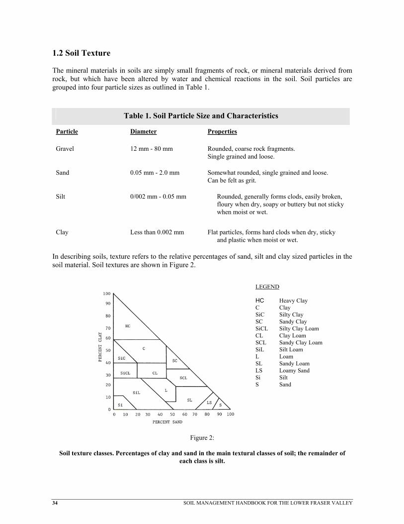
34 SOIL MANAGEMENT HANDBOOK FOR THE LOWER FRASER VALLEY
1.2 Soil Texture The mineral materials in soils are simply small fragments of rock, or mineral materials derived from rock, but which have been altered by water and chemical reactions in the soil. Soil particles are grouped into four particle sizes as outlined in Table 1.
Table 1. Soil Particle Size and Characteristics
Particle Diameter Properties Gravel 12 mm - 80 mm Rounded, coarse rock fragments.
Single grained and loose.
Sand 0.05 mm - 2.0 mm Somewhat rounded, single grained and loose. Can be felt as grit.
Silt 0/002 mm - 0.05 mm Rounded, generally forms clods, easily broken, floury when dry, soapy or buttery but not sticky when moist or wet.
Clay Less than 0.002 mm Flat particles, forms hard clods when dry, sticky
and plastic when moist or wet. In describing soils, texture refers to the relative percentages of sand, silt and clay sized particles in the soil material. Soil textures are shown in Figure 2.
Figure 2:
Soil texture classes. Percentages of clay and sand in the main textural classes of soil; the remainder of each class is silt.
LEGEND HC Heavy Clay C Clay SiC Silty Clay SC Sandy Clay SiCL Silty Clay Loam CL Clay Loam SCL Sandy Clay Loam SiL Silt Loam L Loam SL Sandy Loam LS Loamy Sand Si Silt S Sand

SOIL MANAGEMENT HANDBOOK FOR THE LOWER FRASER VALLEY 35
Table 2. Physical Characteristics of Soil Textural Groups
Group Soil Textures Characteristics Coarse and Moderately Coarse Textured Soils
Gravel, Sand, Loamy Sand, Sandy Loam
Loose and friable when moist or wet. Loose to soft when dry. Very high proportion of large pores. Low water-holding capacity. Good bearing strength and trafficability when wet. Tends to form weak clods when cultivated. Easy to maintain good tilth.
Medium Textured Soils
Loam, Silt Loam, Silt
Slightly sticky and plastic when wet. Friable to firm when moist, soft to slightly
hard when dry. High proportion of medium to small pores,
high water-holding capacity and available water.
Moderately good trafficability and bearing strength when wet.
Tends to form small to medium, slightly firm clods when cultivated.
Moderately easy to maintain good tilth.
Moderately Fine, Fine and Very Fine-Tex-tured Soils
Clay Loam, Silty Clay Loam, Silt Clay, Sandy Clay and Clay
Sticky and plastic when wet. Friable to firm when moist, hard to very hard when dry High proportion of small pores.. High water-holding capacity, but less
available water then medium-textured soils.
Poor trafficability when wet. Tends to form large, firm clods when
cultivated. Moderately difficult to maintain good tilth.
Organic Soils
Muck and Peat
Variably sticky, usually non plastic, friable, slightly firm when dry.
Very high water-holding capacity.
Poor trafficability when wet. Tends to form small to medium clods when cultivated. Easy to maintain good tilth.

36
Soil texture may be further described using modifiers which indicate a dominant or additional feature of the soil, for example, gravelly sandy loam, mucky silt loam, or sandy clay loam. It is convenient to place soil textures into four main groups, and describe the important properties common to each group, as in Table 2. Soil texture is a permanent characteristic. Texture will not change unless a large quantity of soil material of another texture is added to it, such as might occur during land clearing, or very deep plowing into the subsoil which is of a different texture. Also the additions of dredge material may alter the soil texture in a field. 1.3 Soil Structure In soils, individual sand, silt and clay particles become more closely packed and bonded together to form larger particles called aggregates. Soil structure refers to the type and arrangement of aggregates found in soils. Aggregates occur in almost all soils, but their strength, size, and shape varies considerably among soil types. Figure 3 illustrates well-structured and poorly-structured soils. Some of these aggregates may persist in stable forms which are not easily broken down by water or physical forces. In soils under cultivation, most aggregates at the surface tend to break down under the forces of rainfall, tillage and traffic. Soil structure also influences the internal drainage of the soil, affects its water-holding capacity,
temperature and resistance to the growth of plant roots and the emergence of seedlings. The formation of soil structure and factors which influence its breakdown are discussed in section 2.1. 1.4 Porosity The porosity, or % pore space, in soils is the portion of the soil mass occupied by air and water. Porosity is determined by both soil texture and structure and therefore porosity is influenced by practices which alter soil structure. The size and distribution of pores in the soil is very important in determining the rates of air and water movement in soils, as well as influencing root growth. Plant roots require a balance of air and water for optimum growth. Very small (micro) pores tend to restrict air and water movement while large (macro) pores promote good air and water movement.
Schematic drwell-structured
Figure 3:
awing of root growth in and poorly-structured soil.
SOIL MANAGEMENT HANDBOOK FOR THE LOWER FRASER VALLEY

SOIL MANAGEMENT HANDBOOK FOR THE LOWER FRASER VALLEY 37
Sandy soils have a low porosity (35-50% by volume), but the pores are relatively large. As a result of this, sandy soils tend to drain rapidly, to retain little water and to be well-aerated. Medium and fine-textured soils have higher porosity (40-60% by volume), and a high proportion of the pores are small. These soils tend to retain more water, to drain more slowly and to be less well-aerated. In finer textured clay soils, those approaching 60% porosity with a predominance of small pores, structure and porosity, restrict air and water movement. In these soils, it is desirable to create larger pores by promoting a granular structure. In addition to the effects of texture and structure on soil porosity, the activities of soil organisms is of equal importance. The burrowing activities of worms and soil insects result in the formation of larger pores which are beneficial to most soils. Practices which encourage the activity of soil organisms are of some practical significance in the management of finer textured soils.

38 SOIL MANAGEMENT HANDBOOK FOR THE LOWER FRASER VALLEY
2. MAINTAINING SOIL STRUCTURE AND FERTILITY Soil structure is the most important soil characteristic that must be considered when managing soils, because it is structure which is most affected by management practices. In turn, soil structure is one of the most important factors in crop growth. Therefore, the main objective in soil management is to promote and maintain good soil structure which will be favourable to crop growth. Most aspects of soil management are concerned with the structure or tilth of the soil within the cultivated or plow layer. Here, the upper 10 to 30 cm or more of the surface soil is subject to the influence of repeated tillage operations, cropping sequences and frequent additions of soil amendments. Below the plow layer, soil structure can be affected by traffic and tillage causing deep compaction. Soil compaction at the bottom of the plow layer, or deeper in the soil profile, is very common in the soils of the Lower Fraser Valley. This compaction is the result of both natural soil processes and farming activity. Soil structure improvements below the plow layer can be achieved over a long period by the use of deep tillage, subsoiling, drainage and the growth of deep rooted perennial crops. If the compaction or degraded soil structure is just below the plow layer, it is more readily reversed through the use of crop rotations, drainage and variation of tillage implement and tillage depth. As a general rule, the plow layer in most soils has a granular structure, and it is this type of structure which provides the best tilth for seeding, germination and crop growth. Granular structure provides a balanced supply of air and water as well as a friable medium through which roots can penetrate. Over cultivation, particularly with power driven tillage implements, has degraded the surface soil structure in many soils in the region. Massive, crusted or lumpy structure are adverse conditions which will reduce or even prevent plant growth by creating poor aeration and drainage. This structure will also physically restrict growth of roots or emergence of seedlings. Cover cropping, additions of organic residues, such as manure, and reduced tillage will help to reverse the soil structure degradation and return the soil to a granular structure. 2.1 The Formation of Soil Structure Aggregates and structural pores in the soil are formed by a number of means, including the growth of plant roots, tillage, wetting and drying, freezing and thawing, and the activities of soil organisms. 2.1.1 Plant Roots The growth of plant roots is one of the most important agents in the formation of aggregates and pores. Growing roots expand and force individual soil particles closer together; they extract water from the soil, causing the mass to shrink and cracks to develop. Dead roots leave numerous pores and channels. The result of this process is the development of many aggregates and pores. The most

SOIL MANAGEMENT HANDBOOK FOR THE LOWER FRASER VALLEY 39
favourable and stable soil structure is developed under a grass or grass-legume crop. See Figure 4. 2.1.2 Organic Matter and Soil Organisms Soil aggregate stability is proportional to its organic matter content. As a general rule, when soil organic matter levels are high, there are more stable aggregates than in soils with low organic matter levels. By their movement through the soil, the larger soil organisms, such as earthworms and soil insects, leave small channels and promote good soil structure. When soil organisms decompose organic matter, cementing agents such as sugars and gums are formed. These substances serve to bind soil particles together as aggregates, but in time these substances are themselves decomposed by other soil organisms. Therefore, in order to maintain a constant supply of cementing agents to promote soil structure, soils must have a continuous replenishing of organic matter, otherwise the original structure will deteriorate. In soils under cultivation for annual crops, the structure deteriorates faster than it can be built up by plant roots and organic matter. The effect of crops on the formation of stable aggregates is shown in Figure 4. Note that the addition of manure also increases the formation of aggregates.
Figure 4:
Effect of cropping practices on soil aggregation.

40 SOIL MANAGEMENT HANDBOOK FOR THE LOWER FRASER VALLEY
2.1.3 Clay
Clay particles are an important agent in soil aggregate formation. In sandy soils, a small percentage of clay may be the chief agent binding sand particles together. In soils which are dominantly clay, aggregates may tend to be larger than desirable for the preparation of a seedbed. In such soils, the addition of generous amounts of organic matter tends to promote smaller aggregates. 2.1.4 Soil Water - Wetting and Drying - Freezing and Thawing Prolonged saturation of the soil will eventually weaken and 'dissolve' soil aggregates and cause pores to be filled with finer particles. After drainage, the soil may become very compact, retarding water and air movement and restricting root growth. The water table in perennially wet soils must be controlled by artificial drainage before good structure can be achieved. In drained soils, alternate wetting and drying and freezing and thawing of the soil mass has a very important effect on structure. When soils freeze, water in the pores expands, forcing aggregates apart. Moist or dry soil aggregates break down into smaller particles when they are wetted, unless the wetting is very gradual. As wet aggregates dry out, they shrink and crack, breaking down into smaller aggregates. When soil aggregates are large, several cm in diameter, this process may be desirable. In soils with small or very weak aggregates, these processes may destroy most of the structure. Tillage implements, operating in wet soils, can also rapidly destroy structure simply by mechanical forces acting upon soil aggregates. Even on a weakly structured dry soil, tillage can have a detrimental effect on the soil structure. 2.2 Soil Structure, Degradation and Plant Growth The air and water relationships within the soil are markedly influenced by soil structure. Optimum plant growth depends upon an adequate, but not excessive, supply of water and air, as well as a loose, friable medium through which roots and shoots can penetrate. Such a favourable structure is usually found in the plow layer of most cultivated soils, where the common structure is described as granular or crumb-like. The plow layer is subject to many agents or forces which break down or build up soil structure. Some structural conditions, unfavourable to plant growth, commonly occur in soils. These are outlined in the following sections. 2.2.1 Crusting and Puddling By the action of water or mechanical forces, the granular or crumb structure in the plow layer may become completely broken down into a solid mass with no large pores. Such a soil is said to be puddled. When the puddled surface dries out, a hard crust forms. This crust may prevent seedlings from emerging, and tend to seal off the soil surface, preventing the infiltration of air and water.

SOIL MANAGEMENT HANDBOOK FOR THE LOWER FRASER VALLEY 41
2.2.2 Soil Compaction Soil compaction refers to the disruption and reduction of the large pores within the soil. The presence of excess soil moisture at the time of any field operation is the main factor leading to soil compaction. Once a soil is compacted, the bulk density and the strength of the soil are increased. For construction purposes, a compacted soil is ideal, but under normal crop production, a compacted soil can be a serious problem. Penetration into the soil by tillage implements and crop roots is restricted. The movement of air and water through the soil is hampered, causing the soil to remain wet and cool long into the growing season. Many areas in British Columbia suffer from this debilitating condition, which can be the main obstacle
to good crop production. Because compaction is such a serious threat, a closer look should be taken at ways to reduce or reverse its effects. However, section 2.2.2 will only deal with the recognition and effects of soil compaction. 2.2.2.1 How to recognize a compacted soil. Soil compaction occurs when a force compresses the larger soil pores and reduces the air volume of the soil. (See Figure 5.) The continuity of the pores from the surface of the soil to deeper depths is disrupted, and thus, the transmission of water through the soil, and gases between the crop's roots and atmosphere is reduced. (See Figure 6.)
Measurements of compaction damage to agricultural soils can be based on changes in density, strength, or visual estimates of structure. a) Bulk Density The measurement of a soil's bulk density provides a relative value of soil compaction. The porosity of a soil can be related to the bulk density measurement, with further laboratory procedures. Bulk density is expressed as weight per volume of soil (usually in terms of grams per cubic centimetre). Variation in bulk density can occur on a year to year basis, as freezing and thawing, wetting and drying cycles, and cultivation can alter the basic structure of a soil.
Figure 5: The effect of compaction on pore space.
Figure 6: The effect of compaction on root growth.
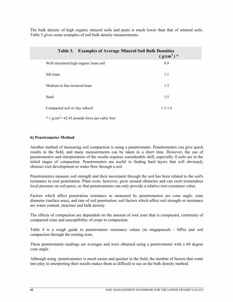
42 SOIL MANAGEMENT HANDBOOK FOR THE LOWER FRASER VALLEY
The bulk density of high organic mineral soils and peats is much lower than that of mineral soils. Table 3 gives some examples of soil bulk density measurements.
Table 3. Examples of Average Mineral Soil Bulk Densities ( g/cm3 ) *
Well structured high organic loam soil
0.9
Silt loam
1.1
Medium to fine textured loam
1.3
Sand
1.5
Compacted soil or clay subsoil
1.3-1.6
* 1 g/cm3= 62.43 pounds force per cubic foot b) Penetrometer Method Another method of measuring soil compaction is using a penetrometer. Penetrometers can give quick results in the field, and many measurements can be taken in a short time. However, the use of penetrometers and interpretation of the results requires considerable skill, especially if soils are in the initial stages of compaction. Penetrometers are useful in finding hard layers that will obviously obstruct root development or water flow through a soil. Penetrometers measure soil strength and their movement through the soil has been related to the soil's resistance to root penetration. Plant roots, however, grow around obstacles and can exert tremendous local pressure on soil pores, so that penetrometers can only provide a relative root resistance value. Factors which affect penetration resistance as measured by penetrometers are cone angle, cone diameter (surface area), and rate of soil penetration; soil factors which affect soil strength or resistance are water content, structure and bulk density. The effects of compaction are dependent on the amount of root zone that is compacted, continuity of compacted zone and susceptibility of crops to compaction. Table 4 is a rough guide to penetrometer resistance values (in megapascals - MPa) and soil compaction through the rooting zone. These penetrometer readings are averages and were obtained using a penetrometer with a 60 degree cone angle. Although using penetrometers is much easier and quicker in the field, the number of factors that come into play in interpreting their results makes them as difficult to use as the bulk density method.

SOIL MANAGEMENT HANDBOOK FOR THE LOWER FRASER VALLEY 43
If proper sampling techniques are used, the bulk density method may give a more accurate result for any particular site in the field. Because both technical methods have limitations, the visual method may be the quickest and best alternative.
Table 4. Examples of Soil Resistance Values on Crop Yield ( MPa ) *
Low Compaction Effects
1.0
Medium Compaction Effects
1.0-1.5
Severe Compaction Effects
2.0-3.0
*1 MPa = 145.0 pounds pressure per square inch *1 KPa = 0.1450 psi
c) Visual Method Often the best method of determining soil compaction is visual observation of both the soil and crops. Cloddy seedbeds, increased surface water ponding, loss of granular soil structure and reduced pore spaces through the soil are good visual indicators of compaction. Digging an observation hole in the field and observing rooting depths and patterns helps to determine if the crop is exploring the total soil volume, or is restricted. Probing soil layers with a knife can indicate compacted zones and help determine where rooting or water flow has been curtailed. Depressed crops, stunted or contorted root systems, a tendency to show yellow colouring, especially during or after large rainfalls (poor aeration), indicate compacted soils. Shifts in weed population are also good indicators. In addition, root rot diseases may increase with surface compaction.
2.2.2.2 Effect of soil compaction on crops. A reduction in yield or yield potential is the most significant effect that soil compaction has on crops. The inability of roots to penetrate compacted soil layers will result in decreased yield. With less root penetration into the soil, root mass is reduced and a plant's ability to take up nutrients is reduced. As a result of surface soil layers having lower water storage capacities, plant roots remain closer to the surface and are therefore more susceptible to drought. Compacted soils often have higher subsurface soil moisture contents because soil water is unable to drain away freely and air movement in the soil is restricted. This reduction in internal drainage generally leads to surface ponding which may drown the crop. As a result of the reduction in the size and number of macropores in the soil and the subsequent reduction in aeration, microbial activity is reduced. Soil microbes play an important role in the breakdown of organic matter and fertilizer into useable plant nutrients, so soil fertility may be reduced. Poor quality, low fertility organic matter accumulates on the soil surface because soil microbes are not present to breakdown crop residues. Well decomposed organic matter (humus) levels in the upper soil layers will decline with a reduction in microbial activity. With this loss of humus, soil aggregate stability is reduced.

44 SOIL MANAGEMENT HANDBOOK FOR THE LOWER FRASER VALLEY
Mechanical pressure and manipulation from equipment and loss of aggregate stability lead to further degradation of the soil structure. Compacted soils also tend to warm more slowly, resulting in slower crop growth and higher moisture contents. Compacted soils remain cool and wet into the growing season resulting in conditions that favour the growth of soilborne pathogens such as Pythium or Rhizoctonia root rot. Plants under stress are also much more susceptible to root rots and other diseases. If compacted layers are present in the soil, the risk of soil erosion is increased. The movement of water into and through the soil is reduced resulting in greater overland flow and subsequent surface erosion.
2.2.2.3 Factors Influencing Compaction The potential of any soil to compact is dependent upon its physical properties, water content and the nature of the force applied. The physical properties influencing compaction include the original bulk density and structure as well as the texture and organic matter content. In general, soils with fine textures (silt and clay), low organic matter contents, high porosity and weakly aggregated structure, are more susceptible to serious compaction. From a soil management stand point, all soils should be considered as capable of being compacted. The two major management factors that influence the soil's ability to compact are the soil moisture content at the time of any field operation and the contact pressure exerted by the implement or vehicle involved in that operation.
2.2.2.4 The Causes Of Soil Compaction a) Natural Compaction is the result of either natural soil formation processes and/or cultural practices. Natural compaction, resulting from soil formation processes, is found in many areas. This compaction is usually related to chemical transformations below the surface of the soil. It may also be related to the texture of the subsurface material and how it was deposited. Natural compaction may take the form of hardpans or cemented subsoils. Because some natural compaction continues as the soil formation processes continue, there is little or nothing that can be done to prevent its occurrence. Cemented layers or shallow natural hardpans may be disturbed by deep cultivation. Other management practices, such as drainage, may reduce the effects of the hardpans or reverse the soil formation processes that lead to cemented layers. b) Cultural Practices Most soils in their undisturbed state have porous surface layers, but after years of cropping this porosity is often significantly reduced. This reduction in pore space and size is the result of several cultural practices either alone or together. Some cultural practices that cause reduction in porosity and compaction are untimely or excessive tillage, repeated tillage at the same depth, pulverizing of soil aggregates by tillage equipment and excessive or untimely access to fields by farm vehicles. The process of deformation of randomly placed soil particles into a dense layered mass is known as

SOIL MANAGEMENT HANDBOOK FOR THE LOWER FRASER VALLEY 45
puddling. A 'puddled' soil has a greatly reduced infiltration rate. (See Figure 7.) The term 'Ks', refers to the steady state water infiltration rate of a soil. c) Drainage The presence of excess soil moisture is the main cause of soil compaction. The cultural practice with the greatest potential to reduce soil compaction in much of the humid areas of British Columbia is the use of subsurface drainage. The whole soil is more easily deformed and soil particles can be forced together when subjected to external pressure when they are wet. In saturated soils, the soil particles are dislodged and subsequently redeposited in a dense, layered form. Wheel ruts and tillage pans
formed in soft wet soils can be seen to have an effect on crop growth long after any excess soil moisture is gone. Drainage systems can be designed to prevent saturated soil conditions thereby greatly reducing soil compaction problems. (See Figure 8.) d) Tillage Tillage breaks apart soil aggregates, permitting soil particles to move apart or be forced closer together. Exposure of the soil particles to air also causes more rapid decomposition of soil organic matter which is important for soil aggregate stability. In wet soils, tillage does not break apart soil particles, but rather smears the particles together to form clods. Tillage, depending on the implement used, also exerts downward pressure on the soil layers below the surface leading to deep compaction and the formation of "plow pans". Thin layer smearing by implements such as mouldboard plows or rotovators, plus the compaction on the bottom of the furrow slice resulting from the contact pressure or any slippage of the tractor wheel cause deep tillage related compaction. (See Figure 9.) e) Traffic Traffic from vehicles such as forage wagons, farm trucks or manure vacuum tankers exerts force on the soil. ( See Figure 10. ) The degree
Figure 7:
Puddling of soil particles.
Figure 7:
Puddling of soil particles.

46 SOIL MANAGEMENT HANDBOOK FOR THE LOWER FRASER VALLEY
Figure 9:
Schematic drawing of the effect of tillage practices on soils. of compaction caused by vehicle traffic is dependent on two main factors that can be controlled by the crop producer. The first is the contact pressure of the vehicle which is determined by the overall weight of the vehicle and the foot print of the vehicle tires or tracks. The greater the contact pressure and/or the more frequently the vehicle passes over a particular area in the field, the greater and deeper will be the resulting compaction. (See Figure 11.) The second factor is the soil moisture content at the time the vehicle is in the field. The greatest amount of compaction occurs when the soil is wet. It has been estimated that up to 80% of the soil surface of a field can be exposed to wheel traffic at least once in any field season; this is particularly true in the case of fields used for forage production. f) Other Cultural Practices Other cultural practices that lead to compaction are soil surface exposure, organic matter depletion and the use of some crop nutrition and protection products. The exposure of soils due to lack of vegetative or trash cover allows raindrop impact to disperse soil particles leading to "puddling" of the soil and ultimately compaction. One use of tillage is to incorporate organic matter. It is also possible for the simple act of tillage to accelerate the breakdown of some types of organic matter in the soil which are required to bind soil particles together. In reduced tillage and forage production systems, soil structure is improved by microbial decomposition of organic residues without the
Figure 10.
Effects of wheel traffic on soil. Dotted and dashed lines indicate zones of compaction.

SOIL MANAGEMENT HANDBOOK FOR THE LOWER FRASER VALLEY 47
Figure 11:
Bulk density profiles before and after tractor wheel passage. benefit of tillage. Because many of the binding agents that maintain a soil's structure are the result of the activity of living organisms, excessive applications of soil amendments and pest control products may be harmful to those organisms. This would lead to a decline in the breakdown of organic matter into products that bind soil aggregates and the end result would be an increased risk of soil compaction. 2.3 Soil Fertility The factors contributing to soil fertility are the physical factors discussed in section 2.2 (page 40) and chemical and biological factors. Plants require various amounts of essential nutrient elements which must come from the soil. These include macronutrients such as: nitrogen, phosphorus, potassium, sulphur, calcium, magnesium and micronutrients such as: iron, manganese, zinc, copper, boron, molybdenum, cobalt, and chlorine. In cultivated soils, most of these nutrients are subject to removal by crops, to leaching, or conversion to unavailable forms. Therefore, deficiencies occur sooner or later, and nutrients must be added to the soil. Most Coastal soils are especially subject to deficiencies of nitrogen, phosphorus, potassium, magnesium, and boron; copper and zinc may be deficient in some soils. See Section 4.5 for more details of soil amendments that can be used to correct nutrient imbalances and deficiencies.

48 SOIL MANAGEMENT HANDBOOK FOR THE LOWER FRASER VALLEY
2.4 Soil Testing Soil testing is a useful tool for determining fertility requirements of crops. A regular sampling program can also track the trends and efficiency of a fertilizer program. A soil testing program should be coupled with feed or plant tissue testing for a more complete pool of information from which the producer can make crop management decisions. The value of the soil test is only as good as the method used to take the soil sample. It is important to be accurate in collecting the samples and when recording information about each sample. Before sampling, you should consult your nearest British Columbia Ministry of Agriculture, Fisheries and Food office or the British Columbia soil testing laboratory of your choice for any specific information regarding fees, sample collecting containers or sampling procedures. The best time to soil sample in the south coastal region is in late spring as this sample will be the most useful. As a general rule, it is best to soil sample a couple of weeks prior to the start of any seedbed preparation. Perennial crops, such as forage and pasture or berries and tree fruits, should have soil sampling done just prior to the beginning of a new flush of growth in the spring. When nutrient symptoms or other growth problems occur during the growing season, two samples should be taken, one each from the poor growth and good growth areas. These samples should be rushed to the laboratory so recommendations for any corrective action can be made rapidly. The following steps should be taken when collecting soil samples:
• Gather clean sampling equipment including a probe, auger or shovel and at least one plastic bucket for collection and mixing of the cores.
• Obtain the appropriate soil sample bags or boxes from the lab of your choice or use small plastic
or paper bags.
• Make a simple map of your farm and identify each field or portion of a field which is to be sampled with a number or letter. Areas in any field that are different due to appearance, fertilization or cropping practice, soil type, slope or drainage should be sampled separately. Care should be taken to avoid small, low, wet areas, dead furrows and areas close to trees, roads and fence lines unless these areas are of particular importance to the sampling program. Do not sample near manure piles (new or old), fertilizer storage or fertilizer bands or livestock droppings. Samples should be taken from fields or portions of fields that are reasonably uniform and can be managed as one unit.
• Record all pertinent information about the area sampled as soon as the sample is collected. This
information should include cropping history and desired crops to be grown, any recent fertilizer or soil amendment applications and any information relevant to the reason for the collection of the soil sample.

SOIL MANAGEMENT HANDBOOK FOR THE LOWER FRASER VALLEY 49
Soil samples are usually taken from the top 15-20 cm of the soil for most cultivated crops as this is the zone that is normally tilled and contains the major portion of the crop's roots. Sampling should be done with the tool that is most appropriate for the soil conditions. If the soil is stony or wet, an auger or shovel will work better than a tube type soil probe. Regardless of the implement chosen, the implement and the sampling bucket should be clean. To begin sampling, remove excess plant residues. When using a shovel, create a V-shaped hole and slice a 2-3 cm thick slice down one side to a depth of 15-20 cm. Trim this slice on either side to form a 2-3 cm wide core and place this in the sample bucket. This core is an individual sample that will be used to create the final composite sample. When using a probe, push the tube into the soil to the desired sample depth and collect the individual sample. Take 10 to 20 individual samples from each sampling area. For fields up to 10 hectares in size, a minimum of 20 individual samples is suggested. Once all the individual samples have been collected in the bucket, break up the lumps and remove the stones. Make sure the soil is completely mixed and then remove about 500 grams or 500 millilitres and place this composite soil sample in the soil sample box or bag. The labelling on the sample should be the same as on the rough map of the farm or field. If, however, the sample is quite moist, it should be air dried before it is sent to the lab unless it is to be hand delivered within a few hours of collection. Moist samples can incubate in warm conditions, such as post offices, bus depots and the inside of warm vehicles, thus changing the chemistry of the soil. Soil samples should not be treated like dirt! Soil sampling is a useful farm management tool, but it is important to keep in mind that the soil test results are only as accurate as the sampling technique and the records kept on each sample. A good soil fertility program requires regular soil sampling, but it may also require feed or plant tissue testing as well. A sampling program that includes the preparation of a farm map each year outlining the location of each sample and the crop management practices that were associated with each field is recommended. Once you have chosen a soil testing lab, it is a good idea to stick with that lab, because each individual lab has its own "soil testing philosophy" for the determination of soil nutrient levels and also for the interpretations and recommendations that come from the test results.

50 SOIL MANAGEMENT HANDBOOK FOR THE LOWER FRASER VALLEY
3. WATER MANAGEMENT High rainfall during the fall, winter and spring periods often causes saturation, flooding and water erosion of most soils, while low rainfall during the summer period often causes a water deficit for most crops. High water table and water deficit conditions are both detrimental to optimum crop production, but both may be largely overcome with drainage, irrigation and appropriate tillage and soil management. 3.1 Land Drainage Poorly drained soils are those with a high water table present for most of the year. The high water table restricts the usefulness of the land by limiting the range of crops that can be grown and limiting the trafficability of soils. In most cases, the water table can be controlled by means of artificial drainage. The costs of drainage are usually more than offset by the value of the crops which can be grown on drained land. Drainage systems are also necessary for erosion control on many upland soils, and, in some cases, to overcome salinity. 3.2 Soil Drainage Guide For The Fraser Valley
3.2.1 Introduction The Soil Drainage Guide for the Fraser Valley is a supplement to the B.C. Agricultural Drainage Manual which deals with detailed design procedures. The Guide presents guidelines for drainage based upon many years of practical experience. The aim is to help in the identification of drainage requirements without the need of having to go through the detailed investigations described in the Drainage Manual. The basis of this guide is a set of generalized soil profiles or soil categories which are distinctly different in regard to drainage and soil management requirements. Drainage requirements were formulated for each soil category and all the inadequately drained soils of the Lower Fraser Valley were placed in the category which matched their profile characteristics most closely. The result is the drainage recommendations on Table 5. Since the recommendations of this guide are based on information contained in the Soil Survey Report which describes average conditions over larger areas, and on generalized soil categories, it is possible that on occasion site specific conditions are at variance with those for which the guidelines were formulated It is for this reason that caution must be used in applying the recommendations. Only through on-site investigation, can the necessary information for completely accurate drainage recommendations be provided.
3.2.2 How To Use The Drainage Guide Soil Name - Use RAB Bulletin 18 of the Langley-Vancouver map area; Vol. 1 for name(s) of soil(s) of the area to be drained. Recommendation - Go to Table 5 and obtain recommendation for the soil(s) in question.

SOIL MANAGEMENT HANDBOOK FOR THE LOWER FRASER VALLEY 51
Soils not listed in Table 5 are mapped as being moderately well, well or rapidly drained. However, some soils, such as the Whatcom and Ryder series which are included in Table 5, could be drained for water erosion control. Land Use - Refer to Table 6 and select the cropping and land use category appropriate for the proposed use of the land and note the adjustment factor. Adjustment Factor - Multiply the adjustment factor with the drain spacing found in Table 5 to get the correct drain spacing. CAUTION - Review all pertinent facts and make further adjustments if necessary. Corroborate drain recommendations with on-site surveys and measurements for final design purposes. Description And Comments - Note the soil category number for the soil in question in Table 5 and refer to Tables 7 and 8 for additional information on drainage soil management and subirrigation.
Table 5 DRAINAGE RECOMMENDATIONS Map Sym.
Soil Name
Drainage
Soil Category
Drain Spacing
Drain Depth
FR SS SI
AB Albion Moderately poor to poor 8 12 0.8 M M AG Addington Very poor 11 12 1.2 H H AL Alouette Poor to very poor 13 14 1.2 M-L H AN Annis Poor to very poor 13 14 1.2 L M H AR Arnold Moderately poor 2 16 1.2 M AS Annacis Very poor 14 12 1.2 M B Benson Poor to very poor 10 16 1.2 H M BB Blackburn Poor to moderately poor 11 18 1.2 H H BD Banford Poor to very poor 15 12 1.2 L M BK Buckerfield Poor to moderately poor 11 16 1.2 H H BL Beharrel Moderately poor to poor 3 14 1.2 L BN Bonson Imperfect 11 20 1.2 H H BR Berry Imperfect 5 16 1.2 M BT Bates Imperfect 10 22 1.2 H H BU Blundell Poor to very poor 13 14 1.2 H H BY Boosey Poor 1 20 1.2 H H CD Cloverdale Poor 3 14 1.2 L CG Coghlan Imperfect 1 24 1.2 H H CN Calkins Poor 10 18 1.2 H H CT Crescent Moderately poor to poor 11 16 1.2 M H CV Carvolth Poor to very poor 8 10 0.8 M M DR Defehr Imperfect 1 24 1.2 H H DS Deas Poor 11 16 1.2 M H DT Delta Poor 11 16 1.2 H-M H DW Dewdney Imperfect 10 22 1.2 M H DX Dixon Poor to very poor 10 16 1.2 H H
FR Filter SS Subsoil SI Subirrigation H Highly Recom. M Mod. Recom. L Recom. with Limited Importance

52 SOIL MANAGEMENT HANDBOOK FOR THE LOWER FRASER VALLEY
Table 5 con’t. Drainage Recommendations Map Soil Drainage Soil Drain Drain FR SS SI
EK Elk Poor 10 18 1.2 H H EM Embree Poor to very poor 11 14 1.2 H H ER Errock Imperfect 1 24 1.2 H H F Fairfield Imperfect 11 20 1.2 H-M H FD Fadden Imperfect 11 20 1.2 H H GG Grigg Poor to imperfect 11 18 1.2 H H GN Gibson Very poor 15 12 1.2 L M GU Guichon Poor to moderately poor 10 18 1.2 H H GV Glen Valley Very poor 14 12 1.2 M GY Goudy Poor 12 12 1.0 M L HD Hazelwood Poor 11 16 1.2 H H HJ Hjorth Poor to moderately poor 11 16 1.2 H H HN Heron Poor 4 18 1.2 H H HP Hopedale Poor 10 18 1.2 H H HT Hallert Poor to very poor 2 14 1.2 L M HZ Hatzic Poor 8 12 0.8 M L JN Judson Very poor 15 12 1.2 M-H M K Kitter Moderately poor 2 16 1.2 L M KZ Katzie Moderately poor to imperfect 11 18 1.2 H H L Ladner Moderately poor to poor 3 14 1.2 M L LA Langley Poor to moderately poor 9 10 0.8 M L LH Lehman Poor 10 18 1.2 H H LM Lumbum Very poor 14 12 1.2 M LU Lulu Very poor 5 12 1.2 M LV Livingstone Imperfect to moderately poor 7 18 0.8 H ME McElvee Poor 10 18 1.2 M H ML McLellan Poor to moderately poor 3 14 1.2 M-L L MW Mathews Moderately poor to poor 10 18 1.2 H H MY Murrayville Imperfect 7 20 1.2 L-M H NK Nicomekl Poor 11 16 1.2 M H NN Niven Poor to very poor 2 14 1.2 M NV Neaves Poor to very poor 11 14 1.2 H H P Pitt Poor to moderately poor 2 16 1.2 M-H M PE Page Poor to moderately poor 10 18 1.2 H-M H PR Prest Very poor 10 14 1.2 M-H H PY Pelly Poor 2 16 1.2 M M RC Richmond Very poor 15 12 1.2 M RD Ryder Well to moderately well 10 18 1.2 H RS Ross Very poor 11 12 1.2 H H SA Sandel Poor to very poor 11 14 1.2 M H SB Seabird Imperfect 1 24 1.2 H H SC Scat Poor 8 12 0.8 M M FR Filter SS Subsoil SI Subirrigation H Highly Recom. M Mod. Recom. L Recom. with Limited Importance
Sym Name Category Spacing Depth

SOIL MANAGEMENT HANDBOOK FOR THE LOWER FRASER VALLEY 53
Table 5 con’t. Drainage Recommendations Map Sym
Soil Name
Drainage
Soil Category
Drain Spacing
Drain Depth
FR SS SI
SF Spetifore Poor to very poor 11 14 1.2 H H SG Sturgeon Poor to very poor 2 14 1.2 L M SI Sim Poor 10 18 1.2 H H SM Sumas Very poor to poor 1 18 1.2 H H SR Summer Imperfect 7 20 1.2 L H ST Steelhead Imperfect 2 20 1.2 M-H M SV Seaview Poor to very poor 8 10 0.8 H M M TR Triggs Very poor 14 12 1.2 M TU Tunbridge Imperfect 2 20 1.2 M V Vinod Very poor 11 12 1.2 M H VD Vedder Poor 11 16 1.2 H H VY Vye Imperfect 2 20 1.2 L M
W Whatcom Moderately well, telluric seepage 6 12 1.0 M L
WG Widgeon Very poor 15 12 1.2 L M WL Westlang Poor to very poor 3 12 1.2 L FR Filter SS Subsoil SI Subirrigation H Highly Recom. M Mod. Recom. L Recom. with Limited Importance
Table 6 Land Use and Subirrigation Adjustment Factor LAND USE ADJUSTMENT FACTOR HIGHEST DRAINAGE DEMAND 0.8 Access to land is desirable or necessary all of the time. Crops to be used are very sensitive to excess water and are of highest value. Use only in the most stringent cases.
HIGH DRAINAGE DEMAND 0.9 Soft fruits, except blueberries and cranberries, perennial ornamentals, early or year-round pasture, alfalfa, other high value or water sensitive crops.
MEDIUM DRAINAGE DEMAND
1.0
Mid-season vegetable crops, hay and pasture, overwintering cereals and cole crops, blueberries.
SUBIRRIGATION
0.7
All crops.

54 SOIL MANAGEMENT HANDBOOK FOR THE LOWER FRASER VALLEY
Table 7. Drain Recommendations Based on Generalized Soil Conditions
Soil Category
Depth cm
Texture
Drain Spacing
Depth
Special Requirements
Subirrigation Suitability
1 0-150 Coarse 20 1.2 Filter H 2 0-150 Medium 16 1.2 M 3 0-150 Fine 14 1.2 L 4 0-100 Coarse 18 1.2 Filter H 100-150 Fine-Dense 5 0-100 Medium 14 1.2 M 100-150 Fine-Dense 6 0-100 Fine 12 1.0 Subsoiling L 100-150 Fine-Dense 7 0-50 Coarse 16 0.8 H 50-150 Fine-Dense 8 0-50 Medium 12 0.8 Subsoiling M 50-150 Fine-Dense 9 0-50 Fine 10 0.8 Subsoiling L 50-150 Fine-Dense 10 0-50 Medium-Fine 18 1.2 Filter H 50-150 Coarse 11 0-100 Medium-Fine 16 1.2 Filter M 100-150 Coarse 12 0-40 Organic 12 1.0 L 40-150 Fine-Dense 13 0-40 Organic 16 1.2 Filter H 40-150 Medium Coarse 14 0-150 Organic 14 1.3 M 15 0-100 Organic 14 1.2 L 100-150 Medium
Table 8. Generalized Description and Conditions Soil Category
1 0-150 cm medium-coarse-texture. Water infiltration and movement through the soil is good. This allows for easy water table control. There is little likelihood of surface ponding to occur. Drainage is most effective by means of underdrainage. There is no need for special surface drainage provisions, but land smoothing should not be ruled out to eliminate problems in low areas. The water-holding capacity is low making provisions for irrigation desirable. Subirrigation can be very effective in this category of soil. Drains should be fitted with a filter. Iron ochre hazard is high.

SOIL MANAGEMENT HANDBOOK FOR THE LOWER FRASER VALLEY 55
2 0-150 cm medium-texture. Water infiltration and transmission through the soil is moderately high, but surface ponding can be a problem. Water table control is effective with underdrains. Surface drainage provisions are not normally required, but land smoothing is recommended. The soil holds water quite well and irrigation needs are, therefore, not high. Suitability for subirrigation is moderately high to moderate.
3 0-150 cm fine-texture. Water infiltration and transmission through the soil is low with a
fairly high surface ponding hazard. Water table control is difficult. Underdrains are suitable, but a close spacing is necessary. Blind surface inlets should be considered in troublesome depressions particularly under sloping conditions. Soils in this category respond well to subsoiling and careful soil management is a prerequisite for effective water control. Land smoothing is strongly recommended. Subirrigation is not effective in these soils.
4 0-100 cm coarse-texture. 100-150 cm fine-texture, moderately dense. Water infiltration and
transmission through the soil is high. Ponding hazard is low. Underdrains are the most effective way of controlling the water table and there is no need for special surface drainage provisions. Irrigation requirements are high and irridrain systems are well suited to this soil. Filters are not needed if the drains can be placed sufficiently deep into the subsoil. Iron ochre hazard is high.
5 0-100 cm medium-texture. 100- 150 cm fine-texture, moderately dense. The
capacity of the soil to accept and transmit water is moderate to low requiring a relatively close drain spacing for good water table control. Where the dense subsoil is less than 100 cm deep, porous soil material or gravel should be used to blind the drains. Underdrains are most appropriate for drainage and land smoothing is a good measure to eliminate depressions and the likelihood of surface ponding. Under sloping conditions, there is a high hazard of water erosion. Water retention capacity is high and there is a moderate to moderately high suitability for subirrigation.
6 0-100 cm fine-texture. 100-150+ cm fine-texture, moderately dense. Control of excess
water in this soil is difficult. A close drain spacing must be used for adequate control and considerable emphasis must be placed on proper soil management to achieve satisfactory results. Land smoothing and judicious use of blind surface inlets in depressions is recommended. Irrigation requirements are not high due to the high water holding capacity and subirrigation suitability is low or moderately low. This soil responds well to subsoiling. When the land slopes there is a high risk of water erosion.
7 0-50 cm coarse-texture. 50-150 cm fine-texture, moderately dense. This soil accepts water
readily, but transmission of water is hampered by the dense subsoil. Drains are well suited to control the water table and filters are not necessary provided drains are placed at the

56 SOIL MANAGEMENT HANDBOOK FOR THE LOWER FRASER VALLEY
recommended depth. There is little danger of surface ponding, and except for land smoothing, there is no need for surface drainage provisions. Irrigation need is relatively high and subirrigation suitability is high. Improving the soil depth through subsoiling is recommended. The possibility of encountering ochre is quite high.
8 0-50 cm medium-texture. 50-150 cm fine-texture, moderately dense. Excess water
management poses difficulties because of the shallow soil. Drains must be placed close together and at a shallower depth than normal. Blinding with porous soil or gravel is recommended. This soil requires emphasis on drainage measures related to the surface. Land smoothing and the use of blind surface inlets in depressions and in other strategic location is needed for optimum water control. With slope, surface interceptors are necessary to stop erosion. Irrigation needs are normal and the suitability for subirrigation is moderate. Subsoiling will deepen effective soil depth and aid water movement. It should be done prior to drain installation. Ochre hazard is low.
9 0-50 cm fine-textured. 50-150 cm fine-texture, moderately dense. Water management
requirements of this soil are high. A great deal of effort and care is needed to get rid of excess water. Closely spaced drains with provisions for direct surface drainage with gravel filled trenches are necessary. Where such surface provisions are not possible, the use of surface ditches may be unavoidable, The soil must be broken with a subsoiler and well supplied with organic matter. Permanent cover crops will work best, but if that is not possible, a careful crop rotation must be selected to prevent the soil from being structurally damaged. Ochre hazard is low. Under sloping conditions, erosion potential is high and surface interceptor drains are required. This soil is not suitable for subirrigation.
10 0-50 cm medium-fine texture. 50-150 cm coarse-texture. Water table control of this soil is
not difficult. Underdrains are very effective, but filters are required. Efforts must be directed towards keeping the surface soil in an open well structured condition with organic matter applications and sensitive management practices. Subirrigation suitability is high. A fairly high ochre hazard is present.
11 0-100 cm medium-fine texture. 100-150 cm coarse-texture. Although water table control of
this soil is moderately good, surface conditions are poor. Land smoothing and surface drainage oriented provisions are desirable as are subsoiling, organic matter applications and sensitive management practices. Filters are generally required and the ochre hazard is moderately high. The suitability of this soil for subirrigation is moderate.
12 0-40 cm organic material moderately well to well decomposed. 40-150 cm fine-texture,
medium high density. Water movement into and through the soil is restricted requiring

SOIL MANAGEMENT HANDBOOK FOR THE LOWER FRASER VALLEY 57
fairly intensive drainage for satisfactory control. Control of water for inhibiting decomposition is of relatively little effect and should not be used in this soil because of the adverse effect of such measures on the subsoil structure. The potential for effective subirrigation is low. Subsoiling will be of help in enhancing subsoil porosity and water movement.
13 0-40 cm organic material, moderately well to well decomposed. 40-150 cm medium to
medium-coarse-texture. Water control prospects are high in this soil which is well suited to the use of underdrains. Filters are recommended where sand is present at drain depth. Accelerated composition of the organic material is a consequence of improved drainage. It should be reduced by keeping the water table level high whenever possible through water control facilities. The effectiveness of these measures, however, diminishes as the depth of the organic material is reduced. Subirrigation potential is moderately high.
14 0-150 cm organic material. Movement of water through this soil material is variable, but
generally in a medium range. Underdrains control excess water well, but accelerated decomposition is a consequence. Drains must be placed at maximum depth and provided with a water control system to raise water levels when possible. The suitability for subirrigation is moderate, but the drought hazard is low due to a high water-holding capability.
15 0-100 cm organic material, well-moderately well decomposed. 100-150 cm
medium-texture. Movement of water through this soil material is variable, but generally in a medium range. Underdrains control excess water well, but accelerated decomposition is a consequence. Drains must be placed at maximum depth and provided with a water control system to raise water levels when possible. The suitability for subirrigation is low, but the drought hazard is low due to a high water-holding capability.
3.2.3 General Considerations For Soil And Water Management 3.2.3.1 Saturation Saturation of the soil for extended periods of time is harmful to most soils and generally causes reduction of crop yields. In addition, it causes trafficability problems reducing land access and use. It is for these reasons that saturation of the soil should be avoided by means of appropriate drainage systems and other measures described below. 3.2.3.2 Surface Ponding Surface ponding may be due to either a high water table or impoundment of water in depressions at the surface and in some cases due to both. It is harmful to most soils, for reasons described above, and it worsens the situation by causing layers of fine soil particles to be deposited which have a much lower permeability than the original soil. Underdrainage with special surface inlet provisions, in some

58 SOIL MANAGEMENT HANDBOOK FOR THE LOWER FRASER VALLEY
cases, land smoothing, cover cropping, reduced tillage and reduced traffic, are all methods or precautions that can be used to eliminate surface ponding. 3.2.3.3 Surface Drainage The removal of water from the surface by means of shallow open ditches finds application in some areas. This type of drainage does not lower the water table and is, therefore, not a substitute for underdrains. Moreover, surface ditches are prone to erosion and restrict traffic on the land. It is for these reasons that surface drainage is a method of water removal which should be used only as a last resort where underdrainage is not possible or as an interim measure. Even where the soil is dense, a subsurface drainage system with surface interception capability is to be preferred. Surface interception is achieved by placing drain rock over the drain to the surface or by means of a standpipe in the lowest area of a field. The drain rock system does not pose a restriction in the field and extends over a much larger area than a single standpipe. Porous interceptor drains have proven to be virtually 100% effective in intercepting surface water on sloping land. Care must be used not to cover such drains with soil during cultivation.
3.2.3.4 Soil Management Drainage and soil management go hand in hand. Cultivation of the soil tends to reduce soil tilth and the capacity of the soil to receive and transmit water. Every effort must be made to enhance tilth if drainage is to be successful. Following are examples of tilth enhancement measures: rotation of row crops with non-row crops such as grasses, and cereals; organic matter addition through application of manure, compost and use of green manure crops; cultivation methods which do not pulverize the soil such as avoiding use of high speed rototillers; avoidance of traffic during wet periods when the soil is most vulnerable to compaction.
3.2.3.5 Organic Soils Organic soils decompose and settle when water is removed and air is able to move into the soil. Over time, all the organic matter will disappear and the soil surface will be lowered. In most cases, this process is undesirable because of the high production value of the organic soil in contrast to the lower production capability of the subsoil. In order to halt or reduce the rate of decomposition and settling, drainage must be controlled so that the water level can be held high whenever this does not interfere with cultural practices. This practice is recommended in deep organic soils. Shallow organic soils benefit substantially less from water control measures and will in fact sustain damage to the structure of the subsoil. When organic matter depth is less than 40 cm water control measures are no longer effective and are not recommended. 3.3 Drainage in Lowland Soils Most lowland soils are poorly to very poorly drained and have a water table near the surface for most of the year. Without artificial drainage, these soils have a short period of trafficability and are useful only for a few crops. The benefits of drainage are: • Increased soil bearing strength, which improves trafficability and extends the opportunity days,
(see page 60), by as much as 6 weeks earlier in spring, and an extended harvest period.

SOIL MANAGEMENT HANDBOOK FOR THE LOWER FRASER VALLEY 59
• Enhanced timeliness of field operations, permitting more efficient distribution of labour and machine use.
• Rooting depth is increased, providing roots with a greater volume of soil from which to draw
nutrients and water. • Increased aeration, providing more oxygen for plant roots. • Increased soil temperatures, permitting earlier germination and growth. Underdrainage is the most effective means of controlling the water table in most cases. In modem systems, lightweight, continuous flexible, perforated plastic drain tubing is installed using highspeed drain trenchers or drain plows. Drains will work effectively in many soils without additional measures, but some special conditions require additional precautions. Porous envelopes are recommended in tight, slowly pervious soils, and sandy soils require drain filters to prevent sand from entering drain tubes and clogging them. Organic soils settle and decompose rapidly after they are drained, and the water table should be more carefully controlled to minimize subsidence. Refer to section 4.4 Management of Peat and Muck Soils. Drainage systems should be designed according to sound design principles and a topographic survey. Detailed information is provided in the publication, British Columbia Drainage Manual. 3.4 Drainage: The Boundary Bay Water Control Project In 1981, a demonstration plot was established, in the Municipality of Delta, to demonstrate the benefits of water control on the very poorly drained Ladner soil series. This soil is fine-textured deltaic soil with surface and subsurface textures in the silt loam to silty clay loam range. Four main subplots were installed at the site to demonstrate both drainage and subirrigation water management techniques. Subsurface drains were installed on three of the subplots at a spacing of 14 m and a depth of approximately 1.10 m. One of these three subplots (A) was a fully drained plot which had an active drainage system in place year round. The second subplot (B) was initially used as a low level subirrigation plot. Due to the poor ability of this soil to conduct water, and therefore create an artificial watertable, the practice of subirrigation at the 14 m drain spacing was abandoned in 1988. This subplot (B) is now managed in the same manner as subplot (A). The third drained subplot (C) was also a subirrigation plot, which initially had drains installed at 14 m. Additional drains where installed at 7 metres in 1986 to achieve better watertable control during moisture deficit periods. The drained subplots are actively drained during the winter months with the use of a float controlled pump installed at the outlet end of a series of ditches into which the drains empty. The fourth subplot (D) was left undrained as a check plot. The results of this demonstration plot have been very beneficial to the pool of information regarding drainage of agricultural land in the Lower Fraser Valley. Although, in most cases the drained plots have given positive yield results from the various crops grown, t here have been some crops, such as

60 SOIL MANAGEMENT HANDBOOK FOR THE LOWER FRASER VALLEY
main season potatoes, that have benefited from the moister soil conditions of the undrained plot area. However, the risk of fall rains interfering with the harvest on undrained soil is very high. In most years, soil moisture conditions and trafficability are poor in the undrained area at the time of main season potato harvest. Early season potatoes, on the other hand, cannot be planted in these soils without a well designed and functioning drainage system. The greatest benefit of the drainage has been seen in the yield response and winter survival of perennial and over wintering annual crops. Small fruit crops, such as blueberries and strawberries, have proven that they can be grown on poorly drained fine textured mineral soils as long as adequate drainage is provided. Perennial forage grass stands will survive without drainage, however, the health, vigour, quality and purity of the stand will decline rapidly if drainage is not provided. Over wintering crops, such as winter wheat, must have drainage in order to survive as these crops continue to grow throughout much of the winter months, particularly in the South Coastal areas of British Columbia. Access to the field early in the year is essential for disease, insect and weed control as well as fertilizer application on small fruits
Table 9. Boundary Bay Water Control Project Opportunity Days* Summary
*8 a.m. – 4 p.m. Water table depth >= 50 cm midway between drains
March 1 – May 31, 92 days
YEAR
A Regime
D Regime
1982 1983 1984 1985 1986 1987 1988 1989 1990 1991
MEAN
RANGE
84 83 90 89 90 89 84 79 76 82
85
76-90
34 19 4
29 3
33 17 34 13 13
20
3-34
Workable Soil Days
March 1 – May 31, 92 Days
YEAR
A Regime
D Regime
1990 1991
MEAN
RANGE
60 65
63
13-31
13 14
14
1-12

SOIL MANAGEMENT HANDBOOK FOR THE LOWER FRASER VALLEY 61
and over wintering annual crops. Only drainage, coupled with good soil management techniques, will allow for this access. Although crop yield is the most obvious means of measuring the benefits of drainage, the concept of opportunity days has been used with some success at the Boundary Bay plots. An
Figure 12:
Typical drainage response to a series of major storm events.
Table 10 a. Boundary Bay Yield Responses Forage Grass (t/ha) Strawberries (t/ha)
Regime 1984 1985 1986 1987 1988 1989 1990 1984 1985
A 12.4 11.8 9.1 4.1 5.7 10.7 8.6 5.2 8.1 C 11.9 12.3 8.6 5.4 5.3 13.4 7.1 5.5 3.6 D 9.5 8.2 6.7 1.9 4.7 7.4 8.9 1.5 0.0
Table 10 b. Boundary Bay Yield Responses
Winter Wheat Grain (t/ha)
Winter Wheat Straw (t/ha)
Corn D.M. (t/ha)
Regime 1986 1988 1989 1986 1988 1989 1983 1984 1985
A 8.2 7.5 4.6 11.5 12.8 6.4 22.1 14.9 12.0 C 8.8 9.4 7.3 13.1 17.4 8.3 22.7 14.3 16.5
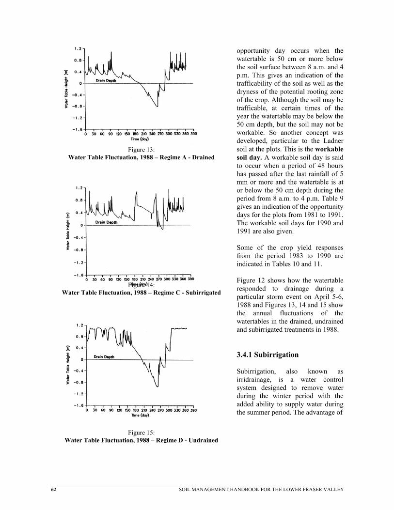
62
opportunity day occurs when the watertable is 50 cm or more below the soil surface between 8 a.m. and 4 p.m. This gives an indication of the trafficability of the soil as well as the dryness of the potential rooting zone of the crop. Although the soil may be trafficable, at certain times of the year the watertable may be below the 50 cm depth, but the soil may not be workable. So another concept was developed, particular to the Ladner soil at the plots. This is the workable soil day. A workable soil day is said
Water Table Fluctua d
Water Table Fluctuati
Water Table Fluctuat
Figure 13: tion, 1988 – Regime A - Draine
to occur when a period of 48 hours has passed after the last rainfall of 5 mm or more and the watertable is at or below the 50 cm depth during the period from 8 a.m. to 4 p.m. Table 9 gives an indication of the opportunity days for the plots from 1981 to 1991. The workable soil days for 1990 and 1991 are also given. Some of the crop yield responses from the period 1983 to 1990 are indicated in Tables 10 and 11. Figure 12 shows how the watertable responded to drainage during a d
Figure 14: on, 1988 – Regime C - Subirrigate
particular storm event on April 5-6,1988 and Figures 13, 14 and 15 show the annual fluctuations of the watertables in the drained, undrained and subirrigated treatments in 1988. 3.4.1 Subirrigation Subirrigation, also known as irridrainage, is a water control system designed to remove water during the winter period with the added ability to supply water during the summer period. The advantage of
d
Figure 15:ion, 1988 – Regime D - Undraine
SOIL MANAGEMENT HANDBOOK FOR THE LOWER FRASER VALLEY

SOIL MANAGEMENT HANDBOOK FOR THE LOWER FRASER VALLEY 63
subirrigation is its dual function at moderate cost. There is no need for overland irrigation pipe systems with all their disadvantages of cost, labour and others related to applying water to the surface of the land. However, the system is not free of disadvantages. Only soils that are naturally poorly drained, have good porosity and are reasonably level are suitable. A relative subirrigation suitability rating for each soil is included in the Drainage Recommendation section. Subirrigation systems must be laid out to satisfy drainage and subirrigation requirements. Sloping lands must be divided into zones that do not vary more than 45 cm in elevation. Drains must be placed close enough together to be able to control the water table in the field evenly. Accurate subirrigation spacings are calculated on the basis of soil hydraulic conductivity. It has been found that reducing the normal drain spacing by 30% provides a drain spacing which, in general, meets subirrigation requirements quite well. Lowland soils often have naturally high water tables which contribute water for crop growth, or the water table can be raised artificially for this purpose. This method of irrigation is known as subirrigation. Subirrigation is particularly effective in porous, coarse-textured soils, but can also be practiced effectively in fine-textured soils with an underdrainage system. The major limiting factors to subirrigation are the soils ability to conduct water vertically from a drainage system and/or horizontally between drains or from ditches. A reliable and abundant supply of “clean”, non-saline and non-sodic water is essential if subirrigation is to be attempted. The critical watertable depth for trafficability for fine-textured mineral soils, with grass cover, is about 45 cm and for the same soils in a cultivated state, a depth of about 60 cm. For peat or muck soils, the depth to water table should be kept at 50 cm, but can be as shallow as 30 cm when a perennial grass cover is present. At the Boundary Bay Water Control Project, subirrigation was demonstrated on the Ladner soil series (fine-textured mineral) using a subsurface drainage system as the mechanism to transmit water into the soil. Two subirrigation plots were established with an initial design depth of 1.10 m and spacing of 14 m. The two plots had different water depths in each supply ditch (30 and 60 cm below the soil surface). After several years, with poor control of the watertable at either ditch water depth, the subirrigation design was changed. The drain spacing was changed to 7 m with a ditch water level of 50 cm for one plot and the other plot was abandoned. Due to the slow upward movement of water through the Ladner soil series, an initial "maximum" wetting of profile at the start of the subirrigation period has been attempted. This allows the soil profile above the design subirrigation watertable depth to become wet and slows the drop of the watertable at mid-spacing between the drains. Crop yield results of the Boundary Bay subirrigation demonstration plot have been inconsistent. With crops, such as main season potatoes, there has been a positive response to subirrigation in relation to full drainage, however, the drainage system alone did not provide a positive yield response. Forage grass crops generally have shown a positive response to subirrigation, but there is a definite correlation to the weather patterns that occur. In "wet" years or years without significant growing season moisture deficits, there is a poor response to subirrigation. The two crops that have consistently shown a response to subirrigation under the soil and climate conditions at the Boundary Bay plots are winter wheat and blueberries.

64 SOIL MANAGEMENT HANDBOOK FOR THE LOWER FRASER VALLEY
Caution, before attempting to use a subirrigation system or drainage system for subirrigation, careful consideration must be given to both the soil and water to be used. Subirrigation of the Ladner soils has reduced the drainable porosity of these soils by a measurable amount. 3.5 Saline and Sodic Soils Saline soils contain soluble salts which may reduce germination and growth of sensitive crops. A soil is considered saline if it has an electrical conductivity (E.C.) of greater than 4 decisiemens per metre (dS/m), although some salt sensitive crops are adversely affected at an E.C. of 2 dS/m. Salinity is usually caused by natural processes. Seawater may move into the groundwater table, or naturally occurring salts in the groundwater may become concentrated in the plow layer when water evaporates from the surface, leaving the salts behind. Salinity may also develop from the application of salty irrigation water applied to poorly drained or undrained land. Repeated applications of excessively high fertilizer rates, without crop use or leaching, can also lead to salinity. Soils with salinity problems must be managed to prevent further buildup of harmful salts. Management practices should include installation of a subsurface drainage system. The system must be installed in a manner which allows for a good year round outlet. The drain tiles should be installed at the desirable depth and spacing for the soil texture present in the field. The drains should act as interceptors and not allow salt water to intrude further into the field. Rainfall and irrigation applications with non-saline water will leach out the salts. Avoid cultivation during hot, dry weather and use tillage practices and crop rotations which improve soil structure and drainage and maintain a crop cover for as much of the year as possible. These management practices will reduce the effects of salinity and should eventually remove salts from the soil profile. However, if salinity is so severe that it is impractical to control it, salt-tolerant crops should be grown. Some of the soils in the area adjacent to Boundary Bay, in the Municipalities of Surrey and Delta, are also sodic or alkaline at depth. This normally would not be a concern, but when ditches are cleaned, the material is usually spread in low areas of the field. A soil is sodic if it has a high exchangeable-sodium percentage and high pH In order to reverse the effects of a sodic soil on crop growth, gypsum and manure should be applied to the soil. The calcium from the gypsum will displace the sodium in the soil and the manure will help with the improvement of the surface soil structure. A drainage system and some supplemental irrigation will help leach the gypsum into and sodium out of the soil. 3.6 Drainage in Upland Soils Most upland soils are moderately well or well drained. However, soils that occur in depressional areas, or have compact slowly permeable layers close to the surface, are poorly or very poorly drained. In the winter months, under heavy prolonged rainfall, many upland soils become saturated to the surface. If the land is sloping, saturated soils will not hold additional water and surface runoff and soil erosion will occur. Uncontrolled soil erosion can bring about substantial, permanent damage to many upland soils, so that soil productivity and manageability are greatly reduced and the livelihood of the land user is threatened.

SOIL MANAGEMENT HANDBOOK FOR THE LOWER FRASER VALLEY 65
3.7 Drainage and Soil Management for Erosion Control Soil erosion by water occurs whenever water fails to percolate into the soil and begins to move across the land as runoff. Erosion is worst under high or intense rainfall conditions. Soil losses increase as the steepness and length of slopes increase. Bare cultivated soil is the most susceptible to erosion. Erosion decreases as the density of the crop increases. Fields in permanent grass or grass-legume mixtures are the most resistant to erosion, and have the least soil loss. The general principles of soil management for water erosion control are: • Runoff water must be controlled rather than allowing it to erode the soil. This may require
properly designed and located ditches, interceptor drains or permanently grassed waterways. • Maintain a vegetation cover to protect the soil from the impact of falling rain, to allow better
infiltration of water, and to reduce the velocity of runoff water. Use cover crops and crop rotations which include close-growing crops. Crop residues should be left on fields over the rainy winter months, rather than working the land.
• Maintain soil structure with large pores and good internal drainage to permit more infiltration of
water. Avoid excessive tillage and compaction. • Carry out tillage and seeding across the slope of the land, preferably on the true contour, rather
than up-and-down the hill. The following guidelines for soil conservation methods apply to upland soils with different degrees of erosion hazard due to the steepness of slopes.
1. Low to Moderate Erosion Hazard (2-5% slopes) Soils with slopes from 2 to 5% have low to moderate erosion hazard, but soil loss may be excessive, particularly if the slopes are long and approaching 5%. Surface runoff, from adjacent land, should be intercepted with a drainage structure, either an open ditch or a tile line backfilled with a porous medium. Areas on hillsides with shallow soils overlying compact subsoils, or areas subject to saturation, should be drained with tile lines placed across the slope and backfilled with a porous medium. The surfaces of these drains should be maintained in a porous, open condition by establishing permanent vegetation on the drain line or by always growing a winter cover crop. Tillage and planting should be done preferably on the contour, or perpendicular to the average slope of the land. Avoid excessive tillage which pulverizes and compacts the soil. Soils should not be left cultivated over the winter. Crop residues should be left on the surface, or a winter cover crop grown. A 2 to 4 cm mulch of straw, litter or sawdust is effective.
66 SOIL MANAGEMENT HANDBOOK FOR THE LOWER FRASER VALLEY
2. Moderate to High Erosion Hazard (5-10% slopes) Upland soils with over 5% slopes are highly susceptible to erosion and soil conservation practices outlined above are considered essential. In addition, other measures may be necessary to overcome the greater erosion hazard found on steeper slopes. • If slopes are over 50 m long, a 2 m buffer strip of permanent grass cover should be placed along
the contour or perpendicular to the slope. • Natural waterways should be left uncultivated and maintained under permanent grass cover. • Outlets for drains, ditches and natural waterways may require permanent drop structures to allow
water to flow gently without causing erosion to the channel. • Where it is feasible, recontour the land to reduce the steepness of slopes and remove abrupt knolls
and undulations. See section 4.1 for recommendations for land clearing.
3. High to Severe Erosion Hazard (10-15% Slopes) Soils on slopes over 10% should not be used for production of annual crops on a regular basis. Cultivation without significant soil loss from water erosion is almost impossible. It is recommended that these soils be used for perennial forage crops, or perennial crops in which a cover crop can be maintained. If these soils are used for berry production, with the exception of strawberries, the conservation practices recommended above for 2% - 10% slopes should be used. Additional measures may be necessary to overcome the high erosion hazard. • If soils are deep and fairly well-drained, terraces may be constructed to reduce the length of
slopes. Terraces are not effective in shallow soils overlying compact subsoils. • Interceptor drains with porous backfill and permanent grass cover should be closely spaced at
about 15 m. • Permanent grass buffer strips or interceptor drains, or both, should be placed on the contour so
that no slope exceeds 15 m length.
4. Extreme Erosion Hazard (Over 15% Slope) Soils with slopes over 15% cannot be managed successfully for annual crops, or left in a cultivated condition over the winter without severe erosion. It is recommended that these soils remain under permanent vegetation, such as a perennial forage crop, or tree fruits, or cane fruits where the surrounding soil is maintained in permanent grass.

SOIL MANAGEMENT HANDBOOK FOR THE LOWER FRASER VALLEY 67
3.7.1 Practical Experience and Demonstration of Erosion Control Measures in the Uplands of Matsqui and Langley
In the 1980's, two erosion control demonstration projects were undertaken by the BCMAFF. The first was in the Mount Lehman area of Matsqui Municipality on a strawberry field. The second was on newly cleared land in the Fort Langley area.
3.7.1.1 Mt. Lehman Site - Erosion Control Research Project Serious soil erosion on exposed soil in row cropped fields, often results from heavy winter rains in the upland areas. Soil erosion rates of 30 tonnes per hectare in one December - January period were measured on a site in the Mt. Lehman area in 1982-83. The property, in pasture for more than 20 years, was planted to strawberries in the early 80's. The field lay fallow over the winter after the initial cultivation and was planted to strawberries in the spring. The worst erosion occurred in the first winter period, but continued long after the field was planted to strawberries. The soil was a Whatcom series with slopes between 6-15%. Whatcom and some other related soil series, such as the Nicholson and Scat, have surface soil textures of fine silt loam overlying compact glacio-marine subsoils. The surface is moderately well to poorly drained, however, these soils are subject to telluric seepage and severe overland flow during winter rainfall events. As a result of these conditions and cultural practices, such as the production of strawberries and vegetables, soil erosion has occurred. In the case of this Mt. Lehman site, strawberries were planted up and down on a field with a 7% slope. In the effort to demonstrate soil erosion control and water management techniques, a plot was set up on this site. One type of erosion control system was compared to a check. The plot was installed in a field with the strawberry rows running up and down the slope. The erosion control system consisted of drainage pipe installed at a 15 m (50 foot) spacing with drains running on the contour, across the slope. The drain lines were connected to a solid mainline which ran down the slope. The trench, above each drainline, was initially backfilled with 1.0 cm (3/8 inch) pea gravel to the surface. After the first winter, the pea gravel became plugged with sediment. This was the result of not having the crop rows running on the contour and the lack of protective cover from a cover crop. In the second year, an attempt was made to improve the porosity of the soil surface above the drain lines by adding shavings and straw while at the same time not changing the orientation of the crop rows. Results from one winter on the site, where rainfall was slightly above average, showed that with the installation of the erosion control system, soil loss was less than 1 tonne per hectare compared to the 30 tonnes per hectare lost on the undrained site. Further improvements to the cultural practices on the site, such as the use of winter cover crops and/or cross slope farming, along with the erosion control system, were expected to produce the same results for many years. Maintenance of the soil structure and drain system are important for erosion control.

68 SOIL MANAGEMENT HANDBOOK FOR THE LOWER FRASER VALLEY
3.7.1.2 Fort Langley Site - Erosion Abatement Demonstration Project The Erosion Abatement Demonstration Project was a demonstration site on a property situated on an upslope area near Fort Langley. Due to inappropriate land clearing practices during the summer and fall of 1984, on an erosion sensitive site, severe surface and gulley erosion occurred. Soil erosion continued on the site over the winters of 1985 and 1986. As a result, plans were prepared by the Soils and Engineering Branch of the B.C. Ministry of Agriculture, Fisheries and Food, along with other government agencies, to install an erosion control system. This system, installed in July, 1987, was designed to reduce the erosion, while at the same time demonstrate an effective system for erosion control which could be used throughout the uplands of the Lower Fraser Valley. a) Site Description The site is a 10 hectare (25 ac) parcel of land along the west side of Armstrong Road in Fort Langley. This property, at the time of installation of the erosion and erosion control works, was a government property lease site. At the present time it is privately owned in two separate parcels. There are two soil polygons on the site. The first polygon is Whatcom-Scat (W-Sc/cd), a silt loam loess material underlain by dense, compact glacio-marine silty clay. Although named within the polygon, Scat soils are not present. However, Nicholson soils, which are a shallower version of the Whatcom soils, are present in the upper landscape positions within the site. The second polygon, Whatcom (W/c), is found on the northwestern portion of the property. In this area, the Whatcom soil has surface textures in the silt loam to sandy loam range and is underlain at 1.1 meters by medium-coarse sands and gravels. The topography is complex with slopes ranging from about 2% on the southern and western portions of the property to less than 10% on the northern section and 70% or steeper in the ravines. The slopes within the cultivated field or plot portion of the property do not exceed 10%. The area is mapped as having Class 3 (moderate 11-22 t/ha/yr) and 5 (very severe 33 t/ha/yr) erosion hazard potentials, which would indicate that land clearing and cultivation operations should be carried out when the risk of severe rainfall or saturated soil conditions are at a minimum. For purposes of the project, the property was divided into four fields. The southern and western portions were not included in the project as the erosion hazard was low and severe erosion had not taken place in these areas in 1984. The other two portions, the central and northern areas, were separated by a change in slope and potential drainage system outlet. The approximate annual precipitation in the area is 1,780 mm with about 53% falling between December 1 and April 30. b) Installation and Works During July and August 1987, the contractor trenched in the drain tubing using a chain trencher. The use of a trencher allows for backfilling of some trenches with pea gravel to act as interceptors.

SOIL MANAGEMENT HANDBOOK FOR THE LOWER FRASER VALLEY 69
During the same time period, catch basins, discharge pipe and rip rap rock were installed at the outlets of the two drainage systems in the ravines. The field was returned to pasture following installation. The drainage system was designed using the criteria for sloping sites and the B.C. Agricultural Drainage Manual. The 100 mm. perforated plastic drain tiles were placed across the field on the contour between 0.2/100 and 0.4/100 grade. These laterals fed into 100 mm non-perforated mainlines which ended at concrete junction boxes (sumps). The mainlines followed the grade of the land at approximately 5.0%. From the junction boxes, the water is taken to the ravine floor via 80 mm polyethylene pipe which is laid on the surface and anchored at several points. The water is then released onto the rip rap which is placed in the stream bed. This dissipates the energy of the water and prevents scouring in the ravine. The discharge pipe has a breather pipe attached to it just as it drops over the ravine wall, to prevent surging at the outlet end. c) Monitoring After installation of the drainage system and ravine stabilization works, a monitoring program was initiated. Monitoring took place from the fall of 1987 to the spring of 1989 and casual observations of the site continued until December, 1990. In December 1987, a weir box and water level recording device were installed in the west ravine at the end of the discharge pipe from the main (southern) drainage system. This recorder was operated continuously during the winters of 1987/88 and 1988/89. d) Results Monitoring of discharge from the upper drainage system continued through the winter months of 1988 and on into 1989. Peak flow rates for storm events are greater than 91/sec (118 gal/min) although the estimated maximum recorded discharge to date was 17.1 l/sec (226 gal/min) on January 14, 1988. Visual observations of the site, during heavy rainfall events, reveal some overland flow where pea gravel interceptors were clogged with silt. The use of drain rock in critical areas should be considered in future when systems similar to this are installed. The three critical areas at the project site are where underdrains (or pea gravel interceptors) intersect surface channels (swales or ditches). As the site has remained in rough pasture (for sheep) and a container nursery field since the drainage system was installed, there is some uncertainty as to how well the system would function with a cultivated soil surface. e) Costs Table 11 gives an indication of the costs of this demonstration project. Costs for larger installations will vary as a result of economies of scale.

70 SOIL MANAGEMENT HANDBOOK FOR THE LOWER FRASER VALLEY
Table 11. Per Area Costs of Demonstration Site Works (1987 dollars) Field Ravine
$5,654 $9,096
(includes: tile & installation) (includes: pea gravel, catch basins, drop pipe, rip rap rock and culvert relocation)
Total: $14,750 Field Area - northern system (bottom field) 1.5 ha - main system (top field) 2.2 ha Total Area 3.7 ha Field Costs: $5,654/3.7 ha = $1,528 /ha ($618 /ac) Total Costs: $14,750/3.7 ha = $3,987 /ha ($1,613 /ac) The additional costs of controlling overland flow and discharging the drainage water at or near the bottom of the ravine were $2,459 /ha ($995 /ac) for this project. This cost is probably in the high range due to the system design and size. 3.8 Irrigation Evapotranspiration normally exceeds precipitation for the period from May through September in the South Coastal region of British Columbia. Supplemental irrigation is therefore required to reduce the climatic moisture deficit and achieve maximum production. Designing an efficient irrigation system requires a good understanding of soil, crop and moisture relationships. The effects of soil type, crop rooting depth and climate are important when considering irrigation system application rates and set times. Four specific criteria must be considered when designing an irrigation system. Those criteria are: 1) Maximum Soil Water Deficit, 2) Maximum Irrigation System Application Rate, 3) Maximum Irrigation Interval and 4) Irrigation System Water Requirement. Some of these criteria will be discussed below, but for a detailed examination of how to design an irrigation system, please refer to the British Columbia Sprinkler Irrigation Design Manual and the British Columbia Trickle Irrigation Design Manual.
3.8.1 Irrigation System Design Criteria
3.8.1.1 Maximum Soil Water Deficit The maximum soil water deficit is the maximum amount of water allowed to be removed from the soil before irrigation is required. It is calculated by determining the crop's rooting depth and availability coefficient and the soil's available water storage capacity.

SOIL MANAGEMENT HANDBOOK FOR THE LOWER FRASER VALLEY 71
3.8.1.2 Effective Rooting Depth The effective rooting depth of a mature crop is that depth of soil from which a crop removes significant amounts of water. The normal effective rooting depths for crops grown on deep, uniformly porous, friable and fertile soils are given in Table 12. These depths must be modified for soils which do not permit normal root development. Compaction of the surface or the subsurface soil layers, excessively coarse subsoil, impervious subsoil, poor soil drainage, high water tables, adverse soil chemistry and fertility problems are all factors which could reduce effective rooting depth for irrigation. Irrigation systems must be designed for mature crop requirements. Shorter duration and more frequent irrigations are required for crops that cannot reach their full rooting depth.
Table 12. Effective Rooting Depth of Mature Crops for Irrigation Systems Design
Shallow 0.45 m
Medium Shallow 0.60 m
Medium Deep 0.90 m
Deep 1.20 m
Cabbage Beans Brussels Sprouts Alfalfa Cauliflowers Beets Cereals Asparagus Clover (ladino) Blueberries Clover (red) Blackberries Cucumbers Broccoli Corn (sweet) Corn (field) Lettuce Carrots Eggplant Grapes Onions Celery Kiwifruit Loganberries Pasture species Peas Peppers Raspberries Radishes Potatoes Squash Tree Fruits Turnips Spinach Strawberries Tomatoes
Less than 0.30 m Cranberries
3.8.1.3 Available Water Storage Capacity The available water storage capacity (AWSC) of the soil is the depth of water that can be retained between field capacity and permanent wilting point. The capacity of a soil to store water depends upon the particle size composition (texture) and particle arrangement (structure) of the soil. To obtain an estimate of the water-holding capacity of a soil, it is necessary to determine the texture of the soil within the effective rooting depth of the crop to be irrigated. Soil textural classes are determined from the percent of sand, silt and clay present within the mineral fraction of the soil. Refer to the textural triangle at the beginning of the soil management section for soil texture classes. Table 13 can be used to calculate the AWSC of the soil once the texture is known. The total AWSC of the effective rooting zone is obtained by adding the AWSC of the various soil textural layers.

72 SOIL MANAGEMENT HANDBOOK FOR THE LOWER FRASER VALLEY
Table 13. Available Water Storage Capacity
Textural Class (AWSC) cm of Water/m of Soil
Sand Loamy Sand Sandy Loam Silty Clay Loam Loam Silt Loam Clay Loam Clay Organic Soils (Muck)
8.33 10.01 12.50 14.17 17.49 20.83 20.01 20.01 25.00
Table 14. Availability Coefficients
Crop Maximum Percent (%) Peas Potatoes Tree Fruits Grapes Tomatoes All other crops until other data available.
35 35 40 40 40 50
3.8.1.4 Availability Coefficient Different crops have varying capabilities of withdrawing moisture from the soil. Only a portion of the total AWSC is readily available for plant use. The availability coefficient is the maximum fraction of the total AWSC stored in the root zone that can be removed before irrigation is required. Allowing depletion of soil moisture to exceed the levels indicated by the availability coefficient, may result in a reduction of crop yields. Table 14 lists the availability coefficients for various crops.
3.8.1.5 Maximum Irrigation System Application Rate Water infiltration into the soil surface depends on soil texture, structure and type of ground cover. The irrigation system application rate should be limited to the infiltration capability of the soil. The objective is to eliminate runoff, ponding of water and puddling of the soil under the irrigation system. Exceeding the maximum design application rates shown below, could lead to soil degradation by compaction or erosion over the long term. Soil compaction and erosion can result in lower crop yields if poor irrigation practices are continued from year to year. Proper nozzle selection and maintenance is important to ensure that maximum soil infiltration rates are not exceeded. Table 15 provides values on estimated maximum application rates for various soil textures and ground cover under normal irrigation practices. The rates shown are assuming irrigation set times of between

SOIL MANAGEMENT HANDBOOK FOR THE LOWER FRASER VALLEY 73
4 to 24 hours. Acceptable maximum application rates for irrigation set times less than or exceeding this time frame may be different. The values shown below are for level ground. For sloping ground the maximum rate must be reduced. A general rule is to reduce the maximum application rate by 25% for field slopes exceeding 10% and by 50% for fields with slopes exceeding 20%. Field tests under actual sprinkler conditions should be conducted to determine accurate application rates.
Table 15. Maximum Design Application Rates
Textural Class Grass Sod (cm/hr) Cultivated (cm/hr) Sand Loamy Sand Sandy Loam Fine Sandy Loam Loam Silt Loam Clay Loam Clay Organic/Muck Soils
1.91 1.65 1.14 1.02 0.89 0.89 0.76 0.64 1.27
1.02 0.89 0.64 0.64 0.51 0.51 0.38 0.25 1.27
3.8.1.6 Maximum Irrigation Interval The maximum irrigation interval is the maximum number of days between irrigations that a crop can sustain optimum growth and production. It is calculated by dividing the maximum soil water deficit by the peak evapotranspiration rate. The actual irrigation interval may differ from the maximum irrigation interval if the irrigation system does not apply the total amount of water capable of being stored in the soil at the maximum soil water deficit. Irrigation should be started for most crops when 50% of the water in the soil, which is available to the plants, has been depleted.
3.8.1.7 Evapotranspiration Rates Evapotranspiration (ET) is a measure of the rate at which water is transpired from plants plus the water evaporated from the soil surface. The peak ET averaged over the irrigation interval decreases as the interval increases. Since the irrigation interval is related to the AWSC of the soil, peak ET decreases with an increase in maximum soil water deficit. Table 16 provides the best estimates of the highest average ET during an irrigation interval. The ET values are given in cm per day for maximum soil water deficits of 2.5 to 12.7 cm of water.

74 SOIL MANAGEMENT HANDBOOK FOR THE LOWER FRASER VALLEY
Table 16. Peak Evapotranspiration Rates for Lower Fraser Valley Locations (cm/day)
Maximum Soil Water Deficits (cm of Water)
Location 2.5 5.0 7.6 10.2 12.7 Abbotsford .457 .406 .381 .356 .356 Agassiz .457 .406 .381 .356 .356 Chilliwack .533 .483 .432 .406 .406 Hope .711 .635 .559 .533 .508 Ladner .406 .356 .330 .330 .305 Langley .432 .356 .356 .330 .305 Pitt Meadows .406 .356 .330 .305 .305 Vancouver .610 .508 .457 .432 .406
Example Calculation of Maximum Soil Water Deficit and Maximum Irrigation Interval for a field of Potatoes Grown on a Silt Loam Soil in Ladner. Effective rooting depth of potatoes: 0.6 m Available water storage capacity for silt loam: 20.83 cm/m Availability coefficient for potatoes: 0.35 Maximum soil water deficit = 0.6 m x 20.83 cm/m x 0.35 = 4.37 cm. Peak evapotranspiration for a maximum soil water deficit of 4.37 cm at Ladner is 0.356 cm/day. Maximum irrigation interval is 4.37/0.356 = 12.5 days.
3.8.2 Application Systems There are a number of systems available for applying irrigation water. These include solid set, hand move, wheel move, giant reel or big gun and trickle or drip systems. Each system has advantages for use for specific crops. Systems are described in the publication B.C. Sprinkler Irrigation Manual. Careless application of water can lead to erosion on sloping land. Application rates should be sufficiently low not to exceed the infiltration capacity of the soil. Furthermore, care should be taken not to exceed the water-holding capacity of the soil, since further addition of water will cause saturation and eventually runoff and erosion. Impact of large drops of water disperses soil particles and leads to compaction. Nozzles should be chosen to discharge water in small droplets. Also, soils that have been wetted by irrigation are more vulnerable to compaction from traffic.

SOIL MANAGEMENT HANDBOOK FOR THE LOWER FRASER VALLEY 75
3.8.3 Salinity of Irrigation Water In some coastal areas, during prolonged dry spells, ditch water used for irrigation may become quite saline. Growers are advised to check the water for salts, using conductivity tests before using such water for irrigation. Use of saline irrigation water, although not recommended, is acceptable if the crop is not sensitive to salts and irrigation water is applied at a rate which is high enough to leach salts from the soil surface. The greatest short term risk when irrigating with saline water is leaf burning. This happens when saline droplets evaporate on the leaf surface. To minimize the risk of crop damage, irrigation should take place in the evening, at night or early morning. Do not irrigate during warm, sunny days.

76 SOIL MANAGEMENT HANDBOOK FOR THE LOWER FRASER VALLEY
4. PRACTICAL ASPECTS OF SOIL MANAGEMENT Good soil management begins with an evaluation of specific soil conditions and an understanding of potential problems before attempts are made to grow a crop. Land under natural vegetation, or cleared land under pasture may prove to be difficult to manage after it is cleared or cultivated. It may be inadequately drained, have shallow topsoil, impermeable subsoil, or it may be too steeply sloping to permit cultivation without excessive erosion. Many potential problems can be identified with information in soil survey reports and maps. Farmers and other land owners are encouraged to obtain more detailed soil management information by contacting soil management specialists who are members of the B.C. Institute of Agrologists. Specific problems and recommendations for management can only be made on the basis of an examination of actual soil conditions. Therefore, recommendations made in this Publication should be considered as general guidelines only. 4.1 Land Clearing, Leveling and Recontouring Improper soil management practices during and following land clearing, leveling and recontouring operations, can result in severe soil degradation either due to excessive compaction and/or erosion of the topsoil.
4.1.1 Land Clearing Land clearing is any operation which includes the removal of excess undesirable vegetation or debris from a site, such as trees, shrubs, stumps, logs or rocks. The practice of land clearing must be thought of in several phases in the Lower Fraser Valley region in order to reduce soil degradation. The site should be mapped to identify intermittent streams, surface water runoff channels and steep slopes such as ravines. Land at the edges of ravines, riverbanks, or other steeply sloping areas subject to erosion, should not be cleared. If they are cleared, they should be seeded to a permanent vegetative cover. Intermittent streams or surface water runoff channels should also be left uncleared unless provision is made to keep water from entering them. If these areas are cleared and cultivated without some means of controlling runoff water, they will soon develop into gullies. By identifying water courses and severe slopes, a drainage plan can be prepared and installation take place prior to the fall of the year of clearing. This will reduce the risk of soil saturation and erosion in the first and subsequent winters following clearing. Every attempt should be made to clear land only during the dry season in order to reduce water runoff and soil erosion. Trees could be removed in the fall and winter, but soil disturbance should be avoided. Once the trees are removed, stumps, rocks and under brush can be removed in the summer and the soil can be prepared with a breaking disc or plow. Discing is recommended for shallow soils, while a mouldboard plow may be more satisfactory in sod, or soils with deep topsoil. Traffic on and tillage of wet soil should be avoided in order to reduce compaction.
SOIL MANAGEMENT HANDBOOK FOR THE LOWER FRASER VALLEY 77
All newly cleared land should be cover cropped with a mixture of cereals, grasses and legumes in order to prevent surface soil degradation from erosion and help rebuild the soil structure.
4.1.2 Land Leveling Land leveling is any operation which scrapes soil material from high points in the field and places that soil material in low points in order to render the field level (or on a constant grade). Land leveling may take two forms, the first being simply the scraping and dragging of soil around the field until the surface is level with no consideration given to topsoil variability and/or salvage. The second is the deliberate removal of the topsoil, then leveling of the subsoil to a constant grade and the subsequent replacement of the topsoil in a uniform layer over the entire field. This second method may be more appropriate in shallow organic soils with undulating subsoils or in areas where the subsoils are fine-textured and high in salts. Some critical points to remember when preparing to level a field are as follows. Firstly, what are the soil moisture conditions? Soil that is wet or extremely dry is very susceptible to structure degradation. Wet soil smears while dry soil fractures. Very dry soil that is worked excessively becomes powder and structureless. Secondly, is there adverse chemical or physical constituents in the soil that could be exposed by the leveling operation? Examples of that would be salt layers or compacted or stony subsoils. If this is the case, it may be appropriate to remove the topsoil and level the subsoil. Thirdly, is there a need to crown the land or put a constant slope on the soil surface to aid in surface drying? Where soil texture, structure or management restrict drainage and under drains are in place, crowning or shallow sloping of soils may be appropriate to relieve the risk of surface ponding.
4.1.3 Recontouring Recontouring is any operation which reshapes the field surface to eliminate or reduce the effects of micro topographic undulations while at the same time not producing a constant grade or level field. An example of this would be the development of grassed waterways in upland areas. When filling in depressions or small gullies, topsoil should be carefully removed from the area to be filled, stockpiled and spread evenly after the land has been filled or leveled with subsoil. Fill material should be somewhat packed with tractor wheels, otherwise loose fill may settle, leaving a depression. Filled gullies may continue to erode if the fill is not packed. When spreading topsoil on compact exposed subsoils, it is recommended that the subsoil be loosened with a chisel plow or subsoiler before spreading topsoil. This will help to overcome poor internal drainage caused by a compact layer immediately below the plow layer.

78 SOIL MANAGEMENT HANDBOOK FOR THE LOWER FRASER VALLEY
4.2 Tillage and Tillage Implements Tillage is done for a number of reasons: to prepare a suitable seedbed; to bury or incorporate crop residues, fertilizers, lime or other soil amendments; to kill weeds; to form raised beds or irrigation furrows. Tillage implements exert mechanical forces on the soil which alter soil structure and bring about changes in soil tilth. As a rule, for most soils, there is a limited range of soil moisture conditions when tillage methods are effective. That is, if soils are too wet or too dry, tillage may leave the soil in poor tilth. In cultivated soils, the structure in the plow layer is weakened or destroyed by two main agents: the weather, and machinery traffic. Bare soil left exposed to the weather, to rain and alternate wetting and drying will naturally become less porous and more compacted as structural aggregates break down and become more closely packed. Machinery traffic breaks down and packs soil aggregates directly, and if the soil is wet, the resulting compaction can be very great. Excessive tillage, that is, more tillage than the minimum necessary for the purpose, can also contribute to poor structure in the plow layer. The effects of tillage implements on the soil are quite variable, depending upon soil texture and structure, the moisture content, and the organic matter content. Medium and fine textured soils with a high clay content are most difficult to manage because they can be successfully tilled only when the moisture content is ideal. It is common to find such soils too wet one afternoon, workable the next morning, and too dry the next afternoon. In such soils it is generally found that high levels of organic matter promote workability and tilth. Many coarse and medium-textured soils are easy to till over a fairly wide range of moisture conditions, and maintaining suitable tilth is not difficult. Some sandy soils, with very low clay and organic matter content, will not form aggregates at all.
4.2.1 Tillage Implements There are two main types of tillage implements: plows and discs, which lift and invert the soil; and cultivators and harrows, which lift and stir the soil without inverting it. Some of the more common implements and tillage practices, and their effects on the soil, are explained in the following sections.
4.2.2 Plows The mouldboard plow is designed to lift the soil mass and throw it sideways so that most of the original surface soil is inverted and buried under soil from the bottom of the plow layer. See Figure 16. Plowing is an effective method of restoring good tilth to a soil in which the surface structure has broken down, while the soil below the surface has developed a granular structure through the action

SOIL MANAGEMENT HANDBOOK FOR THE LOWER FRASER VALLEY 79
Figure 16:
Schematic drawing of the effect of plowing on soils. of plant roots. The plow is quite useful for burying sod or a heavy growth of weeds or crop residues. Plowing when soils are at the right moisture content is most important. If soils are too wet, the plow will turn over a solid mass of soil which has been compressed and compacted by shearing forces of the plow itself. In addition to this, the bottom of the furrow will also be compressed and the pores sealed off by th e smearing action of the tractor wheel and the plow bottom. It is possible to hitch the
Figure 17:
Schematic drawing of the action of disc implements.
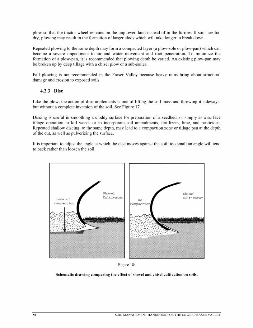
80 SOIL MANAGEMENT HANDBOOK FOR THE LOWER FRASER VALLEY
plow so that the tractor wheel remains on the unplowed land instead of in the furrow. If soils are too dry, plowing may result in the formation of larger clods which will take longer to break down. Repeated plowing to the same depth may form a compacted layer (a plow-sole or plow-pan) which can become a severe impediment to air and water movement and root penetration. To minimize the formation of a plow-pan, it is recommended that plowing depth be varied. An existing plow-pan may be broken up by deep tillage with a chisel plow or a sub-soiler. Fall plowing is not recommended in the Fraser Valley because heavy rains bring about structural damage and erosion to exposed soils.
4.2.3 Disc Like the plow, the action of disc implements is one of lifting the soil mass and throwing it sideways, but without a complete inversion of the soil. See Figure 17. Discing is useful in smoothing a cloddy surface for preparation of a seedbed, or simply as a surface tillage operation to kill weeds or to incorporate soil amendments, fertilizers, lime, and pesticides. Repeated shallow discing, to the same depth, may lead to a compaction zone or tillage pan at the depth of the cut, as well as pulverizing the surface. It is important to adjust the angle at which the disc moves against the soil: too small an angle will tend to pack rather than loosen the soil.
Figure 18:
Schematic drawing comparing the effect of shovel and chisel cultivation on soils.
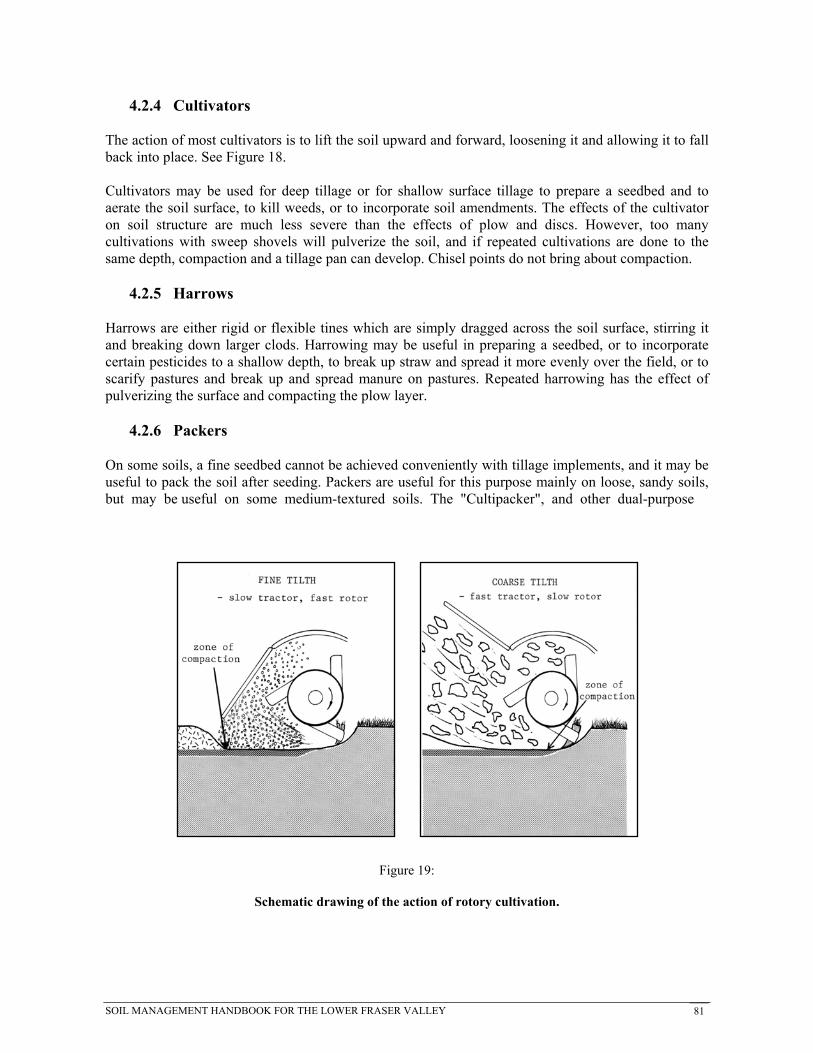
SOIL MANAGEMENT HANDBOOK FOR THE LOWER FRASER VALLEY 81
4.2.4 Cultivators The action of most cultivators is to lift the soil upward and forward, loosening it and allowing it to fall back into place. See Figure 18. Cultivators may be used for deep tillage or for shallow surface tillage to prepare a seedbed and to aerate the soil surface, to kill weeds, or to incorporate soil amendments. The effects of the cultivator on soil structure are much less severe than the effects of plow and discs. However, too many cultivations with sweep shovels will pulverize the soil, and if repeated cultivations are done to the same depth, compaction and a tillage pan can develop. Chisel points do not bring about compaction.
4.2.5 Harrows Harrows are either rigid or flexible tines which are simply dragged across the soil surface, stirring it and breaking down larger clods. Harrowing may be useful in preparing a seedbed, or to incorporate certain pesticides to a shallow depth, to break up straw and spread it more evenly over the field, or to scarify pastures and break up and spread manure on pastures. Repeated harrowing has the effect of pulverizing the surface and compacting the plow layer.
4.2.6 Packers On some soils, a fine seedbed cannot be achieved conveniently with tillage implements, and it may be useful to pack the soil after seeding. Packers are useful for this purpose mainly on loose, sandy soils, but may be useful on some medium-textured soils. The "Cultipacker", and other dual-purpose
Figure 19:
Schematic drawing of the action of rotory cultivation.

82 SOIL MANAGEMENT HANDBOOK FOR THE LOWER FRASER VALLEY
implements, combines some form of cultivator with packing wheels. These are well-suited to some soils and are useful as the final tillage operation prior to seeding.
4.2.7 Rotary Cultivators (Rototiller, Rotovator) The action of rotary cultivators results in a complete mixing and pulverizing of the plow layer. See Figure 19. Because of this, the rotovator is popular as a means of breaking up and completely incorporating sod, crop residues, and soil amendments, while preparing a fine seedbed at the same time. However, the implement has some serious disadvantages. First, the plow layer tends to be too pulverized and repeated use over time is detrimental to stable soil structure. Second, the rotovator compacts the subsoil at the depth of penetration. Avoid slow tractor speeds which result in excessive pulverizing of the soil. Rotovating appears to achieve good practical results, but when used without deeper tillage to break up the tillage pan, the rototiller can do more harm than good. Rotovators are most useful for breaking up old sod prior to plowing, or as a final tillage operation prior to seeding on sandy or organic soils. Deep rotovating is not recommended on medium and fine-texture soils because of the damaging effect the implement has on the structure of these soils.
4.2.8 Spading or Digging Machines Used as a primary tillage implement, the spading machine operates on the same principle as a human powered shovel. In most cases, the implements are built with multiple bottoms or spades which are attached to a PTO driven cam shaft. The spade is driven vertically into the soil and as it reaches its lowest vertical position, the cam then kicks the spade back. This action slices and breaks the soil
Figure 20:
Rotary Spade

SOIL MANAGEMENT HANDBOOK FOR THE LOWER FRASER VALLEY 83
as the implement moves forward. (See figure 20.) This digging action reduces the downward compaction forces that is often associated with tillage equipment such as plows. By varying the speed of rotation of the camshaft and speed of travel, the soil can be broken into a wide range of aggregate sizes.
4.2.9 Power Harrow or Rotary Cultivation Developed as a replacement for conventional rotovators, the power harrow works with a stirring action rather than a pulverizing action. The tines of this PTO powered implement are usually an inverted U-shape. See figure 21. The advantage of the power harrow is that it exerts very little downward force on the soil. This reduces the risk of developing a tillage hardpan. The power harrow will provide complete mixing of the plow layer and can be used to break sod or prepare seedbeds.
4.2.10 Aerators Aerators have been commonly used in the turf industry in the South Coastal region for many years, however, more recently they have been used in the production of crops such as forage grass. Aerators are designed to break through surface crusts or layers of organic residue and provide a channel to allow air exchange within the surface soil layers. These aeration channels also provide inlets for rainfall and nutrients. Aerators relieve surface compaction and will improve the health of a forage stand. Turf type aerators come in many forms, the most common being the hollow tine. Aerators with angled rolling tines, such as the "Aer-way" may be most appropriate for use in forage grass production. The tines are ground driven and can be angled to provide variable levels of surface disturbance. This type of aerator can also be used on cultivated land to roughen the surface and lightly incorporate crop residue or manure.
Figure 21:
Power Harrow

84 SOIL MANAGEMENT HANDBOOK FOR THE LOWER FRASER VALLEY
4.3 Soil Loosening / Subsoiling Many factors influence the soil structure, and soil loosening is only one of many practices used to improve soil structure. Soil loosening is no replacement for good management practices, including crop rotation and avoiding tillage when the soil is wet and easily compacted. Practices such as subsurface drainage and cover cropping, which adds organic matter and improves the soil structure, will tend to increase the effectiveness of subsoiling by stabilizing the aggregates formed.
4.3.1 Critical Working Depth Whenever subsoiling is to be used, the critical working depth of the soil and implement should be determined. Critical working depth is a function of soil texture, soil moisture content and the tractor/implement configuration. Many researchers have reported that subsoiling operations should be designed to work at a depth just below the compacted layer or near the desired rooting depth of the crop. However, the actual working depth should be less than the critical depth of the soil implement combination. The critical depth is defined as the depth at which maximum soil disturbance occurs. If the working depth exceeds the critical depth, draught will increase, compaction on the bottom of the furrow will occur and the volume of disturbed soil will not be maximized. Also, flow fracture, rather than brittle fracture will occur.
4.3.2 The Six Cases for Subsoiling Soil loosening has been found to be economically viable in most situations where it would increase yield. The key is to determine under what conditions soil loosening will increase yield. Before a decision can be made to undertake a soil loosening procedure, information on several soil properties is needed. Many of the soils in the Lower Fraser Valley can be grouped into the following 6 cases. Recommendations for soil loosening are made for each case. Case 1: Well Structured Soils If the rooting pattern is well formed, ie. the rooting is dense and reflects the preferred growing habit of the crop, the field does not require soil loosening. In this situation, the cost of subsoiling will not be warranted. The added traffic and mixing of soil, caused by soil loosening methods, will likely damage the soil structure and reduce yields. If the rooting pattern is restricted, additional observations will be needed to determine the cause. Case 2: Saline Soils Excess salts greatly affect yield, soil properties and the response to soil loosening. Salinity may be the result of natural processes, such as residual salt in marine soils and salts added by groundwater. Cultivation practices, such as irrigating with saline water or applying excess fertilizer may also cause salinity problems. Often the presence of excess salt can be seen from a hard, prismatic structure to the soil just beneath the root zone. Whether or not this is the case, electrical conductivity (EC) tests should be run on soil samples taken from at least three soil horizons: the root zone (0-20 cm), the middle tier (20-50 cm) and the subsoil (90-100 cm). An EC test can be performed inexpensively by

SOIL MANAGEMENT HANDBOOK FOR THE LOWER FRASER VALLEY 85
any soils laboratory or by an EC meter designed for soils. If any of the soil layers have an EC over 1 mS/cm, the soil is somewhat saline. In this case, soil loosening should only be undertaken as part of a desalinization strategy. Subsoiling, used by itself, may worsen the salinity problem by bringing salts to the surface which will lower infiltration and make the soil harder to desalinize. The normal desalinization practice on these soils is to add soluble calcium to replace the sodium on the soil exchange sites, to improve the soil drainage and to irrigate with low-salt water to leach salts from the root zone. After drainage has been established, subsoiling may help to breakup a salt enriched (Bt) horizon. During the period of desalinization, lower yields may occur on the subsoiled areas. Case 3: Poorly Drained Soils If salinity was not effecting the rooting pattern, the next possibility is poor drainage. Soil drainage is defined in terms of: 1) soil moisture in excess of field capacity and 2) duration of the period during which excess water is present in the root zone. Poorly drained soils are defined as having soil moisture in excess of field capacity remaining in all horizons for a large part of the year. Poor drainage conditions are typified by gleying which gives the soil a steel grey appearance. A practical way to assess drainage is to dig a small pit or well about 30 cm in diameter to a depth of 1 m. If the watertable observed in the well is within the normal root zone of the crop for over a week at a time during the growing season, the soil would probably benefit from improved drainage. It is recommended that drainage be improved by lowering the ditch levels and by the installation of subsurface drains before soil loosening is undertaken. Subsoiling will improve the drainage only if the soil water removal system is adequate to handle the greater volume of drainage water. If a restricting layer persists after the drainage is established, subsoiling above and perpendicular to the drainline will improve the effectiveness of the drainage system, especially on coarser-textured soils which resist compaction. In some areas, improved drainage will lower yield as the excess water removed may increase the available water during a period of drought. In such situations, both supplemental irrigation and drainage will normally improve yields over either practice by itself. Case 4: Plow Pans If a layer of dense soil, just below the plow depth, restricts or stops roots penetration, a pan or plow-pan exists. Normally, the pan will be 10 to 20 cm in thickness and will break into large, hard to crumble, clods. Below the pan, the soil will be more friable and will break into smaller crumb-like aggregates. Generally, larger pores will be visible throughout the soil profile, but not visible in the pan. In the case of the plow pan, deep subsoiling, while possibly beneficial in the short term, is not the best approach. The pan is generally the result of improper conventional tillage. Under conventional tillage, plow pans disrupted by subsoiling will likely reform rapidly. The first and best approach to handling

86 SOIL MANAGEMENT HANDBOOK FOR THE LOWER FRASER VALLEY
plow pans is to avoid the cause of the problem by adjusting tillage practices. Adoption of conservation or minimum tillage practices may be appropriate for some crops and soils. In this case, the plow pan should be broken up by a subsoiler with closely spaced tines which penetrate just deep enough into the soil to break through the bottom of the pan. The basic principle of conservation and minimum tillage is to reduce the amount of soil disturbance from tillage and encourage the development of soil structure through increases in soil organic matter and biological activity. These tillage systems also reduce soil erosion and compaction. Conservation tillage systems, such as mulching cultivators, can be complimented by the use of subsoilers such as the TYE Para-till. The Para-till implement acts in such a way as to minimize surface soil disturbance while at the same time breaking the subsoil. The Para-till implement is appropriate for non-saline soils. Another option to break up the plow pan after conventional tillage, is either by attaching tines to the plow, as in the Kverneland plow with the Plog-grubber attachment, or by using a shallow subsoiler. The shallow subsoil should have closely spaced (75 cm) tines that extend into the soil just enough to break up the pan. Conservation or minimum tillage are preferred to simply breaking up the pan, as they avoid further degradation of soil structure rather than simply attempting to ameliorate the plow pan. Case 5: Soils With Compact Fine-Textured Subsoils In cases where the root restricting layer comprises all or a large portion of the soil profile, subsoiling may have a distinct beneficial effect. The soil texture of the restrictive layer plays an important role in determining the success of soil loosening. Fine-textured soils present a problem to soil loosening. When a subsoiling tine (or any implement) is pulled through the soil, two types of fractures may occur. The desired type of fracture is brittle fracture. In brittle fracture, the soil ruptures along planes of weakness, the aggregate size is decreased and large pores are created along the fractures. After the passing of the implement, the soil resettles, but some of the large pores remain. The undesirable type of fracture is flow fracture. Flow fracture is analogous to a knife moving through butter. A large tubular void is created behind the tine and the soil around the void is compressed. The compressed soil has a larger, rather than smaller, aggregate size than the original soil. In the compressed area, the volume percentage of large pores is reduced rather than increased. In practice, both flow and brittle fracture may occur along the path of cultivation. Flow fracture is increased by three major factors: the water content of the soil, the fineness of the soil texture and the overburden pressure. High water content lubricates soils, therefore, subsoiling should be done in early fall when soils are at their driest. Fine-textured soils are much more prone to flow fracture than coarse-textured soils. Since brittle fracture requires the soil to expand upward, more than flow fracture, the weight of the overlying soil increases the amount of flow fracture. Critical depth is a term used to specify the depth at which flow fracture will start to dominate. Critical depth is greatly dependent on soil texture and water content and the water content will often increase with depth.

SOIL MANAGEMENT HANDBOOK FOR THE LOWER FRASER VALLEY 87
Only shallow subsoiling is recommended for the fine-textured soils. The depth of subsoiling should be only 15 cm into the restrictive layer. Fine-textured soils are also more prone to recompaction, than coarse-textured soils. Subsoiling may be required every few years. As the soil structure and drainage improves after repeated treatments, the depth of subsoiling can be increased. Case 6: Soils With Compact Coarse-Textured Subsoils Coarse-textured soils are not as prone to flow fracture and recompaction as fine-textured soils. The result of these factors is that it is often possible, and profitable, to deeply subsoil coarse-textured soils. Soils that are loam in texture or coarser, can normally be successfully subsoiled 75 to 90 cm, as long as the implement and its speed also influence fracture. The only dependable method to determine if the critical depth is being exceeded is to dig a trench across the path of the subsoiler and see if the soil is fractured to the depth of the tine. Subsoiling below the critical depth damages the soil structure and will normally have a negative economic effect. It is recommended that the subsoiler tines be 75 cm apart and angled up, so that all of the soil between the tines is fractured. Ideally, the soil surface between the tines should be raised up uniformly. Some re-compaction will take place, so subsoiling may be beneficial every five years or so.
4.3.3 Implementation of Soil Loosening The success of soil loosening depends on many factors, some of which are hard to quantify in advance. It is recommended that test plots be established before a soil loosening operation is carried out on a whole farm. One way of accomplishing this is to put subsoiling, where appropriate, into a normal crop rotation pattern. In this way, only a portion of the farm would be subsoiled each year. Problems, such as movement of salt into the root zone, would be detected and practices could be changed before the entire area is affected. Rotating subsoiling throughout a farm also aids in scheduling operations when the soil is as dry as possible. 4.4 Management of Peat and Muck Soils Peat and muck soils decompose and subside when they are drained and cultivated. This process is a result of physical settling and biological oxidation of soil organic matter upon exposure to air. Cultivation also breaks the soil particles into smaller pieces which will pack together more closely. Newly drained organic soils may subside as much as one third of their depth in the first ten years. Subsidence has been reported to continue at a rate of about 2.5 cm per year. In deep organic soils, decomposition and subsidence can be minimized by allowing the soil to be saturated or flooded over the winter. However, flooding has adverse effects on the structure of the soil, particularly at the surface where soil particles may become dispersed and then settle out in a compact, puddled layer. This will further reduce the infiltration and movement of air and water at the soil surface. In addition, flooding may cause surface run-off and soil erosion which can be sufficiently serious by itself to nullify any positive benefits. A controlled watertable, held within 15 cm of the soil surface during the winter period, is a practical and effective way of inhibiting decomposition.

88 SOIL MANAGEMENT HANDBOOK FOR THE LOWER FRASER VALLEY
Where the underlying mineral soil is exposed, mixed into the plow layer or within the drain depth, water management becomes critical to prevent surface structure degradation and to maintain the porosity of the soil profile. This is particularly true in the Cloverdale area where the underlying mineral soil was laid down in a marine environment and has a high clay content. Drainage installation, deep tillage and surface cultivation operations should be done when the soil is unsaturated. Tillage contributes to decomposition of peat and muck by increasing its exposure to air. Furthermore, additions of lime, and fertilizer, coupled with excessive or improper tillage and heavy traffic, increases soil compaction which leads to reduced water and air movement and eventually to restricted workability of the soil. Ponding on a drained field after rain is an indicator of poor structure affecting drainage. Reduced tillage, using appropriate implements, crop rotation, cover cropping and minimal traffic are recommended to maintain good soil tilth. Good watertable control is essential to reduce subsidence, but it is also essential for reducing surface structure degradation. 4.5 Soil Amendments Soil amendments are substances added to the soil to improve fertility or structure. The use of several common amendments is discussed below.
4.5.1 Organic Matter The value of organic matter added to the soil cannot be overstated. Organic material serves as a food supply for soil organisms which decompose it, releasing plant nutrients and promoting better soil structure. Most soil will benefit from the addition of organic matter; but loose, sandy soils will benefit more from the effects of organic matter on improving water-holding capacity and fertility, while fine-textured soils benefit from improved granular structure. There is little advantage in adding organic matter to peat and muck soils. Among the many organic materials that may be used to some advantage are farm products such as crop residue, straw, manure and litter, compost and cover crops; industrial products such as vegetable processing wastes, peat, sawdust; and municipal wastes such as sewage sludge. The main benefits of these are from the addition of organic matter itself, and secondarily, from addition of nutrient elements contained in the organic matter.
4.5.2 Straw and Woodwaste Straw and woodwaste can be beneficial sources of organic matter for the soil. They are generally large particles which provide aeration and porosity to the soil. However, when straw or woodwaste is added directly to the soil, most of the available nitrogen in the soil may be used by soil bacteria in the decomposition of the material. This "tie-up" of nitrogen can lead to nitrogen deficiency for a crop. To avoid a nitrogen shortage in the crop, it is recommended that a soluble nitrogen fertilizer such as

SOIL MANAGEMENT HANDBOOK FOR THE LOWER FRASER VALLEY 89
urea (46-0-0) or an Ammonium Salt (34-0-0; 16-20-0; 21-0-0) be added at the same time at a rate of 20 to 40 kg/ha actual nitrogen. Woodwaste should not be applied more than 10 cm deep at any one time. Applications of woodwaste are generally only recommended if they fall within the Code of Agricultural Practice for the Waste Management Act or are covered by Environmental Guidelines for a commodity. Leachate discharge from woodwaste can have serious impacts on water quality, therefore, consideration should be given to the use of leachate control or containment systems.
4.5.3 Peat Moss Peat Moss or other types of organic soil material provide a small quantity of plant nutrients, but their greatest benefit comes from improving the water-holding capacity of sandy soils and improving the tilth of fine-textured soils. Abundant, economical sources of peat moss for soil amendments are not readily available for field scale agriculture. However, in the intensive horticulture markets (nursery and greenhouse) supplies are available. In place of using peat moss in field scale agriculture, products such as composted animal manures may be more readily available and also have the benefit of supplying some plant nutrients.
4.5.4 Industrial Wastes Municipal Solid Waste and Domestic Sewage Sludge, in various forms, may be beneficial when added to soils. They can provide plant nutrients, organic matter and physical amendments. However, many industrial wastes can contain diseases or organisms and high concentrations of heavy metals or other contaminants. It is recommended that safe application rates be determined through consultation with the B.C. Ministry of Agriculture, Fisheries and Food, the B.C. Ministry of Environment, Lands and Parks or other government ministries before using composted municipal solid wastes or domestic sewage sludge on agricultural lands. Many byproducts of the food industry, including vegetable pulp and other organic refuse such as whey, blood meal and bone meal, are considered suitable and beneficial as soil amendments. These byproducts are not considered to be agricultural wastes as defined under the Code of Agricultural Practice, therefore, they are subject to the permit regulations of the Waste Management Act. Domestic Sewage Sludge and Municipal Solid Waste, and other wastes, fall under the jurisdiction of the B.C. Ministry of Environment, Lands and Parks Waste Management Act and the "Regulation for the Production and Use of Compost from Municipal Solid Waste for B.C." and the "Guidelines for the Disposal of Domestic Sludge under the Waste Management Act."
4.5.5 Seaweed Seaweed is a useful soil amendment which provides organic matter and a wide range of plant nutrients. It is the most concentrated organic source of potassium and contains about the same amount of nitrogen as cow manure. The phosphorus content of seaweed is quite low. Seeding of some crops immediately after a heavy seaweed application may result in reduced emergence and growth due to high salt concentrations. Seaweed is inherently saline, so caution should

90 SOIL MANAGEMENT HANDBOOK FOR THE LOWER FRASER VALLEY
be taken if it is repeatedly used as a soil amendment. Rinsing with fresh water will remove residual salt water.
4.5.6 Compost Compost is made from organic materials such as crop residues, clippings, leaves, small animal morts, animal manures or wood wastes. Soil organisms almost completely decompose the organic matter and the end product is a humus-like substance which is a valuable soil amendment. Composting organic waste is a method of converting raw organic materials into a more decomposed stable product from which plant nutrients are more readily available. The main benefit of composting is that it allows the use of low nitrogen organic materials, such as straw or wood waste without reducing available soil nitrogen, which would occur if these materials were added directly to the soil. If adequate time is allowed for decomposition of crop residues or manures on the field prior to crop seeding, composting will not likely provide benefits in addition to those derived from direct incorporation of underdecomposed organic materials. Significant amounts of compost can improve soil structure, water-holding capacity and supply of plant nutrients. Compost made with sewage sludge or large quantities of wood waste should be used with caution, since some of these materials may have high concentrations of toxic metals or harmful organic compounds. These may be harmful to some plants or may be taken up into edible parts of vegetables.
4.5.7 Chemical Fertilizers Chemical fertilizers are commonly used to effectively overcome nutrient deficiencies in the soil. Although fertilizers are valuable, and often essential crop production inputs, they are not a substitute for good soil management. Supplementary practices including crop rotation and additions of organic matter, are strongly recommended to ensure that good soil structure and organic matter levels are maintained. Fertilizers may be applied directly to the soil or in irrigation water. Some fertilizers applied to the soil surface (e.g. phosphorus fertilizers) and not incorporated, have much less effect on plant growth. Many fertilizer materials will lower soil pH over time and excessive application rates can result in temporary salt injury or nutrient imbalances which interfere with normal crop growth. Use of chemical fertilizers, as with the additions of any nutrient source, should be in accordance to a soil and/or plant tissue testing program to ensure crop and soil health and to avoid adverse effects on the environment.
4.5.8 Lime The addition of liming materials is effective in raising soil pH. All soils in the Coastal Region are somewhat acidic and most soils require periodic liming to maintain soil pH at levels high enough

SOIL MANAGEMENT HANDBOOK FOR THE LOWER FRASER VALLEY 91
for good plant growth. In addition, lime provides calcium, which is a plant nutrient and which promotes granular structure in soils. Common liming materials include ground limestone, ground dolomite (a type of limestone which contains both calcium and magnesium) and hydrated lime (calcium hydroxide). Hydrated lime is quite caustic and it raises soil pH quickly. Excess applications of hydrated lime may adversely effect plant growth by initially raising the pH too high. Excessive applications of hydrated lime can adversely effect soil organic matter, therefore, its use on organic soils is not recommended. There is no risk of raising the pH too high with ground limestone and dolomitic limestone. For best results, lime should be applied in the fall or a few weeks prior to seeding, and thoroughly incorporated into the plow layer. Liming programs should be considered carefully during the establishment of perennial crops. Lime has a low level of solubility, so lime applied and left on the soil surface is only slightly effective in raising soil pH in the rooting zone. Soil pH is a poor indicator of lime requirement. Factors, such as organic matter levels, clay content and age of soils, markedly affect the amount of lime needed to prevent any harm to plants. A lime requirement test, performed by a reputable soil testing laboratory, is recommended to ensure the correct rate of lime application.
4.5.9 Pesticides Pesticides that are soil applied or that come in contact with the soil, have an impact on soil quality. Although pesticides are valuable, and often essential for crop production, they are not a substitute for good soil management. Their misuse could have a detrimental effect on soils. Users of pesticides should follow label recommendations and various commodity production guides. Pesticide use is controlled by the Pest Control Products Act administered by Agriculture Canada and the Pesticide Control Act administered by B.C. Ministry of Environment, Lands and Parks.

92 SOIL MANAGEMENT HANDBOOK FOR THE LOWER FRASER VALLEY
5. ANIMAL MANURE MANAGEMENT Animal manures are a valuable source of plant nutrients and organic matter and contain a vast array of organisms that add to the biological activity of soils. However, if not managed with sufficient care, manures can be major sources of pollution and contribute to contamination of surface and ground waters. 5.1 Managing Manures for Crop Production Management is the key to using manures to promote crop production and soil improvement while minimizing any hazard to the environment. Management means application of manures at rates and times of year that: • are compatible with the nutrient requirements and growing characteristics of the crop; • take into account soil characteristics, drainage and the slope of the land; and • recognize the presence of surface and ground waters. The following table provides a general indication of the nutrient contents of various manures. Note that the moisture content of manures varies considerably. These values must be adjusted accordingly before they can be used as a guide to adjust fertilization rates.
Table 17. N, P, and K Content of Various Manures (1 tonne) Nutrient Content (Kg per tome) % Solids N Incorporated N Unincorporated P205 K20
Dairy 13.0 4.0 2.4 1.4 5.3 Swine - Farrow to Finish 9.0 5.0 3.0 3.3 2.6 - Farrow to Weaner 9.0 3.6 2.2 2.4 1.8 - Grower/Finisher 9.0 5.7 3.4 3.9 3.0 Poultry - Layers 40.0 9.0 5.4 30.0 10.0 - Broilers 75.0 16.0 9.6 25.0 13.0

SOIL MANAGEMENT HANDBOOK FOR THE LOWER FRASER VALLEY 93
NOTE: a) Nitrogen content of manure when excreted will be higher than the values shown. Assumed losses during collection, storage and application are:
- Dairy 23% - Farrow to Finish 23% - Farrow to Weaner 23% - Grower/Finisher 23% - Layer 43% - Broiler 24%
If manure is left on the soil surface and not incorporated within 7 days following application, it is assumed that 40% of the remaining nitrogen is lost. b) Values of P205 and K20 assume no loss during collection, storage and field application. 5.2 Factors Affecting Contamination from Manures
5.2.1 Soil Characteristics The proportion of sand, silt, clay and organic matter in a soil determine the water and nutrient-holding capacity. In general, soils with a high clay and/or organic matter content have a relatively high capacity to hold water and nutrients in the root zone. Sandy soils, on the other hand, have a low capacity. Therefore, the leaching of nutrients from sandy soils during the winter months proceeds at a much greater rate than from heavy textured soils or soils with a high level of organic matter.
5.2.2 Drainage Poorly drained soils become saturated during late fall, winter and early spring. After saturation, precipitation can no longer enter the soil and, therefore, water accumulates on the soil surface and eventually runs off into adjacent ditches or other water courses. When this happens, materials, such as manures, that have been applied to the soil surface are removed with the water.
5.2.3 Slope If water does not infiltrate into soils on sloping land it must run off. If such lands also become saturated, runoff is even greater.
5.2.4 Nitrates in the Root Zone The nitrate form of nitrogen is of major concern in the region due to its potential to contaminate drinking water. Nitrate is also the dominant form of plant available nitrogen found in agricultural soils. Most of the nitrate in the root zone in the fall of the year is leached from the soil over the

94 SOIL MANAGEMENT HANDBOOK FOR THE LOWER FRASER VALLEY
winter months. Where soils are over ground waters used for drinking or adjacent to surface waters, the nitrate has a high potential of contributing to water contamination. Excessive levels of root zone nitrates are found in soils where the spring application rates of manure and fertilizer have been high in relation to the ability of the crop to use the nitrogen, or in soils where there has been a fall application of manure after harvest.
5.2.5 Lack of Cover Crops Permanent grassland and, to a lesser extent, fall planted cover crops take up soil nitrates (and other nutrients) during fall, winter and early spring. In addition, cover crops keep the soil surface open thereby reducing or eliminating ponding and surface runoff. Bare soil, on the other hand, is susceptible to leaching, surface sealing, ponding and runoff. 5.3 Factors Contributing to High Fall Nitrate Levels in the Root Zone and Nitrate Leaching
5.3.1 Crop Growth Characteristics Annual crops begin growth in April, May or June (depending on planting date). Nitrogen, and other nutrient, uptake is minimal in the early growth stages and then proceeds rapidly through July and tapers off in August and September. This growing habit means that very little of the nitrate produced in the soil during September and through to the following March or April is used by crops.
5.3.2 Soil Processes Nitrate is produced naturally in the soil by the decomposition of organic matter. Additions of manure and fertilizer further raise the level of nitrate in the root zone. Under favourable soil moisture and temperature conditions, nitrates are produced regardless of the presence or absence of an actively growing crop. In South Coastal B.C., such favourable conditions exist during much of August, September and October when crop uptake of nitrate is decreasing or has completely stopped due to the harvest of the crop. If fertilizer and manure application rates have been in excess of crop demand or if manure is applied in the fall, then soil nitrate levels will be high to excessive.
5.3.3 Climate The climate of coastal B.C. is characterized by mild winter temperatures and extremely high levels of precipitation. Under these conditions, all mobile soil nutrients, such as nitrate, are subject to leaching. Long term soil test data indicates that any nitrate present in the root zone in the fall of the year is removed by the following spring. This differs markedly from the Interior regions of the province where frozen soils and low winter precipitation effectively prevent significant leaching of nutrients from the soil profile.

SOIL MANAGEMENT HANDBOOK FOR THE LOWER FRASER VALLEY 95
5.4 Practical Guidance on Land Application of Manure
5.4.1 January to March If the land is subject to flooding and/or runoff, no manure should be applied because of the high risk of contamination of adjacent waters. If, however, flooding and runoff are controlled through adequate on-farm and regional drainage systems, some manure can safely be applied on grassland or land seeded to a winter cover crop. Manure should not be applied to bare land.
5.4.2 April to May On annually cropped land, apply and immediately incorporate sufficient manure to supply up to 75% of the crop requirement for nitrogen. Do not attempt to completely fertilize the crop with manure. Excess manure will result in a high rate of nitrate production in the latter part of the growing season and after harvest when nutrient uptake is minimal. Supplement the manure with fertilizer at planting or side dress time.
5.4.3 June to August If manure must be applied, in most cases it can be applied only to grassland due to the presence of actively growing crops on other lands. Manure nitrogen efficiency for grassland can be greatly increased by irrigation immediately following application, by manure injections or by application of very wet slurries (95% or higher). Application of additional fertilizer nitrogen to grassland should be fine-tuned according to the protein content of the forage. Research has shown that grasses with a protein level of 20% or more have a high probability of nitrate accumulation and/or high levels of rumen-degradable nitrogen compounds. Although manure cannot be applied to annual crops during this period, crops can be supplemented with fertilizer nitrogen. A late spring soil test has been found to be useful in indicating whether or not a response to added nitrogen is to be expected. The critical range is 20 to 30 kg/ha nitrate nitrogen in the plow layer (0-20 cm). Soils below this range are usually deficient in nitrogen and require supplementation before the crops will achieve adequate yields. Soils above this range will generally supply all of the crops' nitrogen requirements.
5.4.4 September to October This is the most critical time of the year if manures are to be managed in an environmentally sound manner. On annually cropped land, crops have reached maturity and nutrient uptake has ceased. Soil temperature and moisture conditions are near optimal for formation of nitrates in the soil. Therefore, any added manure will only further contribute to the problem of fall nitrate levels and over-winter leaching. However, it is difficult to eliminate application because most animal farms do not have sufficient storage to avoid application at this time and the soils are often dry allowing for ready access to the fields.

96 SOIL MANAGEMENT HANDBOOK FOR THE LOWER FRASER VALLEY
If manure must be applied during this period, it should be restricted to grasslands that are well drained and not subject to flooding or runoff. Grasses are actively growing and their roots will capture much of the nitrate and prevent leaching. On other lands, winter cover crops must be planted preferably before September 15, before any application should be contemplated. These crops can act as 'catch crops' to catch the nitrate in the root zone and reduce leaching. Rates of application on these lands should be lower than on grasslands due to the more immature root system.
5.4.5 November and December With the onset of winter, soils cool to the point where there is very little nitrate produced in the root zone. However, many soils are now too wet to allow ready access for spreading without causing severe soil compaction. If, however, the soil is sufficiently dry to support traffic and flooding and runoff are controlled through adequate on-farm and regional drainage systems, some manure can safely be applied on grassland or land seeded to a winter cover crop. Manure should not be applied to bare land.

SOIL MANAGEMENT HANDBOOK FOR THE LOWER FRASER VALLEY 97
6. SOIL CONSERVATION 6.1 Crop Rotations Crop rotation means growing different crops from year to year on the same field. Continuous cropping to the same crop or related crops often results in a build-up of soil-borne plant diseases or weeds. If this occurs, it will be necessary to grow a different crop in the diseased or weedy field. Continuous cropping to cultivated row crops leads to a breakdown of soil structure, compaction, increased erosion and a loss of organic matter. For these reasons, it is a good practice to grow crops in a rotation so that disease and weeds can be controlled and soil quality can be maintained. The most beneficial crop rotations are those which include grasses or grass-legume mixtures. If this is not possible, rotations which include fibrous rooted crops should be used. These crops are most effective in building stable soil structure, increasing soil organic matter and improving the porosity and structure of the subsoil. (See Figure 4, page 39) A soil which has been seeded to a hay crop for a number of years will have better and longer lasting structure and tilth than the same soil continuously used for annual crops. A rotation of deep-rooted crops with shallow-rooted crops will allow plant nutrients to be extracted from the subsoil. Some of these nutrients are added to the plow layer when residues from deep-rooted crops are incorporated into the plow layer. The best example of crop rotation in the Lower Fraser Valley is corn/grass used by the dairy industry. The most significant improvement that could be made to that rotation would be to include a winter cover crop after corn harvest. On steeply sloping land, crop rotations, which include close-growing crops or perennial grass-legume hay or silage crops, are recommended for direct protection against soil erosion and for building up and maintaining a stable structure which is more resistant to erosion. 6.2 Cover Crops The current level of knowledge about cover crop use in the Lower Fraser Valley is limited. This section will give an indication of the commonly used cover crop species and their seeding rates and dates. Cover crops are also called catch crops, green manures and living mulches. Catch crops are grown for the purpose of trapping leachable nutrients in the plant. This is particularly useful in the South Coastal region of B.C. to reduce the amount of nitrogen leached out of the soils in late fall and winter. Green manures are crops grown for the purpose of adding organic matter to the soil. Cover crops are useful for many purposes in the region. These purposes include: control of wind and water erosion, suppression of weed growth, nutrient capture, soil structure improvement, increased trafficability and production of livestock or wild fowl feed. A cover crop may also be established between the rows of perennial crops, to protect the soil from erosion and to reduce the need for cultivation. The most common use of cover crops has been for over winter soil protection, but recently fall and winter weather have played havoc with many of the cover crop species, particularly

98 SOIL MANAGEMENT HANDBOOK FOR THE LOWER FRASER VALLEY
in the eastern end of the region. The table below lists the production crop (or crop group) and the most appropriate cover crop(s) for use with that crop. If legume crops such as clover, peas or vetch are used, there is a good possibility that the crop will add significant amounts of nitrogen to the soil, provided that the proper strain of nitrogen-fixing bacteria is active in the soil and growing conditions are good.
Table 18. General Cover Crop Recommendations For Winter Soil Protection
CROP
COVER CROP RECOMMENDATION
1. Raspberries Spring barley or oats Before mid-September, 80-150 kg/ha. 2. Strawberries Spring barley or oats After last cultivation, but before the
end of Sept., seed at 80-150 kg/ha. 3. Other Small Fruits (Blueberries, etc.)
Annual/perennial grasses such as Westerwolds, ryegrass or Sheep's Fescue
Plant between rows when soil moisture and traffic will allow for good establishment. Seed at about 25 kg/ha.
4. Vegetables 4a. Early harvest
Any cereal or cereal/legume mix, use spring oats or barley, or annual ryegrass
Plant immediately after harvest at a rate of 80-150 kg/ha for oats or barley and 25 kg/ha for annual rye-grass.
4b. Late harvest Fall rye, winter wheat or winter barley
Prior to Oct. at a rate of 80-150 kg/ha Consider broadcasting ahead of har- vest with root crops.
5. Forage Corn Spring or winter cereals with or without a legume
80-150 kg/ha for cereals and 10-30 kg/ha for legumes. Plant immedi- ately after harvest or consider inter- cropping prior to the last sidedress with a small seeded legume.
6. Nursery For non-permanent cover, oats and barley or annual ryegrass
Seed oats and barley at 80-150 kg/ha and annual ryegrass at 25 kg/ha.
7. Bulbs Barley Seed at 80-150 kg/ha
If cereal crops are grown, there are two groups that should be considered. Spring cereals, particularly barley and oats, or annual ryegrass (Westerwolds) grow well from spring through the late summer. They will usually winter kill if planted in late September, but can provide rapid fall cover. Winter cereals, such as winter barley, winter wheat and fall rye, are better used for late summer and fall growth or where an overwintering cover or early spring forage is desired. Winter cereals grow slowly in the fall, but will continue to grow later than spring cereals. One advantage of cereals is that they are large seeded so they can be seeded by many methods including broadcast-harrow.

SOIL MANAGEMENT HANDBOOK FOR THE LOWER FRASER VALLEY 99
Before making the decision to plant cover crops, some other factors must be considered. The method of managing the cover crop residue prior to planting the following crop is the most important. If the cover crop survives the winter, it must either be controlled by mechanical means (tillage or mowing) or sprayed out with a herbicide. Cover crop species which winter kill may be appropriate if early spring planting is desired. Cover crops can become difficult to manage if they are allowed to set seed, so planting date and control methods are crucial for in season or overwintering cover crop species. Some cover crop species have been reported to adversely affect following crops either due to the amount of cover crop residue remaining at the soil surface or due to chemicals present in the residue. Other cautions for cover crop use are that they may harbour diseases and insects and may change microclimates in perennial crops. Their management is important. Cover crops used for winter erosion control must be well established by mid-October. After this date, cool temperatures and rainfall reduce growth. Surface protection of the soil, to prevent structure degradation and soil loss, will be provided by either a standing or matted down cover, but volume of plant leaves or residue is important. Although the use of cover crops can pose management challenges, their use for erosion control, nutrient capture and soil structure improvement is very beneficial for this region. 6.3 Mulching A mulch is any material placed on the soil surface for the purpose of reducing soil erosion, insulating the soil surface, reducing evaporation of soil moisture, or weed control. Crop residues left on the surface are a kind of mulch. Other materials which may be used include: straw, woodwaste, sand, compost, or plastic film. Use of woodwaste is only recommended for blueberry production or in nursery container operations. When mulches are used over the winter, soils do not warm us as quickly in the spring. This may be a disadvantage for certain crops. Where hot, dry summers lead to high soil temperatures and high rates of evaporation, a mulch is effective in reducing soil temperatures and evaporation. Organic materials used as a mulch will be decomposed by soil organisms and the mulch will eventually disappear. When woodwaste, shavings or straw are used, their decomposition may result in some soil nitrogen deficiency for the crop, and it is recommended that a nitrogen fertilizer be added to the mulch to overcome this problem. The suggested rate of application is 20-40 kg/ha actual nitrogen. A mulch which becomes compact may reduce aeration in the soil below the mulch. For most situations, a mulch should not be greater than 10 cm thick, although in orchards mulch may be up to 30 cm deep. In the Lower Fraser Valley, wood shavings have been used as mulch on blueberries with good success. Plastics have also been used successfully in field production of vegetables such as peppers, tomatoes and cucumbers.

100 SOIL MANAGEMENT HANDBOOK FOR THE LOWER FRASER VALLEY
6.4 Wind Erosion Control Wind erosion generally occurs on bare, dry soil when high winds move across large expanses of open field. In the Lower Fraser Valley, most incidents of soil erosion by wind are reported during the winter months when arctic air masses cause outflow conditions which dessicate soils, particularly on the Sumas Prairie. Wind erosion can remove large quantities of topsoil, but is not as noticeable as water erosion. Exposed soil is eroded by wind when the clods, aggregates or crust are unable to resist the force of wind. Wind breaks the soil up into the primary soil particles of sand, silt and clay. Each fraction is transported in a different manner. In order to prevent wind erosion, the soil surface must be protected either by a crop, crop residue or windbreaks. In all cases, the desire is to reduce the wind speed near the soil surface by creating roughness. Windbreaks should be placed perpendicular to the direction of prevailing winds. Windbreaks can be permanent, in the form of hedge rows of trees and/or shrubs or temporary, in the form of tall grass strips, unharvested crop rows or snow fencing. Cultural methods which protect the soil from wind erosion include vegetation, such as cover crops, cereal stubble or other crop residue standing or lightly incorporated into the soil surface. Crop residue and cover crops must be of sufficient volume to be capable of protecting the soil from rain drop impact and be anchored so as not to be removed by the wind. 6.5 Conservation Farming Conservation farming must address the issue of maintaining environmental quality while maintaining or improving production levels. All factors that affect agricultural production, its impact on the environment and other resource users must be taken into account. 6.5.1 Conservation Tillage Conservation tillage systems are currently defined as any cultivation and planting system that leaves 30% of the previous crop residue on the soil surface after planting. The various types may include no-till or direct seeding, minimum till or one pass before seeding systems, plow-plant, ridge-till, chisel plow, etc. Successful conservation tillage systems reduce soil erosion, improve quality of runoff water by soil retention, improve soil structure by retaining crop residue at the soil's surface and decrease the soil structure degradation by reducing field operations. Fuel consumption may decline, but may be replaced with other inputs for weed, disease or insect control. Labour requirements may decline by reducing the number of field operations needed to cultivate and seed crops. No-till or direct seeding systems have been successfully developed in the dryland regions for cereal and oilseed production. Little if any work has been done on minimum tillage systems for the South Coastal region of B.C. Herbicides are used to control weeds, replacing cultivation.

SOIL MANAGEMENT HANDBOOK FOR THE LOWER FRASER VALLEY 101
A crop disease incidence has not been high, but crops have been rotated to avoid disease build-up that may accompany the increasing crop residue and organic matter at the soil surface. The key is to understand disease cycles and plan the appropriate no-till crop rotations. Without proper planning, the reversion to one series of conventional tillage operations will destroy the soil structure improvement that took several years (more than 5 years) of no-till farming to establish. Disease and insect control under humid growing conditions may have to be augmented with the use of appropriate fungicides and insecticides for control. 6.5.2 The Role of Soil Structure, Drainage and Acidity Well drained soils with good structure and organic matter content, or the ability to develop good structure, are likely to succeed under a reduced or no-till system. Poorly drained soils, with massive or cohesive structure, are difficult to manage successfully under no-till. Direct seeding into wet clayey soils can cause poor seed-soil contact due to smearing of the soil by the seed placement tools. High spring moisture levels and lower temperatures at the soil surface, due to increased surface crop residue levels, may cause reduced yields from zero-till. This is especially true for longer season annual crops such as corn or cereal grain when grown on fine-textured clay soils. The alternative is to use a reduced tillage system (ridge-till) that elevates the seeding zone from the soil surface by shaping the soil ahead of the planting tool. Reducing soil erosion to acceptable levels may be accomplished by using a reduced till system where a no-till system does not seem appropriate. Equipment induced plow pans may create saturated soils, seriously reducing the oxygen required in the root zone for proper crop growth and nutrient response under no-till systems. Subsoiling with minimum disturbance implements, such as the Para-till, may be appropriate to use within a no-till system. High soil acidity will also have to be considered as a deterrent to the establishment of a no-till system when lime is incorporated into the soil every few years to re-establish appropriate soil pH levels. Lime amendments may be incorporated prior to establishing a no-till system at rates that will be retained for the sensitive crops in the rotation. Over-liming soils can cause nutrient deficiencies and some precautions should be taken to avoid this from happening. 6.5.3 The Role of Nutrient Management Fertilizer and livestock nutrient management need to be re-thought when a no-till or reduced-till system is being considered. Appropriate seeding equipment which can place required fertilizer near the seed should be chosen. This is especially important for phosphorus and potassium, as there are no cultivation operations to mix fertilizer into the soil in the no-till cropping systems. Increased surface crop residues and soil moisture levels under reduced-till conditions may cause an increase of nitrogen loss due to denitrification or volatilization. Sub-soil placement of fertilizer nitrogen at the time of seeding can avoid losses to the atmosphere.

102 SOIL MANAGEMENT HANDBOOK
Similarly, the sub-soil injection of livestock wastes will conserve nutrients and place them in a zone that is available to the crop. The only drawback is that injection of manures may cause significant soil disturbance for a no-till system, increasing the potential for weed seedling germination. 6.5.4 Systems Approach to Conservation Tillage Conservation tillage is a package of cultural practices that are specifically developed to conserve soil and water resources, sustain high and satisfactory returns and minimize soil and environmental degradation. Although not practiced in the Lower Fraser Valley, conservation tillage or at least the theory of conservation tillage could be adapted or adopted to fit the needs of soil and water conservation in the region. The figure below shows the interrelationship between conservation tillage and cultural practices that is required for the successful agricultural management of the soil surface that improves rather than degrades this natural resource.
Figure 22:
Conservation Tillage – A Systems Approach
DEVELOPMENT OF A SYSTEMS APPROACH
RESIDUE MANAGEMENT AN
CROPPING SYSTEM
NEW CROPS
IMPROVED VARIETIES
M
TIME AND DEPTH OF SEEDING
WATER MANAGEMENT M
CONSERVATION TILLAGE SYSTEM
SEEDING, TILLAGE
D HARVESTING
FOR THE LOWER FRASER VALLEY
.
ODE, RATE AND TIME OF
FERTILIZER APPLICATION
PEST ANAGEMENT

SOIL MANAGEMENT HANDBOOK FOR THE LOWER FRASER VALLEY 103
1. Low cost, and / or short time to implement, effective practice. 2. Moderate cost, and / or longer to implement, effective practice.

104 SOIL MANAGEMENT HANDBOOK FOR THE LOWER FRASER VALLEY
LIST OF DEFINITIONS Contour Cropping: The production of crops in rows that follow the natural contour of the land and are at right angles to the direction of the slope. Crop Rotation: Growing a variety of crops in reoccurring succession on the same land. (ie. Corn followed by winter wheat, then forage grass). Cover Crop: A crop of close-growing forages or small grains grown primarily for the purpose of soil protection and improvement between periods of regular crop production. This crop is usually allowed to die over the winter or is 'killed' by the use of herbicides or tillage. Forage Crop: Certain green crops (forages/grasses) primarily grown and harvested to feed domestic livestock. Shelterbelt: An extended line(s) or "belt" of living trees and shrubs established and maintained to act as a shield protecting farmland from wind erosion. Barrier Strip: Consists of one or two rows of tall-growing grass or an annual cereal seeded every 15 to 24 metres at right angles to the prevailing wind. It may also be a strip of standing crop left taller than the adjacent crop residue. Residue Management: A cropping system that maintains an adequate residue cover (min. 30% surface cover) for soil erosion control and protection of the soil surface from puddling. Tolerant Crop: A crop able to grow under stressful growing conditions. Animal Manure: Livestock produce nutrient-enriched liquid and solid organic waste materials which can be distributed on soils to supply essential plant nutrients and improve soil physical conditions. Must only be used as a soil conditioner or plant nutrient.
Reduced Tillage: A tillage system where the number of field operations required for crop production are at a minimum. Equipment types or modifications are used to minimize soil disturbance and maintain weed control. To delay or reduce the amount of tillage, herbicides are included in the system. For some forage production systems, tillage may be reduced to subsoiling, aeration and direct seeding. Alter Tillage Practices: Changing tillage equipment type or operating speed, will reduce pulverization of the soil and the burial of crop residue. (ie. Avoid use of rotovators or implements which continuously work at the same depth). Subsoiling: Subsoiling is done in the fall (when soils are dry) to alleviate compaction, and to improve water infiltration and root penetration. Liming: The application of agricultural lime (CaCO3) or other liming material required to raise the soil pH to a desired value under specific cropping conditions. Liming may also increase crop nutrient availability.
Field Operations: The coordination and implementation of various field operations can improve or hinder the existing soil conditions. (ie. Shift major tillage operations to drier periods or change crop type). Water Erosion System: An erosion control system consists of a subsurface drainage system, which may include blind surface inlets and discharge structures coupled with cover, contour or continuous cropping practices. Grassed Waterway: A vegetated, natural or constructed broad, shallow channel designed to carry surface runoff across farmland with minimum water erosion. Subsurface Drainage: A conduit such as tile, pipe or tubing installed below the ground surface to lower watertables within a field and maintain unsaturated soil conditions. Reforestation: The natural seeding or artificial replanting of trees within an area that was previously under forest, which may be used as a wildlife habitat or to reduce erosion hazard. Straw Mulching: The application of straw to reduce the risk of soil erosion or surface structure degradation by wind and water.

SOIL MANAGEMENT HANDBOOK FOR THE LOWER FRASER VALLEY 105
NOTES

SOIL MANAGEMENT HANDBOOK FOR THE LOWER FRASER VALLEY 106
REFERENCES
Published Sources Agriculture Canada. Soil Erosion By Wind. Publication 1266, 1966. Agriculture Canada. Soil Erosion By Water. Publication 1083, 1961. Alberta Agriculture. Conservation and Development Branch. Farm Conservation Planning
Matrix (Goddard, T. and Lohstraeter, G.) 1991. Bertrand, R.A., and Bulley, N.R. Manure Management Guidelines. British Columbia Ministry
of Agriculture, Fisheries and Food, 1985. Bertrand, R.A. and Wood, R.C. Use of a Land Drainage System for Water Erosion Control.
BCMAFF, 1983. Brady, Nyle C. The Nature and Properties of Soils. 10th ed. New York: Macmillan Publishing Co., 1990. British Columbia Ministry of Agriculture, Fisheries and Food. Berry Production Guide.
Victoria, B.C.: Queen's Printer, 1990. British Columbia Ministry of Agriculture, Fisheries and Food. Grape Production Guide.
Victoria, B.C.: Queen's Printer, 1987. British Columbia Ministry of Agriculture, Fisheries and Food. Vegetable Production Guide.
Victoria, B.C.: Queen's Printer, 1991. Buckingham, Frank. Fundamentals of Machine Operation - Tillage. Illinois: Deere and Co., 1976. Canada Department of Agriculture, Research Branch. The Canadian System of Soil Classification.
Publication 1646, 1978. Chieng, S.T. and Hughes-Games, G.A. "Effects of Subirrigation and Controlled Drainage on
Crop Yield, Water Table Fluctuation and Soil Properties." Conference Paper, 1991. Chieng, S.T., Keng, J. and Driehuyzen, M.G. "Effects of Subsurface Drainage and Subirrigation
on the Yields of Four Crops." Canadian Agricultural Engineering, Vol 29, No. 1, Winter 1987, pp. 21-26.
de Vries, Jan. "Soil Compaction - The Problem." In 1985 Dairy Producers' Short Course, pp.
27-37.

SOIL MANAGEMENT HANDBOOK FOR THE LOWER FRASER VALLEY 107
Driehuyzen, M.G. Soil Drainage Guide for the Fraser Valley, Soils and Engineering Branch, BCMAFF, 1982, Unpublished.
Driehuyzen, M.G. and Wood, R.C. "Soil Erosion - An Easy Way To Lose Your Farm." In
1982 Lower Mainland Horticultural Improvement Association Grower' Short Course, pp. 59-68.
Elanco Products Company. "Don't Let Soil Compaction Squeeze Your Profits," Indianapolis,
In. Gao, Y. and Chieng, S.T. "Influence of Water Table Management Systems on Soil Drainable
Porosity." American Society of Agricultural Engineers meeting presentation, Paper No. 902603.
Goldstein, Michael J. Soil Structure and Soil Loosening. August 1990, ARDSA Project 23008,
pp. 63-70. Hughes-Games, G.A. "Dealing with Soil Compaction." In 1991 Dairy Producers' Short
Course, pp. 109-119. Hughes-Games, G.A. 1986-1989. Reports on the Erosion Abatement Demonstration Project.
ARDSA Project 23002. Hughes-Games, G.A. "Results From The Boundary Bay Water Control Project," Soil Notes,
BCMAFF, Dec. 1988. Hughes-Games, G.A. "Soil Compaction," Soil Notes, BCMAFF, Oct. 1990, Agdex 579. Hughes-Games, G.A. "Soil Sampling," Soil Notes, BCMAFF, July 1990, Agdex 533. Luttmerding, H.A. Soils of the Langley-Vancouver Map Area. (RAB Bulletin 18) Volumes
1,2,3,5 and 6. Kelowna, 1980. McBride, R.A. Soil Compaction Factsheet. Ontario Ministry of Agriculture and Food, April
1988, Agdex 510. Nielson, Marius. "Facts on Subsoils and Subsoiling." In 1989 Lower Mainland Horticultural
Improvement Association Growers' Short Course, pp. 123-130. Olson, B.M. and Lowe, L.E. 1990 "Effects of Intensive Vegetation Production on Chemical
Properties and Nutrient Mineralization of a British Columbia Humisol." Canadian Journal of Soil Science, 70: 445-460.
Olson, B.M. and Lowe, L.E. 1990 "Effects of Intensive Vegetation Production on the Hydro-
lyzable Carbon, Nitrogen and Sulphur of a British Columbia Humisol." Canadian Journal of Soil Science, 70: 621-628.

SOIL MANAGEMENT HANDBOOK FOR THE LOWER FRASER VALLEY 108
Paul, C.L. and deVries, J. "Effect of Soil Water Status and Strength on Trafficability." Canadian Journal of Soil Science, 1979, 59: 313-324.
` PNW Conservation Tillage Handbook Series. Traffic Compaction Affects Productivity. Chap-
ter 2 - Systems and Equipment, No. 9, Winter 1988. Runka, G.G. 1990. Soil Degradation and Rural Land Use Change - Uplands of Langley and
Matsqui Municipalities - Fraser Valley. ARDSA Project 23010. Russell, R. Scott. Plant Root Systems: Their Function and Interaction with the Soil. McGraw-
Hill Book Co. (UK) Ltd., 1977. Schreier, H. and Brown, S. Soil Degradation Due To Excess Water And Compaction And Its
Effect On Forage And Corn Production In The Matsqui Prairie. March 1990, ARDSA Project 23003.
Temple, W.D. and Bomke, A.A. UBC Progress Report on Intensive Winter Cereal Production
System for South Coastal B.C. January 1990, ARDSA Project 23007. USDA, Agriculture Handbook 60. Diagnosis and Improvement of Saline and Alkali Soils.
Washington, D.C.: USDA, 1954. Van Der Gulik, Ted W. B.C. Sprinkler Irrigation Manual. BCMAFF, 1989. Van Der Gulik, Ted W. B.C. Trickle Irrigation Manual. BCMAFF, 1987. Van Der Gulik, Chieng and Smith. B.C. Agricultural Drainage Manual. BCMAFF, 1986. Wood, R.C. "Controlling Soil Erosion." In 1983 Lower Mainland Horticultural Improvement
Association Growers' Short Course.
Personal Communication Barnett, Carol, Provincial Nursery Industry Specialist, BCMAFF, Abbotsford, 1990. Bates, Don, Field Crop Specialist, BCMAFF, Chilliwack, 1990. Charles, Ron, Manager, Agriculture Program, BCMAFF, Abbotsford, 1990. Fast, Dan, Matsqui-Langley Uplands Soil Conservation Group Coordinator, Matsqui, 1990. Higgins, Donald, Richardson Seed Company, Burnaby, 1990. Hill, John, Blueberry Specialist, BCMAFF, Abbotsford, 1990. Kline, Rob, Soil Conservation and Management Specialist, BCMAFF, Prince George, 1991.
SOIL MANAGEMENT HANDBOOK FOR THE LOWER FRASER VALLEY 109
Maurer, Fred, Former Research Scientist, Agriculture Canada, Agassiz Research Station, Agassiz, 1990.
Odermatt, Wayne, Regional Fresh Vegetable Specialist, BCMAFF, Cloverdale, 1990. Peters, Bill, Provincial Berry Specialist, BCMAFF, Abbotsford, 1990. Sweeney, Mark, Provincial Vegetable Specialist, BCMAFF, Abbotsford, 1990. Warner, Brent, New Crop Specialist, BCMAFF, Sidney, 1990.

SOIL MANAGEMENT HANDBOOK FOR THE LOWER FRASER VALLEY 0
Appendix A-1
Appendix A: THE CLIMATE OF THE LOWER FRASER VALLEY - M.C. COLIGADO Air Studies Branch, Ministry of Environment CLIMATIC CONTROLS The Lower Fraser Valley lies in the mid-latitude zone where the upper air westerlies predominate throughout the year. This westerly flow carries with it the low and high pressure systems. These systems physically transport energy latitudinally, hence maintaining a global energy balance from year to year. Due to strong latitudinal gradient of solar radiation and hence, of temperature and atmospheric pressure, this westerly flow is stronger in winter than in summer. This is the primary factor controlling the climate of the valley. In addition, other factors such as the distance from the Strait of Georgia, height of the land (topography) and the slope and aspects of the different land units on the valley produce varied meso- and micro- climates in the area. The alternation of the high and low pressure systems passing over the valley determines its day-to-day weather, and in the long-run the seasonal and year to year climates. In general, a high pressure system is associated with fine, sunny weather while a low pressure system brings clouds, strong winds and heavy precipitation. From a two-year study of synoptic weather patterns affecting southwestern British Columbia, by Maunder (1968), he found that sixty-six percent of the time this area is under the influence of low pressure systems from October to April while high pressure systems covered this area twenty-nine percent of the time. Meanwhile, in summer (May-September) high pressure systems dominated the area fifty percent of the time while low pressure systems appeared only in thirty-nine percent of the patterns studied. The temporal variations of precipitation and the sunshine regime discussed in the succeeding sections are highly correlated with the frequency of synoptic weather patterns observed in the area. PRECIPITATION AND OTHER MOISTURE RELATED PARAMETERS The frequent passage of the low pressure systems over the valley bring much precipitation during the winter. This heavy precipitation, except for recharging groundwater reservoirs, is of little benefit to crop production. In fact, the excessive water raises the watertables in many areas to heights sufficient to cause serious drainage problems. Of the annual total precipitation, seventy-eight percent falls during the period of October to April. The remaining precipitation (twenty-two percent) falls from May to September. This amount supports agriculture in the area. Precipitation generally increases from southwest of the valley to the north and east. This increase is associated with the increasing height of the land and increasing distance from the Strait of Georgia (Table 1). In the growing season (May to September), precipitation amounts to slightly less than 200 mm around Delta to greater than 350 mm north of the river. The greater part of the valley receives between 250 to 350 mm. For more details of the May-September precipitation variation in the valley, maps are available from the Ministry of Environment, Lands and Parks, MAPS B.C., Parliament Buildings, Victoria, British Columbia, V8V 1X5.

Appendix A-2 In winter, occasional outbreaks of cold air of continental origin and the subsequent arrival of a disturbance from the west brings snow to the area. Average annual snowfall can vary from 41 cm at White Rock to about 148 cm on Coquitlam Lake and 129 cm in Chilliwack. Precipitation falling as snow amounts to only three to six percent of the total precipitation. Precipitation and evapotranspiration, coupled with the water-holding capacities of the soil, primarily determine the soil water balance of the area. Since summer is dry and sunny, evapotranspiration normally exceeds precipitation. Therefore, without supplemental source of water, plants growing on sandy and other soil types, that have a low water-holding capacity, suffer from water deficiency. Areas with high enough watertables to permit capillary flow to the plant root zone, would not suffer as much moisture stress as on the soil without a high watertable. Without considering the water-holding capacity of the soil and the depth of the watertable, the climatic moisture deficit* (precipitation minus potential evapotranspiration) on most parts of the valley, on the average, amounts to 100-150 mm. The increasing precipitation towards the north shore and to the east helps to decrease the deficit. The eastern section of the valley has, in general, about 50 mm of climatic moisture deficit from May to September. TEMPERATURE AND OTHER PARAMETERS DERIVED FROM TEMPERATURE As a result of the prevailing westerlies and the warm waters of the Pacific and the Strait of Georgia, the main climatic characteristics of the Lower Mainland are the mild winters, warm, but not hot summers and a narrow range of temperatures. Average January minimum temperatures are just slightly below freezing getting colder as one goes towards the north and east from the coastline. The lowest ever recorded temperature in Agassiz is -25.0°C, while at the Vancouver International Airport, the lowest is - 17.8°C. Summers are mild with an average July maximum temperature of 20.7°C at White Rock and Vancouver's U.B.C., increasing to about 27.1°C in the Agassiz and Chilliwack areas (Table 1). The higher extreme maximum temperatures are experienced in areas away from the coastline which are influenced by the sea breezes (Stave Falls and Agassiz CDA in Table 1). Thermal units, such as the effective growing degree days (EGDD)* about 5°C has been recognized as a measure of plant growth and development (APD Tech. Paper 4, 1981). In this area, EGDD ranges from slightly less than 900 around Delta to slightly over 1000 north of Fraser River, but decreases with elevation on the north shore. Agassiz to Hope has an EGDD of over 1000. The Lower Fraser Valley is one of the areas in British Columbia, and in Canada, that has the longest freeze free period (FFP)*. In the more exposed areas, as around Vancouver International Airport and the University of British Columbia campus, FFP exceeds 200 days. In areas where the flow of cold air during calm clear nights is being impeded by a physical barrier, such as the height of land, highway embankment, a line of trees, etc., the FFP becomes more of a localized climatic factor. Depending on the slope, moisture conditions, soil type and surface cover, some areas could have FFP of one or two
*Maps are available from the Ministry of Environment, Lands and Parks, MAPS, B.C., Vic., B.C. V8V IX5

SOIL MANAGEMENT HANDBOOK FOR THE LOWER FRASER VALLEY 0
Appendix A-3 months shorter than well exposed areas. In fact, the Aldergrove climate station site has an FFP of 151 days. SUNSHINE AND RADIATION In association with the prevailing influence of the low pressure systems in winter, only one third of the total annual hours of sunshine is being experienced from October to April. The remaining two-thirds occur in the five-month summer period (May to September) when the high pressure areas are the dominating influence giving the area very pleasant weather. The western edge of the valley receives more sunshine than the inland areas. At Vancouver International Airport, the annual hours of bright sunshine is 1920 hours diminishing inland to 1818 hours at the Vancouver BCHPA site. At Agassiz there are only 1513 hours of sunshine for the year on the average. From the sunshine duration, which is highly correlated with the energy it brings, the average total global radiation for the year was estimated for the above sites as follows: 4454 MJm-2 (megajoules per square metre), 4223 MJm-2 and 3651 MJm-2, respectively. WIND Abbotsford Airport is the most representative site in the valley where wind data have been gathered. Northeast and southwest are the most prevailing directions throughout the year. In winter, particularly in January, the prevailing direction is northeast and in summer (July), from the southwest. This is a result of the temperature and pressure gradients being created by the land-sea interface. In winter, the land is colder than the water resulting in the northeast downflow from the interior to the Strait of Georgia. This flow reverses in summer when the gradient turns to the opposite direction. The general flow in some areas of the valley may not be necessarily similar to that at Abbotsford due to the channelling effect caused by any natural or artificial barrier in the surrounding area. In fact, at Agassiz, the prevailing wind direction is from the north in the winter and from the south in summer due to the channelling effect of a narrow valley that runs in a north-south direction. CLIMATIC CAPABILITY FOR AGRICULTURE The climate of the valley, although not suited to grow all types of crops, is well blended to support flourishing culture of vegetables, field and cereal crops, small fruits, pasture and other minor crops. According to the new climatic capability classification* (APD Tech. Paper 4, 1981) unimproved classes of 3A (A=aridity) is the lowest class on the valley. There are some areas with improved classes of 2F. This makes it one of the best agricultural areas in British Columbia. Improving the water drainage conditions in some areas will make the area more agriculturally suitable.
*Maps are available from the Ministry of Environment, Lands and Parks, MAPS, B.C., Vic., B.C. V8V IX5

Appendix A-4 SUMMARY The integrated climate of the Lower Fraser Valley creates a pleasant environment to live in where temperatures are not harsh, either in winter or in summer. Average snowfall and snowpack do not create travel and water runoff problems that are normally experienced in other parts of the province or in Canada. The climate of the area, although not suited to grow all types of crops, are well blended to support flourishing culture of vegetables, field crops, cereal crops, small fruits, pasture and other minor crops. REFERENCES AND DATA SOURCES Air Studies Branch. 1981. Climatic Capability Classification for Agriculture in British Columbia. APD Tech.
Paper 4. Ministry of Environment, Victoria, B.C. 23pp. Atmospheric Environment Service. 1980. Temperature and Precipitation 1951-80: Means for the Period 1951
to 1980 and extremes up to 1980. Environment Canada, Downsview, Ontario. 268pp. Atmospheric Environment Service. 1980. Canadian Climate Normals (Wind-1951-1980). Environment Can-
ada. Downsview, Ontario, Vol. 3. 283pp. Atmospheric Environment Service. 1982 Canadian Climate Normals (Bright Sunshine - 1951-1980). Environ-
ment Canada. Downsview, Ontario, Vol. 7. Maunder, W.J. 1968. Synoptic Weather Patterns in the Pacific Northwest. Northwest Science, Vol. 42 (2).

SOIL MANAGEMENT HANDBOOK FOR THE LOWER FRASER VALLEY 0
Appendix A-5 ABBREVIATIONS USED IN TABLE 1 Lat.= Latitude (degrees-minutes) North Long.= Longitude (degrees-minutes) West Elev.= Elevation in metres GDD= Growing Degree Day above 5°C LSF= Average date of last spring frost FFF= Average date of first fall frost FFP= Freeze free period in days PA= Annual precipitation in mm PS= May-September precipitation in mm Snow= Mean snowfall in cm GP= Greatest precipitation in 24 hrs. (mm) ever recorded PEA= Estimated annual potential evapotranspiration (mm) PES= Estimated May-September potential evapotranspiration (mm) Ext. min.= Lowest minimum temperature ever recorded (°C) Ext. max.= Highest maximum temperature ever recorded (°C) Jan. min.= Average January minimum temperature (°C) July max.= Average July maximum temperature(°C) EGDD= Effective Growing Degree Day (The product of GDD above 5°C and a crop development index that adjusts for the effects of sub-optimal temperature conditions).

Table 1 Summary of Climatological Data For Some Representative Atmospheric Environment Service Stations In The Lower
Fraser Valley.
STATION Lat. Long. Elev. Yrs.Of Record
*EGDD
LSF FFF FFP PA Ps Snow
GP *PEA *PEs Ext. Min.
Ext. Max.
Jan. Min.
July Max.
Abbotsford A
49 02 122 22 58 30 976 Apr 28 Oct 19 174 1513 329 84 95 449 381 -21 1
37.8 -1.5 23.4
Agassiz CDA
49 15 121 46 15 30 1195 Apr 11 Nov 9 211 1693 380 92 116 388 340 -25 0
39.4 -1.6 29.9
Chilliwack 49 07 122 06 6 30 1199 Apr 6 Nov 9 216 1880 400 129 123 447 382 -21 7
37.8 -1.5 24.3
Coquitlam Lake
49 22 122 48 161 30 841 Apr 28 Nov 1 186 3616 670 148 203 370 327 -22 8
36.7 -1.5 22.0
Cultus Lake 49 05 121 59 46 26 1073 Apr 23 Oct 28 187 1471 343 75 164 424 368 -21 7
37.8 -1.9 23.8
Haney UBC RF
49 16 122 34 143 19 988 Apr 18 Nov 3 198 2140 468 82 125 392 344 -20 0
35.0 -1.2 22.6
Ladner 49 05 123 01 1 17 881 May 3 Oct 4 163 982 212 34 62 440 380 -17 8
35.0 -1.0 22.1
Langley Lochiel
49 03 122 35 101 23 978 Apr 20 Nov 1 194 1454 311 65 92 444 380 -19 4
36.1 -0.7 23.0
Mission 49 08 122 18 56 28 1131 Apr 10 Nov 8 211 1631 375 62 98 422 364 -19 4
37.8 -0.7 23.3
New Westminster
49 13 122 56 119 15 1164 Mar 30 Nov 13 227 1578 334 62 132 442 379 -20 6
37.2 -0.2 22.9
Pitt Polder 49 18 122 38 2 27 1007 Apr 23 Oct 20 179 2285 482 55 145 410 361 -23 3
36.1 -1.3 23.1
Stave Falls 49 14 122 21 55 27 1048 Apr 19 Nov 4 198 2238 522 72 152 430 379 -23 3
40.0 -1.3 23.4
Steveston 49 07 123 11 1 19 928 Apr 22 Oct 17 177 1023 329 51 73 459 394 -21 1
34.4 -0.6 22.4
Vancouver Int'l
49 11 123 10 3 30 1047 Mar 31 Nov 3 216 1113 237 60 89 435 378 -17 8
33.3 -0.2 21.9
Vancouver UBC
49 15 123 15 87 23 1056 Mar 16 Nov 16 244 1258 264 55 88 392 347 -18 3
32.8 0.6 20.7
White Rock 49 02 122 50 61 18 929 Apr 14 Oct 18 186 1093 244 41 97 391 336 -20 0
33.3 -0.1 20.7
* These values are estimated calculations of 1940-1970 normals.
Appendix A-6