soil moisture measurements using reflected gnss signals ......soil moisture measurements using...
TRANSCRIPT

SPACE Research Centre SPACE Research Centre
SPACE Research Centre!School of Mathematical and Geospatial Sciences!
RMIT University, Australia!www.rmit.edu.au/space!
Soil moisture measurements using reflected GNSS signals – a recent
Australian quest
Kefei Zhang, Sonhua Yan, John le Marshall*

SPACE Research Centre
16/10/13 AOMSUC 2
Outline
• Introduction
• Current status
• Methodology
• Field experiments and results
• Conclusion

SPACE Research Centre
GNSS Atmosphere Sounding!
GNSS atmosphere sounding is a new technique to measure the physical properties of the atmosphere such as
ü pressure, temperature, water vapour, wind speed and direction, liquid water contents, …
ü Using global navigation satellite signals
• GNSS meteorology ü Space-borne technique - radio occultation (John Le Marshall’s talk in
Session 8) ü Ground-based technique – national positioning infrastructure (NPI),
e.g. CORS (Witold Rohm’s talk in Session 10)
• GNSS-Reflectometry ü “Trash for treasure” - signal from noise for soil moisture, wind speed/
direction and wave motion etc.
16/10/13 AOMSUC 3

SPACE Research Centre
GPS Meteorology
GPS Meteorology
Ground Based
Space-Based radio Occultation (RO)
Measure signal delays from LEO satellites with global coverage
Measure signal delays from fixed points on ground
ü Gives total precipitable water vapor (PWV) with an accuracy of ~1mm
ü Incepted 1992 and become a valuable tool for determining WV
ü NPI/CORS networks based ü Used for NWP and climate monitoring
with various degrees of success ü Possible severe weather events
ü Provides profiles of integrated refractive index
ü Space-borne - satellite to satellite tracking
ü Many unique/special characteristics
ü Used for NWP with a great success
A name given to the body of science and technology which makes use of GPS for active remote sensing of the Earth’s atmosphere
16/10/13 AOMSUC 4

SPACE Research Centre Introduction
� Global Navigation Satellite System (GNSS) ü Global Navigation Satellite Systems (GPS +
Glonass + Galileo + Beidou + QZSS + …) ü ~70 satellites available, ~150 SVs by 2020
� GNSS reflectometry ü GNSS signals reflected off surrounding
terrain, buildings, … due to multipath ü Most of the reflected signals change
polarizations
ü “Trash for treasure”
GNSS receiver
r 1
r 2 r 3 r 4
Reflected signals
16/10/13 AOMSUC 5
GPS( 30) Glonass (24)
Beidou (35) QZSS (3)

SPACE Research Centre
� Ocean surface altimetry � Wind speed & direction estimation � Significant wave height estimation
Potential applications - Ocean
!
GPS Tide Gauge (K.M.Larson,2013)
CYGNSS (NASA, 2013)
OceanPal for sea monitoring (Starlab/Spain, 2009)
16/10/13 AOMSUC 6

SPACE Research Centre
� Forest change detection � Soil moisture retrieval � Snow depth � Ice thickness
Potential applications - Land
Soil moisture (K.M.Larson,2013)
Snow depth measurement by GPS reflectometry (USA ,2012)
Sea-ice sheet measurement (ESA, 2011)
16/10/13 AOMSUC 7
SPACE Research Centre
Advantages and Disadvantages
� Advantages ü Large coverage ü L-band signals and sensitive to soil
moisture ü GNSS as a critical global infrastructure
Ø both space-borne and Ø ground-based
ü Multi-signal and multi-frequency ü System of systems ü Microwave remote sensing technology,
good penetration characteristics ü Signals are high-accuracy and free
(passive technique)
16/10/13 AOMSUC 8
� Disadvantages ü A relatively complex technique ü Weak reflected signals ü Incoherent signals (caused by
rough surfaces) ü Poor resolution and accuracy,
caused by low sampling rate ü Large computation load ü Influenced by surface
roughness

SPACE Research Centre
� GNSS-R first introduced in 1993 ü Martin-Neira, 1993
� Various experiments conducted based on different platforms across the world, e.g. ü Tower-based experiments (US, V. Zavorotny, 2003) ü Air-borne experiments (US, SMEX02, SMEX03, SMEX04) ü Space-borne experiments (Surrey Satellite Technology
Limited, UK-DMC satellite, 2003) ü Ground-based: The LEiMON project (Starlab, Spain)
(Alejandro Egido, 2012)
!
GNSS-R for soil moisture in world
US Air borne experiments (SMEX02/SMEX03/SMEX04)
Tower based experiment (USA 2003)
16/10/13 AOMSUC 9
(UK-DMC satellite, 2003)
SPACE Research Centre
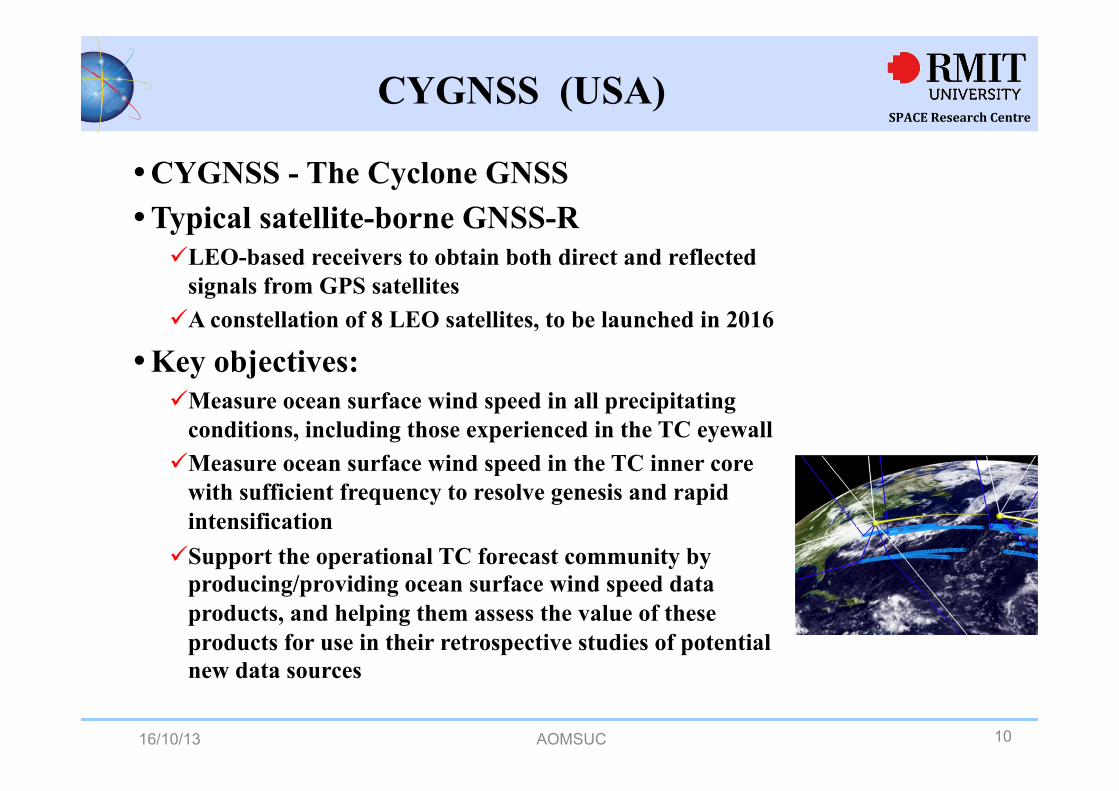
� CYGNSS - The Cyclone GNSS � Typical satellite-borne GNSS-R
ü LEO-based receivers to obtain both direct and reflected signals from GPS satellites
ü A constellation of 8 LEO satellites, to be launched in 2016
� Key objectives: ü Measure ocean surface wind speed in all precipitating
conditions, including those experienced in the TC eyewall ü Measure ocean surface wind speed in the TC inner core
with sufficient frequency to resolve genesis and rapid intensification
ü Support the operational TC forecast community by producing/providing ocean surface wind speed data products, and helping them assess the value of these products for use in their retrospective studies of potential new data sources
CYGNSS (USA)
16/10/13 AOMSUC 10
SPACE Research Centre
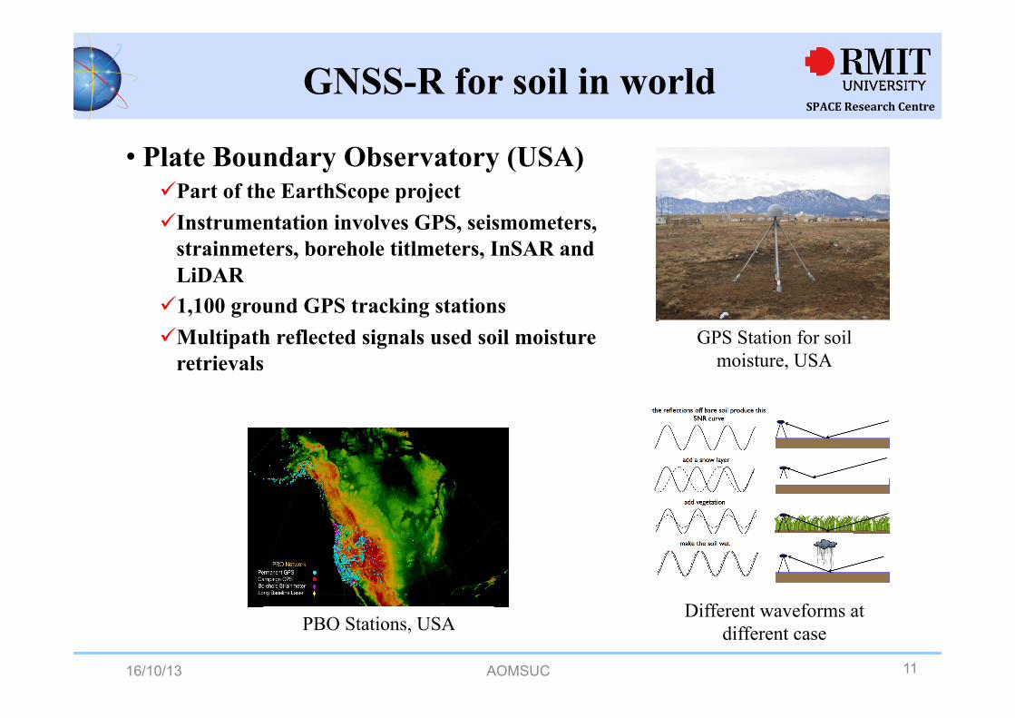
• Plate Boundary Observatory (USA) ü Part of the EarthScope project ü Instrumentation involves GPS, seismometers,
strainmeters, borehole titlmeters, InSAR and LiDAR
ü 1,100 ground GPS tracking stations ü Multipath reflected signals used soil moisture
retrievals
GNSS-R for soil in world
GPS Station for soil moisture, USA
PBO Stations, USA Different waveforms at
different case
16/10/13 AOMSUC 11

SPACE Research Centre
n Soil moisture important in Australia n National Airborne Field Experiment (NAFE05 NAFE06)
ü Aim: to provide access to a wide range of airborne and ground-based monitoring data (Jeffrey Walker & Rocco Panciera, University of Melbourne, 2005)
ü 2005-2006 ü No reflected signals were used
GNSS-R for soil in Australia
16/10/13 AOMSUC 12

SPACE Research Centre
� Australian GNSS-R ü Multipath signals were simulated (Queensland Univ of Technology, 2001) ü Air target detection using GPS bistatic radar was initially discussed in 2006 (E. P. Glennon, A. G. Dempster and C. Rizos, 2006) ü Airborne experiments for GNSS-Based Altimetry was conducted recently (Kegen Yu, Chris Rizos and Andrew Dempster, 2011) ü Ground-based soil moisture field experiments carried out by SPACE,
RMIT (2012-2013)
Australian Centre for Space Engineering Research
(ACSER)
GNSS-R in Australia
SPACE Researh Centre (RMIT)
16/10/13 AOMSUC 13

SPACE Research Centre
� Normalised power method (NPM)
ü Different soil moistures lead to different powers of the reflected signals
ü The power of the reflected GPS signals needs to be normalised by the power of direct signals
ü Dielectric constant is a function of soil moisture
Methods for soil moisture retrieval
� Interference technology method (ITM)
ü Direct and reflected signals form an interference pattern waveform
ü Soil moisture affects the characteristics of the interference waveform (notch position amplitude, etc.)
ü The moisture estimation is realized through identifying the interference characteristics
16/10/13 AOMSUC 14

SPACE Research Centre Our device - hardware
!!!!!!!!!!!!!!!
� A new method - interference difference technique (IDT) (improved ITM) developed which is also hardware related
16/10/13 AOMSUC 15

SPACE Research Centre Our Method
dielectric constant of the i-th layer thickness of the i-th layer height of the j-th antenna incidence angle of the direct signal (complementary angle of elevation) reflected angle of the reflected signal
� GNSS-R interference different signal ü Two antennas are used to receive the reflected signals
iε
incθ
reflectedθ
it
jh
16/10/13 AOMSUC 16

SPACE Research Centre Our Method
� Interference difference Ø Differential technique to remove unknown parameters and improve the accuracy
of the retrieval
G
211 2- = k ( , ) [( )]ijjD S S G R e e φφθ ϕ= ⋅ ⋅ −
14 cos( )incHπ
φ θλ
= ⋅ ⋅
24 ( ) cos( )incH Hπ
φ θλ
= ⋅ +Δ ⋅D is a function of
Means the linear relationship Reflection coefficient Excess phase of reflected signals
1,2i =
kRφG
mv H
mvH
Soil moisture Height of the first antenna Antenna gain
16/10/13 AOMSUC 17

SPACE Research Centre Key steps in signal processing
� Record data series by two receivers � Sort the data series according to elevation angles � Obtain the difference of the two data series � Generate “theoretical” data series according to the double
layer soil model and radio reflection theory � Matching:
ü Calculate the Euclidean/direct distance btw the measured and the model-based info;
ü Identify the minimum distance of the two vectors for matching
16/10/13 AOMSUC 18

SPACE Research Centre Field tests
Soil model for Melbourne!(Australian soils and Landscapes, 2004)
Field experiment in Melbourne Experiment Location in Google map
Site: Gardiners Creek
16/10/13 AOMSUC 19

SPACE Research Centre
!
� Antenna (towards east) � Distribution of satellites � Footprint of satellites
ü The in situ soil moisture is 0.14 ü The mean (average) of 50 samples by a soil
moisture meter
Footprints
Moisture meter: PMS-714
Antennas
Distribution of satellites
16/10/13 AOMSUC 20
Field tests!

SPACE Research Centre Experiment
� Match with Euclidean distance !!� Two steps
ü Search for the optimal H (antenna height) ü Search for the optimal mv (soil moisture)
� Optimal results ü Smallest distance ü Waveform matched well
2_ _
1( )
N
j r j r ei j eii
D S S s s=
= − = −∑
matched waveform
16/10/13 AOMSUC 21

SPACE Research Centre Experiment
� First step: search the optimal antenna height H Ø (due to the terrain effects at the reflected point)
!!!!! PRN1 PRN4 optimal antenna H1=1.1m optimal H1=1m ! ! !
These estimated heights are close to the real height 16/10/13 AOMSUC 22

SPACE Research Centre
� Search the optimal antenna height H for various satellites
PRN7 PRN8 optimal H1=1m optimal H1=1m PRN11 PRN28 optimal H1=1.1m optimal H1=0.9m
Experiment
These estimated heights are close to the real height 16/10/13 AOMSUC 23

SPACE Research Centre Experiment
� Second step: search the optimal moisture (mv) measurements for various satellites !
! PRN1 PRN4 optimal gain=1000 optimal gain=200 optimal mv=0.16 optimal mv=0.15
These estimated soil moistures are close to the real value (0.15) 16/10/13 AOMSUC 24

SPACE Research Centre
PRN7 PRN8 optimal mv=0.16 optimal mv=0.15
PRN11 PRN28 optimal mv=0.15 optimal mv=0.14
Experiment
These estimated soil moistures are close to the real value (0.15) 16/10/13 AOMSUC 25

SPACE Research Centre
� Recent Australian effort in GNSS-R is introduced along with the current status of the technology
� A new soil moisture retrieval method (IDT) is presented � Experiments show the new method is valuable/effective � GNSS-R is an emerging and promising satellite RS
technology for soil moisture measurements that is under significant international development
� Lots of challenges need to be resolved ü e.g. roughness of the parcel, different vegetation cover, second or more
times of signal reflections
� Our future efforts include retrieval theory and algorithms, device/hardware for data collection and more validation tests
� Exploit the full spectrum of GNSS atmospheric sounding
Conclusion
16/10/13 AOMSUC 26

SPACE Research Centre
Thank you
Professor Kefei Zhang
Director, Satellite Positioning for Atmosphere, Climate and Environment Research Centre School of Mathematical and GeoSpatial Sciences, RMIT University
Tel: +61-3-99253272, [email protected], http://www.rmit.edu.au/SPACE
16/10/13 AOMSUC 27

SPACE Research Centre SPACE at a Glance!
! Formed in 2010 as part of the Australian Space Research Program ! One of only 6 officially recognised research centres (and the largest) at RMIT ! Skills and expertise developing new methods, new algorithms and frontier
technologies for satellite PNT, space situation awareness (including space object and debris monitoring and tracking), space weather, weather and climate change modelling and severe weather event modelling and prediction
! Research facilities on the RMIT City and Bundoora campuses
! The first comprehensive GNSS tracking station in Australia
! More than 20 full time Research and Academic and 10 higher degree by research students affiliated with the centre
! Large range of international collaborative arrangement with Asia, Europe, North America etc.
16/10/13 AOMSUC 28