soil survey and ecological sites: integrated map unit design
TRANSCRIPT

Soil Survey and Ecological Sites: Integrated Map Unit Design and
Interpretation
Arlene J. TugelSoil Scientist, Liasion to ARS
Natural Resources Conservation ServiceLas Cruces, NM

Objectives
• Soil maps- a review• Soil survey legend development • Data collection• Soil-Site correlation• Functions and soil behavior• Sources of variance in an Ecological Site• Strategies for ESD development

Mapping the land
Soil functions in natural landscape units.

Soil maps – a review
• User needs• Kinds of soil maps• Kinds of soil map units• Similar soils

Needs: Farmers, ranchers, federal, state and NGO land managers
• Short- and long-term soil productivity • Economic profit and sustainability • Minimize environmental impacts• Assessment and monitoring programs• Predict management effects on resource
condition • Restoration and remediation planning• Prevent degradation

Intensity of mappingIntensity Methods Map units
Order 1 Grid mapping
2(detailed)
Confirm boundary and components
3(broad)
Confirm dominant components
4 Reconnaissance
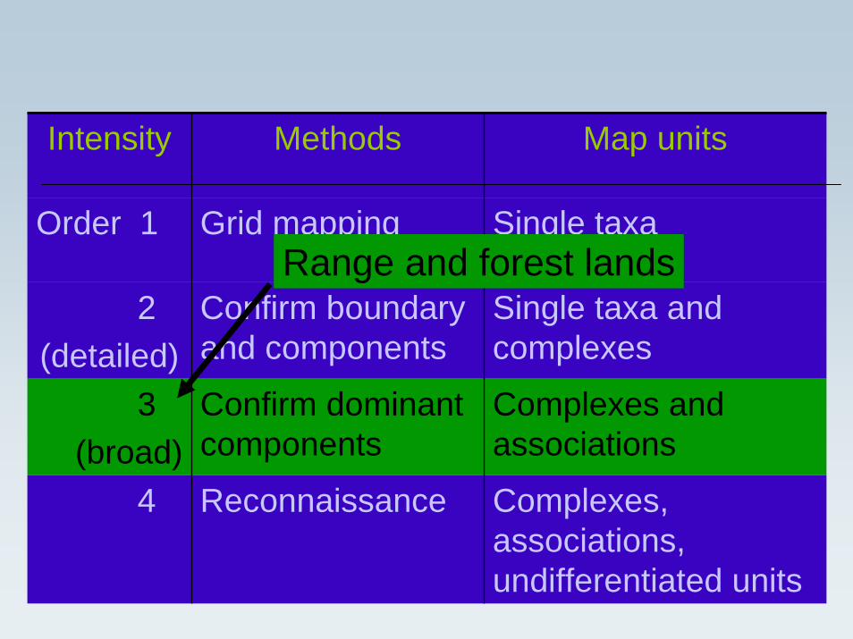
Intensity Methods Map units
Order 1 Grid mapping Single taxa
2(detailed)
Confirm boundary and components
Single taxa and complexes
3(broad)
Confirm dominant components
Complexes and associations
4 Reconnaissance Complexes, associations, undifferentiated units
Range and forest lands
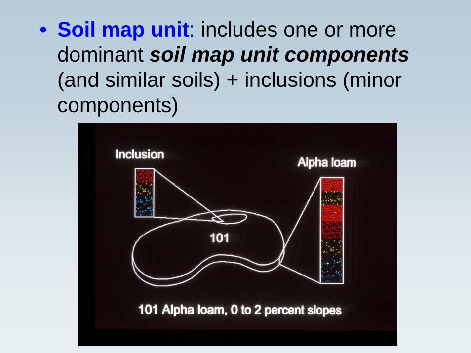
• Soil map unit: includes one or more dominant soil map unit components(and similar soils) + inclusions (minor components)

• Soil map unit component: soil series + slope and surface texture modifier–– Soil seriesSoil series is similar to a plant speciesis similar to a plant species–– Soil map unit componentSoil map unit component is similar to a is similar to a
subsub--species (subset of a series)species (subset of a series)•• Soil map unit components repeat across Soil map unit components repeat across
the landscape, and can be part of more the landscape, and can be part of more than one map unitthan one map unit
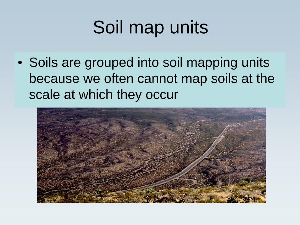
Soil map units
• Soils are grouped into soil mapping units because we often cannot map soils at the scale at which they occur

A soil map unit (what’s on the map) can be:
• An ASSOCIATION of two or more soils that occur in a repetitive and predictablepattern (e.g. low ridges & swales)
• A COMPLEX of two or more soils that usually do not occur in a predictablepattern at a mappable scale (e.g. coarse and fine soils in a river floodplain)
• A single soil series (but even these map units usually have “inclusions” too small to be mapped). Sometimes call a CONSOCIATION

General Soil Map, STATSGO

Similar soils ????
• Use a classification system based on soil properties that are relatively unchanged by management.

Legend development and documentation
Purpose: To organize, gather, describe, and delineate data needed to provide current and accurate soil maps and interpretations.
Who: Soil survey project staff and assisting resource specialists
How: Conduct field studies to determine relationships among landforms, soil and vegetation
“The various disciplines work together as a team in data collection and documentation.”
NSSH 627.02(c)

Steps - Field studies1. Study survey area and adjoining areas in same MLRA2. Identify and delineate major units
• Climatic zones• Geology• Landforms• Vegetation patterns and broad ecological areas• Current and historical land use
3. Clarify soil patterns and relationship to ecological components

Steps - Field studies
1. Study survey area and adjoining areas in same MLRA2. Identify and delineate major units
• Climatic zones• Geology• Landforms• Vegetation patterns and broad ecological areas• Current and historical land use
3. Clarify soil patterns and relationship to ecological components4. Design map units by test mapping areas that have repeating
patterns and can be delineated at scale specified in MOU5. Set up provisional map units that meet the test criteria6. Request approval of new MU’s from MLRA Office (Progress
Reviews)7. Add approved map units to the soil survey descriptive legend


Testing map units• Evaluate the predictive value of soil-ecological features;
soil-plant community relationships, indicator species• Compare the properties of the soil on either side of
natural boundaries to determine if they differ significantly;
• Compare the slope gradient and shape, vegetation, and position on the landform relative to surrounding soils to determine if they help predict the kind of soil;
• Determine the complexity of the soil pattern; • Determine the composition of mappable delineations of
map units; • Evaluate how well map unit concepts furnish soil data
required for soil interpretations; and• Describe other visual features, such as vegetation
patterns, areas of rock, and photograph signature.

Selecting map unit components• Common on older very broadly mapped surveys:
Identify end-members– “Shallow sandy soil”- “very deep fine-loamy soil”
association• Today: Major and minor components based on
transect data, with % composition for each component– Moderately deep sandy soil: 40%– Very deep coarse-loamy soil: 25%– Shallow sandy soil: 10%– Very deep fine-loamy soil: 10%– Other minor soils: 5%

Steps - Field studies
1. Study survey area and adjoining areas in same MLRA2. Identify and delineate major units
• Climatic zones• Geology• Landforms• Vegetation patterns and broad ecological areas• Current and historical land use
3. Clarify soil patterns and relationship to ecological components4. Design map units by test mapping areas that have repeating
patterns and can be delineated at scale specified in MOU5. Set up provisional map units that meet the test criteria6. Request approval of new MU’s from MLRA Office (Progress
Reviews)7. Add approved map units to the soil survey descriptive legend

Soil-site correlation
Soil is a natural body AND it’s a part of functioning soil-plant systems.

Linking pedology, ecology and soil function
Ecological processes– Energy capture
and flow– Hydrologic cycle– Nutrient cycling
Pedogenicprocesses– Inputs– Translocations– Transformations– Removal
processes
Capacity to function

What are the benefits of correlating soils and ecological sites?

What are the benefits of correlating soils and ecological sites?
• Soil components can be used to identify an ecological site where the historic climax plant community no longer exists.
• Geospatial boundaries of ecological sites can be derived from soil map unit boundaries except for soil complexes and associations.
• The range of environmental factors for each ecological site (rainfall, temperature, elevation, landforms, etc.) can be derived from soil map unit boundaries.
• Soil properties characterizing each ecological site are obtained from soil map unit databases.
• Climo-edaphic potentials can be predicted from soil and environmental features.

Creating interpretive groupsSoil – Ecological Site correlation
• “Soil-Site correlation establishes the relationship between soil components and ecological sites ….[and] normally takes place in conjunction with progressive soil surveys.” (NRPH, 2003)
– There is a many to one relationship: many similar soil components can be grouped into one ecological site.
– However, a single specific soil component cannot be included in more than one ecological site.

Chiara silt loam, 2-15% slopes soil map unit
Ecological SiteSoil map unit component
MLRA Sub-MLRA
Eco Site
State
Chiara silt loam, 2-15% slopes
025 XY 019 NV
Inclusion 1 028 BY 010* NVInclusion 2 025 XY 019 NVInclusion 3 025 XY 019 NV
* Loamy 8-10” P.Z. (Precipitation Zone) in MLRA (Major Land Resource Area) 28B (Central Nevada Basin and Range).
Ecological site ID for each soil componentEcological site ID for each soil component

Ecological Site definition:
• An ecological site is a kind of land with specific physical characteristics (soil, topography, climate) which differs from other kinds of land in its ability to produce distinctive kinds and amounts of vegetation (in its response to management).
• In other words, a kind of land with similar potential and response to management.
• Other stratification systems can also be used.

Soil-site correlation “rules”
An ecological site can include more than one soil series, provided that the soils are similar
A soil map unit can include more than one ecological site. Soil map units often include many different soils, with different potentials to support plant communities
Even a soil series can include more than one ecological site. Soil surface texture often varies within a soil series. Soil surface texture is very important in distinguishing ecological sites.

What makes one site different from another?
• Ecological sites are differentiated on the basis of:– Kind, proportion and production of vegetation in the historic climax
plant community– Soil– Environmental factors
“Marked differences in soil texture, depth and topographic position usually result in pronounced differences in plant communities, total production or both. Therefore, such contrasting conditions in the soil characteristics, climate, topography, or other environmental factors known to be associated with a specific ecological site can be used as a means of identifying the site when the historic climax plant community is absent.” (NRPH, 2003)
• Management response


What are the sources of variation in an ecological site?
1. More than one correlated soil component2. Range of characteristics of each soil component
1. 5 - 15% slopes2. 20 – 40 inches deep3. EC of > 8 4. 20 – 35 % clay (clay loam)5. Low to moderate available water capacity (texture and rock fragments)
3. Geographic/climatic range1. 3000-4000’ elevation2. 8 – 12 rainfall3. Etc
4. Management history, fire history1. Plant communities within a state (STM)2. States within an ecological site3. Dynamic soil properties within plant communities and states
5. Contrasting soil or plant community inclusions that are not correlated to the site but occur within site boundaries

The effects of geomorphic position on vegetation dynamics
1969 2003
1962 2003
Active alluvial fan (gravelly ecological site)
Relict, dissected alluvial fan (gravelly ecological site)

1. Rapid assessment of survey area
2. Traversing/auger holes, legend development, range con keeps vegetation notes
3. Preliminary map unit delineations, range con identifies key vegetation differences
4. Preliminary transecting, range con samples vegetation, track changes to legend
5. Update map units, additional transecting and vegetation samples to assist,associate vegetation data to final map unit components
A strategy for ESD development: ongoing soil survey
7. Soil-site correlation, intensive measurements where soil 232 data are gathered
6. Evaluate data: important community differences and….a) no soil differences=different statesb) associated with unique soil or climate properties=different LRU and/or sites

1. Rapid survey of map units across LRU
2. How do map units differ, how many community types?
3. Use ARC GIS to locate all representatives of key map units from digital soil survey
4. Rapid survey of map unit delineations
5. “Transect” a subset of map unit delineations with different communities(at least 3 replicates/community/map unit), id map unit component
6. Evaluate data: important community differences and….a) no soil differences=different statesb) associated with unique soil or climate properties=different LRU and/or sites
7. Select representatives of states within an Ecological Site for intensive measurement
A strategy for ESD development: completed/updating soil survey

When is a transition so severe that a new ecological site should be created?
One thought: Never because then a rangeland can be degraded into a healthy state at a new potential. This way CSP dollars go to mesquite and juniper farmers.
Another thought: When soil morphology is severely altered, establish a new site but maintain its connection as a degraded state of its ancestral site
Danger: When is soil morphology “severely altered” and isn’t this a value judgement?

Soil-site correlation “rules”
“As long as the physical environment remains similar (unchanged by management) to that unique mix of conditions required by the historic climax plant community, change to another ecological site is not recognized.”
(NRPH, 2003)

Soil survey status and soil-site correlation
1. New soil surveys2. Soil survey updates
3. Soil survey maintenance (completed survey)
• Use soil-site correlation procedures in NSSH, NRPH
• Submit revisions for soil-site correlation to MLRA Project Office.
• Get approval of State Range Mgt Specialist

Other considerations for integrated soil ecosystem management inventory
Soil-site correlation should consider:• Soil-plant interactions• Disturbances and management regimes• Potential• Geomorphic activity• Function-based management• Management effects on vegetation and dynamic
soil properties• Quantifying indicators for Rangeland Health

Soil survey and soil inventory
• The National Cooperative Soil Survey (1900) includes many cooperators. NRCS approves soil identification and classification of surveys made according to NCSS standards.
• Soil surveys can have various names.– “Terrestrial Ecosystem Unit Inventories” - USFS – “Soil Resource Inventories” - National Park Service