soil survey of macon county, alabama
TRANSCRIPT

United StatesDepartment ofAgriculture
NaturalResourcesConservationService
In cooperation withthe Alabama AgriculturalExperiment Station and theAlabama Soil and WaterConservation Committee
Soil Survey ofMacon County,Alabama


General Soil Map
The general soil map, which is a color map, shows the survey area divided into groups of associated soils calledgeneral soil map units. This map is useful in planning the use and management of large areas.
To find information about your area of interest, locate that area on the map, identify the name of the map unit in thearea on the color-coded map legend, then refer to the section General Soil Map Units for a general description ofthe soils in your area.
Detailed Soil Maps
The detailed soil maps can be useful in planning the use andmanagement of small areas.
To find information about your areaof interest, locate that area on theIndex to Map Sheets. Note thenumber of the map sheet and turnto that sheet.
Locate your area of interest onthe map sheet. Note the map unitsymbols that are in that area. Turnto the Contents, which lists themap units by symbol and nameand shows the page where eachmap unit is described.
The Contents shows which tablehas data on a specific land use foreach detailed soil map unit. Alsosee the Contents for sections ofthis publication that may addressyour specific needs.
i
How To Use This Soil Survey

Additional information about the Nation’s natural resources is available onlinefrom the Natural Resources Conservation Service at http://www.nrcs.usda.gov.
ii
This soil survey is a publication of the National Cooperative Soil Survey, a joint effortof the United States Department of Agriculture and other Federal agencies, Stateagencies including the Agricultural Experiment Stations, and local agencies. TheNatural Resources Conservation Service (formerly the Soil Conservation Service) hasleadership for the Federal part of the National Cooperative Soil Survey.
Major fieldwork for this soil survey was completed in 1998. Soil names anddescriptions were approved in 1998. Unless otherwise indicated, statements in thispublication refer to conditions in the survey area in 1998. This survey was madecooperatively by the Natural Resources Conservation Service, the Alabama AgriculturalExperiment Station, the Alabama Cooperative Extension System, the Alabama Soil andWater Conservation Committee, the Alabama Department of Agriculture and Industries,the Macon County Commission, and Tuskegee University. It is part of the technicalassistance furnished to the Macon County Soil and Water Conservation District. TheUSDA-Forest Service provided financial assistance for the part of the survey inTuskegee National Forest.
Soil maps in this survey may be copied without permission. Enlargement of thesemaps, however, could cause misunderstanding of the detail of mapping. If enlarged,maps do not show the small areas of contrasting soils that could have been shown at alarger scale.
The U.S. Department of Agriculture (USDA) prohibits discrimination in all itsprograms and activities on the basis of race, color, national origin, sex, religion, age,disability, political beliefs, sexual orientation, or marital or family status. (Not allprohibited bases apply to all programs.) Persons with disabilities who require alternativemeans for communication of program information (Braille, large print, audiotape, etc.)should contact USDA’s TARGET Center at (202) 720-2600 (voice and TDD).
To file a complaint of discrimination, write USDA, Director, Office of Civil Rights,Room 326-W, Whitten Building, 1400 Independence Avenue, SW, Washington, D.C.20250-9410 or call (202) 720-5964 (voice and TDD). USDA is an equal opportunityprovider and employer.
Cover: Cotton growing in an area of Red Bay sandy loam, 0 to 2 percent slopes. This soil is primefarmland and is well suited to cultivated crops, hay, and pasture.

iii
Contents
How To Use This Soil Survey .................................. iContents ................................................................. iiiForeword ............................................................... viiGeneral Nature of the County ................................... 2
How This Survey Was Made ................................. 4General Soil Map Units .......................................... 7
Areas on Flood Plains and Low StreamTerraces Dominated by Level to GentlySloping, Loamy and Clayey Soils that areSubject to Flooding ........................................ 7
1. Altavista-Toccoa-Riverview ........................ 72. Dogue-Kinston-Eunola .............................. 83. Kinston-Mooreville-Goldsboro ................... 94. Urbo-Una-Mooreville ............................... 10
Areas on Uplands Dominated by Nearly Levelto Steep, Loamy, Sandy, and Clayey Soils ... 11
5. Pacolet-Marvyn ....................................... 116. Luverne-Troup-Lucy ................................ 127. Bama-Malbis-Luverne ............................. 138. Cowarts-Uchee-Marvyn .......................... 149. Conecuh-Luverne .................................... 15
Areas on Uplands of the Blackland PrairieDominated by Nearly Level to ModeratelySteep Clayey Soils ....................................... 16
10. Maytag-Hannon-Oktibbeha .................... 1611. Oktibbeha-Conecuh............................... 1712. Sumter-Hannon-Oktibbeha .................... 18
Detailed Soil Map Units ........................................ 19AlA—Altavista silt loam, 0 to 2 percent slopes,
rarely flooded ............................................... 20ArB—Arents, smooth .......................................... 21BaA—Bama fine sandy loam, 0 to 2 percent
slopes .......................................................... 21BaB—Bama fine sandy loam, 2 to 5 percent
slopes .......................................................... 23BeA—Bethera clay loam, 0 to 1 percent
slopes, frequently flooded ............................ 23BgB—Bigbee loamy sand, 1 to 3 percent
slopes, rarely flooded ................................... 24BnE—Blanton-Luverne complex, 12 to 25
percent slopes ............................................. 26BoB—Bonifay loamy fine sand, 1 to 5 percent
slopes .......................................................... 27CaA—Cahaba sandy loam, 0 to 2 percent
slopes, rarely flooded ................................... 28
CmB—Compass loamy sand, 1 to 3 percentslopes .......................................................... 29
CoB—Conecuh fine sandy loam, 1 to 3percent slopes ............................................. 31
CoC2—Conecuh fine sandy loam, 3 to 8percent slopes, eroded ................................ 32
CwD2—Cowarts loamy sand, 5 to 15 percentslopes, eroded ............................................. 33
DgA—Dogue fine sandy loam, 0 to 2 percentslopes, rarely flooded ................................... 34
EuA—Eunola fine sandy loam, 0 to 2 percentslopes, rarely flooded ................................... 36
FaA—Faunsdale clay loam, 1 to 3 percentslopes .......................................................... 38
FuA—Fluvaquents, ponded ................................ 39GoA—Goldsboro loamy fine sand, 0 to 2
percent slopes ............................................. 40GrA—Gritney loamy fine sand, 0 to 2 percent
slopes .......................................................... 41GrB—Gritney fine sandy loam, 2 to 5 percent
slopes .......................................................... 42HnB—Hannon clay loam, 1 to 3 percent
slopes .......................................................... 43HnC2—Hannon clay, 3 to 5 percent slopes,
eroded ......................................................... 44HoD2—Hannon-Maytag complex, 3 to 8
percent slopes, eroded ................................ 46HsE—Hannon-Sumter complex, 5 to 12
percent slopes ............................................. 47KmA—Kinston-Mooreville complex, 0 to 1
percent slopes, frequently flooded ............... 49LcD—Lucy-Luverne complex, 5 to 15 percent
slopes .......................................................... 51LsB—Lucy-Luverne-Springhill complex, 1 to 5
percent slopes ............................................. 53LuB—Luverne sandy loam, 1 to 5 percent
slopes .......................................................... 55LuD2—Luverne sandy loam, 5 to 15 percent
slopes, eroded ............................................. 56LyA—Lynchburg fine sandy loam, 0 to 2
percent slopes, rarely flooded ...................... 57MaA—Malbis fine sandy loam, 0 to 2 percent
slopes .......................................................... 58MnA—Marvyn sandy loam, 0 to 2 percent
slopes .......................................................... 59

iv
MnB—Marvyn loamy sand, 2 to 5 percentslopes .......................................................... 60
MtA—Maytag silty clay, 0 to 2 percent slopes ..... 62MuB—Maytag-Hannon complex, 1 to 3
percent slopes ............................................. 63MyA—Myatt loam, 0 to 1 percent slopes,
rarely flooded ............................................... 65OcA—Ocilla loamy fine sand, 0 to 2 percent
slopes, rarely flooded ................................... 66OkC2—Oktibbeha clay loam, 1 to 5 percent
slopes, eroded ............................................. 67OkE2—Oktibbeha clay loam, 5 to 15 percent
slopes, eroded ............................................. 68OrA—Orangeburg sandy loam, 0 to 2 percent
slopes .......................................................... 70PaD—Pacolet sandy loam, 6 to 10 percent
slopes .......................................................... 71PaE—Pacolet sandy loam, 10 to 25 percent
slopes .......................................................... 72PoA—Pelham-Ocilla complex, 0 to 2 percent
slopes, rarely flooded ................................... 73Pt—Pits, sand and gravel ................................... 75RbA—Red Bay sandy loam, 0 to 2 percent
slopes .......................................................... 75ReA—Riverview silt loam, 0 to 1 percent
slopes, occasionally flooded ........................ 76RoB—Riverview-Bruno complex, 0 to 3
percent slopes, occasionally flooded............ 77Rw—Riverwash .................................................. 78RyA—Roanoke silt loam, 0 to 1 percent
slopes, occasionally flooded ........................ 79SaB—Searcy fine sandy loam, 2 to 5 percent
slopes .......................................................... 80SbB—Springhill sandy loam, 2 to 5 percent
slopes .......................................................... 81SrA—Sucarnoochee clay, 0 to 1 percent
slopes, frequently flooded ............................ 82StE—Sumter-Hannon complex, 12 to 25
percent slopes ............................................. 83TcA—Toccoa fine sandy loam, 0 to 1 percent
slopes, occasionally flooded ........................ 84ToB—Toccoa fine sandy loam, gently
undulating, occasionally flooded .................. 86TpB—Troup-Alaga complex, 0 to 5 percent
slopes .......................................................... 87
TsF—Troup-Springhill-Luverne complex, 15 to35 percent slopes ........................................ 89
UcB—Uchee loamy sand, 1 to 5 percentslopes .......................................................... 90
UcD—Uchee loamy sand, 5 to 15 percentslopes .......................................................... 91
UcE2—Uchee-Cowarts complex, 15 to 25percent slopes, eroded ................................ 93
UdE—Udorthents, rough .................................... 95UoC—Udorthents, smooth ................................. 95UuA—Udorthents-Urban land complex, 0 to 2
percent slopes ............................................. 96UvA—Urbo-Una-Mooreville complex, 0 to 1
percent slopes, frequently flooded ............... 96VaA—Vaiden silty clay loam, 0 to 2 percent
slopes .......................................................... 98WaB—Wagram loamy sand, 1 to 3 percent
slopes .......................................................... 99Prime Farmland .................................................. 101Use and Management of the Soils .................... 103
Crops and Pasture ........................................... 103Yields per Acre ............................................. 105Land Capability Classification ...................... 105
Landscaping and Gardening ............................ 106Woodland Management and Productivity ......... 108Recreation ........................................................ 109Wildlife Habitat ................................................. 110Engineering ...................................................... 112
Building Site Development ........................... 113Sanitary Facilities ......................................... 113Construction Materials ................................. 114Water Management ...................................... 115
Soil Properties .................................................... 117Engineering Index Properties ........................... 117Physical and Chemical Properties .................... 118Soil and Water Features ................................... 119Physical and Chemical Analyses of Selected
Soils ........................................................... 120Engineering Index Test Data ............................. 120
Classification of the Soils .................................. 123Soil Series and Their Morphology ..................... 123Alaga Series ..................................................... 123Altavista Series ................................................ 124Bama Series..................................................... 125Bethera Series ................................................. 126

v
Bigbee Series ................................................... 126Blanton Series .................................................. 127Bonifay Series .................................................. 128Bruno Series .................................................... 129Cahaba Series ................................................. 129Compass Series ............................................... 130Conecuh Series ................................................ 131Cowarts Series ................................................. 132Dogue Series ................................................... 133Eunola Series ................................................... 134Faunsdale Series ............................................. 135Goldsboro Series ............................................. 136Gritney Series .................................................. 137Hannon Series ................................................. 138Kinston Series .................................................. 139Lucy Series ...................................................... 140Luverne Series ................................................. 141Lynchburg Series ............................................. 142Malbis Series .................................................... 143Marvyn Series .................................................. 143Maytag Series .................................................. 147Mooreville Series .............................................. 148Myatt Series ..................................................... 149Ocilla Series ..................................................... 150Oktibbeha Series .............................................. 151Orangeburg Series ........................................... 152Pacolet Series .................................................. 153Pelham Series .................................................. 154Red Bay Series ................................................ 155Riverview Series .............................................. 155Roanoke Series ................................................ 156Searcy Series ................................................... 157Springhill Series ............................................... 158Sucarnoochee Series ....................................... 159Sumter Series .................................................. 159Toccoa Series................................................... 160Troup Series ..................................................... 161Uchee Series ................................................... 162Una Series ....................................................... 162Urbo Series ...................................................... 163
Vaiden Series ................................................... 164Wagram Series ................................................. 165
Formation of the Soils ........................................ 167Factors of Soil Formation ................................. 167Processes of Horizon Differentiation ................ 168Surface Geology............................................... 169
References .......................................................... 171Glossary .............................................................. 173Tables .................................................................. 183
Table 1.—Temperature and Precipitation .......... 184Table 2.—Freeze Dates in Spring and
Fall ............................................................. 185Table 3.—Growing Season ............................... 185Table 4.—Suitability and Limitations of
General Soil Map Units for SpecifiedUses .......................................................... 186
Table 5.—Acreage and Proportionate Extentof the Soils ................................................. 188
Table 6.—Land Capability and Yields perAcre of Crops ............................................. 190
Table 7.—Yields per Acre of Pasture andHay ............................................................ 194
Table 8.—Woodland Management andProductivity ................................................ 198
Table 9.—Recreational Development ............... 209Table 10.—Wildlife Habitat ................................ 215Table 11.—Building Site Development .............. 220Table 12.—Sanitary Facilities ........................... 226Table 13.—Construction Materials .................... 232Table 14.—Water Management ........................ 237Table 15.—Engineering Index Properties ......... 243Table 16.—Physical and Chemical Properties
of the Soils ................................................. 256Table 17.—Soil and Water Features ................. 265Table 18.—Physical Analyses of Selected
Soils ........................................................... 269Table 19.—Chemical Analyses of Selected
Soils ........................................................... 271Table 20.—Engineering Index Test Data ........... 273Table 21.—Classification of the Soils ................ 274
Issued 2004


vii
This soil survey contains information that affects land use planning in this surveyarea. It contains predictions of soil behavior for selected land uses. The survey alsohighlights soil limitations, improvements needed to overcome the limitations, and theimpact of selected land uses on the environment.
This soil survey is designed for many different users. Farmers, ranchers, foresters,and agronomists can use it to evaluate the potential of the soil and the managementneeded for maximum food and fiber production. Planners, community officials,engineers, developers, builders, and home buyers can use the survey to plan land use,select sites for construction, and identify special practices needed to ensure properperformance. Conservationists, teachers, students, and specialists in recreation, wildlifemanagement, waste disposal, and pollution control can use the survey to help themunderstand, protect, and enhance the environment.
Various land use regulations of Federal, State, and local governments may imposespecial restrictions on land use or land treatment. The information in this report isintended to identify soil properties that are used in making various land use or landtreatment decisions. Statements made in this report are intended to help the land usersidentify and reduce the effects of soil limitations that affect various land uses. Thelandowner or user is responsible for identifying and complying with existing laws andregulations.
Great differences in soil properties can occur within short distances. Some soils areseasonally wet or subject to flooding. Some are shallow to bedrock. Some are toounstable to be used as a foundation for buildings or roads. Clayey or wet soils arepoorly suited to use as septic tank absorption fields. A high water table makes a soilpoorly suited to basements or underground installations.
These and many other soil properties that affect land use are described in this soilsurvey. Broad areas of soils are shown on the general soil map. The location of eachsoil is shown on the detailed soil maps. Each soil in the survey area is described.Information on specific uses is given for each soil. Help in using this publication andadditional information are available at the local office of the Natural ResourcesConservation Service or the Cooperative Extension System.
Robert N. JonesState ConservationistNatural Resources Conservation Service
Foreword


1
MACON COUNTY is located in east-central Alabama(fig. 1). The total area of the county, including areas ofwater, is 392,830 acres, or about 614 square miles.Macon County is bounded on the west byMontgomery County, on the northwest by ElmoreCounty, on the north by Tallapoosa County, on thenortheast by Lee County, on the east by RussellCounty, and on the south by Bullock County. In 1990,the population of Macon County was 24,928 (ADECA,1990). Tuskegee, the largest city and the county seat,had a population of 12,257 (ADECA, 1990). Theincorporated cities of Notasulga, Franklin, and Shorterare among the many smaller communities in thecounty.
The Tuskegee Institute National Historic Site,located on the campus of Tuskegee University,became a part of the National Park System in 1974.African-American history, early industrial development,civil rights, and education are some of the themesrepresented at the site. The 11,070-acre TuskegeeNational Forest, which is managed by the USDA–Forest Service to improve the area’s recreationalopportunities, wildlife, water quality, and timberresources, is one of Alabama’s four national forestsand is the smallest in the nation. Although small insize, it offers the outdoor enthusiast facilities for hiking,wildlife viewing, picnicking, camping, hunting, andfishing.
Most of the acreage in the county is forestland;however, a significant acreage is used for cultivatedcrops, pasture, and hay.
Soil Survey of
Macon County, AlabamaBy James M. Mason, Natural Resources Conservation Service
Fieldwork by James M. Mason, Rex H. Chandler, Richard Corley, Malcomb Kirkland,Cleo Stubbs, Johnny C. Trayvick, and Christie L. White, Natural ResourcesConservation Service
United States Department of Agriculture, Natural Resources Conservation Service,in cooperation withthe Alabama Agricultural Experiment Station, the Alabama Cooperative ExtensionSystem, the Alabama Soil and Water Conservation Committee, the AlabamaDepartment of Agriculture and Industries, the Macon County Commission, TuskegeeUniversity, and the USDA–Forest Service
Figure 1.—Location of Macon County in Alabama.

2 Soil Survey
Macon County includes portions of three MajorLand Resource Areas: the Southern Piedmont; theSouthern Coastal Plain; and the Alabama, Mississippi,and Arkansas Blackland Prairies. Elevation rangesfrom about 570 feet above sea level at Liberty City inthe northern part of the county to about 170 feetabove sea level near the mouth of Line Creek in thewestern part of the county.
The major highways providing access throughMacon County include Interstate Highway 85 and U.S.Highway 80, which run east to west, and U.S. Highway29, which runs north to south. Several state highwaysand numerous county roads serve the remainder ofthe county.
This soil survey updates an earlier survey of MaconCounty published in 1944 (Lounsbury and others,1944). It provides additional information and largermaps, which show the soils in greater detail.
General Nature of the CountyThis section provides general information about the
county. It gives a brief description of the history,natural resources, geology, farming, and climate.
History
The area that is now Macon County was part ofthe lands ceded by the Creek Indian Nation. In1832, after the defeat of the Creek Indians atHorseshoe Bend and the passage of the IndianRemoval Act, Macon County was created by an actof the Alabama Legislature. It was named in honorof Nathaniel Macon, a distinguished soldier fromNorth Carolina. Tuskegee was incorporated andauthorized as the county seat in 1833. Indians andsettlers coexisted in the county for many years untilthe last of the Indians were removed in 1836.
In 1866, another act of the Alabama Legislaturetook lands from northeastern and southern parts ofMacon County for the creation of Lee and BullockCounties, respectively. Because of the settled areasto the east and west, land speculation boomed andsettlements sprang up quickly. Settlers came largelyfrom Georgia, the Carolinas, and Tennessee. Someof the early settlements were Cotton Valley, CrossKeys, Franklin, Hunnicutt, Little Texas, Notasulga,Society Hill, Tuskegee, and Warriorstand (TuskegeeUniversity Extension Service, 1993; Yamaguchi,1981).
Tuskegee, the largest town and main businesscenter, is centrally located in the county. It is about 40miles east of Montgomery, Alabama, and 42 miles
west of Columbus, Georgia. Macon County is servedby 574 miles of county roads, 130 miles of state roads,and 80 miles of federally-maintained roads (ADECA,1990). Adjacent to the city of Tuskegee is TuskegeeUniversity, formerly Tuskegee Normal and IndustrialInstitute. Tuskegee University in nationally known forleadership in promoting African-American educationand culture (Yamaguchi, 1981).
Farming, the main economic enterprise in thecounty, flourished during the antebellum “PlantationEra.” Cotton was the chief crop. As cottonproduction declined, the farm economy suffered,prompting a shift toward cattle and timberproduction. This shift in land use brought about apopulation decline. In spite of this decline, however,Macon County remains an agricultural county andnow has a fairly steady population. The populationwas 24,841 in 1970 and 24,928 in 1990(Consolidated Farm Service Agency, 1995).
Natural Resources
Soil is one of the most important natural resourcesin the county. The cattle that graze the pastures, thecrops that are produced on the farms, and the timberand pulpwood that are produced in the forestlands areall marketable products that come from the soil. Sand,gravel, and, to a lesser extent, topsoil are mined alongthe Tallapoosa River and some of its major tributariesand are of major economic value (fig. 2).
Macon County has an adequate water supply fordomestic and livestock use. The county is drained byseveral large creeks and their tributaries. Most ofthese creeks flow west and north and empty into theTallapoosa River. A few in the southeast corner of thecounty flow south and east and empty into theChattahoochee River. Most of the water for domesticuse is drawn from wells by both large and smallpumping systems. Many lakes and ponds arescattered throughout the county. These water areasare used for livestock, wildlife enhancement andhabitat, and recreation.
About 288,800 acres, or 74 percent of the total landarea in Macon County, is forestland (Macon CountySWCD, 1980). Timber production is mainly in thenortheastern, eastern, and central parts of the county.The soils in these areas are generally well suited topine trees. Many acres of cropland and pasturelandhave been converted to timber production by individuallandowners and commercial timber producers. Thesoils in the southwestern and southern parts of thecounty, particularly south of Cotton Valley, generallyare less well suited to the production of pine trees.

Macon County, Alabama 3
Geology
The three Major Land Resource Areas (MLRAs) inMacon County are the Southern Piedmont; theAlabama, Mississippi, and Arkansas Blackland Prairie;and the Southern Coastal Plain.
Soils of the Southern Piedmont are in thenorthernmost tip of the county. These soils formed ingranites, gneisses, and schists of the Opelika andDadeville Complex. This area of the SouthernPiedmont is highly dissected and has narrow ridgesand steep side slopes.
Soils of the Alabama, Mississippi, and ArkansasBlackland Prairies are across the southern part of thecounty. These soils formed in materials weatheredfrom alkaline clay, chalk, and marl of the MoorevilleChalk and Blufftown Formations. This area consists ofa network of low hills and irregular ridges with narrow,v-shaped valleys.
Soils of the Southern Coastal Plain are acrossthe northern and central parts of the county. Thesesoils formed in unconsolidated sands and clays of
the Tuscaloosa Group and Eutaw Formation. Thisarea is moderately to highly dissected by a dendriticpattern of streams and has ridges that range fromnearly level and broad to moderately sloping andnarrow.
Farming
About 80,800 acres, or 20 percent of the total landarea in Macon County, is used for cropland,pastureland, or hayland (Consolidated Farm ServiceAgency, 1995). Cotton has again become the majorcultivated crop in Macon County. Some cotton farmersare planting small grains and legumes as winter cover.Smaller acreages of corn, used primarily for silage,and soybeans are also planted. Haying operations arescattered throughout the county. They produce hay foron-farm use and for sale to livestock producers. Beef-cattle production is the largest agricultural industry inthe county. Specialty crops of economic significanceinclude pecans, sod, blueberries, ornamental plants,and vegetable crops.
Figure 2.—A sand and gravel pit in an area of Cahaba sandy loam, 0 to 2 percent slopes, rarely flooded.

4 Soil Survey
Climate
Macon County has long, hot summers becausemoist tropical air from the Gulf of Mexico persistentlycovers the area. Winters are cool and fairly short. Arare cold wave lingers for 1 or 2 days. Precipitation isfairly heavy throughout the year, and prolongeddroughts are rare. Summer precipitation, mainly in theform of afternoon thunderstorms, is usually adequatefor the growth of all crops.
Severe local storms, including tornadoes, strikeoccasionally in or near the county. They are of shortduration and cause variable and spotty damage. Everyfew years, in summer or fall, a tropical depression orremnant of a hurricane that has moved inland causesextremely heavy rains for 1 to 3 days.
Table 1 gives data on temperature and precipitationfor the survey area as recorded at Martin Dam,Alabama, in the period 1961 to 1990. Table 2 showsprobable dates of the first freeze in fall and the lastfreeze in spring. Table 3 provides data on length of thegrowing season.
In winter, the average temperature is 46 degrees Fand the average daily minimum temperature is 35degrees. The lowest temperature on record, whichoccurred on December 27, 1983, is 0 degrees. Insummer, the average temperature is 78 degrees andthe average daily maximum temperature is 89degrees. The highest recorded temperature, whichoccurred on June 16, 1968, is 110 degrees.
Growing degree days are shown in table 1. Theyare equivalent to “heat units.” During the month,growing degree days accumulate by the amount thatthe average temperature each day exceeds a basetemperature (50 degrees F). The normal monthlyaccumulation is used to schedule single or successiveplantings of a crop between the last freeze in springand the first freeze in fall.
The total annual precipitation is about 56 inches. Ofthis, 29 inches, or about 52 percent, usually falls inApril through October. The growing season for mostcrops falls within this period. In 2 years out of 10, therainfall in April through October is less than 14 inches.The heaviest 1-day rainfall during the period of recordwas 5.9 inches on December 10, 1961.Thunderstorms occur on about 59 days each year,and most occur in July.
The average seasonal snowfall is about 0.6 inch. Thegreatest snow depth at any one time during the periodof record was 14 inches on February 10, 1973. Inmost years, a full inch of snow is never on the ground.The annual snowfall varies greatly from year to year.
The average relative humidity in midafternoon isabout 56 percent. Humidity is higher at night, and the
average at dawn is about 86 percent. The sun shines63 percent of the time possible in summer and 51percent in winter. The prevailing wind is from the south.Average windspeed is highest, 8.3 miles per hour, inMarch.
How This Survey Was MadeThis survey was made to provide information about
the soils and miscellaneous areas in the survey area.The information includes a description of the soils andmiscellaneous areas and their location and adiscussion of their suitability, limitations, andmanagement for specified uses. Soil scientistsobserved the steepness, length, and shape of theslopes; the general pattern of drainage; the kinds ofcrops and native plants; and the kinds of bedrock.They dug many holes to study the soil profile, which isthe sequence of natural layers, or horizons, in a soil.The profile extends from the surface down into theunconsolidated material in which the soil formed. Theunconsolidated material is devoid of roots and otherliving organisms and has not been changed by otherbiological activity.
The soils and miscellaneous areas in the surveyarea are in an orderly pattern that is related to thegeology, landforms, relief, climate, and naturalvegetation of the area. Each kind of soil andmiscellaneous area is associated with a particular kindof landform or with a segment of the landform. Byobserving the soils and miscellaneous areas in thesurvey area and relating their position to specificsegments of the landform, a soil scientist develops aconcept or model of how they were formed. Thus,during mapping, this model enables the soil scientistto predict with a considerable degree of accuracy thekind of soil or miscellaneous area at a specific locationon the landscape.
Commonly, individual soils on the landscape mergeinto one another as their characteristics graduallychange. To construct an accurate soil map, however,soil scientists must determine the boundaries betweenthe soils. They can observe only a limited number ofsoil profiles. Nevertheless, these observations,supplemented by an understanding of the soil-vegetation-landscape relationship, are sufficient toverify predictions of the kinds of soil in an area and todetermine the boundaries.
Soil scientists recorded the characteristics of thesoil profiles that they studied. They noted color,texture, size and shape of soil aggregates, kind andamount of rock fragments, distribution of plant roots,reaction, and other features that enable them toidentify soils. After describing the soils in the survey

Macon County, Alabama 5
area and determining their properties, the soilscientists assigned the soils to taxonomic classes(units). Taxonomic classes are concepts. Eachtaxonomic class has a set of soil characteristics withprecisely defined limits. The classes are used as abasis for comparison to classify soils systematically.Soil taxonomy, the system of taxonomic classificationused in the United States, is based mainly on the kindand character of soil properties and the arrangementof horizons within the profile. After the soil scientistsclassified and named the soils in the survey area, theycompared the individual soils with similar soils in thesame taxonomic class in other areas so that theycould confirm data and assemble additional databased on experience and research.
While a soil survey is in progress, samples of someof the soils in the area generally are collected forlaboratory analyses and for engineering tests. Soilscientists interpret the data from these analyses andtests as well as the field-observed characteristics andthe soil properties to determine the expected behaviorof the soils under different uses. Interpretations for allof the soils are field tested through observation of thesoils in different uses and under different levels ofmanagement. Some interpretations are modified to fitlocal conditions, and some new interpretations aredeveloped to meet local needs. Data are assembledfrom other sources, such as research information,production records, and field experience of specialists.For example, data on crop yields under defined levelsof management are assembled from farm records andfrom field or plot experiments on the same kinds ofsoil.
Predictions about soil behavior are based not onlyon soil properties but also on such variables asclimate and biological activity. Soil conditions arepredictable over long periods of time, but they are notpredictable from year to year. For example, soilscientists can predict with a fairly high degree ofaccuracy that a given soil will have a high water tablewithin certain depths in most years, but they cannotpredict that a high water table will always be at aspecific level in the soil on a specific date.
After soil scientists located and identified thesignificant natural bodies of soil in the survey area,they drew the boundaries of these bodies on aerialphotographs and identified each as a specific mapunit. Aerial photographs show trees, buildings, fields,roads, and rivers, all of which help in locatingboundaries accurately.
This survey area was mapped at two levels ofdetail. At the more detailed level, map units arenarrowly defined. Map unit boundaries were plottedand verified at closely spaced intervals. At the less
detailed level, map units are broadly defined.Boundaries were plotted and verified at wider intervals.
The descriptions, names, and delineations of thesoils in this survey area do not fully agree with thoseof the soils in adjacent survey areas. Differences arethe result of a better knowledge of soils, modificationsin series concepts, or variations in the intensity ofmapping or in the extent of the soils in the surveyareas.
Soil Survey Procedures
The general procedures followed in making thissurvey are described in the “National Soil SurveyHandbook” of the Natural Resources ConservationService. The “Soil Survey of Macon County,” publishedin 1944 (Lounsbury and others, 1944), and the“Geologic Map of Alabama” (Szabo and others, 1988)were among the references used.
Before the fieldwork began, preliminary boundariesof landforms were plotted stereoscopically on high-altitude aerial photographs. United States GeologicalSurvey topographic maps and aerial photographswere studied to relate land and image features.
Traverses were made on foot and by vehicle atvariable intervals, depending on the complexity ofthe soil landscape and geology. Soil examinationsalong the traverses were made 50, 100, and 300feet apart, depending on the landscape and the soilpatterns (Johnson, 1961; Steers and Hajek, 1979).Observations of landforms, uprooted trees,vegetation, roadbanks, and animal burrows weremade continuously without regard to spacing. Soilboundaries were determined on the basis of soilexaminations, observations, and photointerpretation. The soil material was examined withthe aid of a spade, a hand auger, or a truck-mounted probe to a depth of 5 feet or more. Thepedons described as typical were observed andstudied in excavations.
Samples for chemical and physical analyses and fordetermination of engineering test data were takenfrom the site of the typical pedon of some of the majorsoils in the survey area. The analyses were made bythe Agronomy and Soils Clay Mineralogy Laboratory,Auburn University, Auburn, Alabama, and the AlabamaDepartment of Highways and Transportation,Montgomery, Alabama. The results of some of theanalyses are published in this soil survey report.Unpublished analyses and the laboratory procedurescan be obtained from the laboratories.
High-altitude aerial photography base maps at ascale of 1:24,000 were used for mapping of soil andsurface drainage in the field. Cultural features were

6
transferred from U.S. Geological Survey 7.5-minuteseries topographic maps and were recorded fromvisual observations. Soil mapping, drainage patterns,and cultural features recorded on base maps werethen transferred to half-tone film positives by soil
scientists. Separate overlays of soil lines and symbols,drainage features, and cultural features weredeveloped on stable-base mylar and each overlay wasscanned and digitized. The digitized data was certifiedand then used to produce the maps for publication.

7
The general soil map at the back of this publicationshows broad areas that have a distinctive pattern ofsoils, relief, and drainage. Each map unit on thegeneral soil map is a unique natural landscape.Typically, it consists of one or more major soils ormiscellaneous areas and some minor soils ormiscellaneous areas. It is named for the major soils ormiscellaneous areas. The components of one map unitcan occur in another but in a different pattern.
The general soil map can be used to comparethe suitability of large areas for general land uses.Areas of suitable soils can be identified on the map.Likewise, areas where the soils are not suitable canbe identified. Table 4 summarizes the suitability andlimitations of the general soil map units forcultivated crops, pasture, hay, woodland, and urbanuses.
Because of its small scale, the map is not suitablefor planning the management of a farm or field or forselecting a site for a road or building or other structure.The soils in any one map unit differ from place to placein slope, depth, drainage, and other characteristicsthat affect management.
The boundaries of the general soil map units inMacon County were matched, where possible, withthose of the previously completed surveys of Bullock,Elmore, Lee, Montgomery, and Russell Counties. In afew areas, however, the lines do not join and thenames of the map units differ. These differences resultmainly because of changes in soil series concepts,differences in map unit design, and changes in soilpatterns near survey area boundaries.
Areas on Flood Plains and LowStream Terraces Dominated byLevel to Gently Sloping, Loamy andClayey Soils that are Subject toFlooding
These well drained to poorly drained soils have aloamy surface layer and a loamy or clayey subsoil orsubstratum. They make up about 22 percent of thecounty. Most of the acreage is forested and is used for
woodland and wildlife habitat. A few areas are used forcultivated crops, pasture, or hay. Wetness andflooding, which limit the use of equipment andincrease the seedling mortality rate, and plantcompetition are the main management concerns forwoodland.
1. Altavista-Toccoa-RiverviewDominantly level and gently undulating, moderatelywell drained and well drained soils that have a loamysurface layer and a loamy subsoil or loamysubstratum; on low terraces and flood plains
Setting
Location in the survey area: Parallel to the TallapoosaRiver in the western part of the county
Landscape: Coastal PlainLandform: Altavista—low terraces; Toccoa and
Riverview—flood plainsLandform position: Altavista—slightly convex slopes;
Toccoa—high, convex parts of natural levees;Riverview—high and intermediate parts of naturallevees
Slope: 0 to 3 percent
Composition
Percent of the survey area: 3Altavista and similar soils: 25 percentToccoa and similar soils: 23 percentRiverview and similar soils: 20 percentMinor soils: 32 percent, including Cahaba, Dogue,
Kinston, and Roanoke soils and Fluvaquents
Soil CharacteristicsAltavistaSurface layer: Brown silt loamSubsoil: Upper part—dark yellowish brown clay loam
that has brownish mottles; next part—yellowishbrown loam and dark yellowish brown clay loamhaving brownish and grayish mottles; lower part—brown loam that has grayish mottles
Depth class: Very deepDrainage class: Moderately well drained
General Soil Map Units

8 Soil Survey
Seasonal high water table: Apparent, at a depth of 11/2to 21/2 feet from January through March
Slope: 0 to 2 percentParent material: Loamy sedimentsFlooding: Rare
ToccoaSurface layer: Dark brown fine sandy loamSubsurface layer: Dark yellowish brown fine sandy
loamSubstratum: Upper part—dark yellowish brown loamy
fine sand; next part—brown loam; lower part—dark yellowish brown fine sandy loam, loam, andloamy fine sand
Depth class: Very deepDrainage class: Well drainedSeasonal high water table: Apparent, at a depth of 21/2
to 5 feet from January through AprilSlope: 0 to 3 percentParent material: Loamy and sandy alluviumFlooding: Occasional, for brief periods from December
through April
RiverviewSurface layer: Brown silt loamSubsoil: Upper part—dark yellowish brown loam; next
part—brown silty clay loam; lower part—darkyellowish brown silty clay loam and fine sandyloam
Substratum: Yellowish brown loamy fine sandDepth class: Very deepDrainage class: Well drainedSeasonal high water table: Apparent, at a depth of 31/2
to 5 feet from January through AprilSlope: 0 to 2 percentParent material: Loamy alluviumFlooding: Occasional, for brief periods from December
through April
Minor soils• The well drained Cahaba soils on low terraces• The clayey Dogue soils on low terraces• The poorly drained Kinston soils and very poorlydrained Fluvaquents in shallow depressions• The poorly drained Roanoke soils on low terraces
Use and Management
Major uses: Cultivated crops, pasture, and hay
CroplandManagement concerns: Altavista—wetness; Toccoa
and Riverview—flooding
Pasture and hayManagement concerns: Altavista—wetness; Toccoa
and Riverview—flooding
WoodlandManagement concerns: Competition from undesirable
plants
Urban developmentManagement concerns: Flooding and wetness
2. Dogue-Kinston-EunolaDominantly level and nearly level, moderately welldrained and poorly drained soils that have a loamysurface layer and a clayey or loamy subsoil; on lowterraces and flood plains
Setting
Location in the survey area: Parallel to Uphapee andChewacla Creeks in the northern part of thecounty
Landscape: Coastal PlainLandform: Dogue and Eunola—low terraces;
Kinston—flood plainsLandform position: Dogue and Eunola—level and
nearly level, slightly convex slopes; Kinston—flator concave slopes on low parts of natural leveesand in backswamps
Slope: 0 to 2 percent
Composition
Percent of the survey area: 5Dogue soils: 32 percentKinston soils: 28 percentEunola soils: 25 percentMinor soils: 15 percent, including Bigbee, Bruno,
Cahaba, Mooreville, and Riverview soils andFluvaquents
Soil CharacteristicsDogueSurface layer: Brown fine sandy loamSubsoil: Upper part—dark yellowish brown clay loam;
next part—strong brown and dark yellowish brownclay that has brownish and grayish mottles; lowerpart—strong brown sandy clay loam that hasreddish and grayish mottles
Substratum: Yellowish brown sandy loam that hasreddish and grayish mottles
Depth class: Very deepDrainage class: Moderately well drainedSeasonal high water table: Apparent, at a depth of 11/2
to 3 feet from January through MarchSlope: 0 to 2 percentParent material: Stratified clayey and loamy alluviumFlooding: Rare

Macon County, Alabama 9
KinstonSurface layer: Dark gray and gray fine sandy loamSubsoil: Grayish sandy clay loam that has brownish
and reddish mottlesSubstratum: Light gray loamy fine sand that has
brownish mottlesDepth class: Very deepDrainage class: Poorly drainedSeasonal high water table: Apparent, at the surface to
a depth of 1 foot from December through AprilSlope: 0 to 1 percentParent material: Loamy and sandy alluviumFlooding: Frequent, for brief periods from December
through April
EunolaSurface layer: Dark brown and brown fine sandy loamSubsurface layer: Light yellowish brown fine sandy
loamSubsoil: Upper part—dark yellowish brown and brown
sandy clay loam that has brownish and reddishmottles; next part—yellowish brown and brownishyellow sandy clay loam that has reddish andgrayish mottles; lower part—mottled brownish andgrayish sandy loam
Substratum: Strong brown loamy sandDepth class: Very deepDrainage class: Moderately well drainedSeasonal high water table: Apparent, at a depth of 11/2
to 2 feet from January through MarchSlope: 0 to 2 percentParent material: Stratified loamy and sandy alluviumFlooding: Rare
Minor soils• The sandy Bigbee and Bruno soils on high parts ofnatural levees• The well drained Cahaba soils in high, convexpositions on terraces• The very poorly drained Fluvaquents in old oxbows,sloughs, and other shallow depressions on the floodplain• The moderately well drained Mooreville and welldrained Riverview soils in intermediate positions onnatural levees
Use and Management
Major uses: Woodland, wildlife habitat, and pasture
CroplandManagement concerns: Dogue and Eunola—wetness;
Kinston—flooding and wetness
Pasture and hayManagement concerns: Dogue and Eunola—wetness;
Kinston—flooding and wetness
WoodlandManagement concerns: Dogue and Eunola—restricted
use of equipment and competition fromundesirable plants; Kinston—restricted use ofequipment, seedling survival, and competitionfrom undesirable plants
Urban developmentManagement concerns: Flooding and wetness
3. Kinston-Mooreville-GoldsboroDominantly level and nearly level, poorly drained andmoderately well drained soils that have a loamysurface layer and a loamy subsoil; on flood plains andlow terraces
Setting
Location in the survey area: Parallel to Calebee andCubahatchee Creeks in the southwestern part ofthe county
Landscape: Coastal PlainLandform: Kinston and Mooreville—flood plains;
Goldsboro—low terracesLandform position: Kinston—flat or concave slopes on
low parts of natural levees and in backswamps;Mooreville—high, convex parts of natural levees;Goldsboro—slightly convex slopes
Slope: 0 to 2 percent
Composition
Percent of the survey area: 8Kinston soils: 35 percentMooreville soils: 30 percentGoldsboro and similar soils: 20 percentMinor soils: 15 percent, including Cahaba, Dogue,
Eunola, Lynchburg, Myatt, and Ocilla soils
Soil Characteristics
KinstonSurface layer: Dark gray and gray fine sandy loamSubsoil: Grayish sandy clay loam that has brownish
and reddish mottlesSubstratum: Light gray loamy fine sand that has
brownish mottlesDepth class: Very deepDrainage class: Poorly drainedSeasonal high water table: Apparent, at the surface to
a depth of 1 foot from December through AprilSlope: 0 to 1 percentParent material: Loamy and sandy alluviumFlooding: Frequent, for brief periods from December
through April

10 Soil Survey
MoorevilleSurface layer: Brown loamSubsoil: Upper part—yellowish brown clay loam; next
part—yellowish brown sandy clay loam that hasgrayish and brownish mottles; lower part—yellowish brown clay loam that has grayish mottles
Substratum: Gray sandy clay loamDepth class: Very deepDrainage class: Moderately well drainedSeasonal high water table: Apparent, at a depth of 11/2
to 3 feet from January through MarchSlope: 0 to 1 percentParent material: Loamy alluviumFlooding: Frequent, for brief periods from December
through April
GoldsboroSurface layer: Dark grayish brown loamy fine sandSubsurface layer: Pale brown loamy fine sandSubsoil: Upper part—light olive brown sandy clay loam
that has grayish and brownish mottles; next part—light brownish gray sandy clay loam that hasreddish and brownish mottles; lower part—graysandy clay loam that has reddish and brownishmottles
Depth class: Very deepDrainage class: Moderately well drainedSeasonal high water table: Apparent, at a depth of 2 to
3 feet from January through MarchSlope: 0 to 2 percentParent material: Loamy sedimentsFlooding: None
Minor soils• The well drained Cahaba and moderately welldrained Eunola soils on low terraces• The clayey Dogue soils on low terraces• The somewhat poorly drained Lynchburg and Ocillasoils on low terraces• The poorly drained Myatt soils on low terraces
Use and Management
Major uses: Woodland, wildlife habitat, and pasture
CroplandManagement concerns: Kinston and Mooreville—
flooding and wetness; Goldsboro—wetness
Pasture and hayManagement concerns: Kinston and Mooreville—
flooding and wetness; Goldsboro—wetness
WoodlandManagement concerns: Kinston and Mooreville—
restricted use of equipment, seedling survival, andcompetition from undesirable plants; Goldsboro—
restricted use of equipment and competition fromundesirable plants
Urban developmentManagement concerns: Kinston and Mooreville—
flooding and wetness; Goldsboro—wetness andrestricted permeability
4. Urbo-Una-MoorevilleDominantly level and nearly level, somewhat poorlydrained, poorly drained, and moderately well drainedsoils that have a loamy or clayey surface layer and aclayey or loamy subsoil; on flood plains
Setting
Location in the survey area: Parallel to Line,Cubahatchee, Old Town, and Opintlocco Creeks inthe southern part of the county
Landscape: Coastal PlainLandform: Flood plainsLandform position: Urbo—flat or slightly concave
slopes in low and intermediate positions on naturallevees; Una—swales, sloughs, and otherdepressional areas in backswamps; Mooreville—high, convex parts of natural levees
Slope: 0 to 1 percent
Composition
Percent of the survey area: 6Urbo soils: 30 percentUna and similar soils: 20 percentMooreville soils: 20 percentMinor soils: 30 percent, including Dogue,
Goldsboro, Kinston, Lynchburg, Ocilla, andSucarnoochee soils and Fluvaquents
Soil CharacteristicsUrboSurface layer: Dark grayish brown silty clay loamSubsoil: Upper part—light olive brown silty clay loam
that has grayish and brownish mottles; next part—grayish brown silty clay that has brownish andreddish mottles; lower part—gray silty clay andclay having brownish and reddish mottles
Depth class: Very deepDrainage class: Somewhat poorly drainedSeasonal high water table: Perched, at a depth of 1 to
2 feet from December through AprilSlope: 0 to 1 percentParent material: Clayey alluviumFlooding: Frequent, for brief periods from December
through April

Macon County, Alabama 11
UnaSurface layer: Dark grayish brown silty clay loamSubsoil: Upper part—grayish brown and gray silty clay
that has brownish mottles; lower part—dark grayand olive gray clay that has brownish and reddishmottles
Depth class: Very deepDrainage class: Poorly drainedSeasonal high water table: Perched, from 2 feet above
the surface to a depth of 1/2 foot from Decemberthrough April
Slope: 0 to 1 percentParent material: Clayey alluviumFlooding: Frequent, for brief periods from December
through April
MoorevilleSurface layer: Brown loamSubsoil: Upper part—yellowish brown clay loam; next
part—yellowish brown sandy clay loam that hasgrayish and brownish mottles; lower part—yellowish brown clay loam that has grayish mottles
Substratum: Gray sandy clay loamDepth class: Very deepDrainage class: Moderately well drainedSeasonal high water table: Apparent, at a depth of 11/2
to 3 feet from January through MarchSlope: 0 to 1 percentParent material: Loamy alluviumFlooding: Frequent, for brief periods from December
through April
Minor soils• The moderately well drained Dogue and Goldsborosoils on low terraces• The very poorly drained Fluvaquents and poorlydrained Kinston soils in low positions inbackswamps• The somewhat poorly drained Lynchburg and Ocillasoils on low terraces• The alkaline, somewhat poorly drainedSucarnoochee soils in low positions in backswamps
Use and Management
Major uses: Woodland, wildlife habitat, and pasture
CroplandManagement concerns: Flooding and wetness
Pasture and hayManagement concerns: Flooding and wetness
WoodlandManagement concerns: Restricted use of equipment,
seedling survival, and competition fromundesirable plants
Urban developmentManagement concerns: Flooding and wetness
Areas on Uplands Dominated byNearly Level to Steep, Loamy,Sandy, and Clayey Soils
These somewhat excessively drained tomoderately well drained soils are loamy or sandythroughout; have thick, sandy surface andsubsurface layers and a loamy subsoil; or have aloamy surface layer and a clayey subsoil. Theymake up about 63 percent of the county. Most of theacreage is forested and is used for woodland andwildlife habitat. A significant acreage is used forcultivated crops, pasture, hay, and urban land.Erosion, droughtiness, and low fertility aremanagement concerns in areas used for crops,pasture, or woodland.
5. Pacolet-MarvynDominantly gently sloping to moderately steep, welldrained soils that have a loamy surface layer and aclayey or loamy subsoil; on uplands
Setting
Location in the survey area: Northern partLandscape: Uplands in the PiedmontLandform: HillslopesLandform position: Pacolet—sloping to moderately
steep side slopes; Marvyn—nearly level summitsand gently sloping side slopes
Slope: 0 to 25 percent
Composition
Percent of the survey area: 0.5Pacolet soils: 70 percentMarvyn soils: 20 percentMinor soils: 10 percent, including Cowarts,
Kinston, Luverne, Mooreville, Springhill, andUchee soils
Soil Characteristics
PacoletSurface layer: Dark yellowish brown sandy loamSubsoil: Upper part—red clay; lower part—yellowish
red clay loamSubstratum: Mottled reddish and brownish saprolite
that has texture of sandy clay loam in the upperpart and loam in the lower part

12 Soil Survey
Depth class: Very deepDrainage class: Well drainedDepth to seasonal high water table: More than 6 feetSlope: 6 to 25 percentParent material: Residuum from acid crystalline rocks,
such as granite, gneiss, and schist
MarvynSurface layer: Brown sandy loamSubsoil: Upper part—yellowish brown sandy clay
loam; lower part—yellowish brown sandy clayloam that has reddish and brownish mottles
Substratum: Thinly stratified yellowish brown sandyloam, strong brown sandy loam, and light graysandy clay loam
Depth class: Very deepDrainage class: Well drainedDepth to seasonal high water table: More than 6 feetSlope: 0 to 6 percentParent material: Loamy sediments
Minor soils• The loamy Cowarts and Springhill soils on the upperparts of side slopes and on narrow summits• The poorly drained Kinston and moderately welldrained Mooreville soils on narrow flood plains• The clayey Luverne soils on the upper parts of sideslopes• The sandy Uchee soils on high knolls
Use and Management
Major uses: Woodland, wildlife habitat, pasture, andhay
CroplandManagement concerns: Pacolet—erodibility, restricted
use of equipment, and low fertility; Marvyn—erodibility and low fertility
Pasture and hayManagement concerns: Pacolet—erodibility, restricted
use of equipment, and low fertility; Marvyn—lowfertility
WoodlandManagement concerns: Pacolet—erodibility and
restricted use of equipment in the steeper areas;Marvyn—no significant limitations
Urban developmentManagement concerns: Pacolet—slope, restricted
permeability, and low strength; Marvyn—restrictedpermeability
6. Luverne-Troup-LucyDominantly gently sloping to steep, well drained andsomewhat excessively drained soils that have a loamyor sandy surface layer and a clayey or loamy subsoil;on uplands
Setting
Location in the survey area: Southeastern partLandscape: Uplands of the Coastal PlainLandform: HillslopesLandform position: Narrow, gently sloping summits
and moderately sloping to steep side slopesSlope: 1 to 35 percent
Composition
Percent of the survey area: 8Luverne soils: 30 percentTroup and similar soils: 25 percentLucy soils: 17 percentMinor soils: 28 percent, including Alaga, Blanton,
Eunola, Kinston, Mooreville, Springhill, andWagram soils
Soil CharacteristicsLuverneSurface layer: Dark yellowish brown sandy loamSubsoil: Upper part—yellowish red sandy clay; next
part—red clay that has brownish mottles; lowerpart—red sandy clay loam that has reddish andbrownish mottles
Substratum: Stratified red, reddish yellow, and palebrown fine sandy loam
Depth class: Very deepDrainage class: Well drainedDepth to seasonal high water table: More than 6 feetSlope: 1 to 35 percentParent material: Stratified clayey and loamy sediments
TroupSurface layer: Brown loamy fine sandSubsurface layer: Upper part—light yellowish brown
loamy fine sand; lower part—very pale brownloamy sand
Subsoil: Red sandy clay loamDepth class: Very deepDrainage class: Somewhat excessively drainedDepth to seasonal high water table: More than 6 feetSlope: 0 to 35 percentParent material: Sandy and loamy sediments
LucySurface layer: Brown loamy fine sandSubsurface layer: Upper part—yellowish brown loamy
fine sand; next part—brownish yellow loamy fine

Macon County, Alabama 13
sand; lower part—light yellowish brown loamy finesand
Subsoil: Red and yellowish red sandy clay loamDepth class: Very deepDrainage class: Well drainedDepth to seasonal high water table: More than 6 feetSlope: 1 to 15 percentParent material: Sandy and loamy sediments
Minor soils• The sandy Alaga, Blanton, and Wagram soils onsummits and side slopes• The moderately well drained Eunola soils on lowterraces• The poorly drained Kinston and moderately welldrained Mooreville soils on narrow flood plains• The loamy Springhill soils on side slopes
Use and Management
Major uses: Woodland and wildlife habitat
CroplandManagement concerns: Luverne—erodibility,
restricted use of equipment, and low fertility; Troupand Lucy—droughtiness, restricted use ofequipment, and low fertility
Pasture and hayManagement concerns: Luverne—erodibility, restricted
use of equipment, and low fertility; Troup andLucy—droughtiness, restricted use of equipment,and low fertility
WoodlandManagement concerns: Luverne—erodibility, restricted
use of equipment, and competition fromundesirable plants; Troup and Lucy—restricteduse of equipment, seedling survival, and erodibility
Urban developmentManagement concerns: Luverne—the shrink-swell
potential, restricted permeability, low strength, andslope; Troup and Lucy—slope and droughtiness
7. Bama-Malbis-LuverneDominantly nearly level to strongly sloping, welldrained soils that have a loamy surface layer and aloamy or clayey subsoil; on high terraces
Setting
Location in the survey area: Southwestern partLandscape: Uplands of the Coastal PlainLandform: High stream terraces and ridgesLandform position: Bama—broad, nearly level summits
and gently sloping side slopes; Malbis—broad,
nearly level summits; Luverne—gently sloping tostrongly sloping side slopes
Slope: 0 to 15 percent
Composition
Percent of the survey area: 3.5Bama and similar soils: 28 percentMalbis and similar soils: 22 percentLuverne soils: 20 percentMinor soils: 30 percent, including Blanton,
Compass, Kinston, Lucy, Marvyn, Mooreville,and Red Bay soils
Soil CharacteristicsBamaSurface layer: Very dark grayish brown fine sandy
loamSubsurface layer: Light yellowish brown fine sandy
loamSubsoil: Yellowish red sandy clay loam that has
brownish and reddish mottles in the lower partDepth class: Very deepDrainage class: Well drainedDepth to seasonal high water table: More than 6 feetSlope: 0 to 5 percentParent material: Loamy sediments
MalbisSurface layer: Brown fine sandy loamSubsurface layer: Light yellowish brown fine sandy
loamSubsoil: Upper part—yellowish brown fine sandy loam
and sandy clay loam; next part—yellowish brownsandy clay loam that has reddish, brownish, andgrayish mottles; lower part—strong brown sandyclay loam that has brownish and grayish mottlesand plinthite
Depth class: Very deepDrainage class: Well drainedSeasonal high water table: Perched, at a depth of 21/2
to 4 feet from January through AprilSlope: 0 to 2 percentParent material: Loamy sediments
LuverneSurface layer: Dark yellowish brown sandy loamSubsoil: Upper part—yellowish red sandy clay; next
part—red clay that has brownish mottles; lowerpart—red sandy clay loam that has reddish andbrownish mottles
Substratum: Stratified red, reddish yellow, and palebrown fine sandy loam
Depth class: Very deepDrainage class: Well drainedDepth to seasonal high water table: More than 6 feet

14 Soil Survey
Slope: 1 to 15 percentParent material: Stratified clayey and loamy sediments
Minor soils• The sandy Blanton and Lucy soils on high knolls• The moderately well drained Compass soils onterraces at the lower elevations• The poorly drained Kinston and moderately welldrained Mooreville soils on narrow flood plains• The loamy, dark reddish brown Red Bay soils onbroad summits at the higher elevations• The loamy Springhill soils on side slopes
Use and Management
Major uses: Cultivated crops, pasture, and hay
CroplandManagement concerns: Bama and Malbis—erodibility
and low fertility; Luverne—erodibility, restricteduse of equipment in the steeper areas, and lowfertility
Pasture and hayManagement concerns: Bama and Malbis—low
fertility; Luverne—restricted use of equipment inthe steeper areas and low fertility
WoodlandManagement concerns: Bama and Malbis—no
significant limitations; Luverne—restricted use ofequipment and competition from undesirableplants
Urban developmentManagement concerns: Bama—no significant
limitations; Malbis—restricted permeability andwetness; Luverne—restricted permeability, theshrink-swell potential, and, in the steeper areas,slope
8. Cowarts-Uchee-MarvynDominantly nearly level to moderately steep, welldrained soils that have a loamy or sandy surface layerand a loamy subsoil; on uplands
Setting
Location in the survey area: Northern partLandscape: Uplands of the Coastal PlainLandform: Hillslopes and ridgesLandform position: Cowarts—moderately sloping to
moderately steep side slopes; Uchee—nearly levelto gently sloping summits and moderately slopingto moderately steep side slopes; Marvyn—nearlylevel to gently sloping summits
Slope: 0 to 25 percent
Composition
Percent of the survey area: 36Cowarts and similar soils: 30 percentUchee and similar soils: 30 percentMarvyn and similar soils: 18 percentMinor soils: 22 percent, including Blanton,
Compass, Kinston, Luverne, Mooreville,Pacolet, and Wagram soils
Soil Characteristics
CowartsSurface layer: Brown loamy sandSubsurface layer: Yellowish brown loamy sandSubsoil: Upper part—yellowish brown sandy clay
loam; lower part—yellowish brown sandy clayloam that has brownish, reddish, and grayishmottles
Substratum: Mottled reddish, brownish, and grayishsandy clay loam
Depth class: Very deepDrainage class: Well drainedDepth to seasonal high water table: More than 6 feetSlope: 5 to 25 percentParent material: Loamy sediments
UcheeSurface layer: Dark brown loamy sandSubsurface layer: Upper part—brown loamy sand;
next part—yellowish brown loamy sand; lowerpart—brownish yellow loamy sand
Subsoil: Upper part—yellowish brown sandy loam;lower part—yellowish brown sandy clay loam thathas brownish and reddish mottles
Substratum: Stratified light gray sandy clay, yellowishred sandy clay loam, and yellowish brown sandyloam
Depth class: Very deepDrainage class: Well drainedSeasonal high water table: Perched, at a depth of 31/2
to 5 feet from January through MarchSlope: 1 to 25 percentParent material: Loamy and sandy sediments
MarvynSurface layer: Brown sandy loamSubsoil: Upper part—yellowish brown sandy clay
loam; lower part—yellowish brown sandy clayloam that has reddish and brownish mottles
Substratum: Thinly stratified yellowish brown sandyloam, strong brown sandy loam, and light graysandy clay loam
Depth class: Very deepDrainage class: Well drainedDepth to seasonal high water table: More than 6 feet

Macon County, Alabama 15
Slope: 0 to 5 percentParent material: Loamy sediments
Minor soils• The sandy, moderately well drained Blanton and welldrained Wagram soils on high knolls• The moderately well drained Compass soils on highstream terraces• The poorly drained Kinston and moderately welldrained Mooreville soils on narrow flood plains• The clayey Luverne and Pacolet soils on the lowerparts of side slopes• The loamy Springhill soils on the upper parts of sideslopes and on narrow summits
Use and Management
Major uses: Woodland, wildlife habitat, and pasture
CroplandManagement concerns: Cowarts—erodibility,
restricted use of equipment, and low fertility;Uchee—erodibility, droughtiness, restricted use ofequipment, and low fertility; Marvyn—erodibilityand low fertility
Pasture and hayManagement concerns: Cowarts—restricted use of
equipment and low fertility; Uchee—restricted useof equipment, droughtiness, and low fertility;Marvyn—low fertility
WoodlandManagement concerns: Cowarts—erodibility and
restricted use of equipment; Uchee—erodibility,restricted use of equipment, and seedling survival;Marvyn—no significant limitations
Urban developmentManagement concerns: Cowarts—slope and restricted
permeability; Uchee—slope, restrictedpermeability, and droughtiness; Marvyn—restricted permeability
9. Conecuh-LuverneDominantly gently sloping to steep, moderately welldrained and well drained soils that have a loamysurface layer and a clayey subsoil; on uplands
Setting
Location in the survey area: Southern partLandscape: Uplands of the Coastal PlainLandform: Hillslopes and ridgesLandform position: Conecuh—gently sloping, broad
summits and gently sloping side slopes;
Luverne—gently sloping, narrow summits andstrongly sloping to steep side slopes
Slope: 1 to 35 percent
Composition
Percent of the survey area: 15Conecuh soils: 75 percentLuverne and similar soils: 15 percentMinor soils: 10 percent, including Gritney, Kinston,
Lucy, Mooreville, Oktibbeha, and Wagram soils
Soil Characteristics
ConecuhSurface layer: Brown fine sandy loamSubsoil: Upper part—red clay; next part—red and
yellowish red clay that has brownish, yellowish,and grayish mottles; lower part—pale olive clayloam that has brownish and grayish mottles
Substratum: Pale olive clay loam that has yellowishand grayish mottles
Depth class: Very deepDrainage class: Moderately well drainedDepth to seasonal high water table: More than 6 feetSlope: 1 to 8 percentParent material: Clayey sediments
LuverneSurface layer: Dark yellowish brown sandy loamSubsoil: Upper part—yellowish red sandy clay; next
part—red clay that has brownish mottles; lowerpart—red sandy clay loam that has reddish andbrownish mottles
Substratum: Stratified red, reddish yellow, and palebrown fine sandy loam
Depth class: Very deepDrainage class: Well drainedDepth to seasonal high water table: More than 6 feetSlope: 1 to 35 percentParent material: Stratified clayey and loamy marine
sediments
Minor soils• The moderately well drained Gritney soils on narrowsummits• The poorly drained Kinston and moderately welldrained Mooreville soils on narrow flood plains• The sandy Lucy and Wagram soils on high knolls• The clayey Oktibbeha soils on the lower parts ofslopes
Use and Management
Major uses: Woodland, wildlife habitat, and pasture
CroplandManagement concerns: Conecuh—erodibility and low

16 Soil Survey
fertility; Luverne—erodibility, restricted use ofequipment in the steeper areas, and low fertility
Pasture and hayManagement concerns: Conecuh—erodibility and low
fertility; Luverne—erodibility, restricted use ofequipment in the steeper areas, and low fertility
WoodlandManagement concerns: Restricted use of equipment,
competition from undesirable plants, anderodibility
Urban developmentManagement concerns: Conecuh—restricted
permeability, the shrink-swell potential, and lowstrength; Luverne—restricted permeability, theshrink-swell potential, low strength, and, in thesteeper areas, slope
Areas on Uplands of the BlacklandPrairie Dominated by Nearly Levelto Moderately Steep Clayey Soils
These well drained and moderately well drainedsoils are clayey throughout or have a loamy surfacelayer and a clayey subsoil. They make up about 15percent of the county. A large acreage is forested andis used for woodland and wildlife habitat. A significantacreage is used for cultivated crops, pasture, or hay.The main management concerns for woodland are theclayey textures, which limit the use of equipmentduring wet periods and increase the seedling mortalityrate during dry periods, and plant competition. Asignificant acreage is unsuited to pine trees becauseof excessive alkalinity. The high shrink-swell potentialand low strength are concerns in the areas used forhomesites or for roads and streets. The hazard oferosion is a management concern in areas used forcrops and pasture.
10. Maytag-Hannon-OktibbehaDominantly nearly level to strongly sloping, moderatelywell drained soils that have a clayey surface layer anda clayey subsoil; on uplands
Setting
Location in the survey area: Southern partLandscape: Uplands of the Blackland PrairieLandform: RidgesLandform position: Summits and side slopesSlope: 1 to 15 percent
Composition
Percent of the survey area: 7Maytag and similar soils: 30 percentHannon soils: 25 percentOktibbeha soils: 12 percentMinor soils: 33 percent, including Faunsdale,
Sucarnoochee, Sumter, and Vaiden soils
Soil CharacteristicsMaytagSurface layer: Very dark grayish brown silty claySubsoil: Upper part—olive clay; next part—pale olive
clay that has brownish and grayish mottles; lowerpart—mottled olive, grayish, and brownish clay
Depth class: Very deepDrainage class: Moderately well drainedDepth to seasonal high water table: More than 6 feetSlope: 1 to 8 percentParent material: Alkaline, clayey residuum derived
from chalk and marl
HannonSurface layer: Dark brown clay loamSubsoil: Upper part—yellowish red clay; next part—
light olive brown clay that has reddish and grayishmottles; lower part—mottled olive, brownish, andgrayish clay and clay loam
Substratum: Thinly stratified light olive gray sandy clayand olive sandy loam and sandy clay loam
Depth class: Very deepDrainage class: Moderately well drainedDepth to seasonal high water table: More than 6 feetSlope: 1 to 12 percentParent material: Clayey residuum derived from alkaline
clays, chalk, and marl
OktibbehaSurface layer: Dark brown clay loamSubsoil: Upper part—red clay that has brownish and
grayish mottles; next part—brownish yellow claythat has grayish and brownish mottles; lowerpart—light olive brown clay and pale yellow siltyclay having grayish and brownish mottles
Depth class: Very deepDrainage class: Moderately well drainedDepth to seasonal high water table: More than 6 feetSlope: 1 to 15 percentParent material: Clayey residuum derived from alkaline
clays, chalk, and marl
Minor soils• The alkaline, somewhat poorly drained Faunsdalesoils on toeslopes• The somewhat poorly drained Sucarnoochee soilson narrow flood plains

Macon County, Alabama 17
• The alkaline, moderately deep Sumter soils oncrests of ridges and on side slopes• The somewhat poorly drained, acid Vaiden soils inthe lower, smoother positions
Use and Management
Major uses: Pasture, hay, and woodland
CroplandManagement concerns: Erodibility and tilth
Pasture and hayManagement concerns: Erodibility
WoodlandManagement concerns: Restricted use of equipment,
seedling survival, and competition fromundesirable plants; Maytag—unsuited to pinetrees because of excess alkalinity
Urban developmentManagement concerns: Restricted permeability, the
shrink-swell potential, and low strength
11. Oktibbeha-ConecuhDominantly gently sloping to strongly sloping,moderately well drained soils that have a loamy orclayey surface layer and a clayey subsoil; onuplands
Setting
Location in the survey area: Southern partLandscape: Uplands of the Blackland PrairieLandform: Hillslopes and ridgesLandform position: Oktibbeha—summits of broad
ridges and upper parts of side slopes; Conecuh—middle and lower parts of side slopes
Slope: 1 to 15 percent
Composition
Percent of the survey area: 7Oktibbeha and similar soils: 55 percentConecuh and similar soils: 15 percentMinor soils: 30 percent, including Hannon,
Kinston, Luverne, Mooreville, Sumter, and Urbosoils
Soil Characteristics
OktibbehaSurface layer: Dark brown clay loamSubsoil: Upper part—red clay that has brownish
and grayish mottles; next part—brownish yellowclay that has grayish and brownish mottles;lower part—light olive brown clay and pale
yellow silty clay having grayish and brownishmottles
Depth class: Very deepDrainage class: Moderately well drainedDepth to seasonal high water table: More than 6 feetSlope: 1 to 15 percentParent material: Clayey residuum derived from alkaline
clays, chalk, and marl
ConecuhSurface layer: Brown fine sandy loamSubsoil: Upper part—red clay; next part—red and
yellowish red clay that has brownish, yellowish,and grayish mottles; lower part—pale olive clayloam that has brownish and grayish mottles
Substratum: Pale olive clay loam that has yellowishand grayish mottles
Depth class: Very deepDrainage class: Moderately well drainedDepth to seasonal high water table: More than 6 feetSlope: 1 to 8 percentParent material: Clayey sediments
Minor soils• Scattered areas of Hannon soils, which are alkalinewithin a depth of 30 inches, on summits• The poorly drained Kinston, moderately well drainedMooreville, and somewhat poorly drained Urbo soilson narrow flood plains• The well drained, clayey Luverne soils on high knolls• The alkaline, moderately deep Sumter soils onnarrow summits
Use and Management
Major uses: Woodland, wildlife habitat, and pasture
CroplandManagement concerns: Erodibility and tilth
Pasture and hayManagement concerns: Erodibility
WoodlandManagement concerns: Oktibbeha—restricted use of
equipment, seedling survival, and competitionfrom undesirable plants; Conecuh—restricted useof equipment and competition from undesirableplants
Urban developmentManagement concerns: Oktibbeha—restricted
permeability, the shrink-swell potential, lowstrength, and, in the steeper areas, slope;Conecuh—restricted permeability, the shrink-swellpotential, and low strength

18
12. Sumter-Hannon-OktibbehaDominantly gently sloping to moderately steep, welldrained and moderately well drained soils that have aloamy or clayey surface layer and a loamy or clayeysubsoil; on uplands
Setting
Location in the survey area: Southeastern partLandscape: Uplands of the Blackland PrairieLandform: Hillslopes and ridgesLandform position: Sumter—moderately sloping to
moderately steep side slopes; Hannon andOktibbeha—moderately sloping summits andstrongly sloping to moderately steep side slopes
Slope: 1 to 25 percent
Composition
Percent of the survey area: 1Sumter soils: 40 percentHannon soils: 30 percentOktibbeha soils: 15 percentMinor soils: 15 percent, including Eunola, Kinston,
Luverne, Maytag, and Urbo soils
Soil Characteristics
SumterSurface layer: Very dark grayish brown silt loamSubsoil: Upper part—light olive brown silty clay loam;
next part—light yellowish brown silty clay loam;lower part—olive yellow silty clay
Bedrock layer: Thinly bedded strata of fossil oystershell, chalk, and marl
Depth class: Moderately deepDrainage class: Well drainedDepth to seasonal high water table: More than 6 feetSlope: 5 to 25 percentParent material: Alkaline, loamy and clayey residuum
derived from chalk and marl
HannonSurface layer: Dark brown clay loamSubsoil: Upper part—yellowish red clay; next part—
light olive brown clay that has reddish and grayishmottles; lower part—mottled olive, brownish, andgrayish clay and clay loam
Substratum: Thinly stratified light olive gray sandy clayand olive sandy loam and sandy clay loam
Depth class: Very deep
Drainage class: Moderately well drainedDepth to seasonal high water table: More than 6 feetSlope: 5 to 25 percentParent material: Clayey residuum derived from alkaline
clays, chalk, and marl
OktibbehaSurface layer: Dark brown clay loamSubsoil: Upper part—red clay that has brownish
and grayish mottles; next part—brownish yellowclay that has brownish and grayish mottles;lower part—light olive brown clay and paleyellow silty clay having brownish and grayishmottles
Depth class: Very deepDrainage class: Moderately well drainedDepth to seasonal high water table: More than 6 feetSlope: 5 to 15 percentParent material: Clayey residuum derived from alkaline
clays, chalk, and marl
Minor soils• The loamy Eunola soils on low terraces• The poorly drained Kinston and somewhat poorlydrained Urbo soils on narrow flood plains• The well drained, clayey Luverne soils on high knolls• The alkaline, very deep Maytag soils on side slopes
Use and Management
Major uses: Woodland and wildlife habitat
CroplandManagement concerns: Erodibility, tilth, and restricted
use of equipment
Pasture and hayManagement concerns: Erodibility and restricted use
of equipment
WoodlandManagement concerns: Erodibility; restricted use of
equipment; seedling survival; competition fromundesirable plants; and, in areas of the Sumtersoil, unsuited to pine trees because of excessalkalinity
Urban developmentManagement concerns: Sumter—slope, the shrink-
swell potential, depth to bedrock, and restrictedpermeability; Hannon and Oktibbeha—slope, theshrink-swell potential, restricted permeability, andlow strength

19
The map units delineated on the detailed maps atthe back of this survey represent the soils ormiscellaneous areas in the survey area. The map unitdescriptions in this section, along with the maps, canbe used to determine the suitability and potential of aunit for specific uses. They also can be used to planthe management needed for those uses. Moreinformation about each map unit is given under theheading “Use and Management of the Soils.”
A map unit delineation on a map represents anarea dominated by one or more major kinds of soil ormiscellaneous areas. A map unit is identified andnamed according to the taxonomic classification ofthe dominant soils or miscellaneous areas. Within ataxonomic class there are precisely defined limits forthe properties of the soils. On the landscape,however, the soils and miscellaneous areas arenatural phenomena, and they have the characteristicvariability of all natural phenomena. Thus, the rangeof some observed properties may extend beyond thelimits defined for a taxonomic class. Areas of soils ofa single taxonomic class rarely, if ever, can bemapped without including areas of other taxonomicclasses. Consequently, every map unit is made up ofthe soils or miscellaneous areas for which it is namedand some “included” areas that belong to othertaxonomic classes.
Most included soils have properties similar to thoseof the dominant soil or soils in the map unit, and thusthey do not affect use and management. These arecalled noncontrasting, or similar, inclusions. They mayor may not be mentioned in the map unit description.Other included soils and miscellaneous areas,however, have properties and behavioralcharacteristics divergent enough to affect use or torequire different management. These are calledcontrasting, or dissimilar, inclusions. They generallyare in small areas and could not be mappedseparately because of the scale used. Some smallareas of strongly contrasting soils or miscellaneousareas are identified by a special symbol on the maps.The included areas of contrasting soils ormiscellaneous areas are mentioned in the map unitdescriptions. A few included areas may not have beenobserved, and consequently they are not mentioned
in the descriptions, especially where the pattern wasso complex that it was impractical to make enoughobservations to identify all the soils andmiscellaneous areas on the landscape.
The presence of included areas in a map unit in noway diminishes the usefulness or accuracy of thedata. The objective of mapping is not to delineate puretaxonomic classes but rather to separate thelandscape into landforms or landform segments thathave similar use and management requirements. Thedelineation of such segments on the map providessufficient information for the development of resourceplans, but if intensive use of small areas is planned,onsite investigation is needed to define and locate thesoils and miscellaneous areas.
An identifying symbol precedes the map unit namein the map unit descriptions. Each descriptionincludes general facts about the unit and gives theprincipal hazards and limitations to be considered inplanning for specific uses.
Soils that have profiles that are almost alike makeup a soil series. Except for differences in texture ofthe surface layer, all the soils of a series have majorhorizons that are similar in composition, thickness,and arrangement.
Soils of one series can differ in texture of thesurface layer, slope, stoniness, salinity, degree oferosion, and other characteristics that affect their use.On the basis of such differences, a soil series isdivided into soil phases. Most of the areas shown onthe detailed soil maps are phases of soil series. Thename of a soil phase commonly indicates a featurethat affects use or management. For example, RedBay sandy loam, 0 to 2 percent slopes, is a phase ofthe Red Bay series.
Some map units are made up of two or more majorsoils or miscellaneous areas. These map units arecomplexes.
A complex consists of two or more soils ormiscellaneous areas in such an intricate pattern or insuch small areas that they cannot be shownseparately on the maps. The pattern and proportion ofthe soils or miscellaneous areas are somewhatsimilar in all areas. Riverview-Bruno complex, 0 to 3percent slopes, occasionally flooded, is an example.
Detailed Soil Map Units

20 Soil Survey
This survey includes miscellaneous areas. Suchareas have little or no soil material and support littleor no vegetation. Pits, sand and gravel, is an example.
Table 5 gives the acreage and proportionate extentof each map unit. Other tables give properties of thesoils and the limitations, capabilities, and potentialsfor many uses. The Glossary defines many of theterms used in describing the soils or miscellaneousareas.
AlA—Altavista silt loam, 0 to 2percent slopes, rarely flooded
This very deep, moderately well drained soil is onlow stream terraces that parallel the Tallapoosa River.Flooding is rare, but it can occur under unusualweather conditions. Slopes are long and smooth.Individual areas are generally oblong in shape. Theyrange from 10 to about 100 acres in size.
Typically, the surface layer is brown silt loam about7 inches thick. The subsoil extends to a depth of 80inches. In the upper part, it is dark yellowish brownclay loam that has brownish mottles. In the next part,it is yellowish brown loam and dark yellowish brownclay loam having brownish and grayish mottles. In thelower part, it is brown loam that has grayish mottles.
Important properties of the Altavista soil—
Permeability: ModerateAvailable water capacity: HighOrganic matter content: LowNatural fertility: LowDepth to bedrock: More than 60 inchesDepth of the root zone: More than 60 inchesSeasonal high water table: Apparent, at a depth of 11/2
to 21/2 feet from January through MarchShrink-swell potential: LowFlooding: Rare
Included in mapping are a few small areas ofCahaba, Riverview, and Roanoke soils. The welldrained Cahaba soils are in the slightly higher, moreconvex positions and have a reddish subsoil.Riverview soils are in convex positions on naturallevees and do not have grayish mottles in the upperpart of the subsoil. The poorly drained Roanoke soilsare in shallow depressions. Included soils make upabout 10 percent of the map unit. Individual areas aregenerally less than 5 acres in size.
Most areas of this map unit are used for cultivatedcrops or woodland. A few areas are used for pastureor hay.
This map unit is well suited to cultivated crops.Wetness is a limitation. The surface layer is friable
and easy to keep in good tilth. Shallow ditches canhelp to remove excess surface water. Using minimumtillage and returning all crop residue to the soil orregularly adding other organic matter improve fertilityand help to maintain tilth and the content of organicmatter. Most crops respond well to applications oflime and fertilizer.
This map unit is well suited to pasture and hayplants, such as bermudagrass and bahiagrass.Wetness is a limitation. Excess surface water can beremoved by shallow ditches. Deferring or restrictinggrazing during very wet periods helps to keep thepasture in good condition. Applications of lime andfertilizer improve soil fertility and promote the growthof forage plants.
This map unit is well suited to loblolly pine. Otherspecies that commonly grow in areas of this map unitinclude yellow-popular, sweetgum, water oak, andcherrybark oak. On the basis of a 50-year site curve,the mean site index for loblolly pine is 95. The averageannual growth of well stocked, even-aged, unmanagedstands of loblolly pine at 25 years of age is 2.2 cordsper acre per year. The understory vegetation consistsof blackberry, greenbrier, panicums, longleaf uniola,poison ivy, Alabama supplejack, muscadine grape,sweetgum, and water oak.
This map unit has moderate limitations affectingtimber management. The main limitation is plantcompetition, which hinders the growth of trees andcan prevent adequate reforestation. The competingvegetation can be controlled by site preparation,herbicides, or controlled burning.
This map unit is poorly suited to most urban uses.It has severe limitations affecting most uses. The mainlimitations are the flooding, wetness, and restrictedpermeability. Pilings or mounds can elevate buildingsabove the expected level of flooding. Septic tankabsorption fields do not function properly duringperiods of inundation and may not function properlyduring rainy periods because of the moderatepermeability and the seasonal high water table.
This map unit has good potential to support habitatfor openland wildlife and woodland wildlife and haspoor potential to support habitat for wetland wildlife.Habitat for openland and woodland wildlife can beimproved by planting appropriate vegetation,maintaining the existing plant cover, or promoting thenatural establishment of desirable plants. Prescribedburning every three years, rotated among severaltracts of land, can increase the amount of palatablebrowse for deer and the number of seed-producingplants for quail and turkey.
The capability subclass is IIw. The woodlandordination symbol is 9A.

Macon County, Alabama 21
ArB—Arents, smoothThese very deep soils are on uplands in the
southeastern part of the county. They formed in themixed loamy and sandy material remaining after thethick, sandy surface and subsurface layers of othersoils have been removed for use as foundry sand.Examples include the Alaga, Blanton, Bonifay, Lucy,Troup, and Wagram soils. In most areas, most of thesandy material was removed, exposing the loamysubsoil or substratum. Most areas have beensmoothed to the general land contours that existedbefore the mining, but no effort was made to replacesoil material in an orderly sequence. In most areas,the upper 20 to 40 inches of the subsoil or substratumwas disturbed during reclamation and is variable intexture and color.
Most areas of these soils are irregular in shape andrange from 10 to more than 80 acres in size. Slopesare generally long and smooth. They range from 2 to 5percent. These soils are highly variable within a shortdistance, and they may be loamy, sandy, or stratifiedwith various textures. The color of the soil materialvaries from dark red to pale brown and is commonlymixed in shades of red, brown, and yellow.
Included in mapping are a few small areas ofunaltered soils, mostly Alaga, Blanton, Bonifay, Lucy,Troup, and Wagram soils. They are generally on theedges of mapped areas. Included soils make up about5 percent of the map unit.
Most areas of this map unit have been planted toloblolly pine. A few areas are used for pasture or hay.
This map unit is generally poorly suited to mostagricultural and urban uses. The limitations affectingplant growth include poor tilth, low fertility, low contentof organic matter, and droughtiness. The limitationsaffecting most urban uses include the variable soiltextures and permeability. Onsite investigation andtesting are needed to determine the suitability of thisunit for any uses.
This map unit is suited to loblolly pine and longleafpine. On the basis of a 50-year site curve, the meansite index for loblolly pine is 75. The average annualgrowth of well stocked, even-aged, unmanagedstands of loblolly pine at 25 years of age is 1.6 cordsper acre per year.
This map unit has moderate limitations affectingtimber management. The main limitation is themoderate seedling mortality rate caused by soilcompaction and droughtiness. It can be compensatedfor by increasing the number of trees planted. Plantingtrees on raised beds or subsoiling to loosen thecompacted soil material increases the seedlingsurvival rate.
The capability subclass is IVs. The woodlandordination symbol is 7S.
BaA—Bama fine sandy loam, 0 to 2percent slopes
This very deep, well drained soil is on summits ofbroad ridges and high terraces. Slopes are long andsmooth. Individual areas are generally broad or oblong.They range from 10 to more than 500 acres in size.
Typically, the surface layer is very dark grayishbrown and brown fine sandy loam about 8 inchesthick. The subsurface layer is light yellowish brownfine sandy loam to a depth of 14 inches. The subsoilextends to a depth of 80 inches. It is yellowish redsandy clay loam. It has brownish and reddish mottlesin the lower part.
Important properties of the Bama soil—
Permeability: ModerateAvailable water capacity: HighOrganic matter content: LowNatural fertility: LowDepth to bedrock: More than 60 inchesDepth of the root zone: More than 60 inchesDepth to seasonal high water table: More than 6 feetShrink-swell potential: LowFlooding: None
Included in mapping are a few small areas ofMalbis and Red Bay soils. Malbis soils are in slightlylower positions than the Bama soil and have abrownish subsoil. Red Bay soils are in slightly higherlandscape positions than the Bama soil and are darkreddish brown and dark red throughout the subsoil.Included soils make up about 10 percent of the mapunit. Individual areas are generally less than 5 acresin size.
Most areas of this map unit are used for cultivatedcrops, pasture, or hay. A few areas are used as sitesfor homes, and a few areas are wooded.
This map unit is well suited to cultivated crops(fig. 3). It has few limitations affecting this use,although the low fertility is a management concern.The surface layer is friable and is easy to keep ingood tilth. It can be tilled over a wide range ofmoisture content without becoming cloddy. Usingconservation practices, such as cover crops,minimum tillage, and returning all crop residue to thesoil or regularly adding other organic matter, improvesfertility and helps to maintain tilth and the content oforganic matter. Most crops respond well to systematicapplications of lime and fertilizer.

22 Soil Survey
This map unit is well suited to pasture and hay. Ithas no significant limitations affecting these uses,although the low fertility is a management concern.Coastal bermudagrass and bahiagrass are thecommonly grown grasses. Proper stocking rates,pasture rotation, and restricted grazing during wetperiods help to keep the pasture in good condition.Applications of lime and fertilizer improve fertility andincrease the production of forage.
This map unit is well suited to loblolly pine. Otherspecies that commonly grow in areas of this map unitinclude longleaf pine, shortleaf pine, sweetgum, andwater oak. On the basis of a 50-year site curve, themean site index for loblolly pine is 90. The averageannual growth of well stocked, even-aged,unmanaged stands of loblolly pine at 25 years of ageis 2.2 cords per acre per year. The understoryvegetation consists mainly of little bluestem, yellowjessamine, longleaf uniola, huckleberry, floweringdogwood, and greenbrier.
This map unit has few limitations affecting timbermanagement, although plant competition is a minormanagement concern. Using proper site preparationand spraying, cutting, or girdling can eliminateunwanted weeds, brush, and trees.
This map unit is well suited to most urban uses. Ithas no significant limitations for most urban uses.
This map unit has good potential to support habitatfor openland wildlife and woodland wildlife and hasvery poor potential to support habitat for wetlandwildlife. Habitat for woodland wildlife can be improvedby planting appropriate vegetation, maintaining theexisting plant cover, or promoting the naturalestablishment of desirable plants. Prescribed burningevery three years, rotated among several small tractsof land, can increase the amount of palatable browsefor deer and the number of seed-producing plants forquail and turkey.
The capability class is I. The woodland ordinationsymbol is 9A.
Figure 3.—Irrigated cotton in an area of Bama fine sandy loam, 0 to 2 percent slopes.

Macon County, Alabama 23
BaB—Bama fine sandy loam, 2 to 5percent slopes
This very deep, well drained soil is on summits ofnarrow ridges and on the upper parts of side slopesof high terraces. Slopes are generally long andsmooth. Individual areas are irregular in shape. Theyrange from 10 to 500 acres in size.
Typically, the surface layer is dark yellowish brownfine sandy loam about 9 inches thick. The subsoil issandy clay loam and extends to a depth of 65 inches.It is yellowish red in the upper part and dark red in thelower part.
Important properties of the Bama soil—
Permeability: ModerateAvailable water capacity: HighOrganic matter content: LowNatural fertility: LowDepth to bedrock: More than 60 inchesDepth of the root zone: More than 60 inchesDepth to seasonal high water table: More than 6 feetShrink-swell potential: LowFlooding: None
Included in mapping are a few small areas ofLuverne, Malbis, and Springhill soils. Malbis soils arein landscape positions similar to those of Bama soilsand have a brownish subsoil. Luverne and Springhillsoils are in slightly lower landscape positions than theBama soil. Luverne soils have clayey subsoil layers.Springhill soils have a significant decease in claycontent in the lower part of the subsoil. Also includedare small areas that have slopes of greater than 5percent. Included soils make up about 10 percent ofthe map unit. Individual areas are generally less than5 acres in size.
Most areas of this map unit are used for cultivatedcrops, pasture, or hay. A few areas are used as sitesfor homes, and a few areas are wooded.
This map unit is well suited to cultivated crops. Thehazard of erosion, however, is moderate. Gullies formreadily in areas that have a concentrated flow of wateron the surface. Conservation tillage, terraces, contourfarming, and cover crops reduce the runoff rate andhelp to control erosion. Using minimum tillage andreturning all crop residue to the soil or regularlyadding other organic matter improve fertility and helpto maintain tilth and the content of organic matter.Most crops respond well to applications of lime andfertilizer.
This map unit is well suited to pasture and hay. Thehazard of erosion, however, is moderate. Coastalbermudagrass and bahiagrass are the commonly
grown grasses. Preparing seedbeds on the contour oracross the slope reduces the hazard of erosion andincreases the germination rate. Proper stocking rate,pasture rotation, and restricted grazing duringprolonged wet or dry periods help to keep the pasturein good condition. Applications of lime and fertilizerimprove soil fertility and promote the growth of forageplants.
This map unit is well suited to loblolly pine. Otherspecies that commonly grow in areas of this map unitinclude longleaf pine, shortleaf pine, sweetgum, andwater oak. On the basis of a 50-year site curve, themean site index for loblolly pine is 90. The averageannual growth of well stocked, even-aged,unmanaged stands of loblolly pine at 25 years of ageis 2.2 cords per acre per year. The understoryvegetation consists mainly of little bluestem,panicums, sumac, yellow jessamine, huckleberry,greenbrier, and flowering dogwood.
This map unit has few limitations affecting timbermanagement, although competition from understoryplants is a management concern. Carefully managedreforestation helps to control competition fromundesirable understory plants. Site preparationpractices, such as chopping, burning, and applyingherbicides, help to control the initial plant competitionand facilitate mechanical planting.
This map unit is well suited to most urban uses. Ithas no significant limitations affecting these uses.
This map unit has good potential to support habitatfor openland wildlife and woodland wildlife and hasvery poor potential to support habitat for wetlandwildlife. Habitat for openland and woodland wildlifecan be improved by planting appropriate vegetation,maintaining the existing plant cover, or promoting thenatural establishment of desirable plants. Prescribedburning every three years, rotated among severalsmall tracts of land, can increase the amount ofpalatable browse for deer and the number of seed-producing plants for quail and turkey.
The capability subclass is IIe. The woodlandordination symbol is 9A.
BeA—Bethera clay loam, 0 to 1percent slopes, frequentlyflooded
This very deep, poorly drained soil is on lowterraces and flood plains adjacent to major streams. Itis subject to flooding for brief periods several timeseach year. Individual areas are generally long andnarrow, but some areas are oblong. They range from10 to 300 acres in size.

24 Soil Survey
Typically, the surface layer is dark gray clay loamabout 2 inches thick. The subsoil extends to a depthof 60 inches. In the upper part, it is gray clay loam thathas brownish mottles. In the lower part, it is gray claythat has brownish mottles.
Important properties of the Bethera soil—
Permeability: SlowAvailable water capacity: HighOrganic matter content: LowNatural fertility: LowDepth to bedrock: More than 60 inchesDepth of the root zone: More than 60 inchesSeasonal high water table: Apparent, at the surface to
a depth of 11/2 feet from December through AprilShrink-swell potential: ModerateFlooding: Frequent, for brief periods from December
through April
Included in mapping are a few small areas ofEunola, Kinston, Lynchburg, and Riverview soils. Themoderately well drained Eunola soils are on lowknolls. Kinston soils are in shallow depressions andswales and are loamy throughout. The somewhatpoorly drained Lynchburg soils are in the slightlyhigher, more convex positions and are loamythroughout. The moderately well drained Riverviewsoils are on the high parts of natural levees adjacentto the stream channel. Riverview soils are loamythroughout. Included soils make up about 15 percentof the map unit. Individual areas are generally lessthan 5 acres in size.
Most areas of this map unit are used for woodlandand wildlife habitat. A few small areas are used forpasture or hay.
This map unit is poorly suited to cultivated crops.The flooding and wetness are the main limitations.Tillage and planting may be delayed in spring, andcrops may be damaged by flooding in late spring andearly summer. Although the flooding could becontrolled by a system of levees and pumps, installingsuch a system is commonly impractical. Shallowditches help to remove water from the surface.
This map unit is poorly suited to pasture and haybecause of the frequent flooding and the wetness.Grasses that are tolerant of wetness and flooding arerecommended. Common bermudagrass is suitable.Deferment of grazing during wet periods helps tokeep the soil and sod in good condition. A drainagesystem helps to remove excess water from thesurface.
This map unit is well suited to loblolly pine,sweetgum, water oak, and other hardwoods. Otherspecies that commonly grow in areas of this map unitinclude green ash, willow oak, cherrybark oak, and
Nuttall oak. On the basis of a 50-year site curve, themean site index for loblolly pine is 90. The averageannual growth of well stocked, even-aged,unmanaged stands of loblolly pine at 25 years of ageis 2.2 cords per acre per year. The understoryvegetation consists mainly of panicums, poison ivy,red maple, sweetbay, sweetgum, blackgum, and wateroak.
This map unit has severe limitations affectingtimber management. The main limitations are therestricted use of equipment, the seedling mortalityrate, and plant competition. The seasonal high watertable, the flooding, and the low strength of the subsoilrestrict the use of equipment to periods when the soilis dry. Using standard wheeled and trackedequipment when the soil is wet results in ruts andcompaction. Using low-pressure ground equipmentresults in less damage to the soil and helps tomaintain productivity. The high seedling mortality rateis caused by excessive wetness. It can be reduced byplanting on beds or increasing the number of treesplanted. Plant competition hinders the growth of treesand can prevent adequate reforestation unless sitesreceive intensive preparation and maintenance. Sitepreparation can control the initial plant competition,and herbicides can be used to control subsequentgrowth.
This map unit is poorly suited to most urban uses.The flooding, wetness, and slow permeability aresevere limitations. Also, low strength is a severelimitation affecting local roads and streets. Buildings inareas of this soil should be constructed on pilings oron well-compacted fill material that elevates thebuilding above the expected level of flooding.
This map unit has good potential to support habitatfor wetland wildlife and has fair potential to supporthabitat for openland wildlife and woodland wildlife.Habitat can be improved by planting appropriatevegetation, maintaining the existing plant cover, orpromoting the natural establishment of desirableplants. Habitat for wetland wildlife can be improved byconstructing shallow ponds that provide areas of openwater for waterfowl and furbearers.
The capability subclass is VIw. The woodlandordination symbol is 9W.
BgB—Bigbee loamy sand, 1 to 3percent slopes, rarely flooded
This very deep, excessively drained soil is on lowstream terraces and natural levees adjacent to theTallapoosa River and other large streams. Flooding israre but can occur under unusual weather conditions.

Macon County, Alabama 25
Slopes are generally long and smooth, but may beshort and complex in some areas. Individual areasare long and narrow. They range from 10 to 100 acresin size.
Typically, the surface layer is dark yellowish brownloamy sand about 11 inches thick. The substratumextends to a depth of 84 inches. It is brown loamysand in the upper part, yellowish brown loamy sand inthe next part, and brownish yellow sand in the lowerpart.
Important properties of the Bigbee soil—
Permeability: RapidAvailable water capacity: LowOrganic matter content: LowNatural fertility: Very lowDepth to bedrock: More than 60 inchesDepth of the root zone: More than 60 inchesSeasonal high water table: Apparent, at a depth of 31/2
to 6 feet from January through MarchShrink-swell potential: LowFlooding: Rare
Included in mapping are a few small areas ofCahaba, Eunola, and Riverview soils. Cahaba soilsare in the slightly higher positions on low terraces andhave a reddish, loamy subsoil. Eunola soils are in theslightly lower positions on low terraces and are loamyin the upper part of the subsoil. Riverview soils are inpositions similar to those of the Bigbee soil and havea brownish, loamy subsoil. Also included are a fewsmall areas that have a surface layer of gravelly sand.Included soils make up about 10 percent of the mapunit. Individual areas are generally less than 5 acresin size.
Most areas of this map unit are used for pasture orwoodland. A few areas are used for cultivated cropsor hay.
This map unit is suited to cultivated crops. The verylow fertility and the low available water capacity arethe main limitations. The planting of early-seasoncrops may be delayed in some years because of theflooding. Conservation tillage, crop rotation, and covercrops help to conserve moisture and control runoffand erosion. Irrigation can prevent crop damage andincrease productivity in most years. Using minimumtillage and returning all crop residue to the soil orregularly adding other organic matter improve fertility,help to conserve moisture, and help to maintain tilthand the content of organic matter. Crops respond wellto applications of lime and frequent, light applicationsof fertilizer.
This map unit is well suited to pasture and hayplants, such as bahiagrass and coastal
bermudagrass. Droughtiness is the main limitation.The leaching of plant nutrients is also a limitation.Split applications of nitrogen fertilizer arerecommended to maintain the productivity of grasses.Proper stocking rates, pasture rotation, and restrictedgrazing during prolonged dry periods help to keep thepasture in good condition.
This map unit is suited to loblolly pine. Otherspecies that commonly grow in areas of this map unitinclude longleaf pine, sweetgum, willow oak, andwater oak. On the basis of a 50-year site curve, themean site index for loblolly pine is 75. The averageannual growth of well stocked, even-aged,unmanaged stands of loblolly pine at 25 years of ageis 1.6 cords per acre per year. The understoryvegetation consists mainly of huckleberry, greenbrier,pricklypear cactus, blackberry, common persimmon,blackjack oak, and water oak.
This map unit has moderate limitations affectingtimber management. The main limitations are therestricted use of equipment and the seedling mortalityrate. The sandy texture restricts the use of wheeledequipment, especially when the soil is very dry.Harvesting activities should be planned for seasonswhen the soil is moist. The moderate seedlingmortality rate is caused by droughtiness. It can becompensated for by increasing the number of treesplanted.
This map unit is poorly suited to most urban uses.It has severe limitations affecting building sites andmost kinds of sanitary facilities and has moderatelimitations affecting local roads and streets. The mainlimitations are the sandy texture, seepage, wetness,and the flooding. Buildings in areas of this soil shouldbe constructed on pilings or on well-compacted fillmaterial that elevates the building above the expectedlevel of flooding. Septic tank absorption fields may notfunction properly during rainy periods because of theseasonal high water table. Increasing the size of theabsorption field or constructing the absorption field ona raised bed helps to overcome this limitation.
This map unit has fair potential to support habitatfor openland wildlife, poor potential to support habitatfor woodland wildlife, and very poor potential tosupport habitat for wetland wildlife. Habitat can beimproved by planting appropriate vegetation,maintaining the existing plant cover, or promoting thenatural establishment of desirable plants. Prescribedburning every three years, rotated among severalsmall tracts of land, can increase the amount ofpalatable browse for deer and the number of seed-producing plants for quail and turkey.
The capability subclass is IIIs. The woodlandordination symbol is 7S.

26 Soil Survey
BnE—Blanton-Luverne complex,12 to 25 percent slopes
This map unit consists of the very deep,moderately well drained, sandy Blanton soil and thevery deep, well drained, clayey Luverne soil. It is onhillslopes in highly dissected uplands. The soils occuras areas so intricately intermingled that they could notbe mapped separately at the scale selected. TheBlanton soil makes up about 50 percent of the unit,and the Luverne soil makes up about 35 percent.Slopes are generally short and complex. Individualareas are irregular in shape. They range from 25 to500 acres in size.
The Blanton soil generally is on the upper parts ofslopes. Typically, the surface layer is dark yellowishbrown loamy sand about 6 inches thick. Thesubsurface layer is loamy sand and extends to adepth of 68 inches. It is light yellowish brown in theupper part, pale yellow and very pale brown in thenext part, and brownish yellow in the lower part. Thesubsoil is sandy clay loam and extends to depth of 80inches. It is brownish yellow in the upper part andyellowish brown in the lower part.
Important properties of the Blanton soil—
Permeability: Rapid in the surface layer andsubsurface layer and moderate in the subsoil
Available water capacity: LowOrganic matter content: LowNatural fertility: Very lowDepth to bedrock: More than 60 inchesDepth of the root zone: More than 60 inchesSeasonal high water table: Perched, at a depth of 4 to
6 feet from January through MarchShrink-swell potential: LowFlooding: None
The Luverne soil generally is on the middle andlower parts of slopes. Typically, the surface layer isbrown sandy loam about 4 inches thick. The subsoilextends to a depth of 40 inches. It is red clay in theupper part and red sandy clay loam that has brownishmottles in the lower part. The substratum to a depth of65 inches is stratified sandy loam and sandy clayloam. Individual strata are yellowish red, red, lightgray, and strong brown.
Important properties of the Luverne soil—
Permeability: Moderately slowAvailable water capacity: ModerateOrganic matter content: LowNatural fertility: LowDepth to bedrock: More than 60 inches
Depth of the root zone: More than 60 inchesDepth to seasonal high water table: More than 6 feetShrink-swell potential: ModerateFlooding: None
Included in mapping are a few small areas ofAlaga, Cowarts, Kinston, Lucy, Springhill, and Troupsoils. Alaga, Lucy, and Troup soils are in landscapepositions similar to those of the Blanton soil. Alagasoils do not have loamy materials within a depth of 80inches. Lucy soils have sandy surface and subsurfacelayers that have a combined thickness of 20 to 40inches. Troup soils do not have a seasonal high watertable within a depth of 6 feet and have a reddishsubsoil. Cowarts and Springhill soils are in landscapepositions similar to those of the Luverne soil. Cowartssoils do not have thick, sandy surface and subsurfacelayers and have a brownish subsoil. Springhill soils donot have thick, sandy surface and subsurface layersand have a reddish, loamy subsoil. The poorly drainedKinston soils are on narrow flood plains. Also includedare a few small areas that are severely eroded.Included soils make up about 15 percent of the mapunit. Individual areas are generally less than 5 acresin size.
Most areas of this map unit are used for woodlandand wildlife habitat. A few areas are used for pasture.
This map unit is not suited to cultivated crops,mainly because the slopes are too steep and thehazard of erosion is too severe. The complex slope,the droughtiness of the Blanton soil, and the lowfertility are also limitations.
This map unit is poorly suited to pasture and hay.The main limitations are the slope, the droughtinessof the Blanton soil, and a severe hazard of erosion.The more steeply sloping areas are best suited tonative grasses. Proper stocking rates, pasturerotation, and restricted grazing during wet periodshelp to keep the pasture in good condition.
This map unit is suited to loblolly pine. Otherspecies that commonly grow in areas of this map unitinclude shortleaf pine, longleaf pine, sweetgum, andwater oak. On the basis of a 50-year site curve, themean site index for loblolly pine is 85 in areas of theBlanton soil and 90 in areas of the Luverne soil. Theaverage annual growth of well stocked, even-aged,unmanaged stands of loblolly pine at 25 years of ageis 2.0 cords per acre per year in areas of Blanton soiland 2.2 cords per acre per year in areas of Luvernesoil. The understory vegetation consists mainly ofgreenbrier, poison oak, little bluestem, brackenfern,wax myrtle, muscadine grape, American beautyberry,yellow jessamine, huckleberry, and floweringdogwood.
This map unit has moderate limitations affecting

Macon County, Alabama 27
timber management. The main limitations are erosion,the restricted use of equipment, the seedling mortalityrate in areas of the Blanton soil, and plantcompetition. Exposing the surface by removingground cover increases the hazard of erosion, andexposed soil surfaces are subject to rill and gullyerosion. Roads, landings, and skid trails can beprotected against erosion by constructing diversions,mulching, and seeding. The slope and sandy textureof the Blanton soil restrict the use of equipment. Usingstandard wheeled and tracked equipment when thesoils are wet results in ruts and compaction. Themoderate seedling mortality rate in areas of theBlanton soil is caused by droughtiness. It can becompensated for by increasing the number of treesplanted. Plant competition hinders the growth of treesand can prevent adequate reforestation unless sitesreceive intensive preparation and maintenance. Sitepreparation can control the initial plant competition,and herbicides can be used to control subsequentgrowth.
This map unit is poorly suited to most urban uses.It is generally not suitable as a site for buildingsbecause of the slope. Other limitations include themoderately slow permeability, the moderate shrink-swell potential, and the low strength of the Luvernesoil and the sandy textures of the Blanton soils.
This map unit has fair potential to support habitatfor openland wildlife, good potential to support habitatfor woodland wildlife, and very poor potential tosupport habitat for wetland wildlife. Habitat can beimproved by planting appropriate vegetation,maintaining the existing plant cover, or promoting thenatural establishment of desirable plants. Prescribedburning every three years, rotated among severalsmall tracts of land, can increase the amount ofpalatable browse for deer and the number of seed-producing plants for quail and turkey. Habitat forwetland wildlife can be improved by constructingshallow ponds that provide areas of open water forwaterfowl and furbearers.
The capability subclass is VIIe. The woodlandordination symbol is 8R in areas of the Blanton soiland 9R in areas of the Luverne soil.
BoB—Bonifay loamy fine sand, 1 to5 percent slopes
This very deep, well drained soil is on summits ofbroad ridges in the uplands. Slopes generally are longand smooth. Individual areas are irregular in shape.They range from 10 to more than 100 acres in size.
Typically, the surface layer is brown loamy fine
sand about 7 inches thick. The subsurface layerextends to a depth of 58 inches. It is yellowish brownloamy fine sand in the upper part and light yellowishbrown loamy fine sand that has brownish mottles inthe lower part. The subsoil is sandy clay loam andextends to a depth of 84 inches. It is yellowish brownin the upper part and mottled yellowish brown, lightbrownish gray, strong brown, and dark red in thelower part. The subsoil has nodular plinthitethroughout.
Important properties of the Bonifay soil—
Permeability: Rapid in the surface layer andsubsurface layer and moderately slow in thesubsoil
Available water capacity: LowOrganic matter content: LowNatural fertility: Very lowDepth to bedrock: More than 60 inchesDepth of the root zone: More than 60 inchesShrink-swell potential: LowSeasonal high water table: Perched, at a depth of 4 to
5 feet from January through MarchFlooding: None
Included in mapping are a few small areas ofBlanton, Cowarts, Lucy, Marvyn, and Wagram soils.Blanton, Lucy, and Wagram soils are in positionssimilar to those of the Bonifay soil. Blanton soils aremoderately well drained and do not have a significantcontent of plinthite within a depth of 60 inches. Lucyand Wagram soils have sandy surface and subsurfacelayers that have a combined thickness of 20 to 40inches. Cowarts and Marvyn soils are in the lowerpositions and do not have thick, sandy surface andsubsurface layers. Included soils make up about 15percent of the map unit. Individual areas are generallyless than 5 acres in size.
Most areas of this map unit are used for woodland.A few areas are used for cultivated crops, pasture, orhay.
This map unit is suited to cultivated crops. Themain limitations are the low available water capacity,the very low fertility, and a moderate hazard oferosion. Irrigation can prevent crop damage andincrease productivity in most years. Returning cropresidue to the soil helps to maintain tilth andincreases the available water capacity. Minimumtillage, contour farming, and cover crops reduce therunoff rate and help to control erosion. Most cropsrespond well to applications of lime and frequent, lightapplications of fertilizer.
This map unit is well suited to pasture and hayplants, such as coastal bermudagrass andbahiagrass. The main limitations are the low available

28 Soil Survey
water capacity and the very low fertility. The leachingof plant nutrients is also a limitation. Frequent, lightapplications of nitrogen are necessary to maintain theproductivity of grasses. Proper stocking rates, pasturerotation, and restricted grazing during prolonged dryperiods help to keep the pasture in good condition.
This map unit is suited to loblolly pine. Otherspecies that commonly grow in areas of this map unitinclude longleaf pine, shortleaf pine, and southern redoak. On the basis of a 50-year site curve, the meansite index for loblolly pine is 85. The average annualgrowth of well stocked, even-aged, unmanagedstands of loblolly pine at 25 years of age is 2.0 cordsper acre per year. The understory vegetation consistsmainly of little bluestem, longleaf uniola, lespedeza,common persimmon, pricklypear cactus, brackenfern,flowering dogwood, and blackjack oak.
This map unit has moderate limitations affectingtimber management. The main limitations are therestricted use of equipment and the seedling mortalityrate. The sandy texture restricts the use of wheeledequipment, especially when the soil is very dry.Harvesting activities should be planned for seasonswhen the soil is moist. The moderate seedlingmortality rate is caused by droughtiness. It can becompensated for by increasing the number of treesplanted.
This map unit is suited to most urban uses. It hasslight to moderate limitations affecting building sites,local roads and streets, and most kinds of sanitaryfacilities. The main limitations are the sandy texture,wetness, low fertility, and droughtiness. Cutbanks areunstable and are subject to slumping. Support beamsshould be used to maintain the stability of thecutbanks. If septic tank absorption fields are used,effluent can surface in downslope areas and create ahazard to health. Increasing the length of theabsorption lines helps to overcome this concern.Applying lime and fertilizer, mulching, and irrigatinghelp to establish lawns and landscape plants.
This map unit has poor potential to support habitatfor openland wildlife, fair potential to support habitatfor woodland wildlife, and very poor potential tosupport habitat for wetland wildlife. The low availablewater capacity and the very low natural fertility arelimitations affecting the improvement of wildlifehabitat. Habitat can be improved by plantingappropriate vegetation, maintaining the existing plantcover, or promoting the natural establishment ofdesirable plants. Prescribed burning every threeyears, rotated among several small tracts of land, canincrease the amount of palatable browse for deer andthe number of seed-producing plants for quail andturkey.
The capability subclass is IIIs. The woodlandordination symbol is 8S.
CaA—Cahaba sandy loam, 0 to 2percent slopes, rarely flooded
This very deep, well drained soil is on low terracesthat parallel the Tallapoosa River and other largestreams throughout the county. Flooding is rare, but itcan occur under unusual weather conditions. Slopesare generally long and smooth. Individual areas areoblong in shape. They range from 10 to 80 acres insize.
Typically, the surface layer is brown sandy loamabout 7 inches thick. The subsurface layer extends toa depth of 12 inches. It is mixed dark yellowish brownand yellowish red sandy loam. The subsoil is sandyclay loam and extends to a depth of 48 inches. It isred in the upper part and yellowish red in the lowerpart. The substratum to a depth of 80 inches is strongbrown sandy loam.
Important properties of the Cahaba soil—
Permeability: Moderate in the upper part of thesubsoil and moderately rapid in the lower part
Available water capacity: HighOrganic matter content: LowNatural fertility: LowDepth to bedrock: More than 60 inchesDepth of the root zone: More than 60 inchesDepth to seasonal high water table: More than 6 feetShrink-swell potential: LowFlooding: Rare
Included in mapping are a few small areas ofAltavista, Dogue, Eunola, and Myatt soils. Alsoincluded are small areas of soils that are similar to theCahaba soil, except that they have gravelly or verygravelly layers within a depth of 60 inches. Altavista,Dogue, and Eunola soils are in the slightly lower,more concave positions. The moderately well drainedAltavista and Eunola soils have a brownish subsoil.Dogue soils are clayey in the upper part of thesubsoil. The poorly drained Myatt soils are in smalldepressions. Included soils make up about 10 percentof the map unit. Individual areas are generally lessthan 5 acres in size.
Most areas of this map unit are used for cultivatedcrops, pasture, or hay. A few areas are used forwoodland, and some areas are used as sites forhomes.
This map unit is well suited to cultivated crops. Ithas few limitations affecting this use, although the low

Macon County, Alabama 29
fertility is a management concern. Using minimumtillage and returning all crop residue to the soil, orregularly adding other organic matter improve fertilityand help to maintain tilth and the content of organicmatter. Most crops respond well to applications oflime and fertilizer.
This map unit is well suited to pasture and hayplants, such as coastal bermudagrass andbahiagrass. Few limitations affect the use of this mapunit for pasture and hay. Proper stocking rates,pasture rotation, and restricted grazing duringprolonged wet or dry periods help to keep the pasturein good condition. Applications of lime and fertilizerimprove soil fertility and promote the growth of forageplants.
This map unit is well suited to loblolly pine. Otherspecies that commonly grow in areas of this map unitinclude longleaf pine, yellow-poplar, sweetgum, andwater oak. On the basis of a 50-year site curve, themean site index for loblolly pine is 95. The averageannual growth of well stocked, even-aged,unmanaged stands of loblolly pine at 25 years of ageis 2.5 cords per acre per year. The understoryvegetation consists mainly of greenbrier, littlebluestem, panicums, American holly, longleaf uniola,sweetgum, yellow-poplar, and water oak.
This map unit has few limitations affecting timbermanagement, although competition from understoryplants is a minor management concern. Carefullymanaged reforestation helps to control competitionfrom undesirable understory plants. Site preparationpractices, such as chopping, burning, and applyingherbicides, help to control the initial plant competitionand facilitate mechanical planting.
This map unit is poorly suited to most urban uses.The hazard of flooding is severe and is difficult toovercome. If this soil is used as a homesite, thebuilding should be constructed on elevated, well-compacted fill material to minimize damage fromfloodwater.
This map unit has good potential to support habitatfor openland wildlife and woodland wildlife and hasvery poor potential to support habitat for wetlandwildlife. Habitat can be improved by plantingappropriate vegetation, maintaining the existing plantcover, or promoting the natural establishment ofdesirable plants. Prescribed burning every threeyears, rotated among several small tracts of land, canincrease the amount of palatable browse for deer andthe number of seed-producing plants for quail andturkey.
The capability class is I. The woodland ordinationsymbol is 10A.
CmB—Compass loamy sand, 1 to 3percent slopes
This very deep, moderately well drained soil is onsummits of broad ridges and high stream terraces.Slopes are generally long and smooth. Most areasare long and narrow, but some areas are broad oroblong. Individual areas range from 15 to more than60 acres in size.
Typically, the surface layer is brown loamy sandabout 11 inches thick. The subsoil extends to a depthof 65 inches. It is yellowish brown sandy loam in theupper part, yellowish brown and dark yellowish brownsandy loam that has reddish masses of plinthite in thenext part, and strong brown and mottled brownish,reddish, and grayish sandy loam that has reddishmasses of plinthite in the lower part.
Important properties of the Compass soil—
Permeability: Moderately slowAvailable water capacity: ModerateOrganic matter content: LowNatural fertility: LowDepth to bedrock: More than 60 inchesDepth of the root zone: More than 60 inchesSeasonal high water table: Perched, at a depth of 21/2
to 31/2 feet from January through MarchShrink-swell potential: LowFlooding: None
Included in mapping are a few small areas ofMarvyn, Orangeburg, and Uchee soils. Also includedare a few small areas of poorly drained soils inshallow, round depressions. Marvyn soils are inpositions similar to those of the Compass soil. Theyhave a higher content of clay in the upper part of thesubsoil than the Compass soil and do not have asignificant accumulation of plinthite in the lower partof the subsoil. The well drained Orangeburg soils areon shoulder slopes and convex knolls and have areddish subsoil. Uchee soils are on high knolls andhave thick, sandy surface and subsurface layers.Included soils make up about 10 percent of the mapunit. Individual areas are generally less than 5 acresin size.
Most areas of this map unit are used for cultivatedcrops or pasture. A few small areas are used forwoodland.
This map unit is well suited to cultivated crops(fig. 4). The main limitations are the low fertility,droughtiness, and a moderate hazard of erosion.Conservation tillage, contour farming, and cover cropsreduce the runoff rate and help to control erosion.

30 Soil Survey
Using minimum tillage and returning all crop residueto the soil or regularly adding other organic matterimprove fertility and help to maintain tilth and thecontent of organic matter. Using supplementalirrigation and planting crop varieties that are adaptedto droughty conditions increase crop production. Mostcrops respond well to applications of lime andfertilizer.
This map unit is well suited to pasture and hayplants, such as coastal bermudagrass andbahiagrass. The main limitations are the low fertilityand droughtiness. Using supplemental irrigation andseeding crop varieties that are adapted to droughtyconditions increase productivity. Proper stocking rate,pasture rotation, and restricted grazing duringprolonged wet or dry periods help to keep the pasturein good condition. Applications of lime and fertilizerimprove soil fertility and promote the growth of forageplants.
This map unit is well suited to loblolly pine. Otherspecies that commonly grow in areas of this map unitinclude longleaf pine, shortleaf pine, sweetgum, and
water oak. On the basis of a 50-year site curve, themean site index for loblolly pine is 95. The averageannual growth of well stocked, even-aged,unmanaged stands of loblolly pine at 25 years of ageis 2.5 cords per acre per year. The understoryvegetation consists mainly of little bluestem,greenbrier, yellow jessamine, panicums, sumac,sweetgum, southern red oak, and water oak.
This map unit has few limitations affecting timbermanagement, although competition from understoryplants is a management concern. Carefully managedreforestation helps to control competition fromundesirable understory plants. Site preparationpractices, such as chopping, burning, and applyingherbicides, help to control the initial plant competitionand facilitate mechanical planting.
This map unit is suited to most urban uses. It hasmoderate limitations affecting building sites, slightlimitations affecting local roads and streets, andsevere limitations affecting most sanitary facilities.The main limitations are wetness and the moderatelyslow permeability. A subsurface drainage system
Figure 4.—Field-crop research plots in an area of Compass loamy sand, 1 to 3 percent slopes, at the E.V. Smith AgriculturalExperiment Station.

Macon County, Alabama 31
reduces the wetness. Septic tank absorption fields donot function properly during rainy periods because ofthe wetness and the moderately slow permeability.Enlarging the size of the absorption field helps toovercome these limitations.
This map unit has fair potential to support habitatfor openland wildlife and woodland wildlife and haspoor potential to support habitat for wetland wildlife.Habitat for deer, turkey, and squirrel can be improvedby planting or encouraging the growth of oak treesand suitable understory plants. Prescribed burningevery three years, rotated among several small tractsof land, can increase the amount of palatable browsefor deer and the number of seed-producing plants forquail and turkey. Leaving undisturbed areas ofvegetation around cropland and pasture improveshabitat for openland wildlife by providing food and restareas.
The capability subclass is IIe. The woodlandordination symbol is 10A.
CoB—Conecuh fine sandy loam,1 to 3 percent slopes
This very deep, moderately well drained soil is onsummits and shoulder slopes of broad ridges. Slopesare long and smooth. Individual areas are irregular inshape. They range from 50 to 500 acres in size.
Typically, the surface layer is brown fine sandyloam about 3 inches thick. The subsoil extends to adepth of 47 inches. It is red clay in the upper part; redand yellowish red clay that has brownish, yellowish,and grayish mottles in the next part; and pale oliveclay loam that has grayish and brownish mottles in thelower part. The substratum to a depth of 60 inches ispale olive clay loam that has yellowish and grayishmottles.
Important properties of the Conecuh soil—
Permeability: Very slowAvailable water capacity: ModerateOrganic matter content: LowNatural fertility: LowDepth to bedrock: More than 60 inchesDepth of the root zone: More than 60 inchesDepth to seasonal high water table: More than 6 feetShrink-swell potential: HighFlooding: None
Included in mapping are a few small areas of Lucy,Luverne, Oktibbeha, and Orangeburg soils. Lucy,Luverne, and Orangeburg soils are on the slightlyhigher knolls. Lucy soils have thick, sandy surface
and subsurface layers. Luverne soils have mixed claymineralogy. Orangeburg soils are loamy throughout.Oktibbeha soils are in the lower positions and havealkaline strata within a depth of 60 inches. Includedsoils make up about 15 percent of the map unit.Individual areas are generally less than 5 acres insize.
Most areas of this map unit are used for woodland.A few areas are used for pasture or hay.
This map unit is suited to cultivated crops. Themain limitations are the low fertility, poor tilth, and amoderate hazard of erosion. Measures that controlerosion include early-fall seeding, minimum tillage,terraces, diversions, grassed waterways, and covercrops. Tillage should be on the contour or across theslope. Maintaining crop residue on or near the surfacehelps to control runoff and maintain tilth and thecontent of organic matter. Most crops respond well tosystematic applications of fertilizer and lime.
This map unit is well suited to pasture and hay.Bahiagrass and coastal bermudagrass are the mostcommonly grown grasses. The main limitations arethe low fertility and a hazard of erosion. The seedbedshould be prepared on the contour or across theslope if practical. Proper stocking rates, pasturerotation, and restricted grazing during wet periodshelp to keep the pasture in good condition.
This map unit is well suited to loblolly pine. Otherspecies that commonly grow in areas of this map unitinclude shortleaf pine, water oak, and sweetgum. Onthe basis of a 50-year site curve, the mean site indexfor loblolly pine is 90. The average annual growth ofwell stocked, even-aged, unmanaged stands ofloblolly pine at 25 years of age is 2.2 cords per acreper year. The understory vegetation consists mainly ofmuscadine grape, poison ivy, longleaf uniola, yellowjessamine, blackberry, panicums, huckleberry,sweetgum, water oak, and flowering dogwood.
This map unit has moderate limitations affectingtimber management. The main limitations are therestricted use of equipment and plant competition.The low strength restricts the use of equipment toperiods when the soil is dry. Using standard wheeledand tracked equipment when the soil is wet results inruts and compaction. Using low-pressure groundequipment results in less damage to the soil andhelps to maintain productivity. Plant competitionhinders the growth of trees and can prevent adequatereforestation unless sites receive intensivepreparation and maintenance. Site preparation cancontrol the initial plant competition, and herbicidescan be used to control subsequent growth.
This map unit is poorly suited to most urban uses.It has severe limitations affecting building sites, local

32 Soil Survey
roads and streets, and most kinds of sanitaryfacilities. The main limitations are the very slowpermeability, the high shrink-swell potential, and lowstrength on sites for roads and streets. If excavationsare made, the cutbanks cave easily. Support beamsshould be used to maintain the stability of thecutbanks. Properly designing foundations and footingsand diverting runoff away from the buildings help toprevent the structural damage that results fromshrinking and swelling. Roads and streets can be builtif they are designed to compensate for the lowstrength and instability of the subsoil. Septic tankabsorption fields do not function properly during rainyperiods because of the very slow permeability. Analternative method of sewage disposal is needed todispose of sewage properly.
This map unit has good potential to support habitatfor openland wildlife and woodland wildlife and haspoor potential to support habitat for wetland wildlife.Habitat for deer, turkey, and squirrel can be improvedby planting or encouraging the growth of oak treesand suitable understory plants. Prescribed burningevery three years, rotated among several small tractsof land, can increase the amount of palatable browsefor deer and the number of seed-producing plants forquail and turkey. Habitat for wetland wildlife can beimproved by constructing shallow ponds that provideareas of open water for waterfowl and furbearers.Leaving undisturbed areas of vegetation aroundcropland and pasture improves habitat for openlandwildlife by providing food and rest areas.
The capability subclass is IIIe. The woodlandordination symbol is 9C.
CoC2—Conecuh fine sandy loam,3 to 8 percent slopes, eroded
This very deep, moderately well drained soil is onside slopes of broad ridges. In most areas, thesurface layer of this soil is a mixture of the originalsurface layer and material from the subsoil. In someplaces, all of the original surface layer has beenremoved. Some areas have a few rills and gullies.Slopes are generally long and smooth, but some areshort and complex. Individual areas are irregular inshape. They range from 10 to 200 acres in size.
Typically, the surface layer is brown fine sandyloam about 3 inches thick. The subsoil extends to adepth of 52 inches. It is red silty clay in the upper part,red silty clay that has grayish and brownish mottles inthe next part, and mottled grayish, reddish, andbrownish silty clay and silty clay loam in the lowerpart. The substratum to a depth of 72 inches is light
brownish gray silty clay loam that has reddish andbrownish mottles.
Important properties of the Conecuh soil—
Permeability: Very slowAvailable water capacity: ModerateOrganic matter content: LowNatural fertility: LowDepth to bedrock: More than 60 inchesDepth of the root zone: More than 60 inchesDepth to seasonal high water table: More than 6 feetShrink-swell potential: HighFlooding: None
Included in mapping are a few small areas ofLuverne, Kinston, and Oktibbeha soils. Luvernesoils are on the slightly higher knolls and havemixed mineralogy. The poorly drained Kinston soilsare in narrow drainageways. Oktibbeha soils are onthe lower parts of slopes and are alkaline in thelower part of the subsoil and in the substratum.Included soils make up about 15 percent of the mapunit. Individual areas are generally less than 5acres in size.
Most areas of this map unit are used for woodland.A few areas are used for cultivated crops, pasture, orhay.
This map unit is poorly suited to most cultivatedcrops. The main limitations are the low fertility and asevere hazard of erosion. Measures that controlerosion include early-fall seeding, minimum tillage,terraces, diversions, and grassed waterways. Tillageshould be on the contour or across the slope.Maintaining crop residue on or near the surface helpsto control runoff and maintain tilth and the content oforganic matter. Most crops respond well to systematicapplications of fertilizer and lime.
This map unit is well suited to pasture and hay.Bahiagrass and coastal bermudagrass are the mostcommonly grown grasses. The main limitations arethe low fertility and a hazard of erosion. The seedbedshould be prepared on the contour or across theslope if practical. Proper stocking rates, pasturerotation, and restricted grazing during wet periodshelp to keep the pasture in good condition.Applications of lime and fertilizer improve soil fertilityand increase the production of forage.
This map unit is well suited to loblolly pine. Otherspecies that commonly grow in areas of this map unitinclude shortleaf pine, sweetgum, and water oak. Onthe basis of a 50-year site curve, the mean site indexfor loblolly pine is 90. The average annual growth ofwell stocked, even-aged, unmanaged stands ofloblolly pine at 25 years of age is 2.2 cords per acreper year. The understory vegetation consists mainly of

Macon County, Alabama 33
muscadine grape, poison ivy, yellow jessamine,flowering dogwood, longleaf uniola, panicums,sweetgum, and water oak.
This map unit has moderate limitations affectingtimber management. The main limitations are therestricted use of equipment and plant competition.The low strength of the clayey subsoil restricts theuse of equipment to periods when the soil is dry.Using standard wheeled and tracked equipment whenthe soil is wet results in ruts and compaction. Usinglow-pressure ground equipment results in lessdamage to the soil and helps to maintain productivity.Plant competition hinders the growth of trees and canprevent adequate reforestation unless sites receiveintensive preparation and maintenance. Sitepreparation can control the initial plant competition,and herbicides can be used to control subsequentgrowth. Exposing the surface by removing groundcover increases the hazard of erosion, including rilland gully erosion. Roads, landings, and skid trails canbe protected against erosion by constructingdiversions, mulching, and seeding.
This map unit is poorly suited to most urban uses.It has moderate and severe limitations affectingbuilding sites, local roads and streets, and most kindsof sanitary facilities. The main limitations are the highshrink-swell potential, the very slow permeability, andlow strength on sites for roads and streets. Ifexcavations are made, the cutbanks cave easily.Support beams should be used to maintain thestability of the cutbanks. Properly designingfoundations and footings and diverting runoff awayfrom the buildings help to prevent the structuraldamage that results from shrinking and swelling.Roads and streets can be built if they are designed tocompensate for the low strength and instability of thesubsoil. Septic tank absorption fields do not functionproperly because of the very slow permeability. Analternate method of sewage disposal is needed todispose of sewage properly.
This map unit has good potential to support habitatfor openland wildlife and woodland wildlife and hasvery poor potential to support habitat for wetlandwildlife. Habitat for deer, turkey, and squirrel can beimproved by planting or encouraging the growth ofoak trees and suitable understory plants. Prescribedburning every three years, rotated among severalsmall tracts of land, can increase the amount ofpalatable browse for deer and the number of seed-producing plants for quail and turkey. Leavingundisturbed areas of vegetation around cropland andpasture improves habitat for openland wildlife byproviding food and rest areas. Habitat for wetlandwildlife can be improved by constructing shallow
ponds that provide areas of open water for waterfowland furbearers.
The capability subclass is IVe. The woodlandordination symbol is 9C.
CwD2—Cowarts loamy sand, 5 to 15percent slopes, eroded
This very deep, well drained soil is on hillslopes inthe northern part of the county. In most areas, thesurface layer of this soil is a mixture of the originalsurface layer and material from the subsoil. In someplaces, all of the original surface layer has beenremoved. Some areas have a few rills and gullies.Slopes are generally short and complex, but someare long and smooth. Individual areas are irregular inshape. They range from 5 to 150 acres in size.
Typically, the surface layer is brown loamy sandabout 6 inches thick. The subsurface layer is yellowishbrown loamy sand to a depth of 10 inches. Thesubsoil extends to a depth of 39 inches. It is yellowishbrown sandy clay loam in the upper part andyellowish brown sandy clay loam that has brownish,reddish, and grayish mottles in the lower part. Thesubstratum to a depth of 60 inches is mottled reddish,brownish, and grayish sandy clay loam.
Important properties of the Cowarts soil—
Permeability: Moderately slowAvailable water capacity: ModerateOrganic matter content: LowNatural fertility: LowDepth to bedrock: More than 60 inchesDepth of the root zone: More than 60 inchesDepth to seasonal high water table: More than 6 feetShrink-swell potential: LowFlooding: None
Included in mapping are a few small areas ofKinston, Luverne, Marvyn, Springhill, and Uchee soils.Also included are small areas of soils that have layersof gravel within a depth of 60 inches. The poorlydrained Kinston soils are in narrow drainageways.Luverne soils are on the lower parts of slopes and areclayey in the upper part of the subsoil. Marvyn soilsare on smooth slopes of narrow ridges and have asolum that is more than 40 inches thick. Springhillsoils are in landscape positions similar to those of theCowarts soil and have a reddish subsoil. Uchee soilsare on the upper parts of slopes. They have thick,sandy surface and subsurface layers. Included soilsmake up about 15 percent of the map unit. Individualareas are generally less than 5 acres in size.

34 Soil Survey
Most areas of this map unit are used for woodlandor pasture. A few areas are used for hay.
This map unit is poorly suited to cultivated crops.The main limitations are the low fertility, poor tilth, anda severe hazard of erosion. Terraces, contour farming,minimum tillage, and cover crops reduce the runoffrate and help to control erosion. Installing drop-inletstructures in grassed waterways helps to preventgullying. Using a sod-based rotation system andincorporating crop residue into the soil increase thecontent of organic matter and improve tilth. Mostcrops respond well to systematic applications of limeand fertilizer.
This map unit is suited to pasture and hay. Themain limitations are the low fertility and the complexslopes. Erosion is a severe hazard if the soil is leftbare during the establishment of pasture. Preparingseedbeds on the contour or across the slope reducesthe hazard of erosion and increases the germinationrate. Proper stocking rates, pasture rotation, andrestricted grazing during prolonged wet or dry periodshelp to keep the pasture in good condition.Applications of lime and fertilizer improve fertility andincrease the production of forage.
This map unit is well suited to loblolly pine andlongleaf pine. Other species that commonly grow inareas of this map unit include shortleaf pine,sweetgum, and water oak. On the basis of a 50-yearsite curve, the mean site index for loblolly pine is 85.The average annual growth of well stocked, even-aged, unmanaged stands of loblolly pine at 25 yearsof age is 2.1 cords per acre per year. The understoryvegetation consists mainly of greenbrier, poison oak,brackenfern, flowering dogwood, little bluestem,blackjack oak, huckleberry, American beautyberry,yellow jessamine, muscadine grape, sweetgum, andwater oak.
This map unit has only slight limitations affectingtimber management. Erosion, however, is a hazard.Installing broad-based dips, water bars, and culvertshelps to stabilize logging roads, skid trails, andlandings. Reseeding all disturbed areas with adaptedgrasses and legumes helps to reduce the hazard oferosion and the siltation of streams.
This map unit is poorly suited to most urban uses.It has moderate limitations affecting building sites andsevere limitations affecting local roads and streetsand most kinds of sanitary facilities. The mainlimitations are the slope and the moderately slowpermeability. Erosion is a hazard in the steeper areas.Only the part of the site that is used for constructionshould be disturbed. Access roads can be designedso that surface runoff is controlled and cut-slopes arestabilized. Septic tank absorption fields may not
function properly because of the moderately slowpermeability. Enlarging the size of the absorption fieldor using an alternative method of waste disposalhelps to overcome this limitation.
This map unit has good potential to supporthabitat for openland wildlife and woodland wildlifeand has very poor potential to support habitat forwetland wildlife. Habitat for deer, turkey, and squirrelcan be improved by planting or encouraging thegrowth of oak trees and suitable understory plants.Prescribed burning every three years, rotatedamong several tracts of land, can increase theamount of palatable browse for deer and thenumber of seed-producing plants for quail andturkey. Leaving undisturbed areas of vegetationaround cropland and pasture improves habitat foropenland wildlife by providing food and rest areas.Habitat for wetland wildlife can be improved byconstructing shallow ponds that provide areas ofopen water for waterfowl and furbearers (fig. 5).
The capability subclass is VIe. The woodlandordination symbol is 8A.
DgA—Dogue fine sandy loam, 0 to 2percent slopes, rarely flooded
This very deep, moderately well drained soil is onlow stream terraces adjacent to major streams in thenorthern part of the county. Flooding is rare, but it canoccur under unusual weather conditions. Slopes arelong and smooth. Individual areas are generallyoblong in shape. They range from 25 to about 100acres in size.
Typically, the surface layer is brown fine sandyloam about 6 inches thick. The subsoil extends to adepth of 58 inches. It is dark yellowish brown clayloam in the upper part, strong brown and darkyellowish brown clay that has brownish and grayishmottles in the next part, and strong brown sandy clayloam that has reddish and grayish mottles in the lowerpart. The substratum to a depth of 72 inches isyellowish brown sandy loam that has reddish andgrayish mottles.
Important properties of the Dogue soil—
Permeability: SlowAvailable water capacity: HighOrganic matter content: LowNatural fertility: LowDepth to bedrock: More than 60 inchesDepth of the root zone: More than 60 inchesSeasonal high water table: Apparent, at a depth of 11/2
to 3 feet from January through March

Macon County, Alabama 35
Shrink-swell potential: ModerateFlooding: Rare
Included in mapping are a few small areas ofCahaba, Eunola, Kinston, and Myatt soils. Cahabaand Eunola soils are in the slightly higher, moreconvex positions and are loamy throughout thesubsoil. The poorly drained Kinston soils are onnarrow flood plains. The poorly drained Myatt soils arein the slightly lower positions and are loamy in theupper part of the subsoil. Included soils make upabout 10 percent of the map unit. Individual areas aregenerally less than 5 acres in size.
Most areas of this map unit are used for cultivatedcrops or woodland. A few areas are used for pastureor hay.
This map unit is well suited to cultivated crops. Themain limitations are wetness and the low fertility.Shallow ditches can help to remove excess surfacewater. Using minimum tillage and returning all cropresidue to the soil or regularly adding other organic
matter improve fertility and help to maintain tilth andthe content of organic matter. Most crops respondwell to applications of lime and fertilizer.
This map unit is well suited to pasture and hayplants, such as coastal bermudagrass andbahiagrass. Wetness is a moderate limitation.Excessive surface water can be removed by shallowditches. Deferring or restricting grazing during verywet periods helps to keep the pasture in goodcondition. Applications of lime and fertilizer improvesoil fertility and promote the growth of forage plants.
This map unit is well suited to loblolly pine. Otherspecies that commonly grow in areas of this map unitinclude yellow-popular, sweetgum, water oak, andcherrybark oak. On the basis of a 50-year site curve,the mean site index for loblolly pine is 90. The averageannual growth of well stocked, even-aged,unmanaged stands of loblolly pine at 25 years of ageis 2.2 cords per acre per year. The understoryvegetation consists of blackberry, greenbrier,panicums, longleaf uniola, poison ivy, Alabama
Figure 5.—Farm ponds, such as this one in an area of Cowarts loamy sand, 5 to 15 percent slopes, eroded, provide water forlivestock, habitat for wetland wildlife, and opportunities for fishing and swimming.

36 Soil Survey
supplejack, muscadine grape, sweetgum, and wateroak.
This map unit has moderate limitations affectingtimber management. The main limitations are therestricted use of equipment and plant competition.Using standard wheeled and tracked equipment whenthe soil is wet results in ruts and compaction. Usinglow-pressure ground equipment results in lessdamage to the soil and helps to maintain productivity.Harvesting activities should be planned for seasonswhen the soil is dry. Plant competition hinders thegrowth of trees and can prevent adequatereforestation. The competing vegetation can becontrolled by site preparation, herbicides, orcontrolled burning.
This map unit is poorly suited to most urban uses.The main limitations are the flooding, wetness, andthe slow permeability. Pilings or mounds can elevatebuildings above the expected level of flooding. Septictank absorption fields do not function properly duringrainy periods because of the wetness and the slowpermeability. Constructing the absorption field on araised bed helps to overcome these limitations.
This map unit has good potential to support habitatfor openland wildlife and woodland wildlife and haspoor potential to support habitat for wetland wildlife.Habitat for deer, turkey, and squirrel can be improvedby planting appropriate vegetation, maintaining theexisting plant cover, or promoting the naturalestablishment of desirable plants. Prescribed burningevery three years, rotated among several tracts ofland, can increase the amount of palatable browse fordeer and the number of seed-producing plants forquail and turkey. Leaving undisturbed areas ofvegetation around cropland and pasture improveshabitat for openland wildlife by providing food and restareas. Habitat for wetland wildlife can be improved byconstructing shallow ponds that provide areas of openwater for waterfowl and furbearers.
The capability subclass is IIw. The woodlandordination symbol is 9W.
EuA—Eunola fine sandy loam, 0 to2 percent slopes, rarely flooded
This very deep, moderately well drained soil is onlow terraces that are parallel to major streams in thenorthern part of the county. Flooding is rare, but it canoccur under unusual weather conditions. Slopes aregenerally long and smooth. Individual areas aregenerally oblong in shape. They range from 10 toabout 250 acres in size.
Typically, the surface layer is dark brown and
brown fine sandy loam about 7 inches thick. Thesubsurface layer is light yellowish brown fine sandyloam to a depth of 10 inches. The subsoil extends to adepth of 60 inches. In the upper part, it is darkyellowish brown and brown sandy clay loam that hasbrownish and reddish mottles. In the next part, it isyellowish brown and brownish yellow sandy clay loamthat has reddish and grayish mottles. In the lowerpart, it is mottled brownish and grayish sandy loam.The substratum to a depth of 72 inches is strongbrown loamy sand.
Important properties of the Eunola soil—
Permeability: Moderate in the subsoil and rapid in thesubstratum
Available water capacity: HighOrganic matter content: LowNatural fertility: LowDepth to bedrock: More than 60 inchesDepth of the root zone: More than 60 inchesSeasonal high water table: Apparent, at a depth of 11/2
to 2 feet from January through MarchShrink-swell potential: LowFlooding: Rare
Included in mapping are a few small areas ofBethera, Cahaba, Dogue, Kinston, and Myatt soils.The poorly drained Bethera and Myatt soils are inslightly lower, more concave positions than those ofthe Eunola soil. The well drained Cahaba soils are inthe slightly higher, more convex positions and havereddish colors in the subsoil. Dogue soils are inslightly lower positions than those of the Eunola soilsand are clayey in the upper part of the subsoil. Thepoorly drained Kinston soils are in narrowdrainageways. Included soils make up about 10percent of the map unit. Individual areas are generallyless than 5 acres in size.
Most areas of this map unit are used for woodlandor pasture. A few areas are used for cultivated cropsor hay (fig. 6).
This map unit is well suited to cultivated crops. Ithas few limitations affecting this use. Some areas mayrequire surface drainage or grading to facilitate theremoval of excess water. This soil is friable and easyto keep in good tilth. It can be worked over a widerange of moisture content. Using minimum tillage andreturning all crop residue to the soil or regularlyadding other organic matter improve fertility and helpto maintain tilth and the content of organic matter.Most crops respond well to applications of lime andfertilizer.
This map unit is well suited to pasture and hayplants, such as coastal bermudagrass andbahiagrass. Wetness is a moderate limitation.

Macon County, Alabama 37
Excessive surface water can be removed by shallowditches. Deferring or restricting grazing during verywet periods helps to keep the pasture in goodcondition. Applications of lime and fertilizer improvesoil fertility and promote the growth of forage plants.
This map unit is well suited to loblolly pine andhardwoods. Species other than loblolly pine thatcommonly grow in areas of this map unit includelongleaf pine, yellow-poplar, sweetgum, cherrybarkoak, and water oak. On the basis of a 50-year sitecurve, the mean site index for loblolly pine is 95. Theaverage annual growth of well stocked, even-aged,unmanaged stands of loblolly pine at 25 years of ageis 2.5 cords per acre per year. The understoryvegetation consists mainly of greenbrier, Alabamasupplejack, switchcane, blackberry, panicums,longleaf uniola, poison ivy, sweetgum, and water oak.
This map unit has moderate limitations affectingtimber management. The main limitations are therestricted use of equipment and plant competition.Using standard wheeled and tracked equipment whenthe soil is wet results in ruts and compaction. Using
low-pressure ground equipment results in lessdamage to the soil and helps to maintain productivity.Harvesting activities should be planned for seasonswhen the soil is dry. Plant competition hinders thegrowth of trees and can prevent adequatereforestation. The competing vegetation can becontrolled by site preparation or controlled burning.
This map unit is poorly suited to most urban uses.The main limitations are the flooding and wetness.Pilings or mounds can elevate buildings above theexpected level of flooding. Septic tank absorptionfields may not function properly because of themoderate permeability and the seasonal high watertable. Enlarging the size of the absorption field andusing suitable fill material to raise the filter field asufficient distance above the seasonal high watertable improve the performance of a septic system.
This map unit has good potential to support habitatfor openland wildlife and woodland wildlife and haspoor potential to support habitat for wetland wildlife.Habitat can be improved by planting appropriatevegetation, maintaining the existing plant cover, or
Figure 6.—Hybrid bermudagrass sod in an area of Eunola fine sandy loam, 0 to 2 percent slopes, rarely flooded. Irrigationensures rapid growth and regeneration throughout the growing season.

38 Soil Survey
promoting the natural establishment of desirableplants. Prescribed burning every three years, rotatedamong several tracts of land, can increase theamount of palatable browse for deer and the numberof seed-producing plants for quail and turkey. Leavingundisturbed areas of vegetation around cropland andpasture improves habitat for openland wildlife byproviding food and rest areas.
The capability subclass is IIw. The woodlandordination symbol is 10W.
FaA—Faunsdale clay loam, 1 to 3percent slopes
This very deep, somewhat poorly drained soil is ontoeslopes and side slopes in the uplands of theBlackland Prairie. Slopes are long and smooth.Individual areas are irregular in shape. They rangefrom 10 to 25 acres in size.
Typically, the surface layer is very dark grayishbrown clay loam about 9 inches thick. The subsurfacelayer extends to a depth of 17 inches. It is darkgrayish brown silty clay. The subsoil extends to adepth of 80 inches. It is brown and olive brown siltyclay in the upper part and light olive brown and olivesilty clay that has concretions and soft masses ofcalcium carbonate in the lower part. The subsoil hasgrayish mottles and soft masses and concretions ofiron and manganese oxides throughout.
Important properties of the Faunsdale soil—
Permeability: Very slowAvailable water capacity: ModerateOrganic matter content: MediumNatural fertility: HighDepth to bedrock: More than 60 inchesDepth of the root zone: More than 60 inchesSeasonal high water table: Perched, at a depth of 4 to
6 feet from January through AprilShrink-swell potential: HighFlooding: None
Included in mapping are a few small areas ofHannon, Maytag, Oktibbeha, and Sucarnoochee soils.Hannon, Maytag, and Oktibbeha soils are in slightlyhigher positions than those of the Faunsdale soil.Hannon and Oktibbeha soils have reddish colors andare acid in the upper part of the subsoil. Maytag soilsare moderately well drained. Sucarnoochee soils areon narrow flood plains and are subject to frequentflooding. Included soils make up about 10 percent ofthe map unit. Individual areas are generally less than5 acres in size.
Most areas of this map unit are used for cultivatedcrops, pasture, or hay. A few areas are used forwoodland and wildlife habitat.
This map unit is suited to most cultivated crops.The main limitations are poor tilth, a moderate hazardof erosion, and wetness. This soil can be worked onlywithin a narrow range of moisture content andbecomes cloddy if tilled when it is too wet or too dry.Conservation tillage, contour farming, and cover cropsreduce the runoff rate and help to control erosion.Returning all crop residue to the soil improves tilth,reduces the extent of crusting, and increases theavailable water capacity. Wetness can delay plantingof early-season crops in most years. Proper rowarrangement, shallow field ditches, and vegetatedoutlets help to remove excess water.
This map unit is well suited to pasture and hay.Wetness is the main limitation. Shallow ditches canhelp to remove excess surface water. Tall fescue,dallisgrass, and bahiagrass are the most commonlygrown grasses. The seedbed should be prepared onthe contour or across the slope. Proper stockingrates, pasture rotation, and restricted grazing duringwet periods help to keep the pasture in goodcondition.
This map unit is suited to eastern redcedar andhardwoods. It is not suited to pine trees because it isalkaline below the surface layer. Other species thatcommonly grow in areas of this map unit includesugarberry, green ash, and pecan. On the basis of a50-year site curve, the mean site index for easternredcedar is 40. The average annual growth of wellstocked, even-aged, unmanaged stands of easternredcedar at 40 years of age is 140 board feet per acreper year. The understory vegetation consists mainly ofpanicums, Johnsongrass, blackberry, Macartney rose,winged elm, sugarberry, osage orange, broomsedgebluestem, and hawthorns.
This map unit has moderate limitations affectingtimber management. The main limitations are therestricted use of equipment, the seedling mortalityrate, and plant competition. The wetness and theclayey texture of the surface layer and the subsoilrestrict the use of equipment, especially during rainyperiods. Using standard wheeled and trackedequipment when the soil is wet results in ruts andcompaction. Using low-pressure ground equipmentresults in less damage to the soil and helps tomaintain productivity. Harvesting and managementactivities should be planned for seasons when the soilis dry. Planting rates can be increased to compensatefor the high seedling mortality rate. Plant competitionhinders the growth of trees and can prevent adequatereforestation unless sites receive intensive

Macon County, Alabama 39
preparation and maintenance. Site preparation cancontrol the initial plant competition, and herbicidescan be used to control subsequent growth.
This map unit is poorly suited to most urban uses.It has severe limitations affecting building sites, localroads and streets, and most kinds of sanitaryfacilities. The main limitations are the high shrink-swellpotential, the very slow permeability, wetness, andlow strength on sites for roads and streets. Ifexcavations are made, the cutbanks cave easily.Support beams should be used to maintain thestability of the cutbanks. Properly designingfoundations and footings and diverting runoff wateraway from the buildings help to prevent the structuraldamage that results from shrinking and swelling.Roads and streets can be built if they are designed tocompensate for the instability of the subsoil. Septictank absorption fields do not function properlybecause of the very slow permeability. An alternatemethod of waste disposal is needed to dispose ofsewage properly.
This map unit has fair potential to support habitatfor openland wildlife and woodland wildlife and hasvery poor potential to support habitat for wetlandwildlife. Habitat for deer, turkey, and squirrel can beimproved by planting appropriate vegetation,maintaining the existing plant cover, or promoting thenatural establishment of desirable plants. Habitat foropenland wildlife can be improved by planting grassesand other seed-producing plants around cropland andpasture. Habitat for wetland wildlife can be improvedby constructing shallow ponds that provide areas ofopen water for waterfowl and furbearers.
The capability subclass is IIe. The woodlandordination symbol is 4C.
FuA—Fluvaquents, pondedThis very deep, very poorly drained soil is in
swales, sloughs, oxbows, beaver ponds, and othershallow depressions on flood plains of streamsdraining the Coastal Plain. Slopes are smooth andconcave. Most areas are subject to ponding forseveral months in most years. Individual areas vary inshape from circular to long and narrow. They rangefrom 5 to 50 acres in size.
Important properties of the Fluvaquents—
Permeability: SlowAvailable water capacity: HighOrganic matter content: MediumNatural fertility: MediumDepth to bedrock: More than 60 inchesDepth of the root zone: More than 60 inches
Seasonal high water table: Apparent, from 2 feetabove the surface to a depth of 1 foot fromJanuary through December
Shrink-swell potential: LowFlooding: Frequent, for brief periods from December
through April
Included in mapping are a few small areas ofEunola, Kinston, Mooreville, Una, and Urbo soils. Themoderately well drained Eunola and Mooreville soilsare in the slightly higher positions on the edges ofdepressions. The poorly drained Kinston soils are inslightly higher positions than the Fluvaquents and arenot subject to ponding. The poorly drained Una soilsand the somewhat poorly drained Urbo soils are inpositions similar to those of the Fluvaquents and areclayey in the subsoil and substratum. Included soilsmake up about 5 percent of the map unit. Individualareas are generally less than 1 acre in size.
Most areas of this map unit are used for woodlandand wildlife habitat.
This map unit is not suited to cultivated crops,pasture, or hay. Wetness, ponding, and the floodingare severe limitations affecting these uses.
This map unit is suited to the production ofbaldcypress and green ash. Other species thatcommonly grow in areas of this map unit include blackgum, overcup oak, red maple, and water tupelo. Theunderstory vegetation consists mainly of black alder,bulrush, greenbrier, ferns, switchcane, red maple, andblack willow.
The main limitations affecting timber managementare the restricted use of equipment, the seedlingmortality rate, and plant competition. The seasonalhigh water table and the ponding restrict the use ofequipment to periods when the soil is dry. Usingstandard wheeled and tracked equipment when thesoil is wet results in ruts and compaction. Using low-pressure ground equipment results in less damage tothe soil and helps to maintain productivity. The highseedling mortality rate is caused by excessivewetness. It can be compensated for by planting onbeds or by increasing the number of trees planted.Plant competition can prevent adequate natural orartificial reforestation unless sites receive intensivepreparation and maintenance. Site preparation cancontrol the initial plant competition, and herbicidescan be used to control subsequent growth.
This map unit is not suited to most urban uses. Theponding, wetness, and the frequent flooding aresevere limitations affecting most uses. If buildings androads are constructed in areas of this soil, theyshould be constructed on well-compacted fill toelevate them above the expected level of flooding.
This map unit has poor potential to support habitat

40 Soil Survey
for openland wildlife and woodland wildlife and hasgood potential to support habitat for wetland wildlife.Habitat for openland and woodland wildlife can beimproved by planting appropriate vegetation,maintaining the existing plant cover, and promotingthe natural establishment of desirable plants. Habitatfor wetland wildlife can be improved by providing moreareas of open water for waterfowl and furbearers andby planting mast-producing trees.
The capability subclass is VIIw. This unit has notbeen assigned a woodland ordination symbol.
GoA—Goldsboro loamy fine sand,0 to 2 percent slopes
This very deep, moderately well drained soil is onlow stream terraces that are parallel to large streamsin the southern part of the county. Slopes aregenerally long and smooth. Individual areas aregenerally oblong in shape. They range from 40 toabout 100 acres in size.
Typically, the surface layer is dark grayish brownloamy fine sand about 6 inches thick. The subsurfacelayer extends to a depth of 11 inches. It is pale brownloamy fine sand. The subsoil extends to a depth of 72inches. In the upper part, it is light olive brown sandyclay loam that has grayish and brownish mottles. Inthe next part, it is light brownish gray sandy clay loamthat has reddish and brownish mottles. In the lowerpart, it is gray sandy clay loam that has reddish andbrownish mottles.
Important properties of the Goldsboro soil—
Permeability: ModerateAvailable water capacity: HighOrganic matter content: LowNatural fertility: LowDepth to bedrock: More than 60 inchesDepth of the root zone: More than 60 inchesSeasonal high water table: Apparent, at a depth of 2
to 3 feet from January through MarchShrink-swell potential: LowFlooding: None
Included in mapping are a few small areas ofDogue, Lynchburg, Myatt, and Ocilla soils. Doguesoils are in the slightly lower positions and are clayeyin the upper part of the subsoil. The somewhat poorlydrained Lynchburg and Ocilla soils are in slightlylower, less convex positions than those of theGoldsboro soils. Ocilla soils have thick, sandy surfaceand subsurface layers. The poorly drained Myatt soilsare in shallow depressions. Included soils make up
about 10 percent of the map unit. Individual areas aregenerally less than 5 acres in size.
Most areas of this map unit are used for cultivatedcrops, pasture, or hay. A few areas are used as sitesfor homes, and a few areas are wooded.
This map unit is well suited to cultivated crops.Wetness is a moderate limitation. Some areas mayrequire surface drainage or grading to facilitate theremoval of excess water. This soil is friable and easyto keep in good tilth. It can be worked over a widerange of moisture content. Shallow ditches can help toremove excess surface water. Using minimum tillageand returning all crop residue to the soil or regularlyadding other organic matter improve fertility and helpto maintain tilth and the content of organic matter.Most crops respond well to applications of lime andfertilizer.
This map unit is well suited to pasture and hayplants, such as coastal bermudagrass andbahiagrass. Wetness is a moderate limitation. Excesssurface water can be removed by shallow ditches.Deferring or restricting grazing during very wetperiods helps to keep the pasture in good condition.Applications of lime and fertilizer improve soil fertilityand promote the growth of forage plants.
This map unit is well suited to loblolly pine andhardwoods. Species other than loblolly pine thatcommonly grow in areas of this map unit includesweetgum, yellow-poplar, cherrybark oak, and wateroak. On the basis of a 50-year site curve, the meansite index for loblolly pine is 95. The average annualgrowth of well stocked, even-aged, unmanagedstands of loblolly pine at 25 years of age is 2.5 cordsper acre per year. The understory vegetation consistsmainly of poison ivy, greenbrier, panicums, waxmyrtle, water oak, and sweetgum.
This map unit has moderate limitations affectingtimber management. The main limitations are therestricted use of equipment and plant competition.Using standard wheeled and tracked equipment whenthe soil is wet results in ruts and compaction. Usinglow-pressure ground equipment results in lessdamage to the soil and helps to maintain productivity.Harvesting activities should be planned for seasonswhen the soil is dry. Plant competition hinders thegrowth of trees and can prevent adequatereforestation. The competing vegetation can becontrolled by site preparation or controlled burning.
This map unit is suited to most urban uses. It hasmoderate limitations affecting building sites andlocal roads and streets and has severe limitationsaffecting most kinds of sanitary facilities. The mainlimitations are the moderate permeability and thewetness. Septic tank absorption fields may not

Macon County, Alabama 41
function properly during rainy periods because ofthe moderate permeability and the seasonal highwater table. Enlarging the size of the absorptionfield and using suitable fill material to raise the filterfield a sufficient distance above the seasonal highwater table improve the performance of a septicsystem.
This map unit has good potential to support habitatfor openland wildlife and woodland wildlife and haspoor potential to support habitat for wetland wildlife.Habitat can be improved by planting appropriatevegetation, maintaining the existing plant cover, orpromoting the natural establishment of desirableplants. Prescribed burning every three years, rotatedamong several tracts of land, can increase theamount of palatable browse for deer and the numberof seed-producing plants for quail and turkey. Leavingundisturbed areas of vegetation around cropland andpasture improves habitat for openland wildlife byproviding food and rest areas. Habitat for wetlandwildlife can be improved by constructing shallowponds that provide areas of open water for waterfowland furbearers.
The capability subclass is IIw. The woodlandordination symbol is 10W.
GrA—Gritney loamy fine sand, 0 to2 percent slopes
This very deep, moderately well drained soil is onsummits of broad ridges in the northeastern part ofthe county. Slopes are generally long and smooth.Individual areas are irregular in shape. They rangefrom 10 to 100 acres in size.
Typically, the surface layer is brown loamy finesand about 5 inches thick. The subsoil extends to adepth of 65 inches. It is dark yellowish brown clayloam and brown clay in the upper part, reddish brownclay that has grayish and brownish mottles in the nextpart, and mottled grayish, reddish, and brownish clayloam in the lower part. The substratum to a depth of80 inches is mottled grayish, brownish, and reddishsandy clay loam.
Important properties of the Gritney soil—
Permeability: SlowAvailable water capacity: ModerateOrganic matter content: LowNatural fertility: LowDepth to bedrock: More than 60 inchesDepth of the root zone: More than 60 inchesSeasonal high water table: Perched, at a depth of 11/2
to 3 feet from January through March
Shrink-swell potential: ModerateFlooding: None
Included in mapping are a few small areas ofConecuh, Luverne, and Marvyn soils. Conecuh andLuverne soils are in landscape positions similar tothose of the Gritney soils. Conecuh soils have a highshrink-swell potential. Luverne soils are well drainedand are reddish in the upper part of the subsoil.Marvyn soils are on the slightly higher knolls and areloamy throughout. Included soils make up about 15percent of the map unit. Individual areas are generallyless than 5 acres in size.
Most areas of this map unit are used for woodland,pasture, or hay. A few areas are used for cultivatedcrops.
This map unit is well suited to cultivated crops. Themain limitations are wetness and the low fertility.Shallow ditches can help to remove excess surfacewater. Returning crop residue to the soil and growingwinter cover crops minimize crusting, help to maintaintilth, and increase the rate of water infiltration. Mostcrops respond well to systematic applications of limeand fertilizer.
This map unit is well suited to pasture and hayplants, such as coastal bermudagrass andbahiagrass. Wetness is a moderate limitation. Excesssurface water can be removed by shallow ditches.Proper stocking rates, pasture rotation, and restrictedgrazing during prolonged wet or dry periods help tokeep the pasture and soil in good condition.Applications of lime and fertilizer improve soil fertilityand promote the growth of forage plants.
This map unit is well suited to loblolly pine. Otherspecies that commonly grow in areas of this map unitinclude longleaf pine, shortleaf pine, sweetgum, andwater oak. On the basis of a 50-year site curve, themean site index for loblolly pine is 85. The averageannual growth of well stocked, even-aged,unmanaged stands of loblolly pine at 25 years of ageis 2.1 cords per acre per year. The understoryvegetation consists mainly of little bluestem,panicums, greenbrier, poison ivy, huckleberry,muscadine grape, wax myrtle, sweetgum, water oak,and flowering dogwood.
This map unit has moderate limitations affectingtimber management. The main limitations are therestricted use of equipment and plant competition.The low strength restricts the use of equipment toperiods when the soil is dry. Using standard wheeledand tracked equipment when the soil is wet results inruts and compaction. Using low-pressure groundequipment results in less damage to the soil andhelps to maintain productivity. Plant competitionhinders the growth of trees and can prevent adequate

42 Soil Survey
reforestation unless sites receive intensivepreparation and maintenance. Site preparation cancontrol the initial plant competition, and herbicidescan be used to control subsequent growth.
This map unit is poorly suited to most urban uses.It has moderate limitations affecting building sites andhas severe limitations affecting local roads andstreets and most kinds of sanitary facilities. The mainlimitations are the moderate shrink-swell potential, theslow permeability, wetness, and low strength on sitesfor roads or streets. The effects of shrinking andswelling can be minimized by using properengineering designs and by backfilling with materialthat has low shrink-swell potential. Roads and streetsshould be designed to offset the limited ability of thesoil to support a load. Septic tank absorption fieldsmay not function properly because of the slowpermeability and the seasonal high water table.Enlarging the size of the absorption field or using analternative method of waste disposal helps toovercome these limitations.
This map unit has good potential to support habitatfor openland wildlife and woodland wildlife and haspoor potential to support habitat for wetland wildlife.Habitat for deer, turkey, and squirrel can be improvedby planting or encouraging the growth of oak treesand suitable understory plants. Prescribed burningevery three years, rotated among several small tractsof land, can increase the amount of palatable browsefor deer and the number of seed-producing plants forquail and turkey. Leaving undisturbed areas ofvegetation around cropland and pasture improveshabitat for openland wildlife by providing food and restareas. Habitat for wetland wildlife can be improved byconstructing shallow ponds that provide areas of openwater for waterfowl and furbearers.
The capability subclass is IIw. The woodlandordination symbol is 8A.
GrB—Gritney fine sandy loam, 2 to5 percent slopes
This very deep, moderately well drained soil is onshoulder slopes and side slopes of broad ridges in thenortheastern part of the county. Slopes are generallylong and smooth. Individual areas are irregular inshape. They range from 10 to 100 acres in size.
Typically, the surface layer is dark yellowish brownfine sandy loam about 6 inches thick. The subsoilextends to a depth of 45 inches. It is reddish brownclay in the upper part, yellowish red clay that hasgrayish and brownish mottles in the next part, anddark red clay that has grayish and brownish mottles in
the lower part. The substratum to a depth of 72 inchesis mottled grayish, brownish, and reddish sandy clayand sandy clay loam.
Important properties of the Gritney soil—
Permeability: SlowAvailable water capacity: ModerateOrganic matter content: LowNatural fertility: LowDepth to bedrock: More than 60 inchesDepth of the root zone: More than 60 inchesSeasonal high water table: Perched, at a depth of 11/2
to 3 feet from January through MarchShrink-swell potential: ModerateFlooding: None
Included in mapping are a few small areas ofConecuh, Luverne, and Marvyn soils. Conecuh andLuverne soils are in landscape positions similar tothose of the Gritney soils. Conecuh soils have a highshrink-swell potential. Luverne soils are well drainedand are reddish in the upper part of the subsoil.Marvyn soils are on narrow ridges and small knollsand are loamy throughout. Included soils make upabout 15 percent of the map unit. Individual areas aregenerally less than 5 acres in size.
Most areas of this map unit are used for woodland,pasture, or hay. A few areas are used for cultivatedcrops.
This map unit is suited to cultivated crops. Themain limitations are a moderate hazard of erosion andthe low fertility. Using a resource management systemthat includes terraces and diversions, stripcropping,contour tillage, conservation tillage, and crop residuemanagement helps to reduce the hazard of erosion,control surface runoff, and maximize rainfallinfiltration. Most crops respond well to systematicapplications of lime and fertilizer.
This map unit is well suited to pasture and hay.Erosion is a hazard if the surface is left bare duringthe establishment of pasture. Preparing seedbeds onthe contour or across the slope reduces the hazard oferosion and increases the germination rate. Properstocking rates, pasture rotation, and restricted grazingduring prolonged wet or dry periods help to keep thepasture and soil in good condition. Applications oflime and fertilizer improve soil fertility and promote thegrowth of forage plants.
This map unit is well suited to loblolly pine. Otherspecies that commonly grow in areas of this map unitinclude longleaf pine, shortleaf pine, sweetgum, andwater oak. On the basis of a 50-year site curve, themean site index for loblolly pine is 85. The averageannual growth of well stocked, even-aged,

Macon County, Alabama 43
unmanaged stands of loblolly pine at 25 years of ageis 2.1 cords per acre per year. The understoryvegetation consists mainly of little bluestem,panicums, greenbrier, poison ivy, huckleberry,muscadine grape, wax myrtle, sweetgum, water oak,and flowering dogwood.
This map unit has moderate limitations affectingtimber management. The main limitations are therestricted use of equipment and plant competition.The low strength restricts the use of equipment toperiods when the soil is dry. Using standard wheeledand tracked equipment when the soil is wet results inruts and compaction. Using low-pressure groundequipment results in less damage to the soil andhelps to maintain productivity. Plant competitionhinders the growth of trees and can prevent adequatereforestation unless sites receive intensivepreparation and maintenance. Site preparation cancontrol the initial plant competition, and herbicidescan be used to control subsequent growth. Installingbroad-based dips, water bars, and culverts helps tostabilize logging roads, skid trails, and landings.
This map unit is poorly suited to most urban uses.It has moderate limitations affecting building sites andhas severe limitations affecting local roads andstreets and most kinds of sanitary facilities. The mainlimitations are the moderate shrink-swell potential, theslow permeability, wetness, and low strength on sitesfor roads or streets. The effects of shrinking andswelling can be minimized by using properengineering designs and by backfilling with materialthat has low shrink-swell potential. Roads and streetsshould be designed to offset the limited ability of thesoil to support a load. Septic tank absorption fieldsmay not function properly because of the slowpermeability and the seasonal high water table.Enlarging the size of the absorption field or using analternative method of waste disposal helps toovercome these limitations.
This map unit has good potential to support habitatfor openland wildlife and woodland wildlife and haspoor potential to support habitat for wetland wildlife.Habitat for deer, turkey, and squirrel can be improvedby planting or encouraging the growth of oak treesand suitable understory plants. Prescribed burningevery three years, rotated among several small tractsof land, can increase the amount of palatable browsefor deer and the number of seed-producing plants forquail and turkey. Leaving undisturbed areas ofvegetation around cropland and pasture improveshabitat for openland wildlife by providing food and restareas. Habitat for wetland wildlife can be improved byconstructing shallow ponds that provide areas of openwater for waterfowl and furbearers.
The capability subclass is IIIe. The woodlandordination symbol is 8A.
HnB—Hannon clay loam, 1 to 3percent slopes
This very deep, moderately well drained soil is onsummits of broad ridges in the Blackland Prairie.Slopes are generally long and smooth. Individualareas are irregular in shape. They range from 20 to100 acres in size.
Typically, the surface layer is dark yellowish brownclay loam about 3 inches thick. The subsoil extends toa depth of 45 inches. It is red silty clay that hasgrayish mottles in the upper part; light olive brown siltyclay that has reddish, brownish, and grayish mottlesin the next part; and olive silty clay loam that hasgrayish mottles in the lower part. The substratum to adepth of 65 inches is pale olive and light olive grayclay loam. The subsoil and substratum haveconcretions and soft masses of calcium carbonatethroughout.
Important properties of the Hannon soil—
Permeability: Very slowAvailable water capacity: ModerateOrganic matter content: LowNatural fertility: MediumDepth to bedrock: More than 60 inchesDepth of the root zone: More than 60 inchesDepth to seasonal high water table: More than 6 feetShrink-swell potential: HighFlooding: None
Included in mapping are a few small areas ofConecuh, Oktibbeha, and Sumter soils. Conecuh soilsare on the slightly higher knolls and do not havealkaline materials within the solum. Oktibbeha soilsare in positions similar to those of the Hannon soiland do not have concretions or soft masses ofcalcium carbonate within a depth of 30 inches. Themoderately deep Sumter soils are in scattered areasand are alkaline throughout. Included soils make upabout 15 percent of the map unit. Individual areas aregenerally less than 5 acres in size.
Most areas of this map unit are used for pasture orhay. A few areas are used for cultivated crops orwoodland.
This map unit is suited to most cultivated crops.The main limitations are poor tilth and a moderatehazard of erosion. This soil can be worked only withina narrow range of moisture content and becomescloddy if tilled when it is too wet or too dry.

44 Soil Survey
Conservation tillage, contour farming, and cover cropsreduce the runoff rate and help to control erosion.Returning all crop residue to the soil improves tilth,reduces the extent of crusting, and increases theavailable water capacity.
This map unit is well suited to pasture and hay. Tallfescue, dallisgrass, Johnsongrass, and bahiagrassare the most commonly grown grasses. Properstocking rates, pasture rotation, and restricted grazingduring wet periods help to keep the pasture in goodcondition. Applications of lime and fertilizer improvefertility and increase the production of forage.
This map unit is suited to loblolly pine. Otherspecies that commonly grow in areas of this map unitinclude longleaf pine, shortleaf pine, easternredcedar, sugarberry, and sweetgum. On the basis ofa 50-year site curve, the mean site index for loblollypine is 80. The average annual growth of well stocked,even-aged, unmanaged stands of loblolly pine at 25years of age is 1.8 cords per acre per year. Theunderstory vegetation consists mainly of panicums,bluestems, wax myrtle, blackberry, greenbrier, poisonivy, common persimmon, sweetgum, redbud,redcedar, and hawthorns.
This map unit has moderate and severe limitationsaffecting timber management. The main limitationsare the restricted use of equipment, the seedlingmortality rate, and plant competition. The clayeytexture of the surface layer and the subsoil restrictsthe use of equipment, especially during rainy periods.Using standard wheeled and tracked equipment whenthe soil is wet results in ruts and compaction. Usinglow-pressure ground equipment results in lessdamage to the soil and helps to maintain productivity.Harvesting and management activities should beplanned for seasons when the soil is dry. Plantingrates can be increased to compensate for the highseedling mortality rate. Plant competition hinders thegrowth of trees and can prevent adequatereforestation unless sites receive intensivepreparation and maintenance. Site preparation cancontrol the initial plant competition, and herbicidescan be used to control subsequent growth.
This map unit is poorly suited to most urban uses.It has severe limitations affecting building sites, localroads and streets, and most kinds of sanitaryfacilities. The main limitations are the high shrink-swellpotential, the very slow permeability, and low strengthon sites for roads and streets. If excavations aremade, the cutbanks cave easily. Support beamsshould be used to maintain the stability of thecutbanks. Properly designing foundations and footingsand diverting runoff water away from the buildingshelp to prevent the structural damage that results
from shrinking and swelling. Roads and streets canbe built if they are designed to compensate for theinstability of the subsoil. Septic tank absorption fieldsdo not function properly because of the very slowpermeability. An alternate method of waste disposal isneeded to dispose of sewage properly.
This map unit has fair potential to support habitatfor openland wildlife, good potential to support habitatfor woodland wildlife, and poor potential to supporthabitat for wetland wildlife. Habitat for deer, turkey,and squirrel can be improved by planting appropriatevegetation, maintaining the existing plant cover, orpromoting the natural establishment of desirableplants. Prescribed burning every three years, rotatedamong several small tracts of land, can increase theamount of palatable browse for deer and the numberof seed-producing plants for quail and turkey. Leavingundisturbed areas of vegetation around cropland andpasture improves habitat for openland wildlife byproviding food and rest areas. Habitat for wetlandwildlife can be improved by constructing shallowponds that provide areas of open water for waterfowland furbearers.
The capability subclass is IIe. The woodlandordination symbol is 7C.
HnC2—Hannon clay, 3 to 5 percentslopes, eroded
This very deep, moderately well drained soil is onshoulder slopes and side slopes in the BlacklandPrairie. In most areas, the surface layer of this soil is amixture of the original surface layer and material fromthe subsoil. The mixing has been caused by tillage.Some areas have a few rills and shallow gullies.Slopes are generally long and smooth. Individualareas are irregular in shape. They range from 20 to100 acres in size.
Typically, the surface layer is brown clay about 2inches thick. The subsoil extends to a depth of 65inches. In the upper part, it is yellowish red silty claythat has brownish mottles. In the next part, it is olivesilty clay that has grayish and brownish mottles. In thelower part, it is olive silty clay loam that has grayishmottles. The middle and lower parts of the subsoilhave concretions and soft masses of calciumcarbonate.
Important properties of the Hannon soil—
Permeability: Very slowAvailable water capacity: ModerateOrganic matter content: LowNatural fertility: Medium

Macon County, Alabama 45
Depth to bedrock: More than 60 inchesDepth of the root zone: More than 60 inchesDepth to seasonal high water table: More than 6 feetShrink-swell potential: HighFlooding: None
Included in mapping are a few small areas ofConecuh, Oktibbeha, and Sumter soils. Conecuh soilsare on the slightly higher parts of slopes and do nothave alkaline materials within the solum. Oktibbehasoils are in positions similar to those of the Hannonsoil and do not have concretions or soft masses ofcalcium carbonate within a depth of 30 inches. Themoderately deep Sumter soils are in scattered areasand are alkaline throughout. Included soils make upabout 10 percent of the map unit. Individual areas aregenerally less than 5 acres in size.
Most areas of this map unit are used for pasture orhay. A few areas are used for cultivated crops orwoodland.
This map unit is suited to most cultivated crops.The main limitations are poor tilth and erosion.Erosion is a severe hazard if this soil is cultivated.This soil can be worked only within a narrow range ofmoisture content. It becomes cloddy if tilled when it istoo wet or too dry. Conservation tillage, contourfarming, and cover crops reduce the runoff rate andhelp to control erosion. Returning all crop residue tothe soil improves tilth, reduces the extent of crusting,and increases the available water capacity.
This map unit is well suited to pasture and hay. Tallfescue, dallisgrass, Johnsongrass, and bahiagrassare the most commonly grown grasses. The seedbedshould be prepared on the contour or across theslope. Proper stocking rates, pasture rotation, andrestricted grazing during wet periods help to keep thepasture in good condition. Applications of lime andfertilizer improve fertility and increase the productionof forage.
This map unit is suited to loblolly pine. Otherspecies that commonly grow in areas of this map unitinclude longleaf pine, shortleaf pine, easternredcedar, sugarberry, and sweetgum. On the basis ofa 50-year site curve, the mean site index for loblollypine is 80. The average annual growth of well stocked,even-aged, unmanaged stands of loblolly pine at 25years of age is 1.8 cords per acre per year. Theunderstory vegetation consists mainly of panicums,bluestems, wax myrtle, blackberry, greenbrier, poisonivy, common persimmon, redbud, redcedar, andhawthorns.
This map unit has moderate and severelimitations affecting timber management. The mainlimitations are the restricted use of equipment, the
seedling mortality rate, and plant competition. Theclayey texture of the surface layer and the subsoilrestricts the use of equipment, especially duringrainy periods. Using standard wheeled and trackedequipment when the soil is wet results in ruts andcompaction. Using low-pressure ground equipmentresults in less damage to the soil and helps tomaintain productivity. Harvesting and managementactivities should be planned for seasons when thesoil is dry. Planting rates can be increased tocompensate for the high seedling mortality rate.Plant competition hinders the growth of trees andcan prevent adequate reforestation unless sitesreceive intensive preparation and maintenance. Sitepreparation can control the initial plant competition,and herbicides can be used to control subsequentgrowth.
This map unit is poorly suited to most urbanuses. It has severe limitations affecting buildingsites, local roads and streets, and most kinds ofsanitary facilities. The main limitations are the highshrink-swell potential, the very slow permeability,and low strength on sites for roads and streets. Ifexcavations are made, the cutbanks cave easily.Support beams should be used to maintain thestability of the cutbanks. Properly designingfoundations and footings and diverting runoff wateraway from the buildings help to prevent thestructural damage that results from shrinking andswelling. Roads and streets can be built if they aredesigned to compensate for the instability of thesubsoil. Septic tank absorption fields do not functionproperly because of the very slow permeability. Analternate method of waste disposal is needed todispose of sewage properly.
This map unit has fair potential to support habitatfor openland wildlife, good potential to support habitatfor woodland wildlife, and poor potential to supporthabitat for wetland wildlife. Habitat for deer, turkey,and squirrel can be improved by planting appropriatevegetation, maintaining the existing plant cover, orpromoting the natural establishment of desirableplants. Prescribed burning every three years, rotatedamong several small tracts of land, can increase theamount of palatable browse for deer and the numberof seed-producing plants for quail and turkey. Leavingundisturbed areas of vegetation around cropland andpasture improves habitat for openland wildlife byproviding food and rest areas. Habitat for wetlandwildlife can be improved by constructing shallowponds that provide areas of open water for waterfowland furbearers.
The capability subclass is IIIe. The woodlandordination symbol is 7C.

46 Soil Survey
HoD2—Hannon-Maytag complex,3 to 8 percent slopes, eroded
This map unit consists of very deep, moderatelywell drained Hannon and Maytag soils. It is on sideslopes and narrow ridges on uplands of the BlacklandPrairie. The soils occur as areas so intricatelyintermingled that they could not be mappedseparately at the scale selected. In most areas, thesurface layer is a mixture of the original surface layerand material from the subsoil. In places, all of theoriginal surface layer has been removed. Some areashave a few rills and shallow gullies. The Hannon soilmakes up about 50 percent of the map unit, and theMaytag soil makes up about 35 percent. Slopes aregenerally long and smooth but may be short andcomplex. Individual areas are irregular in shape. Theyrange from 100 to 500 acres in size.
The Hannon soil commonly is on the upper parts ofslopes. Typically, the surface layer is dark brown clayloam about 4 inches thick. The subsoil extends to adepth of 72 inches. It is red and yellowish red clay inthe upper part, brownish yellow silty clay that hasgrayish mottles in the next part, and olive yellow andpale olive silty clay that has grayish mottles in thelower part. The middle and lower parts of the subsoilhave concretions and soft masses of calciumcarbonate.
Important properties of the Hannon soil—
Permeability: Very slowAvailable water capacity: ModerateOrganic matter content: MediumNatural fertility: MediumDepth to bedrock: More than 60 inchesDepth of the root zone: More than 60 inchesDepth to seasonal high water table: More than 6 feetShrink-swell potential: HighFlooding: None
The Maytag soil commonly is on summits of narrowridges and on the lower parts of slopes but may occurthroughout the unit. Typically, the surface layer is verydark grayish brown silty clay loam about 7 inchesthick. The subsurface layer is brown silty clay loam toa depth of 10 inches. The subsoil is silty clay andextends to a depth of 60 inches. It is olive yellow inthe upper part and mottled light olive gray and oliveyellow in the lower part. The profile has concretionsand soft masses of calcium carbonate throughout.
Important properties of the Maytag soil—
Permeability: Very slowAvailable water capacity: Moderate
Organic matter content: MediumNatural fertility: HighDepth to bedrock: More than 60 inchesDepth of the root zone: More than 60 inchesDepth to seasonal high water table: More than 6 feetShrink-swell potential: HighFlooding: None
Included in mapping are a few small areas ofFaunsdale, Sucarnoochee, Sumter, and Vaiden soilsand a few small areas of gullied land. The somewhatpoorly drained Faunsdale soils are on footslopes. Thesomewhat poorly drained Sucarnoochee soils are onnarrow flood plains. Sumter soils are in positionssimilar to those of the Maytag soil and are moderatelydeep to bedrock. Vaiden soils are on the upper partsof slopes and do not have alkaline materials within thesolum. Included soils make up about 15 percent of themap unit. Individual areas are generally less than 5acres in size.
Most areas of this map unit are used for woodlandand wildlife habitat. A few areas are used forcultivated crops, pasture, or hay.
This map unit is poorly suited to cultivated crops.The main limitations are poor tilth and erosion.Erosion is a severe hazard if these soils arecultivated. Sheet and rill erosion are evident in mostareas, and shallow gullies are common. These soilscan be worked only within a narrow range of moisturecontent. Clods form if the soils are tilled when they aretoo wet or too dry. Conservation tillage, contourfarming, and cover crops reduce the runoff rate andhelp to control erosion. Returning all crop residue tothe soils improves tilth, reduces the extent of crusting,and increases the available water capacity.
This map unit is suited to pasture and hay. Tallfescue, dallisgrass, and Johnsongrass are the mostcommonly grown grasses. Erosion is a severe hazardif the soils are left bare during the establishment ofpasture. The seedbed should be prepared on thecontour or across the slope. Proper stocking rates,pasture rotation, and restricted grazing duringprolonged wet periods help to keep the soils in goodcondition.
Areas of the Hannon soil are suited to loblolly pine.Because of the intermingling with the Maytag soil,however, onsite delineation of the soil boundaries isrecommended before pine trees are planted. On thebasis of a 50-year site curve, the mean site index forloblolly pine is 80. The average annual growth of wellstocked, even-aged, unmanaged stands of loblollypine at 25 years of age is 1.8 cords per acre per year.Areas of the Maytag soil are suited to easternredcedar. The Maytag soil is not suited to pine treesbecause it is alkaline below the surface layer. On the

Macon County, Alabama 47
basis of a 50-year site curve, the mean site index foreastern redcedar is 40. The average annual growth ofwell stocked, even-aged, unmanaged stands ofeastern redcedar at 40 years of age is 140 board feetper acre per year. The understory vegetation consistsmainly of greenbrier, panicums, Johnsongrass,broomsedge bluestem, Macartney rose, blackberry,poison ivy, redcedar, redbud, sumac, winged elm, andsugarberry.
This map unit has moderate and severe limitationsaffecting timber management. The main limitationsare the restricted use of equipment, the seedlingmortality rate, and plant competition. Using standardwheeled and tracked equipment when the soils arewet results in ruts and compaction. Harvesting andmanagement activities should be planned for seasonswhen the soils are dry. Planting rates can beincreased to compensate for the high seedlingmortality rate. Plant competition hinders the growth oftrees and can prevent adequate reforestation. Thecompeting vegetation can be controlled bymechanical methods, herbicides, or prescribedburning.
This map unit is poorly suited to most urban uses.It has severe limitations affecting building sites, localroads and streets, and most kinds of sanitaryfacilities. The main limitations are the very slowpermeability, the high shrink-swell potential, and lowstrength on sites for roads and streets. If excavationsare made, the cutbanks cave easily. Support beamsshould be used to maintain the stability of thecutbanks. Properly designing foundations and footingsand diverting runoff water away from the buildingshelp to prevent the structural damage that resultsfrom shrinking and swelling. Roads and streets canbe built if they are designed to compensate for theinstability of the subsoil. Septic tank absorption fieldsdo not function properly because of the very slowpermeability. An alternate method of waste disposal isneeded to dispose of sewage properly.
This map unit has fair potential to support habitatfor openland wildlife and woodland wildlife and haspoor potential to support habitat for wetland wildlife.Habitat for deer, turkey, and squirrel can be improvedby planting appropriate vegetation, maintaining theexisting plant cover, or promoting the naturalestablishment of desirable plants. Habitat foropenland wildlife can be improved by planting grassesand other seed-producing plants in small areasaround cropland and pasture (fig. 7). Habitat forwetland wildlife can be improved by constructingshallow ponds that provide areas of open water forwaterfowl and furbearers.
The capability subclass is IVe. The woodland
ordination symbol is 7C in areas of the Hannon soiland 4C in areas of the Maytag soil.
HsE—Hannon-Sumter complex, 5 to12 percent slopes
This map unit consists of the very deep,moderately well drained Hannon soil and themoderately deep, well drained Sumter soil. It is onside slopes and narrow ridges in the BlacklandPrairie. The soils occur as areas so intricatelyintermingled that they could not be mappedseparately at the scale selected. The Hannon soilmakes up about 45 percent of the map unit, and theSumter soil makes up about 35 percent. Slopes aregenerally short and complex. Individual areas areirregular in shape. They range from 10 to 100 acres insize.
The Hannon soil is on shoulder slopes and on theupper parts of side slopes. Typically, the surface layeris brown clay loam about 4 inches thick. The subsoilextends to a depth of 65 inches. It is yellowish redsilty clay in the upper part, light olive brown silty claythat has brownish and grayish mottles in the next part,and olive silty clay that has grayish and brownishmottles in the lower part. The middle and lower partsof the subsoil have concretions and soft masses ofcalcium carbonate.
Important properties of the Hannon soil—
Permeability: Very slowAvailable water capacity: ModerateOrganic matter content: MediumNatural fertility: MediumDepth to bedrock: More than 60 inchesDepth of the root zone: More than 60 inchesDepth to seasonal high water table: More than 6 feetShrink-swell potential: HighFlooding: None
The Sumter soil commonly is on the summits ofnarrow ridges and the lower parts of side slopes butmay occur throughout the unit. Typically, the surfacelayer is grayish brown silty clay loam about 4 inchesthick. The subsoil extends to a depth of 34 inches. It isbrown silty clay loam in the upper part, light olivebrown silty clay loam in the next part, and olive yellowsilty clay in the lower part. The substratum to a depthof 72 inches is weathered, thinly bedded strata offossil oyster shell, chalk, and marl.
Important properties of the Sumter soil—
Permeability: SlowAvailable water capacity: Moderate

48 Soil Survey
Organic matter content: MediumNatural fertility: HighDepth to bedrock: 20 to 40 inchesDepth of the root zone: 20 to 40 inchesDepth to seasonal high water table: More than 6 feetShrink-swell potential: ModerateFlooding: None
Included in mapping are a few small areas ofConecuh, Kinston, Maytag, Oktibbeha, and Una soilsand a few small areas of gullied land. Conecuh soilsare on the upper parts of slopes and do not havealkaline materials within the solum. The poorlydrained Kinston and Una soils are on narrow floodplains. Maytag soils are in positions similar to those ofthe Sumter soil and do not have bedrock within adepth of 60 inches. Oktibbeha soils are in positionssimilar to those of the Hannon soil and do not haveconcretions and soft masses of calcium carbonatewithin a depth of 30 inches. Included soils make up
about 20 percent of the map unit. Individual areas aregenerally less than 5 acres in size.
Most areas of this map unit are used for woodlandand wildlife habitat. A few areas are used for pasture.
This map unit is not suited to cultivated crops. Themain limitations are poor tilth, the complex slopes,and erosion. Erosion is a severe hazard if these soilsare cultivated. Sheet and rill erosion are evident inmost areas, and shallow gullies are common. Thesesoils can be worked only within a narrow range ofmoisture content. Clods form if the soils are tilledwhen they are too wet or too dry. Conservation tillage,contour farming, and cover crops reduce the runoffrate and help to control erosion. Returning all cropresidue to the soils improves tilth, reduces the extentof crusting, and increases the available watercapacity.
This map unit is suited to pasture and poorly suitedto hay. The main limitations are erosion and the short,complex slopes if the soils are used for hay. Erosion is
Figure 7.—An area of Hannon-Maytag complex, 3 to 8 percent slopes, eroded, that is intensively managed as habitat for bobwhitequail. Narrow strips of Egyptian wheat and bicolor lespedeza scattered across the landscape provide food and cover.Prescribed burning helps to maintain open areas and encourages the growth of navtive seed-producing plants, such asshowy partridgepea and tick clover.

Macon County, Alabama 49
a severe hazard if the soils are left bare during theestablishment of pasture. The seedbed should beprepared on the contour or across the slope. Properstocking rates, pasture rotation, and restricted grazingduring prolonged wet periods help to keep the soils ingood condition.
Areas of the Hannon soil are suited to loblolly pine.Because of the intermingling with the Sumter soil,however, onsite delineation of the soil boundaries isrecommended before pine trees are planted. On thebasis of a 50-year site curve, the mean site index forloblolly pine is 80. The average annual growth of wellstocked, even-aged, unmanaged stands of loblollypine at 25 years of age is 1.8 cords per acre per year.Areas of the Sumter soil are suited to easternredcedar. The Sumter soil is not suited to pine treesbecause it is alkaline below the surface layer. On thebasis of a 50-year site curve, the mean site index foreastern redcedar is 40. The average annual growth ofwell stocked, even-aged, unmanaged stands ofeastern redcedar at 40 years of age is 140 board feetper acre per year. The understory vegetation consistsmainly of greenbrier, panicums, Johnsongrass,broomsedge bluestem, Macartney rose, blackberry,poison ivy, sweetgum, redbud, winged elm, redcedar,and sugarberry.
This map unit has moderate and severe limitationsaffecting timber management. The main limitationsare the restricted use of equipment, the seedlingmortality rate, and plant competition. Also, erosion is ahazard. Using standard wheeled and trackedequipment when the soils are wet results in ruts andcompaction. Harvesting and management activitiesshould be planned for seasons when the soils are dry.Planting rates can be increased to compensate for thehigh seedling mortality rate. Plant competition hindersthe growth of trees and can prevent adequatereforestation. The competing vegetation can becontrolled by mechanical methods, herbicides, orprescribed burning. Installing broad-based dips, waterbars, and culverts helps to stabilize logging roads,skid trails, and landings. Reseeding all disturbedareas with adapted grasses and legumes helps toreduce the hazard of erosion and the siltation ofstreams.
This map unit is poorly suited to most urban uses.It has severe limitations affecting building sites, localroads and streets, and most kinds of sanitaryfacilities. The main limitations are the depth tobedrock in areas of the Sumter soil, the very slowpermeability in areas of the Hannon soil, the shrink-swell potential, and low strength on sites for roadsand streets. If excavations are made in areas ofHannon soil, the cutbanks cave easily. Support beams
should be used to maintain the stability of thecutbanks. Properly designing foundations and footingsand diverting runoff water away from the buildingshelp to prevent the structural damage that resultsfrom shrinking and swelling. Roads and streets canbe built if they are designed to compensate for theinstability of the subsoil. Septic tank absorption fieldsdo not function properly because of the very slowpermeability. An alternate method of waste disposal isneeded to dispose of sewage properly.
This map unit has fair potential to support habitatfor openland wildlife and woodland wildlife and hasvery poor potential to support habitat for wetlandwildlife. Habitat for deer, turkey, and squirrel can beimproved by planting appropriate vegetation,maintaining the existing plant cover, or promoting thenatural establishment of desirable plants. Prescribedburning every three years, rotated among severalsmall tracts of land, can increase the amount ofpalatable browse for deer and the number of seed-producing plants for quail and turkey. Habitat foropenland wildlife can be improved by planting grassesand other seed-producing plants in small areasaround cropland and pasture. Habitat for wetlandwildlife can be improved by constructing shallowponds that provide areas of open water for waterfowland furbearers.
The capability subclass is VIe. The woodlandordination symbol is 7C in areas of the Hannon soiland 4C in areas of the Sumter soil.
KmA—Kinston-Mooreville complex,0 to 1 percent slopes, frequentlyflooded
This map unit consists of the very deep, poorlydrained Kinston and moderately well drainedMooreville soils on flood plains of streams drainingthe Coastal Plain. These soils are subject to frequentflooding for brief periods several times each year. Thesoils occur as areas so intricately intermingled that itwas not practical to map them separately at the scaleselected. The Kinston soil makes up about 45 percentof the map unit, and the Mooreville soil makes upabout 40 percent. Individual areas are long andnarrow. They range from 10 to more than 1,000 acresin size.
The Kinston soil is in flat to concave positions,generally at the lowest elevations on the flood plain.Typically, the surface layer is dark gray and gray finesandy loam about 7 inches thick. The subsoil extendsto a depth of 58 inches. It is grayish sandy clay loamthat has brownish and reddish mottles. The

50 Soil Survey
substratum to a depth of 80 inches is light gray loamyfine sand that has brownish mottles.
Important properties of the Kinston soil—
Permeability: ModerateAvailable water capacity: HighOrganic matter content: MediumNatural fertility: MediumDepth to bedrock: More than 60 inchesDepth of the root zone: More than 60 inchesSeasonal high water table: Apparent, at the surface to
a depth of 1 foot from December through AprilShrink-swell potential: LowFlooding: Frequent, for brief periods from December
through April
The Mooreville soil is on the higher, more convexparts of the flood plain. Typically, the surface layer isdark grayish brown fine sandy loam about 10 inchesthick. The subsoil extends to a depth of 52 inches. It isyellowish brown loam that has grayish mottles in theupper part; yellowish brown sandy clay loam that hasreddish, brownish, and grayish mottles in the nextpart; and light olive brown sandy clay loam that hasgrayish and brownish mottles in the lower part. Thesubstratum to a depth of 80 inches is olive yellow andlight yellowish brown sandy loam that has brownishand grayish mottles.
Important properties of the Mooreville soil—
Permeability: ModerateAvailable water capacity: HighOrganic matter content: MediumNatural fertility: MediumDepth to bedrock: More than 60 inchesDepth of the root zone: More than 60 inchesSeasonal high water table: Apparent, at a depth of 11/2
to 3 feet from January through MarchShrink-swell potential: ModerateFlooding: Frequent, for brief periods from December
through April
Included in mapping are a few small areas ofBigbee, Eunola, Riverview, and Toccoa soils andFluvaquents. Bigbee, Riverview, and Toccoa soils areon high parts of the natural levee adjacent to streamchannels. Bigbee soils are sandy throughout.Riverview and Toccoa soils are well drained. Themoderately well drained Eunola soils are on theslightly higher knolls and have a more stronglydeveloped subsoil than the Mooreville and Kinstonsoils. The very poorly drained Fluvaquents are inshallow depressions. The included soils make upabout 15 percent of the map unit. Individual areas aregenerally less than 5 acres in size.
Most areas of this map unit are wooded and areused for wildlife habitat (fig. 8). A few areas are usedfor pasture, hay, or cultivated crops.
This map unit is poorly suited to most cultivatedcrops. The frequent flooding and the wetness are themain limitations. If cultivated crops are grown, asurface drainage system and protection from floodingare needed.
This map unit is poorly suited to pasture and haybecause of the frequent flooding and the wetness. Ifareas are used for pasture or hay, grasses thattolerate the wet soil conditions should be selected.Common bermudagrass and bahiagrass are suitable.Shallow ditches can help to remove excess waterfrom the surface.
This map unit is suited to loblolly pine andhardwoods. Species of hardwood that commonly growin areas of this map unit include sweetgum, Americansycamore, yellow-poplar, willow oak, water oak,swamp chestnut oak, and green ash. On the basis ofa 50-year site curve, the mean site index for loblollypine is 90 in areas of the Kinston soil and 110 inareas of the Mooreville soil. The average annualgrowth of well stocked, even-aged, unmanagedstands of loblolly pine at 25 years of age is 2.2 cordsper acre per year in areas of the Kinston soil and 3.1cords per acre per year in areas of the Mooreville soil.The understory vegetation consists mainly ofsweetgum, blackgum, water oak, poison ivy, Alabamasupplejack, panicums, sweetbay, green ash, and redmaple.
This map unit has moderate and severelimitations affecting timber management. The mainlimitations are the restricted use of equipment, theseedling mortality rate, and plant competition. Theseasonal high water table and the flooding restrictthe use of equipment to periods when the soils aredry. Using standard wheeled and tracked equipmentwhen the soils are wet results in ruts andcompaction. Using low-pressure ground equipmentresults in less damage to the soils and helps tomaintain productivity. The high seedling mortalityrate is caused by excessive wetness. It can bereduced by planting on beds, or it can becompensated for by increasing the number of treesplanted. Plant competition hinders the growth oftrees and can prevent adequate reforestationunless sites receive intensive preparation andmaintenance. Site preparation can control the initialplant competition, and herbicides can be used tocontrol subsequent growth.
This map unit is not suited to most urban uses. Theflooding and wetness are severe limitations affectingmost uses. Buildings in areas of these soils should be

Macon County, Alabama 51
constructed on pilings or on well-compacted fillmaterial that elevates the building above the expectedlevel of flooding.
The Kinston soil has poor potential to supporthabitat for openland wildlife, fair potential to supporthabitat for woodland wildlife, and good potential tosupport habitat for wetland wildlife. The Mooreville soilhas fair potential to support habitat for openlandwildlife, good potential to support habitat for woodlandwildlife, and poor potential to support habitat forwetland wildlife. Habitat for woodland wildlife can beimproved by planting or encouraging the growth ofoak trees and suitable understory plants. Habitat forwetland wildlife can be improved by constructingshallow ponds that provide areas of open water forwaterfowl and furbearers.
The capability subclass is Vw. The woodlandordination symbol is 9W in areas of the Kinston soiland 12W in areas of the Mooreville soil.
LcD—Lucy-Luverne complex, 5 to15 percent slopes
This map unit consists of the very deep, welldrained Lucy and Luverne soils. It is on hillslopes inthe uplands. The soils occur as areas so intricatelyintermingled that they could not be mappedseparately at the scale selected. Although thecomposition of this unit varies between mappedareas, mapping was controlled well enough toevaluate the soils for the expected uses. The Lucyand similar soils makes up about 45 percent of themap unit, and the Luverne and similar soils makes upabout 35 percent. Slopes are generally short andcomplex. Individual areas are irregular in shape. Theyrange from 10 to 200 acres in size.
The Lucy and similar soils are generally on theupper parts of slopes. Typically, the surface layer is
Figure 8.—An area of the Kinston soil in Kinston-Mooreville complex, 0 to 1 percent slopes, frequently flooded. The butressedtree trunks, exposed roots, and sparse understory vegetation indicate that the seasonal high water table is at or near thesurface for long periods.

52 Soil Survey
brown loamy fine sand about 7 inches thick. Thesubsurface layer is loamy fine sand and extends to adepth of 31 inches. It is brownish yellow in the upperpart and light yellowish brown in the lower part. Thesubsoil to a depth of 60 inches is red sandy clay loamthat has brownish and reddish mottles.
Important properties of the Lucy soil—
Permeability: Rapid in the surface and subsurfacelayers and moderate in the subsoil
Available water capacity: LowOrganic matter content: LowNatural fertility: LowDepth to bedrock: More than 60 inchesDepth of the root zone: More than 60 inchesDepth to seasonal high water table: More than 6 feetShrink-swell potential: LowFlooding: None
The Luverne and similar soils are generally on thelower parts of slopes. Typically, the surface layer isbrown loamy fine sand about 4 inches thick. Thesubsurface layer extends to a depth of 9 inches. It islight yellowish brown loamy fine sand. The subsoilextends to a depth of 45 inches. It is red sandy clay inthe upper part and strong brown clay that hasreddish, brownish, and grayish mottles in the lowerpart. The substratum to depth of 60 inches is mottledreddish, brownish, and grayish sandy clay loam.
Important properties of the Luverne soil—
Permeability: Moderately slowAvailable water capacity: HighOrganic matter content: LowNatural fertility: LowDepth to bedrock: More than 60 inchesDepth of the root zone: More than 60 inchesDepth to seasonal high water table: More than 6 feetShrink-swell potential: ModerateFlooding: None
Included in mapping are a few small areas ofBlanton, Conecuh, Cowarts, Gritney, Kinston,Springhill, and Troup soils. Blanton and Troup soilsare in positions similar to those of the Lucy soil.They have sandy surface and subsurface layerswith a combined thickness of 40 to 80 inches. Themoderately well drained Conecuh and Gritney soilsare on the lower parts of slopes. Conecuh soilshave a high shrink-swell potential. Gritney soilshave brownish colors in the subsoil. Cowarts andSpringhill soils are on the upper parts of slopes andare loamy throughout. The poorly drained Kinstonsoils are on narrow flood plains. Included soilsmake up about 20 percent of mapped areas.
Individual areas are generally less than 5 acres insize.
Most areas of this map unit are used for woodlandand wildlife habitat. A few areas are used for pastureor hay.
This map unit is not suited to cultivated crops,mainly because the slopes are too steep and thehazard of erosion is too severe. The complex slope,the low fertility, and the droughtiness of the Lucy soilare also limitations.
This map unit is suited to pasture and poorly suitedto hay. Coastal bermudagrass and bahiagrass aresuitable grasses. The main limitations are thedroughtiness of the Lucy soil, the low fertility, and thecomplex slopes. Erosion is a hazard if the soils areleft bare during the establishment of pasture.Preparing seedbeds on the contour or across theslope reduces the hazard of erosion and increasesthe germination rate. Proper stocking rates, pasturerotation, and restricted grazing during prolonged wetor dry periods help to keep the pasture in goodcondition. Applications of lime and fertilizer improvefertility and increase the production of forage.
This map unit is well suited to loblolly pine andlongleaf pine. Other species that commonly grow inareas of this map unit include shortleaf pine,sweetgum, southern red oak, and water oak. On thebasis of a 50-year site curve, the mean site index forloblolly pine is 85 in areas of the Lucy soil and 90 inareas of the Luverne soil. The average annual growthof well stocked, even-aged, unmanaged stands ofloblolly pine at 25 years of age is 2.1 cords per acreper year in areas of the Lucy soil and 2.2 cords peracre per year in areas of the Luverne soil. Theunderstory vegetation consists mainly of greenbrier,poison oak, flowering dogwood, little bluestem,brackenfern, huckleberry, American beautyberry,yellow jessamine, wax myrtle, muscadine grape,sweetgum, and water oak.
This map unit has moderate limitations affectingtimber management. The main limitations are therestricted use of equipment, the seedling mortalityrate in areas of Lucy soil, and plant competition inareas of Luverne soil. The sandy texture of thesurface layer in areas of Lucy soil restricts the use ofwheeled equipment, especially when the soil is verydry. Harvesting activities should be planned forseasons when the soils are moist. The moderateseedling mortality rate in areas of the Lucy soil iscaused by droughtiness. It can be compensated for byincreasing the number of trees planted. In areas ofthe Luverne soil, the low strength of the clayey subsoilrestricts the use of equipment when the soil is wet.Low-pressure ground equipment results in less

Macon County, Alabama 53
damage to the soil and helps to maintain productivity.Plant competition hinders the growth of trees and canprevent adequate reforestation unless sites receiveintensive preparation and maintenance. Sitepreparation can control the initial plant competition,and herbicides can be used to control subsequentgrowth.
This map unit is poorly suited to most urban uses.Slope is a severe limitation affecting most uses. Otherlimitations include the moderately slow permeability,moderate shrink-swell potential, and the low strengthof the Luverne soil.
This map unit has good potential to support habitatfor openland wildlife and woodland wildlife and hasvery poor potential to support habitat for wetlandwildlife. Habitat for deer, turkey, and squirrel can beimproved by planting or encouraging the growth ofoak trees and suitable understory plants. Prescribedburning every three years, rotated among severaltracts of land, can increase the amount of palatablebrowse for deer and the number of seed-producingplants for quail and turkey. Leaving undisturbed areasof vegetation around cropland and pasture improveshabitat for openland wildlife by providing food and restareas. Habitat for wetland wildlife can be improved byconstructing shallow ponds that provide areas of openwater for waterfowl and furbearers.
The capability subclass is VIs in areas of the Lucysoil and VIe in areas of the Luverne soil. Thewoodland ordination symbol is 8S in areas of the Lucysoil and 9C in areas of the Luverne soil.
LsB—Lucy-Luverne-Springhillcomplex, 1 to 5 percent slopes
This map unit consists of the very deep, welldrained Lucy, Luverne, and Springhill soils. It is onsummits of narrow ridges in the uplands. The soilsoccur as areas so intricately intermingled that theycould not be mapped separately at the scale selected.Although the composition of this unit varies betweenmapped areas, mapping was controlled well enoughto evaluate the soils for the expected uses. The Lucyand similar soils make up about 35 percent of themap unit, the Luverne soil makes up about 30percent, and the Springhill soil makes up about 25percent. Slopes are generally short and complex.Individual areas are irregular in shape. They rangefrom 10 to 100 acres in size.
The Lucy and similar soils are generally onconvex knolls and on shoulder slopes. Typically, thesurface layer is brown loamy fine sand about 5inches thick. The subsurface layer is loamy fine
sand and extends to a depth of 39 inches. It isyellowish brown in the upper part, brownish yellowin the next part, and light yellowish brown in thelower part. The subsoil to a depth of 72 inches isred and yellowish red sandy clay loam that hasbrownish mottles.
Important properties of the Lucy soil—
Permeability: Rapid in the surface and subsurfacelayers and moderate in the subsoil
Available water capacity: LowOrganic matter content: LowNatural fertility: LowDepth to bedrock: More than 60 inchesDepth of the root zone: More than 60 inchesDepth to seasonal high water table: More than 6 feetShrink-swell potential: LowFlooding: None
The Luverne and similar soils are generally on thelower parts of slopes and in saddles. Typically, thesurface layer is yellowish brown loamy sand about 9inches thick. The subsoil extends to a depth of 50inches. It is red clay in the upper part and yellowishred sandy clay loam in the lower part. The substratumto a depth of 65 inches is yellowish red sandy loamthat has brownish and grayish mottles.
Important properties of the Luverne soil—
Permeability: Moderately slowAvailable water capacity: HighOrganic matter content: LowNatural fertility: LowDepth to bedrock: More than 60 inchesDepth of the root zone: More than 60 inchesDepth to seasonal high water table: More than 6 feetShrink-swell potential: ModerateFlooding: None
The Springhill and similar soils are generally on thecrests of ridges. Typically, the surface layer is brownloamy sand about 7 inches thick. The subsurfacelayer extends to a depth of 14 inches. It is yellowishbrown loamy sand. The subsoil extends to a depth of72 inches. It is red sandy clay loam in the upper partand red sandy loam in the lower part.
Important properties of the Springhill soil—
Permeability: ModerateAvailable water capacity: HighOrganic matter content: LowNatural fertility: LowDepth to bedrock: More than 60 inchesDepth of the root zone: More than 60 inchesDepth to seasonal high water table: More than 6 feet

54 Soil Survey
Shrink-swell potential: LowFlooding: None
Included in mapping are small areas of Blanton,Troup, and Wagram soils. Also included are smallareas that have slopes of more than 5 percent.Blanton, Troup, and Wagram soils are in positionssimilar to those of the Lucy soil. Blanton and Troupsoils have sandy surface and subsurface layers with acombined thickness of more than 40 inches. Wagramsoils have sandy surface and subsurface layers with acombined thickness of 20 to 40 inches and have abrownish subsoil. Included soils make up about 10percent of the map unit. Individual areas are generallyless than 5 acres in size.
Most areas of this map unit are idle or are used forpasture or hay. A few areas are used for woodland.
This map unit is suited to cultivated crops. Themain limitations are the low available water capacityof the Lucy soil, the low fertility, and a moderatehazard of erosion. Conservation tillage, contourfarming, field borders, and cover crops reduce therunoff rate and help to control erosion. Returning cropresidue to the soils helps to maintain tilth andincreases the available water capacity. Irrigation canprevent crop damage and increase productivity inmost years. Most crops respond well to applicationsof lime and frequent, light applications of fertilizer.
This map unit is well suited to pasture and hayplants, such as coastal bermudagrass andbahiagrass. The main limitations are the low availablewater capacity of the Lucy soil and low fertility. Theleaching of plant nutrients is also a limitation in areasof Lucy soil. Frequent, light applications of nitrogenare necessary to maintain the productivity of thegrasses in these areas. Erosion is a hazard if the soilsare left bare during the establishment of pasture.Preparing seedbeds on the contour or across theslope reduces the hazard of erosion and increasesthe germination rate. Proper stocking rates, pasturerotation, and restricted grazing during prolonged wetor dry periods help to keep the pasture in goodcondition. Applying lime and fertilizer on the basis ofsoil testing increases the availability of plant nutrientsand maximizes productivity.
This map unit is well suited to loblolly pine andlongleaf pine. Other species that commonly grow inareas of this map unit include shortleaf pine, southernred oak, sweetgum, and water oak. On the basis of a50-year site curve, the mean site index for loblollypine is 90 in areas of the Luverne soil and 85 in areasof both the Lucy and Springhill soils. The averageannual growth of well stocked, even-aged,unmanaged stands of loblolly pine at 25 years of age
is 2.2 cords per acre per year in areas of the Luvernesoil and 2.1 cords per acre per year in areas of boththe Lucy and Springhill soils. The understoryvegetation consists mainly of little bluestem,panicums, greenbrier, huckleberry, pricklypear cactus,muscadine grape, poison oak, brackenfern, yellowjessamine, blackberry, flowering dogwood, andcommon persimmon.
This map unit has moderate limitations affectingtimber management. The main limitations are therestricted use of equipment, the seedling mortalityrate in areas of the Lucy soil, and plant competition inareas of the Luverne soil. The sandy texture of thesurface layer in areas of Lucy soil restricts the use ofwheeled equipment, especially when the soil is verydry. Harvesting activities should be planned forseasons when the soil is moist. The moderateseedling mortality rate in areas of the Lucy soil iscaused by droughtiness. It can be compensated for byincreasing the number of trees planted. In areas ofthe Luverne soil, the low strength of the clayey subsoilrestricts the use of equipment when the soil is wet.Low-pressure ground equipment results in lessdamage to the soil and helps to maintain productivity.Plant competition hinders the growth of trees and canprevent adequate reforestation unless sites receiveintensive preparation and maintenance. Sitepreparation can control the initial plant competition,and herbicides can be used to control subsequentgrowth.
This map unit is suited to most urban uses. TheLucy and Springhill soils have no significantlimitations affecting these uses. The sandy texture ofthe Lucy soil and low fertility, however, aremanagement concerns. The Luverne soil hasmoderate limitations affecting building sites and hassevere limitations affecting local roads and streetsand most kinds of sanitary facilities. The mainlimitations in areas of the Luverne soil are themoderately slow permeability, the moderate shrink-swell potential, and low strength on sites for localroads and streets. Buildings and septic tankabsorption fields should be located in areas of theLucy and Springhill soils if possible.
This map unit has good potential to supporthabitat for openland wildlife and woodland wildlifeand has very poor potential to support habitat forwetland wildlife. The low available water capacity inareas of the Lucy soil and the low natural fertilityare limitations affecting the improvement of wildlifehabitat. Habitat for wildlife can be improved byplanting appropriate vegetation, maintaining theexisting plant cover, or promoting the naturalestablishment of desirable plants. Prescribed

Macon County, Alabama 55
burning every three years, rotated among severalsmall tracts of land, can increase the amount ofpalatable browse for deer and the number of seed-producing plants for quail and turkey. Leavingundisturbed areas of vegetation around croplandand pasture improves habitat for openland wildlifeby providing food and rest areas.
The capability subclass is IIs in areas of the Lucysoil, IIIe in areas of the Luverne soil, and IIe in areasof the Springhill soil. The woodland ordination symbolis 8S in areas of the Lucy soil, 9C in areas of theLuverne soil, and 9A in areas of the Springhill soil.
LuB—Luverne sandy loam, 1 to 5percent slopes
This very deep, well drained soil is on summits ofnarrow ridges in the uplands. Slopes are long andsmooth. Individual areas are irregular in shape. Theyrange from 5 to 100 acres in size.
Typically, the surface layer is dark yellowish brownsandy loam about 4 inches thick. The subsoil extendsto a depth of 45 inches. It is yellowish red sandy clayin the upper part, red clay that has brownish mottlesin the next part, and red sandy clay loam that hasreddish and brownish mottles in the lower part. Thesubstratum to a depth of 72 inches is stratified red,reddish yellow, and pale brown fine sandy loam.
Important properties of the Luverne soil—
Permeability: Moderately slowAvailable water capacity: ModerateOrganic matter content: LowNatural fertility: LowDepth to bedrock: More than 60 inchesDepth of the root zone: More than 60 inchesDepth to seasonal high water table: More than 6 feetShrink-swell potential: ModerateFlooding: None
Included in mapping are a few small areas ofConecuh, Cowarts, Lucy, Orangeburg, and Springhillsoils. Also included are soils that have slopes of morethan 5 percent. Conecuh soils are in slightly lowerpositions than the Luverne soil and have a highshrink-swell potential. Cowarts, Lucy, Orangeburg,and Springhill soils are on small knolls. Cowarts,Orangeburg, and Springhill soils are loamythroughout. Lucy soils have thick, sandy surface andsubsurface layers. Included soils make up about 10percent of the map unit. Individual areas are generallyless than 5 acres in size.
Most areas of this map unit are used for woodland.
A few areas are used for cultivated crops, pasture, orhay or are used as sites for homes.
This map unit is suited to cultivated crops. Themain limitations are the low fertility and a severehazard of erosion. Terraces, contour farming,minimum tillage, and cover crops reduce the runoffrate and help to control erosion. Using a sod-basedrotation system and incorporating crop residue intothe soil increase the content of organic matter andimprove tilth. Crops respond well to systematicapplications of lime and fertilizer.
This map unit is well suited to pasture and hay. Ithas few limitations affecting these uses. Erosion is ahazard if the soil is left bare during the establishmentof pasture. Preparing seedbeds on the contour oracross the slope reduces the hazard of erosion andincreases the germination rate. Proper stocking rates,pasture rotation, and restricted grazing during wetperiods help to keep the pasture and soil in goodcondition. Applications of lime and fertilizer improvefertility and increase the production of forage.
This map unit is well suited to loblolly pine. Otherspecies that commonly grow in areas of this map unitinclude longleaf pine, shortleaf pine, sweetgum, andwater oak. On the basis of a 50-year site curve, themean site index for loblolly pine is 90. The averageannual growth of well stocked, even-aged,unmanaged stands of loblolly pine at 25 years of ageis 2.2 cords per acre per year. The understoryvegetation consists mainly of greenbrier, poison ivy,flowering dogwood, wax myrtle, little bluestem,huckleberry, American beautyberry, muscadine grape,common persimmon, and panicums.
This map unit has moderate limitations affectingtimber management. The main limitations are therestricted use of equipment and plant competition.When the soil is wet, the low strength of the clayeysubsoil restricts the use of equipment. Using standardwheeled and tracked equipment when the soil is wetresults in ruts and compaction. Using low-pressureground equipment results in less damage to the soiland helps to maintain productivity. Plant competitionhinders the growth of trees and can prevent adequatereforestation unless sites receive intensivepreparation and maintenance. Site preparation cancontrol the initial plant competition, and herbicidescan be used to control subsequent growth.
This map unit is suited to most urban uses. It hasmoderate limitations affecting building sites and hassevere limitations affecting local roads and streetsand most kinds of sanitary facilities. The mainlimitations are the moderately slow permeability, themoderate shrink-swell potential, and low strength onsites for local roads and streets. Properly designing

56 Soil Survey
foundations and footings and diverting runoff awayfrom the buildings help to prevent the structuraldamage that results from shrinking and swelling.Septic tank absorption fields do not function properlyduring rainy periods because of the moderately slowpermeability. An alternative method of sewagedisposal is needed to dispose of sewage properly.
This map unit has good potential to support habitatfor openland wildlife and woodland wildlife and haspoor potential to support habitat for wetland wildlife.Habitat for deer, turkey, and squirrel can be improvedby planting or encouraging the growth of oak treesand suitable understory plants. Prescribed burningevery three years, rotated among several small tractsof land, can increase the amount of palatable browsefor deer and the number of seed-producing plants forquail and turkey. Leaving undisturbed areas ofvegetation around cropland and pasture improveshabitat for openland wildlife by providing food and restareas.
The capability subclass is IIIe. The woodlandordination symbol is 9C.
LuD2—Luverne sandy loam, 5 to 15percent slopes, eroded
This very deep, well drained soil is on hillslopes inthe uplands. In most areas, the surface layer of thissoil is a mixture of the original surface layer andmaterial from the subsoil. In some places, all of theoriginal surface layer has been removed. Some areashave a few rills and gullies. Slopes are generally shortand complex, but some are long and smooth.Individual areas are irregular in shape. They rangefrom 20 to more than 250 acres in size.
Typically, the surface layer is brown sandy loamabout 3 inches thick. The subsoil extends to a depthof 48 inches. It is red clay in the upper part andyellowish red clay loam that has brownish andyellowish mottles in the lower part. The substratum toa depth of 72 inches is mottled reddish, brownish, andgrayish sandy clay loam.
Important properties of the Luverne soil—
Permeability: Moderately slowAvailable water capacity: ModerateOrganic matter content: LowNatural fertility: LowDepth to bedrock: More than 60 inchesDepth of the root zone: More than 60 inchesDepth to seasonal high water table: More than 6 feetShrink-swell potential: ModerateFlooding: None
Included in mapping are a few small areas ofConecuh, Cowarts, Kinston, Lucy, and Springhill soils.The moderately well drained Conecuh soils are on thelower parts of slopes and have a high shrink-swellpotential. Cowarts and Springhill soils are on theupper parts of slopes and are loamy throughout. Thepoorly drained Kinston soils are on narrow floodplains. Lucy soils are on shoulder slopes and havethick, sandy surface and subsurface layers. Includedsoils make up about 15 percent of the map unit.Individual areas are generally less than 5 acres insize.
Most areas of this map unit are used for woodlandand wildlife habitat. A few areas are used for pastureor hay.
This map unit is poorly suited to cultivated crops.The main limitations are the low fertility, poor tilth, anda severe hazard of erosion. Terraces, contour farming,minimum tillage, and cover crops reduce the runoffrate and help to control erosion. Installing drop-inletstructures in grassed waterways helps to preventgullying. Using a sod-based rotation system andincorporating crop residue into the soil increase thecontent of organic matter and improve tilth. Mostcrops respond well to systematic applications of limeand fertilizer.
This map unit is suited to pasture and poorly suitedto hay. The short, complex slopes restrict the use ofequipment. Erosion is a hazard if the surface is leftbare during the establishment of pasture. Preparingseedbeds on the contour or across the slope reducesthe hazard of erosion and increases the germinationrate. Proper stocking rates, pasture rotation, andrestricted grazing during prolonged wet or dry periodshelp to keep the pasture in good condition.Applications of lime and fertilizer improve fertility andincrease the production of forage.
This map unit is well suited to loblolly pine. Otherspecies that commonly grow in areas of this map unitinclude longleaf pine, shortleaf pine, sweetgum, andwater oak. On the basis of a 50-year site curve, themean site index for loblolly pine is 90. The averageannual growth of well stocked, even-aged,unmanaged stands of loblolly pine at 25 years of ageis 2.2 cords per acre per year. The understoryvegetation consists mainly of greenbrier, poison ivy,flowering dogwood, little bluestem, huckleberry,American beautyberry, yellow jessamine, wax myrtle,muscadine grape, sweetgum, and water oak.
This map unit has moderate limitations affectingtimber management. The main limitations are therestricted use of equipment and plant competition.Also, erosion is a hazard. Exposing the surface byremoving ground cover increases the hazard of

Macon County, Alabama 57
erosion. Mulching, seeding, and constructingdiversions can help to control erosion on roads,landings, and skid trails. The low strength of theclayey subsoil restricts the use of equipment,especially when the soil is wet. Using standardwheeled and tracked equipment when the soil is wetresults in ruts and compaction. Using low-pressureground equipment results in less damage to the soiland helps to maintain productivity. Plant competitionhinders the growth of trees and can preventadequate reforestation unless sites receiveintensive preparation and maintenance. Sitepreparation can control the initial plant competition,and herbicides can be used to control subsequentgrowth.
This map unit is poorly suited to most urbanuses. It has moderate limitations affecting buildingsites and has severe limitations affecting localroads and streets and most kinds of sanitaryfacilities. The main limitations are the slope, themoderate shrink-swell potential, the moderatelyslow permeability, and low strength on sites forroads or streets. If areas of this map unit are usedas building sites, only the part of the site that isused for construction should be disturbed. Accessroads can be designed so that surface runoff iscontrolled and cut slopes are stabilized. The effectsof shrinking and swelling can be minimized by usingproper engineering designs and by backfilling withmaterial that has low shrink-swell potential. Roadsand streets should be designed to offset the limitedability of the soil to support a load. Septic tankabsorption fields may not function properly becauseof the moderately slow permeability. Enlarging thesize of the absorption field or using an alternativemethod of waste disposal helps to overcome thislimitation.
This map unit has good potential to support habitatfor openland wildlife and woodland wildlife and hasvery poor potential to support habitat for wetlandwildlife. Habitat for deer, turkey, and squirrel can beimproved by planting or encouraging the growth ofoak trees and suitable understory plants. Prescribedburning every three years, rotated among severaltracts of land, can increase the amount of palatablebrowse for deer and the number of seed-producingplants for quail and turkey. Leaving undisturbed areasof vegetation around cropland and pasture improveshabitat for openland wildlife by providing food and restareas. Habitat for wetland wildlife can be improved byconstructing shallow ponds that provide areas of openwater for waterfowl and furbearers.
The capability subclass is VIe. The woodlandordination symbol is 9C.
LyA—Lynchburg fine sandy loam,0 to 2 percent slopes, rarelyflooded
This very deep, somewhat poorly drained soil is onlow terraces that parallel major streams throughoutthe county. Flooding is rare but can occur underunusual weather conditions. Slopes are long andsmooth. Individual areas are generally oblong, butsome are broad. Areas of this soil range from 10 to500 acres in size.
Typically, the surface layer is dark gray fine sandyloam about 10 inches thick. The subsurface layerextends to a depth of 15 inches. It is light yellowishbrown fine sandy loam. The subsoil extends to adepth of 80 inches. It is light olive brown sandy clayloam in the upper part, light brownish gray clay loamthat has brownish and reddish mottles in the nextpart, and light brownish gray and gray sandy clayloam that has brownish and reddish mottles in thelower part.
Important properties of the Lynchburg soil—
Permeability: ModerateAvailable water capacity: HighOrganic matter content: LowNatural fertility: LowDepth to bedrock: More than 60 inchesDepth of the root zone: More than 60 inchesSeasonal high water table: Apparent, at a depth of 1/2
to 11/2 feet from January through MarchShrink-swell potential: LowFlooding: Rare
Included in mapping are a few small areas ofDogue, Goldsboro, Ocilla, and Pelham soils. Themoderately well drained Dogue and Goldsboro soilsare on the slightly higher knolls. Ocilla soils are on theslightly higher knolls and have thick, sandy surfaceand subsurface layers. The poorly drained Pelhamsoils are in shallow depressions and have thick,sandy surface and subsurface layers. Included soilsmake up about 10 percent of the map unit. Individualareas are generally less than 5 acres in size.
Most areas of this map unit are used for woodland.A few areas are used for pasture, hay, or cultivatedcrops.
This map unit is suited to cultivated crops. Themain limitations are the low fertility and wetness.Planting may be delayed in the spring because of thewetness. Shallow ditches can help to remove excesswater from the surface. Using minimum tillage andreturning all crop residue to the soil or regularlyadding other organic matter improve fertility and help

58 Soil Survey
to maintain tilth and the content of organic matter.Applying lime and fertilizer on the basis of soil testingincreases the availability of plant nutrients andmaximizes productivity.
This map unit is suited to pasture and hay. Wetnessis the main limitation. Grasses that tolerate the wetsoil conditions should be selected. Shallow ditchescan help to remove excess water from the surface.Proper stocking rates, pasture rotation, timelydeferment of grazing, and restricted use during wetperiods minimize compaction, help to maintainproductivity, and help to keep the pasture in goodcondition. Applying lime and fertilizer on the basis ofsoil testing increases the availability of plant nutrientsand maximizes productivity.
This map unit is well suited to loblolly pine. Otherspecies that commonly grow in areas of this map unitinclude sweetgum, water oak, and yellow-poplar. Onthe basis of a 50-year site curve, the mean site indexfor loblolly pine is 90. The average annual growth ofwell stocked, even-aged, unmanaged stands ofloblolly pine at 25 years of age is 2.2 cords per acreper year. The understory vegetation consists mainly oflongleaf uniola, poison ivy, wax myrtle, blackgum,sweetgum, and water oak.
This map unit has moderate and severe limitationsaffecting timber management. The main limitationsare the restricted use of equipment, the seedlingmortality rate, and plant competition. Harvestingoperations should be planned for seasons when thesoil is dry. Using standard wheeled and trackedequipment when the soil is wet results in ruts andcompaction. Using low-pressure ground equipmentresults in less damage to the soil and helps tomaintain productivity. The moderate seedling mortalityrate is caused by excessive wetness. It can bereduced by planting on beds, or it can becompensated for by increasing the number of treesplanted. Plant competition hinders the growth of treesand can prevent adequate reforestation. Thecompeting vegetation can be controlled by sitepreparation, herbicides, or prescribed burning.
This map unit is poorly suited to most urban uses.The main limitations are the flooding and wetness.Pilings or mounds can elevate buildings above theexpected level of flooding. Because of the seasonalhigh water table, a drainage system is needed ifbuildings are constructed. Septic tank absorptionfields do not function properly during rainy periodsbecause of the wetness. Increasing the size of theabsorption field or constructing the absorption field ona raised bed helps to compensate for this limitation.
This map unit has good potential to support habitatfor openland wildlife and woodland wildlife and has fair
potential to support habitat for wetland wildlife. Habitatfor deer, turkey, and squirrel can be improved byplanting or encouraging the growth of oak trees andsuitable understory plants. Prescribed burning everythree years, rotated among several small tracts ofland, can increase the amount of palatable browse fordeer and the number of seed-producing plants forquail and turkey. Leaving undisturbed areas ofvegetation around cropland and pasture improveshabitat for openland wildlife by providing food and restareas. Habitat for wetland wildlife can be improved byconstructing shallow ponds that provide areas of openwater for use by waterfowl and furbearing animals.
The capability subclass is IIw. The woodlandordination symbol is 9W.
MaA—Malbis fine sandy loam, 0 to 2percent slopes
This very deep, well drained soil is on summits ofbroad ridges in the western part of the county. Slopesare generally long and smooth. Individual areas areirregular in shape. They range from 20 to 200 acres insize.
Typically, the surface layer is brown fine sandyloam about 8 inches thick. The subsurface layerextends to a depth of 13 inches. It is light yellowishbrown fine sandy loam. The subsoil extends to adepth of 80 inches. It is yellowish brown fine sandyloam and sandy clay loam in the upper part; yellowishbrown sandy clay loam that has reddish, brownish,and grayish mottles and plinthite in the next part; andstrong brown sandy clay loam that has brownish andgrayish mottles and plinthite in the lower part.
Important properties of the Malbis soil—
Permeability: Moderately slowAvailable water capacity: HighOrganic matter content: LowNatural fertility: LowDepth to bedrock: More than 60 inchesDepth of the root zone: More than 60 inchesSeasonal high water table: Perched, at a depth of 21/2
to 4 feet from January through MarchShrink-swell potential: LowFlooding: None
Included in mapping are a few small areas of Bamaand Luverne soils. Also included are soils that haveslopes of more than 2 percent. Bama soils are on theslightly higher, convex knolls; have a reddish subsoil;and do not have significant accumulations of plinthitein the subsoil. Luverne soils are on the lower parts of
Macon County, Alabama 59
slopes and are clayey in the upper part of the subsoil.Included soils make up about 5 percent of the mapunit. Individual areas are generally less than 5 acresin size.
Most areas of this map unit are used for cultivatedcrops, pasture, or hay. A few areas are used forwoodland or as sites for homes.
This map unit is well suited to cultivated crops. Ithas few limitations affecting this use, although the lowfertility is a management concern. The surface layer isfriable and is easy to keep in good tilth. It can be tilledover a wide range of moisture content withoutbecoming cloddy. Using minimum tillage and returningall crop residue to the soil or regularly adding otherorganic matter improve and maintain tilth and thecontent of organic matter. Crops respond well tosystematic applications of lime and fertilizer.
This map unit is well suited to pasture and hay. Ithas few limitations affecting these uses. Coastalbermudagrass and bahiagrass are the mostcommonly grown grasses. Proper stocking rates,pasture rotation, and restricted grazing duringprolonged wet or dry periods help to keep the pasturein good condition. Applications of lime and fertilizerimprove soil fertility and increase the production offorage and hay.
This map unit is well suited to loblolly pine. Otherspecies that commonly grow in areas of this map unitinclude longleaf pine, shortleaf pine, sweetgum, andwater oak. On the basis of a 50-year site curve, themean site index for loblolly pine is 95. The averageannual growth of well stocked, even-aged,unmanaged stands of loblolly pine at 25 years of ageis 2.5 cords per acre per year. The understoryvegetation consists mainly of little bluestem, floweringdogwood, poison ivy, greenbrier, yellow jessamine,panicums, sweetgum, water oak, and hickory.
This map unit has few limitations affecting timbermanagement. Soil compaction and plant competition,however, are minor management concerns.Harvesting during the drier periods helps to preventcompaction. Carefully managed reforestation helps tocontrol competition from undesirable understoryplants. Site preparation practices, such as chopping,burning, and applying herbicides, help to control initialplant competition and facilitate mechanical planting.
This map unit is well suited to most urban uses. Ithas slight or moderate limitations affecting buildingsites and local roads and streets and has moderate orsevere limitations affecting most kinds of sanitaryfacilities. The main limitations are wetness and themoderately slow permeability. A subsurface drainagesystem can reduce the wetness. Septic tankabsorption fields do not function properly during rainy
periods because of the wetness and the moderatelyslow permeability. Enlarging the size of the absorptionfield helps to overcome these limitations.
This map unit has good potential to support habitatfor openland wildlife and woodland wildlife and hasvery poor potential to support habitat for wetlandwildlife. Habitat can be improved by plantingappropriate vegetation, maintaining the existing plantcover, or promoting the natural establishment ofdesirable plants. Prescribed burning every threeyears, rotated among several small tracts of land, canincrease the amount of palatable browse for deer andthe number of seed-producing plants for quail andturkey. Leaving undisturbed areas of vegetationaround cropland and pasture improves habitat foropenland wildlife by providing food and rest areas.
The capability class is I. The woodland ordinationsymbol is 10A.
MnA—Marvyn sandy loam, 0 to 2percent slopes
This very deep, well drained soil is on summits ofbroad ridges in the northern part of the county. Slopesare generally long and smooth. Individual areas aregenerally broad. They range from 10 to 250 acres insize.
Typically, the surface layer is brown sandy loamabout 7 inches thick. The subsoil extends to a depthof 47 inches. It is yellowish brown sandy clay loam inthe upper part and yellowish brown sandy clay loamthat has reddish and brownish mottles in the lowerpart. The substratum to a depth of 65 inches is thinlystratified yellowish brown and strong brown sandyloam and light gray sandy clay loam.
Important properties of the Marvyn soil—
Permeability: Moderately slowAvailable water capacity: ModerateOrganic matter content: LowNatural fertility: LowDepth to bedrock: More than 60 inchesDepth of the root zone: More than 60 inchesDepth to seasonal high water table: More than 6 feetShrink-swell potential: LowFlooding: None
Included in mapping are a few small areas ofBlanton, Cowarts, Luverne, and Uchee soils. Alsoincluded are soils that are similar to the Marvyn soil,except that they have more than 5 percent plinthite inthe lower part of the subsoil. Blanton and Uchee soilsare on the slightly higher, convex knolls and have

60 Soil Survey
thick, sandy surface and subsurface layers. Cowartssoils are in positions similar to those of the Marvynsoil and have a solum that is less than 40 inchesthick. Luverne soils are on the lower parts of slopesand are clayey in the upper part of the subsoil.Included soils make up about 10 percent of the mapunit. Individual areas are generally less than 5 acresin size.
Most areas of this map unit are used for cultivatedcrops, pasture, or hay. A few areas are used forwoodland or as sites for homes.
This map unit is well suited to cultivated crops. Ithas few limitations affecting this use, although the lowfertility is a management concern. The surface layer isfriable and is easy to keep in good tilth. It can be tilledover a wide range of moisture content withoutbecoming cloddy. Using minimum tillage and returningall crop residue to the soil or regularly adding otherorganic matter improve and maintain tilth and thecontent of organic matter. Crops respond well tosystematic applications of lime and fertilizer.
This map unit is well suited to pasture and hay. Ithas few limitations affecting these uses. Coastalbermudagrass and bahiagrass are the mostcommonly grown grasses. Proper stocking rates,pasture rotation, and restricted grazing duringprolonged wet or dry periods help to keep the pasturein good condition. Applications of lime and fertilizerimprove soil fertility and increase the production offorage.
This map unit is well suited to loblolly pine andlongleaf pine. Other species that commonly grow inareas of this map unit include shortleaf pine, southernred oak, sweetgum, and water oak. On the basis of a50-year site curve, the mean site index for loblollypine is 90. The average annual growth of well stocked,even-aged, unmanaged stands of loblolly pine at 25years of age is 2.2 cords per acre per year. Theunderstory vegetation consists mainly of littlebluestem, flowering dogwood, poison oak,brackenfern, greenbrier, yellow jessamine, panicums,sweetgum, southern red oak, water oak, blackjackoak, common persimmon, and hickory.
This map unit has few limitations affecting timbermanagement. Soil compaction and plant competition,however, are minor management concerns.Harvesting during the drier periods helps to preventcompaction. Carefully managed reforestation helps tocontrol competition from undesirable understoryplants. Site preparation practices, such as chopping,burning, and applying herbicides, help to control initialplant competition and facilitate mechanical planting.
This map unit is suited to most urban uses. It hasslight limitations affecting building sites and local
roads and streets and has moderate or severelimitations affecting most kinds of sanitary facilities.The main limitation is the moderately slowpermeability. Septic tank absorption fields do notfunction properly during rainy periods because ofthe moderately slow permeability. Enlarging the sizeof the absorption field helps to overcome thislimitation.
This map unit has good potential to support habitatfor openland wildlife and woodland wildlife and hasvery poor potential to support habitat for wetlandwildlife. Habitat can be improved by plantingappropriate vegetation, maintaining the existing plantcover, or promoting the natural establishment ofdesirable plants. Prescribed burning every threeyears, rotated among several small tracts of land, canincrease the amount of palatable browse for deer andthe number of seed-producing plants for quail andturkey. Leaving undisturbed areas of vegetationaround cropland and pasture improves habitat foropenland wildlife by providing food and rest areas.
The capability subclass is I. The woodlandordination symbol is 9A.
MnB—Marvyn loamy sand, 2 to 5percent slopes
This very deep, well drained soil is on side slopesof ridges in the northern part of the county. Slopes aregenerally long and smooth but may be short andcomplex. Individual areas are irregular in shape. Theyrange from 10 to 100 acres in size.
Typically, the surface layer is dark brown loamysand about 6 inches thick. In some areas, however, itis sandy loam. The subsurface layer extends to adepth of 9 inches. It is yellowish brown and darkbrown sandy loam. The subsoil extends to a depth of50 inches. In the upper part, it is yellowish brownsandy loam and sandy clay loam. In the next part, it isyellowish brown sandy clay loam that has brownishmottles. In the lower part, it is brownish yellow sandyclay loam that has brownish and reddish mottles. Thesubstratum to a depth of 62 inches is mottled reddish,brownish, and grayish sandy clay loam.
Important properties of the Marvyn soil—
Permeability: Moderately slowAvailable water capacity: ModerateOrganic matter content: LowNatural fertility: LowDepth to bedrock: More than 60 inchesDepth of the root zone: More than 60 inchesDepth to seasonal high water table: More than 6 feet

Macon County, Alabama 61
Shrink-swell potential: LowFlooding: None
Included in mapping are a few small areas ofBlanton, Cowarts, Luverne, Springhill, and Ucheesoils. Also included are soils that have slopes of lessthan 2 percent or more than 5 percent and soils thatare similar to the Marvyn soil, except that they havemore than 5 percent plinthite in the lower part of thesubsoil. Blanton and Uchee soils are on shoulderslopes and have thick, sandy surface and subsurfacelayers. Cowarts and Springhill soils are on the upperparts of slopes. The solum of the Cowarts soil is lessthan 40 inches thick. Springhill soils have a reddishsubsoil. Luverne soils are on the lower parts of slopesand are clayey in the upper part of the subsoil.Included soils make up about 10 percent of the mapunit. Individual areas are generally less than 5 acresin size.
Most areas of this map unit are used for cultivatedcrops, pasture, or hay. A few areas are used forwoodland.
This map unit is well suited to cultivated crops. The
main limitations are the low fertility and a moderatehazard of erosion. Gullies form readily in areas thathave a concentrated flow of water on the surface.Conservation tillage, terraces, contour farming, andcover crops reduce the runoff rate and help to controlerosion. Installing drop-inlet structures in grassedwaterways helps to prevent gullying. Returning allcrop residue to the soil or regularly adding otherorganic matter improves fertility and helps to maintaintilth and the content of organic matter. Most cropsrespond well to applications of lime and fertilizer.
This map unit is well suited to pasture and hayplants, such as coastal bermudagrass and bahiagrass(fig. 9). The main limitations are the low fertility and amoderate hazard of erosion. Preparing seedbeds onthe contour or across the slope reduces the hazard oferosion and increases the germination rate. Properstocking rates, pasture rotation, and restricted grazingduring prolonged wet or dry periods help to keep thepasture in good condition. Applications of lime andfertilizer improve soil fertility and promote the growthof forage plants.
This map unit is well suited to loblolly pine and
Figure 9.—An area of Marvyn loamy sand, 2 to 5 percent slopes. This soil is well suited to coastal bermudagrass and bahiagrasshay.

62 Soil Survey
longleaf pine. Other species that commonly grow inareas of this map unit include shortleaf pine, southernred oak, sweetgum, and water oak. On the basis of a50-year site curve, the mean site index for loblolly pineis 90. The average annual growth of well stocked,even-aged, unmanaged stands of loblolly pine at 25years of age is 2.2 cords per acre per year. Theunderstory vegetation consists mainly of little bluestem,poison oak, yellow jessamine, greenbrier, panicums,brackenfern, southern red oak, blackjack oak, wateroak, common persimmon, and flowering dogwood.
This map unit has few limitations affecting timbermanagement. Soil compaction and plant competition,however, are minor management concerns. Carefullymanaged reforestation helps to control competitionfrom undesirable understory plants. Site preparationpractices, such as chopping, burning, and applyingherbicides, help to control initial plant competition andfacilitate mechanical planting. After logging, theestablishment of a permanent plant cover on roadsand landings helps to reduce the hazard of erosionand siltation of streams.
This map unit is suited to most urban uses. It hasslight limitations affecting building sites and localroads and streets and has moderate or severelimitations affecting most kinds of sanitary facilities.The main limitation is the moderately slowpermeability. Septic tank absorption fields do notfunction properly during rainy periods because of themoderately slow permeability. Enlarging the size ofthe absorption field helps to overcome this limitation.
This map unit has good potential to support habitatfor openland wildlife and woodland wildlife and hasvery poor potential to support habitat for wetlandwildlife. Habitat can be improved by plantingappropriate vegetation, maintaining the existing plantcover, or promoting the natural establishment ofdesirable plants. Prescribed burning every threeyears, rotated among several small tracts of land, canincrease the amount of palatable browse for deer andthe number of seed-producing plants for quail andturkey. Leaving undisturbed areas of vegetationaround cropland and pasture improves habitat foropenland wildlife by providing food and rest areas.
The capability subclass is IIe. The woodlandordination symbol is 9A.
MtA—Maytag silty clay, 0 to 2percent slopes
This very deep, moderately well drained soil is onsummits of broad ridges in the uplands of theBlackland Prairie. Slopes are long and smooth.
Individual areas are irregular in shape. They rangefrom 15 to 150 acres in size.
Typically, the surface layer is very dark grayishbrown silty clay about 5 inches thick. The subsoilextends to a depth of 65 inches. It is olive clay in theupper part, pale olive clay that has brownish andgrayish mottles in the next part, and mottled olive,grayish, and brownish clay in the lower part. Theprofile has soft masses and concretions of calciumcarbonate throughout.
Important properties of the Maytag soil—
Permeability: Very slowAvailable water capacity: ModerateOrganic matter content: MediumNatural fertility: HighDepth to bedrock: More than 60 inchesDepth of the root zone: More than 60 inchesDepth to seasonal high water table: More than 6 feetShrink-swell potential: HighFlooding: None
Included in mapping are a few small areas ofFaunsdale, Hannon, Sucarnoochee, and Vaiden soils.Also included are areas of Maytag soils that haveslopes of more than 2 percent. The somewhat poorlydrained Faunsdale soils are in slightly concavepositions around the heads of drainageways. Hannonsoils are in slightly higher, more concave positionsthan those of the Maytag soil, have reddish colors,and are acid in the upper part of the subsoil. Thesomewhat poorly drained Sucarnoochee soils are onnarrow flood plains and are subject to frequentflooding. Vaiden soils are in slightly lower positionsthan those of the Maytag soil and are acid in theupper part of the solum. Included soils make up about10 percent of the map unit. Individual areas aregenerally less than 5 acres in size.
Most areas of this map unit are used for pasture orcultivated crops. A few areas are used for hay,woodland, or wildlife habitat.
This map unit is suited to most cultivated crops.The main limitations are poor tilth and the clayeysurface textures. This soil can be worked only within anarrow range of moisture content and becomescloddy if tilled when it is too wet or too dry. Returningall crop residue to the soil improves tilth, reduces theextent of crusting, and increases the available watercapacity. Restricting field work to dry periodsminimizes the ruts and compaction caused by thehigh content of clay in the soil. Wetness may delayplanting of early-season crops in some years. Properrow arrangement, field ditches, and vegetated outletshelp to remove excess water.
This map unit is well suited to pasture and hay. It

Macon County, Alabama 63
has few limitations affecting these uses. Tall fescue,dallisgrass, Johnsongrass, and bahiagrass are themost commonly grown grasses. Restricting field workto dry periods minimizes the ruts and compactioncaused by the high content of clay in the soil. Properstocking rates, pasture rotation, timely deferment ofgrazing, and restricted use during wet periodsminimize compaction, help to maintain productivity,and help to keep the pasture in good condition.
This map unit is suited to eastern redcedar andhardwoods. It is not suited to pine trees because it istoo alkaline. Other species that commonly grow inareas of this map unit include sugarberry, green ash,and pecan. On the basis of a 50-year site curve, themean site index for eastern redcedar is 40. Theaverage annual growth of well stocked, even-aged,unmanaged stands of eastern redcedar at 40 years ofage is 140 board feet per acre per year. Theunderstory vegetation consists mainly of panicums,Johnsongrass, broomsedge bluestem, blackberry,Macartney rose, winged elm, green ash, sugarberry,osage orange, redcedar, redbud, and hawthorns.
This map unit has moderate and severe limitationsaffecting timber management. The main limitationsare the restricted use of equipment, the seedlingmortality rate, and plant competition. The clayeytexture of the surface layer and the subsoil restrictsthe use of equipment, especially during rainy periods.Using standard wheeled and tracked equipment whenthe soil is wet results in ruts and compaction. Usinglow-pressure ground equipment results in lessdamage to the soil and helps to maintain productivity.Harvesting and management activities should beplanned for seasons when the soil is dry. Plantingrates can be increased to compensate for the highseedling mortality rate. Plant competition hinders thegrowth of trees and can prevent adequatereforestation unless sites receive intensivepreparation and maintenance. Site preparation cancontrol the initial plant competition, and herbicidescan be used to control subsequent growth.
This map unit is poorly suited to most urban uses.It has severe limitations affecting building sites, localroads and streets, and most kinds of sanitaryfacilities. The main limitations are the high shrink-swellpotential, the very slow permeability, and low strengthon sites for roads and streets. If excavations aremade, the cutbanks cave easily. Support beamsshould be used to maintain the stability of thecutbanks. Properly designing foundations and footingsand diverting runoff water away from the buildingshelp to prevent the structural damage that resultsfrom shrinking and swelling. Roads and streets canbe built if they are designed to compensate for the
instability of the subsoil. Septic tank absorption fieldsdo not function properly because of the very slowpermeability. An alternate method of waste disposal isneeded to dispose of sewage properly.
This map unit has fair potential to support habitatfor openland wildlife and woodland wildlife and haspoor potential to support habitat for wetland wildlife.Habitat for deer, turkey, and squirrel can be improvedby planting appropriate vegetation, maintaining theexisting plant cover, or promoting the naturalestablishment of desirable plants. Prescribed burningevery three years, rotated among several small tractsof land, can increase the amount of palatable browsefor deer and the number of seed-producing plants forquail and turkey. Leaving undisturbed areas ofvegetation around cropland and pasture improveshabitat for openland wildlife by providing food and restareas. Habitat for wetland wildlife can be improved byconstructing shallow ponds that provide areas of openwater for waterfowl and furbearers.
The capability subclass is IIe. The woodlandordination symbol is 4C.
MuB—Maytag-Hannon complex,1 to 3 percent slopes
This map unit consists of the very deep,moderately well drained Maytag and Hannon soils. Itis on gently sloping summits of broad ridges in theBlackland Prairie. The soils occur as areas sointricately intermingled that they could not be mappedseparately at the scale selected. The Maytag soilmakes up about 50 percent of the map unit, and theHannon soil makes up about 35 percent. Slopes aregenerally long and smooth. Individual areas areirregular in shape. They range from 200 to 500 acresin size.
The Maytag soil is on the flatter, less convexpositions and occurs in close proximity to the Hannonsoil. Typically, the surface layer of the Maytag soil isdark yellowish brown clay loam about 4 inches thick.The subsoil extends to a depth of 60 inches. It is lightolive brown silty clay in the upper part, pale olive siltyclay that has brownish and grayish mottles in the nextpart, and mottled olive and brownish silty clay in thelower part. The profile has soft masses andconcretions of calcium carbonate throughout.
Important properties of the Maytag soil—
Permeability: Very slowAvailable water capacity: ModerateOrganic matter content: MediumNatural fertility: High

64 Soil Survey
Depth to bedrock: More than 60 inchesDepth of the root zone: More than 60 inchesDepth to seasonal high water table: More than 6 feetShrink-swell potential: HighFlooding: None
The Hannon soil is in the more convex positionsand occurs in close proximity to the Maytag soil.Typically, the surface layer of the Hannon soil is darkbrown clay loam about 7 inches thick. The subsoilextends to a depth of 76 inches. It is yellowish redclay in the upper part, light olive brown clay that hasreddish and grayish mottles in the next part, andmottled olive, brownish, and grayish clay and clayloam in the lower part. The substratum to a depth of80 inches is thinly stratified light olive gray sandy clayand olive sandy loam and sandy clay loam. Softmasses and concretions of calcium carbonate are inthe lower part of the subsoil and in the substratum.
Important properties of the Hannon soil—
Permeability: Very slowAvailable water capacity: ModerateOrganic matter content: MediumNatural fertility: MediumDepth to bedrock: More than 60 inchesDepth of the root zone: More than 60 inchesDepth to seasonal high water table: More than 6 feetShrink-swell potential: HighFlooding: None
Included in mapping are a few small areas ofFaunsdale, Oktibbeha, and Vaiden soils. Thesomewhat poorly drained Faunsdale soils are inslightly concave positions near the heads ofdrainageways. Oktibbeha soils are in positions similarto those of the Hannon soils, are acid in the upperpart of the subsoil, and do not have masses ofcalcium carbonate within a depth of 30 inches. Thesomewhat poorly drained Vaiden soils are in slightlylower positions than those of the Maytag and Hannonsoils and are acid throughout the solum. Includedsoils make up about 10 percent of the map unit.Individual areas are generally less than 5 acres insize.
Most areas of this map unit are used for pasture orhayland or are idle. A few areas are used forcultivated crops or for woodland and wildlife habitat.
This map unit is suited to most cultivated crops.The main limitations are poor tilth and a moderatehazard of erosion. These soils can be worked onlywithin a narrow range of moisture content. Theybecome cloddy if tilled when they are too wet or toodry. Conservation tillage, contour farming, and covercrops reduce the runoff rate and help to control
erosion. Returning all crop residue to the soilsimproves tilth, reduces the extent of crusting, andincreases the available water capacity. Restrictingfield work to dry periods minimizes the ruts andcompaction caused by the high content of clay in thesoils.
This map unit is well suited to pasture and hay. Ithas few limitations affecting these uses. Tall fescue,dallisgrass, Johnsongrass, and bahiagrass are themost commonly grown grasses. Restricting field workto dry periods minimizes the ruts and compactioncaused by the high content of clay in the soils. Properstocking rates, pasture rotation, timely deferment ofgrazing, and restricted use during wet periodsminimize compaction, help to maintain productivity,and help to keep the pasture in good condition.
Areas of the Maytag soil are suited to easternredcedar and hardwoods. The Maytag soil is notsuited to pine trees because it is too alkaline. On thebasis of a 50-year site curve, the mean site index foreastern redcedar is 40. The average annual growth ofwell stocked, even-aged, unmanaged stands ofeastern redcedar at 40 years of age is 140 board feetper acre per year. Areas of Hannon soil are suited toloblolly pine. Because of the intermingling with theMaytag soil, however, onsite delineation of the soilboundaries is recommended before pine trees areplanted. On the basis of a 50-year site curve, themean site index for loblolly pine is 80. The averageannual growth of well stocked, even-aged,unmanaged stands of loblolly pine at 25 years of ageis 1.8 cords per acre per year. The understoryvegetation consists mainly of greenbrier, panicums,Johnsongrass, broomsedge bluestem, Macartneyrose, blackberry, poison ivy, sumac, osage orange,winged elm, redcedar, redbud, and sugarberry.
This map unit has moderate and severelimitations affecting timber management. The mainlimitations are the restricted use of equipment, theseedling mortality rate, and plant competition. Theclayey textures of the surface layer and the subsoilrestrict the use of equipment, especially duringrainy periods. Using standard wheeled and trackedequipment when the soils are wet results in rutsand compaction. Using low-pressure groundequipment results in less damage to the soils andhelps to maintain productivity. Harvesting andmanagement activities should be planned forseasons when the soils are dry. Planting rates canbe increased to compensate for the high seedlingmortality rate. Plant competition hinders the growthof trees and can prevent adequate reforestationunless sites receive intensive preparation andmaintenance. Site preparation can control the initial

Macon County, Alabama 65
plant competition, and herbicides can be used tocontrol subsequent growth.
This map unit is poorly suited to most urban uses.These soils have severe limitations affecting buildingsites, local roads and streets, and most kinds ofsanitary facilities. The main limitations are the highshrink-swell potential, the very slow permeability, andlow strength on sites for roads and streets. Ifexcavations are made, the cutbanks cave easily.Support beams should be used to maintain thestability of the cutbanks. Properly designingfoundations and footings and diverting runoff wateraway from the buildings help to prevent the structuraldamage that results from shrinking and swelling.Roads and streets can be built if they are designed tocompensate for the instability of the subsoil. Septictank absorption fields do not function properlybecause of the very slow permeability. An alternatemethod of waste disposal is needed to dispose ofsewage properly.
This map unit has fair potential to support habitatfor openland wildlife and woodland wildlife and haspoor potential to support habitat for wetland wildlife.Habitat for deer, turkey, and squirrel can be improvedby planting appropriate vegetation, maintaining theexisting plant cover, or promoting the naturalestablishment of desirable plants. Prescribed burningevery three years, rotated among several small tractsof land, can increase the amount of palatable browsefor deer and the number of seed-producing plants forquail and turkey. Leaving undisturbed areas ofvegetation around cropland and pasture improveshabitat for openland wildlife by providing food and restareas. Habitat for wetland wildlife can be improved byconstructing shallow ponds that provide areas of openwater for waterfowl and furbearers.
The capability subclass is IIe. The woodlandordination symbol is 4C in areas of the Maytag soiland 7C in areas of the Hannon soil.
MyA—Myatt loam, 0 to 1 percentslopes, rarely flooded
This very deep, poorly drained soil is in flat toslightly concave positions on low terraces adjacent tomajor streams throughout the county. Flooding is rarebut can occur under unusual conditions. Slopes aresmooth and slightly concave. Most areas are oblongin shape, but some are long and narrow. Areas of thissoil range from 5 to about 150 acres in size.
Typically, the surface layer is dark gray loam about6 inches thick. The subsoil extends to a depth of 65inches. In the upper part, it is grayish brown sandy
clay loam that has brownish and yellowish mottles. Inthe next part, it is gray clay loam that has brownishand yellowish mottles. In the lower part, it is gray loamthat has brownish and yellowish mottles.
Important properties of the Myatt soil—
Permeability: ModerateAvailable water capacity: HighOrganic matter content: LowNatural fertility: LowDepth to bedrock: More than 60 inchesDepth of the root zone: More than 60 inchesSeasonal high water table: Apparent, at the surface to
a depth of 1 foot from December through AprilShrink-swell potential: LowFlooding: Rare
Included in mapping are a few small areas ofBethera, Cahaba, Dogue, Eunola, and Ocilla soils.Bethera soils are in shallow depressions and areclayey in the upper part of the subsoil. The welldrained Cahaba soils and the moderately well drainedDogue and Eunola soils are in slightly higher, moreconvex positions than those of the Myatt soils. Ocillasoils are on slightly convex knolls and have thick,sandy surface and subsurface layers. Also includedare small areas of soils in depressions that areponded for long periods during the growing season.Included soils make up about 10 percent of the mapunit. Individual areas are generally less than 5 acresin size.
Most areas of this map unit are used for woodlandor pasture. A few areas are used for cultivated cropsor hay.
This map unit is poorly suited to cultivated crops,pasture, and hay. Wetness is the main limitation. Ifcultivated crops are grown, a surface drainage systemis needed. If areas are used for pasture or hay,grasses that tolerate wet soil conditions should beselected. Common bermudagrass is a suitable.
This map unit is suited to loblolly pine andhardwoods. Species other than loblolly pine thatcommonly grow in areas of this map unit includewater oak, willow oak, sweetgum, and green ash. Onthe basis of a 50-year site curve, the mean site indexfor loblolly pine is 90. The average annual growth ofwell stocked, even-aged, unmanaged stands ofloblolly pine at 25 years of age is 2.2 cords per acreper year. The understory vegetation consists mainly ofcarpetgrass, common bermudagrass, panicums,sedges, red maple, wax myrtle, green ash, water oak,and blackgum.
This map unit has severe limitations affectingtimber management. The main limitations are therestricted use of equipment, the seedling mortality

66 Soil Survey
rate, and plant competition. The seasonal high watertable restricts the use of equipment to periods whenthe soil is dry. Using standard wheeled and trackedequipment when the soil is wet results in ruts andcompaction. Using low-pressure ground equipmentresults in less damage to the soil and helps tomaintain productivity. The high seedling mortality rateis caused by excessive wetness. It can be reduced byplanting on beds, or it can be compensated for byincreasing the number of trees planted. Plantcompetition hinders the growth of trees and canprevent adequate reforestation unless sites receiveintensive preparation and maintenance. Sitepreparation can control the initial plant competition,and herbicides can be used to control subsequentgrowth.
This map unit is poorly suited to most urban uses.It has severe limitations affecting building sites, localroads and streets, and most kinds of sanitaryfacilities. The main limitations are wetness and theflooding. Pilings or mounds can elevate buildingsabove the expected level of flooding. Septic tankabsorption fields do not function properly during rainyperiods because of the wetness. Constructing theabsorption field on a raised bed helps to overcomethe high water table.
This map unit has good potential to support habitatfor wetland wildlife and has fair potential to supporthabitat for woodland wildlife and openland wildlife.Habitat can be improved by planting appropriatevegetation, maintaining the existing plant cover, orpromoting the natural establishment of desirableplants. Prescribed burning every three years, rotatedamong several small tracts of land, can increase theamount of palatable browse for deer and the numberof seed-producing plants for quail and turkey. Leavingundisturbed areas of vegetation around cropland andpasture improves habitat for openland wildlife byproviding food and rest areas. Habitat for wetlandwildlife can be improved by constructing shallowponds that provide areas of open water for waterfowland furbearers.
The capability subclass is IVw. The woodlandordination symbol is 9W.
OcA—Ocilla loamy fine sand, 0 to 2percent slopes, rarely flooded
This very deep, somewhat poorly drained soil is onlow terraces that are parallel to large streamsthroughout the county. Flooding is rare but can occurunder unusual weather conditions. Slopes aregenerally long and smooth. Individual areas are
generally oblong in shape. They range from 10 to 50acres in size.
Typically, the surface layer is dark grayish brownloamy fine sand about 6 inches thick. The subsurfacelayer extends to a depth of 29 inches. It is lightyellowish brown loamy fine sand that has brownishand grayish mottles. The subsoil extends to a depth of80 inches. In the upper part, it is light yellowish brownsandy clay loam that has brownish, reddish, andgrayish mottles. In the lower part, it is light brownishgray sandy clay loam and sandy clay having brownishand reddish mottles.
Important properties of the Ocilla soil—
Permeability: Rapid in the surface layer andsubsurface layer and moderate in the subsoil
Available water capacity: LowOrganic matter content: LowNatural fertility: LowDepth to bedrock: More than 60 inchesDepth of the root zone: More than 60 inchesSeasonal high water table: Perched, at a depth 1 to
21/2 feet from January through MarchShrink-swell potential: LowFlooding: Rare
Included in mapping are a few small areas ofGoldsboro, Lynchburg, Myatt, and Pelham soils. Themoderately well drained Goldsboro soils are on smallknolls at the slightly higher elevations and do not havethick, sandy surface and subsurface layers.Lynchburg soils are in slightly lower positions than theOcilla soils and do not have thick, sandy surface andsubsurface layers. The poorly drained Myatt andPelham soils are in slightly lower positions than thoseof the Ocilla soils. Included soils make up about 10percent of the map unit. Individual areas are generallyless than 5 acres in size.
Most areas of this map unit are used for woodland.A few areas are used for pasture, hay, or cultivatedcrops.
This map unit is suited to most cultivated crops.The main limitations are the low fertility, wetness, andthe low available water capacity. Shallow ditches canhelp to remove excess surface water. Conservationtillage, cover crops in winter, a crop residuemanagement system, and a crop rotation thatincludes grasses and legumes increase the availablewater capacity, minimize crusting, and improve soilfertility. Using supplemental irrigation and selectingcrop varieties that are adapted to droughty conditionsincrease the production of crops. Most crops respondwell to applications of lime and fertilizer.
This map unit is suited to pasture and hay. Themain limitations are the low fertility, wetness, and the
Macon County, Alabama 67
low available water capacity. Shallow ditches can helpto remove excess surface water. Drought-tolerantgrasses, such as bahiagrass and bermudagrass, arewell adapted to the local conditions. Proper stockingrates, pasture rotation, and restricted grazing duringvery wet and very dry periods help to keep thepasture in good condition. Applications of lime andfertilizer improve soil fertility and promote the growthof forage plants.
This map unit is well suited to loblolly pine. Otherspecies that commonly grow in areas of this map unitinclude longleaf pine, shortleaf pine, sweetgum, willowoak, and water oak. On the basis of a 50-year sitecurve, the mean site index for loblolly pine is 90. Theaverage annual growth of well stocked, even-aged,unmanaged stands of loblolly pine at 25 years of ageis 2.2 cords per acre per year. The understoryvegetation consists mainly of panicums, greenbrier,wax myrtle, water oak, willow oak, and sweetgum.
This map unit has moderate limitations affectingtimber management. The main limitations are therestricted use of equipment, the seedling mortalityrate, and plant competition. The sandy texture of thesurface layer restricts the use of wheeled equipment,especially when the soil is very dry. Wetness limits theuse of equipment during winter and spring. Low-pressure ground equipment results in less damage tothe soil and helps to maintain productivity. Themoderate seedling mortality rate is caused bydroughtiness. It can be compensated for by increasingthe number of trees planted. Plant competition canprevent adequate reforestation unless sites receiveintensive preparation and maintenance. Sitepreparation can control the initial plant competition,and herbicides can be used to control subsequentgrowth.
This map unit is poorly suited to most urban uses.The main limitations are the flooding and wetness.Pilings or mounds can elevate buildings above theexpected level of flooding. A seasonal high water tableis present during winter and spring. A drainagesystem should be provided if buildings areconstructed. Septic tank absorption fields do notfunction properly during rainy periods because of thewetness. Increasing the size of the absorption field orconstructing the absorption field on a raised bedhelps to compensate for this limitation.
This map unit has fair potential to support habitatfor openland wildlife, good potential to support habitatfor woodland wildlife, and fair potential to supporthabitat for wetland wildlife. Habitat can be improvedby planting appropriate vegetation, maintaining theexisting cover, or promoting the natural establishmentof desirable plants. Prescribed burning every three
years, rotated among several small tracts of land, canincrease the amount of palatable browse for deer andthe number of seed-producing plants for quail andturkey. Leaving undisturbed areas of vegetationaround cropland and pasture improves habitat foropenland wildlife by providing food and rest areas.Habitat for wetland wildlife can be improved byconstructing shallow ponds that provide areas of openwater for use by waterfowl and furbearing animals.
The capability subclass is IIIw. The woodlandordination symbol is 9W.
OkC2—Oktibbeha clay loam, 1 to 5percent slopes, eroded
This very deep, moderately well drained soil is onsummits and side slopes of broad ridges in theBlackland Prairie. In most areas, the surface layer ofthis soil is a mixture of the original surface layer andmaterial from the subsoil. The mixing has beencaused by tillage. In some places, all of the originalsurface layer has been removed. Some areas have afew rills and gullies. Slopes are generally long andsmooth. Individual areas are irregular in shape. Theyrange from 10 to 200 acres in size.
Typically, the surface layer is dark brown clay loamabout 4 inches thick. The subsoil extends to a depthof 65 inches. In the upper part, it is red clay that hasbrownish and grayish mottles. In the next part, it isbrownish yellow clay that has brownish and grayishmottles. In the lower part, it is light olive brown clayand pale yellow silty clay having brownish and grayishmottles. The lower part of the subsoil has soft massesand concretions of calcium carbonate.
Important properties of the Oktibbeha soil—
Permeability: Very slowAvailable water capacity: ModerateOrganic matter content: MediumNatural fertility: MediumDepth to bedrock: More than 60 inchesDepth of the root zone: More than 60 inchesDepth to seasonal high water table: More than 6 feetShrink-swell potential: Very highFlooding: None
Included in mapping are a few small areas ofHannon, Maytag, and Vaiden soils. Hannon soils arein positions similar to those of the Oktibbeha soil andhave accumulations of calcium carbonate within adepth of 30 inches. Maytag soils are in higher or lowerpositions than the Oktibbeha soils and are alkalinethroughout. The somewhat poorly drained Vaiden soils

68 Soil Survey
are in slightly lower, less convex positions than thoseof the Oktibbeha soils. Included soils make up about10 percent of the map unit. Individual areas aregenerally less than 5 acres in size.
Most areas of this map unit are used for woodland.A few areas are used for cultivated crops, hay, orpasture.
This map unit is suited to most cultivated crops.The main limitations are poor tilth and erosion.Erosion is a hazard if the soil is cultivated. The soilcan be worked only within a narrow range of moisturecontent and becomes cloddy if tilled when it is too wetor too dry. Conservation tillage, contour farming, covercrops, and stripcropping reduce the runoff rate andhelp to control erosion. Returning all crop residue tothe soil improves tilth, reduces the extent of crusting,and increases the available water capacity.
This map unit is well suited to pasture and hay. Tallfescue, dallisgrass, bahiagrass, and Johnsongrassare the most commonly grown grasses. The seedbedshould be prepared on the contour or across theslope. Proper stocking rates, pasture rotation, andrestricted grazing during wet periods help to keep thepasture in good condition. Applications of lime andfertilizer improve fertility and increase the productionof forage.
This map unit is well suited to loblolly pine. Otherspecies that commonly grow in areas of this map unitinclude longleaf pine, shortleaf pine, easternredcedar, sweetgum, southern red oak, and wateroak. On the basis of a 50-year site curve, the meansite index for loblolly pine is 90. The average annualgrowth of well stocked, even-aged, unmanagedstands of loblolly pine at 25 years of age is 2.2 cordsper acre per year. The understory vegetation consistsmainly of panicums, blackberry, greenbrier, poison ivy,hawthorns, and post oak.
This map unit has moderate and severe limitationsaffecting timber management. The main limitationsare the restricted use of equipment, the seedlingmortality rate, and plant competition. The clayeytexture of the surface layer and the subsoil restrictsthe use of equipment, especially during rainy periods.Using standard wheeled and tracked equipment whenthe soil is wet results in ruts and compaction. Usinglow-pressure ground equipment results in lessdamage to the soil and helps to maintain productivity.Harvesting and management activities should beplanned for seasons when the soil is dry. Plantingrates can be increased to compensate for the highseedling mortality rate. Plant competition hinders thegrowth of trees and can prevent adequatereforestation unless sites receive intensivepreparation and maintenance. Site preparation can
control the initial plant competition, and herbicidescan be used to control subsequent growth.
This map unit is poorly suited to most urban uses.It has severe limitations affecting building sites, localroads and streets, and most kinds of sanitaryfacilities. The main limitations are the very high shrink-swell potential, the very slow permeability, and lowstrength on sites for roads and streets. If excavationsare made, the cutbanks cave easily. Support beamsshould be used to maintain the stability of thecutbanks. Properly designing foundations and footingsand diverting runoff water away from the buildingshelp to prevent the structural damage that resultsfrom shrinking and swelling. Roads and streets canbe built if they are designed to compensate for theinstability of the subsoil. Septic tank absorption fieldsdo not function properly because of the very slowpermeability. An alternate method of waste disposal isneeded to dispose of sewage properly.
This map unit has fair potential to support habitatfor openland wildlife, good potential to support habitatfor woodland wildlife, and poor potential to supporthabitat for wetland wildlife. Habitat for deer, turkey,and squirrel can be improved by planting appropriatevegetation, maintaining the existing plant cover, orpromoting the natural establishment of desirableplants. Prescribed burning every three years, rotatedamong several small tracts of land, can increase theamount of palatable browse for deer and the numberof seed-producing plants for quail and turkey. Leavingundisturbed areas of vegetation around cropland andpasture improves habitat for openland wildlife byproviding food and rest areas. Habitat for wetlandwildlife can be improved by constructing shallowponds that provide areas of open water for waterfowland furbearers.
The capability subclass is IIIe. The woodlandordination symbol is 9C.
OkE2—Oktibbeha clay loam, 5 to 15percent slopes, eroded
This very deep, moderately well drained soil is onside slopes and narrow ridges in the BlacklandPrairie. In most areas, the surface layer of the soil is amixture of the original surface layer and material fromthe subsoil. In places, all of the original surface layerhas been removed. Most areas have a few rills andshallow gullies. Slopes are generally short andcomplex. Individual areas are irregular in shape. Theyrange from 5 to 50 acres in size.
Typically, the surface layer is dark yellowish brownclay loam about 3 inches thick. The subsoil extends to

Macon County, Alabama 69
a depth of 72 inches. It is red clay in the upper part,red clay that has brownish and grayish mottles in thenext part, and olive and olive gray silty clay that hasconcretions and soft masses of calcium carbonate inthe lower part.
Important properties of the Oktibbeha soil—
Permeability: Very slowAvailable water capacity: ModerateOrganic matter content: MediumNatural fertility: MediumDepth to bedrock: More than 60 inchesDepth of the root zone: More than 60 inchesDepth to seasonal high water table: More than 6 feetShrink-swell potential: Very highFlooding: None
Included in mapping are a few small areas ofConecuh, Hannon, Maytag, Sumter, and Una soils.Conecuh soils are on high knolls and do not havealkaline materials within a depth of 80 inches. Hannonsoils are in positions similar to those of the Oktibbehasoil and have accumulations of calcium carbonatewithin a depth of 30 inches. Maytag and Sumter soilsare in higher or lower positions than those of theOktibbeha soil. Maytag soils are alkaline below thesurface layer. Sumter soils are moderately deep overbedrock and are alkaline throughout. The poorlydrained Una soils are on narrow flood plains. Includedsoils make up about 15 percent of the map unit.Individual areas are generally less than 5 acres insize.
Most areas of this map unit are used for woodlandand wildlife habitat. A few areas are used for pastureor hay.
This map unit is not suited to cultivated crops,mainly because the slopes are too steep and thehazard of erosion is too severe. The complex slope isalso a limitation.
This map unit is suited to pasture and poorly suitedto hay. The main limitations are the short, complexslopes if the soil is used for hay and the hazard oferosion. Erosion is a severe hazard if the soils are leftbare during the establishment of pasture. Theseedbed should be prepared on the contour or acrossthe slope. The more steeply sloping areas are bestsuited to native grasses. Proper stocking rates,pasture rotation, and restricted grazing during wetperiods help to keep the soil in good condition.
This map unit is well suited to loblolly pine. Otherspecies that commonly grow in areas of this soilinclude shortleaf pine, longleaf pine, easternredcedar, sweetgum, southern red oak, and wateroak. On the basis of a 50-year site curve, the mean
site index for loblolly pine is 90. The average annualgrowth of well stocked, even-aged, unmanagedstands of loblolly pine at 25 years of age is 2.2 cordsper acre per year. The understory vegetation consistsmainly of panicums, greenbrier, poison ivy, littlebluestem, wax myrtle, muscadine grape, Americanbeautyberry, yellow jessamine, blackberry, redbud,redcedar, sweetgum, water oak, and floweringdogwood.
This map unit has moderate and severe limitationsaffecting timber management. The main limitationsare the restricted use of equipment, the seedlingmortality rate, and plant competition. Also, erosion is ahazard. Exposing the surface by removing groundcover increases the hazard of erosion, including rilland gully erosion. Roads, landings, and skid trails canbe protected against erosion by constructingdiversions, mulching, and seeding. The clayey textureof the surface layer and subsoil restricts the use ofequipment, especially when the soil is wet. Harvestingand management activities should be planned forseasons when the soil is dry. Using standard wheeledand tracked equipment when the soil is wet results inruts and compaction. Using low-pressure groundequipment results in less damage to the soil andhelps to maintain productivity. The high seedlingmortality rate is caused by the clayey texture of thesurface. It can be reduced by planting on beds, or itcan be compensated for by increasing the number oftrees planted. Plant competition hinders the growth oftrees and can prevent adequate reforestation unlesssites receive intensive preparation and maintenance.Site preparation can control the initial plantcompetition, and herbicides can be used to controlsubsequent growth.
This map unit is poorly suited to most urban uses.It has severe limitations affecting building sites, localroads and streets, and most kinds of sanitaryfacilities. The main limitations are the slope, the veryslow permeability, the very high shrink-swell potential,and low strength on sites for roads and streets. Ifexcavations are made, the cutbanks cave easily.Support beams should be used to maintain thestability of the cutbanks. Designing roads to conformto the contour and providing adequate water-controlstructures, such as culverts, help to maintain roadstability. Incorporating sand and gravel into theroadbed and compacting the roadbed help toovercome the low strength of the natural soil material.If buildings are constructed, reinforcing foundationsand footings or backfilling with coarse-texturedmaterial prevents the damage caused by shrinkingand swelling. Grading or landshaping prior toconstruction reduces the damage caused by surface

70 Soil Survey
flow of water and reduces the hazard of erosion.Septic tank absorption fields do not function properlybecause of the very slow permeability. An alternatemethod of waste disposal is needed to dispose ofsewage properly.
This map unit has fair potential to support habitatfor openland wildlife, good potential to support habitatfor woodland wildlife, and very poor potential tosupport habitat for wetland wildlife. Habitat can beimproved by planting appropriate vegetation,maintaining the existing plant cover, or promoting thenatural establishment of desirable plants. Prescribedburning every three years, rotated among severaltracts of land, can increase the amount of palatablebrowse for deer and the number of seed-producingplants for quail and turkey. Leaving undisturbed areasof vegetation around cropland and pasture improveshabitat for openland wildlife by providing food and restareas. Habitat for wetland wildlife can be improved byconstructing shallow ponds that provide areas of openwater for waterfowl and furbearers.
The capability subclass is VIe. The woodlandordination symbol is 9C.
OrA—Orangeburg sandy loam, 0 to2 percent slopes
This very deep, well drained soil is on summits ofbroad ridges in the central part of the county. Slopesare long and smooth. Individual areas are irregular inshape. They range from 10 to more than 100 acres insize.
Typically, the surface layer is dark yellowish brownsandy loam about 6 inches thick. The subsoil to adepth of 80 inches is yellowish red sandy clay loam.
Important properties of the Orangeburg soil—
Permeability: ModerateAvailable water capacity: HighOrganic matter content: LowNatural fertility: LowDepth to bedrock: More than 60 inchesDepth of the root zone: More than 60 inchesDepth to seasonal high water table: More than 6 feetShrink-swell potential: LowFlooding: None
Included in mapping are a few small areas of Lucy,Marvyn, Red Bay, Springhill, and Troup soils. Lucyand Troup soils are at the slightly higher elevations onsmall knolls and have thick, sandy surface andsubsurface layers. Marvyn and Red Bay soils are inpositions similar to those of the Orangeburg soil.
Marvyn soils have a brownish subsoil. Red Bay soilshave a dark reddish brown and dark red subsoil.Springhill soils are on the lower parts of slopes. Thesubsoil of the Springhill soil has a significant decreasein clay content within a depth of 60 inches. Includedsoils make up about 10 percent of the map unit.Individual areas are generally less than 5 acres insize.
Most areas of this map unit are used for cultivatedcrops, pasture, or hay. A few areas are used as sitesfor homes, and a few areas are wooded.
This map unit is well suited to cultivated crops. Ithas few limitations affecting this use, although the lowfertility is a management concern. The surface layer isfriable and is easy to keep in good tilth. It can be tilledover a wide range of moisture content withoutbecoming cloddy. Using conservation practices, suchas cover crops, minimum tillage, and returning all cropresidue to the soil or regularly adding other organicmatter, improves fertility and helps to maintain tilthand the content of organic matter. Most crops respondwell to systematic applications of lime and fertilizer.
This map unit is well suited to pasture and hay. Ithas no significant limitations affecting these uses,although the low fertility is a management concern.Coastal bermudagrass and bahiagrass are thecommonly grown grasses. Proper stocking rates,pasture rotation, and restricted grazing during wetperiods help to keep the pasture in good condition.Applications of lime and fertilizer improve fertility andincrease the production of forage.
This map unit is well suited to loblolly pine. Otherspecies that commonly grow in areas of this map unitinclude longleaf pine, sweetgum, southern red oak,and water oak. On the basis of a 50-year site curve,the mean site index for loblolly pine is 90. The averageannual growth of well stocked, even-aged,unmanaged stands of loblolly pine at 25 years of ageis 2.2 cords per acre per year. The understoryvegetation consists mainly of little bluestem, yellowjessamine, panicums, poison oak, greenbrier,flowering dogwood, and sweetgum.
This map unit has few limitations affecting timbermanagement, although plant competition is a minormanagement concern. Site preparation practices,such as chopping, prescribed burning, and applyingherbicides, help to control plant competition.
This map unit is well suited to most urban uses. Ithas no significant limitations for most urban uses.
This map unit has good potential to supporthabitat for openland wildlife and woodland wildlifeand has very poor potential to support habitat forwetland wildlife. Habitat can be improved byplanting appropriate vegetation, maintaining the

Macon County, Alabama 71
existing plant cover, or promoting the naturalestablishment of desirable plants. Prescribedburning every three years, rotated among severalsmall tracts of land, can increase the amount ofpalatable browse for deer and the number of seed-producing plants for quail and turkey. Leavingundisturbed areas of vegetation around croplandand pasture improves habitat for openland wildlifeby providing food and rest areas.
The capability class is I. The woodland ordinationsymbol is 9A.
PaD—Pacolet sandy loam, 6 to 10percent slopes
This very deep, well drained soil is on hillslopes inthe northern part of the county. Most areas aredissected by deeply incised, intermittentdrainageways. Slopes are generally short andcomplex. Individual areas are irregular in shape. Theyrange from 5 to 100 acres in size.
Typically, the surface layer is dark brown sandyloam about 7 inches thick. The subsurface layerextends to a depth of 11 inches. It is reddish brownsandy clay loam. The subsoil extends to a depth of 38inches. It is red clay in the upper part and red clayloam in the lower part. The substratum to a depth of60 inches is mottled red and reddish yellow sandyloam saprolite.
Important properties of the Pacolet soil—
Permeability: ModerateAvailable water capacity: ModerateOrganic matter content: LowNatural fertility: LowDepth to bedrock: More than 60 inchesDepth of the root zone: More than 60 inchesDepth to seasonal high water table: More than 6 feetShrink-swell potential: LowFlooding: None
Included in mapping are a few small areas ofCowarts, Kinston, Springhill, and Uchee soils.Cowarts, Springhill, and Uchee soils are on the upperparts of slopes and on narrow ridgetops. Cowarts andSpringhill soils are loamy throughout. Uchee soilshave thick, sandy surface and subsurface layers. Thepoorly drained Kinston soils are on narrow floodplains. Included soils make up about 15 percent of themap unit. Individual areas are generally less than 5acres in size.
Most areas of this map unit are used for woodland.A few areas are used for pasture.
This map unit is poorly suited to most cultivatedcrops. The complex topography and the slope arelimitations affecting the use of equipment. Erosion is asevere hazard. Gullies form readily in areas that havea concentrated flow of water on the surface. Using aresource management system that includes contourfarming, conservation tillage, crop residuemanagement, stripcropping, and a sod-based rotationreduces the hazard of erosion, helps to controlsurface runoff, and maximizes infiltration of water.Applying lime and fertilizer on the basis of soil testingincreases the availability of plant nutrients andmaximizes productivity.
This map unit is suited to pasture and hay. Themain limitations are the complex slopes and thesevere hazard of erosion. The use of equipment islimited by the sloping, complex topography. Preparingseedbeds on the contour or across the slope reducesthe hazard of erosion and increases the germinationrate. Proper stocking rates, pasture rotation, andrestricted grazing during wet periods help to keep thepasture in good condition. Applying lime and fertilizeron the basis of soil testing increases the availability ofplant nutrients and maximizes productivity.
This map unit is well suited to loblolly pine. Otherspecies that commonly grow in areas of this map unitinclude longleaf pine, shortleaf pine, sweetgum, andwater oak. On the basis of a 50-year site curve, themean site index for loblolly pine is 80. The averageannual growth of well stocked, even-aged,unmanaged stands of loblolly pine at 25 years of ageis 1.8 cords per acre per year. The understoryvegetation consists mainly of greenbrier, poison oak,flowering dogwood, huckleberry, muscadine grape,sweetgum, common persimmon, hickory, and wateroak.
This map unit has few limitations affecting timbermanagement. Plant competition and erosion,however, are management concerns. Exposing thesurface by removing ground cover increases thehazard of erosion. Roads, landings, and skid trails canbe protected against erosion by constructingdiversions, mulching, and seeding. Plant competitionhinders the growth of trees and can prevent adequatereforestation unless sites receive intensivepreparation and maintenance. Site preparation cancontrol the initial plant competition, and herbicidescan be used to control subsequent growth.
This map unit is suited to most urban uses. It hasmoderate limitations affecting building sites, localroads and streets, and most kinds of sanitaryfacilities. The main limitations are the slope, themoderate permeability, and low strength on sites forroads and streets. Also, erosion is a hazard.

72 Soil Survey
Structures can be designed to conform to thenatural slope or can be built in the less slopingareas. Only the part of the site that is used forconstruction should be disturbed. Access roads canbe designed so that surface runoff is controlled andcut slopes are stabilized. Roads should also bedesigned to offset the limited ability of the soil tosupport a load. Septic tank absorption fields maynot function properly because of the moderatepermeability. Increasing the size of the absorptionfields and placing the distribution lines on thecontour improve the performance of the fields.Installing distribution lines during dry periodsminimizes smearing and sealing of trench walls.Vegetating disturbed areas and using erosion-control structures, such as sediment fences andcatch basins, help to keep soil on the site.
This map unit has fair potential to support habitatfor openland wildlife, good potential to supporthabitat for woodland wildlife, and very poor potentialto support habitat for wetland wildlife. Habitat canbe improved by planting appropriate vegetation,maintaining the existing plant cover, or promotingthe natural establishment of desirable plants.Prescribed burning every three years, rotatedamong several tracts of land, can increase theamount of palatable browse for deer and thenumber of seed-producing plants for quail andturkey. Leaving undisturbed areas of vegetationaround cropland and pasture improves habitat foropenland wildlife by providing food and rest areas.Habitat for wetland wildlife can be improved byconstructing shallow ponds that provide areas ofopen water for use by waterfowl and furbearinganimals.
The capability subclass is IVe. The woodlandordination symbol is 7A.
PaE—Pacolet sandy loam, 10 to 25percent slopes
This very deep, well drained soil is on hillslopes inthe northern part of the county. Areas are dissectedby deeply incised, intermittent drainageways. Slopesare generally short and complex. Individual areas areirregular in shape. They range from 10 to 150 acres insize.
Typically, the surface layer is dark yellowish brownsandy loam about 4 inches thick. The subsoil extendsto a depth of 36 inches. It is red clay in the upper partand yellowish red clay loam in the lower part. Thesubstratum extends to a depth of 72 inches. It ismottled reddish and brownish. In the upper part, it is
saprolite that has a texture of sandy clay loam. In thelower part, it is loam.
Important properties of the Pacolet soil—
Permeability: ModerateAvailable water capacity: ModerateOrganic matter content: LowNatural fertility: LowDepth to bedrock: More than 60 inchesDepth of the root zone: More than 60 inchesDepth to seasonal high water table: More than 6 feetShrink-swell potential: LowFlooding: None
Included in mapping are a few small areas ofCowarts, Kinston, Springhill, and Uchee soils.Cowarts, Springhill, and Uchee soils are on the upperparts of slopes or on narrow ridges. Cowarts andSpringhill soils are loamy throughout. Uchee soilshave thick, sandy surface and subsurface layers. Thepoorly drained Kinston soils are on narrow floodplains. Included soils make up about 15 percent of themap unit. Individual areas are generally less than 5acres in size.
Most areas of this map unit are used for woodland.A few areas are used for pasture.
This map unit is not suited to most cultivated crops.The complex topography and the moderately steepslopes are severe limitations affecting the use ofequipment. Also, erosion is a severe hazard. Gulliesform readily in areas that have a concentrated flow ofwater on the surface. If the soil is cultivated, all tillageshould be on the contour or across the slope.
This map unit is poorly suited to pasture and hay.The main limitations are the complex slopes and thesevere hazard of erosion. The use of equipment islimited by the sloping, complex topography. Preparingseedbeds on the contour or across the slope reducesthe hazard of erosion and increases the germinationrate. Grasses that require low maintenance should begrown in the more steeply sloping areas. Properstocking rates, pasture rotation, and restricted grazingduring wet periods help to keep the pasture in goodcondition.
This map unit is suited to loblolly pine. Otherspecies that commonly grow in areas of this map unitinclude longleaf pine, shortleaf pine, sweetgum,southern red oak, and water oak. On the basis of a50-year site curve, the mean site index for loblollypine is 80. The average annual growth of well stocked,even-aged, unmanaged stands of loblolly pine at 25years of age is 1.8 cords per acre per year. Theunderstory vegetation consists mainly of greenbrier,poison oak, flowering dogwood, huckleberry,

Macon County, Alabama 73
muscadine grape, sweetgum, common persimmon,hickory, and water oak.
This map unit has moderate limitations affectingtimber management. Erosion and the restricted use ofequipment are the main limitations. Exposing thesurface by removing ground cover increases thehazard of erosion. Reseeding all disturbed areas withadapted grasses and legumes helps to reduce thehazard of erosion and the siltation of streams.Installing broad-based dips, water bars, and culvertshelps to stabilize logging roads, skid trails, andlandings. The slope restricts the use of equipment.Constructing roads, fire lanes, and skid trails on thecontour helps to overcome the slope. Using standardwheeled and tracked equipment when the soil is wetresults in ruts and compaction. Management activitiesshould be planned for seasons when the soil is dry.Plant competition hinders the growth of trees and canprevent adequate reforestation unless sites receiveintensive preparation and maintenance. Sitepreparation can control the initial plant competition,and herbicides can be used to control subsequentgrowth.
This map unit is poorly suited to most urban uses.It has moderate and severe limitations affectingbuilding sites, local roads and streets, and most kindsof sanitary facilities. The main limitations are theslope, the moderate permeability, and low strength onsites for roads and streets. Also, erosion is a hazard.Structures can be designed to conform to the naturalslope or can be built in the less sloping areas. Onlythe part of the site that is used for construction shouldbe disturbed. Access roads can be designed so thatsurface runoff is controlled and cut slopes arestabilized. Roads should also be designed to offsetthe limited ability of the soil to support a load. Septictank absorption fields may not function properlybecause of the moderate permeability and the slope.Effluent from absorption fields may surface indownslope areas and create a health hazard.Increasing the size of the absorption fields andplacing the distribution lines on the contour improvethe performance of the fields. Installing distributionlines during dry periods minimizes smearing andsealing of trench walls. Vegetating disturbed areasand using erosion-control structures, such assediment fences and catch basins, help to keep soilon the site.
This map unit has poor potential to support habitatfor openland wildlife, fair potential to support habitatfor woodland wildlife, and very poor potential tosupport habitat for wetland wildlife. Habitat can beimproved by planting appropriate vegetation,maintaining the existing plant cover, or promoting the
natural establishment of desirable plants. Prescribedburning every three years, rotated among severaltracts of land, can increase the amount of palatablebrowse for deer and the number of seed-producingplants for quail and turkey. Leaving undisturbed areasof vegetation around cropland and pasture improveshabitat for openland wildlife by providing food and restareas. Habitat for wetland wildlife can be improved byconstructing shallow ponds that provide areas of openwater for use by waterfowl and furbearing animals.
The capability subclass is VIe. The woodlandordination symbol is 7R.
PoA—Pelham-Ocilla complex, 0 to 2percent slopes, rarely flooded
This map unit consists of the very deep, poorlydrained Pelham soil and the very deep, somewhatpoorly drained Ocilla soil. It is on low terraces that areparallel to large streams throughout the county.Flooding is rare but can occur under unusual weatherconditions. The soils occur as areas so intricatelyintermingled that they could not be mappedseparately at the scale selected. Although thecomposition of this unit varies between mappedareas, mapping was controlled well enough toevaluate the soils for the expected uses. The Pelhamsoil makes up about 45 percent of the map unit, andthe Ocilla soil makes up about 35 percent. Slopes aregenerally long and smooth. Individual areas aregenerally oblong in shape. They range from 10 to 50acres in size.
The Pelham soil is generally in the lower, moreconcave positions. Typically, the surface layer is verydark gray and dark gray loamy fine sand about 8inches thick. The subsurface layer extends to a depthof 26 inches. It is light brownish gray loamy fine sandthat has brownish and yellowish mottles. The subsoilextends to a depth of 68 inches. It is light brownishgray fine sandy loam in the upper part, light brownishgray sandy clay loam that has brownish and yellowishmottles in the next part, and gray sandy clay loam thathas brownish and yellowish mottles in the lower part.The substratum to a depth of 80 inches is gray sandyclay.
Important properties of the Pelham soil—
Permeability: Rapid in the surface layer andsubsurface layer and slow in the subsoil
Available water capacity: LowOrganic matter content: LowNatural fertility: LowDepth to bedrock: More than 60 inches

74 Soil Survey
Depth of the root zone: More than 60 inchesSeasonal high water table: Perched, at the surface to
a depth of 1 foot from January through MarchShrink-swell potential: LowFlooding: Rare
The Ocilla soil is generally in the slightly higher,more convex positions. Typically, the surface layer isvery dark grayish brown loamy fine sand about 10inches thick. The subsurface layer extends to a depthof 24 inches. It is yellowish brown loamy fine sandthat has brownish and grayish mottles. The subsoilextends to a depth of 70 inches. In the upper part, it islight yellowish brown and brownish yellow sandy clayloam that has brownish and grayish mottles. In thenext part, it is yellowish brown sandy clay loam thathas brownish and grayish mottles. In the lower part, itis mottled brownish, reddish, and grayish sandy clayloam.
Important properties of the Ocilla soil—
Permeability: Rapid in the surface layer andsubsurface layer and moderate in the subsoil
Available water capacity: LowOrganic matter content: LowNatural fertility: LowDepth to bedrock: More than 60 inchesDepth of the root zone: More than 60 inchesSeasonal high water table: Perched, at a depth of 1 to
21/2 feet from January through MarchShrink-swell potential: LowFlooding: Rare
Included in mapping are a few small areas ofDogue, Goldsboro, Lynchburg, and Myatt soils. Themoderately well drained Dogue and Goldsboro soilsare on small knolls at the slightly higher elevationsand do not have thick, sandy surface and subsurfacelayers. Lynchburg soils are in slightly higher positionsthan the Pelham and Ocilla soils and do not havethick, sandy surface and subsurface layers. Thepoorly drained Myatt soils are in positions similar tothose of the Pelham soil and do not have thick, sandysurface and subsurface layers. Included soils make upabout 10 percent of the map unit. Individual areas aregenerally less than 5 acres in size.
Most areas of this map unit are used for woodland.A few areas are used for pasture, hay, or cultivatedcrops.
This map unit is poorly suited to most cultivatedcrops. The low fertility, wetness, and the low availablewater capacity are the main limitations. Shallowditches can help to remove excess surface water.Conservation tillage, cover crops in winter, a cropresidue management system, and a crop rotation that
includes grasses and legumes increase the availablewater capacity, minimize crusting, and improve soilfertility. Using supplemental irrigation and selectingcrop varieties that are adapted to droughty conditionsincrease the production of crops. Most crops respondwell to applications of lime and fertilizer.
This map unit is suited to pasture and hay. The lowfertility, wetness, and the low available water capacityare the main limitations. Shallow ditches can help toremove excess surface water. Drought-tolerantgrasses, such as bahiagrass and bermudagrass, arewell adapted to the local conditions. Proper stockingrates, pasture rotation, and restricted grazing duringvery wet and very dry periods help to keep thepasture in good condition. Applications of lime andfertilizer improve soil fertility and promote the growthof forage plants.
This unit is well suited to loblolly pine. Otherspecies that commonly grow in areas of this map unitinclude longleaf pine, shortleaf pine, sweetgum, willowoak, and water oak. On the basis of a 50-year sitecurve, the mean site index for loblolly pine is 90. Theaverage annual growth of well stocked, even-aged,unmanaged stands of loblolly pine at 25 years of ageis 2.2 cords per acre per year. The understoryvegetation consists mainly of panicums, greenbrier,poison ivy, wax myrtle, water oak, willow oak,blackgum, and sweetgum.
These soils have moderate and severe limitationsaffecting timber management. The main limitationsare the restricted use of equipment, the seedlingmortality rate, and plant competition. The sandytexture of the surface and subsurface layers restrictsthe use of wheeled equipment, especially when thesoils are very dry. Low-pressure ground equipmentresults in less damage to the soil and helps tomaintain productivity. Wetness limits the use ofequipment during winter and spring. Harvesting andmanagement activities should be planned for periodswhen the soils are dry. The moderate seedlingmortality rate is caused by droughtiness. It can becompensated for by increasing the number of treesplanted. Plant competition can prevent adequatereforestation unless sites receive intensivepreparation and maintenance. Site preparation cancontrol the initial plant competition, and herbicidescan be used to control subsequent growth.
These soils are poorly suited to most urban uses.The main limitations are the flooding and wetness.Pilings or mounds can elevate buildings above theexpected level of flooding. A seasonal high water tableis present during winter and spring. A drainagesystem should be provided if buildings areconstructed. Septic tank absorption fields do not

Macon County, Alabama 75
function properly during rainy periods because of thewetness. Increasing the size of the absorption fieldand constructing the absorption field on a raised bedhelps to compensate for this limitation.
This map unit has fair potential to support habitatfor openland wildlife and has good potential to supporthabitat for woodland and wetland wildlife. Habitat canbe improved by planting appropriate vegetation,maintaining the existing cover, or promoting thenatural establishment of desirable plants. Prescribedburning every three years, rotated among severalsmall tracts of land, can increase the amount ofpalatable browse for deer and the number of seed-producing plants for quail and turkey. Leavingundisturbed areas of vegetation around cropland andpasture improves habitat for openland wildlife byproviding food and rest areas. Habitat for wetlandwildlife can be improved by constructing shallowponds that provide areas of open water for use bywaterfowl and furbearing animals.
The capability subclass is IVw in areas of thePelham soil and IIIw in areas of the Ocilla soil. Thewoodland ordination symbol is 9W.
Pt—Pits, sand and gravelThis map unit consists of open excavations from
which the original soil and underlying material havebeen removed for use at another location. Pits arescattered throughout the county, primarily on lowterraces that parallel large streams and on sandyuplands. Individual areas are generally rectangular orcircular in shape. They range from 3 to 500 acres insize.
In upland areas, this map unit has provided asource of material for constructing highways andfoundations, for foundry sand, and for use as fillmaterial. Pits in the uplands are mainly in areas ofAlaga, Cowarts, Luverne, Springhill, and Troup soils.The soils have been removed to a depth of 5 to 25feet. On stream terraces and flood plains, this mapunit has provided a source of sand and gravel forconstruction and clay for bricks. Pits on streamterraces and flood plains are mainly in areas ofAltavista, Cahaba, Eunola, Riverview, and Toccoasoils. The soils have been removed to a depth of 5 to50 feet.
Included in mapping are areas of abandoned pits.These areas consist of pits and of spoil banks thatare 10 to 25 feet high. The surface of these areasgenerally is a mixture of coarse sand and gravel.Reaction is extremely acid or very strongly acid. Alsoincluded are pits that hold water for extended periodsafter rains.
Most areas of this map unit support no vegetation.Some of the abandoned pits support a few low-qualitytrees and sparse stands of grass. This map unit isunsuited to most uses. Extensive reclamation effortswould be required to make areas suitable for use ascropland, pasture, or woodland or for urban uses.Onsite investigation and testing are needed todetermine the suitability of this unit for any uses.
The capability subclass is VIIIs. This map unit hasnot been assigned a woodland ordination symbol.
RbA—Red Bay sandy loam, 0 to 2percent slopes
This very deep, well drained soil is on summits ofbroad ridges and high stream terraces in the westernpart of the county. Slopes are long and smooth.Individual areas are generally irregular in shape. Theyrange from 10 to more than 80 acres in size.
Typically, the surface layer is dark brown sandyloam about 9 inches thick. The subsoil extends to adepth of 80 inches. It is dusky red and dark red sandyclay loam in the upper part and dark red gravellysandy clay loam in the lower part.
Important properties of the Red Bay soil—
Permeability: ModerateAvailable water capacity: HighOrganic matter content: LowNatural fertility: LowDepth to bedrock: More than 60 inchesDepth of the root zone: More than 60 inchesDepth to seasonal high water table: More than 6 feetShrink-swell potential: LowFlooding: None
Included in mapping are a few small areas ofOrangeburg and Springhill soils. Orangeburg soils arein positions similar to those of the Red Bay soil andare not dark red throughout the subsoil. Springhillsoils are on the lower parts of slopes and are not darkred throughout the subsoil. Included soils make upabout 10 percent of the map unit. Individual areas aregenerally less than 5 acres in size.
Most areas of this map unit are used for cultivatedcrops. A few areas are used for pasture, hay, orwoodland.
This map unit is well suited to cultivated crops. Ithas few limitations affecting this use, although the lowfertility is a management concern. The surface layer isfriable and is easy to keep in good tilth. It can be tilledover a wide range of moisture content withoutbecoming cloddy. Using conservation practices, suchas cover crops, minimum tillage, and returning all crop

76 Soil Survey
residue to the soil or regularly adding other organicmatter, improves fertility and helps to maintain tilthand the content of organic matter. Most crops respondwell to systematic applications of lime and fertilizer.
This map unit is well suited to pasture and hay. Ithas no significant limitations affecting these uses,although the low fertility is a management concern.Coastal bermudagrass and bahiagrass are thecommonly grown grasses. Proper stocking rates,pasture rotation, and restricted grazing during wetperiods help to keep the pasture in good condition.Applications of lime and fertilizer improve fertility andincrease the production of forage.
This map unit is well suited to loblolly pine. Otherspecies that commonly grow in areas of this map unitinclude longleaf pine, sweetgum, southern red oak,and water oak. On the basis of a 50-year site curve,the mean site index for loblolly pine is 90. The averageannual growth of well stocked, even-aged,unmanaged stands of loblolly pine at 25 years of ageis 2.2 cords per acre per year. The understoryvegetation consists mainly of little bluestem, yellowjessamine, panicums, poison oak, greenbrier,flowering dogwood, and sweetgum.
This map unit has few limitations affecting timbermanagement. Plant competition, however, is a minormanagement concern. Site preparation practices,such as chopping, prescribed burning, and applyingherbicides, help to control plant competition.
This map unit is well suited to most urban uses. Ithas no significant limitations affecting most uses.
This map unit has good potential to support habitatfor openland wildlife and woodland wildlife and hasvery poor potential to support habitat for wetlandwildlife. Habitat can be improved by plantingappropriate vegetation, maintaining the existing plantcover, or promoting the natural establishment ofdesirable plants. Prescribed burning every threeyears, rotated among several small tracts of land, canincrease the amount of palatable browse for deer andthe number of seed-producing plants for quail andturkey. Leaving undisturbed areas of vegetationaround cropland and pasture improves habitat foropenland wildlife by providing food and rest areas.
The capability class is I. The woodland ordinationsymbol is 9A.
ReA—Riverview silt loam, 0 to 1percent slopes, occasionallyflooded
This very deep, well drained soil is in high andintermediate positions on natural levees adjacent tothe Tallapoosa River. It is subject to occasional
flooding, usually in spring. Slopes are long andsmooth. Individual areas are generally long andnarrow. They range from 10 to 200 acres in size.
Typically, the surface layer is brown silt loam about11 inches thick. The subsoil extends to a depth of 60inches. It is dark yellowish brown loam in the upperpart, brown silty clay loam in the next part, and darkyellowish brown silty clay loam and fine sandy loam inthe lower part. The substratum to a depth of 72 inchesis yellowish brown loamy fine sand.
Important properties of the Riverview soil—
Permeability: ModerateAvailable water capacity: HighOrganic matter content: MediumNatural fertility: MediumDepth to bedrock: More than 60 inchesDepth of the root zone: More than 60 inchesSeasonal high water table: Apparent, at a depth of 31/2
to 5 feet from January through AprilShrink-swell potential: LowFlooding: Occasional, for brief periods from
December through April
Included in mapping are a few small areas ofAltavista, Roanoke, and Toccoa soils. The moderatelywell drained Altavista soils are on small knolls atslightly higher elevations than the Riverview soil andhave strongly developed subsoil layers that haveevidence of clay eluviation. The poorly drainedRoanoke soils are in slightly lower positions thanthose of the Riverview soils. Toccoa soils are inslightly higher positions than those of the Riverviewsoils and have a lower content of clay in the subsoiland substratum. Included soils make up about 10percent of the map unit. Individual areas are generallyless than 5 acres in size.
Most areas of this map unit are used for cultivatedcrops. A few areas are used for pasture, hay, orwoodland.
This map unit is well suited to cultivated crops. Themain limitation is the occasional flooding. The plantingof early-season crops may be delayed in some yearsbecause of the flooding. Conservation tillage, covercrops in winter, a crop residue management system,and a crop rotation that includes grasses andlegumes increase the available water capacity,minimize crusting, and improve soil fertility. Mostcrops respond well to applications of lime andfertilizer.
This map unit is well suited to pasture and hay. Theoccasional flooding is the main limitation. Properstocking rates, pasture rotation, and restricted grazingduring very wet periods help to keep the pasture ingood condition. Applications of lime and fertilizer

Macon County, Alabama 77
improve soil fertility and promote the growth of forageplants.
This map unit is well suited to loblolly pine andhardwoods. Species other than loblolly pine thatcommonly grow in areas of this map unit includeyellow-poplar, pecan, sweetgum, water oak, Americansycamore, and green ash. On the basis of a 50-yearsite curve, the mean site index for loblolly pine is 100.The average annual growth of well stocked, even-aged, unmanaged stands of loblolly pine at 25 yearsof age is 2.7 cords per acre per year. The understoryvegetation consists mainly of greenbrier, poison ivy,Alabama supplejack, muscadine grape, sweetgum,and water oak.
This map unit has few limitations affecting timbermanagement, although competition from understoryplants is a management concern. Carefully managedreforestation helps to control competition fromundesirable understory plants. Site preparationpractices, such as chopping, burning, and applyingherbicides, help to control the initial plant competitionand facilitate mechanical planting.
This map unit is poorly suited to most urban uses.The flooding is the main limitation. Buildings can beconstructed on pilings or mounds to elevate themabove the expected level of flooding.
This map unit has good potential to support habitatfor openland wildlife and woodland wildlife and haspoor potential to support habitat for wetland wildlife.Habitat for deer, turkey, and squirrel can be improvedby planting appropriate vegetation, maintaining theexisting plant cover, and promoting the establishmentof desirable plants. Habitat for openland wildlife canbe improved by planting seed-producing grasses andshrubs along the edges of fields and pastures.
The capability subclass is IIw. The woodlandordination symbol is 11A.
RoB—Riverview-Bruno complex,0 to 3 percent slopes,occasionally flooded
This map unit consists of the very deep, welldrained Riverview soil and the very deep, excessivelydrained Bruno soil. It is on gently undulating naturallevees of flood plains along major streams in thenorthern and western parts of the county. The mapunit is subject to occasional flooding, usually in spring.The soils occur as areas so intricately intermingledthat they could not be mapped separately at the scaleselected. The Riverview soil makes up about 45percent of the map unit, and the Bruno soil makes upabout 35 percent. Slopes are short and choppy.
Individual areas are generally oblong. They rangefrom 250 to 500 acres in size.
The Riverview soil is generally on the lower partsof natural levees. Typically, the surface layer is darkbrown and brown loam about 8 inches thick. Thesubsoil extends to a depth of 34 inches. It is darkyellowish brown sandy clay loam. The substratumextends to a depth of 60 inches. It is yellowish brownsandy loam in the upper part and brownish yellowloamy fine sand in the lower part.
Important properties of the Riverview soil—
Permeability: ModerateAvailable water capacity: HighOrganic matter content: MediumNatural fertility: MediumDepth to bedrock: More than 60 inchesDepth of the root zone: More than 60 inchesSeasonal high water table: Apparent, at a depth of 31/2
to 5 feet from January through AprilShrink-swell potential: LowFlooding: Occasional, for brief periods from
December through April
The Bruno soil is generally on the higher parts ofnatural levees. Typically, the surface layer is darkbrown fine sandy loam about 5 inches thick. Thesubsurface layer extends to a depth of 10 inches. It isbrown loam. The substratum extends to a depth of 60inches. It is dark yellowish brown and light yellowishbrown loamy fine sand in the upper part and palebrown sand in the lower part.
Important properties of the Bruno soil—
Permeability: RapidAvailable water capacity: LowOrganic matter content: LowNatural fertility: LowDepth to bedrock: More than 60 inchesDepth of the root zone: More than 60 inchesSeasonal high water table: Apparent, at a depth of 4
to 6 feet from January through AprilShrink-swell potential: LowFlooding: Occasional, for brief periods from
December through April
Included in mapping are a few small areas ofCahaba, Eunola, and Kinston soils and Fluvaquents.Cahaba and Eunola soils are on small knolls atslightly higher elevations than the Riverview andBruno soils and have strongly developed subsoillayers that have evidence of clay eluviation. The verypoorly drained Fluvaquents are in depressions andare subject to ponding. The poorly drained Kinstonsoils are in concave drainageways. Included soils

78 Soil Survey
make up about 10 percent of the map unit. Individualareas are generally less than 5 acres in size.
Most areas of this map unit are used for woodlandor pasture. A few areas are used for cultivated cropsor hay.
This map unit is suited to cultivated crops. Themain limitations are the occasional flooding and theshort, choppy slopes. The planting of early-seasoncrops may be delayed in some years because of theflooding. Land grading and smoothing help to removeexcess surface water. Conservation tillage, covercrops in winter, a crop residue management system,and a crop rotation that includes grasses andlegumes increase the available water, minimizecrusting, and improve soil fertility. Most crops respondwell to applications of lime and fertilizer.
This map unit is suited to pasture and hay. Theoccasional flooding is the main limitation. Properstocking rates, pasture rotation, and restricted grazingduring very wet periods help to keep the pasture ingood condition. Applications of lime and fertilizerimprove soil fertility and promote the growth of forageplants.
This map unit is well suited to loblolly pine andhardwoods. Species other than loblolly pine thatcommonly grow in areas of this map unit includeyellow-poplar, pecan, sweetgum, water oak, Americansycamore, and green ash. On the basis of a 50-yearsite curve, the mean site index for loblolly pine is 100in areas of the Riverview soil and 95 in areas of theBruno soil. The average annual growth of wellstocked, even-aged, unmanaged stands of loblollypine at 25 years of age is 2.7 cords per acre per yearin areas of the Riverview soil and 2.5 cords per acreper year in areas of the Bruno soil. The understoryvegetation consists mainly of greenbrier, poison ivy,Alabama supplejack, muscadine grape, red maple,sweetgum, and water oak.
This map unit has few limitations affecting timbermanagement, although competition from understoryplants is a management concern. Harvesting timberduring the summer reduces the risk of damage fromflooding. Restricting logging operations during wetperiods minimizes rutting and the root damagecaused by compaction. Carefully managedreforestation helps to control competition fromundesirable understory plants. Site preparationpractices, such as chopping, burning, and applyingherbicides, help to control the initial plant competitionand facilitate mechanical planting.
This unit is poorly suited to most urban uses. Theflooding is the main limitation. Buildings can beconstructed on pilings or mounds to elevate themabove the expected level of flooding.
This map unit has good potential to support habitatfor openland wildlife and woodland wildlife and haspoor potential to support habitat for wetland wildlife.Habitat for deer, turkey, and squirrel can be improvedby planting appropriate vegetation, maintaining theexisting plant cover, and promoting the establishmentof desirable plants. Habitat for openland wildlife canbe improved by planting seed-producing grasses andshrubs along the edges of fields and pastures.
The capability subclass is IIw in areas of theRiverview soil and IIIs in areas of the Bruno soil. Thewoodland ordination symbol is 11A in areas of theRiverview soil and 10S in areas of the Bruno soil.
Rw—RiverwashThis map unit consists of unconsolidated deposits
of sand and gravel within the bed of Uphapee Creekand other large streams in the northwestern part ofthe county. It is subject to frequent flooding by fast-flowing water several times each year. The floodingoccurs for very brief periods and may occur at anytime throughout the year. Slopes are generally shortand range from 2 to 10 percent. Individual areas aregenerally crescent-shaped, but some areas are longand narrow. Areas of Riverwash range from less than1 acre to about 5 acres in size.
Areas of Riverwash are relatively unstable becauseof the frequent scouring and deposition by floodwater.The size and shape of individual areas may changewith each flood, and layers of material may bedeposited or washed away. Soil horizons have notformed in this material because of the instability. Thesediments consist mostly of thick and thin strata ofsandy, gravelly, and loamy materials.
Included in mapping are a few small areas ofBruno, Riverview, and Toccoa soils. These soils areon the upper edge of mapped areas and have stable,more strongly expressed soil horizons than those ofthe Riverwash. Included soils make up less than 5percent of the map unit. Individual areas are generallyless than 1 acre in size.
Most areas of this map unit are idle and supportlittle or no vegetation. The more stable, higher lyingareas support a few small willow, birch, and alder andsparse stands of grass. This map unit is unsuited tomost uses, except as a potential source of sand orgravel. Limitations for agricultural or urban usesinclude the frequent flooding; instability; and thevariability in texture, permeability, and depth to theseasonal high water table. Onsite investigation andtesting are needed to determine the suitability of thisunit for any uses.

Macon County, Alabama 79
The capability subclass is Vw. This map unit hasnot been assigned a woodland ordination symbol.
RyA—Roanoke silt loam, 0 to 1percent slopes, occasionallyflooded
This very deep, poorly drained soil is in low, flat toslightly concave positions on low terraces that parallelthe Tallapoosa River. This soil is subject to occasionalflooding, usually in late winter and early spring. Mostmapped areas are oblong in shape. They range from5 to 30 acres in size.
Typically, the surface layer is dark grayish brownsilt loam about 5 inches thick. The subsoil extends toa depth of 52 inches. In the upper part, it is gray siltyclay loam that has brownish mottles. In the next part,it is gray silty clay that has brownish mottles. In thelower part, it is gray silty clay loam that has brownishand reddish mottles. The substratum to a depth of 72inches is stratified gray sand and clay havingbrownish and reddish mottles.
Important properties of the Roanoke soil—
Permeability: SlowAvailable water capacity: HighOrganic matter content: LowNatural fertility: LowDepth to bedrock: More than 60 inchesDepth of the root zone: More than 60 inchesSeasonal high water table: Apparent, at the surface to
a depth of 1 foot from January through MarchShrink-swell potential: ModerateFlooding: Occasional, for brief periods from
December through April in some years
Included in this map unit are a few small areas ofAltavista and Dogue soils. These soils are moderatelywell drained and are in slightly higher, more convexpositions than those of the Roanoke soil. Also, theAltavista soils have a loamy subsoil. Included soilsmake up about 10 percent of the map unit. Individualareas are generally less than 5 acres in size.
Most areas of this map unit are used for pasture orwoodland. A few small areas are used for cultivatedcrops or hay.
This map unit is poorly suited to cultivated crops,pasture, and hay. Wetness and the occasionalflooding are the main limitations. If cultivated cropsare grown, a surface drainage system and protectionfrom flooding are needed. If areas are used forpasture or hay, grasses that tolerate wet soilconditions should be selected. Common
bermudagrass and bahiagrass are suitable pasturegrasses.
This map unit is suited to loblolly pine andhardwoods. Species other than loblolly pine thatcommonly grow in areas of this map unit includesweetgum, water oak, willow oak, and green ash. Onthe basis of a 50-year site curve, the mean site indexfor loblolly pine is 95. The average annual growth ofwell stocked, even-aged, unmanaged stands ofloblolly pine at 25 years of age is 2.1 cords per acreper year. The understory vegetation consists mainly ofred maple, water oak, green ash, sweetgum,panicums, greenbrier, blackberry, Alabamasupplejack, and ironwood.
This map unit has moderate and severe limitationsaffecting timber management. The main limitationsare the restricted use of equipment, the seedlingmortality rate, and plant competition. The seasonalhigh water table and the flooding restrict the use ofequipment to periods when the soil is dry. Usingstandard wheeled and tracked equipment when thesoil is wet results in ruts and compaction. Using low-pressure ground equipment results in less damage tothe soil and helps to maintain productivity. The highseedling mortality rate is caused by excessivewetness. It can be reduced by planting on beds, or itcan be compensated for by increasing the number oftrees planted. Plant competition hinders the growth oftrees and can prevent adequate reforestation unlesssites receive intensive preparation and maintenance.Site preparation can control the initial plantcompetition, and herbicides can be used to controlsubsequent growth.
This map unit is poorly suited to most urban uses.It has severe limitations affecting building sites, localroads and streets, and most kinds of sanitaryfacilities. The main limitations are wetness, the slowpermeability, and the occasional flooding. Buildings inareas of this soil should be constructed on pilings oron well-compacted fill material that elevates thebuilding above the expected level of flooding.
This map unit has fair potential to support habitatfor openland wildlife and woodland wildlife and hasgood potential to support habitat for wetland wildlife.Habitat can be improved by planting appropriatevegetation, maintaining the existing plant cover, orpromoting the natural establishment of desirableplants. Prescribed burning every three years, rotatedamong several small tracts of land, can increase theamount of palatable browse for deer and the numberof seed-producing plants for quail and turkey. Leavingundisturbed areas of vegetation around cropland andpasture improves habitat for openland wildlife byproviding food and rest areas. Habitat for wetland

80 Soil Survey
wildlife can be improved by constructing shallowponds that provide areas of open water for use bywaterfowl and furbearing animals.
The capability subclass is IIIw. The woodlandordination symbol is 9W.
SaB—Searcy fine sandy loam, 2 to 5percent slopes
This very deep, moderately well drained soil is onnarrow ridges, side slopes, and toeslopes in theBlackland Prairie. Slopes are generally long andsmooth but are short and complex in some areas.Individual areas are irregular in shape. They rangefrom 10 to 200 acres in size.
Typically, the surface layer is dark yellowish brownfine sandy loam about 6 inches thick. The subsurfacelayer extends to a depth of 14 inches. It is brown finesandy loam. The subsoil extends to a depth of 65inches. It is strong brown and yellowish red sandyclay in the upper part and mottled grayish, brownish,and reddish sandy clay and clay in the lower part.
Important properties of the Searcy soil—
Permeability: SlowAvailable water capacity: HighOrganic matter content: LowNatural fertility: MediumDepth to bedrock: More than 60 inchesDepth of the root zone: More than 60 inchesSeasonal high water table: Perched, at a depth of 2 to
31/2 feet from January through MarchShrink-swell potential: ModerateFlooding: None
Included in mapping are a few small areas ofHannon and Oktibbeha soils. Also included areSearcy soils that have slopes of more than 5 percent.Hannon and Oktibbeha soils are on the upper parts ofslopes and commonly have alkaline materials in thesubsoil. Included soils make up about 10 percent ofthe map unit. Individual areas are generally less than5 acres in size.
Most areas of this map unit are used for woodland.A few areas are used for pasture or hay.
This map unit is suited to most cultivated crops.Erosion is the main hazard. Terraces, contour farming,minimum tillage, and cover crops reduce the runoffrate and help to control erosion. Installing drop-inletstructures in grassed waterways helps to preventgullying. Using a sod-based rotation system andincorporating crop residue into the soil increase thecontent of organic matter and improve tilth. Most
crops respond well to systematic applications of limeand fertilizer.
This map unit is well suited to pasture and hay.Erosion is a hazard if the soil is left bare during theestablishment of pasture. Preparing seedbeds on thecontour or across the slope reduces the hazard oferosion and increases the germination rate. Properstocking rates, pasture rotation, and restricted grazingduring prolonged wet or dry periods help to keep thepasture and soil in good condition. Applications oflime and fertilizer improve fertility and increase theproduction of forage.
This map unit is well suited to loblolly pine. Otherspecies that commonly grow in areas of this map unitinclude longleaf pine, shortleaf pine, sweetgum, andwater oak. On the basis of a 50-year site curve, themean site index for loblolly pine is 105. The averageannual growth of well stocked, even-aged,unmanaged stands of loblolly pine at 25 years of ageis 2.9 cords per acre per year. The understoryvegetation consists mainly of little bluestem,panicums, greenbrier, poison ivy, huckleberry,muscadine grape, wax myrtle, redbud, and floweringdogwood.
This map unit has moderate limitations affectingtimber management. The main limitations are therestricted use of equipment and plant competition.The low strength of the clayey subsoil restricts theuse of equipment, especially when the soil is wet.Using standard wheeled and tracked equipment whenthe soil is wet results in ruts and compaction. Usinglow-pressure ground equipment results in lessdamage to the soil and helps to maintain productivity.Plant competition hinders the growth of trees and canprevent adequate reforestation unless sites receiveintensive preparation and maintenance. Sitepreparation can control the initial plant competition,and herbicides can be used to control subsequentgrowth.
This map unit is poorly suited to most urban uses.It has moderate limitations affecting building sites andsevere limitations affecting local roads and streetsand most kinds of sanitary facilities. The mainlimitations are the moderate shrink-swell potential, theslow permeability, wetness, and low strength on sitesfor roads or streets. The effects of shrinking andswelling can be minimized by using properengineering designs and by backfilling with materialthat has low shrink-swell potential. Roads and streetsshould be designed to offset the limited ability of thesoil to support a load. Septic tank absorption fieldsmay not function properly because of the slowpermeability and the seasonal high water table.Enlarging the size of the absorption field or using an

Macon County, Alabama 81
alternative method of waste disposal helps toovercome these limitations.
This map unit has good potential to support habitatfor openland wildlife and woodland wildlife and haspoor potential to support habitat for wetland wildlife.Habitat for deer, turkey, and squirrel can be improvedby planting or encouraging the growth of oak treesand suitable understory plants. Prescribed burningevery three years, rotated among several small tractsof land, can increase the amount of palatable browsefor deer and the number of seed-producing plants forquail and turkey. Leaving undisturbed areas ofvegetation around cropland and pasture improveshabitat for openland wildlife by providing food and restareas. Habitat for wetland wildlife can be improved byconstructing shallow ponds that provide areas of openwater for waterfowl and furbearers.
The capability subclass is IIe. The woodlandordination symbol is 12C.
SbB—Springhill sandy loam, 2 to 5percent slopes
This very deep, well drained soil is on summits ofnarrow, gently undulating ridges and on side slopes ofthe uplands. Slopes are generally short and complexbut may be long and smooth in some areas. Individualareas are irregular in shape. They range from 5 to 500acres in size.
Typically, the surface layer is brown sandy loamabout 6 inches thick. In some areas, however, thesurface layer is loamy sand. The subsoil extends to adepth of 77 inches. It is red sandy clay loam in theupper part and red sandy loam in the lower part. Thesubstratum to a depth of 80 inches is red sandy loam.
Important properties of the Springhill soil—
Permeability: ModerateAvailable water capacity: HighOrganic matter content: LowNatural fertility: LowDepth to bedrock: More than 60 inchesDepth of the root zone: More than 60 inchesDepth to seasonal high water table: More than 6 feetShrink-swell potential: LowFlooding: None
Included in mapping are a few small areas ofCowarts, Lucy, Luverne, Orangeburg, Troup, andUchee soils. Also included are soils that have slopesof less than 2 percent or more than 5 percent.Cowarts soils are in landscape positions similar tothose of the Springhill soil and have a brownish
subsoil. Lucy, Orangeburg, Troup, and Uchee soils areon the slightly higher parts of ridgetops. Lucy, Troup,and Uchee soils have thick, sandy surface andsubsurface layers. The subsoil of the Orangeburg soildoes not have a significant decrease in clay contentwithin a depth of 60 inches. Luverne soils are on thelower parts of slopes and are clayey in the upper partof the subsoil. Included soils make up about 10percent of the map unit. Individual areas are generallyless than 5 acres in size.
Most areas of this map unit are used for woodland.A few areas are used for cultivated crops, pasture, orhay.
This map unit is suited to most cultivated crops.The main limitations are the low fertility and amoderate hazard of erosion. Gullies form readily inareas that have a concentrated flow of water on thesurface. Conservation tillage, terraces, contourfarming, and cover crops reduce the runoff rate andhelp to control erosion. Installing drop-inlet structuresin grassed waterways helps to prevent gullying.Returning all crop residue to the soil or regularlyadding other organic matter improves fertility andhelps to maintain tilth and the content of organicmatter. Most crops respond well to applications oflime and fertilizer.
This map unit is well suited to pasture and hayplants, such as coastal bermudagrass andbahiagrass. The main limitations are the low fertilityand a moderate hazard of erosion. Preparingseedbeds on the contour or across the slope reducesthe hazard of erosion and increases the germinationrate. Proper stocking rates, pasture rotation, andrestricted grazing during prolonged wet or dry periodshelp to keep the pasture in good condition.Applications of lime and fertilizer improve soil fertilityand promote the growth of forage plants.
This map unit is well suited to loblolly pine. Otherspecies that commonly grow in areas of this map unitinclude longleaf pine, shortleaf pine, sweetgum,southern red oak, and water oak. On the basis of a50-year site curve, the mean site index for loblollypine is 90. The average annual growth of well stocked,even-aged, unmanaged stands of loblolly pine at 25years of age is 2.2 cords per acre per year. Theunderstory vegetation consists mainly of littlebluestem, greenbrier, panicums, brackenfern,southern red oak, blackjack oak, water oak, andflowering dogwood.
This map unit has few limitations affecting timbermanagement, although competition from understoryplants is a minor management concern. Carefullymanaged reforestation helps to control competitionfrom undesirable understory plants. Site preparation

82 Soil Survey
practices, such as chopping, burning, and applyingherbicides, help to control the initial plant competitionand facilitate mechanical planting.
This map unit is well suited to most urban uses. Ithas no significant limitations affecting these uses.
This map unit has good potential to support habitatfor openland wildlife and woodland wildlife and hasvery poor potential to support habitat for wetlandwildlife. Habitat can be improved by plantingappropriate vegetation, maintaining the existing plantcover, or promoting the natural establishment ofdesirable plants. Prescribed burning every threeyears, rotated among several small tracts of land, canincrease the amount of palatable browse for deer andthe number of seed-producing plants for quail andturkey. Leaving undisturbed areas of vegetationaround cropland and pasture improves habitat foropenland wildlife by providing food and rest areas.
The capability subclass is IIe. The woodlandordination symbol is 9A.
SrA—Sucarnoochee clay, 0 to 1percent slopes, frequentlyflooded
This very deep, somewhat poorly drained soil is onflood plains of streams in the Blackland Prairie. It issubject to flooding for brief periods several times eachyear. Individual areas are generally long and narrow.They range from 10 to 250 acres in size.
Typically, the surface layer is very dark grayishbrown clay about 6 inches thick. The subsurface layerextends to a depth of 15 inches. It is dark grayishbrown silty clay. The subsoil to a depth of 65 inches isdark gray silty clay that has olive mottles.
Important properties of the Sucarnoochee soil—
Permeability: Very slowAvailable water capacity: ModerateOrganic matter content: MediumNatural fertility: HighDepth to bedrock: More than 60 inchesDepth of the root zone: More than 60 inchesSeasonal high water table: Perched, at a depth of 1/2
to 11/2 feet from January through MarchShrink-swell potential: HighFlooding: Frequent, for brief periods from December
through April
Included in mapping are a few small areas ofFaunsdale, Riverview, and Una soils. Faunsdale soilsare in slightly higher positions than those of theSucarnoochee soils and are not subject to flooding.
Riverview soils are on high parts of natural leveesadjacent to stream channels and are loamythroughout. The poorly drained Una soils are inshallow depressions. Included soils make up about 10percent of the map unit. Individual areas are generallyless than 5 acres in size.
Most areas of this map unit are used for woodland.A few areas are used for cultivated crops, pasture, orhay.
This map unit is poorly suited to cultivated crops.The flooding and wetness are the main limitations.Tillage and planting may be delayed in spring, andcrops may be damaged by flooding in late spring andearly summer. Although the flooding could becontrolled by a system of levees and pumps, installingsuch a system is commonly impractical. Shallowditches can help to remove excess water from thesurface.
This map unit is suited to pasture and poorly suitedto hay. The flooding and wetness are the mainlimitations. Tall fescue, dallisgrass, and Johnsongrassare the most commonly grown grasses. Deferment ofgrazing during wet periods helps to keep the soil andsod in good condition. Shallow ditches can help toremove excess water from the surface.
This map unit is well suited to cherrybark oak,sweetgum, water oak, and other hardwoods. It isgenerally not suited to pine trees because it isalkaline within a depth of 20 inches. Other speciesthat commonly grow in areas of this map unitinclude green ash, American sycamore, water oak,eastern cottonwood, and yellow-poplar. On thebasis of a 50-year site curve, the mean site indexfor sweetgum is 100. The average annual growth ofwell stocked, even-aged, unmanaged stands ofsweetgum at 30 years of age is 1.4 cords per acreper year. The understory vegetation consists mainlyof honeylocust, poison ivy, winged elm, sweetgum,sugarberry, green ash, blackberry, osage orange,and panicums.
This map unit has severe limitations affectingtimber management. The main limitations are therestricted use of equipment, the seedling mortalityrate, and plant competition. The seasonal high watertable, the flooding, and the low strength of the subsoilrestrict the use of equipment to periods when the soilis dry. Using standard wheeled and trackedequipment when the soil is wet results in ruts andcompaction. Using low-pressure ground equipmentresults in less damage to the soil and helps tomaintain productivity. The high seedling mortality rateis caused by excessive wetness and the clayeytexture of the surface layer. It can be reduced byplanting on beds, or it can be compensated for by

Macon County, Alabama 83
increasing the number of trees planted. Plantcompetition hinders the growth of trees and canprevent adequate reforestation unless sites receiveintensive preparation and maintenance. Sitepreparation can control the initial plant competition,and herbicides can be used to control subsequentgrowth.
This map unit is poorly suited to most urban uses.The flooding, wetness, the very slow permeability, thehigh shrink-swell potential, and low strength on sitesfor local roads and streets are severe limitations.Buildings in areas of this soil should be constructedon pilings or on well-compacted fill material thatelevates the building above the expected level offlooding.
This map unit has good potential to support habitatfor woodland wildlife and has fair potential to supporthabitat for openland wildlife and wetland wildlife.Habitat can be improved by planting appropriatevegetation, maintaining the existing plant cover, orpromoting the natural establishment of desirableplants. Leaving undisturbed areas of vegetationaround cropland and pasture improves habitat foropenland wildlife by providing food and rest areas.Habitat for wetland wildlife can be improved byconstructing shallow ponds that provide areas of openwater for waterfowl and furbearers.
The capability subclass is IVw. The woodlandordination symbol is 6W.
StE—Sumter-Hannon complex, 12to 25 percent slopes
This map unit consists of the moderately deep, welldrained Sumter soil and the very deep, moderatelywell drained Hannon soil. It is on dissected hillslopesin the Blackland Prairie. The soils occur as areas sointricately intermingled that they could not be mappedseparately at the scale selected. The Sumter soilmakes up about 50 percent of the map unit, and theHannon soil makes up about 35 percent. Slopes aregenerally short and complex. Individual areas areirregular in shape. They range from 20 to 200 acres insize.
The Sumter soil is on summits of narrow ridgesand on the upper and middle parts of side slopes.Typically, the surface layer is very dark grayish brownsilt loam about 4 inches thick. The subsoil extends toa depth of 35 inches. It is light olive brown silty clayloam in the upper part, light yellowish brown silty clayloam in the next part, and olive yellow silty clay in thelower part. The substratum to a depth of 72 inches isthinly bedded strata of fossil oyster shell, chalk, and
marl. The profile has soft masses of calciumcarbonate throughout.
Important properties of the Sumter soil—
Permeability: SlowAvailable water capacity: ModerateOrganic matter content: MediumNatural fertility: HighDepth to bedrock: 20 to 40 inchesDepth of the root zone: 20 to 40 inchesDepth to seasonal high water table: More than 6 feetShrink-swell potential: ModerateFlooding: None
The Hannon soil is generally on shoulder slopesand on the lower parts of side slopes. Typically, thesurface layer is dark brown clay loam about 3 inchesthick. The subsoil extends to a depth of 72 inches. It isyellowish red silty clay in the upper part, light olivebrown and olive silty clay that has common masses ofcalcium carbonate in the next part, and olive gray siltyclay that has many masses of calcium carbonate inthe lower part.
Important properties of the Hannon soil—
Permeability: Very slowAvailable water capacity: ModerateOrganic matter content: MediumNatural fertility: MediumDepth to bedrock: More than 60 inchesDepth of the root zone: More than 60 inchesDepth to seasonal high water table: More than 6 feetShrink-swell potential: HighFlooding: None
Included in mapping are a few small areas ofMaytag and Una soils, a few areas of alkaline soilsthat are shallow over bedrock, and a few areas ofalkaline soils that are deep over bedrock. Alsoincluded are small areas of gullied land and areas ofsoils that have slopes of greater than 25 percent orless than 12 percent. Maytag soils are on the lowerparts of slopes, are alkaline throughout, and are verydeep to bedrock. The poorly drained Una soils are onnarrow flood plains. Included soils make up about 15percent of the map unit. Individual areas are generallyless than 5 acres in size.
Most areas of this map unit are used for woodlandand wildlife habitat.
This map unit is not suited to cultivated crops andis poorly suited to pasture and hay. The complextopography and the strongly sloping and moderatelysteep slopes are severe limitations affecting the useof equipment. Also, erosion is a severe hazard.
Areas of the Sumter soil are suited to eastern

84 Soil Survey
redcedar. The Sumter soil is not suited to pine treesbecause it is alkaline below the surface layer. On thebasis of a 50-year site curve, the mean site index foreastern redcedar is 40. The average annual growth ofwell stocked, even-aged, unmanaged stands ofeastern redcedar at 40 years of age is 140 board feetper acre per year. Areas of the Hannon soil are suitedto loblolly pine. Because of the intermingling with theSumter soil, however, onsite delineation of the soilboundaries is recommended before pine trees areplanted. On the basis of a 50-year site curve, themean site index for loblolly pine is 80. The averageannual growth of well stocked, even-aged,unmanaged stands of loblolly pine at 25 years of ageis 1.8 cords per acre per year. The understoryvegetation consists mainly of greenbrier, poison ivy,broomsedge bluestem, Johnsongrass, panicums,redbud, winged elm, honeylocust, redcedar,sugarberry, and sweetgum.
This map unit has moderate and severe limitationsaffecting timber management. The main limitationsare erosion, the restricted use of equipment, theseedling mortality rate, and plant competition.Exposing the surface by removing ground coverincreases the hazard of erosion, including rill andgully erosion. Mulching, seeding, and constructingdiversions can help to control erosion on roads,landings, and skid trails. The slope and the clayeytexture of the surface layer restrict the use ofequipment. Using standard wheeled and trackedequipment results in ruts and compaction. Harvestingand management activities should be planned forseasons when the soils are dry. The high seedlingmortality rate is caused by droughtiness and clayeytextures. It can be compensated for by increasing thenumber of trees planted and by planting on raisedbeds. Plant competition hinders the growth of treesand can prevent adequate reforestation. Thecompeting vegetation can be controlled bymechanical methods, herbicides, or prescribedburning.
This map unit is poorly suited to most urban uses.It has severe limitations affecting building sites, localroads and streets, and most kinds of sanitaryfacilities. The main limitations are the slope, therestricted permeability, the high shrink-swell potential,and, in areas of the Sumter soil, the depth to bedrock.Also, erosion is a severe hazard.
This map unit has poor potential to support habitatfor openland wildlife, fair potential to support habitatfor woodland wildlife, and very poor potential tosupport habitat for wetland wildlife. Habitat for deer,turkey, and squirrel can be improved by plantingappropriate vegetation, maintaining the existing plant
cover, or promoting the natural establishment ofdesirable plants. Prescribed burning every threeyears, rotated among several small tracts of land, canincrease the amount of palatable browse for deer andthe number of seed-producing plants for quail andturkey. Habitat for openland wildlife can be improvedby planting grasses and other seed-producing plantsin small areas around cropland and pasture. Habitatfor wetland wildlife can be improved by constructingshallow ponds that provide areas of open water forwaterfowl and furbearers.
The capability subclass is VIIe. The woodlandordination symbol is 4R in areas of the Sumter soiland 7R in areas of the Hannon soil.
TcA—Toccoa fine sandy loam, 0 to1 percent slopes, occasionallyflooded
This very deep, well drained soil is on high parts ofnatural levees on the flood plains along the TallapoosaRiver and Uphapee Creek. This soil is subject tooccasional flooding, usually in spring. Slopes are longand smooth. Individual areas are generally long andnarrow. They range from 10 to more than 200 acres insize.
Typically, the surface layer is brown fine sandyloam about 12 inches thick. The substratum extendsto a depth of 80 inches. It is yellowish brown and darkyellowish brown sandy loam and fine sandy loam inthe upper part and light yellowish brown loamy finesand in the lower part.
Important properties of the Toccoa soil—
Permeability: Moderately rapidAvailable water capacity: ModerateOrganic matter content: LowNatural fertility: LowDepth to bedrock: More than 60 inchesDepth of the root zone: More than 60 inchesSeasonal high water table: Apparent, at a depth of 21/2
to 5 feet from January through AprilShrink-swell potential: LowFlooding: Occasional, for brief periods from
December through April
Included in mapping are a few small areas of Brunoand Riverview soils and small areas of loamy soilsthat have buried soils within a depth of 20 inches.Bruno soils are in slightly higher positions than thoseof the Toccoa soil and have a lower content of clay inthe substratum. Riverview soils are in slightly lowerpositions than those of the Toccoa soil and have a

Macon County, Alabama 85
higher content of clay in the subsoil and substratum.Included soils make up about 10 percent of the mapunit. Individual areas are generally less than 5 acresin size.
Most areas of this map unit are used for cultivatedcrops or pasture. A few areas are used for hay orwoodland.
This map unit is well suited to cultivated crops(fig. 10). The main limitation is the occasional flooding.The planting of early-season crops may be delayed insome years because of the flooding. Conservationtillage, cover crops in winter, a crop residuemanagement system, and a crop rotation thatincludes grasses and legumes increase the availablewater, minimize crusting, and improve soil fertility.Most crops respond well to applications of lime andfertilizer.
This map unit is well suited to pasture and hay. Theoccasional flooding is the main limitation. Properstocking rates, pasture rotation, and restricted grazing
during very wet periods help to keep the pasture ingood condition. Applications of lime and fertilizerimprove soil fertility and promote the growth of forageplants.
This map unit is well suited to loblolly pine andhardwoods. Species other than loblolly pine thatcommonly grow in areas of this map unit includeyellow-poplar, pecan, sweetgum, water oak, Americansycamore, green ash, and eastern cottonwood. Onthe basis of a 50-year site curve, the mean site indexfor loblolly pine is 100. The average annual growth ofwell stocked, even-aged, unmanaged stands ofloblolly pine at 25 years of age is 2.7 cords per acreper year. The understory vegetation consists mainly ofpanicums, greenbrier, poison ivy, Alabamasupplejack, muscadine grape, red maple, green ash,sweetgum, and water oak.
This map unit has few limitations affecting timbermanagement, although competition from understoryplants is a management concern. Carefully managed
Figure 10.—Seedling corn in an area of Toccoa fine sandy loam, 0 to 1 percent slopes, occasionally flooded. Leaving cropresidue on the surface minimizes crusting and reduces the hazard of erosion.

86 Soil Survey
reforestation helps to control competition fromundesirable understory plants. Site preparationpractices, such as chopping, burning, and applyingherbicides, help to control the initial plant competitionand facilitate mechanical planting.
This map unit is poorly suited to most urban uses.The flooding is the main limitation. Pilings or moundscan elevate buildings above the expected level offlooding.
This map unit has good potential to support habitatfor openland wildlife and woodland wildlife and haspoor potential to support habitat for wetland wildlife.Habitat for deer, turkey, and squirrel can be improvedby planting appropriate vegetation, maintaining theexisting plant cover, and promoting the naturalestablishment of desirable plants. Habitat foropenland wildlife can be improved by planting seed-producing grasses and shrubs along the edges offields and pastures.
The capability subclass is IIw. The woodlandordination symbol is 11A.
ToB—Toccoa fine sandy loam,gently undulating, occasionallyflooded
This very deep, well drained soil is on high parts ofnatural levees on the flood plains along the TallapoosaRiver. This soil is subject to occasional flooding,usually in spring. The landscape consists of gentlyundulating, low ridges and shallow swales. Slopesrange from 0 to 3 percent and are short and choppy.Individual areas are generally long and narrow. Theyrange from 75 to more than 200 acres in size.
Typically, the surface layer is brown fine sandyloam about 9 inches thick. The subsurface layerextends to a depth of 12 inches. It is dark yellowishbrown fine sandy loam. The substratum extends to adepth of 72 inches. It is dark yellowish brown loamyfine sand in the upper part, brown loam in the nextpart, and dark yellowish brown fine sandy loam, loam,and loamy fine sand in the lower part.
Important properties of the Toccoa soil—
Permeability: Moderately rapidAvailable water capacity: ModerateOrganic matter content: LowNatural fertility: LowDepth to bedrock: More than 60 inchesDepth of the root zone: More than 60 inchesSeasonal high water table: Apparent, at a depth of 21/2
to 5 feet from January through AprilShrink-swell potential: Low
Flooding: Occasional, for brief periods fromDecember through April
Included in mapping are a few small areas of Brunoand Riverview soils. Also included are a few areas ofmoderately well drained, loamy soils in some of theshallow swales. Bruno soils are in slightly higherpositions than those of the Toccoa soil and have alower content of clay in the substratum. Riverviewsoils are in slightly lower positions than those of theToccoa soil and have a higher content of clay in thesubsoil and substratum. Included soils make up about10 percent of the map unit. Individual areas aregenerally less than 5 acres in size.
Most areas of this map unit are used for cultivatedcrops or pasture. A few areas are used for hay orwoodland.
This map unit is well suited to cultivated crops. Themain limitations are the occasional flooding and theshort, choppy slopes. The planting of early-seasoncrops may be delayed in some years because of theflooding. Land grading and smoothing help to removeexcess surface water. Conservation tillage, covercrops in winter, a crop residue management system,and a crop rotation that includes grasses andlegumes increase the available water capacity,minimize crusting, and improve soil fertility. Mostcrops respond well to applications of lime andfertilizer.
This map unit is well suited to pasture and hay. Theoccasional flooding is the main limitation. Properstocking rates, pasture rotation, and restricted grazingduring very wet periods help to keep the pasture ingood condition. Applications of lime and fertilizerimprove soil fertility and promote the growth of forageplants.
This map unit is well suited to loblolly pine andhardwoods. Species other than loblolly pine thatcommonly grow in areas of this map unit includeyellow-poplar, pecan, sweetgum, water oak, Americansycamore, green ash, and eastern cottonwood. Onthe basis of a 50-year site curve, the mean site indexfor loblolly pine is 100. The average annual growth ofwell stocked, even-aged, unmanaged stands ofloblolly pine at 25 years of age is 2.7 cords per acreper year. The understory vegetation consists mainly ofpanicums, greenbrier, poison ivy, Alabamasupplejack, muscadine grape, red maple, green ash,sweetgum, and water oak.
This map unit has few limitations affecting timbermanagement, although competition from understoryplants is a management concern. Carefully managedreforestation helps to control competition fromundesirable understory plants. Site preparationpractices, such as chopping, burning, and applying
Macon County, Alabama 87
herbicides, help to control the initial plant competitionand facilitate mechanical planting.
This map unit is poorly suited to most urban uses.The flooding is the main limitation. Pilings or moundscan elevate buildings above the expected level offlooding.
This map unit has good potential to support habitatfor openland wildlife and woodland wildlife and haspoor potential to support habitat for wetland wildlife.Habitat for deer, turkey, and squirrel can be improvedby planting appropriate vegetation, maintaining theexisting plant cover, and promoting the naturalestablishment of desirable plants. Habitat foropenland wildlife can be improved by planting seed-producing grasses and shrubs along the edges offields and pastures.
The capability subclass is IIw. The woodlandordination symbol is 11A.
TpB—Troup-Alaga complex, 0 to 5percent slopes
These very deep, somewhat excessively drainedsoils are on summits of ridges and on upper parts ofside slopes in the uplands in the southeastern part ofthe county. The soils occur as areas so intricatelyintermingled that it was not practical to map themseparately at the scale selected. The mapped areasare about 50 percent Troup soils and 35 percentAlaga soils. Slopes generally are long and smooth.Individual areas are irregular in shape. They rangefrom 10 to more than 100 acres in size.
Typically, the surface layer of the Troup soil isbrown loamy fine sand about 10 inches thick. Thesubsurface layer extends to a depth of 57 inches. It islight yellowish brown loamy fine sand in the upperpart and very pale brown loamy sand in the lowerpart. The subsoil to a depth of 90 inches is red sandyclay loam.
Important properties of the Troup soil—
Permeability: Rapid in the surface layer andsubsurface layer; moderate in the subsoil
Available water capacity: LowOrganic matter content: LowNatural fertility: Very lowDepth to bedrock: More than 60 inchesDepth of the root zone: More than 60 inchesDepth to seasonal high water table: More than 6 feetShrink-swell potential: LowFlooding: None
Typically, the surface layer of the Alaga soil isbrown loamy fine sand about 8 inches thick. The
substratum extends to a depth of 90 inches. It is lightyellowish brown loamy fine sand in the upper part,very pale brown loamy fine sand in the next part, andvery pale brown loamy sand in the lower part.
Important properties of the Alaga soil—
Permeability: RapidAvailable water capacity: LowOrganic matter content: LowNatural fertility: Very lowDepth to bedrock: More than 60 inchesDepth of the root zone: More than 60 inchesDepth to seasonal high water table: More than 6 feetShrink-swell potential: LowFlooding: None
Included in mapping are a few small areas ofCowarts, Lucy, Luverne, Orangeburg, and Springhillsoils. Also included are Arents in areas that havebeen strip mined. Cowarts, Luverne, and Springhillsoils are generally on the lower parts of slopes and donot have thick, sandy surface and subsurface layers.Lucy and Orangeburg soils are in slightly higherlandscape positions than the Alaga and Troup soils.Lucy soils have sandy surface and subsurface layersthat have a combined thickness of 20 to 40 inches.Orangeburg soils do not have thick, sandy surfaceand subsurface layers. Included soils make up about15 percent of the map unit. Individual areas aregenerally less than 5 acres in size.
Most areas of this map unit are used for hay,pasture, or woodland. A significant acreage has beenmined as a source of foundry sand (fig. 11).
This map unit is suited to cultivated crops. Themain limitations are the low available water capacity,the very low fertility, and a moderate hazard oferosion. Leaching of plant nutrients is also a limitation.Irrigation can prevent crop damage and increaseproductivity in most years. Returning crop residue tothe soil helps to maintain tilth and increases theavailable water capacity. Minimum tillage, contourfarming, and cover crops reduce the runoff rate andhelp to control erosion. Most crops respond well toapplications of lime and frequent, light applications offertilizer.
This map unit is well suited to pasture and hayplants, such as coastal bermudagrass andbahiagrass. The main limitations are the very lowfertility and the low available water capacity. Theleaching of plant nutrients is also a limitation.Frequent, light applications of nitrogen are necessaryto maintain the productivity of grasses. Properstocking rates, pasture rotation, and restricted grazingduring prolonged dry periods help to keep the pasturein good condition.

88 Soil Survey
This map unit is suited to loblolly pine. Otherspecies that commonly grow in areas of this map unitinclude longleaf pine, shortleaf pine, and southern redoak. On the basis of a 50-year site curve, the meansite index for loblolly pine is 85. The average annualgrowth of well stocked, even-aged, unmanagedstands of loblolly pine at 25 years of age is 2.1 cordsper acre per year. The understory vegetation consistsmainly of little bluestem, poison oak, longleaf uniola,lespedeza, common persimmon, pricklypear cactus,brackenfern, flowering dogwood, turkey oak, bluejackoak, and blackjack oak.
This map unit has moderate limitations affectingtimber management. The main limitations are therestricted use of equipment, the seedling mortalityrate, and plant competition. The sandy texturerestricts the use of wheeled equipment, especiallywhen the soils are very dry. Harvesting activitiesshould be planned for seasons when the soils aremoist. The moderate seedling mortality rate is causedby droughtiness. It can be compensated for byincreasing the number of trees planted. Plant
competition hinders the growth of trees and canprevent adequate reforestation. The competingvegetation can be controlled by mechanical methods,herbicides, or prescribed burning.
This map unit is suited to most urban uses. It hasslight limitations affecting building sites and localroads and streets and has slight to severe limitationsaffecting most kinds of sanitary facilities. The mainlimitations are the sandy textures, seepage, lowfertility, and droughtiness. Cutbanks are unstable andare subject to slumping. Support beams should beused to maintain the stability of the cutbanks. If septictank absorption fields are used, effluent can surfacein downslope areas and create a hazard to health.Increasing the length of the absorption lines andconstructing the lines on the contour help tocompensate for this limitation. Applying lime andfertilizer, mulching, and irrigating help to establishlawns and landscape plants.
This map unit has fair potential to support habitatfor openland wildlife, poor potential to support habitatfor woodland wildlife, and very poor potential to
Figure 11.—A sand pit in an area of Troup-Alaga complex, 0 to 5 percent slopes. The sandy surface layer and subsurface layer areremoved and shipped to out-of-state markets for use as foundry sand.

Macon County, Alabama 89
support habitat for wetland wildlife. The low availablewater capacity and the very low natural fertility arelimitations affecting the improvement of wildlifehabitat. Habitat can be improved by plantingappropriate vegetation, maintaining the existing plantcover, or promoting the natural establishment ofdesirable plants. Prescribed burning every threeyears, rotated among several small tracts of land, canincrease the amount of palatable browse for deer andthe number of seed-producing plants for quail andturkey. Leaving undisturbed areas of vegetationaround cropland and pasture improves habitat foropenland wildlife by providing food and rest areas.
The capability subclass is IIIs. The woodlandordination symbol is 8S.
TsF—Troup-Springhill-Luvernecomplex, 15 to 35 percent slopes
This map unit consists of the very deep, somewhatexcessively drained Troup and well drained Springhilland Luverne soils. It is on dissected hillslopes in thesoutheastern part of the county. The soils occur asareas so intricately intermingled that it was notpractical to map them separately at the scaleselected. The Troup soil makes up about 35 percent ofthe unit, the Springhill soil makes up about 30percent, and the Luverne soil makes up about 25percent. Slopes are generally short and complex.Individual areas are irregular in shape. They rangefrom 40 to more than 100 acres in size.
The Troup soil is generally on the upper parts ofslopes. Typically, the surface layer is dark yellowishbrown loamy sand about 4 inches thick. Thesubsurface layer extends to a depth of 55 inches. It isyellowish brown loamy sand in the upper part, lightyellowish brown loamy sand in the next part, and verypale brown sand in the lower part. The subsoil todepth of 75 inches is red sandy clay loam.
Important properties of the Troup soil—
Permeability: Rapid in the surface layer andsubsurface layer; moderate in the subsoil
Available water capacity: LowOrganic matter content: LowNatural fertility: Very lowDepth to bedrock: More than 60 inchesDepth of the root zone: More than 60 inchesDepth to seasonal high water table: More than 6 feetShrink-swell potential: LowFlooding: None
The Springhill soil is generally on the upper andmiddle parts of slopes and on narrow ridges. Typically,
the surface layer is dark yellowish brown sandy loamabout 4 inches thick. The subsurface layer extends toa depth of 12 inches. It is light yellowish brown loamysand. The subsoil is sandy clay loam and extends to adepth of 65 inches. It is yellowish red in the upper partand red in the lower part.
Important properties of the Springhill soil—
Permeability: ModerateAvailable water capacity: ModerateOrganic matter content: LowNatural fertility: LowDepth to bedrock: More than 60 inchesDepth of the root zone: More than 60 inchesDepth to seasonal high water table: More than 6 feetShrink-swell potential: LowFlooding: None
The Luverne soil is generally on the middle andlower parts of slopes. Typically, the surface layer isbrown fine sandy loam about 3 inches thick. Thesubsurface layer extends to a depth of 7 inches. It islight yellowish brown fine sandy loam. The subsoilextends to a depth of 42 inches. In the upper part, it isyellowish red clay. In the lower part, it is strong brownsandy clay that has brownish mottles. The substratumextends to a depth of 65 inches. In the upper part, it isstrong brown sandy clay loam that has reddish andbrownish mottles. In the lower part, it is yellowishbrown sandy loam that has reddish, grayish, andbrownish mottles.
Important properties of the Luverne soil—
Permeability: Moderately slowAvailable water capacity: ModerateOrganic matter content: LowNatural fertility: LowDepth to bedrock: More than 60 inchesDepth of the root zone: More than 60 inchesDepth to seasonal high water table: More than 6 feetShrink-swell potential: ModerateFlooding: None
Included in mapping are a few small areas ofConecuh, Cowarts, Kinston, and Lucy soils. Conecuhsoils are on footslopes and have a high shrink-swellpotential. Cowarts soils are in landscape positionssimilar to those of the Springhill soil and have abrownish subsoil. The poorly drained Kinston soils areon narrow flood plains. Lucy soils are in landscapepositions similar to those of the Troup soil and havesandy surface and subsurface layers that have acombined thickness of 20 to 40 inches. Included soilsmake up about 10 percent of the map unit. Individualareas are generally less than 5 acres in size.

90 Soil Survey
Most areas of this map unit are used for woodlandand wildlife habitat. A few areas are used for pastureor hay.
This map unit is not suited to cultivated crops,mainly because the slopes are too steep and thehazard of erosion is too severe. The complex slope,the droughtiness of the Troup soil, and the low andvery low fertility are also limitations.
This map unit is poorly suited to pasture and hay.The main limitations are the slope, the low and verylow fertility, the droughtiness of the Troup soil, and asevere hazard of erosion. The more steeply slopingareas are best suited to native grasses. Properstocking rates, pasture rotation, and restricted grazingduring wet periods help to keep the pasture in goodcondition.
This map unit is suited to loblolly pine and longleafpine. Other species that commonly grow in areas ofthis map unit include shortleaf pine, sweetgum, andwater oak. On the basis of a 50-year site curve, themean site index for loblolly pine is 85 in areas of theTroup soil and 90 in areas of both the Springhill andLuverne soils. The average annual growth of wellstocked, even-aged, unmanaged stands of loblollypine at 25 years of age is 2.1 cords per acre per yearin areas of Troup soil and 2.2 cords per acre per yearin areas of both the Springhill and Luverne soils. Theunderstory vegetation consists mainly of greenbrier,poison oak, little bluestem, brackenfern, wax myrtle,muscadine grape, American beautyberry, sweetgum,turkey oak, huckleberry, and flowering dogwood.
This map unit has moderate limitations affectingtimber management. The main limitations are erosion,the restricted use of equipment, the seedling mortalityrate in areas of the Troup soil, and plant competition inareas of the Luverne soil. Exposing the surface byremoving ground cover increases the hazard oferosion, including rill and gully erosion. Roads,landings, and skid trails can be protected againsterosion by constructing diversions, mulching, andseeding. The slope and sandy texture of the Troup soilrestrict the use of equipment. Using equipment thathas wide tires or crawler-type equipment andharvesting trees when the soil is moist improvetrafficability. The moderate seedling mortality rate inareas of the Troup soil is caused by droughtiness. Itcan be compensated for by increasing the number oftrees planted. Plant competition hinders the growth oftrees and can prevent adequate reforestation unlesssites receive intensive preparation and maintenance.Site preparation can control the initial plantcompetition, and herbicides can be used to controlsubsequent growth.
This map unit is poorly suited to most urban uses.
It is generally not suitable as a site for buildingsbecause of the slope. Other limitations include themoderately slow permeability, moderate shrink-swellpotential, and low strength of the Luverne soil and thesandy texture of the Troup soil.
This map unit has fair potential to support habitatfor openland wildlife, good potential to support habitatfor woodland wildlife, and very poor potential tosupport habitat for wetland wildlife. Habitat can beimproved by planting appropriate vegetation,maintaining the existing plant cover, or promoting thenatural establishment of desirable plants. Prescribedburning every three years, rotated among severalsmall tracts of land, can increase the amount ofpalatable browse for deer and the number of seed-producing plants for quail and turkey. Habitat forwetland wildlife can be improved by constructingshallow ponds that provide areas of open water forwaterfowl and furbearers.
The capability subclass is VIIe. The woodlandordination symbol is 8R in areas of Troup soil and 9Rin areas of the Springhill and Luverne soils.
UcB—Uchee loamy sand, 1 to 5percent slopes
This very deep, well drained soil is on summits andshoulder slopes of ridges in the northern part of thecounty. Slopes are long and smooth. Individual areasare irregular in shape. They range from 20 to morethan 50 acres in size.
Typically, the surface layer is dark brown loamysand about 8 inches thick. The subsurface layer isloamy sand and extends to a depth of 28 inches. It isbrown in the upper part, yellowish brown in the nextpart, and brownish yellow in the lower part. Thesubsoil extends to a depth of 46 inches. It is yellowishbrown sandy loam in the upper part and yellowishbrown sandy clay loam that has brownish and reddishmottles in the lower part. The substratum to a depth of65 inches is stratified light gray sandy clay, yellowishred sandy clay loam, and yellowish brown sandyloam.
Important properties of the Uchee soil—
Permeability: Rapid in the surface layer andsubsurface layer and moderately slow in thesubsoil
Available water capacity: LowOrganic matter content: LowNatural fertility: Very lowDepth to bedrock: More than 60 inchesDepth of the root zone: More than 60 inches

Macon County, Alabama 91
Seasonal high water table: Perched, at a depth of 31/2
to 5 feet from January through MarchShrink-swell potential: LowFlooding: None
Included in mapping are a few small areas ofBlanton, Cowarts, Marvyn, and Orangeburg soils.Blanton soils are in landscape positions similar tothose of the Uchee soil and have sandy surface andsubsurface layers that have a combined thickness ofmore than 40 inches. Cowarts, Marvyn, andOrangeburg soils do not have thick, sandy surfaceand subsurface layers. Cowarts and Marvyn soils arein the slightly lower landscape positions. Orangeburgsoils are on high knolls. Included soils make up about10 percent of the map unit. Individual areas aregenerally less than 5 acres in size.
Most areas of this map unit are used for woodland.Some areas are used for pasture, hay, or cultivatedcrops.
This map unit is suited to most cultivated crops.The main limitations are the low available watercapacity and the very low fertility. Conservation tillage,cover crops in winter, a crop residue managementsystem, and a crop rotation that includes grasses andlegumes increase the available water capacity,minimize crusting, and improve soil fertility. Usingsupplemental irrigation and selecting crop varietiesthat are adapted to droughty conditions increase theproduction of crops. Most crops respond well toapplications of lime and frequent, light applications offertilizer.
This map unit is well suited to pasture and hay.Drought-tolerant grasses, such as bahiagrass andcoastal bermudagrass, are well adapted to the localconditions. The main limitations are the low availablewater capacity and the very low fertility. The leachingof plant nutrients is also a limitation. Split applicationsof nitrogen fertilizer are recommended to maintain theproductivity of grasses. Proper stocking rates, pasturerotation, and restricted grazing during prolonged dryperiods help to keep the pasture in good condition.
This map unit is suited to loblolly pine and longleafpine. Other species that commonly grow in areas ofthis map unit include shortleaf pine, sweetgum, willowoak, and water oak. On the basis of a 50-year sitecurve, the mean site index for loblolly pine is 85. Theaverage annual growth of well stocked, even-aged,unmanaged stands of loblolly pine at 25 years of ageis 2.1 cords per acre per year. The understoryvegetation consists mainly of little bluestem,greenbrier, poison oak, brackenfern, floweringdogwood, common persimmon, turkey oak, andblackjack oak.
This map unit has moderate limitations affecting
timber management. The main limitations are therestricted use of equipment and a moderate seedlingmortality rate. The sandy texture of the surface layerrestricts the use of wheeled equipment, especiallywhen the soil is very dry. Harvesting activities shouldbe planned for seasons when the soil is moist. Themoderate seedling mortality rate can be compensatedfor by increasing the number of trees planted.
This map unit is suited to most urban uses. It hasmoderate limitations affecting building sites and localroads and streets and has severe limitations affectingmost kinds of sanitary facilities. The main limitationsare the moderately slow permeability in the subsoiland droughtiness. Septic tank absorption fields maynot function properly during rainy periods because ofthe restricted permeability in the subsoil. Enlargingthe size of the absorption field helps to compensatefor this limitation. Applying lime and fertilizer,mulching, and irrigating help to establish lawns andlandscape plants.
This map unit has fair potential to support habitatfor openland wildlife and woodland wildlife and hasvery poor potential to support habitat for wetlandwildlife. The low available water capacity and the verylow natural fertility are limitations affecting theimprovement of wildlife habitat. Habitat can beimproved by planting appropriate vegetation,maintaining the existing plant cover, or promoting thenatural establishment of desirable plants. Prescribedburning every three years, rotated among severalsmall tracts of land, can increase the amount ofpalatable browse for deer and the number of seed-producing plants for quail and turkey. Leavingundisturbed areas of vegetation around cropland andpasture improves habitat for openland wildlife byproviding food and rest areas.
The capability subclass is IIs. The woodlandordination symbol is 8S.
UcD—Uchee loamy sand, 5 to 15percent slopes
This very deep, well drained soil is on hillslopes inthe northern part of the county. Slopes are short andcomplex. Individual areas are irregular in shape. Theyrange from 10 to more than 100 acres in size.
Typically, the surface layer is brown loamy sandabout 4 inches thick. The subsurface layer is alsoloamy sand and extends to a depth of 31 inches. It ispale brown in the upper part and brownish yellow inthe lower part. The subsoil extends to a depth of 51inches. It is yellowish brown sandy loam in the upperpart and brownish yellow sandy clay loam in the lower

92 Soil Survey
part. The substratum to a depth of 65 inches ismottled grayish, brownish, and reddish sandy loam.
Important properties of the Uchee soil—
Permeability: Rapid in the surface layer andsubsurface layer and moderately slow in thesubsoil
Available water capacity: LowOrganic matter content: LowNatural fertility: Very lowDepth to bedrock: More than 60 inchesDepth of the root zone: More than 60 inchesSeasonal high water table: Perched, at a depth of 31/2
to 5 feet from January through MarchShrink-swell potential: LowFlooding: None
Included in mapping are a few small areas ofBlanton, Cowarts, Kinston, Luverne, and Springhillsoils. Also included are soils that have slopes of lessthan 5 percent or more than 15 percent. Blanton soilsare in landscape positions similar to those of theUchee soil and have sandy surface and subsurfacelayers that have a combined thickness of 40 to 80inches. Cowarts, Luverne, and Springhill soils are onthe middle and lower parts of side slopes and do nothave thick, sandy surface and subsurface layers. Thepoorly drained Kinston soils are on narrow floodplains. Included soils make up about 15 percent of themap unit. Individual areas are generally less than 5acres in size.
Most areas of this map unit are used for woodland.A few areas are used for pasture or hay.
This map unit is poorly suited to cultivated crops.The complex topography and the slope are limitationsaffecting the use of equipment. Erosion is a severehazard. The sandy texture and droughtiness are alsolimitations. If the soil is cultivated, all tillage should beon the contour or across the slope.
This map unit is suited to pasture and poorly suitedto hay. Coastal bermudagrass and bahiagrass arewell adapted to the local conditions. The mainlimitations are the slope, droughtiness, the very lowfertility, and a severe hazard of erosion. The use ofequipment is restricted by the sloping, complextopography and the sandy texture. The seedbedshould be prepared on the contour or across theslope if practical. Proper stocking rates, pasturerotation, and restricted grazing during very wet or dryperiods help to keep the pasture in good condition.
This map unit is suited to loblolly pine and longleafpine (fig. 12). Other species that commonly grow inareas of this map unit include shortleaf pine,sweetgum, southern red oak, willow oak, and water
oak. On the basis of a 50-year site curve, the meansite index for loblolly pine is 85. The average annualgrowth of well stocked, even-aged, unmanagedstands of loblolly pine at 25 years of age is 2.1 cordsper acre per year. The understory vegetation consistsmainly of little bluestem, panicums, greenbrier,pricklypear cactus, brackenfern, sumac, commonpersimmon, flowering dogwood, turkey oak, andblackjack oak.
This map unit has moderate limitations affectingtimber management. The main limitations are therestricted use of equipment and the seedling mortalityrate. Exposing the surface by removing ground coverincreases the hazard of erosion. Roads, landings, andskid trails can be protected against erosion byconstructing diversions, mulching, and seeding. Thesandy texture of the surface layer restricts the use ofwheeled equipment, especially when the soil is verydry. Harvesting activities should be planned forseasons when the soil is moist. Low-pressure groundequipment results in less damage to the soil andhelps to maintain productivity. The moderate seedlingmortality rate is caused by droughtiness. It can becompensated for by increasing the number of treesplanted.
This map unit is poorly suited to most urban uses.It has moderate and severe limitations affectingbuilding sites and local roads and streets and hassevere limitations affecting most kinds of sanitaryfacilities. The main limitations are the slope and themoderately slow permeability. The seasonal highwater table, the sandy textures, and droughtiness arealso limitations. Erosion is a hazard in the steeperareas. Only the part of the site that is used forconstruction should be disturbed. Access roads canbe designed so that surface runoff is controlled andcut-slopes are stabilized. Septic tank absorption fieldsmay not function properly during rainy periodsbecause of the restricted permeability. Effluent fromabsorption fields may surface in downslope areas andcreate a health hazard. Alternative methods ofsewage disposal should be used. Applying lime andfertilizer, mulching, and irrigating help to establishlawns and landscape plants.
This map unit has fair potential to support habitatfor openland wildlife and woodland wildlife and hasvery poor potential to support habitat for wetlandwildlife. The low available water capacity and the verylow natural fertility are limitations affecting theimprovement of wildlife habitat. Habitat can beimproved by planting appropriate vegetation,maintaining the existing plant cover, or promoting thenatural establishment of desirable plants. Prescribedburning every three years, rotated among several

Macon County, Alabama 93
small tracts of land, can increase the amount ofpalatable browse for deer and the number of seed-producing plants for quail and turkey. Leavingundisturbed areas of vegetation around cropland andpasture improves habitat for openland wildlife byproviding food and rest areas.
The capability subclass is IVs. The woodlandordination symbol is 8S.
UcE2—Uchee-Cowarts complex,15 to 25 percent slopes, eroded
This map unit consists of the very deep, welldrained Uchee and Cowarts soils on dissectedhillslopes in the northern part of the county. Mostareas have deep gullies. The soils occur as areas sointricately intermingled that it was not practical to mapthem separately at the scale selected. The mappedareas consist of about 50 percent Uchee soil and 35percent Cowarts soil. Slopes generally are short and
complex. Individual areas are irregular in shape. Theyrange from 50 to more than 150 acres in size.
The Uchee soil is generally on the upper parts ofslopes and on narrow ridgetops. Typically, the surfacelayer is dark brown loamy sand about 7 inches thick.The subsurface layer is also loamy sand and extendsto a depth of 22 inches. It is dark yellowish brown inthe upper part and light yellowish brown in the lowerpart. The subsoil extends to a depth of 42 inches. It isstrong brown sandy clay loam. The substratum to adepth of 72 inches is mottled brownish, reddish, andgrayish sandy loam.
Important properties of the Uchee soil—
Permeability: Rapid in the surface and subsurfacelayers and moderately slow in the subsoil
Available water capacity: LowOrganic matter content: LowNatural fertility: Very lowDepth to bedrock: More than 60 inchesDepth of the root zone: More than 60 inches
Figure 12.—A properly thinned and maintained stand of longleaf pine in an area of Uchee loamy sand, 5 to 15 percent slopes.Regularly scheduled prescribed burning reduces competition from undesirable plants and encourages the growth of nativeseed-producing plants used by quail, turkey, and songbirds.

94 Soil Survey
Seasonal high water table: Perched, at a depth of 31/2
to 5 feet from January through MarchShrink-swell potential: LowFlooding: None
The Cowarts soil is generally on the lower andmiddle parts of side slopes. Typically, the surface layeris brown sandy loam about 7 inches thick. In someareas, however, most commonly on nose slopes, thesurface layer is gravelly loamy sand. The subsoilextends to a depth of 35 inches. It is strong brownsandy clay loam in the upper part and yellowish redsandy clay loam that has yellowish and grayishmottles in the lower part. The substratum to a depth of60 inches is mottled reddish, brownish, and grayishsandy loam.
Important properties of the Cowarts soil—
Permeability: Moderately slowAvailable water capacity: ModerateOrganic matter content: LowNatural fertility: LowDepth to bedrock: More than 60 inchesDepth of the root zone: More than 60 inchesDepth to seasonal high water table: More than 6 feetShrink-swell potential: LowFlooding: None
Included in mapping are a few small areas ofBlanton, Kinston, Luverne, and Springhill soils. Alsoincluded are a few small areas of soils that haveslopes of less than 15 percent or more than 25percent. Blanton soils are in landscape positionssimilar to those of the Uchee soil and have sandysurface and subsurface layers that have a combinedthickness of 40 to 80 inches. The poorly drainedKinston soils are on narrow flood plains. Luverne andSpringhill soils are in positions similar to those of theCowarts soil. Luverne soils have a clayey subsoil.Springhill soils have a reddish subsoil and do nothave thick, sandy surface and subsurface layers.Included soils make up about 15 percent of the mapunit. Individual areas are generally less than 5 acresin size.
Most areas of this map unit are used for woodlandand wildlife habitat. A few areas are used for pasture.
This map unit is not suited to cultivated crops. Thecomplex topography and the moderately steep slopesare limitations affecting the use of equipment. Erosionis a severe hazard. Gullies form readily in areaswhere water flow is concentrated. Also, the sandytexture and droughtiness are limitations in areas ofthe Uchee soil.
This map unit is poorly suited to pasture and hay.The main limitations are the slope, droughtiness, the
low fertility, and a severe hazard of erosion. The useof equipment is restricted by the sloping, complextopography and the sandy texture of the Uchee soil.Proper stocking rates, pasture rotation, and restrictedgrazing during very wet or dry periods help to keepthe pasture in good condition.
This map unit is suited to loblolly pine. Otherspecies that commonly grow in areas of this map unitinclude longleaf pine, shortleaf pine, sweetgum,southern red oak, willow oak, and water oak. On thebasis of a 50-year site curve, the mean site index forloblolly pine is 85. The average annual growth of wellstocked, even-aged, unmanaged stands of loblollypine at 25 years of age is 2.1 cords per acre per year.The understory vegetation consists mainly of littlebluestem, panicums, greenbrier, pricklypear cactus,brackenfern, sumac, common persimmon, floweringdogwood, turkey oak, and blackjack oak.
This map unit has moderate limitations affectingtimber management. The main limitations are therestricted use of equipment and the seedling mortalityrate in areas of the Uchee soil and the hazard oferosion. Exposing the surface by removing groundcover increases the hazard of erosion. Roads,landings, and skid trails can be protected againsterosion by constructing diversions, mulching, andseeding. The sandy texture of the surface layer inareas of the Uchee soil restricts the use of wheeledequipment, especially when the soil is very dry. Low-pressure ground equipment results in less damage tothe soil and helps to maintain productivity. Themoderate seedling mortality rate is caused bydroughtiness. It can be compensated for by increasingthe number of trees planted.
This map unit is poorly suited to most urban uses.It has moderate and severe limitations affectingbuilding sites and local roads and streets and hassevere limitations affecting most kinds of sanitaryfacilities. The main limitations are the slope and themoderately slow permeability. The seasonal highwater table, the sandy textures, and droughtiness areadditional limitations in areas of the Uchee soil. Also,erosion is a severe hazard. Only the part of the sitethat is used for construction should be disturbed.Access roads can be designed so that surface runoffis controlled and cut-slopes are stabilized. Septic tankabsorption fields may not function properly duringrainy periods because of the restricted permeability.Effluent from absorption fields may surface indownslope areas and create a health hazard.Alternative methods of sewage disposal should beused. Applying lime and fertilizer, mulching, andirrigating help to establish lawns and landscapeplants.

Macon County, Alabama 95
This map unit has fair potential to support habitatfor openland wildlife and woodland wildlife and hasvery poor potential to support habitat for wetlandwildlife. The low available water capacity and thelow and very low natural fertility are limitationsaffecting the improvement of wildlife habitat. Habitatcan be improved by planting appropriate vegetation,maintaining the existing plant cover, or promotingthe natural establishment of desirable plants.Prescribed burning every three years, rotatedamong several small tracts of land, can increasethe amount of palatable browse for deer and thenumber of seed-producing plants for quail andturkey.
The capability subclass is VIe. The woodlandordination symbol is 8R.
UdE—Udorthents, roughThese very deep soils are on uplands and on
stream terraces. They formed in mixed loamy, sandy,and clayey material in areas that have been stripmined for sand, gravel, or clay and have not beenreclaimed. Most areas consist of a series of long,narrow, parallel ridges or piles of loamy, sandy, orclayey material that have a high content of quartzgravel and long, shallow pits. Little of the original soilmaterial, which consisted primarily of Cahaba,Cowarts, Eunola, and Uchee soils, is recognizable inthe soil profile because of mixing during miningactivities. Some of the pits are ponded for extendedperiods after heavy rains.
Most areas of these soils are roughly rectangular inshape and range from 5 to more than 100 acres insize. Slopes are short and choppy and range from 5to 35 percent. Deep gullies are common throughoutmost areas. These soils are highly variable within ashort distance, and they may be loamy, sandy, clayey,or stratified with various textures. The content ofrounded, quartz gravel is highly variable.
Included in mapping are a few small areas ofunaltered soils, mostly Cahaba, Dogue, and Eunolasoils on stream terraces and Cowarts, Luverne, andUchee soils on uplands. The included soils aregenerally on the edges of mapped areas and make upabout 10 percent of the map unit.
Most areas of this map unit are idle and havereverted to poor-quality woodland. Loblolly pine,shortleaf pine, longleaf pine, sweetgum, and yellow-poplar are the common trees.
This map unit is generally not suited to mostagricultural and urban uses and is poorly suited towoodland. The steep, irregular landscape and theextreme variability of the soils are limitations affecting
most uses. Additional limitations include poor tilth, lowfertility, a low content of organic matter, droughtiness,and a high content of rock fragments. Onsiteinvestigation and testing are needed to determine thesuitability of this unit for any uses.
The capability subclass is VIIe. The woodlandordination symbol is 6D.
UoC—Udorthents, smoothThese very deep soils are on uplands and on
stream terraces. They formed in mixed loamy,sandy, and clayey material in areas that have beenstrip mined for sand, gravel, or clay and thenreclaimed. Most areas have been smoothed to thegeneral land contours that existed before themining, but no efforts were made to replace theoriginal layers of soil and underlying material. Littleof the original soil material, which consistedprimarily of Cahaba, Cowarts, Eunola, and Ucheesoils, is recognizable in the soil profile because ofmixing during reclamation.
Most areas of these soils are roughly rectangular inshape and range from 5 to more than 100 acres insize. Slopes are generally long and smooth. Theyrange from 2 to 8 percent. These soils are highlyvariable within a short distance, and they may beloamy, sandy, clayey, or stratified with varioustextures. The content of rounded, quartz gravel is alsohighly variable.
Included in mapping are a few small areas ofunaltered soils, mostly Cahaba, Dogue, and Eunolasoils on stream terraces and Cowarts, Luverne, andUchee soils on uplands. The included soils aregenerally on the edges of mapped areas and make upabout 5 percent of the map unit.
Most areas of this map unit are idle. A few areasare used for woodland, and a few areas are used forpasture or hay.
This map unit is generally poorly suited to mostagricultural and urban uses. The limitations affectingplant growth include poor tilth, low fertility, a lowcontent of organic matter, and droughtiness. Thelimitations affecting most urban uses include slowpermeability, a high content of rock fragments, andthe variability of the soil textures. Onsite investigationand testing are needed to determine the suitability ofthis unit for any uses.
This map unit is suited to loblolly pine. On the basisof a 50-year site curve, the mean site index for loblollypine is 75. The average annual growth of well stocked,even-aged, unmanaged stands of loblolly pine at 25years of age is 1.6 cords per acre per year.
This map unit has moderate and severe limitations

96 Soil Survey
affecting timber management. The main limitation isthe high seedling mortality rate caused by soilcompaction and droughtiness. It can be compensatedfor by increasing the number of trees planted. Plantingtrees on raised beds or subsoiling to loosen thecompacted soil material increases the seedlingsurvival rate.
The capability subclass is IVs. The woodlandordination symbol is 7D.
UuA—Udorthents-Urban landcomplex, 0 to 2 percent slopes
This map unit consists of the very deep Udorthentsand areas of Urban land on uplands and streamterraces, primarily in the Tuskegee area. The areas ofUdorthents and Urban land occur as areas sointricately intermingled that it was not practical to mapthem separately at the scale selected. The Udorthentsmake up about 50 percent of the map unit, and theUrban land makes up about 40 percent. Individualareas are rectangular in shape. They range from 3 tomore than 100 acres in size.
Udorthents consist of earthen materials that havebeen so modified by construction activities that theoriginal soil components are no longer recognizable.The original soils were altered by cutting and filling,shaping and grading, and compacting. In some areas,the Udorthents consist of materials hauled in fromother sources. Udorthents are highly variable within ashort distance and may be clayey, loamy, or stratifiedwith various textures. Fragments of concrete, wood,metal, and other debris from construction activitiescommonly are mixed into the Udorthents.
Urban land consists of areas that are covered bysidewalks, patios, driveways, parking lots, streets,playgrounds, and buildings.
Included in mapping are a few small areas ofCowarts, Dogue, Eunola, Springhill, and Uchee soils.These soils are on the edges of mapped areas andhave identifiable soil horizons. Included soils make upabout 10 percent of the map unit. Individual areas aregenerally less than 5 acres in size.
Areas of Udorthents cannot easily be managed forcrops, pasture, timber, or wildlife habitat because ofthe limited size of the areas, the areas of Urban land,and the variability of soil properties. Onsiteinvestigation and testing are needed to determine thesuitability of this unit for any uses.
The capability subclass is VIs in areas of theUdorthents and VIIIs in areas of the Urban land. Thisunit has not been assigned a woodland ordinationsymbol.
UvA—Urbo-Una-Moorevillecomplex, 0 to 1 percent slopes,frequently flooded
This map unit consists of the very deep, somewhatpoorly drained Urbo, poorly drained Una, andmoderately well drained Mooreville soils on floodplains along large streams in the southern part of thecounty. These soils are subject to flooding for briefperiods several times each year. They occur as areasso intricately intermingled that it was not practical tomap them separately at the scale selected. The Urbosoil makes up about 40 percent of the map unit, theUna soil makes up about 25 percent, and theMooreville soil makes up about 20 percent. Individualareas are usually long and narrow. They range from20 to more than 500 acres in size.
The somewhat poorly drained Urbo soil is in flat toslightly concave positions, generally at low andintermediate elevations on the flood plain. Typically, thesurface layer is dark grayish brown silty clay loamabout 6 inches thick. The subsoil extends to a depth of80 inches. In the upper part, it is light olive brown siltyclay loam that has brownish and grayish mottles. In thenext part, it is grayish brown silty clay that has brownishand reddish mottles. In the lower part, it is gray siltyclay and clay having brownish and reddish mottles.
Important properties of the Urbo soil—
Permeability: Very slowAvailable water capacity: HighOrganic matter content: MediumNatural fertility: MediumDepth to bedrock: More than 60 inchesDepth of the root zone: More than 60 inchesSeasonal high water table: Perched, at a depth of 1 to
2 feet from December through AprilShrink-swell potential: ModerateFlooding: Frequent, for brief periods from December
through April
The poorly drained Una soil is in swales, sloughs,and other depressional areas at the lowest elevationson the flood plain. Typically, the surface layer is darkgrayish brown silty clay loam about 4 inches thick.The subsoil extends to a depth of 80 inches. In theupper part, it is grayish brown and gray silty clay thathas brownish mottles. In the lower part, it is dark grayand olive gray clay that has brownish and reddishmottles.
Important properties of the Una soil—
Permeability: Very slowAvailable water capacity: High

Macon County, Alabama 97
Organic matter content: MediumNatural fertility: MediumDepth to bedrock: More than 60 inchesDepth of the root zone: More than 60 inchesSeasonal high water table: Perched, from 2 feet above
the surface to a depth of 1/2 foot from Decemberthrough April
Shrink-swell potential: ModerateFlooding: Frequent, for brief periods from December
through April
The moderately well drained Mooreville soil is inslightly convex positions on low ridges and naturallevees. Typically, the surface layer is brown loamabout 4 inches thick. The subsoil extends to a depthof 55 inches. It is yellowish brown clay loam in theupper part, yellowish brown sandy clay loam that hasbrownish and grayish mottles in the next part, andyellowish brown clay loam that has grayish mottles inthe lower part. The substratum to a depth of 88 inchesis gray sandy clay loam.
Important properties of the Mooreville soil—
Permeability: ModerateAvailable water capacity: HighOrganic matter content: MediumNatural fertility: MediumDepth to bedrock: More than 60 inchesDepth of the root zone: More than 60 inchesSeasonal high water table: Apparent, at a depth of 11/2
to 3 feet from January through AprilShrink-swell potential: ModerateFlooding: Frequent, for brief periods from December
through April
Included in mapping are a few small areas ofDogue, Goldsboro, and Lynchburg soils. Themoderately well drained Dogue and Goldsboro soilsand the somewhat poorly drained Lynchburg soils areon low knolls or remnants of terraces at slightly higherelevations than the Urbo, Mooreville, and Una soils.The included soils are not subject to frequent floodingand make up about 15 percent of the map unit.Individual areas are generally less than 5 acres insize.
Most areas of this map unit are used for woodlandand wildlife habitat. A few areas are used for pasture,hay, or cultivated crops.
This map unit is not suited to most cultivated crops.The frequent flooding and the wetness are the mainlimitations. If cultivated crops are grown, a surfacedrainage system and protection from flooding areneeded.
This map unit is poorly suited to pasture and haybecause of the frequent flooding and the wetness. If
areas are used for pasture or hay, grasses thattolerate the wet soil conditions should be selected.Common bermudagrass is suitable. Shallow ditchescan help to remove excess surface water.
This map unit is suited to loblolly pine andhardwoods. Species other than loblolly pine thatcommonly grow in areas of this map unit includeAmerican sycamore, yellow-poplar, cherrybark oak,water oak, green ash, and sweetgum. On the basis ofa 50-year site curve, the mean site index for loblollypine is 95 in areas of Urbo soil and 105 in areas ofthe Mooreville soil. The average annual growth of wellstocked, even-aged, unmanaged stands of loblollypine at 25 years of age is 2.5 cords per acre per yearin areas of the Urbo soil and 2.9 cords per acre peryear in areas of the Mooreville soil. On the basis of a50-year site curve, the mean site index for watertupelo is 70 in areas of the Una soil. The averageannual growth of well stocked, even-aged,unmanaged stands of water tupelo at 30 years of ageis 0.5 cord per acre per year. The understoryvegetation consists mainly of muscadine grape,Alabama supplejack, greenbrier, poison ivy, longleafuniola, sweetgum, blackgum, water oak, sweetbay,green ash, and red maple.
This map unit has moderate and severe limitationsaffecting timber management. The main limitationsare the restricted use of equipment, the seedlingmortality rate, and plant competition. The seasonalhigh water table and the flooding restrict the use ofequipment to periods when the soils are dry. Usingstandard wheeled and tracked equipment when thesoils are wet results in ruts and compaction. Usinglow-pressure ground equipment results in lessdamage to the soils and helps to maintain productivity.The high seedling mortality rate is caused byexcessive wetness. It can be reduced by planting onraised beds, or it can be compensated for byincreasing the number of trees planted. Plantcompetition hinders the growth of trees and canprevent adequate reforestation unless sites receiveintensive preparation and maintenance. Sitepreparation can control the initial plant competition,and herbicides can be used to control subsequentgrowth.
This map unit is not suited to most urban uses. Theflooding and wetness are severe limitations affectingmost uses. Pilings or mounds can elevate buildingsabove the expected level of flooding.
The Urbo and Mooreville soils have fair potential tosupport habitat for openland wildlife and goodpotential to support habitat for woodland wildlifehabitat. The Una soil has poor potential to supporthabitat for openland wildlife and woodland wildlife. The

98 Soil Survey
Urbo and Una soils have fair potential to supporthabitat for wetland wildlife. The Mooreville soil haspoor potential to support habitat for wetland wildlife.Habitat for openland and woodland wildlife can beimproved by planting or encouraging the growth ofoak trees and suitable understory plants. Habitat forwetland wildlife can be improved by constructingshallow ponds that provide areas of open water forwaterfowl and furbearers.
The capability subclass is Vw. The woodlandordination symbol is 10W in areas of the Urbo soil,7W in areas of the Una soil, and 12W in areas of theMooreville soil.
VaA—Vaiden silty clay loam, 0 to 2percent slopes
This very deep, somewhat poorly drained soil is inflat or slightly convex positions on broad ridges in theBlackland Prairie. Slopes are long and smooth.Individual areas are generally broad and oblong inshape. They range from 25 to 150 acres in size.
Typically, the surface layer is very dark grayishbrown silty clay loam and silty clay about 7 inchesthick. The subsoil extends to a depth of 70 inches. It isyellowish brown clay that has grayish and reddishmottles in the upper part; mottled brownish, grayish,and reddish clay in the next part; and mottledbrownish, grayish, and reddish silty clay in the lowerpart. The lower part of the subsoil has soft massesand concretions of calcium carbonate.
Important properties of the Vaiden soil—
Permeability: Very slowAvailable water capacity: ModerateOrganic matter content: MediumNatural fertility: MediumDepth to bedrock: More than 60 inchesDepth of the root zone: More than 60 inchesSeasonal high water table: Perched, at a depth of 1 to
2 feet from January through MarchShrink-swell potential: Very highFlooding: None
Included in mapping are a few small areas ofFaunsdale, Maytag, Oktibbeha, and Sucarnoocheesoils. Also included are a few small areas of poorlydrained soils in small depressions. Faunsdale andMaytag soils are in slightly higher positions than thoseof the Vaiden soils and are alkaline throughout.Oktibbeha soils are in the slightly higher, more convexpositions and have reddish colors in the upper part ofthe subsoil. Sucarnoochee soils are on narrow flood
plains and are subject to frequent flooding. Includedsoils make up about 10 percent of the map unit.Individual areas are generally less than 5 acres insize.
Most areas of this map unit are used for cultivatedcrops, pasture, or hay. A few areas are used forwoodland.
This map unit is suited to most cultivated crops.The main limitations are wetness and poor tilth. Thewetness delays planting and tillage operations in mostyears. Shallow ditches can help to remove excesssurface water. This soil can be worked only within anarrow range of moisture content and becomescloddy if tilled when it is too wet or too dry. Returningall crop residue to the soil improves tilth, minimizescrusting, increases the available water capacity, andincreases the rate of water infiltration.
This map unit is suited to pasture and hay. Tallfescue, dallisgrass, Johnsongrass, and bahiagrassare the most commonly grown grasses. Wetness isthe main limitation. Shallow ditches can help toremove excess surface water. Proper stocking rates,pasture rotation, and restricted grazing during wetperiods help to keep the pasture in good condition.Applications of lime and fertilizer improve fertility andincrease the production of forage.
This map unit is well suited to loblolly pine. Otherspecies that commonly grow in areas of this map unitinclude shortleaf pine, sweetgum, post oak, and wateroak. On the basis of a 50-year site curve, the meansite index for loblolly pine is 80. The average annualgrowth of well stocked, even-aged, unmanagedstands of loblolly pine at 25 years of age is 1.8 cordsper acre per year. The understory vegetation consistsmainly of panicums, blackberry, greenbrier, poison ivy,green ash, and hawthorns.
This map unit has moderate and severe limitationsaffecting timber management. The main limitationsare the restricted use of equipment, the high seedlingmortality rate, and plant competition. The clayeytexture of the surface layer and the subsoil restrictsthe use of equipment, especially during rainy periods.Using standard wheeled and tracked equipment whenthe soil is wet results in ruts and compaction. Usinglow-pressure ground equipment results in lessdamage to the soil and helps to maintain productivity.Harvesting and management activities should beplanned for seasons when the soil is dry. The highseedling mortality rate is due to wetness and theclayey textures. Planting seedlings on raised bedsand increasing the number of seedlings planted helpto compensate for the high seedling mortality rate.Plant competition hinders the growth of trees and canprevent adequate reforestation unless sites receive

Macon County, Alabama 99
intensive preparation and maintenance. Sitepreparation can control the initial plant competition,and herbicides can be used to control subsequentgrowth.
This map unit is poorly suited to most urban uses.It has severe limitations affecting building sites, localroads and streets, and most kinds of sanitaryfacilities. The main limitations are the very high shrink-swell potential, the very slow permeability, wetness,and low strength on sites for roads and streets. Ifexcavations are made, the cutbanks cave easily.Support beams should be used to maintain thestability of the cutbanks. Properly designingfoundations and footings and diverting runoff wateraway from the buildings help to prevent the structuraldamage that results from shrinking and swelling.Roads and streets can be built if they are designed tocompensate for the instability of the subsoil. Septictank absorption fields do not function properlybecause of the very slow permeability and theseasonal high water table. An alternate method ofwaste disposal is needed to dispose of sewageproperly.
This map unit has fair potential to support habitatfor openland wildlife, good potential to support habitatfor woodland wildlife, and poor potential to supporthabitat for wetland wildlife. Habitat for wildlife can beimproved by planting appropriate vegetation,maintaining the existing plant cover, or promoting thenatural establishment of desirable plants. Prescribedburning every three years, rotated among severalsmall tracts of land, can increase the amount ofpalatable browse for deer and the number of seed-producing plants for quail and turkey. Leavingundisturbed areas of vegetation around cropland andpasture improves habitat for openland wildlife byproviding food and rest areas. Habitat for wetlandwildlife can be improved by constructing shallowponds that provide areas of open water for waterfowland furbearers.
The capability subclass is IIIw. The woodlandordination symbol is 8C.
WaB—Wagram loamy sand, 1 to 3percent slopes
This very deep, well drained soil is on summits ofbroad ridges in the central and southern parts of thecounty. Slopes are long and smooth. Individual areasare irregular in shape. They range from 10 to morethan 80 acres in size.
Typically, the surface layer is brown loamy sandabout 6 inches thick. The subsurface layer is loamy
fine sand and extends to a depth of 23 inches. It islight yellowish brown in the upper part and very palebrown in the lower part. The subsoil extends to adepth of 80 inches. It is yellowish brown sandy clayloam in the upper part, yellowish brown sandy clayloam that has brownish and reddish mottles in thenext part, and strong brown sandy clay loam that hasreddish and grayish mottles in the lower part
Important properties of the Wagram soil—
Permeability: Rapid in the surface layer andsubsurface layer and moderate in the subsoil
Available water capacity: LowOrganic matter content: LowNatural fertility: LowDepth to bedrock: More than 60 inchesDepth of the root zone: More than 60 inchesDepth to seasonal high water table: More than 6 feetShrink-swell potential: LowFlooding: None
Included in mapping are a few small areas ofBlanton, Bonifay, Lucy, and Marvyn soils. Alsoincluded are a few small areas of soils that are similarto the Wagram soil, except they have significantaccumulations of plinthite in the subsoil. Blanton andBonifay soils are in landscape positions similar tothose of the Wagram soil and have sandy surface andsubsurface layers that have a combined thickness of40 to 80 inches. Lucy and Marvyn soils are on smallknolls at slightly higher elevations than the Wagramsoil. Lucy soils have a reddish subsoil. Marvyn soilsdo not have thick, sandy surface and subsurfacelayers. Included soils make up about 10 percent of themap unit. Individual areas are generally less than 5acres in size.
Most areas of this map unit are used for woodland.A few areas are used for cultivated crops, pasture, orhay.
This map unit is well suited to most cultivatedcrops. The main limitations are the low available watercapacity and the low fertility. Conservation tillage,cover crops in winter, a crop residue managementsystem, and a crop rotation that includes grasses andlegumes increase the available water capacity,minimize crusting, and improve soil fertility. Usingsupplemental irrigation and selecting crop varietiesthat are adapted to droughty conditions increase theproduction of crops. Most crops respond well toapplications of lime and frequent, light applications offertilizer.
This map unit is well suited to pasture and hay. Themain limitations are the low available water capacityand the low fertility. Drought-tolerant grasses, such asbahiagrass and coastal bermudagrass, are well

100
adapted to the local conditions. The leaching of plantnutrients is also a limitation. Split applications ofnitrogen fertilizer are needed to maintain theproductivity of grasses. Proper stocking rates, pasturerotation, and restricted grazing during prolonged dryperiods help to keep the pasture in good condition.
This map unit is well suited to loblolly pine. Otherspecies that commonly grow in areas of this map unitinclude longleaf pine, sweetgum, southern red oak,and water oak. On the basis of a 50-year site curve,the mean site index for loblolly pine is 90. The averageannual growth of well stocked, even-aged,unmanaged stands of loblolly pine at 25 years of ageis 2.2 cords per acre per year. The understoryvegetation consists mainly of greenbrier, poison oak,brackenfern, flowering dogwood, commonpersimmon, blackjack oak, panicums, and littlebluestem.
This map unit has moderate limitations affectingtimber management. The main limitations are therestricted use of equipment and the seedling mortalityrate. The sandy texture of the surface layer restrictsthe use of wheeled equipment, especially when thesoil is very dry. Harvesting activities should beplanned for seasons when the soil is moist. Themoderate seedling mortality rate can be compensatedfor by increasing the number of trees planted.
This map unit is suited to most urban uses. Themain limitations are the moderate permeability in thesubsoil and droughtiness. Septic tank absorptionfields may not function properly during rainy periodsbecause of the moderate permeability. Enlarging thesize of the absorption field helps to compensate forthis limitation. Applying lime and fertilizer, mulching,and irrigating help to establish lawns and landscapeplants.
This map unit has good potential to support habitatfor openland wildlife, fair potential to support habitatfor woodland wildlife, and very poor potential tosupport habitat for wetland wildlife. The low availablewater capacity and the low natural fertility arelimitations affecting the improvement of wildlifehabitat. Habitat can be improved by plantingappropriate vegetation, maintaining the existing plantcover, or promoting the natural establishment ofdesirable plants. Prescribed burning every threeyears, rotated among several small tracts of land, canincrease the amount of palatable browse for deer andthe number of seed-producing plants for quail andturkey. Leaving undisturbed areas of vegetationaround cropland and pasture improves habitat foropenland wildlife by providing food and rest areas.
The capability subclass is IIs. The woodlandordination symbol is 9S.

101
In this section, prime farmland is defined and thesoils in Macon County that are considered primefarmland are listed.
Prime farmland is one of several kinds of importantfarmland defined by the U.S. Department ofAgriculture. It is of major importance in meeting theNation’s short- and long-range needs for food andfiber. Because the supply of high-quality farmland islimited, the U.S. Department of Agriculture recognizesthat responsible levels of government, as well asindividuals, should encourage and facilitate the wiseuse of our Nation’s prime farmland.
Prime farmland, as defined by the U.S. Departmentof Agriculture, is land that has the best combination ofphysical and chemical characteristics for producingfood, feed, forage, fiber, and oilseed crops and isavailable for these uses. It could be cultivated land,pastureland, forest land, or other land, but it is noturban or built-up land or water areas. The soil qualities,growing season, and moisture supply are thoseneeded for the soil to economically produce sustainedhigh yields of crops when proper management,including water management, and acceptable farmingmethods are applied. In general, prime farmland hasan adequate and dependable supply of moisture fromprecipitation or irrigation, a favorable temperature andgrowing season, acceptable acidity or alkalinity, anacceptable salt and sodium content, and few or norocks. It is permeable to water and air. It is notexcessively erodible or saturated with water for longperiods, and it either is not frequently flooded duringthe growing season or is protected from flooding. Theslope ranges mainly from 0 to 8 percent. More detailedinformation about the criteria for prime farmland isavailable at the local office of the Natural ResourcesConservation Service.
About 119,260 acres, or about 30 percent of thetotal area in Macon County, meets the soilrequirements for prime farmland. The prime farmlandis scattered throughout the county. A large part of theprime farmland is used for cultivated crops, pasture,and hay. The main cultivated crops are cotton, corn,and soybeans.
Because Macon County is primarily rural and does
not have a large population center, few areas of primefarmland have been converted to industrial or urbanuses, except in the vicinity of Tuskegee.
The map units in the survey area that areconsidered prime farmland are listed at the end of thissection. This list does not constitute arecommendation for a particular land use. On somesoils included in the list, measures that overcome ahazard or limitation, such as flooding, wetness, anddroughtiness, are needed. Onsite evaluation is neededto determine whether or not the hazard or limitationhas been overcome by corrective measures. Theextent of each listed map unit is shown in table 5. Thelocation is shown on the detailed soil maps at the backof this publication. The soil qualities that affect use andmanagement are described under the heading“Detailed Soil Map Units.”
The map units that meet the requirements for primefarmland are:
AlA Altavista silt loam, 0 to 2 percent slopes,rarely flooded
BaA Bama fine sandy loam, 0 to 2 percent slopesBaB Bama fine sandy loam, 2 to 5 percent slopesCaA Cahaba sandy loam, 0 to 2 percent slopes,
rarely floodedCmB Compass loamy sand, 1 to 3 percent slopesCoB Conecuh fine sandy loam, 1 to 3 percent
slopesDgA Dogue fine sandy loam, 0 to 2 percent slopes,
rarely floodedEuA Eunola fine sandy loam, 0 to 2 percent slopes,
rarely floodedFaA Faunsdale clay loam, 1 to 3 percent slopesGoA Goldsboro loamy fine sand, 0 to 2 percent
slopesGrA Gritney loamy fine sand, 0 to 2 percent slopesGrB Gritney fine sandy loam, 2 to 5 percent slopesHnB Hannon clay loam, 1 to 3 percent slopesHnC2 Hannon clay, 3 to 5 percent slopes, erodedLuB Luverne sandy loam, 1 to 5 percent slopesLyA Lynchburg fine sandy loam, 0 to 2 percent
slopes, rarely floodedMaA Malbis fine sandy loam, 0 to 2 percent slopes
Prime Farmland

102
MnA Marvyn sandy loam, 0 to 2 percent slopesMnB Marvyn loamy sand, 2 to 5 percent slopesMtA Maytag silty clay, 0 to 2 percent slopesMuB Maytag-Hannon complex, 1 to 3 percent
slopesOkC2 Oktibbeha clay loam, 1 to 5 percent slopes,
erodedOrA Orangeburg sandy loam, 0 to 2 percent slopesRbA Red Bay sandy loam, 0 to 2 percent slopes
ReA Riverview silt loam, 0 to 1 percent slopes,occasionally flooded
SaB Searcy fine sandy loam, 2 to 5 percent slopesSbB Springhill sandy loam, 2 to 5 percent slopesTcA Toccoa fine sandy loam, 0 to 1 percent slopes,
occasionally floodedToB Toccoa fine sandy loam, gently undulating,
occasionally floodedVaA Vaiden silty clay loam, 0 to 2 percent slopes

103
This soil survey is an inventory and evaluation ofthe soils in the survey area. It can be used to adjustland uses to the limitations and potentials of naturalresources and the environment. Also, it can help toprevent soil-related failures in land uses.
In preparing a soil survey, soil scientists,conservationists, engineers, and others collect extensivefield data about the nature and behavioralcharacteristics of the soils. They collect data on erosion,droughtiness, flooding, and other factors that affectvarious soil uses and management. Field experienceand collected data on soil properties and performanceare used as a basis in predicting soil behavior.
Information in this section can be used to plan theuse and management of soils for crops and pasture;as rangeland and woodland; as sites for buildings,sanitary facilities, highways and other transportationsystems, and parks and other recreational facilities;and for wildlife habitat. It can be used to identify thepotentials and limitations of each soil for specific landuses and to help prevent construction failures causedby unfavorable soil properties.
Planners and others using soil survey informationcan evaluate the effect of specific land uses onproductivity and on the environment in all or part of thesurvey area. The survey can help planners to maintainor create a land use pattern in harmony with thenatural soil.
Contractors can use this survey to locate sourcesof sand and gravel, roadfill, and topsoil. They can useit to identify areas where bedrock, wetness, or veryfirm soil layers can cause difficulty in excavation.
Health officials, highway officials, engineers, andothers may also find this survey useful. The surveycan help them plan the safe disposal of wastes andlocate sites for pavements, sidewalks, campgrounds,playgrounds, lawns, and trees and shrubs.
Crops and PastureKenneth M. Rogers, conservation agronomist, Natural
Resources Conservation Service, helped prepare this section.
General management needed for crops and pastureis suggested in this section. The crops or pasture
plants best suited to the soil, including some notcommonly grown in the survey area, are identified; thesystem of land capability classification used by theNatural Resources Conservation Service is explained;and the estimated yields of the main crops and hayand pasture plants are listed for each soil.
Planners of management systems for individualfields or farms should consider the detailedinformation given in the description of each soil underthe heading “Detailed Soil Map Units.” Specificinformation can be obtained from the local office of theNatural Resources Conservation Service or theCooperative Extension System.
In 1995, about 22,200 acres of cropland, 14,000acres of hay, and 44,600 acres of pasture were inMacon County (Consolidated Farm Service Agency,1995). About 5,600 acres of cotton, 1,200 acres ofcorn, 1,000 acres of wheat, and 600 acres ofsoybeans were planted in the county in 1995. A smallacreage of truck crops was grown in the central andwest-central parts of the county. The total acreageused for cultivated crops and pasture has beendecreasing slightly for several years. The current trendis toward the conversion of marginal cropland towoodland.
The potential is good for increased production offood and fiber in Macon County. Yields can beincreased in cultivated areas if the most currenttechnology is applied. This soil survey can help landusers make sound land-management decisions andfacilitate the application of crop production technology.
The field crops that are adapted to the soils andclimate in Macon County include many crops that arenot commonly grown because of economicconsiderations. Cotton, corn, and soybeans are themain row crops that are grown in the county. Grainsorghum, vegetable crops, and similar crops can begrown if economic conditions are favorable. Wheat,rye, and oats are the only close-growing crops plantedfor grain production, although barley can be grown.The specialty crops grown in the county include sweetcorn, peas, okra, melons, strawberries, blueberries,sod, nursery stock, and alfalfa. Many of the soils in thesurvey area, including Bama, Malbis, Orangeburg, andRed Bay soils, are well suited to specialty crops. If
Use and Management of the Soils

104 Soil Survey
economic conditions are favorable, a large acreage ofthese crops can be grown. Pecans and blueberries arethe only orchard crops that are grown commercially inthe county. Additional information regarding specialtycrops can be obtained from the local office of theCooperative Extension System or the NaturalResources Conservation Service.
Erosion is a major concern on about one-third ofthe cropland and one-half of the pastureland in MaconCounty (Macon County SWCD, 1980). Where theslope is more than 2 percent, erosion is a hazard.Conecuh, Cowarts, Gritney, Hannon, Luverne,Maytag, Oktibbeha, and Springhill soils are examplesof soils that are cultivated and that are subject toerosion.
Erosion can reduce productivity and can result inthe pollution of streams. Productivity is reduced as thesurface layer erodes and more of the subsoil isincorporated into the plow layer. Loss of the surfacelayer is especially damaging on soils that have aclayey subsoil, such as Conecuh, Hannon, Luverne,and Oktibbeha soils, and on soils that have a layer inthe subsoil that restricts rooting depth, such asCowarts and Malbis soils. Controlling erosion onfarmland minimizes the pollution of streams andimproves the quality of water for municipal uses, forrecreational uses, and for fish and wildlife.
Erosion-control practices provide a protective plantcover, increase the rate of water infiltration, and helpto control runoff. A cropping system that keeps plantcover and crop residue on the surface for extendedperiods can hold soil losses to amounts that do notreduce the productive capacity of the soils. Includinglegumes and grasses in the cropping system helps tocontrol erosion and improves tilth for the crops thatfollow in the rotation. The legumes also increase thenitrogen levels in the soils.
Applying a system of conservation tillage andleaving crop residue on the surface increase the rateof water infiltration and help to control runoff anderosion. Using a no-till method of planting reduces thehazard of erosion. This practice is suitable on most ofthe soils in the county.
Terraces and diversions help to control runoff anderosion. They are most practical on very deep, welldrained soils that have uniform slopes. Examples areLuverne, Marvyn, Orangeburg, and Springhill soils.Sandy soils, such as Alaga, Blanton, Bonifay, Lucy,Troup, and Wagram soils, are not suitable for terracingbecause gullies form easily when water isconcentrated on the surface. Grassed waterways orunderground tile outlets are essential in areas whereterraces and diversions are installed. Diversions canbe used to intercept surface runoff from hilly uplands
and to divert the water around the fields to vegetateddisposal areas.
Contour farming is an effective method of erosioncontrol in cultivated areas when used in conjunctionwith a water-disposal system. Contour farming is bestsuited to soils that have smooth, uniform slopes.Examples are Conecuh, Faunsdale, Hannon, Marvyn,Maytag, Oktibbeha, and Orangeburg soils.
Soil blowing can be a management concern in earlyspring on some upland soils, especially if the soils aredry and are not protected by a plant cover. The hazardof erosion generally is highest after the seedbed hasbeen prepared, after planting, and when the plants aresmall. Tillage methods that leave crop residue on thesurface reduce the hazard of soil blowing.Conventional planting practices should include animplement that scratches the surface, leaving a rough,irregular pattern. Also, strips of close-growing cropsare effective as windbreaks. If possible, seedbedpreparation should be delayed until after March, whichis generally windy. Additional information regarding thedesign of erosion-control practices is available at thelocal office of the Natural Resources ConservationService.
Macon County has an adequate amount of rainfallfor the commonly grown crops. Prolonged periods ofdrought are rare, but the distribution of rainfall duringspring and summer generally results in droughtyperiods during the growing season in most years.Irrigation may be needed during these periods toreduce plant stress. Most of the soils that arecommonly used for cultivated crops are suitable forirrigation; however, the amount of water applied shouldbe regulated to prevent excessive runoff. Some soilshave a slow rate of water infiltration that limits theirsuitability for irrigation. Examples include Conecuh,Gritney, Hannon, Maytag, and Oktibbeha soils.
Most of the soils that are used for crops in thecounty have a surface layer of sandy loam or loamysand that is light in color and has a low content oforganic matter. Regular additions of crop residue,manure, and other organic material can improve thesoil structure and minimize crusting, thus improvingthe rate of water infiltration.
The use of heavy equipment for tillage results incompaction of subsurface layers in most of the soilson the Coastal Plain. The compacted layers, which arecalled plow pans or traffic pans, are generally at adepth of 2 to 12 inches. They restrict the rate of waterinfiltration and limit the growth of plant roots. Soils thatreadily develop a traffic pan include Bama, Cowarts,Gritney, Malbis, Orangeburg, and Red Bay soils.
Tilth is an important factor affecting plant growthbecause it influences the rate of water infiltration into

Macon County, Alabama 105
the soil. Soils that have good tilth have sufficientorganic matter and a granular, porous surface layer.Tilth is affected by the type of crop planted, pastfarming practices, and the degree of erosion that hasoccurred. Practices that maintain or increase thecontent of organic matter are needed for all of the soilsthat are used as cropland in the county.
Natural fertility is low in most of the soils in MaconCounty. Applications of agricultural limestone areneeded to neutralize acidity in most of the soils. Thealkaline soils on the Blackland Prairie are exceptions.Maytag, Sucarnoochee, and Sumter soils areexamples. The crops grown in the county respond wellto applications of lime and fertilizer. The levels ofavailable phosphorus and potash are generally low inmost of the soils; however, some fields have a buildupof phosphorus or potassium because of pastapplications of large quantities of commercial fertilizer.Therefore, applications of lime and fertilizer should bebased on the results of soil testing. Leaching is aconcern in areas of sandy soils, such as Blanton,Bonifay, Lucy, and Troup soils. Higher levels ofnitrogen, applied in split applications, should be usedon these soils. The Cooperative Extension System canhelp in the determination of the kinds and amounts offertilizer and lime that should be applied.
Wetness is a management concern in areas ofBethera, Kinston, Lynchburg, Myatt, Pelham,Roanoke, Sucarnoochee, Una, Urbo, and Vaiden soils.If crops are grown in areas of these soils, a drainagesystem is needed to minimize the wetness.
Bahiagrass, improved bermudagrass, and tallfescue are the main perennial grasses grown forpasture and hay in Macon County. Rye, ryegrass, andwheat are grown as annual cool-season grass forage.Millets, sorghums, and hybrid forage sorghumsprovide most of the annual warm-season grass forage.These annuals are generally grown for temporarygrazing and for hay in areas otherwise used ascropland. Most of the soils in the county are suited toarrowleaf clover, ball clover, crimson clover, whiteclover, and other cool-season forage legumes,especially if agricultural limestone is applied in properamounts. The well drained soils, such as Bama,Cahaba, Malbis, Orangeburg, Red Bay, Riverview,Springhill, and Toccoa soils, are well suited to alfalfa,which is a warm-season legume.
A combination of management practices is neededon all of the soils that are used as pasture or hayland.These practices include proper grazing management,control of weeds, proper applications of fertilizer,rotational grazing, and the scattering of animaldroppings. Overgrazing, insufficient fertilizer, and acidsoils can result in weak plants and poor stands that
are quickly infested with weeds. Maintaining a densecover of desired pasture species helps to prevent theestablishment of weeds.
Yields per Acre
The average yields per acre that can be expectedof the principal crops and pasture plants under a highlevel of management are shown in tables 6 and 7. Inany given year, yields may be higher or lower thanthose indicated in the table because of variations inrainfall and other climatic factors. The land capabilityclassification of each map unit also is shown in table 6.
The yields are based mainly on the experience andrecords of farmers, conservationists, and extensionagents. Available yield data from nearby counties andresults of field trials and demonstrations are alsoconsidered.
The management needed to obtain the indicatedyields of the various crops depends on the kind of soiland the crop. Management can include drainage,erosion control, and protection from flooding; theproper planting and seeding rates; suitable high-yielding crop varieties; appropriate and timely tillage;control of weeds, plant diseases, and harmful insects;favorable soil reaction and optimum levels of nitrogen,phosphorus, potassium, and trace elements for eachcrop; effective use of crop residue, barnyard manure,and green manure crops; and harvesting that ensuresthe smallest possible loss.
The estimated yields reflect the productive capacityof each soil for each of the principal crops. Yields arelikely to increase as new production technology isdeveloped. The productivity of a given soil comparedwith that of other soils, however, is not likely tochange.
Crops other than those shown in the tables aregrown in the survey area, but estimated yields are notlisted because the acreage of such crops is small. Thelocal office of the Natural Resources ConservationService or of the Cooperative Extension System canprovide information about the management andproductivity of the soils for those crops.
Land Capability Classification
Land capability classification shows, in a generalway, the suitability of soils for most kinds of field crops.Crops that require special management are excluded.The soils are grouped according to their limitations forfield crops, the risk of damage if they are used forcrops, and the way they respond to management. Thecriteria used in grouping the soils do not include majorand generally expensive landforming that would

106 Soil Survey
change slope, depth, or other characteristics of thesoils, nor do they include possible but unlikely majorreclamation projects. Capability classification is not asubstitute for interpretations designed to showsuitability and limitations of groups of soils forrangeland, for woodland, and for engineeringpurposes.
In the capability system, soils are generally groupedat three levels—capability class, subclass, and unit.Only class and subclass are used in this survey.
Capability classes, the broadest groups, aredesignated by numerals I through VIII. The numeralsindicate progressively greater limitations and narrowerchoices for practical use. The classes are defined asfollows:
Class I soils have few limitations that restrict theiruse.
Class II soils have moderate limitations that reducethe choice of plants or that require moderateconservation practices.
Class III soils have severe limitations that reducethe choice of plants or that require specialconservation practices, or both.
Class IV soils have very severe limitations thatreduce the choice of plants or that require very carefulmanagement, or both.
Class V soils are not likely to erode but have otherlimitations, impractical to remove, that limit their use.
Class VI soils have severe limitations that makethem generally unsuitable for cultivation.
Class VII soils have very severe limitations thatmake them unsuitable for cultivation.
Class VIII soils and miscellaneous areas havelimitations that nearly preclude their use forcommercial crop production.
Capability subclasses are soil groups within oneclass. They are designated by adding a small letter, e,w, or s, to the class numeral, for example, IIe. Theletter e shows that the main hazard is the risk oferosion unless close-growing plant cover ismaintained; w shows that water in or on the soilinterferes with plant growth or cultivation (in some soilsthe wetness can be partly corrected by artificialdrainage); and s shows that the soil is limited mainlybecause it is shallow, droughty, or stony.
In class I there are no subclasses because the soilsof this class have few limitations. Class V contains onlythe subclasses indicated by w or s because the soilsin class V are subject to little or no erosion. They haveother limitations that restrict their use to pasture,rangeland, woodland, wildlife habitat, or recreation.
Capability units are soil groups within a subclass.The soils in a capability unit are enough alike to besuited to the same crops and pasture plants, to require
similar management, and to have similar productivity.Capability units are generally designated by adding anArabic numeral to the subclass symbol, for example,IIe-4 and IIIe-6.
The capability classification of each map unit isgiven in the section “Detailed Soil Map Units” and inthe table 6.
Landscaping and GardeningKenneth M. Rogers, conservation agronomist, Natural
Resources Conservation Service, helped prepare this section.
The soils in residential areas are used primarily assites for homes, driveways, and streets. Remainingareas of each lot are commonly used for lawns, whichenhance the appearance of the home; as gardens forvegetables or flowers and shrubs; as orchards forfruits and nuts; for recreational uses; as habitat foranimals and birds; for trees, which provide shade andpromote energy conservation; for vegetation andstructures designed to abate noise, enhance privacy,and provide protection from wind; and for septic tankabsorption fields. Because the outdoor areas are usedfor several purposes, careful planning and a goodunderstanding of the soils are important.
This section contains general soil-relatedinformation for landscaping and gardening. Otherinformation may be obtained from the local office ofthe Cooperative Extension System or the NaturalResources Conservation Service or from privatebusinesses that provide landscaping and relatedservices. The amount of soil information needed foruse in some areas is beyond the scope of this surveyand is more detailed than that provided at the mapscale used. Onsite investigation is needed in theseareas.
Most of the soils in the residential areas in MaconCounty have been disturbed to some degree duringconstruction of houses, streets, driveways, and utilityservice. This construction involved cutting and filling,grading, and excavating. As a result, soil propertiesare more variable and less predictable than inundisturbed areas. Onsite examination is needed forthe planning of land uses in disturbed areas.
Some of the poorest soils for plant growth in thecounty are Cowarts, Conecuh, Luverne, and Marvynsoils that have had the surface layer removed duringgrading. The exposed dense, firm subsoil restricts rootpenetration, absorbs little rainfall, and results inexcessive runoff. Incorporating organic matter into thesoil improves tilth, increases the rate of waterinfiltration, and provides a more desirable rootingmedium. Areas that are subject to intensive foot traffic

Macon County, Alabama 107
should be covered with gravel or a mulch, such aspine bark or wood chips.
Some soils are wet. Examples are Lynchburg,Myatt, and Roanoke soils. The wetness limits theselection of plants to those that are tolerant of a highmoisture content in the soil. Several methods can beused to minimize the effects of the wetness. Installingunderground tile drains can lower the water table inpermeable soils. Bedding the surface layer of slowlypermeable soils helps to provide a satisfactory rootzone for some plants.
Some soils are on flood plains. Examples areKinston, Mooreville, Una, and Urbo soils. Most plantsused for gardening and landscaping can be grown onthese soils, but consideration should be given to theeffects of floodwater. Surface drainage is amanagement concern because urban uses commonlyresult in increased rates of surface runoff, whichincrease the frequency and severity of flooding. Adviceand assistance regarding drainage problems can beobtained from the Natural Resources ConservationService, municipal and county engineeringdepartments, and private engineering companies.
Sandy soils are droughty, have low fertility, andhave a low content of organic matter. Examples areAlaga, Blanton, Troup, Uchee, and Wagram soils.Droughtiness limits the selection of plants that can begrown unless irrigation is provided. Additions oforganic matter increase the available water capacityand help to retain nutrients in the root zone.Supplemental watering and split applications of plantnutrients are recommended. Applying a mulch, suchas pine bark, wood chips, or pine straw, orincorporating peat moss or well-decomposed manureinto the soil provides a more desirable medium forplant growth.
Natural fertility is low in most of the soils in MaconCounty. Most of the soils, with the exception ofFaunsdale, Maytag, Sucarnoochee, and Sumter soils,are strongly acid or very strongly acid. Additions ofground limestone are needed to neutralize the acidityof most of the soils. The original surface layer containsthe most plant nutrients and has the most favorable pHfor most plants. In many areas, the fertility of thesurface layer has been improved by applications oflime and fertilizer. If the surface layer is removedduring construction, the remaining soil is very acid andlow in available plant nutrients. Also, some nutrientsare unavailable for plant growth in acid soil conditions.Disturbed soils generally need larger amounts of limeand fertilizer, which should be applied according to theresults of soil tests and the type of plants grown.Information on sampling for soil testing can beobtained from the Cooperative Extension System, the
Natural Resources Conservation Service, and localnurseries.
In the following paragraphs, some of the plants thatare used in landscaping and gardening and somemanagement relationships between the plants and thesoils are described. Information in this section shouldbe supplemented by consultations with specialists atthe Cooperative Extension System, the NaturalResources Conservation Service, or privatelandscaping and gardening businesses.
The grasses used for landscaping in Macon Countyare mainly vegetatively propagated species, such aszoysiagrass, hybrid bermudagrass, St. Augustinegrass, and centipede grass, and seeded species, suchas common bermudagrass and centipede grass. Thegrasses commonly used for short-term cover includeryegrass, rye, wheat, Sudangrass, and millet.
The vegetatively propagated plants are usuallyplanted as sprigs, plugs, or sod. Additions of topsoilmay be needed before planting in some areas. Also,lime and fertilizer should be applied and incorporatedinto the soil. The plants should be placed in closecontact with the soil, and the plantings should bewatered to ensure the establishment of the rootsystem. St. Augustine grass, centipede grass, andcertain strains of zoysiagrass are moderately shadetolerant. St. Augustine grass and zoysiagrass generallyrequire more maintenance than centipede grass. Thestrains of hybrid bermudagrass are fast growing, butthey are not as tolerant of shade as St. Augustinegrass, centipede grass, or zoysiagrass.
Common perennial grasses that are established byseeding include common bermudagrass andcentipede grass. Lime and fertilizer should be appliedand incorporated into the soil before seeding. Properplanting depth is important when grasses areestablished from seed.
Short-term vegetative cover is used to protect thesoil at construction sites or to provide cover betweenthe planting seasons of the desired grass species. Themost commonly used grasses for short-term cover areryegrass for cool seasons and Sudangrass or millet forwarm seasons. These species are annuals and dieafter the growing season. Periodic applications of limeand fertilizer are needed on all types of grasses. Thekinds and amounts of lime and fertilizer to applyshould be based on the results of soil tests.
Vines can be used to provide vegetative cover inmoderately shaded areas and in steep areas thatcannot be mowed. English ivy and periwinkle can beused for ground cover or on walls and fences. All ofthese plants are propagated vegetatively, usually frompotted plants or sprigs.
Mulches can be used for ground cover in areas

108 Soil Survey
where traffic is too heavy for grass cover, in areaswhere shrubs and flowers are desired with additionalground cover, and in densely shaded areas. Mulchesprovide effective ground cover. They also provideimmediate cover to help control erosion in areaswhere live vegetation is not desired. Effective mulchesinclude pine straw, small-grain straw, hay, compostedgrass clippings, wood chips, pine bark, and severalmanufactured materials. The type of mulch to usedepends to some extent on the hazard of erosion.Mulches also can be used to conserve soil moistureand to control weeds around trees, shrubs, andflowers.
Shrubs are used primarily to enhance theappearance of homesites. They also can be used tocontrol traffic. They can be effective in dissipating theenergy from raindrops and from runoff from roofs.Most native and adapted species add variety toresidential settings. The effects of acidity and fertilitylevels vary greatly between shrub types.
Vegetable and flower gardens are important tomany individuals and businesses. However, the soils inareas where homes and businesses are establishedmay not be suited to vegetables and flowers. Soils thathave been disturbed by construction may not beproductive unless topsoil is applied. Soils that haveslopes of more than 8 percent have poor potential forvegetable gardening because of the hazard of erosionif the soils are tilled. Generally, steeper soils have athinner surface layer. Flower gardening is possible inthe steeper areas, however, if mulches are used tohelp control erosion.
Incorporating composted tree leaves and grassclippings into the soil improves fertility, tilth, andmoisture content. Additional information regardingvegetable crops is included under the heading “Cropsand Pasture.”
Most garden plants grow best in soils that have apH level between 5.5 and 6.5 and that have a highfertility level. Applying too much fertilizer or usingfertilizers that have the wrong combination of plantnutrients can be avoided by soil testing, which is theonly effective method of determining the amount andkind of fertilizer that should be applied. Informationregarding soil testing can be obtained from the localoffice of the Cooperative Extension System, theNatural Resources Conservation Service, or from aretail fertilizer business.
Trees are important to the landscaping ofhomesites. Information regarding the relationshipsbetween soils and trees is available in the section“Woodland Management and Productivity.” Specialassistance regarding urban forestry can be obtainedfrom the Alabama Forestry Commission.
Woodland Management andProductivity
Jerry L. Johnson, forester, Natural Resources ConservationService helped to prepare this section.
Woodland makes up about 288,800 acres, or about74 percent of the total land area in Macon County. Theacreage increased by about 61,900 acres between1982 and 1990, primarily because of the planting oftrees in areas that had been marginal cropland or idleland (USDA, 1985 and 1991).
Private individuals own 88 percent of the woodlandin the county. The forest industry and privatecorporations own about 8 percent. The other 4percent, Tuskegee National Forest, is owned by theU.S. Government (USDA, 1985). The forest types inMacon County include 2,700 acres of longleaf-slashpine, 90,900 acres of loblolly-shortleaf pine, 56,100acres of oak-pine, 84,900 acres of oak-hickory, and54,300 acres of oak-gum-cypress. The county hasabout 99,400 acres of sawtimber, 79,000 acres ofpoletimber, and 110,400 acres of seedlings andsaplings (USDA, 1985).
Most of the soils on the Coastal Plain and the acidsoils on the Blackland Prairie have a site index of 80 ormore for loblolly pine. The alkaline soils on theBlackland Prairie, including Faunsdale, Maytag,Sucarnoochee, and Sumter soils, are not suited topines. Because of long periods of ponding, the Unasoils and Fluvaquents are also not suited to pines. InMacon County, most of the soils suitable for growinghardwoods, such as cherrybark oak, water oak, andNuttall oak, have a site index of 85 or more for wateroak (USDA, 1991).
Table 8 can be used by woodland owners or forestmanagers in planning the use of soils for wood crops.Only those soils suitable for wood crops are listed. Thetable lists the ordination symbol for each soil. Soilsassigned the same ordination symbol require thesame general management and have about the samepotential productivity.
The first part of the ordination symbol, a number,indicates the potential productivity of the soils for anindicator tree species. The number indicates thevolume, in cubic meters per hectare per year, whichthe indicator species can produce in a pure standunder natural conditions. The number 1 indicateslow potential productivity; 2 or 3, moderate; 4 or 5,moderately high; 6 to 8, high; 9 to 11, very high; and12 to 39, extremely high. The second part of thesymbol, a letter, indicates the major kind of soillimitation. The letter R indicates steep slopes; W,excess water in or on the soil; D, restricted rooting
Macon County, Alabama 109
depth; C, clay in the upper part of the soil; and S,sandy texture. The letter A indicates that limitationsor restrictions are insignificant. If a soil has morethan one limitation, the priority is as follows: R, W,D, C, and S.
In the table, slight, moderate, and severe indicatethe degree of the major soil limitations to beconsidered in management.
Erosion hazard is the probability that damage willoccur as a result of site preparation and cutting wherethe soil is exposed along roads, skid trails, and firelanes and in log-handling areas. Forests that havebeen burned or overgrazed are also subject to erosion.Ratings of the erosion hazard are based on thepercent of the slope. A rating of slight indicates that noparticular prevention measures are needed underordinary conditions. A rating of moderate indicates thaterosion-control measures are needed in certainsilvicultural activities. A rating of severe indicates thatspecial precautions are needed to control erosion inmost silvicultural activities.
Equipment limitation reflects the characteristics andconditions of the soil that restrict use of the equipmentgenerally needed in woodland management orharvesting. The chief characteristics and conditionsconsidered in the ratings are slope, stones on thesurface, rock outcrops, soil wetness, and texture of thesurface layer. A rating of slight indicates that undernormal conditions the kind of equipment and seasonof use are not significantly restricted by soil factors.Soil wetness can restrict equipment use, but the wetperiod does not exceed 1 month. A rating of moderateindicates that equipment use is moderately restrictedbecause of one or more soil factors. If the soil is wet,the wetness restricts equipment use for a period of 1to 3 months. A rating of severe indicates thatequipment use is severely restricted either as to thekind of equipment that can be used or the season ofuse. If the soil is wet, the wetness restricts equipmentuse for more than 3 months.
Seedling mortality refers to the death of naturallyoccurring or planted tree seedlings, as influenced bythe kinds of soil, soil wetness, or topographicconditions. The factors used in rating the soils forseedling mortality are texture of the surface layer,depth to a seasonal high water table and the length ofthe period when the water table is high, rockfragments in the surface layer, effective rooting depth,and slope aspect. A rating of slight indicates thatseedling mortality is not likely to be a problem undernormal conditions. Expected mortality is less than 25percent. A rating of moderate indicates that someproblems from seedling mortality can be expected.Extra precautions are advisable. Expected mortality is
25 to 50 percent. A rating of severe indicates thatseedling mortality is a serious problem. Extraprecautions are important. Replanting may benecessary. Expected mortality is more than 50percent.
Plant competition ratings indicate the degree towhich undesirable species are expected to invade andgrow when openings are made in the tree canopy. Themain factors that affect plant competition are depth tothe water table and the available water capacity. Arating of slight indicates that competition fromundesirable plants is not likely to prevent naturalregeneration or suppress the more desirable species.Planted seedlings can become established withoutundue competition. A rating of moderate indicates thatcompetition may delay the establishment of desirablespecies. Competition may hamper stand development,but it will not prevent the eventual development of fullystocked stands. A rating of severe indicates thatcompetition can be expected to prevent regenerationunless precautionary measures are applied.
The potential productivity of common trees on a soilis expressed as a site index and as a volume number.The site index is the average height, in feet, thatdominant and codominant trees of a given speciesattain in a specified number of years. The site indexapplies to fully stocked, even-aged, unmanagedstands. Commonly grown trees are those thatwoodland managers generally favor in intermediate orimprovement cuttings. They are selected on the basisof growth rate, quality, value, and marketability. Theestimates of the productivity of the soils in the surveyarea are based on published data (Beck, 1962;Briscoe and Ferrill, 1958; Broadfoot and Krinard, 1959;Broadfoot, 1963; Coile and Schumacher, 1953; TVA,1948; USDA, 1976)
The volume is the yield likely to be produced by themost important trees. This number, expressed ascords per acre per year, indicates the amount of fiberproduced in a fully stocked, even-aged, unmanagedstand.
The first species listed under common trees for asoil is the indicator species for that soil. It generally isthe most common species on the soil and is the onethat determines the ordination class.
Trees to plant are those that are suitable forcommercial wood production.
RecreationThe soils of the survey area are rated in table 9
according to limitations that affect their suitability forrecreation. The ratings are based on restrictive soil

110 Soil Survey
features, such as wetness, slope, and texture of thesurface layer. Susceptibility to flooding is considered.Not considered in the ratings, but important inevaluating a site, are the location and accessibility ofthe area, the size and shape of the area and its scenicquality, vegetation, access to water, potential waterimpoundment sites, and access to public sewer lines.The capacity of the soil to absorb septic tank effluentand the ability of the soil to support vegetation are alsoimportant. Soils subject to flooding are limited forrecreational uses by the duration and intensity offlooding and the season when flooding occurs. Inplanning recreational facilities, onsite assessment ofthe height, duration, intensity, and frequency offlooding is essential.
In the table, the degree of soil limitation isexpressed as slight, moderate, or severe. Slightmeans that soil properties are generally favorable andthat limitations are minor and easily overcome.Moderate means that limitations can be overcome oralleviated by planning, design, or special maintenance.Severe means that soil properties are unfavorable andthat limitations can be offset only by costly soilreclamation, special design, intensive maintenance,limited use, or a combination of these measures.
The information in the table can be supplementedby other information in this survey, for example,interpretations for septic tank absorption fields in table12 and interpretations for dwellings without basementsand for local roads and streets in table 11.
Camp areas require site preparation, such asshaping and leveling the tent and parking areas,stabilizing roads and intensively used areas, andinstalling sanitary facilities and utility lines. Campareas are subject to heavy foot traffic and somevehicular traffic. The best soils have mild slopes andare not wet or subject to flooding during the period ofuse. The surface has few or no stones or boulders,absorbs rainfall readily but remains firm, and is notdusty when dry. Strong slopes and stones or boulderscan greatly increase the cost of constructingcampsites.
Picnic areas are subject to heavy foot traffic. Mostvehicular traffic is confined to access roads andparking areas. The best soils for picnic areas are firmwhen wet, are not dusty when dry, are not subject toflooding during the period of use, and do not haveslopes or stones or boulders that increase the cost ofshaping sites or of building access roads and parkingareas.
Playgrounds require soils that can withstandintensive foot traffic. The best soils are almost leveland are not wet or subject to flooding during theseason of use. The surface is free of stones and
boulders, is firm after rains, and is not dusty when dry.If grading is needed, the depth of the soil over bedrockor a hardpan should be considered.
Paths and trails for hiking and horseback ridingshould require little or no cutting and filling. The bestsoils are not wet, are firm after rains, are not dustywhen dry, and are not subject to flooding more thanonce a year during the period of use. They havemoderate slopes and few or no stones or boulders onthe surface.
Golf fairways are subject to heavy foot traffic andsome light vehicular traffic. Cutting or filling may berequired. The best soils for use as golf fairways arefirm when wet, are not dusty when dry, and are notsubject to prolonged flooding during the period of use.They have moderate slopes and no stones or boulderson the surface. The suitability of the soil for tees orgreens is not considered in rating the soils.
Wildlife HabitatTommy U. Counts, wildlife biologist, Natural Resources
Conservation Service, helped to prepare this section.
Macon County is dominantly a rural area and hassuitable habitat for many kinds of wildlife. The county isabout 74 percent woodland and is interspersed withareas of cultivated crops, pasture, and hay.
Macon County supports a variety of mammals,reptiles, and birds. The common species of wild gamein the county are eastern wild turkey, bobwhite quail,white-tailed deer, eastern cottontail rabbit, fox squirrel,gray squirrel, swamp rabbit, feral hog, mourning dove,Canada geese, and various species of ducks. Thenongame wildlife species include armadillos, alligators,various venomous and nonvenomous snakes, andvarious species of turtles. Common furbearers includebeaver, bobcat, coyote, fox, opossum, mink, muskrat,nutria, otter, raccoon, and skunk.
Marsh and wading birds include cattle egrets, greategrets, great blue herons, green-backed herons,yellow-crowned night herons, purple gallinules,common moorhens, anhinga, and white ibis. Raptorsand allied species include turkey and black vulture;red-tailed, broad-winged, and red-shouldered hawks;barred and screech owls; and American kestrel.Migratory birds found in the county include bobolinks,song sparrow, pine siskin, American goldfinch, indigobunting, northern cardinal, Carolina wren, bluebirds,and various warblers, including the yellow, pine,hooded, and prothonotary. Robins, thrushes, crows,blackbirds, blue jays, meadowlarks, mockingbirds, andvarious woodpeckers also inhabit the county.
The wildlife species in Macon County that the

Macon County, Alabama 111
Federal Government has listed as threatened orendangered include the red-cockaded woodpecker,bald eagle, and American alligator.
In upland areas, the woodland generally consists ofloblolly pine, longleaf pine, or mixed pines andhardwoods. On the flood plains along streams andrivers, the woodland consists of bottom landhardwoods. The forest types and their associated plantcommunities are of major importance to wildlife. Manyof these woodland areas are managed primarily toprovide habitat for various species of wildlife, such asbobwhite quail, white-tailed deer, and turkey.Management practices that benefit wildlife—includingprescribed burning, creating or maintaining openingsin the forest, and thinning stands—are commonthroughout the county.
Areas of cultivated crops, hay, and pasture arecommonly interspersed with the woodland. The openareas are very important to many species of wildlife.The areas of cropland primarily are used foragricultural commodities, such as cotton, corn, andsoybeans. The areas of pasture and hayland generallyare used for perennial grasses, such as bahiagrass,bermudagrass, and tall fescue.
Wetlands are used by many kinds of wildlife. Manyof the furbearers and wading birds depend upon theseareas almost exclusively. Natural depressions andareas of saturated soils along creeks and rivers,bodies of open water, and beaver ponds make upmost of the wetland areas in the county. They occurmostly along Calebee, Chewacla, Choctafaula, CountyLine, Cubahatchee, Opintlocco, and Uphapee Creeksand in areas adjacent to the Tallapoosa River.
Soils affect the kind and amount of vegetation thatis available to wildlife as food and cover. They alsoaffect the construction of water impoundments. Thekind and abundance of wildlife depend largely on theamount and distribution of food, cover, and water.Wildlife habitat can be created or improved by plantingappropriate vegetation, by maintaining the existingplant cover, or by promoting the natural establishmentof desirable plants.
In table 10, the soils in the survey area are ratedaccording to their potential for providing habitat forvarious kinds of wildlife. This information can be usedin planning parks, wildlife refuges, nature study areas,and other developments for wildlife; in selecting soilsthat are suitable for establishing, improving, ormaintaining specific elements of wildlife habitat; and indetermining the intensity of management needed foreach element of the habitat.
The potential of the soil is rated good, fair, poor, orvery poor. A rating of good indicates that the elementor kind of habitat is easily established, improved, or
maintained. Few or no limitations affect management,and satisfactory results can be expected. A rating offair indicates that the element or kind of habitat can beestablished, improved, or maintained in most places.Moderately intensive management is required forsatisfactory results. A rating of poor indicates thatlimitations are severe for the designated element orkind of habitat. Habitat can be created, improved, ormaintained in most places, but management is difficultand must be intensive. A rating of very poor indicatesthat restrictions for the element or kind of habitat arevery severe and that unsatisfactory results can beexpected. Creating, improving, or maintaining habitatis impractical or impossible.
The elements of wildlife habitat are described in thefollowing paragraphs.
Grain and seed crops are domestic grains andseed-producing herbaceous plants. Soil propertiesand features that affect the growth of grain and seedcrops are depth of the root zone, texture of the surfacelayer, available water capacity, wetness, slope, surfacestoniness, and flooding. Soil temperature and soilmoisture are also considerations. Examples of grainand seed crops are corn, soybeans, grain sorghum,wheat, oats, rye, and millet.
Grasses and legumes are domestic perennialgrasses and herbaceous legumes. Soil propertiesand features that affect the growth of grasses andlegumes are depth of the root zone, texture of thesurface layer, available water capacity, wetness,surface stoniness, flooding, and slope. Soiltemperature and soil moisture are alsoconsiderations. Examples of grasses and legumesare bahiagrass, Johnsongrass, lespedeza, clover,chufa, and bermudagrass.
Wild herbaceous plants are native or naturallyestablished grasses and forbs, including weeds. Soilproperties and features that affect the growth of theseplants are depth of the root zone, texture of thesurface layer, available water capacity, wetness,surface stoniness, and flooding. Soil temperature andsoil moisture are also considerations. Examples of wildherbaceous plants are dewberry, blackberry,goldenrod, beggarweed, crotons, pokeweed,paspalums, ragweed, and partridge pea.
Hardwood trees and woody understory producenuts or other fruit, buds, catkins, twigs, bark, andfoliage. Soil properties and features that affect thegrowth of hardwood trees and shrubs are depth of theroot zone, available water capacity, and wetness.Examples of these plants are oak, yellow-poplar,blackcherry, sweetgum, hawthorn, dogwood, hickory,persimmon, sassafras, sumac, holly, and huckleberry.Examples of fruit-producing shrubs that are suitable

112 Soil Survey
for planting on soils rated good are autumn-olive,plum, and crabapple.
Coniferous plants furnish browse and seeds. Soilproperties and features that affect the growth ofconiferous trees, shrubs, and ground cover are depthof the root zone, available water capacity, andwetness. Examples of coniferous plants are pine,redcedar, and baldcypress.
Wetland plants are annual and perennial wildherbaceous plants that grow on moist or wet sites.Submerged or floating aquatic plants are excluded.Soil properties and features affecting wetland plantsare texture of the surface layer, wetness, reaction,slope, and surface stoniness. Examples of wetlandplants are smartweed, wild millet, cattails, rushes,sedges, reeds, barnyard grass, pondweed, and watershield.
Shallow water areas have an average depth of lessthan 5 feet. Some are naturally wet areas. Others arecreated by dams, levees, or other water-controlstructures. Soil properties and features affectingshallow water areas are depth to bedrock, wetness,surface stoniness, slope, and permeability. Examplesof shallow water areas are marshes, waterfowl feedingareas, beaver ponds, and other ponds.
The habitat for various kinds of wildlife is describedin the following paragraphs.
Habitat for openland wildlife consists of cropland,pasture, meadows, and areas that are overgrown withgrasses, herbs, shrubs, and vines. These areasproduce grain and seed crops, grasses and legumes,and wild herbaceous plants. Wildlife attracted to theseareas include bobwhite quail, mourning dove,meadowlark, field sparrow, cottontail rabbit, red fox,coyote, armadillo, killdeer, and hawks.
Habitat for woodland wildlife consists of areas ofdeciduous plants or coniferous plants or both andassociated grasses, legumes, and wild herbaceousplants. Wildlife attracted to these areas include wildturkey, woodcock, thrushes, woodpeckers, squirrels,gray fox, raccoon, deer, bobcat, opossum, and skunk.
Habitat for wetland wildlife consists of open, marshyor swampy shallow water areas. Some of the wildlifeattracted to such areas are ducks, geese, herons,shore birds, muskrat, mink, otter, beaver, turtles, rails,and kingfisher.
EngineeringThis section provides information for planning land
uses related to urban development and to watermanagement. Soils are rated for various uses, and themost limiting features are identified. Ratings are givenfor building site development, sanitary facilities,
construction materials, and water management. Theratings are based on observed performance of thesoils and on the estimated data and test data in the“Soil Properties” section.
Information in this section is intended for land useplanning, for evaluating land use alternatives, and forplanning site investigations prior to design andconstruction. The information, however, has limitations.For example, estimates and other data generally applyonly to that part of the soil within a depth of 5 or 6 feet.Because of the map scale, small areas of differentsoils may be included within the mapped areas of aspecific soil.
The information is not site specific and does noteliminate the need for onsite investigation of the soilsor for testing and analysis by personnel experienced inthe design and construction of engineering works.
Government ordinances and regulations thatrestrict certain land uses or impose specific designcriteria were not considered in preparing theinformation in this section. Local ordinances andregulations should be considered in planning, in siteselection, and in design.
Soil properties, site features, and observedperformance were considered in determining theratings in this section. During the fieldwork for this soilsurvey, determinations were made about grain-sizedistribution, liquid limit, plasticity index, soil reaction,depth to bedrock, hardness of bedrock within 5 or 6feet of the surface, soil wetness, depth to a seasonalhigh water table, slope, likelihood of flooding, naturalsoil structure aggregation, and soil density. Data werecollected about kinds of clay minerals, mineralogy ofthe sand and silt fractions, and the kinds of adsorbedcations. Estimates were made for erodibility,permeability, corrosivity, shrink-swell potential,available water capacity, and other behavioralcharacteristics affecting engineering uses.
This information can be used to evaluate thepotential of areas for residential, commercial,industrial, and recreational uses; make preliminaryestimates of construction conditions; evaluatealternative routes for roads, streets, highways,pipelines, and underground cables; evaluatealternative sites for sanitary landfills, septic tankabsorption fields, and sewage lagoons; plan detailedonsite investigations of soils and geology; locatepotential sources of gravel, sand, earthfill, and topsoil;plan drainage systems, irrigation systems, ponds,terraces, and other structures for soil and waterconservation; and predict performance of proposedsmall structures and pavements by comparing theperformance of existing similar structures on the sameor similar soils.

Macon County, Alabama 113
The information in the tables, along with the soilmaps, the soil descriptions, and other data provided inthis survey, can be used to make additionalinterpretations.
Some of the terms used in this soil survey have aspecial meaning in soil science and are defined in theGlossary.
Building Site Development
Table 11 shows the degree and kind of soillimitations that affect shallow excavations, dwellingswith and without basements, small commercialbuildings, local roads and streets, and lawns andlandscaping. The limitations are considered slight ifsoil properties and site features are generallyfavorable for the indicated use and limitations areminor and easily overcome; moderate if soilproperties or site features are not favorable for theindicated use and special planning, design, ormaintenance is needed to overcome or minimizethe limitations; and severe if soil properties or sitefeatures are so unfavorable or so difficult toovercome that special design, significant increasesin construction costs, and possibly increasedmaintenance are required. Special feasibility studiesmay be required where the soil limitations aresevere.
Shallow excavations are trenches or holes dug to amaximum depth of 5 or 6 feet for basements, graves,utility lines, open ditches, and other purposes. Theratings are based on soil properties, site features, andobserved performance of the soils. The ease ofdigging, filling, and compacting is affected by the depthto bedrock or a very firm dense layer; stone content;soil texture; and slope. The time of the year thatexcavations can be made is affected by the depth to aseasonal high water table and the susceptibility of thesoil to flooding. The resistance of the excavation wallsor banks to sloughing or caving is affected by soiltexture and depth to the water table.
Dwellings and small commercial buildings arestructures built on shallow foundations on undisturbedsoil. The load limit is the same as that for single-familydwellings no higher than three stories. Ratings aremade for small commercial buildings withoutbasements, for dwellings with basements, and fordwellings without basements. The ratings are basedon soil properties, site features, and observedperformance of the soils. A high water table, flooding,shrinking and swelling, and organic layers can causethe movement of footings. A high water table, depth tobedrock, large stones, slope, and flooding affect theease of excavation and construction. Landscaping and
grading that require cuts and fills of more than 5 or 6feet are not considered.
Local roads and streets have an all-weather surfaceand carry automobile and light truck traffic all year.They have a subgrade of cut or fill soil material; a baseof gravel, crushed rock, or stabilized soil material; anda flexible or rigid surface. Cuts and fills are generallylimited to less than 6 feet. The ratings are based onsoil properties, site features, and observedperformance of the soils. Depth to bedrock, a highwater table, flooding, large stones, and slope affect theease of excavating and grading. Soil strength (asinferred from the engineering classification of the soil),shrink-swell potential, and depth to a high water tableaffect the traffic-supporting capacity.
Lawns and landscaping require soils on which turfand ornamental trees and shrubs can be establishedand maintained. The ratings are based on soilproperties, site features, and observed performance ofthe soils. Soil reaction, a high water table, depth tobedrock, the available water capacity in the upper 40inches, and the content of salts, sodium, and sulfidicmaterials affect plant growth. Flooding, wetness, slope,stoniness, and the amount of sand, clay, or organicmatter in the surface layer affect trafficability aftervegetation is established.
Sanitary Facilities
Table 12 shows the degree and kind of soillimitations that affect septic tank absorption fields,sewage lagoons, and sanitary landfills. The limitationsare considered slight if soil properties and site featuresare generally favorable for the indicated use andlimitations are minor and easily overcome; moderate ifsoil properties or site features are not favorable for theindicated use and special planning, design, ormaintenance is needed to overcome or minimize thelimitations; and severe if soil properties or site featuresare so unfavorable or so difficult to overcome thatspecial design, significant increases in constructioncosts, and possibly increased maintenance arerequired.
The table also shows the suitability of the soilsfor use as daily cover for landfill. A rating of goodindicates that soil properties and site features arefavorable for the use and good performance and lowmaintenance can be expected; fair indicates thatsoil properties and site features are moderatelyfavorable for the use and one or more soilproperties or site features make the soil lessdesirable than the soils rated good; and poorindicates that one or more soil properties or sitefeatures are unfavorable for the use and

114 Soil Survey
overcoming the unfavorable properties requiresspecial design, extra maintenance, or costlyalteration.
Septic tank absorption fields are areas in whicheffluent from a septic tank is distributed into the soilthrough subsurface tiles or perforated pipe. Only thatpart of the soil between depths of 24 and 72 inches isevaluated. The ratings are based on soil properties,site features, and observed performance of the soils.Permeability, a high water table, depth to bedrock, andflooding affect absorption of the effluent. Large stonesand bedrock interfere with installation.
Unsatisfactory performance of septic tankabsorption fields, including excessively slowabsorption of effluent, surfacing of effluent, and hillsideseepage, can affect public health. Ground water canbe polluted if highly permeable sand and gravel orfractured bedrock is less than 4 feet below the base ofthe absorption field, if slope is excessive, or if thewater table is near the surface. There must beunsaturated soil material beneath the absorption fieldto filter the effluent effectively. Many local ordinancesrequire that this material be of a certain thickness.
Sewage lagoons are shallow ponds constructed tohold sewage while aerobic bacteria decompose thesolid and liquid wastes. Lagoons should have a nearlylevel floor surrounded by cut slopes or embankmentsof compacted soil. Lagoons generally are designed tohold the sewage within a depth of 2 to 5 feet. Nearlyimpervious soil material for the lagoon floor and sidesis required to minimize seepage and contamination ofground water.
The table gives ratings for the natural soil thatmakes up the lagoon floor. The surface layer and,generally, 1 or 2 feet of soil material below the surfacelayer are excavated to provide material for theembankments. The ratings are based on soilproperties, site features, and observed performance ofthe soils. Considered in the ratings are slope,permeability, a high water table, depth to bedrock,flooding, large stones, and content of organic matter.
Excessive seepage resulting from rapidpermeability in the soil or a water table that is highenough to raise the level of sewage in the lagooncauses a lagoon to function unsatisfactorily. Pollutionresults if seepage is excessive or if floodwaterovertops the lagoon. A high content of organic matteris detrimental to proper functioning of the lagoonbecause it inhibits aerobic activity. Slope and bedrockcan cause construction problems, and large stonescan hinder compaction of the lagoon floor.
Sanitary landfills are areas where solid waste isdisposed of by burying it in soil. There are two types oflandfill—trench and area. In a trench landfill, the waste
is placed in a trench. It is spread, compacted, andcovered daily with a thin layer of soil excavated at thesite. In an area landfill, the waste is placed insuccessive layers on the surface of the soil. The wasteis spread, compacted, and covered daily with a thinlayer of soil from a source away from the site.
Both types of landfill must be able to bear heavyvehicular traffic. Both types involve a risk of ground-water pollution. Ease of excavation and revegetationshould be considered.
The ratings in the table are based on soilproperties, site features, and observed performance ofthe soils. Permeability, depth to bedrock, a high watertable, slope, and flooding affect both types of landfill.Texture, stones and boulders, highly organic layers,soil reaction, and content of salts and sodium affecttrench landfills. Unless otherwise stated, the ratingsapply only to that part of the soil within a depth ofabout 6 feet. For deeper trenches, a limitation ratedslight or moderate may not be valid. Onsiteinvestigation is needed.
Daily cover for landfill is the soil material that isused to cover compacted solid waste in an areasanitary landfill. The soil material is obtained offsite,transported to the landfill, and spread over the waste.
Soil texture, wetness, coarse fragments, and slopeaffect the ease of removing and spreading the materialduring wet and dry periods. Loamy or silty soils thatare free of large stones or excess gravel are the bestcover for a landfill. Clayey soils are sticky or cloddyand are difficult to spread; sandy soils are subject towind erosion.
After soil material has been removed, the soilmaterial remaining in the borrow area must be thickenough over bedrock or the water table to permitrevegetation. The soil material used as the final coverfor a landfill should be suitable for plants. The surfacelayer generally has the best workability, more organicmatter, and the best potential for plants. Material fromthe surface layer should be stockpiled for use as thefinal cover.
Construction Materials
Table 13 gives information about the soils as asource of roadfill, sand, gravel, and topsoil. The soilsare rated good, fair, or poor as a source of roadfill andtopsoil. They are rated as a probable or improbablesource of sand and gravel. The ratings are based onsoil properties and site features that affect the removalof the soil and its use as construction material. Normalcompaction, minor processing, and other standardconstruction practices are assumed. Each soil isevaluated to a depth of 5 or 6 feet.

Macon County, Alabama 115
Roadfill is soil material that is excavated in oneplace and used in road embankments in anotherplace. In this table, the soils are rated as a source ofroadfill for low embankments, generally less than 6feet high and less exacting in design than higherembankments.
The ratings are for the soil material below thesurface layer to a depth of 5 or 6 feet. It is assumedthat soil layers will be mixed during excavating andspreading. Many soils have layers of contrastingsuitability within their profile. The table showingengineering index properties provides detailedinformation about each soil layer. This information canhelp to determine the suitability of each layer for useas roadfill. The performance of soil after it is stabilizedwith lime or cement is not considered in the ratings.
The ratings are based on soil properties, sitefeatures, and observed performance of the soils. Thethickness of suitable material is a major consideration.The ease of excavation is affected by large stones, ahigh water table, and slope. How well the soil performsin place after it has been compacted and drained isdetermined by its strength (as inferred from theengineering classification of the soil) and shrink-swellpotential.
Soils rated good contain significant amounts ofsand or gravel or both. They have at least 5 feet ofsuitable material, a low shrink-swell potential, fewcobbles and stones, and slopes of 15 percent or less.Depth to the water table is more than 3 feet. Soilsrated fair are more than 35 percent silt- and clay-sizedparticles and have a plasticity index of less than 10.They have a moderate shrink-swell potential, slopes of15 to 25 percent, or many stones. Depth to the watertable is 1 to 3 feet. Soils rated poor have a plasticityindex of more than 10, a high shrink-swell potential,many stones, or slopes of more than 25 percent. Theyare wet and have a water table at a depth of less than1 foot. They may have layers of suitable material, butthe material is less than 3 feet thick.
Sand and gravel are natural aggregates suitable forcommercial use with a minimum of processing. Theyare used in many kinds of construction. Specificationsfor each use vary widely. In the table, only theprobability of finding material in suitable quantity isevaluated. The suitability of the material for specificpurposes is not evaluated, nor are factors that affectexcavation of the material.
The properties used to evaluate the soil as a sourceof sand or gravel are gradation of grain sizes (asindicated by the engineering classification of the soil),the thickness of suitable material, and the content ofrock fragments. Kinds of rock, acidity, and stratificationare given in the soil series descriptions. Gradation of
grain sizes is given in the table on engineering indexproperties.
A soil rated as a probable source has a layer ofclean sand or gravel or a layer of sand or gravel that isup to 12 percent silty fines. This material must be atleast 3 feet thick and less than 50 percent, by weight,large stones. All other soils are rated as an improbablesource. Coarse fragments of soft bedrock, such asshale and siltstone, are not considered to be sand andgravel.
Topsoil is used to cover an area so that vegetationcan be established and maintained. The upper 40inches of a soil is evaluated for use as topsoil. Alsoevaluated is the reclamation potential of the borrowarea.
Plant growth is affected by toxic material and bysuch properties as soil reaction, available watercapacity, and fertility. The ease of excavating, loading,and spreading is affected by rock fragments, slope, awater table, soil texture, and thickness of suitablematerial. Reclamation of the borrow area is affected byslope, a water table, rock fragments, bedrock, andtoxic material.
Soils rated good have friable, loamy material to adepth of at least 40 inches. They are free of stonesand cobbles, have little or no gravel, and have slopesof less than 8 percent. They are low in content ofsoluble salts, are naturally fertile or respond well tofertilizer, and are not so wet that excavation is difficult.
Soils rated fair are sandy soils, loamy soils thathave a relatively high content of clay, soils that haveonly 20 to 40 inches of suitable material, soils thathave an appreciable amount of gravel, stones, orsoluble salts, or soils that have slopes of 8 to 15percent. The soils are not so wet that excavation isdifficult.
Soils rated poor are very sandy or clayey, have lessthan 20 inches of suitable material, have a largeamount of gravel, stones, or soluble salts, have slopesof more than 15 percent, or have a seasonal highwater table at or near the surface.
The surface layer of most soils is generallypreferred for topsoil because of its organic mattercontent. Organic matter greatly increases theabsorption and retention of moisture and nutrients forplant growth.
Water Management
Table 14 gives information on the soil propertiesand site features that affect water management. Thedegree and kind of soil limitations are given for pondreservoir areas and for embankments, dikes, andlevees. The limitations are considered slight if soil

116
properties and site features are generally favorable forthe indicated use and limitations are minor and areeasily overcome; moderate if soil properties or sitefeatures are not favorable for the indicated use andspecial planning, design, or maintenance is needed toovercome or minimize the limitations; and severe if soilproperties or site features are so unfavorable or sodifficult to overcome that special design, significantincrease in construction costs, and possibly increasedmaintenance are required.
This table also gives for each soil the restrictivefeatures that affect drainage, irrigation, terraces anddiversions, and grassed waterways.
Pond reservoir areas hold water behind a dam orembankment. Soils best suited to this use have lowseepage potential in the upper 60 inches. Theseepage potential is determined by the permeability ofthe soil and the depth to fractured bedrock or otherpermeable material. Excessive slope can affect thestorage capacity of the reservoir area.
Embankments, dikes, and levees are raisedstructures of soil material, generally less than 20 feethigh, constructed to impound water or to protect landagainst overflow. In this table, the soils are rated as asource of material for embankment fill. The ratingsapply to the soil material below the surface layer to adepth of about 5 feet. It is assumed that soil layers willbe uniformly mixed and compacted duringconstruction.
The ratings do not indicate the ability of the naturalsoil to support an embankment. Soil properties to adepth even greater than the height of the embankmentcan affect performance and safety of the embankment.Generally, deeper onsite investigation is needed todetermine these properties.
Soil material in embankments must be resistant toseepage, piping, and erosion and have favorablecompaction characteristics. Unfavorable featuresinclude less than 5 feet of suitable material and a highcontent of stones or boulders, organic matter, or saltsor sodium. A high water table affects the amount ofusable material. It also affects trafficability.
Drainage is the removal of excess surface and
subsurface water from the soil. How easily andeffectively the soil is drained depends on the depth tobedrock or to other layers that affect the rate of watermovement; permeability; depth to a high water table ordepth of standing water if the soil is subject to ponding;slope; susceptibility to flooding; subsidence of organiclayers; and the potential for frost action. Excavatingand grading and the stability of ditchbanks are affectedby depth to bedrock, large stones, slope, and thehazard of cutbanks caving. The productivity of the soilafter drainage is adversely affected by extreme acidityor by toxic substances in the root zone, such as salts,sodium, and sulfur. Availability of drainage outlets isnot considered in the ratings.
Irrigation is the controlled application of water tosupplement rainfall and support plant growth. Thedesign and management of an irrigation system areaffected by depth to the water table, the need fordrainage, flooding, available water capacity, intakerate, permeability, erosion hazard, and slope. Theconstruction of a system is affected by large stonesand depth to bedrock. The performance of a system isaffected by the depth of the root zone, the amount ofsalts or sodium, and soil reaction.
Terraces and diversions are embankments or acombination of channels and ridges constructedacross a slope to control erosion and conservemoisture by intercepting runoff. Slope, wetness, largestones, and depth to bedrock affect the construction ofterraces and diversions. A restricted rooting depth, asevere hazard of wind erosion or water erosion, anexcessively coarse texture, and restricted permeabilityadversely affect maintenance.
Grassed waterways are natural or constructedchannels, generally broad and shallow, that conductsurface water to outlets at a nonerosive velocity. Largestones, wetness, slope, and depth to bedrock affectthe construction of grassed waterways. A hazard ofwind erosion, low available water capacity, restrictedrooting depth, toxic substances such as salts andsodium, and restricted permeability adversely affectthe growth and maintenance of the grass afterconstruction.

117
Data relating to soil properties are collected duringthe course of the soil survey. The data and theestimates of soil and water features, listed in tables,are explained on the following pages.
Soil properties are determined by field examinationof the soils and by laboratory index testing of somebenchmark soils. Established standard procedures arefollowed. During the survey, many shallow borings aremade and examined to identify and classify the soilsand to delineate them on the soil maps. Samples aretaken from some typical profiles and tested in thelaboratory to determine grain-size distribution,plasticity, and compaction characteristics. Theseresults are reported in table 20.
Estimates of soil properties are based on fieldexaminations, on laboratory tests of samples from thesurvey area, and on laboratory tests of samples ofsimilar soils in nearby areas. Tests verify fieldobservations, verify properties that cannot beestimated accurately by field observation, and help tocharacterize key soils.
The estimates of soil properties shown in the tablesinclude the range of grain-size distribution andAtterberg limits, the engineering classification, and thephysical and chemical properties of the major layers ofeach soil. Pertinent soil and water features also aregiven.
Engineering Index PropertiesTable 15 gives estimates of the engineering
classification and of the range of index properties forthe major layers of each soil in the survey area. Mostsoils have layers of contrasting properties within theupper 5 or 6 feet.
Depth to the upper and lower boundaries of eachlayer is indicated. The range in depth and informationon other properties of each layer are given for eachsoil series under the heading “Soil Series and TheirMorphology.”
Texture is given in the standard terms used by theU.S. Department of Agriculture. These terms aredefined according to percentages of sand, silt, andclay in the fraction of the soil that is less than 2millimeters in diameter. “Loam,” for example, is soil that
is 7 to 27 percent clay, 28 to 50 percent silt, and lessthan 52 percent sand. If the content of particlescoarser than sand is as much as about 15 percent, anappropriate modifier is added, for example, “gravelly.”Textural terms are defined in the Glossary.
Classification of the soils is determined according tothe Unified soil classification system (ASTM, 1993)and the system adopted by the American Associationof State Highway and Transportation Officials(AASHTO, 1986).
The Unified system classifies soils according toproperties that affect their use as constructionmaterial. Soils are classified according to grain-sizedistribution of the fraction less than 3 inches indiameter and according to plasticity index, liquid limit,and organic matter content. Sandy and gravelly soilsare identified as GW, GP, GM, GC, SW, SP, SM, andSC; silty and clayey soils as ML, CL, OL, MH, CH, andOH; and highly organic soils as PT. Soils exhibitingengineering properties of two groups can have a dualclassification, for example, CL-ML.
The AASHTO system classifies soils according tothose properties that affect roadway construction andmaintenance. In this system, the fraction of a mineralsoil that is less than 3 inches in diameter is classifiedin one of seven groups from A-1 through A-7 on thebasis of grain-size distribution, liquid limit, andplasticity index. Soils in group A-1 are coarse grainedand low in content of fines (silt and clay). At the otherextreme, soils in group A-7 are fine grained. Highlyorganic soils are classified in group A-8 on the basis ofvisual inspection.
If laboratory data are available, the A-1, A-2, and A-7 groups are further classified as A-1-a, A-1-b, A-2-4,A-2-5, A-2-6, A-2-7, A-7-5, or A-7-6. As an additionalrefinement, the suitability of a soil as subgradematerial can be indicated by a group index number.Group index numbers range from 0 for the bestsubgrade material to 20 or higher for the poorest. TheAASHTO classification for soils tested, with groupindex numbers in parentheses, is given in table 20.
Percentage (of soil particles) passing designatedsieves is the percentage of the soil fraction less than 3inches in diameter based on an ovendry weight. Thesieves, numbers 4, 10, 40, and 200 (USA Standard
Soil Properties

118 Soil Survey
Series), have openings of 4.76, 2.00, 0.420, and 0.074millimeters, respectively. Estimates are based onlaboratory tests of soils sampled in the survey areaand in nearby areas and on estimates made in thefield.
Liquid limit and plasticity index (Atterberg limits)indicate the plasticity characteristics of a soil. Theestimates are based on test data from the survey areaor from nearby areas and on field examination.
The estimates of grain-size distribution, liquid limit,and plasticity index are generally rounded to thenearest 5 percent. Thus, if the ranges of gradation andAtterberg limits extend a marginal amount (1 or 2percentage points) across classification boundaries,the classification in the marginal zone is omitted in thetable.
Physical and Chemical PropertiesTable 16 shows estimates of some characteristics
and features that affect soil behavior. These estimatesare given for the major layers of each soil in the surveyarea. The estimates are based on field observationsand on test data for these and similar soils.
Clay as a soil separate consists of mineral soilparticles that are less than 0.002 millimeter indiameter. In this table, the estimated clay content ofeach major soil layer is given as a percentage, byweight, of the soil material that is less than 2millimeters in diameter.
The amount and kind of clay greatly affect thefertility and physical condition of the soil. Theydetermine the ability of the soil to adsorb cations andto retain moisture. They influence shrink-swellpotential, permeability, plasticity, the ease of soildispersion, and other soil properties. The amount andkind of clay in a soil also affect tillage and earthmovingoperations.
Moist bulk density is the weight of soil (ovendry) perunit volume. Volume is measured when the soil is atfield moisture capacity, that is, the moisture content at1/3-bar moisture tension. Weight is determined afterdrying the soil at 105 degrees C. In this table, theestimated moist bulk density of each major soilhorizon is expressed in grams per cubic centimeter ofsoil material that is less than 2 millimeters in diameter.Bulk density data are used to compute shrink-swellpotential, available water capacity, total pore space,and other soil properties. The moist bulk density of asoil indicates the pore space available for water androots. A bulk density of more than 1.6 can restrictwater storage and root penetration. Moist bulk densityis influenced by texture, kind of clay, content of organicmatter, and soil structure.
Permeability refers to the ability of a soil to transmitwater or air. The estimates indicate the rate ofdownward movement of water when the soil issaturated. They are based on soil characteristicsobserved in the field, particularly structure, porosity,and texture. Permeability is considered in the design ofsoil drainage systems and septic tank absorptionfields.
Available water capacity refers to the quantity ofwater that the soil is capable of storing for use byplants. The capacity for water storage is given ininches of water per inch of soil for each major soillayer. The capacity varies, depending on soilproperties that affect the retention of water and thedepth of the root zone. The most important propertiesare the content of organic matter, soil texture, bulkdensity, and soil structure. Available water capacity isan important factor in the choice of plants or crops tobe grown and in the design and management ofirrigation systems. Available water capacity is not anestimate of the quantity of water actually available toplants at any given time.
Linear extensibility refers to the change in length ofan unconfined clod as moisture content is decreasedfrom a moist to a dry state. It is an expression of thevolume change between the water content of the clodat 1/3- or 1/10-bar tension (33kPa or 10kPa tension) andoven dryness. The volume change is reported in thetable as percent change for the whole soil. Volumechange is influenced by the amount and type of clayminerals in the soil.
Linear extensibility is used to determine the shrink-swell potential of soils. The shrink-swell potential is lowif the soil has a linear extensibility of less than 3percent; moderate if 3 to 6 percent; high if 6 to 9percent; and very high if more than 9 percent. If thelinear extensibility is more than 3, shrinking andswelling can cause damage to buildings, roads, andother structures and to plant roots. Special designcommonly is needed.
Organic matter is the plant and animal residue inthe soil at various stages of decomposition. In table16, the estimated content of organic matter isexpressed as a percentage, by weight, of the soilmaterial that is less than 2 millimeters in diameter.
The content of organic matter in a soil can bemaintained by returning crop residue to the soil.Organic matter has a positive effect on available watercapacity, water infiltration, soil organism activity, andtilth. It is a source of nitrogen and other nutrients forcrops and soil organisms.
Erosion factors are shown in table 16 as the Kfactor (Kw and Kf) and the T factor. Erosion factor Kindicates the susceptibility of a soil to sheet and rill

Macon County, Alabama 119
erosion by water. Factor K is one of six factors used inthe Universal Soil Loss Equation (USLE) and theRevised Universal Soil Loss Equation (RUSLE) topredict the average annual rate of soil loss by sheetand rill erosion in tons per acre per year. Theestimates are based primarily on percentage of silt,sand, and organic matter and on soil structure andpermeability. Values of K range from 0.02 to 0.69.Other factors being equal, the higher the value, themore susceptible the soil is to sheet and rill erosion bywater.
Erosion factor Kw indicates the erodibility of thewhole soil. The estimates are modified by thepresence of rock fragments.
Erosion factor Kf indicates the erodibility of the fine-earth fraction, or the material less than 2 millimeters insize.
Erosion factor T is an estimate of the maximumaverage annual rate of soil erosion by wind or waterthat can occur without affecting crop productivity overa sustained period. The rate is in tons per acre peryear.
Soil reaction is a measure of acidity or alkalinity.The pH of each soil horizon is based on many fieldtests. For many soils, values have been verified bylaboratory analyses. Soil reaction is important inselecting crops and other plants, in evaluating soilamendments for fertility and stabilization, and indetermining the risk of corrosion.
Soil and Water FeaturesTable 17 gives estimates of various soil and water
features. The estimates are used in land use planningthat involves engineering considerations.
Hydrologic soil groups are based on estimates ofrunoff potential. Soils are assigned to one of fourgroups according to the rate of water infiltration whenthe soils are not protected by vegetation, arethoroughly wet, and receive precipitation from long-duration storms.
The four hydrologic soil groups are:Group A. Soils having a high infiltration rate (low
runoff potential) when thoroughly wet. These consistmainly of deep, well drained to excessively drainedsands or gravelly sands. These soils have a high rateof water transmission.
Group B. Soils having a moderate infiltration ratewhen thoroughly wet. These consist chiefly ofmoderately deep or deep, moderately well drained orwell drained soils that have moderately fine texture tomoderately coarse texture. These soils have amoderate rate of water transmission.
Group C. Soils having a slow infiltration rate when
thoroughly wet. These consist chiefly of soils having alayer that impedes the downward movement of wateror soils of moderately fine texture or fine texture.These soils have a slow rate of water transmission.
Group D. Soils having a very slow infiltration rate(high runoff potential) when thoroughly wet. Theseconsist chiefly of clays that have a high shrink-swellpotential, soils that have a high water table, soils thathave a claypan or clay layer at or near the surface,and soils that are shallow over nearly imperviousmaterial. These soils have a very slow rate of watertransmission.
Flooding, the temporary inundation of an area, iscaused by overflowing streams, by runoff fromadjacent slopes, or by tides. Water standing for shortperiods after rainfall or snowmelt is not consideredflooding, and water standing in swamps and marshesis considered ponding rather than flooding.
The table gives the frequency and duration offlooding and the time of year when flooding is mostlikely.
Frequency, duration, and probable dates ofoccurrence are estimated. Frequency is expressedas none, rare, occasional, and frequent. Nonemeans that flooding is not probable; rare that it isunlikely but possible under unusual weatherconditions (the chance of flooding is nearly 0percent to 5 percent in any year); occasional that itoccurs, on the average, once or less in 2 years (thechance of flooding is 5 to 50 percent in any year);and frequent that it occurs, on the average, morethan once in 2 years (the chance of flooding is morethan 50 percent in any year). Duration is expressedas very brief if less than 2 days, brief if 2 to 7 days,long if 7 days to 1 month, and very long if more than1 month. Probable dates are expressed in months.About two-thirds to three-fourths of all floodingoccurs during the stated period.
The information is based on evidence in the soilprofile, namely thin strata of gravel, sand, silt, or claydeposited by floodwater; irregular decrease in organicmatter content with increasing depth; and little or nohorizon development.
Also considered are local information about theextent and levels of flooding and the relation of eachsoil on the landscape to historic floods. Information onthe extent of flooding based on soil data is lessspecific than that provided by detailed engineeringsurveys that delineate flood-prone areas at specificflood frequency levels.
High water table (seasonal) is the highest level of asaturated zone in the soil in most years. The estimatesare based mainly on observations of the water table atselected sites and on the evidence of a saturated

120 Soil Survey
zone, namely grayish colors or mottles (redoximorphicfeatures) in the soil. Indicated in the table are thedepth to the seasonal high water table; the kind ofwater table—that is, perched or apparent; and themonths of the year that the water table commonly ishigh. A water table that is seasonally high for less than1 month is not indicated in the table.
An apparent water table is a thick zone of free waterin the soil. It is indicated by the level at which waterstands in an uncased borehole after adequate time isallowed for adjustment in the surrounding soil. Aperched water table is water standing above anunsaturated zone. In places an upper, or perched,water table is separated from a lower one by a dryzone.
Two numbers in the column showing depth to thewater table indicate the normal range in depth to asaturated zone. Depth is given to the nearest half foot.The first numeral in the range indicates the highestwater level. A plus sign preceding the range in depthindicates that the water table is above the surface ofthe soil. “More than 6.0” indicates that the water tableis below a depth of 6 feet or that it is within a depth of6 feet for less than a month.
Depth to bedrock is given if bedrock is within adepth of 5 feet. The depth is based on many soilborings and on observations during soil mapping. Therock is either soft or hard. If the rock is soft orfractured, excavations can be made with trenchingmachines, backhoes, or small rippers. If the rock ishard or massive, blasting or special equipmentgenerally is needed for excavation.
Risk of corrosion pertains to potential soil-inducedelectrochemical or chemical action that dissolves orweakens uncoated steel or concrete. The rate ofcorrosion of uncoated steel is related to such factorsas soil moisture, particle-size distribution, acidity, andelectrical conductivity of the soil. The rate of corrosionof concrete is based mainly on the sulfate and sodiumcontent, texture, moisture content, and acidity of thesoil. Special site examination and design may beneeded if the combination of factors results in a severehazard of corrosion. The steel in installations thatintersect soil boundaries or soil layers is moresusceptible to corrosion than steel in installations thatare entirely within one kind of soil or within one soillayer.
For uncoated steel, the risk of corrosion, expressedas low, moderate, or high, is based on soil drainageclass, total acidity, electrical resistivity near fieldcapacity, and electrical conductivity of the saturationextract.
For concrete, the risk of corrosion is alsoexpressed as low, moderate, or high. It is based on
soil texture, acidity, and amount of sulfates in thesaturation extract.
Physical and Chemical Analyses ofSelected Soils
The results of physical analysis of several typicalpedons in the survey area are given in table 18 andthe results of chemical analysis in table 19. Thedata are for soils sampled at carefully selectedsites. Unless otherwise indicated, the pedons aretypical of the series. They are described in thesection “Soil Series and Their Morphology.” Soilsamples were analyzed by the Agronomy and SoilsMineralogy Laboratory, Auburn University, Auburn,Alabama.
Most determinations, except those for grain-sizeanalysis and bulk density, were made on soilmaterial smaller than 2 millimeters in diameter.Measurements reported as percent or quantity ofunit weight were calculated on an ovendry basis.The methods used in obtaining the data areindicated in the list that follows. The codes inparentheses refer to published methods (Hajek,Adams, and Cope, 1972; USDA, 1996).
Sand—(0.05-2.0 mm fraction) weight percentagesof material less than 2 mm (3A1).
Silt—(0.002-0.05 mm fraction) pipette extraction,weight percentages of all material less than 2 mm(3A1).
Clay—(fraction less than 0.002 mm) pipetteextraction, weight percentages of material less than 2mm (3A1).
Extractable bases—method of Hajek, Adams, andCope.
Cation-exchange capacity—ammonium acetate, pH7.0, steam distillation (5A8b).
Base saturation—method of Hajek, Adams, andCope.
Reaction (pH)—1:1 water dilution (8C1a).
Engineering Index Test DataTable 20 shows laboratory test data for several
pedons sampled at carefully selected sites in thesurvey area. The pedons are representative of theseries described in the section “Soil Series and TheirMorphology.” The soil samples were tested by theAlabama Highway Department, Bureau of Materialsand Tests, Montgomery, Alabama.
The testing methods generally are those of theAmerican Association of State Highway and

Macon County, Alabama 121
Transportation Officials (AASHTO) or the AmericanSociety for Testing and Materials (ASTM).
The tests and methods are AASHTOclassification—M 145 (AASHTO), D 3282 (ASTM);Unified classification—D 2487 (ASTM); Mechanical
analysis—T 88 (AASHTO), D 422 (ASTM), D 2217(ASTM); Liquid limit—T 89 (AASHTO), D 4318(ASTM); Plasticity index—T 90 (AASHTO), D 4318(ASTM); and Moisture density—T 99 (AASHTO), D698 (ASTM).


123
The system of soil classification used by theNational Cooperative Soil Survey has six categories(USDA, 1975; Soil Survey Staff, 1998). Beginning withthe broadest, these categories are the order, suborder,great group, subgroup, family, and series.Classification is based on soil properties observed inthe field or inferred from those observations or fromlaboratory measurements. Table 21 shows theclassification of the soils in the survey area. Thecategories are defined in the following paragraphs.
ORDER. Twelve soil orders are recognized. Thedifferences among orders reflect the dominant soil-forming processes and the degree of soil formation.Each order is identified by a word ending in sol. Anexample is Ultisol.
SUBORDER. Each order is divided into subordersprimarily on the basis of properties that influence soilgenesis and are important to plant growth orproperties that reflect the most important variableswithin the orders. The last syllable in the name of asuborder indicates the order. An example is Udult (Ud,meaning humid, plus ult, from Ultisol).
GREAT GROUP. Each suborder is divided into greatgroups on the basis of close similarities in kind,arrangement, and degree of development ofpedogenic horizons; soil moisture and temperatureregimes; type of saturation; and base status. Eachgreat group is identified by the name of a suborderand by a prefix that indicates a property of the soil. Anexample is Hapludults (Hapl, meaning minimalhorizonation, plus udult, the suborder of the Ultisolsthat has a udic moisture regime).
SUBGROUP. Each great group has a typicsubgroup. Other subgroups are intergrades orextragrades. The typic subgroup is the central conceptof the great group; it is not necessarily the mostextensive. Intergrades are transitions to other orders,suborders, or great groups. Extragrades have someproperties that are not representative of the greatgroup but do not indicate transitions to any othertaxonomic class. Each subgroup is identified by one ormore adjectives preceding the name of the greatgroup. The adjective Typic identifies the subgroup thattypifies the great group. An example is TypicHapludults.
FAMILY. Families are established within a subgroupon the basis of physical and chemical properties andother characteristics that affect management.Generally, the properties are those of horizons belowplow depth where there is much biological activity.Among the properties and characteristics consideredare particle size, mineral content, cation-exchangecapacity, reaction, soil temperature regime, and soildepth. A family name consists of the name of asubgroup preceded by terms that indicate soilproperties. An example is fine-loamy, siliceous,semiactive, thermic Typic Hapludults.
SERIES. The series consists of soils within a familythat have horizons similar in color, texture, structure,reaction, consistence, mineral and chemicalcomposition, and arrangement in the profile. The soilsin the Cahaba series are fine-loamy, siliceous,semiactive, thermic Typic Hapludults.
Soil Series and Their MorphologyIn this section, each soil series recognized in the
survey area is described. Characteristics of the soiland the material in which it formed are identified foreach series. A pedon, a small three-dimensional areaof soil, that is typical of the series in the survey area isdescribed. The detailed description of each soilhorizon follows standards in the “Soil Survey Manual”(USDA, 1993). Many of the technical terms used in thedescriptions are defined in “Soil Taxonomy” (USDA,1975) and in “Keys to Soil Taxonomy” (Soil SurveyStaff, 1998). Unless otherwise indicated, colors in thedescriptions are for moist soil. Following the pedondescription is the range of important characteristics ofthe soils in the series.
The map units of each soil series are described inthe section “Detailed Soil Map Units.”
Alaga SeriesThe Alaga series consists of very deep,
somewhat excessively drained soils that formed insandy sediments. These soils are on summits ofridges in the uplands. Slopes range from 0 to 5
Classification of the Soils

124 Soil Survey
percent. These soils are thermic, coated TypicQuartzipsamments.
Alaga soils are geographically associated withLuverne, Springhill and Troup soils. Luverne andSpringhill soils are commonly in lower positions thanthe Alaga soils and do not have a thick, sandyepipedon. Troup soils are in landscape positionssimilar to those of the Alaga soils and have a loamykandic horizon at a depth of 40 to 80 inches.
Typical pedon of Alaga loamy fine sand, in a area ofTroup-Alaga complex, 0 to 5 percent slopes; about 3miles north of Creek Stand; 1,700 feet west and 2,500feet south of the northeast corner of sec. 5, T. 16 N., R.26 E.
Ap—0 to 8 inches; brown (10YR 4/3) loamy fine sand;single grained; loose; many fine roots; moderatelyacid; clear wavy boundary.
C1—8 to 28 inches; light yellowish brown (10YR 6/4)loamy fine sand; single grained; loose; commonfine roots; moderately acid; clear wavy boundary.
C2—28 to 50 inches; very pale brown (10YR 7/4)loamy fine sand; single grained; loose; stronglyacid; gradual wavy boundary.
C3—50 to 83 inches; very pale brown (10YR 8/3)loamy fine sand; single grained; loose; commonstreaks of clean sand grains; strongly acid;gradual wavy boundary.
C4—83 to 90 inches; very pale brown (10YR 7/3)loamy sand; single grained; loose; strongly acid.
The combined thickness of the sandy horizons ismore than 80 inches. Reaction ranges from verystrongly acid to moderately acid throughout the profile,except in areas where lime has been applied.
The A or Ap horizon has hue of 10YR, value of 3 or4, and chroma of 2 or 3.
The C horizon has hue of 10YR, value of 4 to 8 andchroma of 3 to 6. It is loamy fine sand, fine sand,loamy sand, or sand.
Altavista SeriesThe Altavista series consists of very deep,
moderately well drained soils that formed in loamyfluvial sediments (fig. 13). These soils are on lowstream terraces adjacent to the Tallapoosa River. Theyare subject to brief, rare flooding during periods ofunusually high rainfall. Slopes range from 0 to 2percent. These soils are fine-loamy, mixed, semiactive,thermic Aquic Hapludults.
Altavista soils are geographically associated withCahaba, Riverview, Roanoke, and Toccoa soils.Cahaba soils are in slightly higher, more convexpositions than the Altavista soils and have a reddish
argillic horizon. The poorly drained Roanoke soils arein the lower positions. Riverview and Toccoa soils areon natural levees at the lower elevations and do nothave an argillic horizon.
Typical pedon of Altavista silt loam, 0 to 2 percentslopes, rarely flooded; about 2.6 miles northwest ofShorter; 2,000 feet east and 2,200 feet south of thenorthwest corner of sec. 27, T. 17 N., R. 24 E.
Ap—0 to 7 inches; brown (10YR 4/3) silt loam; weakfine subangular blocky structure; very friable;many fine and medium roots; common fine flakesof mica; slightly acid; clear smooth boundary.
Bt1—7 to 20 inches; dark yellowish brown (10YR 4/6)clay loam; moderate medium subangular blockystructure; friable; few very fine roots; commondistinct dark yellowish brown (10YR 4/4) clay filmson faces of peds; many very fine flakes of mica;few medium distinct very dark gray (10YR 3/1)coatings of iron and manganese oxides on facesof some peds; very strongly acid; clear wavyboundary.
Bt2—20 to 32 inches; dark yellowish brown (10YR 4/6)clay loam; moderate medium subangular blockystructure; friable; few fine roots; common distinctdark yellowish brown (10YR 4/4) clay films onhorizontal and vertical faces of peds; common fineflakes of mica; common medium distinct very darkgray (10YR 3/1) coatings of iron and manganeseoxides on faces of some peds; common fine faintpale brown (10YR 6/3) iron depletions; verystrongly acid; clear wavy boundary.
Bt3—32 to 52 inches; yellowish brown (10YR 5/6)loam; moderate medium subangular blockystructure; friable; common distinct brown (7.5YR4/4) clay films on faces of some peds; commonfine flakes of mica; common fine and mediumdistinct very dark gray (10YR 3/1) coatings of ironand manganese oxides on faces of some peds;few medium faint dark yellowish brown (10YR 4/6)masses of iron accumulation; few medium distinctlight gray (10YR 6/1) iron depletions; very stronglyacid; clear wavy boundary.
Bt4—52 to 62 inches; dark yellowish brown (10YR 4/4)clay loam; moderate medium subangular blockystructure; friable; common distinct brown (7.5YR4/4) clay films on faces of some peds; many fineflakes of mica; many fine and medium distinct verydark gray (10YR 3/1) coatings of iron andmanganese oxides on faces of some peds andwithin the matrix; few medium faint dark yellowishbrown (10YR 4/6) masses of iron accumulation;few medium distinct light gray (10YR 6/1) irondepletions; strongly acid; clear wavy boundary.
BC—62 to 80 inches; brown (10YR 4/3) loam; weak

Macon County, Alabama 125
coarse prisms that part to weak mediumsubangular blocky structure; friable; many veryfine flakes of mica; many fine and medium verydark gray (10YR 3/1) coatings of iron andmanganese oxides on faces of some peds andwithin the matrix; few fine soft black masses ofiron and manganese oxides; very strongly acid.
The thickness of the solum ranges from 38 to morethan 60 inches. Reaction ranges from extremely acidto moderately acid throughout the profile, except inareas where the surface layer has been limed.
The A or Ap horizon has hue of 10YR, value of 3 or4, and chroma of 2 to 4.
The Bt horizon has hue of 7.5YR or 10YR, value of4 to 6, and chroma of 3 to 6. It has few or commonredoximorphic accumulations in shades of yellow,brown, and red and redoximorphic depletions inshades of gray or brown. It is silty clay loam, clayloam, loam, or sandy clay loam.
The BC horizon, where present, has hue of 7.5YRor 10YR, value of 4 or 5, and chroma of 3 to 8. It hasfew to many redoximorphic accumulations in shadesof red, brown, and yellow and redoximorphicdepletions in shades of gray or brown. It is loam,sandy loam, or sandy clay loam.
Bama SeriesThe Bama series consists of very deep, well
drained soils that formed in loamy sediments (fig. 14).These soils are on the summits of ancient streamterraces along the Tallapoosa River. Slopes range from0 to 5 percent. These soils are fine-loamy, siliceous,subactive, thermic Typic Paleudults.
Bama soils are geographically associated withMalbis and Red Bay soils. Malbis soils are inpositions similar to those of the Bama soils andhave hue of 7.5YR or yellower in the upper part ofthe argillic horizon. Red Bay soils are in positionssimilar to those of the Bama soils but are at higherelevations and have a dark red and dusky redkandic horizon.
Typical pedon of Bama fine sandy loam, 0 to 2percent slopes; in Shorter, about 2 miles west of theold school building; 420 feet north and 2,600 feet eastof the southwest corner of sec. 2, T. 16 N., R. 21 E.
Ap1—0 to 2 inches; very dark grayish brown (10YR3/2) fine sandy loam; weak fine granular structure;very friable; many fine and medium roots; about 2percent ironstone nodules up to 1/4 inch indiameter; strongly acid; clear smooth boundary.
Ap2—2 to 8 inches; brown (10YR 4/3) fine sandyloam; weak fine granular structure; very friable;
many fine and medium roots; about 2 percentironstone nodules up to 1/4 inch in diameter;strongly acid; clear smooth boundary.
E—8 to 14 inches; light yellowish brown (10YR 6/4)fine sandy loam; weak coarse subangularblocky structure; very friable; many fine andmedium roots; common thin streaks of strongbrown (7.5YR 5/6) fine sandy loam; about 2percent ironstone nodules up to 1/4 inch indiameter; moderately acid; clear wavyboundary.
Bt1—14 to 19 inches; yellowish red (5YR 5/8) sandyclay loam; moderate medium subangular blockystructure; friable; common fine and mediumroots; few faint clay films on faces of peds;about 2 percent ironstone nodules up to 1/4 inchin diameter; moderately acid; clear wavyboundary.
Bt2—19 to 36 inches; yellowish red (5YR 4/6) sandyclay loam; moderate medium subangular blockystructure; friable; common fine and medium roots;few faint clay films on faces of peds; about 2percent ironstone nodules up to 1/4 inch indiameter; moderately acid; clear wavy boundary.
Bt3—36 to 66 inches; yellowish red (5YR 4/6) sandyclay loam; moderate medium subangular blockystructure; firm; common fine and medium roots;common distinct clay films on faces of peds; about2 percent ironstone nodules up to 1/4 inch indiameter; common medium prominent yellowishbrown (10YR 5/6) and few fine distinct strongbrown (7.5YR 5/6) masses of iron accumulationthat are relict redoximorphic features; stronglyacid; clear wavy boundary.
Bt4—66 to 80 inches; yellowish red (5YR 5/6) sandyclay loam; moderate medium subangular blockystructure; firm; common distinct clay films on facesof peds; common medium prominent yellowishbrown (10YR 5/6) and few fine distinct red (2.5YR5/6) masses of iron accumulation that are relictredoximorphic features; strongly acid.
The solum is more than 60 inches thick. Reactionranges from very strongly acid to moderately acidthroughout the profile, except in areas where thesurface layer has been limed. The content of roundedquartzite pebbles or ironstone nodules ranges from 0to 5 percent throughout the solum.
The Ap horizon has hue of 10YR, value of 3 or 4,and chroma of 2 to 4.
The E horizon, where present, has hue of 10YR,value of 5 or 6, and chroma of 3 to 6. It is fine sandyloam or sandy loam.
The Bt horizon commonly has hue of 2.5YR or5YR, value of 4 or 5, and chroma of 6 to 8. The

126 Soil Survey
quantity of redoximorphic features in shades of brownand red ranges from none to common. The featuresare relict. The texture is loam, sandy clay loam, or clayloam.
Bethera SeriesThe Bethera series consists of very deep, poorly
drained soils that formed in clayey sediments. Thesesoils are on low stream terraces and flood plains. Theyare subject to frequent flooding for brief periods,usually in winter and spring. Slopes are 0 to 1 percent.These soils are fine, mixed, semiactive, thermic TypicPaleaquults.
Bethera soils are geographically associated withCahaba, Eunola, Lynchburg, and Riverview soils. Thewell drained Cahaba soils, the moderately well drainedEunola soils, and the somewhat poorly drainedLynchburg soils are at the slightly higher elevations onadjacent low terraces. The well drained, loamyRiverview soils are on high parts of natural levees.
Typical pedon of Bethera clay loam, 0 to 1 percentslopes, frequently flooded; about 2.5 miles north-northeast of Pleasant Hill; 1,800 feet east and 3,400feet south of the northwest corner of sec. 1, T. 17 N.,R. 24 E.
A—0 to 2 inches; dark gray (10YR 4/1) clay loam;weak medium subangular blocky structure; firm;many fine roots; very strongly acid; abrupt wavyboundary.
Btg1—2 to 7 inches; gray (10YR 6/1) clay loam;moderate medium subangular blocky structure;firm; many fine roots; few faint clay films on facesof peds; common medium distinct yellowish brown(10YR 5/6) masses of iron accumulation; verystrongly acid; gradual wavy boundary.
Btg2—7 to 28 inches; gray (10YR 6/1) clay; moderatemedium subangular blocky structure; firm; few fineroots; few faint clay films on faces of peds;common fine and medium distinct yellowish brown(10YR 5/6) masses of iron accumulation; verystrongly acid; gradual wavy boundary.
Btg3—28 to 42 inches; gray (10YR 6/1) clay; moderatemedium subangular blocky structure; firm; few fineroots; few faint clay films on faces of peds; manyfine and medium distinct yellowish brown (10YR5/6) and strong brown (7.5YR 5/6) masses of ironaccumulation; very strongly acid; gradual wavyboundary.
Btg4—42 to 60 inches; gray (10YR 6/1) clay; weakcoarse subangular blocky structure; firm; fewfine roots; few faint clay films on faces of peds;many fine and medium distinct yellowish brown
(10YR 5/6) masses of iron accumulation; verystrongly acid.
The thickness of the solum is 60 inches or more.Reaction is very strongly acid or strongly acidthroughout the profile, except in areas where thesurface layer has been limed.
The A horizon has hue of 10YR or 2.5Y, value of 2to 4, and chroma of 1 or 2.
The Btg horizon has hue of 10YR to 5Y, value of 4to 6, and chroma of 1 or 2. It has common or manyredoximorphic accumulations in shades of red, yellow,and brown. It is clay, clay loam, or sandy clay.
Bigbee Series
The Bigbee series consists of very deep,excessively drained soils that formed in sandyalluvium. These soils are on low terraces and onhigh parts of natural levees adjacent to theTallapoosa River and other large streams. They aresubject to brief, rare flooding during periods ofunusually high rainfall. Slopes range from 1 to 3percent. These soils are thermic, coated TypicQuartzipsamments.
Bigbee soils are geographically associated withBruno, Cahaba, Eunola, Riverview, and Toccoa soils.The Bruno, Riverview, and Toccoa soils are inpositions similar to those of the Bigbee soils on naturallevees and have a higher content of clay in the subsoiland substratum. Cahaba and Eunola soils are inslightly higher positions on terraces than the Bigbeesoils and have a loamy argillic horizon.
Typical pedon of Bigbee loamy sand, 1 to 3 percentslopes, rarely flooded; about 1.2 miles south-southwest of Pleasant Hill; 600 feet east and 900 feetsouth of the northwest corner of sec. 27, T. 17 N., R.24 E.
Ap1—0 to 5 inches; dark yellowish brown (10YR 3/4)loamy sand; weak fine granular structure; veryfriable; many fine and medium roots; about 2percent rounded quartzite pebbles; very stronglyacid; clear wavy boundary.
Ap2—5 to 11 inches; dark yellowish brown (10YR 4/4)loamy sand; single grained; loose; many fine andmedium roots; about 2 percent rounded quartzitepebbles; very strongly acid; gradual wavyboundary.
C1—11 to 25 inches; brown (7.5YR 4/4) loamy sand;single grained; loose; many fine and mediumroots; about 5 percent rounded quartzite pebbles;very strongly acid; gradual wavy boundary.
C2—25 to 48 inches; yellowish brown (10YR 5/4)

Macon County, Alabama 127
loamy sand; single grained; loose; common fineand very fine roots; about 5 percent roundedquartzite pebbles; very strongly acid; gradual wavyboundary.
C3—48 to 64 inches; brownish yellow (10YR 6/6)sand; single grained; loose; few fine and very fineroots; about 5 percent rounded quartzite pebbles;few fine and medium distinct very pale brown(10YR 8/3) iron depletions; very strongly acid;gradual wavy boundary.
C4—64 to 84 inches; brownish yellow (10YR 6/6)sand; single grained; loose; about 5 percentrounded quartzite pebbles; common fine distinctvery pale brown (10YR 8/3) iron depletions; verystrongly acid.
The combined thickness of the sandy horizons ismore than 80 inches. The content of rounded quartzitepebbles ranges from 2 to 10 percent throughout theprofile. Reaction ranges from very strongly acid tomoderately acid throughout the profile, except in areaswhere lime has been applied.
The A or Ap horizon has hue of 10YR, value of 3 to5, and chroma of 2 to 4.
The upper part of the C horizon has hue of 7.5YRor 10YR, value of 4 to 6, and chroma of 4 to 6. It issand, fine sand, or loamy sand. The lower part of theC horizon has hue of 10YR, value of 6 to 8, andchroma of 3 to 6. Redoximorphic features, wherepresent, are in shades of brown, yellow, or gray. Thelower part of the C horizon is sand or fine sand.
Blanton SeriesThe Blanton series consists of very deep,
moderately well drained soils that formed in sandy andloamy sediments. These soils are on hillslopes in theuplands. Slopes range from 12 to 25 percent. Thesesoils are loamy, siliceous, subactive, thermicGrossarenic Paleudults.
Blanton soils are geographically associated withCowarts, Luverne, Springhill, and Wagram soils.Cowarts, Luverne, and Springhill soils are in positionssimilar to those of the Blanton soils and do not have athick, sandy epipedon. Wagram soils are on summitsof ridges and have a sandy epipedon that is 20 to 40inches thick.
Typical pedon of Blanton loamy sand, in an area ofBlanton-Luverne complex, 12 to 25 percent slopes;about 1.0 mile southwest of Shorter; 1,200 feet westand 4,250 feet north of the southeast corner of sec.10, T. 16 N., R. 21 E.
A—0 to 6 inches; dark yellowish brown (10YR 4/4)loamy sand; weak fine granular structure; very
friable; many fine and medium roots; about 10percent rounded quartzite pebbles; strongly acid;clear wavy boundary.
E1—6 to 33 inches; light yellowish brown (2.5Y 6/4)loamy sand; single grained; loose; many fine andmedium roots; about 5 percent rounded quartzitepebbles; very strongly acid; clear wavy boundary.
E2—33 to 44 inches; pale yellow (2.5Y 7/4) loamysand; single grained; loose; many fine and fewmedium roots; about 5 percent rounded quartzitepebbles; very strongly acid; clear wavy boundary.
E3—44 to 54 inches; very pale brown (10YR 7/4)loamy sand; single grained; loose; common fineand few medium roots; about 5 percent roundedquartzite pebbles; common thin streaks of cleansand; very strongly acid; clear wavy boundary.
E4—54 to 62 inches; brownish yellow (10YR 6/6)loamy sand; single grained; loose; common fineand medium roots; about 5 percent roundedquartzite pebbles; common thin streaks and smallpockets of clean sand; very strongly acid; clearwavy boundary.
E5—62 to 68 inches; brownish yellow (10YR 6/8)loamy sand; single grained; loose; few fine roots;about 5 percent rounded quartzite pebbles; manythin streaks and small pockets of clean sand; verystrongly acid; clear wavy boundary.
Bt1—68 to 73 inches; brownish yellow (10YR 6/8)sandy clay loam; moderate medium subangularblocky structure; friable; few fine roots; few faintclay films on faces of some peds; about 5 percentrounded quartzite pebbles; many medium distinctlight yellowish brown (10YR 6/4) iron depletions;very strongly acid; clear wavy boundary.
Bt2—73 to 80 inches; yellowish brown (10YR 5/6)sandy clay loam; moderate medium subangularblocky structure; friable; few fine roots; commonfaint clay films on faces of some peds; about 5percent rounded quartzite pebbles; commonmedium distinct olive yellow (2.5Y 6/8) masses ofiron accumulation; common medium distinct lightbrownish gray (10YR 6/2) iron depletions; verystrongly acid.
The sandy epipedon ranges from 40 to 80 inches inthickness. Reaction is very strongly acid or stronglyacid throughout the profile, except in areas where limehas been applied. The content of rounded quartzitepebbles ranges from 0 to 10 percent throughout theprofile.
The A or Ap horizon has hue of 10YR, value of 3 or4, and chroma of 2 to 4.
The E horizon has hue of 10YR or 2.5Y, value of 5to 7, and chroma of 3 to 8. It is loamy sand, loamy finesand, or sand.

128 Soil Survey
The Bt horizon has hue of 7.5YR or 10YR, value of5 or 6, and chroma of 4 to 8. It has few to manyredoximorphic accumulations in shades of brown,yellow, and red and redoximorphic depletions inshades of gray or brown. It is sandy clay loam orsandy loam.
Bonifay SeriesThe Bonifay series consists of very deep, well
drained soils that formed in sandy and loamysediments. These soils are on summits of ridges in theuplands. Slopes range from 1 to 5 percent. These soilsare loamy, siliceous, subactive, thermic GrossarenicPlinthic Paleudults.
Bonifay soils are geographically associated withLucy, Orangeburg, Springhill, Troup, and Wagram soils.Lucy, Troup, and Wagram soils are in positions similarto those of the Bonifay soils. Lucy and Wagram soilshave a sandy epipedon that is 20 to 40 inches thick.Troup soils have a reddish kandic horizon and do nothave a significant accumulation of plinthite.Orangeburg soils are in the slightly higher positionsand do not have a thick, sandy epipedon. Springhillsoils are on adjacent side slopes and do not have athick, sandy epipedon.
Typical pedon of Bonifay loamy fine sand, 1 to 5percent slopes; about 2.5 miles south of Warriorstand;1,550 feet west and 2,300 feet south of the northeastcorner of sec. 20, T. 15 N., R. 25 E.
Ap—0 to 7 inches; brown (10YR 4/3) loamy fine sand;weak fine granular structure; very friable; manyfine and very fine roots; about 2 percent fineironstone nodules; moderately acid; abrupt smoothboundary.
E1—7 to 23 inches; yellowish brown (10YR 5/4) loamyfine sand; single grained; loose; many fine andvery fine roots; common thin streaks of very palebrown (10YR 7/3) sand; few fine faint roundedmasses of yellowish brown (10YR 5/6) loamysand; about 2 percent fine ironstone nodules;strongly acid; gradual wavy boundary.
E2—23 to 38 inches; light yellowish brown (10YR 6/4)loamy fine sand; single grained; loose; commonfine roots; about 2 percent fine ironstone nodules;common thin streaks of clean sand; common finedistinct yellowish brown (10YR 5/6) masses of ironaccumulation; strongly acid; gradual wavyboundary.
E3—38 to 58 inches; light yellowish brown (10YR 6/4)loamy fine sand; weak coarse subangular blockystructure; very friable; few fine roots; about 2percent fine ironstone nodules; common thin
streaks of clean sand; common medium faintyellowish brown (10YR 5/6) masses of ironaccumulation; strongly acid; abrupt wavyboundary.
Btv1—58 to 66 inches; yellowish brown (10YR 5/6)sandy clay loam; moderate medium subangularblocky structure; friable; common faint clay filmson faces of peds; about 5 percent nodular plinthite;about 2 percent fine ironstone nodules; commonfine faint light yellowish brown (10YR 6/4) irondepletions; very strongly acid; clear wavyboundary.
Btv2—66 to 72 inches; 30 percent yellowish brown(10YR 5/6), 30 percent light yellowish brown(10YR 6/4), 20 percent strong brown (7.5YR 5/6),and 20 percent red (2.5YR 4/6) sandy clay loam;weak coarse subangular blocky structure; firm;common faint clay films on faces of peds; 15percent nodular plinthite; about 2 percent fineironstone nodules; areas of yellowish brown,strong brown, and red are masses of ironaccumulation; areas of light yellowish brown areiron depletions; very strongly acid; gradual wavyboundary.
Btv3—72 to 84 inches; 20 percent yellowish brown(10YR 5/6), 20 percent light brownish gray (10YR6/2), 20 percent light yellowish brown (10YR 6/4),20 percent strong brown (7.5YR 5/6), and 20percent red (2.5YR 4/6) sandy clay loam; weakcoarse subangular blocky structure; firm; commonfaint clay films on faces of peds; 15 percentnodular plinthite; about 2 percent fine ironstonenodules; areas of yellowish brown, strong brown,and red are masses of iron accumulation; areas oflight brownish gray and light yellowish brown areiron depletions; very strongly acid.
The sandy epipedon ranges in thickness from 40 to80 inches. Reaction is very strongly acid or stronglyacid throughout the profile, except in areas where limehas been applied. The content of hard nodules ofironstone ranges from 2 to 10 percent throughout.
The Ap or A horizon has hue of 10YR, value of 3 to5, and chroma of 2 or 3.
The E horizon has hue of 10YR or 2.5Y, value of 5to 7, and chroma of 3 to 6. It is loamy fine sand, loamysand, or fine sand. In most pedons, it has streaks orpockets of clean sand.
The Btv horizon has hue of 7.5YR or 10YR, valueof 5 or 6, and chroma of 6 to 8; or it has nodominant matrix color and is multicolored in shadesof brown, red, and gray. It has few or commonredoximorphic accumulations in shades of brown,yellow, and red and redoximorphic depletions inshades of gray or brown. The content of nodular

Macon County, Alabama 129
plinthite ranges from 5 to 25 percent. The texture issandy clay loam or sandy loam.
Bruno SeriesThe Bruno series consists of very deep, excessively
drained soils that formed in sandy alluvium. Thesesoils are on high parts of natural levees adjacent tostream channels. They are subject to occasionalflooding for brief periods, usually in late winter andearly spring. Slopes range from 0 to 3 percent. Thesesoils are sandy, mixed, thermic Typic Udifluvents.
Bruno soils are geographically associated withBigbee, Cahaba, Eunola, and Riverview soils. Bigbeeand Riverview soils are in positions similar to those ofthe Bruno soils. Bigbee soils have slightly less clayand silt in the substratum than the Bruno soils.Riverview soils are fine-loamy. Cahaba and Eunolasoils are on low terraces adjacent to areas of theBruno soils and are fine-loamy.
Typical pedon of Bruno fine sandy loam in an areaof Riverview-Bruno complex, 0 to 3 percent slopes,occasionally flooded; about 2 miles east of MotonField; 100 feet west and 500 feet south of thenortheast corner of sec. 16, T. 17 N., R. 24 E.
A1—0 to 5 inches; dark brown (10YR 3/3) fine sandyloam; weak fine granular structure; very friable;many fine and medium roots; strongly acid; clearwavy boundary.
A2—5 to 10 inches; brown (10YR 4/3) loam; weak finegranular structure; very friable; many fine andmedium roots; strongly acid; clear wavy boundary.
C1—10 to 16 inches; dark yellowish brown (10YR 4/4)loamy fine sand; single grained; loose; commonfine, medium, and coarse roots; common thinstrata of very pale brown (10YR 7/3) loamy veryfine sand; strongly acid; clear wavy boundary.
C2—16 to 32 inches; light yellowish brown (10YR 6/4)loamy fine sand; single grained; loose; commonfine, medium, and coarse roots; common thinstrata of very pale brown (10YR 7/3) loamy veryfine sand and fine sandy loam; strongly acid; clearwavy boundary.
C3—32 to 51 inches; pale brown (10YR 6/3) sand;single grained; loose; few fine and medium roots;strongly acid; gradual wavy boundary.
C4—51 to 60 inches; pale brown (10YR 6/3) sand;single grained; loose; few fine distinct brownishyellow (10YR 6/8) masses of iron accumulation;strongly acid.
Reaction ranges from strongly acid to moderatelyacid throughout the profile, except in areas where limehas been applied.
The A horizon has hue of 10YR, value of 3 or 4,and chroma of 2 to 4. The texture is fine sandy loam inthe A1 horizon and loam, fine sandy loam, sandyloam, or loamy sand in the A2 horizon.
The C horizon has hue of 7.5YR or 10YR, value of4 to 6, and chroma of 3 to 6. It has few or commonredoximorphic features in shades of brown or gray inthe lower part of the horizon. The texture is sand,loamy sand, or loamy fine sand. Thin strata of finer-textured materials occur throughout the horizon.
Cahaba Series
The Cahaba series consists of very deep, welldrained soils that formed in loamy and sandy alluvium.These soils are on low stream terraces. They aresubject to rare flooding during periods of unusuallyheavy and prolonged rainfall. Slopes range from 0 to 2percent. These soils are fine-loamy, siliceous,semiactive, thermic Typic Hapludults.
Cahaba soils are geographically associated withBigbee, Dogue, Eunola, and Myatt soils. Bigbee soilsare in the slightly lower positions on low terraces andon high parts of natural levees and are sandythroughout. The moderately well drained Dogue andEunola soils are in slightly lower, less convex positionsthan the Cahaba soils. Dogue soils have a clayeyargillic horizon. Eunola soils have a brownish subsoil.The poorly drained Myatt soils are in lower positionsthan those of the Cahaba soils and have a grayishsubsoil.
Typical pedon of Cahaba sandy loam, 0 to 2percent slopes, rarely flooded; about 0.3 mile north ofTysonville; 2,570 feet east and 140 feet south of thenorthwest corner of sec. 6, T. 16 N., R. 21 E.
Ap—0 to 7 inches; brown (10YR 4/3) sandy loam;weak fine granular structure; very friable; manyfine and medium roots; few wormcasts;moderately acid; clear smooth boundary.
A/B—7 to 12 inches; 70 percent dark yellowish brown(10YR 4/4) sandy loam (A); weak fine granularstructure; very friable; 30 percent yellowish red(5YR 4/6) sandy loam (B); weak mediumsubangular blocky structure; friable; many fine andmedium roots; strongly acid; clear smoothboundary.
Bt1—12 to 30 inches; red (2.5YR 4/6) sandy clayloam; moderate medium subangular blockystructure; friable; common fine and medium roots;few faint clay films on faces of peds and in pores;moderately acid; gradual wavy boundary.
Bt2—30 to 48 inches; yellowish red (5YR 4/6) sandyclay loam; weak medium subangular blocky

130 Soil Survey
structure; friable; few fine roots; few faint clay filmson faces of peds; common medium distinctyellowish brown (10YR 5/6) masses of ironaccumulation that are relict redoximorphicfeatures; very strongly acid; gradual wavyboundary.
C1—48 to 65 inches; strong brown (7.5YR 4/6) sandyloam; massive; very friable; few fine roots;common fine flakes of mica; common mediumdistinct brownish yellow (10YR 6/6) masses of ironaccumulation that are relict redoximorphicfeatures; very strongly acid; gradual wavyboundary.
C2—65 to 80 inches; strong brown (7.5YR 5/6)sandy loam; massive; very friable; few fineroots; common fine flakes of mica; very stronglyacid.
The thickness of the solum ranges from 36 to 60inches. Reaction ranges from very strongly acid tomoderately acid throughout the profile, except in areaswhere the surface layer has been limed.
The Ap horizon has hue of 10YR, value of 3 or 4,and chroma of 2 to 4.
The Bt horizon has hue of 2.5YR or 5YR, value of 4or 5, and chroma of 6 to 8. It is loam, sandy clay loam,or clay loam.
The C horizon has hue of 2.5YR to 7.5YR, valueof 4 to 6, and chroma of 4 to 8. It is commonlystratified with sandy and loamy material or hastexture of fine sandy loam, sandy loam, or loamysand. In some pedons, it has strata of gravel orsand. In some pedons, it has few or commonredoximorphic accumulations in shades of yellowand brown. The accumulations are relict features.
Compass Series
The Compass series consists of very deep,moderately well drained soils that formed in loamysediments. These soils are on summits of broad ridgesand on high stream terraces. Slopes range from 1 to 3percent. These soils are coarse-loamy, siliceous,subactive, thermic Plinthic Paleudults.
Compass soils are geographically associated withCowarts, Marvyn, and Uchee soils. Cowarts soils areon side slopes adjacent to areas of Compass soilsand are fine-loamy. Marvyn soils are on broad ridgesat higher elevations than Compass soils and are fine-loamy. Uchee soils are on narrow ridges and hillslopesat higher elevations than the Compass soils and havea thick, sandy epipedon.
Typical pedon of Compass loamy sand, 1 to 3percent slopes; about 1 mile east-southeast of
Franklin; 2,100 feet east and 2,500 feet south of thenorthwest corner of sec. 8, T. 17 N., R. 23 E.
Ap1—0 to 7 inches; brown (10YR 4/3) loamy sand;single grained; loose; many medium and fineroots; about 5 percent, by volume, roundedquartzite pebbles; strongly acid; clear smoothboundary.
Ap2—7 to 11 inches; 60 percent brown (10YR 4/3)and 40 percent brown (10YR 5/3) loamy sand;weak coarse subangular blocky structure; veryfriable; many fine and medium roots; about 5percent, by volume, rounded quartzite pebbles;strongly acid; clear smooth boundary.
Bt1—11 to 23 inches; yellowish brown (10YR 5/6)sandy loam; weak coarse subangular blockystructure; friable; common fine and medium roots;few faint clay films on faces of peds; about 5percent, by volume, rounded quartzite pebbles;strongly acid; clear smooth boundary.
Bt2—23 to 31 inches; yellowish brown (10YR 5/6)sandy loam; weak coarse subangular blockystructure; friable; common fine and medium roots;few faint clay films on ped faces; about 5 percent,by volume, rounded quartzite pebbles; fewmedium distinct dark yellowish brown (10YR 4/6)masses of iron accumulation; few fine distinct lightbrownish gray (10YR 6/2) iron depletions; stronglyacid; clear smooth boundary.
Btv1—31 to 40 inches; yellowish brown (10YR 5/6)sandy loam; weak thick platy structure; friable;common fine and medium roots; few faint clayfilms on ped faces; about 7 percent nodularplinthite; about 5 percent, by volume, roundedquartzite pebbles; common medium prominentyellowish red (5YR 4/6) and common coarsedistinct dark yellowish brown (10YR 4/4) massesof iron accumulation; common fine distinct lightbrownish gray (10YR 6/2) clay depletions; stronglyacid; clear smooth boundary.
Btv2—40 to 48 inches; sandy loam, dark yellowishbrown (10YR 4/4) interior and light yellowishbrown (2.5Y 6/4) exterior; weak coarse prismaticstructure parting to moderate medium subangularblocky; friable, slightly brittle; few fine and very fineroots; few faint clay films on ped faces; about 8percent nodular plinthite; about 5 percent roundedquartzite pebbles; few medium prominentyellowish red (5YR 4/6) masses of ironaccumulation; strongly acid; clear smoothboundary.
Btv3—48 to 53 inches; strong brown (7.5YR 5/6)sandy loam; weak coarse prisms parting tomoderate medium subangular blocky structure;friable, slightly brittle; few fine and very fine roots;

Macon County, Alabama 131
few faint clay films on faces of peds; about 15percent nodular plinthite; about 5 percent roundedquartzite pebbles; thin seams of clay depletionsconsisting of light yellowish brown (2.5Y 6/4) finesandy loam on vertical faces of prisms; commonmedium faint grayish brown (10YR 5/2) irondepletions; strongly acid; abrupt smooth boundary.
Btv4—53 to 65 inches; 30 percent yellowish red (5YR4/6), 30 percent strong brown (7.5YR 5/6), 20percent yellowish brown (10YR 5/6), and 20percent light brownish gray (10YR 6/2) sandyloam; weak very coarse prismatic structure;friable, slightly brittle; few faint clay films on facesof peds; about 5 percent nodular plinthite; about 5percent rounded quartzite pebbles; areas ofyellowish red, strong brown, and yellowish brownare masses of iron accumulation; areas of lightbrownish gray are iron depletions; strongly acid.
The thickness of the solum ranges from 60 to morethan 80 inches. Reaction is very strongly acid orstrongly acid throughout the profile, except in areaswhere the surface layer has been limed. The contentof quartzite pebbles ranges from 0 to about 10 percentthroughout the profile.
The Ap or A horizon has hue of 10YR or 2.5Y, valueof 3 or 4, and chroma of 2 or 3.
The E horizon, where present, has hue of 10YR,value of 5 or 6, and chroma of 2 to 4. It is loamy sandor loamy fine sand.
The upper part of the Bt horizon has hue of 10YRor 2.5Y, value of 5 or 6, and chroma of 4 to 8. It issandy loam or fine sandy loam. The lower part of theBt horizon has hue of 10YR or 2.5Y, value of 5 to 7,and chroma of 6 to 8. It has few or commonredoximorphic accumulations in shades of brown,yellow, or red and few redoximorphic depletions inshades of brown and gray. The Bt horizon is fine sandyloam, sandy loam, or sandy clay loam.
The Btv horizon dominantly has hue of 7.5YR to2.5Y, value of 4 to 7, and chroma of 3 to 8. In somepedons, however, the lower part of the horizon doesnot have a dominant matrix color and is multicolored inshades of brown, red, and gray. The content of nodularplinthite ranges from 5 to 15 percent. The Btv horizonhas few to many redoximorphic accumulations inshades of brown, yellow, or red and few or commonredoximorphic depletions in shades of brown or gray. Itis sandy loam, fine sandy loam, or sandy clay loam.
Conecuh SeriesThe Conecuh series consists of very deep,
moderately well drained soils that formed in clayeymarine sediments. These soils are on summits and
side slopes of broad ridges in the uplands. Slopesrange from 1 to 8 percent. These soils are fine,smectitic, thermic Vertic Hapludults.
Conecuh soils are geographically associated withGritney, Hannon, Luverne, and Oktibbeha soils.Gritney, Hannon, and Oktibbeha soils are in positionssimilar to those of the Conecuh soils but are at lowerelevations. Gritney soils have mixed mineralogy.Hannon soils have accumulations of calciumcarbonate in the upper part of the solum. Oktibbehasoils have accumulations of calcium carbonate in thelower part of the solum. Luverne soils are on ridgesand hillslopes at the higher elevations and have mixedmineralogy.
Typical pedon of Conecuh fine sandy loam, 1 to 3percent slopes; in pine woodland, about 4.1 milessoutheast of Shorter; 2,100 feet east and 1,000 feetnorth of the southwest corner of sec. 16, T. 16 N., R.22 E.
Ap—0 to 3 inches; brown (7.5YR 4/2) fine sandy loam;weak fine granular structure; very friable; commonfine and medium roots; very strongly acid; clearwavy boundary.
Bt1—3 to 17 inches; red (2.5YR 4/6) clay; moderatefine angular blocky structure; firm; common fineand medium roots; common distinct clay films onfaces of peds; very strongly acid; clear wavyboundary.
Bt2—17 to 22 inches; red (2.5YR 4/6) clay; strong fineangular blocky structure; firm; common distinctclay films on faces of peds; common mediumprominent light gray (10YR 7/1) iron depletions;very strongly acid; clear wavy boundary.
Bt3—22 to 32 inches; red (2.5YR 4/8) clay; strong fineangular blocky structure; firm; common distinctclay films on faces of peds; common fineprominent yellowish brown (10YR 5/8) masses ofiron accumulation; many medium prominent lightolive gray (5Y 6/2) iron depletions; very stronglyacid; clear wavy boundary.
Bt4—32 to 40 inches; yellowish red (5YR 5/6) clay;strong fine angular blocky structure; firm; commonfaint clay films on faces of peds; common mediumprominent light olive brown (2.5Y 5/6), red (2.5YR4/8), and yellowish brown (10YR 5/6) masses ofiron accumulation; common medium prominentlight olive gray (5Y 6/2) iron depletions; verystrongly acid; clear wavy boundary.
BC—40 to 47 inches; pale olive (5Y 6/3) clay loam;moderate fine and medium angular blockystructure; firm; common medium prominent strongbrown (7.5YR 5/6) and few fine distinct pale yellow(2.5Y 7/4) masses of iron accumulation; commonmedium faint light brownish gray (2.5Y 6/2) iron

132 Soil Survey
depletions; very strongly acid; clear wavyboundary.
C1—47 to 55 inches; pale olive (5Y 6/3) clay loam;moderate medium platy rock structure; firm;common medium distinct light olive brown (2.5Y5/6) and few medium distinct pale yellow (2.5Y7/4) masses of iron accumulation; 10 percentfragments of soft, clayey shale; very strongly acid;clear wavy boundary.
C2—55 to 60 inches; pale olive (5Y 6/4) clay loam;moderate medium platy rock structure; firm;common medium distinct light olive brown (2.5Y5/6) and few medium distinct pale yellow (2.5Y7/4) masses of iron accumulation; about 15percent fragments of soft, clayey shale; verystrongly acid.
The thickness of the solum ranges from 40 to 60inches. Reaction ranges from extremely acid tostrongly acid throughout the profile, except in areaswhere the surface layer has been limed.
The A or Ap horizon has hue of 7.5YR or 10YR,value of 3 to 5, and chroma of 2 to 4.
The BA or BE horizon, where present, ranges from2 to 5 inches in thickness. It has hue of 2.5YR or 5YR,value of 4 or 5, and chroma of 4 to 8. It is loam, clayloam, or sandy clay loam.
The upper part of the Bt horizon has hue of 2.5YRor 5YR, value of 4 or 5, and chroma of 4 to 8. Thequantity of redoximorphic accumulations in shades ofred, yellow, and brown ranges from none to common.The quantity of redoximorphic depletions in shades ofgray or brown also ranges from none to common. Thetexture is commonly clay but ranges to silty clay andsilty clay loam. The lower part of the Bt horizon has thesame range in color as the upper part, or it has nodominant matrix color and is multicolored in shades ofred, yellow, brown, and gray. It has common or manyredoximorphic accumulations in shades of red andbrown and common or many redoximorphic depletionsin shades of gray or brown. It is clay or silty clay.
The BC or CB horizon, where present, has hue of10YR to 5Y, value of 5 or 6, and chroma of 2 to 4and has redoximorphic features in shades of brown,yellow, and gray; or it has no dominant matrix colorand is multicolored in shades of gray, red, yellow,and brown. It is clay loam, silty clay loam, or siltyclay.
The C horizon has hue of 2.5Y or 5Y, value of 4 to7, and chroma of 2 to 6; or it has no dominant matrixcolor and is multicolored in shades of red, yellow,brown, and gray. It is massive or has platy rockstructure. It has few to many redoximorphicaccumulations in shades of red, yellow, and brown andfew to many redoximorphic depletions in shades of
gray or brown. The texture commonly ranges fromsandy loam to clay. In some pedons, however, the Chorizon is clayey shale.
Cowarts Series
The Cowarts series consists of very deep, welldrained soils that formed in loamy sediments. Thesesoils are on summits of narrow ridges and on sideslopes in the uplands. Slopes range from 5 to 25percent. These soils are fine-loamy, kaolinitic, thermicTypic Kanhapludults.
Cowarts soils are geographically associated withCompass, Marvyn, Springhill, and Uchee soils.Compass soils are on summits of broad ridges and onterraces and are coarse-loamy. Marvyn soils are onsummits of broad ridges at slightly higher elevationsthan the Cowarts soils and have a solum that is morethen 40 inches thick. Springhill and Uchee soils are inpositions similar to those of the Cowarts soils.Springhill soils have a reddish subsoil. Uchee soilshave a thick, sandy epipedon.
Typical pedon of Cowarts loamy sand, 5 to 15percent slopes, eroded; about 0.75 mile northwest ofAlliance; 400 feet east and 1,550 feet south of thenorthwest corner of sec. 5, T. 17 N., R. 25 E.
Ap—0 to 6 inches; brown (10YR 4/3) loamy sand;weak fine granular structure; very friable; manyfine and medium roots; 5 percent quartzitepebbles; moderately acid; abrupt smoothboundary.
EB—6 to 10 inches; yellowish brown (10YR 5/6) loamysand; weak medium subangular blocky structure;very friable; many fine and medium roots; 5percent quartzite pebbles; strongly acid; abruptsmooth boundary.
Bt1—10 to 18 inches; yellowish brown (10YR 5/8)sandy clay loam; weak medium subangular blockystructure; friable; common fine and medium rootsand few coarse roots; few faint clay films on facesof peds; 5 percent quartzite pebbles; few mediumprominent light red (2.5YR 6/8) and commonmedium distinct reddish yellow (7.5YR 6/8)masses of iron accumulation that are relictredoximorphic features; strongly acid; clear wavyboundary.
Bt2—18 to 29 inches; yellowish brown (10YR 5/8)sandy clay loam; moderate medium subangularblocky structure; friable; few fine, medium, andcoarse roots; common faint clay films on faces ofpeds; 5 percent quartzite pebbles; commonmedium distinct reddish yellow (7.5YR 6/8) andprominent red (2.5YR 4/8) masses of iron

Macon County, Alabama 133
accumulation that are relict redoximorphicfeatures; strongly acid; clear irregular boundary.
BC—29 to 39 inches; yellowish brown (10YR 5/6)sandy clay loam; weak coarse subangular blockystructure; friable, slightly brittle; 5 percent quartzitepebbles; common medium faint yellowish brown(10YR 5/8) and common medium prominentyellowish red (5YR 5/8) masses of ironaccumulation and few medium distinct light gray(10YR 7/1) iron depletions that are relictredoximorphic features; strongly acid; clear wavyboundary.
C—39 to 60 inches; 35 percent red (2.5YR 4/6), 35percent brownish yellow (10YR 6/8), 15 percentlight gray (10YR 7/1), and 15 percent strongbrown (7.5YR 5/6) sandy clay loam; massive; firm;5 percent quartzite pebbles; common pockets andstreaks of coarser- and finer-textured material;areas of red, brownish yellow, and strong brownare relict redoximorphic accumulations; areas oflight gray are relict redoximorphic depletions;strongly acid.
The thickness of the solum ranges from 20 to 40inches. Reaction is very strongly acid or strongly acidthroughout the profile, except in areas where thesurface layer has been limed. The content of quartzitepebbles ranges from 2 to 15 percent in the A, E, and Chorizons and from 2 to 10 percent in the B horizon.
The Ap or A horizon has hue of 10YR, value of 4 or5, and chroma of 2 to 4. It is loamy sand or sandyloam.
The E or EB horizon, where present, has hue of10YR, value of 5 or 6, and chroma of 4 to 6. It is sandyloam or loamy sand.
The Bt horizon commonly has hue of 10YR,value of 5 or 6, and chroma of 4 to 8. In somepedons, however, it has hue of 7.5YR, value of 4 or5, and chroma of 4 to 6. In some pedons, it hasrelict redoximorphic accumulations in shades ofred, brown, and yellow and redoximorphicdepletions in shades of gray. It is sandy clay loam orclay loam. The content of nodular plinthite rangesfrom 0 to 4 percent.
The BC horizon, where present, has hue of 5YR to10YR, value of 4 to 6, and chroma of 4 to 8; or it hasno dominant matrix color and is multicolored in shadesof brown, yellow, red, and gray. It is sandy loam, clayloam, sandy clay loam, or sandy clay.
The C horizon has the same range in color as theBC horizon. The texture varies, ranging from loamysand to clay, and is commonly stratified with finer- andcoarser-textured materials. In some pedons, the Chorizon has thin strata of gravel.
Dogue SeriesThe Dogue series consists of very deep,
moderately well drained soils that formed in clayey andloamy fluvial sediments. These soils are on low streamterraces adjacent to major streams. They are subjectto rare flooding during periods of unusually heavy orprolonged rainfall. Slopes range from 0 to 2 percent.These soils are fine, mixed, semiactive, thermic AquicHapludults.
Dogue soils are geographically associated withCahaba, Eunola, Goldsboro, Lynchburg, and Myattsoils. Cahaba soils are in slightly higher positions thanthe Dogue soils and have a reddish, fine-loamy argillichorizon. Eunola and Goldsboro soils are in positionssimilar to those of the Dogue soils and are fine-loamy.The somewhat poorly drained Lynchburg soils and thepoorly drained Myatt soils are in lower positions thanthe Dogue soils and are fine-loamy.
Typical pedon of Dogue fine sandy loam, 0 to 2percent slopes, rarely flooded; about 1 mile northeastof Tuskegee; 1,150 feet south and 900 feet east of thenorthwest corner of sec. 16, T. 17 N., R. 24 E.
Ap—0 to 6 inches; brown (10YR 5/3) fine sandy loam;weak fine granular structure; very friable; commonfine and medium roots; strongly acid; clear wavyboundary.
Bt1—6 to 10 inches; dark yellowish brown (10YR4/6) clay loam; weak fine and mediumsubangular blocky structure; firm; common fineand medium roots; few faint clay films on facesof peds; few fine flakes of mica; strongly acid;clear wavy boundary.
Bt2—10 to 22 inches; strong brown (7.5YR 4/6) clay;moderate medium subangular blocky structure;firm; few fine and medium roots; few faint clay filmson faces of peds; few fine flakes of mica; fewmedium distinct light brownish gray (10YR 6/2)iron depletions; strongly acid; gradual wavyboundary.
Bt3—22 to 34 inches; dark yellowish brown (10YR 4/6)clay; moderate medium subangular blockystructure; firm; few fine and medium roots; fewfaint clay films on faces of peds; few fine flakes ofmica; common medium distinct strong brown(7.5YR 4/6) masses of iron accumulation;common medium distinct gray (10YR 6/1) irondepletions; strongly acid; gradual wavy boundary.
Bt4—34 to 44 inches; strong brown (7.5YR 4/6) clay;moderate medium subangular blocky structure;firm; few fine roots; few faint clay films on faces ofpeds; few fine flakes of mica; common mediumdistinct light brownish gray (10YR 6/2) iron

134 Soil Survey
depletions; very strongly acid; abrupt wavyboundary.
BC—44 to 58 inches; strong brown (7.5YR 4/6) sandyclay loam; weak coarse subangular blockystructure; friable; few faint clay films on faces ofsome peds; common fine flakes of mica; manymedium prominent yellowish red (5YR 4/6)masses of iron accumulation; few medium distinctlight brownish gray (10YR 6/2) iron depletions;very strongly acid; gradual wavy boundary.
C—58 to 72 inches; yellowish brown (10YR 5/6) sandyloam; massive; many fine flakes of mica; manymedium prominent yellowish red (5YR 4/6)masses of iron accumulation; common mediumdistinct light brownish gray (10YR 6/2) irondepletions; very strongly acid.
The thickness of the solum ranges from 40 to 60inches. Reaction is very strongly acid or strongly acidthroughout the profile, except in areas where thesurface layer has been limed.
The A or Ap horizon has hue of 10YR or 2.5Y, valueof 3 to 5, and chroma of 2 to 4.
The Bt horizon has hue of 7.5YR or 10YR, value of4 or 5, and chroma of 4 to 8. It has few or commonredoximorphic accumulations in shades of yellow,brown, and red and few or common redoximorphicdepletions in shades of gray or brown. It is clay loam,clay, or sandy clay.
The BC horizon, where present, has hue of 7.5YRto 2.5Y, value of 4 to 6, and chroma of 3 to 8. It hascommon or many redoximorphic accumulations inshades of red and yellow and common or manyredoximorphic depletions in shades of gray or brown. Itis sandy clay, sandy clay loam, or sandy loam.
The C horizon has hue of 10YR or 2.5Y, value of 4to 6, and chroma of 3 to 8. It has common or manyredoximorphic accumulations in shades of brown, red,and yellow and common redoximorphic depletions inshades of gray or brown. It is loamy sand, sandy loam,or loam.
Eunola Series
The Eunola series consists of very deep,moderately well drained soils that formed in loamy andsandy fluvial sediments. These soils are on low streamterraces that are adjacent to major streams. They aresubject to rare flooding during periods of unusuallyheavy and prolonged rainfall. Slopes range from 0 to 2percent. These soils are fine-loamy, siliceous,semiactive, thermic Aquic Hapludults.
Eunola soils are geographically associated withBethera, Bigbee, Cahaba, Dogue, Kinston, and Myatt
soils. The poorly drained Bethera and Kinston soils areon flood plains adjacent to areas of the Eunola soils.Bigbee, Cahaba, and Dogue soils are in positionssimilar to those of the Eunola soils. Bigbee soils aresandy throughout. Cahaba soils have a reddish argillichorizon. Dogue soils have a clayey argillic horizon. Thepoorly drained Myatt soils are in lower positions on theterraces than the Eunola soils.
Typical pedon of Eunola fine sandy loam, 0 to 2percent slopes, rarely flooded; about 2.4 milessoutheast of Moton Field; 850 feet north and 1,600feet west of the southeast corner of sec. 21, T. 17 N.,R. 24 E.
Ap1—0 to 3 inches; dark brown (10YR 3/3) fine sandyloam; weak medium granular structure; veryfriable; many fine roots; about 5 percent finequartzite pebbles; strongly acid; abrupt wavyboundary.
Ap2—3 to 7 inches; brown (10YR 5/3) fine sandyloam; weak medium subangular blocky structure;very friable; many fine and few medium roots;about 5 percent fine quartzite pebbles; verystrongly acid; gradual wavy boundary.
E—7 to 10 inches; light yellowish brown (2.5Y 6/4) finesandy loam; weak medium subangular blockystructure; very friable; common fine and mediumroots; about 5 percent fine quartzite pebbles;strongly acid; gradual wavy boundary.
Bt1—10 to 14 inches; dark yellowish brown (10YR 4/4)sandy clay loam; moderate medium subangularblocky structure; friable; few fine and mediumroots; few faint clay films on faces of some peds;about 5 percent fine quartzite pebbles; stronglyacid; gradual wavy boundary.
Bt2—14 to 22 inches; yellowish brown (10YR 5/6)sandy clay loam; weak coarse subangular blockystructure parting to moderate medium subangularblocky; friable; few fine and medium roots; few finewormcasts; few faint clay films on faces of somepeds; about 5 percent fine quartzite pebbles;common medium prominent yellowish red (5YR4/6) masses of iron accumulation; few fine distinctvery pale brown (10YR 7/3) iron depletions;strongly acid; gradual wavy boundary.
Bt3—22 to 31 inches; yellowish brown (10YR 5/6)sandy clay loam; moderate medium subangularblocky structure; friable; few fine roots; few faintclay films on faces of some peds; about 5 percentfine quartzite pebbles; common mediumprominent yellowish red (5YR 4/6) masses of ironaccumulation; common medium distinct lightbrownish gray (10YR 6/2) iron depletions; stronglyacid; gradual wavy boundary.
Bt4—31 to 52 inches; brownish yellow (10YR 6/6)

Macon County, Alabama 135
sandy clay loam; moderate coarse subangularblocky structure parting to moderate mediumsubangular blocky; friable; few fine roots; few faintclay films on faces of some peds; about 5 percentfine quartzite pebbles; many medium prominentyellowish red (5YR 4/6) masses of ironaccumulation; common medium distinct light gray(10YR 7/2) iron depletions; strongly acid; clearwavy boundary.
BC—52 to 60 inches; 40 percent strong brown (7.5YR4/6), 30 percent light gray (10YR 7/2), and 30percent very pale brown (10YR 7/3) sandy loam;weak coarse subangular blocky structure; veryfriable; about 10 percent fine quartzite pebbles;areas of strong brown are masses of ironaccumulation; areas of light gray and very palebrown are iron depletions; strongly acid; clearwavy boundary.
2C—60 to 72 inches; strong brown (7.5YR 5/8) loamysand; single grained; loose; about 10 percent finequartzite pebbles; common medium prominentlight brownish gray (10YR 6/2) iron depletions;common medium prominent yellowish red (5YR5/6) masses of iron accumulation; strongly acid.
The thickness of the solum ranges from 40 to morethan 60 inches. Reaction is very strongly acid orstrongly acid throughout the profile, except in areaswhere the surface layer has been limed. The contentof quartzite pebbles ranges from 2 to 15 percentthroughout the profile.
The Ap or A horizon has hue of 10YR, value of 3 to5, and chroma of 2 to 4.
The E horizon, where present, has hue of 10YR or2.5Y, value of 5 or 6, and chroma of 3 or 4. It is finesandy loam or sandy loam.
The upper part of the Bt horizon has hue of 7.5YRor 10YR, value of 4 to 6, and chroma of 4 to 8. Insome pedons, it has few or common redoximorphicaccumulations in shades of brown and red and few orcommon redoximorphic depletions in shades of gray. Itis sandy clay loam, clay loam, or sandy loam. Thelower part of the Bt horizon has hue of 10YR, value of4 to 6, and chroma of 4 to 6. It has common or manyredoximorphic accumulations in shades of brown, red,and yellow and common or many redoximorphicdepletions in shades of gray or brown. It is sandy clayloam or clay loam.
The BC horizon, where present, commonly has nodominant matrix color and is multicolored in shades ofyellow, red, brown, and gray. It is sandy loam or sandyclay loam.
The 2C horizon has hue of 7.5YR or 10YR, value of5 or 6, and chroma of 4 to 8. It has common or manyredoximorphic accumulations in shades of brown and
red and redoximorphic depletions in shades of gray. Insome pedons, it has no dominant matrix color and ismulticolored in shades of yellow, red, brown, and gray.It is sandy loam, loamy sand, or sand. It commonlyhas pockets or thin strata of finer- and coarser-textured materials.
Faunsdale Series
The Faunsdale series consist of very deep,somewhat poorly drained soils on concave side slopesand toeslopes of the Blackland Prairie. These soilsformed in alkaline clay and the underlying chalk andmarl. Slopes range from 1 to 3 percent. These soilsare fine, smectitic, thermic Aquic Hapluderts.
Faunsdale soils are geographically associated withHannon, Maytag, Sucarnoochee, and Vaiden soils.Hannon, Maytag, and Vaiden soils are in higherpositions than those of the Faunsdale soils. Hannonsoils have reddish, acid horizons in the upper part ofthe subsoil. Maytag soils are moderately well drained.Vaiden soils have a brownish, acid subsoil.Sucarnoochee soils are on flood plains adjacent toareas of the Faunsdale soils and are subject tofrequent flooding.
Typical pedon of Faunsdale clay loam, 1 to 3percent slopes; about 2 miles southeast of Hardaway;2,500 feet west and 1,000 feet south of the northeastcorner of sec. 27, T. 15 N., R. 22 E.
Ap—0 to 9 inches; very dark grayish brown (10YR 3/2)clay loam; moderate fine granular structure; firm;common fine and medium roots; neutral; abruptwavy boundary.
A—9 to 17 inches; dark grayish brown (10YR 4/2) siltyclay; moderate medium subangular blockystructure; firm; common fine and medium roots;few fine soft black masses of iron and manganeseoxides; slightly alkaline; clear wavy boundary.
Bss1—17 to 29 inches; brown (10YR 4/3) silty clay;weak coarse angular blocky structure parting tomoderate fine and medium angular blocky; firm;common fine roots; few large intersectingslickensides that have distinct polished andgrooved surfaces; common fine concretions andsoft black masses of iron and manganese oxides;common medium distinct grayish brown (2.5Y 5/2)iron depletions; moderately alkaline; gradual wavyboundary.
Bss2—29 to 45 inches; olive brown (2.5Y 4/3) siltyclay; weak coarse angular blocky structure partingto moderate fine angular blocky; firm; commonlarge intersecting slickensides that have distinctpolished and grooved surfaces; common large

136 Soil Survey
wedge-shaped aggregates; common mediumconcretions and soft black masses of iron andmanganese oxides; common medium distinct lightolive brown (2.5Y 5/4) masses of ironaccumulation; common medium faint gray (2.5Y5/1) iron depletions; weakly effervescent;moderately alkaline; gradual wavy boundary.
Bkss1—45 to 60 inches; silty clay, light olive brown(2.5Y 5/6) interior and olive (5Y 5/3) exterior;strong coarse angular blocky structure parting tomoderate fine angular blocky; firm; common largeintersecting slickensides that have distinctpolished and grooved surfaces; common largewedge-shaped aggregates; common fine andmedium concretions and soft masses of calciumcarbonate; few fine concretions of iron andmanganese oxides; common medium distinctgrayish brown (2.5Y 5/2) and dark gray (5Y 4/1)iron depletions; strongly effervescent; moderatelyalkaline; gradual wavy boundary.
Bkss2—60 to 80 inches; silty clay, olive (5Y 5/6)interior and olive (5Y 4/3) exterior; strong coarseangular blocky structure parting to strong fineangular blocky; firm; common large intersectingslickensides that have distinct polished andgrooved surfaces; common large wedge-shapedaggregates; many fine and medium concretionsand soft masses of calcium carbonate; few fineconcretions of iron and manganese oxides;common medium distinct yellowish brown (10YR5/8) masses of iron accumulation; stronglyeffervescent; moderately alkaline.
The thickness of the solum is more than 40 inches,and the depth to bedrock is more than 60 inches.
The Ap horizon has hue of 10YR or 2.5Y, value of 3or 4, and chroma of 1 to 3. It is neutral or slightlyalkaline.
The Bss horizon has hue of 10YR or 2.5Y, value of4 or 5, and chroma of 3 to 6. It has few to manyredoximorphic accumulations in shades of brown andolive and few to many redoximorphic depletions inshades of gray. It has common or many soft massesand/or concretions of iron and manganese oxides. It isclay loam, silty clay loam, silty clay, or clay. It is slightlyalkaline or moderately alkaline.
The Bkss horizon has hue of 10YR to 5Y, value of 4to 6, and chroma of 3 to 6. It has few or commonredoximorphic accumulations in shades of brown andolive and few or common redoximorphic depletions inshades of gray. It is clay loam, silty clay loam, siltyclay, or clay. It is moderately alkaline.
The C horizon, where present, has hue of 2.5Y or5Y, value of 5 or 6, and chroma of 1 to 3. It has few tomany redoximorphic accumulations in shades of
brown and olive. It is silty clay loam, silty clay, or clay. Itis moderately alkaline.
The Cr horizon, where present, is stratified chalkand marl. It is massive or has platy rock structure. Itcan be dug with difficulty using hand tools and isrippable by light machinery.
Goldsboro Series
The Goldsboro series consists of very deep,moderately well drained soils that formed in loamysediments. These soils are on low terraces adjacent tomajor streams. Slopes range from 0 to 2 percent.These soils are fine-loamy, siliceous, subactive,thermic Aquic Paleudults.
Goldsboro soils are geographically associated withDogue, Gritney, Lynchburg, Ocilla, and Pelham soils.Dogue soils are in slightly lower positions than theGoldsboro soils and have a clayey argillic horizon.Gritney soils are in higher positions than theGoldsboro soils and have a clayey argillic horizon. Thesomewhat poorly drained Lynchburg and Ocilla soilsand the poorly drained Pelham soils are in slightlylower positions than the Goldsboro soils. Ocilla andPelham soils have a sandy epipedon that is 20 to 40inches thick.
Typical pedon of Goldsboro loamy fine sand, 0 to 2percent slopes; about 2 miles north of Hardaway; 225feet west and 100 feet south of the northeast corner ofsec. 11, T. 15 N., R. 22 E.
Ap—0 to 6 inches; dark grayish brown (10YR 4/2)loamy fine sand; weak fine granular structure; veryfriable; many fine and medium roots; strongly acid;abrupt wavy boundary.
E—6 to 11 inches; pale brown (10YR 6/3) loamy finesand; weak coarse subangular blocky structure;very friable; common fine and medium roots;strongly acid; abrupt wavy boundary.
Bt1—11 to 20 inches; light olive brown (2.5Y 5/4)sandy clay loam; moderate medium subangularblocky structure; friable; common fine and fewmedium roots; common faint clay films on faces ofpeds; few medium distinct yellowish brown (10YR5/6) masses of iron accumulation; few fine distinctgrayish brown (10YR 5/2) iron depletions; stronglyacid; gradual wavy boundary.
Bt2—20 to 31 inches; light olive brown (2.5Y 5/4)sandy clay loam; moderate medium subangularblocky structure; friable; common fine roots;common faint clay films on faces of peds; fewmedium prominent red (2.5YR 4/6) and strongbrown (7.5YR 4/6) masses of iron accumulation;common medium distinct light brownish gray

Macon County, Alabama 137
(10YR 6/2) iron depletions; very strongly acid;gradual wavy boundary.
Btg1—31 to 41 inches; light brownish gray (10YR 6/2)sandy clay loam; moderate medium subangularblocky structure; firm; few fine roots; few distinctclay films on faces of peds; common mediumprominent yellowish brown (10YR 5/8), strongbrown (7.5YR 4/6), and red (2.5YR 4/8) masses ofiron accumulation; very strongly acid; clear wavyboundary.
Btg2—41 to 72 inches; gray (10YR 6/1) sandy clayloam; moderate medium subangular blockystructure; firm; few distinct clay films on faces ofpeds; common medium prominent strong brown(7.5YR 5/6), yellowish brown (10YR 5/6), and darkred (10R 3/6) masses of iron accumulation; verystrongly acid.
The solum is more than 60 inches thick. Reactionranges from extremely acid to strongly acid throughoutthe profile, except in areas where the surface layer hasbeen limed.
The A or Ap horizon has hue of 10YR, value of 3 or4, and chroma of 2 to 4.
The E horizon, where present, has hue of 10YR or2.5Y, value of 5 to 7, and chroma of 2 to 4. It is loamyfine sand, fine sandy loam, or sandy loam.
The Bt horizon has hue of 10YR or 2.5Y, value of 4to 6, and chroma of 4 to 8. The quantity ofredoximorphic accumulations in shades of brown andred is none or few in the upper part and few orcommon in the lower part. The quantity ofredoximorphic depletions in shades of gray is none orfew in the upper part and few or common in the lowerpart. The texture is sandy loam or sandy clay loam.
The Btg horizon, where present, has hue of 10YRor 2.5Y, value of 5 to 7, and chroma of 1 or 2. It hascommon or many redoximorphic accumulations inshades of red and brown. It is clay loam, sandy clayloam, or sandy clay.
Gritney SeriesThe Gritney series consists of very deep,
moderately well drained soils that formed in clayeymarine sediments. These soils are on summits ofbroad ridges and on toeslopes in the uplands. Slopesrange from 0 to 5 percent. These soils are fine, mixed,semiactive, thermic Aquic Hapludults.
Gritney soils are geographically associated withConecuh, Goldsboro, and Luverne soils. Conecuh andLuverne soils are in positions similar to those of theGritney soils but are at higher elevations. Conecuhsoils have smectitic mineralogy. Luverne soils do not
have low-chroma redoximorphic depletions in theupper part of the argillic horizon. Goldsboro soils arein lower positions than the Gritney soils and are fine-loamy.
Typical pedon of Gritney loamy fine sand, 0 to 2percent slopes; about 0.5 mile south of Society Hill;2,500 feet east and 1,600 feet south of the northwestcorner of sec. 33, R. 26 E., T. 17 N.
Ap—0 to 5 inches; brown (10YR 5/3) loamy fine sand;weak fine granular structure; very friable; few fineand medium roots; moderately acid; abrupt wavyboundary.
Bt1—5 to 11 inches; dark yellowish brown (10YR 4/4)clay loam; weak medium subangular blockystructure; friable; few fine roots; common distinctclay films on faces of peds; very strongly acid;clear wavy boundary.
Bt2—11 to 30 inches; brown (7.5YR 4/4) clay;moderate medium subangular blocky structure;firm; common distinct clay films on faces of peds;common medium distinct dark reddish brown(5YR 3/3) masses of iron accumulation; commonmedium distinct grayish brown (10YR 5/2) irondepletions; very strongly acid; clear wavyboundary.
Bt3—30 to 50 inches; reddish brown (5YR 4/4) clay;strong coarse angular and subangular blockystructure; firm; common distinct clay films on facesof peds; common medium distinct yellowish brown(10YR 5/6) masses of iron accumulation; commonmedium distinct grayish brown (10YR 5/2) irondepletions; very strongly acid; clear wavyboundary.
BC—50 to 65 inches; 40 percent light brownish gray(10YR 6/2), 30 percent strong brown (7.5YR 4/6),and 30 percent red (2.5YR 4/6) clay loam; weakcoarse angular blocky structure; firm; few faint clayfilms on faces of peds; areas of strong brown andred are masses of iron accumulation; areas of lightbrownish gray are iron depletions; very stronglyacid; gradual wavy boundary.
C—65 to 80 inches; 25 percent gray (10YR 6/2), 25percent yellowish brown (10YR 5/6), 25 percentbrown (7.5YR 4/4), and 25 percent dusky red(2.5YR 3/2) sandy clay loam; massive; firm; fewthin strata of loamy fine sand and loamy sand;areas of yellowish brown, brown, and dusky redare masses of iron accumulation; areas of grayare iron depletions; very strongly acid.
The thickness of the solum ranges from 35 to morethan 60 inches. Reaction ranges from extremely acidto strongly acid throughout the profile, except in areaswhere the surface layer has been limed.

138 Soil Survey
The Ap horizon has hue of 10YR, value of 3 to 5,and chroma of 2 to 4. It is fine sandy loam or loamyfine sand.
The E horizon, where present, has hue of 10YR or2.5Y, value of 5 or 6, and chroma of 3 or 4. It is loamyfine sand, fine sandy loam, or sandy loam.
The upper part of the Bt horizon has hue of 7.5YRor 10YR, value of 4 to 6, and chroma of 4 to 8. Thelower part of the Bt horizon has hue of 5YR to 10YR,value of 4 to 6, and chroma of 4 to 8; or it has nodominant matrix color and is multicolored in shades ofgray, brown, red, and yellow. The quantity ofredoximorphic accumulations in shades of red orbrown ranges from none to common in the upper partand is common or many in the lower part. The quantityof redoximorphic depletions in shades of gray orbrown ranges from none to common in the upper partand is common or many in the lower part. The textureis clay, clay loam, or sandy clay.
The BC horizon, where present, has colors andtextures similar to those in the lower part of the Bthorizon.
The C horizon is multicolored in shades of gray,brown, and red. It is loam, sandy clay loam, or clayloam. In most pedons, it has thin strata of loamy sand,sandy loam, or sandy clay.
Hannon SeriesThe Hannon series consists of very deep,
moderately well drained soils that formed in clayeysediments overlying stratified loamy and clayeymaterials, chalk, and marl (fig. 15). These soils are onsummits and side slopes of broad ridges in theuplands of the Blackland Prairie. Slopes range from 1to 25 percent. These soils are fine, smectitic, thermicChromic Hapluderts.
Hannon soils are geographically associated withFaunsdale, Maytag, Oktibbeha, Sumter, and Vaidensoils. The somewhat poorly drained Faunsdale soilsare in lower positions than the Hannon soils.Maytag, Oktibbeha, and Sumter soils are inpositions similar to those of the Hannon soils.Maytag and Sumter soils are alkaline throughoutthe profile and do not have reddish colors in thesubsoil. Oktibbeha soils are very-fine textured anddo not have carbonates within a depth of 30 inches.The somewhat poorly drained Vaiden soils are onthe smoother positions at lower elevations and havebrownish and grayish colors in the upper part of thesubsoil.
Typical pedon of Hannon clay loam, in an area ofMaytag-Hannon complex, 1 to 3 percent slopes;about 0.5 mile west of Hannon; 1,400 feet south
and 600 feet west of the northeast corner of sec.33, T. 15 N., R. 25 E.
Ap—0 to 7 inches; dark brown (10YR 3/3) clay loam;moderate medium subangular blocky structure;friable; many fine roots; neutral; abrupt smoothboundary.
Bt—7 to 16 inches; yellowish red (5YR 4/6) clay; weakcoarse prismatic structure parting to strong fineand medium angular blocky; firm; many fine roots;many pressure faces; common dark brown (10YR3/3) wormcasts; common very fine flakes of mica;few medium distinct light olive brown (2.5Y 5/4)masses of iron accumulation; moderately acid;clear wavy boundary.
Bss1—16 to 21 inches; light olive brown (2.5Y 5/6)clay; moderate coarse angular blocky structureparting to strong fine and medium angular blocky;firm; common fine roots; common largeintersecting slickensides that have prominentpolished and grooved surfaces; many pressurefaces; common very fine flakes of mica; fewmedium distinct yellowish red (5YR 4/6) massesof iron accumulation within the matrix; few mediumdistinct light brownish gray (10YR 6/2) irondepletions on faces of slickensides and peds;moderately acid; clear wavy boundary.
Bss2—21 to 26 inches; light olive brown (2.5Y 5/4)clay; moderate coarse angular blocky structureparting to strong medium angular blocky; firm;common fine roots that are flattened on faces ofpeds; common large intersecting slickensides thathave prominent polished and grooved faces; manypressure faces; common very fine flakes of mica;common medium distinct yellowish red (5YR 4/6)masses of iron accumulation within the matrix; fewmedium distinct light brownish gray (2.5Y 6/2) irondepletions on faces of slickensides and peds;neutral; clear wavy boundary.
Bkss1—26 to 40 inches; silty clay, light olive brown(2.5Y 5/4) interior and grayish brown (2.5Y 5/2)exterior; moderate coarse angular blocky structureparting to strong medium angular blocky; firm; fewfine roots that are flattened on faces of peds;common large intersecting slickensides that haveprominent polished and grooved faces; many fineand medium rounded soft masses of calciumcarbonate; common fine flakes of mica; grayishbrown colors on faces of slickensides and pedsare iron depletions; strongly effervescent;moderately alkaline; clear wavy boundary.
Bkss2—40 to 59 inches; clay, light olive brown (2.5Y5/6) interior and light olive gray (5Y 6/2) exterior;moderate coarse angular blocky structure partingto strong medium angular blocky; firm; common

Macon County, Alabama 139
large intersecting slickensides that have prominentpolished and grooved faces; many fine andmedium rounded soft masses of calciumcarbonate; common fine flakes of mica; few finesoft black masses and coatings of iron andmanganese oxides; common medium distinct oliveyellow (2.5Y 6/6) masses of iron accumulation onfaces of peds; the light olive gray areas on faces ofpeds and on slickensides are iron depletions;strongly effervescent; moderately alkaline; clearwavy boundary.
BC—59 to 76 inches; 40 percent pale olive (5Y 6/3),35 percent light olive brown (2.5Y 5/6), and 25percent light olive gray (5Y 6/2) clay loam;moderate medium platy rock structure parting tomoderate medium and coarse angular blocky;firm; many fine and medium soft masses ofcalcium carbonate; many very fine flakes of mica;few fine soft black masses and coatings of ironand manganese oxides; the light olive gray areasare iron depletions; violently effervescent;moderately alkaline; clear wavy boundary.
C—76 to 80 inches; thinly stratified light olive gray (5Y6/2) sandy clay, olive (5Y 5/6) sandy loam, andolive (5Y 5/4) sandy clay loam; weak medium platyrock structure; firm; many fine and medium softmasses of calcium carbonate; many very fineflakes of mica; violently effervescent; moderatelyalkaline.
The depth to an alkaline horizon ranges from 12 to30 inches.
The Ap or A horizon has hue of 7.5YR or 10YR,value of 3 or 4, and chroma of 2 to 4. It is clay loam orsilty clay loam. Reaction ranges from strongly acid toneutral.
The Bt horizon, or Btss horizon where present, hashue of 2.5YR to 7.5YR, value of 4 or 5, and chroma of4 to 8. The quantity of redoximorphic accumulations inshades of red and brown and redoximorphicdepletions in shades of gray ranges from none tocommon. The texture is clay or silty clay. Reactionranges from strongly acid to neutral.
The Bss horizon, where present, has hue of 10YRor 2.5Y, value of 4 or 5, and chroma of 4 to 8. Thequantity of redoximorphic accumulations in shades ofred and brown and redoximorphic depletions inshades of gray ranges from none to common. Thetexture is clay or silty clay. Reaction ranges frommoderately acid to slightly alkaline.
The Bkss horizon has hue of 2.5Y or 5Y and valueof 5 or 6. The chroma ranges from 4 to 6 in pedinteriors and from 2 to 4 on exterior faces of peds. TheBkss horizon has common or many soft masses ofcalcium carbonate and few or common concretions of
calcium carbonate. It has few to many redoximorphicaccumulations in shades of brown and red andredoximorphic depletions in shades of gray. It is clay,silty clay, or silty clay loam. It is slightly alkaline ormoderately alkaline.
The BC horizon, where present, has the samerange in color as the Bkss horizon, or it has nodominant matrix color and is multicolored in shades ofolive, gray, and brown. It has common or many softmasses and/or concretions of calcium carbonate. It isloam, clay loam, sandy clay loam, or silty clay loam.
The C horizon is commonly stratified. It has hue of2.5Y or 5Y, value of 5 to 7, and chroma of 2 to 6. Thetexture ranges from sandy loam to clay. The C horizonis massive or has platy rock structure. It has commonor many soft masses of calcium carbonate. In somepedons, it has thin strata of chalk, marl, or fossil oystershell. Reaction is slightly alkaline or moderatelyalkaline.
Kinston Series
The Kinston series consists of very deep, poorlydrained soils that formed in stratified loamy alluvium.These soils are in flat or concave positions on floodplains. They are subject to flooding for brief periodsone or more times in most years, usually in late winteror early spring. Slopes are 0 to 1 percent. These soilsare fine-loamy, siliceous, semiactive, acid, thermicFluvaquentic Endoaquepts.
Kinston soils are geographically associated withFluvaquents, Eunola soils, and Mooreville soils. Thevery poorly drained Fluvaquents are in depressions onflood plains and are ponded for long or very longperiods. The moderately well drained Eunola soils areon low terraces adjacent to areas of the Kinston soils.The moderately well drained Mooreville soils are in theslightly higher, more convex positions on the floodplains.
Typical pedon of Kinston fine sandy loam, in anarea of Kinston-Mooreville complex, 0 to 1 percentslopes, frequently flooded; about 2.2 miles northwestof Cross Keys; 1,200 feet west and 2,300 feet south ofthe northeast corner of sec. 23, T. 15 N., R. 21 E.
A—0 to 2 inches; dark gray (10YR 4/1) fine sandyloam; weak fine granular structure; very friable;many fine and medium roots and few coarse roots;common fine distinct brown (10YR 4/3) masses ofiron accumulation; strongly acid; clear wavyboundary.
Ag—2 to 7 inches; gray (10YR 5/1) fine sandy loam;weak fine subangular blocky structure; very friable;many fine and medium roots and few coarse roots;
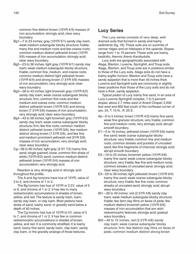
140 Soil Survey
common fine distinct brown (10YR 4/3) masses ofiron accumulation; strongly acid; clear wavyboundary.
Bg1—7 to 23 inches; gray (10YR 5/1) sandy clay loam;weak medium subangular blocky structure; friable;many fine and medium roots and few coarse roots;common medium distinct yellowish brown (10YR5/6) masses of iron accumulation; strongly acid;clear wavy boundary.
Bg2—23 to 36 inches; light gray (10YR 6/1) sandy clayloam; weak medium subangular blocky structure;friable; common fine, medium, and coarse roots;common medium distinct light yellowish brown(10YR 6/4) and strong brown (7.5YR 5/6) massesof iron accumulation; very strongly acid; clearwavy boundary.
Bg3—36 to 43 inches; light brownish gray (10YR 6/2)sandy clay loam; weak coarse subangular blockystructure; firm; common fine roots and fewmedium and coarse roots; common mediumdistinct yellowish brown (10YR 5/6) and strongbrown (7.5YR 5/6) masses of iron accumulation;very strongly acid; clear wavy boundary.
Bg4—43 to 58 inches; light brownish gray (10YR 6/2)sandy clay loam; weak coarse subangular blockystructure; firm; few fine roots; common mediumdistinct yellowish brown (10YR 5/6), few mediumdistinct strong brown (7.5YR 5/6), and few fineand medium prominent yellowish red (5YR 5/6)masses of iron accumulation; very strongly acid;clear wavy boundary.
Cg—58 to 80 inches; light gray (2.5Y 7/2) loamy finesand; single grained; loose; common thin strata ofwhite (10YR 8/2) sand; common medium distinctyellowish brown (10YR 5/4) masses of ironaccumulation; very strongly acid.
Reaction is very strongly acid or strongly acidthroughout the profile.
The A and Ag horizons have hue of 10YR, value of3 to 5, and chroma of 1 or 2.
The Bg horizon has hue of 10YR or 2.5Y, value of 5or 6, and chroma of 1 or 2. It has few to manyredoximorphic accumulations in shades of brown,yellow, and red. The texture is sandy loam, loam,sandy clay loam, or clay loam. Most pedons havestrata of sand, loamy sand, or gravelly sand below adepth of 40 inches.
The Cg horizon has hue of 10YR to 5Y, value of 5to 7, and chroma of 1 or 2. It has few or commonredoximorphic accumulations in shades of brown,yellow, and red. It is commonly stratified. It is loamysand, loamy fine sand, sandy loam, clay loam, sandyclay loam, or the gravelly analogs of those textures.
Lucy SeriesThe Lucy series consists of very deep, well
drained soils that formed in sandy and loamysediments (fig. 16). These soils are on summits ofnarrow ridges and on hillslopes in the uplands. Slopesrange from 1 to 15 percent. These soils are loamy,kaolinitic, thermic Arenic Kandiudults.
Lucy soils are geographically associated withAlaga, Blanton, Luverne, Springhill, and Troup soils.Alaga, Blanton, and Troup soils are in positions similarto those of the Lucy soils. Alaga soils do not have aloamy argillic horizon. Blanton and Troup soils have asandy epipedon that is more than 40 inches thick.Luverne and Springhill soils are commonly in slightlylower positions than those of the Lucy soils and do nothave a thick, sandy epipedon.
Typical pedon of Lucy loamy fine sand, in an area ofLucy-Luverne-Springhill complex, 1 to 5 percentslopes; about 2.7 miles west of Anacil Chapel; 2,000feet west and 800 feet south of the northeast corner ofsec. 24, T. 15 N., R. 25 E.
Ap—0 to 5 inches; brown (10YR 4/3) loamy fine sand;weak fine granular structure; very friable; commonfine and medium roots; very strongly acid; abruptsmooth boundary.
E1—5 to 16 inches; yellowish brown (10YR 5/6) loamyfine sand; weak coarse subangular blockystructure; very friable; common fine and mediumroots; common streaks and pockets of uncoatedsand; few fine fragments of charcoal; strongly acid;abrupt smooth boundary.
E2—16 to 25 inches; brownish yellow (10YR 6/6)loamy fine sand; weak coarse subangular blockystructure; very friable; few fine and medium roots;common streaks of uncoated sand; strongly acid;clear wavy boundary.
E3—25 to 39 inches; light yellowish brown (10YR 6/4)loamy fine sand; weak coarse subangular blockystructure; very friable; few fine roots; commonstreaks of uncoated sand; strongly acid; abruptwavy boundary.
Bt1—39 to 49 inches; red (2.5YR 4/8) sandy clayloam; weak medium subangular blocky structure;friable; few faint clay films on faces of peds; fewmedium distinct brownish yellow (10YR 6/6)masses of iron accumulation that are relictredoximorphic features; strongly acid; gradualwavy boundary.
Bt2—49 to 72 inches; red (2.5YR 4/8) sandyclay loam; weak coarse subangular blockystructure; firm; few distinct clay films on faces ofpeds; common medium distinct strong brown

Macon County, Alabama 141
(7.5YR 5/6) masses of iron accumulation thatare relict redoximorphic features; strongly acid.
The solum is more than 60 inches thick. Thethickness of the sandy epipedon ranges from 20 to 40inches. Reaction is very strongly acid or strongly acidthroughout the profile, except in areas where lime hasbeen applied.
The A or Ap horizon has hue of 10YR, value of 3 to5, and chroma of 3 or 4.
The E horizon has hue of 7.5YR or 10YR, value of5 or 6, and chroma of 3 to 6. It is loamy sand or loamyfine sand.
The Bt horizon has hue of 2.5YR or 5YR, value of 4or 5, and chroma of 6 to 8. The quantity ofredoximorphic accumulations in shades of red, yellow,and brown ranges from none to common. Theaccumulations are relict features. The texture is sandyloam, fine sandy loam, or sandy clay loam in the upperpart and sandy clay loam or clay loam in the lowerpart.
Luverne SeriesThe Luverne series consists of very deep, well
drained soils that formed in stratified clayey and loamysediments. These soils are on summits and sideslopes of narrow ridges in the uplands. Slopes rangefrom 1 to 35 percent. These soils are fine, mixed,semiactive, thermic Typic Hapludults.
Luverne soils are geographically associated withBlanton, Conecuh, Gritney, Lucy, Springhill, and Troupsoils. Blanton, Lucy, and Troup soils are commonly inhigher positions than the Luverne soils and have athick, sandy epipedon. Gritney and Conecuh soils arein lower positions than the Luverne soils. Gritney soilshave brownish colors and low-chroma redoximorphicdepletions in the upper part of the argillic horizon.Conecuh soils have smectitic mineralogy. Springhillsoils are in positions similar to those of the Luvernesoils and are fine-loamy.
Typical pedon of Luverne sandy loam, 1 to 5percent slopes; about 1 mile northwest of CottonValley; 1,000 feet east and 1,500 feet south of thenorthwest corner of sec. 12, T. 15 N., R. 23 E.
Ap—0 to 4 inches; dark yellowish brown (10YR 4/4)sandy loam; weak fine granular structure; friable;many fine and medium roots; very strongly acid;clear smooth boundary.
Bt1—4 to 16 inches; yellowish red (5YR 4/6) sandyclay; weak medium subangular blocky structure;firm; few fine and medium roots; few faint clay filmson faces of peds; few fine flakes of mica; verystrongly acid; clear wavy boundary.
Bt2—16 to 32 inches; red (2.5YR 4/6) clay; moderatemedium subangular blocky structure; firm; few fineand medium roots; few faint clay films on faces ofpeds; few fine flakes of mica; common mediumdistinct strong brown (7.5YR 5/6) masses of ironaccumulation that are relict redoximorphicfeatures; few medium distinct light yellowish brown(10YR 6/4) iron depletions that are relictredoximorphic features; very strongly acid; clearwavy boundary.
BC—32 to 45 inches; red (2.5YR 4/6) sandy clay loam;weak coarse subangular blocky structure; firm; fewfine roots; few faint clay films on faces of somepeds; common fine flakes of mica; commonmedium distinct reddish yellow (7.5YR 6/6)masses of iron accumulation that are relictredoximorphic features; few fine distinct palebrown (10YR 6/3) iron depletions that are relictredoximorphic features; very strongly acid; gradualwavy boundary.
C—45 to 72 inches; thinly stratified red (2.5YR 4/6),reddish yellow (7.5YR 6/6), and pale brown (10YR6/3) fine sandy loam; massive; few thin strata ofsandy clay loam; many fine flakes of mica; areasof red and reddish yellow are masses of ironaccumulation; areas of pale brown are irondepletions; very strongly acid.
The thickness of the solum ranges from 20 to 50inches. Reaction is very strongly acid or strongly acidthroughout the profile, except in areas where thesurface layer has been limed.
The A or Ap horizon has hue of 7.5YR or 10YR,value of 3 to 5, and chroma of 2 to 4. It is loamy sand,loamy fine sand, or sandy loam.
The E horizon, where present, has hue of 10YR,value of 5 or 6, and chroma of 2 to 4. It is loamy sand,loamy fine sand, or sandy loam.
The Bt horizon has hue of 2.5YR or 5YR, value of 4or 5, and chroma of 4 to 8. The quantity ofredoximorphic accumulations in shades of red, brown,and yellow ranges from none to common. The textureis clay loam, sandy clay, or clay.
The BC horizon, where present, has hue of2.5YR or 5YR, value of 4 or 5, and chroma of 6 to 8;or it has no dominant matrix color and ismulticolored in shades of red, brown, and yellow. Ithas few to many redoximorphic accumulations inshades of red, yellow, or brown and redoximorphicdepletions in shades of brown and gray. Theredoximorphic features are relict. The texture issandy clay loam or clay loam.
The C horizon consists of stratified sediments thathave a high content of mica. The texture of individualstrata ranges from loamy sand to clay. Color varies,

142 Soil Survey
but the sandier-textured strata commonly have hue of2.5YR to 7.5YR, value of 4 to 6, and chroma of 4 to 8.Clayey strata are generally grayish. In some pedons,the C horizon has thin strata of clayey shale orironstone.
Lynchburg SeriesThe Lynchburg series consists of very deep,
somewhat poorly drained soils that formed in loamysediments. These soils are on low terraces. They aresubject to rare flooding during periods of unusuallyhigh and prolonged rainfall. Slopes range from 0 to 2percent. These soils are fine-loamy, siliceous,semiactive, thermic Aeric Paleaquults.
Lynchburg soils are geographically associated withDogue, Goldsboro, Ocilla, and Pelham soils. Dogueand Goldsboro soils are in slightly higher positionsthan the Lynchburg soils. Dogue soils have a clayeyargillic horizon. Goldsboro soils are moderately welldrained. Ocilla soils are in positions similar to those ofthe Lynchburg soils and have a thick, sandy epipedon.The poorly drained Pelham soils are in slightly lowerpositions than the Lynchburg soils and have a thick,sandy epipedon.
Typical pedon of Lynchburg fine sandy loam, 0 to 2percent slopes, rarely flooded; about 2.0 miles west ofShorter; 2,250 feet west and 2,200 feet north of thesoutheast corner of sec. 4, T. 16 N., R. 21 E.
Ap—0 to 10 inches; dark gray (10YR 4/1) fine sandyloam; weak fine granular structure; very friable;many fine and medium roots; strongly acid; abruptwavy boundary.
E—10 to 15 inches; light yellowish brown (2.5Y 6/3)fine sandy loam; weak coarse subangular blockystructure; very friable; many fine and mediumroots; common fine distinct yellowish brown (10YR5/6) and dark brown (7.5YR 4/4) masses of ironaccumulation; very strongly acid; clear wavyboundary.
Bt—15 to 29 inches; light olive brown (2.5Y 5/4)sandy clay loam; weak coarse prismaticstructure parting to moderate mediumsubangular blocky; friable; few fine and mediumroots; common faint clay films on faces of peds;thin coatings of clay depletions consisting oflight brownish gray (2.5Y 6/2) very fine sandand silt on faces of prisms; common mediumdistinct yellowish brown (10YR 5/6) andbrownish yellow (10YR 6/8) masses of ironaccumulation; many medium distinct lightbrownish gray (2.5Y 6/2) iron depletions; verystrongly acid; clear wavy boundary.
Btg1—29 to 35 inches; light brownish gray (2.5Y6/2) clay loam; weak coarse prismatic structureparting to moderate medium subangular blocky;firm; few fine roots; common faint clay films onfaces of peds; thin coatings of clay depletionsconsisting of gray (2.5Y 6/1) very fine sand andsilt on faces of prisms; common fine andmedium distinct dark yellowish brown (10YR4/4) and brownish yellow (10YR 6/6) and manymedium and coarse prominent red (2.5YR 4/6)masses of iron accumulation; very strongly acid;clear wavy boundary.
Btg2—35 to 61 inches; light brownish gray (2.5Y6/2) sandy clay loam; moderate mediumsubangular blocky structure; firm; common faintclay films on faces of peds; thin coatings of claydepletions consisting of gray (2.5Y 6/1) veryfine sand and silt on faces of peds; commonfine distinct yellowish brown (10YR 5/6) andstrong brown (7.5YR 5/6) and many mediumand coarse prominent red (2.5YR 4/6) massesof iron accumulation; very strongly acid; clearwavy boundary.
Btg3—61 to 80 inches; gray (2.5Y 6/1) sandy clayloam; moderate medium subangular blockystructure; firm; common faint clay films on facesof peds; thin coatings of clay depletionsconsisting of gray (2.5Y 6/1) very fine sand andsilt on faces of peds; common medium distinctbrownish yellow (10YR 6/8) and strong brown(7.5YR 5/8) and few fine prominent red (2.5YR4/6) masses of iron accumulation; very stronglyacid.
The solum is more than 60 inches thick. Reaction isvery strongly acid or strongly acid throughout theprofile, except in areas where the surface layer hasbeen limed.
The Ap or A horizon has hue of 10YR or 2.5Y, valueof 3 or 4, and chroma of 1 or 2.
The E horizon, where present, has hue of 10YR or2.5Y, value of 5 or 6, and chroma of 3 or 4. It is finesandy loam, loamy fine sand, or sandy loam.
The Bt horizon has hue of 10YR or 2.5Y, value of 5or 6, and chroma of 4 to 6. It has common or manyredoximorphic accumulations in shades of red, brown,and yellow and common or many redoximorphicdepletions in shades of gray. It is sandy clay loam, clayloam, or sandy loam.
The Btg horizon has hue of 10YR or 2.5Y, value of5 or 6, and chroma of 1 or 2. It has common or manyredoximorphic accumulations in shades of brown,yellow, and red. It is clay loam, sandy clay loam, orsandy clay.
Macon County, Alabama 143
Malbis SeriesThe Malbis series consists of very deep, well
drained soils that formed in loamy sediments. Thesesoils are on summits of ridges in the uplands. Slopesrange from 0 to 2 percent. These soils are fine-loamy,siliceous, subactive, thermic Plinthic Paleudults.
Malbis soils are geographically associated withBama and Luverne soils. Bama soils are in positionssimilar to those of the Malbis soils and have a reddishargillic horizon. Luverne soils are on side slopes atlower elevations and have a clayey argillic horizon.
Typical pedon of Malbis fine sandy loam, 0 to 2percent slopes; in Shorter, about 0.38 mile southwestof the old school building; 1,100 feet south and 2,600feet east of the northwest corner of sec. 11, T. 16 N.,R. 21 E.
Ap—0 to 8 inches; brown (10YR 4/3) fine sandy loam;weak fine granular structure; very friable; manyfine and medium roots; slightly acid; abruptsmooth boundary.
E—8 to 13 inches; light yellowish brown (10YR 6/4)fine sandy loam; weak fine granular structure; veryfriable; many fine and medium roots; slightly acid;clear smooth boundary.
BE—13 to 19 inches; yellowish brown (10YR 5/4) finesandy loam; weak medium subangular blockystructure; very friable; many fine and mediumroots; few fine and medium rounded ironstoneconcretions; moderately acid; clear wavyboundary.
Bt—19 to 35 inches; yellowish brown (10YR 5/8)sandy clay loam; moderate medium subangularblocky structure; friable; common fine and mediumroots; common faint clay films on faces of peds;common fine and medium rounded ironstoneconcretions; strongly acid; clear wavy boundary.
Btv1—35 to 49 inches; yellowish brown (10YR 5/8)sandy clay loam; moderate medium subangularblocky structure; friable; common fine and mediumroots; common faint clay films on faces of peds;about 8 percent nodular plinthite; few mediumrounded ironstone concretions; few mediumprominent yellowish red (5YR 4/6) masses of ironaccumulation; strongly acid; clear wavy boundary.
Btv2—49 to 64 inches; yellowish brown (10YR 5/6)sandy clay loam; weak coarse prismatic structureparting to moderate medium subangular blocky;firm; few fine and medium roots; common faint clayfilms on faces of peds; about 10 percent nodularplinthite; common coarse distinct strong brown(7.5YR 5/6) masses of iron accumulation; verystrongly acid; clear wavy boundary.
Btv3—64 to 80 inches; strong brown (7.5YR 5/6)
sandy clay loam; weak very coarse prismaticstructure parting to moderate medium subangularblocky; firm, brittle; few fine roots; common distinctyellowish brown (10YR 5/6) clay films on faces ofpeds; about 10 percent nodular plinthite; few thinlight gray (10YR 7/1) clay depletions on prismfaces; very strongly acid.
The solum is more than 60 inches thick. Reaction isvery strongly acid or strongly acid throughout theprofile, except in areas where the surface layer hasbeen limed.
The Ap or A horizon has hue of 10YR, value of 3 or4, and chroma of 2 or 3.
The E horizon, where present, has hue of 10YR,value of 5 or 6, and chroma of 3 to 6. It is sandy loamor fine sandy loam.
The BE horizon, where present, has hue of 10YR,value of 4 or 5, and chroma of 3 to 6. It is fine sandyloam or loam.
The Bt horizon commonly has hue of 10YR, valueof 4 to 6, and chroma of 4 to 8. In some pedons,however, it has hue of 7.5YR, value of 4 or 5, andchroma of 4 to 8. The texture is commonly sandy clayloam, but the range in texture includes loam and clayloam.
The upper part of the Btv horizon has hue of 7.5YRor 10YR, value of 5 or 6, and chroma of 4 to 8. Thequantity of redoximorphic accumulations in shades ofbrown, yellow, or red ranges from few to many, and thequantity of redoximorphic depletions in shades ofbrown or gray is none or few. The lower part of the Btvhorizon has colors that are similar to the upper part, orit has no dominant matrix color and is multicolored inshades of brown, red, yellow, and gray. The texture ofthe Btv horizon commonly is sandy clay loam or clayloam. In some pedons, however, it is clay below adepth of 50 inches. The content of nodular plinthite inthe Btv horizon ranges from 5 to 15 percent.
Marvyn Series
The Marvyn series consists of very deep, welldrained soils that formed in loamy sediments (fig. 17).These soils are on summits and side slopes of ridgesin the uplands. Slopes range from 0 to 5 percent.These soils are fine-loamy, kaolinitic, thermic TypicKanhapludults.
Marvyn soils are geographically associated withCowarts, Orangeburg, Uchee, and Wagram soils.Cowarts soils are on side slopes adjacent to areas ofthe Marvyn soils and have a solum that is less than 40inches thick. Orangeburg, Uchee, and Wagram soilsare in positions similar to those of the Marvyn soils.

144 Soil Survey
Figure 13.—A profile of Altavista silt loam. These moderatelywell drained soils are on low stream terraces and formedin loamy, fluvial sediments derived from the Piedmontuplands.
Figure 14.—A profile of Bama fine sandy loam. These welldrained soils are on summits of ridges or high streamterraces and formed in loamy sediments.
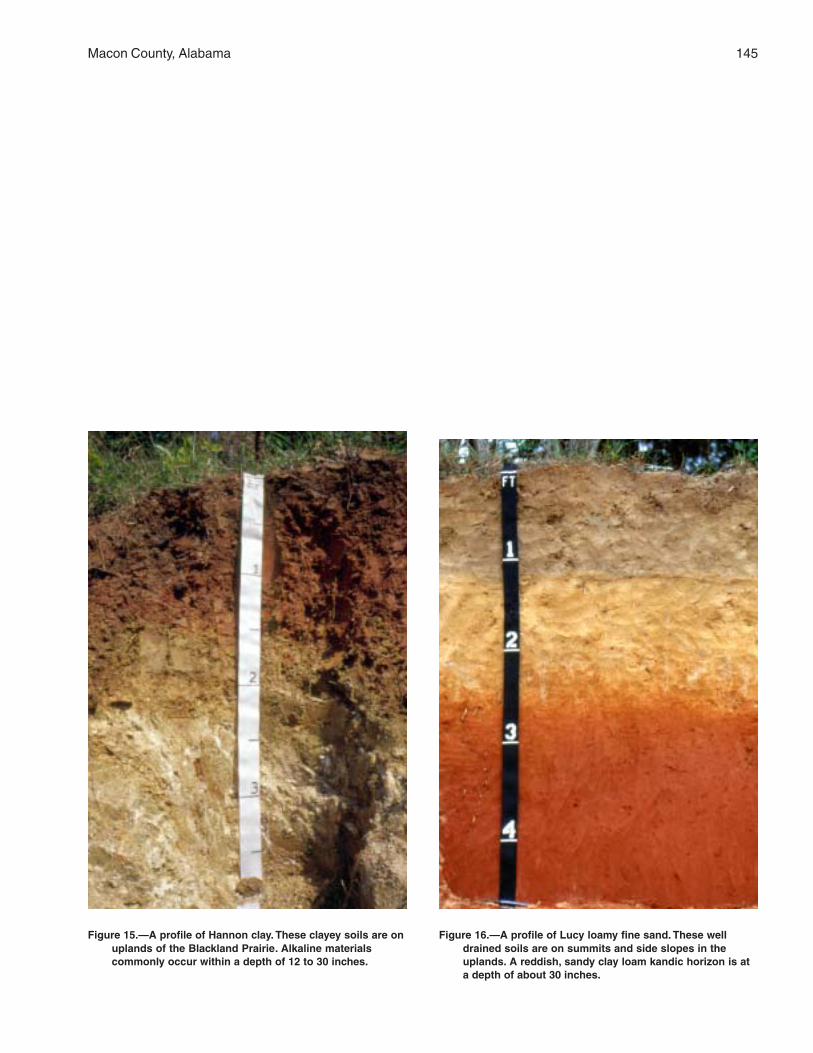
Macon County, Alabama 145
Figure 15.—A profile of Hannon clay. These clayey soils are onuplands of the Blackland Prairie. Alkaline materialscommonly occur within a depth of 12 to 30 inches.
Figure 16.—A profile of Lucy loamy fine sand. These welldrained soils are on summits and side slopes in theuplands. A reddish, sandy clay loam kandic horizon is ata depth of about 30 inches.

146 Soil Survey
Figure 17.— A profile of Marvyn sandy loam. These welldrained soils are on summits of ridges and formed in loamy,fluviomarine sediments.
Figure 18.—A profile of Toccoa fine sandy loam. These welldrained soils are on high parts of natural levees adjacentto the Tallapoosa River. They formed in stratified loamyand sandy fluvial sediments.

Macon County, Alabama 147
Orangeburg soils have a thick, reddish kandic horizon.Uchee and Wagram soils have a thick, sandyepipedon.
Typical pedon of Marvyn sandy loam, 0 to 2 percentslopes; about 1.0 mile northeast of Little Texas; 1,500feet west and 200 feet north of the southeast corner ofsec. 16, T. 17 N., R. 25 E.
Ap—0 to 7 inches; brown (10YR 4/3) sandy loam;weak fine granular structure; very friable; commonfine roots; about 3 percent rounded quartzitepebbles; slightly acid; abrupt wavy boundary.
Bt1—7 to 26 inches; yellowish brown (10YR 5/6)sandy clay loam; weak medium subangular blockystructure; friable; few fine roots; few faint clay filmson faces of peds; about 5 percent roundedquartzite pebbles; strongly acid; clear smoothboundary.
Bt2—26 to 36 inches; yellowish brown (10YR 5/6)sandy clay loam; weak medium subangular blockystructure; friable; few fine roots; few faint clay filmson faces of peds; about 5 percent roundedquartzite pebbles; few fine flakes of mica; fewmedium prominent yellowish red (5YR 4/6)masses of iron accumulation; strongly acid; clearsmooth boundary.
Bt3—36 to 47 inches; yellowish brown (10YR 5/6)sandy clay loam; weak coarse subangular blockystructure parting to weak medium subangularblocky; friable; few faint clay films on faces ofsome peds; about 5 percent rounded quartzitepebbles; common fine flakes of mica; about 3percent nodular plinthite; common coarse distinctstrong brown (7.5YR 5/6) masses of ironaccumulation; strongly acid; clear smoothboundary.
C—47 to 65 inches; thinly stratified yellowish brown(10YR 5/6) sandy loam, strong brown (7.5YR 5/6)sandy loam, and light gray (10YR 7/2) sandy clayloam; massive; friable; about 5 percent roundedquartzite pebbles; many fine flakes of mica;strongly acid.
The thickness of the solum ranges from 40 to 60inches. Reaction ranges from very strongly acid tomoderately acid throughout the profile, except in areaswhere the surface layer has been limed. The contentof rounded quartzite pebbles ranges from 0 to 10percent throughout the profile.
The Ap or A horizon has hue of 10YR, value of 3 to5, and chroma of 2 or 3. It is loamy sand or sandyloam.
The BA horizon, where present, has hue of 10YR,value of 4 or 5, and chroma of 3 to 8. It is sandy loamor sandy clay loam.
The Bt horizon has hue of 7.5YR or 10YR, value of5 or 6, and chroma of 4 to 8. It is commonly sandy clayloam. In some pedons, however, it has thinsubhorizons of sandy loam. The content of nodularplinthite ranges from 0 to 4 percent.
The BC horizon, where present, has the samerange in color as the Bt horizon, or it has no dominantmatrix color and is multicolored in shades of yellow,brown, red, and gray. It is sandy loam or sandy clayloam.
The C horizon is commonly stratified. It commonlyhas no dominant matrix color and is multicolored inshades of red, yellow, brown, and gray. It is dominantlysandy loam or sandy clay loam. Most pedons,however, have strata or pockets of finer- and coarser-textured materials. In some pedons, the C horizon hasthin strata of gravel.
Maytag SeriesThe Maytag series consists of very deep,
moderately well drained soils that formed in alkaline,clayey sediments underlain by chalk or marl. Thesesoils are on summits and side slopes of broad ridgeson uplands in the Blackland Prairie. Slopes range from0 to 8 percent. These soils are fine, smectitic, thermicOxyaquic Hapluderts.
Maytag soils are geographically associated withFaunsdale, Hannon, Oktibbeha, Sucarnoochee, andVaiden soils. The somewhat poorly drained Faunsdalesoils are in slightly lower positions than the Maytagsoils. Hannon and Oktibbeha soils are in positionssimilar to those of the Maytag soils. In the upper partof the subsoil, the Hannon and Oktibbeha soils havereddish colors and are acid. The somewhat poorlydrained Sucarnoochee soils are on flood plains. Thesomewhat poorly drained Vaiden soils are generally inlower positions than those of the Maytag soils and areacid in the upper part of the subsoil.
Typical pedon of Maytag silty clay, 0 to 2 percentslopes; about 2.25 miles south-southwest ofHardaway; 300 feet east and 1,900 feet south of thenorthwest corner of sec. 28, T. 15 N., R. 22 E.
Ap—0 to 5 inches; very dark grayish brown (10YR 3/2)silty clay; weak coarse subangular blockystructure parting to weak medium granular; firm;many fine and very fine roots; many dark graywormcasts; slightly alkaline; gradual wavyboundary.
Bkss1—5 to 20 inches; 60 percent olive (5Y 5/3) and40 percent olive (5Y 5/6) clay; strong coarsesubangular blocky structure parting to moderatefine and medium angular blocky; firm; few fine

148 Soil Survey
roots; common dark gray wormcasts; few largeintersecting slickensides that have distinctpolished and grooved surfaces; common fineconcretions and soft masses of calciumcarbonate; few fine faint olive (5Y 5/3) irondepletions on faces of peds; strongly effervescent;moderately alkaline; gradual wavy boundary.
Bkss2—20 to 36 inches; olive (5Y 4/3) clay; weakcoarse subangular blocky structure parting tostrong medium angular blocky; firm; few fine roots;common large intersecting slickensides that havedistinct polished and grooved surfaces; commonlarge wedge-shaped aggregates; common fineconcretions and soft masses of calciumcarbonate; few fine faint olive (5Y 4/4) masses ofiron accumulation; few fine faint olive (5Y 5/3) irondepletions on faces of peds; strongly effervescent;moderately alkaline; gradual wavy boundary.
Bkss3—36 to 48 inches; pale olive (5Y 6/3) clay; weakcoarse angular blocky structure parting to strongmedium angular blocky; firm; few fine roots thatare flattened on faces of peds; common largeintersecting slickensides that have distinctpolished and grooved surfaces; common largewedge-shaped aggregates; many fine andmedium concretions and soft masses of calciumcarbonate; common medium distinct olive (5Y 5/6)masses of iron accumulation; common fine distinctgray (5Y 5/1) iron depletions on faces of peds;strongly effervescent; moderately alkaline; gradualwavy boundary.
Bkss4—48 to 65 inches; 30 percent pale olive (5Y6/4), 25 percent light gray (5Y 7/2), 25 percentolive yellow (5Y 6/6), and 20 percent strong brown(7.5YR 5/8) clay; weak coarse angular blockystructure parting to strong medium angular blocky;firm; common large intersecting slickensides thathave distinct polished and grooved surfaces;common large wedge-shaped aggregates;common fine and medium concretions and softmasses of calcium carbonate; stronglyeffervescent; moderately alkaline.
The thickness of the solum ranges from 45 to morethan 60 inches. Depth to chalk bedrock is more than60 inches. Reaction is slightly alkaline or moderatelyalkaline throughout the profile. The quantity of softmasses and concretions of calcium carbonate is fewor common throughout the profile.
The A or Ap horizon has hue of 10YR or 2.5Y, valueof 3 to 5, and chroma of 2 to 4. It is clay loam, silty clayloam, or silty clay.
The BA horizon, where present, has hue of 2.5Y or5Y, value of 4 to 6, and chroma of 3 or 4. It is silty clay,clay, or silty clay loam.
The upper part of the Bkss horizon has hue of 2.5Yor 5Y, value of 4 to 6, and chroma of 3 to 6. It has fewor common redoximorphic accumulations in shades ofbrown, yellow, and olive and few or commonredoximorphic depletions in shades of gray. The lowerpart of the horizon has the same range in color as theupper part, or it has no dominant matrix color and ismulticolored in shades of brown, gray, olive, andyellow. The Bkss horizon is silty clay loam, silty clay, orclay.
The C horizon, where present, has hue of 2.5Y or5Y, value of 6 or 7, and chroma of 2 to 4. It has few orcommon redoximorphic depletions in shades of grayand redoximorphic accumulations in shades of yellowand brown. It is silty clay loam, silty clay, or clay.
Mooreville Series
The Mooreville series consists of very deep,moderately well drained soils that formed in loamyalluvium. These soils are on high and intermediateparts of natural levees on flood plains along majorstreams. In most years, they are subject to floodingfor brief periods, usually in late winter or in spring.Slopes are 0 to 1 percent. These soils are fine-loamy, siliceous, active, thermic FluvaquenticDystrudepts.
Mooreville soils are geographically associated withKinston, Una, and Urbo soils. The poorly drainedKinston and Una soils and the somewhat poorlydrained Urbo soils are in the lower positions on floodplains. Kinston soils are grayish throughout. Una andUrbo soils are clayey throughout.
Typical pedon of Mooreville loam, in an area ofUrbo-Una-Mooreville complex, 0 to 1 percent slopes,frequently flooded; about 4.0 miles northwest ofWarriorstand; 600 feet north and 250 feet west of thesoutheast corner of sec. 18, T. 16 N., R. 25 E.
A—0 to 4 inches; brown (10YR 4/3) loam; weak finegranular structure; friable; common fine andmedium roots; strongly acid; clear wavy boundary.
Bw1—4 to 19 inches; yellowish brown (10YR 5/4) clayloam; weak medium subangular blocky structure;friable; common fine and medium roots and fewcoarse roots; few fine distinct light brownish gray(10YR 6/2) iron depletions; very strongly acid;gradual wavy boundary.
Bw2—19 to 29 inches; yellowish brown (10YR 5/6)sandy clay loam; weak medium subangular blockystructure; friable; common fine and medium rootsand few coarse roots; common fine distinct darkyellowish brown (10YR 4/4) masses of ironaccumulation; few fine distinct light brownish gray

Macon County, Alabama 149
(10YR 6/2) iron depletions; very strongly acid;gradual wavy boundary.
Bw3—29 to 55 inches; yellowish brown (10YR 5/4)clay loam; moderate medium subangular blockystructure; firm; few fine roots; common mediumdistinct grayish brown (10YR 5/2) iron depletions;very strongly acid; gradual wavy boundary.
Cg—55 to 88 inches; gray (2.5Y 6/1) sandy clay loam;massive; firm; few thin black coatings of iron andmanganese oxides on ped faces; commonmedium distinct strong brown (7.5YR 5/6) anddark yellowish brown (10YR 4/6) masses of ironaccumulation; very strongly acid.
The thickness of the solum ranges from 40 to morethan 60 inches. Reaction is very strongly acid orstrongly acid throughout the profile.
The A or Ap horizon has hue of 10YR, value of 3 or4, and chroma of 2 or 3. It is fine sandy loam or loam.
The upper part of the Bw horizon has hue of 10YR,value of 4 or 5, and chroma of 3 to 6. The quantity ofredoximorphic accumulations in shades of brown andyellow and redoximorphic depletions in shades of grayranges from none to common. The lower part of thehorizon has hue of 10YR, value of 4 to 6, and chromaof 3 to 6; or it has no dominant matrix color and ismulticolored in shades of brown and gray. It has few tomany redoximorphic depletions in shades of gray. TheBw horizon is loam, sandy clay loam, or clay loam.
The Cg horizon commonly has a grayish matrix andfew to many redoximorphic accumulations in shadesof brown, yellow, and red; or it has no dominant matrixcolor and is multicolored in shades of gray, brown, andyellow. It is sandy loam, loam, sandy clay loam, or clayloam.
Myatt Series
The Myatt series consists of very deep, poorlydrained soils that formed in loamy fluvial sediments.These soils are in low positions on stream terraces.They are subject to brief, rare flooding during periodsof unusually high rainfall. Slopes are 0 to 1 percent.These soils are fine-loamy, siliceous, active, thermicTypic Endoaquults.
Myatt soils are geographically associated withBethera, Cahaba, Dogue, and Eunola soils. Betherasoils are in lower positions than the Myatt soils andhave a clayey argillic horizon. Cahaba, Dogue, andEunola soils are in slightly higher, more convexpositions than those of the Myatt soils. Cahaba soilshave a reddish argillic horizon. Dogue soils have aclayey argillic horizon. Eunola soils have a brownishargillic horizon.
Typical pedon of Myatt loam, 0 to 1 percent slopes,rarely flooded; about 2.3 miles east-southeast ofFranklin; 2,400 feet east and 200 feet south of thenorthwest corner of sec. 9, T. 17 N., R. 23 E.
Ap—0 to 6 inches; dark gray (10YR 4/1) loam; weakmedium granular structure; very friable; many fineand very fine roots; common fine distinct darkyellowish brown (10YR 4/4) masses of ironaccumulation along root channels; commoncoarse distinct light brownish gray (2.5Y 6/2) irondepletions; very strongly acid; abrupt wavyboundary.
Btg1—6 to 12 inches; grayish brown (2.5Y 5/2) sandyclay loam; weak coarse subangular blockystructure; friable; common fine and medium roots;few faint clay films on faces of peds; few fine flakesof mica; common fine distinct dark yellowishbrown (10YR 4/4) masses of iron accumulationalong root channels; common medium prominentbrownish yellow (10YR 6/8) masses of ironaccumulation within the matrix; very strongly acid;clear wavy boundary.
Btg2—12 to 18 inches; gray (10YR 5/1) clay loam;moderate coarse prismatic structure parting tomoderate medium subangular blocky; firm;common fine and medium roots; common distinctclay films on faces of peds; few fine flakes of mica;many medium prominent brownish yellow (10YR6/8) masses of iron accumulation; very stronglyacid; clear smooth boundary.
Btg3—18 to 30 inches; gray (10YR 5/1) clay loam;strong coarse prismatic structure parting to strongmedium subangular blocky; firm; few fine and veryfine roots; common distinct clay films on faces ofpeds; few fine flakes of mica; many coarse andmedium prominent brownish yellow (10YR 6/8)masses of iron accumulation; very strongly acid;clear smooth boundary.
Btg4—30 to 50 inches; gray (10YR 5/1) clay; moderatecoarse prismatic structure; firm; few fine and veryfine roots; common distinct clay films on faces ofpeds; few fine flakes of mica; common mediumprominent brownish yellow (10YR 6/8) masses ofiron accumulation; very strongly acid; gradualsmooth boundary.
Btg5—50 to 55 inches; gray (10YR 5/1) clay loam;weak coarse prismatic structure; firm; few faintclay films on faces of peds; few fine flakes of mica;common medium prominent brownish yellow(10YR 6/8) masses of iron accumulation; verystrongly acid; clear wavy boundary.
BC—55 to 65 inches; gray (10YR 6/1) loam; weakcoarse subangular blocky structure; friable; manyfine flakes of mica; common fine and medium

150 Soil Survey
prominent brownish yellow (10YR 6/8) masses ofiron accumulation; very strongly acid.
The thickness of the solum ranges from 40 to 60inches. Reaction is very strongly acid or strongly acidthroughout the profile, except in areas where thesurface layer has been limed.
The A or Ap horizon has hue of 10YR or 2.5Y, valueof 3 to 5, and chroma of 1 or 2.
The Btg horizon has hue of 10YR or 2.5Y, value of5 or 6, and chroma of 1 or 2. It has few to manyredoximorphic accumulations in shades of brown, red,or yellow. It commonly is sandy clay loam, clay loam,or loam but includes subhorizons of clay in somepedons.
The BC horizon, where present, has hue of 10YRor 2.5Y, value of 5 or 6, and chroma of 1 or 2. It hascommon or many redoximorphic accumulations inshades of red, yellow, or brown. It is sandy clay loam,clay loam, or loam.
The Cg horizon, where present, has the samerange in color as the BC horizon, or it does not have adominant matrix color and is multicolored in shades ofgray, brown, and red. It has common or many massesof iron accumulation in shades of brown, red, oryellow. It is sandy loam, sandy clay loam, clay loam, orgravelly sandy loam.
Ocilla Series
The Ocilla series consists of very deep, somewhatpoorly drained soils that formed in sandy and loamysediments. These soils are on low stream terraces.They are subject to brief, rare flooding during periodsof unusually high rainfall. Slopes range from 0 to 2percent. These soils are loamy, siliceous, semiactive,thermic Aquic Arenic Paleudults.
Ocilla soils are geographically associated withGoldsboro, Lynchburg, and Pelham soils. Goldsborosoils are in slightly higher positions than the Ocillasoils and do not have a thick, sandy epipedon.Lynchburg soils are in landscape positions similar tothose of the Ocilla soils and do not have a thick, sandyepipedon. The poorly drained Pelham soils are inslightly lower, more concave positions than those ofthe Ocilla soils.
Typical pedon of Ocilla loamy fine sand, 0 to 2percent slopes, rarely flooded; about 2.9 milesnortheast of Hardaway; 1,700 feet west and 2,600feet south of the northeast corner of sec. 12, T. 15N., R. 22 E.
Ap—0 to 6 inches; dark grayish brown (2.5Y 4/2)loamy fine sand; weak fine granular structure; very
friable; many fine roots; common fine fragments ofcharcoal; strongly acid; clear smooth boundary.
E—6 to 24 inches; light yellowish brown (2.5Y 6/3)loamy fine sand; weak coarse subangular blockystructure; very friable; many fine roots; commonfine fragments of charcoal; common fine faint lightyellowish brown (2.5Y 6/4) masses of ironaccumulation; strongly acid; clear smoothboundary.
EB—24 to 29 inches; light yellowish brown (2.5Y 6/4)loamy fine sand; weak coarse subangular blockystructure; very friable; many fine roots; commonmedium distinct light brownish gray (10YR 6/2)iron depletions; strongly acid; clear wavyboundary.
Bt1—29 to 38 inches; light yellowish brown (2.5Y 6/4)sandy clay loam; weak medium subangular blockystructure; friable; few fine roots; few faint clay filmson faces of peds; few fine distinct brownish yellow(10YR 6/8) masses of iron accumulation; commonfine and medium distinct light brownish gray(10YR 6/2) iron depletions; very strongly acid;clear wavy boundary.
Bt2—38 to 48 inches; light yellowish brown (2.5Y6/4) sandy clay loam; weak coarse prismaticstructure parting to moderate mediumsubangular blocky; friable; common faint clayfilms on faces of peds; thin coatings of claydepletions consisting of pale yellow (2.5Y 8/2)very fine sand and silt on vertical faces ofprisms; common medium and coarse prominentstrong brown (7.5YR 5/6) and yellowish red(5YR 5/8) masses of iron accumulation; manymedium distinct gray (10YR 6/2) iron depletions;very strongly acid; clear wavy boundary.
Btg1—48 to 60 inches; light brownish gray (10YR 6/2)sandy clay loam; moderate medium subangularblocky structure; firm; common faint clay films onfaces of peds; thin coatings of clay depletionsconsisting of pale yellow (2.5Y 8/2) very fine sandand silt on vertical faces of prisms; commonmedium and coarse prominent strong brown(7.5YR 5/6), dark yellowish brown (10YR 4/6), andyellowish red (5YR 5/6) masses of ironaccumulation; very strongly acid; clear wavyboundary.
Btg2—60 to 80 inches; light brownish gray (10YR 6/2)sandy clay; weak coarse prismatic structureparting to moderate medium subangular blocky;firm; common faint clay films on faces of peds; thincoatings of clay depletions consisting of paleyellow (2.5Y 8/2) very fine sand and silt on verticalfaces of prisms; common coarse prominentstrong brown (7.5YR 5/6) and yellowish brown

Macon County, Alabama 151
(10YR 5/6) masses of iron accumulation; verystrongly acid.
The solum is more than 60 inches thick. Reaction isvery strongly acid or strongly acid throughout theprofile, except in areas where lime has been added.
The A or Ap horizon has hue of 10YR or 2.5Y, valueof 3 to 5, and chroma of 2 or 3.
The E horizon has hue of 10YR or 2.5Y, value of 5to 7, and chroma of 2 to 4. It is loamy fine sand orloamy sand.
The EB or BE horizon, where present, has hue of10YR or 2.5Y, value of 5 or 6, and chroma of 2 to 4. Itis loamy sand, loamy fine sand, or sandy loam.
The Bt horizon has hue of 10YR or 2.5Y, value of 5or 6, and chroma of 3 to 8; or it has no dominantmatrix color and is multicolored in shades of brown,yellow, red, and gray. It has common or manyredoximorphic accumulations in shades of red, yellow,and brown and common or many redoximorphicdepletions in shades of gray or brown. It is sandy clayloam or sandy loam.
The Btg horizon, where present, has hue of 10YRor 2.5Y, value of 5 to 7, and chroma of 1 or 2. It hascommon or many redoximorphic accumulations inshades of red, yellow, and brown. It is sandy clay loamor sandy clay.
Oktibbeha Series
The Oktibbeha series consists of very deep,moderately well drained soils that formed in materialsweathered from alkaline clays and the underlyingchalk and marl. These soils are on summits and sideslopes of broad ridges in the Blackland Prairie. Slopesrange from 1 to 15 percent. These soils are very-fine,smectitic, thermic Chromic Dystruderts.
Oktibbeha soils are geographically associated withHannon, Maytag, Searcy, Sucarnoochee, and Vaidensoils. Hannon and Maytag soils are in positions similarto those of the Oktibbeha soils. Hannon soils are finetextured and have accumulations of calcium carbonatewithin a depth of 30 inches. Maytag soils have hue of10YR or yellower throughout the profile and arealkaline below the surface layer. Searcy soils are inpositions similar to those of the Oktibbeha soils butare at lower elevations, are fine textured, and do nothave vertic properties. The somewhat poorly drainedSucarnoochee soils are on flood plains. The somewhatpoorly drained Vaiden soils are in lower positions thanthose of the Oktibbeha soils and have brownish colorsin the subsoil.
Typical pedon of Oktibbeha clay loam, 1 to 5percent slopes, eroded; about 0.4 mile east of Roba;
1,200 feet east and 700 feet south of the northwestcorner of sec. 31., T. 15 N., R. 25 E.
Ap—0 to 4 inches; dark brown (7.5YR 3/4) clay loam;moderate fine subangular blocky structure; firm;many fine and medium roots; strongly acid; abruptsmooth boundary.
Bt—4 to 9 inches; red (2.5YR 4/6) clay; strong mediumsubangular blocky structure; firm; few fine andmedium roots; few faint clay films on faces ofpeds; many distinct pressure faces; commonmedium distinct yellowish brown (10YR 5/6)masses of iron accumulation; very strongly acid;clear wavy boundary.
Btss1—9 to 14 inches; red (2.5YR 4/6) clay; weakcoarse subangular blocky structure parting tomoderate medium angular blocky; firm; commonfine roots and few medium roots; few faint clayfilms on faces of peds; common intersectingslickensides that have faintly striated surfaces;many distinct pressure faces; common coarsedistinct yellowish brown (10YR 5/6) masses of ironaccumulation; very strongly acid; clear wavyboundary.
Btss2—14 to 33 inches; red (2.5YR 4/6) clay;moderate coarse angular blocky structure partingto moderate fine and medium angular blocky; firm;common fine roots and few medium roots; fewfaint clay films on faces of peds; common largeintersecting slickensides that have distinctpolished and grooved surfaces; common mediumand coarse distinct yellowish brown (10YR 5/6)and yellowish red (5YR 4/6) masses of ironaccumulation; few fine distinct light brownish gray(10YR 6/2) iron depletions on faces of peds;strongly acid; clear wavy boundary.
Btss3—33 to 38 inches; brownish yellow (10YR 6/6)clay; weak coarse subangular blocky structureparting to moderate fine and medium angularblocky; firm; few faint clay films on faces of peds;common large intersecting slickensides that havedistinct polished and grooved surfaces; commoncoarse and medium distinct red (2.5YR 4/6)masses of iron accumulation; common mediumdistinct light brownish gray (10YR 6/2) and verypale brown (10YR 7/3) iron depletions on faces ofpeds; moderately acid; clear wavy boundary.
Bkss1—38 to 54 inches; light olive brown (2.5Y 5/6)clay; weak coarse subangular blocky structureparting to strong fine and medium angular blocky;firm; few fine roots that are flattened on ped faces;common large intersecting slickensides that havedistinct polished and grooved surfaces; commonfine and medium rounded concretions and softmasses of calcium carbonate; common medium

152 Soil Survey
distinct yellowish brown (10YR 5/8) and strongbrown (7.5YR 5/8) masses of iron accumulation;common medium distinct light olive gray (5Y 6/2)iron depletions on faces of peds; stronglyeffervescent; moderately alkaline; clear wavyboundary.
Bkss2—54 to 65 inches; pale yellow (2.5Y 6/4) siltyclay; weak coarse subangular blocky structureparting to strong fine angular blocky; firm;common large intersecting slickensides that havedistinct polished and grooved surfaces; many fineand medium rounded concretions and softmasses of calcium carbonate; common coarsedistinct yellowish brown (10YR 5/6) masses of ironaccumulation; common medium distinct light olivegray (5Y 6/2) and very pale brown (10YR 7/3) irondepletions on faces of peds; strongly effervescent;moderately alkaline.
The depth to an alkaline horizon ranges from 30 to50 inches. The depth to chalk bedrock is more than 60inches.
The Ap or A horizon has hue of 10YR or 7.5YR,value of 3 or 4, and chroma of 2 to 4. It is very stronglyacid or strongly acid, except in areas where lime hasbeen applied.
The Bt horizon, where present, has hue of 2.5YR or5YR, value of 4 or 5, and chroma of 6 to 8. In somepedons, it has redoximorphic accumulations in shadesof brown and red and redoximorphic depletions inshades of gray. It is clay. Reaction is extremely acid orvery strongly acid.
The upper part of the Btss horizon has hue of2.5YR to 10YR, value of 4 to 6, and chroma of 4 to 8;or it has no dominant matrix color and is multicoloredin shades of brown, gray, and red. The lower part hashue of 10YR or 2.5Y, value of 5 or 6, and chroma of 4to 6; or it has no dominant matrix color and ismulticolored in shades of brown, gray, and red. TheBtss horizon has few to many redoximorphicaccumulations in shades of brown, yellow, and red andfew to many redoximorphic depletions in shades ofgray and brown. It is clay. Reaction ranges from verystrongly acid to moderately acid.
The Bkss horizon has hue of 10YR or 2.5Y, value of4 to 6, and chroma of 4 to 8; or it has no dominantmatrix color and is multicolored in shades of brown,olive, yellow, red, and gray. It has few to manyredoximorphic accumulations in shades of brown andfew to many redoximorphic depletions in shades ofgray and brown. The redoximorphic features are mostcommon on the surface of peds or slickensides. TheBkss horizon has few to many concretions and softmasses of calcium carbonate. It is silty clay or clay.Reaction ranges from neutral to moderately alkaline.
The 2C horizon, where present, is chalk orcalcareous clay. It is massive or has platy rockstructure. It is slightly alkaline or moderately alkaline.Some pedons have a 2Cr horizon below a depth of 60inches. The 2Cr horizon can be dug with difficulty withhand tools and is rippable by heavy machinery.
Orangeburg Series
The Orangeburg series consists of very deep, welldrained soils that formed in loamy sediments. Thesesoils are on summits of broad ridges in the uplands.Slopes range from 0 to 2 percent. These soils are fine-loamy, kaolinitic, thermic Typic Kandiudults.
Orangeburg soils are geographically associatedwith Cowarts, Lucy, Marvyn, Springhill, and Troupsoils. Cowarts and Springhill soils are on sideslopes adjacent to areas of Orangeburg soils.Cowarts soils have a brownish kandic horizon.Springhill soils have a significant decrease in claycontent in the lower part of the kandic horizon. Lucyand Troup are in slightly lower positions than thoseof the Orangeburg soils and have a thick, sandyepipedon. Marvyn soils are in positions similar tothose of the Orangeburg soils but are on lessconvex slopes and have a brownish kandic horizon.
Typical pedon of Orangeburg sandy loam, 0 to 2percent slopes; about 1.0 mile southeast of thecourthouse in Tuskegee; 900 feet west and 1,000feet north of the southeast corner of sec. 31, T. 17N., R. 24 E.
Ap—0 to 6 inches; dark yellowish brown (10YR 4/4)sandy loam; weak medium granular structure; veryfriable; many fine roots and few medium roots;very strongly acid; abrupt smooth boundary.
Bt1—6 to 17 inches; yellowish red (5YR 4/6) sandyclay loam; moderate medium subangular blockystructure; friable; common fine roots and fewmedium roots; few faint clay films on faces ofpeds; very strongly acid; clear wavy boundary.
Bt2—17 to 35 inches; yellowish red (5YR 4/6) sandyclay loam; moderate medium subangular blockystructure; friable; few fine roots; few faint clay filmson faces of peds; very strongly acid; clear wavyboundary.
Bt3—35 to 55 inches; yellowish red (5YR 4/6) sandyclay loam; moderate medium subangular blockystructure; friable; common faint clay films on facesof peds; few medium distinct strong brown (7.5YR5/6) masses of iron accumulation that are relictredoximorphic features; very strongly acid; gradualwavy boundary.
Bt4—55 to 80 inches; yellowish red (5YR 5/6) sandy

Macon County, Alabama 153
clay loam; weak medium subangular blockystructure; friable; common faint clay films on facesof peds; common medium prominent yellowishbrown (10YR 5/6) masses of iron accumulationthat are relict redoximorphic features; verystrongly acid.
The solum is more than 60 inches thick. Reaction isvery strongly acid or strongly acid throughout theprofile, except in areas where the surface layer hasbeen limed.
The Ap horizon has hue of 10YR, value of 3 or 4,and chroma of 2 to 4.
The E horizon, where present, has hue of 10YR,value of 5 or 6, and chroma of 3 or 4. It is finesandy loam, sandy loam, loamy sand, or loamy finesand.
The Bt horizon has hue of 2.5YR or 5YR, value of 4or 5, and chroma of 4 to 8. It is sandy clay loam. Inmany pedons, it has redoximorphic accumulations inshades of brown and redoximorphic depletions inshades of gray and brown in the lower part. These arerelict redoximorphic features.
Pacolet SeriesThe Pacolet series consists of very deep, well
drained soils that formed in materials weathered fromacid crystalline rocks, such as granite, gneiss, orschist. These soils are on summits of narrow ridgesand on side slopes in the uplands in the northern partof the county. Slopes range from 6 to 25 percent.These soils are fine, kaolinitic, thermic TypicKanhapludults.
Pacolet soils are geographically associated withCowarts, Marvyn, Springhill, and Uchee soils.Cowarts, Springhill, and Uchee soils are in positionssimilar to those of the Pacolet soils but are at higherelevations. Cowarts and Springhill soils are fine-loamy.Uchee soils have a thick, sandy epipedon. Marvynsoils are on summits and side slopes at the higherelevations and are fine-loamy.
Typical pedon of Pacolet sandy loam, 10 to 25percent slopes; about 0.9 mile southwest of Notasulga;4,300 feet west and 4,600 feet south of the northeastcorner of sec. 14, T. 18 N., R. 24 E.
Ap—0 to 4 inches; dark yellowish brown (10YR 4/4)sandy loam; weak fine granular structure; veryfriable; many fine and medium roots; few fineflakes of mica; very strongly acid; clear smoothboundary.
Bt1—4 to 18 inches; red (2.5YR 4/8) clay; moderatemedium subangular blocky structure; firm; manyfine and medium roots; common distinct clay
films on faces of peds; common fine flakes ofmica; about 3 percent angular quartzitepebbles; very strongly acid; clear smoothboundary.
Bt2—18 to 28 inches; red (2.5YR 4/6) clay; commonmedium distinct strong brown (7.5YR 5/6)mottles; strong medium subangular blockystructure; firm; few fine and medium roots;common distinct clay films on faces of peds;common fine flakes of mica; about 3 percentangular quartzite pebbles; very strongly acid;clear wavy boundary.
BC—28 to 36 inches; yellowish red (5YR 5/6) clayloam; weak coarse subangular blocky structure;friable; few faint clay films on faces of peds;common fine flakes of mica; about 2 percentangular quartzite pebbles; very strongly acid; clearirregular boundary.
C1—36 to 55 inches; 60 percent yellowish red (5YR5/6) and 40 percent strong brown (7.5YR 5/6)saprolite that has a texture of sandy clay loam;weak platy rock structure; friable; few thinseams of clay in cracks; many fine flakes ofmica; very strongly acid; clear irregularboundary.
C2—55 to 72 inches; soft, multicolored saprolite thathas a texture of loam; weak platy rock structure;very friable; many fine flakes of mica; very stronglyacid.
The thickness of the solum ranges from 30 to 60inches. The depth to hard bedrock is more than 60inches. Reaction is very strongly acid or stronglyacid throughout the profile, except in areas wherethe surface layer has been limed. The content ofgravel ranges from 0 to 15 percent throughout theprofile.
The Ap or A horizon has hue of 7.5YR or 10YR,value of 3 or 4, and chroma of 2 to 4.
The BA or BE horizon, where present, has hue of2.5YR or 5YR, value of 4 or 5, and chroma of 4 to 8. Itis sandy loam, loam, or sandy clay loam.
The Bt horizon has hue of 2.5YR, value of 4 or 5,and chroma of 6 to 8. It is clay, clay loam, or sandyclay.
The BC horizon, where present, has hue of 10R to5YR, value of 4 or 5, and chroma of 6 to 8. Thecontent of rock fragments ranges from 0 to 15 percent.The texture is sandy loam, sandy clay loam, or clayloam.
The C horizon has hue of 10R to 5YR, value of 4 or5, and chroma of 6 to 8 and commonly is multicolored.It is soft saprolite that weathered from acid crystallinerock, such as granite, gneiss, and schist. It is loam,sandy loam, or sandy clay loam.

154 Soil Survey
Pelham SeriesThe Pelham series consists of very deep, poorly
drained soils that formed in sandy and loamysediments. These soils are in low positions on streamterraces. They are subject to brief, rare flooding duringperiods of unusually high or prolonged rainfall. Slopesrange from 0 to 2 percent. These soils are loamy,siliceous, subactive, thermic Arenic Paleaquults.
Pelham soils are geographically associated withGoldsboro, Lynchburg, and Ocilla soils. Themoderately well drained Goldsboro soils and thesomewhat poorly drained Lynchburg and Ocilla soilsare in slightly higher positions than those of thePelham soils. Goldsboro and Lynchburg soils do nothave a thick, sandy epipedon. Ocilla soils have abrownish argillic horizon.
Typical pedon of Pelham loamy fine sand, in anarea of Pelham-Ocilla complex, 0 to 2 percent slopes,rarely flooded; about 2.9 miles northeast of Hardaway;1,800 feet west and 2,600 feet south of the northeastcorner of sec. 12, T. 15 N., R. 22 E.
Ap1—0 to 4 inches; very dark gray (2.5Y 3/1) loamyfine sand; weak fine granular structure; veryfriable; many fine and very fine roots and commonmedium roots; strongly acid; abrupt smoothboundary.
Ap2—4 to 8 inches; dark gray (2.5Y 4/1) loamy finesand; weak fine granular structure; very friable;common fine and medium roots; strongly acid;abrupt smooth boundary.
Eg1—8 to 13 inches; light brownish gray (2.5Y 6/2)loamy fine sand; single grained; loose; commonfine roots; few streaks of dark gray (2.5Y 4/1)loamy fine sand in old root channels; few finedistinct light olive brown (2.5Y 5/6) masses of ironaccumulation; few medium prominent strongbrown (7.5YR 5/8) masses of iron accumulation;strongly acid; clear wavy boundary.
Eg2—13 to 26 inches; light brownish gray (2.5Y 6/2)loamy fine sand; single grained; loose; commonfine roots; common streaks of dark gray (2.5Y 4/1)loamy fine sand in old root channels; commonmedium distinct light olive brown (2.5Y 5/6) andolive yellow (2.5Y 6/8) masses of ironaccumulation; few medium prominent strongbrown (7.5YR 5/6) masses of iron accumulation;very strongly acid; abrupt wavy boundary.
Btg1—26 to 35 inches; light brownish gray (2.5Y 6/2)fine sandy loam; weak coarse prismatic structureparting to weak medium subangular blocky; veryfriable; few fine roots; common distinct clay filmson faces of peds; thin coatings of clay depletionsconsisting of white (2.5Y 8/1) very fine sand and
silt on vertical faces of prisms; common mediumdistinct yellowish brown (10YR 5/6) and lightyellowish brown (10YR 6/4) and few fineprominent strong brown (7.5YR 5/8) masses ofiron accumulation; very strongly acid; gradualwavy boundary.
Btg2—35 to 51 inches; light brownish gray (2.5Y 6/2)sandy clay loam; weak coarse prismatic structureparting to moderate medium subangular blocky;friable; common distinct clay films on faces ofpeds; thin coatings of clay depletions consisting ofwhite (2.5Y 8/1) very fine sand and silt on verticalfaces of prisms; many medium distinct olive yellow(2.5Y 6/6) and common fine and mediumprominent strong brown (7.5YR 5/8) masses ofiron accumulation; very strongly acid; gradualwavy boundary.
Btg3—51 to 68 inches; gray (2.5Y 6/1) sandy clayloam; weak coarse prismatic structure parting tomoderate medium subangular blocky; friable;common distinct clay films on faces of peds; thincoatings of clay depletions consisting of white(2.5Y 8/1) very fine sand and silt on vertical facesof prisms; common medium and coarse prominentstrong brown (7.5YR 5/6) and few coarse distinctolive yellow (2.5Y 6/6) masses of ironaccumulation; very strongly acid; gradual wavyboundary.
Cg—68 to 80 inches; gray (10YR 6/1) sandy clay;massive; firm; few thin strata of white (2.5Y 8/1)fine sand and very fine sand; common fine andmedium prominent strong brown (7.5YR 5/6) andyellowish red (5YR 5/6) masses of ironaccumulation; very strongly acid.
The solum is more than 60 inches thick. Thethickness of the sandy epipedon ranges from 20 to 40inches. Reaction is very strongly acid or strongly acidthroughout the profile, except in areas where lime hasbeen added.
The Ap or A horizon has hue of 10YR or 2.5Y, valueof 2 to 4, and chroma of 1 or 2.
The Eg horizon has hue of 10YR or 2.5Y, value of 5to 7, and chroma of 1 or 2. It is loamy fine sand orloamy sand.
The Btg horizon has hue of 10YR or 2.5Y, value of5 to 7, and chroma of 1 or 2. It has common or manyredoximorphic accumulations in shades of red, yellow,or brown. It is sandy clay loam, fine sandy loam, orsandy loam.
The Cg horizon, where present, has hue of 10YR or2.5Y, value of 5 to 8, and chroma of 1 or 2. It hascommon or many redoximorphic accumulations inshades of red, yellow, or brown. It is dominantly sandyloam, sandy clay loam, or sandy clay. In most pedons,

Macon County, Alabama 155
however, it has strata of finer- and coarser-texturedmaterial.
Red Bay SeriesThe Red Bay series consists of very deep, well
drained soils that formed in loamy sediments. Thesesoils are on summits of broad ridges and high streamterraces. Slopes range from 0 to 2 percent. These soilsare fine-loamy, kaolinitic, thermic Rhodic Kandiudults.
Red Bay soils are geographically associated withCowarts, Malbis, Orangeburg, and Springhill soils.Malbis and Orangeburg soils are in positions similar tothose of the Red Bay soils. Malbis soils have abrownish argillic horizon. Orangeburg soils do not havea dark red kandic horizon. Cowarts and Springhill soilsare on side slopes adjacent to areas of the Red Baysoils. Cowarts soils have a brownish kandic horizon.Springhill soils do not have a dark red kandic horizon.
Typical pedon of Red Bay sandy loam, 0 to 2percent slopes; about 2.5 miles north-northwest ofShorter; 500 feet east and 2,000 feet south of thenorthwest corner of sec. 26, T. 17 N., R. 21 E.
Ap1—0 to 4 inches; dark brown (7.5YR 3/3) sandyloam; weak fine granular structure; very friable;many fine and very fine roots; slightly acid; clearsmooth boundary.
Ap2—4 to 9 inches; dark brown (7.5YR 3/4) sandyloam; weak medium subangular blocky structure;very friable; common fine and very fine roots;slightly acid; abrupt smooth boundary.
Bt1—9 to 15 inches; dark reddish brown (2.5YR 3/4)sandy clay loam; moderate medium subangularblocky structure; friable; few fine and mediumroots; few distinct dark brown (10YR 3/3) clay filmson faces of peds; 5 percent rounded quartzitepebbles; strongly acid; gradual wavy boundary.
Bt2—15 to 32 inches; dark red (2.5YR 3/6) sandy clayloam; moderate medium subangular blockystructure; friable; common fine roots; commondistinct clay films on faces of peds; 5 percentrounded quartzite pebbles; strongly acid; gradualwavy boundary.
Bt3—32 to 52 inches; dark red (2.5YR 3/6) sandy clayloam; moderate medium subangular blockystructure; friable; few fine and very fine roots;common distinct clay films on faces of peds; 5percent rounded quartzite pebbles; strongly acid;gradual wavy boundary.
Bt4—52 to 67 inches; dark red (2.5YR 3/6) sandy clayloam; weak coarse subangular blocky structure;friable; common distinct clay films on faces ofpeds; 5 percent rounded quartzite pebbles;strongly acid; gradual wavy boundary.
Bt5—67 to 80 inches; dark red (2.5YR 3/6) gravellysandy clay loam; weak coarse subangular blockystructure; friable; common distinct clay films onfaces of peds and on pebbles; 30 percent roundedquartzite pebbles; strongly acid.
The solum is more than 60 inches thick. Reaction isvery strongly acid or strongly acid throughout theprofile, except in areas where the surface layer hasbeen limed. The content of rounded quartzite pebblesranges from 0 to 15 percent in the upper 60 inches ofthe profile and from 2 to 35 percent below a depth of60 inches.
The Ap horizon has hue of 2.5YR to 7.5YR, value of3 or 4, and chroma of 2 to 4.
The Bt horizon has hue of 10R or 2.5YR, value of 3,and chroma of 4 to 6. It commonly is sandy loam orsandy clay loam, but the range in texture includesgravelly sandy clay loam in the lower part of thehorizon.
Riverview SeriesThe Riverview series consists of very deep, well
drained soils that formed in loamy alluvium. Thesesoils are on natural levees along the Tallapoosa Riverand its major tributaries. They are subject tooccasional flooding, usually in late winter and earlyspring. Slopes range from 0 to 3 percent. These soilsare fine-loamy, mixed, active, thermic FluventicDystrudepts.
Riverview soils are geographically associated withAltavista, Bethera, Bigbee, Bruno, and Toccoa soils.Altavista soils are on terraces at the slightly higherelevations and have a brownish argillic horizon. Thepoorly drained Bethera soils are on low streamterraces and flood plains and have a clayey argillichorizon. Bigbee and Bruno soils are in slightly higherpositions than the Riverview soils and are sandythroughout. Toccoa soils are in positions similar tothose of the Riverview soils and are coarse-loamy.
Typical pedon of Riverview loam, in an area ofRiverview-Bruno complex, 0 to 3 percent slopes,occasionally flooded; about 2.1 miles west-northwestof Pleasant Hill; 700 feet west and 500 feet south ofthe northeast corner of sec. 16, T. 17 N., R. 24 E.
A1—0 to 3 inches; dark brown (10YR 3/3) loam; weakfine granular structure; very friable; many fine andmedium roots; common fine flakes of mica; verystrongly acid; clear wavy boundary.
A2—3 to 8 inches; brown (10YR 4/3) loam; weakmedium subangular blocky structure; very friable;many fine and medium roots; common fine flakesof mica; very strongly acid; clear wavy boundary.
156 Soil Survey
Bw1—8 to 19 inches; yellowish brown (10YR 5/4)sandy clay loam; weak medium subangular blockystructure; friable; few fine and medium roots;common fine flakes of mica; very strongly acid;gradual wavy boundary.
Bw2—19 to 24 inches; yellowish brown (10YR 5/6)sandy clay loam; weak medium subangular blockystructure; friable; few fine and medium roots;common fine flakes of mica; very strongly acid;gradual wavy boundary.
Bw3—24 to 30 inches; yellowish brown (10YR 5/8)sandy clay loam; weak medium subangular blockystructure; friable; few fine roots; common fineflakes of mica; very strongly acid; gradual wavyboundary.
Bw4—30 to 34 inches; yellowish brown (10YR 5/6)sandy clay loam; weak coarse subangular blockystructure; friable; many fine and medium flakes ofmica; very strongly acid; clear wavy boundary.
C1—34 to 39 inches; yellowish brown (10YR 5/6)sandy loam; massive; very friable; few thin strataof loamy sand; many fine flakes of mica; fewmedium faint very pale brown (10YR 7/4) irondepletions; very strongly acid; gradual wavyboundary.
C2—39 to 60 inches; brownish yellow (10YR 6/6)loamy fine sand; single grained; loose; many fineflakes of mica; common coarse faint very palebrown (10YR 7/4) iron depletions; very stronglyacid.
The thickness of the solum ranges from 24 to 60inches. Reaction is very strongly acid or strongly acidthroughout the profile, except in areas where thesurface layer has been limed. Some pedons have aburied A or B horizon or both below a depth of 20inches. These buried horizons have the same range incolor and texture as the A or B horizon.
The A or Ap horizon has hue of 7.5YR or 10YR,value of 3 to 5, and chroma of 2 to 4.
The Bw horizon has hue of 7.5YR or 10YR, value of4 to 6, and chroma of 3 to 8. The quantity ofredoximorphic accumulations in shades of brown andred is none or few. The texture is loam, sandy clayloam, silty clay loam, or clay loam.
The C horizon has hue of 7.5YR or 10YR, value of4 to 6, and chroma of 4 to 8. The quantity ofredoximorphic accumulations in shades of yellow,brown, and red ranges from none to common. Thequantity of redoximorphic depletions in shades of grayand brown is few or common. The texture isdominantly sandy loam, fine sandy loam, loamy sand,or loamy fine sand. In most pedons, however, thehorizon has thin strata of finer- or coarser-texturedmaterial.
Roanoke SeriesThe Roanoke series consists of very deep, poorly
drained soils that formed in clayey sediments. Thesesoils are in low positions on low terraces that parallelthe Tallapoosa River. They are subject to occasionalflooding, usually in late winter and early spring. Slopesare 0 to 1 percent. These soils are fine, mixed,semiactive, thermic Typic Endoaquults.
Roanoke soils are geographically associated withAltavista, Cahaba, and Dogue soils. The moderatelywell drained Altavista and Dogue soils and the welldrained Cahaba soils are in the slightly higher, moreconvex positions on low terraces.
Typical pedon of Roanoke silt loam, 0 to 1percent slopes, occasionally flooded; about 2.5miles northeast of Tysonville; 1,000 feet east and1,850 feet north of the southwest corner of sec. 28,T. 17 N., R. 21 E.
Ap—0 to 5 inches; dark grayish brown (2.5Y 4/2) siltloam; weak fine granular structure; very friable;common fine roots and few medium roots;common fine concretions of iron and manganeseoxides; common fine prominent strong brown(7.5YR 5/8) masses of iron accumulation;common fine faint light brownish gray (10YR 6/2)iron depletions; moderately acid; abrupt wavyboundary.
Btg1—5 to 12 inches; gray (2.5Y 5/1) silty clay loam;weak medium subangular blocky structure; friable;common fine and medium roots; few faint clayfilms on faces of peds; few fine concretions of ironand manganese oxides; few fine flakes of mica;many medium prominent strong brown (7.5YR5/6) and common fine distinct yellowish brown(10YR 5/6) masses of iron accumulation; stronglyacid; clear wavy boundary.
Btg2—12 to 26 inches; gray (10YR 6/1) silty clay loam;moderate medium subangular blocky structure;firm; common fine roots; common distinct clayfilms on faces of peds; few fine concretions of ironand manganese oxides; common coarse distinctbrownish yellow (10YR 6/8) and common fineprominent strong brown (7.5YR 4/6) masses ofiron accumulation; strongly acid; clear smoothboundary.
Btg3—26 to 38 inches; gray (2.5Y 6/1) silty clay;moderate coarse prismatic structure parting tomoderate medium subangular blocky; firm; fewfine and very fine roots; common distinct gray(2.5Y 5/1) clay films on faces of peds; few fine andmedium concretions of iron and manganeseoxides; few fine flakes of mica; common mediumprominent strong brown (7.5YR 5/8) masses of

Macon County, Alabama 157
iron accumulation; strongly acid; clear smoothboundary.
BC—38 to 52 inches; gray (2.5Y 6/1) silty clay loam;moderate medium subangular blocky structure;firm; few fine roots; common fine and mediumconcretions of iron and manganese oxides; fewfine flakes of mica; common medium prominentstrong brown (7.5YR 5/6) and few fine prominentyellowish red (5YR 5/6) masses of ironaccumulation; strongly acid; gradual smoothboundary.
Cg—52 to 72 inches; thinly stratified gray (2.5Y 5/1)sand and clay; massive; few fine flakes of mica;many fine and medium concretions of iron andmanganese oxides; common fine and mediumprominent strong brown (7.5YR 5/8) and yellowishred (5YR 5/8) masses of iron accumulation; verystrongly acid.
The thickness of the solum ranges from 40 to 60inches. Reaction is very strongly acid or strongly acidthroughout the profile, except in areas where thesurface layer has been limed.
The A or Ap horizon has hue of 10YR or 2.5Y, valueof 3 to 5, and chroma of 1 or 2. It has few or commonredoximorphic accumulations in shades of red, brown,and yellow.
The Btg horizon has hue of 10YR or 2.5Y, value of5 or 6, and chroma of 1 or 2. It has common or manyredoximorphic accumulations in shades of brown, red,and yellow. It is silty clay loam, silty clay, clay, or clayloam.
The BC horizon, where present, has hue of 10YR to5Y, value of 4 to 7, and chroma of 1 or 2. It hascommon or many redoximorphic accumulations inshades of brown, red, and yellow. It is clay loam, siltyclay loam, sandy clay loam, sandy clay, or clay.
The Cg horizon, where present, has hue of 10YR to5Y, value of 4 to 8, and chroma of 1 or 2. It commonlyis stratified and ranges in texture from sand to clay. Ithas common or many redoximorphic accumulations inshades of brown, red, and yellow. In some pedons, ithas strata of gravel.
Searcy SeriesThe Searcy series consists of very deep,
moderately well drained soils that formed in clayeysediments. These soils are on side slopes in theuplands of the Blackland Prairie. Slopes range from 2to 5 percent. These soils are fine, mixed, active,thermic Aquic Paleudalfs.
Searcy soils are geographically associated withHannon and Oktibbeha soils. Hannon and Oktibbeha
soils are in positions similar to those of the Searcysoils but are at higher elevations, are clayey to thesurface, and have vertic properties.
Typical pedon of Searcy fine sandy loam, 2 to 5percent slopes; about 2.2 miles southeast of Estelle;2,400 feet south and 500 feet east of the northwestcorner of sec. 4, T. 11 N., R. 9 E.
Ap—0 to 6 inches; dark yellowish brown (10YR 4/4)fine sandy loam; weak medium granular structure;very friable; many fine and few medium roots;strongly acid; clear smooth boundary.
E—6 to 14 inches; brown (7.5YR 5/4) fine sandy loam;weak coarse subangular blocky structure; veryfriable; many fine and few medium roots; stronglyacid; clear wavy boundary.
Bt1—14 to 20 inches; strong brown (7.5YR 5/6) sandyclay; moderate medium subangular blockystructure; firm; common fine roots; commondistinct clay films on faces of peds; common fineflakes of mica; few medium distinct light brownishgray (10YR 6/2) iron depletions; strongly acid;clear wavy boundary.
Bt2—20 to 31 inches; yellowish red (5YR 5/6) sandyclay; moderate medium subangular blockystructure; firm; few fine roots; common distinct clayfilms on faces of peds; common fine flakes ofmica; common medium distinct red (2.5YR 4/8)masses of iron accumulation; common mediumprominent light brownish gray (10YR 6/2) irondepletions; very strongly acid; clear wavyboundary.
Bt3—31 to 45 inches; 40 percent light brownish gray(10YR 6/2), 30 percent yellowish red (5YR 4/6),and 30 percent strong brown (7.5YR 5/6) sandyclay; moderate medium subangular blockystructure parting to moderate fine angular blocky;firm; common distinct clay films on faces of peds;common fine flakes of mica; areas of yellowish redand strong brown are masses of ironaccumulation; areas of light brownish gray are irondepletions; very strongly acid; clear wavyboundary.
Bt4—45 to 65 inches; 40 percent gray (2.5Y 6/1), 30percent yellowish brown (10YR 5/6), and 30percent yellowish red (5YR 4/6) clay; moderatemedium subangular blocky structure parting tomoderate fine angular blocky; firm; common faintclay films on faces of peds; many fine flakes ofmica; areas of yellowish brown and yellowish redare masses of iron accumulation; areas of grayare iron depletions; very strongly acid.
The solum is more than 60 inches thick. Reaction isvery strongly acid or strongly acid throughout the

158 Soil Survey
profile, except in areas where the surface layer hasbeen limed.
The Ap or A horizon has hue of 10YR, value of 3 or4, and chroma of 2 to 4.
The E horizon, where present, has hue of 7.5YR or10YR, value of 5 or 6, and chroma of 3 or 4. It is finesandy loam or sandy loam.
The upper part of the Bt horizon has hue of 5YRor 7.5YR, value of 4 or 5, and chroma of 4 to 8. Thequantity of redoximorphic accumulations in shadesof brown, yellow, and red ranges from none tocommon. The quantity of redoximorphic depletionsin shades of gray also ranges from none tocommon. The lower part of the Bt horizon hascolors similar to those of the upper part, or it doesnot have a dominant matrix color and ismulticolored in shades of red, brown, yellow, andgray. The Bt horizon commonly is clay or sandy clay,but in some pedons it has a thin layer of clay loamor sandy clay loam in the upper part.
Springhill Series
The Springhill series consists of very deep, welldrained soils that formed in loamy sediments. Thesesoils are on summits of narrow ridges and onhillslopes. Slopes range from 2 to 35 percent. Thesesoils are fine-loamy, kaolinitic, thermic TypicKanhapludults.
Springhill soils are geographically associated withAlaga, Cowarts, Lucy, Luverne, Troup, and Ucheesoils. Alaga, Lucy, and Troup soils are in slightly higherpositions than those of the Springhill soils. Alaga soilsare sandy throughout. Lucy and Troup soils have athick, sandy epipedon. Cowarts, Luverne, and Ucheesoils are in positions similar to those of the Springhillsoils. Cowarts soils have a brownish kandic horizon.Luverne soils have a clayey argillic horizon. Ucheesoils have a thick, sandy epipedon.
Typical pedon of Springhill sandy loam, 2 to 5percent slopes; about 1.5 miles southwest of CreekStand; 2,100 feet west and 600 feet south of thenortheast corner of sec. 24, T. 15 N., R. 25 E.
Ap—0 to 6 inches; brown (10YR 4/3) sandy loam;weak fine granular structure; very friable; manyfine roots; strongly acid; clear smooth boundary.
Bt1—6 to 15 inches; red (2.5YR 4/6) sandy clay loam:weak medium subangular blocky structure; friable;common fine roots; few faint clay films on faces ofpeds; strongly acid; clear wavy boundary.
Bt2—15 to 31 inches; red (2.5YR 4/6) sandy clayloam; moderate medium subangular blockystructure; friable; few fine roots; common distinct
clay films on faces of peds; very strongly acid;gradual wavy boundary.
Bt3—31 to 38 inches; red (2.5YR 4/8) sandy clayloam; moderate medium subangular blockystructure; friable; few fine roots; common distinctclay films on faces of peds; very strongly acid;clear wavy boundary.
Bt4—38 to 48 inches; red (2.5YR 4/8) sandy clayloam; moderate medium subangular blockystructure; friable; few fine roots; common distinctclay films on faces of peds; few medium distinctlight olive brown (2.5Y 5/6) masses of ironaccumulation that are relict redoximorphicfeatures; very strongly acid; clear wavy boundary.
Bt5—48 to 60 inches; red (2.5YR 4/8) sandy clayloam; weak medium subangular blocky structure;friable; few fine roots; common distinct clay filmson faces of peds; common medium distinct lightolive brown (2.5Y 5/4) and strong brown (7.5YR5/6) masses of iron accumulation that are relictredoximorphic features; very strongly acid; clearwavy boundary.
BC—60 to 77 inches; red (2.5YR 4/6) sandy loam;weak coarse subangular blocky structure; veryfriable; few faint clay films on faces of some peds;common medium distinct light olive brown (2.5Y5/4) and strong brown (7.5YR 5/6) masses of ironaccumulation that are relict redoximorphicfeatures; very strongly acid; gradual wavyboundary.
C—77 to 80 inches; red (2.5YR 4/6) sandy loam;massive; very friable; few medium distinct lightolive brown (2.5Y 5/4) and strong brown (7.5YR5/6) masses of iron accumulation that are relictredoximorphic features; very strongly acid.
The solum is more than 40 inches thick. Reaction isvery strongly acid or strongly acid throughout theprofile, except in areas where the surface layer hasbeen limed. The content of rounded quartzite pebblesor fragments of ironstone or both ranges from 0 to 15percent throughout the profile.
The A or Ap horizon has hue of 10YR, value of 3 to5, and chroma of 2 to 4. It is loamy fine sand, loamysand, or sandy loam.
The E horizon, where present, has hue of 10YR,value of 5 or 6, and chroma of 2 to 4. It is loamy sandor sandy loam.
The Bt horizon has hue of 2.5YR or 5YR, value of 4or 5, and chroma of 4 to 8. It is sandy clay loam in theupper part and sandy clay loam or sandy loam in thelower part. It has few or common redoximorphicaccumulations in shades of yellow, brown, or red andredoximorphic depletions in the lower part. Theaccumulations are relict features.

Macon County, Alabama 159
The BC horizon, where present, has hue of 2.5YRor 5YR, value of 4 or 5, and chroma of 6 to 8. It issandy loam.
The C horizon, where present, has hue of 2.5YR to7.5YR, value of 4 or 5, and chroma of 4 to 8. It iscommonly stratified. The texture ranges from sandyclay loam to loamy sand. In some pedons, the Chorizon has strata of gravel.
Sucarnoochee SeriesThe Sucarnoochee series consists of very deep,
somewhat poorly drained soils that formed in alkaline,clayey alluvium. These soils are on flood plains in theBlackland Prairie. In most years, they are subject toflooding for brief periods one or more times during latewinter and early spring. Slopes are 0 to 1 percent.These soils are fine, smectitic, thermic ChromicEpiaquerts.
Sucarnoochee soils are geographically associatedwith Faunsdale, Maytag, Oktibbeha, and Vaiden soils.These associated soils are on uplands adjacent toareas of the Sucarnoochee soils and are not subjectto flooding. Faunsdale and Maytag soils do not have aseasonal high water table within a depth of 11/2 feet.Oktibbeha and Vaiden soils have a very-fine particle-size class and are acid in the upper part of the solum.
Typical pedon of Sucarnoochee clay, 0 to 1percent slopes, frequently flooded; about 1.7 milessouth-southeast of Downs; 2,300 feet west and2,950 feet north of the southeast corner of sec. 36,T. 15 N., R. 22 E.
Ap—0 to 6 inches; very dark grayish brown (10YR 3/2)clay; moderate fine and medium subangularblocky structure; firm; many fine roots; moderatelyalkaline; abrupt smooth boundary.
AB—6 to 15 inches; dark grayish brown (2.5Y 4/2) siltyclay; strong coarse subangular blocky structureparting to moderate fine and medium angularblocky; firm; common fine roots; few fine concretionsof iron and manganese oxides; few fine distinctolive (5Y 5/3) masses of iron accumulation;moderately alkaline; clear wavy boundary.
Bss1—15 to 25 inches; dark gray (2.5Y 4/1) silty clay;weak coarse subangular blocky structure partingto strong medium angular blocky; firm; commonfine roots; common large intersecting slickensidesthat have distinct polished and grooved surfaces;few fine concretions of iron and manganeseoxides; few fine distinct olive (5Y 5/3) masses ofiron accumulation; moderately alkaline; clear wavyboundary.
Bss2—25 to 34 inches; dark gray (5Y 4/1) silty clay;
weak coarse angular blocky structure parting tostrong medium angular blocky; firm; common fineroots; common large intersecting slickensides thathave distinct polished and grooved surfaces; fewfine concretions of calcium carbonate; few fineconcretions of iron and manganese oxides; manyfine distinct olive (5Y 5/3) masses of ironaccumulation; slightly effervescent; moderatelyalkaline; clear wavy boundary.
Bss3—34 to 40 inches; dark gray (5Y 4/1) silty clay;weak coarse angular blocky structure parting tostrong medium angular blocky; firm; few fine roots;common large intersecting slickensides that havedistinct polished and grooved surfaces; few fineconcretions of calcium carbonate; few fineconcretions of iron and manganese oxides; manyfine distinct olive (5Y 4/4) masses of ironaccumulation; moderately effervescent;moderately alkaline; clear wavy boundary.
Bss4—40 to 65 inches; dark gray (5Y 4/1) silty clay;weak coarse angular blocky structure parting tostrong medium angular blocky; firm; few fine roots;common large intersecting slickensides that havedistinct polished and grooved surfaces; few fineconcretions of calcium carbonate; few fineconcretions of iron and manganese oxides; manycoarse distinct olive (5Y 4/3) masses of ironaccumulation; moderately effervescent;moderately alkaline.
The solum is more than 60 inches thick. Reactionranges from neutral to moderately alkaline throughoutthe profile.
The Ap or A horizon has hue of 10YR or 2.5Y, valueof 3 or 4, and chroma of 2 or 3.
The AB horizon, where present, has hue of 10YR or2.5Y, value of 3 or 4, and chroma of 1 to 3. It is siltyclay, clay, or silty clay loam.
The Bss horizon has hue of 10YR to 5Y, value of 4or 5, and chroma of 1 to 6; or it has no dominantmatrix color and is multicolored in shades of brown,olive, yellow, and gray. It has few to manyredoximorphic accumulations in shades of brown,yellow, and olive and few to many redoximorphicdepletions in shades of gray. It is silty clay or clay.
The Bkss horizon, where present, generally hascolors and textures similar to those of the Bss horizonand has common or many concretions or soft massesor both of calcium carbonate.
Sumter SeriesThe Sumter series consists of moderately deep,
well drained soils that formed in material weathered

160 Soil Survey
from alkaline clays, marl, and chalk. These soils are onside slopes in the uplands of the Blackland Prairie.Slopes range from 5 to 25 percent. These soils arefine-silty, carbonatic, thermic Rendollic Eutrudepts.
Sumter soils are geographically associated withHannon and Oktibbeha soils. Hannon andOktibbeha soils are in slightly higher positions thanthose of the Sumter soils, have a reddish argillichorizon, and are acid in the upper part of thesubsoil.
Typical pedon of Sumter silt loam, in an area ofSumter-Hannon complex, 12 to 25 percent slopes;about 2.0 miles south of Society Hill; 1,000 feet westand 1,800 feet south of the northeast corner of sec.21, T. 16 N., R. 26 E.
Ap—0 to 4 inches; very dark grayish brown (2.5Y 3/2)silt loam; weak fine granular structure; friable;many fine roots; common fragments of fossiloyster shell; common fine soft masses of calciumcarbonate; moderately effervescent; slightlyalkaline; clear wavy boundary.
Bk1—4 to 12 inches; light olive brown (2.5Y 5/4) siltyclay loam; moderate medium subangular blockystructure; firm; few fine roots; common fragmentsof fossil oyster shell; common fine soft masses ofcalcium carbonate; strongly effervescent;moderately alkaline; gradual wavy boundary.
Bk2—12 to 24 inches; light yellowish brown (2.5Y 6/4)silty clay loam; moderate medium subangularblocky structure; firm; few fine roots; commonfragments of fossil oyster shell; many fine softmasses of calcium carbonate; few fine distinct lightolive brown (2.5Y 5/6) masses of ironaccumulation; strongly effervescent; moderatelyalkaline; clear wavy boundary.
Bk3—24 to 35 inches; olive yellow (2.5Y 6/6) silty clay;moderate medium subangular blocky structure;firm; common fragments of fossil oyster shell;many fine soft masses of calcium carbonate;common medium distinct light olive brown (2.5Y5/4) masses of iron accumulation; few fine distinctlight gray (5Y 7/2) iron depletions; stronglyeffervescent; moderately alkaline; abrupt irregularboundary.
Cr—35 to 72 inches; weathered, thinly bedded strataof fossil oyster shell, chalk, and marl; massive;very firm; violently effervescent; moderatelyalkaline.
The thickness of the solum and the depth to softbedrock range from 20 to 40 inches. Reaction isneutral to moderately alkaline in the A or Ap horizonand is slightly alkaline or moderately alkaline in the Bhorizon.
The Ap or A horizon has hue of 10YR or 2.5Y, valueof 3 to 5, and chroma of 1 to 3.
The Bk horizon has hue of 10YR to 5Y, value of 4 to7, and chroma of 3 to 6. It has common or many softmasses or concretions or both of calcium carbonate.In some pedons, it has up to 10 percent fragments ofoyster shell or chalk. It is silty clay loam, silty clay, orclay.
The Cr horizon consists of stratified layers of chalk,marl, and fossil oyster shell. Individual strata rangefrom a few inches to several feet in thickness. Thestrata are massive or have thick platy rock structure.The Cr horizon restricts plant roots, but can be cutwith difficulty using hand tools and is rippable by lightequipment.
Toccoa SeriesThe Toccoa series consists of very deep, well
drained soils that formed in loamy and sandy alluvium(fig. 18). These soils are on high parts of naturallevees along the Tallapoosa River. They are subject tooccasional flooding for brief periods, usually in latewinter and early spring. Slopes range from 0 to 3percent. These soils are coarse-loamy, mixed,semiactive, nonacid, thermic Typic Udifluvents.
Toccoa soils are geographically associated withAltavista, Bigbee, and Riverview soils. Altavista soilsare on stream terraces at the slightly higher elevationsand have a fine-loamy argillic horizon. Bigbee andRiverview soils are in positions similar to those of theToccoa soils. Bigbee soils are sandy throughout.Riverview soils are fine-loamy.
Typical pedon of Toccoa fine sandy loam, gentlyundulating, occasionally flooded; about 4.5 miles westof Franklin; 2,500 feet south and 900 feet west of thenortheast corner of sec. 4, T. 17 N., R. 22 E.
Ap—0 to 9 inches; brown (10YR 4/3) fine sandy loam;weak fine granular structure; very friable; commonfine and very fine roots; few thin strata of yellowishbrown (10YR 5/4) loamy fine sand; common fineflakes of mica; 3 percent rounded quartzitepebbles; slightly acid; clear wavy boundary.
A—9 to 12 inches; dark yellowish brown (10YR 3/4)fine sandy loam; weak coarse subangular blockystructure; very friable; common fine and very fineroots; common fine flakes of mica; 3 percentrounded quartzite pebbles; moderately acid; clearsmooth boundary.
C—12 to 27 inches; dark yellowish brown (10YR 4/4)loamy fine sand; massive; very friable; few fineand very fine roots; few thin strata of brown (10YR4/3) loamy fine sand; common fine flakes of mica;

Macon County, Alabama 161
3 percent rounded quartzite pebbles; moderatelyacid; clear wavy boundary.
Ab—27 to 37 inches; brown (10YR 4/3) loam; weakcoarse subangular blocky structure; friable; fewfine and very fine roots; few thin strata of darkyellowish brown (10YR 4/4) loam; common fineflakes of mica; 3 percent rounded quartzitepebbles; moderately acid; clear smooth boundary.
C´1—37 to 43 inches; dark yellowish brown (10YR4/4) fine sandy loam; massive; very friable; fewvery fine roots; common fine fragments ofcharcoal; common fine flakes of mica; 5 percentrounded quartzite pebbles; strongly acid; clearsmooth boundary.
C´2—43 to 59 inches; dark yellowish brown (10YR4/4) loam; massive; friable; common finefragments of charcoal; common fine flakes ofmica; 5 percent rounded quartzite pebbles; fewfine faint pale brown (10YR 6/3) iron depletions;strongly acid; clear wavy boundary.
C´3—59 to 72 inches; dark yellowish brown (10YR4/4) loamy fine sand; massive; very friable; manyfine flakes of mica; 5 percent rounded quartzitepebbles; strongly acid.
Reaction is strongly acid or moderately acidthroughout the profile, except in areas where thesurface layer has been limed. The content of roundedquartzite pebbles ranges from 2 to 10 percentthroughout the profile.
The Ap and A horizons have hue of 7.5YR or 10YR,value of 3 or 4, and chroma of 2 to 4.
The Ab horizon, where present, has the samerange in color as the A horizon. It is fine sandy loam,loam, or loamy fine sand.
The C and C´ horizons have hue of 5YR to 10YR,value of 4 or 5, and chroma of 4 to 6. They aredominantly sandy loam, fine sandy loam, loamy sand,loamy fine sand, or loam. In most pedons, however,they have strata of finer- or coarser-textured materials.
Troup SeriesThe Troup series consists of very deep, somewhat
excessively drained soils that formed in sandy andloamy sediments. These soils are on summits ofridges and on side slopes in the uplands. Slopesrange from 0 to 35 percent. These soils are loamy,kaolinitic, thermic Grossarenic Kandiudults.
Troup soils are geographically associated withAlaga, Blanton, Bonifay, Lucy, Luverne, andSpringhill soils. Alaga, Blanton, Bonifay, and Lucysoils are in positions similar to those of the Troupsoils. Alaga soils are sandy throughout. Blanton
soils have a brownish argillic horizon and a perchedseasonal high water table. Bonifay soils have abrownish argillic horizon and a significantaccumulation of plinthite in the argillic horizon. Lucysoils have a sandy epipedon that is 20 to 40 inchesthick. Springhill and Luverne soils are generally inlower positions than those of the Troup soils and donot have a thick, sandy epipedon. Also, Luvernesoils have a clayey argillic horizon.
Typical pedon of Troup loamy fine sand, in a area ofTroup-Alaga complex, 0 to 5 percent slopes; about 3miles north of Creek Stand; 500 feet west and 2,800feet south of the northeast corner of sec. 5, T. 15 N., R.26 E.
Ap—0 to 10 inches; brown (10YR 5/3) loamy finesand; weak fine granular structure; very friable;common fine and medium roots; strongly acid;clear smooth boundary.
E1—10 to 30 inches; light yellowish brown (10YR 6/4)loamy fine sand; single grained; loose; commonfine and medium roots; strongly acid; clear wavyboundary.
E2—30 to 44 inches; very pale brown (10YR 7/4)loamy fine sand; single grained; loose; few fineand medium roots; common thin streaks of palebrown (10YR 6/3) sand; strongly acid; gradualwavy boundary.
E3—44 to 57 inches; very pale brown (10YR 8/3)loamy sand; single grained; loose; few fineroots; common thin streaks of pale brown(10YR 6/3) sand; strongly acid; abrupt wavyboundary.
Bt1—57 to 75 inches; red (2.5YR 4/6) sandy clayloam; weak medium subangular blocky structure;friable; common faint clay films on faces of peds;very strongly acid; gradual wavy boundary.
Bt2—75 to 90 inches; red (2.5YR 4/8) sandy clayloam; weak coarse subangular blocky structure;friable; common faint clay films on faces of peds;common medium distinct reddish yellow (7.5YR6/6) masses of iron accumulation that are relictredoximorphic features; very strongly acid.
The thickness of the sandy epipedon ranges from40 to 80 inches. Reaction is very strongly acid orstrongly acid throughout the profile, except in areaswhere lime has been applied.
The A or Ap horizon has hue of 10YR, value of 3 to5, and chroma of 2 to 4. It is loamy sand or loamy finesand.
The E horizon has hue of 10YR, value of 5 to 8, andchroma of 3 to 8. It is loamy sand or loamy fine sand.
The Bt horizon commonly has hue of 2.5YR or5YR, value of 4 or 5, and chroma of 4 to 8. In some

162 Soil Survey
pedons, however, it has hue of 7.5YR, value of 4 or 5,and chroma of 4 to 6. It is sandy loam, fine sandyloam, or sandy clay loam.
Uchee SeriesThe Uchee series consists of very deep, well
drained soils that formed in sandy and loamysediments. These soils are on summits of ridges andon side slopes in the uplands. Slopes range from 1 to25 percent. These soils are loamy, kaolinitic, thermicArenic Kanhapludults.
Uchee soils are geographically associated withCowarts, Luverne, Marvyn, and Springhill soils.Cowarts soils are in positions similar to those of theUchee soils and do not have a thick, sandy epipedon.Marvyn and Springhill soils are in slightly higherpositions than those of the Uchee soils and do nothave a thick, sandy epipedon. Luverne soils are inslightly lower positions than those of the Uchee soils,have a clayey argillic horizon, and do not have a thick,sandy epipedon.
Typical pedon of Uchee loamy sand, 1 to 5 percentslopes; about 2 miles south-southwest of Chehaw;2,300 feet south and 900 feet west of the northeastcorner of sec. 22, T. 17 N., R. 23 E.
Ap—0 to 8 inches; dark brown (10YR 3/3) loamy sand;weak fine granular structure; very friable; manyfine, medium, and coarse roots; 10 percentrounded quartzite pebbles; strongly acid; clearsmooth boundary.
E1—8 to 15 inches; brown (10YR 5/3) loamy sand;single grained; loose; many fine, medium, andcoarse roots; 10 percent rounded quartzitepebbles; strongly acid; clear wavy boundary.
E2—15 to 23 inches; yellowish brown (10YR 5/4)loamy sand; single grained; loose; many coarseroots and common fine and medium roots; 10percent rounded quartzite pebbles; strongly acid;clear wavy boundary.
E3—23 to 28 inches; brownish yellow (10YR 6/6)loamy sand; single grained; loose; common fineand medium roots; 10 percent rounded quartzitepebbles; very strongly acid; abrupt wavy boundary.
Bt1—28 to 37 inches; yellowish brown (10YR 5/6)sandy loam; moderate medium subangular blockystructure; friable; common fine and medium roots;few distinct clay films on faces of peds; 10 percentrounded quartzite pebbles; strongly acid; clearwavy boundary.
Bt2—37 to 46 inches; yellowish brown (10YR 5/6)sandy clay loam; moderate medium subangularblocky structure; friable; common fine and medium
roots; common distinct clay films on faces of peds;10 percent rounded quartzite pebbles; commonmedium prominent yellowish red (5YR 4/6) andstrong brown (7.5YR 4/6) masses of ironaccumulation; very strongly acid; gradual wavyboundary.
C—46 to 65 inches; stratified light gray (10YR 7/2)sandy clay, yellowish red (2.5YR 4/6) sandy clayloam, and yellowish brown (10YR 5/6) sandyloam; massive; friable; 2 percent rounded quartzitepebbles; areas of yellowish red and yellowishbrown are masses of iron accumulation; areas oflight gray are iron depletions; very strongly acid.
The thickness of the solum ranges from 40 to 60inches. Reaction is very strongly acid or strongly acidthroughout the profile, except in areas where lime hasbeen applied. The content of rounded quartzite gravelranges from 2 to 15 percent throughout the profile.
The Ap or A horizon has hue of 10YR, value of 3 to5, and chroma of 2 to 4.
The E horizon has hue of 10YR, value of 5 or 6,and chroma of 3 to 6. It is loamy sand or sand.
The Bt horizon has hue of 7.5YR or 10YR, value of4 to 6, and chroma of 4 to 8. It has few or commonredoximorphic depletions in shades of gray below adepth of 30 inches. It is sandy loam or sandy clayloam.
The C horizon commonly has no dominant matrixcolor and is multicolored in shades of red, brown,yellow, and gray. It is commonly stratified. The textureof the strata is dominantly sandy loam, sandy clayloam, or sandy clay but can be loamy sand and sand.In most pedons, the C horizon has strata and streaksof finer- and coarser-textured materials. In somepedons, it has strata of rounded gravel and cobblesbelow a depth of 60 inches.
Una SeriesThe Una series consists of very deep, poorly
drained soils that formed in clayey alluvium. Thesesoils are in depressional areas on flood plains. In mostyears, they are subject to flooding for brief periods oneor more times during late winter and early spring.Slopes are 0 to 1 percent. These soils are fine, mixed,active, acid, thermic Typic Epiaquepts.
Una soils are geographically associated withMooreville and Urbo soils. The moderately well drainedMooreville soils and the somewhat poorly drainedUrbo soils are on the flood plains in slightly higher,more convex positions than those of the Una soils.Mooreville soils are fine-loamy. Urbo soils have verticproperties.

Macon County, Alabama 163
Typical pedon of Una silty clay loam, in an area ofUrbo-Una-Mooreville complex, 0 to 1 percent slopes,frequently flooded; about 4 miles northwest ofWarriorstand; 190 feet north and 750 feet west of thesoutheast corner of sec. 18, T. 16 N., R. 25 E.
A—0 to 4 inches; dark grayish brown (10YR 4/2) siltyclay loam; weak fine subangular blocky structure;friable; common fine, medium, and coarse roots;common medium faint dark yellowish brown(10YR 4/4) masses of iron accumulation; stronglyacid; clear wavy boundary.
Bg1—4 to 9 inches; grayish brown (2.5Y 5/2) silty clay;moderate medium subangular blocky structure;firm; few fine and medium roots; few fine andmedium concretions of iron and manganeseoxides; common medium distinct dark yellowishbrown (10YR 4/4) masses of iron accumulation;very strongly acid; gradual wavy boundary.
Bg2—9 to 23 inches; gray (2.5Y 5/1) silty clay;moderate medium subangular blocky structureparting to moderate fine angular blocky; firm; fewfine roots; common fine and medium concretionsof iron and manganese oxides; common fine andmedium distinct yellowish brown (10YR 5/6) andbrown (10YR 4/3) masses of iron accumulation;very strongly acid; gradual wavy boundary.
Bg3—23 to 53 inches; dark gray (2.5Y 4/1) clay; weakcoarse subangular blocky structure parting tomoderate fine angular blocky; firm; few fine roots;common fine and medium concretions of iron andmanganese oxides; common medium prominentstrong brown (7.5YR 5/8) masses of ironaccumulation; very strongly acid; gradual wavyboundary.
BC—53 to 80 inches; olive gray (5Y 5/2) clay; massive;firm; common fine and medium concretions of ironand manganese oxides; few fine prominent strongbrown (7.5YR 5/8) and red (2.5YR 4/6) masses ofiron accumulation; very strongly acid.
The solum is more than 60 inches thick. Reaction isvery strongly acid or strongly acid throughout theprofile.
The A horizon has hue of 10YR or 2.5Y, value of 3to 5, and chroma of 1 or 2. It has few or commonredoximorphic accumulations in shades of red, brown,and yellow.
The Bg horizon has hue of 10YR to 5Y, value of 4 to6, and chroma of 1 or 2. It has few to manyredoximorphic accumulations in shades of red, yellow,and brown. In most pedons, it has few or common softmasses or concretions or both of iron and manganeseoxides. It is silty clay loam, silty clay, or clay.
The BC horizon, where present, has the same
range in color as the Bg horizon. The BC horizon isfine sandy loam, loam, clay loam, silty clay loam, siltyclay, or clay.
Urbo SeriesThe Urbo series consists of very deep, somewhat
poorly drained soils that formed in clayey alluvium.These soils are in low areas on flood plains. In mostyears, they are subject to flooding for brief periods oneor more times during late winter and early spring.Slopes are 0 to 1 percent. These soils are fine, mixed,active, acid, thermic Vertic Epiaquepts.
Urbo soils are geographically associated withMooreville and Una soils. The moderately well drainedMooreville soils are in slightly higher, more convexpositions than those of the Urbo soils and are fine-loamy. The poorly drained Una soils are in slightlylower, more concave positions than those of the Urbosoils.
Typical pedon of Urbo silty clay loam, in an area ofUrbo-Una-Mooreville complex, 0 to 1 percent slopes,frequently flooded; about 4 miles northwest ofWarriorstand; 400 feet west and 200 feet north of thesoutheast corner of sec. 18, T. 16 N., R. 25 E.
Ap—0 to 6 inches; dark grayish brown (2.5Y 4/2) siltyclay loam; weak fine subangular blocky structure;friable; many fine, common medium, and fewcoarse roots; few fine concretions of iron andmanganese oxides; very strongly acid; clear wavyboundary.
Bw—6 to 12 inches; light olive brown (2.5Y 5/3) siltyclay loam; moderate medium subangular blockystructure; firm; common medium and few coarseroots; common fine faint brown (10YR 4/3)masses of iron accumulation; common fine faintgrayish brown (10YR 5/2) iron depletions; verystrongly acid; clear wavy boundary.
Bg1—12 to 25 inches; grayish brown (2.5Y 5/2) siltyclay; moderate medium subangular blockystructure; firm; few medium and coarse roots;common fine prominent yellowish brown (10YR5/6) and strong brown (7.5YR 5/6) masses of ironaccumulation; very strongly acid; gradual wavyboundary.
Bg2—25 to 37 inches; grayish brown (2.5Y 5/2) siltyclay; moderate medium subangular blockystructure; firm; few coarse roots; common fine andmedium prominent yellowish brown (10YR 5/6),strong brown (7.5YR 5/6), and yellowish red (5YR5/6) masses of iron accumulation; very stronglyacid; clear wavy boundary.
Bssg1—37 to 50 inches; gray (2.5Y 5/1) silty clay;
164 Soil Survey
weak medium subangular blocky structure; firm;few large intersecting slickensides that havepolished and faintly grooved surfaces; few fine andmedium prominent yellowish brown (10YR 5/8)and strong brown (7.5YR 5/6) masses of ironaccumulation; very strongly acid; clear wavyboundary.
Bssg2—50 to 57 inches; gray (2.5Y 5/1) silty clay;weak coarse subangular blocky structure; firm; fewlarge intersecting slickensides that have polishedand faintly grooved surfaces; common mediumprominent yellowish brown (10YR 5/6), strongbrown (7.5YR 5/6), and yellowish red (5YR 5/6)masses of iron accumulation; very strongly acid;gradual wavy boundary.
Bssg3—57 to 80 inches; gray (2.5Y 6/1) clay; weakcoarse subangular blocky structure; firm; commonlarge intersecting slickensides that have polishedand faintly grooved surfaces; common mediumprominent red (2.5YR 4/6) and yellowish brown(10YR 5/6) masses of iron accumulation; verystrongly acid.
The solum is more than 60 inches thick. Reaction isvery strongly acid or strongly acid throughout theprofile, except in areas where the surface layer hasbeen limed.
The Ap or A horizon has hue of 10YR or 2.5Y, valueof 3 to 5, and chroma of 2 or 3.
The Bw horizon, where present, has hue of 10YRor 2.5Y, value of 4 or 5, and chroma of 3 or 4; or itdoes not have a dominant matrix color and ismulticolored in shades of brown, yellow, and gray. Ithas common or many redoximorphic accumulations inshades of yellow, brown, and red and common ormany redoximorphic depletions in shades of gray. It issilty clay loam, silty clay, clay loam, or clay.
The Bg and Bssg horizons have hue of 10YR or2.5Y, value of 4 to 6, and chroma of 1 or 2. They havefew to many redoximorphic accumulations in shadesof red, yellow, and brown. They are silty clay loam, clayloam, silty clay, or clay.
Vaiden Series
The Vaiden series consists of very deep, somewhatpoorly drained soils that formed in acid, clayeysediments and the underlying alkaline clay, chalk, andmarl. These soils are on summits of broad ridges inthe uplands of the Blackland Prairie. Slopes rangefrom 0 to 2 percent. These soils are very-fine,smectitic, thermic Aquic Dystruderts.
Vaiden soils are geographically associated withFaunsdale, Hannon, Maytag, Oktibbeha, and
Sucarnoochee soils. Faunsdale soils are on concaveside slopes and toeslopes at lower elevations than theVaiden soils and are alkaline in the upper part of thesolum. Hannon and Oktibbeha soils are in moreconvex positions than those of the Vaiden soils andhave a reddish argillic horizon. Maytag soils are inpositions similar to those of the Vaiden soils but are athigher elevations and are alkaline throughout.Sucarnoochee soils are on flood plains, have a grayishcambic horizon, and are alkaline throughout.
Typical pedon of Vaiden silty clay loam, 0 to 2percent slopes; about 2.1 miles south of Hardaway;1,250 feet west and 2,200 feet south of the northeastcorner of sec. 28, T. 15 N., R. 22 E.
Ap1—0 to 4 inches; very dark grayish brown (10YR3/2) silty clay loam; moderate medium granularstructure; firm; many fine and medium roots;moderately acid; clear smooth boundary.
Ap2—4 to 7 inches; very dark grayish brown (10YR3/2) silty clay; weak coarse subangular blockystructure; firm; many fine and medium roots;common streaks of yellowish brown (10YR 5/8)clay; strongly acid; clear smooth boundary.
Bt—7 to 12 inches; yellowish brown (10YR 5/6) clay;moderate medium subangular blocky structureparting to moderate fine angular blocky; firm;many fine and medium roots; few faint clay filmson faces of peds; many pressure faces; manymedium distinct light brownish gray (10YR 6/2)iron depletions; very strongly acid; gradual wavyboundary.
Btss1—12 to 18 inches; yellowish brown (10YR 5/8)clay; moderate medium subangular blockystructure parting to moderate fine angular blocky;firm; few fine and medium roots; common largeintersecting slickensides that have faintly striatedsurfaces; few faint clay films on faces of peds; fewmedium prominent red (2.5YR 4/6) masses of ironaccumulation; many medium distinct lightbrownish gray (10YR 6/2) iron depletions; verystrongly acid; gradual wavy boundary.
Btss2—18 to 48 inches; 40 percent yellowish brown(10YR 5/6), 30 percent light brownish gray (10YR6/2), and 30 percent dark red (2.5YR 3/6) clay;moderate coarse angular blocky structure partingto strong fine and medium angular blocky; firm;few fine roots that are flattened on faces of peds;common large intersecting slickensides that havedistinct polished and grooved surfaces; commonfine and medium concretions of iron andmanganese oxides; areas of yellowish brown anddark red are masses of iron accumulation; areasof light brownish gray are iron depletions; stronglyacid; gradual wavy boundary.

Macon County, Alabama 165
Bkss1—48 to 55 inches; 35 percent yellowish brown(10YR 5/6), 35 percent light brownish gray (10YR6/2), and 30 percent dark red (2.5YR 3/6) siltyclay; moderate coarse angular blocky structureparting to strong fine and medium angular blocky;firm; common large intersecting slickensides thathave distinct polished and grooved surfaces;common fine and medium concretions of iron andmanganese oxides; many fine and medium softmasses of calcium carbonate; areas of yellowishbrown and dark red are masses of ironaccumulation; areas of light brownish gray are irondepletions; strongly effervescent; moderatelyalkaline; gradual wavy boundary.
Bkss2—55 to 70 inches; 40 percent olive yellow (5Y6/6), 30 percent light gray (5Y 7/2), and 30 percentpale olive (5Y 6/4) silty clay; moderate coarseangular blocky structure parting to strong fine andmedium angular blocky; firm; common largeintersecting slickensides that have distinctpolished and grooved surfaces; common fine andmedium concretions of iron and manganeseoxides; many fine, medium, and coarse softmasses of calcium carbonate; areas of oliveyellow are masses of iron accumulation; areas oflight gray are iron depletions; stronglyeffervescent; moderately alkaline.
The depth to horizons that have secondarycarbonates ranges from 36 to 80 inches. The depth tochalk bedrock is 60 inches or more.
The A or Ap horizon has hue of 10YR, value of 3 or4, and chroma of 2 or 3. Reaction is very strongly acidor strongly acid, except in areas where lime has beenapplied.
The Bt and Btss horizons have hue of 10YR or2.5Y, value of 4 or 5, and chroma of 4 to 8; or they donot have a dominant matrix color and are multicoloredin shades of brown, gray, red, and yellow. They havecommon or many redoximorphic accumulations inshades of brown, red, and yellow and common ormany redoximorphic depletions in shades of gray orbrown. Reaction is very strongly acid in the upper partof the horizons and ranges from very strongly acid toslightly acid in the lower part.
The Bss horizon, where present, commonly doesnot have a dominant matrix color and ismulticolored in shades of gray, brown, olive, red,and yellow. In some pedons, it has hue of 10YR or2.5Y and value of 5 or 6. Chroma ranges from 4 to 8in ped interiors and is 1 or 2 on the exterior of pedsand on faces of slickensides. The Bss horizon hascommon or many redoximorphic accumulations inshades of brown, red, and yellow and common ormany redoximorphic depletions in shades of gray or
brown. It ranges from very strongly acid to slightlyacid.
The Bkss horizon, where present, commonly doesnot have a dominant matrix color and is multicolored inshades of gray, brown, and olive. In some pedons, ithas hue of 10YR to 5Y and value of 4 to 6. Chromaranges from 4 to 6 in ped interiors and is 1 or 2 on theexterior of peds and on faces of slickensides. TheBkss horizon has few to many redoximorphicaccumulations in shades of brown and olive and few tomany redoximorphic depletions in shades of gray. Ithas few to many concretions and soft masses ofcalcium carbonate. It is silty clay or clay. Reactionranges from neutral to moderately alkaline.
Wagram Series
The Wagram series consist of very deep, welldrained soils that formed in sandy and loamysediments. These soils are on summits of broad ridgesin the uplands. Slopes range from 1 to 3 percent.These soils are loamy, kaolinitic, thermic ArenicKandiudults.
Wagram soils are geographically associated withBlanton, Bonifay, Lucy, Marvyn, Orangeburg, andSpringhill soils. Blanton, Bonifay, and Lucy soils are inpositions similar to those of the Wagram soils. Blantonand Bonifay soils have a sandy epipedon that is 40 to80 inches thick. Lucy soils have a reddish kandichorizon. Marvyn and Orangeburg soils are in slightlyhigher positions than the Wagram soils and do nothave a thick, sandy epipedon. Springhill soils are onside slopes adjacent to areas of the Wagram soils anddo not have a thick, sandy epipedon.
Typical pedon of Wagram loamy sand, 1 to 3percent slopes; about 2.1 miles northwest of Liverpool;280 feet east and 1,850 feet north of the southwestcorner of sec. 6, T. 16 N., R. 23 E.
Ap—0 to 6 inches; brown (10YR 5/3) loamy sand;weak fine granular structure; very friable; commonfine and few medium roots; strongly acid; clearsmooth boundary.
E1—6 to 13 inches; light yellowish brown (10YR 6/4)loamy fine sand; weak coarse subangular blockystructure; very friable; common fine roots; stronglyacid; clear wavy boundary.
E2—13 to 23 inches; very pale brown (10YR 7/3)loamy fine sand; weak coarse subangular blockystructure; very friable; common fine roots; stronglyacid; clear wavy boundary.
B/E—23 to 29 inches; 60 percent yellowish brown(10YR 5/4) sandy loam (B); weak mediumsubangular blocky structure; friable; sand grains

166
coated and bridged with clay; 40 percent very palebrown (10YR 7/3) loamy sand (E); massive; veryfriable; few fine roots; very strongly acid; clearwavy boundary.
Bt1—29 to 38 inches; yellowish brown (10YR 5/8)sandy clay loam; moderate medium subangularblocky structure; friable; few fine roots; few faintclay films on faces of peds; common mediumdistinct strong brown (7.5YR 5/6) masses of ironaccumulation; very strongly acid; clear wavyboundary.
Bt2—38 to 56 inches; yellowish brown (10YR 5/8)sandy clay loam; moderate medium subangularblocky structure; friable; few faint clay films onfaces of peds; 3 percent nodular plinthite; commonmedium distinct yellowish red (5YR 4/6) massesof iron accumulation; few medium distinct palebrown (10YR 6/3) iron depletions; very stronglyacid; clear wavy boundary.
Bt3—56 to 80 inches; strong brown (7.5YR 5/6) sandyclay loam; weak coarse prismatic structure parting
to weak medium subangular blocky; friable,slightly brittle; common faint clay films on faces ofpeds; thin coatings of clay depletions consisting ofbrown (10YR 5/3) very fine sand and silt on facesof peds; common medium distinct yellowish red(5YR 5/6) masses of iron accumulation; fewmedium prominent light brownish gray (10YR 6/2)iron depletions; very strongly acid.
The solum is more than 60 inches thick. Reaction isvery strongly acid or strongly acid throughout theprofile, except in areas where lime has been applied.
The Ap or A horizon has hue of 10YR, value of 3 to5, and chroma of 2 to 4.
The E horizon and the E part of the B/E horizonhave hue of 10YR, value of 5 to 7, and chroma of 2 to4. They are loamy fine sand or loamy sand.
The Bt horizon and the B part of the B/E horizonhave hue of 7.5YR or 10YR, value of 5 or 6, andchroma of 4 to 8. They are sandy clay loam or sandyloam.

167
In this section, the factors of soil formation arerelated to the soils in Macon County, the processes ofhorizon differentiation are explained, and the surfacegeology of the county is described.
Factors of Soil FormationSoil is a natural, three-dimensional body on the
earth’s surface that supports plants. It formsthrough weathering and other processes that act ondeposited or accumulated geologic material. Thekind of soil that forms depends on the type ofparent material; the climate under which soilmaterial has existed since accumulation; the relief,or lay of the land; the plant and animal life in and onthe soil; and the length of time that the forces of soilformation have acted on the soil material. Therelative importance of each of these factors differsfrom place to place; in some areas, one factor ismore important, and in other areas another maydominate. A modification or variation in any of thefactors results in the formation of a different kind ofsoil.
Climate and living organisms are the activefactors of soil formation. They act on parent materialand change it to a natural body with definitecharacteristics. The effects of climate and livingorganisms are conditioned by relief, whichinfluences surface drainage, the amount of waterthat percolates through the soil, the rate of erosion,and the kind of vegetation that grows on the soil.The nature of the parent material also affects thekind of soil profile that is formed. Time is needed forthe parent material to change into a soil. Thedevelopment of a distinct soil horizon normallyrequires a long period of time.
Parent Material
The soils of Macon County formed mainly in fourkinds of parent material—acid, marine and fluvialsediments that have undergone considerableweathering in place; water-deposited material onstream terraces and flood plains; calcareous deposits;
and residuum from granite, schist, and gneiss.Blanton, Conecuh, Cowarts, Luverne, Marvyn, andUchee soils, which occur in the northern and centralparts of the county, formed in acid, marine or fluvialsediments. Altavista, Eunola, Kinston, Mooreville, andUrbo soils formed in water-deposited material onstream terraces and flood plains. Hannon, Maytag,Oktibbeha, Sumter, and Vaiden soils, which occur inthe southern part of the county, formed in materialsweathered from alkaline marine sediments. Pacoletsoils, which occur in the extreme northernmost part ofthe county, formed in residuum from granite, schist,and gneiss.
Climate
The climate of Macon County is warm and humid.Summers are long and hot. Winters are short andmild, and the ground rarely freezes to a depth of morethan a few inches. The climate is fairly even throughoutthe county and accounts for few differences betweenthe soils. Rainfall averages about 56 inches a year.
This mild, humid climate favors the rapiddecomposition of organic matter and increases therate of chemical reactions in the soil. The plentifulrainfall leaches large amounts of soluble bases andcarries the less soluble fine particles downward,resulting in soils that are acid, sandy, and low innatural fertility. The large amount of moisture and thewarm temperatures favor the growth of bacteria andfungi and speed the decomposition of organic matter,resulting in soils that have a low content of organicmatter.
Relief
Relief influences the formation of soil through itseffect on drainage, runoff, and erosion. In MaconCounty, the topography ranges from nearly level tosteep. The elevation ranges from 170 to 570 feetabove sea level. Large flat areas and depressionsgenerally are poorly drained, and accumulated water,received mainly as runoff from adjacent areas, slowsthe formation of soil. As the slope increases, thehazard of erosion becomes greater, the rate of runoff
Formation of the Soils

168 Soil Survey
increases, and the rate of leaching decreases. Inplaces, the rate of erosion nearly keeps pace with soilformation. The steep soils, therefore, are generally thinand weakly developed.
The aspect of the slope affects the microclimate.Soils that face the south or southwest warm upsomewhat earlier in spring and generally reach ahigher temperature each day than soils that facenorth. The warmer soil temperatures result inaccelerated chemical weathering. The north-facingsoils retain moisture longer because they areshaded for longer periods and have lowertemperatures. In Macon County, differences causedby the direction of slope are slight and of minorimportance in soil formation.
Plants and Animals
Living organisms greatly influence the processes ofsoil formation and the characteristics of the soils.Trees, grasses, earthworms, rodents, fungi, bacteria,and other forms of plant and animal life are affected bythe other soil-forming factors. Animal activity is largelyconfined to the surface layer of the soil. The soil iscontinually mixed by this activity, which improves waterinfiltration. Plant roots create channels through whichair and water move more rapidly, thereby improvingsoil structure and increasing the rate of chemicalreactions in the soil.
Microorganisms help to decompose organic matter,which releases plant nutrients and chemicals into thesoil. These nutrients are either used by the plants orare leached from the soil. Human activities thatinfluence plant and animal populations in the soil affectthe rate of soil formation.
The native vegetation in the uplands of MaconCounty consisted dominantly of coniferous anddeciduous trees. The understory plants werebluestems, panicums, poison oak, greenbrier,longleaf uniola, huckleberry, honeysuckle, waxmyrtle, muscadine, blackberry, and floweringdogwood. These plants represent only a very limitednumber of the species that once grew in the countybut can be used as a guide to the plants presentlyin the county.
The plant communities in the area are also reflectedin the distribution of species of fauna. Animals, in turn,have an impact on the soil properties of a particulararea. For example, worms, moles, armadillo, andgophers can improve aeration in a compacted soil.Microbes that thrive in a particular plant communityreact to various soil conditions and consequentlyinfluence the soil profile by providing decayed organicmatter and nitrogen to the soil matrix.
Time
If all other factors of soil formation are equal, thedegree of soil formation is in direct proportion to time.If soil-forming factors have been active for a long time,horizon development is stronger than if these samefactors have been active for a relatively short time.
The soils in Macon County range from very youngto old. The youngest soils are the alluvial soils onactive flood plains along streams and rivers. Thesesoils receive deposits of sediment and are undergoinga cumulative soil-forming process. In most cases,these young soils have very weakly defined horizons,mainly because the soil-forming processes have onlybeen active for a short time.
Soils on terraces along major streams and riversare older than soils on flood plains but are stillrelatively young. They formed in material deposited bythe streams, but the stream and river channels arenow deeper and the overflow no longer reaches thesoils. Many of these soils have relatively stronghorizon development.
The oldest soils in the county are on uplands, havebeen in place for a long time, and have undergoneconsiderable weathering. Most of these soils havestrong horizon development.
Processes of HorizonDifferentiation
The processes involved in the formation of soilhorizons are accumulation of organic matter, leachingof calcium carbonate and bases, reduction andtransfer of iron, and formation and translocation ofsilicate clay minerals. These processes can occur incombination or individually, depending on theintegration of the factors of soil formation.
Most soils have four main horizons. The A horizonis the surface layer. It is the horizon of maximumaccumulation of organic matter. The E horizon, whichis usually called the subsurface layer, is the horizon ofmaximum loss of soluble or suspended material.Blanton soils have both an A horizon and an Ehorizon. Other soils have an A horizon but do not havean E horizon. The Conecuh soils are an example. InMacon County, organic matter has accumulated in thesurface layer of all the soils to form an A horizon. Thecontent of organic matter varies in different soilsbecause of differences in relief, wetness, and naturalfertility.
The B horizon, which is usually called the subsoil, isdirectly below the A or E horizon. It is the horizon ofmaximum accumulation of dissolved or suspended
Macon County, Alabama 169
material, such as iron or clay. The B horizon has notyet developed in very young soils, such as Kinstonsoils.
The C horizon is the substratum. It has beenaffected very little by soil-forming processes, but itmay be somewhat modified by weathering.
Gleying is the chemical reduction and transfer ofiron. It is evidenced in the wet soils in the county by agray subsoil and gray mottles in other horizons. Somesoils have horizons with reddish-brown mottles thatindicate the segregation of iron. The Malbis soils arean example.
Leaching of carbonates and bases has occurred inmost of the soils in the county. This processcontributes to the development of distinct horizons andto the naturally low fertility and acid reaction of somesoils. Some soils formed in material weathered fromchalk or soft limestone, and they have a high contentof bases and an alkaline reaction. Maytag and Sumtersoils are examples.
In uniform materials, natural drainage generally isclosely associated with slope or relief. It generallyaffects the color of the soil. Soils that formed undergood drainage conditions have a subsoil that isuniformly bright in color. Bama soils are an example.Soils that formed under poor drainage conditions havea grayish color. Kinston and Myatt soils are examples.Soils that formed where drainage is intermediate havea subsoil that is mottled in shades of gray and brown.Goldsboro and Lynchburg soils are examples. Thegrayish color persists even after artificial drainage isprovided.
In steep areas, erosion removes the surface soil. Inlow or depressional areas, soil materials oftenaccumulate and add to the thickness of the surfacelayer. In some areas, the rate of formation of soilmaterials and the rate of removal are in equilibrium.The degree of relief is also related to the eluviation ofclay from the E horizon to the Bt horizon.
Surface GeologyGeologically, most of the soils in Macon County are
relatively young. On the basis of the degree of soildevelopment, however, the soils range from old to veryyoung. The mature soils in the uplands formed inresiduum of igneous and metamorphic rocks and inmarine sediments that have undergone considerableweathering. Many of these mature soils have relativelystrong horizon development and are considered tohave reached equilibrium with the environment. Theyoungest soils in the county developed in alluvium onactive flood plains along streams. These soils are
subject to frequent flooding and receive additionalsediment from each flood. They have not developedwell-defined horizons and retain the characteristics ofthe parent material.
The county includes igneous, metamorphic, andsedimentary geologic formations that range in agefrom Precambrian to Recent. The igneous andmetamorphic formations consist mainly of granite,schist, and gneiss. The sedimentary formationsconsist mainly of unconsolidated sediments of sand,silt, clay, and gravel and layers of chalk, marl,limestone, and sandstone. The geologic units in thecounty, from oldest to youngest, include theManchester Schist (Pine Mountain Group), the BottleGranite, and the Loachapoka Schist (OpelikaComplex) of Precambrian to Paleozoic age; theTuscaloosa Group, undifferentiated, the EutawFormation, and the Blufftown Formation andMooreville Chalk (Selma Group) of Cretaceous age;and alluvial and low terrace deposits of Quaternaryage (Szabo and others, 1988).
The Manchester Schist, Bottle Granite, andLoachapoka Schist of the Southern and InnerPiedmont are in the extreme northernmost part of thecounty and are the oldest geologic units in the county.The Manchester Schist consists of interlayeredmuscovite-quartz schist and quartzite, commonlyintensely sheared, and locally containing garnet,sillimanite, and graphite. The Bottle Granite consists ofleucocratic, or locally, porphyritic, fine- to medium-grained, well-foliated, quartz monzonite to granite. TheLoachapoka Schist consists of muscovite-quartzschist and locally contains biotite-garnet-muscoviteschist. Soils that formed in materials weathered fromthese rocks include Pacolet soils.
The Tuscaloosa Group, undifferentiated, which iseast of the Tallapoosa River in the northern part of thecounty, consists of light gray to reddish orange, clayeyand gravelly, fine to very coarse sand that isinterbedded with varicolored sandy clay and local thinbeds of indurated sandstone. Gravels consist mainly ofquartz and quartzite and range in size from very finepebbles to large cobbles. Soils that formed in materialsweathered from these sediments include Cowarts,Luverne, Marvyn, Springhill, and Uchee soils.
The Eutaw Formation overlies the TuscaloosaGroup, undifferentiated, and extends across thecentral part of the county. It consists of light greenishgray to yellowish gray, cross-bedded, well-sorted,micaceous, partly fossiliferous, fine to medium, quartzsand interbedded with dark gray, carbonaceous clay,with greenish gray, micaceous sandy clay, and withthin beds of glauconitic, fossiliferous sandstone.Massive accumulations of the fossil oyster Ostrea

170
cretacea (Morton) occur throughout much of theformation in the eastern part of the county. Soils thatformed in materials weathered from these sedimentsinclude Bama, Blanton, Conecuh, Luverne, and Malbissoils.
The Blufftown Formation overlies the EutawFormation and extends from the Chattahoochee RiverValley westward into central Russell County, where itis divided into two westward-extending tongues by aneastward-extending tongue of the Mooreville Chalk.The lower tongue of the Blufftown Formation, whichextends westward across the southern part of thecounty and merges with the lower part of theMooreville Chalk in southwestern Macon County, isgravelly sand, glauconitic sand, calcareous clay, andsandy clay. Soils that formed in materials weatheredfrom these sediments include Conecuh, Lucy,Luverne, Oktibbeha, and Troup soils.
The Mooreville Chalk extends eastward across theextreme southern part of Macon County and overliesthe lower tongue of the Blufftown Formation. Itconsists of medium, light gray to yellowish gray, finesandy, argillaceous, fossiliferous chalk. Soils thatformed in materials weathered from these sedimentsinclude Faunsdale, Hannon, Maytag, Sumter, andVaiden soils.
Alluvial and low terrace deposits occur in streamvalleys throughout the county. These depositsoverlie older geologic units and consist of very paleorange to grayish orange, fine to coarse, quartzsand. Clay lenses and gravel composed mainly ofquartz pebbles occur in places. Kinston, Mooreville,Riverview, Sucarnoochee, Toccoa, Una, and Urbosoils are on active flood plains. Altavista, Cahaba,Dogue, Eunola, Goldsboro, and Myatt soils are onlow terraces.
171
Alabama Department of Economic and Community Affairs (ADECA). 1990. Alabamacounty data book.
American Association of State Highway and Transportation Officials (AASHTO). 1986.Standard specifications for highway materials and methods of sampling andtesting. 14th edition, 2 volumes.
American Society for Testing and Materials (ASTM). 1993. Standard classification ofsoils for engineering purposes. ASTM Standard D 2487.
Beck, Donald E. 1962. Yellow-poplar site index curves. U.S. Department of Agriculture,Forest Service, Southeastern Forest Experiment Station Research Note 180.
Briscoe, C.B., and M.D. Ferrill. 1958. Height growth of American sycamore insoutheastern Louisiana. Louisiana State University, Agricultural ExperimentStation Research Release, Louisiana State University Forest Note 19.
Broadfoot, W.M. 1963. Guide for evaluating water oak sites. U.S. Department ofAgriculture, Forest Service, Southern Forest Experiment Station ResearchPaper SO–1.
Broadfoot, W.M., and R.M. Krinard. 1959. Guide for evaluating sweetgum sites. U.S.Department of Agriculture, Forest Service, Southern Forest Experiment StationOccasional Paper 176.
Coile, T.S., and F.X. Schumacher. 1953. Site index for young stands of loblolly andshortleaf pines in the Piedmont Plateau Region. Journal of Forestry 51.
Consolidated Farm Service Agency. 1995. (Unpublished data available at the USDAAgricultural Service Center in Tuskegee, Alabama.)
Hajek, B.F., F. Adams, and J.T. Cope, Jr. 1972. Rapid determination of exchangeablebases, acidity, and base saturation for soil characterization. Soil Science SocietyAmerica Journal, volume 36.
Johnson, William M. 1961. Transect methods for determination of composition of soilmapping units. U.S. Department of Agriculture, Soil Conservation Service.
Lounsbury, C., R. Wildermuth, G.A. Swenson, and M.M. Striker. 1944. Soil survey ofMacon County, Alabama. U.S. Department of Agriculture, Bureau of Chemistryand Soils.
References

172
Macon County Soil and Water Conservation District and United States Department ofAgriculture, Soil Conservation Service. 1980. Macon County long range soil andwater conservation program. (Unpublished data available at the USDAAgricultural Service Center in Tuskegee, Alabama.)
Soil Survey Staff. 1998. Keys to soil taxonomy. 8th edition. United States Department ofAgriculture, Natural Resources Conservation Service.
Steers, C.A., and B.F. Hajek. 1979. Determination of map unit composition by a randomselection of transects. Soil Science Society America Journal, volume 43.
Szabo, M.W., W.E. Osborne, C.W. Copeland, Jr., and T.L. Neathery. 1988. Geologic mapof Alabama. Geological Survey of Alabama, Special Map 220.
Tennessee Valley Authority (TVA). 1948. Site curves for eastern redcedar.(Unpublished, processed curves based on 271 observations from plotsthroughout the Tennessee Valley; data available at the USDA Agricultural ServiceCenter in Tuskegee, Alabama.)
Tuskegee University Extension Service. 1993. Macon County situation report.(Unpublished report available at the State office of the USDA, Natural ResourcesConservation Service, in Auburn, Alabama.)
United States Department of Agriculture, Soil Conservation Service. 1975. Soiltaxonomy: A basic system of soil classification for making and interpreting soilsurveys. U.S. Department of Agriculture Handbook 436.
United States Department of Agriculture. 1976. Volume, yield, and stand tables forsecond growth southern pines. Forest Service Miscellaneous Publication 50.
United States Department of Agriculture. 1985. Forest statistics for Alabama counties in1982. Forest Service, Southern Forest Experiment Station Resource BulletinSO–97.
United States Department of Agriculture. 1991. Forest statistics for Alabama counties in1990. Forest Service, Southern Forest Experiment Station Resource BulletinSO–158.
United States Department of Agriculture. 1993. Soil survey manual. U.S. Department ofAgriculture Handbook 18.
United States Department of Agriculture, Natural Resources Conservation Service.1996. Soil survey laboratory methods manual. Soil Survey Investigations Report42, version 3.0.
Yamaguchi, E.H. 1981. Macon County, Alabama: Its land and its people from pre-historyto 1870. M.A. Thesis, Auburn University Graduate School.

173
ABC soil. A soil having an A, a B, and a C horizon.AC soil. A soil having only an A and a C horizon.
Commonly, such soil formed in recent alluvium oron steep, rocky slopes.
Aeration, soil. The exchange of air in soil with air fromthe atmosphere. The air in a well aerated soil issimilar to that in the atmosphere; the air in apoorly aerated soil is considerably higher incarbon dioxide and lower in oxygen.
Aggregate, soil. Many fine particles held in asingle mass or cluster. Natural soil aggregates,such as granules, blocks, or prisms, are calledpeds. Clods are aggregates produced by tillageor logging.
Alluvium. Material, such as sand, silt, or clay,deposited on land by streams.
Alpha,alpha-dipyridyl. A dye that when dissolved in1N ammonium acetate is used to detect thepresence of reduced iron (Fe II) in the soil. Apositive reaction indicates a type of redoximorphicfeature.
Animal unit month (AUM). The amount of foragerequired by one mature cow of approximately1,000 pounds weight, with or without a calf, for 1month.
Aquic conditions. Current soil wetness characterizedby saturation, reduction, and redoximorphicfeatures.
Argillic horizon. A subsoil horizon characterized byan accumulation of illuvial clay.
Aspect. The direction in which a slope faces.Association, soil. A group of soils or miscellaneous
areas geographically associated in a characteristicrepeating pattern and defined and delineated as asingle map unit.
Available water capacity (available moisturecapacity). The capacity of soils to hold wateravailable for use by most plants. It is commonlydefined as the difference between the amount ofsoil water at field moisture capacity and theamount at wilting point. It is commonly expressedas inches of water per inch of soil. The capacity, ininches, in a 60-inch profile or to a limiting layer isexpressed as:
Very low ............................................................ 0 to 3
Low ................................................................... 3 to 6
Moderate .......................................................... 6 to 9
High ................................................................ 9 to 12
Very high .............................................. more than 12
Backslope. The geomorphic component that formsthe steepest inclined surface and principalelement of many hillsides. Backslopes in profileare commonly steep, are linear, and may or maynot include cliff segments.
Basal area. The area of a cross section of a tree,generally referring to the section at breast heightand measured outside the bark. It is a measure ofstand density, commonly expressed in square feet.
Base saturation. The degree to which material havingcation-exchange properties is saturated withexchangeable bases (sum of Ca, Mg, Na, and K),expressed as a percentage of the total cation-exchange capacity.
Bedding planes. Fine strata, less than 5 millimetersthick, in unconsolidated alluvial, eolian, lacustrine,or marine sediment.
Bedrock. The solid rock that underlies the soil andother unconsolidated material or that is exposed atthe surface.
Bench terrace. A raised, level or nearly level strip ofearth constructed on or nearly on a contour,supported by a barrier of rocks or similar material,and designed to make the soil suitable for tillageand to prevent accelerated erosion.
Bisequum. Two sequences of soil horizons, each ofwhich consists of an illuvial horizon and theoverlying eluvial horizons.
Bottom land. The normal flood plain of a stream,subject to flooding.
Breast height. An average height of 4.5 feet abovethe ground surface; the point on a tree wherediameter measurements are ordinarily taken.
Brush management. Use of mechanical, chemical, orbiological methods to make conditions favorablefor reseeding or to reduce or eliminate competitionfrom woody vegetation and thus allow understorygrasses and forbs to recover. Brush management
Glossary

174 Soil Survey
increases forage production and thus reduces thehazard of erosion. It can improve the habitat forsome species of wildlife.
Calcareous soil. A soil containing enough calciumcarbonate (commonly combined with magnesiumcarbonate) to effervesce visibly when treated withcold, dilute hydrochloric acid.
Canopy. The leafy crown of trees or shrubs. (SeeCrown.)
Capillary water. Water held as a film around soilparticles and in tiny spaces between particles.Surface tension is the adhesive force that holdscapillary water in the soil.
Catena. A sequence, or “chain,” of soils on alandscape that formed in similar kinds of parentmaterial but have different characteristics as aresult of differences in relief and drainage.
Cation. An ion carrying a positive charge of electricity.The common soil cations are calcium, potassium,magnesium, sodium, and hydrogen.
Cation-exchange capacity. The total amount ofexchangeable cations that can be held by the soil,expressed in terms of milliequivalents per 100grams of soil at neutrality (pH 7.0) or at someother stated pH value. The term, as applied tosoils, is synonymous with base-exchange capacitybut is more precise in meaning.
Chemical treatment. Control of unwanted vegetationthrough the use of chemicals.
Chiseling. Tillage with an implement having one ormore soil-penetrating points that shatter or loosenhard, compacted layers to a depth below normalplow depth.
Clay. As a soil separate, the mineral soil particles lessthan 0.002 millimeter in diameter. As a soil texturalclass, soil material that is 40 percent or more clay,less than 45 percent sand, and less than 40percent silt.
Clay depletions. Low-chroma zones having a lowcontent of iron, manganese, and clay because ofthe chemical reduction of iron and manganeseand the removal of iron, manganese, and clay. Atype of redoximorphic depletion.
Clay film. A thin coating of oriented clay on thesurface of a soil aggregate or lining pores or rootchannels. Synonyms: clay coating, clay skin.
Climax plant community. The stabilized plantcommunity on a particular site. The plant coverreproduces itself and does not change so long asthe environment remains the same.
Coarse textured soil. Sand or loamy sand.Cobble (or cobblestone). A rounded or partly
rounded fragment of rock 3 to 10 inches (7.6 to 25centimeters) in diameter.
Cobbly soil material. Material that is 15 to 35percent, by volume, rounded or partially roundedrock fragments 3 to 10 inches (7.6 to 25centimeters) in diameter. Very cobbly soil materialhas 35 to 60 percent of these rock fragments, andextremely cobbly soil material has more than 60percent.
Colluvium. Soil material or rock fragments, or both,moved by creep, slide, or local wash anddeposited at the base of steep slopes.
Complex slope. Irregular or variable slope. Planningor establishing terraces, diversions, and otherwater-control structures on a complex slope isdifficult.
Complex, soil. A map unit of two or more kinds of soilor miscellaneous areas in such an intricate patternor so small in area that it is not practical to mapthem separately at the selected scale of mapping.The pattern and proportion of the soils ormiscellaneous areas are somewhat similar in allareas.
Concretions. Cemented bodies with crude internalsymmetry organized around a point, a line, or aplane. They typically take the form of concentriclayers visible to the naked eye. Calciumcarbonate, iron oxide, and manganese oxideare common compounds making upconcretions. If formed in place, concretions ofiron oxide or manganese oxide are generallyconsidered a type of redoximorphicconcentration.
Conglomerate. A coarse grained, clastic rockcomposed of rounded or subangular rockfragments more than 2 millimeters in diameter. Itcommonly has a matrix of sand and finer texturedmaterial. Conglomerate is the consolidatedequivalent of gravel.
Conservation cropping system. Growing crops incombination with needed cultural andmanagement practices. In a good conservationcropping system, the soil-improving crops andpractices more than offset the effects of the soil-depleting crops and practices. Cropping systemsare needed on all tilled soils. Soil-improvingpractices in a conservation cropping systeminclude the use of rotations that contain grassesand legumes and the return of crop residue to thesoil. Other practices include the use of greenmanure crops of grasses and legumes, propertillage, adequate fertilization, and weed and pestcontrol.
Conservation tillage. A tillage system that does notinvert the soil and that leaves a protective amountof crop residue on the surface throughout the year.

Macon County, Alabama 175
Consistence, soil. Refers to the degree of cohesionand adhesion of soil material and its resistance todeformation when ruptured. Consistence includesresistance of soil material to rupture and topenetration; plasticity, toughness, and stickiness ofpuddled soil material; and the manner in which thesoil material behaves when subject tocompression. Terms describing consistence aredefined in the “Soil Survey Manual.”
Contour stripcropping. Growing crops in strips thatfollow the contour. Strips of grass or close-growingcrops are alternated with strips of clean-tilledcrops or summer fallow.
Control section. The part of the soil on whichclassification is based. The thickness variesamong different kinds of soil, but for many it is thatpart of the soil profile between depths of 10 inchesand 40 or 80 inches.
Corrosion. Soil-induced electrochemical or chemicalaction that dissolves or weakens concrete oruncoated steel.
Cover crop. A close-growing crop grown primarily toimprove and protect the soil between periods ofregular crop production, or a crop grown betweentrees and vines in orchards and vineyards.
Cropping system. Growing crops according to aplanned system of rotation and managementpractices.
Crop residue management. Returning crop residueto the soil, which helps to maintain soil structure,organic matter content, and fertility and helps tocontrol erosion.
Cross-slope farming. Deliberately conductingfarming operations on sloping farmland in such away that tillage is across the general slope.
Crown. The upper part of a tree or shrub, including theliving branches and their foliage.
Culmination of the mean annual increment (CMAI).The average annual increase per acre in thevolume of a stand. Computed by dividing the totalvolume of the stand by its age. As the standincreases in age, the mean annual incrementcontinues to increase until mortality begins toreduce the rate of increase. The point where thestand reaches its maximum annual rate of growthis called the culmination of the mean annualincrement.
Cutbanks cave (in tables). The walls of excavationstend to cave in or slough.
Decreasers. The most heavily grazed climax rangeplants. Because they are the most palatable, theyare the first to be destroyed by overgrazing.
Deferred grazing. Postponing grazing or restinggrazing land for a prescribed period.
Depth, soil. Generally, the thickness of the soil overbedrock. Very deep soils are more than 60 inchesdeep over bedrock; deep soils, 40 to 60 inches;moderately deep, 20 to 40 inches; shallow, 10 to20 inches; and very shallow, less than 10 inches.
Depth to rock (in tables). Bedrock is too near thesurface for the specified use.
Diversion (or diversion terrace). A ridge of earth,generally a terrace, built to protect downslopeareas by diverting runoff from its natural course.
Drainage class (natural). Refers to the frequency andduration of wet periods under conditions similar tothose under which the soil formed. Alterations ofthe water regime by human activities, eitherthrough drainage or irrigation, are not aconsideration unless they have significantlychanged the morphology of the soil. Sevenclasses of natural soil drainage are recognized—excessively drained, somewhat excessivelydrained, well drained, moderately well drained,somewhat poorly drained, poorly drained, andvery poorly drained. These classes are defined inthe “Soil Survey Manual.”
Drainage, surface. Runoff, or surface flow of water,from an area.
Duff. A generally firm organic layer on the surface ofmineral soils. It consists of fallen plant materialthat is in the process of decomposition andincludes everything from the litter on the surface tounderlying pure humus.
Eluviation. The movement of material in true solutionor colloidal suspension from one place to anotherwithin the soil. Soil horizons that have lost materialthrough eluviation are eluvial; those that havereceived material are illuvial.
Endosaturation. A type of saturation of the soil inwhich all horizons between the upper boundary ofsaturation and a depth of 2 meters are saturated.
Ephemeral stream. A stream, or reach of a stream,that flows only in direct response to precipitation. Itreceives no long-continued supply from meltingsnow or other source, and its channel is above thewater table at all times.
Episaturation. A type of saturation indicating aperched water table in a soil in which saturatedlayers are underlain by one or more unsaturatedlayers within 2 meters of the surface.
Erosion. The wearing away of the land surface bywater, wind, ice, or other geologic agents and bysuch processes as gravitational creep.Erosion (geologic). Erosion caused by geologicprocesses acting over long geologic periods andresulting in the wearing away of mountains andthe building up of such landscape features as

176 Soil Survey
flood plains and coastal plains. Synonym: naturalerosion.Erosion (accelerated). Erosion much more rapidthan geologic erosion, mainly as a result of humanor animal activities or of a catastrophe in nature,such as a fire, that exposes the surface.
Escarpment. A relatively continuous and steep slopeor cliff breaking the general continuity of moregently sloping land surfaces and resulting fromerosion or faulting. Synonym: scarp.
Excess fines (in tables). Excess silt and clay in thesoil. The soil does not provide a source of gravelor sand for construction purposes.
Fallow. Cropland left idle in order to restoreproductivity through accumulation of moisture.Summer fallow is common in regions of limitedrainfall where cereal grain is grown. The soil istilled for at least one growing season for weedcontrol and decomposition of plant residue.
Fast intake (in tables). The rapid movement of waterinto the soil.
Fertility, soil. The quality that enables a soil to provideplant nutrients, in adequate amounts and in properbalance, for the growth of specified plants whenlight, moisture, temperature, tilth, and other growthfactors are favorable.
Field moisture capacity. The moisture content of asoil, expressed as a percentage of the ovendryweight, after the gravitational, or free, water hasdrained away; the field moisture content 2 or 3days after a soaking rain; also called normal fieldcapacity, normal moisture capacity, or capillarycapacity.
Fill slope. A sloping surface consisting of excavatedsoil material from a road cut. It commonly is on thedownhill side of the road.
Fine textured soil. Sandy clay, silty clay, or clay.Firebreak. Area cleared of flammable material to stop
or help control creeping or running fires. It alsoserves as a line from which to work and tofacilitate the movement of firefighters andequipment. Designated roads also serve asfirebreaks.
First bottom. The normal flood plain of a stream,subject to frequent or occasional flooding.
Flood plain. A nearly level alluvial plain that borders astream and is subject to flooding unless protectedartificially.
Fluvial. Of or pertaining to rivers; produced by riveraction, as a fluvial plain.
Fluviomarine. Said of marine sediments that containresorted and redistributed fluvial material alongwith the remains of marine organisms.
Footslope. The inclined surface at the base of a hill.
Forb. Any herbaceous plant not a grass or a sedge.Forest cover. All trees and other woody plants
(underbrush) covering the ground in a forest.Forest type. A stand of trees similar in composition
and development because of given physical andbiological factors by which it may be differentiatedfrom other stands.
Genesis, soil. The mode of origin of the soil. Refersespecially to the processes or soil-forming factorsresponsible for the formation of the solum, or truesoil, from the unconsolidated parent material.
Gilgai. Commonly, a succession of microbasins andmicroknolls in nearly level areas or of microvalleysand microridges parallel with the slope. Typically,the microrelief of clayey soils that shrink and swellconsiderably with changes in moisture content.
Gleyed soil. Soil that formed under poor drainage,resulting in the reduction of iron and otherelements in the profile and in gray colors.
Graded stripcropping. Growing crops in strips thatgrade toward a protected waterway.
Grassed waterway. A natural or constructedwaterway, typically broad and shallow, seeded tograss as protection against erosion. Conductssurface water away from cropland.
Gravel. Rounded or angular fragments of rock asmuch as 3 inches (2 millimeters to 7.6centimeters) in diameter. An individual piece is apebble.
Gravelly soil material. Material that is 15 to 35percent, by volume, rounded or angular rockfragments, not prominently flattened, as much as3 inches (7.6 centimeters) in diameter.
Green manure crop (agronomy). A soil-improvingcrop grown to be plowed under in an early stageof maturity or soon after maturity.
Ground water. Water filling all the unblocked pores ofthe material below the water table.
Gully. A miniature valley with steep sides cut byrunning water and through which water ordinarilyruns only after rainfall. The distinction between agully and a rill is one of depth. A gully generally isan obstacle to farm machinery and is too deep tobe obliterated by ordinary tillage; a rill is of lesserdepth and can be smoothed over by ordinarytillage.
Hard bedrock. Bedrock that cannot be excavatedexcept by blasting or by the use of specialequipment that is not commonly used inconstruction.
High-residue crops. Such crops as small grain andcorn used for grain. If properly managed, residuefrom these crops can be used to control erosionuntil the next crop in the rotation is established.
Macon County, Alabama 177
These crops return large amounts of organicmatter to the soil.
Hill. A natural elevation of the land surface, rising asmuch as 1,000 feet above surrounding lowlands,commonly of limited summit area and having awell defined outline; hillsides generally haveslopes of more than 15 percent. The distinctionbetween a hill and a mountain is arbitrary and isdependent on local usage.
Horizon, soil. A layer of soil, approximately parallel tothe surface, having distinct characteristicsproduced by soil-forming processes. In theidentification of soil horizons, an uppercase letterrepresents the major horizons. Numbers orlowercase letters that follow representsubdivisions of the major horizons. An explanationof the subdivisions is given in the “Soil SurveyManual.” The major horizons of mineral soil are asfollows:O horizon.—An organic layer of fresh anddecaying plant residue.A horizon.—The mineral horizon at or near thesurface in which an accumulation of humifiedorganic matter is mixed with the mineral material.Also, a plowed surface horizon, most of which wasoriginally part of a B horizon.E horizon.—The mineral horizon in which the mainfeature is loss of silicate clay, iron, aluminum, orsome combination of these.B horizon.—The mineral horizon below an Ahorizon. The B horizon is in part a layer oftransition from the overlying A to the underlying Chorizon. The B horizon also has distinctivecharacteristics, such as (1) accumulation of clay,sesquioxides, humus, or a combination of these;(2) prismatic or blocky structure; (3) redder orbrowner colors than those in the A horizon; or (4)a combination of these.C horizon.—The mineral horizon or layer,excluding indurated bedrock, that is little affectedby soil-forming processes and does not have theproperties typical of the overlying soil material.The material of a C horizon may be either like orunlike that in which the solum formed. If thematerial is known to differ from that in the solum,an Arabic numeral, commonly a 2, precedes theletter C.Cr horizon.—Soft, consolidated bedrock beneaththe soil.R layer.—Consolidated bedrock beneath the soil.The bedrock commonly underlies a C horizon, butit can be directly below an A or a B horizon.
Humus. The well decomposed, more or less stablepart of the organic matter in mineral soils.
Hydrologic soil groups. Refers to soils groupedaccording to their runoff potential. The soilproperties that influence this potential are thosethat affect the minimum rate of water infiltration ona bare soil during periods after prolonged wettingwhen the soil is not frozen. These properties aredepth to a seasonal high water table, theinfiltration rate and permeability after prolongedwetting, and depth to a very slowly permeablelayer. The slope and the kind of plant cover are notconsidered but are separate factors in predictingrunoff.
Igneous rock. Rock formed by solidification from amolten or partially molten state. Major varietiesinclude plutonic and volcanic rock. Examples areandesite, basalt, and granite.
Illuviation. The movement of soil material from onehorizon to another in the soil profile. Generally,material is removed from an upper horizon anddeposited in a lower horizon.
Impervious soil. A soil through which water, air, orroots penetrate slowly or not at all. No soil isabsolutely impervious to air and water all the time.
Infiltration. The downward entry of water into theimmediate surface of soil or other material, ascontrasted with percolation, which is movement ofwater through soil layers or material.
Infiltration capacity. The maximum rate at whichwater can infiltrate into a soil under a given set ofconditions.
Infiltration rate. The rate at which water penetratesthe surface of the soil at any given instant, usuallyexpressed in inches per hour. The rate can belimited by the infiltration capacity of the soil or therate at which water is applied at the surface.
Intake rate. The average rate of water entering thesoil under irrigation. Most soils have a fast initialrate; the rate decreases with application time.Therefore, intake rate for design purposes is not aconstant but is a variable depending on the netirrigation application. The rate of water intake, ininches per hour, is expressed as follows:
Less than 0.2 ............................................... very low
0.2 to 0.4 .............................................................. low
0.4 to 0.75 ......................................... moderately low
0.75 to 1.25 ................................................ moderate
1.25 to 1.75 ..................................... moderately high
1.75 to 2.5 .......................................................... high
More than 2.5 ............................................. very high
Intermittent stream. A stream, or reach of astream, that flows for prolonged periods onlywhen it receives ground-water discharge orlong, continued contributions from melting snow

178 Soil Survey
or other surface and shallow subsurfacesources.
Iron depletions. Low-chroma zones having a lowcontent of iron and manganese oxide because ofchemical reduction and removal, but having a claycontent similar to that of the adjacent matrix. Atype of redoximorphic depletion.
Irrigation. Application of water to soils to assist inproduction of crops. Methods of irrigation are:Basin.—Water is applied rapidly to nearly levelplains surrounded by levees or dikes.Border.—Water is applied at the upper end of astrip in which the lateral flow of water is controlledby small earth ridges called border dikes, orborders.Controlled flooding.—Water is released atintervals from closely spaced field ditches anddistributed uniformly over the field.Corrugation.—Water is applied to small, closelyspaced furrows or ditches in fields of close-growing crops or in orchards so that it flows in onlyone direction.Drip (or trickle).—Water is applied slowly andunder low pressure to the surface of the soil orinto the soil through such applicators as emitters,porous tubing, or perforated pipe.Furrow.—Water is applied in small ditches madeby cultivation implements. Furrows are used fortree and row crops.Sprinkler.—Water is sprayed over the soil surfacethrough pipes or nozzles from a pressure system.Subirrigation.—Water is applied in open ditches ortile lines until the water table is raised enough towet the soil.
Knoll. A small, low, rounded hill rising above adjacentlandforms.
Leaching. The removal of soluble material from soil orother material by percolating water.
Linear extensibility. Refers to the change in length ofan unconfined clod as moisture content isdecreased from a moist to a dry state. Linearextensibility is used to determine the shrink-swellpotential of soils. It is an expression of the volumechange between the water content of the clod at1/3- or 1/10-bar tension (33kPa or 10kPa tension)and oven dryness. Volume change is influenced bythe amount and type of clay minerals in the soil.The volume change is the percent change for thewhole soil. If it is expressed as a fraction, theresulting value is COLE, coefficient of linearextensibility.
Liquid limit. The moisture content at which the soilpasses from a plastic to a liquid state.
Loam. Soil material that is 7 to 27 percent clay
particles, 28 to 50 percent silt particles, and lessthan 52 percent sand particles.
Low strength. The soil is not strong enough tosupport loads.
Marl. An earthy, unconsolidated deposit consistingchiefly of calcium carbonate mixed with clay inapproximately equal amounts.
Masses. Concentrations of substances in the soilmatrix that do not have a clearly defined boundarywith the surrounding soil material and cannot beremoved as a discrete unit. Common compoundsmaking up masses are calcium carbonate,gypsum or other soluble salts, iron oxide, andmanganese oxide. Masses consisting of iron oxideor manganese oxide generally are considered atype of redoximorphic concentration.
Medium textured soil. Very fine sandy loam, loam,silt loam, or silt.
Metamorphic rock. Rock of any origin altered inmineralogical composition, chemical composition,or structure by heat, pressure, and movement.Nearly all such rocks are crystalline.
Mineral soil. Soil that is mainly mineral material andlow in organic material. Its bulk density is morethan that of organic soil.
Minimum tillage. Only the tillage essential to cropproduction and prevention of soil damage.
Miscellaneous area. An area that has little or nonatural soil and supports little or no vegetation.
Moderately coarse textured soil. Coarse sandyloam, sandy loam, or fine sandy loam.
Moderately fine textured soil. Clay loam, sandy clayloam, or silty clay loam.
Mollic epipedon. A thick, dark, humus-rich surfacehorizon (or horizons) that has high base saturationand pedogenic soil structure. It may include theupper part of the subsoil.
Morphology, soil. The physical makeup of the soil,including the texture, structure, porosity,consistence, color, and other physical, mineral,and biological properties of the various horizons,and the thickness and arrangement of thosehorizons in the soil profile.
Mottling, soil. Irregular spots of different colorsthat vary in number and size. Descriptive termsare as follows: abundance—few, common, andmany; size—fine, medium, and coarse; andcontrast—faint, distinct, and prominent. The sizemeasurements are of the diameter along thegreatest dimension. Fine indicates less than 5millimeters (about 0.2 inch); medium, from 5 to15 millimeters (about 0.2 to 0.6 inch); andcoarse, more than 15 millimeters (about 0.6inch).

Macon County, Alabama 179
Munsell notation. A designation of color bydegrees of three simple variables—hue, value,and chroma. For example, a notation of 10YR6/4 is a color with hue of 10YR, value of 6, andchroma of 4.
Nodules. Cemented bodies lacking visible internalstructure. Calcium carbonate, iron oxide, andmanganese oxide are common compoundsmaking up nodules. If formed in place, nodules ofiron oxide or manganese oxide are consideredtypes of redoximorphic concentrations.
Nutrient, plant. Any element taken in by a plantessential to its growth. Plant nutrients are mainlynitrogen, phosphorus, potassium, calcium,magnesium, sulfur, iron, manganese, copper,boron, and zinc obtained from the soil and carbon,hydrogen, and oxygen obtained from the air andwater.
Organic matter. Plant and animal residue in the soil invarious stages of decomposition. The content oforganic matter in the surface layer is described asfollows:
Very low ................................... less than 0.5 percentLow ................................................ 0.5 to 1.0 percentModerately low .............................. 1.0 to 2.0 percentModerate ....................................... 2.0 to 4.0 percentHigh ............................................... 4.0 to 8.0 percentVery high ............................... more than 8.0 percent
Pan. A compact, dense layer in a soil that impedes themovement of water and the growth of roots. Forexample, hardpan, fragipan, claypan, plowpan,and traffic pan.
Parent material. The unconsolidated organic andmineral material in which soil forms.
Ped. An individual natural soil aggregate, such as agranule, a prism, or a block.
Pedon. The smallest volume that can be called “a soil.”A pedon is three dimensional and large enough topermit study of all horizons. Its area ranges fromabout 10 to 100 square feet (1 square meter to 10square meters), depending on the variability of thesoil.
Percolation. The downward movement of waterthrough the soil.
Percs slowly (in tables). The slow movement of waterthrough the soil adversely affects the specifieduse.
Permeability. The quality of the soil that enables wateror air to move downward through the profile. Therate at which a saturated soil transmits water isaccepted as a measure of this quality. In soilphysics, the rate is referred to as “saturatedhydraulic conductivity,” which is defined in the “SoilSurvey Manual.” In line with conventional usage in
the engineering profession and with traditionalusage in published soil surveys, this rate of flowcontinues to be expressed as “permeability.” Termsdescribing permeability, measured in inches perhour, are as follows:
Extremely slow ................................. 0.0 to 0.01 inchVery slow ........................................ 0.01 to 0.06 inchSlow .................................................. 0.06 to 0.2 inchModerately slow ................................. 0.2 to 0.6 inchModerate ................................ 0.6 inch to 2.0 inchesModerately rapid ............................ 2.0 to 6.0 inchesRapid ............................................... 6.0 to 20 inchesVery rapid ................................. more than 20 inches
Phase, soil. A subdivision of a soil series based onfeatures that affect its use and management, suchas slope, stoniness, and flooding.
pH value. A numerical designation of acidity andalkalinity in soil. (See Reaction, soil.)
Piping (in tables). Formation of subsurface tunnels orpipelike cavities by water moving through the soil.
Plasticity index. The numerical difference betweenthe liquid limit and the plastic limit; the range ofmoisture content within which the soil remainsplastic.
Plastic limit. The moisture content at which a soilchanges from semisolid to plastic.
Plinthite. The sesquioxide-rich, humus-poor, highlyweathered mixture of clay with quartz and otherdiluents. It commonly appears as red mottles,usually in platy, polygonal, or reticulate patterns.Plinthite changes irreversibly to an ironstonehardpan or to irregular aggregates on repeatedwetting and drying, especially if it is exposed alsoto heat from the sun. In a moist soil, plinthite canbe cut with a spade. It is a form of laterite.
Plowpan. A compacted layer formed in the soildirectly below the plowed layer.
Ponding. Standing water on soils in closeddepressions. Unless the soils are artificiallydrained, the water can be removed only bypercolation or evapotranspiration.
Poor filter (in tables). Because of rapid or very rapidpermeability, the soil may not adequately filtereffluent from a waste disposal system.
Potential rooting depth (effective rooting depth).Depth to which roots could penetrate if the contentof moisture in the soil were adequate. The soil hasno properties restricting the penetration of roots tothis depth.
Prescribed burning. Deliberately burning an area forspecific management purposes, under theappropriate conditions of weather and soilmoisture and at the proper time of day.
Productivity, soil. The capability of a soil for

180 Soil Survey
producing a specified plant or sequence of plantsunder specific management.
Profile, soil. A vertical section of the soil extendingthrough all its horizons and into the parentmaterial.
Proper grazing use. Grazing at an intensity thatmaintains enough cover to protect the soil andmaintain or improve the quantity and quality of thedesirable vegetation. This practice increases thevigor and reproduction capacity of the key plantsand promotes the accumulation of litter and mulchnecessary to conserve soil and water.
Reaction, soil. A measure of acidity or alkalinity of asoil, expressed in pH values. A soil that tests to pH7.0 is described as precisely neutral in reactionbecause it is neither acid nor alkaline. Thedegrees of acidity or alkalinity, expressed as pHvalues, are:
Ultra acid .............................................. less than 3.5
Extremely acid ........................................... 3.5 to 4.4
Very strongly acid ...................................... 4.5 to 5.0
Strongly acid .............................................. 5.1 to 5.5
Moderately acid .......................................... 5.6 to 6.0
Slightly acid ................................................ 6.1 to 6.5
Neutral ........................................................ 6.6 to 7.3
Slightly alkaline .......................................... 7.4 to 7.8
Moderately alkaline .................................... 7.9 to 8.4
Strongly alkaline ........................................ 8.5 to 9.0
Very strongly alkaline ......................... 9.1 and higher
Redoximorphic concentrations. Nodules,concretions, soft masses, pore linings, and otherfeatures resulting from the accumulation of iron ormanganese oxide. An indication of chemicalreduction and oxidation resulting from saturation.
Redoximorphic depletions. Low-chroma zones fromwhich iron and manganese oxide or a combinationof iron and manganese oxide and clay has beenremoved. These zones are indications of thechemical reduction of iron resulting fromsaturation.
Redoximorphic features. Redoximorphicconcentrations, redoximorphic depletions, reducedmatrices, a positive reaction to alpha,alpha-dipyridyl, and other features indicating thechemical reduction and oxidation of iron andmanganese compounds resulting from saturation.
Reduced matrix. A soil matrix that has low chroma insitu because of chemically reduced iron (Fe II).The chemical reduction results from nearlycontinuous wetness. The matrix undergoes achange in hue or chroma within 30 minutes afterexposure to air as the iron is oxidized (Fe III). Atype of redoximorphic feature.
Relief. The elevations or inequalities of a land surface,considered collectively.
Residuum (residual soil material). Unconsolidated,weathered or partly weathered mineral materialthat accumulated as consolidated rockdisintegrated in place.
Rill. A steep-sided channel resulting from acceleratederosion. A rill generally is a few inches deep andnot wide enough to be an obstacle to farmmachinery.
Rock fragments. Rock or mineral fragments having adiameter of 2 millimeters or more; for example,pebbles, cobbles, stones, and boulders.
Rooting depth (in tables). Shallow root zone. The soilis shallow over a layer that greatly restricts roots.
Root zone. The part of the soil that can be penetratedby plant roots.
Runoff. The precipitation discharged into streamchannels from an area. The water that flows offthe surface of the land without sinking into thesoil is called surface runoff. Water that entersthe soil before reaching surface streams iscalled ground-water runoff or seepage flow fromground water.
Sand. As a soil separate, individual rock or mineralfragments from 0.05 millimeter to 2.0 millimeters indiameter. Most sand grains consist of quartz. As asoil textural class, a soil that is 85 percent or moresand and not more than 10 percent clay.
Sandstone. Sedimentary rock containing dominantlysand-sized particles.
Saprolite. Unconsolidated residual materialunderlying the soil and grading to hard bedrockbelow.
Saturation. Wetness characterized by zero or positivepressure of the soil water. Under conditions ofsaturation, the water will flow from the soil matrixinto an unlined auger hole.
Second bottom. The first terrace above the normalflood plain (or first bottom) of a river.
Sedimentary rock. Rock made up of particlesdeposited from suspension in water. The chiefkinds of sedimentary rock are conglomerate,formed from gravel; sandstone, formed from sand;shale, formed from clay; and limestone, formedfrom soft masses of calcium carbonate. There aremany intermediate types. Some wind-depositedsand is consolidated into sandstone.
Seepage (in tables). The movement of water throughthe soil. Seepage adversely affects the specifieduse.
Sequum. A sequence consisting of an illuvial horizonand the overlying eluvial horizon. (See Eluviation.)
Series, soil. A group of soils that have profiles that are

Macon County, Alabama 181
almost alike, except for differences in texture ofthe surface layer. All the soils of a series havehorizons that are similar in composition, thickness,and arrangement.
Shale. Sedimentary rock formed by the hardening of aclay deposit.
Sheet erosion. The removal of a fairly uniform layer ofsoil material from the land surface by the action ofrainfall and surface runoff.
Shrink-swell (in tables). The shrinking of soil whendry and the swelling when wet. Shrinking andswelling can damage roads, dams, buildingfoundations, and other structures. It can alsodamage plant roots.
Silica. A combination of silicon and oxygen. Themineral form is called quartz.
Silt. As a soil separate, individual mineral particlesthat range in diameter from the upper limit of clay(0.002 millimeter) to the lower limit of very finesand (0.05 millimeter). As a soil textural class, soilthat is 80 percent or more silt and less than 12percent clay.
Similar soils. Soils that share limits of diagnosticcriteria, behave and perform in a similar manner,and have similar conservation needs ormanagement requirements for the major land usesin the survey area.
Sinkhole. A depression in the landscape wherelimestone has been dissolved.
Site index. A designation of the quality of a forest sitebased on the height of the dominant stand at anarbitrarily chosen age. For example, if the averageheight attained by dominant and codominant treesin a fully stocked stand at the age of 50 years is75 feet, the site index is 75.
Slickensides. Polished and grooved surfacesproduced by one mass sliding past another. Insoils, slickensides may occur at the bases of slipsurfaces on the steeper slopes; on faces of blocks,prisms, and columns; and in swelling clayey soils,where there is marked change in moisturecontent.
Slope. The inclination of the land surface from thehorizontal. Percentage of slope is the verticaldistance divided by horizontal distance, thenmultiplied by 100. Thus, a slope of 20 percent is adrop of 20 feet in 100 feet of horizontal distance. Inthis survey, classes for simple slopes are asfollows:
Level .................................................... 0 to 1 percentNearly level ......................................... 0 to 2 percentVery gently sloping .............................. 0 to 3 percentGently sloping ..................................... 2 to 5 percentModerately sloping .............................. 5 to 8 percentStrongly sloping ................................ 8 to 15 percent
Moderately steep ............................ 15 to 25 percentSteep ............................................... 25 to 35 percent
Classes for complex slopes are as follows:
Nearly level ......................................... 0 to 2 percent
Gently undulating ................................ 0 to 5 percent
Rolling ............................................... 5 to 15 percent
Hilly ................................................. 15 to 25 percent
Steep ............................................... 25 to 35 percent
Slope (in tables). Slope is great enough that specialpractices are required to ensure satisfactoryperformance of the soil for a specific use.
Slow intake (in tables). The slow movement of waterinto the soil.
Small stones (in tables). Rock fragments less than 3inches (7.6 centimeters) in diameter. Small stonesadversely affect the specified use of the soil.
Soft bedrock. Bedrock that can be excavated withtrenching machines, backhoes, small rippers, andother equipment commonly used in construction.
Soil. A natural, three-dimensional body at the earth’ssurface. It is capable of supporting plants and hasproperties resulting from the integrated effect ofclimate and living matter acting on earthy parentmaterial, as conditioned by relief over periods oftime.
Soil separates. Mineral particles less than 2millimeters in equivalent diameter and rangingbetween specified size limits. The names andsizes, in millimeters, of separates recognized inthe United States are as follows:
Very coarse sand ....................................... 2.0 to 1.0
Coarse sand ............................................... 1.0 to 0.5
Medium sand ........................................... 0.5 to 0.25
Fine sand ............................................... 0.25 to 0.10
Very fine sand ........................................ 0.10 to 0.05
Silt ........................................................ 0.05 to 0.002
Clay .................................................. less than 0.002
Solum. The upper part of a soil profile, above the Chorizon, in which the processes of soil formationare active. The solum in soil consists of the A, E,and B horizons. Generally, the characteristics ofthe material in these horizons are unlike those ofthe material below the solum. The living roots andplant and animal activities are largely confined tothe solum.
Stones. Rock fragments 10 to 24 inches (25 to 60centimeters) in diameter if rounded or 15 to 24inches (38 to 60 centimeters) in length if flat.
Stony. Refers to a soil containing stones in numbersthat interfere with or prevent tillage.
Stripcropping. Growing crops in a systematic

182
arrangement of strips or bands that providevegetative barriers to wind erosion and watererosion.
Structure, soil. The arrangement of primary soilparticles into compound particles or aggregates.The principal forms of soil structure are—platy(laminated), prismatic (vertical axis ofaggregates longer than horizontal), columnar(prisms with rounded tops), blocky (angular orsubangular), and granular. Structureless soilsare either single grained (each grain by itself, asin dune sand) or massive (the particlesadhering without any regular cleavage, as inmany hardpans).
Stubble mulch. Stubble or other crop residue left onthe soil or partly worked into the soil. It protectsthe soil from wind erosion and water erosion afterharvest, during preparation of a seedbed for thenext crop, and during the early growing period ofthe new crop.
Subsoil. Technically, the B horizon; roughly, the part ofthe solum below plow depth.
Subsoiling. Tilling a soil below normal plow depth,ordinarily to shatter a hardpan or claypan.
Substratum. The part of the soil below the solum.Subsurface layer. Technically, the E horizon.
Generally refers to a leached horizon lighter incolor and lower in content of organic matter thanthe overlying surface layer.
Surface layer. The soil ordinarily moved in tillage, orits equivalent in uncultivated soil, ranging in depthfrom 4 to 10 inches (10 to 25 centimeters).Frequently designated as the “plow layer,” or the“Ap horizon.”
Surface soil. The A, E, AB, and EB horizons,considered collectively. It includes all subdivisionsof these horizons.
Terrace. An embankment, or ridge, constructedacross sloping soils on the contour or at a slightangle to the contour. The terrace interceptssurface runoff so that water soaks into the soil orflows slowly to a prepared outlet. A terrace in afield generally is built so that the field can befarmed. A terrace intended mainly for drainagehas a deep channel that is maintained inpermanent sod.
Terrace (geologic). An old alluvial plain, ordinarily flator undulating, bordering a river, a lake, or the sea.
Texture, soil. The relative proportions of sand, silt,and clay particles in a mass of soil. The basictextural classes, in order of increasing proportionof fine particles, are sand, loamy sand, sandyloam, loam, silt loam, silt, sandy clay loam, clayloam, silty clay loam, sandy clay, silty clay, andclay. The sand, loamy sand, and sandy loamclasses may be further divided by specifying“coarse,” “fine,” or “very fine.”
Thin layer (in tables). Otherwise suitable soil materialthat is too thin for the specified use.
Tilth, soil. The physical condition of the soil as relatedto tillage, seedbed preparation, seedlingemergence, and root penetration.
Toeslope. The outermost inclined surface at the baseof a hill; part of a footslope.
Topsoil. The upper part of the soil, which is the mostfavorable material for plant growth. It is ordinarilyrich in organic matter and is used to topdressroadbanks, lawns, and land affected by mining.
Upland. Land at a higher elevation, in general, thanthe alluvial plain or stream terrace; land above thelowlands along streams.
Variegation. Refers to patterns of contrasting colorsassumed to be inherited from the parent materialrather than to be the result of poor drainage.
Water bars. Smooth, shallow ditches or depressionalareas that are excavated at an angle across asloping road. They are used to reduce thedownward velocity of water and divert it off andaway from the road surface. Water bars can easilybe driven over if constructed properly.
Weathering. All physical and chemical changesproduced in rocks or other deposits at or near theearth’s surface by atmospheric agents. Thesechanges result in disintegration anddecomposition of the material.
Well graded. Refers to soil material consisting ofcoarse grained particles that are well distributedover a wide range in size or diameter. Such soilnormally can be easily increased in density andbearing properties by compaction. Contrasts withpoorly graded soil.
Wilting point (or permanent wilting point). Themoisture content of soil, on an ovendry basis, atwhich a plant (specifically a sunflower) wilts somuch that it does not recover when placed in ahumid, dark chamber.

183
Tables

184S
oil Survey
Table 1.--Temperature and Precipitation
(Recorded in the period 1961-90 at Martin Dam, Alabama)
_______________________________________________________________________________________________________________ | | | Temperature | Precipitation | | __________________________________________________________________________________________________ | | | | 2 years in | | |2 years in 10| | | | | | 10 will have-- | Average | | will have-- | Average | _______________________ _____________ | Month |Average|Average|Average| | |number of|Average| | |number of|Average | daily | daily | daily | Maximum | Minimum | growing | | Less | More |days with|snowfall |maximum|minimum| |temperature|temperature| degree | |than--|than--|0.10 inch| | | | | higher | lower | days* | | | | or more | | | | | than-- | than-- | | | | | |_______________________________________________________________________________________________________________ | °F | °F | °F | °F | °F | Units | In | In | In | | In | | | | | | | | | | |January-----| 54.7 | 33.8 | 44.2 | 75 | 9 | 51 | 5.00 | 2.89 | 6.88 | 8 | 0.2 | | | | | | | | | | |February----| 59.3 | 36.1 | 47.7 | 79 | 18 | 73 | 5.57 | 3.19 | 7.69 | 7 | .3 | | | | | | | | | | |March-------| 68.1 | 43.0 | 55.6 | 85 | 22 | 210 | 6.70 | 3.81 | 9.27 | 7 | .1 | | | | | | | | | | |April-------| 75.9 | 49.7 | 62.8 | 89 | 32 | 385 | 5.07 | 1.95 | 7.68 | 5 | .0 | | | | | | | | | | |May---------| 82.0 | 57.3 | 69.6 | 94 | 41 | 606 | 3.74 | 1.85 | 5.38 | 5 | .0 | | | | | | | | | | |June--------| 88.1 | 64.6 | 76.4 | 99 | 51 | 785 | 4.42 | 1.87 | 6.59 | 6 | .0 | | | | | | | | | | |July--------| 90.0 | 68.1 | 79.1 | 99 | 59 | 892 | 5.36 | 3.33 | 7.20 | 8 | .0 | | | | | | | | | | |August------| 89.5 | 68.0 | 78.7 | 97 | 60 | 872 | 3.82 | 1.90 | 5.49 | 5 | .0 | | | | | | | | | | |September---| 85.1 | 63.9 | 74.5 | 95 | 47 | 731 | 4.04 | 2.08 | 5.76 | 5 | .0 | | | | | | | | | | |October-----| 76.2 | 52.5 | 64.3 | 89 | 34 | 446 | 2.73 | 0.91 | 4.39 | 3 | .0 | | | | | | | | | | |November----| 67.0 | 44.0 | 55.5 | 82 | 24 | 205 | 4.24 | 2.23 | 6.01 | 5 | .0 | | | | | | | | | | |December----| 58.4 | 37.2 | 47.8 | 77 | 15 | 87 | 5.57 | 3.18 | 7.70 | 7 | .0 | | | | | | | | | | |Yearly: | | | | | | | | | | | | | | | | | | | | | | Average----| 74.5 | 51.5 | 63.0 | --- | --- | --- | --- | --- | --- | --- | | | | | | | | | | | | Extreme----| 110 | 0 | --- | 101 | 7 | --- | --- | --- | --- | --- | | | | | | | | | | | | Total------| --- | --- | --- | --- | --- | 5,344 | 56.27 |47.67 |62.78 | 71 | .6 | | | | | | | | | | |______________________________________________________________________________________________________________
* A growing degree day is a unit of heat available for plant growth. It can be calculated byadding the maximum and minimum daily temperatures, dividing the sum by 2, and subtracting thetemperature below which growth is minimal for the principal crops in the area (50 degrees F).

Macon County, Alabama 185
Table 2.--Freeze Dates in Spring and Fall
(Recorded in the period 1961-90 at Martin Dam, Alabama)
______________________________________________________________ | | Temperature |__________________________________________ Probability | | | | 24°F | 28°F | 32°F | or lower | or lower | or lower______________________________________________________________ | | | | | | Last freezing | | | temperature | | | in spring: | | | | | | 1 year in 10 | | | later than-- | Mar. 9 | Mar. 28 | Apr. 14 | | | 2 years in 10 | | | later than-- | Mar. 2 | Mar. 21 | Apr. 7 | | | 5 years in 10 | | | later than-- | Feb. 17 | Mar. 7 | Mar. 24 | | | First freezing | | | temperature | | | in fall: | | | | | | 1 year in 10 | | | earlier than-- | Nov. 27 | Nov. 10 | Oct. 30 | | | 2 years in 10 | | | earlier than-- | Dec. 6 | Nov. 18 | Nov. 5 | | | 5 years in 10 | | | earlier than-- | Dec. 23 | Dec. 2 | Nov. 15 | | |______________________________________________________________
Table 3.--Growing Season
(Recorded in the period 1961-90 at Martin Dam, Alabama)
__________________________________________________ | | Daily minimum temperature | during growing season |___________________________________ Probability | | | | Higher | Higher | Higher | than | than | than | 24°F | 28°F | 32°F | | | __________________________________________________ | Days | Days | Days | | |9 years in 10 | 273 | 239 | 210 | | |8 years in 10 | 284 | 249 | 219 | | |5 years in 10 | 307 | 269 | 237 | | |2 years in 10 | 329 | 289 | 255 | | |1 year in 10 | 340 | 299 | 264 | | |___________________________________________________

186 Soil Survey
Table 4.--Suitability and Limitations of General Soil Map Units for Specified Uses__________________________________________________________________________________________________ | | | | | | Extent | | | | Map unit | of | Cultivated | Pasture and | Woodland | Urban uses | area | crops | hay | | | | | | |__________________________________________________________________________________________________ | Pct | | | | | | | | |1. Altavista- | 3 |Suited: |Suited: |Well suited--------|Poorly suited: Toccoa- | | flooding, | flooding, | | flooding, Riverview | | wetness. | wetness. | | wetness. | | | | | | | | | |2. Dogue- | 5 |Suited: |Suited: |Suited: |Poorly suited: Kinston- | | flooding, | flooding, | flooding, | flooding, Eunola | | wetness. | wetness. | wetness, | wetness. | | | | restricted use | | | | | of equipment. | | | | | |3. Kinston- | 8 |Poorly suited: |Poorly suited: |Poorly suited: |Not suited: Mooreville-| | flooding, | flooding, | flooding, | flooding, Goldsboro | | wetness. | wetness. | wetness, | wetness. | | | | restricted use | | | | | of equipment, | | | | | seedling survival.| | | | | |4. Urbo- | 6 |Poorly suited: |Poorly suited: |Poorly suited: |Not suited: Una- | | flooding, | flooding, | flooding, | flooding, Mooreville | | wetness. | wetness. | wetness, | wetness. | | | | restricted use | | | | | of equipment, | | | | | seedling survival.| | | | | |5. Pacolet- | 0.5 |Poorly suited: |Poorly suited: |Suited: |Poorly suited: Marvyn | | restricted use | restricted use| restricted use | slope, restricted | | of equipment, | of equipment, | of equipment, | permeability, low | | hazard of | hazard of | hazard of | strength. | | erosion. | erosion. | erosion. | | | | | |6. Luverne- | 8 |Poorly suited: |Poorly suited: |Suited: |Poorly suited: Troup- | | restricted use | restricted use| restricted use | slope, low Lucy | | of equipment, | of equipment, | of equipment, | strength, | | hazard of | hazard of | hazard of | restricted | | erosion, | erosion, | erosion, | permeability, | | droughtiness. | droughtiness. | seedling survival.| droughtiness. | | | | |7. Bama- | 3.5 |Suited: |Well suited----| Well suited-------|Suited: Malbis- | | hazard of | | | restricted Luverne | | erosion. | | | permeability, | | | | | wetness, shrink- | | | | | swell, slope. | | | | |8. Cowarts- | 36 |Poorly suited: |Suited: |Suited: |Suited: Uchee- | | restricted use | restricted use| restricted use | slope, Marvyn | | of equipment, | of equipment, | of equipment, | restricted | | hazard of | hazard of | hazard of | permeability, | | erosion, | erosion, | erosion, | droughtiness. | | droughtiness. | droughtiness. | seedling survival.| | | | | |9. Conecuh- | 15 |Poorly suited: |Well suited----|Well suited--------|Poorly suited: Luverne | | restricted use | | | shrink-swell, | | of equipment, | | | restricted | | hazard of | | | permeability, | | erosion. | | | low strength. | | | | |

Macon County, Alabama 187
Table 4.--Suitability and Limitations of General Soil Map Units for Specified Uses--Continued__________________________________________________________________________________________________ | | | | | | Extent | | | | Map unit | of | Cultivated | Pasture and | Woodland | Urban uses | area | crops | hay | | | | | | |__________________________________________________________________________________________________ | Pct | | | | | | | | |10. Maytag- | 7 |Suited: |Well suited----|Suited: |Poorly suited: Hannon- | | hazard of | | restricted use | restricted Oktibbeha | | erosion, | | of equipment, | permeability, | | poor tilth. | | seedling survival,| shrink-swell, | | | | excessive | low strength. | | | | alkalinity. | | | | | |11. Oktibbeha- | 7 |Poorly suited: |Suited: |Suited: |Poorly suited: Conecuh | | restricted use | restricted use| restricted use | restricted | | of equipment, | of equipment, | of equipment, | permeability, | | hazard of | hazard of | seedling survival.| shrink-swell, | | erosion, poor | erosion. | | low strength. | | tilth. | | | | | | | |12. Sumter- | 1 |Poorly suited: |Poorly suited: |Suited: |Poorly suited: Hannon- | | restricted use | restricted use| excessive | slope, Oktibbeha | | of equipment, | of equipment, | alkalinity, | shrink-swell, | | hazard of, | hazard of, | restricted use | restricted | | erosion, poor | erosion. | of equipment, | permeability, | | tilth. | | seedling survival.| low strength. | | | | |_________________________________________________________________________________________________

188 Soil Survey
Table 5.--Acreage and Proportionate Extent of the Soils_______________________________________________________________________________________________________ | | | Map | Soil name | Acres |Percentsymbol | | |_______|_________________________________________________________________________|____________|________ | | |AlA |Altavista silt loam, 0 to 2 percent slopes, rarely flooded---------------| 2,141 | 0.5ArB |Arents, smooth-----------------------------------------------------------| 400 | 0.1BaA |Bama fine sandy loam, 0 to 2 percent slopes------------------------------| 1,542 | 0.4BaB |Bama fine sandy loam, 2 to 5 percent slopes------------------------------| 1,308 | 0.3BeA |Bethera clay loam, 0 to 1 percent slopes, frequently flooded-------------| 2,196 | 0.6BgB |Bigbee loamy sand, 1 to 3 percent slopes, rarely flooded-----------------| 618 | 0.2BnE |Blanton-Luverne complex, 12 to 25 percent slopes-------------------------| 8,764 | 2.2BoB |Bonifay loamy fine sand, 1 to 5 percent slopes---------------------------| 1,790 | 0.5CaA |Cahaba sandy loam, 0 to 2 percent slopes, rarely flooded-----------------| 1,073 | 0.3CmB |Compass loamy sand, 1 to 3 percent slopes--------------------------------| 2,606 | 0.7CoB |Conecuh fine sandy loam, 1 to 3 percent slopes---------------------------| 20,375 | 5.2CoC2 |Conecuh fine sandy loam, 3 to 8 percent slopes, eroded-------------------| 29,593 | 7.5CwD2 |Cowarts loamy sand, 5 to 15 percent slopes, eroded-----------------------| 25,706 | 6.5DgA |Dogue fine sandy loam, 0 to 2 percent slopes, rarely flooded-------------| 6,441 | 1.6EuA |Eunola fine sandy loam, 0 to 2 percent slopes, rarely flooded------------| 8,344 | 2.1FaA |Faunsdale clay loam, 1 to 3 percent slopes-------------------------------| 242 | *FuA |Fluvaquents, ponded------------------------------------------------------| 2,485 | 0.6GoA |Goldsboro loamy fine sand, 0 to 2 percent slopes-------------------------| 6,535 | 1.7GrA |Gritney loamy fine sand, 0 to 2 percent slopes---------------------------| 914 | 0.2GrB |Gritney fine sandy loam, 2 to 5 percent slopes---------------------------| 1,420 | 0.4HnB |Hannon clay loam, 1 to 3 percent slopes----------------------------------| 824 | 0.2HnC2 |Hannon clay, 3 to 5 percent slopes, eroded-------------------------------| 709 | 0.2HoD2 |Hannon-Maytag complex, 3 to 8 percent slopes, eroded---------------------| 6,038 | 1.5HsE |Hannon-Sumter complex, 5 to 12 percent slopes----------------------------| 1,562 | 0.4KmA |Kinston-Mooreville complex, 0 to 1 percent slopes, frequently flooded----| 46,205 | 11.8LcD |Lucy-Luverne complex, 5 to 15 percent slopes-----------------------------| 9,431 | 2.4LsB |Lucy-Luverne-Springhill complex, 1 to 5 percent slopes-------------------| 3,663 | 0.9LuB |Luverne sandy loam, 1 to 5 percent slopes--------------------------------| 6,581 | 1.7LuD2 |Luverne sandy loam, 5 to 15 percent slopes, eroded-----------------------| 10,295 | 2.6LyA |Lynchburg fine sandy loam, 0 to 2 percent slopes, rarely flooded---------| 5,842 | 1.5MaA |Malbis fine sandy loam, 0 to 2 percent slopes----------------------------| 2,625 | 0.7MnA |Marvyn sandy loam, 0 to 2 percent slopes---------------------------------| 2,158 | 0.5MnB |Marvyn loamy sand, 2 to 5 percent slopes---------------------------------| 21,241 | 5.4MtA |Maytag silty clay, 0 to 2 percent slopes---------------------------------| 3,963 | 1.0MuB |Maytag-Hannon complex, 1 to 3 percent slopes-----------------------------| 4,588 | 1.2MyA |Myatt loam, 0 to 1 percent slopes, rarely flooded------------------------| 3,063 | 0.8OcA |Ocilla loamy fine sand, 0 to 2 percent slopes, rarely flooded------------| 3,614 | 0.9OkC2 |Oktibbeha clay loam, 1 to 5 percent slopes, eroded-----------------------| 8,571 | 2.2OkE2 |Oktibbeha clay loam, 5 to 15 percent slopes, eroded----------------------| 10,358 | 2.6OrA |Orangeburg sandy loam, 0 to 2 percent slopes-----------------------------| 1,079 | 0.3PaD |Pacolet sandy loam, 6 to 10 percent slopes-------------------------------| 1,419 | 0.4PaE |Pacolet sandy loam, 10 to 25 percent slopes------------------------------| 1,036 | 0.3PoA |Pelham-Ocilla complex, 0 to 2 percent slopes, rarely flooded-------------| 2,060 | 0.5Pt |Pits, sand and gravel----------------------------------------------------| 150 | *RbA |Red Bay sandy loam, 0 to 2 percent slopes--------------------------------| 750 | 0.2ReA |Riverview silt loam, 0 to 1 percent slopes, occasionally flooded---------| 873 | 0.2RoB |Riverview-Bruno complex, 0 to 3 percent slopes, occasionally flooded-----| 2,223 | 0.6Rw |Riverwash----------------------------------------------------------------| 129 | *RyA |Roanoke silt loam, 0 to 1 percent slopes, occasionally flooded-----------| 1,391 | 0.4SaB |Searcy fine sandy loam, 2 to 5 percent slopes----------------------------| 993 | 0.3SbB |Springhill sandy loam, 2 to 5 percent slopes-----------------------------| 1,747 | 0.4SrA |Sucarnoochee clay, 0 to 1 percent slopes, frequently flooded-------------| 1,806 | 0.5StE |Sumter-Hannon complex, 12 to 25 percent slopes---------------------------| 5,612 | 1.4TcA |Toccoa fine sandy loam, 0 to 1 percent slopes, occasionally flooded------| 1,177 | 0.3ToB |Toccoa fine sandy loam, gently undulating, occasionally flooded----------| 942 | 0.2TpB |Troup-Alaga complex, 0 to 5 percent slopes-------------------------------| 1,481 | 0.4TsF |Troup-Springhill-Luverne complex, 15 to 35 percent slopes----------------| 5,676 | 1.4UcB |Uchee loamy sand, 1 to 5 percent slopes----------------------------------| 10,180 | 2.6UcD |Uchee loamy sand, 5 to 15 percent slopes---------------------------------| 16,961 | 4.3UcE2 |Uchee-Cowarts complex, 15 to 25 percent slopes, eroded-------------------| 28,978 | 7.4UdE |Udorthents, rough--------------------------------------------------------| 1,380 | 0.4UoC |Udorthents, smooth-------------------------------------------------------| 81 | * | | |
See footnote at end of table.

Macon County, Alabama 189
Table 5.--Acreage and Proportionate Extent of the Soils--Continued_______________________________________________________________________________________________________ | | | Map | Soil name | Acres |Percentsymbol | | |_______|_________________________________________________________________________|____________|________ | | |UuA |Udorthents-Urban land complex, 0 to 2 percent slopes---------------------| 617 | 0.2UvA |Urbo-Una-Mooreville complex, 0 to 1 percent slopes, frequently flooded---| 18,288 | 4.7VaA |Vaiden silty clay loam, 0 to 2 percent slopes----------------------------| 3,815 | 1.0WaB |Wagram loamy sand, 1 to 3 percent slopes---------------------------------| 3,743 | 1.0 | Areas of water less than 40 acres-----------------------------------| 2,319 | 0.6 | Areas of water more than 40 acres-----------------------------------| 100 | * | |____________|________ | Total---------------------------------------------------------------| 392,830 | 100.0 | | |_______________________________________________________________________________________________________
* Less than 0.1 percent.

190 Soil Survey
Table 6.--Land Capability and Yields per Acre of Crops
(Yields are those that can be expected under a high level of management. They are for nonirrigated areas. Absence of a yield indicates that the soil is not suited to the crop or the crop generally is not grown on the soil.)____________________________________________________________________________________________________ | | | | | | | Map symbol | Land | Corn |Cotton lint | Soybeans | Grain | Peanuts | Wheat and soil name |capability| | | | sorghum | |_________________________|__________|__________|____________|__________|__________|__________|______ | | Bu | Lbs | Bu | Bu | Lbs | Bu | | | | | | |AlA----------------------| IIw | 125 | 650 | 40 | 100 | 3,100 | 50 Altavista | | | | | | | | | | | | | |ArB----------------------| IVs | --- | --- | --- | --- | --- | --- Arents | | | | | | | | | | | | | |BaA----------------------| I | 120 | 900 | 40 | 110 | 4,000 | 50 Bama | | | | | | | | | | | | | |BaB----------------------| IIe | 100 | 800 | 35 | 90 | 3,500 | 35 Bama | | | | | | | | | | | | | |BeA----------------------| VIw | --- | --- | --- | --- | --- | --- Bethera | | | | | | | | | | | | | |BgB----------------------| IIIs | 50 | --- | 15 | 50 | --- | 25 Bigbee | | | | | | | | | | | | | |BnE----------------------| VIIe | --- | --- | --- | --- | --- | --- Blanton-Luverne | | | | | | | | | | | | | |BoB----------------------| IIIs | 60 | 400 | 25 | 65 | 2,400 | 40 Bonifay | | | | | | | | | | | | | |CaA----------------------| I | 125 | 800 | 40 | 110 | 3,500 | 55 Cahaba | | | | | | | | | | | | | |CmB----------------------| IIe | 90 | 500 | 30 | 85 | 3,000 | 40 Compass | | | | | | | | | | | | | |CoB----------------------| IIIe | 50 | 500 | 30 | 75 | --- | 40 Conecuh | | | | | | | | | | | | | |CoC2---------------------| IVe | --- | --- | 25 | 75 | --- | 30 Conecuh | | | | | | | | | | | | | |CwD2---------------------| VIe | 60 | 500 | 20 | --- | 1,600 | --- Cowarts | | | | | | | | | | | | | |DgA----------------------| IIw | 125 | 700 | 40 | 100 | 3,700 | 40 Dogue | | | | | | | | | | | | | |EuA----------------------| IIw | 125 | 650 | 40 | 100 | 3,100 | 40 Eunola | | | | | | | | | | | | | |FaA----------------------| IIe | 90 | 650 | 40 | 70 | --- | 35 Faunsdale | | | | | | | | | | | | | |FuA----------------------| VIIw | --- | --- | --- | --- | --- | --- Fluvaquents | | | | | | | | | | | | | |GoA----------------------| IIw | 125 | 650 | 40 | 100 | 3,100 | 50 Goldsboro | | | | | | | | | | | | | |GrA----------------------| IIw | 95 | 550 | 30 | 80 | 3,100 | 45 Gritney | | | | | | | | | | | | | |

Macon County, Alabama 191
Table 6.--Land Capability and Yields per Acre of Crops--Continued____________________________________________________________________________________________________ | | | | | | | Map symbol | Land | Corn |Cotton lint | Soybeans | Grain | Peanuts | Wheat and soil name |capability| | | | sorghum | |_________________________|__________|__________|____________|__________|__________|__________|______ | | Bu | Lbs | Bu | Bu | Lbs | Bu | | | | | | |GrB----------------------| IIIe | 90 | 500 | 30 | 75 | 2,900 | 40 Gritney | | | | | | | | | | | | | |HnB----------------------| IIe | 65 | 500 | 30 | 85 | --- | 35 Hannon | | | | | | | | | | | | | |HnC2---------------------| IIIe | 60 | 400 | 25 | 75 | --- | 30 Hannon | | | | | | | | | | | | | |HoD2---------------------| IVe | 50 | 400 | 20 | 65 | --- | 30 Hannon-Maytag | | | | | | | | | | | | | |HsE----------------------| VIe | --- | --- | --- | --- | --- | --- Hannon-Sumter | | | | | | | | | | | | | |KmA----------------------| Vw | --- | --- | --- | --- | --- | --- Kinston-Mooreville | | | | | | | | | | | | | |LcD: | | | | | | | Lucy--------------------| VIs | --- | --- | --- | --- | --- | --- Luverne-----------------| VIe | --- | --- | --- | --- | --- | --- | | | | | | |LsB----------------------| | 80 | 650 | 25 | --- | 2,800 | --- Lucy--------------------| IIs | | | | | | Luverne-----------------| IIIe | | | | | | Springhill--------------| IIe | | | | | | | | | | | | |LuB----------------------| IIIe | 90 | 550 | 30 | 80 | 2,800 | 25 Luverne | | | | | | | | | | | | | |LuD2---------------------| VIe | --- | --- | --- | --- | --- | --- Luverne | | | | | | | | | | | | | |LyA----------------------| IIw | 100 | 600 | 35 | 85 | --- | 30 Lynchburg | | | | | | | | | | | | | |MaA----------------------| I | 120 | 900 | 40 | 110 | 4,000 | 45 Malbis | | | | | | | | | | | | | |MnA----------------------| I | 75 | 800 | 35 | 100 | 3,500 | 50 Marvyn | | | | | | | | | | | | | |MnB----------------------| IIe | 70 | 750 | 30 | 90 | 3,000 | 45 Marvyn | | | | | | | | | | | | | |MtA----------------------| IIe | 80 | --- | 35 | 80 | --- | 40 Maytag | | | | | | | | | | | | | |MuB----------------------| IIe | 80 | --- | 35 | 85 | --- | 40 Maytag-Hannon | | | | | | | | | | | | | |MyA----------------------| IVw | --- | --- | 25 | --- | --- | --- Myatt | | | | | | | | | | | | | |OcA----------------------| IIIw | 80 | 500 | 35 | 75 | 2,200 | 40 Ocilla | | | | | | | | | | | | | |OkC2---------------------| IIIe | 60 | 400 | 25 | 80 | --- | 40 Oktibbeha | | | | | | | | | | | | | |OkE2---------------------| VIe | --- | --- | --- | 75 | --- | 35 Oktibbeha | | | | | | | | | | | | | |

192 Soil Survey
Table 6.--Land Capability and Yields per Acre of Crops--Continued____________________________________________________________________________________________________ | | | | | | | Map symbol | Land | Corn |Cotton lint | Soybeans | Grain | Peanuts | Wheat and soil name |capability| | | | sorghum | |_________________________|__________|__________|____________|__________|__________|__________|______ | | Bu | Lbs | Bu | Bu | Lbs | Bu | | | | | | |OrA----------------------| I | 110 | 800 | 35 | 100 | 4,000 | 45 Orangeburg | | | | | | | | | | | | | |PaD----------------------| IVe | 75 | 450 | --- | --- | --- | --- Pacolet | | | | | | | | | | | | | |PaE----------------------| VIe | --- | --- | --- | --- | --- | --- Pacolet | | | | | | | | | | | | | |PoA: | | | | | | | Pelham------------------| IVw | --- | --- | --- | --- | --- | --- Ocilla------------------| IIIw | --- | --- | --- | --- | --- | --- | | | | | | |Pt-----------------------| VIIIs | --- | --- | --- | --- | --- | --- Pits | | | | | | | | | | | | | |RbA----------------------| I | 120 | 900 | 40 | 100 | 4,000 | 50 Red Bay | | | | | | | | | | | | | |ReA----------------------| IIw | 130 | 800 | 45 | 110 | --- | 55 Riverview | | | | | | | | | | | | | |RoB----------------------| | 130 | 700 | 40 | 110 | --- | 55 Riverview---------------| IIw | | | | | | Bruno-------------------| IIIs | | | | | | | | | | | | |Rw-----------------------| Vw | --- | --- | --- | --- | --- | --- Riverwash | | | | | | | | | | | | | |RyA----------------------| IIIw | 100 | 550 | 40 | 40 | --- | 45 Roanoke | | | | | | | | | | | | | |SaB----------------------| IIe | 85 | 650 | 35 | --- | --- | 30 Searcy | | | | | | | | | | | | | |SbB----------------------| IIe | 90 | 600 | 25 | 90 | 3,000 | 45 Springhill | | | | | | | | | | | | | |SrA----------------------| IVw | --- | --- | 35 | 80 | --- | --- Sucarnoochee | | | | | | | | | | | | | |StE----------------------| VIIe | --- | --- | --- | --- | --- | --- Sumter-Hannon | | | | | | | | | | | | | |TcA----------------------| IIw | 90 | 750 | 30 | 65 | --- | --- Toccoa | | | | | | | | | | | | | |ToB----------------------| IIw | 90 | 700 | 30 | 65 | --- | --- Toccoa | | | | | | | | | | | | | |TpB----------------------| IIIs | 60 | 500 | 20 | 65 | 2,200 | 40 Troup-Alaga | | | | | | | | | | | | | |TsF----------------------| VIIe | --- | --- | --- | --- | --- | --- Troup-Springhill-Luverne| | | | | | | | | | | | | |UcB----------------------| IIs | 65 | 450 | 20 | 65 | 2,200 | 35 Uchee | | | | | | | | | | | | | |UcD----------------------| IVs | --- | --- | --- | --- | --- | --- Uchee | | | | | | | | | | | | | |

Macon County, Alabama 193
Table 6.--Land Capability and Yields per Acre of Crops--Continued____________________________________________________________________________________________________ | | | | | | | Map symbol | Land | Corn |Cotton lint | Soybeans | Grain | Peanuts | Wheat and soil name |capability| | | | sorghum | |_________________________|__________|__________|____________|__________|__________|__________|______ | | Bu | Lbs | Bu | Bu | Lbs | Bu | | | | | | |UcE2---------------------| VIe | --- | --- | --- | --- | --- | --- Uchee-Cowarts | | | | | | | | | | | | | |UdE----------------------| VIIe | --- | --- | --- | --- | --- | --- Udorthents | | | | | | | | | | | | | |UoC----------------------| IVs | --- | --- | --- | --- | --- | --- Udorthents | | | | | | | | | | | | | |UuA: | | | | | | | Udorthents--------------| VIs | --- | --- | --- | --- | --- | --- Urban land--------------| VIIIs | --- | --- | --- | --- | --- | --- | | | | | | |UvA----------------------| Vw | --- | --- | --- | --- | --- | --- Urbo-Una-Mooreville | | | | | | | | | | | | | |VaA----------------------| IIIw | 90 | 550 | 35 | 80 | --- | 40 Vaiden | | | | | | | | | | | | | |WaB----------------------| IIs | 75 | 550 | 25 | --- | 2,900 | 40 Wagram | | | | | | | | | | | | | | | | | | | | |____________________________________________________________________________________________________

194 Soil Survey
Table 7.--Yields per Acre of Pasture and Hay
(Yields are those that can be expected under a high level of management. Absence of a yield indicates that the soil is not suited to the crop or the crop generally is not grown on the soil.)
_______________________________________________________________________________________________________ | | | | | | | Map symbol |Bahiagrass| Improved | Improved | Tall | Alfalfa |Cool-season|Warm-season and soil name | |bermudagrass|bermudagrass| fescue | hay | annuals | annuals | | | hay | | | |______________________|__________|____________|____________|________|_________|___________|____________ | AUM | AUM | Tons | AUM | Tons | AUM | AUM | | | | | | |AlA-------------------| 9.0 | 8.5 | 4.5 | 8.5 | 2.5 | 5.0 | 5.0 Altavista | | | | | | | | | | | | | |ArB-------------------| --- | --- | --- | --- | --- | --- | --- Arents | | | | | | | | | | | | | |BaA-------------------| 9.0 | 10.5 | 5.5 | --- | 5.5 | 5.0 | 5.0 Bama | | | | | | | | | | | | | |BaB-------------------| 8.5 | 10.5 | 5.0 | --- | 5.5 | 5.0 | 5.0 Bama | | | | | | | | | | | | | |BeA-------------------| --- | --- | --- | --- | --- | --- | --- Bethera | | | | | | | | | | | | | |BgB-------------------| 7.0 | 7.0 | 4.0 | --- | --- | 3.5 | 3.0 Bigbee | | | | | | | | | | | | | |BnE-------------------| 5.0 | --- | --- | --- | --- | --- | --- Blanton-Luverne | | | | | | | | | | | | | |BoB-------------------| 7.0 | 8.0 | 4.0 | --- | 2.0 | 4.5 | 4.0 Bonifay | | | | | | | | | | | | | |CaA-------------------| 8.5 | 9.0 | 5.0 | --- | 5.0 | 5.0 | 4.5 Cahaba | | | | | | | | | | | | | |CmB-------------------| 8.5 | 9.0 | 5.0 | --- | 4.0 | 4.5 | 4.5 Compass | | | | | | | | | | | | | |CoB-------------------| 6.5 | 6.5 | 3.0 | 8.0 | 2.0 | 4.0 | 4.0 Conecuh | | | | | | | | | | | | | |CoC2------------------| 5.5 | 6.5 | 3.0 | 7.0 | --- | 4.0 | 3.5 Conecuh | | | | | | | | | | | | | |CwD2------------------| 6.5 | 6.5 | 3.0 | --- | --- | 3.5 | 3.0 Cowarts | | | | | | | | | | | | | |DgA-------------------| 9.0 | 8.5 | 4.5 | 7.0 | 2.0 | 4.0 | 5.0 Dogue | | | | | | | | | | | | | |EuA-------------------| 9.0 | 8.5 | 4.5 | 8.5 | 2.5 | 5.0 | 5.0 Eunola | | | | | | | | | | | | | |FaA-------------------| --- | --- | --- | 8.5 | --- | --- | 8.5 Faunsdale | | | | | | | | | | | | | |FuA-------------------| --- | --- | --- | --- | --- | --- | --- Fluvaquents | | | | | | | | | | | | | |GoA-------------------| 9.0 | 8.5 | 4.5 | 8.5 | 2.5 | 5.0 | 5.0 Goldsboro | | | | | | | | | | | | | |GrA-------------------| 9.0 | 9.0 | 5.0 | 8.5 | 2.5 | 5.0 | 5.0 Gritney | | | | | | | | | | | | | |

Macon County, Alabama 195
Table 7.--Yields per Acre of Pasture and Hay--Continued_______________________________________________________________________________________________________ | | | | | | | Map symbol |Bahiagrass| Improved | Improved | Tall | Alfalfa |Cool-season|Warm-season and soil name | |bermudagrass|bermudagrass| fescue | hay | annuals | annuals | | | hay | | | |______________________|__________|____________|____________|________|_________|___________|____________ | AUM | AUM | Tons | AUM | Tons | AUM | AUM | | | | | | |GrB-------------------| 8.5 | 8.5 | 4.5 | 8.0 | 2.0 | 4.5 | 4.5 Gritney | | | | | | | | | | | | | |HnB-------------------| --- | --- | --- | 8.0 | 2.5 | 4.0 | 4.5 Hannon | | | | | | | | | | | | | |HnC2------------------| --- | --- | --- | 8.0 | --- | 4.0 | 4.0 Hannon | | | | | | | | | | | | | |HoD2------------------| --- | --- | --- | 8.0 | --- | 4.0 | 4.0 Hannon-Maytag | | | | | | | | | | | | | |HsE-------------------| --- | --- | --- | --- | --- | --- | --- Hannon-Sumter | | | | | | | | | | | | | |KmA-------------------| 8.0 | --- | --- | --- | --- | --- | --- Kinston-Mooreville | | | | | | | | | | | | | |LcD-------------------| 6.5 | 7.0 | 3.5 | --- | --- | 4.0 | 4.0 Lucy-Luverne | | | | | | | | | | | | | |LsB-------------------| 8.5 | 8.5 | 5.0 | --- | 3.0 | 5.0 | 4.0 Lucy-Luverne | | | | | | | -Springhill | | | | | | | | | | | | | |LuB-------------------| 7.0 | 7.5 | 4.0 | 6.5 | 3.5 | 4.5 | 4.5 Luverne | | | | | | | | | | | | | |LuD2------------------| 7.0 | 8.0 | 3.5 | 6.0 | --- | 4.0 | 4.0 Luverne | | | | | | | | | | | | | |LyA-------------------| 7.5 | --- | --- | 6.0 | --- | --- | 4.0 Lynchburg | | | | | | | | | | | | | |MaA-------------------| 10.0 | 10.0 | 4.5 | --- | 5.0 | 5.0 | 5.0 Malbis | | | | | | | | | | | | | |MnA-------------------| 10.0 | 10.0 | 4.5 | --- | 5.0 | 5.0 | 5.0 Marvyn | | | | | | | | | | | | | |MnB-------------------| 10.0 | 9.0 | 4.5 | --- | 4.5 | 5.0 | 4.5 Marvyn | | | | | | | | | | | | | |MtA-------------------| --- | --- | --- | 7.0 | 6.0 | --- | --- Maytag | | | | | | | | | | | | | |MuB-------------------| --- | --- | --- | 7.0 | 6.0 | --- | --- Maytag-Hannon | | | | | | | | | | | | | |MyA-------------------| 4.5 | --- | --- | --- | --- | --- | --- Myatt | | | | | | | | | | | | | |OcA-------------------| 7.5 | 7.0 | 3.5 | 6.0 | --- | --- | 4.0 Ocilla | | | | | | | | | | | | | |OkC2------------------| --- | --- | --- | 8.0 | --- | 4.0 | 4.0 Oktibbeha | | | | | | | | | | | | | |OkE2------------------| --- | --- | --- | 6.5 | --- | --- | --- Oktibbeha | | | | | | | | | | | | | |

196 Soil Survey
Table 7.--Yields per Acre of Pasture and Hay--Continued_______________________________________________________________________________________________________ | | | | | | | Map symbol |Bahiagrass| Improved | Improved | Tall | Alfalfa |Cool-season|Warm-season and soil name | |bermudagrass|bermudagrass| fescue | hay | annuals | annuals | | | hay | | | |______________________|__________|____________|____________|________|_________|___________|____________ | AUM | AUM | Tons | AUM | Tons | AUM | AUM | | | | | | |OrA-------------------| 9.0 | 10.5 | 5.5 | --- | 5.5 | 5.0 | 5.0 Orangeburg | | | | | | | | | | | | | |PaD-------------------| 6.5 | 7.0 | 3.5 | 6.5 | --- | 4.0 | 4.0 Pacolet | | | | | | | | | | | | | |PaE-------------------| --- | --- | --- | --- | --- | --- | --- Pacolet | | | | | | | | | | | | | |PoA-------------------| 6.0 | --- | --- | 6.5 | --- | --- | --- Pelham-Ocilla | | | | | | | | | | | | | |Pt--------------------| --- | --- | --- | --- | --- | --- | --- Pits | | | | | | | | | | | | | |RbA-------------------| 9.0 | 9.5 | 5.0 | --- | 5.5 | 5.0 | 5.0 Red Bay | | | | | | | | | | | | | |ReA-------------------| 8.0 | 10.0 | 5.5 | --- | 3.0 | 5.0 | 6.0 Riverview | | | | | | | | | | | | | |RoB-------------------| 7.0 | 8.0 | 5.0 | --- | 3.0 | 4.5 | 5.0 Riverview-Bruno | | | | | | | | | | | | | |Rw--------------------| --- | --- | --- | --- | --- | --- | --- Riverwash | | | | | | | | | | | | | |RyA-------------------| 4.5 | --- | --- | 5.0 | --- | --- | 4.0 Roanoke | | | | | | | | | | | | | |SaB-------------------| 9.0 | 9.5 | 9.0 | 8.0 | --- | 5.0 | 4.5 Searcy | | | | | | | | | | | | | |SbB-------------------| 8.0 | 8.0 | 4.0 | --- | 4.5 | 4.5 | 4.5 Springhill | | | | | | | | | | | | | |SrA-------------------| 6.0 | --- | --- | 8.0 | --- | --- | 4.5 Sucarnoochee | | | | | | | | | | | | | |StE-------------------| --- | --- | --- | --- | --- | --- | --- Sumter-Hannon | | | | | | | | | | | | | |TcA-------------------| 8.0 | 10.0 | 5.0 | 6.5 | 3.0 | --- | 6.0 Toccoa | | | | | | | | | | | | | |ToB-------------------| 8.0 | 10.0 | 5.0 | 6.5 | 3.0 | --- | 6.0 Toccoa | | | | | | | | | | | | | |TpB-------------------| 7.0 | 6.5 | 3.0 | --- | --- | 4.0 | 4.0 Troup-Alaga | | | | | | | | | | | | | |TsF-------------------| 5.0 | --- | --- | --- | --- | --- | --- Troup-Springhill | | | | | | | -Luverne | | | | | | | | | | | | | |UcB-------------------| 7.0 | 7.5 | 3.5 | --- | --- | 4.5 | 4.0 Uchee | | | | | | | | | | | | | |UcD-------------------| 6.0 | 6.0 | 3.0 | --- | --- | --- | 3.5 Uchee | | | | | | | | | | | | | |

Macon County, Alabama 197
Table 7.--Yields per Acre of Pasture and Hay--Continued_______________________________________________________________________________________________________ | | | | | | | Map symbol |Bahiagrass| Improved | Improved | Tall | Alfalfa |Cool-season|Warm-season and soil name | |bermudagrass|bermudagrass| fescue | hay | annuals | annuals | | | hay | | | |______________________|__________|____________|____________|________|_________|___________|____________ | AUM | AUM | Tons | AUM | Tons | AUM | AUM | | | | | | |UcE2------------------| --- | --- | --- | --- | --- | --- | --- Uchee-Cowarts | | | | | | | | | | | | | |UdE-------------------| --- | --- | --- | --- | --- | --- | --- Udorthents | | | | | | | | | | | | | |UoC-------------------| --- | --- | --- | --- | --- | --- | --- Udorthents | | | | | | | | | | | | | |UuA-------------------| --- | --- | --- | --- | --- | --- | --- Udorthents-Urban land| | | | | | | | | | | | | |UvA-------------------| 7.0 | --- | --- | 5.0 | --- | --- | --- Urbo-Una-Mooreville | | | | | | | | | | | | | |VaA-------------------| 7.0 | --- | --- | 8.5 | --- | --- | 4.5 Vaiden | | | | | | | | | | | | | |WaB-------------------| 7.0 | 8.0 | 4.0 | --- | 2.0 | 4.5 | 4.0 Wagram | | | | | | | | | | | | | | | | | | | | |________________________________________________________________________________________________________

198S
oil Survey
Table 8.--Woodland Management and Productivity
(Only the soils suitable for production of commercial trees are listed. Absence of an entry indicates that information was not available.)
_____________________________________________________________________________________________________________________ | | Management concerns | Potential productivity | | |___________________________________|___________________________________| Map symbol and |Ordi- | | Equip- | | | | | | soil name |nation|Erosion | ment |Seedling| Plant | Common trees |Site | Volume*| Suggested trees |symbol| hazard |limita- |mortal- |competi-| |index| | to plant | | | tion | ity | tion | | | |__________________|______|________|________|________|________|____________________|_____|________|___________________ | | | | | | | | |AlA---------------| 9A |Slight |Slight |Slight |Moderate|Loblolly pine-------| 90 | 2.2 |Loblolly pine. Altavista | | | | | |Longleaf pine-------| 85 | --- | | | | | | |Sweetgum------------| 100 | --- | | | | | | |Water oak-----------| 90 | --- | | | | | | |Yellow-poplar-------| --- | --- | | | | | | | | | |Arb---------------| 7S |Slight |Slight |Moderate|Slight |Loblolly pine-------| 75 | 1.6 |Loblolly pine. Arents | | | | | |Longleaf pine-------| 70 | --- | | | | | | | | | |BaA---------------| 9A |Slight |Slight |Slight |Slight |Loblolly pine-------| 90 | 2.2 |Loblolly pine, Bama | | | | | |Longleaf pine-------| 80 | --- | longleaf pine. | | | | | | | | |BaB---------------| 9A |Slight |Slight |Slight |Slight |Loblolly pine-------| 90 | 2.2 |Loblolly pine, Bama | | | | | |Longleaf pine-------| 80 | --- | longleaf pine. | | | | | | | | |BeA---------------| 9W |Slight |Severe |Severe |Severe |Loblolly pine-------| 90 | 2.2 |Sweetgum. Bethera | | | | | |Sweetgum------------| 90 | --- | | | | | | |Water oak-----------| 80 | --- | | | | | | | | | |BgB---------------| 7S |Slight |Moderate|Moderate|Slight |Loblolly pine-------| 75 | 1.6 |Loblolly pine. Bigbee | | | | | |Longleaf pine-------| 65 | --- | | | | | | |Sweetgum------------| --- | --- | | | | | | |Water oak-----------| --- | --- | | | | | | | | | |BnE: | | | | | | | | | Blanton----------| 8R |Moderate|Moderate|Moderate|Slight |Loblolly pine-------| 85 | 2.0 |Loblolly pine, | | | | | |Longleaf pine-------| 80 | --- | longleaf pine. | | | | | |Southern red oak----| --- | --- | | | | | | |Sweetgum------------| --- | --- | | | | | | |Water oak-----------| --- | --- | | | | | | | | | | Luverne----------| 9R |Moderate|Moderate|Slight |Moderate|Loblolly pine-------| 90 | 2.2 |Loblolly pine. | | | | | |Shortleaf pine------| 80 | --- | | | | | | | | | |BoB---------------| 8S |Slight |Moderate|Moderate|Slight |Loblolly pine-------| 85 | 2.0 |Loblolly pine, Bonifay | | | | | |Longleaf pine-------| 75 | --- | longleaf pine. | | | | | |Shortleaf pine------| --- | --- | | | | | | |Southern red oak----| --- | --- | | | | | | | | | |

Macon C
ounty, Alabam
a199
Table 8.--Woodland Management and Productivity--Continued_____________________________________________________________________________________________________________________ | | Management concerns | Potential productivity | | |___________________________________|___________________________________| Map symbol and |Ordi- | | Equip- | | | | | | soil name |nation|Erosion | ment |Seedling| Plant | Common trees |Site | Volume*| Suggested trees |symbol| hazard |limita- |mortal- |competi-| |index| | to plant | | | tion | ity | tion | | | |__________________|______|________|________|________|________|____________________|_____|________|___________________ | | | | | | | | |CaA---------------| 10A |Slight |Slight |Slight |Slight |Loblolly pine-------| 95 | 2.5 |Loblolly pine, Cahaba | | | | | |Shortleaf pine------| 85 | --- | sweetgum, water | | | | | |Southern red oak----| --- | --- | oak. | | | | | |Sweetgum------------| 95 | --- | | | | | | |Water oak-----------| 95 | --- | | | | | | |Yellow-poplar-------| 105 | --- | | | | | | | | | |CmB---------------| 10A |Slight |Slight |Slight |Moderate|Loblolly pine-------| 95 | 2.5 |Loblolly pine. Compass | | | | | |Longleaf pine-------| 75 | --- | | | | | | |Sweetgum------------| --- | --- | | | | | | | | | |CoB---------------| 9C |Slight |Moderate|Slight |Moderate|Loblolly pine-------| 90 | 2.2 |Loblolly pine. Conecuh | | | | | |Shortleaf pine------| 75 | --- | | | | | | |Sweetgum------------| 90 | --- | | | | | | |Water oak-----------| 90 | --- | | | | | | | | | |CoC2--------------| 9C |Slight |Moderate|Slight |Moderate|Loblolly pine-------| 90 | 2.2 |Loblolly pine. Conecuh | | | | | |Shortleaf pine------| 80 | --- | | | | | | |Sweetgum------------| 90 | --- | | | | | | |Water oak-----------| 90 | --- | | | | | | | | | |CwD2--------------| 8A |Slight |Slight |Slight |Slight |Loblolly pine-------| 85 | 2.0 |Loblolly pine, Cowarts | | | | | |Longleaf pine-------| 70 | --- | longleaf pine. | | | | | |Shortleaf pine------| --- | --- | | | | | | |Sweetgum------------| --- | --- | | | | | | |Water oak-----------| --- | --- | | | | | | | | | |DgA---------------| 9W |Slight |Moderate|Slight |Moderate|Loblolly pine-------| 90 | 2.2 |Loblolly pine, Dogue | | | | | |American sycamore---| --- | --- | cherrybark oak, | | | | | |Cherrybark oak------| --- | --- | sweetgum, water | | | | | |Sweetgum------------| 85 | --- | oak. | | | | | |Water oak-----------| 90 | --- | | | | | | |Yellow-poplar-------| 90 | --- | | | | | | | | | |EuA---------------| 10W |Slight |Moderate|Slight |Moderate|Loblolly pine-------| 95 | 2.5 |Loblolly pine, Eunola | | | | | |Sweetgum------------| 95 | --- | sweetgum, water | | | | | |Water oak-----------| 85 | --- | oak, yellow- | | | | | |Yellow-poplar-------| 95 | --- | poplar. | | | | | | | | |FaA---------------| 4C |Slight |Moderate|Moderate|Moderate|Eastern redcedar----| 40 | ** |Eastern redcedar. Faunsdale | | | | | |Green ash-----------| --- | --- | | | | | | |Pecan---------------| --- | --- | | | | | | |Sugarberry----------| --- | --- |
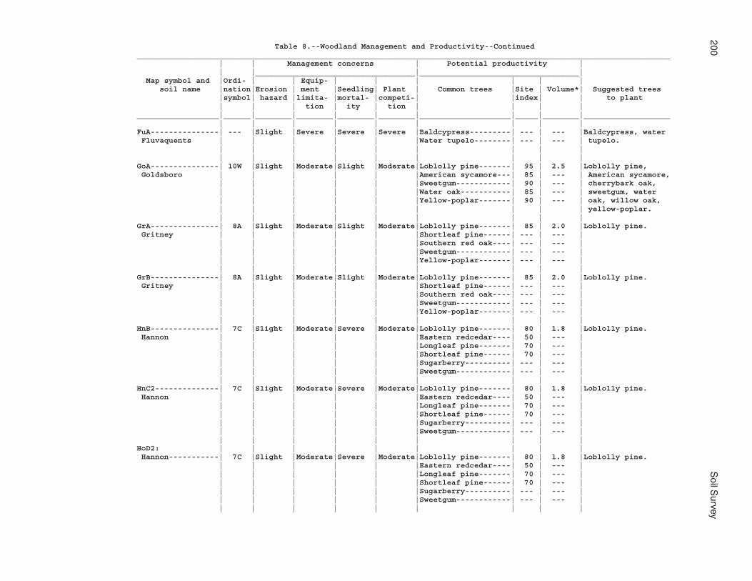
200S
oil Survey
Table 8.--Woodland Management and Productivity--Continued_____________________________________________________________________________________________________________________ | | Management concerns | Potential productivity | | |___________________________________|___________________________________| Map symbol and |Ordi- | | Equip- | | | | | | soil name |nation|Erosion | ment |Seedling| Plant | Common trees |Site | Volume*| Suggested trees |symbol| hazard |limita- |mortal- |competi-| |index| | to plant | | | tion | ity | tion | | | |__________________|______|________|________|________|________|____________________|_____|________|___________________ | | | | | | | | |FuA---------------| --- |Slight |Severe |Severe |Severe |Baldcypress---------| --- | --- |Baldcypress, water Fluvaquents | | | | | |Water tupelo--------| --- | --- | tupelo. | | | | | | | | | | | | | | | | | |GoA---------------| 10W |Slight |Moderate|Slight |Moderate|Loblolly pine-------| 95 | 2.5 |Loblolly pine, Goldsboro | | | | | |American sycamore---| 85 | --- | American sycamore, | | | | | |Sweetgum------------| 90 | --- | cherrybark oak, | | | | | |Water oak-----------| 85 | --- | sweetgum, water | | | | | |Yellow-poplar-------| 90 | --- | oak, willow oak, | | | | | | | | | yellow-poplar. | | | | | | | | |GrA---------------| 8A |Slight |Moderate|Slight |Moderate|Loblolly pine-------| 85 | 2.0 |Loblolly pine. Gritney | | | | | |Shortleaf pine------| --- | --- | | | | | | |Southern red oak----| --- | --- | | | | | | |Sweetgum------------| --- | --- | | | | | | |Yellow-poplar-------| --- | --- | | | | | | | | | |GrB---------------| 8A |Slight |Moderate|Slight |Moderate|Loblolly pine-------| 85 | 2.0 |Loblolly pine. Gritney | | | | | |Shortleaf pine------| --- | --- | | | | | | |Southern red oak----| --- | --- | | | | | | |Sweetgum------------| --- | --- | | | | | | |Yellow-poplar-------| --- | --- | | | | | | | | | |HnB---------------| 7C |Slight |Moderate|Severe |Moderate|Loblolly pine-------| 80 | 1.8 |Loblolly pine. Hannon | | | | | |Eastern redcedar----| 50 | --- | | | | | | |Longleaf pine-------| 70 | --- | | | | | | |Shortleaf pine------| 70 | --- | | | | | | |Sugarberry----------| --- | --- | | | | | | |Sweetgum------------| --- | --- | | | | | | | | | |HnC2--------------| 7C |Slight |Moderate|Severe |Moderate|Loblolly pine-------| 80 | 1.8 |Loblolly pine. Hannon | | | | | |Eastern redcedar----| 50 | --- | | | | | | |Longleaf pine-------| 70 | --- | | | | | | |Shortleaf pine------| 70 | --- | | | | | | |Sugarberry----------| --- | --- | | | | | | |Sweetgum------------| --- | --- | | | | | | | | | |HoD2: | | | | | | | | | Hannon-----------| 7C |Slight |Moderate|Severe |Moderate|Loblolly pine-------| 80 | 1.8 |Loblolly pine. | | | | | |Eastern redcedar----| 50 | --- | | | | | | |Longleaf pine-------| 70 | --- | | | | | | |Shortleaf pine------| 70 | --- | | | | | | |Sugarberry----------| --- | --- | | | | | | |Sweetgum------------| --- | --- | | | | | | | | | |
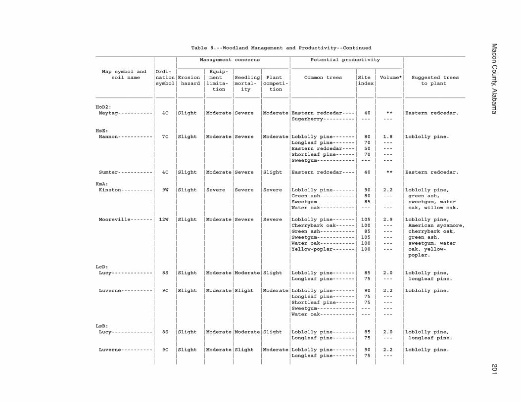
Macon C
ounty, Alabam
a201
Table 8.--Woodland Management and Productivity--Continued_____________________________________________________________________________________________________________________ | | Management concerns | Potential productivity | | |___________________________________|___________________________________| Map symbol and |Ordi- | | Equip- | | | | | | soil name |nation|Erosion | ment |Seedling| Plant | Common trees |Site | Volume*| Suggested trees |symbol| hazard |limita- |mortal- |competi-| |index| | to plant | | | tion | ity | tion | | | |__________________|______|________|________|________|________|____________________|_____|________|___________________ | | | | | | | | |HoD2: | | | | | | | | | Maytag-----------| 4C |Slight |Moderate|Severe |Moderate|Eastern redcedar----| 40 | ** |Eastern redcedar. | | | | | |Sugarberry----------| --- | --- | | | | | | | | | |HsE: | | | | | | | | | Hannon-----------| 7C |Slight |Moderate|Severe |Moderate|Loblolly pine-------| 80 | 1.8 |Loblolly pine. | | | | | |Longleaf pine-------| 70 | --- | | | | | | |Eastern redcedar----| 50 | --- | | | | | | |Shortleaf pine------| 70 | --- | | | | | | |Sweetgum------------| --- | --- | | | | | | | | | | Sumter-----------| 4C |Slight |Moderate|Severe |Slight |Eastern redcedar----| 40 | ** |Eastern redcedar. | | | | | | | | |KmA: | | | | | | | | | Kinston----------| 9W |Slight |Severe |Severe |Severe |Loblolly pine-------| 90 | 2.2 |Loblolly pine, | | | | | |Green ash-----------| 80 | --- | green ash, | | | | | |Sweetgum------------| 85 | --- | sweetgum, water | | | | | |Water oak-----------| --- | --- | oak, willow oak. | | | | | | | | | Mooreville-------| 12W |Slight |Moderate|Severe |Severe |Loblolly pine-------| 105 | 2.9 |Loblolly pine, | | | | | |Cherrybark oak------| 100 | --- | American sycamore, | | | | | |Green ash-----------| 85 | --- | cherrybark oak, | | | | | |Sweetgum------------| 105 | --- | green ash, | | | | | |Water oak-----------| 100 | --- | sweetgum, water | | | | | |Yellow-poplar-------| 100 | --- | oak, yellow- | | | | | | | | | poplar. | | | | | | | | |LcD: | | | | | | | | | Lucy-------------| 8S |Slight |Moderate|Moderate|Slight |Loblolly pine-------| 85 | 2.0 |Loblolly pine, | | | | | |Longleaf pine-------| 75 | --- | longleaf pine. | | | | | | | | | Luverne----------| 9C |Slight |Moderate|Slight |Moderate|Loblolly pine-------| 90 | 2.2 |Loblolly pine. | | | | | |Longleaf pine-------| 75 | --- | | | | | | |Shortleaf pine------| 75 | --- | | | | | | |Sweetgum------------| --- | --- | | | | | | |Water oak-----------| --- | --- | | | | | | | | | |LsB: | | | | | | | | | Lucy-------------| 8S |Slight |Moderate|Moderate|Slight |Loblolly pine-------| 85 | 2.0 |Loblolly pine, | | | | | |Longleaf pine-------| 75 | --- | longleaf pine. | | | | | | | | | Luverne----------| 9C |Slight |Moderate|Slight |Moderate|Loblolly pine-------| 90 | 2.2 |Loblolly pine. | | | | | |Longleaf pine-------| 75 | --- | | | | | | | | | |

202S
oil Survey
Table 8.--Woodland Management and Productivity--Continued_____________________________________________________________________________________________________________________ | | Management concerns | Potential productivity | | |___________________________________|___________________________________| Map symbol and |Ordi- | | Equip- | | | | | | soil name |nation|Erosion | ment |Seedling| Plant | Common trees |Site | Volume*| Suggested trees |symbol| hazard |limita- |mortal- |competi-| |index| | to plant | | | tion | ity | tion | | | |__________________|______|________|________|________|________|____________________|_____|________|___________________ | | | | | | | | |LsB: | | | | | | | | | Springhill-------| 9A |Slight |Slight |Slight |Slight |Loblolly pine-------| 90 | 2.2 |Loblolly pine, | | | | | |Longleaf pine-------| 75 | --- | longleaf pine. | | | | | |Shortleaf pine------| 80 | --- | | | | | | |Southern red oak----| 80 | --- | | | | | | |Sweetgum------------| 90 | --- | | | | | | |Water oak-----------| 90 | --- | | | | | | | | | |LuB---------------| 9C |Slight |Moderate|Slight |Moderate|Loblolly pine-------| 90 | 2.2 |Loblolly pine. Luverne | | | | | |Longleaf pine-------| 75 | --- | | | | | | |Shortleaf pine------| --- | --- | | | | | | |Sweetgum------------| --- | --- | | | | | | |Water oak-----------| --- | --- | | | | | | | | | |LuD2--------------| 9C |Moderate|Moderate|Slight |Moderate|Loblolly pine-------| 90 | 2.2 |Loblolly pine. Luverne | | | | | |Longleaf pine-------| 75 | --- | | | | | | |Shortleaf pine------| 75 | --- | | | | | | |Sweetgum------------| --- | --- | | | | | | |Water oak-----------| --- | --- | | | | | | | | | |LyA---------------| 9W |Slight |Moderate|Moderate|Severe |Loblolly pine-------| 85 | 2.2 |Loblolly pine, Lynchburg | | | | | |Blackgum------------| --- | --- | cherrybark oak, | | | | | |Sweetgum------------| 90 | --- | sweetgum, water | | | | | |Water oak-----------| 80 | --- | oak, willow oak. | | | | | |Willow oak----------| 80 | --- | | | | | | |Yellow-poplar-------| 85 | --- | | | | | | | | | |MaA---------------| 10A |Slight |Slight |Slight |Slight |Loblolly pine-------| 95 | 2.5 |Loblolly pine. Malbis | | | | | |Longleaf pine-------| 80 | --- | | | | | | |Sweetgum------------| --- | --- | | | | | | |Water oak-----------| --- | --- | | | | | | | | | |MnA---------------| 9A |Slight |Slight |Slight |Slight |Loblolly pine-------| 90 | 2.2 |Loblolly pine, Marvyn | | | | | |Longleaf pine-------| 80 | --- | longleaf pine. | | | | | |Shortleaf pine------| 80 | --- | | | | | | |Sweetgum------------| --- | --- | | | | | | |Water oak-----------| --- | --- | | | | | | | | | |MnB---------------| 9A |Slight |Slight |Slight |Slight |Loblolly pine-------| 90 | 2.2 |Loblolly pine, Marvyn | | | | | |Longleaf pine-------| 80 | --- | longleaf pine. | | | | | |Shortleaf pine------| 80 | --- | | | | | | |Sweetgum------------| --- | --- | | | | | | |Water oak-----------| --- | --- | | | | | | | | | |

Macon C
ounty, Alabam
a203
Table 8.--Woodland Management and Productivity--Continued_____________________________________________________________________________________________________________________ | | Management concerns | Potential productivity | | |___________________________________|___________________________________| Map symbol and |Ordi- | | Equip- | | | | | | soil name |nation|Erosion | ment |Seedling| Plant | Common trees |Site | Volume*| Suggested trees |symbol| hazard |limita- |mortal- |competi-| |index| | to plant | | | tion | ity | tion | | | |__________________|______|________|________|________|________|____________________|_____|________|___________________ | | | | | | | | |MtA---------------| 4C |Slight |Moderate|Severe |Moderate|Eastern redcedar----| 40 | ** |Eastern redcedar. Maytag | | | | | |Sugarberry----------| --- | --- | | | | | | | | | |MuB: | | | | | | | | | Maytag-----------| 4C |Slight |Moderate|Severe |Moderate|Eastern redcedar----| 40 | ** |Eastern redcedar. | | | | | |Sugarberry----------| --- | --- | | | | | | | | | | Hannon-----------| 7C |Slight |Moderate|Severe |Moderate|Loblolly pine-------| 80 | 1.8 |Loblolly pine. | | | | | |Eastern redcedar----| 50 | --- | | | | | | |Longleaf pine-------| 70 | --- | | | | | | |Shortleaf pine------| 70 | --- | | | | | | |Sweetgum------------| --- | --- | | | | | | | | | |MyA---------------| 9W |Slight |Severe |Severe |Severe |Loblolly pine-------| 95 | 2.5 |Loblolly pine, Myatt | | | | | |Green ash-----------| 80 | --- | sweetgum. | | | | | |Sweetgum------------| 90 | --- | | | | | | |Water oak-----------| 95 | --- | | | | | | | | | |OcA---------------| 9W |Slight |Moderate|Moderate|Moderate|Loblolly pine-------| 90 | 2.2 |Loblolly pine. Ocilla | | | | | |American sycamore---| 95 | --- | | | | | | |Sweetgum------------| 100 | --- | | | | | | |Water oak-----------| 90 | --- | | | | | | | | | |OkC2--------------| 9C |Slight |Moderate|Severe |Moderate|Loblolly pine-------| 90 | 2.2 |Loblolly pine. Oktibbeha | | | | | |Eastern redcedar----| 55 | --- | | | | | | |Shortleaf pine------| 70 | --- | | | | | | |Longleaf pine-------| 70 | --- | | | | | | |Sweetgum------------| --- | --- | | | | | | | | | |OkE2--------------| 9C |Slight |Moderate|Severe |Moderate|Loblolly pine-------| 90 | 2.2 |Loblolly pine. Oktibbeha | | | | | |Eastern redcedar----| 55 | --- | | | | | | |Longleaf pine-------| 70 | --- | | | | | | |Shortleaf pine------| 70 | --- | | | | | | |Sweetgum------------| ---| --- | | | | | | | | | |OrA---------------| 9A |Slight |Slight |Slight |Slight |Loblolly pine-------| 90 | 2.2 |Loblolly pine, Orangeburg | | | | | |Longleaf pine-------| 75 | --- | longleaf pine. | | | | | |Shortleaf pine------| 75 | --- | | | | | | | | | |PaD---------------| 7A |Slight |Slight |Slight |Slight |Loblolly pine-------| 80 | 1.8 |Loblolly pine. Pacolet | | | | | |Hickory-------------| --- | --- | | | | | | |Shortleaf pine------| 70 | --- | | | | | | |White oak-----------| --- | --- | | | | | | |Yellow-poplar-------| 90 | --- | | | | | | | | | |

204S
oil Survey
Table 8.--Woodland Management and Productivity--Continued_____________________________________________________________________________________________________________________ | | Management concerns | Potential productivity | | |___________________________________|___________________________________| Map symbol and |Ordi- | | Equip- | | | | | | soil name |nation|Erosion | ment |Seedling| Plant | Common trees |Site | Volume*| Suggested trees |symbol| hazard |limita- |mortal- |competi-| |index| | to plant | | | tion | ity | tion | | | |__________________|______|________|________|________|________|____________________|_____|________|___________________ | | | | | | | | |PaE---------------| 7R |Moderate|Moderate|Slight |Slight |Loblolly pine-------| 80 | 1.8 |Loblolly pine. Pacolet | | | | | |Hickory-------------| --- | --- | | | | | | |Shortleaf pine------| 70 | --- | | | | | | |White oak-----------| --- | --- | | | | | | |Yellow-poplar-------| 90 | --- | | | | | | | | | |PoA: | | | | | | | | | Pelham-----------| 9W |Slight |Severe |Severe |Moderate|Loblolly pine-------| 90 | 2.2 |Loblolly pine. | | | | | |Blackgum------------| 80 | --- | | | | | | |Longleaf pine-------| 80 | --- | | | | | | |Sweetgum------------| 80 | --- | | | | | | |Water oak-----------| 75 | --- | | | | | | | | | | Ocilla-----------| 9W |Slight |Moderate|Moderate|Moderate|Loblolly pine-------| 90 | 2.2 |Loblolly pine. | | | | | |Longleaf pine-------| 75 | --- | | | | | | | | | --- |Pt. | | | | | | | | | Pits | | | | | | | | | | | | | | | | | |RbA---------------| 9A |Slight |Slight |Slight |Slight |Loblolly pine-------| 90 | 2.2 |Loblolly pine, Red Bay | | | | | |Longleaf pine-------| 75 | --- | longleaf pine. | | | | | |Sweetgum------------| --- | --- | | | | | | |Water oak-----------| --- | --- | | | | | | | | | |ReA---------------| 11A |Slight |Slight |Slight |Moderate|Loblolly pine-------| 100 | 2.7 |Loblolly pine, Riverview | | | | | |American sycamore---| 105 | --- | American sycamore, | | | | | |Cherrybark oak------| 105 | --- | cherrybark oak, | | | | | |Green ash-----------| --- | --- | green ash, | | | | | |Sweetgum------------| 100 | --- | sweetgum, water | | | | | |Water oak-----------| 100 | --- | oak, yellow- | | | | | |Yellow-poplar-------| 100 | --- | poplar. | | | | | | | | |RoB: | | | | | | | | | Riverview--------| 11A |Slight |Slight |Slight |Moderate|Loblolly pine-------| 100 | 2.7 |Loblolly pine, | | | | | |American sycamore---| 105 | --- | American sycamore, | | | | | |Cherrybark oak------| 105 | --- | cherrybark oak, | | | | | |Sweetgum------------| 100 | --- | green ash, | | | | | |Water oak-----------| 100 | --- | sweetgum, water | | | | | |Yellow-poplar-------| 100 | --- | oak, yellow- | | | | | | | | | poplar. | | | | | | | | |

Macon C
ounty, Alabam
a205
Table 8.--Woodland Management and Productivity--Continued_____________________________________________________________________________________________________________________ | | Management concerns | Potential productivity | | |___________________________________|___________________________________| Map symbol and |Ordi- | | Equip- | | | | | | soil name |nation|Erosion | ment |Seedling| Plant | Common trees |Site | Volume*| Suggested trees |symbol| hazard |limita- |mortal- |competi-| |index| | to plant | | | tion | ity | tion | | | |__________________|______|________|________|________|________|____________________|_____|________|___________________ | | | | | | | | |RoB: | | | | | | | | | Bruno------------| 10S |Slight |Slight |Moderate|Moderate|Loblolly pine-------| 95 | 2.5 |Loblolly pine, | | | | | |American sycamore---| 110 | --- | cherrybark oak, | | | | | |Black willow--------| --- | --- | sweetgum, water | | | | | |Cherrybark oak------| 110 | --- | oak. | | | | | |Eastern cottonwood--| 115 | --- | | | | | | |Sweetgum------------| 105 | --- | | | | | | |Water oak-----------| 100 | --- | | | | | | |Willow oak----------| 100 | --- | | | | | | |Yellow-poplar-------| 105 | --- | | | | | | | | | |Rw. | | | | | | | | | Riverwash | | | | | | | | | | | | | | | | | |RyA---------------| 9W |Slight |Severe |Moderate|Severe |Loblolly pine-------| 95 | 2.5 |Loblolly pine, Roanoke | | | | | |Sweetgum------------| 80 | --- | sweetgum. | | | | | |Water oak-----------| --- | --- | | | | | | |Willow oak----------| 75 | --- | | | | | | | | | |SaB---------------| 12C |Slight |Moderate|Slight |Moderate|Loblolly pine-------| 105 | 2.9 |Loblolly pine. Searcy | | | | | |Longleaf pine-------| --- | --- | | | | | | |Shortleaf pine------| --- | --- | | | | | | |Sweetgum------------| --- | --- | | | | | | |Water oak-----------| --- | --- | | | | | | | | | |SbB---------------| 9A |Slight |Slight |Slight |Slight |Loblolly pine-------| 90 | 2.2 |Loblolly pine, Springhill | | | | | |Longleaf pine-------| 75 | --- | longleaf pine. | | | | | |Shortleaf pine------| 80 | --- | | | | | | |Sweetgum------------| 90 | --- | | | | | | |Water oak-----------| 90 | --- | | | | | | | | | |SrA---------------| 6W |Slight |Severe |Severe |Severe |Sweetgum------------| 100 | 1.4 |Sweetgum, Sucarnoochee | | | | | |American sycamore---| 100 | --- | American sycamore, | | | | | |Eastern cottonwood--| 110 | --- | eastern | | | | | |Cherrybark oak------| 100 | --- | cottonwood. | | | | | |Green ash-----------| 90 | --- | | | | | | |Yellow-poplar-------| 110 | --- | | | | | | | | | |StE: | | | | | | | | | Sumter-----------| 4R |Moderate|Moderate|Severe |Moderate|Eastern redcedar----| 40 | ** |Eastern redcedar. | | | | | | | | | Hannon-----------| 7R |Moderate|Severe |Severe |Moderate|Loblolly pine-------| 80 | 1.8 |Loblolly pine. | | | | | |Eastern redcedar----| 50 | --- | | | | | | |Shortleaf pine------| 70 | --- | | | | | | |Longleaf pine-------| 70 | --- | | | | | | | | | |

206S
oil Survey
Table 8.--Woodland Management and Productivity--Continued_____________________________________________________________________________________________________________________ | | Management concerns | Potential productivity | | |___________________________________|___________________________________| Map symbol and |Ordi- | | Equip- | | | | | | soil name |nation|Erosion | ment |Seedling| Plant | Common trees |Site | Volume*| Suggested trees |symbol| hazard |limita- |mortal- |competi-| |index| | to plant | | | tion | ity | tion | | | |__________________|______|________|________|________|________|____________________|_____|________|___________________ | | | | | | | | |TcA---------------| 11A |Slight |Slight |Slight |Moderate|Loblolly pine-------| 100 | 2.7 |Loblolly pine, Toccoa | | | | | |American sycamore---| 115 | --- | American sycamore, | | | | | |Eastern cottonwood--| --- | --- | cherrybark oak, | | | | | |Shortleaf pine------| 90 | --- | green ash, water | | | | | |Sweetgum------------| 110 | --- | oak, yellow- | | | | | |Water oak-----------| --- | --- | poplar. | | | | | |Yellow-poplar-------| 115 | --- | | | | | | | | | |ToB---------------| 11A |Slight |Slight |Slight |Moderate|Loblolly pine-------| 100 | 2.7 |Loblolly pine, Toccoa | | | | | |American sycamore---| 115 | --- | American sycamore, | | | | | |Eastern cottonwood--| --- | --- | cherrybark oak, | | | | | |Shortleaf pine------| 90 | --- | green ash, water | | | | | |Sweetgum------------| 100 | --- | oak, yellow- | | | | | |Yellow-poplar-------| 100 | --- | poplar. | | | | | | | | |TpB: | | | | | | | | | Troup------------| 8S |Slight |Moderate|Moderate|Slight |Loblolly pine-------| 85 | 2.0 |Loblolly pine, | | | | | |Longleaf pine-------| 75 | --- | longleaf pine. | | | | | |Southern red oak----| --- | --- | | | | | | | | | | Alaga------------| 8S |Slight |Moderate|Moderate|Slight |Loblolly pine-------| 85 | 2.0 |Loblolly pine, | | | | | |Longleaf pine-------| 80 | --- | longleaf pine. | | | | | | | | |TsF: | | | | | | | | | Troup------------| 8R |Moderate|Moderate|Moderate|Slight |Loblolly pine-------| 85 | 2.0 | --- | | | | | |Longleaf pine-------| 70 | --- | | | | | | | | | | Springhill-------| 9R |Moderate|Moderate|Slight |Slight |Loblolly pine-------| 90 | 2.2 |Loblolly pine, | | | | | |Longleaf pine-------| 75 | --- | longleaf pine. | | | | | |Shortleaf pine------| 80 | --- | | | | | | |Southern red oak----| 80 | --- | | | | | | |Sweetgum------------| 90 | --- | | | | | | |Water oak-----------| 90 | --- | | | | | | | | | | Luverne----------| 9R |Moderate|Moderate|Slight |Moderate|Loblolly pine-------| 90 | 2.2 |Loblolly pine, | | | | | |Shortleaf pine------| 80 | --- | longleaf pine. | | | | | | | | |UcB---------------| 8S |Slight |Moderate|Moderate|Slight |Loblolly pine-------| 85 | 2.0 |Loblolly pine, Uchee | | | | | |Longleaf pine-------| 70 | --- | longleaf pine. | | | | | |Shortleaf pine------| --- | --- | | | | | | |Sweetgum------------| --- | --- | | | | | | |Water oak-----------| --- | --- | | | | | | | | | |

Macon C
ounty, Alabam
a207
Table 8.--Woodland Management and Productivity--Continued_____________________________________________________________________________________________________________________ | | Management concerns | Potential productivity | | |___________________________________|___________________________________| Map symbol and |Ordi- | | Equip- | | | | | | soil name |nation|Erosion | ment |Seedling| Plant | Common trees |Site | Volume*| Suggested trees |symbol| hazard |limita- |mortal- |competi-| |index| | to plant | | | tion | ity | tion | | | |__________________|______|________|________|________|________|____________________|_____|________|___________________ | | | | | | | | |UcD---------------| 8S |Slight |Moderate|Moderate|Slight |Loblolly pine-------| 85 | 2.0 |Loblolly pine, Uchee | | | | | |Longleaf pine-------| 70 | --- | longleaf pine. | | | | | |Shortleaf pine------| --- | --- | | | | | | |Sweetgum------------| --- | --- | | | | | | |Water oak-----------| --- | --- | | | | | | | | | |UcE2: | | | | | | | | | Uchee------------| 8R |Moderate|Moderate|Moderate|Slight |Loblolly pine-------| 80 | 1.8 | --- | | | | | |Longleaf pine-------| 70 | --- | | | | | | |Shortleaf pine------| --- | --- | | | | | | |Sweetgum------------| --- | --- | | | | | | |Water oak-----------| --- | --- | | | | | | | | | | Cowarts----------| 8R |Moderate|Moderate|Slight |Slight |Loblolly pine-------| 85 | 2.0 |Loblolly pine, | | | | | |Longleaf pine-------| 70 | --- | longleaf pine. | | | | | | | | |UdE---------------| 6D |Severe |Moderate|Severe |Slight |Loblolly pine-------| 70 | 1.4 |Loblolly pine. Udorthents | | | | | | | | | | | | | | | | | |UoC---------------| 7D |Moderate|Moderate|Severe |Slight |Loblolly pine-------| 75 | 1.6 |Loblolly pine. Udorthents | | | | | | | | | | | | | | | | | |UuA. | | | | | | | | | Udorthents | | | | | | | | | Urban land | | | | | | | | | | | | | | | | | |UvA: | | | | | | | | | Urbo-------------| 10W |Slight |Severe |Severe |Severe |Loblolly pine-------| 95 | 2.5 |Loblolly pine, | | | | | |American sycamore---| 90 | --- | American sycamore, | | | | | |Cherrybark oak------| 95 | --- | cherrybark oak, | | | | | |Green ash-----------| 85 | --- | sweetgum, water | | | | | |Sweetgum------------| 95 | --- | oak, willow oak, | | | | | |Water oak-----------| 90 | --- | yellow-poplar. | | | | | | | | | Una--------------| 7W |Slight |Severe |Severe |Severe |Water tupelo--------| 70 | 0.5 |Water tupelo, | | | | | |Baldcypress---------| 80 | --- | baldcypress, swamp | | | | | |swamp tupelo--------| --- | --- | tupelo. | | | | | | | | | Mooreville-------| 12W |Slight |Moderate|Severe |Severe |Loblolly pine-------| 105 | 2.9 |Loblolly pine, | | | | | |Cherrybark oak------| 100 | --- | cherrybark oak, | | | | | |Eastern cottonwood--| 105 | --- | eastern | | | | | |Green ash-----------| 85 | --- | cottonwood, green | | | | | |Sweetgum------------| 105 | --- | ash, sweetgum, | | | | | |Yellow-poplar-------| 100 | --- | yellow-poplar. | | | | | | | | |

208S
oil Survey
Table 8.--Woodland Management and Productivity--Continued_____________________________________________________________________________________________________________________ | | Management concerns | Potential productivity | | |___________________________________|___________________________________| Map symbol and |Ordi- | | Equip- | | | | | | soil name |nation|Erosion | ment |Seedling| Plant | Common trees |Site | Volume*| Suggested trees |symbol| hazard |limita- |mortal- |competi-| |index| | to plant | | | tion | ity | tion | | | |__________________|______|________|________|________|________|____________________|_____|________|___________________ | | | | | | | | |VaA---------------| 8C |Slight |Moderate|Severe |Moderate|Loblolly pine-------| 80 | 1.8 |Loblolly pine. Vaiden | | | | | |Eastern redcedar----| 45 | --- | | | | | | |Shortleaf pine------| 65 | --- | | | | | | |Southern red oak----| 70 | --- | | | | | | | | | |WaB---------------| 9S |Slight |Moderate|Moderate|Slight |Loblolly pine-------| 90 | 2.2 |Loblolly pine, Wagram | | | | | |Longleaf pine-------| 75 | --- | longleaf pine, | | | | | |Shortleaf pine------| 75 | --- | shortleaf pine. | | | | | |Sweetgum------------| --- | --- | | | | | | |Water oak-----------| --- | --- | | | | | | | | | |_____________________________________________________________________________________________________________________
* Volume is the average yearly growth in cords per acre per year for fully stocked natural stands calculated at25 years of age for loblolly pine and at 30 years of age for oak and tupelo. ** Volume for eastern redcedar is 140 board feet per acre per year calculated at 40 years of age for fullystocked natural stands.

Macon County, Alabama 209
Table 9.--Recreational Development
(Some terms that describe restrictive soil features are defined in the "Glossary." See text for definitions of "slight," "moderate," and "severe." Absence of an entry indicates that the soil was not rated. The information in this table indicates the dominant soil condition but does not eliminate the need for onsite investigation.)
________________________________________________________________________________________________________ | | | | | Map symbol | Camp areas | Picnic areas | Playgrounds | Paths and | Golf fairways and soil name | | | | trails |________________________|_______________|_______________|_______________|_______________|_______________ | | | | |AlA---------------------|Moderate: |Moderate: |Moderate: |Moderate: |Moderate: Altavista | wetness. | wetness. | wetness. | wetness. | wetness. | | | | |ArB---------------------|Variable-------|Variable-------|Variable-------|Variable-------|Variable. Arents | | | | | | | | | |BaA---------------------|Slight---------|Slight---------|Slight---------|Slight---------|Slight. Bama | | | | | | | | | |BaB---------------------|Slight---------|Slight---------|Moderate: |Slight---------|Slight. Bama | | | slope. | | | | | | |BeA---------------------|Severe: |Severe: |Severe: |Severe: |Severe: Bethera | flooding, | wetness. | flooding, | wetness. | flooding, | wetness. | | wetness. | | wetness. | | | | |BgB---------------------|Severe: |Severe: |Severe: |Severe: |Moderate: Bigbee | flooding, | too sandy. | too sandy. | too sandy. | flooding, | too sandy, | | | | too sandy, | droughty. | | | | droughty. | | | | |BnE: | | | | | Blanton----------------|Severe: |Severe: |Severe: |Moderate: |Severe: | slope. | slope. | slope. | slope, | slope. | | | | too sandy. | | | | | | Luverne----------------|Severe: |Severe: |Severe: |Moderate: |Severe: | slope. | slope. | slope. | slope. | slope. | | | | |BoB---------------------|Moderate: |Moderate: |Moderate: |Moderate: |Moderate: Bonifay | too sandy. | too sandy. | slope, | too sandy. | droughty. | | | too sandy. | | | | | | |CaA---------------------|Severe: |Slight---------|Slight---------|Slight---------|Slight. Cahaba | flooding. | | | | | | | | |CmB---------------------|Slight---------|Slight---------|Moderate: |Slight---------|Moderate: Compass | | | slope. | | droughty. | | | | |CoB---------------------|Severe: |Severe: |Severe: |Slight---------|Moderate: Conecuh | percs slowly. | percs slowly. | percs slowly. | | droughty. | | | | |CoC2--------------------|Severe: |Severe: |Severe: |Severe: |Moderate: Conecuh | percs slowly. | percs slowly. | percs slowly, | erodes easily.| droughty. | | | slope. | | | | | | |CwD2--------------------|Moderate: |Moderate: |Severe: |Slight---------|Moderate: Cowarts | percs slowly, | percs slowly, | slope. | | slope, | slope. | slope. | | | droughty. | | | | |DgA---------------------|Severe: |Moderate: |Moderate: |Moderate: |Moderate: Dogue | wetness. | percs slowly, | percs slowly, | wetness. | wetness. | | wetness. | wetness. | | | | | | |EuA---------------------|Severe: |Moderate: |Moderate: |Moderate: |Moderate: Eunola | flooding. | wetness. | wetness. | wetness. | wetness. | | | | |

210 Soil Survey
Table 9.--Recreational Development--Continued________________________________________________________________________________________________________ | | | | | Map symbol | Camp areas | Picnic areas | Playgrounds | Paths and | Golf fairways and soil name | | | | trails |________________________|_______________|_______________|_______________|_______________|_______________ | | | | |FaA---------------------|Severe: |Severe: |Severe: |Moderate: |Moderate: Faunsdale | percs slowly. | percs slowly. | percs slowly. | wetness. | wetness. | | | | |FuA---------------------|Severe: |Severe: |Severe: |Severe: |Severe: Fluvaquents | flooding, | ponding. | flooding, | ponding. | flooding, | ponding. | | ponding. | | ponding. | | | | |GoA---------------------|Slight: |Slight: |Slight: |Slight---------|Slight. Goldsboro | too acid. | too acid. | too acid. | | | | | | |GrA---------------------|Moderate: |Moderate: |Moderate: |Moderate: |Moderate: Gritney | percs slowly, | percs slowly, | small stones, | wetness. | wetness. | wetness. | wetness. | wetness. | | | | | | |GrB---------------------|Moderate: |Moderate: |Moderate: |Moderate: |Moderate: Gritney | percs slowly, | percs slowly, | small stones, | wetness. | wetness. | wetness. | wetness. | wetness. | | | | | | |HnB---------------------|Severe: |Severe: |Severe: |Slight---------|Moderate: Hannon | percs slowly. | percs slowly. | percs slowly. | | droughty. | | | | |HnC2--------------------|Severe: |Severe: |Severe: |Severe: |Severe: Hannon | percs slowly, | percs slowly, | percs slowly, | too clayey. | too clayey. | too clayey. | too clayey. | too clayey. | | | | | | |HoD2: | | | | | Hannon-----------------|Severe: |Severe: |Severe: |Severe: |Severe: | percs slowly. | percs slowly. | percs slowly. | too clayey. | too clayey. | | | | | Maytag-----------------|Severe: |Severe: |Severe: |Severe: |Severe: | too clayey. | too clayey. | slope, | too clayey. | too clayey. | | | too clayey. | | | | | | |HsE: | | | | | Hannon-----------------|Severe: |Severe: |Severe: |Severe: |Severe: | percs slowly, | percs slowly, | percs slowly, | too clayey. | too clayey. | too clayey. | too clayey. | slope, | | | | | too clayey. | | | | | | | Sumter-----------------|Severe: |Severe: |Severe: |Severe: |Severe: | too clayey. | too clayey. | slope, | erodes easily,| too clayey. | | | too clayey. | too clayey. | | | | | |KmA: | | | | | Kinston----------------|Severe: |Severe: |Severe: |Severe: |Severe: | flooding, | wetness. | flooding, | wetness. | flooding, | wetness. | | wetness. | | wetness. | | | | | Mooreville-------------|Severe: |Moderate: |Severe: |Moderate: |Severe: | flooding. | flooding, | flooding. | flooding, | flooding. | | wetness. | | wetness. | | | | | |LcD: | | | | | Lucy-------------------|Moderate: |Moderate: |Severe: |Slight---------|Moderate: | slope. | slope. | slope. | | slope, | | | | | droughty. | | | | | Luverne----------------|Moderate: |Moderate: |Severe: |Slight---------|Moderate: | percs slowly, | percs slowly, | slope. | | slope. | slope. | slope. | | | | | | | |LsB: | | | | | Lucy-------------------|Slight---------|Slight---------|Moderate: |Slight---------|Moderate: | | | slope. | | droughty. | | | | |

Macon County, Alabama 211
Table 9.--Recreational Development--Continued________________________________________________________________________________________________________ | | | | | Map symbol | Camp areas | Picnic areas | Playgrounds | Paths and | Golf fairways and soil name | | | | trails |________________________|_______________|_______________|_______________|_______________|_______________ | | | | |LsB: | | | | | Luverne----------------|Moderate: |Moderate: |Moderate: |Slight---------|Slight. | percs slowly. | percs slowly. | percs slowly, | | | | | slope, | | | | | small stones. | | | | | | | Springhill-------------|Slight---------|Slight---------|Moderate: |Slight---------|Slight. | | | slope. | | | | | | |LuB---------------------|Moderate: |Moderate: |Moderate: |Slight---------|Slight. Luverne | percs slowly. | percs slowly. | percs slowly, | | | | | slope, | | | | | small stones. | | | | | | |LuD2--------------------|Moderate: |Moderate: |Severe: |Slight---------|Moderate: Luverne | percs slowly, | percs slowly, | slope. | | slope. | slope. | slope. | | | | | | | |LyA---------------------|Severe: |Severe: |Severe: |Severe: |Severe: Lynchburg | flooding, | wetness. | wetness. | wetness. | wetness. | wetness. | | | | | | | | |MaA---------------------|Slight---------|Slight---------|Slight---------|Slight---------|Slight. Malbis | | | | | | | | | |MnA---------------------|Slight---------|Slight---------|Slight---------|Slight---------|Slight. Marvyn | | | | | | | | | |MnB---------------------|Slight---------|Slight---------|Moderate: |Slight---------|Slight. Marvyn | | | slope. | | | | | | |MtA---------------------|Severe: |Severe: |Severe: |Severe: |Severe: Maytag | too clayey. | too clayey. | too clayey. | too clayey. | too clayey. | | | | |MuB: | | | | | Maytag-----------------|Moderate: |Moderate: |Moderate: |Slight---------|Slight. | percs slowly. | percs slowly. | percs slowly, | | | | | slope. | | | | | | | Hannon-----------------|Severe: |Severe: |Severe: |Slight---------|Moderate: | percs slowly. | percs slowly. | percs slowly. | | droughty. | | | | |MyA---------------------|Severe: |Severe: |Severe: |Severe: |Severe: Myatt | flooding, | wetness. | wetness. | wetness. | wetness. | wetness. | | | | | | | | |OcA---------------------|Severe: |Moderate: |Moderate: |Moderate: |Moderate: Ocilla | flooding. | too sandy, | too sandy, | too sandy, | wetness, | | wetness. | wetness. | wetness. | droughty. | | | | |OkC2--------------------|Severe: |Severe: |Severe: |Slight---------|Severe: Oktibbeha | percs slowly. | percs slowly. | percs slowly. | | too clayey. | | | | |OkE2--------------------|Severe: |Severe: |Severe: |Severe: |Severe: Oktibbeha | percs slowly, | percs slowly, | percs slowly, | slope, | slope, | slope. | slope. | slope. | too clayey. | too clayey. | | | | |OrA---------------------|Slight---------|Slight---------|Slight---------|Slight---------|Slight. Orangeburg | | | | | | | | | |PaD---------------------|Moderate: |Moderate: |Severe: |Slight---------|Moderate: Pacolet | slope. | slope. | slope. | | slope. | | | | |

212 Soil Survey
Table 9.--Recreational Development--Continued________________________________________________________________________________________________________ | | | | | Map symbol | Camp areas | Picnic areas | Playgrounds | Paths and | Golf fairways and soil name | | | | trails |________________________|_______________|_______________|_______________|_______________|_______________ | | | | |PaE---------------------|Severe: |Severe: |Severe: |Moderate: |Severe: Pacolet | slope. | slope. | slope. | slope. | slope. | | | | |PoA: | | | | | Pelham-----------------|Severe: |Severe: |Severe: |Severe: |Severe: | flooding, | wetness. | wetness. | wetness. | wetness. | wetness. | | | | | | | | | Ocilla-----------------|Severe: |Moderate: |Moderate: |Moderate: |Moderate: | flooding. | too sandy, | too sandy, | too sandy, | flooding, | | wetness. | wetness. | wetness. | wetness, | | | | | droughty. | | | | |Pt----------------------|Variable-------|Variable-------|Variable-------|Variable-------|Variable. Pits | | | | | | | | | |RbA---------------------|Slight---------|Slight---------|Slight---------|Slight---------|Slight. Red Bay | | | | | | | | | |ReA---------------------|Severe: |Slight---------|Moderate: |Slight---------|Moderate: Riverview | flooding. | | flooding. | | flooding. | | | | |RoB: | | | | | Riverview--------------|Severe: |Slight---------|Moderate: |Slight---------|Moderate: | flooding. | | flooding. | | flooding. | | | | | Bruno------------------|Slight---------|Slight---------|Moderate: |Slight---------|Moderate: | | | flooding, | | flooding, | | | slope. | | droughty. | | | | |Rw----------------------|Severe: |Severe: |Severe: |Severe: |Severe: Riverwash | flooding, | too sandy. | flooding, | too sandy. | flooding. | too sandy. | | too sandy. | | | | | | |RyA---------------------|Severe: |Severe: |Severe: |Severe: |Severe: Roanoke | flooding, | wetness, | wetness, | wetness, | wetness, | wetness, | too acid. | too acid. | | | too acid. | | | | | | | | |SaB---------------------|Moderate: |Moderate: |Moderate: |Slight---------|Slight. Searcy | percs slowly, | percs slowly, | percs slowly, | | | wetness. | wetness. | slope, | | | | | wetness. | | | | | | |SbB---------------------|Slight---------|Slight---------|Moderate: |Slight---------|Slight. Springhill | | | slope. | | | | | | |SrA---------------------|Severe: |Severe: |Severe: |Severe: |Severe: Sucarnoochee | flooding, | percs slowly, | flooding, | too clayey, | flooding, | percs slowly, | too clayey, | too clayey, | wetness. | too clayey, | wetness. | wetness. | wetness. | | wetness. | | | | |StE: | | | | | Sumter-----------------|Severe: |Severe: |Severe: |Severe: |Severe: | slope. | slope. | slope. | erodes easily.| slope. | | | | | Hannon-----------------|Severe: |Severe: |Severe: |Severe: |Severe: | percs slowly, | percs slowly, | percs slowly, | too clayey. | slope, | slope, | slope, | slope, | | too clayey. | too clayey. | too clayey. | too clayey. | | | | | | |TcA---------------------|Severe: |Slight---------|Moderate: |Slight---------|Moderate: Toccoa | flooding. | | flooding. | | flooding. | | | | |

Macon County, Alabama 213
Table 9.--Recreational Development--Continued________________________________________________________________________________________________________ | | | | | Map symbol | Camp areas | Picnic areas | Playgrounds | Paths and | Golf fairways and soil name | | | | trails |________________________|_______________|_______________|_______________|_______________|_______________ | | | | |ToB---------------------|Severe: |Slight---------|Moderate: |Slight---------|Moderate: Toccoa | flooding. | | flooding, | | flooding. | | | slope. | | | | | | |TpB: | | | | | Troup------------------|Moderate: |Moderate: |Moderate: |Moderate: |Moderate: | too sandy. | too sandy. | slope, | too sandy. | droughty. | | | too sandy. | | | | | | | Alaga------------------|Moderate: |Moderate: |Moderate: |Moderate: |Moderate: | too sandy. | too sandy. | slope, | too sandy. | droughty. | | | too sandy. | | | | | | |TsF: | | | | | Troup------------------|Severe: |Severe: |Severe: |Moderate: |Severe: | slope. | slope. | slope. | slope, | slope. | | | | too sandy. | | | | | | Springhill-------------|Severe: |Severe: |Severe: |Moderate: |Severe: | slope. | slope. | slope. | slope. | slope. | | | | | Luverne----------------|Severe: |Severe: |Severe: |Severe: |Severe: | slope. | slope. | slope. | slope. | slope. | | | | |UcB---------------------|Moderate: |Moderate: |Moderate: |Moderate: |Moderate: Uchee | too sandy. | too sandy. | slope, | too sandy. | droughty. | | | small stones. | | | | | | |UcD---------------------|Moderate: |Moderate: |Severe: |Moderate: |Moderate: Uchee | slope, | slope, | slope. | too sandy. | slope, | too sandy. | too sandy. | | | droughty. | | | | |UcE2: | | | | | Uchee------------------|Severe: |Severe: |Severe: |Moderate: |Severe: | slope. | slope. | slope. | slope, | slope. | | | | too sandy. | | | | | | Cowarts----------------|Severe: |Severe: |Severe: |Moderate: |Severe: | slope. | slope. | slope. | slope. | slope. | | | | |UdE---------------------|Variable-------|Variable-------|Variable-------|Variable-------|Variable. Udorthents | | | | | | | | | |UoC---------------------|Variable-------|Variable-------|Variable-------|Variable-------|Variable. Udorthents | | | | | | | | | |UuA: | | | | | Udorthents-------------|Variable-------|Variable-------|Variable-------|Variable-------|Variable. | | | | | Urban land-------------|Variable-------|Variable-------|Variable-------|Variable-------|Variable. | | | | |UvA: | | | | | Urbo-------------------|Severe: |Severe: |Severe: |Moderate: |Severe: | flooding, | percs slowly. | flooding, | flooding, | flooding. | percs slowly, | | wetness. | wetness. | | wetness. | | | | | | | | | Una--------------------|Severe: |Severe: |Severe: |Severe: |Severe: | flooding, | percs slowly, | flooding, | ponding. | flooding, | percs slowly, | ponding. | ponding. | | ponding. | ponding. | | | | | | | | |

214 Soil Survey
Table 9.--Recreational Development--Continued________________________________________________________________________________________________________ | | | | | Map symbol | Camp areas | Picnic areas | Playgrounds | Paths and | Golf fairways and soil name | | | | trails |________________________|_______________|_______________|_______________|_______________|_______________ | | | | |UvA: | | | | | Mooreville-------------|Severe: |Moderate: |Severe: |Moderate: |Severe: | flooding. | flooding, | flooding. | flooding, | flooding. | | wetness. | | wetness. | | | | | |VaA---------------------|Severe: |Severe: |Severe: |Severe: |Severe: Vaiden | percs slowly, | percs slowly, | too clayey, | too clayey. | too clayey. | wetness. | too clayey. | wetness. | | | | | | |WaB---------------------|Moderate: |Moderate: |Moderate: |Moderate: |Moderate: Wagram | too sandy. | too sandy. | slope, | too sandy. | droughty. | | | too sandy. | | | | | | |________________________________________________________________________________________________________
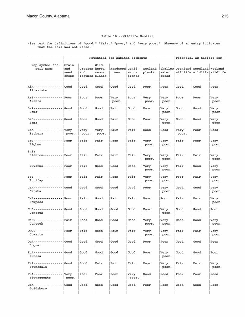
Macon County, Alabama 215
Table 10.--Wildlife Habitat
(See text for definitions of "good," "fair," "poor," and "very poor." Absence of an entry indicates that the soil was not rated.)
_______________________________________________________________________________________________________ | Potential for habitat elements |Potential as habitat for-- |_________________________________________________________|__________________________ Map symbol and |Grain | |Wild | | | | | | | soil name |and |Grasses|herba- |Hardwood|Conif- |Wetland |Shallow|Openland|Woodland|Wetland |seed |and |ceous |trees |erous |plants |water |wildlife|wildlife|wildlife |crops |legumes|plants | |plants | |areas | | |__________________|_______|_______|_______|________|_______|________|_______|________|________|________ | | | | | | | | | |AlA---------------|Good |Good |Good |Good |Good |Poor |Poor |Good |Good |Poor. Altavista | | | | | | | | | | | | | | | | | | | |ArB---------------|Poor |Poor |Poor |Very |Poor |Very |Very |Poor |Poor |Very Arents | | | | poor. | | poor. | poor. | | | poor. | | | | | | | | | |BaA---------------|Good |Good |Good |Fair |Good |Poor |Very |Good |Good |Very Bama | | | | | | | poor. | | | poor. | | | | | | | | | |BaB---------------|Good |Good |Good |Fair |Good |Poor |Very |Good |Good |Very Bama | | | | | | | poor. | | | poor. | | | | | | | | | |BeA---------------|Very |Very |Very |Fair |Fair |Good |Good |Very |Poor |Good. Bethera | poor. | poor. | poor. | | | | | poor. | | | | | | | | | | | |BgB---------------|Poor |Fair |Fair |Poor |Fair |Very |Very |Fair |Poor |Very Bigbee | | | | | | poor. | poor. | | | poor. | | | | | | | | | |BnE: | | | | | | | | | | Blanton----------|Poor |Fair |Fair |Fair |Fair |Very |Very |Fair |Fair |Very | | | | | | poor. | poor. | | | poor. | | | | | | | | | | Luverne----------|Poor |Fair |Good |Good |Good |Very |Very |Fair |Good |Very | | | | | | poor. | poor. | | | poor. | | | | | | | | | |BoB---------------|Poor |Fair |Fair |Poor |Fair |Very |Very |Poor |Fair |Very Bonifay | | | | | | poor. | poor. | | | poor. | | | | | | | | | |CaA---------------|Good |Good |Good |Good |Good |Poor |Very |Good |Good |Very Cahaba | | | | | | | poor. | | | poor. | | | | | | | | | |CmB---------------|Poor |Fair |Good |Fair |Fair |Poor |Poor |Fair |Fair |Very Compass | | | | | | | | | | poor. | | | | | | | | | |CoB---------------|Good |Good |Good |Good |Good |Poor |Very |Good |Good |Poor. Conecuh | | | | | | | poor. | | | | | | | | | | | | |CoC2--------------|Fair |Good |Good |Good |Good |Very |Very |Good |Good |Very Conecuh | | | | | | poor. | poor. | | | poor. | | | | | | | | | |CwD2--------------|Poor |Fair |Good |Fair |Fair |Very |Very |Fair |Fair |Very Cowarts | | | | | | poor. | poor. | | | poor. | | | | | | | | | |DgA---------------|Good |Good |Good |Good |Good |Poor |Poor |Good |Good |Poor. Dogue | | | | | | | | | | | | | | | | | | | |EuA---------------|Good |Good |Good |Good |Good |Poor |Very |Good |Good |Poor. Eunola | | | | | | | poor. | | | | | | | | | | | | |FaA---------------|Good |Good |Fair |Fair |Fair |Poor |Very |Fair |Fair |Very Faunsdale | | | | | | | poor. | | | poor. | | | | | | | | | |FuA---------------|Very |Poor |Poor |Poor |Very |Good |Good |Poor |Poor |Good. Fluvaquents | poor. | | | | poor. | | | | | | | | | | | | | | |GoA---------------|Good |Good |Good |Good |Good |Poor |Poor |Good |Good |Poor. Goldsboro | | | | | | | | | | | | | | | | | | | |

216 Soil Survey
Table 10.--Wildlife Habitat--Continued_______________________________________________________________________________________________________ | Potential for habitat elements |Potential as habitat for-- |_________________________________________________________|__________________________ Map symbol and |Grain | |Wild | | | | | | | soil name |and |Grasses|herba- |Hardwood|Conif- |Wetland |Shallow|Openland|Woodland|Wetland |seed |and |ceous |trees |erous |plants |water |wildlife|wildlife|wildlife |crops |legumes|plants | |plants | |areas | | |__________________|_______|_______|_______|________|_______|________|_______|________|________|________ | | | | | | | | | |GrA---------------|Fair |Good |Good |Good |Good |Poor |Very |Good |Good |Very Gritney | | | | | | | poor. | | | poor. | | | | | | | | | |GrB---------------|Fair |Good |Good |Good |Good |Poor |Very |Good |Good |Very Gritney | | | | | | | poor. | | | poor. | | | | | | | | | |HnB---------------|Fair |Fair |Fair |Fair |Fair |Poor |Poor |Fair |Good |Poor. Hannon | | | | | | | | | | | | | | | | | | | |HnC2--------------|Fair |Fair |Fair |Fair |Fair |Poor |Poor |Fair |Good |Poor. Hannon | | | | | | | | | | | | | | | | | | | |HoD2: | | | | | | | | | | Hannon-----------|Fair |Fair |Fair |Fair |Fair |Poor |Poor |Fair |Good |Poor. | | | | | | | | | | Maytag-----------|Fair |Fair |Fair |Fair |Fair |Poor |Poor |Fair |Fair |Very | | | | | | | | | | poor. | | | | | | | | | |HsE: | | | | | | | | | | Hannon-----------|Fair |Fair |Fair |Fair |Fair |Poor |Poor |Fair |Good |Poor. | | | | | | | | | | Sumter-----------|Fair |Fair |Fair |Fair |Fair |Very |Very |Fair |Fair |Very | | | | | | poor. | poor. | | | poor. | | | | | | | | | |KmA: | | | | | | | | | | Kinston----------|Very |Poor |Poor |Poor |Poor |Good |Fair |Poor |Poor |Fair. | poor. | | | | | | | | | | | | | | | | | | | Mooreville-------|Poor |Fair |Fair |Good |Good |Poor |Poor |Fair |Good |Poor. | | | | | | | | | |LcD: | | | | | | | | | | Lucy-------------|Poor |Fair |Good |Good |Good |Very |Very |Fair |Good |Very | | | | | | poor. | poor. | | | poor. | | | | | | | | | | Luverne----------|Fair |Good |Good |Good |Good |Very |Very |Good |Good |Very | | | | | | poor. | poor. | | | poor. | | | | | | | | | |LsB: | | | | | | | | | | Lucy-------------|Poor |Fair |Good |Good |Good |Poor |Very |Fair |Good |Very | | | | | | | poor. | | | poor. | | | | | | | | | | Luverne----------|Good |Good |Good |Good |Good |Poor |Very |Good |Good |Very | | | | | | | poor. | | | poor. | | | | | | | | | | Springhill-------|Good |Good |Good |Good |Good |Very |Very |Good |Good |Very | | | | | | poor. | poor. | | | poor. | | | | | | | | | |LuB---------------|Good |Good |Good |Good |Good |Poor |Very |Good |Good |Very Luverne | | | | | | | poor. | | | poor. | | | | | | | | | |LuD2--------------|Fair |Good |Good |Good |Good |Very |Very |Good |Good |Very Luverne | | | | | | poor. | poor. | | | poor. | | | | | | | | | |LyA---------------|Fair |Good |Good |Good |Good |Fair |Fair |Good |Good |Fair. Lynchburg | | | | | | | | | | | | | | | | | | | |MaA---------------|Good |Good |Good |Good |Good |Poor |Very |Good |Good |Very Malbis | | | | | | | poor. | | | poor. | | | | | | | | | |MnA---------------|Good |Good |Good |Good |Good |Poor |Very |Good |Good |Very Marvyn | | | | | | | poor. | | | poor. | | | | | | | | | |
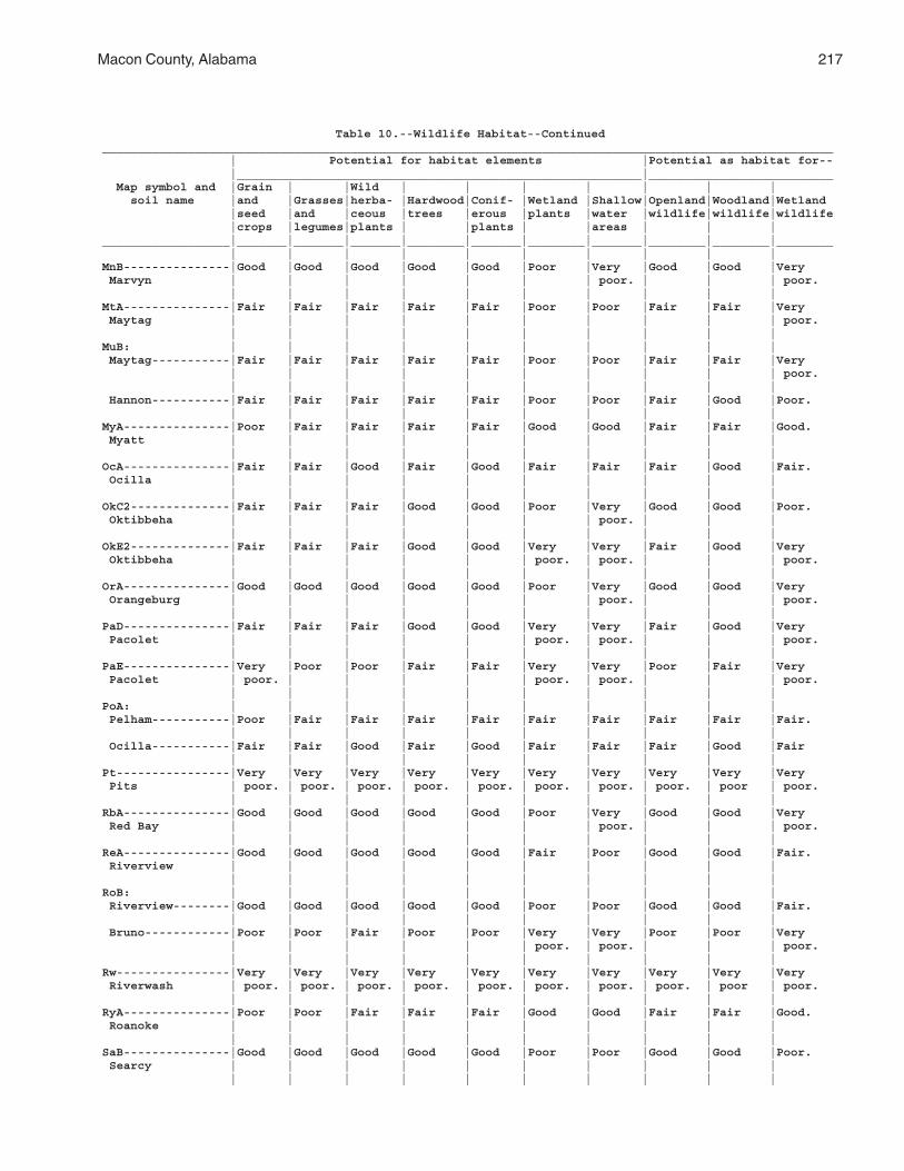
Macon County, Alabama 217
Table 10.--Wildlife Habitat--Continued_______________________________________________________________________________________________________ | Potential for habitat elements |Potential as habitat for-- |_________________________________________________________|__________________________ Map symbol and |Grain | |Wild | | | | | | | soil name |and |Grasses|herba- |Hardwood|Conif- |Wetland |Shallow|Openland|Woodland|Wetland |seed |and |ceous |trees |erous |plants |water |wildlife|wildlife|wildlife |crops |legumes|plants | |plants | |areas | | |__________________|_______|_______|_______|________|_______|________|_______|________|________|________ | | | | | | | | | |MnB---------------|Good |Good |Good |Good |Good |Poor |Very |Good |Good |Very Marvyn | | | | | | | poor. | | | poor. | | | | | | | | | |MtA---------------|Fair |Fair |Fair |Fair |Fair |Poor |Poor |Fair |Fair |Very Maytag | | | | | | | | | | poor. | | | | | | | | | |MuB: | | | | | | | | | | Maytag-----------|Fair |Fair |Fair |Fair |Fair |Poor |Poor |Fair |Fair |Very | | | | | | | | | | poor. | | | | | | | | | | Hannon-----------|Fair |Fair |Fair |Fair |Fair |Poor |Poor |Fair |Good |Poor. | | | | | | | | | |MyA---------------|Poor |Fair |Fair |Fair |Fair |Good |Good |Fair |Fair |Good. Myatt | | | | | | | | | | | | | | | | | | | |OcA---------------|Fair |Fair |Good |Fair |Good |Fair |Fair |Fair |Good |Fair. Ocilla | | | | | | | | | | | | | | | | | | | |OkC2--------------|Fair |Fair |Fair |Good |Good |Poor |Very |Good |Good |Poor. Oktibbeha | | | | | | | poor. | | | | | | | | | | | | |OkE2--------------|Fair |Fair |Fair |Good |Good |Very |Very |Fair |Good |Very Oktibbeha | | | | | | poor. | poor. | | | poor. | | | | | | | | | |OrA---------------|Good |Good |Good |Good |Good |Poor |Very |Good |Good |Very Orangeburg | | | | | | | poor. | | | poor. | | | | | | | | | |PaD---------------|Fair |Fair |Fair |Good |Good |Very |Very |Fair |Good |Very Pacolet | | | | | | poor. | poor. | | | poor. | | | | | | | | | |PaE---------------|Very |Poor |Poor |Fair |Fair |Very |Very |Poor |Fair |Very Pacolet | poor. | | | | | poor. | poor. | | | poor. | | | | | | | | | |PoA: | | | | | | | | | | Pelham-----------|Poor |Fair |Fair |Fair |Fair |Fair |Fair |Fair |Fair |Fair. | | | | | | | | | | Ocilla-----------|Fair |Fair |Good |Fair |Good |Fair |Fair |Fair |Good |Fair | | | | | | | | | |Pt----------------|Very |Very |Very |Very |Very |Very |Very |Very |Very |Very Pits | poor. | poor. | poor. | poor. | poor. | poor. | poor. | poor. | poor | poor. | | | | | | | | | |RbA---------------|Good |Good |Good |Good |Good |Poor |Very |Good |Good |Very Red Bay | | | | | | | poor. | | | poor. | | | | | | | | | |ReA---------------|Good |Good |Good |Good |Good |Fair |Poor |Good |Good |Fair. Riverview | | | | | | | | | | | | | | | | | | | |RoB: | | | | | | | | | | Riverview--------|Good |Good |Good |Good |Good |Poor |Poor |Good |Good |Fair. | | | | | | | | | | Bruno------------|Poor |Poor |Fair |Poor |Poor |Very |Very |Poor |Poor |Very | | | | | | poor. | poor. | | | poor. | | | | | | | | | |Rw----------------|Very |Very |Very |Very |Very |Very |Very |Very |Very |Very Riverwash | poor. | poor. | poor. | poor. | poor. | poor. | poor. | poor. | poor | poor. | | | | | | | | | |RyA---------------|Poor |Poor |Fair |Fair |Fair |Good |Good |Fair |Fair |Good. Roanoke | | | | | | | | | | | | | | | | | | | |SaB---------------|Good |Good |Good |Good |Good |Poor |Poor |Good |Good |Poor. Searcy | | | | | | | | | | | | | | | | | | | |

218 Soil Survey
Table 10.--Wildlife Habitat--Continued_______________________________________________________________________________________________________ | Potential for habitat elements |Potential as habitat for-- |_________________________________________________________|__________________________ Map symbol and |Grain | |Wild | | | | | | | soil name |and |Grasses|herba- |Hardwood|Conif- |Wetland |Shallow|Openland|Woodland|Wetland |seed |and |ceous |trees |erous |plants |water |wildlife|wildlife|wildlife |crops |legumes|plants | |plants | |areas | | |__________________|_______|_______|_______|________|_______|________|_______|________|________|________ | | | | | | | | | |SbB---------------|Good |Good |Good |Good |Good |Very |Very |Good |Good |Very Springhill | | | | | | poor. | poor. | | | poor. | | | | | | | | | |SrA---------------|Poor |Fair |Poor |Good |Poor |Fair |Fair |Poor |Fair |Fair. Sucarnoochee | | | | | | | | | | | | | | | | | | | |StE: | | | | | | | | | | Sumter-----------|Poor |Fair |Fair |Fair |Fair |Very |Very |Fair |Fair |Very | | | | | | poor. | poor. | | | poor. | | | | | | | | | | Hannon-----------|Poor |Poor |Poor |Fair |Fair |Poor |Poor |Poor |Good |Poor. | | | | | | | | | |TcA---------------|Good |Good |Good |Good |Good |Poor |Very |Good |Good |Very Toccoa | | | | | | | poor. | | | poor. | | | | | | | | | |ToB---------------|Good |Good |Good |Good |Good |Poor |Very |Good |Good |Very Toccoa | | | | | | | poor. | | | poor. | | | | | | | | | |TpB: | | | | | | | | | | Troup------------|Poor |Fair |Fair |Poor |Poor |Very |Very |Fair |Poor |Very | | | | | | poor. | poor. | | | poor. | | | | | | | | | | Alaga------------|Poor |Fair |Fair |Poor |Poor |Very |Very |Fair |Poor |Very | | | | | | poor. | poor. | | | poor. | | | | | | | | | |TsF: | | | | | | | | | | Troup------------|Poor |Fair |Fair |Poor |Poor |Very |Very |Poor |Poor |Very | | | | | | poor. | poor. | | | poor. | | | | | | | | | | Springhill-------|Poor |Fair |Good |Good |Good |Very |Very |Fair |Good |Very | | | | | | poor. | poor. | | | poor. | | | | | | | | | | Luverne----------|Poor |Fair |Good |Good |Good |Very |Very |Fair |Good |Very | | | | | | poor. | poor. | | | poor. | | | | | | | | | |UcB---------------|Poor |Fair |Good |Fair |Fair |Very |Very |Fair |Fair |Very Uchee | | | | | | poor. | poor. | | | poor. | | | | | | | | | |UcD---------------|Poor |Fair |Good |Fair |Fair |Very |Very |Fair |Fair |Very Uchee | | | | | | poor. | poor. | | | poor. | | | | | | | | | |UcE2: | | | | | | | | | | Uchee------------|Poor |Fair |Good |Fair |Fair |Very |Very |Fair |Fair |Very | | | | | | poor. | poor. | | | poor. | | | | | | | | | | Cowarts----------|Poor |Fair |Good |Good |Good |Very |Very |Fair |Good |Very | | | | | | poor. | poor. | | | poor. | | | | | | | | | |UdE---------------|Poor |Fair |Fair |Fair |Good |Very |Very |Fair |Good |Very Udorthents | | | | | | poor. | poor. | | | poor. | | | | | | | | | |UoC---------------|Fair |Fair |Fair |Fair |Good |Poor |Poor |Fair |Fair |Poor. Udorthents | | | | | | | | | | | | | | | | | | | |UuA: | | | | | | | | | | Udorthents-------|Fair |Fair |Fair |Fair |Good |Poor |Poor |Fair |Fair |Poor. | | | | | | | | | | Urban land. | | | | | | | | | | | | | | | | | | | |

Macon County, Alabama 219
Table 10.--Wildlife Habitat--Continued_______________________________________________________________________________________________________ | Potential for habitat elements |Potential as habitat for-- |_________________________________________________________|__________________________ Map symbol and |Grain | |Wild | | | | | | | soil name |and |Grasses|herba- |Hardwood|Conif- |Wetland |Shallow|Openland|Woodland|Wetland |seed |and |ceous |trees |erous |plants |water |wildlife|wildlife|wildlife |crops |legumes|plants | |plants | |areas | | |__________________|_______|_______|_______|________|_______|________|_______|________|________|________ | | | | | | | | | |UvA: | | | | | | | | | | Urbo-------------|Poor |Fair |Fair |Good |Good |Fair |Fair |Fair |Fair |Fair. | | | | | | | | | | Una--------------|Poor |Very |Very |Poor |Poor |Good |Good |Very |Very |Good. | | poor. | poor. | | | | | poor. | poor | | | | | | | | | | | Mooreville-------|Poor |Fair |Fair |Good |Good |Poor |Poor |Fair |Good |Poor. | | | | | | | | | |VaA---------------|Fair |Fair |Fair |Good |Good |Poor |Fair |Fair |Good |Poor. Vaiden | | | | | | | | | | | | | | | | | | | |WaB---------------|Good |Good |Good |Good |Good |Poor |Very |Good |Good |Very Wagram | | | | | | | poor. | | | poor. | | | | | | | | | |_______________________________________________________________________________________________________

220 Soil Survey
Table 11.--Building Site Development
(Some terms that describe restrictive soil features are defined in the "Glossary." See text for definitions of "slight," "moderate," and "severe." Absence of an entry indicates that the soil was not rated. The information in this table indicates the dominant soil condition but does not eliminate the need for onsite investigation.)
_________________________________________________________________________________________________________ | | | | | | Map symbol | Shallow | Dwellings | Dwellings | Small | Local roads | Lawns and and | excavations | without | with | commercial | and streets | landscaping soil name | | basements | basements | buildings | |_______________|_______________|______________|______________|______________|______________|_____________ | | | | | |AlA------------|Severe: |Moderate: |Severe: |Moderate: |Moderate: |Moderate: Altavista | wetness. | wetness. | wetness. | wetness. | low strength,| wetness. | | | | | wetness. | | | | | | |ArB------------|Variable-------|Variable------|Variable------|Variable------|Variable------|Variable. Arents | | | | | | | | | | | |BaA------------|Slight---------|Slight--------|Slight--------|Slight--------|Slight--------|Slight. Bama | | | | | | | | | | | |BaB------------|Slight---------|Slight--------|Slight--------|Slight--------|Slight--------|Slight. Bama | | | | | | | | | | | |BeA------------|Severe: |Severe: |Severe: |Severe: |Severe: |Severe: Bethera | wetness. | flooding, | flooding, | flooding, | flooding, | flooding, | | wetness. | wetness. | wetness. | low strength,| wetness. | | | | | wetness. | | | | | | |BgB------------|Severe: |Severe: |Severe: |Severe: |Moderate: |Moderate: Bigbee | cutbanks cave.| flooding. | flooding. | flooding. | flooding. | flooding, | | | | | | too sandy, | | | | | | droughty. | | | | | |BnE: | | | | | | Blanton-------|Severe: |Severe: |Severe: |Severe: |Severe: |Severe: | slope, | slope. | slope. | slope. | slope. | slope. | cutbanks cave.| | | | | | | | | | | Luverne-------|Severe: |Severe: |Severe: |Severe: |Severe: |Severe: | slope. | slope. | slope. | slope. | low strength,| slope. | | | | | slope. | | | | | | |BoB------------|Severe: |Slight--------|Moderate: |Slight--------|Slight--------|Moderate: Bonifay | cutbanks cave.| | wetness. | | | droughty. | | | | | |CaA------------|Severe: |Severe: |Severe: |Severe: |Moderate: |Slight. Cahaba | cutbanks cave.| flooding. | flooding. | flooding. | flooding. | | | | | | |CmB------------|Moderate: |Slight--------|Moderate: |Slight--------|Slight--------|Moderate: Compass | too clayey, | | wetness. | | | droughty. | wetness. | | | | | | | | | | |CoB------------|Moderate: |Severe: |Severe: |Severe: |Severe: |Moderate: Conecuh | too clayey. | shrink-swell.| shrink-swell.| shrink-swell.| low strength,| droughty. | | | | | shrink-swell.| | | | | | |CoC2-----------|Moderate: |Severe: |Severe: |Severe: |Severe: |Moderate: Conecuh | too clayey. | shrink-swell.| shrink-swell.| shrink-swell.| low strength,| droughty. | | | | | shrink-swell.| | | | | | |CwD2-----------|Moderate: |Moderate: |Moderate: |Severe: |Moderate: |Moderate: Cowarts | slope. | slope. | slope. | slope. | slope. | slope, | | | | | | droughty. | | | | | |DgA------------|Severe: |Severe: |Severe: |Severe: |Severe: |Moderate: Dogue | wetness, | flooding. | flooding, | flooding. | low strength.| wetness. | cutbanks cave.| | wetness. | | | | | | | | |

Macon County, Alabama 221
Table 11.--Building Site Development--Continued_________________________________________________________________________________________________________ | | | | | | Map symbol | Shallow | Dwellings | Dwellings | Small | Local roads | Lawns and and | excavations | without | with | commercial | and streets | landscaping soil name | | basements | basements | buildings | |_______________|_______________|______________|______________|______________|______________|_____________ | | | | | |EuA------------|Severe: |Severe: |Severe: |Severe: |Moderate: |Moderate: Eunola | wetness, | flooding. | flooding, | flooding. | flooding, | wetness. | cutbanks cave.| | wetness. | | wetness. | | | | | | |FaA------------|Severe: |Severe: |Severe: |Severe: |Severe: |Moderate: Faunsdale | cutbanks cave.| shrink-swell.| shrink-swell.| shrink-swell.| low strength,| wetness. | | | | | shrink-swell.| | | | | | |FuA------------|Severe: |Severe: |Severe: |Severe: |Severe: |Severe: Fluvaquents | ponding. | flooding, | flooding, | flooding, | flooding, | flooding, | | ponding. | ponding. | ponding. | ponding. | ponding | | | | | |GoA------------|Severe: |Moderate: |Severe: |Moderate: |Moderate: |Slight. Goldsboro | wetness. | wetness. | wetness. | wetness. | wetness. | | | | | | |GrA------------|Severe: |Moderate: |Severe: |Moderate: |Severe: |Moderate: Gritney | wetness. | shrink-swell,| wetness. | shrink-swell,| low strength.| wetness. | | wetness. | | wetness. | | | | | | | |GrB------------|Severe: |Moderate: |Severe: |Moderate: |Severe: |Moderate: Gritney | wetness. | shrink-swell,| wetness. | shrink-swell,| low strength.| wetness. | | wetness. | | wetness. | | | | | | | |HnB------------|Severe: |Severe: |Severe: |Severe: |Severe: |Moderate: Hannon | cutbanks cave.| shrink-swell.| shrink-swell.| shrink-swell.| low strength,| droughty. | | | | | shrink-swell.| | | | | | |HnC2-----------|Severe: |Severe: |Severe: |Severe: |Severe: |Severe: Hannon | cutbanks cave.| shrink-swell.| shrink-swell.| shrink-swell.| low strength,| too clayey. | | | | | shrink-swell.| | | | | | |HoD2: | | | | | | Hannon--------|Severe: |Severe: |Severe: |Severe: |Severe: |Severe: | cutbanks cave.| shrink-swell.| shrink-swell.| shrink-swell.| low strength,| too clayey. | | | | | shrink-swell.| | | | | | | Maytag--------|Severe: |Severe: |Severe: |Severe: |Severe: |Severe: | cutbanks cave.| shrink-swell.| shrink-swell.| shrink-swell.| low strength,| too clayey. | | | | | shrink-swell.| | | | | | |HsE: | | | | | | Hannon--------|Severe: |Severe: |Severe: |Severe: |Severe: |Severe: | cutbanks cave.| shrink-swell.| shrink-swell.| shrink-swell,| low strength,| too clayey. | | | | slope. | shrink-swell.| | | | | | | Sumter--------|Moderate: |Severe: |Severe: |Severe: |Severe: |Severe: | slope, | shrink-swell.| shrink-swell.| shrink-swell,| low strength,| too clayey. | too clayey, | | | slope. | shrink-swell.| | depth to rock.| | | | | | | | | | |KmA: | | | | | | Kinston-------|Severe: |Severe: |Severe: |Severe: |Severe: |Severe: | wetness. | flooding, | flooding, | flooding, | flooding, | flooding, | | wetness. | wetness. | wetness. | low strength,| wetness. | | | | | wetness. | | | | | | | Mooreville----|Severe: |Severe: |Severe: |Severe: |Severe: |Severe: | wetness. | flooding. | flooding, | flooding. | flooding, | flooding. | | | wetness. | | low strength.| | | | | | |
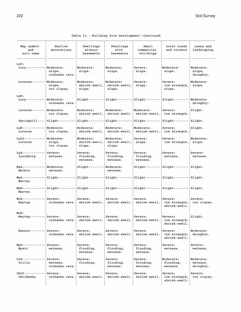
222 Soil Survey
Table 11.--Building Site Development--Continued_________________________________________________________________________________________________________ | | | | | | Map symbol | Shallow | Dwellings | Dwellings | Small | Local roads | Lawns and and | excavations | without | with | commercial | and streets | landscaping soil name | | basements | basements | buildings | |_______________|_______________|______________|______________|______________|______________|_____________ | | | | | |LcD: | | | | | | Lucy----------|Moderate: |Moderate: |Moderate: |Severe: |Moderate: |Moderate: | slope, | slope. | slope. | slope. | slope. | slope, | cutbanks cave.| | | | | droughty. | | | | | | Luverne-------|Moderate: |Moderate: |Moderate: |Severe: |Severe: |Moderate: | slope, | shrink-swell,| shrink-swell,| slope. | low strength,| slope. | too clayey. | slope. | slope. | | slope. | | | | | | |LsB: | | | | | | Lucy----------|Moderate: |Slight--------|Slight--------|Slight--------|Slight--------|Moderate: | cutbanks cave.| | | | | droughty. | | | | | | Luverne-------|Moderate: |Moderate: |Moderate: |Moderate: |Severe: |Slight. | too clayey. | shrink-swell.| shrink-swell.| shrink-swell.| low strength.| | | | | | | Springhill----|Slight---------|Slight--------|Slight--------|Slight--------|Slight--------|Slight. | | | | | |LuB------------|Moderate: |Moderate: |Moderate: |Moderate: |Severe: |Slight. Luverne | too clayey. | shrink-swell.| shrink-swell.| shrink-swell.| low strength.| | | | | | |LuD2-----------|Moderate: |Moderate: |Moderate: |Severe: |Severe: |Moderate: Luverne | slope, | shrink-swell,| shrink-swell,| slope. | low strength.| slope. | too clayey. | slope. | slope. | | | | | | | | |LyA------------|Severe: |Severe: |Severe: |Severe: |Severe: |Severe: Lynchburg | wetness. | flooding, | flooding, | flooding, | wetness. | wetness. | | wetness. | wetness. | wetness. | | | | | | | |MaA------------|Moderate: |Slight--------|Moderate: |Slight--------|Slight--------|Slight. Malbis | wetness. | | wetness. | | | | | | | | |MnA------------|Slight---------|Slight--------|Slight--------|Slight--------|Slight--------|Slight. Marvyn | | | | | | | | | | | |MnB------------|Slight---------|Slight--------|Slight--------|Slight--------|Slight--------|Slight. Marvyn | | | | | | | | | | | |MtA------------|Severe: |Severe: |Severe: |Severe: |Severe: |Severe: Maytag | cutbanks cave.| shrink-swell.| shrink-swell.| shrink-swell.| low strength,| too clayey. | | | | | shrink-swell.| | | | | | |MuB: | | | | | | Maytag--------|Severe: |Severe: |Severe: |Severe: |Severe: |Slight. | cutbanks cave.| shrink-swell.| shrink-swell.| shrink-swell.| low strength,| | | | | | shrink-swell.| | | | | | | Hannon--------|Severe: |Severe: |Severe: |Severe: |Severe: |Moderate: | cutbanks cave.| shrink-swell.| shrink-swell.| shrink-swell.| low strength,| droughty. | | | | | shrink-swell.| | | | | | |MyA------------|Severe: |Severe: |Severe: |Severe: |Severe: |Severe: Myatt | wetness. | flooding, | flooding, | flooding, | wetness. | wetness. | | wetness. | wetness. | wetness. | | | | | | | |OcA------------|Severe: |Severe: |Severe: |Severe: |Moderate: |Moderate: Ocilla | wetness, | flooding. | flooding, | flooding, | flooding, | wetness, | cutbanks cave.| | wetness. | wetness. | wetness. | droughty. | | | | | |OkC2-----------|Severe: |Severe: |Severe: |Severe: |Severe: |Severe: Oktibbeha | cutbanks cave.| shrink-swell.| shrink-swell.| shrink-swell.| low strength,| too clayey. | | | | | shrink-swell.| | | | | | |

Macon County, Alabama 223
Table 11.--Building Site Development--Continued_________________________________________________________________________________________________________ | | | | | | Map symbol | Shallow | Dwellings | Dwellings | Small | Local roads | Lawns and and | excavations | without | with | commercial | and streets | landscaping soil name | | basements | basements | buildings | |_______________|_______________|______________|______________|______________|______________|_____________ | | | | | |OkE2-----------|Severe: |Severe: |Severe: |Severe: |Severe: |Severe: Oktibbeha | cutbanks cave.| shrink-swell.| shrink-swell.| shrink-swell,| low strength,| slope, | | | | slope. | shrink-swell.| too clayey. | | | | | |OrA------------|Slight---------|Slight--------|Slight--------|Slight--------|Slight--------|Slight. Orangeburg | | | | | | | | | | | |PaD------------|Moderate: |Moderate: |Moderate: |Severe: |Moderate: |Moderate: Pacolet | slope, | slope. | slope. | slope. | low strength,| slope. | too clayey. | | | | slope. | | | | | | |PaE------------|Severe: |Severe: |Severe: |Severe: |Severe: |Severe: Pacolet | slope. | slope. | slope. | slope. | slope. | slope. | | | | | |PoA: | | | | | | Pelham--------|Severe: |Severe: |Severe: |Severe: |Severe: |Severe: | wetness, | flooding, | flooding, | flooding, | flooding, | wetness. | cutbanks cave.| wetness. | wetness. | wetness. | wetness. | | | | | | | Ocilla--------|Severe: |Severe: |Severe: |Severe: |Severe: |Moderate: | wetness, | flooding, | flooding, | flooding, | flooding, | flooding, | cutbanks cave.| wetness. | wetness. | wetness. | wetness. | wetness, | | | | | | droughty. | | | | | |Pt-------------|Variable-------|Variable------|Variable------|Variable------|Variable------|Variable. Pits | | | | | | | | | | | |RbA------------|Slight---------|Slight--------|Slight--------|Slight--------|Slight--------|Slight. Red Bay | | | | | | | | | | | |ReA------------|Severe: |Severe: |Severe: |Severe: |Severe: |Moderate: Riverview | cutbanks cave.| flooding. | flooding. | flooding. | flooding. | flooding. | | | | | |RoB: | | | | | | Riverview-----|Severe: |Severe: |Severe: |Severe: |Severe: |Moderate: | cutbanks cave.| flooding. | flooding. | flooding. | flooding. | flooding. | | | | | | Bruno---------|Severe: |Severe: |Severe: |Severe: |Severe: |Moderate: | cutbanks cave.| flooding. | flooding. | flooding. | flooding. | flooding, | | | | | | droughty. | | | | | |Rw-------------|Severe: |Severe: |Severe: |Severe: |Severe: |Severe: Riverwash | cutbanks cave.| flooding. | flooding. | flooding. | flooding. | flooding. | | | | | | | | | | | |RyA------------|Severe: |Severe: |Severe: |Severe: |Severe: |Severe: Roanoke | wetness. | flooding, | flooding, | flooding, | flooding, | wetness. | | wetness. | wetness. | wetness. | low strength,| | | | | | wetness. | | | | | | |SaB------------|Severe: |Moderate: |Severe: |Moderate: |Severe: |Slight. Searcy | wetness. | shrink-swell,| wetness. | shrink-swell,| low strength.| | | wetness. | | wetness. | | | | | | | |SbB------------|Slight---------|Slight--------|Slight--------|Slight--------|Slight--------|Slight. Springhill | | | | | | | | | | | |SrA------------|Severe: |Severe: |Severe: |Severe: |Severe: |Severe: Sucarnoochee | wetness. | flooding, | flooding, | flooding, | flooding, | flooding, | | shrink-swell,| shrink-swell,| shrink-swell,| low strength,| too clayey, | | wetness. | wetness. | wetness. | wetness. | wetness. | | | | | |

224 Soil Survey
Table 11.--Building Site Development--Continued_________________________________________________________________________________________________________ | | | | | | Map symbol | Shallow | Dwellings | Dwellings | Small | Local roads | Lawns and and | excavations | without | with | commercial | and streets | landscaping soil name | | basements | basements | buildings | |_______________|_______________|______________|______________|______________|______________|_____________ | | | | | |StE: | | | | | | Sumter--------|Severe: |Severe: |Severe: |Severe: |Severe: |Severe: | slope. | shrink-swell,| shrink-swell,| shrink-swell,| low strength,| slope. | | slope. | slope. | slope. | shrink-swell,| | | | | | slope. | | | | | | | Hannon--------|Severe: |Severe: |Severe: |Severe: |Severe: |Severe: | slope, | shrink-swell,| shrink-swell,| shrink-swell,| low strength,| slope, | cutbanks cave.| slope. | slope. | slope. | shrink-swell,| too clayey. | | | | | slope. | | | | | | |TcA------------|Moderate: |Severe: |Severe: |Severe: |Severe: |Moderate: Toccoa | flooding, | flooding. | flooding. | flooding. | flooding. | flooding. | wetness. | | | | | | | | | | |ToB------------|Moderate: |Severe: |Severe: |Severe: |Severe: |Moderate: Toccoa | flooding, | flooding. | flooding. | flooding. | flooding. | flooding. | wetness. | | | | | | | | | | |TpB: | | | | | | Troup---------|Severe: |Slight--------|Slight--------|Slight--------|Slight--------|Moderate: | cutbanks cave.| | | | | droughty. | | | | | | Alaga---------|Severe: |Slight--------|Slight--------|Slight--------|Slight--------|Moderate: | cutbanks cave.| | | | | droughty. | | | | | |TsF: | | | | | | Troup---------|Severe: |Severe: |Severe: |Severe: |Severe: |Severe: | slope, | slope. | slope. | slope. | slope. | slope. | cutbanks cave.| | | | | | | | | | | Springhill----|Severe: |Severe: |Severe: |Severe: |Severe: |Severe: | slope. | slope. | slope. | slope. | slope. | slope. | | | | | | Luverne-------|Severe: |Severe: |Severe: |Severe: |Severe: |Severe: | slope. | slope. | slope. | slope. | low strength,| slope. | | | | | slope. | | | | | | |UcB------------|Severe: |Slight--------|Moderate: |Slight--------|Slight--------|Moderate: Uchee | cutbanks cave.| | wetness. | | | droughty. | | | | | |UcD------------|Severe: |Moderate: |Moderate: |Severe: |Moderate: |Moderate: Uchee | cutbanks cave.| slope. | slope, | slope. | slope. | slope, | | | wetness. | | | droughty. | | | | | |UcE2: | | | | | | Uchee---------|Severe: |Severe: |Severe: |Severe: |Severe: |Severe: | slope, | slope. | slope. | slope. | slope. | slope. | cutbanks cave.| | | | | | | | | | | Cowarts-------|Severe: |Severe: |Severe: |Severe: |Severe: |Severe: | slope. | slope. | slope. | slope. | slope. | slope. | | | | | |UdE------------|Variable-------|Variable------|Variable------|Variable------|Variable------|Variable. Udorthents | | | | | | | | | | | |UoC------------|Variable-------|Variable------|Variable------|Variable------|Variable------|Variable. Udorthents | | | | | | | | | | | |UuA: | | | | | | Udorthents----|Variable-------|Variable------|Variable------|Variable------|Variable------|Variable | | | | | | Urban land. | | | | | | | | | | | |

Macon County, Alabama 225
Table 11.--Building Site Development--Continued_________________________________________________________________________________________________________ | | | | | | Map symbol | Shallow | Dwellings | Dwellings | Small | Local roads | Lawns and and | excavations | without | with | commercial | and streets | landscaping soil name | | basements | basements | buildings | |_______________|_______________|______________|______________|______________|______________|_____________ | | | | | |UvA: | | | | | | Urbo----------|Severe: |Severe: |Severe: |Severe: |Severe: |Severe: | wetness. | flooding, | flooding, | flooding, | flooding, | flooding. | | wetness. | wetness. | wetness. | low strength.| | | | | | | Una-----------|Severe: |Severe: |Severe: |Severe: |Severe: |Severe: | ponding. | flooding, | flooding, | flooding, | low strength,| flooding, | | shrink-swell,| shrink-swell,| shrink-swell,| shrink-swell,| ponding. | | ponding. | ponding. | ponding. | ponding. | | | | | | | Mooreville----|Severe: |Severe: |Severe: |Severe: |Severe: |Severe: | wetness. | flooding. | flooding, | flooding. | flooding, | flooding. | | | wetness. | | low strength.| | | | | | |VaA------------|Severe: |Severe: |Severe: |Severe: |Severe: |Severe: Vaiden | wetness, | shrink-swell,| shrink-swell,| shrink-swell,| low strength,| too clayey. | cutbanks cave.| wetness. | wetness. | wetness. | shrink-swell.| | | | | | |WaB------------|Severe: |Slight--------|Slight--------|Slight--------|Slight--------|Moderate: Wagram | cutbanks cave.| | | | | droughty. | | | | | |___________________________________________________________________________________________________________

226 Soil Survey
Table 12.--Sanitary Facilities
(Some terms that describe restrictive soil features are defined in the "Glossary." See text for definitions of "slight," "good," and other terms. Absence of an entry indicates that the soil was not rated. The information in this table indicates the dominant soil condition but does not eliminate the need for onsite investigation.)
___________________________________________________________________________________________________ | | | | | Map symbol | Septic tank | Sewage lagoon |Trench sanitary| Area sanitary | Daily cover and soil name | absorption | areas | landfill | landfill | for landfill | fields | | | |___________________|_______________|_______________|_______________|_______________|_______________ | | | | |AlA----------------|Severe: |Severe: |Severe: |Severe: |Fair: Altavista | wetness. | wetness. | wetness. | wetness. | too clayey, | | | | | wetness. | | | | |ArB----------------|Variable-------|Variable-------|Variable-------|Variable-------|Variable. Arents | | | | | | | | | |BaA----------------|Slight---------|Moderate: |Slight---------|Slight---------|Good. Bama | | seepage. | | | | | | | |BaB----------------|Slight---------|Moderate: |Slight---------|Slight---------|Good. Bama | | seepage, | | | | | slope. | | | | | | | |BeA----------------|Severe: |Severe: |Severe: |Severe: |Poor: Bethera | flooding, | flooding, | flooding, | flooding, | hard to pack, | percs slowly, | wetness. | too clayey, | wetness. | too clayey, | wetness. | | wetness. | | wetness. | | | | |BgB----------------|Severe: |Severe: |Severe: |Severe: |Poor: Bigbee | flooding, | flooding, | flooding, | flooding, | seepage, | wetness, | seepage. | seepage, | seepage. | too sandy. | poor filter. | | wetness. | | | | | | |BnE: | | | | | Blanton-----------|Severe: |Severe: |Severe: |Severe: |Poor: | slope. | seepage, | slope. | seepage, | slope. | | slope. | | slope. | | | | | | Luverne-----------|Severe: |Severe: |Severe: |Severe: |Poor: | percs slowly, | slope. | slope, | slope. | hard to pack, | slope. | | too clayey. | | slope, | | | | | too clayey. | | | | |BoB----------------|Moderate: |Severe: |Moderate: |Severe: |Fair: Bonifay | percs slowly, | seepage. | too sandy. | seepage. | too sandy. | wetness. | | | | | | | | |CaA----------------|Moderate: |Severe: |Severe: |Moderate: |Fair: Cahaba | flooding. | seepage. | seepage. | flooding. | thin layer. | | | | |CmB----------------|Severe: |Severe: |Moderate: |Severe: |Fair: Compass | percs slowly, | seepage, | wetness. | seepage. | thin layer, | wetness. | wetness. | | | wetness. | | | | |CoB----------------|Severe: |Moderate: |Severe: |Slight---------|Poor: Conecuh | percs slowly. | slope. | too clayey. | | hard to pack, | | | | | too clayey. | | | | |CoC2---------------|Severe: |Severe: |Severe: |Slight---------|Poor: Conecuh | percs slowly. | slope. | too clayey. | | hard to pack, | | | | | too clayey. | | | | |CwD2---------------|Severe: |Severe: |Moderate: |Moderate: |Fair: Cowarts | percs slowly. | slope. | slope, | slope. | slope, | | | too clayey. | | too clayey. | | | | |

Macon County, Alabama 227
Table 12.--Sanitary Facilities--Continued___________________________________________________________________________________________________ | | | | | Map symbol | Septic tank | Sewage lagoon |Trench sanitary| Area sanitary | Daily cover and soil name | absorption | areas | landfill | landfill | for landfill | fields | | | |___________________|_______________|_______________|_______________|_______________|_______________ | | | | |DgA----------------|Severe: |Severe: |Severe: |Severe: |Poor: Dogue | percs slowly, | seepage. | seepage, | wetness. | hard to pack, | wetness. | | wetness. | | too clayey. | | | | |EuA----------------|Severe: |Severe: |Severe: |Severe: |Fair: Eunola | wetness. | seepage, | seepage, | wetness. | thin layer, | | wetness. | wetness, | | too clayey, | | | | | wetness. | | | | |FaA----------------|Severe: |Moderate: |Severe: |Moderate: |Poor: Faunsdale | percs slowly. | slope, | too clayey, | wetness. | hard to pack, | | wetness. | wetness. | | too clayey. | | | | |FuA----------------|Severe: |Severe: |Severe: |Severe: |Poor: Fluvaquents | flooding, | flooding, | flooding, | flooding, | too clayey, | percs slowly, | ponding. | too clayey, | ponding. | ponding. | ponding. | | ponding. | | | | | | |GoA----------------|Severe: |Severe: |Severe: |Severe: |Fair: Goldsboro | wetness. | wetness. | wetness, | wetness. | wetness. | | | too acid. | | | | | | |GrA----------------|Severe: |Slight---------|Severe: |Moderate: |Poor: Gritney | percs slowly, | | seepage, | wetness. | hard to pack, | wetness. | | too clayey, | | too clayey. | | | wetness. | | | | | | |GrB----------------|Severe: |Moderate: |Severe: |Moderate: |Poor: Gritney | percs slowly, | slope. | seepage, | wetness. | hard to pack, | wetness. | | too clayey, | | too clayey. | | | wetness. | | | | | | |HnB----------------|Severe: |Moderate: |Severe: |Slight---------|Poor: Hannon | percs slowly. | slope. | too clayey. | | hard to pack, | | | | | too clayey. | | | | |HnC2---------------|Severe: |Moderate: |Severe: |Slight---------|Poor: Hannon | percs slowly. | slope. | too clayey. | | hard to pack, | | | | | too clayey. | | | | |HoD2: | | | | | Hannon------------|Severe: |Moderate: |Severe: |Slight---------|Poor: | percs slowly. | slope. | too clayey. | | hard to pack, | | | | | too clayey. | | | | | Maytag------------|Severe: |Moderate: |Severe: |Slight---------|Poor: | percs slowly. | slope. | too clayey. | | hard to pack, | | | | | too clayey. | | | | |HsE: | | | | | Hannon------------|Severe: |Severe: |Severe: |Moderate: |Poor: | percs slowly. | slope. | too clayey. | slope. | hard to pack, | | | | | too clayey. | | | | | Sumter------------|Severe: |Severe: |Severe: |Severe: |Poor: | percs slowly, | slope, | too clayey, | depth to rock.| hard to pack, | depth to rock.| depth to rock.| depth to rock.| | too clayey, | | | | | depth to rock. | | | | |KmA: | | | | | Kinston-----------|Severe: |Severe: |Severe: |Severe: |Poor: | flooding, | flooding, | flooding, | flooding, | wetness. | wetness. | wetness. | wetness. | wetness. | | | | | |

228 Soil Survey
Table 12.--Sanitary Facilities--Continued___________________________________________________________________________________________________ | | | | | Map symbol | Septic tank | Sewage lagoon |Trench sanitary| Area sanitary | Daily cover and soil name | absorption | areas | landfill | landfill | for landfill | fields | | | |___________________|_______________|_______________|_______________|_______________|_______________ | | | | |KmA: | | | | | Mooreville--------|Severe: |Severe: |Severe: |Severe: |Fair: | flooding, | flooding, | flooding, | flooding, | too clayey, | wetness. | wetness. | wetness. | wetness. | wetness. | | | | |LcD: | | | | | Lucy--------------|Moderate: |Severe: |Moderate: |Severe: |Fair: | slope. | seepage, | slope. | seepage. | slope, | | slope. | | | too clayey. | | | | | Luverne-----------|Severe: |Severe: |Severe: |Moderate: |Poor: | percs slowly. | slope. | too clayey. | slope. | hard to pack, | | | | | too clayey. | | | | |LsB: | | | | | Lucy--------------|Slight---------|Severe: |Slight---------|Severe: |Fair: | | seepage. | | seepage. | too clayey. | | | | | Luverne-----------|Severe: |Moderate: |Severe: |Slight---------|Poor: | percs slowly. | slope. | too clayey. | | hard to pack, | | | | | too clayey. | | | | | Springhill--------|Slight---------|Severe: |Severe: |Severe: |Good. | | seepage. | seepage. | seepage. | | | | | |LuB----------------|Severe: |Moderate: |Severe: |Slight---------|Poor: Luverne | percs slowly. | slope. | too clayey. | | hard to pack, | | | | | too clayey. | | | | |LuD2---------------|Severe: |Severe: |Severe: |Moderate: |Poor: Luverne | percs slowly. | slope. | too clayey. | slope. | hard to pack, | | | | | too clayey. | | | | |LyA----------------|Severe: |Severe: |Severe: |Severe: |Poor: Lynchburg | wetness. | wetness. | wetness. | wetness. | wetness. | | | | |MaA----------------|Severe: |Moderate: |Moderate: |Moderate: |Fair: Malbis | percs slowly, | seepage. | wetness. | wetness. | wetness. | wetness. | | | | | | | | |MnA----------------|Moderate: |Moderate: |Moderate: |Slight---------|Fair: Marvyn | percs slowly. | seepage. | too clayey. | | hard to pack. | | | | |MnB----------------|Moderate: |Moderate: |Moderate: |Slight---------|Fair: Marvyn | percs slowly. | seepage, | too clayey. | | hard to pack. | | slope. | | | | | | | |MtA----------------|Severe: |Slight---------|Severe: |Slight---------|Poor: Maytag | percs slowly. | | too clayey. | | hard to pack, | | | | | too clayey. | | | | |MuB: | | | | | Maytag------------|Severe: |Moderate: |Severe: |Slight---------|Poor: | percs slowly. | slope. | too clayey. | | hard to pack, | | | | | too clayey. | | | | | Hannon------------|Severe: |Moderate: |Severe: |Slight---------|Poor: | percs slowly. | slope. | too clayey. | | hard to pack, | | | | | too clayey. | | | | |MyA----------------|Severe: |Severe: |Severe: |Severe: |Poor: Myatt | percs slowly, | wetness. | wetness. | wetness. | wetness. | wetness. | | | | | | | | |

Macon County, Alabama 229
Table 12.--Sanitary Facilities--Continued___________________________________________________________________________________________________ | | | | | Map symbol | Septic tank | Sewage lagoon |Trench sanitary| Area sanitary | Daily cover and soil name | absorption | areas | landfill | landfill | for landfill | fields | | | |___________________|_______________|_______________|_______________|_______________|_______________ | | | | |OcA----------------|Severe: |Severe: |Severe: |Severe: |Fair: Ocilla | wetness. | seepage, | wetness. | seepage, | too sandy, | | wetness. | | wetness. | wetness. | | | | |OkC2---------------|Severe: |Moderate: |Severe: |Slight---------|Poor: Oktibbeha | percs slowly. | slope. | too clayey. | | hard to pack, | | | | | too clayey. | | | | |OkE2---------------|Severe: |Severe: |Severe: |Moderate: |Poor: Oktibbeha | percs slowly, | slope. | slope, | slope. | hard to pack, | slope. | | too clayey. | | too clayey. | | | | |OrA----------------|Slight---------|Moderate: |Slight---------|Slight---------|Good. Orangeburg | | seepage. | | | | | | | |PaD----------------|Moderate: |Severe: |Moderate: |Moderate: |Fair: Pacolet | percs slowly, | slope. | slope. | slope. | slope, | slope. | | | | too clayey. | | | | |PaE----------------|Severe: |Severe: |Severe: |Severe: |Poor: Pacolet | slope. | slope. | slope. | slope. | slope. | | | | |PoA: | | | | | Pelham------------|Severe: |Severe: |Severe: |Severe: |Poor: | wetness. | seepage, | wetness. | seepage, | wetness. | | wetness. | | wetness. | | | | | | Ocilla------------|Severe: |Severe: |Severe: |Severe: |Fair: | wetness. | seepage, | wetness. | seepage, | too sandy, | | wetness. | | wetness. | wetness. | | | | |Pt-----------------|Variable-------|Variable-------|Variable-------|Variable-------|Variable. Pits | | | | | | | | | |RbA----------------|Slight---------|Moderate: |Slight---------|Slight---------|Good. Red Bay | | seepage. | | | | | | | |ReA----------------|Severe: |Severe: |Severe: |Severe: |Fair: Riverview | flooding, | flooding, | flooding, | flooding, | thin layer. | wetness. | seepage, | seepage, | seepage, | | | wetness. | wetness. | wetness. | | | | | |RoB: | | | | | Riverview---------|Severe: |Severe: |Severe: |Severe: |Fair: | flooding, | flooding, | flooding, | flooding, | thin layer. | wetness. | seepage, | seepage, | seepage, | | | wetness. | wetness. | wetness. | | | | | | Bruno-------------|Severe: |Severe: |Severe: |Severe: |Poor: | flooding, | flooding, | flooding, | flooding, | seepage, | poor filter. | seepage. | seepage, | seepage. | too sandy. | | | wetness. | | | | | | |Rw-----------------|Severe: |Severe: |Severe: |Severe: |Poor: Riverwash | flooding, | flooding, | flooding, | flooding, | seepage, | wetness, | seepage. | seepage, | seepage. | too sandy. | poor filter. | | wetness. | | | | | | |RyA----------------|Severe: |Severe: |Severe: |Severe: |Poor: Roanoke | flooding, | flooding, | flooding, | flooding, | hard to pack, | percs slowly, | seepage. | seepage, | wetness. | too clayey, | wetness. | | wetness. | | wetness. | | | | |

230 Soil Survey
Table 12.--Sanitary Facilities--Continued___________________________________________________________________________________________________ | | | | | Map symbol | Septic tank | Sewage lagoon |Trench sanitary| Area sanitary | Daily cover and soil name | absorption | areas | landfill | landfill | for landfill | fields | | | |___________________|_______________|_______________|_______________|_______________|_______________ | | | | |SaB----------------|Severe: |Moderate: |Severe: |Moderate: |Poor: Searcy | percs slowly, | slope. | too clayey. | wetness. | hard to pack, | wetness. | | | | too clayey. | | | | |SbB----------------|Slight---------|Severe: |Severe: |Severe: |Good. Springhill | | seepage. | seepage. | seepage. | | | | | |SrA----------------|Severe: |Severe: |Severe: |Severe: |Poor: Sucarnoochee | flooding, | flooding, | flooding, | flooding, | hard to pack, | percs slowly, | wetness. | too clayey, | wetness. | too clayey, | wetness. | | wetness. | | wetness. | | | | |StE: | | | | | Sumter------------|Severe: |Severe: |Severe: |Severe: |Poor: | percs slowly, | slope, | slope, | slope, | hard to pack, | slope, | depth to rock.| too clayey, | depth to rock.| too clayey, | depth to rock.| | depth to rock.| | depth to rock. | | | | | Hannon------------|Severe: |Severe: |Severe: |Severe: |Poor: | percs slowly, | slope. | slope, | slope. | hard to pack, | slope. | | too clayey. | | slope, | | | | | too clayey. | | | | |TcA----------------|Severe: |Severe: |Severe: |Severe: |Good. Toccoa | flooding, | flooding, | flooding, | flooding, | | wetness. | seepage, | seepage, | seepage, | | | wetness. | wetness. | wetness. | | | | | |ToB----------------|Severe: |Severe: |Severe: |Severe: |Good. Toccoa | flooding, | flooding, | flooding, | flooding, | | wetness. | seepage, | seepage, | seepage, | | | wetness. | wetness. | wetness. | | | | | |TpB: | | | | | Troup-------------|Slight---------|Severe: |Moderate: |Severe: |Poor: | | seepage. | too sandy. | seepage. | seepage. | | | | | Alaga-------------|Slight---------|Severe: |Severe: |Severe: |Poor: | | seepage. | seepage, | seepage. | seepage, | | | too sandy. | | too sandy. | | | | |TsF: | | | | | Troup-------------|Severe: |Severe: |Severe: |Severe: |Poor: | slope. | seepage, | slope. | seepage, | seepage, | | slope. | | slope. | slope. | | | | | Springhill--------|Severe: |Severe: |Severe: |Severe: |Poor: | slope. | seepage, | seepage, | seepage, | slope. | | slope. | slope. | slope. | | | | | | Luverne-----------|Severe: |Severe: |Severe: |Severe: |Poor: | percs slowly, | slope. | slope, | slope. | hard to pack, | slope. | | too clayey. | | slope, | | | | | too clayey. | | | | |UcB----------------|Severe: |Severe: |Severe: |Severe: |Fair: Uchee | percs slowly, | seepage. | seepage. | seepage. | too sandy. | wetness. | | | | | | | | |UcD----------------|Severe: |Severe: |Severe: |Severe: |Fair: Uchee | percs slowly, | seepage, | seepage. | seepage. | slope, | wetness. | slope. | | | too sandy. | | | | |

Macon County, Alabama 231
Table 12.--Sanitary Facilities--Continued___________________________________________________________________________________________________ | | | | | Map symbol | Septic tank | Sewage lagoon |Trench sanitary| Area sanitary | Daily cover and soil name | absorption | areas | landfill | landfill | for landfill | fields | | | |___________________|_______________|_______________|_______________|_______________|_______________ | | | | |UcE2: | | | | | Uchee-------------|Severe: |Severe: |Severe: |Severe: |Poor: | percs slowly, | seepage, | seepage, | seepage, | slope. | slope, | slope. | slope. | slope. | | wetness. | | | | | | | | | Cowarts-----------|Severe: |Severe: |Severe: |Severe: |Poor: | percs slowly, | slope. | slope. | slope. | slope. | slope. | | | | | | | | |UdE----------------|Variable-------|Variable-------|Variable-------|Variable-------|Variable. Udorthents | | | | | | | | | |UoC----------------|Variable-------|Variable-------|Variable-------|Variable-------|Variable. Udorthents | | | | | | | | | |UuA----------------|Variable-------|Variable-------|Variable-------|Variable-------|Variable. Udorthents | | | | | | | | | | Urban land. | | | | | | | | | |UvA: | | | | | Urbo--------------|Severe: |Severe: |Severe: |Severe: |Poor: | flooding, | flooding. | flooding, | flooding, | hard to pack, | percs slowly, | | too clayey, | wetness. | too clayey, | wetness. | | wetness. | | wetness. | | | | | Una---------------|Severe: |Severe: |Severe: |Severe: |Poor: | flooding, | flooding, | flooding, | flooding, | hard to pack, | percs slowly, | ponding. | too clayey, | ponding. | too clayey, | ponding. | | ponding. | | ponding | | | | | Mooreville--------|Severe: |Severe: |Severe: |Severe: |Fair: | flooding, | flooding, | flooding, | flooding, | too clayey, | wetness. | wetness. | wetness. | wetness. | wetness. | | | | |VaA----------------|Severe: |Slight---------|Severe: |Severe: |Poor: Vaiden | percs slowly, | | too clayey, | wetness. | hard to pack, | wetness. | | wetness. | | too clayey. | | | | |WaB----------------|Moderate: |Severe: |Slight---------|Severe: |Good. Wagram | percs slowly. | seepage. | | seepage. | | | | | |___________________________________________________________________________________________________

232 Soil Survey
Table 13.--Construction Materials
(Some terms that describe restrictive soil features are defined in the "Glossary." See text for definitions of "good," "fair," and other terms. Absence of an entry indicates that the soil was not rated. The information in this table indicates the dominant soil condition but does not eliminate the need for onsite investigation.)
_____________________________________________________________________________________________________ | | | | Map symbol | Roadfill | Sand | Gravel | Topsoil and soil name | | | |_________________________|__________________|__________________|__________________|__________________ | | | |AlA----------------------|Fair: |Improbable: |Improbable: |Fair: Altavista | low strength, | excess fines. | excess fines. | too clayey. | wetness. | | | | | | |ArB----------------------|Good--------------|Improbable: |Improbable: |Poor: Arents | | excess fines. | excess fines. | too sandy. | | | |BaA----------------------|Good--------------|Improbable: |Improbable: |Good. Bama | | excess fines. | excess fines. | | | | |BaB----------------------|Good--------------|Improbable: |Improbable: |Good. Bama | | excess fines. | excess fines. | | | | |BeA----------------------|Poor: |Improbable: |Improbable: |Poor: Bethera | low strength, | excess fines. | excess fines. | too clayey, | wetness. | | | wetness. | | | |BgB----------------------|Good--------------|Probable----------|Improbable: |Poor: Bigbee | | | too sandy. | too sandy. | | | |BnE: | | | | Blanton-----------------|Fair: |Probable----------|Improbable: |Poor: | slope. | | too sandy. | slope. | | | | Luverne-----------------|Fair: |Improbable: |Improbable: |Poor: | slope. | excess fines. | excess fines. | slope, | | | | too clayey. | | | |BoB----------------------|Good--------------|Probable----------|Improbable: |Fair: Bonifay | | | too sandy. | too sandy. | | | |CaA----------------------|Good--------------|Improbable |Improbable: |Fair: Cahaba | | excess fines. | too sandy. | too clayey. | | | |CmB----------------------|Fair: |Improbable: |Improbable: |Good. Compass | wetness. | excess fines. | excess fines. | | | | |CoB----------------------|Poor: |Improbable: |Improbable: |Poor: Conecuh | low strength, | excess fines. | excess fines. | too clayey. | shrink-swell. | | | | | | |CoC2---------------------|Poor: |Improbable: |Improbable: |Poor: Conecuh | low strength, | excess fines. | excess fines. | too clayey. | shrink-swell. | | | | | | |CwD2---------------------|Good--------------|Improbable: |Improbable: |Poor: Cowarts | | excess fines. | excess fines. | thin layer. | | | |DgA----------------------|Fair: |Improbable: |Improbable: |Poor: Dogue | wetness. | excess fines. | excess fines. | too clayey. | | | |EuA----------------------|Fair: |Improbable: |Improbable: |Fair: Eunola | wetness. | excess fines. | too sandy. | thin layer, | | | | too clayey, | | | |FaA----------------------|Poor: |Improbable: |Improbable: |Poor: Faunsdale | low strength, | excess fines. | excess fines. | too clayey. | shrink-swell. | | | | | | |
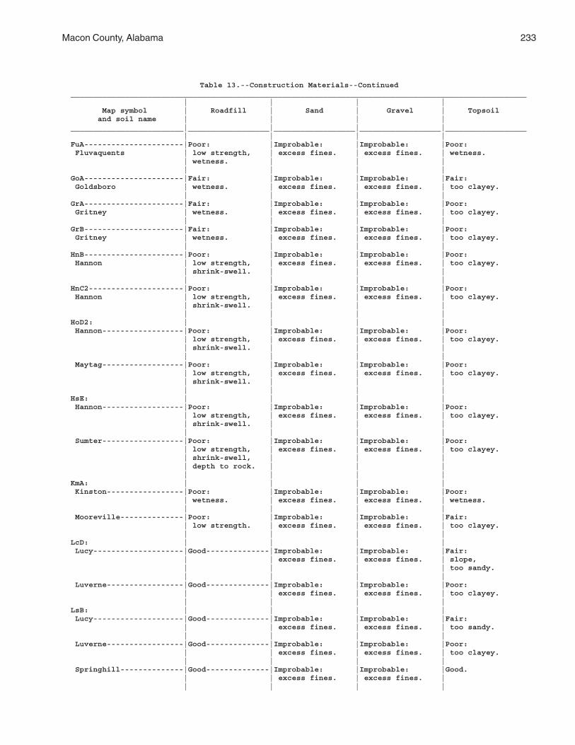
Macon County, Alabama 233
Table 13.--Construction Materials--Continued_____________________________________________________________________________________________________ | | | | Map symbol | Roadfill | Sand | Gravel | Topsoil and soil name | | | |_________________________|__________________|__________________|__________________|__________________ | | | |FuA----------------------|Poor: |Improbable: |Improbable: |Poor: Fluvaquents | low strength, | excess fines. | excess fines. | wetness. | wetness. | | | | | | |GoA----------------------|Fair: |Improbable: |Improbable: |Fair: Goldsboro | wetness. | excess fines. | excess fines. | too clayey. | | | |GrA----------------------|Fair: |Improbable: |Improbable: |Poor: Gritney | wetness. | excess fines. | excess fines. | too clayey. | | | |GrB----------------------|Fair: |Improbable: |Improbable: |Poor: Gritney | wetness. | excess fines. | excess fines. | too clayey. | | | |HnB----------------------|Poor: |Improbable: |Improbable: |Poor: Hannon | low strength, | excess fines. | excess fines. | too clayey. | shrink-swell. | | | | | | |HnC2---------------------|Poor: |Improbable: |Improbable: |Poor: Hannon | low strength, | excess fines. | excess fines. | too clayey. | shrink-swell. | | | | | | |HoD2: | | | | Hannon------------------|Poor: |Improbable: |Improbable: |Poor: | low strength, | excess fines. | excess fines. | too clayey. | shrink-swell. | | | | | | | Maytag------------------|Poor: |Improbable: |Improbable: |Poor: | low strength, | excess fines. | excess fines. | too clayey. | shrink-swell. | | | | | | |HsE: | | | | Hannon------------------|Poor: |Improbable: |Improbable: |Poor: | low strength, | excess fines. | excess fines. | too clayey. | shrink-swell. | | | | | | | Sumter------------------|Poor: |Improbable: |Improbable: |Poor: | low strength, | excess fines. | excess fines. | too clayey. | shrink-swell, | | | | depth to rock. | | | | | | |KmA: | | | | Kinston-----------------|Poor: |Improbable: |Improbable: |Poor: | wetness. | excess fines. | excess fines. | wetness. | | | | Mooreville--------------|Poor: |Improbable: |Improbable: |Fair: | low strength. | excess fines. | excess fines. | too clayey. | | | |LcD: | | | | Lucy--------------------|Good--------------|Improbable: |Improbable: |Fair: | | excess fines. | excess fines. | slope, | | | | too sandy. | | | | Luverne-----------------|Good--------------|Improbable: |Improbable: |Poor: | | excess fines. | excess fines. | too clayey. | | | |LsB: | | | | Lucy--------------------|Good--------------|Improbable: |Improbable: |Fair: | | excess fines. | excess fines. | too sandy. | | | | Luverne-----------------|Good--------------|Improbable: |Improbable: |Poor: | | excess fines. | excess fines. | too clayey. | | | | Springhill--------------|Good--------------|Improbable: |Improbable: |Good. | | excess fines. | excess fines. | | | | |

234 Soil Survey
Table 13.--Construction Materials--Continued_____________________________________________________________________________________________________ | | | | Map symbol | Roadfill | Sand | Gravel | Topsoil and soil name | | | |_________________________|__________________|__________________|__________________|__________________ | | | |LuB----------------------|Good--------------|Improbable: |Improbable: |Poor: Luverne | | excess fines. | excess fines. | too clayey. | | | |LuD2---------------------|Good--------------|Improbable: |Improbable: |Poor: Luverne | | excess fines. | excess fines. | too clayey. | | | |LyA----------------------|Poor: |Improbable: |Improbable: |Poor: Lynchburg | wetness. | excess fines. | excess fines. | wetness. | | | |MaA----------------------|Fair: |Improbable: |Improbable: |Fair: Malbis | low strength, | excess fines. | excess fines. | too clayey. | wetness. | | | | | | |MnA----------------------|Good--------------|Improbable: |Improbable: |Fair: Marvyn | | excess fines. | excess fines. | small stones, | | | | thin layer. | | | |MnB----------------------|Good--------------|Improbable: |Improbable: |Fair: Marvyn | | excess fines. | excess fines. | small stones, | | | | thin layer, | | | | too sandy. | | | |MtA----------------------|Poor: |Improbable: |Improbable: |Poor: Maytag | low strength, | excess fines. | excess fines. | too clayey. | shrink-swell. | | | | | | |MuB: | | | | Maytag------------------|Poor: |Improbable: |Improbable: |Poor: | low strength, | excess fines. | excess fines. | too clayey. | shrink-swell. | | | | | | | Hannon------------------|Poor: |Improbable: |Improbable: |Poor: | low strength, | excess fines. | excess fines. | too clayey. | shrink-swell. | | | | | | |MyA----------------------|Poor: |Improbable: |Improbable: |Poor: Myatt | wetness. | excess fines. | excess fines. | wetness. | | | |OcA----------------------|Fair: |Improbable: |Improbable: |Fair: Ocilla | wetness. | excess fines. | excess fines. | too sandy. | | | |OkC2---------------------|Poor: |Improbable: |Improbable: |Poor: Oktibbeha | low strength, | excess fines. | excess fines. | too clayey. | shrink-swell. | | | | | | |OkE2---------------------|Poor: |Improbable: |Improbable: |Poor: Oktibbeha | low strength, | excess fines. | excess fines. | slope, | shrink-swell. | | | too clayey. | | | |OrA----------------------|Good--------------|Improbable: |Improbable: |Fair: Orangeburg | | excess fines. | excess fines. | too clayey. | | | |PaD----------------------|Good--------------|Improbable: |Improbable: |Poor: Pacolet | | excess fines. | excess fines. | too clayey. | | | |PaE----------------------|Fair: |Improbable: |Improbable: |Poor: Pacolet | slope. | excess fines. | excess fines. | slope, | | | | too clayey. | | | |PoA: | | | | Pelham------------------|Poor: |Improbable: |Improbable: |Poor: | wetness. | excess fines. | excess fines. | wetness. | | | |

Macon County, Alabama 235
Table 13.--Construction Materials--Continued_____________________________________________________________________________________________________ | | | | Map symbol | Roadfill | Sand | Gravel | Topsoil and soil name | | | |_________________________|__________________|__________________|__________________|__________________ | | | |PoA: | | | | Ocilla------------------|Fair: |Improbable: |Improbable: |Fair: | wetness. | excess fines. | excess fines. | too sandy. | | | |Pt-----------------------|Variable----------|Variable----------|Variable----------|Variable------- Pits | | | | | | | |RbA----------------------|Good--------------|Improbable: |Improbable: |Good. Red Bay | | excess fines. | excess fines. | | | | |ReA----------------------|Good--------------|Improbable: |Improbable: |Good. Riverview | | excess fines. | excess fines. | | | | |RoB: | | | | Riverview---------------|Good--------------|Improbable: |Improbable: |Good. | | excess fines. | excess fines. | | | | | Bruno-------------------|Good--------------|Probable----------|Improbable: |Poor: | | | too sandy. | too sandy. | | | |Rw-----------------------|Poor: |Probable----------|Probable----------|Poor: Riverwash | wetness. | | | too sandy, | | | | wetness. | | | |RyA----------------------|Poor: |Improbable: |Improbable: |Poor: Roanoke | wetness. | excess fines. | excess fines. | too clayey, | | | | wetness. | | | |SaB----------------------|Poor: |Improbable: |Improbable: |Poor: Searcy | low strength. | excess fines. | excess fines. | too clayey. | | | |SbB----------------------|Good--------------|Improbable: |Improbable: |Good. Springhill | | excess fines. | excess fines. | | | | |SrA----------------------|Poor: |Improbable: |Improbable: |Poor: Sucarnoochee | low strength, | excess fines. | excess fines. | too clayey, | shrink-swell, | | | wetness. | wetness. | | | | | | |StE: | | | | Sumter------------------|Poor: |Improbable: |Improbable: |Poor: | low strength, | excess fines. | excess fines. | slope, | shrink-swell, | | | too clayey. | depth to rock. | | | | | | | Hannon------------------|Poor: |Improbable: |Improbable: |Poor: | low strength, | excess fines. | excess fines. | slope, | shrink-swell. | | | too clayey. | | | |TcA----------------------|Good--------------|Improbable: |Improbable: |Good. Toccoa | | excess fines. | excess fines. | | | | |ToB----------------------|Good--------------|Improbable: |Improbable: |Good. Toccoa | | excess fines. | excess fines. | | | | |TpB: | | | | Troup-------------------|Good--------------|Probable----------|Improbable: |Fair: | | | excess fines. | too sandy. | | | | Alaga-------------------|Good--------------|Probable----------|Improbable: |Poor: | | | too sandy. | too sandy. | | | |

236 Soil Survey
Table 13.--Construction Materials--Continued_____________________________________________________________________________________________________ | | | | Map symbol | Roadfill | Sand | Gravel | Topsoil and soil name | | | |_________________________|__________________|__________________|__________________|__________________ | | | |TsF: | | | | Troup-------------------|Poor: |Probable----------|Improbable: |Poor: | slope. | | too sandy. | slope. | | | | Springhill--------------|Poor: |Improbable: |Improbable: |Poor: | slope. | excess fines. | excess fines. | slope. | | | | Luverne-----------------|Poor: |Improbable: |Improbable: |Poor: | slope. | excess fines. | excess fines. | slope, | | | | too clayey. | | | |UcB----------------------|Good--------------|Improbable: |Improbable: |Fair: Uchee | | thin layer. | excess fines. | too sandy. | | | |UcD----------------------|Good--------------|Improbable: |Improbable: |Fair: Uchee | | thin layer. | excess fines. | too sandy. | | | |UcE2: | | | | Uchee-------------------|Fair: |Improbable: |Improbable: |Poor: | slope. | thin layer. | excess fines. | slope. | | | | Cowarts-----------------|Fair: |Improbable: |Improbable: |Poor: | slope. | excess fines. | excess fines. | slope, | | | | thin layer. | | | |UdE----------------------|Variable----------|Variable----------|Variable----------|Variable. Udorthents | | | | | | | |UoC----------------------|Variable----------|Variable----------|Variable----------|Variable. Udorthents | | | | | | | |UuA: | | | | Udorthents--------------|Variable----------|Variable----------|Variable----------|Variable. | | | | Urban land. | | | | | | | |UvA: | | | | Urbo--------------------|Poor: |Improbable: |Improbable: |Poor: | low strength. | excess fines. | excess fines. | too clayey. | | | | Una---------------------|Poor: |Improbable: |Improbable: |Poor: | low strength, | excess fines. | excess fines. | too clayey, | shrink-swell, | | | wetness. | wetness. | | | | | | | Mooreville--------------|Poor: |Improbable: |Improbable: |Fair: | low strength. | excess fines. | excess fines. | too clayey. | | | |VaA----------------------|Poor: |Improbable: |Improbable: |Poor: Vaiden | low strength, | excess fines. | excess fines. | too clayey. | shrink-swell. | | | | | | |WaB----------------------|Good--------------|Improbable: |Improbable: |Fair: Wagram | | excess fines. | excess fines. | too sandy. | | | |_____________________________________________________________________________________________________

Macon County, Alabama 237
Table 14.--Water Management
(Some terms that describe restrictive soil features are defined in the "Glossary." See text for definitions of "slight," "moderate," and "severe." Absence of an entry indicates that the soil was not rated. The information in this table indicates the dominant soil condition but does not eliminate the need for onsite investigation.)
________________________________________________________________________________________________________ | Limitations for-- | Features affecting-- |_____________________________|___________________________________________________________ Map symbol |Pond reservoir| Embankments, | | | Terraces and | Grassed and | areas | dikes, and | Drainage | Irrigation | diversions | waterways soil name | | levees | | | |______________|______________|______________|______________|______________|______________|______________ | | | | | |AlA-----------|Moderate: |Severe: |Favorable |Wetness |Wetness |Favorable. Altavista | seepage. | piping, | | | | | | wetness. | | | | | | | | | |ArB-----------|Variable------|Variable------|Variable------|Variable------|Variable------|Variable. Arents | | | | | | | | | | | |BaA-----------|Moderate: |Moderate: |Deep to water |Favorable |Favorable |Favorable. Bama | seepage. | piping. | | | | | | | | | |BaB-----------|Moderate: |Moderate: |Deep to water |Slope |Favorable |Favorable. Bama | seepage, | piping. | | | | | slope. | | | | | | | | | | |BeA-----------|Slight--------|Severe: |Flooding, |Flooding, |Percs slowly, |Percs slowly, Bethera | | hard to pack,| percs slowly.| percs slowly,| wetness. | wetness. | | wetness. | | wetness. | | | | | | | |BgB-----------|Severe: |Severe: |Deep to water |Fast intake, |Too sandy |Droughty. Bigbee | seepage. | seepage, | | droughty. | | | | piping. | | | | | | | | | |BnE: | | | | | | Blanton------|Severe: |Severe: |Deep to water |Fast intake, |Slope, |Slope, | seepage, | seepage, | | slope, | too sandy, | droughty. | slope. | piping. | | droughty. | soil blowing.| | | | | | | Luverne------|Severe: |Severe: |Deep to water |Slope |Slope |Slope. | slope. | hard to pack,| | | | | | piping. | | | | | | | | | |BoB-----------|Severe: |Severe: |Deep to water |Fast intake, |Too sandy, |Droughty. Bonifay | seepage. | seepage, | | slope, | soil blowing.| | | piping. | | droughty. | | | | | | | |CaA-----------|Severe: |Moderate: |Deep to water |Favorable |Favorable |Favorable. Cahaba | seepage. | piping, | | | | | | thin layer. | | | | | | | | | |CmB-----------|Severe: |Severe: |Favorable |Wetness, |Wetness, |Rooting depth, Compass | seepage. | piping. | | droughty. | soil blowing.| droughty. | | | | | |CoB-----------|Moderate: |Severe: |Deep to water |Slope, |Percs slowly |Droughty. Conecuh | slope. | hard to pack.| | droughty. | | | | | | | |CoC2----------|Moderate: |Severe: |Deep to water |Slope, |Percs slowly |Slope, Conecuh | slope. | hard to pack.| | droughty. | | droughty. | | | | | |CwD2----------|Severe: |Severe: |Deep to water |Fast intake, |Percs slowly, |Rooting depth, Cowarts | slope. | piping. | | slope, | slope. | slope, | | | | droughty. | | droughty. | | | | | |DgA-----------|Severe: |Severe: |Percs slowly |Wetness |Wetness |Percs slowly. Dogue | seepage. | wetness. | | | | | | | | | |

238 Soil Survey
Table 14.--Water Management--Continued________________________________________________________________________________________________________ | Limitations for-- | Features affecting-- |_____________________________|___________________________________________________________ Map symbol |Pond reservoir| Embankments, | | | Terraces and | Grassed and | areas | dikes, and | Drainage | Irrigation | diversions | waterways soil name | | levees | | | |______________|______________|______________|______________|______________|______________|______________ | | | | | |EuA-----------|Severe: |Severe: |Favorable |Wetness |Wetness |Favorable. Eunola | seepage. | piping, | | | | | | wetness. | | | | | | | | | |FaA-----------|Slight--------|Severe: |Deep to water |Percs slowly |Erodes easily,|Erodes easily, Faunsdale | | hard to pack.| | | percs slowly.| percs slowly. | | | | | |FuA-----------|Slight--------|Severe: |Flooding, |Flooding, |Ponding |Wetness. Fluvaquents | | ponding. | ponding. | ponding. | | | | | | | |GoA-----------|Moderate: |Moderate: |Percs slowly |Fast intake, |Wetness |Rooting depth, Goldsboro | seepage. | piping, | | wetness, | | droughty. | | wetness. | | droughty. | | | | | | | |GrA-----------|Slight--------|Moderate: |Percs slowly |Wetness, |Percs slowly, |Percs slowly, Gritney | | hard to pack,| | droughty. | wetness. | droughty. | | wetness. | | | | | | | | | |GrB-----------|Moderate: |Moderate: |Percs slowly, |Slope, |Percs slowly, |Percs slowly, Gritney | slope. | hard to pack,| slope. | wetness, | wetness. | droughty. | | wetness. | | droughty. | | | | | | | |HnB-----------|Slight--------|Severe: |Deep to water |Percs slowly, |Percs slowly |Percs slowly, Hannon | | hard to pack.| | droughty. | | droughty. | | | | | |HnC2: |Moderate: |Severe: |Deep to water |Slope, slow |Percs slowly |Percs slowly, Hannon-------| slope. | hard to pack.| | intake, | | droughty. | | | | droughty. | | | | | | | |HoD2: | | | | | | Hannon-------|Moderate: |Severe: |Deep to water |Percs slowly, |Percs slowly |Percs slowly, | slope. | hard to pack.| | slope, | | droughty. | | | | droughty. | | | | | | | | Maytag-------|Moderate: |Severe: |Deep to water |Percs slowly, |Percs slowly |Percs slowly. | slope. | hard to pack.| | slope. | | | | | | | |HsE: | | | | | | Hannon-------|Severe: |Severe: |Deep to water |Percs slowly, |Percs slowly, |Percs slowly, | slope. | hard to pack.| | slope, | slope. | slope, | | | | droughty. | | droughty. | | | | | | Sumter-------|Severe: |Severe: |Deep to water |Percs slowly, |Erodes easily,|Erodes easily, | slope. | thin layer. | | slope. | slope, depth | slope, | | | | | to rock. | depth to rock. | | | | | |KmA: | | | | | | Kinston------|Moderate: |Severe: |Flooding, |Flooding, |Wetness |Wetness. | seepage. | wetness. | wetness. | wetness. | | | | | | | | Mooreville---|Moderate: |Severe: |Flooding |Erodes easily,|Erodes easily,|Erodes easily. | seepage. | wetness. | | flooding, | wetness. | | | | | wetness. | | | | | | | |LcD: | | | | | | Lucy---------|Severe: |Severe: |Deep to water |Fast intake, |Slope, |Slope, | seepage, | piping. | | slope, | soil blowing.| droughty. | slope. | | | droughty. | | | | | | | |

Macon County, Alabama 239
Table 14.--Water Management--Continued________________________________________________________________________________________________________ | Limitations for-- | Features affecting-- |_____________________________|___________________________________________________________ Map symbol |Pond reservoir| Embankments, | | | Terraces and | Grassed and | areas | dikes, and | Drainage | Irrigation | diversions | waterways soil name | | levees | | | |______________|______________|______________|______________|______________|______________|______________ | | | | | |LcD: | | | | | | Luverne------|Severe: |Severe: |Deep to water |Fast intake, |Slope |Slope. | slope. | hard to pack,| | slope. | | | | piping. | | | | | | | | | |LsB: | | | | | | Lucy---------|Severe: |Severe: |Deep to water |Fast intake, |Soil blowing |Droughty. | seepage. | piping. | | slope, | | | | | | droughty. | | | | | | | | Luverne------|Moderate: |Severe: |Deep to water |Fast intake, |Favorable |Favorable. | slope. | hard to pack,| | slope. | | | | piping. | | | | | | | | | | Springhill---|Severe: |Severe: |Deep to water |Fast intake, |Favorable |Favorable. | seepage. | piping. | | slope. | | | | | | | |LuB-----------|Moderate: |Severe: |Deep to water |Slope |Favorable |Favorable. Luverne | slope. | hard to pack,| | | | | | piping. | | | | | | | | | |LuD2----------|Severe: |Severe: |Deep to water |Slope |Slope |Slope. Luverne | slope. | hard to pack,| | | | | | piping. | | | | | | | | | |LyA-----------|Moderate: |Severe: |Favorable |Wetness |Wetness |Wetness. Lynchburg | seepage. | piping, | | | | | | wetness. | | | | | | | | | |MaA-----------|Moderate: |Severe: |Deep to water |Favorable |Favorable |Favorable. Malbis | seepage. | piping. | | | | | | | | | |MnA-----------|Moderate: |Severe: |Deep to water |Favorable |Favorable |Favorable. Marvyn | seepage. | hard to pack,| | | | | | piping. | | | | | | | | | |MnB-----------|Moderate: |Severe: |Deep to water |Fast intake, |Favorable |Favorable. Marvyn | seepage, | hard to pack,| | slope. | | | slope. | piping. | | | | | | | | | |MtA-----------|Slight--------|Severe: |Deep to water |Percs slowly, |Percs slowly |Percs slowly. Maytag | | hard to pack.| | slow intake. | | | | | | | |MuB: | | | | | | Maytag-------|Slight--------|Severe: |Deep to water |Percs slowly |Percs slowly |Percs slowly. | | hard to pack.| | | | | | | | | | Hannon-------|Slight--------|Severe: |Deep to water |Percs slowly, |Percs slowly |Percs slowly, | | hard to pack.| | droughty. | | droughty. | | | | | |MyA-----------|Moderate: |Severe: |Favorable |Wetness |Wetness |Wetness. Myatt | seepage. | piping, | | | | | | wetness. | | | | | | | | | |OcA-----------|Severe: |Severe: |Favorable |Fast intake, |Wetness, |Droughty. Ocilla | seepage. | piping, | | wetness, | soil blowing.| | | wetness. | | droughty. | | | | | | | |OkC2----------|Moderate: |Severe: |Deep to water |Percs slowly, |Percs slowly |Percs slowly. Oktibbeha | slope. | hard to pack.| | slope. | | | | | | | | | | | | | |

240 Soil Survey
Table 14.--Water Management--Continued________________________________________________________________________________________________________ | Limitations for-- | Features affecting-- |_____________________________|___________________________________________________________ Map symbol |Pond reservoir| Embankments, | | | Terraces and | Grassed and | areas | dikes, and | Drainage | Irrigation | diversions | waterways soil name | | levees | | | |______________|______________|______________|______________|______________|______________|______________ | | | | | |OkE2----------|Severe: |Severe: |Deep to water |Percs slowly, |Percs slowly, |Percs slowly, Oktibbeha | slope. | hard to pack.| | slope. | slope. | slope. | | | | | |OrA-----------|Moderate: |Moderate: |Deep to water |Favorable |Soil blowing |Favorable. Orangeburg | seepage. | piping. | | | | | | | | | |PaD-----------|Severe: |Severe: |Deep to water |Slope |Slope |Slope. Pacolet | slope. | piping. | | | | | | | | | |PaE-----------|Severe: |Severe: |Deep to water |Slope |Slope |Slope. Pacolet | slope. | piping. | | | | | | | | | |PoA: | | | | | | Pelham-------|Severe: |Severe: |Favorable |Fast intake, |Wetness, |Wetness. | seepage. | piping, | | wetness. | soil blowing.| | | wetness. | | | | | | | | | | Ocilla-------|Severe: |Severe: |Favorable |Fast intake, |Wetness, |Droughty. | seepage. | piping, | | wetness, | soil blowing.| | | wetness. | | droughty. | | | | | | | |Pt------------|Variable------|Variable------|Variable------|Variable------|Variable------|Variable. Pits | | | | | | | | | | | |RbA-----------|Moderate: |Slight--------|Deep to water |Favorable |Favorable |Favorable. Red Bay | seepage. | | | | | | | | | | |ReA-----------|Severe: |Severe: |Deep to water |Flooding |Favorable |Favorable. Riverview | seepage. | piping. | | | | | | | | | |RoB: | | | | | | Riverview----|Severe: |Severe: |Deep to water |Flooding |Favorable |Favorable. | seepage. | piping. | | | | | | | | | | Bruno--------|Severe: |Severe: |Deep to water |Droughty |Too sandy |Droughty. | seepage. | seepage, | | | | | | piping. | | | | | | | | | |Rw------------|Severe: |Severe: |Variable------|Fast intake, |Too sandy |Droughty. Riverwash | seepage. | seepage, | | droughty. | | | | piping. | | | | | | | | | |RyA-----------|Severe: |Severe: |Flooding, |Erodes easily,|Erodes easily,|Erodes easily, Roanoke | seepage. | wetness. | percs slowly.| percs slowly,| percs slowly,| percs slowly, | | | | wetness. | wetness. | wetness. | | | | | |SaB-----------|Moderate: |Moderate: |Percs slowly, |Slope, |Wetness |Percs slowly. Searcy | slope. | hard to pack,| slope. | wetness. | | | | wetness. | | | | | | | | | |SbB-----------|Severe: |Severe: |Deep to water |Slope |Favorable |Favorable. Springhill | seepage. | piping. | | | | | | | | | |SrA-----------|Slight--------|Severe: |Flooding, |Percs slowly, |Percs slowly, |Percs slowly, Sucarnoochee | | hard to pack,| percs slowly.| slow intake, | wetness. | wetness. | | wetness. | | wetness. | | | | | | | |StE: | | | | | | Sumter-------|Severe: |Severe: |Deep to water |Percs slowly, |Erodes easily,|Erodes easily, | slope. | thin layer. | | slope. | slope, depth | slope, depth | | | | | to rock. | to rock. | | | | | |

Macon County, Alabama 241
Table 14.--Water Management--Continued________________________________________________________________________________________________________ | Limitations for-- | Features affecting-- |_____________________________|___________________________________________________________ Map symbol |Pond reservoir| Embankments, | | | Terraces and | Grassed and | areas | dikes, and | Drainage | Irrigation | diversions | waterways soil name | | levees | | | |______________|______________|______________|______________|______________|______________|______________ | | | | | |StE: | | | | | | Hannon-------|Severe: |Severe: |Deep to water |Percs slowly, |Percs slowly, |Percs slowly, | slope. | hard to pack.| | slope, | slope. | slope, | | | | droughty. | | droughty. | | | | | |TcA-----------|Severe: |Severe: |Flooding |Flooding |Favorable |Favorable. Toccoa | seepage. | piping. | | | | | | | | | |ToB-----------|Severe: |Severe: |Flooding |Flooding |Favorable |Favorable. Toccoa | seepage. | piping. | | | | | | | | | |TpB: | | | | | | Troup--------|Severe: |Severe: |Deep to water |Fast intake, |Soil blowing |Droughty. | seepage. | seepage, | | droughty. | | | | piping. | | | | | | | | | | Alaga--------|Severe: |Severe: |Deep to water |Fast intake, |Too sandy, |Droughty. | seepage. | seepage, | | droughty. | soil blowing | | | piping. | | | | | | | | | |TsF: | | | | | | Troup--------|Severe: |Severe: |Deep to water |Fast intake, |Slope, |Slope, | seepage, | seepage, | | slope, | too sandy, | droughty. | slope. | piping. | | droughty. | soil blowing.| | | | | | | Springhill---|Severe: |Severe: |Deep to water |Fast intake, |Slope |Slope. | seepage, | piping. | | slope. | | | slope. | | | | | | | | | | | Luverne------|Severe: |Severe: |Deep to water |Slope |Slope |Slope. | slope. | hard to pack,| | | | | | piping. | | | | | | | | | |UcB-----------|Severe: |Severe: |Deep to water |Fast intake, |Too sandy |Droughty. Uchee | seepage. | seepage, | | slope, | | | | piping. | | droughty. | | | | | | | |UcD-----------|Severe: |Severe: |Deep to water |Fast intake, |Slope, |Slope, Uchee | seepage, | seepage, | | slope, | too sandy. | droughty. | slope. | piping. | | droughty. | | | | | | | |UcE2: | | | | | | Uchee--------|Severe: |Severe: |Deep to water |Fast intake, |Slope, |Slope, | seepage, | seepage, | | slope, | too sandy. | droughty. | slope. | piping. | | droughty. | | | | | | | | Cowarts------|Severe: |Severe: |Deep to water |Slope, |Percs slowly, |Rooting depth, | slope. | piping. | | droughty. | slope. | slope, | | | | | | droughty. | | | | | |UdE-----------|Variable------|Variable------|Variable------|Variable------|Variable------|Variable. Udorthents | | | | | | | | | | | |UoC-----------|Variable------|Variable------|Variable------|Variable------|Variable------|Variable. Udorthents | | | | | | | | | | | | | | | | | |UuA: | | | | | | Udorthents---|Variable------|Variable------|Variable------|Variable------|Variable------|Variable. | | | | | | Urban land. | | | | | | | | | | | |

242 Soil Survey
Table 14.--Water Management--Continued________________________________________________________________________________________________________ | Limitations for-- | Features affecting-- |_____________________________|___________________________________________________________ Map symbol |Pond reservoir| Embankments, | | | Terraces and | Grassed and | areas | dikes, and | Drainage | Irrigation | diversions | waterways soil name | | levees | | | |______________|______________|______________|______________|______________|______________|______________ | | | | | |UvA: | | | | | | Urbo---------|Slight--------|Severe: |Flooding, |Percs slowly, |Erodes easily,|Erodes easily, | | wetness. | percs slowly.| wetness. | percs slowly,| percs slowly, | | | | | wetness. | wetness. | | | | | | Una----------|Slight--------|Severe: |Flooding, |Percs slowly, |Percs slowly, |Percs slowly, | | ponding. | percs slowly,| ponding. | ponding. | wetness. | | | ponding. | | | | | | | | | Mooreville---|Moderate: |Severe: |Flooding |Erodes easily,|Erodes easily,|Erodes easily. | seepage. | wetness. | | flooding, | wetness. | | | | | wetness. | | | | | | | |VaA-----------|Slight--------|Severe: |Percs slowly |Slow intake, |Percs slowly, |Percs slowly, Vaiden | | hard to pack.| | wetness. | wetness. | wetness. | | | | | |WaB-----------|Severe: |Slight--------|Deep to water |Fast intake, |Soil blowing |Droughty. Wagram | seepage. | | | soil blowing,| | | | | | droughty. | | | | | | | | _______________________________________________________________________________________________________

Macon County, Alabama 243
Table 15.--Engineering Index Properties
(Absence of an entry indicates that the data were not estimated.)
_________________________________________________________________________________________________________ | | | Classification | Percentage passing | | Map symbol |Depth| USDA texture |___________________________| sieve number-- |Liq- | Plas- and | | | | |___________________________| uid |ticity soil name | | | Unified | AASHTO | 4 | 10 | 40 | 200 |Limit|index______________|_____|_______________|_____________|_____________|______|______|______|______|_____|______ | In | | | | | | | | Pct | | | | | | | | | | |AlA-----------| 0-7 |Silt loam------|CL-ML, ML, |A-4 |95-100|90-100|65-99 |35-60 | 0-23|NP-7 Altavista | | | SM, SC-SM | | | | | | | | 7-80|Clay loam, |CL-ML, SC, |A-6, A-4, A-7|95-100|95-100|60-99 |45-75 |20-45| 5-28 | | sandy clay | CL, SC-SM | | | | | | | | | loam, loam. | | | | | | | | | | | | | | | | | |ArB-----------| 0-80|Variable-------|Variable |Variable | --- | --- | --- | --- | --- | --- Arents | | | | | | | | | | | | | | | | | | | |BaA-----------| 0-8 |Fine sandy loam|CL-ML, SM, |A-4 |95-100|85-100|70-95 |40-70 | 0-30|NP-10 Bama | | | SC, SC-SM | | | | | | | | 8-36|Loam, sandy |SC, CL-ML, |A-4, A-6 |90-100|85-100|80-95 |36-70 |15-35| 2-15 | | clay loam, | SC-SM, SM | | | | | | | | | clay loam. | | | | | | | | |36-80|Loam, sandy |CL, SC |A-4, A-6 |85-100|80-100|80-95 |40-70 |20-40| 8-18 | | clay loam, | | | | | | | | | | clay loam. | | | | | | | | | | | | | | | | | |BaB-----------| 0-5 |Fine sandy loam|SC, CL-ML, |A-4 |95-100|85-100|70-95 |40-70 | 0-30|NP-10 Bama | | | SC-SM, SM | | | | | | | | 5-30|Loam, sandy |CL-ML, SM, |A-4, A-6 |90-100|85-100|80-95 |36-70 |15-35| 2-15 | | clay loam, | SC, SC-SM | | | | | | | | | clay loam. | | | | | | | | |30-65|Loam, sandy |CL, SC |A-4, A-6 |85-100|80-100|80-95 |40-70 |20-40| 8-18 | | clay loam, | | | | | | | | | | clay loam. | | | | | | | | | | | | | | | | | |BeA-----------| 0-2 |Clay loam------|CH, CL |A-6, A-7 | 100 |95-100|90-100|70-80 |30-55|12-26 Bethera | 2-60|Clay, clay |CH, CL, ML, |A-6, A-7 | 100 |98-100|93-100|55-95 |37-55|12-30 | | loam, sandy | MH | | | | | | | | | clay. | | | | | | | | | | | | | | | | | |BgB-----------| 0-11|Loamy sand-----|SM |A-2-4 | 100 |95-100|60-90 |15-30 | 0-14| NP Bigbee |11-64|Loamy sand, |SM, SP-SM |A-2-4 | 100 |95-100|60-90 |15-30 | 0-14| NP | | sand. | | | | | | | | |64-84|Sand, fine sand|SM, SP-SM |A-2-4, A-3 |85-100|85-100|50-75 | 5-20 | 0-14| NP | | | | | | | | | |BnE: | | | | | | | | | | Blanton------| 0-6 |Loamy sand-----|SM |A-2-4 | 100 |95-100|85-100|13-25 | 0-14| NP | 6-68|Loamy sand, |SM |A-2-4 | 100 |95-100|65-96 |13-30 | 0-25|NP-3 | | loamy coarse | | | | | | | | | | sand. | | | | | | | | |68-80|Sandy clay |SC-SM, SC, SM|A-2-4, A-6, | 100 |95-100|69-100|25-50 |12-45| 3-22 | | loam, sandy | | A-2-6, A-4 | | | | | | | | loam, sandy | | | | | | | | | | clay. | | | | | | | | | | | | | | | | | | Luverne------| 0-4 |Sandy loam-----|ML, SM |A-2, A-4 |87-100|84-100|80-100|30-60 | 0-20| NP | 4-27|Clay loam, |MH, ML |A-4, A-5, A-7|95-100|90-100|85-100|50-95 |38-70| 8-30 | | sandy clay, | | | | | | | | | | clay. | | | | | | | | |27-40|Clay loam, |MH, ML, SM |A-4, A-7, A-5|95-100|85-100|85-100|36-76 |32-56| 2-14 | | sandy clay | | | | | | | | | | loam. | | | | | | | | |40-65|Stratified |ML, SM |A-4, A-2, |90-100|85-100|70-100|25-65 |28-49| 3-16 | | loamy sand to | | A-6, A-7 | | | | | | | | sandy clay | | | | | | | | | | loam. | | | | | | | | | | | | | | | | | |

244 Soil Survey
Table 15.--Engineering Index Properties--Continued_________________________________________________________________________________________________________ | | | Classification | Percentage passing | | Map symbol |Depth| USDA texture |___________________________| sieve number-- |Liq- | Plas- and | | | | |___________________________| uid |ticity soil name | | | Unified | AASHTO | 4 | 10 | 40 | 200 |Limit|index______________|_____|_______________|_____________|_____________|______|______|______|______|_____|______ | In | | | | | | | | Pct | | | | | | | | | | |BoB-----------| 0-7 |Loamy fine sand|SM |A-2-4 |98-100|98-100|65-95 |13-20 | 0-14| NP Bonifay | 7-58|Loamy sand, |SC-SM, SC, SM|A-2-4, A-2-6,|95-100|90-100|63-95 |23-50 | 0-30|NP-12 | | sandy clay | | A-6, A-4 | | | | | | | | loam, fine | | | | | | | | | | sandy loam. | | | | | | | | |58-84|Sandy clay |SC, SC-SM |A-4, A-6, |95-100|90-100|60-95 |30-50 |25-45| 5-22 | | loam, sandy | | A-6, A-7 | | | | | | | | clay. | | | | | | | | | | | | | | | | | |CaA-----------| 0-12|Sandy loam-----|SM |A-2-4, A-4 |95-100|95-100|65-90 |30-45 | 0-14| NP Cahaba |12-48|Sandy clay |CL, SC |A-4, A-6 |90-100|80-100|75-90 |40-75 |22-35| 8-15 | | loam, loam, | | | | | | | | | | clay loam. | | | | | | | | |48-80|Sand, loamy |SM, SP-SM |A-2-4 |95-100|90-100|60-85 |10-35 | 0-14| NP | | sand, sandy | | | | | | | | | | loam. | | | | | | | | | | | | | | | | | |CmB-----------| 0-11|Loamy sand-----|SM |A-2-4 |95-100|95-100|75-95 |13-25 | 0-14| NP Compass |11-31|Sandy loam, |SM |A-2-4 |95-100|95-100|75-95 |20-30 | 0-10|NP-3 | | fine sandy | | | | | | | | | | loam. | | | | | | | | |31-65|Sandy loam, |SC, SC-SM, SM|A-2-4, A-6, | 100 | 100 |90-100|20-50 | 0-30|NP-15 | | fine sandy | | A-2-6, A-4 | | | | | | | | loam, sandy | | | | | | | | | | clay loam. | | | | | | | | | | | | | | | | | |CoB-----------| 0-3 |Fine sandy loam|CL-ML, SM, |A-4 |95-100|95-100|70-100|40-70 | 0-20|NP-5 Conecuh | | | ML, SC-SM | | | | | | | | 3-47|Clay loam, |CL, CH, MH |A-6, A-7 |95-100|95-100|85-100|70-95 |35-60|10-30 | | clay, silty | | | | | | | | | | clay loam. | | | | | | | | |47-60|Clay, silty |MH, CH |A-7 |95-100|95-100|90-100|80-98 |45-70|15-45 | | clay. | | | | | | | | | | | | | | | | | |CoC2----------| 0-3 |Fine sandy loam|ML, CL-ML, |A-4 |95-100|95-100|70-100|40-70 | 0-20|NP-5 Conecuh | | | SC-SM, SM | | | | | | | | 3-52|Clay loam, |CH, ML, CL, |A-6, A-7 |95-100|95-100|85-100|70-95 |35-60|10-30 | | clay, silty | MH | | | | | | | | | clay loam. | | | | | | | | |52-72|Clay, silty |CH, ML, MH |A-7 |95-100|95-100|90-100|80-98 |45-70|15-45 | | clay. | | | | | | | | | | | | | | | | | |CwD2----------| 0-10|Loamy sand-----|SM |A-2 |90-100|85-100|50-80 |13-30 | 0-14| NP Cowarts |10-39|Fine sandy |SC-SM, SC, SM|A-2, A-6, A-4|95-100|90-100|60-95 |23-45 |20-40|NP-15 | | loam, sandy | | | | | | | | | | loam, sandy | | | | | | | | | | clay loam. | | | | | | | | |39-60|Sandy clay |SC, SM |A-2-6, A-7, |95-100|90-100|60-95 |25-50 |20-54| 5-25 | | loam, sandy | | A-6 | | | | | | | | clay, clay | | | | | | | | | | loam. | | | | | | | | | | | | | | | | | |DgA-----------| 0-6 |Fine sandy loam|SC, SC-SM, SM|A-2, A-4 |95-100|75-100|50-100|20-50 | 0-25|NP-10 Dogue | 6-44|Clay loam, |CH, CL, SC |A-6, A-7 |95-100|75-100|65-100|40-90 |35-60|16-40 | | clay, sandy | | | | | | | | | | clay. | | | | | | | | |44-72|Stratified sand|SC, SC-SM, |A-1, A-2, A-4|80-100|60-100|35-100|10-40 | 0-30|NP-10 | | to sandy clay | SP-SM, SM | | | | | | | | | loam. | | | | | | | | | | | | | | | | | |

Macon County, Alabama 245
Table 15.--Engineering Index Properties--Continued_________________________________________________________________________________________________________ | | | Classification | Percentage passing | | Map symbol |Depth| USDA texture |___________________________| sieve number-- |Liq- | Plas- and | | | | |___________________________| uid |ticity soil name | | | Unified | AASHTO | 4 | 10 | 40 | 200 |Limit|index______________|_____|_______________|_____________|_____________|______|______|______|______|_____|______ | In | | | | | | | | Pct | | | | | | | | | | |EuA-----------| 0-10|Fine sandy loam|SM |A-2, A-4 | 100 |98-100|60-85 |30-50 | 0-14| NP Eunola |10-14|Sandy clay |CL, SM, SC, |A-2, A-4, A-6| 100 |90-100|75-95 |30-60 | 0-36|NP-15 | | loam, clay | SC-SM | | | | | | | | | loam, fine | | | | | | | | | | sandy loam. | | | | | | | | |14-52|Sandy clay |ML, CL, SC, |A-4, A-7, A-6| 100 |98-100|80-95 |36-60 |22-50| 3-26 | | loam, sandy | SM | | | | | | | | | clay, clay | | | | | | | | | | loam. | | | | | | | | |52-60|Sandy loam, |SC, SM, SC-SM|A-2, A-4 | 100 |98-100|60-70 |30-40 | 0-30|NP-10 | | sandy clay | | | | | | | | | | loam. | | | | | | | | |60-72|Sand, loamy |SM, SP-SM |A-2, A-3 | 100 |98-100|50-75 | 5-30 | 0-14| NP | | sand, fine | | | | | | | | | | sand. | | | | | | | | | | | | | | | | | |FaA-----------| 0-9 |Clay loam------|CH, CL |A-7 |98-100|92-100|88-100|80-95 |44-56|23-33 Faunsdale | 9-17|Clay loam, |CH |A-7 |98-100|92-100|88-100|85-95 |51-76|30-49 | | silty clay | | | | | | | | | | loam, silty | | | | | | | | | | clay. | | | | | | | | |17-45|Clay loam, |CH |A-7 |98-100|92-100|88-100|80-95 |51-76|30-49 | | silty clay | | | | | | | | | | loam, silty | | | | | | | | | | clay. | | | | | | | | |45-80|Silty clay, |CH |A-7 |96-100|92-100|88-100|85-98 |56-76|33-49 | | clay. | | | | | | | | | | | | | | | | | |FuA-----------| 0-6 |Sandy loam-----|CL-ML, ML, SM|A-2, A-4 | 100 |90-100|60-90 |30-60 | 0-25|NP-7 Fluvaquents | 6-80|Stratified |CL, ML |A-4, A-6, A-7| 100 |90-100|75-100|60-95 |20-45| 8-22 | | sandy loam to | | | | | | | | | | clay. | | | | | | | | | | | | | | | | | |GoA-----------| 0-11|Loamy fine sand|SM |A-2 |95-100|95-100|50-95 |13-30 |10-20| NP Goldsboro |11-31|Sandy clay |CL, SC-SM, |A-2, A-4, A-6|98-100|95-100|60-100|25-55 |20-37| 4-18 | | loam, sandy | CL-ML, SC | | | | | | | | | loam. | | | | | | | | |31-72|Sandy clay |CH, SC, CL, |A-4, A-7-6, |95-100|90-100|65-95 |36-70 |25-55| 6-32 | | loam, clay | CL-ML | A-6 | | | | | | | | loam, sandy | | | | | | | | | | clay. | | | | | | | | | | | | | | | | | |GrA-----------| 0-5 |Loamy fine sand|SM, SP-SM |A-2-4 |90-100|85-100|75-99 |10-20 |15-20| NP Gritney | 5-65|Clay, sandy |CH, SC, CL |A-7 |95-100|90-100|80-100|45-80 |45-70|22-40 | | clay, clay | | | | | | | | | | loam | | | | | | | | |65-80|Stratified |CL, ML, SM, |A-1, A-2, |70-100|55-100|30-90 |20-60 |20-40|NP-25 | | loamy sand to | SC | A-6, A-4 | | | | | | | | sandy clay | | | | | | | | | | loam | | | | | | | | | | | | | | | | | |GrB-----------| 0-6 |Fine sandy loam|SC, ML, SC- |A-2, A-4 |90-100|80-100|60-95 |30-90 |20-30|NP-8 Gritney | | | SM, SM | | | | | | | | 6-45|Clay, sandy |CH, CL, SC |A-7 |95-100|90-100|80-100|45-80 |45-70|22-40 | | clay, clay | | | | | | | | | | loam. | | | | | | | | |45-72|Stratified |ML, SC, CL, |A-2, A-1, |70-100|55-100|30-90 |20-60 |20-40|NP-25 | | loamy sand to | SM | A-4, A-6 | | | | | | | | sandy clay | | | | | | | | | | loam. | | | | | | | | | | | | | | | | | |

246 Soil Survey
Table 15.--Engineering Index Properties--Continued_________________________________________________________________________________________________________ | | | Classification | Percentage passing | | Map symbol |Depth| USDA texture |___________________________| sieve number-- |Liq- | Plas- and | | | | |___________________________| uid |ticity soil name | | | Unified | AASHTO | 4 | 10 | 40 | 200 |Limit|index______________|_____|_______________|_____________|_____________|______|______|______|______|_____|______ | In | | | | | | | | Pct | | | | | | | | | | |HnB-----------| 0-3 |Clay loam------|CL |A-6, A-7 | 100 | 100 |90-100|75-95 |32-50|20-30 Hannon | 3-18|Clay, silty |CH |A-7 | 100 | 100 |95-100|90-100|55-75|35-50 | | clay. | | | | | | | | |18-30|Clay, silty |CH |A-7 | 100 | 100 |95-100|90-100|55-75|35-50 | | clay. | | | | | | | | |30-45|Clay loam, |CH, CL |A-7 | 100 | 100 |90-100|85-95 |42-65|30-45 | | clay, silty | | | | | | | | | | clay. | | | | | | | | |45-65|Stratified |CH, CL |A-6, A-7 | 100 |90-100|80-90 |75-85 |35-55|15-30 | | sandy loam to | | | | | | | | | | clay. | | | | | | | | | | | | | | | | | |HnC2----------| 0-2 |Clay-----------|CH, CL |A-7 | 100 | 100 |90-100|90-100|42-64|30-40 Hannon | 2-10|Clay, silty |CH |A-7 | 100 | 100 |95-100|90-100|55-75|35-50 | | clay. | | | | | | | | |10-25|Clay, silty |CH |A-7 | 100 | 100 |95-100|90-100|55-75|35-50 | | clay. | | | | | | | | |25-48|Clay loam, |CH, CL |A-7 | 100 | 100 |90-100|85-95 |42-65|30-45 | | clay, silty | | | | | | | | | | clay. | | | | | | | | |48-65|Stratified |CH, CL |A-6, A-7 | 100 |90-100|80-90 |75-85 |35-55|15-30 | | sandy loam to | | | | | | | | | | clay. | | | | | | | | | | | | | | | | | |HoD2: | | | | | | | | | | Hannon-------| 0-4 |Clay loam------|CL |A-6, A-7 | 100 | 100 |90-100|75-95 |32-50|20-30 | 4-12|Clay, silty |CH |A-7 | 100 | 100 |95-100|90-100|55-75|35-50 | | clay. | | | | | | | | |12-28|Clay, silty |CH |A-7 | 100 | 100 |95-100|90-100|55-75|35-50 | | clay. | | | | | | | | |28-60|Clay loam, |CH, CL |A-7 | 100 | 100 |90-100|85-95 |42-65|30-45 | | clay, silty | | | | | | | | | | clay. | | | | | | | | |60-72|Stratified |CH, CL |A-6, A-7 | 100 |90-100|80-90 |75-85 |35-55|15-30 | | sandy loam to | | | | | | | | | | clay. | | | | | | | | | | | | | | | | | | | | | | | | | | | | Maytag-------| 0-10|Silty clay loam|CL, CL-ML, ML|A-4, A-6, A-7|98-100|95-100|90-100|75-90 |20-45| 3-25 |10-45|Silty clay, |CH, MH |A-7 |98-100|95-100|90-100|85-98 |60-95|30-60 | | clay, silty | | | | | | | | | | clay loam. | | | | | | | | |45-60|Silty clay, |CH, MH |A-7 |98-100|95-100|90-100|75-98 |60-95|30-60 | | clay, silty | | | | | | | | | | clay loam. | | | | | | | | | | | | | | | | | |HsE: | | | | | | | | | | Hannon-------| 0-4 |Clay loam------|CL |A-6, A-7 | 100 | 100 |90-100|75-95 |32-50|20-30 | 4-14|Clay, silty |CH |A-7 | 100 | 100 |95-100|90-100|55-75|35-50 | | clay. | | | | | | | | |14-25|Clay, silty |CH |A-7 | 100 | 100 |95-100|90-100|55-75|35-50 | | clay. | | | | | | | | |25-65|Clay loam, |CH, CL |A-7 | 100 | 100 |90-100|85-95 |42-65|30-45 | | clay, silty | | | | | | | | | | clay. | | | | | | | | | | | | | | | | | |

Macon County, Alabama 247
Table 15.--Engineering Index Properties--Continued_________________________________________________________________________________________________________ | | | Classification | Percentage passing | | Map symbol |Depth| USDA texture |___________________________| sieve number-- |Liq- | Plas- and | | | | |___________________________| uid |ticity soil name | | | Unified | AASHTO | 4 | 10 | 40 | 200 |Limit|index______________|_____|_______________|_____________|_____________|______|______|______|______|_____|______ | In | | | | | | | | Pct | | | | | | | | | | |HsE: | | | | | | | | | | Sumter-------| 0-14|Silty clay loam|CL |A-6, A-7 |90-100|85-100|80-98 |75-90 |35-50|16-25 |14-23|Silty clay, |CH, CL |A-6, A-7 |85-100|78-98 |75-95 |75-95 |35-55|16-32 | | clay, silty | | | | | | | | | | clay loam. | | | | | | | | |23-34|Channery silty |CH, CL |A-6, A-7 |80-100|65-98 |60-95 |55-95 |35-55|16-32 | | clay loam, | | | | | | | | | | silty clay | | | | | | | | | | loam, silty | | | | | | | | | | clay. | | | | | | | | |34-72|Weathered | --- | --- | --- | --- | --- | --- | --- | --- | | bedrock. | | | | | | | | | | | | | | | | | |KmA: | | | | | | | | | | Kinston------| 0-7 |Fine sandy loam|SC, SC-SM, SM|A-2, A-4 | 100 |98-100|55-100|25-49 |20-35|NP-10 | 7-58|Loam, clay |CL |A-4, A-6, A-7| 100 |95-100|75-100|60-95 |20-45| 8-22 | | loam, sandy | | | | | | | | | | clay loam. | | | | | | | | |58-80|Variable-------| | | --- | --- | --- | --- | --- | --- | | | | | | | | | | | | | | | | | | | | Mooreville---| 0-10|Fine sandy loam|CL-ML, CL, |A-4 | 100 | 100 |80-100|40-85 |20-30| 5-10 | | | SC, SC-SM | | | | | | | |10-52|Sandy clay |CL, SC |A-6, A-7 | 100 | 100 |80-95 |45-80 |28-50|15-30 | | loam, clay | | | | | | | | | | loam, loam. | | | | | | | | |52-80|Loam, sandy |CL, SC |A-6, A-7 | 100 | 100 |80-95 |45-80 |28-50|15-30 | | clay loam, | | | | | | | | | | clay loam. | | | | | | | | | | | | | | | | | |LcD: | | | | | | | | | | Lucy---------| 0-7 |Loamy fine sand|SM, SP-SM |A-2, A-4 |98-100|95-100|50-90 |10-40 | 0-14| NP | 7-31|Loamy fine sand|SM, SP-SM |A-2, A-4 |98-100|95-100|50-90 |10-40 | 0-14| NP |31-41|Sandy clay |SC, SC-SM, SM|A-2, A-4, A-6|97-100|95-100|55-95 |15-50 |10-30|NP-15 | | loam, fine | | | | | | | | | | sandy loam. | | | | | | | | |41-60|Sandy clay |SC, SM, SC-SM|A-2, A-6, A-4| 100 |95-100|60-95 |20-50 |20-40| 3-20 | | loam, clay | | | | | | | | | | loam, sandy | | | | | | | | | | clay. | | | | | | | | | | | | | | | | | | Luverne------| 0-9 |Loamy fine sand|SM |A-2, A-4 |85-100|80-95 |60-90 |19-45 | 0-14| NP | 9-45|Clay loam, |MH, ML |A-4, A-7, A-5|95-100|90-100|85-100|50-95 |38-70| 8-30 | | sandy clay, | | | | | | | | | | clay. | | | | | | | | |45-60|Stratified |ML, SM |A-4, A-2, |90-100|85-100|70-100|25-65 |28-49| 3-16 | | loamy sand to | | A-6, A-7 | | | | | | | | sandy clay | | | | | | | | | | loam. | | | | | | | | | | | | | | | | | |LsB: | | | | | | | | | | Lucy---------| 0-5 |Loamy fine sand|SM, SP-SM |A-2, A-4 |98-100|95-100|50-90 |10-40 | 0-14| NP | 5-39|Loamy fine sand|SM, SP-SM |A-2, A-4 |98-100|95-100|50-90 |10-40 | 0-14| NP |39-49|Sandy loam, |SC, SC-SM, SM|A-2, A-6, A-4|97-100|95-100|55-95 |15-50 |10-30|NP-15 | | fine sandy | | | | | | | | | | loam, sandy | | | | | | | | | | clay loam. | | | | | | | | |49-72|Sandy clay |SC, SM, SC-SM|A-2, A-4, A-6| 100 |95-100|60-95 |20-50 |20-40| 3-20 | | loam, clay | | | | | | | | | | loam, sandy | | | | | | | | | | clay. | | | | | | | | | | | | | | | | | |

248 Soil Survey
Table 15.--Engineering Index Properties--Continued_________________________________________________________________________________________________________ | | | Classification | Percentage passing | | Map symbol |Depth| USDA texture |___________________________| sieve number-- |Liq- | Plas- and | | | | |___________________________| uid |ticity soil name | | | Unified | AASHTO | 4 | 10 | 40 | 200 |Limit|index______________|_____|_______________|_____________|_____________|______|______|______|______|_____|______ | In | | | | | | | | Pct | | | | | | | | | | |LsB: | | | | | | | | | | Luverne------| 0-9 |Loamy sand-----|SM |A-2, A-4 |85-100|80-95 |60-90 |19-45 | 0-14| NP | 9-45|Clay loam, |MH, ML |A-4, A-7, A-5|95-100|90-100|85-100|50-95 |38-70| 8-30 | | sandy clay, | | | | | | | | | | clay. | | | | | | | | |45-50|Clay loam, |MH, ML, SM |A-5, A-4, A-7|95-100|85-100|85-100|36-76 |32-56| 2-14 | | sandy clay | | | | | | | | | | loam. | | | | | | | | |50-65|Stratified |ML, SM |A-4, A-6, |90-100|85-100|70-100|25-65 |28-49| 3-16 | | loamy sand to | | A-2, A-7 | | | | | | | | sandy clay | | | | | | | | | | loam. | | | | | | | | | | | | | | | | | | Springhill---| 0-7 |Loamy sand-----|SM |A-2 |98-100|95-100|60-87 |14-28 | 0-14| NP | 7-14|Sandy loam, |SM |A-2 |98-100|95-100|70-96 |25-35 | 0-30|NP-4 | | fine sandy | | | | | | | | | | loam. | | | | | | | | |14-56|Sandy loam, |CL, SC, SC-SM|A-4, A-6 |98-100|95-100|70-96 |40-65 |22-46| 8-21 | | sandy clay | | | | | | | | | | loam. | | | | | | | | |56-72|Loamy sand, |SC-SM, SM |A-2, A-4 |98-100|95-100|70-96 |15-45 | 0-30| 3-16 | | sandy loam. | | | | | | | | | | | | | | | | | |LuB-----------| 0-4 |Sandy loam-----|ML, SM |A-2, A-4 |87-100|84-100|80-100|30-60 | 0-20| NP Luverne | 4-32|Clay loam, |MH, ML |A-4, A-5, A-7|95-100|90-100|85-100|50-95 |38-70| 8-30 | | sandy clay, | | | | | | | | | | clay. | | | | | | | | |32-45|Clay loam, |MH, ML, SM |A-4, A-5, A-7|95-100|85-100|85-100|36-76 |32-56| 2-14 | | sandy clay | | | | | | | | | | loam. | | | | | | | | |45-72|Stratified |ML, SM |A-4, A-6, |90-100|85-100|70-100|25-65 |28-49| 3-16 | | loamy sand to | | A-2, A-7 | | | | | | | | sandy clay | | | | | | | | | | loam. | | | | | | | | | | | | | | | | | |LuD2----------| 0-3 |Sandy loam-----|ML, SM |A-2, A-4 |87-100|84-100|80-100|30-60 | 0-20| NP Luverne | 3-36|Clay loam, |MH, ML |A-4, A-7, A-5|95-100|90-100|85-100|50-95 |38-70| 8-30 | | sandy clay, | | | | | | | | | | clay. | | | | | | | | |36-48|Clay loam, |MH, ML, SM |A-4, A-5, A-7|95-100|85-100|85-100|36-76 |32-56| 2-14 | | sandy clay | | | | | | | | | | loam. | | | | | | | | |48-72|Stratified |ML, SM |A-4, A-6, |90-100|85-100|70-100|25-65 |28-49| 3-16 | | loamy sand to | | A-2, A-7 | | | | | | | | sandy clay | | | | | | | | | | loam. | | | | | | | | | | | | | | | | | |LyA-----------| 0-15|Fine sandy loam|ML, SM |A-2, A-4 |92-100|90-100|75-100|25-65 | 0-30|NP-7 Lynchburg |15-61|Sandy clay |CL, SC-SM, |A-2, A-4, A-6|92-100|90-100|70-100|25-67 |15-40| 4-18 | | loam, sandy | CL-ML, SC | | | | | | | | | loam, clay | | | | | | | | | | loam. | | | | | | | | |61-80|Sandy clay |CL-ML, SC, | |95-100|92-100|70-100|25-73 |15-40| 4-20 | | loam, sandy | CL, SC-SM | | | | | | | | | clay, clay | | | | | | | | | | loam. | | | | | | | | | | | | | | | | | |

Macon County, Alabama 249
Table 15.--Engineering Index Properties--Continued_________________________________________________________________________________________________________ | | | Classification | Percentage passing | | Map symbol |Depth| USDA texture |___________________________| sieve number-- |Liq- | Plas- and | | | | |___________________________| uid |ticity soil name | | | Unified | AASHTO | 4 | 10 | 40 | 200 |Limit|index______________|_____|_______________|_____________|_____________|______|______|______|______|_____|______ | In | | | | | | | | Pct | | | | | | | | | | |MaA-----------| 0-19|Fine sandy loam|ML, SM |A-4 | 100 |97-100|91-97 |40-62 | 0-30|NP-5 Malbis |19-35|Loam, sandy |CL, CL-ML |A-4, A-6 |99-100|95-100|80-100|55-70 |21-35| 5-11 | | clay loam, | | | | | | | | | | clay loam. | | | | | | | | |35-64|Sandy clay |CL, ML |A-4, A-6, A-7|98-100|96-100|90-100|56-80 |29-49| 4-15 | | loam, clay | | | | | | | | | | loam, loam. | | | | | | | | |64-80|Sandy clay |CL, ML |A-5, A-6, |98-100|96-100|90-100|56-80 |30-49| 4-15 | | loam, clay | | A-4, A-7 | | | | | | | | loam. | | | | | | | | | | | | | | | | | |MnA-----------| 0-7 |Sandy loam-----|SC-SM, SM |A-2, A-4 |95-100|90-100|70-85 |20-40 | 0-20|NP-5 Marvyn | 7-26|Sandy clay |ML, SM |A-2, A-4, |95-100|90-100|60-80 |30-55 |24-45| 3-15 | | loam, sandy | | A-7, A-6 | | | | | | | | loam. | | | | | | | | |26-47|Sandy clay |MH, ML, SM |A-5, A-4, A-7|95-100|90-100|65-80 |36-60 |38-59| 4-19 | | loam, sandy | | | | | | | | | | clay. | | | | | | | | |47-65|Loamy sand, |ML, SM |A-2, A-1, A-4|95-100|90-100|45-85 |20-55 | 0-40|NP-10 | | sandy loam, | | | | | | | | | | sandy clay | | | | | | | | | | loam. | | | | | | | | | | | | | | | | | |MnB-----------| 0-9 |Loamy sand-----|SM |A-2 |95-100|90-100|50-80 |13-30 | 0-14| NP Marvyn | 9-38|Sandy clay |ML, SM |A-4, A-6, |95-100|90-100|60-80 |30-55 |24-45| 3-15 | | loam, sandy | | A-2, A-7 | | | | | | | | loam. | | | | | | | | |38-50|Sandy clay |MH, ML, SM |A-4, A-5, A-7|95-100|90-100|65-80 |36-60 |38-59| 4-19 | | loam, sandy | | | | | | | | | | clay. | | | | | | | | |50-62|Loamy sand, |ML, SM |A-1, A-4, A-2|95-100|90-100|45-85 |20-55 | 0-40|NP-10 | | sandy loam, | | | | | | | | | | sandy clay | | | | | | | | | | loam. | | | | | | | | | | | | | | | | | |MtA-----------| 0-5 |Silty clay-----|CH, MH |A-7 |98-100|95-100|90-100|85-98 |50-70|20-35 Maytag | 5-48|Silty clay, |CH, MH |A-7 |98-100|95-100|90-100|85-98 |60-95|30-60 | | clay, silty | | | | | | | | | | clay loam. | | | | | | | | |48-65|Silty clay, |CH, MH |A-7 |98-100|95-100|90-100|75-98 |60-95|30-60 | | clay, silty | | | | | | | | | | clay loam. | | | | | | | | | | | | | | | | | |MuB: | | | | | | | | | | Maytag-------| 0-4 |Clay loam------|CL-ML, CL, ML|A-6, A-4, A-7|98-100|95-100|90-100|75-90 |20-45| 3-25 | 4-44|Silty clay, |CH, MH |A-7 |98-100|95-100|90-100|85-98 |60-95|30-60 | | clay, silty | | | | | | | | | | clay loam. | | | | | | | | |44-60|Silty clay, |CH, MH |A-7 |98-100|95-100|90-100|75-98 |60-95|30-60 | | clay, silty | | | | | | | | | | clay loam. | | | | | | | | | | | | | | | | | |

250 Soil Survey
Table 15.--Engineering Index Properties--Continued_________________________________________________________________________________________________________ | | | Classification | Percentage passing | | Map symbol |Depth| USDA texture |___________________________| sieve number-- |Liq- | Plas- and | | | | |___________________________| uid |ticity soil name | | | Unified | AASHTO | 4 | 10 | 40 | 200 |Limit|index______________|_____|_______________|_____________|_____________|______|______|______|______|_____|______ | In | | | | | | | | Pct | | | | | | | | | | |MuB: | | | | | | | | | | Hannon-------| 0-7 |Clay loam------|CL |A-6, A-7 | 100 | 100 |90-100|75-95 |32-50|20-30 | 7-16|Clay, silty |CH |A-7 | 100 | 100 |95-100|90-100|55-75|35-50 | | clay. | | | | | | | | |16-26|Clay, silty |CH |A-7 | 100 | 100 |95-100|90-100|55-75|35-50 | | clay. | | | | | | | | |26-59|Clay loam, |CH, CL |A-7 | 100 | 100 |90-100|85-95 |42-65|30-45 | | clay, silty | | | | | | | | | | clay. | | | | | | | | |59-80|Stratified |CH, CL |A-6, A-7 | 100 |90-100|80-90 |75-85 |35-55|15-30 | | sandy loam to | | | | | | | | | | clay. | | | | | | | | | | | | | | | | | |MyA-----------| 0-6 |Loam-----------|CL-ML, ML |A-4 |95-100|95-100|70-100|60-90 | 0-25|NP-5 Myatt | 6-55|Loam, sandy |CL, SM, ML, |A-4 |95-100|95-100|80-100|40-80 | 0-30|NP-10 | | clay loam, | SC | | | | | | | | | clay loam. | | | | | | | | |55-65|Gravelly sandy |CL-ML, SC, |A-2, A-4, A-6|75-100|60-90 |60-80 |30-70 |15-40| 5-20 | | loam, sandy | CL, SC-SM | | | | | | | | | loam, sandy | | | | | | | | | | clay loam, | | | | | | | | | | clay loam. | | | | | | | | | | | | | | | | | |OcA-----------| 0-6 |Loamy fine sand|SM, SP-SM |A-2, A-3 | 100 |95-100|75-100| 8-35 | 0-14| NP Ocilla | 6-29|Loamy fine sand|SM, SP-SM |A-2, A-3 | 100 |95-100|75-100| 8-35 | 0-14| NP |29-60|Sandy loam, |CL, ML, SM, |A-2, A-6, A-4| 100 |95-100|80-100|20-55 |20-40|NP-18 | | sandy clay | SC | | | | | | | | | loam, fine | | | | | | | | | | sandy loam. | | | | | | | | |60-80|Sandy clay |CL, SC |A-6, A-4, A-7| 100 |95-100|80-100|36-60 |20-45| 7-20 | | loam, sandy | | | | | | | | | | clay, sandy | | | | | | | | | | loam. | | | | | | | | | | | | | | | | | |OkC2----------| 0-4 |Clay loam------|CL |A-6, A-7 | 100 | 100 |90-100|75-95 |32-50|20-30 Oktibbeha | 4-14|Clay-----------|CH |A-7 | 100 | 100 |95-100|95-100|55-75|35-50 |14-38|Clay-----------|CH |A-7 | 100 | 100 |95-100|95-100|55-75|35-50 |38-65|Clay, silty |CL |A-7 | 100 | 100 |90-100|90-100|42-65|30-45 | | clay. | | | | | | | | | | | | | | | | | |OkE2----------| 0-3 |Clay loam------|CL |A-6, A-7 | 100 | 100 |90-100|75-95 |32-50|20-30 Oktibbeha | 3-18|Clay-----------|CH |A-7 | 100 | 100 |95-100|95-100|55-75|35-50 |18-45|Clay-----------|CH |A-7 | 100 | 100 |95-100|95-100|55-75|35-50 |45-72|Clay, silty |CL |A-7 | 100 | 100 |90-100|90-100|42-65|30-45 | | clay. | | | | | | | | | | | | | | | | | |OrA-----------| 0-6 |Sandy loam-----|SM |A-2 |98-100|95-100|75-95 |20-35 | 0-14| NP Orangeburg | 6-80|Sandy clay |SC, CL, |A-4, A-6 |98-100|95-100|71-96 |38-58 |22-40| 3-19 | | loam, sandy | SC-SM, SM | | | | | | | | | loam. | | | | | | | | | | | | | | | | | |

Macon County, Alabama 251
Table 15.--Engineering Index Properties--Continued_________________________________________________________________________________________________________ | | | Classification | Percentage passing | | Map symbol |Depth| USDA texture |___________________________| sieve number-- |Liq- | Plas- and | | | | |___________________________| uid |ticity soil name | | | Unified | AASHTO | 4 | 10 | 40 | 200 |Limit|index______________|_____|_______________|_____________|_____________|______|______|______|______|_____|______ | In | | | | | | | | Pct | | | | | | | | | | |PaD-----------| 0-7 |Sandy loam-----|SC-SM, SM |A-1-b, A-2, |85-100|80-100|42-90 |16-42 | 0-28|NP-7 Pacolet | | | | A-4 | | | | | | | 7-30|Sandy clay, |MH, CL, ML |A-6, A-7 |80-100|80-100|60-100|51-75 |38-65|11-33 | | clay loam, | | | | | | | | | | clay. | | | | | | | | |30-38|Clay loam, |CL-ML, CL, |A-2, A-6, A-4|80-100|70-100|60-80 |30-60 |20-35| 5-15 | | sandy clay | SC, SC-SM | | | | | | | | | loam, sandy | | | | | | | | | | loam. | | | | | | | | |38-60|Sandy loam, |SC-SM, SM |A-2-4, A-4 |80-100|70-100|60-90 |25-50 | 0-28|NP-6 | | fine sandy | | | | | | | | | | loam, loam. | | | | | | | | | | | | | | | | | |PaE-----------| 0-4 |Sandy loam-----|SC-SM, SM |A-1-b, A-4, |85-100|80-100|42-90 |16-42 | 0-28|NP-7 Pacolet | | | | A-2 | | | | | | | 4-28|Sandy clay, |CL, MH, ML |A-6, A-7 |80-100|80-100|60-100|51-75 |38-65|11-33 | | clay loam, | | | | | | | | | | clay. | | | | | | | | |28-36|Clay loam, |CL-ML, SC, |A-2, A-4, A-6|80-100|70-100|60-80 |30-60 |20-35| 5-15 | | sandy clay | CL, SC-SM | | | | | | | | | loam, sandy | | | | | | | | | | loam. | | | | | | | | |36-72|Sandy loam, |SC-SM, SM |A-2-4, A-4 |80-100|70-100|60-90 |25-50 | 0-28|NP-6 | | fine sandy | | | | | | | | | | loam, loam. | | | | | | | | | | | | | | | | | |PoA: | | | | | | | | | | Pelham-------| 0-26|Loamy fine sand|SM |A-2 | 100 |95-100|75-100|15-30 | 0-14| NP |26-68|Sandy clay |SC, SC-SM, SM|A-2, A-4, A-6| 100 |95-100|65-100|27-50 |15-30| 2-12 | | loam, sandy | | | | | | | | | | loam, fine | | | | | | | | | | sandy loam. | | | | | | | | |68-80|Sandy clay |ML, SC, CL, |A-4, A-6, | 100 |95-100|65-100|27-65 |20-45| 3-20 | | loam, sandy | SM | A-2, A-7 | | | | | | | | loam, sandy | | | | | | | | | | clay. | | | | | | | | | | | | | | | | | | Ocilla-------| 0-24|Loamy fine sand|SM, SP-SM |A-2, A-3 | 100 |95-100|75-100| 8-35 | 0-14| NP |24-60|Sandy loam, |CL, SM, ML, |A-2, A-6, A-4| 100 |95-100|80-100|20-55 |20-40|NP-18 | | sandy clay | SC | | | | | | | | | loam, fine | | | | | | | | | | sandy loam. | | | | | | | | |60-70|Sandy clay |CL, SC |A-4, A-6, A-7| 100 |95-100|80-100|36-60 |20-45| 7-20 | | loam, sandy | | | | | | | | | | clay, sandy | | | | | | | | | | loam. | | | | | | | | | | | | | | | | | |Pt------------| 0-60|Variable-------|Variable |Variable | --- | --- | --- | --- | --- | --- Pits | | | | | | | | | | | | | | | | | | | |RbA-----------| 0-9 |Sandy loam-----|SC-SM, SM |A-2, A-4 | 100 |95-100|60-85 |15-45 | 0-20|NP-4 Red Bay | 9-15|Sandy loam, |SC, SC-SM, SM|A-2, A-4 | 100 |95-100|60-85 |15-50 | 0-35|NP-10 | | sandy clay | | | | | | | | | | loam. | | | | | | | | |15-52|Sandy clay loam|SC, SC-SM |A-2, A-6, A-4| 100 |95-100|70-90 |24-50 |18-40| 4-16 |52-80|Sandy clay |CL, SC |A-6, A-4, A-7| 100 |98-100|70-97 |40-65 |24-46| 8-21 | | loam, sandy | | | | | | | | | | clay. | | | | | | | | | | | | | | | | | |

252 Soil Survey
Table 15.--Engineering Index Properties--Continued_________________________________________________________________________________________________________ | | | Classification | Percentage passing | | Map symbol |Depth| USDA texture |___________________________| sieve number-- |Liq- | Plas- and | | | | |___________________________| uid |ticity soil name | | | Unified | AASHTO | 4 | 10 | 40 | 200 |Limit|index______________|_____|_______________|_____________|_____________|______|______|______|______|_____|______ | In | | | | | | | | Pct | | | | | | | | | | |ReA-----------| 0-11|Silt loam------|CL, ML, CL-ML|A-4, A-6 | 100 | 100 |90-100|60-80 |15-30| 3-14 Riverview |11-48|Sandy clay |CL-ML, CL, ML|A-4, A-6 | 100 | 100 |90-100|60-95 |20-40| 3-20 | | loam, silty | | | | | | | | | | clay loam, | | | | | | | | | | loam. | | | | | | | | |48-72|Loamy fine |SC-SM, SM |A-2, A-4 | 100 | 100 |50-95 |15-45 | 0-20|NP-7 | | sand, sandy | | | | | | | | | | loam, sand. | | | | | | | | | | | | | | | | | |RoB: | | | | | | | | | | Riverview----| 0-3 |Loam-----------|CL-ML, CL, ML|A-4, A-6 | 100 | 100 |90-100|60-80 |15-30| 3-14 | 3-30|Sandy clay |CL, CL-ML, ML|A-4, A-6 | 100 | 100 |90-100|60-95 |20-40| 3-20 | | loam, silty | | | | | | | | | | clay loam, | | | | | | | | | | loam. | | | | | | | | |30-60|Loamy fine |SC-SM, SM |A-2, A-4 | 100 | 100 |50-95 |15-45 | 0-20|NP-7 | | sand, sandy | | | | | | | | | | loam, sand. | | | | | | | | | | | | | | | | | | Bruno--------| 0-10|Fine sandy loam|ML, SM |A-2, A-4 | 100 | 100 |60-85 |30-60 | 0-25|NP-3 |10-32|Sand, loamy |SM, SP-SM |A-2 | 100 | 100 |60-80 |10-30 | 0-14| NP | | sand, loamy | | | | | | | | | | fine sand. | | | | | | | | |32-60|Sand-----------|SM, SP-SM |A-2, A-3 | 100 | 100 |50-70 | 5-20 | 0-14| NP | | | | | | | | | |Rw------------| 0-80|Variable-------|Variable |Variable | --- | --- | --- | --- | --- | --- Riverwash | | | | | | | | | | | | | | | | | | | |RyA-----------| 0-5 |Silt loam------|CL-ML, CL, |A-4, A-6 |95-100|85-100|60-100|35-90 |20-35| 5-16 Roanoke | | | SC, SC-SM | | | | | | | | 5-12|Clay loam, |CL |A-6, A-7 |95-100|85-100|80-100|80-95 |35-45|14-20 | | silty clay | | | | | | | | | | loam. | | | | | | | | |12-72|Clay, silty |CH, CL |A-7 |90-100|85-100|85-100|65-95 |45-70|22-40 | | clay, clay | | | | | | | | | | loam. | | | | | | | | | | | | | | | | | |SaB-----------| 0-14|Fine sandy loam|CL-ML, ML, SM|A-2, A-4 |95-100|95-100|80-95 |30-75 | 0-30|NP-7 Searcy |14-20|Clay loam, |CL, SC |A-4, A-6 |95-100|95-100|80-100|36-70 |30-40|11-17 | | sandy clay | | | | | | | | | | loam, clay. | | | | | | | | |20-65|Clay, sandy |CH, SC |A-7 |95-100|95-100|90-100|60-75 |41-50|15-22 | | clay. | | | | | | | | | | | | | | | | | |SbB-----------| 0-6 |Sandy loam-----|SM |A-2 |98-100|95-100|75-85 |20-35 | 0-14| NP Springhill | 6-60|Sandy loam, |CL, SC, SC-SM|A-4, A-6 |98-100|95-100|70-96 |40-65 |22-46| 8-21 | | sandy clay | | | | | | | | | | loam. | | | | | | | | |60-80|Loamy sand, |SC-SM, SM |A-2, A-4 |98-100|95-100|70-96 |15-45 | 0-30| 3-16 | | sandy loam. | | | | | | | | | | | | | | | | | |SrA-----------| 0-15|Clay-----------|CH, CL, MH |A-7 |98-100|95-100|90-100|85-95 |40-65|15-35 Sucarnoochee |15-34|Silty clay, |CH, MH, CL |A-7 |98-100|95-100|90-100|85-98 |45-70|20-40 | | clay. | | | | | | | | |34-65|Silty clay, |CH, MH |A-7 |98-100|95-100|90-100|85-98 |50-80|25-45 | | clay. | | | | | | | | | | | | | | | | | |

Macon County, Alabama 253
Table 15.--Engineering Index Properties--Continued_________________________________________________________________________________________________________ | | | Classification | Percentage passing | | Map symbol |Depth| USDA texture |___________________________| sieve number-- |Liq- | Plas- and | | | | |___________________________| uid |ticity soil name | | | Unified | AASHTO | 4 | 10 | 40 | 200 |Limit|index______________|_____|_______________|_____________|_____________|______|______|______|______|_____|______ | In | | | | | | | | Pct | | | | | | | | | | |StE: | | | | | | | | | | Sumter-------| 0-12|Silt loam------|CL, ML, CL-ML|A-4, A-6 | 100 |95-100|85-95 |60-90 |20-40| 3-20 |12-24|Silty clay, |CH, CL |A-6, A-7 |85-100|78-98 |75-95 |75-95 |35-55|16-32 | | clay, silty | | | | | | | | | | clay loam. | | | | | | | | |24-35|Channery silty |CH, CL |A-6, A-7 |80-100|65-98 |60-95 |55-95 |35-55|16-32 | | clay loam, | | | | | | | | | | silty clay | | | | | | | | | | loam, silty | | | | | | | | | | clay. | | | | | | | | |35-72|Weathered | --- | --- | --- | --- | --- | --- | --- | --- | | bedrock. | | | | | | | | | | | | | | | | | | Hannon-------| 0-3 |Clay loam------|CL |A-6, A-7 | 100 | 100 |90-100|75-95 |32-50|20-30 | 3-14|Clay, silty |CH |A-7 | 100 | 100 |95-100|90-100|55-75|35-50 | | clay. | | | | | | | | |14-28|Clay, silty |CH |A-7 | 100 | 100 |95-100|90-100|55-75|35-50 | | clay. | | | | | | | | |28-72|Clay loam, |CH, CL |A-7 | 100 | 100 |90-100|85-95 |42-65|30-45 | | clay, silty | | | | | | | | | | clay. | | | | | | | | | | | | | | | | | |TcA-----------| 0-9 |Fine sandy loam|ML, SM |A-2, A-4 |95-100|95-100|50-85 |30-55 | 0-30|NP-4 Toccoa | 9-12|Fine sandy loam|ML, SM |A-2, A-4 |95-100|95-100|50-85 |30-55 | 0-30|NP-4 |12-80|Sandy loam, |ML, SM |A-2, A-4 |95-100|90-100|60-100|30-55 | 0-30|NP-4 | | loam. | | | | | | | | | | | | | | | | | |ToB-----------| 0-12|Fine sandy loam|ML, SM |A-2, A-4 |95-100|95-100|50-85 |30-55 | 0-30|NP-4 Toccoa |12-72|Fine sandy |ML, SM |A-2, A-4 |95-100|90-100|60-100|30-55 | 0-30|NP-4 | | loam, loam, | | | | | | | | | | loamy fine | | | | | | | | | | sand. | | | | | | | |TpB: | | | | | | | | | | Troup--------| 0-10|Loamy fine sand|SM, SP-SM |A-2, A-4 |95-100|90-100|50-90 |10-40 | 0-14| NP |10-57|Loamy fine sand|SM, SP-SM |A-2, A-4 |95-100|90-100|50-90 |10-40 | 0-14| NP |57-90|Sandy clay |CL, SC-SM, |A-2, A-6, A-4|95-100|90-100|60-90 |24-55 |19-40| 4-20 | | loam, sandy | CL-ML, SC | | | | | | | | | loam, fine | | | | | | | | | | sandy loam. | | | | | | | | | | | | | | | | | | Alaga--------| 0-8 |Loamy fine sand|SM, SP-SM, |A-1-b, A-2 | 100 | 100 |40-80 |10-35 | 0-25|NP-4 | | | SW-SM | | | | | | | | 8-90|Loamy sand, |SM, SW-SM, |A-2 | 100 | 100 |50-85 |10-35 | 0-25|NP-4 | | loamy fine | SP-SM | | | | | | | | | sand, fine | | | | | | | | | | sand. | | | | | | | | | | | | | | | | | |TsF: | | | | | | | | | | Troup--------| 0-4 |Loamy sand-----|SM, SP-SM |A-2, A-4 |95-100|90-100|50-90 |10-40 | 0-14| NP | 4-55|Loamy sand-----|SM, SP-SM |A-2, A-4 |95-100|90-100|50-90 |10-40 | 0-14| NP |55-75|Sandy clay |CL-ML, SC, |A-2, A-6, A-4|95-100|90-100|60-90 |24-55 |19-40| 4-20 | | loam, sandy | CL, SC-SM | | | | | | | | | loam, fine | | | | | | | | | | sandy loam. | | | | | | | | | | | | | | | | | |

254 Soil Survey
Table 15.--Engineering Index Properties--Continued_________________________________________________________________________________________________________ | | | Classification | Percentage passing | | Map symbol |Depth| USDA texture |___________________________| sieve number-- |Liq- | Plas- and | | | | |___________________________| uid |ticity soil name | | | Unified | AASHTO | 4 | 10 | 40 | 200 |Limit|index______________|_____|_______________|_____________|_____________|______|______|______|______|_____|______ | In | | | | | | | | Pct | | | | | | | | | | |TsF: | | | | | | | | | | Springhill---| 0-4 |Sandy loam-----|SM |A-2 |98-100|95-100|75-85 |20-35 | 0-14| NP | 4-12|Sandy loam, |SM |A-2 |98-100|95-100|70-96 |25-35 | 0-30|NP-4 | | fine sandy | | | | | | | | | | loam. | | | | | | | | |12-50|Sandy loam, |CL, SC, SC-SM|A-4, A-6 |98-100|95-100|70-96 |40-65 |22-46| 8-21 | | sandy clay | | | | | | | | | | loam. | | | | | | | | |50-65|Loamy sand, |SC-SM, SM |A-2, A-4 |98-100|95-100|70-96 |15-45 | 0-30| 3-16 | | sandy loam. | | | | | | | | | | | | | | | | | | Luverne------| 0-7 |Fine sandy loam|ML, SM |A-2, A-4 |87-100|84-100|80-100|30-60 | 0-20| NP | 7-42|Clay loam, |MH, ML |A-4, A-5, A-7|95-100|90-100|85-100|50-95 |38-70| 8-30 | | sandy clay, | | | | | | | | | | clay. | | | | | | | | |42-50|Clay loam, |ML, MH, SM |A-4, A-7, A-5|95-100|85-100|85-100|36-76 |32-56| 2-14 | | sandy clay | | | | | | | | | | loam. | | | | | | | | |50-65|Stratified |ML, SM |A-2, A-7, |90-100|85-100|70-100|25-65 |28-49| 3-16 | | loamy sand to | | A-4, A-6 | | | | | | | | sandy clay | | | | | | | | | | loam. | | | | | | | | | | | | | | | | | |UcB-----------| 0-8 |Loamy sand-----|SM |A-1-b, A-2 |90-100|80-100|40-70 |15-30 | 0-14| NP Uchee | 8-28|Loamy sand-----|SM |A-1-b, A-2 |90-100|80-100|40-70 |15-30 | 0-14| NP |28-37|Sandy loam, |SC, SC-SM |A-2, A-4, A-6|90-100|80-100|50-80 |25-50 |20-40| 6-20 | | sandy clay | | | | | | | | | | loam. | | | | | | | | |37-46|Sandy clay |CH, CL, SC |A-7 |90-100|80-100|65-90 |40-70 |41-70|18-38 | | loam, sandy | | | | | | | | | | clay, clay. | | | | | | | | |46-65|Sandy loam, |CH, SC, CL |A-2-6, A-6, |85-100|80-100|50-80 |30-65 |35-65|15-35 | | sandy clay | | A-7 | | | | | | | | loam, sandy | | | | | | | | | | clay. | | | | | | | | | | | | | | | | | |UcD-----------| 0-4 |Loamy sand-----|SM |A-1-b, A-2 |90-100|80-100|40-70 |15-30 | 0-14| NP Uchee | 4-31|Loamy sand-----|SM |A-1-b, A-2 |90-100|80-100|40-70 |15-30 | 0-14| NP |31-46|Sandy loam, |SC, SC-SM |A-2, A-6, A-4|90-100|80-100|50-80 |25-50 |20-40| 6-20 | | sandy clay | | | | | | | | | | loam. | | | | | | | | |46-51|Sandy clay |CH, SC, CL |A-7 |90-100|80-100|65-90 |40-70 |41-70|18-38 | | loam, sandy | | | | | | | | | | clay, clay. | | | | | | | | |51-65|Sandy loam, |CH, CL, SC |A-6, A-2-6, |85-100|80-100|50-80 |30-65 |35-65|15-35 | | sandy clay | | A-7 | | | | | | | | loam, sandy | | | | | | | | | | clay. | | | | | | | | | | | | | | | | | |UcE2: | | | | | | | | | | Uchee--------| 0-7 |Loamy sand-----|SM |A-1-b, A-2 |90-100|80-100|40-70 |15-30 | 0-14| NP | 7-22|Loamy sand-----|SM |A-1-b, A-2 |90-100|80-100|40-70 |15-30 | 0-14| NP |22-37|Sandy loam, |SC, SC-SM |A-4, A-2, A-6|90-100|80-100|50-80 |25-50 |20-40| 6-20 | | sandy clay | | | | | | | | | | loam. | | | | | | | | |37-42|Sandy clay |CH, SC, CL |A-7 |90-100|80-100|65-90 |40-70 |41-70|18-38 | | loam, sandy | | | | | | | | | | clay, clay. | | | | | | | | |42-72|Sandy loam, |CH, SC, CL |A-6, A-2-6, |85-100|80-100|50-80 |30-65 |35-65|15-35 | | sandy clay | | A-7 | | | | | | | | loam, sandy | | | | | | | | | | clay. | | | | | | | | | | | | | | | | | |

Macon County, Alabama 255
Table 15.--Engineering Index Properties--Continued_________________________________________________________________________________________________________ | | | Classification | Percentage passing | | Map symbol |Depth| USDA texture |___________________________| sieve number-- |Liq- | Plas- and | | | | |___________________________| uid |ticity soil name | | | Unified | AASHTO | 4 | 10 | 40 | 200 |Limit|index______________|_____|_______________|_____________|_____________|______|______|______|______|_____|______ | In | | | | | | | | Pct | | | | | | | | | | |UcE2: | | | | | | | | | | Cowarts------| 0-7 |Sandy loam-----|SC-SM, SM |A-2, A-4 |95-100|90-100|75-90 |20-40 | 0-20|NP-5 | 7-19|Fine sandy |SC, SC-SM, SM|A-2, A-4, A-6|95-100|90-100|60-95 |23-45 |20-40|NP-15 | | loam, sandy | | | | | | | | | | loam, sandy | | | | | | | | | | clay loam. | | | | | | | | |19-26|Sandy clay |SC, SM |A-2-6, A-6, |95-100|90-100|60-95 |25-50 |20-54| 5-25 | | loam, sandy | | A-7 | | | | | | | | clay, clay | | | | | | | | | | loam. | | | | | | | | |26-60|Sandy loam, |CL, CL-ML, |A-2, A-4, |85-100|80-100|60-95 |25-58 |25-53| 5-20 | | sandy clay | SC-SM, SC | A-7, A-6 | | | | | | | | loam, clay | | | | | | | | | | loam. | | | | | | | | | | | | | | | | | |UdE-----------| 0-80|Variable-------|Variable |Variable | --- | --- | --- | --- | --- | --- Udorthents | | | | | | | | | | | | | | | | | | | |UoC-----------| 0-80|Variable-------|Variable |Variable | --- | --- | --- | --- | --- | --- Udorthents | | | | | | | | | | | | | | | | | | | |UuA: | | | | | | | | | | Udorthents---| 0-80|Variable-------|Variable |Variable | --- | --- | --- | --- | --- | --- | | | | | | | | | | Urban land. | | | | | | | | | | | | | | | | | | | |UvA: | | | | | | | | | | Urbo---------| 0-6 |Silty clay loam|CL |A-6 | 100 | 100 |95-100|95-100|30-40|15-25 | 6-80|Silty clay, |CH, CL |A-7 | 100 | 100 |95-100|80-98 |44-62|20-36 | | clay loam, | | | | | | | | | | silty clay | | | | | | | | | | loam. | | | | | | | | | | | | | | | | | | Una----------| 0-4 |Silty clay loam|CH, CL |A-7 | 100 |94-100|90-100|75-95 |41-65|20-40 | 4-80|Clay, silty |CH, CL |A-7 | 100 |94-100|90-100|75-95 |41-65|20-40 | | clay loam, | | | | | | | | | | silty clay. | | | | | | | | | | | | | | | | | | Mooreville---| 0-4 |Loam-----------|CL-ML, CL, |A-4 | 100 | 100 |80-100|40-85 |20-30| 5-10 | | | SC, SC-SM | | | | | | | | 4-55|Sandy clay |CL, SC |A-6, A-7 | 100 | 100 |80-95 |45-80 |28-50|15-30 | | loam, clay | | | | | | | | | | loam, loam. | | | | | | | | |55-88|Loam, sandy |CL, SC |A-6, A-7 | 100 | 100 |80-95 |45-80 |28-50|15-30 | | clay loam, | | | | | | | | | | clay loam. | | | | | | | | | | | | | | | | | |VaA-----------| 0-7 |Silty clay loam|CH, CL |A-6, A-7 | 100 | 100 |90-100|75-95 |32-50|12-30 Vaiden | 7-48|Clay-----------|CH, MH |A-7 | 100 | 100 |95-100|85-100|50-90|30-50 |48-70|Clay, silty |CH, MH |A-7 |95-100|95-100|90-100|85-100|50-90|30-52 | | clay. | | | | | | | | | | | | | | | | | |WaB-----------| 0-6 |Loamy sand-----|SM, SP-SM |A-2, A-3 | 100 |98-100|50-85 | 8-35 |10-20| NP Wagram | 6-29|Loamy sand-----|SM, SP-SM |A-2, A-3 | 100 |98-100|50-85 | 8-35 |10-20| NP |29-80|Sandy clay |SC |A-4, A-6, | 100 |98-100|60-95 |31-49 |21-41| 8-25 | | loam, sandy | | A-2, A-7 | | | | | | | | loam. | | | | | | | | | | | | | | | | | | ________________________________________________________________________________________________________

256S
oil Survey
Table 16.--Physical and Chemical Properties of the Soils
(Entries under "Erosion factors--T" apply to the entire profile. Entries under "Organic matter" apply only to the surface layer. Absence of an entry indicates that data were not available or were not estimated.)
_______________________________________________________________________________________________________________ | | | | | | | |Erosion factors| Map symbol | Depth | Clay | Moist | Permea- |Available| Linear | Organic |_______________| Soil and soil name | | | bulk | bility | water |extensi- | matter | | | |reaction | | | density | (Ksat) |capacity | bility | | Kw | Kf | T |__________________|_______|______|_________|___________|_________|_________|_________|_____|_____|___|_________ | In | Pct | g/cc | In/hr | In/in | Pct | Pct | | | | pH | | | | | | | | | | |AlA---------------| 0-7 | 10-24|1.30-1.50| 2.0-6.0 |0.12-0.20| 0.0-2.9 | 0.5-2.0 | .24 | .24 | 5 | 3.6-6.5 Altavista | 7-80 | 18-35|1.30-1.50| 0.6-2.0 |0.12-0.20| 0.0-2.9 | | .24 | .24 | | 3.6-6.0 | | | | | | | | | | |ArB---------------| 0-6 | 1-5 |1.30-1.70| 6.0-20 |0.02-0.05| 0.0-2.9 | 0.1-2.0 | .10 | .10 | 5 | 3.6-6.5 Arents | 6-80 | 1-5 |1.30-1.70| 0.6-2.0 |0.02-0.05| 0.0-2.9 | | .10 | .10 | | 3.6-6.5 | | | | | | | | | | |BaA---------------| 0-8 | 7-22|1.30-1.60| 0.6-6.0 |0.08-0.15| 0.0-2.9 | 0.5-1.0 | .24 | .24 | 5 | 4.5-6.0 Bama | 8-36 | 18-32|1.40-1.55| 0.6-2.0 |0.12-0.18| 0.0-2.9 | | .32 | .32 | | 4.5-6.0 | 36-80 | 20-35|1.40-1.60| 0.6-2.0 |0.12-0.18| 0.0-2.9 | | .32 | .32 | | 4.5-6.0 | | | | | | | | | | |BaB---------------| 0-5 | 7-22|1.30-1.60| 0.6-6.0 |0.08-0.15| 0.0-2.9 | 0.5-1.0 | .24 | .24 | 5 | 4.5-6.0 Bama | 5-30 | 18-32|1.40-1.55| 0.6-2.0 |0.12-0.18| 0.0-2.9 | | .32 | .32 | | 4.5-5.5 | 30-65 | 20-35|1.40-1.60| 0.6-2.0 |0.12-0.18| 0.0-2.9 | | .32 | .32 | | 4.5-5.5 | | | | | | | | | | |BeA---------------| 0-2 | 27-35|1.20-1.50| 0.6-2.0 |0.11-0.16| 3.0-5.9 | 1.0-6.0 | .28 | .28 | 5 | 3.6-6.0 Bethera | 2-60 | 35-50|1.10-1.50| 0.06-0.6 |0.14-0.18| 3.0-5.9 | | .32 | .32 | | 3.6-6.0 | | | | | | | | | | |BgB---------------| 0-11 | 4-10|1.40-1.50| 6.0-20 |0.05-0.10| 0.0-2.9 | 0.1-1.5 | .10 | .10 | 5 | 4.5-6.0 Bigbee | 11-64 | 4-10|1.40-1.50| 6.0-20 |0.05-0.10| 0.0-2.9 | | .10 | .10 | | 4.5-6.0 | 64-84 | 1-10|1.40-1.50| 6.0-20 |0.05-0.08| 0.0-2.9 | | .17 | .17 | | 4.5-6.0 | | | | | | | | | | |BnE: | | | | | | | | | | | Blanton----------| 0-6 | 5-13|1.35-1.60| 6.0-20 |0.05-0.10| 0.0-2.9 | 0.5-2.0 | .10 | .10 | 5 | 4.5-6.0 | 6-68 | 10-18|1.50-1.65| 2.0-6.0 |0.10-0.15| 0.0-2.9 | | .15 | .15 | | 4.5-5.5 | 68-80 | 12-40|1.60-1.70| 0.2-2.0 |0.10-0.15| 0.0-2.9 | | .20 | .20 | | 4.5-5.5 | | | | | | | | | | | Luverne----------| 0-4 | 7-20|1.35-1.65| 2.0-6.0 |0.11-0.15| 0.0-2.9 | 0.5-1.0 | .24 | .24 | 5 | 3.6-5.5 | 4-27 | 35-50|1.25-1.55| 0.2-0.6 |0.12-0.18| 3.0-5.9 | | .28 | .28 | | 3.6-5.5 | 27-40 | 20-40|1.35-1.65| 0.2-0.6 |0.12-0.18| 0.0-2.9 | | .28 | .28 | | 3.6-5.5 | 40-65 | 10-35|1.35-1.65| 0.2-0.6 |0.05-0.10| 0.0-2.9 | | .28 | .28 | | 3.6-5.5 | | | | | | | | | | |BoB---------------| 0-7 | 6-12|1.50-1.60| 6.0-20 |0.05-0.10| 0.0-2.9 | 0.1-2.0 | .10 | .10 | 5 | 4.5-6.5 Bonifay | 7-58 | 15-35|1.60-1.70| 0.6-2.0 |0.10-0.15| 0.0-2.9 | | .24 | .24 | | 4.5-6.5 | 58-84 | 20-45|1.60-1.70| 0.2-0.6 |0.10-0.15| 0.0-2.9 | | .24 | .24 | | 4.5-6.5 | | | | | | | | | | |CaA---------------| 0-12 | 7-17|1.35-1.60| 2.0-6.0 |0.10-0.14| 0.0-2.9 | 0.5-2.0 | .24 | .24 | 5 | 4.5-6.0 Cahaba | 12-48 | 18-35|1.35-1.60| 0.6-2.0 |0.12-0.20| 0.0-2.9 | | .28 | .28 | | 4.5-6.0 | 48-80 | 4-20|1.40-1.70| 2.0-20 |0.05-0.10| 0.0-2.9 | | .24 | .24 | | 4.5-6.0 | | | | | | | | | | |CmB---------------| 0-11 | 6-12|1.45-1.65| 6.0-20 |0.05-0.10| 0.0-2.9 | 0.2-2.0 | .15 | .15 | 5 | 4.5-5.5 Compass | 11-31 | 10-18|1.40-1.60| 2.0-6.0 |0.10-0.15| 0.0-2.9 | | .20 | .20 | | 4.5-5.5 | 31-65 | 15-35|1.55-1.75| 0.6-2.0 |0.10-0.15| 0.0-2.9 | | .28 | .28 | | 4.5-5.5 | | | | | | | | | | |

Macon C
ounty, Alabam
a257
Table 16.--Physical and Chemical Properties of the Soils--Continued_______________________________________________________________________________________________________________ | | | | | | | |Erosion factors| Map symbol | Depth | Clay | Moist | Permea- |Available| Linear | Organic |_______________| Soil and soil name | | | bulk | bility | water |extensi- | matter | | | |reaction | | | density | (Ksat) |capacity | bility | | Kw | Kf | T |__________________|_______|______|_________|___________|_________|_________|_________|_____|_____|___|_________ | In | Pct | g/cc | In/hr | In/in | Pct | Pct | | | | pH | | | | | | | | | | |CoB---------------| 0-3 | 7-25|1.40-1.60| 0.6-2.0 |0.10-0.15| 0.0-2.9 | 0.5-2.0 | .28 | .28 | 5 | 3.6-5.5 Conecuh | 3-47 | 35-50|1.35-1.60| 0.06-0.2 |0.12-0.18| 3.0-5.9 | | .32 | .32 | | 3.6-5.5 | 47-60 | 45-70|1.30-1.55| 0.00-0.06 |0.08-0.19| 6.0-8.9 | | .32 | .32 | | 3.6-5.5 | | | | | | | | | | |CoC2--------------| 0-3 | 7-25|1.40-1.60| 0.6-2.0 |0.10-0.15| 0.0-2.9 | 0.5-2.0 | .28 | .28 | 5 | 3.6-5.5 Conecuh | 3-52 | 35-50|1.35-1.60| 0.06-0.2 |0.12-0.18| 3.0-5.9 | | .32 | .32 | | 3.6-5.5 | 52-72 | 45-70|1.30-1.55| 0.00-0.06 |0.08-0.19| 6.0-8.9 | | .32 | .32 | | 3.6-5.5 | | | | | | | | | | |CwD2--------------| 0-10 | 3-10|1.30-1.70| 2.0-6.0 |0.06-0.10| 0.0-2.9 | 0.5-2.0 | .15 | .15 | 4 | 4.5-5.5 Cowarts | 10-39 | 10-30|1.30-1.50| 0.6-2.0 |0.10-0.16| 0.0-2.9 | | .28 | .28 | | 4.5-5.5 | 39-60 | 25-40|1.30-1.50| 0.2-2.0 |0.10-0.16| 0.0-2.9 | | .28 | .28 | | 4.5-5.5 | | | | | | | | | | |DgA---------------| 0-6 | 5-10|1.35-1.50| 2.0-6.0 |0.08-0.15| 0.0-2.9 | 0.5-2.0 | .28 | .28 | 5 | 3.5-5.5 Dogue | 6-44 | 35-50|1.45-1.60| 0.2-0.6 |0.12-0.19| 3.0-5.9 | | .28 | .28 | | 3.5-5.5 | 44-72 | 5-30|1.30-1.50| 0.6-6.0 |0.05-0.14| 0.0-2.9 | | .17 | .17 | | 3.5-5.5 | | | | | | | | | | |EuA---------------| 0-10 | 10-20|1.35-1.65| 2.0-6.0 |0.10-0.14| 0.0-2.9 | 0.5-2.0 | .20 | .20 | 5 | 4.5-5.5 Eunola | 10-14 | 18-35|1.35-1.65| 0.6-2.0 |0.12-0.17| 0.0-2.9 | | .28 | .28 | | 4.5-5.5 | 14-52 | 18-45|1.30-1.60| 0.6-2.0 |0.12-0.16| 0.0-2.9 | | .32 | .32 | | 4.5-5.5 | 52-60 | 8-25|1.35-1.65| 2.0-6.0 |0.10-0.16| 0.0-2.9 | | .24 | .24 | | 4.5-5.5 | 60-72 | 2-11|1.45-1.75| 6.0-20 |0.02-0.06| 0.0-2.9 | | .20 | .20 | | 4.5-5.5 | | | | | | | | | | |FaA---------------| 0-9 | 27-40|0.90-1.40| 0.06-0.2 |0.15-0.20| 6.0-8.9 | 2.0-7.0 | .37 | .37 | 5 | 6.6-8.4 Faunsdale | 9-17 | 35-60|0.90-1.40| 0.06-0.2 |0.14-0.20| 6.0-8.9 | | .37 | .37 | | 6.6-8.4 | 17-45 | 35-60|1.00-1.30| 0.06-0.2 |0.14-0.18| 6.0-8.9 | | .32 | .32 | | 6.6-8.4 | 45-80 | 40-60|1.00-1.30| 0.00-0.06 |0.12-0.18| 6.0-8.9 | | .32 | .32 | | 6.6-8.4 | | | | | | | | | | |FuA---------------| 0-6 | 2-18|1.25-1.35| 2.0-6.0 |0.10-0.15| 0.0-2.9 | 3.0-10 | .20 | .20 | 5 | 3.6-5.5 Fluvaquents | 6-80 | 15-45|1.35-1.60| 0.06-0.2 |0.10-0.20| 0.0-2.9 | | .37 | .37 | | 3.6-5.5 | | | | | | | | | | |GoA---------------| 0-11 | 2-8 |1.55-1.75| 6.0-20 |0.06-0.11| 0.0-2.9 | 0.5-2.0 | .17 | .17 | 5 | 3.5-5.5 Goldsboro | 11-31 | 18-30|1.30-1.50| 0.6-2.0 |0.11-0.17| 0.0-2.9 | | .24 | .24 | | 3.5-5.5 | 31-72 | 20-34|1.30-1.40| 0.6-2.0 |0.11-0.20| 0.0-2.9 | | .24 | .24 | | 3.5-5.5 | | | | | | | | | | |GrA---------------| 0-5 | 5-10|1.45-1.55| 6.0-20 |0.05-0.08| 0.0-2.9 | 0.5-2.0 | .15 | .15 | 4 | 3.5-6.0 Gritney | 5-65 | 35-60|1.30-1.50| 0.06-0.2 |0.10-0.17| 3.0-5.9 | | .32 | .32 | | 3.5-5.5 | 65-80 | 10-35|1.30-1.50| 0.06-6.0 |0.06-0.12| 0.0-2.9 | | .20 | .28 | | 3.5-5.5 | | | | | | | | | | |GrB---------------| 0-6 | 10-25|1.30-1.50| 2.0-6.0 |0.08-0.12| 0.0-2.9 | 0.5-2.0 | .28 | .28 | 4 | 3.5-6.0 Gritney | 6-45 | 35-60|1.30-1.50| 0.06-0.2 |0.10-0.17| 3.0-5.9 | | .32 | .32 | | 3.5-5.5 | 45-72 | 10-35|1.30-1.50| 0.06-6.0 |0.06-0.12| 0.0-2.9 | | .20 | .28 | | 3.5-5.5 | | | | | | | | | | |

258S
oil Survey
Table 16.--Physical and Chemical Properties of the Soils--Continued_______________________________________________________________________________________________________________ | | | | | | | |Erosion factors| Map symbol | Depth | Clay | Moist | Permea- |Available| Linear | Organic |_______________| Soil and soil name | | | bulk | bility | water |extensi- | matter | | | |reaction | | | density | (Ksat) |capacity | bility | | Kw | Kf | T |__________________|_______|______|_________|___________|_________|_________|_________|_____|_____|___|_________ | In | Pct | g/cc | In/hr | In/in | Pct | Pct | | | | pH | | | | | | | | | | |HnB---------------| 0-3 | 27-40|1.10-1.40| 0.06-0.2 |0.13-0.17| 3.0-5.9 | 1.0-4.0 | .32 | .32 | 5 | 5.1-7.3 Hannon | 3-18 | 50-75|1.10-1.30| 0.00-0.06 |0.05-0.10| 9.0-25.0| | .32 | .32 | | 5.1-7.3 | 18-30 | 50-75|1.10-1.30| 0.00-0.06 |0.05-0.10| 9.0-25.0| | .32 | .32 | | 5.6-7.8 | 30-45 | 35-60|1.10-1.40| 0.00-0.06 |0.08-0.12| 6.0-8.9 | | .32 | .32 | | 7.4-8.4 | 45-65 | 25-60|1.15-1.50| 0.00-0.06 |0.05-0.10| 3.0-5.9 | | .28 | .28 | | 7.9-8.4 | | | | | | | | | | |HnC2--------------| 0-2 | 40-60|1.10-1.30| 0.00-0.06 |0.12-0.16| 6.0-8.9 | 1.0-4.0 | .32 | .32 | 5 | 5.1-7.3 Hannon | 2-10 | 50-75|1.10-1.30| 0.00-0.06 |0.05-0.10| 9.0-25.0| | .32 | .32 | | 5.1-7.3 | 10-25 | 50-75|1.10-1.30| 0.00-0.06 |0.05-0.10| 9.0-25.0| | .32 | .32 | | 5.6-7.8 | 25-48 | 35-60|1.10-1.40| 0.00-0.06 |0.08-0.12| 6.0-8.9 | | .32 | .32 | | 7.4-8.4 | 48-65 | 25-60|1.15-1.50| 0.00-0.06 |0.05-0.10| 3.0-5.9 | | .28 | .28 | | 7.9-8.4 | | | | | | | | | | |HoD2: | | | | | | | | | | | Hannon-----------| 0-4 | 27-40|1.10-1.40| 0.06-0.20 |0.13-0.17| 3.0-5.9 | 1.0-4.0 | .32 | .32 | 5 | 5.1-7.3 | 4-12 | 50-75|1.10-1.30| 0.00-0.06 |0.05-0.10| 9.0-25.0| | .32 | .32 | | 5.1-7.3 | 12-28 | 50-75|1.10-1.30| 0.00-0.06 |0.05-0.10| 9.0-25.0| | .32 | .32 | | 5.6-7.8 | 28-60 | 35-60|1.10-1.40| 0.00-0.06 |0.08-0.12| 6.0-8.9 | | .32 | .32 | | 7.4-8.4 | 60-72 | 25-60|1.15-1.50| 0.00-0.06 |0.05-0.10| 3.0-5.9 | | .28 | .28 | | 7.9-8.4 | | | | | | | | | | | Maytag-----------| 0-10 | 30-40|1.20-1.60| 0.2-0.6 |0.15-0.20| 3.0-5.9 | 2.0-5.0 | .32 | .32 | 5 | 6.1-8.4 | 10-45 | 35-60|1.15-1.50| 0.06-0.2 |0.12-0.17| 6.0-8.9 | | .32 | .32 | | 6.6-8.4 | 45-60 | 35-70|1.15-1.50| 0.06-0.2 |0.12-0.17| 6.0-8.9 | | .32 | .32 | | 7.4-8.4 | | | | | | | | | | |HsE: | | | | | | | | | | | Hannon-----------| 0-4 | 27-40|1.10-1.40| 0.06-0.2 |0.13-0.17| 3.0-5.9 | 1.0-4.0 | .32 | .32 | 5 | 5.1-7.3 | 4-14 | 50-75|1.10-1.30| 0.00-0.06 |0.05-0.10| 9.0-25.0| | .32 | .32 | | 5.1-7.3 | 14-25 | 50-75|1.10-1.30| 0.00-0.06 |0.05-0.10| 9.0-25.0| | .32 | .32 | | 5.6-7.8 | 25-65 | 35-60|1.10-1.40| 0.00-0.06 |0.08-0.12| 6.0-8.9 | | .32 | .32 | | 7.4-8.4 | | | | | | | | | | | Sumter-----------| 0-14 | 32-50|1.30-1.60| 0.06-2.0 |0.12-0.17| 6.0-8.9 | 2.0-5.0 | .37 | .37 | 2 | 6.6-8.4 | 14-23 | 35-57|1.15-1.55| 0.06-2.0 |0.12-0.17| 6.0-8.9 | | .37 | .37 | | 7.4-8.4 | 23-34 | 35-57|1.15-1.50| 0.06-2.0 |0.11-0.16| 3.0-5.9 | | .32 | .37 | | 7.4-8.4 | 34-72 | --- | --- | 0.00-0.00 | --- | --- | | --- | --- | | --- | | | | | | | | | | |KmA: | | | | | | | | | | | Kinston----------| 0-7 | 5-18|1.40-1.60| 2.0-6.0 |0.13-0.19| 0.0-2.9 | 2.0-5.0 | .24 | .24 | 5 | 4.5-6.0 | 7-58 | 18-35|1.30-1.50| 0.6-2.0 |0.14-0.18| 0.0-2.9 | | .32 | .32 | | 4.5-5.5 | 58-80 | --- | --- | --- | --- | --- | | --- | --- | | --- | | | | | | | | | | | Mooreville-------| 0-10 | 5-27|1.40-1.50| 0.6-2.0 |0.14-0.20| 0.0-2.9 | 0.5-2.0 | .37 | .37 | 5 | 4.5-5.5 | 10-52 | 18-35|1.40-1.50| 0.6-2.08 |0.14-0.18| 3.0-5.9 | | .28 | .28 | | 4.5-5.5 | 52-80 | 10-40|1.40-1.60| 0.6-2.0 |0.14-0.18| 3.0-5.9 | | .28 | .28 | | 4.5-5.5 | | | | | | | | | | |

Macon C
ounty, Alabam
a259
Table 16.--Physical and Chemical Properties of the Soils--Continued_______________________________________________________________________________________________________________ | | | | | | | |Erosion factors| Map symbol | Depth | Clay | Moist | Permea- |Available| Linear | Organic |_______________| Soil and soil name | | | bulk | bility | water |extensi- | matter | | | |reaction | | | density | (Ksat) |capacity | bility | | Kw | Kf | T |__________________|_______|______|_________|___________|_________|_________|_________|_____|_____|___|_________ | In | Pct | g/cc | In/hr | In/in | Pct | Pct | | | | pH | | | | | | | | | | |LcD: | | | | | | | | | | | Lucy-------------| 0-7 | 1-12|1.30-1.70| 6.0-20 |0.08-0.12| 0.0-2.9 | 0.1-2.0 | .10 | .10 | 5 | 5.1-6.0 | 7-31 | 1-12|1.30-1.70| 6.0-20 |0.08-0.12| 0.0-2.9 | | .10 | .10 | | 5.1-6.0 | 31-41 | 10-30|1.40-1.60| 2.0-6.0 |0.10-0.12| 0.0-2.9 | | .24 | .24 | | 4.5-5.5 | 41-60 | 20-45|1.40-1.60| 0.6-2.0 |0.12-0.14| 0.0-2.9 | | .28 | .28 | | 4.5-5.5 | | | | | | | | | | | Luverne----------| 0-9 | 2-12|1.40-1.70| 2.0-6.0 |0.06-0.12| 0.0-2.9 | 0.5-1.0 | .15 | .15 | 5 | 3.6-5.5 | 9-45 | 35-50|1.25-1.55| 0.2-0.6 |0.12-0.18| 3.0-5.9 | | .28 | .28 | | 3.6-5.5 | 45-60 | 10-35|1.35-1.65| 0.2-0.6 |0.05-0.10| 0.0-2.9 | | .28 | .28 | | 3.6-5.5 | | | | | | | | | | |LsB: | | | | | | | | | | | Lucy-------------| 0-5 | 1-12|1.30-1.70| 6.0-20 |0.08-0.12| 0.0-2.9 | 0.1-2.0 | .10 | .10 | 5 | 5.1-6.0 | 5-39 | 1-12|1.30-1.70| 6.0-20 |0.08-0.12| 0.0-2.9 | | .10 | .10 | | 5.1-6.0 | 39-49 | 10-30|1.40-1.60| 2.0-6.0 |0.10-0.12| 0.0-2.9 | | .24 | .24 | | 4.5-5.5 | 49-72 | 20-45|1.40-1.60| 0.6-2.0 |0.12-0.14| 0.0-2.9 | | .28 | .28 | | 4.5-5.5 | | | | | | | | | | | Luverne----------| 0-9 | 2-12|1.40-1.70| 2.0-6.0 |0.06-0.12| 0.0-2.9 | 0.5-1.0 | .15 | .15 | 5 | 3.6-5.5 | 9-45 | 35-50|1.25-1.55| 0.2-0.6 |0.12-0.18| 3.0-5.9 | | .28 | .28 | | 3.6-5.5 | 45-50 | 20-40|1.35-1.65| 0.2-0.6 |0.12-0.18| 0.0-2.9 | | .28 | .28 | | 3.6-5.5 | 50-65 | 10-35|1.35-1.65| 0.2-0.6 |0.05-0.10| 0.0-2.9 | | .28 | .28 | | 3.6-5.5 | | | | | | | | | | | Springhill-------| 0-7 | 4-10|1.30-1.60| 6.0-20 |0.06-0.10| 0.0-2.9 | 0.5-2.0 | .15 | .15 | 5 | 4.5-5.5 | 7-14 | 7-18|1.30-1.50| 2.0-6.0 |0.07-0.12| 0.0-2.9 | | .20 | .20 | | 4.5-5.5 | 14-56 | 18-35|1.40-1.60| 0.6-2.0 |0.11-0.14| 0.0-2.9 | | .24 | .24 | | 4.5-5.5 | 56-72 | 5-25|1.40-1.65| 2.0-6.0 |0.07-0.12| 0.0-2.9 | | .20 | .20 | | 4.5-5.5 | | | | | | | | | | |LuB---------------| 0-4 | 7-20|1.35-1.65| 2.0-6.0 |0.11-0.15| 0.0-2.9 | 0.5-1.0 | .24 | .24 | 5 | 3.6-5.5 Luverne | 4-32 | 35-50|1.25-1.55| 0.2-0.6 |0.12-0.18| 3.0-5.9 | | .28 | .28 | | 3.6-5.5 | 32-45 | 20-40|1.35-1.65| 0.2-0.6 |0.12-0.18| 0.0-2.9 | | .28 | .28 | | 3.6-5.5 | 45-72 | 10-35|1.35-1.65| 0.2-0.6 |0.05-0.10| 0.0-2.9 | | .28 | .28 | | 3.6-5.5 | | | | | | | | | | |LuD2--------------| 0-3 | 7-20|1.35-1.65| 2.0-6.0 |0.11-0.15| 0.0-2.9 | 0.5-1.0 | .24 | .24 | 5 | 3.6-5.5 Luverne | 3-36 | 35-50|1.25-1.55| 0.2-0.6 |0.12-0.18| 3.0-5.9 | | .28 | .28 | | 3.6-5.5 | 36-48 | 20-40|1.35-1.65| 0.2-0.6 |0.12-0.18| 0.0-2.9 | | .28 | .28 | | 3.6-5.5 | 48-72 | 10-35|1.35-1.65| 0.2-0.6 |0.05-0.10| 0.0-2.9 | | .28 | .28 | | 3.6-5.5 | | | | | | | | | | |LyA---------------| 0-15 | 5-20|1.30-1.60| 2.0-6.0 |0.09-0.13| 0.0-2.9 | 0.5-2.0 | .20 | .20 | 5 | 3.6-5.5 Lynchburg | 15-61 | 19-35|1.30-1.50| 0.6-2.0 |0.12-0.16| 0.0-2.9 | | .20 | .20 | | 3.6-5.5 | 61-80 | 20-50|1.30-1.45| 0.6-2.0 |0.12-0.18| 0.0-2.9 | | .20 | .20 | | 3.6-5.5 | | | | | | | | | | |MaA---------------| 0-19 | 10-25|1.30-1.60| 0.6-2.0 |0.10-0.15| 0.0-2.9 | 0.5-1.0 | .24 | .24 | 5 | 4.5-6.0 Malbis | 19-35 | 18-33|1.30-1.70| 0.6-2.0 |0.12-0.20| 0.0-2.9 | | .28 | .28 | | 4.5-5.5 | 35-64 | 20-35|1.40-1.60| 0.6-2.0 |0.12-0.17| 0.0-2.9 | | .28 | .28 | | 4.5-5.5 | 64-80 | 20-35|1.45-1.70| 0.2-0.6 |0.06-0.12| 0.0-2.9 | | .28 | .28 | | 4.5-5.5 | | | | | | | | | | |

260S
oil Survey
Table 16.--Physical and Chemical Properties of the Soils--Continued_______________________________________________________________________________________________________________ | | | | | | | |Erosion factors| Map symbol | Depth | Clay | Moist | Permea- |Available| Linear | Organic |_______________| Soil and soil name | | | bulk | bility | water |extensi- | matter | | | |reaction | | | density | (Ksat) |capacity | bility | | Kw | Kf | T |__________________|_______|______|_________|___________|_________|_________|_________|_____|_____|___|_________ | In | Pct | g/cc | In/hr | In/in | Pct | Pct | | | | pH | | | | | | | | | | |MnA---------------| 0-7 | 5-15|1.30-1.60| 2.0-6.0 |0.10-0.14| 0.0-2.9 | 0.5-2.0 | .24 | .24 | 5 | 4.5-6.0 Marvyn | 7-26 | 18-35|1.30-1.60| 0.6-2.0 |0.12-0.17| 0.0-2.9 | | .32 | .32 | | 4.5-6.0 | 26-47 | 25-45|1.40-1.60| 0.6-2.0 |0.11-0.16| 0.0-2.9 | | .32 | .32 | | 4.5-6.0 | 47-65 | 10-30|1.40-1.60| 0.2-2.0 |0.07-0.14| 0.0-2.9 | | .32 | .32 | | 4.5-6.0 | | | | | | | | | | |MnB---------------| 0-9 | 2-12|1.35-1.70| 2.0-6.0 |0.06-0.11| 0.0-2.9 | 0.5-2.0 | .15 | .15 | 5 | 4.5-6.0 Marvyn | 9-38 | 18-35|1.30-1.60| 0.6-2.0 |0.12-0.17| 0.0-2.9 | | .32 | .32 | | 4.5-6.0 | 38-50 | 25-45|1.40-1.60| 0.6-2.0 |0.11-0.16| 0.0-2.9 | | .32 | .32 | | 4.5-6.0 | 50-62 | 10-30|1.40-1.60| 0.2-2.0 |0.07-0.14| 0.0-2.9 | | .32 | .32 | | 4.5-6.0 | | | | | | | | | | |MtA---------------| 0-5 | 40-60|1.15-1.55| 0.06-0.2 |0.14-0.18| 6.0-8.9 | 2.0-5.0 | .32 | .32 | 5 | 6.1-8.4 Maytag | 5-48 | 35-60|1.15-1.50| 0.06-0.2 |0.12-0.17| 6.0-8.9 | | .32 | .32 | | 6.6-8.4 | 48-65 | 35-70|1.15-1.50| 0.06-0.2 |0.12-0.17| 6.0-8.9 | | .32 | .32 | | 7.4-8.4 | | | | | | | | | | |MuB: | | | | | | | | | | | Maytag-----------| 0-4 | 30-40|1.20-1.60| 0.2-0.6 |0.15-0.20| 3.0-5.9 | 2.0-5.0 | .32 | .32 | 5 | 6.1-8.4 | 4-44 | 35-60|1.15-1.50| 0.06-0.2 |0.12-0.17| 6.0-8.9 | | .32 | .32 | | 6.6-8.4 | 44-60 | 35-70|1.15-1.50| 0.06-0.2 |0.12-0.17| 6.0-8.9 | | .32 | .32 | | 7.4-8.4 | | | | | | | | | | | Hannon-----------| 0-7 | 27-40|1.10-1.40| 0.06-0.2 |0.13-0.17| 3.0-5.9 | 1.0-4.0 | .32 | .32 | 5 | 5.1-7.3 | 7-16 | 50-75|1.10-1.30| 0.00-0.06 |0.05-0.10| 9.0-25.0| | .32 | .32 | | 5.1-7.3 | 16-26 | 50-75|1.10-1.30| 0.00-0.06 |0.05-0.10| 9.0-25.0| | .32 | .32 | | 5.6-7.8 | 26-59 | 35-60|1.10-1.40| 0.00-0.06 |0.08-0.12| 6.0-8.9 | | .32 | .32 | | 7.4-8.4 | 59-80 | 25-60|1.15-1.50| 0.00-0.06 |0.05-0.10| 3.0-5.9 | | .28 | .28 | | 7.9-8.4 | | | | | | | | | | |MyA---------------| 0-6 | 10-25|1.30-1.60| 0.6-2.0 |0.16-0.24| 0.0-2.9 | 0.5-4.0 | .32 | .32 | 5 | 4.5-6.0 Myatt | 6-55 | 18-35|1.30-1.50| 0.2-2.0 |0.12-0.20| 0.0-2.9 | | .28 | .28 | | 3.6-5.5 | 55-65 | 7-30|1.30-1.50| 0.2-2.0 |0.10-0.20| 0.0-2.9 | | .24 | .32 | | 3.6-5.5 | | | | | | | | | | |OcA---------------| 0-6 | 4-10|1.45-1.65| 2.0-20 |0.05-0.08| 0.0-2.9 | 0.1-2.0 | .10 | .10 | 5 | 4.5-5.5 Ocilla | 6-29 | 4-10|1.45-1.65| 2.0-20 |0.05-0.08| 0.0-2.9 | | .10 | .10 | | 4.5-5.5 | 29-60 | 15-35|1.55-1.70| 0.6-2.0 |0.09-0.12| 0.0-2.9 | | .24 | .24 | | 4.5-5.5 | 60-80 | 15-40|1.55-1.70| 0.2-2.0 |0.09-0.12| 0.0-2.9 | | .24 | .24 | | 4.5-5.5 | | | | | | | | | | |OkC2--------------| 0-4 | 30-40|1.10-1.40| 0.06-0.2 |0.13-0.17| 3.0-5.9 | 2.0-7.0 | .32 | .32 | 5 | 4.5-7.3 Oktibbeha | 4-14 | 60-80|1.00-1.30| 0.00-0.06 |0.12-0.16| 9.0-25.0| | .32 | .32 | | 3.5-5.5 | 14-38 | 60-80|1.00-1.30| 0.00-0.06 |0.12-0.16| 9.0-25.0| | .32 | .32 | | 3.5-6.5 | 38-65 | 50-70|1.10-1.40| 0.00-0.06 |0.05-0.10| 9.0-25.0| | .32 | .32 | | 6.6-8.4 | | | | | | | | | | |OkE2--------------| 0-3 | 30-40|1.10-1.40| 0.06-0.2 |0.13-0.17| 3.0-5.9 | 2.0-7.0 | .32 | .32 | 5 | 4.5-7.3 Oktibbeha | 3-18 | 60-80|1.00-1.30| 0.00-0.06 |0.12-0.16| 9.0-25.0| | .32 | .32 | | 3.5-5.5 | 18-45 | 60-80|1.00-1.30| 0.00-0.06 |0.12-0.16| 9.0-25.0| | .32 | .32 | | 3.5-6.5 | 45-72 | 50-70|1.10-1.40| 0.00-0.06 |0.05-0.10| 9.0-25.0| | .32 | .32 | | 6.6-8.4 | | | | | | | | | | |OrA---------------| 0-6 | 7-15|1.30-1.50| 2.0-6.0 |0.07-0.10| 0.0-2.9 | 0.5-2.0 | .20 | .20 | 5 | 4.5-6.0 Orangeburg | 6-80 | 18-35|1.60-1.75| 0.6-2.0 |0.11-0.14| 0.0-2.9 | | .24 | .24 | | 4.5-5.5 | | | | | | | | | | |

Macon C
ounty, Alabam
a261
Table 16.--Physical and Chemical Properties of the Soils--Continued_______________________________________________________________________________________________________________ | | | | | | | |Erosion factors| Map symbol | Depth | Clay | Moist | Permea- |Available| Linear | Organic |_______________| Soil and soil name | | | bulk | bility | water |extensi- | matter | | | |reaction | | | density | (Ksat) |capacity | bility | | Kw | Kf | T |__________________|_______|______|_________|___________|_________|_________|_________|_____|_____|___|_________ | In | Pct | g/cc | In/hr | In/in | Pct | Pct | | | | pH | | | | | | | | | | |PaD---------------| 0-7 | 8-20|1.00-1.50| 2.0-6.0 |0.08-0.12| 0.0-2.9 | 0.5-2.0 | .20 | .20 | 3 | 4.5-6.5 Pacolet | 7-30 | 35-65|1.30-1.50| 0.6-2.0 |0.12-0.15| 0.0-2.9 | | .28 | .28 | | 4.5-6.0 | 30-38 | 15-30|1.20-1.50| 0.6-2.0 |0.08-0.15| 0.0-2.9 | | .28 | .28 | | 4.5-6.0 | 38-60 | 10-25|1.20-1.50| 0.6-2.0 |0.08-0.15| 0.0-2.9 | | .28 | .28 | | 4.5-6.0 | | | | | | | | | | |PaE---------------| 0-4 | 8-20|1.00-1.50| 2.0-6.0 |0.08-0.12| 0.0-2.9 | 0.5-2.0 | .20 | .20 | 3 | 4.5-6.5 Pacolet | 4-28 | 35-65|1.30-1.50| 0.6-2.0 |0.12-0.15| 0.0-2.9 | | .28 | .28 | | 4.5-6.0 | 28-36 | 15-30|1.20-1.50| 0.6-2.0 |0.08-0.15| 0.0-2.9 | | .28 | .28 | | 4.5-6.0 | 36-72 | 10-25|1.20-1.50| 0.6-2.0 |0.08-0.15| 0.0-2.9 | | .28 | .28 | | 4.5-6.0 | | | | | | | | | | |PoA: | | | | | | | | | | | Pelham-----------| 0-26 | 5-10|1.50-1.70| 6.0-20 |0.05-0.08| 0.0-2.9 | 1.0-2.0 | .10 | .10 | 5 | 3.6-5.5 | 26-68 | 15-30|1.30-1.60| 0.6-2.0 |0.10-0.13| 0.0-2.9 | | .24 | .24 | | 3.6-5.5 | 68-80 | 15-40|1.30-1.60| 0.2-2.0 |0.10-0.16| 0.0-2.9 | | .24 | .24 | | 3.6-5.5 | | | | | | | | | | | Ocilla-----------| 0-24 | 4-10|1.45-1.65| 2.0-20 |0.05-0.08| 0.0-2.9 | 1.0-2.0 | .10 | .10 | 5 | 4.5-5.5 | 24-60 | 15-35|1.55-1.70| 0.6-2.0 |0.09-0.12| 0.0-2.9 | | .24 | .24 | | 4.5-5.5 | 60-70 | 15-40|1.55-1.70| 0.2-2.0 |0.09-0.12| 0.0-2.9 | | .24 | .24 | | 4.5-5.5 | | | | | | | | | | |Pt----------------| 0-60 | --- | --- | --- | --- | --- | --- | --- | --- |---| --- Pits | | | | | | | | | | | | | | | | | | | | | |RbA---------------| 0-9 | 7-20|1.40-1.55| 2.0-6.0 |0.07-0.14| 0.0-2.9 | 0.5-2.0 | .20 | .20 | 5 | 4.5-6.0 Red Bay | 9-15 | 10-25|1.30-1.60| 0.6-6.0 |0.10-0.14| 0.0-2.9 | | .15 | .15 | | 4.5-6.0 | 15-52 | 18-35|1.30-1.50| 0.6-2.0 |0.12-0.17| 0.0-2.9 | | .17 | .17 | | 4.5-5.5 | 52-80 | 20-45|1.40-1.60| 0.6-2.0 |0.11-0.14| 0.0-2.9 | | .24 | .24 | | 4.5-5.5 | | | | | | | | | | |ReA---------------| 0-11 | 10-27|1.30-1.60| 0.6-2.0 |0.16-0.24| 0.0-2.9 | 0.5-2.0 | .32 | .32 | 5 | 4.5-6.5 Riverview | 11-48 | 18-35|1.20-1.40| 0.6-2.0 |0.15-0.22| 0.0-2.9 | | .24 | .24 | | 4.5-6.0 | 48-72 | 4-18|1.20-1.50| 2.0-6.0 |0.07-0.11| 0.0-2.9 | | .17 | .17 | | 4.5-6.0 | | | | | | | | | | |RoB: | | | | | | | | | | | Riverview--------| 0-3 | 10-27|1.30-1.60| 0.6-2.0 |0.16-0.24| 0.0-2.9 | 0.5-2.0 | .32 | .32 | 5 | 4.5-6.5 | 3-30 | 18-35|1.20-1.40| 0.6-2.0 |0.15-0.22| 0.0-2.9 | | .24 | .24 | | 4.5-6.0 | 30-60 | 4-18|1.20-1.50| 2.0-6.0 |0.07-0.11| 0.0-2.9 | | .17 | .17 | | 4.5-6.0 | | | | | | | | | | | Bruno------------| 0-10 | 3-10|1.40-1.55| 6.0-20 |0.10-0.15| 0.0-2.9 | 0.5-2.0 | .17 | .17 | 5 | 5.1-8.4 | 10-32 | 2-8 |1.40-1.60| 6.0-20 |0.05-0.10| 0.0-2.9 | | .15 | .15 | | 5.1-8.4 | 32-60 | 2-8 |1.40-1.60| 6.0-20 |0.02-0.05| 0.0-2.9 | | .10 | .10 | | 5.1-8.4 | | | | | | | | | | |Rw. | | | | | | | | | | | Riverwash | | | | | | | | | | | | | | | | | | | | | |RyA---------------| 0-5 | 10-27|1.20-1.50| 0.6-2.0 |0.14-0.20| 0.0-2.9 | 0.5-2.0 | .37 | .37 | 5 | 3.5-5.5 Roanoke | 5-12 | 20-35|1.20-1.50| 0.06-0.2 |0.16-0.19| 3.0-5.9 | | .24 | .24 | | 3.5-5.5 | 12-72 | 35-60|1.35-1.65| 0.06-0.2 |0.10-0.19| 3.0-5.9 | | .24 | .24 | | 3.5-5.5 | | | | | | | | | | |

262S
oil Survey
Table 16.--Physical and Chemical Properties of the Soils--Continued_______________________________________________________________________________________________________________ | | | | | | | |Erosion factors| Map symbol | Depth | Clay | Moist | Permea- |Available| Linear | Organic |_______________| Soil and soil name | | | bulk | bility | water |extensi- | matter | | | |reaction | | | density | (Ksat) |capacity | bility | | Kw | Kf | T |__________________|_______|______|_________|___________|_________|_________|_________|_____|_____|___|_________ | In | Pct | g/cc | In/hr | In/in | Pct | Pct | | | | pH | | | | | | | | | | |SaB---------------| 0-14 | 8-18|1.40-1.65| 0.6-2.0 |0.10-0.15| 0.0-2.9 | 1.0-4.0 | .20 | .20 | 5 | 3.6-6.0 Searcy | 14-20 | 25-45|1.35-1.60| 0.2-0.6 |0.12-0.18| 3.0-5.9 | | .24 | .24 | | 3.6-6.0 | 20-65 | 40-55|1.40-1.65| 0.06-0.2 |0.12-0.20| 3.0-5.9 | | .28 | .28 | | 3.6-6.0 | | | | | | | | | | |SbB---------------| 0-6 | 7-15|1.30-1.50| 2.0-6.0 |0.09-0.12| 0.0-2.9 | 0.5-2.0 | .20 | .20 | 5 | 4.5-5.5 Springhill | 6-60 | 18-35|1.40-1.60| 0.6-2.0 |0.11-0.14| 0.0-2.9 | | .24 | .24 | | 4.5-5.5 | 60-80 | 5-25|1.40-1.65| 2.0-6.0 |0.07-0.12| 0.0-2.9 | | .20 | .20 | | 4.5-5.5 | | | | | | | | | | |SrA---------------| 0-15 | 40-60|1.20-1.50| 0.06-0.2 |0.14-0.20| 6.0-8.9 | 2.0-7.0 | .32 | .32 | 5 | 6.6-8.4 Sucarnoochee | 15-34 | 40-60|1.00-1.30| 0.00-0.06 |0.14-0.18| 6.0-8.9 | | .32 | .32 | | 6.6-8.4 | 34-65 | 45-70|1.00-1.30| 0.00-0.06 |0.12-0.18| 6.0-8.9 | | .32 | .32 | | 6.6-8.4 | | | | | | | | | | |StE: | | | | | | | | | | | Sumter-----------| 0-12 | 10-27|1.40-1.60| 0.6-2.0 |0.15-0.22| 0.0-2.9 | 2.0-5.0 | .37 | .37 | 3 | 6.6-8.4 | 12-24 | 35-57|1.15-1.55| 0.06-2.0 |0.12-0.17| 6.0-8.9 | | .37 | .37 | | 7.4-8.4 | 24-35 | 35-57|1.15-1.50| 0.06-2.0 |0.11-0.16| 3.0-5.9 | | .32 | .37 | | 7.4-8.4 | 35-72 | --- | --- | 0.00-0.06 | --- | --- | | --- | --- | | --- | | | | | | | | | | | Hannon-----------| 0-3 | 27-40|1.10-1.40| 0.06-0.2 |0.13-0.17| 3.0-5.9 | 1.0-4.0 | .32 | .32 | 5 | 5.1-7.3 | 3-14 | 50-75|1.10-1.30| 0.00-0.06 |0.05-0.10| 9.0-25.0| | .32 | .32 | | 5.1-7.3 | 14-28 | 50-75|1.10-1.30| 0.00-0.06 |0.05-0.10| 9.0-25.0| | .32 | .32 | | 5.6-7.8 | 28-72 | 35-60|1.10-1.40| 0.00-0.06 |0.08-0.12| 6.0-8.9 | | .32 | .32 | | 7.4-8.4 | | | | | | | | | | |TcA---------------| 0-9 | 2-15|1.40-1.55| 2.0-6.0 |0.09-0.12| 0.0-2.9 | 0.1-2.0 | .10 | .10 | 4 | 5.1-6.5 Toccoa | 9-12 | 2-15|1.40-1.55| 2.0-6.0 |0.09-0.12| 0.0-2.9 | | .10 | .10 | | 5.1-6.5 | 12-80 | 2-19|1.40-1.50| 2.0-6.0 |0.09-0.12| 0.0-2.9 | | .20 | .20 | | 5.1-6.5 | | | | | | | | | | |ToB---------------| 0-12 | 2-15|1.40-1.55| 2.0-6.0 |0.09-0.12| 0.0-2.9 | 0.1-2.0 | .10 | .10 | 4 | 5.1-6.5 Toccoa | 12-72 | 2-19|1.40-1.50| 2.0-6.0 |0.09-0.12| 0.0-2.9 | | .20 | .20 | | 5.1-6.5 | | | | | | | | | | |TpB: | | | | | | | | | | | Troup------------| 0-10 | 2-12|1.30-1.70| 6.0-20 |0.08-0.12| 0.0-2.9 | 0.1-2.0 | .10 | .10 | 5 | 4.5-6.0 | 10-57 | 2-12|1.30-1.70| 6.0-20 |0.08-0.12| 0.0-2.9 | | .10 | .10 | | 4.5-6.0 | 57-90 | 15-35|1.40-1.60| 0.6-2.0 |0.10-0.13| 0.0-2.9 | | .20 | .20 | | 4.5-5.5 | | | | | | | | | | | Alaga------------| 0-8 | 2-12|1.60-1.75| 6.0-20 |0.05-0.09| 0.0-2.9 | 0.1-2.0 | .10 | .10 | 5 | 3.6-6.0 | 8-90 | 2-12|1.60-1.75| 6.0-20 |0.05-0.09| 0.0-2.9 | | .10 | .10 | | 3.6-6.0 | | | | | | | | | | |TsF: | | | | | | | | | | | Troup------------| 0-4 | 2-12|1.30-1.70| 6.0-20 |0.08-0.12| 0.0-2.9 | 0.1-2.0 | .10 | .10 | 5 | 4.5-6.0 | 4-55 | 2-12|1.30-1.70| 6.0-20 |0.08-0.12| 0.0-2.9 | | .10 | .10 | | 4.5-6.0 | 55-75 | 15-35|1.40-1.60| 0.6-2.0 |0.10-0.13| 0.0-2.9 | | .20 | .20 | | 4.5-5.5 | | | | | | | | | | |

Macon C
ounty, Alabam
a263
Table 16.--Physical and Chemical Properties of the Soils--Continued_______________________________________________________________________________________________________________ | | | | | | | |Erosion factors| Map symbol | Depth | Clay | Moist | Permea- |Available| Linear | Organic |_______________| Soil and soil name | | | bulk | bility | water |extensi- | matter | | | |reaction | | | density | (Ksat) |capacity | bility | | Kw | Kf | T |__________________|_______|______|_________|___________|_________|_________|_________|_____|_____|___|_________ | In | Pct | g/cc | In/hr | In/in | Pct | Pct | | | | pH | | | | | | | | | | |TsF: | | | | | | | | | | | Springhill-------| 0-4 | 7-15|1.30-1.50| 2.0-6.0 |0.09-0.12| 0.0-2.9 | 0.5-2.0 | .20 | .20 | 5 | 4.5-5.5 | 4-12 | 7-18|1.30-1.50| 2.0-6.0 |0.07-0.12| 0.0-2.9 | | .20 | .20 | | 4.5-5.5 | 12-50 | 18-35|1.40-1.60| 0.6-2.0 |0.11-0.14| 0.0-2.9 | | .24 | .24 | | 4.5-5.5 | 50-65 | 5-25|1.40-1.65| 2.0-6.0 |0.07-0.12| 0.0-2.9 | | .20 | .20 | | 4.5-5.5 | | | | | | | | | | | Luverne----------| 0-7 | 7-20|1.35-1.65| 2.0-6.0 |0.11-0.15| 0.0-2.9 | 0.5-1.0 | .24 | .24 | 5 | 3.6-5.5 | 7-42 | 35-50|1.25-1.55| 0.20-0.6 |0.12-0.18| 3.0-5.9 | | .28 | .28 | | 3.6-5.5 | 42-50 | 20-40|1.35-1.65| 0.20-0.6 |0.12-0.18| 0.0-2.9 | | .28 | .28 | | 3.6-5.5 | 50-65 | 10-35|1.35-1.65| 0.20-0.6 |0.05-0.10| 0.0-2.9 | | .28 | .28 | | 3.6-5.5 | | | | | | | | | | |UcB---------------| 0-8 | 3-10|1.30-1.70| 6.0-20 |0.05-0.10| 0.0-2.9 | 0.2-3.0 | .10 | .10 | 5 | 4.5-5.5 Uchee | 8-28 | 3-10|1.30-1.70| 6.0-20 |0.05-0.10| 0.0-2.9 | | .10 | .10 | | 4.5-5.5 | 28-37 | 8-30|1.40-1.60| 0.6-2.0 |0.10-0.15| 0.0-2.9 | | .24 | .24 | | 4.5-5.5 | 37-46 | 25-50|1.40-1.60| 0.2-0.6 |0.10-0.16| 3.0-5.9 | | .28 | .28 | | 4.5-5.5 | 46-65 | 15-40|1.40-1.60| 0.2-2.0 |0.10-0.16| 3.0-5.9 | | .28 | .28 | | 4.5-5.5 | | | | | | | | | | |UcD---------------| 0-4 | 3-10|1.30-1.70| 6.0-20 |0.05-0.10| 0.0-2.9 | 0.2-3.0 | .10 | .10 | 5 | 4.5-5.5 Uchee | 4-31 | 3-10|1.30-1.70| 6.0-20 |0.05-0.10| 0.0-2.9 | | .10 | .10 | | 4.5-5.5 | 31-46 | 8-30|1.40-1.60| 0.6-2.0 |0.10-0.15| 0.0-2.9 | | .24 | .24 | | 4.5-5.5 | 46-51 | 25-50|1.40-1.60| 0.2-0.6 |0.10-0.16| 3.0-5.9 | | .28 | .28 | | 4.5-5.5 | 51-65 | 15-40|1.40-1.60| 0.2-2.0 |0.10-0.16| 3.0-5.9 | | .28 | .28 | | 4.5-5.5 | | | | | | | | | | |UcE2: | | | | | | | | | | | Uchee------------| 0-7 | 3-10|1.30-1.70| 6.0-20 |0.05-0.10| 0.0-2.9 | 0.2-3.0 | .10 | .10 | 5 | 4.5-5.5 | 7-22 | 3-10|1.30-1.70| 6.0-20 |0.05-0.10| 0.0-2.9 | | .10 | .10 | | 4.5-5.5 | 22-37 | 8-30|1.40-1.60| 0.6-2.0 |0.10-0.15| 0.0-2.9 | | .24 | .24 | | 4.5-5.5 | 37-42 | 25-50|1.40-1.60| 0.2-0.6 |0.10-0.16| 3.0-5.9 | | .28 | .28 | | 4.5-5.5 | 42-72 | 15-40|1.40-1.60| 0.2-2.0 |0.10-0.16| 3.0-5.9 | | .28 | .28 | | 4.5-5.5 | | | | | | | | | | | Cowarts----------| 0-7 | 5-20|1.30-1.65| 2.0-6.0 |0.08-0.13| 0.0-2.9 | 1.0-3.0 | .24 | .24 | 4 | 4.5-5.5 | 7-19 | 10-30|1.30-1.50| 0.6-2.0 |0.10-0.16| 0.0-2.9 | | .28 | .28 | | 4.5-5.5 | 19-26 | 25-40|1.30-1.50| 0.2-2.0 |0.10-0.16| 0.0-2.9 | | .28 | .28 | | 4.5-5.5 | 26-60 | 18-35|1.65-1.80| 0.06-0.6 |0.10-0.14| 0.0-2.9 | | .24 | .24 | | 4.5-5.5 | | | | | | | | | | |UdE---------------| 0-80 | --- | --- | --- | --- | --- | --- | --- | --- | 5 | 3.6-5.5 Udorthents | | | | | | | | | | | | | | | | | | | | | |UoC---------------| 0-80 | --- | --- | --- | --- | --- | --- | --- | --- | 5 | 3.6-5.5 Udorthents | | | | | | | | | | | | | | | | | | | | | |UuA: | | | | | | | | | | | Udorthents-------| 0-80 | --- | --- | --- | --- | --- | --- | --- | --- | 5 | 3.6-5.5 | | | | | | | | | | | Urban land. | | | | | | | | | | | | | | | | | | | | | |

264S
oil Survey
Table 16.--Physical and Chemical Properties of the Soils--Continued_______________________________________________________________________________________________________________ | | | | | | | |Erosion factors| Map symbol | Depth | Clay | Moist | Permea- |Available| Linear | Organic |_______________| Soil and soil name | | | bulk | bility | water |extensi- | matter | | | |reaction | | | density | (Ksat) |capacity | bility | | Kw | Kf | T |__________________|_______|______|_________|___________|_________|_________|_________|_____|_____|___|_________ | In | Pct | g/cc | In/hr | In/in | Pct | Pct | | | | pH | | | | | | | | | | |UvA: | | | | | | | | | | | Urbo-------------| 0-6 | 12-35|1.40-1.50| 0.06-0.2 |0.19-0.21| 0.0-2.9 | 1.0-3.0 | .49 | .49 | 5 | 4.5-5.5 | 6-80 | 35-55|1.45-1.55| 0.00-0.06 |0.18-0.20| 3.0-5.9 | | .28 | .28 | | 4.5-5.5 | | | | | | | | | | | Una--------------| 0-4 | 28-45|1.40-1.60| 0.00-0.06 |0.15-0.20| 6.0-8.9 | 1.0-3.0 | .32 | .32 | 5 | 4.5-5.5 | 4-80 | 35-55|1.40-1.60| 0.00-0.06 |0.15-0.20| 6.0-8.9 | | .28 | .28 | | 4.5-5.5 | | | | | | | | | | | Mooreville-------| 0-4 | 5-27|1.40-1.50| 0.6-2.0 |0.14-0.20| 0.0-2.9 | 0.5-2.0 | .37 | .37 | 5 | 4.5-5.5 | 4-55 | 18-35|1.40-1.50| 0.6-2.0 |0.14-0.18| 3.0-5.9 | | .28 | .28 | | 4.5-5.5 | 55-88 | 10-40|1.40-1.60| 0.6-2.0 |0.14-0.18| 3.0-5.9 | | .28 | .28 | | 4.5-5.5 | | | | | | | | | | |VaA---------------| 0-7 | 30-40|1.10-1.40| 0.06-0.2 |0.13-0.17| 3.0-5.9 | 1.0-5.0 | .32 | .32 | 5 | 4.5-6.5 Vaiden | 7-48 | 60-75|1.00-1.30| 0.00-0.06 |0.10-0.15| 9.0-25.0| | .32 | .32 | | 4.5-6.5 | 48-70 | 40-75|1.10-1.40| 0.00-0.06 |0.10-0.15| 9.0-25.0| | .32 | .32 | | 6.6-8.4 | | | | | | | | | | |WaB---------------| 0-6 | 2-10|1.60-1.75| 6.0-20 |0.05-0.08| 0.0-2.9 | 0.1-2.0 | .15 | .15 | 5 | 4.5-6.0 Wagram | 6-29 | 2-10|1.60-1.75| 6.0-20 |0.05-0.08| 0.0-2.9 | | .15 | .15 | | 4.5-6.0 | 29-80 | 10-35|1.35-1.60| 0.6-2.0 |0.12-0.16| 0.0-2.9 | | .20 | .20 | | 4.5-6.0 | | | | | | | | | | | | | | | | | | | | | |_______________________________________________________________________________________________________________

Macon County, Alabama 265
Table 17.--Soil and Water Features
("Flooding" and "water table" and terms such as "rare," "brief," "apparent," and "perched" are explained in the text. Absence of an entry indicates that the feature is not a concern or that data were not estimated.) ________________________________________________________________________________________________________ | | Flooding | High water table | Bedrock |Risk of corrosion __________________________________________________________________________________ Soil name |Hydro-| | | | | | | | | | and | logic|Frequency | Dur- |Months | Depth | Kind |Months |Depth|Hard-|Uncoated|Concrete map symbol |group | | ation| | | | | | ness| steel | ________________________________________________________________________________________________________ | | | | | Ft | | | In | | | | | | | | | | | | | | AlA-----------| C |Rare------| --- | --- |1.5-2.5|Apparent|Jan-Mar| >60 | --- |Moderate|Moderate. Altavista | | | | | | | | | | | | | | | | | | | | | | ArB-----------| C |None------| --- | --- | >6.0 | --- | --- | >60 | --- |Low-----|High. Arents | | | | | | | | | | | | | | | | | | | | | | BaA, BaB------| B |None------| --- | --- | >6.0 | --- | --- | >60 | --- |Low-----|Moderate. Bama | | | | | | | | | | | | | | | | | | | | | | BeA-----------| D |Frequent--|Brief--|Dec-Apr| 0-1.5|Apparent|Dec-Apr| >60 | --- |High----|High. Bethera | | | | | | | | | | | | | | | | | | | | | | BgB-----------| A |Rare------| --- | --- |3.5-6.0|Apparent|Jan-Mar| >60 | --- |Low-----|Moderate. Bigbee | | | | | | | | | | | | | | | | | | | | | | BnE: | | | | | | | | | | | Blanton------| A |None------| --- | --- |4.0-6.0|Perched |Jan-Mar| >60 | --- |High----|High. | | | | | | | | | | | Luverne------| C |None------| --- | --- | >6.0 | --- | --- | >60 | --- |High----|High. | | | | | | | | | | | BoB-----------| A |None------| --- | --- |4.0-5.0|Perched |Jan-Mar| >60 | --- |Low-----|High. Bonifay | | | | | | | | | | | | | | | | | | | | | | CaA-----------| B |Rare------| --- | --- | >6.0 | --- | --- | >60 | --- |Moderate|Moderate. Cahaba | | | | | | | | | | | | | | | | | | | | | | CmB-----------| B |None------| --- | --- |2.5-3.5|Perched |Jan-Mar| >60 | --- |Moderate|High. Compass | | | | | | | | | | | | | | | | | | | | | | CoB, CoC2-----| D |None------| --- | --- | >6.0 | --- | --- | >60 | --- |High----|High. Conecuh | | | | | | | | | | | | | | | | | | | | | | CwD2----------| C |None------| --- | --- | >6.0 | --- | --- | >60 | --- |Moderate|Moderate. Cowarts | | | | | | | | | | | | | | | | | | | | | | DgA-----------| C |Rare------| --- | --- |1.5-3.0|Apparent|Jan-Mar| >60 | --- |High----|High. Dogue | | | | | | | | | | | | | | | | | | | | | | EuA-----------| C |Rare------| --- | --- |1.5-2.5|Apparent|Jan-Mar| >60 | --- |Low-----|High. Eunola | | | | | | | | | | | | | | | | | | | | | | FaA-----------| D |None------| --- | --- |4.0-6.0|Perched |Jan-Apr| >60 | --- |High----|Low. Faunsdale | | | | | | | | | | | | | | | | | | | | | | FuA-----------| D |Frequent--|Brief--|Dec-Apr| +2-1.0|Apparent|Jan-Dec| >60 | --- |High----|High. Fluvaquents | | | | | | | | | | | | | | | | | | | | | | GoA-----------| B |None------| --- | --- |2.0-3.0|Apparent|Jan-Mar| >60 | --- |Moderate|High. Goldsboro | | | | | | | | | | | | | | | | | | | | | | GrA, GrB------| C |None------| --- | --- |1.5-3.0|Perched |Jan-Mar| >60 | --- |High----|High. Gritney | | | | | | | | | | | | | | | | | | | | | | HnB, HnC2-----| D |None------| --- | --- | >6.0 | --- | --- | >60 | --- |High----|Low. Hannon | | | | | | | | | | | | | | | | | | | | | |

266 Soil Survey
Table 17.--Soil and Water Features--Continued ________________________________________________________________________________________________________ | | Flooding | High water table | Bedrock |Risk of corrosion __________________________________________________________________________________ Soil name |Hydro-| | | | | | | | | | and | logic|Frequency | Dur- |Months | Depth | Kind |Months |Depth|Hard-|Uncoated|Concrete map symbol |group | | ation| | | | | | ness| steel | ________________________________________________________________________________________________________ | | | | | Ft | | | In | | | | | | | | | | | | | | HoD2: | | | | | | | | | | | Hannon-------| D |None------| --- | --- | >6.0 | --- | --- | >60 | --- |High----|Low. | | | | | | | | | | | Maytag-------| D |None------| --- | --- | >6.0 | --- | --- | >60 | --- |High----|Low. | | | | | | | | | | | HsE: | | | | | | | | | | | Hannon-------| D |None------| --- | --- | >6.0 | --- | --- | >60 | --- |High----|Low. | | | | | | | | | | | Sumter-------| C |None------| --- | --- | >6.0 | --- | --- |20-40|Soft |Moderate|Low. | | | | | | | | | | | KmA: | | | | | | | | | | | Kinston------| D |Frequent--|Brief--|Dec-Apr| 0-1.0|Apparent|Dec-Apr| >60 | --- |High----|High. | | | | | | | | | | | Mooreville---| C |Frequent--|Brief--|Dec-Apr|1.5-3.0|Apparent|Jan-Mar| >60 | --- |Moderate|High. | | | | | | | | | | | LcD: | | | | | | | | | | | Lucy---------| A |None------| --- | --- | >6.0 | --- | --- | >60 | --- |Low-----|High. | | | | | | | | | | | Luverne------| C |None------| --- | --- | >6.0 | --- | --- | >60 | --- |High----|High. | | | | | | | | | | | LsB: | | | | | | | | | | | Lucy---------| A |None------| --- | --- | >6.0 | --- | --- | >60 | --- |Low-----|High. | | | | | | | | | | | Luverne------| C |None------| --- | --- | >6.0 | --- | --- | >60 | --- |High----|High. | | | | | | | | | | | Springhill---| B |None------| --- | --- | >6.0 | --- | --- | >60 | --- |Moderate|Moderate. | | | | | | | | | | | LuB, LuD2-----| C |None------| --- | --- | >6.0 | --- | --- | >60 | --- |High----|High. Luverne | | | | | | | | | | | | | | | | | | | | | | LyA-----------| C |Rare------| --- | --- |0.5-1.5|Apparent|Jan-Mar| >60 | --- |High----|High. Lynchburg | | | | | | | | | | | | | | | | | | | | | | MaA-----------| B |None------| --- | --- |2.5-4.0|Perched |Jan-Mar| >60 | --- |Moderate|Moderate. Malbis | | | | | | | | | | | | | | | | | | | | | | MnA, MnB------| B |None------| --- | --- | >6.0 | --- | --- | >60 | --- |Moderate|High. Marvyn | | | | | | | | | | | | | | | | | | | | | | MtA-----------| D |None------| --- | --- | >6.0 | --- | --- | >60 | --- |High----|Low. Maytag | | | | | | | | | | | | | | | | | | | | | | MuB: | | | | | | | | | | | Maytag-------| D |None------| --- | --- | >6.0 | --- | --- | >60 | --- |High----|Low. | | | | | | | | | | | Hannon-------| D |None------| --- | --- | >6.0 | --- | --- | >60 | --- |High----|Low. | | | | | | | | | | | MyA-----------| D |Rare------| --- | --- | 0-1.0|Apparent|Dec-Apr| >60 | --- |High----|High. Myatt | | | | | | | | | | | | | | | | | | | | | | OcA-----------| C |Rare------| --- | --- |1.0-2.5|Perched |Jan-Mar| >60 | --- |High----|Moderate. Ocilla | | | | | | | | | | | | | | | | | | | | | | OkC2, OkE2----| D |None------| --- | --- | >6.0 | --- | --- | >60 | --- |High----|High. Oktibbeha | | | | | | | | | | | | | | | | | | | | | | OrA-----------| B |None------| --- | --- | >6.0 | --- | --- | >60 | --- |Moderate|Moderate. Orangeburg | | | | | | | | | | | | | | | | | | | | | | PaD, PaE------| B |None------| --- | --- | >6.0 | --- | --- | >60 | --- |High----|High. Pacolet | | | | | | | | | | | | | | | | | | | | | |

Macon County, Alabama 267
Table 17.--Soil and Water Features--Continued ________________________________________________________________________________________________________ | | Flooding | High water table | Bedrock |Risk of corrosion __________________________________________________________________________________ Soil name |Hydro-| | | | | | | | | | and | logic|Frequency | Dur- |Months | Depth | Kind |Months |Depth|Hard-|Uncoated|Concrete map symbol |group | | ation| | | | | | ness| steel | ________________________________________________________________________________________________________ | | | | | Ft | | | In | | | | | | | | | | | | | | PoA: | | | | | | | | | | | Pelham-------| D |Rare------| --- | --- | 0-1.0|Perched |Jan-Mar| >60 | --- |High----|High. | | | | | | | | | | | Ocilla-------| C |Rare------| --- | --- |1.0-2.5|Perched |Jan-Mar| >60 | --- |High----|Moderate. | | | | | | | | | | | Pt------------| --- |None------| --- | --- | >6.0 | --- | --- | >60 | --- | --- | --- Pits | | | | | | | | | | | | | | | | | | | | | | RbA-----------| B |None------| --- | --- | >6.0 | --- | --- | >60 | --- |Moderate|Moderate. Red Bay | | | | | | | | | | | | | | | | | | | | | | ReA-----------| B |Occasional|Brief--|Dec-Apr|3.5-5.0|Apparent|Jan-Apr| >60 | --- |Low-----|Moderate. Riverview | | | | | | | | | | | | | | | | | | | | | | RoB: | | | | | | | | | | | Riverview----| B |Occasional|Brief--|Dec-Apr|3.5-5.0|Apparent|Jan-Apr| >60 | --- |Low-----|Moderate. | | | | | | | | | | | Bruno--------| A |Occasional|Brief--|Dec-Apr|4.0-6.0|Apparent|Jan-Apr| >60 | --- |Low-----|Low. | | | | | | | | | | | Rw------------| A |Frequent--|Brief--|Dec-Apr| 0-3.5|Apparent|Jan-Dec| >60 | --- | --- | --- Riverwash | | | | | | | | | | | | | | | | | | | | | | RyA-----------| D |Occasional|Brief--|Dec-Apr| 0-1.0|Apparent|Jan-Mar| >60 | --- |High----|High. Roanoke | | | | | | | | | | | | | | | | | | | | | | SaB-----------| C |None------| --- | --- |2.0-3.5|Perched |Jan-Mar| >60 | --- |High----|High. Searcy | | | | | | | | | | | | | | | | | | | | | | SbB-----------| B |None------| --- | --- | >6.0 | --- | --- | >60 | --- |Moderate|Moderate. Springhill | | | | | | | | | | | | | | | | | | | | | | SrA-----------| D |Frequent--|Brief--|Dec-Apr|0.5-1.5|Perched |Jan-Mar| >60 | --- |High----|Low. Sucarnoochee | | | | | | | | | | | | | | | | | | | | | | StE: | | | | | | | | | | | Sumter-------| C |None------| --- | --- | >6.0 | --- | --- |20-40|Soft |Moderate|Low. | | | | | | | | | | | Hannon-------| D |None------| --- | --- | >6.0 | --- | --- | >60 | --- |High----|Low. | | | | | | | | | | | TcA, ToB------| B |Occasional|Brief--|Dec-Apr|2.5-5.0|Apparent|Jan-Apr| >60 | --- |Low-----|Moderate. Toccoa | | | | | | | | | | | | | | | | | | | | | | TpB: | | | | | | | | | | | Troup--------| A |None------| --- | --- | >6.0 | --- | --- | >60 | --- |Low-----|Moderate. | | | | | | | | | | | Alaga--------| A |None------| --- | --- | >6.0 | --- | --- | >60 | --- |Low-----|Moderate. | | | | | | | | | | | TsF: | | | | | | | | | | | Troup--------| A |None------| --- | --- | >6.0 | --- | --- | >60 | --- |Low-----|Moderate. | | | | | | | | | | | Springhill---| B |None------| --- | --- | >6.0 | --- | --- | >60 | --- |Moderate|Moderate. | | | | | | | | | | | Luverne------| C |None------| --- | --- | >6.0 | --- | --- | >60 | --- |High----|High. | | | | | | | | | | | UcB, UcD------| A |None------| --- | --- |3.5-5.0|Perched |Jan-Mar| >60 | --- |Low-----|High. Uchee | | | | | | | | | | | | | | | | | | | | | | UcE2: | | | | | | | | | | | Uchee--------| A |None------| --- | --- |3.5-5.0|Perched |Jan-Mar| >60 | --- |Low-----|High. | | | | | | | | | | | Cowarts------| C |None------| --- | --- | >6.0 | --- | --- | >60 | --- |Moderate|Moderate. | | | | | | | | | | |

268 Soil Survey
Table 17.--Soil and Water Features--Continued ________________________________________________________________________________________________________ | | Flooding | High water table | Bedrock |Risk of corrosion __________________________________________________________________________________ Soil name |Hydro-| | | | | | | | | | and | logic|Frequency | Dur- |Months | Depth | Kind |Months |Depth|Hard-|Uncoated|Concrete map symbol |group | | ation| | | | | | ness| steel | ________________________________________________________________________________________________________ | | | | | Ft | | | In | | | | | | | | | | | | | | UdE, UoC------| C |None------| --- | --- | >6.0 | --- | --- | >60 | --- |High----|High. Udorthents | | | | | | | | | | | | | | | | | | | | | | UuA: | | | | | | | | | | | Udorthents---| C |None------| --- | --- | >6.0 | --- | --- | >60 | --- |High----|High. | | | | | | | | | | | Urban land---| D |None------| --- | --- | --- | --- | --- | --- | --- | --- | --- | | | | | | | | | | | UvA: | | | | | | | | | | | Urbo---------| D |Frequent--|Brief--|Dec-Apr|1.0-2.0|Apparent|Dec-Apr| >60 | --- |High----|High. | | | | | | | | | | | Una----------| D |Frequent--|Brief--|Dec-Apr| +2-0.5|Apparent|Dec-Apr| >60 | --- |High----|High. | | | | | | | | | | | Mooreville---| C |Frequent--|Brief--|Dec-Apr|1.5-3.0|Apparent|Jan-Apr| >60 | --- |Moderate|High. | | | | | | | | | | | | | | | | | | | | | | VaA-----------| D |None------| --- | --- |1.0-2.0|Perched |Jan-Mar| >60 | --- |High----|High. Vaiden | | | | | | | | | | | | | | | | | | | | | | WaB-----------| A |None------| --- | --- | >6.0 | --- | --- | >60 | --- |Low-----|High. Wagram | | | | | | | | | | | | | | | | | | | | | | | | | | | | | | | | |_______________________________________________________________________________________________________

Macon County, Alabama 269
Table 18.--Physical Analyses of Selected Soils
(Analyses performed by the Agronomy and Soils Clay Mineralogy Laboratory, Auburn University, and the Alabama Agricultural Experiment Station.)
__________________________________________________________________________ | | | Particle-size distribution Soil name and | Depth | Horizon | (Percent less than 2.0 mm) _____________________________________ sample number | | | Sand | Silt | Clay | | | (2.0- | (0.05- | (0.002 mm) | | | 0.05 mm) | 0.002 mm) |__________________________________________________________________________ | In | | | | | | | | |Bama* | 0-2 | Ap1 | 69.8 | 25.7 | 4.6 (S95AL-087-3) | 2-8 | Ap2 | 73.2 | 23.3 | 3.6 | 8-14 | E | 60.8 | 31.2 | 8.0 | 14-19 | Bt1 | 49.9 | 29.3 | 20.7 | 19-36 | Bt2 | 48.6 | 23.0 | 28.4 | 36-66 | Bt3 | 51.6 | 22.3 | 26.1 | 66-80 | Bt4 | 55.7 | 22.7 | 21.5 | | | | |Bonifay* | 0-7 | Ap | 82.4 | 14.5 | 3.1 (S90AL-087-1) | 7-23 | E1 | 79.5 | 17.7 | 2.8 | 23-38 | E2 | 80.9 | 16.9 | 2.2 | 38-58 | E3 | 85.3 | 12.5 | 2.2 | 58-66 | Btv1 | 70.0 | 8.9 | 21.1 | 66-72 | Btv2 | 66.7 | 6.5 | 26.8 | 72-84 | Btv3 | 71.5 | 5.7 | 22.8 | | | | |Compass* | 0-7 | Ap1 | 84.2 | 11.9 | 3.9 (S88AL-087-2) | 7-11 | Ap2 | 80.6 | 13.4 | 6.0 | 11-23 | Bt1 | 72.8 | 16.7 | 10.5 | 23-31 | Bt2 | 74.2 | 12.8 | 13.0 | 31-40 | Btv1 | 74.7 | 11.3 | 14.0 | 40-48 | Btv2 | 73.8 | 10.9 | 15.3 | 48-53 | Btv3 | 71.8 | 10.8 | 17.4 | 53-65 | Btv4 | 71.6 | 9.5 | 18.9 | | | | |Goldsboro** | 0-6 | Ap | 75.5 | 22.4 | 2.1 (S91AL-087-7) | 6-11 | E | 71.0 | 26.3 | 2.7 | 11-20 | Bt1 | 56.6 | 24.1 | 19.3 | 20-31 | Bt2 | 55.7 | 22.8 | 21.5 | 31-41 | Btg1 | 54.5 | 20.0 | 25.5 | 41-65 | Btg2 | 48.8 | 20.9 | 30.3 | 65-80 | Btg3 | 61.4 | 17.8 | 20.8 | | | | |Hannon* | 0-7 | Ap | 29.6 | 35.4 | 35.0 (S91AL-087-6) | 7-16 | Bt | 11.8 | 21.2 | 67.0 | 16-21 | Bss1 | 8.9 | 20.1 | 71.0 | 21-26 | Bss2 | 9.0 | 21.2 | 69.8 | 26-40 | Bkss1 | 12.3 | 44.8 | 42.9 | 40-59 | Bkss2 | 10.2 | 38.2 | 51.7 | 59-76 | BC | 36.6 | 31.1 | 32.3 | 76-80 | C | 24.5 | 34.8 | 40.7 | | | | |Malbis* | 0-8 | Ap | 66.1 | 28.6 | 5.2 (S95AL-087-4) | 8-13 | E | 65.9 | 27.3 | 6.7 | 13-19 | BE | 61.1 | 26.2 | 12.7 | 19-35 | Bt | 50.5 | 21.8 | 27.7 | 35-49 | Btv1 | 56.2 | 18.9 | 24.9 | 49-64 | Btv2 | 58.7 | 17.5 | 23.9 | 64-80 | Btv3 | 60.6 | 15.3 | 24.1 | | | | |Maytag* | 0-5 | Ap | 1.8 | 56.5 | 41.7 (S89AL-087-4) | 5-20 | Bkss1 | 9.8 | 39.2 | 51.0 | 20-36 | Bkss2 | 10.4 | 37.9 | 51.7 | 36-48 | Bkss3 | 2.7 | 38.6 | 58.7 | 48-65 | Bkss4 | 3.5 | 36.3 | 60.2 | | | | |

270 Soil Survey
Table 18.--Physical Analyses of Selected Soils--Continued__________________________________________________________________________ | | | Particle-size distribution Soil name and | Depth | Horizon | (Percent less than 2.0 mm) _____________________________________ sample number | | | Sand | Silt | Clay | | | (2.0- | (0.05- | (0.002 mm) | | | 0.05 mm) | 0.002 mm) |__________________________________________________________________________ | In | | | | | | | | |Myatt* | 0-6 | Ap | 37.2 | 42.6 | 20.2 (S88AL-087-1) | 6-12 | Btg1 | 38.8 | 37.0 | 24.3 | 12-18 | Btg2 | 34.2 | 35.6 | 30.2 | 18-30 | Btg3 | 29.3 | 36.0 | 34.7 | 30-50 | Btg4 | 23.6 | 33.3 | 43.1 | 50-55 | Btg5 | --- | --- | --- | 55-65 | BC | 31.0 | 34.0 | 35.0 | | | | |Red Bay* | 0-4 | Ap1 | 70.4 | 16.3 | 13.2 (S95AL-087-1) | 4-9 | Ap2 | 73.0 | 14.5 | 12.4 | 9-15 | Bt1 | 55.4 | 18.4 | 26.2 | 15-32 | Bt2 | 52.1 | 17.5 | 30.4 | 32-52 | Bt3 | 54.4 | 14.1 | 31.5 | 52-67 | Bt4 | 60.5 | 11.9 | 27.6 | 67-80 | Bt5 | 69.5 | 10.1 | 20.4 | | | | |Sucarnoochee*** | 0-6 | Ap | 13.7 | 41.3 | 45.0 (S83AL-087-2) | 6-13 | A | 9.9 | 34.7 | 55.4 | 13-16 | AB | 7.5 | 33.8 | 58.7 | 16-27 | Bss1 | 9.5 | 31.8 | 58.7 | 27-50 | Bss2 | 8.8 | 35.7 | 55.5 | 50-56 | Bss3 | 11.1 | 35.0 | 53.9 | | | | |Toccoa* | 0-9 | Ap | 71.5 | 20.1 | 8.4 (S89AL-087-1) | 9-12 | A | 63.5 | 25.9 | 10.6 | 12-27 | C | 79.5 | 14.8 | 5.7 | 27-37 | Ab | 47.7 | 35.1 | 17.2 | 37-43 | C'1 | 64.5 | 26.4 | 9.1 | 43-59 | C'2 | 35.2 | 45.0 | 19.8 | 59-72 | C'3 | 83.6 | 13.6 | 2.8 | | | | |Uchee* | 0-8 | Ap | 77.9 | 18.2 | 3.9 (S89AL-087-3) | 8-15 | E1 | 78.7 | 17.4 | 3.9 | 15-23 | E2 | 79.4 | 15.8 | 4.8 | 23-28 | E3 | 77.9 | 16.3 | 5.8 | 28-37 | Bt1 | 73.1 | 16.4 | 10.5 | 37-46 | Bt2 | 57.5 | 10.4 | 32.1 | 46-65 | C | 52.0 | 11.2 | 36.8 | | | | |__________________________________________________________________________
* This soil is the typical pedon for the series in Macon County. Forthe description and location of the pedon, see the section "Soil Seriesand Their Morphology."
** This pedon is in an area of Goldsboro loamy fine sand, 0 to 2percent slopes, frequently flooded. It is not the typical pedon for thismap unit. It is about 2,200 feet east and 1,200 feet north of thesouthwest corner of sec. 27, T. 15 N., R. 23 E.
*** This pedon is in an area of Sucarnoochee clay, 0 to 1 percentslopes, frequently flooded. It is not the typical pedon for this map unit.It is about 1,800 feet south and 180 feet west of the northeast corner ofsec. 36, T. 15 N., R. 22 E.

Macon County, Alabama 271
Table 19.--Chemical Analyses of Selected Soils
(Analyses performed by the Agronomy and Soils Clay Mineralogy Laboratory, Auburn University, and the Alabama Agricultural Experiment Station.)
___________________________________________________________________________________________ | | | | | | Cation- Soil name and | Depth |Horizon| Extractable bases | Base | Reaction | exchange _____________________ sample number | | | Ca | Mg | K |saturation| | capacity___________________________________________________________________________________________ | | | meq/100g | Pct | pH | meq/100g _____________________ | | | | | | | |Bama* | 0-2 | Ap1 | 2.02 | 0.87 | 0.22 | 50 | 5.1 | 6.22 (S95AL-087-3) | 2-8 | Ap2 | 0.57 | 0.07 | 0.05 | 42 | 5.5 | 1.66 | 8-14 | E | 0.77 | 0.25 | 0.06 | 47 | 5.6 | 2.40 | 14-19 | Bt1 | 1.52 | 0.90 | 0.08 | 52 | 5.8 | 4.44 | 19-36 | Bt2 | 1.49 | 0.95 | 0.09 | 48 | 5.9 | 4.91 | 36-66 | Bt3 | 0.55 | 0.55 | 0.05 | 24 | 5.1 | 4.56 | 66-80 | Bt4 | 0.33 | 0.33 | 0.04 | 17 | 5.2 | 4.07 | | | | | | | |Bonifay* | 0-7 | Ap | 0.25 | 0.05 | 0.01 | 12 | 5.4 | 2.48 (S90AL-087-1) | 7-23 | E1 | 0.19 | 0.00 | 0.00 | 24 | 5.8 | 0.91 | 23-38 | E2 | 0.04 | 0.04 | 0.00 | 22 | 5.5 | 0.44 | 38-58 | E3 | 0.08 | 0.01 | 0.02 | 36 | 5.7 | 0.44 | 58-66 | Btv1 | 1.43 | 0.34 | 0.07 | 34 | 5.4 | 4.33 | 66-72 | Btv2 | 0.91 | 0.25 | 0.05 | 21 | 5.0 | 7.31 | 72-84 | Btv3 | 0.61 | 0.13 | 0.02 | 14 | 5.0 | 6.93 | | | | | | | |Compass* | 0-7 | Ap1 | 0.51 | 0.13 | 0.05 | 29 | 5.7 | 1.93 (S88AL-087-2) | 7-11 | Ap2 | 0.39 | 0.18 | 0.17 | 28 | 5.9 | 2.13 | 11-23 | Bt1 | 0.06 | 0.07 | 0.15 | 15 | 4.6 | 2.18 | 23-31 | Bt2 | 0.08 | 0.05 | 0.15 | 12 | 4.6 | 2.69 | 31-40 | Btv1 | 0.19 | 0.08 | 0.07 | 14 | 4.8 | 2.48 | 40-48 | Btv2 | 0.34 | 0.07 | 0.11 | 19 | 4.9 | 2.18 | 48-53 | Btv3 | 0.38 | 0.07 | 0.20 | 22 | 4.9 | 2.74 | 53-65 | Btv4 | 0.16 | 0.04 | 0.18 | 18 | 5.0 | 3.37 | | | | | | | |Goldsboro** | 0-6 | Ap | 0.40 | 0.07 | 0.08 | 24 | 5.2 | 2.71 (S91AL-087-7) | 6-11 | E | 0.24 | 0.02 | 0.05 | 24 | 5.2 | 1.24 | 11-20 | Bt1 | 0.54 | 0.07 | 0.10 | 11 | 4.6 | 6.11 | 20-31 | Bt2 | 0.54 | 0.15 | 0.12 | 12 | 4.5 | 7.63 | 31-41 | Btg1 | 0.54 | 0.17 | 0.11 | 9 | 4.3 | 9.88 | 41-65 | Btg2 | 0.55 | 0.12 | 0.13 | 8 | 4.3 | 13.54 | 65-80 | Btg3 | 0.53 | 0.12 | 0.11 | 9 | 4.4 | 10.49 | | | | | | | |Hannon* | 0-7 | Ap |17.92 | 5.64 | 0.23 | 90 | 7.0 | 25.55 (S91AL-087-6) | 7-16 | Bt |23.26 | 4.45 | 0.33 | 86 | 6.0 | 40.57 | 16-21 | Bss1 |27.18 | 2.63 | 0.40 | 88 | 5.8 | 43.27 | 21-26 | Bss2 |37.02 | 2.28 | 0.40 | 93 | 7.2 | 45.51 | 26-40 | Bkss1 |29.07 | 1.18 | 0.22 | 96 | 8.1 | 23.77 | 40-59 | Bkss2 |26.63 | 1.77 | 0.27 | 95 | 8.0 | 25.17 | 59-76 | BC |20.67 | 1.82 | 0.30 | 93 | 8.1 | 17.45 | 76-80 | C |28.15 | 1.50 | 0.33 | 93 | 8.2 | 21.52 | | | | | | | |Malbis* | 0-8 | Ap | 1.04 | 0.38 | 0.20 | 50 | 5.7 | 3.51 (S95AL-087-4) | 8-13 | E | 0.66 | 0.17 | 0.13 | 41 | 5.7 | 2.69 | 13-19 | BE | 0.92 | 0.47 | 0.17 | 49 | 5.8 | 2.96 | 19-35 | Bt | 1.70 | 0.53 | 0.14 | 41 | 5.3 | 5.96 | 35-49 | Btv1 | 0.97 | 0.63 | 0.06 | 31 | 5.1 | 4.77 | 49-64 | Btv2 | 0.70 | 0.65 | 0.05 | 29 | 5.2 | 4.62 | 64-80 | Btv3 | 0.58 | 0.56 | 0.05 | 25 | 5.2 | 4.38 | | | | | | | |Maytag* | 0-5 | Ap |26.46 | 0.68 | 0.39 | 94 | 7.5 | 36.91 (S89AL-087-4) | 5-20 | Bkss1 |23.78 | 0.32 | 0.33 | 93 | 7.9 | 37.55 | 20-36 | Bkss2 |24.17 | 0.26 | 0.26 | 94 | 8.0 | 35.37 | 36-48 | Bkss3 |27.10 | 0.65 | 0.42 | 96 | 8.0 | 34.06 | 48-65 | Bkss4 |26.88 | 1.05 | 0.57 | 97 | 8.2 | 32.04 | | | | | | | |

272 Soil Survey
Table 19.--Chemical Analyses of Selected Soils--Continued___________________________________________________________________________________________ | | | | | | Cation- Soil name and | Depth |Horizon| Extractable bases | Base | Reaction | exchange _____________________ sample number | | | Ca | Mg | K |saturation| | capacity___________________________________________________________________________________________ | | | meq/100g | Pct | pH | meq/100g _____________________ | | | | | | | | | | | | | | | |Myatt* | 0-6 | Ap | 0.60 | 0.35 | 0.23 | 24 | 4.8 | 9.05 (S88AL-087-1) | 6-12 | Btg1 | 0.17 | 0.13 | 0.14 | 14 | 4.5 | 6.96 | 12-18 | Btg2 | 0.12 | 0.14 | 0.10 | 12 | 4.5 | 9.45 | 18-30 | Btg3 | 0.04 | 0.19 | 0.06 | 10 | 4.6 | 11.46 | 30-50 | Btg4 | 0.08 | 0.34 | 0.09 | 9 | 4.6 | 14.73 | 50-55 | Btg5 | --- | --- | --- | --- | --- | --- | 55-65 | BC | 0.17 | 0.53 | 0.10 | 14 | 4.8 | 14.64 | | | | | | | |Red Bay* | 0-4 | Ap1 | 1.84 | 0.76 | 0.44 | 66 | 6.6 | 4.27 (S95AL-087-1) | 4-9 | Ap2 | 1.38 | 0.68 | 0.29 | 57 | 6.4 | 3.64 | 9-15 | Bt1 | 1.16 | 0.65 | 0.34 | 40 | 5.4 | 4.60 | 15-32 | Bt2 | 0.94 | 0.32 | 0.22 | 27 | 4.7 | 4.68 | 32-52 | Bt3 | 0.84 | 0.19 | 0.18 | 22 | 4.7 | 4.44 | 52-67 | Bt4 | 0.73 | 0.16 | 0.09 | 21 | 4.7 | 3.72 | 67-80 | Bt5 | 0.46 | 0.12 | 0.04 | 18 | 4.5 | 2.69 | | | | | | | |Sucarnoochee*** | 0-6 | Ap |27.78 | 0.53 | 0.16 | 91 | 7.3 | 31.18 (S83AL-087-2) | 6-13 | A |26.18 | 0.47 | 0.16 | 89 | 7.5 | 29.92 | 13-16 | AB |24.72 | 0.28 | 0.15 | 89 | 7.0 | 28.01 | 16-27 | Bss1 |22.95 | 0.19 | 0.12 | 90 | 7.5 | 25.77 | 27-50 | Bss2 |20.78 | 0.11 | 0.11 | 89 | 7.5 | 23.39 | 50-56 | Bss3 |20.60 | 0.29 | 0.11 | 89 | 7.2 | 23.64 | | | | | | | |Toccoa* | 0-9 | Ap | 1.49 | 0.80 | 0.19 | 71 | 6.2 | 3.45 (S89AL-087-1) | 9-12 | A | 1.70 | 0.93 | 0.09 | 53 | 5.7 | 4.39 | 12-27 | C | 1.11 | 0.46 | 0.05 | 64 | 5.4 | 2.82 | 27-37 | Ab | 2.09 | 0.72 | 0.05 | 51 | 5.8 | 6.49 | 37-43 | C'1 | 1.35 | 0.36 | 0.05 | 51 | 5.5 | 3.63 | 43-59 | C'2 | 2.29 | 0.92 | 0.05 | 50 | 5.1 | 7.41 | 59-72 | C'3 | 0.87 | 0.40 | 0.02 | 59 | 5.3 | 2.45 | | | | | | | |Uchee* | 0-8 | A | 0.23 | 0.12 | 0.05 | 26 | 5.2 | 3.02 (S89AL-087-3) | 8-15 | E1 | 0.13 | 0.08 | 0.04 | 22 | 5.2 | 1.90 | 15-23 | E2 | 0.30 | 0.06 | 0.04 | 41 | 5.1 | 1.10 | 23-28 | E3 | 0.36 | 0.11 | 0.06 | 41 | 5.2 | 1.06 | 28-37 | Bt1 | 0.17 | 0.25 | 0.06 | 36 | 5.3 | 1.75 | 37-46 | Bt2 | 0.15 | 0.34 | 0.06 | 21 | 5.0 | 4.41 | 46-65 | C | 0.02 | 0.13 | 0.03 | 9 | 4.8 | 4.10 | | | | | | | | | | | | | | | |___________________________________________________________________________________________
* This is the typical pedon for the series in Macon County. For the description andlocation of the pedon, see the section "Soil Series and Their Morphology."
** This pedon is in an area of Goldsboro loamy fine sand, 0 to 2 percent slopes,frequently flooded. It is about 2,200 feet east and 1,200 feet north of the southwestcorner of sec. 27, T. 15 N., R. 23 E.
*** This pedon is in an area of Sucarnoochee clay, 0 to 1 percent slopes, frequentlyflooded. It is not the typical pedon for this map unit. It is about 1,800 feet south and180 feet west of the northeast corner of sec. 36, T. 15 N., R. 22 E.

Macon C
ounty, Alabam
a273
Table 20.--Engineering Index Test Data
(These soils are the typical pedons for the series. See the section "Soil Series and Their Morphology" for the location and description of the pedons sampled. NP means nonplastic. Analyses performed by the Alabama Department of Highways and Transportation, Montgomery, Alabama.)
_______________________________________________________________________________________________________________________ | | Mechanical analysis | | | Moisture density _____________________________________ _____________________ Soil name, | Classification | Percentage |Percentage| | | | report number, | | passing sieve-- | smaller |Liquid|Plas- | Maximum | horizon, and | | | than-- | limit| ticity| dry | Optimum _________________________________________________________ depth in inches | AASHTO |Unified | No. | No. | No. | No. | .005 | | index | density | moisture | | | 4 | 10 | 40 | 200 | mm | | | |______________________________________________________________________________________________________________________ | | | | | | | | Pct | | Lb/ft3 | Pct | | | | | | | | | | |Hannon | | | | | | | | | | | (S91AL-087-6) | | | | | | | | | | | Bt1-----------7 to 16 | A-7-6 | CH | 100 | 100 | 99.9 | 93.8 | 67.3 | 77.0 | 24.0 | 91.9 | 22.3 Bss1 & Bss2--16 to 26 | A-7-5 | CH | 100 | 100 | 99.8 | 95.0 | 67.6 | 84.0 | 54.0 | 93.0 | 23.7 Bkss1--------26 to 40 | A-7-6 | CH | 100 | 100 | 98.8 | 92.6 | 49.1 | 59.0 | 42.0 | 102.1 | 18.9 Bkss2--------40 to 59 | A-7-6 | CH | 100 | 100 | 99.1 | 95.0 | 64.1 | 70.0 | 41.0 | 99.3 | 19.2 | | | | | | | | | | | | | | | | | | | | | |Toccoa | | | | | | | | | | | (S89AL-087-1) | | | | | | | | | | | Ap------------0 to 9 | A-4(0) | SM | 100 | 100 | 98.9 | 37.4 | 11.4 | NP | NP | 112.8 | 10.6 A-------------9 to 17 | A-4(0) | SM | 100 | 100 | 98.7 | 45.8 | 15.6 | NP | NP | 113.6 | 13.0 C------------17 to 27 | A-2-4(0) | SM | 100 | 100 | 98.5 | 28.1 | 8.0 | NP | NP | 106.5 | 14.3 Ab-----------27 to 37 | A-4(0) | ML | 100 | 100 | 99.9 | 62.6 | 24.0 | 26.0 | 3.0 | 109.3 | 14.1 C'1----------37 to 43 | A-4(0) | SM | 100 | 100 | 99.9 | 47.9 | 14.4 | NP | NP | 107.7 | 14.2 C'2----------43 to 59 | A-4(1) | ML | 100 | 100 | 99.5 | 70.8 | 30.4 | 28.0 | 5.0 | 110.0 | 14.6 C'3----------59 to 72 | A-2-4(0) | SM | 100 | 100 | 99.6 | 26.5 | 8.0 | NP | NP | 103.2 | 14.7 | | | | | | | | | | |Uchee | | | | | | | | | | | (S89AL-087-3) | | | | | | | | | | | Bt1----------28 to 37 | A-2-4(0) | CL-ML | 98.3| 94.9| 69.2 | 28.6 | 20.4 | 18 | 5.0 | 130.6 | 9.1 Bt2----------37 to 46 | A-2-6(1) | CL | 97.9| 93.8| 64.2 | 35.2 | 30.8 | 38 | 19.0 | 117.1 | 13.0 C------------46 to 65 | A-7-6(6) | CL | 100 | 98.2| 66.9 | 38.8 | 34.0 | 47 | 24.0 | 113.9 | 13.8 | | | | | | | | | | |_______________________________________________________________________________________________________________________

274
Table 21.--Classification of the Soils______________________________________________________________________________________________________ | Soil name | Family or higher taxonomic class__________________________|___________________________________________________________________________ | Alaga--------------------|Thermic, coated Typic Quartzipsamments Altavista----------------|Fine-loamy, mixed, semiactive, thermic Aquic Hapludults Arents-------------------|Typic Udarents Bama---------------------|Fine-loamy, siliceous, subactive, thermic Typic Paleudults Bethera------------------|Fine, mixed, semiactive, thermic Typic Paleaquults Bigbee-------------------|Thermic, coated Typic Quartzipsamments Blanton------------------|Loamy, siliceous, subactive, thermic Grossarenic Paleudults Bonifay------------------|Loamy, siliceous, subactive, thermic Grossarenic Plinthic Paleudults Bruno--------------------|Sandy, mixed, thermic Typic Udifluvents Cahaba-------------------|Fine-loamy, siliceous, semiactive, thermic Typic Hapludults Compass------------------|Coarse-loamy, siliceous, subactive, thermic Plinthic Paleudults Conecuh------------------|Fine, smectitic, thermic Vertic Hapludults Cowarts------------------|Fine-loamy, kaolinitic, thermic Typic Kanhapludults Dogue--------------------|Fine, mixed, semiactive, thermic Aquic Hapludults Eunola-------------------|Fine-loamy, siliceous, semiactive, thermic Aquic Hapludults Faunsdale----------------|Fine, smectitic, thermic Aquic Hapluderts Fluvaquents--------------|Typic Fluvaquents Goldsboro----------------|Fine-loamy, siliceous, subactive, thermic Aquic Paleudults Gritney------------------|Fine, mixed, semiactive, thermic Aquic Hapludults Hannon-------------------|Fine, smectitic, thermic Chromic Hapluderts Kinston------------------|Fine-loamy, siliceous, semiactive, acid, thermic Fluvaquentic Endoaquepts Lucy---------------------|Loamy, kaolinitic, thermic Arenic Kandiudults Luverne------------------|Fine, mixed, semiactive, thermic Typic Hapludults Lynchburg----------------|Fine-loamy, siliceous, semiactive, thermic Aeric Paleaquults Malbis-------------------|Fine-loamy, siliceous, subactive, thermic Plinthic Paleudults Marvyn-------------------|Fine-loamy, kaolinitic, thermic Typic Kanhapludults Maytag-------------------|Fine, smectitic, thermic Oxyaquic Hapluderts Mooreville---------------|Fine-loamy, siliceous, active, thermic Fluvaquentic Dystrudepts Myatt--------------------|Fine-loamy, siliceous, active, thermic Typic Endoaquults Ocilla-------------------|Loamy, siliceous, semiactive, thermic Aquic Arenic Paleudults Oktibbeha----------------|Very-fine, smectitic, thermic Chromic Dystruderts Orangeburg---------------|Fine-loamy, kaolinitic, thermic Typic Kandiudults Pacolet------------------|Fine, kaolinitic, thermic Typic Kanhapludults Pelham-------------------|Loamy, siliceous, subactive, thermic Arenic Paleaquults Red Bay------------------|Fine-loamy, kaolinitic, thermic Rhodic Kandiudults Riverview----------------|Fine-loamy, mixed, active, thermic Fluventic Dystrudepts Roanoke------------------|Fine, mixed, semiactive, thermic Typic Endoaquults Searcy-------------------|Fine, mixed, active, thermic Aquic Paleudalfs Springhill---------------|Fine-loamy, kaolinitic, thermic Typic Kanhapludults Sucarnoochee-------------|Fine, smectitic, thermic Chromic Epiaquerts Sumter-------------------|Fine-silty, carbonatic, thermic Rendollic Eutrudepts Toccoa-------------------|Coarse-loamy, mixed, semiactive, nonacid, thermic Typic Udifluvents Troup--------------------|Loamy, kaolinitic, thermic Grossarenic Kandiudults Uchee--------------------|Loamy, kaolinitic, thermic Arenic Kanhapludults Udorthents---------------|Typic Udorthents Una----------------------|Fine, mixed, active, acid, thermic Typic Epiaquepts Urbo---------------------|Fine, mixed, active, acid, thermic Vertic Epiaquepts Vaiden-------------------|Very-fine, smectitic, thermic Aquic Dystruderts Wagram-------------------|Loamy, kaolinitic, thermic Arenic Kandiudults |______________________________________________________________________________________________________

The Natural Resources Conservation Service (NRCS) is committed to making itsinformation accessible to all of its customers and employees. If you are experiencingaccessibility issues and need assistance, please contact our Helpdesk by phone at1-800-457-3642 or by e-mail at [email protected]. For assistancewith publications that include maps, graphs, or similar forms of information, you mayalso wish to contact our State or local office. You can locate the correct office andphone number at http://offices.sc.egov.usda.gov/locator/app.
NRCS Accessibility Statement