soils of koronivia agricultural research station, viti
TRANSCRIPT

N.Z. Soil Survey Report 75 1984
Soils of Koronivia Agricultural ~esearch Statiorn, Viti Levu, Fiji
D. M. LESLIE
NZ soil survey report

LANDCARE nr:SEARCH NZ P.O. BOX fo, LINCOLN, NZ.
SOILS OF KORONIVIA AGRICULTURAL RESEARCH STATION,
VITI LEVU, FIJI
D.M. Leslie N.Z. Soil Bureau, Lower Hutt
N .Z. Soil Survey Report 7 5 New Zealand Soil Bureau
Department of Scientific and Industrial Research Lower Hutt, New Zealand 1984
Editor: H. Simmonds Typing: Ngaire McLean
Draughting: Carolyn Powell
Leslie, D.M. 1984: Soils of Koronivia Agricultural Research Station, Viti
Levu, Fiji. N.Z. Soil Survey Report 75 46p.
Includes: Leslie, D.M. 1984: Soil map of Koronivia Agricultural Research Station,
Viti Levu, Fiji. 1:3000. N.Z. Soil Bureau Map 2 JO
ISSN 0110-2079
FIJIAN SPELLING
During the period 1835-37, missionaries produced a written language from
the spoken Fijian. They tried to represent complex Fijian sounds by single letters
of the Roman alphabet and the system they developed has been used ever since
by the Fijian people. The special letters concerned are 'b', 'c', 'd', 'g', and 'q'
and the following examples show how they are pronounced.
b is pronounced 'mb' as in number, e.g. Labasa = Lambasa
c is pronounced 'th' as in that, e.g. Nawaicoba = Nawaithomba
d is pronounced 'nd' as in end, e.g. Nadi = Nandi g is pronounced 'ng' as in sing, e.g. Sigatoka = Singatoka q is pronounced 'ng' as in finger, e.g. Yaqara = Yanggara
In practically all Fijian words, the accent is on the penultimate syllable.
p.15,
p.32,
ERRATA
.t67~:~thould read '2.5Y · 6/ s6 2i~should read '2.5Y 6/
''should read 'IOR 3/6'
I'. D. HASSEl.llE!Hi. (iOVERNMENT PRINTER. WEl.1.IN<iTON. NI'\\' ZF·\L-\ND-l<JX-1

CONTENTS
page SUMMARY .......................................................................................................................................................... 5 INTRODUCTION ............................................................................................................................................... 5 SOIL-FORMING FACTORS .............................................................................................................................. 5 Physiography and parent materials ..................................................................................................................... 5 Climate .................................................................................................................................................................. 6 Vegetation ............................................................................................................................................................. 8
SURVEY METHODS ........................................................................................................................................ 10 Field methods ..................................................................................................................................................... 10 Laboratory methods ........................................................................................................................................... 10 SOILS .................................................................................................................................................................. 11 Soil classification ................................................................................................................................................ 11
Entisols ............................................................................................................................................................ 13 Histosols .......................................................................................................................................................... 13 Inceptisols ....................................................................................................................................................... 13 Ultisols ............................................................................................................................................................ 14
Description of soil taxonomic units ................................................................................................................. 14 Entisols ............................................................................................................................................................ 14
Tropoftuvent ............................................................................................................................................... 14 Histosols .......................................................................................................................................................... 15
Fluvaquentic Tropofibrist ......................................................................................................................... 15 Hydric Tropofibrists .................................................................................................................................. 15 Fibric Terrie Trophemist .......................................................................................................................... 15 Fluvaquentic Troposaprists ....................................................................................................................... 16 Laboratory results from Histosol samples ............................................................................................... 16
Inceptisols ....................................................................................................................................................... 16 Typic Tropaquept ...................................................................................................................................... 16 Aerie Tropaquept ....................................................................................................................................... 17 Typic Humitropept .................................................................................................................................... 17 Typic Eutropept ......................................................................................................................................... 18 Aquic Eutropept. ........................................................................................................................................ 18 Fluventic Eutropept ................................................................................................................................... 19 Fluvaquentic Eutropept ............................................................................................................................. 19 Lithic Eutropept ......................................................................................................................................... 20
Ultisols ............................................................................................................................................................ 20 Typic Trophumult ..................................................................................................................................... 20 Humoxic Tropohumult ............................................................................................................................. 20
Soil mapping units ............................................................................................................................................. 21 Soils of the alluvial ftats ................................................................................................................................ 22
Mineral soils ............................................................................................................................................... 22 Organic soils ............................................................................................................................................... 22
Soils of the dissected plateau ........................................................................................................................ 23 On flattish surfaces .................................................................................................................................... 23 On valley sides (slope > 32°) ................................................................................................................... 23
Soils of the hill country ................................................................................................................................. 24 ACKNOWLEDGMENTS .................................................................................................................................. 25 REFERENCES .................................................................................................................................................... 26
APPENDIX 1 Glossary of terms in Soil Taxonomy .................................................................................... 27 2 Soil profile descriptions and analytical data ......................................................................... 29
Figures 1 Location maps ................................................................................................................................................. 4 2 Idealised cross-section of hilly land and plateau landscapes showing soil series in relation to landscape
and parent n1aterial .......................................................................................................................................... 7 3 Distribution of soil series on the Rewa River flood plain and seasonal water table positions (after Twy-
ford 1972) ......................................................................................................................................................... 7 4 Soil texture diagram showing percentage sand, silt and clay .................................................................... 29

4
Tables page
1 Air temperature (°C) Koronivia Agricultural Research Station, 1965-1979 ............................................. 6
2 Mean monthly sunshine duration (hours) and solar radiation (Langleys) at Koronivia Agricultural
Research Station, 1965-1980 .......................................................................................................................... 7
3 Summary of 9 a.m. wind force (Beaufort scale) and direction at Koronivia Agricultural Research Station.
1967 ....................................................................................................................................................
............... 9
4 Mean daily windrun (km per day) at Koronivia Agricultural Research Station, 1971-1979 .................. 9
5 Rainfall (mm) at Koronivia Agricultural Research Station, 1950-1979 .................................................... 9
6 Average monthly potential evapotranspiration at Koronivia Agricultural Research Station,
1971-1980 ...................................................................................................................................................
..... 9
7 Average soil temperature at 0.3 m (°C) at Koronivia Agricultural Research Station, 1965-1971 .......... 9
8 Soil taxonomic units arranged pedologically .............................................................................................. 12
9 Soil series classified by three different soil classification systems ............................................................ 13
I O Soil mapping units arranged physiographically ........................................................................................ 21
11 Ratings for chemical properties ................................................................................................................. 29
J ~aileka
av~ - "'"
• OVALAU
0 •Korovou~
Nadi9 VITU LEVU
) Naduruloulou Res. Stn Ill Nawaicoba Res. Stn
Waidradra Res. Stn 1111
1111 l...
q/I Sigatoka Res. Stn
Sigatoka
20°$
·:'· 'O 110°w 1eo0 w
~IJI 1~~.ANDS ...... • NIUE ISLAND
TONGA~ t~LANDS CO~K ISLA~DS '.• • 20°s
location of SUMY .: •
30°$ l KERMADEC ISLANDS 30°$
., South Pacific Ocean
170°W 160°W
Figure I Location maps

5
SUMMARY
The soils of Koronivia Agricultural Research Station. an area of 20 I ha in south-east Viti Lcvu. Fiji, arc described. classified and mapped using USDA Soil Taxonomy. Soil physical and chemical properties arc examined in relation to pcdological characteristics and the mapping units in which the individual soils occur. The distribution of the soils is shown on the accompanying soil map at a scale of I :3000 .
.-\complex of Histosols accounts for 29% of the land area. followed by Typic and Aerie Tropaqucpts (24%). Typic Eutropcpts ( 17%). Humoxic Tropohumults ( 14%) and Fluventic Eutropcpts (8%) as the dominant subgroups.
INTRODUCTION
Koronivia Agricultural Research Station is the principal station of nine agricultural research statior.s administered by the Ministry of Primary Industries, and was established at Koronivia (Fig. l), near Nausori in the south-east of Viti Levu, in 1948. It covers 201 ha, excluding roads, of which 150.4 ha or 75% is flat to undulating land. The remaining 49.2 ha (25% of the total area) is hilly land.
The soil survey of the station was carried out by N.Z. Soil Bureau, Department of Scientific and Industrial Research (DSIR), under contract to N.Z. Ministry of Foreign Affairs as part of the soil correlation, classification and crop evaluation programme (SCEP, formerly CEMP) 1980/85-an N.Z./Fiji bilateral aid project (Leslie and Seru 1982). The programme comprises three distinct phases. First. detailed soil surveys of nine agricultural research stations plus a proposed station at Tutu on the island of Taveuni; second, national soil mapping, soil correlation and soil classification; and third, the Soil and Crop Evaluation Project (Fiji SCEP, Silva et al. 1984).
The research stations are considered representative of the soils in their regions (Twyford and Wright 1965) and also cover the major climatic zones of Fiji: Nawaicoba, Legalega and Seaqaqa for
the 'dry' zone; Wainigata, Naduruloulou, Koronivia and Waidradra for the 'wet' zone; and Sigatoka, Dobuilevu and the proposed Tutu station for the 'intermediate' climatic zone. Together. these stations thus have significant potential for agronomic research.
To ensure a sound basis for the Fiji SCEP and for all future agronomic research, N.Z. Soil Bureau undertook to prepare detailed soil maps, to characterise (partially) the main soil series and to classify all soils according to Soil Taxonomy (Soil Survey Staff 1975) with correlation to the Twyford and Wright and FAO classifications. Soil analysis for classification purposes became a joint project between N.Z. Soil Bureau and the Fiji Ministry of Agriculture and Fisheries laboratory at Koronivia.
The survey of Koronivia was the first of these detailed surveys and was carried out over a fiveweek period during April/May 1980. Previous detailed surveys of Koronivia Agricultural Research Station had been made by Twyford in 1955 (Twyford 1972) and by Richmond (1969); the peatlands were also surveyed by Adams ( 1969). The Richmond survey was the most detailed, with a publication scale of approximately 1 :9000, and incorporated a large pa11 of the Twyford and Adams data.
SOIL-FORMING FACTORS
Soils are the result of five major soil-forming factors: those of climate, relief and the organic regime (vegetation and microorganisms) acting upon parent rocks over a period of time. Differences between soils on Koronivia are mainly due to physiographic differences and different parent materials.
PHYSIOGRAPHY AND PARENT MATERIALS
Morphologically, Koronivia Agricultural Research Station may be divided into three physiographic units: the hill country to the west, the dissected plateau and the alluvial flats (flood plain /bog complex).

The hilly land comprises a series of strongly dissected ridges aligned in a radiating pattern to the south-west west, north-west and north, producing a radial drainage pattern. Interfluves are narrow and sinuous, and range between 30 and 40 m above mean sea level. Side slopes are generally strongly rolling to moderately steep (slope classes given by Taylor and Pohlen 1979), tending to be steeper on south-facing aspects in lower back-slope/mid-slope positions. It is in these positions that small landslides frequently occur. The shape of the slopes is distinctive. with pronounced convex back slopes and concave mid-slopes, while toe slopes are either planar (on long slopes), or gently concave (in areas of landslide debris).
The dissected plateau has a flat surface (though tending to slope gently to the south of the station) and looks like an old, raised flood-plain remnant. However. the soils developed on it form on in-situ rock. indicating that the plateau surface is a planated erosional landform.
The surface is about 18 m above mean sea level, with marked slope angles at the plateau margins, suggesting that the side slopes are old sea-cliffs. These flanking slopes are short, planar and steep to very steep, becoming concave in the toe slope positions. The plateau forms the central part of the station and is surrounded on the north, east and south by flood plains, with strongly dissected hilly land to the west.
The lithology of the hilly land is described (Richmond 1969; Twyford 1972) as non-calcareous siltstones and mudstones, with minor sandstones and basic tuffs, and that for the plateau as rhyolitic outwash and tuffs. All these beds form the upper stratigraphic member of the Suva marl formation which is of Mio-Pliocene age. The present soil survey found that tuffaceous rocks are more extensive on the dissected hilly land than suggested by the previous soil surveys.
Differences in mineralogy and in the erosional and weathering history account for the significant morphological and chemical differences found between soils developed on the plateau compared to those developed on the western block of hilly land. Apart from a very small number of stable interfluve sites, the soils of the hilly land have experienced continual erosion over a period of time. They lack the mature profile features of the soils of the plateau, which have developed on stable sites and have been subjected to advanced weathering
6
and leaching. Fig. 2 shows the soil/landscape/parent material relationships for the hilly land and the plateau.
Soils developed on the alluvial flood plain/bog complex display a soil pattern that is widely recognised within the major river systems in the wet zone of Viti Levu. The alluvium is derived from rocks of mixed but quartz-poor mineralogy. Under the normal pattern of deposition, coarser materials are placed on the levees with progressively finer materials further from the river banks. Profiles indicate that deposition of 'fresh' alluvium, associated with major flood events on the Rewa River, occurs once in 25 years, but non-depositing floods are more frequent (I year in 2 to 3).
The levee crest is approximately 5.5 m above mean sea level, and the planar levee surface slopes very gently to the south where it merges with organic soils of the Rewa peat bog. The bog is approximately 4 m above mean sea level. The position of the wet and dry season water tables in the various soils is perhaps the most important factor in explaining the sequence of soils that develops on the flood plain. Fig. 3 shows the seasonal water table positions in relation to the soil series.
CLIMATE
Fiji has an ocean-type climate; it is also in the hurricane belt, and receives prevailing south-east trade winds, so that the climate on the windward side of the mountain ranges of Viti Levu is much wetter than on the leeward side. Koronivia. sited in the south-east of Viti Levu, has a typical ·wet zone' climate, described in Twyford and Wright ( 1965) as tropical lowland climate with no dry season and high rainfall.
Temperatures are high throughout the year and plant growth is not limited by low temperatures (Table l).
Sunshine duration and solar radiation are rather low (Table 2). The low sunshine hours, particularly from April to November, are probably caused by persistent high-cloud cover brought about by the south-east trade winds. In summer these winds are not present and days are typified by a build-up of tropical-shower cloud during the middle of the day. followed by a clearance. Low sunshme hours reduce both the production and the quality of many crops.
Table 1 Air temperature (°C) Koronivia Agricultural Research Station, 1965-1979 1
Jan Feb Mar Apr May Jun Jui Aug Sep Oct Nm' Dec Year
Average daily maximum 30.I 30.2 30.I 29.0 27.9 27.3 26.1 26.3 26.8 27.5 28.4 29.3 28.3 Average daily minimum 22.8 22.8 22.5 21.8 20.6 20.4 19.1 19.3 19.4 20.6 21.1 22.1 21.0 Average daily temperature 26.5 26.5 26.3 25.4 24.3 23.8 22.6 22.8 23.1 24.0 24.8 25.7 24.7 Highest maximum 35.0 34.0 33.I 33.3 35.4 32.2 32.7 31.9 31.4 31.9 34.0 32.4 Average monthly maximum 32.5 32.5 32.2 31.7 ~1.0 30.6 29.8 29.9 30.0 30.6 31.1 31.5 Lowest maximum 25.0 23.9 24.9 23.5 22.7 22.6 21.1 20.2 20.4 21.1 22.8 25.5 !ighest minimum 28.8 27.5 26.2 26.4 26.0 24.4 23.9 23.9 25.2 26.1 25.0 15.5
Average monthly minimum 20.2 20.3 19.8 18.0 !7.0 17.7 15.1 15.7 15.5 16.1 17.7 19.1 Lowest minimum 16.1 15.0 13.0 13.3 14.9 15.0 12.8 13.9 10.8 13.0 15.4 17.3
11. om Fiji Meteorological Service Information Sheet No. 57 (1980)

[ill CD Aqu1c Eutropept (Davu1levu senes) alluvium
® L1th1c Eutropept (Sarava senes) s colluv1um @ Typ1c Eutropept (Wa1d1na series)
w landslide debris @ Typ1c Hum1tropept (Walla series)
strongly weathered in situ rock ® Typ1c Hum1tropept (Domonuku senes)
~ unweathered in s1tu rock ® Typ1c Tropohumult (Naqavoka series)
CD Humoxic Tropohumult (Koroniv1a series)
Figure 2 Idealised cross-section of hilly land and plateau landscapes showing soil series in relation to landscape and parent material
Classif1cat1on __ 'Typicl __ Fluventtc Soil Taxonomy : Tropofluvent :Eutropept
- -1 ,--
Soil ~Toga 1 Rewa
Senes: Series Series
nver
I levee
A cJry season water tab e
Fluvaquentic Eutropept
Navua Senes
Aerie Tropaquept
Tokotoko Series
Typtc Tropaquept
Nau son Series
Nausori
~--- HISTOSOLS __ _,_,
I . 1 Wa1tovu
1 Series
I
91
Waidamu
I 1Melimeli I Series
Series
\
Melimeli Series
Figure 3 Distribution of soil series on the Rewa River flood plain and seasonal water table positions (after Twyford 1972)
The rainy period from November to March averages over a third more sunshine hours than the
period from June to October and the difference in solar radiation is even greater.
Table 2 Mean monthly sunshine duration (hours) and solar radiation (MJ per m2 per day) at Koronivia Agricultural Research Station, 1971-19801
.Jan Feb Mar Apr May Jun Jui Aug Sep Oct Nov Dec Monthly sunshine (hours) 173 162 150 139 141 129 126 143 123 154 148 171 Mean daily sunshine (hours) 5.58 5.80 4.84 4.63 4.55 4.30 4.06 4.61 4.10 4.97 4.93 5.55 % possible sunshine hours 44 48 41 41 42 41 38 42 36 41 40 44 Calculated radiation (MJ m 2 20.2 20.2 17.3 15. I 13.1 11.8 11.8 14.1 15.2 18. l 18.8 20.2 da' ·;
1 from Fiji Meteorological Service Information Sheet No. 77 ( 1982) ~Monthly sunshine totals vary widely from yeur to year. Standard deviations of monthly totals about the mean monthly value range from 20 to 40 hours {.l.D. Coul!er pers. comm.)

South-eastern Viti Levu is under the influence
of the south-east trade winds for, on average, seven
months of the year. The prevailing winds are there
fore easterly-varying east, south-east and east
south-east. Also part of this system are the north
west winds which occur in the hot summer months.
Tropical cyclones occasionally reach Fiji, mostly
during the period November to April and most
often in January and February. On average, some
ten or twelve cyclones per decade affect some part
or other of Fiji and two or three of these do severe
damage. However, any individual area is likely to
remain unaffected by cyclones for several years at
a time (Krishna 198 l ). The wind pattern is illus
trated in Table 3 by data recorded for Koronivia
for a typical year ( 196 7). Mean daily windruns
(Table 4) are low, but because Fiji is in the cyclone
belt. winds of very high speed may occur, some
times of 150 to 200 km per hour.
The rainfall pattern is monomodal, with the
maximum in November to April and the mini
mum in June to August (Table 5). Koronivia
receives a wide variation in monthly rainfall and
annual totals. High-intensity tropical shower storms
are very localised, the most severe storms being
associated with hurricanes which tend to be more
widespread than other storms. The maximum rain
fall recorded in any month is 1285 mm but falls
over 500 mm are quite common. The maximum
recorded in one dav is 430 mm. A fall of 150 mm
in one day may be expected every year and over
60 mm about 12 times a year. These high-intensity
rainstorms cause flooding and pose a drainage
problem, yet soil erosion per se is surprisingly
insignificant on hill soils, due to a total grass cover.
There is, however, clear evidence of past cycles of
mass movement, e.g. slumps, shallow regolith slips
and debris slides, since the time of bush clearance.
A high proportion even of low-intensity rainfall is
lost by runoff, because infiltration rates are low on
most soils in the survey and are reduced to zero
when soils are waterlogged.
Comparing potential evapotranspiration (Table
6) with rainfall (Table 5) indicates that moisture
should be adequate for plant growth and that the
soils are subject to severe leaching. On average,
rainfall in every month is more than double the
potential evapotranspiration (PE). However, rain
fall percentiles for Laucala Bay, which has similar
monthly and annual rainfall to that of Koronivia,
indicate that PE should exceed rainfall in August
and September about two years in every ten, and
also from June to November about one year in ten.
The months of February to April would probably
never be in deficit.
Soil temperatures at 0.3 m (Table 7) show that
mean summer soil temperatures are about 27.4°C
and mean winter about 23.9°C, with a mean annual
of 25. 7°C. Thus the soils of the survey area have
an isohyperthermic temperature regime (Soil Sur
vey Staff 1975). Examination of the soil profiles in
conjunction with the climatic data indicates that
8
the better draining soils have a perudic soil mois
ture regime, while the poorly drained, mottled (low
chroma) soils and soils with high water tables have
an aquic soil moisture regime (Soil Survey Staff
1975).
VEGETATION
Very little of the present-day vegetation of
Koronivia Agricultural Research Station can be
regarded as natural. The previous vegetation was
dense low forest, except on the poorly drained soils
which supported swamp forest, and on the peat
lands which were covered mainly with sedges,
rushes, ferns and Pandanus spp. (Parham 1972).
The forest has been cleared from the plateau and
the hill country and replaced by improved pasture
grasses for dairying. Para grass (Brachiaria mutica).
Batiki blue grass (lschaemum indicum), Setaria
anceps, S. sp/endida and Desmodium heterophy/
lllm are the dominant species in the improved
sward, with Navua sedge (Cyperus aromaticus)
abundant in reverted or poorly managed pastures.
However. Navua sedge cannot compete in swards
in which Setaria sp. is dominant when judicious
grazing is practised. Of the whole station area, only
the peatland is virtually unmodified. The rest of the
alluvial flats has been cleared of forest also, modi
fied by extensive drainage and mostly sown in
improved grasses for dairying, with some land in
rice cultivation, cocoa and a wide range of crops.
i.e. bananas, pawpaw, yams and many root and
green vegetables. Twyford (l 972) described the
sequence of plant species associated with the drain
age sequence on the soils of the alluvial flats.
Para grass and the sensitive plant (Mimosa pud
ica) grow well on all soils including drained peat.
In Twyford's time they were the basis of the better
pastures together with some other sweet grasses such
as Paspa/wn sp. (today Setaria-dominant swards
are common). Rough grasses such as jungle rice
(Echinoch/oa colonum). muraina grass (lschaemwn rugosum) and sour grass (Paspalltm conjllgatum)
are commonest in the poorly drained soils, usually
associated with abundant Navua sedge and the
locally common Desmodium heterophyl!wn. Large
sedges (especially Rhynchospora corymbosa) and the
yellow primrose (Jussiaea si!fji-uticosa) do not occur
on the well drained soils but become increasingly
common as the drainage becomes poorer. They are
less common on the peat where Kuta sedge (Eleo
charis articu/ata) is the most abundant species. with
associated ferns and. locally, many other species
including club moss (Lycopodium sp.) and pan
danus palm (Pandanus odoratissimus).
Common weeds are tarweed (Cuphea carthage
nensis), Phyl/anthus niruri, Ageratum cony:::oides,
Hyptis pectinata and Stachytarpheta sp. on the bet
ter drained cultivated land, and hibiscus burr
(Urena lobata), An hydra sp. and pennywort

9
(Hydrocoty/e asiatica) where drainage is poorer. Mile-a-minute (Mikania micrantha) is never abundant but grows on all soils and may smother Para grass or unweeded crops.
Coconuts, breadfruit and mangoes are common in the surrounds of the station buildings and along Koronivia Road.
Table 3 Summary of 9 a.m. wind force (Beaufort scale) and direction at Koronivia Agricultural Research Station, 1967'
Month Wind force 4-7' Wind direction (no. of days) Calm (no. of N NE E SE s SW w NW days
days)
Jan 4 3 10 4 12 l Feb 8 4 10 2 7 3 2 Mar 3 6 12 8 l l l Apr 6 l 4 5 11 2 2 2 May 11 2 4 5 16 l l l Jun 11 l 3 l 23 2 Jui 10 3 6 4 11 3 Aug 8 2 13 13 l Sep 10 3 24 I
Oct 11 2 3 18 3 Nov 3 2 4 21 Dec 4 2 7 21
1 P. Si Yan pers.comm. 'No days recorded with wind force > 7
Total days
31 28 29 28 31 30 30 29 29 28 30 31
Table 4 Mean daily windrun (km per day) at Koronivia Agricultural Research Station, 1971-19791
Jan Feb Mar Apr May Jun Jui Aug Sep Oct Nov Dec Year
164 143 140 130 134 134 145 140 151 171 158 151 147
'from Fiji Meteorological Service Information Sheet No. 57 ( 1980)
Table 5 Rainfall (mm) at Koronivia Agricultural Research Station, 1950-19791
Jan Feb Mar Apr May Jun Jui Aug Sep Oct Nov Dec Year
Average 367 300 399 359 239 183 171 154 204 221 305 296 3198 Highest 681 587 733 1199 564 409 447 493 488 702 747 644 4249 Lowest 104 136 159 140 67 31 38 35 20 28 27 98 1982 Wettest day 217 191 241 275 223 184 241 154 177 187 430 205
'from Fiji Meteorological Service Information Sheet No. 57 (1980)
Table 6 Average monthly potential evapotranspiration at Koronivia Agricultural Research Station, 1971-19801
Jan Feb Mar Apr May Jun Jui Aug Sep Oct Nov Dec Year
Penman (mm day 1) 4.5 4.5 3.8 3.3 2.6 2.3 2.3 2.8 3.2 3.8 4.1 4.5 Priestly-Taylor (mm day 1) 5.1 5.0 4.2 3.5 2.7 2.4 2.3 2.9 3.4 4.3 4.6 4.9 Penman (mm month 1) 141 125 118 98 80 70 72 86 96 117 122 135 1263 Priestly-Taylor (mm month ') 157 141 131 106 85 71 71 90 102 133 137 151 1375
1from Fiji Meteorological Service Information Sheet No. 60 ( 1980)
Table 7 Average soil temperature at 0.3 m (°C) at Koronivia Agricultural Research Station, 1965-19711
Jan Feb Mar Apr May Jun Jui Aug Sep Oct Nov Dec Year
27.7 27.6 27.7 26.5 24.9 24.4 23.8 23.6 24.4 24.6 26.0 26.9 25.7
1from Fiji Meteorological Service Annual Meteorological Summaries ( 1965-1971)

10
SURVEY METHODS
FIELD METHODS
Field mapping commenced with aerial photo
interpretation of the main landscape units of the survey area. A grid was plotted on the aerial photos
to give a planned auger observation density of
approximately one site per ha and some 435 auger
observations were made. Soil boundaries were
drawn on the aerial photos, checked under ster
eoscope and transferred by 'Sketchmaster' to the
base map.
For full profile descriptions, 42 pits were dug at
replicated sites that were considered typifying pro
files of the taxonomic units recognised. Observa
tions were effected by augering to a depth of l.5 m
and pits were dug, where possible, to the same
depth.
Fifteen profiles were sampled for laboratory ana
lyses, representing a sampling density of one profile
per ten ha. However, with incorporation of the ana
lyses, for known sites, from the two previous sur
veys, sampling density is nearer one profile to 4 ha.
The soil survey reports by Twyford ( 1972) and
Richmond ( 1969) were used to construct an interim
mapping legend, and the profile descriptions and
laboratory analyses from these surveys were avail
able. All previous data have been used in the Soil Taxonomic Unit Descriptions (Leslie 1984).
All soil descriptions follow Taylor and Pohlen
( 1979) except that horizon designation follows F AO
(1974) for mineral horizons and the Canada
Department of Agriculture ( 1970) for organic
horizons.
LABORATORY METHODS
For this survey, the first of the Fijian agricultural
research stations, soil samples were mixed and
'split', with identical parameters being measured
both by N .Z. Soil Bureau, DSIR, and the Koron
ivia soil laboratory, in order to gauge analytical
standards between the two laboratories.
The methods used by N.Z. Soil Bureau for
chemical analyses have been fully described by
Blakemore et al. ( 1981 ); in general, except as other
wise indicated, the same methods were used for
chemical analyses by the Koronivia laboratory.
Ratings used by N.Z. Soil Bureau for chemical ana
lyses are given in Table 11 (Appendix 2). Methods
for particle-size analyses are indicated below.
pH (H20)
Air-dry soil was stirred with water at a soil:water
ratio of 1 :2.5 and pH readings taken using a glass
electrode after the sample had been left standing overnight.
pH (NaF)
This method indicates the presence of active
aluminium. A suspension of soil in sodium fluoride
solution is measured, using a glass electrode, after two minutes' stirring.
%Carbon
These values represent total carbon (%C) after
corrections are made for CaCO, content. Measure
ments were made using an induction furnace, in
which heat is produced by a high frequency elec
trical flux, induced in a mixture of sample and a
conducting matrix of iron chips. The soil was
ignited in a stream of oxygen and the carbon diox
ide that was evolved was collected and measured volumetrically.
Determinations at Koronivia soil laboratory were
made according to the method of Walkley and Black
( 1934), in which unreduced potassium dichromate
is titrated with ferrous ammonium sulphate using diphenylamine as an indicator.
%Nitrogen
These values were produced by a method which
employs digestion to convert nitrogen present in
the sample to ammonium sulphate. Ammonium
nitrogen (%N) is subsequently determined. either
by distillation and titration or by a colorimetric Autoanalyzer method.
Cation exchange
Exchangeable bases were displaced from the soil
with I M ammonium acetate (at neutral pH) by a
leaching procedure. Calcium (Ca). potassium (K)
and sodium (Na) were measured using emission
spectrometry and magnesium (Mg) by atomic
absorption spectrometry. The results were expressed
as milliequivalents per 100 g oven-dried soil (me.%)
and. when summed, as I:bases.
At Koronivia laboratory, the exchangeable bases
were displaced from the soil with 1 M ammonium
acetate (at neutral pH) by a shaking procedure
( 1 hour). Ca. Mg. K and Na were measured by atomic absorption spectrometry.
Cation exchange capacity
N.Z. Soil Bureau determined cation exchange
capacity (CEC) by measuring the ammonium ions
retained by the soil from the ammonium acetate (as above), after washing out excess ammonium

acetate with ethyl alcohol, replacing the ammonium ions by sodium chloride and measuring the displaced ammonium ions by Autoanalyzer.
Koronivia laboratory measured cation exchange capacity by displacing 'exchange acidity' with barium acetate and titrating the acidity with standard alkali. The term 'exchange acidity' used by this laboratory is not the 'exchange acidity' understood at N.Z. Soil Bureau (where BaCl is used with triethanolamine at pH 8.2, see below). Thus:
CEC I bases + exchange acidity (by barium acetate)
% Base saturation
Base saturation (%BS) is that proportion of the CEC which is occupied by exchangeable bases and is calculated:
%BS Ibases , 100 CEC "
The values for Ibases obtained at Koronivia laboratory by the shaking method were often lower than those obtained by N.Z. Soil Bureau using the leaching method.
Exchangeable aluminium
Aluminium (exch. Al) was displaced by I M KC! and measured by atomic absorption spectrometry.
Exchangeable acidity
N.Z. Soil Bureau measured, by titration, the exchangeable acidity which is displaced by barium chloride-triethanolamine at pH 8.2.
Phosphate extractable sulphur
The sulphate (and some organic sulphur) extracted by calcium dihydrogen phosphate was measured by distilling an aliquot with a strong reducing mixture and measuring the H2S evolved colorimetrically.
Acid-oxalate extractable aluminium, iron and silicon
These analyses were carried out according to the
11
'shaking' procedure described by Blakemore et al. (1981 ). Iron and aluminium were measured using flame emission spectrometry and silicon by atomic absorption spectrometry.
Phosphorus
Total content of phosphorus and fractions thereof were determined as described by Blakemore et al. ( 1981 ).
Particle-size analyses
Particle-size analyses were carried out on fieldmoist samples after destruction of organic matter using hydrogen peroxide. Following washing and sieving through a 63 µm sieve, the material retained was dried and weighed. Material passing the sieve was dispersed in sodium polymetaphosphate, buffered with sodium carbonate to pH 8, using ultrasonic vibration. Sedimentation measurements were carried out with an x-ray sedimentometer (Hendrix and Orr 1970) that had been calibrated against the standard pipette method. Results are given for two different coarse sand fractions, the 0.1-2 mm fraction which is used for Soil Taxonomy and the 0.2-2 mm fraction which is used routinely by N.Z. Soil Bureau. Fine clay to total clay ratios were calculated from the x-ray sedimentometer results,
15 bar water
This parameter is a measurement of the water content after draining at 15 bar tension with a pressure membrane apparatus, by a method described by Gradwell ( 1979).
Soil mineralogy
Soil mineralogy was determined by techniques used routinely by N.Z. Soil Bureau (Wells and Smidt 1978). These included (a) x-ray diffraction of the clay fraction (Mg-glycerol treated): (b) differential thermal analysis on the whole soil (finely ground) and the clay fractions; and (c) infrared analysis of the clay fractions,
SOILS
SOIL CLASSIFICATION
The Twyford and Wright survey of the soils of Fiji ( 1965) classified soils according to a genetic local scheme, which closely followed that developed for Hawaii (Cline 1955). A major disadvantage of a classification system unique to one country is that
it does not aid agrotechnology transfer between countries with similar or related soils. Therefore. in 1980, the Fiji Ministry of Agriculture and Fisheries decided to upgrade the national soil resource inventory and adopt USDA Soil Taxonomy (Soil Survey Staff 1975) as the national soil classification system. Soil Taxonomy was chosen in preference

to other systems because it is comprehensive and widely used internationally, enabling the soils of Fiji to be correlated with others in the world; it provides precise diagnostic criteria, class limits and definitions, on a hierachical and multicategoric base with a degree of flexibility that enables new units to be entered.
The system consists of six categories: order, suborder, great group, subgroup, family and series, respectivly from highest to lowest levels of generalisation. The presence or absence of specific diagnostic horizons is used to classify soils at the highest categories. Diagnostic horizons formed at the surface of soils are called epipedons. Other diagnostic horizons, formed below the soil surface, show the accumulation of materials leached from upper horizons or demonstrate other properties and features which can be used for differentiate between soils.
Soil Taxonomy emphasises measurable soil properties. Soil depth, moisture, temperature, clay illuviation, texture, structure, cation-exchange capacity, base saturation, clay mineralogy, organic carbon content and presence of oxides of iron, aluminium and salts are some of the properties used to classify soils.
Appendix l gives brief definitions of the terms used in Soil Taxonomy, including diagnostic horizons and other macrofeatures, that are relevant to this survey.
Soil series identified in this survey are classified
12
to family level in Table 8. However, series as defined for this survey may include a wider range of soil properties, particularly particle-size classes, than is included in soil series as defined by the US Department of Agriculture and are thus not necessarily confined to a single soil family in Soil Taxonomy (Soil Survey Staff 1975). Nonetheless, any particular series as defined in this survey is thought to include a sufficiently narrow range of particlesize classes for individual profiles within the series to have broadly similar agricultural potentials. The series have been defined to avoid an excessive subdivision of the already well established series (Twyford and Wright 1965), with consequent proliferation of new geographic names. Where possible, names of soil series used in this survey follow those used by Twyford and Wright.
In this survey, in most cases, the permissible range of characteristics for a series has been more precisely defined. Ten new series were separated from existing soil series; their correlation with previously established soils is briefly discussed in this section. In general, most of the new series were created to fulfil Soil Taxonomy requirements.
Table 9 lists the soil series according to the three different classification systems: Soil Taxonomy (Soil Survey Staff 1975), the FAO system (1974) and the Twyford and Wright classification (l 965). Laboratory analyses for soils sampled are shown with the representative profile description for each soil (Appendix 2), with N.Z. Soil Bureau ratings given in Table 11, p.29.
Table 8 Soil taxonomic units arranged pedologically
Order Subgroup
EN TISO LS Tropoftuvcnt 1
HISTOSOLS Fluvaquentie Tropofibrist
Hydric Tropofibrist Fibrie Terrie Tropohemist Fluvaquentie Troposaprist
INCEPTISOLS Typie Tropaqucpt
ULTISOLS
Aerie Tropaquept
Typie Humitropept
Typie Eutropept
Aquie Eutropept
Fluventie Eutropept
Fluvaquentie Eutropept
Lithic Eutropept
Typic Tropohumult Humoxic Tropohumult
'Subgroups not defined 2Tightly aggregated kaolinitie clay
Series
Toga
Waitovu Laumoli Melimeli Burebasaga Waidamu
Nausori
Tokotoko
Wai la Domonuku Waidina
Davuilevu
Rewa
Navua
Sarava
Naqavoka Koronivia
Soil families included in series
coarse-loamy. mixcd 2• nonacid. isohypenhermic fine-loamy. mixcd 2• nonacid. isohypcrthcrmic coarse-silty. mixcd 2• nonacid. isohypenhermic
dvsic. isohvperthermic dysic. isohyperthermic dvsic. isohvperthermic clayey. ka~linitic. dysic. isohyperthermic euic. isohypcrthcrmic
fine. kaolinitic. nonacid. isohyperthermic very-tine. kaolinitic. nonacid. isohyperthermic tine. kaolinitic. nonacid. isohyperthermic very-tine. kaolinitic. nonacid. isohyperthermic very-tine. kaolinitic. isohyperthermic tine. kaolinitic. isohyperthermie tine-silty. mixed. isohypcrthermic fine. mixed. isohyperthermic tine-silty. mixed. isohypcrthermic tine. mixed. isohype11hermic tine-silty. mixcd 2• isohyperthermic fine. kaolinitic. i ohyperthcrmic tine. kaolinitic. i;ohyperthermic very-tine. kaolinitic. isohyperthcrmic clayey. mixed. isohypcrthcrmic
clayey. kaolinitic. isohypcrthermic line-silty. mixed 2• isohyperthermic clayey. kaolinitic. isohyperthermic

13
Table 9 Soil series classified by three different soil classification systems
Series Soil Taxonomy (subgroup)' FAO/Uncsco2 Twyford and Wright (1965)-'
Toga Wai10n1 Laumoli Mdinll'li Burcbasaga Waidamu Nausori Tokoloko
Tropotluvcnl Fluvaqucntic Tropotibrisl Fluvaquen1ic Tropotibrisl Hydric Tropofibris1
Eutric Fluvisol Recent Organic Organic Organic Organic Organic Gley Gley
Humic Fluvisol Hurnic Cilevsol
Fibric Terrie Tropohcmist Fluvaquc111ic Troposaprist Typic Tropaqucpt
Dys1ric His.tosol Dystric Histosol Dystric Cilcyic Histosol Hurnic Glcysol
Aerie Tropaquepl Eutric Glcysol \Vail a Typic Humi1ropep1 Humic Cambisol Humic latosol
Humic l<llosol Humic latosol Humic latosol Recent
Domonuku Waidina Da n1 i le n1 Rcwa
Typic Humilropcpt Eutric Cambisol Typic Eutropep1 Eulric Cambisol Aquic Eu1ropep1 Glcyic Cambisol Fluvcntic Eutropept Fluvaquentic Eutropepl Lithic Eutropep1
Eulric Cambisol Nania Eutric Glcvsol Ciley Sar;l\ a Naqanika Koronivia
Eutric Ca1{1bisol Humic latosol Red-yellow podzolic Red-yellow podzolic
Typic Tropohumull Hurnoxic Tropohumull
Humic Acrisol Hurnic Acrisol
'Soil Survey Staff(l975) ~no ( 197-+J 'All soils formed in zone with no dry season
ENTISOLS
Toga series, with an ochric epipedon and the absence of any diagnostic subsurface horizon, qualifies as an Entisol; a Fluvent, due to the irregular decrease of organic carbon down the profile; and a Tropoftuvent, because of the isohyperthermic soil temperature regime. The series would meet the criteria for a Typic Tropofluvent but a Typic subgroup ofTropoftuvents has not yet been defined.
HISTOSOLS
Histosols are dominated by organic matter and all in this survey have a histic diagnostic horizon. At suborder level, the subdivisions relevant to this survey are based on the degree of decomposition of organic matter. These are, in order of increasing decomposition: Fibrists, Hemists and Saprists. At great group level all are prefixed with Tropo to indicate the isohyperthermic soil temperature regime.
Waitovu and Laumoli series meet the criteria of the Fluvaquentic subgroup (of Tropofibrists) in having a mineral layer between 5 and 30 cm thick within the organic horizons. At family level, both series are dysic (pH < 4.5 in all parts of the organic materials).
Melimeli series differs from Waitovu and Laumoli series in having no mineral horizons within the control section, i.e. is entirely organic. Due to the water table being permanently at the soil surface, the series meets criteria for the Hydric subgroup of the Tropofibrists.
Burebasaga series comprises peat more decomposed than for the Tropofibrists and meets criteria for the Tropohemist great group. The series has a horizon > 25 cm thick comprising fibric materials
in the subsurface tier, and a mineral layer thicker than 30 cm that has its upper boundary in the control section below the surface tier. These criteria classify Burebasaga series as a Fibric Terrie Tropohemist.
Waidamu series comprises very strong decomposed peat in which none of the original plant materials that form the peat are recognisable. Based on degree of humification and the isohyperthermic soil temperature regime, Waidamu series classifies as a Troposaprist. It meets the criteria of the Fluvaquentic subgroup in having a mineral layer between 5 and 30 cm thick within the organic horizons.
INCEPTISOLS
Nausori series has an ochric epipedon and a cambic subsurface diagnostic horizon. Based on the aquic soil moisture regime, plus mottling, and chromas on ped faces of < 2 within 50 cm of the soil surface, Nausori series meets criteria for the Aquept suborder. It is a Tropaquept because of the isohyperthermic soil temperature regime.
Tokotoko series fulfills the requirements for a Tropaquept, as described for Nausori series. Because > 60% of the matrix in horizons between the topsoil and a depth of 75 cm has a chroma of > 2, this series does not satisfy criteria for the Typic subgroup and is, therefore, Aerie.
Both Waila and Domonuku series have an ochric epipedon and a cambic subsurface diagnostic horizon and, with an isohyperthermic soil temperature regime, classify within the Tropept suborder. %BS between 25 and 75 cm is < 50 and the series has ?- 12 kg organic carbon per m 2 in the soil to a depth of I m, thus satisfying the requirements for the Humitropept great group.

Waidina series, like Waila and Domunuku series, classifies as a Tropcpt, but as %BS is > 50 in all horizons between depths of 25 cm and 1 m, the series meets criteria for the great group of Eutropepts.
This series satisfies the requirements for a Eutropept as described for Waidina series. However, because the profile has mottles with a chroma of ~ 2 within 1 m of the soil surface, Davuilevu series is classed with the Aquic subgroup, not Typic as for Waidina series.
Rewa series meets all requirements for the Eutropept great group, as described for Waidina series. Due to the presence of paleosols in profiles of Rewa series, the content of organic carbon decreases irregularly with depth and is > 0.2% at 1.25 m, which satisfies the criteria defined for the
Fluventic subgroups.
Navua series meets the criteria for a Fluventic Eutropept as described for Rewa series but has, in addition, mottles with a chroma of ~ 2 within 1 m of the soil surface and this mottled horizon is saturated with water at some time during the year. Navua series is, therefore, classed with the Fluva
quentic subgroup.
Sarava series meets the requirements for the Eutropept great group as described for Waidina series, but as a lithic contact is encountered within 50 cm of the soil surface. this series is classed with the Lithic subgroup.
ULTISOLS
Naqavoka series has an argillic horizon with base saturations (by sum of cations) of < 35% and is, therefore, classed as an Ultisol. At the the suborder level. this series classifies as a Humult because it has a udic soil moisture regime and because organic carbon in the upper 15 cm of the argillic horizon
exceeds 0.9%. It classifies as a Tropohumult because of the isohyperthermic soil temperature regime and, as it conforms to the central concept of the Tropohumults, it is classed as Typic.
Koronivia series differs from the Typic Tropohumults in that it has < 24 me. CEC per 100 g clay and has a cation-retention capacity of < 12 me. per 100 g in the major part of the argillic horizon. It is, therefore, classed as a Humoxic Tropohumult.
DESCRIPTION OF SOIL TAXONOMIC UNITS
Taxonomic units are hierarchical groupings of soil individuals. The basic soil taxonomic unit in this survey is the soil series, which represents a central concept with a defined range of variation in diagnostic soil properties. As discussed above, however. it includes a wider range of properties, particularly particle-size classes, than is included in soil series as defined by the USDA; for example,
14
Navua series includes both fine and very fine particle-size classes (Table 8). The series are listed in pedological order in Table 8 and each is briefly described, pedologically, below. Representative profiles, together with results from laboratory analyses for each soil sampled, are given in Appendix 2.
ENTISOLS Tropoftuvent
Toga series
Toga series is a well drained, brown to dark brown soil developed on the crest of the levee of the Rewa River. Parent material is weakly weathered, recent, sandy textured, river alluvium derived from rocks of mixed mineralogy.
Profiles have very dark greyish brown A horizons up to about 30 cm thick, with weakly developed, fine nut structure, overlying brown to dark brown, friable material that is commonly structureless (rarely, well developed coarse blocky structure). A paleosol(s) is commonly found between 30 to 60 cm from the soil surface, and subsoil textures vary between the visible depositional layers. Besides the predominantly fine sandy loam and loamy fine sand textures, subsurface horizons include silty clay loam layers. In many profiles mixing by earthworms (and associated with the paleosols) has taken place, and here the boundaries between varying textural layers are Jess clear. Weakly expressed mottling is a feature of the coarser textured layers if underlain by a layer of finer texture Oi a buried A horizon.
Toga series was not sampled for laboratory analyses in this survey. However, analytical informa
tion from a soil survey of the Rewa delta (Purnell 1972) shows that Toga series is likely to be slightly to moderately acid, with the acidity changing little when the soils are dried. CEC as measured in Rewa delta soil samples was 17-20 me.% under wet conditions in the A horizon and rather lower in the subsoils. %BS was about 60 in A horizons and 70 in the subsoils, suggesting that topsoils were being
leached at a somewhat faster rate than bases were being accumulated through weathering and decomposition of plant materials. Exchangeable Ca was medium, with a Ca: Mg ratio of 2: l. Exchangeable K was very low except for some accumulation in topsoils where the values were moderate. Exchangeable Na was several times greater than K except in the surface horizon, a feature common to most mineral soils on the flood plain indicating that large amounts of cyclic salt are carried by the rainwater. Organic m1tter content was low to medium in the A horizon and low in subsoils, though the presence of buried topsoils would cause irregular decreases below the surface horizons. Total nitrogen content was about 12%. Total and available phosphorus were both very low, although some medium values of total phosphorus were recorded, probably because of slight differences in materials deposited during past flood events.

The infiltration rate on Toga series 1s moderate (2.6 cm per hour, Purnell 1972). Internal drainage is rapid and the water level is over 2 m below the soil surface for most of the year.
HISTOSOLS
The organic deposits in the survey represent the inland edge of a large (2200 ha) dome-shaped peat bog. centred east-south-east of the station, with a surveved crestal elevation of 4 m above mean sea level. ·Towards the boundary with the mineral soils of the Rewa flood plain, the soil pattern within the Histosols is complex, due to fluctuating and variable water-table depths that have resulted in a variable degree of peat decomposition and to major cyclic flood events that have deposited mineral materials. Thus thin, sometimes thick, surface or buried mineral horizons typify all Histosols except Melimeli series.
Richmond ( 1969) mapped all these organic soils as Melimeli series (Twyford and Wright 1965), although terric and fluventic phases were identified.
With the adoption of Soil Taxonomy for the classification of soils in this survey, four new soil series were separated, and the Melimeli name was retained for those profiles that have no mineral component. and where the peaty horizons are dominantly fibrous. i.e. weakly decomposed.
Within the drained peats, the water table is high throughout the year, but is usually below the surface in the 'drv' season and at or above the surface during the ·~et'. Drainage, together with slight differences in surface elevation, allow the top 20 to 50 cm of some Histosols to remain unsaturated for fairly long periods.
The peats are derived largely from sedges and grasses, and to a minor extent from ferns and Pandanas sp. They are generally humified to only a very low degree, so that the component plant debris are usually recognisable. However, in some areas, where the surface is unsaturated for significant periods, this surface horizon has undergone considerable humification. The original components of the peat can no longer be recognised, and fauna) activity. especially earthworms, appears to have had a significant effect. The presence of buried, strongly decomposed, peat layers below fibrous horizons indicate that this process is cyclic and of long duration.
The five Histosol series are briefly discussed in order of increasing degree of humification, with comment on their chemical characteristics described collectively because of their common properties.
Fluvaquentic Tropofibrists
W aitovu series Profiles of Waitovu series generally have a black
pc2ty loam surface horizon(s) of many weakly decomposed plant fibres, up to about 40 cm thick, overlying one or more mineral horizons which,
15
individually, do not exceed 30 cm in thickness. Mineral horizons are sticky and plastic, massive, greenish-grey clay to clay loam, with firm consistence and commonly mottled dark olive grey, overlying a dark brown friable fibrous peat, > 30 cm and commonly up to 80 cm thick. This buried peat rests on dark greyish brown or olive grey, massive clay or silty clay, which is normally found within 1 m of the soil surface.
Laumo!i series
Profiles of Laumoli series differ from Waitovu profiles in that a relatively organic-rich mineral horizon(s), < 45 cm thick. forms at the surface. This horizon is a very dark greyish brown, structureless, mucky silt to mucky clay, commonly weakly mottled dark yellowish brown toward the base, overlying a peat horizon of about 40-50 cm thickness, that is predominantly weakly decomposed with abundant visible plant fibres but may have a thin ( < 20 cm) layer of more humified peat at its surface. The peat rests on a similar basal mineral horizon to that of Waitovu series.
Hydric Tropofibrist
Me!ime!i series Melimeli series differs from the other Histosols
in that the water table is at or near the ground surface for most months in the year, and the peat. except for the surface horizon. shows little evidence of decomposition.
Profiles have a thin ( < 20 cm), very dark brown. peaty clay to peaty silt loam surface horizon with weakly to moderately developed fine to medium nut structure. This horizon is essentially mineral. though relatively high in organic matter. and the few plant fibres disintegrate on rubbing under pressure. Commonly, this Ah horizon is underlain by a thin ( < 20 cm) black. massive clayey peat with many plant fibres that are weakly decomposed. The combined thickness of these two surface horizons rarely exceeds 35 cm. Below this are alternating horizons of dark yellowish brown or dark brown weakly decomposed fibrous peats that extend to 1.5 m. The mineral basal horizon is rarely encountered < 1.5 m depth from the ground surface.
Fibric Terrie Tropohemist
Burebasaga series Profiles of Burebasaga series have two, very fri
able, peaty loam surface horizons. usually with a combined thickness of 50 to 55 cm. Plant residues and organic matter in both horizons are strongly humified. The upper surface horizon. the thinner of the two, is black, with weakly or moderately developed fine or very fine nut and granular structure. The second horizon is very dusky red, changing rapidly to black on exposure, as the humic acids are oxidised. It has weakly developed fine crumb structure in some profiles, while in others this hori-zon is massive.

Below the peaty loam horizons is a dark reddish brown horizon, usually 25-50 cm in thickness, that comprises very weakly decomposed fibrous peat. It is massive, very friable and changes colour on squeezing.
A basal mineral horizon generally lies < I 00 cm from the soil surface. This horizon is a massive, sticky or non-sticky clay. that may vary from pale olive to olive grey in colour.
Fluvaquentic Troposaprist
Waidamu series
Profiles of Waidamu series are similar to those of Waitovu series but differ in that the peat of the Waitovu profiles is very strongly decomposed while that of the Waidamu profiles is weakly decomposed.
Profiles described for Waidamu series are consistently uniform in horizon properties and thicknesses. A black. friable. peaty loam surface horizon, with weakly developed fine to medium nut structure. overlies a much thicker. dark reddish brown, strongly decomposed peat that commonly extends to 80 cm from the surface. At about this depth, a thin mineral horizon interrupts the predominantly organic profile. It is a greenish grey, massive clay. with sharp horizon boundaries.
Below the mineral layer are two horizons that are very similar to the upper two horizons of the profile. First, a thin, black. very friable, peaty loam, commonly with weakly developed fine crumb structure. overlying a much thicker. dark reddish brown, strongly decomposed peat that more commonly extends to 1.5 m from the ground surface.
Laboratory results from Histosol samples
Histosols are mostly extremely acid (pH < 4.5, Appendix 2). Previous studies on the peats of the Rewa flood plain by Richmond (l 969), Twyford (l 972) and Purnell (l 972) have shown that the loss on ignition is 70-90% in peat horizons, 40-60% in muck layers and peaty clays, and less in the predominantly mineral horizons. However, in some instances, loss on ignition for the upper I 0-30 cm of peat horizons can be as little as half that for the underlying peat. For example, there may be a high degree of mineralisation for Burebasaga, Waidamu and Waitovu series, although there is no evidence of mineral material being deposited on the peat surface. Mineralisation of the surface may be enhanced by biological activity but the mineral nutrient content is low. Analyses from the previous surveys show medium exchangeable cations, but because of the low bulk densities of the Histosols, the cation values are low when compared to mineral soils, or when expressed as kg per ha of nutrients ..
16
INCEPTISOLS Typic Tropaquept
Nausori series
Nausori series is very poorly drained, with the water table above or just below the surface for most of the year. Parent material is weakly weathered, recent, clayey, river alluvium derived from rocks of mixed mineralogy. This series is the finest textured and occupies the lowest lying position of the soil series in the alluvial sequence (Fig. 3, p. 7).
The infiltration rate for Nausori series is very slow (0.05 cm per hour, Purnell 1972) and permeability is low.
Profiles of Nausori series consist of a thin (commonly < 20 cm), dark greyish brown to olive grey, silty clay loam or clay loam, Ag horizon over an olive grey ABg horizon. Both surface horizons have weakly to moderately developed fine to medium nut or blocky structures. and are weakly mottled dark or strong brown, with yellowish red mottles along root channels. To the west of the station these surface horizons for Nausori series are commonly both massive and soft, with a low bearing capacity, and probably represent the modal Nausori series in its undrained form. However. the condition is rare, as most of the land has benefited from improved drainage, and the profile features described above correlate to those described for Nausori series in previous surveys.
Below about 30 cm Nausori series becomes massive, breaking to weakly developed coarse or very coarse blocky structure: colours are olive grey. with profuse yellowish red mottling. and textures are clay to clay loam. At about 90 cm, this horizon(s) merges into a massive. olive grey or greenish grey, C horizon of sticky, clay, loam commonly mottled yellowish red.
The series is moderately or strongly acid when pH is measured on the dried soil (Appendix 2, p.37), but values measured in the field are usually only slightly acid. Figures given in Appendix 2 show that CEC is high (26 me.%) in the AB horizon and medium in the other horizons. %BS is medium for the topsoils, rises to high in the B horizons and drops to medium again in the C basal horizon. Exchangeable Ca is medium and Mg high: the Ca:Mg ratio is about 3:2. Exchangeable K and Na are very low. Organic carbon is low (4%) in the surface horizon and very low in all other horizons. Nitrogen was not determined in the analyses for this survey, but analyses from previous surveys (FAO 1972) show medium nitrogen values and rather high C: N ratios (16 in the topsoil and 20 in the subsoil). Total phosphorus, also, was not measured for this survey, but F AO ( 1972) total phosphorus was medium in the topsoil and low below, with very low acid-soluble phosphorus.

Aerie Tropaquept
Tokotoko series Tokotoko series occupies a lower-lying position
in the alluvial soil sequence (Fig. 3, p. 7) than Navua series. Water tables are high throughout the year, and rarely fall below 50 cm. During the wet season, the water table reaches the surface in most Tokotoko profiles.
The infiltration rate is slow (average 0.37 cm per hour, Purnell 1972). Permeability is also slow, although structural cracks develop when the series is drained and the permeability then becomes more rapid.
Profiles for Tokotoko series generally have a mottled (yellowish red), dark greyish brown topsoil over a gleyed, olive grey, mottled dark yellowish brown Ag horizon. Underlying this is a Bg horizon of 30-55 cm with strong brown or yellowish red matrix and greenish grey mottles; this horizon, in turn. overlies the thick substratum of massive, light olive grey clay to clay loam. Textures for all horizons are dominantly clay loam or clay, although thin, more silty or fine sandy lenses are not uncommon, particularly at depth. Structures are blocky (often approaching pseudo-prismatic in the Ag horizon) above the basal horizon, and peds become firm on drying, with large fissures developing.
Tokotoko series is moderately acid in surface horizons and slightly acid in subsoils (Appendix 2, p.42). CEC is high in the surface horizon and medium below. %BS is high, and very high ( > 80) in subsoils, as in the lower subsoils ofNavua series. These values probably reflect past liming. Exchangeable Ca is high in all horizons while Mg is high in topsoils and very high in subsoils; the Ca: Mg ratio approaches 2: 1 in the topsoils but is nearer 1: l below. Exchangeable K is high in surface horizons but very low below, and exchangeable Na is generally low.
Previous analyses (Purnell 1972) found that total phosphorus was medium to low and acid-soluble phosphate was very low. Nitrogen and organic matter contents were medium; the C:N ratio was rather high (about 14) in the topsoil and high below. Tokotoko series also had high extractable aluminium (Purnell 1972), similar to the values found for Navua series.
Typic Humitropepts
Wai/a series Waila series forms on stable, convex back-slope
positions in strongly dissected hill country. The parent material is colluvium derived from tuffs of basic composition and from some siltstone. The profiles of Waila series are similar. morphologically. to those of Domonuku series and Waidina series with which they merge upslope and downslope. respectively. Slopes are moderately steep to \cry steep, frequently > 30°. Profiles are well· Jrained and have moderate permeability.
17
The profiles have thin ( < 15 cm), dark brown, clay or clay loam topsoils with moderately developed fine nut structures, and commonly a few strongly weathered subangular gravels. There is a colour, mixed, AB transitional horizon, showing moderate biological activity and typified at the lower boundary by a discontinuous line of platy iron concretions ( 1-3 cm thick); a relic feature of a once continuous iron pan formed under tall "orest. The pan has broken up under small downslope movements but this minor displacement attests to the stability of sites on which Wai la series is recognised. Below the AB horizon is a strong brown to yellowish brown, clay loam to clay, Bw horizon, with medium to coarse blocky structures and weakly expressed clay coatings to pores and voids; however, there is an insufficient clay increase to meet criteria for an argillic horizon. The normally thin ( < 20 cm) Bw horizon overlies a colour-variegated BC horizon(s), usually of > 50 cm thickness.. in which pale yellow colours predominate. The BC horizon is clay textured, massive and may show weakly expressed clay coatings to pores and root channels.
Waila series is moderately to strongly acid (Appendix 2, p.45) and, except for the topsoil (52). %BS is < 50 in all horizons, decreasing to 24 at I m. Organic matter is medium for the topsoil and low to very low in the other horizons. CEC is uniform. ranging between 25 and 28 me.%. Exchangeable Ca is medium, but low in the basal horizon. while exchangeable magnesium is high; the Ca:Mg ratio approaches 2: I. Exchangeable K is very low. Total phosphorus is medium and P retention high (64-87 mg%).
Domonuku series
Domonuku series forms on the stable. narrow. convexo-planar interfluves in the strongly dissected hill country. merging downslope to Waila series. Sites are flat to easy rolling and profiles are well to moderately well drained, with slow permeabilities. Parent material is strongly weathered i n-situ tuffs of basic composition and some siltstone.
Profiles have a thin ( < 10 cm), dark brown. Au I horizon and a dark greyish brown, weakly mottled strong brown, Au2 of I 0-20 cm thickness. Both horizons are friable, with moderately developed fine nut structures. A strongly worm-mixed AB transitional horizon follows, of 5-13 cm thickness. with a colour mosaic of dark brown and yellowish-red. Due to an increase in clay, this horizon is generally sticky but friable, with well developed fine nut and worm-made granular structures. Below, the Bw horizon is of variable thickness (range I 0-20 cm) governed by site factors, but uniform in its properties of pale olive to light yellowish brown mottled, and dark brown to vellowish brown matrix colours, moderately developed coarse blocky structures with weakly expressed clay coatings on some peds, and sticky, friable to firm consistence. This

horizon overlies a thin Bs horizon in which a dark brown iron pan(s) is set in a dark yellowish brown matrix. The B~ horizon is firm, with weakly developed. medmm blocky structures that readily break .down to sin.gle grain. !he many underlying C horizons are thin alternatmg layers that reflect variable textural layers within the strongly weathered in-situ rock. Sesquioxides have prefcrentiallv deposited, so th.at t~e alternate layers are strongly colour constrastmg. 1.e. strong brown and light vellowish grey. These horizons are massive, friabl~ to firm and non to slightly sticky. The profile textural gradient is generally clay to clay loam. with fine sandy clay commonly found in the basal horizons below a depth of 1.25 m from the ground surface.
Domonuku series is moderately acid (Appendix 2, p.33). though trending strongly acid in the Au2 and AB horizons. %BS is high in the surface horizon (71 ). dropping to 52 in the AB horizon. and remain~ medi~m but < 50 in the subsoils. Organic matter 1s medium the topsoil horizons. low in the AB and very low below. Nitrogen follows a similar trend and the C:N ratio for the A horizon is 12. CEC is .high. in upper pa1:ts of the profile. dropping to medium 111 lower horizons. Exchangeable Ca is high in. the Au ho~izons and medium below; Mg is very high decreasmg regularly to medium in the basal horizon, with exchangeable K medium in the Au2 horizon and very low below.
Typic Eutropept
Waidina series
Waidina series was found extensivelv in this survey, on a wide range of slopes (8-35-;,) and landscape positions (more commonly on mid-slope and t~e-slope positions) within the strongly dissected hill c.ountry. The parent material is colluvium. predommantly from tuffs and siltstones of basic composition. but also from rhyolitic tuffs where the series is found in association with Naqavoka series.
Waidina series is well drained. with slow permeability.
Profiles of Waidina series have a friable, thin ( 15-20 cm). brown to dark greyish brown A horizon. with moderately developed fine nut structure, and commonly a few, moderately weathered, subang~lar gravels. An AB transitional horizon is present m all profiles but varies in thickness from 1 O to 20 cm. It is olive brown to yellowish brown friable. with gravels as for the topsoiL and con,sistently has moderately developed fine nut and medium blocky structures. The underlying Bw horizons are > 50 cm thick. friable. trending firm toward the base, slightly sticky. yellowish brown in colour. with distinct strong brown mottling. and have weakly developed coarse blocky structures. sometimes with a few stones or gravels. At about I m, a firm, massive, yellowish brown BC horizon occurs, commonly mottled. The A horizon has a silty clay or silty clay loam texture, the AB and Bw horizons are generally silty clay loams and the BC
18
horizon is silty clay loam (rarely, very fine sandy loam).
Waidina series is moderately acid (Appendix 2, p.44). with pH rising to slightly acid in lower horizons. CEC is high, averaging about 36 me.% for all horizons. %BS is high to very high, increasing down the profile from 74 in the A horizon. Exchangeable Ca is high and increases with depth, as does Mg which is very high throughout. Exchangeable K is mainly very low, but Na is medium rising to high with depth. Organic carbon is low in the A horizon and very low below. Nitrogen was not determined.
Aquic Eutropept
Davuilevu series
Davuilevu series forms on concave foot slopes and toe slopes and on stabilised landslide debris in the .strongly di.ssected hill country. Slopes are easy rolling to rollmg (3-15°) and profiles are poorly drained. with slow permeabilities. Sites in which the series is formed receive considerable upslope water runoff. Parent material is weathered colluvium from tuffs of basic composition and from siltstone.
Profiles of Davuilevu series have a thin (12-18 cm), dark brown to dark greyish brown A horizon. which is friable to firm, with moderately developed fine nut structures. Below is an ABg transitional horizon of moderate fauna! activity, generally about 20 cm thick. The matrix is a colour mosaic of dark yellowish brown and dark brown to greyish brown, mottled olive grey. Textures are either silty clay or silty clay loam, often with weaklv developed coarse blocky structures that can be broken down to fine nut structure. A thicker, Bg horizon follows, with predominantly yellowish brown. mottled olive grey, colours. This horizon generally has weakly developed coarse blocky structures and is friable and slightly sticky. with manganese-coated P.eds in the basal 10-15 cm. Textures are mainly silty clay throughout, to the paralithic contact at 85-90 cm.
Profiles developed on landslide debris have a rather thick ( > 50 cm). often stony. BCg horizon of variegated yellowish brown to light olive brown silty clay loam or clay loam. Structures are weaklv dev~loped very coarse blocky. with manganes~ coatmgs on peds.
In the toe slope and foot slope sites, in situ rock is normally found between 55 and 80 cm of the surf~ce. The upper 40 cm is a firm yellowish brown silty clay loam or clay loam, massive, mottled olive. and commonly with manganese coatings on vertical fissures. This horizon invariably has a sharp boundary (paralithic contact) with an extremelv firm. massive. yellowish brown horizon below. i~ which fine sand or silt dominates the fine earth fraction.
Davuilevu series is moderately acid (Appendix 2. p.31) in the surface horizon, becoming slightly

acid below, until the in situ rock is reached, where the pH is near neutral. %BS is high in all horizons, reaching over 90% in the basal layers. CEC is high, ranging between 30 and 36 me.%. Exchangeable Ca is high, becoming very high below about 30 cm, and Mg is high to very high in all horizons. Exchangeable K is very low rising to low at depth. Organic carbon is on the low side of medium in the surface horizon dropping to very low in the subsoil. Nitrogen is similarly on the low side of medium in the surface horizon, dropping to low in the AB horizon and very low below this depth.
Fluventic Eutropept
Rewa series Rewa series is well drained and occurs close to
the levee crest. Parent material is weakly weathered, recent, silty and clayey textured, river alluvium derived from rocks of mixed mineralogy.
Profiles generally have about 25-30 cm of friable, dark brown, silty clay loam, with weakly developed fine nut structures (becoming coarser and blocky to the base), overlying 50-80 cm of dark brown to yellowish brown, generally silty clay loam, with weakly developed fine or medium nut structure, below which is a dark brown buried topsoil. Where the paleosol lies higher in the profile, the yellowish brown Bw horizon extends deeper, grading to a C horizon of the same colour.
The topsoil is rarely mottled, but if the horizon(s) is thick, mottles may be weakly expressed toward the base. Subsoils are commonly weakly mottled yellowish red or dark brown and, rarely, soft, dark reddish brown Fe/Mn concretions are found at depth in subsoils. Mottles become olive grey below 1.5 m but without a marked increase in their density.
The texture of profiles within Rewa series varies quite abruptly from site to site and within the profile. The predominant texture for the top l m is silty clay loam, but thin, rarely thick, layers of clay, fine sandy loam or sandy clay occur.
Water movement and porosity within the peds is low, and individual peds are only slowly permeable. Permeability is fairly rapid due to the reasonably well developed structures and friability of most profiles to depth. The infiltration rate on Rewa series (Purnell 1972) is moderately slow (averaging 1-2 cm per hour). The water table is at 1-1.5 m during the wet season.
Rewa series is moderately acid in the surface horizons (Appendix 2, p.39) and slightly acid in the subsoils, but the pH tends to vary according to past usage (Purnell 1972). CEC is high at about 27-33 me.% (Appendix 2, p.39), and %BS is > 75 in all horizons. In spite of the strong leaching effect of high rainfall, the small amounts of weathering minerals appear to be adequate to sustain a high base status. Organic matter (Appendix 2, p.39) is very low but is known to vary according to current
19
and past usage (Purnell 1972). Due to the presence of paleosols, organic carbon decreases irregularly down the profile, but the C:N ratio is generally about 13 (Purnell 1972). The Purnell ( 1972) analyses showed low total and extractable phosphorus, high exchangeable Ca and Mg and a Ca:Mg ratio of about 2: 1, and low exchangeable K.
Fluvaquentic Eutropept
Navua series Navua series is imperfectly drained and occupies
a lower-lying position in the alluvial soil sequence (Fig. 3, p. 7) than Rewa series. Soil horizons are strongly mottled below the surface horizon but there is no strong gleying within 75 cm depth. The water table is usually high ( < 60 cm) in the wet season or after heavy rain, dropping to 1-1.25 m in the dry season, and the mottled zone reflects these fluctuations. Iron and manganese oxides are mobilised during the periods of waterlogging, when reduction conditions prevail, and are deposited when the soil is oxidated.
Profiles of Navua series have 25-35 cm of olive to olive grey, silt loam to clay loam, with reddish mottles and nut and blocky structures, overlying generally yellowish brown, clay loam, mottled olive grey and massive when wet but having well developed coarse blocky (pseudo-prismatic) structures when dried out. Below about l.5 m there is strong gleying dominated by olive grey colours with iron mottling and humic staining along root channels. Paleosols are common. Where mottling is strong, whether reddish brown or olive grey, it is much more pronounced on the ped faces than in the ped interiors.
The infiltration rate on Navua series is highly variable, because the permeability of the soils depends on the presence of fissures. In pits, water pours in through the vertical fissures, i.e. inter-ped zone in horizons with psuedo-prismatic structure. Thus infiltration rates on these soils (4-5 cm per hour, Purnell 1972) are much higher than would be expected. Water movement through the soil mass is, however, slow. Infiltration rates appear to be much lower where these soils have been used for paddy cultivation. Years of wet cultivation have resulted in breakdown of the surface structure and formation of a plough pan.
CEC for Navua series (Appendix 2, p.38) is about 30 me.% in the topsoil, decreasing slightly with depth to 21 me.% at about l m. %BS is > 65 for all horizons, and > 80 for the deeper subsoils. Organic matter is low in the topsails and very low below this, although the slightly increased values for buried topsoil layers give an irregular decrease down the profile. Purnell ( 1972) analyses showed a moderate nitrogen content with a C:N ratio of about 12 in topsails and higher below, also low total and available phosphorus values and very low K. The Ca:Mg ratio (Purnell 1972) was low with slightly more Mg than Ca in subsoils.

Lithic Eutropept
Sarava series Sarava series is found within a very limited area
of the present survey, formed on steep to very steep slopes ( > 30°) on landslide scars, generally in a concave mid-slope position, and less commonly on more planar surfaces extending into back slopes. The parent material is very shallow colluvium over very weakly weathered in-situ tuffs of basic composition and some siltstone. The eroded material has been re-deposited on toe slopes to form the parent material for Davuilevu soils. Sarava series is well drained, with moderate permeability and rapid external drainage.
Profiles of Sarava series typically have a very dark greyish brown, clay loam, A horizon of 15 to 20 cm, overlying a thin (usually < 20 cm), AB transitional horizon which is, in part, the cambic horizon required to satisfy the definitions for Inceptisols. The transitional horizon is dark yellowish brown to olive brown, clay loam to silty clay loam, mottled reddish brown. The surface horizon is friable, often firm, with moderately developed fine nut and granular structures, while the AB horizon is friable, may have a few subangular stones, and has moderately developed fine and very fine nut and granular structures. A thin, mottled, discontinuous B horizon, with strongly weathered subangular stones, underlies the AB horizon in most profiles. The lower boundary is sharp, marking a lithic contact to in situ rock, which is olive in colour with a yellowish brown colouration following horizontal bedding planes in the rock. The lithic contact is always within 50 cm of the surface.
Sarava series is moderately acid (Appendix 2, p.40), with the parent rock near neutral.Both CEC and %BS are high in all horizons. Exchangeable Ca and Mg are high to very high, with the Ca:Mg ratio > 2: 1 rising to nearly 4: 1 in the parent rock, and exchangeable K is very low. Organic carbon and nitrogen are low in the topsoil, with the C:N ratio about 14.
ULTISOLS Typic Tropohumult
Naqavoka series
Naqavoka series forms on moderately steep to steep (18-30°), short, planar surfaces on the margins to the plateau on which Koronivia series occurs. Both series are genetically related, and form from rhyolitic tuff and outwash material, Naqavoka series from the colluvial material and Koronivia series from the in situ rock. Naqavoka series is well drained and has slow to moderate permeability with rapid external drainage.
Profiles of Naqavoka series have a dark brown to dark yellowish brown Au horizon, faintly mottled reddish brown and olive grey, with moderately developed fine nut structure. This horizon is 15 to 20 cm thick and overlies an Ag horizon of similar
20
properties except that the mottling is denser and more strongly expressed. There is a marked clay increase (Appendix 2, p. 36) from the Ag horizon to the underlying Bts, which is relatively thin for an argillic and is rarely > 35 cm thick. The Bts horizon is greyish brown clay to clay loam, with profuse yellowish red mottles, and weakly to moderately developed, medium to coarse, blocky structure, the peds of which have olive brown humus coatings on vertical faces and, rarely, weakly expressed clay coatings. Clay content decreases (Appendix 2, p. 36) from the base of the Bts to the underlying Cs horizons which reach 1.5 m depth. The Cs 1 is pale yellow to pale olive clay to clay loam, with profuse yellowish brown mottles; it is massive and firm, with humus coatings on vertical fissures. The Cs2 horizon is a light yellowish brown to pale brown silt to silty clay loam, firm to very firm and massive, with common, strong brown mottling along bedding planes.
Naqavoka series is moderately acid (Appendix 2, p.36). %BS is medium in the Au (56) and Ag (53) horizons, dropping to < 40 (low) below. CEC is medium (15 me.%) in the Au and Ag horizons, rising with depth to 29 me.% (high) in the Cs2 horizon. Exchangeable Ca is generally low and exchangeable K generally very low, but exchangeable Mg is medium to high. Organic carbon and nitrogen are low in the Au and Ag horizons and generally very low below; the C:N ratio for the surface horizon is about 12.
Humoxic Tropohumult
Koronivia series Koronivia series forms on the marine-planated
plateau surfaces, where deeply weathered saprolite has been derived from rhyolitic outwash and tuffaceous rocks. The series is moderately well drained, with slow permeability and slow external drainage.
Profiles of Koronivia series have an Ap horizon of very dark greyish brown to dark yellowish brown silt loam, silty clay loam or fine sandy loam, 8-22 cm thick, with weakly to moderately developed medium to very fine nut and granular structure. Prominent humic staining is common along root channels. The Ap horizon is underlain by an Au or Ag horizon that is commonly about 20 cm thick, friable, olive brown silt loam with yellowish red mottles. Structures are similar to those of the Ap horizon. The underlying Bt horizons (argillic) are thick ( > 50 cm) and, in all profiles, comprise an upper Bt, of an average 30 cm, and a lower Bts, of similar thickness, that is typified by the accumulation of iron sesquioxides. The upper Bt is a yellowish brown to strong brown, clay to clay loam, with a few prominent dark red or faint reddish brown mottles, and weakly developed coarse nut or blocky structure commonly breaking to finer structures. It is firm and sticky, with yellowish brown clay coatings on the peds. The Bts horizon is colour-variegated yellowish brown and very pale brown, or light brownish grey, clay to clay

loam, generally with profuse dark red mottles. It is structurally similar to the Bt horizon but generally has well expressed strong brown clay skins on the peds; it is friable to firm, sticky and slightly plastic. The Bts horizon overlies a pale brown BC horizon of massive, firm, strongly weathered in situ rock, with rare yellowish brown clay skins on fissures and structural planes.
A feature of the profiles of Koronivia series is the relative high fine sand fraction in the Ap and Au horizons (Appendix 2, p.34 ), which drops sharply in the Bt horizons where clay content rises at the expense of sand.
Koronivia series is moderately acid in the topsoil horizons (Appendix 2, p.34) and strongly acid below. %BS is high in the topsoil horizons (60) but drops sharply below about 70 cm to an average of 9. CEC is low (average 10 me.%) in all horizons except the BC. Exchangeable Mg and Ca are low, becoming very low below about 70 cm, with the Ca: Mg ratio 5: 1 in the Ap horizon. Exchangeable K is very low throughout the profile. Organic carbon is low for the Ap horizon and becomes very low below with a regular decrease to about 1.2 m.
SOIL MAPPING UNITS
Soil mapping units are those discrete soil areas shown on a soil map and delineated by soil boundaries. Due to natural soil variability, the mapping unit contains greater variation than is found within the defined range of the corresponding taxonomic unit (series). However, within a particular mapping unit, soils belonging to the corresponding taxonomic unit will be the most c0:nmon soils.
In this survey, soil types (Taylor and Pohlen 1979) are the basic soil mapping units and are indicated by a geographic name (corresponding series name) plus the textural class name of the predominant topsoil, e.g. Toga sandy loam, indicated on the soil map by the symbol I.
Phases are subdivisions of soil types based on characteristics that are significant to land use, e.g. slope. Waidina silty clay loam, rolling phase, map symbol 14; Waidina silty clay loam, moderately steep phase, map symbol 14a; and Waidina silty clay loam, steep phase, map symbol 14b, are slope phase subdivisions of the basic soil type, Waidina silty clay loam.
The soil types and phases recognised in this survey are listed in the physiographic legend (Table I 0) where they are grouped according to their position in the landscape, parent material and drainage.
On a map of the scale of this survey (I :3000), it is usually possible to delineate a discrete area of a soil type or phase, which is indicated by a single
umerical symbol. Within that discrete area, however. small areas of soils other than the named soil
21
Table 10 Soil mapping units arranged physiographically
SOILS OF THE ALLUVIAL FLATS Mineral soils
From recent alluvium from rocks of mixed mineralogy Well drained
Toga sandy loam Rewa silty clay loam 2 Rewa silty clay loam. buried topsoil phase 2a Rewa clay loam 2b
lmpertcctly drained Navua clay 3 Navua clay. buried topsoil phase 3a
Poorly drained Tokotoko clay 4 Tokotoko clay. buried topsoil phase 4a
Very poorly drained Nausori clay 5
Organic soils Very poorly drained
Weakly decomposed. with mineral horizons Waitovu peaty loam 6 Laumoli muck 7 Laumoli muck. gently undulating phase 7a
Weakly decomposed Melimeli peat 8
Moderately decomposed with mineral horizons Burebasaga peaty loam 9
Strongly decomposed with mineral horiLOns Waidamu peaty loam 10
SOILS OF THE DISSECTED PLATEAU From strongly weathered in-situ rhyolitic outwash and tuffs
On flattish surfaces Moderately well drained
Koronivia clay loam. flat phase 11 Koronivia clay loam. gently undulating phase I la Koronivia sandy clay loam. flat phase 11 b
On valley sides (slope > 32°) Well drained
Naqavoka clay loam. very steep phase 12
SOILS OF THE HILL COUNTRY From strongly weathered i11-si111 basic luffs
Well to modcratelv well drained Domonuku siliy clay loam. flat to gently undulating
phase 13 Domonuku silty clay loam. rolling phase I 3a
From weathered colluvium derived from basic tuffs Well drained
Waidina silty clay loam. rolling phase 14 Waidina silty clay loam. moderately steep phase I 4a Waidina silty clay loam. steep phase 14b Waila clay loam. very steep phase 15 Sarava silt loam. very steep phase J 6
Poorlv drained D~vuilcvu clay loam. easy rolling phase 17 Davuilevu clay loam. rolling phase I 7a
indicated by the map symbol are likely to be found. particularly soils which intergrade into other types and phases. In some areas, two soils may be so intimately mixed that they cannot be separated at the scale used for this map: such an area is regarded as a soil complex and is indicated on the soil map by a combination of symbols, e.g. 14b + 12 indicates a soil complex containing Waidina silty clay loam, steep phase, and Naqavoka clay loam, very steep phase. When symbols are used in combination, the first named soil is considered dominant within that area.
Soil mapping units are briefly described in the same order as in the physiographic legend, giving the area they occupy and the landscape position in which they occur. Representative profiles are given in Appendix 2.
SOILS OF THE ALLUVIAL FLATS
Mineral soils
Toga sandy loam (/)
This unit forms a narrow I-ha strip on the crest of the Toga River levee. The soils are well drained and easily cultivated, constituting some of the best land in the wet zone of Viti Levu. Fertility is only moderate and mineral nutrients are rapidly depleted under intensive farming. Most crops require applications of nitrogen. phosphorus and potassium.
In dry periods, plants with a high water requirement tend to suffer from drought and some supplementary irrigation is desirable for high value market-garden crops.
Rewa silty clay loam (2) and Rewa silty clay loam, buried topsoil phase (2a)
The two mapping units. Rewa silty clay loam (2) and Rewa silty clay loam, buried topsoil phase (2a), are mapped as a complex (2 + 2a) on a single area of 7 ha close to the Toga River levee crest. Unit 2 occupies > 70% of the area, with 2a found in small depressions and low-lying areas of the levee where recent floods have deposited up to 15 cm of 'fresh' yellowish brown alluvium across the soil surface. These are, however. generally well drained soils.
The trace element status is unknown. but chlorosis and deficiency symptoms are common. This complex comprises probably the most useful soils in the wet zone. With proper use of fertilisers and lime. they can be made highly productive for many arable and market garden crops.
Rewa clay loam (2b)
Rewa clay loam (2b) is mapped as a single area of 8 ha in a parallel but lower position on the levee than Rewa silty clay loam (mapping units 2 and 2a). Rewa clay loam is finer in texture than the central concept for Rewa series, although it is morphologically similar in all other respects. These soils are liable to poaching by cattle and pastures arc easily degraded by overgrazing. Where rice is cultivated, a very dark greyish brown, mottled, compacted ploughsole develops below the surface.
Navua clay (3) and Naviw clay, buried topsoil phase (Ja)
Navua clay (3) is mapped over a total area of 12 ha of flat land on the Toga River levec, and also in complex with Navua clay, buried topsoil phase
22
(3a). over an area of 2 ha where Navua clay (3) occupies about 70% of the area. In this complex (3 + 3a), unit 3a is found in small depressions and low-lying areas across the surface of the levee, where recent floods have deposited up to 15 cm of 'fresh' alluvium. These soils occupy a lower position in the landscape than the Rcwa soil types and have a poorer drainage status, being imperfectly drained. They are at present used primarily for rice cultivation but it would probably be relatively easy to improve the drainage so that the water table is lowered rapidly after heavy rains. The soils would then be suitable for crops which can tolerate periods of occasional poor drainage.
Navua soils are expected to respond to nitrogen application, with probable responses to potassium and phosphorus. and certain benefit from liming.
Tokotoko clay (4) and Tokotoko clay, buried topsoil phase (4a)
Tokotoko clay (4) is mapped over a total area of 12.4 ha of flat land on the Toga River levee, and also in complex with Tokotoko clay, buried topsoil phase (4a). The complex (4 + 4a) covers a total area of 9 ha where Tokotoko clay (4) occupies about 60% of the area, and unit 4a is found in hollows on the ground surface, where recent floods have deposited up to 15 cm of 'fresh' alluvium. These soils occupy a lower position in the landscape than the Navua type and phase, and abut the north-east edge of the hilly land and plateau. The land is well suited to irrigated rice, although most is currently under improved pasture. However, for high rice yields. lime and other fertilisers would be required. The soils are of limited use for other crops because the drainage is slow, both external and internal. If improved drainage could be maintained, good drymatter production could be expected from pastures. and high yields for hydrophilic crops such as dalo could be obtained. If the drained soils were used for other crops, aluminium toxicity could be a problem.
Nausori clay (5)
Mapped over a total area of 14 ha, Nausori clay (5) is the most extensive of the mineral soils on the Toga River levee. occupying the lower positions on the levee. These soils are very poorly drained. with groundwater near the surface all year, and are under water during the wet season or following prolonged heavy rain. Currently used for pasture production. the soils are highly suitable for paddy rice cultivation. Although poaching by cattle produces a strong microrelicf of knolls and hollows. with adequate drainage good pasture can be grown and sustained.
Organic soils
The organic soils should not be used for drvland crops. since deep drainage would be necessary.· Such

drains would require continual deepening due to peat shrinkage and the underlying substratum is already at or below sea level. Reclamation by shallow drainage and sub-irrigation for dairy pastures would be the best use for these soils.
J+"aitovu peaty loam (6)
Mapped over a total area of21 ha, Waitovu peaty loam (6) occupies the outer margin of the large Rewa peat bog and merges with Nausori clay on the flood plain. Elsewhere, this unit is mapped on the larger underfit valley floors within the plateau and hill country.
Laumo/i muck (7)
Laumoli muck (7) is mapped over a total area of 9.5 ha to the south of the station. Most of the land has been drained and is in pasture, but because of the surface mineral horizon and the high water table. Laumoli muck poaches severely under cattle graz1r.g.
Lawnofi muck. gently undulating phase (7a) This unit is mapped on a single, small area of
I ha, a narrow, fan-like strip of gently undulating to easy rolling slopes fringing steep land soils of the plateau to the south-east of the station.
Melimeli peat (8)
Melimeli peat (8) is mapped on a single area of 6 ha and also in complex with Waidamu peaty loam ( 10) in another single area (7 ha). The 6-ha area area comprises undrained land south of and adjacent to King's Road, supporting a natural vegetation in which Pandanus sp., sedges and ferns predominate. In the complex (I 0 + 8), Melimeli peat is subdominant. occupying depressions where the water table is at the surface throughout the year.
Burebasaga peaty loam (9)
Burebasaga peaty loam (9) is mapped only in complex with Waidamu peaty loam (10), over a single area of 8 ha at the south-eastern corner of the station. The complex (9 + I 0) comprises the two most decomposed peats recognised in the survey but the area has not been drained and the water table is at the surface throughout the year. The soils support a natural vegetation dominated by Pandanus sp. 2-3 m high.
Waidamu peaty loam (JO)
Waidamu peaty loam (10) is a deep, strongly decomposed peat. It is mapped over a total area of
23
5 ha in three places to the south-west of the property, which represent the centre of a broad valley extending northwards from the Rewa peat bog to the west of the station, and also in two single-area complexes. In one of the complexes (9 + JO), an area of 8 ha, Waidamu peaty loam is subdominant to Burebasaga peaty loam; in the other (I 0 + 8), Wiadamu peaty loam occupies about 60% of a 7-ha area, occurring on slightly elevated areas, while Mclimeli peat occupies the fringing depressions.
SOILS OF THE DISSECTED PLATEAU On flattish surfaces
Koronivia clay loam. flat phase (I 1)
Koronivia clay loam, flat phase (11 ), is mapped primarily in four areas, covering a total of 15 ha, on the flat surfaces to the east of the plateau where most of the buildings, plus staff housing, of Koroniva Research Station and of the Fiji College of Agriculture, are located. An area of 1.3 ha has been levelled to form Boocock field. Apart from the nonagricultural uses, the land is predominantly in improved pasture for dairying. Koronivia clay loam, flat phase ( 11 ), is also mapped as the dominant member in complex with Koronivia clay loam, gently undulating phase (I la). The complex (11 + I la) comprises a single area of 6.5 ha on the more undulating suface to the south of the property and is primarily under poorly managed reverted pastures.
These soils are generally moderately well drained but strongly acid, requiring liming, and should give responses to applications of nitrogen, phosphorus and potassium. They have good physical properties and could be used for a range of arable crops.
Koronivia clay loam. gently undulating phase (I Ja)
Koronivia clay loam, gently undulating phase (I la), is mapped as a small single area of 3.5 ha. and also in complex (I I + I la) with Koronivia clay loam, flat phase. on a single area of 6.5 ha. The soils are very similar to those of unit 11 except that they are generally developed on slopes of 2-4°.
Koronil'ia sandy clay loam. flat phase ( 11 b)
This soil type is mapped as a single area of 2.5 ha on flat surfaces either side of King's Road. southwest from Boocock field. The soils have a comparable land-use potential to those of Koronivia clay loam, differing mainly in the texture of the surface horizon.
On valley sides (slope > 32°)
Naqavoka clay foam. rery steep phase (12)
Naqavoka clay loam, very steep phase (12). is

mapped only in two complexes with Waidina silty clay loam and is subdominant in each case. One complex (14 + 12), with Waidina silty clay loam, rolling phase, covers a very small area of 0.3 ha in the extreme south of the station, where Naqavoka clay loam occurs on the short. very steep slopes which break up the predominantly rolling land; the soils are in reverted pasture. The other complex (l 4a + 12), mainly of moderately steep slopes, is mapped over a total area of 11.5 ha fringing the plateau on which Koronivia soil types are mapped. Naqavoka clay loam occurs on the planar, rarely convex. short, steep ( > 40°) back slopes of these valley sides. The soils support inferior sward grasses. with a microrelief typified by terracettes.
SOILS OF THE HILL COUNTRY
Domonuku silty clay loam . .flat to gently undulating phase (I J)
This unit is mapped in the north-west of the station, on three small, ridge-top areas totalling only I ha, and also as the subdominant member of a single-area, 1-ha complex (14b + 13) with Waidina silty clay loam, steep phase. From the ridge-top locations, Domonuku soils merge downslope with Waidina soils.
Domonuku silty clay loam. rolling phase (JJa)
This unit is mapped on convex. relatively stable. interftuves in the west of the station. in nine small areas totalling 7 ha. The soils are in pasture. though commonly infested with Navua sedge.
Waidina silty cla.v loam. rolling phase (14)
This unit is mapped both in the north-west of the station, on a single area of 2 ha. comprising mainly planar-concave mid-slopes (average 7-11°). and in the extreme south, in complex with Naqavoka clay loam, very steep phase ( 12). The complex (14 + 12) covers a very small, single area of 0.3 ha. which is in reverted pasture. Waidina silty clay loam is dominant.
Waidina silty clay loam, moderate/_1• steep phase (14a)
Waidina silty clay loam, moderately steep phase (I 4a). is mapped over two small areas of short, planar slopes (12-18°), totalling 2 ha. one area under remnant forest species, the other in reverted pasture. The unit is also mapped in three complexes. The first of these (I 4b + I 4a) covers a total area of 3.5 ha fringing the plateau, where slopes are particularly variable, ranging from 12 to 36°: the two phases of Waidina clay loam cannot be separated at the I :3000 scale, although the steep phase ·is dominant. The second complex (14a + 12) covers
24
a total area of 11.5 ha, also on slopes fringing the plateau, where Waidina silty clay loam occurs in moderately steep, planar to concave, mid-slope and toe slope positions (slope average 12-18°) and occupies 70% of the area in complex with Naqavoka clay loam, very steep phase: the soils support inferior sward grasses and have a terracetted microrelief. The third complex ( 14a + 17a) is mapped over a total area of 3.5 ha on wetter, southerly aspects to the west of the station: Waidina silty clay loam is dominant to Davuilevu clay loam, rolling phase (I 7a). In this area, the slopes are generally long. commonly extending from back slope to toe slope or, elsewhere. in a broad. steeply-sloping, sidevalley landscape, and the soils are mainly in improved pasture with severe infestation by Navua sedge.
Waidina silty clay loam. steep phase (14h)
Although this unit is mapped over a number of discrete areas totalling I 0 ha, like the moderately steep phase of Waidina clay loam (I 4a). it occurs more widely in complexes. The soils generally occupy short. steep, planar slopes. of 30-36°. fringing the plateau on which Koronivia soils develop. A terracette microrelief is characteristic of the ground surface. which supports predominantly low-producing sward grasses.
Where slopes are variable. ranging between 12 and 36°. the steep and the moderately steep phases of Waidina silty clay loam are mapped in complex (l 4b + 14a) over a total area of 3.5 ha: the steep phase is dominant.
Over a single area of only I ha (I 4b + 13). where several short, subsidiary ridges (carrying Domunuku soils) reach out from the primary interfluve. Waiduna silty clay loam. steep phase. is dominant in complex with Domonuku silty clay loam. flat to gently undulating phase. with small occurrences ( < 10%) of Sarava silt loam: the soils are in improved pasture but heavily infested with Navua sedge.
Over a single area of 2.5 ha to the west of the station, the landscape comprises a complex pattern of convex, short. very steep ridges (carrying Waila clay loam). alternating with concave gully heads (carrying Waidina silty clay loam and some Sarava silt loam). This complex (I 4b + 15) primarily occupies back-slope positions. but where ridges extend downslope the pattern is repeated. Waidina silty clay loam. steep phase. is the dominant soil.
Over a single area of only I ha. where landslide scars (carrying Sarava soils) occur. Waidina silty clay loam. steep phase. occupies the lower backslope and concave mid-slope positions which comprise about 70% of the mapped complex (14b + 16).
The steep phase of Waidina silty clay loam is also mapped in complex with Davuilevu clay loam, rolling phase. over a total of I ha. The landscape
of this complex (l 4b + I 7a) is similar to that of the third complex (l4a + l 7a) described under Waidina silty clay loam, moderately steep phase.
Wai/a clay loam. very steep phase (15)
This unit is mapped mainly on a single, 0.6-ha area of stable, convex back slopes (slopes > 40°). where Waila soils merge upslope with Domonuku soils. but is also mapped in complex with Waidina silty clay loam. steep phase. The complex (14b + 15) covers a single area of 2.5 ha. comprising an intricate pattern of short, steep ridges on which Waila clay loam occurs. subdominantly to Waidina soils in concave gully heads.
Sarava silt loam. very steep phase (16)
Sarava silt loam, very steep phase (16). is mapped only in complex with Waidina silty clay loam, steep phase ( l 4b), on a single, I-ha area. The complex ( l 4b + 16) comprises mainly lower back slopes and mid-slopes and Sarava soils develop on sites of easily recognisable landslide scars. where exposed rock can often be seen. Waidina soils occupy about 70% of the complex.
Sarava silt loam is also a minor member ( < 10%) of two other complexes, 14b + 13 and l 4b + 15. each mapped on a single area of I ha and 2.5 ha. respectively. Waidina silty clay loam. steep phase. is dominant in both areas.
Davuilevu clay loam. easy rolling phase (17)
This unit is mapped over eight small, fan-shaped areas. totalling I.I ha, mainly gently-sloping valley
25
floors and toe slopes of side valleys. In both situations, the soils accumulate water runoff from upslope and are wet for most of the year. Slopes within this mapping unit do not generally exceed 5°and the land is mainly in improved grasses with sedge species dominated by Navua sedge.
Davuilern clay loam, rolling phase (I la)
Davuilevu clay loam, rolling phase ( l 7a) is mapped over a total area of 1.3 ha. and also in two complexes as subdominant member to Waidina silty clay loam. The soils of the rolling phase of Davuilevu clay loam are similar to those of the easy rolling phase ( 17), except that slopes are generally between 5 and 12° and there is more landslide debris in the soil parent materials than for the easy rolling phase. Vegetation is generally improved grasses with serious infestation by Navua sedge.
One of the complexes ( J 4a + I 7a) covers a total area of 3.5 ha. on the wetter, southerly aspects to the west of the station. Waidina silty clay. moderately steep phase, is dominant, and slopes are generally long, commonly extending from back slope to toe slope or, elsewhere, in a broad. steeplysloping. side-valley landscape. Davuilevu clay loam. rolling phase. occurs on the toe-slope positions. or in fan-shaped areas with their apices extending upslope into the side valleys. The runoff from the associated Waidina soils is rapid. because of the steeper slopes. and tends to accumulate or permeate slowly through the Davuilevu soils where slopes are more gentle.
The second complex (I 4b + I 7a) covers a total area of only I ha and is very similar to the first (14a + l 7a). except that the slopes carrying Waidina silty clay are steeper. generally 30-36°.
ACKNOWLEDGMENTS
Assistance provided by the following organisations is gratefully acknowledged: N.Z. Ministry of Foreign Affairs, for travel funding and overseas expenses; Research Division, Fiji Ministry of Primary Industries for providing transport and field assistants during the survey; and the laboratories ofN.Z. Soil Bureau and Koronivia Research Station for performing the analyses. Thanks are also due to the following for support and assistance: Mrs Karalaini Ravuloa (field assistant); Dr M.L. Leamy and Mr L.C. Blakemore (assistance with sampling and useful field discussions); Messrs Satendra Singh. Jone Korovou and William Magnus (analyses at Koronivia); Mrs K.M. Giddens, Misses J.D. ·
McCarten and R. Langham. and Mr J.S. Whitton (analyses at N.Z. Soil Bureau).
The author also wishes to thank Messrs Vilitati Seru and Fostino Kafoa, Land Use Section, Fiji Ministry of Primary Industries for lengthy discussions and advice on the survey; Mr J.D. Cowie. Chief Correlator, N.Z. Soil Bureau. for correlation advice and constructive criticism of the manuscript and legends; Mr R. Aldridge for contributing to the climatic section; and Mr L.C. Blakemore for contributing to the section on laboratory methods and who, with Mr R.F. Thomas. checked the soil classifications.

26
REFERENCES
ADAMS. M.E. J 969: The Rewa peal bog and related clay hori-1ons .. l111111a/ Fiji (ieo/ogica/ S11rl'Cl' Co//oq11i111 /969. Surn. 7p.
BL..\KEMORE. L.C.: Searle. P.L.: Daly. B.K. 1981: A. Methods for chemical analysis of soils. (Revised). S.i'.. Soil JJ11rca11 Sciellli/ic ReJ1or1 Iii. I
CAN . .\DA DEPARTMENT OF AGRICULTURE 1970: The Svstem of Soil Classilication For Canada. Queen's Primer. Ottawa. 249p.
CLINE. M.G. 1955: Soil survey: Territory of Hawaii. CS. DcJ1ar/111cn1 o(. lgric11/111rc Series /939. So. 25.
FAO 1974: Soil horizon designations. Pp.20-33 in 'FAO-Unesco Soil Map of the World. 1:5 OOO OOO. Vol. I. Legend'. Unesco. Paris. 59p.
GRADWELL M.W. 1979: C. Methods for physical analysis of soils. (Revised). /\'.i'.. Soil JJ11rca11 Scii'llli/ic ReJ1or1 IOC
HENDRIX. W.P.: ORR. C. 1970: Automatic sedimentation size analvsis instrument. Pp.133-146 in Groves. M.J. and Wyatt-S~rgent. M.L. (Eds). 'Particle Size Analysis. 1970'. Proceedings of a eontcrencc organised by/the Society for Analvtical Chemistry. Society for Analytical Chemistry. London. 430p.
KRISHNA. R. 1981: Tropical cyclones in Fiji. November 1969 to April 1980. Fiji .\lc1corological Scrricc Pu/>/ica1io11 :Yo. :: 35p.
LESLIE. D.M. 1984: Soil Taxonomic Unit Descriptions for Koronivia Agricultural Research Station. Viti Levu. Fiji. .\".i'.. Soil Taxonomic l ·nil DcscriJ1lim1.1· So. 4 82p.
LESLIE. D.M.: SERU. V.B. 1982: Fiji soil correlation. classification and crop evaluation and management programme. Fiji .lgricu/111ral .!011rnal 43: 43-46
PARHAM. J.W. 1972: Plants of the Fiji Islands. Government Printer. Suva. 462 p.
PURNELL 1972: Development of rice growing in the Rewa river basin. Fiji: soil survey. AGF: F/FIJ3-Tec/111ical RcJiort 2. FAO. Rome.
RICHMOND. T. 1969: Soil survey of the Koronivia Research Station. lJ npublished report of the Soil Survey Section. Research Division. Fiji Department of Agriculture. 33p.
SILVA. J.A.: GREGG. P.: HAYDOCK. K.P.: LESLIE. D.M.: WIDDOWSON. J.P.: WOOD. l.M. 1984: A proposal for Fiji soil and crop evaluation project (Fiji SCEP). i\'.i'.. Soil 811rca11 Sciclllific ReJ!Orl 65 l 24p.
SOIL SURVEY STAFF 1975: Soil Taxonomy. A basic system of soil classification for making and interpreting soil surveys. l ·.s Dc'Jlllrl!IU'I// 11(. lgrirnl111rc. Soil Cumerra1io11 Sen-ice. !land/>ook :Yo. 436 754p.
TAYLOR. N.H.: POHLEN. 1..1. 1979: Soil survey method. (Re1·ised). /\'.i'.. Soil Bureau H11/lc1i11 25 242p.
TWYFORD. LT. 1972: The soils of Koronivia Research Station. Fiji Dcpar1111rn11!(. lgrirnl111rc Soil .\fcmoirs So. I 31 p.
TWYFORD. LT.: WRIGHT. A.C.S. 1965: The Soil Resources of the Fiji Islands. Vols. I and 2. Go1·crnment of Fiji. Suva. 570p.
WALKEL Y. A.: BLACK. I.A. 1934: An examination of the Dcgtjareff method for determining soil organic matter. and a proposed modification of the chronic acid titration method. Soil Science 37: 29-38
WELLS. N.: SMIDT. R.E. 1978: D. Methods for mineral and clement analysis. X.i'.. Soil Bureau Scicmific RCJ!Orl /OD

27
APPENDIX 1 GLOSSARY OF TERMS IN SOIL TAXONOMY
The following explanations of terms used in Soil Taxonomy are very simplified. In many cases, the full definition as given by Soil Survey Staff ( 1975) is very complicated in order to allow the precision required by a complete soil classification system. The definitions given below are intended merely as a guide in understanding the text of this report and should not, in any way, be used in soil classification.
Aquepts Inceptisols that are saturated with water for periods long enough to limit their use for most crops other than pasture or rice unless they are artificially drained. Aquepts on Koronivia Agricultural Research Station have an ochric epipedon underlain by a cambic horizon with grey colours. (A suborder in Soil Taxonomy).
Aquic A soil moisture regime that is mostly reducing, i.e. is nearly free of dissolved oxygen due to saturation by groundwater or the capillary fringe of groundwater.
Argillic horizon A mineral, diagnostic, subsurface horizon characterised by the illuvial accumulation of layer-lattice silicate clays. The argillic horizon has a certain minimum thickness depending on the thickness of the sol um, a minimum quantity of clay in comparison with an overlying eluvial horizon depending on the clay content of the eluvial horizon, and usually has coatings of oriented clay on the surface of pores or bridging sand grains.
Cambic horizon A mineral, diagnostic, subsurface horizon that has a texture of loamy very fine sand or finer, has soil structure rather than rock structure and contains some weatherable minerals. It is characterised by the alteration or removal of mineral material, as indicated by mottling or grey colours, and stronger chromas or redder hues than in underlying horizons. The cambic horizon lacks ccmentation or induration and has insufficient evidence of illuviation to meet the requirements of the argillic horizon.
Clay skins Coatings of clay on the surface of soil peds and mineral grains and within soil pores (also called clay films, argillans or clay cutans).
Control section Normally, for soils without an argillic horizon, that section of the soil profile that extends from a depth of 26 cm to 100 cm. For soils with an argillic horizon, the control section is normally the upper 50 cm of the argillic horizon or the whole horizon if it is > 50 cm thick. If there is rock at < 100 cm depth, the control section stops at the rock. In Histosols, the control section normally extends to any layer of water present below 130 cm or to 160 cm if bulk density of the upper 60 cm is <0.1.
Entisols Mineral soils that have no distinct subsurface diagnostic horizons within I m of the soil surface. (An order in Soil Taxonomy).
Epipedon A surface horizon.
Fibrists Histosols that have a high content of undecomposed plant fibres and a bulk density less than about 0.1. Fibrists are saturated with water for periods long enough to limit their use for most crops unless they are artificially drained. (A suborder in Soil Taxonomy).
Fluvents Entisols that form in recent alluvial deposits, are usually stratified and have an organic content that decreases irregularly with depth. Fluvents are not saturated with water long enough to limit their use for most crops. (A suborder in Soil Taxonomy).
Hemists Histosols that have an intermediate degree of plant fibre decomposition and bulk density of about 0.1-0.2. Hemists are saturated with water long enough to limit their use for most crops unless they are artificially drained. (A suborder in Soil Taxonomy).
Histic epipedon A thin, organic soil horizon that is saturated with water at some period of the year unless artificially drained and is at or near the surface of a mineral soil. The maximum thickness of the histic epipedon depends on the kind of materials in the horizon, and the lower limit of organic carbon is the upper limit for the mollic epipedon.
Histosols Soils with organic soil materials in more than half of the upper 80 cm. A lesser thickness of organic soil materials is permitted if the soils overlie rock or fragmental materials that have have interstices filled with organic soil materials. (An order in Soil Taxonomy).
Humults Ultisols that have a high content of organic carbon. Humults are not saturated with water long enough to limit their use for most crops. (A suborder in Soil Taxonomy).
Inceptisols Mineral soils that have one or more diagnostic subsurface horizons in which mineral materials other than carbonates or amorphous silica have been altered or removed but not accumulated to a significant degree. Water is available to plants for more than half the year or for more than three consecutive months during a warm season. (An order in Soil Taxonomy).
Isohyperthermic A soil temperature regime with a mean annual temperature of :;::: 22°C and < 5°C difference between mean summer and mean winter soil temperatures at 50 cm depth.
Lithic contact A boundary between soil and continuous, coherent, underlying material. The underlying material must be sufficiently coherent to make hand-digging with a spade impractical. If mineral, it must have a hardness of :;::: 3 (Mohs scale), and gravel-size chunks do not disperse with 15 hours shaking in water.

Ochric epipedon A surface horizon of a mineral soil that is too light in colour, too high in chroma, too low in organic carbon or too thin to meet definitions for other epipedons.
Paleosol A soil formed during the geologic past and subsequently buried.
Paralithic contact Similar to a lithic contact except that the mineral material below the contact has a hardness of < 3 (Mohs scale), and gravel-size chunks will partially disperse within 15 hours of shaking in water.
Saprists Histosols with a high content of plant material so decomposed that original plant structures cannot be determined and with a bulk density of about :> 0.2. Saprists are saturated with water long enough to limit their use for most crops unless they are artificially drained. (A suborder in Soil Taxonomy).
28
Tropepts Inceptisols that have a mean annual soil temperature of :> 8°C and < 5°C difference between mean summer and mean winter temperatures at a depth of 50 cm below the ground surface. Tropepts on Koronivia Agricultural Research Station commonly have an ochric epipedon and a cambic horizon and are not saturated with water long enough to limit their use for most crops. (A suborder in Soil Taxonomy).
Udic A soil moisture regime that is not dry for as long as 90 cumulative days (nor for as long as 60 consecutive days in the 90 days following the summer solstice), at periods when the soil temperature at 50 cm depth is > 5°C.
Ultisols Mineral soils that have an argillic horizon with a base saturation of < 35% when measured at pH 8.2. Ultisols have a mean annual soil temperature of :> 8°C. (An order in Soil Taxonomy).

29
APPENDIX 2 SOIL PROFILE DESCRIPTIONS AND ANALYTICAL DATA
The following soil descriptions and analytical data are records of specific profiles falling within the definition of a named soil taxonomic unit (see p.14) and are considered typical of it. Within the mapping unit, other profiles will be found that differ in some respects but still fall within the permitted range for the taxonomic unit. However, within the same mapping unit, still other profiles may be found that differ significantly and do not fall within the range for the taxonomic unit; such profiles will not cover more than about 15% of the mapping unit area.
The data sets are arranged according to soil name, in alphabetical order. Terms used in the profile descriptions follow Soil Survey Method (Taylor and Pohlen 1979) except that designations for mineral horizons follow FAO (1974) and those for organic horizons follow the Canada Department of Agriculture ( 1970). Methods of analysis are explained on p. l 0 of this report and ratings for chemical analyses as used by N .Z. Soil Bureau are given in Table 11.
Clay
''°
Soil textures given in the horizon descriptions on the following pages are those assigned in the field, which may differ from those indicated by particle-size analysis (Fig. 4). In general, field textures are somewhat coarser than laboratory-determined textures. This difference is caused by finely aggregated material which is not readily broken down by rubbing between the fingers in the field.
Sa~&,-'----"---><----""Jo---'•"--o ----"'50----'"'------"-n-___,oo,_____"'-90------>10~ilt Per cent /Silt
Figure 4 Soil texture diagram showing percentage sand. silt and clay
Table 11 Ratings for chemical properties The following ratings of chemical properties are used by Soil Bureau for New Zealand soils.
Rating Organic matter Phosphorus Acid oxalate Phosphate Organic Total C/N 0.5 '.\I lnorg- Org- Total P ret- extractable extractable c N H2SO~ anic anic ention Al Fe Si s (%) (%) (mg%) (mg%) (mg%) (mg%) (%) (%) (%) (%) (ppm S)
Very high > 20 > l.O > 24 > 40 > 50 > 70 > 120 90-100 > 3.0 > 2.0 > 150 High 10-20 0.6-1.0 16-24 20-40 30-50 50-70 80-120 60-90 1.0-3.0 1.0-2.0 > 0.5 50-150 Medium 4-10 0.3-0.6 12-16 10-20 20-30 20-50 40-80 30-60 0.5-l.O 0.5-1.0 0.15-0.5 15-50 Low 2-4 0.1-0.3 10-12 5-10 10-20 10-20 20-40 10-30 0.2-0.5 0.2-0.5 0.05-0.15 5-15 Very low <2 <0.1 <10 <5 <10 <10 < 20 0-10 < 0.2 <0.2 <0.05 <5
Rating pH (1:2.5 soil:water) Cation-exchange properties CEC I bases BS Exchangeable
Ca Mg K Na (me.%) (me.0A1) (%) (me.%) (me.%) (me.%) (me.%)
Very high > 9.0 (extremely alkaline) > 40 > 25 80-100 > 20 >7 > 1.2 >2 8.4-9.0 (strongly alkaline) 7.6-8.3 (moderately alkaline)
High 7.1-7.5 (slightly alkaline) 25-40 15-25 60-80 10-20 3-7 0.8-1.2 0.7-2.0 6.6-7.0 (near neutral) Medium 6.0-6.5 (slightly acid) 12-25 7-15 40-60 5-10 1-3 0.5-0.8 0.3-0.7 5.3-5.9 (moderately acid) Low 4.5-5.2 (strongly acid) 6-12 3-7 20-40 2-5 0.5-1.0 0.3-0.5 0.1-0.3 Very low <4.5 (extremely acid) <6 <3 <20 <2 <0.5 < 0.3 <0.1

30
Soil name: BUREBASAGA PEA TY LOAM Profile no.: KN 15 Laboratory no.: Not sampled for analysis Elevation (m): 3.5 Landform: Peat bog Relief: Flat Parent material: Decomposing peat over alluvium derived from rocks of mixed mineralogy Vegetation: Fern and sedges Drainage: Very poorly drained; water table at 60 cm Classification: Fibric Terrie Tropohemist. dysic. clayey. kaolinitic. isophyperthcrmic
Horizon
Orn!
Om2
Of
Crb
Depth (cm)
0-14
14-50
50-95
85-130
Description
moist; black (2.5YR 2/0) peaty loam; weakly developed fine and very fine nut and granular structure; very friable; slightly sticky; abundant fine and medium roots; indistinct smooth boundary.
moist; very dusky red (2.5YR 2/2) peaty loam: weakly developed fine crumb structure and single grains; very friable; abundant fine and medium roots: distinct smooth boundary.
wet; reddish brown (2.5YR 4/4) weakly decomposed peat: massive: very friable; few fine roots: water table at 60 cm; sharp smooth boundary,
wet; olive grey (5Y 5/2) clay: massive; friable; sticky; non-plastic; no roots.
Diagnostic features
Histic
horizon
water table

31
Soil name: DA VUILEVU SIL TY CLAY LOAM Profile no.: KN20 Laboratory no.: SB 9600A-E Elevation (m): 11 Landform: Strongly dissected hill counlry Relief: Concave toe slope (I 8°) Parent material: Wcatherccl colluvium derived from basic tufts \'egetation: Batiki blue grass. Dcsmodium and Navua sedge Drainage: Poorly drained Classific:ltion: Aquic Eu1ropep1. fine. mixed. isohypcrthermic
Horizon
Au
ABg
Bg
BCg
R
Depth (cm)
0-13
13-32
Description
slightly moist: dark brown (IOYR 3/3) silty clay loam: moderately developed fine nut struclllre: friable lo firm: abundant fine and medium roots: indistinct smooth boundary.
slightly moist: 75% dark yellowish brown (I OYR 4/4) with 25% dark brown (I OYR 3/3) silty clay loam: common fine fain! olive grey (5Y 5/2) motiles: weakly developed coarse blocky s1ruc1Ure. breaking to weak line nut: friable 10 firm: abundant line and medium roots: indistinct smooth boundary.
32-58 moist: yellowish brown ( IOYR 5/6) silty clay loam: many line and medium distinct olive (5Y 5/3) mottles: weakly developed coarse blocky structure: friable: slightly sticky: many line and medium roots: few strongly weathered subangular gravels: few fine Fe concretions: few Mn coatings to lower I 0 cm: distinct smooth boundary.
58-83 moist: yellowish brown (I OYR 5/8) silty clay loam: many medium distinct olive grey (5Y 5/2) mottles: massive: firm: common fine roots: in oilu rock: distinct smooth boundary.
83-120 dry: yellowish brown (I OYR 5/4) silty clay loam: massive: extremely firm: uncemented: no roots: i11-si111 rock.
Diagnostic features
Ochric epipedon
Cambic
horizon
Paralithic
contact
SB Depth Horizon pH Organic matter Phosphorus (mg%) P ret-lab. c N C/N 0.5M Inorg- Organic Total ention no. (cm) H10 NaF (%) (%) H1S04 anic (%)
9600 . .\ 0-13 Au 5.5 8.2 4.1 0.34 12 4 10 41 51 47 B 13-32 ABg 6.0 8.3 2.1 0.17 12 2 41 41 46 c 32-58 Bg 6.3 8.6 1.0 0.08 13 2 14 22 36 48 D 58-83 BCg 6.6 8.6 0.5 0.04 13 3 13 16 29 45 E 83-120 R 7.0 8.3 0.1 0.01 10 25 36 7 43 22
SB Depth Horizon Cation exchange KCI- Exch. P04 Acid oxalate extr. lab. CEC L bases BS Ca Mg K Na Al acidity extr. S Al Fe Si no. (cm) _(me.%)_ (%) (me.%) _(me.%)_ (ppm) __(%) __
9600A 0-13 Au 30.8 21.5 70 14.4 6.6 0.23 0.24 0.66 24.3 14 0.29 0.94 0.05 B 13-32 ABg 31.3 24.4 78 16.2 7.7 0.19 0.27 0.42 20.0 10 0.27 0.71 0.16 c 32-58 Bg 36.3 31.4 87 21.4 9.5 0.26 0.26 0.18 19.0 8 0.27 0.41 0.05 D 58-83 BCg 34.1 31.6 93 21.9 9.1 0.30 0.28 0. II 16.1 5 0.25 0.26 0.05 E 83-120 R 35.0 34.5 99 25.7 8.1 0.40 0.28 0.13 12.4 I 0.17 0.24 0.05
SB Depth Horizon Particle size (01<1 fine earth fraction) Fine to 15 bar Clay I ah. 2-0.1 2-0.2 0.2-0.02 0.02-0.002 < 0.002 < 0.0002 total clay water no. (cm) mm mm mm mm mm mm (rntio) (%)• ('Yo) 1
9600 . .\ 0-13 Au 0 18 27 55 30 0.56 20.2 0.40 B 13-32 ABg 0 15 27 58 32 0.55 19.7 0.34 c 32-58 Bg () 14 29 57 32 0.56 21.6 0.38 D 58-83 BCg 0 16 31 53 31 0.58 20.3 0.38 E 83-120 R 0 20 38 42 20 0.48 18.0 0.43
'of air-dry whole soil Analysts: K.M. Giddens, J.D. McCarten. R. Langham

32
Soil name: DOMONUKU SILTY CLAY LOAl\1 Profile no.: KN 17 Laboratory no.: SB 9598A-G Elevation (m): 28 Landform: Strongly dissected hill country Relief: Summit of interfluve (I 0
)
Parent material: Strongly weathered i11-si111 basic tutls \"egetation: Navua sedge. yellow primrose Drainage: Moderately well drained Classification: Typic Humitropept. line. kaolinitic. isohyperthermic
Horizon Depth Description (cm)
Au I 0-6 slightly moist: dark brown (I OYR 3/3) silty clay loam: moderately developed very tine nut structure: friable: many tine and very tine roots: indistinct smooth boundary.
. .\u2 6-19 slightly moist: dark greyish brown ( 1 OYR 4/1) silty clay loam: few tine distinct strong brown (7.5YR 5/6) mollies: weakly to moderately developed tine nut structure: friable: slightly sticky: common very tine roots: diffuse smooth boundary .
. .\B 19-31 slightly moist: yellowish red (5YR 5/6) and worm-mixed dark brown ( IOYR 4/3) clay loam: weakly to moderately developed tine nut and granular structure: friable: sticky: few tine roots: diffuse smooth boundary.
31-43 slightly moist: dark yellowish brown ( IOYR 4/4) clay loam: common medium distinct light yellowish brown (1.5Y 6/4) mottles: moderately developed coarse blocky structure: friable to firm: sticky: few faint yellowish red (5YR 4/6) clay skins: few very tine roots: distinct smooth boundary.
Bs 43-58 slightly moist: dark brown (7.5YR 4/4) iron pan in a matrix of dark yel-lowish brown (I OYR 4/6) clay loam: weakly developed medium blocky structure breaking to single grain: firm: slightly sticky: few very tine roots: distinct smooth boundary.
Cs I 58-98 slightly moist: light brownish grey (1.5YR 6/2) (matrix) with horizontal bands of red (1.5YR 5/8) and strong brown (7.5YR 5/8) clay: massive: firm: slightly sticky: no roots: sharp smooth boundary.
Cw 98-104 slightly moist: strong brown (7.5YR 5/6) clay loam: massive: friable to firm: no roots: sharp smooth boundary.
Cs2 104-130 slightly moist: light brownish grey (1.5YR 6/1) (matrix) with horizontal bands of red (2.5YR 5/8) and strong brown (7.5YR 5/8) clay: massive: firm: slightly sticky: no roots: distinct smooth boundary.
on banded strong brown (7.5YR 5/8) and dark yellowish brown (IOYR 4/4) tine sandy clay.
Diagnostic features
Ochric
epipedon
Cambic horizon

33
Domonuku silty clay loam (cont.)
SB Depth Horizon pH Organic matter Phosphorus (mg%) P ret-lab. c N C/N O.SM lnorg- Organic Total ention no. (cm) 1120 NaF (%) (%) H2S04 anic (%)
9598A 0-6 Aul 5.5 8.0 8.6 0.74 12 30 37 95 D2 48 B 6-19 Au2 5.2 8.2 4.5 0.43 10 13 23 65 88 56 c 19-31 AB 5.2 8.7 2.2 0.18 12 3 16 34 50 62 [) 31-43 Bw 5.3 9.3 I. I 0.07 16 2 16 22 38 71 E 43-58 Bs 5.5 9.3 0.9 0.06 15 3 39 13 72 79 F 58-98 Cs! 5.6 9.6 0.4 0.02 20 I 12 12 24 75 G at 120 Cs2 5.8 9.4 0.3 0.02 15 5 61 44 105 77
SB Depth Horizon Cation exchange KCI- Exch. P04 Acid oxalate extr. lab. CEC i: bases BS Ca Mg K Na Al acidity extr. S Al Fe Si no. (cm) _(me.%)_ (%) (me.%) _(me.%)_ (ppm) __ (%) __
9598.-\ 0-6 Aul 38.7 27.4 71 15.5 10.9 0.51 0.44 0.22 31.0 30 0.30 0.95 0.05 B 6-19 Au2 29.2 18.3 63 10.7 7.0 0.29 0.26 1.00 28.7 37 0.29 0.85 0.05 c 19-31 AB 26.3 13.6 52 8.4 4.9 0.16 0.16 3.7 25.2 33 0.34 0.53 0.00 [) 31-43 Bw 25.4 11.8 46 7.5 4.0 0.15 0.15 6.6 25.7 30 0.44 0.28 0.05 E 43-58 Bs 19.9 6.4 42 5.7 2.5 0.11 0.13 3.4 24.0 113 0.41 0.31 0.05 F 58-98 Csl 26.7 12.0 45 8.8 2.8 0.17 0.19 8.3 25.6 26 0.46 0.13 0.00 G at 120 Cs2 18.6 9.0 48 6.6 2.1 0.11 0.17 2.7 21.3 181 0.32 0.21 0.08
SB Depth Horizon Particle size (0111 fine earth fraction) Fine to 15 bar Clay lab. 2-0.1 2-0.2 0.2-0.02 0.02-0.002 < 0.002 < 0.0002 total clay water no. (cm) mm mm mm mm mm mm (ratio) (%)' (%)'
9598.-\ 0-6 Aul 0 13 24 63 40 0.63 30.2 0.48 B 6-19 Au2 2 l 13 23 63 40 0.63 26.5 0.44 c 19-31 AB 2 I 12 22 65 40 0.62 25.4 0.39 D 31-43 Bw 0 12 26 62 36 0.58 25.3 0.41 E 43-58 Bs 0 14 29 57 34 0.60 23.9 0.42 F 58-98 Csl 0 12 28 60 36 0.60 25.6 0.43 G at 120 Cs2 2 0 22 30 48 24 0.50 21.5 0.45
iof air-dry whole soil Analysts: K.M. Giddens. J.D. McCarten. R. Langham

34
Soil name: KORONIVIA SILT LOAM Profile no.: KN30 Laboratory no.: SB 9604A-E Elerntion (m): 19 Landform: Plateau surface. probably marine-planated Relief: Flat Parent material: 111-si/11 rhyolitic outwash and tuffs Vegetation: Para grass
Drainage: Moderately well drained Classification: Humoxic Tropohumult. clayey. kaolinitic. isohyperthermic
Horizon Depth Description (cm)
. ..\p 0-18 slightly moist: dark brown (I OY R 3/3) silt loam: humic staining along root channels: weakly developed tine and very line nut with granular structure: friable to firm: many line roots: indistinct smooth boundary.
Au 18-41 slightly moist: olive brown (2.5YR 4/4) and rubbed yellowish brown (I OYR 5/8) silt loam: common medium distinct yellowish red (5YR 4/6) mottles: weakly developed very fine nut and granular structure: friable: common fine roots: sharp wavy boundary.
Bt
Bts
41-73 moist: yellowish brown (IOYR 5/8) clay loam: few medium prominent dark red ( IOY 3/6) mottles: weakly developed coarse nut breaking to weak very fine blocky structure: firm: sticky: slightly plastic: few faint dark yellowish brown ( IOYR 4.5/6) clay skins: !Cw very fine roots: indistinct smooth boundary.
73-100 moist: 75% yellowish brown (IOYR 5/8) with 15% very pale brown (iOYR 7 /3) clay loam: profuse coarse prominent dark red (!OR 3/6\ mottles: weakly developed coarse nut structure: lirm: sticky: slightly plastic: common faint strong brown (7.5YR 5/6) clay skins: no roots: indistinct smooth boundary.
BC 100-130 moist: very pale brown (iOYR 7/3) silty clay loam: massive: lirm: slightly sticky: few faint yellowish brown ( IOYR 5/8) clay skins: i11-si111 moderately weathered rock.
Diagnostic features
Ochric epipedon
Argillic horizon
SB Depth Horizon pH Organic matter Phosphorus (mg%) P ret-
lab. c N C/N O.SM lnorg- Organic Total ention
no. (cm) H20 NaF (%) (%) H2S04 anic (%)
9604A 0-18 Ap 5.4 2.6 B 18-41 Au 5.6 1.8 c 41-73 Bt 5.1 1.0 D 73-100 Bts 5.0 0.6 E 100-130 BC 5.1 0.3
SB Depth Horizon Cation exchange KCI- Exch. P04 Acid oxalate extr.
lab. C'EC !: bases BS Ca Mg K Na Al acidity extr. S Al Fe Si
no. (cm) _(me.%)_ (%) (me.%) _(me.%)_ (ppm) __ (%) __
9604A 0-18 Ap 10.6 6.4 60 5.0 1.00 0.16 0.24 B 18-41 Au 8.6 5.2 60 4.4 0.67 0.04 0.08 c 41-73 Bt 10.l 4.5 45 3.6 0.86 0.04 0.02 D 73-100 Bts 11.4 1.2 II 0.7 0.43 0.05 0.03 E 100-130 BC 13.9 I. I 8 0.5 0.34 0.09 0.15 18.2
SB Depth Horizon Particle size (% fine earth fraction) Fine to IS bar Clay
lab. 2-0.1 2-0.2 0.2-0.02 0.02-0.002 < 0.002 < 0.0002 total clay water
no. (cm) mm mm mm mm mm mm (ratio) (%)' (%)'
9604A 0-18 Ap 32 13 42 13 32 23 0.72 11.3 0.35
B 18-41 Au 29 8 41 10 41 32 0.78 13.4 0.33
c 41-73 Bt 13 3 19 9 69 56 0.81 27.4 0.40
D 73-100 Bts 6 2 12 10 76 51 0.67 29.1 0.38
E 100-130 BC 4 18 19 62 40 0.65 23.9 0.39
'of air-dry whole soil Analysts: K.M. Giddens. J.D. McCarten, R. Langham

Soil name: Profile no.: KN34 Elerntion: 4.5
35
LAUMOLI MUCKY SILT Laboratory no.: Not sampled for analysis
Landform: Undcrtit valley floor Relief: Flat Parent material: Weakly decomposed peat with layers of alluvium derived from rocks of mixed mineralogy Vegetation: Para grass. mimosa and Na\'ua sedge Drainage: Very poorly drained: water table at 80 cm Classification: Fluvaqucntic Tropotibrist. dysic. isohypcrthermic
Horiwn
Ahl
. .\h2
on
Depth (cm)
0-10
10-20
Description
moist: \'Cry dark greyish brown (2.5Y 3/2) mucky silt: structureless: firm: slightly sticky: non-plastic: abundant fine and medium roots: indistinct smooth boundary.
moist: 60% very dark greyish brown (2.5Y 3/2) with 40% black (I OYR 2/1) mucky silly clay: few medium distinct dark yellowish brown (IOYR 3/4) mollies: structureless: firm: slightly sticky: abundant tine and medium roots: indistinct smooth boundary.
20-39 moist: black (5YR 2/1) peaty loam: massive. breaking to weakly developed coarse blocky structure: firm: sticky: common tine roots: distinct smooth boundary.
Of2 39-77 wet: \'Cry dark brown ( lOYR 2/2) weakly decomposed fibrous peat: massive: few line roots: sharp smooth boundary.
Crb 77-107 wet: oli\'C grey (5Y 5/2) clay: massive: sticky: plastic: firm: no roots: profuse humic staining along relict root channels.
Soil name: MELIMELI PEA TY CLAY Profile no.: KN39 Laboratory no.: Not sampled for analysis Ele\'ation (m): 3.5 Landform: Peat bog Relief: Flat Parent material: Weakly decomposed peat derived from ferns and sedges \' egetation: Fern. mimosa. Voi voi and sedges Drainage: Very poorly drained: water table at 60 cm Classification: Hydric Tropofibrist. dysic. isohypcrthermic
Horizon
Ah
Ofl
Of2
Of3
Depth (cm)
0-13
13-30
30-100
100-130
Description
very moist: very dark brown (7.5YR 2/2) peaty clay: weakly developed tine nut structure: friable: sticky: slightly plastic: common tine roots: distinct smooth boundary.
very moist: black (7.5YR 2/0) clayey weakly decomposed peat: massive: very sticky: slightly plastic: friable to firm: common tine roo· · distinct smooth boundary.
wet: dark yellowish brown ( IOYR 3/4) weakly decomposed fibrous peat: massive: friable: no roots: distinct smooth boundary.
wet: dark brown (lOYR 4/4) weakly decomposed fibrous peat: massi\'c: friable: no roots.
Diagnostic features
Ochric
cpipcdon
Histic horizon
ll'a/er !able
Diagnostic features
Ochric cpipedon
Histic horizon
ll'a/l'I' !able

Soil name: Profile no.: KN23 Elevation (m): 18
36
NAQA VOKA CLAY LOAM Laboratory no.: SB 9602A-E
Landform: Side slopes of moderately dissected plateau. probably marine planaled Relief: Convex back slope (40°). 20 m in length Parent material: Strongly weathered i11-situ rhyolitic tuffs and outwash material Vegetation: Batiki blue grass. mimosa and Navua sedge Drainage: Well drained Classification: Typic Tropohumult. clayey. kaolinitic. isohyperthermic
Horizon Depth Description (cm)
A.u 0-18 slightly moist: dark brown (I OYR 3/3) clay loam: few tine faint reddish brown (5YR 4/3) and olive grey (5Y 4/2) mollies: moderately developed tine nut structure: friable lo firm: many tine roots: diffuse smooth boundary.
Ag 18-38 slightly moist: dark brown (I OYR 3/3) clay loam: many tine distinct yellowish red (5YR 4/8) and dark greyish brown (2.5Y 4/2) mollies: weak to moderately developed tine and medium nut slruclllre: friable: slightly sticky: common tine roots: diffuse smooth boundary.
Bts 38-68 slightly moist: dark greyish brown (2.5Y 4/2) clay: profuse coarse prominent yellowish red (5YR 4/8) motiles: weakly developed medium blocky structure: friable to firm: sticky: slightly plastic: organic coatings (2.5Y 4/4) to ped faces: few medium roots: indistinct smooth boundary.
Csl 68-86 slightly moist: pale olive (5Y 6/3) and yellowish brown (IOYR 5/6) clay loam: profuse coarse prominent yellowish brown (IOYR 5/8) motiles: massive. breaking lo single grain: firm: olive brown (2.5Y 4/4) organic coatings to vertical fissures: sharp. smooth boundary.
Cs2 36-139 slightly moist: pale brown (I OYR 6/3) silly clay loam: common coarse distinct strong brown (7.5YR 5/8) motlling along bedding planes: massive. breaking 10 single grain: very firm: no roots.
Diagnostic features
Ochric
epipcdon
Argillic horizon
SB Depth Horizon pH Organic matter Phosphorus (mg%) P ret-lab. c N C/N 0.51\1 lnorg- Organic Total ention no. (cm) H20 NaF (%) (%) H2S04 anic (%)
9602A 0-18 Au 5.3 8.1 2.9 0.25 12 5 13 41 54 43 B 18-38 Ag 5.3 8.5 2.2 0.17 13 2 12 29 41 45 c 38-68 Bts 5.3 9.0 1.6 0.11 15 I 12 25 37 65 D 68-86 Csl 5.3 9.4 1.0 0.07 14 5 12 37 49 82 E 86-139 Cs2 5.5 9.6 0.2 0.00 7 20 15 35 79
SB Depth Horizon Cation exchange KCI- Exch. P04 Acid oxalate extr. lab. CEC l: bases BS Ca Mg K Na Al acidity extr. S Al Fe Si no. (cm) _(me.%)_ (%) (me.%) _(me.%)_ (ppm) __ (%) __
9602A 0-18 Au 15.1 8.5 56 5.1 3.0 0.28 0.10 0.83 18.9 23 0.22 0.62 0.05 B 18-38 Ag 15.6 8.3 53 5.0 3.1 0.09 0.09 1.3 20.7 19 0.25 0.65 0.05 c 38-68 Bts 20.5 7.5 37 4.1 3.2 0.10 0.08 5.5 24.9 27 0.29 0.38 0.00 D 68-86 Csl 25.9 6.3 24 3.3 2.7 0.14 0.17 12.7 32.4 50 0.50 0.34 0.05 E 86-139 Cs2 29.4 7.9 27 4.2 3.2 0.33 0.17 15.3 31.9 64 0.44 0.16 0.05
SB Depth Horizon Particle size (% fine earth fraction) Fine to 15 bar Clay lab. 2-0.l 2-0.2 0.2-0.02 0.02-0.002 < 0.002 <0.0002 total clay water no. (cm) mm mm mm mm mm mm (ratio) (%)• (%)'
9602A 0-18 Au 11 3 27 17 53 32 0.60 16.2 0.31 B 18-38 Ag 13 3 27 17 53 32 0.60 17.7 0.33 c 38-68 Bts 5 2 17 19 62 48 0.61 22.1 0.36 D 68-86 Csl 2 0 22 26 52 32 0.62 22.4 0.43 E 86-139 Cs2 3 2 23 39 36 13 0.36 20.1 0.56
'of air-dry whole soil Analysts: K.M. Giddens. J.D. McCarten. R. Langham
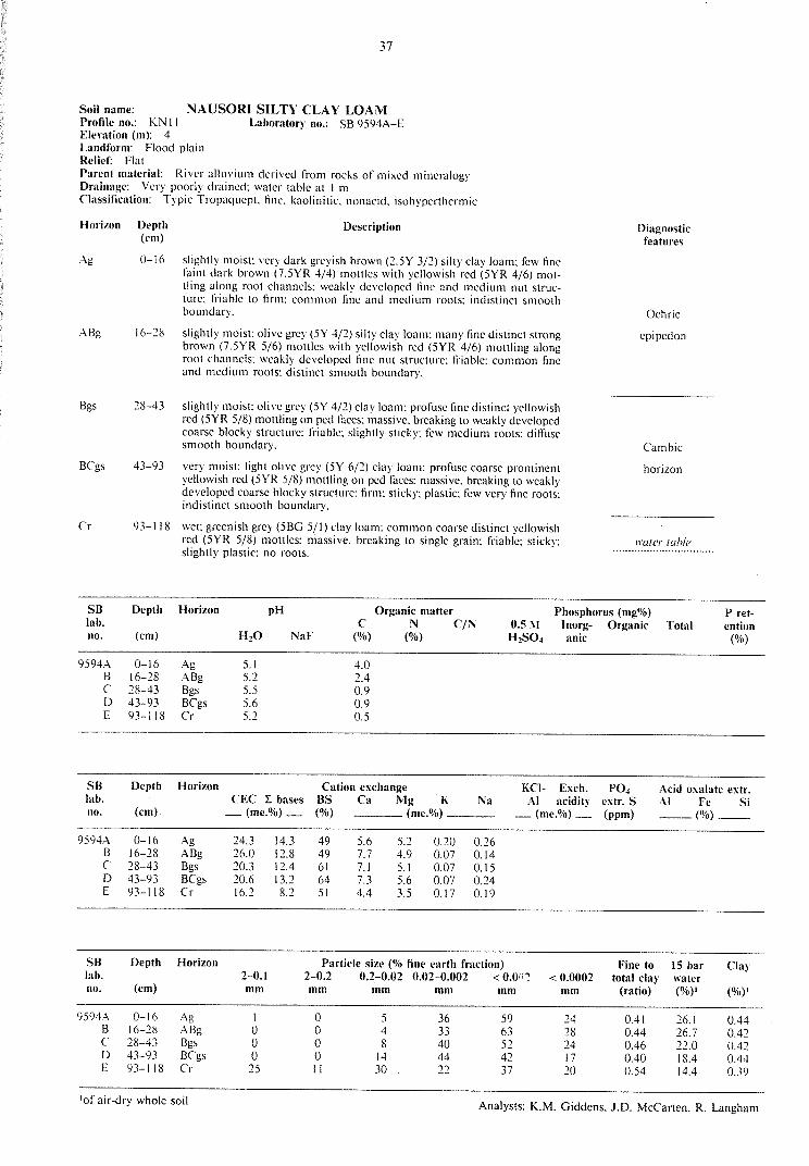
37
Soil name: NAUSORI SILTY CLAY LOAM Profile no.: KN 11 Laboratory no.: SB 9594A-E Elerntion (m): 4 Landform: Flood plain Relief: Flat Parent material: River alluvium derived from rocks of mixed mineralogy Drainage: Very poorly drained: water table at I m Classification: Typic Tropaquept fine. kaolinitic, nonacid. isohyperthermic
Horizon Depth Description (cm)
Ag 0-16 slightly moist: very dark greyish brown (2.5Y 3/2) silty clay loam: few fine faint dark brown (7.5YR 4/4) mollies with yellowish red (5YR 4/6) mottling along root channels: weakly developed fine and medium nut structure: friable to firm: common fine and medium roots: indistinct smooth boundary.
ABg 16-28 slightly moist: olive grey (5Y 4/2) silty clay loam: many fine distinct strong brown (7.5YR 5/6) mollies with yellowish red (5YR 4/6) mollling along root channels: weakly developed fine nut structure: friable: common fine and medium roots: distinct smooth boundary.
Bgs 28-43 slightly moist: olive grey (SY 4/2) clay loam: profuse fine distinct yellowish red (5YR 5/8) mollling on ped faces: massive. breaking to weakly developed coarse blocky structure: friable: slightly sticky: few medium roots: diffuse smooth boundary.
BCgs 43-93 very moist: light olive grey (SY 6/2) clay loam: profuse coarse prominent yellowish red (5YR 5/8) mollling on ped faces: massive. breaking to weakly developed coarse blocky structure: firm: sticky: plastic: few very fine roots: indistinct smooth boundary.
Cr 93-118 wet: greenish grey (5BG 5/1) clay loam: common coarse distinct yellowish red (5YR 5/8) mottles: massive. breaking 10 single grain: friable: sticky: slightly plastic: no roots.
Diagnostic features
Ochric
epipedon
Cambic
horizon
11·at<.'r lab!<.'
SB Depth Horizon pH Organic matter Phosphorus (mg%) P ret-lab. c N C/N 0.5 J\l lnorg- Organic Total ention no. (cm) H10 NaF (%) (%) H 2S04 anic (%)
9594 . ..\ 0-16 Ag 5.1 4.0 B 16-28 ABg 5.2 2.4 c 28-43 Bgs 5.5 0.9 D 43-93 BCgs 5.6 0.9 E 93-1 !8 Cr 5.2 0.5
SB Depth Horizon Cation exchange KCl- Exch. PO• Acid oxalate extr. lab. CEC I bases BS Ca Mg K Na Al acidity extr. S Al Fe Si no. (cm) _(me.%)_ (%) (me.%) __ (me.%)_ (ppm) __ (%) __
9594A 0-16 Ag 24.3 14.3 49 5.6 5.2 0.20 0.26 B 16-28 ABg 26.0 12.8 49 7.7 4.9 0.07 0.14 c 28-43 Bgs 20.3 12.4 61 7.1 5.1 0.07 0.15 D 43-93 BCgs 20.6 13.2 64 7.3 5.6 0.07 0.24 E 93-118 Cr 16.2 8.2 51 4.4 3.5 0.17 0.19
SB Depth Horizon Particle size (% fine earth fraction) Fine to 15 bar Clay lab. 2-0.1 2-0.2 0.2-0.02 0.02-0.002 < 0.()r:! < 0.0002 total clay water no. (cm) mm mm mm mm mm mm (ratio) (%)' (%)'
9594A 0-16 Ag I 0 5 36 59 24 0.41 26.1 0.44 B 16-28 ABg 0 0 4 33 63 28 0.44 26.7 0.42 c 28-43 Bgs 0 0 8 40 52 24 0.46 22.0 0.42 D 43-93 BCgs 0 0 14 44 42 17 0.40 18.4 0.44 E 93-118 Cr 25 II 30 22 37 20 0.54 14.4 0.39
'of air-dry whole soil Analysts: K.M. Giddens. J.D. McCarten, R. Langham

38
Soil name: NAVUA SILT LOAM Profile no.: KN08 Laboratory no.: SB 9S92A-F Elevation (m): S Landform: Flood plain Relief: Flat Parent material: River alluvium derived from rocks of mixed mineralogy Vegetation: Para grass and mimosa Drainage: Imperfectly drained: water table at 1 m Classification: Fluvaquentic Eutropcpt, fine. kaolinitic. isohyperthermic
Horizon Depth Description (cm)
Agl 0-20 moist: oliYc grey (SY S/2) silt loam: profuse medium prominent dark reddish brown (2.SYR 3/4) mottles: weakly developed coarse bloeky structure: friable to firm: slightly sticky: abundant fine and medium roots: indistinct smooth boundary.
Ag2 20-33 moist: olive grey (SY S/2) silty clay loam: profuse medium prominent dark reddish brown (2.SYR 3/4) mottles and many medium distinct yellowish brown ( 1 OYR S/6) mottles: weakly developed medium nut structure: friable to firm: slightly sticky: abundant fine and medium roots: indistinct wavy boundary.
Bg 33-49 moist: brown (I OYR 4/3) silt loam: many medium distinct olive grey (5Y S/2) mottles with common medium distinct dark reddish brown (2.SYR 3/4) mottles: weakly developed coarse blocky structure: friable: slightly sticky: many very fine roots: distinct smooth boundary.
Agb 49-64 moist: olive brown (2.SY 4/4) silty clay loam: many coarse distinct yellowish red (SYR 4/6) mottles as root-channel coatings: weakly developed fine nut structure: non-sticky: non-plastic: friable: common very fine roots: distinct smooth boundary.
Bgb I 64-93 moist: yellowish brown (1 OYR S/6) clay loam: many coarse distinct olive grey (SY S/2) mottles: massive. breaking to weak coarse blocky structure: friable: slightly sticky: no roots: diffuse smooth boundary.
Bgb2 93-143 wet: yellowish brown ( 1 OYR S/6) clay loam: profuse coarse prominent light olive grey (SY 6/2) mottles: massive. breaking to weak coarse blocky structure: friable to firm: slightly sticky: no roots.
Diagnostic features
Ochric
epipedon
Cambic horizon
Palcosol
Cambic horizon
\\'(/[('/" /l/h/('
SB Depth Horizon pH Organic matter Phosphorus (mg%) P ret-
lab. c N C/N 0.5 i\I Inorg- Organic Total ention
no. (cm) HiO NaF (%) (%) HiS04 anic (%)
9S92A 0-20 Ag! S.7 2.2 B 20-33 Ag2 S.8 2.0 c 33-49 Bg S.9 1.0 D 49-64 Agb S.9 1.3 E 64-93 Bgbl S.9 0.8 F 93-143 Bgb2 6.1 0.6
SB Depth Horizon Cation exchange KCI- Exch. P04 Acid oxalate extr.
lab. CEC 2: bases BS Ca Mg K Na Al acidity extr. S Al Fe Si
no. (cm) _(me.%)_ (%) (me.%) _(me.%)_ (ppm) __ (%) __
9S92A 0-20 Agl 30.6 20.2 67 11.4 8.3 0.16 0.38
B 20-33 Ag2 30.7 21.7 71 12.3 9.0 O. lS 0.39
c 33-49 Bg 2S.5 18.5 73 9.3 8.8 0.11 0.31
D 49-64 Agb 2S.O 18.6 74 8.8 9.4 0.12 0.27
E 64-93 Bgbl 21.2 17.1 81 8.1 8.6 0.11 0.28
F 93-143 Bgb2 22.9 18.6 81 8.0 10.2 0.14 0.28
SB Depth Horizon Particle size (% fine earth fraction) to 15 bar Clay
lab. 2-0.I 2-0.2 0.2-0.02 0.02-0.002 < 0.002 < 0.0002 total cla)' water
no. (cm) mm mm mm mm mm mm (ratio) (%)! (%)'
9S92A 0-20 Ag! 0 0 7 37 S6 2S 0.4S 23.S 0.42
B 20-33 Ag2 I 0 6 36 S8 2S 0.43 23.3 0.40
c 33-49 Bg 0 0 s 3S 60 31 O.S2 24.S 0.41
D 49-64 Agb 2 I 9 32 S8 26 0.4S 24.S 0.42
E 64-93 Bgbl I 0 10 31 S9 25 0.42 23.4 0.40
F 93-143 Bgb2 4 2 8 26 64 3S o.ss 24.8 0.39
101· air-dry whole soil Analysts: K.M. Giddens. J.D. McCarten. R. Langham

39
Soil name: REWA SILTY CLAY LOAM Profile no.: KN05 Laboratory no.: SB 9591 A-E Ele\'ation (m): 6 Landform: Levee Relief: Planar. gently sloping ~urfacc (I 0
)
Parent material: River alluvium derived from rocks of mixed mineralogy Vegetation: Bare ground under I 0-ycar-old cocoa grove Drainage: Well drained Classification: Fluventic Eutropept. fine-silty. mixed'. isohyperthermic
Horizon Depth Description (cm)
Aul 0-18 slightly moist: dark brown (IOYR 3/3) silty clay loam: weakly developed fine nut and medium crumb structure: friable; many fine and medium roots: diffuse smooth boundary.
Au2 18-28 slightly moist: dark brown (IOYR 3/3) silty clay loam: few fine faint dark brown (7.5YR 4/4) mottles: weakly developed coarse bloc:ky structure breaking to weak fine nut structure; friable to firm; common fine roots: indistinct smooth boundary.
Bw I 28-77 slightly moist: dark yellowish brown (I OYR 4/4) silty clay: weakly developed fine nut structure: friable: shiny pcd faces. with rare clay coatings to pores: few fine roots; indistinct smooth boundary.
Bw2 77-106 moist: yellowish brown (I OYR 5/6) silty clay loam: common fine faint
Aub
yellowish red (5YR 4/8) mottles: few very fine dark reddish brown (SYR 2/2) Fe/Mn concretions: weakly developed coarse nut structure breaking to weak very fine nut structure: friable: few fine roots: distinct smooth boundary.
I 06-126 moist: dark brown (I OYR 3/3) silty clay loam: weakly developed fine nut structure: friable: few very fine roots.
'tightly aggregated kaolinitic clay
Diagnostic features
Ochric
epipedon
Cambic
horizon
Palcosol
SB Depth Horizon pH Organic matter Phosphorus (mg%) P ret-lab. c N C/N 0.5 "' lnorg- Organic Total ention no. (cm) HiO NaF (%) (%) HiS04 anic (%)
9591A 0-18 Aul 5.6 1.4 B 18-28 Au2 5.7 1.2 c 28-77 Bwl 6.0 1.2 D 77-106 Bw2 6.0 0.7 E 106-126 Aub 6.0 1.2
SB Depth Horizon Cation exchange KCI- Exch. P04 Acid oxalate extr. lab. CEC :l: bases BS Ca Mg K Na Al acidity extr. S Al Fe Si no. (cm) _(me.%)_ (%) (me.%) _(me.%)_ (ppm) __ (%) __
9591A 0-18 Aul 26.7 19.9 75 13.1 6.5 0.13 0.17 B 18-28 Au2 28.0 22.0 79 14.3 7.3 0.17 0.20 c 28-77 Bwl 32.6 25.7 79 16.6 8.7 0.17 0.21 D 77-106 Bw2 32.9 28.7 87 18.1 10.1 0.20 0.32 E 106-126 Aub 28.6 22.8 80 13.9 8.5 0.12 0.25
SB Depth Horizon Particle size (% fine earth fraction) Fine to 15 bar Clay lab. 2-0.1 2-0.2 0.2-0.02 0.02-0.002 <ll.002 <0.0002 total cla)· water no. (cm) mm mm mm mm mm mm (ratio) (%)' (%)'
9591A 0-18 Aul 4 I 22 37 40 16 0.40 14.8 0.37 B 18-28 Au2 3 I 20 36 43 18 0.42 16.5 0.38 c 28-77 Bwl I I 10 36 53 25 0.47 21.7 0.41 D 77-106 Bw2 0 0 10 40 50 26 0.52 23.9 0.48 E 106-126 Aub 0 0 9 39 52 25 0.48 21.2 0.41
'of air-dry whole soil Analysts: K.M. Giddens. J.D. McCarten. R. Langham

40
Soil name: SARA VA CLAY LOAM Profile no.: KN 19 Elevation (m): 18
Laboratory no.: SB 9599A-C
Landform: Strongly dissected hill country Relief: Concave-planar mid-slope: very sleep (40°) Parent material: Shallow colluvium over i11-si111 basic tuffs Vegetation: Batiki blue grass. mimosa. Navua sedge. carpel grass and Dcsmodium Drainage: Well drained Classification: Lithic Eulropept. clayey. mixed. isohypenhermic
HoriLon
Au
AB
R
Depth (cm)
0-18
18-31
Description
slightly moist: very dark greyish brown ( IOYR 3/2) clay loam: moderately de\·eloped fine nut and granular structure: friable to firm: many tine and medium roots: indistinct smooth boundary.
slightly moist: dark yellowish brown (I OYR 4/4) clay loam: common medium distinct reddish brown (5YR 4/4) mollies: weakly to moderately developed very tine nut with tine granular structure: friable: many tine roots: few strongly weathered subangular stones: sharp wavy boundary.
31-120+ dry: olive (5Y 5/3) silty clay loam: yellowish brown (lOYR 5/8) colouration along horizo111al bedding planes: massive: extremely firm: no roots: in silll rock.
Diagnostic features
Ochric
cpipedon
Lithic
contact
SB Depth Horizon pH Organic matter Phosphorus (mg%) P ret-lab. c N C/N 0.5 i\I lnorg- Organic Total ention no. (cm) H20 NaF (%) (%) H2S04 anic (%)
9599 . .\ 0-18 Au 5.6 8.3 2.9 0.21 14 3 10 35 45 48 B 18-31 AB 5.9 8.6 1.6 0.12 13 2 9 27 36 46 c 31-120 R 6.8 8.5 0.4 0.01 40 16 26 12 38 26
SB Depth Horizon Cation exchange KCI- Exch. P04 Acid oxalate extr. lab. CEC L bases BS Ca Mg K Na Al acidity extr. S Al Fe Si no. (cm) _(me.%)_ (%) (me.%) _(me.%)_ (ppm) __ (%) __
9599 . .\ 0-18 Au 32.4 24.2 75 16.8 7.0 0.21 0.23 0.94 21.5 13 0.38 0.78 0.05 B 18-31 AB 33.1 26.9 81 19.0 7.4 0.22 0.27 0.78 19.4 II 0.35 0.55 0.05 c 31-120 R 30.6 30.0 98 23.2 6.3 0.27 0.25 0.21 12.0 I 0.20 0.30 0.05
SB Depth Horizon Particle size (% fine earth fraction) Fine to 15 bar Clay lab. 2-0.1 2-0.2 0.2-0.02 0.02-0.002 <0.002 < 0.0002 total clay water no. (cm) mm mm mm mm mm mm (ratio) (%)' (%)'
9599A 0-18 Au 3 0 25 25 50 29 0.58 20.I 0.40 B 18-31 AB I 0 23 27 50 27 0.54 19.I 0.38 c 31-120 R I 0 31 30 39 18 0.46 15.4 0.39
1of air-dry whole soil Analysts: K.M. Giddens. J.D. McCanen. R. Langham

41
Soil name: TOGA SANDY LOAM Profile no.: KN06 Laboratory no.: Not sampled for analysis Elerntion (m): 6 Landform: Levee crest Relief: Flat Parent material: River alluvium derived from rocks of mixed mineralogy \'egetation: Para grass and mimosa Drainage: Well drained Classification: Tropoftuvcn1 1• fine-loamy. mixed 2• nonacid. isohyperthermic
Horizon
Au
Depth (cm)
0-30
Description
slightly moist: very dark greyish brown (I OYR 3/2) very fine sandy loam: fow fine faint dark greyish brown (2.5Y 4/2) mottles: weakly developed fine nut structure. breaking to single grain: friable: many fine roots: distinct wavy boundary.
AC 30-36 slightly moist: brown lo dark brown (IOYR 4/3) loamy fine sand: common
:\ub
medium distinct dark brown (7.5YR 4/4) motiles: single grain: loose: common fine roots: distinct smooth boundary.
36-80 moist: very dark greyish brown (IOYR 3/2) silty clay loam: weakly developed fine nut and granular structure: friable: common very fine roots: distinct smooth boundary.
BCb 80-109 moist: dark yellowish brown (IOYR 3/4) fine sandy loam: few fine distinct yellowish red (SYR 5/6) mottles: weakly developed coarse blocky structure. breaking to single grain: friable: few very fine roots: distinct smooth boundary.
Cb I 09-128 moist: yellowish red (5YR 4/8) silty clay loam: massive. breaking to single grain: friable to firm: no roots: dark brown (7.5YR 4/4) worm-mixed areas.
1 subgroups not defined 2tightly aggregated kaolinitic clay
Diagnostic features
Ochric epipedon
Paleosol

42
Soil name: TOKOTOKO SILTY CLAY LOAM Profile no.: KN09 Laboratory no.: SB 9593A-D Elevation (m): 4.5 Landform: Flood plain Relief: Flat Parent material: River alluvium derived from rocks of mixed mineralogy Vegetation: Para grass. Navua sedge and tarwecd Drainage: Poorly drained: water table at I m Classification: Aerie Tropoquept. very-fine. kaolinitic. nonacid. isohypcrthermic Horizon Depth Description (cm)
Au 0-17 moist: dark greyish brown (2.5Y 4/2) silty clay loam: common fine faint yellowish red (5YR 5/6) mottles: weakly developed coarse blocky structure breaking to weakly developed very fine nut structure; friable; slightly sticky: many fine and medium roots: indistinct smooth boundary. Ag 17-37 moist: olive grey (5Y 4/2) clay loam; common fine faint dark yellowish brown (IOYR 4/6) mottles: weakly developed coarse prismatic structure breaking to weakly developed medium blocky structure: friable to firm; slightly sticky: many fine roots: distinct wavy boundary. Bg 37-69 moist; strong brown (7.5YR 5/6) clay: many medium distinct greenish grey (5GY 6/1) mottles: massive, breaking to weakly developed medium blocky structure: firm: sticky; slightly plastic; few very fine roots: worm-mixing in upper 10 cm: diffuse smooth boundary. BCgs 69-134 wet: light olive grey (5Y 6/2) clay: profuse coarse prominent strong brown (7.5YR 5/6) mottles: massive: sticky: plastic: firm: no roots.
Diagnostic features
Ochric epipedon
Cambic horizon
ll'ater table . ................................
SB Depth Horizon pH Organic matter Phosphorus (mgo/o) P ret-lab. c N C/N O.SM lnorg- Organic Total ention no. (cm) HiO NaF (%) (%) HiS04 anic (%) 9593A 0-17 Au 5.4 3.4
B 17-37 Ag 5.7 1.5 c 37-69 Bg 6.0 0.9 D 69-100 BCgs 6.3 0.7
SB Depth Horizon Cation exchange KCI- Exch. PQ4 Acid oxalate extr. lab. CEC 2: bases BS Ca Mg K Na Al acidity extr. S Al Fe Si no. (cm) _(me.%)_ (%) (me.%) _(me.%)_ (ppm) __(o/o) __
9593A 0-17 Au 28.7 17.8 62 10.7 6.1 0.81 0.23 B 17-37 Ag 24.6 18.7 76 11.5 6.7 0.16 0.32 c 37-69 Bg 21.6 18.3 85 10.3 7.4 0.15 0.44 D 69-100 BCgs 23.4 19.9 85 10.6 8.9 0.15 0.29
SB Depth Horizon Particle size (% fine earth fraction) Fine to 15 bar Clay lab. 2-0.1 2-0.2 0.2-0.02 0.02-0.002 < 0.002 <0.0002 total clay water no. (cm) mm mm mm mm mm mm (ratio) (%)' (%)' 9593A 0-17 Au 0 5 30 65 33 0.51 24.4 0.38 B 17-37 Ag 2 I 8 27 64 38 0.59 23.6 0.37 c 37-69 Bg 0 0 8 26 66 32 0.64 26.0 0.39 D 69-100 BCgs 6 3 II 21 65 44 0.68 25.5 0.39
1of air-dry whole soil Analysts: K.M. Giddens. J.D. McCarten. R. Langham

43
Soil name: W AIDAMU PEATY LOAM Profile no.: KN 14 Laboratory no.: SB 9595A-E Elerntion (m): 3.5 Landform: Peat bog Relief: Flat Parent material: Strongly decomposed peat derived from terns and sedges. with layer of river alluvium Vegetation: Fern. sedges and Batiki blue grass Drainage: V cry poorly drained: water table at 120 cm Classification: Fluvaquentic Troposaprist. cuic. isohyperthermic
Horizon Depth Description (cm)
Oh 10-20 :noist: black (5YR 2/1) peaty loam: weakly developed tine and very fine nut structure: friable: sticky: abundant fine and medium roots: indistinct smooth boundary.
Oh2 20-77 very moist: dark reddish brown (5YR 3/4) strongly decomposed peat: massive: friable: slightly sticky: many medium roob: sharp smooth boundary.
Cr 77-82 wet: greenish grey (5GY 6/1) clay: massive: firm: sticky: slightly plastic: no roots: sharp smooth boundary.
Ohb I 82-96 wet: black (5YR 2/ I) peaty loam: weakly developed tine crumb structure: very friable: slightly sticky: no roots: indistinct smooth boundary.
Ohb2 96-130 wet: dark reddish brown (5YR 3/3) strongly decomposed peat: massive: friable: slightly sticky: no roots.
Diagnostic features
Histic
horizon
Mineral horizon
Histic horizon
water tahlc
SB Depth Horizon pH Organic matter Phosphorus (mg%) lab. c N C/N 0.5 1\1 lnorg- Organic Total no. (cm) H20 NaF (%) (%) H2SO~ anic
9595A 0-20 Ohl 4.5 34 B 20-77 Oh2 4.3 51 c 77-82 Cr 5.3 3.8 D 82-96 Ohbl 4.5 41 E 96-130 Ohb2 4.7 49
SB Depth Horizon Particle size (% fine earth fraction) Fine to 15 bar lab. 2-0.l 2-0.2 0.2-0.02 0.02-0.002 < 0.002 <0.0002 total clay water no. (cm) mm mm mm mm mm mm (ratio) (%)'
9595A 0-20 Ohl 39.9 B 20-77 Oh2 41.8 c 77-82 Cr 22.5 [) 82-96 Ohbl 40.4 E 96-130 Ohb2 37.9
'of air-dry whole soil
P ret-ention
(%)
Clay
(%1)'

44
Soil name: Profile no.: KN 16 Elerntion (m): I 0
W AIDINA SIL TY CLAY LOAM Laboratory no.: SB 9596A-E
Landform: Moderatclv dissected hill countrv Relief: Convex mid-siope: moderately steep (I 8°) Parent material: Colluvium derived from basic luffs Vegetation: Para grass and Navua sedge Drainage: Well drained Classification: Typic Eutropepl. tine. mixed. isohyperlhcrmic
Horizon Depth Description (cm)
Au 0-14 slightly moist: dark brown to brown (IOYR 4/3) silty clay loam: mod.erately dcvdoped llnc nut structure: friable: many llnc roots: few moderately weathered subangular gravels: indistinct smooth boundary .
. .\B 14-31 slightly moist: olive brown (2.SY 4/4) clay loam: moderately developed llne nut and medium blocky struclllre: friable: many llne roots: few moderately weathered subangular gravels: indistinct smooth boundary,
Bwl
Bw2
31-77 slightly moist: yellowish brown (IOYR 5/6) silty clay loam: many coarse distinct strong brown (7.5YR 5/6) mottles: weakly developed coarse blocky structure: friable: slightly sticky: common medium roots: few moderately weathered subangular stones: horizon indistinct smooth boundary.
77-99 slightly moist: yellowish brown ( IOYR 5/6) silty clay loam; many coarse distinct strong brown (7.5YR 5/6) mottles: weakly developed coarse blocky structure breaking to single grain: slightly sticky: llrm: few: medium roots: common strongly weathered subrounded stones: distinct smooth boundary.
BC 99-119 slightly moist: yellowish brown (I OYR 5/4) silty clay loam: many coarse distinct yellowish brown (IOYR 5/6) mottles: massive: firm: no roots.
Diagnostic features
Ochric epipedon
Cambic
horizon
SB Depth Horizon pH Organic matter Phosphorus (mg%) P ret-lab. c N C/N 0.5 !\I Inorg- Organic Total ention no. (cm) H20 NaF (%) (%) H2S04 anic (%)
9596A 0-14 Au 5.5 3.9 B 14-31 AB 5.7 1.5 c 31-77 Bwl 5.9 0.8 D 77-99 Bw2 6.2 0.4 E 99-119 BC 6.7 0.3
SB Depth Horizon Cation exchange KCI- Exch. P04 Acid oxalate extr. lab. CEC I bases BS Ca Mg K Na Al acidity extr. S Al Fe Si no. (cm) _(me.%)_ (%) (me.%) _(me.%)_ (ppm) __ (%) __
9596A 0-14 Au 35.1 25.8 74 14.8 10.3 0.32 0.35 B 14-31 AB 37.2 28.3 76 15.7 11. 9 0.22 0.48 c 31-77 Bwl 37.9 30.5 80 15.7 13.9 0.23 0.63 D 77-99 Bw2 36.3 33.0 91 17.3 14.9 0.26 0.52 E 99-119 BC 35.2 40.1 (100) 23.9 15.1 0.36 0.73 15.0
SB Depth Horizon Particle size (% fine earth fraction) Fine to 15 bar Clay lab. 2-0.1 2-0.2 0.2-0.02 0.02-0.002 < 0.002 < 0.0002 total clay water no. (cm) mm mm mm mm mm mm (ratio) (%)' (%)•
9596A 0-14 Au I 0 14 27 59 33 0.56 24.1 0.41 B 14-31 AB 7 0 25 28 47 25 0.53 24.4 0.52 c 31-77 Bwl 0 0 12 34 54 28 0.52 25.1 0.46 D 77-99 Bw2 0 0 II 39 50 24 0.48 24.1 0.48 E 99-119 BC 0 0 19 40 41 19 0.46 22.9 0.56
'of air-dry whole soil Analysts: K.M. Giddens. J.D. McCarten. R. Langham

45
Soil name: W AILA CLAY LOAM Profile no.: KN 18 Laboratory no.: SB 9597 A-E Elerntion (m): 24 Landform: Strongly dissected hill country Relief: Convex planar back slope: strongly sloping (11°) Parent material: Colluvium derived from basic luffs Vegetation: Batiki blue grass. Navua sedge. Desmodium and mimosa Drainage: Well drained Classification: Typic Humitropepl. very line. kaolinitic. isohypcrthermic
Horizon Depth Description (cm)
Au 0-11 slightly moist: dark brown (IOYR 3/3) clay loam: moderately developed line and verv line nut structure: friable lo lirm: abundant medium and coarse roots:· few strongly weathered subangular gravels indistinct smooth boundary
AB 11-21 slightly moist: dark yellowish brown (IOYR 4/4) with dark brown (IOYR 3/3) worm-mixed material: clay loam: moderately developed fine nut and granular structure: friable: many medium roots: few strongly weathered subangular gravels: boundary marked by discontinuous line of plaly iron ( 1-3 cm) concretions: indistinct smooth boundary.
Bw 21-37 slightly moist: strong brown (7.5YR 5/6) clay loam: weakly developed coarse blocky structure: friable 10 firm: few faint strong brown (7.5YR 5/6) clay coatings to voids: many line and medium roots: distinct wavy boundary.
BC I 37-63 slightly moist: 75% pale yellow (2.5Y 7 /4) matrix of weathered parent material (clay loam) with 25% yellowish red (5YR 5/6) clay: massive: lirm: !cw faint strong brown (7.5YR 5/6) clay coatings on voids: common fine roots: diffuse: smooth boundary.
BC ·2 63-125 slightly moist: pale yellow (2.5Y 7 /4) clay: massive: friable to firm: slightly sticky: few faint strong brown (7.5YR 5/6) clay coatings on voids.
Diagnostic features
Ochric
epipedon
Cambic horizon
SB Depth Horizon pH Organic matter Phosphorus (mg%) P ret-lab. (' N C/N O.SM lnorg- Organic Total ention no. (cm) HiO NaF (%) (%) HiSO~ anic (%)
9597A 0-11 Au 5.1 8.4 4.5 0.44 14 4 17 51 69 64 B 11-21 AB 5.3 8.7 2.9 0.13 13 5 28 45 73 70 c 21-37 Bw 5.3 9.2 1.4 0.10 14 I 32 16 48 81 D 37-63 BCI 5.2 9.6 0.9 0.05 18 3 33 II 44 86 E 63-125 BC2 5.3 9.6 0.8 0.04 10 1 29 12 41 87
SB Depth Horizon Cation exchange KCI- Exch. P04 Acid oxalate extr. lab. CEC L bases BS Ca Mg K Na Al acidity extr. S Al Fe Si no. (cm) _ (me.%)_ (%) (me.%) -(me.%) _ (ppm) __ (%) __
9597A 0-11 Au 28.8 5.0 52 9.4 5.1 0.15 0.21 1.4 30.9 77 0.37 0.91 0.00 B 11-21 AB 15.5 12.8 50 7.8 4.7 0.18 0.14 2.9 28.9 32 0.38 0.71 0.00 c 21-37 Bw 27.1 11.3 42 6.7 4.3 0.17 0.14 7.1 29.2 15 0.49 0.28 0.00 D 37-63 BCI 27.8 9.1 33 5.6 3.1 0.18 0.15 11.8 31.8 39 0.54 0.15 0.00 E 63-125 BC1 28.3 6.7 14 3.9 1.4 0.17 0.15 13.9 33.5 39 0.52 0.19 0.00
SB Depth Horizon Particle size (% fine earth fraction) Fine to 15 bar Clay lab. 2-0.l 2-0.2 0.2-0.02 0.02-0.002 <0.002 < 0.0002 total cla)· water no. (cm) mm mm mm mm mm mm (ratio) (%)' (%)'
9597A 0-11 Au 1 14 20 6:· 38 0.58 16.5 OAI B 11-21 AB 1 12 19 68 41 0.62 25. I 0.37 c 21-37 Bw 1 12 19 68 45 0.66 17.5 0.40 D 37-63 BCI 1 13 30 56 31 0.55 26.8 0.48 E 63-125 BC1 12 26 61 36 0.59 25.9 0.41
1 of air-dry whole soil Analysts: K.M. Giddens. J.D. McCarten. R. Langham

46
Soil name: W AITOVU PEA TY LOAM Profile no.: KN 13 Laboratory no.: Not sampled for analysis Elerntion (m): 3.5 Landform: Flood plain fringing peat bog Relief: Flat planar surface Parent material: Weakly decomposed peat with mineral horizons derived from rocks of mixed mineralogy Vegetation: Para grass. tarweed and yellow primrose Drainage: Very poorly drained: water table at 1 m Classification: Fluvaqucntic Tropofibrist. dysic. isohyperthcrmic
Horizon
Orn
Of
Cr
Otb
Crb
Depth (cm)
0-17
17-25
25-48
48-88
88-103
Description
moist: black (7.5YR 2/0) peaty loam: weakly developed line nut and granular structure: very friable: abundant. line and medium roots: indistinct smooth boundary.
moist: black ( 1 OYR 2/ 1) peaty loam: many weakly decomposed fibres: weakly developed medium crumb structure: friable: abundant line and medium roots: sharp smooth boundary.
very moist: greenish grey (5GY 6/1) clay: many coarse distinct dark olive grey (5Y 3/2) mottles: massive: tlrm: sticky: plastic: few very line roots: sharp smooth boundary.
wet: very dark brown (I OYR 2/2) weakly decomposed peat: massive: slightly plastic: friable: no roots: sharp smooth boundary.
wet: dark greyish brown (2.5Y 4/2) clay: massive: firm: sticky: plastic: no roots.
Diagnostic features
Histic
horizon
Mineral horizon
Histic horizon
ll'ater 1able ·································