some dam – hydro news - stanford university · pdf filesome dam – hydro news tm...
TRANSCRIPT

3/17/2017
i
Dams:(Factoid: The spillway chute at Oroville Dam failed at a flow of 50,000-55,000 cfs, The chute is designed to handle up to 300,000 cfs. In 1997, the spillway chute handled 160,000 cfs during an actual flood event and had no reported damage.)
(What a mess!)Oroville Dam shuts down mainspillway, crews begin damageassessmentFeb 28, 2017, by Paul KitagakiThe Sacramento Bee,sacbee.com
Shutting off the main spillway brought intoview the massive mound of concrete, rubbleand debris that has formed in the channel atits base. The eroded material has raised
Copy obtained from the National Performance of Dams Program: http://npdp.stanford.edu
Some Dam – Hydro News TM
And Other Stuff
1
Quote of Note: “Beware of programmers who carry screwdrivers. .” -Leonard Brandwein
Some Dam - Hydro News Newsletter Archive for Current and Back Issues and Search: (Hold down the Ctrl key when click on this link) http://npdp.stanford.edu/
Under Partners/Newsletters on left Click on Link (Current issue or View Back Issues)
“Good wine is a necessity of life.” - -Thomas JeffersonRon’s wine pick of the week: 2014 Torbreck Syrah & Shiraz (Other than French) "Woodcutter's" “ No nation was ever drunk when wine was cheap. ” - - Thomas Jefferson
channel levels to the point that the dam’s hydroelectric plant can’t function. DWR will spend several days in an intensive dredging operation to try to bring the river level back to normal.
http://www.sacbee.com/news/state/california/water-and-drought/article135380499.html
Aerial footage reveals the full extent of the damage to the main spillway at the Oroville Dam in California after the flood waters finally recededmsn.com, 3/2/17
http://www.msn.com/en-ca/news/videos/aerial-footage-reveals-full-extent-of-damage-to-oroville-dam-spillway/vi-AAnFZQx
(More Oroville damage video.)rgj.com, 3/2/17http://www.rgj.com/story/news/2017/03/01/amazing-aerial-footage-damaged-spillway-oroville-dam/98577026/
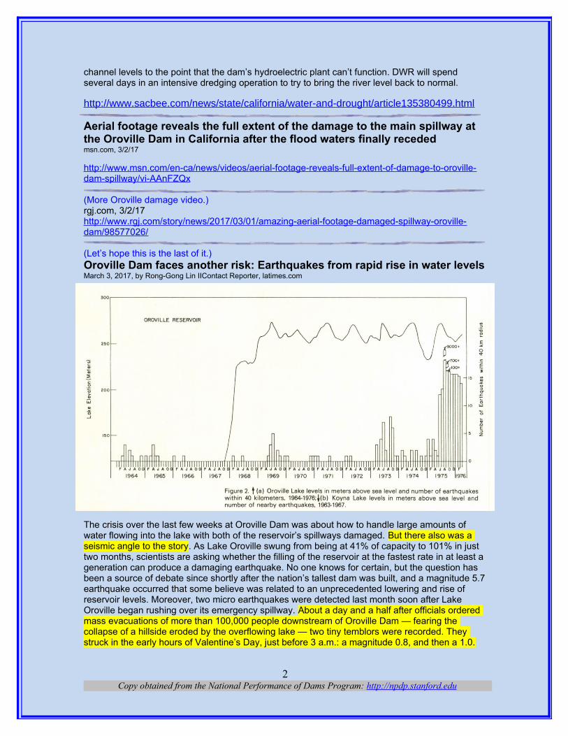
(Let’s hope this is the last of it.)Oroville Dam faces another risk: Earthquakes from rapid rise in water levelsMarch 3, 2017, by Rong-Gong Lin IIContact Reporter, latimes.com
The crisis over the last few weeks at Oroville Dam was about how to handle large amounts of water flowing into the lake with both of the reservoir’s spillways damaged. But there also was a seismic angle to the story. As Lake Oroville swung from being at 41% of capacity to 101% in just two months, scientists are asking whether the filling of the reservoir at the fastest rate in at least ageneration can produce a damaging earthquake. No one knows for certain, but the question has been a source of debate since shortly after the nation’s tallest dam was built, and a magnitude 5.7earthquake occurred that some believe was related to an unprecedented lowering and rise of reservoir levels. Moreover, two micro earthquakes were detected last month soon after Lake Oroville began rushing over its emergency spillway. About a day and a half after officials ordered mass evacuations of more than 100,000 people downstream of Oroville Dam — fearing the collapse of a hillside eroded by the overflowing lake — two tiny temblors were recorded. They struck in the early hours of Valentine’s Day, just before 3 a.m.: a magnitude 0.8, and then a 1.0.
Copy obtained from the National Performance of Dams Program: http://npdp.stanford.edu2

Two micro earthquakes — a magnitude 0.8 and 1.0 — were recorded in the Lake Oroville area shortly after the reservoir started to spill over in mid-February. Those earthquakes were so small a human wouldn’t be able to feel them at the surface. But given how close they were to the dam, and the relationship between some man-made reservoirs and earthquakes, researchers gave the temblors special attention.
“It’s obviously something that needs to be carefully monitored,” U.S. Geological Survey research geophysicist Justin Rubinstein said of the need to carefully monitor dam sites for human-triggeredearthquakes. “But in general, when you see seismicity induced by reservoirs, it’s generally sort of in the beginning of the lifetime of the dam,” Rubinstein said. That’s what some scientists believed happened at this reservoir in 1975, seven years after Oroville Dam was completed. Lake Oroville had been filled before. What made the winter of 1974-75 unusual was that water levels had to be reduced to their lowest level since the reservoir was first filled to repair intakes to the hydroelectricpower plant. Months later, there was an unprecedented refilling of the lake that ended in June 1975. Then the earthquakes started. Instead of fewer than five earthquakes a month in a zone within 25 miles from the dam, as had been the case for the previous year, June and July suddenlysaw more than 10 earthquakes each month. Then the largest earthquake in the sequence hit: a magnitude 5.7 on Aug. 1, 1975. It was strong enough to crack plaster and walls in Oroville and was felt as far away as San Francisco and Sacramento, where the Capitol’s dome suffered minor damage. The 50-person staff of Treasurer Jesse Unruh was ordered to evacuate its office. That August became a banner month for earthquakes around Oroville Dam — more than 3,000 temblors were recorded, before fading to more than 700 a month later and over 100 by October.
Not all scientists agree that the earthquakes were triggered by human activity. But two state seismologists who authored a study in the journal California Geology offered an argument that theevents were influenced by the operations of the man-made reservoir. That Oroville earthquake was similar to a well-established example of a human-triggered quake seen after the construction of the Koyna Dam in western India in 1962. “The major burst of seismicity did not occur upon initial filling, but occurred several years later following an unprecedented seasonal refilling in eachcase,” wrote authors Tousson Toppozada and Paul Morrison Jr., who respectively worked for the California Division of Mines and Geology and the California Department of Water Resources. The Koyna Dam is believed to be related to a magnitude 6.2 earthquake in 1967, which killed 200 people. There is other well-established evidence for reservoir-caused earthquakes, Rubinstein said, such as the construction of Hoover Dam and the filling of Lake Mead. “People started feelingearthquakes in an area with no historical seismicity,” he said.Other cases have been more controversial. Some independent scientists have said the 2008 magnitude 7.9 earthquake in China, which killed nearly 90,000 people, was linked to the filling of the reservoir behind the newly built Zipingpu Dam. Chinese authorities have argued vigorously that the dam was not the cause, said Ross Stein, an earthquake expert and founder of the website temblor.net. Lake Oroville once was the poster child of the California drought. In late 2015, the lake dipped to 26% capacity but began its recovery about a year ago, reaching a high of 96% capacity in May before being drawn down in the summer and fall. What made this winter catch the eye of scientists, however, was how suddenly the reservoir filled up. Last year, it took five months to fill Lake Oroville; this winter, it took only two months. Oroville’s Valentine’s Day earthquakes have not been followed by additional, increasingly larger earthquakes. That makes it improbable that the micro quakes would be the first dominoes in a lead-up to a damaging future earthquake, Rubinstein said. “By all accounts, the situation does not in any way look alarming,” Stein said. “But we recognize in the earthquake business that things don’t look alarming until the earthquake occurs.” Indeed, the 1971 Sylmar earthquake and 1994 Northridge earthquakes came as surprises, said Peggy Hellweg, operations manager at the Berkeley Seismological Laboratory.“Anywhere in California, an earthquake could happen, and I would not be extremely surprised,” Hellweg said.
Copy obtained from the National Performance of Dams Program: http://npdp.stanford.edu3

There are two ways a reservoir can cause an earthquake. A rapid filling or emptying of a lake can change the weight pushing on a fault, which can make an earthquake more likely, said Bill Leith, acting associate director on natural hazards at the USGS. “Especially for a reservoir as large as Oroville, it’s a huge weight on the crust that’s basically being pulled up and down on an annual cycle. So it wouldn’t be surprising if there were earthquakes associated with that,” Leith said. “Therapid filling, I just think it increases the risk. … I would expect that a rapid rise or a rapid fall in the water level would be much more likely to trigger earthquakes.” On the other hand, Lake Oroville has been dealing with seasonal changes in water levels for nearly half a century, and for the mostpart, it has been seismically quiet. “It appears to be a relatively stable system,” Leith said.The second way a reservoir can cause an earthquake is from added pressure. Water trickling deep into the earth can increase pressure underground that makes it easier for faults to move, according to seismologist Lucy Jones. “The pressure in the water sort of pushes the fault back apart,” Jones said. The added water pressure underground essentially unclamps a fault — like loosening a vice that keeps two blocks of rocks stuck together — in a way that makes it easier for the earth to move.
It can take years for water to filter down into the deep crevices of the earth and add fluid pressure around the fault, Leith said. The dramatic fluctuation in reservoir levels in 1975 may have been the trigger point for the earthquake that year. The adding of water deep underground also is what is causing human-induced earthquakes in Oklahoma and southern Kansas, as added fluid
Copy obtained from the National Performance of Dams Program: http://npdp.stanford.edu4

pressure unclamps the fault and triggers earthquakes, Leith said. The 1975 Oroville quake may have released much of the seismic stress that had accumulated in the area. “But I wouldn’t put my reputation on that — just because it’s impossible to know whether there are faults nearby that are close to failure,” Leith said. “This is a problem that we have everywhere where there are human-induced earthquakes,” Leith said. It’s possible there is a fault on the brink of failure in the Oroville area. Even a seasonal change in reservoir levels could be the trigger that unlocks an earthquake. “We don’t have ways of measuring how close to failure the faults are,” Leith said. “It’sone of the challenges of seismology.” The California Department of Water Resources’ latest assessment of Oroville Dam indicates it would be stable under the current predicted level of seismic shaking, a statement from the agency said. The closest known fault is the Cleveland Hill fault, which ends about three miles southeast of the dam. The state’s latest seismic evaluation of the dam, completed in 2014, said the dam is not in need of a retrofit. Even if a magnitude 6.5 earthquake struck about three miles southeast of the dam, the dam would move up to 10 inches, which is minimal considering the dam’s giant size, the state concluded. Other dams regulated by the state have been identified as in need in seismic retrofit, and are either in the planning process,undergoing construction or have had strengthening completed. They include Perris Dam in Riverside County, Calaveras and San Pablo dams in Alameda County, and Anderson, Calero andGuadalupe dams in Santa Clara County.
(Making sure the behemoth is safe.)Dworshak Dam’s safety rating climbsBy Eric Barker, Lewiston Tribune, FEB. 28, 2017, spokesman.com OROFINO, WA – Like the water behind it, Dworshak Dam’ssafety rating is slowly climbing. Officials from the U.S. ArmyCorps of Engineers announced Monday that Dworshak is nowranked at “low risk” of failure – or 4 on a scale of 1 to 5, with 5being the most safe. Risk on the scale is calculated bymultiplying the probability of dam failure by the consequencesof failure. Corps officials made the announcement at aClearwater County Commission meeting. In 2007, the damwas rated as “high risk” – 2 on the scale – and said to be“unsafe or potentially unsafe.” Corps officials at the timedownplayed the risk and said the rating stemmed from waterleaking through and under the dam that had the potential toundermine the 45-year-old structure if it were allowed to getsubstantially worse, combined with the potential downstreamdevastation that would be unleashed if the dam were to fail.\The agency has slowly worked to mitigate the leaks and clearclogged drains that help monitor uplift pressure on the 26-billion-pound structure. In 2012, the safety rating wasupgraded to “moderate risk” – 3 on the scale – and said to be“conditionally unsafe” following a study that was prompted bythe 2007 finding. The evaluation confirmed the “robustness” of the dam’s design and its historic performance since being completed in 1972.
A recently completed second phase of that study confirmed the dam likely would withstand an earthquake and prompted the latest safety upgrade. “Under the type of seismic events we would expect to have in the Dworshak area the risk is very low,” said Donna Street, dam safety officer atThe 700-foot-high dam holds back more than 1 trillion gallons of water in a 55-mile-long reservoir that would devastate downstream communities if it were ever to fail. Because of that, Dworshak will always score poorly on the consequence-side of the formula used to calculate risk, which means it’s not likely to ever reach the highest safety rating possible. “I would not expect this one to go any higher,” Street said. The agency also announced Monday that Mill Creek storage dam near Walla Walla, Ice Harbor Dam upstream of the Tri-Cities and Lower Monumental Dam near Kahlotus, Wash., were all upgraded from “moderate” to “low” risk. The levee system at the Tri-
Copy obtained from the National Performance of Dams Program: http://npdp.stanford.edu5

Cities also was reclassified to “low risk.” “Public safety is our highest priority, and safety is a daily focus at our dams,” said Lt. Col. Damon Delarosa, commander of the Walla Walla District, in a news release. “We can’t completely eliminate risk, but we can reduce risk of dams and dam-related levees by continuing to inspect, assess, maintain or upgrade the dams we manage.”
(Wow, somebody got money to fix a dam.)$995K grant to strengthen historic dam By TORY JONES, 3/2/17, eagletimes.com
WINDSOR, NH — A U.S. Department ofHousing and Community Development grant fornearly $1 million has been awarded to the townof Windsor for a new phase of repairs to thedeteriorated buttress of the Ascutney Mill Dam.The town applied in 2014 for $995,000 inCommunity Development Block Grant funding todo several phases of dam repair. After an in-depth, two-year process, that grant is complete,Town Manager Tom Marsh said at a regularselectboard meeting on Tuesday, Feb. 28. TheWindsor Selectboard voted unanimously toaccept a grant agreement resolution on Tuesday,and authorized Marsh as the executiveadministrator for the grant.\ with the funding, crews can begin squirting cement grout to fill in the stone buttress, which was originally filled with coarse rock rubble in the 1800s. The grouting will help bind the dam, Marsh said.
The buttress repairs are estimated to cost $2 million to $2.5 million, funded through the $995,000 state grant and a previously approved $1.5 million municipal bond the town had to provide as a match to qualify for the state grant, according to Marsh. The total project cost for all repairs is about $4 million, Marsh said on Tuesday. The dam separates Kennedy Pond / Mill Pond from Mill Brook, which crosses Union Street. Kennedy Pond is a popular swimming hole, Marsh said.
The Windsor Upper Dam, also known as the Ascutney Mill Dam, has stood in Windsor for 180 years. It has been listed on the National Register of Historic Places since 2006. “It’s been here for200 years, it will be here for another 200 years,” Marsh said. The town acquired the dam in 1960 as a gift, with the understanding that it would be repaired. The dam was recognized by the American Society of Civil Engineers in 1970 as a National Civil Engineering Landmark. It is “one of the first gravity-arch dams built in the United States, and possibly the oldest masonry dam of significant size,” according to the ASCE Landmark website. The stone-filled gravity dam was originally constructed in 1833-1834 on Mill Brook, which runs through the town, to provide water power to several mills located downstream on Mill Brook. The town has been working on dam repairs for several years. Since 2010, repairs have included downstream spillway repair, stabilization of the buttress base, and a repaired gate at the lower level outlet. Town administrators contracted with consulting firm GeoDesign Engineers in 2010 to provide an assessment of the dam’s condition. Findings from inspections in summer 2010 included cracking, deterioration and leakage in the upstream face, seepage and saturated ground, and other damage.
In 2011, Tropical Storm Irene hit the area, just three weeks after Marsh became the town manager. With water smashing over it, causing further damage to the buttress. It also caused cracking and erosion of the concrete spillway structure and movement of the stone masonry walls, loss of the structural buttress shell stones, and soil erosion. That led to the need for even more repairs, “but it stood,” Marsh said. However, homeowners below the dam have in recent years been concerned about possible dam failure, Marsh said. Due to the dam’s height, volume ofstored water and proximity of residences and infrastructure immediately downstream that could
Copy obtained from the National Performance of Dams Program: http://npdp.stanford.edu6

be seriously damaged if the dam were to fail in the future, it was classified a few years ago as “high hazard” by the Dam Safety Section of Vermont’s Department of Environmental Conservation, according to the grant application. In response to concerns raised by Dam Safety during an annual safety inspection, the town conducted a series of dam safety inspections that identified structural, flood conveyance and operational deficiencies. Through the assessments and the public bonds, the town has prioritized and progressively completed some of the critical maintenance and repairs.
In 2015, GeoDesign, with assistance from sub-consultant Fuss & O’Neill, developed and prioritized preliminary designs and cost estimates for further repairs to the buttress to address deterioration and deficiencies. Project funding has taken place through the state grant in conjunction with the Southern Windsor County Regional Planning Committee (SWCRPC), and thetown bond funding. Upcoming repairs, scheduled to begin this summer, will be primarily focused on strengthening and grouting the buttress shell, Marsh said. The repairs this summer will not include cracks in the upstream face of the concrete spillway at this time. While those cracks will need to be fixed in years ahead, stabilizing the buttress now could help avoid a catastrophic failure, according to information provided by Marsh. Design and permitting work has already begun, funding through the $1.5 million bond. The town will begin sending out bid requests this spring for the grout work, Marsh said.
(It’s also not a 770 foot tall dam.)Albeni Falls Dam unlike Oroville DamMarch 01, 2017 | by Judd Wilson, priestrivertimes.com OLDTOWN, Idaho — Could Oroville happenhere? Officials at the U.S. Army Corps ofEngineers say no. The spillway at the AlbeniFalls Dam is often opened to full spill, saidUSACE spokesperson Patricia Cook GraesserFeb. 24. That makes the North Idaho dam quitedifferent from its counterpart in NorthernCalifornia, where concerns about the OrovilleDam have forced evacuations of area residentsin recent weeks and where experts are stillscrambling to cure its woes. The Oroville Dam’semergency spillway was used for the first timein its 48-year history on Feb. 11, after a largestorm raised Lake Oroville levels higher thannormal. A giant crater opened up in the spillway Feb. 7 and 188,000 area residents were evacuated Feb. 12 when scientists feared that the spillway might fail. The staff at Albeni Falls takes safety seriously, Graesser said.“Safety is a daily focus at our dams, including Albeni Falls. Every employee at the dam is watchfuland empowered to immediately report to the District’s dam safety professionals. We regularly assess our dams in various degrees of detail. Inspections verify proper operation and maintenance is taking place. Risk assessments provide a more in-depth look at the dam and its ability to operate as intended.”
Graesser also said USACE officials at Albeni Falls regularly work with their emergency management staff at Bonner County, Pend Oreille County, and the Kalispel and Kootenai Tribes for flood preparedness and flooding-related weather training. USACE spokesman Scott Lawrence explained Feb. 27 that the technical differences between the two dams mean that what happened at Oroville is not likely to occur here in Bonner County. Oroville Dam is the tallest dam in the U.S. at 770 feet and water in the forebay exerts 267 pounds of pressure per square inch. Albeni Falls is only 90 feet tall and operates of a varying hydraulic head of 8-33 feet equaling only 3.5 to 14 pounds of pressure per square inch, he said. In addition, Lawrence said that spilling water from the vastly different heights of Oroville and Albeni Falls leads to very different erosive
Copy obtained from the National Performance of Dams Program: http://npdp.stanford.edu7

forces. “There’s not the same type of pressures and forces that are being exerted on the structure.”
Bonner County’s emergency operations plan instructs agencies to prepare for many types of situations related to damaged infrastructure, including dams. According to the American Society of Civil Engineers’ 2013 Report Card for America’s Infrastructure, Idaho had 122 high hazard dams in need of rehabilitation, 36th highest in the nation. The report added that the average age of America’s 84,000 dams is 52 years, and that only 66 percent of the nation’s 13,991 high hazarddams located above population centers have emergency action plans in place for use in situationslike what Oroville recently has experienced. At the federal level, the Federal Emergency Management Agency oversees the Interagency Committee on Dam Safety, which includes the Departments of Defense, Agriculture, Interior, and other federal agencies. According to the Association of State Dam Safety Officials, about 14 percent of America’s dams, including the Albeni Falls Dam, are owned or regulated by federal agencies.
(Dam removal big time.)Removal of lightly used Allegheny River locks, dams mulledThe Associated Press, by MARY ANN THOMAS, Pittsburgh Tribune-Review, njherald.com, Mar. 4, 2017
PITTSBURGH, PA (AP) — Imagine 160 milesof continuous open water on the AlleghenyRiver from the Kinzua Dam in Warren County tothe Natrona dam in Harrison. It's not just adream; it's the subject of two studies: Thenonprofit American Rivers, headquartered inWashington, D.C., is studying and advocatingfor the removal of the Allegheny River's upperlocks and dams as it has done throughout thecountry for what it says is decrepit and obsoletewater infrastructure. The Army Corps ofEngineers, owner of the locks and dams, also isstudying the future of the aging and lesser-usedriver locks in Armstrong County and in the upper reaches of the Monongahela River.
Details about what could happen to other river facilities such as hydropower dams and drinking water intakes as well as impact on water levels and the flood plain will be available this year whenthese studies are released. There are eight locks and dams built in the 1920s and 1930s on the Allegheny from Highland Park to Kinzua that haven't had regular maintenance and are expected to fail eventually. These are not dams controlling flooding but fixed crest dams built to create a consistent water depth for large commercial vessel navigation. The Kinzua dam, which created the Allegheny Reservoir on the Pennsylvania-New York border, is a flood control dam and is not acandidate for removal in either study. "At the end of the day with the Allegheny, if we do nothing, there will be a maintenance issue that will shut down the locks," said Lenna Hawkins, deputy engineer for the Corps' Pittsburgh district. The Army Corps closed half of those locks to regular boat traffic in the past four years: Lock Nos. 6 through 9 in South Buffalo, West Kittanning, Boggs and Madison townships, respectively. Federal funding for any lock and dam is determined by howmuch commercial traffic passes through it. Unfortunately for the Allegheny River's upper locks, commercial traffic has all but dried up. For example, the Boggs Township lock recorded 860 transits in 2006 but none in 2016.
In the recent past, the loss of the sand and gravel dredging industry has had profound effects on the number of lockages. The only shining light has been an agreement between the Corps and a Kittanning nonprofit, the first of its kind nationally, for the nonprofit to raise money in the past several years to pay the Corps to open the Armstrong County locks on summer weekends and holidays for recreational boaters.
Copy obtained from the National Performance of Dams Program: http://npdp.stanford.edu8

Tough realityWhat exactly the Army Corps will do with the locks, officials don't know yet. "We're trying to be proactive," Hawkins said of a current Corps study on what to do with the lesser-used locks on the Allegheny and Monongahela rivers, to be released in July or August. "If we just let the locks fail, we would just shut them down because we couldn't get funds (to repair them)," Hawkins said. For example, when Lock and Dam No. 9 in Madison Township, Armstrong County, had a hydraulic pipeline problem in 2006, it was shut down for an entire season because the Corps didn't have the funds to fix it immediately, Hawkins said. Given the looming maintenance issues, the agency is starting the planning process now with a study exploring a number of options: Stay the course, reinvest or divest, transfer ownership to a government/private group, remove the dams or do something else.
"We don't have enough information to really understand fully the potential of the upper Allegheny River," Hawkins said. "Doing this report will give us a glimpse of what those potential possibilities are." An initial question: who might want to own the locks and dams? "No one wants them," said Linda Hemmes, president of the Allegheny River Development Corp., the Kittanning nonprofit thatcontracts with the Corps to open the upper locks to recreational boaters on weekends in the summer. "Who in their right mind would take over 95-year-old locks in deplorable condition?" she asked. There is "no way" a group or a local government could raise enough money to own and maintain the locks, Armstrong County Commissioners Chairman Pat Fabian said. Hemmes credits the Corps mechanics who keep the locks running as "miracle workers." Rather than trying to transfer the locks to someone else, she would like to see the Corps maintain the locks and Congress change the funding formula to include facilities used by recreational boats, which Armstrong County depends on for its tourism. "It's an enormous industry in western Pennsylvania,and we can ill afford to kick it to the curb," Hemmes said.
Remove locks and dams?The American River organization proposes the removal of the locks and dams from Lock and Dam No. 5 in Schenley to No. 9 in Madison Township. The Washington, D.C., nonprofit will release the results of its Allegheny River lock removal study first to the Army Corps next month, then to the residents of Armstrong County and community leaders this spring, said Lisa Hollingsworth-Segedy, director for River Restoration for American Rivers. Dam removal is a trend across the country as more old dams that have outlived their purposes are being removed with dollars provided by a mix of government and nonprofit support. But the concept is new to many."Show me," Fabian said. Like other Armstrong County residents, Fabian has many questions: What are the conditions of locks and dams and how much would it cost to upgrade them? How would dam removal affect the shallow areas of the river where recreational boating is challenging? "My one major concern is, how will taking out these dams impact towns like Ford City and Kittanning?" Fabian said. "How will it affect the water levels for flooding and (drinking water) intakes along the river?" Hollingsworth-Segedy said those issues will be covered in the study, adding that she understands the concerns. "It's a resource that is dear to the people there,"she said. But it's not going to stay that way if the locks and dams fail.
A rough estimate of the cost to remove a lock and dam is about $2 million, compared with tens of millions of dollars to refurbish the same facility, Hollingsworth-Segedy said. If the Allegheny River dams are removed, water levels will recede in some areas, and that will vary, she said. The American Rivers study will focus on the geometry of the riverbed so residents will know how the new levels will affect where they live, Hollingsworth-Segedy said. Recreational boat traffic still would be possible. "If there will be any barriers to boating on the river, we want to know where they are," she said. Hollingsworth-Segedy predicted that a long, free-flowing Allegheny River will boost tourism. "I think it would be a unique recreational opportunity that you won't be able to find anywhere else," she said, "making Armstrong County more of a recreational destination than it is now." The Corps is exploring the removal of the locks in its current report. But for the agency to seriously consider such an option, it would need to conduct a larger study examining every option from reinvestment to removal of the locks, Hawkins said. "Removal of facilities costs money, and we would have to look at local economic impacts," she said. "Maybe there is balance."
Copy obtained from the National Performance of Dams Program: http://npdp.stanford.edu9

Eroding damsPennsylvania, home to more than 6,000 dams, has had more removed than any other state in thecountry, according to American Rivers, a Washington, D.C., nonprofit promoting dam removal across the country. According to the group's records, more than 307 dams were removed in the commonwealth in the past century, the bulk of them since 1995. In 2016, 72 dams were removed throughout the country, opening up 2,100 miles of streams, according to American Rivers, to "benefit public safety, local economies and our national's natural heritage." There's much work to do as the nonprofit estimates that more than 90,000 dams nationwide are no longer serving the purpose that they were built to provide decades or even centuries ago.
(Checks out ok.)Inspections show Canyon Lake Dam meets safety standardsMarch 3, 2017 Edition › News Briefs, fridayflyer.com
Regular inspections show Canyon Lake Dam, CAmeets all safety standards. Recent rains have notcompromised the structure’s integrity. The dam atCanyon Lake is inspected daily by Elsinore ValleyMunicipal Water District and continues to meet allstate safety standards. Recent rain-related issuesat Lake Oroville in Northern California has raisedawareness of dam safety across the state. UnlikeOroville’s earthen dam, the Railroad Canyon Damat Canyon Lake is made of reinforced concrete.“Elsinore Valley Municipal Water District takes allprecautions to ensure the integrity of the dam,” General Manager John Vega says. “We understand the significant responsibility of maintaining the dam and work closely with the Division of Dam Safety to ensure the dam is meeting all State requirements.”
Water spills over the dam when the lake level reaches 1381.76 feet above sea level. In 1996, EVMWD spent more than $9 million to widen and refurbish the dam to withstand a 100-year flood event. Water that flows into the lake from the surrounding watershed is purified at the Canyon Lake Water Treatment Plant, which typically runs six to eight months of the year. When the plant is operating, as it is now, District staff inspect the dam daily. The structure is monitored weekly when the plant is not operating. The California Division of Dam Safety conducts annual safety checks on the dam and emergency release valves; the last inspection was performed and passedin December. EVMWD also submits an annual survey and monitoring report to the state. EVMWDuses Canyon Lake as a drinking water reservoir. The lake is kept as full as possible to avoid having to buy more expensive, imported water supplies. EVMWD provides service to more than 142,000 water and wastewater customers in a 96-square-mile area in Western Riverside County. The District is a sub-agency of the Western Municipal Water District and a member agency of the Metropolitan Water District of Southern California. For more information, visit evmwd.com.
Hydro: (What will it cost? Something new all the time.)kW Hydroelectric works to harness the future of hydroelectricityBy Julie Carpenter | February 28, 2017, soapboxmedia.com
Hamilton-based kW River Hydroelectric joined the water accelerator program Pipeline H2O to develop technology that could transform the future of hydroelectric power generation.
Copy obtained from the National Performance of Dams Program: http://npdp.stanford.edu10

“Our module allows significant amounts of power tobe extracted from the fall of water over a low-leveldam,” says Paul R. Kling, chief operating officer.“This will have a significant worldwide impact in theenergy industry, as well as substantial implicationsfor humanitarian efforts supplying power tounderdeveloped regions.” At the center of themodule is the Williams Cross-Flow Turbine, whichwas developed by retired Air Force officer FredWilliams. While working at Cintrifuse, Williams metKling, who had recently retired from Duke Energy.Together they formed kW Hydroelectric to turn Williams’s invention into a system to generate electricity. The turbine is designed specifically for low-head dams, weir-like structures that span the width of a river or stream, creating a drop of 1-15 feet in water level. Thousands of these dams were built in the 19th and 20th centuries to power mills, feed canals and improve municipal water supplies. Unfortunately, the dams also create dangerous currents for swimmers and boaters. In addition to generating electricity, the turbine also improves safety for recreational water users. “The turbine is installed on the downstream side of the dam and the top of the devicecreates a slope from the top of the dam to the water surface,” Kling says. “The energy we’re taking out is the backflow that made the dams so dangerous. The water not going through the turbine flows over the top, allowing fish, debris and even canoes to travel safely downstream.”
Because most dams are owned by local, state or federal agencies, kW Hydroelectric has developed flexible models for deploying its system. The dam owner may purchase the equipment outright and install it themselves, or have kW Hydroelectric install the system. King and Williams are also working on agreements with dam owners where kW Hydroelectric builds, owns, operatesand maintains the system directly. Each system is anticipated to last 30 years and generate enough revenue to cover costs within the first eight years. This technology will require EPA approval, and less than a month into the Pipeline program, kW Hydroelectric has already started
setting up those meetings, as well as meetings with the Department of Commerce and Small Business Administration. “We need to get moreexposure to State of Ohio officials to have themrecognize how significant the development of our technology could be for the state as a renewable energy source and a source of new manufacturing jobs,” Kling says. “This is also a great example of academic and industry collaboration within the state, and can further put the state at the center of water resource development.” kW Hydroelectric tested a laboratory-scale version of the turbine at Central State University and is completing
computational fluid dynamics testing there as well. In the coming months, the team plans to implement a fully functional field test with the City of Hamilton. “Pipeline will force a very high quality ‘investment grade’ focus as our business models and financial projections are further refined and developed,” Kling says. “We will get fantastic exposure to actual investors who will be able to assess the value of our companies using their rigorous tools and comparisons. It’s tough work, but in reality, it's exactly what needs to happen.”
(Yeah, got my license.)Pacific Power relicensed to run Wallowa County hydro projectPacific Power has received a license to operate the Wallowa Falls hydroelectric project for the next 40 years.By George Plaven, East Oregonian, February 28, 2017, eastoregonian.com
Copy obtained from the National Performance of Dams Program: http://npdp.stanford.edu11

Federal energy regulators will allow Pacific Power tocontinue operating the Wallowa Falls hydro projectfor the next 40 years, while also requiring additionalprotections for bull trout in the Wallowa River. Thefacility, located south of Joseph near Wallowa Lake,consists of a dam on the river’s east fork that divertswater to a small powerhouse with a single 1.1-megawatt generator capable of producing enoughelectricity for about 500 homes. Pacific Power hasrun the system since 1942 when it acquired theoriginal operating license from Inland Power andLight. On Tuesday, the company announced itreceived a new license from the Federal EnergyRegulatory Commission after the previous license expired last year.
As part of the agreement, project manager Russ Howison with PacifiCorp said they will invest $3 million over the next three years to improve stream flow and habitat for bull trout, which are now listed as threatened in Oregon under the Endangered Species Act. “Environmental standards have changed so much,” Howison said. “With an old operating license, you have to bring the project up to new environmental standards.” Most of the work will involve leaving more water in stream for fish, and blocking passage into areas where bull trout may be vulnerable, Howison said. In previous years, Howison said the minimum in-stream releases from the dam into the river bypass were just half a cubic foot per second. Those figures have since bumped up significantly to 4 cubic feet per second during the winter, and five cubic feet per second during the summer. One cubic foot of water is equal to roughly 7.5 gallons. “That’s putting considerably more water in the portion of the stream below the dam,” he said.
Howison said they are working with the U.S. Geological Survey to install a real-time stream gaugeto monitor required minimum flows on the East Fork Wallowa River. The dam’s intake structure will be modified to account for additional releases. Crews will also build a fish passage barrier leading into the tailrace below the powerhouse, which had attracts bull trout especially during the summer. The problem, Howison said, is when the dam faces an unplanned outage, the tailrace is suddenly drained of water. “That’s the real risk to bull trout,” he said. Since the project is right nextto a number of popular hiking and snowshoeing trails, Pacific Power has agreed to work with the Forest Service on putting new signs and landscaping to conceal the powerhouse for visitors. Once the work begins, Howison said there may be some temporary access restrictions, though the company will notify neighbors if and when that happens.
(Hydropower promotion.)Turning water into energy: The nuts and bolts of hydropowerBy Anmar Frangoul, 2 Mar 2017 | CNBC.com
The Lake District, in England, is famed for itsdeep waters, idyllic views and serenity. Located in the market town of Kendal – seenas a gateway to the Lakes – Gilkes specializesin the development of hydropower projects.Here, some members of their team give us aguide to the nuts and bolts of setting up asystem.
Water, turbines and power "The theory behind hydropower is that we ultimately harness the energy available in the water, that's both in terms of the pressure in the water and the flow rate or the movement of the water," Alan Robinson, research and development manager at Gilkes, told CNBC's Sustainable Energy.
Copy obtained from the National Performance of Dams Program: http://npdp.stanford.edu12

Turbines are crucial components of hydropower systems. Robinson went on to describe two types– reaction turbines, and impulse turbines. "In a reaction turbine the runner is fully submerged, it harnesses the energy of the water passing through the runner, that's both in terms of its pressure and the kinetic energy available," he explained. "Impulse turbines are often used on high head or high pressure schemes, they'll take the available energy in the water, convert that into a high velocity jet, which then strikes the runner, or wheel," he added. According to French utility EDF, high head schemes are typically located at high altitudes, making the most of the big difference "between the dam which holds back the water and the plant where electricity is generated."
Access and materialsBy their very nature, hydropower sites can sometimes be hard to get to. "One of the problems thatwe face – mainly on site – is site access," Andy Eaton, Gilkes' international hydro sales manager, said. "These sites are very remote, and the powerhouse is usually located down by the river." As well as access to sites being an issue that needs to be considered, materials used and research and development need to be spot on too. "Our scope of supply uses a number of different materials: mild steel, stainless steel and aluminum bronze," Robinson said. Composite materials were also used, he added. In terms of R&D, Robinson said that validating efficiency gains was a challenge. "We do that using CFD, which is computational fluid dynamics, a simulation tool, but also physical testing as well, to fully validate that gain," he said.
The test of timeEaton said that some machines had been running for more than 100 years. Little tweaks are required now and then. "Recently we've carried out some upgrading work… of some equipment on a tea estate in Kenya, where they have five machines of ours dating back to the 1920s," he said. "We haven't really carried out too much mechanically on the turbines, it's just an upgrade on the electrical side of the equipment where over a period of time the software, etcetera, has changed." Looking to the future, Robinson stressed the role hydropower has to play. "The sustainability of our planet is in everybody's best interests. Renewable energy plays a massive role in that and hydropower is a significant contributor both historically and moving forward to the future."
(Keeping it efficient and running smoothly.)$460 million Power Project upgrade reaches halfway pointBy Thomas J. Prohaska, Mar 2, 2017, buffalonews.com
LEWISTON, NY - The Niagara PowerProject keeps churning out hydroelectricpower with its newly installed turbines, justas it has for the past 56 years. The state'shydropower supports some 400,000 jobs,New York Power Authority President andCEO Gil C. Quiniones said at the plantThursday. Many of the jobs are in new,high-tech fields not even dreamed of whenthe plant opened in 1961. But the $460million upgrade -- which started more thanfour years ago and now is half completed-- shows another way the Americaneconomy has changed in the past half-century. The original turbines, each containing about 68 tons of stainless steel, were made in the United States. Their replacements are imported. The custom-made turbines were hand-cast in Slovenia, said Peter Ludewig, NYPA director of hydro engineering. "They're not made in the United States at any price," Ludewig said. "This is handmade, not made by the foundries in the U.S." Other foundry work on the turbines and related parts was done in Austria and Japan, and the fabrication work - welding and machining - was done in Japan, Ludewig said. The design for the replacement turbines also was created in Japan.
Copy obtained from the National Performance of Dams Program: http://npdp.stanford.edu13

"At any point, we have a dozen or so NYPA engineers abroad at those factories to watch how they make this, because we want to make sure they meet our standards and specs," Quiniones said. "It's really global sourcing." We have no choice in the matter. It's not made here," Ludewig said. There are a couple of American companies that could have done the fabrication work, but the contracts all were competitively bid and the winners were in Japan. "We do a lot of upfront work to make sure it will last for 50 years," Quiniones said. To prevent water leaks and maintain the plant's efficiency, the giant turbines, 15 feet in diameter and nine feet tall, are machined to extremely small tolerances, Ludewig said. The steel in the new turbines is stronger than the originals, he added. The old turbines are being scrapped, NYPA spokeswoman Maura Balaban said. The steel in each of the original turbines will bring $20,000 to $30,000 at a scrapyard.Thursday, authority officials joined Lt. Gov. Kathy Hochul and Niagara Falls Mayor Paul A. Dyster for a news conference marking the halfway point of the "life extension and modernization program" at the Lewiston Pump Generating Plant, with the seventh new turbine as a backdrop.It arrived in January, and work on dismantling the seventh original turbine started Monday, said Anthony J. Dell'Isola, resident construction manager. It takes about eight months to dismantle andreplace a turbine.
About 50 Power Project workers, members of Local 2104, International Brotherhood of Electrical Workers, are part of the upgrade project. Shifts will run 24 hours a day for about 12 weeks during the most intense part of the project, which will begin in about three weeks, Dell'Isola said.Local contractors on the project include Ferguson Electric Construction Co. and Niagara Coating Services. "The work that's being done has an incredible ripple effect across our local economy," Hochul said. Quiniones said $390 million has been spent on improvements at the Niagara Power Project over the past six years. In 2013, the Power Authority announced it would overhaul one turbine at a time, with each upgrade taking about eight months. The pumps in Lewiston serve a dual purpose. During low-demand periods, they pump water into the power project's 1,900-acre reservoir, but during high-demand periods, they become generators and use that same water to generate electricity.
The other main portion of the Power Project, the Robert Moses Niagara Power Plant, has 13 hydroelectric turbines, also driven by water that comes from the upper Niagara River through conduits that run beneath the City of Niagara Falls. A $300 million modernization project at the Moses plant was completed in 2006. The Niagara Power Project, with a capacity of 2.4 million kilowatts, is the largest power generator in New York State.
(The woes of relicensing.)Town Meeting Votes To Address Hydro System Erosion Along Connecticut River By HOWARD WEISS-TISMAN • 3/3/17, digital.vpr.net
Voters in four towns will weigh in on a specialTown Meeting article that addresses riverbankerosion that might be caused by the ConnecticutRiver hydro system. The towns of Hartland,Windsor, Rockingham and Weathersfield willdecide if they should ask the owners of theConnecticut River dams to compensate propertyowners who are losing land due to erosion.TransCanada owns the Connecticut River dams,and the company's in the middle of seeking new,30-year federal licenses for the facilities.Nancy Heatley of Weathersfield says the Town Meeting Day question gives the communities a way to speak in one voice, and let TransCanada know that they want the erosion issue dealt with while the company is under federal review.
Copy obtained from the National Performance of Dams Program: http://npdp.stanford.edu14

"With Town Meeting coming up we saw it as an opportunity to kind of put our hand up and say, 'By the way, you know, the towns have a vested interest in the process,'" Heatley says. Heatley helped organize the votes in the four Vermont towns, as well as similar votes in the New Hampshire towns across the river. The votes are nonbinding, but Heatley says if the towns support the move, it would help riverfront property owners who say they're losing land while the hydro system generates revenue for the company. "We just want to make sure that the landowners, and the local residents, are not being left out," she says. "If there are mitigation funds, we want everybody to get their fair share." The debate over whether the dam system contributes to erosion has been going on for years. A TransCanada spokeswoman says the company just released an extensive erosion study as part of the re-licensing. It found that "complex and diverse factors have contributed to riverbank erosion within the lower Connecticut River," according to the spokeswoman. She says the company will continue to work with people inNew Hampshire and Vermont on a range of issues, including erosion, as the federal re-licensing process continues.
(Innovation abroad.)Underwater Pumped-Storage Hydroelectric Project Completes Its First Practical Test (forschung-energiespeicher.info) 212 By Editor David, March 05, 2017, hardware.slashdot.org
What if you built massive concrete spheres -- 98 feet in diameter, with 10-foot walls -- under the ocean to help generate electricity during peak periods? Slashdot reader nachtkap reports that German researchers just finished testing their 1:10-scale prototype StEnSEA: It was retrieved from Lake Constance, where it was submerged at a depth of 100 meters [328-feet] since November. The system was developed by the Fraunhofer-Institut IWES in Kassel, Germany in collaboration with its inventors... The German Trade Department and Department of Education and Research as well as the German construction company Hochtief are also involved with the project.
The system's hollow concrete spheres are intended to be used in conjunction with off-shore wind-farms to serve as energy storage for peak hours. The spheres are ultimately supposed to be submerged near off-shore wind-farms and pumped free of water with excess energy. When additional energy is needed during peak hours the system goes into reverse and water rushes in, driving a turbine... At 700 meters the system has a capacity of 20MWh, with a linear capacity increase as depth increases.
Water: (A plug for paleo-hydrology. Just to set the record straight, Oroville had nothing to do with a superflood.)West's Super Floods May Wash Over Aging Dams, Scientists WarnBY KRISTA LANGLOIS, 3/5/17, newsweek.com
This story originally appeared on High Country News and is reproduced here as part of the Climate Desk collaboration.
In the late 1980s, a Japanese scientist named Koji Minoura stumbled on a medieval poem that described a tsunami so large it had swept away a castle and killed 1,000 people. Intrigued, Minoura and his team began looking for paleontological evidence of the tsunami beneath rice paddies, and discovered not one but three massive, earthquake-triggered waves that had wracked the Sendai coast over the past 3,000 years. In a 2001 paper, Minoura concluded that the
Copy obtained from the National Performance of Dams Program: http://npdp.stanford.edu15

possibility of another tsunami was significant. But Tokyo Electric Power was slow to respond to the science, leaving the Fukushima Daiichi nuclear power plant unprepared for the 15-meter wavethat inundated it in 2011. The wave resulted in a $188 billion natural disaster. More than 20,000 people died.
For the past several decades, paleo-hydrologist Victor Baker of the University of Arizona has been using techniques similar to Minoura’s to study the flood history of the Colorado Plateau. LikeMinoura, he’s found that floods much larger than any in recorded history are routine occurrences. And like Minoura, he feels his research is being largely ignored by agencies and public utilities with infrastructure in the path of such floods. Last month, when a spillway at the nation’s tallest dam in Oroville, California, nearly buckled under the pressure of record rainfall, the consequencesof under-estimating flood risks werebrought into sharp relief. Dams aren’tbuilt to withstand every curveballnature can throw—only the weatherevents that engineers deem mostlikely to occur within the dam’slifespan. When many Western damswere built in the mid-20th century, thebest science to determine suchprobabilities came from historicalrecords and stream gauges. But thatrecord only stretches back to the late1800s, a timespan Baker calls“completely inadequate.” Today,technology allows scientists toreconstruct thousands of years ofnatural history, giving us a muchclearer picture of how often super-floods occur. “The probability of rarethings is best evaluated if your recordis very long,” Baker explains. By combing the Colorado River, the Green River and others in the Southwest for sediment deposits and other flood evidence and then carbon-dating the results, Baker has concluded the short-term record severely underestimates the size and frequency of large floods. On the Upper Colorado near Moab, Utah, Baker and his team estimated the average 500-year flood at roughly 246,000 cubic feet per second (cfs), more than double the 112,000 cfs that scientists had estimated drawing on the stream gage record alone. Baker’s calculations put the 100-year flood at 171,000 cfs, also much greater than the previous estimate of 96,000 cfs. In comparison, legendary flooding in 1983 and 1984 that nearly overwhelmed Arizona’s Glen Canyon Dam, just downstream, peaked at just 125,000 cfs. (The dam has been bolstered since then, and today engineers say it can handle flows up to 220,000 cfs.)
In California, too, super-floods may be more common than previously thought. United States Geological Survey hydrologist Michael Dettinger and UC Berkeley paleoclimatologist B. Lynn Ingram have studied the paleo-flood record across a broad swath of California and discovered that such floods happen at least every 200 years, and maybe more frequently. The last one was in 1862. Thousands of people died, towns were submerged and the state’s economy was devastated, yet it was nowhere near the worst: One flood in the 1600s was at least twice as big.
In 2013, Dettinger and Ingram wrote in Scientific American that California was due for another huge water year. Their prediction has proven prescient. So much rain and snow has pounded California this winter that as of Feb. 21, half the state was under flood, rain or snow warnings. Creeks are overflowing their banks and flooding homes, and water managers were forced to spill excess water over the Oroville Dam’s emergency spillway for the first time in the dam’s 49-year
Copy obtained from the National Performance of Dams Program: http://npdp.stanford.edu16
An aerial view of the damaged Oroville Dam spillway is shown as the California Department of Water Resources gradually reduced the outflow from the spillway from 50,000 cubic feet per second to zero in Oroville, California. Dale Kolke/California Department of Water Resources/Reuters

history. On the night of Feb. 12, the sediment-choked water began eroding a hole in the spillway, threatening to release a wall of water. More than 180,000 residents fled to higher ground.Luckily, emergency crews were able to patch the spillway, and people trickled back home. But Oroville isn’t alone—across the country, some 2,000 dams whose failure could cause loss of life are in need of repair, according to the Association of State Dam Safety Officials. And in many ways, Californians dodged a bullet: this winter’s precipitation was nowhere near as heavy as the storms Dettinger and Ingram have studied, and yet if Oroville’s reservoir hadn’t been depleted by years of drought, floodwaters could have easily overwhelmed the dam. Does this mean dams like Oroville and Glen Canyon need to be fortified to withstand bigger storms? Officials from the Bureau of Reclamation are confident that Glen Canyon, at least, is equipped to handle even “extremely large hydrologic events.” And The U.S. Army Corps of Engineers is reluctant to apply paleo-hydrology research to existing infrastructure, in part because we’ve altered rivers so much that some Corps’ scientists believe ancient flood records are no longer realistic indicators of current risks. But Baker believes it would be foolhardy to not at least create contingency plans for the possible failure of some of the West’s biggest dams. That Japanese officials were warned about Fukushima and didn’t act is “an embarrassment,” Baker adds. “We may have some similar things occurring in the United States, if we don’t seriously pay attention to this science.”
Environment: (Can’t stop the invasion.)Faced With an Invader, Michigan Gets Creative State turns to public to help block Asian carp By Newser Editors and Wire Services, Mar 5, 2017, newser.com
(NEWSER) – Faced with the threat that Asiancarp could enter the Great Lakes, Michigan isturning to the public for new ideas and plans tooffer a prize to whoever comes up with a way tostop the voracious fish, reports the AP.Michigan alone has a $38 billion tourismindustry, much of it focused on the outdoors,and the Great Lakes region has a $7 billionfishing industry. Asian carp have been spotted45 miles from Lake Michigan. If the aggressivefish make it into that lake, they could make theirway into the world's largest freshwater systemand crowd out prize native fish and hamper recreational boating. "I think in the fight against Asian carp, there aren't really any bad ideas," said Molly Flanagan, vice president of policy for the Alliance for the Great Lakes. "We have to try a bunch of different things."
The Michigan Legislature and Gov. Rick Snyder allocated $1 million to develop the challenge. Most of the money will go toward a prize for ideas that are deemed feasible, a Department of Natural Resources rep said. The rest will be used to create the challenge, which includes working with InnoCentive, a crowdsourcing company that will host the event online. The campaign is to golive this summer. A USGS rep said one idea called a "carp cannon" shot pressurized water to scare the fish. The carp eventually adapted. Asian carp are like a vacuum cleaner, gorging on plankton that native fish need, which can unravel the natural food chain. Silver carp have the added danger of jumping out of the water at the sounds of boat engines and hitting boaters and fishermen. "They are ferocious eaters. They can get up to 60, 80, 100 pounds," says a rep for the Nature Conservancy. "They eat a huge percentage of their body mass; a big fish eating many, many pounds is going to wreak havoc at the base of the food chain."
Copy obtained from the National Performance of Dams Program: http://npdp.stanford.edu17

Other Stuff: (If you want to live longer.)States With Longest, Shortest Life Expectancy It's Hawaii on one end, Mississippi on the other By Newser Editors, Newser Staff, Feb 25, 2017, newser.com
(NEWSER) – Some states fare better thanothers when it comes to the ultimate bottom line:life expectancy. Here are the worst performers,per an analysis at 24/7 Wall St: 1. Mississippi, 74.8 years2. Alabama, 75. 4 years (tie)3. West Virginia, 75.4 years (tie)4. Louisiana, 75.8 years (tie)5. Oklahoma, 75.8 years (tie)6. Kentucky, 75.8 years (tie)7. Arkansas, 75.8 years (tie)And here are the best performers:1. Hawaii, 81.2 years2. California, 80.9 years3. Connecticut, 80.8 years4. Minnesota, 80.7 years (tie)Click for the full rankings and the methodology: http://247wallst.com/special-report/2017/02/25/states-with-the-longest-and-shortest-life-expectancy/
Copy obtained from the National Performance of Dams Program: http://npdp.stanford.edu18
Hawaii Beach on Maui

iThis compilation of articles and other information is provided at no cost for those interested in hydropower, dams, and water resourcesissues and development, and should not be used for any commercial or other purpose. Any copyrighted material herein is distributed withoutprofit or payment from those who have an interest in receiving this information for non-profit and educational purposes only.