some useful web sites for gis...
TRANSCRIPT
31.10.2016
1
GIS Geographical Information Systems
Data Collection &
Organizing Spatial Data
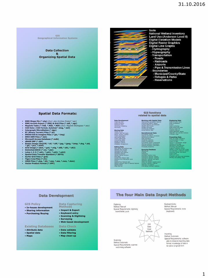
Spatial Data Formats:
• ESRI Shape file (*.shp) (Excl: also ArcView Project *.apr)
• ESRI ArcInfo Export (*.E00) & Grid Files (*.adf, *.agr)
• MapInfo Table (*.TAB, *.MID, *.MIF) (Excl: MapInfo Workspace *.wor)
• CAD Data ( CAD Format, AutoCad *.dwg, *.dxf)
• Intergraph/MicroStation (*.dgn)
• BT (Binary Terrain) Files (*.bt)
• ERDAS GIS & Imagine Files (*.gis, *.img)
• ENVI DEM Files (*.dat)
• Microsoft Access Database (*.mdb)
• dBASE DBF (*.dbf)
• Raster Image (GeoTiff, *.tif, *.tiff, *.jpg, *.jpeg, *.bmp, *.drg, *.sid, *.gif, *.pcx, *.wmf)
• Grid Image (*.dem, *.grd, *.mig, *.dt0, *.dt1, *.dt2)
• Delimited ASCII (*.txt, *.dat)
• Lotus 1-2-3 (*.wk1, *.wk2, *.wk3, *.wk4)
• Spatial Data Transfer Standard (*.SDTS)
• Surfer Grid Files (*.grd)
• Tiger/Line Files (*.rt1)
• USGS Files (*.doq, *.bil, *.nes, *.ses, *.nws, *.dem)
• Vector Product Format (*.VPF)
GIS functions related to spatial data
Working with Spatial Data •Representing geographic features
•Introducing feature classes •Linking features and attributes •Spatial data formats
•Images and grids •Introducing metadata •Using Network data
Georeferenced Data •Coordinate systems
•Datums and datum conversion •Referencing locations •Map projections
•Projection distortion •Types of projections •Coordinate system components
•Storing projection information •Viewing projection information •Changing projections
Querying Database •Identifying
•Finding •Measuring •Available selection tools
•Interactive selection options •Interactive selection methods •Selection methods and layers
•Attribute selection •Select by location (spatial query) •Location selection methods
•Selection by graphics •Calculating summary statistics
Displaying Data •Data & Layout views
•Data visualization •Layers •Layer symbology
•Data frames and maps •Saving a layer file •Labeling features
•Scale-dependent display •Magnifier and overview windows
•Thematic maps
Presenting Data •Map and design objectives
•Communication in maps •Types of maps •Issues in cartographic design
•Setting up the page •Identifying map elements •Inserting map elements
•Legend Properties window •Adding a north arrow and a scale •Incorporating a reference system
•Inserting textual information •Layout tools •Grids and rulers
•Creating and using map templates •Printing and plotting maps
Data Development •Capturing data
•Import & Export •Keyboard entry •Scanning & Digitizing
•Surveying
Storing Data •Tables format
•Tabular data field types •Rows, columns, indexes
•Table manipulation •Associating tables •Table relationships
•Connecting tables •Graphs & Reports •Database systems
•Database management
Editing Data •Edit spatial and attribute data •Editable data formats •Navigating the Editor
•Managing edit sessions •Selecting features •Simple editing functions
•Edit tasks •Create New Feature task •Distance and Intersection tools
•Trace •Extend/Trim Features task •Editing attribute data for selected features
•Editing tables •Map clean-up
Data Development
GIS Policy • In-house development
• Sharing information
• Purchasing/Buying
Data Capturing Methods • Import & Export
• Keyboard entry
• Scanning & Digitizing
• Surveying
• Web based development
Existing Databases • Attribute data
• Spatial data
• Maps
Data Check • Data validate
• Data filtering
• Map clean-up
The four Main Data Input Methods
31.10.2016
2
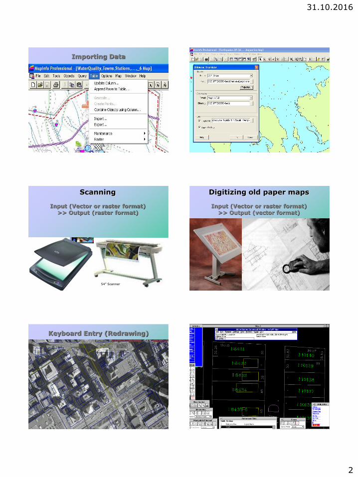
Importing Data Importing Data
Scanning
Input (Vector or raster format) >> Output (raster format)
54” Scanner
Digitizing old paper maps
Input (Vector or raster format) >> Output (vector format)
Keyboard Entry (Redrawing) Development of Building Footprint Map - Digitizing
31.10.2016
3
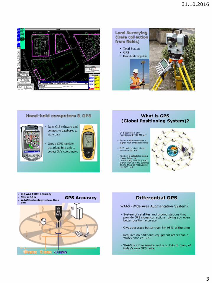
Development of Building Footprint Map - Scanning Land Surveying (Data collection from fields)
• Total Station
• GPS • Hand-held computers
Hand-held computers & GPS
• Runs GIS software and
connect to databases to
store data
• Uses a GPS receiver
that plugs into unit to
collect X,Y coordinates
What is GPS (Global Positioning System)?
– 24 Satellites in sky,
maintained by US Military
– Each satellite transmits a signal with embedded time
– GPS Unit receives signal and records time
– Position is calculated using triangulation by determining how long each signal took to leave satellite and to then be received by the GPS unit
GPS Accuracy • Old was 100m accuracy
• New is 15m
• WAAS technology is less than 3m!
Differential GPS
WAAS (Wide Area Augmentation System)
– System of satellites and ground stations that
provide GPS signal corrections, giving you even better position accuracy
– Gives accuracy better than 3m 95% of the time
– Requires no additional equipment other than a WAAS enabled GPS
– WAAS is a free service and is built-in to many of today’s new GPS units
31.10.2016
4
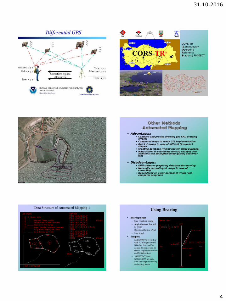
CORS-TR (Continuously Operating Reference Stations) PROJECT
Other Methods Automated Mapping
• Advantages: • Constant and precise drawing (no CAD drawing
errors) • Completed maps to ready GIS implementation • Quick drawing in case of difficult (irregular)
shapes • Creating database (it may use for other purpose) • Maps stored in coordinate format, changes and
additions can be implemented quickly and error free
• Disadvantages:
• Difficulties on preparing database for drawing • Necessity recreating of maps in case of
correcting • Dependency on a key personnel which runs
computer programs
Data Structure of Automated Mapping-1 Using Bearing
• Bearing mode:
– Side (North or South)
– Angle (between line and
N-S line)
– Direction (East or West)
– Line length
• Samples:
– N361500W70 (The line
with 70 ft length toward
NW direction, and 36
degree 15 minute and no
second angle between line
and N-S direction)
– S562233W75 and
N562233E75 are same
lines in exception starting
and ending points
31.10.2016
5
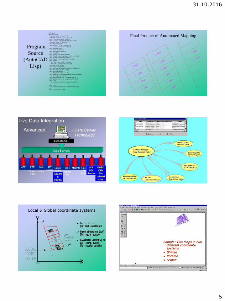
Program
Source
(AutoCAD
Lisp)
(defun pw()
(setq ercd "PW")
(command "layer" "s" "parcel" "")
(command "style" "rs" "" "" "" "" "" "" "")
(if (> j 1) (command "pline" p1 p2 ""))
(if (= i 1) (if (= j 1) (command "pline" p1 p2 "")))
(command "layer" "s" "dimension" "")
(setq l (distance p1 p2))
(setq pp3 (list (/ (+ (car p1) (car p2)) 2)
(/ (+ (cadr p1) (cadr p2)) 2) ))
(setq alfa (angle p1 p2))
(setq beta (+ alfa (/ pi 2)))
(setq pp4 (polar pp3 beta dst))
(setq talfa alfa)
(if (> alfa pi2) (setq talfa (- talfa pi)))
(if (> alfa pi2) (setq pp4 (polar pp3 beta (+ hdim dst))))
(if (> alfa pi3) (setq talfa (- talfa pi)))
(if (> alfa pi3) (setq pp4 (polar pp3 beta dst)))
;(if (> alfa pi)
; (if (< alfa 5.7) (setq talfa (- talfa pi))))
; (if (> alfa 4.71) (setq talfa (- talfa pi)))
;(command "pline" pp3 pp4 "")
(setq talfa (* (/ 180 pi) talfa))
(if (= talfa -90) (setq pp4 (polar pp3 beta (+ hdim dst) )))
(if (= talfa -90) (setq talfa (- talfa)))
(setq lad (rtos l 2 ndcm))
(setq nlad (- (strlen lad) (+ ndcm 1)))
(if (= (substr lad (+ 2 nlad) ndcm) (substr "000000" 1 ndcm))
(setq lad (substr lad 1 nlad) ) )
(if (/= j 3) (command "text" "c" pp4 hdim talfa lad ))
;(if (/= j 3) (command "text" "c" pp4 hdim talfa talfa ))
(if (= i nlot)
(if (= j 3) (command "text" "c" pp4 hdim talfa lad ))
)
;(if (= i nlot)
; (if (= j 3) (command "text" "c" pp4 hdim talfa talfa ))
;)
(if (= j 1) (setq alfatex talfa))
)
�
Final Product of Automated Mapping
Local & Global coordinate systems Result of using two different coordinate systems
Sample: Two maps in two different coordinate systems
• Shifted
• Rotated
• Scaled
31.10.2016
6
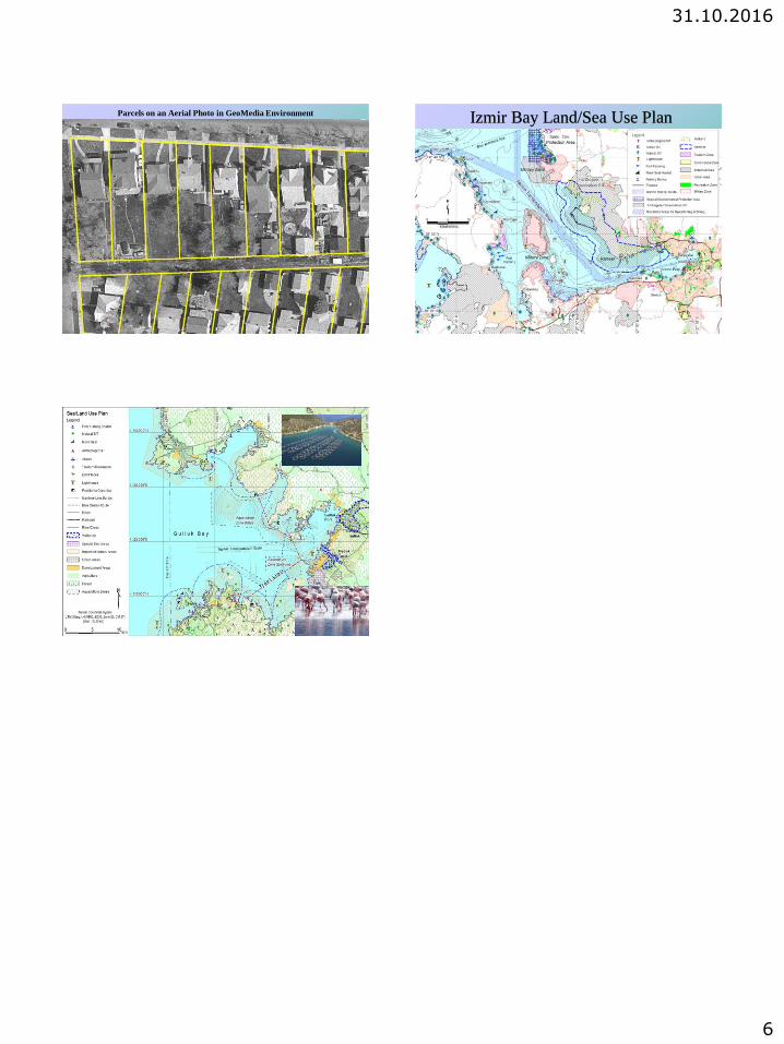
Parcels on an Aerial Photo in GeoMedia Environment Izmir Bay Land/Sea Use Plan