sonoran creosotebush-bursage scrub...santan. 202 freeway. loop. ern section ern section. sonoran...
TRANSCRIPT
South Mountain Freeway (Loop 202) DEIS and Section 4(f) Evaluation Chapter 4 • Affected Environment, Environmental Consequences, and Mitigation 4-117
4
BIOLOGICAL RESOURCES
AFFECTED ENVIRONMENT
The Study Area falls completely within the Sonoran Desert and the Basin and Range Province, between an elevation of 950 feet—at the confluence of the Salt and Gila rivers—and 2,400 feet above mean sea level at the crest of the South Mountains (Chronic 1998). The topography of the Study Area includes broad, flat, low-lying desert valleys between isolated mountains of relatively low relief (the South Mountains and the Sierra Estrella). The 16,600-acre SMPP is located within a mountain range that is part of the Phoenix Mountain Preserve system.
Some portions of the Study Area have been disturbed by development, mining (sand and gravel), and agriculture. The western end of SMPP still supports undisturbed, natural desert spaces. The area between the South Mountains and the Sierra Estrella, to the southwest, has been altered by agriculture, small commercial properties, roads, and housing. Adjacent residential development, roads, and agriculture have truncated many drainages in the area, affecting the extent of the xeroriparian vegetation.
Vegetation and Wildlife ResourcesPlants are specific to the types of soil found in the area. The Study Area is located in several geologic provinces consisting of mostly sand and gravel in stream channels, with sand, silt, and clay on floodplains and playas. At the base of the South Mountains, metamorphic rocks are exposed, showing sedimentary and volcanic rocks metamorphosed to schist and gneiss (Chronic 1998; Kamilli and Richard 1998). The soils in the Study Area support a broad range of plants, from desert to wetland and riparian species.
Vegetation in the Study Area is classified as being in the biotic communities of Arizona Upland Sonoran Desertscrub and Lower Colorado River Sonoran Desertscrub (Turner and Brown 1994). Numerous tree, shrub, flower, and grass species can be found in these
two biotic communities. Examples include blue paloverde (Parkinsonia florida), foothill paloverde (Parkinsonia microphylla), catclaw acacia (Acacia greggii), mesquite (Prosopis spp.), Fremont cottonwood (Populus fremontii), smoketree (Psorothamnus spinosus), ironwood (Olneya tesota), creosote bush (Larrea tridentata), triangle-leaf bursage (Ambrosia deltoidea), fourwing saltbush (Atriplex canescens), littleleaf saltbush (Atriplex polycarpa), desert broom (Baccharis sarothroides), ocotillo (Fouquieria splendens), and brittlebush (Encelia farinosa). Cacti can include saguaro (Carnegiea gigantea), buckhorn cholla (Opuntia acanthocarpa), hedgehog cactus (Echinocereus engelmannii), barrel cactus (Ferocactus wislizenii), prickly pear (Opuntia spp.), and Christmas cactus (Opuntia leptocaulis) (Turner and Brown 1994; Epple 1995). Small numbers of these species are found in the Study Area because much of the native habitat has been altered by agricultural, commercial, and urban development. Displacement of these species is expected to continue because of rapid development in portions of the Study Area.
Plant CommunitiesDuring an initial July 2003 field visit, different plant communities and plant species were recorded by a qualified biologist. A field visit in October 2009 revealed that the plant communities were still represented, although their extents varied somewhat because of natural processes and development. Distinct vegetation communities, as defined by the Arizona Land Resource Information System (1996), in the Study Area are:
➤➤ Sonoran creosotebush scrub➤➤ Sonoran creosotebush-bursage scrub➤➤ Sonoran paloverde mixed cacti/Sonoran creosotebush-bursage
➤➤ mixed/agriculture➤➤ riparian/flood damaged in 1993➤➤ Sonoran riparian/leguminous short tree forest/scrub➤➤ Sonoran riparian/mixed riparian scrub➤➤ Sonoran creosotebush-mesquite scrub
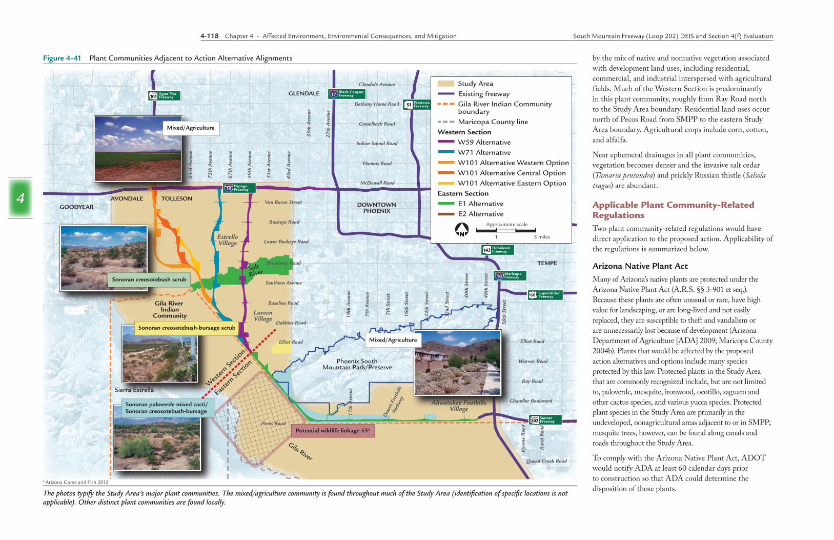
Some of these plant communities are represented at various locations adjacent to action alternative alignments (Figure 4-41).
Sonoran Creosotebush ScrubCreosote bush is a dominant or codominant species in many Sonoran communities and flourishes on gravelly plains and sandy flats. Found throughout the Study Area, the plant community typically includes foothill paloverde, ironwood, and prickly pear, among others. Remnants of the plant community intersect action alternatives in the Western Section, following the Salt River north of Baseline Road, from approximately 83rd Avenue east to 59th Avenue.
Sonoran Creosotebush-Bursage ScrubRemnants of the plant community exist in the Western Section along the Salt River (just north of Baseline Road) and near the intersection of Ray Road and 51st Avenue in the Eastern Section. Triangle-leaf bursage thrives on rocky or gravelly f lats as well as hills. Bursage is one of the most abundant shrubs in the Sonoran Desert. Together, creosote bush and bursage dominate this community. Associated members of the creosotebush-bursage scrub community are acacia, fourwing saltbush, and ocotillo.
Sonoran Paloverde Mixed Cacti/Sonoran Creosotebush-BursageThe community is distinguished by the presence of paloverde and various cacti and shrubs, including triangle-leaf bursage and creosote bush. Within the Study Area, saguaro is the most visible cactus. This plant community is found west of 32nd Street where the terrain becomes hilly approaching SMPP. Littleleaf saltbush, ironwood, and mesquite are also found within this community.
Mixed/AgricultureThe mixed/agriculture plant community covers the largest portion of the Study Area and occurs adjacent to all of the action alternatives. This community is defined
4-118 Chapter 4 • Affected Environment, Environmental Consequences, and Mitigation South Mountain Freeway (Loop 202) DEIS and Section 4(f) Evaluation
4
Figure 4-41 Plant Communities Adjacent to Action Alternative Alignments
The photos typify the Study Area’s major plant communities. The mixed/agriculture community is found throughout much of the Study Area (identification of specific locations is not applicable). Other distinct plant communities are found locally.
DOWNTOWNPHOENIX
TEMPE
GLENDALE
TOLLESONAVONDALEGOODYEAR
Gila River Indian
Community
Phoenix SouthMountain Park/Preserve
Sierra Estrella
Salt River
Gila River
Glendale Avenue
Bethany Home Road
Camelback Road
Indian School Road
Thomas Road
McDowell Road
Van Buren Street
Buckeye Road
Lower Buckeye Road
Broadway Road
Southern Avenue
Baseline Road
Dobbins Road
Elliot Road
Pecos Road
Avo
ndal
e B
oule
vard
83rd
Ave
nue
75th
Ave
nue
67th
Ave
nue
59th
Ave
nue
51st
Ave
nue
43rd
Ave
nue
35th
Ave
nue
27th
Ave
nue
19th
Ave
nue
7th
Ave
nue
17th
Ave
nue
Des
ert F
ooth
ills
Park
way
7th
Stre
et
16th
Str
eet
24th
Str
eet
32nd
Str
eet
40th
Str
eet
48th
Str
eet
56th
Str
eet
Elliot Road
Ray Road
Chandler Boulevard
Queen Creek Road
Kyr
ene
Roa
d
Rur
al R
oad
EstrellaVillage
LaveenVillage
Ahwatukee FoothillsVillage
Warner Road
PiestewaFreeway51
Agua FriaFreeway101
LOOP
HohokamFreeway143
PapagoFreeway10
MaricopaFreeway10
Black CanyonFreeway17
SuperstitionFreeway60
SantanFreeway202
LOOP
Wes
tern Se
ction
Easter
n Secti
on
Sonoran creosotebush-bursage scrub
Sonoran creosotebush scrub
Sonoran paloverde mixed cacti/Sonoran creosotebush-bursage
Potential wildlife linkage 53a
Mixed/Agriculture
Mixed/Agriculture
Approximate scale
3 miles1
Study AreaExisting freewayGila River Indian Community boundaryMaricopa County line
Western SectionW59 AlternativeW71 AlternativeW101 Alternative Western OptionW101 Alternative Central OptionW101 Alternative Eastern Option
Eastern SectionE1 Alternative
Approximate scale
3 miles1
Study AreaExisting freewayGila River Indian Community boundaryMaricopa County line
Western SectionW59 AlternativeW71 AlternativeW101 Alternative Western OptionW101 Alternative Central OptionW101 Alternative Eastern Option
Eastern SectionE1 AlternativeE2 Alternative
by the mix of native and nonnative vegetation associated with development land uses, including residential, commercial, and industrial interspersed with agricultural fields. Much of the Western Section is predominantly in this plant community, roughly from Ray Road north to the Study Area boundary. Residential land uses occur north of Pecos Road from SMPP to the eastern Study Area boundary. Agricultural crops include corn, cotton, and alfalfa.
Near ephemeral drainages in all plant communities, vegetation becomes denser and the invasive salt cedar (Tamarix pentandra) and prickly Russian thistle (Salsola tragus) are abundant.
Applicable Plant Community-Related RegulationsTwo plant community-related regulations would have direct application to the proposed action. Applicability of the regulations is summarized below.
Arizona Native Plant ActMany of Arizona’s native plants are protected under the Arizona Native Plant Act (A.R.S. §§ 3-901 et seq.). Because these plants are often unusual or rare, have high value for landscaping, or are long-lived and not easily replaced, they are susceptible to theft and vandalism or are unnecessarily lost because of development (Arizona Department of Agriculture [ADA] 2009; Maricopa County 2004b). Plants that would be affected by the proposed action alternatives and options include many species protected by this law. Protected plants in the Study Area that are commonly recognized include, but are not limited to, paloverde, mesquite, ironwood, ocotillo, saguaro and other cactus species, and various yucca species. Protected plant species in the Study Area are primarily in the undeveloped, nonagricultural areas adjacent to or in SMPP; mesquite trees, however, can be found along canals and roads throughout the Study Area.
To comply with the Arizona Native Plant Act, ADOT would notify ADA at least 60 calendar days prior to construction so that ADA could determine the disposition of those plants.
a Arizona Game and Fish 2012

South Mountain Freeway (Loop 202) DEIS and Section 4(f) Evaluation Chapter 4 • Affected Environment, Environmental Consequences, and Mitigation 4-119
4
Executive Order 13112, Invasive SpeciesNo invasive species surveys were conducted during field visits because of the extent of the Study Area. Based on Executive Order 13112, dated February 3, 1999, all projects will,
subject to the availability of appropriations, and within Administration budgetary limits, use relevant programs and authorities to: i) prevent the introduction of invasive species; ii) detect and respond rapidly to, and control, populations of such species in a cost-effective and environmentally sound manner; iii) monitor invasive species populations accurately and reliably; and iv) provide for restoration of native species and habitat conditions in ecosystems that have been invaded.
If an action alternative were to be identified as the Selected Alternative, invasive species in the project footprint would be treated according to an invasive species management plan and any necessary treatments would continue following completion of construction. For example, all earthmoving and hauling equipment would be washed at the contractor’s storage facility prior to entering the construction site. To prevent invasive species from leaving the site, the contractor would inspect all construction equipment and remove all attached plant/vegetation and soil/mud debris prior to leaving the construction site. Finally, all disturbed soils that would not be landscaped or otherwise permanently stabilized by construction would be seeded using species native to the project vicinity.
Aquatic/Wetland CommunitiesNo wetlands, as regulated under Section 404 of the CWA, are found in or near the Study Area. The Tres Rios Constructed Wetlands Demonstration Project, however, consists of several water impoundments located near the 91st Avenue WWTP. These nonregulated wetlands provide important foraging and nesting sites for water birds and other wildlife species needing wetland habitat conditions.
Other nonregulated wetlands are also found in the Study Area. For example, a large set of gravel mining pits located along the Salt River hold water year-round. A field investigation conducted in October 2009 determined that these abandoned gravel pits are not jurisdictional under Section 404 of the Clean Water Act. These abandoned gravel pits are not regulated wetlands because there is an absence of wetland vegetation. Finally, concrete-lined irrigation canals are scattered throughout the Study Area, but offer little value to wildlife or plants. Through continued field observations since initial fieldwork in 2003, no additional wetlands have been identified.
In the Study Area, the habitat in the Salt River is highly disturbed as a result of reduced water f lows and mining activities. The majority of the water f low is diverted to irrigation canals at the Granite Reef Dam. There are several sand and gravel companies that extract materials from the riverbed for use in construction. Within the Study Area, a large portion of the habitat surrounding the Salt River has been developed for agricultural, industrial, commercial and residential use.
Wildlife ResourcesGeneral Wildlife Wildlife abundance and diversity are directly related to the amount and variety of habitat types located in the area. Outside SMPP, few wildlife species were observed in the Study Area. These consisted mainly of birds and a few species of lizards. During field visits, coyote (Canis latrans), deer (Odocoileus hemionus), and javelina (Dicotyles tajacu) signs (i.e., tracks and scat) were detected adjacent to the SMPP boundary in the western foothills of the South Mountains, and numerous rodent holes were scattered throughout the Study Area.
Common desert birds that were observed in the Study Area included curve-billed thrasher (Toxostoma curvirostre), Gambel’s quail (Callipepla gambelii), cactus wren (Campylorhynchus brunneicapillus), canyon wren (Catherpes mexicanus), black-throated sparrow (Amphispiza bilineata), phainopepla (Phainopepla nitens), blue-gray gnatcatcher
(Polioptila caerulea), Abert’s towhee (Pipilo aberti), greater roadrunner (Geococcyx californianus), white-winged dove (Zenaida asiatica), mourning dove (Zenaida macroura), turkey vulture (Cathartes aura), and different species of raptors, including owls and hawks. Bald eagles have been sighted near the Western Section action alternatives.
Inactive and active agricultural fields are found in both the Western and Eastern Sections. Inactive agricultural fields would likely support native flora and fauna adapted to dry and disturbed conditions, whereas active agricultural fields would likely provide areas of standing water that could be used by water birds for foraging and nesting. Similarly, both types of agricultural fields may provide habitat for burrowing owls (Athene cunicularia hypugaea), which are frequently found nesting and hunting on the perimeter of agricultural fields and irrigation dikes. Small mammals, reptiles, rodents, and some birds may use the fields for cover and foraging. In flooded fields along Baseline Road, black-necked stilt (Himantopus mexicanus), cattle egret (Bubulcus ibis), and killdeer (Charadrius vociferus) were documented. Along irrigation canals, white-winged dove, mourning dove, Inca dove (Columbina inca), and a roadrunner were documented. Gravel and sand pits that contain water and some riparian vegetation could attract various species of birds that may use the human-made habitat for cover, foraging, and nesting. The steep sides of the pits, however, create less diverse riparian habitat compared with more gently sloping natural riverine ecosystems.
Xeroriparian habitats (desert washes) have high value for many species of wildlife, not only because of the vegetation density and composition, but also as movement corridors. Washes occur throughout the Study Area; many, however, have been altered by previous disturbance, chiefly past agricultural activities. In addition, many have been turned into retention basins or into constructed channels through housing developments.
Many species of wildlife are found in SMPP. Reptiles include Sonoran desert tortoises (Gopherus agassizii), snakes, Gila monsters (Heloderma suspectum), horned lizards (Phrynosoma sp.), geckos (Coleonyx sp.), and chuckwallas (Sauromalus obesus). The mammalian
4-120 Chapter 4 • Affected Environment, Environmental Consequences, and Mitigation South Mountain Freeway (Loop 202) DEIS and Section 4(f) Evaluation
4
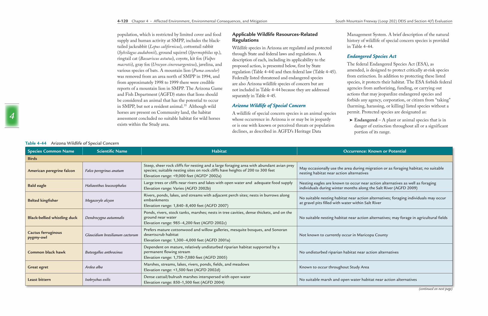
Species Common Name Scientific Name Habitat Occurrence: Known or Potential
Birds
American peregrine falcon Falco peregrinus anatumSteep, sheer rock cliffs for nesting and a large foraging area with abundant avian prey species; suitable nesting sites on rock cliffs have heights of 200 to 300 feet Elevation range: <9,000 feet (AGFDa 2002a)
May occasionally use the area during migration or as foraging habitat; no suitable nesting habitat near action alternatives
Bald eagle Haliaeethus leucocephalusLarge trees or cliffs near rivers and lakes with open water and adequate food supplyElevation range: Varies (AGFD 2002b)
Nesting eagles are known to occur near action alternatives as well as foraging individuals during winter months along the Salt River (AGFD 2009)
Belted kingfisher Megaceryle alcyonRivers, ponds, lakes, and streams with adjacent perch sites; nests in burrows along embankmentsElevation range: 1,840–8,400 feet (AGFD 2007)
No suitable nesting habitat near action alternatives; foraging individuals may occur at gravel pits filled with water within Salt River
Black-bellied whistling duck Dendrocygna autumnalisPonds, rivers, stock tanks, marshes; nests in tree cavities, dense thickets, and on the ground near waterElevation range: 985–4,200 feet (AGFD 2002c)
No suitable nesting habitat near action alternatives; may forage in agricultural fields
Cactus ferruginous pygmy-owl Glaucidium brasilianum cactorum
Prefers mature cottonwood and willow galleries, mesquite bosques, and Sonoran desertscrub habitat Elevation range: 1,300–4,000 feet (AGFD 2001a)
Not known to currently occur in Maricopa County
Common black hawk Buteogallus anthracinusDependent on mature, relatively undisturbed riparian habitat supported by a permanent flowing streamElevation range: 1,750–7,080 feet (AGFD 2005)
No undisturbed riparian habitat near action alternatives
Great egret Ardea albaMarshes, streams, lakes, rivers, ponds, fields, and meadowsElevation range: <1,500 feet (AGFD 2002d)
Known to occur throughout Study Area
Least bittern Ixobrychus exilisDense cattail/bulrush marshes interspersed with open waterElevation range: 850–1,500 feet (AGFD 2004)
No suitable marsh and open water habitat near action alternatives
Table 4-44 Arizona Wildlife of Special Concern
(continued on next page)
population, which is restricted by limited cover and food supply and human activity at SMPP, includes the black-tailed jackrabbit (Lepus californicus), cottontail rabbit (Sylvilagus audubonii), ground squirrel (Spermophilus sp.), ringtail cat (Bassariscus astutus), coyote, kit fox (Vulpes macrotis), gray fox (Urocyon cinereoargenteus), javelina, and various species of bats. A mountain lion (Puma concolor) was removed from an area north of SMPP in 1994, and from approximately 1998 to 1999 there were credible reports of a mountain lion in SMPP. The Arizona Game and Fish Department (AGFD) states that lions should be considered an animal that has the potential to occur in SMPP, but not a resident animal.35 Although wild horses are present on Community land, the habitat assessment concluded no suitable habitat for wild horses exists within the Study area.
Applicable Wildlife Resources-Related Regulations Wildlife species in Arizona are regulated and protected through State and federal laws and regulations. A description of each, including its applicability to the proposed action, is presented below, first by State regulation (Table 4-44) and then federal law (Table 4-45). Federally listed threatened and endangered species are also Arizona wildlife species of concern but are not included in Table 4-44 because they are addressed separately in Table 4-45.
Arizona Wildlife of Special Concern A wildlife of special concern species is an animal species whose occurrence in Arizona is or may be in jeopardy or is one with known or perceived threats or population declines, as described in AGFD’s Heritage Data
Management System. A brief description of the natural history of wildlife of special concern species is provided in Table 4-44.
Endangered Species ActThe federal Endangered Species Act (ESA), as amended, is designed to protect critically at-risk species from extinction. In addition to protecting these listed species, it protects their habitat. The ESA forbids federal agencies from authorizing, funding, or carrying out actions that may jeopardize endangered species and forbids any agency, corporation, or citizen from “taking” (harming, harassing, or killing) listed species without a permit. Protected species are designated as:
➤➤ Endangered – A plant or animal species that is in danger of extinction throughout all or a significant portion of its range.
South Mountain Freeway (Loop 202) DEIS and Section 4(f) Evaluation Chapter 4 • Affected Environment, Environmental Consequences, and Mitigation 4-121
4
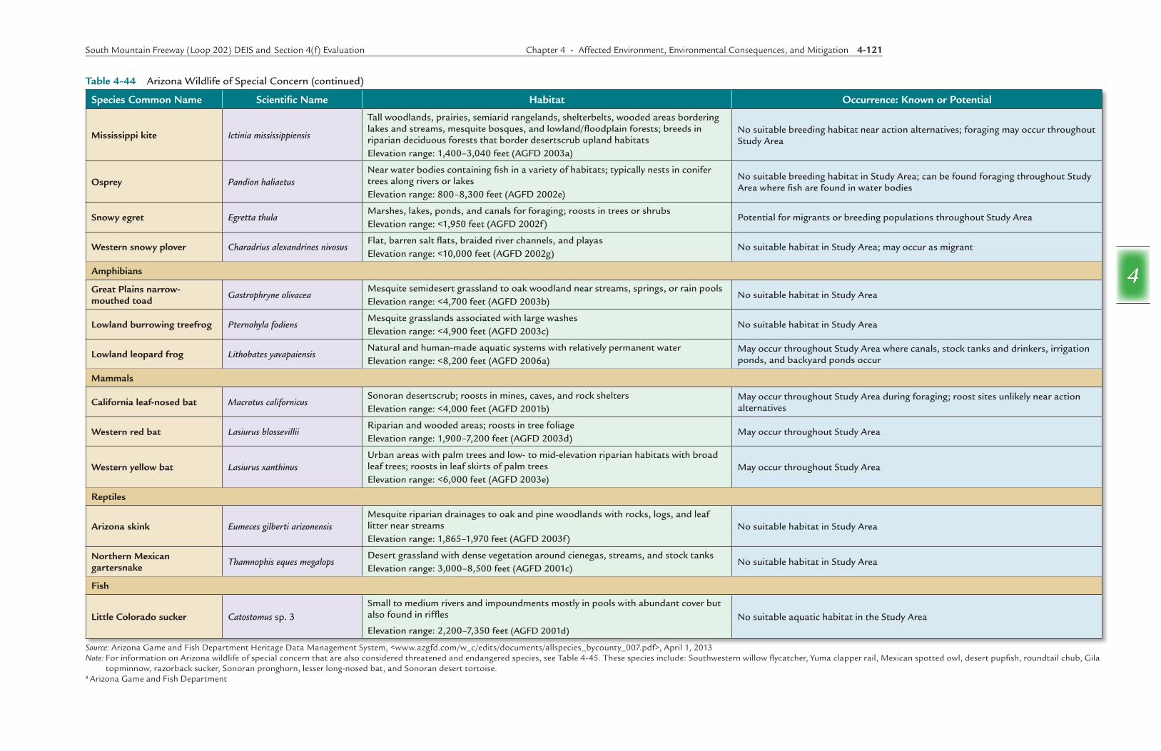
Species Common Name Scientific Name Habitat Occurrence: Known or Potential
Mississippi kite Ictinia mississippiensis
Tall woodlands, prairies, semiarid rangelands, shelterbelts, wooded areas bordering lakes and streams, mesquite bosques, and lowland/floodplain forests; breeds in riparian deciduous forests that border desertscrub upland habitatsElevation range: 1,400–3,040 feet (AGFD 2003a)
No suitable breeding habitat near action alternatives; foraging may occur throughout Study Area
Osprey Pandion haliaetusNear water bodies containing fish in a variety of habitats; typically nests in conifer trees along rivers or lakesElevation range: 800–8,300 feet (AGFD 2002e)
No suitable breeding habitat in Study Area; can be found foraging throughout Study Area where fish are found in water bodies
Snowy egret Egretta thulaMarshes, lakes, ponds, and canals for foraging; roosts in trees or shrubsElevation range: <1,950 feet (AGFD 2002f)
Potential for migrants or breeding populations throughout Study Area
Western snowy plover Charadrius alexandrines nivosusFlat, barren salt flats, braided river channels, and playasElevation range: <10,000 feet (AGFD 2002g)
No suitable habitat in Study Area; may occur as migrant
Amphibians
Great Plains narrow-mouthed toad Gastrophryne olivacea
Mesquite semidesert grassland to oak woodland near streams, springs, or rain poolsElevation range: <4,700 feet (AGFD 2003b)
No suitable habitat in Study Area
Lowland burrowing treefrog Pternohyla fodiensMesquite grasslands associated with large washesElevation range: <4,900 feet (AGFD 2003c)
No suitable habitat in Study Area
Lowland leopard frog Lithobates yavapaiensisNatural and human-made aquatic systems with relatively permanent waterElevation range: <8,200 feet (AGFD 2006a)
May occur throughout Study Area where canals, stock tanks and drinkers, irrigation ponds, and backyard ponds occur
Mammals
California leaf-nosed bat Macrotus californicusSonoran desertscrub; roosts in mines, caves, and rock sheltersElevation range: <4,000 feet (AGFD 2001b)
May occur throughout Study Area during foraging; roost sites unlikely near action alternatives
Western red bat Lasiurus blossevilliiRiparian and wooded areas; roosts in tree foliageElevation range: 1,900–7,200 feet (AGFD 2003d)
May occur throughout Study Area
Western yellow bat Lasiurus xanthinusUrban areas with palm trees and low- to mid-elevation riparian habitats with broad leaf trees; roosts in leaf skirts of palm treesElevation range: <6,000 feet (AGFD 2003e)
May occur throughout Study Area
Reptiles
Arizona skink Eumeces gilberti arizonensisMesquite riparian drainages to oak and pine woodlands with rocks, logs, and leaf litter near streamsElevation range: 1,865–1,970 feet (AGFD 2003f)
No suitable habitat in Study Area
Northern Mexican gartersnake Thamnophis eques megalops
Desert grassland with dense vegetation around cienegas, streams, and stock tanksElevation range: 3,000–8,500 feet (AGFD 2001c)
No suitable habitat in Study Area
Fish
Little Colorado sucker Catostomus sp. 3Small to medium rivers and impoundments mostly in pools with abundant cover but also found in riffles
Elevation range: 2,200–7,350 feet (AGFD 2001d)
No suitable aquatic habitat in the Study Area
Source: Arizona Game and Fish Department Heritage Data Management System, <www.azgfd.com/w_c/edits/documents/allspecies_bycounty_007.pdf>, April 1, 2013Note: For information on Arizona wildlife of special concern that are also considered threatened and endangered species, see Table 4-45. These species include: Southwestern willow flycatcher, Yuma clapper rail, Mexican spotted owl, desert pupfish, roundtail chub, Gila
topminnow, razorback sucker, Sonoran pronghorn, lesser long-nosed bat, and Sonoran desert tortoise. a Arizona Game and Fish Department
Table 4-44 Arizona Wildlife of Special Concern (continued)
4-122 Chapter 4 • Affected Environment, Environmental Consequences, and Mitigation South Mountain Freeway (Loop 202) DEIS and Section 4(f) Evaluation
4
County, 2011, were used as the basis for determining which species and habitat to evaluate when considering the action alternatives. Correspondence from AGFD and USFWS is in Appendix 1-1.
Discussed in the following sections are plant and animal species that are proposed for listing or are listed as threatened, endangered, or candidate species by USFWS (2013). All species listed by USFWS as occurring or potentially occurring in Maricopa County are presented in Table 4-45. Some species have been documented within a 3-mile radius of the action alternatives; the exact locations, however, are not shown in this report because of the sensitive nature of the information. These threatened, endangered, or candidate species are presented below.
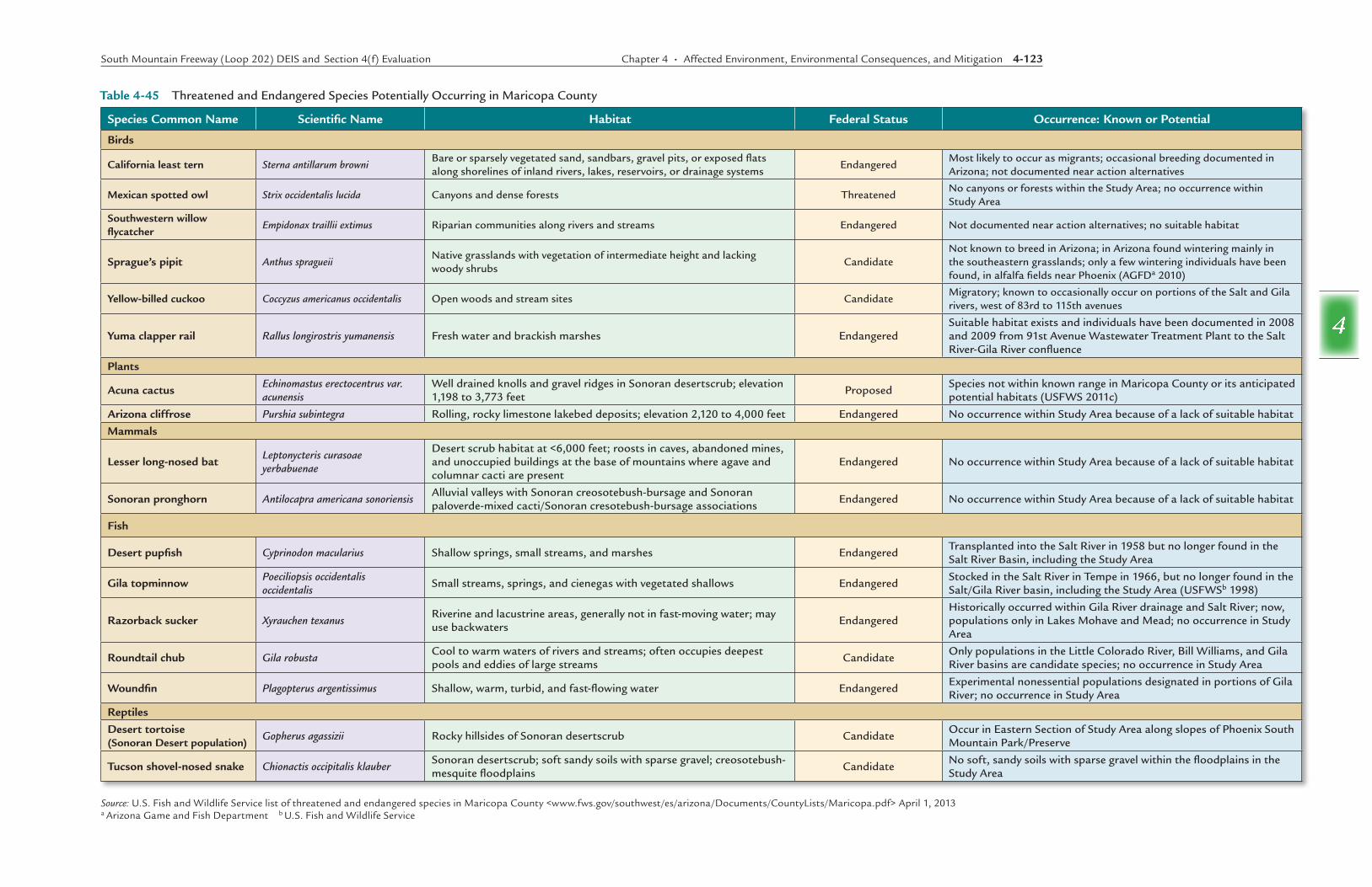
Yuma clapper rail (Rallus longirostris yumanensis) The Yuma clapper rail has a range in Arizona that encompasses several major river drainages in central and southwestern Arizona, including the lower Gila and Salt rivers. Habitat requirements include freshwater and brackish marsh habitat, with nests built in dense vegetation near water’s edge (AGFD 2006b). The main threats to the Yuma clapper rail are loss and alteration of marshland habitat.
Breeding pairs have been documented from the 91st Avenue WWTP west to the confluence of the Salt and Gila rivers, where several large artificial ponds have developed in the Salt River as a result of active gravel mining operations. Although these ponds may provide some value as aquatic habitat for water birds, they lack the dense marshland vegetation required by Yuma clapper rails for foraging and nesting. Furthermore, the future of these ponds is uncertain and would be expected to change with ongoing gravel mining operations.
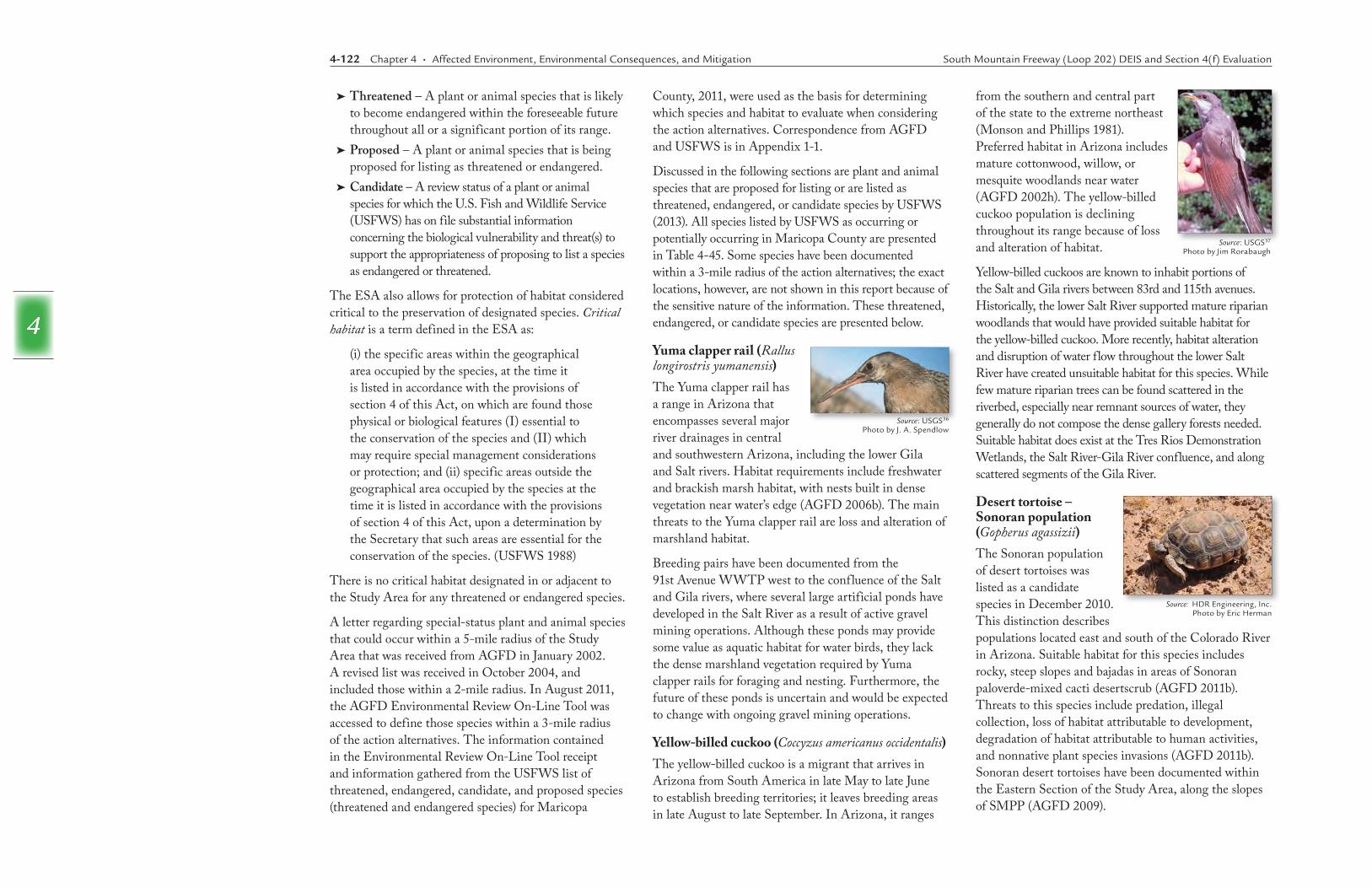
Yellow-billed cuckoo (Coccyzus americanus occidentalis) The yellow-billed cuckoo is a migrant that arrives in Arizona from South America in late May to late June to establish breeding territories; it leaves breeding areas in late August to late September. In Arizona, it ranges
Source: USGS36
Photo by J. A. Spendlow
➤➤ Threatened – A plant or animal species that is likely to become endangered within the foreseeable future throughout all or a significant portion of its range.
➤➤ Proposed – A plant or animal species that is being proposed for listing as threatened or endangered.
➤➤ Candidate – A review status of a plant or animal species for which the U.S. Fish and Wildlife Service (USFWS) has on file substantial information concerning the biological vulnerability and threat(s) to support the appropriateness of proposing to list a species as endangered or threatened.
The ESA also allows for protection of habitat considered critical to the preservation of designated species. Critical habitat is a term defined in the ESA as:
(i) the specific areas within the geographical area occupied by the species, at the time it is listed in accordance with the provisions of section 4 of this Act, on which are found those physical or biological features (I) essential to the conservation of the species and (II) which may require special management considerations or protection; and (ii) specific areas outside the geographical area occupied by the species at the time it is listed in accordance with the provisions of section 4 of this Act, upon a determination by the Secretary that such areas are essential for the conservation of the species. (USFWS 1988)
There is no critical habitat designated in or adjacent to the Study Area for any threatened or endangered species.
A letter regarding special-status plant and animal species that could occur within a 5-mile radius of the Study Area that was received from AGFD in January 2002. A revised list was received in October 2004, and included those within a 2-mile radius. In August 2011, the AGFD Environmental Review On-Line Tool was accessed to define those species within a 3-mile radius of the action alternatives. The information contained in the Environmental Review On-Line Tool receipt and information gathered from the USFWS list of threatened, endangered, candidate, and proposed species (threatened and endangered species) for Maricopa
from the southern and central part of the state to the extreme northeast (Monson and Phillips 1981). Preferred habitat in Arizona includes mature cottonwood, willow, or mesquite woodlands near water (AGFD 2002h). The yellow-billed cuckoo population is declining throughout its range because of loss and alteration of habitat.
Yellow-billed cuckoos are known to inhabit portions of the Salt and Gila rivers between 83rd and 115th avenues. Historically, the lower Salt River supported mature riparian woodlands that would have provided suitable habitat for the yellow-billed cuckoo. More recently, habitat alteration and disruption of water flow throughout the lower Salt River have created unsuitable habitat for this species. While few mature riparian trees can be found scattered in the riverbed, especially near remnant sources of water, they generally do not compose the dense gallery forests needed. Suitable habitat does exist at the Tres Rios Demonstration Wetlands, the Salt River-Gila River confluence, and along scattered segments of the Gila River.
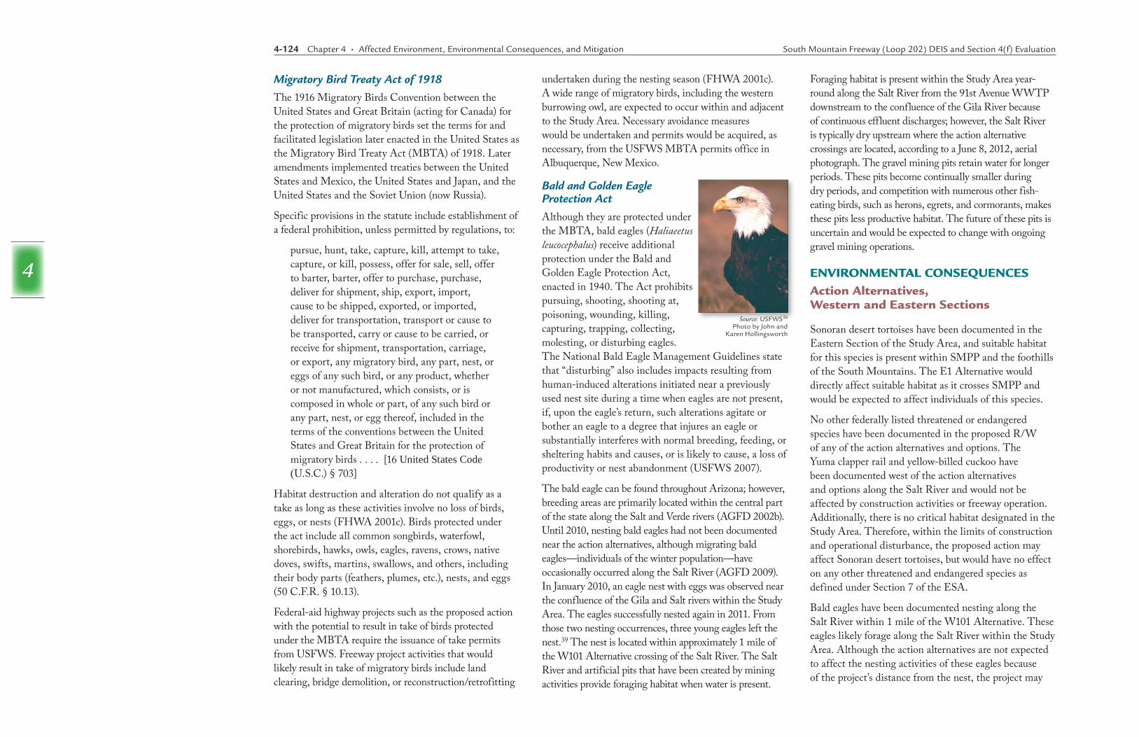
Desert tortoise – Sonoran population (Gopherus agassizii)The Sonoran population of desert tortoises was listed as a candidate species in December 2010. This distinction describes populations located east and south of the Colorado River in Arizona. Suitable habitat for this species includes rocky, steep slopes and bajadas in areas of Sonoran paloverde-mixed cacti desertscrub (AGFD 2011b). Threats to this species include predation, illegal collection, loss of habitat attributable to development, degradation of habitat attributable to human activities, and nonnative plant species invasions (AGFD 2011b). Sonoran desert tortoises have been documented within the Eastern Section of the Study Area, along the slopes of SMPP (AGFD 2009).
Source: USGS37
Photo by Jim Rorabaugh
Source: HDR Engineering, Inc. Photo by Eric Herman
South Mountain Freeway (Loop 202) DEIS and Section 4(f) Evaluation Chapter 4 • Affected Environment, Environmental Consequences, and Mitigation 4-123
4
Species Common Name Scientific Name Habitat Federal Status Occurrence: Known or Potential
Birds
California least tern Sterna antillarum browniBare or sparsely vegetated sand, sandbars, gravel pits, or exposed flats along shorelines of inland rivers, lakes, reservoirs, or drainage systems
EndangeredMost likely to occur as migrants; occasional breeding documented in Arizona; not documented near action alternatives
Mexican spotted owl Strix occidentalis lucida Canyons and dense forests Threatened No canyons or forests within the Study Area; no occurrence within Study Area
Southwestern willow flycatcher
Empidonax traillii extimus Riparian communities along rivers and streams Endangered Not documented near action alternatives; no suitable habitat
Sprague’s pipit Anthus spragueiiNative grasslands with vegetation of intermediate height and lacking woody shrubs
CandidateNot known to breed in Arizona; in Arizona found wintering mainly in the southeastern grasslands; only a few wintering individuals have been found, in alfalfa fields near Phoenix (AGFDa 2010)
Yellow-billed cuckoo Coccyzus americanus occidentalis Open woods and stream sites CandidateMigratory; known to occasionally occur on portions of the Salt and Gila rivers, west of 83rd to 115th avenues
Yuma clapper rail Rallus longirostris yumanensis Fresh water and brackish marshes Endangered Suitable habitat exists and individuals have been documented in 2008 and 2009 from 91st Avenue Wastewater Treatment Plant to the Salt River-Gila River confluence
Plants
Acuna cactus Echinomastus erectocentrus var. acunensis
Well drained knolls and gravel ridges in Sonoran desertscrub; elevation 1,198 to 3,773 feet Proposed Species not within known range in Maricopa County or its anticipated
potential habitats (USFWS 2011c)
Arizona cliffrose Purshia subintegra Rolling, rocky limestone lakebed deposits; elevation 2,120 to 4,000 feet Endangered No occurrence within Study Area because of a lack of suitable habitat
Mammals
Lesser long-nosed bat Leptonycteris curasoae yerbabuenae
Desert scrub habitat at <6,000 feet; roosts in caves, abandoned mines, and unoccupied buildings at the base of mountains where agave and columnar cacti are present
Endangered No occurrence within Study Area because of a lack of suitable habitat
Sonoran pronghorn Antilocapra americana sonoriensisAlluvial valleys with Sonoran creosotebush-bursage and Sonoran paloverde-mixed cacti/Sonoran cresotebush-bursage associations Endangered No occurrence within Study Area because of a lack of suitable habitat
Fish
Desert pupfish Cyprinodon macularius Shallow springs, small streams, and marshes Endangered Transplanted into the Salt River in 1958 but no longer found in the Salt River Basin, including the Study Area
Gila topminnow Poeciliopsis occidentalis occidentalis
Small streams, springs, and cienegas with vegetated shallows Endangered Stocked in the Salt River in Tempe in 1966, but no longer found in the Salt/Gila River basin, including the Study Area (USFWSb 1998)
Razorback sucker Xyrauchen texanusRiverine and lacustrine areas, generally not in fast-moving water; may use backwaters Endangered
Historically occurred within Gila River drainage and Salt River; now, populations only in Lakes Mohave and Mead; no occurrence in Study Area
Roundtail chub Gila robustaCool to warm waters of rivers and streams; often occupies deepest pools and eddies of large streams Candidate Only populations in the Little Colorado River, Bill Williams, and Gila
River basins are candidate species; no occurrence in Study Area
Woundfin Plagopterus argentissimus Shallow, warm, turbid, and fast-flowing water Endangered Experimental nonessential populations designated in portions of Gila River; no occurrence in Study Area
Reptiles
Desert tortoise (Sonoran Desert population)
Gopherus agassizii Rocky hillsides of Sonoran desertscrub Candidate Occur in Eastern Section of Study Area along slopes of Phoenix South Mountain Park/Preserve
Tucson shovel-nosed snake Chionactis occipitalis klauberSonoran desertscrub; soft sandy soils with sparse gravel; creosotebush-mesquite floodplains Candidate No soft, sandy soils with sparse gravel within the floodplains in the
Study Area
Source: U.S. Fish and Wildlife Service list of threatened and endangered species in Maricopa County <www.fws.gov/southwest/es/arizona/Documents/CountyLists/Maricopa.pdf> April 1, 2013a Arizona Game and Fish Department b U.S. Fish and Wildlife Service
Table 4-45 Threatened and Endangered Species Potentially Occurring in Maricopa County
4-124 Chapter 4 • Affected Environment, Environmental Consequences, and Mitigation South Mountain Freeway (Loop 202) DEIS and Section 4(f) Evaluation
4
undertaken during the nesting season (FHWA 2001c). A wide range of migratory birds, including the western burrowing owl, are expected to occur within and adjacent to the Study Area. Necessary avoidance measures would be undertaken and permits would be acquired, as necessary, from the USFWS MBTA permits office in Albuquerque, New Mexico.
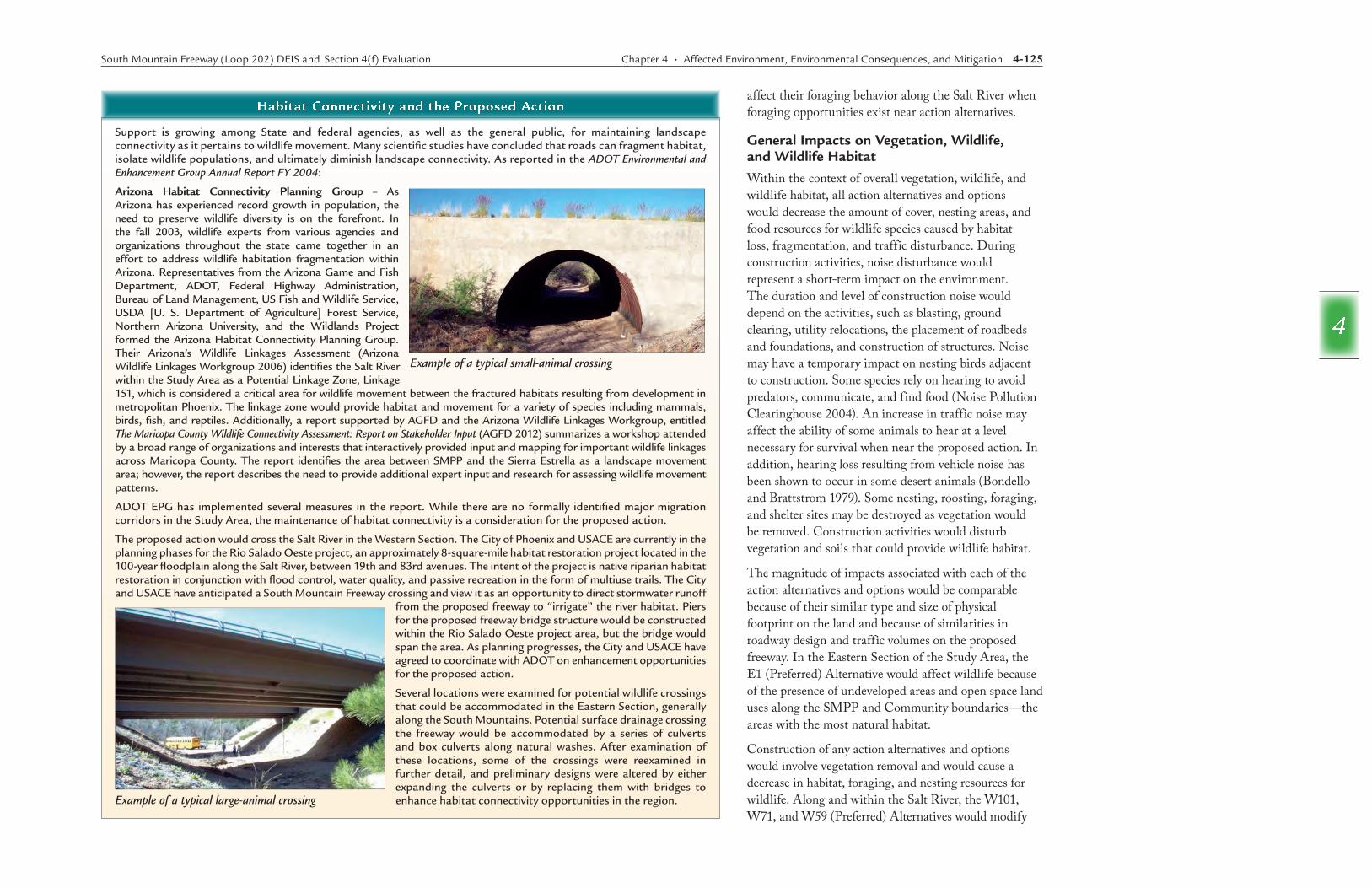
Bald and Golden Eagle Protection ActAlthough they are protected under the MBTA, bald eagles (Haliaeetus leucocephalus) receive additional protection under the Bald and Golden Eagle Protection Act, enacted in 1940. The Act prohibits pursuing, shooting, shooting at, poisoning, wounding, killing, capturing, trapping, collecting, molesting, or disturbing eagles. The National Bald Eagle Management Guidelines state that “disturbing” also includes impacts resulting from human-induced alterations initiated near a previously used nest site during a time when eagles are not present, if, upon the eagle’s return, such alterations agitate or bother an eagle to a degree that injures an eagle or substantially interferes with normal breeding, feeding, or sheltering habits and causes, or is likely to cause, a loss of productivity or nest abandonment (USFWS 2007).
The bald eagle can be found throughout Arizona; however, breeding areas are primarily located within the central part of the state along the Salt and Verde rivers (AGFD 2002b). Until 2010, nesting bald eagles had not been documented near the action alternatives, although migrating bald eagles—individuals of the winter population—have occasionally occurred along the Salt River (AGFD 2009). In January 2010, an eagle nest with eggs was observed near the confluence of the Gila and Salt rivers within the Study Area. The eagles successfully nested again in 2011. From those two nesting occurrences, three young eagles left the nest.39 The nest is located within approximately 1 mile of the W101 Alternative crossing of the Salt River. The Salt River and artificial pits that have been created by mining activities provide foraging habitat when water is present.
Migratory Bird Treaty Act of 1918The 1916 Migratory Birds Convention between the United States and Great Britain (acting for Canada) for the protection of migratory birds set the terms for and facilitated legislation later enacted in the United States as the Migratory Bird Treaty Act (MBTA) of 1918. Later amendments implemented treaties between the United States and Mexico, the United States and Japan, and the United States and the Soviet Union (now Russia).
Specific provisions in the statute include establishment of a federal prohibition, unless permitted by regulations, to:
pursue, hunt, take, capture, kill, attempt to take, capture, or kill, possess, offer for sale, sell, offer to barter, barter, offer to purchase, purchase, deliver for shipment, ship, export, import, cause to be shipped, exported, or imported, deliver for transportation, transport or cause to be transported, carry or cause to be carried, or receive for shipment, transportation, carriage, or export, any migratory bird, any part, nest, or eggs of any such bird, or any product, whether or not manufactured, which consists, or is composed in whole or part, of any such bird or any part, nest, or egg thereof, included in the terms of the conventions between the United States and Great Britain for the protection of migratory birds . . . . [16 United States Code (U.S.C.) § 703]
Habitat destruction and alteration do not qualify as a take as long as these activities involve no loss of birds, eggs, or nests (FHWA 2001c). Birds protected under the act include all common songbirds, waterfowl, shorebirds, hawks, owls, eagles, ravens, crows, native doves, swifts, martins, swallows, and others, including their body parts (feathers, plumes, etc.), nests, and eggs (50 C.F.R. § 10.13).
Federal-aid highway projects such as the proposed action with the potential to result in take of birds protected under the MBTA require the issuance of take permits from USFWS. Freeway project activities that would likely result in take of migratory birds include land clearing, bridge demolition, or reconstruction/retrofitting
Foraging habitat is present within the Study Area year-round along the Salt River from the 91st Avenue WWTP downstream to the confluence of the Gila River because of continuous effluent discharges; however, the Salt River is typically dry upstream where the action alternative crossings are located, according to a June 8, 2012, aerial photograph. The gravel mining pits retain water for longer periods. These pits become continually smaller during dry periods, and competition with numerous other fish-eating birds, such as herons, egrets, and cormorants, makes these pits less productive habitat. The future of these pits is uncertain and would be expected to change with ongoing gravel mining operations.
ENVIRONMENTAL CONSEQUENCES Action Alternatives, Western and Eastern Sections
Sonoran desert tortoises have been documented in the Eastern Section of the Study Area, and suitable habitat for this species is present within SMPP and the foothills of the South Mountains. The E1 Alternative would directly affect suitable habitat as it crosses SMPP and would be expected to affect individuals of this species.
No other federally listed threatened or endangered species have been documented in the proposed R/W of any of the action alternatives and options. The Yuma clapper rail and yellow-billed cuckoo have been documented west of the action alternatives and options along the Salt River and would not be affected by construction activities or freeway operation. Additionally, there is no critical habitat designated in the Study Area. Therefore, within the limits of construction and operational disturbance, the proposed action may affect Sonoran desert tortoises, but would have no effect on any other threatened and endangered species as defined under Section 7 of the ESA.
Bald eagles have been documented nesting along the Salt River within 1 mile of the W101 Alternative. These eagles likely forage along the Salt River within the Study Area. Although the action alternatives are not expected to affect the nesting activities of these eagles because of the project’s distance from the nest, the project may
Source: USFWS38
Photo by John and Karen Hollingsworth
South Mountain Freeway (Loop 202) DEIS and Section 4(f) Evaluation Chapter 4 • Affected Environment, Environmental Consequences, and Mitigation 4-125
4
Support is growing among State and federal agencies, as well as the general public, for maintaining landscape connectivity as it pertains to wildlife movement. Many scientific studies have concluded that roads can fragment habitat, isolate wildlife populations, and ultimately diminish landscape connectivity. As reported in the ADOT Environmental and Enhancement Group Annual Report FY 2004:
Arizona Habitat Connectivity Planning Group – As Arizona has experienced record growth in population, the need to preserve wildlife diversity is on the forefront. In the fall 2003, wildlife experts from various agencies and organizations throughout the state came together in an effort to address wildlife habitation fragmentation within Arizona. Representatives from the Arizona Game and Fish Department, ADOT, Federal Highway Administration, Bureau of Land Management, US Fish and Wildlife Service, USDA [U. S. Department of Agriculture] Forest Service, Northern Arizona University, and the Wildlands Project formed the Arizona Habitat Connectivity Planning Group. Their Arizona’s Wildlife Linkages Assessment (Arizona Wildlife Linkages Workgroup 2006) identifies the Salt River within the Study Area as a Potential Linkage Zone, Linkage 151, which is considered a critical area for wildlife movement between the fractured habitats resulting from development in metropolitan Phoenix. The linkage zone would provide habitat and movement for a variety of species including mammals, birds, fish, and reptiles. Additionally, a report supported by AGFD and the Arizona Wildlife Linkages Workgroup, entitled The Maricopa County Wildlife Connectivity Assessment: Report on Stakeholder Input (AGFD 2012) summarizes a workshop attended by a broad range of organizations and interests that interactively provided input and mapping for important wildlife linkages across Maricopa County. The report identifies the area between SMPP and the Sierra Estrella as a landscape movement area; however, the report describes the need to provide additional expert input and research for assessing wildlife movement patterns.
ADOT EPG has implemented several measures in the report. While there are no formally identified major migration corridors in the Study Area, the maintenance of habitat connectivity is a consideration for the proposed action.
The proposed action would cross the Salt River in the Western Section. The City of Phoenix and USACE are currently in the planning phases for the Rio Salado Oeste project, an approximately 8-square-mile habitat restoration project located in the 100-year floodplain along the Salt River, between 19th and 83rd avenues. The intent of the project is native riparian habitat restoration in conjunction with flood control, water quality, and passive recreation in the form of multiuse trails. The City and USACE have anticipated a South Mountain Freeway crossing and view it as an opportunity to direct stormwater runoff
from the proposed freeway to “irrigate” the river habitat. Piers for the proposed freeway bridge structure would be constructed within the Rio Salado Oeste project area, but the bridge would span the area. As planning progresses, the City and USACE have agreed to coordinate with ADOT on enhancement opportunities for the proposed action.
Several locations were examined for potential wildlife crossings that could be accommodated in the Eastern Section, generally along the South Mountains. Potential surface drainage crossing the freeway would be accommodated by a series of culverts and box culverts along natural washes. After examination of these locations, some of the crossings were reexamined in further detail, and preliminary designs were altered by either expanding the culverts or by replacing them with bridges to enhance habitat connectivity opportunities in the region.
Habitat Connectivity and the Proposed Action
Example of a typical large-animal crossing
Example of a typical small-animal crossing
affect their foraging behavior along the Salt River when foraging opportunities exist near action alternatives.
General Impacts on Vegetation, Wildlife, and Wildlife Habitat Within the context of overall vegetation, wildlife, and wildlife habitat, all action alternatives and options would decrease the amount of cover, nesting areas, and food resources for wildlife species caused by habitat loss, fragmentation, and traffic disturbance. During construction activities, noise disturbance would represent a short-term impact on the environment. The duration and level of construction noise would depend on the activities, such as blasting, ground clearing, utility relocations, the placement of roadbeds and foundations, and construction of structures. Noise may have a temporary impact on nesting birds adjacent to construction. Some species rely on hearing to avoid predators, communicate, and find food (Noise Pollution Clearinghouse 2004). An increase in traffic noise may affect the ability of some animals to hear at a level necessary for survival when near the proposed action. In addition, hearing loss resulting from vehicle noise has been shown to occur in some desert animals (Bondello and Brattstrom 1979). Some nesting, roosting, foraging, and shelter sites may be destroyed as vegetation would be removed. Construction activities would disturb vegetation and soils that could provide wildlife habitat.
The magnitude of impacts associated with each of the action alternatives and options would be comparable because of their similar type and size of physical footprint on the land and because of similarities in roadway design and traffic volumes on the proposed freeway. In the Eastern Section of the Study Area, the E1 (Preferred) Alternative would affect wildlife because of the presence of undeveloped areas and open space land uses along the SMPP and Community boundaries—the areas with the most natural habitat.
Construction of any action alternatives and options would involve vegetation removal and would cause a decrease in habitat, foraging, and nesting resources for wildlife. Along and within the Salt River, the W101, W71, and W59 (Preferred) Alternatives would modify
4-126 Chapter 4 • Affected Environment, Environmental Consequences, and Mitigation South Mountain Freeway (Loop 202) DEIS and Section 4(f) Evaluation
4
former gravel pits used by birds as a local water source. It is likely that birds would continue to use these pits, depending on the availability of water, or would use other existing surface water habitats such as the Tres Rios constructed wetlands or similar habitat located farther downstream.
The proposed project would not affect the Yuma clapper rail or its habitat because no suitable habitat exists in the Study Area. Direct impacts such as freeway noise would have no effect because of a 2,000-foot separation between the nearest documented Yuma clapper rail occurrence and the W101 Alternative. If constructed, the Rio Salado Oeste restoration project may create suitable habitat conditions within the Salt River from approximately 83rd Avenue east through the Study Area, and the Tres Rios demonstration wetlands project will restore suitable habitat from the 91st Avenue WWTP west to the confluence of the Agua Fria River with the Gila River.
The proposed action would not affect the yellow-billed cuckoo or its habitat because insufficient suitable habitat exists in or adjacent to the Study Area. Impacts such as noise and increased activity in the Study Area would have no effect because of the approximately 1,300-foot separation between the nearest documented species occurrence and the W101 Alternative.
Sonoran desert tortoises have been documented in the Eastern Section of the Study Area, and construction of the E1 Alternative could affect individuals of this species. The E1 Alternative would directly affect suitable habitat as it crosses SMPP.
The proposed action may cause bald eagles to alter their foraging activity because of the presence of a busy freeway corridor; however, the potential for foraging exists only if water is present and forage species are available. The project would not affect forage species or their potential and would not remove nesting habitat. Direct impacts such as noise and increased activity in the Study Area would be negligible because of the approximately 1-mile distance from the nest to the nearest action alternative, the W101 Alternative.
Habitat Connectivity Impacts on biological resources during freeway operation would mostly be limited to vehicle-wildlife collisions and disturbances caused by traffic noise (FHWA 2000). A report supported by AGFD and the Arizona Wildlife Linkages Workgroup summarizes a workshop attended by a broad range of organizations and interests that interactively provided input and mapping for important wildlife linkages across Maricopa County (AGFD 2012). The report identifies the area between SMPP and the Sierra Estrella as a landscape movement area. With respect to vehicle-wildlife collisions, no major migration corridors were documented in the Study Area. Many species of wildlife, however, could travel through the Study Area for life requirement purposes. Multifunctional crossing locations were identified to provide a potential movement corridor between SMPP and the Sierra Estrella (see text box on habitat connectivity on page 4-125).
No-Action AlternativeThe No-Action Alternative would result in no direct project-related impacts on biological resources. Indirectly, selection of the No-Action Alternative may increase the pace of urban expansion in some areas because some land (set aside for freeway R/W in the past by local jurisdictions) could be released and become available for development. Therefore, it is anticipated that habitat loss, fragmentation, and traffic disturbance would also occur under the No-Action Alternative.
The proposed action, however, offers an opportunity to promote wildlife connectivity with multiuse crossings that may facilitate the movement of wildlife throughout the region in the long term. Selection of the No-Action Alternative would make it less likely that such multiuse crossings would be constructed. Therefore, the projected development could result in even greater habitat loss, habitat fragmentation, and animal-vehicle collisions than would be expected with the proposed action.
MITIGATIONADOT EPG Responsibilities
➤➤ During the design phase, ADOT EPG would coordinate with USFWS and AGFD to determine whether any additional species-specific mitigation measures would be required.
ADOT EPG, Roadside Development, and Design Responsibilities
➤➤ Protected native plants within the project limits would be affected by this project; therefore, the ADOT Roadside Development Section would determine whether ADA notification would be needed. If notification were needed, the ADOT Roadside Development Section would send the notification at least 60 calendar days prior to the start of construction
➤➤ The proposed action would be designed to provide opportunities for wildlife movement between SMPP and the Gila River Basin and the Sierra Estrella. These opportunities would be located in the region where the E1 Alternative would intersect the southwestern portion of SMPP. Drainage structures incorporated into the roadway plans would be designed to accommodate multifunctional crossings in appropriate locations. If drainage structures were not included in locations identified as likely wildlife movement corridors, strategically located multifunctional crossing structures would be considered. These crossing structures would reduce the incidence of vehicle-wildlife collisions and would ensure the proposed action would not further contribute to complete habitat isolation between SMPP and the Gila River Basin and the Sierra Estrella. In addition, fencing would be installed along both sides of the proposed freeway to ensure that wildlife would be guided into the crossing structures. ADOT would coordinate with AGFD during the design phase regarding the potential for locating and designing wildlife-sensitive roadway structures (see the section, Measures to Minimize Harm, beginning on page 5-23, for additional information regarding multifunctional crossings).
South Mountain Freeway (Loop 202) DEIS and Section 4(f) Evaluation Chapter 4 • Affected Environment, Environmental Consequences, and Mitigation 4-127
4
➤➤ Construction activities would be scheduled and performed in a manner that would attempt to avoid breeding seasons of migratory birds, if necessary, or would develop other mitigation, such as removing dormant nests or obtaining permits from USFWS during the design phase.
➤➤ All disturbed soils that would not be landscaped or otherwise permanently stabilized by construction would be seeded using species native to the project vicinity.
➤➤ During the design phase, ADOT would reexamine the USFWS threatened and endangered species list for Maricopa County, and mitigation would be developed, if necessary, for any newly listed species.
➤➤ During the design phase, ADOT EPG would coordinate with USFWS and AGFD and determine whether any additional species-specific mitigation measures would be required.
➤➤ During the design phase, ADOT EPG would be contacted to initiate a review for updating biological requirements for the project, completing bird surveys as necessary, and developing species-specific mitigation measures to minimize potential impacts to birds protected under the MBTA.
ADOT District and Contractor Responsibilities
➤➤ To prevent the introduction of invasive species seeds, all earthmoving and hauling equipment would be washed at the contractor’s storage facility prior to entering the construction site.
➤➤ To prevent invasive species seed from leaving the site, the contractor would inspect all construction equipment and remove all attached plant/vegetation
and soil/mud debris prior to that equipment leaving the construction site.
➤➤ All disturbed soils that would not be landscaped or otherwise permanently stabilized by construction would be seeded using species native to the project vicinity.
➤➤ Habitat impacts could be minimized by restricting construction activities to the minimum area necessary to perform the activities and by maintaining natural vegetation where possible.
➤➤ If any Sonoran desert tortoises were encountered during construction, the contractor would adhere to AGFD’s most current Guidelines for Handling Sonoran Desert Tortoises Encountered on Development Projects.
➤➤ The contractor would employ a biologist to complete a preconstruction survey for burrowing owls 96 hours prior to construction in all suitable habitat that would be disturbed. The biologist would possess a burrowing owl survey protocol training certificate issued by AGFD. Upon completion of surveys, the contractor would contact ADOT EPG to provide survey results.
➤➤ If any burrowing owls were located during preconstruction surveys or construction, the contractor would employ a biologist holding a permit from USFWS to relocate burrowing owls from the Study Area, as appropriate.
➤➤ If burrowing owls or active burrows were identified during the preconstruction surveys or construction, no construction activities would take place within 100 feet of any active burrow until the owls were relocated.
CONCLUSIONSConstruction and operation of any of the action alternatives would involve vegetation removal; would diminish habitat, foraging, and nesting resources for wildlife; and would contribute to habitat fragmentation. No critical habitat is designated in or adjacent to the Study Area for any threatened or endangered species. Construction of the E1 Alternative could affect Sonoran desert tortoises, which have been documented in the Eastern Section of the Study Area. Wildlife species of special concern have been documented as being in or within 3 miles of the Study Area. Although no major migration corridors are known to exist in the Study Area, wildlife movement between the South Mountains and Sierra Estrella through the Gila River Basin is expected to occur. In response, multifunctional crossing locations have been identified to provide potential movement corridors under the E1 Alternative. Most impacts on wildlife and native plant communities would occur in the Eastern Section, primarily because of the presence of undeveloped areas and open space land uses along the SMPP and Community boundaries—the areas with the most natural habitat. During construction activities, noise disturbance would represent a short-term impact on the environment. Impacts on biological resources during operation of the proposed freeway would be mostly limited to vehicle-wildlife collisions and disturbances caused by traffic noise. BMPs would be followed to serve as mitigation, and the use of wildlife corridors is being studied [see the section, Presentation of Section 4(f) Resources, Impacts, and Measures to Minimize Harm, beginning on page 5-5].
Under the No-Action Alternative, rapid urban development would contribute to cumulative conversion of natural land/habitat to human-oriented uses.