south australian water corporation mt bold reservoir
TRANSCRIPT

South Australian Water CorporationMt Bold Reservoir Reserve - Open Access Stage 1
May 2021

© GHDWoodhead Pty Ltd 2020
This document is and shall remain the property of GHDWoodhead. Unauthorised use of this document in any form whatsoever is prohibited.
Document Control
31/36374
Rev No. Author Reviewer Authorisation
Name Name Signature Name Signature Date
0 MSeparovic/ACoultard
M Separovic D Grzan 21.7.2021
A MSeparovic/ACoultard
M Separovic D Grzan 04.20.2021
B MSeparovic/ACoultard
M Separovic D Grzan 06.05.2021
C MSeparovic/ACoultard
M Separovic D Grzan 05.31.2021

3GHDWoodhead
Executive Summary
1 | Initial Open Space Access Works
Wide Context Analysis
2 | Surrounding Context Site Analysis
3 | Detailed Schematic Site Plan
Lookout 1
4 | Lookout 1- Detail Plan
5 | Lookout 1 - Section
6 | Lookout 1 - Visualisation
7 | Lookout 1 - Visualisation
Focus Area 1
8 | Focus Area 1 - Detail Plan
9 | Focus Area 1 - Visualisation
Rest Stop 1
10 | Rest Stop 1 - Detail Plan
11 | Rest Stop 1 - Visualisation
Trail Treatment Typologies & Signage
12 | Walking Trail Treatments
13 | Signage & Pedestrian entry point Typology
Site Location
Adelaide CBD
Mt Bold Reservoir
46 min/ 31.8km
Contents
Approximate distance from Adelaide CBD is 31.8km, 46 minutes by vehicle.

4GHDWoodhead
Executive SummaryInitial Open Space Access Works

5GHDWoodhead
Broad Scope of Stage 1 Mt Bold Reservoir Concept Plan
The Stage 1 Concept Plan incorporates a site analysis plan with a detailed rationale based on the site visit with key stakeholders.
The Concept Plan considers and resolves the following key design principles and landscape/engineering/urban elements:
•Maximising visitor number and range experiences offered.
•Car parking and drainage, incorporating Water Sensitive Urban design
•Infrastructure – including stormwater, wastewater and electricity supply
•Built facilities – including positioning, form and function of on-site buildings such as public toilets, shelters, picnic tables.
•Viewing platforms
•Fencing
•Fire risk and ensuring visitor safety
•Emergency services access
•Visual impact
•Pavements
•Flood and highwater considerations (1 in 100-year flood levels of the river)
•Track and trail mapping
•Linkages
•Signage
•Site management and maintenance
•Public safety
•Disabled access and facilities
•Environmental stewardship
This Design Report reflects on the stakeholder engagement outcomes of the site visit undertaken on the 31 March 2021.
This study also incorporates SA Water’s current design principles, project vision and strategic opportunities for visitor access.This study has been informed by other visitor upgrades to Reservoirs currently being opened, such as Happy Valley Reservoir.
Focus of Stage 1 Mt Bold Reservoir Concept Plan :
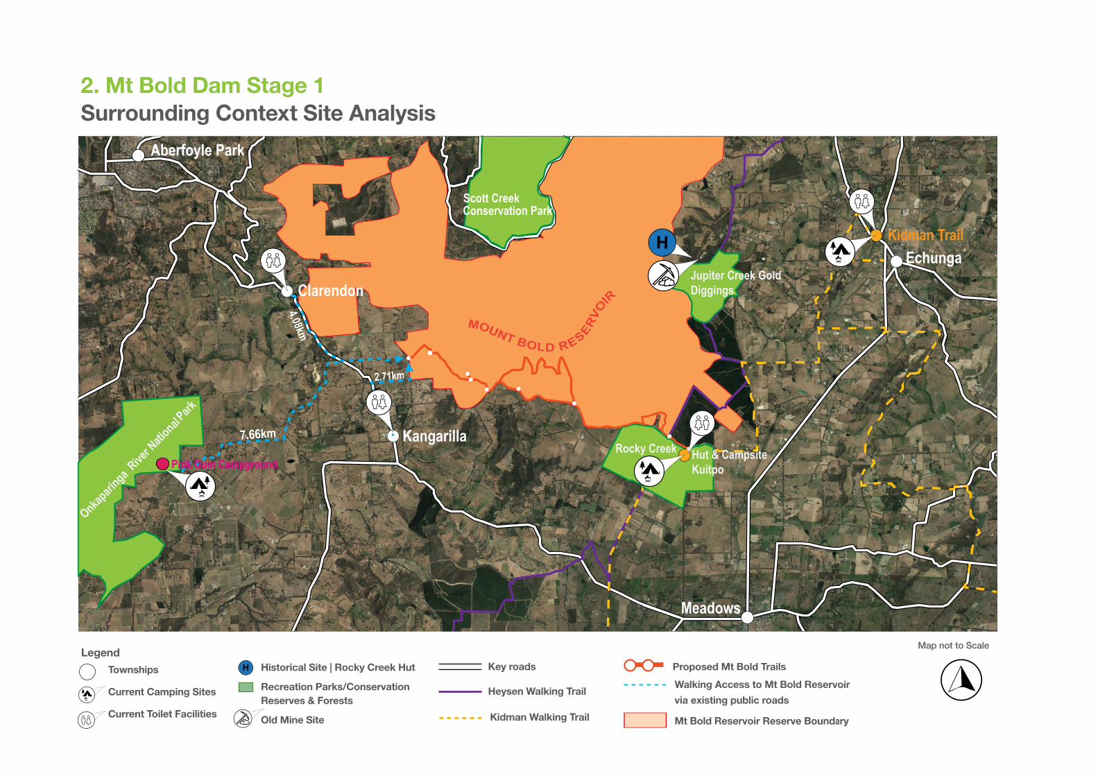
The Stage 1 visitor access works focuses on the connection of southern trails along the southern border of the Mt Bold Reservoir SA Water land. It provides for connections and visitor access to the following areas:
• The New Trail 1 connects from Mt Bold Road to Scenic Road and Golder Road junction point to west, Gate 1 (Fire Track 2) which provides further connection to the Kangarilla Township (Approx 2.62 km to the main street), Claredon Township (Approx 4.08km) and Pink Gum Campsite (Approx 7.66km).
• New Trail 2 connects to Mt Bold Road and then further to new Trail 3 moving towards the east to Lookout 1.
• New Trail 3 runs parallel to Razorback Road and further east towards Focus Area 1 which provides parking, toilets and seating adjacent the Communications Tower.
• New Trail 4 provides scenic views and pedestrian access to the views of the Reservoir with additional high intensity walking trail following back to Razorback Road to connect to Trail 5.
• New Trail 5 provides light intensity walk alonge side Razorback Road connecting to Rest Stop 1 which provides parking and seating with vistas over the reservior. This then further connects to the Heysen Trail, the Kidman Trail and Kuitpo Forest.
1. Executive SummaryInitial Open Space Access Works
The Concept Plan includes the following :
1 - Surrounding Context Analysis - showing southern portion of the Reservoir in context with local adjoining neighbourhoods.
2 - Detailed Schematic Site Plan - proposed new Trails & Lookouts.
3 - Zoomed in Details Plan 1 – Lookout 1
4 - Zoomed in Details Plan 2 – Focus Area 1 Proposed carpark and new entrances near the Telstra Tower plus Toilet block and Picnic area.
5 - Rest Stop 1 Proposed Picnic area and Lookout.
6 - Photo-montages of proposed key Focus Areas/ Lookouts, and section for proposed viewing platform.
Mt Bold Reservoir Reserve Project Team :
DEW - Emma Ginman
SA Water - Darrell Hamlyn, Brooke Swaffer, David Loveder, Ian Smart, Dylan Ribbons, Peter Pavy, Jim Garrod and James Crocker.
GHDWoodhead - Danny Grzan, Azhrudin Coulthard, Katie Williams and Marko Separovic
RLB - Sam Valkonen, Giulio Altamura

Wider Context Analysis
H
MOUNT BOLD RESERVO
IR
Echunga
Aberfoyle Park
Meadows
Clarendon
Kangarilla Rocky Creek
Onkapari
nga Rive
r Natio
nal
Jupiter Creek Gold Diggings
Park
Pink Gum Campground Hut & Campsite Kuitpo
Kidman Trail
7GHDWoodhead
2. Mt Bold Dam Stage 1Surrounding Context Site Analysis
Legend
Townships
Current Camping Sites
Current Toilet Facilities
Historical Site | Rocky Creek Hut
Recreation Parks/Conservation Reserves & Forests
Old Mine Site
Heysen Walking Trail
Key roads Proposed Mt Bold Trails H
Kidman Walking Trail
Walking Access to Mt Bold Reservoir
via existing public roads
Mt Bold Reservoir Reserve Boundary
Map not to Scale

8GHDWoodhead
3. Mt Bold Dam Stage 1Detailed Schematic Site Plan
Detail Schematic Legend
Lookout 1:
Proposed Trail & Distances
Walking Trail 1 | 0.72 km
Walking Trail 2 | 1.33 km
Walking Trail 3 | 0.63 km
Walking Trail 4 | 4.60 km
Walking Trail 5 | 5.42 km
Walking Trail Grade
Grade 1 | Less than 1:14 slopes
Grade 2 | Less than 1:10.
Grade 3 | Section greater than 1:10. Up to 20km
Grade 4 | Arduous section greater than 1:10, or longer than 20km.
Rest Stop 1:
FA1 Focus Area 1:
Toilet Facility
Car Park
Picnic Table
Heysen Walking Trail
Kidman Walking Trail
Rocky Creek
Hut & Campsite Kuitpo
MOUNT BOLD RESERVOIR Clarendon 4.08km
Kangarilla 2.71km
Echunga 6.2km
MT BOLD RD
GO
LDER
RD
SADDLE BAGS RD
RAZORBACK RD
TRAIL 3
TRAI
L 4
TRA
IL 5
TRAIL 1
TRAIL 2
LOOK
OUT
1
REST STOP 1
FA1
Viewing PlatformMajor Areas
Wayfinding
* Trail grades are colour coded to appropriate trails above
Map not to Scale

9GHDWoodheadGHDWoodhead
Mt Bold Dam Stage 1 Lookout 1

4.8m
10GHDWoodhead
4. Mt Bold Dam Stage 1Detail Plan - Lookout 1
AATT ORIGINA ORIGINALL SIZE A 3
HERITAGE SURVEY MARKER
WAYFINDING
INFORMATION SIGN
PROPOSED SEATING
LEGEND
H H
PROPOSED WAY-FINDING SIGNAGE
PROPOSED PATH TREATMENT 03, BITUMEN PATH
RECYCLED PLASTIC DECK ON STEEL STRUCTURE
PROPOSED LOOKOUT INFORMATION SIGNAGE
PROPOSED BENCH SEATING
2.5m
20.5m
4m
6 m
00 20002000 40004000 60006000 80008000 1000010000 mm mm
SCALE 1:200SCALE 1:200
00 55 1010 1515 2020 2525 mm
SCALE 1:500SCALE 1:500 AATT ORIGINA ORIGINALL SIZE A 3

5. Mt Bold Dam Stage 1Section - Lookout 1
STEEL BALUSTRADES WITH STEEL HANDRAILS
LOOKOUT PLATFORM WILL HAVE A RECYCLED PLASTIC DECK SURFACE ON A STEEL STRUCTURE
4.5m
20.5m 4m
Lookout Viewing PlatformRamp to lookout viewing Platform
3m
1.2m
PROPOSED RETAINING WALL WITH EARTH BACK FILL
00 10001000 20002000 30003000 40004000 50005000 mm mm
SCALE 1:100SCALE 1:100
AATT ORIGINA ORIGINALL SIZE A 3

6. Mt Bold Dam Stage 1Concept Visualisation - Lookout 1

13GHDWoodhead Client Name
7. Mt Bold Dam Stage 1Concept Visualisation - Approaching Lookout 1

14GHDWoodheadGHDWoodhead
Mt Bold Dam Stage 1
Focus Area 1

15GHDWoodhead
8. Mt Bold Dam Stage 1Detail Plan - Focus Area 1
3.5m
3m
RAZORBACK R
OAD
PROPOSED WAY-FINDING SIGNAGE
EXISTING FENCES
PROPOSED ENTRY POINT FOR WHEELCHAIR ACCESS
EXISTING TELECOMMUNICATIONS
TOWER
ONE W
AY CIRCULATION
TOTAL 22 CAR PARKING
SPACES
PROPOSED PATH TREATMENT 2. COMPACT GRAVEL
PROPOSED DIRECTIONAL WAY-FINDING SIGNAGE AT NOMINAL DISTANCES ALONG PATH
PROPOSED CAR PARKING
CRUSHED ROCK AND PLASTIC WHEEL STOPS TO BE INSTALLED
PROPOSED LOG SEATING UNDER EXISTING TREES
PROPOSED SERVICE GATE TO ACCESS PATH
FUTU
RE AREA FOR
CARPARK EXPAN
SION
EXISTING TREE
PROPOSED TOILETS
PROPOSED SEATING (TREE LOGS)
PROPOSED WAY-FINDING
EXISTING ROAD
LEGEND
00 44 88 1212 1616 2020 mm
SCALE 1:400SCALE 1:400 AATT ORIGINA ORIGINALL SIZE A 3

9. Mt Bold Dam Stage 1Concept Visualisation - Focus Area 1

17GHDWoodheadGHDWoodhead
Mt Bold Dam Stage 1
Trail Treatment Typologies & Signage
18GHDWoodhead Client Name
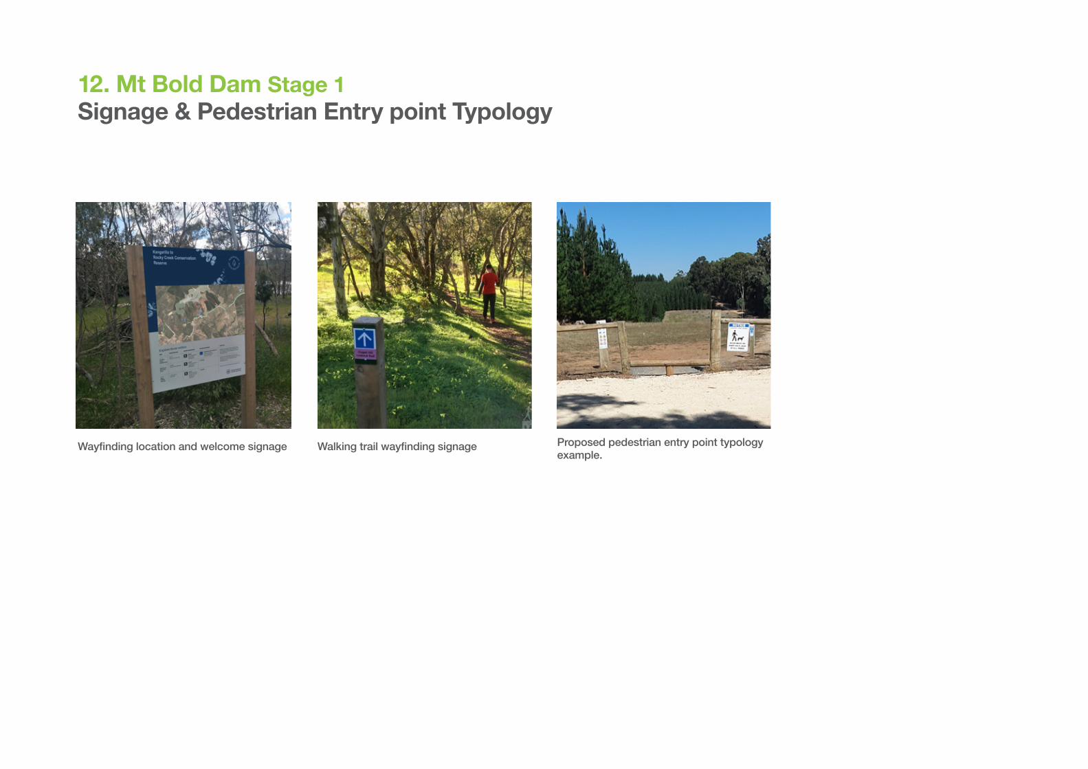
12. Mt Bold Dam Stage 1Signage & Pedestrian Entry point Typology
Walking trail wayfinding signage Proposed pedestrian entry point typology example.
Wayfinding location and welcome signage

MOUNT BOLD RESERVOIR
TRAIL 3
TRAI
L 4
TRA
IL 5
TRAIL 1
TRAIL 2
LOOK
OUT
1
REST STOP 1
Walking Trails Treatments 13. Mt Bold Dam Stage 1
Path Treatment 1
Minimal path treatment to topography with occasional grass maintenance over the seasons. Hikes to be guided through landscape by wayfinding directional marks placed at 50m centres along the way or where appropriate to guide bushwalkers.
PT1 = PT2 = PT3 =
Path Treatment Reference Map:
Paths Treatments are colour coded to the above map.
Path Treatment 3
Clearing of ground level with light path treatment to topography with crushed gravel.
Treatment to be used as indicacted above as well on paths and areas at Rest Stop 1.
Path Treatment 2
Bitumen walking trail treatment to path to allow for disability access to reach Lookout 1 to suit wheel chair access.
Map not to Scale

Melbourne
Level 8
180 Lonsdale Street
Melbourne, Victoria
3000
T: +61 3 8687 8000
Adelaide
211 Victoria Square
Adelaide, South Australia
5000
T: +61 8 8111 6600
ghdwoodhead.com