south coast missing linkages project · south coast missing linkages project ... landscape...
TRANSCRIPT

South Coast Missing Linkages Project
A Linkage Design for the Tehachapi Connection
Prepared by:
Kristeen Penrod Clint R. Cabañero Dr. Claudia Luke
Dr. Paul Beier Dr. Wayne Spencer
Dr. Esther Rubin
September 2003 This report was made possible with financial support from: The Wildlands Conservancy, Environment Now, The Resources Agency, U.S. Forest Service, California State Parks Foundation, and the Zoological Society of San Diego.

III
Table of Contents
List of Tables & Figures V
Acknowledgements VII
Executive Summary VIII
Introduction Nature Needs Room to Move 1 Patterns of Habitat Conversion 1 Missing Linkages: A Statewide Vision 2 South Coast Missing Linkages: A Vision for the Ecoregion 2 Ecological Significance of the Tehachapi Connection 4 Existing Conservation Investments 5 Conservation Planning Approach Introduction 6 Focal Species Selection 7 Landscape Permeability Analysis 8 Patch Size & Configuration Analysis 9 Minimum Linkage Width 9 Field Investigations 10 Identify Conservation Opportunities 10 Landscape Permeability Analyses Landscape Permeability Analyses Summary 11 Mountain Lion 12 American Badger 13 San Joaquin Kit Fox 14 Mule Deer 15 Western Gray Squirrel 16 Tipton Kangaroo Rat 17 Tehachapi Pocket Mouse 18 California Spotted Owl 19 Blunt-nosed Leopard Lizard 20 Patch Size & Configuration Analyses Patch Size & Configuration Analyses Summary 21 Western Pond Turtle 23 Blunt-nosed Leopard Lizard 25 Tipton Kangaroo Rat 27 Heermann’s Kangaroo Rat 29

IV
California Thrasher 30 Bright Blue Copper Butterfly 32 Linkage Design Description of the Linkage 34 Natural Communities in the Linkage 34 Removing and Mitigating Barriers to Movement 36 Roads as Barriers to Upland Movement 37 Types of Mitigation for Roads 37 Recommended Locations for Crossing Structures on Interstate 5 38 Recommended Locations for Crossing Structures on State Route 58 40 Other Recommendations Regarding Paved Roads Within the Linkage Area 42 Roads as Ephemeral Barriers 43 The California Aqueduct 44 Impediments to Streams 44 Urbanization 45 Agriculture and Livestock Grazing 45 Other Land Uses 46 Land Protection & Stewardship Opportunities 46 Appendices (Enclosed CD) A. Workshop Participants B. Workshop Summary C. Flyover Animation of the Tehachapi Connection D. Patch Size & Configuration Analyses E. Literature Cited
V
List of Tables
Table 1. Focal Species Selected Table 2. Focal Species Movement Criteria Table 3. Vegetation and Land Cover in the Linkage List of Figures
Figure 1. South Coast Missing Linkages Figure 2. Convergence of Ecoregions Figure 3. Aggregated Vegetation Types in the Linkage Planning Area Figure 4. Ownership Boundaries in the Linkage Planning Area Figure 5. Interdisciplinary Approach Figure 6. Model Inputs: Topographic features, vegetation, and road density Figure 7. Least Cost Union Figure 8. Least Cost Union Displaying Species Overlap Figure 9. Least Cost Corridor for Mountain lion Figure 10. Least Cost Corridor for American badger Figure 11. Least Cost Corridor for San Joaquin kit fox Figure 12. Least Cost Corridor for Mule deer Figure 13. Least Cost Corridor for Western gray squirrel Figure 14. Least Cost Corridor for Tipton kangaroo rat Figure 15. Least Cost Corridor for Tehachapi pocket mouse Figure 16. Least Cost Corridor for California spotted owl Figure 17. Least Cost Corridor for Blunt-nosed leopard lizard Figure 18. Linkage Cost Union Additions Figure 19. Potential Cores & Patches for Western pond turtle Figure 20. Potential Cores & Patches for Blunt-nosed leopard lizard Figure 21. Patch Configuration for Blunt-nosed leopard lizard Figure 22. Potential Cores & Patches for Tipton kangaroo rat Figure 23. Patch Configuration for Tipton kangaroo rat Figure 24. Potential Cores & Patches for Heerman’s kangaroo rat Figure 25. Patch Configuration for Heerman’s kangaroo rat Figure 26. Potential Cores & Patches for California thrasher Figure 27. Potential Cores & Patches for Bright blue copper butterfly Figure 28. Patch Configuration for Bright blue copper butterfly Figure 29. Linkage Design for the Tehachapi Connection Figure 30. Existing Infrastructure in the Planning Area Figure 31. Culvert on Interstate 5 for Gorman Creek Figure 32. Fill slope along SR-58 that should be replaced with a bridge Figure 33. View south from the culvert shown in Figure 32, showing oak woodland habitat Figure 34. Tehachapi Creek flowing under SR 58 Figure 35. The North side of SR 58 at Sand Canyon Figures in Appendix D Figure 36. Potential Patches for Mountain lion Figure 37. Potential Cores & Patches for American badger Figure 38. Potential Cores & Patches for San Joaquin kit fox Figure 39. Potential Cores & Patches for Mule deer Figure 40. Potential Cores & Patches for Western gray squirrel Figure 41. Potential Cores & Patches for Tehachapi pocket mouse

VI
Figure 42. Patch Configuration for Tehachapi pocket mouse Figure 43. Potential Cores & Patches for California spotted owl Figure 44. Potential Cores & Patches for Burrowing owl Figure 45. Potential Cores & Patches for Acorn woodpecker Figure 46. Potential Cores & Patches Coast horned lizard Figure 47. Patch Configuration for Coast horned lizard Figure 48. Potential Cores & Patches Yellow-blotched salamander Figure 49. Patch Configuration for Yellow-blotched salamander Figure 50. Potential Cores & Patches Long-nosed leopard lizard Figure 51. Potential Cores for Callippe fritillary Figure 52. Potential Cores for San Emigdio blue butterfly Figure 53. Potential Cores for Bear sphinx moth Figure 54. Potential Cores for Linsley’s rain beetle Figure 55. Potential Cores for Tejon rabbitbrush longhorned borer Figure 56. Potential Cores for Lined Lomatium longhorned borer Figure 57. Potential Habitat for White fir Figure 58. Potential Habitat for Blue oak Figure 59. Potential Habitat for California black oak Figure 60. Potential Habitat for California buckeye Figure 61. Potential Habitat for Jeffrey pine Figure 62. Potential Habitat for Single-leaf pinyon pine Figure 63. Potential Habitat for Bakersfield cactus Figure 64. Potential Habitat for Tejon poppy
VII
Acknowledgements: We would like to thank the following individuals for their participation in the selection of focal species: Ileene Anderson, Bill Asserson, Keith Babcock, Jim Bland, Monica Bond, Ryan Bourque, Liz Chattin, David Clendenen, Michelle Cullens, Brendan Cummings, Brian Cypher, Ellen Cypher, Ken Davenport, Anne Dove, Mark Faull, Joe Fontaine, Mike Foster, John Gallo, Mary Griffen, Frank Hovore, Michelle James, Steve Juarez, Steve Junak, Jeannine Kashear, John Kelly, Amy Kuritsubo, Mary Ann Lockhart, Mickey Long, Rob Lovich, David Magney, Randi McCormick, Pete Nichols, Kacy O’Malley, Ken Osborne, Chuck Patterson, Gordon Pratt, Hugh Safford, Kassie Siegel, Lynn Stafford, Allison Sterling Nichols, Julie Striplin-Lowry, Tim Thomas, Rocky Thompson, Steve Torres, Ian Swift, Andrea Warniment, and Mike White. Reviewers and/or Contributing Authors: We would especially like to thank the following individuals who are reviewing or have reviewed and provided comments on either individual species sections or the entire draft report: Ileene Anderson, Bill Asserson, Jim Bland, Bill Block, Monica Bond, Chris Brown, Dave Clendenen, Dan Cooper, Brian Cypher, Ellen Cypher, Ken Davenport, Michelle Dohrn, Paul Edelman, Robert Fisher, Dave Germano, Chris Haas, Frank Hovore, Patrick Kelly, Bill LaHaye, Ken Logan, Rob Lovich, Lisa Lyren, Scott Morrison, Ken Osborne, Jim Patton, Gordon Pratt, Seth Riley, Hugh Safford, Ray Sauvajot, Jerre Ann Stallcup, Linda Sweanor, Ian Swift, David Wake, Mike White, and Dan Williams. Project Steering Committee: We are extremely grateful to the following individuals, who serve on the steering committee for the South Coast Missing Linkages Project:
• Paul Beier, South Coast Wildlands Project • Madelyn Glickfeld, The Resources Agency California Legacy Project • Gail Presley, California Department of Fish and Game • Therese O’Rourke, U.S. Fish & Wildlife Service (formerly with The Nature Conservancy) • Kristeen Penrod, South Coast Wildlands Project • Rick Rayburn, California State Parks • Ray Sauvajot, National Park Service • Tom White, U.S. Forest Service
Project Partners: Finally, we would like to recognize our partners on the South Coast Missing Linkages Project, including The Wildlands Conservancy, The Resources Agency, U.S. Forest Service, California State Parks, California State Parks Foundation, National Park Service, San Diego State University Field Stations Program, Environment Now, The Nature Conservancy, Conservation Biology Institute, Santa Monica Mountains Conservancy, California Wilderness Coalition, Wildlands Project, Zoological Society of San Diego Center for Reproduction of Endangered Species, Pronatura, Conabio, and Universidad Autonoma de Baja California. We are committed to collaboration to secure a wildlands network for the South Coast Ecoregion and beyond and look forward to adding additional agencies and organizations to our list of partners.

VIII
Executive Summary Habitat loss and fragmentation are the leading threats to biodiversity, both globally and in southern California. Efforts to combat these threats must focus on conserving well-connected networks of large wildland areas where natural ecological and evolutionary processes can continue operating over large spatial and temporal scales—such as top-down regulation by large predators, and natural patterns of gene flow, pollination, dispersal, energy flow, nutrient cycling, inter-specific competition, and mutualism. Adequate landscape connections will thereby allow these ecosystems to respond appropriately to natural and unnatural environmental perturbations, such as fire, flood, climate change, and invasions by alien species.
The tension between fragmentation and conservation is particularly acute in California, because our state is one of the 25 most important hotspots of biological diversity on Earth. And nowhere is the threat to connectivity more severe than in southern California—our nation’s largest urban area, and still one of its fastest urbanizing areas. But despite a half-century of rapid habitat conversion, southern California retains some large and valuable wildlands, and opportunities remain to conserve and restore a functional wildland network here.
Although embedded in one of the world’s largest metropolitan areas, Southern California’s archipelago of conserved wildlands is fundamentally one interconnected ecological system, and the goal of South Coast Missing Linkages is to keep it so. South Coast Missing Linkages is a collaborative effort among a dozen governmental and non-governmental organizations. Our aim is to develop Linkage Designs for 15 major landscape linkages to ensure a functioning wildland network for the South Coast Ecoregion, along with connections to neighboring ecoregions. The Tehachapi Connection is perhaps our most important linkage in that it is the sole wildland connection between two major mountain systems—the Sierra Nevada and the Sierra Madre.
On September 30, 2002, 90 participants representing over 40 agencies, academic institutions, land managers, land planners, conservation organizations, and community groups met to establish biological foundations for planning landscape linkages in the Tehachapi region. They identified 34 focal species that are sensitive to habitat loss and fragmentation here, including 9 plants, 7 insects, 1 amphibian, 5 reptiles, 4 birds and 8 mammals. These focal species cover a broad range of habitat and movement requirements: some are widespread but require huge tracts of land to support viable populations (e.g., mountain lion, badger, California spotted owl); others are endemic species, narrowly restricted within the linkage planning area (e.g., yellow-blotched salamander). Many are habitat specialists (e.g., pond turtle in riparian habitat, or acorn woodpecker in oak woodlands) and others require specific configurations of habitat elements (e.g. California quail or western toad). Together, these 34 species cover a wide array of habitats and movement needs in the region, so that planning adequate linkages for them is expected to cover connectivity needs for the ecosystems they represent. To identify potential routes between existing protected areas we conducted landscape permeability analyses for 9 focal species for which appropriate data were available. Permeability analyses model the relative cost for a species to move between protected core habitat or population areas. We defined a least-cost corridor—or best potential route—for each species, and then combined these into a Least Cost Union covering all 9 species. We then analyzed the size and configuration of suitable habitat patches within this Least Cost Union for all 34 focal species to verify that the final Linkage Design would suit the live-in or move-through habitat needs of all. Where the Least Cost Union omitted areas essential to the needs of a particular species, we expanded the Linkage Design to accommodate that species’ particular requirements to produce a final Linkage Design (Figure ES-1). We also visited priority areas in the field to identify and evaluate barriers to movement for our
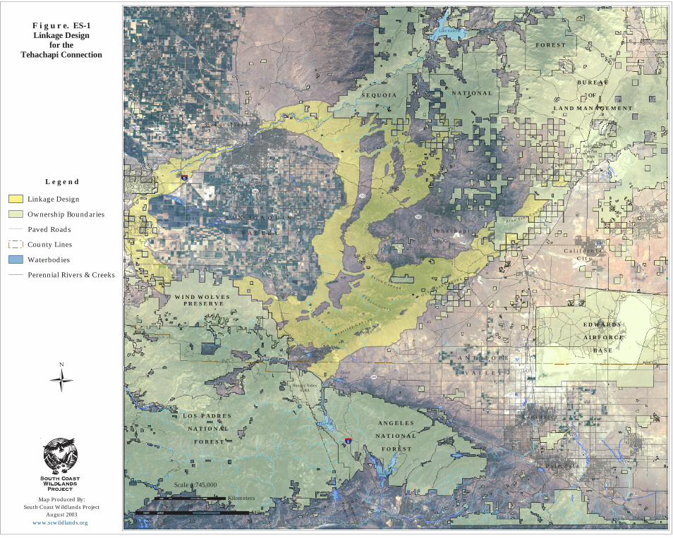
F i g u r e. ES-1Linkage Design
for theTehachapi Connection
0 5 10 15 202.5
Miles0 5 10 15 202.5
Kilometers
Scale 1:745,000
�
Map Produced By:South Coast Wildlands Project
August 2003
www.scwildland s.org
L e g e n d
Linkage Design
Ow nership Bound aries
Paved Road s
Cou nty Lines
Waterbod ies
Perennial Rivers & Creeks
B a k e r s f i e l d
T e h a c h a p i
L a n c a s t e r
P a l m d a l e
C a l i f o r n i a C i t y
W I N D W O L V E S P R E S E R V E
L O S P A D R E S
N A T I O N A L
F O R E S T
A N G E L E S
N A T I O N A L
F O R E S T
E D W A R D S
A I R F O R C E
B A S E
S E Q U O I A N A T I O N A L
F O R E S T
B U R E A U
OF
L A N D M A N A G E M E N T
Ventu
ra Co.
Los A
ngeles C
o.
Kern Co.
���5
���599
9958
223
138
Castac Lake
Quail Lake
Lake Isabella
14
P a s t o r i a C r e e k
E l P a s o C r e e k
K e r n R i v
e r
Hungry ValleySVRA
Red RockCanyon
StatePark
J a w b o n e C a n y o n
B e a r t r a
p C a n y o n
O a k C r e e k C a n y o n
W a l k e r B a s i n C
r e e k
T e j o n C a n y o n
P i n e T r e e C a n y o n
S A N J O A Q U I N
V A L L E Y
A N T E L O P E
V A L L E Y
PyramidLake
CastaicLake

IX
focal species. In this plan we suggest restoration strategies to mitigate those barriers, with special emphasis on opportunities to reduce the adverse effects of Interstate-5, State Route 58, and the California Aqueduct. The ecological, educational, recreational, and spiritual values of protected wildlands in the South Coast Ecoregion are immense. Our Linkage Design for the Tehachapi Connection represents an opportunity to protect a truly functional landscape-level connection—and an ecological jewel at the remarkable juncture of several major ecoregions. The cost of implementing this vision will be substantial—but the cost is small compared with the benefits. If implemented, our plan would not only permit movement of individuals and genes between the Sierra Nevada and the Sierra Madre, but should also conserve large-scale ecosystem processes that are essential to the continued integrity of existing conservation investments throughout the region. We hope that our biologically based and repeatable procedure will be applied in other parts of California and elsewhere to ensure continued ecosystem integrity in perpetuity.