south east inshore marine plan - gov.uk · 2020-01-10 · the south east inshore marine plan area...
TRANSCRIPT

South East Inshore Marine Plan Draft for consultation
January 2020

This document is available in large print, audio and Braille on request. Please call +44 (0)300 123 1032 or [email protected]
Please note:
On 23 June 2016, the EU referendum took place and the people of the United Kingdom voted to leave the European Union. Until exit negotiations are concluded, the UK remains a full member of the European Union and all the rights and obligations of EU membership remain in force. During this period the Government will continue to negotiate, implement and apply EU legislation. The outcome of these negotiations will determine what arrangements apply in relation to EU legislation in future once the UK has left the EU.
References in marine plans to EU legislation, insofar as it is currently, or will become, part of UK law after the UK leaves the EU, may require some changes in relation to rights and obligations under EU legislation. Any such changes will be addressed at the most appropriate point during plan drafting or revision, as required.
Published by the:
Marine Management Organisation Lancaster House Hampshire Court Newcastle upon Tyne NE4 7YH
Tel: 0300 123 1032 Email: [email protected] Website: www.gov.uk/mmo
Publication date: January 2020
© Crown copyright 2020
You may re-use this information (not including logos) free of charge in any format or medium, under the terms of the Open Government Licence.
To view this licence, visit http://www.nationalarchives.gov.uk/doc/open- government-licence/ or write to the Information Policy Team, The National Archives, Kew, London TW9 4DU, or e-mail: [email protected]
Any enquiries regarding this document/publication should be sent to the Marine Management Organisation at: [email protected]
This document is also available on the gov.uk website: https://www.gov.uk/government/publications/draft-south-east-marine-plan-documents
Cover photo: Margate, Kent

Contents
The South East Inshore Marine Plan 1 The South East Marine Plan.............................................................................. 4
1.1 Overall aims .................................................................................................. 4
1.2 Background and introduction......................................................................... 4
1.3 The south east inshore marine plan area ...................................................... 9
1.4 Legal and policy context .............................................................................. 10
1.5 Overview of plan development and supporting documents ......................... 12
2 Vision, objectives and policies ....................................................................... 14
2.1 Vision .......................................................................................................... 14
2.2 Objectives ................................................................................................... 14
2.3 Policies ........................................................................................................ 17
3 Using and implementing the South East Marine Plan .................................. 49
3.1 Specific plan policy considerations .............................................................. 49
3.2 General considerations for public authorities in applying the plan to decisions ........................................................................................................... 50
3.3 How to use the plan in application and decision-making process ............... 52
3.4 Explore Marine Plans – a digital marine planning service ........................... 52
3.5 Pre-application ............................................................................................ 55
3.6 Proposal development and design .............................................................. 55
3.7 Proposal submission and determination ..................................................... 56
3.8 Further material and guidance .................................................................... 56
4 Monitoring, review and reporting ................................................................... 57
4.1 Approach to monitoring ............................................................................... 57
4.2 Reporting .................................................................................................... 57

South East Inshore Marine Plan
1 The South East Marine Plan
1.1 Overall aims
1. The South East Marine Plan introduces a strategic approach to planningwithin the inshore waters between Felixstowe, in Suffolk and near Dover, inKent. It provides a clear, evidence-based approach to inform decision-makingby marine users and regulators on where activities might take place within theinshore marine plan area.
2. The plan applies national policies in a local context, ensuring the needs andaspirations of the marine plan area are reflected. To achieve this, the marineplan has been developed in consultation with stakeholders and in conjunctionwith government.
3. The plan will enable activities to move more quickly from concept to consentby identifying areas suitable for investment, encouraging earlier and clearercommunication between developers and regulatory decision-makers, and byearly identification of proposals that are inappropriate or unfeasible.
4. Implementation of the plan’s policies, through more informed decision-making,will help to ensure that we optimise use of the marine area’s natural capital.This assists in realising greater enhancement and protection of vulnerablehabitats and species, and natural defences against climate change andflooding, as well as improving the well-being of coastal communities andsupporting a strong marine economy.
1.2 Background and introduction
5. A marine plan is required for the south east inshore marine plan area shownin Figure 1 (Marine and Coastal Access Act 2009, Section 51). This marineplan has been prepared for the purposes of Section 51 of the Marine andCoastal Access Act 2009 and will be adopted with the agreement of theSecretary of State for Environment, Food and Rural Affairs. There is nooffshore marine plan area in the south east (Figure 1). The South East MarinePlan document is supported by a Technical Annex, which includes furtherdetail on policy implementation and must be read alongside the South EastMarine Plan to implement the plan policies1.
1 The South East Marine Plan Technical Annex
4

6. The South East Marine Plan will help to enhance and protect the marineenvironment and achieve sustainable economic growth, whilst respecting localcommunities both within and adjacent to the marine plan area. Policies arepresented within an economic, social and environmental framework, helpingto deliver the high level marine objectives set out in the Marine PolicyStatement2. Other relevant government priorities benefit from this approachsuch as those set out in the 25 Year Environment Plan, the Clean GrowthStrategy and sustainable development3 of the marine area.
7. The plan is an enabling mechanism, providing greater certainty about whereactivities could best take place and assisting users in determining preferredlocations. Specifically, the South East Marine Plan:
• enables efficient use of space, highlighting the need and opportunitiesfor co-existence in areas with high concentrations of activity
• clarifies where co-existence is not appropriate, and where activitiesshould be avoided
• enables communication and negotiation where co-existence is anoption, so impacts can be mitigated or minimised. In some caseswhere impacts cannot be minimised but where proposals will bringother benefits, the plan enables these to be taken into account in thedecision-making process
• gives greater certainty around current activity by providing real timedata through the Explore Marine Plans digital service
• provides appropriate safeguarding for areas of future resource potentialwhere evidence allows
• allows flexibility where evidence is limited so developers and decision-makers are able to apply their knowledge and experience
• supports the development of proposals by:
o setting out requirements that apply irrespective of specificlocation, including how an activity or development is undertaken
o identifying factors within the specific opportunities and challengesidentified in the south east inshore marine plan area which willimprove the chances of success within the decision-makingprocess. One example is ensuring that the needs of manyimportant activities that take place in a relatively small marine planarea are balanced effectively
o providing context for when ‘imperative reasons of overriding publicinterest’ are being considered4 such as the need for nationallysignificant infrastructure
2 HM Government, Marine Policy Statement (2011) 3 As defined in the United Kingdom Sustainable Development Strategy 4 Considerations of overriding public interest defined in section 64 of The Conservation of Habitats and Species Regulations 2017 and section 29 of The Conservation of Offshore Marine Habitats and Species Regulations 2017 (please note both pieces of legislation have since been amended by The Conservation of Habitats and Species (Amendment) (EU Exit) Regulations 2019).
5

o increasing awareness of which other relevant legislation, guidance and existing measures should or must be taken into consideration
o reiterating the importance of other relevant project-level regulation and assessment within the decision-making process
8. Section 1 of the plan provides essential background information, section 2 includes, the vision, objectives and plan policies, section 3 provides guidance for those using and implementing the plan and section 4 includes a description of how monitoring, reporting and review will be carried out.
6

Figure 1 | South East Inshore Marine Plan AreaInformation mapThis map is to be used for referenceonly. Please refer to Explore MarinePlans for a detailed view of the data andto interrogate plan policies.
Not to be used for Navigation. Containspublic sector information, licensedunder the Open Government Licencev3.0. UK Hydrographic Office © [2018].Ordnance Survey data © copyright anddatabase right [2018]. National Oceanicand Atmospheric Administration ©copyright and database right [2015].Marine Management Organisation ©[2019].
Date: August 2019Coordinate System: ETRS 1989 UTMZone 30NProjection: Transverse MercatorDatum: ETRS 1989
Marine Plan AreasEast InshoreEast OffshoreNorth East InshoreNorth East OffshoreNorth West InshoreNorth West OffshoreSouth East InshoreSouth West InshoreSouth West OffshoreSouth InshoreSouth Offshore

South East marine plan areas
Over 800 sq/km miltary practice and exercise areas Home to around 125 fish species and over
400 invertebrates
15
Operational Offshore wind farms: Generating more than 1.2GW
7Of the 53 protected wreck sites
in England
37Designated Marine Protected Areas
42Local Authorities
1.3 The south east inshore marine plan area
9. The south east inshore marine plan area stretches from Felixstowe in Suffolk to near Dover, in Kent covering approximately 1,400 kilometres of coastline, taking in a total of approximately 3,900 square kilometres of sea. The French marine area, east marine plan areas and the south inshore marine plan area border the south east inshore marine plan area. It includes:
• the area from mean high water spring tide to 12nm • any area submerged at mean high water spring tide • the waters of any estuary, river or channel, so far as the tide flows at
mean high water spring tide • waters in any area which is closed (permanently or intermittently) by a
lock or other artificial means against the regular action of the tide, but into and from which seawater is caused or permitted to flow (continuously or occasionally)
10. There are 42 local authorities (including two unitary authorities) within the south east inshore marine plan area. The resulting overlap and complexity of governance arrangements is a particular feature and challenge for the south east inshore marine plan area.
11. The south east inshore marine plan area is an important area for a variety of interests, with many important activities competing for a small amount of space. This includes important shipping lanes to Europe which lie in close proximity to offshore wind installations. The south east inshore marine plan area is home to the highest number of ports and harbours in England, contributing the greatest amount of gross value added (GVA) to the national economy of all the English marine plan areas from ports and shipping. These include the Port of London, with high volumes of traffic, Felixstowe the UK’s largest container port and Dover, the UK’s busiest ferry port and top port for roll-on-roll-off freight5. Associated activities such as dredging of ports, harbours and approaches are essential to ensure safety of navigation, ensuring the viability of ports and harbours, along with the ability to compete in the global maritime sector.
12. Marine aggregate extraction is important locally, with half of all aggregates used in construction in London being from marine sources. Fishing activity is at a lower intensity in the south east inshore marine plan area than in some other English marine plan areas. However, there are a significant number of smaller fishing vessels operating out of ports such as Ramsgate and West Mersea. Aquaculture is a locally important activity in the south east inshore marine plan area, particularly for shellfish species.
13. Tourism and recreation both play an important role in the economy of the south east. London and the river Thames are significant areas for tourism and recreation activities, with the coastlines of Suffolk, Essex and Kent with
5 Marine Planning: Strategic Scoping Report (2014)
9

traditional seaside towns also being vital. Boating activity is a prevalent recreational activity throughout the marine plan area with over 140 recognised recreational Royal Yachting Association cruising routes. There are a high number of marinas and mooring facilities in the vast majority of the estuaries in the south east inshore marine plan area.
14. A diverse range of habitats and species are found within the south east inshore marine plan area. For example the river Thames and the estuaries in Essex, Kent and Suffolk support significant assemblages of waterfowl and breeding birds like the red-throated diver. In addition the Thanet coast contains the longest continuous subtidal chalk seabed in the UK and is the only site to protect the stalked jellyfish. Within the plan area there are a large number of sites designated for environmental protection, which have a large spatial extent. For example, the Outer Thames Special Protected Area covers approximately one third of the south east inshore marine plan area.
1.4 Legal and policy context
15. Marine plans are prepared under the policy framework provided by the Marine Policy Statement, and together they underpin the marine planning system for England. The Marine Policy Statement builds on the shared UK wide high level marine objectives, and provides an overview of the relevant national policy, including the National Planning Policy Framework and associated National Policy Statements.
16. The South East Marine Plan conforms to the Marine and Coastal Access Act 2009 and Marine Policy Statement requirements. Where relevant, it also takes account of informal guidance set out within the marine planning description document prepared by the Department for Environment, Food and Rural Affairs.
17. During the development of the South East Marine Plan all reasonable steps were taken, as required by the Marine and Coastal Access Act 2009, to ensure the South East Marine Plan is compatible with marine plans for marine areas related to the south east marine plan area6, including the South Marine Plan and the East Marine Plan. All reasonable steps were also taken, as required by the Marine and Coastal Access Act 2009, to ensure the South East Marine Plan is compatible with any related relevant development plans7 (or their equivalent). Public and local authorities responsible for other plans affecting the south east marine plan area8, for example River Basin Management Plans, have been engaged throughout the development of the South East Marine Plan. Further details can be found in Appendix 2 of the South East Marine Plan Technical Annex.
6 HM Government Marine and Coastal Access Act 2009 Schedule 6 3(1) 7 HM Government Marine and Coastal Access Act 2009 Schedule 6 3(2) 8 HM Government Marine and Coastal Access Act 2009 Schedule 6 9(2)(h)
10

18. The plan also takes account of the duty to co-operate with public authorities9 in the preparation of relevant plans (under the Planning and Compulsory Purchase Act 2004 Section 33A, as amended by the Localism Act 2011) in the English inshore region, the English offshore region or any part of either of those regions. The duty to co-operate requires local authorities and other public bodies to engage constructively, actively and on an ongoing basis10. That duty applies to the marine plans, their implementation and any subsequent revisions. These requirements, together with the option for communities to formulate their own neighbourhood plans, bring new opportunities for an integrated planning system for land and sea.
19. The South East Marine Plan has been prepared in accordance with, and gives consideration to, the EU Maritime Spatial Planning Directive (2014/89/EU) which supports the Integrated Maritime Policy for the European Union. The directive introduces a framework for maritime spatial planning and encourages sustainable development of marine areas and resources. It also sets out minimum requirements, which have been addressed in the South East Marine Plan.
20. As a result of the above, the South East Marine Plan:
• provides a strategic approach to decision-making, considering future use and providing a clear approach to managing resources, activities and interactions within the south east marine plan area
• reduces burden, providing developers with greater clarity on where to invest, encouraging public authorities and plan users to communicate earlier in the process
• enables projects to move more quickly from concept to consent, reducing the number of inappropriate or unfeasible proposals, saving time and resources
• applies and clarifies national policy and existing measures, taking account of the issues, opportunities, and characteristics of the south east marine plan area – marine plans do not establish new requirements
• addresses potential cumulative effects of impacts from the many and increasing pressures
• takes an ecosystem approach and reflects the benefit of clean and healthy seas and natural capital to provide ecosystem goods and services
• complements current measures where appropriate • takes all reasonable steps to make sure compatibility with any related
relevant development plans11 (or their equivalent), and having regard
9 Prescribed bodies are currently set out in Regulation 4 of The Town & Country Planning (Local Planning) (England) Regulations 2012 (SI 2012/767) 10 A Plain English Guide to the Localism Act 11 HM Government Marine and Coastal Access Act 2009 Sc 6 3(2)
11

to other plans12, is in line with the principles of Integrated Coastal Zone Management, addressing the importance of land-sea interactions
• contributes to the UK Marine Strategy13 • is based on sound evidence as far as possible14, is informed by
consultation with stakeholders and makes use of available data and existing management measures where appropriate
21. The draft Marine Plan applies legislation and policies across government in a sub-regional context, ensuring the needs and aspirations of the marine plan area are reflected. National policy and priorities evolve in response to emerging issues and concepts, for example climate change and its implications for the marine environment or applying a natural capital approach or applying nature-based solutions to solving environmental issues. New legislation could set out new and additional considerations for marine planning, for example in relation to Highly Protected Marine Areas (HMPA) if considered necessary following the HPMA Review. The draft Marine Plan is the result of a long process to examine available evidence, identify local priorities and meet stakeholder expectations in the context of current national policy. It represents the most up to date thinking on emerging concepts and developing legislation. Amendments made to the Marine Plan following public consultation offer an opportunity to update the plan in line with new legislation and government policy alongside responses to the consultation. The statutory reporting cycle for Marine Plans at a frequency of no less than three years provides further opportunity for Marine Plans to be reviewed and amended.
1.5 Overview of plan development and supporting documents
22. Stakeholders and government officials across all relevant departments including those relating to retained functions eg defence, local and other authorities and representatives of bordering nations whose authorities were notified of the intention to prepare the marine plan (see table 6 in the Technical Annex), have been central to the development of the plan. All stages of preparing the South East Marine Plan have been supported by ongoing formal and informal public engagement. Details of the engagement approach and activities are set out in the Statement of Public Participation. The South East Marine Plan was developed iteratively in nine month development blocks followed by three months of engagement. Stakeholder input from the engagement periods was incorporated into the following iteration of plan development. The third and final iteration of the South East
12 Technical Annex appendix 2. Note, further to the requirement to ensure compatibility with any marine plan related to the plan area (Marine and Coastal Access Act 2009 Schedule 6 3(1)) there are two marine plans that border the south east inshore marine plan area: East Inshore and Offshore Marine Plans and South Inshore and Offshore Marine Plan. In addition the French marine area also borders the south east inshore marine plan area. 13 The Technical Annex sets out the detail of the UK Marine Strategy and how the plan will contribute to delivery. 14 Where evidence is inconclusive, decision-makers should make reasonable efforts to fill evidence gaps but will need to apply precaution within an overall risk-based approach, in accordance with the sustainable development policies of the UK Administrations.
12

Marine Plan was followed with a more detailed summary of responses and actions ahead of consultation on the draft South East Marine Plan. Material produced through the iterations in preparation of the plan can be found in the South East Marine Plan core development documents.
23. Assessments undertaken as part of the South East Marine Plan’s preparation are the:
• Sustainability Appraisal as required by the Marine and Coastal Access Act 2009 (Schedule 6, Paragraph 10) – appraises the social, economic and environmental impacts of the South East Marine Plan and makes sure sustainable development is at the heart of the plan making process
• Habitats Regulations Assessment – fulfils the requirements of The Conservation of Habitats and Species Regulations 201715 and The Conservation of Offshore Habitats and Species Regulations 201716
15 As amended by The Conservation of Habitats and Species Regulations (Amendment) (EU Exit) Regulations 2019 16 As amended by the Conservation of Habitats and Species Regulations (Amendment) (EU Exit) Regulations 2019
13

2 Vision, objectives and policies
2.1 Vision
The vision for the south east marine plan area in 2041
The south east marine plan area is distinctive for being a substantial maritime gateway to the world with locally and nationally important ports that are thriving. The prosperous ports, associated industries and shipping sectors are contributing to the long-term economic growth and prosperity of the UK and south east coastal communities. The tidal rivers in the south east have been optimised for short sea shipping. The Tidal Thames facilitates more sustainable passenger and freight transport than before with improved access, infrastructure, local employment and air quality, benefiting the greater Thames area.
The densely populated communities of the south east and its valuable cultural heritage, environmental assets and seascape are more resilient than ever before, including against the impacts of climate change and coastal change. The important role marine and estuarine environments play in mitigating climate change is realised. A profitable, sustainable fisheries sector is thriving in the south east.
The consideration of cumulative effects and the net gain approach have successfully resulted in a natural environment that is in a measurably better state than before. That includes maintaining and, where required, enhancing and restoring the condition of natural capital and marine protected areas.
The South East Marine Plan promotes good governance and has solved challenges and conflicts in the crowded marine plan area through enabling plan-led decisions and the co-existence of activities. Awareness of the marine plan and connectivity with the large number of consenting regimes and local planning authorities is high, especially in the densely populated London and Greater Thames Estuary area.
24. The vision for the south east inshore marine plan area in 2041 reflects the challenges and opportunities that exist in the plan area. The vision was developed through stakeholder engagement and taking account of the approach to drafting plans, national policy and the evidence base. Detail on how the south east inshore marine plan area will look as a result of the vision being achieved can be found in the Technical Annex.
2.2 Objectives
25. The vision for the South East Marine Plan will be achieved through the marine plan objectives (Table 1). The plan objectives reflect engagement with stakeholders and government throughout the planning process. As a result of stakeholder feedback, together with experience and lessons from the development of earlier marine plans, it was concluded that relevant high level marine objectives set out in the Marine Policy Statement would be appropriate to use as the objectives for the South East Marine Plan. The ‘generic’ high
14

level marine objectives are made specific to the vision for South East Marine Plan by the evidence and issues that describe opportunities and challenges in the south east inshore marine plan area over the next 20 years (marine planning issues and evidence database). As a result, the high level marine objectives, underpinned by the evidence, issues and policies specific to the south east inshore plan area, form the plan objectives listed in Table 1.
26. High level marine objectives relevant to the South East Marine Plan are only those which are mainly delivered through plan policies. Therefore, the plan objectives are based on the economic, social and environmental high level marine objectives. Those high level marine objectives that are to do with process or largely delivered through other mechanisms, such as plan development or implementation of marine plans as a whole17, are not appropriate to use as plan objectives. Instead, these can be considered as ‘supporting’ objectives to the plan. The Technical Annex provides more information on the plan objectives and supporting objectives.
27. Plan objectives are cross-cutting rather than topic or sector specific. The order of the objectives does not reflect their priority. Economic, social and environmental objectives must be considered equally alongside one another. Plan objectives should be applied in an integrated way, though not every objective will apply to every situation and in every location.
28. For detail on the objectives see Table 1 of the Technical Annex which outlines the relevance and importance of each plan objective to the south east inshore marine plan area. Detail on the contribution of polices to each objective can be found in Table 2 of the Technical Annex. The Technical Annex also includes 'signposting’ to existing legislation, guidance and best practice which may aid implementation of the plan objectives through informing decision-making and the development of proposals.
17 For example, objective 17 ‘Marine businesses are subject to clear, timely, proportionate and, where appropriate, plan-led regulation’ will be achieved through the development and implementation of marine planning as a whole rather than specific policies.
15

Table 1: Objectives of the South East Marine Plan Achieving a sustainable marine economy
1 Infrastructure is in place to support and promote safe, profitable and efficient marine businesses.
2 The marine environment and its resources are used to maximise sustainable activity, prosperity and opportunities for all, now and in the future.
3 Marine businesses are taking long-term strategic decisions and managing risks effectively. They are competitive and operating efficiently.
4 Marine businesses are acting in a way which respects environmental limits and is socially responsible. This is rewarded in the market place.
Ensuring a strong, healthy and just society
5 People appreciate the diversity of the marine environment, its seascapes, its natural and cultural heritage and its resources and can act responsibly.
6 The use of the marine environment is benefiting society as a whole, contributing to resilient and cohesive communities that can adapt to coastal erosion and flood risk, as well as contributing to physical and mental wellbeing.
7 The coast, seas, oceans and their resources are safe to use.
8 The marine environment plays an important role in mitigating climate change.
9 There is equitable access for those who want to use and enjoy the coast, seas and their wide range of resources and assets and recognition that for some island and peripheral communities the sea plays a significant role in their community.
10 Use of the marine environment will recognise, and integrate with, defence priorities, including the strengthening of international peace and stability and the defence of the United Kingdom and its interests.
Living within environmental limits
11 Biodiversity is protected, conserved and, where appropriate, recovered, and loss has been halted.
12 Healthy marine and coastal habitats occur across their natural range and are able to support strong, biodiverse biological communities and the functioning of healthy, resilient and adaptable marine ecosystems.
13 Our oceans support viable populations of representative, rare, vulnerable, and valued species.
16

2.3 Policies
29. Policies contained in the South East Marine Plan support delivery of the plan objectives to achieve the vision and address issues (challenges and opportunities) identified in the south east marine plan area. Where a plan objective cannot be achieved through existing legislation, new policies have been drafted. The policies may also clarify existing requirements or make them relevant to the plan area.
30. Policies cover a wide range of topics including activities and uses, economic, social and environmental considerations, and cross-cutting issues such as integration of decision-making on land and at sea. Table 2 shows the relationship between the marine plan policies and the plan objectives. Each policy has a unique reference code, for example SE-BIO-1. Policy aims are provided in Table 2 to explain how the policies guide decisions and support the application of plan objectives. Related policies are presented alongside each other in the Technical Annex with shared supporting text where appropriate to avoid duplication, for example SE-AQ-1 and SE-AQ-2.
31. Some policies apply across the whole of the inshore marine plan area and some may apply to specific areas. Plan policies and relevant supporting information have been expressed spatially where possible. Maps are presented in the Technical Annex and on the Explore Marine Plans digital service, together with guidance on use of the latest data and information.
32. The Technical Annex provides more detail on what each policy covers, why it is important and where and how the policy will be implemented. Unless stated otherwise in the Technical Annex, policies apply all year round. The Technical Annex also provides guidance on use of the latest data and information to support application of policies. Both the Technical Annex and the Explore Marine Plans digital service should be used alongside this plan.
33. The marine plan must be read as a whole, taking all plan policies together rather than each policy in isolation. It is unlikely that a particular decision will involve a single policy or all policies. Instead, several plan policies are likely to be pertinent to a decision. Decision-makers, working with proponents and others as necessary, are to determine which plan policies (and associated maps) apply to a particular decision.
17

Table 2: Policies of the South East Marine Plan The page numbers identify the location in the South East Marine Plan Technical Annex where the policy is described in detail
Topic Policy code Policy text Policy aim Plan
Objectives Page
Infr
astr
uctu
re
SE-INF-1 Appropriate land-based infrastructure which facilitates marine activity (and vice versa) should be supported.
Many marine activities in the south east and adjacent marine plan areas are reliant on land-based infrastructure in the south east inshore marine plan area. Supporting infrastructure development will provide economic and social benefits and facilitate marine business, including those that are land-based. SE-INF-1 supports integration between marine and terrestrial systems by encouraging proposals and other measures that maintain existing or provide new infrastructure in the intertidal area that facilitates marine activity.
1 33
SE-INF-2
(1) Proposals for alternative development at existing safeguarded landing facilities will not be supported.
(2) Proposals adjacent and opposite existing safeguarded landing facilities must demonstrate that they avoid significant adverse impacts on existing safeguarded landing facilities.
(3) Proposals for alternative development at existing landing facilities (excluding safeguarded sites) should not be supported unless that facility is no longer viable or capable of being made viable for waterborne transport.
(4) Proposals adjacent and opposite existing landing facilities (excluding safeguarded sites)
Landing facilities in the south east marine plan area, especially on the Thames, are critical for enabling industries including shipping, tourism and leisure, construction, aggregates and waste. Wharves along the river Thames land more than half of all English landings of marine sand and gravel. Through protecting landing facilities, identifying the difference in safeguarding, SE-INF-2 expands terrestrial legislation to the marine and encourages the continuation and development at these vital landing facilities.
1 33
18

Topic Policy code Policy text Policy aim Plan
Objectives Page
should demonstrate that they will in order of preference:
a) avoid b) minimise c) mitigate significant adverse impacts on existing landing facilities.
Co-
exis
tenc
e
SE-CO-1
Proposals that optimise the use of space and incorporate opportunities for co-existence and co-operation with existing activities will be supported.
Where potential conflicts with existing activities are likely (including displacement) proposals must demonstrate that they will, in order of preference:
a) avoid b) minimise c) mitigate significant adverse impacts on existing activities (including displacement) d) if it is not possible to mitigate significant adverse impacts on existing activities (including displacement), proposals should state the case for proceeding.
Space within the small and busy south east inshore marine plan area is limited. To realise sustainable social, environmental and economic benefits it is therefore important to plan for and make efficient use of the space. SE-CO-1 encourages proposals to be spatially planned, take account of existing activities, and promote co-existence. The policy ensures new activities seek to avoid creating conflicts and to minimise their footprint.
2, 4, 6, 8, 9, 10, 11, 12,
13 43
Agg
rega
tes
SE-AGG-1
Proposals in areas where a licence for extraction of aggregates has been granted or formally applied for should not be authorised, unless it is demonstrated that the other development or activity is compatible with aggregate extraction.
SE-AGG-1 safeguards marine aggregate licence areas from other activities, unless it is demonstrated that the other activities are compatible with marine aggregate extraction. This enables continuity of supply of construction aggregate and supports local and national objectives and economies.
2, 3 50
19

Topic Policy code Policy text Policy aim Plan
Objectives Page
While there are currently no active licensed marine aggregate dredging sites in the south east marine plan area, growing pressures on traditional land-based aggregates means that this may change with time. It is therefore important to safeguard potential future aggregates resources. There are also areas of high potential aggregate resource which would support this future extraction.
SE-AGG-2
Proposals within an area subject to an Exploration and Option Agreement with The Crown Estate should not be supported unless it is demonstrated that the other development or activity is compatible with aggregate extraction.
SE-AGG-2 safeguards marine aggregate Exploration and Option Agreement areas to enable the aggregate industry to explore defined areas to identify commercially viable aggregate resource. Proposals will only be supported if they are compatible with marine aggregate extraction. This enables future supply of construction aggregate and supports local and national objectives and economies.
2, 3 50
SE-AGG-3
Proposals in areas where high potential aggregate resource occurs should demonstrate that they will, in order of preference:
a) avoid b) minimise c) mitigate significant adverse impacts on aggregate extraction d) if it is not possible to mitigate significant adverse impacts, proposals should state the case for proceeding.
SE-AGG-3 ensures that proposals consider areas of high potential aggregate resource, as defined by the British Geological Survey. It ensures that any impacts on access to commercially viable marine sand and gravel resources in the future are managed, enabling secure access to sufficient supply of aggregate resources.
2, 3 50
20

Topic Policy code Policy text Policy aim Plan
Objectives Page
Aqu
acul
ture
SE-AQ-1
Proposals within existing or potential strategic areas of sustainable aquaculture production must demonstrate consideration of and compatibility with sustainable aquaculture production. Where compatibility is not possible, proposals must demonstrate that they will, in order of preference:
a) avoid b) minimise c) mitigate significant adverse impacts on sustainable aquaculture production, d) if it is not possible to mitigate significant adverse impacts, proposals should state the case for proceeding.
The policy recognises that aquaculture is an important industry with potential to grow, contributing to food supply and security. SE-AQ-1 seeks to protect both existing aquaculture operations as well as opportunities for aquaculture in strategic areas of sustainable aquaculture production. These strategic areas have been spatially defined for species of commercial importance by considering environmental factors, technical constraints and other users of the sea (planning constraints).
The policy does not prevent other developments or activities; it supports sustainable aquaculture production by spatially defining areas where other industries are required to demonstrate compatibility with aquaculture. If this cannot be demonstrated, proposals must avoid, minimise or mitigate significant adverse impacts on sustainable aquaculture production, or state the case for proceeding if mitigation is not possible.
2, 4 58
SE-AQ-2 Proposals enabling the provision of infrastructure for sustainable aquaculture and related industries will be supported.
SE-AQ-2 aims to tackle barriers to aquaculture by encouraging the provision, maintenance and development of marine and land infrastructure to support sustainable aquaculture and related industries. This policy supports the development of sustainable aquaculture projects by ensuring connectivity between marine operations and land infrastructure, which will ensure opportunities for aquaculture are realised. Due to the overlap between some shore side aquaculture and fisheries infrastructure, SE-AQ-2 supports integration of aquaculture with the fishing industry, and the diversification of fishers. This policy will
1, 2 58
21

Topic Policy code Policy text Policy aim Plan
Objectives Page
also benefit employment and development of skills in coastal communities.
Cab
les
SE-CAB-1
Preference should be given to proposals for cable installation where the method of installation is burial. Where burial is not achievable, decisions should take account of protection measures for the cable that may be proposed by the applicant. Where burial or protection measures are not appropriate, proposals should state the case for proceeding without those measures.
Submarine cabling is important to the growth and sustainability of telecommunications, offshore wind farms and electricity transmission. SE-CAB-1 supports and encourages cable burial where possible to meet the needs of the sector whilst enabling the co-existence with other users of the south east inshore marine plan area.
3, 4 67
SE-CAB-2
Proposals demonstrating compatibility with existing landfall sites and incorporating measures to enable development of future landfall opportunities should be supported. Where this is not possible proposals will, in order of preference:
a) avoid b) minimise c) mitigate significant adverse impacts on new and existing landfall sites d) if it is not possible to mitigate significant adverse impacts, proposals should state the case for proceeding.
Subsea cabling is important to the growth and sustainability of telecommunications, offshore wind farms and electricity transmission. Existing and potential future landfall sites for subsea cables are not currently protected from other uses, which may prevent these sites being used as cable landfall locations. SE-CAB-2 seeks to avoid the loss of existing and potential future landfall sites and supports proposals that consider the requirement for future cable landfall opportunities, ensuring that socially and economically vital cable activities can continue.
1, 3 67
22

Topic Policy code Policy text Policy aim Plan
Objectives Page
SE-CAB-3
Where seeking to locate close to existing sub-sea cables, proposals should demonstrate compatibility with ongoing function, maintenance and decommissioning activities of the cable.
SE-CAB-3 protects the continued function, maintenance and decommissioning of subsea cables. 3, 4 67
Dre
dgin
g an
d di
spos
al
SE-DD-1
In areas of authorised dredging activity, including those subject to navigational dredging, proposals for other activities will not be supported unless they are compatible with the dredging activity.
Dredge areas, and the area surrounding these that are required for dredge activity to take place, are affected by new proposals, including cables or built infrastructure, that negatively impact the ability to access or egress from these sites. SE-DD-1 ensures continued safe access by vessels to ports and harbours over the lifetime of the South East Marine Plan. Adjacent areas in this policy are defined as those identified to be necessary to dredge activity. This policy discourages proposals that would cause significant adverse impacts on dredge activities, due to the need for related vessels to navigate to and from authorised dredge areas.
2 75
SE-DD-2
Proposals that cause significant adverse impacts on licensed disposal areas should not be supported. Proposals that cannot avoid such impacts must, in order of preference:
a) minimise b) mitigate c) if it is not possible to mitigate the significant adverse impacts, proposals must state the case for proceeding.
Disposal areas, and the areas surrounding these that are required for the disposal activity to take place, are often impacted on by new proposals, including cables or built infrastructure, that negatively impact the ability to access or egress from these sites. SE-DD-2 ensures that disposal areas are not compromised, reducing the need to designate new disposal sites which are not intended for alternative use, reducing environmental impacts. Adjacent areas in this policy are defined as those identified to be necessary for disposal activity. This policy discourages proposals that would cause significant adverse impacts on disposal activities, due to the need for vessels to navigate safely to and from disposal sites.
2 75
23

Topic Policy code Policy text Policy aim Plan
Objectives Page
Preserving current disposal sites, particularly where sites are being used for beneficial and alternative use, will enable and facilitate the growth of ports within the south east inshore marine plan area. Over the 20 year life span of the plan this may become more prevalent in the developing economic climate.
SE-DD-3
Proposals for the disposal of dredged material must demonstrate that they have been assessed against the waste hierarchy. Where there is the need to identify new dredge disposal sites, proposals should be supported which are subject to best practice and guidance.
As a result of dredging activity, disposal of this material is often required, whether this is direct disposal as a last resort in the waste hierarchy or disposal of material for alternative uses. SE-DD-3 provides a source of best practice and guidance for the designation of new dredge disposal sites. This is required as the demand increases for new disposal sites, and encourages early consideration of impacts to avoid conflicts during the proposal process. The establishment of new dredge disposal sites should only be explored after previous levels within the waste hierarchy have been considered and where the disposal is for the purposes of alternative use. If existing designated disposal sites cannot be used, for example where sediment size does not match or there are particular constraints, and the potential to utilise closed or disused sites has been fully investigated and discounted, the designation of new dredge disposal sites may also be required.
2 75
Oil
and
gas
SE-OG-1
Proposals in areas where a licence for oil and gas has been granted or formally applied for should not be authorised unless it is demonstrated that the other development or activity is compatible with the oil and gas activity.
The potential to extract oil and gas is important to the UK’s energy supply. However, oil and gas exploration and production may require access to the same area of seabed within existing licenses as other proposals. This policy safeguards areas where there are existing licenses by
2, 3 88
24

Topic Policy code Policy text Policy aim Plan
Objectives Page
favouring other proposals which demonstrate compatibility with oil and gas activities.
The policy gives clarity on dealing with potential future conflicts with other users who may want to use the same space as oil and gas extraction activities by supporting co-existence opportunities for different users of the south east marine plan area. This supports the UK in meeting its energy and security objectives, as activities that may impact or sterilise areas that may be used for potential oil and gas extraction would hinder the fulfilment of the objectives of the Marine Policy Statement and the UK’s energy objectives.
SE-OG-2 Proposals within areas of geological oil and gas extraction potential demonstrating compatibility with future extraction activity will be supported.
Maximising economic recovery of oil and gas resources may require access to discoveries that have not yet been developed. However, future oil and gas extraction proposals may require access to the same area of seabed as other proposals. This policy safeguards areas identified as having geological potential for future oil and gas extraction by supporting proposals that take future oil and gas extraction into account.
The policy gives clarity on dealing with potential future conflicts with other users who may want to use the same space as oil and gas extraction activities by supporting co-existence opportunities for different users of the south east marine plan area. This supports the UK in meeting its energy and security objectives, as activities that may impact or sterilise areas that may be used for potential oil and gas extraction would hinder the fulfilment of the objectives of the Marine Policy Statement and the UK’s energy objectives.
2, 3 88
25

Topic Policy code Policy text Policy aim Plan
Objectives Page
Port
s, h
arbo
urs
and
ship
ping
SE-PS-1
Only proposals demonstrating compatibility with current activity and future opportunity for sustainable expansion of port and harbour activities will be supported. Proposals that may have a significant adverse impact upon current activity and future opportunity for expansion of port and harbour activities must demonstrate that they will, in order of preference:
a) avoid b) minimise c) mitigate significant adverse impacts d) if it is not possible to mitigate significant adverse impacts, proposals should state the case for proceeding.
Ports and harbours are essential to realise economic and social benefits for the south east inshore marine plan area and the UK. SE-PS-1 makes sure proposals do not restrict current port and harbour activity or future growth, enabling long-term strategic decisions, and supporting competitive and efficient port and shipping operations.
SE-PS-1 provides clarity on how the economic interests of ports and harbours should be protected and makes sure new development does not restrict current activities or future growth. This policy protects the efficiency and resilience of continuing port operations, and further port development (Marine Policy Statement 3.4.7). The sustainable development of ports (increase in shipping activity) is supported by the Marine Policy Statement (3.4.10). This policy also complements and supports the National Policy Statement for Ports, setting provisions for port growth in the context of the management and development of other activities. Policy SE-PS-1 supports the Government policy for ports (National Policy Statement for Ports 3.3). It is recognised that although not all ports are able, or wish to grow physically, there will remain a need to be commercially viable through adaptation, change, and diversification. Also recognised is the need to ensure safe navigation both within and in the approaches to ports, both at the present time and into the future. This policy supports continued port maintenance and repairs, diversification and other sustainable port development which contribute to long-term economic growth and prosperity.
2, 3 95
26
Topic Policy code Policy text Policy aim Plan
Objectives Page
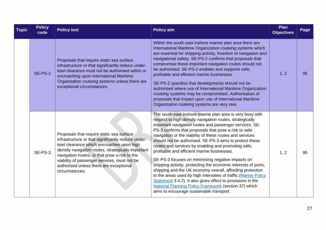
SE-PS-2
Proposals that require static sea surface infrastructure or that significantly reduce under-keel clearance must not be authorised within or encroaching upon International Maritime Organization routeing systems unless there are exceptional circumstances.
Within the south east inshore marine plan area there are International Maritime Organization routeing systems which are essential for shipping activity, freedom of navigation and navigational safety. SE-PS-2 confirms that proposals that compromise these important navigation routes should not be authorised. SE-PS-2 enables and supports safe, profitable and efficient marine businesses.
SE-PS-2 specifies that developments should not be authorised where use of International Maritime Organization routeing systems may be compromised. Authorisation of proposals that impact upon use of International Maritime Organization routeing systems are very rare.
1, 2 95
SE-PS-3
Proposals that require static sea surface infrastructure or that significantly reduce under-keel clearance which encroaches upon high density navigation routes, strategically important navigation routes, or that pose a risk to the viability of passenger services, must not be authorised unless there are exceptional circumstances.
The south east inshore marine plan area is very busy with respect to high density navigation routes, strategically important navigation routes and passenger services. SE-PS-3 confirms that proposals that pose a risk to safe navigation or the viability of these routes and services should not be authorised. SE-PS-3 aims to protect these routes and services by enabling and promoting safe, profitable and efficient marine businesses.
SE-PS-3 focuses on minimising negative impacts on shipping activity, protecting the economic interests of ports, shipping and the UK economy overall, affording protection to the areas used by high intensities of traffic (Marine Policy Statement 3.4.2). It also gives effect to provisions in the National Planning Policy Framework (section 37) which aims to encourage sustainable transport.
1, 2 95
27

Topic Policy code Policy text Policy aim Plan
Objectives Page
SE-PS-4
Proposals promoting or facilitating sustainable coastal and/or short sea shipping as an alternative to road, rail or air transport will be supported where appropriate.
Short sea shipping provides a sustainable alternative for the transport of goods. SE-PS-4 aims to support sustainable coastal or short sea shipping where appropriate as an alternative to road, rail or air methods. Short sea shipping is important as a means of both distributing goods brought into ports by growing numbers of ultra large container ships and through direct movements of smaller bulk materials. Policy SE-PS-4 supports the Government policy for ports (National Policy Statement for Ports 3.3.5 and 3.1.4). The short sea shipping market is expected to grow as a sustainable alternative to the transport of goods by road or rail, providing a flexible and specialised service. There are however, a number of factors to consider in what is a price sensitive market (see, for example, Clean Maritime Plan paragraph 98). In particular the relative lower costs of road transport, time constraints on delivery of goods and the availability of government subsidies.
SE-PS-4 encourages short sea shipping as a sustainable alternative to road, rail or air transport, lowering CO2 emissions and reducing road congestion. Bulk volumes are moved quickly with a reduction in administrative burden and increased efficiency through economies of scale. Short sea routes also allow the transhipment of cargo from large vessels landing into major European ports to the UK, reducing costs, improving reliability and allowing smaller ports to expand through the establishment of increased numbers of short sea shipping routes where suitable
The types of cargo carried by short sea shipping in the south east plan area include (but is not limited to):
3 95
28

Topic Policy code Policy text Policy aim Plan
Objectives Page
• landing of marine aggregates • motor vehicles and plant • steel and metals • transport of cargo (including bulks such as raw
sugar, chemicals including petroleum products and fertilisers, animal feeds, cement) containers and roll-on roll-off units) and passengers
Ren
ewab
les
SE-REN-1 Proposals that enable the provision of renewable energy technologies and associated supply chains, will be supported.
Supply chains play an important role in developing technology, reducing associated costs of infrastructure and realising the economic and social benefits of renewable energy to the UK economy. SE-REN-1 recognises the importance of the supply chain within the lifecycle of renewable energy projects. SE-REN-1 enables public authorities to support proposals that will reduce costs, ensuring that businesses are operating competitively and with a long term strategy.
2, 3, 8 110
SE-REN-2
Proposals for new activity within areas held under a lease or an agreement for lease for renewable energy generation should not be authorised, unless it is demonstrated that the proposed development or activity will not reduce the ability to construct, operate or decommission the existing or planned energy generation project.
Renewable energy technologies contribute to the diversification and decarbonisation of the electricity grid. SE-REN-2 provides protection to areas identified for energy developments from other activities that could affect the sites ability to generate energy. It enables the development of safe, profitable and efficient marine businesses.
2, 3, 8 110
29

Topic Policy code Policy text Policy aim Plan
Objectives Page
SE-WIND-1
Proposals for offshore wind inside areas of identified potential will be supported.
Offshore wind is the current favoured offshore renewable energy generating technology in the UK. SE-WIND-1 highlights areas of least constraint for offshore wind energy generation and indicates potential future areas for leasing. SE-WIND-1 supports the identification of future leasing rounds and provides a level of certainty for other activities as to where future development may occur.
Figure 13 identifies a large portion of the plan areas that have the potential for future development of offshore wind. The report MMO1210 ‘Identifying key potential areas for future offshore wind’ outlines the methodology used to define areas that at the time of analysis were relatively cost effective and less constrained for the development of fixed foundation offshore wind. This policy is in place to facilitate the identification of areas for future offshore wind development. The dataset supporting this policy has been developed against current constraints (see MMO1210 'Identifying key potential areas for future offshore wind') and will be updated, as required, based on improved understanding of constraints and technical advancements, including new technologies.
2, 3, 8 110
30

Topic Policy code Policy text Policy aim Plan
Objectives Page
Her
itage
ass
ets
SE-HER-1
Proposals that demonstrate they will conserve and enhance elements contributing to the significance of heritage assets will be supported. Proposals unable to conserve and enhance elements contributing to the significance of heritage assets will only be supported if they demonstrate that they will, in order of preference:
a) avoid b) minimise c) mitigate harm to those elements contributing to the significance of heritage assets d) if it is not possible to mitigate, then public benefits for proceeding with the proposal must outweigh the harm to the significance of heritage assets.
The south east marine plan area has many significant cultural assets. Many of these are protected through existing statutory designations. However, some have little protection despite their contribution to the character of the south east marine plan area and tourism economy which makes them especially worthy of consideration by developers and decision-makers.
Heritage assets provide many social benefits for coastal communities, such as improved health (mental and physical) and well-being and an increased sense of place. An increased understanding and awareness of the historic environment, its heritage assets and culture can provide benefits to conservation management and the quality of life, health and wellbeing of coastal communities.
5, 9 120
31

Topic Policy code Policy text Policy aim Plan
Objectives Page
Seas
cape
and
land
scap
e
SE-SCP-1
Proposals that may have a significant adverse impact upon the seascapes and landscapes of an area should only be supported if they demonstrate that they will, in order of preference:
a) avoid b) minimise c) mitigate d) if it is not possible to mitigate, the public benefits for proceeding with the proposal must outweigh significant adverse impacts to the seascapes and landscapes of an area and its significance.
Where possible, proposals should demonstrate that they have considered how highly the seascapes and landscapes of an area is valued, its quality, and the areas potential for change. In addition, the scale and design of the proposal should be compatible with its surroundings, and not have a significant adverse impact on the seascapes and landscapes of an area.
Seascapes and landscapes are important due to the prevalence of protected landscapes, their distinctiveness and their association with tourism and recreation activities, well-being and sense of place. SE-SCP-1 ensures that proposals should only be supported if they manage impacts on the seascapes and landscapes. SE-SCP-1 adds clarity to existing national policy by identifying the visual resource and important characteristics of the south east marine plan area, enabling these policies to be better supported.
5, 9 126
Fish
erie
s
SE-FISH-1 Proposals supporting a sustainable fishing industry, including the industry's diversification, should be supported.
Commercial fisheries can be affected by changes to fish abundance, growth, distribution or behaviour. SE-FISH-1 supports long-term strategic proposals that enable the fishing industry to diversify or build in resilience to manage climate change risks and maximise opportunities for sustainable use of marine resources.
3, 4 135
32

Topic Policy code Policy text Policy aim Plan
Objectives Page
SE-FISH-2
Proposals that enhance access for fishing activities should be supported.
Proposals that may have significant adverse impacts on access for fishing activities, must demonstrate that they will, in order of preference:
a) avoid b) minimise c) mitigate significant adverse impacts d) if it is not possible to mitigate the significant adverse impacts, proposals should state the case for proceeding.
A sustainable fishing industry provides benefits to coastal communities and contributes to UK food security. Fishing activities are restricted in where they can operate, making the access to these activities vulnerable. SE-FISH-2 supports enhanced access for sustainable fishing activities and seeks to limit impacts from other marine activities on access to fishing activities, enabling continued marine resource use and generating prosperous, resilient and cohesive coastal communities. This policy covers not only fishing activity, but also the transit routes to and from sites and any berthing/beaching or landing/loading points. Policy
2, 9 135
33

Topic Policy code Policy text Policy aim Plan
Objectives Page
SE-FISH-3
Proposals enhancing essential fish habitat, including spawning, nursery and feeding grounds, and migratory routes should be supported. If proposals cannot enhance essential fish habitat, they must demonstrate that they will, in order of preference:
a) avoid b) minimise c) mitigate significant adverse impact on essential fish habitat, including spawning, nursery and feeding grounds, and migration routes.
Sustainable fish populations rely upon specific habitats throughout their life. SE-FISH-3 recognises that the protection of habitats and the services they provide can enhance fish populations, supporting the long-term existence of the fisheries and contributing to Good Environmental Status as detailed in the Marine Strategy Part One. SE-FISH-3 enables sustainable use of marine resources within environmental limits, alongside productive fisheries, by requiring proposals to manage impacts on these habitats.
11, 12 135
Empl
oym
ent
SE-EMP-1
Proposals that result in a net increase to marine related employment will be supported, particularly where they meet one or more of the following:
i) create employment in areas identified as the most deprived, or
ii) support and are aligned with local skills strategies and the skills available in and adjacent to the south east inshore marine plan area, or
iii) create a diversity of opportunities, or iv) implement new technologies.
The OECD Employment and Skills Strategies in England highlights how the UK governments aim is to ensure that everyone is able to take advantage of a return to economic growth and the opportunities that come with that. The creation of quality jobs is central to this aim and SE-EMP-1 supports proposals that provide a net increase in marine related employment.
It encourages proposals to focus on areas identified as the most deprived, evidence of alignment with local skills strategies, a diversification of opportunities and the implementation of new technologies. In addition, SE-EMP-1 seeks public authorities to consider the employment benefits of a proposal and how the required skills equate to those of the plan area.
2, 4 152
34

Topic Policy code Policy text Policy aim Plan
Objectives Page
Clim
ate
chan
ge SE-CC-1
Proposals which enhance habitats that provide flood defence or carbon sequestration will be supported.
Proposals that may have significant adverse impacts on habitats that provide a flood defence or carbon sequestration ecosystem service must demonstrate that they will, in order of preference:
a) avoid b) minimise c) mitigate significant adverse impacts, or as a last resort d) compensate and deliver environmental net gains in line with and where required in current legislation.
Habitats that provide flood defence and carbon sequestration contribute to natural resilience for coastal communities that are vulnerable to coastal erosion and change. SE-CC-1 requires proposals to manage impacts, enabling these important habitats to continue to provide this valuable service. Proposals that cannot avoid, minimise and mitigate, or as a last resort compensate for significant adverse impacts, will not be supported.
6, 8, 11, 12 157
SE-CC-2
Proposals in the south east marine plan area should demonstrate for the lifetime of the project that they are resilient to the impacts of climate change and coastal change.
The effects of climate change are wide ranging and can included sea level rise, coastal flooding and rising sea temperatures. SE-CC-2 adds provision to enable enhanced resilience of developments, activities and ecosystems within the south east marine plan area to the effects of climate change and coastal change.
3, 6 157
35

Topic Policy code Policy text Policy aim Plan
Objectives Page
SE-CC-3
Proposals in the south east marine plan area and adjacent marine plan areas that are likely to have significant adverse impacts on coastal change should not be supported. Proposals that may have significant adverse impacts on climate change adaptation measures outside of the proposed project area must demonstrate that they will, in order of preference:
a) avoid b) minimise c) mitigate the significant adverse impacts upon these climate change adaptation measures.
Large areas of the south east inshore marine plan area coastline are subject to or vulnerable to change. SE-CC-3 makes sure proposals do not exacerbate coastal change, enabling communities to be more resilient and able to adapt better to coastal erosion and flood risk where identified. SE-CC-3 also supports proposals that do not compromise existing adaptation measures, which will enable improvement of the resilience of coastal communities to coastal erosion and flood risk. Proposals that cannot avoid, minimise and mitigate significant adverse will not be supported.
3, 6, 11, 12 157
Car
bon
capt
ure
usag
e an
d st
orag
e SE-CCUS-1
Decommissioning Programmes for oil and gas facilities should consider the potential for re-use of infrastructure.
The re-use of existing oil and gas infrastructure may bring cost savings to the existing owners and operators of these oil and gas assets. This policy encourages the consideration of infrastructure re-use by oil and gas operators prior to decommissioning. The policy notes that re-use is not always the most viable or realistic option for infrastructure, so asks that the potential be considered, and lists some of the factors that should be taken into account.
2, 3 168
36
Topic Policy code Policy text Policy aim Plan
Objectives Page
Air
qual
ity
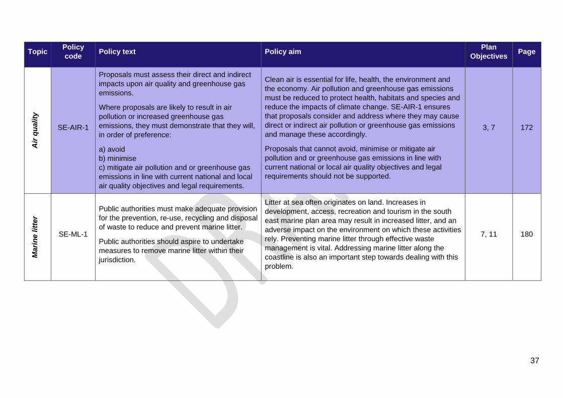
SE-AIR-1
Proposals must assess their direct and indirect impacts upon air quality and greenhouse gas emissions.
Where proposals are likely to result in air pollution or increased greenhouse gas emissions, they must demonstrate that they will, in order of preference:
a) avoid b) minimise c) mitigate air pollution and or greenhouse gas emissions in line with current national and local air quality objectives and legal requirements.
Clean air is essential for life, health, the environment and the economy. Air pollution and greenhouse gas emissions must be reduced to protect health, habitats and species and reduce the impacts of climate change. SE-AIR-1 ensures that proposals consider and address where they may cause direct or indirect air pollution or greenhouse gas emissions and manage these accordingly.
Proposals that cannot avoid, minimise or mitigate air pollution and or greenhouse gas emissions in line with current national or local air quality objectives and legal requirements should not be supported.
3, 7 172
Mar
ine
litte
r
SE-ML-1
Public authorities must make adequate provision for the prevention, re-use, recycling and disposal of waste to reduce and prevent marine litter.
Public authorities should aspire to undertake measures to remove marine litter within their jurisdiction.
Litter at sea often originates on land. Increases in development, access, recreation and tourism in the south east marine plan area may result in increased litter, and an adverse impact on the environment on which these activities rely. Preventing marine litter through effective waste management is vital. Addressing marine litter along the coastline is also an important step towards dealing with this problem.
7, 11 180
37

Topic Policy code Policy text Policy aim Plan
Objectives Page
SE-ML-2
Proposals that facilitate waste re-use or recycling to reduce or remove marine litter will be supported.
Proposals that could potentially increase the amount of marine litter in the marine plan area, must include measures to:
a) avoid b) minimise c) mitigate waste entering the marine environment.
The natural landscapes, wildlife and recreational opportunities on offer in the marine plan area attract visitors to the area. More visitors and increases in coastal and marine development could lead to an increase in litter.
SE-ML-2 makes sure proposals avoid, minimise or mitigate waste entering the marine environment and encourages support for improvements in waste management and removal of marine litter, during construction and over the lifetime of the development. Proposals that cannot avoid, minimise or mitigate waste entering the marine environment will not be supported.
7, 11 180
Wat
er q
ualit
y
SE-WQ-1
Proposals that enhance and restore water quality will be supported.
Proposals that cause deterioration of water quality must demonstrate that they will, in order of preference:
a) avoid b) minimise c) mitigate deterioration of water quality in the marine environment.
Much of the economic and cultural prosperity of the south east marine plan area is reliant on water quality. Activities can place stress on water bodies such that, in parts of the south east marine plan area water quality requires improvement. SE-WQ-1 supports activities whose primary objective is to enhance and restore water quality.
SE-WQ-1 also manages activities that may cause deterioration to a body of water by ensuring that adverse impacts from proposals must be avoided, minimised and mitigated. With the exception of Article 4.718 derogation route no residual adverse impacts on water bodies should occur.
7, 11 188
18 Article 4.7 of the Water Framework Directive is a mechanism by which developments that are beneficial to society can still be progressed even if they are likely to cause deterioration in Water Framework Directive water body status.
38

Topic Policy code Policy text Policy aim Plan
Objectives Page
Acc
ess
SE-ACC-1
Proposals demonstrating appropriate enhanced and inclusive public access to and within the marine area, and also demonstrate the future provision of services for tourism and recreation activities, will be supported.
Where appropriate and inclusive enhanced public access cannot be provided, proposals should demonstrate that they will, in order of preference:
a) avoid b) minimise c) mitigate significant adverse impacts on public access.
Provision for marine access is essential to enabling the economic and social benefits that will come from the growth of tourism and recreation in the South East Marine Plan.
SE-ACC-1 makes sure that support will be given to proposals which provide appropriate and inclusive enhanced public access to the marine area, such as physical, digital, and interpretative access and signage. Support will also be given to proposals which enhance access by removing unsuitable access arrangements.
Furthermore, it requires proposals to manage impacts on public access to the marine area and contributes to the health and wellbeing of communities. Any change in access to the marine environment, increase or decrease, must be compatible with wider environmental, social and economic goals. For example, access should not impact priority habitats or exclude certain user groups.
Proposals that cannot avoid, minimise or mitigate significant adverse impacts should not be supported.
6, 9 198
39

Topic Policy code Policy text Policy aim Plan
Objectives Page
Tour
ism
and
recr
eatio
n
SE-TR-1
Proposals that promote or facilitate sustainable tourism and recreation activities, or that create appropriate opportunities to expand or diversify the current use of facilities, should be supported.
Where proposals may have a significant adverse impact on tourism and recreation activities they must demonstrate that they will, in order of preference:
a) avoid b) minimise c) mitigate that impact.
Tourism and recreation are widely recognised as important sectors within the south east marine plan area, providing numerous economic and social benefits to coastal communities and visitors to the region. SE-TR-1 supports these growth industries through promotion of sustainable tourism and recreation at appropriate locations. It also encourages diversification of activities – through extension of operating seasons or development of alternative uses for facilities – to create additional employment opportunities, while reducing adverse impacts on natural resources and heritage assets. To minimise stakeholder conflict, this policy also addresses the impact of proposals on existing tourism and recreation use, or future potential activities; those that cannot avoid, minimise and mitigate significant adverse impacts on tourism and recreation are unlikely to be supported.
6, 9 204
Soci
al b
enef
its
SE-SOC-1
Those bringing forward proposals are encouraged to consider and enhance public knowledge, understanding, appreciation and enjoyment of the marine environment as part of (the design of) the proposal.
SE-SOC-1 seeks to increase the general knowledge, understanding, appreciation and enjoyment by people of the many values provided by the marine environment through encouraging proposals that incorporate these factors.
5, 6 211
Def
ence
SE-DEF-1 Proposals in or affecting Ministry of Defence areas should only be authorised with agreement from the Ministry of Defence.
There are a high number of defence activities and estates in the south east marine plan area. Marine infrastructure can affect their continuity or future use. SE-DEF-1 will avoid conflict between defence activities and new proposals within the south east marine plan area, ensuring defence interests are not hindered.
10 218
40

Topic Policy code Policy text Policy aim Plan
Objectives Page
Mar
ine
prot
ecte
d ar
eas
SE-MPA-1
Proposals that support the objectives of marine protected areas and the ecological coherence of the marine protected area network will be supported.
Proposals that may have adverse impacts on the objectives of marine protected areas must demonstrate that they will, in order of preference:
a) avoid b) minimise c) mitigate adverse impacts, with due regard given to statutory advice on an ecologically coherent network.
The government is committed to establishing an ecologically coherent network of marine protected areas around the UK. The south east marine plan area will make a significant contribution to this network, through the many existing and proposed marine protected area sites. SE-MPA-1 makes sure proposals take account of adverse impacts on individual sites and the overall network, protecting important habitats, species and geological features, enabling the successful and continued management of these sites.
Proposals that cannot avoid, minimise and mitigate adverse impacts will not be supported. Proposals cannot proceed to (b) unless they have first demonstrated why they cannot meet (a), and so on.
11 223
SE-MPA-2
Proposals that enhance a marine protected area’s ability to adapt to climate change, enhancing the resilience of the marine protected area network will be supported.
Proposals that may have adverse impacts on an individual marine protected area’s ability to adapt to the effects of climate change and so reduce the resilience of the marine protected area network, must demonstrate that they will, in order of preference:
a) avoid b) minimise c) mitigate adverse impacts.
The effects of climate change on habitats and species poses a challenge to designated marine protected area sites in the south east marine plan area. SE-MPA-2 ensures proposals account for adverse impacts on individual marine protected areas ability to adapt to climate change, improving resilience and working towards a well-managed marine protected area network.
Proposals that cannot avoid, minimise and mitigate adverse impacts will not be supported. Proposals cannot proceed to (b) unless they have first demonstrated why they cannot meet (a), and so on.
11 223
41

Topic Policy code Policy text Policy aim Plan
Objectives Page
SE-MPA-3
Where statutory advice states that a marine protected area site condition is deteriorating or that features are moving or changing due to climate change, a suitable boundary change to ensure continued protection of the site and coherence of the overall network should be considered.
Anthropogenic activities such as the burning of fossil fuels, deforestation and farming and methane release from animal farming are having serious adverse impacts on the climate. These impacts include but are not limited to, increased ocean acidity, temperature shifts, and increased storm activity. Climate change will likely result in marine protected area feature migration and/or feature displacement due to shifts in ranges of habitats and species. SE-MPA-3 ensures flexibility by supporting boundary changes to improve the resilience of the marine protected area network. SE-MPA-3 enables adaptive management to help mitigate the loss of features within sites, and support adaptation to climate change.
11, 12 223
SE-MPA-4
Proposals must demonstrate that they will, in order of preference:
a) avoid b) minimise c) mitigate significant adverse impacts on designated geodiversity
Geodiversity in the south east marine plan area has formed over millions of years and natural change happens slowly over long time scales, meaning geodiversity is particularly vulnerable to human impacts. SE-MPA-4 makes sure proposals account for adverse impacts on designated geodiversity, protecting important geological and geomorphological features that underlie and determine the character of our landscape and seascape.
Proposals that cannot avoid, minimise and mitigate adverse impacts will not be supported. Proposals cannot proceed to (b) unless they have first demonstrated why they cannot meet (a), and so on.
11 223
42

Topic Policy code Policy text Policy aim Plan
Objectives Page
Bio
dive
rsity
SE-BIO-1
Proposals that enhance the distribution of priority habitats and priority species will be supported.
Proposals that may have significant adverse impacts on the distribution of priority habitats and priority species must demonstrate that they will, in order of preference:
a) avoid b) minimise c) mitigate d) compensate for significant adverse impacts.
Maintaining the distribution of priority habitats and priority species is important as it reduces habitat fragmentation, species isolation and supports strong, biodiverse communities which in turn provide ecosystem services. SE-BIO-1 maintains the distribution of priority habitats and priority species by ensuring proposals do not significantly adversely affect them. Proposals that cannot avoid, minimise and mitigate for significant adverse impacts, will not be supported.
11, 12, 13 244
SE-BIO-2
Proposals that enhance or facilitate native species or habitat adaptation or connectivity, or native species migration will be supported.
Proposals that may cause significant adverse impacts on native species or habitat adaptation or connectivity, or native species migration must demonstrate that they will, in order of preference:
a) avoid b) minimise c) mitigate significant adverse impacts d) compensate for significant adverse impacts.
Competition for space, increased levels of development and predicted effects of climate change can affect the south east marine plan area habitat and species connectivity, ability to adapt to change and migrate. SE-BIO-2 requires proposals to manage negative effects which may not enable the functioning of healthy, resilient and adaptable marine ecosystems. Proposals that cannot avoid, minimise and mitigate, or as a last resort compensate, for significant adverse impacts, will not be supported.
11, 12, 13 244
43

Topic Policy code Policy text Policy aim Plan
Objectives Page
SE-BIO-3
Proposals that deliver environmental net gain for coastal habitats where important in their own right and/or for ecosystem functioning and provision of ecosystem services will be supported.
Proposals must take account of the space required for coastal habitats where important in their own right and/or for ecosystem functioning and provision of ecosystem services, and demonstrate that they will in order of preference:
a) avoid b) minimise c) mitigate d) compensate for net habitat loss and deliver environmental net gain.
In the south east inshore marine plan area there are numerous important coastal habitats. There is competition for space with these coastal habitats, resulting in coastal squeeze, a process where habitats have decreasing space between rigid coastal structures and rising sea level or coastal erosion. SE-BIO-3 requires proposals to manage their impacts on these habitats to support the functioning of healthy and resilient coastal and intertidal ecosystems. Proposals that cannot avoid, minimise and mitigate, or as a last resort compensate, for significant adverse impacts, will not be supported.
8, 11, 12 244
Net
gai
n an
d na
tura
l cap
ital
SE-NG-1
Proposals should deliver environmental net gain for marine or coastal natural capital assets and services.
Proposals that may have significant adverse impacts on marine and coastal natural capital assets and services must demonstrate that they will, in order of preference:
a) avoid b) minimise c) mitigate d) compensate for significant adverse impacts and deliver environmental net gain.
SE-NG-1 encourages proposals to apply the evolving net gain approach to development that aims to leave the natural environment in a measurably better state than beforehand. The policy also protects marine and coastal natural capital assets and services by ensuring that proposals which are likely to cause harm take measures to prevent, reduce or mitigate significant adverse impacts, with compensation strategies being encouraged to deliver environmental net gain. Proposals that cannot avoid, minimise and mitigate, or as a last resort compensate for significant adverse impacts, will not be supported.
8, 11, 12, 13 262
44

Topic Policy code Policy text Policy aim Plan
Objectives Page
Inva
sive
non
-nat
ive
spec
ies
SE-INNS-1
Proposals that reduce the risk of introduction and/or spread of invasive non-native species should be supported.
Proposals must put in place appropriate measures to avoid or minimise significant adverse impacts that would arise through the introduction and transport of invasive non-native species, particularly when: 1) moving equipment, boats or livestock (for example fish or shellfish) from one water body to another 2) introducing structures suitable for settlement of invasive non-native species, or the spread of invasive non-native species known to exist in the area.
Activities in the south east marine plan area have a high risk of introducing or spreading non-native invasive species. SE-INNS-1 aims to avoid or minimise damage to the marine area from the introduction or transport of non-native invasive species and support proposals that attempt to reduce the risk and spread of non-native invasive species. This will enable support for viable populations of flora and fauna. Proposals that cannot avoid or minimise the introduction or transport of invasive species will not be supported. Due to the expected increased risk and impacts caused by non-native invasive species SE-INNS-1 will contribute towards the prevention of further introduction and spread caused by human activities.
7, 11 268
SE-INNS-2
Public authorities with functions to manage activities that could potentially introduce, transport or spread invasive non-native species should implement adequate biosecurity measures to avoid or minimise the risk of introducing, transporting or spreading invasive non-native species.
SE-INNS-2 aims to avoid or minimise the spread and introduction and spread of non-native invasive species through encouraging public authorities with relevant functions to implement adequate biosecurity measures throughout the south east. This will help to increase awareness of non-native invasive species and provide suitable guidance and legislation throughout the south east to help prevent adverse impacts to the marine environment as a result of invasive species. Due to the expected increased risk and impacts caused by non-native invasive species SE-INNS-2 will contribute towards the prevention of further introduction and spread caused by human activities.
7, 11 268
45

Topic Policy code Policy text Policy aim Plan
Objectives Page
Dis
turb
ance
SE-DIST-1
Proposals that may have significant adverse impacts on highly mobile species through disturbance or displacement must demonstrate that they will, in order of preference:
a) avoid b) minimise c) mitigate significant adverse impacts.
Disturbance and displacement from activities, including those that do not require authorisation such as tourism and recreation, has caused declines in some highly mobile species. SE-DIST-1 reduces the effects of disturbance and displacement by requiring proposals to manage impacts, highlighting good practice and encouraging strategic management of un-authorised activities. SE-DIST-1 enables people to appreciate the marine biodiversity and act responsibly to protect and recover populations of rare, vulnerable and valued species. Proposals that cannot, avoid, minimise and mitigate for significant adverse impacts will not be supported.
11, 13 278
Und
erw
ater
noi
se
SE-UWN-1
Proposals that result in the generation of impulsive sound must contribute data to the UK Marine Noise Registry as per any currently agreed requirements. Public authorities must take account of any currently agreed targets under the UK Marine Strategy part one descriptor 11.
Impulsive sounds can have an adverse effect on marine life and human enjoyment of marine areas. SE-UWN-1 supports the established noise registry to determine baselines, levels of impulsive sound and management options through the recording and assessment of the distribution and timing of impulsive sound sources in the marine environment. This will enable effective marine management and protection of biodiversity or viable populations of species.
13 283
46

Topic Policy code Policy text Policy aim Plan
Objectives Page
SE-UWN-2
Proposals that result in the generation of impulsive or non-impulsive noise must demonstrate that they will, in order of preference:
a) avoid b) minimise c) mitigate significant adverse impacts on highly mobile species d) if it is not possible to mitigate significant adverse impacts, proposals must state the case for proceeding.
Underwater noise levels have increased with marine space use. Noise can affect highly mobile species, including causing chronic stress and death at higher intensities. SE-UWN-2 supports management of underwater noise, requiring proposals to take appropriate noise reduction actions. SE-UWN-2 enables clear and proportionate regulation to make sure marine activity respects environmental limits and protects biodiversity.
11, 13 283
Cum
ulat
ive
effe
cts
SE-CE-1
Proposals which may have adverse cumulative effects with other existing, authorised or reasonably foreseeable proposals must demonstrate that they will, in order of preference:
a) avoid b) minimise c) mitigate significant adverse cumulative and/or in-combination effects.
Whilst cumulative effects are considered in relevant assessments and decision-making, the increasing use of the marine area reinforces the need to consider and address cumulative effects, in line with the aims set out in the Marine Policy Statement. In conjunction with and in support of other relevant south east plan policies, this policy is intended to ensure relevant effects, including those that may seem less significant in their own right, are taken account of and addressed. In doing so, the policy will help to ensure that the cumulative effects in the south east marine area and other relevant receptors are effectively managed.
2, 3, 4, 6 11, 12, 13 290
47

Topic Policy code Policy text Policy aim Plan
Objectives Page
Cro
ss-b
orde
r co-
oper
atio
n
SE-CBC-1
Proposals must consider cross-border impacts throughout the lifetime of the proposed activity.
Proposals that impact upon one or more marine plan area or impact upon terrestrial environments must show evidence of the relevant public authorities (including other countries) being consulted and responses considered.
SE-CBC-1 requests a considered approach to enhance cross-border co-operation between the terrestrial and marine planning systems in the south east inshore marine plan area, the bordering English east and south marine plan areas and the neighbouring jurisdiction of France.
1-13 (all plan
objectives) 296
48

3 Using and implementing the South East Marine Plan
34. This section provides guidance on how to use and implement the South East Marine Plan. Applicants, those developing a proposal, and third parties, such as advisors, as well as public authorities, should consider the South East Marine Plan where relevant. It is the responsibility of the user to determine whether and to what extent the policies are relevant, and to apply them to a proposal in the context of their own processes and current practice.
3.1 Specific plan policy considerations
35. The marine plan policies affect different types of decision including not only ‘authorisations’, such as those similar to plan-based permitting, but also those which are not ‘authorisation’ decisions that are capable of affecting the marine area, eg making of bye laws in the management of marine protected areas. As such, the term ‘proposals’ is used where appropriate in the plan policies to encompass the range of activities that could require a decision including those that have no formal ‘application’ process as well as those that do. Plan policies can therefore apply to new developments, uses, management measures and other activities, and in the review of existing activities, authorisations or measures.
36. The South East Marine Plan addresses overall and specific issues of the south east marine plan area. Issues are described as either challenges or opportunities within the marine plan area. As the issues vary in impact and priority, the policy text has been written to reflect this. Public authorities and applicants should note whether a policy uses ‘must/will’ or ‘should’. ‘Must’ or ‘will’ provides strong direction and greater certainty. ‘Should’ is used where greater flexibility is required, for example in relation to proportionality. This is consistent with the language used in the Marine Policy Statement.
37. A number of South East Marine Plan policies require proposals to demonstrate that they will a) avoid, b) minimise or c) mitigate impacts on other users or the environment. Policies with steps a) to c) indicate that proposals should not proceed unless criteria in a) to c) are met in order of preference. In other words proposals cannot proceed to b) unless they have first demonstrated why they cannot meet a) and likewise cannot proceed to c) unless they have first demonstrated why they cannot meet a) and b).
38. A fourth step d) is relevant for some policies. Generally, the policies with steps a) to c) will have more robust evidence or data supporting them combined with stronger levels of stakeholder support and direction. Policies with steps a) to d) have a greater degree of flexibility in their application. Proposals applying d) will not receive approval by default for including this information. That will depend on all relevant considerations taken into account by the decision-maker which may include other policies in the South East Marine Plan and other material considerations such as other plans.
49

Box 1: Cumulative Effects Cumulative effects can arise from a range of pressures and can occur both spatially and temporally.
As set out in the Marine Policy Statement (2.3.1.6 and 2.3.2.1), marine plans should contribute to considering cumulative impacts, for example ‘Marine plans should ... identify how the potential impacts of activities will be managed, including cumulative effects’ and ‘when considering the potential benefits and adverse effects, decision-makers should also take into account any multiple and cumulative impacts of proposals, in the light of other projects and activities’.
In developing the South East Marine Plan each plan policy has been considered within the Sustainability Appraisal for cumulative effects. The results of this consideration can be found in Sustainability Appraisal database, which is available from the MMO on request.
When taken as a whole, the policies set out in the South East Marine Plan will contribute to the consideration of cumulative effects, including the specific policy requiring cumulative effects to be addressed but also other policies such as those to manage the use of space effectively and reduce adverse impacts.
Further information about cumulative effects can be found in Box 4 of the South East Marine Plan Technical Annex.
3.2 General considerations for public authorities in applying the plan to decisions
39. The scope of decisions affected by marine plans means that the South East Marine Plan is potentially relevant to a wider range of public authorities19 - more than may usually be the case for land-based plans. All public authorities are responsible for applying the South East Marine Plan through the decisions that they make using existing regulatory and decision-making processes. There are no new mechanisms. Better Regulation principles should be adhered to when implementing the South East Marine Plan.
40. Marine plans apply in differing ways dependent on whether the matter under consideration is either an authorisation or enforcement decision under Section 58(1) of the Marine and Coastal Access Act 2009 or, under Section 58(3), a decision which relates to the exercise of any function capable of affecting the whole or any part of the UK marine area, but which is not an authorisation or enforcement decision. In broad terms, an authorisation or enforcement decision is the determination of any application for authorisation to do any act which affects or might affect the UK marine area20.
41. Public authorities must make decisions that fall under Section 58(1) ‘in accordance’ with the South East Marine Plan unless relevant considerations
19 For further information on public authorities see Marine and Coastal Access Act 2009 Section 322 (1). See also Implementation Mapping for information, although it is ultimately for individual public authorities to determine the role of marine plans in their work. 20 See Section 58(4) of the Marine and Coastal Access Act 2009 for details including exclusions.
50

indicate otherwise. For decisions that fall under Section 58(3), public authorities ‘must have regard’ to the South East Marine Plan. It is for public authorities to establish all relevant considerations in relation to Section 58(1) as appropriate. Relevant material considerations would include local plans.
42. In respect of local authority decision-making, development plan policies are a material consideration in the determination of an application for planning permission. Decisions must be taken in accordance with the development plan unless there are material considerations that indicate otherwise (see Section 70(2) of The Town and Country Planning Act 1990 and Section 38(6) of The Planning and Compulsory Purchase Act 2004 – these provisions also apply to appeals)21.
43. Whilst marine plans and the Marine Policy Statement are material considerations in decision-making, it is important to note that a marine plan is not to be construed as a development plan under The Planning and Compulsory Purchase Act 2004. Local plans may be a more relevant consideration than the marine plan in certain decision-making activities, for example housing should be taken into account as material considerations as appropriate.
44. How the plan informs the decision-making process is the responsibility of the relevant public authority. For example, the relevant public authority will determine if and how proposals meet the high level marine objectives, plan vision, and all relevant policies, with applicants considering the plan policies in developing their application and its submission.
45. Decisions must be compliant with relevant legislation, regulations and existing policies and measures, such as Environmental Impact Assessment through relevant regulations including The Town and Country Planning (EIA) Regulations 2017, The Marine Works (EIA) Regulations 2007 and The Infrastructure Planning (Environmental Impact Assessment) Regulations 2017, plus Guidance Notes on the Offshore Petroleum Production and Pipelines (Assessment of Environmental Effects) Regulations 1999. The South East Marine Plan policies complement rather than replace these requirements, which may have a stronger influence on decisions. For example, the designation and management of marine protected areas must be made in accordance with the relevant legislation and policy underpinning them. In such cases the marine plan policies help public authorities to understand the effect on or interaction with other interests. This may subsequently inform or alter the decision to be made.
46. Mechanisms also exist to support more integrated and efficient decision-making; one example of such an approach is the Coastal Concordat. The Coastal Concordat is an agreement between the Department for Environment, Food and Rural Affairs, the Ministry of Housing Communities and Local
21 For further information on what constitutes a development plan, their role and application in local authority decision making see The Planning and Compulsory Purchase Act 2004 Section 38
51

Government, the Department for Transport, the Marine Management Organisation, the Environment Agency, Natural England and the Local Government Association’s Coastal Special Interest Group. It sets out how regulatory and advisory bodies propose to work with local authorities to enable sustainable growth in the coastal zone in support of efficient consenting and decision-making.
3.3 How to use the plan in application and decision-making process
47. Whilst public authorities will apply the South East Marine Plan to decisions they take, those introducing proposals that require the decision, sometimes in the form of an application for an authorisation, will need to take relevant account of the plan. To maximise benefits the South East Marine Plan should be used throughout the development of proposals and in all stages of decision-making, in line with current best practice. In taking a proportionate approach to applying policies, consideration should be given to the scale, complexity and impact of a proposal. Policies may provide support for a specific sector, and can also help to identify potential challenges and offer direction as how to address them. One example is through negotiation and consultation. The South East Marine Plan can also help to ensure submissions are informed by a knowledge of other activities occurring or proposed in any given area of interest. Making use of marine plans at the early stages of an application, prior to submission, can help to ensure an efficient decision-making process.
48. Those introducing proposals or making applications can use the South East Marine Plan and supporting tools (including the Explore Marine Plans digital service, described in section 3.4) in proposal development and design, including refining the preferred proposal location. Further guidance structured around each stage of the application and decision-making process that users of the plan go through is provided in sections 3.5 to 3.8. Minimum requirements for submissions and determinations are set out in section 3.7 with further material and guidance provided in section 3.8, including:
• pre-application discussions and consultation • proposal development and design • formal submission and determination by the public authority
3.4 Explore Marine Plans – a digital marine planning service
49. The Explore Marine Plans digital service provides an online, interactive resource for viewing marine planning policies, evidence, and supporting information. It allows users to consider multiple sources of information, at a resolution relevant to their interest. Applicants and public authorities are encouraged to:
• view other known activities, interests, and marine licences that may complement or conflict with a proposal in order to avoid, minimise or
52

mitigate adverse impacts where possible, prior to the submission of an application
• identify appropriate parties to discuss the proposal with, for example areas of future offshore wind potential
• identify where the proposal contributes to economic, social and environmental considerations within the South East Marine Plan within any formal application
• use the policy checking tool to see:
which plan policies may apply to the proposal and view the Technical Annex to identify how to meet policy specific requirements
which plan policies from adjacent English marine plan areas may apply for decisions across plan area boundaries. The east and south marine plan areas are adjacent to the south east inshore marine plan area
50. In Table 3 similar types of policy are grouped together to provide a suggested walk through for the Explore Marine Plans policy checking tool. Where policies deliver both enhancement and protection, and therefore have two elements, the policy has been categorised in Table 3 based on the element that is likely to be applied most often. Box 1 in the South East Marine Plan Technical Annex provides more detailed information regarding map types. Data for the maps is updated regularly on the system.
53

Table 3: Policy walk through Walk through step Relevant policy codes
Check the policies which are relevant to all proposals and apply across the whole of the inshore plan area.
These are likely to apply to you and set out considerations or points to be aware of.
SE-ACC-1 SE-AIR-1 SE-CBC-1 SE-CC-2, SE-CC-3 SE-CO-1 SE-INF-2 SE-INNS-1, SE-INNS-2 SE-ML-1 SE-MPA-1, SE-MPA-4 SE-NG-1 SE-SOC-1 SE-UWN-1, SE-UWN-2
Check definitive policies which show a clear preference for certain activities in certain locations. These provide support for the relevant activities, and preclude other activities or require them to be compatible.
SE-AGG-1, SE-AGG-2 SE-DD-1, SE-DD-2 SE-DEF-1 SE-PS-1, SE-PS-2, SE-PS-3 SE-REN-2
Check the policies which support existing use of the marine area. While these policies do not preclude other activities, they require proposals to work through a number of steps to reduce impacts on existing activities to enable co-existence and manage conflicts.
SE-BIO-1, SE-BIO-2, SE-BIO-3 SE-CAB-2 SE-CE-1 SE-DD-3 SE-DIST-1 SE-FISH-2, SE-FISH-3 SE-HER-1 SE-ML-2 SE-MPA-2 SE-OG-1 SE-SCP-1 SE-WQ-1
Check the policies which safeguard areas for future development by certain sectors. These may support your sector, or require you to work through a number of steps to prevent affecting future activity if you wish to go there.
SE-AGG-3 SE-AQ-1 SE-CAB-3 SE-OG-2 SE-REN-1
Check for policies which directly support certain sectors, support diversification, skills enhancement or employment across all activities.
SE-AQ-2 SE-CCUS-1 SE-EMP-1 SE-FISH-1 SE-INF-1 SE-PS-4 SE-TR-1 SE-WIND-1
Check for policies which support preferred methods and approaches, including best practice and support identification of the best way to successfully achieve a proposal.
SE-CAB-1 SE-CC-1 SE-MPA-3
54

3.5 Pre-application
51. Early engagement between applicants, agents, third parties and public authorities is encouraged. Pre-application engagement can help remove uncertainty, support efficient decision-making and reduce the resources required. Pre-application engagement is likely to be most beneficial in larger or more complex proposals.
52. Consideration of the South East Marine Plan and its Technical Annex, alongside the Marine Policy Statement is recommended at the earliest stage. The South East Marine Plan will help:
• assess the viability of a proposal, helping to identify the best locations and discount those that are unviable, saving time and money
• identify other activities and developments that may influence or be influenced by a proposal
• identify relevant parties for discussions or consultation such as potential partners in the case of co-locating/co-existing activities
• clarify the appropriateness of information that needs to be provided, and inform the level of assessment to be undertaken
• identify policies relevant to the proposal, how they apply and the potential to contribute to the achievement of the plan vision and the high level marine objectives
53. During pre-application discussion public authorities should:
• encourage applicants to use the South East Marine Plan and Marine Policy Statement to understand and demonstrate how the proposal contributes to the South East Marine Plan vision and the high level marine objectives
• encourage use and submission of any evidence22 used to demonstrate how relevant policies have been met within the proposal, proportionate to the scale, complexity and potential impact of the proposal and including evidence and discussions/consultation with appropriate parties such as Marine Management Organisation, The Crown Estate, Department for Business, Energy and Industrial Strategy and The Ministry of Defence where relevant
• encourage explanation as to why the proposal should proceed in the event of a conflict with the South East Marine Plan
3.6 Proposal development and design
54. The South East Marine Plan assists in proposal development and design, including refining the preferred proposal location. Policies may provide support for a specific sector, and can also help to identify potential challenges and offer direction as how to address them. An example of this is through negotiation and consultation.
22 Marine and Coastal Access Act 2009 Part 4 Section 67, paragraphs 4 and 5
55

3.7 Proposal submission and determination
55. The minimum requirements a proposal should include are:
• the proposal location • what is proposed • when and how it is to be undertaken (methodology, materials etc) • why the proposal is being undertaken • how the proposal contributes to the achievement of the high level
marine objectives, the South East Marine Plan vision and policies (and/or the Marine Policy Statement where appropriate)
• reference to any relevant assessments such as Habitats Regulations Assessments, Environmental Impact Assessments (as appropriate) to help demonstrate how the proposal addresses plan policies
56. Public authorities should:
• assess the proposal’s contributions to the achievement of the high level marine objectives, the South East Marine Plan vision and policies
• evidence how the proposal and decision taken address the South East Marine Plan in support of compliance with the Marine and Coastal Access Act 2009 (Section 58). For example, through data recording systems used as part of the public authorities own processes to illustrate relevant policies and case officer assessments
• request additional relevant information before proceeding with a decision, where it is judged that a proposal has not provided the required information to make an informed assessment
3.8 Further material and guidance
57. The following additional plan-related material may be useful in providing wider context to marine plans and marine planning:
• Marine planning issues and evidence database – a central part of marine plan development and can be used to view and appraise the issues raised and evidence used for marine planning.
• evidence reports – marine evidence and data required for the work of the Marine Management Organisation, including marine planning, are systematically acquired and managed. The Marine Management Organisation makes sure that data and evidence are publicly available where possible and interpreted to a high standard for use in its decision-making
• core development documents – a chronological list of documents produced in the development of the South East Marine Plan, including iteration engagement and feedback documents.
• assessments – of the draft South East Marine Plan including the Sustainability Appraisal and Habitat Regulations Assessment
56

4 Monitoring, review and reporting
4.1 Approach to monitoring
58. The South East Marine Plan Approach to Monitoring describes how the South East Marine Plan will be monitored, this is supported by an Annex of Indicators, which sets out indicator descriptions.
4.2 Reporting
59. The Marine and Coastal Access Act 2009 Section 61(1) sets out a duty to prepare and publish, and lay before parliament, a copy of, a report on the following matters (as set out in the Marine and Coastal Access Act 2009 61(3)):
a. the effects of policies in the marine plan; b. the effectiveness of those policies in securing the objectives for which
the marine plan was prepared and adopted are met; c. the progress being made towards securing those objectives; d. if the Marine Policy Statement governs marine planning for the marine
plan authority’s region, the progress being made towards securing that the objectives for which the Marine Policy Statement was prepared and adopted are met in that region.
60. Reporting must occur at intervals of not more than three years from the date of marine plan adoption. From this report the marine plan authority must decide whether or not to amend or replace the marine plan. Under Section 61(1)(c) a report must also be produced, at intervals of not more than six years, identifying any marine plans that have been adopted, any intention to amend adopted plans and the planned adoption of further plans.
61. Once prepared these reports will be laid before parliament on behalf of the Secretary of State by the Department of Environment, Food and Rural Affairs.
62. Activities in relation to monitoring and reporting duties under the Marine and Coastal Access Act 2009 Section 61 must also be carried out in such a way as to fulfil duties under Section 54 that specifies a duty to keep relevant matters under review.
63. The Marine Managements Organisation’s approach to monitoring is informed by the Government’s Magenta Book.
57