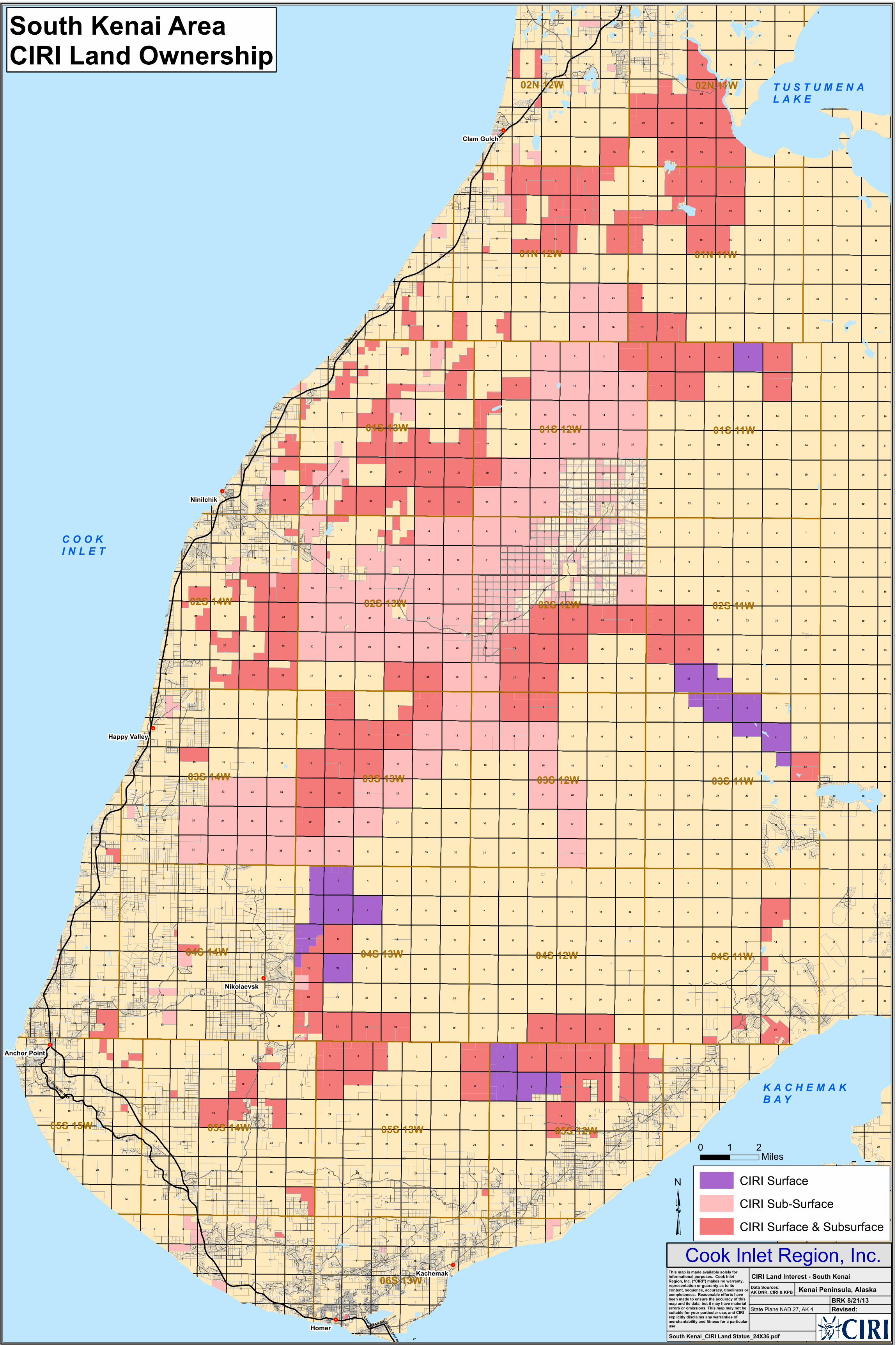
south kenai area ciri land ownership · ak dnr, ciri & kpb ciri land interest - south kenai...

1
! . ! . ! . ! . ! . ! . ! . STERLING HWY OLD STERLING HWY LAKE ST 04S 11W 03S 11W 01S 11W 02S 11W 04S 14W 04S 13W 04S 12W 01N 11W 03S 14W 03S 13W 03S 12W 01S 13W 02S 14W 01S 12W 02S 13W 02S 12W 05S 14W 05S 13W 05S 12W 01N 12W 02N 11W 02N 12W 05S 15W 06S 13W 5 4 3 2 1 5 4 3 2 1 5 4 3 2 1 5 5 4 3 9 2 1 1 5 5 4 8 4 8 3 8 8 9 3 9 2 5 9 9 9 2 4 1 4 1 3 3 5 2 2 4 5 1 1 4 8 8 8 8 8 8 3 9 5 9 9 5 9 9 9 2 4 4 1 3 3 2 2 5 1 5 1 8 4 8 8 8 8 4 8 3 9 9 9 5 9 9 9 3 5 9 2 4 2 4 1 3 1 3 2 5 2 1 5 4 1 8 8 8 8 8 8 4 8 3 9 9 9 9 5 9 9 3 9 2 5 4 2 1 4 3 1 3 2 5 2 1 5 8 1 8 8 8 8 9 5 5 4 3 2 1 5 4 3 2 1 5 4 3 2 1 5 4 3 2 1 5 4 3 7 7 7 7 7 7 7 7 6 6 6 6 6 6 6 6 7 7 7 7 7 6 6 6 6 7 7 7 7 7 6 6 6 6 6 6 6 6 6 6 7 7 7 7 7 7 7 7 6 6 6 6 1 2 3 4 6 5 1 2 6 3 4 11 11 11 11 11 11 11 11 11 11 11 11 11 11 11 11 11 11 11 11 11 11 11 11 11 11 9 4 4 9 4 9 4 9 16 34 27 27 22 15 10 35 26 23 14 26 23 14 36 25 24 13 12 36 25 36 25 24 13 12 32 29 20 17 32 29 20 17 32 29 20 32 29 20 17 33 28 21 16 33 28 21 16 33 28 21 16 33 28 21 16 34 27 22 15 10 34 27 22 15 10 34 27 22 15 10 34 15 10 34 27 22 15 10 35 26 23 14 35 26 23 14 35 26 23 14 35 26 23 14 35 26 23 14 36 25 24 13 12 36 25 24 13 12 36 25 24 13 12 36 25 24 13 13 12 36 25 24 13 12 32 29 20 17 32 29 20 17 32 29 20 17 32 29 20 17 20 17 32 29 20 17 33 28 21 16 33 28 21 16 33 28 21 16 33 28 21 16 21 16 33 28 21 16 34 34 27 22 15 10 34 27 22 15 10 34 27 22 15 10 34 27 22 15 10 22 15 10 34 27 22 15 10 35 26 23 35 26 23 14 35 26 23 14 35 26 23 14 35 26 23 14 14 35 26 23 14 36 25 24 13 36 25 24 13 12 36 25 24 13 12 36 25 24 13 12 36 25 24 13 12 12 36 25 24 13 12 32 29 20 17 32 29 32 29 20 17 32 29 20 17 32 29 20 17 32 29 20 17 32 29 20 17 33 28 21 16 33 28 21 16 33 28 21 16 33 28 21 16 33 28 21 16 33 28 21 16 33 28 21 16 34 27 22 15 10 34 27 22 15 10 34 27 22 15 10 34 27 22 15 10 34 27 22 15 10 34 27 22 15 10 34 27 22 15 10 35 26 23 14 35 26 23 14 35 26 23 14 35 26 23 14 35 26 23 14 35 26 23 14 26 23 14 36 25 24 13 12 36 25 24 13 12 36 25 24 13 12 36 25 24 13 12 36 25 24 13 12 36 25 24 13 12 25 24 13 12 32 29 20 17 32 29 20 17 32 29 20 17 32 29 17 20 32 29 20 17 32 29 20 17 17 33 28 21 16 33 28 21 16 33 28 21 16 33 28 16 21 33 28 21 16 33 28 16 21 34 27 22 15 10 34 27 22 15 10 34 27 22 15 10 27 34 22 15 10 34 27 22 15 10 34 27 15 22 10 35 26 23 14 14 35 26 23 14 35 26 14 23 35 26 23 14 35 26 23 14 36 24 25 12 13 36 12 36 25 24 13 12 25 36 24 13 12 36 25 24 13 12 36 25 24 13 12 32 29 20 17 32 20 29 17 32 29 17 20 32 29 20 17 32 29 20 17 33 21 28 16 28 31 31 31 31 31 31 31 30 30 30 30 30 30 30 30 19 19 19 19 19 19 19 19 18 18 18 18 18 18 18 18 31 31 31 31 31 31 30 30 30 30 30 30 19 19 19 19 19 19 18 18 18 18 18 18 20 17 31 31 31 31 30 30 30 30 19 19 19 19 19 18 18 18 18 18 31 31 31 31 31 31 31 30 30 30 30 30 30 30 19 19 19 19 19 19 19 19 18 18 18 18 18 18 18 18 28 21 16 33 28 21 16 33 28 21 16 33 28 21 16 27 34 27 22 15 Homer Ninilchik Clam Gulch Nikolaevsk Happy Valley HOMER SPIT RD OCEAN DR Kachemak Anchor Point South Kenai Area CIRI Land Ownership 0 2 1 Miles CIRI Surface CIRI Sub-Surface CIRI Surface & Subsurface ³ South Kenai_CIRI Land Status_24X36.pdf Revised: Kenai Peninsula, Alaska Data Sources: AK DNR, CIRI & KPB CIRI Land Interest - South Kenai Cook Inlet Region, Inc. This map is made available solely for informational purposes. Cook Inlet Region, Inc. (“CIRI”) makes no warranty, representation or guaranty as to its content, sequence, accuracy, timeliness or completeness. Reasonable efforts have been made to ensure the accuracy of this map and its data, but it may have material errors or omissions. This map may not be suitable for your particular use, and CIRI explicitly disclaims any warranties of merchantability and fitness for a particular use. BRK 8/21/13 State Plane NAD 27, AK 4 COOK INLET KACHEMAK BAY TUSTUMENA LAKE

Upload: lymien

Post on 21-Aug-2018

220 views

Category:

Documents


0 download

TRANSCRIPT

!.

!.

!.

!.

!.

!.

!.

!.

STERLIN

G HWY

OLD STERLING HWY

LAKE ST

04S 11W

03S 11W

01S 11W

02S 11W

04S 14W 04S 13W 04S 12W

01N 11W

03S 14W 03S 13W 03S 12W

01S 13W

02S 14W

01S 12W

02S 13W 02S 12W

05S 14W 05S 13W 05S 12W

01N 12W

02N 11W02N 12W

05S 15W

06S 13W

5 4 3 2 1 5 4 3 2 1 5 4 3 2 1 5

5 4 3

9

2 1

1

5

5

4

8

4

8

3

8

8

9

3

9

2

5

9

9

9

2

4

1

4

1

3

3

5

2

2

4

5

1

1

4

8

8

8

8

8

8

3

9

5

9

9

5

9

9

9

2

4

4

1

3

3

2

2

5

2

1

5

1

8

4

8

8

8

8

4

8

3

9

9

9

5

9

9

9

3

5

9

2

4

2

4

1

3

1

3

2

5

2

1

5

4

1

8

8

8

8

8

8

4

8

3

9

9

9

9

5

9

9

3

9

2

5

4

2

1

4

3

1

3

2

5

2

1

5

8

1

8

8

8

8

9

5

5

1

4 3 2 1 5 4 3 2 1 5 4 3 2 1 5 4 3 2 1 5 4 3

7 7 7 7 7

7 7 7

6 6 6 6 6

6 6 6

7 7 7 7

7

6 6 6 6

7

7 7 7 7

6 6 6

6 6 6 6

6 6 6

7 7 7 7

7 7 7 7

6 6 6 6

1234 6512 634

11

11

11

11

11

11

11

11

11

11

11

11

11

11

11

11

11

11

11

11

11

11

11

11

11

11

11

9

4

4

9

4

9

4

9

16

34

27

27

22

15

10

35

26

23

14

26

23

14

36

25

24

13

12

36

25

36

25

24

13

12

32

29

20

17

32

29

20

17

32

29

20

32

29

20

17

33

28

21

16

33

28

21

16

33

28

21

16

33

28

21

16

34

27

22

15

10

34

27

22

15

10

34

27

22

15

10

34

15

10

34

27

22

15

10

35

26

23

14

35

26

23

14

35

26

23

14

35

26

23

14

35

26

23

14

36

25

24

13

12

36

25

24

13

12

36

25

24

13

12

36

25

24

13

13

12

36

25

24

13

12

32

29

20

17

32

29

20

17

32

29

20

17

32

29

20

17

20

17

32

29

20

17

33

28

21

16

33

28

21

16

33

28

21

16

33

28

21

16

21

16

33

28

21

16

34

34

27

22

15

10

34

27

22

15

10

34

27

22

15

10

34

27

22

15

10

22

15

10

34

27

22

15

10

35

26

23

35

26

23

14

35

26

23

14

35

26

23

14

35

26

23

14

14

35

26

23

14

36

25

24

13

36

25

24

13

12

36

25

24

13

12

36

25

24

13

12

36

25

24

13

12

12

36

25

24

13

12

32

29

20

17

32

29

32

29

20

17

32

29

20

17

32

29

20

17

32

29

20

17

32

29

20

17

33

28

21

16

33

28

21

16

33

28

21

16

33

28

21

16

33

28

21

16

33

28

21

16

33

28

21

16

34

27

22

15

10

34

27

22

15

10

34

27

22

15

10

34

27

22

15

10

34

27

22

15

10

34

27

22

15

10

34

27

22

15

10

35

26

23

14

35

26

23

14

35

26

23

14

35

26

23

14

35

26

23

14

35

26

23

14

26

23

14

36

25

24

13

12

36

25

24

13

12

36

25

24

13

12

36

25

24

13

12

36

25

24

13

12

36

25

24

13

12

25

24

13

12

32

29

20

17

32

29

20

17

32

29

20

17

32

29

17

20

32

29

20

17

32

29

20

17

20

17

33

28

21

16

33

28

21

16

33

28

21

16

33

28

16

21

33

28

21

16

33

28

16

21

21

34

27

22

15

10

34

27

22

15

10

34

27

22

15

10

27

34

22

15

10

34

27

22

15

10

34

27

15

22

10

22

15

35

26

23

14

14

35

26

23

14

35

26

14

23

35

26

23

14

35

26

23

14

23

14

36

24

25

12

13

36

12

36

25

24

13

12

25

36

24

13

12

36

25

24

13

12

36

25

24

13

12

36

25

32

29

20

17

32

20

29

17

32

29

17

20

32

29

20

17

32

29

20

17

33

21

28

16

28

24

13

12

31 31 31

31

31

31 31

30 30 30 30

30

30

30 30

19 19 19 19 19

19 19 19

18 18 18 18 18

18 18 18

31 31 31 31 31

31

30 30 30 30 30

30

19 19 19 19 19

19

18 18 18 18 18

18

32

29

20

17

31 31 31 31

30 30 30 30

19

19 19 19 19

18

18 18 18 18

31 31 31 31

31 31 31 31

30 30 30 30

30 30 30 30

19 19 19 19

19 19 19 19

18 18 18 18

18 18 18 18

28

21

16

33

28

21

16

33

28

21

16

33

28

21

16

27 29 28 27 26 25

34

27

22

15

6 5

Homer

Ninilchik

Clam Gulch

Nikolaevsk

Happy Valley

HOMER SPIT RD

OCEAN DR

Kachemak

Anchor Point

South Kenai AreaCIRI Land Ownership

0 21Miles

CIRI SurfaceCIRI Sub-SurfaceCIRI Surface & Subsurface³

South Kenai_CIRI Land Status_24X36.pdf

Revised:

Kenai Peninsula, AlaskaData Sources: AK DNR, CIRI & KPB

CIRI Land Interest - South Kenai

Cook Inlet Region, Inc.This map is made available solely for informational purposes. Cook Inlet Region, Inc. (“CIRI”) makes no warranty, representation or guaranty as to its content, sequence, accuracy, timeliness orcompleteness. Reasonable efforts havebeen made to ensure the accuracy of this map and its data, but it may have material errors or omissions. This map may not besuitable for your particular use, and CIRI explicitly disclaims any warranties of merchantability and fitness for a particular use.

BRK 8/21/13State Plane NAD 27, AK 4

C O O KI N L E T

K A C H E M A KB A Y

T U S T U M E N AL A K E