south puget sound wildlife area management plan › sites › default › files › publications ›...
TRANSCRIPT

SOUTH PUGET SOUND WILDLIFE AREA MANAGEMENT PLAN
Washington Department of Fish and Wildlife
Prepared by Wildlife Area Manager, Richard Kessler
2006

STATE OF WASHINGTON
CHRIS GREGOIRE, GOVERNOR
DEPARTMENT OF FISH AND WILDLIFE JEFF KOENINGS, Ph.D., DIRECTOR
WILDLIFE PROGRAM DAVE BRITTELL, ASSISTANT DIRECTOR
LANDS DIVISION MARK QUINN, MANAGER
This Program Receives Federal Aid in Wildlife Restoration funds. Project W-94-D, Segment 24
This report should be cited as: Washington Department of Fish and Wildlife. 2006. South Puget Sound Wildlife Area Management Plan. Wildlife Management Program, Washington Department of Fish and Wildlife, Olympia. 67 pp.
This program receives Federal financial assistance from the U.S. Fish and Wildlife Service. It is the policy of the Washington State Department of Fish and Wildlife (WDFW) to adhere to the following: Title VI of the Civil Rights Act of 1964, Section 504 of the Rehabilitation Act of 1973, Title II of the Americans with Disabilities Act of 1990, the Age Discrimination Act of 1975, and Title IX of the Education Amendments of 1972. The U.S. Department of the Interior and its bureaus prohibit discrimination on the basis of race, color, national origin, age, disability and sex (in educational programs). If you believe that you have been discriminated against in any program, activity or facility, please contact the WDFW ADA Coordinator at 600 Capitol Way North, Olympia, Washington 98501-1091 or write to: U.S. Fish and Wildlife Service, Office of External Programs, 4040 N. Fairfax Drive, Suite 130, Arlington, VA 22203.

Washington State Wildlife Area Plan
SOUTH PUGET SOUND
WILDLIFE AREA
Washington Department of Fish and Wildlife Wildlife Management Program
600 Capitol Way North Olympia, WA 98501-1091

Table of Contents
EXECUTIVE SUMMARY................................................................................................................. v
CHAPTER I. INTRODUCTION...................................................................................................... 1
1.1 Agency Mission Statement ..................................................................................................... 1
1.2 Agency Goals and Objectives................................................................................................. 1
1.3 Agency Policies........................................................................................................................ 1
1.4 South Puget Sound Wildlife Area Goals............................................................................... 2
1.5 Planning Process ..................................................................................................................... 2
CHAPTER II. AREA DESCRIPTION AND MAP......................................................................... 3
2.1 Property Location and Size.................................................................................................... 3
2.2 Purchase History & Purpose ................................................................................................. 3
2.3 Ownership and Use of Adjacent Lands ................................................................................ 3
2.4 Funding Sources.................................................................................................................... 25
2.5 Climate................................................................................................................................... 25
2.6 Soils and Geology .................................................................................................................. 25
2.7 Hydrology and Watersheds.................................................................................................. 25
2.8 Fire/Flood History................................................................................................................. 26
2.9 Vegetation Characterization................................................................................................ 26
2.10 Important Habitats ............................................................................................................. 27
2.11 Fish and Wildlife................................................................................................................. 28
2.12 Cultural Resources ............................................................................................................. 29
CHAPTER III. MANAGEMENT OBJECTIVES, ISSUES & STRATEGIES ........................... 30
Agency Objective: Protect, Restore & Enhance Fish and Wildlife and Their Habitats ..... 30 1. Maintain big game populations............................................................................................. 30 2. Improve and maintain fish populations ................................................................................ 30 3. Manage for upland birds ....................................................................................................... 30 4. Manage for species diversity ................................................................................................ 31 5. Protect and restore riparian/wetland habitat ......................................................................... 31 6. Protect and restore estuary habitat ........................................................................................ 31 7. Protect and restore prairie habitat ......................................................................................... 31 8. Protect and manage other species ......................................................................................... 32
Agency Objective: Provide Sustainable Fish and Wildlife-Related Recreational and Commercial Opportunities Compatible with Maintaining Healthy Fish and Wildlife Populations and Habitats. Improve the Economic Well Being of Washington by Providing Diverse, High Quality Recreational and Commercial Opportunities. ................................... 33
1. Provide public access compatible with fish, wildlife and habitat protection........................ 33
November 2006 ii Washington Department of Fish and Wildlife

Agency Objective: Ensure WDFW Activities, Programs, Facilities and Lands are Consistent With Local, State and Federal Regulations that Protect and Recover Fish, Wildlife and Their Habitats ....................................................................................................... 34
1. Manage weeds consistent with state and county rules and to protect and recover fish and wildlife and their habitats ......................................................................................................... 34 2. Manage species and habitats in compliance with the Endangered Species Act and Washington State fish passage, road management and forest practice rules............................ 35 3. Protect cultural resources consistent with state and federal law........................................... 36 4. Pay county PILT and assessment obligations....................................................................... 36
Agency Objective: Provide Sound Operational Management of WDFW Lands, Facilities and Access Sites........................................................................................................................... 36
1. Maintain facilities to achieve safe, efficient and effective management of the wildlife area................................................................................................................................................... 36 2. Maintain other structures and physical improvements ......................................................... 36 3. Maintain equipment .............................................................................................................. 37 4. Pursue funding opportunities ................................................................................................ 37 5. Assess forest conditions with regard to catastrophic fire, insect and disease risks .............. 37 6. Perform administrative responsibilities ................................................................................ 37 7. Protect and apply water rights for best use ........................................................................... 37 8. Other Issues or Concerns ...................................................................................................... 37
CHAPTER IV: PERFORMANCE MEASURES, EVALUATION AND UPDATES TO THE SOUTH PUGET SOUND WILDLIFE AREA PLAN.................................................................... 39
1. The South Puget Sound Wildlife Area Performance Measures Include: .......................... 39
2. Annual Evaluation of Performance....................................................................................... 39
3. Annual Plan Update................................................................................................................ 39
Appendix 2. Weed Control Plan ...................................................................................................... 43
Appendix 3. Fire Control Plan ........................................................................................................ 63
Appendix 4. Water Rights ................................................................................................................ 65
Appendix 5. Management Plan Comments & Responses .............................................................. 66
REFERENCES................................................................................................................................ 67
List of Figures
Figure 1. Union River........................................................................................................................ 4
Figure 2. South Puget Sound Urban Interpretive Center ................................................................ 6
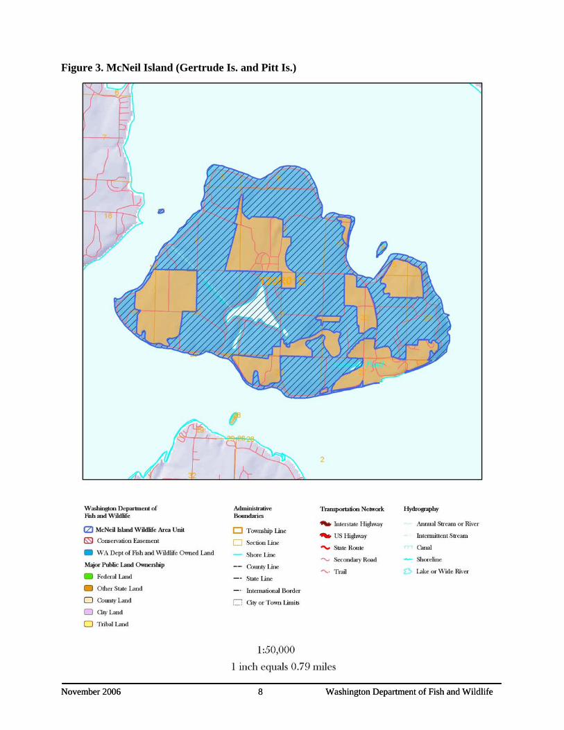
Figure 3. McNeil Island (Gertrude Is. and Pitt Is.).......................................................................... 8
Figure 4. Nisqually .......................................................................................................................... 10
Figure 5 Ohop Farm........................................................................................................................ 11
Figure 6. Scatter Creek.................................................................................................................... 13
Figure 7. Black River....................................................................................................................... 15
November 2006 iii Washington Department of Fish and Wildlife

Figure 8. Skokomish Delta .............................................................................................................. 17
Figure 9. Skookumchuck................................................................................................................. 19
Figure 10. Duckabush ..................................................................................................................... 21
Figure 11 Big Beef Creek Unit........................................................................................................ 23
Figure 12 Morgan Marsh Unit........................................................................................................ 24
November 2006 iv Washington Department of Fish and Wildlife

EXECUTIVE SUMMARY The South Puget Sound Wildlife Area Complex is made up of multiple parcels of land owned and/or maintained by WDFW. These parcels include the following units: Union River, South Puget Sound Urban Wildlife Interpretive Center, McNeil Island (Gertrude and Pitt Islands), Nisqually, Ohop, Scatter Creek, Black River, Skokomish Delta, Skookumchuck, Duckabush, Morgan Marsh, and West Rocky Prairie. These properties total approximately 8,020 acres in Thurston, Pierce, east Mason, Kitsap and Jefferson counties. Management goals for the South Puget Sound Wildlife Area Complex are to preserve habitat and species diversity for both fish and wildlife resources, maintain healthy populations of game and non-game species, protect and restore native plant communities, and provide diverse opportunities for the public to encounter, utilize, and appreciate wildlife and wild areas. Units that provide habitat or recreational opportunities for waterfowl and/or migratory birds include Nisqually, Ohop, Black River, Skokomish, Morgan Marsh and Skookumchuck. Prevention of further development on Union River, Nisqually, Ohop, Black River, Big Beef Creek, Morgan Marsh and Skokomish Units provides protection of critical habitat for many salmon species. Some of these units also provide recreational fishing opportunities. Management for upland birds including pheasant, grouse and occasionally turkey occur on the Skookumchuck, Black River and Scatter Creek Units. The South Puget Sound UWIC Unit, a non-consumptive recreational and educational unit, provides habitat for many species and has played a primary role in the efforts to recover populations of western pond turtles, a state endangered species. The McNeil Island Unit, which includes Gertrude and Pitt Islands, provides opportunities for many species due to limited access. These islands provide habitat for a great blue heron rookery, bald eagle nests and haul out sites for marine mammals, especially harbor seals, all federally protected species. Scatter Creek, a relatively large unit, supports many unique species due to the prairie and wetland habitats found here. These species include great blue heron, northern alligator lizard, western bluebird, vesper sparrow, mazama pocket gopher, and several species of butterfly including the state endangered mardon skipper. Other species historically seen, but not now present on Scatter Creek include the slender-billed white-breasted nuthatch, streaked horned lark, Oregon vesper sparrow, western gray squirrel and several species of butterfly. Scatter Creek is one of only two remaining south Puget Sound sites that supports the state endangered Mardon skipper. State candidate status butterflies: Puget blue, Taylor’s checkerspot, and valley silverspot occupy this site, as well as several state monitor status butterfly species. The Skookumchuck Unit is managed for multiple species as part of the mitigation agreement. Habitat is provided for big game and small game, waterfowl including wood duck, as well as non-game species such as pilleated woodpecker, western bluebird, spotted frog and western pond turtle. The primary management concerns and public issues identified in the South Puget Sound Wildlife Area Complex Plan are:
• Monitor field trials for onsite rules compliance at Scatter Creek Unit to protect native prairie habitat and continue to provide recreational opportunities compatible with habitat protections.
• Protect and enhance native prairie habitat using weed control and native plant propagation. • Control scotch broom, tall oat grass and other noxious weeds.
November 2006 v Washington Department of Fish and Wildlife

• Monitor and coordinate recreational activities in areas known to have endangered or threatened plants and animals.
• Manage wetland ponds for endangered western pond turtles at South Puget Sound UWIC Unit and enhance turtle nesting sites.
• Protect and enhance existing ESA listed fish habitat. In 2006, the following major wildlife and habitat enhancement activities were completed:
• Scotch broom was controlled on 500 acres native prairie by mowing and herbicide application on Scatter Creek Unit to enhance and restore prairie habitat.
• Controlled tall oat grass on 160 acres of native prairie using aerial and ground herbicide applications and mowing on Scatter Creek Unit to enhance and restore prairie habitat.
• Managed wetland ponds for endangered western pond turtles at S. Puget Sound UWIC area. Enhanced endangered western pond turtle nesting site areas by controlling Himalayan blackberries. Participated in endangered western pond turtle trapping, monitoring and nest protections. 35 baby turtles were hatched this year.
• Corrected a long-standing fish passage barrier on the Scatter Creek Unit access road on an unnamed tributary to Scatter Creek.
• Topped and killed 80+ Douglas fir trees that were overtopping Oregon white oak trees to create snags on Scatter Creek Unit.
November 2006 vi Washington Department of Fish and Wildlife
November 2006 1 Washington Department of Fish and Wildlife
CHAPTER I. INTRODUCTION This plan provides management direction for the South Puget Sound Wildlife Area. This plan will be updated annually to maintain its value as a flexible working document. It identifies needs and guides activities on the areas based on the agency mission and statewide goals and objectives as they apply to local conditions. 1.1 Agency Mission Statement The Washington Department of Fish and Wildlife serves Washington’s citizens by protecting, restoring and enhancing fish and wildlife and their habitats, while providing sustainable and wildlife-related recreational and commercial opportunities. 1.2 Agency Goals and Objectives The underlined goals and objectives directly apply to the management of this wildlife area. These goals and objectives are found in the Agency’s Strategic Plan. Goal I: Healthy and diverse fish and wildlife populations and habitats
• Objective 2: Protect, restore and enhance fish and wildlife populations and their habitats. • Objective 3: Ensure WDFW activities, programs, facilities and lands are consistent with
local, state and federal regulations that protect and recover fish, wildlife and their habitats. Goal II: Sustainable fish and wildlife-related opportunities
• Objective 6: Provide sustainable fish and wildlife-related recreational and commercial opportunities compatible with maintaining healthy fish and wildlife populations and habitats.
• Objective 7: Improve the economic well being of Washington by providing diverse, high quality recreational and commercial opportunities.
Goal III: Operational Excellence and Professional Service • Objective 11: Provide sound operational management of WDFW lands, facilities and access
sites.
1.3 Agency Policies The following agency policies provide additional guidance for management of agency lands.
• Commission Policy 6003: Domestic Livestock Grazing on Department Lands • Policy 6010: Acquiring and disposing of real property • Policy 5211: Protecting and Restoring Wetlands: WDFW Will Accomplish Long-Term
Gain of Properly Functioning Wetlands Where Both Ecologically and Financially Feasible on WDFW-Owned or WDFW-Controlled Properties
• Policy 5001: Fish Protection At Water Diversions/Flow Control Structures And Fish Passage Structures
• Policy: Recreation management on WDFW Lands • Policy: Commercial Use of WDFW Lands • Policy: Forest Management on WDFW Lands • Policy: Weed Management on WDFW Lands • Policy: Fire Management on WDFW Lands • Other policies/contractual obligations/responsibilities

1.4 South Puget Sound Wildlife Area Goals Management goals for the South Puget Sound Wildlife Areas are to preserve habitat and species diversity for both fish and wildlife resources, maintain healthy populations of game and non-game species, protect and restore native plant communities, and provide diverse opportunities for the public to encounter, utilize, and appreciate wildlife and wild areas. Public participation, in the form of a Citizens Advisory Group (CAG), will be encouraged as a means to identify social, cultural, and economic issues important to the people of South Puget Sound Washington and influential in the management of this Wildlife Area. Specific management goals and objectives for the South Puget Sound Wildlife Area can be found in Chapter 3. 1.5 Planning Process Statewide goals and objectives listed above shape management priorities on wildlife areas. Individual wildlife area information including why the area was purchased, habitat conditions, species present, and public issues and concerns are evaluated to identify specific wildlife area activities or tasks. A Citizens Advisory Group (CAG) has been established to bring public input, ideas and concerns to wildlife area management. CAG participation in planning will add credibility and support for land management practices and help build constituencies for wildlife areas. The CAG is made up of one representative for each interest group/entity. CAG members are spokespersons for their interest groups. South Puget Sound Wildlife Area Citizens Advisory Group Representation Sue Danver, Black Hills Audubon Richard Matzke, NW Field Trial Council Patrick Dunn, Friends of Puget Prairies Birdi Davenport, DNR Natural Heritage Program Doug Stein, Volunteer Pheasant Release Mary Friez, Washington Native Plant Society Bob Munson, Backcountry Horsemen of WA – Scatter Creek Riders Chapter John Little, McNeil Island Corrections Center Christine Sherman, representing Robert Kelly - Concerned Neighbor The group met twice in 2005. The meetings were held in The Olympia Center, in Olympia. Three of the members were not able to attend the meetings, but sent in comments, which were incorporated into the plan. Plans will incorporate cross-program input and review at the regional and headquarters level by the habitat program, wildlife program, enforcement program, and fish program. Pertinent information from existing species plans, habitat recommendations, watershed plans, ecoregional assessments, etc will be used to identify local issues and needs and ensure that the specific Wildlife Area Plan is consistent with WDFW statewide and regional priorities. The South Puget Sound plan will be reviewed annually with additional input from the CAG and district team to monitor performance and desired results. Strategies and activities will be adapted where necessary to accomplish management objectives.
November 2006 2 Washington Department of Fish and Wildlife

CHAPTER II. AREA DESCRIPTION AND MAP The South Puget Sound Wildlife Area is made up of multiple parcels of land owned and/or maintained by WDFW (Figure 1). These parcels include the following units: Union River, South Puget Sound Urban Wildlife Interpretive Center, McNeil Island (Gertrude and Pitt Islands), Nisqually, Ohop, Scatter Creek, Black River, Skokomish Delta, Skookumchuck, Duckabush and Morgan Marsh. The property location and size (2.1), purchase history and purpose of purchase (2.2), ownership/use of adjacent lands (2.3), and purchase funding (2.4) for all units are outlined in Table 1. 2.1 Property Location and Size 2.2 Purchase History & Purpose 2.3 Ownership and Use of Adjacent Lands Name: Union River Location: 10 mi. SW of Bremerton W of SR-3 at the head of Hood Canal; Kitsap County Acquisition: 83.42 ac: 1998, 61.8 ac: 1962, 69.2 ac: 1987 Funding - How Purchased: 83.42 ac: $300,000 IAC-WWRP/USFWS-NCWCG, 131 ac. Donated Purpose Purchased: Estuary Protection, Fish and Wildlife preserve on Union River Delta - Salmon/ Waterfowl Adjacent Properties: Theller Land Trust - Nature Trail, Great Bend Conservancy - Estuary Restoration, North Mason School District - Protected
November 2006 3 Washington Department of Fish and Wildlife

November 2006 4 Washington Department of Fish and Wildlife
November 2006 4 Washington Department of Fish and Wildlife
Figure 1. Union River

Name: South Puget Sound Urban Wildlife Interpretive Center Location: Lakewood; Pierce County Acquisition: 90 ac: 1922 Funding - How Purchased: Acquired ownership Purpose Purchased: Game Farm/ Fish Hatchery; Currently: Urban Wildlife Interpretive Center Adjacent Properties: Housing developments and Business Districts
November 2006 5 Washington Department of Fish and Wildlife

November 2006 6 Washington Department of Fish and Wildlife
November 2006 6 Washington Department of Fish and Wildlife
Figure 2. South Puget Sound Urban Interpretive Center

Name: McNeil Island (Gertrude Is. and Pitt Is.) Location: Puget Sound Islands 7 mi. SW of Tacoma and 15 mi. NE of Olympia; Pierce County Acquisition: 3119 ac: 1984 Funding - How Purchased: USA Transfer Purpose Purchased: Habitat Conservation, Preservation of natural shoreline, Marine Mammal protection Adjacent Properties: DOC - State Penitentiary Complex and Farmland; DSHS - Civil Commitment Center
November 2006 7 Washington Department of Fish and Wildlife
November 2006 8 Washington Department of Fish and Wildlife
November 2006 8 Washington Department of Fish and Wildlife
Figure 3. McNeil Island (Gertrude Is. and Pitt Is.)
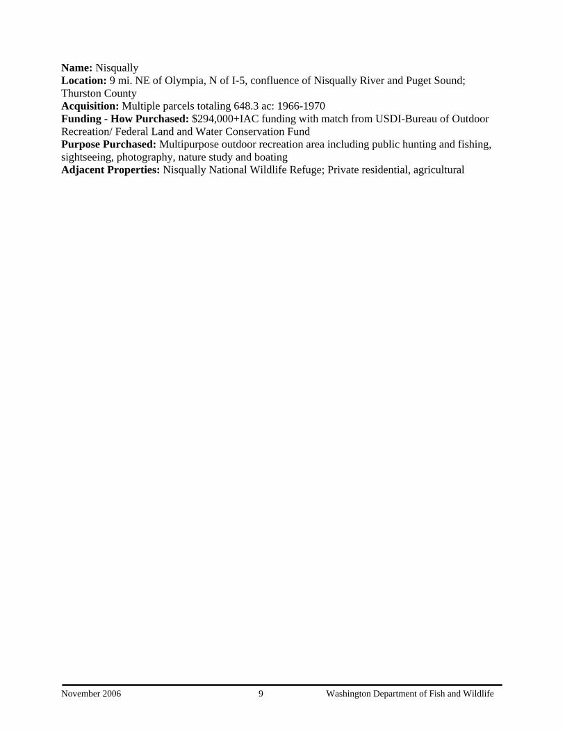
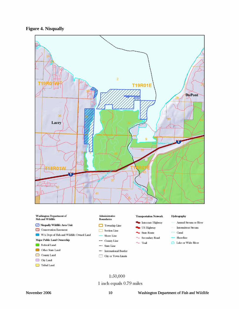
Name: Nisqually Location: 9 mi. NE of Olympia, N of I-5, confluence of Nisqually River and Puget Sound; Thurston County Acquisition: Multiple parcels totaling 648.3 ac: 1966-1970 Funding - How Purchased: $294,000+IAC funding with match from USDI-Bureau of Outdoor Recreation/ Federal Land and Water Conservation Fund Purpose Purchased: Multipurpose outdoor recreation area including public hunting and fishing, sightseeing, photography, nature study and boating Adjacent Properties: Nisqually National Wildlife Refuge; Private residential, agricultural
November 2006 9 Washington Department of Fish and Wildlife
November 2006 10 Washington Department of Fish and Wildlife
November 2006 10 Washington Department of Fish and Wildlife
Figure 4. Nisqually

Name: Ohop Farm Location: 7 mi. SW of Eatonville off Hwy 7; Pierce County Acquisition: 40 ac: 1990 Funding - How Purchased: USFWS - Transfer Purpose Purchased: Originally: Environmental farm; Currently: Floodplain Restoration Adjacent Properties: Private Residential Figure 5. NO MAP AVAILABLE
November 2006 11 Washington Department of Fish and Wildlife

Name: Scatter Creek Location: 20 mi S of Olympia, W of I-5, E of Rochester; Thurston County Acquisition: 492 ac: 1964, 324 ac: 1966/1968, 110.6 ac: 2001 Funding - How Purchased: $78,500: IAC $43,500: BOR $53,936: State 110.6 ac. DNR Transfer Purpose Purchased: Multipurpose outdoor recreation area, prairie restoration area, Dog training/ field trials, upland bird hunting, pheasant release site Adjacent Properties: Private Residential
November 2006 12 Washington Department of Fish and Wildlife

November 2006 13 Washington Department of Fish and Wildlife
Figure 6. Scatter Creek Name: Black River Location: 1.5 mi. N of Rochester, 5.7 mi SW of Littlerock, S of Mima Gate Road, North of Black River; Thurston County

Acquisition: 109 ac: 1982 Funding - How Purchased: Land Exchange Purpose Purchased: Upland bird habitat (pheasant), waterfowl, wildlife, and fishing Adjacent Properties: North Boundary: Mima Gate Road, South Boundary: Black River, private land
November 2006 14 Washington Department of Fish and Wildlife

November 2006 15 Washington Department of Fish and Wildlife
November 2006 15 Washington Department of Fish and Wildlife
Figure 7. Black River

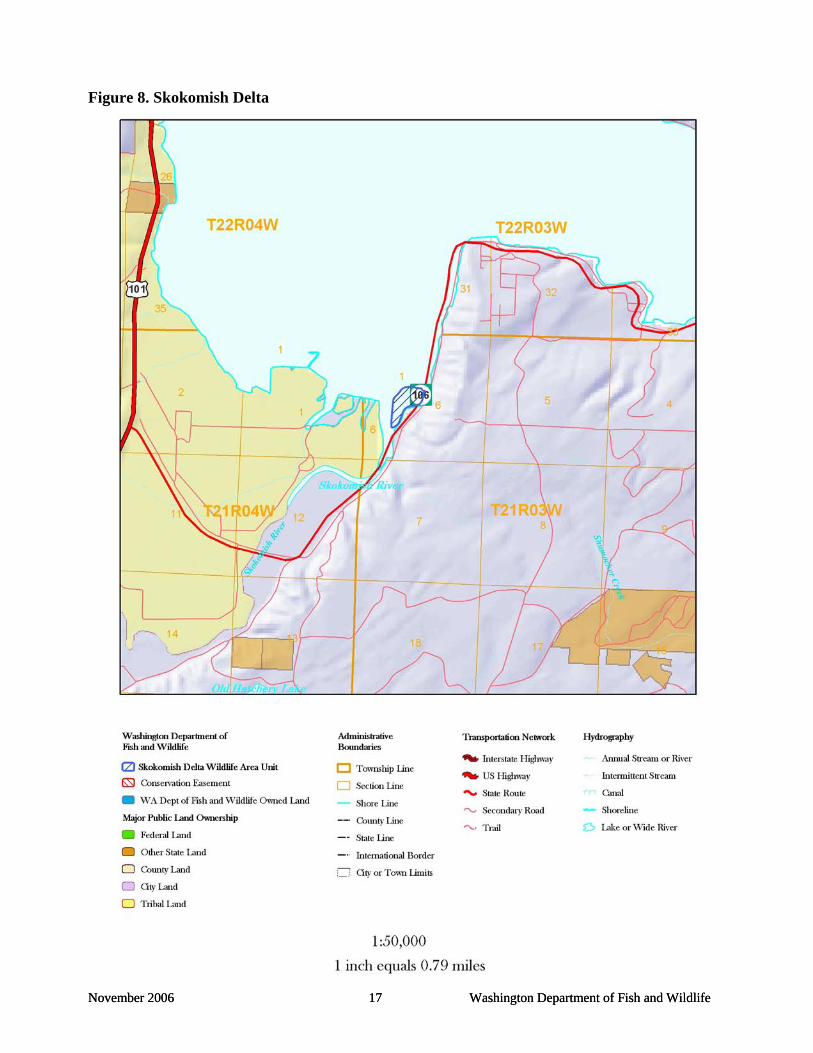
Name: Skokomish Delta Location: 20 mi. N of Shelton at the S end of Hood Canal, E of Hwy 101, Estuary islands at mouth of Skokomish River; Mason County Acquisition: 104.3 ac: 1947 Funding - How Purchased: $20,200 general funds - state or federal Purpose Purchased: Public Shooting Grounds; Boat-in waterfowl access Adjacent Properties: adjacent diked farmland - Estuary Restoration by Tacoma City Light and the Skokomish Tribe
November 2006 16 Washington Department of Fish and Wildlife
November 2006 17 Washington Department of Fish and Wildlife
November 2006 17 Washington Department of Fish and Wildlife
Figure 8. Skokomish Delta

Name: Skookumchuck Location: 11 mi. NE of Centralia, downstream from the Skookumchuck Dam; Thurston County Acquisition: 960 ac: 1979 Funding - How Purchased: Management Agreement with PacifiCorp and 7 additional owners - WDFW provides management recommendations Purpose Purchased: Mitigation for loss of Wildlife Habitat from inundation by the reservoir. Wildlife habitat improvement and management Adjacent Properties: Private Farmland, Timber lands
November 2006 18 Washington Department of Fish and Wildlife

November 2006 19 Washington Department of Fish and Wildlife
Figure 9. Skookumchuck

Name: Duckabush Location: 22 mi. N of Hoodsport, 4 mi. S of Brinnon, off Hwy 101; Jefferson County Acquisition: 123.8 acres: 1997 Funding - How Purchased: $510,000 IAC-WWRP USFWS - Coastal Wetland ALEA Purpose Purchased: Protection of the estuary for fish and wildlife benefits Adjacent Properties: Private Residential, Timber lands
November 2006 20 Washington Department of Fish and Wildlife

November 2006 21 Washington Department of Fish and Wildlife
November 2006 21 Washington Department of Fish and Wildlife
Figure 10. Duckabush

Name: Big Beef Creek and Morgan Marsh Location: 10 mi. W of Bremerton, adjacent to Lost Highway; Kitsap County Acquisition: 962 ac: 2001-2005 Funding - How Purchased: $3,644,263 IAC-WWRP Purpose Purchased: Wetland & Riparian Preservation/ Conservation and salmon protection Adjacent Properties: Forestland, limited private residential
November 2006 22 Washington Department of Fish and Wildlife

Figure 11 Big Beef Creek Unit
November 2006 23 Washington Department of Fish and Wildlife

Figure 12 Morgan Marsh Unit
November 2006 24 Washington Department of Fish and Wildlife

2.4 Funding Sources The McNeil, Gertrude and Pitt Island Units operation and maintenance costs are provided by 100% State funding. The Skookumchuck Units activities, operation and maintenance costs are 100% funded by TransAlta and the Centralia Steam Electric Generating Plant. ALL other units operation and maintenance costs provided by 32% PR funds and 68% state funds. Total biennium budget is $119,500. In addition, $11,000 provided by NRCS-WHIP funds for tall oat grass control on Scatter Creek Unit for 2005-2006; $10,000 provided by NRCS-WHIP funds for oak tree plantings and fescue demonstration at South Puget Sound Unit for 2003-2006; and $12,000 provided by State Weed Control Funds for tall oat grass control on Scatter Creek Unit for 2005-2006. The Department will, as part of the implementation of this plan, continue to submit grant proposals and applications and identify other strategies to address unfunded management needs on the wildlife area. 2.5 Climate The Pacific Ocean, westerly winds and the Olympic Mountains largely influence the regions climate. The region generally experiences a maritime climate characterized by mild temperatures with prolonged cloudy periods; wet, mild winters, cool, relatively dry summers; and heavy precipitation, averaging 84 in annually. Variations in precipitation occur, ranging from 24 in (NE peninsula) to 118 in (mountain interior), as a result of the coastal mountains, which create rain shadows in the Puget trough region. The majority of precipitation falls between October and March, primarily as rain with small amounts of snow in the Olympic Mountains. Average winter and spring temperatures range from 34oF to 75oF. 2.6 Soils and Geology Glacial outwash plains are common to this area and are rimmed by low-lying hills formed by the last continental ice sheet 12,000 years ago. The receding Vashon glaciations deposited the sand, gravel, boulders and clay that make up the current Spanaway gravelly sandy loam soils. The terminal moraine of the Vashon glacier, just south of Olympia, slopes gently toward Puget Sound and contains many lakes and poorly drained depressions underlain by glacial drift. Franklin and Dyrness (1973) describe the soils and geology as follows: “Glacial deposits range from very porous gravels and sands to a hard till in which substantial clay and silt are mixed with coarser particles…Soil texture is commonly gravelly sandy loam, and profile depth averages about 1 meter. Underlying materials are either loose gravels and sands or hard, cemented till.” In the prairie communities, soils are extremely well drained and contain very little organic matter (Appendix B). In estuary and wetland communities soils are poorly drained and contain considerable amounts of organic matter. 2.7 Hydrology and Watersheds The wildlife areas outlined in this management plan occur throughout Kitsap, Mason, Thurston and Pierce counties in areas effected by major rivers and tributaries that flow into Puget Sound, Hood Canal or the Chehalis River, which then flows out into Grays Harbor. These wildlife areas are maintained within the following Water Resource Inventory Areas (WRIA): Puyallup-White (WRIA 10), Nisqually (WRIA 11), Chambers-Clover (WRIA 12), Deschutes (WRIA 13),
November 2006 25 Washington Department of Fish and Wildlife

Kennedy-Goldsborough (WRIA 14), Kitsap (WRIA 15), Skokomish-Dosewallips (WRIA 16), and Upper Chehalis (WRIA 23). 2.8 Fire/Flood History Fire history is limited in western Washington due to the high amount of rainfall received annually. Fire has not significantly impacted the management strategies of wildlife areas today. However, controlled burning has been used as a management tool on several occasions and is one method that will be used for weed management at the Scatter Creek Unit. The flood history of western Washington is more extensive than fire history and includes areas along many rivers and streams as well as shorelines of Puget Sound and Hood Canal. Seasonal flooding is one characteristic that defines the purpose of several wildlife areas in this region. A few parcels acquired by WDFW had dike systems or other land alterations in place, inhibiting natural flooding processes. A majority of these areas have been returned to their natural systems, which benefit multiple species of fish and wildlife.
2.9 Vegetation Characterization The region encompasses multiple habitat types with various vegetation characteristics. Characteristics of specific habitat types are listed here and management strategies concerning these habitats will be highlighted as appropriate per individual unit. Forested – Primary conifer species typically consist of Douglas fir, Western red cedar, Sitka spruce, and Western hemlock, primary deciduous species typically include red alder, black cottonwood, big leaf maple, Oregon ash or Oregon white oak. Riparian forest - dense stands of trees and/or shrubs provide hiding, escape and thermal cover, shade, foraging and nesting sites, perches, and water sources. Often these highly productive communities contain both plant and wildlife species that are endangered or threatened. Common overstory trees in riparian zones include big leaf maple or black cottonwood, while the understory vegetation is composed of many hydrophytic shrub species such as alder or willow. Riparian shrub wetland – shrubs or small trees growing in soil, which is seasonally or permanently flooded, vegetation may consist of cascara, crabapple, willow, red alder, and Douglas spirea. Marsh wetland – adjacent to riparian wetlands and characterized, typically, by permanent water depths of between 1-3 feet, vegetation may consist of cattails, sedges, rushes, reed canary grass, Douglas spirea, and willow. Forested wetland – many layers of plant growth where the upper layers consists of deciduous, evergreen or mixed tree types and the lower layers consist of shrubs and herbaceous plants, the upper canopy may consist of red alder, black cottonwood, Oregon ash, Sitka spruce, western red cedar, Douglas fir and big leaf maple, the shrub layer below canopy may consist of vine maple, devil’s club, cascara, salmonberry, snowberry, red elderberry and crabapple, and the herbaceous plants may include lady fern, skunk cabbage, and water parsley. Wet upland meadows – flood seasonally with water run-off and have varying depths of standing water during the fall, winter and spring, vegetation typically includes grasses, sedges and rushes.
November 2006 26 Washington Department of Fish and Wildlife
November 2006 27 Washington Department of Fish and Wildlife
Upland – dry throughout the year and used as farmland, planted crops previously consisted of grasses, clover, barley, peas, millet, winter wheat, and cereal grain. Open water – average water depth of over three feet, vegetation may consist of water milfoil, pond lily, cattails, and duckweeds for freshwater systems, and eelgrass, sedges, or rushes for saltwater systems. Mixed Shrub – occur in uplands and where mounds of gravel or rocks are present, vegetation may include thick clumps of willow, wood rose, evergreen blackberry, and Scot’s broom. Oak-Woodland Prairie – Oregon white oak, associated with prairie habitat, typically have an open understory with grass species dominating including Idaho fescue/ Balsam root short grass and some wildflowers. Estuary – occur along the coast as well as in Puget Sound and Hood Canal and include deep water tidal habitats and adjacent tidal wetlands semi-enclosed by land but with access to the open ocean and where ocean water is diluted by freshwater runoff. Typically contains mudflats or salt-tolerant vegetation such as eelgrass, rushes or sedges. 2.10 Important Habitats Riparian – Area adjacent to aquatic systems with flowing water that contains elements of both aquatic and terrestrial ecosystems, which mutually influence each other. The terrestrial element provides shade, fine or large woody material, nutrients, organic and inorganic debris, terrestrial insects, or habitat for riparian-associated wildlife. The aquatic element includes vegetation adapted to wet conditions and provides thermal cover, creates stream channel features such as pools, and maintains stream bank stability, primary factors influencing the quality and health of fish habitat. Units of the South Puget Sound Wildlife Area with riparian habitat include the following: Scatter Creek, Morgan Marsh and Skookumchuck. Estuary – Deep water tidal habitats and adjacent tidal wetlands, semi-enclosed by land but with access to the open ocean, and where ocean water is diluted by freshwater runoff. Estuarine habitat extends upstream and landward to where ocean-derived salts measure less than 0.5% during the period of average annual low flow. These areas provide high fish and wildlife density and species diversity, important breeding habitat and important fish and wildlife seasonal ranges and movement corridors. Estuaries are limited in availability and are highly vulnerable to habitat alteration. Units with estuary habitat include the following: McNeil/Gertrude/Pitt Islands, Union River, Nisqually, Duckabush and Skokomish Delta. Wetland – Lands transitional between terrestrial and aquatic systems where wtable is usually at or near the surface or the land is covered by shallow water. The land supports predominantly hydroplants, substrate is predominantlundrained hydric soils, and/or substratenonsoil and is saturated with water or
ater
phytic y
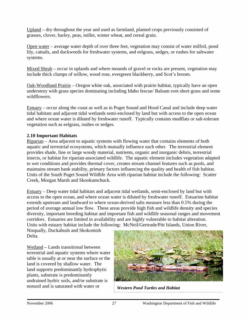
is Western Pond Turtles and Habitat
November 2006 28 Washington Department of Fish and Wildlife
covered by shallow water at some time during the growing season of each year. These areas support relatively high fish and wildlife density, high fish and wildlife species diversity, important fish and wildlife breeding habitat and important fish and wildlife seasonal ranges. Units with wetland habitat include the following: Scatter Creek, McNeil/Gertrude/Pitt Islands, South PugetSound UWIC, Ohop, Black River, Morgan Marsh and Skookumchuck.
Oak-Woodland Prairie – Oregon white oak, associated with prairie habitat is uncommon and at the extent of its range on the west side of the Cascade Mountains and north of the Columbia River and has been subject to loss from land development and invasion by Douglas fir. The South Puget Sound UWIC unit is undergoing oak-woodland prairie restoration. The prairies on the Scatter Creek Unit show a unique habitat of dominant grasses including Idaho fescue/ Balsamroot short grass and associated wildflower, moss, lichen, fern, shrub and tree species. Wildflowers support nectar feeding insects and bird species. Also present are state sensitive, federal species of concern white-topped aster and state sensitive small-flowered trillium.
2.11 Fish and Wildlife Fish and wildlife diversity is of primary importance to the goals and strategies guiding WDFW’s management efforts. The South Puget Sound units supports many prairie, estuary and wetland dependent species, nongame, big game and small game species of wildlife as well as native fish populations, some federally endangered. Each unit provides habitat for many common species found throughout western Washington such as deer, elk, fox, bobcat, coyote, hare, raccoon, river otter, beaver, muskrat, small rodents, shrews, hawks, owls, ducks, geese, swallows, red-winged bkilldeer, woodpeckers and a variety of song birds. In addition to the common species, units are managed either for recreation associated with fish and wildlife or for the protection of specific spand their habitats. Unique species, species of interest, or primary management species occurring on individual units are outlined below.
lackbird,
ecies
Units that provide habitat or recreational opportunities for waterfowl and/or migratory birds include Nisqually, Ohop, Black River, Skokomish, Morgan Marsh and Skookumchuck. Prevention of further development on Union River, Nisqually, Ohop, Black River, Big Beef Creek, Morgan Marsh and Skokomish Units provides protection of critical habitat for many salmon species. Some of these units also provide recreational fishing opportunities. Management for upland birds including pheasant, grouse and occasionally turkey occur on the Skookumchuck, Black River and Scatter Creek Units. The South Puget Sound UWIC Unit, a non-consumptive recreational and educational unit, provides habitat for many species and has played a
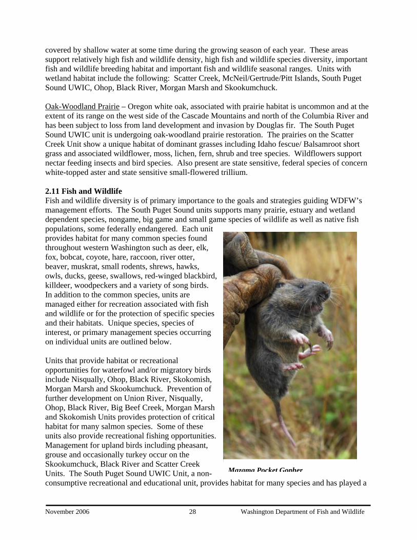
Mazama Pocket Gopher

November 2006 29 Washington Department of Fish and Wildlife
primary role in the efforts to recover populations of western pond turtles, a state endangered species. The McNeil Island Unit, which includes Gertrude and Pitt Islands, provides opportunities for many species due to limited access. These islands provide habitat for a great blue heron rookery, bald eagle nests and haul out sites for marine mammals, especially harbor seals, all federally protected species. Scatter Creek, a relatively large unit, supports many unique species due to the prairie and wetland habitats found here. These species include great blue heron, northern alligator lizard, western bluebird, vesper sparrow, mazama pocket gopher, and several species of butterfly including the state endangered mardon skipper. Other species historically seen, but not now present on Scatter Creek include the slender-billed white-breasted nuthatch, streaked horned lark, Oregon vesper sparrow, western gray squirrel and several species of butterfly. Scatter Creek is one of only two remaining south Puget Sound sites that supports the state endangered Mardon skipper.
State candidate status bPuget blue, Taylor’s checkerspot, and valley silverspot occupy this site, as well as several state monitor status butterfly species. The Skookumchuck Unit is managed for multiple species as part of the mitigation agreement. Habitat is provided for big game and small game, waterfowl including wood duck, as well as non-game species such as pilleated woodpecker, western bluebird, spotted frog and western pond turtle.
utterflies:
2.12 Cultural Resources Cultural, geological, and other non-renewable resources are protected, and may not be removed unless such removal is beneficial to wildlife, habitat, or the Wildlife Area, or for scientific or educational purposes. WDFW will coordinate with the appropriate agency of jurisdiction for the protection of such resources. Past issues have included the removal of various rock formations, Native American artifacts, plants, seeds, and other items by members of the public.
Taylor's Checkerspot Butterfly
CHAPTER III. MANAGEMENT OBJECTIVES, ISSUES & STRATEGIES Statewide goals and objectives listed in chapter one shape management priorities on wildlife areas. Specific wildlife area information including why the area was purchased, habitat conditions, species present, and public issues and concerns are evaluated to identify wildlife area activities or tasks. Objectives and associated tasks specific to the South Puget Sound Wildlife Area are listed where appropriate under applicable agency objectives. Unfunded needs are underlined.
Agency Objective: Protect, Restore & Enhance Fish and Wildlife and Their Habitats 1. Maintain big game populations There are two units within the South Puget Sound complex that include big game management. They are the Skookumchuck unit, and McNeil Island. The management activities that occur on the Skookumchuck are conducted through PacifiCorp in an agreement with WDFW and 7 other owners through the Skookumchuck Wildlife Habitat Management Plan developed in 1982. The Skookumchuck Dam Wildlife Habitat Management Program SOP (1994) includes detailed management objectives for the following strategy.
A. Strategy: Farmland, meadow, orchard and forest management to provide forage and cover for elk and deer. (Annual 2006) The Management activities that occur on McNiel, Gertrude and Pitt Islands are based on the Transfer Deed management requirements for the following strategy. B. Strategy: Farmland, meadow, orchard and forest management to provide forage and cover for deer. (Annual 2006)
2. Improve and maintain fish populations The aquatic element in riparian corridors includes vegetation adapted to wet conditions and provides thermal cover, creates stream channel features such as pools, and maintains stream bank stability, primary factors influencing the quality and health of fish habitat. The parcels located in Hood Canal; Skokomish Delta, Duckabush, Union River, Big Beef Creek, and Morgan Marsh, all provide protection for critical salmon stocks. State ownership insures that these areas will not be developed and the estuary habitat will be protected from degradation.
A. Strategy: Provide habitat protection for critical salmon stocks in Hood Canal through continued State ownership. (Annual 2006) B. Control recreational access on these sites by posting signs and information on the area. Direct users and protect the habitat from damage by overuse. (Annual 2006)
3. Manage for upland birds Upland birds provide recreational opportunities where pheasants are released at several sites in western Washington. The only upland bird management issues or activities on the SPSWA are found on the Scatter Creek and Skookumchuck units and consist of recreation related management.
A. Strategy: Coordinate with WDFW Game Farm on pheasant release activities at the Scatter Creek and Skookumchuck Units. (October - December 2006) B. Strategy: Post and maintain Safety Zone, No Unauthorized Vehicles, No Target Practice signs on the Scatter Creek and Skookumchuck units. (Annual 2006)
November 2006 30 Washington Department of Fish and Wildlife

4. Manage for species diversity Old Growth habitat is limited and has declined due to its high vulnerability to habitat alteration. These habitats support high fish and wildlife density and species diversity and provide important breeding, movement and cover habitat for many species.
A. Strategy: Investigate timber-thinning project to enhance even aged tree stands for old growth characteristics on McNeil Island and the Scatter Creek Unit. (October 2006)
5. Protect and restore riparian/wetland habitat Riparian and wetland habitats have been identified as priorities for management and protection due to their importance to many species, both fish and wildlife. Many of the wildlife areas are managed to provide or to protect wetland habitat especially for waterfowl. A. Strategy: Support NRCS efforts to meander Ohop Creek into Nisqually River and restore the area to a natural floodplain. (Annual 2006) B. Strategy: Manage wetland ponds at South Puget Sound UWIC Unit for western pond turtles. (Annual 2006) C. Strategy: Support TransAlta in wetland and riparian management activities on Skookumchuck Unit. (Annual 2006) D. Strategy: Continue protection efforts of wetland habitat at Morgan Marsh Unit. (Annual 2006)
6. Protect and restore estuary habitat Estuaries are important for many species and are a priority for migratory shorebirds along the pacific flyway and provide forage and resting areas for waterfowl. Estuaries are productive environments and provide salmon with transitional habitat and forage opportunities.
A. Strategy: Continue estuary protection for salmon and waterfowl habitat on the Union River Unit. (Annual 2006) B. Strategy: Maintain estuary protection of the Skokomish Delta Unit for salmon, migratory bird and waterfowl habitat and support estuary restoration efforts. (Annual 2006) C. Strategy: Maintain estuary protection for salmon, waterfowl, and migratory bird habitat on the Nisqually Unit. (Annual 2006)
7. Protect and restore prairie habitat Oregon white oak, associated with prairie habitat is uncommon and at the extent of its range on the west side of the Cascade Mountains and north of the Columbia River and has been subject to loss from land development and invasion by Douglas fir. Approximately 10 % of the original short grass prairies are left in the Puget Sound area. 90% of that is located on Fort Lewis. The remainder is located in several parcels owned by Washington Department of Fish & Wildlife, Washington Department of Natural Resources, Thurston County, and The Nature Conservancy. All of these agencies are working to protect, restore and enhance the prairie habitats. Scatter Creek is one of the largest parcels, and has some of the highest quality native prairie habitat. Several species of butterflies, mammals and birds depend on this prairie habitat. The Mardon skipper
November 2006 31 Washington Department of Fish and Wildlife
butterfly is a state endangered species in Washington and is found on Scatter Creek The Mazama pocket gopher, valley silverspot, and Puget blue are state candidate species that are in very low numbers in Washington State, and depend on the native prairies and associated Oregon white oak woodlands at Scatter Creek. The state endangered plant, Sidalcea malviflora var virgata’s only location in Washington State is at the Scatter Creek Unit. Scatter Creek may also play an important role in recovering the federally endangered golden paintbrush (Castilleja levisecta). For all of these species to survive on Scatter Creek, it is critical that the native prairie habitat be protected, restored and enhanced. The South Puget Sound unit is one of the last parcels of native prairie and Oregon white oak woodlands in Lakewood. Located in an urban setting, it provides a unique opportunity to educate the public in the importance of native prairie and oak woodlands habitats, and the process of restoring those habitats.
A. Strategy: Plant 150 Oregon white oak trees as per WHIP contract with NRCS on South Puget Sound UWIC Unit each year for two years. (November 2006) B. Strategy: Maintain 300-planted Oregon white oak trees as per WHIP contract with NRCS on South Puget Sound UWIC Unit for three years. (Annual 2006) C. Strategy: Plant native prairie grass, Roemer’s (Idaho) fescue, in test plots as per WHIP contract with NRCS on South Puget Sound UWIC Unit. (September 2006) D. Strategy: Set up native plant nursery at South Puget Sound UWIC Unit. (February 2006) E. Strategy: Annually collect seeds of native prairie plants, grasses and forbs, for propagation on Scatter Creek Unit. (July - August 2006) F. Strategy: Plant native Roemer’s (Idaho) fescue plugs along edges of designated horse trail to rehabilitate adjacent native prairie on Scatter Creek Unit as needed. (January - February 2006) G. Strategy: Work with the Natural Heritage Program to recover Sidalcea malviflora var. virgata at Scatter Creek Unit. (Annual 2006) H. Strategy: Evaluate Scatter Creek Wildlife Area for potential reintroduction of western gray squirrel, taylor’s checkerspot, streaked horned lark, and western pond turtle. (Annual 2006) I. Strategy: Coordinate and assist interagency research efforts to develop grassland restoration techniques. (Annual 2006) J. Strategy: Perform Bird Point Counts on Scatter Creek Unit. (April - May 2006)
8. Protect and manage other species Great blue heron rookeries are in low numbers in Puget Sound. Existing rookeries should be monitored and protected from disturbance to ensure nesting success.
A. Strategy: Monitor and survey Gertrude Island great blue heron rookery. (May - June 2006) B. Strategy: Top and kill Douglas fir trees that are overtopping Oregon white oak trees to create snags on Scatter Creek Unit. Inject fungus-laced dowels into topped trees to create cavities for cavity nesting birds and mammals. (March 2006)
November 2006 32 Washington Department of Fish and Wildlife
Agency Objective: Provide Sustainable Fish and Wildlife-Related Recreational and Commercial Opportunities Compatible with Maintaining Healthy Fish and Wildlife Populations and Habitats. Improve the Economic Well Being of Washington by Providing Diverse, High Quality Recreational and Commercial Opportunities.
1. Provide public access compatible with fish, wildlife and habitat protection. Access for hunting, fishing, wildlife viewing and other activities is an agency priority. However, access and recreation must be controlled to protect fish and wildlife resources and to comply with federal and state regulations. Through our meetings with the public, both in our CAG meetings and onsite each of the units in the wildlife area, it is clear that recreational opportunities are a high priority with the public, as long as the wildlife and wildlife habitats are protected. Several units of the wildlife area are home to endangered or sensitive plant and animal species, and present a unique challenge balancing recreational use and habitat protection.
A. Strategy: Maintain paved walking trail at South Puget Sound UWIC Unit to provide public wildlife viewing recreation and protect adjacent prairie habitat. (Annual 2006) B. Strategy: Design and install interpretive materials along trail at South Puget Sound UWIC Unit to educate the public in the importance of urban open space, native prairies and oak woodlands and habitat restoration processes. (September 2006) C. Strategy: Set up and participate in Hudloft Middle School field trips to South Puget Sound UWIC Unit to educate students in the importance of urban open space, native prairies and oak woodlands and habitat restoration processes. (April 2006) D. Strategy: Plan, set up and participate in annual Nature Fest Festival at South Puget Sound UWIC Unit to provide educational opportunities, public outreach and community support. (August - September 2006) E. Strategy: Maintain and monitor designated horse trails on North and South Units of Scatter Creek to protect adjacent native prairie habitat and continue to provide compatible public recreational opportunities. (Annual 2006) F. Strategy: Monitor field trials for onsite rules compliance at Scatter Creek Unit to protect native prairie habitat and continue to provide recreational opportunities compatible with habitat protections. (Annual 2006) G. Strategy: Coordinate pheasant release activities at Scatter Creek and Skookumchuck Units to provide consumptive recreational opportunities. (October - December 2006) H. Strategy: Monitor horse use from the Scatter Creek North Unit parking area for onsite rules compliance to protect native prairie habitat and continue to provide recreational opportunities compatible with habitat protections. (Annual 2006) I. Strategy: Monitor and coordinate recreational activities in areas known to have endangered or threatened plants and animals. (Annual 2006) J. Strategy: Maintain trail from parking area to river at Black River Unit to provide increased consumptive and non-consumptive public recreational opportunities. (Annual 2006) K. Strategy: Post WDFW ownership signs on Black River Unit property to provide increased consumptive and non-consumptive public recreational opportunities. (April 2006)
November 2006 33 Washington Department of Fish and Wildlife
L. Strategy: Support non-profit organization in the operation of the interpretive center at Luhr’s Beach boat launch for public education and outreach. (Annual 2006) M. Strategy: Maintain duck blinds, posting of regulations and site info for access on Union River Unit to provide consumptive and non-consumptive public recreational opportunities. (October 2006) N. Strategy: Maintain safety zone adjacent to Thellar Nature Trail at Union River Unit to provide consumptive and non-consumptive public recreational opportunities. (Annual 2006) O. Strategy: Continue access agreement for portion of trail and interpretive stations on WDFW property at Thellar wetlands, Union River Unit for public education and outreach. (Annual 2006) P. Strategy: Improve access site at Union River Unit to enhance public recreation on the site. (October 2006) Q. Strategy: Set up an access for canoe hunting and fishing at Morgan Marsh Unit to provide increased consumptive and non-consumptive public recreational opportunities. (June 2006) R. Strategy: Install gates to restrict vehicle traffic and prevent trash dumping at Morgan Marsh Unit. (No Time Line Set) S. Strategy: Post an ownership sign on the property at the main access point at Morgan Marsh Unit to provide increased consumptive and non-consumptive public recreational opportunities. (January 2006) T. Strategy: Post WDFW Wildlife Area signs at Duckabush Unit to inform the public of the recreational opportunities onsite. (June 2006) U. Strategy: Block vehicle access to estuary to Duckabush Unit to protect the habitat. (Annual 2006) V. Strategy: Remove litter at Duckabush Unit to enhance the public recreation onsite. (Annual 2006)
Agency Objective: Ensure WDFW Activities, Programs, Facilities and Lands are Consistent With Local, State and Federal Regulations that Protect and Recover Fish, Wildlife and Their Habitats
1. Manage weeds consistent with state and county rules and to protect and recover fish and wildlife and their habitats Weed control is required by state law to protect public economic and natural resources. Invasive weeds are one of the greatest threats to fish and wildlife habitat quality. Cooperative weed efforts are encouraged to improve efficacy and to minimize impacts on adjacent landowners as part of the agencies good-neighbor priority.
One of the biggest threats to native prairie habitat in the SPS and Scatter Creek units is the invasive shrub Scot’s boom. In order to protect and enhance the prairie habitat, it must be continually controlled. If left alone for any length of time it will take over an area and degrade the habitat to the point of it being unusable by wildlife and limit the public recreational use of an area. Control is done primarily by mowing and/or herbicide applications. New strategies for Scot’s broom control will be researched and tested whenever feasible.
November 2006 34 Washington Department of Fish and Wildlife
A. Strategy: Implement weed management plan for Scatter Creek Unit (Appendix D). (Annual 2006) B. Strategy: Annually control Scot’s broom on 60 acres degraded prairie by mowing and herbicide applications on South Puget Sound UWIC Unit to enhance and restore prairie habitat. (July - August 2006) Strategy: Annually control Canada thistle and tansy ragwort on South Puget Sound UWIC Unit as per Pierce County Weed Board regulations. (May 2006) C. Strategy: Annually coordinate with DOC and Pierce County Weed Board for tansy ragwort control efforts on McNeil Island Unit. (May 2006) D. Strategy: Release biocontrol insects for tansy ragwort control on McNeil Island and Scatter Creek Units in 2006. (July 2006) E. Strategy: Annually monitor Ohop Unit for noxious weeds and control as necessary. (Annual 2006) F. Strategy: Annually control Scot’s broom on 500 acres native prairie by mowing and herbicide application on Scatter Creek Unit to enhance and restore prairie habitat. (July - August 2006) G. Strategy: Control tall oat grass on 160 acres of native prairie by aerial and ground herbicide applications, mowing and burning on Scatter Creek Unit in 2005 and 2006 to enhance and restore prairie habitat. (April - May 2006) H. Strategy: Annually monitor and control patches of tansy ragwort, knapweed and mouse-ear hawkweed on Scatter Creek Unit as per Thurston County Weed Board regulations and to enhance and restore prairie habitat. (May - July 2006)
2. Manage species and habitats in compliance with the Endangered Species Act and Washington State fish passage, road management and forest practice rules Federal law requires the protection and management of threatened and endangered species. State law requires fish passage and screening issues and forest road sedimentation issues to be addressed on state public lands. Forest thinning operations on agency lands must follow state forest practice law.
A. Strategy: Manage wetland ponds for endangered western pond turtles at South Puget Sound UWIC Unit. (Annual 2006) B. Strategy: Enhance endangered western pond turtle nesting site areas by controlling Himalayan blackberries, and placing additional topsoil at sites on South Puget Sound UWIC Unit. (May 2006) C. Strategy: Participate in endangered western pond turtle trapping, monitoring and nest protections on South Puget Sound UWIC Unit. (April - July 2006) D. Strategy: Work with Pierce County for possible new wetland pond development on South Puget Sound UWIC Unit for endangered western pond turtles. (Annual 2006) E. Strategy: Monitor and ground survey two existing bald eagle nests on McNeil Island Unit. (April - July 2006) F. Strategy: Survey for new bald eagle nest sites on McNeil Island Unit. (March - April 2006) G. Strategy: Gertrude Island, part of the McNeil Island unit, has the largest haul out site for harbor seals in south Puget Sound. Research on the seals at Gertrude has been ongoing since the 1970’s studying the contaminant levels in them as a barometer of the health of Puget Sound. Coordinate and participate in harbor seal
November 2006 35 Washington Department of Fish and Wildlife

captures on McNeil Island Unit – primarily Gertrude Island (not endangered but under Marine Mammal Protection Act). (Annual 2006) H. Strategy: Perform surveys for endangered, threatened and candidate butterflies on Scatter Creek Unit. (April - July 2006) I. Strategy: Recreational use on Scatter Creek has the potential of harming sensitive prairie habitat and threatened and endangered wildlife species. Recreational use will be monitored and coordinated to protect the endangered or threatened plants and animals on Scatter Creek Unit. (Annual 2006) J. Strategy: Maintain designated horse trail on Scatter Creek Unit to protect endangered or threatened plants and animals. (Annual 2006) K. Strategy: Coordinate with endangered butterfly propagation efforts for possible release onto sites at the Scatter Creek Unit. (Annual 2006) L. Strategy: Perform Bird Point Count surveys on the North & South Units of Scatter Creek Unit. (April - July 2006) M. Strategy: Correct a longstanding fish passage barrier on the Scatter Creek Unit access road on an Unnamed Tributary to Scatter Creek. (June - July 2006) N. Strategy: Strategy: Restore near shore habitat to anadromous and marine fish behind the McNeil Island Unit access road on Milewa Creek Cove. (Planning 2006)
3. Protect cultural resources consistent with state and federal law Federal and state law requires an assessment of cultural resources on agency lands prior to activities that may impact those resources.
A. Strategy: Assess cultural resource value (historic and archaeological) of all structures before renovation or removal. (Annual 2006) B. Strategy: Perform cultural resource survey and assessment before digging- including posts for new fence line, parking lots, toilets, buildings, new agricultural fields, etc. (Annual 2006)
4. Pay county PILT and assessment obligations State law requires the agency to pay PILT and county assessments.
A. Strategy: Pay PILT and assessments to counties. (Annual 2006) Agency Objective: Provide Sound Operational Management of WDFW Lands, Facilities and Access Sites.
1. Maintain facilities to achieve safe, efficient and effective management of the wildlife area.
A. Strategy: Repair boundary fence on South Puget Sound UWIC Unit. (Annual 2006) B. Strategy: Mow north and south fire trails for fire protection on South Puget Sound UWIC. (July 2006) C. Strategy: Maintain boundary fence on Scatter Creek Unit. (Annual 2006) D. Strategy: Maintain three parking lots of Scatter Creek Unit by mowing and grading. (Annual 2006)
2. Maintain other structures and physical improvements
A. Strategy: Maintain all signs, gates, culverts or water structures to perform operation and maintenance of areas. (Annual 2006)
November 2006 36 Washington Department of Fish and Wildlife
B. Strategy: Replace/install new boundary and unit signs where appropriate. (Annual 2006)
3. Maintain equipment A. Strategy: Service all equipment including trucks, tractor and implements, weed sprayers, trailers, etc. Request replacement equipment when needed. (Annual 2006) B. Strategy: Rent equipment when it is more efficient to do so or when needed. (Annual 2006)
4. Pursue funding opportunities A. Strategy: Current funding levels cannot address the cost of needed habitat restoration and enhancement goals for the wildlife area. Apply for NRCS WHIP grants for habitat restoration work and other funding opportunities consistent with planned priorities to supplement funding. (Annual 2006 as per individual grant timelines) B. Strategy: Research and apply for grants to repair and preserve the Brewer House, which is on the Federal and State Historic Registers. Coordinate with Washington State Parks who usually manage state historic sites. (Annual 2006 as per individual grant timelines)
5. Assess forest conditions with regard to catastrophic fire, insect and disease risks The history of fire suppression in many cases has resulted in forest tree densities far greater than historic levels. Dense forest stands may create fire safety issues and risk to the spread of detrimental forest insects and disease.
A. Strategy: Fire danger on McNeil Island is a great concern to the Department of Corrections. Many of the timber stands on McNeil Island are even aged monocultures of Douglas fir. Assess timber-thinning project on McNeil Island to reduce potential fire danger and create forest conditions more suitable to a diversity of species. (October 2006)
6. Perform administrative responsibilities
A. Strategy: Develop and monitor budgets (Annual 2006) B. Strategy: Supervise employees (Annual 2006)
7. Protect and apply water rights for best use Water rights can impact wildlife area operations including food plots, restoration projects, etc. Water use can also reduce in-stream volumes for fish and other animals.
A. Strategy: Identify and record all water rights and uses of water (Appendix G). (Annual 2006) B. Strategy: Move all unneeded water rights permanently or temporarily into the State Trust Water Rights Program. (Annual 2006)
8. Other Issues or Concerns (List any other issues related to the wildlife area that are not addressed above. Include discussion of the issues and a strategy for resolution.)
A. Strategy: Coordinate with DOC and DSHS to ensure compliance with transfer deed wildlife protection requirements on McNeil Island Unit. (Annual 2006)
November 2006 37 Washington Department of Fish and Wildlife

B. Strategy: Participate in biennial WDFW, DOC, and DSHS Wildlife Training as per transfer deed requirement of McNeil Island Unit. (May 2007) C. Strategy: Keep the South Puget Sound UWIC unit in State ownership as open space. (Annual 2006) D. Strategy: Transfer ownership and management of the Big Beef Creek properties to Kitsap County. (No Set Timeline)
November 2006 38 Washington Department of Fish and Wildlife

CHAPTER IV: PERFORMANCE MEASURES, EVALUATION AND UPDATES TO THE SOUTH PUGET SOUND WILDLIFE AREA PLAN Wildlife area plan performance measures are listed below. Accomplishments and desired outcomes will be evaluated to produce an annual performance report. The wildlife area plan is a working document that will evolve as habitat and species conditions change, as new regulations are enacted, and as public issues and concerns change. Plan updates will address these changes.
1. The South Puget Sound Wildlife Area Performance Measures Include:
• Find suitable recreational replacement area for Scatter Creek unit • Release 1500 pheasants at Scatter Creek and Skookumchuck units • Plant 150 Oregon white oak trees on SPS UWIC unit • Maintain 300 Oregon white oak trees on SPS UWIC unit • Plant one test plot of Roemer’s (Idaho) fescue on SPS UWIC Unit • Set up native plant nursery at SPS UWIC Unit • Collect native prairie plant, grass and forb seeds for propagation. • Plant Roemer’s (Idaho) fescue plugs along ¼ mile of horse trail on Scatter Creek • Create 25 snags on Scatter Creek • Create 30 nesting cavities on Scatter Creek • Perform annual Bird Point Count surveys on Scatter Creek • Develop educational materials and host 2 educational events • Install two gates on wildlife area properties • Control weeds on 720+ acres • Enhance western pond turtle nest sites with 100 yards of topsoil • Develop new wetland pond for western pond turtles • Identify, survey and monitor endangered/threatened/sensitive species of butterflies • Repair 1 mile fence • Set up canoe access area for Morgan Marsh Unit • Transfer ownership and management of Big Beef Creek properties to Kitsap County.
2. Annual Evaluation of Performance Evaluate performance measures and produce an annual report. At the beginning of each calendar year, the manager will convene the CAG and district team to assess wildlife area specific performance measures and accomplishments that will be used to develop the annual plan update. This update will be an attachment to the plan. 3. Annual Plan Update As projects are completed and new issues arise, this plan will be updated, without needing to be re-written. With CAG and District Team input, the plan will continually reflect the strategies, goals and objectives of the current year.
November 2006 39 Washington Department of Fish and Wildlife

Appendix 1. Public Issues The purpose of meeting with the CAG and DT was to obtain input to help guide management actions on the wildlife area. A draft of the introduction and history of the wildlife area and copies of the Agency’s goals and objectives were distributed for review and discussion. Below is a list of issues and concerns identified by the CAG and DT. This input will assist in developing strategies to implement management goals and objectives. Underlined statements below indicate that the input was received from the DT or WDFW staff. Issues that are not underlined originated from the CAG or other public sources. Issue A – Access/Recreation
• Public access and the ability for the public to recreate is a high priority for the wildlife area.
• Current public recreation on Scatter Creek should not be closed until a suitable replacement area is available.
• Find suitable recreational replacement area for Scatter Creek unit. • Consult District Team members for help resolving conflicts between public use and
resource protection • Manage public use impacts on SPSWA by careful planning of access developments and
improvements, controlling vehicles, implementing seasonal and use restrictions and using other land and resource management techniques
• Post ownership boundary signs on the Skookomish Unit. Issue B – Wildlife
• Clearly state the management activities on Scatter Creek, which protect and enhance the endangered or threatened wildlife species found there. Example: Mardon skipper, Mazama pocket gopher, streaked horned lark.
• Identify and inventory TES species on SPSWA. • Evaluate Scatter Creek Wildlife Area for potential reintroduction of western gray
squirrel, taylor’s checkerspot, streaked horned lark, and western pond turtle. • Perform Bird Point Counts on Scatter Creek Unit.
Issue C – Habitat
• The South Puget Sound Urban Wildlife Interpretive Center Unit needs to be kept as Open Space.
• Protect water rights on the Wildlife Area. • Aggressively control non-native or invasive plants on Scatter Creek. • Prevent and reduce noxious weed infestations where possible by applying good land
management on SPSWA. • Coordinate and assist interagency research efforts to develop grassland restoration
techniques. • Control noxious weeds, on State and County Weed Lists, over the entire 6,507.42 acres
of the SPSWA, while avoiding damage to important non-target vegetation and wildlife habitats.
• Produce and implement a weed management plan with habitat threat, control priority, timing, monitoring and cost information.
November 2006 40 Washington Department of Fish and Wildlife
• Respond to official ‘Weed Control Notices’ that come from the five County Weed Districts and Weed Boards that oversee most of the SPSWA.
• Coordinate weed control efforts with Federal, State and Local entities to improve efficacy and minimize costs.
• Attend pesticide applicators training sessions and participate in weed control education, listing and research efforts.
• Contract and coordinate with Local, County, State or Federal entities to provide fire suppression on SPSWA.
• Update the Fire Plan to address fire fighting priorities and response procedures on the SPSWA.
• Plan and implement fire control measures like fire breaks, fuel reduction, green strips, etc…
• Enhance existing wetlands and create new wetland habitat for priority wildlife species. • Protect important wetlands from invasive plants, non-native wildlife, and detrimental
uses. • Preserve shallow water habitat on SPSWA by controlling emergent plants that could
reduce the shallow open water in small ponds and impoundments. Issue D – Roads
• Reopen the designated horse trail on the North Unit of Scatter Creek Issue E – Enforcement
• Need to increase enforcement on the wildlife area • Garbage and litter • Vandalism and theft
Public Education and Involvement
• Increase public awareness of the area with maps, kiosks, signs, more information on the web, etc.
• Provide more interpretive materials and educational opportunities onsite on the area. • Continue use of a Citizens Advisory Group (CAG) to represent various interests on
SPSWA • Meet with the CAG twice a year to discuss SPSWA issues and concerns • Serve and assist the public in a timely and professional manner • Develop volunteer activities and partnerships that assist in achieving SPSWA goals
Issue F – Wildlife Area Infrastructure and Equipment
• Plan and budget for the supplies needed on the SPSWA each biennium and maintain an inventory of essential equipment, signs and other materials.
• Maintain the SPSWA office and shop facilities to provide a safe and effective workplace.
• Maintain roads, parking areas, vehicle controls and other such facilities to provide safe public use with minimal damage or disturbance to wildlife, habitat and other valuable resources.
• Establish and maintain boundary fences to establish ownership and help control uses of the wildlife area.
November 2006 41 Washington Department of Fish and Wildlife

• Inventory and assess buildings, fences, bridges, culverts, gates and other facilities and infrastructure on SPSWA.
• Remove unnecessary interior fences and structures that present a hazard to people or wildlife.
Issue G – Monitor, Survey and Inventory
• Perform annual weed surveys to find and deal with noxious weeds. • Monitor recreational activities on the Wildlife Area for conflicts. • Monitor wildlife areas for public safety needs and take immediate action when possible. • Monitor uses on SPSWA for possible negative impacts to fish, wildlife and habitats
and take corrective actions. • Plan and implement surveys and monitoring of TES species and rare plants on SPSWA.
Issue H – Other
• Develop Work Plans that identify and address performance of the high priority duties. • Plan, assign and schedule Performance Measures. • Report on Performance Measures. • Prepare for management plan updates.
November 2006 42 Washington Department of Fish and Wildlife

APPENDIX 2. WEED CONTROL PLAN Weed Control Goals on WDFW Lands The goal of weed control on Department lands is to maintain and improve the habitat for wildlife, meet legal obligations, provide good stewardship and protect adjacent private lands. Weed control activities and restoration projects that protect and enhance fish and wildlife populations and their habitats on Department lands are a high priority. When managing for specific wildlife species on our lands the weed densities that trigger control are sometimes different than on lands managed for other purposes (e.g. agricultural, etc.). For example, if a weed is present at low densities and does not diminish the overall habitat value, nor pose an immediate threat to adjacent lands, control may not be warranted. WDFW focuses land management activities on the desired plant species and communities, rather than on simply eliminating weeds. Control for certain, listed species is mandated by state law (RCW 17.10 and 17.26) and enforced by the County Noxious Weed Board. WDFW will strive to meet its legal obligation to control for noxious weeds listed according to state law (Class A, B-Designate, and county listed weeds). Importantly, WDFW will continue to be a good neighbor and partner regarding weed control issues on adjacent lands. Weeds do not respect property boundaries. The agency believes the best way to gain long-term control is to work cooperatively on a regional scale. As funding and mutual management objectives allow, WDFW will find solutions to collective weed control problems. Weed Management Approach State law (RCW 17.15) requires that WDFW use integrated pest management (IPM), defined as a coordinated decision-making and action process that uses the most appropriate pest control methods and strategy in an environmentally and economically sound manner to meet agency programmatic pest management objectives, to accomplish weed control. The elements of IPM include: Prevention- Prevention programs are implemented to keep the management area free of species that are not yet established but which are known to be pests elsewhere in the area. Monitoring- Monitoring is necessary to implement prevention and to document the weed species, the distribution and the relative density on the management area. Prioritizing- Prioritizing weed control is based on many factors such as monitoring data, the invasiveness of the species, management objectives for the infested area, the value of invaded habitat, the feasibility of control, the legal status of the weed, past control efforts, and available budget. Treatment- Treatment of a weeds using biological, cultural, mechanical, and chemical control serves to eradicate pioneering infestations, reduce established weed populations below densities that impact management objectives for the site, or otherwise diminish their impacts. The method used for control considers human health, ecological impact, feasibility, and cost-effectiveness. Adaptive Management- Adaptive management evaluates the effects and efficacy of weed treatments and makes adjustments to improve the desired outcome for the management area.
November 2006 43 Washington Department of Fish and Wildlife

The premise behind a weed management plan is that a structured, logical approach to weed management, based on the best available information, is cheaper and more effective than an ad-hoc approach where one only deals with weed problems as they arise. Weed Species of Concern on the South Puget Sound WLA Weeds of concern on the South Puget Sound include: Mouse-ear Hawkweed (Hieracium pilosella), Tansy Ragwort (Senecio jacobaea), Diffuse Knapweed (Centaurea diffusa), Poison Hemlock (Conium maculatum), Canada Thistle (Cirsium arvense), Oxeye Daisy (Leucanthemum vulgare), English Ivy (Hedera helix) and Scotch Broom (Cytisus scoparius). This list is based on species that have been documented on the wildlife area (Table 1). Table 1. South Puget Sound Wildlife Area weeds including the state and county weed class listing and acres treated.
Weed Species 2005 StateWeed Class
2005 CountyWeed Class
Wildlife Unit(s)
2005 Treated Acres
Mouse-ear Hawkweed B B-Designate Scatter Creek 1
Tansy Ragwort B B-Designate
McNeil Island, SPSUWIC,
Scatter Creek 500 Diffuse Knapweed B B-Designate
SPSUWIC, Scatter Creek 1
Oxeye Daisy B B non-
Designate Scatter Creek 1
Scotch Broom B B non-
Designate SPSUWIC,
Scatter Creek 600 Poison Hemlock C C-Designate SPSUWIC 2
Canada Thistle C C non-
Designate SPSUWIC,
Scatter Creek 15
English Ivy C C non-
Designate SPSUWIC 1
St Johns Wort C C non-
Designate SPSUWIC,
Scatter Creek 0 B-Designate are state-listed and mandatory for control to prevent seed production/spread.
B Non-Designate are state-listed with containment, gradual reduction, and prevention of further spread. C-Designate are state-listed, but control is local to the county weed board recommendations. C Non-Designate are state-listed, but control is local to the county weed board recommendations. Management for individual weed species can be found in the following “Weed Species Control Plan” (WSCP) sections.
November 2006 44 Washington Department of Fish and Wildlife

MOUSE-EAR HAWKWEED WEED SPECIES CONTROL PLAN Scientific name: Hieracium pilosella Common name: Mouse-ear hawkweed DESCRIPTION: Mouse-ear Hawkweed is a yellow-flowered species of Asteraceae, native to Europe and northern Asia. It produces single, citrus-colored inflorescences. It is an allelopathic plant. Like most hawkweed species, it shows tremendous variation and is a complex of several dozens subspecies and hundreds of varieties and forms. It is a hispid (hairy) perennial plant, with a basal rosette of leaves. The whole plant, with the exception of the flower parts, is covered in glandular hairs, usually whitish, sometimes reddish on the stem. The rosette leaves are entire, acute to blunt, and range from 1-12 cm long and 0.5-2 cm broad. Their underside is tomentose (covered with hair). The flowering stem (scape) is generally between 5 cm to 50 cm tall, and sprouts from the centre of the basal rosette. The flower heads are borne singly on the scape and are a pale lemon-yellow color, with the outermost ligules having a reddish underside. The plant favors dry, sunny areas. It grows well on sandy and similarly less fertile ground types. It produces stolons are which generate a new rosette at their extremity, each rosette has the possibility of developing into a new clone forming dense mats in open space. It also propagates by seeds. It is a known allelopathic plant, whose roots secrete a substance inhibiting root growth, including its own. It can be controlled through rotation with clover and grasses where possible. Mouse-ear Hawkweed has become a common introduced invasive species in North America (where it is found in southern Canada and both northeast and northwest US), and New Zealand. It is a level C noxious weed in the United States (with higher levels in the states of Washington and Oregon), and a weed in Quebec. It does not have special designations in other locations of Canada. It is known to be strongly invasive in New Zealand's tussock fields, where there are no native species of hawkweed, and biological control measures are being undertaken to control it and other hawkweed species. MANAGEMENT INFORMATION: Herbicide can be an effective tool for control and applicators should refer to the PNW Weed Management Handbook, or other reputable resources, for product recommendations and timing. 2,4-D ester, dicamba, MCPA, and clopyralid have been shown to effectively control smaller infestations. Mechanical management techniques are uneconomic, impractical or ineffective for the control of large hawkweed infestations. Pulling up the complete plant including roots can control smaller infestations. No Biocontrol information is available on American releases. CURRENT DISTRIBUTION ON THE WILDLIFE AREA Scatter Creek Unit: Mouse-ear Hawkweed is found in two locations on the Scatter Creek Unit. These areas total less then 1 acre in size. A combination of chemical and mechanical control has, and will be used on these patches. Surrounding areas will also be surveyed for new infestations. ACRES AFFECTED BY WEED: ~5 WEED DENSITY: Low (Widely Scattered) GOALS Control expanding populations Prevent new occurrences
November 2006 45 Washington Department of Fish and Wildlife
OBJECTIVES Survey and map existing populations Continue investigating biological control availability Treat all plants before they produce seed Survey nearby units for pioneering infestations ACTIONS PLANNED A consistent maintenance effort is required each year to keep mouse-ear hawkweed at or below the current level. One acre (widely scattered plants) was treated in 2002-2004 and 16 hours was spent on hand removal in 2005. In 2006, an herbicide will be used to prevent the majority of the plants from flowering, which will cut the time needed to pull flowering plants. In late Spring 2006, the Scatter Creek Unit will be surveyed and mouse-ear hawkweed plants will be sprayed with copyralyd before they reach flowering stage. They will be resurveyed in July and August, with the flowering plants pulled in their entirety. Monitoring will continue on an annual basis on nearby units. CONTROL SUMMARY AND TREND 2002- Approximately 1 acres were treated. 2003- Approximately 1 acres were treated. 2004- Approximately 1 acres were treated. 2005- Approximately 5 acres were treated.
November 2006 46 Washington Department of Fish and Wildlife

TANSY RAGWORT WEED SPECIES CONTROL PLAN Scientific name: Senecio jacobaea Common name: Tansy ragwort DESCRIPTION: Tansy ragwort is classified as a biennial herb. As a biennial, most tansy ragwort seeds germinate in the fall. The first year is spent in the rosette stage with dark green and ruffled basal leaves. The flowering stalk bolts during the second year. The flower heads are in flat topped clusters. Each flower head is composed of yellow, daisy-like flowers. Each flower head is a composite of many disc flowers surrounded by (usually) 13 ray flowers. The number of seeds per plant can range from 5,000 to 200,000. Tansy ragwort flowers from July through September, and the seed matures and disperses during the flowering season. After seed production, individual plants generally die. Tansy ragwort is toxic, and can be lethal to cattle and horses, to a lesser extent goats, and seldom sheep. These toxic properties remain in cut plants found in hay. All plant parts are toxic, with the highest amount of alkaloids in the flowers, followed by the leaves, roots, and stems. Chronic, cumulative poisoning, and irreversible liver damage, including cirrhosis of the liver are the results of ragwort poisoning. Tansy ragwort will establish itself in disturbed sites that include roadsides, pastures, and recently cleared forested areas. MANAGEMENT INFORMATION: Herbicide can be an effective tool for control and applicators should refer to the PNW Weed Management Handbook, or other reputable resources, for product recommendations and timing. The herbicides 2,4-D, Dicamba, Tordon, and Glyphosate are effective on Tansy ragwort. Hand pulling is effective on small infestation sites of tansy ragwort. Mowing is not recommended. Mowing will prevent seed production, however, any damage to the flowering stalk will force tansy ragwort to keep growing. There are several Biocontrols available for Tansy ragwort. The ragwort flea beetle (Longitarsus jacobaeae), the ragwort seed fly (Pegohylemyia seneciella), and the cinnabar moth (Tyria jacobaeae) are the biological agents effectively used to control tansy ragwort in Washington. CURRENT DISTRIBUTION ON THE SITE Tansy ragwort is fairly widespread on the Scatter Creek and McNeil Island units. It is also found in two small areas of the SPSUWIC unit totaling approximately ½ acre. ACRES AFFECTED BY WEED: ~3000 WEED DENSITY: Low to High GOALS Control expanding populations Prevent new occurrences OBJECTIVES Survey and map existing populations Continue releasing biological control insects on all sites Treat all plants before they produce seed Survey nearby units for pioneering infestations
November 2006 47 Washington Department of Fish and Wildlife

ACTIONS PLANNED Control on the Scatter Creek unit will be a combination of mechanical plant removal, chemical applications and release of biocontrols. Control on the SPSUWIC will be focused on complete mechanical plant removal, and release of biocontrols. Tansy Ragwort control on McNeil Island is coordinated with and performed by Department of Corrections crews. A combination of mechanical and chemical control is used. CONTROL SUMMARY AND TREND 2002- Approximately 10 acres were treated. 2003- Approximately 10 acres were treated. 2004- Approximately 10 acres were treated. 2005- Approximately 250 acres were treated.
November 2006 48 Washington Department of Fish and Wildlife
DIFFUSE KNAPWEED WEED SPECIES CONTROL PLAN Scientific name: Centaurea diffusa Common name: Diffuse Knapweed DESCRIPTION: Diffuse knapweed (Centaurea diffusa) is a native of Eurasia, introduced into the U. S. in the early 1900s. It spreads by seed, aided by the tumbling of windblown mature plants, and it grows under a wide range of conditions. Diffuse knapweed is widespread in the Northwest and many other states. Diffuse knapweed (Centaurea diffusa) is a short-lived perennial, a biennial, or occasionally an annual. It reproduces and spreads from seed. The plant develops a single shoot (stem), 1 to 2 feet tall that is branched toward the top. Grazed plants may produce multiple stems. Rosette and lower shoot leaves are finely divided. Leaves become smaller toward the top of the shoot and have smooth margins. Many solitary flowering heads occur on shoot tips. They are about 1/8 inch in diameter and 1/2 to 2/3 inch long. Flowers usually are white but may be purplish. Involucre bracts are divided like teeth on a comb and tipped with a slender spine that makes them sharp to the touch. Sometimes the bracts are dark-tipped or spotted like spotted knapweed. The long terminal spine differentiates diffuse from spotted knapweed. Diffuse knapweed seeds germinate in spring or fall or anytime during the growing season following a disturbance, if adequate soil moisture is present. Seedlings develop into rosettes and diffuse knapweed remains as a rosette until it grows to a critical size, then it bolts, flowers, and sets seed. It may take from one to several years for diffuse knapweed to reach the critical size necessary to reproduce by seed. Diffuse knapweed is native to degraded non-cropland and seashores from southern Europe to north-central Ukraine. It generally is found on dry, light, porous soils in Europe. Diffuse knapweed appears to occupy similar areas in the United States. Diffuse knapweed will not tolerate flooding or shade and thrives in the semiarid west (generally in 9- to 16-inch precipitation zones). Environmental disturbance (e.g., overgrazed pastures or rangeland, roadsides, rights-of-way, gravel piles, etc.) promotes its invasion. MANAGEMENT INFORMATION: Diffuse knapweed can be readily controlled with herbicides. However, the weeds will reinvade unless cultural techniques are used. Tordon 22K (picloram), Transline (clopyralid), Curtail (clopyralid + 2,4-D), or Banvel/Vanquish/Clarity (dicamba) are all effectively control diffuse knapweed. Pulling the entire plant including roots can control small infestations of diffuse knapweed. If desirable grass competition is evident in diffuse knapweed stands, judicious herbicide application that does not injure grasses may allow them to compete effectively with the weeds. Irrigation (where possible) may help stimulate grass competition in these cases. However, infested rangeland or pastures often are degraded, allowing knapweed invasion, and herbicides alone will not restore the land to a productive state. Seeding suitable perennial grasses is necessary to prevent weed reinvasion. Several biological control agents, including a root boring beetle and moth, 2 seed head gall flies, and a seed head weevil are available but have not proven effective. Root-feeding insects may have a more detrimental effect on knapweed populations than seed-feeding ones. Larvae of the diffuse knapweed root beetle (Sphenoptera jugoslavica) feed in the roots of diffuse knapweed. Larvae of the yellow-winged knapweed moth (Agapeta zoegana) and the knapweed root weevil (Cyphocleonus achates) feed in the roots. CURRENT DISTRIBUTION ON THE SITE Diffuse Knapweed is found in one location on the SPSUWIC unit, totaling less then ½ acre. It is also found in one small location on the Scatter Creek unit, totaling less then ½ acre. Control on
November 2006 49 Washington Department of Fish and Wildlife

both units will be mechanical removal of the complete plants. Surrounding areas will be surveyed each year for new infestations. ACRES AFFECTED BY WEED: ~1 WEED DENSITY: Low GOALS Control expanding populations Prevent new occurrences OBJECTIVES Survey and map existing populations Research availability of biological control insects for use on all sites Completely remove all plants before they produce seed Survey nearby units for pioneering infestations ACTIONS PLANNED A consistent maintenance effort is required each year to keep diffuse knapweed at or below the current level. One acre (widely scattered plants) was treated by hand pulling in 2002-2005. In 2006, the same actions will be performed. The South Puget Sound Urban Interpretive site and the Scatter Creek Unit will be surveyed and diffuse knapweed plants will be pulled before they reach flowering stage. Monitoring will continue on an annual basis on nearby units. CONTROL SUMMARY AND TREND 2002- Approximately 1 acres were treated. 2003- Approximately 1 acres were treated. 2004- Approximately 1 acres were treated. 2005- Approximately 1 acres were treated.
November 2006 50 Washington Department of Fish and Wildlife

OXEYE DAISY WEED SPECIES CONTROL PLAN
Latin name: Leucanthemum vulgare Common name: Oxeye Daisy DESCRIPTION: Oxeye daisy (Leucanthemum vulgare) is a perennial herb, 1 to 3 feet tall, with shallow, branched rhizomes and adventitious roots. Oxeye daisy is a weed of 13 crops in 40 countries, causing particular problems in pastures. The plant becomes a greater problem as grazing intensity increases. It can be a serious weed of barley, flax, oats, oilseed rape, sunflowers, and wheat. It competes with cereals and has been shown to reduce oat yield by up to 16 percent. Many of the exact economic and environmental impacts of oxeye daisy have not been precisely documented. It aggressively invades fields, where it forms dense populations, thus decreasing plant species diversity. Oxeye daisy can survive over a wide range of environmental conditions. It is common in native grasslands, overgrazed pastures, waste areas, meadows, railroad rights-of-way, and roadsides. Although the plant germinates throughout growing season, most seedlings establish in autumn. Growth is slow during the first winter and spring. Extensive rhizome and crown development occurs during the summer, and the crown will send up new shoots in the fall. The plant flowers during its second year. Flowering occurs June to August, with seeds dispersing August to September. MANAGEMENT INFORMATION Because of its shallow root system, oxeye daisy is easily killed by intensive cultivation. In pastures, mowing as soon as the first flowers open can eliminate seed production. Watch for its growth and hand pull or hoe small patches. No information is available on Biological controls. The herbicide Diuron, can be effective in controlling Oxeye Daisy. CURRENT DISTRIBUTION ON THE SITE Oxeye daisy is widespread on many areas of the Scatter Creek unit. Several control methods have been discussed, and tests will begin in 2006. The main focus will be on tests using herbicides applied with wiping tools. Some timed mowing may also be tested. ACRES AFFECTED BY WEED: ~500 WEED DENSITY: High GOALS Control expanding populations Prevent new occurrences OBJECTIVES Survey and map existing populations Research availability of biological control insects for use on all sites Start herbicide application tests using wipe on tools Survey nearby units for pioneering infestations ACTIONS PLANNED In 2006, herbicide applications using wiper implements will begin on the Scatter Creek Unit. The success of these experiments will help guide oxeye daisy control in the future. Monitoring will continue on an annual basis on nearby units. CONTROL SUMMARY AND TREND As of this date, no control methods have been used on oxeye daisy.
November 2006 51 Washington Department of Fish and Wildlife

SCOTCH BROOM WEED SPECIES CONTROL PLAN Latin name: Hieracium pilosella Common name: Scotch or Scot’s Broom DESCRIPTION: Scotch broom is native to Europe and was likely introduced as an ornamental. It spreads by seed and inhabits well-drained sites over a wide range of precipitation regimes. Several commercial varieties of Scotch broom are not considered noxious. Scotch broom is a woody perennial species up to 10 feet tall. Leaves are mostly trifoliate with ½ inch long, alfalfa-like leaflets. Stems are strongly angled and dark green, with branches that spread only slightly from the main stem. Flowers are bright yellow, pealike, 1 inch in length, and borne in the leaf axils during June. Brown seed pods are smooth (except for hair along the margins), flattened, and contain several beanlike seeds, which are thrown some distance as the pods snap open at maturity. Like many other legumes, Scotch broom forms root nodules with soil bacteria to fix nitrogen. Scotch broom is widespread along both coasts and has been introduced in northern Idaho primarily. It grows best in open prairies, meadows, scrublands, and roadsides. MANAGEMENT INFORMATION: Hand pulling using weed wrenches can be effective if the infestation is small enough. Soil disturbance as a result of hand pulling increase the chance of reinfestations. Mowing of Scotch broom is most effective during the late summer months when the plants are most stressed. When mowed, Scotch broom plants with smaller stem diameters are more likely to resprout than plants with larger diameters. There are several biological controls available for Scotch broom. Leucoptera spartifoliella, a twig-mining moth reduces the vigor of the Scotch broom but will not usually kill them. Apion fuscirostre is a seed feeding weevil that eats the seeds and are then released when the seedpod pops open. Agonopterix nervosa is a shoot tip leaf-tying moth, but has little effect in controlling Scotch broom. Herbicides such as triclopyr ester (Garlon 4), triclopyr amine (Garlon 3A), triclopyr and 2,4-D low volatile ester (Crossbow), and glyphosate (Roundup) all can be used to control Scotch broom. Late summer burning has been shown to be somewhat effective against Scotch broom. CURRENT DISTRIBUTION ON THE SITE Scotch broom is widespread on the South Puget Sound Urban Interpretive Area and Scatter Creek. It is also found in lesser numbers on the Nisqually and Black River units. ACRES AFFECTED BY WEED: ~1,500 WEED DENSITY: Low to High GOALS Control expanding populations Prevent new occurrences OBJECTIVES Survey and map existing populations Research availability of biological control insects for use on all sites Research new herbicide application tractor implements Continue herbicide application tests Continue mowing regime on all sites
November 2006 52 Washington Department of Fish and Wildlife

ACTIONS PLANNED Scotch broom control on all sites will be essentially the same. A comprehensive program utilizing mechanical, chemical, biocontrol and burning methods will be used. In areas of thick large infestations, Scotch broom will be mowed using a tractor and mower. In more sensitive areas, or in areas with low-density infestations, it will be pulled using Weed Wrenches, or cut using gas powered weed whackers. Tests using chemicals are ongoing, and more areas will be treated in 2006. Areas on the Scatter Creek unit will be burned to test the effectiveness of burning as a control tool. Biocontrols have been released on SPSUWIA and Scatter Creek units in the past, and further releases may occur in the future. CONTROL SUMMARY AND TREND 2002- Approximately 500 acres were mowed, 25 acres were hand pulled. 2003- Approximately 500 acres were mowed, 25 acres were hand pulled. 2004- Approximately 500 acres were mowed, 25 acres were hand pulled. 2005-Approximately 500 acres were mowed, 25 acres were hand pulled, 15 acres were treated with herbicides
November 2006 53 Washington Department of Fish and Wildlife

POISON HEMLOCK WEED SPECIES CONTROL PLAN Latin name: Hieracium pilosella Common name: Poison Hemlock DESCRIPTION: Poison hemlock (Conium maculatum) is native to Europe. It contains highly poisonous alkaloids toxic to all classes of livestock and humans. It has poisoned many who have mistaken it for parsley. Poison hemlock is often found on poorly drained soils, particularly near streams, ditches, and other surface water. Poison hemlock is a biennial that grows up to 10 feet tall. Stems are stout, hollow, ridged, and mottled with purple spots. Leaves are shiny green, 3 to 4 times pinnately compound, and clasp the stem at the obvious nodes. Crushed foliage has a disagreeable, mousy odor. Flowers are small, white, and borne in umbrella-shaped clusters about 3 inches across in early summer. Seeds are ridged and flattened, with 2 seeds borne together. The plant has a thick, white taproot. MANAGEMENT INFORMATION A biological control agent (a defoliating moth) provides good to excellent but inconsistent control. The herbicide 2,4-D applied to the early stages of growth will kill it. Poison hemlock must be removed. It cannot be allowed to go to seed. Gloves must be worn when handling it. It cannot be composted. Dead stalks can remain poisonous for two or three seasons. CURRENT DISTRIBUTION ON THE SITE One small infestation is located on the South Puget Sound Urban Wildlife Interpretive Area. ACRES AFFECTED BY WEED: ~1 WEED DENSITY: Low GOALS Control expanding populations Prevent new occurrences OBJECTIVES Survey and map existing populations Remove all plants before going to seed ACTIONS PLANNED Due to the plant being highly poisonous, mechanical control will be used on the small infestations on the South Puget Sound Urban Wildlife Interpretive Area unit. The plants will be bagged up and deposited at the landfill. CONTROL SUMMARY AND TREND 2002- Approximately 1/2 acre was hand pulled. 2003- Approximately 1/2 acre was hand pulled. 2004- Approximately 1/2 acre was hand pulled. 2005- Approximately 1/2 acre was hand pulled.
November 2006 54 Washington Department of Fish and Wildlife

CANADA THISTLE WEED SPECIES CONTROL PLAN
Latin name: Cirsium arvense Common name: Canada Thistle DESCRIPTION: Canada thistle (Cirsium arvense) is an aggressive, creeping perennial weed that infests crops, pastures, rangeland, roadsides and noncrop areas. Infestations start on disturbed ground, including ditch banks, overgrazed pastures, tilled fields or abandoned sites. Canada thistle grows in a variety of soils and can tolerate up to 2 percent salt content. It is most competitive in deep, well-aerated, cool soils. It usually occurs in 17- to 35-inch annual precipitation zones or where soil moisture is adequate. It is less common in light, dry soils. Canada thistle develops from seed or vegetative buds in its root system. Horizontal roots may extend 15 feet or more and vertical roots may grow 6 to 15 feet deep. Canada thistle begins to flower in late spring to early summer in response to 14- to 16-hour days. Plants are male or female and grow in circular patches that often are one clone and sex. Female flowers produce a sweet odor and insects readily pollinate different sexed patches up to 200 feet apart. Canada thistle may produce 1,000 to 1,500 seeds per flowering shoot. Generally, vegetative reproduction from its root system contributes to local spread and seed to long distance dispersal. Seed can remain viable in the soil for up to 20 years. MANAGEMENT INFORMATION: Grasses and alfalfa can compete effectively with Canada thistle. Herbicides such as Tordon 22K (picloram), Curtail (clopyralid plus 2,4-D), Transline (clopyralid), Banvel/Vanquish/Clarity (dicamba), 2,4-D and Telar (chlorsulfuron) are effective against Canada thistle. These herbicides are most effective when combined with cultural and/or mechanical control. Mowing can be an effective tool if combined with herbicide treatments. Mowing alone is not effective unless conducted at one-month intervals over several growing seasons. Ceutorhyncus litura and Urophora cardui are biocontrol insects used for Canada thistle. Ceutorhyncus alone will not effectively control Canada thistle. It must be combined with other methods to be successful. CURRENT DISTRIBUTION ON THE SITE One medium sized infestation is located near the Western Pond Turtle ponds on the South Puget Sound Urban Wildlife Interpretive Area, and some small patches are found on Scatter Creek unit. McNeil Island has several small infestations. ACRES AFFECTED BY WEED: ~40 WEED DENSITY: Low to High GOALS Control expanding populations Prevent new occurrences OBJECTIVES Survey and map existing populations Research new biological control methods Use mechanical control in wet areas ACTIONS PLANNED Canada thistle will be controlled using a combination of chemical, mechanical and biocontrol methods. In areas containing sensitive plant species, or areas too wet for use of chemicals,
November 2006 55 Washington Department of Fish and Wildlife

mechanical control will be used. In uplands that contain few sensitive plant species, chemical herbicides will be used. Biocontrols will also be released on several sites and monitored for effectiveness. CONTROL SUMMARY AND TREND 2002- Approximately 5 acres were controlled 2003- Approximately 5 acres were controlled 2004- Approximately 5 acres were controlled 2005- Approximately 5 acres were controlled
November 2006 56 Washington Department of Fish and Wildlife

ENGLISH IVY WEED SPECIES CONTROL PLAN
Latin name: Hedera helix Common name: English Ivy DESCRIPTION: English ivy is an evergreen climbing vine that attaches to the bark of trees, brickwork, and other surfaces by way of numerous, small rootlike structures. It was probably first introduced to the US by European immigrants and is widely sold as an ornamental plant for landscapes throughout the US. Leaves are dark green, waxy, somewhat leathery, and are arranged alternately along the stem. English ivy has many recognized leaf forms, the most common being a 3-lobed leaf with a heart-shaped base. Leaves in full sun are often unlobed, oval and have wedge-shaped bases. Umbrella-like clusters of small, greenish-white flowers appear in the fall. Fruits mature in Spring and are black with a fleshy outer covering enclosing one to a few hard, stone-like seeds. English ivy is an aggressive invader that threatens all vegetation levels of forested and open areas. The dense growth and abundant leaves form a thick canopy just above the ground that prevents sunlight from reaching other plants. English ivy also serves as a reservoir for bacterial leaf scorch (Xylella fastidiosa), a plant pathogen that is harmful to native trees such as elms, oaks, and maples. English ivy occurs in at least 26 states and the District of Columbia, where it is one of the most abundant and widespread invasive plants. English ivy infests woodlands, forest edges, fields, hedgerows, coastal areas, salt marsh edges, and other upland areas, especially where some soil moisture is present. It does not grow well in extremely wet conditions and is often associated with some form of land disturbance, either human-caused or natural. English ivy reproduces vegetatively and by seed, which is dispersed to new areas primarily by birds. New plants grow easily from cuttings or from stems making contact with the soil. MANAGEMENT INFORMATION: Vines growing as groundcover can be pulled up by hand and left on-site or bagged and taken to a landfill. Vines climbing up into the tree canopy are more difficult to manage. They should be cut to kill upper portions and relieve the tree canopy. A large screwdriver or forked garden tool can be used to pry and snap the vines away from the tree trunks. Vines can be cut using an axe or using a pruning saw. Rooted portions of vines will remain alive and should be pulled, and repeatedly cut. Herbicides such as triclopyr (e.g., Garlon) are extremely effective in killing English Ivy. It is translocated throughout the plant and effectively kills it in place. There are no biological controls currently available for English ivy. CURRENT DISTRIBUTION ON THE SITE English Ivy has been well established at the entrance to the SPS Urban Wildlife Interpretive Center. There is also a small patch at the Scatter Creek unit, near the residence. ACRES AFFECTED BY WEED: ~1/2 acre WEED DENSITY: Low GOALS Control expanding populations Prevent new occurrences OBJECTIVES Use mechanical control to eradicate it
November 2006 57 Washington Department of Fish and Wildlife

ACTIONS PLANNED To control the English ivy, past control methods used have been mechanical removal, and herbicide applications to resprouting plants. These control methods will continue until the plant has been eradicated from the area. CONTROL SUMMARY AND TREND 2005- Approximately 1/2 acre was controlled
November 2006 58 Washington Department of Fish and Wildlife

SAINT JOHNSWORT WEED SPECIES CONTROL PLAN Latin name: Hypericum perforatum Common name: Saint Johnswort DESCRIPTION: Saint Johnswort (Hypericum perforatum) is an erect, opposite-leaved perennial herb, ranging from two to four feet tall arising from a taproot. The narrow, lance shaped leaves are about one inch long, stalkless with pointed tips. Each leaf is spotted with tiny translucent dots. Each flower has five yellow petals and many yellow stamens. The black dots often visible along the petal margins are glands containing hypericin. This red pigment is also visible in glands on leaf margins giving the leaf a perforated look. The inflorescence is a flat topped cluster of many flowers found at branch ends. The extended flowering period is from May to late September. St. Johnswort spreads both by underground and aboveground creeping stems, and by seed. St. Johnswort spreads both by underground and aboveground creeping stems, and by seed. The amount of seed produced annually ranges from 15,000 up to 100,000. The seeds are believed to be viable in the ground from six to ten years. Dissemination is by wind, animals (both externally and internally), water and human activity. Germination occurs during summer, and seedlings are not considered competitive. It may take two to several years to reach maturity. St. Johnswort flowers from May to September. Basal foliage that over winters will start growing in early spring, followed by vertical stem growth. Each plant may include several well-spaced crowns, each with lateral roots. Lateral root buds are capable of producing new crowns. St. Johnswort is invasive as well as toxic to livestock. It is a vigorous competitor in pastures, rangelands, and natural areas. Like many Hypericum species, St. Johnswort contains hypericin, a photo toxin that travels to the skin after ingestion. It is activated by ultraviolet rays responsible for dermatitis, inflammation of the mucus membranes, itching, swelling, blisters, and open sores. Light skinned livestock (horses, cattle, and to a lesser extent sheep and goats) are affected, and humans can experience the same reactions when using herbal remedies containing hypericin. St. Johnswort is well adapted to a variety of temperate climates and soil types. It prefers poor soils and full sun, and can be found primarily in meadows, dry pastures, rangelands, roadsides, and empty fields. MANAGEMENT INFORMATION: The encouragement of beneficial plants species will prevent new infestations and reinfestations. The best time to apply 2,4-D is right after germination on new seedlings, before any blossoms open. Repeated applications will be necessary. Escort, with a surfactant can be used as a post emergent for use in non cropland, pastures and rangeland. Biological control agents are recommended for large weed infestation sites. Two foliage beetles, Chrysolina hyperici and C. quadrigemina, a root-boring beetle Agrilus hyperici, a leaf bud gall-forming midge Zeuxidiplosis giardi and a moth Aplocera plagiata have been released in other areas as biocontrol for Saint Johnswort. Pulling should only be considered an option on new or small infestation sites and repeated pulls will be necessary to ensure removal of the whole plant and any lateral roots. Do not leave plants at the site, since vegetative growth will occur, and the seed source will remain. CURRENT DISTRIBUTION ON THE SITE Saint Johnswort is widespread on the SPSUWIC and the Scatter Creek units. ACRES AFFECTED BY WEED: ~500 acre WEED DENSITY: Low to High
November 2006 59 Washington Department of Fish and Wildlife

GOALS Control expanding populations Prevent new occurrences OBJECTIVES Survey and map existing populations Research availability of biological control insects for use on all sites ACTIONS PLANNED Some chemical control may be done using 2, 4-D, and Escort which are common herbicides used to control St. Johnswort. Several biological controls are present in Washington to control this plant, although it is unknown if they occur on any or all of the units of the South Puget Sound Wildlife Area. We will try to determine if they are present in 2006. CONTROL SUMMARY AND TREND No control activities have occurred yet.
November 2006 60 Washington Department of Fish and Wildlife

GENERAL WEEDS CONTROL PLAN Scientific name: Many Common name: General Weeds Updated: 2006 DESCRIPTION: General weeds describe mixed vegetation that interferes with maintenance, agricultural, or restoration activities, where keying plants to individual species is not appropriate. Examples of general weeds may include vegetation occurring along roadsides, parking areas, trails, and structures and include species like blackberry, reed canary grass, dandelion, etc. General weeds may also comprise the dominant vegetation at a site identified for habitat restoration and includes species like reed canary grass, blackberries and thistle. MANAGEMENT INFORMATION Herbicide can be an effective tool for control and applicators should refer to the PNW Weed Management Handbook, or other reputable resources, for product recommendations and timing depending on the weed and desired management objectives. Mechanical weed control may include mowing, burning, to the plowing and disking entire fields. CURRENT DISTRIBUTION ON THE SITE All public accesses and roadsides on the wildlife area contain general weeds to varying degrees. ACRES AFFECTED BY WEED: ~40 WEED DENSITY: High GOALS Maintain public access Reduce fire danger OBJECTIVES At high public use areas use mechanical control or treat with residual herbicide to prevent seed production. Maintain firebreaks ACTIONS PLANNED In the spring of 2006, problematic portions of roadsides, parking lots, access sites, and trailheads will be treated with a residual herbicide to eliminate the production and spread of weed seeds and improve appearance and public access. Throughout the growing season, use mechanical means to continue control. General weed along roads used as firebreaks on the wildlife area will be maintained to keep fuels to a minimum, especially where our lands lie adjacent to residential areas. CONTROL SUMMARY AND TREND 2002- Approximately 40 acres were treated. 2003- Approximately 40 acres were treated. 2004- Approximately 40 acres were treated. 2005- Approximately 40 acres were treated.
November 2006 61 Washington Department of Fish and Wildlife

Roadside and access management have required a consistent, yearly maintenance effort. However, using new residual herbicide has reduced the effort needed to accomplish the same amount of work.
November 2006 62 Washington Department of Fish and Wildlife
APPENDIX 3. FIRE CONTROL PLAN Responsible Fire-Suppression Entities: The South Puget Sound Wildlife Area primarily fall within the jurisdiction of the Washington State Department of Natural Resources (DNR). The South Puget Sound Urban Wildlife Interpretive Center is within the jurisdiction of the Lakewood Fire District. The Scatter Creek Wildlife Area Unit is within the Rochester Fire District. The Department of Corrections on McNeil Island has their own Fire Department. Fires that occur within the local fire districts are the responsibility of those districts and fires that occur within the state fire protection boundary are the responsibility of the DNR. Therefore, depending upon where the fire occurs, the appropriate entity must be contacted first, followed by an immediate call to other jurisdictions adjacent to the fire. In some cases, where there are multiple landowners or fire responders, fire suppression activities may involve two or more fire fighting entities. WDFW pays an annual fee to the Lakewood Fire District to maintain an existing fire protection services contract. This fee is in addition to Payment In Lieu of Taxes (PILT) paid to the county and is based on the assessed value of the Wildlife Area within their district. Suppression on WDFW forestlands within the State Fire Protection Boundary is performed by DNR. WDFW pays an assessment fee for each acre within the fire protection boundary for these services. Department Fire Management Policy: It is the Departments policy that wildlife area staffs are not firefighters and should not fight fires. Wildlife Area staff are trained in fire fighting and fire behavior, however, staff will only provide logistical support and information regarding critical habitat values to the Incident Commander of the responding fire entity. Wildlife Habitat Concerns: The South Puget Sound Wildlife Area contains fire sensitive habitat that is critical to the survival of the Mardon Skipper butterfly. Native prairie grasses and shrubs provide critical year round habitat for the Mardon Skipper. Due to the very low numbers of Mardon Skippers in Washington, WDFW requests that the Incident Commander or other fire fighting personnel on site notify WDFW personnel immediately in the order listed below. A WDFW Advisor will provide information to the Incident Commander regarding habitat concerns. Aerial Support: The WDFW recommends that fire-fighting entities suppress fires on the wildlife area as rapidly as possible. WDFW requests the Incident Commander to seek aerial support if needed to extinguish a fire on its land promptly. If, in the professional judgment of the Incident Commander, a fire on lands adjacent to the South Puget Sound Wildlife Area causes an immediate threat to the area, WDFW requests that he/she seeks aerial support as possible. Reporting: Report any fire on or adjacent to all units of the South Puget Sound Wildlife Area by contacting the local fire districts and the DNR Dispatch Office in Centralia (See contacts below). It is absolutely critical that any fire on the area is attacked as aggressively as possible during the initial attack. The importance of aerial support cannot be overstated.
November 2006 63 Washington Department of Fish and Wildlife

Fire Districts – DIAL 911 NAME TELEPHONE CELL Lakewood Fire District For: South Puget Sound Urban Wildlife Interpretive Center unit.
(253) 582-4600
Grand Mound Fire District For: Scatter Creek unit (360) 273-5060 McNeil Island Fire Department For: McNeil Island unit
(253) 588-5060
DNR- contact in order listed and request Operations or Staff Coordinator Pierce County & North NAME TELEPHONE DNR South Puget Sound Region (360) 825-1631 Thurston County NAME TELEPHONE DNR Pacific Cascade Region (360) 577-2025 The following table provides telephone numbers in priority order of Department staff to be contacted in the event of a fire. Department of Fish and Wildlife - contact in order listed NAME TELEPHONE PRIVATE
TELEPHONE CELL
Richard Kessler, South Puget Sound Wildlife Area Manager
(253) 589-7235 (253) 677-2839
Regional Program Manager – Jack Smith
(360) 249-1222
Dustin Prater, Wildlife Officer (360) 586-2003 Ted Jackson – Sergeant, Region 6 (360) 586-2003 Regional Office - Montesano (360) 249-4628 The following table provides telephone numbers in priority order of Department of Corrections staff to be contacted in the event of a fire on McNeil Island. McNeil Island Corrections Center - contact in order listed NAME TELEPHONE PRIVATE
TELEPHONE CELL
MICC Major Control – Major Control will contact MICC Fire Department
(253) 588-5281 ex 1223
MICC Shift Lieutenant (253) 512-6633 MICC Fire Department – Phone not always manned, call Major Control
(253) 512-6520
November 2006 64 Washington Department of Fish and Wildlife

November 2007 65 Washington Department of Fish and Wildlife
APPENDIX 4. WATER RIGHTS
File # Cert # Person Stat Doc Priority Dt Purpose Qi UOM Qa Ir Acres WRIA County TRS QQ/Q Src's 1stSrc Com
Scatter Creek WA
G2-047896CL
WN ST DEPT GAME A Claim S DG GPM 23 Thurston 16.0N 02.0W 30
1 WELL Domestic water for residence at Scatter Creek WA
Scatter Creek WA
G2-047895CL
WN ST DEPT GAME A Claim S DG GPM 23 Thurston 16.0N 03.0W 36
1 WELL Domestic water for residence at Scatter Creek WA
South Puget Sound WA
G2-143577CL
Fort Lewis Military Revs A Claim L DG GPM 12 Pierce 19.0N 02.0E 21
1 WELL Domestic water for Domestic, Hatchery & Game Farm Operations
South Puget Sound WA
S2-*08943CWRIS
3566 WN ST DEPT GAME A Certificate 04/01/50 DG 9 CFS 12 Pierce 19.0N 02.0E 27
1 5 unnamed springs
Domestic water for Domestic, Hatchery & Game Farm Operations
Nisqually WA
S2-*01932CWRIS
1254 Mcallister Rod & Gun Club A Certificate 11/23/1926 DM, FS 1 CFS 11 Thurston 19.0N 01.0E 31
SE SW
1 Unnamed Stream
Migrated from 1 WRIS Main record(s) and 2 WRIS Use record(s). No splits/repeats
Nisqually WA
G2-009754CL
William R. Luhr A Claim L DG GPM 11 Thurston 19.0N 01.0E 30
1 Unknown
November 2006 66 Washington Department of Fish and Wildlife
APPENDIX 5. MANAGEMENT PLAN COMMENTS & RESPONSES
Washington State Department of Fish and Wildlife, March 2007 The following individuals commented during the management plans public comment period.
Comment Author Organization Location Sgt J.W. Feigel None Listed Unknown Peter Keith None Listed Unkown
Abbreviations: USFWS-United States Fish and Wildlife Services, etc. Comments received on the South Puget Sound Wildlife Area Plan are presented below. A response for each comment is included. Where appropriate, changes were incorporated into the management plan to address public comments. Commenter Comment Response
General Support Sgt J.W. Feigel
ALL Plans; ALL Wildlife Protect & No Kill on The Largest of ALL Species as These Are The Strongest & Reproduce the Most & Best Offsprings.
The Wildlife Commision enacts species-specific hunting rules based on the best known science and local conditions. These rules are enforced on our wildlife areas.
Hunting/Fishing
Keith Peter I believe that if there is an over abundance of elk in the Mt Saint Helens area that should be resolved with the use of AHE graduates.
The Mt Saint Helens unit is not within the S. Puget Sound Wildlife area. This question will be addressed in the Mt Saint Helens Management Plan.

REFERENCES WDFW Strategic Plan Wildlife Area Statewide Plan WDFW policies and procedures South Puget Sound Wildlife Area Plan Scatter Creek Wildlife Area Plan Skookumchuck Dam wildlife habitat management program SOP Natural Vegetation of Oregon and Washington (Franklin and Dyrness 1973)
November 2006 67 Washington Department of Fish and Wildlife